Notice of Meeting
Floodplain
Management Advisory Committee Meeting
A Floodplain Management
Advisory Committee Meeting of Byron Shire Council will be held as follows:
|
Venue
|
Conference Room, Station Street, Mullumbimby
|
|
Date
|
Thursday, 16 June 2022
|
|
Time
|
2.00pm
|
Phillip Holloway
Director Infrastructure
Services
 I2022/696
Distributed
09/06/22
What is a “Conflict of Interests” - A conflict of
interests can be of two types:
Pecuniary - an interest that a person has in a matter because of a reasonable
likelihood or expectation of appreciable financial gain or loss to the person
or another person with whom the person is associated.
Non-pecuniary – a private or personal interest that a Council
official has that does not amount to a pecuniary interest as defined in the
Code of Conduct for Councillors (eg. A friendship, membership of an
association, society or trade union or involvement or interest in an activity
and may include an interest of a financial nature).
Remoteness – a person does not have a pecuniary interest in a matter
if the interest is so remote or insignificant that it could not reasonably be
regarded as likely to influence any decision the person might make in relation
to a matter or if the interest is of a kind specified in the Code of Conduct
for Councillors.
Who has a Pecuniary Interest? - a person has a pecuniary interest in a
matter if the pecuniary interest is the interest of the person, or another
person with whom the person is associated (see below).
Relatives, Partners - a person is taken to have a pecuniary
interest in a matter if:
·
The
person’s spouse or de facto partner or a relative of the person has a
pecuniary interest in the matter, or
·
The
person, or a nominee, partners or employer of the person, is a member of a
company or other body that has a pecuniary interest in the matter.
N.B. “Relative”, in relation to a person means any of the
following:
(a) the parent,
grandparent, brother, sister, uncle, aunt, nephew, niece, lineal descends or
adopted child of the person or of the person’s spouse;
(b) the spouse
or de facto partners of the person or of a person referred to in paragraph (a)
No Interest in the Matter - however, a person is not taken to have a
pecuniary interest in a matter:
·
If
the person is unaware of the relevant pecuniary interest of the spouse, de
facto partner, relative or company or other body, or
·
Just
because the person is a member of, or is employed by, the Council.
·
Just
because the person is a member of, or a delegate of the Council to, a company
or other body that has a pecuniary interest in the matter provided that the
person has no beneficial interest in any shares of the company or body.
Disclosure and participation in meetings
·
A
Councillor or a member of a Council Committee who has a pecuniary interest in
any matter with which the Council is concerned and who is present at a meeting
of the Council or Committee at which the matter is being considered must
disclose the nature of the interest to the meeting as soon as practicable.
·
The
Councillor or member must not be present at, or in sight of, the meeting of the
Council or Committee:
(a) at
any time during which the matter is being considered or discussed by the
Council or Committee, or
(b) at
any time during which the Council or Committee is voting on any question in
relation to the matter.
No Knowledge - a person does not breach this Clause if the person did
not know and could not reasonably be expected to have known that the matter
under consideration at the meeting was a matter in which he or she had a
pecuniary interest.
Non-pecuniary Interests - Must be disclosed in meetings.
There are a broad range of options available for managing conflicts &
the option chosen will depend on an assessment of the circumstances of the
matter, the nature of the interest and the significance of the issue being
dealt with. Non-pecuniary conflicts of interests must be dealt with in at
least one of the following ways:
·
It
may be appropriate that no action be taken where the potential for conflict is
minimal. However, Councillors should consider providing an explanation of
why they consider a conflict does not exist.
·
Limit
involvement if practical (eg. Participate in discussion but not in decision
making or vice-versa). Care needs to be taken when exercising this
option.
·
Remove
the source of the conflict (eg. Relinquishing or divesting the personal
interest that creates the conflict)
·
Have
no involvement by absenting yourself from and not taking part in any debate or
voting on the issue as of the provisions in the Code of Conduct (particularly
if you have a significant non-pecuniary interest)
RECORDING OF VOTING ON PLANNING MATTERS
Clause 375A of the Local Government Act
1993 – Recording of voting on planning matters
(1) In this section, planning
decision means a decision made in the exercise of a function of a council
under the Environmental Planning and Assessment Act 1979:
(a) including a decision relating to
a development application, an environmental planning instrument, a development
control plan or a development contribution plan under that Act, but
(b) not including the making of an
order under that Act.
(2) The general manager is required
to keep a register containing, for each planning decision made at a meeting of
the council or a council committee, the names of the councillors who supported
the decision and the names of any councillors who opposed (or are taken to have
opposed) the decision.
(3) For the purpose of maintaining
the register, a division is required to be called whenever a motion for a
planning decision is put at a meeting of the council or a council committee.
(4) Each decision recorded in the
register is to be described in the register or identified in a manner that
enables the description to be obtained from another publicly available
document, and is to include the information required by the regulations.
(5) This section extends to a meeting
that is closed to the public.
BUSINESS OF MEETING
1. Apologies
2. Declarations
of Interest – Pecuniary and Non-Pecuniary
3. Adoption of Minutes from
Previous Meetings
3.1 Adoption
of Minutes from Previous Meeting.............................................................. 5
4. Staff Reports
Infrastructure Services
4.1 Byron
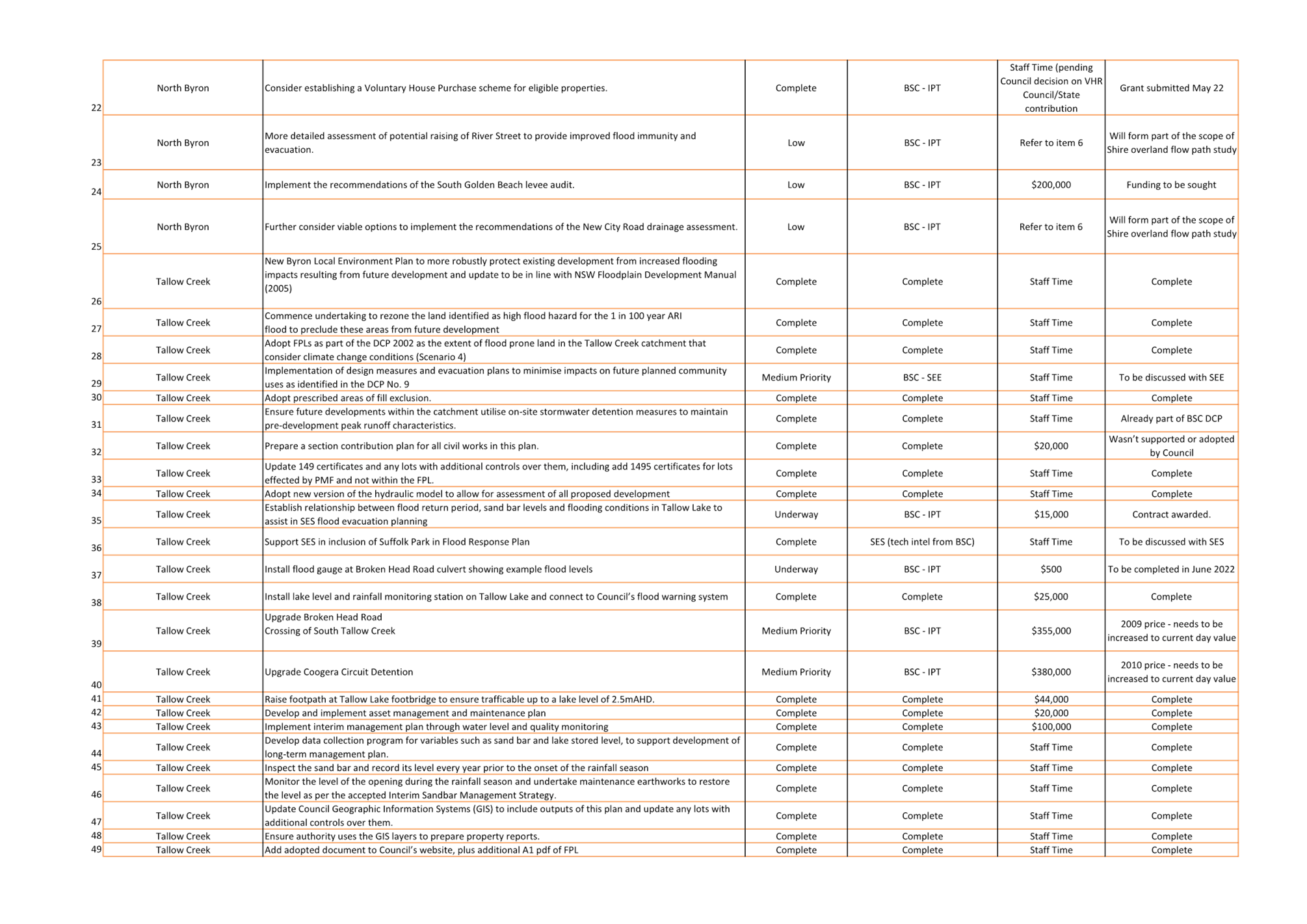
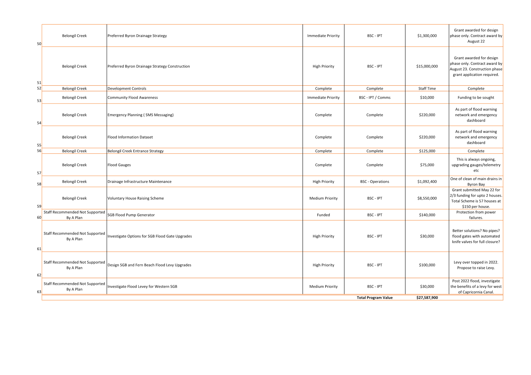
Shire Council Flood Risk Management Plan-Actions and Accomplishments........................................................................................................................................ 11
4.2 Byron
Bay Drainage Upgrade Project...................................................................... 17
4.3 Capricornia
Canal and Marshalls Creek.................................................................. 20
4.4 Byron
Shire Post 2022 Flood Analysis Update....................................................... 26
4.5 Voluntary
House Raising............................................................................................ 29
Adoption of Minutes from Previous Meetings 3.1
Adoption of Minutes from Previous Meetings
Report No. 3.1 Adoption of Minutes from Previous Meeting
Directorate: Infrastructure Services
Report Author: Shelley
Flower, Executive Assistant IS
File No: I2022/586
RECOMMENDATION:
That the minutes of the Floodplain Management Advisory
Committee Meeting held on 21 April 2022 be confirmed.
Attachments:
1 Minutes
21/04/2022 Floodplain Management Advisory Committee, I2022/388 , page 7⇩ 
Report
The attachment to this report provides the minutes of the
Floodplain Management Advisory Committee Meeting of 21 April 2022.
Report to Council
The minutes were reported to Council on 26 May 2022.Comments
In accordance with the Committee Recommendations, Council
resolved the following:
22-226: Resolved that Council notes the minutes of the
Floodplain Management Advisory Committee Meeting held on 21 April 2022.
Adoption
of Minutes from Previous Meetings 3.1 - Attachment 1
Staff Reports - Infrastructure Services 4.1
Staff Reports - Infrastructure Services
Report No. 4.1 Byron
Shire Council Flood Risk Management Plan-Actions and Accomplishments
Directorate: Infrastructure
Services
Report Author: Scott
Moffett, Drainage & Flood Engineer, IS - Works - Infrastructure Planning
File No: I2022/632
Summary:
Council has adopted three sets of Flood Risk Management
Studies (FRMS) and Plans (FRMP) for the shires three main catchments. These
are:
· Brunswick
River Catchment (North Byron)
· Tallow
Creek Catchment
· Belongil
Creek catchment
A summary of prioritised actions
has been prepared based on the outcomes of the three adopted Flood Risk
Management Plans
RECOMMENDATION:
That Council note the current Byron Shire Council
Flood Mitigation Program, attachment 1 (E2022/52007), and the Floodplain
Management Advisory Committee receive a further report with all actions
prioritised as per discussion with the committee.
Attachments:
1 BSC
Flood Mitigation Program, E2022/52007
, page 14⇩ 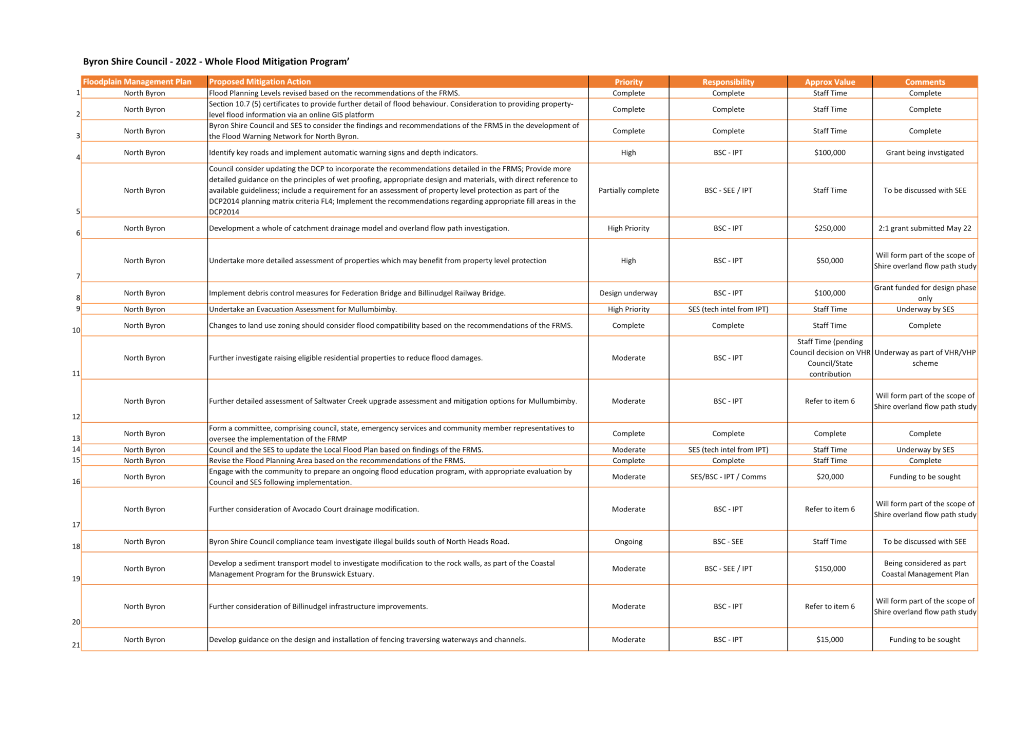
Report
Council has adopted three sets of Flood Risk Management
Studies and Plans for the shires three main catchments. These are:-
· Brunswick
River Catchment (North Byron);
· Tallow
Creek Catchment; and
· Belongil
Creek catchment.
The Brunswick River Catchment is
drained by three major tributaries, Marshalls Creek (North Arm), Simpsons Creek
(South Arm) and the Brunswick River (West and Main Arm).
A North Byron detailed flood study
and subsequent FRMS and FRMP were developed and adopted in 2020. The FRMP
listed 25 recommended actions with associated priority rankings.
The Tallow Creek Catchment is
drained by Tallow Creek and receives a large proportion of the urban Suffolk
Park district runoff. A detailed flood study and subsequent FRMS and FRMP
were developed and adopted in 2009 with an update being adopted in 2015.
The FRMP listed 24 recommended actions with associated priority rankings.
Tallow Creek opens to the ocean and is known as an intermittently closed and
open lagoon system (ICOLL).
The Belongil Creek Catchment is
drained by Belongil Creek and receives a large proportion of the urban Byron
Bay central business district runoff in addition to wetland and agricultural
runoff. A detailed flood study and subsequent FRMS and FRMP were
developed and adopted in 2015. The FRMP listed 10 recommended actions with
associated priority rankings. Belongil Creek opens to the ocean and is
known as an intermittently closed and open lagoon system (ICOLL).
A summary of prioritised actions
has been prepared based on the outcomes of the three adopted Flood Risk
Management Plans, as per attachment 1 (E2022/52007)..
Key issues
Several key issues have been
identified that will impact the delivery of the flood mitigation program.
These include, however, not limited to:-
· Available budget-Council budgets are limited. It is
likely that grant funding will be required to financially assist Council with
delivery;
· Timing and community expectations-Following the recent 2022
flood natural disaster the community expect a quick delivery of the
actions. Realistic delivery programs will need to be communicated
effectively with the community highlighting budgetary and resource constraints;
and
· Local Council and State responsibilities- Following the
recent 2022 flood natural disaster the community has an expectation that
Council can undertake any and all works. This is sometimes not the case
with many actions the responsibility of various state departments such as SES,
Crown, Marine Parks, Fisheries and the National Parks and Wildlife
Services. Realistic delivery programs will need to be communicated
effectively with the community highlighting budgetary and resource constraints.
Next steps
Further prioritisation of actions,
budget sourcing and delivery program development. The committee may recommend
prioritise at the meeting and further prioritised report provided.
Strategic Considerations
Community Strategic Plan
and Operational Plan
|
CSP Objective
|
CSP Strategy
|
DP Action
|
Code
|
OP Activity
|
|
Community
Objective 1: We have infrastructure, transport and services which meet
our expectations
|
1.1:
Provide a road network which is safe, accessible and maintained to an
acceptable level of service
|
1.1.6:
Provide stormwater infrastructure to manage flood mitigation, social and
environmental outcomes
|
1.1.6.1
|
Review
and update 10 year Stormwater Levy program
|
Recent Resolutions
Not Applicable
Legal/Statutory/Policy
Considerations
Not Applicable
Financial Considerations
It is likely that grant funding
will be required to financially assist Council with delivery
Staff
Reports - Infrastructure Services 4.1 - Attachment 1
Staff Reports - Infrastructure Services 4.2
Report
No. 4.2 Byron Bay
Drainage Upgrade Project
Directorate: Infrastructure
Services
Report Author: Scott
Moffett, Drainage & Flood Engineer, IS - Works - Infrastructure Planning
File No: I2022/633
Summary:
Council have been successful in obtaining Commonwealth grant
funding to deliver the Byron Bay Drainage Strategy Design (Total funding value
$1.282M).
The tender document has been prepared for the design phase
and will be released in mid June 2022.
RECOMMENDATION:
That Council notes the current progress of the
Byron Bay Drainage Strategy and the Floodplain Management Advisory Committee
receive a further report with a consultation plan for the project.
Report
The Byron Drainage Strategy will design the town centres
flood mitigation plan and the prioritisation of stormwater drainage
infrastructure upgrades.
The Strategy will include a technical assessment of work to
date, model updates and modelling to prepare concept drainage layouts.
Understanding, and resolving social and environmental conflicts, key
stakeholder inputs. Once a concept layout is complete detail survey will
be completed and detail designs prepared. Upon completion the project will be
construction ready.
The Strategy will detail a drainage system adaptable to
future projected sea-level rise, ocean storm surges and increased rainfall
intensities associated with climate change. It will also provide updated
information to the NSW State Emergency Service to effectively prepare and
implement local flood plans to deal with flood emergency response within the
Byron Bay town centre.
The request for tender will be released in the month of June
2022 with the project due to commence in August 2022.
Next steps
The following
will be undertaken in 2022:
· Request
for Tender release
· Consultancy
engagement
· Data
collection
· Initial
survey commencement
· Initial
model development
· Reporting
to the Floodplain Management Advisory Committee
Strategic Considerations
Community Strategic Plan
and Operational Plan
|
CSP Objective
|
CSP Strategy
|
DP Action
|
Code
|
OP Activity
|
|
Community
Objective 1: We have infrastructure, transport and services which meet
our expectations
|
1.1:
Provide a road network which is safe, accessible and maintained to an
acceptable level of service
|
1.1.6:
Provide stormwater infrastructure to manage flood mitigation, social and
environmental outcomes
|
1.1.6.1
|
Review
and update 10 year Stormwater Levy program
|
Recent Resolutions
Not applicable
Legal/Statutory/Policy
Considerations
Not applicable
Financial Considerations
$1,282,000 in funding is available. $1,080,000 in grant
funding (Preparing Australian Communities) and $220,000 in Council funding.
Consultation and
Engagement
A consultation plan will be prepared with Council’s
Comms team to ensure the project consults with the committee and community
appropriately.
Staff Reports - Infrastructure Services 4.3
Report
No. 4.3 Capricornia Canal
and Marshalls Creek
Directorate: Infrastructure
Services
Report Author: Scott
Moffett, Drainage & Flood Engineer, IS - Works - Infrastructure Planning
File No: I2022/636
Summary:
Cr Asren Pugh recently raised a Notice of Motion detailed
below.
“Refers the requests
raised by the North Byron Shire community regarding dredging the Capricornia
Canal and Marshalls Creek to Council’s Water and Sewer Advisory
Committee, Coastal and ICOLL Advisory Committee, and Floodplain Management Committee
with a view to consider the requests; in particular the option of removing the
Marshalls Creek rock walls at Brunswick Heads and its potential to reduce
siltation of Marshalls Creek”.
This report reproduces Council staff response to the Notice
of Motion (refer File Number I2022/498) and facilitates further discussion by
the Flood Advisory Committee.
RECOMMENDATION:
That the Floodplain Management Advisory Committee
receive a further report with a proposed scope that includes recommendation
received from the committee.
Report
Council have resolved that Council’s Floodplain
Management Advisory Committee and Coastal and ICOLL Advisory Committee consider
the requests raised by the North Byron Shire community regarding dredging the
Capricornia Canal and Marshalls Creek with a view to consider the requests; in
particular the option of removing the Marshalls Creek rock walls at Brunswick
Heads and its potential to reduce siltation of Marshalls Creek.
Flood Risk Management
Options (Dredging and Removal of Rock Walls)
The North Byron Floodplain Management Study notes the
following on page 109 and can be found at https://www.byron.nsw.gov.au/files/assets/public/hptrim/land-use-and-planning-planning-strategies-working-documents-north-byron-coastal-creeks-flood-study/e2021-43013-north-byron-floodplain-risk-management-study-web.pdf
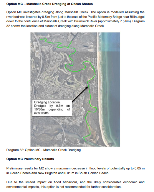
It is not unusual for dredging to provide limited if any
flood mitigation results when modelled. This is usually because it does not
create more storage or a mechanism to greatly alter flood levels because the
dredged area fills with water and only allows for an increase in flow
velocities. Further it can fill in again quite quickly with sediment
moving in the creek system.
A number of rock wall alterations were also modelled in the
study, none provided a level of flood mitigation that resulted in them being a
recommended action in the Floodplain Management Plan. Further details can
be found from page 102 of the above document.
The Brunswick Estuary is a system dominated by ocean
processes in the lower reaches, like all the Shire’s
estuaries/ICOLLs. There is a constant push of sand into the lower reaches
due to the high littoral drift of sediment up the coast from south to
north. This is evident in the formation of bars within the
entrance. As such, lower catchment flood levels tend to be dominated by
ocean levels.
Dredging campaigns in the Brunswick Estuary have
historically been undertaken to improve the navigability of the estuary
entrance for the commercial fishing fleet. Generally, the benefits have
been short-lived with the dredging channels quickly filling in due to sediment
deposits from the high littoral transport system along the coastline. Dredging
activities have, however, changed the tidal prism of the Brunswick Estuary and
have therefore altered the salinity regime, increased turbidity, and reduced
areas of important habitat, such as shallow water, seagrass and intertidal mud
banks. The ecological value of the estuary is unique falling within the
Cape Byron Marine Park, and the impact of dredging to this waterway would be
significant.
The North Byron Floodplain Management Study was developed by
a reputable consultant with expertise in flood modelling and flood risk
management. The development of flood plans follows a step by step process
in accordance with the State Government Flood Manual and close consultation
with experts within the flood department. The inclusion of options within
a Flood Management Plan is based on robust science, modelling, sensitivity
testing and expert knowledge.
Staff are aware that historical / legacy issues arise each
time there is a flood event and our community has been significantly impacted,
however to pursue management options that have already been assessed through a
robust scientific process and deemed unfeasible results in loss of focus and
distraction from implementation of actions in an endorsed Plan.
Recommended Investigation
A recommended action from the North Byron Floodplain
Management Plan is to Develop a sediment transport model to investigate
modification to the rock walls, as part of the Coastal Management Program for
the Brunswick Estuary. This modelling is aimed at managing
sedimentation from an estuary health perspective not flood mitigation.
Council is in the process of preparing Coastal Management
Programs (CMPs) for its parts of the Byron Shire coastline, prioritising the
Open Coast and ICOLLs in the four-stage process set out to develop the
long-term strategy. Council has not yet commenced the development of a
CMP for the Brunswick Estuary.
However, as part of Council’s preparation of CMPs for
the Open Coast and ICOLLs, the Byron Shire Coastal Hazard Assessment, currently
underway, which will cover the entire spatial extent of the Shire’s coastline
and will inform the CMP. A key task of the Hazard Study is the
development of a quantified conceptual sand transport model for the coastal
zone. The preparation of sand transport model will include detailed
assessment of:
· coastal
geomorphology and geophysical setting
· marine
and shoreline sediments
· wave
climate and coastal processes
· time
history of anthropogenic changes along the coastline (including minor and major
works such as the Brunswick River training works)
· sediment
budgets and the influence of natural and anthropogenic changes on sediment
sources and sinks (sediment gains or losses determine whether shorelines will
either erode or accrete).
Development of the sediment budget requires consideration of
the various possible sources of sand, transport pathways, sinks, and agents of
transport. The Brunswick River entrance is a known key source and sink of
sediment which will be assessed in detail through this analysis as part of the
study. Development of a quantified conceptual sand movement model is
important as it focuses on sand transport (or sediment transport) and the key
drivers that govern the processes of sand movement. The forcing agents
(where does the sand come from and how?) will also be considered in the context
of a changing climate. Understanding sediment transport is essential to inform
decision making on potential coastal management options to address coastal
hazards and/or key issues such as sedimentation.
Council has not yet commenced the development of a CMP for
the Brunswick Estuary. Stage 1 of development of the CMP process comprises a
Scoping Study to:
· collate
existing information on the study area;
· carry
out stakeholder and community engagement;
· understand
values and management issues (i.e. such as community concerns regarding
sedimentation of Marshalls Creek);
· identify
any information gaps; and
· outline
studies required to be carried out to inform the later stages of the CMP
development.
It is not until Stage 3 of the CMP process where management
options are identified and evaluated through risk assessment and cost, benefit
analysis. Any management options such as dredging or rock wall
alterations (to deal with sedimentation issues) would need to be supported as a
feasible option in Stage 3 for inclusion in a CMP before it could proceed.
Key issues
The process followed in the North
Byron Floodplain Management Plan has not resulted in the broader community
accepting that dredging or rock wall changes will have limited impact on flood
levels.
Options
1. Do nothing.
2. Complete further studies.
Next steps
It is proposed to discuss at the
committee meeting the following questions:
1. Why haven’t the outcomes of the North
Byron Floodplain Management Plan been accepted by the community?
2. Should we do further complete further
studies?
3. If further studies were completed, what
should be included in the scope?
Strategic Considerations
Community Strategic Plan
and Operational Plan
|
CSP Objective
|
CSP Strategy
|
DP Action
|
Code
|
OP Activity
|
|
Community
Objective 3: We protect and enhance our natural environment
|
3.3:
Partner to protect and enhance the health of the Shire’s coastlines,
estuaries, waterways and catchments
|
3.3.1:
Implement Coastal Management Program
|
3.3.1.1
|
Continue
preparing a Coastal Management Program (CMP) in accordance with the staged
process for Cape Byron to South Golden Beach
|
Recent Resolutions
No Applicable
Legal/Statutory/Policy
Considerations
Not applicable
Financial Considerations
Development of a conceptual sand/sediment transport model is
part of the Byron Shire Coastal Hazard Assessment is not funded. Any other
studies are currently unfunded.
Commencement of a Coastal Management Program for the
Brunswick Estuary is currently unfunded. However, the planning of this process
may commence in the 2022/23 FY pending funding and staff capacity.
Estimating the costs of further studies is difficult without
a clear scope.
Consultation and
Engagement
Extensive consultation and engagement was undertaken during
the public exhibition stage of the North Byron Flood Risk Management Study and
Plan prior to adoption in 2020.
Staff Reports - Infrastructure Services 4.4
Report
No. 4.4 Byron Shire Post
2022 Flood Analysis Update
Directorate: Infrastructure
Services
Report Author: Scott
Moffett, Drainage & Flood Engineer, IS - Works - Infrastructure Planning
File No: I2022/651
Summary:
Following the recent flooding and rain events, Council has
been working closely with State Emergency Services (SES), the Department of
Planning & Environment (DPE) and specialist flooding consultants to
undertake a post events data collection and summary report.
This report provides a summary of actions and ongoing
activities for discussion by the Floodplain Management Advisory Committee
(FMAC).
RECOMMENDATION:
That Council notes the report and the Floodplain
Management Advisory Committee continue to receive progress reports on the Post
2022 Flood Analysis.
Report
Following the recent flooding and rain events, Council has
been working closely with State Emergency Services (SES), the Department of
Planning & Environment (DPE) along with specialist flooding external
consultants to undertake a post event/s data collection and summary report.
Council initiated the first phase
internal post event survey protocols immediately following the recent events.
Council’s Flooding and Drainage Engineer was contacted by SES to
collaborate in obtaining post event survey marks.
SES contracted Public Works
Advisory (PWA) to provide survey resourcing across the Byron Shire. DPE
then became involved to oversee the data collection. Council’s
Flooding and Drainage Engineer worked closely with SES, DPE and PWA to isolate
the areas of interest with a focus on the main urbanised areas of the shire.
Post event survey has now been
completed and SES, DPE and PWA, along with Council are currently collating the
data and undertaking quality assurance checks. This data will be available for
use by Council in the coming weeks. Survey has covered the Brunswick
River, Belongil, Tallow Creek catchments and Bangalow.
Council then initiated the second
phase of post event survey protocols. This has involved releasing media alerts
to all shire residents to ask for assistance with collection of additional
private property survey. This initiative has been very successful with over 200
responses received so far and more coming in every day. Council has mobilised
survey resources to begin the final stage of the survey involving surveying
private property recorded flood marks. The scope, timing and funding
arrangements have now been negotiated with various Government departments and
authorities together with Council.
Council contacted DPE to initiate
a post event technical analysis. Following discussions with Council’s
Flooding and Drainage Engineer, DPE agreed to fund all the post event technical
analysis.
The post event technical analysis
will cover the Brunswick River, Belongil, Tallow Creek catchments and Bangalow.
Consultants WMA have been commissioned by DPE for the Brunswick River catchment
and BMT have been commissioned by DPE for the Belongil and Tallow Creek
catchments. QIT, Council Emergency Dashboard provider have also been
commissioned to undertake a post event analysis of Councils flood warning
system.
There is a large amount of works
involved to complete the post event technical analysis and current estimates
from DPE and consultants is likely to take two to three months as a minimum.
Council staff will provide a
digital GIS presentation of all post event survey information gained to date at
the committee meeting.
Key issues
· Timing of works (reliance on DPE and third-party
consultants)
· Privacy of data
Next steps
· Quality assurance and sorting of phase one survey data
· Process survey for phase two data collection
· Review draft post event technical analysis
· Finalise reporting and report back to the Floodplain
Management Advisory Committee
Financial Considerations
· Council’s
Flooding and Drainage Engineer’s time and resource allocation
· All other
activities are fully funded by DPE and SES (approx. $150 000)
Consultation and
Engagement
Community consultation has been in the form of digital flood
survey mark requests via media releases and Council’s website.
Staff Reports - Infrastructure Services 4.5
Report No. 4.5 Voluntary
House Raising
Directorate: Infrastructure
Services
Report Author: Scott
Moffett, Drainage & Flood Engineer, IS - Works - Infrastructure Planning
File No: I2022/686
Summary:
Council has applied under the Department of Planning and
Environment 2022-23 Floodplain Management Grant for Voluntary House Raising
funding.
Under this program, state government provide two thirds
funding with a remaining one third contribution required. The following
provides an overview of the program, draft guidelines and proposes that the
landowner provides the remaining one third funding contribution.
RECOMMENDATION:
That Council support:
1. The
Draft Byron Shire Council Voluntary House Raising Scheme Guidelines Attachment
1 (E2022/29988) being placed on public exhibition as per Council policy;
2. The
benefiting landowner being responsible for the one third funding contribution
under the NSW Floodplain Management Program Voluntary House Raising
funding grant
3. That for any approved
Voluntary House Raising dwellings, Council’s development applications
fees be waived in order to minimise the costs related to these essential works
4. The
Floodplain Management Advisory Committee receive a further report that maps and
details the number of houses across the shire with floors levels below the 100
year flood level that are ineligible for funding under the NSW Floodplain
Management Program Voluntary House Raising funding grant and the number houses
with floors between the 100 year flood level and the probable maximum flood
Attachments:
1 BSC
Voluntary House Raising Scheme - DRAFT Guidelines, E2022/29988 , page 35⇩ 
Report
Each year, the Department of Planning and Environment
Floodplain Management Grant for Voluntary House Raising funding supports local
government to manage flood risk. The main aim of the NSW Floodplain
Management Grant Program is to reduce the impact of flooding and flood
liability on communities and reduce the damage floods cause using
environmentally friendly methods.
Within this program is the opportunity to apply for Voluntary
House Raising (VHR) further information can
be found here Floodplain
management grants | NSW Environment and Heritage
Council has applied for VHR,
under the 2022-23, round and will continue in future years. If
successful, Council will manage and administer the VHR Scheme. The grant outcome
is anticipated to be known in November 2022.
The VHR scheme is aimed at
reducing flood damage to houses by raising the habitable floor level of
individual buildings, therefore, reducing the economic and social burden of
flooding on the community and government.
Benefits of VHR include:
· reduced
flood damage to houses and their contents
· reduced
personal loss, stress and post-flood trauma
· reduced
frequency of household disruption
· reduced
clean up after floods
· improved
safety (if isolated)
A VHR scheme is part of an
overall floodplain risk management strategy for the Byron Shire rather than a
stand-alone program.
To be eligible for consideration
under the VHR scheme properties need to be:
· With floor heights
below the Flood Planning Level (0.5 metres above the 1% predicted flood level)
· Not identified in
a designated Voluntary House Purchase area
· Constructed prior
to 1986
· Constructed of a
material that is suitable for raising (i.e., wood, not brick)
Funding is available on a 2:1
basis. The NSW Government will fund two-thirds of the eligible cost of
raising the dwelling and it is recommended that the property owner is
responsible for the remaining one-third of costs.
Council is unable to financially
contribute the remaining one-third to the VHR scheme as the raising is not
being undertaken in compensation for other flood mitigation works, and the
private owner of the property
receives significant benefit from the raising of their house in the form of reduced flood exposure
and potential increased property value.
Based on feedback from
Council’s working within the VHR Scheme, it is likely to cost
approximately $150,000 to raise a house; this is dependent on the size of the
house, location, materials, labour availability and design. It is also
recognised that due to the severe and wide-reaching impacts of the 2022 Storm
and Flood event and the COVID-19 building boom within the Northern Rivers, that
contractors and materials may be hard to source and further increase costs and
or delays.
Inclusion of a property within
the VHR Scheme is not necessarily confirmation that the property will be eligible for access to State Government
funding. Further checks against the VHR Guidelines will be undertaken at the application stage for each property.
Attachment 1 (E2022/29988)
details how the Voluntary House Raising Scheme will be managed and recognises
that is entirely voluntary and properties are under no obligation to
participate.
The owner of the property is
responsible for managing the various activities associated with the actual raising the dwelling. Council
officers will provide oversight, guidance and
administration of the VHR
scheme.
The property owner is responsible
for:
· Gaining the relevant
development approvals
· Seeking quotes
for raising works
· Engaging
a suitable contractor
· Monitoring the works
· Organising certification of the works
· Submission of grant
funding claims to Council
It will also be a condition of
approval for all raised dwellings that the areas below design flood level (the lower storey) are not to
be used for habitable purposes (i.e. enclosed as bedrooms, rumpus rooms, ground floor secondary dwellings or
similar). In this regard the lower level can be used as a garage and
storage and in some cases a laundry. The area under the house should be
left open to enable the free flow of floodwaters in the event of a flood.
Eligible and ineligible costs
Costs eligible for funding are
those that are essential to raise the footprint of the existing habitable floor
area or relocate the existing dwelling to a location on higher ground within
the same lot (as applicable). Such costs include but are not limited to:
· plan
and document preparation, including survey costs
· development
application costs
· site
preparation costs
· disconnection
of services and provision of temporary services (water, electricity,
communications, gas and stormwater, including rainwater tanks)
· preparation
for and raising of the floor to the required minimum flood design level
· installation
of supporting structure for the elevated floor
· reconnection
of services
· the
installation of front and back doorsteps or ramp and associated safety
rails/devices
· costs
associated with inspection and approval by the council
· relocating
the house to an appropriate site within the same property if this is considered
the most cost-effective option to meet the required minimum design floor level.
Costs which are not eligible for
funding include but are not limited to:
· any
additional features, improvements, renovations and substitutions of services
requested by the homeowner, such as landscaping and concrete floor to the
understorey
· raising
the property above the minimum design floor level that is required
· accommodation
for the homeowner while works are being done
· remedial
works to the house
· expenses
incurred prior to a funding agreement being entered (unless otherwise agreed to
in writing by the department).
(Source: https://www.environment.nsw.gov.au/-/media/OEH/Corporate-Site/Documents/Water/Coast-estuary-and-flood-grants/floodplain-management-program-guidelines-voluntary-house-raising-schemes-220095.pdf?la=en&hash=B11D5E75BE8DC1D17B0C1C7BBAE74B471160E9F9)
Strategic Considerations
Community Strategic Plan
and Operational Plan
Aligned within upcoming 2022-23
Delivery Program:
3.3.2 Floodplain Management
– Mitigate the impact of flooding on private and public property.
Recent Resolutions
|
22-001
|
Resolved:
1. That
Council notes the report and Attachment 1 (#E2022/30893)
for Byron Shire Council’s grant submissions as of 31 March 2022.
2. That
Council receives a report in June on the Voluntary House Raising Scheme
detailing the process and co-contribution funding requirements. (Dey/Lyon)
The motion
was put to the vote and declared carried.
|
Financial Considerations
No Council financial contributions are recommended; however,
staff resourcing to manage the funding and provide guidance on the house
raising will be required. Feedback from neighbouring Tweed Shire has
advised that it can take up to 3 years for house raising to occur: from grant
application to construction completion.
Consultation and
Engagement
The Voluntary House Raising Scheme is managed as per the NSW
Department of Planning and Environment Floodplain Management Program
Guidelines.
Council considered the property owner contribution at a
recent Strategic Planning Workshop on 2 June.
Staff
Reports - Infrastructure Services 4.5 - Attachment 1