 Agenda
Ordinary (Planning) Meeting

Thursday, 9 February 2023
Agenda
Ordinary (Planning) Meeting
Thursday, 9 February 2023
Agenda Ordinary (Planning) Meeting
held at Conference Room, Station Street, Mullumbimby
commencing at 11:00am
Public access relating to items on this agenda can be made between 11:00am and 11:30am on the day of the meeting. Requests for public access should be made to the General Manager or Mayor no later than 12:00 midday on the day prior to the meeting.

Mark Arnold
General Manager
CONFLICT OF INTERESTS
What is a “Conflict of Interests” - A conflict of interests can be of two types:
Pecuniary - an interest that a person has in a matter because of a reasonable likelihood or expectation of appreciable financial gain or loss to the person or another person with whom the person is associated.
Non-pecuniary – a private or personal interest that a Council official has that does not amount to a pecuniary interest as defined in the Code of Conduct for Councillors (eg. A friendship, membership of an association, society or trade union or involvement or interest in an activity and may include an interest of a financial nature).
Remoteness – a person does not have a pecuniary interest in a matter if the interest is so remote or insignificant that it could not reasonably be regarded as likely to influence any decision the person might make in relation to a matter or if the interest is of a kind specified in the Code of Conduct for Councillors.
Who has a Pecuniary Interest? - a person has a pecuniary interest in a matter if the pecuniary interest is the interest of the person, or another person with whom the person is associated (see below).
Relatives, Partners - a person is taken to have a pecuniary interest in a matter if:
· The person’s spouse or de facto partner or a relative of the person has a pecuniary interest in the matter, or
· The person, or a nominee, partners or employer of the person, is a member of a company or other body that has a pecuniary interest in the matter.
N.B. “Relative”, in relation to a person means any of the following:
(a) the parent, grandparent, brother, sister, uncle, aunt, nephew, niece, lineal descends or adopted child of the person or of the person’s spouse;
(b) the spouse or de facto partners of the person or of a person referred to in paragraph (a)
No Interest in the Matter - however, a person is not taken to have a pecuniary interest in a matter:
· If the person is unaware of the relevant pecuniary interest of the spouse, de facto partner, relative or company or other body, or
· Just because the person is a member of, or is employed by, the Council.
· Just because the person is a member of, or a delegate of the Council to, a company or other body that has a pecuniary interest in the matter provided that the person has no beneficial interest in any shares of the company or body.
Disclosure and participation in meetings
· A Councillor or a member of a Council Committee who has a pecuniary interest in any matter with which the Council is concerned and who is present at a meeting of the Council or Committee at which the matter is being considered must disclose the nature of the interest to the meeting as soon as practicable.
· The Councillor or member must not be present at, or in sight of, the meeting of the Council or Committee:
(a) at any time during which the matter is being considered or discussed by the Council or Committee, or
(b) at any time during which the Council or Committee is voting on any question in relation to the matter.
No Knowledge - a person does not breach this Clause if the person did not know and could not reasonably be expected to have known that the matter under consideration at the meeting was a matter in which he or she had a pecuniary interest.
Non-pecuniary Interests - Must be disclosed in meetings.
There are a broad range of options available for managing conflicts & the option chosen will depend on an assessment of the circumstances of the matter, the nature of the interest and the significance of the issue being dealt with. Non-pecuniary conflicts of interests must be dealt with in at least one of the following ways:
· It may be appropriate that no action be taken where the potential for conflict is minimal. However, Councillors should consider providing an explanation of why they consider a conflict does not exist.
· Limit involvement if practical (eg. Participate in discussion but not in decision making or vice-versa). Care needs to be taken when exercising this option.
· Remove the source of the conflict (eg. Relinquishing or divesting the personal interest that creates the conflict)
· Have no involvement by absenting yourself from and not taking part in any debate or voting on the issue as of the provisions in the Code of Conduct (particularly if you have a significant non-pecuniary interest)
RECORDING OF VOTING ON PLANNING MATTERS
Clause 375A of the Local Government Act 1993 – Recording of voting on planning matters
(1) In this section, planning decision means a decision made in the exercise of a function of a council under the Environmental Planning and Assessment Act 1979:
(a) including a decision relating to a development application, an environmental planning instrument, a development control plan or a development contribution plan under that Act, but
(b) not including the making of an order under that Act.
(2) The general manager is required to keep a register containing, for each planning decision made at a meeting of the council or a council committee, the names of the councillors who supported the decision and the names of any councillors who opposed (or are taken to have opposed) the decision.
(3) For the purpose of maintaining the register, a division is required to be called whenever a motion for a planning decision is put at a meeting of the council or a council committee.
(4) Each decision recorded in the register is to be described in the register or identified in a manner that enables the description to be obtained from another publicly available document, and is to include the information required by the regulations.
(5) This section extends to a meeting that is closed to the
public.
OATH AND AFFIRMATION FOR COUNCILLORS
Councillors are reminded of the oath of office or affirmation of office made at or before their first meeting of the council in accordance with Clause 233A of the Local Government Act 1993. This includes undertaking the duties of the office of councillor in the best interests of the people of Byron Shire and the Byron Shire Council and faithfully and impartially carrying out the functions, powers, authorities and discretions vested under the Act or any other Act to the best of one’s ability and judgment.
BUSINESS OF Ordinary (Planning) Meeting
1. Public Access
3. Attendance by Audio-Visual Link / Requests for Leave of Absence
4. Declarations of Interest – Pecuniary and Non-Pecuniary
5. Tabling of Pecuniary Interest Returns (Cl 4.14 Code of Conduct for Councillors)
6. Adoption of Minutes from Previous Meetings
6.1 Ordinary (Planning) Meeting held on 8 December 2022
7. Reservation of Items for Debate and Order of Business
8. Mayoral Minute
9. Notices of Motion
9.1 Timing of removal of fill on bank of Marshalls Creek................................................ 8
9.2 Consult about local impacts of 2023 Triathlon........................................................ 11
9.3 Expression of Interest for land for a Natural Burial Ground.................................. 16
10. Petitions
11. Submissions and Grants
12. Delegates' Reports
13. Staff Reports
Sustainable Environment and Economy
13.1 PLANNING - Amendments to Byron Development Control Plan Submissions Report........................................................................................................................................ 20
13.2 PLANNING - Rural Community Title DCP 2014 Chapter D2 amendments - submissions report....................................................................................................... 28
13.3 Memorandum of Understanding between Byron Shire Council and TheTransport Asset Holding Entity of NSW (TAHE).................................................................................. 32
13.4 PLANNING - DA 10.2022.193.1 - Torrens Title Subdivision of Two (2) Lots into Two (2) Lots 11 Argyle Street MULLUMBIMBY.............................................................. 35
13.5 PLANNING - Quarter 4 SEPP Variations October to December 2022............... 47
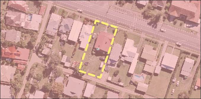
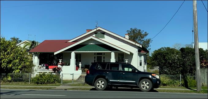
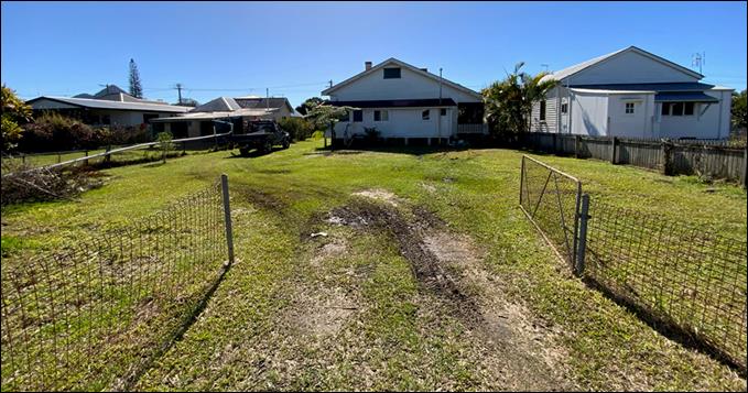
13.6 PLANNING - DA 10.2021.571.1 Demolition of Existing Dwelling and Construction of Two (2) New Dwellings to create Dual Occupancy (Detached) including Earthworks and Swimming Pool in Two (2) Stages at 212 Fowlers Lane BANGALOW....... 50
Infrastructure Services
13.7 Planning agreement for the dedication of land at Bayside 15 Torakina Road, Brunswick Heads......................................................................................................... 62
14. Questions With Notice
14.1 Upgrades on Main Arm Road.................................................................................... 65
14.2 Triathlon sponsor’s not-for-profit status.................................................................... 67
Questions with Notice: A response to Questions with Notice will be provided at the meeting if possible, that response will be included in the meeting minutes. If a response is unable to be provided the question will be taken on notice, with an answer to be provided to the person/organisation prior to the next Ordinary Meeting and placed on Councils website www.byron.nsw.gov.au/Council/Council-meetings/Questions-on-Notice
Councillors are encouraged to ask questions regarding any item on the business paper to the appropriate Director prior to the meeting. Any suggested amendments to the recommendations should be provided to Councillor Support prior to the meeting to allow the changes to be typed and presented on the overhead projector at the meeting.
BYRON SHIRE COUNCIL
Notices of Motion 9.1
Notice of Motion No. 9.1 Timing of removal of fill on bank of Marshalls Creek
File No: I2023/95
I move that Council:
1. Notes:
a) that large amounts of fill were placed over recent months on the bank of Marshalls Creek at 295 Pocket Road, The Pocket;
b) a Stop Work Order was issued in November 2022;
c) a Restore Works Order was issued on 7 December 2022 to restore the area back to its original condition, by 7 April 2023;
d) Council staff had been stockpiling material on the site with the landowner’s approval whilst undertaking works in the area; and
e) that February is close to the middle of this region’s wet season, when floods are most likely and erosion of the material into Marshalls Creek is thus likely.
2. Pursues ways of having the fill removed and the site restored earlier than the date of the Restore Works Order (7 April 2023) including pursuing:
a) an amendment of the Restore Works Order to restore the area by the end of February 2023,
b) Council undertaking the removal, at least to the extent of recovering Council’s share of the material, and / or
Signed: Cr Duncan Dey
Councillor’s supporting information:
Residents of The Pocket complained to Council in October 2022 and then sought my support as a Councillor to have this matter investigated. It is clearly poor practice to store soil on a river bank.
Aerial views of the site would illustrate that fill material has already fallen into Marshalls Creek. I ask staff to examine satellite imagery since October.
The fill project appears to have been well organised, by experienced operators. Trucks and earth moving machinery are now stored on the resulting platform.
I am extremely grateful that Council staff took action by inspecting the site and issuing Orders so promptly last year. The issue remains however that the point of intervening is lost if the fill washes into Marshalls Creek.
Staff comments
by Sharyn French, A/Director, Sustainable Environment and Economy:
In relation to the following:
2. Pursues ways of having the fill removed and the site restored earlier than the date of the Restore Works Order (7 April 2023) including pursuing:
a) an amendment of the Restore Works Order to restore the area by the end of February 2023,
b) Council undertaking the removal, at least to the extent of recovering Council’s share of the material, and / or
c) any other ways.
It should be noted that the owner has substantially complied with the Restore Works Order; the piles of fill have been removed and the sediment and erosion control has been installed.
In relation to the remaining pad of highly compressed fill, the owner has engaged a flood engineer and planner to provide advice if the pad could likely be approved through a development application. If so, a development application is expected to be lodged and if not, then the fill will need to be removed as per the Order.
Staff cannot arbitrarily amend an Order, we must comply with procedural fairness. Pursuant to the Act, this would require the issuing of a new Notice of Proposed Order giving the owner a period of time to respond, which is generally not less than 14 days before a new Restore Works Order can be issued.
The terms of a Development Control Order can be modified by agreement between the parties.
Financial/Resource/Legal Implications:
Notice’s and Orders must be administered in accordance with the Act and procedural fairness.
Is the proposal consistent with any Delivery Program tasks?
Yes
|
CSP Objective |
CSP Strategy |
DP Action |
Code |
OP Activity |
|
2:
Inclusive Community |
2.2: Enhance safety and contribute to the physical, mental, and spiritual health and well being of our people |
2.2.3: Regulatory controls and compliance - Enhance public safety, health and liveability through the use of Council's regulatory controls and services |
2.2.3.2 |
Respond to and investigate complaints against building standards |
|
3:
Nurtured Environment |
3.2: Deliver initiatives and education programs to encourage protection of our environment |
3.2.1: Compliance - Encourage compliance with environmental planning regulations |
3.2.1.1 |
Monitor, investigate and respond to unauthorised land use, development and environment complaints |
BYRON SHIRE COUNCIL
Notices of Motion 9.2
Notice of Motion No. 9.2 Consult about local impacts of 2023 Triathlon
File No: I2023/96
I move that Council:
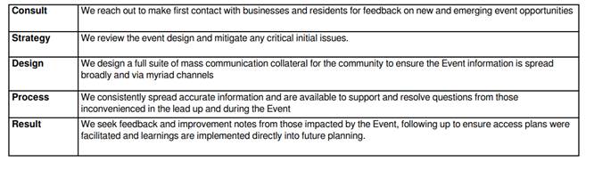
1. Consults with businesses that will be impacted by street closures approved or sought for the 2023 Byron Bay Triathlon, with the Byron Bay Chamber of Commerce and with the Shire’s community, to ascertain whether:
a) we support the 2023 and future events going ahead, based on impacts from events to date;
b) there are variations of the land routes or of timing of road closures that could reduce impacts on businesses and community;
c) we would prefer that 2023 be the last such event; and
d) any other comments.
2. Receives a report in March 2023 with findings on those matters.
1 Byron
Triathlon 2022 - Proposed alternative cycle route for consideration, E2022/16000 ![]()
2 Byron
Triathlon 2021 cycle route, E2022/16007
![]()
3 BBCC
Letter of Support for Cycle Way, E2023/8671
![]()
4 Confidential - Byron Bay Triathlon - Community Engagement Report, 2021, E2023/9585
Signed: Cr Duncan Dey
Councillor’s supporting information:
On 24 March 2022 Council resolved (Res 22-101) that Council:
1. Notes the importance of the Byron Triathlon event to the local community and businesses, as well as the Australian sporting community in general.
2. Supports the 2022 Byron Triathlon and future events using a similar route to the 2021 event as per attachment 2, and that this route is endorsed by Council, on the basis that the route is supported by the Local Traffic Committee at its April meeting.
3. Communicates its position to the local community via media release.
4. Requests the community and businesses respect this decision and support the organisers in the delivery of the 2022 Byron Triathlon.
5. Council requests that the Byron Triathlon and NX Sports provide to Council evidence of their status as a not-for-profit including registration with the Australian Charities and not-for-profit commission (ACNC) and any details of disbursement of funds to charities or other financial details that give evidence of their status as a not-for-profit organisation.
The report to our March 2022 meeting informed us that:
in previous years community and business concern has been raised with regard to road closures. The event organiser have investigated an alternate route, however, it also has its down sides for both the community and the events success.
Business concerns have again been raised, including in an email to Councillors on 14 May 2022. The Chamber of Commerce wrote a further letter on 1 August 2022, as attached.
Attached to this NoM are attachments 1 and 2 of the 24 March 2022 meeting. Resolution 22-101 approves the 2022 route and also ‘pre-approves’ the same route for future years including 2023.
My question with Notice lodged for today’s meeting asks for the outcome of Part 5 of Res 22-101, on the not-for-profit status of the event organisers.
The level of opposition to this route is high and needs to be reassessed and reported. If it is too late to alter the 2023 route, then let’s at least get it right from 2024 onwards.
Staff comments
by Sharyn French, A/Director Sustainable Environment and Economy Directorate:
The Byron Bay Triathlon is in its 27th year. It is a local, yet national event that attracts around 1,400 competitors from across Australia and internationally. Traditionally it is held on the Mothers Day weekend every year and signals the last race in the QLD/NSW triathlon calendar.
As Byron Bay has become busier, the event organisers have shortened the cycle leg in the past in response to community concerns, by removing the olympic distance. The cycle leg is no longer 40km, but 20km to reduce the impact of road closures.
Furthermore and prior to the 2022 event, staff presented cycle leg route options to Council at the 24 March 2022 Council meeting for consideration due to the potential community and event impacts that could arise from choosing either route. Council resolved (Res. 22-101) to note the importance of the event, and to support future events using a similar route to the 2021 event. The routes have been established in close consultation with Police and Council’s Local Traffic Committee.
2022 Event
The 2022 Byron Bay Triathlon was impacted by the Feb/Mar floods and COVID reducing the number of crew and participants. Six weeks prior to event date, the event purpose was pivoted from a major destination triathlon to become a regional fundraiser supporting the flood appeal.
Despite the smaller participant numbers in 2022, the event footprint for road closures was as planned. Council staff received complaints from one business and one sporting group, not including the letter from the Byron Bay Chamber of Commerce (Attachment 3). These complaints related to a business owner being able to gain access at a specific time outside the opportunities provided by the road closure, and a sporting event that was also planned for the same day. The sporting club were aware of the triathlon coinciding on the same date as their event and as such they attempted to change their date, though this didn’t happen and their event occurred on the same day.
In the lead up to delivering the event the organisers undertake extensive engagement with residents and businesses via surveys, emails, phones calls and social media etc to enable them to respond to any concerns which might be raised. Confidential Attachment 4 provides a copy of the organisers Community Engagement Report for the 2021 event. It is noted that the Byron Bay Chamber is included in their email communications.
2023 Event
Resolution 22-101 provides Council’s support for future events to use a similar route to the 2021 event.
Council has received an event application for the 2023 Byron Bay Triathlon to be held on Saturday 13 May 2023, and the Byron Bay Lighthouse Run to be held on Sunday 14 May 2023. The lighthouse event is a lower scale event with road closures confined to the lighthouse precinct.
The event organisers are advanced in their planning for this event and have commenced implementing their Event Management Plan, which outlines amongst other matters their community engagement methodology, extract below:
 Byron Bay Triathlon report that
their position moving to 2023 for the event is strong. In 2022 the Byron Bay
Triathlon event won a Regional Events Accelerator Fund grant through the
Department of Regional NSW. Following the repurposing of the 2022 event, the
funding moved forward to 2023.
Byron Bay Triathlon report that
their position moving to 2023 for the event is strong. In 2022 the Byron Bay
Triathlon event won a Regional Events Accelerator Fund grant through the
Department of Regional NSW. Following the repurposing of the 2022 event, the
funding moved forward to 2023.
NOM Consultation and report
The NOM requests that staff consult with businesses, community and Byron Bay Chamber of Commerce on the 2023 event to ascertain support, variations to the route, timing of road closures and appetite for future events and to receive a report in March with the findings on these matters.
As noted above, the event organisers conduct extensive community engagement in the planning and delivery of their event. Council’s Event Guide encourages event organisers to embed best practice models into their events this includes community consultation. Community consultation for events is typically led by event organisers, not Council.
The consultation proposed by the NOM is currently not resourced and neither is it included as an activity in the 2022/23 Operational Plan.
This work would compete with existing Council priorities such as the development of the Events Strategy (Res.22-288). The development of the Event Strategy has commenced, and consultants have been appointed to support its development with initial community engagement commencing in March 2023.
Given the timeframe to the 2023 triathlon event, it is suggested that the organisers be asked to reach out to the Byron Bay Chamber of Commerce, noting they are already a key stakeholder in their engagement plan.
A report on the 2023 Byron Bay Triathlon and Lighthouse Run will be considered at the Local Traffic Committee at their 7 February 2023 meeting. It is anticipated that with earlier approvals for road closures, event organisers can undertake community engagement and notifications earlier and resolve any potential issues.
The event organisers have expressed interest in changing the date for the 2024 event off the Mothers Day weekend. This will require further consideration and consultation, including other major multi-sport events to ensure maximum participation and equity across the sport and local businesses and community impacts.
Additionally, through the development of the Events Strategy the community’s appetite for different types of events, their timing and location will be better understood as will event organisers expectations and needs for existing and future events.
Financial/Resource/Legal Implications:
The work proposed in the NOM would need to be appropriately resourced and included in the Operational Plan. Currently there is no funding for this work and this work would compete with existing Council priorities as per above.
Is the proposal consistent with any Delivery Program tasks?
No
Council’s support to event organisers is by way of administering licences for events on Council and Crown lands. It doesn’t provide for the level of community engagement sought by this NOM. Community engagement is generally undertaken by event organisers as encouraged in Council’s Event Guide.
|
CSP Objective |
CSP Strategy |
DP Action |
Code |
OP Activity |
|
2:
Inclusive Community |
2.1: Foster opportunities to express, celebrate and participate in arts and cultural activity |
2.1.3: Events and festivals - Support and enable arts & cultural activity, festivals, projects, and events |
2.1.3.8 |
Administer licences for weddings, events, activities and filming on council and crown land |
BYRON SHIRE COUNCIL
Notices of Motion 9.3
Notice of Motion No. 9.3 Expression of Interest for land for a Natural Burial Ground
File No: I2023/97
I move that Council:
1. Engages in March 2023 with parties including Natural Burial Ground for Byron Shire to develop an Expression of Interest that will be advertised as described in Part 3 below seeking dedication and public acquisition by donation or by purchase of private land for a Natural Burial Ground in Byron Shire.
2. Develops in April a list of criteria for the land sought, including its location:
a) near bushland, so that bush regeneration will follow burial in open ground;
b) where road access is convenient and safe, including for parking; and
c) where soils are suitable to promote decomposition and recycling of bodies.
3. Advertises the Expression of Interest in May, or later if the parties need longer to agree, with responses due six weeks later.
4. Receives a report that evaluates the Expressions of Interest after consultation with parties mentioned in Part 1 above.
Signed: Cr Duncan Dey
Councillor’s supporting information:
Council has always supported there being a Natural Burial Ground but the pathway to create and manage one has not been smooth, nor even successful. I believe the favoured site on STP land at Vallances Road was not suitable, in the main because road access to it is not safe.
Council resolved last year to abandon the Vallance Road site and to next consider two others. Those sites are sections of two existing cemeteries, at Mullumbimby and at Clunes. The former option relies on land being available, something that is not certain. The latter is a lovely site but is considered by some as too remote from their neighbourhoods.
With this motion, I propose a third option – to seek private land. There may well be landholders with suitable land and a keenness to support the idea. There could be grants towards creation and management of such a project.
The Project Reference Group on the previous site has been disbanded. Conversations with the parties are still possible but likely not through that formal process.
Staff comments
by Malcolm Robertson, Manager Open Space & Facilities, Infrastructure Services:
Council in 2019 Resolved 19-607 the action to Call for Expressions of Interest from landholders within Byron Shire to provide a space for a Natural Burial Ground, and to report back to Council on any protocols required from Council to implement such a project.
The EOI was advertised in July 2020 and no responses were received. Because of the lack of community response previously, it is recommended that current actions to investigate options within Mullumbimby and Clunes Cemeteries are undertaken as a first step.
Council Resolving in November 2022 (22-657) to
1. Rescinds Resolution 21-250 part 2 and no longer support a Natural Burial Ground at Council’s Vallances Road site (Lot 1 DP 129374);
2. Further investigate both Clunes and Mullumbimby cemeteries for a Natural Burial Ground and receive a report on the matter in the first quarter of 2023; and
Staff will be initiating investigations into options for a Natural Burial section at both Clunes and Mullumbimby. Investigations will seek to identify any potential constraints as well as opportunities and will return the findings to Council as requested.
Identifying a suitable location is only the first step. Management process to guide both community expectations and actual practices will need to be developed and adopted. These processes will need to include types of memorials permitted, and specify the requirements around use of embalming chemicals, coffins, caskets or shrouds.
Operational manuals will also need to be developed to ensure clarity around aspects such as the means of grave digging permitted (hand vs machinery), depth and dimensions of graves, permissible lowering devices, location and mapping of sites etc.
These elements will impact the final layout and capacity of the site and will allow development of a landscape plan for the Natural Burial section to better delineate it from the traditional cemetery sections at the location and enable a continual revegetation plan for implementation as burials are made and the landscape evolves.
Financial/Resource/Legal Implications:
There is no budget specified for Natural Burial investigations at Clunes and Mullumbimby Cemeteries. Limited resources and existing operational priorities are restricting the ability to progress this initiative. Identification of funding would enable external consultants to be engaged which would assist in expediting an outcome.
Is the proposal consistent with any Delivery Program tasks?
|
CSP Objective |
CSP Strategy |
DP Action |
Code |
OP Activity |
|
5:
Connected Infrastructure |
5.4: Provide accessible community facilities and open spaces |
5.4.2: Parks and open spaces - Provide and maintain active and passive recreational community space that is accessible and inclusive for all |
5.4.2.2 |
Operate and Maintain Cemeteries across the Shire |
BYRON SHIRE COUNCIL
Staff Reports - Sustainable Environment and Economy 13.1
Staff Reports - Sustainable Environment and Economy
Report No. 13.1 PLANNING - Amendments to Byron Development Control Plan Submissions Report
Directorate: Sustainable Environment and Economy
Report Author: Sam Tarrant, Planner
File No: I2022/1804
Summary:
A list of 25 amendments were proposed to various chapters within Byron Development Control Plan 2014.
These amendments were placed on public exhibition for a 28 day period. During this time, eight submissions were received. Majority of the submissions raised objections to the proposed density controls in Chapter D1: Residential Accommodation in Urban, Village & Special Purpose Zones. Submissions were also received on Part A: Preliminary and E5: Certain locations in Byron Bay and Ewingsdale.
Changes to several of the exhibited chapters are recommended as a result of the exhibition period and further review from Council planners.
This report recommends changes to Chapters:
- Part A: Preliminary
- D1: Residential Accommodation in Urban, Village & Special Purpose Zones
- D2: Residential Accommodation and Ancillary Development in Rural Zones
- D8: Public Art
- E2: Bangalow
No change is recommended to the exhibited Chapter E5: Certain locations in Byron Bay and Ewingsdale.
The remaining chapters have been
adopted as exhibited and are now in effect in accordance with resolution 22-554.
RECOMMENDATION:
That Council
1. Adopts the following Byron Development Control Plan 2014 chapters as amended post exhibition and outlined within this report:
- Part A: Preliminary (Attachment 2 - E2023/5564)
- D1: Residential Accommodation in Urban, Village & Special Purpose Zones (Attachment 3 - E2023/5565)
- D2: Residential Accommodation and Ancillary Development in Rural Zones (Attachment 4 - E2023/5566)
- D8: Public Art (Attachment 5 - E2023/5567)
- E2: Bangalow (Attachment 6 - E2023/5568)
2. Adopts Chapter E5: Certain locations in Byron Bay and Ewingsdale as exhibited (Attachment 7 - E2022/91198)
1 Combined
submissions public version for attachment to Council report - DCP 2014 multiple
chapter amendments 2022, E2022/121019
![]()
2 Byron
DCP 2014 Draft Part A Preliminary - Amendments 2022 - Post exhibition version
to Council February 2023, E2023/5564
![]()
3 Byron
DCP 2014 Draft Chapter D1 Residential Accommodation - Amendments 2022 Post
exhibition version to Council February 2023, E2023/5565
![]()
4 Byron
DCP 2014 Draft Chapter D2 Residential Accommodation and Ancillary Development
in Rural Zones - Amendments 2022 POST exhibition version to Council February
2023, E2023/5566 ![]()
5 Byron
DCP 2014 Draft Chapter D8 Public Art - Amendments 2022 - renaming to B15 public
exhibition version - Post Exhibition to Council February 2023, E2023/5567 ![]()
6 Byron
DCP 2014 Draft Chapter E2 Bangalow - Amendments 2022 Post exhibition to Council
February 2023, E2023/5568
![]()
7 Chapter
E5 Certain locations in Byron Bay and Ewingsdale - Amendments 2022 - As
exhibited, E2022/91198 ![]()
Report
At the 13 October 2022 planning meeting Council resolved 22-554 as follows:
1. Proceeds with the public exhibition of the Byron DCP 2014 amendments proposed in this report, as detailed in Attachment (E2022/91228) and includes the following:
(i) Remove the 100m maximum separation control from prescriptive measure (2) from D2.5.2 Character and Siting of Dwellings and insert instead a prescriptive measure for dual occupancy (detached) and secondary dwellings to be sited to minimise land use conflicts, support clustering of buildings, prevent fragmentation of primary production, and reduce environmental impacts.
(ii) That the proposed prescriptive measure number 2 under E4.3.1 of DCP 2014 be reworded to remove the word ‘discouraged’ and replace with the words ‘are to be minimised’
2. Receives a further report for consideration on the amendments that receive submissions following the public exhibition period.
3. Should there be no submissions received to certain amendments, that those amendments to the DCP be adopted as of the close of the statutory public exhibition period date and notified accordingly.
Amendments to the draft DCP were made in accordance with part 1 above and placed on public exhibition from 7 November until 5 December 2022. Eight (8) submissions were received.
Five submissions were in objection to the proposed density provisions for multi-dwelling housing in the R2 Low Density Residential Zone (D1.6.11).
D1.6.11 Seeks to ensure multi-dwelling housing and attached dwellings within the R2 Low Density Residential Zone are consistent with the low density zone objectives and have a sufficient site area for services. A prescriptive measure was exhibited to have a maximum of 3 dwellings per 1000m2 of lot size. Any additional dwellings require a site area of 333m2 per dwelling.
The submissions raised concerns that 333m2 is excessively large for multi-dwelling housing and will reduce the number of dwellings that can be placed on a lot, which will reduce the affordability of each dwelling. Concerns were raised that this control would restrict smaller dwellings and the ‘missing middle’ development needed in the shire.
It was noted that existing controls with the DCP such as setbacks and private open space, coupled with height limits and FSR in the LEP already govern density. Submissions argued that this change is inappropriate given the majority of residential land within the Shire is low-density and would only be appropriate if a larger portion of land was to be rezoned medium density.
D1.6.11 Density (as exhibited)
Objectives
1. To ensure that medium density housing development, including multi-dwelling housing (including Manor Houses and Terraces) and attached dwellings are compatible in bulk and scale with development in the locality and is consistent with objectives of the zone.
2. To enable a variety of housing types within the Shire.
Performance Criteria
1. To provide a range of housing options that are compatible with locality that is suitable within the Low Density Residential Zone.
Prescriptive measures
1. Multi-dwelling housing and attached dwellings within the R2 Low Density Residential Zone are to have a maximum of 3 dwellings per 1000m2 of lot size. Any additional dwellings require a site area of 333m2 per dwelling.
Prescriptive measure one for this part does not apply if the proposal includes the provision of affordable housing.
The purpose of this control is to give certainty to residents on the scale of development that can be expected within Low Density Residential Zone. Applications for multi-dwelling housing in the R2 Low Density Residential Zone have been approved in the past that exceeds the proposed maximum of one dwelling per 333m2. These applications are often of high interest to the public and receive multiple submissions. Some recent approved examples include:
10.2021.582.1 - 8 Kumbellin Glen, Ocean Shores.
Two buildings with three attached units each on a site of 1076m2, resulting in a density of 179m2 per dwelling. This development would be non-compliant with the proposed density control.
10.2021.619.1 – 99 Station Street, Mullumbimby
Four dwellings in two buildings on a site of 1304m2, resulting in a density of 326m2 per dwelling. This would be non-compliant with the proposed controls with a minor variation likely appropriate.
Submissions for multi-dwelling housing in the Low Density Residential Zone often argue that the bulk and scale is inconsistent with the character of the area as well as parking, services and access problems.
To provide consistency to the scale of development in the Low Density Residential Zone it is recommended the proposed density controls are adopted as exhibited.
Two submissions were received relating to Chapter E5: Certain locations in Byron Bay and Ewingsdale and Part A: Preliminary.
Wategos Progress Association provided comments on the amendments to Chapter E5 relating to Wategos. The submission supported all the proposed controls for Wategos and recommended additional controls be considered to apply to the entire Shire relating to excavation and geotechnical reports. The submission also requested that the anomaly within the LEP that allows dual occupancies a higher FSR than a single dwelling be addressed.
Byron DCP Chapter B14: Excavation and Fill provides controls to limit excavation and fill amounts as well as geotechnical requirements. The FSR anomaly within the LEP will be addressed in the upcoming LEP housekeeping planning proposal.
A submission objected to Chapter E5 being included within a housekeeping amendment list and requested a separate report be provided on North Beach, Habitat and Hospital sites dealt within chapter E5. It is argued that the amendments would create new development areas and raises concern over the controls relating to Habitat and North Byron.
The amendments presented to Chapter E5 only relate to Wategos which was identified in red text in the exhibited documents. The controls for North Byron, Habitat and the Hospital site are all existing within this chapter and are not proposed to be changed as part of this amendment. A separate amendment to this chapter will be required for North Byron as per resolution 21-493 due to the recent C4 Environmental Living rezoning.
A submission objected to the energy requirement for re-sited buildings, that hot water systems must not be an electric storage tank that is connected to mains power. It is argued that this will restrict hot water systems to gas where solar is unavailable due to tree cover and alternatively the occupant could purchase green electricity. In this scenario it is possible that a variation could be sought.
One submission was received relating to the zoning changes under the LEP employment rezone reform. This submission is not relevant to the presented DCP amendments.
Recommended changes to exhibited chapters
Staff have considered the public submissions, and in further reviewing the proposed amendments now recommend some changes. These changes are presented below and are also highlighted yellow in Attachments 2 to 6.
|
|
Change and chapter |
Reason |
|
1 |
Replace references to current SEPP and legislation titles. Replace Council’s duty officer reference to development support officer and remove reference to Byron Rural Settlement Strategy (Part A, D1) |
Administrative. |
|
2 |
Change wet bar definition of sizing from 500mm x 500mm to 600mm x 600mm (Part A) |
600mm x 600mm is a more standard size for cabinets and benchtops. |
|
3 |
Minor wording changes to D1.2.3 Privacy and D1.2.4 Solar Access (D1) |
Clarification |
|
4 |
Change the heading of part D1.2.12 Multi Storey Dwellings to Internal access between storeys in residential development (D1, D2) |
Clarification to better relate the heading to the controls |
|
5 |
Update prescriptive measure 3 in D1.4.1 to require the provision of private open space not to be located within the front setback for secondary dwellings (D1) |
This will include a prescriptive measure to provide private open space for secondary dwellings not within the front setback. This is the same requirement for dwellings and dual occupancies. |
|
6 |
Include impact on adjoining dwellings as a consideration within the objectives of location and siting of residential accommodation and other buildings (D2) |
To better align the performance criteria with the objectives. |
|
7 |
Add a part that clarifies that evidence of support of Traditional Owners is required if an applicant proposes to engage an Aboriginal artist or use artwork or designs including Aboriginal Content for provision of public art required under the DCP (D8) |
To support local Aboriginal artists and culture. |
|
8 |
Include performance criteria in E2.5 Bangalow Urban Release Areas (E2) |
To include considerations around development within proximity of the vegetation buffer. |
As outlined in the above table, amendments to the following exhibited chapters are recommended:
- D1: Residential Accommodation in Urban, Village & Special Purpose Zones
- D2: Residential Accommodation and Ancillary Development in Rural Zones
- D8: Public Art
- E2: Bangalow
The Chapters are attached to this report with the exhibited amendments shown in red text and the recommended changes post exhibition highlighted in yellow.
No change is recommended to the exhibited Chapter E5: Certain locations in Byron Bay and Ewingsdale.
Adopted Chapters at the close of public exhibition
The following Chapters received no submission and in accordance with part 3 of resolution 22-554 were adopted and are now in effect.
- B3: Services
- B4: Traffic Planning, Vehicle Parking, Circulation and Access
- B10: Signage
- C2: Areas Affected by Flood
- E4: Brunswick Heads
Next steps
In accordance with the Environmental Planning and Assessment Regulation 2021 Council may approve the plan as exhibited or approve the plan with any alteration the Council considers appropriate.
Should Council wish to proceed with the adoption of the plan. Notification will be made on Council’s website and the draft plan will come into effect on the day the plan is published.
Strategic Considerations
Community Strategic Plan and Operational Plan
|
CSP Objective |
CSP Strategy |
DP Action |
Code |
OP Activity |
|
4: Ethical
Growth |
4.1: Manage responsible development through effective place and space planning |
4.1.4: LEP & DCP - Review and update the Local Environmental Plan and Development Control Plans |
4.1.4.2 |
Review and update LEP and DCP to reflect strategic land use priorities and/or legislative reforms |
Recent Resolutions
· 22-554
Legal/Statutory/Policy Considerations
N/a
Financial Considerations
N/a
Consultation and Engagement
The DCP amendments were exhibited for 28 days in accordance with Byron Community Participation Plan.
BYRON SHIRE COUNCIL
Staff Reports - Sustainable Environment and Economy 13.2
Report No. 13.2 PLANNING - Rural Community Title DCP 2014 Chapter D2 amendments - submissions report
Directorate: Sustainable Environment and Economy
Report Author: Sam Tarrant, Planner
File No: I2022/1892
Summary:
This report presents the exhibition outcomes of the amendment to Byron DCP 2014 Chapter D2: Residential Accommodation and Ancillary Development in Rural Zones to facilitate additional dwellings on rural Community Title (CT) sites.
The Development Control Plan (DCP) was exhibited from 21 November 2022 to 19 December 2022. Three submissions were received and were mostly supportive of the proposed amendments.
A minor change to the draft chapter is recommended to clarify what is meant by ‘both dwellings’ in prescriptive measure four.
It is recommended that the amended Byron DCP 2014 Chapter D2: Residential Accommodation and Ancillary Development in Rural Zones is adopted, as attached to this report.
NOTE TO COUNCILLORS:
In accordance with the provisions of S375A of the Local Government Act 1993, a Division is to be called whenever a Motion for a planning decision is put to the meeting, for the purpose of recording voting on planning matters. Pursuant to clause 2(a) under the heading Matters to be Included in Minutes of Council Meetings of Council's adopted Code of Meeting Practice (as amended) a Division will be deemed to have been called by the Mover and Seconder of all Motions relating to this report.
RECOMMENDATION:
That Council adopts the amended Draft Byron Development Control Plan Chapter D2: Residential Accommodation and Ancillary Development in Rural Zones, Attachment 2 (E2023/5962) permitting additional dwellings on rural community title sites and publishes the amendment on Council’s website.
1 26.2022.1.1
Combined submissions Rural CT DCP amendment, E2023/6013
![]()
2 26.2022.1.1
Byron DCP 2014 Chapter D2 Residential Accommodation and
Ancillary Development in Rural Zones - ~ Post exhibition version, E2023/5962 ![]()
Report
At the 8 September 2022 Planning Meeting Council resolved 22-457 as follows
1. Adopts the amended planning proposal to permit secondary dwellings and dual occupancies on multiple occupancies and rural community title sites as attached to this report (Attachment 1 - #E2022/73196), and forwards this to the Department of Planning and Environment for finalisation.
2. Request staff to review and amend Byron DCP 2014 to reflect secondary dwellings and dual occupancies are now permitted with consent and to clarify Vegetation Management Plan (VMP) requirements and development application process and proceed to public exhibition with these changes.
3. Notes Resolution 22-152 where Council is to receive a report on its ability to enforce consent conditions existing or in the future which limits short term rental use of residential accommodation
4. Council confirms its intention that secondary dwellings and dual occupancies on rural multiple occupancy and community title sites should be used for long term residential purposes
The associated planning proposal in part 1 of the above resolution has been sent to Department of Planning for finalisation and is likely to be gazetted in February.
As requested in part 2, Byron DCP Chapter D2 was amended to reflect the Planning Proposal to amend Byron Local Environmental Plan 2014. The DCP amendment was placed on exhibition from 21 November 2022 to 19 December 2022. Council staff also met with representatives from Northern Rivers Intentional Communities. During the exhibition period three submissions were received and are contained in attachment 1.
The submissions are mostly supportive of the proposed DCP controls and the ability for secondary dwellings and dual occupancies on rural community title sites.
A submission requested some minor changes to the exhibited DCP including:
|
No. |
Recommendation |
|
|
1. |
Removing the restriction to site additional dwellings to not require removal of established vegetation and replace with “reduce impacts on established native vegetation and comply with chapter B1”.
|
No change. The prescriptive measure to prevent removal of established vegetation is retained as a key component of these rural communities is environmental conservation. A variation can be sought if the applicant can demonstrate the appropriateness of the dwelling siting and meet the VMP requirements |
|
2. |
Amend prescriptive measure four to clarify that vacant CT sites should show indicative envelope for secondary dwellings and dual occupancies if seeking no restriction of these. |
No change. Prescriptive measure 1. clarifies when secondary dwellings or dual occupancies are restricted by the community title management statement. |
|
3. |
Request Council facilitate a fast track process for individual DAs to be submitted and that a fact sheet is provided outlining this process. A potential process for the modification of previous CT applications was put forward in one of the submissions. |
Noted. Staff are currently working on a fact sheet outlining the appropriate process for these applications, including the modification of past CT consents that restrict secondary dwellings and dual occupancies. This fact sheet will be posted on Councils website in February. |
A further change is recommended to prescriptive measure four to clarify what is meant by ‘both dwellings’ to read ‘Vacant CT sites should identify the indicative envelopes for the principal dwelling and the secondary dwellings or dual occupancies’.
Changes to the exhibited version have been identified by yellow highlight in Attachment 2.
A separate report is being presented to this Council meeting on general amendments to Byron DCP 2014 including other non-related amendments to Chapter D2. The final published version of this chapter will include all relevant amendments as adopted by Council.
Next steps
If adopted, the Development Control Plan will come into effect once uploaded to Council’s website.
A fact sheet will also be uploaded to Council’s website on the process for receiving development applications for additional dwellings on rural community title sites.
The related LEP amendment has been signed off and will be notified on the NSW Legislation website shortly.
Development applications will then be able to be received for additional dwellings on rural CT sites.
Strategic Considerations
Community Strategic Plan and Operational Plan
|
CSP Objective |
CSP Strategy |
DP Action |
Code |
OP Activity |
|
4: Ethical Growth |
4.1: Manage responsible development through effective place and space planning |
4.1.4: LEP & DCP - Review and update the Local Environmental Plan and Development Control Plans |
4.1.4.2 |
Review and update LEP and DCP to reflect strategic land use priorities and/or legislative reforms |
Recent Resolutions
· 22-457
Legal/Statutory/Policy Considerations
If adopted this will amend Byron Development Control Plan 2014 Chapter D2: Residential Accommodation and Ancillary Development in Rural Zones.
Financial Considerations
n/a
Consultation and Engagement
As outlined in this report.
BYRON SHIRE COUNCIL
Staff Reports - Sustainable Environment and Economy 13.3
Report No. 13.3 Memorandum of Understanding between Byron Shire Council and TheTransport Asset Holding Entity of NSW (TAHE)
Directorate: Sustainable Environment and Economy
Report Author: Andrew FitzGibbon, Place Planning Coordinator
File No: I2023/5
Summary:
Council has entered a non-binding Memorandum of Understanding with The Transport Asset Holding Entity of NSW (TAHE) – refer Attachment 1.
The agreement currently focuses on investigation of TAHE-owned land around Mullumbimby Rail Station for the provision of affordable housing. Several sites in this area are identified for potential affordable housing, along with social and infrastructure uses including car parking, open space, community uses, shared paths or multi-modal public transport.
RECOMMENDATION:
That Council note the non-binding Memorandum of Understanding between Byron Shire Council and The Transport Asset Holding Entity of NSW (refer Attachment 1, E2023/951).
1 Memorandum
of Understanding MoU Byron Shire Council and Transport Asset Holding Entity
TAHE - Signed, E2023/951 ![]()
Report
On 30 August 2022 the Mayor and Council staff representatives met with Alison McDonagh, Executive General Manager - Commercial and Property for The Transport Asset Holding Entity of NSW (TAHE).
TAHE is a State-owned Corporation and the owner of an extensive portfolio of railway networks across NSW, including tracks, trains, stations, significant land holdings around stations. More information about TAHE can be found on their website here: https://www.tahensw.com.au/about-us/our-role-and-responsibility.
At the meeting, Council shared our communities’ aspirations for the rail corridor – as already identified by existing Council resolutions and/or adopted place plans. It was evident from the discussions that there was significant alignment between our local goals and TAHE’s strategic vision and objectives.
To formalise this, a Memorandum of Understanding (MoU) between Council and TAHE has been entered into to articulate shared goals and to confirm an ongoing relationship between our two organisations to achieve them. The MoU is provided at Attachment 1.
The MoU currently focuses on investigation of TAHE-owned land around Mullumbimby Rail Station for the provision of affordable housing. Several sites are identified for potential affordable housing, along with social and infrastructure uses including car parking, open space, community uses, shared paths or multi-modal public transport.
This is consistent with Action 1 from the Our Mullumbimby Masterplan (pages 34-35) as detailed below.
The investigation of this land marks the beginning of the planning process and Council will be advocating for meaningful community consultation and robust analysis of constraints and potential impacts on adjoining residents.
Action 1: Urban Village in the Rail Lands (from the Our Mullumbimby Masterplan)
· Liaise with Transport for NSW to ensure that any future use of the rail corridor lands are consistent with community needs and values. These uses include medium density housing for key workers and compatible commercial/live work uses, along with peripheral parking and open space.
· Though the land is owned by the State Government, and they will have the final say, ensure that the views of Council and the community are heard when further community consultation occurs.
· Look for opportunities for well connected peripheral parking on the edge of the town centre.
· Integrate the village with the multiuse rail corridor and the Story Trail.
Strategic Considerations
Community Strategic Plan and Operational Plan
|
CSP Objective |
CSP Strategy |
DP Action |
Code |
OP Activity |
|
4: Ethical Growth |
4.2: Enable housing diversity and support people experiencing housing insecurity |
4.2.1 People experiencing housing insecurity - Seek opportunities that provide fair, appropriate, and affordable housing for people experiencing housing insecurity |
|
|
|
4: Ethical Growth |
4.1: Manage responsible development through effective place and space planning |
4.1.3: Town / Village Masterplans - Develop, implement and update Place Plans that promote place-based forward planning strategies and actions |
|
|
Recent Resolutions
Not applicable.
Legal/Statutory/Policy Considerations
The Supporting Partnerships Policy was adopted by Council in 2017 with the purpose of facilitating open and transparent partnerships to deliver services to the community.
The Policy establishes a framework to assess if a partnership approach is the best project delivery mechanism to achieve economic, social, environmental and cultural/governance outcomes.
Under the terms of the Policy, a MOU is an acceptable form of agreement between parties.
Financial Considerations
Not applicable.
Consultation and Engagement
BYRON SHIRE COUNCIL
Staff Reports - Sustainable Environment and Economy 13.4
Report No. 13.4 PLANNING - DA 10.2022.193.1 - Torrens Title Subdivision of Two (2) Lots into Two (2) Lots 11 Argyle Street MULLUMBIMBY
Directorate: Sustainable Environment and Economy
Report Author: Jordan Vickers, Planner
File No: I2023/18
Proposal:
|
Proposal description: |
Torrens Title Subdivision of Two (2) Lots into Two (2) Lots |
||
|
Property description: |
LOT: 12 SEC: 1 DP: 4721, LOT: 11 SEC: 1 DP: 4721 |
||
|
11 Argyle Street MULLUMBIMBY |
|||
|
Parcel No/s: |
126760, 14060 |
||
|
Applicant: |
Byron Bay Planning and Property Consultants |
||
|
Owner: |
Mr J A Lawliss & Ms L R Jeffery |
||
|
Zoning: |
R2 Low Density Residential |
||
|
Date received: |
14 May 2022 |
||
|
Integrated / Designated Development: |
☐ Integrated |
☐ Designated |
☒ Not applicable |
|
Concurrence required |
No |
||
|
Public notification or exhibition: |
- Level 1 advertising under Council’s Community Participation Plan. - Exhibition period: 26/5/2022 – 8/6/2022 - Submissions received: 0 - Submissions acknowledged: ☐ Yes ☐ No ☒ N/A |
||
|
Variation request to Development Standards under an EPI (e.g., clause 4.6) |
Clause 4.6
|
||
|
Estimated cost |
$22,500.00 |
||
|
Delegation to determine |
Council |
||
|
Issues |
· Lot < minimum lot size · Clause 4.6 variation, |
||
Summary:
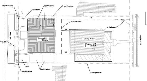
The DA proposes Torrens Title Subdivision of Two (2) Lots into Two (2) Lots at 11 Argyle Street, Mullumbimby. The subject site comprises two lots with the boundary running on a north south alignment from the rear lane to the street though the existing dwelling. The dwelling is located within the front of the property facing the street.
The proposal will re-orientate boundaries so that the dwelling is located on a lot of its own and to create a vacant rear lot. The proposal will result in the lots with the following areas:
· Lot 1 - 658.19m2 (existing dwelling)
· Lot 2 – 328.4 m2 (Vacant lot)
Vehicle access is to be provided to the larger Lot 1 from Wards Lane, whilst the smaller Lot 2 although predominantly fronting the lane will have a pedestrian service access handle back to Argyle Street.
A variation is sought to vary the development standards with Lot 2 being undersized and non-complaint with the 600 m2 minimum provision. This is supported in this instance as discussed in the body of this report below.
The application appropriately addresses the relevant constraints applying to the site and is recommended for approval subject to conditions of consent.
NOTE TO COUNCILLORS:
In accordance with the provisions of S375A of the Local Government Act 1993, a Division is to be called whenever a motion for a planning decision is put to the meeting, for the purpose of recording voting on planning matters. Pursuant to clause 2(a) under the heading Matters to be Included in Minutes of Council Meetings of Council's adopted Code of Meeting Practice (as amended) a Division will be deemed to have been called by the mover and seconder of all motions relating to this report.
That pursuant to Section 4.16 of the Environmental Planning & Assessment Act 1979, Development Application No. 10.2022.193.1 for Torrens Title Subdivision of Two (2) Lots into Two (2) Lots, be granted consent subject to the conditions of consent in Attachment 1.
Attachments:
1 Conditions
of Consent - DA10.2022.193.1 at 11 Argyle Street, Mullumbimby, E2023/3577 ![]()
2 Plans
for approval - DA10.2022.193.1 at 11 Argyle Street, Mullumbimby, E2022/125571 ![]()
Assessment:
INTRODUCTION
History/Background

Description of the proposed development
 |
Description of the site
|
Land is legally described |
LOT: 12 SEC: 1 DP: 4721, LOT: 11 SEC: 1 DP: 4721 |
|
Property address |
11 Argyle Street MULLUMBIMBY |
|
Land is zoned: |
R2 Low Density Residential |
|
Land area is: |
986.59m2 |
|
Property is constrained b |
Flood Liable Land, Acid Sulfate Soils Class 3 |
SUMMARY OF REFERRALS
|
Referral |
Issue |
|
Environmental Health Officer* |
No objections subject to conditions. |
|
Development Engineer |
No objections subject to conditions. |
|
Local Approvals Officer |
Concurrent applications decoupled. |
|
Heritage Advisor |
See comments below |
* Conditions provided in the above referral are included in the Recommendation of this Report below
Issues:
Heritage advisor
The subject application was referred to Council’s Heritage Advisor for comment, who raised initial concerns about the size of the rear yard for the front lot (Lot 1) which contains a heritage item being the existing dwelling. The initial plans showed a setback of approximately two metres which was considered inadequate in terms of its traditional curtilage.
In response to the above, the applicant provided amended plans demonstrating that the curtilage of the heritage dwelling has been increased, with a setback to the rear boundary of 4m proposed. Council’s Heritage advisor reviewed the amended proposal and provided an amended response noting no concerns regarding the proposal. Comments were also provided about a future dwelling on the vacant lot, however a formal assessment of that dwelling will occur if and when such an application is made to council to seek approval. Notwithstanding those comments have been added as notes to the conditions of consent.
SECTION 4.14 – BUSH FIRE PRONE LAND
SECTION 4.15C – MATTERS FOR CONSIDERATION – DISCUSSION OF ISSUES
Having regard to the matters for consideration detailed in Section 4.15(1) of the Environmental Planning & Assessment Act 1979 (EP&A Act), the following is a summary of the evaluation of the issues.
State Environmental Planning Policies (SEPP)
|
Considerations |
Satisfactory |
Unsatisfactory |
|
Resilience and Hazards SEPP 2021 Consideration: Council’s Environmental Health Officer reviewed the proposal and provided the following comment: Assessed and a Remedial Action Plan submitted for removal of lead and zinc contamination from the site. Conditions to apply. |
☒ |
☐ |
4.2A Byron Local Environmental Plan 2014 (LEP 2014)
In accordance with LEP 2014 clauses 1.4 and 2.1 – 2.3:
(a) The proposed development is defined in the LEP 2014 Dictionary as Subdivision;
(b) The land is within the R2 Low Density Residential according to the Land Zoning Map;
(c) The proposed development is Permitted with consent; and
(d) Regard is had for the Zone Objectives as follows:
|
Zone Objective |
Consideration |
|
• To provide for the housing needs of the community within a low density residential environment. • To enable other land uses that provide facilities or services to meet the day to day needs of residents. |
The proposal realigns the boundary of the allotment to create a usable property for residential use in close proximity to the Mullumbimby township. The development provides for the housing needs of the community within a low density residential environment. Alternative development options on the site include dual occupancy and strata development or secondary dwelling. |
Clause 4.1 Minimum subdivision lot size
The subject site is located within the Low density residential zone where the minimum lot size map prescribes a size of 600m². A variation to the development standard has been sought and is supported as discussed below.
Clause 4.6 Exceptions to Development Standards
Applicant has sought a variation to Clause 4.1 – Minimum subdivision lot size by proposing an undersized lot with an area of 328.4m² in lieu of the 600m² minimum lot size, varying the development standard by 271.6m², or 45.3%.
The applicant has submitted a written request that strict compliance with the development standard is unreasonable or unnecessary and that there are sufficient environmental grounds to vary the controls as follows:
• the objectives of the development standard are achieved notwithstanding noncompliance with the standard. The applicant posits that the design does not change the already approved settlement pattern of the area, conversely it aligns the subdivision pattern of the allotments with those nearby.
• the underlying objective or purpose of the standard is not relevant to the development with the consequence that compliance is unnecessary. In this regard, the applicant posits that there is no increase in density as the application relates to a boundary realignment, and the proposed allotments are consistent with others within the local area.
• the underlying objective or purpose of the development standard would be defeated or thwarted if compliance was required with the consequence that compliance is unreasonable. In this regard, the applicant submits that the proposal grants opportunity for both allotments to house a dwelling, whereas strict compliance with the development standard will not facilitate two dwellings over two residential allotments, as this would necessitate the removal of the heritage building.
• the development standard has been virtually abandoned through the granting consents departing from the standard and hence compliance with the standard is unnecessary and unreasonable. In this regard, the applicant submits that the proposal avails (for the purposes of a dwelling) an otherwise constrained residential allotment, and that this proposal mirrors recently approved boundary realignments on four (4) adjacent properties to the south.
It is considered that strict compliance with the development standard is unreasonable and unnecessary in the circumstances of the case and that there are sufficient environmental grounds to vary the development standard for the following reasons:
• The development provides for the housing needs of the community within a low density residential environment, and therefore complies with the Objectives of the Low density residential zone.
• The proposed allotments are congruent with the emerging subdivision pattern of the locality.
• The proposal does not increase the density of the land.
• The proposal will allow for the residential use of two residential allotments
• The proposal will eventually result in a development not dissimilar to a dual occupancy and strata subdivision arrangement.
It is recommended that the development standard can be varied in this instance and is satisfactory in terms of the Clause 4.6 of BLEP 2014 and compliance is with the development standard is unreasonable and unnecessary in this instance.
Clause 5.10 Heritage Conservation
A Statement of Heritage Impact was submitted with the development application by Kayandel Archaeological Services. The proposal was referred to Councils Heritage advisor who raised no objection to the proposal as amended and as discussed above. It is considered the proposal is acceptable in terms of Clause 5.10.
Clause 5.21 Flood Planning
The level of the subject land varies from 3.26 m AHD to 3.41 m AHD. The 1% AEP flood level is 3.47 m AHD, and the flood planning level for new dwellings is set at 4.04 m AHD. Any future dwelling on subject site will need to meet this minimum floor level and it is likely that such a dwelling will be sited on piers, bearers and joists. It is considered the proposal is satisfactory in terms of flooding.
4.3 Any proposed Instrument that has been the subject of public consultation and has been notified to the consent authority
There are no proposed environmental planning instruments of relevance to the proposal.
4.4A Byron Shire Development Control Plan 2014 (DCP 2014)
Chapter C1 – Non-indigenous heritage
C1.4.9 – Subdivision
No Prescriptive Measures exist for this development control, however the proposal does not align with Performance Criteria 2, which requires the following:
2. The setting of a Heritage item and a satisfactory curtilage, including important landscape and garden elements, must be retained.
The existing dwelling on the allotment is a Heritage Item. The proposed boundary realignment subdivision seeks to modify the setting, curtilage and landscape garden elements (specifically at the rear of the dwelling) by reducing the boundary setbacks and private open space about the dwelling. Therein, the setting and curtilage have not been retained by the proposal – conflicting with Performance Criteria 2.
The Objectives of this control are as follows:
1. To retain the development and subdivision pattern of the Heritage Conservation Areas including their characteristic rhythm and spacings of the built form.
2. To retain significant curtilages, views and vistas and landscape elements associated with individual Heritage items that may be lost through subdivision
The subject land is not within a Heritage Conservation Area, however the dwelling house on the land is a listed Heritage Item. The proposal will modify the subdivision pattern about the Heritage item in a manner which Council’s Heritage Advisor has noted will adversely impact the traditional curtilage of the dwelling. Therefore, the proposal does not “retain significant curtilage…associated with [the] individual Heritage item” as it is anticipated to be “lost through subdivision”. The applicant was advised that the proposal was not likely to be supported in the current format.
In response to the above, the applicant provided amended plans demonstrating that the curtilage of the heritage dwelling has been increased, with a setback to the rear boundary of 4m proposed. Council’s Heritage advisor reviewed the amended proposal and provided an amended response noting no concerns regarding the proposal, subject to recommended conditions of consent.
C1.4.10 – Dual Occupancy, Subdivision and Development on Single Lots
No Prescriptive Measures exist for this development control, however the proposal does not align with Performance Criteria 3, which requires the following:
1. Applications seeking consent for subdivision of lots on which there is a Heritage item or in a Heritage Conservation Area must include full details of proposed future development on the land, together with an assessment of potential impacts on heritage values.
The subject land includes a listed Heritage Item and proposes subdivision (boundary adjustment). Details of proposed future development on the residual allotment has not been provided with the application. A Statement of Heritage Impact was provided with the application noting that impacts are negligible.
The Objectives of this control are as follows:
1. To retain the traditional relationship between Heritage items or Heritage Conservation Areas and the original subdivision lot pattern and character.
2. To ensure that Heritage items are not dwarfed by new additions or new development.
The proposal seeks to alter the relationship between the Heritage Item and the original subdivision pattern and character. Plans have not been provided to demonstrate that the Heritage Item will not be dwarfed by new development on the residual allotment.
Council’s Heritage advisor reviewed the amended proposal and provided no objection to the proposal, acknowledging that the amended boundaries provide suitable curtilage around the Heritage dwelling (E2022/91717).
D6.4.3 – Infill Subdivision with Rear Lane access
The proposal includes an access handle for pedestrian access to Argyle Street from Proposed Lot 2 fronting to Ward Lane with a width of 1.2m. DCP Part D6.4.3(d) notes that where legal pedestrian access includes infrastructure the handle may need to be 3m wide. The pedestrian walkway will accommodate services, and Council’s Manager Sustainable Development resolved that the 1.2m width is sufficient.
The proposed development is demonstrated to meet the relevant Objectives of DCP 2014.
4.5 Environmental Planning and Assessment Regulation 2021 considerations
|
|
Applicable to the proposal: |
Considered the control as it relates to the proposal: |
If this control is applicable, does the proposal comply? |
|
Section 61 - Additional matters that consent authority must consider |
☐ Yes ☒ No |
☐ Yes ☐ No ☒ NA |
☐ Yes ☐ No ☒ NA |
|
Section 62 - Consideration of fire safety |
☐ Yes ☒ No |
☐ Yes ☐ No ☒ NA |
☐ Yes ☐ No ☒ NA |
|
Section 64 - Consent authority may require upgrade of buildings |
☐ Yes ☒ No |
☐ Yes ☐ No ☒ NA |
☐ Yes ☐ No ☒ NA |
|
Section 63 - Considerations for erection of temporary structures |
☐ Yes ☒ No |
☐ Yes ☐ No ☒ NA |
☐ Yes ☐ No ☒ NA |
* Non-compliances and any other significant issues discussed below
4.6 The likely impacts of that development, including environmental impacts on both the natural and built environments, and social and economic impacts in the locality
|
Impact on: |
Likely significant impact/s? |
|
Natural environment |
No. The proposal will not have a significantly adverse impact on the natural environment of the locality. |
|
Built environment |
No. The proposal will not have a significantly adverse impact on the built environment of the locality. |
|
Social Environment |
No. The proposal will not have a significant social impact on the locality. |
|
Economic impact |
No. The proposal will not have a significant economic impact on the locality. |
|
Construction Impacts |
The development will generate minor impacts during its construction. Conditions of consent recommended to control hours of work, builders waste, construction noise, installation of sedimentation and erosion control measures and the like to ameliorate such impacts. |
There are no Council Policies that are applicable to the proposed development.
4.7 The suitability of the site for the development
The site is a serviced, unconstrained property and is suitable for the proposed development.
4.8 Submissions made in accordance with this Act or the regulations
The development application was publicly exhibited. No submissions were received.
4.9 Public interest
The proposed development is unlikely to prejudice or compromise the public interest or create an undesirable precedent.
DEVELOPER CONTRIBUTIONS
5.1 Water & Sewer Levies
No Section 64 levies will be required.
5.2 Developer Contributions
No Developer Contributions will be required.
DISCLOSURE OF POLITICAL DONATIONS AND GIFTS
|
Disclosure details |
Response |
|
Has a Disclosure Statement been received in relation to this application? If Yes, Provide Disclosure Statement register reference: 91. |
Yes ☐ No ☒ |
|
Have staff received a ‘gift’ from anyone involved in this application that needs to be disclosed. |
Yes ☐ No ☒ |
CONCLUSION
The proposed development is satisfactory having regard to the relevant environmental planning instruments and planning controls applicable to the site. The proposal raises no significant issues in terms of environmental impacts which cannot be managed, and the site is considered suitable for the proposed subdivision. The application is recommended for approval subject to the conditions of consent.
BYRON SHIRE COUNCIL
Staff Reports - Sustainable Environment and Economy 13.5
Report No. 13.5 PLANNING - Quarter 4 SEPP Variations October to December 2022
Directorate: Sustainable Environment and Economy
Report Author: Chris Larkin, Manager Sustainable Development
File No: I2023/76
Summary:
This report is provided as a requirement of the NSW Department of Planning Circular PS17-006, for reporting on exceptions to development standards for applications made under Clause 4.6 of Byron LEP 2014 and Clause 64A of Byron LEP 1988.
NOTE TO COUNCILLORS:
In accordance with the provisions of S375A of the Local Government Act 1993, a Division is to be called whenever a motion for a planning decision is put to the meeting, for the purpose of recording voting on planning matters. Pursuant to clause 2(a) under the heading Matters to be Included in Minutes of Council Meetings of Council's adopted Code of Meeting Practice (as amended) a Division will be deemed to have been called by the mover and seconder of all motions relating to this report.
RECOMMENDATION:
That Council adopts the report on exceptions to development standards for the period October 2022 to December 2022.
Report
This report is provided as a requirement of the NSW Department of Planning Circular PS17-006, for reporting on exceptions to development standards for applications made under Clause 4.6 of Byron LEP 2014 and Clause 64A of Byron LEP 1988.
The period of reporting is for the October 2022 to December 2022 Quarter for the following DAs:
Quarter 4 – October 2022 to December 2022
|
DA No. |
10.2022.165.1 |
|
Property: |
139 Jonson Street, Byron Bay |
|
Development Category |
Commercial/retail/office |
|
Environmental planning Instrument |
Byron LEP 2014 |
|
Zoning: |
B2 Local Centre |
|
Development Standard being varied: |
4.4 Floor Space Ratio |
|
Justification Summary |
The restaurant is located below ground and therefore adds no further bulk, scale, or height to the development as approved. Consistent with the zoning. |
|
Extent of variation |
14.5% |
|
Concurring Authority |
Council |
|
Determined Date |
15/12/2022 |
|
|
|
|
DA No. |
10.2021.752.1 |
|
Property: |
140 Alcorn Street, Suffolk Park |
|
Development Category |
Residential - New second occupancy |
|
Environmental planning Instrument |
Byron LEP 2014 |
|
Zoning: |
· R 2 Low Density Residential |
|
Development Standard being varied: |
44.1E |
|
Justification Summary |
Meets objectives of the zone, site contains an existing dual occupancy, and the low-density character of the locality is maintained |
|
Extent of variation |
102m2 or 12.75% |
|
Concurring authority |
Council |
|
Determined Date |
10/11/2022 |
|
|
|
|
DA No. |
10.2021.870.1 |
|
Property: |
1 Brownell Drive, Byron Bay |
|
Development Category |
Residential – Single new dwelling |
|
Environmental planning Instrument |
Byron LEP 2014 |
|
Zoning: |
R2 Low Density Residential |
|
Development Standard being varied: |
4.4 Floor Space Ratio 0.4:1 |
|
Justification Summary |
Applicants written request to vary development standard has been considered and variation meets objectives of zone and development standard, and design responds to specific characteristics of the land including steep slope of the Site. Compliance is unreasonable and unnecessary in the circumstances |
|
Extent of variation |
9.1% FSR of 0.437:1 |
|
Concurring authority |
Director Delegation |
|
Determined Date |
21/12/2022 |
|
|
|
Strategic Considerations
Community Strategic Plan and Operational Plan
|
CSP Objective |
CSP Strategy |
DP Action |
Code |
OP Activity |
|
4:
Ethical Growth |
4.1: Manage responsible development through effective place and space planning |
4.1.1: Development assessment - Manage development through a transparent and efficient assessment process |
4.1.1.1 |
Assess and Determine DA's accordance with the relevant legislation |
Legal/Statutory/Policy Considerations
The report is provided as a requirement of NSW Department of Planning circular PS 17-006.
BYRON SHIRE COUNCIL
Staff Reports - Sustainable Environment and Economy 13.6
Report No. 13.6 PLANNING - DA 10.2021.571.1 Demolition of Existing Dwelling and Construction of Two (2) New Dwellings to create Dual Occupancy (Detached) including Earthworks and Swimming Pool in Two (2) Stages at 212 Fowlers Lane BANGALOW
Directorate: Sustainable Environment and Economy
Report Author: Jordan Vickers, Planner
File No: I2023/100
Proposal:
|
Proposal description: |
Demolition of Existing Dwelling and Construction of Two (2) New Dwellings to create Dual Occupancy (Detached) including Earthworks and Swimming Pool in Two (2) Stages |
|
Property description: |
LOT: 2 DP: 261219 |
|
212 Fowlers Lane BANGALOW |
|
|
Parcel No/s: |
25130 |
|
Applicant: |
Newton Denny Chapelle |
|
Owner: |
Jacama Pty Ltd |
|
Zoning: |
RU2 Rural Landscape |
|
Date received: |
15 November 2021 |
|
Concurrence required |
No |
|
Public notification or exhibition: |
- Level 2 advertising under Council’s Community Participation Plan. - Exhibition period: 25/11/21 – 8/12/21 - Submissions received: Nil - Submissions acknowledged: ☐ Yes ☐ No ☒ N/A |
|
Variation request to Development Standards under an EPI (eg clause 4.6) |
Clause 4.6 variation – dual occupancy is accessible from two driveways instead of one |
|
Estimated cost |
$3,531,000.00 |
|
Delegation to determine |
Council |
|
Issues |
Variation sought to access provisions for rural dual occupancies as access proposed from separate driveway |
Summary:
The DA proposes Demolition of Existing Dwelling and Construction of Two (2) New Dwellings to create Dual Occupancy (Detached) including Earthworks and Swimming Pool in Two (2) Stages.
A variation is sought to the numerical restriction of one access point to rural dual occupancies under Clause 4.2D of Byron LEP 2014. In this instance the second access already exists and is constructed and the variation to the development standard is supported in this instance under Clause 4.6 of the Byron LEP 2014.
The application appropriately addresses the relevant constraints applying to the site and is recommended for approval subject to the conditions listed in the Recommendation of this Report below.
NOTE TO COUNCILLORS:
In accordance with the provisions of S375A of the Local Government Act 1993, a Division is to be called whenever a motion for a planning decision is put to the meeting, for the purpose of recording voting on planning matters. Pursuant to clause 2(a) under the heading Matters to be Included in Minutes of Council Meetings of Council's adopted Code of Meeting Practice (as amended) a Division will be deemed to have been called by the mover and seconder of all motions relating to this report.
RECOMMENDATION:
That pursuant to Section 4.16 of the Environmental Planning & Assessment Act 1979, Development Application No. 10.2021.571.1 for Demolition of Existing Dwelling and Construction of Two (2) New Dwellings to create Dual Occupancy (Detached) including Earthworks and Swimming Pool in Two (2) Stages, be granted consent subject to conditions of approval in Attachment 1.
1 Conditions
of Consent for Council report - DA10.2021.571.1 at 212 Fowlers Lane, Bangalow, E2023/3551 ![]()
2 Plans
for approval - DA10.2021.571.1 at 212 Fowlers Lane, Bangalow, E2022/124670 ![]()
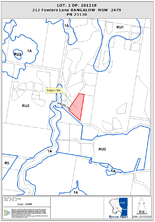
Assessment:
INTRODUCTION
History/Background
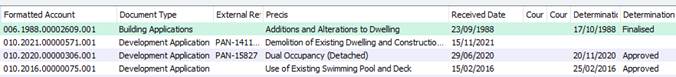
Description of the proposed development
This application seeks approval for Demolition of Existing Dwelling and Construction of Two (2) New Dwellings to create Dual Occupancy (Detached) including Earthworks and Swimming Pool in the following Two (2) Stages: Stage 1 – Erection of ‘B House’ including swimming pool, driveway and associated earthworks; Stage 2 – Demolition of existing dwelling and erection of ‘M House’.
The ‘B House’ comprises of five (5) bedrooms, Gymnasium, indoor and outdoor living areas, open plan kitchen and dining, covered car parking for three (3) vehicles, and a swimming pool. It is located to the north of the existing dwelling and is approximately 98m from the existing dwelling. Access is proposed via a separate driveway which currently exists as general farm access to the property
The ‘‘M House’ comprises of three (3) bedrooms, open plan kitchen and dining, ground floor covered car parking for three (3) vehicles, and a swimming pool. It is located at the foot of the property approximately on the footprint of the existing dwelling which is to be demolished. Access is to be provided via the existing driveway at the site.
As the proposal seeks to make use of a second driveway for access to B House, a Clause 4.6 variation request has been submitted to vary Clause 4.2D.
Description of the site
The subject land known as 212 Fowlers Lane, Bangalow and legally described as Lot 2 on DP261219 has an area of 2.428ha and is located within the Rural landscape (RU2) zone of the Byron LEP 2014. The property is a rural lifestyle lot improved by an existing dwelling house. The land falls approximately 45m from the northern boundary toward Fowlers Lane at the south and is predominantly devoid of vegetation other than along the eastern and western side boundaries. The land is identified as Bushfire prone and containing high environmental value, does not contain easements or Council infrastructure, however is traversed by an Essential Energy overhead powerline.
The subject area is characterised by rural residential development with a number of small rural holdings, and community title development located in Fowlers lane.
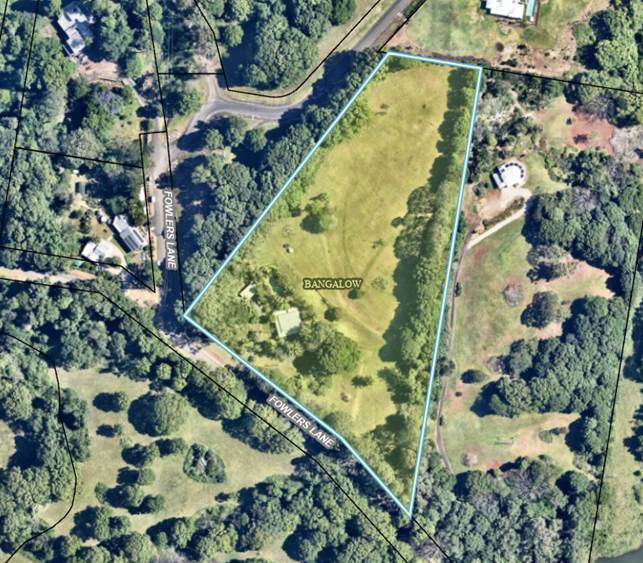
Subject Site
![]()
Existing Farm Access to be formalised into driveway to the new dwelling house “B”
![]()
House Site for dwelling house “B”
|
Land is legally described |
LOT: 2 DP: 261219 |
|
|
Property address |
212 Fowlers Lane BANGALOW |
|
|
Land is zoned: |
RU2 Rural Landscape |
|
|
Land area is: |
2.428ha |
|
|
Property is constrained by: |
Bushfire prone land, High Environmental Value |
|
|
|
Is a BDAR required due to the location of the proposed development? |
☐ Yes ☒ No |
|
|
Are there any easements in favour of Council affecting the site? |
☐ Yes ☒ No |
|
|
Is there a Vegetation Management Plan which might affect the proposal? |
☐ Yes ☒ No |
|
|
Is there a Voluntary Planning Agreement which might affect the proposal? |
☐ Yes ☒ No |
SUMMARY OF REFERRALS
|
Referral |
Issue |
|
Environmental Health Officer* |
No objections subject to conditions. |
|
Development Engineer |
No objections subject to conditions. |
|
S7.11 / Contributions Planner |
No objections subject to conditions. |
|
Essential Energy |
No objections subject to conditions. In response to Essential Energy’s request for information, the applicant provided an amended Site Plan which demonstrates compliance with the prescribed distances of the SEPP (Infrastructure) 2007. |
SECTION 4.14 – BUSH FIRE PRONE LAND
Under section 4.14 of the Act, Council must be satisfied prior to making a determination for development on bush fire prone land, that the development complies with the document ‘Planning for Bush Fire Protection 2019’. The site is bush fire prone land. The development application is accompanied by a Report by Sustainable Home Solutions dated 21 June 2021 which provides conditions. A Condition is included in the Recommendation of this Report requiring that the development must comply at all times with the requirements of the aforementioned report.
SECTION 4.15C – MATTERS FOR CONSIDERATION – DISCUSSION OF ISSUES
Having regard to the matters for consideration detailed in Section 4.15(1) of the Environmental Planning & Assessment Act 1979 (EP&A Act), the following is a summary of the evaluation of the issues.
State Environmental Planning Policies (SEPP)
|
Considerations |
Satisfactory |
Unsatisfactory |
|
SEPP No 55—Remediation of Land Consideration: Council’s Environmental Health Officer reviewed the proposal and provided the following comment: “The land has been utilised for rural residential purposes for a number of years. Land contamination was considered during the assessment of DA2020/306 and found satisfactory upon receipt of a Statutory Declaration from previous owner. Previous EH Assessment comments located in doc#: A2020/23121.” |
☒ |
☐ |
|
SEPP (Building Sustainability Index: BASIX) 2004 Consideration: The proposal is accompanied by a valid BASIX certificate. The SEPP has been addressed and the proposal is considered to comply. |
☒ |
☐ |
|
Consideration: In response to Essential Energy’s request for information, the applicant provided an amended Site Plan which demonstrates compliance with the prescribed distances of the SEPP (Infrastructure) 2007. |
☒ |
☐ |
|
SEPP (Biodiversity and Conservation) 2021, Chapter 3 – Koala Habitat Protection 2020 Consideration: The subject land is >1ha and contains vegetation mapped under the Koala Habitat Protection SEPP 2020. The applicant provided a Koala assessment (E2022/122126) against the SEPP and determined that the proposed development: · Will not require removal of Koala feed trees, have substantial impact on koala movement or result in isolation of areas of potential habitat · Does not involve the construction of any fencing that may hinder koala movement · Will not substantially increase vehicle movements on the property and traffic speeds on the driveway will remain low The proposal has been demonstrated to comply with the SEPP. |
☒ |
☐ |
4.2A Byron Local Environmental Plan 2014 (LEP 2014)
In accordance with LEP 2014 clauses 1.4 and 2.1 – 2.3:
(a) The proposed development is defined in the LEP 2014 Dictionary as Dual Occupancy (detached);
(b) The land is within the RU2 Rural Landscape according to the Land Zoning Map;
(c) The proposed development is permitted with consent; and
(d) Regard is had for the Zone Objectives as follows:
|
Zone Objective |
Consideration |
|
• To encourage sustainable primary industry production by maintaining and enhancing the natural resource base. • To maintain the rural landscape character of the land. • To provide for a range of compatible land uses, including extensive agriculture. • To enable the provision of tourist accommodation, facilities and other small-scale rural tourism uses associated with primary production and environmental conservation consistent with the rural character of the locality. • To protect significant scenic landscapes and to minimise impacts on the scenic quality of the locality. |
The proposal will maintain the natural resource base and rural character of the land while protecting the significant scenic landscape and scenic quality of the locality. |
Clause 4.2D Erection of dual occupancies (detached) and secondary dwellings in Zones RU1 and RU2
The proposed dual occupancy complies with the clause other than the provisions regarding a single access from a public road. In this regard, variation is sought with separate access proposed for each dwelling. The variation is supported for the reasons as discussed below.
Clause 4.3 Height of Buildings
Both dwellings comply with the 9 m height limit for the site.
Clause 4.6 Exceptions to Development Standards
Applicant has sought a variation to Clause 4.2D(2)(b) by proposing separate access to each Dual occupancy building.
The applicant has submitted a written request that strict compliance with the development standard is unreasonable or unnecessary and that there are sufficient environmental grounds to vary the controls as follows:
• The proposal meets the objectives of the RU2 zone in that the proposal will maintain the character of the locality.
• The proposal will provide alternative accommodation on the allotment that is of a scale and nature that is compatible with existing development in the locality, and previous development consent issued at the site.
• The second driveway is currently existing in situ and this scenario was approved via DA2020/306.
It is considered that strict compliance with the development standard is unreasonable and unnecessary in the circumstances of the case and that there are sufficient environmental grounds to vary the development standard for the following reasons:
• Compliance would demand additional and excessive earthworks which can be avoided through the variation.
• Compliance would demand removal of native vegetation to comply with bushfire access standards which can be avoided by the variation.
• Compliance would place the driveway in close proximity to overhead powerlines which may need to be relocated. This can be avoided by the variation.
• Compliance would conflict with the location of the existing OSMS which can be avoided by the variation.
• The existing farm entrance has been previously approved by Council for use as an accessway for a Dual occupancy (DA10.2020.306.1)
It is recommended that the development standard can be varied in this instance and that compliance is with the development standard is unreasonable and unnecessary having regards to the circumstances of the case.
4.3 Any proposed Instrument that has been the subject of public consultation and has been notified to the consent authority
There are no proposed environmental planning instruments of relevance to the proposal.
4.4A Byron Shire Development Control Plan 2014 (DCP 2014)
|
What Section and prescriptive measure does the development not comply with? |
Does the proposed development comply with the Objectives of this Section? Address. |
Does the proposed development comply with the Performance Criteria of this Section? Address. |
|
B14 - Earthworks D2.5.2 – Character & Siting |
The proposed development complies with the Objectives of the Section as discussed below. |
The proposed development complies with the Performance Criteria of this Section as discussed below. |
Chapter B14 – Earthworks
The proposed development includes earthworks (excavation, retaining and fill) which exceed the 1m prescribed by the DCP, up to a maximum of 1.7m. Notwithstanding, excavation and retaining proposed does not introduce adverse visual impacts, does not overshadow adjoining private and public land, is in keeping with the scale and character of the locality, and comprise part of the vehicle parking area for the dwelling as permitted by the DCP.
Chapter D2 – Residential accommodation in Rural zones
The proposed dwellings are accompanied by attached garages capable of accommodating the required on-site car parking which are compatible in design with each respective dwelling house. On-site Sewage management is proposed to service the proposed dwellings and Council’s Environmental Health Officer has confirmed the viability of the site to accommodate OSMS.
The proposed dwellings are located within 100m of one another, however separate vehicle access is proposed to each dwelling house, refer discussion under Clause 4.6 above.
Private Open Space is available to each dwelling house in excess of the 30m² prescribed by the DCP.
The subject land is bordered by mature vegetation, screening the allotment from surrounding premises. The location of the proposed dwellings is not anticipated to introduce adverse visual impacts on adjoining and nearby development.
The proposed development raises no other issues under DCP 2014.
4.5 Environmental Planning and Assessment Regulation 2000 considerations
|
|
Applicable to the proposal: |
Considered the control as it relates to the proposal: |
If this control is applicable, does the proposal comply? |
|
Clause 92 - Additional matters that consent authority must consider |
☐ Yes ☒ No |
☐ Yes ☐ No ☒ NA |
☐ Yes ☐ No ☒ NA |
|
Clause 93 Fire safety and other considerations |
☐ Yes ☒ No |
☐ Yes ☐ No ☒ NA |
☐ Yes ☐ No ☒ NA |
|
Clause 94 - Consent authority may require buildings to be upgraded |
☐ Yes ☒ No |
☐ Yes ☐ No ☒ NA |
☐ Yes ☐ No ☒ NA |
|
Clause 94A - Fire safety and other considerations applying to erection of temporary structures |
☐ Yes ☒ No |
☐ Yes ☐ No ☒ NA |
☐ Yes ☐ No ☒ NA |
4.6 The likely impacts of that development, including environmental impacts on both the natural and built environments, and social and economic impacts in the locality
|
Impact on: |
Likely significant impact/s? |
|
Natural environment |
No. The proposal will not have a significantly adverse impact on the natural environment of the locality. |
|
Built environment |
No. The proposal will not have a significantly adverse impact on the built environment of the locality. |
|
Social Environment |
No. The proposal will not have a significant social impact on the locality. |
|
Economic impact |
No. The proposal will not have a significant economic impact on the locality. |
|
Construction Impacts |
The development will generate minor impacts during its construction. Conditions of consent recommended to control hours of work, builders waste, construction noise, installation of sedimentation and erosion control measures and the like to ameliorate such impacts. |
There are no Council Policies that are applicable to the proposed development.
4.7 The suitability of the site for the development
The site is a serviced, unconstrained property and is suitable for the proposed development.
4.8 Submissions made in accordance with this Act or the regulations
The development application was publicly exhibited
No submissions were made on the development application.
4.9 Public interest
The proposed development is unlikely to prejudice or compromise the public interest or create an undesirable precedent.
DEVELOPER CONTRIBUTIONS
5.1 Developer Contributions
Section 7.11 Contributions will be payable.
DISCLOSURE OF POLITICAL DONATIONS AND GIFTS
|
Disclosure details |
Response |
|
Has a Disclosure Statement been received in relation to this application? If Yes, Provide Disclosure Statement register reference: 91. |
Yes ☐ No ☒ |
|
Have staff received a ‘gift’ from anyone involved in this application that needs to be disclosed. |
Yes ☐ No ☒ |
CONCLUSION
The proposed development is satisfactory having regard to the relevant environmental planning instruments and planning controls applicable to the site. The proposal raises no significant issues in terms of environmental impacts which cannot be managed and the site is considered suitable for the development. The application is recommended for approval subject to conditions of consent.
BYRON SHIRE COUNCIL
Staff Reports - Infrastructure Services 13.7
Staff Reports - Infrastructure Services
Report No. 13.7 Planning agreement for the dedication of land at Bayside 15 Torakina Road, Brunswick Heads
Directorate: Infrastructure Services
Report Author: Christopher Soulsby, Development Planning Officer S94 & S64
File No: I2023/94
Summary:
The purpose of this report is to seek Council’s acceptance of a planning agreement to dedicate land at the extension of the Bayside subdivision at Brunswick heads.
The substantive development application is to be determined by the Planning Panel.
Council’s role is to accept, reject, or amend by negotiation the planning agreement for the dedication of the land.
RECOMMENDATION:
That Council enter into the planning agreement as provided at attachment one, subject the resolution of the drainage issues at the development site and approval of the development by the planning panel.
Attachments:
1 10.2021.575.1
- Voluntary planning agreement, E2022/114771
![]()
2 Bayside
Brunswick - DA Engineering Plans - Issue C FINAL (no DA2C), E2022/115717 ![]()
3 Form
of Special Disclosure of Pecuniary Interest, E2012/2815
![]()
Report
The Minister for Planning, Infrastructure & Environment granted Concept Plan Approval 05_0091 pursuant to Section 750 of the EP & A Act, 1979 on 9 July 2013 for the subdivision of the land.
The applicant has subsequently lodged development application 10.2021.575.1 to make changes to the development layout. The proposed development is for a staged subdivision (5 Stages) of the Land to create 127 lots comprising, 123 residential lots (two with additional conservation area), three (3) medium density lots, and one (1) public reserve together with associated roads and infrastructure services in accordance with the staging plan DA4 Issue C dated 16.11.2022.
This report is not to examine the merits of that development application. The purpose of this report is to seek Council’s agreement to accept the dedication of land being the public reserve associated with the drainage, frog habitat, and open space. The planning agreement also proposed to make a monetary contribution to the ongoing maintenance and monitoring of the frog habitat on the land to be dedicated.
A recent judgement in the NSW Land and Environment Court has necessitated the need for a planning agreement for the dedication of land where that land is not identified in a contributions plan and the land is not an integral part of the subdivision. In L & G Management Pty Ltd v Council of the City of Sydney [2021] NSWLEC 1084 the Court confirms that the power to require the dedication of land free of charge resides only in sections 7.11 (Developer contributions) or section 7.4 (planning agreements) of the Environmental Planning and Assessment Act 1979. That is if the land to be dedicated is not in the contributions plan and is not integral to the development (such as the roads to form the subdivision) then a planning agreement is required.
The Developer had initially proposed to dedicate significant areas of land that was not suitable to develop due to the habitat constraints on that land. Staff have formed the view that this land does not need to be owned by Council with the associated maintenance costs in order to preserve the habitat. These areas of habitat have been incorporated into residential proposed lots 402 and 324 as shown on the development plans provided as attachment 2.
The land to be dedicated to Council is lot 521. This land will contain a community garden, drainage infrastructure, and acid frog habitat. The Developer also proposes to make a monetary contribution of $31,950 towards the maintenance of the reserve. Page 22 of the draft planning agreement sets out the commitments by the developer. It is to be noted that that items 1 and 2 of that schedule relate to the establishment of public positive covenants on lots 402 and 324. These lots will not come into Council ownership. The establishment of these covenants is to satisfy the ecological requirements set by the Department of Planning to protect the habitat.
The land to be dedicated is generally consistent with the original concept approval issued by the Minister.
Options
There are three options available to Council:
1. Enter into the planning agreement as recommended; or
2. Decline to enter into the planning agreement; or
3. Negotiate amendments to the planning agreement.
Next steps
If Council enters into the planning agreement then the development application report will be finalised and referred off to the planning panel for determination.
Strategic Considerations
Community Strategic Plan and Operational Plan
The adoption of this planning agreement is not an identified activity in the operational plan (OP). The dedication of land will not generate a new activity in the OP.
Recent Resolutions
There are no resolutions pertaining to this planning agreement.
Legal/Statutory/Policy Considerations
The planning agreement had been referred to Legal Services for review. At the date of writing this report the review had not been finalised. If there are any issues of significance raised by Legal Services these will be provided to Council in a confidential memorandum.
Council has an adopted policy on planning agreements and there is the Department of Planning - Planning Agreements Practice Note 2020 to consider when considering a planning agreement. The proposed agreement is not inconsistent with these two documents.
Financial Considerations
There are no immediate financial implications for Council. In the longer term additional budget will need to be allocated to manage the land that has been dedicated.
Consultation and Engagement
The initial planning agreement that proposed the dedication of lots 521, 402 and 324 was publicly exhibited with the initial development application as required by the Act. The amended planning agreement was not re-exhibited as it was essentially the same agreement with a reduction in the land area to be dedicated. No submissions were received that commented on the planning agreement.
BYRON SHIRE COUNCIL
Questions With Notice 14.1
Question with Notice No. 14.1 Upgrades on Main Arm Road
File No: I2023/98
Cr Duncan Dey asks the following question:
Council’s press release on 9 September 2022 announced:
“Major roadworks on Main Arm Road are due to start on 12 September 2022.
“Council has received $3.45 million in grant funding from Transport for NSW to improve safety for people travelling on Main Arm Road, especially the section from Mullumbimby to Sherrys Bridge.
“Additional funding of $1.3 million from the NSW Government will allow for reconstruction work on the one-kilometre section of Main Arm Road, west of Sherrys Bridge. This work will commence early in 2023, weather permitting”.
More details can be found at:
https://www.byron.nsw.gov.au/Services/Roads-and-parking/Road-works-and-closures/Main-Arm-road-improvements
While these roadworks are very welcome, they are not flood related. There remains fundamental flood-proofing measures that need attention on Main Arm Road. One of these bridges sits between the two sections of Main Arm Road that received these grants:
1. at what stage will the inadequacy of the waterway opening beneath Williams Bridge to withstand the 2022 flood be reported to higher authorities, who must then ensure the waterway is enlarged before a repeat flood causes a repeat washout of the approach embankments?
2. will the adequacy or otherwise in the waterway area beneath Sherrys Bridge be examined as part of the design for $1.3million grant for reconstructing the flood-prone section of Main Arm Road west of the Bridge, given that raising the road will likely exacerbate the inadequacy?
In addition, the proposed roadworks match a 6 km route that should but doesn’t yet support safe cycling. Community in Main Arm have put together a concept design for a 1.5km cycle route on low-use and closed roads to bypass the dangerous section of Main Arm Road (west of Coopers Lane and past Settlement Road). The 6km route funded by the two grants could make cycling feasible on this important and desirable route from Mullumbimby to Main Arm:
3. do the two upgrades include provision for cycling, either on or off road?
4. If not, can one or both of the designs be upgraded to include provisions for cycling?
Response Director Infrastructure Services:
1. Staff have not made comment to suggest the damage that occurred to Williams Bridge in 2022 was caused by inadequacy of the waterway opening beneath Williams Bridge.
Staff had indicated previously that a review could be undertake however funding has not been available to resource this. Therefore, staff have not proposed any reporting to higher authorities at this stage.
The scour repairs completed are considered to be the permanent solution and provide a similar waterway area to pre-2022. Should Council wish to investigate the adequacy of the waterway opening beneath Williams Bridge, funding would need to be provided to engage a consultant to model and provide a report. Professional advice based on modelling is required before the waterway opening could be considered inadequate.
2. The flood modelling completed to date for this section of road includes the waterway area beneath Sherry’s Bridge.
All future modelling will also consider the waterway area beneath Sherry’s Bridge.
3. All civil road works completed by Council consider provisions for cycling. Design and construction outcomes hinge upon; design standards, site constraints, project funding amounts and any funding constraints if grant funded.
Where feasible improvements will be made, where not feasible no worsening will be made.
BYRON SHIRE COUNCIL
Questions With Notice 14.2
Question with Notice No. 14.2 Triathlon sponsor’s not-for-profit status.
File No: I2023/99
Cr Duncan Dey asks the following question:
On 24 March 2022 Council resolved (Res 22-101) that Council:
1. Notes the importance of the Byron Triathlon event to the local community and businesses, as well as the Australian sporting community in general.
2. Supports the 2022 Byron Triathlon and future events using a similar route to the 2021 event as per attachment 2, and that this route is endorsed by Council, on the basis that the route is supported by the Local Traffic Committee at its April meeting.
3. Communicates its position to the local community via media release.
4. Requests the community and businesses respect this decision and support the organisers in the delivery of the 2022 Byron Triathlon.
5. Council requests that the Byron Triathlon and NX Sports provide to Council evidence of their status as a not-for-profit including registration with the Australian Charities and not-for-profit commission (ACNC) and any details of disbursement of funds to charities or other financial details that give evidence of their status as a not-for-profit organisation.
Has Part 5 of this Resolution been executed and what is the result?
Response A/Director Sustainable Environment and Economy:
On the 22 March 2022, Staff requested NX Sports provide information in accordance with Part 5 of Resolution 22-101. NX Sports advised the next day that they are not a charity, they are not-for-profit. NX Sports have offered to provide a copy of their constitution and staff have requested they do. At the time of writing, receipt of a copy was pending.
Detail of the monies NX Sports distribute in Byron Shire have been provided as part of their 2022 post-event debrief, refer to Confidential Attachment 1.
Attachments:
1 Confidential - 2022 Byron Bay Triathlon - Post Event Report, E2022/129426