|
The purpose of this report is to
gain Council support for the proposed regulatory signage and line markings
shown in Attachment 1 (E2023/61852).
Council has received a Roads Act
application associated with a development consent for a Community Title
Subdivision comprising twenty (20) lots at 24 Bayside Way BRUNSWICK HEADS.
Condition 41 of the development
consent (10.2021.425.1) partly requires the following:
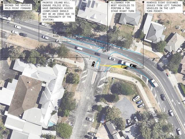
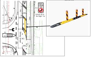
a. Channelised
Right (CHR) Treatment opposite the southern driveway
Kerb and gutter, road pavement,
line-marking, streetlighting (AS 1158) and associated drainage construction,
including any necessary relocation of services in accordance with SDS Civil
Enterprises drawing 2061-C1 Rev B.
b. On-street
parking and relocation of footpath
A fully detailed design of five (5) on-street
parallel parking including line-marking and any necessary relocation of
services in accordance with AS 2890.5 and IPWEA drawing R-0031 (see
Note). The following must be adopted: -
· Carriageway of 3.5m.
· Parking lane of 2.1m.
· Safety barrier line
between the parking lane and carriageway of 0.5m.
· The parking lane be
sheltered by way of full indentation of the parking lane. It is necessary to
replace the existing kerb and gutter with a concrete invert or dish gutter in
accordance with NRLG drawing R-03 and install a mountable kerb at a new
alignment in accordance with IPWEA drawing R-0031 – Verge with Parking
Bays and Pathways.
· Relocate the existing
1.5m wide footpath, measured 1.5m from the invert of the mountable kerb.
Refer to IPWEA drawing.
c. Concrete
footpath extension
The footpath located inside Lot
33 DP730006 and south of 13 Kingsford Drive is to be extended through to Lot
36 DP800926 & Lot 7 DP1261870 to connect onto the footpath on the western
section of Bayside Way. The footpath is to be 1.5m wide, concrete and
with a crossfall of 1 % or 1:100 (maximum 2.5% or 1 in 40).
d. Ramped
pedestrian crossing
A ramped pedestrian crossing
including streetlighting (AS1158) in accordance with Council’s standard
plan – No. 941 and SDS Civil Enterprises drawing 2061-C1.
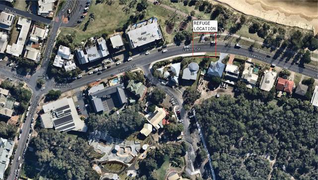
e. Pedestrian
refuge
A pedestrian refuge including
streetlighting (AS1158) in accordance with SDS Civil Enterprises drawing
2061-C1. The pedestrian refuge is to be designed in accordance with
Australian Standard 1742.10 – Manual of Uniform Traffic Controls
– Pedestrian Control and Protection and Traffic Authority of New South
Wales Guidelines for Traffic Facilities, Part 4.2 – Pedestrian
Refuges. The design is to address siting, signs, line-marking, parking
restrictions and night-time visibility.
f. Driveways
Driveways are to be designed
and constructed generally in accordance with the approved plans and Council's
current “Northern Rivers Local Government Development Design &
Construction Manuals and Standard Drawings”. Adjustment and/or
relocation of services may be necessary to meet the requirements of the
relevant service authorities and to ensure that the services are constructed
flush with the finished surface levels.
Comments from TfNSW -
Pedestrian Refuge, Parking and Channelised Right
(CHR) Treatment on Bayside Way – Response –
Development type is unknown and therefore traffic generation numbers
have not been provided. Internal roadway appears to be located within the
development and will be therefore on private property. TfNSW considers the
road is not a ‘Gazetted’ road. However being a road related area
the NSW Road Rules apply and Council should consider any regulatory devices
that may be required, if necessary. While Bayside Way is a local road under
the care and control of local council it is recommended that Council ensure
the design of the two concrete driveways will not impact on the safe and
efficient flow of traffic on Bayside Way when vehicles are entering this
development. These comments are for councils information, and TfNSW supports
this item as presented.
|