 Agenda
Ordinary (Planning) Meeting

Thursday, 14 September 2023
Agenda
Ordinary (Planning) Meeting
Thursday, 14 September 2023
Agenda Ordinary (Planning) Meeting
held at Council Chambers, Station Street, Mullumbimby
commencing at 11.00am
Public access relating to items on this agenda can be made between 11:00am and 11:30am on the day of the meeting. Requests for public access should be made to the General Manager or Mayor no later than 12:00 midday on the day prior to the meeting.

Mark Arnold
General Manager
CONFLICT OF INTERESTS
What is a “Conflict of Interests” - A conflict of interests can be of two types:
Pecuniary - an interest that a person has in a matter because of a reasonable likelihood or expectation of appreciable financial gain or loss to the person or another person with whom the person is associated.
Non-pecuniary – a private or personal interest that a Council official has that does not amount to a pecuniary interest as defined in the Code of Conduct for Councillors (eg. A friendship, membership of an association, society or trade union or involvement or interest in an activity and may include an interest of a financial nature).
Remoteness – a person does not have a pecuniary interest in a matter if the interest is so remote or insignificant that it could not reasonably be regarded as likely to influence any decision the person might make in relation to a matter or if the interest is of a kind specified in the Code of Conduct for Councillors.
Who has a Pecuniary Interest? - a person has a pecuniary interest in a matter if the pecuniary interest is the interest of the person, or another person with whom the person is associated (see below).
Relatives, Partners - a person is taken to have a pecuniary interest in a matter if:
· The person’s spouse or de facto partner or a relative of the person has a pecuniary interest in the matter, or
· The person, or a nominee, partners or employer of the person, is a member of a company or other body that has a pecuniary interest in the matter.
N.B. “Relative”, in relation to a person means any of the following:
(a) the parent, grandparent, brother, sister, uncle, aunt, nephew, niece, lineal descends or adopted child of the person or of the person’s spouse;
(b) the spouse or de facto partners of the person or of a person referred to in paragraph (a)
No Interest in the Matter - however, a person is not taken to have a pecuniary interest in a matter:
· If the person is unaware of the relevant pecuniary interest of the spouse, de facto partner, relative or company or other body, or
· Just because the person is a member of, or is employed by, the Council.
· Just because the person is a member of, or a delegate of the Council to, a company or other body that has a pecuniary interest in the matter provided that the person has no beneficial interest in any shares of the company or body.
Disclosure and participation in meetings
· A Councillor or a member of a Council Committee who has a pecuniary interest in any matter with which the Council is concerned and who is present at a meeting of the Council or Committee at which the matter is being considered must disclose the nature of the interest to the meeting as soon as practicable.
· The Councillor or member must not be present at, or in sight of, the meeting of the Council or Committee:
(a) at any time during which the matter is being considered or discussed by the Council or Committee, or
(b) at any time during which the Council or Committee is voting on any question in relation to the matter.
No Knowledge - a person does not breach this Clause if the person did not know and could not reasonably be expected to have known that the matter under consideration at the meeting was a matter in which he or she had a pecuniary interest.
Non-pecuniary Interests - Must be disclosed in meetings.
There are a broad range of options available for managing conflicts & the option chosen will depend on an assessment of the circumstances of the matter, the nature of the interest and the significance of the issue being dealt with. Non-pecuniary conflicts of interests must be dealt with in at least one of the following ways:
· It may be appropriate that no action be taken where the potential for conflict is minimal. However, Councillors should consider providing an explanation of why they consider a conflict does not exist.
· Limit involvement if practical (eg. Participate in discussion but not in decision making or vice-versa). Care needs to be taken when exercising this option.
· Remove the source of the conflict (eg. Relinquishing or divesting the personal interest that creates the conflict)
· Have no involvement by absenting yourself from and not taking part in any debate or voting on the issue as of the provisions in the Code of Conduct (particularly if you have a significant non-pecuniary interest)
RECORDING OF VOTING ON PLANNING MATTERS
Clause 375A of the Local Government Act 1993 – Recording of voting on planning matters
(1) In this section, planning decision means a decision made in the exercise of a function of a council under the Environmental Planning and Assessment Act 1979:
(a) including a decision relating to a development application, an environmental planning instrument, a development control plan or a development contribution plan under that Act, but
(b) not including the making of an order under that Act.
(2) The general manager is required to keep a register containing, for each planning decision made at a meeting of the council or a council committee, the names of the councillors who supported the decision and the names of any councillors who opposed (or are taken to have opposed) the decision.
(3) For the purpose of maintaining the register, a division is required to be called whenever a motion for a planning decision is put at a meeting of the council or a council committee.
(4) Each decision recorded in the register is to be described in the register or identified in a manner that enables the description to be obtained from another publicly available document, and is to include the information required by the regulations.
(5) This section extends to a meeting that is closed to the public.
OATH AND AFFIRMATION FOR COUNCILLORS
Councillors are reminded of the oath of office or affirmation of office made at or before their first meeting of the council in accordance with Clause 233A of the Local Government Act 1993. This includes undertaking the duties of the office of councillor in the best interests of the people of Byron Shire and the Byron Shire Council and faithfully and impartially carrying out the functions, powers, authorities and discretions vested under the Act or any other Act to the best of one’s ability and judgment.
BUSINESS OF Ordinary (Planning) Meeting
1. Public Access
3. Attendance by Audio-Visual Link
4. Requests for Leave of Absence
5. Declarations of Interest – Pecuniary and Non-Pecuniary
6. Tabling of Pecuniary Interest Returns (Cl 4.14 Code of Conduct for Councillors)
7. Adoption of Minutes from Previous Meetings
7.1 Ordinary (Planning) Meeting held on 10 August 2023
8. Reservation of Items for Debate and Order of Business
9. Notices of Motion
9.1 Murwillumbah Rd Mullumbimby................................................................................... 9
9.2 Annual expenditure on consultants & Conflicts of Interest.................................... 13
9.3 Notice to LGNSW Annual Conference regarding Ethical Investments............... 20
9.4 Changing policy to remove fossil fuel sponsorship................................................ 24
9.5 Non- Lethal Dingo Management Motion LGNSW Annual Conference 2023.... 28
10. Mayoral Minute
11. Petitions
12. Delegates' Reports
13. Staff Reports
Corporate and Community Services
13.1 Council Resolutions Quarterly Review - Q4 - 1 April to 30 June 2023............... 36
13.2 Revised Delivery Program 2022-26.......................................................................... 39
Sustainable Environment and Economy
13.3 PLANNING - DA 10.2022.289.1 - Relocation and Raising of Existing Dwelling and Construction of New Dwelling to create Dual Occupancy (Detached) at 97 Main Arm Road Mullumbimby...................................................................................................... 45
13.4 26.2022.5.1 Submissions report - Byron DCP 2014 - Planning controls for rural tourist and visitor accommodation......................................................................................... 70
13.5 PLANNING - 10.2022.502.1 Three Rural Tourist Cabins in Two Stages 56 Taylors Road NASHUA 2479................................................................................................... 78
13.6 PLANNING - Report of the Planning Review Committee held 3 August 2023 100
13.7 PLANNING - S4.55 10.2022.391.2 - Use of Existing and Proposed New Alterations and Additions to an Existing Dwelling, and New Detached Secondary Dwelling, Driveway and Garage – 27 Paterson Street Byron Bay...................................... 103
13.8 Update Resolution 22-459 Wallum Place Affordable Housing Investigation... 132
13.9 Appointment of Replacement Community Member to the Climate Change and Resource Recovery Advisory Committee.............................................................. 142
Infrastructure Services
13.10 Levels of Service to Heritage Park Arboretum...................................................... 145
13.11 Bangalow Sports Fields Plan of Management and Landscape Masterplan.... 151
13.12 Mullumbimby Heritage Park Landscape Masterplan........................................... 154
13.13 Update on the Additional Flow Path project - Response to Council Resolutions 23-108 and 23-277.................................................................................................................. 162
14. Reports of Committees
Sustainable Environment and Economy
14.1 Report of the Climate Change and Resource Recovery Advisory Committee Meeting held on 29 June 2023................................................................................................ 169
Infrastructure Services
14.2 Report of the Local Traffic Committee Meeting held on 4 September 2023.... 172
No table of contents entries found.
15. Questions With Notice
15.1 Mullumbimby Gravity Sewer Condition.................................................................. 178
16. Confidential Reports
General Manager
16.1 Confidential - Lease to Catholic Healthcare Limited over proposed Lot 50 in unregistered plan of subdivision (presently part Folio 188/728535) request for further holding over................................................................................................................ 180
Questions with Notice: A response to Questions with Notice will be provided at the meeting if possible, that response will be included in the meeting minutes. If a response is unable to be provided the question will be taken on notice, with an answer to be provided to the person/organisation prior to the next Ordinary Meeting and placed on Councils website www.byron.nsw.gov.au/Council/Council-meetings/Questions-on-Notice
Councillors are encouraged to ask questions regarding any item on the business paper to the appropriate Director prior to the meeting. Any suggested amendments to the recommendations should be provided to Councillor Support prior to the meeting to allow the changes to be typed and presented on the overhead projector at the meeting.
BYRON SHIRE COUNCIL
Notices of Motion 9.1
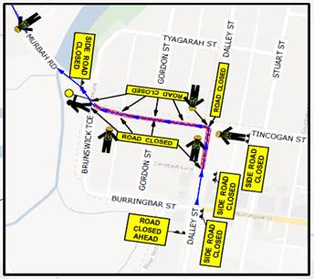
Notice of Motion No. 9.1 Murwillumbah Rd Mullumbimby
File No: I2023/1185
I move that Council:
1. Accepts the need to and if necessary, determine or applies to the relevant authority for the existing, above mentioned, road to become a gazetted road.
2. Accepts responsibility for any future upgrade and ongoing maintenance required to provide suitable, standard vehicular access to the adjoining properties.
Signed: Cr Alan Hunter
Councillor’s supporting information:
Council where appropriate should always aim to provide safe and open access on public roads and pathways across the shire.
In this case, the street is a 150 mt remnant from the old interstate highway on the eastern side of the Main Arm Rd - Coolamon Scenic Dr intersection in Mullumbimby, so it is difficult to see how it has never been gazetted as has been claimed by staff when asked about maintaining the road.
The road has been referred to differently by staff at various times including, an ungazetted road, a road reserve, a shared driveway and a public road, all used to avoid acknowledging any obligation to maintain the road carriageway.
Council in the past has required development applicants in the street to provide a bond to repair any damage caused by the developer.
It is clearly not a private access road, instead open to the public and providing the only access to lots 17, 19 & 21 for many years.
Despite all this Council has on a few occasions carried out some maintenance at various times over the last 40 years stressing it as a favour for the street residents and claiming it is not a council responsibility. Council has a water main also under
the road which has required repairs in past years causing further damage to the road surface.
Council has also required a bond on development applicants in the street to repair any damage to the road by the building works. A normal standard requirement for any development that abuts council managed land.
Staff comments
by James Flockton, Infrastructure Planning Coordinator, Infrastructure Services:
Council has a considerable road network to maintain, sealed and unsealed. As has been previously reported to Council in Asset Management Plan’s, existing budgets are limited to maintain Council’s existing network.
Significant improvements have been made in recent times due to grant funding, but existing recurrent funding continues to be insufficient to cover all road and drainage infrastructure needs. Therefore staff and Council need to carefully consider committing to increasing the maintenance burden.
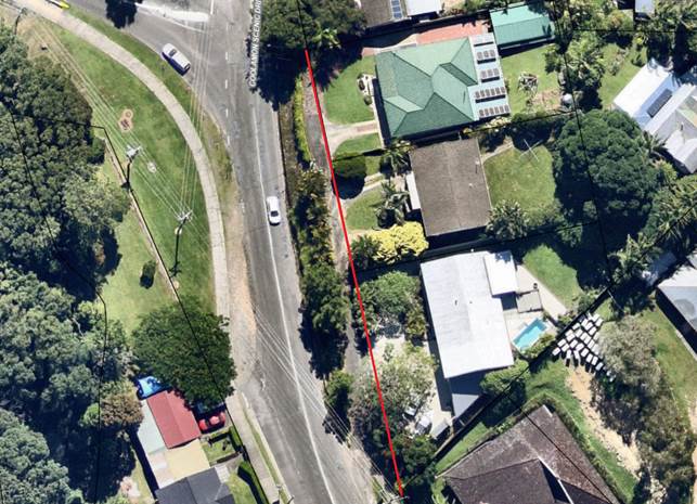
Staff maintain mapping of the road segments we currently maintain. The driveway / access road in question that provides access to 3 properties is likely within Council Road Reserve, but is not a segment we maintain.
The image below shows the property / road reserve boundary with a red line.
Survey would be required to ensure the driveway is wholly within road reserve or not.
Council does not currently have a policy that has a methodology for deciding which segments we do or do not maintain.
Historically staff have used a rule that if an access road within road reserve provides access to five or more properties, it will be included as a road segment to be maintained.
The subject access does not meet this criteria therefore staff do not support the maintaining of this access at this time.
Resolving as recommended will set a precedent that with time will result in a reduction in Council’s overall service levels for road maintenance.
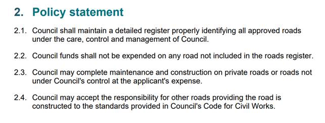
Council’s current policy on road maintenance can be found at the below link.
Register of Roads Maintained by Council Policy - Byron Shire Council (nsw.gov.au)
The Policy Statement is as below:
It is recommended that the following alternate resolution be considered prior to making a final decision on maintaining the above access road:
That Council’s Infrastructure Advisory Committee receive a report regarding Councils Register of Roads Maintained By Council Policy and that the report include an updated policy and case studies to support the direction stipulated by the policy
This will allow Council to consider the subject site as a case study while also considering the precedent that the movers resolution will set on Council’s limited resources to maintain roads across the shire.
Financial/Resource/Legal Implications:
Whilst the maintenance of the proposed section may appear to have a minor impact on Councils overall budget, it is the precedent that this decision makes that has the greater financial impact and risk on Council long term ability to maintain current service levels.
Is the proposal consistent with any Delivery Program tasks?
No. Delivery Program tasks require staff to maintain roads as per current policies and as noted above, the proposed road is not a segment Council maintains. Council would need to resolve to add this segments to its maintenance segments.
BYRON SHIRE COUNCIL
Notices of Motion 9.2
Notice of Motion No. 9.2 Annual expenditure on consultants & Conflicts of Interest
File No: I2023/1317
I move that Council receives a Report on:
1. The annual amount spent in 2022-23 on consultants, including but not limited to
(a) contractors retained in-house;
(b) technical, legal and financial advice received;
(c) assistance in court or on threats of legal action;
(d) planning assessment;
(e) etc.
2. Opportunities to retain such capabilities in-house.
3. Any advantages of external advice over internal.
4. What criteria apply before comparative quotes must be sought for consultancies.
5. Whether Council has ever taken a consultant to task for under-performance, including slow delivery.
6. Whether Council has a protocol for managing consultants’ Conflicts of Interest and related matters.
7. Why the brief to the consultant is not a fundamental starting point published with any report received by Council.
Signed: Cr Duncan Dey
Councillor’s supporting information:
Council receives reports at almost every Council meeting and at many of our Advisory Committee meetings. These reports are usually taken as truth and are rarely challenged. Draft reports are received and assessed by employed staff, and perhaps also by contracted (consultant) staff.
We live in a time where state and federal government use of consultants has become so rife that these two levels of public service find themselves stripped of expertise in carrying out many of these actions within the public service. Local government too is experiencing increased use of consultants, favouring the private consultant industry over carrying out the same activities in-house. Apart from deskilling the staff, the use of consultants may indeed be more expensive, is relatively unregulated and could be carried out by a small number of consultancy companies.
At federal level, accusations have been made that advice can be self-serving rather than the raw truth on matters where in-house expertise falls short. There have always been issues of the rotating door and similar conflicts. While staff and Councillors must declare Conflicts of Interest, consultants don’t seem to address the matter.
I am concerned that potential conflicts may exist. For example, on 24 August Council received advice on hydraulic efficacy of its Additional Flow Path, which utilises the stormwater channel draining Byron Arts & Industry Estate. That advice was provided by the company that helped West Byron developers defeat Council and thus introduce fill up to 2m deep across a huge area immediately downstream of the A&I Estate. This is the West Byron development now being built.
That consulting company had originally done flood investigations in the Belongil catchment for the public (ie through government floodplain management processes). It then went on to argue zero impact from fill that will now be place on the Belongil floodplain. It has now investigated drainage and flooding for the public in the same catchment. That report was attached to Council Report 13.28 on the Agenda of our meeting of 24 August.
The consultant’s report should examine future drainage behaviour after the fill is placed on the Belongil floodplain. It says in its Introduction however:
Downstream of the industrial estate exists the potential West Byron development areas. These developments are currently seeking DA, and as such drainage from these areas to the main drain are uncertain. For the purposes of this assessment no increase in development of West Byron Urban Release Area land has been assumed to impact upon flows to the drain line from the Industrial estate.
Were it true that the fill will impact drainage behaviour on the floodplain Council could not get unprejudiced advice from that consultant. That is the matter that should have been addressed by the consultant, not a blanket refusal to examine a necessary scenario.
A second example of my concerns appears in the Agenda for 24 August, at Report 14.4 which dealt with Mullumbimby’s future water supply. The consultant who delivered the report recommending connection to Rous water also prepares similar strategic reports for Rous Water itself.
A third example of my concerns occurs in Report 13.23 where the Queensland-based consulting company has just opened an office in Bangalow, where it is very likely the first significant Rail Trail will be built in Byron Shire. In addition, the person who prepared that report had just left Council after 6 years’ employment (and that after coming from the same consulting company to Council).
A fourth example is up-coming, as was revealed on 24 August in discussion around Report 13.23. A consulting company has been contracted to conduct a vegetation study of sectors of the rail corridor within Byron Shire. Its contract will now be extended to scrutinise the Dilapidation Report that is part of a private Rail Degradation Study. The extension appeared to be announced on the day that the private study became known to Council. I am unclear whether there was an opportunity to consider options or tenders. It is sad that Council doesn’t have sufficient expertise to carry out this task in-house.
Staff comments
by Heather Sills, Manager Corporate Services, Corporate and Community Services:
The recommendation before Council requests a report containing information about budgeting, workforce management, procurement, and Code of Conduct. Each of these matters are broadly addressed in this response. Should Council resolve to receive a further report clarity is sought on the detail being requested.
Budgeting
The budget does not have explicit cost codes allocated to 'consultants', rather these costs are included in project and program budgets. Accordingly, a manual report can be compiled on the annual expenditure on consultants for the 2022/23 financial year as requested in recommendation point 1. However, it will be resource intensive to produce and it does not guarantee that every transaction will be captured.
The 2022/23 spend on consultants will likely be inflated, attributed to several significant factors.
· The 2022 Flood Disaster Recovery necessitated the deployment of specialised resources and expertise. This response required immediate and focused attention, resulting in the engagement of consultants to address the unique challenges posed by the disaster.
· The aftermath of the 2022 flood disaster not only increased the demand for specialised resources but also intensified competition for talent within the local and regional market. This competition for skilled professionals led to skill shortages in professional areas, compelling Council to seek external consultants possessing the required expertise.
· The specialised nature of certain projects required expertise that is not a permanent requirement within the organisation.
Workforce Management
Management are guided by the Workforce Management Strategy and adopt a planned and deliberate approach to resourcing Council functions. When undertaking project and program planning, management consider all resourcing options, the costs involved and the skills required, particularly when planning significant capital works programs. The options available, as outlined in the Workforce Management Plan are:
• BUY – recruit regular employees where skills are needed immediately or where critical skills recently left
• BORROW – borrow contingent labour for skills where there is uncertainty in demand, an uncertain budget, or skills required for limited projects
• BUILD – develop internal talent where there is a danger to the business if skills are not present, skills cannot be purchased, or where there is no immediate urgency but the skills are needed for future
• MOVE – redeploy internal talent where skills are already acquired and where need is immediate and skills are in short supply
Accordingly, points 2 and 3 of the recommendation are considered by management on a case-by-case basis, factoring in the unique circumstances for each individual engagement. Management considers opportunities to retain capabilities in-house, where they exist and where it is advantageous to do so.
The recommendation requests the report include “Any advantages of external advice over internal.” This may provide a skewed perspective, as for example some advantages may include:
· Specialised skills and knowledge that may not be available internally
· Impartial advice that is not influenced by internal biases or preconceptions
· Engage based on a project by project basis linked to funding sources
· Ability to expedite projects, unburdened by regular responsibilities or competing priorities
· Supplement existing workforce during peak periods without industrial relations implications
Conversely, internal expertise offers distinct advantages:
· Capacity building within the workforce
· Alignment with the Council’s values and commitment to outcomes
· Understanding of Council processes, requirements, and systems
· Continuity and accessibility of information, knowledge, and advice
· Reduced costs
It is unclear from the recommendation what information is being sought in a further report, as the advantages and disadvantages are evaluated on a case-by-case basis, giving consideration to the unique circumstances of each particular engagement.
Procurement
What criteria apply before comparative quotes must be sought for consultancies.
Council’s Procurement and Purchasing Policy states that “Council will use competitive processes to the greatest extent possible in its purchasing and procurement activities, even where competitive processes are not mandated at law.”
The Procurement Guidelines 2023 further stipulate that comparative quotes must be obtained for all purchases greater than $20,000 (gst excl.).
Whether Council has ever taken a consultant to task for under-performance, including slow delivery.
Each contract, including those with consultants, has an assigned contract manager responsible for managing the performance of the contact. In short, the answer to this question is “yes.”
Why the brief to the consultant is not a fundamental starting point published with any report received by Council.
Councillors are provided with information to support decision-making, where required this may include the brief to the consultant. Including this is any report received by council may unnecessarily add to the length and complexity of Council and Committee Meeting reports and agendas.
Code of Conduct
Whether Council has a protocol for managing consultants’ Conflicts of Interest and related matters.
Code of Conduct for Council Committee Members, Delegates of Council and Council Advisers
4.12 A person who, at the request or with the consent of the council or a council committee, gives advice on any matter at any meeting of the council or committee, must disclose the nature of any pecuniary interest the person has in the matter to the meeting at the time the advice is given. The person is not required to disclose the person’s interest as an adviser.
Financial/Resource/Legal Implications:
Consideration should be given to closing the meeting to the public in accordance with Local Government Act s10A Which parts of a meeting can be closed to the public?
(1) A council, or a committee of the council of which all the members are councillors, may close to the public so much of its meeting as comprises—
(a) the discussion of any of the matters listed in subclause (2), or
(b) the receipt or discussion of any of the information so listed.
(2) The matters and information are the following—
(a) personnel matters concerning particular individuals (other than councillors),
(b) the personal hardship of any resident or ratepayer,
(c) information that would, if disclosed, confer a commercial advantage on a person with whom the council is conducting (or proposes to conduct) business,
(d) commercial information of a confidential nature that would, if disclosed—
(i) prejudice the commercial position of the person who supplied it, or
(ii) confer a commercial advantage on a competitor of the council, or
(iii) reveal a trade secret,
(e) information that would, if disclosed, prejudice the maintenance of law,
(f) matters affecting the security of the council, councillors, council staff or council property,
(g) advice concerning litigation, or advice that would otherwise be privileged from production in legal proceedings on the ground of legal professional privilege,
(h) information concerning the nature and location of a place or an item of Aboriginal significance on community land,
(i) alleged contraventions of any code of conduct requirements applicable under section 440.
Is the proposal consistent with any Delivery Program tasks?
No.
BYRON SHIRE COUNCIL
Notices of Motion 9.3
Notice of Motion No. 9.3 Notice to LGNSW Annual Conference regarding Ethical Investments
File No: I2023/1323
I move Council submits to the NSW Local Government Conference the following motion:
That the NSW Local Government Conference:
1. Recognises the importance of council autonomy in making investment decisions with ratepayer funds
2. Calls on the NSW Government to review its investment rules for Local Government, particularly the rules around Councils with TCorp loans, to allow more flexibility to invest in ethical and non-fossil fuel investments with different credit ratings
3. Requests that the NSW Government directly create more ethical and fossil fuel-free investment options for Councils
Signed: Cr Asren Pugh
Councillor’s supporting information:
Staff comments
by James Brickley, Manager Finance, Corporate and Community Services:
Council’s ability to invest funds it holds, but not immediately required, is governed by Section 625 of the Local Government Act 1993. Principally Section 625 requires Councils to only invest funds in the form of investment notified by Order of the Minister.
The last Ministerial Investment Order for Councils in NSW to use was issued in January 2011 and this Order is still the Order in place today. This Order limited the ability of Councils to invest funds and followed the fallout of the Global Financial Crisis (GFC) where Councils lost money invested mainly in investments known as Collateralised Debt Obligations (CDOs) that collapsed.
The Ministerial Investment Order now in place issued over 12 years ago limited Councils to invest in the following:
· Public funds or securities issued by or guaranteed by the Commonwealth, any State of the Commonwealth or Territory.
· Interest bearing deposits or bonds issued by authorised deposit taking institution as defined by the Banking Act 1959 (Commonwealth) excluding subordinated debt obligations.
· Deposits with the New South Wales Treasury Corporation or investments in an Hour-Glass investment facility of the New South Wales Treasury Corporation.
The above restrictions have meant:
· Councils cannot invest overseas
· Councils cannot invest in shares
· Councils cannot invest in managed funds except those of New South Wales Treasury Corporation.
In 2019, Council accessed the low interest loan facility offered by New South Wales Treasury Corporation. In doing so, Council gained substantial financial advantage with refinanced loans and new loans but those loans came with conditions in addition to the Ministerial Investment Order, as to where, and limits on Council investing funds. At the same time Council wanted to and continues to want to invest in environmentally and socially responsible investments consistent with its investment policy.
The effect of the NSW Treasury Corporation Loan conditions meant that Council was limited to a maximum of 30% of its investment portfolio being invested in financial institutions with a credit rating of BBB+ to BBB and 5% in BBB- or below. This meant the majority of Council’s investments needed to be held with financial institutions that had a credit rating of A- (maximum 40%) or up to 100% in A+ to AAA credit ratings. Most financial institutions with credit ratings of A- and above have links to fossil fuels through lending or other means. These same financial institutions though from time to time do issue investment opportunities that support environmental and socially responsible activities to which Council has invested when able.
Council on 22 August 2023 has received written correspondence from NSW Treasury Corporation asking Council to agree to a modification of its loan agreements. Council has been asking for some time for New South Wales Treasury Corporation to relax the conditions in the loan agreements around Councils investments so that Council can pursue more investment opportunities away from fossil fuels into the environmental and socially responsible space that will mean investing more with financial institutions that have lower credit ratings as they are more inclined to offer investment products in this area or as a financial institution do not lend to fossil fuel companies outright.
A report will be coming to the September 2023 Ordinary Council Meeting asking Council to agree with the New South Wales Treasury Corporation proposal on the restrictions on Councils investments, being lifted completely by removing Clause 11.4 of the loan agreement entirely. A Council resolution to accept the revised loan conditions will be necessary as New South Wales Treasury Corporation require Council to execute the agreement through signature of the Mayor and General Manager plus the application of the Council Seal. Authorisation to use the Council Seal can only be done by Council resolution.
Given the recent advice by New South Wales Treasury Corporation, Council may consider alternate wording for recommendation 2 concerning the reference to TCorp loans. That being said, whilst New South Wales Treasury Corporation are offering to remove restrictions for Byron Shire Council concerning investments, whether that is the case of other Councils is not known.
The offer from New South Wales Treasury Corporation is most pleasing effectively allowing Council to revert back to its investment policy completely and will enable Council over time to increase its investment exposure away from fossil fuels into more environmental and socially responsible purposes but that does not solve the further restrictions of the Ministerial Investment Order. It was understood that in 2020 the NSW Office of Local Government reported it was intending to work with NSW Treasury and NSW Treasury Corporation to review the Ministerial Investment Order, however where that has got to is unknown. In that regard the intent of this Notice of Motion therefore is supported.
Conference Motions
All Local Government NSW (LGNSW) member Councils are invited to submit motions by 15 September 2023 to the LGNSW Annual Conference in accordance with the 2023 Motions Submission Guide.
As per clause 6.40 of the Councillor Expenses and Facilities Policy 2022, motions to the Local Government NSW Annual Conference must first be endorsed by Council prior to submission.
Criteria for motions
The LGNSW criteria for motion submission specifies that motions must be:
1. consistent with the objects of LGNSW (see Rule 4 of the Association’s rules),
2. relate to or concern local government as a sector in NSW and/or across Australia,
3. seek to establish or change policy positions of LGNSW and/or improve governance of the Association (noting that the LGNSW Board is responsible for decisions around resourcing any campaigns or operational activities, and any necessary resource allocations will be subject to the LGNSW budgetary process),
4. have a lawful purpose (a motion does not have a lawful purpose if its implementation would require or encourage non-compliance with prevailing laws),
5. clearly worded, calling on a specific body, and unambiguous in nature, and
6. not expressing preference for one or several members over one or several other members.
This motion aligns with the LGNSW Financial Sustainability Policy Platform.
Length of motions
Motion wording should include a sentence or two which includes the call to action. The background note should provide a paragraph or two to explain the context and importance of the issue to the local government sector.
Financial/Resource/Legal Implications:
Implications for attending the LGNSW Conference were outlined in Report 13.3 ‘Local Government NSW Annual Conference 2023’, 24 August Ordinary Council Meeting Agenda.
Is the proposal consistent with any Delivery Program tasks?
|
CSP Objective |
CSP Strategy |
DP Action |
Code |
OP Activity |
|
1: Effective Leadership |
1.1: Enhance trust and accountability through open and transparent leadership |
1.1.2: Governance - Ensure legislative compliance and support Councillors to carry out their civic duties |
1.1.2.3 |
Provide administrative support to Councillors to carry out their civic duties |
BYRON SHIRE COUNCIL
Notices of Motion 9.4
Notice of Motion No. 9.4 Changing policy to remove fossil fuel sponsorship
File No: I2023/1324
I move that Council submits the following motion to the NSW Local Government Conference:
1. The NSW Local Government Conference:
a) Recognises that fossil fuels are the main driver of climate change and that we are in a climate emergency.
b) Recognises that the marketing of high emissions products, such as petroleum and gas through sponsorships or advertising increases demand and delays behaviour changes in the community that are required to reduce emissions.
c) Notes that the Federal Government has a responsibility to implement restrictions on fossil fuel advertising through national laws, like what was done for tobacco advertising which saw a proven reduction in tobacco consumption per capita, therefore reducing the health burden of tobacco use.
2. That Local Government NSW
a) writes to the Federal Minister for Communications, The Hon Michelle Rowland MP, to ask the Federal Government to pass national laws that restrict fossil fuel advertising; and
b) Updates relevant policies to prohibit accepting sponsorships from companies whose main business is the extraction, production or sale of coal, petroleum and gas.
i) Reviews other policies as appropriate to remove support for companies whose main business is the extraction, production or sale of coal, petroleum and gas.
ii) Lobbies the NSW Government to support NSW councils to also adopt the banning of fossil fuel sponsorships and advertising.
Signed: Cr Asren Pugh
Councillor’s supporting information:
Air pollution from burning fossil fuels takes 8.7 million lives prematurely each year – more than tobacco. An estimated 150,000 people are dying due to climate change impacts every year.
At least eight Australian Councils, as well as France and jurisdictions in the UK and Netherlands are restricting fossil fuel advertising.
Councils have a duty to ensure that its activities do not adversely impact the health and wellbeing of residents. Because of this, Council restricts the advertising of tobacco and other harmful products as well as fossil fuels. We should be supporting other Councils to also adopt this policy.
Coal, oil and gas are affecting our health, environment and climate. Air pollution from burning fossil fuels takes 8.7 million lives prematurely each year – more than tobacco. An estimated 150,000 people are dying due to climate change impacts every year.
Fossil fuels are the primary cause of global warming, which is impacting our LGA in the form of more intense and frequent heatwaves, storms, bushfires, floods, droughts and coastal erosion.
Council has adopted that we are facing a climate emergency and we are aiming to reach net zero by 2025. Advertising of companies involved with fossil fuel production or supply, as well as products such as gas, oil and coal is inconsistent with this adopted Council position.
1 https://yaleclimateconnections.org/2021/04/air-pollution-from-fossil-fuels-caused-8-7-million-premature-deaths-in-2018-study-finds/
2 https://www.who.int/news-room/fact-sheets/detail/tobacco
3 https://www.who.int/heli/risks/climate/climatechange/en/
4 https://climate.nasa.gov/causes/
Staff comments
by Heather Sills, Manager Corporate Services, Corporate and Community Services:
Council passed a similar resolution (22-740) on 15 December 2022 to recognise that fossil fuels are the main driver of climate change and the impact of marketing high emission products delays behaviour changes that are required to reduce emissions. Following this resolution Council has taken action, similar to that requested in the proposed Motion to the LGNSW conference, by updating the Sponsorships Received by Council Policy and advocating to the Federal and State Government and local organisations and events.
LGNSW Motions
All Local Government NSW (LGNSW) member Councils are invited to submit motions by 15 September 2023 to the LGNSW Annual Conference in accordance with the 2023 Motions Submission Guide.
As per clause 6.40 of the Councillor Expenses and Facilities Policy 2022, motions to the Local Government NSW Annual Conference must first be endorsed by Council prior to submission.
Criteria for motions
The LGNSW criteria for motion submission specifies that motions must be:
1. consistent with the objects of LGNSW (see Rule 4 of the Association’s rules),
2. relate to or concern local government as a sector in NSW and/or across Australia,
3. seek to establish or change policy positions of LGNSW and/or improve governance of the Association (noting that the LGNSW Board is responsible for decisions around resourcing any campaigns or operational activities, and any necessary resource allocations will be subject to the LGNSW budgetary process),
4. have a lawful purpose (a motion does not have a lawful purpose if its implementation would require or encourage non-compliance with prevailing laws),
5. clearly worded, calling on a specific body, and unambiguous in nature, and
6. not expressing preference for one or several members over one or several other members.
This motion aligns with the LGNSW Financial Sustainability Policy Platform.
Length of motions
Motion wording should include a sentence or two which includes the call to action. The background note should provide a paragraph or two to explain the context and importance of the issue to the local government sector.
Financial/Resource/Legal Implications:
Implications for attending the LGNSW Conference were outlined in Report 13.3 ‘Local Government NSW Annual Conference 2023’, 24 August Ordinary Council Meeting Agenda.
Is the proposal consistent with any Delivery Program tasks?
|
CSP Objective |
CSP Strategy |
DP Action |
Code |
OP Activity |
|
1: Effective Leadership |
1.1: Enhance trust and accountability through open and transparent leadership |
1.1.2: Governance - Ensure legislative compliance and support Councillors to carry out their civic duties |
1.1.2.3 |
Provide administrative support to Councillors to carry out their civic duties |
BYRON SHIRE COUNCIL
Notices of Motion 9.5
Notice of Motion No. 9.5 Non- Lethal Dingo Management Motion LGNSW Annual Conference 2023
File No: I2023/1325
I move that Byron Shire Council submits the following motion to the
Local Government NSW Annual Conference 2023:
That the LGNSW:
1. Recognises that dingoes are native animals with an important ecological role and are worthy of protection and care.
2. Acknowledges the long connection between dingoes and Aboriginal Australians and endeavour to respect this connection in relevant actions of the LGNSW.
3. Recognises that the term ‘wild dogs’ is frequently and incorrectly used to describe dingoes and dingo-hybrids.
4. Commits to working towards new and updated investigations, community education, research and implementation of non-lethal dingo management.
5. Writes a letter on behalf of the LGNSW to the Hon. Penny Sharpe MLC, Minister for the Environment and Heritage, to call for dingoes to be a protected animal under the Biodiversity Conservation Act 2016 (NSW), with all other relevant policies and management plans updated to reflect this protected status, to ensure this protected status is reflected in the implementation of the Biosecurity Act 2015 (NSW), and to ban the use of 1080 as an inhumane and indiscriminate poison.
6. Writes a letter on behalf of the LGNSW to the Hon. Tanya Plibersek MP, Federal Minister for Environment and Water, to call for dingoes to be included in the list of threatened species protected by the Environment Protection and Biodiversity Conservation Act 1999 (Cth), or to be included in a special list of non-threatened species to be protected by the Environment Protection and Biodiversity Conservation Act 1999 (Cth).
Attachments:
1 Literature
Review for Councillor Workshop - Dingo Genetics, Ecology, Management and
Legislation, E2023/52458 ![]()
2 RESEARCH
PAPERS - Castle et al. (2023) Stuck in the mud: Persistent failure of
‘the science’ to provide reliable information on the ecological roles
of Australian dingoes’, Biological Conservation 2023, E2023/90554 ![]()
Signed: Cr Sama Balson
Councillor’s supporting information:
Recognising Dingoes as important Australian native species
Dingoes inhabited Australia long before European colonisation. The earliest mitochondrial DNA data provides evidence that dingoes inhabited Australia at least 18,000 years ago.
As an iconic Australian animal, the legal treatment of dingoes is significant at both a domestic and international level, warranting careful consideration from all levels of government.
Dingoes are incorrectly called ‘wild dogs’
According to more updated and effective research, over 90% of so-called ‘wild dogs’ in NSW are dingo or dingo-hybrids.
A recent study examined the genetics of 5,039 “wild dogs”, finding almost all had predominantly dingo ancestry. The majority of these wild dogs in fact appeared to be purely or dominantly dingoes.
“A shift in terminology from wild dog to dingo would better reflect the identity of these canid dingoes and allow more nuanced debate about the balance between conservation and management of dingoes in Australia.”
Dingoes are deeply connected to First Nations people of Australia
The dingo is culturally significant and very important to many First Nations people across the country. Dingoes are a totem animal for some Indigenous groups.
Dingoes play a central role in the Dreamtime and the Dreaming across the country.
Indigenous stories also honour the travels of ancestral dingoes, which map song lines and pathways between water sources.
Dingoes play an essential ecological role
As a keystone species and an apex land-based predator in Australia, dingoes play a central ecological role. Any removal, decline or shifts in distribution of an apex predator significantly disrupts an ecosystem.
Dingoes are a threatened species, facing multiple threats from extensive lethal control programs and habitat fragmentation. Dr Cairns, a leading expert on dingoes, believes their indiscriminate killing disrupts the structure of family packs, affecting their natural social groups. This can leave young dingoes fending for themselves, starving and can disrupt the natural breeding cycles with other dingoes, which are less frequent than that of dogs.
Australia has the world’s highest rate of extinction among mammals, and Dr Cairns suggests killing dingoes could be partly to blame. “If we don’t have them [apex predators], then ecosystems get out of whack,” she says. “You have much more diverse and also resilient ecosystems where there are dingoes.”
Australia wide, the impact is well evidenced in studies around exclusion fencing, which is a common dingo control method. The most famous fence spans 5,600 km across several Eastern states, including NSW. Research data has shown that the ecosystems are healthier and more resilient on the dingo side of the fence, with more small native mammals and a natural balance in species. By contrast, the dingo-exclusion side of the fence has seen larger numbers of kangaroos, cats, rabbits and foxes.
Current control methods inflict cruelty and suffering
Control methods include ground baiting, aerial
baiting, trapping, shooting and fencing.
The most commonly used
bait poison is called ‘1080’. RSPCA Australia has
found the use of 1080 to be ‘inhumane’, with fully conscious
animals suffering convulsions, mania, vomiting, whimpering and muscle spasms.
Furthermore, the baits are indiscriminate, meaning a wide range of species
suffer poisoning.
The type of traps used will depend on the State or Territory laws. Generally, spring-loaded steel or padded jaw traps are used to catch dingoes. Traps are known to cause immense and prolonged suffering, often breaking bones and tearing muscles as animals are trapped or try to escape. While immobilised and in pain, dingoes are also vulnerable to exposure, dehydration, starvation and other kinds of predation. Given the remote nature of traps, dingoes often remain trapped and in pain before being found. The suffering is exacerbated in some states where traps are laced with a suffocating poison called Strychnine. RSPCA Australia has said the use of this poison is not humane.
Shooting is a typically imprecise and risky method of killing dingoes. As with the shooting of other wildlife, animals are highly likely to suffer extreme stress, fear, pain and severe injury from non-lethal shots. Unfortunately, mis-shots are inevitable.
The use of exclusion
fencing creates new risks for animal welfare. Animals such as kangaroos,
wallabies, echidnas and goannas may become entrapped, including in high-stress
situations when being chased or escaping wildfire. Animals who are entrapped
may be severely injured or may suffer a slow death from exposure.
Research shows non-lethal alternatives are effective
More farmers are increasingly discovering the benefits of non-lethal control methods and coexistence with dingoes.
In the case of crop farmers, studies have shown that dingoes can reduce competition for pasture from wild herbivores.
Graziers have also found benefit in coexistence with dingoes. Not only do dingoes deter other animals such as foxes and cats, but a recent report found that the use of guardian animals and/or the use of sensory deterrents (such as light, sound or smell) to be effective non-lethal management practices such as Guardian animals including Guardian Donkeys and Guardian dogs are having positive results in Australia and abroad, protecting stock from predation.
Dingoes can be allies for graziers by reducing the competition for pasture from wild herbivores such as kangaroos and goats, as well as removing non-native species from the area, such as cats, rabbits and foxes.
Dingoes lack protection at both a state and federal level
Dingoes are the only native mammal not protected in NSW. Schedule 5 of the Biodiversity Conservation Act 2016 (NSW) outlines protected animals, which includes native mammals of any species except for dingoes. This means dingoes have no protections under this Act.
NSW defines ‘wild dog’ as any dog living in the wild, including homeless domestic dogs, dingoes and hybrids. Part 3 of the Biosecurity Act 2015 (NSW) establishes a General Biosecurity Duty requiring any person dealing with biosecurity to take reasonable measures to prevent, minimise or eliminate the risk. This applies to wild dog populations, as wild dogs have been classified as a ‘priority pest animal’ in various State management strategies.
In regard to Federal legislation, dingoes are not included in the list of threatened species protected by the Environment Protection and Biodiversity Conservation Act 1999 (Cth), meaning they are not protected by national environmental law.
Supporting links:
https://hsi.org.au/australian-wildlife-habitats/coexisting-with-wildlife/
References:
https://hsi.org.au/wp-content/uploads/2023/03/HSI-Predator-Smart-Farming-Digital.pdf
https://hsi.org.au/australian-wildlife-habitats/coexisting-with-wildlife/
https://www.defendthewild.org/dingo-killing
https://besjournals.onlinelibrary.wiley.com/doi/10.1111/1365-2664.12378
https://onlinelibrary.wiley.com/doi/full/10.1002/ece3.3487
https://www.publish.csiro.au/am/pdf/AM20055
https://theconversation.com/killing-dingoes-is-the-only-way-to-protect-livestock-right-nope-200905
https://www.dingoden.net/noble-spirit.html
https://hsi.org.au/wp-content/uploads/2023/03/HSI-Predator-Smart-Farming-Digital.pdf
Dr Kylie Cairns updated DNA information https://www.kyliecairns.com/single-post/the-facts-about-dingo-dna-testing-reliability-and-accuracy
Royal Zoological Society of NSW 2019 symposium “The Dingo Dilemma”: https://www.rzsnsw.org.au/documents/item/90
Staff comments
By Shannon Burt, Director Sustainable Environment and Economy:
Council has not yet reached a position locally on this issue, and it would be beneficial to do this prior to taking this motion to the LGNSW meeting. To date, Council has resolved to undertake further investigations and consultation as part of the review of our Pest Animal Management Plan (Resolution 23-351).
The review of our Pest Animal Management Plan in 2024 (and development of Local Land Services Pest-Predator Management Plan on a similar timeframe) presents an excellent opportunity for Council to engage with the community (researchers, traditional owners, landholders, industry, other government agencies etc), to learn more about real on-ground impacts, positive and negative, and to gauge the level of support for the action proposed in this NOM, from community and other government agencies (like Local Land Services, who are the primary agency for pest animal management in NSW). This is an important first step to help us make the best decision on further action.
It should also be noted that the briefing notes cite some, but not all, of the current scientific research relating to the genetics and ecological role of dingoes. The claims made about the ecological role of dingoes are contested in the literature, and, as land managers, we need to consider all the scientific evidence not just part of it (Ref Attachments 1 and 2).
As a land manager, Council should be trying to use current research and best practice pest animal management wherever feasible, and trialling new innovations where resources allow. But there is a lot of research still to be done regarding effectiveness and impacts of different management methods; in particular we need research and trials specific to this region and natural environment. In the first instance, Council needs to work with other land managers, scientists and State Government, to compile knowledge and work out a joint approach.
For example, there needs to be more research and better information regarding the actual impact of changing the Biodiversity Conservation Act and Biosecurity Act to prevent control of wild dogs and banning the use of 1080, in particular the impacts on native wildlife, human safety and livestock/the rural economy. The most widespread and effective management techniques currently used to control foxes, feral dogs and dingo hybrids are the same. In Byron Shire NPWS use 1080 baiting to control foxes that are known to kill endangered shorebirds nesting at Brunswick Heads and Belongil. There is currently no strong, locally-tested evidence base for alternative methods that allow control of foxes and feral dogs/hybrids while protecting dingoes. But the effectiveness of alternatives is being investigated on a smaller scale in one LGA on the Central Coast and on some western rangeland properties, and Council would benefit from similar research/studies carried out in the Northern Rivers local environment.
If Councillors wish to seek action from the NSW Minister for the Environment and Heritage and/or the Federal Minister for Environment and Water, staff recommend that this should be in the form of investment into trialling effective and affordable ways to protect native dingoes where they are fulfilling a natural ecological role, whilst also minimising the risk to people, livestock and native animals posed by feral/hybrid dogs, problematic individual dingoes/hybrids and other introduced species that are currently managed in a similar way.
The LGA conference may present an opportunity to engage with other Councils and State agencies regarding management of dingoes/dingo hybrids and pest animals, and community perceptions around this issue.
Conference Motions
All Local Government NSW (LGNSW) member Councils are invited to submit motions to the LGNSW Annual Conference in accordance with the 2023 Motions Submission Guide.
As per clause 6.40 of the Councillor Expenses and Facilities Policy 2022, motions to the Local Government NSW Annual Conference must first be endorsed by Council prior to submission.
Criteria for motions
The LGNSW criteria for motion submission specifies that motions must be:
1. consistent with the objects of LGNSW (see Rule 4 of the Association’s rules),
2. relate to or concern local government as a sector in NSW and/or across Australia,
3. seek to establish or change policy positions of LGNSW and/or improve governance of the Association (noting that the LGNSW Board is responsible for decisions around resourcing any campaigns or operational activities, and any necessary resource allocations will be subject to the LGNSW budgetary process),
4. have a lawful purpose (a motion does not have a lawful purpose if its implementation would require or encourage non-compliance with prevailing laws),
5. clearly worded, calling on a specific body, and unambiguous in nature, and
6. not expressing preference for one or several members over one or several other members.
This motion aligns with the LGNSW Fundamental Principle ‘Environment’ and the Biodiversity Position Statement.
Length of motions
Motion wording should include a sentence or two which includes the call to action. The background note should provide a paragraph or two to explain the context and importance of the issue to the local government sector.
Financial/Resource/Legal Implications:
Implications for the LGNSW Conference were outlined in Report 13.3 ‘Local Government NSW Annual Conference 2023’, 24 August Ordinary Council Meeting Agenda.
Is the proposal consistent with any Delivery Program tasks?
|
CSP Objective |
CSP Strategy |
DP Action |
Code |
OP Activity |
|
1: Effective Leadership |
1.1: Enhance trust and accountability through open and transparent leadership |
1.1.2: Governance - Ensure legislative compliance and support Councillors to carry out their civic duties |
1.1.2.3 |
Provide administrative support to Councillors to carry out their civic duties |
BYRON SHIRE COUNCIL
Staff Reports - Corporate and Community Services 13.1
Staff Reports - Corporate and Community Services
Report No. 13.1 Council Resolutions Quarterly Review - Q4 - 1 April to 30 June 2023
Directorate: Corporate and Community Services
Report Author: Heather Sills, Manager Corporate Services
File No: I2023/1127
Summary:
This report provides an update on the status of Council Resolutions as at 30 June 2023.
78 Resolutions were completed during the period 1 April to 30 June 2023.
129 Resolutions remain active.
RECOMMENDATION:
That Council:
1. Notes the information provided in this report on active Council Resolutions in Attachment 1 (#E2023/67986).
2. Notes the completed Resolutions in Attachment 2 (#E2023/67999).
1 Active
Resolutions - as at 30 June 2023, E2023/67986
![]()
2 Completed
Resolutions - 1 April to 30 June 2023, E2023/67999
![]()
Report
Each quarter, Council is updated on the status of Council Resolutions; identifying those Resolutions completed within the reporting period, those proposed to be closed, and those Resolutions that remain ‘Active’.
Quarterly Report – 1 April to 30 June 2023
Active Resolutions
The Active Resolutions Report (#E2023/67986) provides an update to Council on all active Resolutions up to 30 June 2023, with relevant commentary regarding the status of each Resolution as at this date. There were 129 active Resolutions at the time of preparing this report.
30 of the active Resolutions were overdue by more than 60 days at the time the report was prepared. Resolutions could be overdue due to budget constraints, staff resourcing, extended negotiations with stakeholders, or other reasons.
Completed Resolutions
The Completed Resolutions Report (#E2023/67999) provides details of those Resolutions that were completed during the period 1 April to 30 June 2023. 78 Resolutions were completed during this period.
Resolutions Closed with No Action:
There were no actions identified as needing to be ‘closed with no action.
Strategic Considerations
Community Strategic Plan and Operational Plan
|
CSP Objective |
CSP Strategy |
DP Action |
Code |
OP Activity |
|
1:
Effective Leadership |
1.1: Enhance trust and accountability through open and transparent leadership |
1.1.2: Governance - Ensure legislative compliance and support Councillors to carry out their civic duties |
1.1.2.4 |
Deliver Council meeting secretariat – including agenda preparation, minutes and council resolutions monitoring |
Recent Resolutions
This report has been prepared in accordance with requirements prescribed by Council Resolution 20-513.
Legal/Statutory/Policy Considerations
Implementation of Council Resolutions in accordance with the Local Government Act 1993.
Financial Considerations
A number of Resolutions note that resource constraints limit completion of action required.
Consultation and Engagement
Not applicable.
BYRON SHIRE COUNCIL
Staff Reports - Corporate and Community Services 13.2
Report No. 13.2 Revised Delivery Program 2022-26
Directorate: Corporate and Community Services
Report Author: Heather Sills, Manager Corporate Services
File No: I2023/1141
Summary:
This Report is prepared in accordance with Clause 4.13 of the Integrated Planning and Reporting Guidelines which requires that:
4.13 Where an amendment to the Delivery Program is proposed, it must be included in a council business paper which outlines the reasons for the amendment. The matter must be tabled and resolved to be noted at that meeting, must be and considered by the council at its next meeting (i.e. time must be set aside for the amendment to be considered).
The amended Delivery Program (Attachment 1) was provided at the 22 June Ordinary Council Meeting for noting. The revised delivery program includes:
· Outcomes
Measurement Framework
Council endorsed a set of ‘indicators’ developed alongside the
Community Strategic Plan and Delivery Program in June 2022. Since that time,
further work has been undertaken to prepare the associated performance
measurement framework to accompany the Delivery Program, entitled the Outcomes
Measurement Framework (Attachment 2). The Outcomes Measurement Framework
has been considered by the Audit, Risk, and Improvement Committee on 18 May.
· List of ‘services’ as the basis for the future development of a service review framework A service review is a systematic evaluation of an identified service, for the purposes of assessing the efficiency, effectiveness, and quality of the service, and to identify opportunities for improving service delivery and outcomes for the community. The first step had been taken to define the services for inclusion in the Delivery Program. Work will continue in 2023/24 to prepare a service review program, as required by the IP&R Guidelines.
RECOMMENDATION:
That Council endorses the revised Delivery Program 2022-26 (Attachment 1 #E2023/40277), noting the inclusion of indicators from the Outcomes Measurement Framework (Attachment 2 #E2022126119) and the list of services as part of the service review process.
Attachments:
1 Revised
Delivery Program - 2022-26, E2023/40277
![]()
2 Corporate
Performance Measures - Outcomes Measurement Framework - Final, E2022/126119 ![]()
Report
In September 2021, the NSW Office of Local Government (OLG) published revised guidelines for Integrated Planning and Reporting (IP&R). The revised guidelines included requirements for all Councils with regard to performance measurement and service reviews.
The Delivery Program 2022-26 has been amended (Attachment 1) to include additional information taken from the Outcomes Measurement Framework and to provide the list of ‘services’ as the basis for the future development of a service review framework. Each of these elements is explained in detail in this report.
Outcome Measurement Framework
In partnership with the Centre for Social Impact, UNSW (CSI) Council has developed an outcomes measurement framework to embed meaningful, robust measurement practices, as is now required of local government through IP&R legislation (Local Government Act s406). The framework was developed through a collaborative partnership between Council and the Centre for Social Impact (CSI)/University of NSW.
The ‘indicators’ were endorsed by Council in 2022 with the Community Strategic Plan and Delivery Program and were designed to evaluate success and priorities for Council between 2022-26. The indicators measure Council’s effectiveness in bringing about positive change and its delivery of the desired outcomes identified by the community.
A NSW Audit Office report Council Reporting on Service Delivery (2018) demonstrated that the methodology of a performance measurement framework needs to be robust, with clearly defined measures, data sources, baselines, targets and above all, consistency. The measures and results should be publicly available to enhance accountability and designed in such a way that both inform decision-making and help communities understand how efficiently and effectively services are being delivered.
Work has been undertaken to refine the indicators and develop the corresponding Outcomes Measurement Framework with provides additional information such as the indicator definition, data source, reporting frequency, baseline result, target, and alignment with the UN Sustainable Development Goals. The Delivery Program has been amended to include some of this extra detail, as provided in the below example.
|
Indicator |
Definition |
Baseline Result |
Target |
|
Community consultation/ engagement |
Residents’ level of satisfaction with community consultation/ engagement |
3.06 (2020) |
✓ |
|
Participation in Council decision making |
Residents’ level of satisfaction with opportunities to participate in Council decision making |
2.86 (2020) |
↑ |
|
Digital platform engagement – Byron Shire website |
Number of visits to Byron Shire Council website
|
257,569 (FY22Q1) |
✓ |
|
Digital platform engagement Your Say Byron Shire |
Number of visits to Your Say Byron Shire platform |
8,657 (FY22Q1) |
✓ |
|
Customer service satisfaction rating |
Residents’ level of satisfaction with the way their contact with Council was handled |
3.52 (2020) |
↑ |
Monitoring and Reporting on the Outcomes Measurement Framework
The General Manager is required to provide six monthly progress reports to the Council on the progress toward the Delivery Program, in accordance with clause 4.9 of the Integrated Planning and Reporting Guidelines: “The general manager must ensure that progress reports are provided to the council, with respect to the principal activities detailed in the Delivery Program, at least every 6 months.”
While the requirement is six monthly reporting, the Council is provided with a Quarterly Report on the activities in the Operational Plan, to promote effective and efficient reporting and decision making. The Q2 and Q4 Reports contain an additional level of reporting, providing an update on progress toward the priorities in the Delivery Program. Reporting on the Outcome Measurement Framework will be included in this 6-monthly Delivery Program Report.
The outcome measures, also be included in the Annual Report, provides an overview of the work undertaken by Council in a given year to deliver on the commitments of the Delivery Program via that year’s Operational Plan.
Service Reviews
The focus on continuous improvement and ways to better meet the community’s expectations around priorities and service levels is a requirement under Essential Element 4.3 of the revised IP&R Guidelines, which states that:
“To encourage continuous improvement across the council’s operations, the Delivery Program must identify areas of service that the council will review during its term, and how the council will engage with the community and other stakeholders to determine service level expectations and appropriate measures.”
Council is committed to continually improving how services are delivered within available resources. In accordance with the above requirements, this process was formalised through the Operational Plan 2022/23 activity to “identify and scope services delivered by Council to inform opportunities for achieving efficiencies”. This work was completed, and a list of Council services has been developed. The scope of each service will be further defined throughout the service review process.
The service list and outline of the process for development of the framework has been incorporated into the Delivery Program 2022-26.
Strategic Considerations
Community Strategic Plan and Operational Plan
|
CSP Objective |
CSP Strategy |
DP Action |
Code |
OP Activity |
|
1:
Effective Leadership |
1.1: Enhance trust and accountability through open and transparent leadership |
1.1.4: Performance Measurement and Reporting - Embed a robust performance management system through the development of an outcomes measurement framework |
1.1.4.1 |
Use the outcomes measurement framework to strengthen the Delivery Program reporting |
Recent Resolutions
· 22-332 – adoption of the Delivery Program 2022-26
· 22-335 - adoption of the Byron Shire Community Strategic Plan 2032
Legal/Statutory/Policy Considerations
The requirements for Integrated Planning and Reporting are governed by Sections 402-406 of the Local Government Act 1993.
Section 404 requires that a council must have a 4-year delivery program detailing the principal activities to be undertaken within available resources.
Detailed requirements are outlined in the Integrated Planning and Reporting Guidelines and Handbook.
The relevant clauses are:
4.12 The council must review its Delivery Program each year when preparing the Operational Plan.
4.13 Where an amendment to the Delivery Program is proposed, it must be included in a council business paper which outlines the reasons for the amendment. The matter must be tabled and resolved to be noted at that meeting, must be and considered by the council at its next meeting (i.e. time must be set aside for the amendment to be considered).
4.14 Where significant amendments are proposed, the Delivery Program must be re-exhibited as per Essential Element 4.10.
Financial Considerations
The project was delivered within budget.
Consultation and Engagement
The amendments to the Delivery Program were noted by Council at the 22 June Ordinary Meeting, with further consideration and endorsement to occur at the next Ordinary Council Meeting on 24 August.
BYRON SHIRE COUNCIL
Staff Reports - Sustainable Environment and Economy 13.3
Staff Reports - Sustainable Environment and Economy
Report No. 13.3 PLANNING - DA 10.2022.289.1 - Relocation and Raising of Existing Dwelling and Construction of New Dwelling to create Dual Occupancy (Detached) at 97 Main Arm Road Mullumbimby
Directorate: Sustainable Environment and Economy
Report Author: Ben Grant, Planner
File No: I2023/21
Proposal:
|
DA No: |
10.2022.289.1 |
||
|
NSW PP |
PAN-237703 |
||
|
Proposal description: |
Relocation and Raising of Existing Dwelling and Construction of New Dwelling to create Dual Occupancy (Detached) |
||
|
Property description: |
LOT: 1 DP: 720422, LOT 1: DP: 402361 |
||
|
97 Main Arm Road MULLUMBIMBY |
|||
|
Parcel No/s: |
|||
|
Applicant: |
Mr M Obradovic |
||
|
Owner: |
Mr T B Jackson & Ms R D Horsfall |
||
|
Zoning: |
RU1 Primary Production |
||
|
Date received: |
13 July 2022 |
||
|
Integrated / Designated Development: |
☐ Integrated |
☐ Designated |
☒ Not applicable |
|
Concurrence required |
Yes – CNR-42743 Concurrence required to vary Clause 4.1E of Byron LEP 2014 by mor than 10%. |
||
|
Public notification or exhibition: |
- Level 2 advertising under Council’s Community Participation Plan. - Exhibition period: 27 July 2022 to 9 August 2022. - Submissions received: Nil - Submissions acknowledged: ☐ Yes ☐ No ☒ N/A |
||
|
Planning Review Committee |
Not applicable |
||
|
Variation request to Development Standards under an EPI (e.g., clause 4.6) |
Clause 4.6 request to vary the minimum lot size standard for dual occupancy development in Clause 4.1E of Byron LEP 2014. |
||
|
Estimated cost |
$670,494.00 |
||
|
Delegation to determine |
Council >10% variation to development standard. |
||
|
Issues |
Consolidation of lots recommended to ensure that driveway access and OSMS are located on a single parcel of land. |
||
Summary:
This development application seeks consent to relocate and raise an existing dwelling and to construct a new dwelling to create a dual occupancy (detached) at 97 Main Arm Road, Mullumbimby.
The application is referred to Council for determination due to an exceedance of the minimum lot size standard for the erection of a dual occupancy (detached) on land in a rural zone by more than 10% of the standard.
Clause 4.1E of Byron LEP 2014 sets a minimum lot size standard of 4000m2 for the erection of a dual occupancy (detached) in the RU1 Primary Production zone. The subject site comprises two lots which have areas of 3560m2 and 557m2 respectively. The proposal represents a variation to the standard of 11% for the larger lot and 86% for the smaller lot.
A written justification for the proposed variation to the lot size standard was submitted in accordance with Clause 4.6 of the LEP. The statement demonstrates that compliance with the standard is unreasonable and unnecessary in the circumstances of the case and that there are sufficient environmental planning grounds to justify varying the standard.
The combined area of both lots achieves the 4000m2 minimum lot size standard and therefore satisfies the relevant objectives of Clause 4.1E.
To ensure the driveway access and wastewater system are located on the same lot as the dwelling houses, a condition is recommended that requires the two existing lots to be consolidated after the construction of both dwellings and prior to the issue of an occupation certificate.
The application was advertised and notified for a period of 28 days between 27 July 2022 to 9 August 2022 in accordance with the Byron Shire Community Participation Plan. No submissions were received.
The application appropriately addresses the relevant constraints applying to the site and is recommended for approval subject to the conditions in Attachment 1.
NOTE TO COUNCILLORS:
In accordance with the provisions of S375A of the Local Government Act 1993, a Division is to be called whenever a motion for a planning decision is put to the meeting, for the purpose of recording voting on planning matters. Pursuant to clause 2(a) under the heading Matters to be Included in Minutes of Council Meetings of Council's adopted Code of Meeting Practice (as amended) a Division will be deemed to have been called by the mover and seconder of all motions relating to this report.
RECOMMENDATION:
It is recommended that:
1. Pursuant to Section 4.16 of the Environmental Planning & Assessment Act 1979, Development Application No. 10.2022.289.1 for Relocation and Raising of Existing Dwelling and Construction of New Dwelling to create Dual Occupancy (Detached), be granted consent subject to the conditions of approval at the end of this report
1 10.2022.289.1
- Recommended Conditions of Consent, E2023/77860
![]()
2 10.2022.289.1
- Architectural Plans, E2023/77866
![]()
3 10.2022.289.1
- Letter of Concurrence, E2023/74482
![]()
4 10.2022.289.1
- Clause 4.6 Written Request, E2023/27473
![]()
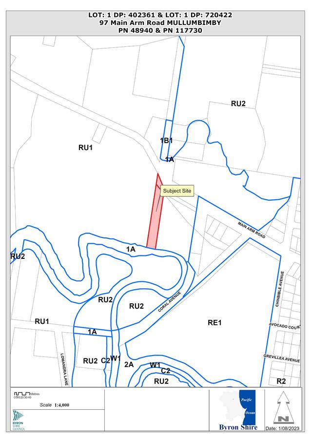 Report
1. INTRODUCTION
History/Background
Deposited Plan 402361 was registered on 20 September 1906. Deposited Plan 720422 is a former road reserve parcel that was registered on 8 February 1985. No previous determinations were found in Council’s records for either lot. There is an existing dwelling on the property which appears to be unapproved.
Description of the proposed development
This application seeks approval to relocate and raise an existing dwelling on the property and construct a new dwelling to create a dual occupancy (detached).
The following is proposed in detail:
· Move the existing building 4m-5m to the west and raise on a steel support structure 1.6m above existing ground level along with alterations and additions.
· Construct a new three-bedroom dwelling at the rear of the property. The dwelling is single storey and will utilise rammed earth and stone materials.
· Extend and reconfigure the driveway to provide vehicular access for both dwellings.
· Landscape screen plantings near the Main Arm Road frontage.
· New on-site sewage management system near the front of the property.
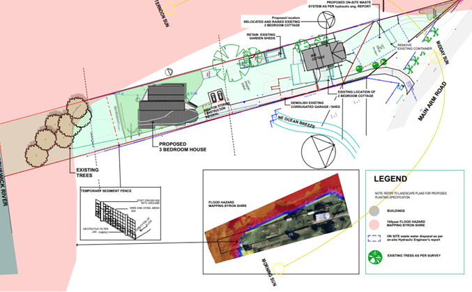
Figure 1: Site plan extract.
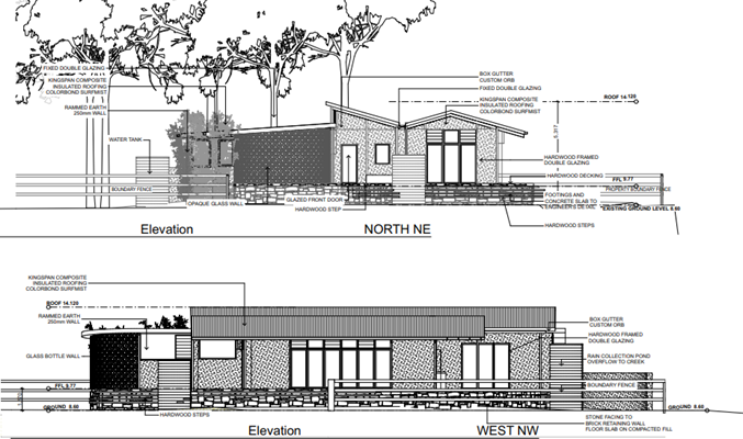
Figure 1: Extract of elevations plan for proposed new 3-bedroom dwelling.
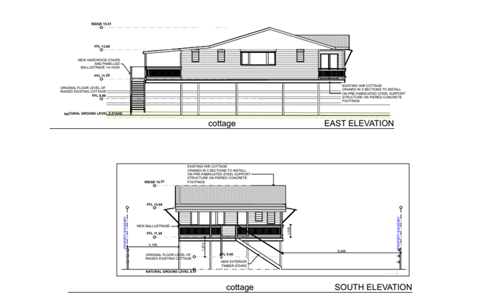
Figure 2: Extract of elevations plan for raised 2-bedroom dwelling.
Description of the site
A site inspection was carried out on 11 November 2022
|
Land is legally described |
LOT: 1 DP: 720422 |
|
|
Property address |
97 Main Arm Road MULLUMBIMBY |
|
|
Land is zoned: |
RU1 Primary Production |
|
|
Land area is: |
3560m2, 557m2 (Total Area 4117 m2) |
|
|
Property is constrained by: |
Flood Liable Land, Bushfire prone land |
|
|
|
Is a BDAR required due to the location of the proposed development? |
☐ Yes ☒ No |
|
|
Are there any easements in favour of Council affecting the site? |
☐ Yes ☒ No |
|
|
Is there a Vegetation Management Plan which might affect the proposal? |
☐ Yes ☒ No |
|
|
Is there a Voluntary Planning Agreement which might affect the proposal? |
☐ Yes ☒ No |
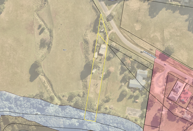
Figure 1: Aerial image of the site with zoning overlay.
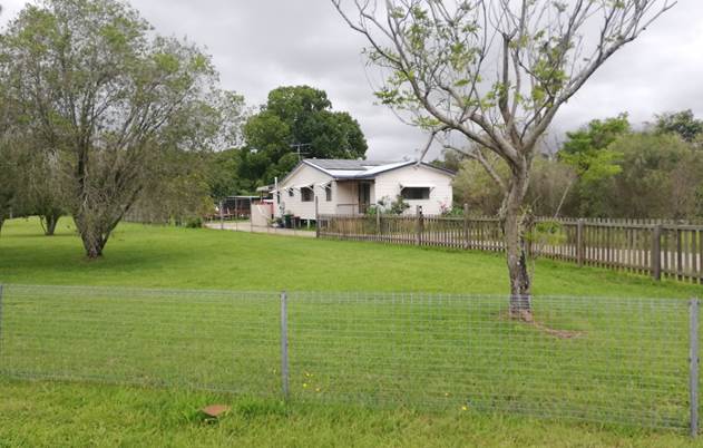
Figure 2: Subject site, looking south
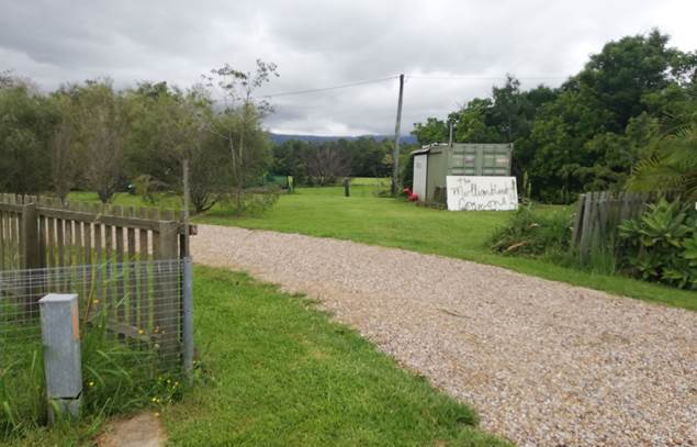
Figure 3: Driveway entrance (shipping container to be relocated.
2. SUMMARY OF REFERRALS
External referrals
|
Referral |
Issue |
|
DPIE |
A delegate of the Planning Secretary granted concurrence to the proposed Clause 4.6 variation request on 20 July 2023. Refer to E2023/74482. |
Internal referrals
|
Referral |
Issue |
|
Environmental Health Officer |
Council’s Environmental Health Officer raised no concerns with the proposal. Refer to A2022/23984. |
|
Development Engineer |
Council’s Development Engineer commented that the proposal was acceptable from an engineering perspective. Both dwellings will have finished floor levels above the 2050 flood planning level of 8.83m AHD. |
|
Systems Planning Officer |
Council’s Systems Planning Officer noted that development servicing levies are payable. |
|
Building Surveyor |
Council’s Building Surveyor commented that the existing building is to be brought into compliance with the fire protection and structural provisions of the BCA. Details are to be provided with the construction certificate application. |
3. SECTION 4.14 – BUSH FIRE PRONE LAND
Using the procedure provided on the NSW Rural Fire Service webpage titled ‘Site Assessment Methodology’, the asset protection zone and bush fire attack levels for this proposed development (which is in fire weather area FDI 80) are as follows:
|
Direction |
South: 29m, West 15m |
|
Vegetation formation |
South - Camphor laurel dominated rainforest, West - Grassland |
|
Distance between vegetation formation and building |
South: 29m, West 15m |
|
Effective slope |
10o-15o |
|
Asset Protection Zone |
15m APZ can be provided within the site and on adjoining managed land. |
|
Bushfire Attack Level (BAL) |
2-Bedroom Dwelling BAL-19 to all facades. 3-Bedroom Dwelling BAL– 29 to all facades |
Conditions for bushfire protection in accordance with Planning for Bushfire Protection 2019 are recommended.
SECTION 4.15C – MATTERS FOR CONSIDERATION – DISCUSSION OF ISSUES
Having regard to the matters for consideration detailed in Section 4.15(1) of the Environmental Planning & Assessment Act 1979 (EP&A Act), the following is a summary of the evaluation of the issues.
State Environmental Planning Policies (SEPP)
|
Considerations |
Satisfactory |
Unsatisfactory |
|
Resilience and Hazards SEPP 2021 Chapter 2 Coastal management The site is within the coastal use area and coastal environment area as defined under Section 2.4 of the SEPP. The proposal is unlikely to have an adverse impact on access to the foreshore, views from public places, Aboriginal cultural heritage, or the scenic qualities of coastal headlands. The proposal is satisfactory having regard to the matters for consideration under ss. 2.8, 2.11 and 2.12 of the SEPP (Resilience and Hazards) 2021. Chapter 4 Remediation of land Council’s Environmental Health Officer conducted a desktop assessment of the land parcels history and preliminary site assessments for the neighbouring properties and concluded that the site is unlikely to be contaminated. |
☒ |
☐ |
|
SEPP (Building Sustainability Index: BASIX) 2004 A valid BASIX certificate was provided with the application. Commitments for water, energy and thermal comfort are shown on the DA plans.
|
☒ |
☐ |
4.2A Byron Local Environmental Plan 2014 (LEP 2014)
LEP 2014 is an applicable matter for consideration in the assessment of the subject development application in accordance with subsection 4.15(1) of the EP&A Act because it applies to the subject land and the proposed development. The LEP 2014 clauses that are checked below are of relevance to the proposed development:
|
Part 1 |
☒1.1 | ☒1.1AA | ☒1.2 | ☒1.3 | ☒1.4 | ☒Dictionary | ☒1.5 | ☒1.6 | ☒1.7 | ☒1.8 | ☒1.8A | ☒1.9 | ☒1.9A |
|
Part 2 |
☒2.1 | ☒2.2 | ☒2.3 | ☒ Land Use Table | ☒2.4 | ☒2.5 | ☒2.6 | ☒ 2.7 | ☒2.8 |
|
Part 4 |
☒4.1E | ☒4.2A | ☒4.2D | ☒4.3 | ☒4.4 | ☒4.5 | ☒4.6 |
|
Part 5 |
☒5.16 | ☒5.21 |
|
Part 6 |
☒6.1 | ☒6.2 | ☒6.6 |
In accordance with LEP 2014 clauses 1.4 and 2.1 – 2.3:
(a) The proposed development is defined in the LEP 2014 Dictionary as Dual Occupancy (Detached);
(b) The land is within the RU1 Primary Production according to the Land Zoning Map;
(c) The proposed development is Permitted with Consent; and
(d) Regard is had for the Zone Objectives as follows:
|
Zone Objective RU1 Primary Production |
Consideration |
|
To encourage sustainable primary industry production by maintaining and enhancing the natural resource base. |
The proposal is not inconsistent with the zone objectives. |
|
To encourage diversity in primary industry enterprises and systems appropriate for the area. |
|
|
To minimise the fragmentation and alienation of resource lands. |
|
|
To minimise conflict between land uses within this zone and land uses within adjoining zones. |
|
|
To encourage consolidation of lots for the purposes of primary industry production. |
|
|
To enable the provision of tourist accommodation, facilities and other small-scale rural tourism uses associated with primary production and environmental conservation consistent with the rural character of the locality. |
|
|
To protect significant scenic landscapes and to minimise impacts on the scenic quality of the locality. |
The remaining checked clauses have been taken into consideration in the assessment of the subject development application in accordance with Section 4.15 of the EP&A Act. The proposed development complies with all clauses of LEP 2014 (in some cases subject to conditions and/or to the satisfaction of other assessing officers).
Part 4 – Principal Development Standards
|
Compliance |
Comment |
||||||||||
|
4.1E Minimum lot sizes for certain residential accommodation |
No but considered acceptable |
A minimum lot size of 4000m2 is required for dual occupancy (detached) development in the RU1 Primary Production zone. The proposed use of the land for the purposes of a dual occupancy (detached) will extend over Lot 1 DP 402361 and Lot 1 DP 720422 which have areas of 3560m2 and 557m2 respectively. Both dwellings will be physically situated within Lot 1 DP 402361. Non-compliance with the development standard is detailed in the following table:
It is noted that the cumulative area of both lots is 4,117m2 which complies with the numerical standard. The Applicant has submitted a written request to vary the development standard which is addressed in the Byron LEP 2014 Issues section. |
|||||||||
|
4.2A Erection of dwelling houses and dual occupancies on land in certain rural and environment protection zones |
Yes |
Both dwelling houses will be erected on Lot 1 DP 402361 (the rear lot) which is an existing holding and is recognised as having a dwelling entitlement pursuant to subclause 4.2A(3)(c). Lot 1 DP720422 (the front lot) is an ex-road reserve parcel that does not benefit from a dwelling entitlement. The only physical works occurring on this land will be a driveway upgrade and part of a proposed wastewater system. It is noted that both lots cannot be consolidated externally to the DA, or prior to the construction of either dwelling, because the newly created lot would not benefit from a dwelling entitlement under subclause 4.2A(3)(c), thus preventing any future residential development on the subject land. To ensure the driveway access and wastewater system are located on the same lot as the dwelling houses, a condition is recommended that requires the two existing lots to be consolidated after the construction of both dwellings and prior to the issue of an occupation certificate. This approach will ensure compliance with Clause 4.2A of the LEP while also ensuring the driveway and wastewater system are located on the same lot as the two dwelling to prevent site isolation in the unlikely event that the ex-road reserve parcel is sold separately at some point in the future. Consolidating both lots will extinguish the dwelling entitlement for Lot 1 DP 420361 but the approved development will be protected under subclause 4.2A(5) which allows a lawfully approved dwelling house or dual occupancy to the replaced or rebuilt under certain circumstances. The proposed development is considered to meet the requirements of Clause 4.2A. |
|||||||||
|
4.2D Erection of dual occupancies (detached) and secondary dwellings in Zones RU1 and RU2 |
Yes |
The proposal satisfies the requirements of Clause 4.2D as follows: · The development will not impar the use of the land for agricultural purposes. · Each dwelling will have the same vehicular access to Main Arm Road. · Both dwellings are within 100m of each other. · The is physically suitable for the development and can accommodate on-site disposal of sewage. · The proposal will not have an adverse impact on the scenic amenity or character of the rural environment. |
|||||||||
|
4.3 Height of Buildings |
Yes |
A maximum height of 9m is permitted. Proposed building heights are: · 2-bedroom house 6.8m. · 3-bedroom house 5.32m. |
|||||||||
|
4.6 Exceptions to development standards |
Yes |
The proposed development seeks to vary the minimum lot size standard prescribed under Clause 4.1E Minimum lot sizes for certain residential accommodation. A Clause 4.6 variation request has been submitted with the application. See further details in the ‘Discussion’ section below. |
Part 5 – Additional local provisions
|
Provision |
Compliance |
Comment |
|
Clause 5.16 Subdivision of, or dwellings on, land in certain rural, residential or conservation zones |
Yes |
The proposed development will not have a significant impact on surrounding rural-residential development in the area. |
|
Clause 5.21 Flood planning |
Yes |
The site has a 2050 flood planning level of 8.83m AHD. The lowest habitable floor level proposed is 9.77m AHD. The proposal is consistent with the flood hazard of the land. |
Part 6 – Additional local provisions
|
Compliance |
Comment |
|
|
Clause 6.6 Essential services
|
Yes |
The site has access to reticulated water, electricity, and telecommunications. Vehicular access to the site is adequate. The site is capable of supporting on-site disposal of sewage and stormwater drainage acceptable. |
Byron Local Environmental Plan 2014 – Discussion of Issues
Clause 4.6 request to vary a development standard – minimum lot size for dual occupancies
Clause 4.1E of Byron LEP 2014 specifies a minimum lot size of 4000m2 for dual occupancy (detached) development in the RU1 Primary Production zone.
The proposal does not comply with the minimum lot size standards in Clause 4.1E as detailed in the table below:
|
Lot |
Lot size |
Lot size standard |
Variation |
|
Lot 1 DP 720422 |
3560m2 |
4000m2 |
11% |
|
Lot 1 DP 402361 |
557m2 |
4000m2 |
86% |
|
Combined area |
4117m2 |
4000m2 |
Complies |
A written request has been submitted to Council in accordance with Clause 4.6(3)(a) and (b) of Byron LEP 2014 seeking to justify the contravention of the development standard by demonstrating:
(a) That compliance with the development standard is unreasonable or unnecessary in the circumstances of the case, and
(b) That there are sufficient environmental planning grounds to justify contravening the standard.
Objective of the standard
The objective of Clause 4.1E is: “to achieve planned residential density in certain zones”. Larger lot sizes are generally required in rural areas to ensure there is adequate room for on-site sewage management, to minimise land use conflict, and to maintain rural character.
Objectives of the zone
The objectives of the RU1 Primary Production zone are:
· To encourage sustainable primary industry production by maintaining and enhancing the natural resource base.
· To encourage diversity in primary industry enterprises and systems appropriate for the area.
· To minimise the fragmentation and alienation of resource lands.
· To minimise conflict between land uses within this zone and land uses within adjoining zones.
· To encourage consolidation of lots for the purposes of primary industry production.
· To enable the provision of tourist accommodation, facilities and other small-scale rural tourism uses associated with primary production and environmental conservation consistent with the rural character of the locality.
· To protect significant scenic landscapes and to minimise impacts on the scenic quality of the locality.
Applicant's Written Request - Clause 4.6(3)(a) and (b)
The Applicant’s written request is contained within Attachment 4. The applicant seeks justify the contravention of the minimum lot size on the following basis:
(a) That compliance with the standard is unreasonable and unnecessary in the circumstances of the case, and that the proposed development will meet the objectives of the standard, zone, and Act for the following reasons:
· It is submitted that compliance with the development standard is both unreasonable and unnecessary in the circumstances of this particular case. The proposed development is on a site that meets the requirement however consists of two allotments that are related. The strict compliance with the development standard is unreasonable given the nature of the site, location in relation to the urban area to Mullumbimby and the minimal variation sought.
· Further the smaller allotment cannot be developed separately due to size, association with larger allotment (no dwelling entitlement), setbacks and the proposal includes works on the allotment related to the development. The development requires both allotments and the whole sites area should be taken into consideration of this request.
(b) That there are sufficient environmental planning grounds to justify contravening the standard:
· The environmental planning grounds to justify the development standard relate to the nature of the allotment, the site consisting of two allotments, with the smaller allotment restricted in development (does not have dwelling entitlement), together these allotments would achieve the planning outcome of the standard and the land use zoning.
· The proposal is consistent with surrounding development being in close proximity to non-rural zoning, non-agricultural uses and residential areas of Mullumbimby.
Consideration of Applicant’s Written Request - Clause 4.6(4) (a) (i) and (ii)
Development consent must not be granted unless the consent authority is satisfied that:
(a) The applicant’s written request has adequately addressed the matters required to be demonstrated by subclause 4.6(3) being that compliance with the development standard is unreasonable or unnecessary in the circumstances of the case, and that there are sufficient environmental planning grounds to justify contravening the standard.
(b) The proposed development will be in the public interest because it is generally consistent with the objectives of the particular standard and the objectives for development within the zone in which the development is proposed to be carried out.
Does the written request adequately address those issues at Clause 4.6(3)(a)?
The applicant's written request has adequately addressed Clause 4.6(3)(a) as it demonstrates the objectives of the development standard are achieved notwithstanding non-compliance with the numerical standard.
The proposed development achieves a site area of more than 4000m2 by incorporating two separate parcels of adjoining land in the same ownership. Conditions are recommended that require both lots to be consolidated prior to the issue of an occupation certificate to ensure the driveway access and waste-water system are located on the same parcel of land following construction of both dwellings.
The written request has demonstrated that the proposed development is consistent with the Objectives of Clause 4.1E and that compliance with the development standard is unreasonable or unnecessary in the circumstances of the case.
Does the written request adequately address those issues at clause 4.6(3)(b)?
The applicant's written request has adequately demonstrated that there are sufficient environmental planning grounds to justify varying the development standard. The proposal will provide much needed housing close to the Mullumbimby township in a manner that is generally consistent with the zone objectives and Council’s planning controls for dual occupancy development. Strict compliance with the standard would not achieve any planning purpose (given that both lots together exceed the minimum lot size standard) and would inhibit the orderly and economic use of land if strictly enforced. The Applicant’s written request has demonstrated that there are sufficient environmental planning grounds to justify a variation to the development standard in the circumstances.
Is the development in the public interest?
The proposed development will be in the public interest because it is consistent with both the objectives of the standard and the objectives for development within the zones in which the development is proposed to be carried out, as outlined in detail above.
Has the concurrence of the Planning Secretary been obtained?
Concurrence was granted by a delegate of the Planning Secretary on 19 July 2023. Refer to Attachment 3.
Conclusion
For the reasons provided above the requested variation to the minimum lot size for dual occupancies in the RU1 Primary Production zone is supported as the applicant's written request has adequately addressed the matters required to be addressed by Clause 4.6 of the Byron LEP 2014 and the proposed development would be in the public interest because it is generally consistent with the objectives of standard and the zoning of the site.
4.3 Any proposed Instrument that has been the subject of public consultation and has been notified to the consent authority
There are no proposed instruments with relevance to the application.
4.4A Byron Shire Development Control Plan 2014 (DCP 2014)
DCP 2014 is an applicable matter for consideration in the assessment of the subject development application in accordance with subsection 4.15(1) of the EP& A Act because it applies to the land to which LEP 2014 applies. The DCP 2014 Parts/Chapters that are checked below are of relevance to the proposed development:
|
Part A |
☒ Preliminary |
|
Part B Chapters: |
☒ B1 | ☒ B3 | ☒ B4 | ☒ B6 | ☒ B8 | ☒ B9 | ☒ B14 |
|
Part C Chapters: |
☒ C2 | ☒ C3 |
|
Part D Chapters |
☒ D2 |
These checked Parts/Chapters have been taken into consideration in the assessment of the subject development application in accordance with Section 4.15 of the EP&A Act. The proposed development is demonstrated to meet the relevant Objectives of all relevant Parts/Chapters (in some cases subject to conditions and/or to the satisfaction of other assessing officers).
Chapter B3 Services
|
Provision |
Compliance |
Comment |
|
B3.2.1 Provision of Services |
Yes |
The site is capable of being adequately serviced subject to conditions of consent. A new -onsite sewage management system is proposed to handle sewage disposal. |
|
B3.2.3 Stormwater Management |
Yes |
Stormwater will be dealt with via infiltration trenches within the site. |
Chapter B4 Traffic Planning, Vehicle Parking, Circulation and Access
|
Provision |
Compliance |
Comment |
|
B4.2.2 Parking Layout Standards B4.2.3 Vehicle Access and Manoeuvring Areas |
Yes |
Car parking and manoeuvring details comply with AS 2890 and Council’s standards. |
|
B4.2.5 Car Parking Requirements |
Yes |
Two carparking spaces are proposed for each dwelling. |
Chapter B6 Buffers and Minimising Land Use Conflict
|
Provision |
Compliance |
Comment |
|
B6.2.4 Buffers |
Yes |
The adjoining land to the west is zoned RU1 Primary Production and could potentially be used for grazing. Table B6.1 does not specify a minimum buffer distance for rural dwellings and grazing paddocks, noting this is generally not an issue. |
Chapter C2 Areas Affected by Flood
|
Provision |
Compliance |
Comment |
|
C2.3.2 Minimum Floor Levels |
Yes, subject to conditions |
Council’s Development Engineer calculated a 2050 flood planning level for the site of 8.83m AHD. The lowest habitable floor level for the development is 9.77m AHD. The proposed habitable floor levels are therefore greater than the 2050 flood planning level and satisfy the requirements of Chapter C2. |
|
C2.3.4 Flood Proofing |
Yes, subject to conditions |
Conditions are recommended for the use of flood compatible materials below the flood planning level. |
Chapter D2 Residential Accommodation and Ancillary Development in Rural Zones
|
Provision |
Compliance |
Comment |
|
D2.2.2 Setbacks from Boundaries |
Yes |
A 15m road boundary setback is required. The existing cottage will have a 17m road boundary setback (if calculated from Lot 1 DP 720422). |
|
D2.2.3 Character and Visual Impact |
Yes |
The proposed dwelling is compatible with the character of the surrounding rural environment. |
|
D2.5.4 Private Open Space |
Yes |
Each dwelling will have access to at least 30m2 private open space at ground level. |
|
D2.5.5 Adjoining and Nearby Development |
Yes |
The proposal will not adversely affect the privacy, amenity or solar access of any adjoining dwellings. |
4.5 Environmental Planning and Assessment Regulation 2021 considerations
|
Provision |
Applicable to the proposal: |
Considered the control as it relates to the proposal: |
If this control is applicable, does the proposal comply? |
|
Section 61 - Additional matters that consent authority must consider |
☒ Yes |
☒ Yes
|
☒ Yes – Condition AS2601. |
|
Section 62 - Consideration of fire safety |
☒ Yes |
☒ Yes |
☒ Yes
|
|
Section 64 - Consent authority may require upgrade of buildings |
☒ Yes |
☒ Yes
|
☒ Yes
|
|
Section 63 - Considerations for erection of temporary structures |
☒ No |
☒ NA |
☒ NA |
4.6 The likely impacts of that development, including environmental impacts on both the natural and built environments, and social and economic impacts in the locality
|
Impact on: |
Likely significant impact/s? |
|
Natural environment |
No. The proposal will not have a significantly adverse impact on the natural environment of the locality. |
|
Built environment |
No. The proposal will not have a significantly adverse impact on the built environment of the locality. |
|
Social Environment |
No. The proposal will not have a significant social impact on the locality. |
|
Economic impact |
No. The proposal will not have a significant economic impact on the locality. |
|
Construction Impacts |
No. The development will generate minor impacts during its construction. Conditions of consent recommended to control hours of work, builders waste, construction noise, installation of sedimentation and erosion control measures and the like to ameliorate such impacts. |
4.7 The suitability of the site for the development
The site is a serviced, unconstrained property and is suitable for the proposed development.
4.8 Submissions made in accordance with this Act or the regulations
The development application was publicly exhibited for a period of 14 days between 27 July 2022 to 9 August 2022. There were no submissions made on the development application.
4.9 Public interest
The proposed development is unlikely to prejudice or compromise the public interest or create an undesirable precedent.
DEVELOPER CONTRIBUTIONS
5.1 Water & Sewer Levies
The site has access to Mullumbimby’s reticulated water supply. Section 64 levies will be payable for water supply.
5.2 Developer Contributions
Section 7.11 Contributions will be payable.
CONCLUSION
This development application seeks consent to relocated and raise an existing dwelling and to construct a new dwelling to create a dual occupancy (detached) at 97 Main Arm Road, Mullumbimby.
Clause 4.1E of Byron LEP 2014 sets a minimum lot size standard of 4000m2 for the erection of a dual occupancy (detached) in the RU1 Primary Production zone. The subject site comprises two lots which have areas of areas of 3560m2 and 557m2, representing a variation to the standard of 11% and 86% respectively.
A written justification for the proposed variation to the lot size standard was submitted in accordance with Clause 4.6 of the LEP. The statement demonstrates that compliance with the standard is unreasonable and unnecessary in the circumstances of the case and that there are sufficient environmental planning grounds to justify varying the standard.
The combined area of both lots achieves the 4000m2 minimum lot size standard and therefore satisfies the relevant objectives of Clause 4.1E.
The application was advertised and notified for a period of 28 days between 27 July 2022 to 9 August 2022 in accordance with the Byron Shire Community Participation Plan. No submissions were received.
The application appropriately addresses the relevant constraints applying to the site and is recommended for approval subject to the conditions in Attachment 1.
BYRON SHIRE COUNCIL
Staff Reports - Sustainable Environment and Economy 13.4
Report No. 13.4 26.2022.5.1 Submissions report - Byron DCP 2014 - Planning controls for rural tourist and visitor accommodation
Directorate: Sustainable Environment and Economy
Report Author: Roseanna Meech, Planner
File No: I2023/1108
Summary:
This report presents the exhibition outcomes of additional amendments to Byron Development Control Plan (DCP) 2014 Part A: Preliminary and Chapter D3: Tourist Accommodation, to support new planning controls for rural Tourist and Visitor Accommodation within the Byron Local Environmental Plan (LEP) 2014.
This follows Council’s adoption of a corresponding planning proposal (Res 23-244 on 8 June 2023) to amend Byron LEP 2014 to better align the controls for rural tourist accommodation with (i) the objectives of the rural zones and (ii) the corresponding provisions in Byron LEP 1988.
The planning proposal and accompanying DCP amendments were exhibited from 8 March to 21 April 2023. Following that exhibition, it was recommended that further DCP amendments be made and that these undergo further community consultation with a submissions report to be presented back to Council.
The additional DCP amendments were exhibited from 30 June to 30 July 2023. Eight (8) submissions were received.
It is recommended that the amended Byron DCP 2014 Chapters are adopted as exhibited and attached to this report.
RECOMMENDATION:
That Council adopts the following amendments to Byron DCP 2014 Part A and Chapter D3: Tourist Accommodation:
a) Part A - amend Rural Tourist Accommodation definition to reflect proposed changes shown on page 36 of Attachment 2 (#E2023/50568)
b) Chapter D3 (Attachment 3 – #E2022/34439) – reinstate updated Table D3.1 ‘Density of Rural Tourist Accommodation’, as exhibited within the Prescriptive Measures of D3.3.4
c) Chapter D3 (Attachment 3 – #E2022/34439) – add an additional Table D3.2 to regulate farm stay accommodation densities, as exhibited within the Prescriptive Measures of D3.3.4
Attachments:
1 Copy
of Submissions to Rural Tourist Visitor Accommodation - DCP Amendments, E2023/78314 ![]()
2 26.2022.5.1
- Draft Byron Shire DCP 2014 Part A Preliminary - June & July second Public
Exhibition Version - attachment to September 2023 submissions report for
adoption, E2023/50568 ![]()
3 26.2022.5.1
- Draft Byron Shire DCP 2014 Chapter D3 Tourist Accommodation - June & July
second Public Exhibition Version - attachment to September 2023 submissions
report for adoption, E2022/34439 ![]()
4 Form
of Special Disclosure of Pecuniary Interest, E2012/2815
![]()
REPORT
Background
At the Planning Meeting of 20 June 2019, Council resolved to review and amend Byron LEP 2014 and DCP 2014 in relation to rural tourist accommodation. The resolution was made in response to a staff report which noted that the current planning framework for rural tourist accommodation was resulting in development on rural land that is not entirely consistent with the RU1 and RU2 zone objectives.
As per the Resolution, an investigation has been carried out into the adequacy of the planning controls in Byron LEP 2014 and DCP 2014 for rural tourist and farm stay accommodation. A planning proposal was submitted to the Department of Planning and Environment (DPE) to amend Byron LEP 2014 to better align the controls for rural tourist accommodation with (i) the objectives of the rural zones and (ii) the corresponding provisions in Byron LEP 1988.
At the 8 June 2023 Planning Meeting Council resolved 23-244 as follows:
1. Adopts the amended planning proposal as attached to this report (Attachment 1 – #E2023/46789) to introduce a minimum lot size for rural tourist accommodation, and forwards this to the Department of Planning and Environment for finalisation.
2. Supports the following amendments to Byron DCP 2014 Part A and Chapter D3: Tourist Accommodation, to be further exhibited and then reported to Council:
a) Part A (Attachment 2 – #E2023/50568) - Amend Rural Tourist Accommodation definition to reflect proposed changes
b) Chapter D3 (Attachment 3 – #E2022/34439) – Reinstate updated Table D3.1 ‘Density of Rural Tourist Accommodation’ within the Prescriptive Measures of D3.3.4
c) Chapter D3 – Add an additional Table to regulate for farm stay accommodation densities within the Prescriptive Measures of D3.3.4.
The planning proposal as referenced in Part 1 of the resolution has now been finalised with DPE and the LEP amendments were gazetted on 14 July 2023.
In accordance with Part 2 above, the relevant Byron DCP amended Chapters were placed on exhibition from 30 June to 30 July 2023. During the exhibition period eight (8) submissions were received and are contained in Attachment 1.
Additional changes to Byron Development Control Plan 2014
To support the changes to the
proposed Byron LEP wording and to ensure the intent of the planning proposal is
maintained, Council staff decided to reinstate an updated version of the Rural
Tourist Accommodation density tables which had been removed as part of the
original DCP amendments exhibited with the planning proposal. These changes are
shown below and in Attachment 3 (with previously exhibited text
shown as red text and deleted text shown as strikethrough
within the draft DCP).
Table D3.1 – Density of Rural Tourist Accommodation (excluding Farm Stay Accommodation)
|
Land Size |
Max Number of Bedrooms |
Max Number of Buildings 1. |
|
15 – 20 ha |
5 |
3 |
|
20 – 25 ha |
6 |
4 |
|
25 – 30 ha |
7 |
5 |
|
30 ha or greater |
8 |
6 |
Table D3.2 – Density of Farm Stay Accommodation
|
Land Size |
Max Number of Bedrooms |
Max Number of Buildings 1. |
|
0 - 5 ha |
2 |
1 |
|
5 - 10 ha |
3 |
2 |
|
10 - 15 ha |
4 |
3 |
|
15 - 20 ha |
5 |
4 |
|
20 - 25 ha |
6 |
5 |
|
25 - 30 ha |
7 |
6 |
|
30 ha or greater |
8 |
6 |
1. Accords with Codes SEPP building densities for farm stay accommodation
Chapter A: Preliminary - Dictionary
Byron DCP 2014 Chapter A is to be amended to reflect changes to the Rural Tourist Accommodation definition (Attachment 2).
Rural tourist accommodation
means (in relation to Section
D3.3.4 and D3.3.5 of this DCP) a structure containing a room or suite of rooms
used, or intended to be used, for the provision of holiday accommodation only. Any such accommodation
structure is to have a maximum of two bedrooms and must be freestanding.
Submission summary
During the exhibition period eight submissions (8) were received. Whilst there were submissions in support of the document some submissions were opposed to the further amendments or sought to clarify aspects of the proposal.
Department of Primary Industries – Agriculture
NSW DPI were invited to comment following their initial agency response to the planning proposal. NSW DPI have reviewed the proposed amendments to Part A and the planning controls in Chapter D3 of the DCP relating to tourist accommodation, and specifically rural tourist accommodation and farm stay accommodation, and raised no concerns.
A summary of the public submission issues and staff response to these is provided below.
|
Submission |
Staff comment |
|
It is unclear how 'rural tourist accommodation' and 'farm stay accommodation' differ. |
Farm stay accommodation is a type of tourist accommodation that operates secondary to primary farming activity on the land. Additional wording has been included in the chapter (as exhibited) that details what qualifies as farm stay accommodation and refers to the LEP definition of a ‘commercial farm’. |
|
I am not aware of any sound reasoning behind the introduction of the limitations set out within Table D3.1. Was there any analysis carried out by Byron Shire Council as to a suitable number of bedrooms or accommodation buildings per hectare? |
An investigation was carried out into the adequacy of the planning controls in Byron LEP 2014 and DCP 2014 for rural tourist and farm stay accommodation. The density tables were omitted at the time of the original planning proposal to introduce a 20ha minimum lot size (MLS). When DPE requested this be reduced to 15ha and that farm stay accommodation be excluded from the MLS requirement, the density tables were reintroduced to ensure the intent of the planning proposal was maintained (ie. to better align the controls for rural tourist accommodation with (i) the objectives of the rural zones and (ii) the corresponding provisions in Byron LEP 1988). |
|
The approved sites should be located on roads that can cater with increased traffic. The BSC should collect developer fees to cover road infrastructure improvements and protection of water catchments as this amendment will likely see increased waste water treatment occurring in catchment that charges Tyagarah Aquifer. The Tyagarah aquifer could well play a critical role in supplying water to Byron town and future based on RousCC water future 2060 plan. |
Developer contributions are collected to help fund infrastructure across the Shire. The allocation of these contributions is detailed within the Section 7.11 Development Contributions Plan 2012. Currently the Tyagarah Aquifer is not identified within the schedule for infrastructure works and is outside the focus of this report. |
|
Due to the potential conflict between BSC's DCP and the present recent State Housing SEPP amendment which includes Holliday Letting as an Exempt use, I request that the DCP clarify the conflict, and be amended to include a Prescriptive use that prohibits the use of the conversion of a present rural Primary Dwelling House to a Short-term Holiday Letting tourist facility. |
Council’s local planning controls cannot override uses that are permissible (as ‘exempt’ or ‘complying’ development) in a State Environmental Planning Policy. Notwithstanding this, Council’s planning services team will continue to impose conditions of consent where necessary to limit the use of additional residential dwellings for short term holiday letting use.
|
|
The proposal to limit rural tourist buildings to lots of 15Ha or greater is far too restrictive. Minimum should be no greater than 5Ha (i.e., approx. 10 acres). There seems no logic that up to 3 “farm stay cabins” can be built on a lot of 10-15Ha (See Table D3.2) but a single tourist cabin cannot be built on anything under 15 Ha! |
To better support and guide the establishment of low scale farm tourism, where farm stay accommodation is proposed, it was recommended that the draft DCP be further revised. The previously removed Table D3.1 – Density of Rural Tourist Accommodation (i.e. showing maximum number of bedrooms to land size) was reinstated to align with the same densities that apply under the Codes State Environmental Planning Policy (SEPP) for Agritourism, whilst ensuring rural tourist and visitor accommodation remains consistent with the objectives of the rural zones. |
Next steps
If adopted, the Development Control Plan will come into effect once uploaded to Council’s website.
The related LEP amendments have been gazetted and are now in force.
Strategic Considerations
Community Strategic Plan and Operational Plan
|
CSP Objective |
CSP Strategy |
DP Action |
Code |
OP Activity |
|
4: Ethical
Growth |
4.1: Manage responsible development through effective place and space planning |
4.1.4: LEP & DCP - Review and update the Local Environmental Plan and Development Control Plans |
4.1.4.4 |
Implement review of Planning Controls for Rural Tourist Accommodation (Res 20-691) |
Recent Resolutions
· Resolution 19-284 - 20 June 2019 Council (Planning) Meeting
· Resolution 20-691 - 10 December 2020 Council (Planning) Meeting
· Resolution 23-244 - 8 June 2023 Council (Planning) Meeting
Legal/Statutory/Policy Considerations
If adopted this will amend Byron Development Control Plan 2014 Part A: Preliminary and Chapter D3: Tourist Accommodation.
Financial Considerations
N/A
Consultation and Engagement
The outcome of the latest community engagement process has been outlined within this report.
BYRON SHIRE COUNCIL
Staff Reports - Sustainable Environment and Economy 13.5
Report No. 13.5 PLANNING - 10.2022.502.1 Three Rural Tourist Cabins in Two Stages 56 Taylors Road NASHUA 2479
Directorate: Sustainable Environment and Economy
Report Author: Patricia Docherty, Planner
File No: I2023/1165
Proposal:
|
Proposal description: |
Three Rural Tourist Cabins in Two Stages |
||
|
Property description: |
LOT: 2 DP: 259313 |
||
|
56 Taylors Road NASHUA |
|||
|
Parcel No/s: |
89680 |
||
|
Applicant: |
Balanced Systems Planning Consultants |
||
|
Owner: |
Mr G J Wray & Ms D J Rodney |
||
|
Zoning: |
RU2 Rural Landscape |
||
|
Date received: |
25 November 2022 |
||
|
Integrated / Designated Development: |
☒ Integrated |
☐ Designated |
☐ Not applicable |
|
Concurrence required |
Yes – Enter CNR No. 48979 |
||
|
Public notification or exhibition: |
- Level 1 advertising under Council’s Community Participation Plan. - Exhibition period: 11 January 2023 to 24 January 2023 - Submissions received: Two Objections - Submissions acknowledged: ☒ Yes ☐ No ☐ N/A |
||
|
Planning Review Committee |
Not applicable |
||
|
Variation request to Development Standards under an EPI (eg clause 4.6) |
Clause 4.6
|
||
|
Estimated cost |
$455,950.00 |
||
|
Delegation to determine |
Council |
||
|
Issues |
4.6 Variation Request. Byron Local Environmental Plan (LEP) 2014 Clause 6.7 gazetted on 14 July 2023 introduced a new development standard for 15 ha minimum lot size; eight months after the application was lodged. No savings provisions were included in the amending instrument. DA must be assessed under current LEP provision, in force. Two submissions of objection were received that raise issues about potential for impacts on their neighbouring properties, ecological, environmental, effluent management, traffic, and road access concerns. |
||
Summary:
The DA proposes tourist and visitor accommodation comprising three one-bedroom rural tourist cabins in two stages, to be operated and managed by the residents living on the same rural lot. The proposal will involve minimal works to extend the internal driveway and parking that does not require any further works to the driveway crossover to Taylors Road.
The first stage is for a one-bedroom cabin that will provide access for people with a disability and the second stage will be for a further two, one bedroom cabins. The cabins are small scale totalling three bedrooms combined and are to be clustered in close proximity to the existing dwelling house on the land. The new buildings are proposed to be sited so as not to be visible from adjoining properties. No native vegetation is required to be removed and a detailed vegetation management plan (VMP) provides for substantial planting of suitable native species and restoration of rainforest habitat to the Wilsons River riparian zone.
The application was lodged 25 November 2022. On 14 July 2023, Amendment No.38 of Byron Local Environmental Plan (LEP) 2014 was gazetted; introducing a new development standard for a minimum lot size of 15 hectares for rural tourist accommodation. The application was lodged prior to Amendment No.38 coming into effect but no savings provisions were gazetted with the LEP amendment.
The site area of 8.144 hectares is 6.856 hectares below the 15 hectares minimum lot size for rural tourist and visitor accommodation now required under Clause 6.7. With regards to assessment timeframes, the application was advertised in accordance with the Regulations in January 2023 and being a type of integrated development, required referral to the Rural Fire Service (RFS) for general terms of approval (GTA) under S100B of the Rural Fires Act 1997.
The RFS made its original determination on 2 March 2023. During assessment, improvements were made to the applicant’s VMP in response to a request by Council’s Consultant Ecologist. The amended VMP required a second referral to the RFS and the updated GTA’s were determined on 21 June 2023. The gazettal of Amendment No 38 on 14 July 2023 changed the delegation of determination of the development application from staff to Council, due to the need for a 4.6 Variation exceeding 10%.
The applicant prepared a written 4.6 Variation Request in August 2023, seeking a variation to the minimum15 hectare development standard, which sets out the environmental planning grounds and the particular circumstances of this development on this site. It is noted the application was submitted in November last year prior to the new planning controls going on exhibition in March and April of 2023.
The application appropriately addresses the relevant constraints applying to the site, and Council, being the consent authority can be satisfied that there are reasonable environmental planning grounds to support the variation to Clause 6.7 in the particular circumstances of this site and the proposed development of three, one-bedroom cabins to be constructed in two stages.
The application is recommended for approval subject to the conditions of consent attached to this Report.
NOTE TO COUNCILLORS:
In accordance with the provisions of S375A of the Local Government Act 1993, a Division is to be called whenever a motion for a planning decision is put to the meeting, for the purpose of recording voting on planning matters. Pursuant to clause 2(a) under the heading Matters to be Included in Minutes of Council Meetings of Council's adopted Code of Meeting Practice (as amended) a Division will be deemed to have been called by the mover and seconder of all motions relating to this report.
That Pursuant to Section 4.16 of the Environmental Planning & Assessment Act 1979, Development Application No. 10.2022.502.1 for Three Rural Tourist Cabins in Two Stages, be granted consent subject to the conditions of consent attached to this report.
Attachments:
1 10.2022.502.1
- Combined Architectural and Civil Engineering Plans, E2023/85530 ![]()
2 10.2022.502.1
- Clause 4.6 variation request, E2023/80381
![]()
3 10.2022.502.1
- Submissions, E2023/85494 ![]()
4 10.2022.502.1
- Recommended Conditions of Consent, E2023/86055
![]()
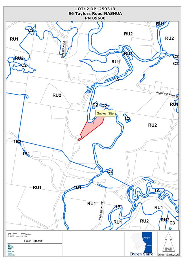
1. INTRODUCTION
History/Background
Record of approvals:![]()
Note. Council is satisfied that the requirements of the Deferred Commencement Conditions in Development Consent No. 10.2020.559.1 have been met, confirmed in writing on 27 February 2023.
Description of the proposed development
This application seeks approval for Three Rural Tourist Cabins in Two Stages.
The first stage is for a one-bedroom cabin that will provide access for people with a disability and the second stage will be for two, one bedroom cabins. The cabins are small scale and are clustered in close proximity to the existing dwelling house on the land. The three cabins will be sited to ensure they are not visible from adjoining properties and will involve minimal works and use of the existing access.
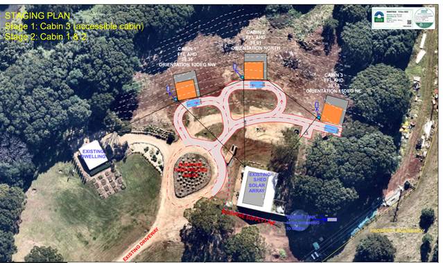
Figure 1: Part Site Plan and Staging
The proposal is accompanied by a vegetation management plan (VMP) which proposes ecological works to the Wilsons River riparian zone and will provide benefits to habitat and to water catchment values. The VMP will facilitate both the management of weeds as well as additional native rainforest plantings, including suitable native species for the river bank areas.
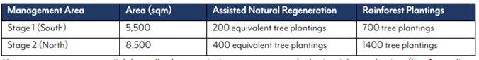
Table 1: Vegetation Management Zones and Planting
Description of the site
A site inspection was carried out on 30 March 2023
|
Land is legally described |
LOT: 2 DP: 259313 |
|
|
Property address |
56 Taylors Road NASHUA |
|
|
Land is zoned: |
RU2 Rural Landscape |
|
|
Land area is: |
8.14 hectares |
|
|
Property is constrained by:
|
Flood Liable Land Bushfire prone land High Conservation Value / High Environmental Value |
|
|
|
Is a BDAR required due to the location of the proposed development? |
☐ Yes ☒ No |
|
|
Are there any easements in favour of Council affecting the site? |
☐ Yes ☒ No |
|
|
Is there a Vegetation Management Plan which might affect the proposal? |
☒ Yes ☐ No |
|
|
Is there a Voluntary Planning Agreement which might affect the proposal? |
☐ Yes ☒ No |
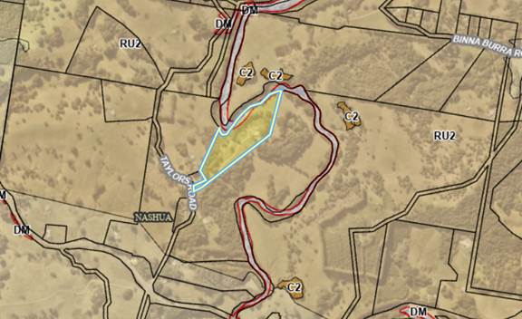
Figure 2: Zoning
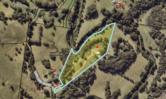
Figure 3: Aerial Photo, Cabins location and nearest residences (approx.350m north-east south-west)
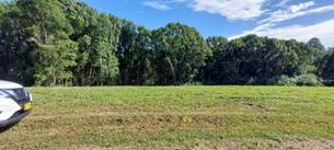

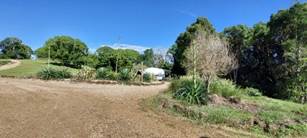


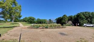
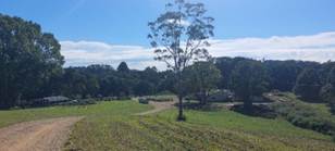

Figure 4: Site photos
2. SUMMARY OF REFERRALS
|
Referral |
Issue |
|
Environmental Health Officer |
No objections subject to conditions. |
|
Development Engineer |
No objections subject to conditions. |
|
Natural Resource Planner |
No objections subject to conditions. |
|
Rural Fire Service (100B) |
No objections subject to general terms of approval. |
* Conditions provided in the above referral are included in the Recommendation of this Report
3. SECTION 4.14 – BUSH FIRE PRONE LAND
Effect of 10/50 rule on significant vegetation – nil.
4. SECTION 4.15C – MATTERS FOR CONSIDERATION – DISCUSSION OF ISSUES
Having regard to the matters for consideration detailed in Section 4.15(1) of the Environmental Planning & Assessment Act 1979 (EP&A Act), the following is a summary of the evaluation of the issues.
State Environmental Planning Policies (SEPP)
|
Considerations |
Satisfactory |
Unsatisfactory |
|
State Environmental Planning Policy (Biodiversity and Conservation) 2021 Consideration: Chapter 3: Koala Habitat Protection 2020 In accordance with sections 3.6 and 3.7 of this policy, the site is not considered to be a potential or core koala habitat. No native vegetation or koala food trees will be affected by the proposed cabins or the asset protection zone for bushfire protection. The proposed vegetation management plan aims to restore endemic vegetation to the site being lowland subtropical rainforest. |
☒ |
☐ |
|
Resilience and Hazards SEPP 2021 Consideration: Chapter 4: Remediation of land The applicant submitted a Preliminary Site Investigation prepared by Balanced Systems Planning Consultants, dated July 2020. A desk top assessment, conceptual site model and soil sampling was undertaken. The report concludes the following: · The site has been used for grazing; · No historical evidence of banana growing; and · Preliminary soil testing shows that all heavy metals and pesticides were below NEPM Hills, except for Chromium and Manganese which are at naturally occurring levels.
It is considered the site is suitable for the proposed development.
|
☒ |
☐ |
|
Consideration: The land is zoned RU2 Rural Landscape. The proposal is not inconsistent with the aims of the SEPP because it does not present any land use conflicts with primary production and will not undermine the orderly economic use and viability of land for sustainable agriculture. The proposed vegetation management works will ensure the protection of native vegetation, biodiversity and water resources. |
☒ |
☐ |
|
SEPP (Building Sustainability Index: BASIX) 2004 Consideration: The applicant submitted BASIX Certificates for the proposed cabins. |
☒ |
☐ |
4.2 Byron Local Environmental Plan 2014 (LEP 2014)
In accordance with LEP 2014 clauses 1.4 and 2.1 – 2.3:
(a) The proposed development is defined in the LEP 2014 Dictionary as Tourist and Visitor Accommodation - Rural Tourist Cabins;
(b) The land is within the RU2 Rural Landscape according to the Land Zoning Map;
(c) The proposed development is Permissible with consent; and
(d) Regard is had for the Zone Objectives as follows:
|
Zone Objective |
Consideration |
|
To encourage sustainable primary industry production by maintaining and enhancing the natural resource base. |
The proposal for small scale rural tourist and visitor accommodation comprising three bedrooms in three cabins in close proximity to the existing approved dwelling on the site is not inconsistent with the objectives of the zone. If approved, the use of the land will maintain the rural character of the site, will not undermine the use of land for small scale agriculture within this stie or on any adjoining sites and will ensure the environmental conservation of the part of the site in the Wilsons River riparian area. The site is not a visually prominent site* and the siting of the cabins will not impact on the scenic quality of landscape in the locality of Nashua. |
|
To maintain the rural landscape character of the land. |
|
|
To provide for a range of compatible land uses, including extensive agriculture. |
|
|
To enable the provision of tourist accommodation, facilities and other small-scale rural tourism uses associated with primary production and environmental conservation consistent with the rural character of the locality. |
|
|
To protect significant scenic landscapes and to minimise impacts on the scenic quality of the locality. |
Clause 4.3 Height of Buildings
The proposed cabins comply with the 9 metre height limit.
Clause 5.21 Flood Planning
Due to the slope and topography of the site the development is not at risk of flooding.
Clause 6.5 Drinking Water Catchment
The subject land is on land identified by the Drinking water Catchment map. Adequate buffer is provided between the development and the adjacent Wilson River and it is considered the proposal will not have an impact on the water way.
Clause 6.6 Essential Services
The proposal is serviced in terms of electricity and has access to a sealed road managed by Council. Water will need to be sourced from rainwater harvesting, while stormwater and effluent will need to be disposed of onsite. The proposal is satisfactory subject to conditions of consent.
6.7 Minimum lot sizes for certain rural tourist and visitor accommodation
The site area of 8.144 hectares is 6.856 hectares below the 15 hectares minimum lot size for rural tourist and visitor accommodation now required under Clause 6.7, which represents a 45.7 % variation. The application was lodged prior to Amendment No.38 coming into effect but no savings provisions were gazetted with the LEP amendment introducing a 15 ha minimum lot size for rural tourist and visitor accommodation.
The applicant prepared a written 4.6 Variation Request in August 2023, seeking a variation to the minimum15 hectare development standard, which sets out the environmental planning grounds and the particular circumstances of this development on this site.
The proposal does not present any land use conflicts with primary production and will not undermine the orderly economic use and viability of land for sustainable agriculture. The proposed vegetation management works will ensure the protection of native vegetation, biodiversity and water resources.
Clause 6.7 is not precluded from Clause 4.6 of the LEP and the applicants request to vary the development standard is considered in full below.
6.8 Rural and nature-based tourism development
(1) The objective of this clause is to ensure that tourism development in rural and natural areas is small scale and does not adversely impact on the agricultural production, scenic or environmental values of the land.
(2) This clause applies to land in the following zones—
(a) Zone RU1 Primary Production,
(b) Zone RU2 Rural Landscape.
(3) Development consent must not be granted to tourism development on land to which this clause applies unless the consent authority is satisfied that—
(a) there is, or will be, adequate vehicular access to and from a road, other than a classified road, taking into account the scale of the development proposed, and
(b) the development is small scale and low impact, and
(c) the development is complementary to the rural or environmental attributes of the land and its surrounds, and
(d) the development will not have a significant adverse impact on agricultural production, amenity or significant features of the natural environment.
(4) Development consent must not be granted to development for the purpose of tourism development on land to which this clause applies unless—
(a) a lawfully erected dwelling house or dual occupancy (attached) is situated on the land, or
(b) a dwelling house may be erected on the land under this Plan.
(5) Development consent must not be granted to development under subclause (4) if the development—
(a) includes an ancillary caretaker’s or manager’s residence, or
(b) is for the purpose of more than 1 bed and breakfast accommodation.
(6) In this clause—
small scale means a scale that is small enough to be generally managed and operated by the principal owner living on the property.
Consideration:
There is adequate vehicular access to and from a road taking into account the scale of the development proposed. There is a recently sealed driveway crossover to and from the site from Taylors Road, which is a bitumen sealed road. Whilst it is acknowledged that the condition of the surface of Taylors Road need some repair by Council being a council asset, there is no nexus for any upgrades to Taylors Road, as a direct result of this small scale proposal.
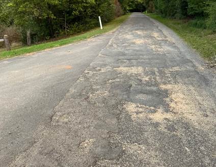
Taylors Road looking past the entrance to the property on the left
The development is small scale and low impact comprising three bedrooms in three cabins located approximately 42-96 metres from the existing residential dwelling on the site and is of a scale that can be generally managed an operated by the principal owner living in an approved dwelling on the property, and
The development is complementary to the rural or environmental attributes of the land and its surrounds and due to the topography and vegetation on the land the proposed cabins will not be visible from any adjoining dwellings or buildings, and
The development will not have a significant adverse impact on agricultural production, amenity or significant features of the natural environment. The proposal does not present any land use conflicts with primary production and will not undermine the orderly economic use and viability of land for sustainable agriculture. The proposed vegetation management works will ensure the protection of native vegetation, biodiversity and water resources.
There is a lawfully erected dwelling house situated on the land.
Clause 4.6 Exceptions to Development Standards
The applicant has sought a variation to Clause 6.7 minimum 15 hectare lot size by proposing rural tourist and visitor accommodation on an undersized lot with an area of 8.144 hectares, which is 6.856 hectares below the 15 hectares minimum lot size for rural tourist and visitor accommodation which represents a 45.7 % variation. The written request is attached to this report and provides the following reasons why the development standard should be varied as follows:
1) Compliance with the development standard is unreasonable or unnecessary because the objectives of the development standard are achieved notwithstanding non-compliance with the standard: Wehbe v Pittwater Council at [42] and [43]. The new development standard Clause 6.7 does not contain any objectives, while the proposal is seeking consent pursuant to Clause 6.8, and proposal is considered to be highly compliant with the sole objective of Clause 6.8. The proposed rural three (3) tourist cabins facility is small-scale, and does not adversely impact upon agricultural production, scenic or environmental values of the land, which is clearly demonstrated within the submission. The proposal is highly complementary to the ecological repair and enhancement works within the Wilsons River riparian corridor and other smallscale food growing activities on the site, and is of a suitable scale to not generate any significant adverse impacts.
2) Establish that the underlying objective or purpose is not relevant to the development with the consequence that compliance is unnecessary: Wehbe v Pittwater Council at [45]. The underlying objective or purpose of the clause is not relevant to this case considering that Clause 6.7 does not contain an objective and that the underlying purpose of Clause 6.7 is not contrary to the outcomes of the proposal which is considered highly suitable for the site. It is noted that if the subject site was a larger landholding above 15 hectares, the siting, location and design of the visitor cabins and environmental considerations would not be altered as their current proposed format would still provide the best environmental planning outcomes.
3) Establish that the underlying objective or purpose would be defeated or thwarted if compliance was required with the consequence that compliance is unreasonable: Wehbe v Pittwater Council at [46]. The underlying objective of the minimum lot size for rural tourist and visitor accommodation was sourced from a Council review of planning controls relating to rural tourism development applications, that concluded that smaller sites were being over-developed, conflicting land use outcomes for conserving and improving the environment and aim to help balance tourist accommodation, agricultural land uses, environmental repair and infrastructure impacts. In this regard, even though the subject site is below the new minimum lot size stipulated in Clause 6.7, the proposal does not raise any non-compliance issues in regards to the underlying purpose of the new clause, which is demonstrated with the Council’s assessment of the proposal; and in particular the site contains attributes that strongly aligns with the intent of the Clause 6.7, that is to enable a small-scale rural tourist facility to be managed by the long-term residents, that includes significant ecological restoration works of the Wilsons River riparian corridor and also undertaking a range of sustainable food growing activities on the site.
4) Establish that the development standard has been virtually abandoned or destroyed by the Council’s own decisions in granting development consents that depart from the standard and hence compliance with the standard is unnecessary and unreasonable: Wehbe v Pittwater Council at [47]. Not applicable; considering the specific circumstances of the proposal where the development application was submitted well before the new development standard came into effect, and where there are no suitable savings provisions built into the BLEP 2014 to allow for approval without seeking a Clause 4.6 Variation. The proposal is also highly consistent with the objectives and other requirements of Clause 6.8 of the BLEP 2014 and the BDCP 2014. Approval of this variation would not result in a long-term precedent considering the highly specific circumstances of the case.
5) Establish that the zoning of the particular land on which the development is proposed to be carried out was unreasonable or inappropriate so that the development standard, which was appropriate for that zoning, was also unreasonable or unnecessary as it applied to that land and that compliance with the standard in the circumstances of the case would also be unreasonable or unnecessary: Wehbe v Pittwater Council at [48]. The property is suitably zoned as RU2 – Rural Landscape where the proposed rural tourist cabins are located.
It is considered that strict compliance with the development standard is unreasonable and unnecessary in the circumstances of the case and that there are sufficient environmental grounds to vary the development standard for the following reasons:
The proposal is highly compliant in regard to all other aspects of the Byron LEP 2014 including building heights, water catchment zone objectives, rural landscape zone objectives and other relevant provisions.
The proposal is also highly compliant with Chapter D3: Tourist Accommodation of the Byron DCP 2014; the proposal suitably addresses the requirements of controls from within section D3.3.4.
The proposal nominates a highly suitable vegetation management plan for the Wilsons River riparian corridor, of which the owner’s have already started doing works, and the tourist cabins facility will provide essential ongoing funding as an integral part of the approval.
The proposal is considered to be highly suitable in terms of visual impacts and scenic values with the buildings located in a central clustered format with limited visibility from public viewing areas or from neighbouring properties. The proposal is also consistent with Table D3.1 which stipulates that the property size can easily support 3 tourist cabins.
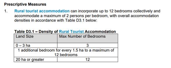
a) The proposal is considered to be highly beneficial in terms of the social and economic welfare of the property owners, the visitors of the facility and the local community will benefit from a viable mixed-land use property:
- Provides a small-scale, sustainable rural tourist accommodation facility that aligns with the values of the land both in terms of the natural physical characteristics, the economic viability of the land-holding and the built form in the locality;
- Positively contributes to the local economy during construction and operational stages; - Manageable by the residents of the property as a low-impact, sustainable rural tourist facility that integrates with food growing activities and ecological enhancement works on the property; and
- [S7.12 Levy] Contributions are payable as a requirement of undertaking the proposed development that will contribute to local roads and other community infrastructure;
b) The proposal is considered to facilitate ecologically sustainable development:
- Allows for the financial capability to undertake the integral, long-term regeneration of Wilsons River riparian corridor, in this location is currently highly degraded from historic land clearing, and in terms of ecological connectivity, water catchment health and flood mitigation is in a critical location on the river system;
- Minimises adverse ecological impacts in terms of effects on any existing recognised native flora and fauna species and ecological communities; - Implements a safe and effective on-site wastewater management system to protect downstream aquatic ecosystems; - Includes landscaping around the cabin buildings to provide additional privacy and improve the visual aesthetics of the rural tourist facility; - Utilises a sustainable building design that achieves the requirements of the NSW BASIX certification system including solar PV electricity, on-site water supply and sustainable building design; and - Intends to illuminate visitors on the environmental values of the land including the principles of organic farming, management of exotic invasive weed species and planting of native vegetation to restore endemic habitat.
c) The proposal is considered to align with the orderly and economic use of rural land, in that the property is not viable as a large-scale commercial farm holding and is more suited to a mixed-land use format with multiple income streams in a well-managed format, one of which is the tourist and visitor accommodation which provides the ability to implement high quality land management while the existing works conducted on the site reflects this.
d) A core objective of the proposal is to protect and enhance the natural environment. The site is in a highly degraded state following not being managed for decades, being covered in exotic weed species mostly being Camphor Laurel, Small-leaf Privet, Large-leaf Privet and exotic grass species. The proposal does not negatively impact any threatened flora or fauna species and an integral component of the project is undertaking the Council endorsed Vegetation Management Plan by Balanced Systems Planning Consultants within the nominated Wilsons River Riparian Zone, which contains areas mapped on Byron Shire Council’s High Environmental Value vegetation, and also on the NSW Biodiversity Values Map, and also contains in the northern portion of the zone the threatened species Thorny Pea (Desmodium acanthocladum) of which the habitat will be protected and enhanced.
e) The proposal does not impact negatively upon any recognised indigenous heritage or non-indigenous heritage values.
f) The proposed building design maximises the northerly aspect with views towards Wilsons River however is well shielded from any public viewing areas due to surrounding topography and does not generate negative outcomes for scenic values. The proposed building design will integrate well into the natural environment by utilisation of appropriate building materials and colours which will be supplemented by native landscape plantings.
g) The proposal has considered the potential for environmental impacts and provided mitigation solutions in the layout and design of the three tourist cabins and associated infrastructure. The existing driveway has already been upgraded to a sealed surface to reduce noise and dust impacts on neighbours while additional vegetation screening will be implemented to improve privacy. It is noted that the cabin buildings are well distanced from any neighbouring dwellings, and it is highly unlikely that there are any adverse impacts on amenity of surrounding properties
Further the proposal is in the public interest having regards to the objectives of the RU2 Zone noting that Clause 6.7 does not specify the objectives of the development standard. The proposal is consistent with the objective of Clause 6.8:
Being suitably small-scale in terms of clustering in a central portion of the property on un-constrained land with an existing approved dwelling building;
Contains sufficient setbacks to neighbouring and surrounding land-uses including rural dwellings;
Not adversely impact upon the agricultural values or farming production capability of the land; - Is not easily visible from any public viewing locations and does not disrupt or degrade the scenic values of the surrounding locality;
Does not result in any significant adverse environmental impacts; and
Is ecologically beneficial with significant ancillary works to be undertaken within the Wilsons River riparian vegetation management zone
The concurrence of the Planning Secretary has been granted (assumed concurrence).
It is considered that strict compliance with the development standard is unreasonable and can be varied in this instance.
4.3 Any proposed Instrument that has been the subject of public consultation and has been notified to the consent authority
Not applicable.
4.4 Byron Shire Development Control Plan 2014 (DCP 2014)
DCP 2014 is an applicable matter for consideration in the assessment of the subject development application in accordance with subsection 4.15(1) of the EP& A Act because it applies to the land to which LEP 2014 applies. The DCP 2014 Parts/Chapters that are checked below are of relevance to the proposed development:
|
Part A |
☒ |
|
Part B Chapters: |
☒ B1 | ☒ B3 | ☒ B4 | ☒ B6 | ☒ B8 | ☒ B9 | ☒ B11 | ☒ B13 | ☒ B14 |
|
Part C Chapters: |
☒ C1 | ☒ C4 |
|
Part D Chapters |
☒ D3 |
Chapter B4 Traffic Planning, Vehicle Parking, Circulation and Access
The proposal provides for the required 1 car parking space per cabin as per the DCP
Chapter B6 Chapter B6 Buffers and Minimising Land Use Conflict.
The proposed three cabins will be located and operated so that they do not:
a) adversely affect the conduct and productivity of agricultural operations on the site;
b) create potential for conflict with adjoining land uses;
c) disrupt environmental enhancement projects on the land; and
d) impact on the ecological or environmental values of the land; and
e) conflict with buffer requirements pursuant to Chapter B6 Buffers and Minimising Land Use Conflict.
Chapter D3 Tourist Accommodation
The three proposed cabins are single storey 1-bedroom buildings with an area of 60m2 each. In terms of the ecological restoration, a vegetation management plan prepared in accordance with Councils requirements is recommended for approval. Conditions to apply.
The proposal raises no other issues in terms of the DCP controls.
4.5 Environmental Planning and Assessment Regulation 2021 considerations
The proposed development raises no specific issues in terms of the relevant regulations.
4.6 The likely impacts of that development, including environmental impacts on both the natural and built environments, and social and economic impacts in the locality
|
Impact on: |
Likely significant impact/s? |
|
Natural environment |
No. The proposal will not have a significantly adverse impact on the natural environment of the locality. |
|
Built environment |
No. The proposal will not have a significantly adverse impact on the built environment of the locality. |
|
Social Environment |
No. The proposal will not have a significant social impact on the locality. |
|
Economic impact |
No. The proposal will not have a significant economic impact on the locality. |
|
Construction Impacts |
No. The development will generate minor impacts during its construction. Conditions of consent recommended to control hours of work, builders waste, construction noise, installation of sedimentation and erosion control measures and the like to ameliorate such impacts. |
4.7 The suitability of the site for the development
The site is partly constrained by Bushfire which can be managed and conditions of consent to apply. In terms of flooding the site is elevated above the adjacent Wilsons River and should not be affected by flooding. The cabins themselves are located within close proximity to the dwelling on the property, enabling them to be managed by the owner. It is unlikely the use of the cabins will impact upon surrounding rural landowners or other residents in the locality.
4.8 Submissions made in accordance with this Act or the regulations
The development application was publicly exhibited. There were two submissions made against the development application:
|
Key Issues raised |
Consideration |
|
Clause 6.8 of LEP adequate vehicular access to and from a road, other than a classified road, taking into account the scale of the development proposed. Chapter B4 Byron DCP 2014 requires the Local Road network to be suitable to support the proposal. Traffic Impact Statement is required. In our view a comprehensive assessment will demonstrate that Taylors Road does not have the capacity to cope with an increase in traffic volume generated by the development. RFS require access.
|
Council Engineers have assessed the development, the site access, and the local road network. A traffic impact assessment was submitted by the applicant in February 2023. There is adequate vehicular access to and from a local road considering the scale of the development proposed. There is a recently sealed driveway crossover to and from the site from Taylors Road, which is a bitumen sealed road. It is acknowledged that the condition of the surface of Taylors Road is degraded but there is no nexus for any upgrades to Taylors Road, as a direct result of this small-scale proposal, which will generate some 9-12 trips a day on average if fully occupied.
|
|
Property Values |
The effect of any development on property values is beyond the powers of a DA (Ultra Vires). |
|
Biodiversity Development Assessment Report (BDAR) required pursuant to The Biodiversity Conservation Act as works are proposed in the BDAR mapped areas.
|
A BDAR is not required. The cabins are not proposed in the Biodiversity Values Map Area. No native trees including Koala Food Trees are proposed to be removed. Vegetation Management Plan is supported to manage restoration of native vegetation in the Wilsons River Riparian area and upper banks. |
|
Buffers to surrounding land users. Concerns about amenity impacts.
|
The proposed cabins are located over 350 metres to the nearest residential dwellings and no significant agricultural activities ae located on adjoining lands that would require management in terms of land use conflicts specified in Byron DCP 2014. |
|
Applicant’s civil company being run out of the proposed development site (without approval).
|
Council compliance staff have investigated, as follows: Attended property for inspection. Property owners Planner Luke Houghton and owners were present. Owner Graham owns an earthmoving business and owns one truck and an excavator and posi track. He advised he tries to leave the vehicles on site when he can but does store the truck and machines on the property at times. These vehicles are used for his occupation and storing them on his private property does not constitute the need for approval for a depot. Council’s compliance unit decided that no further action was required. |
Submissions are attached to this report for Council consideration.
4.9 Public interest
The proposed development is unlikely to prejudice or compromise the public interest or create an undesirable precedent.
5. DEVELOPER CONTRIBUTIONS
5.1 Water & Sewer Levies
No Section 64 levies will be required.
5.2 Developer Contributions
Section 7.12 Contributions will be payable.
6. DISCLOSURE OF POLITICAL DONATIONS AND GIFTS
|
Disclosure details |
Response |
|
Has a Disclosure Statement been received in relation to this application? If Yes, Provide Disclosure Statement register reference: 91. |
Yes ☐ No ☒ |
|
Have staff received a ‘gift’ from anyone involved in this application that needs to be disclosed. |
Yes ☐ No ☒ |
7. CONCLUSION
The DA proposes Three Rural Tourist Cabins in Two Stages.
The proposed development is satisfactory having regard to the relevant environmental planning instruments and planning controls applicable to the site. The proposal raises no significant issues in terms of environmental impacts which cannot be managed. The application appropriately addresses the relevant constraints applying to the site, and is recommended for approval subject to the conditions of consent.
BYRON SHIRE COUNCIL
Staff Reports - Sustainable Environment and Economy 13.6
Report No. 13.6 PLANNING - Report of the Planning Review Committee held 3 August 2023
Directorate: Sustainable Environment and Economy
Report Author: Chris Larkin, Manager Sustainable Development
File No: I2023/1170
Summary:
This report provides the outcome of the Planning Review Committee (PRC) held on 3 August 2023.
NOTE TO COUNCILLORS:
In accordance with the provisions of S375A of the Local Government Act 1993, a Division is to be called whenever a motion for a planning decision is put to the meeting, for the purpose of recording voting on planning matters. Pursuant to clause 2(a) under the heading Matters to be Included in Minutes of Council Meetings of Council's adopted Code of Meeting Practice (as amended) a Division will be deemed to have been called by the mover and seconder of all motions relating to this report.
RECOMMENDATION:
That Council endorses the outcomes of the Planning Review Committee meeting held 3 August 2023.
Report
The Planning Review Committee meeting was held on 3 August 2023. The meeting commenced at 4:30pm and concluded at 5:00pm.
Councillors: Cr A Hunter, Cr D Dey, Cr M Swivel, C Coorey, Cr P Westheimer.
Apologies: Nil
Staff: Chris Larkin (Manager Sustainable Development)
Conflict of Interest: None declared
The following development applications were reviewed with the outcome shown in the final column.
|
DA No. / Applicant |
Property Address / Proposal |
Consultation / Submissions |
Reason/s / Outcome |
|
10.2022.574.1 Byron Bay Planning |
28 Cavvanbah St Demolition of Existing Dwelling and Shed and Tree Removal and Construction of Dual Occupancy (Detached) with Swimming Pools and Strata Subdivision
|
Level 1 23/2/23 to 8/3/23
5 submissions against |
Staff delegation |
|
10.2023.195.1 Planning Ingenuity |
2 Hamilton Lane Use of Garage as Expanded Dwelling Module with New Alterations and Additions and Use of Covered Outdoor Area
|
Level 2 19/7/23 to 1/8/23 3 submissions |
The perceived public significance of the application Council |
Council determined the following original development applications. The S.4.55 applications to modify those consents were referred to the Planning Review Committee to decide if the modification applications can be determined under delegated authority with the outcome shown in the final column.
|
DA No. / Applicant |
Property Address / Proposal |
Consultation / Submissions |
Reason/s / Outcome |
|
10.2016.444.3 Town Planning Studio P/L |
5 Bulgoon Crescent S4.55 for Changes to Approved Lot Layout and addition of Staging to Development |
Level 1 11/1/23 to 24/1/23 2 submissions against |
Staff Delegation |
|
10.2020.574.2 Matthew O’Reilly |
219 The Saddle Rd S4.55 Modification to vary Vehicular Access (Conditions 14, 15 and 5) Vegetation Management Plan Requirements (Conditions 29, 30) and Remove Condition 72 |
Level 2 21/5/23 to 14/6/23
No submissions |
Staff Delegation |
BYRON SHIRE COUNCIL
Staff Reports - Sustainable Environment and Economy 13.7
Report No. 13.7 PLANNING - S4.55 10.2022.391.2 - Use of Existing and Proposed New Alterations and Additions to an Existing Dwelling, and New Detached Secondary Dwelling, Driveway and Garage – 27 Paterson Street Byron Bay
Directorate: Sustainable Environment and Economy
Report Author: Dylan Johnstone, Development Investigations Lead
File No: I2023/1223
Proposal:
|
Modification No |
10.2022.391.2 |
|
Planning Portal Ref |
PAN-339612 |
|
Proposed modification |
Section 4.55 to Amend Conditions 1, 3, 12, 13, 15 , 48, 50 and 58 and to Delete Conditions 11 and 14 |
|
Original Development |
Use of Existing and Proposed New Alterations and Additions to an Existing Dwelling, and New Detached Secondary Dwelling, Driveway and Garage |
|
Type of modification sought |
4.55(2) Other modifications |
|
Property description |
LOT: 16 DP: 258780 |
|
27 Paterson Street BYRON BAY |
|
|
Parcel No/s |
71240 |
|
Applicant |
Mr C R Lonergan |
|
Owner |
Ms A M Callan |
|
Zoning |
R2 Low Density Residential |
|
Date received |
9 July 2023 |
|
Original DA determination date |
5 May 2023 |
|
Integrated Development |
No |
|
Public notification or exhibition |
- Level 2 advertising under the Byron Shire Council Community Participation Plan. - Exhibition period: 20/07/23 – 02/08/23 - Submissions received: Seven (7) |
|
Planning Review Committee |
Not applicable |
|
Delegation to determination |
Council
|
|
Issues |
· Bushfire prone land · DCP 2014 variation of setback of garage to front boundary · DCP 2014 variation of setback of garage to northern boundary and secondary dwelling to rear boundary · DCP 2014 variation for Building height plane encroachment of garage on northern boundary and secondary dwelling on southern boundary · Building Information Certificate required for garage converted to bedroom · Sewer main located in rear yard · Essential energy infrastructure in proximity to proposed driveway |
Summary:
Consent was granted under delegation for the Use of Existing and Proposed New Alterations and Additions to an Existing Dwelling, and New Detached Secondary Dwelling, Driveway and Garage on 5 May 2023.
The approved garage had been converted to a bedroom and consent was granted for the use of the bedroom. Consent was also granted for a balcony to the upper floor bedroom at the rear of the existing dwelling.
A new garage and driveway were approved to provide two car parking spaces adjacent to the northern boundary. Approval also included moving the laundry from the existing dwelling into this garage.
A one-bedroom secondary dwelling was approved in the rear yard with a floor area of 22m2.
This application seeks approval for a Section 4.55 modification to Amend Conditions 1, 3, 12, 13, 15, 48, 50 and 58 and to Delete Conditions 11 and 14.
Conditions sought to be amended are in relation to allowing a footpath between the kerb and existing driveway, setbacks of the approved garage to the front and northern boundaries, enclosure of the garage, provision of privacy screening for the balcony, and retention of an unapproved deck constructed over Council’s sewer infrastructure.
The application was notified between 20 July 2023 to 2 August 2023 in accordance with the Byron Community Participation Plan and seven (7) submissions were received. The objection raised concerns primarily regarding the number and nature of requested amendments, privacy and visual amenity.
Proposed amendments in relation to the footpath between the kerb and the existing driveway and enclosure of the garage are supported while all other requested amendments are not supported.
The application is recommended for approval subject to the conditions listed in Attachment 4.
NOTE TO COUNCILLORS:
In accordance with the provisions of S375A of the Local Government Act 1993, a Division is to be called whenever a motion for a planning decision is put to the meeting, for the purpose of recording voting on planning matters. Pursuant to clause 2(a) under the heading Matters to be Included in Minutes of Council Meetings of Council's adopted Code of Meeting Practice (as amended) a Division will be deemed to have been called by the mover and seconder of all motions relating to this report.
RECOMMENDATION:
That pursuant to Section 4.55 of the Environmental Planning and Assessment Act 1979, Modification No. 10.2022.391.2, be granted approval subject to the conditions in Attachment 4 (#E2023/87381).
1 10.2022.391.2
Amended Site Plan, E2023/87454 ![]()
2 Confidential - 10.2022.391.1 Submissions - Original DA, E2023/87385
3 Confidential - 10.2022.391.2 Submissions to modification, E2023/87382
4 10.2022.391.2
- Recommended modified conditions, E2023/87381
![]()
5 10.2022.391.1
- Existing Approved Plans, E2023/45038
![]()
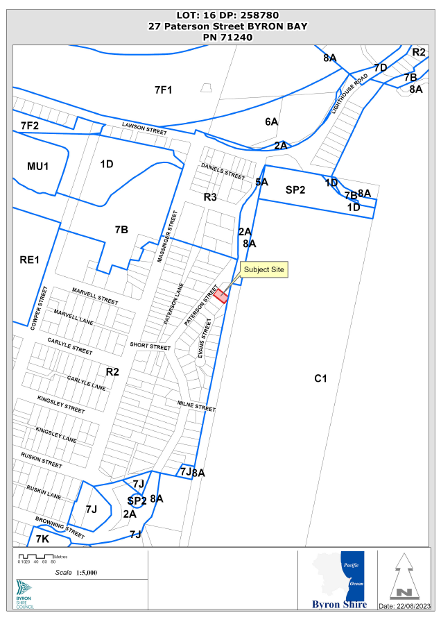
Assessment
1. INTRODUCTION
History/Background
BA 84/2384 – Dwelling – approved 03/09/84
10.2022.391.1 – Use of Existing and Proposed New Alterations and Additions to an Existing Dwelling, and New Detached Secondary Dwelling, Driveway and Garage – approved 05/05/23
Unauthorised works
Since the original approval of the dwelling in 1984 the following unauthorised works were carried out:
· Conversion of the approved garage to a bedroom. The original dwelling was required to provide one car parking space for a 2-bedroom dwelling. The unauthorised conversion of the garage to a bedroom took one car parking space away and triggered the requirement for a second car parking space as DCP 2014 requires 2 car parking spaces for a 3-bedroom dwelling. It is noted that the use of the bedroom converted from the approved garage was granted approval as part of consent 10.2022.391.1 subject to a Deferred Commencement Consent condition to obtain a Building Information Certificate.
· Construction of a deck at the rear of the dwelling. This deck has been constructed over Council’s sewer main which is not permitted by the Building in the Vicinity of Underground Infrastructure Policy 2020. Therefore consent 10.2022.391.1 included condition 48 to require the demolition of this deck prior to issue of an Occupation Certificate.
Variations granted
In issuing consent 10.2022.391.1 Council staff granted 4 variations to DCP 2014 including:
· Building height plane encroachment of the garage on the northern boundary
· Building height plane encroachment of the secondary dwelling on the southern boundary
· Setback of garage on the northern boundary. The application proposed a 400mm setback to the northern boundary which does not comply with the required 900mm setback. Consent conditions were applied to require a 450mm setback to the northern boundary, to require appropriate cladding of the garage on the northern elevation to minimise visual impacts, and to provide a boundary fence along the northern boundary to further minimise the visual and amenity impacts presented by a decreased setback. The requirement for a 450mm setback was also applied as a practical measure to ensure that a sufficient setback to the boundary is provided to enable maintenance of the garage.
· Setback of secondary dwelling to the eastern boundary. While the secondary dwelling provided a setback from the wall to the eastern boundary of 1.5m, the patio roof is proposed with a setback of approximately 400mm. DCP 2014 requires that secondary dwellings must provide a minimum setback of 1.5m to side and rear boundaries.
Submissions
Three (3) submissions were received on the original application which raised a number of objections including privacy impacts of the proposed first floor balcony, the shower and toilet included in the proposed carport and concerns that this structure will be used as a third dwelling, providing stacked car parking within the front setback, privacy impacts presented by the proposed location of the secondary dwelling, and the need for fencing to ensure privacy, safety, noise, security and asset protection.
These submissions are included in Attachment 2 and were considered when granting consent 10.2022.391.1.
Description of the proposed development
This application seeks approval for a Section 4.55 to Amend Conditions 1, 3, 12, 13, 15, 48, 50 and 58 and to Delete Conditions 11 and 14.
Condition 1
Requested amendment
Staff comment
The requested amendment to permit a concrete path from the kerb and gutter to the existing driveway is supported. It is recommended that the pathway be a maximum 1.0m wide.
All other requested amendments to Condition 1 are not supported as outlined below.
Condition 3
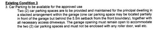
Requested amendment
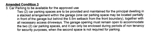
Applicant comment
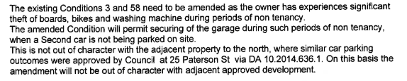
Staff comment
The requested amendment is not supported. Condition 3 was imposed to ensure that two car parking spaces required by DCP 2014 are provided behind the required 5.5m setback to the front boundary. In this regards the garage was not designed to be long enough for two standard vehicles to park inside with the garage door down. Enclosure of the garage would result in one car parking space in front of the garage which would provide an effective front setback to car parking of only 1.2m. The proposed condition that the garage can only be closed during periods of non-tenancy would be impractical to enforce.
It is noted that due to the bathroom and laundry within the garage, submissions for the original application raised concern that, if the garage was to be enclosed, then it could potentially be used as a third dwelling. If the bathroom was removed from the garage then
A garage with a length of 10m has been approved however it is noted that the usable length of the garage for car parking is reduced by 1.0m due to the inclusion of a bathroom. The required length of a car parking space is 5.5m.
An alternate condition is recommended to require the length of the garage to be increased to 12 metres to allow two car parking spaces in a stacked arrangement within the garage while also allowing for the garage to be enclosed. When combined with the requirement of Condition 11 to relocate the garage approximately 700mm eastwards, this will result in a setback of 5.4m from the garage to the front boundary requiring a minor front setback variation of 100mm. It is considered this is a reasonable solution to these design matters
Condition 11
Requested to delete this condition
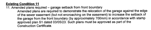
Applicant comment
Staff comment
The requested amendment is not supported. Condition 11 was imposed to ensure that car parking required to comply with DCP 2014 is provided behind the required 5.5m setback to the front boundary.
It is acknowledged that the dwelling to the north was granted approval to convert the original garage to habitable space in 2015, resulting in an approved car parking space forward of the building line of the dwelling. At that time, DCP 2014 permitted one uncovered car parking space within the front setback. It is noted that DCP 2014 now requires that no car parking is permitted within front setbacks. This DCP amendment was introduced to curtail the trend of providing car parking within front setbacks creating unappealing streetscapes within the shire. The existing pattern of onsite car parking for properties along the northern end of Paterson Street is largely consistent with the current DCP requirement that car parking is not provided within the front setback.
Condition 12
Requested amendment
Applicant comment
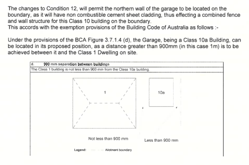
Staff comment
The requested amendment is not supported. Whilst it is acknowledged that the wall of the garage can be constructed to comply with the BCA, this is not the sole consideration. The performance criteria of D1.2.2 of DCP 2014 requires a 900mm setback to side boundaries. The objectives of D1.2.2 includes the requirement “to ensure that development in residential areas seeks to minimise any negative impacts on neighbours caused by siting”.
Staff consented to a variation to DCP 2014 to allow a 450mm setback of the garage to the northern boundary with the northern elevation required to be clad in appropriate materials, and a 1.8m high boundary fence to be installed to minimise any negative impacts of the variation on the adjoining land.
The proposal to construct the garage with a zero setback to the northern boundary is not considered to minimise negative impacts on the neighbouring land to the north and is not compatible with the existing pattern of side boundary setbacks in the locality. The proposed zero setback is considered to have a negative visual and amenity impact on the adjoining land to the north and therefore the proposal is considered to represent a highly undesirable precedent.
Condition 13
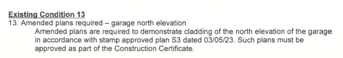
Requested amendment
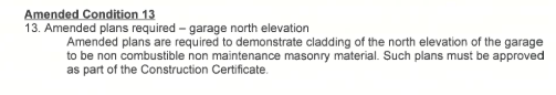
Applicant comment
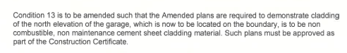
Staff comment
The requested amendment is not supported. Whilst it is acknowledged that the wall of the garage can be constructed to comply with the BCA, this is not the sole consideration. The performance criteria of D1.2.2 of DCP 2014 requires a 900mm setback to side boundaries. The objectives of D1.2.2 includes the requirement “to ensure that development in residential areas seeks to minimise any negative impacts on neighbours caused by siting”.
Staff consented to a variation to DCP 2014 to allow a 450mm setback of the garage to the northern boundary with the northern elevation required to be clad in appropriate materials, and a 1.8m high boundary fence to be installed to minimise any negative impacts of the variation on the adjoining land.
The proposal to construct the garage with a zero setback to the northern boundary is not considered to minimise negative impacts on the neighbouring land to the north and is not compatible with the existing pattern of side boundary setbacks in the locality. Therefore the proposal is considered to represent a highly undesirable precedent.
Condition 14
Requested to delete this condition
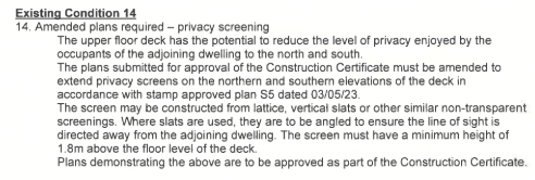
Applicant comment

Staff comment
The requested amendment is not supported. Condition 14 was imposed in accordance with privacy controls of chapter D1.2.3 of DCP 2014 which include an objective to ensure buildings do not unduly affect existing or future development on adjoining properties by impinging on privacy or obstructing views.
This part of the DCP also requires that all parts of any decks, terraces and balconies located in the Building Height Plane are designed to have generous building separation and screens to avoid loss of amenity and visual privacy.
The approved first floor balcony has a direct view into the rear yard of the adjoining dwelling to the north and overlooks the dwelling to the south. While the dwellings to the north and south may already have installed privacy screens to their deck areas, it is considered that there is an onus on the proponent to minimise any potential future privacy impacts by installing privacy screens on the first floor balcony in accordance with Condition 14 and chapter D1.2.3 of DCP 2014.
Condition 15
Requested amendment
Applicant comment
Staff comment
The requested amendment is not supported.
Plans submitted by the applicant for 10.2022.391.1 did not identify any vegetation on the site. Submissions received for the original application raised concerns that vegetation removal will be required to facilitate the proposed garage and associated driveway access. This concern was raised with the applicant prior to determination of application 10.2022.391.1 who confirmed that no vegetation removal is required.
The applicant has not provided plans or any other evidence to demonstrate that “the requirement for a northern fence will destroy existing screen plantings along the northern boundary”.
In accordance with the below Google Street image captured in April 2023 it is considered that existing screen plantings are inadequate to minimise the visual and amenity impacts on the neighbouring land to the north presented by the proposed garage with its setback reduced from 900mm to 450mm.
Further, the original condition to require fencing along the northern boundary is considered reasonable to provide privacy between the rear yard of the adjoining land to the north and the proposed secondary dwelling in the rear yard of the subject land.
It is acknowledged that no other dwellings in the area have fencing to the east, however, it is also noted that all other surrounding lots at the northern end of Paterson Street that back onto the Council reserve / National Park contain only single dwellings and have not intensified the residential use of the land by virtue of a secondary dwelling in the rear yard.
A submission lodged for the original application (Attachment 2) raised concerns with regard to privacy and security issues presented by the proximity of the proposed secondary dwelling to the southern and eastern boundaries.
For the above reasons it was considered reasonable to impose conditions on consent 10.2022.391.1 to require fencing of the northern and eastern boundaries and the amendments proposed by the applicant are not supported.
It is recommended that consent conditions be amended to permit tree removal where demonstrated to be required to establish fencing on the northern and eastern boundaries.
Condition 48
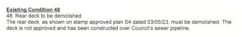
Requested amendment
![]()
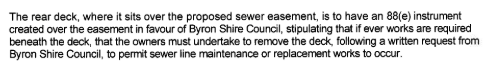
Applicant comment
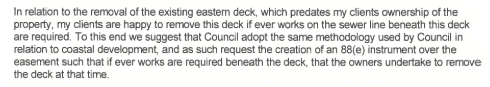
Staff comment
A deck at the rear of the dwelling has been constructed over Council’s sewer main which is not permitted by the Building in the Vicinity of Underground Infrastructure Policy 2020. Therefore consent 10.2022.391.1 included condition 48 to require the demolition of this deck prior to issue of an Occupation Certificate. The requested amendment is not supported. This application was referred to Council engineering staff who are required to assess development in accordance with the Building in the Vicinity of Underground Infrastructure Policy 2020.
Condition 19 requires that an easement be registered over the existing sewer pipeline that traverses the rear yard in accordance with Section 5 of the Policy. Section 5.4 of the Policy provides that, in cases where the pipeline is in an easement, or an easement is a requirement as part of a development application, building works will not be permitted in that easement (limited exceptions for lightweight removable structures may be allowed under the conditions described in Section 7.3). The existing deck is not a lightweight removable structure as defined by Section 7.3 of the Policy.
Section 8.1 of the Policy provides that where structures have been built in the vicinity of underground infrastructure without Council approval, then Council may require that the structure be demolished, moved or substantially modified so that it complies with this Policy. It is unfortunate that the deck has been constructed without approval, but this is a risk for landowners who inadvertently do building work without the requisite approvals in place first. Approval of such outside of the policy creates an undesirable precedent.
Condition 50
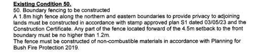
Requested amendment
Applicant comment
Staff comment
The requested amendment is not supported as outlined in comments under Condition 15 above.
Condition 58
Requested amendment
Applicant comment
Staff comment
The requested amendment is not supported. Condition 3 was imposed to ensure that two car parking spaces required by DCP 2014 are provided behind the required 5.5m setback to the front boundary. Enclosure of the garage would require one car parking space in front of the garage which would provide an effective front setback to car parking of only 1.2m. The proposed condition that the garage can only be closed during periods of non-tenancy would be impractical to enforce.
It is noted that due to the bathroom and laundry within the garage, submissions for the original application raised concern that, if the garage was to be enclosed, then it could potentially be used as a third dwelling.
A garage with a length of 10m has been approved however it is noted that the usable length of the garage for car parking is reduced by 1.0m due to the inclusion of a bathroom. The required length of a car parking space is 5.5m.
An alternate condition is recommended to require the length of the garage to be increased to 12 metres to allow two car parking spaces in a stacked arrangement within the garage while also allowing for the garage to be enclosed. When combined with the requirement of Condition 11 to relocate the garage approximately 700mm eastwards, this will result in a setback of 5.4m from the garage to the front boundary requiring a minor front setback variation of 100mm.
Description of the site
The site has an area of 587.6m2 and is located on the eastern side of Paterson Street, Byron Bay. The lot is a regular rectangular configuration with an 18m road frontage. The site slopes down from the street frontage and flattens out around the existing dwelling before gently sloping down to the rear where the site adjoins a Council reserve and National Park.
The site contains an existing dwelling constructed in the 1980’s under approval BA 84/2384. Existing vegetation consists of planted landscaping.
Surrounding development to the north and south consists of single dwellings. The site is bounded to the west by Paterson Street and to the east by a Council reserve and National Park.
The site is mapped as bushfire prone land.
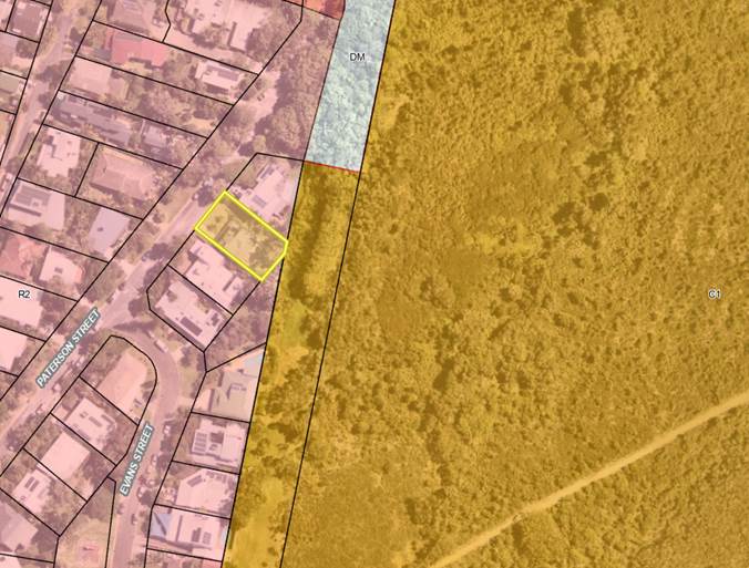
Figure 1: Aerial photo with land zoning overlay. Subject property identified by yellow polygon

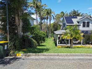
Figure 2: Figure 3:
Approved garage converted to bedroom Location of proposed driveway and garage
viewed from Paterson Street looking East viewed from Paterson Street looking East
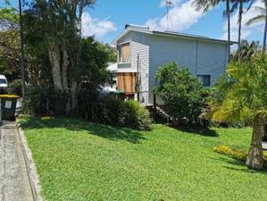
Figure 4: Figure 5:
Adjoining dwelling to the north looking Location of proposed secondary dwelling in SE
northeast Corner of the site
|
Land is legally described |
LOT: 16 DP: 258780 |
|
|
Property address |
27 Paterson Street BYRON BAY |
|
|
Land is zoned: |
R2 Low Density Residential |
|
|
Land area is: |
587.6 m2 |
|
|
Property is constrained by:
|
Bushfire prone land |
|
|
|
Is a BDAR required due to the location of the proposed development? |
☐ Yes ☒ No |
|
|
Are there any easements in favour of Council affecting the site? |
☐ Yes ☒ No |
|
|
Is there a Vegetation Management Plan which might affect the proposal? |
☐ Yes ☒ No |
|
|
Is there a Voluntary Planning Agreement which might affect the proposal? |
☐ Yes ☒ No |
2. SECTION 4.55(2)
The development to which the consent as modified relates is substantially the same as the originally approved development. Section 4.15(1) matters are considered below.
3. ENVIRONMENTAL PLANNING AND ASSESSMENT REGULATION 2021
The proposed S4.55 application raises no issues under the EPA Regulations 2021.
4. SUMMARY OF REFERRALS
|
Referral |
Issue |
|
ET Engineer |
Proposed amendment of Condition 48 not supported. |
Issues:
A deck at the rear of the dwelling has been constructed over Council’s sewer main which is not permitted by the Building in the Vicinity of Underground Infrastructure Policy 2020. Therefore consent 10.2022.391.1 included condition 48 to require the demolition of this deck prior to issue of an Occupation Certificate.
The requested amendment to Condition 48 is not supported. The application was referred to Council engineering staff who are required to assess development in accordance with the Building in the Vicinity of Underground Infrastructure Policy 2020.
Condition 19 requires that an easement be registered over the existing sewer pipeline that traverses the rear yard in accordance with Section 5 the Policy. Section 5.4 of the Policy provides that, in cases where the pipeline is in an easement, or an easement is a requirement as part of a development application, building works will not be permitted in that easement (limited exceptions for lightweight removable structures may be allowed under the conditions described in Section 7.3). The existing deck is not a lightweight removable structure as defined by Section 7.3 of the Policy.
Section 8.1 of the Policy provides that where structures have been built in the vicinity of underground infrastructure without Council approval, then Council may require that the structure be demolished, moved or substantially modified so that it complies with this Policy.
5. SECTION 4.14 – BUSH FIRE PRONE LAND
Under section 4.14 of the Act, Council must be satisfied prior to making a determination for development on bush fire prone land, that the development complies with the document Planning for Bush Fire Protection 2019. The site is bush fire prone land. The original application was referred to the NSW Rural Fire Service, which provided conditions which were attached to the original consent.
The proposed modification does not impact these conditions.
6. SECTION 4.15 – MATTERS FOR CONSIDERATION – DISCUSSION OF ISSUES
Having regard to the matters for consideration detailed in Section 4.15(1) of the Environmental Planning & Assessment Act 1979 (EP&A Act), the following is a summary of the evaluation of the issues.
6.1. State Environmental Planning Instruments
The proposal does not present any new issues that were not considered in the assessment of the original application in relation to SEPPs.
6.2. Byron Local Environmental Plan 2014 (LEP 2014)
The Proposal raises no issues under the LEP which have not previously been considered.
6.3. Any proposed Instrument that has been the subject of public consultation and has been notified to the consent authority
No Draft Planning Instruments affect the proposal.
6.4. Byron Shire Development Control Plan 2014 (DCP 2014)
D1.2.1 Building height plane
The application proposes to increase the building height plane encroachment of the garage on the northern boundary by proposing to reduce the approved setback from 450mm to zero which is not supported.
It is noted that a variation to the 900mm setback required by the DCP was granted for the original approval to allow a reduced 450mm setback.
The objectives of D1.2.1 include to establish spatial separation of residential dwellings and domestic outbuildings from the street, and between allotments and to establish neighbourhoods that offer a high level of amenity and sense of openness with buildings that are cognisant of, and blend with, the scale and streetscape character of the locality.
The proposal to locate the garage on the northern boundary greatly reduces spatial separation between the garage and the adjoining dwelling to the north, significantly reduces the level of amenity and sense of openness within the neighbourhood and is inconsistent with the existing setbacks and built form of the locality.
D1.2.2 Setbacks to boundaries
The requested amendment to locate the garage with a zero setback to the northern boundary is not supported. Whilst it is acknowledged that the wall of the garage can be constructed to comply with the BCA, this is not the sole consideration. The performance criteria of D1.2.2 of DCP 2014 requires a 900mm setback to side boundaries. The objectives of D1.2.2 includes the requirement “to ensure that development in residential areas seeks to minimise any negative impacts on neighbours caused by siting”.
Staff consented to a variation to DCP 2014 to allow a 450mm setback of the garage to the northern boundary with the northern elevation required to be clad in appropriate materials, and a 1.8m high boundary fence to be installed to minimise any negative impacts of the variation on the adjoining land.
The proposal to construct the garage with a zero setback to the northern boundary is not considered to minimise negative impacts on the neighbouring land to the north and is not compatible with the existing pattern of side boundary setbacks in the locality. The proposed zero setback is considered to have a negative visual and amenity impact on the adjoining land to the north and therefore the proposal is considered to represent a highly undesirable precedent.
The application seeks to amend Condition 3 to permit the approved garage to be enclosed. This amendment is not supported however an alternate condition is recommended to require the length of the garage to be increased to 12 metres to allow two car parking spaces in a stacked arrangement within the garage while also allowing for the garage to be enclosed. When combined with the requirement of Condition 11 to relocate the garage approximately 700mm eastwards, this will result in a setback of 5.4m from the garage to the front boundary requiring a minor front setback variation of 100mm.
A minor variation to allow a 100mm encroachment into the 5.5m front setback to the garage is considered reasonable as it does not present a significant visual impact on the existing streetscape and is consistent with the existing pattern of setbacks in the locality.
D1.2.3 Privacy
The requested amendment is not supported. Condition 14 was imposed in accordance with privacy controls of chapter D1.2.3 of DCP 2014 which include an objective to ensure buildings do not unduly affect existing or future development on adjoining properties by impinging on privacy or obstructing views.
This part of the DCP also requires that all parts of any decks, terraces and balconies located in the Building Height Plane are designed to have generous building separation and screens to avoid loss of amenity and visual privacy.
The approved first floor balcony has a direct view into the rear yard of the adjoining dwelling to the north and overlooks the dwelling to the south. While the dwellings to the north and south may already have installed privacy screens to their deck areas, it is considered that there is an onus on the proponent to minimise any potential future privacy impacts by installing privacy screens on the first floor balcony in accordance with Condition 14 and chapter D1.2.3 of DCP 2014.
6.5. The likely impacts of that development, including environmental impacts on both the natural and built environments, and social and economic impacts in the locality
|
Impact on: |
Likely significant impact/s? |
|
Natural environment |
No. The modifications recommended for approval will not have a significantly adverse impact on the natural environment of the locality. |
|
Built environment |
As discussed above the proposal has been approved with a range of conditions imposed to protect the amenity and privacy of the surrounding residents. It is considered that most of the changes proposed by the applicant are not supported. |
|
Social Environment |
No. The modifications recommended for approval will not have a significant social impact on the locality. |
|
Economic impact |
No. The modifications recommended for approval will not have a significant economic impact on the locality. |
|
Construction Impacts |
No. The modifications recommended for approval will generate minor impacts during its construction. Conditions of consent recommended to control hours of work, builders waste, construction noise, installation of sedimentation and erosion control measures and the like to ameliorate such impacts. |
6.6. Council Policies applicable to the proposed development?
Building in the Vicinity of Underground Infrastructure Policy 2020
There is a sewer pipeline traversing the property. Conditions were imposed on the original consent to ensure the proposal complies with the Policy. It is recommended these conditions remain on the consent and not be removed as discussed above.
6.7. The suitability of the site for the development
The site is a serviced, unconstrained property and is suitable for the development with recommended modifications.
6.8. Submissions made in accordance with this Act or the regulations
The application was publicly exhibited .
There were 7 submissions made on the application:
- 6 For
- 1 Against
|
Issue - Objections |
Comment |
|
The request to amend consent conditions should be made to the court rather than Council |
If a person is dissatisfied with conditions imposed on a consent, they have the option of lodging a Section 4.55 application to modify a consent or a Section 8.2 review of determination with Council or they may make an appeal to the Land and Environment Court. The submitted Section 4.55 application to modify consent conditions is appropriate to be assessed and determined by Council. |
|
The proposed amendments are significant and the submitted S4.55(2) application does not meet the requirement that the proposal is substantially the same development as the development for which consent was originally granted as per the Environmental Planning and Assessment Act 1979 |
Council staff have considered the relevant case law and are satisfied that the application is substantially the same development as the development for which consent was originally granted under 10.2022.391.1 and in accordance with Section 4.55 of the Environmental Planning and Assessment Act 1979. |
|
Proposed amendment to condition 1 should not be supported and should be kept as is.
|
The requested amendment to permit a concrete path from the kerb and gutter to the existing driveway is supported. It is recommended that the pathway be a maximum 1.0m wide. All other requested amendments to Condition 1 are not supported as outlined in this report. |
|
Proposed amendment to conditions 3 and 58 to permit enclosure of “carport” should not be granted as no evidence of theft claims have been provided. Further an additional external bathroom is unreasonable and the structure will be used as a third dwelling |
The requested amendment is not supported. Condition 3 was imposed to ensure that two car parking spaces required by DCP 2014 are provided behind the required 5.5m setback to the front boundary. Enclosure of the garage would require one car parking space in front of the garage which would provide an effective front setback to car parking of only 1.2m. The proposed condition that the garage can only be closed during periods of non-tenancy would be impractical to enforce. It is noted that due to the bathroom and laundry within the garage, submissions for the original application raised concern that, if the garage was to be enclosed, then it could potentially be used as a third dwelling. A garage with a length of 10m has been approved however it is noted that the usable length of the garage for car parking is reduced by 1.0m due to the inclusion of a bathroom. The required length of a car parking space is 5.5m. An alternate condition is recommended to require the length of the garage to be increased to 12 metres to allow two car parking spaces in a stacked arrangement within the garage while also allowing for the garage to be enclosed. When combined with the requirement of Condition 11 to relocate the garage approximately 700mm eastwards, this will result in a setback of 5.4m from the garage to the front boundary requiring a minor front setback variation of 100mm. Condition 56 will remain on the consent to ensure that the approved garage must not be configured or used as a dwelling or for separate habitation. |
|
Condition 4 – tree removal.
If compliance with the fencing condition requires removal of trees as stated in the application, then it should be specified which trees are required to be removed |
Agreed. The applicant has not provided plans or any other evidence to demonstrate that “the requirement for a northern fence will destroy existing screen plantings along the northern boundary”. It is recommended that consent conditions be amended to permit tree removal only where it is demonstrated to be required to establish fencing on the northern and eastern boundaries. |
|
Proposed amendment to condition 11 to delete requirement for increased front setback to garage.
Comparison with the front setback to carparking on the property to the north is unreasonable as the structure on the property to the north is a parking deck and not a carport.
The correct comparison should be with the property to the south to ensure a more uniform streetscape.
|
The requested amendment is not supported. Condition 11 was imposed to ensure that car parking required to comply with DCP 2014 is provided behind the required 5.5m setback to the front boundary.
It is acknowledged that the dwelling to the north was granted approval to convert the original garage to habitable space in 2015, resulting in an approved car parking space forward of the building line of the dwelling. At that time, DCP 2014 permitted one uncovered car parking space within the front setback. It is noted that DCP 2014 now requires that no car parking is permitted within front setbacks. This DCP amendment was introduced to curtail the trend of providing car parking within front setbacks creating unappealing streetscapes. The existing pattern of onsite car parking for properties along the northern end of Paterson Street is largely consistent with the current DCP requirement that car parking is not provided within the front setback.
|
|
Proposed amendment to condition 12 to permit the carport to be constructed on the northern boundary will negatively impact the amenity of the adjoining land to the north |
Agreed. As outlined in this report, staff do not support the request to construct the garage with a zero setback to the northern boundary as it will negatively impact the amenity of the adjoining land to the north and create an undesirable precedent. |
|
Proposed amendment to condition 13 to change construction materials for carport when setback condition is amended should not be granted as it is a significant alteration of the original development |
Agreed. As outlined in this report, staff do not support the request to construct the garage with a zero setback to the northern boundary as it will negatively impact the amenity of the adjoining land to the north and create an undesirable precedent. |
|
Condition 14 requiring privacy screens is proposed to be deleted as “neighbours to north and south already have privacy screens on their deck areas, and as such…achieve no practical outcome”.
The condition should be kept as concerns with privacy have historically been a major issue between the subject site and adjoining land to the north and south.
Removing the condition of privacy screening will significantly impact the residents adjoining to the north and south as the proposed deck will have a direct line of sight into the kitchen, dining, living, and backyard areas of both sites. |
The requested amendment is not supported. Condition 14 was imposed in accordance with privacy controls of chapter D1.2.3 of DCP 2014 which include an objective to ensure buildings do not unduly affect existing or future development on adjoining properties by impinging on privacy or obstructing views.
This part of the DCP also requires that all parts of any decks, terraces and balconies located in the Building Height Plane are designed to have generous building separation and screens to avoid loss of amenity and visual privacy.
The approved first floor balcony has a direct view into the rear yard of the adjoining dwelling to the north and overlooks the dwelling to the south. While the dwellings to the north and south may already have installed privacy screens to their deck areas, it is considered that there is an onus on the proponent to minimise any potential future privacy impacts by installing privacy screens on the first floor balcony in accordance with Condition 14 and chapter D1.2.3 of DCP 2014.
|
|
Conditions 15 and 50 are proposed to be amended to only require a northern fence where existing screen planting is not adequate and the eastern fence requirement be entirely removed as it “impedes views from the property to the natural bushland”.
Both fences should be required as it is not accepted that a subjective assessment of planting being “adequate” is a reasonable reason for a fence not being constructed.
Appropriate fencing will ensure that the privacy of neighbours is preserved with additional tenants residing in the granny flat.
The construction of the granny flat already impedes views and, as a balcony is being constructed, the requirements for fences will not impede views of the natural bushland. |
Proposed amendments to Conditions 15 and 50 are not supported as outlined in this report.
|
|
Proposal to amend condition 48 so that the deck be allowed to remain should not be granted as the deck is not approved by Council and is constructed in the building exclusion zone. |
The requested amendment is not supported. The application was referred to Council engineering staff who are required to assess development in accordance with the Building in the Vicinity of Underground Infrastructure Policy 2020.
Condition 19 requires that an easement be registered over the existing sewer pipeline that traverses the rear yard in accordance with Section 5 the Policy. Section 5.4 of the Policy provides that, in cases where the pipeline is in an easement, or an easement is a requirement as part of a development application, building works will not be permitted in that easement (limited exceptions for lightweight removable structures may be allowed under the conditions described in Section 7.3). The existing deck is not a lightweight removable structure as defined by Section 7.3 of the Policy.
Section 8.1 of the Policy provides that where structures have been built in the vicinity of underground infrastructure without Council approval, then Council may require that the structure be demolished, moved or substantially modified so that it complies with this Policy.
|
6.9. Public interest
The recommended amendments are unlikely to prejudice or compromise the public interest or create an undesirable precedent.
7. DEVELOPER CONTRIBUTIONS
The proposed amendments do not generate any nexus to amend the levied developer contributions or headworks charges.
8. DISCLOSURE OF POLITICAL DONATIONS AND GIFTS
|
Disclosure details |
Response |
|
Has a Disclosure Statement been received in relation to this application? If Yes, Provide Disclosure Statement register reference: 91. |
Yes ☐ No ☒ |
|
Have staff received a ‘gift’ from anyone involved in this application that needs to be disclosed. |
Yes ☐ No ☒ |
9. CONCLUSION
An application has been received for a Section 4.55 to Amend Conditions 1, 3, 12, 13, 15, 48, 50 and 58 and to Delete Conditions 11 and 14. The proposal has been assessed with regard to relevant matters for consideration and Section 4.55 of the Environmental Planning and Assessment Act 1979. Proposed amendments in relation to the footpath between the kerb and the existing driveway and enclosure of the garage are supported while all other requested amendments are not supported. Accordingly, the application is recommended for approval subject to conditions listed in Attachment 4.
BYRON SHIRE COUNCIL
Staff Reports - Sustainable Environment and Economy 13.8
Report No. 13.8 Update Resolution 22-459 Wallum Place Affordable Housing Investigation
Directorate: Sustainable Environment and Economy
Report Author: Shannon Burt, Director Sustainable Environment and Economy
File No: I2023/1240
Summary:
Council following consideration of Notice of Motion No 9.3 - Wallum Place Affordable Housing Investigation in the Agenda of Ordinary (Planning) Meeting - Thursday, 8 September 2022 (infocouncil.biz)
Resolved 22-459 “that Council:
1. Receives a report into the suitability of the B4 Mixed Use part of Council-owned land at 42 Wallum Place (Lot 4 DP1004514) (excluding the Byron Herb Nursery), for an affordable housing development to provide much needed housing supply for key workers and low – moderate income residents living in Byron Shire.
2. Funds this investigation to the amount of $10,000 from the Property Development Reserve.”
The purpose of this report is to provide Council with an update on the relevant parts of Resolution 22-459.
That Council:
1. Notes the update of Resolution 22-459 Wallum Place Affordable Housing Investigation and the documented opportunities and constraints relative to development of this site.
2. In response to 1, investigates the potential viability of establishing a Biodiversity Stewardship Agreement over the bulk of the site, except for the operational area around the existing nursery in the western corner of the property.
3. Pending completion of the investigations in ‘2’, support rezoning the bulk of the site to C2 Environmental Conservation Zone, except for the operational area around the existing nursery in the western corner of the property.
Attachments:
1 Wallum
Place Planning advice prepared by Mike Svikis Planning dated 21 October 2022, E2023/85195 ![]()
2 Wallum
Place Biodiversity Constraints Assessment prepared by RECONECO dated
April 2023, E2023/85196 ![]()
Report
In response to Resolution 22-459 two site specific reports have been prepared.
The first to outline the planning controls that apply to the subject land and the constraints and opportunities that are relevant in the development of affordable housing on the site.
The second to address the need to understand the ecological and biodiversity values and constraints of the land.
Both reports are attached in full.
Subject site details
Lot 4 DP 1004514 is a 4.9 hectare lot with a 412 metre frontage to Wallum Place. It also has a 342 metre frontage to the railway corridor on the northern side. It is owned by Byron Shire Council and is classified as Operational land. Operational land has no special restrictions other than those that may apply to any piece of land. It can be sold, leased or licensed. The total area of land zoned B4 now MU4 Mixed Use is approximately 1.6 hectares.
The land is largely vacant of built structures, with part of the Byron Herb Nursery occupying the north-western tip and some of the adjacent lot (also Council land), being Lot 2 DP 706286.
Surrounding land uses include the North Byron Hotel at its eastern boundary, the Habitat development on the other side of Wallum Place, and the Byron Sewage Treatment Plant (STP) and its associated wetlands to the north-west
Some relevant map extracts from the report below:
Figure – Subject Site
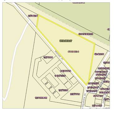
Figure – current aerial image
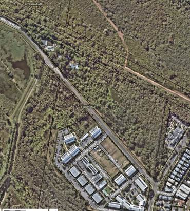
Figure – Land Use Zoning
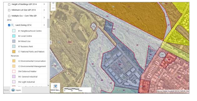
Figure Bushfire Vegetation Map
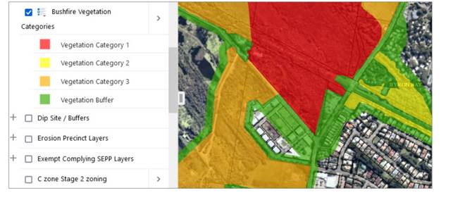
Planning report summary
In summary: ‘the planning report has established that an application for affordable housing could be prepared for the subject land, but to comply with the zone objectives, it should be in the form of a mixed-use development.
As the subject land is classified as Operational land, it could be leased or sold for private use such as affordable housing for tenants or local businesses. It could be retained by Council and built and/or managed by other organisations.
The subject land, however, is relatively small with approximately 1.6 hectares of the 4.9-hectare site zoned B4 Mixed Use. This reduces to approximately 1.2 hectares when the Byron Herb Nursery is excluded. The 1.2- hectare part is relatively narrow, ranging from 20 to 50 metres deep with a long frontage to Wallum Place.
The wider section has the best chance of providing land for built structures, with narrower sections providing for access, parking, open space and infrastructure.
The 1.2-hectare part is relatively constrained, despite having been cleared as recently as 2009.
Key constraints are that the regrowth includes a range of native tree and understorey species some of which is responding to poor site drainage and high rainfall to take on the characteristics of wetland communities.
The 1.2-hectare part is mapped by the state government as being within an area having high biodiversity values, is likely to contain ASS and is entirely in a bushfire hazard area. It is low lying and needs to be filled to eliminate the stormwater drainage problems.
The report went on to say that:
On a development site with multiple constraints, development planning and specialist reports are typically an interactive process. Once the specialist studies have been considered, the development plan can be revised. Once a development plan is finalised then a cost benefit analysis can be undertaken based on estimated yield. If the project is financially viable then a development application with appropriate supporting information will need to be prepared for community consultation and assessment by Council (or the Northern Regional Planning Panel).
There is not enough information to make a clear statement on the development potential (if any) of the subject land for affordable housing. It will be difficult to develop and there are no certainties that an approval could be granted for a residential/mixed use development.
If Council wants to proceed with further investigations, the first two assessments that will assist in firming up the development footprint are a detailed ecological assessment of the site (a baseline study) consistent with the Biodiversity Conservation Act 2016, and a bushfire hazard report that meets the requirements of Planning for Bush Fire Protection.
Ecology report summary
In response to the bold above, an ecological assessment report was prepared which provides a biodiversity constraints assessment for a portion of Council owned land at 42 Wallum Place Byron Bay. The assessment aims to identify biodiversity constraints to inform planning for potential future development of the site.
In the summary the report concludes:
The site contains a range of biodiversity values which significantly constraint options for development on the site, as detailed in this report. Given these constraints, and consideration of relevant commonwealth, state and local legislation and polices, the site is considered to be unsuitable for residential, commercial, or industrial development.
Council could consider other opportunities and uses of the site, which are more sympathetic to the biodiversity values, including investigating the viability of establishing a Biodiversity Stewardship Agreement over the site. This would provide ongoing protection of the site and may also generate income for its ongoing management. Council could also consider rezoning the bulk of the site to C2 Environmental Conservation Zone, except for the operational area around the existing nursery in the western corner of the property.
Figure Biodiversity Values Map
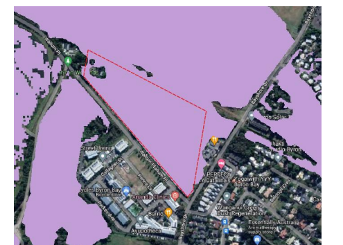
Figure Coastal Wetlands (SEPP) Map
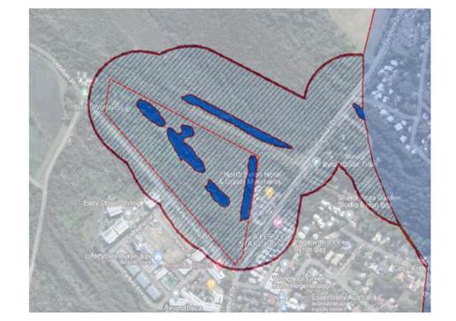
Figure Vegetation (plant community type)
Figure Threatened ecological communities and koala habitat
Figure Red flag map (DCP)
Given the recommendations from both the planning and ecological assessment reports, and without a budget allocation to undertake any further work to determine if there remains a workable and feasible development footprint on the B4 now MU4 Mixed Use zone land e.g., bushfire hazard report and Biodiversity Assessment Report (BDAR) no further consultants reports have been requested at this time.
As such, staff recommend investigation into the potential viability of establishing a Biodiversity Stewardship Agreement over the bulk of the site, and potential C2 Conservation Zone also, except for the operational area around the existing nursery in the western corner of the property.
It remains open to Council however to decide what to do next.
Strategic Considerations
Community Strategic Plan and Operational Plan
|
CSP Objective |
CSP Strategy |
DP Action |
|
4: Ethical Growth |
4.2: Enable housing diversity and support people experiencing housing insecurity |
4.2.2: Partnerships and pilots to address housing needs - Investigate partnerships and pilots that deliver an innovative and affordable housing model for the Shire |
Recent Resolutions
· 22-459
Legal/Statutory/Policy Considerations
As discussed in the report and the attachments.
Financial Considerations
A new operational plan activity and budget allocation would be necessary to fund any further work on this project.
Consultation and Engagement
Not relevant to this report.
BYRON SHIRE COUNCIL
Staff Reports - Sustainable Environment and Economy 13.9
Report No. 13.9 Appointment of Replacement Community Member to the Climate Change and Resource Recovery Advisory Committee
Directorate: Sustainable Environment and Economy
Report Author: Michelle Wilde, Project Support Officer
File No: I2023/1118
Summary:
This report contains the application of the proposed replacement member for the Climate Change and Resource Recovery Advisory Committee, for Council’s decision to appoint.
RECOMMENDATION:
That Council appoints the applicant shown in Confidential Attachment 1 (E2023/, being _____________ to the Climate Change and Resource Recovery Advisory Committee.
1 Confidential - Nomination for Climate Change and Resource Recovery Advisory Committee, E2023/80747
Report
The Climate Change and Resource Recovery Advisory Committee made a recommendation to Council at their 29 June 2023 meeting to seek a replacement member for the Committee. (Note: the minutes of this Committees meeting are subject to a separate report to Council at this same meeting).
Council has a list of two candidates who previously applied for the Climate Change and Resource Recovery Advisory Committee in 2022 and were placed on a wait list.
One of the applicants confirmed verbally that although they are still interested in hearing about future vacancies, they do not have capacity to commit to the committee at this stage.
The other applicant confirmed that they are still interested and can attend the next meeting on 21 September 2023, if appointed. Applicant’s details are included at Confidential Attachment 1.
Strategic Considerations
Community Strategic Plan and Operational Plan
|
CSP Objective |
CSP Strategy |
DP Action |
Code |
OP Activity |
|
|
1:
Effective Leadership |
1.2: Engage and involve community in decision making |
1.2.4: Advisory Committees - Coordinate advisory committees to inform decision making on their areas of expertise |
1.2.4.1 |
Coordinate and support Advisory Committees to assist with effective Council decision making |
|
Recent Resolutions
n/a
Legal/Statutory/Policy Considerations
Nil
Financial Considerations
Consultation and Engagement
Candidates previously applied for the Climate Change and Resource Recovery Advisory Committee in 2022, following advertisement for all committee member appointments for this term of Council.
BYRON SHIRE COUNCIL
Staff Reports - Infrastructure Services 13.10
Staff Reports - Infrastructure Services
Report No. 13.10 Levels of Service to Heritage Park Arboretum
Directorate: Infrastructure Services
Report Author: Malcolm Robertson, Manager Open Space and Facilities
File No: I2023/768
Summary:
This Report is in response to Res 23-149 (part 5) “Requests a staff report on providing a higher level of regular maintenance to the Maslen Arboretum”.
Council levels of service to the Arboretum are constrained by available adopted budget. Increasing service to the Arboretum requires either identification of other parks where service levels can be reduced, or allocation of additional budget.
RECOMMENDATION:
That Council notes current Levels of Service to the Heritage Park Arboretum.
Attachments:
1 Brunswick
Valley Heritage Park Management Plan - May 18 1980, E2023/49414 ![]()
2 Heritage
Park Bush Regeneration Map, E2023/49588
![]()
3 Heritage
Park Arboretum Map Feb 2022, E2022/15439
![]()
Background
In 1979 the Byron Flora and Fauna Conservation Society (BFFCS), a group of local residents led by Russ and Beryl Maslen, counter-proposed a botanic park, which was agreed to by Council in 1980. The BFFCS were given responsibility to design and establish a park. The aim of establishing the park was to collect in one area a wide and representative selection of the flora native to the area (original management plan attachment 1).
On 7 June 1980 the Mayor of Mullumbimby, Alderman Stan Robinson, planted the first tree in the arboretum, a Red Cedar, symbolically launching Brunswick Valley Heritage Park. The Maslen family carried out much of its maintenance till 2003, assisted by volunteers who continue to manage the area today. On 26 November 2018 Council resolved to name this section of Heritage Park the Maslen Arboretum to reflect the contribution of the Maslen family.
Volunteers have subsequently propagated and planted trees native to the local area, and the arboretum now boasts over 600 species with 300 species of local rainforest trees grown from seeds and seedlings collected locally from forests within the Brunswick, Tweed and Richmond valleys.
Levels of Service
Council’s Open Space staff are currently limited in ability to provide additional servicing due to the gap between desired levels of service and allocated resources and backlog of maintenance works required. The Operational Plan action is to maintain each of the Council owned parks, reserves, and sports fields to agreed level of service, however there is no policy direction as to what the agreed levels of service should be.
Every year sees new open space assets being handed to Council, existing assets upgraded or request for existing assets to receive higher levels of service. There is currently no additional operational budget allocated for new assets, or new initiatives such as increased levels of service to the Arboretum.
Previously Council’s Asset Management team have completed a review of Levels of Service for Open Space resources. In order to assist with calculating actual cost and resource requirements for Open Space assets, a Parks Maintenance Level of Service Manual was developed which included an objective formula to determine Levels of Service (LoS) using Frequency Visitation Rate (FVR), Value = (development x frequency) and population. This formula is one which is used in various asset management systems and also in adjoining shires. This FVR is allocated values to determine the LoS hierarchy.
Currently Heritage Park open parkland areas is defined as LOS 2. Parklands are maintained through mowing three weekly through the growing season, dropping to six weekly in the cooler months. Herbicide use is limited to managing major bindi infestations. Litter and rubbish are removed at each service.
Hardscape playgrounds and park furniture receive formal inspections monthly. Routine visual inspections are completed as per regular the maintenance regime. Reactive inspections are undertaken in response to customer requests to ensure safety and functionality of assets.
On occasions the level of service may be increased, such as in preparation for a large-scale community event. The recent Mullum to Bruns Paddle event is an example where anticipated higher levels of use have seen a one-off undertaking to service the park to a higher level of presentation. This increased servicing elicited the following response from the current Arboretum team;
We were agreeably surprised, and pleased, to see at the weekend that the Park had been very carefully 'maintained', presumably for the Paddle event. We volunteers have been trying to do this work with our own equipment over the past few years, disappointed that Byron Council didn't have the interest, or workers, to do this essential job. In fact, I spoke to Councillor Westheimer about my disappointment.
Can we expect your staff to continue this added workload in the year ahead? While the huge lawn tractor adequately mows the road verge, the dog exercise area, and the northern park, is not suitable for the Arboretum.
The new work by the Bush Regen team along the river bank from behind the school into the Arboretum is also appreciated. We residents believe more maintenance work by your departments needs to be considered. Mullum has been looking very 'tired' and run down. It used to be 'a tidy town'.
This undertaking requires re-assignment of operational staff from core duties and is not sustainable as an on-going activity unless additional resourcing was made available.
To maintain the increased levels of service through provision of an additional three-weekly brush cutting and edging to Heritage Park pathways and perimeters, weekly collection of palm fronds and litter collection throughout the park would require around $37,940 in additional operational maintenance budget per annum. This funding would allow areas currently being serviced by Council staff to be reassigned to contractors, freeing staff to provide increased servicing to Heritage Park.
There is intention within the 2023/24 financial year to conduct a review of the Open Space Levels of Service and to present this to Council for adoption. That document will allow better understanding of the maintenance cost implications and may lead to reconsideration of current maintenance programs and priorities.
Bush Regeneration
The regen team is currently working on approx. 14kms of riparian zone along the Brunswick River and its tributaries. This area includes Heritage Park, as shown in attached map. All bushland in the Arboretum area is currently at a maintenance level with all mature weeds having been removed and receives a bush regeneration maintenance treatment to prevent establishment of weed species 3-5 times per year.
The first time this site was treated in 2020 it took around $13,000 of Council funds to treat all weeds. Subsequently an additional $14,000 has gone into weed control at the site with the most recent maintenance run in March 2023 taking $950 to treat all weeds.
In addition to the weed control, the Bush Regeneration team have also been carrying out plantings of select native species in riparian areas. Most recently 250 seedings were planted on 8 May 2023 in the area west of the tennis courts.
Community Servicing
The plantings within the Arboretum have historically been maintained by a dedicated group of volunteers. Recent advice from volunteers currently providing oversight to the Arboretum is that “Vegetation management along Arboretum path should be left to the Volunteers who have empirical knowledge, however a professional audit of trees in this area is necessary. Possibly some vegetation needs to be managed.”
“The current general park management by council with larger zero turn mowers don’t work in the arboretum where large areas of grass are shaded and disappearing as the planted trees mature. Grass areas are too much maintenance, and these should be removed and replaced by pathways and gardens”
“Palm fronds from both the Arboretum and Palm Park need to be regularly removed. They are not habitat - they are untidy and unwelcome”
Botanic Gardens
It has been suggested that Council should consider framing the Arboretum as Mullumbimby’s Botanic Gardens. No agency gives legal accreditation to botanic gardens, so effectively anyone can call any garden a botanic gardens. There are, however, some generally accepted criteria for defining the terms 'botanic gardens' or 'botanical gardens'.
The only legal definition of a botanic garden in Commonwealth legislation occurs in the National Parks and Wildlife Conservation Act 1975. This definition is carried forward into the replacement Environment Protection and Biodiversity Conservation Act 1999 by bridging legislation. Under this legislation "botanic garden" means
a scientific and educational institution the purpose of which is the advancement and dissemination of knowledge and appreciation of plants by:
(a) growing them in a horticultural setting; and
(b) establishing herbarium collections; and
(c) conducting research; and
(d) providing displays and interpretative services.
The following is a list of general criteria that are aimed at meeting by any institution that is considered to be a botanic garden:
· A reasonable degree of permanence
· An underlying scientific basis for the collections
· Proper documentation of the collections, including wild origin
· Monitoring of the plants in the collections
· Adequate labelling of the plants
· Open to the public
· Communication of information to other gardens, institutions and the public
· Exchange of seed or other materials with other botanic gardens, arboreta or research institutions
· Undertaking of scientific or technical research on plants in the collections
· Maintenance of research programs in plant taxonomy in associated herbaria.
In order to maintain the requirements of a Botanic Gardens it is also normal practice to have dedicated staff including a Curator managing collections.
Strategic Considerations
Community Strategic Plan and Operational Plan
|
CSP Objective |
CSP Strategy |
DP Action |
Code |
OP Activity |
|
3:
Nurtured Environment |
3.1: Partner to nurture and enhance our biodiversity, ecosystems, and ecology |
3.1.3: Habitat restoration - Restore degraded areas that provide high environmental or community value |
3.1.3.6 |
Undertake bush regeneration activities to maintain and expand restoration of HEV sites on Council owned or managed lands forming part of the Council bush regeneration program
|
|
5:
Connected Infrastructure |
5.4: Provide accessible community facilities and open spaces |
5.4.2: Parks and open spaces - Provide and maintain active and passive recreational community space that is accessible and inclusive for all |
5.4.2.1 |
Implement Open Space maintenance and capital programs in accordance with the adopted budgets and Open Space Asset Management Plan. |
Recent Resolutions
23-149 Resolved (in part) that Council:
5. Requests a staff report on providing a higher level of regular maintenance to the Maslen Arboretum.
Financial Considerations
Without identification of funding this additional work to maintain new planting areas is not possible. The first priority since adopting the budget is to recover the deficit throughout 2023/24. Unless decision was taken to reprioritise adopted budgeted and reduce expenditure in another area, funding of this new initiative cannot be achieved,
Consultation and Engagement
Considerable engagement with community was undertaken through the resent public exhibition of the Landscape Master Plan for Heritage Park. This plan includes the Arboretum area. Full details on community feedback from the draft Master Plan is provided to Council in separate report.
BYRON SHIRE COUNCIL
Staff Reports - Infrastructure Services 13.11
Report No. 13.11 Bangalow Sports Fields Plan of Management and Landscape Masterplan
Directorate: Infrastructure Services
Report Author: Malcolm Robertson, Manager Open Space and Facilities
File No: I2023/830
Summary:
A Plan of Management has been prepared for the Bangalow Sportsfields that:-
• Specifies the purposes for which the land, and any buildings or improvements, will be permitted to be used
• Specifies purposes for which any further development of the land will be permitted, whether under lease or licence or otherwise, and
• Specifies and describe the scale and intensity of any such permitted use or development.
An associated Landscape Master Plan for the reserve has been developed that lays out preferred options for the future development and upgrade of the Sportsfields precinct.
Following public exhibition of the draft documents and consideration of community feedback, the documents are now presented for Council consideration and adoption.
RECOMMENDATION:
That Council adopts the Bangalow Sportsfields Plan of Management (Attachment 5) and associated concept Landscape Master Plan (Attachment 6).
Attachments:
1 Survey
Responses Redacted - Bangalow Sports Fields Plan of Management and Landscape
Master Plan - Public Exhibition, E2023/56750
![]()
2 Bangalow
Bluedogs Soccer Club Sports Field Plan of Management - Public Exhibition
Submission, E2023/53570 ![]()
3 Bangalow
Bluedogs Proposed Field Layout Options, E2023/54674
![]()
4 Review
of Responses to Public exhibition Bangalow Sports Fields Plan of
Management, E2023/56749 ![]()
5 Final
Draft Bangalow Sportsfields Plan of Management, E2023/56746 ![]()
6 Final
Draft Bangalow Landscape Master Plan, E2023/56745
![]()
Report
This Plan of Management has been prepared to be as flexible and enabling as possible, recognising the constraints associated with the land, and to allow it to meet current community sporting and Council needs.
Initial engagement with Bangalow Sportsfields user groups and community stakeholders saw over 200 submissions from community and allowed draft plans to be produced that were largely in alignment with community expectations. The draft plans were placed on public exhibition from 3 April until 18 May 2023.
Over 40 comments were made by clubs and the community on the Bangalow Sports Fields Draft Plan of Management And Master Plan. Attachment 1 provides the Your Say comments and feedback in full. Attachment 2 is a detailed response submitted by the Bangalow Bluedogs football club, along with Attachment 3 containing suggestions for amended field layouts also presented by Bangalow Bluedogs.
There were no significant changes to either Plan of Management or Landscape Plan arising from the public exhibition. Consideration of all comments is provided in attachment 4, along with detail of resulting amendments where applicable. Community comments were in four main themes, being:
1. Provide more generic references in the Plan Of Management to enable flexibility.
In general, this is agreed and flexibility is seen as an important aspect of the Plan of Management and Concept Landscape Plan, however the flexibility suggested was primarily around things that cannot be achieved. Changing wording to allow for construction of buildings on flood prone land or provision of additional facilities for which there is no space adds no value to the document.
2. Desire for the amenities building to be significantly larger.
There is only one location for a central amenities block due to flooding and access, and the available footprint is relatively small. It is suggested that the playground could move to accommodate a bigger building, but this would enable only a marginal increase of building footprint. It is also not desirable to constrain the configuration of fields any further by building amenities between playing fields.
The need for a central amenities block is constrained by available land across the whole reserve. The compromise was to provide a two storey block in the same footprint as existing, supported by two small satellite facilities with accessible amenities and shelter at either end of the park.
3. Suggestion to move the playground to make it larger and safer.
Consultation with the wider community did not recommend either relocation of the playground nor increase in size. It was recommended that the play area retained a small footprint because of the availability of alternate playgrounds in nearby, non-sporting sites such as Piccabeen Park. The current play area has good sight lines and is centrally located. The design concept provided resolves concerns raised with the path and fences the play area from adjacent vehicle accessways.
4. Options for the layout of pitches.
These were considered in detail with the clubs. The survey drawing shows that it is not possible to fit two rugby pitches side by side in the north cricket oval and the only way this could be achieved would be by the flexibility of rugby using the second oval. The soccer club drawings of the fields (Attachment 3) confirm inadequate space for two fields. The drawing provided shows the wrong field orientation. In this proposal even without required runout space fields extend over the pathway.
Strategic Considerations
Community Strategic Plan and Operational Plan
|
CSP Objective |
CSP Strategy |
DP Action |
Code |
OP Activity |
|
5:
Connected Infrastructure |
5.4: Provide accessible community facilities and open spaces |
5.4.2: Parks and open spaces - Provide and maintain active and passive recreational community space that is accessible and inclusive for all |
5.4.4.3 |
Complete review of Plan of Management and associated Landscape Masterplan for Bangalow Sportsfields and seek funding opportunities for implementation |
Financial Considerations
The adoption of the Plan of Management and Landscape Master Plan will provide the basis for future funding applications to enable development of the Sportsfields.
The current project to upgrade the Sportsfields lighting across the precinct is being implemented through a $795,000 grant from the NSW Government’s Essential Community Sports Assets Program and is indicative of potential funding sources that may be leveraged to further enhance this facility.
Consultation and Engagement
Initial engagement with Bangalow Sportsfields user groups and community stakeholders saw over 200 submissions to “Your Say” survey in 2022. This allowed draft plans to be produced that were placed on public exhibition from 3 April until 18 May 2023 and received an additional 40 comments from clubs and community.
E2019/76582
Report No. 13.12 Mullumbimby Heritage Park Landscape Masterplan
Directorate: Infrastructure Services
Report Author: Malcolm Robertson, Manager Open Space and Facilities
File No: I2023/1083
Summary:
A Landscape Masterplan has been prepared for Heritage Park Mullumbimby with the intention of to establishing a shared vision for this important open space. The Landscape Masterplan lays out preferred options for the future development and upgrade of the park.
Following public exhibition of the draft documents and consideration of community feedback, the Landscape Masterplan is now presented for Council consideration and adoption.
RECOMMENDATION:
That Council adopts the Heritage Park Landscape Masterplan (Attachment 1, E2023/78596).
Attachments:
1 Heritage
Park - Landscape Master Plan FINAL, E2023/78596
![]()
2 Redacted
Submissions Heritage Park Draft Masterplan, E2023/73150
![]()
3 Comments
from online survey (Redacted), E2023/73164
![]()
4 Community
Comments Responses from Plummer & Smith - Heritage Park Masterplan, E2023/78598 ![]()
Report
The Landscape Master Plan outlines landscape treatments and design strategies for Heritage Park, Mullumbimby. The plan seeks to promote environmental, cultural, and open space outcomes in a space that is a celebration of the diverse local community.
The online survey received 89 submissions, with a further 12 formal submissions received. All submissions and responses are attached to this report for reference. The main issues raised, and responses are outlined below.
Accessibility and Connectivity
Upgrade to accessibility was strongly supported. Accessibility within the park is currently very poor in all areas north of Tincogan Street. Improving accessibility within the park not only increases the potential park uses and users but also opens the opportunity for connecting the park to Mullumbimby town centre circulation - thereby providing benefits to both.
Seven submissions did not support improved accessibility, and with only one exception these were strongly focused on retention of the boat ramps.
Vehicle Access
Prioritising people oriented open space and riparian health will mean the removal of informal car parking and vehicular access from the northern end of the park. Car parking to the western river access will be upgraded and rationalised with accessible car parking.
On street car parking and existing car parking near the tennis court will be retained and upgraded. This will improve safety, ecological issues, and enhance usable public open space.
66% of respondants (59) supported the proposed changes that restrict vehicles from accessing the parklands. 14% (12) that did not support the changes were all strongly in favour of retaining the boat ramps.
Proposed changes to the Tincogan Street / Brunswick Terrace intersection
65 submissions (73%) were in favour of the proposed changes to improve pedestrian safety at the Tincogan street crossing.
Nineteen submissions commented on the concept plan for the pedestrian crossing with nine of these submissions providing suggestions for additional changes including;
· The proposed refuge island is not wide enough for someone on a bike to safely stop in the middle and even worse for a family walking together or on bikes.
The refuge island will provide a minimum storage width of 2.5m to accommodate cyclists.
· Safety of the intersection could be improved by firstly reducing the speed limit to and from Federation Bridge as well as improving signage.
This will be considered within the detailed design process; however the speed limit is set by the Sate Road Authority and any reduction in speed will be assessed by Transport for New South Wales.
· Put a small roundabout at the intersection which would aid in traffic flow and also reduce the speed of vehicles.
A roundabout/traffic circle is not supported at this location due to geometric constraints and issues roundabouts can pose for on-road cyclists.
· Has a pedestrian crossing been considered? I believe the installation of a zebra pedestrian crossing where the current informal crossing is on Tincogan Street/Murwillumbah Road would be a great way to connect the already popular walking paths and highly improve pedestrian safety.
It would be difficult to achieve the required sight distance (Tincogan St approach) required for a Zebra at this location.
· I'd like to see a speed hump/cross walk similar to the one at St Johns school and/or noise strips in the lead up to the crossing. The plan looks insufficient to slow down traffic travelling from Mullum around the corner.
A raised crossing would assist in reducing vehicle speeds, however the same sight distance considerations apply as the Zebra crossing requirements.
· Our Mullumbimby Masterplan mentions ‘Investigate the potential for Brunswick Terrace to become a cul-de-sac where it meets Tincogan Street and Federation Bridge". Brunswick Terrace splays out widely near the intersection of Tincogan St giving ample room for a turning circle to be constructed.
This can be considered throughout our investigative processes and detail design.
· It is not clear what formalise parking means. We would like details and clarification of what this actually means. Formalised car parking along the road in Burringbar St and Gordon St makes more sense than Brunswick Terrace.
Formalising carparking refers to clarifying where you can and cannot park with line-marked parking bays or re-enforcing existing parking restrictions (road rules) which may not be known to everyone.
· Installation of a barricade to prevent vehicles turning into Brunswick Terrace will only increase the speed of vehicles as they no longer have to steady for turning vehicles.
This will be considered during our investigation processes and detail design.
· There are no line markings on Tincogan to indicate which side of the road vehicles should drive on. Putting line markings back on the road would increase the safety of the intersection as vehicles would have a guide for where to drive.
This work has been scheduled.
· Tyagarah Street is too narrow, passing cars are forced onto the grass nature strip to allow other vehicles to pass and avoid collisions. Further, the state of Tyagarah Street is in disrepair and as a person with back injuries, the road is too rough to travel on.
This information has been passed onto our operations department to investigate and resolve.
Of the eight submissions that did not support the changes only three commented, and these were all residents of Brunswick Terrace concerned about restrictions on access to their homes. Residents of Brunswick Terrace also separately presented concerns about the potential inconvenience from having to drive around the block.
Change to “soft” river access from within the park for kayaks and canoes only
46% of respondents (41) supported changing the boat ramp into a kayak launching facility only. Comments from supporters of this change focused on the environmental damage from power boats and improving the quality of the park by reducing access to foot traffic.
31 (35%) strongly supported retention of the boat ramps, with 27 people commenting as to why the ramps should be retained. Key issues were distance to Brunswick Heads, lack of an alternate option around Mullumbimby and historical connections with the river.
The Mullumbimby Residents Association strongly advocated for a new motor boat launch site to be developed close to Mullumbimby prior to removal of the existing ramp.
Because of the strength of community concern, the suggestion to remove both boat ramps has been amended. The Heritage Park West boat ramp, located near Federation Bridge is now proposed to be retained in the Masterplan. The retention of this boat ramp will entail a formalised car park with the existing boat ramp retained in it's current condition with potential for renewal, subject to future funding.
As recognised within the plan, maintaining and formalising boat access will result in significant loss of public open space for required vehicle movements and associated parking. This runs counter to community desires for maximising usable open space. Beyond the park boundaries the small residential village streets are already under strain from increasing traffic movements and parking. Parking space on the reserve for boats and trailers is limited, so this option is effectively encouraging large vehicles and boat trailers into these streets. In case there is a need for future review, the alternative option for this area to be a 'soft' river access is retained as an option for future consideration in section 3.7.
Dog Management
The Masterplan is silent on dog exercise areas, with areas identified for open space recreation without specifying any compliance restrictions. The lack of specific detail around control over dog access has alerted many people who were recently engaged with the Dogs in Public Spaces Strategy.
The Landscape Masterplan is focused on landscape treatments and design strategies rather than specific uses, restrictions or compliance over those spaces. The Landscape Master Plan presents open spaces that may have multiple uses. Regulation and compliance over uses of those spaces sits within Management Planning for the reserve stands separately from the Landscape Masterplan.
Of note;
· 21 submissions requested that the existing off leash dog area be maintained.
· 3 submissions suggested that dogs could use the pathway through the Arboretum, but only if on lead.
The Mullumbimby Residents Association conducted their own survey on this matter and also found preference for an off-leash dog area to be retained in the far eastern end of Heritage Park.
The use of Heritage Park as an off-leash dog area was considered in the Dogs in Public Spaces Strategy, adopted by Council in December 2022. Consideration on the implications of removing the off-leash area from heritage Park was taken at Council’s meeting on 25 May 2023, with decision deferred until the new Lot 22 off leash exercise area is operational.
Arboretum
Several community members raised concerns about funding, affiliations and “values” relating to the Arboretum. These are management issues rather than landscape design and need to be considered separately to this plan.
The Landscape Masterplan does recognise to the values of history and environmental significance throughout report. In response to the community concerns an additional note (page 36) has been added that “Opportunities for ecological and plant educational signage throughout the Maslen Arboretum area to celebrate this environmental and community asset. Works to not negatively impact Arboretum vegetation.’
Some concern was expressed about vegetation management within the Arboretum. Only selective and careful pruning to manage pathway use is proposed. No other clearing is suggested.
It was also suggested that a light-coloured surface treatment should be used through the arboretum. Asphalt has been recommended as pathway material through the arboretum due to access, construction, and maintenance reasons. The asphalt surface proposed is more practical and will limit any impact on existing trees. A light-coloured surface is not supported as a coloured surface would also quickly become dark and dirty due to moisture, leaves and lack of direct sunlight.
Pedestrian Bridge
Submission was received suggesting that a pedestrian bridge linking Pine Avenue precinct and Burringbar Street should be included. While this proposition for pedestrian linkage is a visionary aspiration, the complexity around location, linkages, land tenures and potential cost suggest that any consideration should be undertaken as a separate project outside of the scope of this Masterplan.
Art and Sculpture Elements
It was proposed that all park furniture including, shelters, footbridges, seating etc. should be designed and commissioned by local artists and designers. The Masterplan does not dictate detail design but rather provides guidance as to the location and style of infrastructure. Any new works within the park will be staged and the staging of these works will be guided by need, community desires, and available funds and works programming. The masterplan and associated costings are designed to guide future works, assist with funding allocations and applications, and staging. Council seeks to support local suppliers in all procurement processes where possible.
Suggestion is also that the Masterplan needs to recognise specific sites for indigenous statement artworks. The plan already proposed locations for that cultural and environmental interpretation and wayfinding, Community consultation will continue as the project proceeds to detail design and Council has committed within the Masterplan to providing opportunity for Arakwal artists to have their art on display.
Exercise Equipment
The Mullumbimby Residents Association advocated for inclusion of outdoor exercise equipment as an enhancement. A location within the Landscape Masterplan has not been defined for exercise equipment, however this does not constrain consideration should future funding allow for an installation.
Strategic Considerations
Community Strategic Plan and Operational Plan
|
CSP Objective |
CSP Strategy |
DP Action |
Code |
OP Activity |
|
5:
Connected Infrastructure |
5.4: Provide accessible community facilities and open spaces |
5.4.2: Parks and open spaces - Provide and maintain active and passive recreational community space that is accessible and inclusive for all |
5.4.2.4 |
Complete Landscape Master planning for Heritage Park, Mullumbimby and seek funding opportunities for implementation |
Recent Resolutions
RESOLUTION 23-210
That Council notes the implications of excising the Heritage Park off-lead exercise area detailed in this Report.
Once the Lot 22 exercise area is operational then Council considers the future use of the Off-Lead dog area within Heritage Park
RESOLUTION 21-375
That Council allocates $20,000 from the existing $87,300 budget allocated to Heritage Park Infrastructure Works to fund development of a Masterplan for Mullumbimby Heritage Park.
That the Masterplan is to ensure that pedestrian and cycle links between Palm Park, Heritage Park and across Tincogan Street are improved to a safe accessible standard for all users.
Financial Considerations
Adoption of the Heritage Park Landscape Masterplan will provide a solid basis for future grant funding applications.
Consultation and Engagement
The draft Landscape Masterplan was developed through external consultation with TBLALC, Arakwal Board, Mullumbimby Residents Association, Maslen Arboretum representatives, Creative Mullum, the Byron Place Planning Collective, and casual park users. Public Exhibition of the draft Masterplan saw 101 submissions.
BYRON SHIRE COUNCIL
Staff Reports - Infrastructure Services 13.13
Report No. 13.13 Update on the Additional Flow Path project - Response to Council Resolutions 23-108 and 23-277
Directorate: Infrastructure Services
Report Author: Pablo Orams, Integrated Water Management Officer
File No: I2023/1160
Summary:
The Additional Flow Path (AFP) has undergone initial tests. However, it is not yet fully operational. Resourcing and technical issues have delayed the project commissioning process. Council have asked staff for extensive information regarding the status of the project:
1. Res. 23-108 (Council Meeting of 13 April 2023) requested a response to NoM. 9.1 (see Attachment 1). Staff prepared a comprehensive report to address this request (see Attachment 2). The full Resolution is included below:
|
|
Notice of Motion No. 9.1 Alternative Flow path Bayshore Drive File No: I2023/490
|
|
23-108 |
Resolved that: a. How often it is used and in what conditions, i.e. wet weather and dry weather. b. The amount of water transferred down it from the STP under various conditions, including as a percentage of total out flows. c. Any filling that has been done to grade the drain toward west Byron and its effectiveness. d. Performance relative to initial project objectives. e. Impact on the amount of water leaving the STP through the drain on the Flick’s property. f. The hydraulic efficacy of the flow path, given the stagnant water apparent in the photographs attached in the Notice of Motion. 2. The Report also goes on the agenda of the next meeting of Council’s Water & Sewer Advisory Committee. (Lyon/Hunter) The motion was put to the vote and carried unanimously. |
2. Res. 23-277 (Council Meeting of 22 June 2023) requested further clarification regarding Res. 23-108, and included various additional questions to staff. The full Resolution is included below:
|
|
Report No. 13.20 Project update - Additional Flow Path File No: I2023/874
|
|
23-277 |
Resolved: 1. That Council notes the Additional Flow Path (AFP) project report dated May 2023
2. That Council receives a Report that responds to all Parts of Resolution 23-108 including Part 1(f) and also assesses: (g) whether Council should have and does have a Legal Point of Discharge from Council’s STP land onto the Flicks’ property; (h) current condition of vegetation on the AFP as a starting point for Drain Maintenance, which was discussed in Section 3.3 of Attachment 2; (i) when periodic checks of vegetation should commence; (j) the likely annual cost of mechanical vegetation removal and which Council Fund should cover that cost. (k) That also assesses capacity to go beyond 1 megalitre per day into the AFP during the trial period and up to the maximum possible whilst maintaining environmental flows at EPA 4 3. That a detailed response is provided in the next Ordinary Council Meeting in August 2023. (Hunter/Dey) |
Staff’s responses to item 2 of Res. 23-277 are provided in the report below. Staff requests feedback and advice from Council regarding the issues in question.
RECOMMENDATION:
That Council notes this report.
1 Report
13/04/2023 Council (Planning) Alternative Flowpath Bayshore Drive, I2023/490 ![]()
2 Report
22/06/2023 Council Project update - Additional Flow Path, I2023/874 ![]()
3 Byron
Bay Integrated Water Management Reserve BBIWMR - Surface and ground water
review, E2023/19414 ![]()
4 DRAFT
AFP Discharge Draing Modelling BMT, E2020/35472
![]()
5 Confidential - BSC legal advice - 27 July 2023 - Byron sewerage treatment plant - drainage rights, E2023/79546
6 DRAFT
AFP Operating Manual and Functional Specification 31 May 2023, E2023/54928 ![]()
Report
Staff’s response to Resolution 23-277
Question 1: That Council receives a Report that responds to all Parts of Resolution 23-108 including Part 1(f).
a. How often it [the AFP] is used and in what conditions, i.e. wet weather and dry weather.
The AFP was designed to be utilised during dry weather conditions.
The operational protocol (which will define how often the AFP can be used) and the monitoring/instrumentation infrastructure needed to implement that protocol are being revised based on the ongoing AFP testing regime.
Various effluent release trials were undertaken between May and July 2023 to test the infrastructure (e.g. pumps, instrumentation, etc).
A more substantial effluent release exercise was done on early August, with 2.5 ML being released on a 7-hour system run.
Staff are observing system performance in preparation to further operational tests.
b. The amount of water transferred down it from the STP under various conditions, including as a percentage of total out flows.
This will be defined through operational testing of the AFP. Effluent will be released in increments to gauge system performance and impacts on the surrounding catchment.
Council recommended staff to develop an ambitious testing regime. 2.5ML/day have been released during the last AFP operational test.
The testing regime is being revised based on this experience.
c. Any filling that has been done to grade the drain toward west Byron and its effectiveness.
The AFP drain grade is roughly 0.1%.
The highest point of the graded drain of the AFP and the lowest point of the pipe (at the Pocket Park) are the same.
The surveyed pipe invert level is IL 2.70. The lowest point of the graded drain is at the upstream headwall of the Ewingsdale Road crossing with and approx. invert of IL 2.18.
During the latest effluent release trial of 2.5ML/day, flow was observed throughout the length of the AFP drain.
Staff will continue to assess conveyance effectiveness as AFP testing progresses.
d. Performance relative to initial project objectives.
As the AFP is not yet fully operational, it’s performance against initial objectives is yet to be assessed.
The AFP needs to be operated within a complex set of objectives, including reduction of effluent discharge via current discharge path, wetland function for effluent treatment, management of acid sulphate soils (ASS) and peat fires, effluent reuse and environmental flows for biodiversity.
It is important to emphasize that a performance assessment framework for the AFP will be developed and tested overtime. Outcomes related to reduction of effluent discharge via the current flow path (i.e. discharging at EPA point 4) may be evident as soon as the AFP is fully operational. However, assessing performance related to the mitigation/improvement of environmental outcomes (i.e. wetland functions, ASS/peat fires, biodiversity, flooding of neighbouring land, etc.) will require on-going monitoring and evaluation over a longer period (e.g. 1-2 years).
e. Impact on the amount of water leaving the STP through the drain on the Flick’s property.
Careful interpretation and analysis of available information suggests that increase in surface water levels within the Farm Drain and Upper Union Drain correspond with recent La Niña conditions, with rainfall being the strongest driver for changes in water levels. It is also suggested that water logging in neighbouring low-lying farmland (of which a substantial portion sits below sea level) may be exacerbated due to insufficient conveyance capacity / constrains in the Drainage Union drain network. Also, further monitoring infrastructure is required to better understand groundwater dynamics across and around the BBIWMR site and surrounding areas.
Further understanding of the linkages between effluent discharge and the dynamics of the surrounding catchment will be informed by monitoring data collected over the first 1-2 years of the AFP operation.
A detailed study of this issue is available in Attachment 3.
f. The hydraulic efficacy of the flow path, given the stagnant water apparent in the photographs attached in the Notice of Motion.
The hydraulic calculations for both the piped and open channel drainage lines of the AFP are based the report from BMT named Byron Industrial Estate STP Discharge Drain Modelling (see Attachment 4).
In brief, modelling in this report suggests that:
- In dry weather, the effects of increase of the STP discharge into the AFP from 3ML to 7ML a day alone are negligible and have minimal effect on water levels in the drainage lines.
- In wet weather, that is when combined with a 10-year ARI event, minor increases are observed in the downstream drainage line.
- At the predicted peak water levels in the drainage lines, inclusive of the STP flow and a 10-year ARI catchment event, there remains freeboard within the drainage line.
- Overall, the addition of flow to the AFP drainage lines has not been observed to impact on flooding in the Industrial Estate up to a 10-year ARI event.
The last effluent release test saw 2.5ML/day flow into and through the AFP drain. Modelled drain capacity will be further verified through upcoming system tests.
It must be noted that silt and debris are likely to accumulate in the drain from time to time. This will be managed via periodic drain inspections and clearing.
Question 2: Whether Council should have and does have a Legal Point of Discharge from Council’s STP land onto the Flicks’ property.
CONFIDENTIAL legal advice regarding this question is provided in Attachment 5.
Question 3: Current condition of vegetation on the AFP as a starting point for Drain Maintenance, which was discussed in Section 3.3 of Attachment 2.
The “Attachment 2” referred to in the above question is the AFP Draft Operating Manual and Functional Specification document (see Attachment 6), which was included as part of staff response to Res. 23-108.
While the current condition of the vegetation on the AFP drains hasn’t been assessed by a subject-matter expert (i.e. water sensitive urban design - WSUD), staff have identified sections of plant overgrowth that may not align with the operational specifications for the system.
Clearing of the identified overgrowth will be undertaken in parallel to the revised AFP testing regime, as water flows can be used to control condition of drain vegetation.
During the last effluent release (2.5ML/day), overgrowth appeared to slow-down water movement during the early stages of the trial, but flow was clearly observed at the down-stream end of the AFP drain after 1-2 hours.
Mechanical removal will be required. Utilities is collaborating with the Works department to assess the feasibility of mechanical removal considering drain design, WSUD requirements and access (e.g. safety fencing may limit access for required machinery). A first drain clean is be scheduled for late August / September, weather-permitting.
Question 4: When periodic checks of vegetation should commence.
The AFP Draft Operating Manual and Functional Specification document (see Attachment 6) recommends that “Periodical checks and mechanical removal of vegetation overgrowth is recommended.”
The frequency of vegetation checks will be informed by the outcomes of the AFP testing regime and the finalisation of the Operating Manual and Functional Specification document.
Question 5: The likely annual cost of mechanical vegetation removal and which Council Fund should cover that cost.
The cost of mechanical vegetation removal is still to be defined.
Considering that the AFP drains will also receive stormwater flows from the surrounding catchment (i.e. Industrial State), drain maintenance costs are likely to be shared between the Utilities and Works Departments.
Question 6: That also assesses capacity to go beyond 1 megalitre per day into the AFP during the trial period and up to the maximum possible whilst maintaining environmental flows at EPA 4
Staff have noted Council’s recommendation to increase the scale of effluent release tests. A reviewed testing regime is being finalised. A release of 2.5ML/day was undertaken on early August. Staff are assessing the outcomes of these trials to review the AFP Operating Manual and Functional Specification, as well as the monitoring/instrumentation infrastructure to implement it adequately.
BYRON SHIRE COUNCIL
Reports of Committees - Sustainable Environment and Economy 14.1
Reports of Committees - Sustainable Environment and Economy
Report No. 14.1 Report of the Climate Change and Resource Recovery Advisory Committee Meeting held on 29 June 2023
Directorate: Sustainable Environment and Economy
File No: I2023/1042
Summary:
This report provides the minutes of the Climate Change and Resource Recovery Advisory Committee Meeting held on 29 June 2023.
RECOMMENDATION:
That Council notes the minutes of the Climate Change and Resource Recovery Advisory Committee Meeting held on 29 June 2023.
1 Minutes
29/06/2023 Climate Change and Resource Recovery Advisory Committee, I2023/965 ![]()
Report
The attachment to this report provides the minutes of the Climate Change and Resource Recovery Advisory Committee Meeting of 29 June 2023 for determination by Council. The agenda for this meeting can be located on Council’s website at:
https://byron.infocouncil.biz/RedirectToDoc.aspx?URL=Open/2023/06/CCRR_29062023_AGN_1649_AT.PDF
The following items were considered by the Committee:
Report No. 4.1 Future Discussion Items for Climate Change and Resource Recovery Advisory Committee
That the Climate Change and Resource Recovery Advisory Committee notes the community members’ report and looks forward to a more detailed report in the September meeting.
Report No. 4.2 Regional Waste Strategy and Waste to Energy
That the Climate Change and Resource Recovery Advisory Committee:
1. Notes the report;
2. Notes that we oppose any incineration or waste treatment that results in worse environmental outcomes than current operations.
3. That Council supports the NSW Energy from Waste Policy Statement 2022 approach that the incineration facilities for the destruction of waste not be permitted.
4. Supports maintaining an open, investigative approach to long term waste management, including alternative waste treatment, ensuring options are assessed transparently to ensure the best outcome for the environment and our communities; and.
5. Is updated on regional waste management initiatives and any progression or changes in energy from waste status locally or at a state level as part of the Resource Recovery Update report provided to this Committee each meeting.
Report No. 4.3 Draft Single-use Packaging and Materials Policy
That the Climate Change and Resource Recovery Advisory Committee notes the report and attachment.
Report No. 4.4 Sustainability project updates
That the Climate Change and Resource Recovery Committee notes the report.
Report No. 4.5 Climate Change Risk and Adaptation: Council Project Update
That the Climate Change and Resource Recovery Advisory Committee notes the report.
John Taberner resigned from the Climate Change and Resource Recovery Advisory Committee on 22 June 2023.
Committee Recommendation:
That Council seek a replacement member for the Climate Change and Resource Recovery Advisory Committee.
Management Comment:
Council has a list of two candidates who previously applied for the Climate Change and Resource Recovery Advisory Committee in 2022 and were placed on a wait list.
One of the applicants confirmed verbally that although they are still interested in hearing about future vacancies, they do not have capacity to commit to the committee at this stage.
The other applicant confirmed that they are still interested and can attend the next meeting on 21 September 2023, if appointed.
This matter is the subject of a separate report to Council at the same meeting titled “Appointment of Replacement Community Member to the Climate Change and Resource Recovery Advisory Committee”.
Financial Implications
As per the Reports listed within the Climate Change and Resource Recovery Advisory Committee Meeting of 29 June 2023.
Statutory and Policy Compliance Implications
As per the Reports listed within the Climate Change and Resource Recovery Advisory Committee Meeting of 29 June 2023.
BYRON SHIRE COUNCIL
Reports of Committees - Infrastructure Services 14.2
Reports of Committees - Infrastructure Services
Report No. 14.2 Report of the Local Traffic Committee Meeting held on 4 September 2023
Directorate: Infrastructure Services
File No: I2023/1346
Summary:
The purpose of this Report is to gain Council support for the Chinny Charge fun run event scheduled to run on the 16 September 2023.
RECOMMENDATION:
1. That Council supports the “Chincogan Charge” to be held on Saturday 16 September 2023.
2. That Council supports in Part 1 is subject to:
a) Separate approvals by NSW Police and TfNSW being obtained;
b) The event organiser providing Council with an updated Traffic Management Plan and Traffic Guidance Scheme(s) for the event, if required;
c) Development and implementation of a Traffic Management Plan and Traffic Guidance Scheme/s by those with appropriate TfNSW accreditation and the holding of current and appropriate levels of insurance and liability cover;
d) The impact of the event be advertised, and charged at cost to the organisers, via a notice in the local weekly paper and Variable Message Signage (VMS) a minimum of one week prior to the operational impacts taking effect, noting it must include the event name, specifics of any traffic impacts or road closures and times, alternative route arrangements, event organiser, a personal contact name and a telephone number for all event related enquiries or complaints;
e) The event be notified on Council’s web page and social media with the event organiser supplying Council with the relevant information;
3. The event organiser to:
a) Inform the community and businesses that are directly impacted (e.g. within road closure zones) via written information which is delivered to the property in a timely manner so as to document, consider and respond to any concerns raised;
b) Arranging for private property access and egress affected by the event;
c) Liaising with bus, taxi and waste operators and ensuring arrangements are made for provision of services during conduct of the event;
d) Consulting with Emergency Services and any identified issues be addressed;
e) Holding $20m Public Liability Insurance cover which is valid for the event;
f) Not place any signage on the road related area of the Pacific Highway.
|
Background For the 2022 event the organisers followed the same course as 2020 (the 2021 event was cancelled due to COVID) with runners starting and finishing near Mullumbimby Police Station. The road course will require actions to control traffic and the implementation of prescribed traffic control devices such as No Parking signs to control vehicles. 500 participants are expected. Event Overview The organisers have submitted a 2023 TGS the image below shows the expected impact on roads. The blue line indicates the approximate running path within the road reserve and the following major impacts are planned: · Dalley Street, between the Post Office and the Civic Hall is expected to be closed between 12.30-5.30pm · Murwillumbah Road, at Federation Bridge to Main Arm Rd to be controlled by traffic controllers. The South bound lane will be used for contraflow traffic controlled by Traffic Controllers. Traffic will be allowed to access Main Arm Road in-between competitors. Traffic will be controlled at this point between 12.35-5.30pm · Coolamon Scenic Drive from Main Arm Rd to 1913 Coolamon Scenic Drive. The South bound lane will be used for contraflow traffic controlled by Traffic Controllers. Traffic will be allowed to access Main Arm Road in-between competitors. Traffic will be controlled at this point between 12.40-5.30pm · Once competitors cross the finish line they will move onto the footpath and head to the Mullumbimby Civic Memorial Hall for the presentation. · The race itself is expected to finish at 4pm with presentations from 4-5.30pm.
Strategic Considerations Community Strategic Plan and Operational Plan
Recent Resolutions 22-084 Resolved that Council adopts the following committee recommendations: Report No. 6.4 Event - Chincogan Walk and Charge 2022 File No: I2022/69
Committee Recommendation 6.4.1 1. That Council support the Chincogan Walk 2022 to be held on a day (as approved by asset owner) in March / April 2022 and Chincogan Charge 2022 to be held on Saturday 17 September 2022, between 8:00am and 5:30pm. 2. That Council support in Part 1 is subject to: a) Traffic Guidance Scheme(s) and a Traffic Management Plan (TMP) being designed by those with the appropriate and relevant NSW (TfNSW) accreditation. The TGS(s) and TMP to include the closure of Dalley Street between Burringbar Street and Tincogan Street between 12.30pm-5.30pm; b) The TGS to be generally in accordance with Attachment 1 (E2020/46680); c) Implementation of the approved Traffic Management Plan and Traffic Guidance Scheme/s by those with appropriate TfNSW accreditation and the holding of current and appropriate levels of insurance and liability cover; d) Separate approvals by NSW Police and TfNSW being obtained; e) The March/April event date when specified is supported by staff prior to proceeding. f) Any concerns expressed by members of the public to be addressed by council or relevant authority before the event;
3. The event organiser at to: a) Advertise the impact of the event, via a Variable Message Sign on site and notice in the local weekly paper, a minimum of one week prior to the operational impacts taking effect, noting it must include the event name, specifics of any traffic impacts or road closures and times, alternative route arrangements, event organiser, a personal contact name and a telephone number for all event related enquiries or complaints; b) Arrange for the event to be notified on Council’s webpage a minimum one week prior to the TGS being implemented; c) Undertake consultation with affected community and businesses including adequate response/action to any raised concerns. d) Undertake consultation with emergency services and any identified issues addressed. e) Holding $20m public liability insurance cover which is valid for the event. f) Paying Council’s Road Event Application Fee prior to the event. (Lyon/Ndiaye) Consultation and Engagement All consultation and Engagement has/will be undertaken by the event organiser. |
1 Minutes
04/09/2023 Local Traffic Committee Extraordinary, I2023/1328 ![]()
2 Re_ Extraordinary LTC - Chincogan Charge Report - Comments from LTC Committee members_LTC_extraordinary__September_2023, E2023/91656
BYRON SHIRE COUNCIL
Questions With Notice 15.1
Question with Notice No. 15.1 Mullumbimby Gravity Sewer Condition
File No: I2023/1250
Cr Hunter asks the following question:
I note in the Willow Sparrow Report (2019) of the Mullumbimby Gravity Sewer Condition within the catchment 4001, that of the 109 mains that were assessed, 22 were recommended for immediate replacement in addition to another 22 recommended for immediate minor rectification works and the remaining 87 mains were recommended for re-assessment prior July 2020.
Could staff please provide:
1. Further information on how many of the 22 mains recommended for replacement have been completed and how many of the 22 recommended for immediate minor rectification have been attended to and rectified.
2. An explanation of the risk that, in times of heavy rain events storm water or untreated sewerage could enter the decaying system and ultimately into the Brunswick River?
Response Director Infrastructure Services
1) The sewer mains required to have structural relining are detailed within the Willow and Sparrow conditions report (attachment 1).
A total of 44 sewer lines required remedial works of which 27 had structural re-lining. While 17 had minor rectification works carried out.
2) The rectification works took a risk and condition assessment approach to minimise untreated sewage entering the Brunswick River. This is the purpose of the program.
It would be highly unlikely that this would occur where rectification works have been carried out. Attachment 2 is the scope maps showing the sewer main locations.
In summary, the sewer mains in question have been relined.
Attachments:
1 Inflow
and Infiltration 21 Mullumbimby works: Attachment 2 - Scope Maps, E2023/89196 ![]()
2 Inflow
and Infiltration Mullumbimby works: Attachment 1 - Detailed Scope, E2023/89194 ![]()
BYRON SHIRE COUNCIL
Confidential Reports - General Manager 16.1
Confidential Reports - General Manager
Report No. 16.1 Confidential - Lease to Catholic Healthcare Limited over proposed Lot 50 in unregistered plan of subdivision (presently part Folio 188/728535) request for further holding over.
Directorate: General Manager
Report Author: Ralph James, Legal Counsel
File No: I2023/1111
Summary:
This report updates “Commercial in confidence” discussions between Council and Catholic Healthcare Pty Ltd in enacting Council resolution 22-515.
RECOMMENDATION:
1. That pursuant to Section 10A(2)(c) of the Local Government Act, 1993, Council resolves to move into Confidential Session to discuss the report Lease to Catholic Healthcare Limited over proposed Lot 50 in unregistered plan of subdivision (presently part Folio 188/728535) request for further holding over..
2. That the reasons for closing the meeting to the public to consider this item be that the report contains:
a) information that would, if disclosed, confer a commercial advantage on a person with whom the council is conducting (or proposes to conduct) business
3. That on balance it is considered that receipt and discussion of the matter in open Council would be contrary to the public interest, as:
All discussions have proceeded on a commercial in confidence basis. Commercial in confidence must be maintained.
1 Confidential - Council letter to Catholic Healthcare Ltd 30 January 2023, E2023/15931
2 Confidential - Letter Catholic Healthcare Ltd to Council 11 May 2023, E2023/76428
3 Confidential - Letter from Catholic Healthcare summarising meeting outcomes, E2023/81629
4 Confidential - Letter from Catholic Healthcare setting out a lease proposal, E2023/81628