 Agenda
Ordinary (Planning) Meeting

Thursday, 9 November 2023
Agenda
Ordinary (Planning) Meeting
Thursday, 9 November 2023
Agenda Ordinary (Planning) Meeting
held at Council Chambers, Station Street, Mullumbimby
commencing at 11.00am
Public access relating to items on this agenda can be made between 11:00am and 11:30am on the day of the meeting. Requests for public access should be made to the General Manager or Mayor no later than 12:00 midday on the day prior to the meeting.

Mark Arnold
General Manager
CONFLICT OF INTERESTS
What is a “Conflict of Interests” - A conflict of interests can be of two types:
Pecuniary - an interest that a person has in a matter because of a reasonable likelihood or expectation of appreciable financial gain or loss to the person or another person with whom the person is associated.
Non-pecuniary – a private or personal interest that a Council official has that does not amount to a pecuniary interest as defined in the Code of Conduct for Councillors (eg. A friendship, membership of an association, society or trade union or involvement or interest in an activity and may include an interest of a financial nature).
Remoteness – a person does not have a pecuniary interest in a matter if the interest is so remote or insignificant that it could not reasonably be regarded as likely to influence any decision the person might make in relation to a matter or if the interest is of a kind specified in the Code of Conduct for Councillors.
Who has a Pecuniary Interest? - a person has a pecuniary interest in a matter if the pecuniary interest is the interest of the person, or another person with whom the person is associated (see below).
Relatives, Partners - a person is taken to have a pecuniary interest in a matter if:
· The person’s spouse or de facto partner or a relative of the person has a pecuniary interest in the matter, or
· The person, or a nominee, partners or employer of the person, is a member of a company or other body that has a pecuniary interest in the matter.
N.B. “Relative”, in relation to a person means any of the following:
(a) the parent, grandparent, brother, sister, uncle, aunt, nephew, niece, lineal descends or adopted child of the person or of the person’s spouse;
(b) the spouse or de facto partners of the person or of a person referred to in paragraph (a)
No Interest in the Matter - however, a person is not taken to have a pecuniary interest in a matter:
· If the person is unaware of the relevant pecuniary interest of the spouse, de facto partner, relative or company or other body, or
· Just because the person is a member of, or is employed by, the Council.
· Just because the person is a member of, or a delegate of the Council to, a company or other body that has a pecuniary interest in the matter provided that the person has no beneficial interest in any shares of the company or body.
Disclosure and participation in meetings
· A Councillor or a member of a Council Committee who has a pecuniary interest in any matter with which the Council is concerned and who is present at a meeting of the Council or Committee at which the matter is being considered must disclose the nature of the interest to the meeting as soon as practicable.
· The Councillor or member must not be present at, or in sight of, the meeting of the Council or Committee:
(a) at any time during which the matter is being considered or discussed by the Council or Committee, or
(b) at any time during which the Council or Committee is voting on any question in relation to the matter.
No Knowledge - a person does not breach this Clause if the person did not know and could not reasonably be expected to have known that the matter under consideration at the meeting was a matter in which he or she had a pecuniary interest.
Non-pecuniary Interests - Must be disclosed in meetings.
There are a broad range of options available for managing conflicts & the option chosen will depend on an assessment of the circumstances of the matter, the nature of the interest and the significance of the issue being dealt with. Non-pecuniary conflicts of interests must be dealt with in at least one of the following ways:
· It may be appropriate that no action be taken where the potential for conflict is minimal. However, Councillors should consider providing an explanation of why they consider a conflict does not exist.
· Limit involvement if practical (eg. Participate in discussion but not in decision making or vice-versa). Care needs to be taken when exercising this option.
· Remove the source of the conflict (eg. Relinquishing or divesting the personal interest that creates the conflict)
· Have no involvement by absenting yourself from and not taking part in any debate or voting on the issue as of the provisions in the Code of Conduct (particularly if you have a significant non-pecuniary interest)
RECORDING OF VOTING ON PLANNING MATTERS
Clause 375A of the Local Government Act 1993 – Recording of voting on planning matters
(1) In this section, planning decision means a decision made in the exercise of a function of a council under the Environmental Planning and Assessment Act 1979:
(a) including a decision relating to a development application, an environmental planning instrument, a development control plan or a development contribution plan under that Act, but
(b) not including the making of an order under that Act.
(2) The general manager is required to keep a register containing, for each planning decision made at a meeting of the council or a council committee, the names of the councillors who supported the decision and the names of any councillors who opposed (or are taken to have opposed) the decision.
(3) For the purpose of maintaining the register, a division is required to be called whenever a motion for a planning decision is put at a meeting of the council or a council committee.
(4) Each decision recorded in the register is to be described in the register or identified in a manner that enables the description to be obtained from another publicly available document, and is to include the information required by the regulations.
(5) This section extends to a meeting that is closed to the public.
OATH AND AFFIRMATION FOR COUNCILLORS
Councillors are reminded of the oath of office or affirmation of office made at or before their first meeting of the council in accordance with Clause 233A of the Local Government Act 1993. This includes undertaking the duties of the office of councillor in the best interests of the people of Byron Shire and the Byron Shire Council and faithfully and impartially carrying out the functions, powers, authorities and discretions vested under the Act or any other Act to the best of one’s ability and judgment.
BUSINESS OF Ordinary (Planning) Meeting
1. Public Access
3. Attendance by Audio-Visual Link
4. Requests for Leave of Absence
5. Declarations of Interest – Pecuniary and Non-Pecuniary
6. Tabling of Pecuniary Interest Returns (Cl 4.14 Code of Conduct for Councillors)
7. Adoption of Minutes from Previous Meetings
7.1 Ordinary (Planning) Meeting held on 12 October 2023
8. Reservation of Items for Debate and Order of Business
9. Notices of Motion
9.1 Mayoral Fund 2023-2024 - Allocation of Funding..................................................... 8
10. Mayoral Minute
11. Petitions
12. Delegates' Reports
13. Staff Reports
General Manager
13.1 Licence to Byron Bay FC Incorporated.................................................................... 10
Sustainable Environment and Economy
13.2 Bangalow Streetscape Materials Design Guide for Public Exhibition................. 17
13.3 PLANNING - 26.2023.7.1 Planning Proposal to transition the West Byron Urban Release Area into LEP 2014...................................................................................... 22
13.4 PLANNING - Planning Proposal 26.2021.7.1 – 55 Settlement Road Main Arm 34
13.5 PLANNING - Report of the Planning Review Committee held 5 October 2023 44
13.6 PLANNING - DA 10.2022.538.1 - Use of, and Alterations and Additions to, existing Food Co-Op structure and Use of associated shade structures, New Cool Room, Use of, and New, shade structures, Men's Shed Additions, Use of existing sheds and Use of existing nursery structures associated with Reforest Now– 156 Stuart Street Mullumbimby................................................................................................................. 47
13.7 PLANNING - 10.2020.109.4 - Section 4.55 to Stage 9 for Removal of Existing Exotic and Native Trees to Allow for Construction of Approved Roads and Earthworks, ReIocation of Inter-allotment Drainage and Sewer Services and Easement Modifications and Deletion of Local Open Space and Recreation S7.11 Contributions - 86 Tuckeroo Avenue Mullumbimby........................................................................... 68
13.8 Byron Shire Local Heritage Grants Program 2023-24........................................... 83
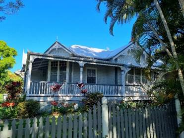
13.9 PLANNING - DA 10.2023.116.1 - New Dwelling to create dual occupancy (detached), clause 4.6 variation for second driveway, and use of existing building as farm storage shed and studio – 149 Friday Hut Road Coorabell................................................ 89
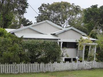
13.10 PLANNING - DA 10.2023.195.1 - 2 Hamiltons Lane Byron Bay....................... 105
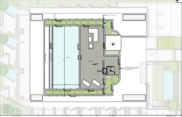
13.11 PLANNING - DA10.2014.417.6 Section 8.2 Review of Determination 10.2014.417.4 - Amendmeent to Building including roof terrace and pool, 43 Lawson Street Byron Bay...................................................................................................................................... 127
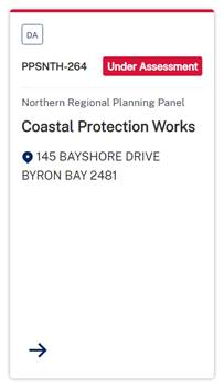
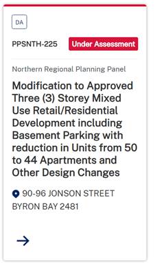
13.12 Status report on Development Applications (DAs) with bodies like the Northern Regional Planning Panel (NRPP)........................................................................... 140
Questions with Notice: A response to Questions with Notice will be provided at the meeting if possible, that response will be included in the meeting minutes. If a response is unable to be provided the question will be taken on notice, with an answer to be provided to the person/organisation prior to the next Ordinary Meeting and placed on Councils website www.byron.nsw.gov.au/Council/Council-meetings/Questions-on-Notice
Councillors are encouraged to ask questions regarding any item on the business paper to the appropriate Director prior to the meeting. Any suggested amendments to the recommendations should be provided to Councillor Support prior to the meeting to allow the changes to be typed and presented on the overhead projector at the meeting.
BYRON SHIRE COUNCIL
Notices of Motion 9.1
Notice of Motion No. 9.1 Mayoral Fund 2023-2024 - Allocation of Funding
File No: I2023/1635
I move:
That Council confirms the donations from the Mayor’s Discretionary Allowance 2023/2024 as per the recommendation in Confidential Attachment 1 (E2023/109567), including applications partially supported.
1 Confidential - Mayoral Fund 2023 2024 Applications Received, E2023/109567
Signed: Cr Michael Lyon
Councillor’s supporting information:
One method that Council uses to support community groups, organisations and local schools is through the provision of funding by way of the “Mayor’s Discretionary Allowance”.
Following a review in March 2021 (Res 21-075) of how the Mayor’s Discretionary Allowance is considered and determined, community groups, organisations and local schools were invited to apply for funding, including justification for the request, with the Mayor’s decision to be reported to Council for confirmation in accordance with the Act and Res 09-349.
On 9 August 2023 Council announced the Mayoral Fund for 2023/2024 was open for applications via Council’s website, with applications closing on 19 September 2023. Twelve applications were received with a total of $18,630.00 funding requested. This year’s total available budget is $3,500.00.
Applications received are for multiple locations across the Shire, including a variety of community groups, organisations, and local schools, and align with the following themes of the Community Strategic Plan:
• Community - We have an inclusive and active community where diversity is embraced and everyone is valued.
• Environment - We nurture and enhance the natural environment.
• Infrastructure – We have connected infrastructure, transport, and facilities that are safe, and reliable.
• Leadership – We have effective decision making and community leadership that is open and informed.
STAFF COMMENTS
by Esmeralda Davis, Director Corporate and Community Services:
There is sufficient funding available to allocate as per the recommendations in Confidential Attachment 1 (E2023/109567). If the Notice of Motion is supported, staff will process accordingly.
Financial/Resource/Legal Implications:
The 2023/2024 Budget adopted by Council included an allocation of $3,500 for budget item Mayor – Discretionary Allowance. Sufficient funds are available for making the nominated donations of $3,500.
In relation to the making of Section 356 Donations from Mayor – Discretionary Allowance, Council at its Ordinary meeting held on 14 May 2009 resolved as follows:
“09-349 Resolved that Council confirm that all s356 donations, to be made from the budget allocation “Mayor – Discretionary Allowance”, must be the subject of a resolution of the Council at Ordinary or Extraordinary meeting.”
The Section 356 Donation will be advertised, and public notice of financial assistance provided in accordance with Section 356 of the Local Government Act 1993.
Is the proposal consistent with any Delivery Program tasks?
|
CSP Objective |
CSP Strategy |
DP Action |
Code |
OP Activity |
|
1:
Effective Leadership |
1.5: Empower community leadership through collaboration, capacity building, and cultivating community driven initiatives |
1.5.1: Community grant programs - Provide financial assistance and grants to empower community groups and organisations to deliver priority projects |
1.5.1.1 |
Deliver annual Community Initiatives Program and associated funding and support |
BYRON SHIRE COUNCIL
Staff Reports - General Manager 13.1
Staff Reports - General Manager
Report No. 13.1 Licence to Byron Bay FC Incorporated
Directorate: General Manager
Report Author: James Newberry, Facilities Officer Liaison
Paula Telford, Leasing and Licensing Coordinator
File No: I2023/1499
Summary:
Byron Bay FC Incorporated (Club) requests a 5-year licence over an existing amenity block in the Byron Bay Memorial and Recreation Ground. The Club seeks to carry out alterations and additions to the amenity building to construct a clubhouse with ongoing occupation of the clubhouse when completed.
RECOMMENDATION:
That Council:
1. Considers submissions received from the Public Notice on the proposed licence to Byron Bay FC Incorporated as outlined in this report.
2. Delegates to the General Manager the right to grant a licence to Byron Bay FC Incorporated on the following conditions:
a) term 5-years no holding over or renewal options,
b) over part Folio 144/758207 for the use of the amenity block, the ground floor canteen, change rooms and access to the building, and for the construction of an upper-floor multi-user clubhouse, a new foyer area and all access to the upper-floor,
c) annual rent to be set at $1 if demanded in recognition of the Club’s financial contribution to improvements to the amenity building,
d) the Licensee must:
i) once constructed, hire out the upper-level multi-user clubhouse for community uses when not required by the Club, excluding all community uses associated with a function centre as defined by the Byron LEP 2014,
ii) expend all income derived from the hiring of the (to be constructed) upper-level multi-use clubhouse upon the operational costs and maintenance to the amenity block,
iii) undertake all building maintenance to the licenced area,
iv) provide public liability and professional indemnity insurance covers and confirmation that all Club officials who work with children hold current working with children checks, and
v) pay for all metered utilities connected to the building excluding water usage,
e) Council to be responsible for annual fire safety, pest management, the exterior of the building, structural maintenance, the ground floor public amenities and Council storage areas.
Report
Byron Bay FC currently occupy, by virtue if a sports field user agreement issued by Council, part Folio 144/758207 for the use of the amenity block, the ground floor canteen, change rooms and access to the building.
The Club obtained development consent 10.2017.681.1 for alterations and additions to an existing amenity building (clubhouse) adjacent to the main soccer field in the Byron Bay Memorial and Recreation Ground.
The Club seeks a 5-year licence to continue its current occupation and to carry out the development works to the building and for occupation of the building including its alterations and additions.
Proposed development:
Consent 10.2017.681.1 provides for alterations to the ground floor of an existing amenities building for a new foyer area and disabled access to a new staircase linking a new upper-level clubhouse. Ground floor change rooms and canteen area to remain unchanged. The new upper-level addition to include new toilet amenities, new office, and storage space, and a 77 sqm multi-purpose area.
The development is entirely funded by the Club from fund raising efforts and secured grants. In order to provide for an ongoing revenue stream to maintain the building improvements, the Club intends to hire out the new multi-purpose area to other community users.
The development once completed is to be owned by Council.
Land:
The Byron Bay Memorial and Recreation Ground is Council owned land classified as community land and categorised in part for a sportsground and in part for general community use. The amenity building is located on land categorised for general community use.
The Plan of Management over the land permits both the proposed building alterations and additions and a new 5-year licence over the existing amenity block and new clubhouse additions.
Proposed Licence:
Council is proposing a new licence to the Club on the following conditions:
1. That Council considers submissions received from the Public Notice on the proposed licence to Byron Bay FC Incorporated as outlined in this report.
2. That Council delegate to the General Manager the right to grant a licence to Byron Bay FC Incorporated on the following conditions:
a) term 5-years no holding over or renewal options,
b) over part Folio 144/758207 for the use of the amenity block, the ground floor canteen, change rooms and access to the building, and for the construction of an upper-floor multi-user clubhouse, a new foyer area and all access to the upper-floor,
c) annual rent to be set at $1 if demanded in recognition of the Club’s financial contribution to improvements to the amenity building,
d) the Licensee must:
i. once constructed, hire out the upper-level multi-user clubhouse for community uses when not required by the Club, excluding all community uses associated with a function centre as defined by the Byron LEP 2014,
ii. expend all income derived from the hiring of the (to be constructed) upper-level multi-use clubhouse upon the operational costs and maintenance to the amenity block,
iii. undertake all building maintenance to the licenced area,
iv. provide public liability and professional indemnity insurance covers and confirmation that all Club officials who work with children hold current working with children checks, and
v. pay for all metered utilities connected to the building excluding water usage,
e) Council to be responsible for annual fire safety, pest management, the exterior of the building, structural maintenance, the ground floor public amenities and Council storage areas.
Public consultation:
In accordance with section 47A of the Local Government Act, Council undertook public consultation on the proposed licence from 11 September to 9 October 2023. Council received 2 submissions as detailed:
|
Submission |
Response |
|
Living in close proximity to the building in the Recreation grounds that is proposed a five-year lease, I am objecting to the granting of this lease. It will greatly diminish the resident’s amenity with the running of functions and people and cars coming & going at all hours with the accompanying drunken behaviour & noise. With increased parking in Carlyle Street that will be utilised for their benefit not for the myriad of other Recreation Grounds and tennis court users, not to mention resident’s visitors. There should be a trial period and a short lease. This is not to be a new function facility as a big money earner for the soccer club. The Recreation Grounds are for community sport and Recreation, NOT another party venue. If the soccer club wants a function room it can go to Cavanbah Centre, away from the residential area. I believe that granting a long lease, 2,3,4 or 5 years spells disaster for this HERITAGE RESIDENTIAL AREA. We have the bowling club on town side and don’t need a further spread of party venues into residential areas. It is assumed that if its available to other sporting and community groups that is in reference to functions and that alcohol will be a part of these functions, that a big NO! We as a community & in particular the residential areas have been subjected to huge reduction in amenity due to bad behaviour. |
Consent (10.2017.681.1) condition 2 limits use of the new clubhouse to: a) sporting club activities including the general supporter viewing area, post-match presentation area, club officers, meetings and other community users by sporting clubs and community groups. b) The upper floor clubhouse must not be used as a function centre (which means a building or place used for holding events, functions, conferences, and the like, and includes convention centres, exhibition centres and reception centres. c) The upper floor clubhouse must not be used as a food and drink premises (which means premises that are used for the preparation and retail sale of food or drink for immediate consumption on or off the premises). |
|
The Byon Bay Football Club must not be allowed to operate at night. If there is an evening game the club must be vacated at end of game. The new building will increase light pollution and further impact the native creatures and residents. |
Consent (10.2017.681.1) permits the upper floor clubhouse to be use for after match presentations. Otherwise Consent (10.2017.681.1) prohibits functions within the definition of the Byron LEP 2014 to be held in the upper floor clubhouse. Council will monitor light impact on neighbouring residential areas resulting from the new upper floor clubhouse. |
This report recommends that Council considers submissions received on the proposed licence in its decision whether or not to grant the proposed licence as detailed in this report.
Strategic Considerations
Community Strategic Plan and Operational Plan
|
CSP Objective |
CSP Strategy |
DP Action |
Code |
OP Activity |
|
5: Connected Infrastructure |
5.4: Provide accessible community facilities and open spaces |
5.4.2: Parks and open spaces - Provide and maintain active and passive recreational community space that is accessible and inclusive for all |
5.4.2.3 |
Undertake programmed inspections of playgrounds and park infrastructure and complete required maintenance and capital renewals to ensure safe use |
Recent Resolutions
· Nil.
Legal/Statutory/Policy Considerations
s47A Local Government Act: Leases, licences, and other estates in respect of community land—terms of 5 years or less
(1) This section applies to a lease, licence, or other estate in respect of community land granted for a period that (including any period for which the lease, licence or other estate could be renewed by the exercise of an option) does not exceed 5 years, other than a lease, licence or other estate exempted by the regulations.
(2) If a council proposes to grant a lease, licence, or other estate to which this section applies—
(a) the proposal must be notified and exhibited in the manner prescribed by section 47, and
(b) the provisions of section 47(3) and (4) apply to the proposal, and
(c) on receipt by the council of a written request from the Minister, the proposal is to be referred to the Minister, who is to determine whether or not the provisions of section 47(5)– (9) are to apply to the proposal.
(3) If the Minister, under subsection (2)(c), determines that the provisions of section 47(5)– (9) are to apply to the proposal—
(a) the council, the Minister and the Director of Planning are to deal with the proposal in accordance with the provisions of section 47(1)–(8), and
(b) section 47(9) has effect with respect to the Minister’s consent.
Financial Considerations
This report proposes that rent under the proposed licence is set at a peppercorn rate to recognise the financial contribution by the Club to the building improvements.
Consultation and Engagement
Community consultation on the proposed licence was undertaken between 11 September and 9 October 2023. Council received 2 submissions as detailed in this report.
BYRON SHIRE COUNCIL
Staff Reports - Sustainable Environment and Economy 13.2
Staff Reports - Sustainable Environment and Economy
Report No. 13.2 Bangalow Streetscape Materials Design Guide for Public Exhibition
Directorate: Sustainable Environment and Economy
Report Author: Kristie Hughes, Natural Disaster Policy Planner
File No: I2023/206
Summary:
The draft Bangalow Streetscape Materials Design Guide (the Design Guide) aims to facilitate a cohesive, consistent approach to upgrades within the public realm of Bangalow. Bangalow is a celebrated heritage village within the Byron Shire. This project aims to identify, preserve, and enhance the local character and heritage elements that make Bangalow village special.
It will be useful for both Council led infrastructure projects, and privately funded Development Application related works in the road reserve.
It provides guidelines to inform future streetscape treatments, village entry statements and planting for use in public domain projects.
The draft Design Guide provides example materials and treatments. These are indicative and will support Council and developers to make considerate design choices in the public realm.
It is intended to have the Design Guide referenced in the Byron Development Control Plan 2014 so that it can be a readily accessible and endorsed document.
It is recommended to exhibit and seek community input on the draft Design Guide and accompanying amendment to the Byron Development Control Plan 2014. The outcomes of this consultation would then be reported back to Council for their consideration.
RECOMMENDATION:
1. Places on public exhibition, the draft Bangalow Streetscape Materials Design Guide (Attachment 1, E2023/95853) and proposed accompanying amendment to the Byron Development Control Plan 2014, Part E, Chapter E2 Bangalow (Attachment 2, E2023/109098) for a minimum of 28 days.
2. Receives a further report on the outcomes from the consultation process.
Attachments:
1 Draft
Bangalow Village - Streetscape Materials Design Guide Exhibition Version, E2023/95853 ![]()
2 Draft
Byron Shire DCP 2014 Chapter E2 Bangalow - exhibition version to Council
November 2023, E2023/109098 ![]()
3 Template
- Form of Special Disclosure of Pecuniary Interest, E2012/2815 ![]()
Report
The draft Bangalow Streetscape Materials Design Guide (the Design Guide) has been developed to ensure consistency in streetscape works being carried out in the public realm. Bangalow is a celebrated heritage village within the Byron Shire. This project aims to identify, preserve, and enhance the local character and heritage elements that make Bangalow village special.
The need for a Design Guide arose in response to a variety of materials being used in streetscape projects across Bangalow, highlighting a desire for more consistent and cohesive design approach within the village.
The project was identified by Bangalow Place Planning Collective and is consistent with the Bangalow Village Plan. Following a competitive Request for Quotation process, local landscape architects Plummer and Smith were engaged.
The deliverables for the project were to provide:
· Character analysis documentation to support discussion and development of a materials design guide.
· A materials design guide for use within different precincts of Bangalow Village, (including the Heritage Conservation Area) that provides guidance with respect to appropriate material selection within the public realm.
· Documentation showing recommended locations for entry statements to the village and design guidance and material selection for these gateways.
Bangalow Streetscape Materials Design Guide Outline
The draft Design Guide provides:
· An overview of Bangalow village, the purpose of the guide and guiding principles.
· Context maps of Bangalow that identify different precincts included in the analysis.
· An audit of existing materiality and furniture within the public realm of Bangalow which also considers the management of existing assets.
· Precedent studies demonstrating contemporary streetscape designed to complement heritage environments.
· Proposed design and materials and a general planting palette to be used within identified precincts.
· Recommended entry treatments to be considered at the three main entrances to Bangalow.
Consultation to Date
Preliminary consultation included multiple site visits with Council Staff, Place Planning Collective Members and key community stakeholders walking through the village with the consultant.
Plummer and Smith presented key findings to broader stakeholder groups and community members at a local information session to stimulate further discussion and ideas. Council staff from Infrastructure Services, Open Spaces and Land Use Planning were also consulted at multiple project stages.
Advice was sought from the Land Use Planning Coordinator and the Manager of Sustainable Development for where this document should sit within the hierarchy of Council Strategic Planning documents. If adopted, the document will be referenced within Byron Shire Development Control Plan 2014, Part E: Further Controls Applying to Specific Localities, Chapter E2 Bangalow.
The document has been reported to Council’s Executive Team and staff now seek Council’s approval to place the draft document on public exhibition.
Key issues
The overarching guiding principles identified in the draft Design Guide encapsulate the primary issues to be taken into consideration for future works in Bangalow village.
The guiding principles are as follows:
· Protect and compliment the existing heritage and character.
· Prioritise sustainability.
· Consider ongoing care and maintenance.
o Open Spaces and Infrastructure Services teams have been consulted to make sure elements included in the guide won’t require excessive maintenance.
· Accessibility and safety standards meet the needs of all users.
o Guidelines have been prepared with aim to improve or not worsen accessibility and safety in the public realm.
Next steps
· The draft Design Guide and accompanying amendment to the Byron Development Control Plan 2014 are recommended to be placed on public exhibition from late November until January 2024.
· Submissions will
then be reported back to Council in February 2024 with suggested amendments as
required for Council’s consideration.
Strategic Considerations
Community Strategic Plan and Operational Plan
|
CSP Objective |
CSP Strategy |
DP Action |
Code |
OP Activity |
|
5:
Connected Infrastructure |
5.4: Provide accessible community facilities and open spaces |
5.4.2: Parks and open spaces - Provide and maintain active and passive recreational community space that is accessible and inclusive for all |
5.4.2.6 |
Provide programmed maintenance and asset renewal programs to towns and villages streetscapes across the shire |
Legal/Statutory/Policy Considerations
If adopted this will amend Byron Development Control Plan 2014 Part E, Chapter E2 Bangalow.
Financial Considerations
The draft Bangalow Streetscape Materials Design Guide does not initiate new project work. It will inform future infrastructure and development application projects in Bangalow.
Consultation and Engagement
As discussed in the report.
BYRON SHIRE COUNCIL
Staff Reports - Sustainable Environment and Economy 13.3
Report No. 13.3 PLANNING - 26.2023.7.1 Planning Proposal to transition the West Byron Urban Release Area into LEP 2014
Directorate: Sustainable Environment and Economy
Report Author: Lachlan Wall, Land Use Planner
File No: I2023/1215
Summary:
This report is prepared in response to Council Resolution 19-137 and as foreshadowed in the 10 August 2023 Housekeeping LEP report.
This Report presents a standalone planning proposal.
(i) amend the West Byron Urban Release Area (WBURA) land use zones to reflect the court approved subdivisions for Harvest Estate (development consent 10.2017.201.1) and Site R&D (Development Consent 10.2017.661.1); and
(ii) transition all relevant LEP 1988 maps and site-specific provisions into Byron Local Environmental Plan 2014 (LEP 2014) for the WBURA.
It is proposed to rezone the WBURA to a mix of R2 Low Density Residential, R3 Medium Density Residential, R5 Large Lot Residential (new), C2 Environmental Conservation (previously E2), C3 Environmental Management (previously E3), RE1 Public Recreation, RE2 Private Recreation (new), E1 Local Centre (previously B1) and E4 General Industrial (previously IN2), and SP1 Infrastructure – Drainage (new), as applicable under the LEP 2014.
The proposed zone changes outside the L&E court-approved residential subdivisions relate to the existing IN2 – Light Industrial and B1 Neighbourhood Centre zoned land, which are to be rezoned to E4 – General Industrial and E1 – Local Centre, respectively, to reflect recent planning reforms.
The Planning Proposal also seeks to delete Part 4 of the Byron Local Environmental Plan 1988 (LEP 1988), which is specific to the WBURA. As part of transitioning into LEP 2014, it is proposed to bring forward two West Byron-specific clauses within the 1988 LEP into the LEP 2014. This will ensure the intent of these provisions are retained.
Should council resolve to proceed with this planning proposal, a request for a Gateway determination will be sent to the Department of Planning, Industry and Environment.
NOTE TO COUNCILLORS:
In accordance with the provisions of S375A of the Local Government Act 1993, a Division is to be called whenever a motion for a planning decision is put to the meeting, for the purpose of recording voting on planning matters. Pursuant to clause 2(a) under the heading Matters to be Included in Minutes of Council Meetings of Council's adopted Code of Meeting Practice (as amended) a Division will be deemed to have been called by the mover and seconder of all motions relating to this report.
RECOMMENDATION:
That Council:
1. Proceeds with the planning proposal contained in Attachment 1, which seeks to:
(i) amend the West Byron Urban Release Area (WBURA) zones to reflect the court approved subdivisions for Harvest Estate (development consent 10.2017.201.1) and Site R&D (Development Consent 10.2017.661.1); and
(ii) transition all relevant LEP 1988 maps and site-specific provisions into Byron Local Environmental Plan 2014 for the WBURA.
2. Forwards the planning proposal to the NSW Department of Planning, Industry and Environment for a Gateway determination;
3. Pending a positive Gateway determination, undertakes public exhibition of the planning proposal in accordance with the determination requirements; and
4. Considers a submissions report post-exhibition that includes any recommended changes to the planning proposal for final adoption.
1 26.2023.7.1
- West Byron Transition Planning Proposal, E2023/76729
![]()
2 26.2023.7.1
- Current and proposed land zoning map, E2023/106157
![]()
3 26.2023.7.1
- West Byron Transition LEP comparison, E2023/103464
![]()
Report
This report presents a planning proposal to:
(i) amend the West Byron Urban Release Area (WBURA) zones to reflect the court approved subdivisions for Harvest Estate (development consent 10.2017.201.1) and Site R&D (Development Consent 10.2017.661.1); and
(ii) transition all relevant LEP 1988 maps and site-specific provisions into Byron Local Environmental Plan 2014 (LEP 2014) for the WBURA.
The amended zoning is intended to reflect the ‘land use’ layout of the approved subdivision plans.
This report has been prepared in response to Council Resolution 19-137 and as foreshadowed in the 10 August 2023 Housekeeping LEP report. As part of this planning proposal it is also proposed to delete Part 4 of the Byron LEP 1988, which only applies to the West Byron Bay Site. This comprises clauses 65 through 101 of the LEP 1988.
This proposal applies to the land shown in the West Byron Bay - Land Application Area map of LEP 1988, as shown in Figure 1 below.
 Figure 1: Land Application
Area West Byron Urban Release Area
Figure 1: Land Application
Area West Byron Urban Release Area
Land & Environment Court approved Subdivisions.
The West Byron Urban Release area has two development applications approved for the subdivision of the land. Both subdivisions are largely residential in nature with a mixture of low density, medium density and large lot residential zonings. These development consents comprise 10.2017.201.1 approved by the Land & Environment Court on 8 December 2020, and 10.2017.661.1 approved by the Land & Environment Court on 21 April 2022.
Development consent 10.2017.201.1 approved the subdivision of the land comprising 145 residential lots, 4 large lifestyle lots and contains a community centre / garden and public recreational green space lots. construction works for this subdivision have commenced for the initial stages of this development.
Development consent 10.2017.661.1 approved the subdivision of the land into one hundred and sixty-two (162) lots comprising one hundred and twenty-seven (127) residential lots, twenty-five (25) super (master) lots, two (2) business lots, one (1) recreation lot, two (2) industrial lots and five (5) residue lots. Construction works associated with this subdivision has yet to begin.
The layout of these subdivisions with the existing land use zoning overlaid is shown in figure 2.
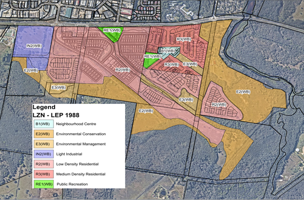
Figure 2: Layout of the West Byron Bay Site subdivision approvals and existing zoning overlaid.
The Current land use zoning of the WBURA is shown in figure 2 above and within Attachment 2. The majority of the proposed zoning changes relate to the subdivision known colloquially as “Harvest Estate,” as approved by the development consent 10.2017.201.1.
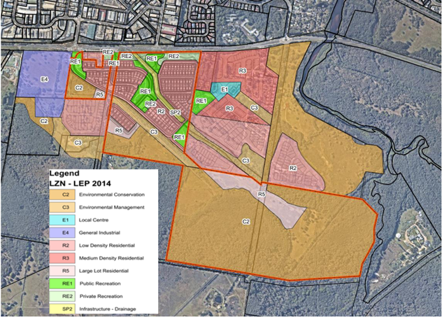
Figure 3: Proposed land zoning map of the entire West Byron Urban
Release Area.
The court approved Harvest Estate subdivision (2021) differs from the zoning currently within Byron LEP 1988. The proposed zoning map shown in Figure 3 is consistent with the subdivision layout as approved by the Land and Environment Court issued Development Consents.
Other proposed zoning changes within the WBURA relate to
land zoned IN2 Light Industrial and B1 Neighbourhood Centre. The Employment
zone reforms undertaken by the NSW Department of Planning have removed these
two zones from the Standard Instrument LEPs and replaced with a corresponding
Employment zone or ‘E zone.’ It is proposed to rezone these areas
‘E4 – General Industrial’ and ‘E1 – Local
Centre’, respectively, as the equivalent land use zones as shown in
figure 4 below.
Figure 4: Equivalent zone table - Employment zone reform.
In addition to the Harvest Estate zoning amendments, other consequential mapping amendments are required to ensure there is consistency between the land use, and other principal planning controls, including height of buildings, acid sulfate soils and minimum lot size.
The planning proposal also proposes to carry over a number of West Byron-specific policy amendments in LEP 1988 to ensure there is no reduction in permissible residential densities. These changes are discussed below and outlined in Attachment 3.
Draft Policy Amendments
There are three key differences between the 1988 and 2014 LEP provisions that the planning proposal seeks to address. These are discussed below.
Item 1: deletion of Part 4 of LEP 1988 West Byron Bay Site
The entirety of the land to which this part applies is proposed to be transitioned into the Byron LEP 2014, and hence this part will be removed from Byron LEP 1988. As part of this transition, the planning proposal seeks to retain certain site-specific clauses that currently apply to the site, which if not adopted would substantially reduce the number of dwellings that can be delivered within the WBURA. These are discussed below.
Item 2: Inconsistency between (I) Clause 82 Minimum lot sizes for dual occupancies, multi dwelling housing and residential flat buildings (LEP 1988) and (II) Section 4.1E – minimum lot size for certain residential developments (LEP 2014).
In transitioning WBURA into LEP 2014, there are differences between Clause 82 (LEP 1988) and Section 4.1E (LEP 2014) in terms of minimum lot size requirements for dual occupancies, multi-dwelling housing and residential flat buildings. Table 1 below provides a comparison of both LEP clauses.
|
Development Type |
Land Zoning |
Minimum Lot Size 1988 required (Clause 82) |
Minimum Lot Size 2014 required (Section 4.1E) |
|
Dual Occupancy (attached) |
R2 Low Density Residential |
600m2 |
800m2 |
|
R3 Medium Density Residential |
300m2 |
800m2 |
|
|
Dual occupancy (detached) |
R2 Low Density Residential |
700m2 |
800m2 |
|
R3 Medium Density Residential |
400m2 |
800m2 |
|
|
Multi dwelling Housing |
R2 Low Density Residential |
1000m2 |
1000m2 |
|
R3 Medium Density Residential |
450m2 |
800m2 |
|
|
Residential Flat Building |
R3 Medium Density Residential |
1000m2 |
800m2 |
|
Attached Dwelling |
R2 Low Density Residential |
Not specified |
1000m2 |
|
R3 Medium Density Residential |
Not specified |
800m2 |
|
|
Manor House |
R2 Low Density Residential |
Not specified |
1000m2 |
|
R3 Medium Density Residential |
Not specified |
800m2 |
Table 1: comparison of minimum lot size between 1988 LEP and 2014 LEP for certain types of residential development
The difference between Clause 82 and 4.1C would result in an inconsistency with Ministerial Direction Focus Area 6. Direction 6.1- Housing, as existing clause 4.1C would reduce the permissible residential density of WBURA if left as is. As minimum Lot sizes within the WBURA have been largely set by the court-approved subdivisions, and to ensure permissible residential densities are maintained (and not reduced), it is proposed to amend Section 4.1E (LEP 2014) to include the provisions of Clause 82(2) as applicable to the West Byron Bay site.
Rationale
Clause 82 requires a smaller minimum lot size of 600m2 for dual occupancies on R2 Low Density Residential or 300m2 for R3 Medium density zoned land when compared to the LEP 2014 Clause 4.1E, which requires a minimum lot size of 800m2 for any dual occupancy. There is also a difference between the two clauses for minimum lot size requirements for multi-dwelling housing on R3 zoned land. Clause 82 requires a minimum lot size of 450m2 but the Clause 4.1E requires 800m2.
Due to the age of clause 82, there is no reference to ‘attached dwellings’, or ‘manor houses’ within this clause, which are permissible land uses within the LEP 2014, but would otherwise have no minimum lot size requirement under the 1988 LEP.
As a result, the current provisions of clause 82 would allow for greater residential density within the WBURA when compared with the provisions of Clause 4.1E. Amending Clause 4.1E to reflect this will ensure consistency with the Ministerial Direction, Focus Area 6: Housing, Direction 6.1., which states that: “A planning proposal must, in relation to land to which this direction applies..(b) not contain provisions which will reduce the permissible residential density of land.” If the LEP 1988 table is not carried forward into LEP 2014 the potential for infill development beyond a single dwelling house and / or secondary dwelling is significantly reduced.
More specifically, not adopting this change will effectively prohibit the construction of a dual occupancy on most lots within the entire area, substantially reducing the permissible density within this area.
Item 3: Clause 83 Exceptions to minimum subdivision lot sizes for certain residential development.
Clause 83 of the 1988 LEP allows for the provision of Integrated Housing within the WBURA, but has no direct equivalent clause within the LEP 2014. Clause 83 states
83 Exceptions to minimum subdivision lot sizes for certain residential development
(1) The objective of this clause is to encourage housing diversity without adversely impacting on residential amenity.
(2) This clause applies to development on land in the following zones—
(a) Zone R2 Low Density Residential,
(b) Zone R3 Medium Density Residential.
(3) Development consent may be granted for a single development application for development to which this clause applies that is both of the following—
(a) the subdivision of land into 3 or more lots,
(b) the erection of a dwelling house, an attached dwelling or a semi-detached dwelling on each lot resulting from the subdivision, if the size of each lot is equal to or greater than—
(i) for the erection of a dwelling house—300 square metres for land in Zone R2 Low Density Residential and 200 square metres for land in Zone R3 Medium Density Residential, or
(ii) for the erection of an attached dwelling—250 square metres for land in Zone R2 Low Density Residential and 150 square metres for land in Zone R3 Medium Density Residential, or
(iii) for the erection of a semi-detached dwelling—250 square metres for land in Zone R2 Low Density Residential and 150 square metres for land in Zone R3 Medium Density Residential
The term Integrated Housing is defined as following within the Byron Development Control Plan 2014 – Part A: “the subdivision of land into three or more lots and the erection of a dwelling (attached or semi attached) or dwelling house on each lot as per Clause 83 of Byron LEP 1988”.
As part of the transition process, it is proposed to create a new additional local provision of the under Part 6 of the LEP 2014 that brings forward this provision.
Rationale
This clause is unique to the West Byron Bay Site and should be retained as it provides for greater diversity in housing types to be constructed within the area. Bringing forward this provision into the 2014 LEP would also be consistent with the Ministerial Direction 6: Housing, and would retain the current permissible residential density of the West Byron Site.
Item 4: Savings provision for the amendments
The West Byron Bay Urban Release Area contains number of lots that are not related to the subdivision of the WBURA as approved by the two Development consents issued.
To ensure that a development application made on any lot affected by this planning proposal will not be impacted by the processing of the application, It is proposed to create a self-repealing savings provision for this planning proposal that will provide certainty for any development application lodged currently, or lodged during, but not finally determined during the planning proposal process to provide clarity and surety for landowners that this planning proposal will impact.
Doing so will ensure that any Development Application made during the processing of this planning proposal does not create new or modified planning considerations that were not in force at the date of lodgement of that application.
Draft Mapping Amendments
Item 5: Changes to Land Zoning.
The planning proposal seeks to modify the zoning within the West Byron Urban Release Area to reflect the approved subdivision layout of the Harvest Estate. The proposed zoning changes are contained within Attachment 2.
Rationale
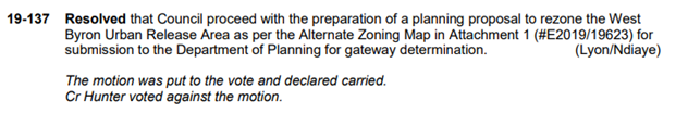
Council Resolution 19-137 sought to enact this change. The changes to the zoning presented are consistent with the (subsequently) approved subdivision layout, as well as the Employment zone review undertaken by the Department of Planning.
On 26 April 2023 the Department of Planning Employment Zone reforms replaced the IN2 – Light Industrial and B1 Neighbourhood Centre Zones in the Standard LEP instrument with the new zones shown in Figure 4 above. The WBURA includes area an area of Lot 2 DP 542178 which is currently zoned B1 Neighbourhood centre, and Lot 5 DP 1269369 and a section of Lot 2 DP 818403 that are currently zoned IN2 Light Industrial (refer to figure 2).
It is proposed, as part of the
transitioning these areas into the 2014 LEP, to rezone these areas to the
equivalent land use zone in LEP 2014 (see Attachment 7). Specifically,
the proposed rezoning will apply E1 – Local Centre and E4
– General Industrial respectively over these lots.
Other consequential mapping amendments are required to ensure there is consistency between the land use, and other principal planning controls, including height of buildings, acid sulfate soils and minimum lot size.
Next steps
Should council resolve to proceed with this planning proposal, a request for a Gateway determination will be sent to the Department of Planning, Industry and Environment.
Strategic Considerations
Community Strategic Plan and Operational Plan
|
CSP Objective |
CSP Strategy |
DP Action |
Code |
OP Activity |
|
|
4: Ethical Growth |
4.1: Manage responsible development through effective place and space planning |
4.1.4: LEP & DCP - Review and update the Local Environmental Plan and Development Control Plans |
4.1.4.2 |
Review and update Local Environmental Plan and Development Control Plans to reflect strategic land use priorities and/or legislative reforms |
|
Recent Resolutions
19-137 (28 March 2019). Resolved that Council proceed with the preparation of a planning proposal to rezone the West Byron Urban Release Area as per the Alternate Zoning Map [in attachment 1] for submission to the Department of Planning for gateway determination.
Legal/Statutory/Policy Considerations
This planning proposal will amend the Byron Local Environmental Plan 2014 and Byron Local Environmental Plan 1988.
Financial Considerations
Task to be managed within existing financial / legal and resource allocations.
Consultation and Engagement
Should Council proceed with the planning proposal, upon receipt of a Gateway determination it will be placed on public exhibition for 28 days in accordance with Byron Community Participation Plan.
BYRON SHIRE COUNCIL
Staff Reports - Sustainable Environment and Economy 13.4
Report No. 13.4 PLANNING - Planning Proposal 26.2021.7.1 – 55 Settlement Road Main Arm
Directorate: Sustainable Environment and Economy
Report Author: Dylan Johnstone, Development Investigations Lead
File No: I2023/1494
Summary:
The subject land contains an existing unauthorised dual occupancy (detached). Aerial photography indicates that one of the dwellings has existed since at least 1997, while the other has existed since at least 2009.
This Planning Proposal is the result of Action No. 22 of the Byron Shire Rural Land Use Strategy 2017 (BSRLS) which recommends investigation into a strategic framework for resolving dwelling entitlement issues. This action provides the strategic basis for the subject planning proposal, which is considered the best means to obtain development consent for use of the existing dual occupancy (detached).
The Unauthorised Dwelling Guidelines 2022 expands upon the strategy by providing that a planning proposal may be pursued via “Planning Pathway 2” to rectify the use of existing unapproved dwellings on land that does not have a dwelling entitlement. Council resolution 20-283 provides that any unauthorised dwellings existing as of 18 June 2020 may pursue the planning pathways identified in the guidelines.
The subject land is partially affected by the probable maximum flood and is mapped as bush fire prone land. These issues are addressed to the satisfaction of Council. The proposal generates minimal additional traffic movements but the submitted Traffic Safety Assessment identifies that upgrade works to Settlement Road may be required to achieve compliance with Planning for Bushfire Protection 2019. This would be a matter for the NSW RFS to comment on during the Planning Proposal notification to state agencies following gateway determination.
The planning proposal is consistent with the North Coast Regional Plan 2041. The site is located west of the Pacific Highway and is therefore not located in the coastal strip.
The planning proposal is also consistent with the Council adopted Local Strategic Planning Statement and 10 year + Community Strategic Plan 2022 (CSP), the relevant SEPPs and the majority of relevant section 9.1 Directions; and where inconsistencies occur, they can be justified or addressed with further information.
It is recommended that the planning proposal be forwarded to the NSW DPE for a Gateway determination.
NOTE TO COUNCILLORS:
In accordance with the provisions of S375A of the Local Government Act 1993, a Division is to be called whenever a motion for a planning decision is put to the meeting, for the purpose of recording voting on planning matters. Pursuant to clause 2(a) under the heading Matters to be Included in Minutes of Council Meetings of Council's adopted Code of Meeting Practice (as amended) a Division will be deemed to have been called by the mover and seconder of all motions relating to this report.
RECOMMENDATION:
That Council:
1. Proceeds with the planning proposal as attached to this report (Attachment 1 – E2023/105727) to amend LEP 2014 to permit a dual occupancy (detached) with consent on the subject land;
2. Forwards the planning proposal to the NSW Department of Planning and Environment for a Gateway determination;
3. Pending a positive Gateway determination and completion of further studies (if required) and a draft Planning Agreement by the applicant, undertakes public exhibition of the planning proposal in accordance with the determination requirements;
4. Considers a submissions report post-exhibition that includes any recommended changes to the planning proposal for final adoption.
1 26.2021.7.1
- Draft Planning Proposal for Council - 55 Settlement Road Main Arm, E2023/105727 ![]()
2 26.2021.7.1
- Preliminary Contaminated Land Assessment - 55 Settlement Road Main Arm, E2023/103671 ![]()
3 26.2021.7.1
- Onsite Wastewater Management Assessment - 55 Settlement Road Main Arm, E2023/103666 ![]()
4 26.2021.7.1
- Bushfire Assessment - 55 Settlement Road Main Arm, E2023/102424 ![]()
5 26.2021.7.1
- Ecology Assessment - 55 Settlement Road Main Arm, E2023/102427 ![]()
6 26.2021.7.1
- Land Use Conflict Risk Assessment - 55 Settlement Road Main Arm, E2023/103669 ![]()
7 26.2021.7.1
- Traffic Safety Assessment - 55 Settlement Road Main Arm, E2021/136157 ![]()
8 26.2021.7.1
- Letter of offer for Voluntary Planning Agreement - 55 Settlement Road Main
Arm, E2021/136162 ![]()
Background
Council resolution 20-283 dated 18 June 2020 included a request that staff “prepare an Unauthorised Residential Accommodation Policy as a matter of priority to confirm the planning pathways and consequences for unauthorised residential accommodation seeking regularisation in Byron Shire”. This resolution also included “that in the meantime any planning proposal or development application lodged with Council for existing (as of 18 June 2020) unauthorised residential accommodation comply with the requirements of the Unauthorised Residential Accommodation Policy or for those applications lodged prior to the Policy being adopted the principles as presented in this report”.
Council resolution 20-417 dated 27 August 2020 resolved that the Draft Byron Shire Unauthorised Dwellings Policy be placed on public exhibition with a submissions report to be sent back to Council following the exhibition.
As a result of issues raised in public submissions, the Draft Unauthorised Dwellings Policy was converted to a guideline document for internal use by staff to outline the process for reactive investigations initiated by complaints and owner-initiated actions.
One of the planning pathways identified in the guideline is “pathway 2” which provides that, where land does not have a dwelling entitlement and contains an existing unapproved dual occupancy (detached), a planning proposal may be submitted to seek to amend LEP 2014 to permit the dual occupancy (detached) on the land with development consent.
Subject Land
Historically, Lot 5 was previously part of a larger rural land holding which was then subject to further subdivision, resulting in the current lot configuration. The subject site is described as a “concessional allotment” which was not allocated a dwelling entitlement at the time of its registration in 1976.
Council received a planning proposal in September 2021 requesting an amendment to Byron LEP 2014 to obtain a dwelling entitlement for Lot 5 DP 585928 which has an area of approximately 24 hectares (see Figures 1 & 2 below). The street address is 55 Settlement Road, Main Arm. The subject land contains an existing unauthorised dual occupancy (detached).
Flood information available to Council indicates that the majority of the site (including the site of the existing dual occupancy (detached)) is not inundated during the Probable Maximum Flood (PMF).
The site includes some mapped High Environmental Value Vegetation identified as subtropical rainforest and the entire site is mapped as bushfire prone land. This vegetation is located in close proximity to one of the existing dwellings, however Bushfire and Ecology reports submitted with the planning proposal demonstrate that the establishment of required Asset Protection Zones to comply with Planning for Bushfire Protection 2019 will have negligible ecological impact.
Consultation with the Rural Fire Service will be undertaken as part of this Planning Proposal.

Figure 1: Subject land - 55 Settlement Road, Main Arm (Lot 5 DP 585928)
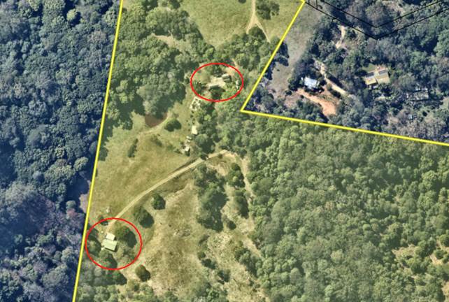
Figure 2: Existing dual occupancy (detached)
Planning Proposal
The planning proposal lodged by the proponent (Attachment 1) requests an amendment to Byron LEP 2014 to obtain a dwelling entitlement for Lot 5 DP 585928, which is zoned RU2 Rural Landscape and C2 Environmental Conservation. The existing dual occupancy (detached) is located entirely on land zoned RU2.
The aim of the planning proposal is to establish a legislative mechanism to permit the lawful use of the dual occupancy (detached) with development consent. Specifically, the planning proposal seeks to add the land to Byron LEP 2014: Part 6 – Additional local provisions to permit a dual occupancy (detached) with consent on Lot 5 DP 585928.
Planning Framework
North Coast Regional Plan
The site is located west of the Pacific Highway and is therefore not located in the coastal strip.
The most relevant NCRP objective is Objective 1: Provide well located homes to meet demand. The most relevant strategy is 1.2 Local Council plans are to encourage and facilitate a range of housing options in well located areas.
The proposal is consistent with the objectives and strategies of the NCRP and is consistent with Action No. 22 of the Byron Shire Rural Land Use Strategy 2017 (BSRLS), which recommends investigation into a strategic framework for resolving dwelling entitlement issues. This strategy was endorsed by the NSW DPE in July 2018.
Local Strategic Planning Statement
Council adopted a Local Strategic Planning Statement in September 2020 and it was subsequently agreed to by DPE.
The relevant planning priority in the LSPS (page 37) is:
“3. Support housing diversity and affordability with housing growth in the right locations.”
This planning proposal will be adding to the valid supply of housing stock in the shire by providing a mechanism to legalise an existing dual occupancy (detached) and is consistent with the adopted LSPS.
Site Specific Issues
Bushfire and ecology
The land is mapped as bush fire prone land and contains a mix of Category 1 (high risk), Category 2 (lower risk) and Category 3 (medium risk) vegetation.
The existing dwellings are located within Vegetation Category 3 with the hazard identified as being grassland.
One of the existing dwellings is located in close proximity to vegetation mapped as subtropical rainforest.
Bushfire and Ecology assessments have been submitted which demonstrate that establishment of the required Asset Protection Zones to comply with Planning for Bush Fire Protection 2019 will have negligible biodiversity impacts.
Council staff will consult with the Commissioner of the NSW Rural Fire Service following receipt of a gateway determination.
Flooding
Flood modelling information available to Council indicates that the majority of the site (including the site of the existing dual occupancy (detached)) is not inundated during the Probable Maximum Flood (PMF).
Access to the site during a flood is compromised due to localised flooding of Settlement Road and Main Arm Road. There is no need to evacuate during a flood as the site has land above the PMF.
Traffic and roads
Settlement Road has a traffic count of approximately 142 vehicles per day (2017 traffic counts) and is not expected to carry more than 150 vehicles per day. The road formation is a 4.0m (approximately) wide gravel carriageway. Council’s adopted engineering standards (Northern Rivers Local Government Development Design and Construction Manuals) requires a road formation for such daily traffic flows of a 6m seal with 0.5m shoulders. The current road formation does not comply with Council’s standards irrespective of a dual occupancy (detached) on the subject site and it is reasonable for the current formation to serve the additional 15 trips for a dual occupancy development. It is noted that the additional traffic loading is only theoretical as the dual occupancy (detached) has been in use.
While the proposal generates minimal additional traffic movements, the submitted Traffic Safety Assessment identifies that upgrade works to Settlement Road may be required to achieve compliance with Planning for Bushfire Protection 2019. These works consist of two passing bays located between the driveway of the subject property and the intersection with Main Arm Road.

Figure 3: Existing Settlement Road and passing bay options (Source: Traffic Safety Assessment prepared by SDS Civil Enterprises dated September 2021)
This would be a matter for the NSW RFS to comment on during the Planning Proposal notification to state agencies following gateway determination.
Land contamination
The applicant has supplied a preliminary contaminated land assessment carried out in accordance with the contaminated land planning guidelines.
Soil tests were undertaken and no contamination of concern was identified. The existing dwelling envelopes are considered suitable for use as a dual occupancy (detached).
Aboriginal cultural heritage
The Tweed Byron LALC and the Arakwal Corporation will be consulted as part of the public exhibition of the planning proposal following a gateway determination.
Developer Contributions / Planning Agreement
The planning proposal seeks to amend LEP 2014 so that a dual occupancy (detached) is permitted with consent on the subject site.
If a dual occupancy (detached) is permitted on the site, this will create additional demands on rural roads, community facilities, open spaces etc. Such demands are captured by the Byron Shire Developer Contributions Plan 2012 which requires a monetary contribution in accordance with the Plan and Section 7.11 of the Environmental Planning and Assessment Act 1979.
Ordinarily contributions would be paid at the time of subdivision for creating a lot with a dwelling entitlement equivalent to one Standard Dwelling Unit (SDU) (3 bedroom dwelling or greater). However, for the purposes of this planning proposal, there is no clear mechanism within the Contributions Plan for applying developer contributions.
Therefore, the submitted planning proposal has included a letter of offer to enter into a planning agreement with Council (Attachment 8). The offer proposes payment of a monetary contribution which is equivalent to 1.55 SDUs (1 SDU for a 3 bedroom dwelling plus 0.55 SDUs for a 1 bedroom dwelling). This amounts to a total of $31,000 of which approximately $25,000 is allocated to rural roads.
Council staff have no justification to require additional contributions over and above the demand normally generated for a rural dual occupancy under the terms of the Contributions Plan 2012.
However, Council may resolve to apply different terms in the planning agreement if deemed reasonable and appropriate in the circumstances.
A formal planning agreement will need to be drafted and exhibited concurrently with the planning proposal.
Next steps
There are three options for Council to consider:
1. Proceed with the planning proposal contained in Attachment 1 to this report, which will facilitate the lawful use of the existing dual occupancy (detached) with Council consent (RECOMMENDED). This option is subject to any requirements imposed by DPE in its Gateway determination; or
2. Proceed with the planning proposal in a modified form other than the version attached to this report; or
3. Not proceed with the planning proposal and advise the applicant accordingly.
There is sufficient information to support the planning proposal (see Attachments 2-8) and proceed to a Gateway submission. It is considered that no additional studies are required prior to public exhibition and agency consultation.
Strategic Considerations
Community Strategic Plan and Operational Plan
|
CSP Objective |
CSP Strategy |
DP Action |
Code |
OP Activity |
|
4: Ethical Growth |
4.1: Manage responsible development through effective place and space planning |
4.1.4: LEP & DCP - Review and update the Local Environmental Plan and Development Control Plans |
4.1.4.1 |
Assess requests to amend Local Environmental Plans and/or Development Control Plans including maps in accordance with legislative requirements. |
Recent Resolutions
· 20-283: that staff prepare an Unauthorised Residential Accommodation Policy as a matter of priority to confirm the planning pathways and consequences for unauthorised residential accommodation seeking regularisation in Byron Shire.
· 20-417: that the Draft Byron Shire Unauthorised Dwellings Policy be placed on public exhibition with a submissions report to be sent back to Council following the exhibition.
· 21-448: that Council agrees to the Draft Unauthorised Dwellings Policy being converted to a guideline document for internal use by staff to outline the process for reactive investigations initiated by complaints and owner-initiated actions.
Legal/Statutory/Policy Considerations
The relevant legal/statutory/policy considerations have been noted above.
Financial Considerations
If Council chooses to proceed with the planning proposal, it will be at the proponent’s expense as a landowner-initiated planning proposal. Full cost recovery of the remaining stages will be required by Council. If the applicant chooses not to pay then the planning proposal will not proceed. If Council chooses not to proceed, then the matter does not incur any additional costs.
Consultation and Engagement
If Council chooses to proceed with the planning proposal, it will be forwarded to the NSW Department of Planning & Environment for a Gateway determination. A positive determination will identify public exhibition requirements and government agency consultation requirements.
BYRON SHIRE COUNCIL
Staff Reports - Sustainable Environment and Economy 13.5
Report No. 13.5 PLANNING - Report of the Planning Review Committee held 5 October 2023
Directorate: Sustainable Environment and Economy
Report Author: Shannon Burt, Director Sustainable Environment and Economy
File No: I2023/1539
Summary:
This report provides the outcome of the Planning Review Committee (PRC) held on 5 October 2023.
NOTE TO COUNCILLORS:
In accordance with the provisions of S375A of the Local Government Act 1993, a Division is to be called whenever a motion for a planning decision is put to the meeting, for the purpose of recording voting on planning matters. Pursuant to clause 2(a) under the heading Matters to be Included in Minutes of Council Meetings of Council's adopted Code of Meeting Practice (as amended) a Division will be deemed to have been called by the mover and seconder of all motions relating to this report.
RECOMMENDATION:
That Council endorses the outcomes of the Planning Review Committee meeting held 5 October 2023.
Report
The Planning Review Committee meeting was held on 5 October 2023. The meeting commenced at 3:52pm and concluded at 4:15pm.
Councillors: Mayor M Lyon, Cr D Dey, Cr S Ndiaye, Cr Balson
Apologies: Nil
Staff: Shannon Burt (Director of Sustainable Environment & Economy)
Conflict of Interest: None declared.
The following development applications were reviewed with the outcome shown in the final column.
|
DA No. / Applicant |
Property Address / Proposal |
Consultation / Submissions |
Reason/s / Outcome |
|
10.2023.304.1 Newton Denny Chapelle |
5 Gloria Street Demolition of Existing Dwelling and Construction of New Dwelling House |
Level 1 5 submissions |
Staff Delegation |
|
10.2023.289.1 Mr GJ Southern |
62 Kingsvale Road MYOCUM Dual Occupancy (Detached) Comprising the Existing Dwelling & a New Dwelling |
Level 1 Nil |
Staff Delegation |
|
10.2023.299.1 BRS Northern Rivers |
189 Federal Drive Multiple Occupancy comprising 15 dwelling sites and Associated Infrastructure |
Level 2 29/8/23 to 27/8/23 3 submissions |
Staff Delegation |
The following development applications were reviewed with the outcome shown in the final column.
Council determined the following original development applications. The S.4.55 applications to modify those consents were referred to the Planning Review Committee to decide if the modification applications can be determined under delegated authority with the outcome shown in the final column.
|
DA No. / Applicant |
Property Address / Proposal |
Consultation / Submissions |
Reason/s / Outcome |
|
10.2018.534.1 Ardill Paye & Partners |
44 Brownell Drive Modify the roof form of approved dwelling |
Level 2 14/9/23 to 27/9/23 Nil |
Staff Delegation |
BYRON SHIRE COUNCIL
Staff Reports - Sustainable Environment and Economy 13.6
Report No. 13.6 PLANNING - DA 10.2022.538.1 - Use of, and Alterations and Additions to, existing Food Co-Op structure and Use of associated shade structures, New Cool Room, Use of, and New, shade structures, Men's Shed Additions, Use of existing sheds and Use of existing nursery structures associated with Reforest Now– 156 Stuart Street Mullumbimby
Directorate: Sustainable Environment and Economy
Report Author: Dylan Johnstone, Development Investigations Lead
File No: I2023/1544
Proposal:
|
DA No: |
10.2022.538.1 |
||||||
|
Planning Portal ref |
PAN-288976 |
||||||
|
Proposal description: |
Use of, and Alterations and Additions to, existing Food Co-Op structure and Use of associated shade structures, New Cool Room, Use of, and New, shade structures, Men’s Shed Additions Use of existing sheds and Use of existing nursery structures associated with Reforest Now |
||||||
|
Property description: |
LOT: 22 DP: 1073165 |
||||||
|
156 Stuart Street MULLUMBIMBY |
|||||||
|
Parcel No/s: |
239417 |
||||||
|
Applicant: |
MULLUMBIMBY SUSTAINABILITY EDUCATION AND ENTERPRISE DEVELOPMENT INCORPORATED |
||||||
|
Owner: |
Byron Shire Council |
||||||
|
Zoning: |
RE1 Public Recreation / PART DM Deferred Matter (7b Coastal Habitat Zone) Byron LEP 1988 |
||||||
|
Date received: |
22 December 2022 |
||||||
|
Integrated / Designated Development: |
☐ Integrated |
☐ Designated |
☒ Not applicable |
||||
|
Concurrence required |
No |
||||||
|
Public notification or exhibition: |
- Level 2 advertising under Council’s Community Participation Plan. - Exhibition period: 11/01/23 – 24/01/23 - Submissions received: 1 - Submissions acknowledged: ☒ Yes ☐ No ☐ N/A |
||||||
|
Concurrent approvals included with DA |
☒ N/A |
☐ W & S (68) |
☐OSMS (68) |
☐ ST (68) |
☐ RA (138) |
||
|
Other: |
|
||||||
|
Planning Review Committee |
Not applicable |
||||||
|
Variation request to Development Standards under an EPI (eg clause 4.6) |
Not applicable
|
||||||
|
Estimated cost |
$78,640.00 |
||||||
|
Delegation to determine |
Council |
||||||
|
Issues |
· Landowners consent not granted · Components of the proposal conflict with the adopted Plan of Management for the site · Flood liable land · Bushfire prone land · Acid Sulfate Soils Class 3 · HEV · Cattle dip buffer |
||||||
Summary:
This development application seeks consent for Use of, and Alterations and Additions to, existing Food Co-Op structure and Use of associated shade structures, New Cool Room, Use of, and New, shade structures, Men’s Shed Addition, Use of existing sheds and Use of existing nursery structures associated with Reforest Now at the Mullumbimby Community Garden.
Many of the structures subject to this application are existing which have been constructed without the required development consent. This is unfortunate that those that have the benefit of the use of the subject reserve have not followed due process in getting consent prior to construction.
A number of existing and proposed structures subject of this application are located outside of the nominated community garden area under the Plan of Management (POM) for this Reserve, and fall within land identified for sports fields. These structures are proposed for use by Reforest Now and the Men’s Shed. The structures are located within the licensed area defined by the temporary licence held by Mullumbimby SEED Inc. granted in accordance with Council resolution 23-114.
Due to this inconsistency with the POM, landowners’ consent has not been granted by Council’s Infrastructure Services staff. Therefore the application may only be supported if Council resolves to grant landowners’ consent for the proposal.
Should Council resolve to grant landowners’ consent, and to ensure there is no long term conflict caused by the above inconsistency, staff recommend that the POM be amended as priority.
The application as assessed appropriately addresses the relevant planning controls and constraints applying to the land, and is recommended for approval subject to conditions of consent.
NOTE TO COUNCILLORS:
In accordance with the provisions of S375A of the Local Government Act 1993, a Division is to be called whenever a motion for a planning decision is put to the meeting, for the purpose of recording voting on planning matters. Pursuant to clause 2(a) under the heading Matters to be Included in Minutes of Council Meetings of Council's adopted Code of Meeting Practice (as amended) a Division will be deemed to have been called by the mover and seconder of all motions relating to this report.
RECOMMENDATION:
1. That Council resolves as to whether landowners’ consent should be granted for the subject application.
2. That, should Council resolve to grant landowners’ consent, Use of, and Alterations and Additions to, existing Food Co-Op structure and Use of associated shade structures, New Cool Room, Use of, and New, shade structures, Men’s Shed Additions, Use of existing sheds and Use of existing nursery structures associated with Reforest Now, be granted Deferred Commencement consent subject to the conditions in Attachment 3 (#E2023/108594).
3. That the Plan of Management applicable to the site be amended as a priority to reflect the intended use of the site.
Attachments:
1 10.2022.538.1
- Plans, E2023/108641 ![]()
2 10.2022.538.1
- Submission, E2023/108643 ![]()
3 10.2022.538.1
- Recommended conditions, E2023/108594
![]()
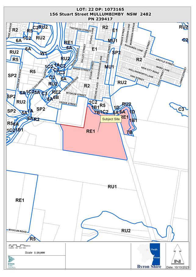
1. INTRODUCTION
History/Background
10.2010.133.1 – Nursery Shed and associated drainage – approved 15/09/2010
10.2015.159.1 – Replacement of site office and first aid room within Community Garden – approved 04/06/2015
10.2018.296.1 – Men’s Shed Complex including construction of 3 sheds and use of 1 existing shed – approved 22/11/2018
10.2020.222.1 – Greenhouse structure in Mullumbimby Community Gardens – approved 14/05/2020
10.2020.230.1 – Use of existing Nursery Structure ancillary to Community Facility (Mullumbimby Community Garden) – approved 25/02/2021
DA 10.2018.296.1 sought consent for use of an existing shed and three proposed sheds as part of the Men’s Shed complex. Due to conflicts with the Community Gardens Policy and Plan of Management for the site applicable at the time, consent was granted only for the use of the existing shed by Council resolution 18-766 dated 22 November 2018.
Council resolution 18-766 also resolved that the Community Gardens Policy and Plan of Management be reviewed to allow the community to consider further uses and application for further sheds.
While the Community Gardens Policy has been amended, the Plan of Management is yet to be reviewed in accordance with this resolution.
Description of the proposed development
This application seeks approval for Use of, and Alterations and Additions to, existing Food Co-Op structure and Use of associated shade structures, New Cool Room, Use of, and New, shade structures, Men’s Shed Additions, Use of existing sheds and Use of existing nursery structures associated with Reforest Now.
As per the submitted Site Plan drawn by JJ Drafting Services received 04/09/23, the application seeks consent for the following structures:
A7 – “Performance and Market Space” – proposed
B4 – “MCG Nursery Houses” – existing
B6 – “Under Cover Event Shelter” – existing
B7 – “MCG Elders Rotunda” – existing
B8 – “MCG Events Shed” – existing
B9 – “MCG Tool Shed” – existing
B10 – “MCG Container” – existing
B13 – “Chook Shed” – existing
B14 – 2 x “Shade Shelter” – 1 existing 1 proposed
B15 – “BCC Storage Shed” – existing
B18 – “Proposed Men’s Shed addition” – proposed
B19 – “Co-op” – existing
B20 – “Co-op Cool Room” – proposed
B21 – “RN Shade Houses” – existing
B22 – “RN Hot Houses” – existing
B23 – “RN Potting Structures” – existing
B24 – “RN Solar Shed” – existing
B25 – “Proposed Environment Centre” – proposed
B26 – “Lilypad Performance Stage” – proposed
Of the structures listed above, the following are not supported by staff:
B25 – “Proposed Environment Centre” – proposed
This proposed structure is significant in its proposed size (9m x 18m) and its use described in the submitted Statement of Environmental Effects as:
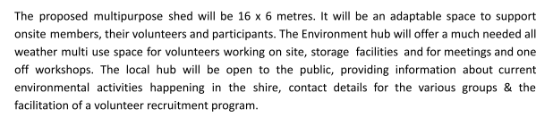
Plans and details for this structure were submitted in September 2023, some 8-9 months after the application was submitted and advertised.
Given that this structure is significantly different from what was originally proposed, consent will need to be sought for this structure under a separate development application.
Description of the site

A site inspection was carried out on 30 March 2023
|
Land is legally described |
LOT: 22 DP: 1073165 |
|
|
Property address |
156 Stuart Street MULLUMBIMBY |
|
|
Land is zoned: |
RE1 Public Recreation / PART DM Deferred Matter (7b Coastal Habitat Zone) Byron LEP 1988 |
|
|
Land area is: |
29.18 ha |
|
|
Property is constrained by:
|
Flood Liable Land Bushfire prone land Acid Sulfate Soils Class 3 High Conservation Value High Environmental Value Cattle Dip Buffer |
|
|
|
Is a BDAR required due to the location of the proposed development? |
☐ Yes ☒ No |
|
|
Are there any easements in favour of Council affecting the site? |
☐ Yes ☒ No |
|
|
Is there a Vegetation Management Plan which might affect the proposal? |
☐ Yes ☒ No |
|
|
Is there a Voluntary Planning Agreement which might affect the proposal? |
☐ Yes ☒ No |
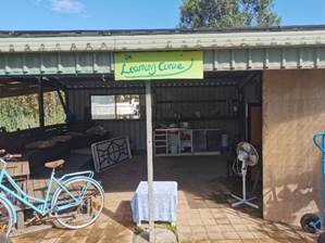
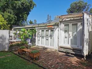
Existing Co-op B19 looking W Existing Co-op B19 looking W
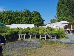
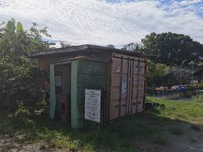
Existing structures B21 & B22 looking S Existing structure B15 looking SE
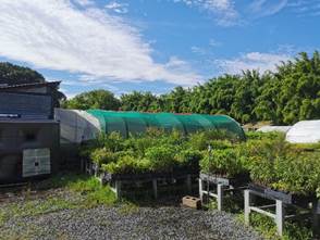
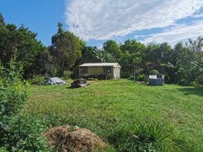
Existing structures B24 & B22 looking SE Existing Men’s Shed B17 looking NW

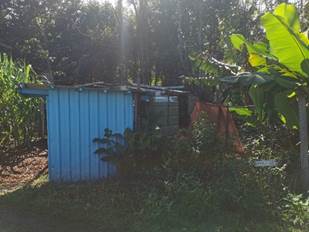
Existing structures B8, B9 & B10 looking NE Existing structure B13 looking E
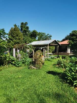
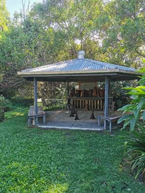
Existing structure B22 looking NW Existing structure looking NW
Location of proposed structure B14 looking E
2. SUMMARY OF REFERRALS
|
Referral |
Issue |
|
Environmental Health Officer |
No objections subject to conditions. |
|
Development Engineer |
No objections subject to conditions. |
|
Building Surveyor |
No objections subject to conditions. |
|
S64 / Systems Planning Officer |
No objections subject to conditions. |
|
Infrastructure Services |
Landowners consent not granted due to conflict with Plan of Management for the land. |
3. SECTION 4.14 – BUSH FIRE PRONE LAND
4. SECTION 4.15C – MATTERS FOR CONSIDERATION – DISCUSSION OF ISSUES
Having regard to the matters for consideration detailed in Section 4.15(1) of the Environmental Planning & Assessment Act 1979 (EP&A Act), the following is a summary of the evaluation of the issues.
State Environmental Planning Policies (SEPP)
|
Considerations |
Satisfactory |
Unsatisfactory |
|
Resilience and Hazards SEPP 2021 Consideration: Clause 2.10 – Development on land within the coastal environment area
(1) Development consent must not be granted to development on land that is within the coastal environment area unless the consent authority has considered whether the proposed development is likely to cause an adverse impact on the following: (a) the integrity and resilience of the biophysical, hydrological (surface and groundwater) and ecological environment, (b) coastal environmental values and natural coastal processes, (c) the water quality of the marine estate (within the meaning of the Marine Estate Management Act 2014), in particular, the cumulative impacts of the proposed development on any of the sensitive coastal lakes identified in Schedule 1, (d) marine vegetation, native vegetation and fauna and their habitats, undeveloped headlands and rock platforms, (e) existing public open space and safe access to and along the foreshore, beach, headland or rock platform for members of the public, including persons with a disability, (f) Aboriginal cultural heritage, practices and places, (g) the use of the surf zone. (2) Development consent must not be granted to development on land to which this clause applies unless the consent authority is satisfied that: (a) the development is designed, sited and will be managed to avoid an adverse impact referred to in subclause (1), or (b) if that impact cannot be reasonably avoided—the development is designed, sited and will be managed to minimise that impact, or (c) if that impact cannot be minimised—the development will be managed to mitigate that impact. (3) This clause does not apply to land within the Foreshores and Waterways Area within the meaning of Sydney Regional Environmental Plan (Sydney Harbour Catchment) 2005.
The application does not propose any vegetation removal or impacts on the coastal environment and coastal processes. The proposal does not impact on foreshore access or any known item or place of aboriginal cultural heritage. The proposal is consistent with the provisions of Clause 2.10 of the SEPP. |
☒ |
☐ |
4.2A Byron Local Environmental Plan 2014 (LEP 2014)
LEP 2014 is an applicable matter for consideration in the assessment of the subject development application in accordance with subsection 4.15(1) of the EP&A Act because it applies to the subject land and the proposed development. The LEP 2014 clauses that are checked below are of relevance to the proposed development:
|
Part 1 |
☒1.1 | ☒1.1AA | ☒1.2 | ☒1.3 | ☒1.4 | ☒Dictionary | ☒1.5 | ☒1.6 | ☒1.7 | ☒1.8 | ☐1.8A | ☒1.9 | ☐1.9A |
|
Part 2 |
☒2.1 | ☒2.2 | ☒2.3 | ☒Land Use Table | ☐2.4 | ☐2.5 | ☐2.6 | ☐2.7 | ☐2.8 |
|
Part 3 |
☐3.1 | ☐3.2 | ☐3.3 |
|
Part 4 |
☐4.1 | ☐4.1A | ☐4.1AA | ☐4.1B | ☐4.1C | ☐4.1D | ☐4.1E | ☐4.1F | ☐4.2 | ☐4.2A | ☐4.2B | ☐4.2C | ☐4.2D | ☒4.3 | ☐4.4 | ☐4.5 | ☐4.6 |
|
Part 5 |
☐5.1 | ☐5.2 | ☐5.3 | ☐5.4 | ☐5.6 | ☐5.7 | ☐5.8 | ☐5.10 | ☐5.11 | ☐5.12 | ☐5.13 | ☐5.14 | ☐5.15 | ☐5.16 | ☐5.17 | ☐5.18 | ☐5.19 | ☐5.20 | ☐5.21 | ☐5.22 |
|
Part 6 |
☒6.1 | ☐6.2 | ☒6.4 | ☐6.5 | ☒6.6 | ☐ 6.7 | ☐6.8 | ☐6.9 | ☐6.11 | ☐ 6.12 | ☐6.13 | ☐6.14 | ☐6.15 | ☐6.16 |
In accordance with LEP 2014 clauses 1.4 and 2.1 – 2.3:
(a) The proposed development is defined in the LEP 2014 Dictionary as Community Facility (development ancillary to);
(b) The land is within the RE1 Public Recreation / PART DM Deferred Matter (7b Coastal Habitat Zone) Byron LEP 1988 according to the Land Zoning Map;
(c) The proposed development is permitted; and
(d) Regard is had for the Zone Objectives as follows:
|
Zone Objective |
Consideration |
|
To enable land to be used for public open space or recreational purposes. |
The proposal does not impact on the ability of the land to continue to be used for the purpose of a community garden |
|
To provide a range of recreational settings and activities and compatible land uses. |
The structures provide storage, shelter and nursery space for users of the community garden which are compatible with the existing use of the site for a community garden. |
|
To protect and enhance the natural environment for recreational purposes. |
The proposal will not have a significant impact on the natural environment for recreational purposes |
6.1 Acid Sulfate Soils
The land is mapped as potential Acid Sulfate Soils Class 3. Works do not extend more than 1m below the natural ground surface therefore no further assessment is required.
6.3 Flood Planning
The land is subject to both the 10 year and 100 year flood events however, given the use of the structures as ancillary to a community garden, this does not present any significant safety risk.
6.6 Essential Services
The land contains an existing onsite sewage management system approved in accordance with 70.2016.1073.1 and associated with existing toilet facilities. There is no nexus to require any further provisions for onsite sewage management under this application.
The site has suitable vehicular access via the existing access arrangement through the community garden.
Recommended conditions will ensure that the site provides suitable stormwater drainage.
The remaining checked clauses have been taken into consideration in the assessment of the subject development application in accordance with Section 4.15 of the EP&A Act. The proposed development complies with all clauses of LEP 2014 (in some cases subject to conditions and/or to the satisfaction of other assessing officers).
Clause 4.6 Exceptions to Development Standards
N/A
4.2B Byron Local Environmental Plan 1988 (LEP 1988)
Part of the site is zoned 7b Coastal Habitat Zone. In accordance with LEP 1988 clauses 5, 8 and 9:
(a) The proposed development is defined in the LEP 1988 Dictionary as Recreation Area (development ancillary to);
(b) The land is within the LEP1988 7b Coastal Habitat Zone according to the map under LEP 1988;
(c) The proposed development (Recreation Area) is prohibited in the 7b zone in accordance with Clause 9 however is permitted with consent given it is ancillary to the Community Facility located on the portion of the site zoned RE1; and
(d) The proposed development is consistent with the relevant objectives of the Zone for the following reasons:
|
Zone Objective |
Consideration |
|
to identify coastal habitats (being wetlands, heath, sedge, marshland, rainforest types, schlerophyll forest and the like) of local significance, |
An existing rotunda and storage sheds are partially located on land zoned 7(b) and substantially on land zoned RE1. The continuing use of these structures will not have any significant environmental impact.
|
|
to identify and preserve estuaries and other significant coastal habitat areas, wetlands and allow them to continue to function as feeding and breeding areas for wildlife, shellfish and fish, |
|
|
to prohibit development within the zone that is likely to have a detrimental effect on the habitat or landscape qualities or the flood mitigation function of significant coastal habitat areas, including wetlands, |
|
|
to enable development of public works and environmental facilities where such development would not have a significant detrimental effect on the habitat or landscape qualities of the wetland and other significant coastal habitat areas, and |
|
|
to enable the careful control of noxious plants and weeds by means not likely to be significantly detrimental to the native ecosystem. |
The proposal raises no other issues under the LEP.
4.3 Any proposed Instrument that has been the subject of public consultation and has been notified to the consent authority
N/A
4.4A Byron Shire Development Control Plan 2014 (DCP 2014)
The proposed development raises no issues under Byron DCP 2014. Conditions of consent recommended addressing car parking, services and flooding consistent with the provisions of the DCP.
4.4B Byron Shire Development Control Plan 2010 (DCP 2010)
The proposed development that is zoned under Byron LEP 1988 raises no specific issues under Byron DCP 2010.
4.5 Environmental Planning and Assessment Regulation 2021 considerations
|
|
Applicable to the proposal: |
Considered the control as it relates to the proposal: |
If this control is applicable, does the proposal comply? |
|
Section 61 - Additional matters that consent authority must consider |
☐ Yes ☒ No |
☐ Yes ☐ No ☒ NA |
☐ Yes ☐ No ☒ NA |
|
Section 62 - Consideration of fire safety |
☐ Yes ☒ No |
☐ Yes ☐ No ☒ NA |
☐ Yes ☐ No ☒ NA |
|
Section 64 - Consent authority may require upgrade of buildings |
☐ Yes ☒ No |
☐ Yes ☐ No ☒ NA |
☐ Yes ☐ No ☒ NA |
|
Section 63 - Considerations for erection of temporary structures |
☐ Yes ☒ No |
☐ Yes ☐ No ☒ NA |
☐ Yes ☐ No ☒ NA |
* Non-compliances and any other significant issues discussed below
4.6 The likely impacts of that development, including environmental impacts on both the natural and built environments, and social and economic impacts in the locality
4.6.1
|
Impact on: |
Likely significant impact/s? |
|
Natural environment |
No. The proposal will not have a significantly adverse impact on the natural environment of the locality. |
|
Built environment |
No. The proposal will not have a significantly adverse impact on the built environment of the locality. |
|
Social Environment |
No. The proposal will not have a significant social impact on the locality. |
|
Economic impact |
No. The proposal will not have a significant economic impact on the locality. |
|
Construction Impacts |
No. The development will generate minor impacts during its construction. Conditions of consent recommended to control hours of work, builders waste, construction noise, installation of sedimentation and erosion control measures and the like to ameliorate such impacts. |
4.6.2 Marine Estate Management Act 2014
The development is unlikely to have an effect on the plants or animals within the Cape Byron Marine Park or their habitat.
4.6.3 Council Policies applicable to the proposed development?
|
Council Policy |
Consideration |
|
A Building Information Certificate is required for existing structures subject to any consent granted. |
|
|
A condition is recommended to ensure applicable developer contributions are paid. |
Community Gardens Policy 2022
This Policy requires that a community garden must abide with the relevant plan of management. The Plan of Management (POM) for the land adopted on 26 June 2008 identifies the location of the following existing and proposed structures as being on land dedicated for use as Sports Fields:
B15 – “BCC Storage Shed” – existing (permanent structure)
B18 – “Proposed Men’s Shed addition” – proposed (permanent structure)
B21 – “RN Shade Houses” – existing (temporary structure)
B22 – “RN Hot Houses” – existing (temporary structure)
B23 – “RN Potting Structures” – existing (permanent structure)
B24 – “RN Solar Shed” – existing (permanent structure)

Due to this conflict, Infrastructure Services staff have not granted landowners consent for the application.
Should Council resolve to grant landowners’ consent, and to ensure there is no long term conflict caused by the above inconsistency, staff recommend that the POM be amended as priority.
4.7 The suitability of the site for the development
The site is a serviced, unconstrained property and is suitable for the proposed development.
4.8 Submissions made in accordance with this Act or the regulations
The development application was publicly exhibited
There was one submission made on the development application:
|
Issue - Objections |
Comment |
|
Concerns with the community garden used by numerous people as housing, camping and as a recreation venue on an ongoing, nightly basis. Request that any new developments do not result in more after hours activity. |
Recommended conditions require that general activities at the community garden are restricted to between the hours of 7am – 6pm daily, that the use of the Food Co-Op is restricted to between the hours of 10am-4pm daily, and that use of the Men’s Shed is permitted between the hours of 9am – 3pm daily.
Recommended conditions also require that doors and windows of the Men’s Shed must remain closed at times when electric or pneumatic hand tools and/or mechanical equipment is being used, that amplified noise/music is not permitted, and that activities must not interfere with the amenity of the neighbourhood.
|
|
Concerns with noise generating activities including from the recent addition of a piano to the rotunda |
|
|
Objection to any development not in line with the zoning of the site and to the creeping development of non-garden facilities and structures. |
The use of the existing and proposed structures subject to this application are permitted in the zoning of the site. |
4.9 Public interest
The proposed development is unlikely to prejudice or compromise the public interest or create an undesirable precedent.
5. DEVELOPER CONTRIBUTIONS
5.1 Water & Sewer Levies
Section 64 levies will be payable.
5.2 Developer Contributions
No Developer Contributions will be required.
6. DISCLOSURE OF POLITICAL DONATIONS AND GIFTS
|
Disclosure details |
Response |
|
Has a Disclosure Statement been received in relation to this application? If Yes, Provide Disclosure Statement register reference: 91. |
Yes ☐ No ☒ |
|
Have staff received a ‘gift’ from anyone involved in this application that needs to be disclosed. |
Yes ☐ No ☒ |
7. CONCLUSION
The DA proposes Use of, and Alterations and Additions to, existing Food Co-Op structure and Use of associated shade structures, New Cool Room, Use of, and New, shade structures, Men’s Shed Additions, Use of existing sheds and Use of existing nursery structures associated with Reforest Now.
The proposed development is satisfactory having regard to the relevant environmental planning instruments and planning controls applicable to the site. The proposal raises no significant issues in terms of environmental impacts which cannot be managed. The site is a serviced, unconstrained property and is considered suitable for the proposed development.
The application appropriately addresses the relevant constraints applying to the site, and is recommended for approval subject to the conditions attached to this report.
BYRON SHIRE COUNCIL
Staff Reports - Sustainable Environment and Economy 13.7
Report No. 13.7 PLANNING - 10.2020.109.4 - Section 4.55 to Stage 9 for Removal of Existing Exotic and Native Trees to Allow for Construction of Approved Roads and Earthworks, ReIocation of Inter-allotment Drainage and Sewer Services and Easement Modifications and Deletion of Local Open Space and Recreation S7.11 Contributions - 86 Tuckeroo Avenue Mullumbimby
Directorate: Sustainable Environment and Economy
Report Author: Greg Smith, Team Leader Planning Services
File No: I2023/1555
Proposal:
|
Modification No |
10.2020.109.4 |
|
Planning Portal Ref |
PAN-317313 |
|
Proposed modification |
S4.55 to Stage 9 for Removal of Existing Exotic and Native Trees to Allow for Construction of Approved Roads and Earthworks, Relocation of Inter-allotment Drainage and Sewer Services and Easement Modifications and Deletion of Local Open Space and Recreation S7.11 Contributions |
|
Original Development |
Stage 9 Tallowood Ridge Estate Subdivision to Create Forty-Eight (48) Residential Lots, of which Seven (7) of these Lots are a Community Title subdivision, and a Community Title common Property Lot |
|
Type of modification sought |
4.55(2) Other modifications |
|
Property description |
LOT: 196 DP: 1281667 |
|
86 Tuckeroo Avenue MULLUMBIMBY |
|
|
Parcel No/s |
271058 |
|
Applicant |
CivilTech Consulting Engineers |
|
Owner |
Gainsplay Pty Ltd |
|
Zoning |
C2 Environmental Conservation / C3 Environmental Management / R2 Low Density Residential / RU1 Primary Production / RU2 Rural Landscape |
|
Date received |
12 April 2023 |
|
Original DA determination date |
14 October 2021 |
|
Integrated Development |
Yes |
|
Public notification or exhibition |
- Level 2 advertising under the Byron Shire Council Community Participation Plan. - Exhibition period: 25/4/2023 to 8/5/2023 - Submissions received: 22 |
|
Planning Review Committee |
Meeting date 1/6/2023 Outcome: Report to Council |
|
Delegation to determination |
Council |
|
Issues |
· Ecological impacts |
Summary:
The approved Stage 9 Tallowood Ridge Estate subdivision includes 48 residential lots, of which seven are a Community Title subdivision, and a Community Title common property lot. The section 4.55 application seeks approval for the modification of the approved Stage 9 subdivision, being for the removal of existing exotic and native trees to allow for the construction of approved roads and earthworks, relocation of the inter-allotment drainage and sewer services and easement modifications, and the deletion of local open space and recreation section 7.11 contributions.
A number of public submissions have been received which predominantly raise concerns in relation to tree removal and impacts of existing trees on likely future dwellings. Two of the trees to be removed are located within roads that have been approved. The proposed tree removal, compensatory planting and other ecological impacts have been considered by Council’s Ecologist who raises no objections to the application subject to conditions with a further 210 species to be planted as compensatory planting.
A number of these trees could remain onsite now, however it is considered highly likely future land owners will then need to apply to remove such vegetation when they go to construct on these lots and have no way of compensating for them. It is considered a better and more prudent approach to enable them to be removed now by the developer for Stage 9 who can facilitate the compensatory planting on residual land within stage 9 that won’t be developed and which he owns now. Once the land is subdivided and on-sold that opportunity no longer exists.
The proposal is considered satisfactory having regard to relevant matters for consideration and the section 4.55 application is recommended for approval subject to the Recommended Modifications in Attachment 1 to this Report.
NOTE TO COUNCILLORS:
In accordance with the provisions of S375A of the Local Government Act 1993, a Division is to be called whenever a motion for a planning decision is put to the meeting, for the purpose of recording voting on planning matters. Pursuant to clause 2(a) under the heading Matters to be Included in Minutes of Council Meetings of Council's adopted Code of Meeting Practice (as amended) a Division will be deemed to have been called by the mover and seconder of all motions relating to this report.
RECOMMENDATION:
That pursuant to Section 4.55 of the Environmental Planning & Assessment Act 1979, that Application No. 10.2020.109.4, for S4.55 to Stage 9 for Removal of Existing Exotic and Native Trees to Allow for Construction of Approved Roads and Earthworks, Relocation of Inter-allotment Drainage and Sewer Services and Easement Modifications and Deletion of Local Open Space and Recreation S7.11 Contributions, be approved by modifying Development consent number 10.2020.109.1 in accordance with Attachment 1 Recommended Modifications.
1 10.2020.104.4
- Recommended Modifications, E2023/105246
![]()
2 10.2020.104.4
- Modified Plans, E2023/105245 ![]()
3 10.2020.109.4
- Biodiversity Assessment, E2023/105244
![]()
4 10.2020.109.4
- Redacted Submissions, E2023/105242
![]()
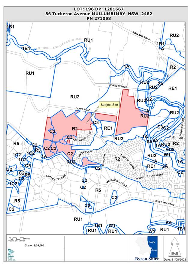
Assessment:
1. INTRODUCTION
1.1. History/Background
Stage 9 is the final stage within the Tallowwood Estate. The following approval history is relevant to this stage.
· DA10.2020.109.1 – Stage 9 to create 48 Residential Lots including 8 community title lots and common property - Approved 14/10/21
· DA10.2020.109.2 – To correct S94 contributions withdrawn
· DA10.2020.109.3 - To expand area of Approved Environmental Management Zone 8 – Approved 9/8/23
It is noted Stage 9 will dedicate 5.96 ha of vegetated land along the southern boundary to Council, other remnant vegetation along the western boundary is to remain in a community title common property lot.
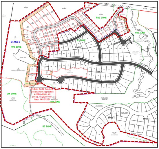
Stage 9 – Depicted by Dashed Red Outline
1.2. Description of the proposed development
This application seeks approval for a S4.55 to Stage 9 for Removal of Existing Exotic and Native Trees to Allow for Construction of Approved Roads and Earthworks, ReIocation of Inter-allotment Drainage and Sewer Services and Easement Modifications and Deletion of Local Open Space and Recreation S7.11 Contributions. Attachment 2 of this Report includes the Modified Plans and Attachment 3 includes the Biodiversity Assessment which supports this application.
There are three main components of the proposed modification as follows:
Modification 1: Removal of existing exotic and native trees to allow for construction of approved roads and earthworks
The application states:
Condition 4 of DA 10.2020.109.1 prohibits removal, lopping or damage to existing native trees.
To construct roads and earthworks, as per the DA approval, removal of the following native trees is required:
· Tree #1 - Sweet Pittosporum (DBH 4.5cm) located in the turnaround adjacent to the proposed stormwater basin.
· Tree #53 - Prickly Paperbark (DBH 15cm) located in the middle of the road reserve near lot 265.
· Trees #90-101, 102-104, 109, 110 & MG1 located in the building area of lots 261 & 262. These trees are in clusters along with numerous exotic species.
· Trees #54 & 55 in lot 256 are to be removed to allow construction of the approved retaining wall.
In addition to the removal of these native trees, exotic species, including lemon scented gums, will be removed including those along the rear of lots 244 to 253.
Condition 4 is to be re-worded to allow for the removal of the above noted native trees as shown on plan 1002-ST9-DA32B and the pruning of several other native trees by an accredited environmentalist nominated by Australian Wetlands Consulting Pty Ltd.
Australian Wetlands Consulting prepared a Biodiversity Assessment for stage 9. The report found that “The proposed development does not impact on biodiversity value land or exceed clearing thresholds therefore the Biodiversity Offsets Scheme (BOS) is not triggered and a Biodiversity Development Assessment Report (BDAR) is not required."
The Biodiversity Assessment sets out the required offset ratios for compensation in section 5.3.
Proposed modification 3 [sic] removing existing native trees will have minimal effect and impact on the development and residents. Trees #1 & #53 are relatively small while other native trees, located towards the rear of lots 261 and 262 aren't readily visible from the surrounding lots or proposed roads. The native trees proposed to be removed will be offset in accordance with the attached AWC report and the report found that a “Biodiversity Offsets Scheme (BOS) is not triggered and a Biodiversity Development Assessment Report (BDAR) is not required.”
Modification 2: ReIocation of inter-allotment drainage and sewer services and easement modifications
Amended sewer and inter-allotment drainage plans are proposed resulting in amendments to Conditions 1, 5, 12 and 13 if approved.
Modification 3: Deletion of Local Open Space and Recreation S7.11 contributions
The applicant is seeking the developer contribution to be amended to reflect the that he is dedicating a further 5.96 hectares of land to Council as part of this consent and other reserves to be dedicated to Council under the stage 8 consent, and the open space and recreation amount be deleted.
1.3. Description of the site
|
Land is legally described |
LOT: 196 DP: 1281667 |
|
|
Property address |
86 Tuckeroo Avenue MULLUMBIMBY |
|
|
Land is zoned: |
C2 Environmental Conservation C3 Environmental Management R2 Low Density Residential RU1 Primary Production RU2 Rural Landscape |
|
|
Land area is: |
30.04 hectares |
|
|
Property is constrained by:
|
· Bush fire prone land · Flood Liable Land – no impact on the proposal so no further consideration required. |
|
|
Is a BDAR required due to the location of the proposed development? |
☐ Yes ☒ No |
|
|
Are there any easements in favour of Council affecting the site? |
☐ Yes ☒ No |
|
|
Is there a Vegetation Management Plan which might affect the proposal? |
☒ Yes ☐ No |
|
|
Is there a Voluntary Planning Agreement which might affect the proposal? |
☐ Yes ☒ No |
|
2. SECTION 4.55(2)
|
Section 4.55(2) |
The Applicant is a person entitled to act on the consent. The applicable provisions of the Regulation are considered below. The development to which the consent as modified relates is substantially the same as the originally approved development. Consultation was not required with the Minister. Council has consulted with the NSW Rural Fire Service, an integrated development approval body, which provided it’s General Terms of Approval and Bush Fire Safety Authority, both of which are included in the attached Recommended Modifications. Public notification of the application, including consideration of submissions received, is discussed in this Report below. |
|
Section 4.55(3) |
Section 4.15(1) matters are considered below. |
|
Section 4.55(4) |
The modification to the development consent is not the granting of a consent. The modified consent becomes the consent. |
|
Section 4.55(6) |
The deemed refusal provisions are noted. |
|
Section 4.55(8) |
The Court was not involved in the parent development consent and is not involved in the current section 4.55 application. |
3. ENVIRONMENTAL PLANNING AND ASSESSMENT REGULATION 2021
The proposal raises no issues in terms of the relevant regulations that apply to modification applications.
4. SUMMARY OF REFERRALS
|
Referral |
Issue |
|
Ecologist |
In relation to modification 1, Council’s Ecologist raised no objection subject to conditions which are reflected in the attached Recommended Modifications. |
|
Development Engineer |
In relation to modification 2, Council’s Development Engineer confirms that the application is supported from an engineering perspective, with no changes to all engineering conditions on the development consent as modified other than updating of Condition 1 to endorse the new revision of the plans. This is reflected in the attached recommended Modifications. |
|
ET Engineer |
In relation to modification 2, Council’s ET Engineer recommends that their conditions remain the same as approved in the original consent as modified. The ET Engineer does recommend however that the “Water payments under the Water Management Act 2000” note in the consent be modified, as reflected in the attached Recommended Modifications. In this regard, the ET Engineer advises that this development generates an additional load onto Councils Water, and Sewer Systems, noting that Lot 280 does not appear in plans used for the original ET assessment. |
|
Contributions Planner |
In relation to modification 3, Council’s Contribution Planner recommended that no changes be made to existing condition 48 of the consent for the reasons outlined above. |
|
NSW Rural Fire Service |
No objections subject to modified General Terms of Approval and Bush Fire Safety Authority, both of which are included in the attached Recommended Modifications. |
5. SECTION 4.14 – BUSH FIRE PRONE LAND
Under section 4.14 of the Act, Council must be satisfied prior to making a determination for development on bush fire prone land, that the development complies with the document Planning for Bush Fire Protection 2006. The site is bush fire prone land. The Rural Fire Service has provided it’s General Terms of Approval and Bush Fire Safety Authority and these are provided in the attached Recommended Modifications.
6. SECTION 4.15 – MATTERS FOR CONSIDERATION – DISCUSSION OF ISSUES
Having regard to the matters for consideration detailed in Section 4.15(1) of the Environmental Planning & Assessment Act 1979 (EP&A Act), the following is a summary of the evaluation of the issues.
6.1. State Environmental Planning Instruments
Biodiversity and Conservation SEPP 2021
Consideration: Council’s Ecologist advises that in relation to Chapter 2 of the SEPP Vegetation in non-rural areas applies to application area based on urban zoning. In relation to Koala Planning Policies (CKPoM, Chapters 3 and 4 of the Biodiversity and Conservation SEPP), the SEPP defers to the Comprehensive Koala Plan of Management. There is no mapped Koala habitat impacted and no Koala feed trees are proposed to be removed.
The site contains substantial vegetated areas in the south, but the application area comprises pasture with scattered trees and minor regrowth. No threatened flora or ecological communities present.
The consultant ecologists have provided an assessment of likely threatened fauna and the report states:
Three threatened fauna species have been previously recorded within the broader Tallowood Ridge
site area:
- Glossy Black-cockatoo (Calyptorhynchus lathami)
- Koala (Phascolarctos cinereus)
- Masked Owl (Tyto novaehollandiae)
No threatened fauna species were recorded during field assessment. Based on the desktop analysis and habitat present, several threatened fauna species have potential to occur at the site on an opportunistic basis.
Council’s Ecologist advises that these assumptions are concurred with.
Compensation is proposed for trees removed as a result of the proposed modification, in area of approximately 900m2, near the existing Management Zone (MZ) 8 as per the Tallowood Ridge Biodiversity Conservation Management Plan. The Compensation is adequate and is supported subject to conditions consent with additional plantings required to compensate for lemon scented gums to be removed.
6.2. Byron Local Environmental Plan 2014 (LEP 2014)
The proposed amendments raise no issues in terms of the LEP that have not been previously considered.
6.3. Any proposed Instrument that has been the subject of public consultation and has been notified to the consent authority
There are no proposed instruments of significant applicability to the proposal.
6.4. Byron Shire Development Control Plan 2014 (DCP 2014)
DCP 2014 is an applicable matter for consideration in the assessment of the subject development application in accordance with subsection 4.15(1) of the EP& A Act because it applies to the land to which LEP 2014 applies.
In relation to Chapter B1: Biodiversity, Council’s Ecologist confirmed that the red flag setback requirements and planning principles are not relevant given that the subdivision is approved and the modification (and vegetation removal) are necessary for roads and services.
In relation to Chapter D6: Subdivision and Chapter E3: Mullumbimby, the approved development would not be so modified as to result in any significant non-compliances that have not already been assessed. The amendments to infrastructure location raises no issue in terms of Councils design guidelines for such.
The proposal raise no other issues under the DCP.
Environmental Planning & Assessment Regulation 2021 Considerations
The proposal raises no other issues under the regulations that haven’t been previously considered.
6.5. The likely impacts of that development, including environmental impacts on both the natural and built environments, and social and economic impacts in the locality
The proposed modification raises additional environmental impacts which are summarised as follows:
• Removal of native vegetation – up to 23 trees
• Removal of seven (7) Camphor Laurel greater than 5m tall, along with several small
regenerating Camphor Laurel thickets
• Loss of two (2) trees with habitat value for local wildlife - one (1) hollow bearing tree (Tree
103 - Blue Lilly Pilly) and one (1) stag (Tree C2 – Camphor Laurel)
• Disturbance of piled logs and debris (fauna habitat) within patches of trees to be removed.
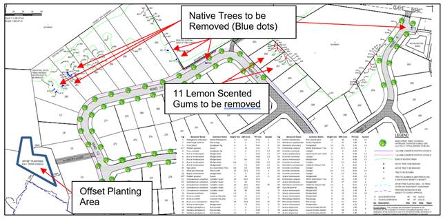
Extract of Tree Removal and Offset Plan
In this regard some of this vegetation has already been identified for removal by way of the approved plans with Condition 4 in conflict with that plan layout. This includes the trees with in Roads 1 - 2 and Road 5. The condition would not prevent the removal of camphor laurel and other vegetation to be removed as identified by the red dots on the plan above. The submitted plan has not adequately considered the 11 Lemon Scented Eucalypts on Lots 251 and 252. It appears this vegetation has been planted and or escaped from surrounding properties with the providence of this species more regularly found in northern eastern climes of Australia than in Byron Shire. Notwithstanding the trees do have some ecological value, as habitat and should not just be discounted like a weed, and as such further compensation of 55 trees (Ratio of 1/5) are required beyond the initial 155 recommended by the applicant.
It is noted that some of the vegetation to be removed will facilitate the future residential development of these lots once on-sold including trees on Lots 254, 261 and 262. This co-ordinated approach at the subdivision stage to tree removal is supported as once the lots are created and on-sold opportunities for offset plantings are limited or not possible within residential sized properties.
The proposal with compensation is reasonable response to the further tree removal proposed and subject to conditions of consent the environmental impacts are negated in this instance.
6.6. The suitability of the site for the development
The site is still a serviced, unconstrained property and is suitable for the proposal as amended.
6.7. Submissions made in accordance with this Act or the regulations
The application was publicly exhibited. Twenty two submissions have been received. The redacted Public Submissions are contained in Attachment 4 of this Report. The issues raised are summarised and commented on as follows:
Lemon Scented not properly considered on Lots 251 and 252
Comment: See Comments above- the trees are not endemic to Byron Shire but additional compensatory plantings required
As the inter-allotment drainage of Lots 249-253 is now proposed to be located at the front of the lots, the removal of trees on Lots 251 and 252 will not be required
Comment: See comments above on the Lemon scented gums, a co-ordinated response to the tree removal and compensatory plantings at subdivision stage is supported.
Lot 256 has existing significant native tree canopy coverage likely within the proposed building footprint area, from the adjoining Rural Zoned property DP 608876. How will future dwelling comply with planning for bushfire protection.
Comment: Two additional trees are proposed for removal from Lot 256. NSW RFS have conditioned up a 12 metre setback from the rear boundary. The property has an area of 2070 m2 and it is considered a dwelling can be sited on the allotment and satisfactorily address planning for bushfire protection.
Lots 244-256 have existing tree canopy overhang from Rural Zoned adjoining land as Rural Landholders we have concerns regarding the liability to trim these trees to a boundary line.
Comment: The matter was considered by the Rural Fire Service with the original subdivision and an updated Section 100B Bushfire fire Safety Authority has been issued. The RFS have not conditioned up any APZs on this property as opposed to Lots 240 – 243, 256 – 262 and Lots C1- C7. In the event that tree branches overhanging property boundaries need to be lopped this would be a matter for the future land owners of the property to consider and apply for the appropriate approvals at that time if required.
6.8. Public interest
It is considered the proposed amendments are unlikely to significantly prejudice or compromise the public interest or create an undesirable precedent.
7. DEVELOPER CONTRIBUTIONS
7.1. Water & Sewer Levies
The proposal does not generate any additional lots or nexus to amend the water and sewer levies.
7.2. Section 7.11 Contributions
The applicant is seeking the developer contribution to be amended to reflect the that he is dedicating a further 5.96 hectares of land to Council as part of this consent and other reserves to be dedicated to Council under the stage 8 consent, and the at the open space amount be deleted.
Given the value of the land is unknown at this point Council cannot delete the requirement to pay the contributions. It is probable that the contributions may well be reduced to zero at that time, but this will be depend on the value of land at the time of dedication. As such the condition already has mechanisms built into it to enable the amount to be reduced accordingly, and there is no need to amend the condition.
As such it is recommended that Condition 48 not be amended.
8. CONCLUSION
An application has been received to S4.55 to Stage 9 for removal of existing exotic and native trees to allow for construction of approved roads and earthworks, relocation of inter-allotment drainage and sewer services and easement modifications and deletion of local open space and recreation section 7.11 contributions. The proposal is satisfactory having regard to relevant matters for consideration and the section 4.55 application is recommended for approval subject to the attached Recommended Modifications.
BYRON SHIRE COUNCIL
Staff Reports - Sustainable Environment and Economy 13.8
Report No. 13.8 Byron Shire Local Heritage Grants Program 2023-24
Directorate: Sustainable Environment and Economy
Report Author: Roseanna Meech, Planner
File No: I2023/1569
Summary:
This report seeks Council endorsement of the funding allocation for the Byron Shire Local Places Heritage Grants Program 2023-24.
RECOMMENDATION:
That:
1. Council endorses the recommended funding allocations of the Byron Shire Local Places Heritage Grants Program 2023-24 for landowners to complete building repairs, enhancements, and maintenance to prominent local heritage items in main towns such that each application in Attachments 1 to 4 receive $3,000 each.
2. The grant applicants be notified of Council’s decision.
Attachments:
1 CONFIDENTIAL - Local Heritage Places Funding Application 2023/24 1 Market Street Bangalow, E2023/105706
2 CONFIDENTIAL - Local Heritage Places Funding Application 2023/24 - 52 Kingsley Street Byron Bay, E2023/105763
3 CONFIDENTIAL - Local Heritage Places Funding Application 2023/24 - 80 Jonson Street Byron Bay, E2023/105771
4 CONFIDENTIAL - Local Heritage Places Funding Application 2023/24 - 26 Carlyle Street Byron Bay, E2023/105778
5 CONFIDENTIAL - Local Heritage Places Funding Application 2023/24 - Bangalow Railway Station, E2023/105777
6 CONFIDENTIAL - Byron Local Heritage Grants Summary Report 2023, E2023/105710
Report
The Local Heritage Places Grants program is jointly funded by Council and the NSW Heritage Division as part of its commitment to heritage management and tourism within Byron Shire. The purpose of the fund is to provide small grants to support owners of heritage items or draft heritage items in maintaining their heritage property.
There is an amount of up to $12,000.00 in the 2023-24 fund made up of a grant from the Heritage Division of the NSW Office of Environment of up to $5,500.00 and $6,500.00 from Council.
To incentivise applications this year up to $4,000 was the maximum amount offered to applications from the grant funding available. The main conditions are that property owners need to provide one dollar for every dollar contributed jointly by Council and the Heritage Division and that the work must be completed before or by March 2024.
Five applications were received this year. One application for the Bangalow Railway Station is not supported as there was not sufficient information provided at this stage to meet the grant application criteria.
Each proposal was assessed by Council’s Heritage Advisor against the required Heritage Division criteria. Local Heritage Places Funding - Byron Shire Council (nsw.gov.au)
The grant applications are confidential Attachments 1-5. A summary of each successful application is provided below.
|
ITEM |
PROPOSAL |
|
Bangalow Showground Complex (Heritage Item) The showground has been connected with the cultural and commercial life of the town and surrounding district for 100 years and has been important to the day-to-day lives of generations of settlers in the Bangalow district. The annual agricultural show has been an important economic and social event in Bangalow for over a century. The showground was established on land that was donated by Robert Campbell from his original selection.
|
Repaint buildings in the Bangalow Showground, namely Moller Pavilion and the Show Office. |
|
‘Palm Court’ 52-54 Kingsley Street (Heritage Item) The timber bungalow in federation style, and timber stables building at the rear form a striking group on the corner of Kingsley and Cowper streets. The addition of the rear stables built in the 1990s is an example of adding accommodation sympathetic to the well-kept original building. A rare type of construction in the district. These buildings are part of the Kingsley Street precinct.
|
Repairs and repainting
|
|
Byron Visitor Centre - 80 Jonson Street, Byron Bay This building forms part of the Railway precinct and is linked to the settlement of the town of Byron Bay. The building comprises the former Station Masters House built in 1904 and is historically, associatively aesthetically and socially significant. As part of the town centre, it is an integral part of the cultural identity of the town. It was originally part of the state listed complex but it is now excluded from the curtilage when excised from rail property.
|
Repainting/repairs of exterior |
|
26 Carlyle Street, Byron Bay This is a contributory traditional inter war weatherboard dwelling within the Kingsley Street Conservation Area. It is a corner property with high public visibility. The triple gabled Californian bungalow style dwelling is aesthetically and historically significant showing growth during the boom of the dairying industry and Norco operations in Byron Bay.
|
Repair /restore and repaint various building elements to period correct and asbestos removal.
|
The Local Heritage Grants Program is to support conservation works that enhance individual places, buildings and historic streetscapes including buildings in conservation areas that will promote and foster community appreciation of the history of the Shire.
The focus for this year’s grants was for conservation works within Bangalow. This includes buildings within the Bangalow Heritage Conservation Areas that will in turn promote and foster the community’s and visitor’s appreciation of the village. While the focus is to encourage positive work on heritage within Bangalow, owners of heritage properties in other parts of the Shire were encouraged to apply.
After consideration by the Council’s Heritage Adviser and the Director Sustainable Environment and Economy, it was agreed that four of the projects meet the criteria and are recommended to Council for funding this year. Confidential Attachment 6.
In summary, four applications will each receive $3,000 from the available grant funding, this is based on the scope and costs of works and compliance with grant criteria.
Strategic Considerations
Community Strategic Plan and Operational Plan
|
CSP Objective |
CSP Strategy |
DP Action |
Code |
OP Activity |
|
2: Inclusive Community |
2.1: Foster opportunities to express, celebrate and participate in arts and cultural activity |
2.1.5: Share and celebrate diverse stories including the built, natural, and cultural heritage of the Shire |
2.1.5.3 |
Manage the Heritage Grants Program |
Legal/Statutory/Policy Considerations
Grant funding guidelines and requirements.
Financial Considerations
Council will deliver the Local Heritage Grants Program with the aid of a grant from the Heritage Division of the NSW Office of Environment and Heritage with Council providing at least $6,500 to qualify for up to $5,500 from the Heritage Division of the Office of Environment and Heritage.
Consultation and Engagement
The Local Heritage Grants program is a key action task in the Byron Shire Heritage Strategy 2020-2024.
The Local Heritage Grants program was published on Council’s website, through social media posting and appeared in the Bangalow Herald.
BYRON SHIRE COUNCIL
Staff Reports - Sustainable Environment and Economy 13.9
Report No. 13.9 PLANNING - DA 10.2023.116.1 - New Dwelling to create dual occupancy (detached), clause 4.6 variation for second driveway, and use of existing building as farm storage shed and studio – 149 Friday Hut Road Coorabell
Directorate: Sustainable Environment and Economy
Report Author: Greg Yopp, Planner
File No: I2023/1590
Proposal:
|
Proposal description: |
|||
|
Property description: |
LOT: 1 DP: 962263 |
||
|
149 Friday Hut Road COORABELL |
|||
|
Parcel No/s: |
26500 |
||
|
Applicant: |
Ms A Nettle |
||
|
Owner: |
Ms A Nettle |
||
|
Zoning: |
RU2 Rural Landscape |
||
|
Date received: |
21 May 2023 |
||
|
Integrated / Designated Development: |
☐ Integrated |
☐ Designated |
☒ Not applicable |
|
Public notification or exhibition: |
- Level 1 advertising under Council’s Community Participation Plan. - Exhibition period: 01/06/2023 to 15/06/2023 - No Submissions were received
|
||
|
Variation request to Development Standards under an EPI (eg clause 4.6) |
Clause 4.6 Variation request regarding 4.2D Erection of dual occupancies (detached) and secondary dwellings in zones RU1 and RU2. Clause 4.2D(2)(b) requires each dwelling to use the same vehicular access to and from a public road. This development application proposes a second vehicle access. |
||
|
Estimated cost |
$2,772,000.00 |
||
|
Delegation to determine |
Council |
||
|
Issues |
4.6 Variation – Regarding Extra Driveway |
||
Summary:
The proposed buildings, sheds and studio appropriately address the relevant constraints applying to the site and is recommended for Deferred Commencement Consent subject to the conditions listed in Attachment 1 to this report.
NOTE TO COUNCILLORS:
In accordance with the provisions of S375A of the Local Government Act 1993, a Division is to be called whenever a motion for a planning decision is put to the meeting, for the purpose of recording voting on planning matters. Pursuant to clause 2(a) under the heading Matters to be Included in Minutes of Council Meetings of Council's adopted Code of Meeting Practice (as amended) a Division will be deemed to have been called by the mover and seconder of all motions relating to this report.
RECOMMENDATION:
Pursuant to Section 4.16 of the Environmental Planning & Assessment Act 1979, Development Application No. 10.2023.116.1 for New dwelling to create dual occupancy (detached), clause 4.6 variation for second driveway, and use of existing building as farm storage shed and studio, be granted Deferred Commencement subject to the conditions of Deferred Commencement Consent in Attachment 1 (#E2023/105891).
Attachments:
1 10.2023.116.1
- Conditions of Consent, e2023/105891
![]()
2 10.2023.116.1
- Architectural Plans, e2023/74668
![]()
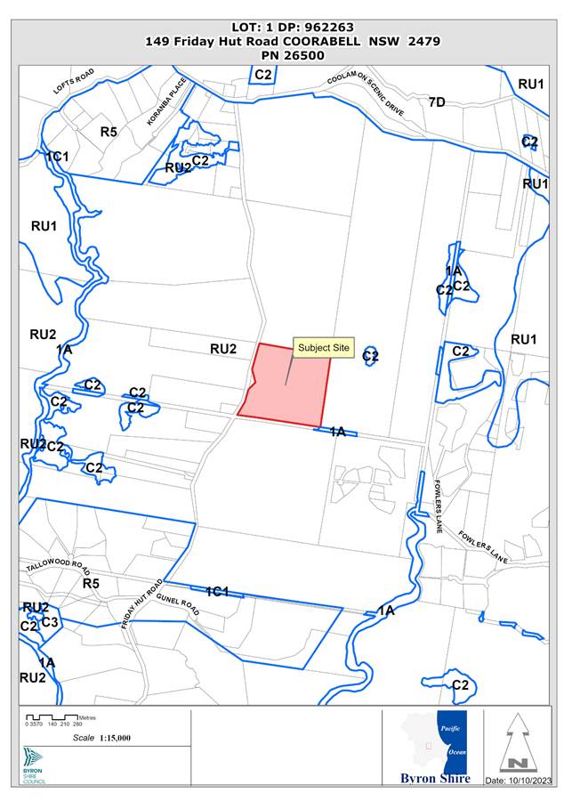
History/Background
There is an existing circa 1960’s four bedroom single storey dwelling house and ancillary structures on the site. Council has no record of approval for the existing dwelling house, however, this should not necessarily be construed as being unauthorised development with historic approval records dating back to the 1960s and earlier are somewhat incomplete.
There is also a recently constructed unauthorised farm shed / studio and an existing separate driveway from Friday Hut Road. The second driveway predates the current owner’s tenure. The current owners have cleared camphor laurels along the fence line in this location and upgraded this existing second driveway. Refer to Figure 1 for historical second driveway image.
Figure 1 – Historical second driveway
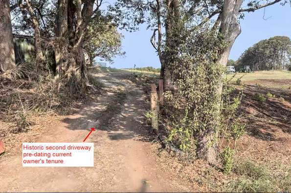
Description of the proposed development
The DA proposes a new dwelling to create a dual occupancy (detached), clause 4.6 variation for a second driveway, and use of an existing building as farm storage shed and studio. Refer to Figure 2 for Partial Site Plan. Refer to Attachment 2 for complete set of architectural plans.
Figure 2 – Partial Site Plan

The proposed single storey dwelling is to be constructed within a cleared area of the property within 100m to the south of the established dwelling. The proposed dwelling includes 3 bedrooms, a study, a gym, bathrooms, laundry, an open plan kitchen/living/dining area and a three vehicle garage with additional storage space. The dwelling is to be constructed on a concrete slab with timber frames and a mixture of external vertical cladding including feature timber walls. The roof is of a gable design clad with metal sheets. Refer to Figures 3 and 4 for detail.
Figure 3 – Proposed dwelling floor plan

Figure 4 - Proposed dwelling North East Elevation
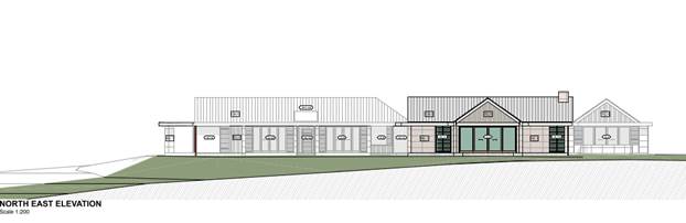
Consent is also sought for the recently constructed shed /studio. The building is constructed on a concrete slab and is metal clad. The gross floor area of the building is 172m2 with 50m2 of that area forming the studio. Refer to Figures 5 and 6 for detail.
Figure 5 – Shed / Studio floor plan
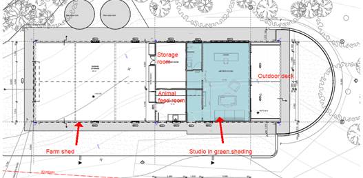
Figure 6 – Shed / Studio perspectives

Description of the site
Buildings and structures on the site include an established circa 1960’s four bedroom dwelling with associated driveway and infrastructure; livestock stable to the east of the dwelling, shipping container to the north west of the dwelling; landscaping and pergola to the north of the dwelling, chook house, internal fencing for livestock, existing shed / studio (part subject of this DA) and associated second driveway (part subject of this DA); landscaping and garden beds adjacent to the west and south of the dwelling. Refer to Figure 7 for an aerial view of the subject allotment with the LEP land zoning overlay.
Figure 7 – Aerial site view with zones and existing and proposed structures
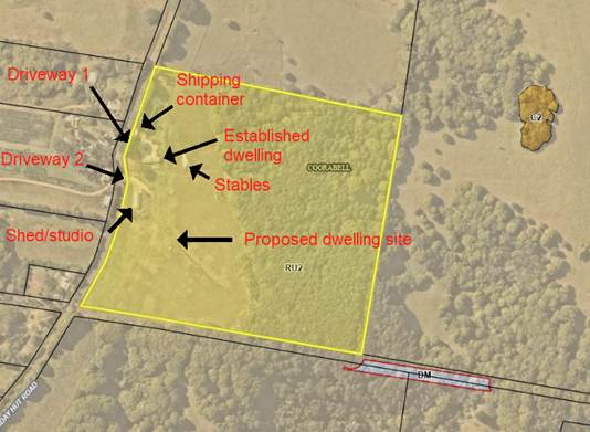
A site inspection was carried out on 10 October 2023
|
Land is legally described |
LOT: 1 DP: 962263 |
|
|
Property address |
149 Friday Hut Road COORABELL |
|
|
Land is zoned: |
RU2 Rural Landscape |
|
|
Land area is: |
16.19ha |
|
|
Property constraints
|
Bushfire prone land, High Environmental Value vegetation, Cattle Dip Buffer |
|
|
|
Is a BDAR required due to the location of the proposed development? |
☐ Yes ☒ No |
|
|
Are there any easements in favour of Council affecting the site? |
☐ Yes ☒ No |
|
|
Is there a Vegetation Management Plan which might affect the proposal? |
☐ Yes ☒ No |
|
|
Is there a Voluntary Planning Agreement which might affect the proposal? |
☐ Yes ☒ No |
The generally rectangular allotment has frontage to Friday Hut Road. The land contains gentle to steep slopes, with the fall generally from west to east away from the road frontage. The steeper land within the north east and east of the site is heavily vegetated. Vegetation in the north east of the site is mapped as Subtropical Rainforest. The proposed development and any bush fire safety asset protection zones are all located in a cleared area in the south western portion of the lot.
The site has a history of grazing under the previous ownership. The pastures are both grazed and mowed by the current landholder. Similar sized rural lifestyle lots are located on the western side of Friday Hut Road. Larger rural holdings are located to the north and south and a rural community title subdivision adjoins the eastern boundary.
An approximately 400m2 triangular area of closed road reserve in public ownership is located to the west of the shed and the east of the road reserve. Personal communication with the landholder on 10/10/2023 indicated they had initiated a procedure to purchase this land. Refer to Figure 9 for detail.
Figure 9 – Area of closed road reserve

SUMMARY OF REFERRALS
|
Referral |
Issue |
|
Environmental Health Officer |
No objections subject to conditions. |
|
Development Engineer |
No objections subject to conditions. |
|
Building Surveyor |
The DA includes, inter alia, the proposed use of an existing building as a farm storage shed and studio. Council’s Building Surveyor has assessed the proposal and has recommended Deferred Commencement. This will require the issuance of a Building Information Certificate prior to the consent becoming operational. |
|
S7.11 / Contributions Planner |
No objections subject to conditions. |
* Conditions provided in the above referral are included in the Attachment 1 (Conditions of Consent) to this report.
SECTION 4.14 – BUSH FIRE PRONE LAND
Under section 4.14 of the Act, Council must be satisfied prior to making a determination for development on bush fire prone land, that the development complies with the document ‘Planning for Bush Fire Protection 2006’. The site is bush fire prone land. The development application was referred to the NSW Rural Fire Service, which provided conditions which are reflected in the Consent Conditions (Attachment 1 to this report).
SECTION 4.15C – MATTERS FOR CONSIDERATION – DISCUSSION OF ISSUES
Having regard to the matters for consideration detailed in Section 4.15(1) of the Environmental Planning & Assessment Act 1979 (EP&A Act), the following is a summary of the evaluation of the issues.
4.1 State Environmental Planning Policies (SEPP)
|
Considerations |
Satisfactory |
Unsatisfactory |
|
Biodiversity and Conservation SEPP 2021 Consideration: No tree removal required. Proposed development and associated bush fire protection asset protection zones located in a cleared part of the allotment. |
☒ |
☐ |
|
Resilience and Hazards SEPP 2021 Consideration: In accordance with s4.6 of the SEPP, contamination and remediation were considered as part of the assessment of this development application. Council’s Environmental Health Officer is satisfied that this cleared former grazing land has no signs of contamination or contaminating activities. |
☒ |
☐ |
|
Transport and Infrastructure SEPP 2021 Consideration: The proposed development did not require referral to referral to the electricity supply authority under s2.48 of the SEPP. |
☒ |
☐ |
|
SEPP (Building Sustainability Index: BASIX) 2004 Consideration: BASIX Certification accompanies the DA. Certificate No. 1353229S, dated 03/02/2023. |
☒ |
☐ |
4.2 Byron Local Environmental Plan 2014 (LEP 2014)
In accordance with LEP 2014 clauses 1.4 and 2.1 – 2.3:
(a) The proposed development is defined in the LEP 2014 Dictionary as dwelling, dual occupancy and farm building;
(b) The land is within the RU2 Rural Landscape according to the Land Zoning Map;
(c) The proposed development is permissible with consent; and
(d) Regard is had for the Zone Objectives as follows:
|
Zone Objective |
Consideration |
|
To encourage sustainable primary industry production by maintaining and enhancing the natural resource base. |
The proposed dwelling is of a scale that can easily be accommodated within the rural lifestyle property and does not compromise the primary production potential or rural character of the land. |
|
To maintain the rural landscape character of the land. |
|
|
To provide for a range of compatible land uses, including extensive agriculture. |
The proposed development does not compromise the potential to undertake extensive agriculture within the subject allotment or surrounding lots. The location of the development is well set back from adjoining shared allotments and is unlikely to create future land use conflict issues. |
|
To enable the provision of tourist accommodation, facilities and other small-scale rural tourism uses associated with primary production and environmental conservation consistent with the rural character of the locality. |
The proposed development does not compromise the potential to undertake tourist accommodation, facilities and other small-scale rural tourism uses associated with primary production and environmental conservation consistent with the rural character of the locality. |
|
To protect significant scenic landscapes and to minimise impacts on the scenic quality of the locality. |
The proposed development site is situated within a cleared area in the south-west of the 16.2ha property. A setback of over 50 metres is provided to the road frontage. The development is not likely to significantly impact on the scenic amenity or character of the locality. |
The relevant LEP 2014 clauses have been taken into consideration in the assessment of the subject development application in accordance with Section 4.15 of the EP&A Act. The proposed development complies with all clauses of LEP 2014 with the exception of clause 4.2D(2)(b) which requires each dwelling to use the same vehicular access to and from a public road. In this regard, LEP 2014 clause 4.6 is addressed below. Additional detail is also provided below for clause 4.2A regarding the “dwelling entitlement” associated with the land.
Clause
4.2A Erection
of dwelling houses and dual occupancies on land in certain rural and
environment protection zones
Council issued a Planning Certificate
pursuant to sections 10.7(2) & 10.7(5) of the Environmental Planning and
Assessment Act 1979, dated 20/09/2023, stating the that a dwelling house is
permitted to be erected on the land in accordance with LEP 2014 clause 4.2A(3)
and 4.2A(5).
Clause 4.6 Exceptions to Development Standards
The applicant has sought a variation to the single driveway requirement for rural dual occupancies under clause 4.2D by proposing a second driveway.
The applicant has submitted a written request that strict compliance with the development standard is unreasonable or unnecessary and that there are sufficient environmental grounds to vary the controls as follows:
• The partial existing second driveway will provide access to an existing, albeit unauthorised farm storage shed/studio. It is contended that the location of this second driveway is meritorious and is capable of compliance with Council’s engineering standards.
· The second driveway has existed for several decades, predating the current owner’s tenure. The current owners have upgraded this driveway prior to lodgement of this DA.
· Whilst it is possible to extend the existing driveway that serves the established dwelling house on the site, such an extension is unreasonable and unnecessary. It would require more material and resources to extend the existing driveway than it would to utilise a second driveway.
· The provision of a second driveway would eliminate the necessity of large vehicles delivering agricultural products or machinery passing in close proximity to the established dwelling house.
It is considered that strict compliance with the development standard is unreasonable and unnecessary in the circumstances of the case and that there are sufficient environmental grounds to vary the development standard for the following reasons:
• The proposed development is consistent with Zone RU2 objectives.
· The contravention of the development standard does not raise any matter of significance for State or regional environmental planning.
· The proposed contravention of the development standard is deemed to be compatible with the public interest as there will be a reduction in earthworks and construction material required. Moreover, the second driveway, subject to conditions, will provide safe access to the rural allotment.
Further the proposal is in the public interest having regards to the objectives of the development standard
4.2D (1) The objectives of this clause are as follows—
(a) to provide alternative accommodation for rural families and workers,
(b) to ensure that development is of a scale and nature that is
compatible with the primary production potential, rural character and
environmental capabilities of the land,
(c) to set out consent considerations for development of dual occupancies
(detached) and secondary dwellings to address matters such as access, siting,
land suitability and potential impacts.
for the following reasons:
a) The proposed dual occupancy and associated second driveway will provide alternative accommodation for rural families and workers.
b) The proposed development is compatible with the primary production potential, rural character and environmental capabilities of the land. A second driveway will better enable access and egress of primary production vehicles, in particular trucks that may be required to deliver or pick up primary produce and agricultural machinery, without having to navigate a circuitous route past the established dwelling house. The second driveway is proposed in a cleared section of the site and does not require any tree removal or high environmental value vegetation.
c) The proposed development complies with the development standards and considerations of clause 4.2D with the exception of the proposed second driveway, which is deemed to be fair and reasonable in the circumstances. The proposed second dwelling (dual occupancy) is within 100m of the established dwelling. The proposal is compatible with the surrounding built and natural environment. The siting of the proposal within the allotment serves to minimise any potential rural amenity and biodiversity impacts.
Council has assumed concurrence of the of the Planning Secretary for the clause 4.2D contravention.
It is recommended that the development standard can be varied in this instance.
a) The development is satisfactory having regard to the requirements outlined in clause 4.6;
b) The development is satisfactory having regard to applicable Department of Planning, Infrastructure and Environment Circulars;
c) The development is satisfactory having regard to relevant case law;
d) The DA demonstrates that compliance with the development standard is unreasonable and unnecessary;
e) The DA demonstrates that there are sufficient environmental planning grounds to justify contravening the standard;
f) The DA demonstrates that the development is in the public interest;
g) The DA demonstrates that the development is consistent with the objectives of the standard and the zone;
h) The DA demonstrates how the development produces a better planning outcome than one that strictly complied with the development standard; and
i) The DA demonstrates what it is about the grounds of the request that are particular to the proposed development on this site, and that there has to be something particular to the development on this site to justify the variation.
4.3 Any proposed Instrument that has been the subject of public consultation and has been notified to the consent authority
Not applicable.
4.4 Byron Shire Development Control Plan 2014 (DCP 2014)
The following comments are provided on the relevant DCP provisions for this proposal.
|
DCP Section |
Section Objectives - compliance |
Section Performance Criteria - compliance |
|
Chapter D2 – Residential Accommodation and Ancillary Development in Rural Zones. Section D2.2.2 Setbacks from Boundaries Front setback 15m |
The proposed use of the existing shed/studio involves a building that has a front setback of 13m. The proposed development complies with the Objectives of the Section because:
1. The proposed development does not compromise the rural or scenic character and amenity of the location. The 13m setback From Friday Hut Road reserve for the shed / studio is considered reasonable in the location, considering nearby western dwellings and ancillary buildings have similar or lesser setbacks, with some between 3m to 10m. Refer to Figure 9 for more detail. 2. The setback enables the achievement of favourable orientation and spacing of development in and adjoining this rural allotment. The proposal does not compromise privacy, sunlight, shade, wind and weather protection for neighbouring development, while at the same time, providing optimal rural amenity in the subject allotment. 3. Council’s Environmental Health Officer raises no concerns regarding land use conflict. |
The proposed development complies with the Performance Criteria of this Section because:
1. Council’s Environmental Health Officer raises no concerns regarding land use conflict. 2. The proposal does not compromise rural character or amenity. The location of the shed/studio is in a cleared part of the lot. The design of the building is appropriate for its intended purpose. Landscaping is in place that will in time screen the shed from the road. 3. The proposal complies as follows: · Consistent with the objectives of this section. · The are no other provisions in the DCP (such as land use conflict and buffers) that would require a greater setback. · The proposal is consistent with the rural and scenic character of the locality. · The proposed setback of 13m is considered a minor variation (13%) of the prescribed 15m, especially considering front setbacks on the western side of Friday Hut Road, adjacent to the subject allotment, include some that range from 3m to 10m. · The proposal does not impact on privacy, amenity, solar access or climatic characteristics of nearby residential accommodation. · The minor encroachment into the front setback does not affect vehicular safety and visibility along Friday Hut Road. · The location of the shed / studio, in a cleared, generally level area of the site is appropriate. · The location of the shed / studio does not compromise the ability of this 16ha allotment to accommodate adequate carparking and manoeuvring. |
The proposed development is demonstrated to meet the relevant Objectives of DCP 2014.
4.5 Environmental Planning and Assessment Regulation 2021 considerations
|
Relevant clauses |
Applicable to the proposal: |
Considered the control as it relates to the proposal: |
If this control is applicable, does the proposal comply? |
|
Section 61 - Additional matters that consent authority must consider |
☐ Yes ☒ No |
☐ Yes ☐ No ☒ NA |
☐ Yes ☐ No ☒ NA |
|
Section 62 - Consideration of fire safety |
☐ Yes ☒ No |
☐ Yes ☐ No ☒ NA |
☐ Yes ☐ No ☒ NA |
|
Section 64 - Consent authority may require upgrade of buildings |
☐ Yes ☒ No |
☐ Yes ☐ No ☒ NA |
☐ Yes ☐ No ☒ NA |
|
Section 63 - Considerations for erection of temporary structures |
☐ Yes ☒ No |
☐ Yes ☐ No ☒ NA |
☐ Yes ☐ No ☒ NA |
* Non-compliances and any other significant issues discussed below
4.6 The likely impacts of that development, including environmental impacts on both the natural and built environments, and social and economic impacts in the locality
4.6.1
|
Impact on: |
Likely significant impact/s? |
|
Natural environment |
No. The proposal will not have a significantly adverse impact on the natural environment of the locality. |
|
Built environment |
No. The proposal will not have a significantly adverse impact on the built environment of the locality. |
|
Social Environment |
No. The proposal will not have a significant social impact on the locality. |
|
Economic impact |
No. The proposal will not have a significant economic impact on the locality. |
|
Construction Impacts |
No. The development will generate minor impacts during its construction. Conditions of consent recommended to control hours of work, builders waste, construction noise, installation of sedimentation and erosion control measures and the like to ameliorate such impacts. |
4.6.2 Marine Estate Management Act 2014
The development is unlikely to have an effect on the plants or animals within the Cape Byron Marine Park or their habitat.
4.6.3 Council Policies applicable to the proposed development?
|
Council Policy |
Consideration |
|
Development consent is sought for a new dwelling to create dual occupancy (detached), clause 4.6 variation for second driveway, and use of existing building as farm storage shed and studio. Appropriate conditions of consent are recommended for the use of the existing building including a Deferred Commencement Consent that will require the issuance of a Building Information Certificate prior to the operation of the consent. |
|
|
The proposed driveway will be constructed in accordance with this policy. |
4.7 The suitability of the site for the development
The site is a serviced, relative unconstrained property and is suitable for the proposed development subject to conditions of consent.
4.8 Submissions made in accordance with this Act or the regulations
The development application was publicly exhibited. No submissions were received.
4.9 Public interest
The proposed development is unlikely to prejudice or compromise the public interest or create an undesirable precedent.
DEVELOPER CONTRIBUTIONS
5.1 Water & Sewer Levies
No Section 64 levies will be required.
5.2 Developer Contributions
Section 7.11 Contributions will be payable.
DISCLOSURE OF POLITICAL DONATIONS AND GIFTS
|
Disclosure details |
Response |
|
Has a Disclosure Statement been received in relation to this application? If Yes, Provide Disclosure Statement register reference: 91. |
Yes ☐ No ☒ |
|
Have staff received a ‘gift’ from anyone involved in this application that needs to be disclosed. |
Yes ☐ No ☒ |
CONCLUSION
The DA proposes a new dwelling to create dual occupancy (detached), clause 4.6 variation for second driveway, and use of existing building as farm storage shed and studio.
The proposed development is satisfactory having regard to the relevant environmental planning instruments and planning controls applicable to the site. The proposal raises no significant issues in terms of environmental impacts which cannot be managed. The site is a serviced, unconstrained property and is considered suitable for the proposed development.
The application appropriately addresses the relevant constraints applying to the site and is recommended for Deferred Commencement Consent subject to the conditions listed in Attachment 1 to this report.
BYRON SHIRE COUNCIL
Staff Reports - Sustainable Environment and Economy 13.10
Report No. 13.10 PLANNING - DA 10.2023.195.1 - 2 Hamiltons Lane Byron Bay
Directorate: Sustainable Environment and Economy
Report Author: Rob Van Iersel, Contract Planner
File No: I2023/1591
Proposal:
|
DA No: |
10.2023.195.1 |
||||||
|
Planning Portal ref |
PAN-335294 |
||||||
|
Proposal description: |
Internal alterations to an existing structure and use of the structure as a shed |
||||||
|
Property description: |
LOT: 2 DP: 791508 |
||||||
|
2 Hamiltons Lane BYRON BAY |
|||||||
|
Parcel No/s: |
119400 |
||||||
|
Applicant: |
Planning Ingenuity |
||||||
|
Owner: |
Ms T E Watson |
||||||
|
Zoning: |
RU2 Rural Landscape |
||||||
|
Date received: |
7 July 2023 |
||||||
|
Integrated / Designated Development: |
☐ Integrated |
☐ Designated |
☒ Not applicable |
||||
|
Concurrence required |
No |
||||||
|
Public notification or exhibition: |
- Level 2 advertising under Council’s Community Participation Plan. - Exhibition period: 17/7/2023 to 1/8/2023 - Submissions received: 3 - Submissions acknowledged: ☒ Yes ☐ No ☐ N/A |
||||||
|
Concurrent approvals included with DA |
☒ N/A |
☐ W & S (68) |
☐OSMS (68) |
☐ ST (68) |
☐ RA (138) |
||
|
Other: |
|
||||||
|
Planning Review Committee |
03 Aug 2023 |
||||||
|
Variation request to Development Standards under an EPI (e.g. clause 4.6) |
Clause 4.6 – Relating to Building Height
|
||||||
|
Estimated cost |
$10,000.00 |
||||||
|
Issues |
· Bona fides of proposal – shed v dwelling · Building height · Privacy impacts |
||||||
Summary:
The DA proposes to make internal alterations to an unapproved building and authorise its use as a shed.
A shed was approved on this property in 2017, but the building subsequently constructed was not the same as that approved.
Following compliance action by Council, an application was submitted to modify the 2017 approval to provide for the building as constructed. That application was refused.
A subsequent DA was submitted to approve the building as constructed and that was refused. An application to review that determination was reported to Council in September 2022 and was also refused.
The current application is the same as those previously refused.
A primary issue is the bona fides of the proposal. While the internal partition walls have not been finalised, the building appears as a large dwelling, including two internal levels and generous outdoor decks at each level. It has a floor space of approx. 360m2 with a significant internal second floor mezzanine and includes large external decks at ground and first floor levels.
A small area of the building exceeds the 9.0m maximum building height standard.
The subject land has an area of 1.1ha and is substantially vegetated. The size of the building is well in excess of what would ordinarily be expected of a shed for a property such as this, particularly as there is a second two-level shed on the property in addition to an existing dwelling.
It is recommended that the application be refused.
NOTE TO COUNCILLORS:
In accordance with the provisions of S375A of the Local Government Act 1993, a Division is to be called whenever a motion for a planning decision is put to the meeting, for the purpose of recording voting on planning matters. Pursuant to clause 2(a) under the heading Matters to be Included in Minutes of Council Meetings of Council's adopted Code of Meeting Practice (as amended) a Division will be deemed to have been called by the mover and seconder of all motions relating to this report.
RECOMMENDATION:
That, pursuant to Section 4.16 of the Environmental Planning and Assessment Act 1979, Development Application No. 10.2023.195.1 for internal alterations to an existing structure and use of structure as a shed, be refused for the following reasons:
1. Pursuant to section 4.15 (1)(a)(i) of Environmental Planning and Assessment Act 1979, the development does not comply with Clause 4.3 Height of Buildings of the Byron Local Environmental Plan 2014.
2. The development is not satisfactory in relation to the Public Interest under subsection 4.15(1)(e) of the Environmental Planning and Assessment Act 1979, having regard to the unapproved shed, which is not ancillary and subservient to the principal dwelling on the site and non-compliance with the applicable height controls under Byron LEP 1988 and Byron LEP 2014.
Attachments:
1 10.2023.195.1
Architectural Plans, E2023/52402 ![]()
2 10.2023.195.1
submissions_Redacted, E2023/107533
![]()
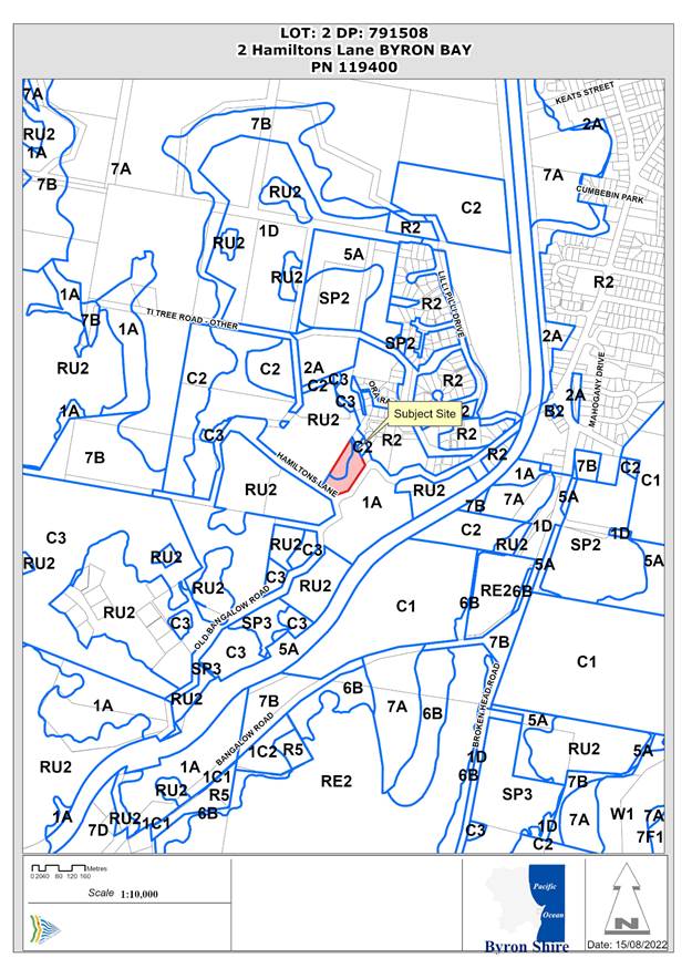
Assessment:
1. INTRODUCTION
History/Background
The following chronology and history of applications is relevant to this application:
|
5.1997.476.1 |
Rural dwelling |
Approved |
30/01/1998 |
|
10.2016.776.1 |
Shed |
Approved |
23/01/2017 |
The shed approved under DA 10.2016.776.1 was described as single-storey, with the approved plans shown below:
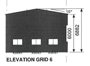
In 2021, following a complaint about unapproved works, Council officers inspected the site and determined that the shed constructed on the property was different to that approved. The inspection also noted a second shed/ garage on the land and a search of Council records failed to find any approval for that second building.
Modification application 10.2016.776.2 was lodged in response to Council’s inspection, seeking to modify the consent to account for the shed as constructed. That application was refused on 28 September 2021 on the basis that the modified building was not substantially the same as that approved.
A Notice was subsequently sent to the (then) landowner on 1 October 2021, advising Council’s intent to serve a Demolish Works Order to remove the two unapproved sheds.
In response, the owner’s representative advised that an application would be lodged for approval for the main shed, and that the second shed / garage was constructed under the exempt development provisions.
Development application 10.2021.693.1 was lodged in November 2021, seeking approval for use of the main shed and alterations to remove internal walls. That application was refused in March 2022.
A subsequent application to review that refusal was lodged in June 2022 and reported to Council (Planning) Meeting on 8 September 2022, where it was also refused.
At around this time, the property was sold. The previously issued Notice of Intent to Serve Orders was still in place at that time and should have been discovered in the conventional conveyancing process.
Following refusal of the S8.2 review application, a second Notice of Intent was issued to the new landowner on 14 October 2022, again advising of Council’s intention to serve a Demolish Works Order.
After requesting additional time to review the situation, the new owner lodged the current development application on 7 July 2023.
Description of the proposed development
This application seeks approval proposes to make internal alterations to an existing unapproved building and authorise its use as a shed.
Plans submitted with the application show the building located as shown below. An existing second shed, located between the dwelling and the shed subject to this application, is not shown on these plans.
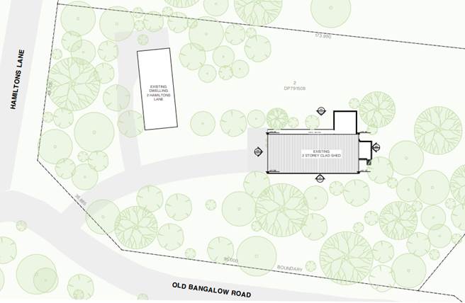
2. The Statement of Environmental Effects submitted with the application describes the proposal as:
The proposal involves alterations to the existing structure on the subject site. In essence, the proposal seeks to retain the building with removal of internal walls and partitions within the structure to remove the rooms created and confirm the use of the building as a shed.
Plans submitted with the application show the shed with external dimensions of 28m x 12m, with 128m2 of external decking at lower level on the western side. It therefore has an overall footprint of approx. 462m2.
The lower level has an internal floor area of approx. 209m2, while the upper floor level has an area of 151m2, resulting in a total floor space of approx. 360m2.
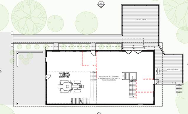
Lower Floor
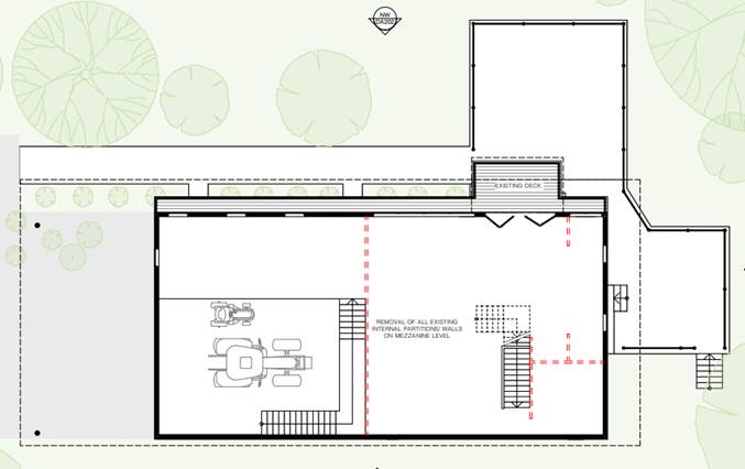
Upper Floor
The shed has been constructed on a sloping site, at existing ground level on the south and east, and elevated at the north and west. The north-western corner of the building exceeds the 9.0m maximum building height, as shown below (area of exceedance in red).
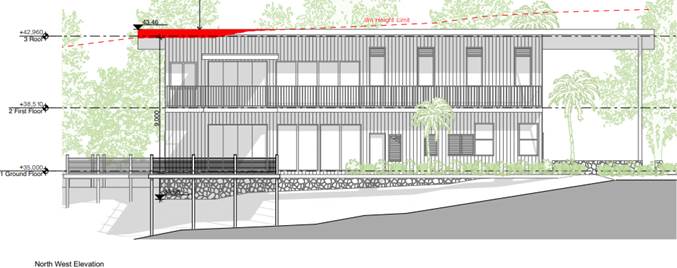
Description of the site
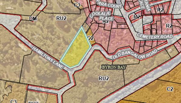
A site inspection was carried out on 14 September 2023.
|
Land is legally described |
LOT: 2 DP: 791508 |
|
|
Property address |
2 Hamiltons Lane BYRON BAY |
|
|
Land is zoned: |
RU2 Rural Landscape |
|
|
Land area is: |
1.102 ha |
|
|
Constraints: |
Bushfire prone land |
|
|
|
High Conservation Value Vegetation (North Coast Wet Sclerophyll Forest) |
|
|
|
Preferred Koala Habitat (CKPOM 2016) |
|
|
|
Is a BDAR required due to the location of the proposed development? |
No |
|
|
Are there any easements in favour of Council affecting the site? |
No |
|
|
Is there a Vegetation Management Plan which might affect the proposal? |
No |
|
|
Is there a Voluntary Planning Agreement which might affect the proposal? |
No |
The site is located close to the intersection of Hamiltons Lane and Old Bangalow Road. It is heavily vegetated, with steep slopes falling from the road frontages, from approx. RL 30mAHD to a low point in the north-west of approx. RL 8mAHD.

Adjoining land to the west is privately owned, partially vegetated with managed private open space around a central dam.
As shown below, the subject building has been constructed on the lower part of the slope, with an outlook to the north-west across the neighbouring property.
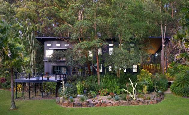
North-west elevation of existing building

External decks on north-west elevation
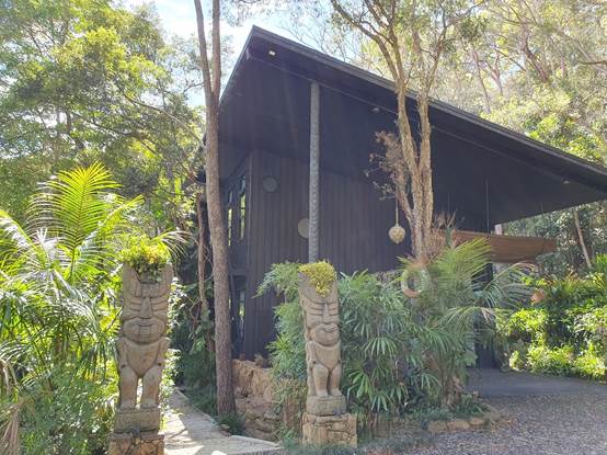
Southern elevation
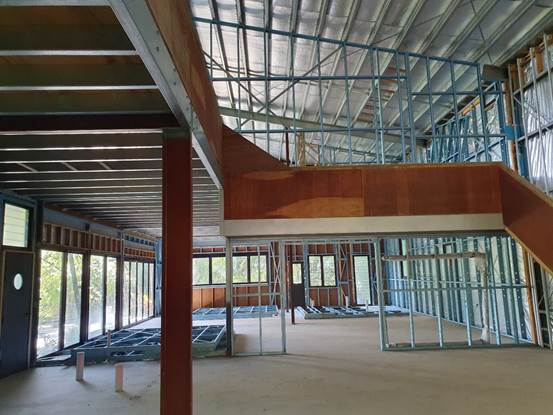
Internal framing for dividing walls
2. SUMMARY OF REFERRALS
|
Referral |
Issue |
|
Building Surveyor |
Referrals not complete given planning recommendation. |
Issues:
Bona fides of the application
The existing building is not consistent with the configuration of a shed. The extensive decks, additional windows, installation of sliding doors and bifold doors, are consistent with a habitable structure.
A previous application to modify the original shed consent (DA 10.2016.776.2) was refused partially on the basis that it did not demonstrate shed was to be a legitimate, non-residential use.
A subsequent development application (10.2021.693.1) was also refused for the same reason, as was an application to review that refusal.
Conventionally, a shed is defined as:
· “a simple roofed structure used for garden storage, to shelter animals, or as a workshop” Oxford languages (www.languages.oup.com);
· “a slight structure for shelter or storage” Merriam-Webster Dictionary (www.merriam-webster.com); and
· “a small building that is used for storing things such as garden tools” Collins English Dictionary (www.collinsdictionary.com).
The commonality in these definitions is that a shed is usually a small structure. It would be reasonable to expect a residential shed to be smaller than the dwelling house on the site, unless site uses warrant a larger structure, as might be the case for agricultural sheds.
The subject property had no agricultural use and is heavily vegetated on steep slopes, which would restrict any such use. The applicant has not provided any justification that would warrant a shed of this scale on the property, particularly given that a second two-storey shed also exists on the land.
A similar situation was considered in Malta-Fell v Byron Shire Council [2020] NSWLEC 1448, which included issues associated with an unauthorised shed.
In the that case, a deck addition to a shed, significantly smaller than those under this application, was required to be removed.
In this instance, the size and nature of the structure and the extent of decking constructed without consent is excessive and inconsistent with the use as a shed.
3. SECTION 4.14 – BUSH FIRE PRONE LAND
Under section 4.14 of the Act, Council must be satisfied prior to making a determination for development on bush fire prone land, that the development complies with the document ‘Planning for Bush Fire Protection 2019’.
The site is bush fire prone land.
Planning for Bush Fire Protection 2019 indicates that there are no bush fire protection requirements for Class 10a buildings located more than 6m from a dwelling in bush fire prone areas. This would apply in the case of a shed.
The use of the subject building as a shed, therefore, does not require any APZ bushfire separation or any specific construction standards.
It is noted, however, that significant restrictions would apply for a dwelling sited in the location of the shed.
Effect of 10/50 rule on significant vegetation: The site is located in a designated 10/50 vegetation entitlement clearing area. However, the 10/50 exemption cannot be used to clear vegetation on this site as it is excluded from the operation of the Code because it is mapped as preferred Koala habitat mapped in the Byron Coast Comprehensive Koala Plan of Management.
4. SECTION 4.15C – MATTERS FOR CONSIDERATION – DISCUSSION OF ISSUES
Having regard to the matters for consideration detailed in Section 4.15(1) of the Environmental Planning & Assessment Act 1979 (EP&A Act), the following is a summary of the evaluation of the issues.
4.1 State Environmental Planning Policies (SEPP)
|
Considerations |
Satisfactory |
Unsatisfactory |
|
Biodiversity and Conservation SEPP 2021 Consideration: Chapter 3 Koala Habitat Protection 2020: This Chapter applies, as the land is zoned RU2 Rural Landscape, and the development controls apply as the site has an area in excess of 1ha. Cl 3.6: Before a council may grant consent to a development application for consent to carry out development on land to which this Part applies, the council must be satisfied as to whether or not the land is a potential koala habitat. The site is mapped as potential koala habitat under the CKPOM. Cl.3.7: Before granting consent to a development application for consent to carry out development on land to which this Part applies that it is satisfied is a core koala habitat, there must be a plan of management prepared in accordance with Part 3 that applies to the land. Core koala habitat is defined in this SEPP to mean: an area of land with a resident population of koalas, evidenced by attributes such as breeding females, being females with young, and recent sightings of and historical records of a population It is not known whether the site is core koala habitat as defined above. No information has been submitted with the information addressing the potential for koalas at this site. The structure exists, and its use as a shed would not impact koala habitat as no vegetation clearing is required. While the structure was not constructed in accordance with the original shed approval, development consent was granted in 2017 for a shed of similar proportions. It does not appear that potential koala impacts were considered at that time.
|
☒ |
☐ |
|
Resilience and Hazards SEPP 2021 Consideration: Chapter 4 Remediation of land: No works are required for the proposed use and therefore there will be no disturbance of existing soil. |
☒ |
☐ |
4.2 Byron Local Environmental Plan 2014 (LEP 2014)
LEP 2014 is an applicable matter for consideration in the assessment of the subject development application in accordance with subsection 4.15(1) of the EP&A Act because it applies to the subject land and the proposed development. The LEP 2014 clauses that are checked below are of relevance to the proposed development:
|
Part 1 |
☒1.1 | ☒1.1AA | ☒1.2 | ☒1.3 | ☒1.4 | ☒Dictionary | ☒1.5 | ☒1.6 | ☒1.7 | ☒1.8 | ☐1.8A | ☒1.9 | ☐1.9A |
|
Part 2 |
☒2.1 | ☒2.2 | ☒2.3 | ☒Land Use Table | ☐2.4 | ☐2.5 | ☐2.6 | ☐2.7 | ☐2.8 |
|
Part 3 |
☐3.1 | ☐3.2 | ☐3.3 |
|
Part 4 |
☐4.1 | ☐4.1A | ☐4.1AA | ☐4.1B | ☐4.1C | ☐4.1D | ☐4.1E | ☐4.1F | ☐4.2 | ☐4.2A | ☐4.2B | ☐4.2C | ☐4.2D | ☒4.3 | ☐4.4 | ☐4.5 | ☒4.6 |
|
Part 5 |
☐5.1 | ☐5.2 | ☐5.3 | ☐5.4 | ☐5.6 | ☐5.7 | ☐5.8 | ☐5.10 | ☐5.11 | ☐5.12 | ☐5.13 | ☐5.14 | ☐5.15 | ☐5.16 | ☐5.17 | ☐5.18 | ☐5.19 | ☐5.20 | ☐5.21 | ☐5.22 |
|
Part 6 |
☐6.1 | ☐6.2 | ☐6.4 | ☐6.5 | ☒6.6 | ☐ 6.7 | ☐6.8 | ☐6.9 | ☐6.11 | ☐ 6.12 | ☐6.13 | ☐6.14 | ☐6.15 | ☐6.16 |
In accordance with LEP 2014 clauses 1.4 and 2.1 – 2.3:
(a) The Statement of Environmental Effects describe the existing building as “a shed which is ancillary development to the existing dwelling house”. ‘Shed’ is not defined in the LEP 2014 Dictionary.
Conventionally, a shed is defined as:
· “a simple roofed structure used for garden storage, to shelter animals, or as a workshop” Oxfordlanguages (www.languages.oup.com);
· “a slight structure for shelter or storage” Merriam-Webster Dictionary (www.merriam-webster.com); and
· “a small building that is used for storing things such as garden tools” Collins English Dictionary (www.collinsdictionary.com).
(b) The land is within the RU2 Rural Landscape according to the Land Zoning Map;
(c) Dwelling-houses are permissible with consent in the RU2 zone, subject to the provisions of cl 4.2A of the LEP. Development ordinarily ancillary to a dwelling-house would also be permitted with consent.
While the existing structure is permissible as a shed, it could not be approved as a dwelling unless the existing dwelling were removed.
A dual occupancy would only be permissible in accordance with clause 4.2A(3) of LEP 2014. In this case:
· the lot size is less than the 40ha minimum specified for the RU2 zone;
· the lot was not created by a subdivision approved under the current LEP; and
· under the previous LEP, only attached dual occupancy development could be approved.
(d) Regard is had for the Zone Objectives as follows:
|
Zone Objective |
Consideration |
|
· To encourage sustainable primary industry production by maintaining and enhancing the natural resource base. · To maintain the rural landscape character of the land. · To provide for a range of compatible land uses, including extensive agriculture. · To enable the provision of tourist accommodation, facilities and other small-scale rural tourism uses associated with primary production and environmental conservation consistent with the rural character of the locality. · To protect significant scenic landscapes and to minimise impacts on the scenic quality of the locality. |
The site does not have potential for primary industry given its size, slope and vegetation cover. The landscape character of the site is largely a result of its extensive mature vegetation cover and the use of the shed will not alter that. |
Clause 4.3 Height of buildings
A 9.0m maximum building height applies to this site. The shed has been constructed with a small section exceeding this 9.0m height limit as shown above.
The development application includes a submission made under Clause 4.6 to request a variation to the 9.0m height limit.
The extent of non-compliance is quoted as a maximum of 0.75m, or 8.3%, and is limited to a small area of the north-west corner of the building, as shown below.
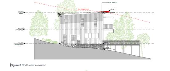
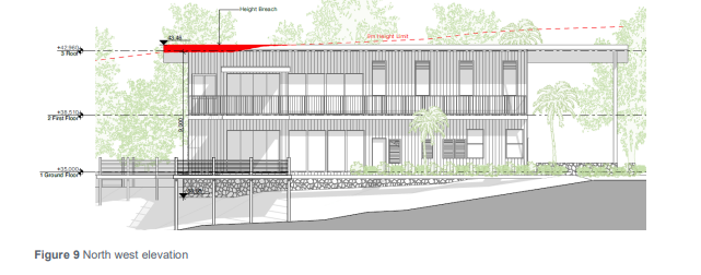
It is noted that the building exists at this height and, on that basis, the applicant argues that strict compliance with the development standard is unnecessary in this case. The applicant’s submission also notes that the extent of non-compliance is very minor in comparison to the building as a whole, and it does not result in any adverse visual impacts or overshadowing of adjoining land (see further detail below).
The remaining checked clauses have been taken into consideration in the assessment of the subject development application in accordance with Section 4.15 of the EP&A Act. The proposed development complies with all clauses of LEP 2014 (in some cases subject to conditions and/or to the satisfaction of other assessing officers).
Clause 4.6 Exceptions to Development Standards
The applicant has submitted a written request that strict compliance with the development standard is unreasonable or unnecessary and that there are sufficient environmental grounds to vary the controls as follows:
· The non-compliance is numerically minor, being a maximum breach of 9.75m (8.3%). The point of the maximum breach is limited to a minor portion of the existing roof form, whilst the bulk of the structure, including all floor area, sits entirely below the height limit.
· The height breach is a result of the site topography, which has a fall of approximately 1.7m over the 12m where the shed sits on the site. This is a specific condition that the LEP height limit does not contemplate, in that the height limit applies equally to a vast area of the LGA with distinctly different topography. The minor non-compliance for the mezzanine floor roof is a result of the steep and undulating topography.
· The height exceedance is located within the middle of the site, surrounded by vegetation and to the casual observer, the proposal would appear compliant with the intended height and form of development envisaged for the site. The proposed non-compliance is not visible from Hamiltons Lane and Old Bangalow Road and will sit well below the permitted height standard for the majority of the structure. The rear, centralised location of the shed and subsequent non-compliance will not impose an unreasonable bulk or scale when viewed from adjoining properties. Furthermore, the extent of non-compliance only relates to the non-habitable roof form of the mezzanine floor. The proposed design and overall height are also considered to be entirely compatible with the built form and character of the locality.
· It is considered that there is an absence of any significant material impacts of the proposed non-compliance on the amenity of the environmental values of the locality, the amenity of neighbouring properties and on area character. Specifically:
o The extent of the non-compliance creates no additional adverse overshadowing to adjoining properties which will create any adverse impacts;
o The height breach does not result in any additional privacy impacts, as it does not provide any openings from habitable areas which will create overlooking. The height variation will have no greater impact on the privacy of adjoining properties when compared to the complying elements of the building; and
o The proposed development will not result in any material loss of views or outlook when compared to a building with a compliant height, given its centralised rear location. When considering the extent of view sharing against the backdrop of the applicable planning controls, the extent of view loss caused by the non-compliant element would be insignificant or nil.
· The proposed development meets the objectives of the development standard and meets the objectives of the RU2 Rural Landscape zone
· The proposal provides for an appropriate scale and form that reflects the desired future character for development in the area. The shed will not be overly visible from the street frontages and adjoining properties and sits well within the site and will be perceived as a compatible, two storey structure which responds to the topography of the locality and has incorporated high quality architectural elements, ensuring that the non-compliance will not be perceivable to the casual observer.
The concurrence of the Planning Secretary is not required.
The argument that the 9.0m height standard is unreasonable or unnecessary largely relies on the existence of the building at this height and the relatively small area of non-compliance.
However, given that the existing building is unauthorised, in that it was not constructed in accordance with the 2017 approval, the relevant question is whether an application for a shed on the property, ancillary to the rural dwelling, would be approved with a building height non-conformance.
While this is hypothetical, it is difficult to see any environmental planning grounds to support a rural shed of this scale on a 1.1ha vegetated property.
Given this, it is considered that the applicant’s request to vary the building height standard should not be supported.
4.3 Any proposed Instrument that has been the subject of public consultation and has been notified to the consent authority
There are no relevant draft instruments.
4.4 Byron Shire Development Control Plan 2014 (DCP 2014)
DCP 2014 is an applicable matter for consideration in the assessment of the subject development application in accordance with subsection 4.15(1) of the EP& A Act because it applies to the land to which LEP 2014 applies. The DCP 2014 Parts/Chapters that are checked below are of relevance to the proposed development:
|
Part A |
☒ |
|
Part B Chapters: |
☐ B1 | ☐ B2 | ☒ B3 | ☒ B4 | ☐ B5 | ☐ B6 | ☐ B7 | ☐ B8 | ☐ B9 | ☐ B10 | ☐ B11 | ☐ B12 | ☐ B13 | ☐ B14 | ☐ B15 |
|
Part C Chapters: |
☐ C1 | ☐ C2 | ☐ C3 | ☐ C4 |
|
Part D Chapters |
☐ D1 | ☒ D2 | ☐ D3 | ☐ D4 | ☐ D5 | ☐ D6 | ☐ D7 | ☐ D8 | ☐ D9 |
|
Part E Chapters |
☐ E1 | ☐ E2 | ☐ E3 | ☐ E4 | ☐ E5 | ☐ E6 | ☐ E7 | ☐ E8 | ☐ E9 | ☐ E10 |
The only DCP section directly relevant to a shed is Section D2.72 Farm buildings, sheds and other structures. The existing shed is consistent with the performance criteria within this section. There are no relevant prescriptive measures.
These checked Parts/Chapters have been taken into consideration in the assessment of the subject development application in accordance with Section 4.15 of the EP&A Act. The proposed development is demonstrated to meet the relevant Objectives of all relevant Parts/Chapters (in some cases subject to conditions and/or to the satisfaction of other assessing officers).
4.5 Environmental Planning and Assessment Regulation 2021 considerations
|
|
Applicable to the proposal: |
Considered the control as it relates to the proposal: |
If this control is applicable, does the proposal comply? |
|
Section 61 - Additional matters that consent authority must consider |
☐ Yes ☒ No |
☐ Yes ☐ No ☒ NA |
☐ Yes ☐ No ☒ NA |
|
Section 62 - Consideration of fire safety |
☐ Yes ☒ No |
☐ Yes ☐ No ☒ NA |
☐ Yes ☐ No ☒ NA |
|
Section 64 - Consent authority may require upgrade of buildings |
☐ Yes ☒ No |
☐ Yes ☐ No ☒ NA |
☐ Yes ☐ No ☒ NA |
|
Section 63 - Considerations for erection of temporary structures |
☐ Yes ☒ No |
☐ Yes ☐ No ☒ NA |
☐ Yes ☐ No ☒ NA |
4.6 The likely impacts of that development, including environmental impacts on both the natural and built environments, and social and economic impacts in the locality
|
Impact on: |
Likely significant impact/s? |
|
Natural environment |
No. The proposal will not have a significantly adverse impact on the natural environment of the locality. |
|
Built environment |
No. The proposal will not have a significantly adverse impact on the built environment of the locality. |
|
Social Environment |
No. The proposal will not have a significant social impact on the locality. There is, however, the issue of overlooking of the neighbour’s private open space, which has potential to impact on the privacy of the neighbours and their enjoyment of that space. The slope of the land is such that it will take some time to provide an effective vegetated screen between the two properties, as trees would need to be of a mature heght. The issue is somewhat mitigated in that the use of the building is proposed as a shed rather than a habitable structure, but the existing decks have been established to take advantage of the views to the west over the neighbours property. |
|
Economic impact |
No. The proposal will not have a significant economic impact on the locality. |
|
Construction Impacts |
No construction is proposed or required. |
Council Policies applicable to the proposed development?
|
Council Policy |
Consideration |
|
The previous Notices of Intent were issued in accordance with this Policy. In accordance with Claise 4.30 of the Policy, Council may suspend enforcement action whilst a development application not correct the unauthorised development is being considered. |
4.7 The suitability of the site for the development
A shed could be reasonably expected on a site of 1.1ha zoned RU2 Rural Landscape. In this case, however, the site contains two large sheds, with the shed subject of this application having two levels and a floor area of 360m2.
The site is significantly vegetated, and it is difficult to justify a need for two large sheds as ancillary to a rural dwelling on this property.
4.8 Submissions made in accordance with this Act or the regulations
The development application was publicly exhibited.
There were 3 submissions made, all objecting to the proposal.
All submissions note that the structure is not what would reasonably be expected as a shed, suggesting that the real intent of the previous owners was to use the structure as a dwelling. All 3 submissions included references to marketing material from the sale of the site, indicating that the shed was marketed in the style of a dwelling.
The submissions made by and on behalf of the adjoining owner also object to the development on the basis of privacy and overlooking, noting that the building has extensive decks on two levels that look directly over the neighbour’s private open space area.
The building is sited on the property in a way that indicates a purposeful intent to take advantage of rural views to the west. The enjoyment of those views detracts from the privacy of the neighbouring property and the slope of the land would make it difficult to provide a vegetated screen between the two properties.
4.9 Public interest
The proposed development raises a number of issues relevant to the public interest.
While development consent was issued for a shed on this property in 2017, the structure that was constructed was significantly different to that approved. A second large shed was also constructed without approval.
Three previous applications have been made to authorise the existing structure. All applications were refused.
The bona fides to the proposal as a shed is questionable, considering the external treatment of the building and internal layout as currently constructed.
Having regard to this matter and the height of the building exceeding the 9 metre height limit, it is considered the proposed development is likely to prejudice or compromise the public interest and is recommended for refusal.
5. DEVELOPER CONTRIBUTIONS
5.1 Water & Sewer Levies
No Section 64 levies will be required.
5.2 Developer Contributions
No Developer Contributions will be required.
6. DISCLOSURE OF POLITICAL DONATIONS AND GIFTS
|
Disclosure details |
Response |
|
Has a Disclosure Statement been received in relation to this application? If Yes, Provide Disclosure Statement register reference: 91. |
Yes ☐ No ☒ |
|
Have staff received a ‘gift’ from anyone involved in this application that needs to be disclosed. |
Yes ☐ No ☒ |
7. CONCLUSION
The DA proposes to make internal alterations to an unapproved building and authorise its use as a shed. As discussed the size of the building is well in excess of what would ordinarily be expected for a property such as this, particularly as there is a second two-level shed on the property in addition to the existing dwelling. Further the building has also been constructed with a section of the roof exceeding the 9.0m building height limit applicable to the site.
It is recommended that the application be refused.
BYRON SHIRE COUNCIL
Staff Reports - Sustainable Environment and Economy 13.11
Report No. 13.11 PLANNING - DA10.2014.417.6 Section 8.2 Review of Determination 10.2014.417.4 - Amendmeent to Building including roof terrace and pool, 43 Lawson Street Byron Bay
Directorate: Sustainable Environment and Economy
Report Author: Chris Larkin, Manager Sustainable Development
File No: I2023/1619
Proposal:
|
Section 8.2 Review of Development Application No. 10.2014.417.4 |
10.2014.417.6 |
|
Applicant: |
Ms H Hopkinson |
|
Development: |
Review of Determination – Refusal of S4.55 10.2014.417.4 for Changes to Building Height to accommodate One (1) Roof Top Swimming Pool and associated Access and Structures, provision of Internal Access between Levels and Modification to Private Open Space |
|
Parcel No.: |
41930 |
|
Location: |
LOT: 0 SP: 16094, 43 Lawson Street BYRON BAY |
|
Date of Refusal: |
8 June 2023 |
|
Original Assessing Officer: |
Patricia Docherty |
|
8.2 Assessment Officer |
Rob Van Iersel, Consultant Planner |
|
Date 8.2 Review Lodged: |
10 August 2023 |
|
Exhibition: |
18 August – 31 August 2023 6 Submissions of support 1 Objection |
Summary:
This application seeks a request to review the determination of refusal of Modification Application number 10.2014.417.4, dated 8 June 2023, pursuant to Section 8.2 of the Environmental Planning & Assessment Act 1979 (The Act) and in accordance with Part 12 of the Environmental Planning & Assessment Regulation 2021 (The Regulation).
The Section 8.2 review must be lodged and determined within 6 months of the 8 June 2023 (period ends 8 December 2023).
The Section 8.2 Review was received on 10 August 2023 and was publicly exhibited - Level 2 advertising under DCP 2014 Part A14 – Public Notification and Exhibition of Development Applications. Exhibition period: 18-31 August. One (1) Submission of objection and six (6) submissions of support were received.
As the original application was refused at a Council (Planning) Meeting, the matter is reported to Council for determination.
Consent 10.2014.417.1 provided for the demolition of an existing residential flat building and the construction of a new three-storey residential flat building with basement parking, two units on each of the ground and first floors and a single apartment on the upper floor.
Modification application 10.2014.417.4 proposed changes to the approved building to provide for a rooftop swimming pool and terrace, accessed from the single upper floor apartment by way on an internal staircase. The rooftop pool and terrace is for the private use of the upper floor apartment.
The modification application was predominantly refused due to the height of the proposed rooftop facilities exceeding the 9 metre height limit under the LEP. The applicant’s S8.2 Review request includes a revised architectural drawing set to address the reasons for refusal. The amendments include:
· removal of all roof top enclosures
· reduction in the approved lift over run height from 15.90m AHD to 15.85m AHD
· reduction in size of the proposed roof terrace.
· Further survey detail to accurately reflect the heights of the development
While the amended proposal still results in a non-conformance with the 9.0m height limit, the reductions in overall height result in a building that is at the same height as existing buildings on either side. The removal of the rooftop enclosures significantly reduce the visibility of the rooftop facilities when viewed from adjoining areas. The location of the rooftop facilities are sited to minimise amenity impacts on neighbours, including adjacent residential apartments and the open space to the north.
It is recommended that the Section 8.2 application be approved and that development consent 10.2014.417.1 be modified as proposed in application 10.2014.417.4.
NOTE TO COUNCILLORS:
In accordance with the provisions of S375A of the Local Government Act 1993, a Division is to be called whenever a motion for a planning decision is put to the meeting, for the purpose of recording voting on planning matters. Pursuant to clause 2(a) under the heading Matters to be Included in Minutes of Council Meetings of Council's adopted Code of Meeting Practice (as amended) a Division will be deemed to have been called by the mover and seconder of all motions relating to this report.
RECOMMENDATION:
That, pursuant to Section 8.4 of the Environmental Planning and Assessment Act 1979, that Section 8.2 Application 10.2017.417.6 be approved by amending plans and relevant conditions of Development Consent No. 10.2014.417.1 in accordance with the modified conditions in Attachment 2 (#E2023/108278)
Attachments:
1 10.2014.417.6
- Architectural Plans, E2023/69879
![]()
2 10.2014.417.4
Modified Conditions of Consent, E2023/108278
![]()
3 Confidential - Submissions received 10.2014.417.6, E2023/108264
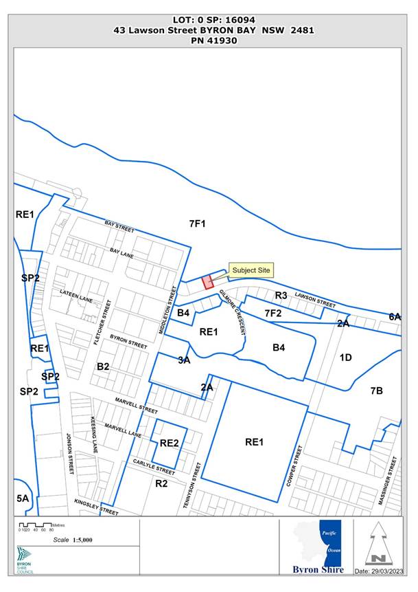 Assessment:
Reason/s for refusal:
Application 10.2014.417.4 was refused at the Council (Planning) Meeting of 8 June 2023 for the following reasons:
1. Pursuant to section 4.15(1)(a)(i) of the Environmental Planning and Assessment Act 1979 the proposed development does not comply with Section 2.11 of State Environmental Planning Policy - Resilience and Hazards.
2. Pursuant to section 4.15(1)(a)(i) of the Environmental Planning and Assessment Act 1979 the proposed development does not comply with Clause 4.3 Height of building under Byron Local Environmental Plan 2014.
3. Pursuant to Section 4.15(1)(a)(iii) of the Environmental Planning and Assessment Act 1979 the proposed development does not comply with Chapter C3 Byron Development Control Plan 2014.
4. Pursuant to Section 4.15(1)(a)(iii) of the Environmental Planning and Assessment Act 1979 the proposed development does not comply with Chapter D1 of Byron Development Control Plan 2014.
5. Pursuant to Section 4.15(1)(a)(iii) of the Environmental Planning and Assessment Act 1979 the proposed development does not comply with Chapter E5 of Byron Development Control Plan 2014.
6. Pursuant to Section 4.15 (1) (a) (iv) the application for the proposed modification of an approved residential flat building does not comply with section 102 of the Environmental Planning and Assessment Regulation 2021.
7. Pursuant to Section 4.15 (1) (b) of the Environmental Planning and Assessment Act 1979 the proposed development is likely to result in adverse environmental impacts on both the natural and built environments, and social impacts in the locality and the occupants of that environment.
8. Pursuant to Section 4.15(1)(d) of the Environmental Planning & Assessment Act 1979 the proposed development is not in the public interest with regards for relevant matters for consideration raised in properly made submissions received by Council.
9. Pursuant to Section 4.15(1)(e) of the EP&A Act 1979 the proposed development is not in the public interest for the reasons outlined above.
Issues addressed in the revised submission:
The review application includes a revised architectural drawing set to address the reasons for refusal. The amendments include:
· removal of all roof top enclosures
· reduction in the approved lift over run height from 15.90m AHD to 15.85m AHD
· reduction in size of the proposed roof terrace
· modified plans that now accurately reflect the existing level (AHD) of the land relative to the proposed development
· a revised Clause 4.6 Variation report
· a Design Verification Statement and Certification
|
|
|
Roof Terrace – 10.2014.417.4 |
|
|
|
Roof Terrace – Current review application |
Refusal Reason 1 – Section 2.11 of State Environmental Planning Policy - Resilience and Hazards
Section 2.11 of the SEPP relates to development of land within the coastal use area. The whole of the site is mapped within the coastal use area.
The original assessment concluded that the proposed amendment, with its increase in building height, was inconsistent would have impacts on the visual amenity and scenic quality of the coast.
The review application proposes reductions to the building height, notwithstanding that the non-compliance with the maximum building height standard remains.
The reduction in maximum height results in a proposed building that is consistent with the established built form and character in the area. The amended building does impede foreshore access impact on existing views and or sunlight relating to neighbouring properties. In particular, the removal of the previously proposed rooftop enclosures significantly reduces the visibility of the rooftop features. This is considered no longer a reason for refusal.
Refusal Reason 2 – Clause 4.3 Height of building under Byron Local Environmental Plan 2014.
The original development was approved with a roof level of RL 14.84m. There were no structures proposed on the roof.
The building height, based on existing ground at RL 6.2m, was therefore 8.64m, compliant with the maximum building height standard.
The plans submitted for 10.2014.417.4 showed ground levels at RL 6.00m, with the highest part of the building at RL 17.34m, showing a maximum height of 11.34m.
The applicant states that the previously stated ground level of RL 6.00m was incorrect, and that a closer review of site survey indicates the correct level at approx. RL 6.2m. Review of survey plans previously submitted in relation to this development indicate that the applicant is correct.
Amended plans submitted with the review application include removal of the previously proposed rooftop enclosure and show the highest part of the building now being the top of the proposed rooftop pool, at RL 16.04m. The current plans as amended show the highest point of the building is therefore approx. 9.84m above existing ground level, which exceeds the 9m maximum building height applicable to this site.
The applicant acknowledges that the building exceeds the 9.0m height limit, but argues that the 9.0m standard is unreasonable or unnecessary in this case, based on a height that is consistent with existing buildings on either side. In this regards both adjacent buildings have a height similar to and exceeding the proposed development as amended.
The northern and southern elevations for the proposed development are shown below which indicate this. It is considered in this context and having regards to the merits of the proposal and the buildings’ location in proximity to the town centre, strict compliance with the height limit is not required and a variation to the height limit can be supported in this instance and this no longer is a reason for refusal.
![]()
Street and Beach Elevations showing the adjacent building outlines at 41 and 45 Lawson Street
Refusal Reason 3 – Chapter C3 Byron Development Control Plan 2014
The assessment report for 10.2014.417.4 indicated that the proposal was considered to be inconsistent with the following highlighted aspects of the Chapter objectives:
The Aims of this Chapter are:
1. to promote Byron Shire’s natural features, vegetation and topography as key components of its visual character and appeal;
2. to control development including land use, earthworks, vegetation clearing, built form and civil works in order to preserve and enhance the visual, cultural, ecological and landscape values of visually prominent sites and locations;
3. to ensure that development blends into the natural surroundings and does not intrude on the skyline when viewed from public land;
4. to minimise the visual impact of development when viewed from adjacent land, public reserves, public areas and waterways;
This reason for refusal was based on the increased height of the rooftop facilities.
The applicant for this review application argues:
Having regard to the nature of the application, the development will not and cannot have any impact on views from another property to a significant vista, landscape or another prominent site.
The proposal does not directly impacts on the two neighbouring properties views of the Pacific Ocean in terms of their orientation across Apex Park and to the beach. Further the increase in height by the pool area including associated landscaping will not detract from the visual amenity of
the area when viewed from waterways and surrounding public land. It is considered based on the amended plans and reduced height of the overall structure, the addition of the roof top pool area can now be supported in this instance.
Refusal Reason 4 – Chapter D1 of Byron Development Control Plan 2014
The assessment of 10.2014.417.4 indicated that the proposal did not comply with the provisions of the chapter in terms of Building height plane, setbacks, privacy, solar access and character visual impacts
The original consent (10.2014.417.1) approved an encroachment into the BHP on the side boundaries (see cross section below), but with a relative flat roof and with no roof top features.

Approved Plans – Cross Section
The modification application (10.2014.417.4) that was refused by Council proposed a significant increase in this encroachment by way of the proposed rooftop elements and when viewed from Lawson street had elements consistent with fourth storey.
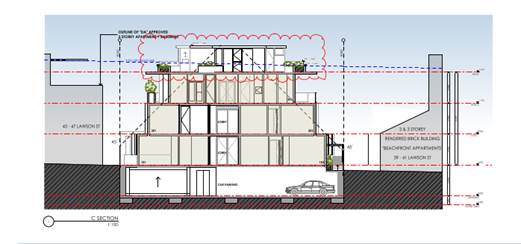
Refused Proposed Modification Cross Section Plans – NB roof top storey
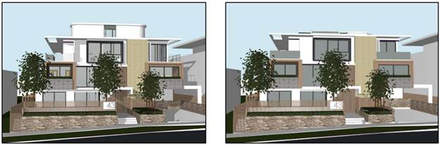
Refused Lawson Street Perspective Proposed Lawson Street Perspective Showing fourth storey element No fourth storey element
The reduction in roof height proposed in the review application, particularly by removal of rooftop enclosures, reduces the BHP non-compliance to a level more consistent with the original approval, and consistent with existing development on adjoining properties. The addition of the roof top pool and associated areas does not present as a fourth storey elements and is considered reasonable in the context of what was originally approved and, in comparison to what was more recently refused. It is considered the proposal is acceptable in terms of the DCP provisions and this is no longer a reason for refusal.
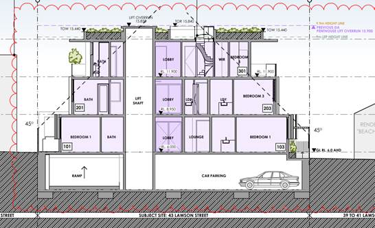
Proposed Amended Development with roof top pool.
Refusal Reason 5 – Chapter E5 of Byron Development Control Plan 2014
The assessment of 10.2024.417.4 indicated that the proposed modification is not consistent with the defined character narrative of the area under Section E5.8.4.
In response, the applicant refers to the Design Verification Statement submitted in support of the review application.
That Statement addresses the relevant character narrative within Chapter E5 by stating
the building retains a scale and overall presentation that is consistent with the area and with the streetscape.
The subject site sits within Pocket A which references that this area of town
has a strong presence of medium density villa, townhouse and three storey mixed use developments. These medium density developments exhibit a somewhat incoherent and inconsistent design contribution to the overall streetscape. As a mix of apartment types and sizes is proposed for this area, new buildings outside of the Heritage Conservation Areas should be able to have their own unique interpretation of ‘local’ to continue the pattern of an eclectic village character. The outcome should nevertheless be one that responds sensitively to the predominant coastal townscape of the particular locality.
It is considered the proposal as amended continues with that eclectic mix of development that Pocket A is known for, and the addition of the roof top pool does not offend the provisions under Chapter E5.
Refusal Reason 6 – Section 102 of the Environmental Planning and Assessment Regulation 2021
Application 10.2014.417.4 was not supported by a Design Verification Statement, as required by this clause of the Regulation.
A Statement has been provided with the current review application with the plans prepared by a qualified architect satisfying the requirements under the regulations.
Refusal Reason 7 – Adverse environmental impacts on both the natural and built environments, and social impacts in the locality and the occupants of that environment.
The assessment report for 10.2014.417.4 indicates that the environmental impacts referred to above arise from the exceedance of the building height standard and the associated visual impact, given the site adjoining beachfront public open space.
As indicated above, the review application includes amended plans that reduce the extent of building height exceedance, resulting in a structure of a height that is consistent with the existing development on adjoining properties.
Refusal Reason 8 – Public interest - submissions
The original assessment report noted:
The impacts as a result of increase in height are not in the public interest with consideration for issues raised in properly made submissions of objection, including:
· Privacy, overlooking, overshadowing and amenity.
· History of the original assessment and consent that specifically limited the height of the building having regards to the 9 metre height controls that applied at the time.
· In its current approved form, no activity is to occur at the roof level. The proposal now seeks to create a useable space, pools and new roof top structures.
· Accuracy and depiction of Byron Local Environmental Plan 2014 height requirement of 9.0 metres, misrepresented on plans as “9.9M LEP HEIGHT LINE” scales to a height of over 10.75 metres above ground.
See commentary on building height issues above.
The review application was publicly exhibited, and 6 submissions of support were received noting the design quality of the proposal. One (1) objection was received on behalf of owners within the adjoining residential flat building, citing issues of privacy and amenity.
Given that the amended plans provide for a building of a height consistent with the adjoining development, but of a smaller scale, it is considered that the proposed development, as amended, will not result in significant impacts on the adjoining property. Further the upper level is designed for the residences using the pool deck to take advantage of views predominantly across Apex Park to the Pacific Ocean not to overlook into the neighbours either side with wide landscape bays proposed along the sides to act as Balustrades an to direct views to the ocean.
Conditions of approval are recommended to limit the hours during which the rooftop terrace can be used up to 9pm, which will further limit the potential for impacts associated noise and lighting.
Refusal Reason 9 –Public interest
This reason arises from all of the issues discussed above.
It is considered that the amendments proposed, which reduce the previous height exceedance, lessen the issues associated with public interest, and this no longer is a reason for refusal.
Conclusion
The amendments made within this Section 8.2 Review Application reduce the overall height of the building. While the addition of private rooftop facilities results in an exceedance of the 9.0m building height standard, the proposal is of a height, size and scale that is consistent with existing development on adjoining properties.
As such, the proposal is consistent with the character of the locality and will not result in significant visual or amenity impacts.
It is recommended, therefore, that Section 8.2 application 10.2014.417.6 be approved subject to the recommended attached conditions.
BYRON SHIRE COUNCIL
Questions With Notice 14.2
Report No. 13.12 Status report on Development Applications (DAs) with bodies like the Northern Regional Planning Panel (NRPP)
Directorate: Sustainable Environment and Economy
Report Author: Shannon Burt, Director Sustainable Environment and Economy
File No: I2023/1662
Summary:
At the Council (Planning) Meeting of 12 October 2023 it was resolved as part of 23-461
that Council: Receives status reports monthly to each Ordinary (Planning) Meeting on all
DA’s that are being processed by Council for determination by other bodies such as the
Northern Regional Planning Panel or the Independent Planning Commission.
Resolution 22-559 further requires: That Councillors receive, as a standard procedure, a copy of the Assessment Report prepared by Council staff for any DA that is to be determined by the Northern Regional Planning Panel on the next working day after it is lodged on the Planning Portal.
RECOMMENDATION:
That Council notes the status report on Development Applications (DAs) with bodies like the Northern Regional Planning Panel (NRPP).
Report
The following applications are matters for determination by the Northern Regional Planning Panel in accordance with the Sydney District & Regional Planning Panels Operational Procedures. There are no matters currently with the Independent Planning Commission.
|
Planning Authority |
Application Description and link |
Status |
|
Northern Regional Planning Panel |
Coastal Protection Works | Planning Portal - Department of Planning and Environment (nsw.gov.au)
Link to DA tracker for DA 2023.287.1 information and documents here: Byron Shire Council - Application Tracker
|
Under assessment |
|
Northern Regional Planning Panel |
Link to Council DA tracker for DA 2021.384.3 information and documents here: Byron Shire Council - Application Tracker
|
Under assessment |
Strategic Considerations
Community Strategic Plan and Operational Plan
|
CSP Objective |
CSP Strategy |
DP Action |
|
1: Effective Leadership |
1.1: Enhance trust and accountability through open and transparent leadership |
1.1.2: Governance - Ensure legislative compliance and support Councillors to carry out their civic duties |
Recent Resolutions
· 23-461
Legal/Statutory/Policy Considerations
The Planning Panels determine regionally significant development applications (DAs), certain other DAs and s4.55(2) and s4.56 modification applications including:
· Regionally significant development, as outlined in Schedule 6 of the State Environmental Planning Policy Planning Systems 2021
· Regionally significant development relating to Aboriginal land, as outlined in Chapter 3 of the State Environmental Planning Policy Planning Systems 2021
· Development with a capital investment value (CIV)* over $30 million.
· Development with a CIV* over $5 million which is:
o council related
o lodged by or on behalf of the Crown (State of NSW)
o private infrastructure and community facilities
o eco-tourist facilities
o extractive industries, waste facilities and marinas that are designated development
o certain coastal subdivisions and
o certain coastal protection works.
*Capital investment value (CIV) is calculated at the time of lodgement of the DA for the purpose of determining whether an application should go to a Planning Panel - refer to Planning Circular PS 10-008.
Section 10 of the Sydney District & Regional Planning Panels Operational Procedures talks to Roles of councils and other panels.
10.1 states the elected council and council staff have different roles in the assessment of DAs. Under the Local Government Act 1993, the independence of council staff is protected in the preparation of advice and recommendations. Staff members are not subject to direction by the council or by a councillor as to the content of any advice or recommendation made by the staff member. Equally, a council or councillor is not bound by the advice or recommendation made by a member of staff.
10.3 states historically, one of the roles of an elected council has been to determine or make decisions on DAs in their capacity as a consent authority. There are occasions, however, where the determination role is performed by other people or bodies, either because the council has delegated that function, or because it has been conferred upon another person or body. For example, where local planning panels have been introduced, elected councils no longer determine DAs (see section 2.17 of the EP&A Act). The Panel for the area in which the development is to be carried out is the consent authority for regionally significant development (see section 4.5 of the EP&A Act).
10.4 states Council staff are responsible for post-determination functions including: · notifying Panel determinations on DAs (see sections 4.7(2)(e), 4.18 and 4.59 of the EP&A Act), · registering Panel development consents on the NSW Planning Portal (see sections 4.7(2)(e) and 4.20 of the EP&A Act), and · monitoring and enforcing compliance with conditions of the development consent.
The notice of determination should be issued once council receives a copy of the endorsed and final determination from the Panel. The notice of determination must include all conditions imposed by the Panel, including any additional or amended conditions.
The council has no power to amend conditions or include additional conditions following the Panel’s determination.
Council will advise any person who made a submission on the DA of the determination.
The council continues to be responsible for the monitoring of, and enforcing compliance with, any conditions of the development consent.
Where an application has been approved subject to a ‘deferred commencement’ condition council is responsible for determining whether the requirements of the condition have been met (see section 4.16(3) of the EP&A Act). Council advises the chair of the Panel in writing when the matter specified in the condition has been satisfied (see section 277(2) of the EP&A Regulation)
Microsoft Word - Att C - Amended RPP Operational Procedures.docx (amazonaws.com)
11.13 talks to Council representation to the Planning Panel.
An elected council may make a submission on a DA within their LGA that is to be determined by a Panel up to seven days before the Panel meeting. After the assessment report is sent to the Secretariat, it may be given to the elected council to assist in its decision as to whether it will be making a submission to the Panel. The elected council’s submission should not be prepared by persons involved in the assessment of the application but could be prepared by another council officer, or a consultant.
A council submission should not be specifically referenced in the assessment report or recommendations prepared by the council staff. If council makes a submission, a staff representative or individual Councillors may register to address the Panel at the meeting to express the views of council. Councillors who are also Panel members have an independent role because they have been nominated by their council as its nominee to the Panel.
A Code of Conduct also applies to members of the Planning Panels.
Appeals from Planning Panel determinations
Section 8.15(4) of the EPA Act was introduced on 1 March 2018. It provides relevantly:
If the determination or decision appealed against under this Division was made by a Sydney district or regional planning panel or a local planning panel, the council for the area concerned is to be the respondent to the appeal but is subject to the control and direction of the panel in connection with the conduct of the appeal. The council is to give notice of the appeal to the panel.
In respect of the conduct and potential resolution of appeals, Councils are subject to the direction and control of planning panels in respect of decisions they make after 1 March 2018.
The Land and Environment Court has said that in circumstances where the panel and council have conflicting views on a development, the appropriate approach would be for the panel to apply to be joined as a party to the appeal proceedings.
Financial Considerations
None relevant to this report.
Consultation and Engagement
Applications are exhibited as per the Council’s Community Participation Plan.
Otherwise, consultation, engagement and reporting must be in accordance with the Planning Panels Operations Procedure and Code of Conduct.