Minutes of Meeting
Local Traffic Committee Meeting
|
Venue |
Conference Room, Station Street, Mullumbimby |
|
Date |
Tuesday, 12 December 2023 |
|
Time |
10.30am |

Minutes of Meeting
Local Traffic Committee Meeting
|
Venue |
Conference Room, Station Street, Mullumbimby |
|
Date |
Tuesday, 12 December 2023 |
|
Time |
10.30am |
BYRON SHIRE COUNCIL
Local Traffic Committee Meeting Minutes 12 December 2023
MINUTES of the Local Traffic Committee Meeting held on Tuesday, 12 December 2023
File No: I2023/1964
Meeting Commenced: 10:33 am
PRESENT:
|
Councillor: |
Cr M Lyon |
Zoom |
|
Transport for NSW: |
Alexie Miller |
Zoom |
|
NSW Police: |
Detective Chief Inspector Matt Kehoe |
In Person |
|
MP: |
Audrey Warren on behalf of Tamara Smith MP |
Apology |
|
Staff: |
Judd Cornwall (Traffic Engineer) |
In Person |
|
|
James Flockton (Infrastructure Planning Coordinator) |
In Person |
|
|
Samuel Frumpui (Manager Works) |
Zoom |
|
|
Gray Blunden (Development Engineer) |
Zoom |
Audrey Warren on behalf of Tamara Smith MP
There were no declarations of interest raised.
Adoption of Minutes from Previous Meetings
|
That the minutes of the Local Traffic Committee Meeting held on 21 November 2023 be confirmed. (Miller/Kehoe) The recommendation was put to the vote and declared carried. |
N/A
Outstanding Issues/Resolutions
N/A
|
Report No. 6.2 Potential Pay Parking Scheme - Brunswick Heads File No: I2023/1947
|
||||||||||||||||||||
|
Background Council is potentially looking at introducing a pay parking scheme based on the outcomes from a recent study undertaken at Brunswick Heads (attachment 1). The purpose of this report is to gain endorsement for the pay parking scheme in principle based on the information and recommendations contained within attachment 1. It does not consider the machines or other regulatory devices at this time, these items will be reported to LTC at a later date should the scheme be endorsed at Council. Report The purpose of the recent review was to assess the outcomes resulting from the implementation of parking improvements based on recommendations from earlier parking studies for Brunswick Heads. These improvements involved modifications to the timed restrictions aimed at encouraging better parking turnover and providing more people with the opportunity to enjoy and conduct business in the town. Please refer to Figure 1 which shows the current restrictions previously recommended.
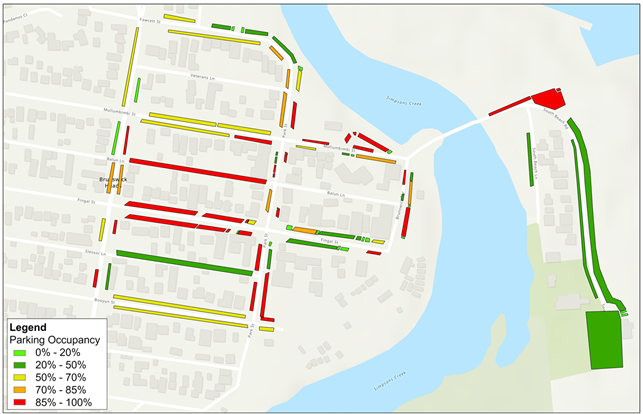
Figure 1: Current parking restrictions within Brunswick Heads Parking assessment findings Following an investigation of previous parking survey data and results from the validation parking surveys undertaken within this review there was found to be no significant improvement to occupancy from an overstay and turnover perspective. A detailed explanation of these findings can be found within part 4. Current Parking Situation, of the attached report (attachment 1). One of the main takeaways from the study was that during this low season, considering weather conditions etc. the centre of town is still reaching a trigger point for further intervention (72% occupancy) when considering growth (Please refer to figure 2). On the day of the surveys which produced figure 2 (below) the weather was generally poor, from a beachgoing perspective. This indicates that from a base background parking demand point of view, under poor weather and weekday conditions Brunswick is still approaching capacity in the commercial precinct without the tourist overlay.
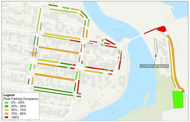
Figure 2: Weekday Parking occupancy (low season) Parking surveys were also undertaken during the peak season (October, fine weather), which indicated that the weekday parking demand within the centre of town reached 77% occupancy, with the foreshore reaching around 60% occupancy. It is worth noting that it is hard to give a true indication of occupancy given that some areas are not maximised to the full potential due to un-formalised and underutilised kerb space. A detailed breakdown of this assessment can be found within attachment 1 contained within this report in section 4.4.2. The figure below (figure 3) shows the peak demand for the weekday, high season.
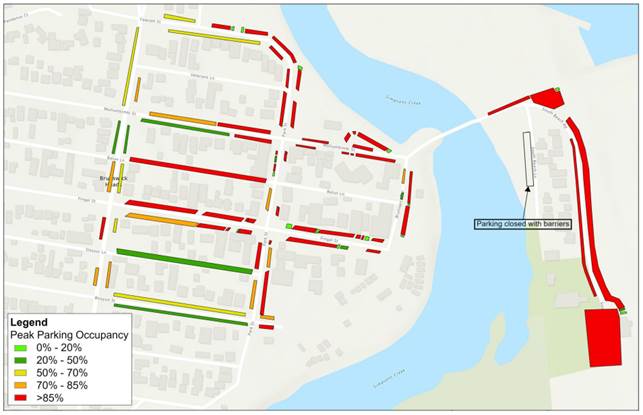
Figure 3: Weekday peak parking occupancy (High season) The weekend peak parking demand as expected reaches capacity at the peak in town (85% occupancy) during the low and high periods. The high season weekend peak period for the high season is well over capacity (please refer to figure 4).
Figure 4: Weekend peak, high season parking occupancy Forecasted parking demand The anticipated parking demand is determined by various growth factors outlined in the attached report (Attachment 1, Part 5, Future Parking Demand). This assessment suggests that in the short term, the growth analysis indicates an increase in demand for the core Brunswick center, rising from 72% weekday occupancy to 81% by 2028 (please refer to Figure 5). Additionally, it is
anticipated that the projected peak parking demands in the foreshore parking
area could surpass the current available parking supply by approximately 20%
to 50% from 2028 to 2038. Summary Parking demands in the town center, even during the low season, have reached a point where an update to the parking management regime needs to be considered in the short term. Reducing time limits is an option, but it would be too restrictive and would require significant enforcement to ensure compliance. Additional formalised parking (surfacing, signs/lines) would help increase supply but would come at a substantial cost, given that much of the kerbside within Brunswick is unsealed. Following the consultants' review, they have concluded that the implementation of pay parking would be the most effective way to achieve improved parking outcomes. Therefore, several options were analysed to determine which paid parking scenario would best enhance parking efficiency throughout the township (please refer to Attachment 1, Part 7, Pay Parking Assessment for further details). A summary of the different parking scenarios is presented below (Table 2: Pay parking options and evaluation).
Table 2: Pay parking options and evaluation
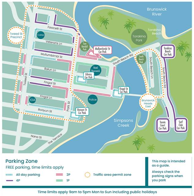
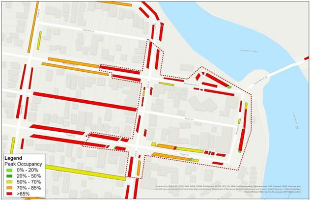
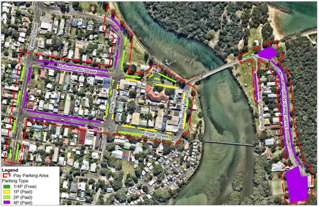
Based on the results of the pay parking assessment and workshop discussions (Councillor Workshop on 2 November 2023), the consultant has recommended that Scenario 1 or Scenario 4 be the preferred options to progress the implementation of pay parking in Brunswick Heads. While Scenario 2 or 3 would likely achieve more optimal parking management outcomes for turnover and availability, there is a need to consider the local context, given: · The growing parking pressures in the centre are a result of increasing tourists and visitor demands in Brunswick Heads. · Nearby in Byron Bay, pay parking has been implemented with a resident permit exemption and other permit provisions for workers. · Across other benchmarking examples, some form of resident permit is provided (for a fee). Council staff support the consultant’s recommendation, particularly regarding the lower hourly parking rate, which will lessen the impact of a reduction in visitation. Staff believe that the 4B boundary option would be the best scenario, as the 4A staged approach (town then foreshore after 2 years) would be unpredictable and likely have a significant impact on the foreshore in terms of nuisance camping and all-day parking (please refer to figures 6 and 7 for the Option 4 pay parking boundary). This option would not alter the current time limit restrictions within Brunswick Heads.
Figure 6: Recommended parking regime boundary (no change to current parking time restrictions)
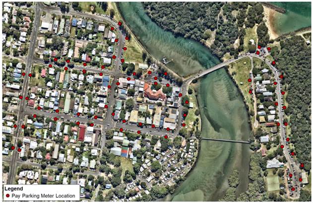
Figure 7: Parking meter location (preferred parking regime)
|
||||||||||||||||||||
|
Committee Comments N/A Management Comments It is only endorsing scheme, hours to be confirmed.
|
||||||||||||||||||||
|
That the Local Traffic Committee: - 1. Endorse the proposed of Brunswick Heads pay parking regime in principle (only) as scenario 4 (extended boundary) contained within this report.
2. Note that the implementation of this regime is still subject to Council approval. The recommendation was put to the vote and declared carried. |
|
Report No. 6.3 Somerset Street, Byron Bay - Permit Holder Exception File No: I2023/1948
|
|
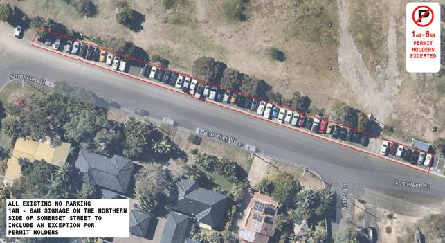
The purpose of this report is to gain Local Traffic Committee endorsement for the change to the existing No Parking 1am – 6am signs to include an exception for our current resident parking area permit holders (refer to figure 1). This is to allow resident to park in their street overnight while still mitigating nuisance camping.
Figure 1: Permit holder excepted locality map/plan
|
|
Committee Comments N/A Management Comments N/A
|
|
That the Local Traffic Committee endorse the permit holder exception for the current “No Parking” area on the northern side of Somerset Street, Byron Bay (between Butler Street and Wordsworth Street). (Lyon/Kehoe) The recommendation was put to the vote and declared carried. |
Matters for Traffic Engineering Advice
|
Report No. 7.1 Jubilee Avenue, School Traffic Operations - Potential Improvements File No: I2023/1867
|
||
|
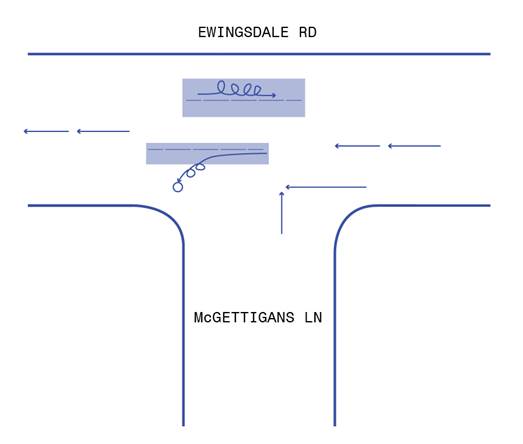
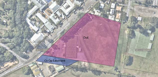
Background Numerous stakeholders have approached Council staff regarding traffic safety concerns adjacent or related to Mullumbimby High School. These issues are generally only experienced during the school peak periods (7:30 – 9:00am and 2:30 – 4pm) and any improvements will be spread across three different landholders/custodians (Council, NSW Department of Education and the Mullumbimby Co Op/Service Station).
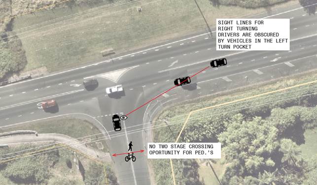
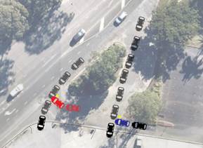
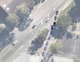
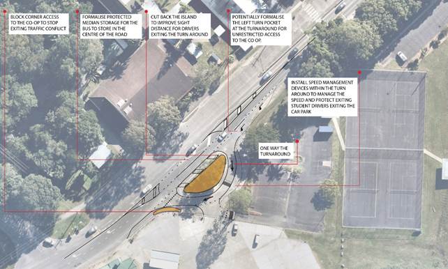
Figure 1: Locality map landowners Issues Bus turn-around facility (refer to figure 2) · Multiple access points to the Co-op that cross conflict points with no delineation. · High speed exits at bus turn around facility for co-op access. · Poor sight lines when exiting the facility
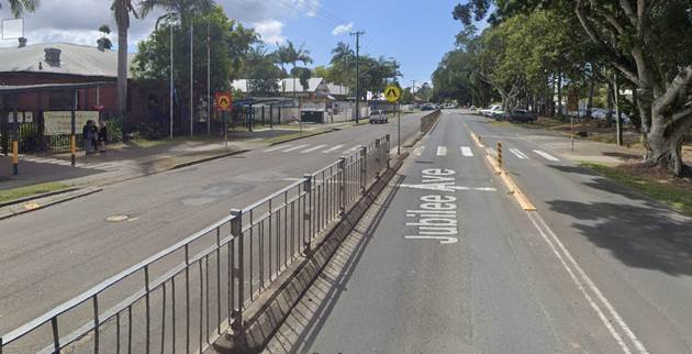
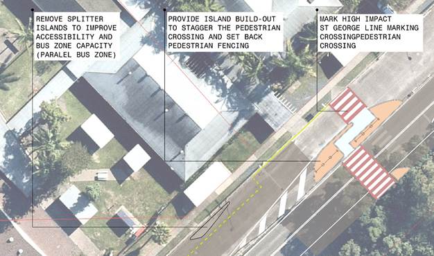
Figure 2: Issues diagram Pedestrian Crossing (Mullumbimby High School)
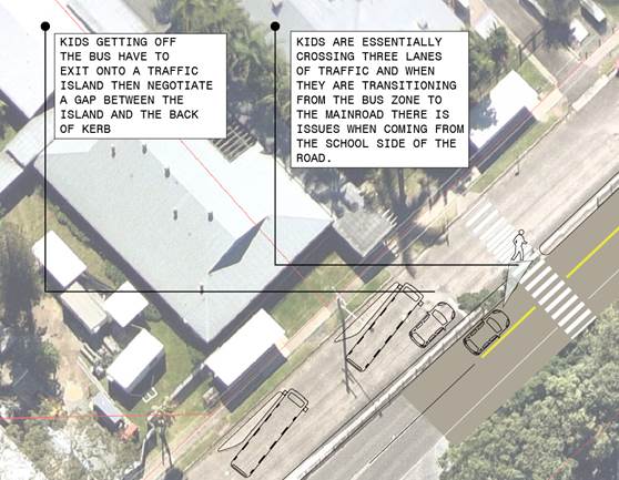
Figure 3: Pedestrian crossing, Jubilee Ave, Mullumbimby, adjacent Mullumbimby High School · Sight distance issues from median/pedestrian fencing, · Pedestrians are crossing three lanes of traffic, · Driver behavioural issues at the crossing due to extended queueing during school peaks (kids are not platooned), · School bus, drop off islands creating significant accessibility issues for kids getting on and off the bus,
Figure 4: Issues diagram un-supervised school pedestrian crossing
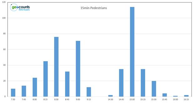
Figure 5: School day pedestrian crossing volume data (15 minute intervals) Purpose The purpose of this report is to present possible safety improvement treatments (short term) for the issues on Jubilee Avenue, Mullumbimby (outlined above) and gain support for further investigation should the treatments be found to be appropriate. Please see concepts below for comment and consideration.
Stakeholder Engagement Council have been talking with the Department of Education (including the principal of the High School) regarding concept development for the treatment of the issues contained within this report. However, funding and resourcing has been hard to achieve. Council has recently (23/11/2023) met with the Police and the Co Op to discuss these issues on-site. It has been recommended by the Police that we bring these concerns to the Local traffic committee for discussion. There have been numerous discussions with Transport for New South Wales who are currently assisting with potential avenues for funding.
|
||
|
Committee Comments N/A Management Comments N/A
|
||
|
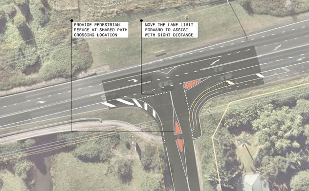
That the Local Traffic Committee endorse the safety upgrade treatments for the School Bus Turnaround and the Pedestrian Crossing adjacent to the Mullumbimby High School (figures 6 and 7) in principle for further discussions with the Dept of Education. (Kehoe/Miller) The recommendation was put to the vote and declared carried. |
There being no further business the meeting concluded at 11:15 am