 Agenda
Ordinary (Planning) Meeting

Thursday, 14 March 2024
Agenda
Ordinary (Planning) Meeting
Thursday, 14 March 2024
Agenda Ordinary (Planning) Meeting
held at Council Chambers, Station Street, Mullumbimby
commencing at 9.00am
Public access relating to items on this agenda can be made between 9:00am and 9:30am on the day of the meeting. Requests for public access should be made to the General Manager or Mayor no later than 12:00 midday on the day prior to the meeting.

Mark Arnold
General Manager
CONFLICT OF INTERESTS
What is a “Conflict of Interests” - A conflict of interests can be of two types:
Pecuniary - an interest that a person has in a matter because of a reasonable likelihood or expectation of appreciable financial gain or loss to the person or another person with whom the person is associated.
Non-pecuniary – a private or personal interest that a Council official has that does not amount to a pecuniary interest as defined in the Code of Conduct for Councillors (eg. A friendship, membership of an association, society or trade union or involvement or interest in an activity and may include an interest of a financial nature).
Remoteness – a person does not have a pecuniary interest in a matter if the interest is so remote or insignificant that it could not reasonably be regarded as likely to influence any decision the person might make in relation to a matter or if the interest is of a kind specified in the Code of Conduct for Councillors.
Who has a Pecuniary Interest? - a person has a pecuniary interest in a matter if the pecuniary interest is the interest of the person, or another person with whom the person is associated (see below).
Relatives, Partners - a person is taken to have a pecuniary interest in a matter if:
· The person’s spouse or de facto partner or a relative of the person has a pecuniary interest in the matter, or
· The person, or a nominee, partners or employer of the person, is a member of a company or other body that has a pecuniary interest in the matter.
N.B. “Relative”, in relation to a person means any of the following:
(a) the parent, grandparent, brother, sister, uncle, aunt, nephew, niece, lineal descends or adopted child of the person or of the person’s spouse;
(b) the spouse or de facto partners of the person or of a person referred to in paragraph (a)
No Interest in the Matter - however, a person is not taken to have a pecuniary interest in a matter:
· If the person is unaware of the relevant pecuniary interest of the spouse, de facto partner, relative or company or other body, or
· Just because the person is a member of, or is employed by, the Council.
· Just because the person is a member of, or a delegate of the Council to, a company or other body that has a pecuniary interest in the matter provided that the person has no beneficial interest in any shares of the company or body.
Disclosure and participation in meetings
· A Councillor or a member of a Council Committee who has a pecuniary interest in any matter with which the Council is concerned and who is present at a meeting of the Council or Committee at which the matter is being considered must disclose the nature of the interest to the meeting as soon as practicable.
· The Councillor or member must not be present at, or in sight of, the meeting of the Council or Committee:
(a) at any time during which the matter is being considered or discussed by the Council or Committee, or
(b) at any time during which the Council or Committee is voting on any question in relation to the matter.
No Knowledge - a person does not breach this Clause if the person did not know and could not reasonably be expected to have known that the matter under consideration at the meeting was a matter in which he or she had a pecuniary interest.
Non-pecuniary Interests - Must be disclosed in meetings.
There are a broad range of options available for managing conflicts & the option chosen will depend on an assessment of the circumstances of the matter, the nature of the interest and the significance of the issue being dealt with. Non-pecuniary conflicts of interests must be dealt with in at least one of the following ways:
· It may be appropriate that no action be taken where the potential for conflict is minimal. However, Councillors should consider providing an explanation of why they consider a conflict does not exist.
· Limit involvement if practical (eg. Participate in discussion but not in decision making or vice-versa). Care needs to be taken when exercising this option.
· Remove the source of the conflict (eg. Relinquishing or divesting the personal interest that creates the conflict)
· Have no involvement by absenting yourself from and not taking part in any debate or voting on the issue as of the provisions in the Code of Conduct (particularly if you have a significant non-pecuniary interest)
RECORDING OF VOTING ON PLANNING MATTERS
Clause 375A of the Local Government Act 1993 – Recording of voting on planning matters
(1) In this section, planning decision means a decision made in the exercise of a function of a council under the Environmental Planning and Assessment Act 1979:
(a) including a decision relating to a development application, an environmental planning instrument, a development control plan or a development contribution plan under that Act, but
(b) not including the making of an order under that Act.
(2) The general manager is required to keep a register containing, for each planning decision made at a meeting of the council or a council committee, the names of the councillors who supported the decision and the names of any councillors who opposed (or are taken to have opposed) the decision.
(3) For the purpose of maintaining the register, a division is required to be called whenever a motion for a planning decision is put at a meeting of the council or a council committee.
(4) Each decision recorded in the register is to be described in the register or identified in a manner that enables the description to be obtained from another publicly available document, and is to include the information required by the regulations.
(5) This section extends to a meeting that is closed to the public.
OATH AND AFFIRMATION FOR COUNCILLORS
Councillors are reminded of the oath of office or affirmation of office made at or before their first meeting of the council in accordance with Clause 233A of the Local Government Act 1993. This includes undertaking the duties of the office of councillor in the best interests of the people of Byron Shire and the Byron Shire Council and faithfully and impartially carrying out the functions, powers, authorities and discretions vested under the Act or any other Act to the best of one’s ability and judgment.
BUSINESS OF Ordinary (Planning) Meeting
1. Public Access
3. Attendance by Audio-Visual Link
4. Requests for Leave of Absence
5. Declarations of Interest – Pecuniary and Non-Pecuniary
6. Tabling of Pecuniary Interest Returns (Cl 4.14 Code of Conduct for Councillors)
7. Adoption of Minutes from Previous Meetings
7.1 Ordinary (Planning) Meeting held on 8 February 2024
8. Reservation of Items for Debate and Order of Business
9. Notices of Motion
Nil
10. Mayoral Minute
11. Petitions
12. Delegates' Reports
13. Staff Reports
Corporate and Community Services
13.1 Draft submission - Draft Terms of Reference for NSW council financial model review by IPART - January 2024.............................................................................................. 8
Sustainable Environment and Economy
13.2 PLANNING - Report of the Planning Review Committee held 1 February 2024 11
13.3 Byron Shire Residential Strategy 2041.................................................................... 13
13.4 PLANNING - DA10.2022.107.2 - S4.55 Modification to Easement & VMP Conditions – 23 Bayshore Drive, Byron Bay................................................................................... 38
13.5 PLANNING - 26.2022.11.1 Submissions report, Housekeeping Amendments to Byron Local Environmental Plan 2014................................................................................. 50
13.6 PLANNING - S4.55(1A) 10.2021.857.3 - Modifiction to Design of Dual Occupancy (Attached) including Use of Unauthorised Built Works at 2/16 Peter Street, South Golden Beach............................................................................................................... 62
13.7 State Government review of short term rental accommodation regulations and the supply of long-term rental accommodation in NSW............................................... 78
14. Reports of Committees
Infrastructure Services
14.1 Report of the Local Traffic Committee Meeting held on 13 February 2024....... 85
15. Questions With Notice
Nil
Questions with Notice: A response to Questions with Notice will be provided at the meeting if possible, that response will be included in the meeting minutes. If a response is unable to be provided the question will be taken on notice, with an answer to be provided to the person/organisation prior to the next Ordinary Meeting and placed on Councils website www.byron.nsw.gov.au/Council/Council-meetings/Questions-on-Notice
Councillors are encouraged to ask questions regarding any item on the business paper to the appropriate Director prior to the meeting. Any suggested amendments to the recommendations should be provided to Councillor Support prior to the meeting to allow the changes to be typed and presented on the screen at the meeting.
BYRON SHIRE COUNCIL
Staff Reports - Corporate and Community Services 13.1
Staff Reports - Corporate and Community Services
Report No. 13.1 Draft submission - Draft Terms of Reference for NSW council financial model review by IPART - January 2024
Directorate: Corporate and Community Services
Report Author: Esmeralda Davis, Director Corporate and Community Services
File No: I2024/229
Summary:
IPART has received a draft Terms of Reference (ToR) from the NSW Government (Attachment 1 E2024/14547) to investigate and report on the financial model for NSW local councils under section 12A of the Independent Pricing and Regulatory Tribunal Act 1992.
IPART is seeking feedback on the draft Terms of Reference until 15 March 2024.
IPART will publish the submissions received on its website.
This current stage of consultation seeks feedback on the scope of this review. There will be an opportunity to provide feedback on these matters during the course of the review.
Once IPART have been issued with the final ToR, the review will be completed within 12 months which includes publishing a Draft Report and submitting a Final Report to the Premier and Minister for Local Government. Further consultation will be carried out on the key issues and matters as part of this review.
Attachment 2 (E2024/11641) provides a copy of the draft submission to IPART for Council endorsement.
RECOMMENDATION:
That Council endorses the submission on the draft Terms of Reference at Attachment 2 (E2024/11641) to be lodged with the Independent Pricing and Regulatory Tribunal prior to the closing time on 15 March 2024.
1 Draft
Terms of Reference for NSW council financial model review by IPART - January
2024, E2024/14547 ![]()
2 Submission
to IPART - Draft Terms of Reference for NSW council financial model review -
2024, E2024/11641 ![]()
Report
IPART has received a draft Terms of Reference (ToR) from the NSW Government (Attachment 1 E2024/14547) to investigate and report on the financial model for NSW local councils under section 12A of the Independent Pricing and Regulatory Tribunal Act 1992.
This current stage of consultation seeks feedback on the scope of this review. There will be an opportunity to provide feedback on these matters during the course of the review.
The draft ToR asks IPART to review and recommend improvements to:
1. The visibility of councillors and the community over the financial and operational performance of their councils
2. Whether the current budget and financial processes used by councils are delivering value-for-money for ratepayers and residents
3. Whether the current funding model will sustainably support the needs of communities
4. Whether councils (both councillors and staff) have the financial capacity and capability to meet current and future needs of communities
5. How can better planning and reporting systems improve long term budget performance, transparency, and accountability to the community
6. Any other matters IPART considers relevant
Once IPART have been issued with the final ToR, the review will be completed within 12 months which includes publishing a Draft Report and submitting a Final Report to the Premier and Minister for Local Government. Further consultation will be carried out the key issues and matters as part of this review.
Key issues
The current draft ToR do not address the financial model of local government – i.e. how councils are financed. There is no reference to, or accounting for the impact of cost-shifting; the inequitable distribution of taxes, such as the methodology for calculating the Financial Assistance Grant program; or the burden of rates exemptions on other ratepayers. It disregards the outcome of the previous IPART review of the rate methodology which suggested measures for consideration that included:
· Better targeting eligibility criteria for rates exemptions
· Allowing councils to use the Capital Improved Value method to set the variable component of rates
· Ensuring statutory charges reflect the costs incurred by councils in providing statutory services
· Alternative funding mechanisms to provide essential social services
· Comprehensive state-wide evaluation of the existing pensioner concessions
Staff have prepared a draft submission (Attachment 2 E2024/11641) which highlights the need to consider such issues if the review is to genuinely investigate and report on the financial model for NSW local Councils.
Strategic Considerations
Community Strategic Plan and Operational Plan
|
CSP Objective |
CSP Strategy |
DP Action |
|
1: Effective Leadership |
1.3: Ethical and efficient management of resources |
1.3.1: Financial Management - Ensure the financial integrity and sustainability of Council through effective financial management |
|
1: Effective Leadership |
1.3: Ethical and efficient management of resources |
1.3.5: Resourcing - Identify and investigate resourcing to meet future needs |
Recent Resolutions
N/A
Legal/Statutory/Policy Considerations
LOCAL GOVERNMENT ACT 1993 - As at 6 February 2024 - Act 30 of 1993 (austlii.edu.au)
IPART Review of the rate peg methodology – August 2023
Financial Considerations
There are no financial implications of making a submission on the draft Terms of Reference for the IPART review on the financial model for NSW local councils.
Consultation and Engagement
Councillors were invited to provide feedback on the draft Terms of Reference for inclusion in this submission. No comments had been received at the time of preparing this report.
Councillors are also able to make individual submissions through IPART directly.
BYRON SHIRE COUNCIL
Staff Reports - Sustainable Environment and Economy 13.3
Staff Reports - Sustainable Environment and Economy
Report No. 13.2 PLANNING - Report of the Planning Review Committee held 1 February 2024
Directorate: Sustainable Environment and Economy
Report Author: Chris Larkin, Manager Sustainable Development
Noreen Scott, EA Sustainable Environment and Economy
File No: I2024/110
Summary:
This report provides the outcome of the Planning Review Committee (PRC) held on 1 February 2024.
NOTE TO COUNCILLORS:
In accordance with the provisions of S375A of the Local Government Act 1993, a Division is to be called whenever a motion for a planning decision is put to the meeting, for the purpose of recording voting on planning matters. Pursuant to clause 2(a) under the heading Matters to be Included in Minutes of Council Meetings of Council's adopted Code of Meeting Practice (as amended) a Division will be deemed to have been called by the mover and seconder of all motions relating to this report.
RECOMMENDATION:
That Council endorses the outcomes of the Planning Review Committee meeting held 1 February 2024.
Report
The PRC meeting was held on 1 February 2024. The meeting commenced at 3:45pm and concluded at 4:30pm.
Councillors: Mayor M Lyon, Cr M Swivel, Cr D Dey, Cr S Ndiaye, Cr A Hunter, Cr P Westheimer.
Apologies: Nil
Staff: Chris Larkin (Manager Sustainable Development).
Conflict of Interest: Nil
|
DA No. / Applicant |
Property Address / Proposal |
Consultation / Submissions |
Reason/s / Outcome |
|
10.2023.266.1 Planners North |
66 The Saddle Rd Group Home and Ancillary Building |
Level 2 30/8/23 to 12/9/23 No submissions |
The perceived public significance of the application.
Report to Council |
|
10.2023.358.1 Byron Bay Planning |
349 St Helena Road Change of Use of Dwelling to Tourist and Visitor Accommodation comprising of Six (6) Units, Tree Removal and New Dwelling House |
Level 2 11/1/24 to 24/1/24 2 submissions
|
Staff Delegation |
The S 4.55 application to modify these development consents are referred to the Planning Review Committee to decide if the modification applications can be determined under delegated authority.
|
DA No. / Applicant |
Property Address / Proposal |
Consultation / Submissions |
Reason/s / Outcome |
|
10.2021.716.3 Town Planning Studio |
18 Banksia Drive S4.55 to Modify Floor Plan of approved Artisan Food and Drink Industry including Addition of External Seating, increase Hours of Operation, nominate Maximum Patron Numbers and allow for Amplified Music |
13/12/2023 to 23/1/2024 56 submissions
|
The number of public submissions. The validity of the matters raised in the public submissions. Report to Council
|
Report No. 13.3 Byron Shire Residential Strategy 2041
Directorate: Sustainable Environment and Economy
Report Author: Shannon Burt, Director Sustainable Environment and Economy
File No: I2024/41
Summary:
Council considered Report 13.6 Housing Options Paper Submissions Report Agenda of Ordinary Meeting - Thursday, 14 December 2023 (infocouncil.biz) and resolved 23-654 interalia that a Final updated 2024 Residential Strategy be presented to Council February 2024 for approval to submit to the Department of Planning and Environment.
The purpose of this report is to address all parts of the
resolution noting that in particular the resolution Notes its submission
needs to be made before 31 March 2024 to meet Department of Planning and
Environment requirements as per Resolutions 23-165 and
23-315.
NOTE TO COUNCILLORS:
In accordance with the provisions of S375A of the Local Government Act 1993, a Division is to be called whenever a motion for a planning decision is put to the meeting, for the purpose of recording voting on planning matters. Pursuant to clause 2(a) under the heading Matters to be Included in Minutes of Council Meetings of Council's adopted Code of Meeting Practice (as amended) a Division will be deemed to have been called by the mover and seconder of all motions relating to this report.
RECOMMENDATION:
That Council:
1. Notes that staff have actioned all relevant parts of Resolution 23-654 as discussed in the report.
2. Approves the final Byron Shire Residential Strategy 2041 and Appendices (Attachments 1 to 5) for submission to the Department of Planning, Housing, and Infrastructure, with the following notified and other sites included and or excluded as recommended in this report:
Included:
a) Area 20 - 139 Bangalow Road
b) Area 21 - 64 Corkwood Road
c) Area 8 – Mullumbimby – 1B Ann Street & 20 Prince Street; and 75 New City Road
d) Area 17 – inclusive of 66 The Saddle Road and 251 The Saddle Road
Excluded:
a) Area 18 – Lot 69 DP851902 & Lot 71 DP851902, Kingsford Drive, Brunswick Head
b) Area bounded by Ewingsdale Road to Grays Lane (which includes 29 Buckleys Road) East of the M1
3. Notes that staff will submit the Residential Strategy 2041 (and Appendices) to the Department of Planning, Housing and Infrastructure before 31 March 2024 to meet their requirements as per Resolutions 23-165 and 23-315.
Attachments:
1 Byron
Shire Residential Strategy 2041, E2024/20516
![]()
2 Residential
Strategy 2041 - APPENDIX A Implementation & Delivery Plan, E2024/21356 ![]()
3 Residential
Strategy 2041 - APPENDIX B Site Profiles, E2024/20633
![]()
4 Residential
Strategy 2041 - APPENDIX C Development Sequencing Plan, E2024/20965 ![]()
5 Residential
Strategy 2024 - APPENDIX D NSW Planning Framework Assessment, E2024/21251 ![]()
6 Additional
Investigation areas redacted submissions, E2024/19352
![]()
7 Letter
23 January 2024 from Department of Planning, Housing and Infrastucture re
Res 23- 654, E2024/17845 ![]()
8 Mullumbimby
Release Areas Flood Impact Assessment Final Draft (WMAWater) - March 2020, E2020/22334 ![]()
9 CABS
Community Alliance Byron Shire - Common elements for meeting 29 February 2024, E2024/21989 ![]()
10 Form
of Special Disclosure of Pecuniary Interest, E2012/2815
![]()
Report
Council considered Report 13.6 Housing Options Paper Submissions Report Agenda of Ordinary Meeting - Thursday, 14 December 2023 (infocouncil.biz) and resolved 23-654.
Each part of the resolution is provided below with staff comment.
Resolution 23-654
1. Adopts the Housing Options Paper including existing mapped lands and updates a) to d) and Recommendations below to enable staff to complete the 2020 Residential Strategy Refresh:
a) New Dwelling Yield Assumptions
b) Certain New Lands for inclusion
c) Updates to policy and associated actions in 2020 Residential Strategy to address the issues raised during the public comment period where relevant to the 2020 Residential Strategy Refresh
d) The changes needed to the body, content, format and name of the 2020 Residential Strategy to refresh it.
Staff comment:
The Housing Options Paper and recommendations informed the refresh of the Residential Strategy in Attachments 1 to 5.
2. Supports the inclusion of new sites/lands in the 2024 Residential Strategy, namely:
a) as identified in Tables 1 and 2 of this report (sites supported) and Attachment 16 (E2023/127137); and
b) Lot 2 DP1275809 and Lot 438 DP729107 Bangalow Road, Byron Bay.
These lands are to be notified on Council web page and letters to adjoining owners for the period December 2023 – January 2024.
Lands were notified on Council’s web page and letters sent to landowners and adjoining property owners.
There were 47 submissions received to this notification.
The details of which are discussed in the Submissions section of the report, and the redacted submissions can be viewed in Attachment 6.
Note there was an unintended omission from Table 2 (New sites supported and not supported), being 139 Bangalow Road, Byron Bay (Lot PT 22 DP 549688), as it was included in Table 3 (Sites already located within the urban growth boundary) instead, as presented in the 14 December 2024 report.
To correct this, this site was also notified to adjoining landowners, and is now recommended to be included in the updated Residential Strategy as discussed in the Submissions section of the report.
3. Does not support inclusion of sites/lands in the 2024 Residential Strategy identified in Tables 1 and 2 of this report and Attachment 17 (E2023/126871).
Noted and action complete.
4. Acknowledges the sites/lands, identified in Table 3 of this report, inside the North Coast Regional Plan 2041 urban growth boundary that do not need to rely upon the 2024 Residential Strategy and that these can proceed to an owner-initiated planning proposal at the landowner’s discretion.
Staff comment:
Noted and action complete.
5. Supports the inclusion of sites/lands identified in the Resilient Lands Strategy in the 2024 Residential Strategy and associated actions to confirm a collaborative approach to the planning and development of these sites with State Agencies, Landowners and other stakeholders involved at the relevant time.
Staff comment:
Following discussions with the NSW Reconstruction Authority only those sites identified as ‘Short Term’ in the Draft Northern Rivers Resilient Lands Strategy have been included as investigation areas in the Residential Strategy 2041. These are sites B1 and B2.
The Residential Strategy Implementation and Delivery Plan and Development Sequencing Plan provide separate commentary on the future planning and delivery timeframes for sites B1 and B2.
Further and in support of the acceleration of site B1, a Funding Agreement has also progressed with the NSW Reconstruction Authority to enable Council to complete technical studies and a Structure Plan with landowners and key stakeholders, and statutory plan amendments to the LEP and DCP for the Saddle Road Precinct (more broadly) inclusive of site B1. This work is programmed to occur over the next 2-3 years.
6. Notifies State agencies of the decision of Council and agrees to continue to work with them on their submissions.
Staff comment:
Email notifications were sent about the resolution, seeking any further feedback from relevant State Agencies to that received at the State Agency roundtable meeting in November 2023 by end January 2024.
All previous State Agency feedback has already been taken into consideration and updates to the Residential Strategy made where necessary.
The Department Planning, Housing and Infrastructure (DPHI) provided additional general feedback in early February 2024, about dwelling yield assumptions, mapped areas, and infrastructure planning. This feedback has been taken into consideration and updates to the Residential Strategy made where necessary.
Council was also reminded by DPHI, of its commitments to increase housing supply made to the Minister for Planning September 2023 (Resolutions 23-165 and 23-315).
It is understood that DPHI and relevant State agencies will do a final review of the Residential Strategy 2041 once adopted by Council and submitted to them for endorsement.
7. Notes that staff will update the 2020 Residential Strategy as per the report and recommendations adopted in 1.
Staff comment:
Updates completed and presented in this report and Attachments 1-5.
8. Notes that a Final updated 2024 Residential Strategy will be presented to Council February 2024 for approval to submit to the Department of Planning and Environment.
Staff comment:
Presented as Attachments 1 - 5 to this report.
9. Notes its submission needs to be made before 31 March 2024 to meet Department of Planning and Environment requirements as per Resolutions 23-165 and 23-315.
Staff comment:
Noted in recommendation.
10. Agrees to receive further updates on a number of recent and related housing resolutions mentioned in the report at future meetings of Council.
Staff comment:
Noted and update reports will be presented to Council as required on these other resolutions.
11. Requests further consideration by the Department of Planning of the area bounded by Ewingsdale Road to Grays Lane (which includes Buckleys Road) East of the M1 for an extension to the existing urban growth boundary including in the next review of the North Coast Regional Plan 2027.
Staff comment:
A request was sent to the DPHI by email dated 21 December 2023. The DPHI has responded 23 January 2024 Attachment 7 extract below:
“The process to amend the urban growth area boundary is outlined in the North Coast Regional Plan 2041 (page 61) and requires any changes to the growth area to be undertaken firstly as part of a local land use strategy. As such, the first steps to include land in the urban growth area boundary, is for it to be identified in Council’s Residential Strategy as a ‘potential investigation area’, and for that strategy to be approved by the Department.
When determining whether land is suitable for inclusion in the Residential Strategy, it is essential the strategy address the following in the North Coast Regional Plan 2041:
• Key settlement planning principles (page 61)
• Settlement planning guidelines – Appendix A (page 117); and
• Urban growth area variation principles – Appendix B (page 119).
then be considered by Council for a ‘release area’ as part of the mid-point review in 2026/2027 (and in accordance with part 13 of the Council resolution). If this change is approved by the Department, the North Coast Regional Plan will be amended in its next review. Area 11 referenced in part 12 of the Council resolution (23-654) will also need to follow this process to be included in next review of the North Coast Regional Plan.”
Staff recommendation previously was that the site known as 29 Buckleys Lane Tyagarah did not satisfy the requirements of the North Coast Regional Plan 2041. For this reason, staff did not include it in the Housing Options Paper.
Following a Councillor debate, parts 11-12-13 were added to the staff recommendation from the floor at the Council meeting 14 December 2023.
Based on the DPHI advice, it is again staff recommendation that the area bounded by Ewingsdale Road to Grays Lane (which includes 29 Buckleys Road) East of the M1 not be included in the Residential Strategy, as it does not satisfy the requirements of the North Coast Regional Plan 2041 in terms of the Key Settlement Principles, Settlement Planning Guidelines and Urban Growth Variation Principles.
A review of it could be considered as part of the mid-point review of Residential Strategy in 2026/27, in the context of there being no other suitable land available for housing, and no movement being made towards achieving required infill targets within existing urban growth area boundaries.
12. Includes a section in the 2024 Residential Strategy highlighting the area in 11 as a potential future investigation area for inclusion in the 2024 Residential Strategy review (normally 5 years). Noting that the current North Coast Regional Plan also needs to be amended in its next review 2027 to identify the area in 11 within an urban growth area first. Requirements for this include: no other suitable land is available for housing, and movement has been made towards achieving required infill targets within existing urban growth area boundaries.
Staff comment:
A section has not been included in the Residential Strategy 2041 given staff comments in 11.
13. Requests staff to include a mid-point review (2026/27) of the 2024 Residential Strategy actions to enable an informed submission to be made to the Department of Planning about point 12.
The Residential Strategy 2041 Implementation and Delivery Plan responds to this part of the resolution.
Submissions Summary
As per part 2 of Resolution 23-654, lands were notified on Council’s web page and letters sent to landowners and adjoining property owners.
There were 47 submissions received to this notification.
The submissions in the main relate to the following:
· 1B Ann Street & 20 Prince Street; and 75 New City Road Areas 8 and 9 - Areas 8 and 9 (29 objections)
· 139 Bangalow Road (8 objections)
· 64 Corkwood (6 objections and 1 support)
· 66 and 251 The Saddle Road (1 support)
· General (1)
· Resident Group (1)
There was also a letter requesting withdrawal of the Byron Bay Golf Club site from consideration of inclusion in the Residential Strategy.
There were also some general topics and issues raised in submissions like: climate change, natural disaster events, dwelling targets, and infrastructure planning.
The main topics and issues raised have been summarised and are responded to below by site and or topic/issue.
Development and fill on floodplains
The current requirements of the North Coast Regional Plan, Settlement Guidelines and Urban Growth Area Variation Principles have been used to inform the Housing Options Paper and Residential Strategy.
Location and settlement form has
also had regard to hard (primary) and manageable constraints which include
flood hazard risk and other flood planning considerations
(e.g., Climate Change).
The Residential Strategy 2041 includes principles for ‘suitable-for-use urban lands’ including that the land is safe from other hazards or risks such as coastal erosion, tidal inundation, dunal movement, steep slopes and land slip areas, extreme bushfire and slopes greater than 20%.
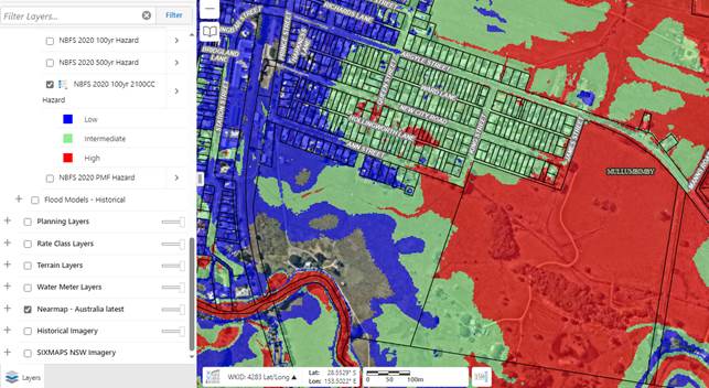
Lands included in the Housing Options Paper and Residential Strategy 2041 have been assessed using the above as well as the following flood-related criteria:
· Land identified in adopted flood studies with a medium or high future flood hazard risk (based on 2100 Climate Change)
· Land within a Fill Exclusion Zone
The above criteria is from the 2020 North Byron Floodplain Risk Management Plan and Study and has been applied to the other adopted flood study catchments (ie. Marshall’s Creek, Belongil, Tallow Creek).
It is acknowledged that the NSW Government has supported, either in full or in principle, the recommendations of the 2022 Flood Inquiry and noted some will require further work on implementation, including further consultation with local and Commonwealth governments.
It is also acknowledged that further work and updates to Council’s current flood management plans is needed to incorporate the 2022 flood data levels (once this information is publicly available); but is also dependent on State Government making formal policy decisions about the 2022 Flood events and releasing updated flood planning and development requirements for use by councils. This will assist with Council’s review of DCP flood planning controls, which is currently underway, as well as inform future planning proposals in flood affected areas.
Council will be seeking grant funding in 2024 from the NSW Government to update the North Byron Flood Model and associated Risk Study and Plan. This was a recommendation from the recent “Post 2022 Event Flood Behaviour Analysis – Brunswick River – February 2024“commissioned by the NSW Department of Climate Change, Energy, the Environment and Water (DCCEEW).
In the meantime, the DPHI is working with councils to determine how the planning for hazards is to occur, including flooding at the Strategy and or masterplan/rezoning stage.
To this end specific actions are included in the Residential Strategy 2041 to address the issue of current and future flood planning, having regard to the updated Flood Prone Land Policy and Flood Risk Management Manual (2023), and the various elements of the flood-prone land package which commenced in July 2021.
In addition, development and fill on floodplains are managed via LEP 2014 clause 5.21 – Flood Planning and Development Control Plan (DCP) 2014 Chapter C2 - Areas Affected by Flood. Proposed Updates arising from review of this DCP will go through a public consultation process and this will allow the community to be involved in the process.
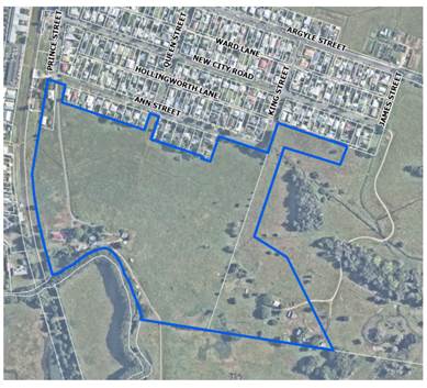
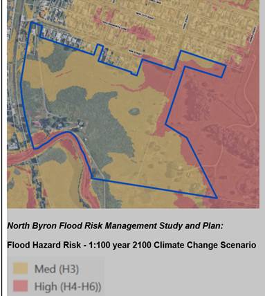
1B Ann Street & 20 Prince Street; and 75 New City Road Areas 8 and 9 – suitability for inclusion for future investigation
Council identifies and deals with "flood-prone" land at different stages of the development process. This includes at the Strategy level, at an investigation area level through studies associated with planning proposals, and then at a site-specific level for specific DAs. Each stage will have different flooding needs and implications. In addition, all flood assessment must be undertaken in accordance with the NSW Flood Risk Management Manual – 2023 and Council’s adopted LEP/DCP controls.
At the Strategy level, land affected by ‘high’ and ‘intermediate’ flood hazard has been excluded from ‘new release’ and ‘infill’ housing considerations. The only exceptions are Areas 8 & 9 (see below) where more detailed flood and stormwater management investigations undertaken in 2020 (Attachment 8) – ‘Mullumbimby Land Release Areas Flood Impact Assessment and Concept SWMP’ – WMAwater, March 2020) found that it was possible to deliver improved drainage outcomes for both sites and the adjoining urban residential land to the north (i.e., New City Road precinct).
More detailed flood-related information about these sites is contained in Appendix B, which includes the following extract below:
“Detailed flood and stormwater management investigations:
- must be undertaken concurrently as part of a single ‘combined’ planning proposal.
- must demonstrate improved drainage outcomes for adjoining urban residential land to the north.”
and
“An updated flood and stormwater management study is required to inform a planning proposal, which must:
- incorporate updated survey information from 2022 flood event
- be undertaken concurrently as part of a single ‘combined’ planning proposal
- demonstrate improved drainage outcomes for adjoining urban residential land to the north.”
For background context to these sites, a chronology of the planning history is as follows:
2017/18: Council seeks to establish an ‘Early implementation Program to provide affordable housing’, which includes Areas 8 & 9. DPE notified and advises that Council’s draft Residential Strategy is the most appropriate mechanism for directing growth to appropriate locations that can sustainably accommodate residential development.
March 2018: Drainage Assessment Report – New City Road, Mullumbimby prepared by Ardill Payne & Partners at the request of Byron Shire Council for the purpose of assessing localised drainage issues at Mullumbimby, together with options for addressing these.
March 2020: Mullumbimby Release Areas – Flood Impact Assessment and Concept SWMP (Final Draft – WMAWater). Purpose was to assess flood risk due to regional catchment flooding and to assess and mitigate the flood impacts caused by the proposed development. A concept level stormwater management plan for the area was prepared to inform the stormwater infrastructure that may be required to service the development.
December 2020: Byron Shire Residential Strategy adopted by Council, with Areas 8 & 9 included as ‘Investigation Areas’
As part of any future rezoning of these sites, detailed flood and stormwater management investigations must be undertaken concurrently and collectively. And consistent with LEP 2014 clause 5.21 – Flood Planning the outcome of these investigations must demonstrate improved drainage outcomes for adjoining urban residential land to the north.
Council will continue to implement updated planning guidance and requirements as set by the NSW State Government. This includes the updated Flood Prone Land Policy and Flood Risk Management Manual (2023), and the various elements of the flood-prone land package which commenced in July 2021. The outcome of these reviews may influence the future sequencing of the investigation areas.
For the purposes of inclusion in the Residential Strategy 2041, given the above, sites 8 and 9 have now been combined into one site (Area 8) as shown below extract from New Urban Areas Site Profile (Appendix B) in Attachment 3:
Areas 8 (formerly Areas 8 & 9)
It is noted that Council will be applying for grant funding to cover an update to the North Byron Flood study in 2024 via the funding DCCEEW. The resulting updates will inform development control advice in respect to these investigation areas, including whether future development of these sites should be reliant on fill or raised house forms.
Trunk drain on New City Road and stormwater impacts on this area from development of Area 8 (formerly Areas 8 and 9)
Council received a number of submissions identifying concerns with future stormwater impacts from development of Areas 8 and 9 on the drainage of the adjoining New City Road urban residential area. As discussed above, Flood and stormwater management investigations undertaken in 2020 ‘Mullumbimby Land Release Areas Flood Impact Assessment and Concept SWMP’ (WMAwater – March 2020) found that it was possible to deliver improved drainage outcomes for both sites Areas 8 & 9 and the adjoining urban residential land to the north.
Council’s Infrastructure Services staff are aware of the existing drainage issues in this area and will be undertaking drain maintenance works in 2024. The assessment of downstream drainage is identified in the adopted North Byron Floodplain Risk Management Plan, as a recommended measure within the list of 25 projects. However, this investigation is the lowest ranked priority of the listed projects and as such, is not funded and would be subject to a future flood grant application. As discussed above, any planning proposal application for Areas 8 & 9 must demonstrate improved drainage outcomes for adjoining urban residential land to the north.
More detailed flood-related information about these sites is contained in Appendix B.
No evacuation plans or routes for Mullumbimby
The North Byron Floodplain Risk Management Study and Plan 2020 includes numerous references to evacuation routes, planning and centres.
The adopted North Byron Floodplain Risk Study and Plan identified a recommendation to undertake an Evacuation Assessment for Mullumbimby which is currently being undertaken by SES with the assistance of Council. SES are an integral member of Council’s Floodplain Management Advisory Committee.
A review of these aspects will be undertaken in concert with the update and review of the Flood Study and associated Floodplain Risk Study and Plan which involve liaison with NSW Reconstruction Authority and SES and other relevant agencies. Council will be applying for a funding grant to cover an update to the North Byron Flood study in 2024 via the funding body DCCEEW.
Further, for events, Council operates the Byron Flood Warning Network and Disaster Dashboard. The Dashboard can be found at https://emergency.byron.nsw.gov.au
Various flood related information is provided on The Dashboard, and this can be increased during times of flood to include evacuation routes and centres and warnings to the community via an Opt In warning system. This is typically the sharing of SES warnings and orders. SES are the lead agency; therefore, Council’s role is to support the SES rather than take their role.
Behind The Dashboard is Council’s Guardian Incident Management System, this system manages what The Dashboard is presenting to the community and has the Flood Intel system.
Flood Intel issues flood forecasts and observations to users. It also provides forecast flood maps, dwellings likely to be inundated due to a forecast flood, rainfall forecasts, storm tracker, cyclone tacker, water level graphs and accumulated rainfall observed and predicted for various forecasts.
North Byron Floodplain Risk Management Study and Plan is past its use by date and needs updating
DCCEEW, following several briefings with Council’s Floodplain Management Advisory Committee, has recently released the “Post 2022 Event Flood Behaviour Analysis – Brunswick River – February 2024 “.
Generally speaking, this Report found:
That the flood model has reached its limit of use from a technical perspective in terms of hydrological, hydraulic and modelling performance.
Council will be seeking funding in 2024 from the NSW Government to update the North Byron Flood Model and associated Risk Study and Plan as recommended in the “Post 2022 Event Flood Behaviour Analysis – Brunswick River – February 2024 “. This report was commissioned by DCCEEW.
These updates will inform development control advice in respect to the investigation areas.
Demand removal of fill on Prince Street where Pod Houses are located
The removal of fill from this site is not a matter for the Residential Strategy. The future of the temporary accommodation site is a matter for the Reconstruction Authority and the landowner (TAHE) to determine at the end of the lease term. It is understood that the lease also requires that the site be made good at the end of the lease.
Mullumbimby temporary housing village | NSW Government
Site-Fact-Sheet-Station-Street-Mullumbimby_0.pdf (nsw.gov.au)
139 Bangalow Road (Area 20 in Appendix B)
There is a Development Application DA 2023/346 for this land to: Stage 1 Boundary Adjustment, Demolition of Existing Dwelling House, and 2 Lot Torrens Title Subdivision, Stage 2 Community Title Subdivision to Create 5 Community Title Residential Lots and Community Title Lot currently under assessment.
A number of submissions received raised objection to this DA and have been referred to the planner managing this DA for consideration. In particular: biodiversity, environmental impact, traffic impact, bushfire risk, stormwater management and construction impacts.
A number of submissions and a consultant prepared submission also raised objections/concerns about the proposal to include that part of the land currently zoned 7d Scenic/Escarpment (Deferred Matter) as an investigation area in the Residential Strategy. In particular, these concerns relate to: biodiversity, environmental impact, traffic impact, bushfire risk, stormwater management and construction impacts.
Image: Site Profile 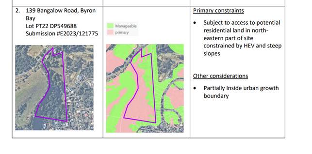
Image: Site zoning
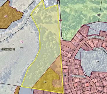
It should be noted that the landowner agreed to rezone 60% of their previous R2 Low Density Residential Zone to C2 Environmental Conservation, as part of the Stage 3 C zones review.
The proposed investigation area is located to the north of the existing R2 zone area and largely adjoins the Golf Course (see image above). The current DA is proposed on the residual R2 zone area.
Only that part of the land mapped as ‘manageable’ constraints (see image above) is proposed to be included in the Residential Strategy.
64 Corkwood Drive (Area 21 Appendix B)
A number of submissions raised objections/concerns about the proposal to include that part of the land currently 7d Deferred Matter in the Residential Strategy as an investigation area. In particular: environmental impact, escarpment and land slip, traffic impact, bushfire risk, density.
This site has been assessed by staff on several occasions prior, and in response to a submission to the Housing Options Paper and supported by staff for inclusion in the Residential Strategy as per Resolution 23-654 on 14 December 2023.
A submission in support of its inclusion was also received by the landowners.
Image: site profile
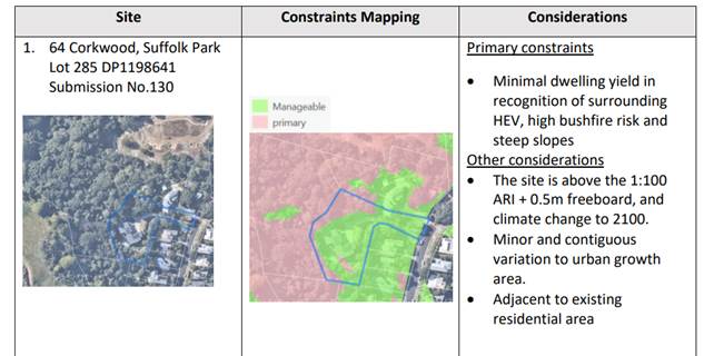
Only that part of the land mapped as manageable constraints (see image above) is proposed to be included in the Residential Strategy.
It should be noted that the majority of the land mapped as ‘manageable constraints’ (see green areas image above) is already developed for 2 dwellings as part of an approved dual occupancy and any development on the fringe most likely being limited to 1 or 2 secondary dwellings.
Other issues
Dwelling targets are over ambitious and wishful thinking on the part of government and should be revised.
Dwelling targets have been the subject of several Reports and Resolutions of Council and are in response to the Minister for Planning and DPHI requirements.
Where land expansion is allowed on significant farmland, that areas be set aside for food growing as part of its development strategy.
Limited opportunity exists under the current North Coast Regional Plan 2041 to rezone important farmland. Land that is allowed to be rezoned is generally considered a rounding off of an urban area or village, is of poor quality in terms of agricultural production, and or is fragmented land with limited size capability and land use conflicts.
Notwithstanding the above, the consideration of land for ‘food security’ is a matter that can be considered as part of future land use planning including structure plans and planning proposals. It would need to be done on a site-by-site basis though.
Further Resolution 23–303 talks about parts of the draft Resilient Lands Strategy Sites in Byron Shire being used for food security in the form of market gardens and environmental rehabilitation.
The ‘development strategy’ for the Byron Shire Northern Rivers Draft Resilient Lands Strategy sites is discussed elsewhere in the report.
Infrastructure Planning
Detailed comments in relation to Infrastructure Planning were included in the report 14 December 2023.
A review of Council’s 7.11 and 7.12 contributions plans, and development servicing plans (DSP) also mentioned then, are now being progressed.
A funding agreement with the NSW Reconstruction Authority is also being progressed that includes identifying ‘key priority infrastructure’ needed to support and accelerate the development of the Saddle Road Precinct inclusive site B1.
Further, the DPHI is about to undertake an infrastructure audit in concert with Council to support the preparation of the North Coast Urban Development Program UDP as required under the North Coast Regional Plan 2041.
The purpose of the audit is to identify the key enabling infrastructure required to support new release/greenfield areas within LGAs as identified in their respective LGA Residential Strategy. Council is now working with the DPHI in this regard. The audit will focus on roads and utilities infrastructure (sewer, water, and electricity). It is unclear at this time if this audit will result in funding or grants for identified enabling infrastructure.
The Residential Strategy Implementation and Delivery Plan and Development Sequencing Plan otherwise provide for residential development staging and sequencing considering the current known infrastructure capacity, capital works programs and infrastructure and contributions plan reviews.
Mullumbimby Residents Association (MRA)
The MRA has made several submissions and presentations to Council in relation to the 2022 Flood Event, After the Flood Discussion Paper, and the Housing Options Paper and report 14 December 2023.
The following comments/issues/points as summarised have been made in their most recent submission.
1. Object to the inclusion of 1B Ann Street and 75 New City Road as investigation areas in the Residential Strategy.
Comments provided elsewhere in the report.
2. Note that the North Byron Floodplain Risk Management Study 2020 needs review.
Comments provided elsewhere in the report.
3. Comment that The After the Flood Discussion Paper has not been actioned.
The After the Floods Discussion Paper as per Resolution 23-165 has informed the Housing Options Paper and Residential Strategy 2041.
4. Comment that Resolution 23-360 remains incomplete.
Being progressed by staff and reported separately to Flood Advisory Committee and Council.
5. Recommends that due to cumulative impacts of filling the whole Mullumbimby Urban Growth Area needs to be designated as No Fill area.
The current adopted 2020 North Byron Floodplain Risk Management Study and Plan already considered a number of Cumulative Development Scenarios. The assessment established finite “Fill Exclusion” Zones that preclude fill within that zone.
As mentioned above, Council will be seeking funding in 2024 from the NSW Government to update the North Byron Flood Model and associated Risk Study and Plan as recommended in the “Post 2022 Event Flood Behaviour Analysis – Brunswick River – February 2024“. This report was commissioned by the DCCEEW.
The proposed updates to the Flood Study and associated Risk Study and Plan will incorporate the proposed release areas in accordance with NSW Flood Risk Management Manual – 2023. It will also include a review and update to the existing “Fill Exclusion Zones”.
6. Comment that Mullumbimby has no current evacuation plan or suitable evacuation centre for the population
Evacuation Routes - The adopted North Byron Floodplain Risk Study and Plan identified a recommendation to undertake an Evacuation Assessment for Mullumbimby which is currently being undertaken by SES with the assistance of Council. SES are updating their pre-prepared flood plan/s for various localities in the shire for the evacuation routes.
Evacuation Centres - This is solely the responsibility of the SES. They are the combat agency when a flood event occurs. They determine the specific location and organise resources for all of these activated evacuation centres once a flood warning is issued by BOM. SES have pre-prepared flood plan/s for various localities in the shire for the evacuation routes.
7. Support inclusion of 1862 Coolamon Scenic Drive as an investigation area.
Comments noted.
8. Concerned with inclusion of 1897 Coolamon Scenic Drive as an investigation area.
Comments noted.
9. Concern about the proposed Affordable Housing Development on 57 Station Street and loss of carparking in the town centre
57 Station Street is being progressed by separate resolution of Council. It is not Residential Strategy dependant.
10. Comment flood pod site in Prince Station has caused trauma as has its inclusion in the Housing Options Paper.
The inclusion of the Mullumbimby temporary accommodation site as an investigation area in the Residential Strategy was done to maintain a level of transparency with the community about its current use given its land use zoning.
The future of the temporary accommodation site is a matter for the Reconstruction Authority and the landowner (TAHE) to determine.
11. Agrees with decision not to include Council land Lot 22 but concerned about 1660-1634 Coolamon Scenic Drive inclusion.
Comments noted.
12. Concern about infill development and impact on character.
Housing targets, density and character are addressed in Policy 2 and 3 and associated actions in the Residential Strategy 2041.
13. Notes that Byron Shire has a high growth rate comparatively and that we exceed our growth requirements.
Comments noted.
14. Important to identify constraint free land for future development.
The Residential Strategy has done this by identifying land that satisfies the requirements of the North Coast Regional Plan 2041 taking into consideration primary and manageable constraints.
15. Important to consider climate risk adaptation in future strategy and development.
Noted and the Residential Strategy has done this.
16. Notes include about supporting infrastructure, capacity, and capability.
Noted and the Residential Strategy has done this.
Investigation Area (Lot 69 DP851902 & Lot 71 DP851902) Bayside Brunswick Temporary Accommodation Site
A Notice of Motion No. 9.2 Save the community park in Bayside Brunswick was put to the Agenda of Ordinary (Planning) Meeting - Thursday, 8 February 2024 (infocouncil.biz) and lost.
The NOM was seeking to remove from consideration, as a Housing Option for the Shire’s Residential Strategy, Lot 69 DP 851902 (Bayside Park) so that the Park returns as soon as possible to its original intended use as open space for the local community.
The staff comments in response to this was:
The Housing Options Paper Engagement Strategy Report (Attachment 4 of Report No. 13.6 to the Ordinary Council Meeting 14 December 2023) included feedback from submissions received on Lot 69 DP 851902 (Lot 69), as follows:
Lot 69 DP 851902 (The Park)
“The site is identified as a potential investigation area in the Housing Options Paper.
Around five submissions were received opposing the inclusion of this site as an investigation area as this land (together with Lot 71) are the only spaces that facilitates community and social cohesion in the Bayside area. The site is the only centrally located green space for community gatherings and recreation. The community has also been promised that the park (which is currently used for temporary housing pods) would be returned in an equal or better state after the emergency period”.
Council Report No. 13.6 acknowledged these submissions and that concerns raised in them would be addressed in a future report to Council (emphasis added):
Lot 69, together with the adjoining parcel (Lot 71) were identified as an Investigation Area in the Housing Options Paper. Lot 71 is privately owned and has approval for a mixed-use development.
The visual context of these sites is provided in the map extracts below.
Image: Investigation Area (Lot 69 DP851902 & Lot 71 DP851902)
Image: Boundary of Lot 69 DP 851902
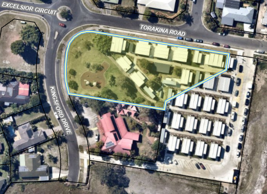
Lot 69 is classified as Community Land with an R2 Low Density Residential zoning.
As an Investigation Area it requires further detailed studies to determine what land is suitable for development. Additionally, whilst the land is zoned for residential purposes, the sites classification would need to be changed from Community to Operational before any long-term housing development could proceed, and this process requires a public hearing.
At the Council (Planning) Meeting of 12 May 2022, Council resolved 22-183 to provide in principle support to the proposed leases with Resilience NSW (now NSW Reconstruction Authority) for the temporary pod villages. Council also resolved to enter into a lease on set terms, including a 3-year lease with 2 x 1-year options to renew. The lease commences on the date it was executed; it was signed on 19 August 2022. The lease also requires that the site be made good at the end of the lease.
The temporary accommodation development has retained the playground and an area of open parkland. There is additional parkland across from the site on the corner of Excelsior Ct and Kingsford Dr.
Infrastructure has been invested on the site to support the placement of the temporary accommodation and is likely to remain in situ.
The dwelling yield for the Investigation Area (Lot 69 & 71) is estimated at 31 dwellings. This is based on the number of temporary accommodation pods. This number contributes to Council’s housing target of 4,522 homes by 2041.
Given the underlying residential and local centre zoning of the land, and leases in place with the NSW Reconstruction Authority for temporary accommodation, mapping Area 18 as an Investigation Area is not needed. It is recommended for removal from the Residential Strategy 2041.
Excelsior Circuit and Torakina Road, Bayside, Brunswick Heads
Meeting with Community Alliance for Byron Shire members 29 February 2024
At the request of the Chair of the Community Alliance for Byron Shire, a meeting was held with the General Manager, Director Sustainable Environmental and Economy and senior staff on 29 February 2024 about the Residential Strategy.
The CABS is a collection of Byron Shire groups who want community and environment put first in planning considerations.
Nine members of CABS representing groups from (Mullumbimby, Saddle Road, Ocean Shores/South Golden Beach, Brunswick Heads, Byron Environment Centre, Suffolk Park and Bangalow) attended the meeting.
Attachment 9 is the CABS members common elements. These were distilled on the day to four key topics.
· Rezoning
· Flooding
· Infill
· Infrastructure
The meeting went for 2 hours during which the CABS members asked questions of staff and received answers on same.
Strategic Considerations
Community Strategic Plan and Operational Plan
|
CSP Objective |
CSP Strategy |
DP Action |
Code |
OP Activity |
|
4: Ethical Growth |
4.1: Manage responsible development through effective place and space planning |
4.1.2: Growth Management Strategies - Implement Local Growth Management Strategies |
4.1.2.5 |
Revise and update Residential Strategy |
|
4: Ethical Growth |
4.1: Manage responsible development through effective place and space planning |
4.1.4: LEP & DCP - Review and update the Local Environmental Plan and Development Control Plans |
4.1.4.7 |
Progress Short Term Rental Accommodation planning proposal |
|
4: Ethical Growth |
4.2: Enable housing diversity and support people experiencing housing insecurity |
4.2.2: Partnerships and pilots to address housing needs - Investigate partnerships and pilots that deliver an innovative and affordable housing model for the Shire |
4.2.2.1 |
Consider residential rezoning proposals, as identified within existing North Coast Regional Plan growth boundary and the Affordable Housing Contribution Scheme. |
Recent Resolutions
· 22-247 Residential Strategy Refresh
· 22-739 After the Floods Discussion Paper
· 23-165 IPC and Short-Term Rental Accommodation
· 23-303 Resilient Lands Strategy
· 23-315 Housing Targets Commitment DPE
· 23-509 Aboriginal Housing On Country
· 23-459 Housing Options Paper
Legal/Statutory/Policy Considerations
A Residential Strategy (now known as a Local Housing Strategy) is a document prepared by Council which addresses the planning issues relating to the future housing needs of a local government area.
These strategies must align with State Government Plans. The North Coast Regional Plan 2041 most relevant.
The DPHI endorses Residential/Local Housing strategies as fit for purpose. Following endorsement, councils are to make their strategy and supporting background information available to the public on their website.
The implementation of a strategy can be phased over a number of years, with multiple actions including multiple planning proposals and other giving effect to its actions.
Financial Considerations
As per Operational Plan and Project Budgets.
Consultation and Engagement
As outlined in Report 13.6 Housing Options Paper Submissions Report Agenda of Ordinary Meeting - Thursday, 14 December 2023 (infocouncil.biz) and this report.
BYRON SHIRE COUNCIL
Staff Reports - Sustainable Environment and Economy 13.4
Report No. 13.4 PLANNING - DA10.2022.107.2 - S4.55 Modification to Easement & VMP Conditions – 23 Bayshore Drive, Byron Bay
Directorate: Sustainable Environment and Economy
Report Author: Jordan Vickers, Planner
File No: I2024/192
Proposal:
|
Modification No: |
10.2022.107.2 |
|
Proposed modification: |
Modification to Condition 9, 40 and 53 of the Consent for the Approved Subdivision One (1) Lot into Three (3) Lots |
|
Original Development: |
Subdivision One (1) Lot into Three (3) |
|
Type of modification sought: |
4.55(1A) Modifications involving minimal environmental impact |
|
Property description: |
LOT: 12 DP: 1189646 |
|
23 Bayshore Drive BYRON BAY |
|
|
Parcel No/s: |
267109 |
|
Applicant: |
Planit Consulting |
|
Owner: |
Byron Shire Council |
|
Zoning: |
E3 Productivity Support / Deferred Matter Byron LEP 2014. Deferred Matter land is zoned 2V (Village Zone) and part 4A (Industrial Zone) under Byron LEP 1988. |
|
Date received: |
31 October 2023 |
|
Original DA determination date: |
8 December 2022 |
|
Public notification or exhibition: |
- Level 2 advertising under the Byron Shire Council Community Participation Plan. - Exhibition period: 7 November – 20 November 2023 - Submissions received: 0 |
Summary:
This application seeks approval for a Modification to Condition 9, 40 and 53 of the Consent for the approved Subdivision of one (1) into three (3) lots. The conditions to be modified relate to habitat compensation, creation of easements and completion of Vegetation Management Plan works respectively.
It is requested to delete condition 9 which requires works under Vegetation Management Plan from a previous approval at the site to be completed. The condition no longer serves purpose, as condition 10 requires a new VMP to be submitted which carries forward the intent of the condition 9 VMP. It is recommended to delete condition 9.
It is requested to modify condition 40 which requires that an easement is created for an ecological buffer area and prohibits work in the easement area. The applicant is requesting this condition be modified to permit work for Stormwater Management. It is recommended to modify Condition 40 as requested.
It is requested to delete condition 53 which requires monitoring and certification that VMP works to year 3 are completed prior to issue of Stage 2 Subdivision Certificate. It is recommended to leave this condition in-situ to ensure VMP works are completed prior to issue of the Subdivision Certificate.
NOTE TO COUNCILLORS:
In accordance with the provisions of S375A of the Local Government Act 1993, a Division is to be called whenever a motion for a planning decision is put to the meeting, for the purpose of recording voting on planning matters. Pursuant to clause 2(a) under the heading Matters to be Included in Minutes of Council Meetings of Council's adopted Code of Meeting Practice (as amended) a Division will be deemed to have been called by the mover and seconder of all motions relating to this report.
RECOMMENDATION:
That pursuant to Section 4.55 of the Environmental Planning & Assessment Act 1979, Application No. 10.2022.107.2, for Modification to Conditions 9, 40 and 53 of the Consent for the Approved Subdivision One (1) Lot into Three (3) Lots, be approved by modifying Development consent number 10.2022.107.1 as follows:
Delete condition 9 of the Notice of Determination and amend condition 40 a) to read
40. Section 88B Instrument - Infrastructure
A Section 88B Instrument and one (1) copy are to be submitted with the application for a subdivision certificate. The final plan of subdivision and accompanying Section 88B Instrument are to provide for:
a) Ecological Buffer – Lot 1
A 25-metre ecological buffer be provided over Lot 1 from the western boundary with Lot 3 to prohibit any development (other than works associated with stormwater management) in this area other than VMP works.
1 10.2022.107.2
- Vegetation Management Plan, E2023/110456
![]()
2 10.2022.107.1
- DA Stamped Plans, E2022/124758 ![]()
Report
Assessment:
1. INTRODUCTION
1.1. History/Background
The subject site is owned by Byron Shire Council (BSC). DA10.2022.107.1 obtained consent to subdivide the site into three (3) lots to create two (2) commercial lots and one residue lot that is proposed to be retained for environmental protection purposes.
A TAFE Connected Learning Centre has been constructed on part of the site which is subject to a lease agreement between BSC and TAFE NSW. The connected learning centre will be located on part of one of the commercial lots.
The following is a history of development applications from Council records.
|
Application Number |
Description |
Determination Date |
Decision |
|
10.2022.107.1 |
Subdivision (1 into 3) |
8/12/2022 |
Approved by Council |
|
10.2021.234.1 |
Educational Establishment TAFE NSW Connected Learning Centre |
29/11/2021 |
Approved by NRPP |
|
10.2015.177.1 |
Tree removal |
17/06/2015 |
Approved |
|
10.2015.10.1 |
New Tree Removal / Lopping |
13/01/2015 |
Rejected |
|
10.2007.177.1 |
Environmental enhancement work |
19/12/2007 |
Approved |
|
5.1997.171.1 |
Subdivision - Subdivision (4 lots) |
04/07/1997 |
Approved Delegation |
The site was historically used by BSC for the storage of a range of construction materials including a variety of surplus fill materials derived from construction works. The site was cleaned up following an assessment of materials on the site and development of a clean-up strategy. The NSW Environment Protection Authority (EPA) issued a license for the works. The license was lifted in 2017 following final approval of the completed clean up.
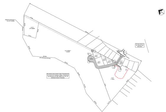
A copy of the approved Vegetation Management Plan (VMP) and subdivision plans are attached to this report.
1.2. Description of the proposed development
This application seeks approval for a Modification to Condition 9, 40 and 53 of the Consent for the Approved Subdivision One (1) Lot into Three (3) Lots. The conditions to be modified relate to habitat compensation, creation of easements and completion of Vegetation Management Plan works respectively. The proposal seeks consent to remove condition 9 and modify conditions 40a) and delete the second paragraph of 53. Conditions 9, 40a) and 53 currently read as follows:
|
9. |
Habitat compensation works required by development consent 10.2015.177.1 to be substantially completed Certification from a suitably qualified ecologist to be submitted to Council prior to the issue of the Subdivision Works Certificate. certifying that Plantings and/or restoration works required as compensation for the clearing of native vegetation approved by development consent 10.2015.177.1 are to be substantially implemented in accordance with the approved plan titled ‘Vegetation Management Plan – Lot 12 DP11189646 – Bayshore Drive, Byron Bay’ prepared by Blackwood Ecological Services and dated 28/07/2015 Note: for the purposes of this condition, ‘substantially implemented’ means that all primary weed control and planting works required by the approved plan referenced above have been completed. |
|
40. |
Section 88B Instrument - Infrastructure A Section 88B Instrument and one (1) copy are to be submitted with the application for a subdivision certificate. The final plan of subdivision and accompanying Section 88B Instrument are to provide for: A 25-metre ecological buffer be provided over Lot 1 from the western boundary with Lot 3 to prohibit any development in this area other than VMP works.
|
|
53. |
Completion of Vegetation Management Plan works Prior to the issue of a Subdivision Certificate for Stage 1, a monitoring report from a qualified and experienced ecologist and/or bush regenerator certifying that primary works as defined within the approved Vegetation Management Plan (VMP) for the site have been completed must be submitted and approved by Council. Prior to the completion of Stage 2 works a monitoring report from a qualified and experienced ecologist and/or bush regenerator certifying that vegetation works up to Year 3 as defined within the approved Vegetation Management Plan (VMP) for the site have been completed must be submitted and approved by Council. |
1.3. Description of the site
|
Land is legally described |
LOT: 12 DP: 1189646 |
|
|
Property address |
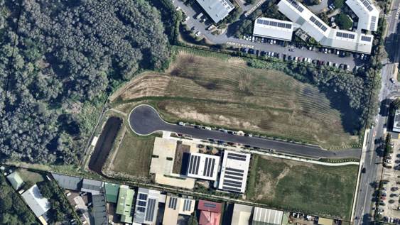
23 Bayshore Drive BYRON BAY. An aerial photograph of the property is shown below (Figure 2). |
|
|
Land is zoned: |
Part B7 Business Park / part DM Deferred Matter Byron LEP 1988. The deferred matter is zoned part 2V (Village Zone) and part 4A (Industrial Zone) under Byron LEP 1988 (refer to Figure 3). |
|
|
Land area is: |
5.815 m2 |
|
|
Property is constrained by:
|
Bushfire prone land – northern portion of the site Acid Sulfate Soils Class 3 High Environmental Value land Proximity land to coastal wetlands Biodiversity Values Map |
|
|
|
Is a BDAR required due to the location of the proposed development? |
☐ Yes ☒ No |
|
|
Are there any easements in favour of Council affecting the site? |
☒ Yes ☐ No There are easements for services, sewage, water supply and sewer rising main running along the eastern frontage of the site, adjacent to Bayshore Drive. (refer to Figure 4). |
|
|
Is there a Vegetation Management Plan which might affect the proposal? |
☒ Yes ☐ No A VMP was required as a condition of consent for DA 10.2015.1771.1 for tree removal over the site. This is discussed later in this report. |
|
|
Is there a Voluntary Planning Agreement which might affect the proposal? |
☐ Yes ☒ No |
![]()
Figure 1 – Aerial Photograph – Tafe and Internal road constructed.
Figure 2 – Zoning (Byron LEP 2014 and BLEP 1988 combined) – the eastern portion of the site is zoned B7 Business Park (BLEP 2014). The Deferred Matter (DM) is shown white and is zoned part 2V (Village Zone) and part 4A (Industrial Zone) under Byron LEP 1988.
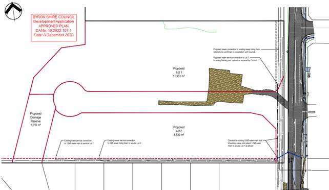
Figure 3 Extract of Approved Subdivision Plan
2. SECTION 4.15 – MATTERS FOR CONSIDERATION – DISCUSSION OF ISSUES
S4.55(1A) Assessment:
Delete condition 9:
Condition 9 requires that habitat compensation works in accordance with the vegetation management plan prepared by Blackwood Ecological Service approved under DA10.2015.177.1 must be completed and certification from an ecologist provided prior to issue of a subdivision works certificate.
Condition 10 of the subject consent requires a Vegetation Management Plan (VMP) to be approved prior to the issue of a subdivision works certificate. The VMP prepared by Geolink in accordance with condition 10 includes ongoing management of the Blackwood Ecological Services VMP from the 2015 consent. Council’s ecologist has reviewed the proposal and recommended that the Condition 9 be removed (E2024/8133) as it is superfluous moving forward with the development.
Accordingly, as the VMP prepared under condition 10 includes the ongoing management of matters described in condition 9, condition 9 may be deleted from the consent.
Modify condition 40:
Condition 40(a) requires that an 88B instrument is created to facilitate a 25m ecological buffer over proposed Lot 1. The location of the ecological buffer is identified as Management Zone 5 in the VMP. The applicant is requesting that this condition be modified to include an exception for works associated with stormwater management.
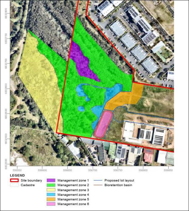
Figure 4 Extract from VMP – Management Zone 5 shows the extent of the easement
The development of Lot 1 will require a further stormwater device to be installed in the form of a bio retention treatment basin to manage and clean stormwater before it leaves the site. The purpose of the buffer is to provide a physical separation between the future development on Lot 1 and the high value vegetation to the west
The applicant submits such stormwater works are not incompatible with the aims and objectives of the ecological setback, and it likely such a bioretention basin and surrounding areas will incorporate native vegetation to help ensure a suitable setback to the more heavily vegetated areas to the west. Such planting as listed in the VMP are likely to include a range of natives such as banksias, tuckeroos, paperbarks, cheese trees, corkwoods, dianellas, lomandras native ferns and other sedges.
It is considered Including an exception for stormwater management works in this easement area will facilitate the (already considered) bioretention basin and is not likely to adversely impact up on the conservation areas of Lot 3. To this end, the Vegetation Management Plan submitted with this modification (discussed above) includes management actions for the easement and notes that the 25m ecological buffer (easement) permits stormwater management measures.
Council’s ecologist reviewed the proposal and agreed that the condition may be modified as requested. It is considered that this condition can be modified as requested.
Modify condition 53:
Condition 53 requires a monitoring report prepared by a qualified ecologist to be provided certifying that primary works defined within the approved VMP have been completed, prior to the issue of a subdivision certificate for Stage 1.
Subsequently, prior to completion of Stage 2, a monitoring report prepared by a qualified ecologist is to be provided certifying that primary works up to year 3 within the approved VMP have been completed.
The applicant submits that the Stage 2 element of this condition is unnecessary and can be removed given the requirements of condition 56, which reads:
|
56. |
Replanting and restoration works Replanting and restoration works must be undertaken and continued until the performance criteria have been achieved in accordance with the approved Vegetation Management Plan for a minimum period of five years, during which annual monitoring reports must be submitted to Council for approval. |
Condition 56 requires that works noted in the approved VMP must be undertaken and continued until the performance criteria of the VMP have been achieved for a minimum period of 5 years, with annual monitoring reports provided.
Condition 56 is located under the heading “to be complied with at all times” in the determination, whereas condition 53 is required to be satisfied prior to the completion of Stage 2 works.
It is submitted that the purpose of condition 53 is to ensure works noted in the VMP are completed to year 3 prior to completion of stage 2 (i.e. limiting completion of stage 2 until year 3 of VMP is complete); conversely, condition 56 serves an alternate purpose: requiring the ongoing submission of monitoring reports to Council and ensuring the ongoing nature of the vegetation management works to a minimum 5 years.
Whist condition 56 ensures that the VMP is enacted for a minimum of 5 years, condition 53 precludes finalising Stage 2 until year-3 VMP works are completed. These conditions overlap but serve individual purpose. Such conditions are imposed to ensure works are completed by the developer to a satisfactory standard. In this instance, it is noted the 2015 VMP requirements were never completed.
As such it is considered reasonable to maintain condition 53 in situ to ensure VMP works are undertaken.
General Assessment Having regard for the matters for consideration detailed in Section 4.15(1) of the Environmental Planning & Assessment Act 1979, the following is a summary of the evaluation of the issues.
|
Is the person who made the application entitled to act on the Consent? |
☒ Yes |
☐ No |
|
Is the modification of minimal environmental impact? |
☒ Yes |
☐ No |
|
Is the development, as modified substantially the same as the development for which the consent was originally granted. |
☒ Yes |
☐ No |
2.1. State/Regional Planning Policies, Instruments, EPA Regulations 2021
Proposed amendments raise no issues under the relevant SEPPS, Policies or clauses of the EPA Regulations 2021
2.2. Byron Local Environmental Plan 2014
Proposed amendments raise no issues under the LEP.
2.3. Draft EPI that is or has been placed on public exhibition and details of which have been notified to the consent authority - Issues
No draft EPIs affect the proposal.
2.4. Development Control Plans
Proposed amendments do not generate any additional issues that have not been previously considered.
2.5. The likely impacts of that development, including environmental impacts on both the natural and built environments, and social and economic impacts in the locality
Proposed amendments do not generate any impacts that have not been previously considered.
2.6. The suitability of the site for the development
Proposed amendments do not affect the Sites Suitability.
3.6 Submissions made in accordance with this Act or the regulations
No Submissions were received.
3.7 Public interest
Proposed amendments are unlikely to prejudice or compromise the public interest.
4. DEVELOPER CONTRIBUTIONS/ WATER AND SEWER CHARGES
There is no nexus to levy additional contributions.
5. Conclusion
The proposal is considered to be substantially the same development and satisfies the provisions under Clause 4.55 of the EPA Act 1979. The proposal as amended raises no issues of significance and is recommended for approval subject to amended conditions of consent.
BYRON SHIRE COUNCIL
Staff Reports - Sustainable Environment and Economy 13.5
Report No. 13.5 PLANNING - 26.2022.11.1 Submissions report, Housekeeping Amendments to Byron Local Environmental Plan 2014
Directorate: Sustainable Environment and Economy
Report Author: Kristie Hughes, Natural Disaster Policy Planner
File No: I2024/212
Summary:
This report presents the exhibition outcomes of housekeeping amendments to Byron Local Environment Plan 2014. The planning proposal includes 7 policy amendments and 4 mapping changes.
13 submissions were received during the exhibition period from 5 December 2023 until 29 January 2024. Majority of submissions were supportive with comments received primarily around amendments to Floor Space Ratio and boundary adjustment provisions.
The report recommends that the planning proposal be sent to PCO for finalisation with changes to Items 3, 6 and 7 as per below (Note. new wording is shown in red/blue):
Item 3 – Amend clause 4.1C - Minimum subdivision lot size for boundary adjustments in certain rural and residential zones to provide increased flexibility for rural boundary changes.
Minor changes to recommended wording in clause 4.2A(3)(b) to reduce ambiguity around dwelling entitlements in relation to rural boundary adjustments, with additional clause references as follows:
(b) is a lot created under this Plan, other than a lot resulting from a subdivision under—
(i) clause 4.2(3), or
(ii) clause 4.1C(3), or
(iii) clause 4.1D(3)(a)(i), or
Item 6 – Proposed to amend Schedule 1 to include an additional permitted use for certain land at Seven Mile Beach Road, Broken Head. After further investigation of the site’s approval history and discussion with the landowner, it was confirmed that the previous Multiple Occupancy approval for this property had been activated. As such this proposed amendment is not required and has been removed from the planning proposal.
Item 7 – Remove from clause 4.2D Erection of dual occupancies (detached) and secondary dwellings in Zones RU1 and RU2, clause 4.2D(2)(c) for dual occupancies (detached) dwellings will be situated within 100 metres of each other, and add the following subclause in 4.2D(2):
(b) the development will not have an adverse impact on agricultural production on neighbouring land and or increase the potential for land use conflict with neighbouring agricultural land uses, and
Removing this subclause acknowledges that siting dwellings further than 100m apart may be appropriate and produce better outcomes in certain circumstances. Other considerations already exist in clause 4.2D and Byron DCP 2014 to minimise land use conflict, ensure development will not impair the use of the land for agricultural purposes and utilise a single vehicular access from a public road.
NOTE TO COUNCILLORS:
In accordance with the provisions of S375A of the Local Government Act 1993, a Division is to be called whenever a motion for a planning decision is put to the meeting, for the purpose of recording voting on planning matters. Pursuant to clause 2(a) under the heading Matters to be Included in Minutes of Council Meetings of Council's adopted Code of Meeting Practice (as amended) a Division will be deemed to have been called by the mover and seconder of all motions relating to this report.
RECOMMENDATION:
That Council:
1. Forwards the attached planning proposal to amend Byron LEP 2014, as revised to include the changes recommended in this report (Attachment E2024/14929), to NSW Parliamentary Counsel’s Office (PCO) requesting that a draft LEP instrument be prepared;
2. Requests confirmation from the NSW Department of Planning, Housing and Infrastructure that the changes made to the planning proposal post-exhibition are of such a minor nature that re-exhibition is not required; and
3. Pending receipt of PCO opinion that the plan can be made, forwards the plan to the NSW Department of Planning, Housing and Infrastructure requesting notification on the NSW Government legislation website.
1 26.2022.11.1
Planning Proposal Housekeeping Amendments to Byron LEP 2014 - Post exhibition
version (as revised) to Council for adoption, E2024/18235
![]()
2 26.2022.11.1
Combined Agency submissions (4) for attachment to Council report, E2024/17536 ![]()
3 26.2022.11.1
Public submissions for attachment to Council report, E2024/11412 ![]()
4 Form
of Special Disclosure of Pecuniary Interest, E2012/2815
![]()
Report
At the Planning Meeting of 10 August 2023, Council resolved 23-314 to proceed with the public exhibition of this housekeeping planning proposal.
The planning proposal contains 7 policy amendments and 4 mapping amendments. The policy amendments are summarised as follows:
· Item 1: Include Zone C4 Environmental Living in clause 4.1AA - Minimum subdivision lot size for strata plan schemes in certain zones.
· Item 2: Remove clause 4.4(2A) - Erection of dwelling houses and dual occupancies on land in certain rural and conservation zones from the Byron LEP 2014.
· Item 3: Amend clause 4.1C - Minimum subdivision lot size for boundary adjustments in certain rural and residential zones to provide increased flexibility for rural boundary changes
· Item 4: Amend clause 6.8(4)(a) - Rural and nature-based tourism development to permit detached dual occupancies.
· Item 5: Amend clause 6.8(3)(a) - Rural and nature-based tourism development to permit access via a classified road.
· Item 6: Amend Schedule 1 to include an additional permitted use for certain land at Seven Mile Beach Road, Broken Head.
· Item 7: Remove clause 4.2D(2)(c) - Erection of dual occupancies (detached) and secondary dwellings in Zones RU1 and RU2, from the Byron LEP 2014.
The planning proposal was placed on exhibition from 5 December 2023 until 29 January 2024. Notification was sent to community groups, directly affected landowners, public agencies, and Tyagarah Airfield lessee/operator as required by the Gateway determination.
During exhibition eight submissions were received from members of the public, four from relevant agencies and one internal staff submission.
Key issues raised in the submissions are summarised and addressed below. A copy of all submissions received is contained in Attachments 1-3.
Summary of the public submissions and staff responses
Item 1: Include the C4 Environmental Living zone in clause 4.1AA Minimum subdivision lot size for community title schemes
Objections: 0 Support: 1
No specific feedback was received for this item, only a general comment of support that encompassed other items.
Recommendation: No change
Item 2: Remove (2A) from clause 4.4 Floor space ratio.
Rationale
Clause 4.4 gives weight to the floor space ratio (FSR) maps within Byron LEP 2014. Subclause (2A) enables applications for dual occupancies in the R2 Low Density Residential zone to have a FSR of 0.5:1, regardless of what is shown in the FSR map for a particular area. This subclause, which has been carried forward from Byron LEP 1988, is inconsistent as some areas intentionally have an FSR of less than 0.5:1 to minimise the bulk/scale of development, protect environmental features and or reduce risk to hazards (e.g. flooding). This inconsistency currently promotes construction of a larger dual occupancy over a dwelling house (i.e. with lower FSR) in identified sensitive or constrained areas.
Objections: 2 Support: 1
|
Submission Issues |
Staff comment |
|
A reduction in the maximum FSR for dual occupancy development will restrict the provision of infill development and new housing. Concern that projects currently in the design phase would be impacted by proposed changes. If this change is made, will there be a savings provision to allow Development Applications already submitted to be determined using the current controls? |
This FSR change does not alter the land use permissibility. The removal of clause 4.4(2a) ensures that dual occupancies in the R2 zone will be of a suitable scale having regard to the FSR of the land, and environmental constraints.
|
|
The clause was not a provision carried over from Byron LEP 1988 as suggested. The Clause in Byron LEP 1988 provided a blanket FSR for dual occupancies when the LEP did not have a general FSR provision. Clause 4.4(2A) provides an incentive for landowners to provide for dual occupancy developments on their residential land.
This proposed change is contrary to the State Government’s policy intentions released in November last year of facilitating more dual occupancies in all R2 low-density residential zones across all of NSW. It will frustrate the further provision of dual occupancy developments at a time when Council should be encouraging better utilisation of its existing residential land stock.
|
LEP 2014 clause 4.4(2A) was carried over from clause 17(7) of Byron LEP 1988.
The State Government’s policy change is to make dual occupancies permissible in all R2 zones across NSW, and seeks to introduce smaller minimum lot size and FSR requirements only within the Greater Sydney area. The removal of clause 4.4(2a) does not alter the land use permissibility and ensures that dual occupancies in the R2 zone will be of a suitable scale, having regard to the FSR of the land, character and environmental/hazard constraints. |
Recommendation: No change
Item 3: Amend Rural boundary adjustment clause 4.1C
Council resolved (21-174) in June 2021 to consider this clause in a future housekeeping planning proposal, pending the outcome of rural planning reforms from Department of Primary Industries. Although these reforms have not progressed it is considered necessary to amend this clause in order to ensure it is fit for purpose without creating unintended outcomes.
Objections: 0 Support: 4
|
Submission Issues |
Staff comment |
|
Amendment to cl 4.1C will provide for improved agricultural and ecological outcomes without resulting in additional dwelling entitlements. |
Noted. Proposed amendments seek to ensure 4.1C is fit for purpose without creating unintended outcomes |
|
Supported. Interpretation of the current provisions has hampered boundary adjustment between my property and a neighbour’s property which is practical and will provide for a better agricultural outcome for the land. |
Noted. As per comments above. |
|
Internal Staff Feedback: In one of the Lismore house-keeping amendments some ‘exclusion’ provisions in the dwelling entitlement clause (Lismore LEP 4.2B(2)) were included. The Lismore dwelling entitlement clause now refers to the boundary adjustment clause and the split zone subdivision clause, ensuring all 3 clauses talk to each other. Thus, removing any ambiguity when regarding dwelling entitlements. |
Agreed, the additional clause references add clarity and eliminate potential confusion/conflicts between these clauses in relation to dwelling entitlements. Therefore, further proposed wording has been included in clause 4.2A(3) of the attached planning proposal for consideration. |
Recommendation: That clause 4.2A(3) be amended to read as follows:
(3) Development consent must not be granted for the erection of a dwelling house or a dual occupancy on land to which this clause applies unless the land—
(a) is a lot that is at least the minimum lot size shown on the Lot Size Map in relation to that land, or
(b) is a lot created under this Plan, other than a lot resulting from a subdivision under—
(i) clause 4.2(3), or
(ii) clause 4.1C(3), or
(iii) clause 4.1D(3)(a)(i), or
This amendment has been made and is Item 6 in the revised planning proposal (Attachment 1) for consideration.
Item 4: Remove "attached" from clause 6.8 Rural and nature-based tourism development - (4) (a).
Objections: 0 Support: 1
No specific feedback was received for this item, only a general comment of support that encompassed other items.
Recommendation: No change
Item 5: Remove “other than a classified road” from clause 6.8 Rural and nature-based tourism development – (3)(a).
AND
Add a new consideration to subclause 3 as follows:
(3)(b) “where that road is a classified road, vehicular access to and from the road must be safe, ensure the safety, efficiency and ongoing operations of the classified road, and it must be demonstrated that alternate access from a road other than a classified road is not practicable or safe”
Objections: 0 Support: 2
|
Submission Issues |
Staff comment |
|
Support a merit-based assessment of vehicular access via classified road for certain rural and nature-based tourism development. |
Noted. |
Recommendation: No change.
Item 6: Insert the following into Schedule 1 Additional Permitted Uses, as a carryover from clause 17 in Schedule 8 of Byron LEP 1988:
"Lot 3, DP 599728, development for the purpose of four dwelling-houses for a multiple occupancy is permitted with development consent"
Objections: 0 Support: 1
|
Submission Issues |
Staff comment |
|
Biodiversity, Conservation and Science (Department of Climate Change, Energy, the Environment and Water): Notes that this issue has arisen by not transferring the “Additional Permitted Uses” (APU) from the Byron LEP 1988 to the Byron LEP 2014 and that the portion of Lot 3 in question is currently zoned C3 - Environmental Management under the 2014 LEP.
The C3 zoned land on Lot 3 contains littoral rainforest which is listed as an endangered ecological community under the Biodiversity Conservation Act 2016 and as a critically endangered ecological community under the Commonwealth Environment Protection and Biodiversity. The vegetation is also mapped as High Environmental Value (HEV) land by the Byron Shire Council.
Strategy 3.1 of the North Coast Regional Plan 2041, requires strategic planning and local plans to consider the protection of biodiversity values, including by focusing land use intensification away from HEV land and using planning mechanisms to protect that land. We note, existing dwellings are located within the C3 zoned land adjacent to Seven Mile Beach Road.
Given the conservation value of the vegetation found on this portion of Lot 3, BCS would not ordinarily support amending the 2014 LEP to allow for further dwellings to be constructed on Lot 3. However, we recognise the planning proposal seeks to ensure fairness and equity by adding the previous additional permitted use into the Byron LEP 2014 that enabled four dwellings to be constructed on the site within a fixed building envelope adjacent to Seven Mile Beach Road subject to development consent for multiple occupancy. Limiting future dwellings to this small building envelope will ensure development does not occur in the littoral rainforest on the remainder of the site.
|
Noted. After further investigation of the site’s approval history and discussion with the landowner, it was confirmed that the previous Multiple Occupancy approval for this property (DA 90/252 for 3 dwellings + studio) has been activated as there is already an approved dwelling & studio on the land. There is also a Voluntary Conservation Agreement covering more than> 90% of the property that was registered on 6 December 2021. In light of this information, it is considered unnecessary to bring forward the APU provisions from clause 17 in Schedule 8 of Byron LEP 1988, into Byron LEP 2014. Accordingly this item has been removed from the planning proposal.
|
Recommendation: remove item 6 from this planning proposal.
This amendment has been made to the revised planning proposal for consideration.
Item 7: Remove subclause 2(c) from clause 4.2D - Erection of dual occupancies (detached) and secondary dwellings in Zones RU1 and RU2 in LEP 2014
Rationale
Subclause 2(c) requires dual occupancies to be situated within 100m of each other.
Removing this subclause acknowledges that siting dwellings further than 100m apart may be appropriate and produce better outcomes in certain circumstances.
Other considerations already exist in clause 4.2D and Byron DCP 2014 to minimise land use conflict, ensure development will not impair the use of the land for agricultural purposes and utilise a single vehicular access from a public road.
Objections: 1 Support: 2
|
Submission Issues |
Staff comment |
|
Removal of subclause 2(c) supported for following reasons:
· will result in logical and improved outcomes; · can provide improved outcomes in certain circumstances, particularly where existing rural buildings are converted to habitable buildings.
In addition to this LEP amendment, Council should consider amending the DCP 2014, by adding a requirement to undertake ecological enhancement works on a rural property as part of a rural dual occupancy or secondary dwelling, similar to multiple occupancy and community title development requirements. In addition to this LEP amendment, Council should consider requiring a concept landscape plan for all dual occupancies to help nullify any potential adverse impacts in terms of the building of more dwellings in the rural zones that may be in highly visible locations. |
Noted.
Outside scope of this planning proposal. However can be investigated as part of next housekeeping DCP.
As per above, this amendment could be further investigated as part of a future housekeeping DCP. The current DCP controls for urban areas (chapter B9 landscaping) require a minimum landscaped area.
|
|
Department of Primary Industries – Agriculture:
The proposed amendment to Clause 4.2D of Byron LEP 2014 has the potential to impact agricultural activities in rural areas.
The existing requirement for a maximum 100 metre separation distance between dwellings benefits agriculture by requiring clustering of dwellings in rural areas. This; · reduces the dispersal of sensitive receptors which impact the ability of adjoining farmers to intensify production systems. · ensures that these types of developments would only occur where the landowner is comfortable having the second dwelling close to the existing dwelling, promoting use by family and farm workers. · reduces the pressure on Council to then enable subdivision of the land. · minimises the potential for dwellings to be spread along neighbouring property boundaries which can lead to land use conflict with agricultural land uses.
It is noted clause 4.6 of the Byron LEP already enables the variation of the 100m separation distance where there are sufficient planning grounds to justify the contravention, and the standard is unreasonable or unnecessary in the circumstances.
If Council finds this clause too restrictive an alternative may be to vary clause 4.2D(2)(c) such that
“(c) …dwellings will be situated within 100 metres of each other, unless another siting produces a superior planning outcome.”
or wording to that effect.
While not supported by NSW DPI, if a decision is made to proceed with the amendment to remove clause 4.2D(2)(c) entirely, it is strongly recommended that Council consider strengthening the provisions in Byron LEP 2014 which require consideration of the impact of residential development on agriculture. While clause 4.2D requires that a proposed dual occupancy development does not impair the agricultural use of that land, it does not require consideration of the potential impacts on neighbouring agricultural land.
It is recommended that Council include an additional provision that dual occupancies (detached) in the RU1 and RU2 zones do not have an adverse impact on agricultural production on neighbouring land and do not increase the potential for land use conflict with neighbouring agricultural land uses.
|
Siting of dwellings is determined by several planning controls which are considered at the Development Application stage. However, based on the matters raised by DPI at left, it is agreed that the siting of a dwelling should not impact on or create land use conflicts with agricultural land uses — both within and surrounding the subject land. Therefore, it is recommended that an additional subclause be added to 4.2D(2) so that consideration is given to agricultural land uses on neighbouring land. |
Recommendation: that the following new subclause is added to 4.2D(2) so that consideration is given to neighbouring agricultural land uses:
(b) the development will not have an adverse impact on agricultural production on neighbouring land and or increase the potential for land use conflict with neighbouring agricultural land uses, and
This amendment has been made to the revised planning proposal for consideration.
Items 8-11: No objections were received to the minor mapping changes proposed, except:
Item 8: Increase the Floor Space Ratio (FSR) from 0.2:1 to 0.3:1 for certain areas in Suffolk Park and New Brighton.
|
Submission Issues |
Staff comment |
|
Oppose increase in the FSR from .2:1 to .3:1 because it will create structures that are too bulky that impede, sunshine and breeze. It will also create mega mansions on some lots. |
Many existing single dwellings within these areas already exceed the 0.2:1 FSR. The increased FSR does not exempt the larger lots from considering other physical constraints including vegetation from controlling the size of structures. The DCP also contains existing controls that require consideration of the bulk and scale of buildings and the access to sunshine and breeze corridors. |
Recommendation: No changes for items 8-11.
Next steps
It is recommended that Council adopt the planning proposal with the changes recommended in this report. Should Council proceed, the planning proposal will be sent to Parliamentary Counsel for legal drafting and to the Department of Planning, Housing and Infrastructure for finalisation.
Strategic Considerations
Community Strategic Plan and Operational Plan
|
CSP Objective |
CSP Strategy |
DP Action |
Code |
OP Activity |
|
4: Ethical Growth |
4.1: Manage responsible development through effective place and space planning |
4.1.4: LEP & DCP - Review and update the Local Environmental Plan and Development Control Plans |
4.1.4.2 |
Review and update Local Environmental Plan and Development Control Plans to reflect strategic land use priorities and/or legislative reforms |
Recent Resolutions
· 23-314 (10 August 2023) Housekeeping Amendments to Byron Local Environmental Plan 2014
· 22-555 (13 October 2022) Amendments to Byron Local Environmental Plan 2014
Legal/Statutory/Policy Considerations
This planning proposal will amend the Byron Local Environmental Plan 2014.
Financial Considerations
This is a Council initiated planning proposal funded through the existing operational budget.
Consultation and Engagement
The planning proposal was placed on exhibition between 5 December 2023 until 29 January 2024. Notification was sent to community groups and landowners of site-specific amendments, including Tyagarah Airfield lessee/operator as per the Gateway determination.
The following agencies were also notified:
· Rural Fire Services
· Transport for NSW
· Biodiversity, Conservation and Science
· Department of Primary Industries Agriculture
BYRON SHIRE COUNCIL
Staff Reports - Sustainable Environment and Economy 13.6
Report No. 13.6 PLANNING - S4.55(1A) 10.2021.857.3 - Modifiction to Design of Dual Occupancy (Attached) including Use of Unauthorised Built Works at 2/16 Peter Street, South Golden Beach
Directorate: Sustainable Environment and Economy
Report Author: Ben Grant, Planner
File No: I2024/227
Proposal:
|
Modification No: |
10.2021.857.3 |
|
Planning Portal Ref. |
PAN-369128 |
|
Proposed modification: |
Modification to Design of Dual Occupancy (Attached) including Use of Existing Built Works and Use of Ancillary Outbuilding |
|
Original Development: |
Alterations and Additions to Dual Occupancy Dwelling |
|
Type of modification sought: |
4.55(1A) Modifications involving minimal environmental impact |
|
Property description: |
LOT: 2 SP: 104068 |
|
Unit 2, 16 Peter Street SOUTH GOLDEN BEACH |
|
|
Parcel No/s: |
270923 |
|
Applicant: |
Mr M J Bruvel |
|
Owner: |
Mr M J Bruvel & Ms B J Dann |
|
Zoning: |
R2 Low Density Residential zone |
|
Date received: |
9 November 2023 |
|
Original DA determination date: |
16 June 2022 |
|
Integrated Development: |
No |
|
Public notification or exhibition: |
- Level 2 advertising under the Byron Shire Council Community Participation Plan. - Exhibition period: 17 November 2023 to 30 November 2023. - Submissions received: Nil |
|
Planning Review Committee: |
Not applicable |
|
Delegation to determination: |
Referred to Council
|
|
Issues: |
· Existing development not in accordance with consent. · Inconsistency with Chapter C2 of DCP 2014 – more than 50% weatherproof area below the 2050 Flood Planning Level. · Additional shed with 450mm front boundary setback. |
Summary:
This Section 4.55(1A) application seeks approval for design modifications to an approved dual occupancy (attached) at 2/16 Peter Street, South Golden Beach. The proposed modifications include the use of an existing living room extension and ancillary storage shed that have been constructed in contravention of the approved plans and conditions of consent.
The original development consent permitted alterations and additions comprising a new kitchen, study, bedroom, laundry, covered deck, and changes to the upper level and external roof form. Conditions 2 and 4 of the consent also stipulated that a proposed storage shed in the front yard was to be deleted from the plans due to the building having a nil boundary setback which contravened Chapter D1, Part D1.2.2 Setbacks of Byron DCP 2014.
The landowner commenced building works in late 2022 without obtaining a construction certificate. The design was modified during construction by enclosing a 10m2 portion of the front deck which was incorporated into the living room area. The landowner also constructed the storage shed that had been excluded from the consent. It is understood that the dwelling is currently occupied without an occupation certificate having been issued.
This assessment finds that the modified floor plan is acceptable, despite a minor variation to the Flood Planning Matrix under Part C2.3.3 of Byron DCP 2014 which provides that dwelling additions below the projected 2050 Flood Planning Level should be limited to no more than 50% of the ‘weatherproof area’ of the original dwelling. The proposed extension results in a weatherproof area of 53m2, which exceeds the development control by only 6.5m2. The additional floor area is relatively minor and will not significantly alter flood behaviour in a way that increases flood affectation to other properties, and is considered a acceptable in this instance.
The storage shed constructed in the front yard however is setback less than half a metre from the front boundary and 0.3m meters from the side boundary. It is clearly in breach of Councils setback controls of 4.5 metres from the front boundary and 0.9m from the side boundary under DCP 2014, detracts from the streetscape, and sets a dangerous precedent of building first and obtain approval after the fact. Whilst there is some variation in the alignment of buildings along Peter Street, there are no examples of buildings with similarly reduced setbacks to justify such a large variation to the development control in this instance. Further, support for the shed if approved erodes Councils planning controls. As such, the shed in its current position is not supported and conditions to apply for its removal.
Other than the shed, the section 4.55 application is recommended for partial approval subject to the Recommended Modifications in Attachment 1 to this Report.
NOTE TO COUNCILLORS:
In accordance with the provisions of S375A of the Local Government Act 1993, a Division is to be called whenever a motion for a planning decision is put to the meeting, for the purpose of recording voting on planning matters. Pursuant to clause 2(a) under the heading Matters to be Included in Minutes of Council Meetings of Council's adopted Code of Meeting Practice (as amended) a Division will be deemed to have been called by the mover and seconder of all motions relating to this report.
That:
1. Pursuant to Section 4.55 of the Environmental Planning and Assessment Act 1979, that Application No. 10.2021.857.3 for Modification to Design of Dual Occupancy (Attached) including Use of Existing Built Works be approved by modifying development consent number 10.2021.357.1 in accordance with the Recommended Amended Conditions of Consent in Attachment 1.
2. The matter be referred to Council’s Community Enforcement Team to take further compliance action where necessary in the event landowner does not act on the modified consent should approval be granted.
1 10.2021.857.3
Recommended Modified Conditions of Consent, E2024/17261
![]()
2 10.2021.857.3
Modified Plans for Approval, E2024/18265
![]()
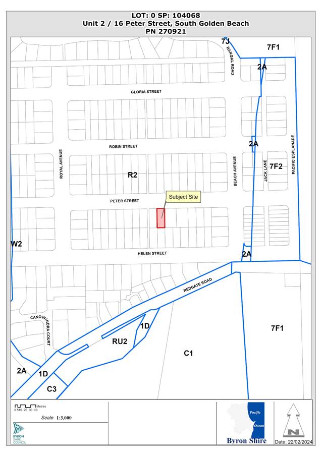 Assessment:
1. INTRODUCTION
1.1. History/Background
DA 10.2021.857.1 – alterations and additions to dual occupancy (attached)
On 16 June 2021, Council granted consent to development application 10.2021.857.1 for alterations and additions to an existing dual occupancy (attached) at 2/16 Peter Street, South Golden Beach.
Development not in accordance with consent and no construction certificate
The landowner commenced building works in late 2022 without obtaining a construction certificate; although it appears that a Plumbing Approval and Roads Act Approval were obtained. The design was also modified during construction by enclosing a 10m2 portion of the front deck which was incorporated into the living room. The landowner also constructed a storage shed in the front yard which had been excluded from the approval. It is understood that the dwelling is currently occupied without an occupation certificate having been issued.
1.2. Description of the proposed development
This application seeks approval to modify the design of a dual occupancy (attached) including the use of a living room extension and storage shed which have been constructed in contravention of the approved plans and conditions of consent. All the works were constructed without a construction certificate being obtained.
The following design modifications are sought:
(1) Use of 10m2 of additional habitable floor space within the proposed living room.
(2) Use of a 15m2 shed which has been constructed in the front yard. The shed had been crossed off the stamped plans and was excluded from the consent via conditions 2 and 4.
Councillors should note that a construction certificate cannot be issued retrospectively to authorise existing building work. Therefore, this application seeks approval for the ‘use’ of all the alterations and additions that were approved under the development consent in addition to the living room extension and shed that are inconsistent with the original approved plans. Should approval be granted to the modification application, it is recommended that a Building Information Certificate be obtained for all new building work that was constructed without a construction certificate being issued.
A comparison of the approved plans and the ‘as-built’ plans are shown below:
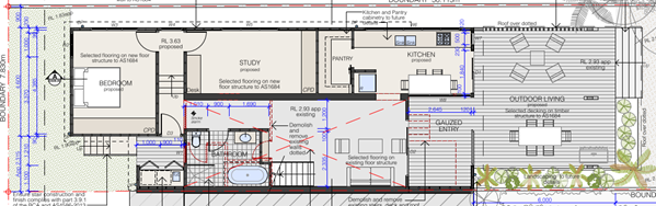
Figure1: Extract of approved ground floor plan.
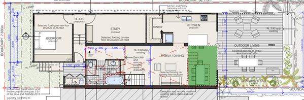
Figure 2: Extract of ‘as-built’ ground floor plan. Additional floor is highlighted in green.
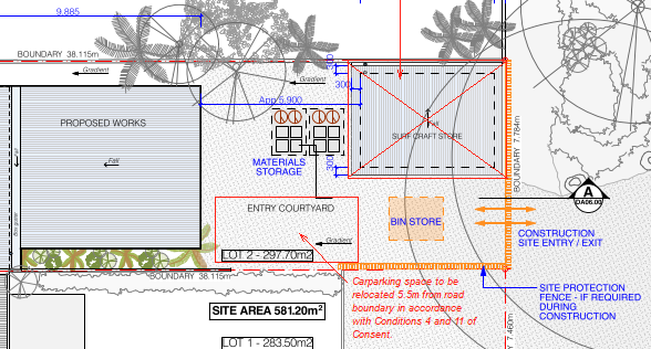
Figure 3: Extract of stamped plans with shed excluded from approval.
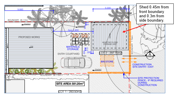
Figure 4: Extract of modified site plan showing shed location to boundaries.
1.3. Description of the site
The site was inspected on 10 January 2024.
|
Land is legally described |
LOT: 2 SP: 104068 |
|
|
Property address |
Unit 2 16 Peter Street SOUTH GOLDEN BEACH |
|
|
Land is zoned: |
R2 Low Density Residential |
|
|
Land area is: |
327 m2 |
|
|
Property is constrained by: |
Acid Sulfate Soils Class 2 |
|
|
|
Is a BDAR required due to the location of the proposed development? |
☐ Yes ☒ No |
|
|
Are there any easements in favour of Council affecting the site? |
☐ Yes ☒ No |
|
|
Is there a Vegetation Management Plan which might affect the proposal? |
☐ Yes ☒ No |
|
|
Is there a Voluntary Planning Agreement which might affect the proposal? |
☐ Yes ☒ No |
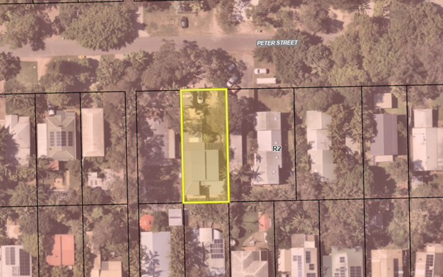
Figure 5: Aerial image of subject site with R2 Low Density Residential zoning overlay.
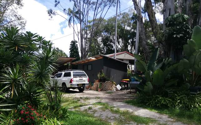
Figure 6: View of site from Peter Street.
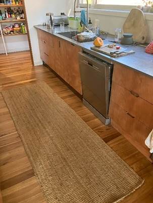
Figures 7 and 8: Expanded kitchen floor area and covered deck.

Figures 9 and 10: Shed in front yard and new extension (west elevation).
2. SUMMARY OF REFERRALS
|
Referral |
Issue |
|
Development Engineer |
Council’s Development Engineer did not support the proposed modification due to non-compliance with Chapter C2 of Byron DCP 2014 which provides that extensions to existing dwellings below the projected 2050 Flood Planning Level should be limited to a maximum of 50% of the original weatherproof area of the building. The development as constructed exceeds this limitation by 6.5m2. The proposed variation to DCP Chapter C2 is addressed further in sections 3.2 and 3.4 of this report. It is noted that the variation will not alter flood behaviour or flood affectation to surrounding properties. The Development Engineer’s key concern is that the proposal may potentially set an undesirable precedent with respect to development in flood prone areas. However having regards to the minor nature of the additional floor area it is supported in this instance. |
|
Building Surveyor |
Council’s Building Surveyor inspected the site and noted that the works were generally satisfactory and complied with the deemed to satisfy provisions of the BCA. A Building Information Certificate will be required to be obtained prior to the issue of an occupation certificate. |
3. SECTION 4.15 – MATTERS FOR CONSIDERATION – DISCUSSION OF ISSUES
Having regard for the matters for consideration detailed in Section 4.15(1) of the Environmental Planning & Assessment Act 1979, the following is a summary of the evaluation of the issues.
|
Is the person who made the application entitled to act on the Consent? |
☒ Yes |
☐ No |
|
Is the modification of minimal environmental impact? |
☒ Yes |
☐ No |
|
Is the development, as modified substantially the same as the development for which the consent was originally granted. |
☒ Yes |
☐ No |
3.1. State/Regional Planning Policies, Instruments, EPA Regulations 2021
State Environmental Planning Policy (Resilience and Hazards) 2021
Chapter 2 Coastal management
The site is approximately 270m from Yelgun Creek and is within the Coastal Use Area and Coastal Environment Area.
The proposed modifications are relatively minor in nature and will not have a significantly adverse impact on the coastal environment. The modified development is satisfactory having regard to the matters for consideration under Chapter 2 of this policy.
Chapter 4 Remediation of land
Land contamination was considered during the assessment of the original development application and the site was found to be suitable for ongoing residential use in its current state.
State Environmental Planning Policy (Sustainable Buildings) 2022
Chapter 2 Standards for residential development—BASIX
A BASIX certificate has been provided with the modification application. Commitments for energy water and thermal comfort have been shown on the plans.
Environmental Planning and Assessment Regulation 2021
Section 61 Additional matters that consent authority must consider
A condition is recommended requiring any demolition works required for removal of the storage shed to be carried out in accordance with AS2601–2001 the demolition of structures.
3.2. Byron Local Environmental Plan 2014
Clause 4.3 Height of buildings
A maximum building height of 9m applies to the site. The proposed storage shed has a maximum height of 3.1m. The proposed modifications to the dual occupancy (attached) dwelling have a maximum height of 3.8m.
Clause 4.4 Floor space ratio
The maximum floor space ratio for the site is 0.5:1.
The proposed modifications (including the shed) contribute an additional 25m2 of gross floor area resulting in a floor space ratio of 0.45:1 as shown in the table below:
Table 1: FSR calculation
|
Site Area |
581.2 m2 |
|
Unit 1 GFA |
110m2 |
|
Unit 2 Approved GFA |
124m2 |
|
Unit 2 Proposed Additional GFA |
25m2 |
|
Total GFA |
259m2 |
|
FSR |
0.45:1 |
Clause 5.21 Flood planning
The site is affected by flooding from Yelgun Creek to the west and is within the North Byron Flood Planning Area. The modified proposal is considered to be acceptable from a flood planning perspective for the following reasons:
· The increase in habitable floor area is relatively minor (10m2) and relates to the enclosure of a deck area that is within the building footprint. The additional floor area will not significantly increase the intensity or capacity of the residential use and will not adversely affect the safe occupation or evacuation of the building in the event of a flood.
· The additional habitable floor area is supported by metal piers and allows for the free movement of floodwaters beneath the building. In this regard, the modified development will not adversely affect flood behaviour in a way that increases the potential flood affectation of other properties. There is only a minor difference with the original design which has already been assessed as being acceptable from a flooding perspective.
· The modified proposed will not have a significant impact on flood behaviour taking into the likely increase in flood levels as a result of climate change.
The minor additional floor area will not affect the potential of the building to be modified, relocated, or removed if the surrounding area is impacted by flooding or coastal erosion.
3.3. Draft EPI that is or has been placed on public exhibition and details of which have been notified to the consent authority - Issues
There are no relevant draft EPI’s.
3.4. Development Control Plans
Chapter B3 Services
B3.2.3 Stormwater Management
It is not clear if the stormwater drainage system has been correctly constructed given the works were carried out prior to the issue of a construction certificate and no building inspections have been carried out. The proposed stormwater system was meant to discharge via gravity to the drainage easement at the rear of the property.
A condition is recommended requiring a BIC to be obtained prior to the issue of an occupation certificate. Certification of the plumbing and stormwater drainage system must be provided to Council for approval as part of the BIC application and shall be certified as having been correctly installed prior to the issue of an occupation certificate.
Chapter D1 Residential Accommodation in Urban, Village and Special Purpose Zones
D1.2.2 Setbacks from Boundaries
Prescriptive Measure D1.2.2 (1)(a) stipulates a minimum road boundary setback of 4.5m and a minimum side boundary setback of 900mm.
The shed does not satisfy the above development controls, having been constructed with a road boundary setback of 450mm and a side boundary setback of 300mm.
The shed detracts from the visual amenity of the area and is inconsistent with the Objectives and Performance Criteria of Part D1.2.2. In particular, the building does not harmonise with the streetscape in the locality and does not contribute to the general attractiveness of the streetscape by means of good design, appropriate materials, and effective landscaping.
A condition is recommended for the shed to be removed from the land prior to the issue of any occupation certificate.
Chapter C2 Areas Affected by Flood
C2.3.2 Minimum Floor Levels
The Flood Planning Matrix stipulates that dwelling additions shall not have a floor level less than the existing floor level of the building. If the weatherproof area of the extension exceeds 50% of the existing weatherproof area, the extension shall be treated as a new building.
The original dual occupancy building (constructed circa 1984) had a weatherproof area below the 2050 FPL of approximately 31m2 for Unit 2. The new development has a weatherproof area of 53m2 which exceeds the development control by 6.5m2.
Calculations are shown below:
|
Original weatherproof area |
31m2 |
|
Maximum weatherproof area below 2050 FPL (50% increase) |
46.5m2 |
|
Proposed weatherproof area below 2050 FPL: |
53m2 |
|
Extent of variation: |
6.5m2 |
The proposed development is considered to be compatible with the Objectives of Chapter C2 and is acceptable from a flood planning perspective notwithstanding the non-compliance with the development control. The additional 6.5m2 of habitable floor area is unlikely to alter flood behaviour or increase risk to life in the event of a flood.
Refer to Clause 5.21 of LEP 2014 ‘Flood Planning’ for detailed reasons.
3.5. The likely impacts of that development, including environmental impacts on both the natural and built environments, and social and economic impacts in the locality
Flooding impacts
The modified development will not significantly affect flood behaviour or the potential flood affectation of other properties in the area.
Visual impacts
The existing storage shed detracts from the visual amenity of the area and is generally inconsistent with the pattern of building setbacks along Peter Street. A condition is recommended for the shed to be removed from the land prior to the issue of an occupation certificate for the dwelling.
3.6. The suitability of the site for the development
The site is suitable for the modified development, other than the shed as discussed above.
3.6 Submissions made in accordance with this Act or the regulations
The modification application was advertised for a period of 14 days in accordance with the Community Participation Plan. No submissions were received.
3.7 Public interest
Other than the shed the proposal can be supported having regards to the public interest.
4. DEVELOPER CONTRIBUTIONS/ WATER AND SEWER CHARGES
There is no nexus to charge additional development contributions or development servicing levies.
4. CONCLUSION
The Section 4.55 application can be partially supported is recommended for approval subject to amended conditions of consent
BYRON SHIRE COUNCIL
Staff Reports - Sustainable Environment and Economy 13.7
Report No. 13.7 State Government review of short term rental accommodation regulations and the supply of long-term rental accommodation in NSW
Directorate: Sustainable Environment and Economy
Report Author: Shannon Burt, Director Sustainable Environment and Economy
File No: I2024/259
Summary:
An online consultation process is underway 15 February until 14 March 2024 with the release of a discussion paper and online questionnaire.
At the time of Agenda publication, a formal submission had not been drafted by staff.
Instead, a Councillor workshop is scheduled for the 7 March 2024, following which a submission drafted by staff will be provided as a late attachment to this report.
RECOMMENDATION:
That Council makes a submission to the State Government review of short-term rental accommodation regulations and the supply of long-term rental accommodation in NSW taking into consideration the discussions at the Councillor Workshop 7 March 2024.
Report
The Minister for Housing, supported by the Department of Planning Housing and Infrastructure and Treasury is seeking feedback on the current planning policy and regulatory framework for short-term rental accommodation and on options to encourage the supply of long-term rental accommodation.
The policy objectives of the review include:
· Housing policy should prioritise use of residential dwelling stock for long term rental housing
· Balancing short term rental accommodation and its economic benefits with housing availability and affordability, in the context of rising homelessness
· Compliance should be supported by enforceable policy and regulatory settings and reliable and accurate data
· Policy that discourages investment in long term supply of housing or the efficient use of current residential stock should be avoided
An online consultation process is underway 15 February until 14 March 2024 with the release of a discussion paper and online questionnaire.
Feedback is sought on the following:
· How well the current planning and regulatory framework for short term rental accommodation in NSW is balancing benefits to the tourism economy with the potential costs for housing availability and affordability.
· What are the potential policy options including revenue measures, to encourage property investors to make homes available for long term accommodation.
Link to Discussion paper: Short-term rental accommodation | Planning (nsw.gov.au)
Key issues
The Discussion Paper has identified 4 key issues for consultation.
Planning Pathways and requirements
Short Term Rental Accommodation (STRA) is permitted in lawfully constructed dwellings as exempt (no approval) development.
Key issues for Council to consider: is there a need for additional more stringent ‘general requirements or alternate planning pathways for STRA.
Note: Byron Shire is the only LGA in NSW with a 60-day cap for non-hosted STRA across the entire Byron Shire local government area, except for 2 precincts in and around Byron Bay Town Centre and at Brunswick Heads. These controls to come into effect September 2024, after which a period of monitoring and review will follow.
Land Use classification and definition
The current planning and regulatory framework consider STRA as an activity that does not alter the ‘residential accommodation’ land use characterisation of a dwelling.
Key issues for Council to consider: does the current position that STRA does not affect the characterisation of a dwelling hold true. Is STRA too commercialised and inappropriate for residential areas. Need to resolve the conflict of use of a secondary dwelling being deemed as hosted STRA, and vice versa with the use of the main dwelling.
STRA register and compliance
Under the current situation, hosts must register and review STRA dwellings on STRA register. The host and booking platforms must report number of days for each booking. Online booking platform must show STRA dwelling PID.
NSW Fair Trading has a major compliance role in administering the Code of Conduct and the Exclusion Register, but there are no pathways in place for Council’s to refer compliance matters to them at the moment.
Key issues for Council to consider: issues with the functionality, reliability and State administration of the STRA register, lack of booking day data sharing, impediments to enforcement through poor data and off shore data, and the poor integration between Council’s and NSW Fair Trading in terms of STRA compliance roles and responsibilities.
Potential Review measures
The current approach to managing STRA relies solely on a planning and regulatory framework, where local government receives no income/revenue for the cost of monitoring STRA and enforcement for breaches of the planning and regulatory framework. However, in other jurisdictions, revenue measures play a role, and support local government in this regard.
The NSW Government seeks views and comments on the merits, benefits, and costs of potential revenue measures to achieve the policy review objectives with the following guiding principles in mind.
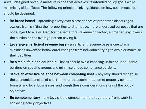
A levy on non-hosted STRA is a favoured option under consideration. The way in which the levy could be applied can take different forms: rental revenue, land value based, location based.
The levy would be collected by the State Government for the State Government. It may also have its own exemption criteria. It would not be collected to assist with the monitoring or compliance of STRA, instead for encouraging the supply of long-term rental accommodation.
Council has long advocated for a income/revenue source to support its monitoring and enforcement of the STRA planning and regulatory framework. Some suggestions to State Government and the Independent Planning Commission during the Planning Proposal process have been:
• STRA registration scheme that Council administers locally with a fee regime to fund administration, auditing, and enforcement.
• Differential rating category of STRA properties under the Local Government Act,
• A local development levy that Council administers to generate funds to cover enforcement and infrastructure demands.
The current Short Term Rental Accommodation Register is administered by the State Government. By their own accounts the current registration fee of $65 for new STRA dwellings and annual renewal of $25 is low compared to other jurisdictions.
Councils responsible for the monitoring and enforcement of the STRA planning and regulatory framework receive no fees from the Register for this work.
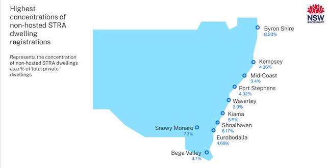
Based on the high concentration of non-hosted STRA in Byron Shire, it is again open, and some would say reasonable for Council to advocate to receive a form of income/revenue to enable monitoring and enforcement of STRA.
Such a request is consistent with Recommendation 8 of the Independent Planning Commission 2023 Advice Report:
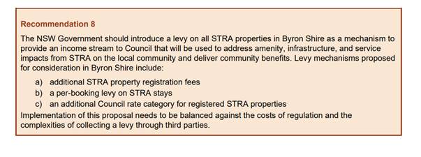
It is also consistent with enabling policy objective 3 of this review: compliance should be supported by enforceable policy and regulatory settings and reliable and accurate data.
The procurement of real time data from reliable external sources and its monitoring and reporting costs Council annually in staff time and operating budget.
Key issues for council to consider: how when and to what should a levy apply. Should councils receive a % of the levy for monitoring and enforcement of STRA in their LGAS. Are there other revenue options for councils? Like those in IPC Recommendation 8?
Strategic Considerations
Community Strategic Plan and Operational Plan
|
CSP Objective |
CSP Strategy |
DP Action |
Code |
OP Activity |
|
4: Ethical Growth |
4.1: Manage responsible development through effective place and space planning |
4.1.4: LEP & DCP - Review and update the Local Environmental Plan and Development Control Plans |
4.1.4.7 |
Progress Short Term Rental Accommodation planning proposal |
Legal/Statutory/Policy Considerations
Relevant NSW Legislation and Regulations Short-term rental accommodation | Planning (nsw.gov.au)
Short-Term Rental Accommodation - Byron Shire Council (nsw.gov.au)
13.13 Update Resolution 23-056 Short Term Rental Accommodation Consent Conditions Agenda of Ordinary Meeting - Thursday, 22 February 2024 (infocouncil.biz)
Financial Considerations
N/A
Consultation and Engagement
N/A
BYRON SHIRE COUNCIL
Reports of Committees - Infrastructure Services 14.1
Reports of Committees - Infrastructure Services
Report No. 14.1 Report of the Local Traffic Committee Meeting held on 13 February 2024
Directorate: Infrastructure Services
File No: I2024/270
Summary:
The attachment to this report provides the minutes of the Local Traffic Committee Meeting held on 13 February 2024 for determination by Council.
Council’s action on the LTC advice will be:
a) If Council is in agreement with the LTC unanimous support then the proposal may be approved. In these cases there is no conflict between Council and the advice of the LTC, consequently there is no need for Council to inform TfNSW or the NSW Police representatives of the decision.
b) If Council is in agreement with the LTC unanimous support, but no longer wants to proceed, the proposal may still be rejected.
c) If Council is in agreement with the LTC unanimous decline then the proposal may be rejected. Again there is no conflict between Council and the advice of the LTC. Consequently there is no need for Council to inform TfNSW or the NSW Police representatives of the decision.
d) If Council decides to proceed with a proposal where the advice of the LTC is not unanimous support, then the Council must first advise the TfNSW and the NSW Police representatives in writing of their intention to approve the proposal. TfNSW or the NSW Police may then lodge an appeal to the Regional Traffic Committee (RTC).
e) If Council decides to proceed with a proposal where the advice of the LTC is a unanimous decline, then the Council must first advise the TfNSW and NSW Police representatives in writing of their intention to approve the proposal. TfNSW or the NSW Police may then lodge an appeal to the RTC.
Due to the fact that the TfNSW and the NSW Police have the power to appeal certain decisions of the Council, the LTC cannot provide its advice to Council until both TfNSW and the NSW Police have provided their vote on the issue.
RECOMMENDATION:
1. That Council notes the minutes of the Local Traffic Committee Meeting held on 13 February 2024.
Report
The attachment to this report provides the minutes of the Local Traffic Committee Meeting of 13 February 2024 for determination by Council. The agenda for this meeting can be located on Council’s website at:
Agenda of Local Traffic Committee Meeting - Tuesday, 13 February 2024 (infocouncil.biz)
This report contains the recommendations of the Local Traffic Committee (LTC) meeting held on 13 February.
Financial Implications
As per the Reports listed within the Local Traffic Committee Meeting of 13 February 2024.
Statutory and Policy Compliance Implications
As per the Reports listed within the Local Traffic Committee Meeting of 13 February 2024.