 Agenda
Ordinary (Planning) Meeting

Thursday, 16 May 2024
Agenda
Ordinary (Planning) Meeting
Thursday, 16 May 2024
Agenda Ordinary (Planning) Meeting
held at Council Chambers, Station Street, Mullumbimby
commencing at 11.00am
Public access relating to items on this agenda can be made between 11:00am and 11:30am on the day of the meeting. Requests for public access should be made to the General Manager or Mayor no later than 12:00 midday on the day prior to the meeting.

Mark Arnold
General Manager
CONFLICT OF INTERESTS
What is a “Conflict of Interests” - A conflict of interests can be of two types:
Pecuniary - an interest that a person has in a matter because of a reasonable likelihood or expectation of appreciable financial gain or loss to the person or another person with whom the person is associated.
Non-pecuniary – a private or personal interest that a Council official has that does not amount to a pecuniary interest as defined in the Code of Conduct for Councillors (eg. A friendship, membership of an association, society or trade union or involvement or interest in an activity and may include an interest of a financial nature).
Remoteness – a person does not have a pecuniary interest in a matter if the interest is so remote or insignificant that it could not reasonably be regarded as likely to influence any decision the person might make in relation to a matter or if the interest is of a kind specified in the Code of Conduct for Councillors.
Who has a Pecuniary Interest? - a person has a pecuniary interest in a matter if the pecuniary interest is the interest of the person, or another person with whom the person is associated (see below).
Relatives, Partners - a person is taken to have a pecuniary interest in a matter if:
· The person’s spouse or de facto partner or a relative of the person has a pecuniary interest in the matter, or
· The person, or a nominee, partners or employer of the person, is a member of a company or other body that has a pecuniary interest in the matter.
N.B. “Relative”, in relation to a person means any of the following:
(a) the parent, grandparent, brother, sister, uncle, aunt, nephew, niece, lineal descends or adopted child of the person or of the person’s spouse;
(b) the spouse or de facto partners of the person or of a person referred to in paragraph (a)
No Interest in the Matter - however, a person is not taken to have a pecuniary interest in a matter:
· If the person is unaware of the relevant pecuniary interest of the spouse, de facto partner, relative or company or other body, or
· Just because the person is a member of, or is employed by, the Council.
· Just because the person is a member of, or a delegate of the Council to, a company or other body that has a pecuniary interest in the matter provided that the person has no beneficial interest in any shares of the company or body.
Disclosure and participation in meetings
· A Councillor or a member of a Council Committee who has a pecuniary interest in any matter with which the Council is concerned and who is present at a meeting of the Council or Committee at which the matter is being considered must disclose the nature of the interest to the meeting as soon as practicable.
· The Councillor or member must not be present at, or in sight of, the meeting of the Council or Committee:
(a) at any time during which the matter is being considered or discussed by the Council or Committee, or
(b) at any time during which the Council or Committee is voting on any question in relation to the matter.
No Knowledge - a person does not breach this Clause if the person did not know and could not reasonably be expected to have known that the matter under consideration at the meeting was a matter in which he or she had a pecuniary interest.
Non-pecuniary Interests - Must be disclosed in meetings.
There are a broad range of options available for managing conflicts & the option chosen will depend on an assessment of the circumstances of the matter, the nature of the interest and the significance of the issue being dealt with. Non-pecuniary conflicts of interests must be dealt with in at least one of the following ways:
· It may be appropriate that no action be taken where the potential for conflict is minimal. However, Councillors should consider providing an explanation of why they consider a conflict does not exist.
· Limit involvement if practical (eg. Participate in discussion but not in decision making or vice-versa). Care needs to be taken when exercising this option.
· Remove the source of the conflict (eg. Relinquishing or divesting the personal interest that creates the conflict)
· Have no involvement by absenting yourself from and not taking part in any debate or voting on the issue as of the provisions in the Code of Conduct (particularly if you have a significant non-pecuniary interest)
RECORDING OF VOTING ON PLANNING MATTERS
Clause 375A of the Local Government Act 1993 – Recording of voting on planning matters
(1) In this section, planning decision means a decision made in the exercise of a function of a council under the Environmental Planning and Assessment Act 1979:
(a) including a decision relating to a development application, an environmental planning instrument, a development control plan or a development contribution plan under that Act, but
(b) not including the making of an order under that Act.
(2) The general manager is required to keep a register containing, for each planning decision made at a meeting of the council or a council committee, the names of the councillors who supported the decision and the names of any councillors who opposed (or are taken to have opposed) the decision.
(3) For the purpose of maintaining the register, a division is required to be called whenever a motion for a planning decision is put at a meeting of the council or a council committee.
(4) Each decision recorded in the register is to be described in the register or identified in a manner that enables the description to be obtained from another publicly available document, and is to include the information required by the regulations.
(5) This section extends to a meeting that is closed to the public.
OATH AND AFFIRMATION FOR COUNCILLORS
Councillors are reminded of the oath of office or affirmation of office made at or before their first meeting of the council in accordance with Clause 233A of the Local Government Act 1993. This includes undertaking the duties of the office of councillor in the best interests of the people of Byron Shire and the Byron Shire Council and faithfully and impartially carrying out the functions, powers, authorities and discretions vested under the Act or any other Act to the best of one’s ability and judgment.
BUSINESS OF Ordinary (Planning) Meeting
1. Public Access
3. Attendance by Audio-Visual Link
4. Requests for Leave of Absence
5. Declarations of Interest – Pecuniary and Non-Pecuniary
6. Tabling of Pecuniary Interest Returns (Cl 4.14 Code of Conduct for Councillors)
7. Adoption of Minutes from Previous Meetings
7.1 Ordinary (Planning) Meeting held on 14 March 2024
8. Reservation of Items for Debate and Order of Business
9. Notices of Motion
9.1 Accessible Beaches....................................................................................................... 8
9.2 Impacts of Urban Stormwater on Receiving Environments.................................. 19
9.3 Modular For Affordable Housing Sydney 19-20 June 2024.................................. 22
9.4 Northern Rivers Compact........................................................................................... 25
10. Mayoral Minute
11. Petitions
12. Delegates' Reports
13. Staff Reports
Corporate and Community Services
13.1 Arakwal National Park and Byron Coast Area Management Committees – Council nominees....................................................................................................................... 27
Sustainable Environment and Economy
13.2 Status report on Development Applications (DAs) with bodies like the Northern Regional Planning Panel (NRPP).............................................................................. 30
13.3 PLANNING - DA10.2008.565.5 - S4.55 modification to modify approved plans for use of alterations and additions – 13 Gaggin Street, New Brighton........................... 37
13.4 PLANNING - DA 10.2023.491.1 - Dual Occupancy (detached) – 541 Federal Drive, Federal........................................................................................................................... 55
13.5 PLANNING - Report of the Planning Review Committee held 4 April 2024....... 74
13.6 PLANNING - DA 10.2023.229.1 - Tourist and Visitor Accommodation Comprising Four (4) Cabins – 131 The Tunnell Road, Billinudgel..................................................... 77
Infrastructure Services
13.7 Tender 2024-2089 Stormwater Management Plan Implementation - Package 1 99
14. Reports of Committees
Infrastructure Services
14.1 Report of the Local Traffic Committee Meeting held on 16 April 2024............. 105
15. Questions With Notice
Questions with Notice: A response to Questions with Notice will be provided at the meeting if possible, that response will be included in the meeting minutes. If a response is unable to be provided the question will be taken on notice, with an answer to be provided to the person/organisation prior to the next Ordinary Meeting and placed on Councils website www.byron.nsw.gov.au/Council/Council-meetings/Questions-on-Notice
Councillors are encouraged to ask questions regarding any item on the business paper to the appropriate Director prior to the meeting. Any suggested amendments to the recommendations should be provided to Councillor Support prior to the meeting to allow the changes to be typed and presented on the screen at the meeting.
Notices of Motion 9.1
Notices of Motion
Notice of Motion No. 9.1 Accessible Beaches
File No: I2024/669
1. Notes that according to Accessible Beaches Australia, no beaches in the Byron Shire are fully accessible to people with disabilities.
a) Some level of lifeguard service
b) A portable mat designed to facilitate wheeled access to the water
c) Access to a public specialty wheelchair for use on water, specifically the Hippocampe style, and
d) Access to a public child-sized Hippocampe style chair
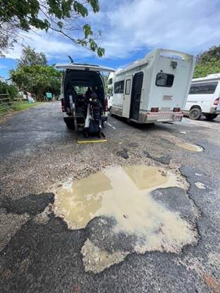
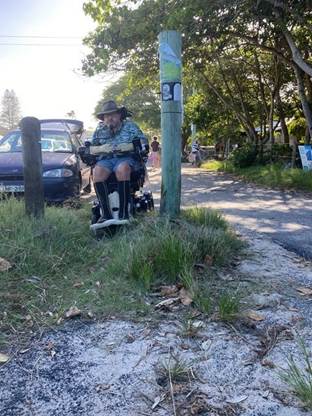
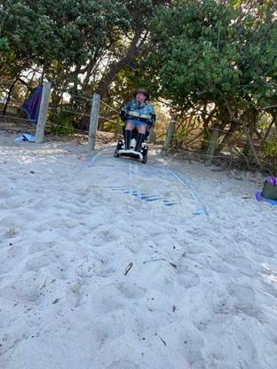
3. Notes that despite having a beach mat, Torakina Beach is currently not accessible and accessibility needs to consider the parking, pathways and adjacent areas as well as the direct beach access.
4. Convenes a meeting including the Access Working Group, Reflections Byron Bay, Arakwal Native Title holders, and all other key stakeholders for the Torakina reserve and beach to develop an action plan to make the beach fully accessible before spring 2024.
5. Works with other key stakeholders such as including the Access Working Group, Bundjalung of Byron Bay Aboriginal Corporation (Arakwal), Reflections Byron Bay, Crown Lands and National Parks to establish prepare a report on the logistics of providing inclusive access at Byron Shire beaches.
6. Develops a plan, codesigned with the Access Working Group, for reaching the objective of providing fully accessible beach access on all Byron Shire beaches, including necessary upgrades at 3 beaches with lifeguard services and 1 dog beach within the next 12 -18 months.
7. Seeks out relevant funding opportunities to develop and implement beach accessibility.
8. Writes to Federal Member for Richmond, Justine Elliot and NSW Minister for Disability Inclusion, Kate Washington to request support for any available federal and state funding streams for accessibility upgrades to Byron Shire beaches.
Attachments:
1 Torakina
beach community feedback February 2024, E2024/50729
![]()
Signed: Cr Sarah Ndiaye, Cr Duncan Dey
Councillor’s supporting information:
The beautiful beaches of Byron Shire are not inclusive places for the significant proportion of our community who live with a disability. Our own Disability Inclusion Action Plan notes that:
· 16.8% of our community live with a disability
· 9.7% care for someone with a disability
· Nationally, 1 in 5 people live with a disability, and 2 in 5 over 65s.
(BSC DIAP 2022-2026)
In this very Disability Inclusion Action Plan, beach access is identified as a “key theme” and it’s stated that Council will “improve beach access” (p14) yet halfway through the term of the plan, little progress has been made. While other factors such as erosion, Covid and the devastating floods have contributed to this, people with mobility issues are excluded from key public places on a daily basis. Members of our community who live with a disability have said that the DIAP’s suggestion that a viewing platform makes a beach accessible was exclusive and insensitive. People who live with a disability want to access the water with ease and dignity, not just look at it.
The incredible successes of the Adaptive Pro Surfing Competition held in Byron in March 2024 and the regular Disabled Surfing Association Australia (DSAA) events held locally, show that with the right tools and adaptations, people who live with a disability can compete in beach sports at an elite level and recreationally. We are the hometown of many pro surfing champs, yet Byron Shire does not give kids or adults living with a disability the same opportunities to excel as their peers.
According to Accessible Beaches Australia’s Beach Directory (https://accessiblebeaches.com/beach-directory) there are no beaches between Nelson Bay and the Gold Coast that are fully accessible. This is not good enough. Byron Shire Council can lead the NSW North Coast in providing fully accessible beaches. This would also have benefits for tourism, as the 1-in-5 Australians who live with a disability would be able to enjoy our beautiful beaches like everyone else.
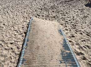
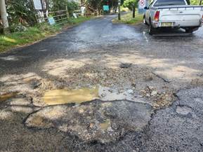
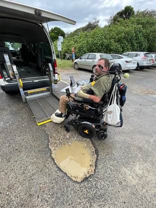
While the beach mat at Torakina was a small step in the right direction, this beach is in no way accessible and in its current poorly-maintained form the mat is dangerous to all beach users. The mat requires regular maintenance; the sand erodes and creates sharp drop-offs at the edge of the mat, and the part of the mat below the high-tide level is frequently buried under a thick layer of soft sand. On a recent visit with a person in a wheelchair, they could not go beyond the end of the dunes. However, even a well-maintained beach mat is inadequate without:
· Addressing the state of the carpark; there are 1.5m wide potholes and so many bumpy patch repairs that this carpark is unsafe to traverse for people in wheelchairs or other mobility issues, particularly those with spinal injuries. The point of connection between the carpark and footpath is misaligned and a motorised wheelchair can’t get onto the footpath without a “run up”. The poor state of the carpark is a risk to people’s equipment. Further, due to sand drift, the grade of the poorly-signposted accessible parking spaces is well beyond the 3% mandated in AS2890 and is unsafe.
· Safe connection to Brunswick Heads town across the river; the bridge upgrade included a pedestrian bridge that abruptly ends on the Torakina side, leaving people to navigate poorly maintained roads, parking cars, potholes, gravel and grass to get to the Torakina footpaths, risking their safety and damaging vital equipment.
· Appropriate changing facilities that meet the Changing Places guidelines (https://changingplaces.org.au/)
· Access to a beach wheelchair (currently stored hundreds of metres up a potholed road at the Surf Club) and a secure, lockable place to store the person’s regular chair
· Adequate signage; no “Accessible Beach” signage was observed on site in mid-April
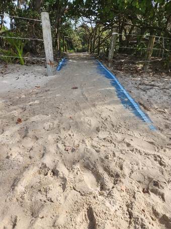
While the first image, taken in late December, may look to a
beach goer like it is a safe and stable surface; the second picture shows that
there was no sand under half the mat making it very easy for any beach user to
topple on. Reflections were made aware of this and did nothing to fix it up all
through that peak summer period.

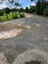
The next image shows the beach access from north of Belongil
Beach which is not accessible.
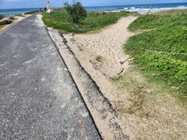
The carpark is also in a terrible state of disrepair adding to the complications in accessing the beach.

Maintaining this beach is ostensibly the responsibility of Reflections, however the Access Working Group and people in the Brunswick Heads community who live with a disability have been repeatedly ignored by Reflections in their efforts to have a conversation about these issues. Council must step in to facilitate an action plan and hold Reflections to account.
Attachment 1 outlines concerns raised by community members,
with further images supplied below demonstrating that this issue has worsened:
Staff comments
by Malcolm Robertson, Manager Open Spaces, Infrastructure Services:
Council is aware of community’s concerns regarding beach accessibility including the need for dignified access to public amenities along the foreshore in the Byron Shire as reflected in the Disability Inclusion Action Plan (2022-2026).
Members of the Access Consultative Working Group (ACWG) have been proactive in raising awareness of the barriers that people with disability continue to face when visiting beaches in the Byron Shire.
As a result, Council recently met with Accessible Beaches Australia and ACWG members in February and March 2024 to discuss concerns and identify solutions, acknowledging that management of these spaces are generally a shared responsibility between Native Title holders, National Parks, Reflections Holiday Park and Council.
Council staff from Open Spaces and Major Projects have also recently attended ACWG meetings to discuss beach accessibility at Main Beach, Byron Bay, ensuring this is integrated into the foreshore masterplan.
Council Progress
In 2018, Council completed an All Abilities Beach Access Report, and identified priority locations at Clarkes Beach, Byron Bay, Main Beach, Byron Bay and Brunswick based on relative usage and geographical equity.
The report proposed four priority areas, however there were significant constraints around all of these locations that Council was not at that time resourced to overcome.
The four priority beaches identified were:
1. Clarkes Beach, Byron Bay:
All abilities access was constructed in 2004 at Clarkes Beach. This was the Byron Shire’s preferred beach due to calmer water conditions.
The active dune system and coastal erosion worked to steadily destroy the constructed path. Dune height at Clarkes beach has varied up to 10m over the last 70 years, and for the first decade following construction there was a constant struggle to prevent the path being absorbed by the dune.
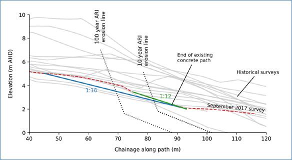
Figure 1: Dunal movements - Clarkes Beach
Coastal erosion is also on a recurrent cycle, and in 2020 a low pressure system drove a storm system that remove around 25m of the seaward end of the concrete path.
Figure 2: Clarkes Beach Accessible Path following storm event.
Following the erosion event The Water Research Laboratory of the School of Civil and Environmental Engineering, UNSW Sydney was commissioned to undertake an options study to restore the structure.
A permanent path in this location would require significant infrastructure and engineering to make it sustainable. To fully withstand coastal processes, a structure in this location would need to be founded on piled footings, which are appropriately designed as friction piles, or founded on bedrock. A structure such as this is not well suited to the subject location due to the high degree beach change there. Such a structure would be best suited to either the Pass or the Jonson Street seawall due to the presence of more stable beaches/structures/natural features at those locations.
For wheelchair access, Australian Standard 1428 Design for access and mobility requires that ramps have a maximum slope of 1V:14H, with flat landings (1200 mm long) provided every 9 m, giving an overall slope of approximately 1V:16H for long ramps. Due to the space required for this form of access, it was recommended that beach access compliant with this standard would best be located in the vicinity of the Pass or the Jonson Street seawall.
A key recommendation from that study was that due to anticipated ongoing variation in the dune a ramp in full compliance with disability access standards would best be located elsewhere in the bay.
Council sought State Government funding towards restoration of the disabled access path, but it was confirmed by both Resilience NSW and the Dept. of Home Affairs that the disabled access path was not considered an essential public asset, and was therefore not eligible for funding.
2. Main Beach, Byron Bay:
The concrete ramp at Main Beach leads to an area where Surf Life Saving patrols are present 7 days per week, however this ramp is currently too steep for safe wheelchair use.
This access at Main Beach also leads to a section of beach that is exposed to wave action and is considered less suitable for many people with disabilities.
Disabled access is a key consideration for the design investigation within the Byron Foreshore Landscape project .and new accessible paths to both Main Beach and Belongil beach are included within designs that will soon be placed on public exhibition.
3. Torakina Beach, Brunswick Heads:
This beach site was selected as a key location by ACWG members, particularly due to safety considerations.
In 2020, Council and the ACWG supported Crown Land Manager, Reflections Holiday Parks to upgrade the beach access at Torakina, provide “mobi matting” and new pathways, however ongoing maintenance has proven problematic for Reflections, and the site does not have any surf patrol.
Council recognises that signage at Torakina Beach could be improved and acknowledges the responsibly for installing these signs lies with Reflections due to their Crown Land Manager role. Council will continue to liaise with Reflections on this matter.
Council acknowledges the current state of the carpark, footpaths and roads near Torakina Beach do not meet community expectations. Renewal of this area has been prioritised and detail design is being finalised with works planned for the 24/25 financial year.
4. South Golden Beach
Southern beach access was preferred as the car park is established and life savers are present at certain time of the year. Current access over the dune was not seen as achievable due to the length of ramp required. A new path to the south of the community hall was suggested, however this runs through Crown managed Crown land, and would require separate Licence agreement for Council to utilise.
Stakeholders consultation in 2018 had identified this location as low on the priority list due to remoteness and low usage.
Requirements for Accessibility
As well as the need for an accessible path and ramps an accessible beach should have;
a) Some level of lifeguard service
b) Accessible parking (multiple available) \close to access points
c) Accessible bathrooms or Changing Places facility
d) Direct beach access from the pathways
e) Beach matting to the water’s edge
f) Beach wheelchairs
g) Access to shade and fresh water
h) Accessible by public transport
i) Food outlets nearby
A portable mat designed to facilitate wheeled access to the water such as the mobi-mat installed at Torakina is essential, however unless there is a calm water or minimal tide movement, these mats need to be removed on a daily basis, or at a minimum when storm events are predicted.
Council has endeavoured to provide access to a specialty beach wheelchairs, and currently has two of these available. These wheelchairs are designed for calm water only, restricting opportunities to safely use these chairs within Byron surf beaches. As a small Council, Byron is also reliant upon volunteers to manage access to the beach wheelchairs, as there are no Council staff or storage locations on hand when peak usage is anticipated.
Council is aware of the need for a Changing Places facility. An accessible bathroom and changing space is needed for people with disability who use mobility aids, particularly wheelchairs. Changing Places facilities have been recommended by Accessible Beaches Australia and requested by Byron Shire community members, including the ACWG.
They are considered best practice when it comes to accessible amenities.
Stakeholders and shared responsibility
Beach access improvements are generally the responsibility of Crown Land Managers. At Torakina Beach this is Reflections Holiday Park. Council has worked with ACWG and other community groups to gather feedback on the improvements needed at Torakina Beach to ensure it is truly accessible. This feedback and the experience of people with lived experience of disability is critical to creating accessible and inclusive spaces. In February 2024, Council provided a summary of feedback to Reflections for consideration and action.
NSW NPWS also have a potential role in providing accessible pathways, as The Pass beach is seen as preferred for many disabled people due to the calmer water. Currently there is no accessible path to this beach area.
Council recognises that collaboration is critical to creating accessible beaches and that our role may vary from advocate to provider to partner depending on circumstances.
In 2018 Council wrote to the Member for Ballina, Minister for Social Services, and Assistant Minister for Social Services and Disability Services seeking support in providing essential beach accessibility infrastructure. Assistant Minister for Social Services and Disability Services at that time responded to Council’s request and was encouraging towards Council’s vision but no suitable funding opportunities were able to be identified.
Financial/Resource/Legal Implications:
Council would be dependent upon grant funding opportunities to develop and implement the suggested beach accessibility program.
Provision of sustainable accessible paths over foreshore dunal systems requires significant engineering. Detail design, including consideration of environmental and cultural impacts around proposed structures, with associated cost estimations would be required prior to submission of grant funding submissions. The impact of ongoing management and maintenance requirements of new assets would also need to be considered within operational budgets.
Is the proposal consistent with any Delivery Program tasks?
|
CSP Objective |
CSP Strategy |
DP Action |
Code |
OP Activity |
|
2: Inclusive Community |
2.5: Create social impact and initiatives that address disadvantage |
2.5.1: Access and inclusion - Improve access and inclusion for all community members, including people with disability |
2.5.1.1 |
Implement, monitor and report on the Disability Inclusion Action Plan 2022-2026
|
Notices of Motion 9.2
Notice of Motion No. 9.2 Impacts of Urban Stormwater on Receiving Environments
File No: I2024/670
1. That Council receives a report on the environmental impacts of discharging urban stormwater from those parts of Mullumbimby that drain south-east onto neighbouring rural properties, including 75 New City Road and 1B Ann Street.
2. The report is to examine impacts of:
a) present quantities & qualities of stormwater, and
b) future quantities & qualities including under full uptake of our growth strategies (including the recently adopted Residential Settlement Strategy).
3. The report is to provide options for ameliorating those impacts, not only through ongoing maintenance of existing drains but also through works like: relocating or enlarging channels; adding treatment devices; changing broadacre landforms; and more.
Signed: Cr Duncan Dey
Councillor’s supporting information:
During consideration of housing options and development of the Residential Settlement Strategy, it was broadly accepted that stormwater has impacts on rural properties south-east of Mullumbimby. Historically, drains were cut there and elsewhere, to make land dry enough for agricultural uses. Such drains were maintained in the sense of silt being removed regularly. The banks of such drains were often steep and inherently unstable. There is a “New City Drain” project afoot now to once again clear the drain that connects Mullumbimby’s stormwater system to Kings Creek.
Arguments were made recently during development of the Residential Strategy that dealing with stormwater could only be done by also developing the properties for urban uses. I disagreed.
The impacts of ever-increasing stormwater do however need proper consideration. With urban densities set to rise, hardstand ratios will increase and direct sorption of rain into soil will decrease. These matters should be considered strategically, without waiting till complaints arise and court cases possibly ensue.
The report sought by this motion moves us in a cooperative and wholistic direction.
Staff comments
by James Flockton, Infrastructure Planning Coordinator, Infrastructure Services:
A report that provides further information can be provided to the August Council meeting. However not all elements will be covered. Provision of some elements of the above recommendation cannot be provided without a funding source, this is discussed further in the financial section.
The following is noted for Council’s consideration:
The urban area in question is quite small in comparison to other urban areas in the shire. Council would achieve much greater environmental improvements targeting other urban drainage networks in the shire. The blue area below shows the area of urban run off entering the drain in question.
Staff are not aware of any urban run off concerns in this drain from an environmental perspective. Staff are aware residents feel the drain needs increased capacity and support any opportunity to increase capacity in this drain to reduce any potential future flood impacts.
Council do not own the land or an easement for which the New City Road Drain flows. Due to historic use and changes in legislation Council is able to legally maintain the drain, but upgrade and improvement as requested may result in the need to negotiate, obtain and pay for an easement along the drain. This would increase costs of such a project.
Staff support the proposal because we should be doing these types of works across the shire to ensure we minimise our environmental impacts from urban run off. The proposal is also in keeping with Council’s adopted Water Sensitive Urban Design Policy.
However, Council does not have sufficient budget to maintain existing infrastructure to an appropriate service level or renew aging infrastructure at a suitable service level or upgrade infrastructure where we have known capacity problems, therefore staff are unsure how Council could realistically afford to complete the proposed project works in the near future without impacting other important works.
Financial/Resource/Legal Implications:
Council has one engineer overseeing flooding and drainage. Given the current weather patterns and the recent floods this resource is not available to investigate present quantities & qualities of stormwater, and future quantities & qualities including under full uptake of our growth strategies. Water quality sampling by a specialist company would also be required to understand current water quality issues properly.
Due to current staff availability this type of work would typically be outsourced to consultants.
There are many options available to improve stormwater quality and manage quantity. Typically for this situation an options assessment as requested would be outsourced to consultants.
To provide everything requested in the proposed resolution Council would need to provide a budget allocation in the 2024/25 budget to the value of $60,000. This will cover consultant fees and project management costs. Staff managing such works are project based and therefore budget is needed to cover their costs as well as consultancy costs.
Is the proposal consistent with any Delivery Program tasks?
No current measure that applies directly to this matter.
Notices of Motion 9.3
Notice of Motion No. 9.3 Modular For Affordable Housing Sydney 19-20 June 2024
File No: I2024/678
1. Recognises the value of Councillors attending conferences to expand and update their knowledge in fields relevant to Council’s activities.
2. Acknowledges that we are in a housing crisis and that modular housing may be one of the primary ways we are able to deliver housing to meet needs in a timely and cost-effective manner.
3. Supports the registration, travel, and accommodation for Cr Ndiaye to attend the Modular for Affordable Housing 2024 Conference in Sydney from 19 to 20 June 2024.
4. Registers Cr Ndiaye before the early-bird fee offer ends on 31 May 2024.
1 Modular
For Affordable Housing - Conference Information, E2024/50728 ![]()
Signed: Cr Sarah Ndiaye
Councillor’s supporting information:
The housing crisis is top of mind for many. As a council, we have been proactive in trying to create reforms that can address these issues but the need is dire. Modular homes may be one of the ways we are able to meet the needs of our community in a timely and cost effective manner.
As a result of the Affordable Housing Contribution Scheme there may be opportunities to utilize modular housing in the short and medium term. Having a councillors up to date on the current opportunities and limitations can help us to make better decisions and I can report findings back to councillors and council staff.
Event Overview (further information in Attachment 1)
According to the parliamentary library research, it was estimated that Australia had a shortfall of 524,000 social housing dwellings in 2022, adding to the already dire situation of the housing crisis. The average price of housing tops out at $1,333,985 as stated by the Australian Bureau of Statistics, which makes it exceedingly difficult to own a home. Even rental prices have gone through the roof. In November 2022, SQM Research reported that rents in Sydney have increased by 28% from the last year to an average of $709 per week. Similar rises have been observed in other cities, with rent increasing by 24% to an average of $574 in Brisbane. If left unchecked, the effects on the economy can be catastrophic if no immediate action is taken to combat this.
The National cabinet & federal government announced in August 2023 that they’ve promised $3 billion and $500 million respectively in incentives to support the building of 1.2 million dwellings over the next 5 years Given the abnormally long period it takes for councils to approve the smallest of construction projects, this move aims to encourage states and territories to quicken the pace of building approvals and housing construction. However, with rising material prices and the introduction of a tariff on imported steel, contractors & builders will face challenges in delivering houses using the conventional way.
With the ability to deliver housing at a faster and cheaper rate, modular construction & prefab methods have been pipped to be an effective solution to the crisis. A modular or prefab house can be completed anywhere from 30% – 50% sooner compared to conventional housing, with 60% – 90% of construction being done offsite in a factory. Additionally, prefab houses are built in an environment where quality and safety is guaranteed. And it gives future home owners limitless options to customize their home according to their need.
With the urgency of building affordable housing, Modular for Affordable Housing by Trueventus is aims to create a premier destination for construction industry professionals to gain insights and experience first-hand on the latest innovations and opportunities in modular & prefab construction. Learn & understand emerging construction technologies that are becoming increasingly leveraged to aid the design and development of modular construction. Many have realized the glaring opportunity stand before them and have begun the transition of modularizing their projects. Don’t get left behind or it may be too late.
Why you cannot miss this event:
• Why modular construction is the way forward for affordable housing?
• Learn how to enhance the prefab buildings design with an architectural approach
• Develop the right digital manufacturing line for precast modules
• Increase the efficiencies of modular construction with DfMA & BIM
• Gain insights from case specific studies on how current players have successfully leveraged modular & prefab construction
• Exploring the applications of steel – hybrid systems for sustainable construction
Staff comments
by Heather Sills, Manager Corporate Services, Corporate and Community Services:
Council is committed to ensuring its Councillors are up to date with contemporary issues facing Council and the community, and local government in NSW.
Councillor attendance at Conferences is subject to the Councillor Expenses and Facilities Policy which stipulates that a resolution of Council is required to authorise attendance.
As per Clause 6.40, in assessing a Councillor request to attend a conference, the following factors should be considered:
1. Relevance of the topics and presenters to current Council priorities and business and the exercise of the Councillor’s civic duties
2. Cost of the event in relation to the total remaining budget.
Council will meet the reasonable cost of registration fees, transportation and accommodation associated with attendance. Estimated registration and associated costs for the Conference are provided below.
Costs: (per delegate)
Registration Fee (Early Bird until end of May 2024) $1,995
Accommodation (3 nights) $ 900*
Travel (Flights) $ 300*
Total: $ 3,199*
*Approximate
This does not include meal allowances and additional travel expenses to and from the conference.
Should the registered delegate be unable to attend, a substitute delegate is able to attend at no extra charge. Trueventus does not provide refunds for cancellations.
Delegate report
Following the Conference, Councillor/s are requested to submit a delegate’s report in writing to an Ordinary Meeting of Council on the aspects of the conference, seminar, workshop, or function relevant to Council business and or the local community.
Financial/Resource/Legal Implications:
Councillor Expenses and Facilities Policy
The allocation to Conferences within the 2023/24 budget (2145.4) has been fully expended for the financial year.
Is the proposal consistent with any Delivery Program tasks?
|
CSP Objective |
CSP Strategy |
DP Action |
|
4: Ethical Growth |
4.2: Enable housing diversity and support people experiencing housing insecurity |
4.2.2: Partnerships and pilots to address housing needs - Investigate partnerships and pilots that deliver an innovative and affordable housing model for the Shire |
Notices of Motion 9.4
Notice of Motion No. 9.4 Northern Rivers Compact
File No: I2024/702
I move:
That Council endorses the Northern Rivers Compact for signing by the Mayor, in his role as Chair of the Northern Rivers Joint Organisation.
1 Confidential - Northern Rivers Compact Draft, E2024/51702
Signed: Cr Michael Lyon
Councillor’s supporting information:
Regional cooperation has been a major theme since the natural disaster events of 2022. To this end there has been regular meetings of the Northern Rivers Leader’s Forum, a grouping of politicians from Local, State and Federal Governments that discuss issues relating to the recovery of the region following the disasters. The Compact is an MOU between the Northern Rivers Leader’s Forum, the Reconstruction Authority, the National Emergency Management Agency. It seeks to ensure that through meaningful collaboration and effective coordination, Northern Rivers communities are well-prepared, safe, prosperous and sustainable into the future regardless of future floods and other natural disasters.
Further to this, a regional vision and masterplan is being proposed to be the guiding framework for the Northern Rivers region's future over the short, medium and long-term. It will be a forward-looking plan which considers current and potential challenges and opportunities across four fundamental pillars: economic, social, environmental, and built components, then provide recommendations and an order of priorities for future planning and investment by both the public and private sectors. This is currently being scoped and will be put forward for public consultation in due course.
This NOM is only about the Compact, which is really a shared commitment to work together for the benefit of the region.
Staff comments
by Esmeralda Davis, Director, Corporate & Community Services:
The purpose of the Compact is to embed a shared commitment to collaborative and coordinated implementation of disaster risk mitigation, adaptation and resilience outcomes for the Northern Rivers. It is underpinned by a number of guiding principles aimed at supporting effective collaboration and coordination.
As a partner to the proposed agreement, the NRJO will contribute by providing regional leadership and representing the Northern Rivers, sharing regional context and knowledge, and providing guidance and advice on region-wide recovery programs.
Whilst understanding the needs at a local (Byron Shire) level is absolutely critical to supporting our community with recovery initiatives, collaboration at a regional level will enable meaningful advocacy and support for much needed mitigation, preparedness, response and recovery to natural disaster events.
There are valuable lessons learned from the 2022 flood events and this initiative is viewed as a positive step towards implementing and/or advocating for constructive changes in government response to natural disaster events.
Financial/Resource/Legal Implications:
The draft Northern Rivers Compact has been reviewed by the Legal Counsel and the following Advice provided.
“Regarding the draft Northern Rivers Compact, I think this draft is of low enough risk that it doesn’t need any amending.
I think it is low risk for two reasons:
· Council isn’t a party to the compact. Council’s involvement is only at a remove via NRJO being a party.
· The agreement is expressly intended not to be legally binding (first paragraph of section two).”
Is the proposal consistent with any Delivery Program tasks?
Yes
|
CSP Objective |
CSP Strategy |
DP Action |
|
4: Ethical Growth |
4.5: Support a resilient community that can adapt and respond to change |
4.5.2: Recovery - Support disaster recovery following the 2022 flood events |
Staff Reports - Corporate and Community Services 13.1
Staff Reports - Corporate and Community Services
Report No. 13.1 Arakwal National Park and Byron Coast Area Management Committees – Council nominees
Directorate: Corporate and Community Services
Report Author: Heather Sills, Manager Corporate Services
File No: I2024/595
Summary:
Council has received correspondence dated 12 April 2024, from the National Parks & Wildlife Service (NPWS), (refer Attachment 1) advising that the current appointments to the National Parks and Wildlife Service joint management committees will expire on 30 June 2024.
NPWS is requesting that Council provides completed nomination forms (Attachment 2) and curriculum vitae for Councillor nominees.
One nominee will be selected by NPWS and appointed to both committees for a four year term ending on 30 June 2028.
RECOMMENDATION:
1. The Council nominates Cr________________ and Cr ____________ for consideration by the National Parks and Wildlife Service for the appointment of one Councillor to both Committees - Arakwal National Park Management Committee and the Byron Coast Area Management Committee.
2. That nomination forms, completed by the nominated Councillors, be provided to the General Manager along with each nominee’s CV by 2pm on 20 May 2024, in order for staff to collate and lodge the nominations with the National Parks and Wildlife Service by the due date.
1 Letter
to Byron Shire Council - Arakwal Byron Coast nominees, E2024/41843 ![]()
2 Arakwal
Byron Coast nomination form, E2024/41844
![]()
Report
Council has received correspondence from the National Parks & Wildlife Service (NPWS) shown at Attachment 1, requesting that Council provides completed nomination forms (Attachment 2) and curriculum vitae for Councillor nominees, of which one will be appointed to both committees for a four year term ending on 30 June 2028. The two committees are:
Arakwal National Park Management Committee established under section 24(3) of the National Parks and Wildlife Act 1974 (NPW Act) for the care, control and management of the Arakwal National Park and meets for about half a day every second month.
Byron Coast Area Management Committee is established under section 24(3) of the NPW Act for the care, control and management of Tyagarah, Brunswick Heads (south), Hayters Hill, Nguthungulli Julian Rocks, Cumbebin Swamp, Broken Head Nature Reserves and meets for about half a day every second month.
Note: The day of the meetings will be determined by the new committees. Generally, meetings are held one after the after on the same day.
NPWS were seeking nominations by 10 May 2024. At the request of the General Manager, an extension has been granted to 20 May 2024 to accommodate Council’s meeting schedule.
Clarification was also sought on the number of nominations required, given that the outcome of the September 2024 Local Government election is unknown at this time.
NPWS have advised that they are supportive of Council submitting nominations from less than the requested three (3) Councillors for appointment to the vacancy. In the event that the appointed Council representative is not re-elected in September, Council will be required to submit another nomination noting that this will require Ministerial approval.
Strategic Considerations
Community Strategic Plan and Operational Plan
|
CSP Objective |
CSP Strategy |
DP Action |
Code |
OP Activity |
|
1: Effective Leadership |
1.1: Enhance trust and accountability through open and transparent leadership |
1.1.2: Governance - Ensure legislative compliance and support Councillors to carry out their civic duties |
1.1.2.3 |
Provide administrative support to Councillors to carry out their civic duties |
Recent Resolutions
· 20-076 – Council endorsed nominations for three Councillors to the Arakwal National Park Management Committee and the Byron Coast Area Management Committee. Of whom, Cr Cate Coorey was appointed.
· 22-030 – Newly elected Council noted Cr Coorey’s appointment to the Arakwal National Park and Byron Coast Area Management Committee to 2024, as endorsed by the Minister.
Legal/Statutory/Policy Considerations
National Parks and Wildlife Act: sections 24(3) and 47GA
Financial Considerations
Nil.
Consultation and Engagement
Not applicable.
Staff Reports - Sustainable Environment and Economy 13.2
Staff Reports - Sustainable Environment and Economy
Report No. 13.2 Status report on Development Applications (DAs) with bodies like the Northern Regional Planning Panel (NRPP)
Directorate: Sustainable Environment and Economy
Report Author: Chris Larkin, Manager Sustainable Development
File No: I2024/367
Summary:
At the Council (Planning) Meeting of 12 October 2023 it was resolved as part of 23-461
that Council: Receives status reports monthly to each Ordinary (Planning) Meeting on all
DA’s that are being processed by Council for determination by other bodies such as the
Northern Regional Planning Panel or the Independent Planning Commission.
Resolution 22-559 further requires: That Councillors receive, as a standard procedure, a copy of the Assessment Report prepared by Council staff for any DA that is to be determined by the Northern Regional Planning Panel on the next working day after it is lodged on the Planning Portal.
RECOMMENDATION:
That Council notes the status report on Development Applications (DAs) with bodies like the Northern Regional Planning Panel (NRPP).
Report
The following applications are a matter for determination by the Northern Regional Planning Panel in accordance with the Sydney District & Regional Planning Panels Operational Procedures. There are no matters currently with the Independent Planning Commission.
|
Planning Authority |
Application Description and link |
Status |
|
Northern Regional Planning Panel |
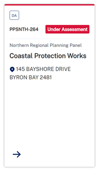
Coastal Protection Works | Planning Portal - Department of Planning and Environment (nsw.gov.au) Link to DA tracker for DA 2023.287.1 information and documents here: Byron Shire Council - Application Tracker
|
Under assessment |
|
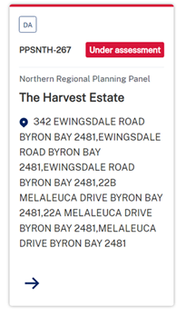
Northern Regional Planning Panel |
The Harvest Estate | Planning Portal - Department of Planning and Environment (nsw.gov.au) Link to DA tracker for DA 2017.201.3 information and documents here: Byron Shire Council - Application Tracker (nsw.gov.au)
|
Under assessment |
|
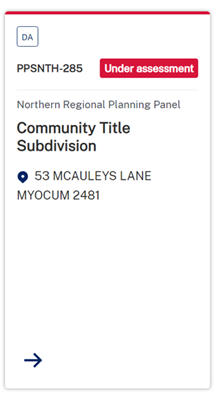
Northern Regional Planning Panel |
Community Title Subdivision | Planning Portal - Department of Planning and Environment (nsw.gov.au) Link to DA tracker for DA 2023.454.1 information and documents here: |
Under assessment |
Strategic Considerations
Community Strategic Plan and Operational Plan
|
CSP Objective |
CSP Strategy |
DP Action |
|
1: Effective Leadership |
1.1: Enhance trust and accountability through open and transparent leadership |
1.1.2: Governance - Ensure legislative compliance and support Councillors to carry out their civic duties |
Recent Resolutions
· 23-461
Legal/Statutory/Policy Considerations
The Planning Panels determine regionally significant development applications (DAs), certain other DAs and s4.55(2) and s4.56 modification applications including:
· Regionally significant development, as outlined in Schedule 6 of the State Environmental Planning Policy Planning Systems 2021
· Regionally significant development relating to Aboriginal land, as outlined in Chapter 3 of the State Environmental Planning Policy Planning Systems 2021
· Development with a capital investment value (CIV)* over $30 million.
· Development with a CIV* over $5 million which is:
o Council related
o lodged by or on behalf of the Crown (State of NSW)
o private infrastructure and community facilities
o eco-tourist facilities
o extractive industries, waste facilities and marinas that are designated development
o certain coastal subdivisions and
o certain coastal protection works.
*Capital investment value (CIV) is calculated at the time of lodgement of the DA for the purpose of determining whether an application should go to a Planning Panel - refer to Planning Circular PS 10-008.
Section 10 of the Sydney District & Regional Planning Panels Operational Procedures talks to Roles of councils and other panels.
10.1 states the elected Council and Council staff have different roles in the assessment of DAs. Under the Local Government Act 1993, the independence of Council staff is protected in the preparation of advice and recommendations. Staff members are not subject to direction by the Council or by a Councillor as to the content of any advice or recommendation made by the staff member. Equally, a Council or Councillor is not bound by the advice or recommendation made by a member of staff.
10.3 states historically, one of the roles of an elected Council has been to determine or make decisions on DAs in their capacity as a consent authority. There are occasions, however, where the determination role is performed by other people or bodies, either because the Council has delegated that function, or because it has been conferred upon another person or body. For example, where local planning panels have been introduced, elected Councils no longer determine DAs (see section 2.17 of the EP&A Act). The Panel for the area in which the development is to be carried out is the consent authority for regionally significant development (see section 4.5 of the EP&A Act).
10.4 states Council staff are responsible for post-determination functions including:
· notifying Panel determinations on DAs (see sections 4.7(2)(e), 4.18 and 4.59 of the EP&A Act),
· registering Panel development consents on the NSW Planning Portal (see sections 4.7(2)(e) and 4.20 of the EP&A Act), and
· monitoring and enforcing compliance with conditions of the development consent.
The notice of determination should be issued once Council receives a copy of the endorsed and final determination from the Panel. The notice of determination must include all conditions imposed by the Panel, including any additional or amended conditions.
The Council has no power to amend conditions or include additional conditions following the Panel’s determination.
Council will advise any person who made a submission on the DA of the determination.
The Council continues to be responsible for the monitoring of, and enforcing compliance with, any conditions of the development consent.
Where an application has been approved subject to a ‘deferred commencement’ condition Council is responsible for determining whether the requirements of the condition have been met (see section 4.16(3) of the EP&A Act). Council advises the chair of the Panel in writing when the matter specified in the condition has been satisfied (see section 277(2) of the EP&A Regulation)
Microsoft Word - Att C - Amended RPP Operational Procedures.docx (amazonaws.com)
11.13 talks to Council representation to the Planning Panel.
An elected Council may make a submission on a DA within their LGA that is to be determined by a Panel up to seven days before the Panel meeting. After the assessment report is sent to the Secretariat, it may be given to the elected Council to assist in its decision as to whether it will be making a submission to the Panel. The elected Council’s submission should not be prepared by persons involved in the assessment of the application but could be prepared by another Council officer, or a consultant.
A Council submission should not be specifically referenced in the assessment report or recommendations prepared by the Council staff. If Council makes a submission, a staff representative or individual Councillors may register to address the Panel at the meeting to express the views of Council. Councillors who are also Panel members have an independent role because they have been nominated by their Council as its nominee to the Panel.
A Code of Conduct also applies to members of the Planning Panels.
Appeals from Planning Panel determinations
Section 8.15(4) of the EPA Act was introduced on 1 March 2018. It provides relevantly:
If the determination or decision appealed against under this Division was made by a Sydney district or regional planning panel or a local planning panel, the Council for the area concerned is to be the respondent to the appeal but is subject to the control and direction of the panel in connection with the conduct of the appeal. The Council is to give notice of the appeal to the panel.
In respect of the conduct and potential resolution of appeals, Councils are subject to the direction and control of planning panels in respect of decisions they make after 1 March 2018.
The Land and Environment Court has said that in circumstances where the panel and Council have conflicting views on a development, the appropriate approach would be for the panel to apply to be joined as a party to the appeal proceedings.
Financial Considerations
None relevant to this report.
Consultation and Engagement
Applications are exhibited as per the Council’s Community Participation Plan.
Otherwise, consultation, engagement and reporting must be in accordance with the Planning Panels Operations Procedure and Code of Conduct.
Staff Reports - Sustainable Environment and Economy 13.3
Report No. 13.3 PLANNING - DA10.2008.565.5 - S4.55 modification to modify approved plans for use of alterations and additions – 13 Gaggin Street, New Brighton
Directorate: Sustainable Environment and Economy
Report Author: Jordan Vickers, Planner
File No: I2024/566
Proposal:
|
Modification No: |
10.2008.565.5 |
|
Proposed modification: |
Modification to Condition 1 for use of existing alterations and additions to Dwelling House, and modification to Condition 8 to correct typographical error for Flood Planning Level |
|
Original Development: |
Alterations and additions to Dwelling House |
|
Type of modification sought: |
4.55(1A) Modifications involving minimal environmental impact |
|
Property description: |
LOT: 317 DP: 755687 |
|
13 Gaggin Street NEW BRIGHTON |
|
|
Parcel No/s: |
115140 |
|
Applicant: |
Mr L Wilkinson |
|
Owner: |
Leo Wilkinson Family Investments Pty Ltd |
|
Zoning: |
Urban Coastal Lands (7f2) Byron LEP 1988 |
|
Date received: |
27 February 2024 |
|
Original DA determination date: |
31 October 2008 |
|
Public notification or exhibition: |
- Level 2 advertising under the Byron Shire Council Community Participation Plan. - Exhibition period: 8 March – 21 March 2024 - Submissions received: 3 |
|
Delegation to determination: |
Council |
|
Issues: |
· Unapproved structure inconsistent with development controls (Non-compliant with setback & building height plane) · Submissions – concerns discussed in report |
Summary:
This application is seeking to modify conditions of consent to DA10.2008.565.1 pertaining to approved plans and Flood Planning Level. The modification is to both facilitate the use of a building which has been constructed without development consent and amend the Flood Planning Level in existing conditions of consent to align with the updated North Byron Floodplain Risk Management Study.
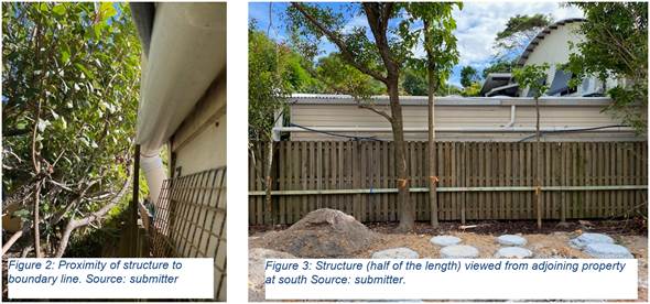
This consent (10.2008.565.1) and the structure which is the subject of this modification (a bedroom and garage constructed to close to the southern property boundary 0.1 m at its closest point), has a detailed history of modification(s) and compliance action(s) originating from complaints made by nearby residents. Such complaints precipitated compliance investigations which resulted in a demolition order being issued to the landowner for the building (75.2023.35.1).
Subsequently, DA10.2008.565.4 was submitted seeking consent for the structure, this application was refused and referred to Development Compliance on 13 October 2023. The subject application, submitted 19 February 2024, has not been modified to improve boundary setbacks, building height plane encroachments or the impact of the structure on adjoining owners since the refusal of DA10.2008.565.4.
Three (3) public submissions of objection were received during notification of this proposal. Submitter’s concerns included: amenity, microclimate, overshadowing, privacy, building maintenance (only possible from neighbouring property) and therefore liability, and the unreasonableness of an adjoining owner being responsible for maintaining their on-site amenity because a structure has been constructed unlawfully on their boundary line.
The building is not considered to beneficially contribute to local character and has the potential to adversely impact upon the amenity enjoyed by residents of the adjoining property. Further, the minimal boundary setback does not provide for access around the building for maintenance purposes, requiring in effect maintenance through the adjacent premises which is not supported by the adjoining landowner.
In essence when seeking consent to construct on the boundary as the applicant has, it is vitally important the other land owner is in agreeance with that proposal. The need to access the side of the building for general maintenance needs to be considered, and from a planning perspective, without that agreement, it is normal in a residential setting to have some sort of setback from boundaries. This is not just for standard Building Code of Australia reasons (although there are alternate solutions to build on the boundary) but also to maintain residential character and keeping impacts of the development upon your own land and not hard to the adjacent boundary and as consequence imposing such impacts directly upon the neighbour.
In this instance it is unfortunate the applicant has constructed first without getting the appropriate approvals first considering the various planning provisions that are in place for side setbacks. Why this occurred and what advice, if any, he received from builders and other consultants is unclear. Had an approval first been obtained instead of an afterthought, it is likely the garage would have been narrowed down to around 3 metres instead of the currently constructed 3.85 metres, whilst bedroom 3 would have been setback the requisite 900 mm from the boundaries.
Considering the objections received and the lack of any specific reasons to demonstrate why Council’s planning controls should be varied, the proposal cannot be supported by Council staff and the application is recommended for refusal.
NOTE TO COUNCILLORS:
In accordance with the provisions of S375A of the Local Government Act 1993, a Division is to be called whenever a motion for a planning decision is put to the meeting, for the purpose of recording voting on planning matters. Pursuant to clause 2(a) under the heading Matters to be Included in Minutes of Council Meetings of Council's adopted Code of Meeting Practice (as amended) a Division will be deemed to have been called by the mover and seconder of all motions relating to this report.
RECOMMENDATION:
That:
1. Pursuant to Section 4.55 of the Environmental Planning & Assessment Act 1979, Modification No. 10.2008.565.5 for the Use of Alterations and additions to a dwelling house, be refused for the following reasons:
a. Pursuant to section 4.15 (1)(a)(iii) of Environmental Planning and Assessment Act 1979, the development does not comply with Part C2.5 Building Height Plane under Byron DCP 2010.
b. Pursuant to section 4.15 (1)(a)(iii) of Environmental Planning and Assessment Act 1979, the development does not comply with Part 2.6 Setbacks to Boundaries and Part 4.4 Reduced Boundary Setbacks under Byron DCP 2010.
c. Pursuant to Section 4.55(1)(b) of the Environmental Planning & Assessment Act 1979, the proposed development has an adverse impact on the built environment.
d. Pursuant to Section 4.55(1)(c) of the Environmental Planning & Assessment Act 1979, the proposed development as constructed is not suitable for the site.
e. Pursuant to Section 4.15 (1)(e) the proposed development is not in the Public Interest.
2. Council’s Compliance Team be advised of the outcome of this application.
1 10.2008.565.5
- Architectural Plans, E2024/16565
![]()
2 Confidential - 10.2008.565.5 submissions received, E2024/48982
Assessment:
1. INTRODUCTION
1.1. History/Background
This property is subject to demolition order (75.2023.35.1, 75.2023.35.2) pertaining to works undertaken without consent. The demolition order, issued 14 March 2023, required the landowner to:
1. “Demolish the garage located on the southern side of the dwelling that has been constructed without approval shown in annexure 1.
2. Demolish the area located on the southern side of the dwelling that has been constructed contrary to approved plans under Construction Certificate 11.2008.565.1 and has been converted from a garage to a habitable space shown in annexure 2.”
 |
It is relevant to note that the previous modification assessed by Council (10.2008.565.4) sought consent for these works and was refused on 13 October 2023. To properly understand the history of approvals and the nature of the modification, it is necessary to catalogue what has occurred at the site:
1. DA10.2008.565.1 approved alterations and additions to the dwelling, including the relocation of the garage (10.2006.226.1) adjacent to the southern property boundary closer to the frontage. Garage was setback 300 mm from southern side boundary:
2. S4.55 application 10.2008.565.2 approved modifications to the consent, including relocation of the approved garage away from the front (Gaggin Street) property boundary:
3. Construction Certificate (11.2008.565.1) was issued for this building work which included notes requiring that the garage provides a setback of 450mm from the side boundary to the non combustible eaves and fascia. The building walls based on the drawings would have been setback further from the boundary.
4. S4.55 application 10.2008.565.3 was approved on 5/2/2010 which granted consent for a deck on the northern boundary that was also built without approval. The plans included relocating the garage closer to the Gaggin Street frontage, however the garage relocation was not formalised as part of this application and accordingly the plans were marked up to show this as not approved. Extract below.
![]()
5. Unlawful construction: Over the following years, the landowner has constructed the garage back toward the Gaggin Street frontage and with an additional bedroom attached to the rear, with minimal setback not compliant with the 450 mm setback to the eaves as approved under Construction Certificate 11.2008.565.1.
6. Demolition order 75.2023.35.1 was issued for works undertaken without consent.
7. S4.55 application 10.2008.565.4 was submitted seeking consent for work undertaken
without consent, depicted in images and described under point 6 above. This application was refused on numerous grounds, boundary setbacks, suitability of the site, environmental impact and landowners consent.
1.2. Description of the proposed development
This application seeks approval for a Modification to Condition 1 to permit use of existing alterations and additions to Dwelling House which have been undertaken without development consent, and modification to Condition 8 to amend the Flood Planning Level to accord with the amended North Byron Floodplain Risk Management Study. Plans for the development are shown above under point 7 in history/ Background.
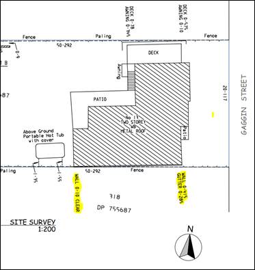
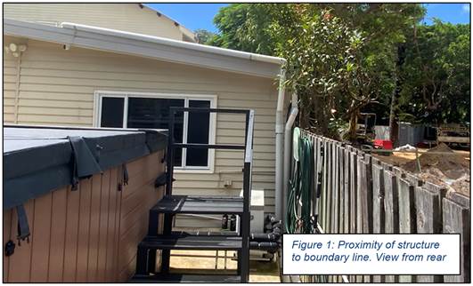
The applicants survey plan shows the garage bedroom extension not square to the boundary, with the wall 415 mm and gutter 285mm setback to the southern side boundary at the buildings most easterly point and then reducing to 100mm setback to the wall only from the boundary at the western end of the building. No detail is provided on the gutter or downpipes at this location and it is likely they are situated hard on the boundary.
Survey extract
1.3. Description of the site
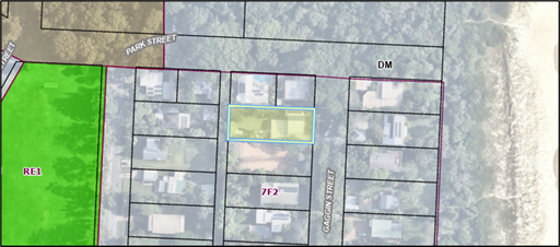
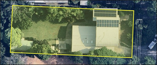
The subject land known as 13 Gaggin Street, New Brighton and legally described as Lot 317 on DP755687 has a site area of 1011m² and is within the Urban Coastal Lands (7f2) zone of the Byron LEP 1988. The property is currently improved by a Dwelling house and above-ground spa/swimming pool, and has frontage to Gaggin Street and a rear lane. The site is identified as flood liable and bushfire prone land and is within the Coastal Erosion Precinct overlay (precincts 2 & 3).
Byron LEP – GIS Extract
Aerial Photo – GIS Extract
2. SECTION 4.15 – MATTERS FOR CONSIDERATION – DISCUSSION OF ISSUES
Having regard for the matters for consideration detailed in Section 4.15(1) of the Environmental Planning & Assessment Act 1979, the following is a summary of the evaluation of the issues.
S4.55 assessment:
The primary matters of consideration for assessment of this application relate to:
· compliance with boundary setbacks and building height plane;
· compliance with DCP 2010, Part J (coastal erosion land);
· compliance with Councils flood planning controls;
These matters will be discussed in detail below under Byron DCP 2010
2.1. State/Regional Planning Policies, Instruments, EPA Regulations 2021
The Proposed amendments raise no issues under the relevant SEPPS, Policies or clauses of the EPA Regulations 2021.
2.2. Byron Local Environmental Plan 1988
The Proposed amendments raise no issues under the LEP.
2.3. Draft EPI that is or has been placed on public exhibition and details of which have been notified to the consent authority - Issues
No draft EPIs affect the proposal.
2.4. Development Control Plan 2010
Section C2.5 – Building Height Plane
The development as constructed clearly does not comply with the Building Height plane provisions as indicated below. The yellow triangle shows the section of the extensions as non compliant.
It is acknowledged a single storey building with a standard 900 mm setback to the wall would possibly also breach the building height plane control, however with such a setback, access to the side of the building would be possible for maintenance, whilst a degree of spatial separation is then provided between the neighbours land and the applicants development.
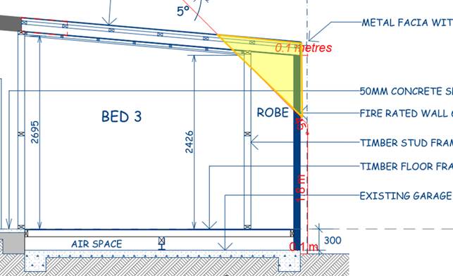
As indicated in the various photos in this report, it would be impossible to access the side of the building without removing fencing to carry out any maintenance of the walls of the garage and building. Similarly any work to the stormwater pipes and guttering would also require access from the neighbours land. No evidence is provided of any such arrangements between neighbours.
Section C2.6 Setbacks from Street, Side and rear Boundaries
The DCP states that setbacks to side boundaries are to be in accordance with the requirements of the building code of Australia and the Building Height Plane. As discussed above, the proposal is non compliant with the Building Height Plane, whilst the standard that is normally set for the Building Code of Australia is 900 mm from the side of the building to the side boundaries. Whilst it is possible to construct closer to the side boundaries right up to a zero setback with fire rated walls, however this is not always ideal.
In this regard when seeking consent to construct on the boundary as the applicant has, it is important the other land owner is in agreeance with that proposal. Equally if not more so, Development Consent from Council should also be obtained prior to the construction as opposed to a build first seek consent later approach as documented in this application. The need to access the side of the building for general maintenance needs to be considered, and from a planning perspective, and without that agreement, it is normal in a residential setting to have some sort of setback from boundaries.
This is not just for standard Building Code of Australia reasons (although here are alternate solutions to build on the boundary as proposed) but also to maintain residential character and keeping impacts of the development upon your own land and not hard to the adjacent boundary and imposing such impacts directly upon the neighbour.
In the event of there being blocked gutters or downpipes, and rainwater runoff will enter directly into the neighbours property to the south. Had the development been constructed with more appropriate setback such runoff would impact the applicants property first and foremost, and therefore it would be of some interest to the applicant to have it repaired and maintained at the earliest opportunity, not leave it to the neighbour to put up with, or have to complain to the land owner or Council for it to be repaired. In such situations these neighbourly disputes can then escalate into civil matters as a result of a poorly sited and constructed building.
In this instance it is unfortunate the applicant has constructed first without getting the appropriate approvals first considering the various planning provisions that are in place for side setbacks, however considering the objections received, the variations being sort can-not be supported and the application is recommended for refusal.
Part C4 – Reduced Side Setbacks
The DCP sets in place controls for reduced side setbacks as follows:
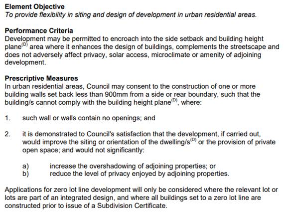
The building as constructed has minimal setbacks with the gutter and down pipes for the garage and bedroom likely to be hard to the boundary. In terms of the controls the building has no windows or openings in it, but it will result in increase overshadowing on the neighbour and as discussed will require some arrangement with the neighbour to gain access for maintenance purposes as discussed above. As noted no such arrangement is in place (such as a negotiated easement for maintenance access) and as such the development will impact on the privacy of the neighbour next door.
In terms of streetscape, the area is dominated with low density residential development designed and constructed with complaint setbacks. There is nothing specific or out of the ordinary regarding this particular parcel of land, compared to others surrounding it as to why a reduced setback as proposed should be supported, and it is considered no evidence has been presented demonstrating that the design of the dwelling as constructed is an improvement on one with a more compliant setback up to the 900 mm.
Had approval been sought first, it is likely the garage would have been narrowed down to around 3.0 metres instead of the constructed 3.85 metres and the bedroom setback the required 900 mm from the boundary to comply with the standard residential controls under DCP 2010.
It is submitted the proposal does not satisfy Part C4.4 of DCP 2010, and is recommended for refusal.
Part J Coastal Erosion Lands)
The site straddles erosion precincts 2 and 3, with the works located wholly within Precinct 2. The allotment has restrictions imposed by previous development consents requiring that the development ceases if the erosion escarpment is within 50m of the development.
The Prescriptive Measure associated with this control requires that Class 1 (residential) buildings must be relocatable. Extensions to dwellings “may also be required to be demountable, taking into consideration the additional floor space proposed and the likely effect of the extension on the ability of the building to be relocated in an emergency”. No information has been submitted that demonstrates that the works undertaken have been designed and constructed so that it can be easily removed from the site by road vehicle. The application is also not accompanied by plans or a description of the removal procedures.
However If the application was to be approved then the garage and bedroom would need to be demolished in the event of the property being at risk of coastal erosion.
Part K Flood Liable Lands.
The proposal considers the extension of habitable spaces (bedroom) within the existing dwelling, and the allotment is identified as flood liable land. Condition 8 of consent to DA10.2008.565.1 when originally approved required that the floor level be constructed to R.L. 3.7m A.H.D as follows:
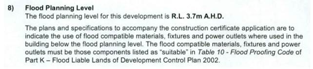
The floor level of the bedroom extension is set at 3.64m AHD. Council’s Development Engineer has advised “since approval of the DA in 2008, Council has undertaken and adopted North Byron Floodplain Risk Management Study. The FPL of the site is now 3.59m AHD.” Should the application be approved then the floor of the bedroom can comply with the adopted flood height provisions
2.5. The likely impacts of that development, including environmental impacts on both the natural and built environments, and social and economic impacts in the locality
Impacts generated by the development have been considered under previous development applications, with dispensations to development controls already afforded. The proposal presents further departure from prescribed controls, and performance assessments already applied. Impacts generated by further departure from the development controls are not supported in this instance, and it is considered the proposed development has an adverse impact on the built environment.
2.6. The suitability of the site for the development
The development does not consider the implications of ongoing management and maintenance of the structure on an adjoining landowner (see submissions: maintenance of building), is not responsive to surrounding character (streetscape character) or adjoining amenity (microclimate, bulk).
The development is not suitable as-constructed at this property, and the property is therefore not suitable for the development.
2.6 Submissions made in accordance with this Act or the regulations
|
Three (3) submissions were received during notification of this application which are aggregated for discussion below:
|
|
|
Issues |
Comments |
|
Unsightly, imposing, impacting amenity & microclimate Submission notes that the structure is unlawful, has been constructed non-compliant with the approved plans, and is unsightly, imposing upon the adjoining property at the south, and directly impacts the neighbours right to privacy, safety and amenity. This submission is a 9-page document, with substantial verification of these concerns |
The building has been constructed inconsistent with the approved plans, which already considered variation to development controls, and is not considered to achieve the performance outcomes of DCP 2010 pertaining to building setbacks and building height plane for the reasons provided by the submitter as discussed within this report. |
|
Maintenance of building As the building is constructed within 0.1m of the southern boundary, all and any maintenance of this building (notably eaves, building wall, stormwater, pest control etc.) must be undertaken from the adjoining allotment at the south. The submitter highlights concerns regarding legal liability risk with work being undertaken from adjoining property. |
The building presents a minimal setback to the southern boundary for a length of 17.1m. It is unreasonable for Council to approve a structure requiring all future maintenance to be undertaken from the adjoining property without prior agreement from the adjoining landowner. The adjoining landowner does not consent to this occurrence.
Plumbing overhanging boundary – extract from submission. |
|
Reduced setback, amenity & microclimate Reduced boundary setback has resulted in adverse impacts on their amenity, by creating a “dark, damp, unhealthy and potentially hazardous micro climate” between the building and the property boundary. |
Noted – it would be impossible to maintain the side of the building without re moving the fence and gaining access from the neighbours property to the south. |
|
Building Height of Garage Garage and extension also depart form height approved under previous DA’s |
Noted - the garage wall was meant to be 2.4 metres high on the southern elevation. However the building is now 2.9 metres high. This further exacerbates BHP breaches. |
|
Vegetation on property to the south Vegetation on neighbouring property does not screen the development as claimed in the application
|
Noted – as included in the photo attached to the submission
|
|
Flooding – Constructed below flood level Coastal Erosion Hazard
|
As discussed in the body of the report the floor level of the building as constructed complies with current flood planning levels. It is considered the proposal is acceptable in terms of the provision of Part J Coastal Erosion Lands under DCP 2010. |
2.7 Public interest
|
For the reasons discussed in this report, it is considered that approval of this building is not in the public interest. |
|
|
2.8 DEVELOPER CONTRIBUTIONS/ WATER AND SEWER CHARGES
|
There is no nexus to levy additional contributions. |
3. CONCLUSION
The proposed development as amended is not satisfactory having regard to relevant matters for consideration as detailed in this report and the section 4.55 application is recommended for refusal.
Staff Reports - Sustainable Environment and Economy 13.4
Report No. 13.4 PLANNING - DA 10.2023.491.1 - Dual Occupancy (detached) – 541 Federal Drive, Federal
Directorate: Sustainable Environment and Economy
Report Author: Jordan Vickers, Planner
File No: I2024/569
Proposal:
|
DA No: |
10.2023.491.1 |
||||||
|
Planning Portal ref |
PAN-398199 |
||||||
|
Proposal description: |
New Dwelling to create Dual Occupancy (Detached) |
||||||
|
Property description: |
LOT: 5 DP: 793657 |
||||||
|
541 Federal Drive FEDERAL |
|||||||
|
Parcel No/s: |
22690 |
||||||
|
Applicant: |
Ms K J Ackland |
||||||
|
Owner: |
Ms K J Ackland |
||||||
|
Zoning: |
C2 Environmental Conservation / PART RU2 Rural Landscape |
||||||
|
Date received: |
21 December 2023 |
||||||
|
Integrated / Designated Development: |
☐ Integrated |
☐ Designated |
☒ Not applicable |
||||
|
Concurrence required |
No |
||||||
|
Public notification or exhibition: |
- Level 1 advertising under Council’s Community Participation Plan. - Exhibition period: 11/1/24 to 24/1/24 - Submissions received: 2 - Submissions acknowledged: ☒ Yes ☐ No ☐ N/A |
||||||
|
Concurrent approvals included with DA |
☐ N/A |
|
☒OSMS (68) |
|
|
||
|
Other: |
|
||||||
|
Planning Review Committee |
7 March 2024 – Decision Maker: Council Meeting |
||||||
|
Variation request to Development Standards under an EPI (eg clause 4.6) |
Not applicable
|
||||||
|
Estimated cost |
$317,513.00 |
||||||
|
Delegation to determine |
Council |
||||||
|
Issues |
Bushfire prone land Public submission |
||||||
|
Summary:
|
The DA proposes New Dwelling to create Dual Occupancy (Detached). The application appropriately addresses the relevant constraints applying to the site, and is recommended for approval subject to the conditions listed in the Recommendation of this Report below. |
||||||
|
Recommendation: |
· Pursuant to Section 4.16 of the Environmental Planning & Assessment Act 1979, Development Application No. 10.2023.491.1 for New Dwelling to create Dual Occupancy (Detached), be granted consent subject to the conditions of approval at the end of this report |
||||||
Summary:
This application seeks approval for new Dwelling to create Dual Occupancy (Detached). The proposed dual occupancy dwelling is comprised of two bedrooms, laundry, bathroom and an open-plan living and kitchen area. The dwelling is located 80m from the existing dwelling on the allotment and will gain access via the existing driveway at the property as required by the LEP, Clause 4.2A. It will be serviced by rainwater tanks and an On-site Sewage Management System. Minor cut/fill/batter is required to establish the driveway and building pad for the development, with excavation and retaining up to 1m.
Submissions have been received highlighting concerns regarding: the possibility of landslip in the vicinity, the driveway is not suitable for increased use, and that contaminated fill has been used at the site. In relation to slope and land stability, the site of the subject dwelling is located to the south of the existing dwelling and some 140 metres from the Landslip on Federal drive.
Council’s Development Engineer reviewed a Geotechnical Report prepared by qualified geotechnical consultants for the development. It was found that that the site is a Low Risk and is suitable for the proposed dwelling. In terms of access to the dwelling existing and proposed arrangements from Federal Drive are adequate for this development. A Preliminary Contaminated Land assessment was submitted, and it is considered the location of the building is not contaminated and is suitable for a residential use.
The proposal is recommended to be approved, subject to conditions.
NOTE TO COUNCILLORS:
In accordance with the provisions of S375A of the Local Government Act 1993, a Division is to be called whenever a motion for a planning decision is put to the meeting, for the purpose of recording voting on planning matters. Pursuant to clause 2(a) under the heading Matters to be Included in Minutes of Council Meetings of Council's adopted Code of Meeting Practice (as amended) a Division will be deemed to have been called by the mover and seconder of all motions relating to this report.
That pursuant to Section 4.16 of the Environmental Planning & Assessment Act 1979, Development Application No. 10.2023.491.1 for New Dwelling to create Dual Occupancy (Detached), be granted consent subject to the conditions of approval at the end of this report
1 DA10.2023.491.1
Plans for Approval, E2024/47892 ![]()
2 DA10.2023.491.1
Conditions of Consent, E2024/47893
![]()
3 DA10.2023.491.1
Submissions redacted, E2024/48248
![]()
4 DA10.2023.491.1
Geotechnical Report - New Dual Occupancy - 541 Federal Drive, Federal, E2024/47887 ![]()
Assessment:
1. INTRODUCTION
History/Background
A search of Council records indicates the following relevant site history:
|
DA No. |
Description |
Outcome |
Date |
|
10.2003.417.1 |
Dwelling house & carport |
Approved |
28/10/2003 |
|
10.2003.417.2 |
Mod: OSMS |
Refused |
19/05/2005 |
|
10.2007.413.3 |
Mod: OSMS |
Approved |
17/08/2005 |
|
10.2017.175.1 |
Alts & Adds to Dwelling, new swimming pool |
Approved |
14/07/2017 |
|
10.2022.148.1 |
Tennis Court lighting |
Approved |
05/05/2022 |
Description of the proposed development
This application seeks approval for New Dwelling to create Dual Occupancy (Detached). The proposed dual occupancy dwelling is comprised of two bedrooms, laundry, bathroom and an open-plan living and kitchen area. The dwelling is located 80m from the existing dwelling on the allotment and will gain access via the existing driveway at the property. It will be serviced by rainwater tanks and an On-site Sewage Management System. Minor cut/fill/batter is required to establish the driveway and building pad for the development, with excavation and retaining up to 1m.
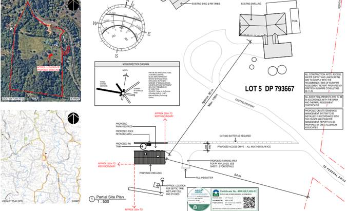
Description of the site
The subject site known as 541 Federal Drive, Federal and legally described as Lot 5 on DP793657 has a site area of 22.41ha and is located within the Environmental Conservation (C2) and Rural Landscape (RU2) zones of the Byron LEP 2014. It is identified as Bushfire Prone land containing high environmental value vegetation, and is traversed by Essential Energy overhead infrastructure. The property is improved by an existing dwelling house, tennis court and shed. Access is granted to the property via an existing crossover at Federal Drive.
A site inspection was carried out on 12 February 2024
|
Land is legally described |
LOT: 5 DP: 793657 |
|
|
Property address |
541 Federal Drive FEDERAL |
|
|
Land is zoned: |
C2 Environmental Conservation / PART RU2 Rural Landscape |
|
|
Land area is: |
22.41 ha |
|
|
Property is constrained by: |
Bushfire prone land High Environmental Value |
|
|
|
Is a BDAR required due to the location of the proposed development? |
☐ Yes ☒ No |
|
|
Are there any easements in favour of Council affecting the site? |
☐ Yes ☒ No |
|
|
Is there a Vegetation Management Plan which might affect the proposal? |
☐ Yes ☒ No |
|
|
Is there a Voluntary Planning Agreement which might affect the proposal? |
☐ Yes ☒ No |
![]()
![]()
![]()
![]()
![]()
![]()
2. SUMMARY OF REFERRALS
|
Referral |
Issue |
|
Environmental Health Officer* |
No objections subject to conditions. |
|
Development Engineer |
No objections subject to conditions. |
|
S7.11 / Contributions Planner |
No objections subject to conditions. |
3. SECTION 4.14 – BUSH FIRE PRONE LAND
Effect of 10/50 rule on significant vegetation
“The parcel of land you have selected is located in a designated 10/50 vegetation entitlement clearing area. You must read the 10/50 Code of Practice carefully to ensure that you are only clearing in accordance with the 10/50 Code. For more information see our frequently asked questions.”
Accordingly, the land owner may clear vegetation in accordance with the 10/50 Vegetation Clearing Code Of Practice For New South Wales.
4. SECTION 4.15C – MATTERS FOR CONSIDERATION – DISCUSSION OF ISSUES
Having regard to the matters for consideration detailed in Section 4.15(1) of the Environmental Planning & Assessment Act 1979 (EP&A Act), the following is a summary of the evaluation of the issues.
State Environmental Planning Policies (SEPP)
|
Considerations |
Satisfactory |
Unsatisfactory |
|
Resilience and Hazards SEPP 2021 Chapter 4: Remediation of land Consideration: Council’s Environmental Health Officer (EHO) reviewed the submitted preliminary contaminated land assessment (PSI) and concurs that the site is suitable for the proposed residential use. Council’s EHO gave specific regard to matters raised in public submissions pertaining to the deposition of “potentially contaminated fill” at the building pad. In this regard the soil samples used for the PSI were taken (27/11/2023) after the deposition of mulch at the location of the building pad, which occurred prior to 16 September 2023 (confirmed by aerial imagery). |
☒ |
☐ |
|
Sustainable Buildings SEPP 2022 Consideration: The proposal is accompanied by a valid BASIX and NatHers certificate. The SEPP has been addressed and the proposal is considered to comply. |
☒ |
☐ |
4.2A Byron Local Environmental Plan 2014 (LEP 2014)
In accordance with LEP 2014 clauses 1.4 and 2.1 – 2.3:
(a) The proposed development is defined in the LEP 2014 Dictionary as Dual occupancy;
(b) The land is within the C2 Environmental Conservation / PART RU2 Rural Landscape according to the Land Zoning Map;
(c) The proposed development is permitted with consent; and
(d) Regard is had for the Zone Objectives as follows:
|
Zone Objective |
Consideration |
|
C2 Environmental Conservation |
The proposal takes place entirely within the Rural Landscape (RU2) zone and assessment against the C2 zone is not required.
|
|
Rural Landscape (RU2) zone Objectives • To encourage sustainable primary industry production by maintaining and enhancing the natural resource base. • To maintain the rural landscape character of the land. • To provide for a range of compatible land uses, including extensive agriculture. • To enable the provision of tourist accommodation, facilities and other small-scale rural tourism uses associated with primary production and environmental conservation consistent with the rural character of the locality. • To protect significant scenic landscapes and to minimise impacts on the scenic quality of the locality. |
The proposal considers the continued use of the land for residential purposes. The Dual occupancy dwelling is proposed to be located 80m from the existing dwelling on the property, and is unlikely to adversely impact on the rural character of the land. It is considered the proposal will not detract from the rural landscape character or scenic quality of the locality and is not inconsistent with the zone objectives. |
|
Clause 4.2D Erection of Dual Occupancies and secondary dwellings in Zones RU1 and RU2 |
It is considered the proposed dual occupancy complies with the provisions of the clause as follows: · the dwelling located 80 metres from the primary dwelling, · will use the same driveway as the existing dwelling · the site is considered suitable for the dwelling in terms of agricultural uses and onsite effluent disposal · wont have an adverse impact scenic amenity or character of the rural environment. |
|
Clause 4.3 Height of Buildings |
The proposed single storey dwelling with a height of approximately 5 metres complies with the 9 metre height limit. |
|
Clause 6.5 Drinking water catchments |
The main potential impact from the proposal like others within the Wilsons River Drinking Water Catchment is from the disposal of effluent onsite. The proposal has been designed with a septic tank with secondary treatment via a wetland before disposal via an ETA bed. The proposal is considered suitable with conditions of consent to apply. |
|
Clause 6.6 Essential Services |
All necessary services are available for the development. |
4.3 Any proposed Instrument that has been the subject of public consultation and has been notified to the consent authority
There are no proposed Environmental Planning Instruments of relevance to the proposal.
4.4 Byron Shire Development Control Plan 2014 (DCP 2014)
Chapter D2 Residential Accommodation and Ancillary Development in Rural Zones
The proposed dual occupancy is satisfactory in terms of the general provisions and is suitably setback from surrounding properties which are predominantly used for rural residential type purposes. As discussed above the proposal is unlikely to have an impact upon the scenic qualities of the locality and the dwelling is to be clad in dark color-bond as opposed to surf mist or other highly reflective materials.
Adequate room is available on site for car parking and effluent disposal and the dwelling is setback some 84 metres from the closest boundary complying with the minimum 10 metres as prescribed under the DCP.
The proposal is considered acceptable in terms of the provisions of D2 and raises no other issues under DCP 2014.
4.5 Environmental Planning and Assessment Regulation 2021
|
|
Applicable to the proposal: |
Considered the control as it relates to the proposal: |
If this control is applicable, does the proposal comply? |
|
Section 61 - Additional matters that consent authority must consider |
☐ Yes ☒ No |
☐ Yes ☐ No ☒ NA |
☐ Yes ☐ No ☒ NA |
|
Section 62 - Consideration of fire safety |
☐ Yes ☒ No |
☐ Yes ☐ No ☒ NA |
☐ Yes ☐ No ☒ NA |
|
Section 64 - Consent authority may require upgrade of buildings |
☐ Yes ☒ No |
☐ Yes ☐ No ☒ NA |
☐ Yes ☐ No ☒ NA |
|
Section 63 - Considerations for erection of temporary structures |
☐ Yes ☒ No |
☐ Yes ☐ No ☒ NA |
☐ Yes ☐ No ☒ NA |
* Non-compliances and any other significant issues discussed below
4.6 The likely impacts of that development, including environmental impacts on both the natural and built environments, and social and economic impacts in the locality
|
Impact on: |
Likely significant impact/s? |
|
Natural environment |
No. The proposal will not have a significantly adverse impact on the natural environment of the locality. |
|
Built environment |
No. The proposal will not have a significantly adverse impact on the built environment of the locality. |
|
Social Environment |
No. The proposal will not have a significant social impact on the locality. |
|
Economic impact |
No. The proposal will not have a significant economic impact on the locality. |
|
Construction Impacts |
No. The development will generate minor impacts during its construction. Conditions of consent recommended to control hours of work, builders waste, construction noise, installation of sedimentation and erosion control measures and the like to ameliorate such impacts. |
Marine Estate Management Act 2014
The development is unlikely to have an effect on the plants or animals within the Cape Byron Marine Park or their habitat.
Council Policies applicable to the proposed development?
Council Policies applicable to the proposed development have been considered through the assessment of this application with relevant conditions imposed where necessary.
4.7 The suitability of the site for the development
Issue |
Comment |
|
Services - Water/ Sewer/ Stormwater - Ph/ power - Access |
- The dwelling will be serviced by 40,000L rainwater tanks for domestic water supply. - An On-site Sewage Management System is proposed for the dwelling. - Stormwater can be accommodated on site - Telecommunications and electricity infrastructure are available at the property. - Access is provided to the property via Federal Drive. |
|
Onsite Effluent Disposal |
- An On-site Sewage Management System is proposed for the dwelling. |
|
Bushfire
|
The land is identified as bushfire pone and a Bushfire Assessment report accompanies the proposal. Conditions of consent will apply as recommended. |
|
Land Use conflicts |
The proposal considers the continued use of the land for residential purposes. It does not introduce any land uses which may cause conflict within the locality. Surrounding land uses are predominantly rural residential, particularly on immediately adjoining lots. |
|
Land Slip A Geotechnics report was submitted by OB Geotechnics for the subject site. Slopes were considered moderate compared to the where the landslip occurred on Federal Drive. An extract from there plan is provided below. The review of the Geotechnical Report prepared by OB Geotechnics is based on a quantitative analysis in accordance with Australian Geomechanics Society, Practice Note Guidelines for Land Risk Management, Volume 42, No. 1, March 2007. The summary is tabulated below: -
As discussed in the report, The landslip risk assessment results show the that the proposed new dual occupancy development has been assigned a risk instability of “Low” in accordance with AGS2007c. The proposal is supported by Councils development engineer who has recommended conditions of consent accordingly. |
|
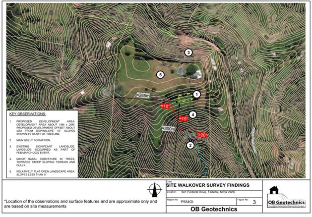
4.8 Submissions made in accordance with this Act or the Regs.
The development application was publicly exhibited.
There were 2 submissions of opposition made on the development application which are discussed hereafter:
Ø Landslide hazard
The property is adjacent to the landslip which occurred at Federal Drive and highlights concerns that the location of the proposed Dual occupancy will contribute to further instability at their land. The submitter notes that the development site (and greater locality) are well known for underground springs which can cause landslip when disturbed.
Comment:
The Federal Drive landslip occurred within the northern portion of the development site, on significantly steep land. The proposed dwelling is located approximately 140m to the south of the landslip, with substantially less gradient, on the opposite site of the crest to the landslip (see below).
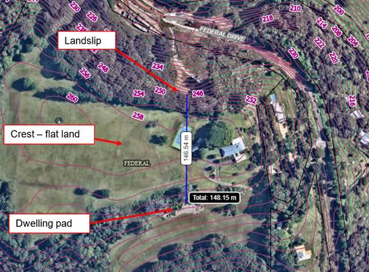
Council’s Development Engineer reviewed the proposal and the submitted geotechnical report and it is considered that landslip is not an issue for this proposed development.
Ø Relocation of Contaminated Soil to the site
The submission notes that they were advised by a tip truck driver that the site was the destination of up to 60 tipper loads (approximately 600 tonnes) of soil, relocated from the landslip at Federal Drive. The submitter is concerned that this soil is contaminated (having come from former banana plantation land) and will contribute to contamination of the environment and water table. In this regard the submitter notes the soil was then mulched up.
Comment: The matter was raised with the applicant planning consultant Chris Pratt from Planning resolutions) who advised the following:
The owner advises that there was no soil or fill delivered or moved to the site from the Federal Slip works. She was offered mulch created from fallen trees and some of the basalt rocks/ boulders that came from the Federal drive landslip area on her property. These were delivered by Byron shire Council contractors working on the Federal Slip. The basalt rocks and bounders were delivered to the tree line on the south side of the lower field away from the proposed dwelling site. The mulch and rocks are evident in the photograph. (See below) The land contamination assessment by Greg Alderson and Associates was carried out after this photo was taken.
Council’s Environmental Health Officer (EHO) reviewed the submitted preliminary contaminated land assessment (PSI) and concurs that the site is suitable for the proposed residential use. The soil testing was carried out after mulch was placed on house site. The report indicates the samples were taken on 22 November 2023. There is no evidence to suggest the land is contaminated. The area of the dwelling has a layer of mulch over it and there is no evidence of 60 trucks loads of soil being disposed of at the house site.
![]()
![]()
![]()
Ø Use of shared driveway
It is suggested that the driveway is not designed for or in a condition to support additional dwellings, and that insufficient sight-distances exist.
Comment: Council’s Development Engineer has reviewed the proposal and notes that the driveway and access is suitable and can be upgraded via Roads Act consent to upgrade the driveway. It is understood the neighbour next door benefits from a right of way over the driveway on the subject land. It is considered the driveway can cater for the additional dwelling and the extra traffic that generates. Conditions of consent are recommended accordingly for the driveway crossover within the road reserve to be resealed.
Ø Old windmill and bore
Proposal will have an impact on the bore and groundwater quality
Comment: The applicant has advised the old windmill has not been in operation for pumping water since the 1990’s and has been covered over with metal sheets and concrete blocks. The well is also above the land application area. The applicant advises the windmill is to be removed and the well permanently sealed to prevent future use and any potential impacts of cross contamination. Conditions to apply.
Ø Proposed dwelling location
The proposed dwelling location is prone to landslip and contains contaminated soil, and is an inappropriate location for the proposed dual occupancy dwelling.
Comment: As discussed above the proposed site is considered suitable for the development.
4.9 Public interest
The proposed development is unlikely to prejudice or compromise the public interest or create an undesirable precedent.
5. DEVELOPER CONTRIBUTIONS
5.1 Water & Sewer Levies
No Section 64 levies will be required.
5.2 Developer Contributions
Section 7.11 Contributions will be payable.
6. DISCLOSURE OF POLITICAL DONATIONS AND GIFTS
|
Disclosure details |
Response |
|
Has a Disclosure Statement been received in relation to this application? If Yes, Provide Disclosure Statement register reference: 91. |
Yes ☐ No ☒ |
|
Have staff received a ‘gift’ from anyone involved in this application that needs to be disclosed. |
Yes ☐ No ☒ |
7. CONCLUSION
The DA proposes New Dwelling to create Dual Occupancy (Detached).
The proposed development is satisfactory having regard to the relevant environmental planning instruments and planning controls applicable to the site. The proposal raises no significant issues in terms of environmental impacts which cannot be managed. The site is a serviced, unconstrained property and is considered suitable for the proposed development.
The application appropriately addresses the relevant constraints applying to the site, and is recommended for approval subject to the conditions listed in the Recommendation of this Report.
Staff Reports - Sustainable Environment and Economy 13.5
Report No. 13.5 PLANNING - Report of the Planning Review Committee held 4 April 2024
Directorate: Sustainable Environment and Economy
Report Author: Chris Larkin, Manager Sustainable Development
Noreen Scott, EA Sustainable Environment and Economy
File No: I2024/577
Summary:
This report provides the outcome of the Planning Review Committee (PRC) held on 4 April 2024.
NOTE TO COUNCILLORS:
In accordance with the provisions of S375A of the Local Government Act 1993, a Division is to be called whenever a motion for a planning decision is put to the meeting, for the purpose of recording voting on planning matters. Pursuant to clause 2(a) under the heading Matters to be Included in Minutes of Council Meetings of Council's adopted Code of Meeting Practice (as amended) a Division will be deemed to have been called by the mover and seconder of all motions relating to this report.
RECOMMENDATION:
That Council endorses the outcomes of the Planning Review Committee meeting held 4 April 2024.
Report
The PRC meeting was held on 4 April 2024. The meeting commenced at 3:00pm and concluded at 3:45pm.
Councillors: Mayor M Lyon, Cr D Dey, Cr S Ndiaye, Cr A Hunter, Cr P Westheimer, Cr Pugh.
Apologies: Cr Coorey.
Staff: Chris Larkin (Manager Sustainable Development).
Conflict of Interest: Cr Ndiaye DA 10.2023.346.1
|
DA No. / Applicant |
Property Address / Proposal |
Consultation / Submissions |
Reason/s / Outcome |
|
10.2024.20.1 |
1178 Myocum Road Use of land and existing shed for landscaping material supplies |
Level 2 No submission received. |
The perceived public significance of the application.
Report to Council |
|
10.2023.465.1 |
56B Bangalow Road A Multi Dwelling Housing development comprising of 24 Dwellings. Five of the Dwellings (Dwellings 1-5) will be affordable consistent with the definition within the Housing SEPP. Dwelling type A will consist of partially affordable (not consistent with the definition of affordable housing in the Housing SEPP) with Dwelling types D and E being adaptable product |
Level 2 30 submissions 19 for |
Staff Delegation |
|
10.2023.346.1 |
139 Bangalow Road Stage 1 Boundary Adjustment, Demolition of Existing Dwelling House, and 2 Lot Torrens Title Subdivision, Stage 2 Community Title Subdivision to Create 5 Community Title Residential Lots and Community Title Lot
|
Level 2 31 submissions against
|
The number of public submissions.
The perceived public significance of the application.
Report to Council |
The S 4.55 application to modify these development consents are referred to the Planning Review Committee to decide if the modification applications can be determined under delegated authority.
|
DA No. / Applicant |
Property Address / Proposal |
Consultation / Submissions |
Reason/s / Outcome |
|
10.2022.391.3 |
27 Paterson Street Section 4.55 to add window and door, and amend location of approved window and door to garage, amend window and door to sliding doors in principal dwelling, extend rear balcony and delete privacy screens from rear balcony and amend external finishes to secondary dwelling. |
Level 1 2 submissions against
|
Staff |
|
10.2021.425.3 |
24 Bayside Way Section 4.55 for minor design modifications to dwellings within Stage 1, increase in height of front fencing to 1.5m, and installation of feature signage. |
Level 2 No submissions |
Staff |
|
10.2021.657.2 |
375 Coorabell Road Modification to Stage the Development and Conditions relating to Bin Storage. |
Level 1 No submissions |
Staff |
|
10.2017.588.3 |
4 Marvel Street Modification of court approved condition of consent no. 87 base patron numbers related to approved restaurant and roof top bar. |
Level 2 No submissions |
Staff |
|
10.2008.12.4 |
142 Broken Head Reserve
Road S4.56 Modification to Approved Dwelling including, minor amendments to floor plans, additional bedroom, new spiral stairs and new second floor deck. |
Level 2 2 submissions against |
Staff
|
Staff Reports - Sustainable Environment and Economy 13.6
Report No. 13.6 PLANNING - DA 10.2023.229.1 - Tourist and Visitor Accommodation Comprising Four (4) Cabins – 131 The Tunnell Road, Billinudgel
Directorate: Sustainable Environment and Economy
Report Author: Greg Smith, Team Leader Planning Services
File No: I2024/599
Proposal:
|
DA No: |
10.2023.229.1 |
||
|
Planning Portal ref |
PAN-342667 |
||
|
Proposal description: |
Tourist and Visitor Accommodation Comprising Four (4) Cabins |
||
|
Property description: |
LOT: 9 DP: 582423 |
||
|
131 The Tunnell Road BILLINUDGEL |
|||
|
Parcel No/s: |
93350 |
||
|
Applicant: |
The trustee for R & G FAMILY TRUST |
||
|
Owner: |
Gung Ho Investments Pty Ltd |
||
|
Zoning: |
RU2 Rural Landscape |
||
|
Date received: |
23 June 2023 |
||
|
Integrated / Designated Development: |
☒ Integrated |
☐ Designated |
☐ Not applicable |
|
Public notification or exhibition: |
- Level 2 advertising under Council’s Community Participation Plan. - Exhibition period: 7/7/2023 to 20/7/2023 - No Submissions were received |
||
|
Variation request to Development Standards under an EPI (eg clause 4.6) |
Name of clause – Minimum lot sizes for certain rural tourist and visitor accommodation Clause number – 6.7 of Byron Local Environmental Plan 2014 Percentage value of variation sought – 13.47% Percentage value of the variation approved – 13.47% Brief justification for the variation - The variation is minimal. The standard was not in existence when the DA was lodged, there is a precedence with similar circumstances and there is unlikely to be any further applications in these circumstances. The site is suitable for the development and no significant environmental impacts are expected. |
||
|
Estimated cost |
$650,000.00 |
||
Summary:
The DA proposes Tourist and Visitor Accommodation Comprising Four (4) Cabins.
The application is referred to Council for determination due to the area of the site being 12.98 hectares, which is less than the planning control requiring the site for the proposed rural tourist and visitor accommodation (being in Zone RU2 Rural Landscape) to be at least 15ha under clause 6.7 Minimum lot sizes for certain rural tourist and visitor accommodation of Byron Local Environmental Plan 2014. The site is less than the development standard by 2.02 hectares, which represents a variation to the development standard of approximately 13.47%.
A written justification for the proposed variation to the lot size standard was submitted in accordance with Clause 4.6 of the LEP. The extent of the required variation to the development standard is minimal. The development standard was not in existence as at the date of lodgement of the development application, and the application was prepared with reference to the then applicable requirements. The site is suitable for and capable of accommodating the proposed tourist and visitor accommodation and the development is not assessed as having any significant environmental impacts. The written justification is well founded, and it is considered strict compliance with the development standard is unreasonable and unnecessary in the circumstances of the case and that there are sufficient environmental grounds to vary the development standard.
The development application was publicly exhibited from 7 July 2023 to 20 July 2023 in accordance with the Byron Shire Community Participation Plan. No submissions were received.
The development application appropriately addresses the relevant constraints applying to the site and is recommended for approval subject to the conditions in Attachment 1 to this Report.
NOTE TO COUNCILLORS:
In accordance with the provisions of S375A of the Local Government Act 1993, a Division is to be called whenever a motion for a planning decision is put to the meeting, for the purpose of recording voting on planning matters. Pursuant to clause 2(a) under the heading Matters to be Included in Minutes of Council Meetings of Council's adopted Code of Meeting Practice (as amended) a Division will be deemed to have been called by the mover and seconder of all motions relating to this report.
RECOMMENDATION:
That pursuant to Section 4.16 of the Environmental Planning & Assessment Act 1979, Development Application No. 10.2023.229.1 for Tourist and Visitor Accommodation Comprising Four (4) Cabins, be granted consent subject to the conditions of approval at the end of this report.
Attachments:
1 Attachment
1 - Recommended Conditions, E2024/42119
![]()
2 Attachment
2 - Plans, E2024/42118 ![]()
3 Attachment
3 - Clause 4.6 Written request for Variation to Development Standard, E2024/42117 ![]()
4 Attachment
4 - Vegetation Management Plan, E2024/46527
![]()
Assessment:
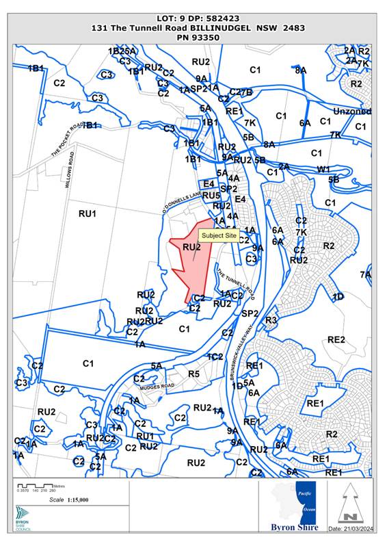
1. INTRODUCTION
1.1 History/Background

1.2 Description of the proposed development
This application seeks approval for Tourist and Visitor Accommodation Comprising Four (4) Cabins. The plans are included as Attachment 2 to this Report. The DA provides further descriptive details for the proposal as follows:
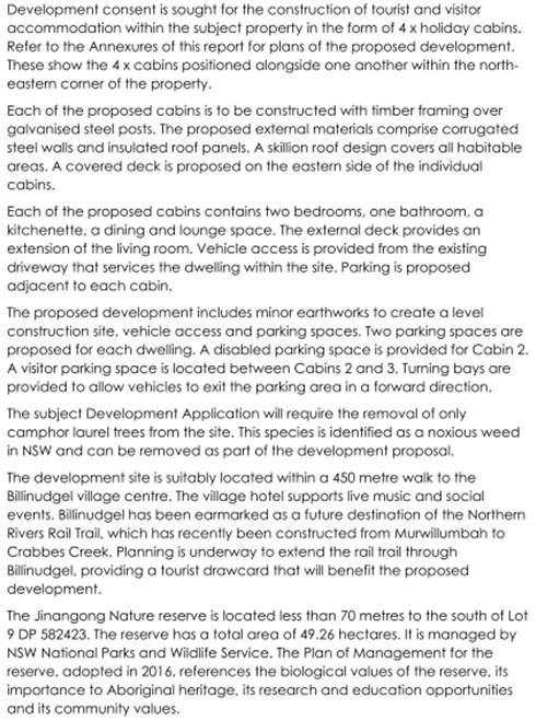
1.3 Description of the site
A site inspection was carried out on 25 August 2023.
|
Land is legally described |
LOT: 9 DP: 582423 |
|
|
Property address |
131 The Tunnell Road BILLINUDGEL |
|
|
Land is zoned: |
RU2 Rural Landscape |
|
|
Land area is: |
12.98 hectares |
|
|
Property is constrained by: |
Bush Fire Prone Land Flood Liable Land Acid Sulfate Soils Class 3 High Environmental Value Vegetation |
|
|
|
Is a BDAR required due to the location of the proposed development? |
☐ Yes ☒ No |
|
|
Are there any easements in favour of Council affecting the site? |
☐ Yes ☒ No |
|
|
Is there a Vegetation Management Plan which might affect the proposal? Note: The VMP submitted in support of the development application is recommended for approval. |
☒ Yes ☐ No |
|
|
Is there a Voluntary Planning Agreement which might affect the proposal? |
☐ Yes ☒ No |
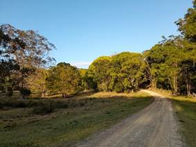
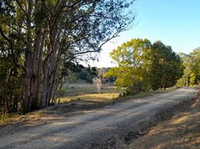
2. SUMMARY OF REFERRALS
|
Referral |
Issue |
|
Environmental Health Officer |
No objections subject to conditions. |
|
Development Engineer |
No objections subject to conditions. |
|
ET Engineer |
No objections subject to conditions. |
|
Ecologist |
No objections subject to conditions – see additional comments below. |
|
Resource Recovery |
No objections subject to conditions. |
|
Rural Fire Service (100B) |
No objections subject to conditions. |
Issues:
Council’s Ecologist advises in relation to ecological impacts as follows:
“Flora
Vegetation at the site has been historically cleared and thinned for agriculture, with regrowth vegetation dominated by Camphor Laurel and Small-leaved Privet. Small areas of intact native vegetation (sclerophyll forest communities dominated by Brush Box and Blackbutt) occur in the north and south of the site. Eight broad vegetation communities occur, include five native vegetation communities:
- PCT755: Brush Box tall moist forest of the northern ranges of the NSW North Coast Bioregion
- PCT692: Blackbutt - Tallowwood moist ferny open forest of the coastal ranges of the NSW North Coast Bioregion
- PCT872: Grey Ironbark – Grey Gum open forest of the northern escarpment ranges of the NSW North Coast Bioregion
- PCT1064: Paperbark swamp forest of the coastal lowlands of the NSW North Coast Bioregion and Sydney Basin Bioregion
- PCT780: Coastal floodplain sedgelands, rushlands, and forblands of the North Coast.
PCT1064 is characteristic of the threatened ecological community (TEC) Swamp Sclerophyll Forest on Coastal Floodplains of the New South Wales North Coast, Sydney Basin and South East Corner Bioregions. - PCT780is characteristic of the TEC Freshwater wetlands on coastal floodplains of the NSW North Coast, Sydney Basin and South East Corner bioregions.
No threatened flora species were confirmed at the site.
Fauna
The consultant ecologists have provided an assessment of likely threatened fauna and the report states:
No threatened fauna species were confirmed at the site, however there is potential for several species (eg. Rose-crowned Fruit-dove, Grey-headed Flying-fox, microchiropteran bats) to occur on an opportunistic or seasonal basis. The site provides poor quality habitat for Koala due to the low incidence of preferred feed trees and no signs of Koalas were recorded; there are few recent Koala records in the locality (BioNet atlas).
Riparian and corridor values
The site is within a mapped wildlife corridor.
Proposed Development Impact
The project bushfire assessment states that APZ for the proposed cabins (which are located in grassland areas) do not require native tree removal.
The project wastewater report states that the land application area (0.1 ha) comprises 6 x Camphor laurel trees in pasture grassland (not native vegetation) and that 2 x Banksia within the land application area will be retained.
A Vegetation Management Plan (VMP) has been prepared to address the requirements of Chapter D3 (Tourist Accommodation) of the DCP. As 4 cabins are proposed, 3600 trees or equivalent restoration works are required.”
3. SECTION 4.14 – BUSH FIRE PRONE LAND
Under section 4.14 of the Act, Council must be satisfied prior to making a determination for development on bush fire prone land, that the development complies with the document ‘Planning for Bush Fire Protection 2006’. The site is bush fire prone land. The development application was referred to the NSW Rural Fire Service, which provided it’s General Terms of Approval and Bush Fire Safety Authority for the proposal which is a special fire protection purpose.
Effect of 10/50 rule on significant vegetation: Not applicable as no homes are proposed.
4. SECTION 4.15C – MATTERS FOR CONSIDERATION – DISCUSSION OF ISSUES
Having regard to the matters for consideration detailed in Section 4.15(1) of the Environmental Planning & Assessment Act 1979 (EP&A Act), the following is a summary of the evaluation of the issues.
4.1 State Environmental Planning Policies (SEPP)
|
Considerations |
Satisfactory |
Unsatisfactory |
|
Biodiversity and Conservation SEPP 2021 Consideration: The proposal having regard to the provisions of the Biodiversity and Conservation SEPP raises no issues. |
☒ |
☐ |
|
Resilience and Hazards SEPP 2021 Consideration: In relation to coastal management, the proposed tourist and visitor accommodation cabins are not located within the part of the site which mapped as being within the Coastal Environment Area. In relation to potential for contamination and remediation of land, Council’s Environmental Health Officer confirmed that the Preliminary Site Assessment submitted in support of the DA has assessed and identifies that the land parcel is suitable for the proposed use. |
☒ |
☐ |
|
Transport and Infrastructure SEPP 2021 Consideration: The proposal is satisfactory having regard to the provisions of the Transport and Infrastructure SEPP. |
☒ |
☐ |
4.2 Byron Local Environmental Plan 2014 (LEP 2014)
LEP 2014 is an applicable matter for consideration in the assessment of the subject development application in accordance with subsection 4.15(1) of the EP&A Act because it applies to the subject land and the proposed development.
In accordance with LEP 2014 clauses 1.4 and 2.1 – 2.3:
(a) The proposed development is defined in the LEP 2014 Dictionary as tourist and visitor accommodation;
(b) The land is within the RU2 Rural Landscape according to the Land Zoning Map;
(c) The proposed development is permitted with consent; and
(d) The proposed development is satisfactory having regard to the Zone Objectives.
The following comments are provided on specific LEP provisions relating to the development.
In relation to clause 5.21 Flood Liable land, Council’s Development Engineer confirmed that the proposed development is satisfactory subject to conditions (which are included I the recommendation of this report below) relating to the flood planning level, use of flood compatible materials below the flood planning level, a flood evacuation plan and certification of floor levels as being are at or above the relevant flood planning levels.
In relation to clause 6.1 Acid Sulfate Soils, the site is in part Class 3 however Council’s Environmental Health Officer has confirmed that the development area is not affected by Acid Sulfate Soils.
In relation to clause 6.8 Rural and nature-based tourism development,
3(a) Council’s Development has raised no objection to the adequacy of the proposed vehicular access to and from the non-classified road;
3(b) The development is small scale, being of a scale that is small enough to be generally managed and operated by the principal owner living on the property, and low impact;
3(c) The development is complementary to the rural or environmental attributes of the land and its surrounds;
3(d) The development will not have a significant adverse impact on agricultural production, amenity or significant features of the natural environment;
(4) There is a lawfully erected dwelling house situated on the land and a dwelling house may be erected on the land under LEP 2014; and
(5) There is no proposed ancillary caretaker’s or manager’s residence and is not bed and breakfast accommodation.
Clause 4.6 Exceptions to Development Standards
The development application seeks a variation to clause 6.7 Minimum lot sizes for certain rural tourist and visitor accommodation by proposing a rural tourist and visitor accommodation on the site which is in Zone RU2 Rural Landscape and is not a lot which is at least 15ha. The area of the existing lot is 12.98 hectares, which is less than the development standard by 2.02 hectares. This represents a variation to the development standard of approximately 13.47%.
Applicants Submission
The development application is supported by a written request that strict compliance with the development standard is unreasonable and unnecessary and that there are sufficient environmental grounds to vary the controls as follows (the full Clause 4.6 Written Request for Variation is included as Attachment 3 to this Report):
“Unreasonable and Unnecessary Considerations
The NSW Land & Environment Court has previously identified 5 common methods that an applicant may use to establish that compliance with a development standard is unreasonable or unnecessary in the circumstances of the case. These are discussed below:
1. Clause 6.7 of Byron Local Environmental Plan 2014 does not nominate an objective for the development standard. However, it is understood that Byron Shire Council recently added this development standard to create a limit on the number of properties within RU1 and RU2 zones that are eligible for seeking development consent for tourist and visitor accommodation. It is noted that at the time Development Application No. 10.2023.229.1 was submitted to Byron Shire Council, this development standard did not exist. It was anticipated that Byron Shire Council would determine the Development Application prior to the development standard being adopted. See comments under Item 2 below.
2. Development Application No. 10.2023.229.1 comprehensively demonstrates that the subject site (Lot 9 DP 582423) is suitable for and capable of accommodating tourist & visitor accommodation, despite the land size being less than 15 hectares. The four proposed holiday cabins sit comfortably within the lower slopes of the site, despite the land being 2.02 hectares short of the 15 hectare minimum. Compliance with Byron Shire Council's objective to limit the size of properties that are eligible for tourist and visitor accommodation is unnecessary where such development is achieved without adverse impacts on the natural and built environments.
3. Byron Local Environmental Plan 2014 first came into effect in May 2014 without a development standard that specified a minimum lot size for tourist & visitor accommodation. For almost a decade, Byron Shire Council assessed and granted consent to multiple tourist & visitor accommodation proposals within properties that are less than 15 hectares. Byron Development Control Plan 2014 previously included provisions which endorsed up to 3 x holiday cabins within properties that had an area of between 0 and 3 hectares. Refer to a copy of Table D3.1 below which confirms Council's previously adopted density allowances. A property with an area of 12.98 hectares was eligible for over 10 cabins using this table.
A review of the Council minutes from the two Council meetings which resulted in the adoption of a 15 hectare minimum lot size does not clearly set out the reasoning for this particular number.
Council Report 13.3 on 8 June 2023 stated:
At the 10 December 2020 Planning Meeting, Council received a report that reviewed the current controls for rural tourist accommodation and resolved 20-691 to prepare a planning proposal and DCP amendment.
A planning proposal and draft amendments to DCP 2014 Chapter D3 Tourist Accommodation where subsequently prepared.
During the preparation of these amendments NSW Department of Planning and Environment (DPE) were reviewing the State planning controls for tourism on rural land and in December 2022 finalised the agritourism reforms.
Based on consultation with DPE and the Gateway determination (issued 25 October 2022), the planning proposal was amended to address the agritourism planning reforms. This included reducing the minimum lot size proposed for rural tourist and visitor accommodation from 20 hectares to 15 hectares. This minimum lot size is consistent with the lot size applied to farm stay accommodation as complying development within the agritourism reform.
There does not appear to be any strong justification for either a 20 hectare or a 15 hectare minimum. The report simply makes reference to the minimum allotment size under State Environmental Planning Policy (Exempt and Complying Development Codes) 2008.
Given the number of planning approvals that were granted for holiday cabin development on properties below 15 hectares in area since 2014, it is argued that the underlying purpose is defeated. It would be unreasonable to refuse consent to the proposed holiday cabin development on a 12.98 hectare property when it has easily been demonstrated that the site is suitable for that development and where environmental impacts are minimal.
4. As discussed above, Byron Shire Council has granted consent to multiple proposals for tourist and visitor accommodation within development sites that have an area of less than 15 hectares.
Examples include:
DA 10.2022.502.1 - 3 x cabins at 15 Taylors Road, Nashua (8.144ha site)
DA 10.2021.612.1 - 3 x holiday cabins at 80 Yagers Lane, Skinners Shoot (8.08ha site).
DA 10.2020.212.1 - 3 x holiday cabins at 63 Yankee Creek Road, Mullumbimby Creek (1.25ha site)
It is argued that strict compliance with the development standard has been destroyed by previous decisions where Byron Shire Council has supported tourist and visitor accommodation development on lots with an area of less than 15 hectares.
5. It is not argued that the RU2 zoning of the area is unreasonable or inappropriate. It is argued that the 15 hectare development standard is unreasonable and inappropriate.
Sufficient Environmental Planning Grounds
The subject Development Application was submitted to Byron Shire Council in June 2023, which was prior to the 15 hectare development standard being adopted. The following comments were made within the Town Planning Report that accompanied the Development Application:
The subject property has a land area of 12.98 hectares which is 2.02 hectares short of the future 15 hectare development control. The subject Development Application is submitted for assessment under the current development controls which do not provide a minimum lot size for tourist and visitor accommodation development. It is anticipated that Byron Shire Council will determine the Development Application prior to the formalisation of the revised controls. The proposal is capable of support under the current development controls.
It is noted that the subject property, with an area of 12.98 hectares, is well suited to holiday cabin development. The proposed cabins are located within the north-east of the property, which is within walking distance to the Billinudgel village. The topography of the locality is such that the development will not impact on surrounding rural-lifestyle properties. Site constraints can be appropriately managed. The property provides a suitable space for guests to experience the rural environment.
Unfortunately, over 8 months after lodgement, the Development Application has not been determined. During the assessment period, the 15 hectare development standard has been incorporated into Byron Local Environmental Plan 2014.
It is clear that at the time the Development Application was submitted, the proposal met the applicable planning controls. It is by way of an extended assessment period that the proposal is now inconsistent with Clause 6.7. It is reasonable to in the circumstances that Byron Shire Council would apply some grace to proposal and endorse a variation to the newly formed standard.
The comprehensive documentation that has been submitted with the Development Application demonstrates that the site is suitable for the proposed development. Byron Shire Council has granted consent to multiple proposals for tourist and visitor accommodation within development sites that have an area of less than 15 hectares. Examples include:
· DA 10.2022.502.1 - 3 x cabins at 15 Taylors Road, Nashua (8.144ha site)
· DA 10.2021.612.1 - 3 x holiday cabins at 80 Yagers Lane, Skinners Shoot (8.08ha site).
· DA 10.2020.212.1 - 3 x holiday cabins at 63 Yankee Creek Road, Mullumbimby Creek (1.25ha site)
It is argued that strict compliance with the development standard has been destroyed by previous decisions where Byron Shire Council has supported tourist and visitor accommodation development on lots with an area of less than 15 hectares. Sufficient environmental planning grounds have been provided to allow the Development Application to be supported.
Note that the following density allowances existed at the time the Development Application was submitted to Council in June 2023:
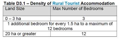
The Objectives of the RU2 Rural Landscape Zone are as follows:
· To encourage sustainable primary industry production by maintaining and enhancing the natural resource base.
· To maintain the rural landscape character of the land.
· To provide for a range of compatible land uses, including extensive agriculture.
· To enable the provision of tourist accommodation, facilities and other small-scale rural tourism uses associated with primary production and environmental conservation consistent with the rural character of the locality.
· To protect significant scenic landscapes and to minimise impacts on the scenic quality of the locality.
The subject property has a history of residential and agricultural activities. Historic mapping and aerial photography shows a dwelling within the south of the property, bananas within the central north facing slopes and cattle grazing throughout. The proposal seeks to establish tourist and visitor uses in the north of the property and continue cattle grazing in the surrounding farmland.
The development does not adversely impact on the scenic environment nor the rural character of the locality. Predominantly rural-lifestyle properties are located within the surrounding area. The proposed land use will not compromise the objectives of the zone.”
Staff Considerations
It is not agreed that the integrity of the development standard is destroyed because of the examples of approvals cited in the clause 4.6 request. Some comments are provided in relation to each of these as follows:
· DA 10.2022.502.1 - 3 x cabins at 15 Taylors Road, Nashua (8.144ha site)
Comment: 45.7% request for variation. Lodged prior to development standard coming into effect, approved at Council meeting on 14 September 2023 after the development standard came into effect.
· DA 10.2021.612.1 - 3 x holiday cabins at 80 Yagers Lane, Skinners Shoot (8.08ha site).
Comment: Approved 27 February 2023, prior to coming into effect of development standard.
· DA 10.2020.212.1 - 3 x holiday cabins at 63 Yankee Creek Road, Mullumbimby Creek (1.25ha site)
Comment: Approved 6 October 2020, prior to coming into effect of development standard.
However it is considered that the written request is well founded, that strict compliance with the development standard is unreasonable and unnecessary in the circumstances of the case and that there are sufficient environmental grounds to vary the development standard for the following reasons:
a. The extent of the required variation to the development standard is minimal, being only 13.47%.
b. The development standard was not in existence as at the date of lodgement of the development application, and the application was prepared with referenced to the then applicable requirements. The application was lodged on 23 June 2023 whereas the development standard came into effect on 14 July 2023.
c. The site is considered to be suitable for and capable of accommodating the proposed tourist and visitor accommodation.
d. The development is not assessed as having any significant environmental impacts.
e. Many approvals exist for tourist and visitor accommodation developments on lots of less than 15 hectares, not just approvals dating back to the commencement of LEP 2014, but approved under the prior LEP 1988. Council approved DA 10.2022.502.1 which was lodged prior to the development standard coming into effect, being a proposal which required a much larger variation.
f. The Development Control Plan previously provided a sliding scale relating the maximum allowable number of tourist and visitor accommodation bedrooms to the area of the site. On that basis, the development was eligible to have a total of 9 bedrooms, and complies because it has a total of 8 bedrooms.
g. The proposal is considered to be satisfactory having regard to the objectives of the applicable RU2 Rural Landscape Zone, including to provide for tourist accommodation consistent with the rural character of the locality and will not have a significant impact on scenic landscapes or scenic quality of the locality.
h. This is likely to be the last tourist and visitor accommodation development consent relating to a development application not complying with now, but lodged prior to the coming into effect of, the development standard.
Further the proposal is in the public interest having regard to the underlying objectives of the development standard (given that there are no stated objectives) for the above reasons. The concurrence of the Planning Secretary is not required.
It is recommended that the development standard can be varied in this instance.
a) The development is satisfactory having regard to the requirements outlined in clause 4.6;
b) The development is satisfactory having regard to applicable Department of Planning, Housing and Infrastructure Circulars;
c) The development is satisfactory having regard to relevant caselaw;
d) The development application demonstrates that compliance is with the development standard is unreasonable and unnecessary;
e) The development application demonstrates that there are sufficient environmental planning grounds to justify contravening the standard;
f) The development application demonstrates that that the development in the public interest;
g) The development application demonstrates that the development is consistent with the objectives of the standard and the zone;
h) The development application demonstrates how the development produces a better planning outcome than one that strictly complied with the development standard; and
i) The development application demonstrates what it is about the grounds of the request that are particular to the proposed development on this site, and that there has to be something particular to the development on this site to justify the variation.
4.3 Any proposed Instrument that has been the subject of public consultation and has been notified to the consent authority
There are no proposed instruments of significant applicability to the development.
4.4 Byron Shire Development Control Plan 2014 (DCP 2014)
In relation to Chapter B13 Access and Mobility, the plans indicate that Cabin 2 is to be accessible with the exception of bedroom 2. A condition is recommended requiring that Cabin 2 (excluding bedroom 2) must have disabled access in accordance with the provisions of the Building Code of Australia and Australian Standard AS1428.1 – Design for Access and Mobility – General Requirements for Access – New Buildings. Parking must be provided in accordance with Australian Standard AS/NZS 2890.6:2009 Parking Facilities – Part 6: Off-street parking for people with disabilities. The plans submitted for approval of the Construction Certificate must demonstrate compliance with the requirements of this condition.
In relation to Chapter D3: Tourist Accommodation,
A. The proposal complies with the D3.2.3 Character and Design in Rural Zones objectives and performance criteria for the following reasons:
Objectives
1. The proposal is a ‘low scale’ form of tourist accommodation that is compatible with the surrounding landscape and with the character and amenity of development in the locality.
2. The development includes well-designed buildings that provide a high level of amenity to guests, respond to the subtropical climate, and enhance the Byron Shire’s unique image, diverse lifestyles and local character.
3. The proposal is sustainable, well designed rural tourist accommodation that harmonises with the rural and natural character of its locality.
4. The proposal incorporates ecologically sustainable management practices to the satisfaction of Council’s Ecologist, which serve to enhance the appeal of tourist accommodation and promote Byron Shire as a leading sustainable tourism destination. This includes for example vegetation and habitat protection.
Performance Criteria
1. The proposal is low scale and compatible with the character and amenity of the surrounding rural and natural landscape, and with development in the locality.
2. The proposal is not contrary to the provisions of Chapter D2 Residential Accommodation and Ancillary Development in Rural Zones.
3. The development observes the road and boundary setback requirements specified in Chapter D2 Residential Accommodation and Ancillary Development in Rural Zones (D2.2.2) and the character and visual impact requirements (D2.2.3).
4. The location of the proposal will not interrupt the skyline, is below the natural tree line and is along the contour. The proposal is not considered to require a visual impact assessment.
5. The development is in a ‘cluster’ pattern and does not present a continuous visual wall of buildings.
6. The development is climate responsive and oriented to maximise solar access and summer shade and take advantage of rural vistas and breezes to the extent that is possible.
7. The design responds to the subtropical climate with open planned exterior and interior design which maximises air flow and cross ventilation. The design includes shaded decks, large eaves and weather protection, high ceilings to support natural airflow, and use of insulating and lightweight materials.
8. Colours and materials complement and are sympathetic to those of the surrounding landscape. A condition is recommended in this regard.
9. Tourist accommodation in rural zones should be located on suitable sites that offer a high level of amenity for guests with views, breezes and outlooks over the rural landscape or natural environment, typically, with an east, north-east or northerly orientation that maximise solar access and energy efficient design practices.
B. In relation to the D3.3.4 Rural Tourist Accommodation and Farm Stay Accommodation prescriptive measures, the rural tourist bedroom and building density provisions were not in effect at the date of lodgement of the DA. The new provisions have a minimum site area of 15 hectares for rural tourist accommodation, and the site is less than that minimum requirement. However at the time of DA lodgement, the density provisions were as follows:
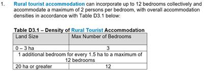
On this basis, the area of the site is 12.98 hectares which would permit 3 bedrooms + (12.98 hectares – 3 hectares) / 1.5 hectares = 9.65 bedrooms (that is, 9 bedrooms). The proposed development has 8 bedrooms and complies with the prescriptive measure as at the date of lodgement.
The proposal complies with the remaining prescriptive measures of D3.3.4 as follows:
3. The proposal includes features as follows:
a) Each cabin has a gross floor area not more than 60m2 comprising a maximum of two (2) bedrooms, a kitchenette and bathroom / toilet amenities. Rural tourist accommodation opens up onto outdoor recreation / living areas with access to winter sun and summer shade, and where possible orientated to take advantage of views of the surrounding rural landscapes.
b) All weather car parking is provided on-site as per the recommendations of the Development Engineer.
c) External pedestrian access is provided between buildings and car parking comprising connecting pathways. A condition is recommended in this regard.
d) Council’s Environmental Health Officer recommended a condition regarding noise.
e) A landscape plan is submitted which is recommended for approval.
f) The development benefits from existing road and physical infrastructure and utilises a single access point from the public road network to service both the accommodation and residential use of the site.
g) One of the rural tourist accommodation buildings is required to have disabled access in accordance with a recommended condition.
h) No laundries are shown on the plans. The Applicant instead advises that “there is a laundromat within walking distance in Billinudgel”.
i) A purpose-built group accommodation building is is not proposed.
j) The siting of rural tourist accommodation is such that:
i) adequate separation distances are incorporated to minimise the potential for land use conflict between the proposed rural tourist facility and existing or potential conflicting land uses, to the satisfaction of Council’s Environmental Health Officer;
ii) the orientation is easterly as required;
iii) the development is arranged in a ‘cluster’ pattern and does not present as a continuous visual wall of buildings.
iv) The buildings are located such that none is more than 20m from at least one other.
v) the proposal will not significantly affect the conduct and productivity of any agricultural operations on the site.
vi) The development does not interrupt the skyline.
vii) The cabins utilise complementary colour values to the surrounding landscape, and conditions are recommended in this regard.
4. Council’s ET Engineer has raised no objection to the proposal to connect to the water main, and conditions are recommended in this regard.
5. Council’s Environmental Health Officer advised that the proposal is satisfactory in relation to dust and noise. Council’s Development Engineer confirmed that the proposal is satisfactory in relation to existing road conditions. No significant impacts on local amenity are expected, subject to compliance with recommended conditions.
6. Council’s Development Engineer has recommended conditions in relation to road access to the site.
7. A condition is recommended requiring the proposed tourist and visitor accommodation to be for the purpose of providing short-term holiday accommodation on a commercial basis only.
8. There is an existing lawfully erected dwelling house on this site.
9. Council’s Ecologist recommends approval of the submitted vegetation management plan (VMP) which is included in Attachment 4 to this Report, which includes the following works, subject to a condition requiring it to be amended to note that compliance with the RFS setbacks (as per the RFS letter of 20 November 2023) is required with regard to the Vegetation Management Zone:
10. Farm stay accommodation is not proposed.
11. No outdoor recreational facilities such as tennis courts, sporting facilities or pools are proposed.
12. A fire refuge building is not proposed.
13. A communal guest facility building is not proposed.
4.5 Environmental Planning and Assessment Regulation 2021 considerations
|
|
Applicable to the proposal: |
Considered the control as it relates to the proposal: |
If this control is applicable, does the proposal comply? |
|
Clause 92 - Additional matters that consent authority must consider Section 61 - Additional matters that consent authority must consider |
☐ Yes ☒ No |
☐ Yes ☐ No ☒ NA |
☐ Yes ☐ No ☒ NA |
|
Clause 93 Fire safety and other considerations Section 62 - Consideration of fire safety |
☐ Yes ☒ No |
☐ Yes ☐ No ☒ NA |
☐ Yes ☐ No ☒ NA |
|
Clause 94 - Consent authority may require buildings to be upgraded Section 64 - Consent authority may require upgrade of buildings |
☐ Yes ☒ No |
☐ Yes ☐ No ☒ NA |
☐ Yes ☐ No ☒ NA |
|
Clause 94A - Fire safety and other considerations applying to erection of temporary structures Section 63 - Considerations for erection of temporary structures |
☐ Yes ☒ No |
☐ Yes ☐ No ☒ NA |
☐ Yes ☐ No ☒ NA |
4.6 The likely impacts of that development, including environmental impacts on both the natural and built environments, and social and economic impacts in the locality
4.6.1
|
Impact on: |
Likely significant impact/s? |
|
Natural environment |
No. The proposal will not have a significantly adverse impact on the natural environment of the locality. Council’s Ecologist raised no objection to the proposal on the basis of impacts on High Environmental Value Vegetation. |
|
Built environment |
No. The proposal will not have a significantly adverse impact on the built environment of the locality. |
|
Social Environment |
No. The proposal will not have a significant social impact on the locality. |
|
Economic impact |
No. The proposal will not have a significant economic impact on the locality. |
|
Construction Impacts |
No. The development will generate minor impacts during its construction. Conditions of consent recommended to control hours of work, builders waste, construction noise, installation of sedimentation and erosion control measures and the like to ameliorate such impacts. |
4.6.2 Marine Estate Management Act 2014
The development is unlikely to have an effect on the plants or animals within the Cape Byron Marine Park or their habitat.
4.6.3 Council Policies applicable to the proposed development?
|
Council Policy |
Consideration |
|
Council’s Environmental Health Officer raised no objection to the proposal on the basis of potential for contamination. |
4.7 The suitability of the site for the development
The site is a serviced, unconstrained property and is suitable for the proposed development.
4.8 Submissions made in accordance with this Act or the regulations
The development application was publicly exhibited.
There were no submissions made on the development application.
4.9 Public interest
The proposed development is unlikely to prejudice or compromise the public interest or create an undesirable precedent.
5. DEVELOPER CONTRIBUTIONS
5.1 Water & Sewer Levies
No Section 64 levies will be required.
5.2 Developer Contributions
Section 7.12 Levy will be payable.
6. DISCLOSURE OF POLITICAL DONATIONS AND GIFTS
|
Disclosure details |
Response |
|
Has a Disclosure Statement been received in relation to this application? If Yes, Provide Disclosure Statement register reference: 91. |
Yes ☐ No ☒ |
|
Have staff received a ‘gift’ from anyone involved in this application that needs to be disclosed. |
Yes ☐ No ☒ |
7. CONCLUSION
The DA proposes Tourist and Visitor Accommodation Comprising Four (4) Cabins.
The proposed development is satisfactory having regard to the relevant environmental planning instruments and planning controls applicable to the site. The proposal raises no significant issues in terms of environmental impacts which cannot be managed. The site is a serviced, unconstrained property and is considered suitable for the proposed development.
The application appropriately addresses the relevant constraints applying to the site, and is recommended for approval subject to the conditions listed in Attachment 1 to this Report.
Staff Reports - Infrastructure Services 13.7
Staff Reports - Infrastructure Services
Report No. 13.7 Tender 2024-2089 Stormwater Management Plan Implementation - Package 1
Directorate: Infrastructure Services
Report Author: Ricky Ballard, Project Officer
File No: I2024/659
Summary:
On 9 February 2024, the General Manager, under delegated authority, approved the use of the open tender method to call for tenders for Contract 2024-2089 Stormwater Management Plan Implementation Project – Package 1.
The Request for Tender was advertised from 21 February 2024 to 22 March 2024. Tenders were received from the following organisations:
· Civilcs Pty Ltd
· Kingsline Pty Ltd
· RCC Earthworks Pty Ltd
· Terra Firma Industries Pty Ltd
Tenders have been assessed in accordance with the provisions of the Local Government (General) Regulations 2021. This report summarises the background and assessment of the tenders and provides a recommendation to award the tender for Contract 2024-2089 Stormwater Management Plan Implementation Project – Package 1.
That Council:
1. Awards Tender 2024-2089 Stormwater Management Plan Implementation Project – Package 1 to the preferred supplier identified in the tender evaluation report (Confidential Attachment #1 – E2024/47840).
2. Makes public its decision, including the name and amount of the successful tenderer, in accordance with Clause /179(b) of the Local Government (General) Regulation 2021.
Attachments:
1 Confidential - Evaluation Panel Recommendation Report Stormwater Management Plan Implementation Project - Package 1 2024-2089 (RB), E2024/47840
Report
On 9 February 2024 the General Manager, under delegated authority, approved the use of the open tendering method to call for tenders for Contract 2024-2089 Stormwater Management Plan Implementation Project – Package 1.
An upgrade to the stormwater infrastructure is required at Byron Shire Council’s Resource Recovery Centre (BRRC) as part of a program of works to be undertaken over the next 2 years, these works will ensure the best management of stormwater and leachate during daily operations and high rainfall events. This tender evaluation relates to works proposed for package 1 of the Stormwater Management Plan Implementation. These works are a part of the larger BRRC program of works which includes the Leachate System Upgrade and Southern Landfill Capping and Closure Projects.
The Stormwater Management Plan Implementation Project – Package 1 has been prioritised as the first works to be undertaken for this program due to the impacts of stormwater on the existing leachate system, minimal planning requirements and site personnel feedback. The scope of this project will focus primarily on the northern landfill area. Pond expansions and other southern swale stormwater upgrades will form Package 2 and will be completed alongside the Capping and Closure Project next year.
This project, along with the Leachate System Upgrade, are both required to be delivered this year during the expected dry period before future inclement weather events can affect the site’s deteriorated stormwater management system. The NSW EPA have been consulted throughout the planning and design process and are supportive of the project and its timing in relation to the full program of works.
The Request for Tender sought responses from proponents to supply and/or construct the following works in accordance with the Stormwater Management Plan Implementation Project – Package 1:
• Open swales;
• Grated drains;
• Gravel trench drains;
• Culverts and headwalls; and
• Pits.
The Contract is expected to commence in May 2024 for a period of 12 weeks.
The Contract will be managed by the Project Officer.
Tenders were advertised as follows:
VendorPanel Online: 21 February 2024 and closed on 22 March 2024.
An optional briefing and site inspection was held at the Byron Resource Recovery Centre (BRRC) on 4 March 2024 at 2pm and was attended by the following suppliers:
· Civilcs Pty Ltd
· RCC Earthworks Pty Ltd
The briefing/site inspection was included in a VendorPanel notice. The purpose of the briefing/site inspection was to familiarise contractors with the site conditions and constraints.
An Evaluation Panel comprising of two Council staff members and one consultant (Talis Consultants) was formed.
Tenders closed on 22 March and tenders were received from the following proponents:
· Civilcs Pty Ltd
· Kingsline Pty Ltd
· RCC Earthworks Pty Ltd
· Terra Firma Industries Pty Ltd
Tenders were evaluated by the Evaluation Panel in accordance with the following evaluation criteria:
Mandatory criteria: <ensure the listed criteria match details in RFT and evaluation plan>>
a) Tenderer must have a valid Australian Business Number.
b) Substantial conformance to Conditions of Contract and Statement of Requirements.
c) Workers compensation insurance for all employees.
d) Holds, or is willing to obtain, the insurances as specified in the Statement of Requirements.
e) Satisfactory Work Health and Safety practices.
f) Commitment to ethical business practice principles.
Qualitative criteria:
|
Criteria |
Elements |
|
Profile and relevant experience |
Tenderer profile |
|
Previous relevant experience |
|
|
Environmental practices |
|
|
Opportunities for disadvantaged people |
|
|
Local employment opportunities |
|
|
Quality and availability of resources |
Proposed key personnel |
|
Proposed staff |
|
|
Use of subcontractors |
|
|
Vehicles, plant and equipment |
|
|
Delivery Plan |
Goods/services standards and methodology |
|
Implementation plan |
|
|
Product sustainability |
|
|
Supporting local business, social enterprise and Indigenous business |
|
|
Price |
Total contract price |
Following the evaluation, the Evaluation Panel conducted referee and financial checks on the preferred tenderer. The results of these checks were deemed by the Evaluation Panel to be satisfactory as detailed in the attached Evaluation Report.
Financial Considerations
The price basis for the contract is a lump sum.
Council has budgeted $536,295.80 for this project.
There is sufficient funding for the proposed contract in the current budget.
Statutory and Policy Compliance Considerations
The tendering process has been undertaken in accordance with Council’s Purchasing and Procurement Policy, and the provisions of the Local Government (General) Regulation 2021.
The Local Government (General) Regulations 2021 define the options available to Council. An extract is provided below.
Local Government (General) Regulation 2021 - Reg 178
178 Acceptance of tenders
(1) After considering the tender submissions for a proposed contract, the council must either—
(a) accept the tender submission that, having regard to all the circumstances, appears to it to be the most advantageous, or
(b) decline to accept any of the tender submissions.
(1A) Without limiting subsection (1), in considering the tender submissions for a proposed contract for the performance of domestic or other waste management services, the council must take into account whether or not existing workers (within the meaning of section 170) will be offered employment or engagement on terms and conditions comparable to those applicable to the workers immediately before the tender submissions.
(2) A council must ensure that every contract it enters into as a result of a tender submission accepted by the council is with the successful tenderer and in accordance with the tender (modified by any variation under section 176). However, if the successful tender submission was made by the council (as provided for in section 55(2A) of the Act), the council is not required to enter into any contract in order to carry out the requirements of the proposed contract.
(3) A council that decides not to accept any of the tender submissions for a proposed contract or receives no tender submissions for the proposed contract must do one of the following—
(a) postpone or cancel the proposal for the contract,
(b) invite, in accordance with section 167, 168 or 169, fresh tender submissions based on the same or different details,
(c) invite, in accordance with section 168, fresh applications from persons interested in making a tender submission for the proposed contract,
(d) invite, in accordance with section 169, fresh applications from persons interested in making a tender submission for contracts of the same kind as the proposed contract,
(e) by resolution of the council, enter into negotiations with any person (whether or not the person was a tenderer) with a view to entering into a contract in relation to the subject matter of the tender,
(f) carry out the requirements of the proposed contract itself.
(4) If a council resolves to enter into negotiations as referred to in subsection (3)(e), the resolution must state the following—
(a) the council’s reasons for declining to invite fresh tender submissions or applications as referred to in subsection (3)(b)–(d),
(b) the council’s reasons for determining to enter into negotiations with the person or persons referred to in subsection (3)(e).
Council’s endorsement of the recommendation to award the tender as recommended in the attached Evaluation Report is sought.
Reports of Committees - Infrastructure Services 14.1
Reports of Committees - Infrastructure Services
Report No. 14.1 Report of the Local Traffic Committee Meeting held on 16 April 2024
Directorate: Infrastructure Services
File No: I2024/613
Summary:
The attachment to this report provides the minutes of the Local Traffic Committee Meeting held on 16 April 2024 for determination by Council.
Council’s action on the LTC advice will be:
a) If Council is in agreement with the LTC unanimous support then the proposal may be approved. In these cases there is no conflict between Council and the advice of the LTC, consequently there is no need for Council to inform TfNSW or the NSW Police representatives of the decision.
b) If Council is in agreement with the LTC unanimous support, but no longer wants to proceed, the proposal may still be rejected.
c) If Council is in agreement with the LTC unanimous decline then the proposal may be rejected. Again there is no conflict between Council and the advice of the LTC. Consequently there is no need for Council to inform TfNSW or the NSW Police representatives of the decision.
d) If Council decides to proceed with a proposal where the advice of the LTC is not unanimous support, then the Council must first advise the TfNSW and the NSW Police representatives in writing of their intention to approve the proposal. TfNSW or the NSW Police may then lodge an appeal to the Regional Traffic Committee (RTC).
e) If Council decides to proceed with a proposal where the advice of the LTC is a unanimous decline, then the Council must first advise the TfNSW and NSW Police representatives in writing of their intention to approve the proposal. TfNSW or the NSW Police may then lodge an appeal to the RTC.
Due to the fact that the TfNSW and the NSW Police have the power to appeal certain decisions of the Council, the LTC cannot provide its advice to Council until both TfNSW and the NSW Police have provided their vote on the issue.
RECOMMENDATION:
1. That Council notes the minutes of the Local Traffic Committee Meeting held on 16 April 2024.
1 Minutes
16/04/2024 Local Traffic Committee, I2024/557
![]()
Report
The attachment to this report provides the minutes of the Local Traffic Committee Meeting of 16 April 2024 for determination by Council. The agenda for this meeting can be located on Council’s website at:
Agenda of Local Traffic Committee Meeting - Tuesday, 16 April 2024 (infocouncil.biz)
This report contains the recommendations of the Local Traffic Committee (LTC) meeting held on 16 April 2024.
Committee Recommendation
As per the Reports listed within the Local Traffic Committee Meeting of 16 April 2024.
Financial Implications
As per the Reports listed within the Local Traffic Committee Meeting of 16 April 2024.
Statutory and Policy Compliance Implications
As per the Reports listed within the Local Traffic Committee Meeting of 16 April 2024.