Minutes of Meeting
Local Traffic Committee Meeting
|
Venue |
Conference Room, Station Street, Mullumbimby |
|
Date |
Tuesday, 11 June 2024 |
|
Time |
11.30am |

Minutes of Meeting
Local Traffic Committee Meeting
|
Venue |
Conference Room, Station Street, Mullumbimby |
|
Date |
Tuesday, 11 June 2024 |
|
Time |
11.30am |
BYRON SHIRE COUNCIL
Local Traffic Committee Meeting Minutes 11 June 2024
MINUTES of the Local Traffic Committee Meeting held on Tuesday, 11 June 2024
File No: I2024/911
Meeting Commenced: 11:36AM
PRESENT:
|
Councillor: |
Cr M Lyon |
Present |
|
Transport for NSW: |
Alexie Miller (comments provided via email E2024/66614) |
Apology |
|
NSW Police: |
Detective Chief Inspector Matt Kehoe |
Present |
|
MP: |
Audrey Warren on behalf of Tamara Smith MP |
Apology |
|
Staff: |
James Flockton (Infrastructure Planning Coordinator) |
Present |
|
Staff: |
Ben Taylor (Traffic Engineer) |
Present |
|
Staff: |
Shelley Currie (Road Safety Officer) |
Present (online) |
|
Staff: |
Sarah Nagel (Manager Public and Environmental Services) |
Present |
|
Staff: |
Gray Blunden (Development Engineer) |
Present (online) |
|
Staff: |
Honey Ayres (Infrastructure Planning Support Officer) |
Present |
As noted above.
There were no declarations of interest raised.
Adoption of Minutes from Previous Meetings
|
That the minutes of the Local Traffic Committee Meeting held on 14 May 2024 be confirmed. (Lyon/Kehoe) The recommendation was put to the vote and declared carried. |
None.
Outstanding Issues/Resolutions
None.
|
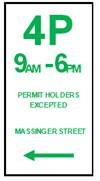
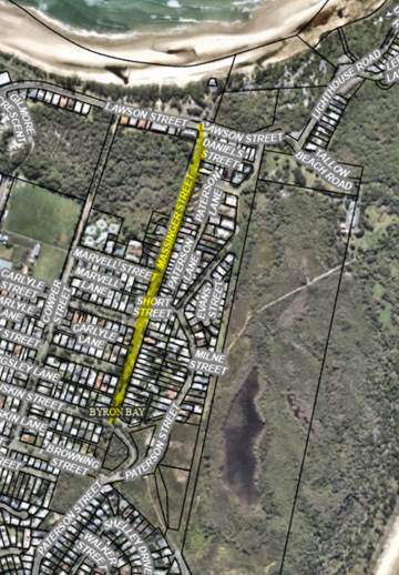
Report No. 6.1 Signage requests from Compliance Team – Linda Vidler Sports Field; Wallum Place Byron Bay; Sommerset Street Byron Bay; Burns Street Byron Bay; Alcorn Street Suffolk Park, William Flick Lane Ewingsdale, Brunswick Terrace Mullumbimby and Station Street Carpark Mullumbimby. File No: I2024/762
|
||||||||||||||||||||||||||||||||||||||||||||||||||||||||||||||||||||||||||||||||||||||||||||||||||||||||||||
|
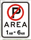
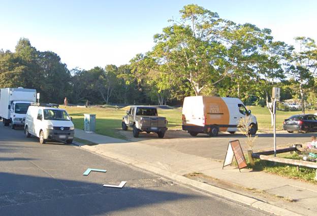
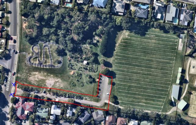
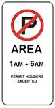
BACKGROUND Council’s Community Enforcement Team have identified traffic and parking issues in eight locations and Manager Public & Environmental Services has provided regulatory signage recommendations for Local Traffic Committee approval, consistent with previous Traffic Engineer recommendations. 1. LINDA VIDLER SPORTS FIELD, BEECH DRIVE The parking area of Linda Vidler Sports Field, in the vicinity of Beech Drive, Suffolk Park– refer to Figure 1 below. This area has become an illegal camping hotspot especially during the busy periods with numerous amounts of resident complaints. Community Enforcement Officers are unable to adequately enforce this location due to lack of signage. See Figure 1 for locality view and Figure 2 for street view. Recommendation: It is recommended installing 2 “No Parking Area 1-6am” signs at the vehicle entrance to Linda Vidler Sports Field on Beech Drive as shown in Figure 3 below and as summarised in the table below. The sign layout shown in Figure 3 is considered to be indicative and dependant on actual site conditions encountered during installation.
Financial implication: Funding is available in the Public & Environmental Services budget.
Figure 1. Linda Vidler Sports Field - locality plan
Figure 2. Linda Vidler Sports Field - street view
Figure 3. Linda Vidler Sports Field - proposed signage locations
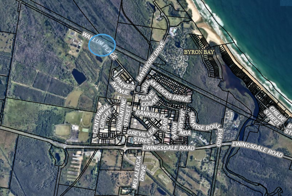
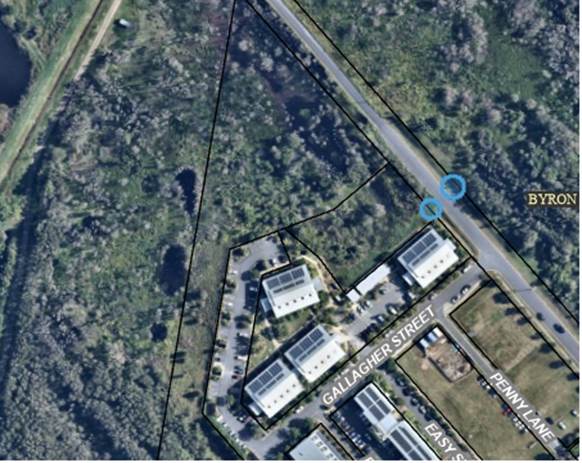
2. WALLUM PLACE – BYRON BAY Wallum Place, Byron Bay – refer to Figure 4. This area has also become an illegal camping hotspot especially during the busy periods with numerous amounts of resident complaints. Community Enforcement Officers are unable to adequately enforce this location due to lack of signage. See Figure 4 for locality view. A street view is not available for this location. Recommendation: It is recommended installing 2 “No Parking Area 1-6am” signs to the NW of Gallagher Street, as shown in Figure 5 below and as summarised in the table below. The sign layout shown in Figure 5 is considered to be indicative and dependant on actual site conditions encountered during installation.
Financial implication: Funding is available in the Public & Environmental Services budget.
Figure 4. Wallum Place, Byron Bay - locality view
Figure 5. Wallum Place, Byron Bay – proposed signage
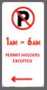
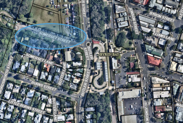
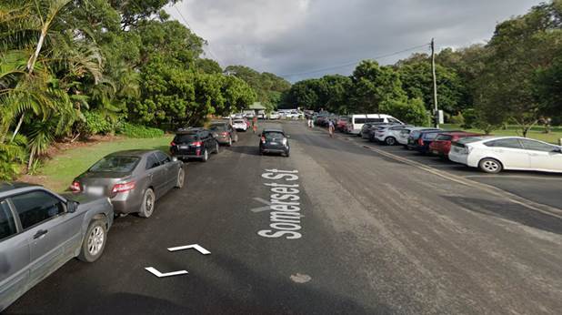
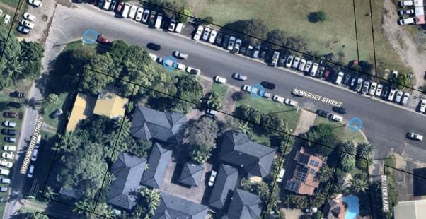
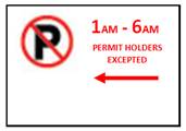
locations 3. SOUTHERN SIDE OF SOMERSET STREET, BYRON BAY The Southern side of Somerset Street, Byron Bay – refer to Figure 6. This area has increased complaints from residents weekly due to it being an illegal camping hotspot all year round. Community Enforcement Officers are unable to adequately enforce this location due to lack of signage. See Figure 6 for locality view and Figure 7 for street view. Recommendation: It is recommended installing 4 “No parking 1-6am” signs (permit holders excepted) with arrows along the Southern (residential) side of Somerset Street as shown in Figure 8 below and as summarised in the table below. The sign layout shown in Figure 8 is considered to be indicative and dependant on actual site conditions encountered during installation.
Financial implication: Funding is available in the Public & Environmental Services budget.
Figure 6. Somerset Street Byron Bay - locality view
Figure 7. Somerset Street, Byron Bay - street view
Figure 8. Southern Side of Somerset Street,
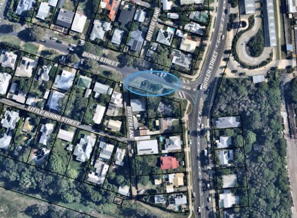
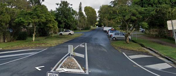
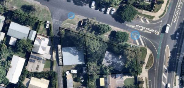
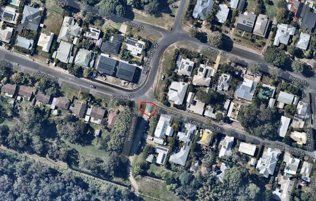
Byron Bay– proposed signage locations 4. SOUTHERN SIDE OF BURNS STREET, BYRON BAY The southern side of Burns Street, Byron Bay – refer to Figure 9. This area has increased complaints from residents weekly due to it being an illegal camping hotspot all year round. Continues to be a problem area and causes great anxiety to elderly residents in this location. Consistent with other signage in this area. Community Enforcement Officers are unable to adequately enforce this location due to lack of signage. See Figure 9 for locality view and Figure 10 for street view. Recommendation: It is recommended installing 2 “No parking 1-6am signs” (permit holders excepted) with arrows located along the southern side of Burns Street between Butler Street and Butler Lane as shown in Figure 11 below and as summarised in the table below. The sign layout shown in Figure 11 is considered to be indicative and dependant on actual site conditions encountered during installation.
Financial implication: Funding is available in the Public & Environmental Services budget.
Figure 9. Burns Street, Byron Bay - locality view
Figure 10. Southern Side of Burns Street, Byron Bay – street view
Figure 11. Southern Side of Burns Street, Byron Bay – proposed signage locations
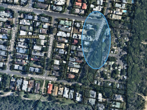
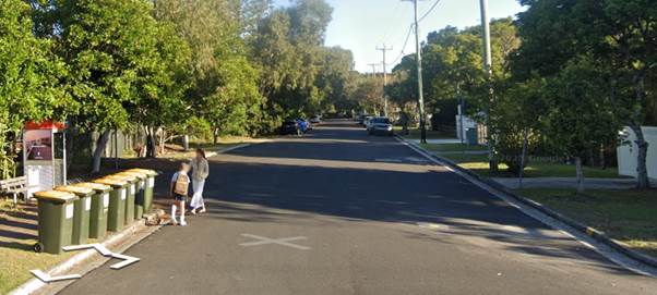
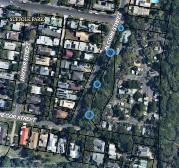
5. EASTERN SIDE OF ALCORN STREET, SUFFOLK PARK The eastern side of Alcorn Street, Suffolk Park – refer to Figure 12. This area has a long history of complaints and dumped vehicles. Bush area between caravan park and Alcorn Street being used as a toilet which is concerning to neighbouring residents. Consistent with other signage in this area. Community Enforcement Officers are unable to adequately enforce this location due to lack of signage. See Figure 12 for locality view and Figure 13 for street view. Recommendation: It is recommended installing 4 “No parking 1-6am signs” with arrows located along the eastern side of Alcorn Street between MacGregor Street and Clifford Street as shown in Figure 14 below and as summarised in the table below. The sign layout shown in Figure 14 is considered to be indicative and dependant of actual site conditions encountered during installation.
Financial implication: Funding is available in the Public & Environmental Services budget.
Figure 12. Alcorn Street, Suffolk Park - locality view
Figure 13. Alcorn Street, Suffolk Park - street view
Figure 14. Alcorn Street, Suffolk Park – proposed sign locations
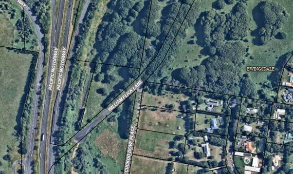
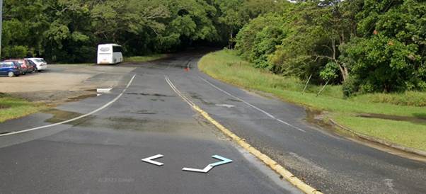
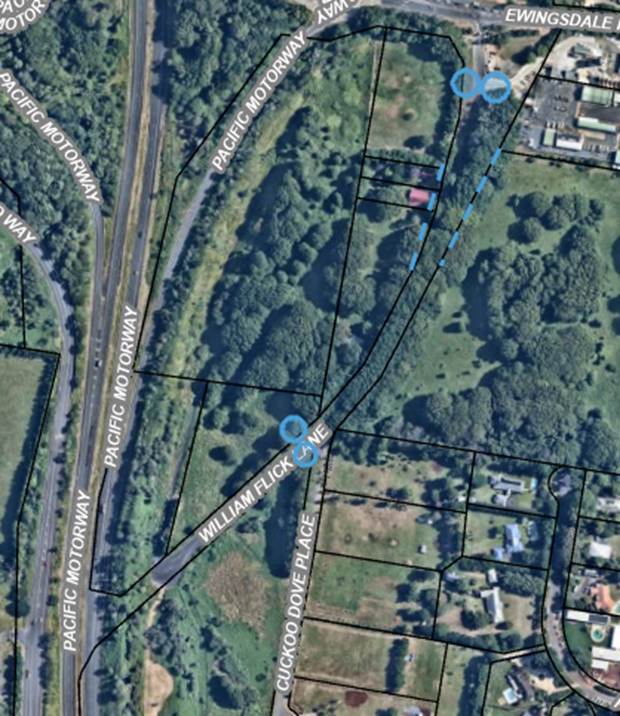
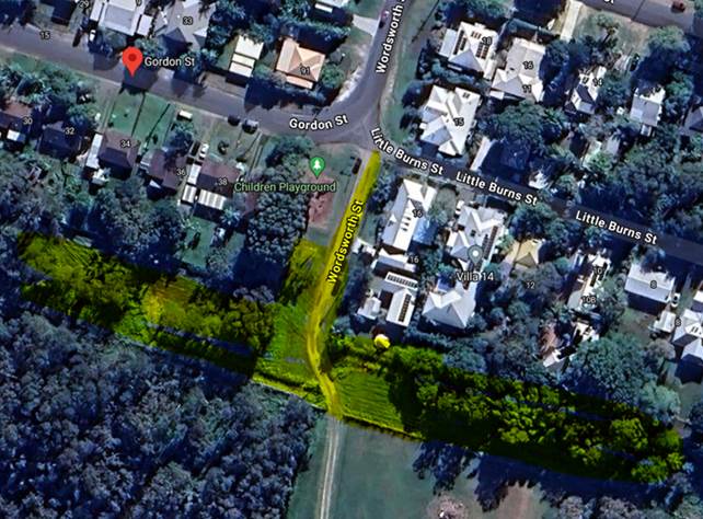
6. WILLIAM FLICK LANE, EWINGSDALE William Flick Lane has outdated signage which is currently unenforceable. The eastern side has some faded No Parking 1-6am signage. The western side has a combination of No Parking 1-8am and 1-6am signage (along the area of the blue dotted line in Figure 17). This area has a long history of complaints regarding camping, illegal dumping, drug paraphernalia and dumped vehicles. Community Enforcement Officers are unable to adequately enforce this location due to lack of signage. See Figure 15 for locality view and Figure 16 for street view. Recommendation: It is recommended installing 2 large “No Parking Area 1-6am signs” at the entrance of William Flick Lane and near the entrance to Cuckoo Dove Place as shown in Figure 17 below and as summarised in the table below. The sign layout shown in Figure 17 is considered to be indicative and dependant on actual site conditions encountered during installation.
Financial implication: Funding is available in the Public & Environmental Services budget.
Figure 15. William Flick Lane, Ewingsdale - locality view
Figure 16. William Flick Lane, Ewingsdale - street view
Figure 17. William Flick Lane, Ewingsdale – proposed sign
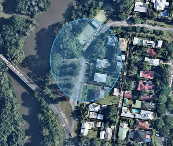
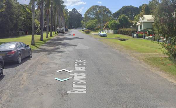
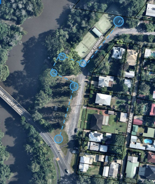
locations 7. BRUNSWICK TERRACE, MULLUMBIMBY Brunswick Terrace, Mullumbimby receives weekly complaints from multiple residents all year round. Multiple vehicles camp in this location daily. The ability to park in this location overnight also encourages camping in tents along the river, in the park, behind the tennis courts and into the arboretum. Regular complaints from residents about campers playing loud music at night. One resident in this location has been requesting Council install signage for a number of years. Community Enforcement officers are unable to adequately enforce this location due to lack of signage. See Figure 18 for locality view and Figure 19 for street view. Recommendation: It is recommended installing 6 “No parking 1-6am signs” with arrows along Brunswick Terrace from Murwillumbah Road to Tyagarah Street, as shown in Figure 20 below and as summarised in the table below. The sign layout shown in Figure 20 is considered to be indicative and dependant on actual site conditions encountered during installation.
Financial implication: Funding is available in the Public & Environmental Services budget.
Figure 18. Brunswick Terrace, Mullumbimby - locality view
Figure 19. Brunswick Terrace, Mullumbimby - street view
Figure 20. Brunswick Terrace, Mullumbimby – proposed sign locations
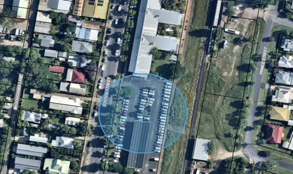
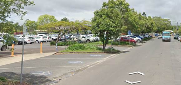
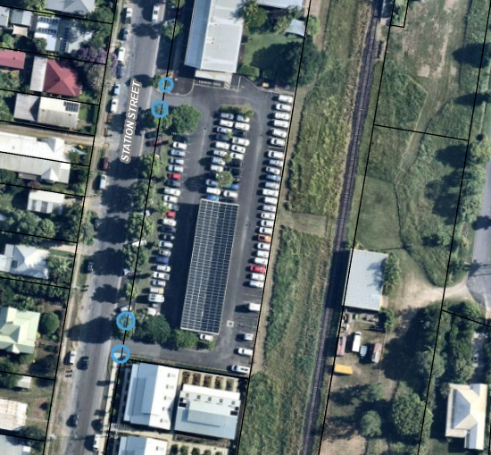
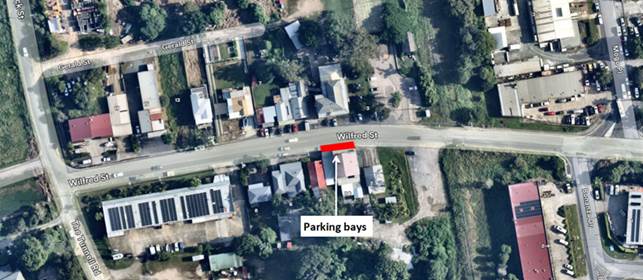
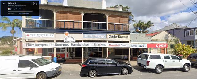
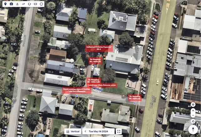
8. STATION STREET CARPARK, MULLUMBIMBY The Council car-park area adjacent to Council’s operational building and Chambers located at Station Street, Mullumbimby – refer to Figure 21 below. This area has become an illegal camping hotspot and is receiving complaints from local residents and users of the public car-park. Community Enforcement Officers are unable to adequately enforce this location due to lack of signage. See Figure 21 for locality view and Figure 22 for street view. Recommendation: It is recommended installing 4 “No Parking Area 1-6am” signs at the two vehicle entrances to the Station Street carpark as shown in Figure 23 below and as summarised in the table below. The sign layout shown in Figure 23 is considered to be indicative and dependant on actual site conditions encountered during installation.
Financial implication: Funding is available in the Public & Environmental Services budget.
Figure 21. Station Street Carpark, Mullumbimby - locality view
Figure 22. Station Street Carpark, Mullumbimby - street view
Figure 23. Station Street Carpark, Mullumbimby – proposed signage |
||||||||||||||||||||||||||||||||||||||||||||||||||||||||||||||||||||||||||||||||||||||||||||||||||||||||||||
|
Committee Comments None.
Management Comments None.
|
||||||||||||||||||||||||||||||||||||||||||||||||||||||||||||||||||||||||||||||||||||||||||||||||||||||||||||
|
That Local Traffic Committee approve the following:- 1. At Linda Vidler Sports Field, install regulatory “No Parking Area 1am – 6am” signs on the vehicle entrance to the sports field on Beech Drive, Suffolk Park; 2. At Wallum Place, Byron Bay, install regulatory “No Parking Area 1am – 6am” signs at the North-West of Gallagher Street on Wallum Place; 3. At Somerset Street, Byron Bay, install regulatory “No Parking 1am – 6am” signs along the Southern (residential) side of Somerset Street; 4. At Burns Street, Byron Bay, install regulatory “No Parking 1am – 6am” signs along the Southern side of Burns Street between Butler Street and Butler Lane; 5. At Alcorn Street, Suffolk Park, install regulatory “No Parking 1am – 6am” signs along the Eastern side of Alcorn Street between MacGregor Street and Clifford Street; 6. At William Flick Lane, Ewingsdale, install regulatory “No Parking Area 1am – 6am” signs at the entrance of William Flick Lane and past the entrance to Cuckoo Dove Place; 7. At Brunswick Terrace, Mullumbimby, install regulatory “No Parking 1am – 6am” signs along Brunswick Terrace from Murwillumbah Road to Tyagarah Street; and 8. At Station Street, Mullumbimby install regulatory “No Parking Area 1am – 6am” signs at the two vehicle entrances of the Council carpark on Station Street, Mullumbimby. (Lyon/Kehoe) The recommendation was put to the vote and declared carried. |
|
Report No. 6.2 29 Shirley Street, Byron Bay - Temporary changes to existing regulatory signage due to major civil works, new regulatory signage with line marking and associated Traffic Guidance Schemes File No: I2024/794
|
|
The purpose of this report is to gain Council support for proposed temporary regulatory signage changes during construction and new line markings and regulatory signs shown in Attachment 1 (E2024/59382). Council has received a Roads Act application associated with a development approval to Demolish existing development and clear the site, including existing buildings and trees to facilitate a residential flat building development comprising of 25, three-bedroom dwellings distributed across four separate two and three-storey buildings with basement car parking, associated landscaping and amenities at 29 Shirley Street BYRON BAY The Roads Act application is for the external works only, which must be completed prior to any works internally starting in accordance with conditions of development consent (Condition 50). The major civil works (new sewer, stormwater and road upgrades) required are to be constructed in 5 stages, having the earlier stage finished before another starts. It is estimated that the works will take approximately 4 months to complete. These works will have major impacts on the surrounding road network. TGS plans have been provided accordingly – see Attachment 1 (E2024/59382), in the associated stages, to undertake these works, to keep all traffic following as best as possible. Existing regulatory signage is to be covered and Temporary “No Stopping” signs installed to allow these works to be completed safely. Bus stops will also be required to be moved during these works as identified on the submitted TGS plans – Blanch’s Bus Company is to be informed of these temporary changes. VMS signage is proposed to be erected at least 1 week prior any works commencing. The works must be advertised on Councils web page. Letter box drops will also take place. Temporary road closures to Milton Street will be required to undertake the construction and upgrade of the existing road. After the works are completed, new line markings and regulatory signs will be required as indicated on ADG engineering plans in Attachment 1 (E2024/59382). A Public Safety Management Plan (PSMP) and Traffic Management Plan (TMP) have also been submitted to address the below conditions – refer Attachment 2 (E2024/59383) Conditions 22, 24 & 25 of development consent 10.2022.371.1 state: Condition 22. Consent required for Works within Road Reserve Consent from Council must be obtained for works within the road reserve pursuant to Section 138 of the Roads Act 1993. Three (3) copies of engineering construction plans must accompany the application for consent for works within the road reserve. Such plans are to be in accordance with Council’s current Design & Construction Manuals and are to provide for the following works: a) Milton St upgrade (north) • Carriageway of width 7.0m • Upgrade the pedestrian crossing in accordance with Figure 4 of TfNSW Technical Direction no TDT 2011/01a. (See approved annotated ADG drawing D04) Note: Carriageway widening, road widening, line marking and signage, concrete island, Page 11 of 35 proposed driveway to the basement, kerb & gutter, footpath and other services must be adjusted and proposed on-street parking deleted. • The proposed drainage swale running along the side boundary with Lot 10 DP1153734 must be deleted and replace with a new stormwater pit and pipe as shown on the approved annotated ADG drawing D04. Minimum pipe in the road reserve to be 375mm RCP. b) Milton St upgrade (south of Shirley St) i. Roadworks • Resealing and the provision of concrete edge strips on both sides of the Carriageway • Carriageway to be 7.5m ii. Stormwater The following must be included in the design and construction: • Final pipe sizing of the downstream stormwater drainage design to include all contributing catchments • 100 year HGL of the final pipe design to remain below the surface in accordance with the approved design plans. • Potholing is required to determine the final alignment of the stormwater drainage extension. • Construction of stormwater drainage system line C, D, E & F in ADG drawing D17 Rev A • Provision of flood control device at the pipe discharge point c) Driveway upgrades The driveway proposal in ADG drawing DA13 Rev C must be updated in accordance with Council's Northern Rivers Local Government Development Design & Construction Manuals unless details are submitted to demonstrate that the vertical gradients create scraping issues for a B99 vehicle and stormwater calculations demonstrate the capacity of the design is adequate for 1% AEP flows to be maintained in the kerb. The driveway proposal in ADG drawing DA12 Rev C must be updated in accordance with Council's Northern Rivers Local Government Development Design & Construction Manuals and Figure 3.1 of AS2890.2. Minimum driveway width of 6.0m in accordance with AS2890.2. Longitudinal grade of driveway along the road reserve in accordance with Council’s standard drawing R06. Note: Vehicles must enter and leave the driveway without infringing the boundaries of the roadway. Exiting vehicles movement across the centre-line of the roadway is not permitted. d) Driveway Removal The existing driveway must be removed and the kerb and footpath area reinstated to Council’s satisfaction Condition 24. Public Safety Management Plan required Prior to issue of the construction certificate, consent from Council must be obtained for a Public Safety Management Plan for those works within the road reserve pursuant to Section 138 of the Roads Act 1993. This public safety management plan is to include provision for (but not be limited to): a) a pedestrian barrier, alternative footpaths and ramps as necessary; b) an awning sufficient to prevent any substance from, or in connection with, the work falling into the road reserve; c) lighting of the alternative footpath between sunset and sunrise; d) the loading and unloading of building materials; e) parking space for tradesman’s vehicles, where such vehicles must be located near the site due to tools and equipment contain within the vehicle; f) Removal of any such hoarding, fence or awning as soon as the particular work has been completed. The temporary use of Council land/road reserve to enable construction work or an event is subject to fees in accordance with Council’s adopted fees and charges. The use fee must be paid upfront prior to use and will generally be required to be paid prior to issue of the Council’s consent for such use. Condition 25. Traffic Management Plan (TMP) Prior to issue of the construction certificate, consent from Council must be obtained for a Traffic Management Plan (TMP) pursuant to Section 138 of the Roads Act 1993. The plans and specifications are to include the measures to be employed to control traffic (inclusive of construction vehicles) during construction of the development. The TMP is to be designed in accordance with the requirements of the current version of the Transport for NSW Traffic Control at Work Sites Technical Manual. The report must incorporate measures to ensure that motorists using road adjacent to the development, residents and pedestrians in the vicinity of the development are subjected to minimal time delays due to construction on the site or adjacent to the site. The TMP and associated traffic guidance scheme/s must be prepared by a suitably qualified Transport for NSW accredited person |
|
Committee Comments None.
Management Comments None.
|
|
That Local Traffic Committee support the temporary and new signage, line markings and traffic control devices associated with the 29 Shirley Street, Byron Bay development as shown in Attachment 1 (E2024/59382), subject to the following: 1. An amendment to diagram on page 35, to remove the detour line from Byron street, and to make Shirley lane no stopping during construction.
2. Existing line marking and signage to be reinstated upon completion of construction works.
3. Traffic management designer to confirm design vehicle respect to heavy vehicle network.
4. VMS Boards to be provided on approach of either end of project site, at a minimum 1 week prior to commencement of project.
(Lyon/Kehoe) The recommendation was put to the vote and declared carried. |
|
Report No. 6.4 Toni Childs - Filming Road Closure Secondary Proposal 12 or 19 August 2024 File No: I2024/861
|
|
Council has received an application for the Toni Childs Music Video Shoot to be held in August 2024. With the intention to close off part of Jonson Street, Byron Bay – the section between Lawson Street and Byron Street – between 3:30am and 11:30am (8 hours). This was previously approved by Resolution 23-342 however, did not occur as planned and a new date, 19th August, 2024 plus alternate ‘weather hold date’ 26th August 2024 has been proposed. The proposal is planned as per previous application. Confirmation via email from Toni Childs confirms they will not be prohibiting businesses from accessing their businesses in anyway and pedestrians are not prohibited from walking on the sidewalks or entering shops. This is to be amended in the TMP, but the amendment has not been yet received at the time of writing. Approval for each business being affected is being sought and being signed off. This is also to be sent to Council.
|
|
Committee Comments None.
Management Comments None.
|
|
1. That the Local Traffic Committee (LTC) support the Toni Childs Music Video Production to be held in August 2024. 19th August and Weather Hold date, or a following Monday as agreed with staff. 2. That LTC support in Part 1 is subject to: a) the event organiser providing council with an updated Traffic Management Plan and Traffic Guidance Scheme/s for the film shoot; b) development and implementation of a Traffic Management Plan and Traffic Guidance Scheme/s by those with appropriate TfNSW accreditation and the holding of current and appropriate levels of insurance and liability cover; c) the impact of the film shoot be advertised, and charged at cost to the organisers, via a notice in the local weekly paper and Variable Message Signage near the site, a minimum of one week prior to the operational impacts taking effect, noting it must include the film shoot name, specifics of any traffic impacts or road closures and times, alternative route arrangements, Production Team, a personal contact name and a telephone number for all event related enquiries or complaints; d) the film shoot be notified on Council’s web page with the event organiser supplying Council with the relevant information. 3. The Production Team to: a) inform the community and businesses that are directly impacted (e.g. within road closure zones) via written information which is delivered to the property in a timely manner so as to document, consider and respond to any concerns raised; b) arranging for private property access and egress affected by the film shoot; c) liaising with bus, taxi and waste operators and ensuring arrangements are made for provision of services during conduct of the film shoot; d) consulting with emergency services and any identified issues be addressed; e) holding $20m public liability insurance cover which is valid for the film shoot; f) paying Council’s Road Event Application Fee prior to the film shoot; g) not place any signage on the road related area of the Pacific Highway. h) apply/receive consent by the relevant road authority under section 138 of the NSW road act (1993) and pay any associated fees and charges within this process. i) not prohibit pedestrians from walking on the sidewalks or entering shops. (Lyon/Kehoe) The recommendation was put to the vote and declared carried. |
There being no further business the meeting concluded at 12:42.