 Agenda
Ordinary (Planning) Meeting

Thursday, 13 June 2024
Agenda
Ordinary (Planning) Meeting
Thursday, 13 June 2024
Agenda Ordinary (Planning) Meeting
held at Council Chambers, Station Street, Mullumbimby
commencing at 11.00am
Public access relating to items on this agenda can be made between 11:00am and 11:30am on the day of the meeting. Requests for public access should be made to the General Manager or Mayor no later than 12:00 midday on the day prior to the meeting.

Mark Arnold
General Manager
CONFLICT OF INTERESTS
What is a “Conflict of Interests” - A conflict of interests can be of two types:
Pecuniary - an interest that a person has in a matter because of a reasonable likelihood or expectation of appreciable financial gain or loss to the person or another person with whom the person is associated.
Non-pecuniary – a private or personal interest that a Council official has that does not amount to a pecuniary interest as defined in the Code of Conduct for Councillors (eg. A friendship, membership of an association, society or trade union or involvement or interest in an activity and may include an interest of a financial nature).
Remoteness – a person does not have a pecuniary interest in a matter if the interest is so remote or insignificant that it could not reasonably be regarded as likely to influence any decision the person might make in relation to a matter or if the interest is of a kind specified in the Code of Conduct for Councillors.
Who has a Pecuniary Interest? - a person has a pecuniary interest in a matter if the pecuniary interest is the interest of the person, or another person with whom the person is associated (see below).
Relatives, Partners - a person is taken to have a pecuniary interest in a matter if:
· The person’s spouse or de facto partner or a relative of the person has a pecuniary interest in the matter, or
· The person, or a nominee, partners or employer of the person, is a member of a company or other body that has a pecuniary interest in the matter.
N.B. “Relative”, in relation to a person means any of the following:
(a) the parent, grandparent, brother, sister, uncle, aunt, nephew, niece, lineal descends or adopted child of the person or of the person’s spouse;
(b) the spouse or de facto partners of the person or of a person referred to in paragraph (a)
No Interest in the Matter - however, a person is not taken to have a pecuniary interest in a matter:
· If the person is unaware of the relevant pecuniary interest of the spouse, de facto partner, relative or company or other body, or
· Just because the person is a member of, or is employed by, the Council.
· Just because the person is a member of, or a delegate of the Council to, a company or other body that has a pecuniary interest in the matter provided that the person has no beneficial interest in any shares of the company or body.
Disclosure and participation in meetings
· A Councillor or a member of a Council Committee who has a pecuniary interest in any matter with which the Council is concerned and who is present at a meeting of the Council or Committee at which the matter is being considered must disclose the nature of the interest to the meeting as soon as practicable.
· The Councillor or member must not be present at, or in sight of, the meeting of the Council or Committee:
(a) at any time during which the matter is being considered or discussed by the Council or Committee, or
(b) at any time during which the Council or Committee is voting on any question in relation to the matter.
No Knowledge - a person does not breach this Clause if the person did not know and could not reasonably be expected to have known that the matter under consideration at the meeting was a matter in which he or she had a pecuniary interest.
Non-pecuniary Interests - Must be disclosed in meetings.
There are a broad range of options available for managing conflicts & the option chosen will depend on an assessment of the circumstances of the matter, the nature of the interest and the significance of the issue being dealt with. Non-pecuniary conflicts of interests must be dealt with in at least one of the following ways:
· It may be appropriate that no action be taken where the potential for conflict is minimal. However, Councillors should consider providing an explanation of why they consider a conflict does not exist.
· Limit involvement if practical (eg. Participate in discussion but not in decision making or vice-versa). Care needs to be taken when exercising this option.
· Remove the source of the conflict (eg. Relinquishing or divesting the personal interest that creates the conflict)
· Have no involvement by absenting yourself from and not taking part in any debate or voting on the issue as of the provisions in the Code of Conduct (particularly if you have a significant non-pecuniary interest)
RECORDING OF VOTING ON PLANNING MATTERS
Clause 375A of the Local Government Act 1993 – Recording of voting on planning matters
(1) In this section, planning decision means a decision made in the exercise of a function of a council under the Environmental Planning and Assessment Act 1979:
(a) including a decision relating to a development application, an environmental planning instrument, a development control plan or a development contribution plan under that Act, but
(b) not including the making of an order under that Act.
(2) The general manager is required to keep a register containing, for each planning decision made at a meeting of the council or a council committee, the names of the councillors who supported the decision and the names of any councillors who opposed (or are taken to have opposed) the decision.
(3) For the purpose of maintaining the register, a division is required to be called whenever a motion for a planning decision is put at a meeting of the council or a council committee.
(4) Each decision recorded in the register is to be described in the register or identified in a manner that enables the description to be obtained from another publicly available document, and is to include the information required by the regulations.
(5) This section extends to a meeting that is closed to the public.
OATH AND AFFIRMATION FOR COUNCILLORS
Councillors are reminded of the oath of office or affirmation of office made at or before their first meeting of the council in accordance with Clause 233A of the Local Government Act 1993. This includes undertaking the duties of the office of councillor in the best interests of the people of Byron Shire and the Byron Shire Council and faithfully and impartially carrying out the functions, powers, authorities and discretions vested under the Act or any other Act to the best of one’s ability and judgment.
BUSINESS OF Ordinary (Planning) Meeting
1. Public Access
3. Attendance by Audio-Visual Link
4. Requests for Leave of Absence
5. Declarations of Interest – Pecuniary and Non-Pecuniary
6. Tabling of Pecuniary Interest Returns (Cl 4.14 Code of Conduct for Councillors)
7. Adoption of Minutes from Previous Meetings
7.1 Ordinary (Planning) Meeting held on 16 May 2024
8. Reservation of Items for Debate and Order of Business
9. Notices of Motion
9.1 Food Security in the Northern Rivers.......................................................................... 8
9.2 Restore funding to alleviate flooding in Coomburra Crescent, Ocean Shores.. 11
10. Mayoral Minute
11. Petitions
12. Delegates' Reports
13. Staff Reports
Sustainable Environment and Economy
13.1 PLANNING - Report of the Planning Review Committee held 2 May 2024....... 14
13.2 PLANNING - DA10.2023.286.1 - Alterations and additions to a Dwelling house – 1/42 Macgregor Street, Suffolk Park.................................................................................. 17
13.3 PLANNING - DA 10.2023.346.1 – Stage 1: Two Lot Torrens Title Subdivision, Boundary Adjustment and Demolition. Stage 2: Five Lot Community Title Subdivision, Road Works, Drainage Infrastructure, Tree Removal and Associated Works – 139 Bangalow Road, Suffolk Park.................................................................................... 32
13.4 26.2024.1.1 - Planning Proposal to introduce Federal Heritage Conservation Area and additional heritage items............................................................................................. 76
13.5 26.2023.6.1 Planning Proposal for Lot 1 DP123302, Broken Head Road, SUFFOLK PARK............................................................................................................................. 84
14. Reports of Committees
Infrastructure Services
14.1 Report of the Local Traffic Committee Meeting held on 14 May 2024................ 93
15. Questions With Notice
Nil
Questions with Notice: A response to Questions with Notice will be provided at the meeting if possible, that response will be included in the meeting minutes. If a response is unable to be provided the question will be taken on notice, with an answer to be provided to the person/organisation prior to the next Ordinary Meeting and placed on Councils website www.byron.nsw.gov.au/Council/Council-meetings/Questions-on-Notice
Councillors are encouraged to ask questions regarding any item on the business paper to the appropriate Director prior to the meeting. Any suggested amendments to the recommendations should be provided to Councillor Support prior to the meeting to allow the changes to be typed and presented on the screen at the meeting.
Notices of Motion 9.1
Notices of Motion
Notice of Motion No. 9.1 Food Security in the Northern Rivers
File No: I2024/869
I move that Council:
1. Notes the findings and recommendations of the Plan C and UTS Northern Rivers Food Security & Resilience Scoping Study, in particular the urgent need for coordinated food system governance, policies and planning in the region to build resilience to disasters and supply chain disruptions
2. Notes the ‘Food Production and Supply in NSW’ Inquiry and Report (November 2022), particularly Recommendation 6: that the NSW Government works with local councils to develop and implement strategies to improve local food systems, and provides appropriate funding as required
3. Writes to the following NSW Labor Government Ministers requesting the Government’s response to the Inquiry, noting that Government has indicated it will respond to the findings by May, and highlighting the importance of Recommendation 6 for communities recovering from disasters such as the:
a) NSW Premier the Hon Chris Minns MP
b) Minister for Agriculture the Hon Tara Moriarty MP
c) Minister for Local Government the Hon Ron Hoenig MP
d) Minister for Regional New South Wales and North Coast the Hon Rose Jackson MP
e) Minister for Health and Regional Health the Hon Ryan Park MP
f) Minister for Climate Change, Minister for Energy, Minister for the Environment, and Minister for Heritage, the Hon Penny Sharpe MP
4. Notes the Northern Rivers Joint Organisation passed a similar motion at its February meeting
7. Provides a briefing to Council by August 2024 outlining current constraints and the mechanisms that could be considered to enable small scale urban agriculture in the Byron LGA
Signed: Cr Sarah Ndiaye
Councillor’s supporting information:
In 2023, rising living costs in Australia contributed to increasing food insecurity with 36% of Australians struggling to put food on the table. In the Northern Rivers, floods, bushfires and the COVID pandemic made this region’s food system one of the most vulnerable in Australia.
Further information is available from:
Staff comments
by Sharyn French, Manager Environmental and Economic Planning, Sustainable Environment and Economy Directorate:
This NoM asks that:
· letters be written to NSW Labour Government Ministers requesting a response to the ‘Food Production and Supply in NSW’ Inquiry and Report to highlight the importance of Recommendation 6 for communities recovering from disasters.
· questions regarding food and water security be included in the Community Strategic Plan engagement process to understand community lived experience in the Byron LGA.
· Council advocates to the NSW Reconstruction Authority for future possible use of buyback properties for urban and small-scale agriculture in the Byron LGA
· a briefing to Council by August 2024 outlining current constraints and the mechanisms that could be considered to enable small scale urban agriculture in the Byron LGA
Financial/Resource/Legal Implications:
Preparing letters to the NSW Labour Government and NSW Reconstruction Authority can be serviced within existing staff resources.
Council has commenced community engagement to inform a refresh of the Community Strategic Plan. The recommendations from the Northern Rivers Food Security Scoping Study can further influence the review of the CSP to develop a shared understanding and commitment to developing greater resilience within the regional food system.
There are no more Councillor workshops for this term of council. The briefing will be listed in the Councillor Workshop Future Agenda Items for consideration at the next available workshop.
Is the proposal consistent with any Delivery Program tasks?
Yes
This NoM will assist in delivering DP Action 4.3.5: Regenerative agriculture - Develop and implement strategies to support regenerative agriculture, agri-business and farmers.
|
CSP Objective |
CSP Strategy |
DP Action |
Code |
OP Activity |
|
4: Ethical Growth |
4.3: Promote and support the local economy |
4.3.5: Regenerative agriculture - Develop and implement strategies to support regenerative agriculture, agri-business and farmers |
4.3.5.2 |
Provide extension services to farmers to support and promote sustainable agriculture |
|
4: Ethical Growth |
4.3: Promote and support the local economy |
4.3.5: Regenerative agriculture - Develop and implement strategies to support regenerative agriculture, agri-business and farmers |
4.3.5.3 |
Deliver farmer mentoring and farmer education activities
|
Notices of Motion 9.2
Notice of Motion No. 9.2 Restore funding to alleviate flooding in Coomburra Crescent, Ocean Shores
File No: I2024/870
I move that Council:
1. Restores into the upcoming budget a vote of $40,000, as was allocated in several previous budget rounds, to design and plan stormwater works near and within 32 Coomburra Crescent, Ocean Shores. The works aim to reduce the frequency of local flooding that impacts the property, the dwelling on it and the safety of residents living there.
2. Completes that design early in the financial year 2024-25 so that the cost of the project is known.
3. Then considers further funding, or seek it from external sources, to complete the project.
Signed: Cr Duncan Dey
Councillor’s supporting information:
This part of Coomburra Crescent floods from two distinct flood mechanisms: flooding in Marshalls Creek and localised overland flow. A mostly urban catchment of about two square kilometres drains to Coomburra Crescent via a pipe network of limited capacity. Flows in excess of the pipe capacity utilise low points in the landscape including roadways and road reserves. Once this water arrives at Coomburra Crescent, it has no onward route other than across private properties and in places through dwellings as well.
The dwelling on 32 Coomburra Crescent is flooded often by this local stormwater mechanism as well as occasionally by the other mechanism, backwater from Marshalls Creek.
The landholder addressed Council’s Ordinary Meeting on 22 February 2024, speaking against Report 13.5 Budget Review – 1 October 2023 to 31 December 2023. That budget review was approved as recommended by staff and saw the removal of the last $20,000 of funding item. Page 56 of 64 in Attachment 1 to that Report listed the reduction as:
($20,000) 44282.043 Overland Flow Path-32 Coomburra Crescent – It is proposed to decrease this budget as it is not required in 2023/24.
I believe the item was first introduced (see orange highlight) at our meeting of 24 February 2022 at the Budget Review for October to December 2021:
![]()
... removed in August 2022:
![]()
.... reinstated later and then removed for a second time. Staff may have exact information on this.
Staff met with the landholders and some Councillors on 21 May 2024 to discuss the project. It was agreed that the works would not reduce the impacts of Marshalls Creek flooding and that the local flooding on a regular basis needs addressing, even if only to reduce rather than fully alleviate it. The landholders agreed and do want relief from this mechanism of flooding, even with that relief being only partial. The works should mean that, instead of being threatened several times per year, they need only worry when rainfall is severe and of the type experienced only once every several years. Safety of their children and damage to their dwelling is their prime concern. It was agreed this would be addressed by partial relief via proposed project.
Staff mentioned that a ‘waiver’ or similar recognising such limited relief might be required. There are details such as weep holes in the walls of the dwelling that need consideration, along with how to guide the stormwater off the roadway and through the property.
Staff comments
by James Flockton, Infrastructure Planning Coordinator, Infrastructure Services:
Competing priorities resulted in the need for the previous budget changes, therefore, staff are supportive of the proposed budget allocation.
The proposed budget allocation will allow more detailed designs to be prepared and the project to be more accurately costed, including the cost to purchase an easement to drain water over the land.
As part of the above process staff will need to further investigate the legality and suitability of a ‘waiver’ that the residents could sign that could achieve protections for Council and staff should the proposed solution not be fully successful in future rainfall events. It is noted that this may require notations on the property to ensure possible future purchasers are aware of such a waiver exists over the property.
Once the above designs and investigations are complete a detailed report can be taken to the Infrastructure Advisory Committee and then approved by Council before works can be funded and proceed.
Financial/Resource/Legal Implications:
Should Council adopt the recommendation of this Notice of Motion, the funding of the $40,000 requested can be included in the draft 2024/25 budget with funding available from the stormwater levy reserve.
Is the proposal consistent with any Delivery Program tasks?
|
CSP Objective |
CSP Strategy |
DP Action |
Code |
OP Activity |
|
5: Connected Infrastructure |
5.3: Invest in renewable energy and emerging technologies |
5.3.1: Future needs - Plan for the infrastructure needs of the current and future population |
5.3.1.1 |
Review and update 10-year flood and drainage renewal, upgrade and stormwater levy program |
Staff Reports - Sustainable Environment and Economy 13.1
Staff Reports - Sustainable Environment and Economy
Report No. 13.1 PLANNING - Report of the Planning Review Committee held 2 May 2024
Directorate: Sustainable Environment and Economy
Report Author: Chris Larkin, Manager Sustainable Development
Noreen Scott, EA Sustainable Environment and Economy
File No: I2024/667
Summary:
This report provides the outcome of the Planning Review Committee (PRC) held on 2 May 2024.
NOTE TO COUNCILLORS:
In accordance with the provisions of S375A of the Local Government Act 1993, a Division is to be called whenever a motion for a planning decision is put to the meeting, for the purpose of recording voting on planning matters. Pursuant to clause 2(a) under the heading Matters to be Included in Minutes of Council Meetings of Council's adopted Code of Meeting Practice (as amended) a Division will be deemed to have been called by the mover and seconder of all motions relating to this report.
RECOMMENDATION:
That Council endorses the outcomes of the Planning Review Committee meeting held 2 May 2024.
Report
The PRC meeting was held on 2 May 2024. The meeting commenced at 3:00pm and concluded at 3:30pm.
Councillors: Cr M Lyon, Cr D Dey, Cr A Hunter, Cr P Westheimer, Cr S Ndiaye, Cr M Swivel.
Apologies: Cr Pugh, Cr S Balson.
Staff: Chris Larkin (Manager Sustainable Development).
Conflict of Interest: Nil
|
DA No. / Applicant |
Property Address / Proposal |
Consultation / Submissions |
Reason/s / Outcome |
|
10.2024.14.1 |
31 Alidenes Road
|
Level 2 9 submissions against |
Council No delegation |
|
10.2024.57.1 |
22B Melaleuca Drive 17 lot industrial subdivision including creation of a drainage lot, residue lot, roadworks, bulk earthworks, vegetation removal and associated infrastructure. |
Level
2 No submissions
|
Council No delegation
|
The S 4.55 applications to modify these development consents are referred to the Planning Review Committee to decide if the modification applications can be determined under delegated authority.
|
DA No. / Applicant |
Property Address / Proposal |
Consultation / Submissions |
Reason/s / Outcome |
||
|
10.2019.466.3 The Trustee for Elevendon Unit Trust |
41 Bottlebrush Crescent Modification to Condition of Consent to approved Community Title Subdivision |
Level 2 2 submissions against |
Staff Delegation |
||
|
LATE ITEM |
|||||
|
10.2020.242.2 |
84 Blindmouth Road Modification - Rural Land Sharing Community (Multiple Occupancy) consisting of Twelve (12) Dwelling Sites, Associated Infrastructure, Land Management and Environmental Enhancement |
Level 0 |
Staff Delegation
|
||
Staff Reports - Sustainable Environment and Economy 13.2
Report No. 13.2 PLANNING - DA10.2023.286.1 - Alterations and additions to a Dwelling house – 1/42 Macgregor Street, Suffolk Park
Directorate: Sustainable Environment and Economy
Report Author: Jordan Vickers, Planner
File No: I2024/738
Proposal:
|
DA No: |
10.2023.286.1 |
||
|
Planning Portal ref |
PAN-355913 |
||
|
Proposal description: |
Alterations and Additions to Existing Dwelling House |
||
|
Property description: |
LOT: 2 DP: 285106 |
||
|
House 1 42 Macgregor Street SUFFOLK PARK |
|||
|
Parcel No/s: |
187590 |
||
|
Applicant: |
Planit Consulting Pty Ltd |
||
|
Owner: |
Ms A Borrello |
||
|
Zoning: |
Urban Coastal Lands (7f2) Byron LEP 1988 |
||
|
Date received: |
7 August 2023 |
||
|
Integrated / Designated Development: |
☐ Integrated |
☒ Designated |
☐ Not applicable |
|
Concurrence required |
No |
||
|
Public notification or exhibition: |
- Level 4 advertising under Council’s Community Participation Plan. - Exhibition period: 16 April – 13 May 2024 - No Submissions were received : |
||
|
Estimated cost |
$500,000.00 |
||
|
Delegation to determine |
Council |
||
Summary:
This application considers alterations and additions to an existing dwelling house at 1/42 Macgregor Street, Suffolk Park. Alterations and additions to the building comprise the construction of two bedrooms, living room, laundry, entry, and sauna at the ground floor, and modified internal walls at the first floor to create a pantry, increase the entryway void and include a new staircase to the rear deck.
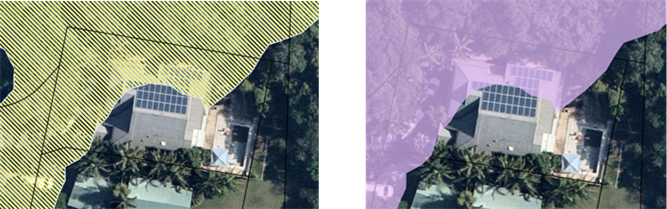
The development site is Lot 1 within a Community Titled property at 42 Macgregor Street, Suffolk Park and is located in the Urban Coastal Lands (7f2) zone of the Byron LEP 1988. The existing dwelling on the land was approved in 1994 and constructed soon after. The application is designated development due to its location within mapped littoral rainforest under SEPP Resilience and Hazards 2021 and is accompanied by an Environmental Impact Assessment as required by the Secretary’s Environmental Assessment Requirements.
The Littoral Rainforest mapping which overlays the existing dwelling on the property is an inaccurate representation of vegetation at the site, being general landscaping, and is somewhat erroneous in this regard. It is noted the subject site was not mapped as containing littoral rainforest under the old SEPP 26. Notwithstanding, the proposal does not require vegetation to be cleared and has no impact on the littoral rainforest surrounding the dwelling with the alterations and additions to the dwelling mainly insitu in terms of the existing dwellings footprint.
This application was publicly notified, and no submissions were received. The proposed dwelling additions raises no planning issues and is recommended for approval.
NOTE TO COUNCILLORS:
In accordance with the provisions of S375A of the Local Government Act 1993, a Division is to be called whenever a motion for a planning decision is put to the meeting, for the purpose of recording voting on planning matters. Pursuant to clause 2(a) under the heading Matters to be Included in Minutes of Council Meetings of Council's adopted Code of Meeting Practice (as amended) a Division will be deemed to have been called by the mover and seconder of all motions relating to this report.
RECOMMENDATION:
That pursuant to Section 4.16 of the Environmental Planning & Assessment Act 1979, Development Application No. 10.2023.286.1 for Alterations and Additions to Existing Dwelling House, be granted consent subject to the conditions of approval at the end of this report.
1 DA10.2023.286.1
Recommended Condition of Consent, E2024/55330
![]()
2 DA10.2023.286.1
Plans for approval, E2024/36057 ![]()
Assessment:
1. INTRODUCTION
History/Background
A search of Council records indicates the following relevant site history:
|
DA No. |
Description |
Outcome |
Date |
|
5.1994.354.1 |
Dwelling (DA) |
Approved |
09/12/1994 |
|
6.1994.2823.1 |
Dwelling (CC) |
Approved |
25/01/1995 |
|
10.2021.677.1 |
Swimming pool |
Approved |
21/02/2022 |
The ground floor of the building has previously experienced alterations and additions which were not granted development consent. These works are to be demolished as part of this DA.
Description of the proposed development
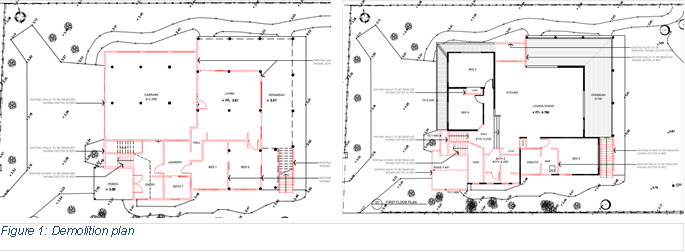
This application seeks approval for Alterations and Additions to an existing
Dwelling House, comprising: addition of skylights and modification to roofline,
construction of two bedrooms, living room, laundry, entry, and sauna at the
ground floor, and modification to internal walls including extension of the
pantry and void at the first floor. Ground floor works have been previously
undertaken without consent, however the proposal seeks consent for their
demolition and reconstruction.

Description of the site
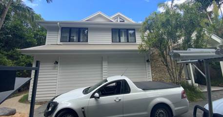
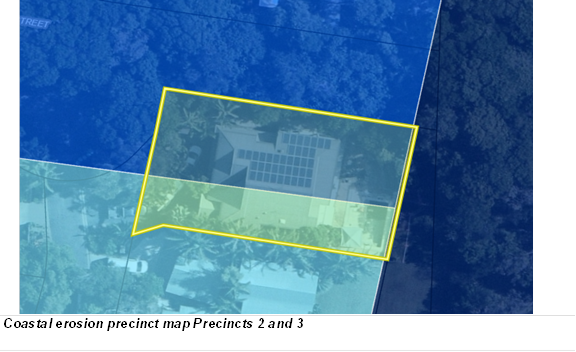
The development site known as 1/42 Macgregor Street, Suffolk Park and legally described as Lot 2 on DP285106 has a site area of 780.9m² and is located within the Urban Coastal Lands (7f2) zone of the Byron LEP 1988. The allotment is currently improved by a two storey dwelling house and swimming pool. The property is identified as Bushfire prone land containing Acid Sulfate Soils (Class 3), and is within the Coastal Erosion area (Precinct 2 and 3). The property is also mapped under the SEPP Resilience and Hazards as containing Littoral Rainforest. Considering the age of the dwelling, the mapping is an error, and in hindsight should terminate at the northern boundary.
A site inspection was carried out on 4 March 2024
|
Land is legally described |
LOT: 2 DP: 285106 |
|
Property address |
House 1 42 Macgregor Street SUFFOLK PARK |
|
Land is zoned: |
Urban Coastal Lands (7f2) zone Byron LEP 1988 |
|
Land area is: |
780.9 m2 |
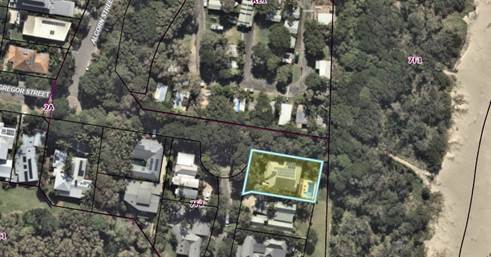
Subject site
Western Elevation
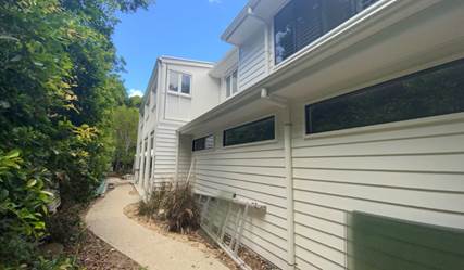 |
Northern Elevation
2. SUMMARY OF REFERRALS
|
Referral |
Issue |
|
Environmental Health Officer* |
No objections subject to conditions. |
|
Development Engineer |
No objections subject to conditions. |
Ecology:
The subject land is mapped as containing littoral rainforest vegetation under the SEPP Resilience and Hazards, Chapter 2: Coastal Management, and therefore Biodiversity Values under the Biodiversity Conservation SEPP:
Accordingly, the proposal is Designated development. Prior to submission of the
application, the applicant obtained the Secretary’s Environmental
Assessment Requirements for this proposal pursuant to s173 of the Environmental
Planning & Assessment Regulation 2021.
The littoral rainforest mapping overlays the dwelling and is therefore an inaccurate representation of vegetation at the site. In this regards vegetation on the site is maintained garden landscaping.
The development does not propose the removal of vegetation from the site, and therefore does not trigger the need for assessment against the Biodiversity Assessment Method and/or a Biodiversity Development Assessment Report under the Biodiversity Conservation Act.
3. SECTION 4.14 – BUSH FIRE PRONE LAND
4. SECTION 4.15C – MATTERS FOR CONSIDERATION – DISCUSSION OF ISSUES
Having regard to the matters for consideration detailed in Section 4.15(1) of the Environmental Planning & Assessment Act 1979 (EP&A Act), the following is a summary of the evaluation of the issues.
State Environmental Planning Policies (SEPP)
|
Considerations |
Satisfactory |
Unsatisfactory |
|
Biodiversity and Conservation SEPP 2021 Consideration: The proposal considers renovation to an existing dwelling at the subject land which is mapped as containing Biodiversity Values (littoral rainforest). It is submitted that the mapping is inaccurate as it applies to this property as the mapping overlays the existing dwelling at the property (not vegetation). Notwithstanding, the development does not propose the removal or damage to vegetation of significance. It is considered that no further assessment of the proposal against the Biodiversity Assessment Method (& submission of a Biodiversity Development Assessment Report) is warranted. |
☒ |
☐ |
|
Resilience and Hazards SEPP 2021, Consideration: Coastal Environment Area: The property is within the Coastal Environment Area and the proposed development is unlikely to cause an adverse impact on: a) the integrity and resilience of the biophysical, hydrological (surface and groundwater) and ecological environment, b) coastal environmental values and natural coastal processes, c) the water quality of the marine estate (within the meaning of the Marine Estate Management Act 2014), in particular, the cumulative impacts of the proposed development on any of the sensitive coastal lakes identified in Schedule 1, d) marine vegetation, native vegetation and fauna and their habitats, undeveloped headlands and rock platforms, e) existing public open space and safe access to and along the foreshore, beach, headland or rock platform for members of the public, including persons with a disability, f) Aboriginal cultural heritage, practices and places, g) the use of the surf zone. |
☒ |
☐ |
|
Coastal Use Area: The proposed development is within the Coastal Use Area and: a) the proposed development is not likely to cause an adverse impact on: i. existing, safe access to and along the foreshore, beach, headland or rock platform for members of the public, including persons with a disability, ii. overshadowing, wind funnelling and the loss of views from public places to foreshores, iii. the visual amenity and scenic qualities of the coast, including coastal headlands, iv. Aboriginal cultural heritage, practices and places, v. cultural and built environment heritage, and b) Council is satisfied that: i. the development is designed, sited and will be managed to avoid an adverse impact referred to in paragraph (a), or ii. if that impact cannot be reasonably avoided—the development is designed, sited and will be managed to minimise that impact, or iii. if that impact cannot be minimised—the development will be managed to mitigate that impact, and c) the surrounding coastal and built environment, and the bulk, scale and size of the proposed development have been taken into account. The development is designed, sited and will be managed to minimise adverse impacts as referred to above. The proposal is acceptable having regard to the surrounding coastal and built environment, and the bulk, scale and size of the proposed development. |
||
|
Littoral Rainforests: The development site contains Littoral Rainforest and Council is satisfied that sufficient measures have been, or will be, taken to protect, and where possible enhance, the biophysical, hydrological and ecological integrity of the coastal wetland or littoral rainforest. |
||
|
Coastal Wetlands proximity area (buffer) The proposal is within the Coastal Wetlands proximity area and will not significantly impact upon: a) the biophysical, hydrological or ecological integrity of the adjacent coastal wetland, or b) the quantity and quality of surface and ground water flows to and from the adjacent coastal wetland.
|
||
|
Resilience and Hazards SEPP 2021, Consideration: The property has a long standing residential history and is not included on Council’s contaminated lands register. There is no record of previous land uses on the site, or on surrounding sites, that are likely to have resulted in land contamination. Based on the available information, the site is considered to be suitable for the proposed residential use in its current state and no further investigation is warranted. |
☒ |
☐ |
|
Sustainable Buildings SEPP 2022 Consideration: The proposal is accompanied by a valid BASIX certificate. The SEPP has been addressed and the proposal is considered to comply. |
☒ |
☐ |
4.2B Byron Local Environmental Plan 1988 (LEP 1988)
In accordance with LEP 1988 clauses 5, 8 and 9:
(a) The proposed development is defined in the LEP 1988 Dictionary as Dwelling house;
(b) The land is within the LEP1988 7f2 zone according to the map under LEP 1988;
(c) The proposed development is permitted with consent; and
(d) The proposed development is consistent with the relevant objectives of the Zone for the following reasons:
|
Zone Objective |
Consideration |
|
The objectives of the zone are— a) to identify urban land likely to be influenced by coastal processes, b) to permit urban development within the zone subject to the council having due consideration to the intensity of that development and the likelihood of such development being adversely affected by, or adversely affecting, coastal processes, c) to permit urban development within the zone subject to the council having due consideration to— (i) the need to relocate buildings in the long term, (ii) the need for development consent to be limited to a particular period, (iii) the form, bulk, intensity and nature of the development, and (iv) continued safe public access to the site, and d) to allow detailed provisions to be made, by means of a development control plan, to set aside specific areas within the zone for different land uses and intensities of development. |
The proposal seeks to maintain residential use of the land in a manner that is responsive to the threat of coastal hazards. The proposal is satisfactory in terms of the zone objectives. |
Clause 32 Development within Zone No 7 (f2) (Urban Coastal Land Zone)
The proposal is cognitive and responsive to the potential effects of coastal processes. The dwelling has been designed to be removed/relocated with a removability report and certification assessed by Council’s Development Engineers. A Condition requiring a restriction on the use of the land if the erosion escarpment comes within 50m of any buildings will be applied to the recommendation of this report.
Clause 40 Height of Buildings
It is noted the existing building may exceed the 9 metre height limit by 9 cm, based on the applicants plans when measuring to the pitch of the roof. The development however does not seek to change the height of the building with all works being of an internal nature. It is considered the proposed additions are satisfactory in terms of he height provisions within the LEP.
Clause 45 Provision of Services
All necessary services are available to cater for this development.
Clause 63 Acid Sulfate Soils
The land is mapped as containing class 3 Acid Sulfate Soils. No works are proposed which would result in the need for any excavation below a metre on the site and result in such soils being potentially exposed.
4.3 Any proposed Instrument that has been the subject of public consultation and has been notified to the consent authority
There are no proposed Environmental Planning Instruments of relevance to the proposal.
4.4 Byron Shire Development Control Plan 2010 (DCP 2010)
Part J: Coastal Erosion Lands
The subject site traverses Precincts 2 & 3 of the Coastal Erosion Precinct map. The proposal is cognitive and responsive to the potential effects of coastal processes. The dwelling has been designed to be removed/relocated with a removability report and certification assessed by Council’s Development Engineers. A Condition requiring a restriction on the use of the land if the erosion escarpment comes within 50m of any buildings will be applied to the recommendation of this report.
 |
The proposal raises no other issues under DCP 2010.
4.5 Environmental Planning and Assessment Regulation 2021 considerations
|
|
Applicable to the proposal: |
Considered the control as it relates to the proposal: |
If this control is applicable, does the proposal comply? |
|
Section 61 - Additional matters that consent authority must consider |
☐ Yes ☒ No |
☐ Yes ☐ No ☒ NA |
☐ Yes ☐ No ☒ NA |
|
Section 62 - Consideration of fire safety |
☐ Yes ☒ No |
☐ Yes ☐ No ☒ NA |
☐ Yes ☐ No ☒ NA |
|
Section 64 - Consent authority may require upgrade of buildings |
☐ Yes ☒ No |
☐ Yes ☐ No ☒ NA |
☐ Yes ☐ No ☐ NA |
|
Section 63 - Considerations for erection of temporary structures |
☐ Yes ☒ No |
☐ Yes ☐ No ☒ NA |
☐ Yes ☐ No ☐ NA |
* Non-compliances and any other significant issues discussed below
4.6 The likely impacts of that development, including environmental impacts on both the natural and built environments, and social and economic impacts in the locality
4.6.1
|
Impact on: |
Likely significant impact/s? |
|
Natural environment |
No. The proposal will not have a significantly adverse impact on the natural environment of the locality. |
|
Built environment |
No. The proposal will not have a significantly adverse impact on the built environment of the locality. |
|
Social Environment |
No. The proposal will not have a significant social impact on the locality. |
|
Economic impact |
No. The proposal will not have a significant economic impact on the locality. |
|
Construction Impacts |
No. The development will generate minor impacts during its construction. Conditions of consent recommended to control hours of work, builders waste, construction noise, installation of sedimentation and erosion control measures and the like to ameliorate such impacts. |
4.6.2 Marine Estate Management Act 2014
The development is unlikely to have an effect on the plants or animals within the Cape Byron Marine Park or their habitat.
4.6.3 Council Policies applicable to the proposed development?
4.7 The suitability of the site for the development
The site is a serviced and is suitable for the proposed development.
4.8 Submissions made in accordance with this Act or the Regs.
The development application was publicly exhibited. No submissions were received.
4.9 Public interest
The proposed development is unlikely to prejudice or compromise the public interest or create an undesirable precedent.
5. DEVELOPER CONTRIBUTIONS
No Developer Contributions or Water and Sewer Levies will be required.
6. DISCLOSURE OF POLITICAL DONATIONS AND GIFTS
|
Disclosure details |
Response |
|
Has a Disclosure Statement been received in relation to this application? If Yes, Provide Disclosure Statement register reference: 91. |
Yes ☐ No ☒ |
|
Have staff received a ‘gift’ from anyone involved in this application that needs to be disclosed. |
Yes ☐ No ☒ |
7. CONCLUSION
The DA proposes Alterations and Additions to Existing Dwelling House.
The proposed development is satisfactory having regard to the relevant environmental planning instruments and planning controls applicable to the site. The proposal raises no significant issues in terms of environmental impacts which cannot be managed and the site having regards to the scale of the alterations and additions to the dwelling is suitable for the proposed development.
The application appropriately addresses the relevant constraints applying to the site and is recommended for approval subject to the conditions of consent.
Staff Reports - Sustainable Environment and Economy 13.3
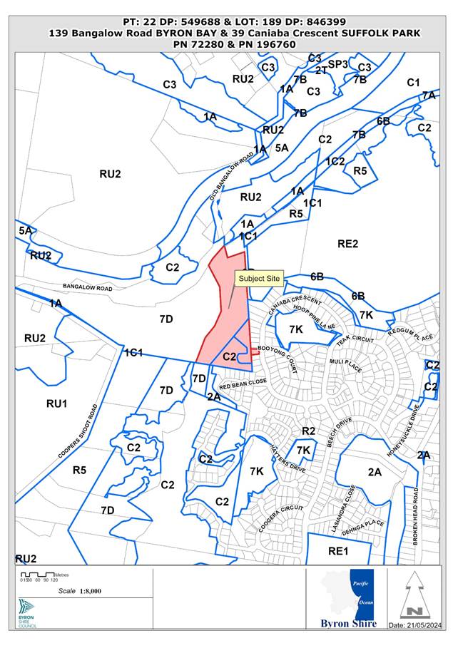
Report No. 13.3 PLANNING - DA 10.2023.346.1 – Stage 1: Two Lot Torrens Title Subdivision, Boundary Adjustment and Demolition. Stage 2: Five Lot Community Title Subdivision, Road Works, Drainage Infrastructure, Tree Removal and Associated Works – 139 Bangalow Road, Suffolk Park
Directorate: Sustainable Environment and Economy
Report Author: Ben Grant, Planner
File No: I2024/747
Proposal:
|
10.2023.346.1 |
|||
|
Planning Portal ref |
PAN-370200 |
||
|
Proposal description: |
Stage 1: Two Lot Torrens Title Subdivision, Boundary Adjustment and Demolition. Stage 2: Five Lot Community Title Subdivision, Road Works, Drainage Infrastructure, Tree Removal and Associated Works. |
||
|
Property description: |
Lot PT22 DP549688, Lot 189 DP846399 |
||
|
139 Bangalow Road, BYRON BAY |
|||
|
Parcel No/s: |
72280, 196760 |
||
|
Applicant: |
Dwayne Roberts C/O The Trustee for Cromack Family Trust and Others. |
||
|
Owner: |
Ms Y M Donohoe & Ms E R Donohoe & Mr M W Donohoe & Others |
||
|
Zoning: |
Part C2 Environmental Conservation, Part R2 Low Density Residential, Part 7(d) (Scenic/Escarpment Zone) |
||
|
Date received: |
29 November 2023 |
||
|
Integrated / Designated Development: |
☒ Integrated |
☐ Designated |
☐ Not applicable |
|
Concurrence required |
No |
||
|
Public notification or exhibition: |
- Level 1 advertising under Council’s Community Participation Plan. - Exhibition period: 8 December 2023 to 12 January 2024 - Submissions received: Nil - Submissions acknowledged: ☐ Yes ☐ No ☒ N/A |
||
|
Planning Review Committee |
PRC meeting held 4 April 2024. Referred to Council for determination. |
||
|
Variation request to Development Standards under an EPI (e.g., clause 4.6) |
Name of clause - Subdivision in rural areas for agriculture etc Clause number – 11(1) Percentage value of variation sought – 90% for Lot 2 and 96% for Lot 3. Percentage value of the variation approved – Nil. Recommend refusal to the variation. Brief summary of the variation – The written request has not adequately demonstrated that compliance with the development standard is unreasonable or unnecessary in the circumstances or that there are sufficient environmental planning grounds to justify varying the development standard. |
||
|
Estimated cost |
$742,000.00 |
||
|
Issues |
1. Non-compliant staggered T-intersection design. 2. Insufficient information regarding stormwater management. 3. Stage 1 boundary adjustment non-compliant with Minimum Lot Size Map under Clause 4.1 LEP 2014. 4. Insufficient written request to justify varying the 40-hectare minimum lot size development standard in the 7(d) Zone. 5. Insufficient information regarding ecological impacts. 6. Non-compliant subdivision layout. |
||
Summary:
This proposal is for a staged subdivision at 139 Bangalow Road and 39 Caniaba Crescent, Suffolk Park, comprising:
· Stage 1: Demolish existing dwelling house, boundary adjustment and two-lot Torrens title subdivision.
· Stage 2: Five-lot community title subdivision including road works, drainage infrastructure, tree removal, and associated works.
The development application seeks a variation to Clause 11 of Byron LEP 1988 which stipulates a 40-hectare minimum subdivision lot size in the 7(d) (Scenic Escarpment Zone). The application must be determined by the full Council as the extent of the variation is greater than 10% of the development standard.
This assessment finds that the proposed development is unable to be supported in its current form primarily due to insufficient or inadequate information in relation to a range of issues including traffic safety, road design, stormwater management, biodiversity impacts, and the proposed variation to the minimum lot size standard.
The proposed staggered T-intersection with Caniaba Crescent does not meet the Austroads design guidelines and inadequate information was provided to demonstrate that stormwater flows can be adequately managed to mitigate potential flooding impacts on downstream residential properties.
Furthermore, the applicant’s written request to vary the 40-hectare minimum lot size standard under Clause 11 of Byron LEP 1988 cannot be supported as it has not accurately detailed the extent of the variation being sought and has not adequately demonstrated that compliance with the development standard is unreasonable or unnecessary in the circumstances and that there are sufficient environmental planning grounds to justify the contravention of the development standard.
Additionally, the proposed Stage 1 boundary adjustment will result in Lot 1 (39 Caniaba Crescent) being extended further west, partially into an area of land with a 40ha minimum lot size under the Lot Size Map in Byron LEP 2014. The applicant has not provided a written request to vary the Lot Size Map which is a jurisdictional precondition for the granting of development consent.
Council staff requested further information on 14 November 2023 asking for a traffic impact assessment, intersection design details, and a Major Stormwater Drainage Analysis. A second request for information was uploaded to the portal on 28 March 2024 asking for additional information in relation to the Clause 64A variation request, ecological assessment, and Stage 2 subdivision layout. The applicant was given an opportunity to resolve the identified issues above however no response to either request was forthcoming.
The development application was publicly exhibited for a period of 14 days between 2 November 2023 and 15 November 2023 in accordance with the Byron Shire Community Participation Plan. A total of 31 submissions were received objecting to the development including 1 petition with 44 signatures. Concerns were raised over ecological impacts, Aboriginal heritage, traffic, stormwater, subdivision design and amenity issues.
Without significant amendment or submission of additional information the proposal is not considered capable of complying with the relevant planning controls applying to the site or demonstrating that the impacts of the development on the natural and built environment is acceptable. As such the development application is recommended for refusal for the reasons listed in the recommendations of this report.
NOTE TO COUNCILLORS:
In accordance with the provisions of S375A of the Local Government Act 1993, a Division is to be called whenever a motion for a planning decision is put to the meeting, for the purpose of recording voting on planning matters. Pursuant to clause 2(a) under the heading Matters to be Included in Minutes of Council Meetings of Council's adopted Code of Meeting Practice (as amended) a Division will be deemed to have been called by the mover and seconder of all motions relating to this report.
RECOMMENDATION:
Pursuant to Section 4.16 of the Environmental Planning & Assessment Act 1979, Development Application No. 10.2023.346.1 for Stage 1: Two Lot Torrens Title Subdivision, Boundary Adjustment and Demolition. Stage 2: Five Lot Community Title Subdivision, Road Works, Drainage Infrastructure, Tree Removal and Associated Works, be refused for the following reasons:
1. Pursuant to section 4.15(1)(a)(i) of the Environmental Planning and Assessment Act 1979, the proposed Stage 1 subdivision contravenes the 40-hectare minimum lot size under Clause 11 of Byron LEP 1988 and Council is not satisfied that the applicant’s written request has adequately demonstrated that compliance with the development standard is unreasonable or unnecessary in the circumstances of the case and that there are sufficient environmental planning grounds to justify the contravention of the development standard.
2. Pursuant to section 4.15(1)(a)(i) of the Environmental Planning and Assessment Act 1979, the proposed Stage 1 subdivision contravenes the Lot Size Map under Clause 4.1 of Byron LEP 2014 which specifies a 40-hectare minimum subdivision lot size for part of the land within proposed Lot 1. A written request under Clause 4.6 of Byron LEP 2014 to vary the Lot Size Map under was not submitted with the development application.
3. Pursuant to section 4.15(1)(a)(i) of the Environmental Planning and Assessment Act 1979, the proposed development is unsatisfactory having regard to the matters for consideration under Clause 6.6 of Byron LEP 2014 because insufficient information has been provided to demonstrate that adequate arrangements have been or will be made to provide suitable vehicular access to the site and to ensure that stormwater drainage will be adequately managed.
4. Pursuant to section 4.15(1)(a)(i) of the Environmental Planning and Assessment Act 1979, insufficient information has been provided to demonstrate that the proposed development is consistent with the objective of the C2 Environmental Conservation zone under Byron LEP 2014.
5. Pursuant to section 4.15(1)(a)(i) of the Environmental Planning and Assessment Act 1979, insufficient information has been provided to demonstrate that sewage, drainage, and water services can be provided to the Stage 1 subdivision, contrary to Clause 45 of Byron LEP 1988.
6. Pursuant to section 4.15(1)(a)(iii) of the Environmental Planning and Assessment Act 1979, insufficient information has been provided to demonstrate that adequate road access and stormwater drainage can be provided to the development in accordance with Chapter B3 of Byron Development Control Plan 2014.
7. Pursuant to section 4.15(1)(a)(iii) of the Environmental Planning and Assessment Act 1979, insufficient information has been provided to demonstrate that the development will not adversely affect traffic and pedestrian safety and that the intersection and road design complies with the requirements of Chapter B4 of Byron DCP 2014 including relevant engineering standards and guidelines.
8. Pursuant to section 4.15(1)(a)(iii) of the Environmental Planning and Assessment Act 1979, insufficient information has been provided to demonstrate that the proposed development will ensure no net-loss of biodiversity and that areas to be retained will be adequately protected and managed in accordance the relevant Objectives and requirements of Chapter B1 of Byron Development Control Plan 2014.
9. Pursuant to section 4.15(1)(a)(iii) of the Environmental Planning and Assessment Act 1979, the development application is unsatisfactory having regard to the Objectives, Performance Criteria and Prescriptive Measures of Chapter D6, Parts D6.2.1 and D6.4.1 of Byron DCP 2014, because it has not been demonstrated that the proposed lots are of sufficient area or shape to accommodate well designed development that is compatible with the amenity and established character of the area.
10. Pursuant to section 4.15(1)(b) of the Environmental Planning and Assessment Act 1979, insufficient information has been provided to demonstrate that the proposed development will not adversely affect the natural environment of the locality including threatened species or ecological communities, or their habitats.
11. Pursuant to section 4.15(1)(b) of the Environmental Planning and Assessment Act 1979, insufficient information has been provided to demonstrate that the proposed development will not adversely affect the built environment of the locality due to potential traffic safety issues and unmanaged stormwater drainage impacts.
12. Pursuant to section 4.15(1)(c) of the Environmental Planning and Assessment Act 1979, insufficient information has been provided to demonstrate that the site is suitable for the development in its current form.
13. The development is not satisfactory having regard to subsection 4.15(1)(d) and (e) of the Environmental Planning and Assessment Act 1979 because approval of the development application is not in the public interest having regards to the objects of the Act, potential impacts on Aboriginal cultural heritage, and submissions in objection to the development.
14. Insufficient information has been provided to demonstrate that a Biodiversity Development Assessment Report is not required to be submitted with the development application in accordance with Section 7.7 of the Biodiversity Conservation Act 2016.
1 DA
10.2023.346.1 Stage 1 and 2 Subdivision Plans, E2024/61010 ![]()
2 DA
10.2023.346.1 Road Design Plans, E2024/61014
![]()
3 DA
10.2023.346.1 Stormwater Management Plan, E2024/61015
![]()
4 DA
10.2023.346.1 Ecological Assessment, E2024/61016
![]()
5 DA
10.2023.346.1 Cl. 64A Variation Request, E2024/61017
![]()
6 DA
10.2023.346.1 Aborignal Cultural Heritage Report, E2024/61018 ![]()
7 DA
10.2023.346.1 10.2023.346.1 submission redacted, E2024/62750 ![]()
8 DA
10.2023.346.1 BOBBAC Submission, E2024/63592
![]()
Report
INTRODUCTION
History/Background
139 Bangalow Road (Lot 22 DP 549688) was registered on 6 September 1971. The site contains a two-storey dwelling house near Bangalow Road which appears to predate Council’s records.
The following determinations were identified for 39 Caniaba Crescent (Lot 189 DP846399) in Council’s records:
· BA 6.1996.2522.1 – Dwelling House, approved 23 September 1996.
· DA 10.2002.754.1 – Dwelling Additions, approved, 21 August 2003.
Assessment and requests for additional information
Further information was requested on 14 November 2023 requesting a traffic impact assessment and preliminary design details for intersection upgrades at the frontage of the development. A Major Stormwater Drainage Analysis was also requested.
A second request for information was uploaded to the portal on 28 March 2024 requesting further information and amendments in relation to the Clause 64A variation request, ecological assessment, and Stage 2 subdivision layout.
A further letter was sent on 24 May 2024 advising that the application would likely be recommended for refusal considering the outstanding matters. The applicant was offered an opportunity to withdraw the application before it was reported to Council for determination.
Description of the proposed development
Development consent is sought for a staged subdivision and associated works as follows:
Stage 1:
a. Demolish the existing dwelling house on Lot 189 DP 846399 (39 Caniaba Crescent).
b. Boundary adjustment between Lot 189 DP 846399 and the adjoining public pathway to create a smaller residential lot (Proposed Lot 1) and a road reserve corridor to facilitate access to the site in Stage 2.
c. Boundary adjustment between Lot 189 DP 846399 and Lot 22 DP 549688 to ensure that Proposed Lot 1 has an area of at least 600m2.
d. Torrens title subdivision of Lot 22 DP 549688 to create 2 lots, being Proposed Lot 2 (vacant) and Proposed Lot 3 containing the existing dwelling house near Bangalow Road.
Stage 2:
e. Community title subdivision of Lot 2 (as per Stage1) to create:
· 5 vacant residential lots (Proposed Community Lots 2-6), and
· 1 community lot to contain the new internal road from Canaiba Crescent including infrastructure services (Proposed Community Lot 1).
f. Construction of new road within proposed Community Lot 1, being a cul-de-sac with an intersection to Canaiba Crescent.
g. Provision of infrastructure services to Proposed Community Lots 2-6 including a bioretention basin within proposed Lot 6.
h. Removal of 25 native trees and up to 25 exotic trees.
Stage 1 Torrens title lots:
|
Proposed Lot |
Area |
Status |
Zoning |
|
1 |
600m2 |
Vacant |
R2 Low Density Residential |
|
2 |
1.618ha |
Vacant |
R2 Low Density Residential, C2 Environmental Conservation, 7(d) (Scenic/Escarpment). |
|
3 |
4.065ha |
Dwelling House |
7(d) (Scenic/Escarpment). |
Stage 2 Community title lots:
|
Proposed Lot |
Area |
Status |
Zoning |
|
1 |
1.855ha |
Community Lot (internal road) |
R2 Low Density Residential, 7(d)(Scenic Protection) |
|
2 |
601m2 |
Vacant |
R2 Low Density Residential |
|
3 |
602m2 |
Vacant |
R2 Low Density Residential |
|
4 |
955m2 |
Vacant |
R2 Low Density Residential |
|
5 |
700m2 |
Vacant |
R2 Low Density Residential |
|
6 |
1.143ha |
Vacant |
R2 Low Density Residential, C2 Environmental Conservation |
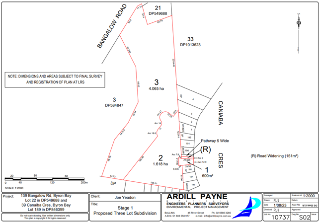
Figure 2: Stage 1 Torrens title subdivision plans.
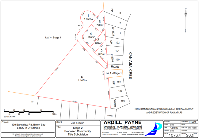
Figure 3: Stage 2 Community title subdivision plans.
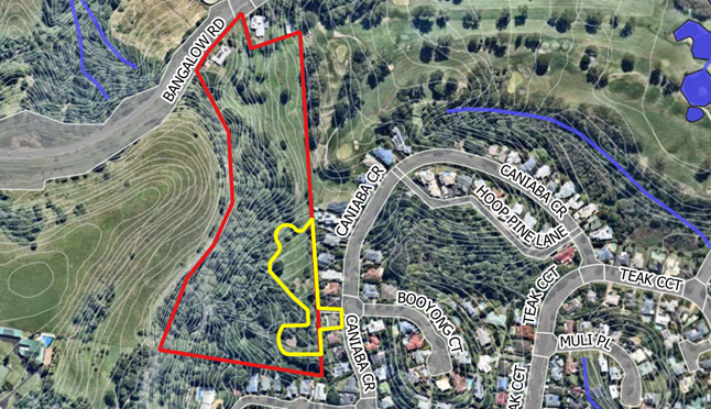
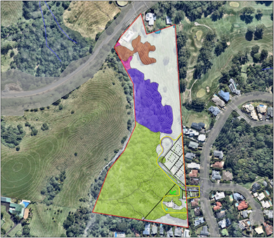
Figure 4: Extract from ecology report identifying the development footprint.
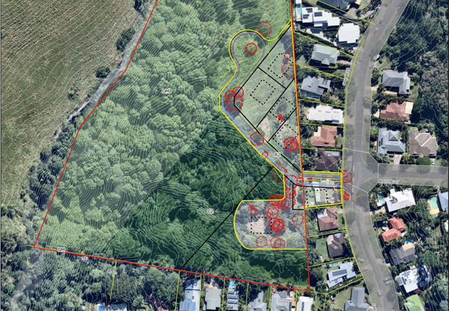
Figure 5: Extract from ecology report illustrating the Stage 2 community title subdivision.
Description of the site
A site inspection was carried out on 30 October 2023
|
Land is legally described |
PT: 22 DP: 549688, LOT: 189 DP: 846399 |
|
|
Property address |
139 Bangalow Road BYRON BAY, 39 Caniaba Crescent SUFFOLK PARK |
|
|
Land is zoned: |
DM Deferred Matter / PART C2 Environmental Conservation / PART R2 Low Density Residential Byron LEP 1988 |
|
|
Land area is: |
5.66 ha |
|
|
Property is constrained by: |
Bushfire prone land, High Conservation Value Vegetation |
|
|
|
Is a BDAR required due to the location of the proposed development? |
☐ Yes ☒ No |
|
|
Are there any easements in favour of Council affecting the site? |
☐ Yes ☒ No |
|
|
Is there a Vegetation Management Plan which might affect the proposal? |
☐ Yes ☒ No |
|
|
Is there a Voluntary Planning Agreement which might affect the proposal? |
☐ Yes ☒ No |
The site comprises two lots, legally described as Lot 22 DP 549688 and Lot 189 DP 846399, commonly known as 139 Bangalow Road and 39 Caniaba Crescent, Suffolk Park. 139 Canaiba Crescent is an irregular shaped parcel with an area of approximately 5.68ha. 39 Caniaba Crescent is a regular shaped residential zoned lot with an area of 601m2.
The site is located on the western side of the Suffolk Park adjoining the Baywood Chase residential area. The land has a moderate slope and drains in a southerly direction towards residential zoned land frontaing Caniaba Crescent and Red Bean Close.
139 Bangalow Road contains a two-storey dwelling house at the northern end of the property. 39 Caniaba Crescent contains a single storey mid-90’s era dwelling house with landscaped gardens.
Subtropical rainforest vegetation can be found at the southern end of the site. Open grassy areas can be found in the south-east corner which generally correspond to the R2 Low Density Residential zone boundaries.
Development to the south and east is of a residential nature, comprising single dwellings and dual occupancies in a low density residential environment. Byron Bay Golf Course is located to the north-east, while cleared grazing land can be found above the escarpment on the site’s western boundary.
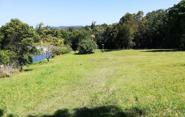
Figure 2: View from proposed Lot 5 looking south.
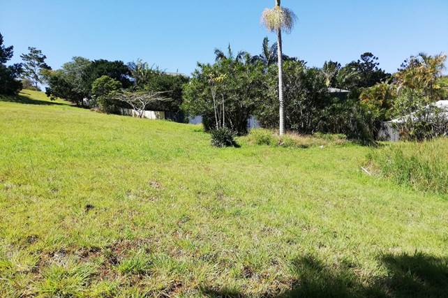
Figure 3: View north-east.
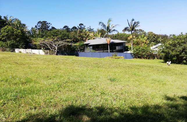
Figure 4: View east towards dwellings on Caniaba Crescent.
 Figure 5: Public pathway
linking the site to Caniaba Crescent.
Figure 5: Public pathway
linking the site to Caniaba Crescent.
Figure 6: Location of internal road providing access to the proposed new lots.
Figure 7: Location of proposed Lot 6.
Figure 8: View from Lot 22 looking south over the subject site.
SUMMARY OF REFERRALS
External referrals
|
Referral |
Issue |
|
Rural Fire Service (s100B) |
General Terms of Approval and a Bush Fire Safety Authority were issued by the NSW Rural Fire Service on 5 December 2023. |
|
Essential Energy |
Essential Energy did not raise any objections to the proposed development subject to standard notes regarding electricity easements and safety precautions when building near powerlines. |
|
Bundjalung of Byron Bay Aboriginal Corporation (BOBBAC) |
The DA was referred to BOBBAC on 11 March 2024 in response to public submissions which raised concerns about potential impacts on Aboriginal cultural heritage in the surrounding area. BOBBAC responded on 29 May 2024 requesting deferral of Council’s determination of the DA until a cultural heritage site inspection had been undertaken by BOBBAC staff. Given the extent of outstanding information and current assessment timeframes, the application is being reported to Council for determination with a recommendation for refusal, noting there is insufficient information to properly assess potential impacts on Aboriginal cultural heritage significance at the current time. |
Internal referrals
|
Referral |
Issue |
|
Environmental Health Officer |
Council’s Environmental Health Officer did not raise any objections to the proposed development on environmental health grounds. |
|
Development Engineer |
Council’s Development Engineer did not support the proposed development for three key reasons: (1) The proposed access road creates a staggered T-intersection with Caniaba Crescent which does not comply with Council or Austroads design guidelines. The intersection design has the potential to adversely affect traffic and pedestrian safety if constructed.
(2) The internal access road may not be sufficiently wide to accommodate traffic from the Stage 2 community title subdivision given the potential for medium density forms of residential accommodation such as secondary dwellings or dual occupancies being developed within the site.
(3) Insufficient information has been provided to demonstrate that stormwater drainage will be adequately managed and that downstream properties in Red Bean Close and Caniaba Crescent will not be inundated during periods of heavy rain. |
|
Systems Planning Officer |
Council’s Systems Planning Officer noted that development contributions would be payable should be consent be granted. |
|
Contributions Planner |
Developer Contributions were not calculated given the application is recommended for refusal. |
|
Ecologist |
The proposal could not be supported because there was insufficient information to confirm that the development did not exceed the Biodiversity Offsets Scheme (BOS) threshold, which, if surpassed, would trigger a statutory requirement for a Biodiversity Development Assessment Report (BDAR) to be provided with the DA. Areas of grassland were not fully assessed to determine if they comprise native grasses (such as hairy joint grass) and therefore the extent of native vegetation clearing has not been properly demonstrated. |
|
Infrastructure Services |
Council’s Infrastructure Planning Coordinator did not raise any objections to the removal of the public access pathway off Caniaba Crescent. The pathway is not required by Council at the current time as it provides pedestrian access to private land. |
SECTION 4.46 INTEGRATED DEVELOPMENT
The proposed subdivision is integrated development requiring a Bush Fire Safety Authority (BFSA) under Section 100B of the Rural Fires Act 1997. The NSW Rural Fire Service issued General Terms of Approval and a BFSA on 5 December 2023.
SECTION 4.15C – MATTERS FOR CONSIDERATION – DISCUSSION OF ISSUES
Having regard to the matters for consideration detailed in Section 4.15(1) of the Environmental Planning & Assessment Act 1979 (EP&A Act), the following is a summary of the evaluation of the issues.
State Environmental Planning Policies (SEPP)
|
Considerations |
Satisfactory |
Unsatisfactory |
|
Biodiversity and Conservation SEPP 2021 Chapter 4 Koala habitat protection 2021 The site has an area of more than 1 hectare and is within the Koala Planning Area identified in the Byron Coast Comprehensive Koala Plan of Management (Koala Plan). In accordance with Section 4.2 of the Biodiversity SEPP, Council’s determination of the development application must be consistent with the Koala Plan. Byron Coast Comprehensive Koala Plan of Management The submitted ecological assessment report identifies three general vegetation groups occurring on the site, being (1) exotic species in the north, (2) Camphor laurel dominated rainforest in the middle of the site, and (3) subtropical rainforest vegetation in the south-western corner beneath the escarpment.
Figure 1: Vegetation groups: (1) exotic (brown), (2) Camphor laurel (purple), (3) subtropical rainforest (green). The subject site is not identified in the Koala Plan as containing potential or core koala habitat. This was confirmed in the ecological assessment report which found that vegetation on the site was primarily native rainforest species with a mixture of Camphor laurel and other exotic species. The proposed development is considered to be consistent with the provisions of the Koala Plan for the following reasons: · The development site is not considered to be potential, or core koala habitat as defined in the Koala Plan. · None of the trees to be removed are koala feed tree species. · No koala feed tree species will be located within proposed residential allotments. · The subdivision will not create any new lots within 20m of koala habitat. · The subdivision is unlikely to significantly affect landscape connectivity between pockets of core habitat in the Suffolk Park and Broken Head. · Mitigation measures are possible (should consent be granted) by imposing restrictive covenants that prevent cat or dog ownership within the Stage 2 community title subdivision. |
☒ |
☐ |
|
Resilience and Hazards SEPP 2021 Chapter 4 Remediation of land A preliminary site investigation report was provided which included analysis of soil samples taken from around the proposed development area. Soils were tested for heavy metal contaminants and organochloride pesticide residues. There were no samples that exceeded the residential criteria for metals or pesticide contamination. Council’s Environmental Health Officer endorsed the findings of the report. Based on the available information, the site is deemed suitable for residential use in its current state and does not require remediation or further investigation. |
☒ |
☐ |
|
Transport and Infrastructure SEPP 2021 Section 2.48 Determination of development applications—other development The development application was referred to Essential Energy for comment in accordance with s.2.48 of the Transport and Infrastructure SEPP. Essential Energy responded on 14 November 2023 with a set of standard notes regarding safety procedures for working near underground powerlines. |
☒ |
☐ |
4.2A Byron Local Environmental Plan 2014 (LEP 2014)
In accordance with LEP 2014 clauses 1.4 and 2.1 – 2.3:
(a) The proposed development is defined in Part 6 of the Act as subdivision and associated subdivision work;
(b) The land is within the 7(d) (Scenic/Escarpment Zone), C2 Environmental Conservation zone, and R2 Low Density Residential zone according to the land zoning map.
(c) The proposed development is permitted with consent; and
(d) Regard is had for the Zone Objectives as follows:
|
Zone Objective C2 Environmental Conservation |
Consideration |
|
To protect, manage and restore areas of high ecological, scientific, cultural or aesthetic values. |
Insufficient information has been provided to demonstrate that the proposal is consistent with the C2 zone objectives for the following reasons: · Part of the bioretention basin is located in the C2 zone. It is unclear if this drainage infrastructure will require tree removal or otherwise affect the site’s conservation values. · All the C2 zoned land will be contained within proposed Lot 6 in Stage 2, which is a residential lot containing a dwelling envelope. It is unclear who will have responsibility for managing this land under any future community management plan. |
|
To prevent development that could destroy, damage or otherwise have an adverse effect on those values. |
|
Zone Objective R2 Low Density Residential |
Consideration |
|
To provide for the housing needs of the community within a low-density residential environment. |
The proposed subdivision is not inconsistent with the R2 zone objectives. |
|
To enable other land uses that provide facilities or services to meet the day to day needs of residents. |
The remaining checked clauses have been taken into consideration in the assessment of the subject development application in accordance with Section 4.15 of the EP&A Act. The proposed development complies with all clauses of LEP 2014 (in some cases subject to conditions and/or to the satisfaction of other assessing officers).
Part 4 Principal development standards
|
Provision |
Compliance |
Comment |
|
4.1 Minimum subdivision lot size |
No |
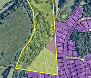
The Lot Size Map specifies the following minimum lot sizes for the land: · A 600m2 minimum lot size applies to R2 Low Density Residential zoned land in the north-eastern corner of the site. · A 40-hectare minimum lot size applies to the southern part of proposed Lot 2 which encapsulates land within the C2 zone and part of the R2 zoned land.
Figure 10: Extract of Lot Size Map overlay from Council’s GIS. In Stage 1, proposed Lots 1 and 2 will have areas of 600m2 and 1.618ha respectively. Both lots contravene the 40-hectare minimum lot size standard applying to the southern portion of the site as shown in Figure 10. Clause 4.1 does not apply to any kind of subdivision under the Community Land Development Act 2021. As such there are no minimum lot size standards applying to the proposed community title subdivision in Stage 2. Refer to Clause 4.1D in relation to potential exemptions to minimum lot size standards for certain split-zoned sites. |
|
4.1D Exceptions to minimum subdivision lot sizes for certain split zones |
No |
Clause 4.1D allows development consent to be granted for the subdivision of an “original lot” containing a mix of residential, rural, or environmental conservation zones, even if one of the “resulting lots” is less than the minimum lot size. To qualify for the exemption, one of the resulting lots must contain land in a residential, employment or mixed-use zone that has an area not less than the minimum lot size, and all the land in the rural or conservation zone that was in the original lot. All the other resulting lots must comply with the Lot Size Map. The proposed Stage 1 subdivision does not fully comply with the requirements of Clause 4.1D, as detailed below: · Lot 1 (600m2) – Does not comply. The boundaries of proposed Lot 1 will be extended further west, partially into an area of land with a 40ha minimum lot size under the Lot Size Map. Proposed Lot 1 is an “original lot” that only contains residential zoned land. It does not qualify for any exemptions under Clause 4.1D. · Lot 2 (1.618ha) – Complies. Proposed Lot 2 will contain residential zoned land with an area of at least 600m2 (as specified by the Lot Size Map for part of the lot) and will also contain all the C2 zoned land that was in the original lot. · Lot 3 (4.065ha) – Not Applicable. Proposed Lot 3 is entirely within the 7(d) (Scenic/Escarpment Zone) under LEP 1988 and is not subject to the provisions of Clause 4.1 or Clause 4.1D. A Clause 4.6 request was not submitted seeking a variation to the 40-hectare minimum lot size standard for proposed Lot 1. As such, there is no power to grant consent to the application in its current form. |
|
4.6 Exceptions to development standards |
N/A |
The applicant has not submitted a written request to vary any development standards in accordance with Clause 4.6. |
Part 5 Miscellaneous provisions
|
Provision |
Compliance |
Comment |
|
5.10 Heritage conservation |
N/A |
The site is not currently identified as an Aboriginal place of heritage significance and therefore consideration under Clause 5.10(8) of LEP 2014 is not required. |
|
5.16 Subdivision of, or dwellings on, land in certain rural, residential or conservation zones |
Yes |
The proposed subdivision is unlikely to result in significant land use conflict with surrounding land uses which are predominantly residential in nature. |
Part 6 Additional local provisions
|
Provision |
Compliance |
Comment |
|
6.2 Earthworks |
Yes |
Minor cut and fill will be required to construct the internal road network and drainage infrastructure. The proposed earthworks are acceptable having regard to the matters for consideration under Clause 6.2. |
|
6.6 Essential services |
No, insufficient information |
Services The site can accommodate essential services for future residential lots including reticulated water, sewer, electricity, and telecommunications subject to conditions of consent. Stormwater The proposed subdivision will potentially alter the stormwater drainage characteristics of the site and could exacerbate flooding impacts on downstream residents in Red Bean Close and Caniaba Crescent. Council requested a Major Stormwater Drainage Analysis to be provided in support of the application however no response was received. Based on the available information, Council’s Development Engineer could not be satisfied that the proposed subdivision will have adequate site drainage in accordance with the Northern Rivers Local Government Development Design and Construction Manuals, Byron Shire Council Comprehensive Guidelines for Stormwater Management, and the relevant Australian Standards. Vehicular access The proposed intersection with Caniaba Crescent does not meet the design standards for a staggered T-intersection in accordance with Austroads Guide to Road Design Part 4 (2023) and Austroads Guide to Traffic Management Part 6 (2017). The applicant was given the opportunity of submitting amended plans to resolve the non-compliant intersection design however no response was forthcoming. Based on the current plans and information, Council’s Development Engineer could not be satisfied that the proposed intersection would provide safe or adequate vehicular access to the Stage 2 subdivision and therefore the application cannot be supported in its current form. |
|
6.17 Affordable housing in residential and business zones |
Yes |
The proposed subdivision will not affect the provision or retention of affordable housing. |
|
6.18 Affordable housing contribution for certain development in affordable housing contribution areas |
Not applicable |
There is no Affordable Housing Contributions Scheme Map at the time of writing. Clause 6.18 is therefore not applicable. |
4.2B Byron Local Environmental Plan 1988 (LEP 1988)
In accordance with LEP 1988 clauses 5, 8 and 9:
(a) The proposed development is defined in the LEP 1988 Dictionary as subdivision of land and ancillary works.
(b) The land is within the LEP1988 7(d) (Scenic Escarpment Zone) according to the map under LEP 1988.
(c) The proposed development is permitted with consent; and
(d) The proposed development is consistent with the relevant objectives of the Zone for the following reasons:
|
Zone Objective 7(d) (Scenic Escarpment) |
Consideration |
|
(a) to protect and enhance the scenic qualities of the Shire of Byron which enhance the visual amenity by controlling the choice and colour of building materials, position and bulk of buildings, access roads and landscaping, |
The proposed subdivision involves constructing a minor portion of the internal access road in the 7(d) Zone to create a vehicle turning area. The works will not be clearly visible from publicly accessible locations and will not adversely affect the scenic qualities of the surrounding area.
|
|
(a) to protect and enhance the scenic qualities of the Shire of Byron which enhance the visual amenity by controlling the choice and colour of building materials, position and bulk of buildings, access roads and landscaping, |
|
|
(c) to enable development for certain purposes where such development would not have a detrimental effect on the scenic quality and visual amenity of the Shire, |
|
|
(c) to enable development for certain purposes where such development would not have a detrimental effect on the scenic quality and visual amenity of the Shire, |
|
|
(e) to enable the careful control of noxious plants and weeds by means not likely to be significantly detrimental to the native ecosystem. |
The remaining checked clauses have been taken into consideration in the assessment of the subject development application in accordance with Section 4.15 of the EP&A Act. The proposed development complies with all clauses of LEP 1988 (in some cases subject to conditions and/or to the satisfaction of other assessing officers).
Part 3 Special provisions
|
Provision |
Compliance |
Comment |
|
Clause 11 Subdivision in rural areas for agriculture etc. |
No, refer to Clause 64A request. |
A minimum subdivision lot size of 40 hectares applies to land in the 7(d) (Scenic Escarpment Zone). Stage 1 involves the subdivision of 7(d) zoned land into two separate Torrens title allotments of 4.065ha and 1.618ha respectively which contravene the 40ha minimum lot size standard as detailed below: Stage 1 Subdivision Proposed Lot 2 Proposed Lot 2 has an area of 1.618ha and contains a small portion of 7(d) zoned land. Proposed Lot 2 contravenes the 40-hectare minimum lot size by 38.38ha or ~96% of the development standard. · Proposed Lot 3 Proposed Lot 3 has an area of 4.065ha and contains all the remaining 7(d) zoned land including the existing dwelling near Bangalow Road. Proposed Lot 3 contravenes the 40-hectare minimum lot size by 35.94ha or ~90% of the development standard. The applicant has submitted a written request to vary the 40-hectare minimum lot size standard. Refer to Clause 64A. |
|
Clause 30 Development within Zone No 7 (d) (Scenic) |
Yes |
Part of the internal road network will extend into the 7(d) (Scenic Escarpment Zone). The road will be located below the ridgeline and will not have a significantly adverse impact on the visual qualities of the area. |
|
Clause 31 Development on ridgetops |
Yes |
Part of the proposed internal road network will extend into the 7(d) (Scenic Escarpment Zone) however the works lie well below the escarpment and will not have a significantly adverse visual impact on the landscape. No development is proposed on or near a ridgeline. |
|
Clause 45 Provision of Services |
No, insufficient information |
The applicant has not provided a staging plan to demonstrate how sewerage drainage and water services will be provided to the proposed Stage 1 lots, particularly proposed Lot 2). |
|
Clause 64A |
No |
The proposed development seeks to vary the 40-hectare minimum lot size standard for subdivision in the 7(d) (Scenic Protection Zone) under Clause 40 of LEP 1988. See further details in the ‘Discussion’ section below. |
Byron Local Environmental Plan 1988 – Issues Section
Clause 64A Exceptions to Development Standards
Clause 11 of Byron LEP 1988 specifies a minimum subdivision lot size of 40 hectares for land in the 7(d) (Scenic Escarpment Zone). The existing property is zoned part 7(d) (Scenic Escarpment), part C2 Environmental Conservation and part R2 Low Density Residential. Proposed Lots 2 and 3 will have areas of 4.056ha and 1.618ha respectively, resulting in a contravention of the 40-hectare lot size for the 7(d) zone by up to 96% as detailed below.
Stage 1: Torrens title subdivision
|
Proposed Lot |
Zone/s |
Proposed Lot size |
Lot Size per Clause 11 of LEP 1988 |
Variation |
|
Lot 2 |
R2, C2, 7(d) |
4.065ha |
40ha |
89.8% |
|
Lot 3 |
7(d) |
1.618ha |
40ha |
96% |
Clause 64A allows development consent to be granted to a development that contravenes a development standard if the consent authority is satisfied that –
(a) compliance with the development standard is unreasonable or unnecessary in the circumstances, and
(b) there are sufficient environmental planning grounds to justify the contravention of the development standard.
A written request has been submitted in accordance with Clause 64A of Byron LEP 1988 seeking to justify the contravention of the development standard. The request is included in Attachment 5.
Objective of the standard
There are no stated objectives for Clause 11 of LEP 1988. Environmental protection zones typically require larger lot sizes to ensure that the environmental, ecological, or scenic values are not fragmented or compromised by overdevelopment, and to ensure that future development is compatible with the character of the natural landscape.
Objectives of the zone
Zone No 7 (d) (Scenic/Escarpment Zone)
The objectives are—
(a) to protect and enhance the scenic qualities of the Shire of Byron which enhance the visual amenity by controlling the choice and colour of building materials, position and bulk of buildings, access roads and landscaping,
(b) to prohibit development within the zone that is likely to have a visually disruptive effect on the scenic quality and visual amenity of the Shire,
(c) to enable development for certain purposes where such development would not have a detrimental effect on the scenic quality and visual amenity of the Shire,
(d) to minimise soil erosion from escarpment areas and prevent development in geologically hazardous zones, and
(e) to enable the careful control of noxious plants and weeds by means not likely to be significantly detrimental to the native ecosystem.
Applicant's Written Request – Clause 64A(3)
In summary, the applicant written request seeks to justify the contravention of the 40-hectare minimum lot size standard on the following basis:
· the existing approved lot (Lot 22 DP 549688) is zoned part 7(d), part C2 and part R2 and is already substantially below the 40ha standard (5.695ha) and will remain so (4.065ha).
· the proposal involves the excision of and further subdivision of the R2 zoned land from Lot 22 to create vacant residential lots that are consistent with the statutory planning provisions for the land under the BLEP 2014.
· The consolidation of the 7(d) zoned land into a single private residual lot that will contain an existing dwelling house is consistent with and will not compromise the attainment of the objectives of the 7(d) zoned land.
· Other than part of the proposed new road which will service new vacant R2 zoned residential lots, there is no residential development within the 7(d) zoned land and thus no potential to significantly impact or change the scenic value of that land and no development/works that will create soil erosion or be on steeply sloping (potentially geologically hazardous) land.
Does the written request adequately address those issues at Clause 64A(3)(a)?
The applicant's written request has not adequately addressed Clause 4.6(3)(a) as it has not accurately detailed the extent of the variation being sought and has not sufficiently explained how the objectives of the development standard are achieved.
The written request only addressed the contravention of the minimum lot size standard for proposed Lot 2 and did not provide any acknowledgment of or justification for the proposed contravention of the standard for proposed Lot 3.
Does the written request adequately address those issues at clause 64A(3)(b)?
The applicant's written request has not adequately demonstrated that there are sufficient environmental planning grounds to justify varying the development standard.
The written request simply stated that no residential development was proposed within any of the 7(d) zoned land. No specific environmental planning grounds were provided to demonstrate why varying the standard would result in a superior planning outcome or was otherwise justified in the circumstances.
Conclusion
For the reasons provided above the requested variation to the 40-hectare minimum subdivision lot size in the 7(d) (Scenic/Escarpment) Zone is not supported as the applicant's written request has not adequately addressed the matters required to be addressed by Clause 64A of Byron LEP 1988.
4.3 Any proposed Instrument that has been the subject of public consultation and has been notified to the consent authority
There are no proposed instruments with relevance to the subject application.
4.4A Byron Shire Development Control Plan 2014 (DCP 2014)
Chapter B1 Biodiversity
|
Provision |
Compliance |
Comment |
|
B1.2.1 Development Envelope Controls |
No, insufficient information |
An inner protection zone of at least 9m will need to be established around the designated dwelling site on Lot 6 resulting in loss of vegetation and further degradation of the subtropical rainforest EEC. Further information was requested from the applicant to confirm any additional clearing that would be required for Lot 6 however no response was forthcoming. The proposed development is considered to be partially inconsistent with the Prescriptive Measures and Objectives of Part B1.2.1 given the potential impacts on the Subtropical Rainforest EEC and the lack of information explanation the extent of clearing and likely impact of establishing a dwelling on proposed Lot 6. |
Chapter B3 Services
|
Provision |
Compliance |
Comment |
|
B3.2.1 Provision of Services |
No |
Refer to Clause 6.6 of LEP 2014. Insufficient information has been provided to demonstrate that the proposed subdivision will have adequate road access in accordance with the requirements of B3.2.1. |
|
B3.2.3 Stormwater Management |
No |
Refer to Clause 6.6 of LEP 2014. Council cannot be satisfied that the proposed subdivision will have adequate site drainage in accordance with the requirements of B3.2.3 and the relevant design guidelines and Australian standards. |
Chapter B4 Traffic Planning, Vehicle Parking, Circulation and Access
|
Provision |
Compliance |
Comment |
|
B4.2.1 Traffic Impact |
No |
Refer to Clause 6.6 of LEP 2014. Insufficient information has been provided to demonstrate that the proposed T-intersection and internal road design meets the relevant requirements of Part B4.2.1. |
Chapter D6 Subdivision
|
Provision |
Compliance |
Comment |
|
D6.4.1 Lot Size and shape D6.2.1 Subdivision Design Guidelines |
No |
The proposed community title lots have been designed with NW-SE orientation due to the topography and spatial constraints of the site. This type of arrangement typically requires larger lot sizes to accommodate dwellings which have non-standard designs or are not sited parallel to lot boundaries. Proposed Lot 2 has an unusual triangular shape and cannot accommodate a building envelope with minimum dimensions of 12m by 15m as required by Prescriptive Measure 3. Council requested further information demonstrating that Lot 2 could accommodate a dwelling which was able to comply with the planning controls for residential development however a response was not forthcoming. |
4.4B Byron Shire Development Control Plan 2010 (DCP 2010)
Chapter 1: Part B Subdivision
|
Provision |
Compliance |
Comment |
|
B3 Development Guidelines |
Yes |
The proposed Stage 1 subdivision generally complies with the Objectives and Prescriptive Measures outlined in Element B3. Stage 1 is a Torrens title subdivision of the existing 7(d) zones land and will only result in a single new allotment with a dwelling entitlement. |
|
B4 Rural Subdivision B5 Urban Subdivision |
Yes |
The proposed Stage 1 subdivision generally complies with the development criteria in Elements B4 and B5. |
4.5 Environmental Planning and Assessment Regulation 2021 considerations
Section 61 - Additional matters that consent authority must consider
The existing dwelling at 38 Caniaba Crescent is proposed to be demolished during Stage 1 of the development. If Council decides to grant consent to the application, a condition should be imposed requiring demolition to comply with AS2601-2001 The Demolition of Structures.
4.6 The likely impacts of that development, including environmental impacts on both the natural and built environments, and social and economic impacts in the locality
|
Impact on: |
Likely significant impact/s? |
|
Natural environment |
Clearing for APZ’s Insufficient information has been provided to explain the extent of clearing required to create an asset protection zone around the designated building envelope in Proposed Lot 6 (Stage 2). Impacts on the surrounding subtropical rainforest EEC have not been properly assessed. Potential habitat fragmentation The submitted ecological assessment and Council’s Ecological Consultant both concluded that the proposal would be unlikely to reduce habitat connectivity or increase habitat fragmentation for native species with the potential to occur on the subject land Important areas of native vegetation near the escarpment will be largely unaffected by the proposed subdivision and could potentially be enhanced subject to compensatory plantings and vegetation restoration works if required. |
|
Built environment |
Traffic and Road Design The proposed access road creates a staggered T-intersection which does not comply with Council or Austroads design guidelines. Insufficient information has been provided to demonstrate that the road design will not adversely affect vehicular and traffic safety. Stormwater Impacts Insufficient information has been provided to demonstrate that stormwater drainage will be adequately managed and that downstream properties in Red Bean Close and Caniaba Crescent will not be inundated during periods of heavy rain. |
|
Social Environment |
Insufficient information has been in relation to potential impacts on the site’s Aboriginal cultural heritage significance as noted in the comments by BOBBAC and public submissions made on the DA. |
|
Economic impact |
No. The proposal will not have a significant economic impact on the locality. |
|
Construction Impacts |
No. The development will generate minor impacts during its construction. Conditions of consent recommended to control hours of work, builders waste, construction noise, installation of sedimentation and erosion control measures and the like to ameliorate such impacts. |
4.7 The suitability of the site for the development
Insufficient information has been provided to demonstrate the sites suitability for the proposed development. The land has steep topography and a narrow site access which creates significant challenges for managing stormwater and providing safe and efficient vehicular access to the site.
4.8 Submissions made in accordance with this Act or the regulations
The development application was publicly exhibited for a period of 14 days between 2 November 2023 and 15 November 2023 in accordance with the Byron Shire Community Participation Plan. Council received 31 submissions and 1 petition with 44 signatures objecting to the proposed development.
Issues raised in the public submissions have been summarised and addressed in the table below.
|
Issue |
Comment |
|
Impacts on Subtropical Rainforest EEC |
|
|
The southern part of the development is endangered sub-tropical rainforest and classified as having ‘High Environmental Value’. The development does not align with councils planned C zone Stage 3 zoning that will further increase the boundaries of the C2 on this property. |
Noted. Insufficient information has been provided regarding potential clearing of vegetation on proposed Lot 6 to create an asset protection zone around the designated building envelope. |
|
The Development Application has proposed Lots 2 & 6 in areas of established sub-tropical rainforest without adequate bushfire mitigation controls. The required buffer zone of 30m for Vegetation Category 2, (grasslands, scrublands, rainforests, open woodlands, and mallee) is not possible |
See above. |
|
Impacts on koalas and other animals |
|
|
Koalas do exist on the subject land. Any reduction or fragmentation of habitat even if deemed ‘not core’ will over time reduce the numbers of koalas and other species in the area. |
It is acknowledged that koalas exist in the surrounding area and may potentially pass through the site or use it for temporary refuge. As discussed elsewhere in this report, it is concluded that the proposal would not significantly affect the movement of koalas in the local area due to habitat fragmentation. The vegetation corridor near the escarpment will be left largely intact and there is potential for compensatory plantings and environmental enhancement activities to mitigate the likely impacts of the subdivision. |
|
The koalas around Byron Bay and Suffolk Park are under extreme pressure and stress due to habitat fragmentation and the high levels of traffic on the roads and human disturbance. If any consideration is to be given to the development more information on the status of koalas within the site and surrounding area is required before an accurate assessment can be made. |
See above. |
|
The site is home to many animals including Koalas, wallabies, and birds including cockatoos. Additional traffic will increase the potential for vehicle strike. |
See above. |
|
Impact on wildlife corridor and high environmental value vegetation |
|
|
The subject land is part of the Broken Head regional habitat corridor and is a highly significant connective area. It is crucial to keep habitat corridors intact. The southern half of the development is classified as a C2 Environmental Conservation zone due to its high environmental value and significance. |
Council’s habitat corridor mapping does not cover the residential zoned parts of the site in recognition that these areas have been identified for future housing. |
|
The land in question comprises high value vegetation and
it is not just the removal of 30 plus trees that will result in a significant
impact on threatened fauna and a high impact on biodiversity values. |
See above.
|
|
This is a wildlife corridor and Koala habitat, evident from the mating calls heard on several occasions November last year by a resident whose bedroom backs onto this bush. The current habitat is a sensitive conservation area and a wildlife corridor so should be protected from further development. |
See above. |
|
Tree removal and general impact on the environment and biodiversity |
|
|
The proposed development will destroy the little remaining
habitat in this area and displace what little wildlife we have left in Byron
Bay/Suffolk Park. The zoning of this land does not support the proposed
development. |
The development is almost entirely located within R2 zoned land.
|
|
Vegetation clearing will need to be undertaken to facilitate multiple building developments and roadway construction through areas zoned as C2 Environmental Conservation zone. |
The applicant’s ecology report does not identify any trees to be removed within the C2 zone. The only development occurring in the C2 zone is part of the stormwater Bioretention basin and no clearing is required for that purpose. |
|
It is not possible to construct a building in the location of the proposed Lot 6 without substantial removal of sub-tropical rainforest vegetation in the C2 zone. |
Noted. The extent of clearing to create an asset protection zone for proposed Lot 6 has not been properly established. |
|
The Hairy joint Grass is growing in this area and the
clearing of the land would be detrimental to its existence. |
Council cannot be certain the development does not exceed the BOS without a native grass assessment. |
|
No details of tree species or proposed compensatory plantings have been demonstrated in the development application. |
Agreed. The submitted ecological assessment noted that compensatory plantings could be provided on site however no details of any such environmental offsets were provided with the application. A condition could be imposed if necessary for detailed ecological enhancement works to be submitted for approval post-consent. |
|
Stormwater Management |
|
|
The Storm Water Management plan is reliant on an inadequate existing drainage infrastructure as evidenced in the recent flooding of several houses at the junction of Red Bean Close and Caniaba Crescent. Major downstream flooding impacts have not been addressed. |
Agreed. Council’s Development Engineer commented that there insufficient information had been provided in relation to stormwater management. |
|
The capacity of the existing drainage infrastructure to remove peak water flows is insufficient. The inadequacy of existing stormwater drainage infrastructure at the rear of Caniaba Crescent residences has not been accounted for. |
See above. |
|
The development of an external catchment to divert water from the undeveloped grassed area to the north of the proposed development into a drainage channel is unacceptable |
Noted. |
|
The drainage line shown Appendix 1 is not maintained and is essentially blocked by vegetation and accumulated litter. |
Noted. |
|
The storm water was up to my backdoor and the drainage culvert behind the property was full of sediment to a depth of around one metre |
Downstream flooding impacts have not been adequately addressed. |
|
Indigenous heritage |
|
|
The area is located between known aboriginal heritage areas. It is extremely important that this area be reserved so that it can be researched and whole area be explored by the appropriate persons who can recognise the history of the area. The area has large caves in the escarpment and the creeks, native vegetation and extensive wildlife that are in the lower southern area of the DA support the significance of aboriginal heritage to the area. |
Noted – See comments above from BOBBAC
|
|
It is essential to assess whether Aboriginal objects are likely to be present in the area of the proposed development, considering specific landscape features. An assessment can be conducted through either a Due Diligence-style report or an Aboriginal Cultural Heritage Assessment Report (ACHAR). The DA only included an AHIMS search however this does not mean that a thorough investigation has been made or done. |
Noted. See above. |
|
Traffic Impacts |
|
|
The application has not sufficiently addressed additional traffic movements from the site including road safety aspects for another exit onto Caniaba Crescent in an already overcrowded road corridor. There are no footpaths or dedicated cycle lanes. |
Insufficient information was provided for Council to be satisfies that the staggered T-intersection complies with the relevant design guidelines and standards. |
|
The alignment (curving nature) of Caniaba crescent does not allow a clear line of sight to on coming or entering traffic. This becomes more problematic if vehicles are parked on the road. The proposed road is not in line with Booyong Crescent further increasing vehicle accidents. There is not significant offset to achieve an adequate “T” junction or room for the construction of a roundabout. |
See above. |
|
Loss of Privacy & Noise |
|
|
The proposed development goes directly behind existing residents’ properties with some building blocks only five metres from existing houses and backyards. Due to the topology of the site and the proximity to existing houses, there will be loss of natural light, loss of privacy and increased noise. There is no consideration for a vegetation buffer or a more community friendly Lot subdivision to mitigate these factors. |
Noted. The alignment and shape of the Community title subdivision lots could potentially result in privacy impacts in the future. The presence of an electricity easement on the eastern boundary limits the ability to plant trees for privacy screening. |
|
Due to the topology of the site and the proximity 47, 45 & 49 Caniaba Crescent, there will be loss of natural light, loss of privacy and increased noise. No Noise survey has been conducted to date. |
See above. |
|
No effort has been made to provide a screen planting buffer and this will significantly detract from the amenity and privacy of adjacent dwellings. |
See above. |
|
Inconsistency with C2 zoning |
|
|
Our understanding is there is a current lodgement in Byron Shire Council to rezone a greater portion of this (proposed) Lot to C2 Environmental Conservation Zone. This should not be disregarded. |
There is no proposal with Council to rezone a greater portion of the site to C2 Environmental Conservation. |
|
My primary concern is that of native vegetation has been removed to facilitate the development. This has occurred on land that has been mapped by council of being of High Environmental Value vegetation and Endangered Ecological Communities. Some of the affected land is zoned C2, which primarily applies to areas of high ecological, scientific or cultural value |
The majority of the development footprint is occurring on land zoned R2 Low Density Residential. |
|
The proposed development is inconsistent with the C2 zone objectives. |
See above. Most of the development is not occurring in the C2 zone. |
4.9 Public interest
Approving the development application in its current form would not be in the public interest having regards to the objects of the Act, potential impacts on Aboriginal heritage significance, and submissions in objection to the development.
BIODIVERSITY CONSERVATION ACT 2016
Section 7.7 of the Biodiversity Conservation Act provides that if a proposed development is likely to significantly affect threatened species, the development application must be accompanied by a Biodiversity Development Assessment Report (BDAR).
A proposed development is considered “likely to significantly affect threatened species” if it exceeds the biodiversity offsets scheme threshold. This can occur if the total area of native vegetation to be cleared exceeds the clearing threshold detailed in s7.2 of the Biodiversity Conservation Regulation 2017.
The submitted ecological assessment report asserts that the 0.25ha clearing threshold is not exceeded because most of the development footprint occurs on cleared grassy areas that have been zoned for residential use. However there is insufficient information to verify this claim. Areas of cleared grassland may still comprise native vegetation (e.g., Hairy joint grass) and need to be assessed using a valid native ground cover assessment method. If these areas are found to comprise native vegetation, then the BOS would be exceeded, and a BDAR must be provided with the application.
DEVELOPER CONTRIBUTIONS
5.1 Water & Sewer Levies
Development servicing levies will be payable should consent be granted to the application. Levies were no included in this report as the proposal is recommended for refusal.
5.2 Developer Contributions
Development contributions will be payable to Council should consent be granted to the application. Contribution rates were not included in this report as the proposal is recommended for refusal.
DISCLOSURE OF POLITICAL DONATIONS AND GIFTS
|
Disclosure details |
Response |
|
Has a Disclosure Statement been received in relation to this application? If Yes, Provide Disclosure Statement register reference: 91. |
Yes ☐ No ☒ |
|
Have staff received a ‘gift’ from anyone involved in this application that needs to be disclosed. |
Yes ☐ No ☒ |
CONCLUSION
This development application seeks consent for staged subdivision at 139 Bangalow Road and 39 Caniaba Crescent, Suffolk Park.
This assessment finds that the proposed development is unable to be supported in its current form primarily due to insufficient or inadequate information in relation to a range of issues including traffic safety, road design, stormwater management, biodiversity impacts, and the proposed variation to the minimum lot size standard.
Council staff requested further information on 14 November 2023 asking for a traffic impact assessment, intersection design details, and a Major Stormwater Drainage Analysis. A second request for information was uploaded to the portal on 28 March 2024 asking for additional information in relation to the Clause 64A variation request, ecological assessment, and Stage 2 subdivision layout. No response to either request was forthcoming.
Without significant amendment or submission of additional information the proposal is not considered capable of complying with the relevant planning controls applying to the site or demonstrating that the impacts of the development on the natural and built environment is acceptable. As such the development application is recommended for refusal for the reasons listed in the recommendations of this report.
Staff Reports - Sustainable Environment and Economy 13.4
Report No. 13.4 26.2024.1.1 - Planning Proposal to introduce Federal Heritage Conservation Area and additional heritage items
Directorate: Sustainable Environment and Economy
Report Author: Cameron Thiessen, Land Use Planner
File No: I2024/749
Summary:
This report seeks to implement the Heritage Strategy by progressing action 5b of the Federal Village Masterplan 2022-2042 (Attachment 1.), namely, the conducting of a Heritage assessment of Federal village, leading to the consideration of a Heritage Conservation Area listing.
A preliminary Federal Village Heritage Assessment was subsequently undertaken to establish a proposed Heritage Conservation Area and provide a list of additional significant Heritage items for consideration by councils Heritage Advisory Committee. Following this preliminary assessment, council staff, in collaboration with community members and council’s heritage advisor, have progressed to a planning proposal for exhibition.
It is recommended that Council proceed with the planning proposal (Attachment 2) to amend Schedule 5 - Environmental Heritage of the Byron Local Environmental Plan (LEP) 2014 to include additional Part 1 - Heritage items, and to establish a new Part 2 - Heritage Conservation Area in the Village of Federal.
RECOMMENDATION:
That Council:
1. Proceeds with the planning proposal contained in Attachment 2, which seeks to create a Heritage Conservation Area and to list additional Heritage items within the Village of Federal.
2. Forwards the planning proposal to the NSW Department of Planning, Industry and Environment for a Gateway determination; and
3. Pending a positive Gateway determination, undertakes public exhibition of the planning proposal in accordance with the determination requirements; and
4. Considers submissions report post-exhibition that includes any recommended changes to the planning proposal for final adoption.
1 26.2024.1.1
Federal Village Masterplan - Adopted by Council, E2022/112461 ![]()
2 26.2024.1.1
Planning Proposal - Federal HCA and Items, E2024/50115
![]()
3 26.2024.1.1
Combined Pre-Lodgement Submissions, E2024/35130
![]()
4 26.2024.1.1
Combined Heritage Inventory Forms - Federal HCA and Items, E2024/47651 ![]()
5 Councillor
Form - Special Disclosure of Pecuniary Interest, E2012/2815 ![]()
Background
The Byron Shire Heritage Strategy 2020-2024 sets-out a framework and provides direction for heritage management. The strategy aims to protect and properly manage identified heritage assets and promote a wider and more informed understanding of the cultural, economic and social value of heritage by the community to enable it to be conserved for future generations.
Two items of environmental heritage in Federal are currently listed in Schedule 5 of the Byron Local Environmental Plan 2014: notably the 1895 School of Arts and adjacent former (former) Holy Trinity Anglican Church c.1900. There is currently a Heritage Character Area for part of the Federal Village in Chapter E6 of the Byron Shire DCP 2014, however there is no statutory Heritage Conservation Area in LEP 2014.
In 2022 Council adopted the Federal Village Masterplan (Attachment 1), that includes a character statement and several planning strategies for implementation. Included in the plan was an identified need for a heritage assessment to identify and list surviving historic places helping to ensure that future development does not detract from those items and respects the existing low-rise, low density rural character of the village. In this regard Action 5b of the Plan is to “conduct a heritage assessment of Federal village, leading to consideration of a Heritage Conservation Area listing”.
Further to this, a presentation was made to the Byron Shire Heritage Committee on 20 April 2023 outlining the history of Federal and examples of the tangible physical evidence of its non-Indigenous early development. The presentation, “Federal Village Preliminary Heritage Assessment” was prepared by Federal community member, Jenna Reed Burns. The presentation was accompanied by a more detailed report (“Preliminary Heritage Assessment of Federal Village – Proposed Heritage Conservation Area + Additional Individual Listings”), containing further historical information and detailed assessment.
Council resolved 23-188 on 25 May 2023 to require further consultation with residents and owners of the properties to be undertaken prior to reporting any planning proposal to Council. This consultation occurred between October 2023 to November 2023 and is included in Table 1 of this report.
Report
This report implements Action 5b of the Federal Village Masterplan 2022-2042 (Attachment 1), via a standalone Planning Proposal that seeks to introduce a Heritage Conservation Area and list 12 additional heritage items in the Village of Federal, which includes a group of dry-stone walls. This Planning Proposal relates to various parcels of land in Federal including the historic village core and various properties in the vicinity of the village (Figures 1and 2).
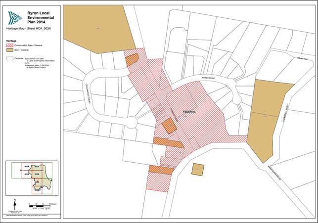
Figure 1 Federal Village Heritage Conservation Area mapping
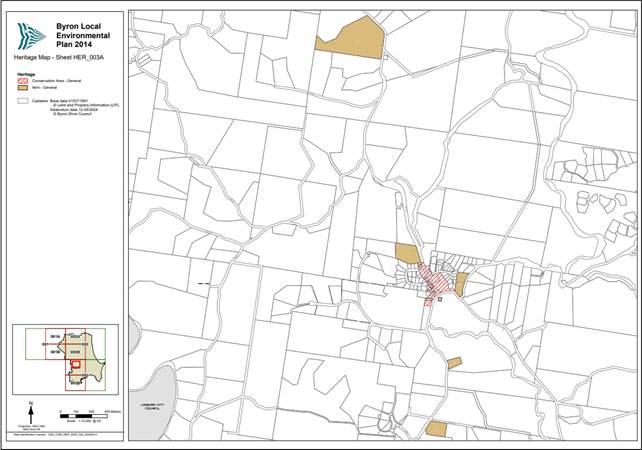
Figure 2 Federal Heritage Items and Conservation Area mapping
Federal Village Heritage Conservation Area Pre-Consultation
Pre-consultation of this proposal has been undertaken with the community of Federal village. The Preliminary Heritage Assessment of Federal Village document and minutes of the 20 April 2023 Heritage Advisory Committee were informally exhibited until 28 November 2023. Refer to Protecting the heritage of Federal Village - Byron Shire Council (nsw.gov.au) for details.
Four (4) submissions were received on the proposal (Attachment 3), all in support, with some submissions including amendments. A summary of the pre-consultation submissions is presented in Table 1.
|
Submission |
Staff Comment |
|
The Google Map on page 6 be amended or removed and that Council does not use Google Maps that can mislead in any heritage assessment documents. The Google Map of ‘Federal’ on p. 6 excises Goonengerry Church of England out of ‘Goonengerry’ and into ‘Federal’ on the corner of Repentance Creek Rd and Federal Drive. This church (built before Federal Church) is part of Goonengerry’s heritage. Retention of the [Google] map diminishes the heritage value of Goonengerry. |
Noted. A higher resolution map has been added to the preliminary heritage assessment.
The planning proposal include maps showing the location of the proposed heritage conservation area and listed items for Federal (Attachment 2).
|
|
The St Phillip & St James Church of England are not located in the Federal Area. |
Noted. Both the St. Phillip and St. James Churches are not identified for inclusion within this proposal. |
|
There should be a heritage zone around the Halls on the corner of Rose Road / Federal Drive. Any developments in that area should be very sensitively designed to be in the same scale as the buildings on the shop side of Federal drive and not be of a bulk and scale that dominates the halls or disadvantages the user’s amenity |
Both of these buildings have been included within the proposed Heritage Conservation Area. Existing DCP controls within Chapters C1 and E6, and the Byron LEP 2014 clause 5.10 require consideration of Heritage values and the character of the area. The adoption of a heritage conservation area would create a Local Environmental Plan requirement for applications undertaking works to take into account the heritage character and potential impacts on the proposed heritage items and conservation area where applicable. |
Table 1. Summary of Pre-Consultation submissions
Proposed listing of new heritage items
A number of properties and or features have been supported for individual heritage listing in the LEP, which are both inside and outside the proposed Heritage Conservation Area, as identified in the planning proposal (Attachment 2). These properties and features were established as part of the preliminary heritage assessment and are listed from page 34 of this document. A more detailed assessment has been provided in the form of draft Heritage Inventory forms for each item (Attachment 4).
In addition, the preliminary assessment establishes the eligibility of Federal Village for inclusion as a Heritage Conservation Area (as shown on the proposed mapping) on Schedule 5 of the Byron LEP 2014. This report recommends that council proceed with the planning proposal.
Next Steps
It is recommended that Council proceed with the Planning Proposal (Attachment 2) and forward to the Department of Planning for a gateway determination, followed by public exhibition.
STRATEGIC CONSIDERATIONS
Community Strategic Plan and Operational Plan
|
CSP Objective |
CSP Strategy |
DP Action |
Code |
OP Activity |
|
4: Ethical Growth |
4.1: Manage responsible development through effective place and space planning |
4.1.4: LEP & DCP - Review and update the Local Environmental Plan and Development Control Plans |
4.1.4.3 |
Develop stand-alone Local Environmental Plan 2014 amendment to introduce new heritage-listed properties |
Recent Resolutions
23-188 – Council Meeting of 25 May 2023
Legal/Statutory/Policy Considerations
The Byron Shire Heritage Strategy (2020–2024) includes the following action in relation to the local area’s heritage:
· Identify Heritage Items in the Byron Shire and list them in the Local Environmental Plan - Maintain, review, and update the Byron LEP 2014 Heritage Schedule and accompanying State Heritage Inventory database.
The planning proposal will also progress Action 5b of the Federal Masterplan, being to: Conduct a heritage assessment of Federal village, leading to consideration of a Heritage Conservation Area listing.
Exhibition of this planning proposal will require identification of affected properties in Council’s s10.7 Planning Certificates.
Financial Considerations
This is a Council initiated planning proposal and will be funded from within existing budgets.
The listing of a site as a heritage item on the Local Environmental Plan will assist property owners in applying for Council’s Heritage Assistance Funds as well as State Government grants.
Consultation and Engagement
Council undertook an informal community consultation between October 2023 to November 2023 outlining the proposed Federal Village Heritage Conservation Area and potential Heritage Items to gauge the feeling of the community, prior to preparation of a formal Planning Proposal. Individual letters were sent to all affected owners and the information was placed on general public exhibition on Council’s website. The results of this consultation are outlined in this report.
Once a Gateway determination is received, the planning proposal will be formally exhibited in accordance with the gateway determination and Council’s Community Participation Plan. Notification of the Planning proposal exhibition will be sent directly to landowners of affected properties and any state agency identified within the gateway determination.
Staff Reports - Sustainable Environment and Economy 13.5
Report No. 13.5 26.2023.6.1 Planning Proposal for Lot 1 DP123302, Broken Head Road, SUFFOLK PARK
Directorate: Sustainable Environment and Economy
Report Author: Alex Caras, Land Use Plannning Coordinator
File No: I2024/761
Summary:
This report assesses a planning proposal to amend Byron LEP 2014 to permit residential development on the former Broken Head Quarry site on the western side of Broken Head Road. The planning proposal requests that approximately 11.8 hectares of land zoned RU1 Primary Production be rezoned to R2 Low Density Residential. It also proposes to change the minimum lot size from 40ha to 400m2 and apply a maximum Floor Space Ratio of 0.6:1.
The applicant has also offered a voluntary planning agreement (VPA) that includes the construction of a shared pedestrian and cycle path linking the site to Suffolk Park plus an offer to dedicate 20% of residential lots to Council to be used for the purpose of Affordable Housing.
A preliminary concept plan indicates possible road and intersection locations and a lot layout indicating approximately 92 residential lots of various sizes between 383 m2 to 1505m2.
The appropriate response to an unsolicited planning proposal is to undertake a Strategic Merit Test and Site-specific Merit Test as outlined in the Department of Planning and Environment - Local Environmental Plan Making Guideline (August 2023).
The Strategic Merit Test and Site-specific Merit Test for the subject land are included in a separate report in Attachment 3. The report concludes that the planning proposal does not meet both the Strategic Merit Test and the Site-specific Merit Test.
It is therefore recommended that Council does not support the planning proposal and advises the Department of Planning, Housing and Infrastructure of its decision in this regard.
NOTE TO COUNCILLORS:
In accordance with the provisions of S375A of the Local Government Act 1993, a Division is to be called whenever a motion for a planning decision is put to the meeting, for the purpose of recording voting on planning matters. Pursuant to clause 2(a) under the heading Matters to be Included in Minutes of Council Meetings of Council's adopted Code of Meeting Practice (as amended) a Division will be deemed to have been called by the mover and seconder of all motions relating to this report.
RECOMMENDATION:
That:
1. Council does not support the subject planning proposal (as contained in Attachment 1) seeking to amend Byron LEP 2014 to rezone the former Broken Head Quarry site on the western side of Broken Head Road for residential development; and
2. Both the applicant and the Department of Planning, Housing and Infrastructure be notified of Council’s decision to not support the planning proposal.
Attachments:
1 26.2023.6.1
Planning Proposal - Ex-Broken Head Quarry Site_Suffolk Park, E2024/59156 ![]()
2 26.2023.6.1
Letter of Offer to enter into a Voluntary Planning Agreement (VPA) in
connection with Planning Proposal for Broken Head Quarry_PP-2024-679, E2024/59159 ![]()
3 26.2023.6.1
Merit Assessment of Planning Proposal for Broken Head Rd Ex-Quarry Site, E2024/59157 ![]()
4 Form
of Special Disclosure of Pecuniary Interest, E2012/2815
![]()
Report
In March 2023, Byron Shire Council received a planning proposal (PP) requesting that it rezone land on the western side of Broken Head Road to permit residential development (Attachment 1). After early consultation with Council and the NSW Biodiversity Conservation Division, the applicant opted to prepare a Biodiversity Development Assessment Report. This report was submitted to Council on 28 March 2024 with a request that the planning proposal be assessed and reported to Council.
Council then engaged Mike Svikis Planning to undertake an independent review of the merit of the planning proposal and supporting information.
The subject land is described as the old Broken Head Quarry site on the western side of Broken Head Road. The old quarry on the eastern side is not part of this planning proposal. The subject land is described as Lot 1 DP 123302 and Lot 2 DP 700806, Broken Head Road. The combined area of these two lots is approximately 32.7 hectares (Figure 1).
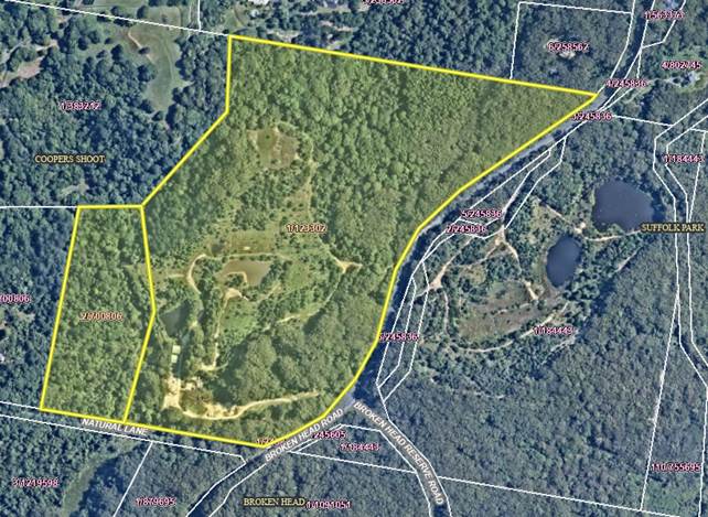
Figure 1: Subject land is west of Broken Head Road
The subject land is zoned partly RU1 Primary Production, partly C2 Environmental Conservation and partly Deferred Matter under Byron Local Environmental Plan 2014 (BLEP 2014) (Figure 2). It has a 40-hectare Minimum Lot Size and a maximum Building Height of 9.0 metres. No FSR applies to the land. The small Deferred Matter area at the eastern boundary is zoned Rural 7(d) Scenic Escarpment zone under Byron Local Environmental Plan 1988 (BLEP 1988).
Adjoining land is variously zoned C2 Environmental Conservation and RU2 Rural Landscape (BLEP 2014) and Deferred Matter (BLEP 1988).
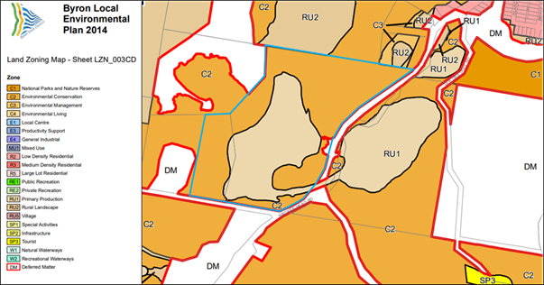
Figure 2: Current BLEP 2014 land use zones
The primary objective of this planning proposal (PP) is to amend Byron LEP 2014 to rezone the RU1 Primary Production portion of the site (west of Broken Head Road) to R2 Low Density Residential. This affects an area approximately 11.8 hectares in size. It will also change the Minimum Lot Size from 40 hectares to 400 m2, and apply a maximum Floor Space Ratio of 0.6:1.
The applicant has also offered a voluntary planning agreement (VPA) that includes the construction of a shared pedestrian and cycle path linking the site to Suffolk Park, plus an offer to dedicate 20% of lots to Council to be used for the purpose of Affordable Housing (Attachment 2).
Technical reports supplied with the PP include an infrastructure capacity report (water and sewer), a strategic bushfire study and a biodiversity development assessment report (BDAR).
A preliminary concept plan indicates possible road and intersection locations, and a lot layout indicating approximately 92 residential lots of various sizes between 383 m2 and 1,505 m2 (Figure 3). This concept is not approved and is only indicative of what might occur on the site if it were rezoned.
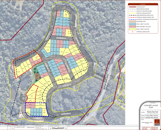
Figure 3: Preliminary Concept Layout Plan
Key issues
Merit Assessment Report
The role of Council when it receives a planning proposal is to prepare a merit assessment report and make a determination as to whether or not it supports the planning proposal. The structure of this assessment report should be consistent with the Strategic Merit Test and Site-specific Merit Test, as outlined in the Department of Planning and Environment Local Environmental Plan Making Guideline (August 2023). The Department defines strategic and site-specific merit as follows:
Strategic merit: A proposal’s demonstrated alignment with the NSW strategic planning framework or current government priority. When an LEP is made or amended through the planning proposal, it must demonstrate strategic merit having regard to the criteria in Section 2 of [the Local Environmental Plan Making Guideline].
Site-specific merit: A proposal’s demonstrated environmental, social and economic impact on the site and surrounds and ability to be accommodated within the capacity of the current and/or future infrastructure and services. When an LEP is made or amended through the planning proposal, it must demonstrate site-specific merit by having regard to the criteria in Section 2 of [the Local Environmental Plan Making Guideline].
The Strategic Merit Test must address the following criteria:
Is the planning proposal consistent with the relevant regional or subregional strategy? This would include the North Coast Regional Plan 2041;
Is the planning proposal consistent with a relevant local council strategy, endorsed by the Department? This would include Byron Local Strategic Planning Statement (LSPS) and the Byron Shire Residential Strategy 2041 (adopted 14 March 2024, but not yet endorsed) and or previous residential strategies;
Does the planning proposal respond to a change in circumstances that has not been recognised by the existing planning framework? Such as:
· Key infrastructure investment;
· Key government priorities;
· Changes to population and demographic trends such as housing and jobs.
The Site Specific Merit Test requires an assessment of site-specific merit and compatibility with surrounding land uses, having regard to:
· the natural environment (including known significant environmental areas, resources or hazards);
· the existing uses, approved uses, and likely future uses of land in the vicinity of the proposal;
· the services and infrastructure that are or will be available to meet the demands arising from the proposal and any proposed financial arrangements for infrastructure provision.
The Merit Assessment Report is contained in Attachment 3.
Conclusions of the Merit Assessment Report
Strategic merit:
The planning proposal is not consistent with the North Coast Regional Plan 2041. It is also not consistent with the Byron Shire Residential Strategy 2041 and Byron Shire Local Strategic Planning Statement, or with any previous residential strategies.
Council is actively addressing the need to ensure an adequate supply of residential zoned land, both in greenfield areas and infill development opportunities. This land has been considered on a number of occasions and has not been supported. Council monitors land development and is aware of supply and demand trends. There is no evidence of changed circumstances that would warrant rezoning the subject land from rural to residential. Importantly, the recently adopted Residential Strategy 2041 identifies more than enough suitable land to meet Council’s housing supply commitments over the next 20 years.
In conclusion, this planning proposal cannot be supported based on the above assessment of strategic merit.
Site-specific merit:
The planning proposal is not adequately supported by reports or assessments of the subject land that address environmental, hazards, infrastructure and other issues. It is not the intention of this report to recommend that such reports or assessments be undertaken. The site-specific merit assessment has been undertaken in this case to ensure the PP is considered to the fullest extent based on available information.
A specific study of the biodiversity on this site has been undertaken. It concluded that impacts on threatened species and threated ecological communities cannot be avoided despite confining most of the development to areas disturbed in the past. The development will impact on native vegetation that occupies 56% of the development site. The report does not address off-site impacts such as the proposed shared path, or infrastructure such as road widening (at intersections), and pipelines and pump stations for water and sewerage. On balance, the report concludes that areas of native vegetation of various quality will be cleared by future residential development (based on the concept design) and offsets will be required. There is no indication of how practical or costly this may be. It is also not clear if future bushfire hazard clearing to protect dwellings and infrastructure will also impact on native vegetation — both on and beyond the subject land.
The site has been substantially reshaped as part of the quarry rehabilitation work, but there is no indication as to whether this work has made the site sufficiently stable to now be used for residential development. There is no information on areas that have been filled and no consideration of existing water bodies proposed for residential use. It is noted that extensive drainage and surface water storage work has been undertaken to control the major erosion issues that the site exhibited in 2017, yet parts of the site are still actively eroding and parts are quite steep.
The supplied strategic bushfire hazard analysis of the subject land was undertaken in 2020, based on 2018 bushfire mapping. BSC adopted revised shire-wide hazard mapping in 2022. However, the site remains substantially either in a bushfire hazard category or a buffer. As the rehabilitation areas mature, this may change further. It is noted that the bushfire hazard analysis is reliant on a slope analysis. It appears that the LiDAR slope analysis was based on a surface analysis undertaken in 2010, before the site was reshaped for rehabilitation. Bushfire hazard is a significant issue with this site. Although it can be addressed, this essentially requires removal and management of all vegetation within the proposed 11.8-hectare residential zone. Furthermore, it is reliant on creating a second (new) access to Broken Head Road that may or may not be approved.
No site-specific contaminated land analysis of the subject land has been provided, yet the history of land use on this site is defined by the State as a potentially contaminating land use. The level of contamination (if any) is unknown. The rehabilitation work that has been undertaken has not addressed this issue. This is potentially a major constraint to urban expansion that would need to be addressed before any rezoning could proceed.
No site-specific assessment of the Aboriginal cultural heritage of the subject land has been provided. An AHIMS search with a 50-metre buffer shows that there is likely to be at least one Aboriginal site located on or near the subject land. There is no evidence of contact with the relevant LALC or any site assessment by a qualified archaeologist. This is a significant constraint to urban expansion that would need to be addressed before any rezoning could proceed.
It is notable that the applicant has not addressed the practicality and environmental impacts of connecting the subject land to trunk water and sewer mains that are located hundreds of metres away to the east of Broken Head Road. There is no assessment of the cost of off-site pipelines and connections, and the cost of building and running pump stations (potentially two for sewage and one for water). The BDAR notes the ecological significance of intact native vegetation surrounding the subject land. It should not be assumed that the narrow and heavily vegetated Broken Head Road reserve can accommodate multiple pipelines.
Road access to the site is currently via a single point on a bend in Broken Head Road. Minimal information is provided on traffic generation and impacts from the site, or whether a second access proposed is practical or even possible given site topography and ecological constraints.
A shared path proposed to connect the subject land back to Suffolk Park is good for connecting this remote site to schools and neighbourhood shops, etc. However, it is not supported by any assessment of whether it can be achieved. By road reserve, this is a distance of approximately 1,000 metres. Parts of the road reserve in this section are narrow and heavily vegetated with variable topography such as cuttings and drop offs. It is not certain that the shared path can be constructed without considerable cost and ecological impact.
No information is supplied on the practicality of upgrading and connecting electricity to the subject land. NBN connections are not currently available in this locality.
In conclusion, this planning proposal cannot be supported based on the above assessment of site-specific merit.
Recommendation and Next steps
This report recommends that Council: (i) does not support the subject planning proposal given that it fails to satisfy both the Strategic and Site-Specific merit tests; and (ii) advises the Department of Planning, Housing and Infrastructure of its decision in this regard.
If Council decides not to support the planning proposal the applicant can seek a rezoning review through the Department of Planning, Housing and Infrastructure. A rezoning review allows a proponent to request that an independent planning panel (Northern) evaluate and recommend to the Minister whether a proposal should progress to Gateway determination. Council would be notified in if a rezoning review is requested.
Strategic Considerations
Community Strategic Plan and Operational Plan
|
CSP Objective |
CSP Strategy |
DP Action |
Code |
OP Activity |
|
4: Ethical |
4.1: Manage responsible development through effective place and space planning |
4.1.2: Growth Management Strategies - Implement Local Growth Management Strategies |
4.1.2.5 |
Revise and update Residential Strategy |
Previous Resolutions
20-276 Resolved:
2. That Council requests staff to advise the submission proponents of the following sites as detailed in Attachment 1 (# E2020/40080) that their land is excluded from further consideration as part of the investigation areas under the Residential Strategy due to inconsistency with the North Coast Regional Plan Settlement Guidelines and the policies and directions contained in the Byron Shire Draft Residential Strategy:
k) Lot 1 DP12330 (Broken Head Quarry Site, Broken Head Rd, Suffolk Park)
Legal/Statutory/Policy Considerations
The Environmental Planning and Assessment Act 1979 outlines Council powers in making and amending LEPs in Division 3.4 Environmental planning instruments—LEPs.
This report is consistent with these provisions.
It is also consistent with the Department of Planning and Environment Local Environmental Plan Making Guideline (August 2023).
Financial Considerations
In accordance with policy, Council has received fees from the applicant that cover Stage 2: Pre-Gateway Assessment (Payable prior to Council on acceptance of the Planning proposal on NSW Planning Portal). The cost of the merit assessment and this Council report has been included in those fees.
Consultation and Engagement
No consultation is required if the planning proposal is not supported.
Reports of Committees - Infrastructure Services 14.1
Reports of Committees - Infrastructure Services
Report No. 14.1 Report of the Local Traffic Committee Meeting held on 14 May 2024
Directorate: Infrastructure Services
File No: I2024/793
Summary:
The attachment to this report provides the minutes of the Local Traffic Committee Meeting held on 14 May 2024 for determination by Council.
Council’s action on the LTC advice will be:
a) If Council is in agreement with the LTC unanimous support then the proposal may be approved. In these cases there is no conflict between Council and the advice of the LTC, consequently there is no need for Council to inform TfNSW or the NSW Police representatives of the decision.
b) If Council is in agreement with the LTC unanimous support, but no longer wants to proceed, the proposal may still be rejected.
c) If Council is in agreement with the LTC unanimous decline then the proposal may be rejected. Again there is no conflict between Council and the advice of the LTC. Consequently there is no need for Council to inform TfNSW or the NSW Police representatives of the decision.
d) If Council decides to proceed with a proposal where the advice of the LTC is not unanimous support, then the Council must first advise the TfNSW and the NSW Police representatives in writing of their intention to approve the proposal. TfNSW or the NSW Police may then lodge an appeal to the Regional Traffic Committee (RTC).
e) If Council decides to proceed with a proposal where the advice of the LTC is a unanimous decline, then the Council must first advise the TfNSW and NSW Police representatives in writing of their intention to approve the proposal. TfNSW or the NSW Police may then lodge an appeal to the RTC.
Due to the fact that the TfNSW and the NSW Police have the power to appeal certain decisions of the Council, the LTC cannot provide its advice to Council until both TfNSW and the NSW Police have provided their vote on the issue.
RECOMMENDATION:
1. That Council notes the minutes of the Local Traffic Committee Meeting held on 14 May 2024.
1 Minutes
14/05/2024 Local Traffic Committee, I2024/720
![]()
Report
The attachment to this report provides the minutes of the Local Traffic Committee Meeting of 14 May 2024 for determination by Council. The agenda for this meeting can be located on Council’s website at:
Agenda of Local Traffic Committee Meeting - Tuesday, 14 May 2024 (infocouncil.biz)
This report contains the recommendations of the Local Traffic Committee (LTC) meeting held on 14 May 2024.
Committee Recommendation
As per the Reports listed within the Local Traffic Committee Meeting of 14 May 2024.
Financial Implications
As per the Reports listed within the Local Traffic Committee Meeting of 14 May 2024.
Statutory and Policy Compliance Implications
As per the Reports listed within the Local Traffic Committee Meeting of 14 May 2024.