 Agenda
Ordinary (Planning) Meeting

Thursday, 5 December 2024
Agenda
Ordinary (Planning) Meeting
Thursday, 5 December 2024
Agenda Ordinary (Planning) Meeting
held at Council Chambers, Station Street, Mullumbimby
commencing at 11:00 AM
Public access relating to items on this agenda can be made between 11:00am and 11:30am on the day of the meeting. Requests for public access should be made to the General Manager or Mayor no later than 12:00 midday on the day prior to the meeting.

Mark Arnold
General Manager
CONFLICT OF INTERESTS
What is a “Conflict of Interests” - A conflict of interests can be of two types:
Pecuniary - an interest that a person has in a matter because of a reasonable likelihood or expectation of appreciable financial gain or loss to the person or another person with whom the person is associated.
Non-pecuniary – a private or personal interest that a Council official has that does not amount to a pecuniary interest as defined in the Code of Conduct for Councillors (eg. A friendship, membership of an association, society or trade union or involvement or interest in an activity and may include an interest of a financial nature).
Remoteness – a person does not have a pecuniary interest in a matter if the interest is so remote or insignificant that it could not reasonably be regarded as likely to influence any decision the person might make in relation to a matter or if the interest is of a kind specified in the Code of Conduct for Councillors.
Who has a Pecuniary Interest? - a person has a pecuniary interest in a matter if the pecuniary interest is the interest of the person, or another person with whom the person is associated (see below).
Relatives, Partners - a person is taken to have a pecuniary interest in a matter if:
· The person’s spouse or de facto partner or a relative of the person has a pecuniary interest in the matter, or
· The person, or a nominee, partners or employer of the person, is a member of a company or other body that has a pecuniary interest in the matter.
N.B. “Relative”, in relation to a person means any of the following:
(a) the parent, grandparent, brother, sister, uncle, aunt, nephew, niece, lineal descends or adopted child of the person or of the person’s spouse;
(b) the spouse or de facto partners of the person or of a person referred to in paragraph (a)
No Interest in the Matter - however, a person is not taken to have a pecuniary interest in a matter:
· If the person is unaware of the relevant pecuniary interest of the spouse, de facto partner, relative or company or other body, or
· Just because the person is a member of, or is employed by, the Council.
· Just because the person is a member of, or a delegate of the Council to, a company or other body that has a pecuniary interest in the matter provided that the person has no beneficial interest in any shares of the company or body.
Disclosure and participation in meetings
· A Councillor or a member of a Council Committee who has a pecuniary interest in any matter with which the Council is concerned and who is present at a meeting of the Council or Committee at which the matter is being considered must disclose the nature of the interest to the meeting as soon as practicable.
· The Councillor or member must not be present at, or in sight of, the meeting of the Council or Committee:
(a) at any time during which the matter is being considered or discussed by the Council or Committee, or
(b) at any time during which the Council or Committee is voting on any question in relation to the matter.
No Knowledge - a person does not breach this Clause if the person did not know and could not reasonably be expected to have known that the matter under consideration at the meeting was a matter in which he or she had a pecuniary interest.
Non-pecuniary Interests - Must be disclosed in meetings.
There are a broad range of options available for managing conflicts & the option chosen will depend on an assessment of the circumstances of the matter, the nature of the interest and the significance of the issue being dealt with. Non-pecuniary conflicts of interests must be dealt with in at least one of the following ways:
· It may be appropriate that no action be taken where the potential for conflict is minimal. However, Councillors should consider providing an explanation of why they consider a conflict does not exist.
· Limit involvement if practical (eg. Participate in discussion but not in decision making or vice-versa). Care needs to be taken when exercising this option.
· Remove the source of the conflict (eg. Relinquishing or divesting the personal interest that creates the conflict)
· Have no involvement by absenting yourself from and not taking part in any debate or voting on the issue as of the provisions in the Code of Conduct (particularly if you have a significant non-pecuniary interest)
RECORDING OF VOTING ON PLANNING MATTERS
Clause 375A of the Local Government Act 1993 – Recording of voting on planning matters
(1) In this section, planning decision means a decision made in the exercise of a function of a council under the Environmental Planning and Assessment Act 1979:
(a) including a decision relating to a development application, an environmental planning instrument, a development control plan or a development contribution plan under that Act, but
(b) not including the making of an order under that Act.
(2) The general manager is required to keep a register containing, for each planning decision made at a meeting of the council or a council committee, the names of the councillors who supported the decision and the names of any councillors who opposed (or are taken to have opposed) the decision.
(3) For the purpose of maintaining the register, a division is required to be called whenever a motion for a planning decision is put at a meeting of the council or a council committee.
(4) Each decision recorded in the register is to be described in the register or identified in a manner that enables the description to be obtained from another publicly available document, and is to include the information required by the regulations.
(5) This section extends to a meeting that is closed to the public.
OATH AND AFFIRMATION FOR COUNCILLORS
Councillors are reminded of the oath of office or affirmation of office made at or before their first meeting of the council in accordance with Clause 233A of the Local Government Act 1993. This includes undertaking the duties of the office of councillor in the best interests of the people of Byron Shire and the Byron Shire Council and faithfully and impartially carrying out the functions, powers, authorities and discretions vested under the Act or any other Act to the best of one’s ability and judgment.
BUSINESS OF Ordinary (Planning) Meeting
1. Public Access
3. Attendance by Audio-Visual Link
4. Requests for Leave of Absence
5. Declarations of Interest – Pecuniary and Non-Pecuniary
6. Tabling of Pecuniary Interest Returns (Cl 4.14 Code of Conduct for Councillors)
7. Adoption of Minutes from Previous Meetings
7.1 Ordinary (Planning) Meeting held on 14 November 2024
8. Reservation of Items for Debate and Order of Business
9. Notices of Motion
9.1 No parking signage in Piccabeen Park....................................................................... 8
9.2 Flexible use of Colab on Arakwal Country............................................................... 10
10. Mayoral Minute
11. Petitions
12. Delegates' Reports
13. Staff Reports
General Manager
13.1 Byron Community Market review.............................................................................. 15
13.2 In principle support for temporary accommodation lease extensions between Council and NSW Reconstruction Authority.......................................................................... 29
Sustainable Environment and Economy
13.3 26.2022.2.1 Gulgan North Planning Proposal (Business & Industrial Land Strategy, Site 5)............................................................................................................................. 34
13.4 PLANNING - 26.2024.7.1 - Planning Proposal - 32 Grays Lane Tyagarah....... 45
13.5 Update Resolution 23-056 Short Term Rental Accommodation Consent Conditions........................................................................................................................................ 54
13.6 Status report on Development Applications (DAs) with bodies like the Northern Regional Planning Panel (NRPP).............................................................................. 58
13.7 PLANNING - Report of the Planning Review Committee held 31 October 2024 65
13.8 PLANNING - DA 10.2024.14.1 - Rural Community Title Subdivision Comprising Fifteen (15) Neighbourhood Lots and One (1) Community Lot, Access Roads, Ancillary Works and Ecological Works – 31 Alidenes Road, Wilsons Creek..... 68
13.9 PLANNING - 10.2024.20.2 Section 8.2 review of refusal of use of land and existing shed for landscaping material supplies 1178 Myocum Road MYOCUM.......... 101
13.10 PLANNING - DA 10.2024.259.1 - Use of Secondary Dwelling - 80 Vallances Road Mullumbimby............................................................................................................... 132
13.11 Letter of Offer - Planning Agreement for Gulgan Village, The Saddle Road, Brunswick Heads........................................................................................................................... 148
13.12 PLANNING - DA 10.2024.230.1 - Staged DA, Consolidation of two allotments into one; dual occupancy (detached) with swimming pools; and strata subdivision. – 2 Brownell Drive, Byron Bay 2481.............................................................................. 162
Infrastructure Services
13.13 Expression Of Interest - Panel of Contractors for Infrastructure Recovery Program Delivery........................................................................................................................ 190
14. Questions With Notice
Nil
Questions with Notice: A response to Questions with Notice will be provided at the meeting if possible, that response will be included in the meeting minutes. If a response is unable to be provided the question will be taken on notice, with an answer to be provided to the person/organisation prior to the next Ordinary Meeting and placed on Councils website www.byron.nsw.gov.au/Council/Council-meetings/Questions-on-Notice
Councillors are encouraged to ask questions regarding any item on the business paper to the appropriate Director prior to the meeting. Any suggested amendments to the recommendations should be provided to Councillor Support prior to the meeting to allow the changes to be typed and presented on the screen at the meeting.
Notices of Motion 9.1
Notices of Motion
Notice of Motion No. 9.1 No parking signage in Piccabeen Park
File No: I2024/1581
I move that Council:
1. Reconsiders the installation of no parking 1am-5am signs at Piccabeen Park.
2. Consults with relevant stakeholders including Police, Piccabeen Park group, Historical Society, the Bangalow Mens Shed and the Bangalow Farmers Market operators and report back to Council.
Signed: Cr Asren Pugh
Councillor’s supporting information:
There are also reports of increased movement of so-called ‘van packers’ into hinterland areas due to new parking arrangements at Brunswick Heads.
There may be other reasons for the installations of the signs from police or other agencies.
We must balance the needs of different stakeholders, including public safety and the needs of those sleeping rough, when making these decisions but they are worth revisiting if they are having adverse or unexpected consequences.
Staff comments
by Shelley Currie, Road Safety Officer, Infrastructure Services:
On 28 March 2024, under Council resolution 24-123, Council endorsed the Local Traffic Committee recommendation to install a mixture of No Camping and No Parking 1am – 6am signage in and around Piccabeen Park (also known as the Bangalow Weir Parklands) in Bangalow. This was in response to Bangalow Police feedback regarding illegal camping activity occurring here. The signage allows both NSW Police and Council’s enforcement team to move on any vehicles that are parked between these hours.
Before making further changes to this area and to ensure a holistic solution to the issues raised, staff agrees with Cr Pugh’s recommendation to undertaken consultation and provide report back to Council.
In addition to consultation with the external stakeholders staff will include internal consultation with Council’s Parking Enforcement and Open Spaces teams.
Financial/Resource/Legal Implications:
N/A
Is the proposal consistent with any Delivery Program tasks?
The current parking signage is in line with the below OP action.
|
CSP Objective |
CSP Strategy |
DP Action |
Code |
OP Activity |
|
2: Inclusive Community |
2.2: Enhance safety and contribute to the physical, mental, and spiritual health and well being of the community |
2.2.3: Regulatory controls and compliance - Enhance public safety, health and liveability through the use of Council's regulatory controls and services |
2.2.3.1 |
Undertake proactive camping patrols of streets and public places throughout the Shire
|
Notices of Motion 9.2
Notice of Motion No. 9.2 Flexible use of Colab on Arakwal Country
File No: I2024/1582
I move that Council notes that:
1. Council has already declared that our Local Government area is in the middle of a housing crisis and welcomes the operation of the Assertive Outreach Program in the Shire;
2. We have a deficit of community housing and transitional housing in our Council area which is impacting the ability of people sleeping rough to access shelter and support in their own community and that limits referral pathway options;
3. The financial viability of the Colab on Arakwal Country project is dependent on getting an anchor tenant for the rear of the property;
4. There were significant restrictions placed on the use of the property as part of the conditions of sale that were not placed on the Mullumbimby site; and
5. The NSW Government has concerns about maintaining the site for community use and not providing a windfall profit to Council into the future.
Accordingly, Council resolves that:
1. The General Manager be authorised to commence discussions with the State Government to determine whether social, not for profit accommodation use could be supported on the Byron CoLab on Arakwal Country property; and
2. This change is not seeking to enable future for profit development of the site.
Signed: Cr Asren Pugh
Staff comments
by Claire McGarry, Place Manager, General Manager’s Office:
It is understood that this Notice of Motion is intended to open discussions with the state government to explore what may be possible on the site in future, rather than necessarily proceed down the pathway of changing the permitted uses on the site. While staff can understand the desire to explore expanding the uses on the site and that the discussion would not necessarily result in this option being pursued, it is important to highlight at this early stage:
a) The risks associated with Council pursuing a change of use; and
b) The complex process that would be involved.
Background
The project was facilitated by Council on behalf of the community, who developed the original proposal for repurposing of the site for welfare, health, cultural and education services (see attached). The proposal was developed through extensive community-run forums, including:
· An initial concept meeting with around 80 attendees
· 15 steering committee meetings
· Hundreds of meetings with individuals and small groups
Over 75 letters of support were received for the project. The proposal was promoted extensively through local media and community forums and received universal support from the community, across all political parties and all three levels of government.
The sale contract that Byron Shire Council negotiated with NSW Health restricted uses on the site, which reflect the community’s proposal. These uses are:
- Community facility
- Educational establishment
- Information and education facility
- Health services facility
- Food and drink premises
- Office premises
- Any other use which, in the Purchaser’s reasonable opinion, has similar characteristics and/or is ancillary to the above uses
The NSW Government registered a covenant over the land prior to transfer to Council that limits the use of the land in perpetuity to the above list of uses.
Following a commercial tender process, Social Futures were awarded the head lease over the site and established a Community Advisory Group to ensure building uses and sub-tenancies are in line with the original community proposal and vision.
The foundations of the Co-Lab were as an innovative model for adaptive re-use of a former government building, which at the time had not been done elsewhere in NSW. An objective of the project has been to demonstrate that this model can be successful and sustainable, so that it can be replicated. The NSW government placed trust in the community’s ability to design and deliver services for themselves by providing this land subject to restrictions.
Risks
1. The proposal presents a risk around community expectation and social licence. Discussions with the original steering committee and Social Futures indicate that adding accommodation to the permitted uses would not be in line with the community’s expectations for the use of this site and would undermine the extensive work done by the community to hold the project to the original vision over many years, ideas and iterations of what the site could be.
2. Adding accommodation as a permitted use on the site, while currently intended to be social, not-for-profit accommodation, allows that use in perpetuity. While the current elected Councillors and the current Social Futures board may be committed to the existing vision, there is a 20 year lease in place and adding this permitted use presents a risk that future decision-makers decide to pursue a different type of accommodation which does not align with the community’s vision for the site, or the community need. The restrictions on use is a constraint associated with the site that sits outside of political cycles or changes.
It is important to note that throughout the development of this site, Council and Social Futures have been approached by numerous industry sectors and individual businesses who are interested in taking a lease on the site but do not align with the community’s vision, and the use restrictions have been relied on as one of the clear parameters to guide tenancy selection. While the site operations are in its infancy, it would be advisable to avoid ‘muddying the water’ on this front.
3. Imposing covenants on land restricting its use for to a particular purpose is common when NSW Government transfers land to other entities. Other examples in the Shire include the Byron Library or a number of community halls owned by incorporated community associations. When there is a covenant on the title, ‘ownership’ of the land is in a sense temporary and subject to the continuation of the permitted use. Usually, once the land is no longer used for the purpose it is authorised for, ownership automatically reverts to the State. In the Byron Hospital case, the automatic reversion provisions were negotiated out of the contract, however, NSW Government insisted on the restriction on the title to the land. This means, there remains a risk that if Council were to indicate that the land is not needed for its intended use, any Ministerial consideration of requests for other uses could result in the land being required to be returned to State ownership.
Process
If Council were to pursue this proposal there are three initial hurdles to overcome:
1. Restrictions of Use in the contract of sale between NSW Health and Byron Shire Council;
2. Permitted uses under the Byron Shire LEP;
3. Financial implications
Restrictions on use
Any variation to the restrictions would have to be authorised through the relevant Minister and the Department would likely be the Health Administration Corporation. There is no formal pathway for this type of variation and it would be reliant on securing meetings with the relevant Minister to discuss the merits of the proposal. As such, it is difficult to estimate process, timeframe or potential outcome.
Permitted uses under the Byron Shire LEP
The site is zoned R2 low density residential in a heritage conservation area. To facilitate the uses detailed in the community proposal, Council funded a planning proposal to amend the LEP permitted additional uses.
The proposed type and model of delivery of any alternate uses would influence what planning pathway options could be considered. The community were consulted on the current suite of uses via the LEP amendment processes and there could be community expectation that they would be consulted before any further additional uses were permitted on the site. If a further LEP amendment were needed, it would take an estimated nine months (minimum for NSW Planning, community consultation and Council parts of the process, and assuming no community opposition) and a budget would be needed for preparation of the Planning Proposal.
Financial implications
Another consideration is that the former Byron Hospital (and Mullumbimby site) have no sewer or water entitlements. NSW Health reassigned their entitlements from their old sites to the new Byron site – rather than pay for the new connection. This means that any future uses on the former hospital sites have to pay water and sewer contributions as part of the approvals processes. The amount that has to be paid depends on the type of use, with high water demand uses attracting higher developer contributions and vice verse. Residential use, particularly high density use, would generate higher water and sewer demands, and therefore higher amounts of contributions that Council or ratepayers would have to pay, than the proposed existing uses.
Financial/Resource/Legal Implications:
Proposed discussion can be achieved within existing resources.
Is the proposal consistent with any Delivery Program tasks?
Yes
|
CSP Objective |
CSP Strategy |
DP Action |
Code |
OP Activity |
|
1: Effective Leadership |
1.5: Empower community leadership through collaboration, capacity building, and cultivating community driven initiatives |
1.5.2: Collaboration and capacity building - Collaborate with stakeholders to build community capacity |
1.5.2.1 |
Ongoing management of the former Byron Bay Hospital |
Staff Reports - General Manager 13.1
Staff Reports - General Manager
Report No. 13.1 Byron Community Market review
Directorate: General Manager
Report Author: Claire McGarry, Place Manager - Byron Bay
File No: I2024/1522
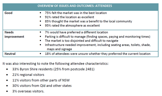
Summary:
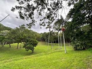
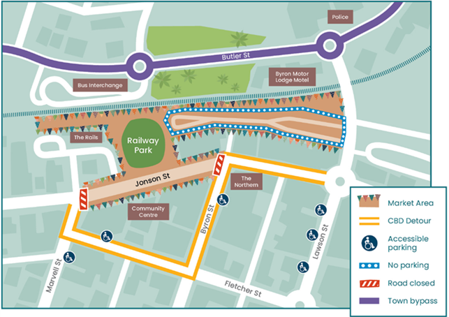
In 2023, the Byron Community Market relocated to the commercial centre of town, occupying Railway Park and South Lawson St carpark, as well as sections of the rail corridor and Jonson St.
Council recently engaged independent consultant Destination Research to conduct a comprehensive review of the economic and social impact of the market in its new location. The review aims to evaluate the impacts, both positive and negative, that the market’s location has had on various stakeholders including:
· Stallholders
· market management
· local businesses
· the local community
· Council operations.
This report summarises the outcomes of the review and provides recommendations for actions that could improve the market’s operations in this location and reduce negative impacts or perceptions.
RECOMMENDATION:
That Council:
1. Notes the comprehensive impact analysis undertaken by Destination Research in relation to the Byron Community Markets’ location in the Byron town centre;
2. Works with the Byron Community Market managers and Byron Bay Chamber of Commerce to improve the market’s operations in this location as per the actions in the table on page 9 of this report;
3. Provides a letter of support to the Byron Community Centre for any funding applications to cover traffic management costs to retain the Jonson St section of the market for stalls; and
4. Works with market managers to maximise capacity within the market footprint in the rail corridor, Railway Park and Lawson St south carpark in place of Jonson St stalls if funding is unable to be secured for traffic management.
Attachments:
1 Byron
Bay Community Markets evaluation 2024 - Destination Research report, E2024/134477 ![]()
2 Byron
Community Centre response - Jonson St options, E2024/135102 ![]()
Report
Background
Council’s ‘Sustainable Markets’ policy guides all regular markets on Council managed land, with 5-year licences issued under public tender. The Byron Bay Community Association Inc. successfully tendered for the weekly Railway Park Artisan Markets, and Monthly Community Markets, with their current licence expiring 31 October 2026.
During their time as managers, a number of public spaces have hosted the markets:
· 2019 - Byron Shire Council temporarily moved the monthly Byron Community Market from Butler Street Reserve to the Byron foreshore to enable construction of the Byron bypass. The market was unable to return to Butler Street Reserve due an active contamination investigation which has still not resolved - https://www.byron.nsw.gov.au/Environment-Resilience/Environmental-Hazards/Contaminated-land/Contamination-at-Butler-Street-Reserve.
· 2021 - in order to reduce impacts of the markets on the foreshore and find a permanent home for the market, Council put forward a proposal to the community to permanently relocate the market from the foreshore to the centre of town, which also aligned with the community’s vision as outlined in the Byron Bay Town Centre Masterplan - to reimagine the town centre as a place that’s filled with people and activities rather than vehicles.
· 2022 - Council resolved to grant development consent for the markets in the town centre and to conduct a review after 12 months of operations to assess ‘the impact on the environment, businesses, residents and traffic.’
· 2023 – First market held in new town centre location
· 2024 - Council engaged local independent research consultants Destination Research to conduct the review – attachment 1 details the methodology, result areas and specific issues analysis.
Current market site:
This report provides a summary of the key results and discusses the main areas of opportunity to maximise the current location. Overall, the assessment shows the diverse opinions of local stakeholders while highlighting the positive perspectives of attendees who embrace the unique Byron atmosphere and the variety of local products. All stakeholders recognised the influence of external socio-economic and environmental factors that are impacting the success of all stakeholders, especially the reduction of visitors in the area and less disposable income for residents.
Stakeholder feedback
CBD businesses
Observations on market day and one-on-one interviews with 20 businesses were undertaken across a range of retail and dining sectors in close vicinity to the market in Jonson St, Lawson St, Byron St and Feros Arcade. The high-level results suggest:
· 45% of interviewees had positive opinions of the new location – sales were increased and/or atmosphere was improved
· 25% of interviewees had neutral opinions – sales were the same as a normal Sunday
· 30% of interviewees had negative experiences – these were in the closed section of Jonson St, directly adjacent to the market site, where the road closure and installation of stalls had caused:
- Displacement of regular customer parking
- Decreased sales on market day
- Change of footfall, from customers to browsers
- Reduction in visibility of the shopfront
Stallholders
A total of 91 stallholders completed a survey (33% of stallholder capacity) with representation from all areas of the site. As part of that survey they were asked to rate the impact of the location change as being negative, neutral or positive in four key areas. The results suggest:
· 41% perceived the local community has been positively impacted
· 46% perceived the image of Byron has been positively impacted
· 40% perceived the effects to surrounding businesses have been positive
· 40% of stallholders’ businesses have been positively impacted
Stallholders were also asked a series of questions about the impacts of the change of location to their sales and their customers. Almost half (49%) felt their sales had decreased since moving to the new site, 21% reported an increase, 4% saw no change and 24% were unsure. The attached report details direct and indirect factors contributing to these changes.
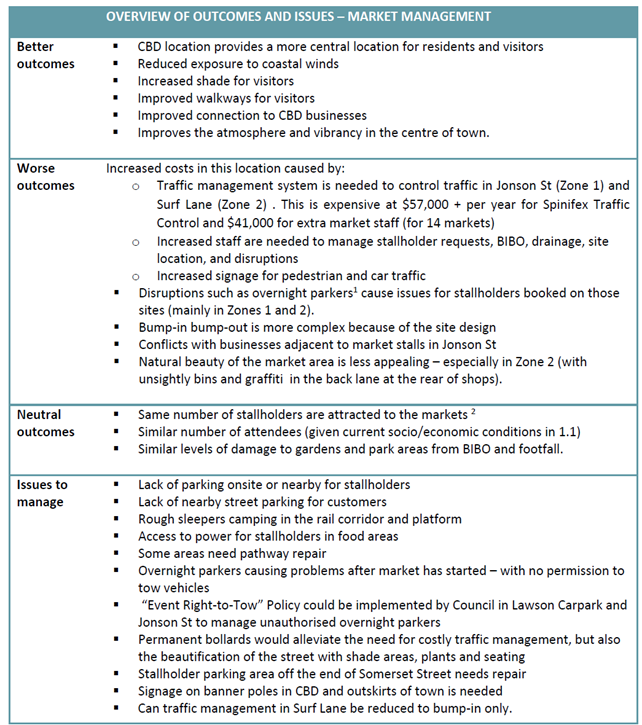
Market management
The new location has resulted in an increased workload for market staff and large expenses for traffic management and signage. As a result, this has meant reduced revenue available to the Byron Community Centre to distribute to community projects. The following table summarises the outcomes and identified issues to be addressed in collaboration with Council and other stakeholders.
Attendees
An attendee survey was collected on site at the July and August markets with 202 responses. The results highlighted their positive experiences at the market as well as areas for improvement.
Areas of opportunity
Review of the responses received shows a great diversity of opinions and ideas in all stakeholder groups. The most consistently positive opinions on the current location are from customers, who are highly satisfied with their experience. The feelings of stallholders, management and businesses are mixed.
The research has identified specific areas of opportunity to maximise the current location, which may benefit the experience for management, stallholders, businesses and attendees.
Council staff have met with market management and the Byron Chamber of Commerce to discuss these recommendations and agree on actions from them – these comments are noted below.
1. Ambience
The increasing number and frequency of markets in the region and beyond creates an impetus for Byron Community Market to maintain the characteristics which have made it a unique and intriguing place to visit. The research showed that this is related to:
· An atmosphere which is local, chilled and relaxed
· A focus on products that are community make, bake, grow or sew
· Local entertainers, good food, live music
Issues were identified at the new location which detract from this positive and relaxed ambience:
· Surf Lane needs cleaning – Council signs, waste bins and graffiti present a poor image
· Rough sleepers camping in the rail corridor and on the platform
· The laid back atmosphere is interrupted by the ‘hassle’ of customer parking – and the fixed time limit on dining and shopping
· The layout of the site is sometimes confusing
· Some stalls were not selling products that align with the market focus
Site layout
There is no obvious solution to the difficulties in the current layout, which is seen by many attendees and stallholders as disjointed and maze-like. The main impact of the disjointed layout is attendees not reaching all zones of the site and not being able to find specific stalls. This creates inequity for stallholders as some receive more footfall than others. The design of further information strategies involving maps, apps, flags and volunteers may assist in overcoming this issue.
Jonson St closure
Many of the issues raised by stallholders in this study relate to the Jonson St area, where 38% of stallholders were dissatisfied with the location of the market. Issues from stallholders included:
· Safety of bump in/ bump out with moving vehicles
· Heat reflected from asphalt on roadway
· Poor ambience of being on the street as opposed to in the park
64% of businesses interviewed felt positive about the current location of the Byron Community Market, however all businesses with negative responses were located on Jonson St, directly adjacent to the market site, where the road closure and installation of stalls had caused:
· Displacement of regular customer parking
· Decrease in sales on market day and subsequent reduction in staff
· Change of footfall, from customers to browsers
· Increase in litter
· Reduced visibility of the shopfront
The major issue from market management also relates to Jonson St and the costly traffic management which is required to close and open streets – approximately $97,000 per year. The revenue generated from stalls in this section covers traffic management costs, but no additional staffing or operational costs, or funding distributed to community services.
Given these issues from multiple stakeholders, market management have undertaken a cost benefit analysis of removing and/or relocating some of the stalls and reopening Jonson St to through-traffic. Their preference is to maintain this section of the market but find a way of offsetting these fees such as donations, grants or contributions from Byron Shire Council – see attachment 2.
CBD businesses
There was an overall positive response from local businesses to the current location with some reporting increased footfall, sales and improved atmosphere of the CBD to make it a more vibrant town centre.
While some businesses adjacent to the site had significant negative experiences, others further from the site had better outcomes, especially after the markets close, when market attendees disperse and are looking for food and other things to do. More could be done to encourage this attendee behaviour by promoting CBD businesses and market day free parking to encourage longer stays.
Promotion and information
The significant number of new attendees at each market (50%) requires the increased distribution of information (via signage, maps, apps), and access to personal assistance (volunteers and staff) to guide those who are not familiar with the market experience.
The increased competition from other smaller and niche markets in the region makes it important to maintain a presence in the regional and national media. Promotion of the Byron Market as a part of a wider tourism promotion strategy would help attract visitors to Byron Bay.
Parking
The availability of parking was raised as an issue by all stakeholders in this study.
Customer parking:
· Lack of nearby street parking for customers who also feel parking is expensive and restricts the time and money they will spend at the markets
· It is perceived that accessible parking is not available adjacent to the site – the accessible parks in the Rails car park and Lawson St North carparks could be part of a broader promotional strategy about where to park.
Stallholder parking:
· Stallholders report a lack of parking on site or nearby and issues with the surface at the end of Somerset St where stallholders are encouraged to park to free up town centre spaces for customers. This issue leads stallholders to park on the street rather than in stallholder parking
· Overnight illegal parkers cause stress for staff and stallholders on market mornings when stalls and food vans must be reallocated. A special event ‘right to tow’ zone could be implemented by Council to manage overnight parking. Large signage would help mitigate this problem, as would VMS boards in peak season.
· Staff parking for businesses was an issue for some who were unable to park in usual areas and needed to park and pay at other areas.
Bump in and bump out
Stallholders, management and Council acknowledge the current location is generally more difficult for bump-in and bump-out processes. Previous locations have been easier for vehicles to reach all parts of the site, however this created significant maintenance issues on Council reserves. Parts of this site are not directly accessed by vehicles, requiring some stallholders to ‘lug’ heavy items from the drop-off zones to their site. This also leads to:
· Congestion at the drop off zone
· Leaving the stall unattended while parking cars / vans elsewhere
· Gardens are trampled by stallholders walking across the site rather than on pathways
· The impetus to clear Jonson St by 3pm means some stallholders are asked to start packing up at 2:30 while attendees are still shopping
· Confusion as to who has right of way from cars / pedestrians on Jonson St
Next steps
The feedback includes a range of recommendations which will require concerted, collaborative effort from Council, market management, stallholders and businesses to provide an overall improvement in market operations. The below table summarises actions which key stakeholders, including Council, could implement.
It is recommended that Council resolves to endorse Council-related actions and continue to work with market management and business representatives to ensure the market continues to prosper.
|
Action |
Staff comments |
|
Determine the cost-benefit of the road closure and stalls in Jonson St and investigate alternative solutions.
|
Byron Community Markets have advised that the income generated from stalls in Jonson St covers purely traffic management costs for the market and removing these stalls is therefore cost-neutral if they cannot be relocated elsewhere. Notably, the Byron Chamber of Commerce’s preference is removal of this section to reduce negative impacts for Jonson St businesses. However, there is some positive feedback about this section of the market site from customers and stallholders and the market management preference is to retain it. There are two options available to address this issue: 1. Retain this section of the market but find a way of offsetting these fees such as donations, grants or Council-funding; or 2. Remove this section of the market and work with market managers to maximise capacity within the market footprint in the rail corridor, railway park and Lawson St south carpark Staff are not supportive of Council covering traffic management costs for the market. While it is acknowledged that the market brings significant community and business benefit, the Shire hosts many markets and over 100 events per year, many of whom request Council cover their traffic management costs and/or waive fees associated with traffic and parking. These costs are genuine operational costs associated with running events and markets and Council does not have the capacity to cover the $95,000 per year for the community market or for other events who request the same assistance. Market managers currently have ability under their licence to identify and implement opportunities for modifications to stallholder layout within the approved footprint. Staff will work with Market management to assist with access to services where any changes may be required to better facilitate desired stallholder numbers, subject to available budget. |
|
Provide free and/or all-day parking in the town centre on market days to improve parking challenges |
One of the key objectives of paid parking is to encourage regular turnover of carparks. The proposal for all day parking on market days increases the risk of all town carparks being at capacity for the entirety of the day, which would significantly impact peoples’ ability to come into town and access not only the markets and local businesses but also beaches, parks and other shops in town. Staff believe a more effective approach to encourage market customers to stay on beyond the market is a promotional campaign directing customers towards businesses that are open once the market has closed. Council is still working with the EPA to return Butler Street Reserve to community use for a mix of passive recreation, car parking and market site. There is still a significant amount of investigation and remediation work to be completed before this will be possible, but once in place this should help to alleviate parking issues. |
|
Information and promotion campaign |
Upgraded collateral and a targeted promotional campaign could: · Reduce confusion around site layout · Direct attendees to specific parking areas · Reduce stallholder inequality · Increase dispersal of attendees to local surrounding businesses · Contribute towards a visitor attraction strategy This could include the signage on banner poles on the way into town, which are available for rent to events and community organisations. Market management and Byron Chamber of Commerce could partner on a campaign to provide mutual benefit. |
|
Clean up Surf Alley zone to improve ambience and improve damage to pathways and stallholder parking area as required |
Staff will continue to work with market managers to address site issues that arise. A core issue is maintenance of the murals on the privately owned buildings adjoining the alleyway. Council has no authority to modify or maintain these artworks that were established in part to memorialise local surfers. Repairs and upgrades of footpaths, regulatory signs and road surfaces are undertaken as start of standard operations where possible. Council is looking to remedy the commercial waste bins issue in Lawson St South carpark, as the upgrades to Byron drainage in 2025 will likely require centralisation or alternative management of waste bins through this precinct. |
|
Create Special Event Zone on market days |
Staff will investigate the implementation of a ‘Special Event Zone’ on market days to enable illegally parked vehicles in the market footprint to be towed. |
Strategic Considerations
Community Strategic Plan and Operational Plan
|
CSP Objective |
CSP Strategy |
DP Action |
Code |
OP Activity |
|
4: Ethical Growth |
4.3: Promote and support the local economy |
4.3.3: Business advice and support - Support, participate, and advocate for sustainable business |
4.3.3.2 |
Continue to strengthen partnerships between Council and the business community / industry |
|
4: Ethical Growth |
4.3: Promote and support the local economy |
4.3.1: Diverse economy - Develop a Business and Visitor Economy Strategy to support a resilient and diverse economy |
4.3.1.1 |
Develop a Business, Industry and Visitor Economy Strategy |
Recent Resolutions
· 22-513
· 23-057
Legal/Statutory/Policy Considerations
Council adopted Policy - Sustainable Community Markets is due for review in early 2025, prior to public advertisement of RFP for new 5 year Markets Management Licences.
Consideration of current markets operations across the Shire will be undertaken within the Policy review process. Any proposed amendments to current markets footprints can be considered within this process.
Financial Considerations
The recommended actions for Council in this report can be accommodated within existing budgets and staffing.
Staff are not supportive of the Byron Community Centre’s request that Council cover traffic management costs for the market. While it is acknowledged that the market brings significant community and business benefit, the Shire hosts many markets and over 100 events per year, many of whom request Council cover their traffic management costs and/or waive fees associated with traffic and parking.
These costs are genuine operational costs associated with running events and markets and Council does not have the capacity to cover the $95,000 per year for the community market or for other events who request the same assistance.
Council receives $542 (incl.) per market in Fees and Charges, allowing between 251 – 300 individual market stalls per market. Currently market operations related reserve maintenance requirements cost to Council far exceed return, which contrasts to Policy intent that Licenced markets provide Council with recurrent income to support its Community Strategic Plan.
Consultation and Engagement
Council undertook broad community engagement ahead of the market’s relocation to the town centre in 2023.
As part of this review, Council’s consultant undertook:
· Direct one-on-one interviews with stallholders, market managers, Council operational staff, local community groups, local businesses, local arts groups
· 200 visitor surveys on market days
· Stallholder survey with 92 responses
Additionally, project staff and Destination Research met one-on-one with the Byron Chamber of Commerce and the Byron Community Centre management to discuss the data collected in the review and agree upon actions moving forward.
Staff Reports - General Manager 13.2
Report No. 13.2 In principle support for temporary accommodation lease extensions between Council and NSW Reconstruction Authority
Directorate: General Manager
Report Author: Esmeralda Davis, Director Corporate and Community Services
File No: I2024/1577
Summary:
In May 2022 Council resolved to enter into lease arrangements with Resilience NSW, now established as the NSW Reconstruction Authority, for temporary accommodation sites at Tweed Street and Bayside in Brunswick Heads known as the “Pod Villages”.
These sites were established following the NSW Government announcement of a $350 million investment in temporary modular housing to give people displaced by the February and March 2022 floods a place live, while they rebuilt their lives.
The term of the leases over both sites was an initial 3 years with 2 x 1 year renewal options.
The NSW Reconstruction Authority wrote to the General Manager on 8 May 2024, thanking Council for its ongoing support in making land available for temporary housing, and seeking in principle support for a lease extension to June 2026 on the Tweed Street site, thereby exercising the first of the one year renewal options. Council subsequently resolved to do so (Res 24-206).
At this time, Council also noted that discussions with landowners of the Bayside site (Lots 51 and 69 in Deposited Plan 851902 - Excelsior Circuit and Torakina Road Brunswick Heads) were on hold until after August 2024. This site is located both on Council land and private land. The General Manager received notification on 18 November 2024 from NSW Reconstruction Authority that the private landholder has provided in principle support for a lease extension to 31 December 2025, and is seeking similar in principle support from Council.
Formal extension of sites will be subject to the development of transition or decommissioning plans by the NSW Reconstruction Authority, and further decisions of government regarding program timelines and funding, expected by the end of 2024.
RECOMMENDATION:
That Council authorises the General Manager:
1. To respond to the NSW Reconstruction Authority request to confirm in principle support for the one year lease extension of the Bayside site (Lots 51 and 69 in Deposited Plan 851902 - Excelsior Circuit and Torakina Road Brunswick Heads); and
2. To continue, under delegation, discussions with the NSW Reconstruction Authority on the transition plan for both the Tweed Street and Bayside sites.
1 Confidential - Letter from NSW Reconstruction Authority to General Manager seeking in principle support for extension of Bayside Temporary Housing Site, E2024/135523
Report
Background
In May 2022 Council resolved to enter into lease arrangements with Resilience NSW, now established as the NSW Reconstruction Authority, for temporary accommodation sites at Tweed Street and Bayside in Brunswick Heads known as the “Pod Villages”.
These sites were established following the NSW Government announcement of a $350 million investment in temporary modular housing to give people displaced by the February and March 2022 floods a place live while they rebuilt their lives. The NSW Government led the delivery of temporary housing throughout the region with agreement and consultation from Councils. A community housing provider was appointed as site and tenancy manager with the NSW Reconstruction Authority as the land manager for the length of the lease.
The NSW Reconstruction Authority has advised that the NSW Government is considering options for the use of temporary sites beyond the current program timeframe. Due to the ongoing housing stress in the region, many residents will not be able to transition out of temporary housing before the end of the current lease terms, primarily due to the limited housing options available in the Northern Rivers. Therefore, an extension of some of the ‘Pod Villages’ will be required to support residents to secure long term alternative housing.
The term of the initial leases over both sites was 3 years with 2 x 1 year renewal options.
The NSW Reconstruction Authority wrote to the General Manager on 8 May 2024, thanking Council for its ongoing support in making land available for temporary housing, and seeking in principle support for a lease extension to June 2026 on the Tweed Street site, thereby exercising the first of the one year renewal options. Council subsequently resolved to do so. (Res 24-206).
At this time, Council also noted that discussions with landowners of the Bayside site (Lots 51 and 69 in Deposited Plan 851902 - Excelsior Circuit and Torakina Road Brunswick Heads) were on hold until after August 2024 due to the sale of the private parcel of land. This site is located both on Council land and private land.
The General Manager received notification on 18 November 2024 from NSW Reconstruction Authority (refer Confidential Attachment 1 E2024/135523) that the private landholder has provided in principle support for a lease extension to 31 December 2025, and is seeking similar in principle support from Council.
A third temporary accommodation site between Prince and Station streets in Mullumbimby on land owned by Transport Asset Holding Entity (TAHE). It is understood that a similar request has been made to TAHE for in principle support for a lease extension to June 2026.
Formal extension of sites will be subject to the development of transition or decommissioning plans, and further decisions of government regarding program timelines and funding, expected by end of 2024.
Strategic Considerations
Community Strategic Plan and Operational Plan
|
CSP Objective |
CSP Strategy |
DP Action |
Code |
OP Activity |
|
4: Ethical Growth |
4.5: Support a resilient community that can adapt and respond to change |
4.5.2: Recovery - Support disaster recovery following the 2022 flood events |
4.5.2.10 |
Support the NSW Government to deliver temporary housing in Byron Shire for flood and landslip impacted residents |
Recent Resolutions
Relevant extract of Res 22-183 below:
1. That Council provides its in principle support to the proposed leases over Lot 1 in Deposited Plan 560486 (125 Tweed Street Brunswick Heads) and Lots 51 and 69 in Deposited Plan 851902 (Excelsior Circuit and Torakina Road Brunswick Heads) to Resilience NSW.
2. That Council authorises the General Manager, under delegation, to negotiate the final form of a lease and enter into a lease with Resilience NSW (ABN 11 518 338 739) on the following terms:
a) over Lot 1 in Deposited Plan 560486 (125 Tweed Street Brunswick Heads).
b) for a term of 3 years, with 2 x 1 year options to renew,
c) for rental of $136,213 per year,
d) for the purpose of construction, maintenance, and operation of temporary housing, and making good the site at the end of the lease but providing that base eligibility criteria for the pop-up village pod allocation is to be expanded to include additional criteria - primary place of residence inaccessible, unusable, or unliveable as a result of the February and March 2022 flood events
e) Lessee must, at its cost, be responsible for the following:
i. all outgoings payable in respect of the Land,
ii. providing a minimum $20 million public risk insurance cover noting Byron Shire Council as an interested party, and
f) Lessee must, at its cost, remove all improvements from the Land and return the Land as vacant possession to the Lessor on the day the Lease.
3. That Council authorises the General Manager, under delegation, to negotiate the final form of a lease and to enter into a lease with Resilience NSW (ABN 11 518 338 739) on the following terms:
a) over Lots 51 and 69 in Deposited Plan 851902 (Excelsior Circuit and Torakina Road Brunswick Heads).
b) for a term of 3 years, with 2 x 1 year options to renew,
c) for rental of $19,459 per year,
d) for the purpose of construction, maintenance, and operation of temporary housing, and making good the site at the end of the lease but providing that base eligibility criteria for the pop-up village pod allocation is to be expanded to include additional criteria - primary place of residence inaccessible, unusable, or unliveable as a result of the February and March 2022 flood events
e) Lessee must, at its cost, be responsible for the following:
i. all outgoings payable in respect of the Land,
ii. providing a minimum $20 million public risk insurance cover noting Byron Shire Council as an interested party, and
f) Lessee must, at its cost, remove all improvements from the Land and return the Land as vacant possession to the Lessor on the day the Lease ends, unless a new lease is negotiated to commence on the day after the end of the Head Lease.
Res 24-206
That Council:
1. Authorises the General Manager to write to the NSW Reconstruction Authority confirming in principle support for the one year lease extension on the Tweed Street site (Lot 1 in Deposited Plan 560486 - 125 Tweed Street Brunswick Heads) until June 2026; and
2. Notes that discussions with landowners of the Bayside site (Lots 51 and 69 in Deposited Plan 851902 - Excelsior Circuit and Torakina Road Brunswick Heads) are on hold until after August 2024.
3. Authorises the General Manager, under delegation, to continue discussions with the NSW Reconstruction Authority on the transition plan for the Tweed Street site.
Legal/Statutory/Policy Considerations
Nil. Providing in principle support does not create a legally binding agreement between Council and NSW Reconstruction Authority.
Financial Considerations
Rent is payable to Council with the exercising of any lease extension.
Consultation and Engagement
Discussions with Council staff, the Mayor and NSW Reconstruction Authority occurred in March, April, May and November 2024.
Staff Reports - Sustainable Environment and Economy 13.3
Staff Reports - Sustainable Environment and Economy
Report No. 13.3 26.2022.2.1 Gulgan North Planning Proposal (Business & Industrial Land Strategy, Site 5)
Directorate: Sustainable Environment and Economy
Report Author: Steve Daniels, Project Officer - Planning Reforms
File No: I2024/1235
Summary:
On 26 October 2023, Council considered a Planning Proposal (Attachment 1) to rezone part of the land located at 66 The Saddle Road, Brunswick Heads described as Lot 2 DP1159910. The part of the land subject to the rezoning is identified as Area 5 in Council’s Business and Industrial Lands Strategy.
The objective of the Planning Proposal is to enable the future subdivision of part of the subject land to create a combination of work/live employment land and a separate precinct for light industrial uses. The Planning Proposal also seeks to rezone some rural areas for environmental conservation and management. The Planning Proposal is supported by a draft Planning Agreement (Attachment 2) to fund works associated with a proposed roundabout on Gulgan Rd, which will allow access to the site.
A Gateway determination was issued by the Department of Planning Housing and Infrastructure (DPHI) on 3 July 2024 (Attachment 8). The Gateway conditions included a 9-month period to finalise the planning proposal, amendments required to the Planning Proposal, and consultation requirements. Prior to community and agency consultation, the Planning Proposal was amended in accordance with the Gateway conditions.
In accordance with the Gateway determination, the Planning Proposal was placed on public exhibition from 3 October to 30 October 2024. The draft Planning Agreement and Preliminary Draft DCP were exhibited concurrently with the Planning Proposal.
Following an assessment of feedback received from the community and agencies, this report recommends minor amendments to the Planning Proposal and supporting studies to enable its finalisation.
Proposed amendments include a minor alteration to zone boundaries to accommodate a higher order internal road classification, as well as updates to the Ecological Assessment Report, Traffic Impact Study and Aboriginal Cultural Heritage Assessment Report.
It is also recommended that following finalisation of the
Planning Proposal, the Preliminary Draft DCP that was exhibited with the
Planning Proposal be updated to consider adopted LEP planning controls for the
site, and DCP related issues raised in public submissions. It is
recommended that the updated Draft DCP be reported to Council at a future
meeting for public exhibition.
RECOMMENDATION:
That Council:
1. Amends the exhibited Planning Proposal in Attachment 1 (E2024/116338) to include the following changes as discussed in the report:
a) Revise the Minimum Lot Size (MLS) Map for areas F, G and H (Figure 5 in this report) to show the following MLS:
· Area F – 12 ha MLS
· Area G – 6 ha MLS
· Area H – 8 ha MLS
b) Revises the Planning Proposal zone boundaries, and other relevant maps, to accommodate the preferred road boundary alignment (Figure 1 in Attachment 16 - E2024/134795)
2. Revises Figure 3 of the Ecological Assessment Report (Attachment 12 -E2023/102499) to clearly delineate existing and proposed Conservation zoned land.
3. Amends the Aboriginal Cultural Heritage Assessment Report (Attachment 3 E2024/116766) in accordance with the recommended management measures noted in the Heritage NSW submission (Attachment 14 - E2024/136008).
4. Forwards the amended Planning Proposal and supporting information to the NSW Department of Planning, Housing & Infrastructure and finalise the plan.
5. Updates the draft Planning Agreement (Attachment 2 - E2024/116632) to reference the final version of the Traffic Impact Study supported by TfNSW.
7. Following finalisation of the Planning Proposal:
a) Staff will update the Preliminary Draft DCP (Attachment 9 - E2024/116947) and prepare a report to Council for consideration, including community engagement options for public exhibition of the Draft DCP.
b) In updating the Draft DCP, staff will consider relevant matters raised in public submissions (Attachment 16 - E2024/134795).
1 Planning
Proposal - Exhibition Version 26.2022.2.1, E2024/116338
![]()
2 Draft
Planning Agreement - Exhibition Version - 26.2022.2.1, E2024/116632 ![]()
3 Aboriginal
Cultural Heritage Assessment Report - 26.2022.21, E2024/116766 ![]()
4 TfNSW
response - 26.2022.2.1, E2024/66040
![]()
5 Biodiversity,
Conservation, Science Group DCCEEW - Pre-gateway advice - 26.2022.2.1, E2024/29407 ![]()
6 Ecological
Assessment - Hairy Joint Grass - 26.2022.2.1, E2024/66039
![]()
7 Biodiversity
Conservation Science Group DCCEEW - Submission - 26.2022.2.1, E2024/135999 ![]()
8 Gateway
determination -26.2022.2.1, E2024/76989
![]()
9 Preliminary
Draft - Byron DCP Chapter 11, E2024/116947
![]()
10 TfNSW
updated submission -26.2022.2.1, E2024/137000
![]()
11 Traffic
Impact Study (Revision J) - 26.2022.2.1, E2024/137024
![]()
12 Ecological
Assessment - 26.2022.2.1, E2023/102499
![]()
13 DPIRD
Agriculture & Biosecurity submission - 26.2022.2.1, E2024/136004 ![]()
14 Heritage
NSW Submission - 26.2022.2.1, E2024/136008
![]()
15 NSW
Rural Fire Service submission - 26.2022.2.1, E2024/136012
![]()
16 Public
Submission Summary and Staff Response - 26.2022.2.1, E2024/134795 ![]()
17 Combined
Submission Redacted - 26.2022.2.1, E2024/129849
![]()
18 Government
Agency Submissions - BILS Area 5 Gulgan North Planning Proposal - 26.2022.2.1, E2024/137957 ![]()
19 Template
- Form of Special Disclosure of Pecuniary Interest - IF YOU EDIT THIS, THE
TEMPLATE IN BSC TEMPLATES MUST ALSO BE UPDATED, E2012/2815 ![]()
Report
Background
Business and Industrial Land Strategies provide the basis for future employment land use allocation and infrastructure planning actions required to meet projected growth and provide for future local jobs in an LGA.
The (then) Department of Planning endorsed the Byron Shire BILS in September 2020. This endorsement enabled the lodgement of Planning Proposals for individual sites as per the actions and sites contained in the Strategy.
On 26 October 2023, Council considered a Planning Proposal (Attachment 1) to rezone part of the land located at 66 The Saddle Road, Brunswick Heads described as Lot 2 DP1159910 (Figure 1). The part of the land subject to the rezoning is identified as Area 5 in the Byron Shire Business and Industrial Lands Strategy (BILS), adopted in October 2020 (Figure 2).
The objective of the Planning Proposal is to enable the future subdivision of part of the subject land to create a combination of work/live employment land and a separate precinct for light industrial uses. The Planning Proposal also seeks to rezone some rural areas for environmental conservation and management.
The planning proposal is supported by a draft Planning Agreement (Attachment 2) to fund works associated with a proposed roundabout on Gulgan Rd, which will allow vehicle access to the site.
Res 23-490 resolved that Council:
1. Notes the current deficit of available zoned and fit for purpose ‘Business and Industrial Land’ in Byron Shire, and that the Planning Proposal for Area 5 Gulgan North partly addresses this.
2. Notes that the Planning Proposal provides for a mix of uses compatible to the site opportunity and constraints, including a new sub land use category of ‘Work-Live’ dwelling.
3. Accepts the applicant’s letter of offer to enter into a Planning Agreement (Attachment 10 E2023/102502) with Council as part of this planning proposal and require that a draft Planning Agreement be prepared in accordance with the letter of offer.
4. Amends the Planning Proposal land use zone mapping to accord with Figure 5 of this report.
5. Amends the Planning Proposal to identify the subject land on a Local Clauses Map, with that portion of the subject land proposed to be zoned E3 Productivity Support identified as a ‘Work-Live precinct’.
6. Prior to requesting a Gateway determination:
a) requires the proponent to submit an updated Cultural Heritage Assessment,
b) forwards the draft planning proposal and relevant studies to Transport for NSW to obtain an ‘in-principle’ agreement to a speed zone reduction at the approach to the proposed roundabout,
c) forwards the draft planning proposal and relevant to studies to the Biodiversity Conservation Division of the NSW DPE for comment and any necessary changes to the Planning Proposal
7. Pending completion of ‘6, finalise and forward the planning proposal and supporting documents for the land known as Area 5 Gulgan North (informed by the Byron Shire Business and Industrial Lands Strategy) to the Department of Planning and Environment for the purpose of obtaining a Gateway Determination, and that Council exhibit the Planning Proposal in accordance with the Gateway Requirements.
8. Notes that a draft Development Control Plan to support the Planning Proposal will be prepared to manage building design and general site requirements including public transport, active transport, location of any bus stops and integration with any intersection upgrade and be exhibited alongside the Planning Proposal.
9. Notes that legal drafting of the draft Planning Agreement will be prepared and exhibited alongside the Planning Proposal.
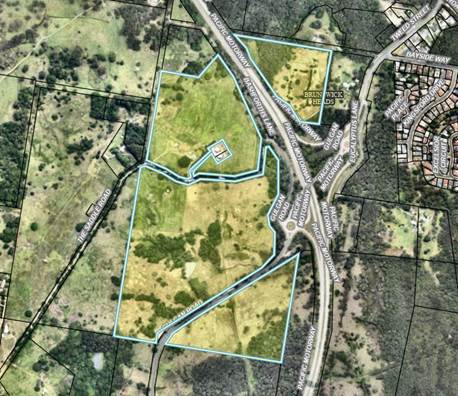
Figure 1 – Subject Land: Lot 2 DP1159910
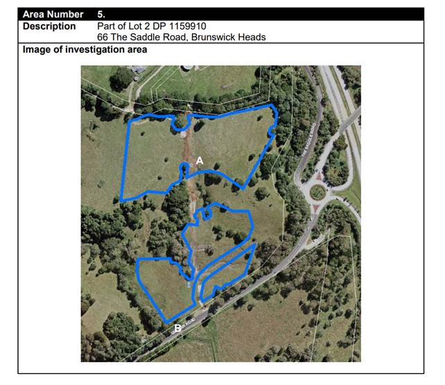
Figure 2 – BILS Area 5
Amendments & Actions prior to requesting a Gateway Determination
Prior to requesting a Gateway determination, the following amendments and actions were taken in accordance with items 4 to 6 of Council Resolution 23-490:
|
Item # (Res 23-490) |
Summary of Action |
|
Item 4 |
Amends the Planning Proposal land use zone mapping to accord with Figure 5 of this report. The planning proposal mapping was updated to include existing Conservation zoned land to the south of the development area – these areas were initially excluded due to a mapping error. |
|
Item 5 |
Amends the Planning Proposal to identify the subject land on a Local Clauses Map, with that portion of the subject land proposed to be zoned E3 Productivity Support identified as a ‘Work-Live precinct’. The planning proposal was updated to identify the proposed E3 Productivity Support zone as a Work/Live precinct on a local clauses map. |
|
Item 6 |
Prior to requesting a Gateway determination: a) requires the proponent to submit an updated Cultural Heritage Assessment
An updated Cultural Heritage Assessment (ACHAR) was submitted by the proponent (Attachment 3). The study was forwarded to NSW Environment & Heritage for comment during the exhibition period. b) forwards the draft planning proposal and relevant studies to Transport for NSW to obtain an ‘in-principle’ agreement to a speed zone reduction at the approach to the proposed roundabout,
An ‘in-principle’ agreement to a speed zone reduction at the approach to the proposed roundabout was provided by Transport for NSW (Attachment 4). c) forwards the draft planning proposal and relevant to studies to the Biodiversity Conservation Division of the NSW DPE for comment and any necessary changes to the Planning Proposal
Biodiversity Conservation Division of the NSW (BCD) provided comment on the planning proposal in a letter dated 9 February 2024 (Attachment 5). In accordance with their recommendations, a further survey of Hairy Joint Grass of the site was undertaken (Attachment 6). The BCD advice also recommended a Planning Agreement be prepared for exhibition with the Planning Proposal, committing the landholder to the preparation and implementation of a vegetation management plan to manage the conservation zoned land in the planning area. However, this recommendation was considered unnecessary because the conservation zoned land will form part of an association lot under a future community title scheme. Therefore, the preparation and implementation of a vegetation management plan will be considered as part of the future subdivision development application. This approach was agreed to by BCS (formerly BCD) during the exhibition period (see Attachment 7). |
Gateway Determination
In accordance with Item 7 of Resolution 23-490, the Planning Proposal and supporting documents were submitted to the (then) Department of Planning & Environment requesting a Gateway determination.
A Gateway determination was issued on 3 July 2024 (Attachment 8). The Gateway conditions included a 9-month period to finalise the planning proposal, amendments required to the planning proposal, and consultation requirements.
Prior to community and agency consultation, the Planning Proposal was amended in accordance with the Gateway conditions.
Draft Development Control Plan
In response to Item 8 of Res 23-490, a Preliminary Draft Development Control Plan (DCP) (Attachment 9) was prepared and exhibited concurrently with the planning proposal.
The Preliminary Draft DCP provides an outline of key elements that will accompany a final draft. It is considered appropriate to further develop and finalise the draft once the LEP planning controls have been established for the site.
Recommendation:
· Following finalisation of the planning proposal, staff will update the Preliminary Draft DCP (Attachment 9) and prepare a report to Council for consideration, including community engagement options for public exhibition of the Draft DCP.
Planning Agreement
In accordance with Item 9 of Res 23-490, a draft Planning Agreement (Attachment 2) to fund construction of a roundabout access to the site was drafted and placed on public exhibition with the planning proposal.
No submissions in relation to the draft Planning Agreement were received.
Staff note that the draft Planning Agreement references Revision G of the Traffic Impact Study. This should be updated to reference Revision J (Attachment 11) of the Study as discussed below in response to submissions received from TfNSW.
Recommendation:
· Update the draft Planning Agreement (Attachment 2) to reference the final version of the Traffic Impact Study supported by TfNSW.
· Undertakes a further final legal review of the Draft Planning Agreement after changes and administers the signing and registration of the Final Planning
Agreement.
Community and Agency Consultation
In accordance with the Gateway determination, the Planning Proposal was placed on public exhibition for a minimum of 20 working days from 3 October to 30 October 2024. The draft Planning Agreement and Preliminary Draft DCP were exhibited concurrently with the Planning Proposal.
Community Consultation
A total of 7 public submissions were received during the exhibition period, Attachment 17. A summary of key issues raised, and staff response is provided in Attachment 16. Issues raised have been grouped into the following general submission themes:
· Master planning in connection with Byron Residential Strategy 2041 Area 16
· Traffic management and infrastructure provision
· Land Use Planning Controls
· Consideration of Wildlife Conservation
· Community Consultation
· Strategic Merit
· DCP Specific Matters
It should be noted there was a general level of confusion in some submissions between matters considered at the rezoning stage, and more detailed design related matters that are considered at the DA stage. This confusion is understandable given the complexities of the NSW planning system.
It is acknowledged that some matters raised will be addressed when a more detailed draft of the site specific DCP is presented to Council for consideration.
Recommendations (arising from public submissions):
· In updating the Draft DCP, staff will consider relevant matters raised in public submissions (Attachment 16)
· Options for community consultation on the Draft DCP is included in the report to Council.
· Revise the planning proposal zone boundaries, and other relevant maps, to accommodate the preferred road boundary alignment (Figure 1 in Attachment 16)
Public Authority and Government Agency Consultation
The Planning Proposal and supporting documents were also referred to 8 Government agencies and public authorities for comment. Five submissions were received from the first five agencies listed below:
· Department of Climate Change, Energy, the Environment and Water – Biodiversity, Conservation and Science Group
· Department of Primary Industries – Agriculture
· Heritage NSW
· NSW Rural Fire Service
· Transport for NSW
· NSW Reconstruction Authority
· Rous County Council
· Arakwal Corporation
Staff response to matters raised in submissions are provided in Attachment 18.
Recommendations (arising from agency submissions):
· Amend the exhibited Minimum Lot Size Map for areas F, G and H (Figure 5) to the show the following MLS:
- Area F – 12 ha MLS
- Area G – 6 ha MLS
- Area H – 8 ha MLS
· Revise Figure 3 of the Ecological Assessment Report (Attachment 12) to clearly delineate existing and proposed Conservation zoned land.
· Amend the Aboriginal Cultural Heritage Assessment Report (Attachment 3) in accordance with the recommended management measures noted in the Heritage NSW submission (Attachment 14).
Next steps
· Amend the Planning Proposal and supporting documents as recommended in this report.
· Forward the planning proposal to the DPHI and request finalisation of the plan.
· Undertake a legal review of the draft Planning Agreement and administer the registration of the agreement.
· Update the Preliminary Draft DCP and report it to Council for consideration for public exhibition.
The Gateway timeframe for the planning proposal expires on 3 April 2025. If the Planning Proposal is not finalised in this timeframe for any reason, including DPHI administrative delays, then the applicant may be required to resubmit the Planning Proposal and seek a new Gateway determination.
Strategic Considerations
Community Strategic Plan and Operational Plan
|
CSP Objective |
CSP Strategy |
DP Action |
Code |
OP Activity |
|
4: Ethical Growth |
4.1: Manage responsible development through effective place and space planning |
4.1.4: LEP & DCP - Review and update the Local Environmental Plan and Development Control Plans |
4.1.4.2 |
Review and update Local Environmental Plan and Development Control Plans to reflect strategic land use priorities and/or legislative reforms |
Recent Resolutions
· Res 23-490
26 October 2023 Council Meeting
Consideration of Planning Proposal for the site.
Legal/Statutory/Policy Considerations
Relevant legal/statutory/policy considerations are provided in this report.
Financial Considerations
This is an applicant funded planning proposal.
Consultation and Engagement
Consultation and engagement outcomes are provided in this report.
Staff Reports - Sustainable Environment and Economy 13.4
Report No. 13.4 PLANNING - 26.2024.7.1 - Planning Proposal - 32 Grays Lane Tyagarah
Directorate: Sustainable Environment and Economy
Report Author: Dylan Johnstone, Development Investigations Lead
File No: I2024/1424
Summary:
The Planning Proposal includes a draft Planning Agreement proposing a monetary contribution of $20,000 toward infrastructure.
The subject land contains an existing unauthorised dual occupancy (detached). The subject planning proposal seeks a dwelling entitlement for a single dwelling only, and the landowners intend to seek development consent for the use of the other existing dwelling for a purpose that is currently permitted with consent in the RU2 zone. Aerial photography indicates that the subject dwelling has existed since at least September 2019.
This Planning Proposal is the result of Action No. 22 of the Byron Shire Rural Land Use Strategy 2017 (BSRLS) which recommends investigation into a strategic framework for resolving dwelling entitlement issues. This action provides the strategic basis for the subject planning proposal, which is considered the best means to obtain development consent for use of the existing dwelling.
The Unauthorised Dwelling Guidelines 2022 expands upon the strategy by providing that a planning proposal may be pursued via “Planning Pathway 2” to rectify the use of existing unapproved dwellings on land that does not have a dwelling entitlement. Council resolution 20-283 provides that any unauthorised dwellings existing as of 18 June 2020 may pursue the planning pathways identified in the guidelines.
The subject land is affected by the 1% flood and is mapped as bush fire prone land. These issues are addressed to the satisfaction of Council. The proposal generates minimal additional traffic movements and does not require any upgrading of Grays Lane.
The planning proposal is consistent with the North Coast Regional Plan 2041. The site is located east of the Pacific Highway and is therefore located in the coastal strip however the proposal does not seek rezoning to urban land and the proposal will not have any significant impact on the environmental sensitivities of the site.
The planning proposal is also consistent with the Council adopted Local Strategic Planning Statement and 10 year + Community Strategic Plan 2022 (CSP), the relevant SEPPs and the majority of relevant section 9.1 Directions; and where inconsistencies occur, they can be justified or addressed with further information.
It is recommended that the planning proposal, draft Planning Agreement and supporting information be forwarded to the NSW DPHI for a Gateway determination.
NOTE TO COUNCILLORS:
In accordance with the provisions of S375A of the Local Government Act 1993, a Division is to be called whenever a motion for a planning decision is put to the meeting, for the purpose of recording voting on planning matters. Pursuant to clause 2(a) under the heading Matters to be Included in Minutes of Council Meetings of Council's adopted Code of Meeting Practice (as amended) a Division will be deemed to have been called by the mover and seconder of all motions relating to this report.
RECOMMENDATION:
That Council:
1. Proceeds with the planning proposal as attached to this report (Attachment 1 – E2024/134068) to amend LEP 2014 to permit a dwelling house with consent on the subject land;
2. Forwards the planning proposal, draft Planning Agreement and supporting information to the NSW Department of Planning, Housing and Infrastructure for a Gateway determination;
3. Pending a positive Gateway determination and completion of further studies (if required), undertakes public exhibition of the planning proposal and draft Planning Agreement in accordance with the determination requirements; and
4. Considers submissions in a report post-exhibition that includes any recommended changes to the planning proposal for final adoption.
Attachments:
1 26.2024.7.1
Draft Planning Proposal, E2024/134068
![]()
2 26.2024.7.1
Preliminary Site Investigation - Contaminated Land, E2024/62623 ![]()
3 26.2024.7.1
Onsite Sewage Management Design Report, E2024/62621
![]()
4 26.2024.7.1
Flood Assessment, E2024/62622 ![]()
5 26.2024.7.1
Driveway and Access Assessment, E2024/62712
![]()
6 26.2024.7.1
Bushfire Assessment, E2024/126419
![]()
7 26.2024.7.1
AHIMS search, E2024/126425 ![]()
8 26.2024.7.1
Draft Planning Agreement, E2024/62713
![]()
9 Template
- Form of Special Disclosure of Pecuniary Interest, E2012/2815 ![]()
Background
Council resolution 20-283 dated 18 June 2020 included a request that staff “prepare an Unauthorised Residential Accommodation Policy as a matter of priority to confirm the planning pathways and consequences for unauthorised residential accommodation seeking regularisation in Byron Shire”. This resolution also included “that in the meantime any planning proposal or development application lodged with Council for existing (as of 18 June 2020) unauthorised residential accommodation comply with the requirements of the Unauthorised Residential Accommodation Policy or for those applications lodged prior to the Policy being adopted the principles as presented in this report”.
Council resolution 20-417 dated 27 August 2020 resolved that the Draft Byron Shire Unauthorised Dwellings Policy be placed on public exhibition with a submissions report to be sent back to Council following the exhibition.
As a result of issues raised in public submissions, the Draft Unauthorised Dwellings Policy was converted to a guideline document for internal use by staff to outline the process for reactive investigations initiated by complaints and owner-initiated actions.
One of the planning pathways identified in the guideline is “pathway 2” which provides that, where land does not have a dwelling entitlement and contains an existing unapproved dwelling, a planning proposal may be submitted to seek to amend LEP 2014 to permit the dwelling on the land with development consent.
The land contains an existing unapproved dual occupancy (detached) and outbuildings. Council’s compliance staff have commenced formal enforcement action in relation to the unapproved dual occupancy. The subject planning proposal seeks a dwelling entitlement for a single dwelling only, and the landowners intend to seek development consent for the use of the other existing dwelling for a purpose that is currently permitted with consent in the RU2 zone.
Subject Land
The land contains an existing unapproved dual occupancy (detached) and outbuildings. The lot was created by subdivision registered on 1 August 1979 but does not have a dwelling entitlement.
Council received a planning proposal in February 2024 requesting an amendment to Byron LEP 2014 to obtain a dwelling entitlement for Lot 1 DP 258921 which has an area of approximately 4 hectares (see Figures 1 & 2 below). The Planning Proposal was accompanied by a draft Planning Agreement proposing payment of a monetary contribution equivalent to 1.0 Standard Dwelling Unit (SDU) ($20,000).
The street address is 32 Grays Lane, Tyagarah. The subject land contains an existing unauthorised dual occupancy (detached). However, the subject planning proposal seeks a dwelling entitlement for a single dwelling only.
Flood modelling provided by the applicant demonstrates that the site is inundated during the 1% flood, however the subject dwelling has a floor height above the Flood Planning Level of the site during such events.
The site includes some mapped High Environmental Value Vegetation identified as coastal swamp forest and North Coast wet sclerophyll forest, and the entire site is mapped as bushfire prone land. This vegetation is located approximately 43m and 53m respectively from the existing dwelling. Given these significant distances between the existing dwelling and vegetation, the establishment of required Asset Protection Zones to comply with Planning for Bushfire Protection 2019 will not have a significant ecological impact.
Consultation with the Rural Fire Service will be undertaken as part of this Planning Proposal.
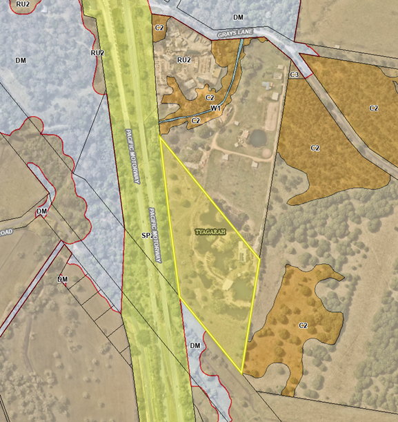
Figure 1: Subject land - 32 Grays Lane, Tyagarah (Lot 1 DP 258921)
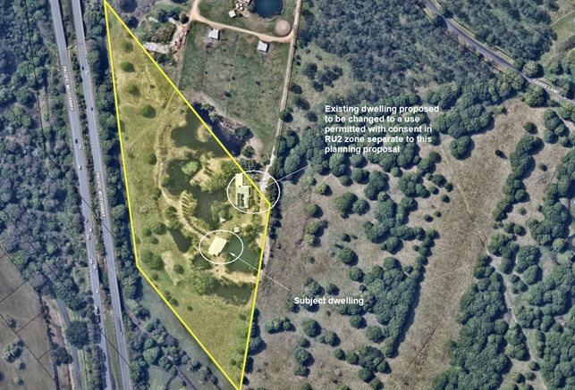
Figure 2: Existing dual occupancy (detached)
Planning Proposal
The planning proposal lodged by the proponent (Attachment 1) requests an amendment to Byron LEP 2014 to obtain a dwelling entitlement for Lot 1 DP 258921, which is zoned RU2 Rural Landscape.
The aim of the planning proposal is to establish a legislative mechanism to permit the lawful use of the dwelling house with development consent. Specifically, the planning proposal seeks to add the land to Byron LEP 2014: Part 6 – Additional local provisions to permit a dwelling house with consent on Lot 1 DP 258921.
Planning Framework
North Coast Regional Plan 2041
The site is located east of the Pacific Highway and is therefore located in the coastal strip however the proposal does not seek rezoning to urban land and the proposal will not have any significant impact on the environmental sensitivities of the site.
The most relevant NCRP objective is Objective 1: Provide well located homes to meet demand. The most relevant strategy is 1.2 Local Council plans are to encourage and facilitate a range of housing options in well located areas.
The proposal is consistent with the objectives and strategies of the NCRP and is consistent with Action No. 22 of the Byron Shire Rural Land Use Strategy 2017 (BSRLS), which recommends investigation into a strategic framework for resolving dwelling entitlement issues. This strategy was endorsed by the NSW DPE in July 2018.
Local Strategic Planning Statement
Council adopted a Local Strategic Planning Statement in September 2020 and it was subsequently agreed to by DPE.
The relevant planning priority in the LSPS (page 37) is:
“3. Support housing diversity and affordability with housing growth in the right locations.”
This planning proposal will be adding to the valid supply of housing stock in the shire by providing a mechanism to legalise an existing dwelling and is consistent with the adopted LSPS.
Site Specific Issues
Bushfire and ecology
The land is mapped as bush fire prone land and contains vegetation mapped as Category 3 (medium risk).
The hazard is identified as being predominantly grassland with fringes of forest along the eastern and southwestern boundaries.
This vegetation is located approximately 53m and 43m respectively from the existing dwelling. Given these significant distances between the existing dwelling and vegetation, the establishment of required Asset Protection Zones to comply with Planning for Bushfire Protection 2019 will not have a significant ecological impact.
Council staff will consult with the Commissioner of the NSW Rural Fire Service following receipt of a gateway determination.
Flooding
Flood modelling provided by the applicant demonstrates that the site is inundated during the 1% flood, however the subject dwelling has a floor height above the Flood Planning Level of the site during such events.
Access to the site during a flood, however, will be compromised as Yarun Rd, Grays Lane and the right of carriageway over the lot to the north are inundated during the 5% flood event and above. Therefore, a Flood Evacuation Plan will be required as part of a future development application seeking consent for use of the existing dwelling.
Traffic and access
The land is accessed from Grays Lane via a registered right of carriageway over the adjoining lot to the north.
The proposal generates minimal additional traffic movements and does not require any upgrading of Grays Lane. It is noted that the additional traffic loading is only theoretical as a dwelling has been in use on the site.
Land contamination
The applicant has supplied a preliminary contaminated land assessment carried out in accordance with the contaminated land planning guidelines.
Soil tests were undertaken, and no contamination of concern was identified. The existing dwelling envelope is considered suitable for the proposed use.
Aboriginal cultural heritage
An AHIMS search was undertaken on the property with a buffer of 1000 metres dated 11 October 2023. One aboriginal site was recorded in the results of this search.
The Tweed Byron LALC and the Arakwal Corporation will be consulted as part of the public exhibition of the planning proposal following a gateway determination.
Developer Contributions / Planning Agreement
The planning proposal seeks to amend LEP 2014 so that a dwelling house is permitted with consent on the subject site.
If a dwelling house is permitted on the site, this will create additional demands on rural roads, community facilities, open spaces etc. Such demands are captured by the Byron Shire Developer Contributions Plan 2012 which requires a monetary contribution in accordance with the Plan and Section 7.11 of the Environmental Planning and Assessment Act 1979.
Ordinarily contributions would be paid at the time of subdivision for creating a lot with a dwelling entitlement equivalent to one Standard Dwelling Unit (SDU) (3-bedroom dwelling or greater). However, for the purposes of this planning proposal, there is no clear mechanism within the Contributions Plan for applying developer contributions.
Therefore, the submitted planning proposal has included a draft planning agreement (Attachment 8). The draft planning agreement proposes payment of a monetary contribution which is equivalent to 1.0 SDU. This amounts to a total of $20,000 of which approximately $16,000 is allocated to rural roads.
Council staff have no justification to require additional contributions over and above the demand normally generated for a rural dwelling under the terms of the Contributions Plan 2012.
However, Council may resolve to apply different terms in the planning agreement if deemed reasonable and appropriate in the circumstances.
A formal planning agreement will need to be drafted and exhibited concurrently with the planning proposal.
Next steps
There are three options for Council to consider:
1. Proceed with the planning proposal contained in Attachment 1 to this report, which will facilitate the lawful use of the existing dwelling with Council consent (RECOMMENDED). This option is subject to any requirements imposed by DPHI in its Gateway determination; or
2. Proceed with the planning proposal in a modified form other than the version attached to this report; or
3. Not proceed with the planning proposal and advise the applicant accordingly.
There is sufficient information to support the planning proposal (see Attachments 2-8) and proceed to a Gateway submission. It is considered that no additional studies are required prior to public exhibition and agency consultation.
Strategic Considerations
Community Strategic Plan and Operational Plan
|
CSP Objective |
CSP Strategy |
DP Action |
Code |
OP Activity |
|
4: Ethical Growth |
4.1: Manage responsible development through effective place and space planning |
4.1.4: LEP & DCP - Review and update the Local Environmental Plan and Development Control Plans |
4.1.4.1 |
Assess requests to amend Local Environmental Plans and/or Development Control Plans including maps in accordance with legislative requirements. |
Recent Resolutions
· 20-283: that staff prepare an Unauthorised Residential Accommodation Policy as a matter of priority to confirm the planning pathways and consequences for unauthorised residential accommodation seeking regularisation in Byron Shire.
· 20-417: that the Draft Byron Shire Unauthorised Dwellings Policy be placed on public exhibition with a submissions report to be sent back to Council following the exhibition.
· 21-448: that Council agrees to the Draft Unauthorised Dwellings Policy being converted to a guideline document for internal use by staff to outline the process for reactive investigations initiated by complaints and owner-initiated actions.
Legal/Statutory/Policy Considerations
The relevant legal/statutory/policy considerations have been noted above.
Financial Considerations
If Council chooses to proceed with the planning proposal, it will be at the proponent’s expense as a landowner-initiated planning proposal. Full cost recovery of the remaining stages will be required by Council. If the applicant chooses not to pay then the planning proposal will not proceed. If Council chooses not to proceed, then the matter does not incur any additional costs.
Consultation and Engagement
If Council chooses to proceed with the planning proposal, it will be forwarded to the NSW Department of Planning, Housing & Infrastructure for a Gateway determination. A positive determination will identify public exhibition requirements and government agency consultation requirements.
Staff Reports - Sustainable Environment and Economy 13.5
Report No. 13.5 Update Resolution 23-056 Short Term Rental Accommodation Consent Conditions
Directorate: Sustainable Environment and Economy
Report Author: Sarah Nagel, Manager Public and Environmental Services
File No: I2024/1380
Summary:
Council at the Ordinary Planning Meeting 9 March 2023 resolved 23-056 that it:
1. Enforces consent conditions which prohibit the use of a property as short term rental accommodation.
2. Continues to prohibit the use of short-term rental of housing in new approvals, including but not limited to secondary dwellings, standard homes in the residential areas and business zones of the Shire.
3. Puts out a media release to inform the public of this decision.
4. Receives a report back every six months on the status of 1 and 2.
Council at the Ordinary Meeting 26 October 2023 resolved 23-500 to receive a report back every three months on the status of 1 and 2.
A three-month status report on items 1 and 2 was most recently provided via 24-211.
This report was delayed due to the Council election and now provides a further status update.
RECOMMENDATION:
That Council:
1. Supports an updated approach, which is consistent with current legislation, to include specific conditions in relevant development consents in order to accurately reflect the use of dwellings in the relevant zones (i.e. 60-day cap or 365-day cap); and
2. Receives further updates on STRA monitoring and compliance actions as part of the annual Environment and Safety Priorities Program, or as otherwise deemed appropriate by staff.
Report
Notice of Motion No. 9.3 Short Term Rental Accommodation Consent Conditions was presented at the Agenda of Ordinary (Planning) Meeting - Thursday, 9 March 2023 (infocouncil.biz) where Council resolved via 23-056 to receive a report every six months on the status of:
1. Enforcement of consent conditions which prohibit the use of a property as short term rental accommodation.
2. The continuing prohibition of the use of short-term rental of housing in new approvals, including but not limited to secondary dwellings, standard homes in the residential areas and business zones of the Shire.
At the Ordinary Meeting 26 October 2023, Council resolved via 23-056 to receive a report back every three months.
A staff update follows.
Point 1
The history of Council’s enforcement of consent conditions which prohibit the use of a property as short term rental accommodation enforcement action since 9 March 2023 was outlined in Report to Council 13.13 Agenda of Ordinary Meeting - Thursday, 22 February 2024 (infocouncil.biz).
Since 22 February 2024, Council has continued to respond to complaints relating to STRA properties. All complaints have been investigated and have been resolved without formal enforcement action except for two x day cap breaches. Those two breaches have now been finalised by way of Penalty Infringement Notices. Despite Council reporting the breaches to Department of Fair Trading, no formal enforcement action was undertaken by the department.
Staff are now in the process of monitoring and undertaking a proactive investigation program in relation to properties that are prohibited from STRA and properties that have a 60-day restriction for non-hosted STRA on or after 23 September 2024.
Point 2
In accordance with resolution 23-056 specific conditions were included in all relevant development consents in order to prohibit STRA use.
Changes for non-hosted STRA were endorsed by the NSW Government in September 2023. There will be a 12-month transition period for the community and industry to prepare. New day caps for non-hosted STRA took effect on 23 September 2024.
The changes are:
· A house or unit cannot be used for non-hosted STRA for more than 60 days in a 365-day period, for most of the Shire.
· Some areas in Byron Bay and Brunswick Heads will be able to operate without a cap on holiday letting, for 365 days per year. Maps of these areas are available on the NSW Department of Planning portal website and Council’s website.
The changes do not affect hosted STRA where the host lives on the premises or properties that are prohibited from use as STRA.
As a result of the recent legislative changes, staff are now including specific conditions in relevant development consents to accurately reflect the use of dwellings in the relevant zones (i.e. 60-day cap or 365- day cap).
Staff will provide a further update to Council on Points 1 and Point 2 via the annual Environment and Safety Priorities Program report, or as otherwise deemed appropriate by staff.
Strategic Considerations
Community Strategic Plan and Operational Plan
|
CSP Objective |
CSP Strategy |
DP Action |
Code |
OP Activity |
|
2:
Inclusive Community |
2.2: Enhance safety and contribute to the physical, mental, and spiritual health and well being of our people |
2.2.3: Regulatory controls and compliance - Enhance public safety, health and liveability through the use of Council's regulatory controls and services |
|
|
|
4:
Ethical Growth |
4.2: Enable housing diversity and support people experiencing housing insecurity |
4.2.1: People experiencing housing insecurity - Seek opportunities that provide fair, appropriate, and affordable housing for people experiencing housing insecurity |
|
|
|
4: Ethical Growth |
4.1: Manage responsible development through effective place and space planning |
4.1.4: LEP & DCP - Review and update the Local Environmental Plan and Development Control Plans |
4.1.4.7 |
Progress Short Term Rental Accommodation planning proposal |
Recent Resolutions
· 23-056
· 23-500
· 24-051
· 24-063
· 24-211
Legal/Statutory/Policy Considerations
Legal advice supports the approach discussed in the report. It should be noted that legal matters like STRA can be resource intensive, take considerable time and be costly to pursue. As such, Council has discretion in deciding whether to take enforcement action based on the available evidence and the circumstances of the individual case.
The above local planning changes and Council resolution align with IPC Advice Report on Byron Shire STRA recommendation 2 ‘Utilise the available regulatory regime to support Byron Shire Council to plan for and manage local impacts from the conversion of existing and future housing stock to non-hosted STRA…’
As a result of the above, staff are developing and implementing a Monitoring and Compliance Strategy specific to the new day caps for non-hosted STRA in the Shire.
Evaluation and Monitoring of STRA is addressed in IPC Advice Report on Byron Shire STRA recommendations 10,11 and 12.
A wider review of STRA has also been progressed by the Minister for Planning under the auspice of the Minister for Housing. The findings of which when released ostensibly to address the remaining recommendations of the IPC report outside of the Byron Shire Planning Proposal decision (Recommendations 1 and 2) and also the NSW STRA framework more generally.
Financial Considerations
Staff time and resourcing of STRA monitoring and compliance in Byron Shire is currently funded by the enforcement program budget of the Operational Plan. This may change the result of the Monitoring and Compliance Strategy development.
Funding to support local community benefits and also enforcement is addressed in IPC Advice Report on Byron Shire STRA recommendations 8 and 9.
Consultation and Engagement
Not applicable.
Staff Reports - Sustainable Environment and Economy 13.6
Report No. 13.6 Status report on Development Applications (DAs) with bodies like the Northern Regional Planning Panel (NRPP)
Directorate: Sustainable Environment and Economy
Report Author: Shannon Burt, Director Sustainable Environment and Economy
File No: I2024/1491
Summary:
At the Council (Planning) Meeting of 12 October 2023 it was resolved as part of 23-461
that Council: “Receives status reports monthly to each Ordinary (Planning) Meeting on all
DA’s that are being processed by Council for determination by other bodies such as the
Northern Regional Planning Panel or the Independent Planning Commission.”
Resolution 22-559 further requires: “That Councillors receive, as a standard procedure, a copy of the Assessment Report prepared by Council staff for any DA that is to be determined by the Northern Regional Planning Panel on the next working day after it is lodged on the Planning Portal.”
RECOMMENDATION:
That Council notes the status report on Development Applications (DAs) with bodies like the Northern Regional Planning Panel (NRPP).
Report
The following applications are a matter for determination by the Northern Regional Planning Panel in accordance with the Sydney District & Regional Planning Panels Operational Procedures. There are no matters currently with the Independent Planning Commission.
|
Planning Authority |
Application Description and link |
Status |
|
Northern Regional Planning Panel |
Community Title Subdivision | Planning Portal - Department of Planning and Environment (nsw.gov.au) Link to DA tracker for DA 2023.454.1 information and documents here: |
Submitted 12/12/2023 Record of Briefing - PPSNTH-285.pdf Determination meeting date to be confirmed
|
|
Northern Regional Planning Panel |
Modification to Residential Flat Building | Planning Portal - Department of Planning and Environment Link to DA tracker for DA 10.2022.371.2 information and documents here: |
Submitted 16/09/2023 Record of Briefing - PPSNTH-330.pdf Determination meeting date 10/12/24
|
|
Northern Regional Planning Panel |
S4.56 Modification | Planning Portal - Department of Planning and Environment Link to DA tracker for DA 10.2017.661.2 information and documents here: Byron Shire Council - Application Tracker
|
Submitted 12/07/24 Record of Briefing - PPSNTH-329 - 22 October 2024.pdf Determination meeting date 10/12/24 Class 1 legal appeal lodged – without prejudice meeting scheduled for 25/11/24 and conciliation conference on 30/11/2025 |
Strategic Considerations
Community Strategic Plan and Operational Plan
|
CSP Objective |
CSP Strategy |
DP Action |
|
1: Effective Leadership |
1.1: Enhance trust and accountability through open and transparent leadership |
1.1.2: Governance - Ensure legislative compliance and support Councillors to carry out their civic duties |
Recent Resolutions
· 23-461
Legal/Statutory/Policy Considerations
The Planning Panels determine regionally significant development applications (DAs), certain other DAs and s4.55(2) and s4.56 modification applications including:
· Regionally significant development, as outlined in Schedule 6 of the State Environmental Planning Policy Planning Systems 2021
· Regionally significant development relating to Aboriginal land, as outlined in Chapter 3 of the State Environmental Planning Policy Planning Systems 2021
· Development with a capital investment value (CIV)* over $30 million.
· Development with a CIV* over $5 million which is:
o Council related
o lodged by or on behalf of the Crown (State of NSW)
o private infrastructure and community facilities
o eco-tourist facilities
o extractive industries, waste facilities and marinas that are designated development
o certain coastal subdivisions and
o certain coastal protection works.
*Capital investment value (CIV) is calculated at the time of lodgement of the DA for the purpose of determining whether an application should go to a Planning Panel - refer to Planning Circular PS 10-008.
Section 10 of the Sydney District & Regional Planning Panels Operational Procedures talks to Roles of councils and other panels.
10.1 states the elected Council and Council staff have different roles in the assessment of DAs. Under the Local Government Act 1993, the independence of Council staff is protected in the preparation of advice and recommendations. Staff members are not subject to direction by the Council or by a Councillor as to the content of any advice or recommendation made by the staff member. Equally, a Council or Councillor is not bound by the advice or recommendation made by a member of staff.
10.3 states historically, one of the roles of an elected Council has been to determine or make decisions on DAs in their capacity as a consent authority. There are occasions, however, where the determination role is performed by other people or bodies, either because the Council has delegated that function, or because it has been conferred upon another person or body. For example, where local planning panels have been introduced, elected Councils no longer determine DAs (see section 2.17 of the EP&A Act). The Panel for the area in which the development is to be carried out is the consent authority for regionally significant development (see section 4.5 of the EP&A Act).
10.4 states Council staff are responsible for post-determination functions including:
· notifying Panel determinations on DAs (see sections 4.7(2)(e), 4.18 and 4.59 of the EP&A Act),
· registering Panel development consents on the NSW Planning Portal (see sections 4.7(2)(e) and 4.20 of the EP&A Act), and
· monitoring and enforcing compliance with conditions of the development consent.
The notice of determination should be issued once Council receives a copy of the endorsed and final determination from the Panel. The notice of determination must include all conditions imposed by the Panel, including any additional or amended conditions.
The Council has no power to amend conditions or include additional conditions following the Panel’s determination.
Council will advise any person who made a submission on the DA of the determination.
The Council continues to be responsible for the monitoring of, and enforcing compliance with, any conditions of the development consent.
Where an application has been approved subject to a ‘deferred commencement’ condition Council is responsible for determining whether the requirements of the condition have been met (see section 4.16(3) of the EP&A Act). Council advises the chair of the Panel in writing when the matter specified in the condition has been satisfied (see section 277(2) of the EP&A Regulation)
Microsoft Word - Att C - Amended RPP Operational Procedures.docx (amazonaws.com)
11.13 talks to Council representation to the Planning Panel.
An elected Council may make a submission on a DA within their LGA that is to be determined by a Panel up to seven days before the Panel meeting. After the assessment report is sent to the Secretariat, it may be given to the elected Council to assist in its decision as to whether it will be making a submission to the Panel. The elected Council’s submission should not be prepared by persons involved in the assessment of the application but could be prepared by another Council officer, or a consultant.
A Council submission should not be specifically referenced in the assessment report or recommendations prepared by the Council staff. If Council makes a submission, a staff representative or individual Councillors may register to address the Panel at the meeting to express the views of Council. Councillors who are also Panel members have an independent role because they have been nominated by their Council as its nominee to the Panel.
A Code of Conduct also applies to members of the Planning Panels.
Appeals from Planning Panel determinations
Section 8.15(4) of the EPA Act was introduced on 1 March 2018. It provides relevantly:
If the determination or decision appealed against under this Division was made by a Sydney district or regional planning panel or a local planning panel, the Council for the area concerned is to be the respondent to the appeal but is subject to the control and direction of the panel in connection with the conduct of the appeal. The Council is to give notice of the appeal to the panel.
In respect of the conduct and potential resolution of appeals, Councils are subject to the direction and control of planning panels in respect of decisions they make after 1 March 2018.
The Land and Environment Court has said that in circumstances where the panel and Council have conflicting views on a development, the appropriate approach would be for the panel to apply to be joined as a party to the appeal proceedings.
Financial Considerations
None relevant to this report.
Consultation and Engagement
Applications are exhibited as per the Council’s Community Participation Plan.
Otherwise, consultation, engagement and reporting must be in accordance with the Planning Panels Operations Procedure and Code of Conduct.
Staff Reports - Sustainable Environment and Economy 13.7
Report No. 13.7 PLANNING - Report of the Planning Review Committee held 31 October 2024
Directorate: Sustainable Environment and Economy
Report Author: Patricia Docherty, Team Leader Planning Services - Commercial Industrial & Tourism
Noreen Scott, EA Sustainable Environment and Economy
File No: I2024/1506
Summary:
This report provides the outcome of the Planning Review Committee (PRC) held on 31 October 2024.
NOTE TO COUNCILLORS:
In accordance with the provisions of S375A of the Local Government Act 1993, a Division is to be called whenever a motion for a planning decision is put to the meeting, for the purpose of recording voting on planning matters. Pursuant to clause 2(a) under the heading Matters to be Included in Minutes of Council Meetings of Council's adopted Code of Meeting Practice (as amended) a Division will be deemed to have been called by the mover and seconder of all motions relating to this report.
RECOMMENDATION:
That Council endorses the outcomes of the Planning Review Committee meeting held 31 October 2024.
Report
The PRC meeting was held on 31 October 2024. The meeting commenced at 2:40pm and concluded at 3:12pm.
Councillors: Cr J Swain, Cr D Warth, Cr S Ndiaye, Cr D Kay, Cr J Dods, Cr E Hauge.
Apologies: Cr M Lowe, Cr M Lyon, Cr A Pugh.
Staff: Shannon Burt (Director Sustainable Environment and Economy), Patricia Docherty (Acting Manager Sustainable Development).
Conflict of Interest: Cr Jack Dods 10.2023.73.3
|
DA No. / Applicant |
Property Address / Proposal |
Consultation / Submissions |
Reason/s / Outcome |
|
10.2024.305.1 Geolink Consulting |
10 Cudgerie Gully Lane Upgrades to the Booyong processing facility, involving alterations and additions to an existing Designated Development (Livestock Processing Industry), including part demolition, tree removal, additions, and ancillary works.
|
Level 2 29/9/24 to 10/10/24 7 submissions |
The validity of the matters raised in the public submissions. The perceived public significance of the application.
Council
|
The S 4.55 applications to modify these development consents are referred to the Planning Review Committee to decide if the modification applications can be determined under delegated authority.
|
DA No. / Applicant |
Property Address / Proposal |
Consultation / Submissions |
Reason/s / Outcome |
|
10.2023.235.3 Planners North |
119 Jonson Street Modification to plans of approved mixed-use development including minor reconfiguration of internal floor areas, removal of private residential roof terraces, removal of retail kiosk in courtyard, façade updates, increase in car share parking and substation layout to meet easement requirements.
|
Level 0 |
Staff Delegation |
|
10.2023.73.3 Planners North |
9 Marvell Street Modification to plans of approved mixed-use development - changes to materials and finishes, relocation of bike parking associated with relocation of pit and pillar to within property boundary.
|
Level 0 |
Staff Delegation
|
Staff Reports - Sustainable Environment and Economy 13.8
Report No. 13.8 PLANNING - DA 10.2024.14.1 - Rural Community Title Subdivision Comprising Fifteen (15) Neighbourhood Lots and One (1) Community Lot, Access Roads, Ancillary Works and Ecological Works – 31 Alidenes Road, Wilsons Creek.
Directorate: Sustainable Environment and Economy
Report Author: Ben Grant, Senior Planner
File No: I2024/1431
Proposal:
|
DA No: |
10.2024.14.1 |
||
|
Planning Portal ref |
PAN-406854 |
||
|
Proposal description: |
Rural Community Title Subdivision comprising Fifteen (15) Neighbourhood Lots and One (1) Community Lot, Access Roads, Ancillary Works, and Ecological Works |
||
|
Property description: |
LOT: 38 SEC: DP: 1059938 |
||
|
31 Alidenes Road WILSONS CREEK |
|||
|
Parcel No/s: |
239087 |
||
|
Applicant: |
Ms Y Y Jiang |
||
|
Owner: |
Ms Y Y Jiang |
||
|
Zoning: |
RU2 Rural Landscape |
||
|
Date received: |
4 March 2024 |
||
|
Integrated / Designated Development: |
☒ Integrated |
☐ Designated |
☐ Not applicable |
|
Concurrence required |
Yes – CNR-66409. NSW Rural Fire Service, DPE Water, DPI Fisheries. |
||
|
Public notification or exhibition: |
- Level 2 advertising under Council’s Community Participation Plan. - Exhibition period: 13 March 2024 to 26 March 2024. - Submissions received: Ten (10) - Submissions acknowledged: ☒ Yes ☐ No ☐ N/A |
||
|
Planning Review Committee |
The development application was considered at the Planning Review Committee Meeting of 2 May 2024. Called to Council for determination via resolution at the Planning Meeting of 13 June 2024. |
||
|
Estimated cost |
$1,796,801.00 |
||
|
Delegation to determine |
Council – Subdivision greater than 10 Lots. |
||
|
Issues |
· Flood prone land. · Effluent disposal. · Road / intersection upgrades. · Potential impacts on threatened species. · Public submissions. |
||
Summary:
This development application seeks consent for a community title subdivision comprising fifteen (15) neighbourhood lots and one (1) community lot, access roads, ancillary works, and ecological restoration works at 31 Alidenes Road, Wilsons Creek. The subject land is identified as a ‘priority site for rural living’ in the Byron Shire Rural Land Use Strategy 2017.
The community lot will be held in shared ownership, and this will include Yankee Creek waterway and suitable riparian buffers. Subdivision works will comprise construction of two internal access roads and new creek culvert crossing across Yankee Creek Road. Minor vegetation removal works are proposed along with an environmental rehabilitation project to restore the Yankee Creek Riparian corridor under a vegetating management plan.
This assessment finds that the proposed subdivision design adequately responds to the constraints and opportunities of the site and complies with the relevant planning controls applying to community title subdivision. The site layout avoids flood prone land, riparian corridors, and sensitive environmental areas. Building envelopes are generally clear of vegetation and most sites will require minimal excavation or filling to site a new dwelling.
A key issue is the current state of the intersection between Alidenes Road and Wilsons Creek Road which provides access to the site. A previous road safety audit conducted at the planning proposal stage identified numerous deficiencies in the intersection including a lack of signage, no line marking, poor sightlines, and acute road alignment. To address these concerns, conditions are recommended requiring the intersection to be fully upgraded to meet current road safety standards, including provision of a channelised right turn treatment. Such works are to be informed by a further detailed road safety audit and must be implemented prior to the issue of a subdivision certificate.
The submitted VMP aims to restore the Yankee Creek riparian corridor through the planting of 13,810 trees along with targeted weeding and assisted natural regeneration techniques. The VMP and is likely to have a positive environmental impact on the site’s biodiversity values if fully implemented.
The development application was advertised and notified for a period of 14 days in accordance with the Byron Shire Community Participation Plan and 10 submissions were received objecting to the proposal. Concerns were raised in relation to traffic safety, flooding, density, pedestrian access, and environmental impacts. These issues have been considered and are addressed through appropriate design and conditions of consent.
The proposed subdivision is consistent with Council’s strategic planning objectives for the site and will make a positive contribution to the supply of housing stock in the Mullumbimby area.
The development application is recommended for approval subject to the Conditions in Attachment 1.
NOTE TO COUNCILLORS:
In accordance with the provisions of S375A of the Local Government Act 1993, a Division is to be called whenever a motion for a planning decision is put to the meeting, for the purpose of recording voting on planning matters. Pursuant to clause 2(a) under the heading Matters to be Included in Minutes of Council Meetings of Council's adopted Code of Meeting Practice (as amended) a Division will be deemed to have been called by the mover and seconder of all motions relating to this report.
RECOMMENDATION:
That pursuant to Section 4.16 of the Environmental Planning & Assessment Act 1979, Development Application No. 10.2024.14.1 for Rural Community Title Subdivision comprising fifteen (15) neighbourhood lots and one (1) community lot, access roads, ancillary works, and ecological works, be granted consent subject to the conditions in Attachment 1.
Attachments:
1 10.2024.14.1
Recommended Conditions of Consent, E2024/138007
![]()
2 10.2024.14.1
Subdivision Plans and Reports, E2024/138485
![]()
3 10.2024.14.1
Submissions (Redacted), E2024/138487
![]()
4 10.2024.14.1
Indicative Flood Planning Map, E2024/134789
![]()
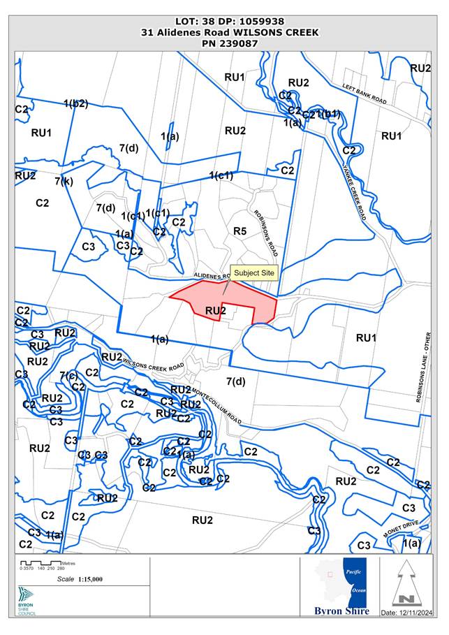
Assessment:
1. INTRODUCTION
1.1 Strategic context and background
The subject land is identified as a ‘priority site for rural living’ in the Byron Shire Rural Land Use Strategy 2017 (RLUS). In February 2019, Council received a landowner-initiated planning proposal which aimed to rezone the land to R5 Large Lot Residential to facilitate rural-residential subdivision in accordance with the vision of the RLUS. The planning proposal was later amended to become a Community Title development comprising up to 15 neighbourhood lots and one lot for association property. On 17 December 2021, Amendment No. 32 to Byron LEP 2014 was gazetted which included the subject site on the Multiple Occupancy and Community Title Map allowing for the creation of up to 15 neighbourhood lots.
1.2 Previous determinations
The property currently contains a dwelling house near Alidenes Road that was approved on 6 February 2020 via complying development certificate 16.2020.6.1. The design was modified via CDC application 16.2020.6.2 on 20 April 2020. No other determinations were identified for the property in Council’s records.
1.3 Description of the proposed development
The development application seeks consent for a community title subdivision comprising fifteen (15) neighbourhood lots and one (1) community lot, access roads, ancillary works, and ecological restoration works. The community lot will be held in shared ownership, and this will include Yankee Creek waterway and suitable riparian buffers. Each privately owned lot will contain only one dwelling. An existing dwelling house located near Alidenes Road will be incorporated into the subdivision on proposed Lot 3.
The following is proposed in detail:
(1) Community title subdivision
(a) Creation of 15 neighbourhood lots with areas ranging from 0.31 ha to 1.94 ha.
(b) Creation of 1 community lot with an area of 2.86 ha containing the Yankee Creek riparian corridor.
(2) Eastern arterial accessway
(a) Creation of a new access road servicing Lots 2 to 5 in the eastern side of the proposed subdivision. Works include upgrades to the Alidenes Road eastern crossover, construction of ~120m access road, creation of turning head for firefighting vehicles, and installation of a new box culvert across Yankee Creek.
(3) Western arterial accessway
(a) Creation of a new access roads servicing Lots 6 to 16 in the western side of the proposed subdivision. Works include upgrades to the Alidenes Road western crossover, upgrade of the existing sealed access road, construction of ~140m new access road for Lots 6 to 11, construction of ~133m new access road for Lots 13 to 15, construction of turning head for firefighting vehicles, and installation of a new box culvert across Yankee Creek.
(4) Private driveways
(a) Short driveway entrances are to be provided for each neighbourhood allotment, while Lot 16 is provided a longer driveway construction to a suitable area on the lot for a future dwelling site.
(5) Tree removal
(a) Remove and retain vegetation to facilitate the creation of building envelopes and access roads, including:
(i) removal of a Camphor laurel and Mango tree on Lot 2 for bushfire APZ,
(ii) removal of Camphor laurel regrowth along a fence line at the bushfire turnaround at the eastern accessway arterial road near Lot 4 and Lot 5,
(iii) remove planted exotic ornamental trees and some regrowth native trees on Lot 4 to be offset with additional native plantings at a ratio of 10:1 within the Yankee Creek riparian corridor,
(iv) protect existing large Cudgerie and Strangler Fig on Lot 13, and
(v) protect and enhance habitat of existing Scrub turpentine on Lot 1 near Lot 5 and habitat of Rough-shelled Bush Nut and Red Boppel Nut on Lot 1.
(6) Vegetation Management Plan
(a) Implementation of a Vegetation Management Plan (VMP) to enhance and restore the Yankee Creek riparian corridor over a period of 5-years. The VMP includes the planting of 13,810 trees along with targeted weeding.
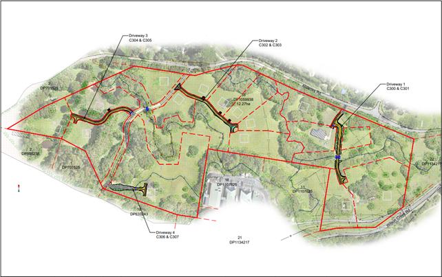
Figure 1: Extract of subdivision layout plan.
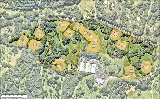
Figure 2: Extract of subdivision layout plan with asset protection zone overlays.
Description of the site
A site inspection was carried out on 20 March 2024.
|
Land is legally described |
LOT: 38 SEC: DP: 1059938 |
|
Property address |
31 Alidenes Road WILSONS CREEK |
|
Land is zoned: |
RU2 Rural Landscape |
|
Land area is: |
12.27 ha |
|
Property is constrained by: |
Bushfire prone land, High Environmental Value Vegetation, Cattle Dip Buffer |
The subject site described as Lot 38 DP 1059938, commonly known as 31 Alidenes Road, Wilsons Creek. It is an irregular shaped lot with an area of 12.27 hectares located next to the old Mullumbimby hydro-electric power station, approximately 4.5 kilometres from Mullumbimby township. The subject land is currently zoned RU2 Rural Landscape under Byron LEP 2014
The site has approximately 550 metres frontage to Alidenes Road and approximately 170 metres frontage to Wilsons Creek Road. However, much of the Wilsons Creek Road frontage is occupied by an access road to the adjacent power station.
The site is burdened by a 10-metre wide Right of Carriageway that provides access to Lot 1 DP 701525 (a neighbouring lot) from Alidenes Road. It is also burdened by two 10-metre-wide easements for pipelines that stem from the old power station and run along the Wilsons Creek Road boundary.
The subject land was historically used for dairy farming and has largely been cleared of native vegetation in the past. Existing vegetation cover comprises modified Camphor laurel forest with emergent native sub-tropical rainforest species, various environmental weeds, and exotic pasture grasses. The site is crossed by the upper reaches of Yankee Creek which flows in an easterly direction to a culvert near the intersection of Alidenes Road and Wilsons Creek Road.
Existing development comprises a rural dwelling house that will be incorporated into the community title estate and an old farm building near Wilsons Creek Road that will presumably be demolished. The locality is characterised by small holdings and rural-residential development.
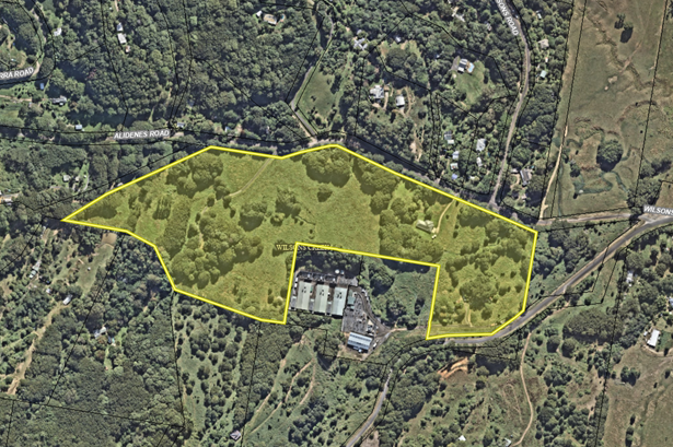
Figure 3: Aerial image of subject site.
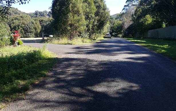
Figure 9: Access point off Alidenes Road, looking west.
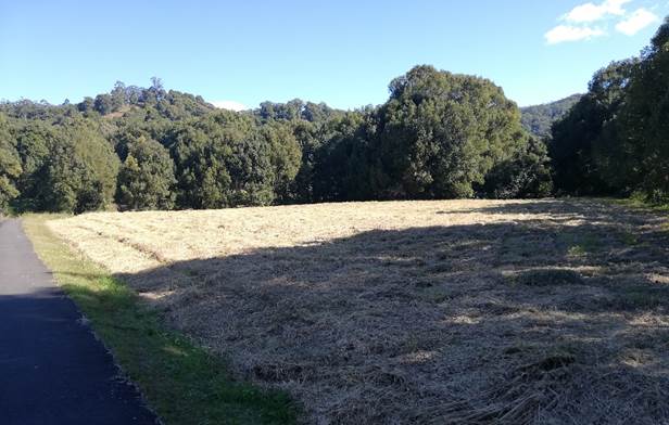
Figure 4: View SW towards Proposed Lots 12 and 13.
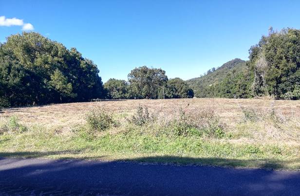
Figure 5: View east towards Proposed Lots 6 to 11.
Figure 6: View south towards electricity substation from Proposed Lots 6 and 7. Overhead powerlines traverse the western portion of these lots.
Figure 7: View NW toward proposed Lots 13 to 15.
Figure 8: View NW toward proposed Lot 16.
Figure 10: Intersection of Wilsons Creek Road and Alidenes Road.
2. SUMMARY OF REFERRALS
Internal Referrals
|
Referral |
Issue |
|
Environmental Health Officer |
Council’s Environmental Health Officer noted the proposal was acceptable on environmental health grounds subject to conditions of consent. |
|
Development Engineer |
Council’s Development Engineer concluded that the intersection between Alidenes Road and Wilsons Creek Road will require upgrading to provide safe and efficient access to the site. Conditions are recommended. |
|
S64 / Systems Planning Officer |
Potable water supply to the neighbourhood lots will be provided by rainwater harvesting and storage and therefore no development servicing levies are payable. Council’s Systems Planning Officer commented that the existing trunk water connection to the property must therefore be disconnected prior to the issue of a subdivision certificate. |
|
Contributions Planner |
Development contributions are payable. |
|
Ecological Consultant |
Council’s Ecological Consultant did not raise any objections in relation to biodiversity impacts. Conditions are recommended to ensure that Biodiversity Offset Credits are paid, and primary restoration works detailed in the VMP implemented prior to the issue of a subdivision certificate. |
|
Heritage Consultant |
No objections subject to conditions of consent. |
|
Resource Recovery |
Council’s Resource and Recovery Officer noted that bins must be collected from within the subdivision as there is insufficient room within Alidenes Road. Conditions are recommended for garbage collection to occur from within the CT estate. |
External Referrals
|
Referral |
Issue |
|
Rural Fire Service (s100B) |
General Terms of Approval and a Bush Fire Safety Authority were issued by the RFS on 10 April 2024. |
|
DPI Fisheries |
General Terms of Approval Authority were issued by DPI Fisheries on 127 March 2024. |
|
DPE Water |
General Terms of Approval were issued by DPE Water on 25 July 2024. |
|
Essential Energy |
Essential Energy raised no objections to the proposed development. A set of standard comments were provided regarding safety responsibilities when working near powerlines. |
3. BIODIVERSITY CONSERVATION ACT 2016
A Biodiversity Development Assessment Report (BDAR) was submitted in accordance with the Biodiversity Conservation Act 2016 outlining measures to avoid, minimise and mitigate impacts to vegetation and habitats within the development site. The BDAR identifies 4 eco-system credits and 9 species credits that will need to be retired to offset the residual impact on the site’s biodiversity values.
4. SECTION 4.46 INTEGRATED DEVELOPMENT
The proposed subdivision requires the following approvals listed under s 4.46 of the Environmental Planning and Assessment Act 1979 and is integrated development.
Rural Fires Act 1997
The proposed subdivision is for residential or rural-residential purposes and requires a Bush Fire Safety Authority under s100B of the Rural Fires Act 1997. General Terms of Approval and a Bush Fire Safety Authority were issued by the RFS on 10 April 2024.
Fisheries Management Act 1994
The proposal involves the construction of two box culverts within Yankee Creek which is identified as a key fish habitat and requires a permit under the Fisheries Management Act 1994. General Terms of Approval were issued by the NSW Department of Primary Industries (Fisheries) on 27 March 2024.
Water Management Act 2000
Construction of the two box-culverts within Yankee Creek requires a Controlled Activity Approval under s91 of the Water Management Act 2000 for work on waterfront land. General Terms of Approval were issued by the Department Planning and Environment–Water on 5 July 2024.
SECTION 4.15C – MATTERS FOR CONSIDERATION – DISCUSSION OF ISSUES
Having regard to the matters for consideration detailed in Section 4.15(1) of the Environmental Planning & Assessment Act 1979 (EP&A Act), the following is a summary of the evaluation of the issues.
State Environmental Planning Policies (SEPP)
|
Considerations |
Satisfactory |
Unsatisfactory |
|
Biodiversity and Conservation SEPP 2021 Chapter 3 Koala habitat protection 2020 The subject site contains a combination of cleared grazing land with multiple fragmented areas of camphor laurel dominated rainforest and other environmental weeds along with varying components of native sub-tropical rainforest species. Less than 15% of trees in the upper and lower strata of the tree component comprise koala feed tree species. The site is not considered to be a potential or core koala habitat as defined in this policy and a koala plan of management is not required as a precondition to the granting of consent. The proposed development is unlikely to adversely affect local koala populations or their habitats. |
☒ |
☐ |
|
Resilience and Hazards SEPP 2021 Chapter 4 Remediation of land A contaminated land assessment report was provided which included analysis of soil samples taken around the property. Soils were tested for heavy metals, organochlorines, and organophosphates, which were the most likely chemicals to cause contamination at the site or within any imported fill. Results of all potential contaminants were below the relevant Health Investigation Threshold for residential use. The site is therefore considered suitable for the proposed subdivision in its current state and does not remediation or further investigation. Council’s Environmental Health Officer recommended that an Unexpected Find Protocol be implemented during subdivision works to deal with any unknown rubbish or asbestos that may have been buried within the site. |
☒ |
☐ |
|
Transport and Infrastructure SEPP 2021 Section 2.48 Determination of development applications—other development The development application was referred to Essential Energy for comment in accordance with s2.48 of this policy. Essential Energy did not raise any specific concerns in relation to the proposed development. General comments were provided regarding safety risks when working near powerlines. Section 2.122 Traffic-generating development The proposed subdivision will result in less than 50 new allotments and is therefore not classified as ‘traffic generating development’ requiring referral to Transport for NSW for review and comment. |
☒ |
☐ |
4.2A Byron Local Environmental Plan 2014 (LEP 2014)
In accordance with LEP 2014 clauses 1.4 and 2.1 – 2.3:
(a) The proposed development is defined in the Act as subdivision of land.
(b) The land is within the RU2 Rural Landscape according to the Land Zoning Map.
(c) The proposed development is permitted with consent subject to Clause 4.1B; and
(d) Regard is had for the Zone Objectives as follows:
|
Zone Objective RU2 Rural Landscape |
Consideration |
|
To encourage sustainable primary industry production by maintaining and enhancing the natural resource base. |
The proposed development is generally compatible with the RU2 zone objectives, noting that the land has been identified for rural-residential development in Council’s Rural Land Use Strategy 2017 and Community Title subdivision for up to 15 lots is permissible under Clause 4.1B of LEP 2014. |
|
To maintain the rural landscape character of the land. |
|
|
To provide for a range of compatible land uses, including extensive agriculture. |
|
|
To enable the provision of tourist accommodation, facilities and other small-scale rural tourism uses associated with primary production and environmental conservation consistent with the rural character of the locality. |
|
|
To protect significant scenic landscapes and to minimise impacts on the scenic quality of the locality. |
The following LEP Clauses area of relevance to the proposal.
Part 4 Principal development standards
|
LEP Requirement |
Complies? |
Comment |
|
Clause 4.1B Minimum subdivision lot size for multiple occupancy or rural community title developments |
Yes |
Size and Number of Neighbourhood Lots The subject land is identified on the Multiple Occupancy and Community Title Map under LEP 2014 and can accommodate up to 15 neighbourhood lots in accordance with Clause 4.1B(3). Appropriate management measures are in place that will ensure the protection and enhancement of the landscape, biodiversity, and rural setting of the land. |
Part 5 Miscellaneous provisions
|
LEP Requirement |
Complies? |
Comment |
|
Clause 5.10 Heritage conservation |
Yes |
The property adjoins the Mullumbimby Hydro Power Station Complex which is listed as an item of State Significance on the State Heritage Register. The Statement of Significance notes that the item has historical significance as an example of the early development of hydroelectricity in NSW and represents the transition from local councils and private companies to county Council’s in the provision of electricity to the community. Council’s Heritage Advisor commented that there is no visibility of the power station from the development sites due to the presence of established vegetation corridors along riparian zones, which are proposed to be retained. The development will potentially alter the broader rural landscape through the addition of 15 dwelling sites however the low-density form of development will not significantly detract from the heritage significance and visual setting of the historic power station. |
|
Clause 5.16 Subdivision of, or dwellings on, land in certain rural, residential or conservation zones |
Yes |
The proposed subdivision is compatible with surrounding land uses which are characterised by rural living, grazing and small-scale agricultural pursuits. |
|
Clause 5.21 Flood planning |
Yes |
The site is subject to periodic inundation during periods of heavy rainfall. Each of the proposed dwelling sites can accommodate a building envelope above the 2100 Flood Planning Level and is satisfactory having regard to the matters for consideration under Clause 5.21. |
Part 6 Additional local provisions
|
LEP Requirement |
Complies? |
Comment |
|
Clause 6.6 Essential services |
Yes |
Water supply Future dwellings within the subdivision will be supplied potable water via rainwater harvesting and storage systems. Connection to the local reticulated water supply is not proposed at the current time. Sewage disposal Sufficient information has been provided demonstrating that each lot can accommodate an on-site sewage management system for a single dwelling on flood free land. Council’s Environmental Health Officer recommended that a Community On-site Wastewater Management Plan be prepared detailing strategies to ensure optimal environmental performance of on-site sewage management systems within the subdivision. Measures such as flood-resistant design, secondary/tertiary treatment and regular maintenance protocols are to be established and incorporated into the Neighbourhood Management Statement. Electricity and telecommunications The proposed subdivision is capable of being connected to reticulated electricity and telecommunications services. NBN fixed wireless technology is available in the area to provide internet services. Vehicular access External and internal vehicular access off Alidenes Road is adequate for the proposed subdivision. Conditions are recommended for the main access on Alidenes Road and the intersection between Alidenes Road and Wilsons Creek Road to be upgraded to meet the relevant engineering design guidelines including construction of a channelized right turn treatment. |
4.3 Any proposed Instrument that has been the subject of public consultation and has been notified to the consent authority
There are no proposed instruments that are relevant to the proposed development.
4.4 Byron Shire Development Control Plan 2014 (DCP 2014)
Chapter B1 Biodiversity
|
Provision |
Compliance |
Comment |
|
B1.2.1 Development Envelope Controls B1.2.4 Vegetation Management Plans & Biodiversity Conservation Management Plans |
Yes |
The proposed subdivision avoids environmentally sensitive areas of the site and proposes restoration and enhancement of the Yankee Creek riparian corridor under a VMP. 13,820 rainforest plantings are proposed across 2ha of land, along with weed management and assisted natural regeneration. |
Chapter B3 Services
|
Provision |
Compliance |
Comment |
|
B3.2.1 Provision of Services |
Yes, subject to conditions |
The proposed development is capable of being adequately serviced in accordance with Chapter B3 subject to conditions of consent. Upgrades to the intersection of Alidenes Road and Wilsons Creek Road will be required to improve safety. |
|
B3.2.2 On-site Sewage Management |
Yes, subject to conditions |
Sufficient information has been provided demonstrating that each allotment has a suitable flood-free land area capable of assimilating wastewater from a single dwelling. |
|
B3.2.3 Stormwater Management |
Yes, subject to conditions |
The proposed allotments have sufficient area to assimilate stormwater from a single dwelling without requiring specialised drainage infrastructure. |
|
B3.2.4 Sedimentation and Erosion Control Measures |
Yes, subject to conditions |
A comprehensive sediment and erosion control plan is required to manage earth disturbing works in proximity to Yankee Creek. A condition is recommended for a plan to be prepared and submitted for approval as part of the subdivision works certificate. |
Chapter B4 Traffic Planning, Vehicle Parking, Circulation and Access
|
Provision |
Compliance |
Comment |
|
B4.2.1 Traffic Impact |
Yes |
Traffic Impact Assessment Report The submitted traffic impact report estimates that traffic will be generated at an average rate of: · 7.4 trips per dwelling per day (AADT). · 0.78 peak hour trips per dwelling. Based on these rates, a 15-lot residential subdivision with one dwelling per lot would generate traffic at an average rate of 111 trips per day with 11.7 peak hour trips. If dual occupancies and secondary dwelling are permitted, the development yield and traffic rates would be doubled. Council’s Development Engineer noted the development is likely to have a moderate traffic impact on the surrounding road network. Alidenes Road will therefore need to be widened from 5m to 7m with a 1m shoulder upgrade. Road Safety Audit Findings The submitted Road Safety Audit (RSA) identifies several deficiencies in the design and condition of the intersection between Alidenes Road and Wilsons Creek Road that were deemed to be “high risk”. Deficiencies include a lack of signage, no line marking, poor sightlines, acute intersection alignment, and poor road surface condition. To ensure the intersection is safe and functional, a condition is recommended for the intersection to be upgraded to current Austroads standards including creation of a channelized right-hand turn treatment. |
|
B4.2.3 Vehicle Access and Manoeuvring Areas |
Yes, subject to conditions |
The internal road network has been designed in accordance with the relevant engineering standards and can accommodate firefighting and waste collection vehicles. |
Chapter B8 Waste Minimisation and Management
|
Provision |
Compliance |
Comment |
|
B8.2.2 Site Waste Minimisation and Management Plans |
Yes |
A suitable site waste minimisation and management plan was provided in the applicant’s further information. Conditions are recommended to ensure that bins are collected from within the community title estate and not from Alidenes Road. |
Chapter B9 Landscaping
|
Provision |
Compliance |
Comment |
|
B9.11.1 Design and Selection of Street Trees |
Yes, subject to conditions |
Conditions are recommended for a final landscaping plan to be submitted with the subdivision works certificate detailing street trees, lighting, and landscape treatments for the proposed subdivision. |
Chapter B14 Excavation and Fill
|
Provision |
Compliance |
Comment |
|
B14.2 Excavation and Fill in all Zones |
Yes |
Minimal excavation and filling will be required to establish the internal road network and building envelopes for the proposed subdivision. Works will generally be less than 1m in depth in accordance with B14.2, Prescriptive Measure 1. |
Chapter C2 Areas Affected by Flood
|
Provision |
Compliance |
Comment |
|
C2.3.3 Flood Planning Matrix & C2.3.4 Flood Proofing |
Yes |
The site is not identified on Councils Flood Planning Map; however, it is known that the property does experience temporary flash flooding events. As shown in Figure 11, detailed flood modelling has been provided demonstrating that each allotment can provide a building envelope and OSMS disposal area on land above the 2100 Flood Planning Level. |
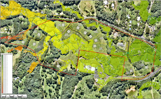
Figure 11: Extract of flooding map illustrating the extent of flooding during a 1% annual exceedance probability event. Proposed building envelopes are located on flood free land.
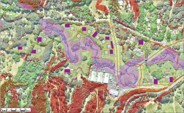
Figure 12: Extract of Land Application Area Map illustrating indicative effluent application areas on flood free land adjacent to building envelopes.
Chapter D6 Subdivision
|
Provision |
Compliance |
Comment |
|
D6.2.1 Subdivision Design Guidelines |
Yes |
Overall, the proposed subdivision design adequately responds to the constraints and opportunities of the site and will provide a range of lots sizes with sufficient shape and area to accommodate a single dwelling in a low density rural-residential environment. Each lot has adequate room for the siting of a dwelling on flood free land with a northerly aspect and room for gardens and ancillary outbuildings. Building envelopes are generally clear of vegetation and most sites will require minimal excavation or filling to site a new dwelling. Conditions are recommended for building envelopes to be prescribed on the subdivision plan which limit development on flood affected land or land with high biodiversity values. |
Chapter D2 Residential Accommodation and Ancillary Development in Rural Zones
|
Provision |
Compliance |
Comment |
|
D2.8 Community Title Development of Rural Land |
Yes |
The proposed development satisfies the Objectives and Prescriptive Measures of Part D2.8 as follows: · The existing dwelling within proposed Lot 3 complies with all relevant planning controls for dwelling houses in D2.2 and D2.3. · A vegetation management plan has been provided outlining an environmental repair strategy to plant 13,810 trees alongside assisted natural regeneration and weed management equivalent to 900 rainforest plantings per 1 hectare. · New plantings and environmental repair will be focused within the Yankee Creek riparian corridor which is contained with the proposed community lot. The environmental restoration program will be managed by the neighbourhood association. |
Chapter D6 Subdivision
|
Provision |
Compliance |
Comment |
|
D6.3.5 Rural Community Title Subdivision |
Yes |
The proposed subdivision satisfies the requirements of Part D6.3.5 as follows: · Information has been provided demonstrating that each neighbourhood lot can accommodate on-site effluent disposal for a single dwelling house. · Drinking water is to be supplied rainwater harvesting and storage. The design of drinking water systems will be addressed at the development application stage for future dwellings within the subdivision. · Waste management measures are adequate, with garbage being collected from central bin collection points within the subdivision. · A draft Neighbourhood Scheme was submitted consistent with the Community Land Development Act 2021. A condition is recommended for a final Neighbourhood Scheme to be submitted to Council for approval prior to the release of a subdivision certificate. The final plan is to include additional matters relating to bushfire protection, garbage collection, and vegetation management. |
4.5 Environmental Planning and Assessment Regulation 2021 considerations
Section 61 - Additional matters that consent authority must consider
A condition is recommended that requires any demolition works to be carried out in accordance with AS2601–the demolition of structures.
Section 64 - Consent authority may require upgrade of buildings
The existing dwelling house within proposed Lot 3 is adequate in its current state and does not require upgrading.
4.6 The likely impacts of that development, including environmental impacts on both the natural and built environments, and social and economic impacts in the locality
|
Impact on: |
Likely significant impact/s? |
|
Natural environment |
Direct impacts associated with future residential use Future residential development of the site is expected to directly impact approximately 1.67 ha of vegetation as illustrated in Figure 13. This accounts for typical rural-residential style development on each lot, inclusive of clearing for dwellings, asset protection zones, sheds, garages, and swimming pools, etc. The subdivision layout has been carefully designed so that building envelopes are located on predominantly cleared land and can accommodate a dwelling with minimal disturbance of surrounding vegetation. Small areas of degraded Camphor laurel forest and planted vegetation may be impacted by the proposal however these contain relatively low biodiversity values. Impact on threatened species and ecological communities The submitted BDAR has identified the presence of four threatened plant species on the site, being: 1 Red Bopple Nut, 2 Rough-shelled Bushnut, 1 Durobby and 7 Scrub Turpentine. The BDAR notes that the development footprint of Lot 16 is in proximity to three of the Scrub Turpentine trees (refer to Figure 13). It is likely that these plants can be retained in-situ, although the for the purposes of credit calculations they are assumed to be impacted with credit obligations generated. A condition is recommended that requires the VMP to updated to include specific measures for the protection and management of threatened species including Scrub turpentine. Such measures are also to be reference in the Neighbourhood Management Statement. Environmental restoration and enhancement A Vegetation Management Plan (VMP) is proposed that aims to restore the central riparian corridor and protect threatened flora species throughout the site. The VMP includes the planting of 13,810 trees and is likely to have a positive environmental impact if fully implemented. |
|
Built environment |
Intersection upgrade The intersection between Alidenes Road and Wilsons Creek Road requires upgrading as noted in the submitted Road Safety Audit. Conditions are recommended for upgrades to occur prior to the issue of a subdivision certificate subject to Roads Act consent. Garbage Collection Due to the limited kerbside frontage on Alidenes Road, a condition is recommended that requires all bins to be collected from within the community title estate. Bin collection can occur at centralised pickup points with the estate. Flooding Flood free access to and around the site is not available, however sufficient flood free land is available on the site to ensure that each neighbourhood lot will be able to accommodate a single dwelling house. It is likely that lots on the southern side of Yankee Creek may become isolated during heavy rainfall however this is likely to be temporary as catchments feeding the waterways are small, so floods rise fast but also disappear quickly. Demolition of existing farm buildings Two existing farm buildings are located on Proposed Lots 4 and 5 near Wilsons Creek Road. The buildings will be required to be demolished to accommodate a suitable building envelope for future residential development. Conditions are recommended requiring the demolition and removal of these buildings prior to the issue of a subdivision certificate. |
|
Social Environment |
The proposed subdivision will have minimal social and economic effects as the site adjoins an already established rural residential area on the northern side of Alidenes Road. Any housing that may come onto the market is unlikely to be affordable for average income earners but will nevertheless make a positive contribution to the supply of housing stock in the Mullumbimby area. |
|
Economic impact |
The proposal will not have a significant long-term economic impact on the locality. Additional employment opportunities may be generated in the building industry during the initial construction phase. |
|
Construction Impacts |
The development will generate minor impacts during its construction. Conditions of consent recommended to control hours of work, builders waste, construction noise, installation of sedimentation and erosion control measures and the like to ameliorate such impacts. |
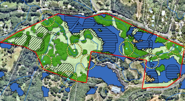
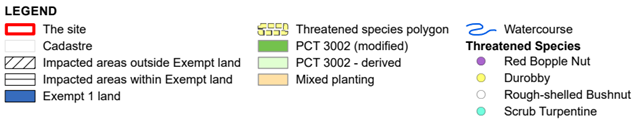
Figure 13: Extract of Vegetation Impacts Map from the BDAR illustrating the likely extent of vegetation impacted by future residential development on the site.
4.7 The suitability of the site for the development
The site attributes are considered suitable for the proposed subdivision having regard to bushfire hazard, flooding, vegetation management, servicing, and access. Physical and environmental constraints have been addressed through appropriate design and conditions of consent.
4.8 Submissions made in accordance with this Act or the regulations
The development application was publicly exhibited for a period of 14-days in accordance with the Byron Shire Community Participation Plan.
There were ten (10) submissions made on the development application raising a variety of concerns in relation to traffic safety, flooding, density, pedestrian access, environmental impacts, and construction impacts. The poor state of the intersection between Alidenes Road and Wilsons Creek Road was a common theme.
Issues raised in submissions are summarised and addressed in the following table:
|
Issue |
Comment |
|
Traffic Safety Concerns were raised that the intersection of Wilsons Creek Road and Alidenes Road is dangerous and requires urgent upgrade. Submitters noted there had been accidents and fatalities on the road including a car recently overturning into the creek. It was noted that previous traffic assessments carried out at the rezoning stage had identified deficiencies in relation to signage, line marking, intersection alignment, sightlines, road surface and lack of a dedicated turning lane. |
Conditions are recommended requiring the intersection between Wilsons Creek Road and Alidenes Road to be upgraded to a suitable standard for the proposed subdivision. |
|
Pedestrian access and bus stop Concerns were raised regarding the lack of pedestrian access, particularly for children. It was noted that safe pedestrian access should be provided from the subdivision to the bus stop on the corner of Alidenes and Wilsons Creek Road. The bus stop is not sign posted, no shelter is provided and there is loose gravel nearby. There has been no consideration of children needing to walk to the bus stop, or consideration that the bus stop itself is dangerous due to traffic. |
Given the rural location, there is not a clear nexus to require the construction of a new bus stop and pedestrian pathway.
|
|
Flooding Submission authors commented that the site is subject to flooding and will act as a catchment for water running down from the surrounding valleys. Concerns were raised that the area will be trapped during a flood placing additional burden on emergency services. Specific comments were made in relation to the causeway linking the property to Alidenes Road, noting that flooding of the causeway would result in future dwellings becoming isolated during heavy rain. |
Each proposed lot provides a sufficient flood-free building envelope to accommodate a future dwelling house.
|
|
Number of lots / dwellings Submitters noted the lack of certainty regarding the future dwelling yield of the proposed subdivision. 15 neighbourhood lots are proposed, however, up to 30 dwellings would be permitted if the lots were developed with secondary dwellings or dual occupancies. Given there is no practical way to ‘switch off’ secondary dwelling or dual occupancies, the subdivision should be assessed on the basis of 30 dwellings. |
Noted. Conditions are recommended limiting the number of dwellings in the subdivision to a maximum of 15, being one per lot. This restriction is also to be included in the Neighbourhood Management Statement. |
|
Environmental Impacts Submitters noted that the proposed subdivision would adversely affect the environment due to vegetation removal, reduction in water quality and damage to wildlife. |
Sufficient information has been provided demonstrating that the environmental impacts of the development are manageable subject to conditions of consent. The submitted vegetation management includes a proposal to restore the central riparian corridor which will have a positive environmental outcome. |
|
Right of Carriageway for Adjoining Properties Concerns were raised regarding the maintenance and use of the internal access road which is currently contained within a right of carriageway benefitting adjoining properties. |
The existing right of carriage way will not be compromised or impeded once subdivision works have been completed. |
|
Construction Traffic Many large vehicles will access the site during the construction phase of the development causing safety issues. |
A condition is recommended for a construction management plan to be prepared to mitigate potential impacts during the construction phase of the development. It is noted that such impacts will be temporary in nature. |
|
Housing affordability The proposed subdivision will not contribute to the supply of affordable housing in the Shire, with each lot selling for up to a million dollars. |
The proposed development will add to the supply of housing in the Byron Shire and is therefore likely to have positive social and economic impact. |
|
Impact on riparian corridors Concerns were raised regarding potential pollution and sedimentation of the creek, along with potential impacts on koalas and pademelons. |
A Vegetation Management Plan is proposed that involves restoration and enhancement of the site’s central riparian corridor. Conditions are recommended for an erosions and sediment control plan to be prepared with measures for mitigating sedimentation of the creek during the construction phase of the development. |
4.9 Public interest
The proposed development is unlikely to prejudice or compromise the public interest or create an undesirable precedent.
DEVELOPER CONTRIBUTIONS
5.1 Water & Sewer Levies
The proposed subdivision will not be connected to Council’s reticulated water or sewer network. Development servicing levies are not payable.
5.2 Developer Contributions
Section 7.11 Contributions will be payable.
DISCLOSURE OF POLITICAL DONATIONS AND GIFTS
|
Disclosure details |
Response |
|
Has a Disclosure Statement been received in relation to this application? If Yes, Provide Disclosure Statement register reference: 91. |
Yes ☐ No ☒ |
|
Have staff received a ‘gift’ from anyone involved in this application that needs to be disclosed. |
Yes ☐ No ☒ |
CONCLUSION
This development application seeks consent for a community title subdivision comprising fifteen (15) neighbourhood lots and one (1) community lot, access roads, ancillary works, and ecological restoration works at 31 Alidenes Road, Wilsons Creek. The subject land is identified as a ‘priority site for rural living’ in the Byron Shire Rural Land Use Strategy 2017.
The proposed subdivision design adequately responds to the constraints and opportunities of the site and will make a positive contribution to the supply of housing in the Mullumbimby area.
The development application is recommended for approval subject to the Conditions in Attachment 1.
Staff Reports - Sustainable Environment and Economy 13.9
Report No. 13.9 PLANNING - 10.2024.20.2 Section 8.2 review of refusal of use of land and existing shed for landscaping material supplies 1178 Myocum Road MYOCUM
Directorate: Sustainable Environment and Economy
Report Author: Patricia Docherty, Team Leader Planning Services - Commercial Industrial & Tourism
File No: I2024/1426
Proposal:
|
8.2 Review of Determination No: |
10.2024.20.2 |
|
Planning Portal ref |
PAN-463739 |
|
Proposal description: |
Section 8.2 review of refusal of use of land and existing shed for landscaping material supplies |
|
Property description: |
LOT: 342 DP: 755692 |
|
1178 Myocum Road MYOCUM |
|
|
Parcel No/s: |
238148 |
|
Applicant: |
Town Planning Studio Pty Ltd |
|
Owner: |
Mr M K Archibald |
|
Zoning: |
RU1 Primary Production |
|
Date of Refusal: |
01 August 2024 |
|
Date S8.2 Review received: |
24 September 2024 |
|
Original Assessing Officer: |
Dylan Johnstone, Development Investigations Lead |
|
8.2 Assessment: Officer |
Patricia Docherty, Team Leader Planning Services - Commercial Industrial & Tourism |
|
Public notification or exhibition: |
- Level 2 advertising under DCP 2014 Part A14 – Public Notification and Exhibition of Development Applications - Exhibition period: 02 - 16 October 2024 - Submissions received – One objection - Acknowledged – Yes |
|
Planning Review Committee |
8.2 Review not referred to the Planning Review Committee |
|
Estimated Cost |
$65,000 |
|
Delegation to determine |
Council Environmental Planning and Assessment Act 1979, Section 8.3 Application for and conduct of review sub section (6) The review of a determination or decision made by a council is to be conducted by the council and not by a delegate of the council. |
|
Issues: |
A review application must be determined within 6-months of the date of the determination, which is the same timeframe within which an appeal can be made to the Court. Council refused the original application at a meeting of Council on 1 August 2024 and the 8.2 Review must be determined by 1 February 2025. Applicant has not resolved issues raised in the original reasons for refusal. Issued raised in the original application: · Existing shed built without approval · Business operating on-site without consent · Large sand stockpile on site that does not form part of the current development application · Visual impact of shed Submission of objection the 8.2 Review, raised the following concerns: · Potential for effect of flooding on neighbouring property · Visual amenity |
Summary:
This application seeks a review of Council’s determination of development application (DA) 10.2024.20.1 that was refused at the Council Planning Meeting of 1 August 2024. The section 8.2 review application did not submit additional contemporary reports or information, when compared to the original assessment that would address the reasons for refusal.
The original DA sought consent for the use of an existing landscaping material supplies business operating from the site and also sought consent for the construction of an amenities building and for the use of an existing shed as an ancillary component of the development.
The original report to Council indicated that the existing landscaping material supplies business and existing shed have been carried out without the necessary development consent. The DA had been submitted in response to compliance action taken by staff for unauthorised development. A previous deferred commencement consent was issued by Council under DA10.2020.568.1 – Use of Land and Existing Shed for Landscaping Material Supplies on 09 September 2022, however the applicant has not complied with any conditions of consent and the consent has now lapsed.
The proposal is permissible with consent, but a number of elements on the site were recommended to be finalised under deferred commencement consent conditions. This included removal of a concrete batching plant and equipment, unauthorised signs, illegal fill material on site (being a large sand mound), obtaining a building information certificate for the shed and carrying out the landscaping as per the submitted landscape plan.
The original report to Council raised development engineering issues with consideration for Council’s engineering assessment of flooding:
“A flood report was submitted with the application which provided the following comments in conclusion:
The hydraulic model created as part of the NBFS has been updated to include the existing concrete blocks on the property (Wards Landscaping) to the east of the site. The 5-, 20- and 100-year ARI flood events have been simulated with the revised model.
The proposed development has been incorporated into the hydraulic model and has been assessed for the 5-, 20- and 100-year ARI flood events and maps representing flood impacts have been created. The flood impact assessment shows that there are some minor offsite changes to peak flood level in the range 10 to 20mm predicted on lot number DP 3/1067849. The extent of this impacts is largest in the 20-year ARI flood event and they extend approximately 40 metres onto this property.
Staff have noted that no assessment has been made of the site in the current condition as advised by the applicant:
It is important to note that no assessment of the site in the current (i.e. present day) condition has been prepared, as on advice from Michael Archibald (owner), the site will be modified to remove materials and equipment that exists outside of the proposed development extent.
It is likely that the flood extent and flood level will increase should an assessment be made to the current condition.
Therefore, the retention of the large areas of stockpiled fill are not supported as they are non-compliant with clause 5.21(2) of LEP 2014 and Chapter C2 of DCP 2014. However, compliance can be achieved by removal of fill material from the site which is [was] recommended as a deferred commencement condition.”
In its consideration of the officer report, Council determined to refuse the application for the following reasons:
1. Pursuant to Section 4.15(1)(a)(i) the proposed development is inconsistent with the objectives of the RU1 Primary Production Zone under Byron LEP 2014 as the existing shed and sand stockpile detract from the scenic quality of the locality.
2. Pursuant to Section 4.15(1)(a)(i) the application has not demonstrated compliance with Clause 5.21(2) – “Flood planning” of Byron LEP 2014.
3. Pursuant to Section 4.15(1)(a)(iii) the application has not demonstrated compliance with Chapter C2 – “Areas affected by flood” of Byron DCP 2014.
4. Pursuant to Section 4.15(1)(b) the proposed development has not demonstrated that it will not have a significant adverse impact upon the built environment with respect to potential flood impacts on adjoining land, and the natural environment having regards to the visual amenity impacts of the existing shed and sand stockpile on the locality.
5. Pursuant to Section 4.15(1)(c) the application has not demonstrated that the site is suitable for the proposed development with respect to visual amenity impacts and potential flood impacts on adjoining land. The application did not provide an assessment of the impacts of the existing sand stockpile on the natural flow of flood waters during flood events.
6. Pursuant to Section 4.15(1)(e) the proposed development is not in the public interest having regards to visual amenity impacts, the objectives of the zone, potential flood impacts on adjoining land, and the bonafides of the proposal as a landscaping material supplies business given that concrete batching equipment remains onsite and use of such equipment is prohibited in the zone, and lack of attempt at compliance with the approved DA 10.2020.568.1 which has since lapsed.
This assessment finds that the section 8.2 application did not provide information to address the original reasons for refusal. There is no evidence that any of the issues raised in the reasons for refusal have been addressed.
It is therefore recommended that Section 8.2 review number 10.2024.20.2 upholds the refusal of DA10.2024.20.1 for the same reasons resolved by Council on 1 August 2024 with additional consideration given to the provisions of State Environmental Planning Policy (SEPP) Resilience and Hazards 2021, Part 2 Division 3 – Coastal Environment Area – Section 2.10 (1) (a) - that development consent must not be granted to development on land that is within the coastal environment area unless the consent authority has considered whether the proposed development is likely to cause an adverse impact on the integrity and resilience of the biophysical, hydrological (surface and groundwater) and ecological environment. A further reason for refusal has been added in the recommendation to this report.
NOTE TO COUNCILLORS:
In accordance with the provisions of S375A of the Local Government Act 1993, a Division is to be called whenever a motion for a planning decision is put to the meeting, for the purpose of recording voting on planning matters. Pursuant to clause 2(a) under the heading Matters to be Included in Minutes of Council Meetings of Council's adopted Code of Meeting Practice (as amended) a Division will be deemed to have been called by the mover and seconder of all motions relating to this report.
RECOMMENDATION:
That Council, pursuant to Section 8.4 of the Environmental Planning & Assessment Act 1979, being the consent authority uphold the refusal of application 10.2024.20.1, for the reasons as follows:
1. Pursuant to Section 4.15(1)(a)(i) the proposed development is inconsistent with the objectives of the RU1 Primary Production Zone under Byron LEP 2014 as the existing shed and sand stockpile detract from the scenic quality of the locality.
2. Pursuant to Section 4.15(1)(a)(i) the application has not demonstrated compliance with Clause 5.21(2) – “Flood planning” of Byron LEP 2014.
3. Pursuant to Section 4.15(1)(a)(iii) the application has not demonstrated compliance with Chapter C2 – “Areas affected by flood” of Byron DCP 2014.
4. Pursuant to Section 4.15(1)(b) the proposed development has not demonstrated that it will not have a significant adverse impact upon the built environment with respect to potential flood impacts on adjoining land, and the natural environment having regards to the visual amenity impacts of the existing shed and sand stockpile on the locality.
5. Pursuant to Section 4.15(1)(c) the application has not demonstrated that the site is suitable for the proposed development with respect to visual amenity impacts and potential flood impacts on adjoining land. The application did not provide an assessment of the impacts of the existing sand stockpile on the natural flow of flood waters during flood events.
6. Pursuant to Section 4.15(1)(e) the proposed development is not in the public interest having regards to visual amenity impacts, the objectives of the zone, potential flood impacts on adjoining land, and the bonafides of the proposal as a landscaping material supplies business given that concrete batching equipment remains onsite and use of such equipment is prohibited in the zone, and lack of attempt at compliance with the approved DA 10.2020.568.1 which has since lapsed.
And an additional reason for refusal be added, as follows:
7. Pursuant to Section 4.15(1)(a)(i) the proposed development is inconsistent with State Environmental Planning Policy (Resilience and Hazards) 2021, Part 2 Division 3 – Coastal Environment Area – Section 2.10 (1) (a) that development consent must not be granted to development on land that is within the coastal environment area unless the consent authority has considered whether the proposed development is likely to cause an adverse impact on the integrity and resilience of the, hydrological (surface and groundwater) environment.
1 10.2024.20.2
- H - Development Plans - 320 McAuleys Lane, Myocum, E2024/99257 ![]()
2 10.2024.20.2
- Submission (Redacted) Object 10.2024.20.2 - SUB2495_redacted.pdf, A2024/54539 ![]()
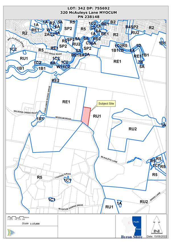
Figure 1: Locality Plan
Assessment:
1. INTRODUCTION
1.1 History/Background
History of development applications
10.2004.567.1 – Removal of one tree from the site - Approved 07/02/05
10.2017.694.1 - Subdivision (Boundary adjustment between two (2) Lots) - Approved 20/02/18
10.2018.259.1 – Use of site as a landscaping material supplies business – Council officers identified various issues with this application. The application was subsequently withdrawn on 09/07/19.
10.2020.568.1 – Use of Land and Existing Shed for Landscaping Material Supplies – Approved (Deferred Commencement) 09/09/22.
10.2024.20.1 – Use of land and existing shed for landscaping material supplies Refused Council 01/08/24.
Background
The land is currently used for “landscaping material supply” activities. This use is unauthorised. It includes the stockpiling of sand and gravel which have been placed on the site since late 2016 without Council approval.
Over time the site has had stockpiles of sand and gravel of various sizes (and other landscape and construction materials) on it. The sand stockpile was up to approximately 6m in height which is being gradually removed as material is sold. The plans and historical photos also show a gravel stockpile which has largely been removed. The stockpiles do not form part of the Development Application. The application proposes that that landscape material be placed in purpose-built landscape bays as part of this Development Application.
Enforcement Officers have been in contact with the owners regarding the unauthorised activities. In response the applicant lodged DA 10.2018.259.1 which was subsequently withdrawn to enable the applicant to address outstanding issues identified by Council officers as part of a new development application.
A Notice of Proposed Stop Use Order was issued to the landowner on 21 January 2020 to stop the use of the site for the purpose of landscaping material supplies, remove unapproved signage and to remove all stockpiles of landscaping supplies. Development application 10.2020.568.1 was lodged in response to the Notice.
A shed had also been constructed on the site without the required approvals between the issuing of the above Notice and lodgement of development application 10.2020.568.1.
Consent 10.2020.568.1 was granted on 9 September 2022 and included deferred commencement conditions requiring a Building Information Certificate for the existing shed, removal of illegal fill, removal of unauthorised signs, removal of concrete batching plant, and establishing approved landscaping.
All of these deferred conditions were required to be complied with within 12 months of the date of the consent.
None of the deferred commencement conditions were completed within this timeframe and, in accordance with the Deferred Commencement Consent, the consent subsequently lapsed.
Application 10.2024.20.1 was submitted in response to Council’s Community Enforcement staff issuing a Notice of Proposed Order dated 2 November 2023 to stop use of the landscaping material supplies business.
An aerial photograph of the site is provided in Figure 2 below and various images of the site in Figures 4 – 6. These images were produced during the assessment of 10.2020.568.1.
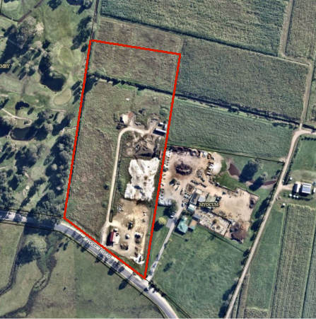
Figure 2: Aerial Photograph from previous report and most recent in Figure 3 below
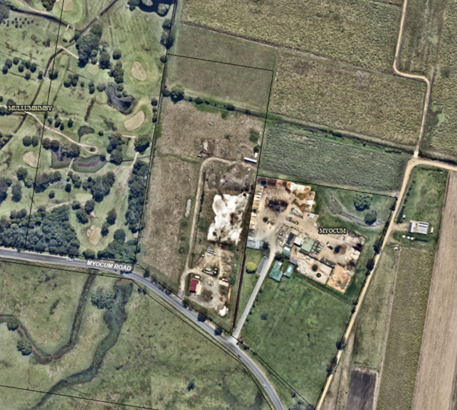
Figure 3: Aerial Photograph extracted 22/11/2024 Nearmap latest
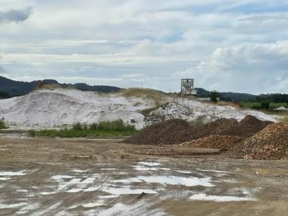
Figure 4: Photograph (May 2022) – Existing Stockpiles with a
concrete batching plant in the background.
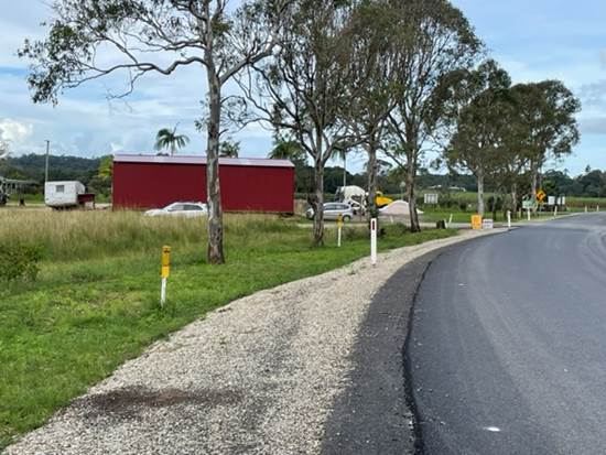
Figure 5: Photograph (May 2022) – View of shed from Myocum Road
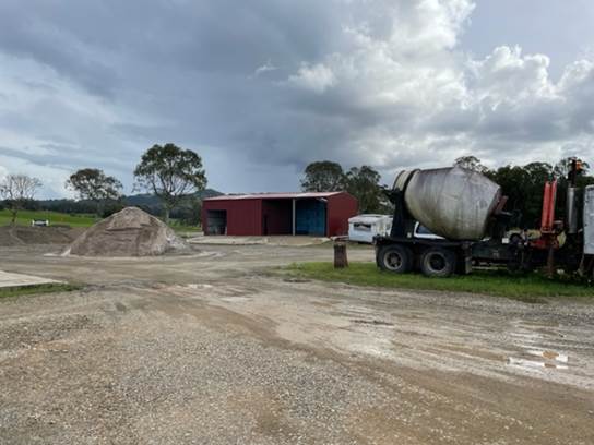
Figure 6: Photograph (May 2022)– View of shed – Photograph taken from within the site
2.1 Description of the proposed development
The section 8.2 Application was submitted with the same information from the original application. The original application sought consent for the use of an existing landscaping material supplies business operating from the site. The application also sought consent for the construction of an amenities building and for the use of an existing shed as an ancillary component of the development.
The proposal includes:
· The storage and sale of sand, gravel, soil and mulch of various sizes and mixes. The application indicates that between 1,000 and 2,000 cubic metres of landscape materials will be moved in and out of the site per annum. Landscaping products will include:
- 10mm, 20mm & 30mm aggregate
- White Sand
- Metal dust
- Road Base
- Sand/gravel mixes
- Garden Soils
- Garden Mulches
The proposed site layout plan is shown on Figure 5.
· The construction of 46 storage bays. These will be divided by 200mm thick concrete tilt slabs with a height of 1.3 metres. The material to be stockpiled within each bay will have a height of up to 3.0 metres.
· Use of an existing shed that has been constructed on the site. The shed measures 14 m x 7m (floor area 98m2) and is 4.27 metres high (refer to photographs above). The shed will be used to store landscape materials that require protection from the weather. The applicant indicates that: The landowner has recently constructed a steel framed shed within the site in consideration of the ‘exempt development’ provisions from State Environmental Planning Policy (Exempt & Complying Development Codes) 2008.
The construction of the shed was not ‘exempt development’ and required development consent. This issue will be discussed later in this report.
· Provision of landscaping along the site frontage, adjacent to the shed and along part of the eastern boundary (refer to Figure 6).
· Construction of a unisex amenities building with one (1) WC and a handbasin. It is elevated off the ground and has an overall total height of 4.01 m (2.4 x 3.2 m overall size) plus a deck and stairs, with provision for a future disabled access ramp if required.
· An on-site wastewater management system (OSMS) which includes:
- Water Conserving Devices to be installed on the hand basin and tank water supply of 4L/person/day equating to 20 L/day total.
- Composting toilet a dry composting toilet (Clivus Multrum) for collection and treatment of all wastewater flow.
- An Evapotranspiration/ Absorption Bed (ETA) Disposal Area (15m2).
· Both retail sales from the site and a bulk delivery service. Stored material is to be delivered by a heavy rigid vehicle to customers off site. The application estimates that the development will generate approximately 50 trips per day comprising 4 staff trips, 20 retail customer trips, 20 wholesale and delivery trips and 6 trips for landscape materials supply to the site.
· Driveway design to allow a 19 m articulated (semi) vehicles and regular service with 12.5 heavy rigid vehicles.
· Hours of operation 7am-5pm Monday to Friday and 7am-2pm Saturday
The application indicated that the business will be almost entirely operated by the landowner. A staff member will be hired to deliver sand and gravel material depending on demand.
The adjoining property to the east also contains a landscape materials supply business. The application indicates that: The proposal differs to the adjoining landscape supplies business in that it also provides a bulk delivery service. Orders will be received by the business owner by telephone. The delivery vehicle is loaded following receipt of an order and material is transported to customers off site. The proposed business is capable of handling larger orders than the adjoining landscape supplies business (between 5 and 10 cubic metres per delivery) – catering for both residential and commercial customers. The site will also be open for retail sales to members of the public who attend the property using their own vehicle.
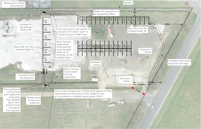
Figure 7: Site Layout Plan (Source: Greg Alderson & Associates) - This plan covers part of the site – refer to Figure 2 for the aerial photograph which shows the extent of the site
2.2 Description of the site
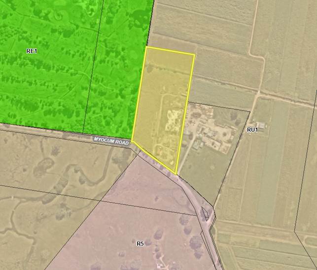
Figure 8: LEP 2014 zone map of the site
|
Land is legally described |
LOT: 342 DP: 755692 |
|
|
Property address |
1178 Myocum Road MYOCUM |
|
|
Land is zoned: |
RU1 Primary Production |
|
|
Land area is: |
4.047 ha |
|
|
Property is constrained by:
|
Flood Liable Land Acid Sulfate Soils Class 4 |
|
|
|
Is a BDAR required due to the location of the proposed development? |
☐ Yes ☒ No |
|
|
Are there any easements in favour of Council affecting the site? |
☐ Yes ☒ No |
|
|
Is there a Vegetation Management Plan which might affect the proposal? |
☐ Yes ☒ No |
|
|
Is there a Voluntary Planning Agreement which might affect the proposal? |
☐ Yes ☒ No |
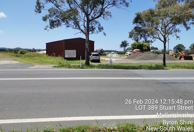
Figure 9: Existing shed and landscaping materials viewed from Myocum Road looking North
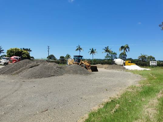
Figure 10: Existing landscaping materials and machinery looking East
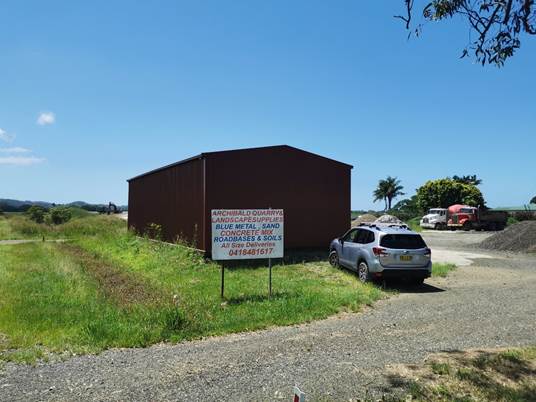
Figure 11: Existing shed and advertising signage looking Northeast
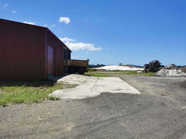
Figure 12: Existing shed (foreground) and existing sand stockpile and concrete batching plant (background) looking North
3 Division 8.2 Review of Determination
Division 8.2 of the Environmental Planning and Assessment Act 1979 allows an applicant to request a review of the determination of a consent authority. If the application was determined by the Council, the review of the decision is also to be conducted by the Council and not by a delegate of the Council.
A review application must be determined within 6-months of the date of the determination, which is the same timeframe within which an appeal can be made to the Court.
The application subject of this review was refused by the Council at the Planning Meeting of 1 August 2023. The review application must therefore be determined before 1 February 2025.
The section 8.2 review application did not submit additional contemporary reports or information, when compared to the original assessment that would address the reasons for refusal.
The original DA sought consent again for the use of an existing landscaping material supplies business operating from the site and sought consent for the construction of an amenities building and for the use of an existing shed as an ancillary component of the development.
The original report to Council indicated that the existing landscaping material supplies business and existing shed have been carried out without the necessary development consent. The DA had been submitted in response to compliance action taken by staff for unauthorised development. A previous deferred commencement consent was issued by Council under DA10.2020.568.1 – Use of Land and Existing Shed for Landscaping Material Supplies on 09 September 2022, however the applicant has not complied with any conditions of consent and the consent has now lapsed.
The proposal is permissible with consent, but a number of elements on the site were recommended to be finalised under deferred commencement consent conditions. This included removal of a concrete batching plant and equipment, unauthorised signs, illegal fill material on site (being a large sand mound), obtaining a building information certificate for the shed and carrying out the landscaping as per the submitted landscape plan.
The original report to Council raised development engineering issues with consideration for Councils assessment of flooding:
A flood report was submitted with the application which provided the following comments in conclusion:
The hydraulic model created as part of the NBFS has been updated to include the existing concrete blocks on the property (Wards Landscaping) to the east of the site. The 5-, 20- and 100-year ARI flood events have been simulated with the revised model.
The proposed development has been incorporated into the hydraulic model and has been assessed for the 5-, 20- and 100-year ARI flood events and maps representing flood impacts have been created. The flood impact assessment shows that there are some minor offsite changes to peak flood level in the range 10 to 20mm predicted on lot number DP 3/1067849. The extent of this impacts is largest in the 20-year ARI flood event and they extend approximately 40 metres onto this property.
Staff have noted that no assessment has been made of the site in the current condition as advised by the applicant:
It is important to note that no assessment of the site in the current (i.e. present day) condition has been prepared, as on advice from Michael Archibald (owner), the site will be modified to remove materials and equipment that exists outside of the proposed development extent.
It is likely that the flood extent and flood level will increase should an assessment be made to the current condition.
Therefore, the retention of the large areas of stockpiled fill are not supported as they are non-compliant with clause 5.21(2) of LEP 2014 and Chapter C2 of DCP 2014. However, compliance can be achieved by removal of fill material from the site which is [was] recommended as a deferred commencement condition.
In its consideration of the officer report, Council determined to refuse the application.
3.1 SECTION 4.14 – BUSH FIRE PRONE LAND
In accordance with Section 8.3 of ‘Planning for Bush Fire Protection 2019’ the following access requirements are relevant to the proposal:
To provide safe access to/from the public road system for firefighters providing property protection during a bush fire and for occupant egress for evacuation.
The existing driveway access would need to be upgraded. The proposed access is to be constructed to meet the requirements of AS2890.2 Figure 3.1, with a minimum width at the boundary line of 12.5m to cater for all vehicle sizes up to and including 19m Articulated Vehicles and 12.5m Heavy Rigid Vehicles.
The above requirements would ensure that access is in accordance with ‘Planning for Bush Fire Protection 2019’.
The proposed amenities building is a class 10a structure and, in accordance with Section 8.3.2 of ‘Planning for Bush Fire Protection 2019’, there are no bush fire protection requirements.
4 SECTION 4.15C – MATTERS FOR CONSIDERATION – DISCUSSION OF ISSUES
Having regard to the matters for consideration detailed in Section 4.15(1) of the Environmental Planning & Assessment Act 1979 (EP&A Act), the following is a summary of the evaluation of the issues.
State Environmental Planning Policies (SEPP)
|
Considerations |
Satisfactory |
Unsatisfactory |
|
Resilience and Hazards SEPP 2021 Consideration: Chapter 2 Coastal management - This chapter applies to land within the coastal zone. Coastal management areas comprise: · the coastal wetlands and littoral rainforests area – The subject land is not mapped as coastal wetlands or littoral rainforest. The land is not within a ‘proximity’ area to coastal wetlands or littoral rainforest. · the coastal vulnerability area – no areas mapped at this time · the coastal environment area – the subject site is within the coastal environment area · the coastal use area – the subject site is within the coastal use area. Part 2 Division 3 – Coastal Environment Area – Section 2.10 requires that: (1) Development consent must not be granted to development on land that is within the coastal environment area unless the consent authority has considered whether the proposed development is likely to cause an adverse impact on the following— (a) the integrity and resilience of the biophysical, hydrological (surface and groundwater) and ecological environment, (b) coastal environmental values and natural coastal processes, (c) the water quality of the marine estate (within the meaning of the Marine Estate Management Act 2014), in particular, the cumulative impacts of the proposed development on any of the sensitive coastal lakes identified in Schedule 1, (d) marine vegetation, native vegetation and fauna and their habitats, undeveloped headlands and rock platforms, (e) existing public open space and safe access to and along the foreshore, beach, headland or rock platform for members of the public, including persons with a disability, (f) Aboriginal cultural heritage, practices and places, (g) the use of the surf zone. (2) Development consent must not be granted to development on land to which this section applies unless the consent authority is satisfied that— (a) the development is designed, sited and will be managed to avoid an adverse impact referred to in subsection (1), or (b) if that impact cannot be reasonably avoided—the development is designed, sited and will be managed to minimise that impact, or (c) if that impact cannot be minimised—the development will be managed to mitigate that impact. The proposal is considered unsatisfactory satisfactory in relation to the relevant considerations as: · the management of soil and water in accordance with relevant engineering standards is not demonstrated.
The following are noted: · No native vegetation will require removal. · The site is not adjacent to the foreshore and there is no public open space that the proposal will affect. · An Aboriginal Heritage Information Management System search indicates that there are no Aboriginal sites or places recorded or declared within 50m of the site. Part 2 Division 4 – Coastal use area – Section 2.11 requires that: (1) Development consent must not be granted to development on land that is within the coastal use area unless the consent authority— (a) has considered whether the proposed development is likely to cause an adverse impact on the following— (i) existing, safe access to and along the foreshore, beach, headland or rock platform for members of the public, including persons with a disability, (ii) overshadowing, wind funnelling and the loss of views from public places to foreshores, (iii) the visual amenity and scenic qualities of the coast, including coastal headlands, (iv) Aboriginal cultural heritage, practices and places, (v) cultural and built environment heritage, and (b) is satisfied that— (i) the development is designed, sited and will be managed to avoid an adverse impact referred to in paragraph (a), or (ii) if that impact cannot be reasonably avoided—the development is designed, sited and will be managed to minimise that impact, or (iii) if that impact cannot be minimised—the development will be managed to mitigate that impact, and (c) has taken into account the surrounding coastal and built environment, and the bulk, scale and size of the proposed development. The proposal is considered to be consistent with Section 2.11 provisions of the SEPP. Part 2.2 Division 5 relates to development in coastal zone generally and requires that the consent authority must be satisfied that development will not increase risk of coastal hazards and any certified coastal management programs that apply to the land. The location of the site is sufficiently distant from the active coastal zone and there are no coastal management programs applying to the land. Chapter 4 – Remediation of land The development will not result in an increased sensitivity of land use. Councils Environmental Health Officer has recommended that an Unexpected Findings Protocol (UFP) be prepared to ensure management of any unexpected findings are managed appropriately. Conditions requiring the importation of landscape materials into the site to be certified clean and free of contamination could be recommended. |
☐ |
☒ |
4.2 Byron Local Environmental Plan 2014 (LEP 2014)
In accordance with LEP 2014 clauses 1.4 and 2.1 – 2.3:
(a) The proposed development is defined in the LEP 2014 Dictionary as landscaping material supplies which is: landscaping material supplies means a building or place used for the storage and sale of landscaping supplies such as soil, gravel, potting mix, mulch, sand, railway sleepers, screenings, rock and the like;
(b) The land is within the RU1 Primary Production according to the Land Zoning Map;
(c) Landscaping material supplies are permitted with consent; and
(d) Regard is had for the Zone Objectives as follows:
|
Zone Objective |
Consideration |
|
To encourage sustainable primary industry production by maintaining and enhancing the natural resource base |
The proposal includes landscape bays which could be removed in the future if the land was to revert to agricultural uses. The business occupies part of the site with the remainder being available for agricultural uses. The proposal will not have any significant impact on the agricultural viability of the site. The proposal will not result in the fragmentation or alienation of resource lands. The proposal in its current form has potential to create land use conflicts with adjoining land. The shed is rural in character, similar to what would be found in other rural locations in the shire. Presently, the shed is highly visible when driving along Myocum Road. Landscaping along the site frontage and adjacent to the shed could mitigate these impacts. |
|
To encourage diversity in primary industry enterprises and systems appropriate for the area |
|
|
To minimise the fragmentation and alienation of resource lands. |
|
|
To minimise conflict between land uses within this zone and land uses within adjoining zones |
|
|
To encourage consolidation of lots for the purposes of primary industry production |
|
|
To enable the provision of tourist accommodation, facilities and other small-scale rural tourism uses associated with primary production and environmental conservation consistent with the rural character of the locality |
|
|
To protect significant scenic landscapes and to minimise impacts on the scenic quality of the locality |
Clause 4.3 Height of buildings
The height limit for the site is 9 metres. The existing shed and proposed amenities building comply with this requirement.
Clause 5.21 Flood planning
A flood report was submitted with the application which provided the following comments in conclusion:
The hydraulic model created as part of the NBFS has been updated to include the existing concrete blocks on the property (Wards Landscaping) to the east of the site. The 5-, 20- and 100-year ARI flood events have been simulated with the revised model.
The proposed development has been incorporated into the hydraulic model and has been assessed for the 5-, 20- and 100-year ARI flood events and maps representing flood impacts have been created. The flood impact assessment shows that there are some minor offsite changes to peak flood level in the range 10 to 20mm predicted on lot number DP 3/1067849. The extent of this impacts is largest in the 20-year ARI flood event and they extend approximately 40 metres onto this property.
Staff have noted that no assessment has been made of the site in the current condition as advised by the applicant:
It is important to note that no assessment of the site in the current (i.e. present day) condition has been prepared, as on advice from Michael Archibald (owner), the site will be modified to remove materials and equipment that exists outside of the proposed development extent.
It is likely that the flood extent and flood level will increase should an assessment be made to the current condition.
Therefore, the proposal has not demonstrated compliance with clause 5.21(2) of LEP 2014. and Chapter C2 of DCP 2014.
Clause 6.1 Acid Sulfate Soils
The site is mapped as Class 4 Acid Sulfate Soil land. Works more than 2 metres below the natural ground surface or where the water table is likely to be lowered more than 2 metres below the natural ground surface require acid sulfate soil investigation and where required, the preparation of an acid sulfate soil management plan. The proposal does not include any work below 2m below the natural ground level. No further investigation or actions are required in this regard.
Clause 6.2 - Earthworks
Minor earthworks are required to install the proposed landscape bays and implement the proposed stormwater management system.
Clause 6.4 Floodplain risk management
The objectives of this clause are as follows—
(a) in relation to development with particular evacuation or emergency response issues, to enable evacuation of land subject to flooding above the flood planning level,
(b) to protect the operational capacity of emergency response facilities and critical infrastructure during extreme flood events.
Subclause 3 nominates a variety of land uses for which development consent must not be granted unless the consent authority is satisfied that the development will not, in flood events exceeding the flood planning level, affect the safe occupation of, and evacuation from the land.
A landscape material supplies business is not a nominated land use.
Flooding considerations are discussed below in relation to Byron DCP 2014 Chapter C2 – Areas Affected by Flood.
Clause 6.6 Essential services
This clause requires that:
Development consent must not be granted to development unless the consent authority is satisfied that any of the following services that are essential for the development are available or that adequate arrangements have been made to make them available when required—
(a) the supply of water,
(b) the supply of electricity,
(c) the disposal and management of sewage,
(d) stormwater drainage or on-site conservation,
(e) suitable vehicular access.
In relation to these matters it is commented that:
· The application states that: The subject property has access to a reticulated water supply. Water tanks are to be installed within the site to capture rainwater. A spring supply within the site can also be activated if required by the landowner.
· Overhead electricity is available to the site.
· The proposal contains a new amenities building containing a composting toilet for staff. The proposed on-site sewage management system has been assessed as being satisfactory subject to conditions being imposed. An application under Section 68 of the Local Government Act would be required for its installation.
· The development plans include storage basins to accommodate runoff from the development site before it is released into the local drainage system. Surface water disperses to existing drainage lines within the site.
· Access – Access has been assessed as being satisfactory subject to conditions being imposed.
4.3 Any proposed Instrument that has been the subject of public consultation and has been notified to the consent authority
No such instrument applicable.
4.4 Byron Shire Development Control Plan 2014 (DCP 2014)
B6 - Buffers and Minimising Land Use Conflict
The proposed facility seeks approval for a similar operation as the adjoining Wards landscaping. The adjoining property also contains a dwelling.
A Land Use Conflict Risk Assessment (LUCRA) was lodged with the application which concluded that there was LOW likelihood of land use conflicts. This was assessed by Councils Environmental Health Officer. Conditions could be recommended with respect to noise control.
C2 – Areas Affected by Flood
A flood report was submitted with the application which provided the following comments in conclusion:
The hydraulic model created as part of the NBFS has been updated to include the existing concrete blocks on the property (Wards Landscaping) to the east of the site. The 5-, 20- and 100-year ARI flood events have been simulated with the revised model.
The proposed development has been incorporated into the hydraulic model and has been assessed for the 5-, 20- and 100-year ARI flood events and maps representing flood impacts have been created. The flood impact assessment shows that there are some minor offsite changes to peak flood level in the range 10 to 20mm predicted on lot number DP 3/1067849. The extent of this impacts is largest in the 20 year ARI flood event and they extend approximately 40 metres onto this property.
Staff noted that no assessment has been made of the site in the current condition as advised by the applicant:
It is important to note that no assessment of the site in the current (i.e. present day) condition has been prepared, as on advice from Michael Archibald (owner), the site will be modified to remove materials and equipment that exists outside of the proposed development extent.
It is likely that the flood extent and flood level will increase should an assessment be made to the current condition.
Therefore, the proposal has not demonstrated compliance with Chapter C2 of DCP 2014.
C3 – Visually Prominent Sites, Visually Prominent Development and View Sharing
This Chapter applies to visually prominent development on a visually prominent site on land subject to Byron LEP 2014.
A ‘visually prominent site’ means land that is wholly or partly within the coastal zone; and land in Zone RU1 Primary Production, RU2 Rural Landscape with a height of 60m AHD or greater.
‘Visually prominent development’ means any development located on a visually prominent site or development in a location that has the potential to impact the visual or scenic character of a visually prominent site.
The land is at a level of less than 60m AHD (approximately 2.6 – 3.1m AHD). However, as the site is within the SEPP (Resilience and Hazards) 2021 mapped coastal management area it is defined as a visually prominent site.
The existing shed that has been located on the site is the most visually prominent aspect of the proposal (refer photos). It would have been more desirable to locate this shed with a greater setback to the road, the shed is characteristic of rural development and with the proposal to provide landscaping along the frontage of the site and along the side of the shed, it will be substantially screened. On this basis, visual impacts could be made be satisfactory with new landscaping.
There is unauthorised signage on the site which is not included in the development application and will need to be removed.
D2 – Residential Accommodation and Ancillary Development in Rural Zones
This Chapter does not apply to commercial development in the RU1 zone however it is useful to consider the provisions relating to setbacks of farm buildings and dwellings to determine the appropriateness of the setback of the shed to Myocum Road. Setback requirements may be flexible provided they are demonstrated to achieve the objectives and performance criteria of the chapter.
The prescriptive measures in the DCP identifies that dwellings and farm buildings are to have a minimum setback of 15 metres to the front property boundary. The existing shed has a setback of 11.91m. Given the proposed landscaping, the shed could be adequately screened.
D4 – Commercial and Retail Development
Design Detail and Appearance
As discussed, the shed is setback 11.91 metres from Myocum Road. The proposed landscape material containment bays will be setback 25m. The bays will have a maximum height of 1.3m with materials to be stored within the bays having a stockpile height of up to 3m. The existing unauthorised large stockpiles are required to be removed.
The shed style is typical of rural development and the containment bays are sufficiently setback from Myocum Road. Given the low-lying nature of the land, the low height of the structures (existing and proposed) on the site, the visual impact could be mitigated by landscaping.
4.5 Environmental Planning and Assessment Regulation 2021 considerations
|
Environmental Planning and Assessment Regulations 2021 |
Applicable to the proposal: |
Considered the control as it relates to the proposal: |
If this control is applicable, does the proposal comply? |
|
Section 61 - Additional matters that consent authority must consider |
☐ Yes ☒ No |
☐ Yes ☐ No ☒ NA |
☐ Yes ☐ No ☒ NA |
|
Section 62 - Consideration of fire safety |
☐ Yes ☒ No |
☐ Yes ☐ No ☒ NA |
☐ Yes ☐ No ☒ NA |
|
Section 64 - Consent authority may require upgrade of buildings |
☒ Yes ☐ No |
☒ Yes ☐ No ☐ NA |
☒ Yes ☐ No ☐ NA |
|
Section 63 - Considerations for erection of temporary structures |
☐ Yes ☒ No |
☐ Yes ☐ No ☒ NA |
☐ Yes ☐ No ☒ NA |
4.6 The likely impacts of that development, including environmental impacts on both the natural and built environments, and social and economic impacts in the locality
4.6.1
|
Impact on: |
Likely significant impact/s? |
|
Natural environment |
Yes. The proposal will likely have a significantly adverse impact on the natural environment of the locality without mitigation. |
|
Built environment |
Yes. The proposal will likely have an adverse impact on the built environment of the locality without mitigation measures being imposed. The primary issue of concern is the visual impact of the unauthorised shed. As discussed, this can be suitably screened by landscaping. |
|
Social Environment |
No. The proposal will not have a significant social impact on the locality. |
|
Economic impact |
No. The proposal will not have a significant economic impact on the locality. |
Are there any Council Policies that are applicable to the proposed development?
|
Council Policy |
Consideration |
|
Building Certificates Policy |
A Building Information Certificate is required to be obtained for unauthorised building works. |
|
The Compliance Services Team of Council have been involved in the history associated with the transportation of materials to the site without approval. The applicant/ land owner is at risk of further compliance action should this matter not be taken seriously, noting that this has been ongoing for some four years plus. |
4.7 The suitability of the site for the development
The site is a serviced property that subject to the implementation of suitable conditions of consent could be made suitable for the proposed development.
4.8 Submissions made in accordance with this Act or the regulations
The Section 8.2 Review application was publicly exhibited. There was one submissions of objection made on the development application, which raised concerns related to potential for flooding impacts on adjoining property and the visual impact of the development.
4.9 Public interest
The proposed development is likely to prejudice or compromise the public interest or create an undesirable precedent.
5 DEVELOPER CONTRIBUTIONS
The proposal provides no nexus to levy developer contributions or water and sewer headworks charges.
6 DISCLOSURE OF POLITICAL DONATIONS AND GIFTS
|
Disclosure details |
Response |
|
Has a Disclosure Statement been received in relation to this application? If Yes, Provide Disclosure Statement register reference: 91. |
Yes ☐ No ☒ |
|
Have staff received a ‘gift’ from anyone involved in this application that needs to be disclosed. |
Yes ☐ No ☒ |
7 CONCLUSION
A Section 8.2 review of Council’s determination of development application (DA) 10.2024.20.1 for use of land and existing shed for landscaping material supplies that was refused at the Council Planning Meeting of 1 August 2024 has been assessed.
The application did not contain any additional contemporary reports or information, when compared to the original assessment that would address the reasons for refusal. As such, there is no evidence that any of the issues raised in the reasons for refusal have been addressed.
It is therefore recommended that the Section 8.2 review upholds the refusal of DA 10.2024.20.1 for the same reasons resolved by Council on 1 August 2024 and further consideration be given under Section 8.2, to further matters related to the coastal environment, as detailed in the recommendation of this report.
Staff Reports - Sustainable Environment and Economy 13.10
Report No. 13.10 PLANNING - DA 10.2024.259.1 - Use of Secondary Dwelling - 80 Vallances Road Mullumbimby
Directorate: Sustainable Environment and Economy
Report Author: Alissa Magnifico, Senior Planner
File No: I2024/1545
Proposal:
|
DA No: |
10.2024.259.1 |
|
Planning Portal ref |
PAN-458117 |
|
Proposal description: |
Use of Secondary Dwelling |
|
Property description: |
LOT: 1 DP: 779821 |
|
80 Vallances Road MULLUMBIMBY |
|
|
Parcel No/s: |
96030 |
|
Applicant: |
Matt Walker Town Planning |
|
Owner: |
Midjimbil Creek Pastoral Co Pty Ltd |
|
Zoning: |
PART RU1 Primary Production / PART RU2 Rural Landscape Byron LEP 2014/ PART 7(b) Coastal Habitat Zone Byron LEP 1988. All works located within RU2 zone under Byron Local Environmental Plan 2014 (LEP 2014) |
|
Date received: |
14 August 2024 |
|
Integrated / Designated Development: |
Not Integrated or Designated Development |
|
Concurrence required |
No |
|
Public notification or exhibition: |
- Level 2 advertising under Council’s Community Participation Plan. - Exhibition period: 26 August 2024 to 8 September 2024 - Submissions received: Nil - Submissions acknowledged: ☐ Yes ☐ No ☒ N/A |
|
Planning Review Committee |
Planning Review Committee did not call up the application. |
|
Variation request to Development Standards under an EPI (e.g. clause 4.6) |
Clause 5.5– Controls relating to secondary dwellings on land in a rural zone. Distance between the secondary dwelling and the principal dwelling must not exceed 100 metres. Percentage value of variation sought and recommended for approval– 50% |
|
Estimated cost |
$172,590.00 |
|
Delegation to determine |
Council Reason: Variation to a development standard over 10% |
|
Issues |
Clause 4.6 variation - Clause 5.5 - Secondary Dwelling is more than 100 metres distance from the principal dwelling |
Summary:
The Development Application (DA) proposes Use of a Secondary Dwelling. The application is referred to Council for determination as the proposal involves a variation to Clause 5.5 of LEP 2014 which specifies that the distance between the Secondary Dwellings and Principal Dwelling must not exceed 100m on land in a rural zone.
By definition a ‘secondary dwelling’ is:
secondary dwelling means a self-contained dwelling that—
(a) is established in conjunction with another dwelling (the principal dwelling), and
(b) is on the same lot of land as the principal dwelling, and
(c) is located within, or is attached to, or is separate from, the principal dwelling.
The secondary dwelling was constructed without development approval and is the subject of a Demolition Works Order. It is located 150m from the existing Principal Dwelling. A written justification for the proposed variation to the development standard was submitted with the DA in accordance with clause 4.6 of LEP 2014. The reasons contained in the clause 4.6 request are acceptable and the variation is supported.
The application was advertised and notified between 26 August 2024 to 8 September 2024. No submissions were received.
The application appropriately addresses the relevant constraints applying to the site and is recommended for approval subject to the conditions listed in the Conditions in Attachment 1.
NOTE TO COUNCILLORS:
In accordance with the provisions of S375A of the Local Government Act 1993, a Division is to be called whenever a motion for a planning decision is put to the meeting, for the purpose of recording voting on planning matters. Pursuant to clause 2(a) under the heading Matters to be Included in Minutes of Council Meetings of Council's adopted Code of Meeting Practice (as amended) a Division will be deemed to have been called by the mover and seconder of all motions relating to this report.
RECOMMENDATION:
1. That Pursuant to Section 4.16 of the Environmental Planning & Assessment Act 1979, Development Application No. 10.2024.259.1 for use of secondary welling, be granted deferred commencement consent subject to the conditions in Attachment 1 (E2024/134530); and
2. That Council’s Compliance Services Team is notified of the determination in relation to the outstanding demolition works order.
1 10.2024.259.1
Conditions of Consent, E2024/134529
![]()
2 10.2024.259.1
Architectural Plans, E2024/134530
![]()
3 10.2024.259.1
Bushfire Assessment Report, E2024/89225
![]()
4 10.2024.259.1
Basix Certificate, E2024/134544 ![]()
Report:
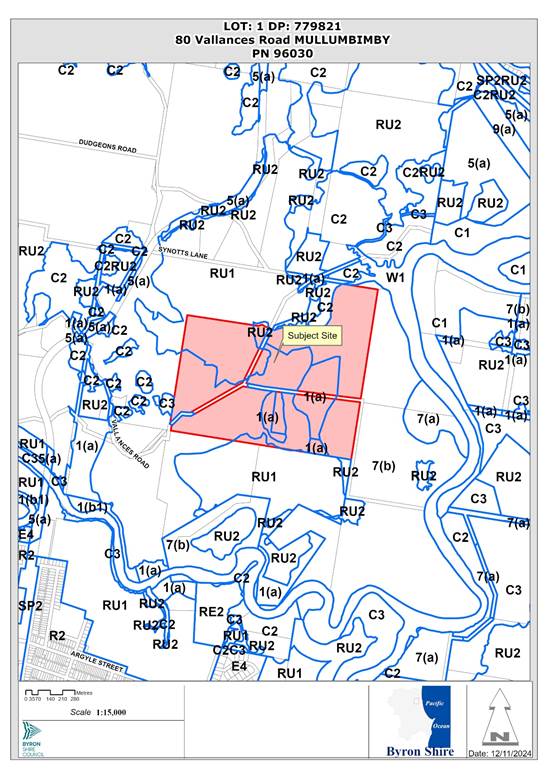
Figure 1: Locality Map
Assessment:
1.1 History/Background
![]()
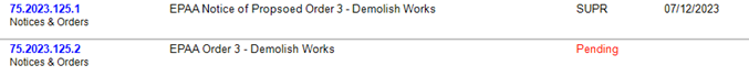
1.2 Description of the proposed development
The application seeks approval for use of the secondary dwelling (detached) which was constructed without approval and is currently the subject of a Demolition Works Order.
The secondary dwelling is a studio style structure with 1-bedroom, open plan living and kitchen all opening onto a deck to the north. The dwelling has a bathroom in the southeast corner and an attached, covered carport to the west.
The secondary dwelling is approximately 59.9m² in floor area and is constructed of timber frame on hardwood posts with concrete footings. The carport floor is of slab on ground construction. The dwelling is clad in fibre cement sheet with colorbond cladding and a colorbond gable roof sloping at 6 degrees from the ridge. The building is a maximum height of 5.1 m above natural ground on the eastern elevation on the sloping site. There is a small subfloor under-croft area that contains a hot water system.
The secondary dwelling is located 150 m from the existing principal dwelling on the property and a Clause 4.6 variation to development standards has been submitted to address a variation to clause 5.5 LEP 2014.
By definition a ‘secondary dwelling’ is:
secondary dwelling means a self-contained dwelling that—
(a) is established in conjunction with another dwelling (the principal dwelling), and
(b) is on the same lot of land as the principal dwelling, and
(c) is located within, or is attached to, or is separate from, the principal dwelling.
Plans of the development are enclosed at Attachment 2 in this report.
1.3 Description of the site
The site contains an approved single storey 3-bedroom dwelling (principal dwelling) that is locate in the southwest, most elevated part of the site. It is of wooden frame construction on a raised timber floor with concrete piles. An existing shed with 3 large water tanks is located near the southern boundary.
To the east of the shed is a Secondary Dwelling that has been built without approval, 24.7 metres from the southern boundary and contains 1 bedroom. The rest of the site is a mix of cleared and heavily wooded flat rural land. The vegetation along the eastern boundary is uninterrupted until it reaches the Brunswick River which winds just to the east of the site.
The site is intersected by a Crown Road which runs through the property.
A site inspection was carried out on 1 November 2024.
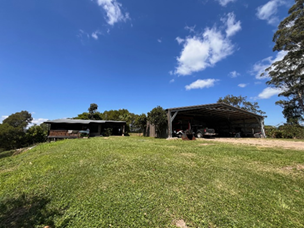
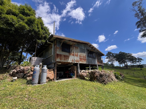
Figure 2 and 3: Secondary Dwelling
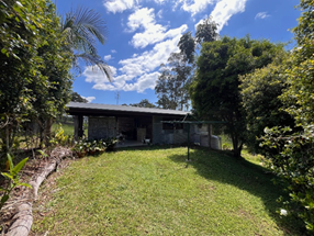
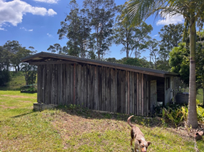
Figure 4 and 5: Secondary Dwelling
|
Land is legally described |
LOT: 1 DP: 779821 |
|
|
Property address |
80 Vallances Road MULLUMBIMBY |
|
|
Land is zoned: |
All works located within RU2 zone under Byron LEP 2014. The overall site contains PART RU1 Primary Production / PART RU2 Rural Landscape Byron LEP 2014/ PART 7(b) Coastal Habitat Zone Byron LEP 1988. |
|
|
Land area is: |
76.77ha |
|
|
Constraints and Attributes:
|
Flood Liable Land (part) Bushfire prone land Acid Sulfate Soils Class 1 High Conservation Value High Environmental Value |
|
|
|
Is a BDAR required due to the location of the proposed development? |
☐ Yes ☒ No |
|
|
Are there any easements in favour of Council affecting the site? |
☐ Yes ☒ No |
|
|
Is there a Vegetation Management Plan which might affect the proposal? |
☐ Yes ☒ No |
|
|
Is there a Voluntary Planning Agreement which might affect the proposal? |
☐ Yes ☒ No |
2.1 SUMMARY OF REFERRALS
|
Referral |
Issue |
|
Environmental Health Officer |
No objections subject to conditions. |
|
Development Engineer |
No objections subject to conditions. |
|
Building Surveyor |
No objections subject to conditions. |
|
S7.11 / Contributions Planner |
No objections subject to conditions. |
Issues:
Building Information Certificate
As work has already been undertaken to create a secondary dwelling, a Building Information Certificate will be required as a condition of consent. No construction certificate is required.
3.1 SECTION 4.14 – BUSH FIRE PRONE LAND
Under section 4.14 of the Act, Council must be satisfied prior to making a determination for development on bush fire prone land, that the development complies with the document ‘Planning for Bush Fire Protection 2019’. The site is bush fire prone land. The development application is accompanied by a Report by Firetech Bushfire Consulting dated 27/02/2024 which provides conditions. Condition recommended requiring that the development must comply at all times with the requirements of this Report.
Effect of 10/50 rule on significant vegetation: as at 11/11/24:
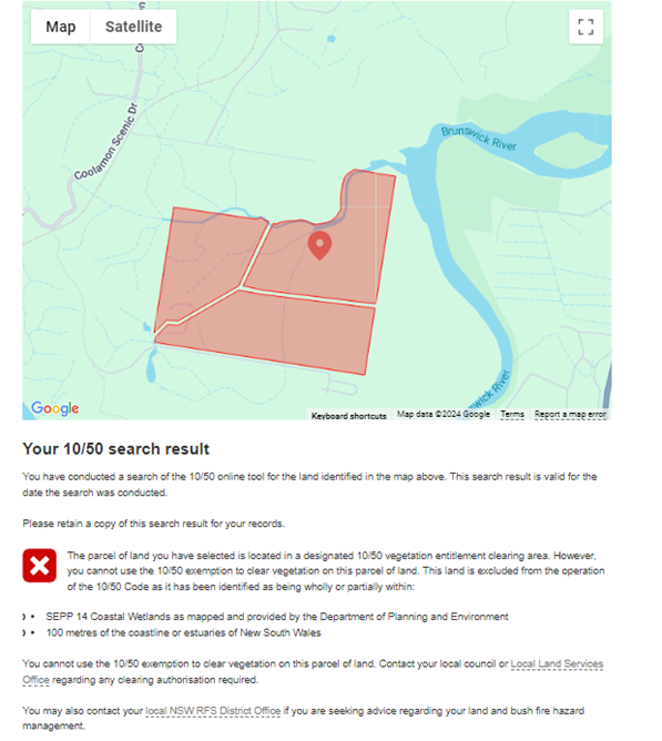
Accordingly, the 10/50 exemption cannot be used.
4. SECTION 4.15C – MATTERS FOR CONSIDERATION – DISCUSSION OF ISSUES
Having regard to the matters for consideration detailed in Section 4.15(1) of the Environmental Planning & Assessment Act 1979 (EP&A Act), the following is a summary of the evaluation of the issues.
4.1 State Environmental Planning Policies (SEPP)
|
Considerations |
Satisfactory |
Unsatisfactory |
|
Biodiversity and Conservation SEPP 2021 Consideration: No vegetation removal is proposed. The proposal is satisfactory in regards to this SEPP. |
☒ |
☐ |
|
Resilience and Hazards SEPP 2021 Consideration: Chapter 4 Remediation of Land Comment: The land is not on Council’s register of potentially contaminated sites and is not located within a cattle dip buffer. In support of the application, the applicant submitted a statutory declaration confirming that there have been no contaminating activities carried out within the immediate vicinity of the dwelling. Council’s Environmental Health Officer considers that the land is not contaminated. |
☒ |
☐ |
|
Sustainable Buildings SEPP 2022 Consideration: A valid BASIX Certificate has been provided. |
☒ |
☐ |
4.2A Byron Local Environmental Plan 2014 (LEP 2014)
LEP 2014 is an applicable matter for consideration in the assessment of the subject development application in accordance with subsection 4.15(1) of the EP&A Act because it applies to the subject land and the proposed development. The LEP 2014 clauses that are checked below are of relevance to the proposed development:
|
Part 1 |
☒1.1 | ☒1.1AA | ☒1.2 | ☒1.3 | ☒1.4 | ☒Dictionary | ☒1.5 | ☒1.6 | ☒1.7 | ☒1.8 | ☒1.9 |
|
Part 2 |
☒2.1 | ☒2.2 | ☒2.3 | ☒Land Use Table |
|
Part 4 |
☒4.2D | ☒4.3 | ☒4.4 | ☒4.5 | ☒4.6 |
|
Part 5 |
☒5.5 |
|
Part 6 |
☒6.2 |☒6.6 |
In accordance with LEP 2014 clauses 1.4 and 2.1 – 2.3:
(a) The proposed development is defined in the LEP 2014 Dictionary as Secondary Dwelling;
(b) The land is within the RU2 Rural Landscape according to the Land Zoning Map;
(c) The proposed development is permitted with consent; and
(d) Regard is had for the Zone Objectives as follows:
|
Zone Objective |
Consideration |
|
To encourage sustainable primary industry production by maintaining and enhancing the natural resource base. • To maintain the rural landscape character of the land. • To provide for a range of compatible land uses, including extensive agriculture. • To enable the provision of tourist accommodation, facilities and other small-scale rural tourism uses associated with primary production and environmental conservation consistent with the rural character of the locality. • To protect significant scenic landscapes and to minimise impacts on the scenic quality of the locality. |
The proposal addresses and satisfies the objectives. |
The remaining checked clauses have been taken into consideration in the assessment of the subject development application in accordance with Section 4.15 of the EP&A Act. The proposed development complies with all clauses of LEP 2014 (in some cases subject to conditions and/or to the satisfaction of other assessing officers).
Clause 4.2D Erection of dual occupancies (detached) and secondary dwellings in Zones RU1 and RU2
Development consent must not be granted to development for the purpose of a dual occupancy (detached) or secondary dwelling on land in Zone RU1 Primary Production or Zone RU2 Rural Landscape unless the consent authority is satisfied that—
(a) the development will not impair the use of the land, or neighbouring land, for agriculture or rural industries, and
(b) each dwelling will use the same vehicular access to and from a public road, and
(d) the land is physically suitable for the development, and
(e) the land is capable of accommodating the on-site disposal and management of sewage for the development, and
(f) the development will not have an adverse impact on the scenic amenity or character of the rural environment.
Complies.
Clause 4.6 Exceptions to Development Standards
A variation to the 100m separation distance under Clause 5.5 is sought for the secondary dwelling from the Principal Dwelling. The variation of 50m is a 50% variation to the development standard, and concurrence therefore may not be assumed for Council delegates and the application is to be determined by Councillors.
The applicant has submitted a written request that strict compliance with the development standard is unreasonable or unnecessary and that there are sufficient environmental grounds to vary the controls as follows:
• “The Secondary dwelling has been established within an existing structure, with modifications to ensure habitability. It is assessed that continued utilisation of this building as a dwelling will not negatively affect neighbouring residents or the streetscape of the locality.
• Council recently eliminated the 100m metre requirement for Dual Occupancy Dwellings within the Rural Zones, a decision that essentially places Secondary dwellings on equal footing for assessment purposes. Consequently, it is deemed impractical and unnecessary to enforce compliance of 100m maximum distance between both dwellings in this particular circumstance.
• Continuing to utilise the existing dwelling eliminates the necessity for additional excavation, demolition, and construction costs associated with relocating the building, thus providing an environmental benefit.
• The decision to maintain the current dwelling incurs minimal impact on the environment compared to shifting it 50 metres closer to the principal dwelling, which would entail extensive construction work, excavation, and the installation of a new septic system. Utilising the existing dwelling poses no detrimental effects on the environment”.
It is considered that strict compliance with the development standard is unreasonable and unnecessary in the circumstances of the case and that there are sufficient environmental grounds to vary the development standard for the following reasons:
• Despite a variation to the standard, the location of the secondary dwelling makes use of an existing structure and existing services, with minimal disturbance to natural ground levels, thus providing an environmental benefit.
• Utilising the existing secondary dwelling location is unlikely to pose detrimental effects on the environment or conflict with existing land uses. There are sufficient environmental grounds to vary the development standard.
• It is considered the proposal is in the public interest as the development provides alternative accommodation for rural families, is compatible with the primary production potential, rural character, and environmental capabilities of the land.
The concurrence of the Planning Secretary is not required.
It is recommended that the development standard can be varied in this instance.
a) The development is satisfactory having regard to the requirements outlined in clause 4.6;
b) The development is satisfactory having regard to applicable Department of Planning, Infrastructure and Environment Circulars;
c) The development is satisfactory having regard to relevant caselaw;
d) The DA demonstrates that compliance is with the development standard is unreasonable and unnecessary;
e) The DA demonstrates that there are sufficient environmental planning grounds to justify contravening the standard;
f) The DA demonstrates that that the development in the public interest;
g) The DA demonstrates that the development is consistent with the objectives of the standard and the zone;
h) The DA demonstrates how the development produces a better planning outcome than one that strictly complied with the development standard; and
i) The DA demonstrates what it is about the grounds of the request that are particular to the proposed development on this site, and that there has to be something particular to the development on this site to justify the variation.
4.3 Any proposed Instrument that has been the subject of public consultation and has been notified to the consent authority
There are no proposed Environmental Planning Instruments of relevance to the proposal.
4.4 Byron Shire Development Control Plan 2014 (DCP 2014)
DCP 2014 is an applicable matter for consideration in the assessment of the subject development application in accordance with subsection 4.15(1) of the EP& A Act because it applies to the land to which LEP 2014 applies. The DCP 2014 Parts/Chapters that are checked below are of relevance to the proposed development:
|
Part A |
☒ |
|
Part B Chapters: |
☒ B1 | ☒ B3 | ☒ B4 | ☐ B5 | ☒ B6 | ☒ B7 | ☒ B8 | ☒ B9 | ☒ B14 |
|
Part C Chapters: |
☒ C2 |
|
Part D Chapters |
☒ D2 |
These checked Parts/Chapters have been taken into consideration in the assessment of the subject development application in accordance with Section 4.15 of the EP&A Act. The proposed development is demonstrated to meet the relevant Objectives of all relevant Parts/Chapters (in some cases subject to conditions and/or to the satisfaction of other assessing officers).
4.5 Environmental Planning and Assessment Regulation 2021 considerations
|
Environmental Planning and Assessment Regulations 2021 |
Applicable to the proposal: |
Considered the control as it relates to the proposal: |
If this control is applicable, does the proposal comply? |
|
Section 61 - Additional matters that consent authority must consider |
☐ Yes ☒ No |
☐ Yes ☐ No ☒ NA |
☐ Yes ☐ No ☒ NA |
|
Section 62 - Consideration of fire safety |
☒ Yes ☐ No |
☒ Yes ☐ No ☐ NA |
☒ Yes ☐ No ☐ NA |
|
Section 64 - Consent authority may require upgrade of buildings Comments: Change of use from a shed to a secondary dwelling will require an upgrade to the current BCA. This will happen with the BIC where engineering certification and smoke alarm certification will be provided. |
☒ Yes ☐ No |
☒ Yes ☐ No ☐ NA |
☒ Yes ☐ No ☐ NA |
|
Section 63 - Considerations for erection of temporary structures |
☐ Yes ☒ No |
☐ Yes ☐ No ☒ NA |
☐ Yes ☐ No ☒ NA |
* Non-compliances and any other significant issues discussed below
4.6 The likely impacts of that development, including environmental impacts on both the natural and built environments, and social and economic impacts in the locality
4.6.1
|
Impact on: |
Likely significant impact/s? |
|
Natural environment |
No. The proposal will not have a significantly adverse impact on the natural environment of the locality. |
|
Built environment |
No. The proposal will not have a significantly adverse impact on the built environment of the locality. |
|
Social Environment |
No. The proposal will not have a significant social impact on the locality. |
|
Economic impact |
No. The proposal will not have a significant economic impact on the locality. |
|
Construction Impacts |
No. The development will generate minor impacts during its construction. Conditions of consent recommended to control hours of work, builders waste, construction noise, installation of sedimentation and erosion control measures and the like to ameliorate such impacts. |
4.6.2 Marine Estate Management Act 2014
The development is unlikely to have an effect on the plants or animals within the Cape Byron Marine Park or their habitat.
4.6.3 Council Policies applicable to the proposed development?
|
Council Policy |
Consideration |
|
Council’s Building Surveyor has reviewed the proposal and recommended conditions |
|
|
Council’s Environmental Health Officer has reviewed the proposal and raised no objections. |
4.7 The suitability of the site for the development
Issue |
Comment |
|
Services - Water/ Sewer/ Stormwater - Ph/ power - Access |
• The site has existing lawful access from Vallance Road • The lot is serviced by electricity and telecommunication infrastructure • The land is of suitable size to accommodate stormwater on the property • The Secondary Dwelling is to be serviced by a minimum 20,000L rainwater tanks for domestic water supply |
|
Onsite Effluent Disposal |
The secondary dwelling will be serviced by on site effluent system. In support of the application, the applicant has submitted an on site Waste Water management report prepared by Byron Waste Water Management dated 8 April 2024. The proposed system is deemed satisfactory by Council’s Environmental Health Officer |
|
Hazards - Flooding - Bushfire
|
Part of the land is mapped as bushfire prone however the secondary dwelling is not located in this area. The land is identified as bushfire prone. The land has been assessed and bushfire measures recommended in the conditions of consent. |
|
Land Use conflicts |
The proposal considers the residential use of the land which is consistent with the existing and surrounding land uses. The secondary dwelling is not anticipated to cause land use conflicts. |
4.8 Submissions made in accordance with this Act or the regulations
The development application was publicly exhibited. There were no submissions made on the development application.
4.9 Public interest
The proposed development is unlikely to prejudice or compromise the public interest or create an undesirable precedent.
5. DEVELOPER CONTRIBUTIONS
5.1 Water & Sewer Levies
No Section 64 levies will be required.
5.2 Developer Contributions
Section 7.11 Contributions will be payable.
6. DISCLOSURE OF POLITICAL DONATIONS AND GIFTS
|
Disclosure details |
Response |
|
Has a Disclosure Statement been received in relation to this application? If Yes, Provide Disclosure Statement register reference: 91. |
Yes ☐ No ☒ |
|
Have staff received a ‘gift’ from anyone involved in this application that needs to be disclosed. |
Yes ☐ No ☒ |
7. CONCLUSION
The DA proposes use of secondary dwelling. The proposed development is satisfactory having regard to the relevant environmental planning instruments and planning controls applicable to the site. The proposal raises no significant issues in terms of environmental impacts which cannot be managed. The site is a serviced, unconstrained property and is considered suitable for the proposed development.
The application appropriately addresses the relevant constraints applying to the site and is recommended for approval subject to the conditions listed in Attachment 1.
Staff Reports - Sustainable Environment and Economy 13.11
Report No. 13.11 Letter of Offer - Planning Agreement for Gulgan Village, The Saddle Road, Brunswick Heads
Directorate: Sustainable Environment and Economy
Report Author: Shannon Burt, Director Sustainable Environment and Economy
File No: I2024/1553
Summary:
A Letter of Offer to enter into a Planning Agreement (PA) has been submitted to Council for Gulgan Village, The Saddle Road, Brunswick Heads.
The Letter of Offer being part of the documents lodged in October 2024 for a Planning Proposal to amend Byron LEP 2014 to rezone land known as “Site B1” in the Northern Rivers Resilient Lands Strategy, and the northern part of Area 16 in Byron Shire Residential Strategy 2041 for residential development.
The proposed LEP amendment is identified as Department of Planning, Housing, and Infrastructure (DPHI) Planning Portal Reference number: PP-2024-2187 ‘Gulgan Village’ The Saddle Road, Brunswick Heads.
The Letter of Offer for a PA will be between Byron Shire Council and Gulgan Road Property Pty Ltd, to provide essential infrastructure and affordable housing associated with the proposed Gulgan Village development the subject of PP-2024-2187.
Council’s Infrastructure Contributions Plans, Development Service Plan, and Affordable Housing Contribution Policy and Procedure, and Affordable Housing Contributions Scheme No 2, are relevant considerations.
As such, it is appropriate for Council to consider and provide commentary on the terms of the Letter of Offer ahead of reporting the Planning Proposal with the drafted PA to Council in early 2025.
Reporting this now will enable:
(i) Council to consider the terms of the Letter of Offer and provide in-principle support and include any necessary recommended changes to inform the terms of a drafted PA; and
(ii) provide the developer time to consider any changes proposed and respond; and
(iii) ensure the DPHI Planning Proposal reporting time frames in the Guidelines can be met.
RECOMMENDATION:
That Council:
1. Agrees to provide in principle support to the terms in the Letter of Offer to enter into a Planning Agreement (PA) for Gulgan Village, The Saddle Road, Brunswick Heads Attachment 1 (#E2024/137961) subject to the amendments shown in Tables 1 and 2 of the report;
2. Requests the developer to prepare a draft Planning Agreement (PA) on the basis of the Council resolution and resubmit this to staff;
3. Receives a report on the Planning Proposal for Gulgan Village along with the draft Planning Agreement in February 2025 for gateway determination.
Attachments:
1 26.2024.3.1
VPA letter of offer 240925_PP-2024-2187, E2024/137961 ![]()
Report
What is a Planning Agreement?
Planning Agreements (PA) are voluntary and negotiated between planning authorities and developers in the context of applications for changes to environmental planning instruments (planning proposals) or for consent to carry out development (development applications).
PAs enable the provision of development contributions for a variety of public purposes, some of which extend beyond the scope of section 7.11 and 7.12 (local infrastructure contributions) of the EP&A Act.
PAs provide a flexible framework under which the planning authorities can share responsibility for the provision of infrastructure in new release areas or in major urban renewal projects. They permit tailored governance arrangements and the provision of infrastructure in an efficient, co-operative, and coordinated way.
Part 7 Division 7.1 Subdivision 2 of the Environmental Planning and Assessment Act 1979 (EP&A Act) provides the legislative framework for planning agreements.
Part 9 Division 1A of the Environmental Planning and Assessment Regulation 2021 (the EP&A Regulation) has further requirements relating to the form and subject matter of planning agreements, making, amending and revocation of planning agreements, giving public notice and other procedural arrangements relating to planning agreements.
Planning agreements – Practice note – February 2021
Planning Agreements Policy - Byron Shire Council
A Letter of Offer is the first stage of developing a PA.
Gulgan Village
This Planning Proposal (i.e. change to an environmental planning instrument) relates the Part of 66 and 132 The Saddle Road, Brunswick Heads being approximately 45.5 Ha in land area.
MAP 1 Subject Land - 132 The Saddle Rd & (Part) 66 The Saddle Rd
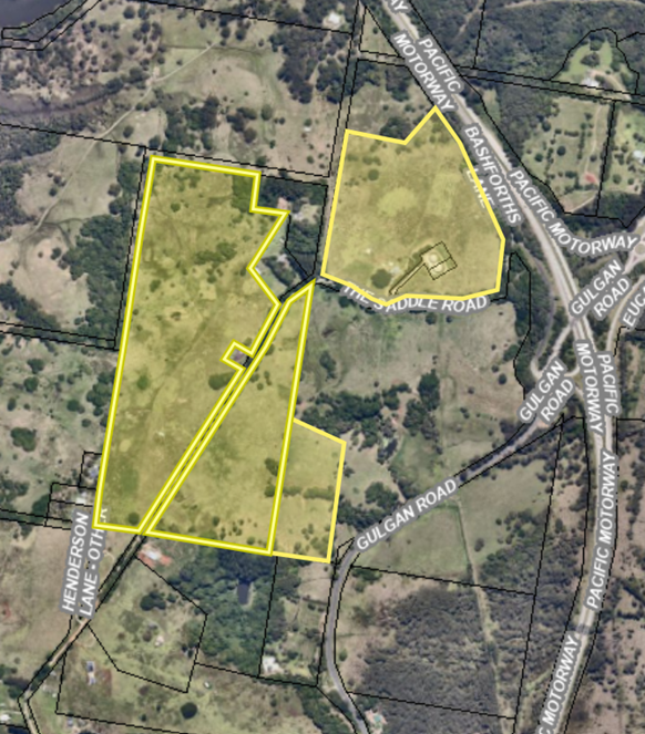
It is proposed to rezone parts of the land to R1 General Residential. The total R1 area proposed is approximately 37.9 ha. This area has the potential for generating housing for a population of 600 to 1000 persons, depending on the housing mix. The allotments are proposed to range in size from 120m2 to 1400m2 and the development will contain a diverse mixture of Torrens Title, Community Title, Strata Title, and land lease arrangements.
MAP 2 – Proposed Zoning (R1 Zone – Pink)
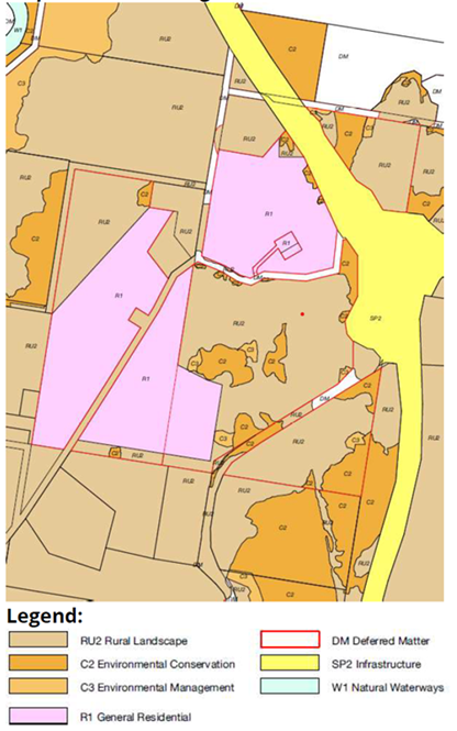
Letter of Offer from Gulgan Road Property Pty Ltd
A copy of the Letter of Offer is attached to the report (Attachment 1). Staff from various teams across the SEE and IS directorates have reviewed the Letter of Offer. Their comments on the Letter of Offer terms are provided in 2 parts.
· Essential Infrastructure
· Affordable Housing
Essential Infrastructure
Staff amendments to the Letter of Offer essential infrastructure terms are shown in blue bold in Table 1 below.
Table 1
|
Letter of Offer |
Staff Amendments |
|
The planning agreement will require the proponent to provide water, sewer and access infrastructure as generally described in the Civil engineering report by Ingen Consulting Pty Ltd dated 6/6/24 and involving: 1. Provision of boosted and gravity networks water supply to cater for the additional demand; 2. Provision of a sewer rising main to the Brunswick Heads SPS to cater to for the additional demand;
3. Provision of a collector road intersection with Gulgan Road as a single lane roundabout, with north-south bypass lane and left turn slip lane into the site off Gulgan Road; 4. Provision of an intersection for the northern entry road from Bashforths Lane; and 5. Upgrading of the Brunswick Head Interchange at some point in the future, as defined by TfNSW.
|
The planning agreement will require the proponent to provide water, sewer and access infrastructure as generally described in the Civil engineering report and Traffic Impact Study by Ingen Consulting Pty Ltd dated 6/6/24, subject to a detailed assessment by Council staff of the existing capacity of the relevant infrastructure, and involving: 1. Provision of boosted and gravity networks water supply to cater for the additional demand;
3. Provision of a collector road intersection with Gulgan Road as a dual lane roundabout, with north-south bypass lane off Gulgan Road;
4. Provision of an intersection for the northern entry road from Bashforths Lane; and 5. Transport for NSW has requested that point 5 be removed from the Letter of Offer terms. Instead, they require a separate planning agreement be made directly with the State for this proposed upgrading of the Brunswick Head interchange. A notation should be included in the PA to acknowledge this. |
The amendments in blue bold are considered necessary by staff to clarify Council’s need to meet existing development demands for the Brunswick Village and Northern Shire areas, as well as commit to the future delivery of essential infrastructure to support the orderly development of the Gulgan Village as described in the Planning Proposal and its documentation.
The costs and timing of essential infrastructure delivery to service Gulgan Village however are complicated. It is a greenfield site outside of the existing town and village areas. Further this Letter of Offer and Planning Proposal have been lodged ahead of the current Contribution Plans and Development Service Plan reviews which are needed to provide updated works plans and costs for developer contributions reflecting the endorsed Residential Strategy 2041. These reviews are progressing early 2025.
Of further note, is that the NSW Reconstruction Authority has not provided any commitment to date to forward fund any of the essential infrastructure for the Gulgan Village, notwithstanding earlier discussions about this with them. The site is identified in the Resilient Lands Strategy as a priority site for accelerated delivery with funding support available under the Resilient Lands Program.
As such, the wording in blue is recommended to be included in the final PA.
Affordable Housing
Council’s Affordable Housing Contributions Policy and Procedure were adopted on 13 August 2020.
The Policy provides an overarching framework to facilitate, provide and manage affordable housing contributions in our Shire.
Section 4.10 of the Policy supports engaging with developers on Planning Agreements for the provision of affordable housing, noting however that acceptance of an offer to enter into a Planning Agreement is at the absolute discretion of Council.
The supporting ‘Procedure’ is intended to assist with implementation of the Policy and details how Council intends to operate the contribution framework in Byron Shire.
The information contained in the Procedure is considered most relevant to Council’s assessment of the draft PA. This assessment is provided in Table 1 below.
Table 2 – Assessment of draft Letter of Offer against Council’s Affordable Housing Contribution Procedure 2020
|
Applicable Section in Procedure |
Draft Letter of Offer |
Staff comment and suggested updates (where applicable) |
|
Diagram 1: Contribution setting: provides a visual overview of the steps required to enable submission of a planning proposal for Gateway determination. · States that “even if the proponent
offers to enter into a VPA, Council will seek to apply an Affordable Housing
Contribution Scheme (AHCS) clause for the subject land in LEP 2014”
|
No specific comment made about this in the Letter of Offer. |
Council’s draft Affordable Housing Contribution Scheme No 2 (currently on exhibition) applies to the site. Have your say on the Affordable Housing Contribution Scheme - Byron Shire Council
Both the Scheme and agreed terms of a PA will be applied in parallel.
A notation should be included in the PA to acknowledge this. |
|
2. Affordable Housing Contribution Rates: The minimum contribution rate for this land is 10%. |
The Letter of Offer proposes to provide affordable housing at a maximum rate of 10%. The final rate to be determined via an expert report(s), prepared at the cost of the proponent, containing the independent viability testing undertaken generally in accordance with the Guidelines for Development Affordable Housing Contribution Schemes (NSW Govt. Feb 2019), taking into account the proponents actual land acquisition, development and borrowing costs. The Letter of Offer also states that any planning agreement will provide that the affordable housing contribution shall not be triggered until the development profitability (as specified in the independent report) has exceeded the cost for the installation of the essential infrastructure. So, for example, with a 6-stage development and assuming that the essential infrastructure costs are recouped at the completion of the 2nd stage, the remaining 4 stages would continue at a rate of 15% in order to satisfy Scheme 2 contribution requirements.
|
The Letter of Offer proposes a maximum 10% contribution rate. The Scheme sets a minimum 10% contribution rate based on a Viability Assessment Report. The basic test of viability examines the capacity of the development to pay a market-based land value for the land and the associated development costs, pay the affordable housing contributions and still make a profit large enough not to discourage land transactions. The timing of the contribution under the Scheme is ordinarily at the initial development application /subdivision stage.
The developer is suggesting a different approach. Under the Procedure an alternative contribution rate and delivery regime request can be made to Council before lodging a planning proposal application. The request inter alia must include a report, prepared at the cost of the proponent, containing the independent viability testing undertaken in line with the Guidelines for Development Affordable Housing Contribution Schemes (NSW Govt. Feb 2019) if being sought. The acceptance of a request for an alternative contribution rate is at the absolute discretion of Council. In determining whether to accept a request the Council is required to take into consideration a number of matters including the nature and value of the public benefit being offered and the matters as set out in the Guidelines for Development Affordable Housing Contribution Schemes (NSW Govt. Feb 2019) and terms for undertaking an independent viability testing set in the pre-lodgement meeting. The Letter of Offer includes references to an expert report being prepared and submitted using the guidelines to address the variation request. If agreed, a timeframe for the developer’s expert report needs to be included in the PA. |
|
4 4.2.1 The contribution rate may be fulfilled using: a) a percentage of dedicated floor space b) land (may be part of the said land, or other land of the applicant) c) monetary contribution or d) combination of the above. |
The Letter of Offer provides affordable housing as a land dedication, construction of residential buildings, cash contribution or combination of the above.
|
Acceptable under the Policy and Procedure. See comments below in 5.3. |
|
5.18.1: “… if the Planning Agreement relates to an application by a developer for an instrument change, the developer will pay the whole of Council’s costs.” |
The Letter of Offer states that the developer will pay Council’s legal costs (if any) relating to reviewing and executing the planning agreement up to a maximum amount of $1,500.00 (incl GST). |
Acceptable under the Policy and Procedure. |
|
5.1.5: “Any letter of offer for a Planning Agreement with Council is to be made by the proponent before lodging a planning proposal application. |
No specific comment made about this in the draft PA. |
The terms of the letter of offer have been the subject of various discussions with the proponent prior to lodgement of the Planning Proposal. Acceptable under the Policy and Procedure. |
|
5.1.7 Council will endeavour to consider the offer within 40 days of receipt and advise of the proponent of the in-principle determination to enable the proponent to progress with the lodgement of the planning proposal. This in principle determination will provide the basis for the agreement negotiation. Council may decide to delegate this advisory determination process in the interest of efficiency. |
No specific comment made about this in the draft PA. |
The letter of offer is being presented to Council ahead of the Planning Proposal to provide an in-principle determination of it to inform the terms of the final agreement. Acceptable under the Policy and Procedure. |
|
5.3 Form of Contribution · “A contribution for affordable housing will only be accepted in the form of a land dedication free of cost. The dedicated land has to be part of the development application land. A land contribution to Council for the purpose of affordable housing requires the land is fit for purpose.” · “ .. Planning Agreements must be in addition to s7.11 or s7.12 of the Act contributions. |
The Letter of Offer states that “Affordable housing can be provided as a land dedication, construction of residential buildings, cash contribution or combination of the above”;
The Letter of Offer states that developer contributions under the provisions of section 7.11 of the Environmental Planning and Assessment Act will still apply. |
Acceptable under 4.4.2.1 of the Procedure (note: any conflict between sections 5.3 and 4.4.2.1 of the Procedure will be addressed as part of a review currently underway). Acceptable under the Policy and Procedure. |
|
5.4 Acceptability test to be applied to Planning Agreements (pp 9-10 list 12 questions to be considered for a Letter of Offer and negotiated planning agreement) |
No specific comment made about this in the draft PA. |
Meets all relevant acceptability questions.
Acceptable under the Policy and Procedure. |
|
5.5 When will Council not consider entering a Planning Agreement (pp 10-11 identify the specific circumstances where Council will not consider entering a Planning Agreement) |
No specific comment made about this in the draft PA.
|
None of the 11 circumstances identified in 5.5 apply to the draft PA. |
Next steps
The applicant will be requested to prepare a draft Planning Agreement (PA) on the basis of the Council resolution, and with the Planning Proposal for Gulgan Village will be reported to Council early 2025 for gateway determination.
Strategic Considerations
Community Strategic Plan and Operational Plan
|
CSP Objective |
CSP Strategy |
DP Action |
Code |
OP Activity |
|
4: Ethical Growth |
4.2: Enable housing diversity and support people experiencing housing insecurity |
4.2.1: People experiencing housing insecurity - Seek opportunities that provide fair, appropriate, and affordable housing for people experiencing housing insecurity |
4.2.1.1 |
Expand or apply new affordable housing contribution mechanisms over all new residential rezonings |
|
4: Ethical Growth |
4.2: Enable housing diversity and support people experiencing housing insecurity |
4.2.2: Partnerships and pilots to address housing needs - Investigate partnerships and pilots that deliver an innovative and affordable housing model for the Shire |
4.2.2.1 |
Consider residential rezoning proposals, as identified within existing North Coast Regional Plan growth boundary and the Affordable Housing Contribution Scheme |
Legal/Statutory/Policy Considerations
Part 7 Division 7.1 Subdivision 2 of the Environmental Planning and Assessment Act 1979 (EP&A Act) provides the legislative framework for planning agreements.
Part 9 Division 1A of the Environmental Planning and Assessment Regulation 2021 (the EP&A Regulation) has further requirements relating to the form and subject matter of planning agreements, making, amending and revocation of planning agreements, giving public notice and other procedural arrangements relating to planning agreements.
Planning agreements – Practice note – February 2021
Planning Agreements Policy - Byron Shire Council
Council’s Infrastructure Contributions Plans, Development Service Plan, and Affordable Housing Contribution Policy and Procedure, and Affordable Housing Contributions Scheme No 2, are also relevant considerations.
Financial Considerations
If Council chooses to accept the Letter of Offer, a draft Planning Agreement will be drafted as agreed to by the parties and presented formally as part of a landowner-initiated Planning Proposal.
Consultation and Engagement
Any future consultation and engagement will take place in accordance with a Gateway determination for the Planning Proposal and in accordance with any other relevant Council Policy requirements.
Staff Reports - Sustainable Environment and Economy 13.12
Report No. 13.12 PLANNING - DA 10.2024.230.1 - Staged DA, Consolidation of two allotments into one; dual occupancy (detached) with swimming pools; and strata subdivision. – 2 Brownell Drive, Byron Bay 2481
Directorate: Sustainable Environment and Economy
Report Author: Nick Horan, Planner
Chris Larkin, Manager Sustainable Development
File No: I2024/1579
Proposal:
|
Proposal description: |
Staged Development Application including Consolidation of two allotments into one; dual occupancy (detached) with swimming pools; and strata subdivision |
|
|
Property description: |
LOT: 2 DP: 1208728, LOT: 13 DP: 112794 |
|
|
2 Brownell Drive BYRON BAY |
||
|
Parcel No/s: |
267759, 182950 |
|
|
Applicant: |
KENNON GROUP PTY LTD |
|
|
Owner: |
Raes Residences Pty Ltd |
|
|
Zoning: |
R2 Low Density Residential |
|
|
Date received: |
27 July 2024 |
|
|
Designated Development: |
☒ Yes |
|
|
Public notification or exhibition: |
- Level 3 advertising under Council’s Community Participation Plan. - Exhibition period: 06/08/2024 TO 11/09/2024 - Submissions received: 251 Support:47 Oppose: 204 |
|
|
Variation request to Development Standards under an EPI (e.g. clause 4.6) |
Clause 4.6 - Variation to Maximum Building Height Limit |
|
|
Estimated cost |
$28,784,913.00 |
|
|
Delegation to determine |
Council: Reason: Estimated cost of works. |
|
|
Issues |
· Impacts on littoral Rainforest; · Extent of earthworks; · Bulk and Scale of development; · Height of development; · Access and stormwater Management; and · Non Compliant with Various LEP and DCP provisions. · Site Suitability |
|
Summary:
This application seeks approval for Staged DA, Consolidation of two allotments into one; dual occupancy (detached) with swimming pools; and strata subdivision.
The consolidation of Lot 2 DP1208728 and Lot 13 DP112794, would result in a parcel with a combined area of 4,223.52 square metres.
The development plans include the construction of two detached dwellings to form a dual occupancy. The first dwelling will be a six-bedroom, multi-level house with swimming pools, accessible via Julian Place. The second dwelling will be a four-bedroom, multi-level house with a swimming pool, accessible via Brownell Drive.
The land features a small, northeast-facing drainage basin with very steep upper slopes. It is extensively covered in littoral rainforest. The site holds significant importance due to its location on the mainland’s most easterly point, with the Cape Byron State Conservation Area and the Lighthouse providing a notable backdrop.
The proposed development site is situated within a Littoral Rainforest, which is classified as an Endangered Ecological Community and falls under the Coastal Environment Area mapping overlays for Littoral Rainforest under State Environmental Planning Policy (SEPP) Resilience and Hazards 2021. This development is designated under the State Environmental Planning Policy (Resilience and Hazards) 2021 due to the proposed tree clearing, of the native vegetation within the mapped littoral rainforest area. The impact of this development will extend over a total area of 0.34 hectares of the mapped Littoral Rainforest. The removal of these trees, which are part of a threatened ecological community, underscores the significant environmental considerations associated with this project.
The proposed development involves significant earthworks, including excavation up to 8 metres deep for the central staircase and lift of the main dwelling. This extensive excavation is not confined to a small area, as much of the lower ground floor level requires excavation between 4 to 6 metres. The architectural plans include a 3D cut and fill plan to illustrate these earthworks.
To achieve the proposed earthworks pad level, approximately 279 cubic metres of cut material will be sourced on-site. However, a substantial volume of spoil material, approximately 4,078 cubic metres, will need to be exported off-site. This process is expected to take around four weeks at a minimum, with 30 trucks per day, each carrying 8 cubic metres, operating five days a week, assuming such works can be carried out as planned.
On September 26, 2024, a meeting was held with the applicant at the Council Offices. During this meeting, they were informed that the proposal could not be supported due to significant ecological and planning concerns. The applicant was then given an opportunity to amend their proposed development.
On October 24, 2024, amended plans were uploaded to the NSW Planning Portal. While it was recognised that efforts had been made to reduce the clearing of mapped littoral rainforest, the proposal still cannot be supported due to ongoing significant ecological concerns.
On October 31, 2024, the applicant was informed that the amended plans had been rejected in accordance with Section 38 of the Environmental Planning and Assessment Refuilation 2021, and the proposed development application was not supported. The applicant was also given the opportunity to withdraw the application prior to it being reported to the Council with a recommendation for refusal.
At the time of writing this report, the applicant had not withdrawn the application, and as such the application in its current form is recommended for refusal.
One of the main reasons being the impacts on the mapped littoral rainforest whereby the controls under the SEPP require that devlopement consent must not be granted unless the consent authority is satisfied that sufficient measures have been, or will be, taken to protect, and where possible enhance, the biophysical, hydrological and ecological integrity of the coastal wetland or littoral rainforest. Having regards to the scale of the development proposed, these controls can not be satisfied.
Other reasons for refusal include non compliance with various Byron LEP 2014 and Byron DCP 2014 provisions.
It is considered the proposed development is not sympathetic to the environmental constraints of the land, does not comply with the relevant state and local planning controls, is unsuitable for this site in Byron Bay due to bulk scale and land changes required to accommodate it, and is not in the public interest.
The application is recommended for refusal.
NOTE TO COUNCILLORS:
In accordance with the provisions of S375A of the Local Government Act 1993, a Division is to be called whenever a motion for a planning decision is put to the meeting, for the purpose of recording voting on planning matters. Pursuant to clause 2(a) under the heading Matters to be Included in Minutes of Council Meetings of Council's adopted Code of Meeting Practice (as amended) a Division will be deemed to have been called by the mover and seconder of all motions relating to this report.
Pursuant to Section 4.16 of the Environmental Planning & Assessment Act 1979, Development Application No. 10.2024.230.1 for Staged DA, consolidation of two allotments into one; dual occupancy (detached) with swimming pools; and strata subdivision, be refused for the following reasons:
1. Pursuant
to Section 4.15(1)(a)(i) of the Environmental Planning and Assessment Act
1979, the proposed development is inconsistent with Section 2.1 of
State Environmental Planning Policy (Resilience and Hazards) 2021. The proposed
development fails to protect the environmental assets of the coastal zone.
2. Pursuant
to Section 4.15 (a)(i) of the Environmental Planning and Assessment Act 1979,
the application does not comply with Section 2.7(4) of State Environmental
Planning Policy (Resilience and Hazards) 2021. Sufficient measures have not
been taken to protect and enhance the ecological integrity of littoral
rainforest.
4. Pursuant
to Section 4.15(a)(i) of the Environmental Planning and Assessment Act 1979,
the application does not comply with Chapter 2 Coastal Management, Section
2.11(1)(c) of the State Environmental Planning Policy (Resilience and Hazards)
2021. The bulk, scale and size of the proposed development impacts negatively
on the surrounding coastal and built environment.
5. Pursuant
to Section 4.15 (1)(a)(i) of the Environmental Planning and Assessment Act
1979, the proposed development is inconsistent with Clause
1.2(2)(a)(iii) of Byron Local Environmental Plan 2014 as it is inconsistent
with the principle of conserving biological diversity and ecological integrity.
6. Pursuant
to Section 4.15(1)(a)(i) of the Environmental Planning and Assessment Act
1979, the proposed development is inconsistent with Clause 4.3 Height of
Buildings of Byron Local Environmental Plan 2014. The proposed development
breaches the maximum height of buildings development standard of 9m.
7. Pursuant
to Section 4.15(a)(i) of the Environmental Planning and Assessment
Act 1979, the application does not comply with Clause 6.2(1) Earthworks of
Byron Local Environmental Plan 2014. The proposed earthworks are likely to have
a detrimental impact on environmental functions and processes on the
surrounding land.
8. Pursuant to Section 4.15(1)(a)(i) of the Environmental Planning
and Assessment Act 1979, the proposed development is inconsistent with
Byron Local Environmental Plan 2014 Clause 6.6(d) Essential Services.
Insufficient information has been provided to enable a thorough assessment of
the lawful point of discharge of stormwater and adverse stormwater impacts
downstream of the site.
9. Pursuant to Section 4.15(1)(a)(i) of the Environmental Planning
and Assessment Act 1979, the proposed development is inconsistent with
Byron Local Environmental Plan 2014 Clause 6.6(e) Essential Services. The
proposed development fails to provide a) safe entry and exit from Brownell
Drive; and b) inadequate verge width. Moreover, insufficient information was
provided to enable a thorough assessment of the proposal. Deficiencies include:
a road safety audit of the full Brownell Drive frontage; and a Landslide
Susceptibility Risk assessment, including, but not limited to, Brownell Drive.
10. Pursuant to Section 4.15(1)(a)(iii) of the Environmental Planning
and Assessment Act 1979, the proposed development is inconsistent with
Byron Development Control Plan 2014 Sections B3.2.1(7) Road Access –
General (Including Driveways) and B3.2.1(9) Council Controlled Roads. The
proposed driveways and adjoining roadworks are inconsistent with the Northern
Rivers Development Design and Construction Manual. The proposed development
fails to provide a) safe entry and exit from Brownell Drive; and b) inadequate
verge width. Moreover, insufficient information was provided to enable a
thorough assessment of the proposal. Deficiencies include: a road safety audit
of the full Brownell Drive frontage; and a Landslide Susceptibility Risk
assessment, including, but not limited to, Brownell Drive.
11. Pursuant to Section 4.15(1)(a)(iii) of the Environmental Planning
and Assessment Act 1979, the proposed development is inconsistent with
Byron Development Control Plan 2014 Section B3.2.3 Stormwater Management.
Insufficient information has been provided to enable a thorough assessment of
the lawful point of discharge of stormwater and adverse stormwater impacts
downstream of the site.
12. Pursuant
to Section 4.15(1)(a)(iii) of the Environmental Planning and Assessment Act
1979, the application is inconsistent with Section B14.2 of Byron
Development Control Plan 2014 Excavation and fill in all zones. The proposed
development exceeds the excavation limit of 1m.
13. Pursuant to
Section 4.15(1)(a)(iii) of the Environmental Planning and Assessment
Act 1979, the proposed development is inconsistent with Section D1.5.2
Character (Dual Occupancy and Semi-Detached Dwellings) and E5.8.4 Caracter
Narratives Pocket C Wategos Beach of Byron Development Control Plan 2014. The
bulk and scale of the proposed development is inconsistent with surrounding
development.
14. Pursuant to Section 4.15(1)(a)(iii) of the Environmental
Planning and Assessment Act 1979, the proposed development is inconsistent
with Section D1.2.1 Building Height Plane. The proposed development encroaches
into the building height plane.
15. Pursuant to Section 4.15(1)(a)(iii) of the Environmental
Planning and Assessment Act 1979, the proposed development is inconsistent
with Section D1.2.2 setbacks from Boundaries. The proposed development is
inconsistent setback requirements.
16. Pursuant to
Section 4.15(1)(a)(iii) of the Environmental Planning and Assessment
Act 1979, the proposed development is inconsistent with Section E5.8.3
Design Considerations, Chapter E5 Certain Locations in Byron Bay, and
Ewingsdale of Byron Development Control Plan 2014. The proposed development is
not small scale.
17. Pursuant to
Section 4.15(1)(a)(iii) of the Environmental Planning and Assessment
Act 1979, the proposed development is inconsistent with Section E5.10
Wategos Beach Performance Criteria 1 & 2 and Prescriptive Measures 1 &
3 of Byron Development Control Plan 2014. The proposal: fails to minimise site
excavation for the basement and garage; fails to avoid removal of native
vegetation; exceeds the 50m2 maximum for basements and subterranean
car parks; and fails to limit excavation.
18. Pursuant to
Section 4.15(1)(a)(iii) of the Environmental Planning and Assessment
Act 1979, the proposed development does not comply with Section F1.2.1
Development Envelope Controls, Chapter F1 Biodiversity of Byron Development
Control Plan 2014. The proposed Development does not meet the minimum
Ecological Setback Requirements from High Environmental Value Vegetation and
Threatened and Significant Species Mapping on site.
19. Pursuant to
Section 4.15(1)(a)(iii) of the Environmental Planning and Assessment
Act 1979, the proposed development is inconsistent with Section F1.1.3(3)
Objectives of Chapter, Chapter F1 Tree, and Vegetation Management of Byron
Development Control Plan 2014. The proposed development fails to avoid and
minimise wherever possible the unnecessary removal of native vegetation.
20. Pursuant
to Section 4.15(1)(b) of the Environmental Planning and Assessment Act 1979,
the application does not satisfactorily address the likely impacts of the
proposed development, including environmental impacts on natural environments
in the locality. The biodiversity assessment is inconsistent with the
Section 7.1.1 of the Biodiversity Assessment Method (BAM) and is therefore
inconsistent with Section 6.12 of the Biodiversity Conservation Act 2016
as the proposed development fails to avoid or minimise direct and indirect
impacts on littoral rainforest.
21. Pursuant
to Section 4.15(1)(b) of the Environmental Planning and Assessment Act 1979,
the application does not satisfactorily address the likely impacts of the
proposed development, including environmental impacts on natural environments
in the locality. The proposed development is inconsistent with Section
1.3(a) of the Biodiversity Conservation Act 2016 as it fails to conserve
the biodiversity values of the littoral rainforest.
22. Pursuant
to Section 4.15(1)(b) of the Environmental Planning and Assessment Act 1979,
the proposed development can potentially negatively impact the natural and
built environments. Insufficient information has been provided to enable a
thorough assessment of slope stability to ensure the proposed development will
not adversely impact the site and its surrounds.
23. Pursuant to Section 4.15(1)(c) of the Environmental Planning and Assessment Act 1979, the proposed development is not suitable for the subject site. The proposed development will have detrimental impacts on littoral rainforest and high environmental value vegetation within the site.
24. Pursuant to Section 4.15(1)(e) of the Environmental Planning and Assessment Act 1979, the proposed development is not in the public interest. The proposed removal of littoral rainforest and the large scale of the development in a residential area will negatively impact the natural and built environment.
Attachments:
1 10.2024.230.1
Development Plans, E2024/80269 ![]()
2 Confidential - 10.2024.230.1 Submissions, E2024/116163
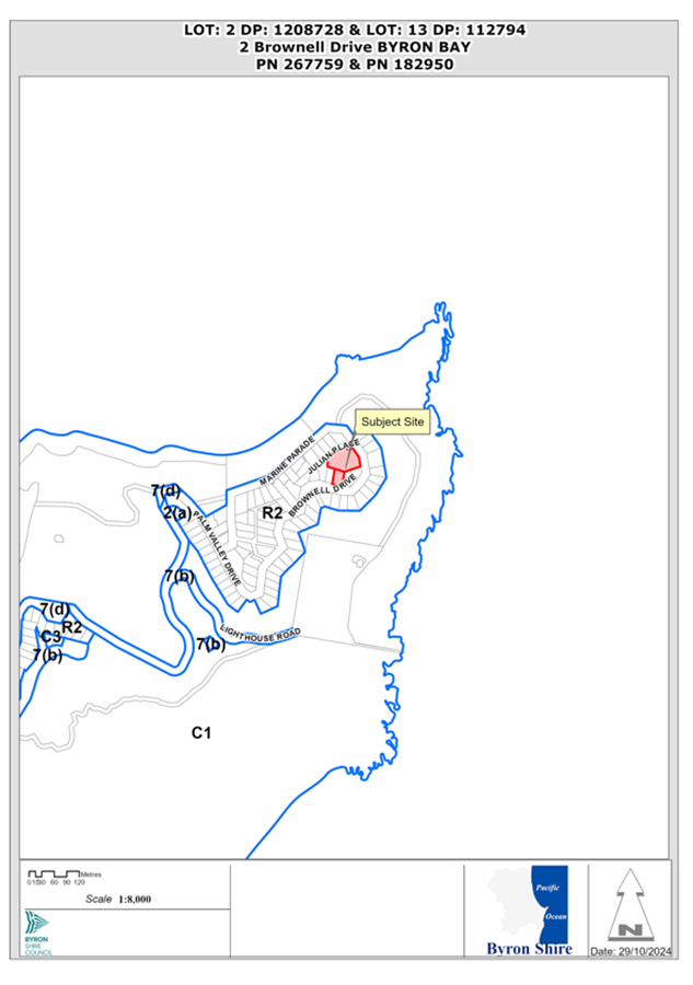
Assessment:
1. INTRODUCTION
1.1 History / Background
The subject sites have no history of development.
The site is comprised of:
Lot: 2 DP:1208728
Registered on: 26/09/2015.
And,
Lot: 13 DP:112794
Registered on: 05/09/1978.
1.2 Description of the proposed development
The proposed development entails the consolidation of Lot 2 DP1208728 and Lot 13 DP112794, resulting in a combined area of 4,223.52 square metres.
The development plans include the construction of two detached dwellings to form a dual occupancy. The first dwelling will be a six-bedroom, multi-level house with swimming pools, accessible via Julian Place. The second dwelling will be a four-bedroom, multi-level house with a swimming pool, accessible via Brownell Drive.
The land features a small, northeast-facing drainage basin with very steep upper slopes. It is extensively covered in littoral rainforest. The site holds significant importance due to its location on the mainland’s most easterly point, with the Cape Byron State Conservation Area and the Lighthouse providing a notable backdrop.
Significant Ecological Impacts have been proposed as construction of the Dual Occupancy (detached) would result in the clearing of 61 trees mapped within a Littoral Rainforest Area.
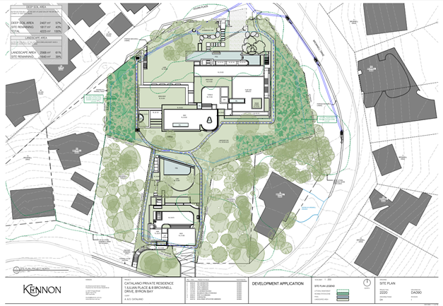
Figure 2: Site Plan
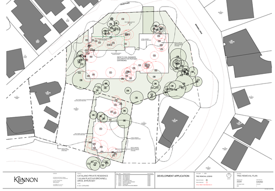
Figure 3: Tree Removal Plan
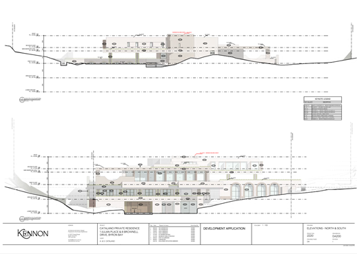
Figure 4: Main House (Dwelling 1) Elevations North and South
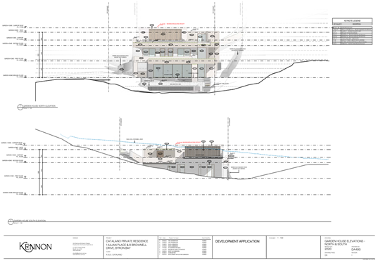
Figure 5: Garden House (Dwelling 2) Elevations North and South
1.3 Description of the site
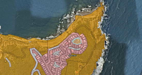
Figure 6: Zoning Map
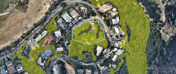
Figure 7: Littoral Rainforest Mapping
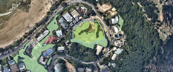
Figure 8: Potential Mitchells Rainforest Snail Habitat (Above)
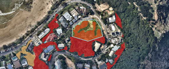
Figure 9: Endangered Ecological Communities Mapping (Above)
|
Land is legally described |
LOT: 2 DP: 1208728, LOT: 13 DP: 112794 |
|
|
Property address |
2 Brownell Drive BYRON BAY |
|
|
Land is zoned: |
R2 Low Density Residential |
|
|
Land area is: |
Combined area of 4,223.52 square metres |
|
|
Property is constrained by:
|
Bushfire prone land High Environmental Value Vegetation Endangered Ecological Communities |
|
|
|
Is a BDAR required due to the location of the proposed development? |
☒ Yes ☐ No |
|
|
Are there any easements in favour of Council affecting the site? |
☒ Yes ☐ No |
|
|
Is there a Vegetation Management Plan which might affect the proposal? |
☐ Yes ☒ No |
|
|
Is there a Voluntary Planning Agreement which might affect the proposal? |
☐ Yes ☒ No |
A site inspection was carried out on 20 November 2024. The below images were taken during the site visit.
|
|
|
|
|
|
|
|
|
|
|
|
1.4 Summary of Referrals
|
Referral |
Issue |
|
Environmental Health Officer |
Not supported. Insufficient detail submitted to demonstrate how the development will be managed during construction to minimise amenity and environmental impacts considering its size, such as impacts on roads, traffic, parking, acoustic environment, ground water and the like. |
|
Development Engineer |
Not supported.
Insufficient detail provided to address stormwater management, access and egress arrangements for vehicles. |
|
Natural Resource Planner / Ecologist |
Not supported. The proposed development has an unacceptable impact on the littoral rainforest which is mapped under SEPP Resilience and Hazards and is inconsistent with the Biodiversity Conservation Act 2016. It is also noted that three mature Cryptocarya foetida which used to be present at the site appear to have been removed from the site. The VMP states: No threatened flora was identified within the management zones. There are records from BioNet of Stinking Cryptocarya (Cryptocarya foetida) at the site, these individuals were not identified during the current and previous site assessments and surveys (AWC 2023).In terms of the Biodiversity Assessment Report, the key issue with this is demonstrating that biodiversity impacts have been avoided and minimised – this is very poorly addressed in the BDAR where it states that 0.34 ha of littoral rainforest will be removed, and 0.06 ha retained – this is not avoiding or minimising – as demonstrated by the very large development footprint. The proposed compensation is also non-compliant (1:2 instead of 1:10). It is considered the destruction of littoral rainforest and planting of replacement trees does not protect or enhance the biophysical, hydrological, and ecological integrity of the littoral rainforest at the site.
|
|
Crown Lands |
No objection subject to conditions of consent if approved to ensure adjacent Crown Land and assets are protected. |
|
Rural Fire Service (100B/4.14/4.14) |
No objection to subject conditions of consent if approved. |
|
Department of Climate Change, Energy, the Environment and Water. |
Not supported. The proposal does not demonstrate and justify reasonable efforts to avoid and minimise impacts on biodiversity values in accordance with section 6. 12 of the Biodiversity Conservation Act 2016. |
|
Cape Byron Marine Parks Authority |
No objection subject to conditions to ensure the Marine Park Assets are protected and lighting conditions imposed in relation to turtles, seabirds and migratory shorebirds. |
2.0. Section 4.15 – MATTERS FOR CONSIDERATION – DISCUSSION OF ISSUES
Having regard to the matters for consideration detailed in Section 4.15(1) of the Environmental Planning & Assessment Act 1979 (EP&A Act), the following is a summary of the evaluation of the issues.
2.1. State Environmental Planning Instruments
The original assessment considered the provisions of the relevant SEPP’s applicable to the land and the proposed development, as follows:
|
Considerations |
Satisfactory |
Unsatisfactory |
|
Biodiversity and Conservation SEPP 2021 Consideration: Wategos Beach, including the subject allotment are outside of the Byron Coast Comprehensive Koala Plan of Management 2016. Therefore Chapter 4 of the SEPP applies. Chapter 4 Koala habitat protection 2021 Section 4.9 Development assessment process no approved koala plan of management. The area of land is less than 1ha, therefore the SEPP does not apply. |
☒ |
☐ |
|
Resilience and Hazards SEPP 2021 Consideration: Section 2.7 Development on certain land within coastal wetlands and littoral rainforests area 2.7(4) A consent authority must not grant consent for development referred to in subsection (1) unless the consent authority is satisfied that sufficient measures have been, or will be, taken to protect, and where possible enhance, the biophysical, hydrological and ecological integrity of the coastal wetland or littoral rainforest. Council’s Ecologist makes the following comments: The proposal makes little effort to protect littoral rainforest at the site (in fact, the vast majority is proposed for removal), and littoral rainforest enhancement is at a low scale (and non-compliant with DCP requirements where rainforest trees require offset at a ratio of 1:10). Council cannot grant consent to the proposed development pursuant to Section 2.7(4) of State Environmental Planning Policy (Resilience and Hazards) 2021. Sufficient measures have not been taken to protect and enhance the ecological integrity of littoral rainforest. Section 2.1 Aim of Chapter The aim of this Chapter is to promote an integrated and co-ordinated approach to land use planning in the coastal zone in a manner consistent with the objects of the Coastal Management Act 2016, including the management objectives for each coastal management area, by— (a) managing development in the coastal zone and protecting the environmental assets of the coast, and (b) establishing a framework for land use planning to guide decision-making in the coastal zone, and (c) mapping the 4 coastal management areas that comprise the NSW coastal zone for the purpose of the definitions in the Coastal Management Act 2016. The proposed development is inconsistent with Section 2.1 of State Environmental Planning Policy (Resilience and Hazards) 2021. The proposed development fails to protect the environmental assets of the coastal zone. |
☐ |
☒ |
|
Transport and Infrastructure SEPP 2021 Consideration: Division 5 Electricity transmission or distribution Section 2.48 Determination of development applications-other development The DA was referred to Essential Energy in accordance with 2.48(1). Essential Energy have made the following comments: Strictly based on the documents submitted, Essential Energy has the following comments to make as to potential safety risks arising from the proposed development: · The plans provided do not show the distances from Essential Energy’s infrastructure to the proposed development. A safe distance of 2.5 metres is required to the nearest of the OVERHEAD LOW VOLTAGE NETWORK RUNNING IN JULIAN PLACE AND BROWNELL DRIVE. |
☐ |
☒ |
|
Sustainable Buildings SEPP 2022 Consideration: Incorrect BASIX. Two single dwelling BASIX Certificates were provided. This development would require a Multi Dwelling BASIX Certificate plus a Summary NatHERS Certificate for the Dual Occupancy. Plus, two (2) NatHERS Certificates (one for each dwelling). Plus, NatHERS Stamped Plans. In the event the application was to be supported this matter would be resolved accordingly with correct documentation. |
☐ |
☒ |
2.2. Byron Local Environmental Plan 2014 (LEP 2014)
In accordance with LEP 2014 clauses 1.4 and 2.1 – 2.3:
(a) The proposed development is defined in the LEP 2014 Dictionary as dual occupancy (detached); Subdivision is defined in Section 6.2 of the EP&A Act 1979; Consolidation of lots is not subdivision pursuant to S6.2 of the EP&A Act 1979, moreover, consolidation does not require development consent and is not part of this assessment. However, if development consent is granted, consolidation of lots will be a condition of consent.
(b) The land is within the R2 Low Density Residential according to the Land Zoning Map;
(c) The proposed development is permitted with consent; and
(d) Regard is had for the Zone Objectives as follows:
|
Zone Objective |
Consideration |
|
To provide for the housing needs of the community within a low-density residential environment. |
Having regards to the size of the main dwelling house it is difficult to submit the dwelling is consistent with the needs of the community within a low-density residential environment. At best the proposal is not antipathetic with the first objective in the R2 zone. The other objective applies to other land uses other than residential dwelling in this instance. |
|
To enable other land uses that provide facilities or services to meet the day to day needs of residents. |
The following clauses from the LEP are of relevance to the development.
|
LEP Clause |
Assessment comments |
|
1.2 Aims of Plan (2) The particular aims of this Plan are as follows— (aa) to protect and promote the use and development of land for arts and cultural activity, including music and other performance arts, (a) to progressively respond to changes in the natural, social and economic environment in a way that is consistent with the following principles of ecologically sustainable development— (iii)the principle of conserving biological diversity and ecological integrity—this principle aims to protect, restore and conserve the native biological diversity and enhance or repair ecological processes and systems,
|
Inconsistent Proposed: The Environmental Impact Statement that accompanied the DA states that 61 littoral rainforest trees are proposed for removal and 74 littoral rainforest trees will be retained. The Biodiversity Assessment Report that accompanied the DA states “The project footprint will impact approximately 0.34ha of degraded remnant vegetation through the centre of the site, with approximately 0.06ha of higher quality vegetation on the eastern and western boundaries retained.” Littoral rainforest is an Endangered Ecological Community pursuant to the Biodiversity Conservation Act 2016 and the Environment Protection and Biodiversity Conservation Act 1999. The proposed development fails to avoid or minimise direct and indirect impacts on littoral rainforest with the removal of 0.34ha of this ecological community. The proposed development is inconsistent with Clause 1.2(2)(a)(iii) of Byron Local Environmental Plan 2014 as it is inconsistent with the principle of conserving biological diversity and ecological integrity. |
|
4.1E Minimum lot sizes for certain residential accommodation Dual occupancy (detached) in Zone R2 – 800m2 |
Complies Lot 2 DP 1208728 (2 Brownell Drive) – 3,328.5m2 Lot 13 DP 112794 – 892m2 Total area of consolidated lots - 4,220m2 |
|
4.3 Height of buildings |
Inconsistent Exceeds 9m Clause 4.6 Variation submitted – discussed below |
|
4.4 Floor space ratio |
Complies Lot 2 DP 1208728 (2 Brownell Drive) – 3,328.5m2, GFA of dwelling – 1,361m2 Lot 13 DP 112794 – 892m2, GFA of dwelling 324m2 Total area of consolidated lots - 4,220m2 Total GFA – 1,685m2 FSR – 0.399:1 |
|
4.6 Exceptions to development standards
|
Exceedance of Building Height Limits – 4.6 Variation requested, however in this instance it is not supported. The intrusions above the 9-metre height limit for the main dwelling, although minor, should not be supported in this instance, considering the building could be designed to ensure full compliance with the LEP height provisions with some minor changes to floor to ceiling heights. As to the smaller dwelling the encroachments are more significant, considering the slope of the land Some of these breaches maybe acceptable, however the quantum of them in this instance is not. (e.g. the garage contains three spaces when only two is required which is where the main breach occurs for this dwelling)
As such it is considered the applicant has not demonstrated that strict compliance with the development standard is unnecessary based on the application as proposed and the variation to the height controls is not supported in this instance
|
|
6.2 Earthworks (3) In deciding whether to grant development consent for earthworks (or for development involving ancillary earthworks), the consent authority must consider the following matters— (a) the likely disruption of, or any detrimental effect on, drainage patterns and soil stability in the locality of the development, (b) the effect of the development on the likely future use or redevelopment of the land, (c) the quality of the fill or the soil to be excavated, or both, (d) the effect of the development on the existing and likely amenity of adjoining properties, (e) the source of any fill material and the destination of any excavated material, (f) the likelihood of disturbing relics, (g) the proximity to, and potential for adverse impacts on, any waterway, drinking water catchment or environmentally sensitive area, (h) any appropriate measures proposed to avoid, minimise or mitigate the impacts of the development.
|
Inconsistent The total excavation consists of 4,357m3 of cut and 279m3 of fill. This site with an area of 4,233m2 is equivalent to five normal dual occupancy sized lots (800m2). Thus, equivalent to 871.4m3 per standard lot. The deepest excavation of up to 8m relates to the lift well and stair corridor. The basement carpark is generally 4m – 5m deep. The back of house storage area and music rooms have excavations around 6m deep. The top dwelling has excavation over 4m deep but over a limited area. Much of the excavation is to cater for car parking. It is considered the earthworks are excessive in the site circumstances and are not supported.
|
|
6.6 Essential services |
Inconsistent Insufficient information has been submitted addressing the treatment and disposal of stormwater, whilst access arrangements as discussed below under Byron DCP 2014 are inadequate. |
2.3. Any proposed instrument that has been the subject of public consultation and has been notified to the consent authority
The proposal is not affected by any draft Environmental Planning Instruments.
2.4. Byron Shire Development Control Plan 2014 (DCP 2014)
DCP 2014 is an applicable matter for consideration in the assessment of the subject development application in accordance with subsection 4.15(1) of the EP& A Act because it applies to the land to which LEP 2014 applies. The DCP 2014 Parts/Chapters that are addressed below are of relevance to the proposed development:
|
Assessment comments |
|
|
Chapter B1 - Biodiversity B1.1.5 Biodiversity Planning Principles P13 Avoid and minimise.
B1.2.1 Development Envelope Controls 30m ecological setback from Threatened Ecological Communities
|
Inconsistent The proposed development is inconsistent with Section B1.1.5 Biodiversity Planning Principle P13 Chapter B1, Development Control Plan 2014. The scale and siting of the proposed development fail to avoid and minimise ecological impacts. The proposed development is inconsistent with Section B1.2.1, Development Control Plan 2014. The proposed development fails to provide a 30m ecological setback to littoral rainforest. |
|
Chapter B3 - Services |
Inconsistent Existing services are available and can be extended to the site. However, there is insufficient information to demonstrate compliance to clause 6.6(d) of BLEP 2014 and Chapter B3 of BDCP 2014. No assessment has been undertaken to verify that there is capacity of downstream system of the nominated lawful point of discharge of the development to cater for the generated post development flows by proposed stormwater works specified in the Stormwater Management Report prepared by Westera Partners with reference N23-094-SWMR Rev 2 dated 4 July 2024. |
|
Chapter B4 - Traffic Planning, Vehicle Parking, Circulation and Access |
Inconsistent There is insufficient information to demonstrate compliance to clause 6.6(e) of BLEP 2014 and Chapter B4 of the Byron Shire Councils DCP 2014. The proposed driveway design does not comply with design and manoeuvring requirements of Chapter B4 of BDCP 2014, AS2890.1 and Chapter D1.37 & N1.38 of the Northern Rivers Local Government Design and Construction Guidelines. |
|
Chapter B14 - Excavation and Fill Prescriptive Measures 1m or 2m if within building and for car parking |
Inconsistent The total excavation consists of 4,357m3 of cut and 279m3 of fill. This site with an area of 4,233m2 is equivalent to five normal dual occupancy sized lots (800m2). Thus, equivalent to 871.4m3 per standard lot. The deepest excavation of up to 8m relates to the lift well and stair corridor. The basement carpark is generally 4m – 5m deep. The back of house storage area and music rooms have excavations around 6m deep. The top dwelling has excavation over 4m deep but over a limited area. A significant part of the excavation is to cater for car parking of 6 vehicles and turning areas when only two spaces are required. Other areas to be excavated are to provide for a music room, sound booth, cellar, dry store, laundry, gymnasium, plant and equipment, garden storage. There is insufficient information to demonstrate compliance with clause 6.2(1) of BLEP 2014 and Chapter B14 of DCP 2014. It is considered the earthworks are excessive in the site circumstances and are not supported.
|
|
Chapter D1 - Residential Accommodation in Urban, Village & Special Purpose Zones |
Inconsistent The proposed development does not comply with the “Small Scale” Design Considerations for Character and Visual Impact of Wategos as outlined above in Chapter D1.2.6 and E5.8.3 of the DCP. The proposed Development also breaches the Maximum Building Height of 9m and encroaches into minimum setback requirements outlined within Chapter D1 of the DCP.
|
|
Chapter E5 - Certain Locations in Byron Bay and Ewingsdale |
Inconsistent The proposed development does not comply with the prescriptive measures outlined in Chapter E5.10 for Wategos Beach. The proposed 307m2 basement significantly exceeds the maximum 50m2 footprint. The proposed development does not comply with performance criteria 1 and 2 of E5.10 Wategos Beach. The scale of the basement garage has not been designed to minimise excavation, and the development seeks to remove established native vegetation.
|
|
Chapter F1 – Vegetation and Tree Management |
Inconsistent The proposed development does not comply with the objectives of Chapter F1-Tree and Vegetation Management. As there is 61 Trees proposed for removal from a littoral rainforest area, further demonstration is needed on how the proposal avoids and minimises tree and vegetation removal of significant value. The DCP definition of avoid means “to keep away from’ and minimise means “reduce to the smallest possible amount or degree”. Evidence of avoidance should be further illustrated through ecological buffers and the design of the development footprint. The Compensatory Planting Schedule is also non-compliant as the application has proposed a 1:2 planting schedule instead of a 1:10. |
2.5. The likely impacts of that development, including environmental impacts on both the natural and built environments, and social and economic impacts in the locality
|
Impact on: |
Likely significant impact/s? |
|
Natural environment |
The proposal will have a significantly adverse impact on the natural environment of the locality with the removal of a significant portion of the littoral rainforest from the site. |
|
Built environment |
The proposal is likely to have a significantly adverse impact on the built environment of the locality having regards to the size, bulk and scale of the subject development and with the removal of a significant portion of the littoral rainforest from the site. |
|
Social Environment |
The proposal is unlikely to have a significant social impact on the locality. |
|
Economic impact |
The proposal may have an economic impact during the construction phase of the development. |
|
Construction Impacts |
Based on the supplied information, the development will generate major and significant adverse impacts during construction. These have not been addressed in the application. |
2.6. The suitability of the site for the development
The site is not suitable for proposed development due to the reasons outlined in the report.
2.7. Submissions made in accordance with this Act or the regulations.
The application was publicly exhibited. 251 submissions have been received. The redacted Public Submissions are contained in Attachment 4 of this Report. The issues raised are summarised and commented on as follows:
There were 251 submissions made on the development application:
- For: 47
- Against: 204
Among the supporting submissions, three key topics consistently emerged:
1. Harmonious Urban Design Features
2. Re-Vegetation and Landscaping Plans
3. Supporting
development for a Family Home
Comment: Supporting submissions have been considered as part of this assessment report.
Among the opposing submissions, six key topics consistently emerged:
1. Impact
on local flora and fauna
Comment: Environmental concerns have been noted and taken into consideration.
2. Concerns regarding the Biodiversity Assessment Report (BDAR)
Comment: Concerns regarding the Biodiversity Assessment Report (BDAR) have been noted and taken into consideration.
3. Integration of
the Ecological Assessment, Landscaping Plan, and Bushfire Report
Comment: Concerns regarding the Integration of the Ecological Assessment,
Landscaping Plan, and Bushfire Report have been noted and taken into
consideration.
4. Variations in
building height
Comment: Concerns regarding the variations to building height standards have
been noted and taken into consideration.
5. Loss
of public parking and Traffic
Comment: Concerns regarding the loss of public parking and traffic issues have
been noted and taken into consideration.
6. Potential
unauthorised removal of vegetation
Comments: Unauthorised removal of vegetation concerns have been raised with
the Local Land Services who have taken no action.
Additional notable issues raised by the community include:
· Stormwater
drainage and hydrology concerns
Comment: Stormwater drainage and hydrology concerns have been addressed by
Development Engineers who have also raised concerns. These issues have been
noted and addressed as part of this development assessment.
· Land use
and zoning, specifically regarding the current R2 zoning for low-density
residential development.
Comment: Issues regarding the land use zoning have been considered as part of
this development assessment.
· Basement
car parking, which exceeds the Development Control Plan requirements and
involves the excavation of over 4,000 square metres of soil.
Comment: Excavation and Basement plans for this development have been noted and
assessed as part of this development assessment.
· A proposed
five-year construction timeline
Comment: The timeframes around the Construction have been considered as
part of this development assessment.
· Concerns
regarding the basement and its potential use for commercial activities, such as
a recording studio, nightclub, or event space.
Comment: Concerns regarding the use of the proposed development for
commercial activities have been assessed as part of this development
assessment.
2.8. Public Interest
The proposed development is likely to prejudice and compromise the public interest as well as create an undesirable precedent for development in a Low-Density Residential Zone.
3. Conclusion
The DA proposes Staged DA, consolidation of two allotments into one; dual occupancy (detached) with swimming pools; and strata subdivision.
The proposed development is not supported having regard to the relevant environmental planning instruments and planning controls applicable to the site. The proposal raises significant issues in terms of environmental, and locality impacts. The site is considered unsuitable for the proposed development.
The application is recommended for refusal.
Staff Reports - Infrastructure Services 13.13
Staff Reports - Infrastructure Services
Report No. 13.13 Expression Of Interest - Panel of Contractors for Infrastructure Recovery Program Delivery
Directorate: Infrastructure Services
Report Author: James Flockton, Infrastructure Planning Coordinator
File No: I2024/1488
Summary:
On 18 September 2024 under delegated authority, the General Manager approved the use of an open Expression of Interest (EOI) process to establish a panel of contractors for the delivery of flood damage repairs under EOI 2024-2376.
This process aims to form a panel of qualified and experienced contractors capable of executing a range of flood damage repair works across the shire. Allowing for more simple and faster tender process during the delivery of the Infrastructure Recovery program.
The EOI was advertised from 3 October to 23 October 2024.
Responses have been assessed in accordance with the provisions of the Local Government (General) Regulations 2021. This report summarises the background and assessment of the responses and provides a recommendation to form the panel 2024-2376.
RECOMMENDATION:
That Council:
1. Endorses the establishment of a panel of contractors for flood damage repairs, as identified in the Evaluation Report (E2024/135351); and
2. Makes public its decision, including the name and amount of the successful Panel Members, in accordance with Clause 179(b) of the Local Government (General) Regulation 2021.
1 Confidential - Infrastructure Recovery EOI Panel of Contractors Evaluation Panel Recommendation Report, E2024/135351
Report
On 18 August 2024 under delegated authority, the General Manager approved the use of an open Expression of Interest (EOI) to establish a panel of contractors for flood damage repairs under EOI 2024-2376.
Due to recurrent flooding events and related infrastructure damage across Byron Shire, there is a critical need for a responsive panel of contractors. This panel will undertake remediation works, including but not limited to:
· Road reconstruction
· Bridge and culvert repairs
· Embankment stabilisation
· Drainage works
The panel is expected to commence in December 2024 for a period of three years.
The panel will be managed by Infrastructure Recovery Team.
The established panel will serve as the basis for issuing Request For Tenders (RFT) and Request For Quotes (RFQ) for flood damage repair projects and packages.
Only contractors included on this panel will be eligible to participate in these subsequent procurement processes. The panel also shortlists interested contractors and categorises the types of repairs they are suited for, allowing for a more targeted RFQ/RFT process.
This approach increases efficiency by eliminating the need to reassess qualitative and mandatory requirements for each project, enabling awards to be based primarily on price and availability.
The EOI was advertised on VendorPanel Online between 3 October to 23 October 2024.
An Evaluation Panel comprising of 3 Latsyrc Project Management and 1 Council staff member was formed.
EOI Submissions closed on 23 October 2024 and submissions were received from the following proponents:
· 4H Civil Pty Ltd
· ACCIONA GEOTECH
· AG EARTH CIVIL
· Albem Operations Pty. Ltd. & Sgq Pty Ltd
· Allbase Infrastructure Solutions Pty Ltd
· Alliance Construction Group Pty Ltd
· Aussie Rock Landscape and Construction
· Austek Asphalt Services Pty Ltd
· Australian Marine & Civil Pty Ltd
· Bellwether Consulting Services Pty Ltd
· Bild Infrastructure Pty Ltd
· Bouman Pty Ltd
· Brefni Pty Ltd
· BROWN CONTRACTORS
· Brown Environmental Earthworks Planning Pty Ltd
· Cambra Holdings Pty. Ltd (Morgans)
· Civilcs Pty Ltd
· Civilwise Pty Ltd
· CMC
· Country 2 Coast Concreting Pty. Ltd
· D.J. & J.A. Brooker Pty Ltd
· Daracon Contractors Pty Ltd
· DEKACON
· Doval Constructions (Qld.) Ltd
· Downer EDi Works Pty Ltd
· Dt Infrastructure Pty Ltd
· Durack Civil Pty Ltd
· Earthtrack Solutions Pty Ltd
· East Coast Asphalt
· Ellis Profiling (Qld) Pty Ltd
· Enviro Hydromulch Pty Ltd
· FGH CIVIL
· Finn Valley Plant & Civil Pty Ltd
· Fulton Hogan Industries Pty Ltd
· Gmac Construction Group Pty Ltd
· Golding Contractors Pty Ltd
· GRC Civil
· Ground Stabilisation Systems Pty Limited
· H.R Wilson & M.E Wilson
· Hannigan Civil Pty Ltd
· Hazell Bros (QLD) Pty Ltd
· Hiway Aus Pty Ltd
· Ireland Civil Contracting Pty Ltd
· Isa Australia Pty. Ltd
· J.E Williamson & J.G Williamson
· Lee Civil Pty Ltd
· Lucas Civil Construction Pty Ltd
· Mcilwain Civil Engineering Pty. Ltd
· Mcnamara & Tierney Pty. Ltd
· Mj Smith Ground Preparation Pty Ltd
· Naviq Pty Ltd
· New Ground Excavations Pty Ltd
· Nviroscope Pty. Limited
· OMEX CIVIL
· Osullivan Ground Engineering Pty Ltd
· Oz Stabilisation & Construction Services Pty Ltd
· Pan Civil Pty Ltd
· Parrys Earthmoving Pty Ltd
· PCA Ground Engineering
· Pointe Engineering Pty Ltd
· PRB PROPERTY SERVICES
· Precision Projects Pty Ltd
· Quickway Constructions Pty Ltd
· R & M Earthmoving Pty Ltd
· Rcc Earthworks Pty Ltd
· Resinject Pty Limited
· Rix Asset Maintenance Pty Limited
· Roseberry Creek Developments Pty Ltd
· Rugendyke And Bashforth Contracting Pty Ltd
· SC Comms & Utilities
· See Civil Pty Ltd
· Silverstrand Developments Pty Ltd
· Skeen Constructions Pty Ltd
· SmithPlant
· SOMERVILLE EXCAVATOR HIRE
· Specialist Site Services Pty Ltd
· Stabilcorp Pty Ltd
· SYMAL INFRASTRUCTURE PTY LTD
· SYNERGY RESOURCE MANAGEMENT
· The Bashforth Unit Trust
· The Rix Group Pty Ltd
· Timber Restoration Services
· TMC Civil Consulting
· Tom Thumb Earthmoving
· Townes Group Operations Pty Ltd
· Tymmos Tippers
· Unyte Eastern Pty Ltd
· Valley Earthworks Civil Pty Ltd
· WDI EARTHMOVING
· WINSLOW INFRASTRUCTURE PTY. LTD
Responses were evaluated by the Evaluation Panel in accordance with the following evaluation criteria:
Mandatory criteria:
· Response lodged on time, in accordance with the Conditions of EOI.
· Respondent has a valid Australian Business Number.
· Respondent substantially complies with the Statement of Requirements.
· Respondent substantially complies with the Conditions of Contract.
· Respondent holds the required insurances or has the ability to obtain the insurances.
· Holds current Workers Compensation insurance for all employees
· Respondent has satisfactory work health and safety and environmental compliance practices.
· Financial capacity to undertake the contract
· Commitment to ethical business practice principles.
· Does not obtain financial benefit from Australia’s offshore detention centres.
· Is not involved with the development or operation of the Carmichael mine or otherwise have ties to Bravus Mining previously Adani.
· Satisfactory environmental controls
· Respondent can confirm steps to comply with the elimination of Modern Slavery from their supply chain
Qualitative criteria:
|
Criteria |
Elements |
Assigned Weighting |
|
Profile & Relevant Experience |
Tender Profile |
35% |
|
Previous relevant experience |
||
|
Sustainable Practices |
Environmental Practices |
5% |
|
Quality and Availability of Resources |
Proposed Key Personnel |
30% |
|
Proposed Staff |
||
|
Proposed Plant and Equipment |
||
|
Use of subcontractors |
||
|
Delivery Plan |
Proposal for Repairing Flood-Damaged Infrastructure |
20% |
|
Social Procurement |
Aboriginal and Torres Strait Islander business |
5% |
|
Local Industry |
Employment Opportunities |
5% |
Financial Considerations
There are no financial considerations associated with this EOI. This is an EOI to establish a panel of contractors for flood damage repairs. Contractors are addressed on criteria other than price. The price will be requested when RFQ/RFT are issued under this EOI.
The expected spend on flood damage works for RFQ/RFT issued under this EOI is approximately $80 Million.
There is sufficient funding for the proposed contracts in the Total Upper Limit Grant (TULG) provided under the DRFA guidelines.
Statutory and Policy Compliance Considerations
The EOI process has been undertaken in accordance with Council’s Purchasing and Procurement Policy, and the provisions of the Local Government (General) Regulation 2021.
The Local Government (General) Regulations 2021 define the options available to Council. An extract is provided below.
Local Government (General) Regulation 2021 - Reg 169
(1) A council that decides to prepare a list of suitable tenderers for the allocation of proposed contracts of a specified kind using the selective tendering method referred to in section 166(c) must publish an advertisement inviting applications from persons interested in making a tender submission for proposed contracts of that kind—
(a) on the website of the council, and
(b) in any other manner that the council considers necessary to bring it to the attention of persons who may be interested in making a tender submission for the proposed contract.
(2) Every such advertisement must include—
(a) a brief description of the kind of work, goods, facilities, services or property concerned, and
(b) the name of a person to whom requests for information concerning the proposed contracts may be addressed and how the person can be contacted, and
(c) the deadline for submitting applications, and
(d) the way an application must be made.
(3) A council must consider all applications made in response to such an advertisement and, in so doing, take into account the experience of the applicants in fulfilling the requirements of, and their capacity to undertake, similar contracts.
(4) After considering an application under this section, the council may either—
(a) list the applicant as a recognised contractor for some or all of the kinds of work, goods, facilities, services or property specified in the application, or
(b) reject the application in whole or part.
(5) In seeking tenders for a particular proposed contract, a council may invite some or all of the recognised contractors listed by it under this section to tender for that contract and may do so on the basis of—
(a) their capacity to fulfil the requirements of that contract, and
(b) the number of occasions on which each contractor has previously been invited to tender for similar proposed contracts.
(6) In inviting tenders for a proposed contract from recognised contractors listed by the council under this section, the council must—
(a) invite them to tender before the deadline specified in the invitations, and
(b) give details of where and when tender proposal documents relating to the proposed contract can be obtained and the purchase price of those documents, and
(c) state the way a tender submission must be submitted.
(6A) The deadline must be a specified time on a date that is at least 21 days after the date of the invitation.
(7) The tender proposal documents relating to the proposed contract must comply with section 170.
Council’s endorsement of the recommendation to add the respondents to the Panel of Contractors for Flood Damage Repairs as recommended in the attached Evaluation Report is sought.