Notice of Meeting
Floodplain
Management Advisory Committee Meeting
A Floodplain Management
Advisory Committee Meeting of Byron Shire Council will be held as follows:
|
Venue
|
Conference Room, Station Street, Mullumbimby
|
|
Date
|
Thursday, 20 February 2025
|
|
Time
|
9:00 AM
|
Phil Holloway
Director Infrastructure
Services
I2025/158
Distributed
13/02/25

What is a “Conflict of Interests” - A conflict of
interests can be of two types:
Pecuniary - an interest that a person has in a matter because of a reasonable
likelihood or expectation of appreciable financial gain or loss to the person
or another person with whom the person is associated.
Non-pecuniary – a private or personal interest that a Council
official has that does not amount to a pecuniary interest as defined in the
Code of Conduct for Councillors (eg. A friendship, membership of an
association, society or trade union or involvement or interest in an activity
and may include an interest of a financial nature).
Remoteness – a person does not have a pecuniary interest in a matter
if the interest is so remote or insignificant that it could not reasonably be
regarded as likely to influence any decision the person might make in relation
to a matter or if the interest is of a kind specified in the Code of Conduct
for Councillors.
Who has a Pecuniary Interest? - a person has a pecuniary interest in a
matter if the pecuniary interest is the interest of the person, or another
person with whom the person is associated (see below).
Relatives, Partners - a person is taken to have a pecuniary
interest in a matter if:
·
The
person’s spouse or de facto partner or a relative of the person has a
pecuniary interest in the matter, or
·
The
person, or a nominee, partners or employer of the person, is a member of a
company or other body that has a pecuniary interest in the matter.
N.B. “Relative”, in relation to a person means any of the
following:
(a) the parent,
grandparent, brother, sister, uncle, aunt, nephew, niece, lineal descends or
adopted child of the person or of the person’s spouse;
(b) the spouse
or de facto partners of the person or of a person referred to in paragraph (a)
No Interest in the Matter - however, a person is not taken to have a
pecuniary interest in a matter:
·
If
the person is unaware of the relevant pecuniary interest of the spouse, de
facto partner, relative or company or other body, or
·
Just
because the person is a member of, or is employed by, the Council.
·
Just
because the person is a member of, or a delegate of the Council to, a company
or other body that has a pecuniary interest in the matter provided that the
person has no beneficial interest in any shares of the company or body.
Disclosure and participation in meetings
·
A
Councillor or a member of a Council Committee who has a pecuniary interest in
any matter with which the Council is concerned and who is present at a meeting
of the Council or Committee at which the matter is being considered must
disclose the nature of the interest to the meeting as soon as practicable.
·
The
Councillor or member must not be present at, or in sight of, the meeting of the
Council or Committee:
(a) at
any time during which the matter is being considered or discussed by the
Council or Committee, or
(b) at
any time during which the Council or Committee is voting on any question in
relation to the matter.
No Knowledge - a person does not breach this Clause if the person did
not know and could not reasonably be expected to have known that the matter
under consideration at the meeting was a matter in which he or she had a
pecuniary interest.
Non-pecuniary Interests - Must be disclosed in meetings.
There are a broad range of options available for managing conflicts &
the option chosen will depend on an assessment of the circumstances of the
matter, the nature of the interest and the significance of the issue being
dealt with. Non-pecuniary conflicts of interests must be dealt with in at
least one of the following ways:
·
It
may be appropriate that no action be taken where the potential for conflict is
minimal. However, Councillors should consider providing an explanation of
why they consider a conflict does not exist.
·
Limit
involvement if practical (eg. Participate in discussion but not in decision
making or vice-versa). Care needs to be taken when exercising this
option.
·
Remove
the source of the conflict (eg. Relinquishing or divesting the personal
interest that creates the conflict)
·
Have
no involvement by absenting yourself from and not taking part in any debate or
voting on the issue as of the provisions in the Code of Conduct (particularly
if you have a significant non-pecuniary interest)
Committee members are reminded that they should declare and manage all
conflicts of interest in respect of any matter on this Agenda, in accordance
with the Code of Conduct.
RECORDING OF VOTING ON PLANNING MATTERS
Clause 375A of the Local Government Act
1993 – Recording of voting on planning matters
(1) In this section, planning
decision means a decision made in the exercise of a function of a council
under the Environmental Planning and Assessment Act 1979:
(a) including a decision relating to a development
application, an environmental planning instrument, a development control plan
or a development contribution plan under that Act, but
(b) not including the making of an order under that Act.
(2) The general manager is required to keep a register
containing, for each planning decision made at a meeting of the council or a
council committee, the names of the councillors who supported the decision and
the names of any councillors who opposed (or are taken to have opposed) the
decision.
(3) For the purpose of maintaining the register, a division
is required to be called whenever a motion for a planning decision is put at a
meeting of the council or a council committee.
(4) Each decision recorded in the register is to be described
in the register or identified in a manner that enables the description to be
obtained from another publicly available document and is to include the
information required by the regulations.
(5) This section extends to a meeting that is closed to the
public.
OATH AND AFFIRMATION FOR COUNCILLORS
Councillors are
reminded of the oath of office or affirmation of office made at or before their
first meeting of the council in accordance with Clause 233A of the Local
Government Act 1993. This includes undertaking the duties of the office of
councillor in the best interests of the people of Byron Shire and the Byron
Shire Council and faithfully and impartially carrying out the functions,
powers, authorities and discretions vested under the Act or any other Act
to the best of one’s ability and judgment.
BYRON SHIRE COUNCIL
BUSINESS OF MEETING
1. Apologies
2. Declarations
of Interest – Pecuniary and Non-Pecuniary
3. Minutes from Previous
Meetings
3.1 Adoption
of Minutes from Previous Meeting.............................................................. 6
4. Staff Reports
Corporate and Community
Services
4.1 Integrated
Planning and Reporting........................................................................... 13
Infrastructure Services
4.2 Byron
Shire Council Flood Risk Management Plan-Update on Actions and Accomplishments
- Post 2022 Flood Priorities........................................................ 17
4.3 Current
Status of Flood Resillience Studies and Works........................................ 26
4.4 Recommended
Flood Grant Applications in May 2025 subject to budget allocation........................................................................................................................................ 40
4.5 Performance
of Automatic Warning Signs for Water Over Main Arm Road just west of Sherrys
Bridge.............................................................................................................. 48
BYRON SHIRE COUNCIL
Minutes from Previous Meetings 3.1
Minutes from Previous Meetings
Report No. 3.1 Adoption of Minutes from Previous Meeting
Directorate: Infrastructure Services
File No: I2025/136
RECOMMENDATION:
That the minutes of the Floodplain Risk Management
Advisory Committee Meeting held on 12 July 2024 be confirmed.
<Section5>
Attachments:
1 Minutes
12/07/2024 Floodplain Management Advisory Committee Extraordinary, I2024/1025 ,
page 8⇩ 
Report
The attachment to this report provides the minutes of the
Floodplain Risk Management Advisory Committee Meeting of 12 July 2024 .
Report to Council
The minutes to be reported to Council on 27 February 2024.
Comments
The reporting of the minutes to Council should have occurred
in August 2024 and staff will review internal process to ensure that oversight
does not occur in future.
BYRON SHIRE COUNCIL
Minutes
from Previous Meetings 3.1 - Attachment 1

BYRON SHIRE COUNCIL
Staff Reports - Corporate and Community Services 4.1
Staff Reports - Corporate and Community Services
Report No. 4.1 Integrated
Planning and Reporting
Directorate: Corporate
and Community Services
Report Author: Amber
Evans Crane, Corporate Planning and Improvement Coordinator
File No: I2025/128
Summary:
This report provides an overview of Council’s
Integrated Planning and Reporting Framework and invites discussion on priority
areas in the arts for inclusion in Council’s delivery program.
RECOMMENDATION:
That the Floodplain Risk Management Advisory
Committee:
1. Notes Council’s
Integrated Planning and Reporting Framework
2. Discusses priorities for
the 2025 – 2029 Delivery Program
Background to Integrative Planning and
Reporting (IP&R)
The Integrated Planning and
Reporting Framework in NSW requires all councils to adopt a suite of strategic
plans. These long-term plans provide transparency and make it possible
for Council to plan in a manner which ensures that community needs and
priorities are responded to well into the future. Council also has a
suite of strategies, plans and policies which help inform operations and
decision making, and these policies are adhered to in alignment with the
Integrated Planning and Reporting Framework.
The central IP&R
documents are outlined in more detail:
10 Year Community Strategic Plan
Leading the Council’s planning hierarchy, the
Community Strategic Plan (CSP) captures the community’s vision,
aspirations, and expectations for the future. It identifies key social,
economic, and environmental priorities and long term strategies to achieve
these goals over the next 10 years.
The CSP outlines the vision, community objectives and
supporting strategies which will guide Council’s long-term decision
making. Robust engagement with the community about their desires and
expectations has guided the long-term future planning to meet the needs and
aspirations of the community.
10 Year Resourcing Strategy
The resourcing strategy addresses the sustainable long term
financial, asset management, and workforce planning requirements. This is
the point where Council assists the community by sorting out who is responsible
for what, in terms of the issues identified in the Community Strategic Plan.
4 Year Delivery Program
The delivery program translates the community strategic plan
goals into actions. It is Council’s commitment to the community,
outlining what it intends to do toward achieving the goals of the community
strategic plan during its term of office. The Delivery Program is the single
point of reference for all principal activities undertaken by Council. All
plans, projects, activities, and funding allocations must be directly linked to
the four-year delivery program.
Annual Operational Plan
The Delivery Program is supported by an annual Operational
Plan which details the individual projects and activities that will be
undertaken each year to achieve the commitments of the Delivery Program.
The Operational Plan is supported by a detailed budget and a statement of
revenue policy, which also sets the fees and charges for that year.
Advisory Committee Input into IP&R
The key IP&R documents
described in the Background section are in the process of review as is the
requirement following a local government election.
The current Community Strategic Plan (CSP) 2032 has been
reviewed and the next iteration, the CSP 2035, was placed on public exhibition
at the 28 November 2024 Ordinary Council meeting with submissions open until 9
February 2025. The revised CSP will be presented back to Council for
adoption in April 2025. The draft can be found on Council’s website at
www.byron.nsw.gov.au/communityplan.
Adjacent to this, the Delivery
Program 2025 – 2029 and Operational Plan 2025/26 are being developed.
Both documents will be presented to Council in April 2025 and placed on public
exhibition for public feedback.
The Committee will be presented
with draft priorities for the next four years relevant to floodplain risk
management for discussion whilst the documents are still in the development
phase. These priorities include:
· Floodplain management
· Coastal
Management
· Stormwater
· Water
sensitive urban design
Strategic Considerations
Community Strategic Plan
and Operational Plan
|
CSP Objective
|
CSP Strategy
|
DP Action
|
Code
|
OP Activity
|
|
1:
Effective Leadership
|
1.1:
Enhance trust and accountability through open and transparent leadership
|
1.1.4:
Performance Measurement and Reporting - Embed a robust performance management
system through the development of an outcomes measurement framework
|
1.1.4.4
|
Prepare the 2025-2029 Delivery
Program
|
Statutory Considerations
Integrated Planning and Reporting is governed by:
· ‘Local
Government Act 1993’.
· ‘Local
Government (General) Regulation 2021’.
· Integrated
Planning and Reporting Guidelines for Local Government in NSW’: outlines
the statutory planning and reporting requirements that councils, county
councils and joint organisations must meet.
BYRON SHIRE COUNCIL
Staff Reports - Infrastructure Services 4.2
Staff Reports - Infrastructure Services
Report No. 4.2 Byron
Shire Council Flood Risk Management Plan-Update on Actions and Accomplishments
- Post 2022 Flood Priorities
Directorate: Infrastructure
Services
Report Author: Euan
Rose, Project Officer
File No: I2025/73
Summary:
Council has adopted three sets of Flood Risk Management
Studies (FRMS) and Plans (FRMP) for the shires three main catchments.
These are:
· Brunswick
River Catchment (North Byron, includes Marshalls Creek)
· Tallow
Creek Catchment
· Belongil
Creek catchment
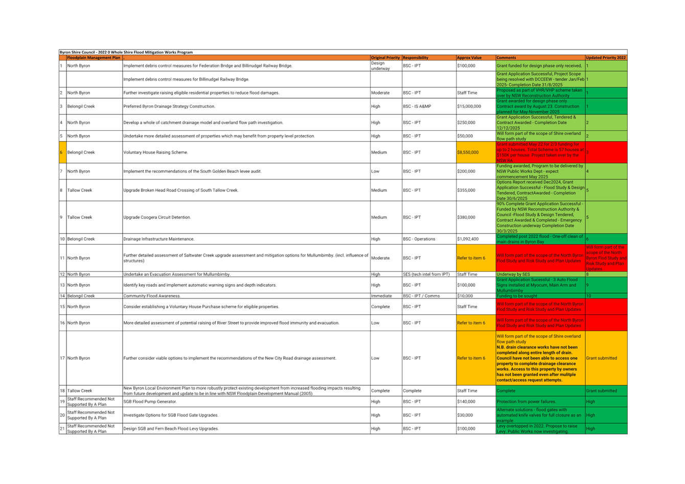
As per resolution 22-349, the Flood Advisory Committee conducted a
workshop on the 12th August 2022 to update priorities of flood
mitigation works. A summary of prioritised actions was prepared based on
the outcomes of the three adopted Flood Risk Management Plans which was adopted
at October 11 2022 Flood Advisory Committee. The adopted priority list of 64
items is referenced in Attachment 1 (E2022/89966).
This report provides an update on
what works have been undertaken since the flood mitigation program was adopted
in October 2022 – refer Attachment 2 (E2025/10640).
This report provides an update on
the status of the work completed and underway of the 64 items
prioritised. The works undertaken will underpin the Flood Study and
associated Floodplain Risk Management Study and Plans for these three (3) shire
catchments.
· Belongil
Creek catchment
· Tallow
Creek Catchment
· Brunswick
River Catchment (North Byron)
Update investigations have already
commenced for the Belongil and Tallow Creek catchments with an estimated
completion by March 2026. The Brunswick River (North Byron) update is
subject to applying for the annual Flood Grant rounds by the NSW Department
of Climate Change, Energy, the Environment and Water (DCCEEW) in April/May 2025.
RECOMMENDATION:
The Floodplain Management Advisory Committee recommend:
That Council note and endorse the update on the
2022 Byron Shire Council Flood Mitigation Program, Attachment 2 (E2025/10640).
Attachments:
1 Update
Works Completed-E2022 89966 Flood Mitigation Program Oct 2022, E2025/16812 , page 23⇩ 
Report
Council has adopted three sets of Flood Risk Management
Studies and Plans (FRMS and FRMP) for the shires three main catchments.
These are:-
· Brunswick
River Catchment (North Byron)
· Tallow
Creek Catchment
· Belongil
Creek catchment
The Brunswick River Catchment is
drained by three major tributaries, Marshalls Creek (North Arm), Simpsons Creek
(South Arm) and the Brunswick River (West and Main Arm).
A North Byron flood study and
subsequent FRMS and FRMP were developed and adopted in 2020. The FRMP
listed 25 recommended actions with associated priority rankings.
The Tallow Creek Catchment is
drained by Tallow Creek and receives a large proportion of the urban Suffolk
Park district runoff. A flood study and subsequent FRMS and FRMP were
developed and adopted in 2009 with an update being adopted in 2015. The
FRMP listed 24 recommended actions with associated priority rankings.
Tallow Creek opens to the ocean and is known as an intermittently closed and
open lagoon system (ICOLL).
The Belongil Creek Catchment is
drained by Belongil Creek and receives a large proportion of the urban Byron
Bay central business district runoff in addition to wetland and agricultural
runoff. A flood study and subsequent FRMS and FRMP were developed and
adopted in 2015. The FRMP listed 10 recommended actions with associated
priority rankings. Belongil Creek opens to the ocean and is known as an
intermittently closed and open lagoon system (ICOLL).
An updated summary of prioritised
actions has been prepared based on the outcomes of the three adopted Flood Risk
Management Plans, in addition to the outcomes from a workshop help by the
Floodplain Management Advisory Committee on 12th August 2022 and 11th
October 2022, as per attachment 1.
This report provides an update on
the status of the work completed and underway of the 64 items
prioritised. The works undertaken will underpin the Flood Study and
associated Floodplain Risk Management Study and Plan/s for these three (3) shire
catchments
· Belongil
Creek catchment
· Tallow
Creek Catchment -
· Brunswick
River Catchment (North Byron)
Upgrade investigations have
already commenced for the Belongil and Tallow Creek catchments with an
estimated completion by March 2026. The Brunswick River ( North Byron )
update is subject to applying for the annual Flood Grant rounds by the NSW
Department of Climate Change, Energy, the Environment and Water (DCCEEW)
in April/May 2025.
Key issues
Several key issues have been
identified that will impact the delivery of the flood mitigation program.
These include, however, not limited to:
· Available budget-Council budgets are limited. Grant
funding will be required to financially assist Council with delivery
· Timing and community expectations - following the recent
2022 floods and natural disaster the community expect a quick delivery of the
actions. Realistic delivery programs will need to be communicated
effectively with the community highlighting budgetary and resource constraints
· Local Council and State responsibilities - following the
recent 2022 flood and natural disaster the community has an expectation that
Council can undertake any and all works. This is sometimes not the case
with many actions the responsibility of various state departments such as SES,
Crown Land, Marine Parks, Fisheries and the National Parks and Wildlife
Services. Realistic delivery programs will need to be communicated
effectively with the community highlighting budgetary and resource constraints.
Next steps
Budget sourcing and delivery
program development.
Strategic Considerations
Community Strategic Plan
and Operational Plan
|
CSP Objective
|
CSP Strategy
|
DP Action
|
Code
|
OP Activity
|
|
Community
Objective 1: We have infrastructure, transport and services which meet
our expectations
|
1.1:
Provide a road network which is safe, accessible and maintained to an
acceptable level of service
|
1.1.6:
Provide stormwater infrastructure to manage flood mitigation, social and
environmental outcomes
|
1.1.6.1
|
Review
and update 10 year Stormwater Levy program
|
Recent Resolutions
22-349
Legal/Statutory/Policy
Considerations
Council has a general duty of care to provide reasonable infrastructure,
as resources and priorities permit. Where existing infrastructure becomes
known to be inadequate for any reason within the control of Council, repair,
renewal and upgrade of drainage assets for the provision of stormwater drainage
/ flood mitigation is a fundamental component of meeting Council’s
obligations.
Provision of stormwater drainage / flood mitigation
infrastructure is a legitimate function of local government under the Local
Government Act 1993. To the extent that the provision of infrastructure
protects public roads, other infrastructure, Council land, Crown land, private
land and the community. Council is also responsible for drainage under
the Roads Act 1993.
Financial Considerations
Grant funding will be required to
financially assist Council with delivery of the flood mitigation program.
The most likely source of funding
is via the Department of Planning and Environment grant program https://www.environment.nsw.gov.au/topics/water/floodplains/floodplain-management-grants
This program requires Council to fund one third of any
funding application. Therefore, Council still needs to be finding funding
solutions for its share. These are significant costs that Council have
limited resources to fund at this time.
BYRON SHIRE COUNCIL
Staff
Reports - Infrastructure Services 4.2 - Attachment 1

BYRON SHIRE COUNCIL
Staff Reports - Infrastructure Services 4.3
Report No. 4.3 Current
Status of Flood Resillience Studies and Works
Directorate: Infrastructure
Services
Report Author: Euan
Rose, Project Officer
File No: I2025/74
Summary:
Ongoing flood resilience studies and works include:
· Broken Head
Road – Evacuation Route (2:1, DCCEEW:BSC funded): JBP have been
engaged to develop a detailed design (construction ready) to improve flood
mitigation and evacuation at the intersection of Broken Head Rd and Beech Dr in
Suffolk Park. The project is currently at the optioneering stage and is
expected to be finalised in Oct 2025.
· Belongil and
Tallow flood risk management study and plan (FRMSP) update (2:1, DCCEEW:
BSC funded): WMS have been engaged to update both the Belongil and Tallows
FRMSP’s. The projects will improve and modernise the modelling used
and revisit mitigation measures for the catchment areas. The project is
currently at the model calibration stage and is expected to be finalised in
October 2025.
· Byron Shire
overland flow path study (2:1, DCCEEW: BSC funded): Engeny have been
engaged to produce LGA wide flood models to assess overland flow paths in
regional areas and undertake comprehensive overland flood studies for the
following focus locations:
o Ocean Shores
o New Brighton
o South Golden Beach
o Billinudgel
o Brunswick Heads
o Mullumbimby
o Ewingsdale
o Byron Bay
o Bangalow
o Federal Village
The project is currently at the model development stage and
is expected to be finalised in December 2025.
· Billinudgel
rail bridge debris options study and implementation (2:1, DCCEWW:BSC
funded): Council have released a select tender to 5 trusted organisations to
develop and select preferred options for debris control measures for
Billinudgel Railway Bridge to mitigate in associated flood issues. The
project is expected to commence in late Feb 2025 and to be completed by Aug
2025.
The project has 3 key milestones to be achieved, being:
1 - Establish Site Characteristics and Preliminary Options
2 - Options Analysis & Recommendations
3 - Implementation Plan
· Bangalow Flood
Study (wholly funded by Council): Council has commissioned Wilde –
Engineering Consulting to conduct a comprehensive flood study for Bangalow,
NSW. This study is crucial for developing a thorough understanding of
flood behaviour and risk in the area, which will, in turn, inform government
systems, decision-makers, and the community at large. The primary outcome
of the flood study is to inform floor planning levels in Bangalow, which are
currently unguided.
The Stage 2 report which documents model calibration and
validation have been submitted and reviewed by Councils technical staff, who
have approval for the project to commence the third and final stage.
Pending a review from DCCEEW.
The project has is currently at the model development stage
and is expected to be finalised in August 2025.
· South Golden
Beach Levee Works (funded and run by NSW Public Works). As part of
the NSW Flood Levee Repair Project, Public works are constructing a maintenance
access track to the western South Golden Beach Levee and undertaking
remediation works on the levee. Construction is set to commence August
2025.
· Coogera Basin
Upgrade Project (90% funded by NSW reconstruction Authority) Emergency
flood protection works on Coogera Detention Basin have been completed,
improving protection for properties in Coogera Circuit, Teatree Place, Beech
Drive, and Bottlebrush Crescent areas from 20% AEP to 2% AEP. Additional
improvements are planned for Beech Drive, including a shallow swale drain along
the eastern boundary, with design completion expected within two weeks and
initial contractor pricing already received. The concept cost estimate of
the proposed swale is $146,000, $13,000 more than the available grant funding
of $133,000.
· Preferred Byron Drainage Strategy The Byron Bay Drainage Upgrade Strategy is a Floodplain
Management Measure in the Belongil Creek Floodplain Risk Management Plan (2015)
adopted by Council.
Project is funded by the
"Preparing Australian Communities" grant to develop the drainage
strategy through Concept Design to Detailed design stage.
The scope of works for the design
of drainage upgrades to concept stage includes the following catchments/regions
of the current Preferred Byron Bay Drainage Strategy (BMT, 2015):
o “Town Centre” Catchment
o “Marvel Street” Catchment
o “Cowper Street” Catchment
o “Shirley Street” Catchment
The scope of work generally
includes the following milestones/deliverables:
• Strategy review and data
collection
• Detailed Survey (all
catchments)
• Concept design and
hydraulic modelling (all catchments)
• Detailed Design -
construction documentation (Town Centre and Cowper St)
· NSW
Severe Weather and Flood Grant AGRN1012 $1M program
- South Golden Beach resilience betterment program (wholly
funded by NSW State Government Funding) – The program comprises
the following projects:
o SGB flood levee raising
investigation ($110,000)– The investigation phase has been completed
and a draft report has been submitted to Council for review. Findings of
the study indicate that along with implementing findings of the Public Works
Levee Audit, low points in the levee should be rectified. The study found
that raising the levee any amount is not feasible due to site constraints.
o West SGB levee flood pump
investigation ($30,000)- Investigation and hydraulic modelling have been
completed to evaluate the effectiveness of an additional pump installation
behind the western levee in SGB. The modelling concluded that installing
an additional pump would not achieve the desired outcomes unless comprehensive
works are undertaken across all canals and easements throughout South Golden
Beach and the works are cost prohibitive. The final detailed report is
currently in preparation.
o Investigate road design to access
the SGB flood pump
o Investigate platform design to
house a generator to support power in the event of mains power failure
· NSW Severe
Weather and Flood Grant AGRN1012 $2M program - Highly impacted Councils (wholly
NSW State Government, administered by Office of Local Government) – The
program comprises the following projects:
o SGB Flood Pump Generator Continuous
Power Supply Install ($150,000) – Complete - Generator commissioning and
handover meeting held on site on 30/08/2024.
o SGB Rear Easements Enhancements
Planning (project planning to complete full enhancement of SGB rear easements
($50,000) – Complete
o SGB Rear Easements Enhancements (on
ground works from planning process) ($300,000) – 95% complete
o SGB soakage pits enhancements by
connecting to drainage systems ($50,000) – Scheduled for completion March
2025
o Flooding and Drainage Easement
Communication Education Program ($15,000) – 95% complete
o Byron Drainage Works Enhancement
Program ($390,000) – This project is a short-term enhancement of the
drainage maintenance program. The project includes the upgrade to Narooma
Road, New City Road drain and culvert upgrade and New City Road and other small
scale minor improvement works
RECOMMENDATION:
1. That
the Committee notes the status of the following works being undertaken
by Council:
o Broken Head Road –
Evacuation Route
o Belongil and Tallow flood risk
management study and plan update – DCCEEW & BSC
o Byron Shire overland flow path
study – DCCEEW & BSC
o Billinudgel rail bridge debris
options study and implementation – DCCEEW & BSC
o South Golden Beach Levee Works
– NSW Public Works
o Coogera Basin Upgrade Project
– NSW Reconstruction Authority
o Byron Preferred Drainage Strategy
o NSW Severe Weather and Flood
Grant AGRN1012 $2M program
o NSW Severe Weather and Flood
Grant AGRN1012 $1M program
2. That
the Committee notes the Council staff endorsement of the Stage 2 –
Bangalow Flood Study Report – Calibration and Validation (E2025/9759)
Introduction
This report has been prepared to provide the Flood Advisory
Committee with an overview of current floodplain risk management projects being
undertaken across multiple locations in the Byron Shire Council LGA.
At present, all projects - including the Broken Head Road
Evacuation Route, Belongil and Tallow flood risk management updates, Byron
Shire overland flow path study, Billinudgel rail bridge debris options,
Bangalow Flood Study, and South Golden Beach Levee Works - are in their initial
stages of development. While the committee's input will be valuable to these
projects, their current early status means immediate committee involvement is
not yet required. Each project will progress at its own pace, with the Flood
Advisory Committee being engaged at the appropriate milestone points specific
to each initiative.
Background
The NSW Flood Risk Management Manual (DPE – now
DCCEEW, 2023) stipulates that councils are responsible for managing flood risk
within their respective LGAs. Figure 1, taken from this manual, documents the
process for plan preparation, implementation and review.
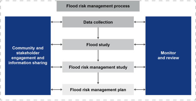
Figure 1. The
floodplain risk management process in New South Wales
Councils can apply for funding through DCCEEW's Floodplain
Management Program during the annual funding round, which opens in April and
closes in May each year. The funding is provided on a 2:1 basis, where
DCCEEW contributes two-thirds of the cost and Council contributes
one-third. This funding supports various floodplain management activities
including studies, works, and measures identified in council's floodplain risk
management plans.
Byron Shire Council currently have the second highest value
of funded projects in the state, of which 80 constituent councils are eligible
for funding.
Ongoing DCCEEW partially funded projects include:
· Broken Head Road
– Evacuation Route
· Belongil and
Tallow flood risk management study and plan update
· Byron Shire
overland flow path study
· Billinudgel rail
bridge debris options study and implementation
In addition to the DCCEEW partially funded projects listed
above, Council are also undertaking the following:
· Bangalow Flood
Study which is wholly funded by Council, following an unsuccessful grant
application to DCCEEW in 2023.
· NSW Public Works
are undertaking flood levee improvement works post a 2022 flood event
audit. It is completely funded by the NSW Government with no Council co
contribution required at all, and acting only as a liaison point.
· Coogera Basin
Upgrade Project which is primarily funded by NSW Reconstruction Authority, who
contributed $550,000 with Council contributing approximately $70,000.
· Preferred Byron Drainage Strategy The Byron Bay Drainage Upgrade Strategy is a Floodplain
Management Measure in the Belongil Creek Floodplain Risk Management Plan (2015)
adopted by Council
Project is funded by the
"Preparing Australian Communities" grant to develop the drainage
strategy through Concept Design to Detailed design stage.
The scope of works for the design
of drainage upgrades to concept stage includes the following catchments/regions
of the current Preferred Byron Bay Drainage Strategy (BMT, 2015):
o “Town Centre” Catchment
o “Marvel Street” Catchment
o “Cowper Street” Catchment
o “Shirley Street” Catchment
The scope of work generally
includes the following milestones/deliverables:
• Strategy review and data
collection
• Detailed Survey (all
catchments)
• Concept design and
hydraulic modelling (all catchments)
• Detailed Design -
construction documentation (Town Centre and Cowper St)
· NSW Severe Weather
and Flood Grant AGRN1012 $2M program - Highly impacted Councils
o SGB Flood Pump Generator Continuous
Power Supply Install
o SGB Rear Easements Enhancements
Planning
o SGB Rear Easements Enhancements
o SGB soakage pits enhancements by
connecting to drainage systems
o Flooding and Drainage Easement
Communication Education Program
o Byron Drainage Works Enhancement
Program
· NSW Severe Weather
and Flood Grant AGRN1012 $1M program - South Golden Beach resilience betterment
program (wholly funded by NSW Government)
o SGB flood levee raising
investigation
o West SGB levee flood pump
investigation
A summary of the current status of each of the above project
is presented above.
Broken Head Road – Evacuation Route
The Broken Head Road flood immunity project has been
prioritised as a critical initiative within the Tallow Creek catchment.
Byron Shire Council engaged JB Pacific to conduct a Feasibility Options
Assessment (FOA) to enhance the flood resilience and trafficability of Broken
Head Road. Following the FOA, JBP will prepare a detailed design of the works,
ready for construction.
The assessment uses an updated hydrodynamic model with the
latest LiDAR data (2023), rainfall data, and methodologies, calibrated against
the March 2022 and April 2024 floods.
Several flood mitigation options were evaluated, including
upgrades to the Coogera Circuit Detention Basin. The preferred strategy,
Option 5B, involves constructing a drainage channel adjacent to 32 Beech Drive,
shifting the driveway northward, and integrating emergency works. This
option is cost-effective, minimally impacts the community, and aligns with
future Coogera Basin upgrades.
The evaluation rejects a "Do-Nothing" approach,
emphasizing immediate and staged interventions. Recommendations prioritize
Option 5B as part of a comprehensive strategy to improve flood immunity and
accommodate future flood risk management plans.
Additional survey is currently being investigated which will
bolster the modelling and allow the refinement of the FOA. Following
finalisation of the FOA the project will move through the following phases:
· Concept Design
· Preliminary Design
· Issue for
Construction
· Final Report
Belongil and Tallow flood risk management study and plan update
WMS have been engaged to update the existing Tallows Creek
and Belongil Creek Floodplain Risk Management Study and Plans (FRMSP).
This update follows the previous studies completed in 2009 and 2015
respectively, and will comply with current NSW flood management policies and
guidelines.
The project aims to:
· Update flood
models and risk assessments for Belongil and Tallows Creeks
· Develop
prioritised flood management strategies, including structural, non-structural,
and natural solutions,
· Assess evacuation
routes and early warning systems
· Provide land use
planning recommendations (update floor planning levels)
· Engage with the
community on flood risks and mitigation
· Review Councils
current Climate Change policy in relation to flood estimation.
The outcomes will inform government decision-making,
community planning, emergency management, and future development in the
area. The project will also provide valuable information to key
stakeholders including utility providers and insurers.
The study is currently in early stages, having sourced all
required data to undertake the project, the consultant is currently
establishing flood models calibrated against the March 2022 and April 2024
flood events. Calibration is informed by flood height survey and
supplemented by information and photographs provided by the community following
the March 2022 event.
Community consultation, in the form of Your Say, will be
undertaken in the coming months to inform the community of the project, allow
for the community to provide feedback on the initial modelling results and to
provide recommendation for potential mitigation measures.
Byron Shire overland flow path study
Riverine flooding occurs when rivers, creeks, or other
watercourses overflow their banks due to heavy rainfall or upstream conditions,
affecting areas within the floodplain. Overland flooding (also called
surface flooding) happens when intense rainfall exceeds the capacity of local
drainage systems, causing water to flow across the land surface before it
reaches waterways, often affecting areas outside traditional floodplains.
Engeny Pty Ltd have been engaged to undertake a
comprehensive overland flood study of the entire LGA is a comprehensive
technical investigation of flood behaviour that provides the main technical
foundation for the development of a robust floodplain risk management
plan. It aims to provide an understanding of the full range of flood
behaviour and consequences in the study area. It involves consideration
of the local flood history, available collected flood data, and the development
of hydrologic and hydraulic models.
The overall project provides an understanding of, and
information on, flood behaviour and associated risk to inform:
· relevant
government information systems
· government and
strategic decision makers on flood risk and asset management
· the community
· flood risk
management planning for existing and future development
· emergency
management planning for existing and future development, and strategic and
development scale land-use planning to manage growth in flood risk
· other key
stakeholders (including utility providers and the insurance industry) on flood
risk
The study will map all overland flow paths within the shire
and provide a detailed understanding of overland flooding in the following
focus locations:
· Ocean Shores
· New Brighton
· South Golden Beach
· Billinudgel
· Brunswick Heads
· Mullumbimby
· Ewingsdale
· Byron Bay
· Bangalow
· Federal Village
The study is in the early stages, having completed the data
gathering phase, and achieving Council and DCCEEW approval of the basis of
modelling report.
Bangalow Flood Study
Byron Shire Council commissioned Wilde – Engineering
Consulting to conduct a comprehensive flood study for Bangalow. This
study is crucial for developing a thorough understanding of flood behaviour and
risk in the area, which will, in turn, inform government systems,
decision-makers, and the community at large. The primary outcome of the
flood study is to inform floor planning levels in Bangalow, which are currently
unguided.
The project involves the creation and calibration of a
hydrologic and hydraulic model in accordance with current guidelines and
standards and industry best practice. The model assesses the impacts of
both riverine (Byron Creek) and overland flooding for the township.
The project has completed Stage 2, which focuses on the
calibration and validation of these models using historical flood events,
namely the March 2022 for calibration and the February 2022 event and June 2016
event for model validation. The models were deemed to achieve a good
calibration and validation for the events through comparison with gauged water
level data within Byron Creek and community descriptions and photos of the
flood events, gained through a community consultation process (Your Say Survey)
undertaken as part of the project. Council technical staff have reviewed this
report and provided approval for the project to commence the third and final
stage.
Stage 3 (the final stage) will undertake modelling of design
events to identify flood risk areas for a range of flood magnitudes, produce
flood maps and set floor planning levels. The findings will be documented
in an Exhibition report which will be exhibited to the public prior to holding
a community workshop, with feedback being integrated into the final Flood Study
Report.
Billinudgel Rail Bridge debris options study and implementation
The adopted North Byron Floodplain Risk Management Plan (WMA,
2020) identified to implement debris control measures for Billinudgel Railway
Bridge as a high priority action. In response, Council successfully applied for
a Grant with DCCEEW to undertake an options analysis for debris control
measures for Billinudgel Railway Bridge and to prepare an implementation plan
moving forward.
Project Objective: To develop an implementation plan for
bridge debris control measures at Billinudgel Rail Bridge to reduce flooding
risk and maintain evacuation routes in the Billinudgel area, while
incorporating environmentally positive approaches. The project will be
overseen by Council and relevant stakeholders.
Types of measures to be investigated include:
· Structural
measures (trash racks/bollards)
· Catchment debris
reduction strategies
· Railway embankment
modifications
· Creek bank
alterations
· Potential bridge
infrastructure removal
The study will be undertaken in three phases:
1. Site
Assessment & Options Development (Milestone 1) which includes initial
stakeholder engagement with the community and DCCEEW
2. Options
Analysis (Milestone 2) – Through multi-criteria analysis incorporating
environmental, heritage, safety, and financial constraints, two preferred
options will be shortlisted and assessed via hydraulic modelling and lifecycle
costing to produce a comprehensive options analysis report.
3. Implementation
Planning (Milestone 3) – The final implementation plan will detail the
preferred solution's operational framework, priorities, timeline, costs, and
concept design, while establishing requirements for future environmental
approvals and assessments.
The project is in tendering phase with 5 organisations
invited to provide quotes. The project is expected to commence in late
February 2025 and to be completed by August 2025.
South Golden Beach Levee Works – NSW Public Works
NSW Public Works is running the Flood Levee Repair Program
which will provide funding to support medium-long term recovery for eligible
affected Local Government Areas (LGAs), by providing funding for repairs,
restoration and betterment of urban flood levee infrastructure impacted by
severe weather and flood events declared under AGRN 1012.
The FLRP will be administered by the Department of Primary
Industries and Regional Development (DPIRD) (formerly Department of Regional
NSW) in collaboration with the NSW Department of Climate Change, Energy, the
Environment and Water: Biodiversity and Conservation and Science (DCCEEW BCS),
and the NSW Reconstruction Authority (NSWRA).
The total program value is $36M jointly funded by NSW and
Australian Governments under DRFA.
Byron Shire Allocation:
1. Primary:
South Golden Beach Canal Levee
· Scope: Remediation
& Maintenance Accessway Construction
· Est. Cost:
$864,000
2. Supplementary
(if funding allows following primary projects): South Golden Beach Levee
· Scope: Remediation
& Pathway Construction (Beach Av to Pacific Esplanade)
· Est. Cost:
$688,500
Total Project Value: $1,552,500
Current Status:
· Initial
assessments and surveys completed
· Engineering
assessments finished
· Framework and
approval processes established
· Land title and
access matters assessed
Program oversight shared between DPIRD, DCCEEW BCS, and
NSWRA. Council to act as point of liaison only.
Coogera Detention Basin Flood
Resilience Project Update
The emergency works for the Coogera Detention Basin in
Suffolk Park has been successfully completed. This significant
infrastructure upgrade has substantially improved flood protection for the
Byron Hills residential area, including properties along Coogera Circuit,
Teatree Place, Beech Drive, and Bottlebrush Crescent. The completed works
have increased the flood resilience capacity from a 20% Annual Exceedance
Probability (AEP) to a 2% AEP, benefiting approximately 80 properties in the
catchment area. No adverse impacts have been observed from the
implemented works.
As part of the original Coogera Basin scope, supplementary
flood resilience works are scheduled for implementation along Beech
Drive. These works comprise construction of a shallow swale drain along
the eastern boundary of Beech Drive, connecting to the existing drainage
channel, which will provide additional flood resilience to properties along
Beech Drive.
The detailed design phase for the Beech Drive component is
nearing completion, with finalisation expected within the next two weeks.
Initial contractor pricing has been received and is currently under review by
Council staff.
Community consultation for the Beech Drive works is
progressing positively. A productive site meeting was recently conducted
with the primary affected property owner, indicating strong stakeholder support
for the proposed works. Further engagement activities are ongoing to
ensure comprehensive community awareness and input.
The remaining works are currently estimated at $146,000,
which marginally exceeds the available NSW Reconstruction Authority funding of
$133,000 by $13,000. A detailed construction estimate will be developed
upon design finalisation to confirm the precise funding requirements.
Rear Drainage Easements Upgrade
– South Golden Beach
This project focuses on enhancing rear easements through
on-ground works from the planning process. With a budget of $300,000, the
project's objective is to mobilise work crews to clear all drainage
easements. Currently, the project scope includes conducting detailed site
inspections, identifying issues on all easements, engaging a surveyor to survey
all easements and mark the centre line, engaging an ecologist for the REF and
Ecological Report, and gathering all information required for future funding applications.
Byron Bay Surveying is working on the survey with an expected completion by the
end of February, while GeoLINK is undertaking the REF and ecological
assessment, with the draft REF already received and awaiting the final
copy.
The remaining budget will be allocated towards designing
access to the easements to enable machinery deployment for clearing work, as
the site is currently inaccessible in several areas, hampering maintenance
efforts.
BYRON SHIRE COUNCIL
Staff Reports - Infrastructure Services 4.4
Report No. 4.4 Recommended
Flood Grant Applications in May 2025 subject to budget allocation
Directorate: Infrastructure
Services
Report Author: Euan
Rose, Project Officer
File No: I2025/102
Summary:
Introduction: The NSW Flood Risk Management
Manual (DPE – now DCCEEW, 2023) mandates councils to manage flood risk
within their LGAs. The manual outlines a cyclical process for plan preparation,
implementation, and review, recommending updates to Floodplain Risk Management
Studies and Plans (FRMSPs) every 5 to 10 years to incorporate the latest data
and changes.
Funding: Councils can apply for funding through
the NSW DCCEEW Floodplain Management Program, which opens in April and closes
in May annually. The funding is provided on a 2:1 basis, with DCCEEW
contributing two-thirds and the Council one-third. This supports various
floodplain management activities.
Projects proposed for Grant Funding:
1. North
Byron Floodplain Risk Management Study and Plan (FRMSP) Update:
· Based
on findings of the DPE funded Post-2022 Event Flood Behaviour Analysis for the
Brunswick River (WMAwater, Feb 2024), the 2020 FRMSP (WMAwater) needs updating
due to limitations in model performance, rainfall intensity and frequency data,
flood frequency analysis, and Brunswick River entrance conditions.
· A
number of proposed flood risk management strategies from the current FRMSP
should be delayed until he completion of the updated study to ensure they are
based of robust modelling results.
· Estimated
cost: $450,000; Duration: 2 years.
2. Bangalow
Floodplain Risk Management Study and Plan:
· Currently,
Bangalow lacks specified flood planning levels and has no FRMSP. The
ongoing Bangalow Flood Study (expected completion: August 2025) will provide
necessary data to undertake an FRMSP allows for future land-use planning and
flood risk management to be defined.
· Estimated
cost: $150,000; Duration: 1 year.
RECOMMENDATION:
The Floodplain Management Advisory Committee recommend:
That Council endorse funding Councils component
and applying for grant funding through the NSW DCCEEW Floodplain Management
Program for the following two (2) projects:
1. North
Byron Floodplain Risk Management Study and Plan Update, and
2. Bangalow
Floodplain Risk Management Study and Plan.
Report
Introduction
The NSW Flood Risk Management Manual (DPE – now
DCCEEW, 2023)[1] stipulates that councils are responsible for managing flood
risk within their respective LGAs. Figure 1, taken from this manual, documents
the process for plan preparation, implementation and review.
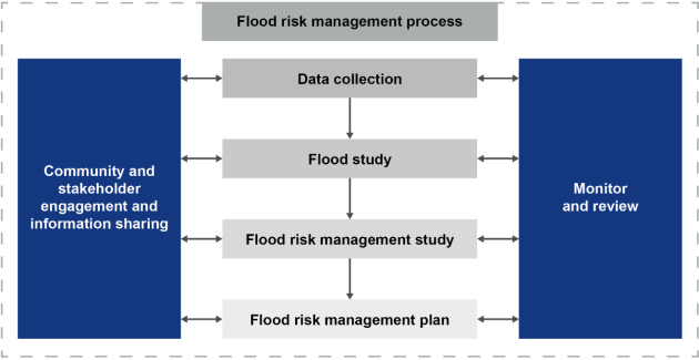
Figure 1. The
floodplain risk management process in New South Wales
It is highlighted that the process outlined in Figure 1 is
cyclical and the guidelines recommend that Floodplain Risk Management Studies
and Plans (FRMSPs) be updated every 5 to 10 years. This ensures that the
plans remain relevant and incorporate the latest data, technological
advancements, and changes in land use or climate patterns.
Councils can apply for funding through the NSW Department of
Climate Change, Energy, the Environment and Water’s (DCCEEW) Floodplain
Management Program during the annual funding round, which opens in April and
closes in May each year. The funding is provided on a 2:1 basis, where DCCEEW
contributes two-thirds of the cost and Council contributes one-third. This
funding supports various floodplain management activities including studies,
works, and measures identified in council's floodplain risk management plans.
Council intend to apply to fund two projects under this
grant (in order of priority):
1. North
Byron Floodplain Risk Management Study and Plan
2. Bangalow
Risk Management Study and Plan
North Byron Floodplain Risk Management Study and Plan Update
In 2020, WMAwater completed the North Byron Floodplain Risk
Management Study and Plan (FRMSP) [2], primarily using models developed as part
of the North Byron Flood Study (BMT, 2016), but also incorporating external
models to inform boundary conditions. This FRMSP is currently adopted by
Council.
Following the flood events of early 2022, the Department of
Planning and Environment (DPE) commissioned WMAwater to conduct the Post-2022
Event Flood Behaviour Analysis for the Brunswick River (WMAwater, Feb 2024)
[3]. This analysis utilised models from the 2020 Floodplain Risk Management
Study and Plan (FRMSP) and included a review of the modelling to compare it
with the 2022 flood event. The document recommends updating the modelling for
several reasons as noted below, and following this, updating the FRMSP:
1. Hydrologic
Model Limitations:
· The current
hydrologic model over-attenuates flows upstream of the Durrumbul gauge, Main
Arm, resulting in an underestimation of flood extents for the design events.
· The model uses
outdated ARR87 approaches, with the guidelines being updated in 2019.
· The hydrologic
modelling was undertaken using XP-RAFTs, which is no longer supported.
2. Rainfall
Intensity and Frequency:
· A comparison of
BOM 2016 Intensity-Frequency-Duration (IFD) and an at site IFD analysis of
gauges in the catchment suggest that the IFD’s are likely underestimating
the total depths of storms greater than 24 hours, for events less frequent than
10% AEP. In addition, is unclear if there are orographic effects influencing
rainfall in higher regions due to the short record at Upper Main Arm, and this
effect should be investigated.
3. Flood
Frequency Analysis (FFA):
· The 2022 event
significantly altered the FFA at Durrumbul, further indicating previous flood
estimates were underestimated.
· Design flow
estimates at Durrumbul need to be reviewed and updated.
4. Hydraulic
Model Performance:
· The hydraulic
model shows good matches in populated zones but underestimates north-west of
the town centre of Mullumbimby and adjacent to Kings Creek, with known
inundated areas not being modelled as so.
· The model’s
1-Dimensional representation may not accurately capture flow characteristics,
suggesting a potential improvement with 2-Dimensional approaches.
5. Complex
Interactions and Model Integration:
· The Marshalls
Creek system is characterised by a complicated interaction between the Yelgun,
Mooball and Marshalls Creeks. Mooball Creek Discharges at Pottsville but flows
from this catchment flow into the Yelgun Creek catchment in sufficiently large
flood events.
The model relies on external Mooball Ck flows from a dated
Tweed Shire Council model, and so is dependent on the accuracy of two
independent models. It is noted Tweed Shire Council are currently undertaking
the Coastal Creek Flood Study, which will provide a more robust model to
represent cross catchment flows from the Mooball Creek catchment into Yelgun
Creek.
· Two hydrologic
models covering Marshalls Creek and Yelgun Creek have feedback loop
dependencies for each other and are therefore unlikely to appropriately
represent the complexities of the system. The two models have diverged over
time.
6. Brunswick
River Entrance:
· Significant head
loss occurs in the Brunswick River at the confluence of Marshalls Creek and
Simpsons Creek. Past mitigation assessments focused on high ocean levels. The
2022 flood event, with a low tide condition (<10% AEP), was 0.7 m lower than
the lowest design level assessed in a 1% AEP event. Future assessments should
consider lower tide conditions, such as a 20% AEP, to capture the full scope of
impacts and benefits
These points highlight the need for a comprehensive review
and update of the modelling to ensure accurate representation and effective
flood risk management. Following this modelling update the FRMSP will require
update to capture the changed modelling outcomes.
Council estimate the project to cost in the order of
$450,000 and take approximately 2 years to complete.
Council continue to implement recommendations of the current
FRMSP, which are not sensitive to the likely updated design flood levels of an
updated flood model, as documented in I2025/74, examples of such projects
include:
· Debris control
measures for Federation Bridge (complete) and Billinudgel Railway Bridge
· Development a
whole of catchment drainage model and overland flow path investigation
· Undertake more
detailed assessment of properties which may benefit from property level
protection.
· Implement the
recommendations of the South Golden Beach levee audit.
However, it is suggested that some mitigation strategies be
updated, informed by the updated FRMSP, such as:
· Engage with the
community to prepare an ongoing flood education program, with appropriate
evaluation by Council and SES following implementation.
· Changes to land
use zoning should consider flood compatibility based on the recommendations of
the FRMS.
· Section 10.7 (5)
certificates to provide further detail of flood behaviour. Consideration to
providing property-level flood information via an online GIS platform.
· Develop guidance
on the design and installation of fencing traversing waterways and channels.
Updating mitigation strategies based on the latest flood
modelling from the updated FRMSP ensures that they are informed by the most
accurate and current flood risk data. This approach enhances flood risk
management and community resilience by providing up-to-date information and
effective strategies and avoids the need to revisit items such as community
education in light of more accurate guidance.
Bangalow Floodplain Risk Management Study and Plan
As of now, Bangalow does not have a specified flood planning
level according to the guidelines set out in the Department of Climate Change,
Energy, the Environment and Water (DCCEEW) Floodplain Risk Management Manual
[1]. This manual provides comprehensive strategies for managing flood-prone
land, ensuring that flood risk is effectively mitigated through sustainable and
community-focused approaches. This absence means that the Council's development
engineers do not have formal flood planning level requirements to guide
developments within the township. This gap can lead to inconsistencies and
potential risks in managing flood-prone areas effectively.
For the flood planning levels to be formally adopted into a
Development Control Plan (DCP), they must be established as part of a
Floodplain Risk Management Study and Plan (FRMSP). The DCCEEW mandates that
flood planning levels derived from such studies are integrated into local
planning instruments to ensure that development within flood-prone areas is
appropriately managed and mitigated. Reasons for this approach include:
1. Comprehensive
Approach: FRMSP includes risk management strategies beyond flood behaviour
analysis.
2. Risk
Mitigation: Incorporates measures to reduce flood risk and enhance
community resilience.
3. Stakeholder
Engagement: Involves input from communities and relevant stakeholders.
4. Regulatory
Compliance: Aligns with national and state flood risk management policies.
Currently, there is no Floodplain Risk Management Study and
Plan (FRMSP) for Bangalow.
The Bangalow Flood Study is currently being prepared by
Wilde – Engineering Consulting, expected to be complete by August 2025.
This study will provide a detailed technical analysis of flood behaviour in
Bangalow and its surrounding areas. The outcomes of this study include
confirming the flood planning levels for the town, as developed by the Flood
study. The study aims to gather valuable data on how and where floods impact
the town, which will be instrumental in guiding future land-use planning and
flood risk management strategies.
Council estimate the project to cost in the order of
$150,000 and take approximately 1 year to complete.
References
[1] Flood
risk management toolkit | Floodplains | Environment and Heritage
[2] North
Byron Floodplain Risk Management Study and Plan - Byron Shire Council
[3] Post
2022 Event Flood Behaviour Analysis – Brunswick River
Strategic Considerations
Legal/Statutory/Policy
Considerations
Council has a general duty of care to provide reasonable
infrastructure, as resources and priorities permit. Where existing
infrastructure becomes known to be inadequate for any reason within the control
of Council, repair, renewal and upgrade of drainage assets for the provision of
stormwater drainage / flood mitigation is a fundamental component of meeting
Council’s obligations.
Provision of stormwater drainage / flood mitigation
infrastructure is a legitimate function of local government under the Local
Government Act 1993. To the extent that the provision of infrastructure
protects public roads, other infrastructure, Council land, Crown land, private
land and the community. Council is also responsible for drainage under
the Roads Act 1993.
Financial Considerations
Council will need to include the following sums for Council
Contribution (2:1 basis) in the Capital Budget request for FY25/26 to proceed
with the proposed projects:
· North Byron
Floodplain Risk Management Study and Plan - $150,000
· Bangalow Risk
Management Study and Plan - $50,000
BYRON SHIRE COUNCIL
Staff Reports - Infrastructure Services 4.5
Report No. 4.5 Performance
of Automatic Warning Signs for Water Over Main Arm Road just west of Sherrys
Bridge
Directorate: Infrastructure
Services
Report Author: Euan
Rose, Project Officer
File No: I2025/105
Summary:
Following the flash flood event on 1 December 2024, concerns
were raised about the effectiveness of automatic warning signs on Main Arm
Road. Despite the signs flashing as designed, four vehicles were washed
off the road, with two prevented from entering the Brunswick River by private
farm fencing. One occupant from a vehicle that entered the river was later
rescued from a tree.
The traffic on Main Arm Road that night was likely returning
from an event at Durrumbul Hall, which ended around midnight. Heavy rain
was still falling at that time, and the peak river gauge height at Sherrys
Bridge reached 4 metres at approximately 1 am.
An occupant interviewed after the event claimed the height
of the sign (3 metres above ground) meant visibility of the signs’ text
was impeded and the driver did not understand the meaning of the flashing
lights.
The bottom edge of the sign reading “ROAD SUBJECT
TO FLOODING DO NOT ENTER WHEN FLOODED” was constructed at 2.2m above
the of the edge of the road, while the flashing lights are approximately 3m
above the road. The design heights were based on the following
considerations:
· Australian
Standard AS 1742 and Austroads Guide to Traffic Management specifies in rural
areas signs should be at least 1.5m above the road pavement.
· Sign at 2m to
bottom edge from ground provides earlier sighting deters vandalism or theft
– particularly of the battery pack and solar panels.
· to ensure
visibility during large flood events.
The board could be lowered by 700mm and still comply with AS
1742; however, this would reduce the flood immunity and increase the risk of
tampering, but most importantly lower early sighting of the sign during flood
events, which poses a risk to motorists travelling at speed.
It is noted that Variable Message Signs, which are display
lit messages, were considered during the project design phase, however these
are significantly more expensive and based on allocated project budget would
have reduced the number of signs able to be installed in the shire to 1, which
would not have fulfilled the required grant outcomes.
Based on the above it is not recommended the signs are not
lowered.
Nominal sign design E2025/13642
RECOMMENDATION:
That the Committee note Council staff decision to
not adjust the height of the Main arm flood warning signs.
Attachment 1
(E2025/13642)