Notice of Meeting
Local Traffic Committee Meeting
A Local Traffic
Committee Meeting of Byron Shire Council will be held as follows:
|
Venue
|
Conference Room, Station Street, Mullumbimby
|
|
Date
|
Tuesday, 18 February 2025
|
|
Time
|
1:30 PM
|
Phil Holloway
Director Infrastructure
Services
I2025/145
Distributed
11/02/25

BYRON SHIRE COUNCIL
Local Traffic Committee
Meeting
BUSINESS OF MEETING
1. Apologies
2. Declarations
of Interest – Pecuniary and Non-Pecuniary
3. Adoption
of Minutes from Previous Meetings
3.1 Local
Traffic Committee Meeting held on 25 December 2024
4. Matters
Arising
5. Outstanding
Issues/Resolutions
6. Regulatory Matters
6.1 510
Goonengary Road, Intersection Upgrade........................................................... 3
6.2 Federal
Village Main Street - Short Term Road Safety Treatments...................... 5
6.3 Changes
to the Intersection of Warrambool Road, Coomburra Crescent and Goondooloo Drive
in Ocean Shores......................................................................... 14
6.4 Blues
Festival 2025 - Traffic Managment Plan....................................................... 20
6.5 315
Coorabell Road - Upgrade turning treatment for the site access................. 24
7. Matters for Traffic
Engineering Advice
7.1 Adaptive
Pro Surf Championship - 23 March - 30 March...................................... 25
8. Events
8.1 Event
- Westpac Helicopter Byron Coastal Charity Walk – 3rd May 2025......... 28
8.2 Event
- Bangalow Billycart Derby May 2025........................................................... 32
8.3 Chincogan
Charge - September 2025...................................................................... 36
BYRON SHIRE COUNCIL
Local Traffic Committee Meeting 6.1
Regulatory Matters
Report No. 6.1 510 Goonengary Road, Intersection Upgrade
File No: I2024/1716
The purpose of this report is to
gain Council support for the proposed line markings and regulatory signs shown
in Attachment 1 (E2024/149675).
Council has received a Roads Act
application associated with a development approval 10.2022.181.1 for a Multiple
Occupancy consisting of Nine (9) Dwelling Sites, Associated Infrastructure,
Tree Removal and Environmental Enhancement Works at 510 Goonengerry Road
MONTECOLLUM
Schedule 1 – Deferred
Commencement of development consent 10.2022.181.1 state:
1. Deferred Commencement Consent
This consent does not operate until Council is satisfied as to the
following matter:
(a) Approval required under Section 138 of the Roads Act 1993
Consent from Council must be
obtained under Section 138 of the Roads Act 1993 for road widening and
driveway consolidation works in Goonengerry Road, as follows:
Consolidated
driveway
(a) A
consolidated driveway servicing numbers 506 and 510 Goonengerry Road, designed
and constructed in accordance with Type 1 driveway of TfNSW drawing Typical
Rural Property Access dated 19/05/2020 version 2. The works are to
include the adjustment and/or relocation of services as necessary to the
requirements of the appropriate service authorities.
Basic
Right Turn treatment
(b) Provision
must be made to provide (i.e., design & construct) a Basic Right Turn (BAR)
treatment on a two-lane rural road in accordance with Figure A6 in Austroads
Guide to Road Design Part 4: Intersections and Crossings – General
(2021).
(c) BAR
treatments and any associated road widening and/or tree removal works are to be
carried out generally in accordance with Plan C1 (Revision C) titled
“Type BAR – West Widening & Reconstruct’, by SDS Civil
Enterprises, dated April 2022 as referred to in Condition 1 of this development
consent.
(d) The
above plan may be subject to change or modification as necessary to achieve
compliance with the relevant engineering standards and Council
requirements. If the proposed road works (e.g., earth batters, retaining
walls, rock mattresses etc.) will encroach onto neighbouring private land, it
will be necessary to obtain landowners consent from the affected landowner to
carry out the proposed road widening.
Note
1: The calculation of the C value on
curves requires additional curve widening.
Note
2: Road reserve widening (if
required) is to be taken on the development side only.
Note 3. Any encroachments affecting the road reserve must be
removed or relocated wholly within the development boundaries. Any
encroachments of roadworks onto private land are to be dedicated as “Road
Widening” at no cost to Council.
RECOMMENDATION:
That Council supports the
signage and line markings associated with the 510 Goonengerry
Road intersection works, as shown in
Attachment 1 (E2024/149675)
Attachments:
1 51.2022.181.1
- LTC submission, E2024/149675 
BYRON SHIRE COUNCIL
Local Traffic Committee Meeting 6.2
Report No. 6.2 Federal Village Main Street - Short Term Road Safety
Treatments
File No: I2024/1587
Purpose:
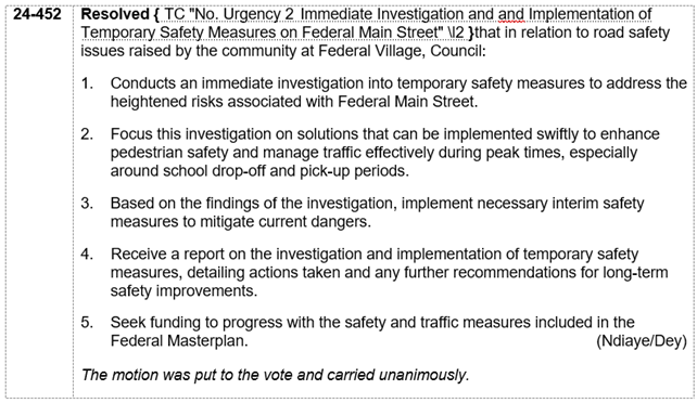
In response to an Urgency Motion raised by Cr Sarah Ndiaye
during the 5 September 2024 Council meeting and as noted in Council resolution
24-452 shown below, this report provides recommended road treatments on Federal
Drive in Federal to improve road safety in the short term while Council seek
funding for the longer term Federal Village Masterplan changes.
The proposed treatments aim to provide pedestrians with a
clear crossing location and should also help to reduce vehicle speeds.
Information/Background:
The northern end of Federal Drive had been closed due to a
landslide which occurred during the March 2022 flood event. During the
closure period, only local traffic was able to access Federal village from the
north and when the road was re-opened in July 2024 the amount of traffic from
the north increased dramatically (i.e. from 164 vehicles per day in June to 922
in August). On 3 September 2024, a near miss road incident occurred
between a vehicle and a school child. Refer Figure 1 location map below.

Figure 1: Location map showing main street (Federal Drive)
in Federal and location of near miss incident
Federal Drive provides on-street parking which services
several local businesses and a local park. School buses also use this
section of the main street for student drop-off / pick-up.
Due to the width, geometry, and lack of line marking / speed
treatments, vehicles often speed through this area. This creates an
increased safety risk given the high pedestrian and vehicle activity in the
area. Refer Figure 2 below showing the current road environment.
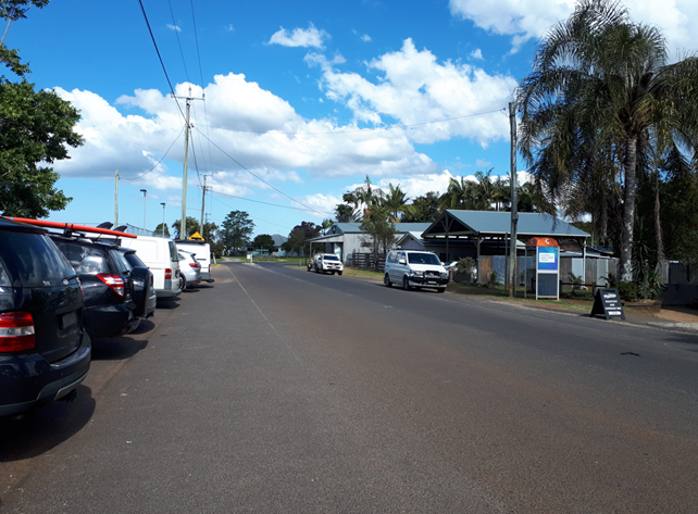
Figure 2: Photo showing current road environment
(looking south down Federal Drive, towards Binna Burra Road)
A future design for the area (refer Figure 3 below or
Attachment 1 for more detail) includes treatments to mitigate road safety
issues, however this concept requires funding to progress and will likely take
years to implement.
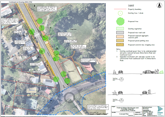
Figure 3: Federal Village Main Street Long Term Concept
Design
To mitigate the safety issues in the short term, staff
recommend installation of the following treatments as shown in Figure 4 below:
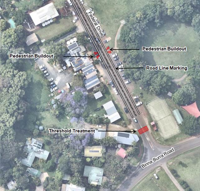
Figure 4: Interim Federal Drive Concept
1. Speed
limit reduction to 30kph within the village main street
Transport for NSW have conducted an urgent speed zone review
of the current 50kph speed limit and have approved a reduction to 30kph within
the main village area (refer Attachment 2).
In addition, they have recommended installation of more
50kph speed signage in the surrounding 50kph zone to improve driver
awareness. TfNSW will provide funding for installation of this signage by
Council’s Works team.
2. Line
marking of the road edges and centre line
Defining the road edges and centreline is beneficial for a
couple of reasons. This type of line marking is a common feature within
townships and is a visual indication to drivers that they are entering a new
lower speed environment. In this case, they will be leaving a rural 50kph
speed zone and entering a 30kph zone. The other benefit to this treatment
is that it makes the road appear narrower which usually encourages drivers to
reduce speed.
3. Pedestrian
build-outs or kerb blisters
While there is no obligation for vehicles to stop at a
pedestrian build-out, it should direct pedestrians to cross here when the road
is clear, rather than crossing randomly. It should also alert drivers to
the possibility that pedestrians may cross here and help to slow vehicle
speeds.
The location for the pedestrian build-out was selected as
there is an existing connection to the footpath running through the park,
minimal infrastructure changes required and it’s also the same location
as the future raised pedestrian crossing. Refer Figures 5 and 6 below.
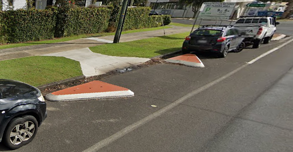
Figure 5: Example of Pedestrian Build-Out (Kerb Extension)

Figure 6: photos showing approx. location of new pedestrian
build-out
In addition, installation of pedestrian advisory signage
should be installed around the build-out, such as the “Look Out Before
You Step Out” decals shown in Figure 7 below. These have already
been installed in a number of high pedestrian activity areas around the shire.
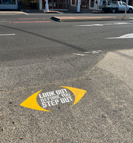
Figure 7: Look Out Before You Step Out decal
Installation of a formal pedestrian crossing would require a
significant amount of time and cost to implement which is why it hasn’t
been considered in the short term (e.g. new street lighting, removal of car
parks and vegetation, etc).
4. Threshold
treatment on the southern approach of Federal Drive
Threshold treatments are commonly used as traffic calming
devices in areas with increased pedestrian activity or where there is a speed
limit change as they provide a visual indication to drivers that they are
entering a new road environment.
There is also a threshold treatment in use on the northern
approach to Federal and it’s recommended that a similar treatment be used
on the southern approach.
An example of this treatment is shown below in Figure 8.
Figure 8: Example of Threshold Treatment
RECOMMENDATION:
That the Local Traffic Committee support the
following:
1. Speed
limit change from 50kph to 30kph on Federal Drive;
2. Installation
of signage as per TfNSW speed zone review;
3. Edge
line and centre line marking on Federal Drive;
4. Pedestrian
build-out and advisory signage; and
5. Threshold
treatment on the southern end of Federal Drive.
Attachments:
1 Federal
Village Main Street Long Term Concept Design, E2024/137332

2 TfNSW
Speed Zone Review Federal Village, E2024/137469

BYRON SHIRE COUNCIL
Local Traffic Committee Meeting 6.3
Report No. 6.3 Changes to the Intersection of Warrambool Road,
Coomburra Crescent and Goondooloo Drive in Ocean Shores
File No: I2025/5
The purpose of this Report is to
request minor changes to the previously approved design detailed in LTC report
attached (Attachment 1, I2023/780). For reference, see current
intersection and originally proposed changes below.
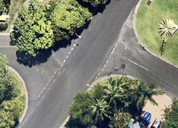
Fig 1 – current intersection
layout
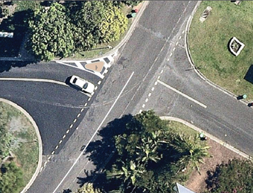
Fig 2 – previous proposed
intersection layout
Further investigation of the area
has been undertaken and the following changes have been made to the design (see
updated design plans below, Figures 3 - 6):
1. Replacing the existing Give Way signs with
new Stop signs on Goondooloo Drive and Coomburra Crescent.
2. New No Stopping signage and line marking to
prevent vehicles parking on the road verge and obstructing driver sight
distances on approach to Warrambool Road via Goondooloo Drive and Coomburra
Crescent.
3. Replacing the Coomburra Crescent left side
concrete island with chevron line marking and red RRPMs to provide space for
larger vehicle turning movements.
4. New concrete splitter island on the
Goondooloo Drive approach to assist in slowing vehicles and preventing exiting
right turning vehicles cutting across the intersection.
5. Change to extent of BB centre line marking
to avoid driver confusion at the intersection. In summary, previous
design showed BB double centre line marking on Warrambool Road southern
approach and extending into the middle of the intersection. New design
has BB double centre line marking on south and north approaches with break
around intersection area.
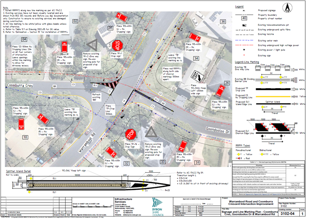
Fig 3 – new proposed
intersection layout (sheet 1 of 4)
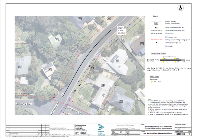
Fig 4 – new proposed
intersection layout (sheet 2 of 4)
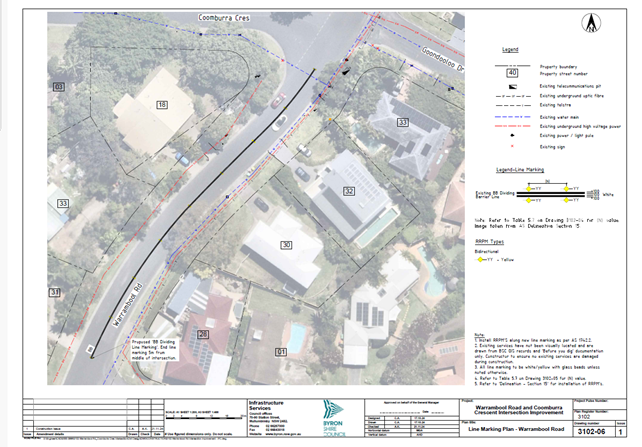
Fig 5 – new proposed
intersection layout (sheet 3 of 4)
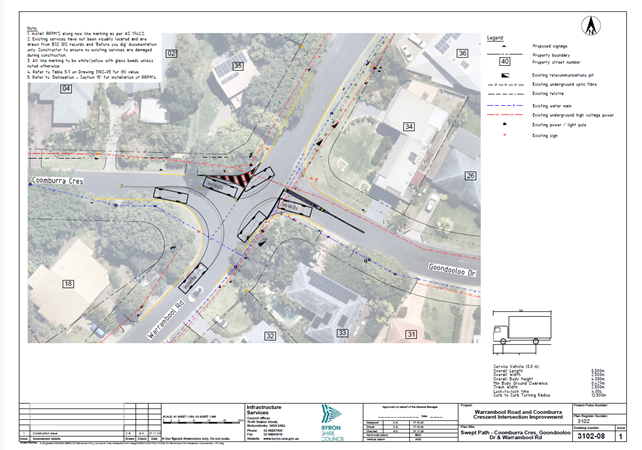
Fig 6 – new proposed
intersection layout (sheet 4 of 4)
RECOMMENDATION:
That the Local Traffic Committee support the following
changes to the design of the intersection of Coomburra Crescent, Goondooloo
Drive and Warrambool Road in Ocean Shores:
1. New
Stop signs instead of Give Way signs on Coomburra Crescent and Goondooloo
Drive.
2. No
Stopping signage and line marking around the entire intersection.
3. New
concrete splitter island on Goondooloo Drive.
4. Chevron
line marking and RRPMs in lieu of concrete island on Coomburra Crescent.
5. Change
to extent of BB double centre line marking around intersection.
Attachments:
1 Report
15/08/2023 Local Traffic Committee Road Safety Improvements to Warrambool Road
and Coomburra Crescent Intersection Ocean Shores, I2023/780
BYRON SHIRE COUNCIL
Local Traffic Committee Meeting 6.4
Report No. 6.4 Blues Festival 2025 - Traffic Managment Plan
File No: I2025/49
Bluesfest plans to run the 2025 event
over the Easter Long Weekend: Thursday 17th
April to Sunday 20th April 2024 in accordance with DA10.2014.753.9.
Access to the camp grounds will be
available from Wednesday 16th April until the 21st April 2024.
Bluesfest have submitted a traffic
management plan (TMP) and traffic guidance scheme (TGS) in accordance with the
conditions of consent for DA 10.2014.753.9. The TMP includes a trigger
point to be enforced to open Grays Lane in the south, only if ticket sales
are greater than 18,000 a day with gates to be open from 9pm-2am ONLY.
Council’s Development Engineer,
TfNSW and NSW Police have reviewed the submitted TMP and TGS and confirms they
meet the conditions of consent requirements. For reference the specific
traffic related condition has been inserted below.
Contingency plans (refer table 1 in the
TMP) have been designed to manage the flow of traffic in the event of an
incident or if traffic queues appear as though they may breach KPIs.
These contingency plans have been designed with the intent of increase traffic
flow from the public roads onto the site before any of the KPIs are
breached. These contingency plans are to be implemented by festival
management, with notification of any contingency implemented to be given to the
relevant parties (traffic control supervisor, police, safety advisor, traffic
engineer, etc.).
DA 10.2014.753.9 CONDITIONS
The following condition are relevant:
61. Transport Management Plan
The submission of a
Transport Management Plan (TMP) prepared in accordance with the “Guide
to Traffic and Transport Management for Special Events”, to Council
for approval at least 90 days prior to the commencement of the first event
under Stage 1. The Transport Management Plan to be broken into three
parts to delineate management measures for small, medium and large
events. The plan to be robust to enable it to be used for a variety of
small, medium and large events annually.
a) The
Transport Management Plan must include, but not be limited to:
i. Details for the
efficient management of parking, including provision for overflows from the
southern parking area to the northern parking area. The management of
overflow parking must ensure that the overflow vehicles exit the site from
where they entered the site.
ii. A contingency plan
for unplanned incidents that may disrupt traffic and transport before, during
or after the event. The contingency plan must be fully documented and include
emergency contact names and phone numbers.
iii. A copy of an
approved Traffic Control Plan.
b) The Traffic Control
Plan (TCP) must address the following matters:
i The TCP
must be designed in accordance with the requirements of the Roads and Maritime
Services’ Manual, Traffic Control at Work Sites Version 2, and the
current Australian Standards, Manual of Uniform Traffic Control Devices Part 3,
‘Traffic Control Devices for Works on Roads’.
ii The TCP
must be prepared by a suitably qualified and RMS accredited Work Site Traffic
Controller.
iii The regulation
of traffic must be authorised under the Roads Act 1993 and the use of traffic
control devices authorised under the Road Transport (Safety & Traffic
Management) Act 1999.
iv Reduced speed
zones must be approved by the Roads and Maritime Services.
v There is to be
no impact on through travel times on the pacific Highway
vi The TCP must
incorporate a monitoring program to assess the traffic volumes and peak parking
numbers associated with each event. Twenty four hour traffic counts are
to be undertaken before, during and after the first two medium and large events
(and as further required by Council or the Roads and Maritime Service) for the
traffic on the frontage and surrounding roadways. Such report must include details demonstrating
compliance with the conditions of consent relating to traffic management
including the requirements of the RMS provided below. From time to time
aerial photography of the site and surrounds at regular intervals before during
and after the event, including peak traffic and parking periods should be
undertaken to support the traffic monitoring report.
vii The TCP must provide
for all relevant conditions of the Roads and Maritime Services.
viii The TCP must be submitted
to the Local Traffic Committee prior to approval under the Roads Act 1993 and
adequate time must be allowed for this to occur and for the preparation of any
necessary reports and amendments necessary to meet the Local Traffic Committee
recommendations.
ix The TCP must
satisfactorily address any concerns or issues raised by the Council, Police
and/or Roads and Maritime Services from previous events.
x The TCP must
ensure access to surrounding and neighbouring properties at all times including
the wrecker and service station.
xi The TCP must
provide appropriate signage to prohibit parking in the surrounding road network
and to prohibit access to the airport by festival patrons. Adequate provision
must be made to allow residents of Grays Lane to park in Tanner Lane near the
end of Grays Lane when through access is closed due to flood. Permanent
“No Parking” signs in Grays Lane from the Pacific Highway to the
Tyagarah Nature Reserve boundary will be considered as a permanent management
arrangement.
xii Entrance to Grays
Lane East of Yarun Road to be restricted to residents and their guests for the
duration of the festival to prevent the parking of vehicles in Grays Lane.
xiii The TCP to factor in that
local roads operate a Level of Service D or better between the hours of 8am and
8pm on event days. The ramps of the Gulgan Road Interchange with the
Pacific Highway to operate at Level of Service C or better at event times
(See Figure 3.1 Levels of Service Flow rates Austroads Guide to Traffic
Management Part 3 and Highway Capacity Manual)
xiv The TCP to include
provision so that Traffic queuing on the Gulgan road off ramps does not exceed
stopping sight distances for 110 km/h speeds. (See RMS supplements and
Austroads Guide to road Design Part 3 Section 5.3.1 for stopping sight distances)
c) The Transport Management Plan and Traffic
Control Plans to be reviewed on an annual basis and where required such plans
to be updated accordingly taking into consideration changing traffic
conditions, altered management arrangements and other issues as identified by
the Roads and Maritime Service, Council or the Regulatory Working Group to
ensure the safety and efficiency of the road network.
d) The Transport Management Plan and Traffic
Guidance Scheme for the temporary use of the camping ground in conjunction with
the Splendour in the Grass Festival is to be reviewed at the end of the event
and a report prepared by a suitably qualified traffic engineer to identify the
effectivity and performance of the Traffic Management Plan including measures
to improve the safety and efficiency of the surrounding road network. The
report shall be submitted to Council and reviewed by the Splendour in the Grass/
North Byron Parklands Regulatory Working Group
Note:
·
Access/ Egress from, and to, the Pacific Highway to Grays Lane to be closed in
the future by the RMS, and opened only to limited event traffic should approval
be given. The Transport Management Plan and Traffic Control Plan to
reflect proposed changes to this intersection.
· Traffic
management documents to be in accordance with current standards and terminology
as stipulated by TfNSW.
RECOMMENDATION:
1. That
Council endorse the regulatory traffic management facilities and devices,
including signs and traffic controller provisions proposed for the Council
controlled public road network as outlined in attachment 1 (E2025/6308) for the
Byron Bay Bluesfest 2025 to be held from Wednesday 16th April 2024
to Monday 21st April 2024, subject to:
a) Separate
approvals by NSW Police and TfNSW being obtained, noting that the event is on a
state road or may impact the state road network;
b) The
event be held through the implementation of the events Traffic Management Plan
and Traffic Control Plan(s) as per attachment 1 (E2025/6308). The Traffic
Management Plan is to include contingency measures in case the level of queuing
fails to meet KPI requirements. It is noted that such queuing may be caused by
the introduction of paid parking.
c) The
Traffic Management Plan and the Traffic Guidance Scheme(s) to be implemented by
those with relevant and current TfNSW accreditation;
d) Traffic
camera data recorders or similar be used to obtain an accurate record of
traffic impacts at KPI queue locations;
e) That
the impact of the event be advertised via a notice in the local weekly paper a
minimum of one week prior to the operational impacts taking effect, noting it
must include the event name, specifics of any traffic impacts or road closures
and times, alternative route arrangements, event organiser, a personal contact
name and a telephone number for all event related enquiries or complaints;
2. That
the event organiser:
a) advertise
the impact of the event via a notice in the local weekly paper a minimum of one
week prior to the operational impacts taking effect, noting it must include the
event name, specifics of any traffic impacts or road closures and times,
alternative route arrangements, event organiser, a personal contact name and a
telephone number for all event related enquiries or complaints;
b) provide
a copy of the advert for Council's web page;
c) give
consideration of any submissions received;
d) inform
community and businesses that are directly impacted (e.g. adjacent to the
event) via written information which is delivered to the property in a timely
manner so as to document, consider and respond to any concerns raised;
e) arrange
for private property access and egress affected by the event;
f) liaise
with bus and taxi operators and ensuring arrangements are made for provision of
services during conduct of the event;
g) consult
with emergency services and any identified issues be addressed;
h) holding
$20m public liability insurance cover which is valid for the event;
i) paying
Council’s Road Event Application Fee prior to the event.
Attachments:
1 51.2024.1074.1
25172-TMP-B - Bluesfest 2025 TMP_10122024_RA-2024-10984, E2025/6308
2 51.2024.1074.1
Bluefest 2025 V2.0_TGS_10122024_RA-2024-10984, E2025/6309
BYRON SHIRE COUNCIL
Local Traffic Committee Meeting 6.5
Report No. 6.5 315 Coorabell Road - Upgrade turning treatment for the
site access
File No: I2025/109
The purpose of this report is to
gain Local Traffic Committee and Council support for the proposed line markings
and regulatory signs shown in Attachment 1 (E2025/13840
Council has received a Roads Act
application associated with a development approval for Modification to consent no.10.2019.236.1 condition no.
4 & 45 to allow for dual occupancies and secondary dwellings on a rural
community title at 315 Coorabell Road, Coorabell
1. Deferred
Commencement Consent
This
consent does not operate until Council is satisfied as to the following matter:
(a) Consent
required for works within the road reserve
Consent
from Council must be obtained for works within the road reserve pursuant to
Section 138 of the Roads Act 1993. Three (3) copies of engineering construction
plans must accompany the application for consent for works within the road
reserve.
Such
plans are to be in accordance with Council's current Design & Construction
Manuals and are to provide for the Upgrade of the Turning Treatment for the
Site Access to provide rural CHR(s) & BAL turning treatment in accordance
with AUSTROADS and Council’s standards. Works must include the adjustment
of the existing line marking and any necessary increased pavement widening.
Please
Note: Regulatory devices, linemarkings and signage must be referred to Local
Traffic Committee and approved by Council Resolution.
(b) Completion
of works within the road reserve
The Upgrade of the Turning
Treatment for the Site Access to provide a CHR(s) & BAL turning treatment must be completed to Council’s satisfaction in
accordance with the Roads Act consent. A copy of the final completion letter/s,
issued by Council, must be obtained.
RECOMMENDATION:
That the Local Traffic
Committee supports the signage and line markings associated with the 315
Coorabell Road intersection upgrade works, as shown in Attachment 1 (E2025/13840)
Attachments:
1 51.2023.399.1
- LTC submission, E2025/13840
BYRON SHIRE COUNCIL
Local Traffic Committee Meeting 7.1
Matters for Traffic Engineering Advice
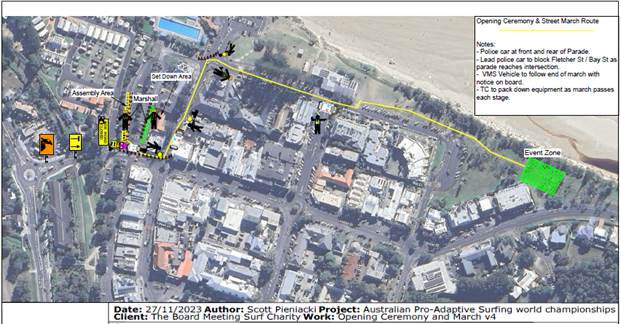
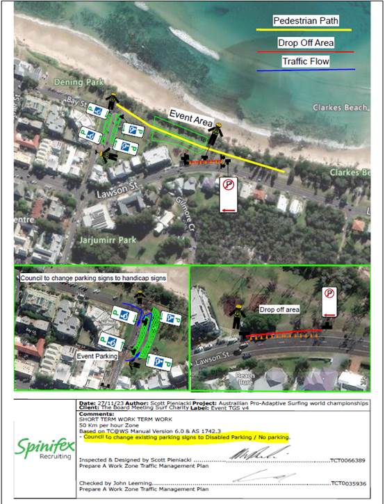
Report No. 7.1 Adaptive Pro Surf Championship - 23 March - 30 March
File No: I2024/1713
Council has received an application for the 2025 Adaptive
Pro Surf Championship
This report is to keep members of the LTC informed of road
closures and traffic measures to be put in place at the upcoming event.
Opening Ceremony and Event
RECOMMENDATION:
1. That
the Local Traffic Committee support the Adaptive Pro Surf Competition 23 March
through to 30 March 2025
2. That
Council support in Part 1 is subject to:
a) separate
approvals by NSW Police and TfNSW being obtained;
b) the
event organiser providing council with an updated Traffic Management Plan and
Traffic Guidance Scheme/s for the event;
c) development
and implementation of a Traffic Management Plan and Traffic Guidance Scheme/s
by those with appropriate TfNSW accreditation and the holding of current and
appropriate levels of insurance and liability cover;
d) the
impact of the event be advertised, and charged at cost to the organisers, via a
notice in the local weekly paper and Variable Message Signage (VMS) a minimum
of one week prior to the operational impacts taking effect, noting it must
include the event name, specifics of any traffic impacts or road closures and
times, alternative route arrangements, event organiser, a personal contact name
and a telephone number for all event related enquiries or complaints;
e) the
event be notified on Council’s web page and social media with the event
organiser supplying Council with the relevant information;
f)
access to Lawson Street is to be unrestricted at all times.
3. The
event organiser to:
The event
organiser to:
a) Arrange for the
event to be notified on Council’s webpage a minimum one week prior to the
TGS being implemented;
b) Undertake consultation
with affected community and businesses including adequate response/action to
any raised concerns.
c) Undertake
consultation with emergency services and any identified issues addressed.
d) Holding $20m public
liability insurance cover which is valid for the event.
e) Paying
Council’s Road Event Application Fee prior to the event.
BYRON SHIRE COUNCIL
Local Traffic Committee Meeting 8.1
Events
Report No. 8.1 Event - Westpac Helicopter Byron Coastal Charity Walk
– 3rd May 2025
File No: I2024/1707
The 2025 Byron Coast Charity Walk will be held on Saturday
3rd May from 5.00am – 5.00pm. The organisers anticipate 750
participants.
The majority of the Charity Walk will be along beaches and
footpaths. There are two locations within Council’s delegated
authority where walkers will be required to walk along the road with associated
traffic control: Lighthouse Road and Seven Mile Beach Road.
The walking route will start in Dening Park, Byron Bay and
typically follows the coastline south to Ballina SLSC, a total distance of
36km.
The images below show the key sections of the walk and areas
where traffic control is proposed are circled in blue. In figure 1 traffic
control is proposed on Lighthouse Road as the walk heads towards Tallows
Beach. In figure 2 traffic control is proposed at the entrance to Seven
Mile Beach Road.
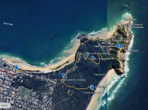
Figure 1 – Lighthouse Road
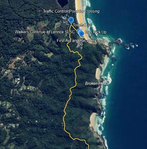
Figure 2 – Seven Mile Beach Road
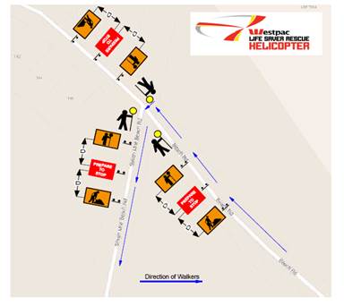
Figure 3 – Proposed TGS for the Seven Mile Beach Road
entrance (refer Figure 2). The Traffic Control is to be in place from 7am to
1pm.
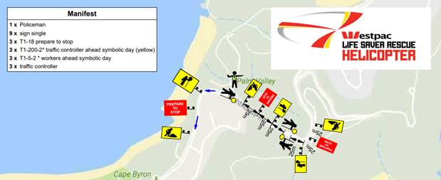
Figure 4 – Traffic control proposed for eastern
section Lighthouse Road. Coming down from Lighthouse Road (refer to Figure 1).
Traffic control to be in place from 6am to 10.30pm.
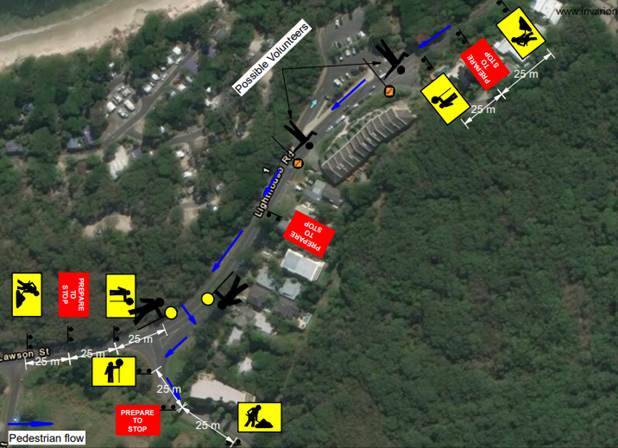
Figure 5 – Traffic control proposed for the western
section of Lighthouse Road entering Tallow Beach Road (refer to Figure 1.)
Traffic control to be in place between 6am and 10.30pm
RECOMMENDATION:
1. That
the Local Traffic Committee supports the Westpac Life Saver Rescue Helicopter
fundraiser, Byron Coast Charity Walk, to be held Saturday 4th May
2025 from 6.00am – 5.00pm.
2. That
Council support in Part 1 is subject to:
a) The development of a
Traffic Guidance Scheme (TGS) and Traffic Management Plan(s) for the 2025 event
by those with relevant and current TfNSW accreditation. The TGS(s) and Traffic
Management Plan is to include, but is not limited to, the following:
b) Signage, which specifies
the date, hours and nature of the event, be positioned at the entrance and exit
of Seven Mile Beach Road one week prior to the event;
c) On the day of the
event, at 500m intervals on Seven Mile Beach Road, and facing both directions
of travel, signs advising of “Special Event – Charity Walk
Ahead” (or similar) are installed prior, and removed after, the event
occurs;
d) A safety induction for
participants advising of hazards be provided.
e) Implementation of the
Traffic Management Plan and Traffic Guidance Scheme/s as designed by those with
appropriate accreditation and implemented by people with appropriate
accreditation, including traffic controllers.
3. The
event organiser to:
a) Arrange for the
event to be notified on Council’s webpage a minimum one week prior to the
TGS being implemented;
b) Undertake consultation
with affected community and businesses including adequate response/action to
any raised concerns.
c) Undertake
consultation with emergency services and any identified issues addressed.
d) Holding $20m public
liability insurance cover which is valid for the event.
e) Paying
Council’s Road Event Application Fee prior to the event.
BYRON SHIRE COUNCIL
Local Traffic Committee Meeting 8.2
Report No. 8.2 Event - Bangalow Billycart Derby May 2025
File No: I2024/1712
Council has received an application for the Bangalow
Billycart Derby to be held on Sunday 18 May 2025.
The Billy Cart Derby has been previously approved by the
Local Traffic Committee (LTC) and by Council resolution 22-343.
RECOMMENDATION:
1. That
Council support the Bangalow Billycart Derby to be held on 18 May 2025.
2. That
Council support in Part 1 is subject to:
a) separate
approvals by NSW Police and TfNSW being obtained;
b) the
event organiser providing council with an updated Traffic Management Plan and
Traffic Guidance Scheme/s for the event;
c) development
and implementation of a Traffic Management Plan and Traffic Guidance Scheme/s
by those with appropriate TfNSW accreditation and the holding of current and
appropriate levels of insurance and liability cover;
d) the
impact of the event be advertised, and charged at cost to the organisers, via a
notice in the local weekly paper and appropriate Variable Message Signage a
minimum of one week prior to the operational impacts taking effect, noting it
must include the event name, specifics of any traffic impacts or road closures
and times, alternative route arrangements, event organiser, a personal contact
name and a telephone number for all event related enquiries or complaints;
e) the
event be notified on Council’s web page with the event organiser
supplying Council with the relevant information.
3. The
event organiser to:
a) inform
the community and businesses that are directly impacted (e.g. within road
closure zones) via written information which is delivered to the property in a
timely manner so as to document, consider and respond to any concerns raised;
b) arranging
for private property access and egress affected by the event;
c)
liaising with bus, taxi and waste operators and ensuring arrangements are made
for provision of services during conduct of the event;
d) consulting
with emergency services and any identified issues be addressed;
e) holding
$20m public liability insurance cover which is valid for the event;
f) paying Council’s
Road Event Application Fee prior to the event;
g)
not place any signage on the road related area of the Pacific Highway.
Background
The Bangalow Billycart Derby is an
annual event held by the Bangalow Lions Club. It’s been taking place
since the first event in 1994. .
The format of the event is the
same as in previous years, with traffic detoured through Deacon Street.
Event Overview
As a family friendly community
event, the focus of the day
is not the speed of the entries but family fun for participants and spectators.
The Grand Parade is a highlight, the event also features local bands, vintage
cars, schools, local clubs, scouts and celebrities.
The event involves the temporary
closure of a section of Byron Street, between the Granuaille Road roundabout
and Ashton Street intersection, with a traffic detoured through Deacon Street,
the temporary closure will be in place between 6am and 5pm.
Key Issues
1. The
proposed TGS places signage on Lismore to Bangalow Road (B62) and TfNSW
controlled Granuaille Road.
2. The
western end of Deacon Street is a laneway not suitable to Heavy Vehicles as a
detour to the Pacific Highway. However, the volume of HV on Sunday’s is
very limited and not been a concern for previous years.
Council Implications
Financial Considerations
Nil.
Asset Management
Not applicable.
Policy or Regulation
All TGS’s are to be developed and
implement by people with the appropriate level and type of accreditation.
Consultation
A condition of the endorsement of this
event is that the event organisers conduct appropriate community consultation,
including:
1. Advertising
the impact of the event in the local newspaper and on the Council website.
2. Informing
community and business that are directly impacted.
3. Liaising
with bus and taxi operators.
4. Consulting
with emergency services.
Legal and Risk Management
This road closure directly affects TfNSW
controlled asset – Lismore to Bangalow Road (B62) and TfNSW controlled
Granuaille Road. TfNSW Traffic Engineering Department requires separate
approval of the TMP and TGS.
BYRON SHIRE COUNCIL
Local Traffic Committee Meeting 8.3
Report No. 8.3 Chincogan Charge - September 2025
File No: I2024/1714
Council is in anticipation to receive an application for the
Chincogan Charge to be held on Saturday 13 September 2025.
This was previously approved by the Local Traffic Committee
(LTC) and by Council resolution 22-084.
RECOMMENDATION:
1.
That the Local Traffic Committee support the Chincogan Charge to be held on
Saturday 13 September 2025.
2. That
the Local Traffic Committee support in Part 1 is subject to:
a) separate
approvals by NSW Police and TfNSW being obtained;
b) the
event organiser providing council with an updated Traffic Management Plan and
Traffic Guidance Scheme/s for the event if required;
c) development
and implementation of a Traffic Management Plan and Traffic Guidance Scheme/s
by those with appropriate TfNSW accreditation and the holding of current and
appropriate levels of insurance and liability cover;
d) the
impact of the event be advertised, and charged at cost to the organisers, via a
notice in the local weekly paper and Variable Message Signage (VMS) a minimum
of one week prior to the operational impacts taking effect, noting it must
include the event name, specifics of any traffic impacts or road closures and
times, alternative route arrangements, event organiser, a personal contact name
and a telephone number for all event related enquiries or complaints;
e) the
event be notified on Council’s web page and social media with the event
organiser supplying Council with the relevant information;
3. The
event organiser to:
a) inform
the community and businesses that are directly impacted (e.g. within road
closure zones) via written information which is delivered to the property in a
timely manner so as to document, consider and respond to any concerns raised;
b) arranging
for private property access and egress affected by the event;
c)
liaising with bus, taxi and waste operators and ensuring arrangements are made
for provision of services during conduct of the event;
d) consulting
with emergency services and any identified issues be addressed;
e) holding
$20m public liability insurance cover which is valid for the event;
f)
not place any signage on the road related area of the Pacific Highway.
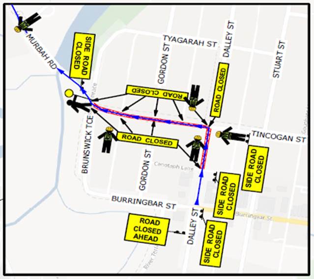
Background
The
event organisers followed the same course since 2020 with runners starting and
finishing near Mullumbimby Police Station.
The
road course will require actions to control traffic and the implementation of
prescribed traffic control devices such as No Parking signs to control
vehicles. 500 participants are expected.
Event Overview
The
organisers TGS will be as per 2024; the image below shows the expected impact
on roads. The blue line indicates the approximate running path within the
road reserve and the following major impacts are planned:
· Dalley
Street, between the Post Office and the Civic Hall is expected to be closed
between 12.30-5.30pm
· Murwillumbah
Road, at Federation Bridge to Main Arm Rd to be controlled by traffic
controllers. The South bound lane will be used for contraflow traffic
controlled by Traffic Controllers. Traffic will be allowed to access Main Arm
Road in-between competitors. Traffic will be controlled at this point between
12.35-5.30pm
· Coolamon
Scenic Drive from Main Arm Rd to 1913 Coolamon Scenic Drive. The South
bound lane will be used for contraflow traffic controlled by Traffic
Controllers. Traffic will be allowed to access Main Arm Road in-between
competitors. Traffic will be controlled at this point between
12.40-5.30pm
· Once
competitors cross the finish line they will move onto the footpath and head to
the Mullumbimby Civic Memorial Hall for the presentation.
· The race itself is
expected to finish at 4pm with presentations from 4-5.30pm.