 Agenda
Ordinary (Planning) Meeting

Thursday, 8 May 2025
Agenda
Ordinary (Planning) Meeting
Thursday, 8 May 2025
Agenda Ordinary (Planning) Meeting
held at Council Chambers, Station Street, Mullumbimby
commencing at 3:00 PM
Public access relating to items on this agenda can be made between 3:00pm and 4:00pm on the day of the meeting. Requests for public access should be made to the General Manager or Mayor no later than 12:00 midday on the day prior to the meeting.

Mark Arnold
General Manager
CONFLICT OF INTERESTS
What is a “Conflict of Interests” - A conflict of interests can be of two types:
Pecuniary - an interest that a person has in a matter because of a reasonable likelihood or expectation of appreciable financial gain or loss to the person or another person with whom the person is associated.
Non-pecuniary – a private or personal interest that a Council official has that does not amount to a pecuniary interest as defined in the Code of Conduct for Councillors (eg. A friendship, membership of an association, society or trade union or involvement or interest in an activity and may include an interest of a financial nature).
Remoteness – a person does not have a pecuniary interest in a matter if the interest is so remote or insignificant that it could not reasonably be regarded as likely to influence any decision the person might make in relation to a matter or if the interest is of a kind specified in the Code of Conduct for Councillors.
Who has a Pecuniary Interest? - a person has a pecuniary interest in a matter if the pecuniary interest is the interest of the person, or another person with whom the person is associated (see below).
Relatives, Partners - a person is taken to have a pecuniary interest in a matter if:
· The person’s spouse or de facto partner or a relative of the person has a pecuniary interest in the matter, or
· The person, or a nominee, partners or employer of the person, is a member of a company or other body that has a pecuniary interest in the matter.
N.B. “Relative”, in relation to a person means any of the following:
(a) the parent, grandparent, brother, sister, uncle, aunt, nephew, niece, lineal descends or adopted child of the person or of the person’s spouse;
(b) the spouse or de facto partners of the person or of a person referred to in paragraph (a)
No Interest in the Matter - however, a person is not taken to have a pecuniary interest in a matter:
· If the person is unaware of the relevant pecuniary interest of the spouse, de facto partner, relative or company or other body, or
· Just because the person is a member of, or is employed by, the Council.
· Just because the person is a member of, or a delegate of the Council to, a company or other body that has a pecuniary interest in the matter provided that the person has no beneficial interest in any shares of the company or body.
Disclosure and participation in meetings
· A Councillor or a member of a Council Committee who has a pecuniary interest in any matter with which the Council is concerned and who is present at a meeting of the Council or Committee at which the matter is being considered must disclose the nature of the interest to the meeting as soon as practicable.
· The Councillor or member must not be present at, or in sight of, the meeting of the Council or Committee:
(a) at any time during which the matter is being considered or discussed by the Council or Committee, or
(b) at any time during which the Council or Committee is voting on any question in relation to the matter.
No Knowledge - a person does not breach this Clause if the person did not know and could not reasonably be expected to have known that the matter under consideration at the meeting was a matter in which he or she had a pecuniary interest.
Non-pecuniary Interests - Must be disclosed in meetings.
There are a broad range of options available for managing conflicts & the option chosen will depend on an assessment of the circumstances of the matter, the nature of the interest and the significance of the issue being dealt with. Non-pecuniary conflicts of interests must be dealt with in at least one of the following ways:
· It may be appropriate that no action be taken where the potential for conflict is minimal. However, Councillors should consider providing an explanation of why they consider a conflict does not exist.
· Limit involvement if practical (eg. Participate in discussion but not in decision making or vice-versa). Care needs to be taken when exercising this option.
· Remove the source of the conflict (eg. Relinquishing or divesting the personal interest that creates the conflict)
· Have no involvement by absenting yourself from and not taking part in any debate or voting on the issue as of the provisions in the Code of Conduct (particularly if you have a significant non-pecuniary interest)
RECORDING OF VOTING ON PLANNING MATTERS
Clause 375A of the Local Government Act 1993 – Recording of voting on planning matters
(1) In this section, planning decision means a decision made in the exercise of a function of a council under the Environmental Planning and Assessment Act 1979:
(a) including a decision relating to a development application, an environmental planning instrument, a development control plan or a development contribution plan under that Act, but
(b) not including the making of an order under that Act.
(2) The general manager is required to keep a register containing, for each planning decision made at a meeting of the council or a council committee, the names of the councillors who supported the decision and the names of any councillors who opposed (or are taken to have opposed) the decision.
(3) For the purpose of maintaining the register, a division is required to be called whenever a motion for a planning decision is put at a meeting of the council or a council committee.
(4) Each decision recorded in the register is to be described in the register or identified in a manner that enables the description to be obtained from another publicly available document, and is to include the information required by the regulations.
(5) This section extends to a meeting that is closed to the public.
OATH AND AFFIRMATION FOR COUNCILLORS
Councillors are reminded of the oath of office or affirmation of office made at or before their first meeting of the council in accordance with Clause 233A of the Local Government Act 1993. This includes undertaking the duties of the office of councillor in the best interests of the people of Byron Shire and the Byron Shire Council and faithfully and impartially carrying out the functions, powers, authorities and discretions vested under the Act or any other Act to the best of one’s ability and judgment.
BUSINESS OF Ordinary (Planning) Meeting
1. Public Access
3. Attendance by Audio-Visual Link
4. Requests for Leave of Absence
5. Declarations of Interest – Pecuniary and Non-Pecuniary
6. Tabling of Pecuniary Interest Returns (Cl 4.14 Code of Conduct for Councillors)
7. Adoption of Minutes from Previous Meetings
7.1 Ordinary (Planning) Meeting held on 10 April 2025
8. Reservation of Items for Debate and Order of Business
9. Notices of Motion
Nil
10. Mayoral Minute
11. Petitions
12. Delegates' Reports
12.1 Country Mayors Association of NSW - General Meeting 28th March 2025 Communique................................................................................................................... 8
12.2 Mayor Meeting Diary Summary October- December 2024................................... 27
13. Staff Reports
Corporate and Community Services
13.1 Community Strategic Plan 2025 - 2035 (CSP)........................................................ 30
13.2 Draft Delivery Program 2025 - 2029 and 2025/26 Operational Plan, Budget, and Revenue Policy............................................................................................................. 35
13.3 Pay Parking Scheme Distribution Methodology...................................................... 49
Sustainable Environment and Economy
13.4 PLANNING - Report of the Planning Review Committee held 3 April 2025....... 55
13.5 Status report on Development Applications (DAs) with bodies like the Northern Regional Planning Panel (NRPP).............................................................................. 57
13.6 2025 Regional & Remote Music Summit Partnership Proposal........................... 63
13.7 PLANNING - Development Application 10.2024.428.1 – Torrens Title subdivision of 8 concept approved lots into 10 lots resulting in the total increasing from 47 to 49 lots across the 2 consents, and modification to the consent to DA10.2015.795.1 in relation to stormwater management and size of concept approved lots 40, 45, 46 and 47 – 35 Bayside Way Brunswick Heads................................................................................. 66
Infrastructure Services
13.8 Review of Pay Parking Permits and Fees and Charges....................................... 87
13.9 Bangalow Road, Cooper Street and Paterson Street Intersection, Byron Bay - Traffic and Safety Assessment............................................................................................ 104
No table of contents entries found.
14. Questions With Notice
Nil
Questions with Notice: A response to Questions with Notice will be provided at the meeting if possible, that response will be included in the meeting minutes. If a response is unable to be provided the question will be taken on notice, with an answer to be provided to the person/organisation prior to the next Ordinary Meeting and placed on Councils website www.byron.nsw.gov.au/Council/Council-meetings/Questions-on-Notice
Councillors are encouraged to ask questions regarding any item on the business paper to the appropriate Director prior to the meeting. Any suggested amendments to the recommendations should be provided to Councillor Support prior to the meeting to allow the changes to be typed and presented on the screen at the meeting.
Delegates' Reports 12.1
Delegates' Reports
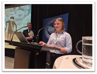
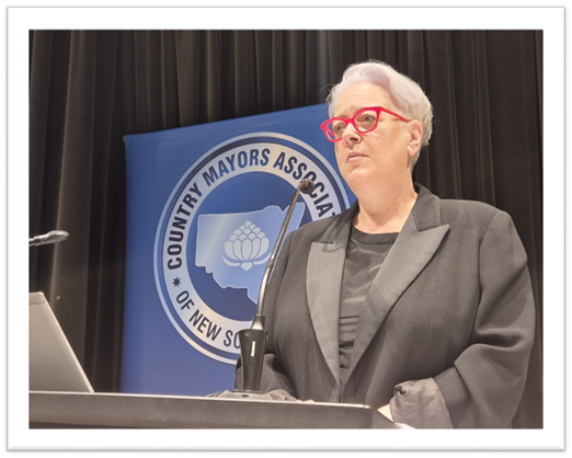
Delegate's Report No. 12.1 Country Mayors Association of NSW - General Meeting 28th March 2025 Communique
File No: I2025/539

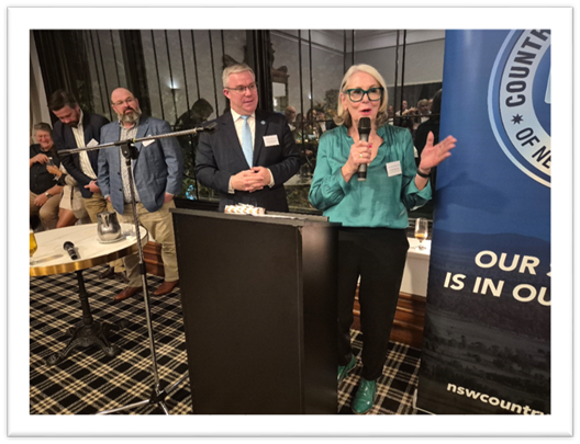
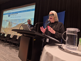
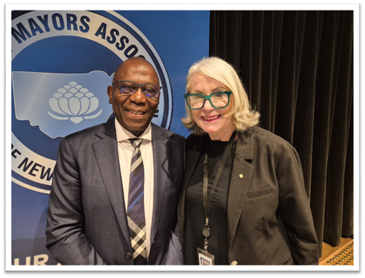
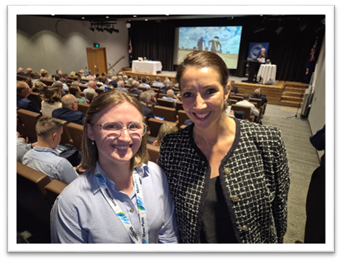
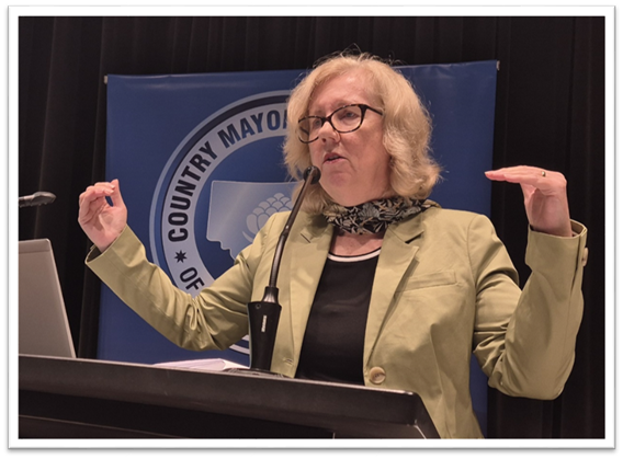
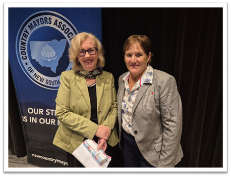
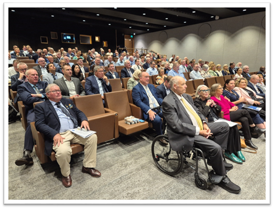
Country Mayors Association of NSW – General Meeting 28 March 2025
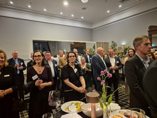
The Country Mayors Association of NSW held our General Meeting in the Theatrette in NSW Parliament House, Sydney on Friday 28 March 2025. We had 150 representatives of Country NSW Councils and associated organisations coming together to focus on the Financial Sustainability theme. We were joined by a variety of Parliamentarians.
For dinner, the night before, our Associate Member, the NRMA hosted a special cocktail-style function in the Tattersalls Club, across from Hyde Park, Sydney. We were grateful for this networking and fellowship opportunity. There were over 120 attendees and three special guest speakers.
NSW Local Government Minister the Hon. Ron Hoenig MP had some attention-grabbing statements, including that all NSW Councils will be mandated to live-stream their Council and Committee meetings. Local Government NSW President and CMA Executive Board member, Mayor Phyllis Miller (Forbes Shire) OAM explained the origin of her passion for Local Government and the NRMA’s Chief Membership Officer Victoria Doidge reaffirmed their commitment to work with Country Mayors towards better, safer roads.
CMA Chairman, Temora Shire Mayor Rick Firman OAM said the chance for country Mayors to get together was greatly valued and we are thankful to the NRMA. "There was a real warmth in the room. Never underestimate the value of fellowship.”
The Meeting
CMA Chairman Mayor Rick Firman OAM of Temora Shire Council issued a warm welcome and introduced the new Chair of the NSW Grants Commission, Ms. Linda Scott.
Ms Scott advised that she had not yet been inducted and it is too soon for her to say much. She emphasised that submissions need to go to the NSW Grants Commission email address: grantscommission@olg.nsw.gov.au . Ms Scott also urged CMA members to work with their CFOs regarding the forward payments of FAGs and the implications of that.
CMA Executive Board Member and President of LGNSW – Mayor Phyllis Miller OAM and Mayor Firman paid tribute to Forbes Shire GM Mr. Steve Loane OAM, who has served the Local Government sector for decades.
Mayor Miller announced that a new cost-shifting survey is about to be conducted by LGNSW.
“I don’t expect a return to 1% overnight but we need to get it back up there, bit by bit.”
Mayor Miller drew attention to the new Food Organics and Garden Organics (FOGO) recycling legislation, intended to reduce food waste and stop food waste going to landfill.
The NSW Parliament has passed legislation to mandate FOGO collection services for households by July 2030, and for businesses and institutions in stages from July 2026. Click here for more detail. Mayor Miller added that the Regional Summit in the State Library promises to be a great event.
The Hon. Emily Suvaal, BN MLC. Was welcomed to the lectern as Chair of the NSW Government Inquiry into the “Ability of local governments to fund infrastructure and services”
Mrs Suvaal said the Inquiry was important to her personally and professionally. There were 128 submissions, over 50 organisations gave evidence. We are still awaiting the State Government response to the Inquiry and the recommendations. We handed it down on 29 November and the Minister has told me that he is going to take the time to get it right. We can appreciate that changes to the accounting codes and the like take work.
It was a very important Inquiry and I know the challenges you face are still there and may have gotten worse.
CMA Chairman Rick Firman OAM presented a thank-you gift to Mrs Suvaal.
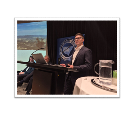
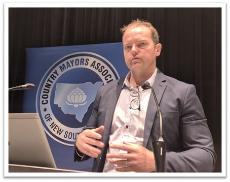
The entire TCorp Local Government Services Team then came onto the stage because it was important for members to have faces for the names they deal with.
Snr Analyst, Mr. Tom Threlkeld gave the presentation, supported by his colleagues:
Mr. Rob Kenna – General Manager, Financial Markets
Mr. Brett Perry – Senior Manager, Credit Review
Ms. Danielle Aspery – Senior Manager
Mr. Craig Selvage – Senior Analyst
Ms. Alina Tee – Analyst
Mr. Threlkeld said that prior to 2015, banks and finance companies were the option. Since then, Tcorp has offered competitive rates for councils.
“We have a cost recovery focus, making us 0.5 to 1% cheaper than banks. Large loans can be spread over generations of rate payers. Please reach out to our Local Government Services team if you need to discuss flexibility.
CMA Deputy Chairman Mayor Russell Fitzpatrick and Executive Board Member Mayor Sharon Cadwallader thanks the TCorp team.
Q. Mayor Phyllis Miller asked about the suitability of saleyards for financing.
Q. Mayor Sarah Ndiaye from Byron Shire: Thank you for our sustainability loans
Q. Bega Valley Shire CEO Anthony McMahon: Could you explain your process for assessing Councils’ capacity to repay loans.
A. Enough unrestricted cash for two months of operations required. We are more intrusive than a bank. But we partner with Councils, so we will not behave like a bank.
One member asked about upper limits and Mr Threlkeld said we don’t really have one.
Another member asked when did you change to allow commercial elements. Mr Threlkeld said July last year.
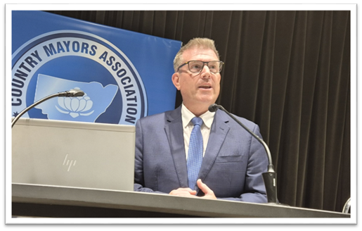
Auditor-General for NSW, Mr. Bola Oyetunji
Mr Oyetunji said I learn a lot from you.
“When you talk about depreciation, we can improve things there. Financial Sustainability of Local Government is something we need to work on together.”
A revenue imbalance graph highlighted the need for the return to 1%.
Costs or valuation, I cannot answer. But I want to work with the sector on it.
We like to think when we do an audit, we are making a difference.
Imagine a world without auditors – though there were chuckles, the value of audits was clear in members’ minds.
Mr Oyetunji gave an example of the pool in Clarence Valley, which was done 7% under budget but everybody has heard of the North Sydney Pool. I am going to promote the top 10 and bottom 10 Councils, in terms of financial sustainability against OLG benchmarks, with the purpose of encouraging improvement. We need a deep understanding of how councils work. The desired outcome of audits is to improve performance.
Mr Oyetunji’s presentation and update from Audit Office were distributed to the CMA Membership.
Steve Loane: Cost shifting $1.6billion – what is your view? Should we invoice the State Government?
Uralla Shire Mayor Cr. Robert Bell: The Auditor General is used as an excuse for declining funding.
A: I am happy to work with you on any examples you have.
Q: If you have a top 10 and a bottom 10, perhaps the top can assist the bottom 10.
Q. Mayor Bronwyn Petrie of Tenterfield Shire Council: Thank you for your refreshing attitude.
Mayor Phyllis Miller OAM presented the thank-you gift.
Excelling CMA Members Segment
Bega Valley Shire Council was the 2024 Bluett Award Winner and CEO, Anthony McMahon detailed some of the work that his Council is proud of.
Mr. McMahon ran a slideshow of Bega Valley Shire’s innovative projects and detailed how they applied for the Bluett Award.
The LGA was the most devastated by the worst bushfire season in history and innovative approaches to temporary housing and recovery in general have been critical.
He said they are proud to have home grown staff – locals who have been recruited and trained/upskilled.
Byron Shire Mayor Sarah Ndiaye asked about the portable housing project. This was one important area where CMA members could learn from example. An example of the innovative housing in the Bega Valley: https://chl.org.au/about-us/our-developments/bega/
Mr. McMahon said “we sold to a community housing provider, with caveats, including that they use funds to re-invest in more local housing. One was 100 Lots.”
Richmond Valley Mayor Cr. Robert Mustow: Asked about the circular economy
Mr. McMahon: That’s a presentation in itself and I suggest CMA gets the CEO of Bega Cheese in on that.
Moree Plains Shire Council presentation. 2024 Bluett Award Runner-up
Moree Plains Shire Council Mayor Susannah Pearse also ran a slideshow, with which she illustrated how the Council had been forced to act to clean-up neighbourhoods marred by burnt out homes. The charred remains of houses have lingered for years and detract from more than aesthetics. Mayor Pearse described how her Council incentivised the cleaning up of these sites, with the waiving of waste fees (up to $10,000). The project has dramatically improved a lower socio-economic neighbourhood.
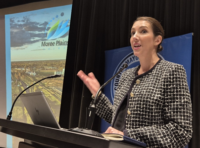
Mayor Pearse became Mayor in September 2024.
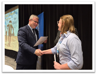
The 2024 CMA Scholarship was presented to Moree Plains Shire Council’s Jazmine Howarth.
The inspiring young Local Government GIS professional gave an articulate talk on what her work entails, how important it is to Council and how the $5,000 CMA scholarship will help her to advance her knowledge and skills with a degree.
There was then a brief presentation from the Hon Penny Sharpe MLC, Minister for Climate Change, Minister for Energy, Minister for the Environment, Minister for Heritage
We are working with land holders, I’ll be heading out to visit REZs.
The costs of Biodiversity offsets is a concern but I think we can bring them down.
We built flexibility into the new system.
There is funding for landowners who can provide for the offsets scheme.
They could be funded for what they are already doing.
The Minister also talked about waste: FOGO and the levy review – “I know you want more from it” (the levy).
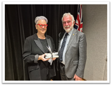
Mayor Russell Webb presented a thank-you gift.
A quick morning tea was enjoyed by all.
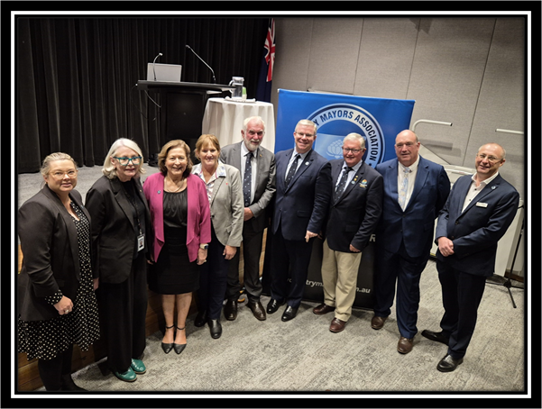
Before the Country Mayors Association of NSW Executive Board members got their hands on a scone, sausage roll or brownie, they posed for a photo. Pictured left to right: Secretary (and Temora Shire General Manager) Melissa Boxall, Local Government NSW President and Forbes Shire Mayor Phillys Miller OAM, Ballina Shire Mayor Sharon Cadwallader, Singleton Council Mayor Sue Moore, Tamworth Regional Council Mayor Russell Webb, Chairman and Temora Shire Mayor Rick Firman OAM, Lachlan Shire Mayor John Medcalf OAM, Deputy Chairman and Bega Valley Shire Mayor Russell Fitzpatrick and Dubbo Regional Council Mayor Josh Black. with Mayor Sam Coupland of Armidale Regional Council absent from the photo.
NSW Nationals Leader the Hon. Dougald Saunders MP gave an update on the Crime Bill and the Bail Act.
Mr. Saunders said we need consequences, we need the stick and we will keep the CMA updated about the Bill. The NSW Nationals are pushing for strong and immediate legislative reform to stop repeat serious youth offenders from carrying out crime sprees across regional NSW.
The Crimes Legislation Amendment (Youth Crime) Bill 2025 will offer stronger measures than Labor’s changes to the Bail Act that were passed last week, by:
Expanding the definition of repeat offences beyond serious break and enter and motor vehicle theft, to include all serious indictable offences like murder or sexual assault.
Introducing electronic monitoring and a mandatory curfew as conditions of bail.
Revoking bail if there is a breach of the bail conditions, if another charge is laid while on bail, or if there is any interference with the electronic monitoring device.
Elevating the voice of victims in the court through the use of victim impact statements.
NSW Electoral Commissioner Mrs. Rachel McCallum
The Electoral Commissioner congratulated the attending mayors on their election in September 2024.
Ms McCallum was appointed in Dec. 2024 and was previously the Information Commissioner. I am keen to learn more about what you do. Your September 2024 election was the biggest in the country that year, with well over 5mil. voters. The NSW Electoral Commission is both a statutory authority regulating and managing election propriety and a service provider. We issue penalty notice for not voting and approve campaign material, for example. The time taken to invoice Councils for their elections is due to the cost-recovery basis of election costs, meaning invoices must be received by the Commission before they issue theirs.
Surveys have shown that a quick and easy process is most valued by voters.
We do work to identify cost-saving opportunities and efficiencies, without compromising or risking public confidence. We are open to feedback.
Q. Mayor Firman, can we simplify the declarations process?
A. We do have an online system for updating.
Q. Cr. Bruce Reynolds Mayor of Blayney Shire: The postal votes time frame – waiting two weeks for the count was frustrating.
A. Voters are allowed up to 13 days to get their vote in, which is policy nationally as well. The postal system has changed a lot also.
Mayor John Medcalf OAM presented the thank-you gift.
Chair of IPART, Ms. Carmel Donnelly PSM
Ms Donnelly graciously allowed for her presentation to be distributed to members.
IPART acknowledged when the rate peg was lower than the rise in inflation. We are proud of the new rate pegging methodology. The rate peg is now unique for each 128 council in NSW.
IPART is involved in pricing increases of interest to CMA Members, other than those relating to Council rates. The Valuer-General is currently seeking to increase charges to Councils. Ms Donnelly encouraged submissions.
Mayor Sue Moore presented the thank-you gift.
Members voted that Port Macquarie-Hastings Council, Balranald Shire Council, Lake Macquarie City Council and Nambucca Valley Council be endorsed as new members of the CMA. Further, that the Central NSW JO be endorsed as an Associate Member.
The following motions were unanimously supported by the CMA Membership:
a) Executive Board Recommendation: That the CMA Membership support the Executive Board’s endorsement of the 17 recommendations from the “NSW Inquiry into the ability of local governments to fund infrastructure and services”. Further, that the CMA advocate for their expeditious implementation.
b) Executive Board Recommendation: That the Constitution be amended to enable the Executive to accept new member applications, with member endorsement at the next general meeting.
c) Executive Board Recommendation: That the Membership endorse the Executive Board’s determination that the CMA submission to 2024 Local Government Financial Sustainability Inquiry be considered the CMA’s position regarding FAGs and the return to 1%. Further, that the CMA supports ALGA’s campaign: “Put Our Communities First”.
Note: The CMA Executive Board resolved at their most recent meeting to write to all Federal political parties, asking for their position on FAGs and outlining CMA’s. This has already been done by the Policy Advisor and Secretariat.
d) Executive Board Recommendation: That the Membership endorse the Board’s appointment of a trial Policy Advisor (Submissions etc), for 7.5 hours per week until 30 November, 2025. And Further, that the Board revise the roles of Secretariat and Policy Advisor and report back to Members in due course.
NB: The 7.5 Hours were initially allocated to extend the Secretariat role. Therefore, the role is at no extra cost to Members.
e) Executive Board Recommendation: That the membership endorse the Executive Board’s decision to support the existing Orana DAMA (Designated Area Migration Agreement) under the operation of RDAs. Further that, as per the request from RDA Riverina, the CMA writes to both the NSW Minister for Skills, The Hon Steve Whan, MP and Federal Assistant Minister for Immigration, The Hon Matt Thistlethwaite MP, requesting that they keep the Orana DAMA as an inland DAMA in NSW under RDA operation, and support the geographical expansion to include Far West and Northern Inland RDAs.
f) Member Recommendation: That the CMA write urgently to the NSW Government and the NSW Grants Commission to immediately review and overhaul the current methodology for the distribution of the Financial Assistance Grants from the Federal Government, as required under the legislation – Local Government (Financial Assistance) Act 1995 (Commonwealth), to ensure the principles of Horizontal Fiscal Equalization as highlighted in the Act, are correctly applied in NSW and that the funds are distributed to those Councils that need it the most. (from Dungog Shire Council)
g) Member Recommendation: That the CMA support and advocate to the NSW Government for the expansion of a pig bounty trial. (from Lachlan Shire).
The next meeting is scheduled for 9 May 2025 in the Theatrette, NSW Parliament House, Sydney. It will have a Health theme.
The NSW Regional Health Minister, the Hon Ryan Park is confirmed as a guest speaker.
Signed: Cr Sarah Ndiaye
Delegates' Reports 12.2
Delegate's Report No. 12.2 Mayor Meeting Diary Summary October- December 2024
File No: I2025/547
 |
Meeting Diary Summary
Position Title: Mayor
Period: 01 October to 31 December 2024
|
Organisation/Individual |
Topic |
|
|
01 October 2024 |
The Drill Hall Theatre |
Arts Northern Rivers |
|
02 October 2024 |
BayFM interview |
General |
|
02 October 2024 |
Byron Master Plan Guidance Group |
General |
|
03 October 2024 |
ReVision |
Revitalising Community Regen Panel discussion pre meeting |
|
03 October 2024 |
Opening Brunswick Nature Sculpture Walk |
Sculptures |
|
04 October 2024 |
Byron Shire Council |
All day induction |
|
08 October 2024 |
Mullumbimby Chamber of Commerce |
General Meeting |
|
10 October 2024 |
Byron Shire Council |
Extraordinary Council Meeting |
|
11 October 2024 |
Adam Bandt |
Housing and other regional issues |
|
12 October 2024 |
Community event |
Salvinia Clean-Up, Tyagarah Tea Tree Lakes - community event |
|
15 October 2024 |
Destination Byron |
Annual General Meeting |
|
16 October 2024 |
Local Government NSW Association |
Welcome to Newly Elected Council |
|
16 October 2024 |
Darriea Turley AM and CEO |
Dinner with President of Local Government New South Wales |
|
17 October 2024 |
Santos Organics |
Panelist - Revitalizing Community Regen Panel discussion |
|
17 October 2024 |
Byron Shire Council |
Councillor Workshop |
|
18 October 2024 |
Byron Bay International Film Festival (BBIFF) |
Opening Address - Palace Cinema |
|
19 October 2024 |
Community event |
Salvinia Clean-Up, Tyagarah Tea Tree Lakes - community event |
|
20 October 2024 |
Rae's at Wategos |
30 year anniversary |
|
20 October 2024 |
Byron Bay International Film Festival |
Host The Pool Q&A BBIFF event, Palace Cinema |
|
22 October 2024 |
The Remix |
Byron Leaders Dinner, Tech Chat, Casa Luna |
|
22 October 2024 |
Minister for Local Government, Kristy McBain and Hon. Justine Elliot MP, Member for Richmond |
Local Issues |
|
22 October 2024 |
Destination Byron |
Board Meeting |
|
22 October 2024 |
Northern Rivers Food Collaboration |
Local Food Production |
|
24 October 2024 |
Byron Shire Council |
Ordinary Meeting |
|
25 October 2024 |
CoLab |
Formal Opening of CoLab (former Byron Hospital) |
|
27 October 2024 |
Byron Bay Film Festival |
Q&A Host re film Wilding with Tony Kenway - Bruns Picture House |
|
28 October 2024 |
Community member |
Local issues |
|
28 October 2024 |
Byron Shire Community |
Citizenship Ceremony |
|
29 October 2024 |
St. Johns Primary School Students |
Housing Crisis Solutions |
|
30 October 2024 |
Rous County Council |
General Meeting |
|
31 October 2024 |
Community Leaders Forum |
Flood Recovery Update |
|
31 October 2024 |
The Hon. Sam Mostyn Governor General |
Northern Rivers Matters |
|
01 November 2024 |
Community Member |
Housing Solutions |
|
04 November 2024 |
Anglicare Bangalow |
Housing Solutions |
|
04 November 2024 |
Community Member |
Local Issues |
|
05 November 2024 |
Tamara Smith Ballina MP |
Local Issues |
|
05 November 2024 |
Marine Rescue Byron Bay |
Local Issues |
|
05 November 2024 |
The Hon. Rose Jackson, Minister for Housing |
Housing Solutions |
|
05 November 2024 |
Community Member |
Local Issues |
|
07 November 2024 |
Byron Shire Council |
Councillor Workshop |
|
08 November 2024 |
Northern Rivers Joint Organisation |
Board Meeting |
|
08 November 2024 |
Community Members |
Local Issues |
|
11 November 2024 |
Byron Basketball Association |
Local Sporting Facilities |
|
11 November 2024 |
Mullumbimby Tennis Club |
Award Presentation |
|
11 November 2024 |
Destination Byron |
Board Meeting |
|
12 November 2024 |
Destination North Coast |
Introduction with General Manager |
|
12 November 2024 |
Community Member |
Local Issues |
|
14 November 2024 |
Byron Shire Council |
Planning Meeting |
|
15 November 2024 |
Country Mayors Association |
Board Meeting |
|
18 November 2024 |
LGNSW Conference |
Local Government Matters |
|
19 November 2024 |
LGNSW Conference |
Local Government Matters |
|
20 November 2024 |
Bangalow Men’s Shed |
Tour and presentation |
|
20 November 2024 |
Community Members |
Local Issues |
|
21 November 2024 |
Byron Shire Council |
Councillor Workshop |
|
22 November 2024 |
Rous County Council |
RAPAG Meeting |
|
25 November 2024 |
Community Leaders Forum |
Flood Recovery Update |
|
25 November 2024 |
Community Members |
Local Issues |
|
26 November 2024 |
Siddle Family Foundation |
Homelessness |
|
26 November 2024 |
Community Member |
Affordable Housing |
|
26 November 2024 |
Beacon Laundry |
Local Issues |
|
27 November 2024 |
Rous County Council |
Councillor Workshop |
|
28 November 2024 |
Byron Shire Council |
Ordinary Meeting |
|
04 December 2024 |
The Hon. Ron Hoenig, Minister for Local Government and Tamara Smith Ballina MP |
Local Government Matters |
|
04 December 2024 |
Rous County Council |
Board Meeting |
|
05 December 2024 |
NSW Reconstruction Authority |
Byron Shire Flood Recovery |
|
05 December 2024 |
Byron Shire Council |
Planning Meeting |
|
06 December 2024 |
Byron Shire Council |
Councillor Workshop |
|
09 December 2024 |
Byron Bay Chamber of Commerce |
Local Business Matters |
|
09 December 2024 |
Bangalow Koalas |
Local Issues |
|
10 December 2024 |
Destination Byron |
Byron Shire Tourism |
|
11 December 2024 |
Rous County Council |
Councillor Tour |
|
12 December 2024 |
Byron Shire Council |
Ordinary Meeting |
|
16 December 2024 |
Byron Shire Council |
Citizenship Ceremony |
|
17 December 2024 |
Richmond Tweed Regional Library Committee |
Staff Award Ceremony |
|
20 December 2024 |
Destination Byron |
Byron Shire Tourism |
Signed: Cr Sarah Ndiaye
Staff Reports - Corporate and Community Services 13.1
Staff Reports - Corporate and Community Services
Report No. 13.1 Community Strategic Plan 2025 - 2035 (CSP)
Directorate: Corporate and Community Services
Report Author: Amber Evans Crane, Corporate Planning and Improvement Coordinator
File No: I2025/465
Summary:
The Community Strategic Plan guides long term future planning to meet the needs and aspirations of the community. It sets the collective vision for the next 10 years and highlights the community’s priorities. It is a collective document with delivery facilitated by Council in collaboration with the community and other partners.
Councils are required to review their community strategic plan by 30 June 2025, following the local government election in 2024.
Council’s current Community Strategic Plan 2032 has been reviewed and a draft refreshed Community Strategic Plan 2035 (CSP) was presented to Council on 28 November 2024. Council placed the draft CSP on public exhibition from 28 November 2024 to 9 February 2025.
This Report presents Council with the submissions received during public exhibition and the final CSP for endorsement.
The CSP forms the overarching structure for the Draft 2025 – 2029 Delivery Program and 2025/26 Operational Plan so it is proposed that the CSP is endorsed in conjunction with these documents being exhibited.
RECOMMENDATION:
That Council:
1. Notes the submissions to the draft Community Strategic Plan 2035 received during the public exhibition period and responses outlined in Attachment 2 (E2025/39366).
2. Endorses the Community Strategic Plan 2035 at Attachment 1 (E2025/39499).
3. Notes that any changes to the Outcomes Measurement Framework will be reflected in the Community Strategic Plan 2035.
Attachments:
1 Community
Strategic Plan 2035, E2025/39499 ![]()
2 Public
Exhibition Submissions on the Community Strategic Plan 2035 for presentation to
Council - Redacted, E2025/39366 ![]()
Background
All councils are required to have a Community Strategic Plan (CSP) covering a minimum 10-year period. The CSP serves to capture the community’s top priorities and aspirations for the future and set out strategies that can achieve these goals. The CSP informs all of council’s plans and strategies and filters into the Delivery Program and annual Operational Plans. The CSP also needs to align with broader state and federal plans and priorities.
Components of a CSP include:
· Vision Statement – The community’s aspiration for the next ten years
· Objectives – Desired goals to be achieved through the CSP
· Strategies – Outlines how the desired outcomes will be achieved
The CSP is a shared plan for how Council, the community, other levels of government, and local groups and organisations can work together to achieve outcomes.
Current Community Strategic Plan
The current Byron Shire Community Strategic Plan 2032 was formally adopted by Council in June 2022.
An engagement program was undertaken at that time, which resulted in renewed objectives, strategies, and the vision statement, ‘Byron Shire is a meeting place – where people can come together to connect, share, grow, inspire, and create positive change’.
Review Process
Council must review the Community Strategic Plan before 30 June in the year following an ordinary election. Council may endorse the existing plan, or develop and endorse a new CSP, as appropriate, to ensure that the area has a CSP covering at least the next 10 years.
The review consisted of a series of engagement activities to collect feedback from the community from late 2023 to 2024. Over 800 community members from across the Byron Shire are estimated to have participated via:
· In person pop-up stalls in Bangalow, Byron Bay, Mullumbimby, and New Brighton
· Adult and youth surveys on Your Say
· Ideas workshops with stakeholders including community groups and young people
· Submission box and information nook in Council foyer
· Telephone Community Satisfaction Survey
· Drawing and visioning exercises
· The YouthSay Program
A Report on the engagement process and outcomes, including resulting amendments to the Plan was provided to the 29 November 2024 Council Meeting and is available on Council’s website at www.byron.nsw.gov.au/communityplan. Another input into the review included the State of Our Shire Report 2024, which was presented to the 24 October 2024 Ordinary Council Meeting.
The Plan was publicly exhibited from 29 November 2024 to 9 February 2025. The extended exhibition beyond the required 28-day period was provided to account for the holiday period.
Attachment 2 (E2025/39366) provides the complete list of submissions.
Amendments to the Draft Community Strategic Plan
Attachment 2 (E2025/39366) outlines the amendments that were made to the draft Community Strategic Plan 2035 based on submissions from public exhibition.
Further amendments to the Plan included:
· Strategies 4.3 and 4.4 within the Ethical Growth Objective have been combined. The previous 4.3 has been taken from the draft Business, Industry and Visitor Economy Strategy however the new 4.3 mirrors the development of the Vibrant Economy Strategy
o Previous 4.3: ‘Promote and support a resilient and diverse economy providing for our community and environment in a balanced and sustainable manner
o Previous 4.4: Foster sustainable visitation and manager the impacts of tourism on the Shire
o NEW 4.3: Support sustainable local business development, visitation and events
· Updates to the Access and Inclusion information to align with the development of the draft 2025 - 2029 Disability Inclusion Action Plan.
· Updates to the ‘Key Council Plans and Programs’ section.
· Updates to the ‘Progress Indicators’ based on the development of the 2025/2029 Delivery Program.
Strategic Considerations
Community Strategic Plan and Operational Plan
|
CSP Objective |
CSP Strategy |
DP Action |
Code |
OP Activity |
|
1: Effective Leadership |
1.2: Engage and involve community in decision making |
1.2.1: Community-led decision making - Engage with community to inform Council decision making |
1.2.1.7 |
Prepare the 2025-2035 Community Strategic Plan |
Recent Resolutions
· 22-335: Adoption of the 2032 Byron Shire Community Strategic Plan
· 24-061: YouthSay Program Report
· 24-465: Endorsement of the State of Our Shire Report 2024
· 24-517: Public Exhibition of the Draft Community Strategic Plan 2035
Legal/Statutory/Policy Considerations
Local Government Act 1993 s402(5): Following an ordinary election of councillors, the council must review the community strategic plan before 30 June following the election. The council may endorse the existing plan, endorse amendments to the existing plan or develop and endorse a new community strategic plan, as appropriate to ensure that the area has a community strategic plan covering at least the next 10 years.
Financial Considerations
Not applicable.
Consultation and Engagement
The engagement activities and impact during the public exhibition of the Draft CSP 2035 are outlined in the table below.
|
Promotion Activities: |
· Information page and submissions form on Council’s Your Say page. · Print advertisement in the Byron Shire Echo Newspaper on 15 January 2025. An unsponsored article was also published in the 29 January edition. · Online advertisement via two dedicated media releases, Council’s social media and e-news. · Flyers and submission box in Council’s foyer. · Participants to CSP development activities were notified of the public exhibition via email. |
|
Impact: |
· The Your Say page was viewed 617 times during public exhibition · 19 Submissions were received This indicates that the submissions received account for approximately 3% of the total viewers. |
Staff Reports - Corporate and Community Services 13.2
Report No. 13.2 Draft Delivery Program 2025 - 2029 and 2025/26 Operational Plan, Budget, and Revenue Policy
Directorate: Corporate and Community Services
Report Author: Heather Sills, Manager Corporate Services
James Brickley, Manager Finance
Amber Evans Crane, Corporate Planning and Improvement Coordinator
File No: I2025/500
Summary:
The Community Strategic Plan, the Delivery Program and the Operational Plan form part of the Integrated Planning and Reporting Framework which is a requirement under the Local Government Act 1993 (Sections 402 to 406).
The Delivery Program sets out the priority actions planned for the four-year Council Term being 2025 – 2029.
Council’s Operational Plan articulates the key activities to be delivered in a financial year based on the community objectives in the Byron Shire Community Strategic Plan 2035 and the priorities in the 4-year Delivery Program.
Council’s Statement of Revenue Policy includes Budget Estimates, Rates and Charges, Borrowings, and Fees and Charges.
This report recommends placing the Draft 2025 -2029 Delivery Program, 2025/26 Operational Plan and Statement of Revenue Policy, subject to any amendments, on public exhibition for 28 days.
RECOMMENDATION:
That Council places the following draft documents on public exhibition until 8 June 2025:
1. Delivery Program 2025 – 2029 (Attachment 1 #E2025/28134)
2. Operational Plan 2025/26 (Attachment 3 #E2025/41579) and associated Draft 2025/26 Budget Estimates (Attachment 4 #E2025/42943), Draft 2024/25 Statement of Revenue Policy including Fees and Charges (Attachment 5 #E2025/42947).
1 Draft
Delivery Program 2025-29 for Public Exhibition, E2025/28134 ![]()
2 Revisions
to the Outcomes Measurement Framework - 2025, E2025/41976
![]()
3 Draft
2025- 2026 Operational Plan for Public Exhibition, E2025/41579 ![]()
4 Draft
2025/26 Detailed Budget Estimates for Public Exhibition, E2025/42943 ![]()
5 Draft
2025/26 Statement of Revenue Policy including Fees and Charges for Public
Exhibition, E2025/42947 ![]()
Report
All Councils in NSW use the IP&R framework to guide their planning and reporting activities. The Community Strategic Plan, the Delivery Program and the Operational Plan form part of the Integrated Planning and Reporting Framework which is a requirement under the Local Government Act 1993.
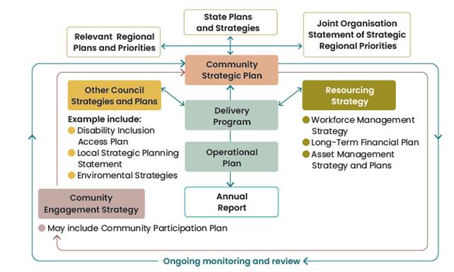
Overview of Integrated Planning and Reporting
The Integrated Planning and Reporting (IPR) Framework includes:
· 10 year Community Strategic Plan reflecting the aspirations, needs, and priorities of the local community
· The Resourcing Strategy, addressing sustainable long term financial, asset management and workforce planning;
· A four year Delivery Program outlining Council's activities planned for Council term
· Annual Operational Plan consisting of actions identified to be undertaken each year to meet the Delivery Program commitments; together with the related budget, statement of revenue policy, and fees and charges.
The diagram below highlights the relationship and hierarchy of the strategies and plans.
Draft 2025 – 2029 Delivery Program
The delivery program translates the community strategic plan goals into actions. It is each newly elected Council’s commitment to the community, outlining what it intends to do toward achieving the goals of the community strategic plan during its term of office. It becomes the single point of reference for all principal activities undertaken by Council. All plans, projects, activities and funding allocations must be directly linked to the four-year delivery program.
Outcomes Measurement Framework
The Outcomes Measurement Framework supports Council to track progress against the Delivery Program and in effect the Community Strategic Plan. The Framework was devised in 2022 in partnership with the Centre for Social Impact, University of NSW. Indicators are listed in the CSP and DP and reported on at 6 monthly intervals with a summary report at the conclusion of the Council term (the State of Our Shire Report).
In developing the 2025 – 2029 Delivery Program some measures have been amended to retain alignment and increase measurement capabilities. This includes additional, measures, amendments to existing measures and removal of measures. Changes to content inclusion are highlighted in Attachment 2 (E2025/41976), other changes not highlighted include:
· End of Term Result inserted for existing indicators where applicable.
· CSP and DP reference updated where the corresponding CSP Strategy or DP priority was updated through the development process
An Operational Plan Activity has been added to the draft 2025/26 Operational Plan to continue to seek enhancements to Council's performance reporting and monitoring.
Draft 2025/26 Operational Plan
The Delivery Program is supported by an annual Operational Plan which details the individual projects and activities that will be undertaken each year to achieve the commitments of the delivery program. The Operational Plan must include the Council’s annual budget, along with Council’s Statement of Revenue Policy, which sets the proposed rates, fees and charges for that financial year.
The draft Operational Plan 2025/26 is grouped under the five Community Strategic Plan community objectives, which are:
· Effective Leadership – we have effective decision making and community leadership that is open and informed
· Inclusive Community – we have an inclusive and proactive community where diversity is embraced and everyone is valued
· Nurtured Environment – we nurture and enhance the natural environment
· Ethical Growth – we will responsibly and resiliently navigate growth and change
· Connected Infrastructure – we have connected infrastructure, transport, and facilities that are safe, accessible, and reliable
Within each theme the Operational Plan is structured according to the Delivery Plan priorities. Each Operational Plan activity is coded, and details included about the activity, completion statement, due date, and responsible unit. Links to relevant Council Resolutions and the Disability Inclusion Action Plan are also referenced.
The draft Operational Plan 2025/26 is included at Attachment 2.
Draft 2025/26 Budget Estimates (Statement of Revenue Policy)
The Draft 2025/26 Budget Estimates are based on the 31 December 2024 Quarterly Budget Review with various changes to reflect updated costs of service delivery developed from the input received from each Council Directorate. Results from the 31 March 2025 Quarterly Budget Review are yet to be finalised and considered by Council which will happen during May 2025 and any outcome from that review is yet to be incorporated into the Draft 2025/26 Budget Estimates.
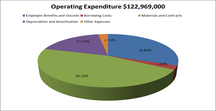
The Draft 2025/26 Budget Result on a Consolidated (All Funds) basis forecasts a balanced budget result as outlined below at Table 1.
Table 1 – Forecast Budget Result 2024/25 Consolidated (All Funds)
|
Item |
Amount $ |
|
Operating Result |
|
|
Operating Revenue |
122,690,000 |
|
Less: Operating Expenditure |
101,091,300 |
|
Less: Depreciation |
21,877,700 |
|
Operating Result – Surplus/(Deficit) |
(279,000) |
|
|
|
|
Funding Result |
|
|
Operating Result – Surplus/(Deficit) |
(279,000) |
|
Add: Non cash expenses – Depreciation |
21,877,700 |
|
Add: Capital Grants and Contributions |
39,029,300 |
|
Add: Loan Funds Used |
3,102,000 |
|
Add: Asset Sales |
0 |
|
Less: Capital Works |
61,155,100 |
|
Less: Loan Principal Repayments |
4,417,000 |
|
Funding Result – Surplus/(Deficit) (Cash Movement) |
(1,842,100) |
|
Reserves Movement – Increase/(Decrease) |
(1,842,100) |
|
Overall Budget Result – Surplus/(Deficit) (Operating + Funding) |
(0) |
The detailed Draft 2025/26 Budget Estimates are included at Attachment 4. Table 1 indicates a forecasted balanced budget result, and this relates to the General Fund. The forecast General Fund Unrestricted Cash Balance position based on the draft budget included at Table 1 is outlined in Table 2 below:
Table 2 – Forecast General Fund Unrestricted Cash Balance
|
Item |
$ |
|
Forecast unrestricted cash balance to 30 June 2025 at 31 December 2024 Quarterly Budget Review |
400,000 |
|
Add: Estimated Draft 2025/26 Budget result |
0 |
|
Forecast unrestricted cash balance at 30 June 2026 |
400,000 |
In addition to Table 1 above, budgeted financial statements incorporating an Operating Statement and Cash Flow Statement have been produced. These financial statements, replicating the format of Council’s Annual Financial Statements, are included in Attachment 3 as part of the Operational Plan, along with a summary of all Council budget program outcomes. Reserve balances are outlined in the detailed budget estimates provided at Attachment 4.
Council’s financial position
In producing the proposed draft budget outcome for 2025/26 Council has had to continue to take dividends from some of its reserves and other funds again, which is not sustainable. This, in addition to the continual use of the Plant Fund to fund operation of the Works Depot, have been underlying structural issues in Council’s budget for a number of years which have not been able to be addressed.
The difficulty of balancing the proposed 2025/26 budget position has been compounded by the following factors also on a consolidated all funds basis:
· Superannuation guarantee increasing from 11.5% to 12.0%
· Award salary increase of 3.0% budgeted plus a one off $1,000 payment to all full time staff and pro-rata to part-time staff.
· Insurance premiums of up to 6% to 15% estimated increase (excluding workers compensation insurance).
· Increased workers compensation insurance, $1,140,200 funded but a further potential $443,300 required yet to be identified and confirmed.
· Council addressing gaps left by other levels of government, despite insufficient resources
· Budget bids for funding much needed maintenance which are not affordable albeit some were accommodated.
It is vital for Council to consider the financial impacts of future decisions, given its current financial position. Whilst the 2025/26 draft budget is projecting the Council as business as usual, it also encompasses ongoing recovery works from the 2022 February/March flood events that are expected to be grant funded – estimated $26.135million. This is outlined in the budget program titled ‘Infrastructure Recovery’ and the Capital Works Program.
It is becoming increasingly difficult for Council to fund its operations with the current revenue base. This is due to:
· Not able to allocate general revenue funding towards capital works aside from pay parking revenue and the 2017/2018 Special Rate Variation yield in part.
· Traditional levels of maintenance funding in the General Fund being unsustainable.
· Council not able to increase its expenditure budgets to keep pace with inflation.
· Council’s revenue base being subject to variability in that revenue levels derived are dependent upon demand and use of the services, however the cost of those services is often fixed.
· The growing reliance on grant funding as a means to fund works or projects is a risk given that the significant levels of grant funding received or to be received in recent times cannot be assumed will be continued.
· The inability to incorporate any new budget bids or requests without funding.
· No capacity to increase any service level without corresponding additional revenue to fund or reduction in a service level elsewhere amongst Council services to compensate.
· Restrictions imposed by regulated fees and charges that Council must use that do not reflect the cost of services.
· For the second year Council has not budgeted for a full staff complement but is assuming continual salaried vacancies of at least 4.0 full time positions.
· Items yet to be determined such as the Emergency Services Levy (ESL).
It is expected Council will be provided with an updated Long Term Financial Plan (LTFP) in the lead up to the final adoption of the 2024/25 Delivery Plan, Operational Plan and Revenue Policy. The LTFP is a tool supporting Council’s financial projections over ten years endeavouring to fund services and expectations.
Table 2 also suggests that Council has depleted its unrestricted cash balance. Council’s goal is to maintain this balance at $1million so, over time, will need to recover this balance to provide Council with a buffer against of any unforeseen expense. It is hoped the current projected unrestricted cash balance of $400,000 can at least maintained or improved by the end of the 2024/25 financial year.
In terms of the draft 2025/26 budget position outlined in this report, further review will be undertaken during the public exhibition period to consider any new information and or outcomes from the 31 March 2025 Quarterly Budget Review with any adjustments reported to the Extraordinary 30 June 2025 Council Meeting.
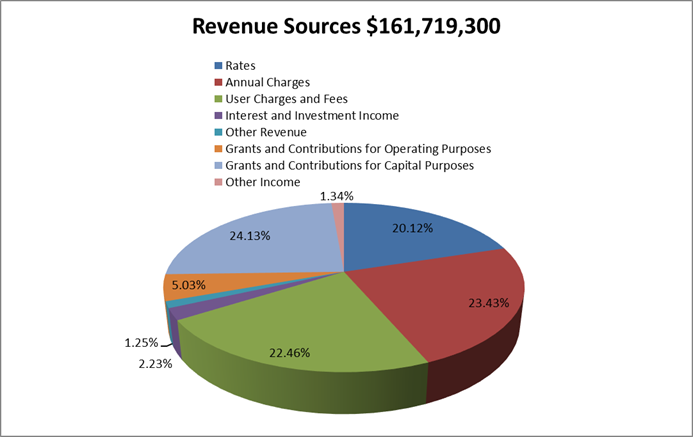
To arrive at the Draft Budget Results outlined in Table 1 for the 2025/26 financial year, Council’s revenue and operational expenses are expected to be derived from the following sources and allocated respectively as outlined in the graphs below:
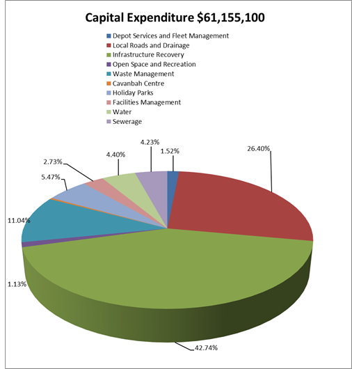
In addition to the operational aspects of the proposed Draft 2024/25 Budget Estimates, Council is proposing a capital works program of $61.155million. By Fund, the projected capital works are:
· General Fund $55.877million
· Water Fund $2.693million
· Sewerage Fund $2.585million
Specific capital works projects have been detailed in Attachment 4. As in previous years, the General Fund is presented in a different format, to improve the disclosure of funding sources for specific projects including:
· Developer contribution funding to describe the specific part of the Developer contribution plan and catchment that is providing the funding for a project.
· Where reserve funds are funding a project, identification of the reserve being utilised.
· Separation of funding provided by the 2017/18 Special Rate Variation (SRV) for which Council has reporting obligations for 10 years from 2017/18.
Of the $55.877million for capital works related to the General Fund, the following major components are proposed:
· Local Roads and Drainage $16.145million
· Infrastructure Recovery $26.135million – infrastructure restoration associated with February/March 2022 flood events
· Open Space and Recreation $0.693million
· Waste Management $6.750million
· Holiday Parks $3.344million
· Facilities Management $1.667million
The Draft 2025/26 Budget Estimates also propose new loan borrowings of $3.102million to fund the following projects:
· First Sun Holiday Park Masterplan Works $2.140million
· Suffolk Beachfront Holiday Park Works including Amenities Block $0.962million.
The amount of actual loan funds Council will need to borrow may be reduced pending how the above projects proceed: Council decision to proceed formally, and capital expenditure reviews submitted to the Office of Local Government where required.
Aside from new loan borrowings, whilst not currently factored into the budget, Council will need to refinance the following three loans borrowed in the 2023/24 financial year on a two year interest only term as a holding position assuming interest rates will start to decline and enable the locking in of more favourable long term fixed interest rates. These loans totalling $10.635million are as follows:
· Loan No 77 $4,700,000 maturing on 29 June 2026 borrowed to fund detention basin works at Lot 12 Bayshore Drive $1,200,000 and for the redevelopment of the former Byron Hospital $3,500,000.
· Loan No 78 $1,100,500 maturing on 20 June 2026 borrowed to fund LED Street Lighting upgrades $560,500 and Suffolk Beachfront Holiday Park Compliance Works $540,000.
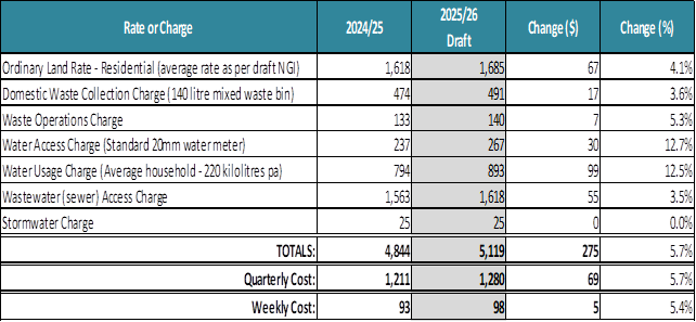
Draft General Land Rates and Charges (Statement of Revenue Policy)
The Draft 2024/25 Revenue Policy includes the proposed general land rating structure, consistent with the structure revised by Council for the 2017/18 financial year. This is outlined in Attachment 5. Whilst the general land rating structure is the same in terms of yield split, categorisation and retaining the use of a minimum rate subject to an ad valorem rate, Council has continued to incorporate land values with a 2022 base date for the purposes of general land rating for 2025/26 provided by the NSW Valuer General.
The rating structure also incorporates the approved rate peg of 5.00% determined by the Independent Pricing and Regulatory Tribunal (IPART) for Byron Shire Council representing the standard rate peg of 3.60% plus Emergency Services Levy factor 0.10% plus a Election Cost Adjustment 0.10% and plus a population increase factor of 1.30% then rounded to 5.0%.
The proposed general land rating structure included in the Draft 2025/26 Statement of Revenue Policy provided at Attachment 5 is estimated to derive $32.825million in allowable general land rating income inclusive of the 5.00% rate peg.
In respect of other charges, the Draft 2025/26 Statement of Revenue Policy includes:
· Waste Charges – increase of 3.6% to 4.3%
· Water access charges and usage charges increasing by 12.5%
· Sewerage charge - increased by 3.50%.
· The stormwater charge has not increased. It is a regulated charge that has not changed over the last nineteen years.
Water charges overall have been increased by 12.5% to improve the financial sustainability of the water fund, but principally to cover the increase cost to purchase water from Rous County Council. The cost of water will increase by 8.94% to $6,943,900, an increase of $569,600 over the previous year, even though Council’s water consumption with Rous County Council has declined by 4.24%.
For the average residential ratepayer, the increases proposed for 2025/26 to general land rates and charges if a fully serviced property are indicated below compared on the same basis to that applicable in 2024/25:
Draft Fees and Charges (Statement of Revenue Policy)
The Draft 2025/26 Fees and Charges have been reviewed by the respective program managers and included at Attachment 5 as part of the Draft 2025/26 Statement of Revenue Policy. Where possible, fees have been altered/increased to reflect the following:
· Increases in the Consumer Price Index (CPI)/Indexation – 3.5% at the time of preparation.
· Review of fees and charges including benchmarking/cost of service provision and where possible, introduction of new fees to assist Council to generate additional/ enhanced revenue.
· Regulated fees updated (if known) to reflect latest changes in legislative regulations. There will be further updates to regulated fees for Council to endorse at the 30 June 2025 Extraordinary Council Meeting as advice on these is still to arrive.
Significant changes to proposed fees and charges 2025/26
The Draft 2025/26 fees and charges has proposed changes Council needs to consider that are highlighted as follows:
· Pay Parking Permit Fees – the current disclosure in Attachment 5 will need to be changed prior to public exhibition should Council adopt the recommendations or alternate recommendations proposed in a separate report to this Planning Meeting.
· Cemetery Fees have been changed principally due to legislative changes under the Cemeteries and Crematoria Act 2013 that now require a levy payable to Cemeteries and Crematoria NSW on interments and the requirements to establish a perpetual maintenance fund. The proposed cemetery fees incorporate these changes.
· Section 355 Committee Managed Facility Fees have been changed in consultations with the respective Committees to establish some consistency across facilities to provide greater clarity to the Committees and Hirers. This includes standard definitions and possible discounts for multiple/recurrent hires. The intended outcome is to increase accessibility of facilities, improve customer experience and streamline administration.
Strategic Considerations
Community Strategic Plan and Operational Plan
|
CSP Objective |
CSP Strategy |
DP Action |
Code |
OP Activity |
|
1: Effective Leadership |
1.1: Enhance trust and accountability through open and transparent leadership |
1.1.4: Performance Measurement and Reporting - Embed a robust performance management system through the development of an outcomes measurement framework |
1.1.4.4 |
Prepare the 2025-2029 Delivery Program |
|
1.1.4.1 |
Continue to develop the outcomes measurement framework to strengthen the Delivery Program reporting |
|||
|
1.1.1: Leadership - Enhance leadership effectiveness, capacity, and ethical behaviour |
1.1.1.3 |
Develop 2025/26 Operational Plan |
||
|
1.3: Ethical and efficient management of resources |
1.3.1: Financial Management - Ensure the financial integrity and sustainability of Council through effective financial management |
1.3.1.3 |
Provide completion of Council's statutory annual financial statements for 2024/2025 |
Recent Resolutions
· 22-335 – adoption of the Byron Shire Community Strategic Plan 2032
· 23-389 – adoption of the revised Delivery Program 2022-26
· 24-517 – Draft 2035 Community Strategic Plan placed on public exhibition
Legal/Statutory/Policy Considerations
The requirements for Integrated Planning and Reporting are governed by Sections 402-406 of the Local Government Act 1993.
Section 404 requires that a council must have a 4-year delivery program detailing the principal activities to be undertaken within available resources.
Section 405 outlines the Operational Plan requirements including public exhibition and timeframes.
The specific statements required by Council to be disclosed as part of its Revenue Policy are determined by Clause 201 of the Local Government (General) Regulation 2005.
Detailed requirements are outlined in the Integrated Planning and Reporting Guidelines and Handbook.
Financial Considerations
As outlined in the report.
Consultation and Engagement
In accordance with the Local Government Act, the draft Operational Plan (including the annual budget, revenue policy, and fees and charges) must be exhibited for 28 days. Prior to the adoption the Operational Plan, Council must consider any submissions received during the exhibition period.
Feedback will be sought primarily through Your Say Byron Shire. Public notices and media releases will also be distributed.
Two Community Conversations are scheduled to be held, the first on 20 May (in person) and 27 May (online) as part of the exhibition period. These sessions will provide members of the community an opportunity to discuss how the delivery program, budget and operational plan have been developed, and projects planned for the 2025/26 financial year. Any input provided by the community as an outcome of the community conversations will be included as a submission to be considered by Council when adopting the final plans.
Local high schools have been contacted to participate in a consultation session and the Access Consultative Working Group.
Staff Reports - Corporate and Community Services 13.3
Report No. 13.3 Pay Parking Scheme Distribution Methodology
Directorate: Corporate and Community Services
Report Author: James Brickley, Manager Finance
Heather Sills, Manager Corporate Services
File No: I2025/559
Summary:
The 2024/2025 Budget was modified as part of adopting the original budget on 27 June 2024 via resolution 24-328 to incorporate the establishment of the Brunswick Heads Pay Parking Scheme.
This report proposes a methodology for the distribution of pay parking revenue for future budgets.
RECOMMENDATION:
That:
1. Funds generated from Brunswick Heads Pay Parking, after deducting costs for operating the scheme, be allocated to the Infrastructure Renewal Reserve – Brunswick Heads for works in Brunswick Heads village.
2. Following the full reimbursement of establishment costs to the Pay Parking Meter Replacement Reserve, that funding for works in Brunswick Heads township be funded from the Infrastructure Renewal Reserve Brunswick Heads and no longer from the Infrastructure Renewal Reserve – Non Byron as of 1 July 2026.
3. A review be undertaken as to the apportionment of revenue split between Council and Crown for both the Byron Bay and Brunswick Heads schemes before final adoption of the 2025/2026 Budget in June 2025.
4. Funding for the shortfall to cover the Transport Interchange/Rail Corridor expenditure, including provisions for future works, should be incorporated into the distribution formula for the Byron Scheme, and:
a) This adjustment should be made before distributing the remaining revenue to the three related Infrastructure Renewal Reserves.
b) Any unspent funds at the end of the financial year be maintained in the Rails Carpark Reserve.
Report
This report addresses the outstanding Part 3 of resolution 24-131, which required that Council:
3. Receives further reports:
a) discussing how the funds generated from the Brunswick Heads Pay Parking scheme could be distributed in Brunswick Heads and the Shire.
The 2024/2025 Budget was modified as part of adopting the original budget on 27 June 2024 via resolution 24-328 to incorporate the establishment of the Brunswick Heads Pay Parking Scheme.
This report proposes that the funding methodology for the pay parking schemes be allocated as follows:
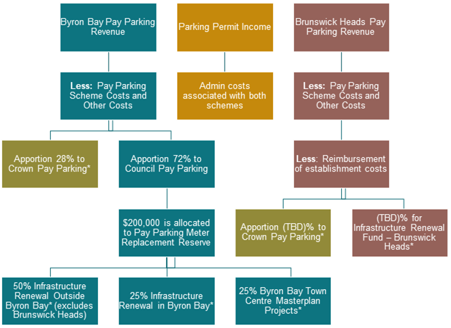
*Any unexpended funds are retained in their respective reserves
Background and Explanation of Changes
In February 2018, Council resolved (18-023) that:
· 50% of the income (after costs) is to be spent on projects in Byron Bay
· 50% of the income (after costs) is to be used to fund shire-wide projects as a way to equitably distribute the funding to address impacts on infrastructure from tourism.
In accordance with Council’s overall resolved distribution formula, revenues from the Byron Scheme are currently distributed on the following basis and this has been followed since scheme commencement:
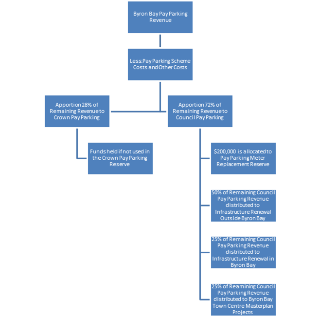
As at 30 June 2024, Council held the following funds in reserve related to pay parking derived revenue totalling $6,648,341:
· Infrastructure Renewal Reserve – Byron Bay $1,147,301
· Byron Bay Town Centre Masterplan Reserve $930,829
· Infrastructure Renewal Reserve – Non Byron Bay $2,349,891
· Crown Pay Parking Reserve $1,420,320
· Pay Parking Meter Replacement Reserve $800,000
Over the last eight full financial years, Council has expanded the parking scheme from the initial expansion including, Captain Cook Carpark, Wategos, the Byron scheme footprint itself, the Rails Carpark, and most recently in the establishment of a new scheme in Brunswick Heads that went operational in late September 2024.
Resolution 18-023 further required that “the distribution of all paid parking revenue be reviewed should additional paid parking schemes be implemented.”
When Council introduced pay parking in Brunswick Heads it also committed to reviewing how revenue from the scheme could be distributed in Brunswick Heads and the Shire (resolution 24-131).
In the first five and a half months, the Brunswick Heads Pay Parking Scheme has raised just over $380,000 through:
· Parking meters: $249,839
· Mobile app payments: $130,876
This is around 25% of the annual budget target of $1.54 million, with revenue currently averaging about $69,000 per month.
The setup and operation of the scheme has cost just over $1 million so far.
Assuming the monthly revenue average Brunswick Heads Pay Parking may generate up to another $242,270 for the remainder of the financial year, the projected 30 June 2024 total revenues would be approximately $700,000 leaving a shortfall of around $300,000.
Because of this shortfall, the 2025/26 budget has been prepared without relying on any surplus from the Brunswick Heads parking revenue. Instead, the focus will be on repaying the initial setup costs. The current projections suggest funding for works in Brunswick Heads may not be available until the 2026/2027 financial year.
To ensure revenue generated through pay parking in Brunswick Heads is reinvested into projects in Brunswick Heads, it is recommended that funds generated from Brunswick Heads Pay Parking, after deducting costs for operating the scheme, be allocated to a new Infrastructure Renewal Reserve – Brunswick Heads.
Following the full reimbursement of establishment costs to the Pay Parking Meter Replacement Reserve, funding for works in Brunswick Heads township should be funded from the Infrastructure Renewal Reserve Brunswick Heads and no longer from the Infrastructure Renewal Reserve – Non Byron.
This means that from 1 July 2026 any infrastructure renewal works for Brunswick Heads township would no longer be funded from the Infrastructure Renewal Reserve non Byron unless resolved otherwise by Council.
Crown Lands
There is a separation maintained within the Byron Scheme to distinguish revenues and costs associated between Council owned land and Crown Land.
Further work is needed to determine the pay parking revenue generated on Crown Land in Brunswick Heads. This may require a similar framework to the Byron Scheme with an appropriate apportionment.
It is further recommended that a review be undertaken as to the apportionment of revenue split between Council and Crown for both Byron Bay and Brunswick Heads schemes before final adoption of the 2025/2026 Budget in June 2025.
Rails Carpark Funding, Rail Corridor and Byron Transport Interchange
Council some time ago reached agreement with Transport for NSW to redevelop the Rails Carpark and implement Pay Parking. This agreement was further expanded upon completion of the Transport Interchange, with Council taking on the maintenance of that facility.
Expenditure to date for maintaining the Transport Interchange and Rail Corridor is $133,325 and $7,117 respectively totalling $140,442. Currently there is a $60,444 shortfall from the $79,998 revenue generated to date.
To resolve this issue, it would be feasible to utilise pay parking revenue from the Byron Scheme to fund the shortfall. It is recommended that funding for the shortfall to cover the Transport Interchange/Rail Corridor expenditure, including provisions for future works, should be incorporated into the distribution formula for the Byron Scheme. This adjustment should be made before distributing the remaining revenue to the three related Infrastructure Renewal Reserves.
Any unspent funds at the end of the financial year are to be maintained in the Rails Carpark Reserve.
Strategic Considerations
Community Strategic Plan and Operational Plan
|
CSP Objective |
CSP Strategy |
DP Action |
Code |
OP Activity |
|
5: Connected Infrastructure |
5.2: Connect the Shire through integrated transport services |
5.2.4: Parking - Manage parking through effective controls that support Movement and Place Plans and are coordinated with other initiatives such as park and ride |
5.2.4.2 |
Byron Bay Pay Parking system operations |
|
5.2.4.6 |
Implementation of Paid Parking Scheme in Brunswick Heads |
Recent Resolutions
· This report specifically addresses point 3 of resolution 24-131
Legal/Statutory/Policy Considerations
Council is asked to endorse the distribution methodology for pay parking revenue as outlined in the report.
Financial Considerations
As outlined in the report.
Consultation and Engagement
The draft 2025/26 Budget and Statement of Revenue Policy has been prepared in accordance with the details contained within this report.
The draft documents will be placed on public exhibition (subject to a separate report to this meeting) for 28 days, during which time members of the public will be invited to make submissions.
Submissions will be considered by Council prior to adoption of the final budget at the Extraordinary Meeting on 30 June 2025.
Staff Reports - Sustainable Environment and Economy 13.4
Staff Reports - Sustainable Environment and Economy
Report No. 13.4 PLANNING - Report of the Planning Review Committee held 3 April 2025
Directorate: Sustainable Environment and Economy
Report Author: Chris Larkin, Manager Sustainable Development
Noreen Scott, EA Sustainable Environment and Economy
File No: I2025/454
Summary:
This report provides the outcome of the Planning Review Committee (PRC) held on 3 April 2025.
NOTE TO COUNCILLORS:
In accordance with the provisions of S375A of the Local Government Act 1993, a Division is to be called whenever a motion for a planning decision is put to the meeting, for the purpose of recording voting on planning matters. Pursuant to clause 2(a) under the heading Matters to be Included in Minutes of Council Meetings of Council's adopted Code of Meeting Practice (as amended) a Division will be deemed to have been called by the mover and seconder of all motions relating to this report.
RECOMMENDATION:
That Council endorses the outcomes of the Planning Review Committee meeting held on 3 April 2025.
Report
The PRC meeting was held on 3 April 2025. The meeting commenced at 2:51pm and concluded at 2:59pm.
Councillors: Cr A Pugh, Cr J Dods, Cr D Kay, Cr M Lowe, Cr J Swain, Cr D Warth.
Apologies: Cr S Ndiaye, Cr M Lyon, Cr E Hauge.
Staff: Chris Larkin (Manager Sustainable Development).
Conflict of Interest: Cr Dods, 10.2023.73.4 9 Marvell St, Byron Bay.
The following development applications are referred to the Planning Review Committee to decide if the applications can be determined under delegated authority.
|
DA No. / Applicant |
Property Address / Proposal |
Consultation / Submissions |
Reason/s / Outcome |
|
10.2025.26.1 Matt Walker Town Planning |
25 Paterson St Use of alterations and additions to existing dwelling house. |
Level 2 11/03/25 to 24/03/25 11 submissions |
Staff Delegation |
Council determined the following original development applications. The S4.55 application/s to modify these development consents are referred to the Planning Review Committee to decide if the modification applications can be determined under delegated authority.
|
DA No. / Applicant |
Property Address / Proposal |
Consultation / Submissions |
Reason/s / Outcome |
|
10.2023.73.4 Planners North |
9 Marvell St Modification to approved demolition and construction of mixed-use development |
Level 1 12/03/25 to 25/03/25 No submissions |
Staff Delegation |
|
10.2024.226.2 Dr B T Donnellan |
158 Skinners Shoot Road Section 4.55 to delete condition 2 which prohibits connection to reticulated water and to delete Condition 10 regarding the setback to the northern boundary |
Level 0 |
Staff Delegation
|
Staff Reports - Sustainable Environment and Economy 13.5
Report No. 13.5 Status report on Development Applications (DAs) with bodies like the Northern Regional Planning Panel (NRPP)
Directorate: Sustainable Environment and Economy
Report Author: Shannon Burt, Director Sustainable Environment and Economy
File No: I2025/485
Summary:
At the Council (Planning) Meeting of 12 October 2023 it was resolved as part of 23-461
that Council: “Receives status reports monthly to each Ordinary (Planning) Meeting on all
DA’s that are being processed by Council for determination by other bodies such as the
Northern Regional Planning Panel or the Independent Planning Commission.”
Resolution 22-559 further requires: “That Councillors receive, as a standard procedure, a copy of the Assessment Report prepared by Council staff for any DA that is to be determined by the Northern Regional Planning Panel on the next working day after it is lodged on the Planning Portal.”
RECOMMENDATION:
That Council notes the status report on Development Applications (DAs) with bodies like the Northern Regional Planning Panel (NRPP).
Report
The following applications are a matter for determination by the Northern Regional Planning Panel in accordance with the Sydney District & Regional Planning Panels Operational Procedures. There are no matters currently with the Independent Planning Commission.
|
Planning Authority |
Application Description and link |
Status |
|
Northern Regional Planning Panel |
PPSNTH-285 Community Title Subdivision 53 McAuleys Lane Myocum 2481 Community Title Subdivision | Planning Portal - Department of Planning and Environment (nsw.gov.au) Link to DA tracker for DA 2023.454.1 information and documents here: |
Submitted 12/12/2023 Record of Briefing - PPSNTH-285.pdf Exhibition of DA and amended Planning Agreement 9 April /25 – 9 May 25. Determination meeting date to be confirmed.
|
|
Northern Regional Planning Panel |
PPSNTH-405 Review of Determination (Refusal) - Temporary extension to existing coastal protection works 144 Bayshore Drive Byron Bay 2481 Link to DA tracker for DA 2023.287.2 information and documents here: |
Submitted 13/01/25 Review of determination (refusal) comprising the temporary extension of an existing geobag wall on private property. The Development Application was refused on 26 September, 2024 by the Northern Regional Planning Panel. Determination meeting scheduled for 24 March 2025 was cancelled. Two appeals by Ganra Pty Ltd against the refusal of DA 10.2023.2.87.1 and the deemed refusal of the review application for the DA lodged. Court directions are on 14 April 2025. |
|
Northern Regional Planning Panel |
PPSNTH-406 Modification to Condition 1 of the Consent to establish Stage 4 Public Open Space during Stage 3. 26 Harvest Boulevard Byron Bay & 342 Ewingsdale Road Byron Bay & Ewingsdale Road West Byron | Planning Portal - Department of Planning and Environment Link to DA tracker DA 10.2017.201.4 information and documents here: |
Submitted: 16/12/25 Determination meeting 22 April 2025.
|
|
Northern Regional Planning Panel |
PPSNTH-409 Modification to residential flat building including increase in building height within R3 Medium Density Residential and 7(F2) Urban Coastal Land zones and increase in size of rooftop areas across all buildings. 29 Shirley Street, 4 Milton Street and 2 Milton Street Byron Bay Link to DA tracker DA 10.202.371.4 information and documents here: Byron Shire Council - Application Tracker
|
Submitted: 14/02/25 Under assessment. A deemed refusal appeal was lodged with the LEC 14/4/25. Court directions are on 12/05/25. |
Strategic Considerations
Community Strategic Plan and Operational Plan
|
CSP Objective |
CSP Strategy |
DP Action |
|
1: Effective Leadership |
1.1: Enhance trust and accountability through open and transparent leadership |
1.1.2: Governance - Ensure legislative compliance and support Councillors to carry out their civic duties |
Recent Resolutions
· 23-461
Legal/Statutory/Policy Considerations
The Planning Panels determine regionally significant development applications (DAs), certain other DAs and s4.55(2) and s4.56 modification applications including:
· Regionally significant development, as outlined in Schedule 6 of the State Environmental Planning Policy Planning Systems 2021
· Regionally significant development relating to Aboriginal land, as outlined in Chapter 3 of the State Environmental Planning Policy Planning Systems 2021
· Development with a capital investment value (CIV)* over $30 million.
· Development with a CIV* over $5 million which is:
o Council related
o lodged by or on behalf of the Crown (State of NSW)
o private infrastructure and community facilities
o eco-tourist facilities
o extractive industries, waste facilities and marinas that are designated development
o certain coastal subdivisions and
o certain coastal protection works.
*Capital investment value (CIV) is calculated at the time of lodgement of the DA for the purpose of determining whether an application should go to a Planning Panel - refer to Planning Circular PS 10-008.
Section 10 of the Sydney District & Regional Planning Panels Operational Procedures talks to Roles of councils and other panels.
10.1 states the elected Council and Council staff have different roles in the assessment of DAs. Under the Local Government Act 1993, the independence of Council staff is protected in the preparation of advice and recommendations. Staff members are not subject to direction by the Council or by a Councillor as to the content of any advice or recommendation made by the staff member. Equally, a Council or Councillor is not bound by the advice or recommendation made by a member of staff.
10.3 states historically, one of the roles of an elected Council has been to determine or make decisions on DAs in their capacity as a consent authority. There are occasions, however, where the determination role is performed by other people or bodies, either because the Council has delegated that function, or because it has been conferred upon another person or body. For example, where local planning panels have been introduced, elected Councils no longer determine DAs (see section 2.17 of the EP&A Act). The Panel for the area in which the development is to be carried out is the consent authority for regionally significant development (see section 4.5 of the EP&A Act).
10.4 states Council staff are responsible for post-determination functions including:
· notifying Panel determinations on DAs (see sections 4.7(2)(e), 4.18 and 4.59 of the EP&A Act),
· registering Panel development consents on the NSW Planning Portal (see sections 4.7(2)(e) and 4.20 of the EP&A Act), and
· monitoring and enforcing compliance with conditions of the development consent.
The notice of determination should be issued once Council receives a copy of the endorsed and final determination from the Panel. The notice of determination must include all conditions imposed by the Panel, including any additional or amended conditions.
The Council has no power to amend conditions or include additional conditions following the Panel’s determination.
Council will advise any person who made a submission on the DA of the determination.
The Council continues to be responsible for the monitoring of, and enforcing compliance with, any conditions of the development consent.
Where an application has been approved subject to a ‘deferred commencement’ condition Council is responsible for determining whether the requirements of the condition have been met (see section 4.16(3) of the EP&A Act). Council advises the chair of the Panel in writing when the matter specified in the condition has been satisfied (see section 277(2) of the EP&A Regulation).
Microsoft Word - Att C - Amended RPP Operational Procedures.docx (amazonaws.com)
11.13 talks to Council representation to the Planning Panel.
An elected Council may make a submission on a DA within their LGA that is to be determined by a Panel up to seven days before the Panel meeting. After the assessment report is sent to the Secretariat, it may be given to the elected Council to assist in its decision as to whether it will be making a submission to the Panel. The elected Council’s submission should not be prepared by persons involved in the assessment of the application but could be prepared by another Council officer, or a consultant.
A Council submission should not be specifically referenced in the assessment report or recommendations prepared by the Council staff. If Council makes a submission, a staff representative or individual Councillors may register to address the Panel at the meeting to express the views of Council. Councillors who are also Panel members have an independent role because they have been nominated by their Council as its nominee to the Panel.
A Code of Conduct also applies to members of the Planning Panels.
Appeals from Planning Panel determinations
Section 8.15(4) of the EPA Act was introduced on 1 March 2018. It provides relevantly:
If the determination or decision appealed against under this Division was made by a Sydney district or regional planning panel or a local planning panel, the Council for the area concerned is to be the respondent to the appeal but is subject to the control and direction of the panel in connection with the conduct of the appeal. The Council is to give notice of the appeal to the panel.
In respect of the conduct and potential resolution of appeals, Councils are subject to the direction and control of planning panels in respect of decisions they make after 1 March 2018.
The Land and Environment Court has said that in circumstances where the panel and Council have conflicting views on a development, the appropriate approach would be for the panel to apply to be joined as a party to the appeal proceedings.
Financial Considerations
None relevant to this report.
Consultation and Engagement
Applications are exhibited as per the Council’s Community Participation Plan.
Otherwise, consultation, engagement and reporting must be in accordance with the Planning Panels Operations Procedure and Code of Conduct.
Staff Reports - Sustainable Environment and Economy 13.6
Report No. 13.6 2025 Regional & Remote Music Summit Partnership Proposal
Directorate: Sustainable Environment and Economy
Report Author: Shannon Burt, Director Sustainable Environment and Economy
Arika McElroy, Business and Industry Project Lead
File No: I2025/548
Summary:
Becoming the Presenting Partner would strengthen Council’s support for these industries and help promote the Shire’s unique creative identity. It would also highlight and encourage community-led initiatives, aligning with Council’s goals for events and industry development in the region.
RECOMMENDATION:
That Council:
1. Welcomes the opportunity to host the 2025 Regional & Remote Music Summit to be held in Byron Bay 23-25 July 2025.
2. Agrees to become a Presenting Partner of the 2025 Regional and Remote Music Summit.
3. Requests staff to identify a budget of $15,000 to meet the Council’s financial contribution as a Presenting Partner through the next Quarterly Budget Review.
Report
MusicNSW has invited Council to be the Presenting Partner for the Delegates Welcome Reception at the Regional & Remote Music Summit | 23-25 July 2025 This invitation presents a valuable opportunity for Council to actively support the local music and creative industries.
The 2025 Summit will be the second annual event of its kind, presented by MusicNSW. The Summit aims to bring together music professionals, artists, policymakers, academics, and community leaders to shape a new vision for regional music. The overarching goal is to strengthen and connect music communities across regional and remote areas.
The event is hosted by MusicNSW, with support from Music Australia and Sound NSW. The inaugural Summit was held on Larrakia Country in Darwin in August 2024 and was hosted by MusicNT.
About MusicNSW
MusicNSW is a not-for-profit organisation that supports and connects artists and the music industry in New South Wales. The organisation provides access to professional development, skill-building opportunities, and industry resources. MusicNSW also plays a key role in building strong industry networks and leading community consultation and engagement. Key initiatives include Sound Advice, regional industry development programs, and support for First Nations artists and the wider music community.
More information: www.musicnsw.com
Council Benefits as Presenting Partner
As a Presenting Partner, Council would receive:
· Shared branding and promotional opportunities
· A speaking role at the Delegates Welcome Reception
· Participation in a NSW music industry roundtable
· Recognition as a supporter and leader in the creative industries
· 10 VIP tickets to the Summit
The theme for the 2025 Summit is “Strengthening Music Communities”, acknowledging the vital role music plays in identity, belonging, and community recovery across regional areas.
Strategic Considerations
Community Strategic Plan and Operational Plan
|
CSP Objective |
CSP Strategy |
DP Action |
|
2: Inclusive Community |
2.1: Foster opportunities to express, celebrate and participate in arts and cultural activity |
2.1.3: Events and festivals - Support and enable arts & cultural activity, festivals, projects, and events |
Recent Resolutions
· 25-130 Events Strategy
· 25-124 Vibrant Economy Strategy
Legal/Statutory/Policy Considerations
Not relevant to this report.
Financial Considerations
Based on the nominated partner tier for the Summit, a $15,000 contribution is sought from Council.
As the invitation to partner in the Summit falls outside the usual grant and budget planning timelines, a one-off budget allocation of $15,000 is required.
Should Council choose to become a presenting partner, this allocation can be identified, considered and approved through the next quarterly budget review process.
Consultation and Engagement
Not relevant to this report.
Staff Reports - Sustainable Environment and Economy 13.7
Report No. 13.7 PLANNING - Development Application 10.2024.428.1 – Torrens Title subdivision of 8 concept approved lots into 10 lots resulting in the total increasing from 47 to 49 lots across the 2 consents, and modification to the consent to DA10.2015.795.1 in relation to stormwater management and size of concept approved lots 40, 45, 46 and 47 – 35 Bayside Way Brunswick Heads
Directorate: Sustainable Environment and Economy
Report Author: Greg Smith, Team Leader Planning Services
File No: I2025/560
Proposal:
|
DA No: |
10.2024.428.1 |
||
|
Planning Portal ref |
PAN-484955 |
||
|
Proposal description: |
Torrens Title subdivision of 8 concept approved lots into 10 lots resulting in the total increasing from 47 to 49 lots across the 2 consents, and modification to the consent to DA10.2015.795.1 in relation to stormwater management and size of concept approved lots 40, 45, 46 and 47 |
||
|
Property description: |
LOT: 8 DP: 1261870 |
||
|
35 Bayside Way BRUNSWICK HEADS |
|||
|
Parcel No/s: |
270098 |
||
|
Applicant: |
Planners North |
||
|
Owner: |
Mr J E & Mrs G M Mills |
||
|
Zoning: |
R3 Medium Density Residential RU2 Rural Landscape C2 Environmental Conservation |
||
|
Date received: |
19 November 2024 |
||
|
Type of development |
☐ Local |
☒ Integrated |
☐ Designated |
|
Concurrence required |
No |
||
|
Public notification or exhibition: |
- Level 2 advertising under Council’s Community Participation Plan. - Exhibition period: 29/11/2024 to 12/12/2024 - Two Submissions received |
||
|
Variation request to Development Standards under an EPI (e.g. clause 4.6) |
Not applicable |
||
|
Estimated cost |
$360,226.00 |
||
|
Delegation to determine |
Council – due to the total number of lots proposed. |
||
Summary:
The development application proposes a 10 lot Torrens Title Subdivision at 35 Bayside Way, Brunswick Heads. The subdivision was previously approved under DA10.2015.795.1 for a total of 47 lots in a concept approval. This proposal affects 8 of those concept approved lots where the applicant now seeks consent for an additional 2 parcels to make a total of 10 residential lots.
The proposal also includes a modification to the previous consent DA10.2015.795.1 in relation to stormwater management.
The development application was publicly exhibited, with two submissions received, including one from Department of Planning, Housing & Infrastructure - Crown Lands in relation to road reserve transfer.
The development application addresses the relevant constraints applying to the site, with land previously cleared and utilised for a plant nursery.
The proposal is consistent with the R3 Medium Density Zone controls in Byron LEP 2014 and satisfies the minimum lot size provisions of 450m2.
The proposal will provide for much needed housing supply.
The development application is recommended for approval subject to the conditions listed in Attachment 1.
NOTE TO COUNCILLORS:
In accordance with the provisions of S375A of the Local Government Act 1993, a Division is to be called whenever a motion for a planning decision is put to the meeting, for the purpose of recording voting on planning matters. Pursuant to clause 2(a) under the heading Matters to be Included in Minutes of Council Meetings of Council's adopted Code of Meeting Practice (as amended) a Division will be deemed to have been called by the mover and seconder of all motions relating to this report.
RECOMMENDATION:
That pursuant to Section 4.16 of the Environmental Planning & Assessment Act 1979, Development Application No. 10.2024.428.1 for Torrens Title subdivision of 8 concept approved lots into 10 lots resulting in the total increasing from 47 to 49 lots across the 2 consents, and modification to the consent to DA10.2015.795.1 in relation to stormwater management and size of concept approved lots 40, 45, 46 and 47, be granted consent subject to the conditions in Attachment 1 (E2025/38008).
Attachments:
1 10.2024.428.1
- Recommended Conditions, E2025/38008
![]()
2 10.2024.428.1
- Plans, E2025/38007 ![]()
3 10.2024.428.1
- Biodiversity Development Assessment Report, E2025/38006
![]()
4 10.2024.428.1
- Redacted Submissions, E2025/37399
![]()
Assessment:
1. INTRODUCTION
1.1 History/Background
Development Application No. 10.2015.795.1 for:
Staged Development Comprising:
a) Concept proposal for a subdivision to create 47 Residential lots and associated Urban Infrastructure; and
b) Stage 1 Development proposal for a Subdivision to create Forty (40) Residential Lots, One (1) Residue Lot, Public Roads and Associated Urban Infrastructure.
This was approved on 23 February 2017 and modified on 22 May 2019 and 12 June 2019.
The consent “concept” approved the entire subdivision, being Lots 1 to 47 (refer to Figure 2 below), requiring subsequent development consent for any part of the subdivision to be carried out.
In the same consent Lots 1 through to residue Lot 41 were approved to be carried out (refer to Figure 3 below).
The re-subdivision of residue Lot 41 to create new Lots 41 to 47 remained concept approved under that consent. The concept approval of new Lots 41 to 47 meant that these still required development consent to be carried out – hence the lodgement of the current Development Application No. 10.2024.428.1.
Figure 2: Concept approval under DA 10.2015.795.1
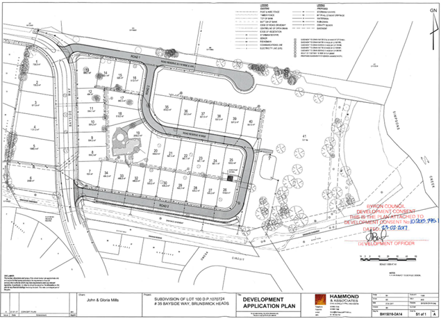
Figure 3: Lots approved to be carried out under DA 10.2015.795.1
The report on Development Application No. 10.2015.795.1 advised in part as follows in relation to the prior approval history of the then site:
|
BA 89.308 |
Dwelling |
Approved 30/5/1989 |
|
5.1997.316.1 |
Commercial Development – Nursery, Tree Removal |
Approved 21/1/1998 |
|
6.1997.2257.1 |
Swimming Pool |
Approved 28/5/1997 |
|
10.2004.32.1 |
New shed for existing nursery |
Approved 26/2/2004 |
|
11.2004.32.1 |
Construction Certificate – New shed for nursery |
Approved 10/9/2004 |
The current site has the following additional Tree Removal Permits which apply:
|
9.2020.85.1 |
Tree Removal Eighteen (18) Trees |
Approved 12/1/2021 |
|
9.2024.7.1 |
Dead, Dying, Dangerous Tree removal Application |
Approved 7/3/2024 |
1.2 Description of the proposed development
The development application seeks approval for Torrens Title subdivision of 8 concept approved lots into 10 lots resulting in the total increasing from 47 to 49 lots across the 2 consents, and modification to the consent to DA10.2015.795.1 in relation to stormwater management and size of concept approved lots 40, 45, 46 and 47.
Approved Lot 40 is to be slightly adjusted in area under the proposal. The concept approved lots are Lots 41 to 47. The 2 additional lots are Lots 48 and 49. There is no change to the area of Lots 41 to 44 compared to the concept approval. The approved and modified areas of Lots 40, 45, 46 and 47, and the size of new Lots 48 and 49, are as follows:
|
Lot number |
Approved Size |
Modified Size |
|
40 |
507.5m2 |
590.2m2 |
|
41 |
509.8m2 |
No change |
|
42 |
484.7m2 |
No Change |
|
43 |
478.6m2 |
No Change |
|
44 |
478.7m2 |
No Change |
|
45 |
477.1m2 |
477.7m2 |
|
46 |
533.3m2 |
471.8m2 |
|
47 |
2.844 hectares |
2.729 hectares |
|
48 |
New Lot |
594.4m2 |
|
49 |
New Lot |
484.1m2 |
Section 4.24 of the Environmental Planning and Assessment Act 1979 requires that, relevant to the determination of a concept development application for a site, the determination of any further development application in respect of the site cannot be inconsistent with the consent for the concept proposal.
A comparison of the approved plans and the proposed plans in conjunction with the above table confirms that Lots 40 to 47, which are equivalent to the concept approved lots, are consistent in lot size, lot shape and lot location to that approved. The development consent is not prevented from adding in the 2 new Lots 48 and 49.
Lots 40 to 46, 48 and 49 are all residential size lots and located entirely within the R2 Low Density Residential Zone.
Lot 47 is a battle-shaped lot with an extended handle (accommodating a drainage easement) to Bayside Way along the southern side of the site. Lot 47 is zoned R3 Medium Density Residential in the southwestern part, C2 Environmental Conservation on the eastern area adjacent to Simpsons Creek and RU2 Rural Landscape in the central part.
The proposed development is depicted in “Proposed Layout” plan in Attachment 2, and this plan includes an overlay of the boundaries between the zones which are indicated by 2 purple dashed lines.
The Development Application confirms that no trees are to be removed.
The Proposed Layout plan includes a private driveway constructed along the road reserve to the northern boundary of Lot 47. This was not on the plans approved under the consent to DA 10.2015.795.1 and is crossed out on the plans as not approved now.
1.3 Description of the site
A site inspection was carried out on 24 March 2025.
|
Land is legally described |
LOT: 8 DP: 1261870 |
||
|
Property address |
35 Bayside Way BRUNSWICK HEADS |
||
|
Land is zoned: |
R3 Medium Density Residential RU2 Rural Landscape C2 Environmental Conservation |
||
|
Land area is: |
5.895 hectares |
||
|
Constraints and Attributes: |
Bush Fire Prone Land Acid Sulfate Soils – Class 1, Class 3, Class 4 High Environmental Value Vegetation – area of which is generally consistent with the Biodiversity Values mapping, hence considered in the context of the BDAR below. |
||
|
|
Is a BDAR required due to the location of the proposed development? |
☒ Yes ☐ No |
|
|
|
Are there any easements affecting the site? |
☒ Yes ☐ No |
|
|
|
Is there a Vegetation Management Plan which might affect the proposal? |
☒ Yes ☐ No |
|
|
|
Is there a Voluntary Planning Agreement which might affect the proposal? |
☐ Yes ☒ No |
|
|
Figure 4: View east towards Lots 41 to 46 |
Figure 5: View east along approved Road 1 |
||
|
Figure 6: View west towards Lots 46 to 41 |
Figure 7: View south towards Lots 46, 40, 48, 49 |
||
|
Figure 8: View north towards Lots 49, 47 |
Figure 9: View south towards Lot 47 building envelopes |
||
2. SUMMARY OF REFERRALS
|
Referral |
Issue |
|
Environmental Health Officer |
No objections subject to conditions. |
|
Development Engineer |
No objections subject to conditions.
|
|
S64 / Systems Planning Officer |
No objections subject to conditions. |
|
S7.11 / Contributions Planner |
No objections subject to payment of contributions, as per the attached Recommended conditions. |
|
Ecologist |
No objections subject to conditions. The Council’s Ecologist has advised that many biodiversity issues are not relevant to this site and proposed development due to historic clearing and modification. The vegetation and habitat flanking Simpsons Creek will be retained and enhanced. A 50m buffer is required. |
|
Resource Recovery |
No objections subject to a condition. |
|
Rural Fire Service (100B) |
The proposal is integrated development being the subdivision of bush fire prone land and the NSW Rural Fire Service has issued its General Terms of Approval and Bush Fire Safety Authority which are included in the Recommendation of this Report. |
|
Department of Planning and Environment – Water |
The proposal is integrated development being a controlled activity approval under section 91 of the Water Management Act 2000. The Department of Planning and Environment–Water has issued its General Terms of Approval which are included in the Recommendation of this Report. |
|
Essential Energy |
No objections. The Recommendation of this Report includes the Essential Energy advice as a Note. |
|
Department of Primary Industries and Regional Development – NSW Fisheries |
The comments provided by the Department of Primary Industries and Regional Development (DPIRD) Fisheries are commented on in the section of this Report below relating to section 56 of the Marine Estate Management Act 2014. |
Council’s Ecologist advised that the Biodiversity Values Map applies to the area flanking Simpsons Creek and along the watercourse / drain at southern boundary:
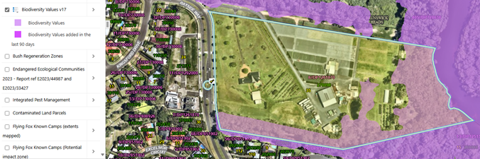 Figure 10:
Biodiversity Values Map extract
Figure 10:
Biodiversity Values Map extract
The Ecologist advises as follows in this regard:
The application has been assessed via a Biodiversity Development Assessment Report (BDAR), prepared by Biodiversity Assessments & Solutions (2024) due to impacts on biodiversity value land. The BDAR was submitted on 20/09/2024*.
* the period of currency of the credit information in the BDAR has lapsed and will need to be re-calculated for retirement of biodiversity credits – this is included in the recommended conditions of consent.
Flora
The BDAR states:
Most of the subject land is completely absent of native vegetation or overwhelmingly dominated by exotic pasture grasses and / or exotic shrubs and / or trees. These areas include obvious developed hard surface such as driveways and carparking, sheds and nursery structures, facility buildings, orchard species, or managed lawns and landscaping.
Native vegetation at the site was assigned to PCT 3551 Northern Sands Blackbutt-Red Mahogany Forest, with three condition states identified. PCT 3551 is not a TEC and no threatened flora were recorded despite extensive targeted survey.
Fauna
The BDAR completed targeted survey as required via the BAM, in addition to further survey for birds, acid frogs and Koalas. One fauna species credit species (Bush Stone-curlew Burhinus grallarius) was recorded on the subject land during site surveys.
Riparian and corridor values
The site is adjacent to Simpsons Creek and the eastern forested riparian vegetation (which is modified and mown/managed) is within a mapped wildlife corridor.
Proposed Development Impact
The BDAR states (Section 6.1.1):
The proposed development has been located on relatively low biodiversity value land with limited ecological constraints, particularly regarding the development footprint. The subject land has been historically cleared and developed for use as a commercial nursery… Planted and regrowth vegetation also occurs along the southern boundary which contains a man-made drain and provides a stormwater drainage function for the Bayside locality. The surrounding area has also been substantially developed, with the proposal located on the most suitable land in the locality to accommodate needed residential development. The proposal is for an infill development, with negligible direct or indirect ecological impacts likely to occur on adjacent land or in the wider locality because of this proposal. A majority of the subject land consists of existing hard surfaces, cleared land or low condition vegetation, with the proposal located accordingly to avoid higher condition vegetation or vegetation with significant habitat features.
This assessment is supported, as is the assessment of impacts in Section 6 of the BDAR.
SAII assessment in Section 8.2 of the BDAR is supported.
Section 9.1.1 of the BDAR states:
The proposal will have minimal ecosystem impacts due to the subject land currently being largely cleared and containing predominantly low to very low (i.e., ‘cleared’) condition vegetation with little biodiversity value. Most of the vegetation to be impacted and requiring offsets is located in the existing cleared portion of the subject land, with a small area of vegetation impacted to accommodate the stormwater outlet pipe into the existing man-made stormwater drainage easement along the southern boundary.
This assessment is supported.
Approximately 0.04 ha of the subject land requires offsetting with ecosystem credits, with credits also required to offset habitat loss for the Bush Stone-curlew. Biodiversity credit requirements as per Tables 27 & 28 of the BDAR include:
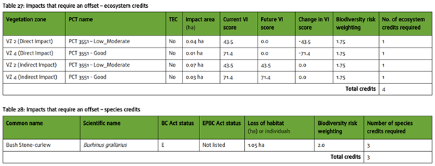
The BDAR is considered to have applied the BAM appropriately and adequately assessed the proposal and identified biodiversity credits for the proposal based on the project footprint (with buffer) and direct and indirect residual impacts.
Conditions recommended by the Ecologist are included in Attachment 1. The BDAR is provided in Attachment 3.
3. SECTION 4.14 – BUSH FIRE PRONE LAND
Effect of 10/50 rule on significant vegetation: The 10/50 Rule is not applicable to this site.
4. SECTION 4.15C – MATTERS FOR CONSIDERATION – DISCUSSION OF ISSUES
Having regard to the matters for consideration detailed in Section 4.15(1) of the Environmental Planning & Assessment Act 1979 (EP&A Act), the following is a summary of the evaluation of the issues.
4.1 State Environmental Planning Policies (SEPP)
|
Considerations |
Satisfactory |
Unsatisfactory |
|
Biodiversity and Conservation SEPP 2021 Consideration: Chapter 4 defers to the approved Byron Comprehensive Koala Plan of Management. The development application addresses this in Section 4.1.4. The site contains potential Koala habitat, however the site assessment indicates core Koala habitat does not occur. Therefore, no further requirements apply. Notwithstanding the area where this habitat occurs in the main, I located along the eastern boundary where it adjoins Simpsons creek. This area is not to be developed and will be the subject of a vegetation management plan and embellished. Conditions of consent to apply. |
☒ |
☐ |
|
Resilience and Hazards SEPP 2021 Consideration: In relation to Chapter 2 Coastal management, the proposal is satisfactory for the following reasons: · Clause 2.7 Coastal wetlands The eastern extremity of the site is mapped as containing an area of coastal wetlands. The mapped area is within the eastern part of the C2 zoned part of the site and is not located near any part of the proposed development including its ancillary components. On this basis and advice contained in referrals, sufficient measures will be taken to protect, and where possible enhance, the biophysical, hydrological and ecological integrity of the coastal wetland.
Figure 11: Coastal Wetlands map extract · Clause 2.8 Coastal wetlands buffer The development will not significantly impact on— (a) the biophysical, hydrological or ecological integrity of the adjacent coastal wetland or littoral rainforest, and (b) the quantity and quality of surface and ground water flows to and from the adjacent coastal wetland or littoral rainforest. · Clause 2.10 Coastal environment area The development is unlikely to cause an adverse impact on— (a) the integrity and resilience of the biophysical, hydrological (surface and groundwater) and ecological environment, (b) coastal environmental values and natural coastal processes, (c) the water quality of the marine estate (within the meaning of the Marine Estate Management Act 2014), in particular, the cumulative impacts of the proposed development on any of the sensitive coastal lakes, (d) marine vegetation, native vegetation and fauna and their habitats, undeveloped headlands and rock platforms, (e) existing public open space and safe access to and along the foreshore, beach, headland or rock platform for members of the public, including persons with a disability, (f) Aboriginal cultural heritage, practices and places, (g) the use of the surf zone. The development is designed, sited and will be managed to avoid an adverse impact referred to above. · Clause 2.11 Coastal use area (a) The development is unlikely to cause an adverse impact on— (i) existing, safe access to and along the foreshore, beach, headland or rock platform for members of the public, including persons with a disability, (ii) overshadowing, wind funnelling and the loss of views from public places to foreshores, (iii) the visual amenity and scenic qualities of the coast, including coastal headlands, (iv) Aboriginal cultural heritage, practices and places, (v) cultural and built environment heritage, (b) and (i) the development is designed, sited and will be managed to avoid and minimise an adverse impact referred to in paragraph, and (c) the development will not have a significant impact in terms of the surrounding coastal and built environment, and its scale and size. In relation to Chapter 4 Remediation of land, the matter was previously considered as part of the 2015 development consent. With the passage of time and continued nursery operations on the land, and although the risk of the site being contaminated over the last decade is low it is recommended that the application for a subdivision works certificate must be accompanied by a Detailed Contaminated Land Assessment and Remedial Action Plan (where results deem in necessary). |
☒ |
☐ |
|
Transport and Infrastructure SEPP 2021 Consideration: The proposal is satisfactory having regard to the provisions of the Transport and Infrastructure SEPP. Essential Energy has raised no objection to the proposal, including general comments which are recommended to be included as a note in the consent if granted. |
☒ |
☐ |
4.2 Byron Local Environmental Plan 2014 (LEP 2014)
LEP 2014 is an applicable matter for consideration in the assessment of the subject development application in accordance with subsection 4.15(1) of the EP&A Act because it applies to the subject land and the proposed development.
In accordance with LEP 2014 clauses 1.4 and 2.1 – 2.3:
(a) The development is defined as subdivision of land;
(b) The land is within the C2 Environmental Conservation Zone / R3 Medium Density Residential Zone / RU2 Rural Landscape Zone according to the Land Zoning Map;
(c) The development is permitted with consent in accordance with clause 2.6; and
(d) Regard is had for the Zone Objectives as follows:
|
R3 Medium Density Residential Zone Objectives |
Consideration |
|
• To provide for the housing needs of the community within a medium density residential environment. |
The subdivision contributes toward provision for the housing needs of the community within a medium density residential environment. |
|
• To provide a variety of housing types within a medium density residential environment. |
The subdivision provides opportunities to contribute toward provision of a variety of housing types within a medium density residential environment. |
|
• To enable other land uses that provide facilities or services to meet the day to day needs of residents. |
The subdivision does not prevent other permissible land uses that provide facilities or services to meet the day to day needs of residents. |
|
RU2 Rural Landscape Zone Objectives |
Consideration |
|
• To encourage sustainable primary industry production by maintaining and enhancing the natural resource base. |
The RU2 zoned part of the site is approximately 1.1 hectares, which is not significant for sustainable primary industry production. No changes are proposed for this area; it will remain as one lot and will not be fragmented. This section maintains the buffer between the R3 medium density zoned area and the natural resource base, including Simpsons Creek and the C2 zoned part of the site. |
|
• To maintain the rural landscape character of the land. |
The proposal to maintain the rural zoned part of the site in one parcel (Lot 47) ensures that no change occurs in this regard. Lot 47 includes 2 indicative building envelopes in a cleared, RU2 zoned part of the site (refer to Figure 9 of this Report). |
|
• To provide for a range of compatible land uses, including extensive agriculture. |
The ability to use the rural zoned part of the site for a range of compatible land uses, including extensive agriculture, remains unchanged under the proposal. |
|
• To enable the provision of tourist accommodation, facilities and other small-scale rural tourism uses associated with primary production and environmental conservation consistent with the rural character of the locality. |
The ability to potentially use the rural zoned part of the site for the provision of tourist accommodation, facilities and other small-scale rural tourism uses associated with primary production and environmental conservation consistent with the rural character of the locality remains unchanged. |
|
• To protect significant scenic landscapes and to minimise impacts on the scenic quality of the locality. |
The proposal within the rural zoned part of the site will not have a significant effect on significant scenic landscapes and minimises impacts on the scenic quality of the locality. |
|
C2 Environmental Conservation Zone Objectives |
Consideration |
|
• To protect, manage and restore areas of high ecological, scientific, cultural or aesthetic values. |
The conservation zoned part of the site remains in one lot under the proposal, and no physical part of the development is shown in that area to protect any areas of high ecological, scientific, cultural or aesthetic values. |
|
• To prevent development that could destroy, damage or otherwise have an adverse effect on those values. |
The development is unlikely to have a significantly adverse effect on those values. |
Clause 4.1 Minimum subdivision lot size
The site is shown on the Lot Size Map as partly within the area requiring a minimum lot size of 450m2 (corresponding to the R3 zoned area) and partly within the area requiring a minimum lot size of 40 hectares (corresponding to the RU2 and C2 zoned areas). Lots 41 to 46 and Lots 48 and 49 are entirely within the area mapped as being within the R3 Zone and 450m2 minimum lot size area. The table in section 1 of this Report above demonstrates that all these lots comply with the minimum lot size requirement. Lot 47 is within the area mapped as being within the R3 Zone / RU2 Zone / C2 Zone and 40 hectare minimum lot size area. The area of Lot 47 is 2.729 hectares which is less than the 40 hectare development standard, however this addressed in relation to the provisions of clause 4.1D below.
Clause 4.1D Exceptions to minimum subdivision lot sizes for certain split zones
This clause applies to the site because it is a lot that contains (relevantly to the circumstances):
(a) land in a residential zone, and
(b) land in Zone RU2 Rural Landscape and Zone C2 Environmental Conservation.
Development consent may be granted under this clause to subdivide the site to create other lots (the resulting lots) if:
(a) one of the resulting lots will contain:
(i) land in a residential zone that has an area that is not less than the minimum size shown on the Lot Size Map in relation to that land, and
(ii) all of the land in Zone RU2 Rural Landscape or Zone C2 Environmental Conservation that was in the original lot, and
(b) all other resulting lots will contain land that has an area that is not less than the minimum size shown on the Lot Size Map in relation to that land.
Lot 47 has:
(a)(i) an estimated 5000m2 of land in the R3 Zone / 450m2 minimum lot size mapped area which is “not less than the minimum size development standard shown on the Lot Size Map in relation to that land” and
(a)(ii) all the land in Zone RU2 Rural Landscape and Zone C2 Environmental Conservation that was in the original lot.
(b) all other resulting lots contain land that has an area that is not less than the minimum size shown on the Lot Size Map in relation to that land.
The subdivision complies with the requirements of clause 4.1D and there is no necessity for Lot 47 to comply with the 40 hectare minimum lot size development standard.
Clause 6.1 Acid sulfate soils
The site is mapped as containing areas of Class 1, Class 3 and Class 4 acid sulfate soils with the development occurring on Class 3 land. Council’s Environmental Health Officer raises no objection to the proposal in this regard and recommends conditions in relation to acid sulfate soils management.
Clause 6.2 Earthworks
Council’s Development Engineer confirms that the proposal is satisfactory in relation to earthworks and geotechnical hazard, acknowledging that only minor earthworks will be carried out over the site to fill depressions and improve surface drainage across the proposed lots
Clause 6.6 Essential services
The following services are to be provided to the development (conditions, and an Essential Energy note, are included in Attachment 1)—
(a) water supply infrastructure to the satisfaction of Council’s ET Engineer,
(b) electricity to the satisfaction of Essential Energy,
(c) connection to the reticulated sewerage to the satisfaction of Council’s ET Engineer,
(d) connection to the stormwater drainage to the satisfaction of Council’s Development Engineer,
(e) suitable vehicular access to the satisfaction of Council’s Development Engineer.
4.3 Any proposed Instrument that has been the subject of public consultation and has been notified to the consent authority
There are no proposed instruments of significant applicability to the proposal.
4.4 Byron Shire Development Control Plan 2014 (DCP 2014)
DCP 2014 is an applicable matter for consideration in the assessment of the subject development application in accordance with subsection 4.15(1) of the EP& A Act because it applies to the land to which LEP 2014 applies.
The proposed development is demonstrated to meet the relevant Objectives of all relevant Parts/Chapters (in some cases subject to conditions and/or to the satisfaction of other assessing officers).
Chapter B1: Biodiversity
Council’s Ecologist has raised no objections to the proposed development in relation to biodiversity considerations and recommends a specific condition in relation to ecological protection and embellishment.
This condition requires a Vegetation Management Plan which to address: “DPIRD Fisheries requirements to provide a vegetated buffer to Simpsons Creek as follows:
DPIRD Fisheries recommends that unrestricted access and inappropriate use of the creek is not an outcome of the development. Planting native vegetation and adequate fencing will need to be included to achieve this. The extent of vegetated buffer areas between the waters of Simpsons Creek and this development or associated works should be maximised. A minimum vegetated buffer of 50 metres, ideally contiguous and complementary with like buffers in adjacent developments is recommended.”
Chapter B3: Services
Council’s ET Engineer raised no objection to the proposal based on water and sewer infrastructure provision, subject to conditions. Council’s Development Engineer raised no objection to the proposal based on stormwater or vehicular access infrastructure provision, subject to conditions.
Essential Energy raised no objection to the proposal based on electricity infrastructure provision. Council’s Development Engineer recommended a condition requiring that a Notice of Arrangement (NOA) from Essential Energy, confirming that satisfactory electricity supply has been provided to each of the proposed lots and all necessary street lighting has been energised for the development, must be submitted to the Principal Certifying Authority prior to the issue of the Subdivision Certificate.
Chapter B4: Traffic Planning, Vehicle Parking, Circulation and Access
Council’s Development Engineer raised no objection to the proposal based on traffic, parking, circulation and access, subject to recommended conditions in relation to road and access construction.
Chapter B9: Landscaping
A condition is recommended requiring that the plans and specifications to accompany the Subdivision Works Certificate application are to include a detailed landscape plan indicating the locations, names, mature heights of shrub and tree species to be planted, the location of grassed and paved areas, and the location of trees/vegetation to be removed. The landscaping plan is to provide for street tree planting within the new roads must be in accordance with Chapter B9. Such plans and specifications must be approved as part of the Subdivision Works Certificate.
Chapter B14: Excavation and Fill
Council’s Development Engineer and Environmental Health Officer raised no objection to the proposal that minor earthworks are to be carried out over the site to fill depressions and improve surface drainage across the proposed lots to the desired levels.
Chapter D6: Subdivision
The proposed lots comply with the minimum size requirements of LEP 2014. Lots are required to provide an appropriate shape and area to accommodate an unconstrained building envelope with minimum dimensions of 12 metres by 15 metres. There is minimal change in this regard to proposed Lots 40 to 47 compared to the concept approval. Lot 48 can accommodate a slightly smaller building envelope than the requirement, being an estimated 15m x 10m. However, Lot 48 is almost twice the size of the building envelope requirement (594m2 lot size versus 15m x 12m = 300m2) and can accommodate a dwelling which complies with setback requirements but with slightly lesser dimensions compared to the 15m x 12m requirement. Lot 49 can accommodate the required building envelope dimensions. All lots comply with the minimum road frontage requirement of 6m.
Chapter E4: Brunswick Heads
The site is in ‘Pocket B’, being part of the Bayside estate. The development, being essentially 2 lots plus formalising the approval of the concept approved 8 lots, can make use of the link via the existing path through the nearby bushland, sporting fields and remnants of coastal cypress pine forest along the banks of Simpsons Creek, to the older part of town. Parking can be accommodated on proposed lots. Future housing can be designed to complement the low scale character, natural landscape qualities and seaside atmosphere that characterise older Brunswick Heads.
The design of the subdivision does not prevent future housing options being able to address the challenges of a low growth and ageing population, decreasing household sizes, increasing number of lone person households, attracting young families, housing affordability and growing popularity with holiday makers.
4.5 Environmental Planning and Assessment Regulation 2021 considerations
|
Environmental Planning and Assessment Regulations 2021 |
Applicable to the proposal: |
Considered the control as it relates to the proposal: |
If this control is applicable, does the proposal comply? |
|
Section 61 - Additional matters that consent authority must consider |
☐ Yes ☒ No |
☐ Yes ☐ No ☒ NA |
☐ Yes ☐ No ☒ NA |
|
Section 62 - Consideration of fire safety |
☐ Yes ☒ No |
☐ Yes ☐ No ☒ NA |
☐ Yes ☐ No ☒ NA |
|
Section 64 - Consent authority may require upgrade of buildings |
☐ Yes ☒ No |
☐ Yes ☐ No ☒ NA |
☐ Yes ☐ No ☒ NA |
|
Section 63 - Considerations for erection of temporary structures |
☐ Yes ☒ No |
☐ Yes ☐ No ☒ NA |
☐ Yes ☐ No ☒ NA |
4.6 The likely impacts of that development, including environmental impacts on both the natural and built environments, and social and economic impacts in the locality
4.6.1
|
Impact on: |
Likely significant impact/s? |
|
Natural environment |
No. The proposal will not have a significantly adverse impact on the natural environment of the locality. |
|
Built environment |
No. The proposal will not have a significantly adverse impact on the built environment of the locality. |
|
Social Environment |
No. The proposal will not have a significant social impact on the locality. |
|
Economic impact |
No. The proposal will not have a significant economic impact on the locality. |
|
Construction Impacts |
No. The development will generate minor impacts during its construction. Conditions of consent recommended to control hours of work, builders waste, construction noise, installation of sedimentation and erosion control measures and the like to ameliorate such impacts. |
4.6.2 Marine Estate Management Act 2014
Council consulted with the Department of Primary Industries and Regional Development (DPIRD) Fisheries in relation to section 56 of the Marine Estate Management Act 2014, and the issues identified by DPIRD are commented on as follows:
1. The proposed development is satisfactory having regard to the objects of the Act because it is unlikely to have a significant effect on:
(a) the management of the marine estate of New South Wales (the site is in the locality of waters zoned Sanctuary in Cape Byron Marine Park) in a manner which would be inconsistent with the principles of ecologically sustainable development that:
(i) promote a biologically diverse, healthy and productive marine estate, and
(ii) facilitate—
• economic opportunities for the people of New South Wales, including opportunities for regional communities, and
• the cultural, social and recreational use of the marine estate, and
• the maintenance of ecosystem integrity, and
• the use of the marine estate for scientific research and education,
(b) the co-ordination of the exercise, by public authorities, of functions in relation to the marine estate,
(c) providing for the declaration and management of a comprehensive system of marine parks and aquatic reserves.
2. Council’s Development Engineer raised no objection to the proposal in relation to the input of foreign materials into the Marine Park. The proposal includes various stormwater filtering measures to mitigate possible impacts on water quality such as litter baskets, grass verges, Bioretention Swale and Bioretention Basin.
3. No extractive uses such as fishing / crabbing, and otherwise interfering with the natural resources of the creek, which are generally prohibited, and not proposed by this application.
4. A condition is recommended in relation to ecological protection and embellishment, requiring a Vegetation Management Plan which is required to provide for the DPIRD Fisheries recommendation, including:
(a) unrestricted access and inappropriate use of the creek is not an outcome of the development, with planting native vegetation and adequate fencing to be included to achieve this, and
(b) provision of vegetated buffer areas between the waters of Simpsons Creek and this development or associated works to be maximised this is to be a minimum vegetated buffer of 50 metres, ideally contiguous and complementary with like buffers in adjacent developments.
5. Council’s Environmental Health Officer recommends conditions in relation to acid sulfate soils management.
4.6.3 Council Policies applicable to the proposed development?
|
Council Policy |
Consideration |
|
A condition is recommended requiring the subdivision works certificate application be accompanied by a Detailed Contaminated Land Assessment and Remedial Action Plan (where results deem in necessary) prepared by a suitably qualified specialist. A further condition is recommended requiring that, prior to the issue of a Subdivision Certificate a notice of completion is to be provided to Council’s Health and Environment Section within 30 days of completion of the remediation work. The notice of completion must be accompanied by a Validation Report prepared by a suitably qualified person with experience in the remediation of contaminated land. The Validation Report must specify the standard of remediation achieved and certify that the site is suitable for the proposed use. Documentary evidence must also be provided confirming the method of disposal and destination of all contaminated soil removed from the site. |
|
|
A condition and a note are recommended requiring the obtaining of a section 307 Certificate and payment of developer charges for water and sewer. |
4.7 The suitability of the site for the development
The site is a serviced, unconstrained property and is suitable for the proposed development.
4.8 Submissions made in accordance with this Act or the regulations
The development application was not required to be publicly notified.
There were 2 Agency submissions from referrals (Attachment 4) made on the development application. The issues raised in the submissions are as follows:
The Department of Planning, Housing & Infrastructure - Crown Lands (the department), as adjoining landowner has reviewed the development application in accordance with the principles of Crown land management (s.1.4 Crown Land Management Act 2016) and offers no objections to the proposed development subject to the following condition:
· The adjacent Crown Road (CADID 108211394) be transferred in its entirety to Byron Shire Council prior to the commencement of works.
Comment: There is a condition on the consent to Development Application No. 10.2015.795.1 requiring the Crown Road to be transferred to Council. A similar condition to apply to this development if approved.
· Failure of the Bayside Brunswick Heads road system due to sink holes in and around the storm water drains, due to storm water drains failure to meet the regulations and inability to cope with the nearby sports field, flows from Tweed Street which was the old original highway, and additional housing development. Sulphate soils has been noted by Council. Sink holes were to be fixed by replacing the defunct system with the proper upgrades to meet today’s standards.
Comment: Council’s Development Engineer confirmed that the proposed stormwater system, including litter baskets, grass verges, a Bioretention Swale and a Bioretention Basin is satisfactory subject to conditions for this development. Other issues within the broader road and stormwater network are beyond the scope or responsibility of this developer to repair or maintain. Acid sulfate soils has been considered and assessed as part of the proposal and meets Councils requirements.
4.9 Public interest
The proposed development is unlikely to prejudice or compromise the public interest or create an undesirable precedent.
5. DEVELOPER CONTRIBUTIONS
5.1 Water & Sewer Levies
Section 64 levies will be payable.
5.2 Developer Contributions
Section 7.11 Contributions will be payable.
6. DISCLOSURE OF POLITICAL DONATIONS AND GIFTS
|
Disclosure details |
Response |
|
Has a Disclosure Statement been received in relation to this application? If Yes, Provide Disclosure Statement register reference: 91. |
Yes ☐ No ☒ |
|
Have staff received a ‘gift’ from anyone involved in this application that needs to be disclosed. |
Yes ☐ No ☒ |
7. CONCLUSION
The DA proposes Torrens Title subdivision of 8 concept approved lots under DA10.2015.795.1 into 10 lots resulting in the total of 49 lots, with a further modification to development consent DA10.2015.795.1 in relation to stormwater management.
The proposed development meets all relevant planning instruments and controls, including the minimum lot size of 450m² for residential lots. There are no significant environmental impacts that cannot be managed. The site is serviced, and the application addresses all relevant constraints. Approval is recommended, subject to conditions of consent.
Staff Reports - Infrastructure Services 13.8
Staff Reports - Infrastructure Services
Report No. 13.8 Review of Pay Parking Permits and Fees and Charges
Directorate: Infrastructure Services
Report Author: Phillip Holloway, Director Infrastructure Services
Heather Sills, Manager Corporate Services
File No: I2025/497
Summary:
In June 2024, Council introduced a revised Shire Resident Parking Permit system (resolution 24-334) which included provision of two free permits per rateable property. This initiative was introduced in accordance with earlier commitments by Council to make permits free with the expansion of pay parking to Brunswick Heads and was aimed at alleviating costs of parking for Shire residents. The program has led to both positive and negative feedback.
Council is now considering the 2026/27 fees and charges (reported separately to this meeting). In setting fees and charges, Councillors have requested a report considering alternative models for the parking permits, including the introduction of a new permit for non-resident ratepayers and border community members. These changes aim to address equity of the system.
This report provides information for Councillors to consider relating specifically to the parking permit fees and charges. The resultant resolution will be reflected in the draft Fees and Charges 2026/27 that are placed on public exhibition.
RECOMMENDATION:
1. That the draft 2025/26 fees and charges be exhibited with the inclusion of the following fees associated with pay parking permits:
a) Removal of the statement that “Council has resolved that each rateable property in the Byron Shire can access two free Shire resident parking permits, subject to terms and conditions, upon commencement of the proposed Brunswick Heads paid parking scheme.”
b) The “Shire resident parking permit” fee be set at $55
c) A new fee type called “Non-resident ratepayer parking permit” be included with the fee set at $110
d) A new fee type called “Border community parking permit” be included with the fee set at $110
2. The parking permit terms and conditions be amended to reflect the proposed changes, effective from 1 July 2025.
Report
24-334 resolved that:
1. Council endorses the proposed implementation of the ‘resident permit’ system to respond to Council resolution 24-131, to “reducing the resident permit fee from $55 to $0 when the Brunswick Heads scheme becomes operational” such that:
a) The draft fees and charges 2024/25 be updated to rename this permit type “Shire resident parking permit”, from the current “Shire resident or ratepayer exemption, or resident interim parking permit”
b) Each rateable property in the Byron Shire can access two free “Shire resident parking permit”, subject to terms and conditions as detailed within the recommendations of this report.
c) That a fee for the purchase of additional “Shire resident parking permit” be included in the draft 2024/25 fees and charges to enable additional eligible permits to be purchased for $55.
2. Council notes the parking scheme will be considered 'operational' when all essential components, including functioning meters capable of accepting payments, enforcement, and any associated regulations, are in place and ready to be enforced.
3. The parking permit terms and conditions be amended to reflect the proposed changes.
Accordingly, the Fees and Charges for 2024/25 included a statement that “Council has resolved that each rateable property in the Byron Shire can access two free Shire resident parking permits, subject to terms and conditions, upon commencement of the proposed Brunswick Heads paid parking scheme.”
Existing Permit Types and Fee Structures
In addition to the proposed changes to the Shire resident parking permits, there are other permit types that are currently available under the parking scheme. These should also be taken into consideration:
|
Permit Type |
Details |
Evidence Required |
2024/25 Fee |
|
Shire Resident Parking Permits |
A Shire Resident Parking Permit allows parking in all Byron Shire parking areas (including Byron Bay and Brunswick Heads) without the need for a parking meter ticket.
|
Proof of vehicle ownership and Byron Shire address: · Proof of ownership: Vehicle registration · Proof of address: Vehicle registration or licence with Shire address For company owned vehicles, proof that they have full legal use: · Documents identifying owner of the company vehicle and signed letter confirming they are an employee with full private use
|
Two free permits are available per rateable property to residents who meet the eligibility criteria.
Additional permits can be purchased for $55 each
(12 months) |
|
Pensioner Pay Parking Permits |
As above with one of the following supporting documents: · Current Centrelink Pension Card · DVA Gold Card · Vehicle registration stating pensioner |
Free (12 months) |
|
|
Business Parking Permit |
Must be a business based within the pay parking area |
· Current vehicle registration certificate · Proof of Business Location: e.g. lease agreement or utilities bill |
$116* (12 months) |
|
Worker Parking Permit |
Workers employed by a business with a fixed address within the pay parking area |
· Current vehicle registration certificate in the name of the applicant. · Proof of employment, such as payslip or company letterhead |
$116* (12 months) |
|
Volunteer Parking Permit |
Volunteers working for an organisation with a fixed address within the pay parking area |
· Current vehicle registration certificate in the name of the applicant. · Proof of volunteer work, such as a supporting letter |
$116* (12 months) |
|
Temporary Business Parking Permit |
A 3 month Temporary Permit for within 200m of the pay parking area. Limit of 5 permits/vehicles. |
· Vehicle registration for each vehicle · Driver’s licence for each vehicle owner · Supporting letter(s) from the relevant business, activity, or service located within the pay parking |
$116* (3 months) |
|
Traffic Area Permits |
Residents who live in certain parking areas are eligible for a Traffic Area Permit. A maximum of two vehicles per household can be exempt at any one time. Traffic Area Permits allow residents to park in the street where they live with no time restriction. These permits to not permit free parking in other pay parking areas.
|
Must be a long-term resident (not a guest at hotel, hostel, holiday unit) with limited off-street parking. If they have 2+ spaces, they are not eligible. Supporting documentation to verify residential address: · Utility bill or phone account (<3mnths old) · Current lease · Driver’s licence · Rates notice · Bank statement (<3mnths old) · Rates notice · Bank Statement · Centrelink health card · Rental bond receipt · Government correspondence |
Free (12 months) |
|
Mobility Permit |
A mobility parking permit enables free parking in pay parking areas |
Not required. |
Free |
|
Tourist and Visitor Accommodation Permit |
For approved tourist and visitor premises |
· Premises has an ABN · Approval prior to 30 May 2014 · Excludes Short Term Rental · Only within 200m of the premises · Limit of 10 per premises · A site inspection, review of DA and assessment required |
$696 (12 months) |
|
Native Title Permit |
Free for Native Title Holders of the Bundjalung People of Byron Bay |
Confirmation of membership and eligibility determined by Bundjalung of Byron Bay Aboriginal Corporation |
Free |
|
School Permit |
Free and exempts from time limits in specific streets surrounding schools.
|
Staff and teachers at the following schools: · Brunswick Heads Public School · Byron Bay Public School · Byron Community Primary School |
Free (12 months) |
*note: the draft Fees and Charges for 2025/26 propose a fee increase to $120
Uptake
Prior to the provision of free permits, the number of active permits was approximately 12,600, with over 75% (9,571) being Resident Permits. These permits were available to residents, ratepayers, and border community residents in particular localities.
Since the introduction of the two free resident parking permits per rateable property, parking permits have been popular among residents. The total number of active permits at the time of the report is 19,052. This reflects a 52% increase (approximately 6,500) in the number of permits granted since the introduction of free permits.
Table 1 Permit uptake since changes to eligibility criteria in September 2024
|
Category |
Total |
|
NEW Shire Resident |
12,456 |
|
Old Byron Resident |
2,642* |
|
Pensioner |
3,547 |
|
Worker/Volunteer |
407 |
|
Total Granted |
19,052 |
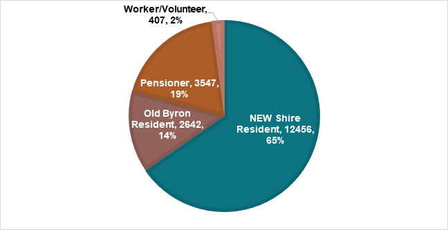
*note: the ‘Old Byron Shire Resident’ permits refer to the 2,642 permits that are still active under the previous $55 parking permit scheme. These permits were renewed by the holder for the then adopted fee of $55, sometime between mid-April 2024 and when the changes to the permit scheme were implemented.
Challenges
There have been administrative challenges associated with issuing and managing the free permits, which has resulted in negative feedback. This feedback is primarily related to the verification of eligibility for the permits.
Furthermore, the processing and management of free permits required allocation of additional resources, and as demand for permits has grown, so too has the workload associated with issuing and verifying the permits.
While the free permits were intended to ease parking issues for residents, there are indications that they have not fully addressed the intended outcomes. Free permits have not always translated into improved parking availability, with spaces being occupied by permit holders. There has likely been in increased use of cars. Where residents who live close by might have otherwise opted to walk or use other modes of transport, the free permit may have encouraged them to use their car and park in pay parking bays.
Feedback from the Community
Council has received conflicting feedback from the community regarding the parking permit system. The key themes include:
· Many residents have expressed support for the two free permits as they have helped reduce the financial burden of living in a Shire with pay parking. Some residents have indicated that the removal of free permits would create a financial strain.
· Concerns about the eligibility of the free permits and the exclusion of non-resident ratepayers and border communities. Complaints from people who claim to ‘live’ in the Shire but have their primary address elsewhere and are therefore ineligible.
· There have been concerns about the fairness of providing free permits without considering varying needs based on household size or multiple occupancy arrangements. Council is aware of instances of property owners directing tenants to revoke their permits to make them available for themselves, or where people have failed to update their permit details when circumstances change (e.g. moving out of the area or selling a vehicle).
· Feedback has also highlighted that while free permits have been appreciated, they have contributed to an increase in demand for parking spaces. Residents in certain areas have noted that free permits have led to an increase in the number of cars occupying the streets, making it more difficult to find parking.
Brunswick Heads Chamber of Commerce Feedback
A meeting coordinated by the Brunswick Heads Chamber of Commerce on 25 March 2025 raised concerns about the operation of the scheme in Brunswick Heads.
The meeting heard that some businesses are reporting an average downturn in revenue of around 30%. The business representatives attributed this downturn to the pay parking scheme and sought remedy through options such as:
· Removal of the meters and termination of the Pay Parking scheme in Brunswick Heads
· Retention of the meters and the operation of the Pay Parking scheme on weekends with free parking during the week
· Reduction in the hourly fee of $5 for the Brunswick Heads Pay Parking Scheme
Council has obtained independent spend data for Brunswick Heads to assist with this analysis. The data does not support the generalised claims that were made by businesses at the meeting.
Overall, the spend data indicates that spending patterns are consistently comparative to the same month in the previous year.
Local spending has remained relatively stable over the past 12 months, with most months showing comparable or slightly increased levels of activity when measured against the same month in the previous year. While there was some softening in the second half of 2024, there was no greater than a 6.9% decline in any given month, this was balanced by stronger performance in early 2025, including a notable increase of 11.3% in January. This suggests that spending by locals has been sustained, if not increased, since the implementation of pay parking in Brunswick Heads.
Visitor spending has shown more variability, which is not uncommon given its sensitivity to seasonal, economic, and environmental factors. The data shows some positive growth in mid-to-late 2024, including post implementation of pay parking in Brunswick Heads, with October (2.5%), November (7.9%), and January (6.1%) demonstrating increases. The most significant drop in visitor spend occurred in March 2025 (30.6%) which coincided with the extreme weather event and impacts of Tropical Cyclone Alfred.
Despite this significant decrease in visitor spend in March 2025, the overall spend decrease was a more moderate 14.7%, with local spending in the same period remaining consistent with March 2024.
Therefore, the overall spend data does not reflect a sustained or systemic downturn in either local or visitor activity that would align with the reported 30% decline in business revenue as a result of implementation of pay parking in Brunswick Heads.
2025/26 Fees and Charges
Options were discussed with Councillors at the 3 April 2025 Councillor Workshop, and feedback was received on eligibility and evidence requirements, the impacts of the free permit implementation, the suggestions made at the meeting with representatives of the Brunswick Heads Chamber of Commerce, and consideration of appropriate fees for the 2025/26 fees and changes.
Councillors at the 3 April 2025 Councillor Workshop indicated a desire for a report to Council to model potential modifications to the Shire Resident Parking Permits.
The draft 2025/26 fees and charges have been modelled off the current arrangements. The fees are charges are subject to a separate report to this meeting, for public exhibition.
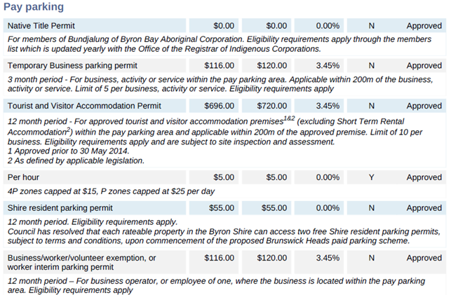
The outcome of this report will be included in the draft prior to exhibition.
The key points under consideration are as follows:
1. Changes
to the per hour pay parking fee
At the request of the Brunswick Heads Chamber of Commerce meeting attendees,
consideration could be given to a reduction of the hourly pay parking fee which
is currently set at $5/hour, with 4P zones capped at $15 and P zones capped at
$25 per day
2. Re-introducing
fees for Shire Resident Parking Permits
Councillors are considering options regarding the provision of two free permits
for each rateable property in the Byron Shire and instead imposing a charge for
these permits.
3. Introduction
of new permit types for Non-Resident Ratepayers and Border Community Members
In conjunction with this change, there is a proposal to introduce new permit
categories for non-resident ratepayers and border communities. Permits had
previously been available to these categories prior to the implementation of
the free permit system. It has been suggested by some Councillors that these
new permits be priced at $110.
Each of these options is explored in further detail in the next sections of this report.
OPTION 1: Changes to the per hour pay parking fee
At the request of attendees at a recent Brunswick Heads Chamber of Commerce meeting, consideration has been sought for a reduction in the hourly pay parking fee, which is currently set at $5 per hour. Under the existing scheme, 4P zones are capped at $15 and P (all-day) zones are capped at $25 per day.
While the request reflects concerns from some local business owners about the impact of parking costs on visitors and revenue, a reduction in the pay parking fee is not recommended, due to both the financial implications and broader impacts on the effectiveness of the parking scheme.
The table below provides a forecast of the potential revenue impacts under various scenarios, assuming a reduction in the hourly rate:
· Under the current rate, the program is projected to return to a surplus in Year 2, with a net positive impact of over $400,000 over five years.
· Reducing the hourly fee to $4/hr significantly reduces the benefit, bringing the 5-year surplus down to just $116,900.
· Reductions to $3/hr or $2/hr would result in sustained losses, with a cumulative impact of up to -$1.25 million over five years.
These figures reinforce the importance of maintaining the current fee structure to ensure the program remains financially sustainable.
The current $5/hour rate is consistent with other coastal tourist destinations and reflects both demand and the high value placed on convenient parking in popular areas like Brunswick Heads.
|
Location |
Hourly fee 2024/25 |
|
Port Stephens |
$4.50 (draft 2025/26 fee set at $5) |
|
Newcastle |
$5 |
|
Northern Beaches |
$8 off-peak $10 peak |
|
Waverley (residential streets) |
$8.60 |
|
Waverley (Bondi Beach) |
$10.80 (summer) $6.50 (winter) |
|
Waverley (Bonte inner core commercial) |
$6.50 |
|
Gold Coast (Surfers Paradise) |
0-2 hours - $4.90 Per hour 2-4 hours - $7.40 Per hour |
|
Gold Coast (Southport) |
0-2 hours - $3.30 Per hour 2-4 hours - $5.10 Per hour |
|
Gold Coast (Bundall) |
$2.50 |
|
Gold Coast |
$3.60 |
|
Gold Coast (Burleigh Heads) |
$2.20 |
|
Whitsunday |
$3 (progressive hourly rates apply) |
|
Mooloolaba |
$2.80 (multi-storey facility) |
Source: adopted fees and charges of the respective council.
Furthermore, there is access to free parking options in surrounding streets, offering convenient alternatives for those who prefer not to pay for parking. All pay parking areas are within a kilometre of free parking options.
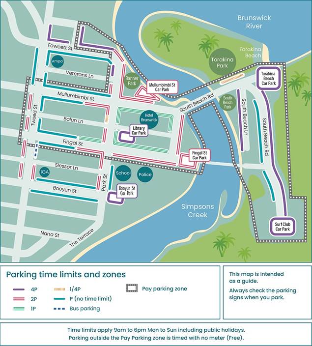
The pay parking scheme was only recently extended to Brunswick Heads, and it may be premature to alter the pricing structure before its full impacts are properly assessed. Parking rates are one of the tools used to encourage turnover in high-demand areas, supporting access to local businesses. Lowering the fee could result in longer stays and reduced availability of spaces, particularly in the town centre.
For these reasons, it is recommended that the current fee structure remain unchanged at this stage.
OPTION 2: Reintroducing fees for Shire Resident Parking Permits
Council has historically set a fee for the purchase of pay parking permits that enabled free use of parking spaces within time limits. The permit fee reached a maximum of $55.00 for residential permits.
Upon commencement of the Brunswick Heads Scheme, Council (by resolution 24-131 and 24-334) resolved to change the permit arrangement by changing eligibility requirements and providing two free permits per rateable property. Consequently, permit revenue dropped significantly; for the 2024/2025 financial year this may be in the vicinity of $400,000 +. The revenue impacts are reflected in the chart below:
Further, there is an expected loss of meter revenue as a result of the parking spaces utilised by more permit holders, however this impact on meter revenues is harder to determine.
A return to a user pays model is being explored, with Council considering the option of reintroducing the $55 charge for Shire Resident Parking Permits.
This fee remains good value for individuals who regularly park in pay parking areas, equivalent to the cost of 11 hours of paid parking at the current $5/hour rate. For residents who rarely park in these areas, it may be more cost effective to forgo the permit and pay the hourly rate when needed. This approach encourages users to make a conscious choice based on their individual circumstances.
Community feedback has suggested that many residents are willing to pay for permits, particularly those who regularly used pay parking areas. However, there is also support for continuation of the free permits to recognise the impact of pay parking on local residents.
It is anticipated that the introduction of a fee for parking permits may generate some negative feedback, particularly from residents who previously received a free permit for a shorter period than others. This is due to the initial free permit expiry being aligned with vehicle registration dates, resulting in varying durations of free access (ranging from 6 to up to 18 months). Additionally, due to the short timeframe between the proposed changes, some existing permit holders may not receive a free permit at all, which may also lead to disappointment.
However, free permits have led to increased administrative costs and a surge in demand, including permits obtained “just in case.” Charging a fee again may help ensure the permits system is more equitable and sustainable.
OPTION 3: Introduction of a new permit types for Non-resident Ratepayers and Border Communities
Under the previous scheme, non-resident ratepayers and border community members were able to purchase parking permits for $55. However, following Council’s resolution to introduce free Shire Resident Parking Permits, these categories became ineligible for permits under the revised conditions.
Currently, individuals who own property in the Byron Shire but do not nominate it as their primary place of residence on their licence or vehicle registration are excluded from the Shire Resident Parking Permit scheme. Likewise, some residents from neighbouring communities have reported that their community of interest is within the Byron Shire, and that their exclusion from the permit system has unfairly disadvantaged them.
In response to this feedback, some Councillors have indicated an interest in introducing new paid permit categories for non-resident ratepayers and border community members, a fee of $110 has been suggested.
This permit would allow individuals, who do not permanently reside in the Byron Shire but who either own property or live in adjoining areas, access pay parking areas without paying for parking at the meter. An economical assessment would determine the value for money based individual circumstances, with the $110 fee equating to 22 hours of parking in metered locations (at $5/hour).
While the introduction of these new categories may result in an increase in the number of permits issued, it provides a fairer and more inclusive approach for those with an ongoing connection to the Byron Shire.
Eligibility criteria for these new permit types would be outlined in updated Terms and Conditions, as detailed below.
Non-resident ratepayer
Eligibility for this permit type would be defined in the terms and conditions with the required evidence to be supplied being:
Proof of ratepayer status
· If the applicant is a Byron Shire ratepayer, no supporting documents are required. The name on the rates notice must match the applicant’s name.; or
· If the property is owned by a company, the applicant will be required to provide documents proving company ownership, trust interest, or joint ownership (e.g. ASIC company extract).
Proof of vehicle ownership or lawful use
· Vehicle registration certificate naming the applicant as the registered owner.
Border Communities
A previous resolution of Council (17-604) defined border communities for the purpose of parking permits, which included residents of Clunes, Newrybar, Rosebank, Nashua, Brooklet, Booyong, and Repentance Creek.
Given the implementation of pay parking in Brunswick Heads, it is recommended that eligibility for the Border Community Parking Permit also be extended to include localities that border the northern part of the Shire and identify Brunswick Heads as their community of interest. This would include Wooyung, Crabbes Creek, and Upper Burringbar. This approach promotes fairness and acknowledges the shared geographic and service connections within the pay parking area.
Council had previously received feedback from some Burringbar, Mooball, and other area residents who were dissatisfied with the implementation of pay parking and their ineligibility for a permit. However, as these are not bordering the Byron Shire and they cover a large area in closer proximity to Pottsville, it is not recommended that they be included.
Eligibility for this permit type would be defined in the terms and conditions with the required evidence to be supplied being:
Proof of residency
The applicant must provide a current
version of one of the following:
•
NSW Vehicle registration certificate; or
• NSW Driver’s licence
with an address in one of the following localities: Clunes, Newrybar, Rosebank, Nashua, Brooklet, Booyong, Repentance Creek, Wooyung, Crabbes Creek, or Upper
Burringbar.
Proof of vehicle ownership or lawful use
Vehicle registration certificate naming
the applicant as the registered owner.
Summary of Proposed Changes to Draft Fees and Charges
|
Permit Type |
Evidence Required |
Cost |
|
Shire Resident Parking Permits |
Proof of vehicle ownership and Byron Shire address: · Proof of ownership: Vehicle registration · Proof of address: Vehicle registration or licence with Shire address For company owned vehicles, proof that they have full legal use: · Documents identifying owner of the company vehicle and signed letter confirming they are an employee with full private use |
$55 (12 months) |
|
Non-resident Ratepayer Parking Permit |
Proof of ratepayer status · If the applicant is a Byron Shire ratepayer no supporting documents are required. The name on the rates notice must match the applicant’s name.; or · If the property is owned by a company, the applicant will be required to provide documents proving company ownership, trust interest, or joint ownership (e.g. ASIC company extract). Proof of vehicle
ownership or lawful use |
$110 (12 months) |
|
Border Community Parking Permit |
Proof of vehicle ownership: Vehicle registration
Proof of address: Vehicle registration or licence with address at one of the following localities Clunes, Newrybar, Rosebank, Nashua, Brooklet, Booyong, Repentance Creek, Wooyung, Crabbes Creek, or Upper Burringbar. |
$110 (12 months) |
All other permit types remain unchanged.
Strategic Considerations
Community Strategic Plan and Operational Plan
|
CSP Strategy |
DP Action |
Code |
OP Activity |
|
|
5: Connected Infrastructure |
5.2: Connect the Shire through integrated transport services |
5.2.4: Parking - Manage parking through effective controls that support Movement and Place Plans and are coordinated with other initiatives such as park and ride |
5.2.4.6 |
Implementation of Paid Parking Scheme in Brunswick Heads |
Recent Resolutions
· 23-652 – Endorsed the implementation of Brunswick Heads pay parking regime scenario 4 (extended boundary) and resolved to update the fees and charges to change the ‘Shire Resident or Ratepayer Exemption, or Resident Interim Parking Permit’ from $55 to $0 at the time that the scheme becomes operational in Brunswick Heads.
· 24-114 – Local Traffic Committee endorses the proposed of Brunswick Heads pay parking regime in principle as scenario 4 (extended boundary), subject to Council approval.
· 24-131 - Endorsed for inclusion in the draft 2024/25 Fees and Charges, a fee of $5 per hour for the Brunswick Heads Pay Parking scheme and reiterated the commitment (Resolution 23-652) to reducing the resident permit fee from $55 to $0 when the Brunswick Heads scheme becomes operational.
· 24-334 - each rateable property in the Byron Shire able to access two free “Shire resident parking permits”, subject to terms and conditions, with additional eligible permits able to be purchased for $55.
Legal/Statutory/Policy Considerations
As outlined in this report.
Financial Considerations
The potential financial impacts of the various options are outlined in the report.
Consultation and Engagement
The draft 2025/26 fees and charges, including the draft fees determined by this report, will be placed on public exhibition for a period of 28 days. Submissions will be invited from members of the public about the proposed fees.
Council will consider submissions at the 30 June Extraordinary Council Meeting and determine the adopted fees and charges which will come into effect from 1 July 2025.
It is anticipated that the changes proposed to the Shire Parking Parking Permit fees will attract community attention, and will highlighted in information about the draft fees and charges.
Some of the challenges that will need to be addressed in the communications plan include:
• Ensuring people are aware of the re-introduction of fees for all permits, if this option is supported by Council.
• Eligibility of the new permit types.
• Providing clear instructions on how to apply using the current permit portal.
Staff Reports - Infrastructure Services 13.9
Report No. 13.9 Bangalow Road, Cooper Street and Paterson Street Intersection, Byron Bay - Traffic and Safety Assessment
Directorate: Infrastructure Services
Report Author: Shelley Currie, Road Safety Officer
File No: I2025/608
Summary:
Introduction
This report was deferred from the Ordinary Council Meeting of 24 April 2025, resolution 25-149.
This report provides an update on Council resolution 24-133 parts 1 and 2, which state:
1. That the petition regarding the Traffic Impacts of Proposed Development at Lot 14, 58-60 Bangalow Road be noted.
2. That the petition be referred to the Director Infrastructure Services
The above petition requested that Council:
· undertake a current and future traffic study on the section of Bangalow Road between the Browning/Tennyson/Bangalow Road roundabout and the intersection of Bangalow Road with Old Bangalow Road.
· pay particular attention to the Cooper, Paterson and Bangalow Road intersection.
· develop and implement an appropriate proposal for mitigation of the impacts.
While the above doesn’t specifically request review of road safety, it’s assumed that this would also be included.
The extent of road requested is large (including side roads with high volumes of traffic) and it would require significant cost and time to undertake a traffic study of this magnitude. In addition, Council does not have funding for this work and would need to either reallocate funding from existing project budgets or seek external funding, both of these options would require additional time to implement.
Given the urgency of the petition, Council staff and Bitzios Consulting have worked together to provide the following traffic and safety review of the intersection of Cooper Street, Paterson Street, Bangalow Road and the new 58-60 Bangalow Road development access. Fortunately, this work can be completed in the short term using operational budgets. The full extent of Bangalow Road will be reviewed as part of longer term planning for the MR545 road network.
Traffic and Safety Assessment Summary
Paterson Street, Cooper Street and the new development access are all closely spaced along Bangalow Road and, therefore, any traffic interactions are shared between them.
At present, the existing intersections are generally within acceptable traffic management parameters, with the key exceptions being the back-to-back right turn pockets for Cooper Street and Paterson Street on Bangalow Road. However, this may be partly due to local traffic avoiding the intersection. Furthermore, the proposed development seeks to add additional traffic to the area.
There have been a small number of minor crashes in this area
In the short term, the following changes are recommended:
1. Install line marking and concrete islands to physically isolate the Cooper Street right turn pocket on Bangalow Road. This will prevent vehicles cutting across the lanes from both directions.
2. Prohibit right turns into and out of Paterson Street (i.e. left in / left out only) to reduce the risk of vehicle collisions.
3. Install a right turn pocket for the new development on Bangalow Road (as proposed at the Local Traffic Committee meeting held on 18 March 2025). This will provide storage and access for southbound traffic.
In the long term, strategic planning is required to assess improvements for the Bangalow Road / Broken Head Road corridor. Future growth is likely to lead to the corridor exceeding traffic capacity and any infrastructure changes will create traffic and safety impacts along the whole corridor. In addition, Council is continuing to liaise with Transport for NSW (TfNSW) regarding the reclassification of the MR545 from a regional road to a state road (extent of road is shown in Figure 1 below). This reclassification would allow TfNSW to manage this section of the road network and make significant improvements.
Figure 1: MR545 road network shown orange
RECOMMENDATION:
That Council:
1. Seeks community feedback on the following short-term options:
a) prohibiting right turns into and out of Paterson Street; and
b) installation of line marking and concrete islands on the north bound right turn pocket on Bangalow Road which provides access to Cooper Street.
2. Continues to work with Transport for NSW on the reclassification of the MR545 road network from Regional Road to State Road.
3. Seeks funding for a safety and traffic study of the MR545 road network from Byron Bay to Suffolk Park to determine required upgrades for future growth.
Report
Background
The 58-60 Bangalow Road development has recently been completed, including an intersection with Bangalow Road to provide access. A petition was submitted to Council by local residents in response to this development, noting safety concerns with the development access and concerns about overuse of Paterson Street due to ‘rat-running’. To the south of the subject development is the Paterson Street and Cooper Street intersections with Bangalow Road. The locations of these intersections are shown in Figure 1 below.
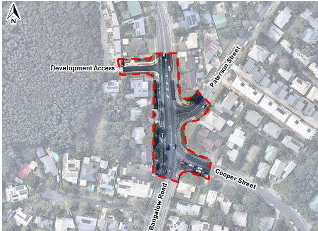
Figure 1. Location map showing new development in relation to nearby intersections
The key details of the surrounding local network are as follows:
· Bangalow Road / Broken Head Road
o Provides the main southern connection between Byron Bay, Suffolk Park, Broken Head, Lennox Head and Ballina.
o Carries an average of 20,000 motor vehicles per day, including 7% heavy vehicles.
o Has a high amount of active transport use per day, probably due to the road being fairly flat and a direct route to Byron as well as the presence of the pedestrian and cycling infrastructure that runs between Byron Bay and Suffolk Park.
o Is a flat two-lane wide undivided road with on-road bicycle lanes, off-road footpaths and sections of line marked on-street parking.
o Has a 50km/h posted speed limit.
· Cooper Street:
o Provides local access to a residential catchment and an indirect connection to Byron Bay.
o Carries an average of 1,500 motor vehicles per day, including 5% heavy vehicles.
o Active transport user data unknown.
o Is a flat two-lane narrow undivided road with no pedestrian or cycle infrastructure and unmarked on-street parking.
o Has a 50km/h posted speed limit.
· Paterson Street
o Provides local access to a residential catchment and a connection to Byron Bay.
o Carries an average of 3,000 vehicles per day, including 4% heavy vehicles.
o Active transport user data is unknown but community have requested footpaths and advise that pedestrians are present. Also, Paterson Street connects to bush walking tracks leading to Tallow Beach.
o Is a fairly steep two-lane narrow undivided road with no pedestrian or cycle infrastructure and unmarked on-street parking.
o Has a 50km/h posted speed limit.
· Lot 58-60 Development
o The Lot 58-60 development comprises 24 attached dwellings and 30 car parking spaces for both residents and visitors. Access is provided via the western side of Bangalow Road, north of Paterson Street.
o The proposed development includes plans to upgrade the development intersection with a short right-turning lane for southbound traffic along Bangalow Road.
o Future traffic turning into the development access from the north (right turning traffic) will potentially need to store on the road. This could cause traffic to attempt dangerous overtakes using the bicycle lane.
Key Issues and Findings
Community Feedback
The following concerns were identified in the resident petition:
· Turning into and out of residential side streets is getting worse and leading to risky driving decisions, particularly right turns into and out of Cooper Street.
· Intersection is complicated and dangerous due to proximity of Paterson and Cooper Streets and lack of traffic controls.
· Residential developments are increasing traffic volumes, particularly on Bangalow Road and Cooper Street.
· Locals avoid the intersection due to long delays in finding a gap in traffic and will instead use the back roads to get to Byron Bay. However, the back roads are much slower due to traffic calming treatments, multiple intersections, etc.
In addition, Council has received the following feedback from local residents:
· Locals using the intersection will often “go south to go north” (i.e. traffic will turn left onto Bangalow Road and then use another street further south to turn around and head north).
· Near misses occur when vehicles on side streets attempt to join northbound traffic on Bangalow Road.
· Near misses occur between vehicles and cyclists when vehicles turn from Bangalow Rd onto side streets.
· Lack of pedestrian infrastructure and vehicles speeding on Paterson Street.
· Suggestion of using a “dog-bone” style roundabout at the intersection of Cooper St/Paterson St/Bangalow Road.
Safety Review
A site visit was undertaken on 21 November 2024 to view existing conditions in the subject area. Key findings are as follows:
· Sight distances from side streets are generally compliant, given the straight and flat nature of Bangalow Road.
· The Paterson Street approach is steep and has a sharp curve where it connects to Bangalow Road.
· Vehicle speeds in this section of Bangalow Road are limited due to the presence of cyclists, high traffic volume and turning vehicles. This is reflected in the speed data which shows the 85th percentile speeds are below the posted speed limit of 50km/h on Bangalow Road. However, there may be a tendency of drivers to increase speed once they leave the congestion on Bangalow Road. Further traffic data would be required to confirm.
· Due to the crossfall of Bangalow Road and the slight bend near Paterson and Cooper Streets, vehicles travelling southbound will cross into the right turn pocket at Cooper Street when there is no oncoming traffic. This is illustrated in Figure 2.
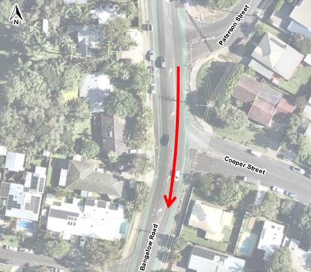
Figure 2. Southbound Movement
· Vehicles turning right from Bangalow Road into Paterson Street often use the Cooper Street turn pocket, cutting across the lane. This is illustrated in Figure 3.

Figure 3. Northbound Movement
· Traffic turning out of Cooper Street often hesitates when vehicles cut through the Bangalow Rd right turn pockets and are effectively giving way to three lanes of traffic.
· Traffic turning out of the side streets generally hesitates when giving way to cyclists using the cycle lanes, due to the speed difference with vehicle traffic.
· No adverse behaviour was observed at the current development access, noting that the traffic volumes are quite low turning onto Bangalow Road and sight distances at this location are generally acceptable due to the flat and straight nature of Bangalow Road.
· 5 crashes have been recorded in this area between 2019 and 2023 as follows (see Figure 4):
o 3 moderate injury; 2 involving vehicles crashing into parked vehicles (A, B), 1 involving a cyclist crossing the road and getting hit by a vehicle (C).
o 1 minor injury involving a vehicle crashing into a parked vehicle (D).
o 1 non-casualty involving a vehicle turning left out of Paterson St hitting a vehicle heading north on Bangalow Road (E).
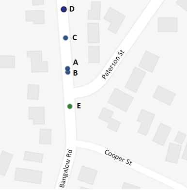
Figure 4. Crash map
This data is consistent with the number of crashes along the section of Bangalow Road between the Browning Street roundabout and the intersection with Old Bangalow Road. The various crash types should be considered as part of the broader network review of Bangalow / Broken Head Road.
There is a reduced likelihood of crash types A, B & D recurring as parking has since been removed on the south bound side and the right turn pocket being constructed as part of the development access will remove the remaining parking on the north bound side.
Crash C occurred in 2020, just prior to completion of the Byron to Suffolk cycleway. Two new pedestrian refuge crossings were constructed as part of that project (located approx. 200m south and 350m north of the incident location) and should reduce future risk of this crash type.
Crash E is directly related to the Paterson Street / Bangalow Road intersection and requires further investigation. However, for this crash to have occurred, at least one of the vehicles had to be outside the correct lane and may be related to the northbound movement issue shown in Figure 3. The proposed intersection changes should help channelise vehicle movements and reduce the risk of this crash type.
Traffic Review
SIDRA intersection modelling has been undertaken using 2022 and 2025 traffic counts in the subject area. The results of this modelling are shown in Table 1 below for both the current year (2025) and 10-year design horizon (2035), noting the following:
· Traffic for the development access was calculated using industry traffic generation rates as no data from here was collected.
· The overall level of service is taken from the worst leg of each intersection (the side street), in line with NSW modelling guidelines.
· The levels of service (LOS) used for this analysis are based on the below guidelines (extracted from RMS Guide to Traffic Generation Developments 2002). While not shown below, LOS F indicates that an intersection is over-capacity and safety issues are likely to occur.
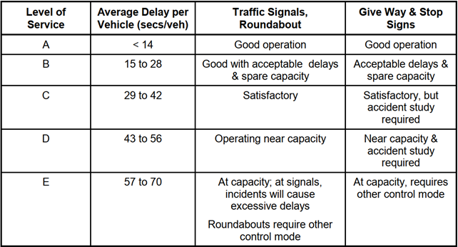
|
Intersection |
Average Delay and Level of Service |
|||
|
2025 |
2035 |
|||
|
AM |
PM |
AM |
PM |
|
|
1. Paterson Street |
21s (LOS B) |
24s (LOS B) |
65s (LOS E) |
75s (LOS F) |
|
2. Cooper Street |
22s (LOS B) |
28s (LOS B) |
257s (LOS F) |
230s (LOS F) |
Table 1: Intersection delays for Paterson and Cooper Streets in 2025 and 2035
As shown, the subject intersections currently have acceptable levels of service but are forecast to be over-capacity, based on future growth along Bangalow Road. Given these results, it is likely that the development access has a similar or better LOS due to its slightly lower volumes which occur to the north of the subject intersections.
Intersection Options
To mitigate existing and future issues at the subject intersections, the following options have been considered:
Option 1 – Removing right turns into and out of Paterson Street and improving the right turn pocket to Cooper Street using line marking and raised concrete islands.
This aims to prevent vehicles from using the right turn lane as a through lane, reduce the amount of vehicles using the intersection and Paterson Street, removes the highest risk turning movements and may also reduce vehicle speeds on Paterson Street. While not removing the issue entirely, this would likely improve the current situation. Given the low speeds along this stretch of Bangalow Road, this is not expected to increase the risk of incidents significantly.
In the short-term, this should improve access for Cooper St traffic which does not have direct access via back roads to Byron Bay town centre. Paterson Street has a more direct connection to Byron Bay and the north-bound right turn movements out of the street are very low. The north-bound right turn movements into Paterson are quite high during the morning peak which may be causing the local resident concerns in relation to speeding, etc. Diverting this traffic may impact other areas of the Bangalow road network.
A north bound merge lane for Cooper St traffic was also considered but is not recommended as this “seagull” style intersection can cause more safety issues and there may be insufficient space for the merge lane.
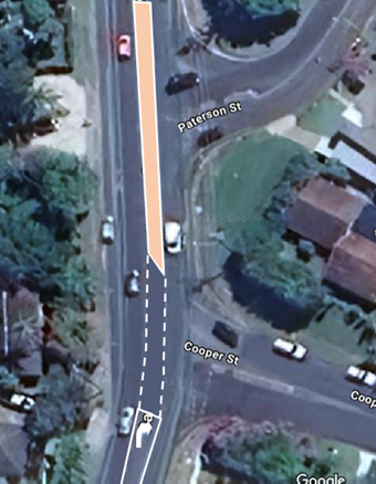
Figure 2. Right Turn Pocket Cooper St and concrete island preventing right turn access to Paterson St
The above sketch is indicative and is subject to civil design to ensure it’s cost effective, compliant and addresses key safety risks.
Option 2 – Traffic control changes on Paterson and Cooper Streets, including:
a) Add a northbound merge lane for right turns out of Paterson onto Bangalow. Allows vehicles turning right out of Paterson to better navigate multiple traffic lanes.
Most likely there is insufficient room for a merge lane, especially given the new right turn pocket for the development access. Also, the traffic turning right of Paterson is minimal.
b) Close the connection between Paterson Street and Bangalow Road and provide a north bound right turn lane for Cooper St. Significantly reduces vehicle and active transport user crash risk on Paterson Street and Bangalow Road. Significantly improves traffic flow on Bangalow Road. Reduces speeding behaviour on Paterson St.
Option 3 – Roundabout at the Cooper Street intersection
A roundabout will allow for greater traffic flow within the subject area, and potentially allow for turns to be banned at nearby accesses as the roundabout will allow for u-turns. Furthermore, a roundabout will slow vehicle speeds in the area which will reduce the risk and severity of any future safety issues.
As discussed in the intersection modelling results below, both a roundabout and signals will reach capacity if growth continues on Bangalow Road however, this would also indicate that majority of the other intersections along this corridor are also failing. As such, this option would need to be considered in line with strategic planning in the area and particularly the corridor. For instance, the roundabout to the north at Browning Street will be likely to experience these same high volumes and as such, also exceed its capacity.
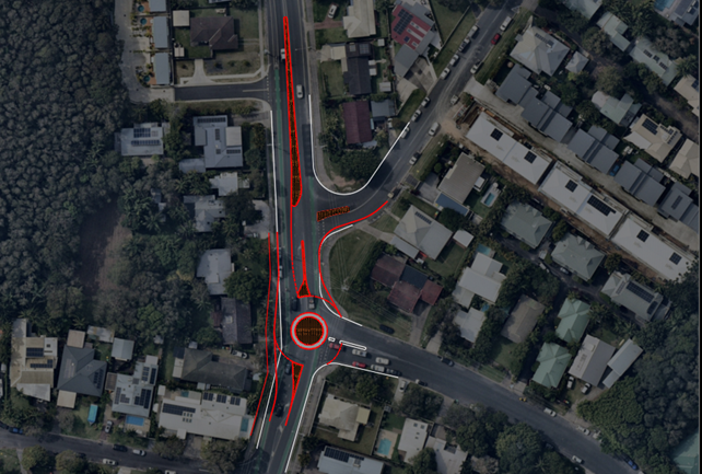
Figure 3. Indicative sketch of roundabout option
The above sketch is indicative and is subject to civil design to ensure it’s cost effective, compliant and addresses key safety risks.
Option 4 – Mini-roundabout at the Cooper Street intersection.
This option aims to reprioritise traffic (i.e. northbound traffic will have to give-way to sideroad traffic in this configuration) as per a standard roundabout but with a reduced footprint. The key difference is the diameter of the central island is greatly reduced, to fit in a standard road width, and required to be mountable for heavy vehicle movements. This intersection configuration is typically only used for low volume / low speed roads as safety concerns can arise as the mountable island does not force vehicles on the main road to slow down, particularly larger vehicles, which can increase the risk and severity of several crash types.
Option 5 – “Dog-bone” style roundabout covering the Cooper and Paterson Street intersections.
A “dog-bone” roundabout combines two intersections into a single larger intersection, essentially an elongated roundabout with four approaches. This treatment mitigates any complications with closely spaced roundabouts by combining them, avoiding majority of the affects of queues between intersections. This form has the benefit of slowing vehicle approach speeds in the same manner as a typical roundabout. An example of this intersection form is shown in Figure 4.
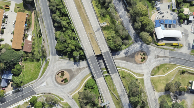
Figure 4. Example Dog-Bone Intersection Form (Kennedy Drive, Tweed Heads)
While this proposed form would likely see a benefit for safety and traffic flow while retaining all movements, the northern intersection (with Patterson Street) does not have sufficient space within the existing road reserve to accommodate such an intersection form and the Patterson Street approach would be unlikely to have sufficient sight distance for a safe approach.
Option 6 – Traffic lights at the Cooper Street intersection.
Traffic lights provide the ability to manage individual traffic movements generally without vehicles having to give-way to other traffic. As such, minor movements from the side streets can be catered for by limited green time with the majority of the priority being given to Bangalow Road. Assuming lane duplications aren’t required, signals can generally be provided with a limited footprint. Traffic lights also provide an opportunity to provide enhanced active transport infrastructure as is generally regarded as the highest order treatment for all road users.
Queues for a signalised intersection are generally higher than a roundabout form which has the potential to cause conflicts at nearby intersections depending on the overall growth of Bangalow Road. Furthermore, traffic signals do not physically slow vehicle speeds in low traffic conditions (outside of the AM and PM peaks).
Depending on the future growth of the corridor, a signalised intersection has a clear upgrade path and short lanes can be added for additional capacity for critical movements.
It should also be noted, as per Council resolution 25-067, any proposed traffic signals will require extensive community consultation prior to implementation.
Overall Outcomes
Options 3 to 6 aim to better manage vehicles from a performance and safety perspective. These intersection upgrades (except for the “dog-bone”) were only considered at Cooper Street as the road geometry is more suitable and the proposed changes would involve less cost than implementing the same at Paterson Street, due to the steeper grade and the bend where it meets Bangalow Road.
A roundabout form (Option 3), Dog-bone (Option 5), or signalisation (Option 6) would all address the main safety concern of a priority controlled right turn out of the side streets and aid the safety of the corridor by further slowing vehicles and managing flows. These options would also reduce delays and queues for the right turn into Cooper Street which is at capacity in the long term.
A small mountable roundabout (Option 4) would not be suitable at either location due to the high traffic volumes on Bangalow Road and number of heavy vehicles using this route. Furthermore, it would not slow vehicle volumes. As such, Option 3, 5, and 6 could be utilized from a safety perspective, assuming a compliant design with the relevant design aspects, but Option 4 is not recommended as it would not address the main safety issues and potential create new safety risks.
The dog-bone option would likely adequately address safety concerns and traffic management however, the Paterson Street portion of the combined intersection form would not be feasible due to the grades and width of the road.
The safety concerns relating to traffic queuing at the right turns into the development access from the north, can be addressed by allowing for a short channelised right turning lane as vehicles will not have to store within the main traffic lane. A design has been nominated in the DA which includes this but will need to be designed to the relevant design aspects.
Intersection options 2, 3 and 6 have been modelled based on the previous assumptions for the existing case analysis. Options 1, 4 and 5 have not been modelled due to following:
· Option 1 – This is a minor upgrade that will not have a significant impact on the traffic performance in the area.
· Option 4 – There are safety concerns with this option and SIDRA intersection software cannot replicate vehicle behaviour of a mountable island accurately.
· Option 5 – The northern section of the dog-bone would not be feasible within the available road width and steep grade on Paterson Street.
In addition to the above, the right turn bans at Paterson Street has been included in all options.
|
Intersection |
Average Delay and Level of Service |
|||
|
2025 |
2035 |
|||
|
AM |
PM |
AM |
PM |
|
|
Existing |
||||
|
1. Paterson Street |
21s (LOS B) |
24s (LOS B) |
65s (LOS E) |
75s (LOS F) |
|
2. Cooper Street |
22s (LOS B) |
28s (LOS B) |
257s (LOS F) |
230s (LOS F) |
|
Option 2 – Banned Right Turns at Paterson |
||||
|
1. Paterson Street |
7s (LOS A) |
9s (LOS A) |
10s (LOS A) |
10s (LOS A) |
|
2. Cooper Street |
24s (LOS B) |
28s (LOS B) |
257s (LOS F) |
232s (LOS F) |
|
Option 3 – Roundabout |
||||
|
1. Paterson Street |
7s (LOS A) |
12s (LOS A) |
10s (LOS A) |
10s (LOS A) |
|
2. Cooper Street |
11s (LOS A) |
17s (LOS B) |
70s (LOS E) |
70s (LOS E) |
|
Option 6 – Signalisation |
||||
|
1. Paterson Street |
7s (LOS A) |
9s (LOS A) |
10s (LOS A) |
10s (LOS A) |
|
2. Cooper Street |
17s (LOS B) |
28s (LOS B) |
59s (LOS E) |
28s (LOS B) |
In summary:
· Option 2 will work well for Paterson Street but will not help reduce delays at Cooper Street in the long term.
· Options 3 and 6 will be at / exceeding their capacity in future years on at-least one leg but will improve the existing situation.
· Upgrading the Bangalow/Cooper intersection form to either a roundabout or signals is recommended as it improves performance and will moderate traffic as volumes grow.
· If growth continues along Bangalow Road at the current rate, only banning right turns entirely will ease congestion. However, banning turns can create issues when drivers seek to make u-turns. Data collection and modelling is needed to help understand the issues and solutions.
· A safety and traffic study of the Bangalow / Broken Head Road corridor is recommended to ensure road changes are coordinated for future traffic growth and to ensure road safety.
Strategic Considerations
Community Strategic Plan and Operational Plan
There are no specific activities identified in the current Operational Plan for this project, however the long term planning for the MR545 will be included as part of the Integrated Transport Plan under OP action 5.2.3.5 and both the short and long term options will be reviewed as part of OP action 5.3.1.11 - Traffic, Transport and Active Transport Capital Works Business Cases Development.
A new Operational Plan action is recommended to ensure this work is included in future Council planning.
|
CSP Objective |
CSP Strategy |
DP Action |
Code |
OP Activity |
|
5: Connected Infrastructure |
5.2: Connect the Shire through integrated transport services |
5.2.3: Traffic management and reduced car dependence - Develop transport infrastructure and services that are accessible to all and meet a diverse range of needs and community expectations |
5.2.3.5 |
Develop an Integrated Transport Plan in collaboration with Transport for NSW |
|
5: Connected Infrastructure |
5.3: Invest in renewable energy and emerging technologies |
5.3.1: Future needs - Plan for the infrastructure needs of the current and future population |
5.3.1.11 |
Traffic, Transport and Active Transport Capital Works Business Cases Development |
Recent Resolutions
· 24-133
· 24-240
· 25-067
· 25-149
Legal/Statutory/Policy Considerations
Not applicable.
Financial Considerations
The cost of the works required for both the short and long term options will need to be assessed so that funding can be sought.
However, the long term option will most likely require external funding via Transport for NSW grants.
Consultation and Engagement
No community consultation has been undertaken on the options identified in this report.
It is recommended that local residents be consulted prior to implementation of any short term changes and the broader community on longer term plans.