Local Traffic Committee Meeting
A Local Traffic Committee Meeting of
Byron Shire Council will be held as follows:
|
Venue
|
Meeting Room 1, Station Street, Mullumbimby
|
|
Date
|
Tuesday, 21 March 2017
|
|
Time
|
10.30am
|
|
Committee
Members
|
Etiene La
Grange – Roads and Maritime Services
Snr Constable Tony Darby – Police
Cr Basil Cameron
Tamara Smith MP
|

Phil Holloway
Director Infrastructure Services I2017/339
Distributed 16/03/17
Local Traffic Committee Meeting
BUSINESS OF MEETING
1. Apologies
2. Declarations of Interest
– Pecuniary and Non-Pecuniary
3. Adoption of Minutes from
Previous Meetings
4. Matters Arising
5. Outstanding
Issues/Resolutions
6. Regulatory Matters
6.1 Traffic
- Events - Anzac Day 2017 - Road Closures in Byron, Mullumbimby, Brunswick
Heads, Bangalow........................................................................................................................... 3
6.2 Events
- Mullum2Bruns Paddle - 28 May 2017 - Road One Way.................................... 9
6.3 Regulatory
Signage - Wilfred St 2 - No Stopping - Emergency Services...................... 21
7. Matters for Traffic Engineering Advice
7.1 Event
- Byron St, Bangalow - Road Closure - Bangalow Billy Cart Derby 21 May 2017 23
7.2 Traffic
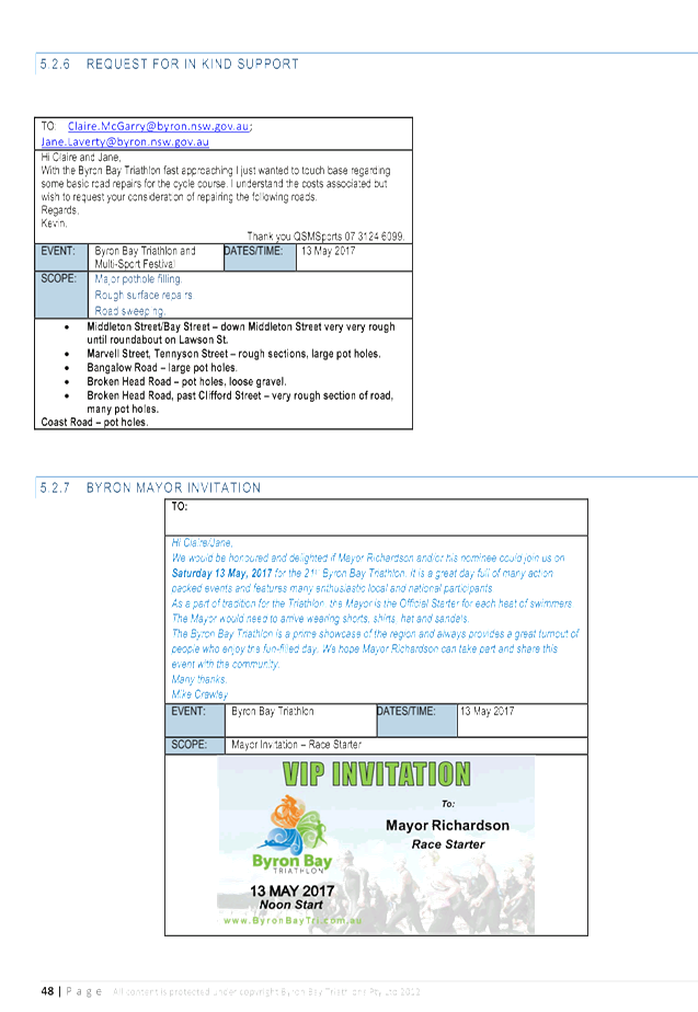
- Events - Byron Bay Triathlon 13 May 2017 - Road Closures........................... 26
7.3 Traffic
- Events - Byron Bay Blues Festival 13 to 17 April 2017.................................... 47
8. Development Applications
8.1 DA
- Splendour in the Grass, 21-23 July 2017............................................................... 47
Local Traffic Committee Meeting 6.1
Regulatory Matters
Report No. 6.1 Traffic - Events - Anzac Day 2017 - Road Closures in Byron,
Mullumbimby, Brunswick Heads, Bangalow
File No: I2017/154
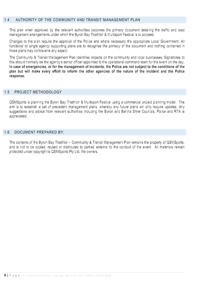
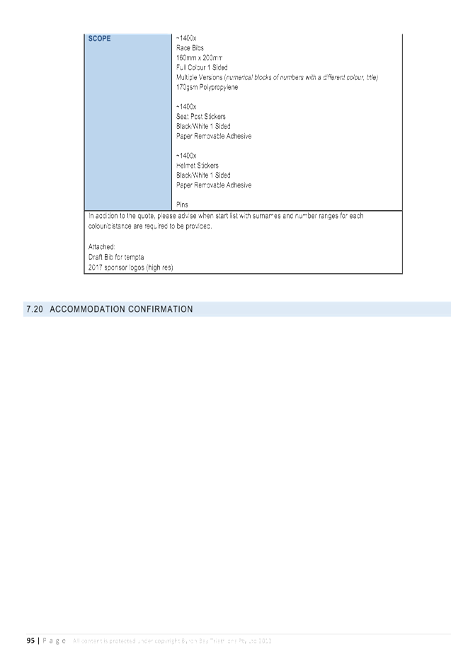
SUMMARY
Council has received an event application from the Byron Bay
RSL, Mullumbimby Sub Branch RSL, Bangalow Sub Chamber RSL, Brunswick Heads Sub
Chambers RSL for the Byron Bay, Mullumbimby, Bangalow and Brunswick Heads Anzac
Day March 2017 to be held on Tuesday 25 April 2017.
OFFICER RECOMMENDATION
That Council endorse the Byron Bay, Mullumbimby, Brunswick
Heads and Bangalow Anzac Day March 2017 to be held Tuesday 25 April 2017, that
includes the temporary road closure and Police Escorts from 04:30am to 12pm,
subject to conditions.
LINKAGE TO OUR COMMUNITY STRATEGIC PLAN
|
Theme
|
Economy
|
A sustainable and diverse
economy which provides innovative employment and investment opportunities in
harmony with our ecological and social aims.
|
|
Objective
|
EC1
|
A diverse economic base and
support for local businesses.
|
|
Strategy
|
EC1.4
|
Support sporting and cultural events in Byron Shire.
|
|
Measures
|
EC1.B
|
Increase the sustainability of events in which Council is
involved.
|
BACKGROUND
Each year the RSL sub-branches of Byron Bay, Mullumbimby,
Bangalow and Brunswick Heads arrange their respective annual ANZAC Day street
parade. All four have confirmed that little to no change to previous
years are sought. The route of each parade is shown below, noting that:
- Byron
Bay (S2016/2652): as per previous years, the Dawn Service requires
closure of the Tennyson Street and Marvell Street intersection between 4.30am
and 5.30am and then again (approximately at 11am) when the parade reaches
the gates to conduct the main service. Council implements such measures
including signed detours at the intersections prior at Marvell and Middleton
Street and at both the Kingsley Street and Cowper Street intersections on
Tennyson Street. As for the parade, it is held under Police escort after it
gathers at 10:15am off-road (Beach Hotel) at Bay and Jonson Street, then at
10.30am proceeds south down Jonson Street, left into Marvell Street to its end
at the Memorial Gates on Tennyson Street.
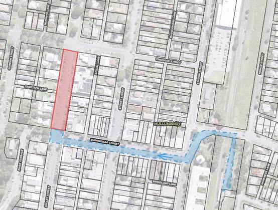
- Mullumbimby
(E2016/9115): the parade will again be held under Police escort
commencing this year at 10.50am from Apex Park via Burringbar Street to
concluding at the cenotaph on Dalley Street and that Council is to close Dalley
Street to traffic between Burringbar Street and Tincogan Street between 8am and
12noon with signed detours in place.
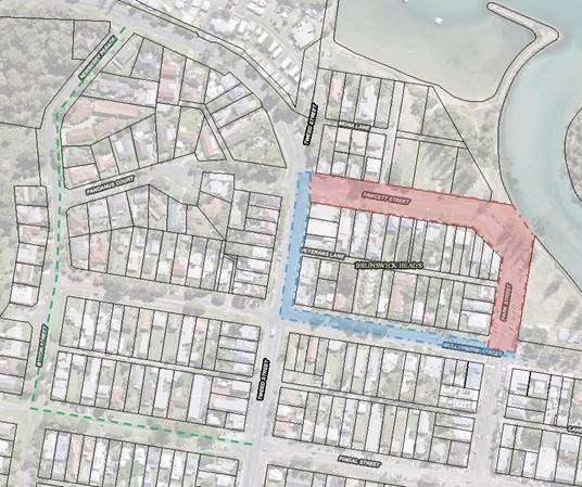
- Brunswick
Heads (E2016/10067): Police involvement with both an escort and closing of
the road on Fawcett Street between 430am and 630am. No Council involvement
requested.
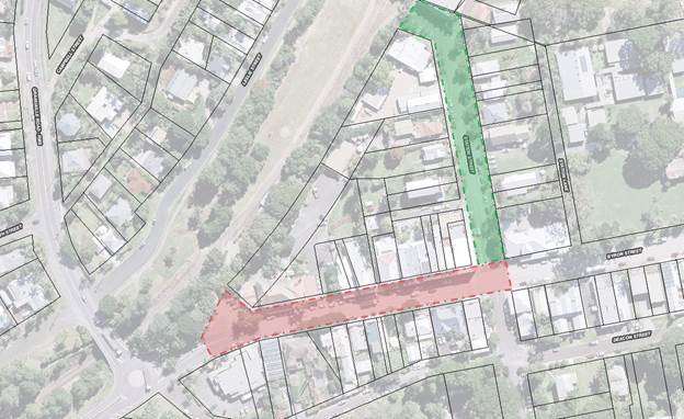
- Bangalow
(S2016/3471): the sub branch have
confirmed the parade forms by 10.45am in front of the Bangalow Hotel in
Byron Street, and sets out by 11am east to the intersection at Station Street,
then turns left (north) to the front of the RSL Memorial Hall on Station Street
for wreath laying and ceremony through to 11.45am. Council therefore are to
implement the following:
o by 10.40am through
to end of event, close Station Street north of Byron Street;
o by 10.40am, close
Byron Street west of Station Street and provide signed detours south along
Station Street to and via Deacon Street;
o by 10.45am close
Byron Street at the east bound leg of the Granuaille Road and Lismore Road
roundabout; and
o remove the two
Byron Street closures once parade has departed Byron Street.
In general it should be noted previous year’s events
have not resulted in any reported safety concern, and the road closures are
typically less than one hour duration and signed detours are implemented.
Therefore given the above, and that the local events are
part of a well known and anticipated nation wide annual tradition, the usual
conditions imposed on road events (for example event organisers to notify local
residents and emergency providers, etc) is not typically applied, hence their
omissions from the recommendation now tabled.
KEY ISSUES
1. No formalised traffic control or Traffic
Control Plan to RMS specifications are in place for any of the four events.
2. Pedestrian and vehicle interaction is not
managed
3. Issues have been reported about the Byron Bay
Anzac Day March 2016 where live traffic was allowed to enter the parade by
volunteer traffic control under the command of the supervisor.
COUNCIL IMPLICATIONS
§ Budget/Financial
The event organisers
have been invoiced $0.00 as they are exempt for the relevant Approval of Road
Events pursuant to s144 of the Roads Act fee as per the Fees & Charges
2016/17.
§ Asset Management
Not applicable.
§ Policy or Regulation
Speed
Limit (as required) ROAD WORK (R4-212) - Delegated to council for authorisation
in conjunction with NSW Road Rules 21 and AS 1742.4 (Speed Controls) Clause
3.1.2, AS 1742.3 (Roadworks).
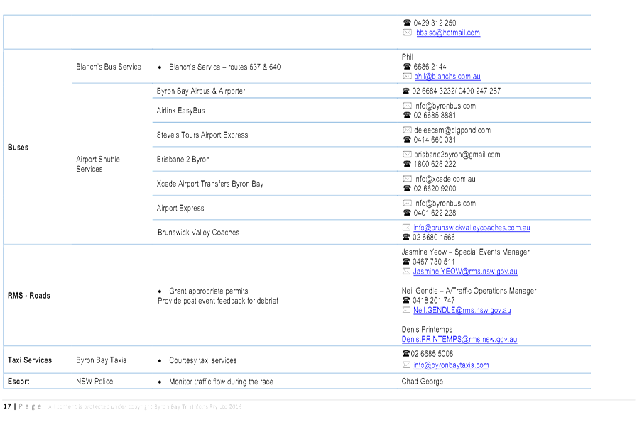
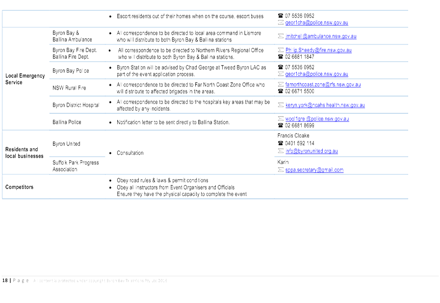
§ Consultation
A condition of the
endorsement of this event is that appropriate consultation is undertaken,
including:
1. Advertising
the impact of the event in the local newspaper and on the Council website.
2. Informing
community and business that are directly impacted.
3. Liaising
with bus and taxi operators.
4. Consulting
with emergency services.
§ Legal and Risk Management
No
formalised traffic control or Traffic Control Plan to RMS specifications are in
place for any of the four events. This may have a large insurance issue if
anything goes wrong.
The
Bangalow road closure directly affects RMS controlled asset - Lismore to
Bangalow Road (B62) and RMS controlled Granuaille Road. RMS Traffic Engineering
Department requires to separately approve the TMP and TCP.
|
Figure 1.
Sketches of all four Anzac Day Marches
|
|
Location
|
Road Closures red,
green and orange. Police Escort in Blue
|
|
Byron Bay
|
|
|
Mullumbimby
|
|
|
Figure 1.
Sketches of all four Anzac Day Marches
|
|
Location
|
Road Closures
red, green and orange. Police Escort in Blue
|
|
Bangalow
|
|
|
Brunswick Heads
|
|
|
RECOMMENDATION:
1. That
Council endorse the ANZAC Day Parades for 25 April 2016 for the Return
Services League sub branches of Byron Bay, Mullumbimby, Bangalow and
Brunswick Heads / Billinudgel.
2. That
the endorsement provided in Part 1 is subject to:
a) separate approvals by NSW Police and RMS
being obtained, noting that the Bangalow event is on a state road or may
impact the state road network;
b) implementation of the approved Traffic
Management Plan and Traffic Control Plan, including the use of signed
detours, as designed and implemented by those with appropriate accreditation;
c) that the impact of the event be advertised
via a notice in the local weekly paper a minimum of one week prior to the
operational impacts taking effect, noting it must include the event name,
specifics of any traffic impacts or road closures and times, alternative
route arrangements, event organiser, a personal contact name and a telephone
number for all event related enquiries or complaints.
d) the event be notified on Council’s
webpage.
e) the event organiser:
i. undertake consultation with community
and affected businesses including adequate response/action to any raised
concerns.
ii. undertake consultation with emergency
services and any identified issues addressed.
iii. holding $20m public liability insurance cover
which is valid for the event.
iv. paying Council’s Road Event Application Fee
prior to the event.
3. That
Council:
a) assists
where requested with implementing the necessary temporary road closures and
detours; and
b) placing of
public notice advertisements in a local weekly newspaper which is circulated
prior to the event and a copy of which is placed on Council’s web site.
c) Write to
the applicants RSL sub-branches at Byron Bay, Bangalow, Brunswick Heads,
Mullumbimby asking them to have their requests for their 2017 events to
Council by 09 January 2017.
4. That the approvals
provided above are subject to NSW Police approval being obtained and that
each event is undertaken either or both under Police escort or traffic
control and/or Council’s implemented traffic control.
|
Local Traffic Committee Meeting 6.2
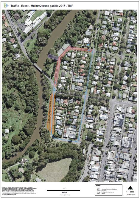
Report No. 6.2 Events - Mullum2Bruns Paddle - 28 May 2017 - Road One Way
File No: I2017/156
SUMMARY
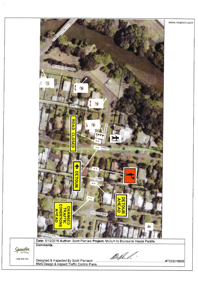
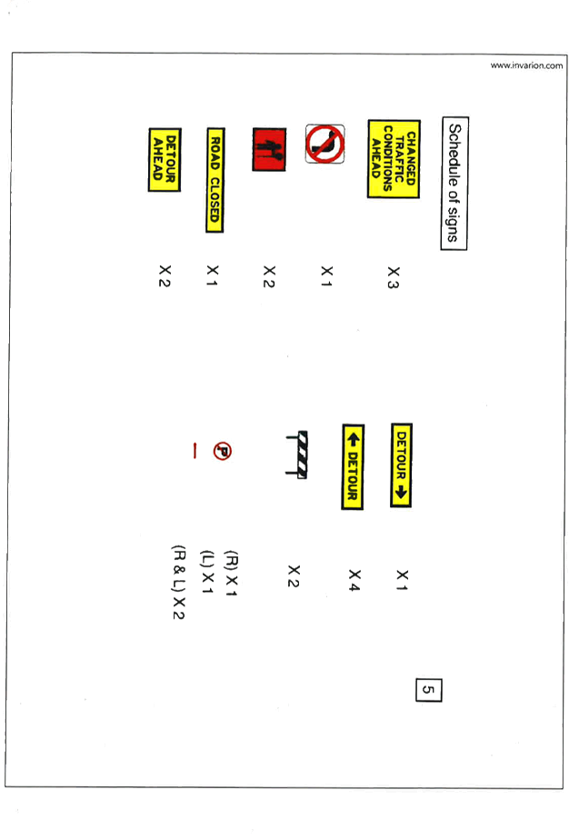
Council has received an event application with acceptable
Traffic Control Plan (TCP) and Traffic Management Plan (TMP) from the
Mullum2Bruns Paddle Committee for the Mullum2Bruns Paddle 2017 to be held on
Saturday 28 May 2016.
OFFICER RECOMMENDATION
That Council endorse the Mullum2Bruns Paddle 2017 to be held
Saturday 28 May 2017, that includes the temporary road closure on Brunswick
Terrace, Mullumbimby between Tincogan Street and Gordon Street One Way, between
06:30am and 10:00am on Saturday 28 May 2017.
LINKAGE TO OUR COMMUNITY STRATEGIC PLAN
|
Theme
|
Economy
|
A sustainable and diverse
economy which provides innovative employment and investment opportunities in
harmony with our ecological and social aims.
|
|
Objective
|
EC1
|
A diverse economic base and
support for local businesses.
|
|
Strategy
|
EC1.4
|
Support sporting and cultural events in Byron Shire.
|
|
Measures
|
EC1.B
|
Increase the sustainability of events in which Council is
involved.
|
BACKGROUND
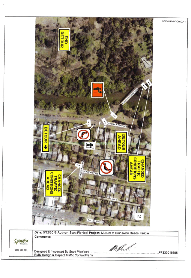
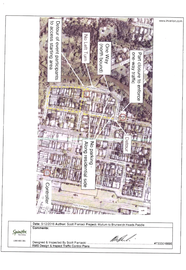
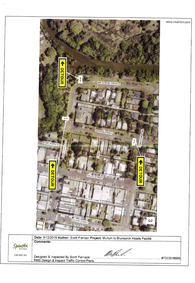
The event organisers are proposing to partially close
Brunswick Terrace, Mullumbimby to make it one way between Tincogan Street and
Gordon Street, between 06:30am and 10:00am on Saturday 28 May 2017 for the
annual Mullum2Bruns Paddle.
The format will be the same as previous years, with traffic
diverted via Gordon St (From Tyagarah St to Burringbar St) to Burringbar St to
Brunswick Terrace. The event organisers have advised that they will
engage spinifex to carry out the TCP and will have assistance from the
volunteers in relation to traffic management.
KEY ISSUES
1. Competitors
parking haphazardly around the Brunswick Terrace boat ramp
2. Pedestrian
and vehicle management at the Tincogan Street and Brunswick Terrace
COUNCIL IMPLICATIONS
§ Budget/Financial
The event organisers
have been invoiced $356.00 for the relevant Approval of Road Events pursuant to
s144 of the Roads Act fee as per the Fees & Charges 2016/17. This fee will
be paid for by a $600 grant given to the event by Council.
§ Asset Management
Not applicable.
§ Policy or Regulation
Speed Limit (as
required) ROAD WORK (R4-212) - Delegated to council for authorisation in
conjunction with NSW Road Rules 21 and AS 1742.4 (Speed Controls) Clause 3.1.2,
AS 1742.3 (Roadworks).
§ Consultation
A condition of the
endorsement of this event is that appropriate consultation is undertaken,
including:
1. Advertising
the impact of the event in the local newspaper and on the Council website.
2. Informing
community and business that are directly impacted.
3. Liaising
with bus and taxi operators.
4. Consulting
with emergency services.
§ Legal and Risk Management
This road closure will
not directly affect any RMS controlled asset.
|
RECOMMENDATION:
1. That
Council approve the Mullum2Bruns Paddle 2017 to be held Saturday 28 May 2017,
that includes the temporary road closure below:
a) Brunswick
Terrace, Mullumbimby between Tincogan Street and Gordon Street One Way),
between 06:30am and 10:00am on Saturday 28 May 2017.
2. That
the approval provided in Part 1 is subject to:
a) separate approvals by NSW Police and RMS being obtained;
b) implementation of the approved Traffic Management Plan and
Traffic Control Plan, including the use of signed detours, as designed and
implemented by those with appropriate accreditation;
c) that the impact of the event be advertised via a notice in the
local weekly paper a minimum of one week prior to the operational impacts
taking effect, noting it must include the event name, specifics of any
traffic impacts or road closures and times, alternative route arrangements,
event organiser, a personal contact name and a telephone number for all event
related enquiries or complaints.
d) the event be notified on Council’s webpage.
e) the event organiser:
i. undertake
consultation with community and affected businesses including adequate
response/action to any raised concerns.
ii. undertake
consultation with emergency services and any identified issues addressed.
iii. holding
$20m public liability insurance cover which is valid for the event.
iv. paying
Council’s Road Event Application Fee prior to the event.
|
Attachments:
1 Traffic -
Event - Mullum2Bruns Paddle 2017 - TMP, E2017/8689
, page 12⇩ 
2 Traffic -
Event - Mullum2Bruns Paddle 2017 - TCP, E2017/8824
, page 15⇩ 
Regulatory Matters 6.2 - Attachment 1
|
Table 1. TMP performa
|
|
Details Required
|
Response (If no, state your
reasons why)
|
|
A. Description
or detailed plan of proposed measures.
Is a detailed plan
of the proposed measures necessary?
|
Event Name
|
Mullum2Bruns
Paddle 2017
|
A.
Organiser
Name |
Mullum2Bruns
Paddle Committee
|
A.
Traffic
Control |
Spinifex
|
A.
Date(s) |
Saturday
28/05/2017
|
A.
Times |
06:30
am to 10:00 am
|
A.
Roads
affected |
Brunswick
Terrace (One Way from Tincogan St to Gordon St)
Murwillumbah
Rd and Tincongan St can not turn North onto Brunswick Terrace
|
A.
Detours
in place |
Gordon
St (From Tyagrah St to Burringbar St) to Burringbar St to Brunswick Terrace
|
A.
Parking |
Parking
is provided in Brunswick Terrace for unloading water craft.
|
A.
There
will be little effect to traffic traveling from Mullumbimby travelling to Uki
via Murwillumbah Road. |
|
B. Identification
and assessment of impact of proposed measures.
Is a detailed
assessment required?
|
Brunswick
Terrace is a minor road with one way traffic which will allow residents to
access their properties. By controlling vehicle parking with volunteers
Brunswick Terrace will remain open to one way traffic.
A
detailed assessment is not required.
|
|
C. Measures
to ameliorate the impact of re-assigned traffic
Is an assessment
required?
|
There
will be little to no impact of reassigned traffic to the State Arterial
Network.
|
|
D. Assessment
of public transport services affected.
Is an assessment
required?
|
The
local public transport companies have been advised of the proposal thereby
minimising the impact on these services.
|
|
E. Details
of provision made for emergency vehicles, heavy vehicles, cyclists and
pedestrians.
Are these details
required?
|
Emergency
|
Emergency
vehicles have right of way on Brunswick Terrace and the road access is to
remain clear at all times.
Emergency
Services are all notified via the LEMC every year, they are informed of the
date, start & finish times and pick up areas along the river in the event
of an emergency.
|
A.
Heavy
Vehicles |
No
heavy vehicles or buses are known to use Brunswick Terrace. The organisers
have advised the local bus companies.
|
A.
Cyclist |
There
is parking on Brunswick Terrace
|
A.
Pedestrians |
There
is a traffic controlled pedestrian and vehicle crossing on Murwillumbah Road
for competitors taking their water craft from Brunswick Terrace South to the
boat ramp.
|
|
F. Assessment
of effect on existing and future developments with transport implications in
the vicinity of the proposed measures.
Is an assessment
required?
|
There
will be little to no effect on existing & future developments.
|
|
G. Assessment
of effect of proposed measures on traffic movements in adjoining Council
areas.
Is an assessment
required?
|
There
will be little to no effect on traffic movements in adjoining council areas.
|
|
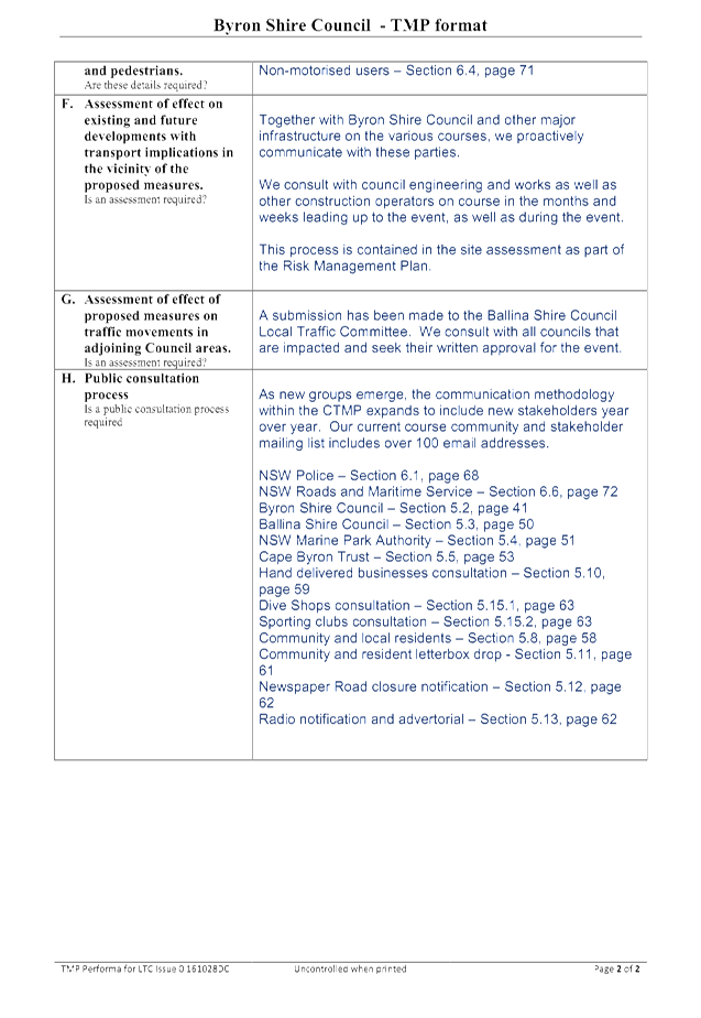
H. Public
consultation process
Is a public
consultation process required
|
The
Mullum2Bruns Paddle Committee will adhere to the Public Consultation Process
via the following methods; council approved advertising in local newspapers
advising the public & local businesses alike of upcoming road closure
& traffic detours, plus through local newsletters/publications, social
media, radio & community television.
|
|
|
|
|
|
Table
2. Flow Chart for TMP approval
|
|
1. Proposed
measure identified as requiring the preparation of a TMP.
2. TMP
Prepared below
3. Council may seek informal comments from
the Local Traffic Committee before submitting the TMP.
4. TMP to be presented directly to the
nearest RMS office.
5. Council advised of either RMS approval to
the TMP or a need for more information. If the TMP is not approved Council
has the right of appeal to the Minister for Roads.
6. Following
receipt of RMS approval to the TMP, Council can proceed in accordance with
the requirements of the Delegation.
|
|
Table
3. Explanation of each TMP stage
|
Question
|
Response
(If no, state your reasons why)
|
|
a. Description or detailed plan of proposed
measures.
Is
a detailed plan of the proposed measures necessary?
|
This may take the
form of a detailed plan where there are a large number of measures which are
best described in a plan. This plan could show the road hierarchy proposed as
a result of the changes, if applicable. In the case of a simple measure or
measures a written description is sufficient.
|
|
b. Identification and assessment of impact
of proposed measures.
Is
a detailed assessment required?
|
The assessment would
include appropriate traffic flow data (eg heavy vehicles % pedestrian volumes
etc.) for the roads and intersections affected, including the re-assignment
of traffic, intersection and accident analysis and coordinated modeling where
necessary (The traffic modeling software to be used would require agreement
from the Authority prior to the assessment proceeding ).
|
|
c. Measures to ameliorate the impact
of re-assigned traffic
Is
an assessment required?
|
Measures to
ameliorate the impact of re-assigned traffic particularly on the State
arterial network should be detailed.
|
|
d. Assessment of public transport services
affected.
Is
an assessment required?
|
Details should be
provided of public transport services affected by the proposal and the
provisions made to minimise the impact on those services.
|
|
e. Details of provision made for emergency
vehicles, heavy vehicles, cyclists and pedestrians.
Are
these details required?
|
Details should be
provided of the provision made for emergency vehicles, heavy vehicles,
cyclists and pedestrians and the provisions made to minimise the impact on
that traffic.
|
|
f. Assessment of effect on existing
and future developments with transport implications in the vicinity of the
proposed measures.
Is
an assessment required?
|
The assessment
should describe the transport implications on all existing and future
developments (ie those described as Schedules 1 and 2 in State Environmental
Planning Policy No. 11) as a consequence of the proposed measures. This would
include the effect of servicing those developments as well as existing properties
in the vicinity.
|
|
g. Assessment of effect of proposed measures
on traffic movements in adjoining Council areas.
Is
an assessment required?
|
This would require
Council to consult with adjoining Councils to determine the effect of the
proposed measures on their road network.
|
|
h. Public consultation process
Is
a public consultation process required
|
This would require
Council to consult with the public directly effected by the proposed measures
and Councils subsequent determination on the matter.
|
http://www.rms.nsw.gov.au/business-industry/partners-suppliers/documents/technical-manuals/tmplan_v2.pdf
Regulatory Matters 6.2 - Attachment 2
Local Traffic Committee Meeting 6.3
Report No. 6.3 Regulatory Signage - Wilfred St 2 - No Stopping - Emergency Services
File No: I2017/300
SUMMARY
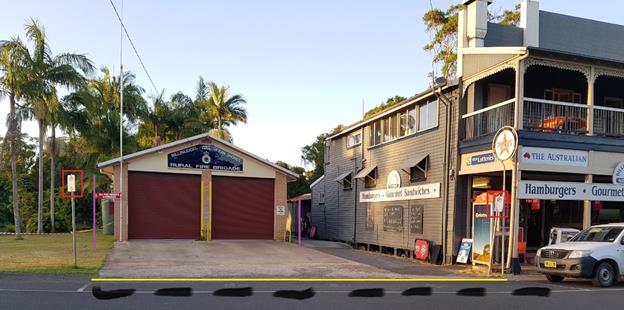
Council has received a request from the Billinudgel Ocean
Shores Rural Fire Brigade to restrict vehicles parking in the Fire Stations
access at 2 Wilfred St, Billinudgel.
|
Figure 1.
Billinudgel Rural Fire Service Station with improvement options.
|
|
Legend:
· Change Red signs
with No stopping.
· Black out old
white parking bay.
· Install Yellow
no stopping line.
· Install purple
repeater no stopping signs if parking issues persist.
|
|
|
OFFICER RECOMMENDATION
That Council upgrade and duplicate the No Parking signs to
No Stopping zones at the Billinudgel Ocean Shores Rural Fire Brigade station at
2 Wilfred Street, Billinudgel.
LINKAGE TO OUR COMMUNITY STRATEGIC PLAN
|
Theme
|
Community Infrastructure
|
Services and infrastructure
that sustains, connects and integrates our communities and environment.
|
|
Objective
|
CI3
|
Renew and maintain existing
infrastructure.
|
|
Strategy
|
CI3.1
|
Maintain roads and drainage in
a safe and operational condition.
|
|
Measures
|
CI3.A
|
Reduction in funding gap for infrastructure renewal and
maintenance.
|
BACKGROUND
Vehicles are regularly parking (especially during events) in
the emergency access due to poor line marking and incorrect signage. This has
the potential to delay fire crews in responding to an incident and saving
lives.
KEY ISSUES
1. Rural
Fire Service Appliances can not effectively leave their fire station due to
vehicles being parked incorrectly.
COUNCIL IMPLICATIONS
§ Budget/Financial
Estimate of $1,000.00
for (4) R5-400 No Stopping signs, posts, clips, traffic control, Council Works
team (4 hrs) with a line marker for the no stopping line.
§ Asset Management
Estimate $400.00 for 4
signs x $10.00 per sign/year x 10 year expected life. Council will need to
maintain signage ongoing, including cleaning and replacement (if necessary).
§ Policy or Regulation
Delegated to council
for authorisation in conjunction with NSW Road Rules 167 and AS1742.11 (Parking
Control).
§ Consultation
No consultation has
been carried out as this solution improves the enforcement of the current
signage.
§ Legal and Risk Management
Stopping vehicles
parking in this area allows access for emergency vehicles and members vehicles
that use the lane way to access parking behind the fire station.
|
RECOMMENDATION:
That Council
1. Approve
the installation of No Stopping signs and lines at the Billinudgel Ocean
Shores Rural Fire Brigade Station at 2 Wilfred St, Billinudgel.
2. Approve
funding for the works included in the Emergency Works Budget Bid 2016/2017.
|
Local Traffic Committee Meeting 7.1
Matters for Traffic Engineering Advice
Report No. 7.1 Event - Byron St, Bangalow - Road Closure - Bangalow Billy Cart
Derby 21 May 2017
File No: I2017/151
SUMMARY
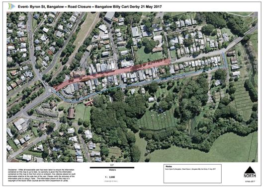
Council has received an event application from the Bangalow
Lions Club for the Bangalow Billy Cart Derby to be held on Saturday 21 May
2017.
OFFICER RECOMMENDATION
That Council endorse the Bangalow Lions Club for the
Bangalow Billy Cart Derby to be held on Saturday 21 May 2017, that includes the
temporary road closure of Byron Street, Bangalow (between Ashton Street and
Granuaille Road) between 6am and 4pm, subject to conditions.
LINKAGE TO OUR COMMUNITY STRATEGIC PLAN
|
Theme
|
Economy
|
A sustainable and diverse
economy which provides innovative employment and investment opportunities in
harmony with our ecological and social aims.
|
|
Objective
|
EC1
|
A diverse economic base and
support for local businesses.
|
|
Strategy
|
EC1.4
|
Support sporting and cultural events in Byron Shire.
|
|
Measures
|
EC1.B
|
Increase the sustainability of events in which Council is
involved.
|
BACKGROUND
The format will be the same as previous years, with traffic
diverted via Deacon Street. The event organisers have advised that they
will engage Spinifex to carry out the TCP and will have assistance from the SES
in relation to traffic management.
The event organisers have provided a conforming TCP and TMP.
KEY ISSUES
1. This
road closure directly affects RMS controlled asset - Lismore to Bangalow Road
(B62) and RMS controlled Granuaille Road.
2. RMS
Traffic Engineering Department requires to separately approve the TMP and TCP.
3. Deacon
Street is not suitable to Heavy Vehicles as a detour to the Pacific Highway.
4. Heavy
Vehicles from Lismore will have to use Granuaille Road to access the Pacific
Highway.
5. Increase
traffic congestion as vehicle use the undesirable Deacon Street detour.
6. Deacon
Street is overgrown and will require Council to trim prior to the event.
COUNCIL IMPLICATIONS
§ Budget/Financial
The event organisers
have been invoiced $356.00 for the relevant Approval of Road Events pursuant to
s144 of the Roads Act fee as per the Fees & Charges 2016/17.
§ Asset Management
Not applicable.
§ Policy or Regulation
Speed Limit (as
required) ROAD WORK (R4-212) - Delegated to council for authorisation in
conjunction with NSW Road Rules 21 and AS 1742.4 (Speed Controls) Clause 3.1.2,
AS 1742.3 (Roadworks).
§ Consultation
A condition of the
endorsement of this event is that appropriate consultation is undertaken,
including:
1. Advertising
the impact of the event in the local newspaper and on the Council website.
2. Informing
community and business that are directly impacted.
3. Liaising
with bus and taxi operators.
4. Consulting
with emergency services.
§ Legal and Risk Management
This road closure
directly affects RMS controlled asset - Lismore to Bangalow Road (B62) and RMS
controlled Granuaille Road. RMS Traffic Engineering Department requires to
separately approve the TMP and TCP.
Figure 1. Byron
Street, Bangalow road closure
|
RECOMMENDATION:
1. That
Council endorse the Bangalow Billy Cart Derby to be held on Saturday 21 May
2017, that includes the temporary road closure below:
a) Byron Street, Bangalow between Ashton Street and Granuaille Road,
between 6am and 4pm on Saturday 21 May 2017.
2. That
the approval provided in Part 1 is subject to:
a) separate approvals by NSW Police and RMS being obtained, noting
that the event is on a state road or may impact the state road network;
b) implementation of the approved Traffic Management Plan and
Traffic Control Plan, including the use of signed detours, as designed and
implemented by those with appropriate accreditation;
c) that the impact of the event be advertised via a notice in the
local weekly paper a minimum of one week prior to the operational impacts
taking effect, noting it must include the event name, specifics of any traffic
impacts or road closures and times, alternative route arrangements, event
organiser, a personal contact name and a telephone number for all event
related enquiries or complaints.
d) the event be notified on Council’s webpage.
e) the event organiser:
i. undertake
consultation with community and affected businesses including adequate
response/action to any raised concerns.
ii. undertake
consultation with emergency services and any identified issues addressed.
iii. holding
$20m public liability insurance cover which is valid for the event.
iv. paying
Council’s Road Event Application Fee prior to the event.
|
Local Traffic Committee Meeting 7.2
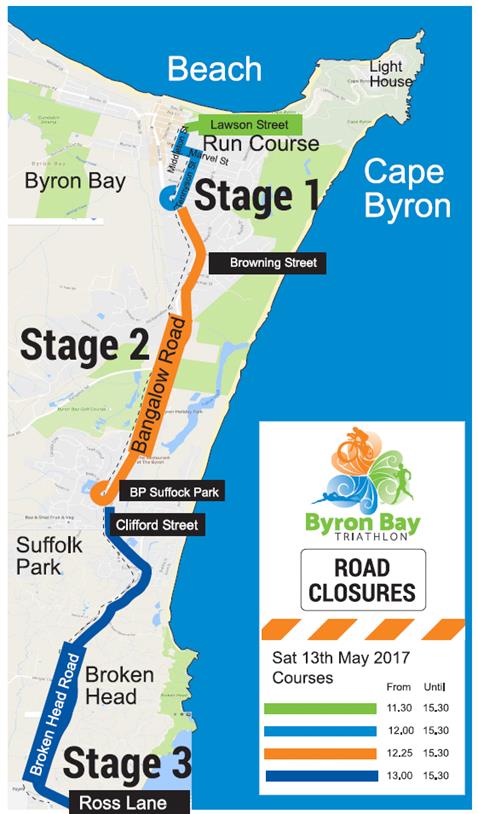
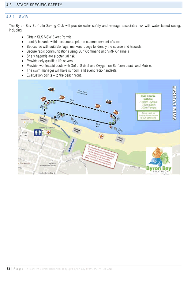
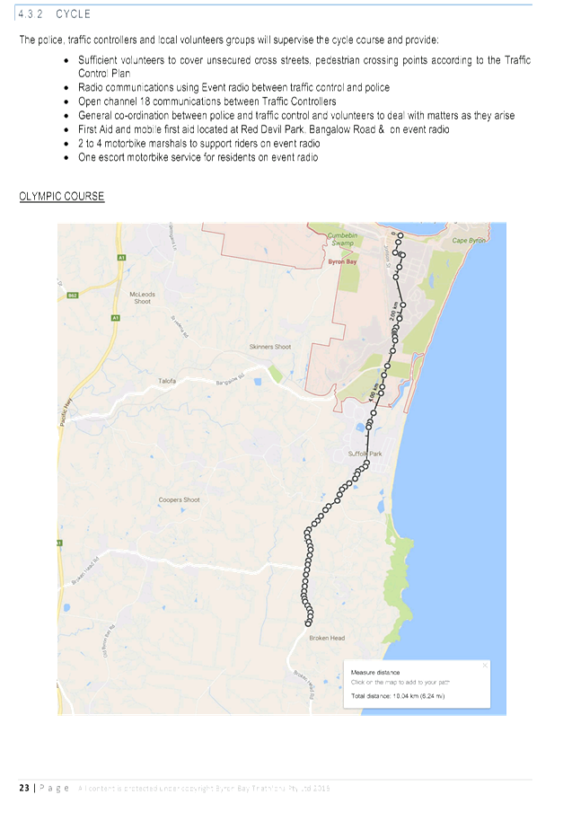
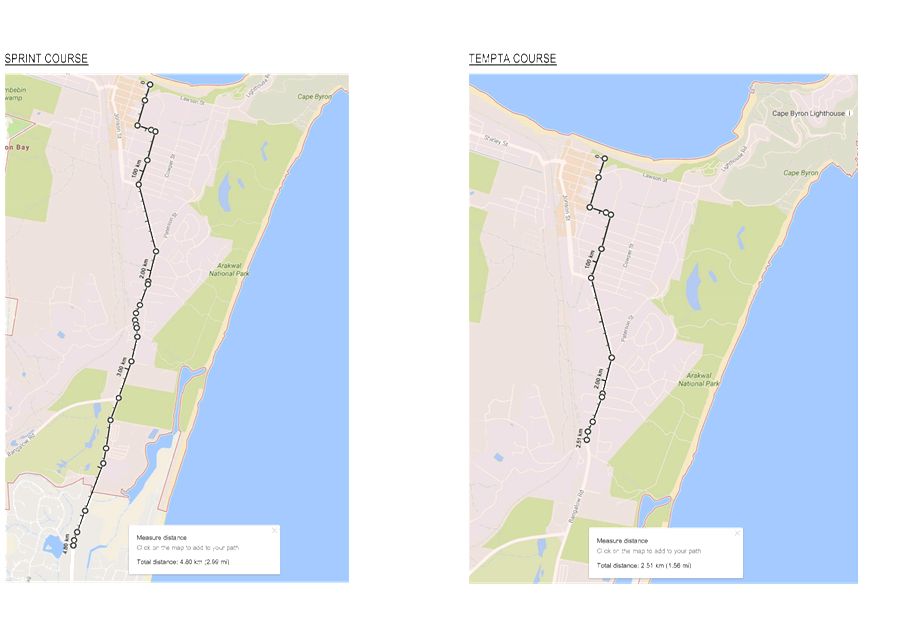
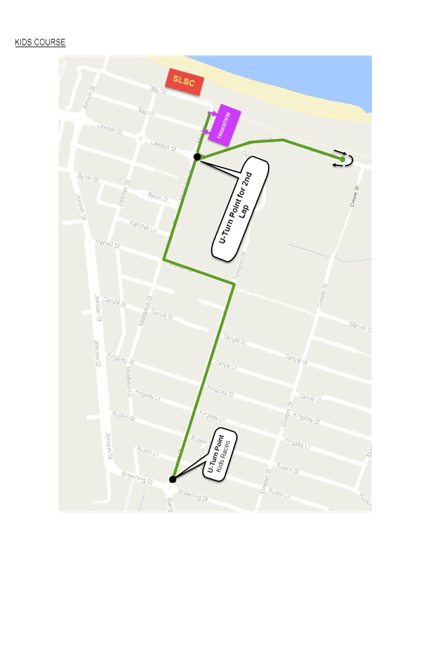
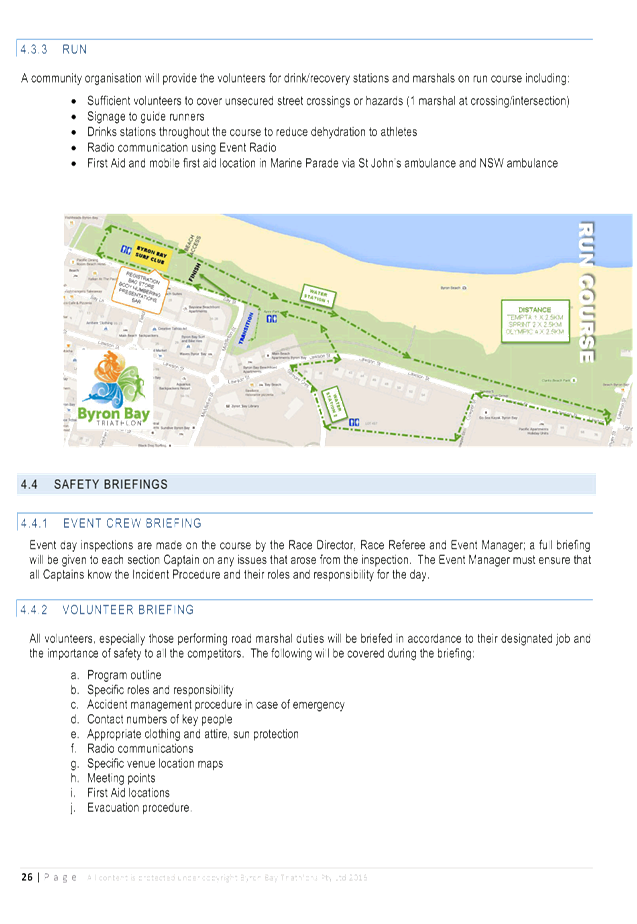
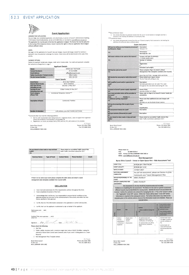
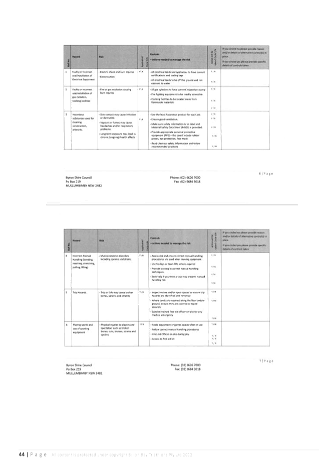
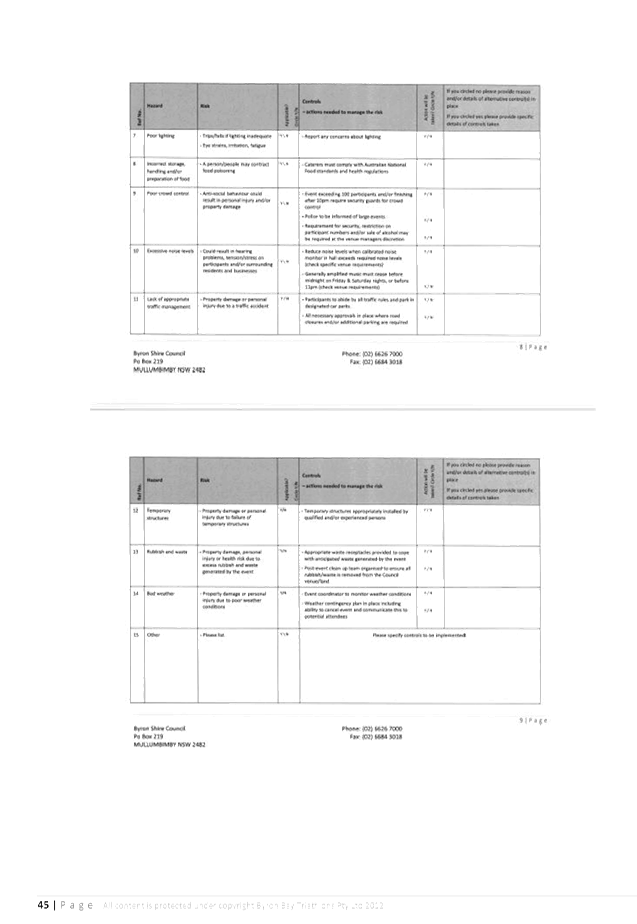
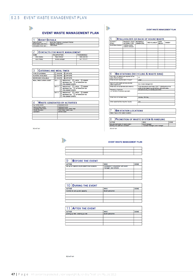
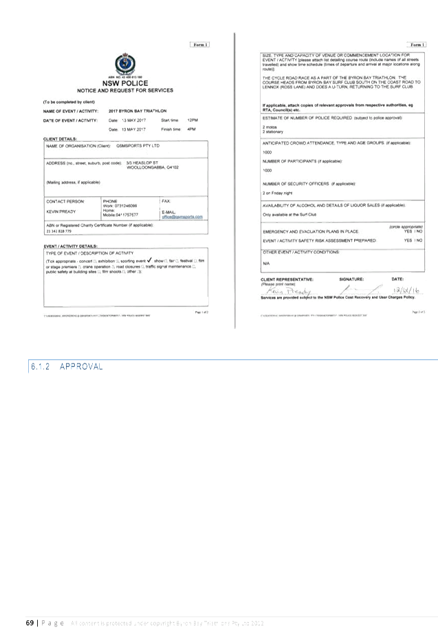
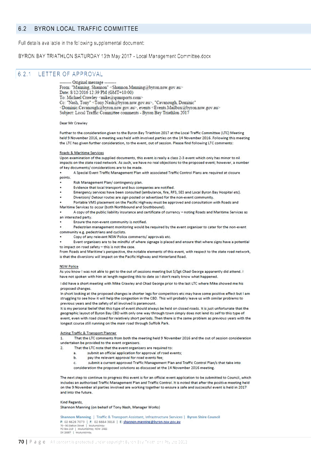
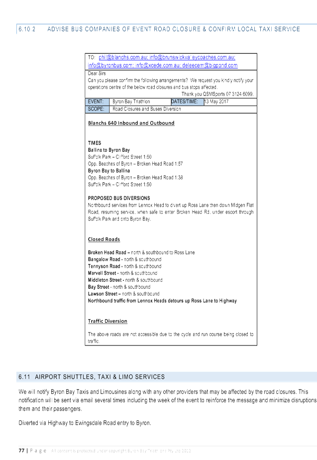
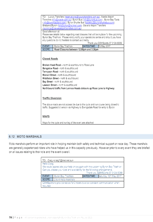
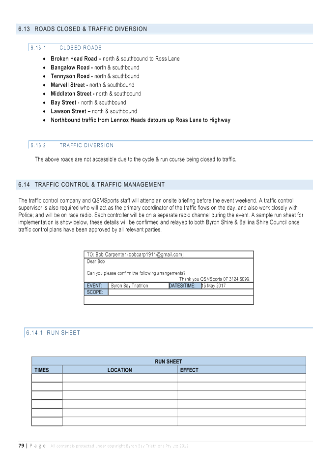
Report No. 7.2 Traffic - Events - Byron Bay Triathlon 13 May 2017 - Road Closures
File No: I2017/160
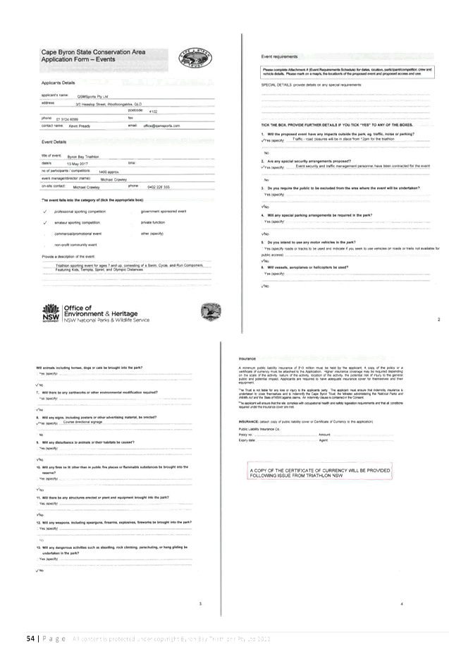
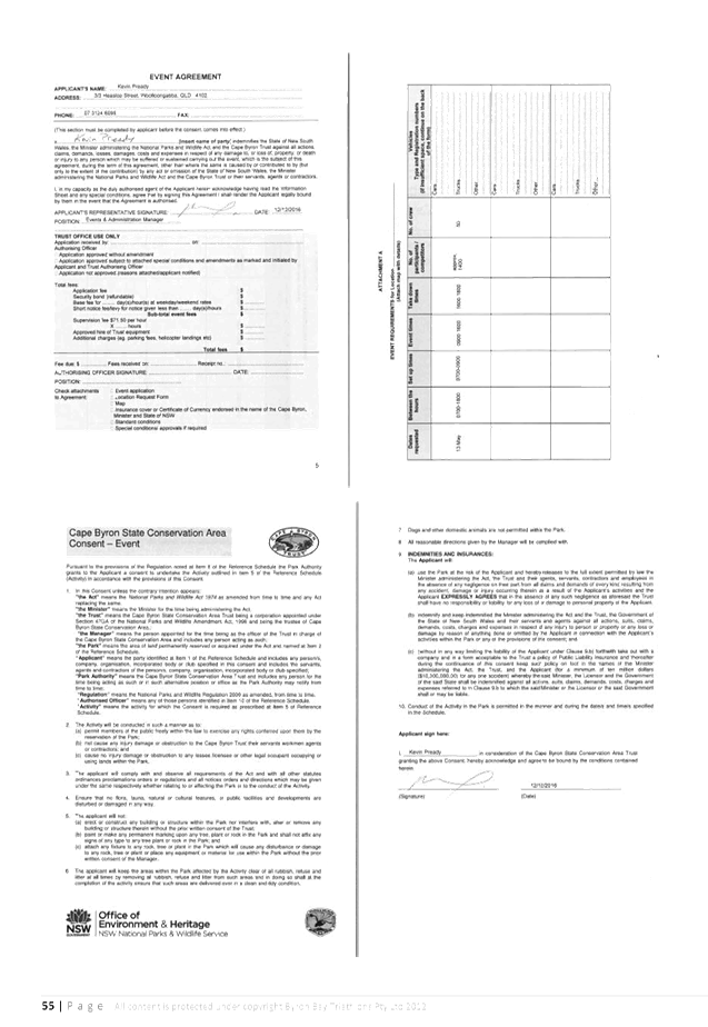
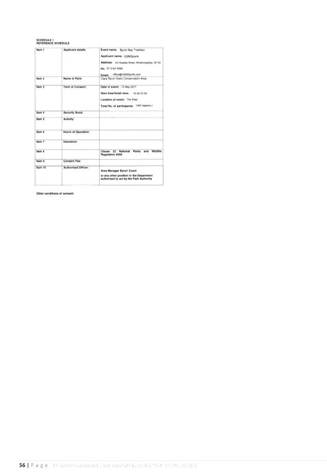
SUMMARY
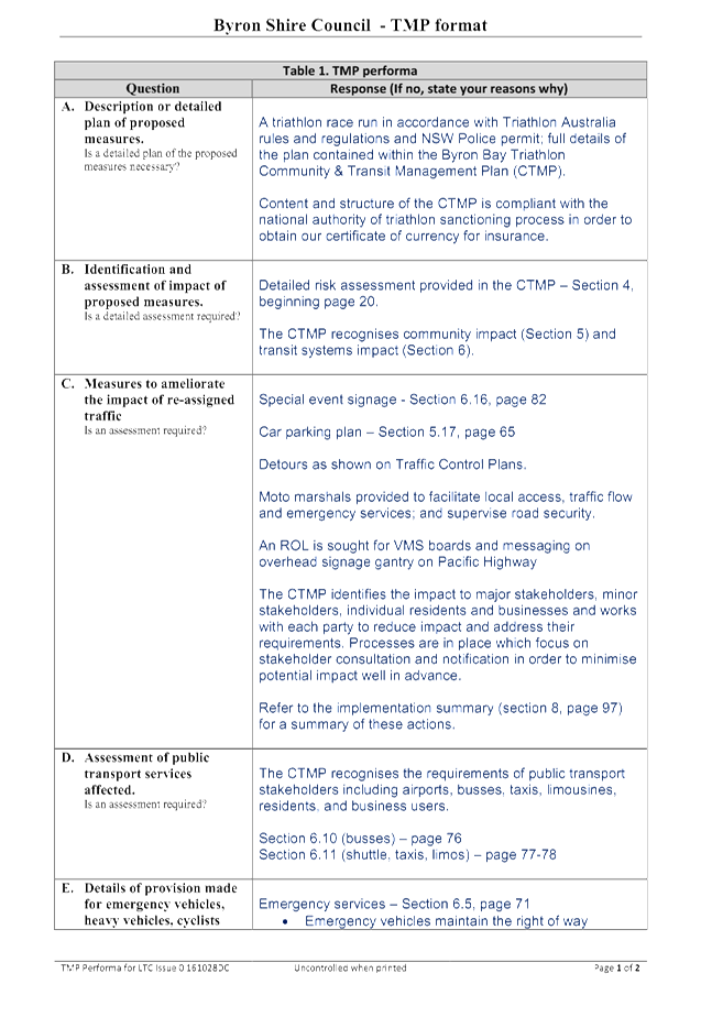
Council has received an event application with an acceptable
Traffic Management Plan (TMP) and Traffic Control Plan (TCP) from QSM Sports
for the Byron Bay Triathlon to be held in Byron Bay on Saturday 13 May 2017.
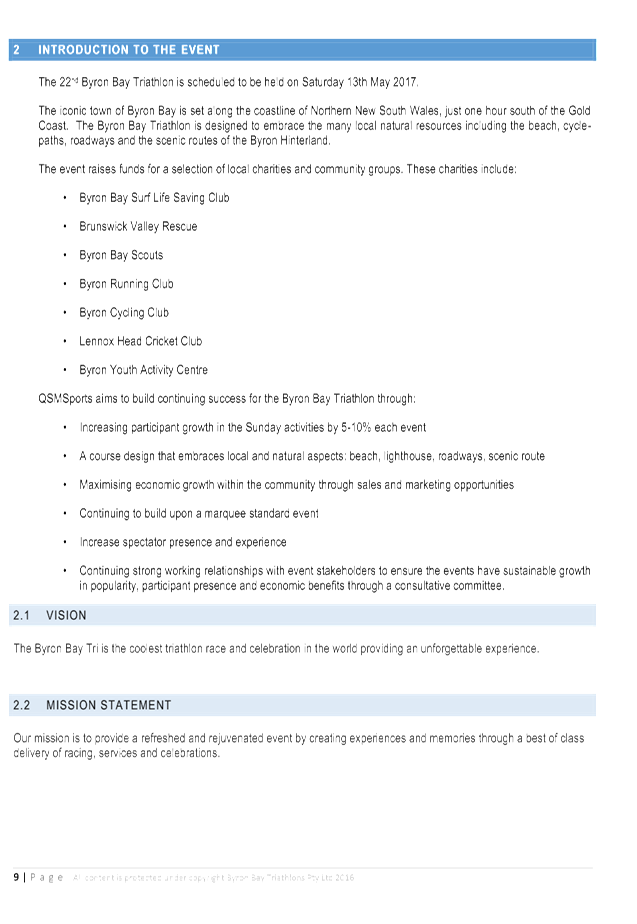
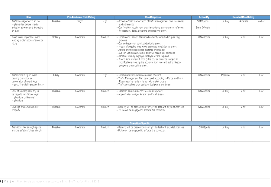
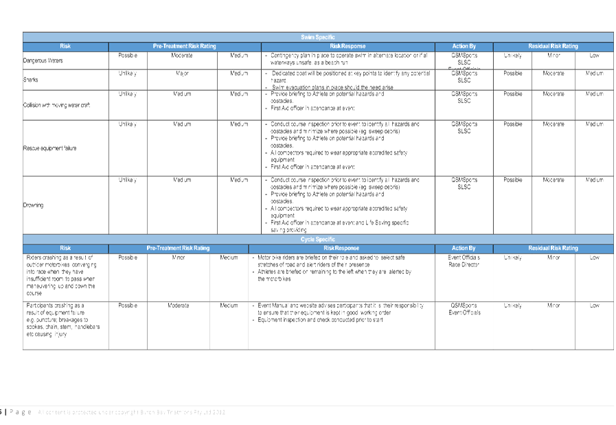
The Byron Bay Triathlon has been running for over twenty
years. However a number of concerns have been highlighted as a result of the
event held in 2016 and they have been workshopped to create a solution to
reduce the risks associated with the proximity of athletes and vehicles.
OFFICER RECOMMENDATION
That Council endorse the Byron Bay Triathlon to be held in
Byron Bay on Saturday 13 May 2017 that includes the temporary road closure of
the following roads, subject to conditions:
|
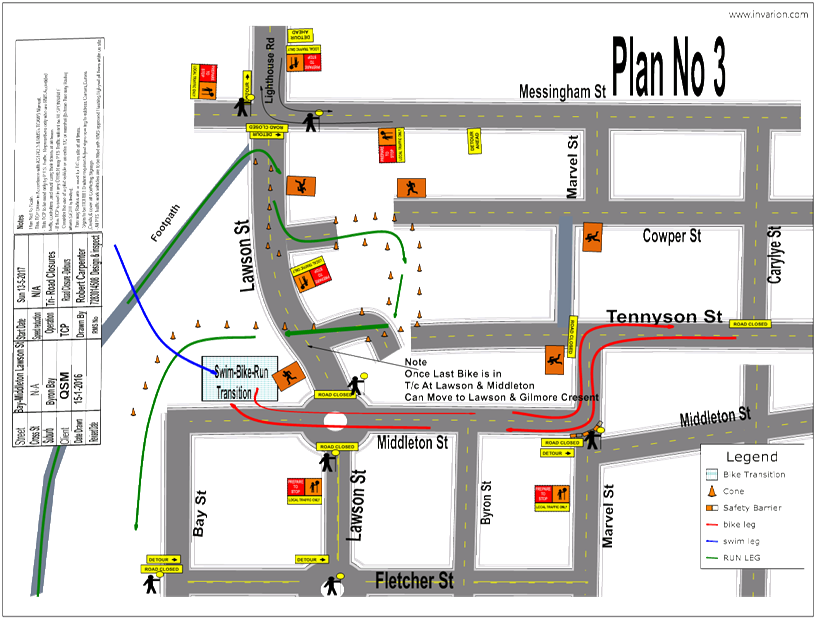
Table
1. Estimated Road Closure Times for the 2016 event
|
|
Location
|
Time
|
|
Closed
|
Open
|
|
Lawson
Street (Middleton Street to Massinger St)
|
11:30
|
15:30
|
|
Marvell
Street
|
12:00
|
15:30
|
|
Bay
Street (Fletcher St to Middleton St)
|
12:00
|
15:30
|
|
Bay
Ln (Fletcher St to Middleton St)
|
12:00
|
15:30
|
|
Middleton
St (Marvel St to Bay St)
|
12:00
|
15:30
|
|
Marvell
St (Middleton St to Tennyson St)
|
12:00
|
15:30
|
|
Tennyson
St
|
12:00
|
15:30
|
|
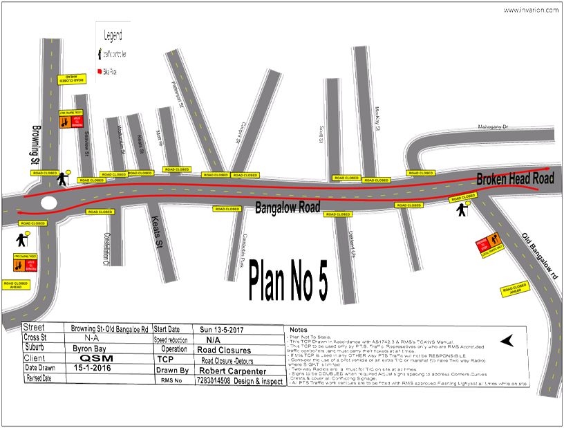
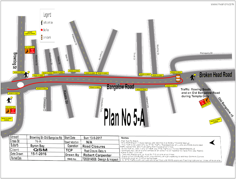
Bangalow
Road (Browning St to Old Bangalow Rd)
|
12:25
|
15:30
|
|
Bangalow
Road (Old Bangalow Rd to Broken Head Rd)
|
12:25
|
15:30
|
|
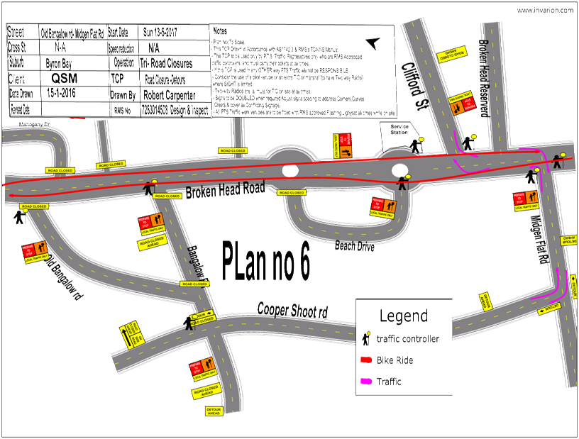
Broken
Head Road (Bangalow Rd to Beech Dr)
|
13:00
|
15:30
|
|
Broken
Head Road (Beech Dr to Ross Lane)
|
13:00
|
15:30
|
LINKAGE TO OUR COMMUNITY STRATEGIC PLAN
|
Theme
|
Economy
|
A sustainable and diverse
economy which provides innovative employment and investment opportunities in
harmony with our ecological and social aims.
|
|
Objective
|
EC1
|
A diverse economic base and
support for local businesses.
|
|
Strategy
|
EC1.4
|
Support sporting and cultural events in Byron Shire.
|
|
Measures
|
EC1.B
|
Increase the sustainability of events in which Council is
involved.
|
BACKGROUND
In September 2016 Council received a request from QSM Sports
for the LTC to consider the proposal for the Byron Bay Triathlon to be held in
Byron Bay on Saturday 13 May 2017.
The LTC has met twice to discuss the issues surround the
event as per reports I2016/1262 and I2016/1408. The organisers have
modified their TCP and TMP based on committee recommendations.
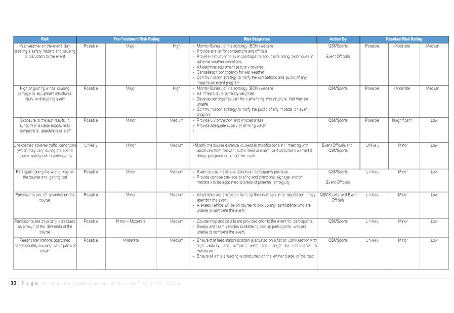
KEY ISSUES
|
Byron Bay Triathlon 2017 – Previous Issues and
proposed actions to be taken
|
|
Issues
|
Solutions to be implemented
|
|
1
|
Three previous models
haven’t worked
|
· Create three smaller more manageable courses with
all starting in CBD with 2 courses out of town with one of those courses
going past Suffolk Park
|
|
2
|
Suffolk Park resistance due
to traffic delays
|
· Cycle club to door knock each resident on route.
· Free BBQ at Suffolk park
|
|
3
|
Byron Bay Fringe and
tourists are not clicking on about how the event affecting their travel times
|
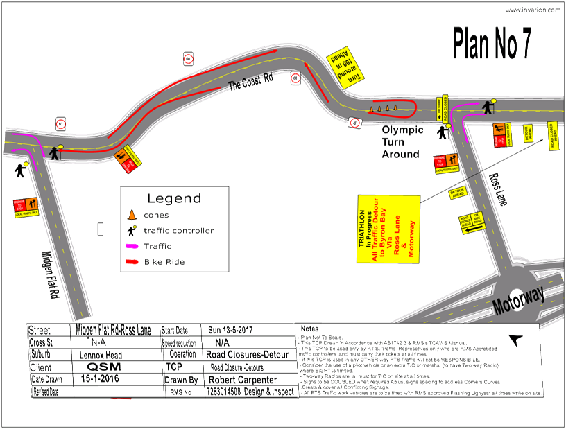
· Early warning by VMS and signs along the route up to
a 2 weeks before the event
· Wider media release perhaps State papers
· VMS on highway near Bangalow to show Road Broken
Head Road Closure and show alternative routes
· VMS at Hospital to advise road closures
|
|
4
|
Traffic delays and
congestion
|
· Bulk feed with slow competitors on the course first
and fast finisher on the course last
· Vehicle to clean up the tail with a police escort in
stage 2 and 3.
· Option to electrical tag competitors to know the
last person.
|
|
5
|
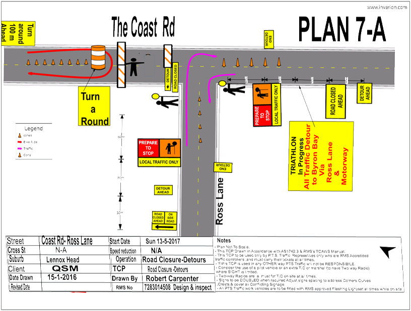
Can not run live traffic
with competitors due to the lack of road width.
|
· Full road closures required.
|
|
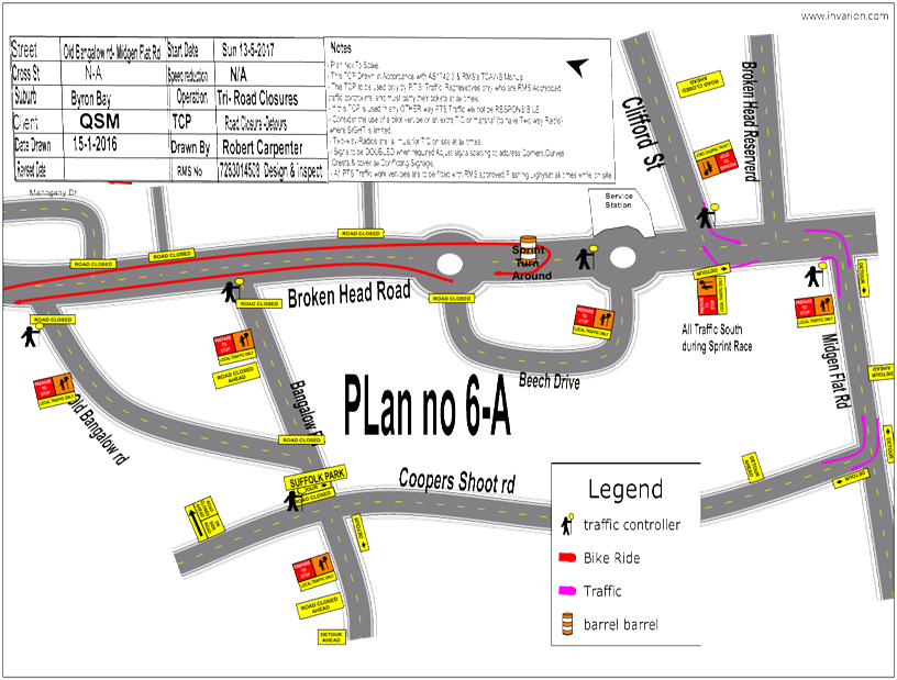
6
|
Previous Traffic Control
has been inadequate to deal with hot spots. So resources were relocated from
cold spots to hot spots allowing uncontrolled vehicle access to the course.
|
· Increase Traffic Control and volunteer presence
· Each road closure with a Traffic Control should have
an event enthusiast to talk to the motorists
· Two mobile Traffic control teams to monitor signage
(North team and South team)
· Police to provide 1 motorcycle with potential for a
second
· If the traffic is moving then vehicle operators are
more likely to follow instructions
· Increase water filled barriers
· Increase Moto marshals
|
COUNCIL IMPLICATIONS
§ Budget/Financial
The event organisers
have been invoiced $356.00 for the relevant Approval of Road Events pursuant to
s144 of the Roads Act fee as per the Fees & Charges 2016/17.
§ Asset Management
Not applicable.
§ Policy or Regulation
Speed Limit (as
required) ROAD WORK (R4-212) - Delegated to council for authorisation in
conjunction with NSW Road Rules 21 and AS 1742.4 (Speed Controls) Clause 3.1.2,
AS 1742.3 (Roadworks).
§ Consultation
A condition of the
endorsement of this event is that appropriate consultation is undertaken,
including:
1. Advertising
the impact of the event in the local newspaper and on the Council website.
2. Informing
community and business that are directly impacted.
3. Liaising
with bus and taxi operators.
4. Consulting
with emergency services.
§ Legal and Risk Management
This road closure may
affect RMS controlled assets. RMS Traffic Engineering Department requires to
separately approve the TMP and TCP.
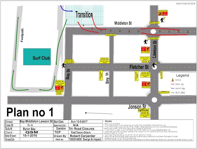
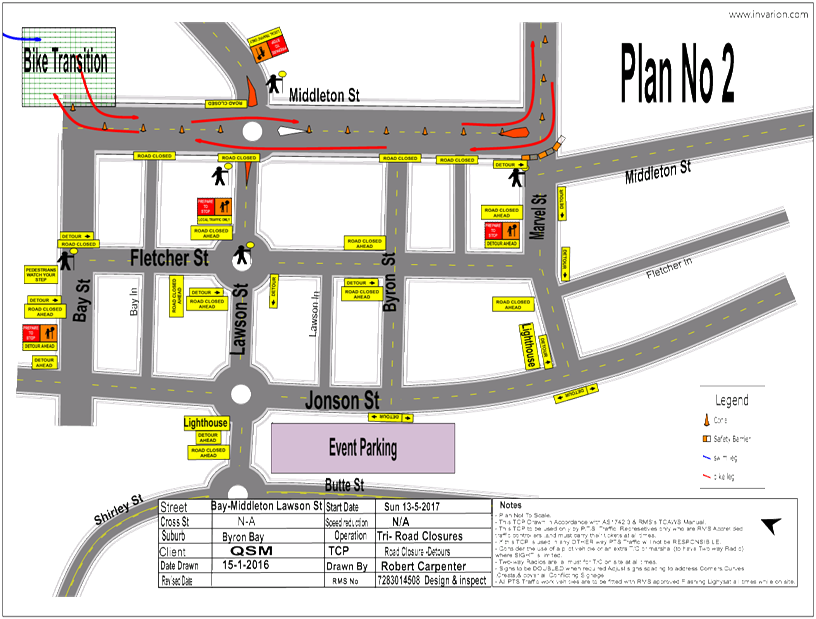
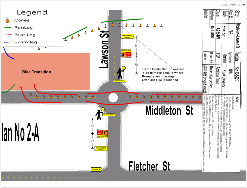
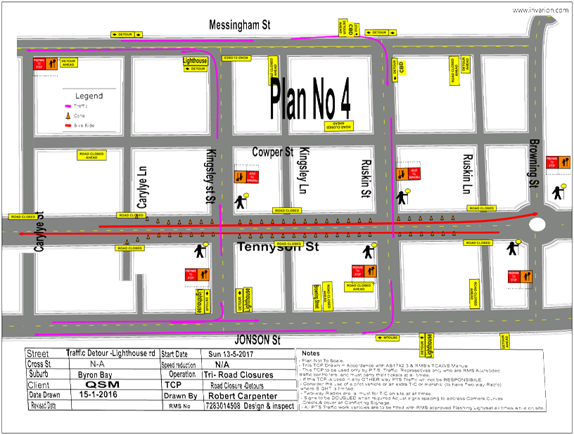
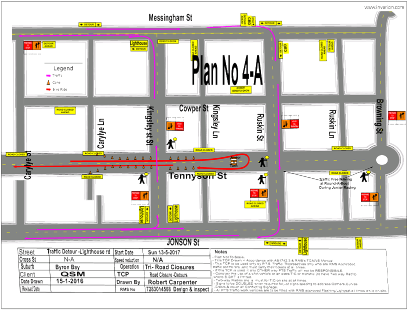
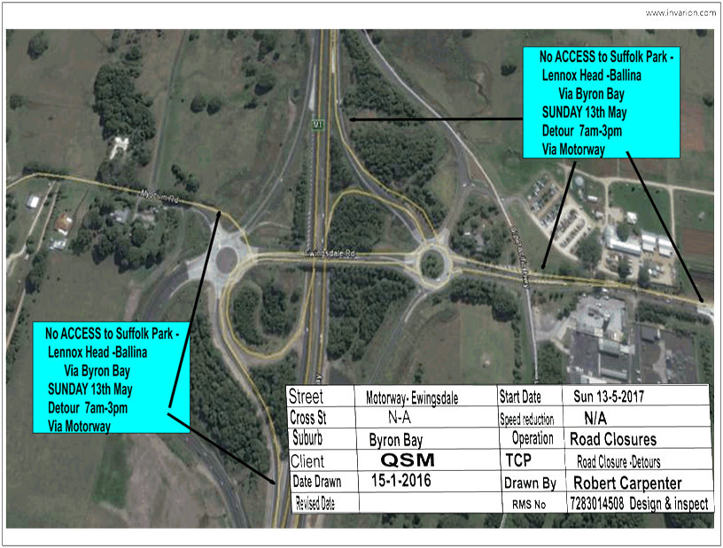
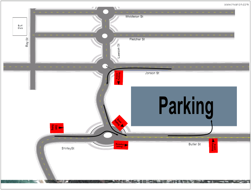
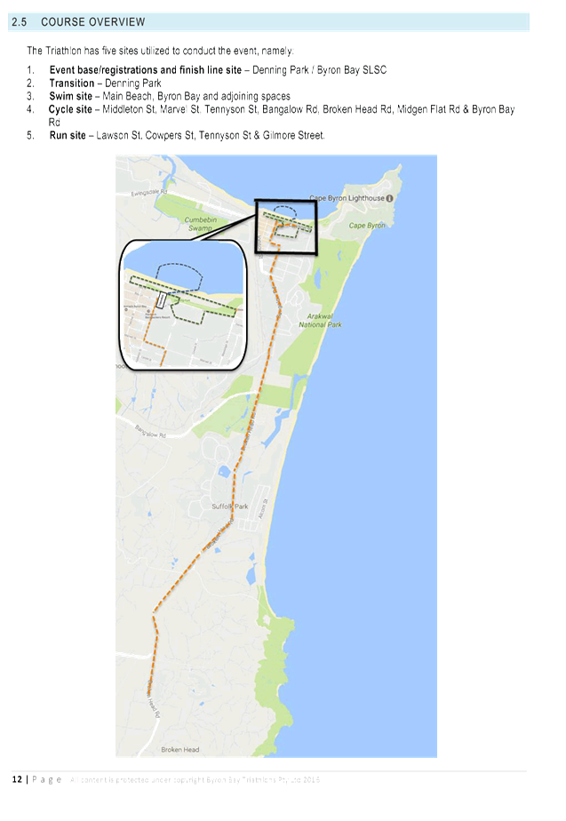
Figure 1. Road
Closures and timings
|
RECOMMENDATION:
1. That
Council approve the Byron Bay Triathlon to be held in Byron Bay on Saturday
13 May 2017, that includes the temporary road closure below:
a)
Lawson Street (Middleton Street to
Massinger St), between 11:30am and 3:30pm on Saturday 13 May 2017.
b)
Marvell Street, Middleton Street , Bay
Street (Fletcher St to Middleton St), Bay Ln (Fletcher St to Middleton St),
Marvell St (Middleton St to Tennyson St), Tennyson St, between 12:00pm and
3:30pm on Saturday 13 May 2017.
c)
Bangalow Road (Browning St to Broken
Head Rd), between 12:25pm and 3:30pm on Saturday 13 May 2017.
d) Broken
Head Road (Bangalow Rd to Ross Lane), between 1:00pm and 3:30pm on Saturday
13 May 2017.
2. That
the approval provided in Part 1 is subject to:
a)
separate approvals by NSW Police
and RMS being obtained, noting that the event is on a state road or may
impact the state road network;
b)
implementation of the approved
Traffic Management Plan and Traffic Control Plan, including the use of signed
detours, as designed and implemented by those with appropriate accreditation;
c)
that the impact of the event be
advertised via a notice in the local weekly paper a minimum of one week prior
to the operational impacts taking effect, noting it must include the event
name, specifics of any traffic impacts or road closures and times,
alternative route arrangements, event organiser, a personal contact name and
a telephone number for all event related enquiries or complaints.
d)
the event be notified on
Council’s webpage.
e)
the event organiser:
i. undertake
consultation with community and affected businesses including adequate
response/action to any raised concerns.
ii. undertake
consultation with emergency services and any identified issues addressed.
iii. holding
$20m public liability insurance cover which is valid for the event.
iv. paying
Council’s Road Event Application Fee prior to the event.
|
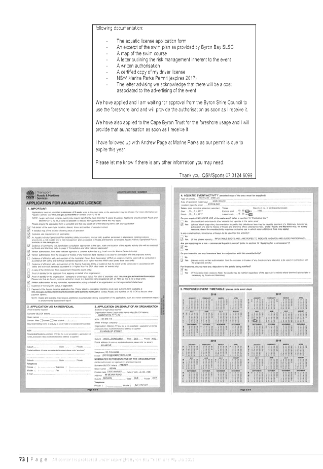
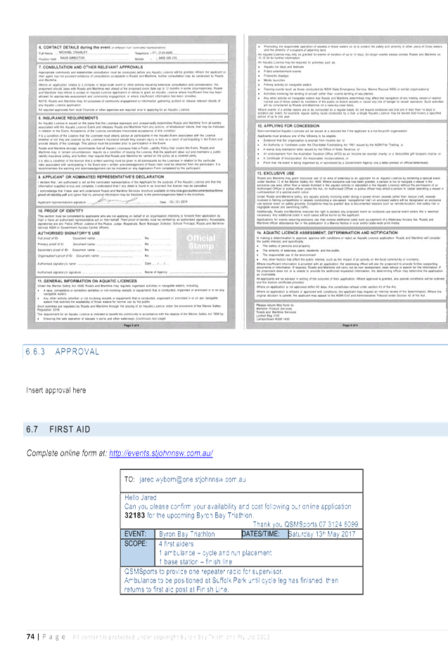
Attachments:
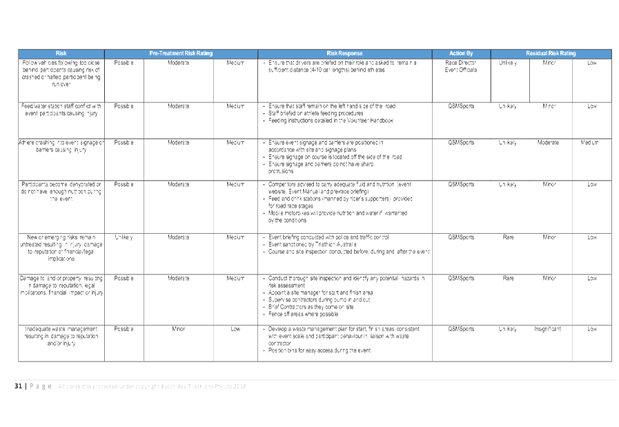
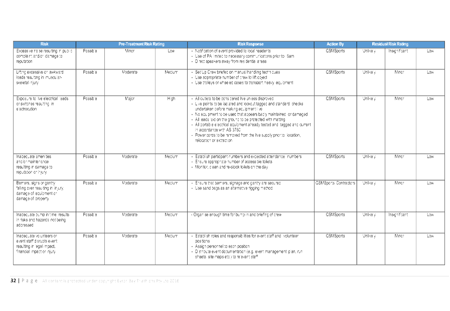
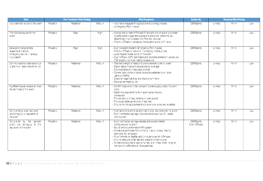
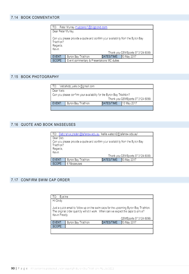
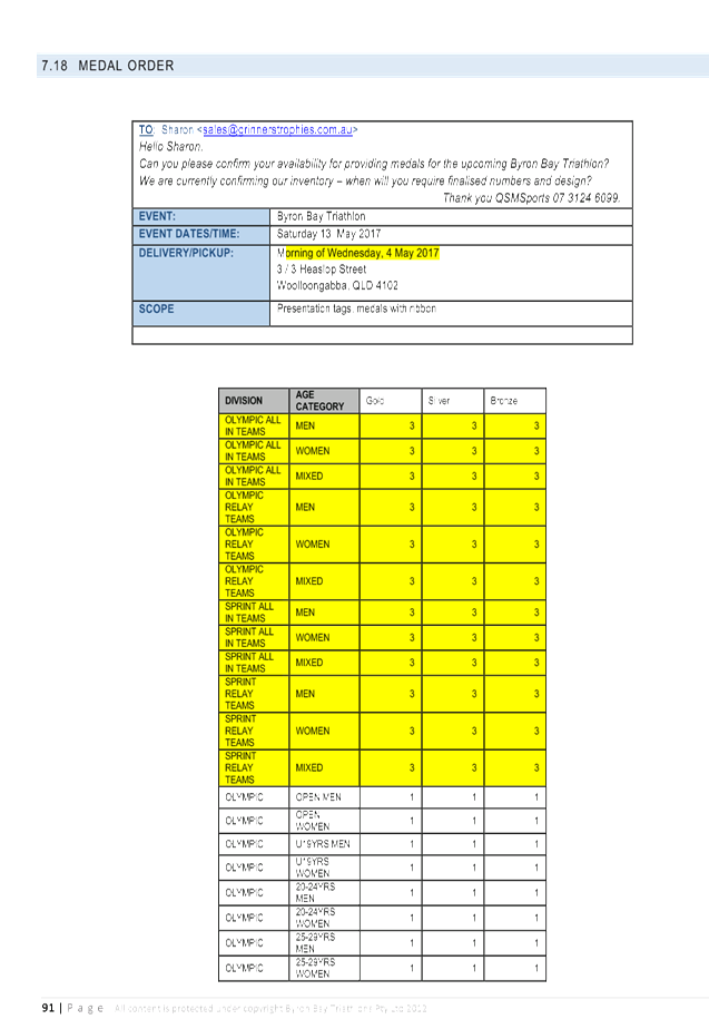
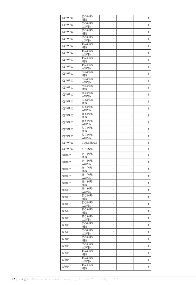
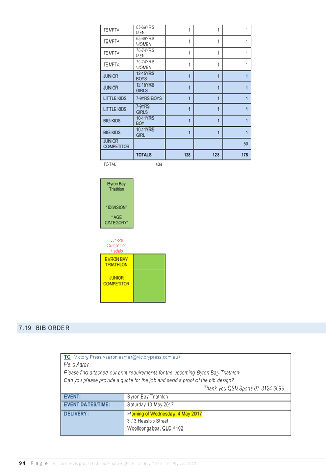
1 Traffic -
Events - Byron Bay Triathlon 2017 - TCP, E2017/8842
, page 30⇩ 
2 Traffic -
Events - Byron Bay Triathlon 13 May 2017 - TMP, E2017/8929 , page 44⇩ 
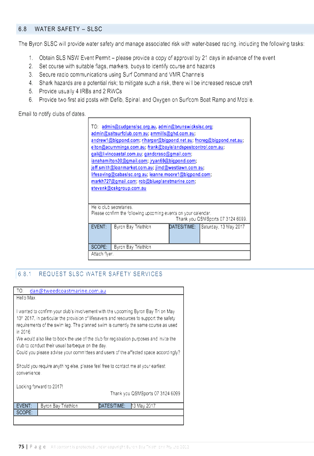
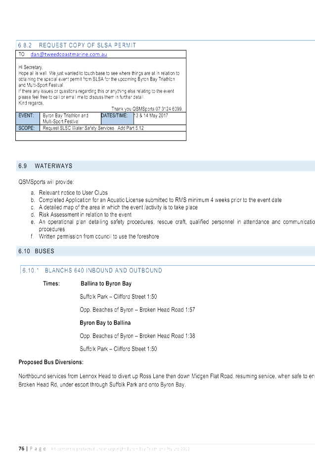
3 Traffic -
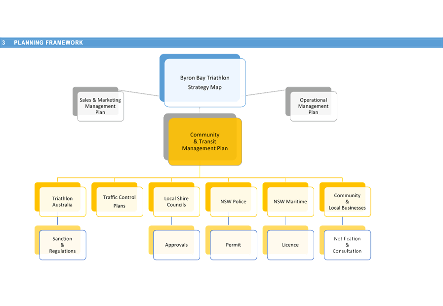
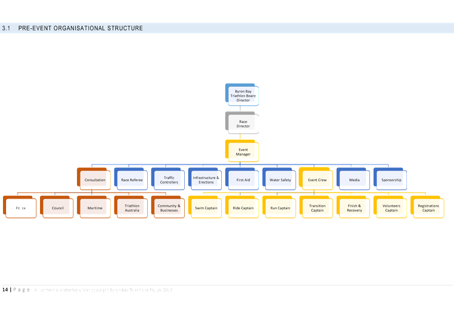
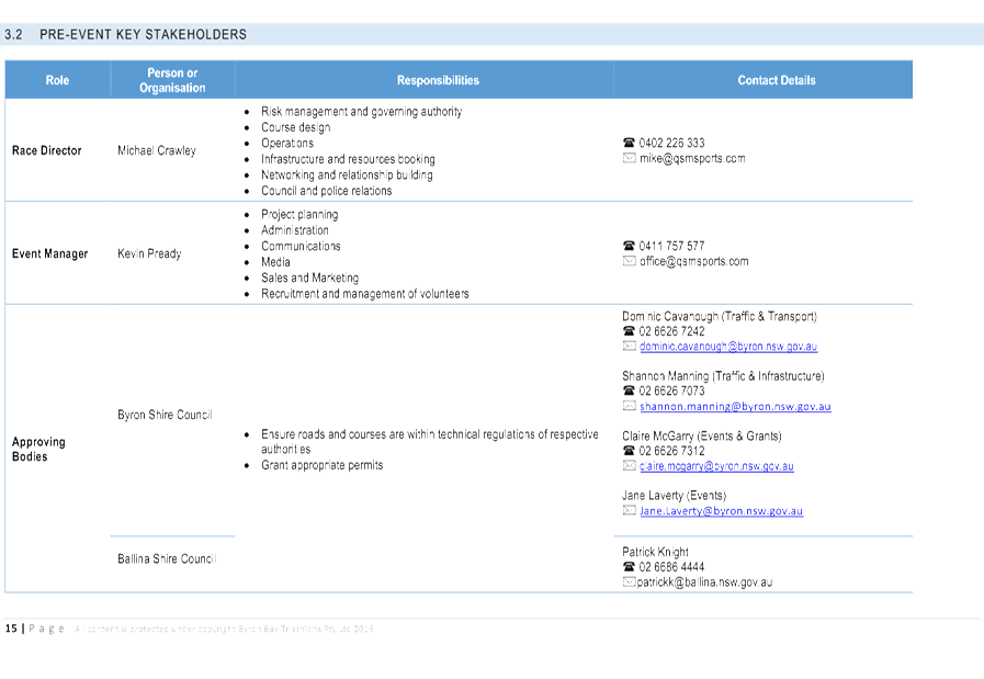
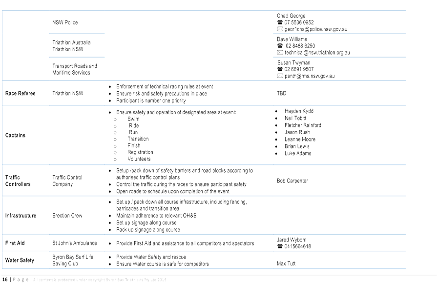
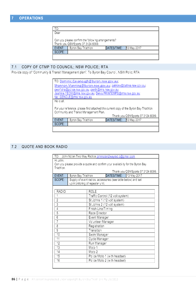
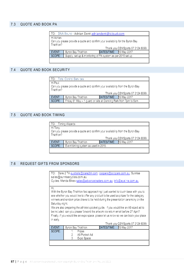
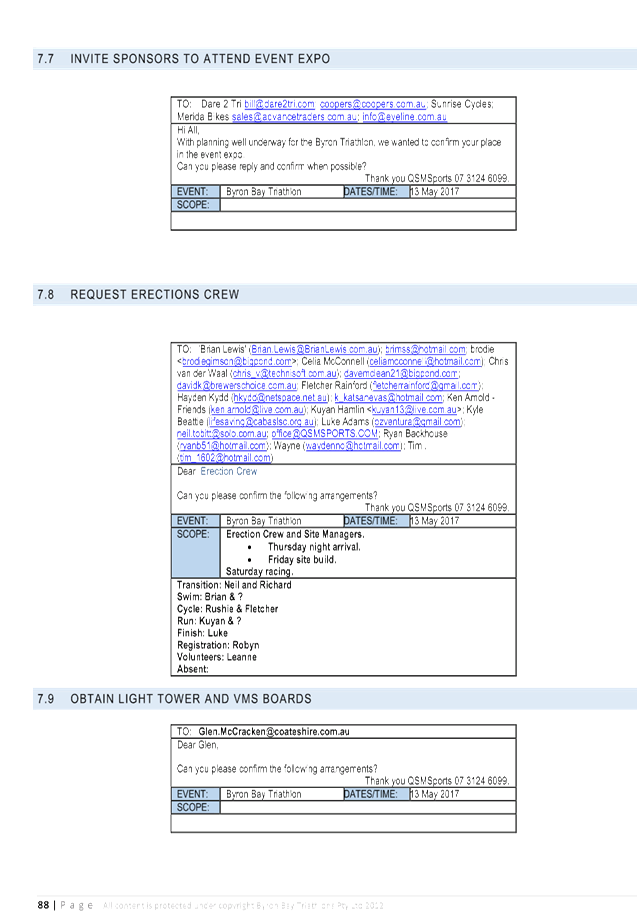
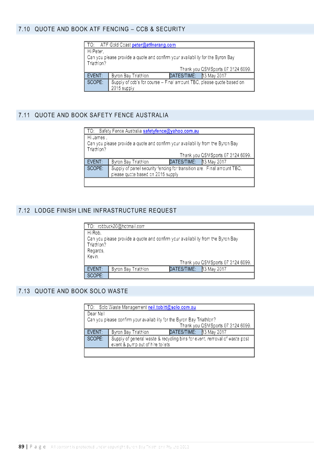
Events - BBT17 - Community and Transit Managmenet Plan, E2017/9005 , page 46⇩
Matters for Traffic Engineering Advice 7.2 - Attachment 1
Matters for Traffic Engineering Advice 7.2 - Attachment 2
Matters for Traffic Engineering Advice 7.2 - Attachment 3

Matters for Traffic Engineering Advice 7.2 - Attachment 3
Matters for Traffic Engineering Advice 7.2 - Attachment 3

Matters for Traffic Engineering Advice 7.2 - Attachment 3
Matters for Traffic Engineering Advice 7.2 - Attachment 3
Matters for Traffic Engineering Advice 7.2 - Attachment 3
Matters for Traffic Engineering Advice 7.2 - Attachment 3


Local Traffic Committee Meeting 7.3
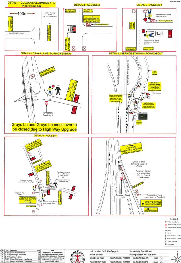
Report No. 7.3 Traffic - Events - Byron Bay Blues Festival 13 to 17 April 2017
File No: I2017/162
SUMMARY
Council has received an event application and draft Traffic
Management Plan (TMP) and Traffic Control Plan (TCP) for Byron Bay Bluesfest
2017 to be held on Thursday 13 April 2017 to Monday 17 April 2017.
OFFICER RECOMMENDATION
That Council endorse the Byron Bay Bluesfest 2017 to be held
on Thursday 13 April 2017 to Monday 17 April 2017, that includes the including
the installation and enforcement of No Camping and No Stopping signs between
6am and 6pm, subject to conditions at:
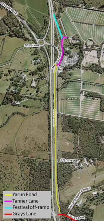
a) Gulgan
Road, from Mullumbimby Road intersection to the Pacific Highway interchange at
Tyagarah;
b) Foxs
Lane, Tyagarah;
c) Tanner
Lane and Yarin Lane, Tyagarah and
d) Grays
Lane, Tyagarah
LINKAGE TO OUR COMMUNITY STRATEGIC PLAN
|
Theme
|
Economy
|
A sustainable and diverse economy
which provides innovative employment and investment opportunities in harmony
with our ecological and social aims.
|
|
Objective
|
EC1
|
A diverse economic base and
support for local businesses.
|
|
Strategy
|
EC1.4
|
Support sporting and cultural events in Byron Shire.
|
|
Measures
|
EC1.B
|
Increase the sustainability of events in which Council is
involved.
|
BACKGROUND
Bluesfest is proposing to restrict parking and camping on
Gulgan Road, Foxs Lane, Tanner Lane, Yarin Lane, and Grays Lane between the
times of 6am – 6pm Thursday 13 April 2017 to Monday 17 April 2017 for the
27th annual Byron Bay Bluesfest 2017.
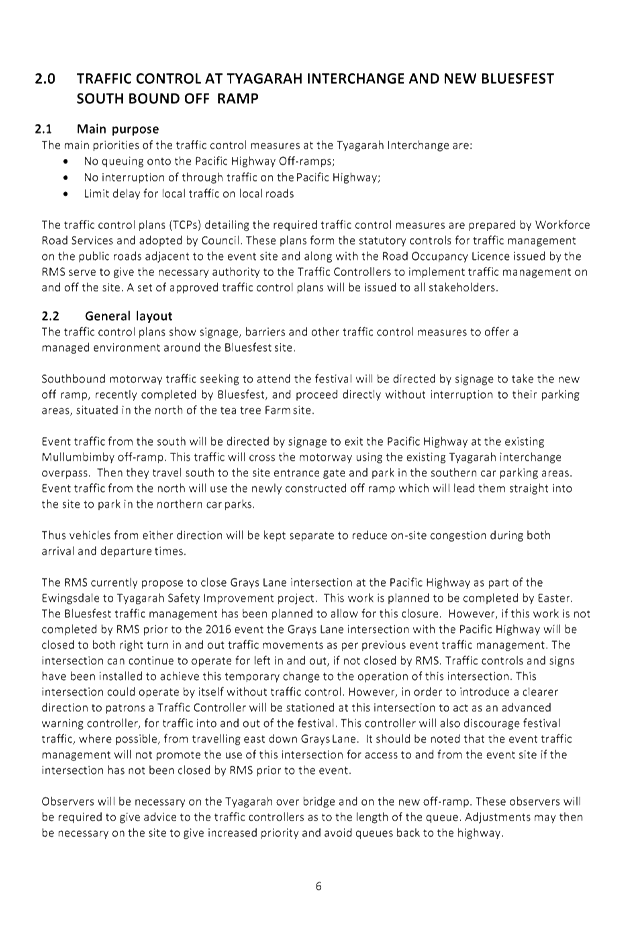
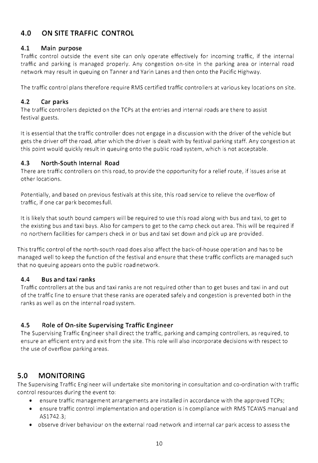
The Traffic Management Plan (TMP) and Traffic Control Plans
(TCP) are the same as 2016.
KEY ISSUES
1. Congestion
caused by the event will directly affect a RMS controlled asset – Pacific
Highway.
2. RMS
Traffic Engineering Department requires to separately approve the TMP and TCP.
COUNCIL IMPLICATIONS
§ Budget/Financial
The event organisers
have been invoiced $356.00 for the relevant Approval of Road Events pursuant to
s144 of the Roads Act fee as per the Fees & Charges 2016/17.
§ Asset Management
Not applicable.
|
§ Policy or Regulation
Speed Limit (as
required) ROAD WORK (R4-212) - Delegated to council for authorisation in
conjunction with NSW Road Rules 21 and AS 1742.4 (Speed Controls) Clause
3.1.2, AS 1742.3 (Roadworks).
§ Consultation
A condition of the
endorsement of this event is that appropriate consultation is undertaken,
including:
1. Advertising
the impact of the event in the local newspaper and on the Council website.
2. Informing
community and business that are directly impacted.
3. Liaising
with bus and taxi operators.
4. Consulting
with emergency services.
§ Legal and Risk Management
Congestion caused by
the event will directly affect a RMS controlled asset – Pacific
Highway. RMS Traffic Engineering Department requires to separately approve
the TMP and TCP.
|
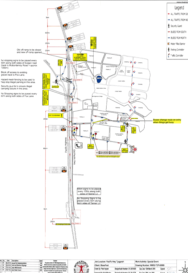
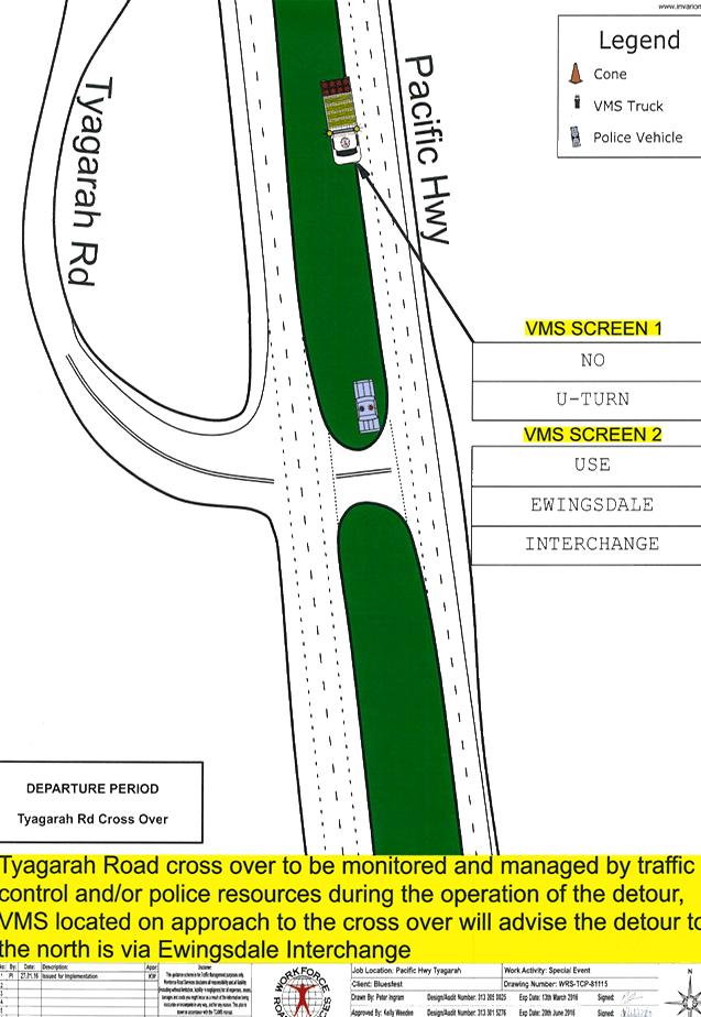
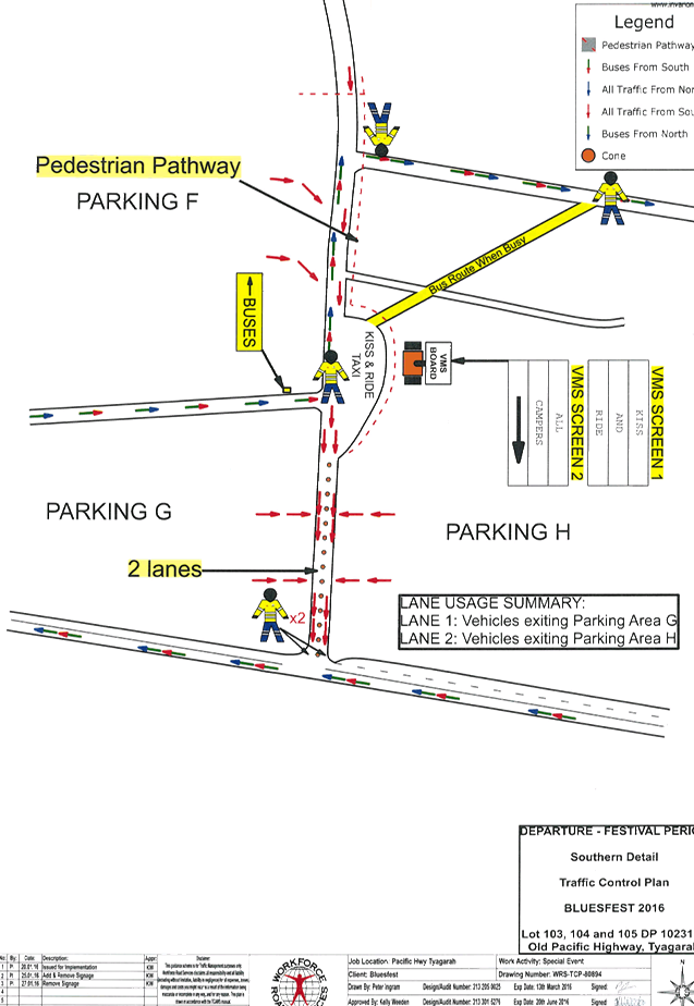
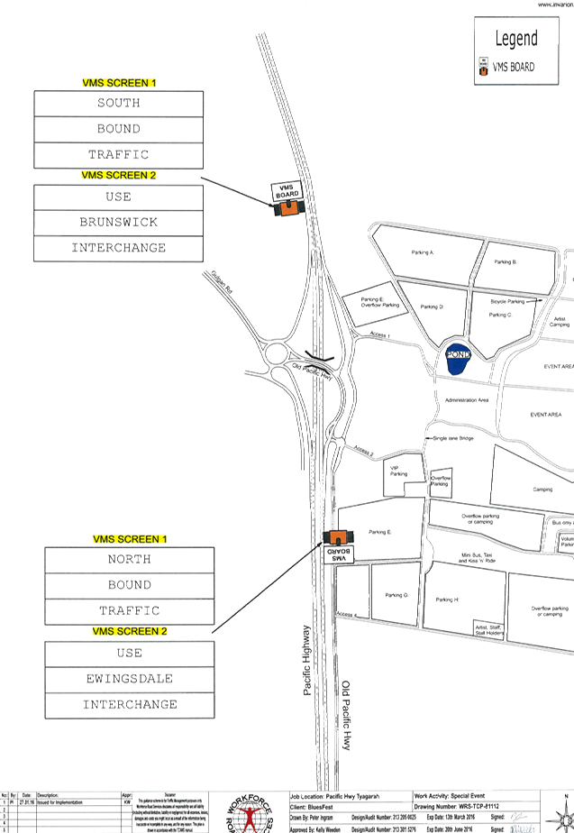
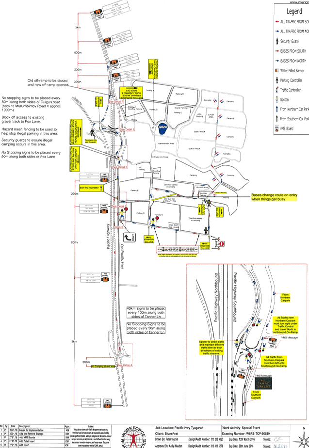
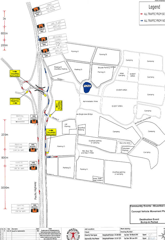
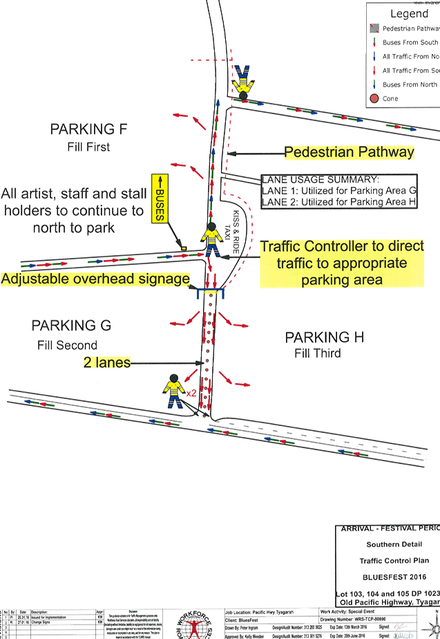
Figure 1.
Roads affected by the event
|
|
RECOMMENDATION:
1. That
Council endorse the Byron Bay Bluesfest 2017 to be held on Thursday 13 April
2017 to Monday 17 April 2017, that includes the including the installation
and enforcement of No Camping and No Stopping signs between 6am and 6pm,
subject to conditions at:
a) Gulgan
Road, from Mullumbimby Road intersection to the Pacific Highway interchange
at Tyagarah
b)
Foxs Lane, Tyagarah
c)
Tanner Lane and Yarin Lane, Tyagarah and
d)
Grays Lane, Tyagarah
2. That
the approval provided in Part 1 is subject to:
a)
separate approvals by NSW Police and RMS being
obtained, noting that the event is
on a state road or may impact the state road network
b) implementation
of the approved Traffic Management Plan and Traffic Control Plan,
including the use of signed detours, as designed and implemented by those
with appropriate accreditation
c) that
the impact of the event be advertised via a notice in the local weekly paper
a minimum
of one week prior to the operational impacts taking effect, noting it must
include the event name, specifics of any traffic impacts or road closures and
times, alternative route arrangements, event organiser, a personal contact name
and a telephone number for all event related enquiries or complaints
d) the
event be notified on Council’s webpage
e) the
event organiser:
i. undertake
consultation with community and affected businesses including adequate
response/action to any raised concerns
ii. undertake
consultation with emergency services and any identified issues addressed
iii. hold
$20m public liability insurance cover which is valid for the event
iv. pay
Council’s Road Event Application Fee prior to the event
|
Attachments:
1 Traffic -
Events - Blues Fest - TCP 2016, E2016/100289
, page 47⇩
2 Traffic -
Events - Bluesfest - TMP 2016, E2016/100290
, page 47⇩
3 Traffic -
Events - Byron Bay Bluesfest 2017 - TMP checklist, E2017/9094 , page 47⇩
Matters for Traffic Engineering Advice 7.3 - Attachment 1
Matters for Traffic Engineering Advice 7.3 - Attachment 2

Matters for Traffic Engineering Advice 7.3 - Attachment 3
|
Table 1. TMP performa
|
|
Question
|
Response (If no, state your
reasons why)
|
|
A. Description
or detailed plan of proposed measures.
Is a detailed plan
of the proposed measures necessary?
|
Event Name
|
Byron Bay
Bluesfest 2017
|
A.
Organiser Name |
Bluesfest
Services Pty Ltd
|
A.
Traffic Control |
TBA
|
A.
Date(s) |
Thursday
13 April 2017 to Monday 17 April 2017
|
A.
Times |
06:00
Thursday – 18:00 Monday
|
A.
Roads affected |
a) Gulgan Road,
from Mullumbimby Road intersection to the Pacific Highway interchange at
Tyagarah;
b) Foxs Lane,
Tyagarah;
c) Tanner Lane
and Yarun Rd, Tyagarah and
d) Grays Lane,
Tyagarah
|
A.
Detours in place |
Nil
|
A.
Parking |
On site
only
|
A.
Other |
N/A
|
|
B. Identification
and assessment of impact of proposed measures.
Is a detailed
assessment required?
|
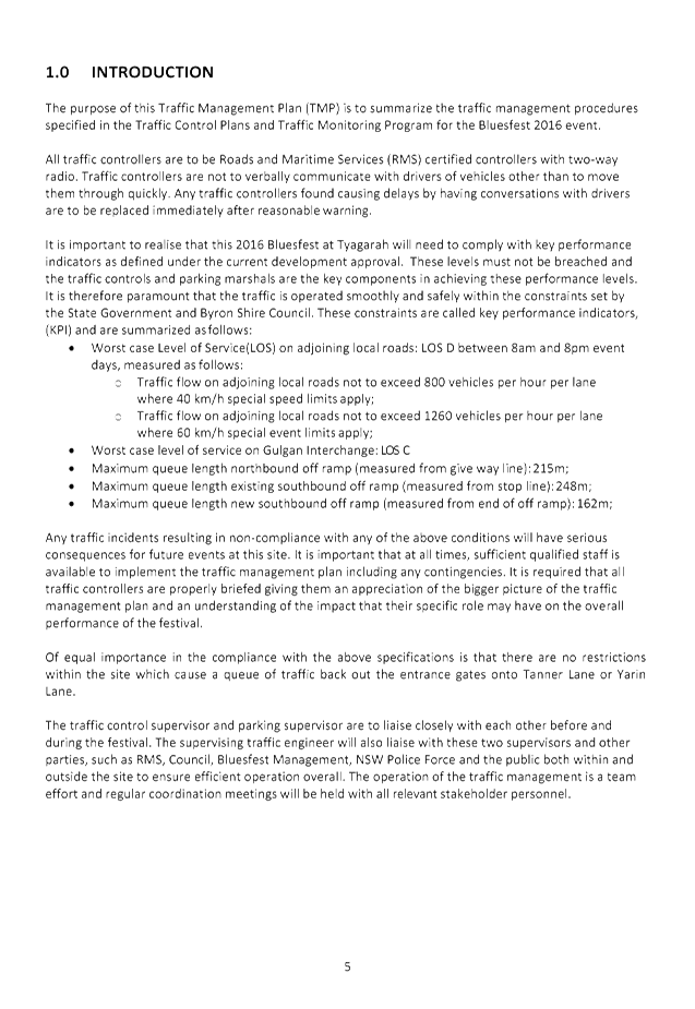
TMP 1.0 INTRODUCTION
It
is important to realise that this 2017 Bluesfest at Tyagarah will need to
comply with key performance indicators as defined under the current
development approval. These levels must not be breached and the traffic
controls and parking marshals are the key components in achieving these
performance levels. It is therefore paramount that the traffic is operated
smoothly and safely within the constraints set by the State Government and
Byron Shire Council. These constraints are called key performance indicators,
(KPI) and are summarized as follows:
- Worst case Level of Service(LOS)
on adjoining local roads: LOS D between 8am and 8pm event days, measured as
follows:
- Traffic flow on adjoining local
roads not to exceed 800 vehicles per hour per lane where 40 km/h special
speed limits apply;
- Traffic flow on adjoining local
roads not to exceed 1260 vehicles per hour per lane where 60 km/h special
event limits apply;
- Worst case level of service on
Gulgan Interchange: LOS C
- Maximum queue length northbound
off ramp (measured from give way line): 215m; Maximum queue length
existing southbound off ramp (measured from stop line): 248m;
- Maximum queue length on southbound
off ramp (measured from end of off ramp): 162m;
|
|
C. Measures
to ameliorate the impact of re-assigned traffic
Is an assessment
required?
|
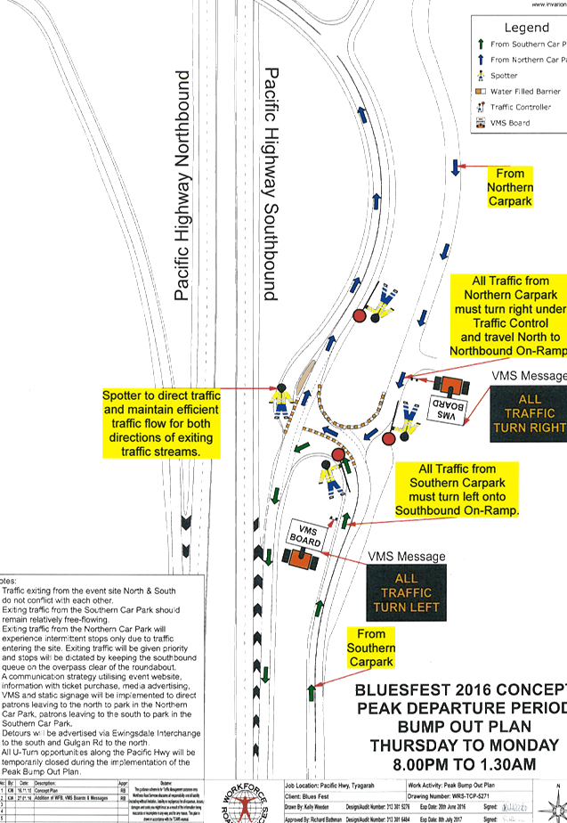
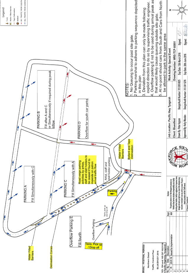
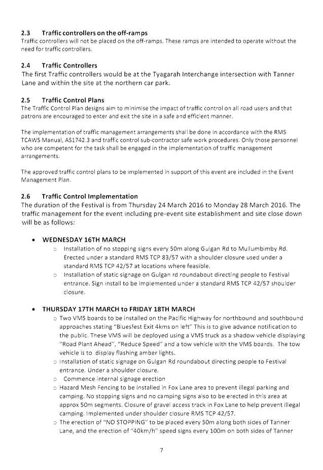
2.5 Traffic Control Plans
The
Traffic Control Plan designs aim to minimise the impact of traffic control on
all road users and that patrons are encouraged to enter and exit the site in
a safe and efficient manner.
The
implementation of traffic management arrangements shall be done in accordance
with the RMS
TCAWS
Manual, AS1742.3 and traffic control sub-contractor safe work procedures.
Only those personnel who are competent for the task shall be engaged in the
implementation of traffic management arrangements.
The
approved traffic control plans to be implemented in support of this event are
included in the Event
Management
Plan.
|
|
D. Assessment
of public transport services affected.
Is an assessment
required?
|
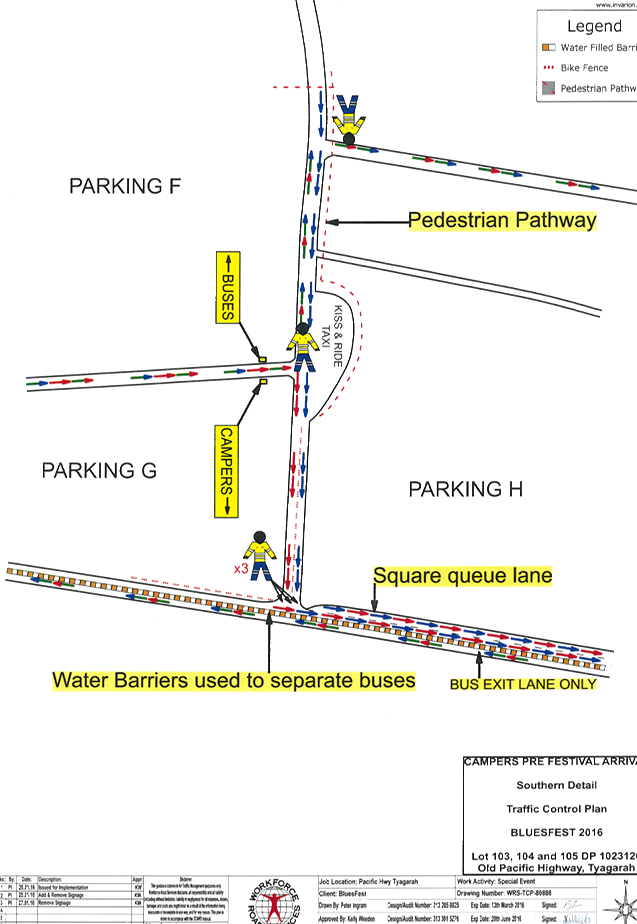
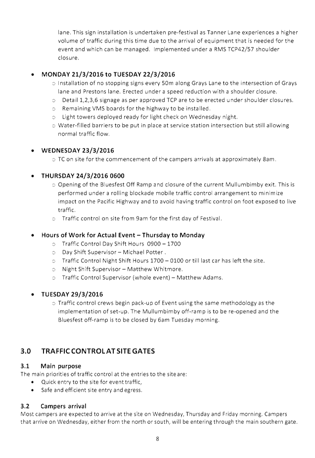
TMP 3.4 Buses
All
buses and Taxis are to use the southern main entry and exit. There will be no
Kiss & Ride facility in the northern area of the event site.
|
|
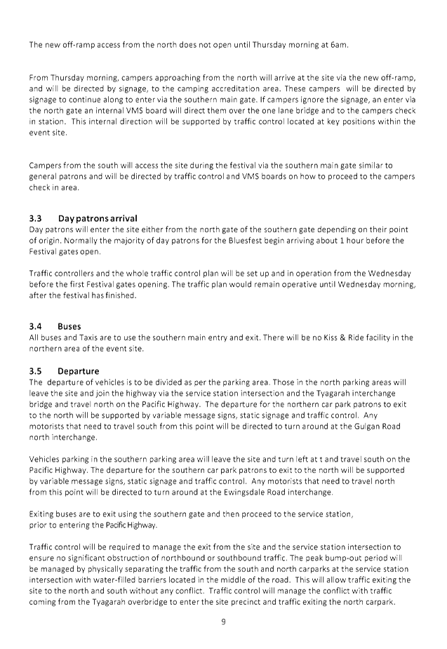
E. Details
of provision made for emergency vehicles, heavy vehicles, cyclists and
pedestrians.
Are these details
required?
|
Emergency
|
All
emergency vehicles leave by access 2 road “2 Tanner Lane”. On the
TCP, access 2 road is the emergency vehicle access road.
|
A.
Heavy Vehicles |
There
is no heavy vehicle movement during gate open hours.
The
use of the water car, waste management and sewage treatment vehicles does not
affect traffic as it is conducted at off peak ingress and egress time.
|
A.
Cyclist |
Cyclists
can enter through the north and south entrance. There are marked bike lock
ups for their bikes.
|
A.
Pedestrians |
Pedestrian
traffic comes through the southern entrance and they follow the lantern lit
pedestrian walkway to the southern entrance of the festival.
|
|
F. Assessment
of effect on existing and future developments with transport implications in
the vicinity of the proposed measures.
Is an assessment
required?
|
There
will be little to no effect on existing & future developments as this is
a temporary event.
|
|
G. Assessment
of effect of proposed measures on traffic movements in adjoining Council
areas.
Is an assessment
required?
|
There
will be little to no effect on traffic movements in adjoining council areas.
|
|
H. Public
consultation process
Is a public
consultation process required
|
We
are currently operating under the DA 10.2008.352.1 where this is not a
requirement. One will be enacted when the new DA 10.2014.753.1 is in
operation.
|
Local Traffic Committee Meeting 8.1
Development Applications
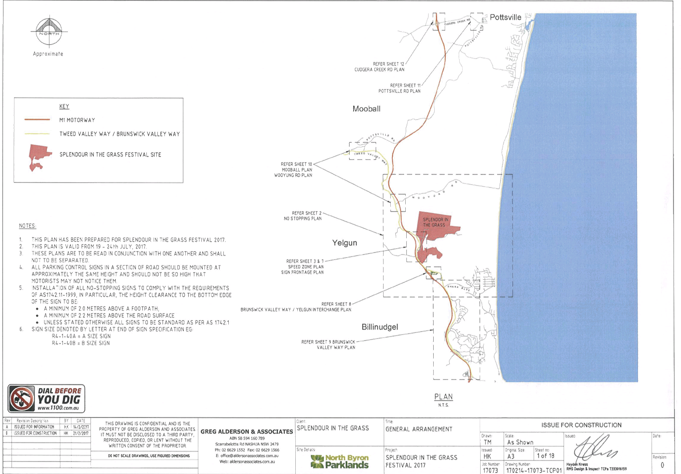
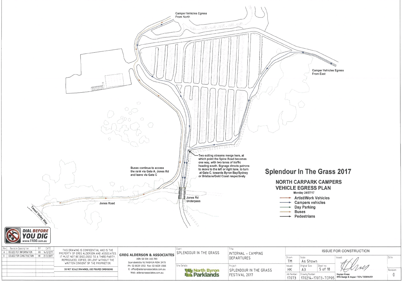
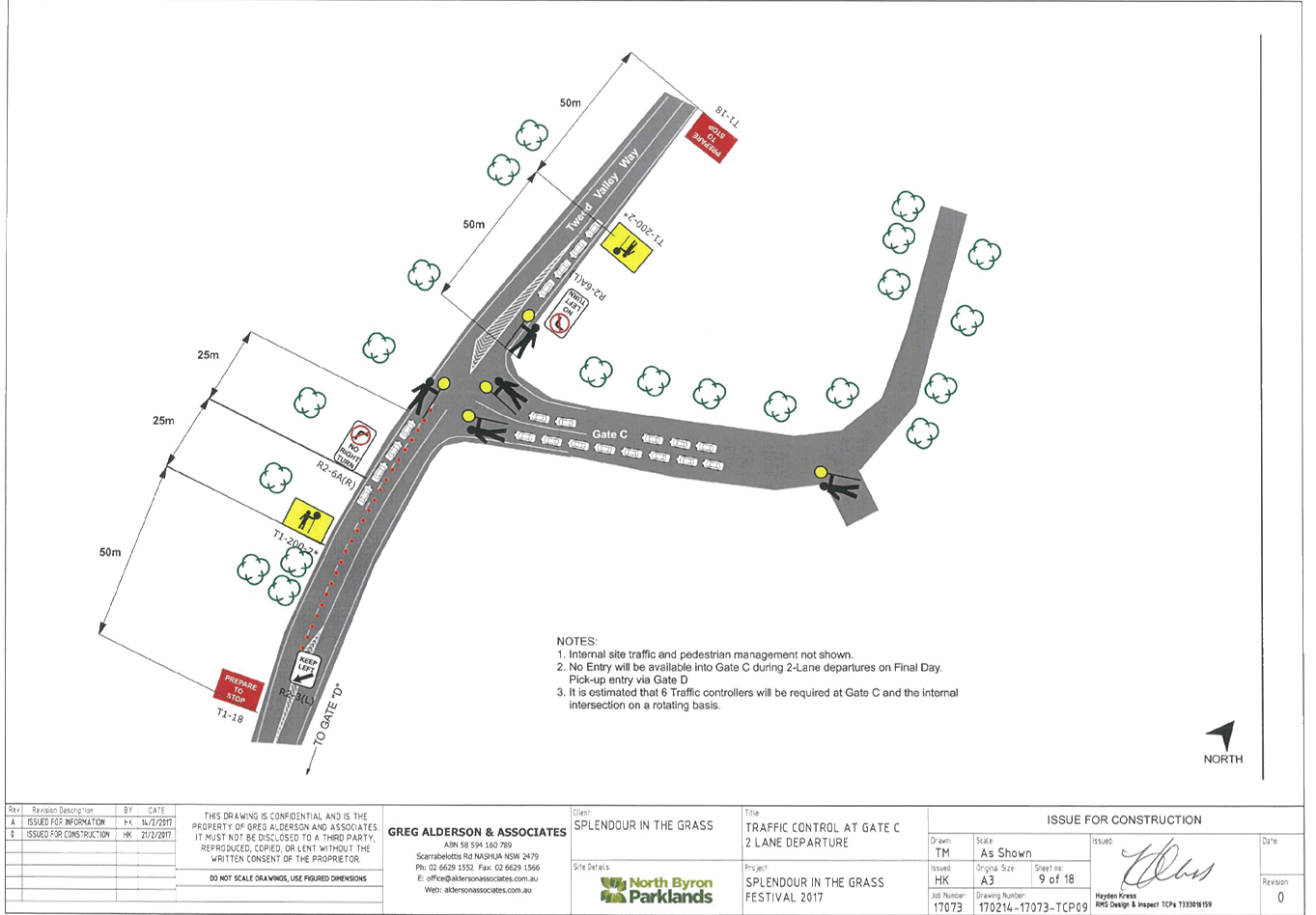
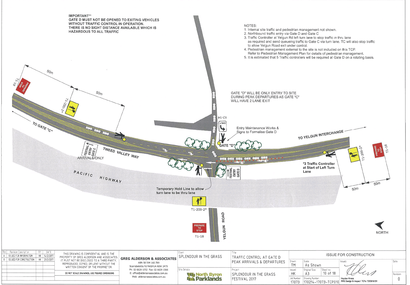
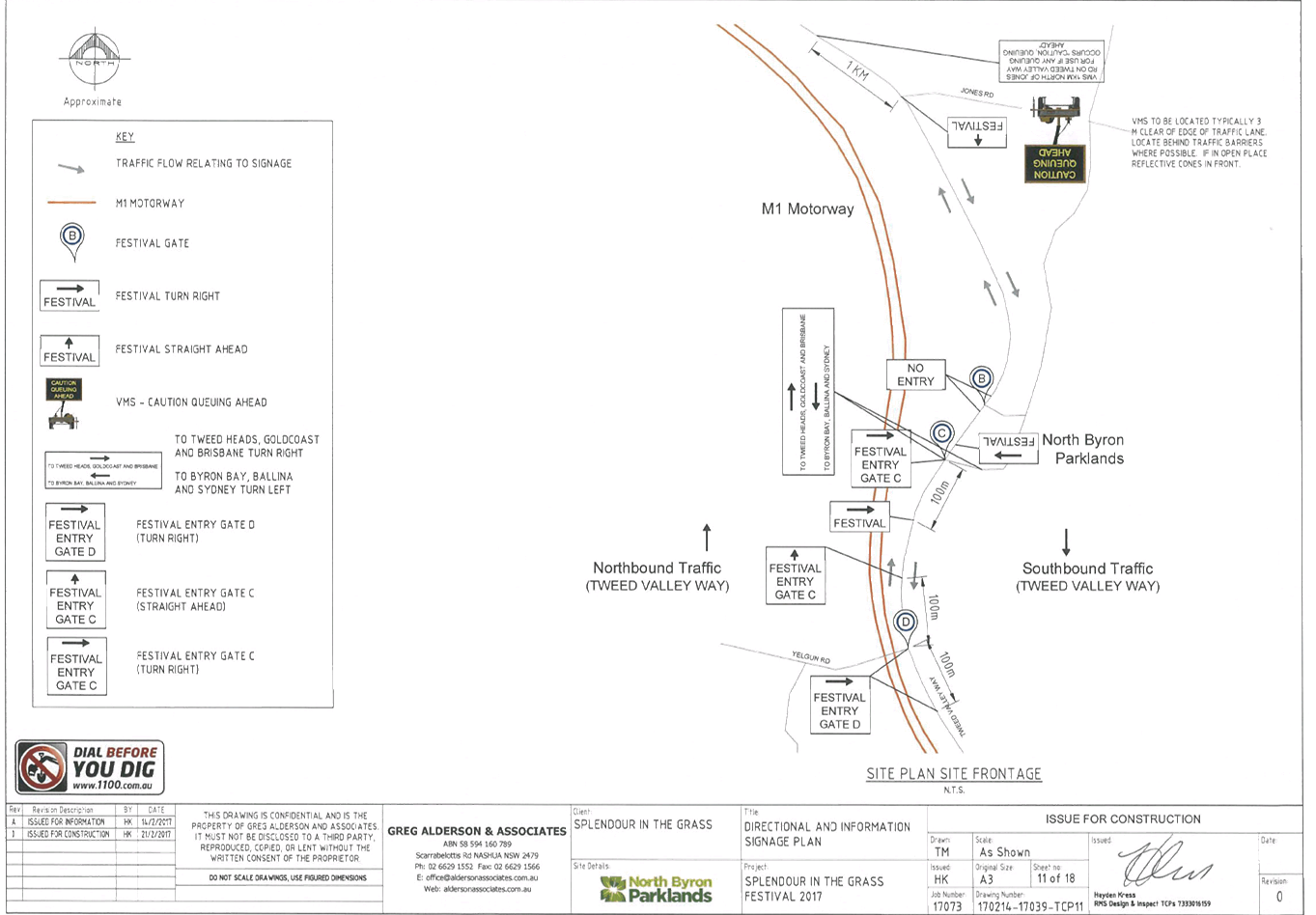
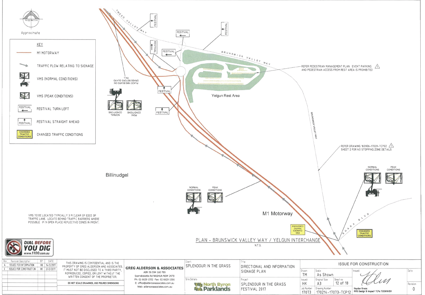
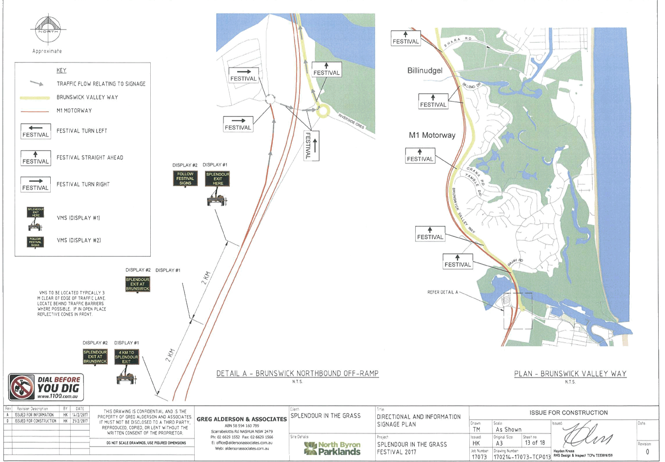
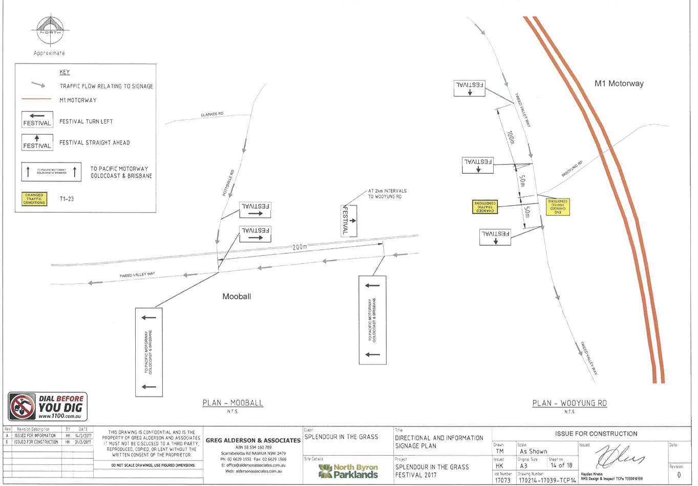
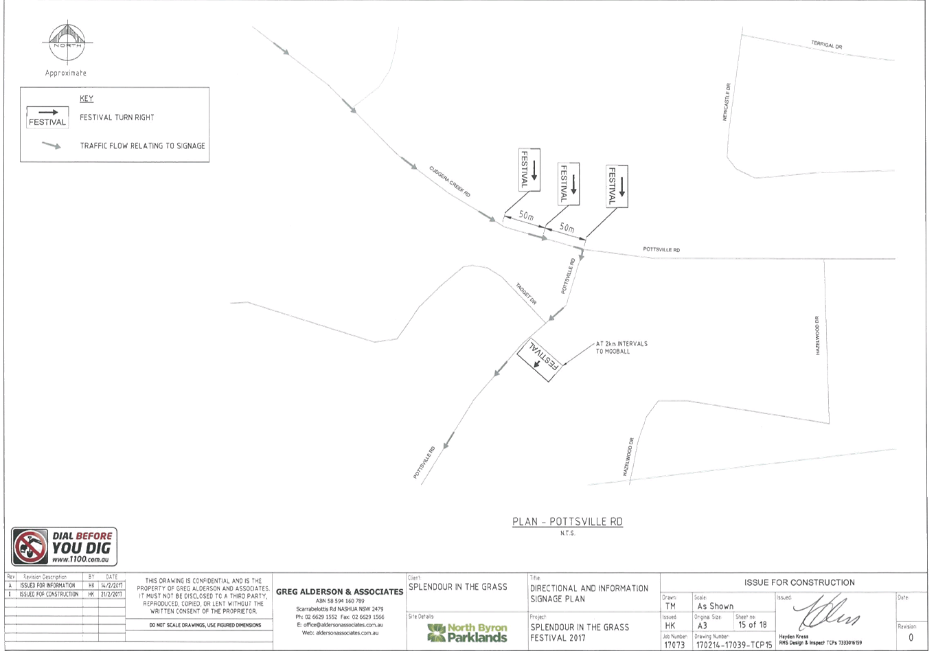
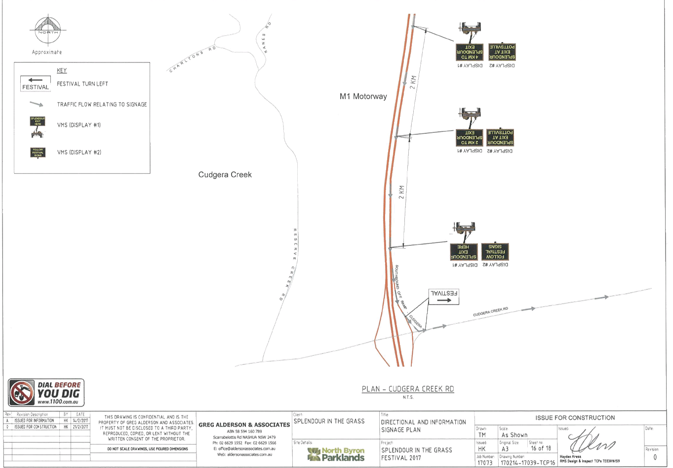
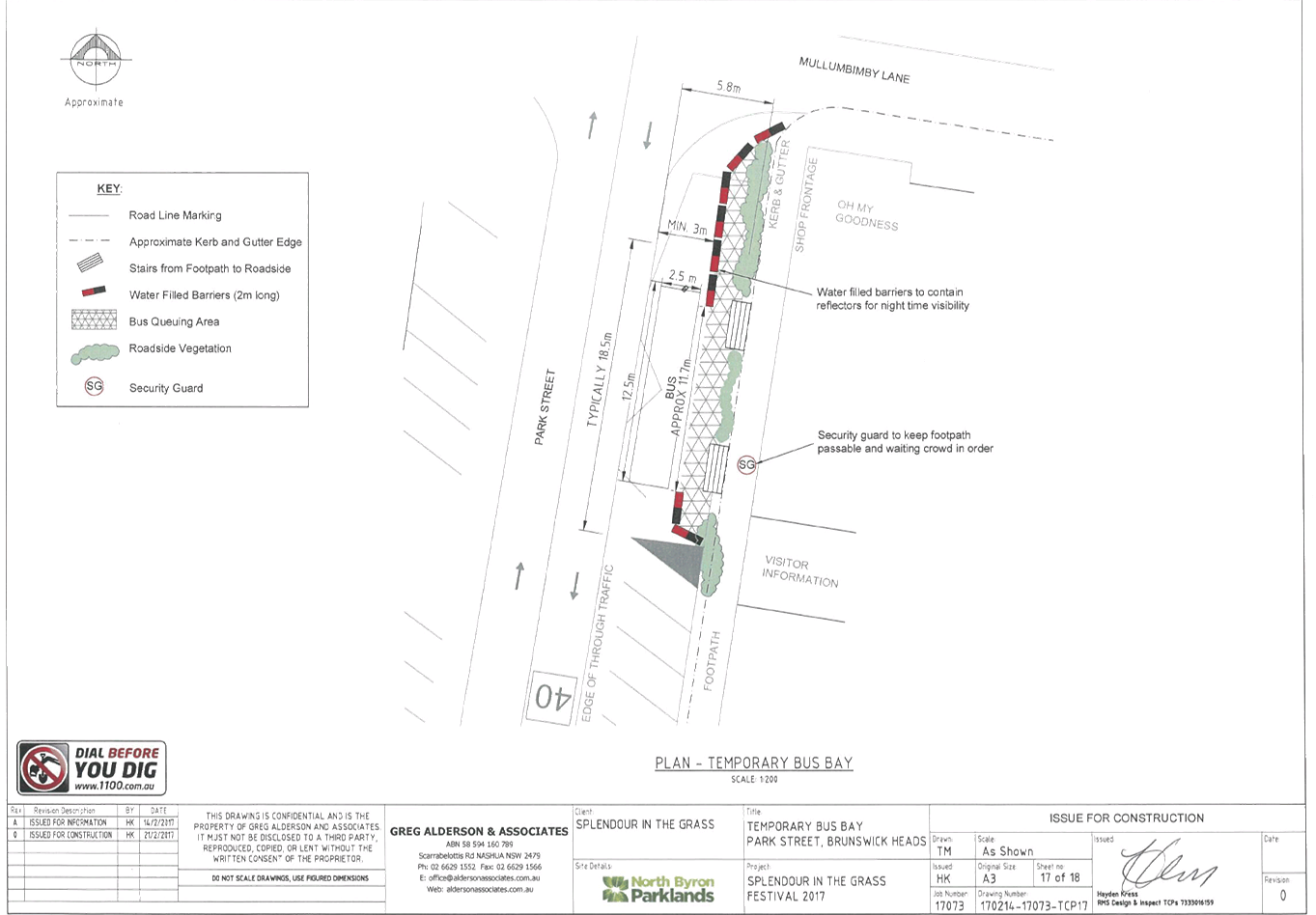
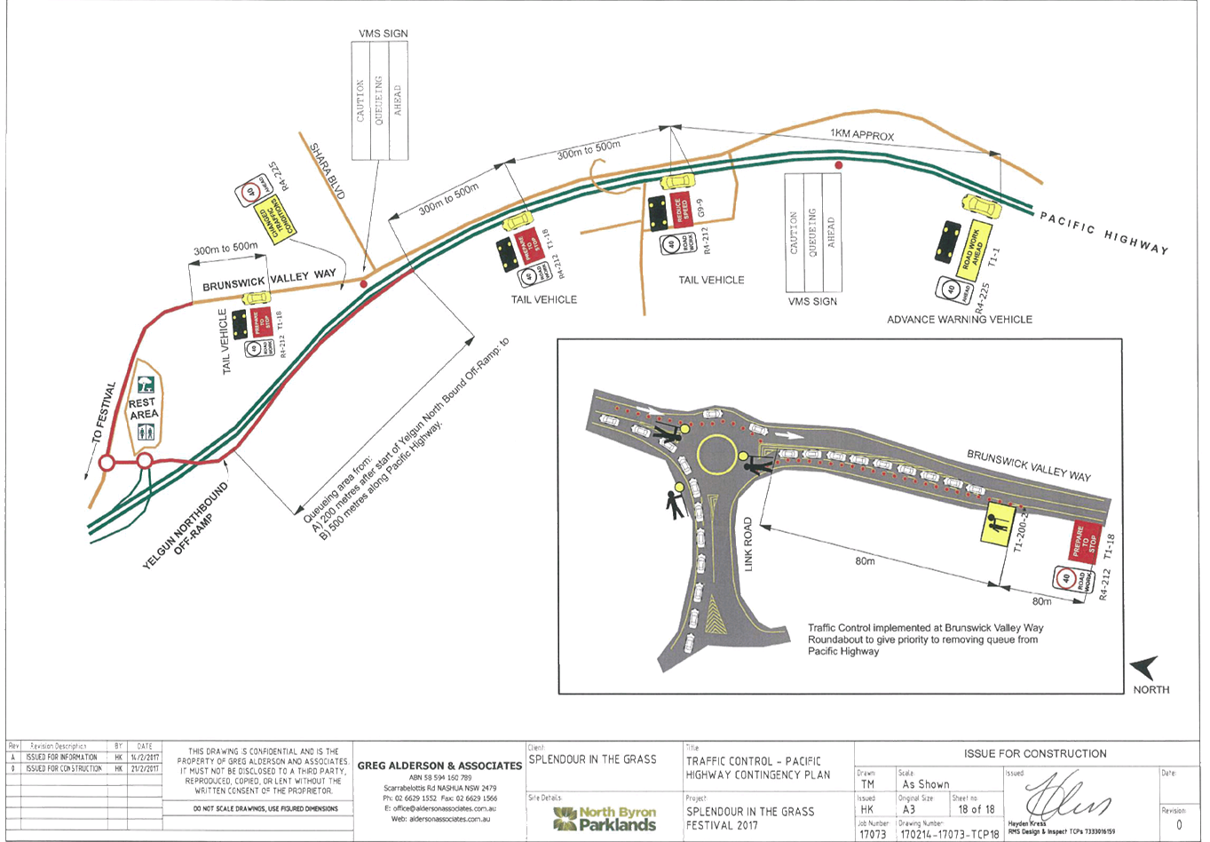
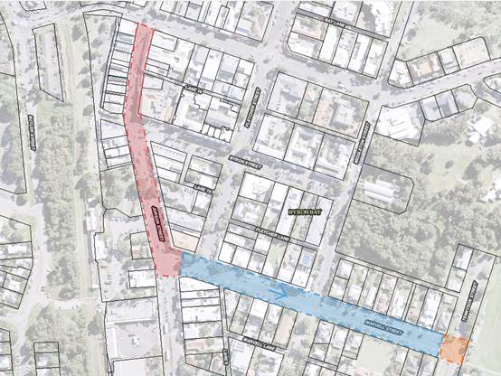
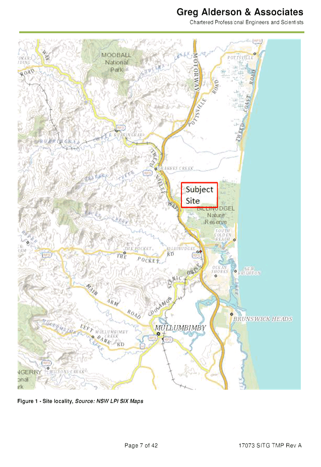
Report No. 8.1 DA - Splendour in the Grass, 21-23 July 2017
File No: I2017/301
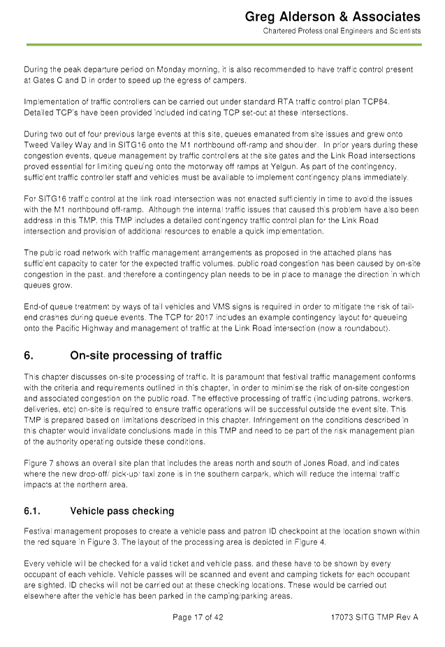
SUMMARY
Council has received an event application, Traffic
Management Plan (TMP) and Traffic Control Plan (TCP) for Splendour in the Grass
(SITG) 2017 to be held on Friday 21 July 2017 to Sunday 23 July 2017.
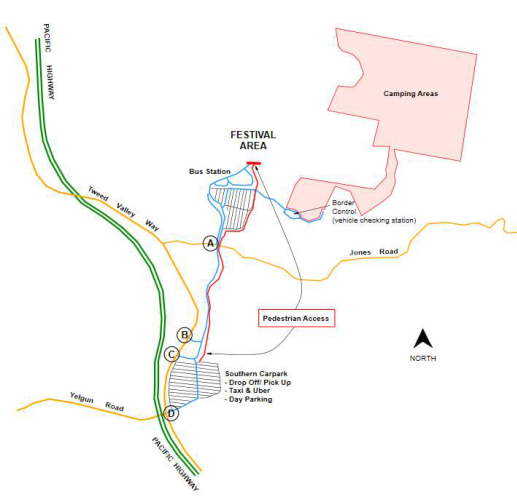
|
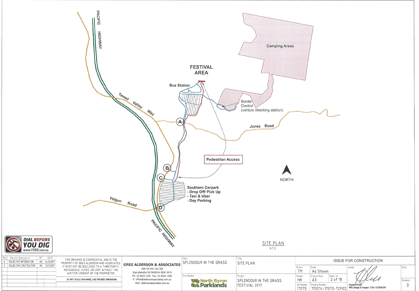
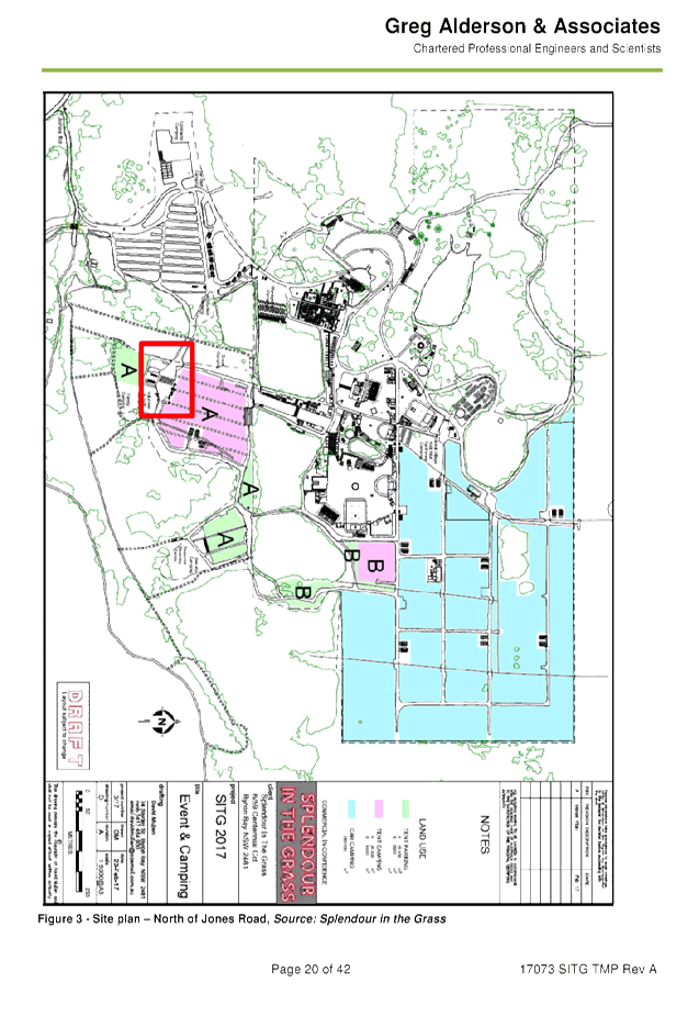
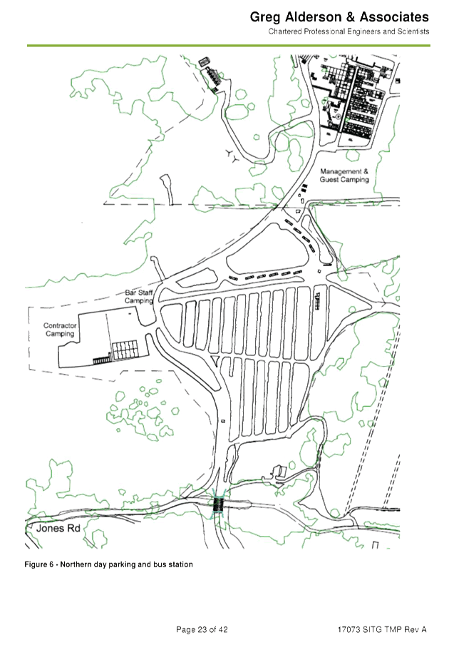
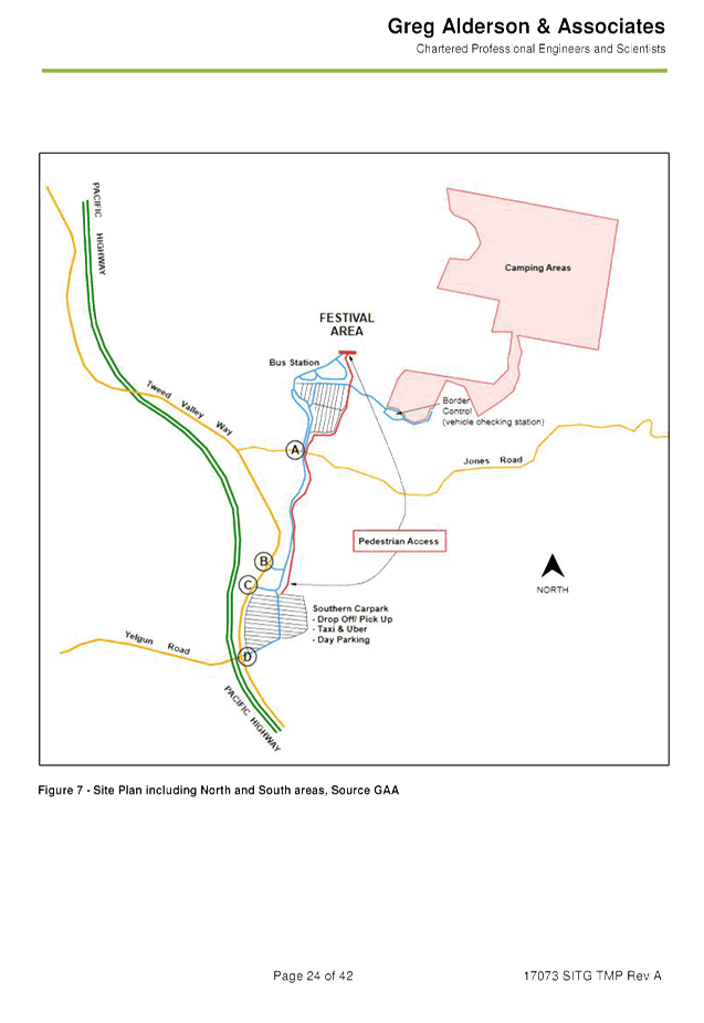
Figure 1.
Splendour in the Grass site map
|
|
|
OFFICER RECOMMENDATION
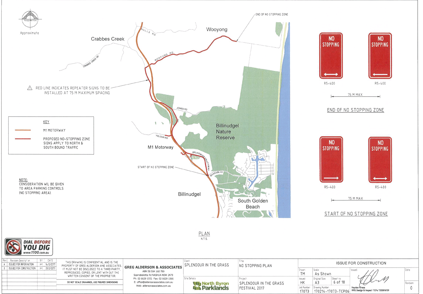
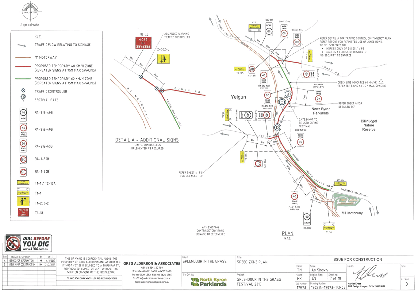
That Council approve the Traffic Management Plan and Traffic
Control Plans for Splendour in the Grass 2017 to be held on Friday 21 July 2017
to Sunday 23 July 2017, that includes the including the installation and
enforcement of No Camping and No Stopping signs between 6am and 6pm, subject to
conditions at:
a) Tweed
Valley Way
b) Brunswick
Valley Way
c) Yelgun
Road
Councils Parking Enforcement be invited to assist the event
in compliance of no stopping areas within the Road Reserve.
LINKAGE TO OUR COMMUNITY STRATEGIC PLAN
|
Theme
|
Economy
|
A sustainable and diverse
economy which provides innovative employment and investment opportunities in
harmony with our ecological and social aims.
|
|
Objective
|
EC1
|
A diverse economic base and
support for local businesses.
|
|
Strategy
|
EC1.4
|
Support sporting and cultural events in Byron Shire.
|
|
Measures
|
EC1.B
|
Increase the sustainability of events in which Council is
involved.
|
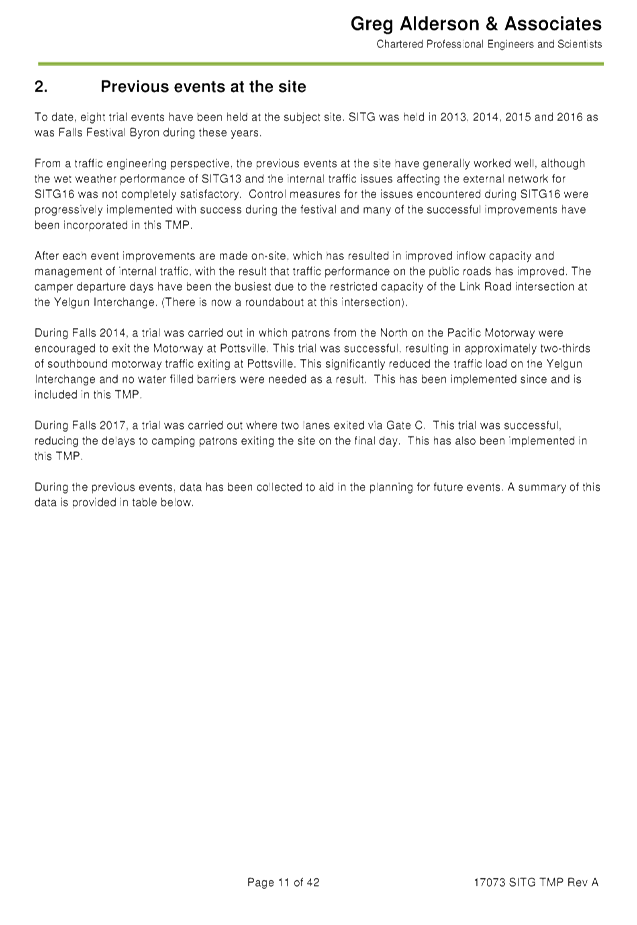
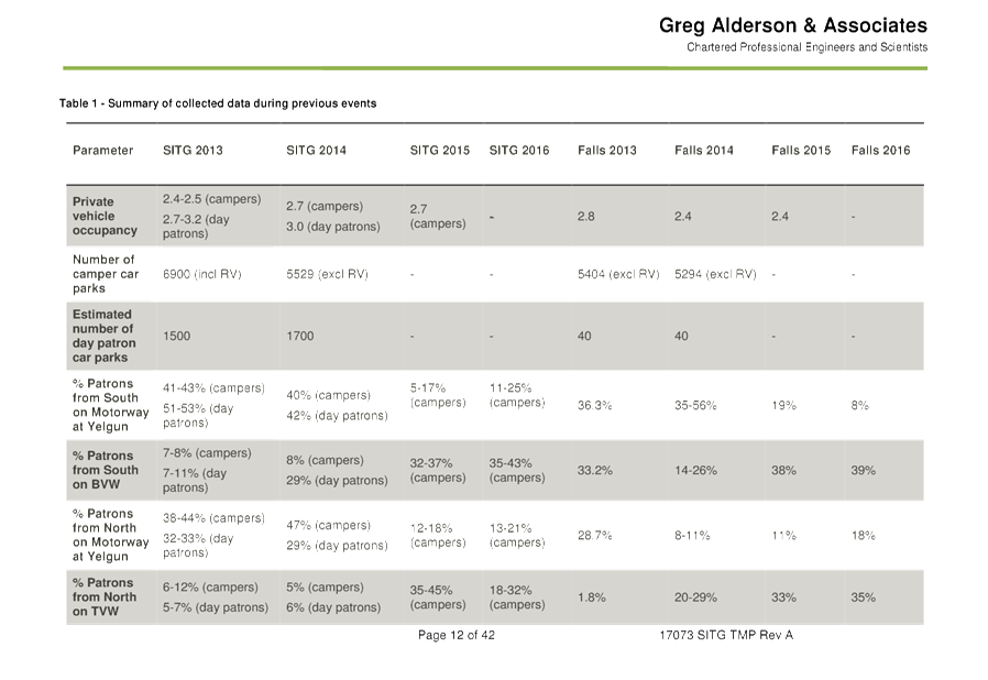
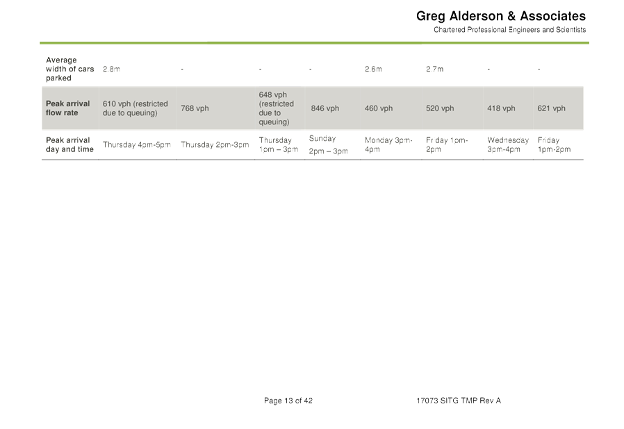
BACKGROUND
Since 2001 Splendour in the Grass has been claimed as the
biggest Winter Australian Music festival.
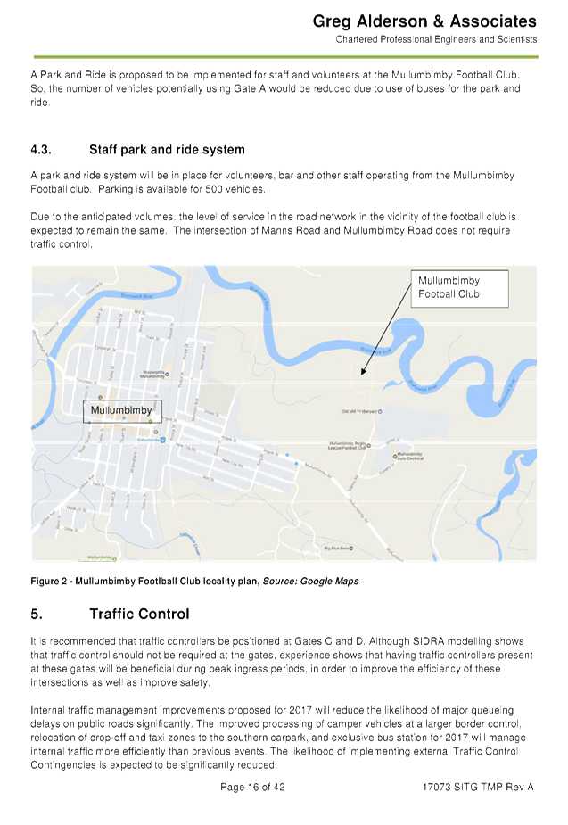
2016 TMP debrief
• Seamless
bump in of all camping patrons (approximately 17,500) on Thursday and Friday;
• The
event did experience a significant modal shift in some day patron’s
travel to and from site reflected in a larger than normal number of people
being dropped off and collected;
• On
Friday traffic cameras and traffic controllers noted upwards of 800 vehicles
entering the site and dropping patrons off at Guest Services in the northern
carpark between 3pm and 6pm;
• These
same vehicles returned between 10.30pm and midnight greatly impacting the
ability for buses to enter and depart the bus turnaround facility;
• This
resulted in long delays to transport patrons offsite;
• A
meeting on Saturday 23rd of July between the event, NSW Police, RMS and traffic
controllers resolved to move the drop-off/pick up zone to the southern carpark
which dramatically improved traffic flows at the end of the show on this day;
• An
additional meeting was on Sunday 24th of July between the event, NSW Police,
RMS and traffic controllers where it was agreed to also move the taxi rank to
the southern carpark;
• As
a result of these changes all traffic patterns were returned to normal on the
Sunday evening;
• SITG
has since held debriefs with RMS and NSW Police and a range of measures will be
implemented in the future including the construction of a permanent drop off
and taxi zone in the southern car park; and
• The
new Council roundabout adjacent to the Yelgun interchange worked well.
• Yasmin
Yeow from RMS asked that pedestrian management should be included in future
TMPs for this event as well as more details on internal traffic movements and
bus routes;
• Yasmin
Yeow asked if there was in incident management room during events. Yasmin was
advised there was and was invited to attend the next event for a tour.
• DN
asked if NIR and Parklands community hotline register report have been
prepared.
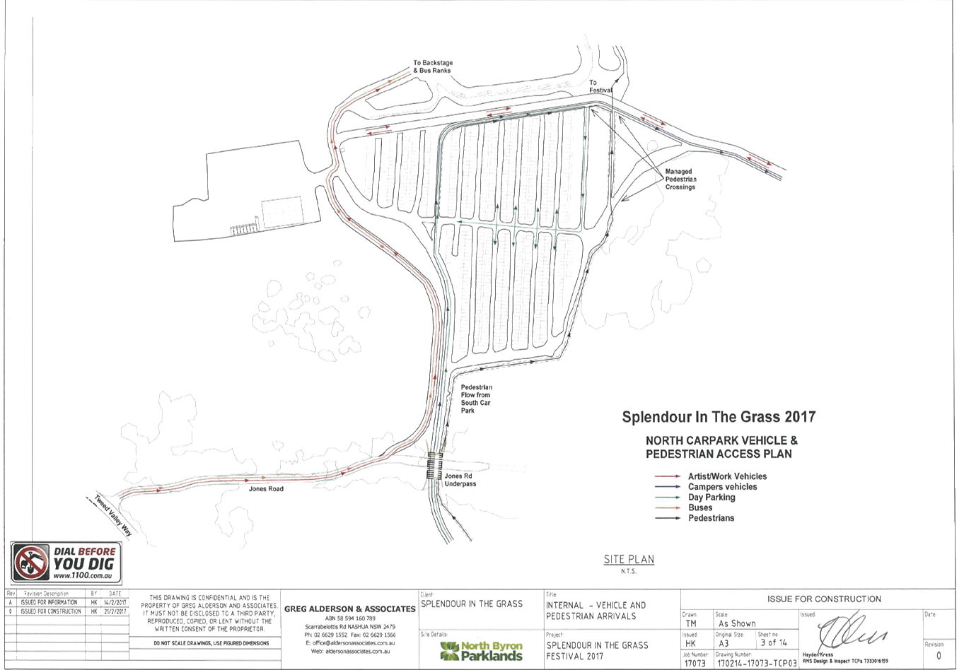
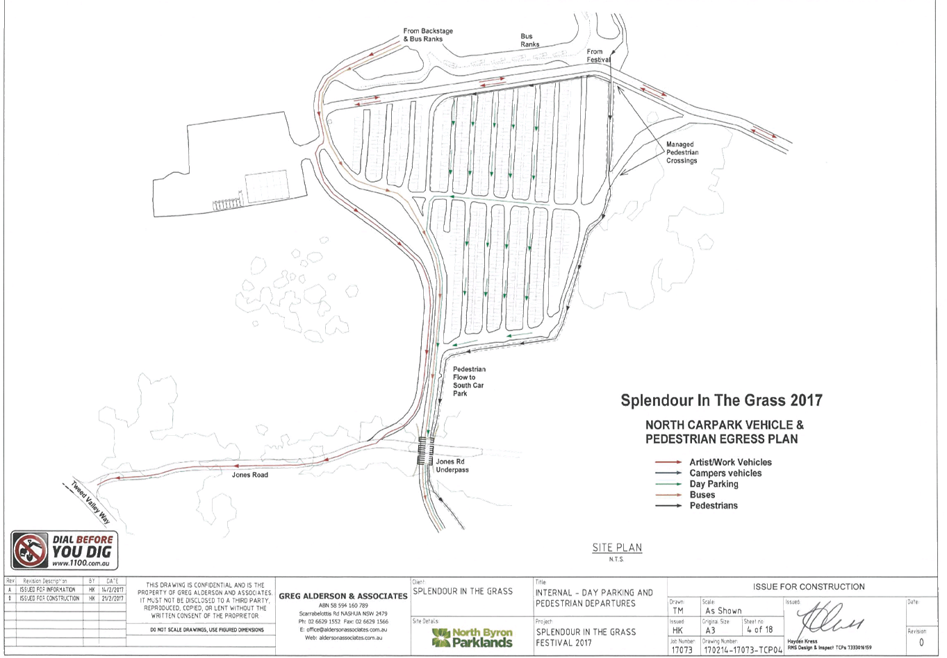
2017 TMP Improvements
• Improvements
made to reduce the likelihood of pedestrians making the decision to leave the
site by foot as per TMP section 8
• Pick-up/
taxi/ uber relocated to southern carpark to reduce conflict with buses. This
will improve operational efficiency of buses (again reducing likelihood of
pedestrians leaving the site by foot);
• Parking
Enforcement is invited to assist with compliance of external no-stopping areas
(day & night) to reduce likelihood of patrons being "dropped" and
"picked up" on the roadside;
• 2
lane departures on camping departure day which was trialled successfully at
Falls recently;
• Approximately
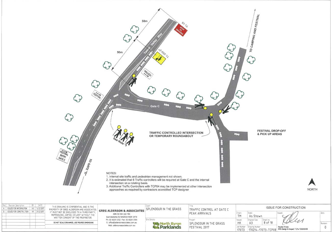
500 parking spaces at the Mullumbimby football Field for volunteers and staff
• Detailed
TCP's provided for Gate C & Gate D;
• Buses
will have exclusive use of the internal bus station for more efficient
operation;
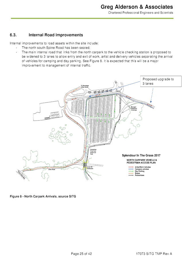
• Proposed
road widening internally (north of the northern carpark) to provide 3 lanes to
separate camping arrival traffic from operational traffic;
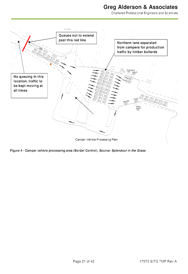
• Border
Control (vehicle checking) improvements;
• The
internal north/south spine road has been sealed recently to reduce dust and
improve travel times;
• Improved
internal signage to direct vehicles & pedestrians efficiently;
• Channelisation
& management of internal pedestrian crossings to reduce conflict with
vehicles.
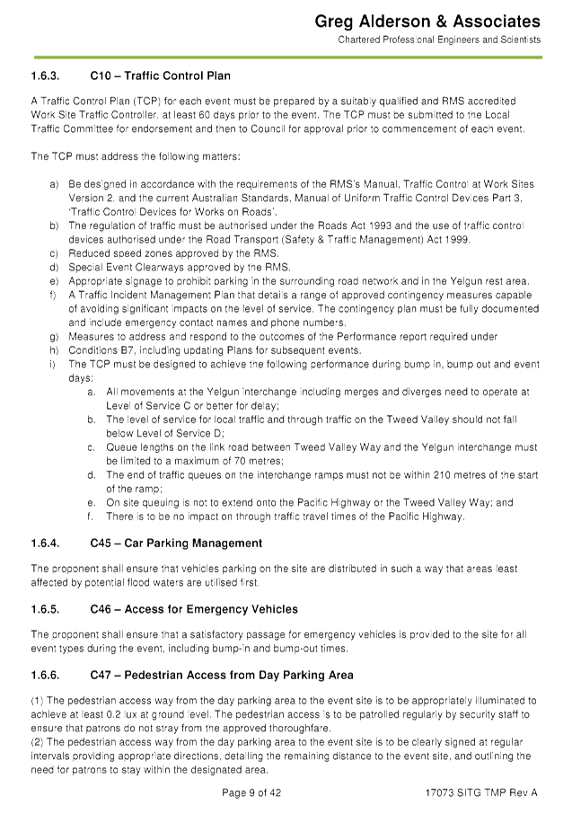
KEY ISSUES
1. Congestion
caused by the event will directly affect a RMS controlled asset – Pacific
Highway.
2. RMS
Traffic Engineering Department are required to separately approve the TMP and
TCP.
3. Bus
and private vehicles movements inside the North Byron Parklands was a major
issue in 2016.
4. Pedestrian
traffic along Tweed Valley Way and Brunswick Valley Way as festival goers left
the venue on foot due to traffic congestion inside the site.
5. With
three major events each year, tt would be worthwhile to investigate Event Day
parking restrictions to reduce signage required for events and improve
compliance.
COUNCIL IMPLICATIONS
§ Budget/Financial
The event organisers
have been invoiced $356.00 for the relevant Approval of Road Events pursuant to
s144 of the Roads Act fee as per the Fees & Charges 2016/17.
§ Asset Management
Not applicable.
|
§ Policy or Regulation
Speed Limit (as
required) ROAD WORK (R4-212) - Delegated to council for authorisation in
conjunction with NSW Road Rules 21 and AS 1742.4 (Speed Controls) Clause
3.1.2, AS 1742.3 (Roadworks).
§ Consultation
A condition of the
endorsement of this event is that appropriate consultation is undertaken,
including:
1. Advertising
the impact of the event in the local newspaper and on the Council website.
2. Informing
community and business that are directly impacted.
3. Liaising
with bus and taxi operators.
4. Consulting
with emergency services.
§ Legal and Risk Management
Congestion caused by
the event will directly affect a RMS controlled asset – Pacific
Highway. RMS Traffic Engineering Department requires to separately approval
of the TMP and TCP.
|
|
RECOMMENDATION:
1. That
Council approve the Splendour in the Grass 2017 TMP to be held on Friday 21
July 2017 to Sunday 23 July 2017, that includes the including the
installation and enforcement of No Camping and No Stopping signs between 6am
and 6pm, subject to conditions at Tweed Valley Way, Brunswick Valley Way and
Yelgun Road
2. That
the approval provided in Part 1 is subject to:
a) separate approvals by NSW Police and RMS being obtained, noting
that the event is on a state road or may impact the state road network;
b) implementation
of the approved Traffic Management Plan and Traffic Control Plan, including
the use of signed detours, as designed and implemented by those with
appropriate accreditation;
c) that
the impact of the event be advertised via a notice in the local weekly paper
a minimum of one week prior to the operational impacts taking effect, noting
it must include the event name, specifics of any traffic impacts or road
closures and times, alternative route arrangements, event organiser, a
personal contact name and a telephone number for all event related enquiries
or complaints.
d) the event be notified on Council’s webpage.
e) the event organiser:
i. undertake
consultation with community and affected businesses including adequate
response/action to any raised concerns.
ii. undertake
consultation with emergency services and any identified issues addressed.
iii. holding
$20m public liability insurance cover which is valid for the event.
iv. paying
Council’s Road Event Application Fee prior to the event.
v. the
holding of an event debrief within a month following the festival which
includes but not limited to Council, RMS and Police;
3. Councils
Parking Enforcement be invited to assist the event in compliance of no
stopping areas within the Road Reserve.
|
Attachments:
1 TMP, E2017/15688 , page 47⇩
2 TCP, E2017/15689 , page 47⇩ 
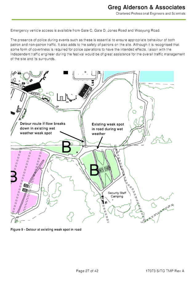
Development Applications 8.1 - Attachment 1

Development Applications 8.1 - Attachment 1
Development Applications 8.1 - Attachment 1


Development Applications 8.1 - Attachment 1
Development Applications 8.1 - Attachment 1


Development Applications 8.1 - Attachment 2