Local Traffic Committee Meeting
A Local Traffic Committee Meeting of
Byron Shire Council will be held as follows:
|
Venue
|
Conference Room, Station Street, Mullumbimby
|
|
Date
|
Tuesday, 18 July 2017
|
|
Time
|
10.00
|
|
Committee
Members
|
Alan Eichmann – Roads and
Maritime Services
Snr Constable Tony Darby – Police
Cr Basil Cameron
Tamara Smith MP
|

Phil Holloway
Director Infrastructure Services I2017/954
Distributed 10/07/17
Local Traffic Committee Meeting
BUSINESS OF MEETING
1. Apologies
2. Declarations of Interest
– Pecuniary and Non-Pecuniary
3. Adoption of Minutes from
Previous Meetings
3.1 Local
Traffic Committee Meeting held on 21 March 2017
4. Matters Arising
5. Outstanding
Issues/Resolutions
6. Regulatory Matters
6.1 Traffic
– Lucky Lane, Billinudgel – Regulatory Signage - Stop to Give Way................... 3
6.2 Traffic
- Stuart Street 152 - Regulatory Signage - No Parking 1am to 6am at Mullumbimby
Community Garden........................................................................................................... 5
6.3 Traffic
- Main Arm Road 911 - Regulatory signage - No Stopping - Main Arm RFS....... 7
7. Matters for Traffic Engineering Advice
7.1 Traffic
- Old Bangalow Road 86 - Advisory Sign - Wildlife Sign request....................... 10
7.2 Traffic
- Office of Transport Safety Investigations (OTSI) - Informal Bus Stops -
Findings and Recommendations ......................................................................................................... 12
7.3 Traffic
- Lateen Lane - Regulatory Signage - Proposed Shared Zone........................... 17
7.4 Traffic
- Bay Lane - Regulatory Signage - Proposed Shared Zone .............................. 19
8. Development Applications
8.1 DA
- Byron Writers Festival 2017 - Road Closure - 4 to 6 August 2017......................... 21
8.2 DA
- Festival of the Stone 2017 - Road Closure - Sunday 11 June 2017...................... 30
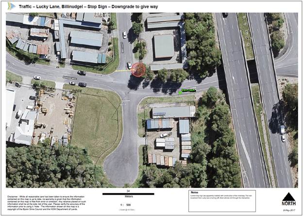
Local Traffic Committee Meeting 6.1
Regulatory Matters
Report No. 6.1 Traffic – Lucky Lane, Billinudgel – Regulatory Signage -
Stop to Give Way
File No: I2017/595
SUMMARY
After construction of the Pacific Highway two stop lines
with signs appear to have been installed in at a give way intersection.
The “Stop” signs do not meet the RMS warrants and should be
replaced with give way signs and line marking.
OFFICER RECOMMENDATION
That Council revise the Lucky Lane and Bonanza Drive,
Billinudgel intersection from stop to a give way.
LINKAGE TO OUR COMMUNITY STRATEGIC PLAN
|
Theme
|
Community Infrastructure
|
Services and infrastructure
that sustains, connects and integrates our communities and environment.
|
|
Objective
|
CI2
|
Provision of essential
services
|
|
Strategy
|
CI2.3
|
Provide roads and drainage
infrastructure within the Shire
|
|
Measures
|
CI2.G
|
Provide road, drainage and transport infrastructure within
the Shire
|
BACKGROUND
A resident has advised Council that vehicles are not abiding
to the existing stop sign on Lucky lane either side of Bonanza Drive.
A site inspection confirmed the residents observations and a
Giveway is recommended as there is enough sight distance relocate the Giveway
line.
KEY ISSUES
1. Vehicles
are currently breaking the law by ignoring the stop sign and stop sign.
2. The
main traffic movement from Lucky Lane is the turn left towards the Pacific
Highway overpass.
3. The
conversion to the give-way is supported by the improvement to sight distance
conditions when the hold position is shifted towards the intersection.
COUNCIL IMPLICATIONS
§ Budget/Financial
Estimate of $1,000
includes two new signs and relocation of the give way line.
§ Asset Management
Estimate of $200 for 2
signs at $10.00 per sign/year for an expected life of 10 years. Council will
need to maintain signage ongoing, including cleaning and replacement (if
necessary).
§ Policy or Regulation
Delegated to council for
authorisation in conjunction with:
- Prescribed
traffic control devices - division 1 of Part 4 (Sections 50 to 55) of the Road
Transport (Safety and Traffic Management) Act, 1999.
- R1-2
Giveway sign - NSW Road Rules - rules 69, 70, 71, 122
§ Consultation
Consultation has not
been carried out at this time as it is deemed unnecessary.
§ Legal and Risk Management
Austroads Guide to Traffic
Management Part 6: Intersections, Interchanges and Crossing Section 3.2.2 Stop
Signs and Giveway Signs: “Stop signs should normally be installed only
where justified on the basis of sight distance requirements, otherwise the
signs will lose ‘credibility’ and their effectiveness in general
will be compromised.”
|
RECOMMENDATION:
That Council revise the Lucky Lane and Bonanza Drive, Billinudgel
intersection from stop to give way with lines and signs, when funding is
available.
|
Local Traffic Committee Meeting 6.2
Report No. 6.2 Traffic - Stuart Street 152 - Regulatory Signage - No Parking 1am to
6am at Mullumbimby Community Garden
File No: I2017/654
SUMMARY
The Mullumbimby Community Garden has requested assistance to
resolve illegal camping in the Council car park adjacent to their
boundary. They have proposed that regulated parking be installed with
signs stating ‘No Parking 1am to 6am’.

OFFICER RECOMMENDATION
That Council regulate parking at the Mullumbimby Community
Gardens including ‘No Parking 1am to 6am’ to deter illegal camping.
LINKAGE TO OUR COMMUNITY STRATEGIC PLAN
|
Theme
|
Community Infrastructure
|
Services and infrastructure
that sustains, connects and integrates our communities and environment.
|
|
Objective
|
CI2
|
Provision of essential
services
|
|
Strategy
|
CI2.3
|
Provide roads and drainage infrastructure
within the Shire
|
|
Measures
|
CI2.G
|
Provide road, drainage and transport infrastructure within
the Shire
|
BACKGROUND
Councils Sustainability Officer has advised that illegal
camping is being carried out at the southern end of Stuart Street,
Mullumbimby. There is currently no regulator parking signage in this
section of the road reserve.
KEY ISSUES
1. Anti
social behaviour is occurring with people camping illegally.
2. There
is a lack of regulatory parking signage to be able to enforce illegal camping.
COUNCIL IMPLICATIONS
§ Budget/Financial
Estimate of $2,200
includes ten new signs.
§ Asset Management
Estimate of $1,000 for 10
signs at $10.00 per sign/year for an expected life of 10 years. Council will
need to maintain signage ongoing, including cleaning and replacement (if
necessary).
§ Policy or Regulation
Delegated to council for
authorisation in conjunction with:
- Prescribed
traffic control devices - division 1 of Part 4 (Sections 50 to 55) of the Road
Transport (Safety and Traffic Management) Act, 1999.
- R5-41
No Parking (specified times) - NSW Road Rules 168, $108 fine.
- No
Camping by order Local Government Act 1993 – Section 632, $80 fine.
§ Consultation
Consultation to be
completed once the design is finalised with the Mullumbimby Community Garden
and the management of the Tennis Courts.
§ Legal and Risk Management
Travellers and visitors
are drawn to the car park adjacent to the community gardens due to its discreet
location and the proximity to water, toilets, kitchen and undercover facilities
of the community gardens. The community gardens seek to deter this
activity as it breaches their licence of operation which is only for daylight
hours and has resulted in antisocial behaviour occurring after dark. The
community gardens have erected no camping signs on the gate of the gardens and
within their licenced area but as the car park is Council managed they
haven’t had any power to move people on.
Additionally since anti
social incidents have occurred the volunteer gardens committee have
understandably been reluctant to continue confrontations with repeat offenders
due to the associated risk of verbal or physical abuse.
|
RECOMMENDATION:
That Council regulate parking at 152 Stuart Street,
Mullumbimby at the Mullumbimby Community Gardens including ‘No Parking
1am to 6am’ when funds become available.
|
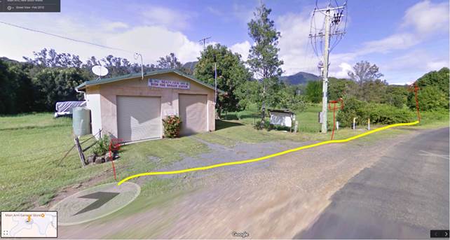
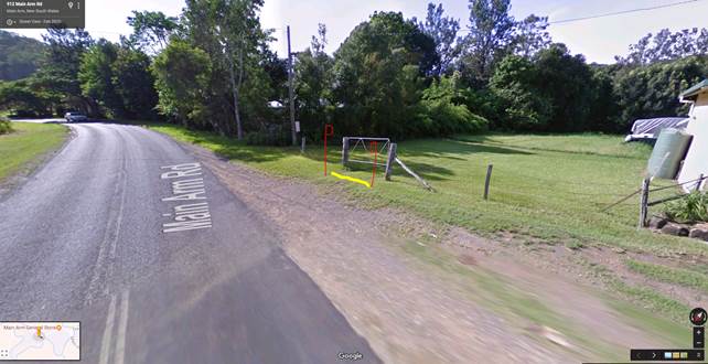
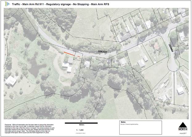
Local Traffic Committee Meeting 6.3
Report No. 6.3 Traffic - Main Arm Road 911 - Regulatory signage - No Stopping -
Main Arm RFS
File No: I2017/930
SUMMARY
The Main Arm Rural Fire Service has requested assistance to
resolve vehicles parking across both accesses during emergencies. They
have proposed that “No Stopping” signs be installed.
|
Figure 1. RFS main access with No Stopping shown in
yellow with red signs
|
|
|
|
Figure 2. RFS parking area access with No Stopping
shown in yellow with red signs
|
|
|
|
Figure 3. Site showing No Stopping zone in red.
|
|
|
OFFICER RECOMMENDATION
That Council install “No Stopping:” across the
two accesses to the Main Arm Rural Fire Service Station.
LINKAGE TO OUR COMMUNITY STRATEGIC PLAN
|
Theme
|
Community Infrastructure
|
Services and infrastructure
that sustains, connects and integrates our communities and environment.
|
|
Objective
|
CI2
|
Provision of essential
services
|
|
Strategy
|
CI2.3
|
Provide roads and drainage
infrastructure within the Shire
|
|
Measures
|
CI2.G
|
Provide road, drainage and transport infrastructure within
the Shire
|
BACKGROUND
Councils Parking Enforcement Supervisor has advised that he
has discussed illegal parking across the Main Arm RFS emergency accesses and
they have developed this No Stopping solution.
KEY ISSUES
1. Vehicles
are being parked across the RFS Station emergency access.
COUNCIL IMPLICATIONS
§ Budget/Financial
Estimate of $750
includes five new signs.
§ Asset Management
Estimate of $500 for 5
signs at $10.00 per sign/year for an expected life of 10 years. Council will
need to maintain signage ongoing, including cleaning and replacement (if
necessary).
§ Policy or Regulation
Delegated to council for
authorisation in conjunction with:
- Prescribed
traffic control devices - division 1 of Part 4 (Sections 50 to 55) of the Road
Transport (Safety and Traffic Management) Act, 1999.
- R5-400
No Stopping - NSW Road Rules 167, $253 fine.
§ Consultation
Consultation has been
completed between Parking Enforcement and the Main Arm RFS.
§ Legal and Risk Management
Vehicles parked across the RFS Station
access could impact on the RFS being able to access emergency’s and
potentially saving lives and property.
|
RECOMMENDATION:
That Council install “No Stopping” signs across
the two accesses to the Main Arm Rural Fire Service Station when funds become
available.
|
Local Traffic Committee Meeting 7.1
Matters for Traffic Engineering Advice
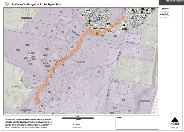
Report No. 7.1 Traffic - Old Bangalow Road 86 - Advisory Sign - Wildlife Sign
request
File No: I2017/617
SUMMARY
The Byron Shire Council Ecological Planner has supported the
installation of two Koala signs at the entrance of Old Bangalow Road, Byron Bay
to make the motorist aware of the potential of a Koala within the road reserve.
Figure 1: Sketch of the site in orange. Secondary Koala
Habitat shown in purple.
OFFICER RECOMMENDATION
That Council install two Koala signs near 19 and 162 Old
Bangalow Road, Byron Bay.
LINKAGE TO OUR COMMUNITY STRATEGIC PLAN
|
Theme
|
Community Infrastructure
|
Services and infrastructure
that sustains, connects and integrates our communities and environment.
|
|
Objective
|
CI2
|
Provision of essential
services
|
|
Strategy
|
CI2.3
|
Provide roads and drainage
infrastructure within the Shire
|
|
Measures
|
CI2.G
|
Provide road, drainage and transport infrastructure within
the Shire
|
BACKGROUND
A resident has requested wild life signs along Old
Bangalow Rd as per E2017/1010 on the 05/01/2017. Old Bangalow Road is 2230m
long and in Geocortex the road is in a wildlife corridor, HEV, and a Secondary
Koala Habitat (shown in purple in figure 1). The Byron Shire Council Ecological
Planner has endorsed the proposed Koala signs at 19 and 162 Old Bangalow Road
as per E2017/32390. A repeater sign is not required along the 2230m long
road.
KEY ISSUES
1. Koalas
are likely attracted to the secondary food sources along Old Bangalow Road.
2. There
is an increase probability of a vehicle and animal strike in this area.
COUNCIL IMPLICATIONS
§ Budget/Financial
Estimate of $600
includes two new signs.
§ Asset Management
Estimate of $200 for 2
signs at $10.00 per sign/year for an expected life of 10 years. Council
will need to maintain signage ongoing, including cleaning and replacement (if
necessary).
§ Policy or Regulation
Delegated to council for
authorisation in conjunction with:
- Prescribed
traffic control devices - division 1 of Part 4 (Sections 50 to 55) of the Road
Transport (Safety and Traffic Management) Act, 1999.
- W5-47
Koala Sign – Not delegated to Council
§ Consultation
Consultation has been
deemed to be unnecessary at this time.
§ Legal and Risk Management
A Koala sign is advisory only.
|
RECOMMENDATION:
That Council install two Koala signs near 19 and 162
Old Bangalow Road, Byron Bay when funds become available in 2017/2018
|
Local Traffic Committee Meeting 7.2
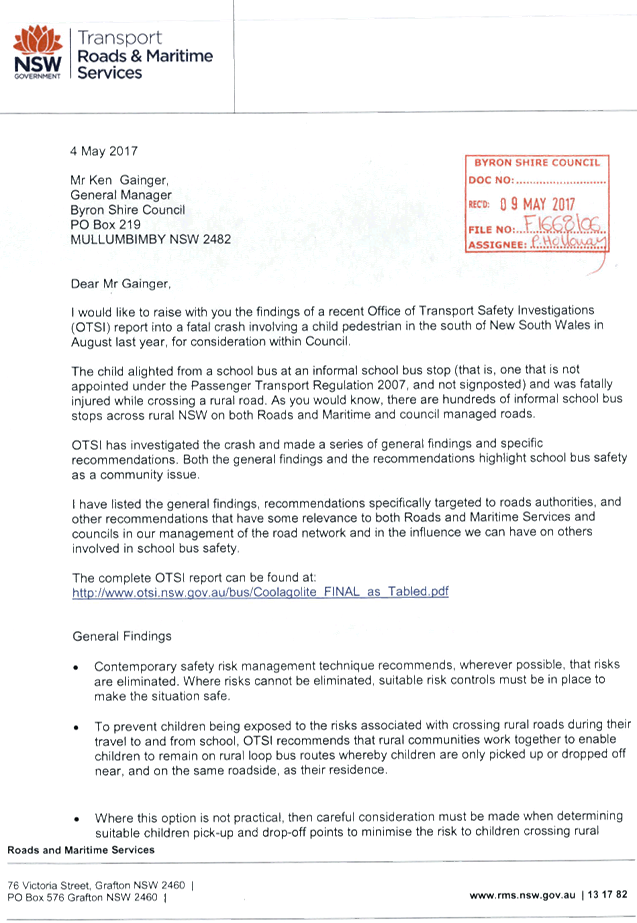
Report No. 7.2 Traffic - Office of Transport Safety Investigations (OTSI) -
Informal Bus Stops - Findings and Recommendations
File No: I2017/626
SUMMARY
The Office of Transport Safety Investigations (OTSI) has
sent Council a letter to be reviewed in relation to a fatality where a child
was alighting a school bus at an informal bus stop.
OFFICER RECOMMENDATION
That the committee carry out an informal
discussion with comments provided to the Traffic and Transport Planner.
LINKAGE TO OUR COMMUNITY STRATEGIC PLAN
|
Theme
|
Community Infrastructure
|
Services and infrastructure that sustains, connects and
integrates our communities and environment.
|
|
Objective
|
CI2
|
Provision of essential services
|
|
Strategy
|
CI2.3
|
Provide roads and drainage infrastructure within the Shire
|
|
Measures
|
CI2.G
|
Provide road, drainage and transport infrastructure within
the Shire
|
BACKGROUND
The Office of Transport Safety Investigations (OTSI) has
sent Council a letter to be reviewed in relation to a fatality where a child
was alighting a school bus at an informal bus stop. The main points of the
letter are detailed in the key issues.
KEY ISSUES
1. Risk
management technics required to eliminate or control risk of bus stop locations
2. Allow
bus passengers to access the bus from their residence side of the road.
3. Minimise
the risk of bus passengers crossing the road to a minimum and safest locations.
www.roadsafety.transport.nsw.gov.au/downloads/advice-for-choosing-locations-of-informal-school-bus-stops.pdf
4. Adult
supervision for children holding hands to cross the road is recommended until
10 years old. www.safetytown.com.au/parents/
5. The
community needs to clearly understand the location of all non designated bus
stops.
6. Council
resources are required to advise the community of how to select non-designated
bus stops.
7. Advise
the community to drive cautiously on school bus routes.
8. Bus operators and Council to work
together to select non-designated bus stops in regards to risk assessment
activities.
|
RECOMMENDATION:
That the Local Traffic Committee carry out an informal
discussion with comments provided to the Traffic and Transport Planner.
|
Attachments:
1 Transport
for NSW - Letter, S2017/7476 , page 13⇩ 
Matters for Traffic Engineering Advice 7.2 - Attachment 1
Local Traffic Committee Meeting 7.3
Report No. 7.3 Traffic - Lateen Lane - Regulatory Signage - Proposed Shared Zone
File No: I2017/829
SUMMARY
The Elysium Project has carried out an art installation that
has changed the colours of the wearing surface of the street. Council
Officers are investigating either a 10km/hr Shared Zone or a 40km/hr High
Pedestrian Zone.
|
Figure 1. Lateen Shared Zone
|
|
|
|
Figure 2. Photo approximately 70m to the east of Jonson
St and Lateen Ln, intersection.
|
|
|
OFFICER RECOMMENDATION
That the committee carry out an informal
discussion with comments provided to the Traffic and Transport Planner.
LINKAGE TO OUR COMMUNITY STRATEGIC PLAN
|
Theme
|
Community Infrastructure
|
Services and infrastructure
that sustains, connects and integrates our communities and environment.
|
|
Objective
|
CI2
|
Provision of essential
services
|
|
Strategy
|
CI2.3
|
Provide roads and drainage
infrastructure within the Shire
|
|
Measures
|
CI2.G
|
Provide road, drainage and transport infrastructure within
the Shire
|
BACKGROUND
The installation of Byron Shire Council’s first
permanent Place Making Seed funding project, ELYSIUM was completed on March
15th in Byron’s CBD. ELYSIUM had been planned for over 12 months and was
delivered by volunteer local art design professionals who raised over $90,000
through local business and philanthropists to cover supplier and material costs.
A road safety audit has been completed with a traffic count
due for completion in late June 2017. The results of the traffic count will
determine if the RMS warrants would be meet for either a 10km/hr Shared Zone or
a 40km/hr High Pedestrian Activity Zone.
KEY ISSUES
1. Pedestrians
are using the coloured wearing surface as an informal shared zone.
2. Motorists
are confused by the coloured wearing surface.
3. Lack
of lighting could be an issue.
4. There
is an increased risk of a pedestrian / vehicle strike in this area.
|
RECOMMENDATION:
That the Local Traffic Committee carry out an informal
discussion with comments provided to the Traffic and Transport Planner.
|
Local Traffic Committee Meeting 7.4
Report No. 7.4 Traffic - Bay Lane - Regulatory Signage - Proposed Shared Zone
File No: I2017/951
SUMMARY
Council Officers are investigating if Bay Lane, Byron Bay
between Jonson Street and Fletcher Street will meet the RMS warrants to be
converted from 50km/hr urban zone into a 10km/hr Shared Zone.
|
Figure 1. Bay Lane Shared Zone Concept Design
|
OFFICER RECOMMENDATION
That the committee approve in principle the
installation of a 10km Shared Zone in Bay Lane, Byron Bay on the condition that
the RMS warrants are met.
LINKAGE TO OUR COMMUNITY STRATEGIC PLAN
|
Theme
|
Community Infrastructure
|
Services and infrastructure that sustains, connects and
integrates our communities and environment.
|
|
Objective
|
CI2
|
Provision of essential services
|
|
Strategy
|
CI2.3
|
Provide roads and drainage infrastructure within the Shire
|
|
Measures
|
CI2.G
|
Provide road, drainage and transport infrastructure within
the Shire
|
BACKGROUND
Council has established a $20,000 budget to investigate and
design a 10km/hr Shared Zone in Bay Lane, Byron Bay between Jonson Street and
Fletcher Street.
Currently Bay Lane meets most of the RMS warrants for a
shared zone and a road safety audit has been completed. A traffic count due for
completion in late July 2017 will confirm if the traffic volumes meet the RMS
warrants for a 10km/hr Shared Zone.
KEY ISSUES
1. Pedestrians
are using the wearing surface as an informal shared zone.
2. Outdoor
dining is operating in the laneway very close to live traffic.
3. Lack
of lighting could be an issue.
4. There
is an increased risk of a pedestrian / vehicle strike in this area.
COUNCIL IMPLICATIONS
§ Budget/Financial
Estimate to be
finalised with the design.
§ Asset Management
Estimate to be
finalised with the design.
§ Policy or Regulation
R4-4 Shared Zone is not delegated
to Council for authorisation.
§ Consultation
Consultation with local
businesses to be carried out once the design is finalised.
§ Legal and Risk Management
By lowering the speed
of vehicles and making them aware of pedestrians in the laneway the
consequences of a pedestrian / vehicle strike are greatly reduced.
|
RECOMMENDATION:
That the Local Traffic Committee recommend in principle
the installation of a 10km Shared Zone in Bay Lane, Byron Bay on the
condition that the RMS warrants are met.
|
Local Traffic Committee Meeting 8.1
Development Applications
Report No. 8.1 DA - Byron Writers Festival 2017 - Road Closure - 4 to 6 August 2017
File No: I2017/659
SUMMARY
Council has received an event application and Traffic
Management Plan (TMP) and Traffic Control Plan (TCP) for Byron Bay Writers
Festival to be held on Friday 4 August to Sunday 6 August 2017.
OFFICER RECOMMENDATION
That Council endorse the Byron Bay Writers Festival 2017 to
be held on Friday 4 August to Sunday 6 August 2017 that includes the
installation of temporary regulatory signage including “No Stopping”,
“No Parking” and “Disability” Parking Signs between 8am
and 6pm, subject to conditions at:
a) Bayshore
Drive, Byron Bay
LINKAGE TO OUR COMMUNITY STRATEGIC PLAN
|
Theme
|
Economy
|
A sustainable and diverse economy which provides
innovative employment and investment opportunities in harmony with our
ecological and social aims.
|
|
Objective
|
EC1
|
A diverse economic base and support for local businesses.
|
|
Strategy
|
EC1.4
|
Support sporting and cultural events in Byron Shire.
|
|
Measures
|
EC1.B
|
Increase the sustainability of events in which Council is
involved.
|
BACKGROUND
The Byron Bay Writers Festival is proposing to restrict
parking on Bayshore Drive between the times of 6am – 6pm Friday 4 August
2017 to Sunday 06 August 2017 for the annual Byron Bay Writers Festival 2017.
The TMP and TCPs have been updated from 2016 with the
following site changes:
· Two experienced
Bluesfest parking coordinators to manage the car park areas.
· Second car park
available to deal with wet weather which restricts access to the main parking
area.
· New black on
yellow directional signage on Ewingsdale Road.
· Temporary
regulatory signage including No Parking and Disability Parking Signs.
· Crusher dust has
been used to make the parking areas more resistant to weather events.
· Donations for
parking to be collected from pedestrians as they access the event instead of
collecting it from vehicles on Bayshore Drive.
KEY ISSUES
1. In
2016 collecting donations from motorists on Bayshore Drive caused congestion
that could directly impacted a Regional Road – Ewingsdale Road.
COUNCIL IMPLICATIONS
§ Budget/Financial
The event organisers
have a Council Memorandum of Understanding (Item 2.1 Councils role and
responsibilities) which waives fees for the relevant Approval of Road
Events pursuant to s144 of the Roads Act fee as per the Fees & Charges 2017/18.
§ Asset Management
Not applicable.
§ Policy or Regulation
Delegated to council for
authorisation in conjunction with:
- Actions
required to control traffic- Part 8 (Sections 114 to 124) Roads Act, 1993.
- Prescribed
traffic control devices - division 1 of Part 4 (Sections 50 to 55) Road
Transport (Safety and Traffic Management) Act, 1999.
- R5-1-3
Parking (Disable) – NSW Road Rules 203, $541 fine
- R5-400
No Stopping - NSW Road Rules 167, $253 fine
- R5-41
No Parking (specified times) - NSW Road Rules 168, $108 fine.
§ Consultation
A condition of the
endorsement of this event is that appropriate consultation is undertaken,
including:
1. Advertising
the impact of the event in the local newspaper and on the Council website.
2. Informing
community and business that are directly impacted.
3. Liaising
with bus and taxi operators.
4. Consulting
with emergency services.
§ Legal and Risk Management
If vehicles cause
congestion on Bayshore Drive then this could directly impacted a Regional Road
– Ewingsdale Road. RMS Traffic Engineering Department requires to
separately approving the TMP and TCP.
|
RECOMMENDATION:
1. That
Council endorse the Byron Bay Writers Festival 2017 to be held on Friday 4
August to Sunday 6 August 2017, that includes the installation of temporary
regulatory signage including No Stopping, No Parking and Disability Parking
Signs between 8am and 6pm, subject to conditions at:
a)
Bayshore Drive, Byron Bay
2. That
the approval provided in Part 1 is subject to:
a)
separate approvals by NSW Police and RMS being
obtained
b) implementation
of the approved Traffic Management Plan and Traffic Control Plan,
including the use of signed detours, as designed and implemented by those
with appropriate accreditation
c) that
the impact of the event be advertised via a notice in the local weekly paper
a minimum
of one week prior to the operational impacts taking effect, noting it must
include the event name, specifics of any traffic impacts or road closures and
times, alternative route arrangements, event organiser, a personal contact name
and a telephone number for all event related enquiries or complaints
d) the
event be notified on Council’s webpage
e) the
event organiser:
i. undertake
consultation with community and affected businesses including adequate response/action
to any raised concerns
ii. undertake
consultation with emergency services and any identified issues addressed
iii. hold
$20m public liability insurance cover which is valid for the event
|
Attachments:
1 TCP, E2017/69715 , page 24⇩ 
2 TMP, E2017/69714 ,
page 26⇩
3 DWG
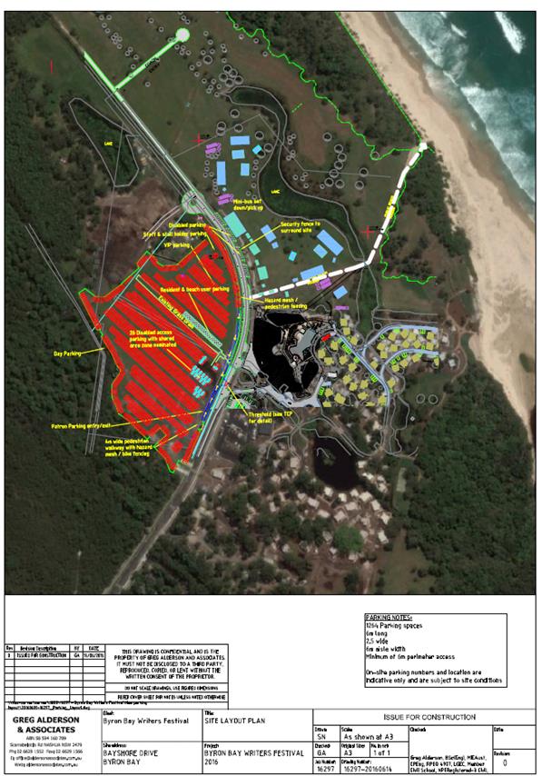
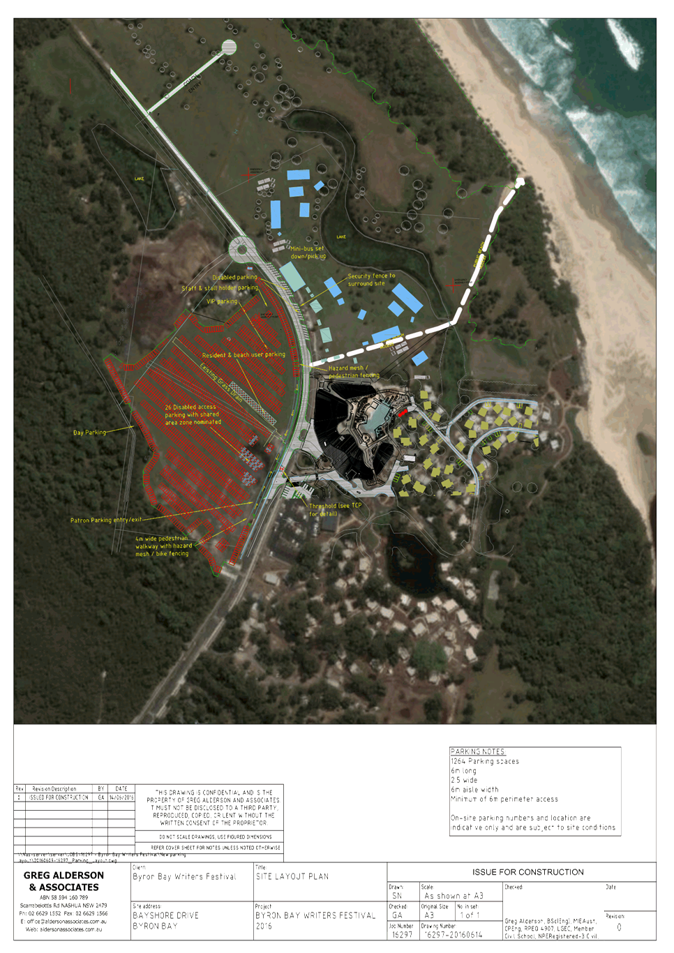
Parking Layout, E2017/69746 , page 29⇩
Development Applications 8.1 - Attachment 1
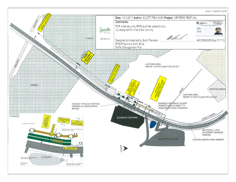
Development Applications 8.1 - Attachment 1
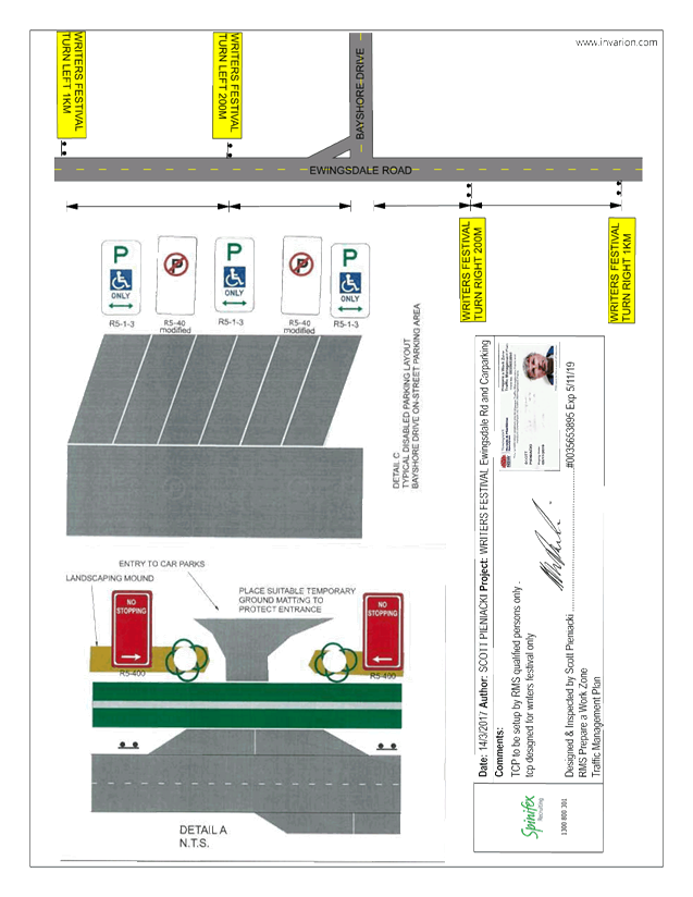
Development Applications 8.1 - Attachment 2
|
Table 1. TMP Performa (part 1 of
2)
|
|
Question
|
Response (If no, state your
reasons why)
|
|
A. Description
or detailed plan of proposed measures.
Is a detailed
plan of the proposed measures necessary?
|
Event Name
|
Byron Bay
Writers Festival 2017
|
A.
Organiser
Name |
Sarah Ma,
Operations Manager (t)
02 6685 5115 (m) 0414 272 327 sarah@byronwritersfestival.com
|
A.
Traffic
Control |
Spinifex
|
A.
Date(s) |
04/08/2017
– 06/08/2017
|
A.
Times |
06:00
– 18:00
|
A.
Roads
affected |
Ewingsdale
Rd – Signs Only
Bayshore
Drive – Road Closure near Elements Building
|
A.
Detours
in place |
N/A
|
A.
Parking |
Private
parking is provided in two locations.
The field
opposite Elements Resort and the field north of the Festival site, both will
be marked out.
The
Festival has also requested from Council to use the Cavanbah Centre in case
one of the carparks are not viable due to an extreme weather event prior to
the Festival weekend. Park and Ride signs would be used. Go Byron would
transfer patrons.
|
A.
Other |
Parking
Signs on Ewingsdale Rd and Bayshore Drive
|
|
B. Identification
and assessment of impact of proposed measures.
Is a detailed
assessment required?
|
Traffic Controls – Ewingsdale Road
Four
black on yellow directional signage on Ewingsdale Road.
Traffic Controls – Bayshore Drive
There
are no controls on the flow of traffic on Bayshore Drive. The two traffic
control plans are designed to inform motorists about the changed traffic
conditions and to be ready to enter the private car park quickly.
Parking – Cueing Vehicles
In
2016 vehicles were being stopped in the private car park for a gold coin donation
and vehicles had the potential to backup along Bayshore Drive. To avoid
vehicles backing up onto Bayshore Drive .
To
avoid vehicles backing up onto Bayshore Drive parking staff will be
collecting the fee once cars have already parked. We have employed two
Bluesfest car parking staff this year and are using experienced volunteers
only.
|
|
C. Measures
to ameliorate the impact of re-assigned traffic
Is an
assessment required?
|
There
is no traffic flow data available for vehicles and pedestrians.
There
should an increase of pedestrians crossing Bayshore Drive however most
private vehicles will be directed into the private car parks with the
signage. We have confirmed a traffic controller with Spinifex for all days.
|
|
Table 1. TMP Performa (part 2 of
2)
|
|
Question
|
Response (If no, state your
reasons why)
|
|
D. Assessment
of public transport services affected.
Is an
assessment required?
|
Water
filled barriers will be installed to create a narrow access point to the
Elements Resort. The use of the water field barriers and signage will deter
private vehicles entering this pace which will allow for improved access for
Public Transport Services to the event precinct.
Private
vehicles can still turn around after the water filled barriers as per normal.
|
|
E. Details
of provision made for emergency vehicles, heavy vehicles, cyclists and
pedestrians.
Are these
details required?
|
Emergency
|
Emergency
vehicles will have right of way on Bayshore Drive.
|
A.
Heavy Vehicles |
Emergency
vehicles will have right of way on Bayshore Drive.
|
A.
Cyclist |
Access
in not affected
|
A.
Pedestrians |
Scaffold
pedestrian crossing over the swale drain to provide a pedestrian crossing.
|
|
F. Assessment
of effect on existing and future developments with transport implications in
the vicinity of the proposed measures.
Is an
assessment required?
|
Elements
are the only affected development north of the railway line on Bayshore
Drive. So therefore if vehicle cueing is kept within the Railway line
crossing area then there is no impact to any other developments.
|
|
G. Assessment
of effect of proposed measures on traffic movements in adjoining Council
areas.
Is an
assessment required?
|
Bayshore
Drive will be affected by vehicles queuing on Bayshore Drive to enter the two
private car parks. The Parking Traffic Control is aware that queuing length
is to be kept within the length of Bayshore drive up to the railway line.
|
|
H. Public
consultation process
Is a public
consultation process required
|
The
event organisers are using printed media, internet, socials and signage to
make the public aware of the event.
|
Figure 1. Sketch of the site.
|
http://www.rms.nsw.gov.au/business-industry/partners-suppliers/documents/technical-manuals/tmplan_v2.pdf
Development Applications 8.1 - Attachment 3
Local Traffic Committee Meeting 8.2
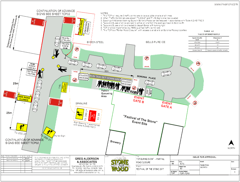
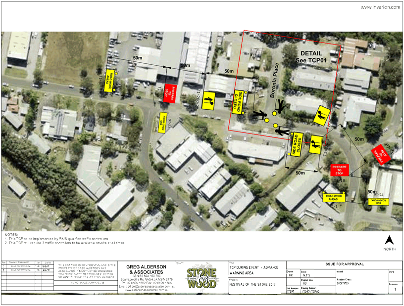
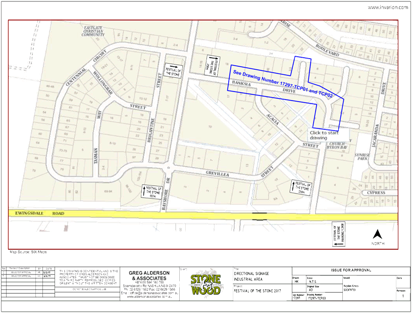
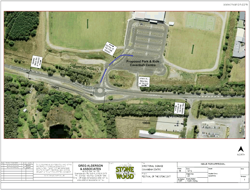
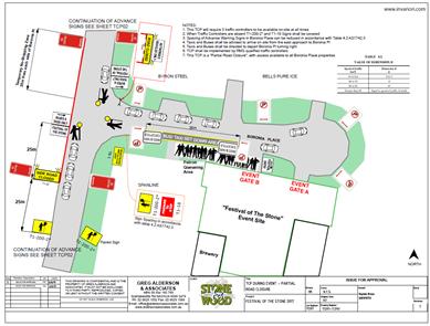
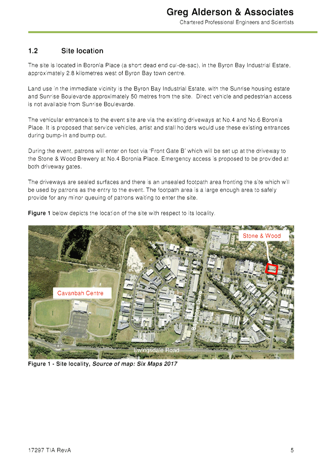
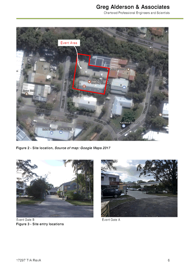
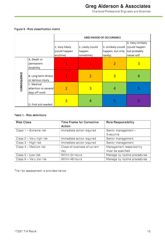
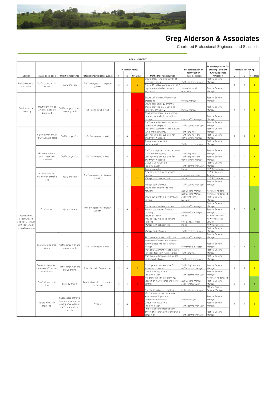
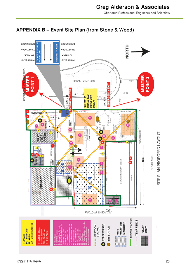
Report No. 8.2 DA - Festival of the Stone 2017 - Road Closure - Sunday 11 June 2017
File No: I2017/785
SUMMARY
Council has received a development application including
Traffic Control Plan (TCP) and Traffic Management Plan from the Festival of the
Stone 2017 to be held on Sunday 11 June 2017.
OFFICER RECOMMENDATION
That Council approve the traffic control and traffic
management plans for the Festival of the Stone 2017 to be held on Sunday 11
June 2017 in accordance with the Local Traffic Committee recommendations.
LINKAGE TO OUR COMMUNITY STRATEGIC PLAN
|
Theme
|
Economy
|
A sustainable and diverse
economy which provides innovative employment and investment opportunities in
harmony with our ecological and social aims.
|
|
Objective
|
EC1
|
A diverse economic base and
support for local businesses.
|
|
Strategy
|
EC1.4
|
Support sporting and cultural events in Byron Shire.
|
|
Measures
|
EC1.B
|
Increase the sustainability of events in which Council is
involved.
|
BACKGROUND
|
This is the inaugural event with next years event in the
planning stages.
Up to 1,000 patrons are expected at the Brewery event.
More details of the event are online: www.stoneandwood.com.
KEY ISSUES
1. Safety
of Pedestrians walking across Boronia Place.
2. Safety
of motorists cueing to enter or leave the event precinct.
|
|
COUNCIL IMPLICATIONS
§ Budget/Financial
The event organisers
have been invoiced $476.00 for the relevant Approval of Road Events pursuant to
s144 of the Roads Act fee as per the Fees & Charges 2016/17.
§ Asset Management
Not applicable.
§ Policy or Regulation
Speed Limit (as
required) ROAD WORK (R4-212) - Delegated to council for authorisation in
conjunction with NSW Road Rules 21 and AS 1742.4 (Speed Controls) Clause 3.1.2,
AS 1742.3 (Roadworks).
§ Consultation
A condition of the
endorsement of this event is that appropriate consultation is undertaken,
including:
1. Advertising
the impact of the event in the local newspaper and on the Council website.
2. Informing
community and business that are directly impacted.
3. Liaising
with bus and taxi operators.
4. Consulting
with emergency services.
§ Legal and Risk Management
No RMS controlled asset
are affected by the traffic control.
|
RECOMMENDATION:
1. That
Council approve the Traffic Control and Traffic Management Plans for the
Festival of the Stone 2017, to be held Sunday 11 June 2017.
2. That
the approval provided in Part 1 is subject to:
a) separate
approvals by NSW Police and RMS being obtained
b) implementation
of the approved Traffic Management Plan and Traffic Control Plan, including
the use of signed detours, as designed and implemented by those with
appropriate accreditation.
c) that
the impact of the event be advertised via a notice in the local weekly paper
d) the
event be notified on Council’s webpage.
e) the
event organiser:
i. undertake
consultation with community and affected businesses including adequate
response/action to any raised concerns.
ii. undertake
consultation with emergency services and any identified issues addressed.
iii. holding
$20m public liability insurance cover which is valid for the event.
iv. paying
Council’s Road Event Application Fee prior to the event.
|
Attachments:
1 TMP, E2017/61515 , page 32⇩
2 TCP(s), E2017/61516 , page 55⇩
Development Applications 8.2 - Attachment 1

Development Applications 8.2 - Attachment 1
Development Applications 8.2 - Attachment 1
Development Applications 8.2 - Attachment 2