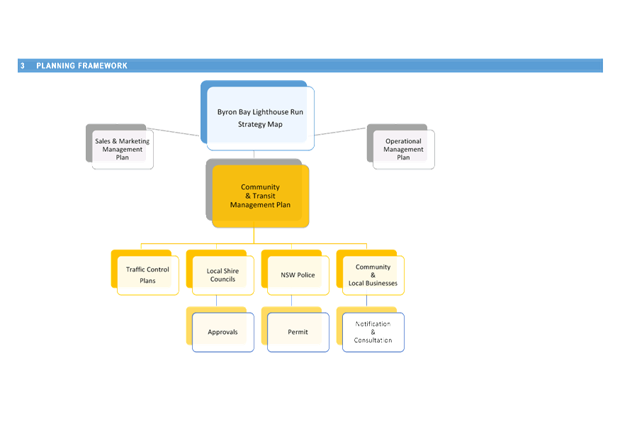
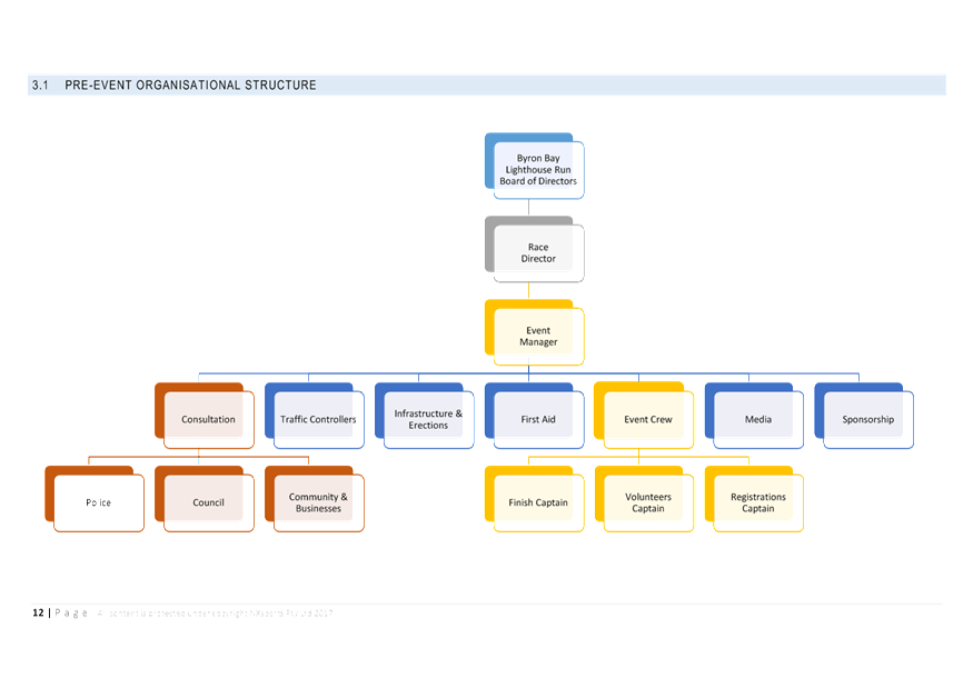
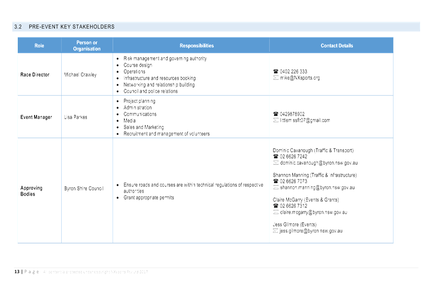
Local Traffic Committee Meeting
A Local Traffic Committee Meeting of
Byron Shire Council will be held as follows:
|
Venue
|
Conference Room, Station Street, Mullumbimby
|
|
Date
|
Tuesday, 19 September 2017
|
|
Time
|
10.00am
|
|
Committee
Members
|
Alan Eichmann – Roads and
Maritime Services
Snr Constable Tony Darby – Police
Cr Basil Cameron
Tamara Smith MP
|
Phillp Holloway
Director Infrastructure Services I2017/1335
Distributed 12/09/17 (amended
18/09/17 Reports 6.2 & 6.6)
1. Apologies
2. Declarations of Interest
– Pecuniary and Non-Pecuniary
3. Adoption of Minutes from
Previous Meetings
3.1 Local
Traffic Committee Meeting held on 18 July 2017
4. Matters Arising
5. Outstanding
Issues/Resolutions
6. Regulatory Matters
6.1 Event
Road Closures - Mullum2Bruns Paddle 2018........................................................ 3
6.2 Event
Road Closures - Falls Festival 2017/18.................................................................. 6
6.3 Capital
Works - Coolamon Scenic Drive (South Mullumbimby) - Regulatory Signage and Line
Marking.............................................................................................................................. 6
6.4 Event
Road Closures - 50th Anniversary NSW National Parks and Wildlife Service...... 6
6.5 Event
Road Closures - Bangalow Christmas Eve Carnival 2017..................................... 6
6.6 Event
Road Closures - Brunswick Woodchop Twilight Markets 2017............................. 6
6.7 Event
Road Closures - Byron Lighthouse Run 2017........................................................ 6
6.8 Event
Road Closures - Mullumbimby Music Festival 2017.............................................. 6
6.9 Event
Road Closures - Chincogan Charge 2017 (out of session).................................... 6
7. Matters for Traffic Engineering Advice
7.1 Shared
Zone - Seven Mile Beach Road, Broken Head.................................................... 6
7.2 Event
Road Closures - Byron Bay Triathlon 2018 (for comment only)............................ 6
8. Development Applications
8.1 DA
10.2016.632.1 - Subdivision of One Lot into Two Lots - 103 Paterson Street,
Byron Bay 6
Local Traffic Committee Meeting 6.1
Regulatory Matters
Report No. 6.1 Event Road Closures - Mullum2Bruns Paddle 2018
File No: I2017/1036
SUMMARY
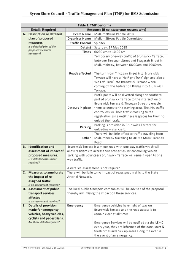
Council has received an application, Traffic Management Plan
(TMP) and Traffic Control Plan (TCP) from the Mullum2Bruns Paddle Committee for
the Mullum2Bruns Paddle 2018 to be held Sunday 27 May 2018.
OFFICER RECOMMENDATION
That the temporary traffic
management and regulatory changes within the Traffic Control Plans, as relates
to the Mullum2Bruns Paddle 2018 to be held on Sunday 27 May 2018, be endorsed
subject to specified conditions.
LINKAGE TO OUR COMMUNITY STRATEGIC PLAN
|
Theme
|
Economy
|
A sustainable and diverse economy which provides
innovative employment and investment opportunities in harmony with our
ecological and social aims.
|
|
Objective
|
EC1
|
A diverse economic base and support for local businesses.
|
|
Strategy
|
EC1.4
|
Support sporting and cultural events in Byron Shire.
|
|
Measures
|
EC1.B
|
Increase the sustainability of events in which Council is
involved.
|
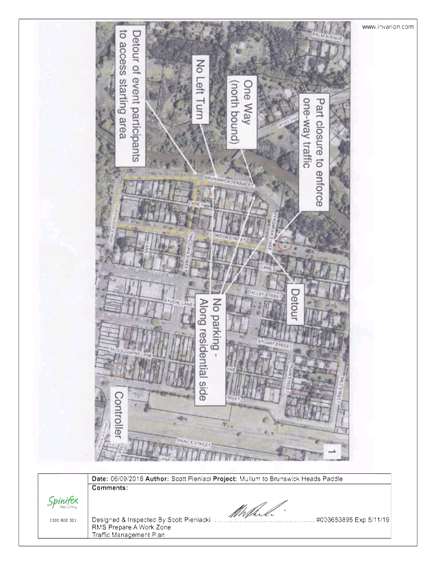
BACKGROUND
As in past years the Paddle Committee is requesting
permission for temporary one-way traffic of Brunswick Terrace, between Tincogan
Street and Tyagarah Street in Mullumbimby, between 06:00am and 10:00am. This
will allow for the registrations and start of the 2018 Mullum2Bruns Paddle to
be held on Sunday 27 May 2018.
The turn from Tincogan Street into Brunswick Terrace will
have a ‘No Right Turn’ sign and also a ‘No Left Turn’
into Brunswick Terrace when coming off the Federation Bridge into Brunswick
Terrace.
Uniformed Marine Rescue personnel will be patrolling the
homes opposite the registration area to ensure that participants are not
parking in front of or across driveways, thereby minimising inconvenience to
the residents.
Participants will be diverted along the southern part of
Brunswick Terrace to the intersection of Brunswick Terrace & Tincogan
Street to enable them to cross to the starting area. The JHA traffic
controllers will hold traffic crossing to the registration zone until there is
spaces for them to unload their craft.
A letter box drop would be done 2 weeks prior to the event
informing residents in the surrounding streets of the temporary one way traffic
closures.
COUNCIL IMPLICATIONS
§ Budget/Financial
The event organisers to be
invoiced for the relevant Approval of Road Events pursuant to s144 of the Roads
Act fee as per the Fees & Charges 2017/18.
§ Asset Management
N/A
§ Policy or Regulation
Regulatory traffic signage as delegated
to council for authorisation in conjunction with NSW Road Rules.
§ Consultation
A condition of the
endorsement of this event is that appropriate consultation is undertaken, which
may include:
· Advertising the
impact of the event in the local newspaper and on the Council website.
· Informing
community and business that are directly impacted.
· Liaising with bus
and taxi operators.
· Consulting with
emergency services.
§ Legal and Risk Management
Event organiser is required to
hold $20m public liability insurance cover which is valid for the event.
|
RECOMMENDATION:
1. That
Council approve the Traffic Management Plan and Traffic Control Plans for the
Mullum2Bruns Paddle 2018 to be held Sunday 27 May 2018, that includes the
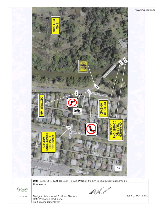
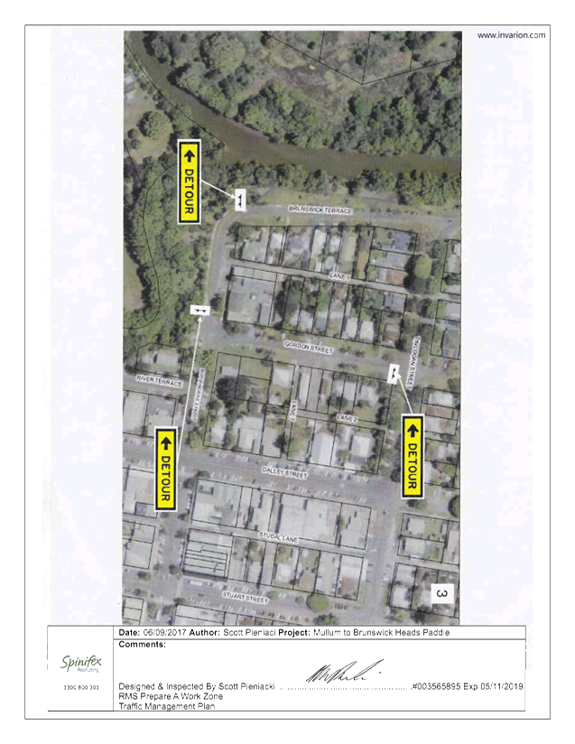
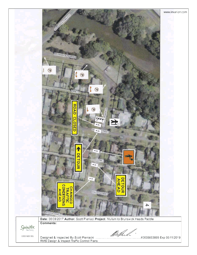
temporary road closure below:
a) Brunswick
Terrace, Mullumbimby, between Tincogan Street and Tyagarah Street (to become
one-way traffic), between 06:00am and 10:00am on Sunday 27 May 2018.
2. That
the approval provided in Part 1 is subject to:
a) separate
approvals by NSW Police and RMS being obtained;
b) implementation
of the approved Traffic Management Plan and Traffic Control Plan, including
the use of signed detours, as designed and implemented by those with
appropriate accreditation;
c) that
the impact of the event be advertised via a notice in the local weekly paper
a minimum of one week prior to the operational impacts taking effect, noting
it must include the event name, specifics of any traffic impacts or road
closures and times, alternative route arrangements, event organiser, a personal
contact name and a telephone number for all event related enquiries or
complaints;
d) the
event be notified on Council’s webpage;
e) the
event organiser:
i) undertake
consultation with community and affected businesses including adequate
response/action to any raised concerns;
ii) undertake
consultation with emergency services and any identified issues addressed;
iii) holding
$20m public liability insurance cover which is valid for the event;
iv) paying
Council’s Road Event Application Fee prior to the event.
That a debrief be held within two weeks of the event
involving staff, Police (if they had incidents) and traffic controllers.
|
Attachments:
1 Mullum2Bruns
Paddle 2018 - TMP, E2017/87501 , page 6⇩ 
2 Mullum2Bruns
Paddle - TCP 1, E2017/87390 , page 6⇩
3 Mullum2Bruns
Paddle - TCP 2, E2017/87380 , page 6⇩
4 Mullum2Bruns
Paddle - TCP 3, E2017/87381 , page 6⇩
5 Mullum2Bruns
Paddle - TCP 4, E2017/87382 , page 6⇩
6 Mullum2Bruns
Paddle - TCP 5, E2017/87384 , page 6⇩
Regulatory Matters 6.1 - Attachment 1
Regulatory Matters 6.1 - Attachment 2
Regulatory Matters 6.1 - Attachment 3
Regulatory Matters 6.1 - Attachment 4
Regulatory Matters 6.1 - Attachment 5
Regulatory Matters 6.1 - Attachment 6
Local Traffic Committee Meeting 6.2
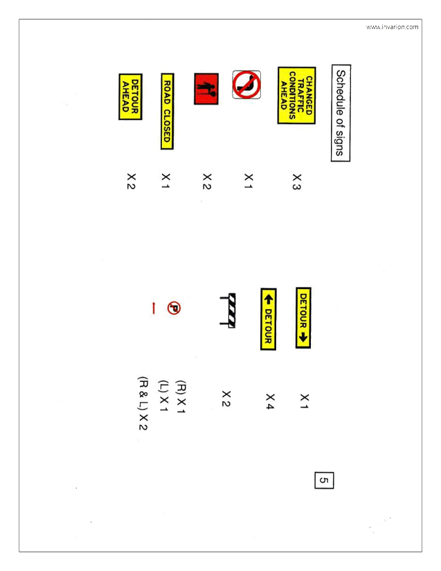
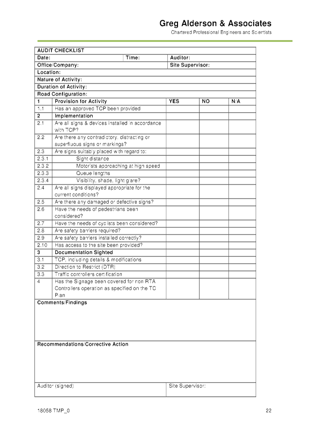
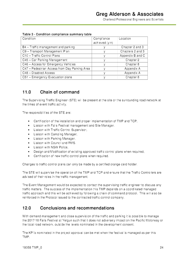
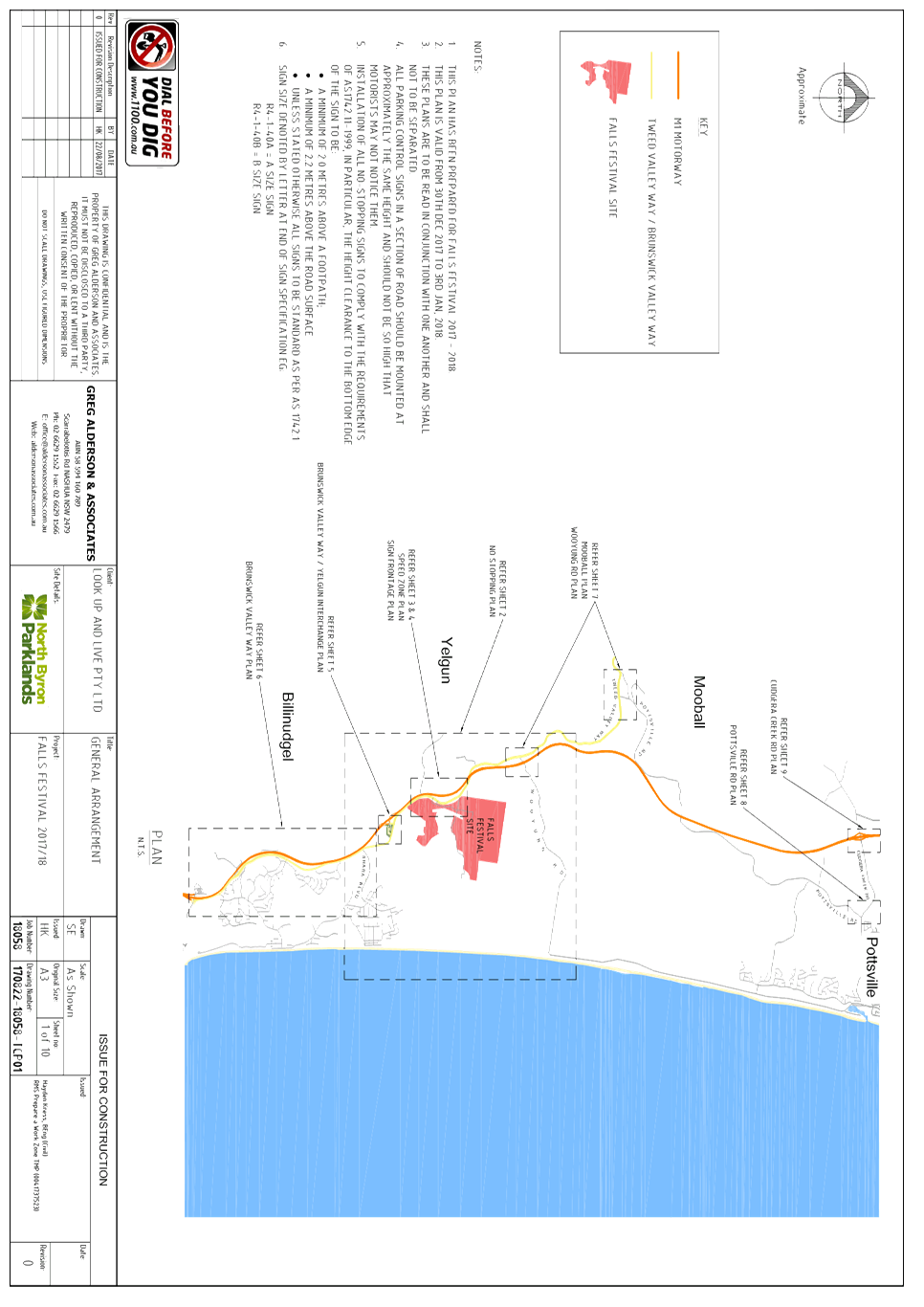
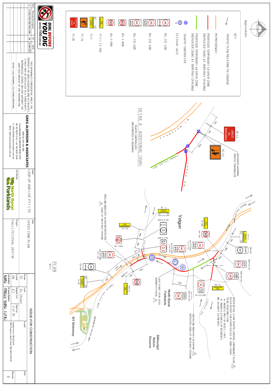
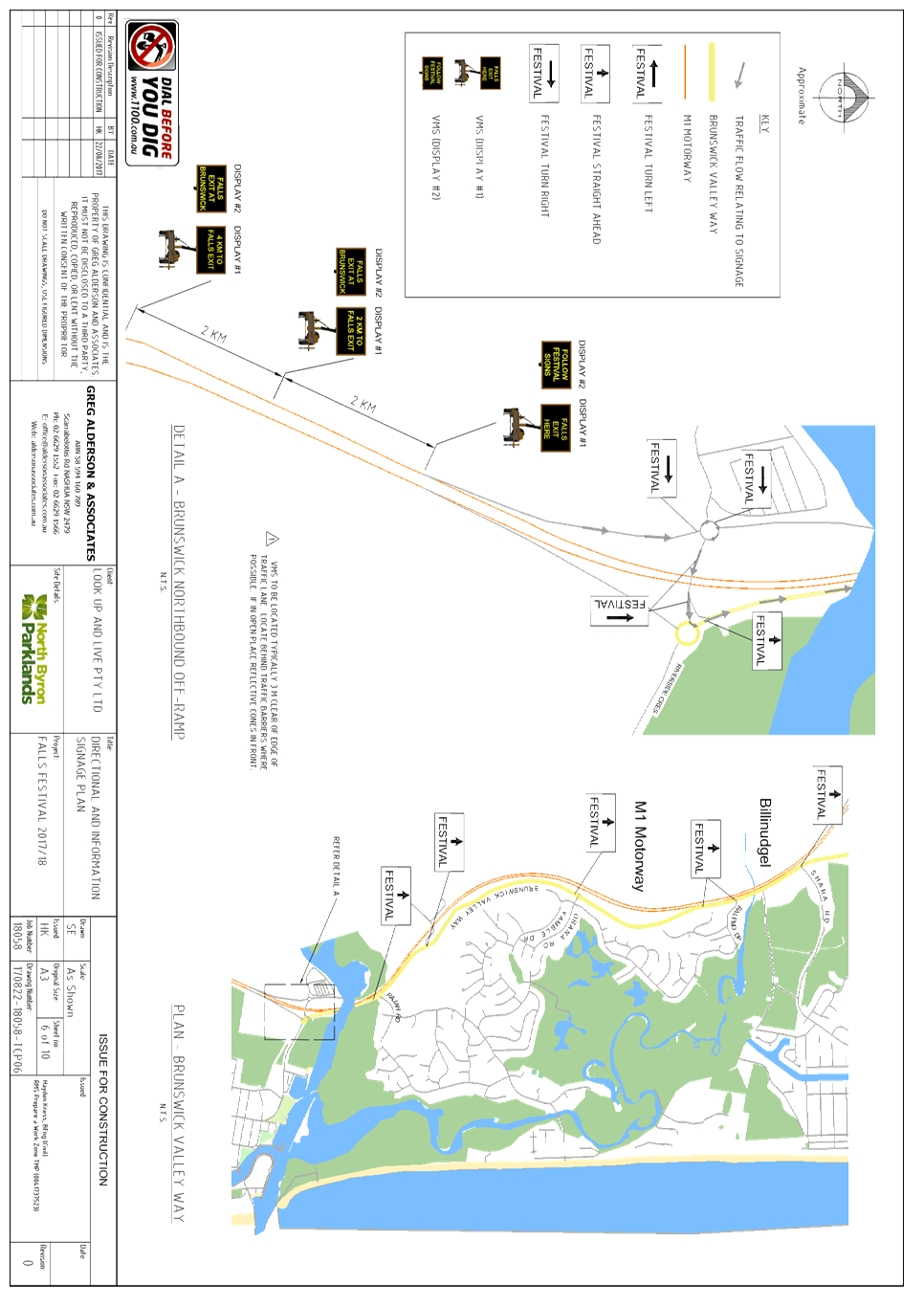
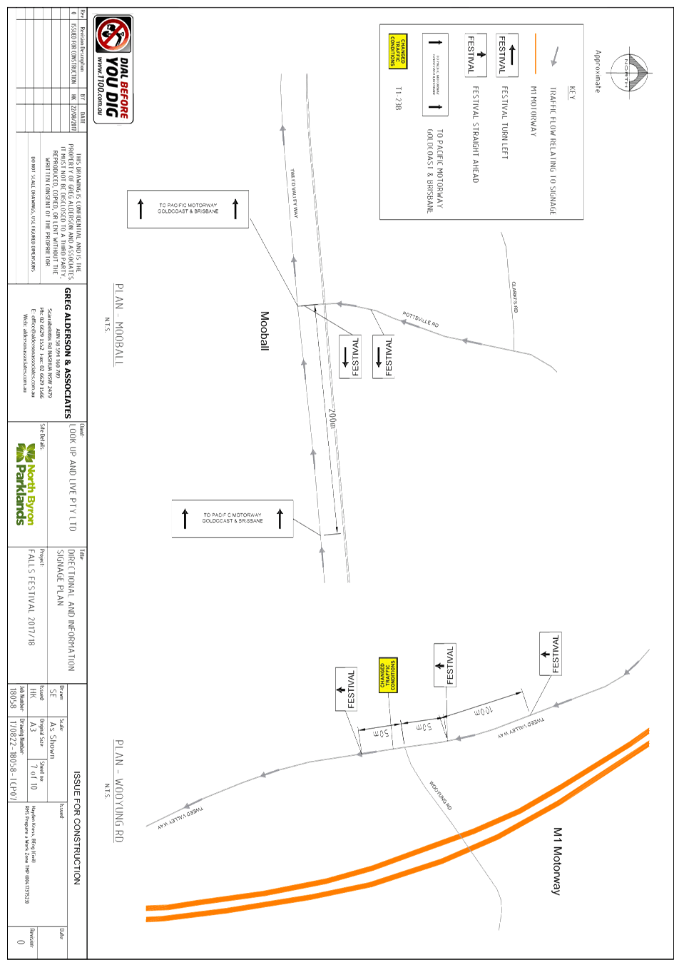
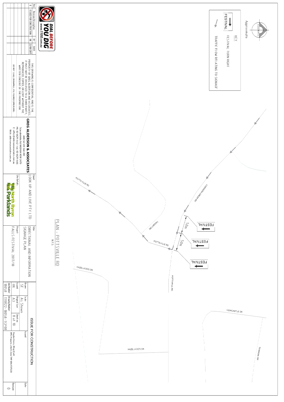
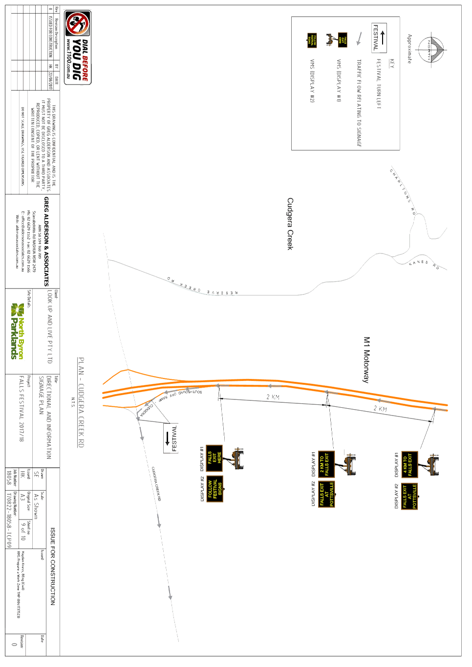
Report No. 6.2 Event Road Closures - Falls Festival 2017/18
File No: I2017/1146
SUMMARY
Council has received an
application and Traffic Control Plan (TCP) from Greg Alderson & Associates
on behalf of Look Up and Live Pty Ltd for Falls Festival 2017/18 at North Byron
Parklands in Yelgun, which is to be held during the New Year’s period of
2017/18.
The festival will be held from
Sunday 31 December 2017 to Tuesday 2 January 2018. Camper bump in will commence
on Saturday 30 December 2017. The camping areas close in the afternoon of
Wednesday 3 January 2018.
OFFICER RECOMMENDATION
That the temporary traffic
management and regulatory changes within the series of Traffic Control Plans,
as relates to the Falls Festival to be held at the North Byron Parklands site
Yelgun between Sunday 31 December 2017 and Tuesday 2 January 2018 inclusive, be
endorsed subject to specified conditions.
LINKAGE TO OUR COMMUNITY STRATEGIC PLAN
|
Theme
|
Economy
|
A sustainable and diverse economy which provides
innovative employment and investment opportunities in harmony with our
ecological and social aims.
|
|
Objective
|
EC1
|
A diverse economic base and support for local businesses.
|
|
Strategy
|
EC1.4
|
Support sporting and cultural events in Byron Shire.
|
|
Measures
|
EC1.B
|
Increase the sustainability of events in which Council is
involved.
|
BACKGROUND
The Falls Festival was held at
North Byron Parklands for the first time during the 2013/14 New Year’s Eve
period and held each year since that date. All festivals were a success from a
traffic engineering perspective with no major impacts on the public roads
during peak arrival periods.
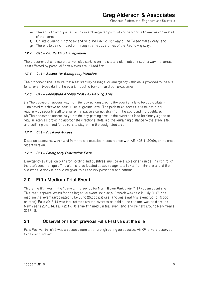
This is the fifth year in the
five-year trial period for North Byron Parklands (NBP) as an event site.
This year, approval exists for
one large trial event up to 32,500 which was held in July 2017, one medium
trial event (anticipated to be up to 25,000 patrons) and one small trial event
(up to 15,000 patrons). Falls 2013/14 was the first medium trial event to be
held at the site and was held around New Year’s 2013/14. Falls Festival
2017/18 is the fifth medium trial event and is to be held around New
Year’s 2017/18.
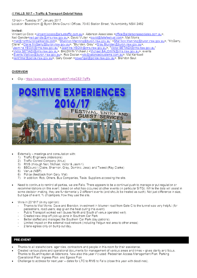
Falls Festival 2016/17 was a
success from a traffic engineering perspective. All KPI’s were
observed to be complied with. As per the conditions set out in Council
Resolution 16-640, an event debrief was held on 31 January 2017 to discuss
Falls Festival 2016/17 (minutes attached).
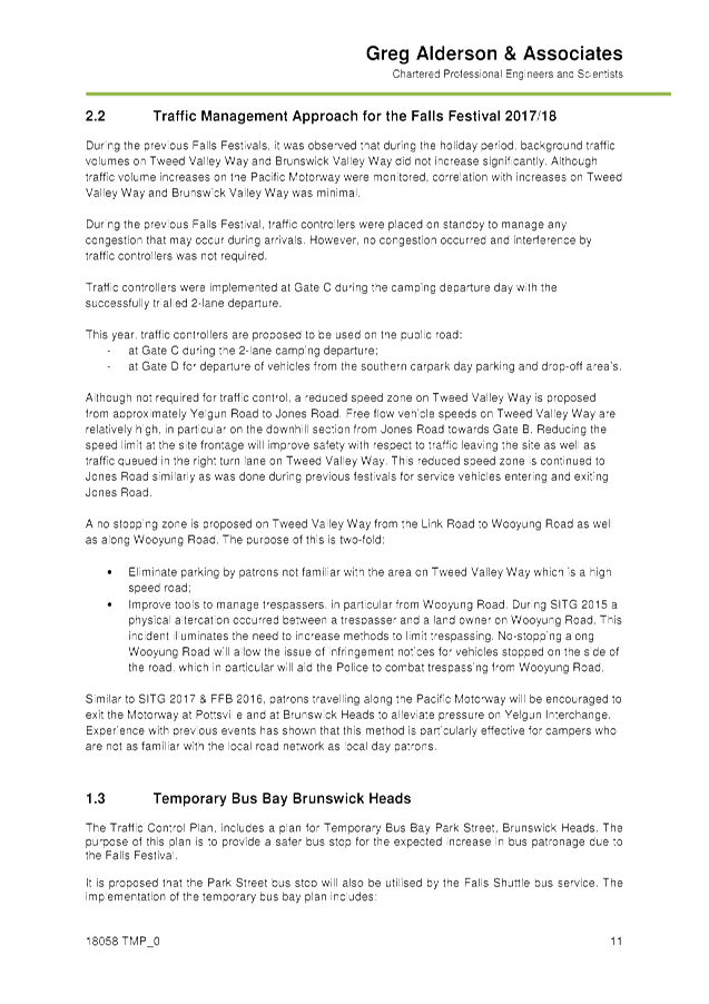
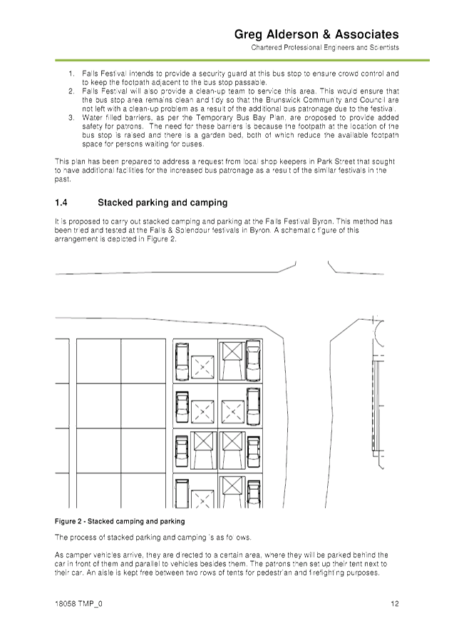
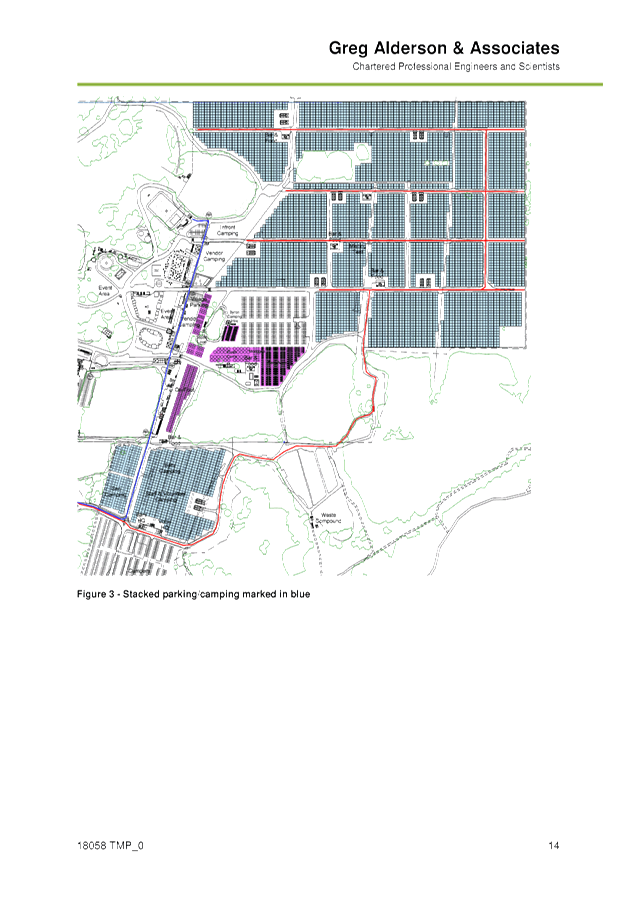
The Traffic Management Plan (TMP)
for this years event states:
This year, traffic controllers
are proposed to be used on the public road at Gate C during the 2-lane camping
departure and at Gate D for departure of vehicles from the southern carpark day
parking and drop-off area’s.
Although not required for
traffic control, a reduced speed zone on Tweed Valley Way is proposed
from approximately Yelgun Road
to Jones Road. Reducing the speed limit at the site frontage will improve
safety with respect to traffic leaving the site as well as traffic queued in
the right turn lane on Tweed Valley Way. This reduced speed zone is continued
to Jones Road similarly as was done during previous festivals for service
vehicles entering and exiting Jones Road.
A no stopping zone is proposed
on Tweed Valley Way from the Link Road to Wooyung Road as well as along Wooyung
Road.
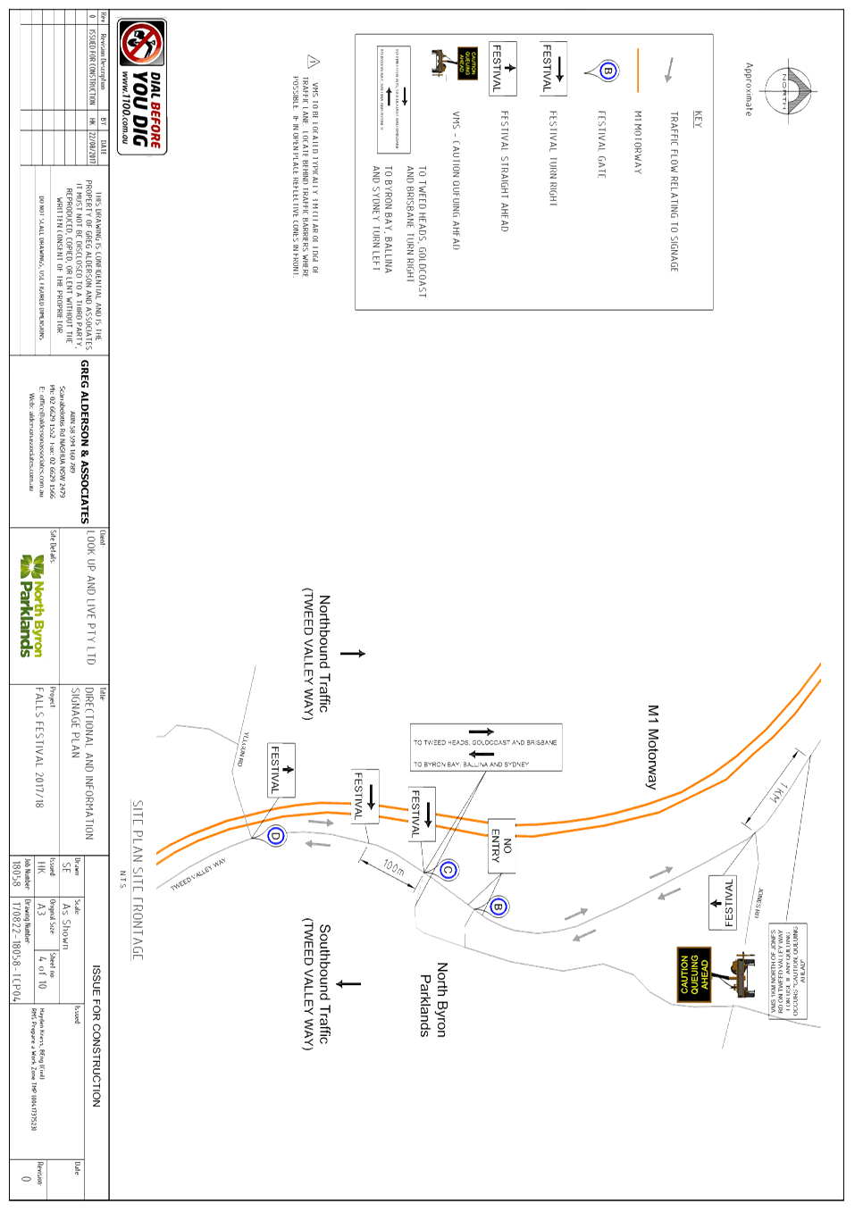
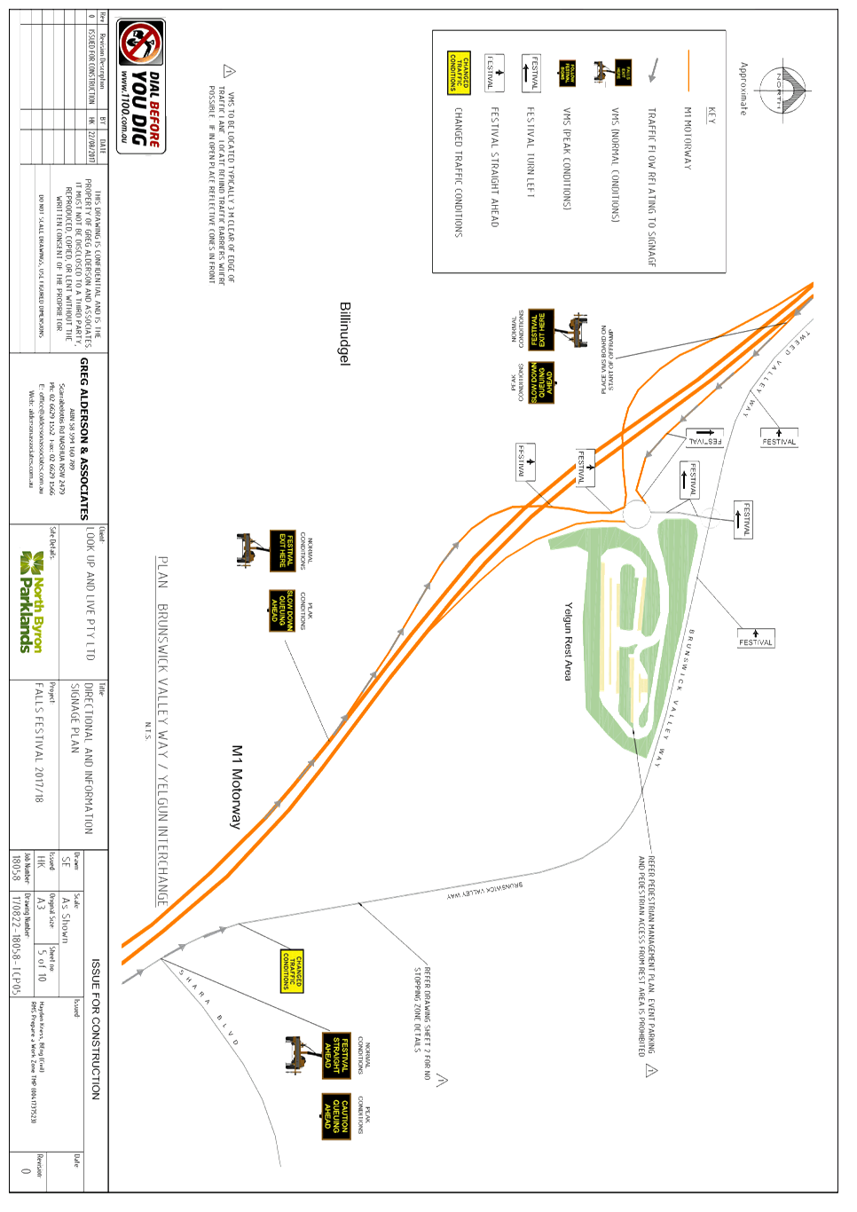
Similar to SITG 2017 & FFB
2016, patrons travelling along the Pacific Motorway will be encouraged to exit
the Motorway at Pottsville and at Brunswick Heads to alleviate pressure on
Yelgun Interchange. Experience with previous events has shown that this method
is particularly effective for campers who are not as familiar with the local
road network as local day patrons.
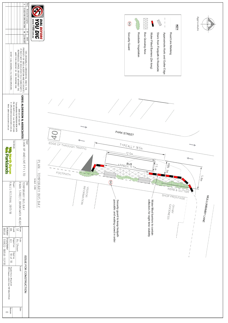
The Traffic Control Plan,
includes a plan for Temporary Bus Bay Park Street, Brunswick Heads. The purpose
of this plan is to provide a safer bus stop for the expected increase in bus
patronage due to the Falls Festival.
It is proposed that the Park
Street bus stop will also be utilised by the Falls Shuttle bus service.
KEY ISSUES
1. Congestion
caused by the event will directly affect a RMS controlled asset – Pacific
Highway.
2. Separate
approval of the TMP & TCP required by the RMS Traffic Engineering
Department.
COUNCIL IMPLICATIONS
§ Budget/Financial
The event organisers to be
invoiced for the relevant Approval of Road Events pursuant to s144 of the Roads
Act fee as per the Fees & Charges 2017/18.
§ Asset Management
N/A
§ Policy or Regulation
Regulatory traffic signage as delegated
to council for authorisation in conjunction with NSW Road Rules.
§ Consultation
A condition of the
endorsement of this event is that appropriate consultation is undertaken,
including:
· Advertising the
impact of the event in the local newspaper and on the Council website.
· Informing
community and business that are directly impacted.
· Liaising with bus
and taxi operators.
· Consulting with
emergency services.
§ Legal and Risk Management
Congestion caused by
the event will directly affect a RMS controlled asset – Pacific Highway. Separate
approval of the TMP & TCP required by the RMS Traffic Engineering
Department.
|
RECOMMENDATION:
That Council approve the Traffic Management Plan, which
includes Traffic Control Plans, for the Falls Festival 2017/18 to be held at
the North Byron Parklands site, Yelgun Sunday 31 December 2017 to Tuesday 2
January 2018 inclusive, subject to the following conditions:
a) Separate
approvals by NSW Police and RMS being obtained;
b) Implementation
of the approved Traffic Management Plan and Traffic Control Plan by those with
appropriate RMS accreditation and the holding of current and appropriate
levels of insurance and liability cover;
c) The
approved event size being sufficient (20,000 patrons) to trigger use of the
south car park as per the DA Condition for its use;
d) The
temporary ‘No Stopping’ where applied, including on Brunswick
Valley Way (between Shara Boulevard and Tweed Valley Way) and on Tweed Valley
Way (between Brunswick Valley Way and the Shire boundary), is implemented
prior to the event and in accordance with relevant state requirements and
Australian Standards;
e) A
communications protocol be developed and maintained by those involved in the
implementation of traffic management including monitoring and ability to
implement contingency plans as and when directed;
f) Monitoring
of vehicle volumes that arrive and depart the festival site and on the local
road network;
g) The
holding of an event debrief within the month following the festival which
includes but not limited to Council, RMS and Police;
h) The
event organiser:
i) advertising
the impact of the event via a notice in the local weekly paper a minimum of
one week prior to the operational impacts taking effect, noting it must
include the event name, specifics of any traffic impacts or road closures and
times, alternative route arrangements, event organiser, a personal contact
name and a telephone number for all event related enquiries or complaints;
ii) providing
a copy of the advert for Council's web page;
iii) give
consideration of any submissions received;
iv) informing
community and businesses that are directly impacted (e.g. adjacent to the
event) via written information which is delivered to the property in a timely
manner so as to document, consider and respond to any concerns raised;
v) arranging
for private property access and egress affected by the event;
vi) liaising
with bus and taxi operators and ensuring arrangements are made for provision
of services during conduct of the event;
vii) consulting
with emergency services and any identified issues be addressed;
viii) holding
$20m public liability insurance cover which is valid for the event.
ix) paying
of Council’s Road Event Application Fee prior to the event.
|
Attachments:
1 Falls
Festival 2017/18 - Traffic Management Plan (TMP), E2017/86616 , page 6⇩ 
2 Falls
Festival 2017/18 - Traffic Control Plan (TCP), E2017/86603 , page 6⇩ 
3 Falls
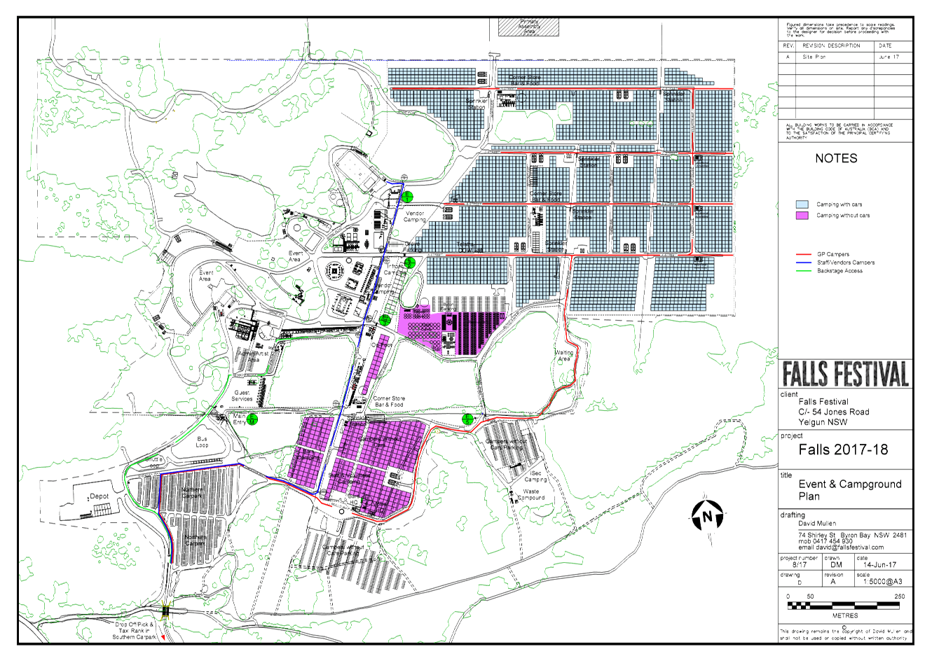
Festival 2017/18 - Event & Camp Ground Plan, E2017/86606 , page 6⇩
4 Falls
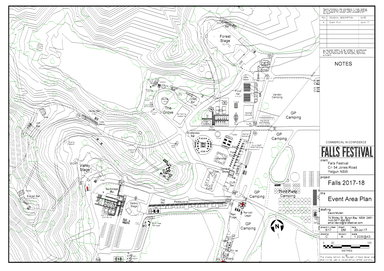
Festival 2017/18 - Event Area Plan, E2017/86607
, page 6⇩
5 Falls
Festival 2016/17 - Debrief Notes, E2017/86597
, page 6⇩
Regulatory Matters 6.2 - Attachment 1

Regulatory Matters 6.2 - Attachment 1
Regulatory Matters 6.2 - Attachment 1


Regulatory Matters 6.2 - Attachment 2
Regulatory Matters 6.2 - Attachment 3
Regulatory Matters 6.2 - Attachment 4
Regulatory Matters 6.2 - Attachment 5
Local Traffic Committee Meeting 6.3
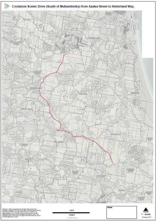
Report No. 6.3 Capital Works - Coolamon Scenic Drive (South Mullumbimby) -
Regulatory Signage and Line Marking
File No: I2017/1236
SUMMARY
A Roads and Maritime Services
(RMS) funded Road Safety Evaluation (RSE) has been conducted along the 16.5km
long Coolamon Scenic Drive (South of Mullumbimby) from Azalea Street to the
Hinterland Way. The RSE has identified the highest safety risk sections
of the road and the regulatory signage and line marking that can be installed
to reduce the risks. These works can be carried out in stages as the
funding becomes available.
OFFICER RECOMMENDATION
That Council approve the use of curve and advisory speed
signs, chevron alignment markers, unidirectional hazard markers and a white
double barrier line marking along Coolamon Scenic Drive from Azalea Street to
Hinterland Way as required.
LINKAGE TO OUR COMMUNITY STRATEGIC PLAN
|
Theme
|
Community Infrastructure
|
Services and infrastructure
that sustains, connects and integrates our communities and environment.
|
|
Objective
|
CI2
|
Provision of essential
services
|
|
Strategy
|
CI2.3
|
Provide roads and drainage
infrastructure within the Shire
|
|
Measures
|
CI2.G
|
Provide road, drainage and transport infrastructure within
the Shire
|
BACKGROUND
Coolamon Scenic Drive between Azalea Street and the
Hinterland Way is approximately 16.5km long. In early 2016 the road was
designated as Tourist Drive No. 28 and the rural default speed limit of
100km/hr speed limit was reduced to 80km/hr.
The carriageway is sealed with varying width, no kerb and
gutter and limited line marking; however the road is generally in good
condition. As such, road user safety will be increased by improving the
line marking and signage to better suit the 80km/hr speed limit.
In the 2017/18 budget Council has allocated $30,000 towards
improving the highest risk sections.
KEY ISSUES
1. Lack
of line marking and signage, which increases the risk of incidents
2. Anthony
Stante is a very vocal resident that has campaigned Council over the past few
years to install line marking and carry out a Road Safety Audit.
COUNCIL IMPLICATIONS
§ Budget/Financial
Estimate of $50,000
includes various new signs.
§ Asset Management
Estimate of $1,000 for 10
signs at $10.00 per sign/year for an expected life of 10 years. Council will
need to maintain signage ongoing, including cleaning and replacement (if
necessary).
§ Policy or Regulation
Delegated to council for
authorisation in conjunction with:
- Prescribed
traffic control devices - division 1 of Part 4 (Sections 50 to 55) of the Road
Transport (Safety and Traffic Management) Act, 1999.
§ Consultation
No consultation is
required as the project will upgrade the safety of the road in stages.
§ Legal and Risk Management
Under the NSW
WHS Act 2011 division 2 item 19 Primary duty of care to Council has a
primary duty of care to undertaking and ensure, so far as is reasonably
practicable, the health and safety of road users.
|
RECOMMENDATION:
That Council approve the use of curve and advisory
speed signs, chevron alignment markers, unidirectional hazard markers and a
white double barrier line marking along Coolamon Scenic Drive from Azalea Street
to Hinterland Way as required.
|
Local Traffic Committee Meeting 6.4
Report No. 6.4 Event Road Closures - 50th Anniversary NSW National Parks and
Wildlife Service
File No: I2017/1244
SUMMARY
Council has received an application, Traffic Management Plan
(TMP) and Traffic Control Plan (TCP) from the NSW National Parks and Wildlife
Service (NPWS) for the 50th Anniversary of the NSW NPWS to be held Sunday,
8 October 2017.
OFFICER RECOMMENDATION
That the temporary traffic
management and regulatory changes within the Traffic Control Plans, as relates
to the 50th Anniversary of the NSW NPWS to be held Sunday 8 October 2017, be
endorsed subject to specified conditions.
LINKAGE TO OUR COMMUNITY STRATEGIC PLAN
|
Theme
|
Economy
|
A sustainable and diverse economy which provides
innovative employment and investment opportunities in harmony with our
ecological and social aims.
|
|
Objective
|
EC1
|
A diverse economic base and support for local businesses.
|
|
Strategy
|
EC1.4
|
Support sporting and cultural events in Byron Shire.
|
|
Measures
|
EC1.B
|
Increase the sustainability of events in which Council is
involved.
|
BACKGROUND
October 2017 marks the 50 year
anniversary of the NSW NPWS. To celebrate the occasion NPWS will be
holding eight key events throughout the state on the 8 October 2017. The
Byron Coast Area will be hosting one of the events at the Cape Byron Lighthouse
in the Cape Byron State Conservation Area.
The event will celebrate the
history of the NSW NPWS, including five decades of conservation of NSW’s
amazing natural and cultural landscapes, heritage and environment. Above all,
the aim of the celebration is to inspire everyone to love and enjoy their
national parks.
This will be a free community
event. Some of the proposed activities are Aboriginal cultural dance,
local music, school art competitions, lighthouse tours, fauna displays and
Aboriginal art, as well as a variety of workshops focussing on conservation.
The Cape Byron Lighthouse will be
closed to vehicles for the day creating a great space for visitors, performers
and activities.
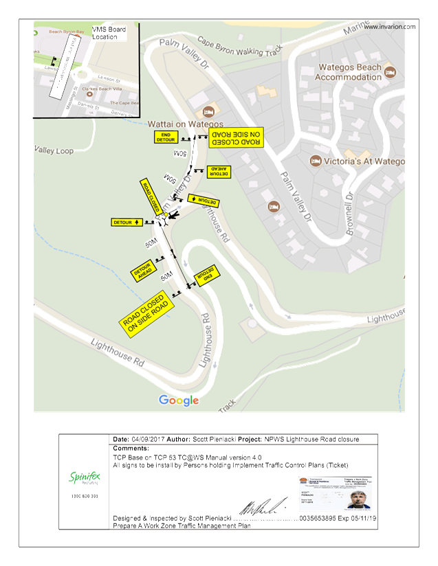
It is requested that Lighthouse
Road be closed, from the intersection of Palm Valley Drive through to the Cape
Byron Lighthouse, between 5:00am to 4:00pm. During this time the NPWS
will be operating two free shuttle buses between Lawson Street and the Cape
Byron Lighthouse, however pedestrian traffic is promoted. The NPWS has
requested the use of the Clarkes Beach bus stop to facilitate the smooth
operation of the shuttle bus service.
KEY ISSUES
1. Traffic
congestion throughout Wategos, as traffic will be detoured into Wategos at the
road closure.
COUNCIL IMPLICATIONS
§ Budget/Financial
The event organisers to be
invoiced for the relevant Approval of Road Events pursuant to s144 of the Roads
Act fee as per the Fees & Charges 2017/18.
§ Asset Management
N/A
§ Policy or Regulation
Regulatory traffic signage as delegated
to council for authorisation in conjunction with NSW Road Rules.
§ Consultation
A condition of the
endorsement of this event is that appropriate consultation is undertaken, which
may include:
· Advertising the
impact of the event in the local newspaper and on the Council website.
· Informing
community and business that are directly impacted.
· Liaising with bus
and taxi operators.
· Consulting with
emergency services.
§ Legal and Risk Management
Event organiser is required to
hold $20m public liability insurance cover which is valid for the event.
|
RECOMMENDATION:
1. That
Council endorse the Traffic Management Plan for the 50th
Anniversary of the NSW National Parks and Wildlife Service to be held on
Sunday 8 October 2017 that includes:
a) the
temporary road closure of Lighthouse Road (between Palm Valley Drive and the
Cape Byron Lighthouse) between 5:00am and 4:00pm;
b) the
use of the Clarkes Beach bus stop for the operation of the free shuttle bus
service.
2. That
the approval provided in Part 1 is subject to:
a) separate
approvals by NSW Police and RMS being obtained;
b) implementation
of the approved Traffic Management Plan and Traffic Control Plan, including
the use of signed detours, as designed and implemented by those with
appropriate accreditation;
c) that
the impact of the event be advertised via a notice in the local weekly paper
a minimum of one week prior to the operational impacts taking effect, noting
it must include the event name, specifics of any traffic impacts or road
closures and times, alternative route arrangements, event organiser, a
personal contact name and a telephone number for all event related enquiries
or complaints;
d) the
event be notified on Council’s webpage;
e) the
event organiser:
i) undertake
consultation with community and affected businesses including adequate
response/action to any raised concerns;
ii) undertake
consultation with emergency services and any identified issues addressed;
iii) hold
$20m public liability insurance cover which is valid for the event;
iv) paying
Council’s Road Event Application Fee prior to the event.
|
Attachments:
1 50th
Anniversary of the NPWS - TCP, E2017/86932
, page 6⇩
2 50th
Anniversary of the NPWS - TMP, E2017/86933
, page 6⇩
Regulatory Matters 6.4 - Attachment 1
Regulatory Matters 6.4 - Attachment 2
Local Traffic Committee Meeting 6.5
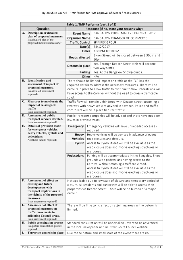
Report No. 6.5 Event Road Closures - Bangalow Christmas Eve Carnival 2017
File No: I2017/1245
SUMMARY
Council has received an application, Traffic Management Plan
(TMP) and Traffic Control Plan (TCP) from the Bangalow Chamber of Commerce for
the Bangalow Christmas Eve Carnival 2017 to be held Sunday, 24 December 2017.
OFFICER RECOMMENDATION
That the temporary traffic
management and regulatory changes within the Traffic Control Plans, as relates
to the Bangalow Christmas Eve Carnival to be held on Sunday 24 December 2017,
be endorsed subject to specified conditions.
LINKAGE TO OUR COMMUNITY STRATEGIC PLAN
|
Theme
|
Economy
|
A sustainable and diverse economy which provides
innovative employment and investment opportunities in harmony with our
ecological and social aims.
|
|
Objective
|
EC1
|
A diverse economic base and support for local businesses.
|
|
Strategy
|
EC1.4
|
Support sporting and cultural events in Byron Shire.
|
|
Measures
|
EC1.B
|
Increase the sustainability of events in which Council is
involved.
|
BACKGROUND
The Bangalow Christmas Eve
Carnival is an annual community event with performers, food vendors and
carnival rides. It is anticipated that there will be approximately 2,000
attendees.
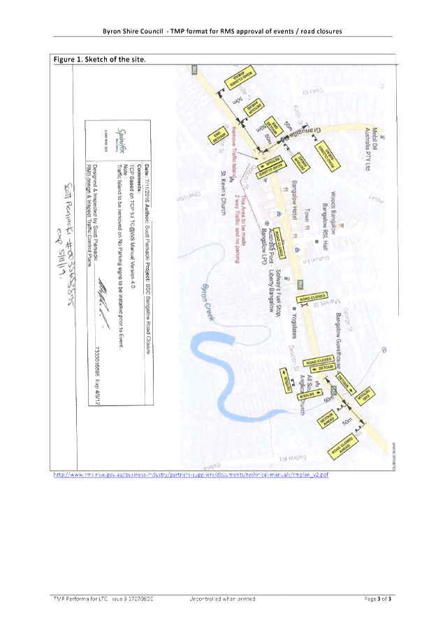
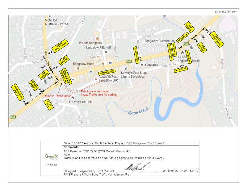
It is proposed that Byron Street
will be closed between 3:30pm and 10:00pm on Sunday 24 December 2017.
There will be detours in place to allow traffic to continue to flow.
Traffic will be directed through Deacon Street, which will facilitate two-way
traffic flow.
Parking will be available at the
Bangalow Showgrounds, which will allow pedestrians to have access to the
carnival without the need to cross a trafficable road.
COUNCIL IMPLICATIONS
§ Budget/Financial
The event organisers to be
invoiced for the relevant Approval of Road Events pursuant to s144 of the Roads
Act fee as per the Fees & Charges 2017/18.
§ Asset Management
N/A
§ Policy or Regulation
Regulatory traffic signage as delegated
to council for authorisation in conjunction with NSW Road Rules.
§ Consultation
A condition of the
endorsement of this event is that appropriate consultation is undertaken,
including:
· Advertising the
impact of the event in the local newspaper and on the Council website.
· Informing
community and business that are directly impacted.
· Liaising with bus
and taxi operators.
· Consulting with
emergency services.
§ Legal and Risk Management
Event organiser is required to
hold $20m public liability insurance cover which is valid for the event.
|
RECOMMENDATION:
1. That
Council approve the Traffic Management Plan (TMP) and Traffic Control Plan
(TCP) for the Bangalow Christmas Eve Carnival 2017 to be held Sunday 24
December 2017, that includes the temporary road closure below:
a) Byron
Street, Bangalow between Ashton Street and Granuaille, between 3:30pm and
10:00pm.
2. That
the approval provided in Part 1 is subject to:
a) separate
approvals by NSW Police and RMS being obtained, noting that the event is on a
state road or may impact the state road network;
b) implementation
of the approved Traffic Management Plan and Traffic Control Plan, including
the use of signed detours, as designed and implemented by those with appropriate
accreditation;
c) that
the impact of the event be advertised via a notice in the local weekly paper
a minimum of one week prior to the operational impacts taking effect, noting
it must include the event name, specifics of any traffic impacts or road
closures and times, alternative route arrangements, event organiser, a
personal contact name and a telephone number for all event related enquiries
or complaints;
d) the
event be notified on Council’s webpage;
e) the
event organiser:
i) undertake
consultation with community and affected businesses including adequate
response/action to any raised concerns;
ii) undertake
consultation with emergency services and address any identified issues;
iii) holding
$20m public liability insurance cover which is valid for the event;
iv) paying
Council’s Road Event Application Fee prior to the event.
|
Attachments:
1 Bangalow
Christmas Eve Carnival - TMP, E2017/87192
, page 6⇩
2 Bangalow
Christmas Eve Carnival - TCP, E2017/87016
, page 6⇩
Regulatory Matters 6.5 - Attachment 1
Regulatory Matters 6.5 - Attachment 2
Local Traffic Committee Meeting 6.6
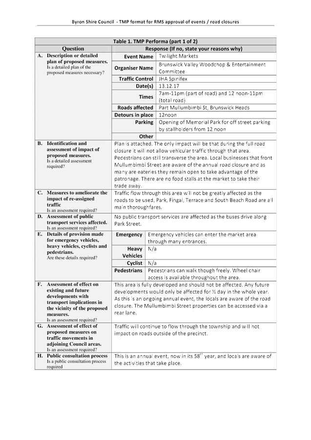
Report No. 6.6 Event Road Closures - Brunswick Woodchop Twilight Markets 2017
File No: I2017/1246
SUMMARY
Council has received an application, Traffic Management Plan
(TMP) and Traffic Control Plan (TCP) from the Brunswick Valley Woodchop &
Entertainment Committee Inc for the Twilight Markets to be held Wednesday, 13
December 2017 and the Fireworks Night to be held Saturday, 13 January 2018.
OFFICER RECOMMENDATION
That the temporary traffic
management and regulatory changes within the Traffic Control Plans, as relates
to the Twilight Markets to be held on Wednesday 13 December 2017 and the
Fireworks Night to be held on Saturday 13 January, be endorsed subject to
specified conditions.
LINKAGE TO OUR COMMUNITY STRATEGIC PLAN
|
Theme
|
Economy
|
A sustainable and diverse economy which provides
innovative employment and investment opportunities in harmony with our
ecological and social aims.
|
|
Objective
|
EC1
|
A diverse economic base and support for local businesses.
|
|
Strategy
|
EC1.4
|
Support sporting and cultural events in Byron Shire.
|
|
Measures
|
EC1.B
|
Increase the sustainability of events in which Council is
involved.
|
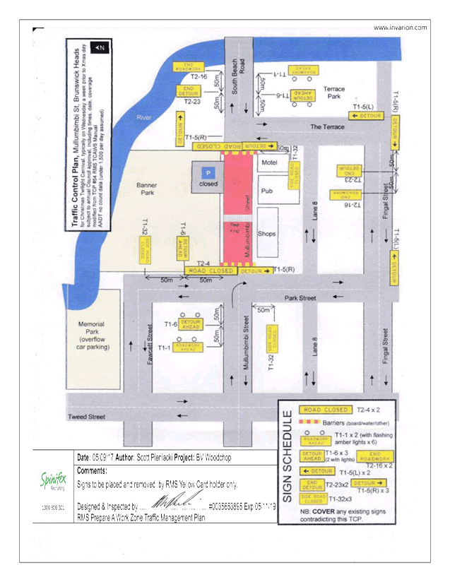
BACKGROUND
The Twilight Markets continue to
be a success and bring huge crowds to Brunswick Heads. The event organisers are
requesting:
1. Closure of Mullumbimbi Street, between The Terrace and
Park Street, as follows:
a) Closure of the area bounded by the nose-in parking and
centre parking bay from 7:00am until 11:00pm. This is the u-shaped provision
for parking that is adjacent Banner Park in the vicinity of the children's play
area.
b) Two (2) temporary designated ‘Disability
Parking’ spaces outside of the hotel during the morning. The existing two
(2) spaces will be closed off.
c) Closure of the remaining section of ‘through
road’ between The Terrace and Park Street from 12:00noon until 11:00pm.
2. Opening of Memorial Park for parking, as follows:
a) Twilight markets - Wednesday, 13 December 2017 from
12:00noon. This will allow stallholders to get their vehicles off the street
before the markets start at 3pm.
b) Fireworks Night – Saturday, 13 January 2018 from
6:00pm. This will allow for people attending the carnival/housie, and through
to when the fireworks take place at 9pm, to park off the streets.
Appropriately Accredited (JHA)
staff will be requested to put out the early blockades and the temporary
designated Disability Parking signs as per the TCP. Market staff will relocate
the blockades at 12:00noon. Market staff will remove the road closed signs and
Disability Parking and store these securely with McGregor's Amusements for
collection of JHA the next day.
As in the past McGregor's
Amusement will move their ride during the night of Tuesday 12 December 2017 and
place it over the centre parking bays for erection the next afternoon. This
effectively blocks off most of the area mentioned in item 1 above and the early
road closure will ensure that vehicles are not parked indefinitely in that area
(eg patrons of the hotel) once the premises are open for business.
COUNCIL IMPLICATIONS
§ Budget/Financial
The event organisers to be
invoiced for the relevant Approval of Road Events pursuant to s144 of the Roads
Act fee as per the Fees & Charges 2017/18.
§ Asset Management
N/A
§ Policy or Regulation
Regulatory traffic signage as delegated
to council for authorisation in conjunction with NSW Road Rules.
§ Consultation
A condition of the
endorsement of this event is that appropriate consultation is undertaken,
including:
· Advertising the
impact of the event in the local newspaper and on the Council website.
· Informing
community and business that are directly impacted.
· Liaising with bus
and taxi operators.
· Consulting with
emergency services.
§ Legal and Risk Management
Event organiser is required to
hold $20m public liability insurance cover which is valid for the event.
|
RECOMMENDATION:
1. That
the Twilight Markets to be held on Wednesday 13 December 2017, which includes
the temporary road closure/s below, be endorsed between these times:
a) Mullumbimbi
Street Brunswick Heads, between The Terrace and Park Street on Wednesday 13
December 2017, as per the following:
i) Closure
of the area bounded by the nose-in parking and centre parking bay from 7:00am
until 11:00pm. This is the u-shaped provision for parking that is adjacent
Banner Park in the vicinity of the children's play area;
ii) Two
(2) temporary designated ‘Disability Parking’ spaces be created
outside of the hotel during the morning, with signage to be installed by
appropriately accredited persons in conjunction with the implementation of
the TCP. The existing 2 spots will have been closed off;
iii) Closure
of the remaining section of ‘through road’ between The Terrace
and Park Street from 12:00noon until 11:00pm.
b) Opening
of Memorial Park for parking on Wednesday, 13 December 2017 from 12:00noon to
allow stallholders to get their vehicles off the street before the markets
start at 3:00pm.
2. That
the Fireworks Night to be held on Saturday 13 January 2018, which includes
the opening of Memorial Park for parking from 6:00pm be endorsed.
3. That
the approval provided in Part 1 and Part 2 is subject to:
a) separate
approvals by NSW Police and RMS being obtained;
b) implementation
of the approved Traffic Management Plan and Traffic Control Plan by those
with appropriate RMS accreditation and the holding of current and appropriate
levels of insurance and liability cover;
c) the
impact of the event be advertised, and charged at cost to the organisers, via
a notice in the local weekly paper a minimum of one week prior to the
operational impacts taking effect, noting it must include the event name,
specifics of any traffic impacts or road closures and times, alternative
route arrangements, event organiser, a personal contact name and a telephone
number for all event related enquiries or complaints;
d) the
event be notified on Council’s web page;
e) the
event organiser:
i) informing
community and businesses that are directly impacted (eg adjacent to the
event) via written information which is delivered to the property in a timely
manner so as to document, consider and respond to any concerns raised;
ii) arranging
for private property access and egress affected by the event;
iii) liaising
with bus and taxi operators and ensuring arrangements are made for provision
of services during conduct of the event;
iv) consulting
with emergency services and any identified issues be addressed;
v) holding
$20m public liability insurance cover which is valid for the event;
vi) paying
of Council’s Road Event Application Fee prior to the event.
|
Attachments:
1 Twilight
Markets & Fire Works - TMP, E2017/87031
, page 6⇩
2 Twilight
Markets & Fire Works - TCP, E2017/87013
, page 6⇩
Regulatory Matters 6.6 - Attachment 1
Regulatory Matters 6.6 - Attachment 2
Local Traffic Committee Meeting 6.7
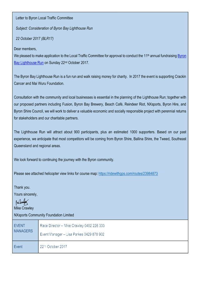
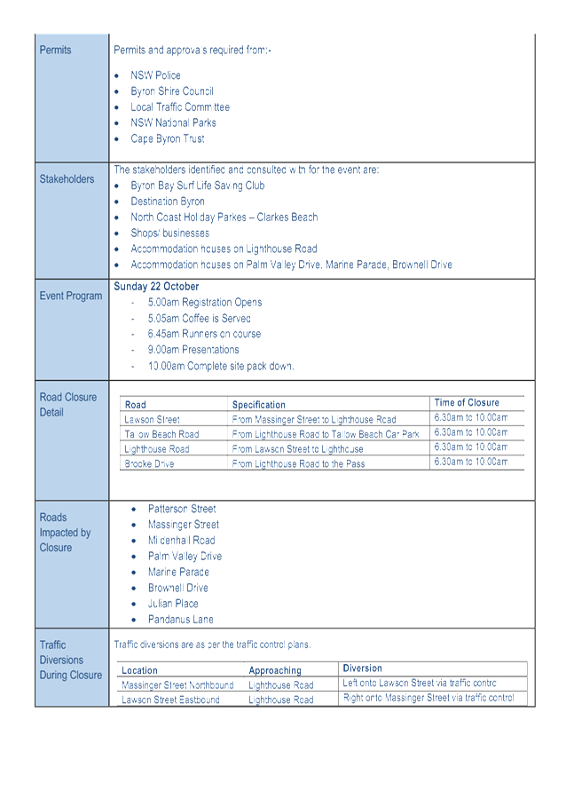
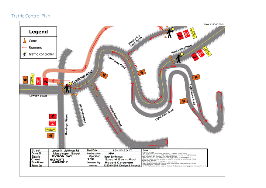
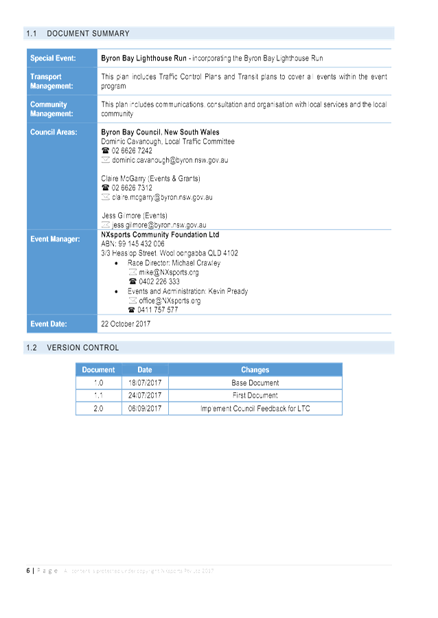
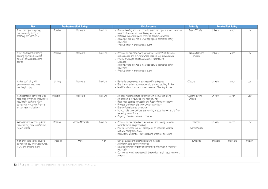
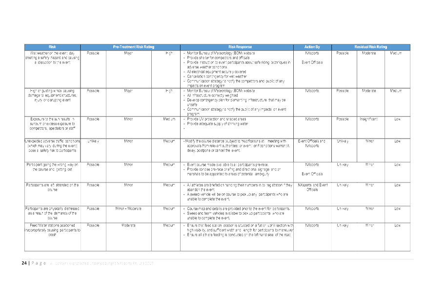
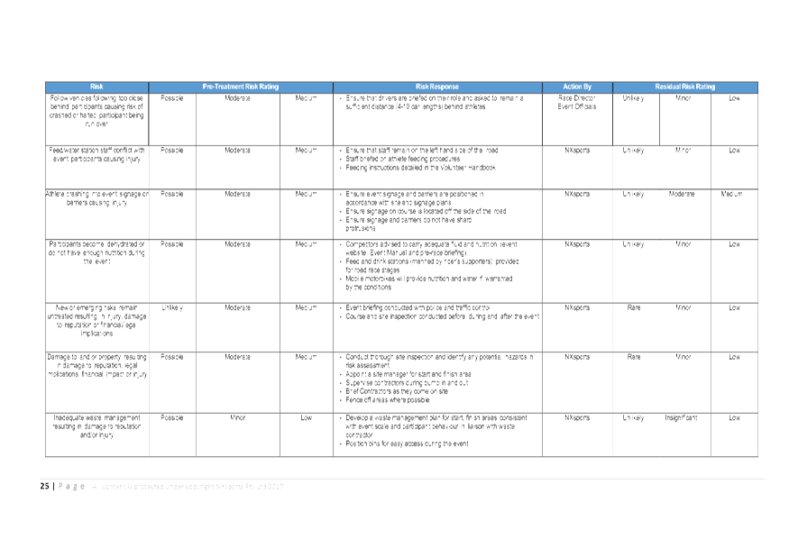
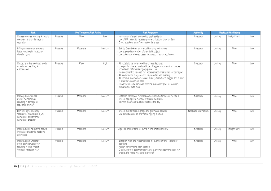
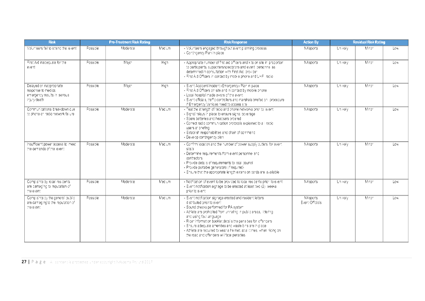
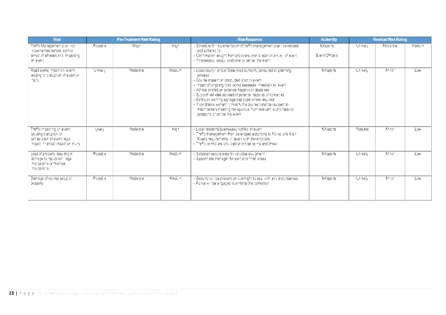
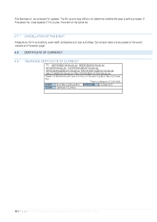
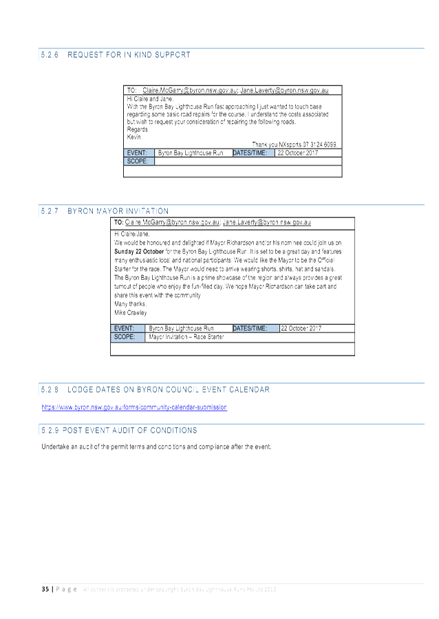
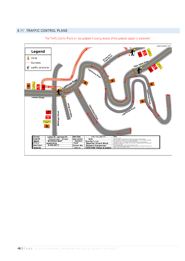
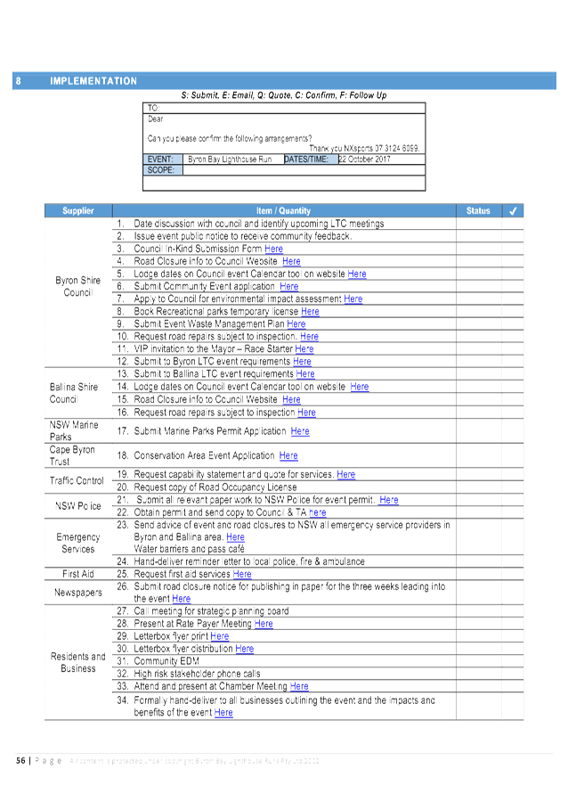
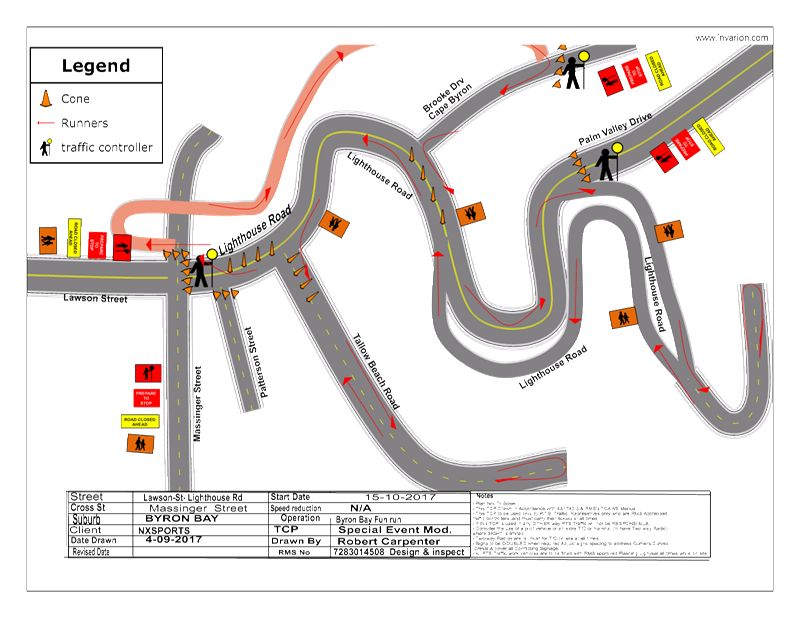
Report No. 6.7 Event Road Closures - Byron Lighthouse Run 2017
File No: I2017/1250
SUMMARY
Council has received an application, Traffic Management Plan
(TMP) and Traffic Control Plan (TCP) from NXsports Community Foundation Ltd for
the Byron Lighthouse Run 2017 to be held Sunday, 22 October 2017.
OFFICER RECOMMENDATION
That the temporary traffic
management and regulatory changes within the Traffic Control Plans, as relates
to the Byron Lighthouse Run 2017 to be held on Sunday 22 October 2017, be
endorsed subject to specified conditions.
LINKAGE TO OUR COMMUNITY STRATEGIC PLAN
|
Theme
|
Economy
|
A sustainable and diverse economy which provides
innovative employment and investment opportunities in harmony with our
ecological and social aims.
|
|
Objective
|
EC1
|
A diverse economic base and support for local businesses.
|
|
Strategy
|
EC1.4
|
Support sporting and cultural events in Byron Shire.
|
|
Measures
|
EC1.B
|
Increase the sustainability of events in which Council is
involved.
|
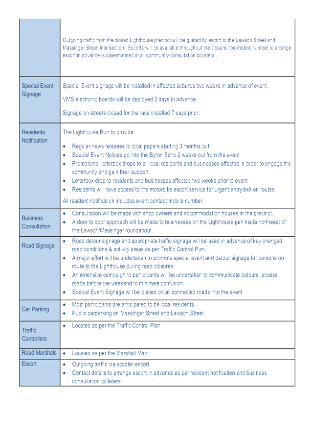
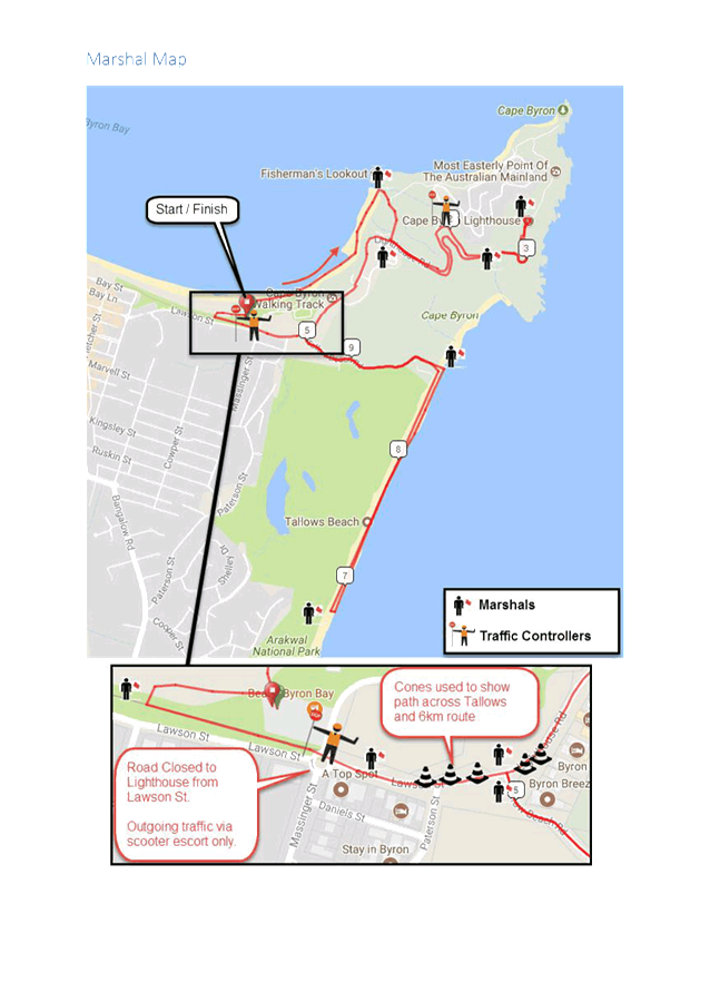
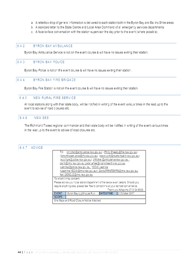
BACKGROUND
The 11th annual Byron
Lighthouse Run is proposed to be held on Sunday, 22 October 2017. It is a
fun run and walk to raise money for charity. This year the event is
supporting Crackin Cancer and Mai Wuru Foundation.
The Byron Lighthouse Run 2017
will attract about 900 participants, plus an estimated 1000 supporters. Based
on previous years, it is expected that most competitors will be coming from the
Byron Shire, the Ballina Shire, the Tweed, Southeast Queensland and regional
areas.
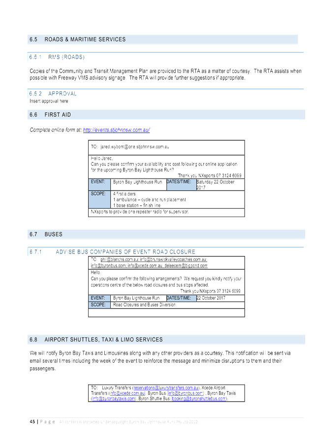
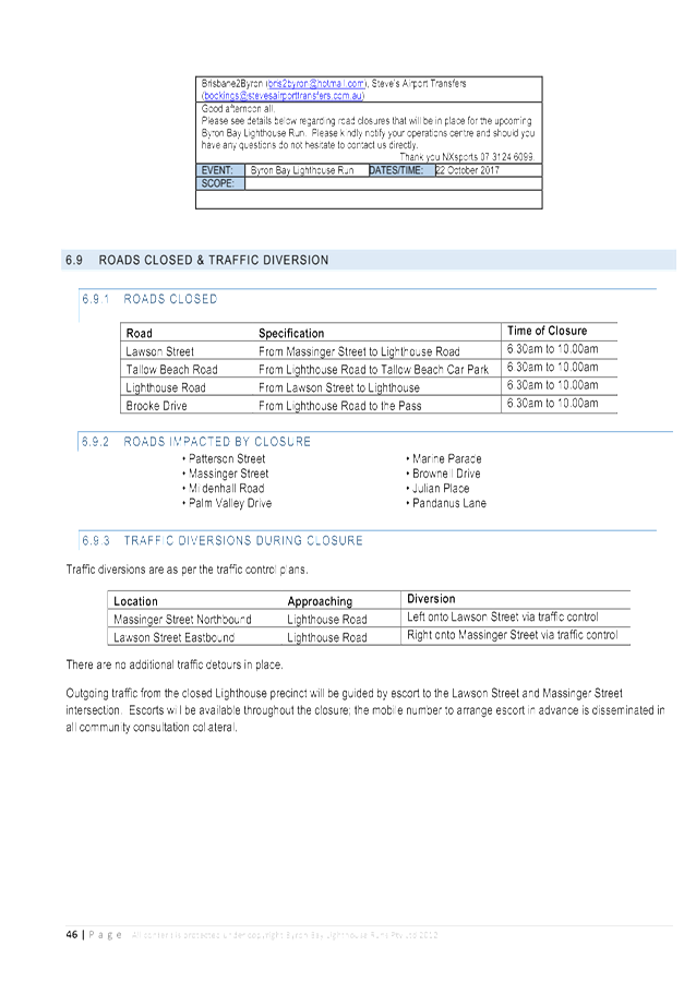
Proposed temporary road closures
include:
· Lawson
Street, between Massinger Street and Lighthouse Road, between 6:30am and
10:00am;
· Tallow
Beach Road, between Lighthouse Road and Tallow Beach Car Park, between 6:30am
and 10:00am;
· Lighthouse
Road, between Lawson Street and the Cape Byron Lighthouse, between 6:30am and
10:00am; and
· Brooke
Drive, between Lighthouse Road and the Pass, between 6:30am and 10:00am.
Traffic diversions in place
during the event include:
· Massinger
Street (northbound), approaching Lighthouse Road, will be diverted left onto
Lawson Street via traffic control; and
· Lawson
Street (eastbound), approaching Lighthouse Road, will be diverted right onto
Massinger Street via traffic control.
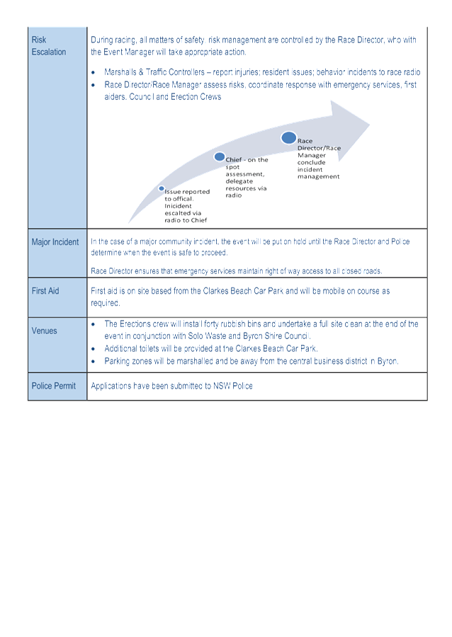
In the case of a major community
incident such as terrorism, the event will be put on hold until the Race
Director and Police determine when the event is safe to continue. Emergency
services will maintain right of way.
COUNCIL IMPLICATIONS
§ Budget/Financial
The event organisers to be
invoiced for the relevant Approval of Road Events pursuant to s144 of the Roads
Act fee as per the Fees & Charges 2017/18.
§ Asset Management
N/A
§ Policy or Regulation
Regulatory traffic signage as delegated
to council for authorisation in conjunction with NSW Road Rules.
§ Consultation
A condition of the
endorsement of this event is that appropriate consultation is undertaken, which
may include:
· Advertising the
impact of the event in the local newspaper and on the Council website.
· Informing
community and business that are directly impacted.
· Liaising with bus
and taxi operators.
· Consulting with
emergency services.
§ Legal and Risk Management
Event organiser is required to
hold $20m public liability insurance cover which is valid for the event.
|
RECOMMENDATION:
1. That
the Traffic Management Plan and Traffic Control Plan/s that relate to the
Byron Lighthouse Run 2017, to be held Sunday 22 October 2017, which includes
the temporary road closures below, be endorsed between these times:
a) Lawson
Street, between Massinger Street and Lighthouse Road, between 6:30am and
10:00am;
b) Tallow
Beach Road, between Lighthouse Road and Tallow Beach Car Park, between 6:30am
and 10:00am;
c) Lighthouse
Road, between Lawson Street and the Cape Byron Lighthouse, between 6:30am and
10:00am; and
d) Brooke
Drive, between Lighthouse Road and the Pass, between 6:30am and 10:00am.
2. That
the approval provided in Part 1 is subject to:
a) separate
approvals by NSW Police, RMS and Cape Byron Headland Trust being obtained;
b) implementation
of the approved Traffic Management Plan and Traffic Control Plan/s by those
with appropriate RMS accreditation and the holding of current and appropriate
levels of insurance and liability cover; and
c) The
event organiser:
i) advertising
the impact of the event via a notice in the local weekly paper a minimum of
one week prior to the operational impacts taking effect, noting it must
include the event name, specifics of any traffic impacts or road closures and
times, alternative route arrangements, event organiser, a personal contact
name and a telephone number for all event related enquiries or complaints;
ii) providing
copy of the advert for Council's web page;
iii) informing
community and businesses that are directly impacted (e.g. adjacent to the
event), including the Beach Byron Bay Café and North Coast Holiday
Park Clarkes Beach, via written information which is delivered to the
property in a timely manner so as to document, consider and respond to any
concerns raised;
iv) arranging
for private property access and egress affected by the event;
v) liaising
with bus and taxi operators and ensuring arrangements are made for provision
of services during conduct of the event;
vi) consulting
with emergency services with any identified issues being addressed;
vii) holding
$20m public liability insurance cover which is valid for the event; and
viii) payment
of Council’s Road Event application fee prior to the event.
|
Attachments:
1 Byron
Lighthouse Run 2017 - TMP Letter, E2017/87617
, page 6⇩ 
2 Byron
Lighthouse Run 2017 - TMP (final), E2017/87616
, page 6⇩
3 Byron
Lighthouse Run 2017 - TCP, E2017/87509
, page 6⇩
Regulatory Matters 6.7 - Attachment 1
Regulatory Matters 6.7 - Attachment 1
Regulatory Matters 6.7 - Attachment 1
Regulatory Matters 6.7 - Attachment 2

Regulatory Matters 6.7 - Attachment 2
Regulatory Matters 6.7 - Attachment 2

Regulatory Matters 6.7 - Attachment 2
Regulatory Matters 6.7 - Attachment 2


Regulatory Matters 6.7 - Attachment 3
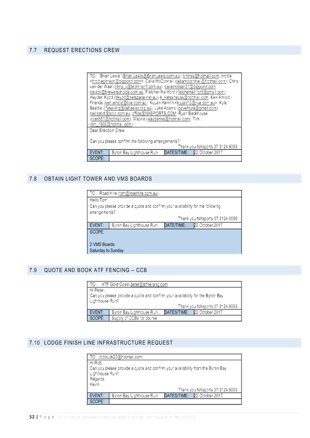
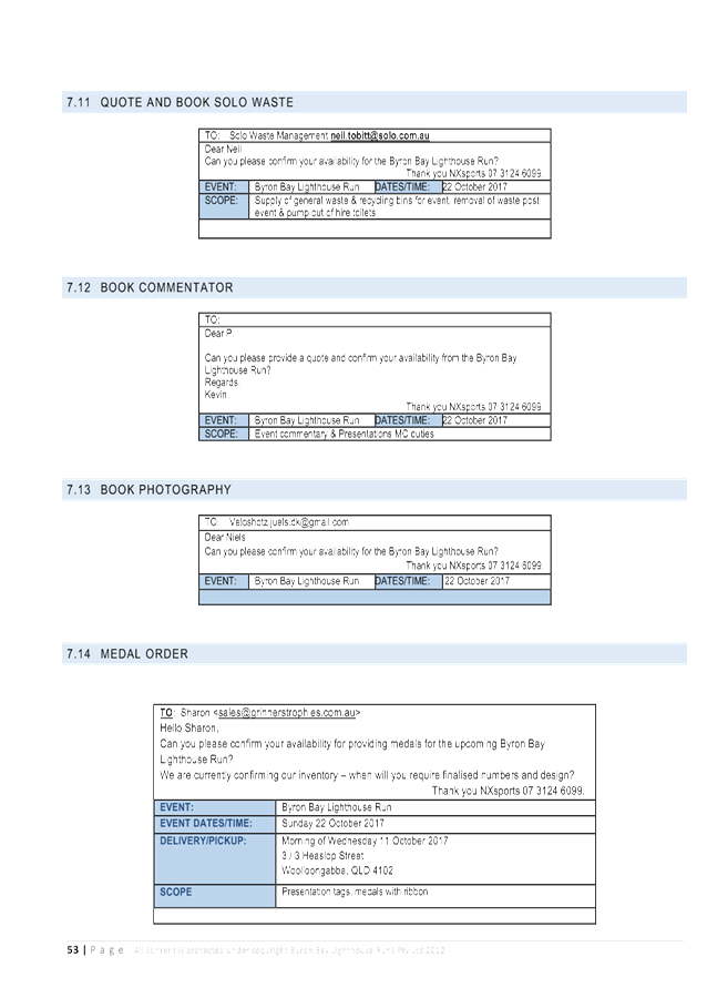
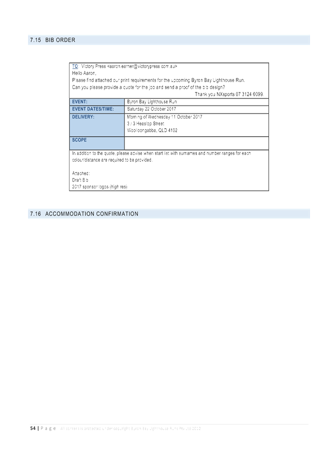
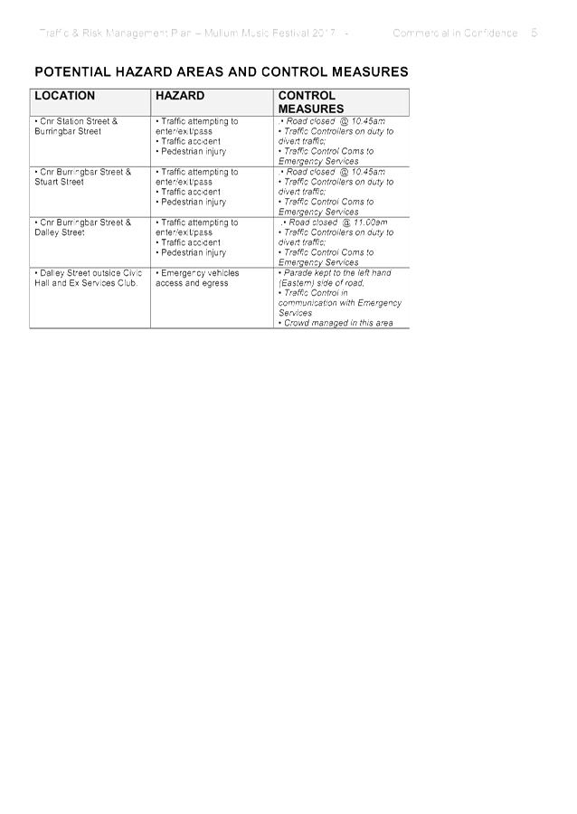
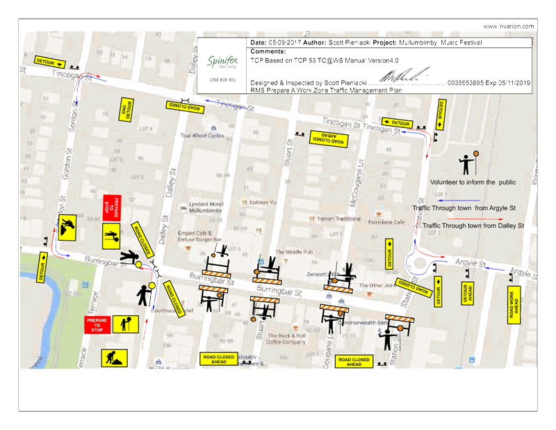
Local Traffic Committee Meeting 6.8
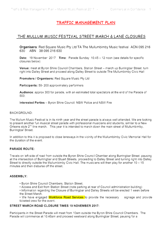
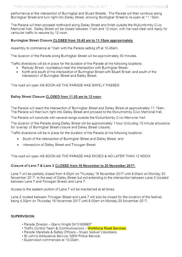
Report No. 6.8 Event Road Closures - Mullumbimby Music Festival 2017
File No: I2017/1267
SUMMARY
Council has received an
application, Traffic Management Plan (TMP) and Traffic Control Plan (TCP) from
Planners North for the Mullumbimby Music Festival 2017 to be held between
Thursday 16 November 2017 and Monday 20 November 2017, including a Street
Parade to be held on Sunday 19 November 2017.
OFFICER RECOMMENDATION
That the temporary traffic
management and regulatory changes within the Traffic Control Plans, as relates
to the Mullumbimby Music Festival 2017 to be held between Thursday 16 November
2017 and Monday 20 November 2017, be endorsed subject to specified conditions.
LINKAGE TO OUR COMMUNITY STRATEGIC PLAN
|
Theme
|
Economy
|
A sustainable and diverse
economy which provides innovative employment and investment opportunities in
harmony with our ecological and social aims.
|
|
Objective
|
EC1
|
A diverse economic base and
support for local businesses.
|
|
Strategy
|
EC1.4
|
Support sporting and cultural
events in Byron Shire.
|
|
Measures
|
EC1.B
|
Increase the sustainability of events in which Council is
involved.
|
BACKGROUND
The Mullumbimby Music Festival is
in its ninth year and this will be the seventh year that the Street Parade will
be conducted. The fun musical Street Parade, with professional musicians
and students, is always well attended; with no problems or safety issues have
been reported in the past. This year it is intended to march down the
main street of Mullumbimby, Burringbar Street, and will be conducted in the
same way as the 2016 event.
Following are the proposed
temporary road closures for the whole event:
· Dalley
Street, between Tincogan Street and Burringbar Street, between 11:00am and
12:00noon on Sunday 19 November 2017 - Street Parade;
· Burringbar
Street, between Station Street and Dalley Street, effective between 10:45am and
11:15am on Sunday 19 November 2017 - Street Parade;
· Cenotaph
Lane (formerly known as Lane 7), between Dalley Street and east of the fire
station driveway and Murphys Lane (formerly known as Lane 2), effective from 4:00pm
Thursday 16 November 2017 through to 8am Monday 20 November 2017; and
· Murphys
Lane, between Cenotaph Lane and Tincogan Street, effective from 4:00pm Thursday
16 November 2017 through to 8am Monday 20 November 2017.
There will be use of the single
event shuttle bus, “The Magic Bus” (double decker), operating
between venues. A TCP will establish the management of pick-up and set down
locations.
COUNCIL IMPLICATIONS
§ Budget/Financial
The event organisers to be
invoiced for the relevant Approval of Road Events pursuant to s144 of the Roads
Act fee as per the Fees & Charges 2017/18.
§ Asset Management
N/A
§ Policy or Regulation
Regulatory traffic signage as delegated
to council for authorisation in conjunction with NSW Road Rules.
§ Consultation
A condition of the
endorsement of this event is that appropriate consultation is undertaken, which
may include:
· Advertising the
impact of the event in the local newspaper and on the Council website.
· Informing
community and business that are directly impacted.
· Liaising with bus
and taxi operators.
· Consulting with
emergency services.
§ Legal and Risk Management
Event organiser is required to
hold $20m public liability insurance cover which is valid for the event.
|
RECOMMENDATION:
1. That
the Traffic Management Plan and Traffic Control Plan/s as relates to the
Mullumbimby Music Festival 2017, to be held between Thursday 16 November 2017
and Monday 20 November 2017, which includes the temporary road closures
below, be endorsed between these times:
a) Dalley
Street, between Tincogan Street and Burringbar Street, between 11:00am and
12:00noon on Sunday 19 November 2017 - Street Parade;
b) Burringbar
Street, between Station Street and Dalley Street, effective between 10:45am
and 11:15am on Sunday 19 November 2017 - Street Parade;
c) Cenotaph
Lane, between Dalley Street and east of the fire station driveway and Murphys
Lane, effective from 4:00pm Thursday 16 November 2017 through to 8am Monday
20 November 2017; and
d) Murphys
Lane, between Cenotaph Lane and Tincogan Street, effective from 4:00pm
Thursday 16 November 2017 through to 8am Monday 20 November 2017.
2. That
the approval provided in Part 1 is subject to:
a) separate
approvals by NSW Police and RMS being obtained;
b) implementation
of the approved Traffic Management Plan and Traffic Control Plan/s by those
with appropriate RMS accreditation and the holding of current and appropriate
levels of insurance and liability cover;
c) that
each temporary bus stop, as required by the event, be established in
accordance with the accredited Traffic Control Plan/s;
d) the
event organiser:
i) advertising
the impact of the event via a notice in the local weekly paper a minimum of
one week prior to the operational impacts taking effect, noting it must
include the event name, specifics of any traffic impacts or road closures and
times, alternative route arrangements, event organiser, a personal contact
name and a telephone number for all event related enquiries or complaints;
ii) providing
a copy of the advert for Council's web page;
iii) the
written concurrence of the Fire Stations on both Gordon Street and Dalley
Street, be obtained and copies provided to Council;
iv) informing
community and businesses that are directly impacted (eg adjacent to the
event) via written information which is delivered to the property in a timely
manner so as to document, consider and respond to any concerns raised;
v) arranging
for private property access and egress affected by the event;
vi) liaising
with bus and taxi operators and ensuring arrangements are made for provision
of services during conduct of the event;
vii) consulting
with emergency services and any identified issues be addressed;
viii) holding
$20m public liability insurance cover which is valid for the event;
ix) paying
of Council’s Road Event Application Fee prior to the event.
|
Attachments:
1 Mullumbimby
Music Festival 2017 - TMP (final), E2017/87632
, page 6⇩
2 Mullumbimby
Music Festival 2017 - TCP, E2017/87242
, page 6⇩
Regulatory Matters 6.8 - Attachment 1
Regulatory Matters 6.8 - Attachment 2
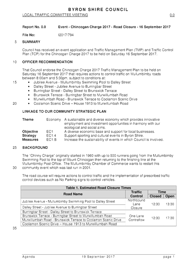
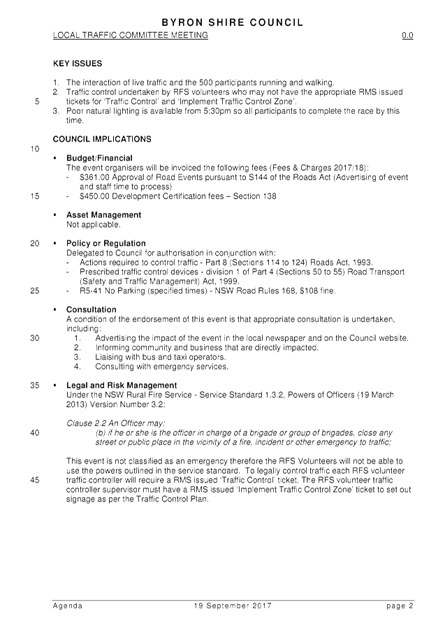
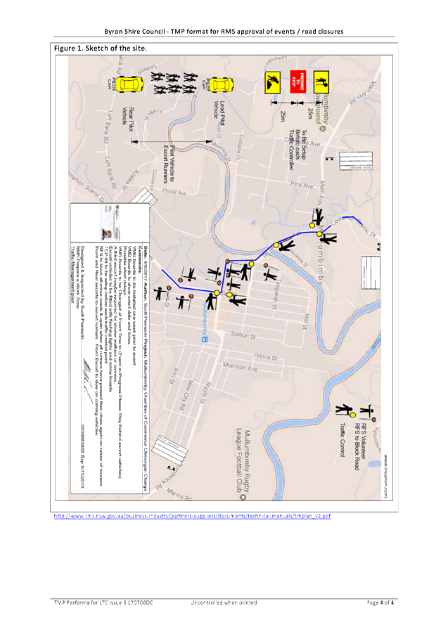
Local Traffic Committee Meeting 6.9
Report No. 6.9 Event Road Closures - Chincogan Charge 2017 (out of session)
File No: I2017/794
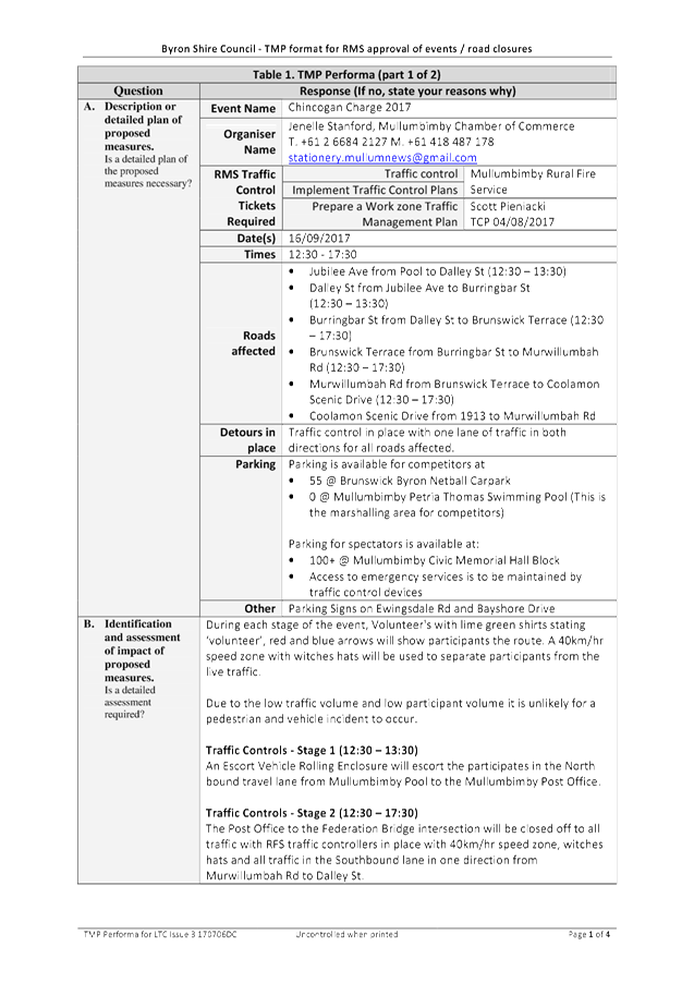
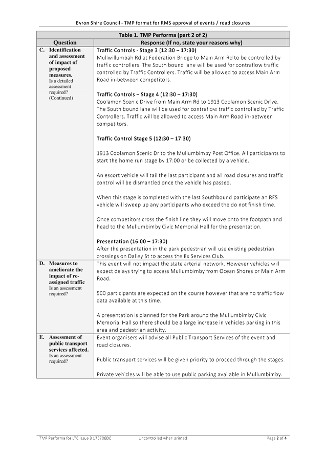
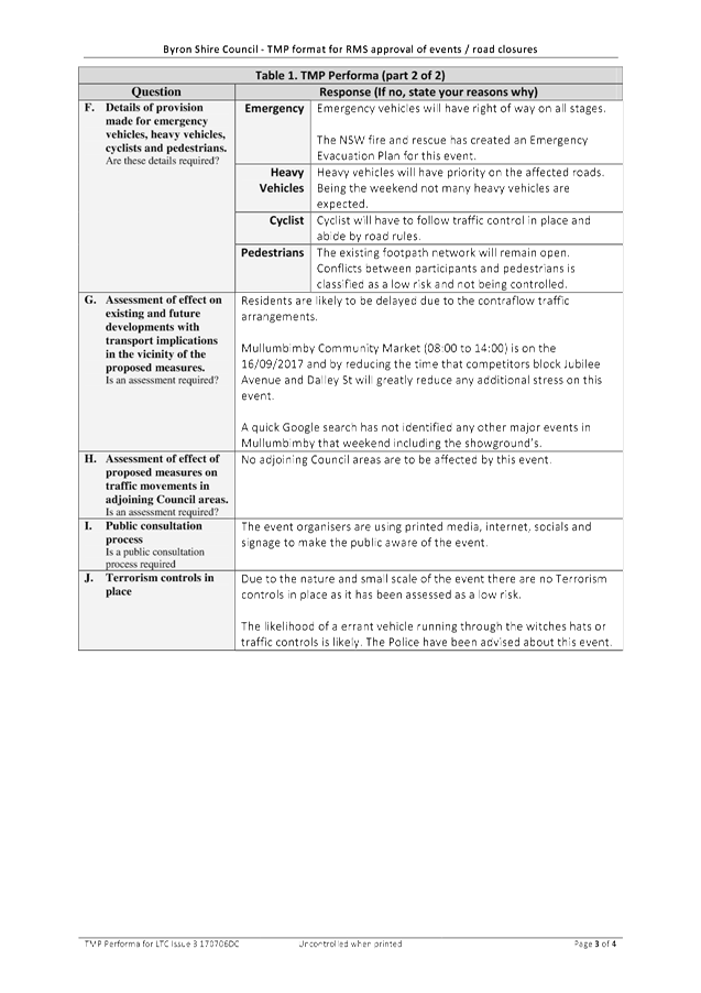
SUMMARY
Council has received an event application and Traffic
Management Plan (TMP) and Traffic Control Plan (TCP) for the Chincogan Charge 2017
to be held on Saturday 16 September 2017.
Due the short notice of the event, the Local Traffic
Committee (LTC) reviewed the TMP and TCP out of session and concurrence was
gained for the temporary road closures.
OFFICER RECOMMENDATION
That Council note that the Local Traffic Committee reviewed
the Traffic Management Plan and Traffic Control Plan for the Chincogan Charge
2017 out of session and concur with the event road closures.
LINKAGE TO OUR COMMUNITY STRATEGIC PLAN
|
Theme
|
Economy
|
A sustainable and diverse economy which provides
innovative employment and investment opportunities in harmony with our
ecological and social aims.
|
|
Objective
|
EC1
|
A diverse economic base and support for local businesses.
|
|
Strategy
|
EC1.4
|
Support sporting and cultural events in Byron Shire.
|
|
Measures
|
EC1.B
|
Increase the sustainability of events in which Council is
involved.
|
BACKGROUND
After out of session consideration by the Local Traffic
Committee and subsequent Ordinary Council meeting, on 24 August 2017, Council
resolved that:
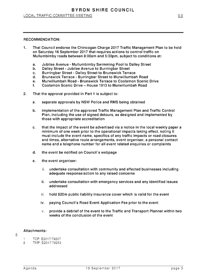
Res 17-330
1. That
Council endorse the Chincogan Charge 2017 Traffic Management Plan to be held on
Saturday 16 September 2017 that requires actions to control traffic on
Mullumbimby roads between 8:00am and 5:30pm, subject to conditions at:
a) Jubilee
Avenue - Mullumbimby Swimming Pool to Dalley Street
b) Dalley
Street - Jubilee Avenue to Burringbar Street
c) Burringbar
Street - Dalley Street to Brunswick Terrace
d) Brunswick
Terrace - Burringbar Street to Murwillumbah Road
e) Murwillumbah
Road - Brunswick Terrace to Coolamon Scenic Drive
f) Coolamon
Scenic Drive – House 1913 to Murwillumbah Road
2. That
the approval provided in Part 1 is subject to:
a)
separate approvals by NSW Police and RMS being obtained
b) implementation
of the approved Traffic Management Plan and Traffic Control Plan, including the
use of signed detours, as designed and implemented by those with appropriate
accreditation
c) that
the impact of the event be advertised via a notice in the local weekly paper a
minimum of one week prior to the operational impacts taking effect, noting it
must include the event name, specifics of any traffic impacts or road closures
and times, alternative route arrangements, event organiser, a personal contact
name and a telephone number for all event related enquiries or complaints
d) the
event be notified on Council’s webpage
e) the
event organiser:
i. undertake
consultation with community and affected businesses including adequate
response/action to any raised concerns
ii. undertake
consultation with emergency services and any identified issues addressed
iii. hold
$20m public liability insurance cover which is valid for the event
iv. paying
Council’s Road Event Application Fee prior to the event
v. provide
a debrief of the event to the Traffic and Transport Planner within two weeks of
the conclusion of the event
LTC OUT OF SESSION COMMENTS
RMS Representative
‘RMS has no objection, considering all approvals are
obtained, Council is happy and current insurances are in place’.
Local Member Representative
‘Thank you for your email, this looks fine to
me’.
|
RECOMMENDATION:
That Council note that the Local Traffic Committee
reviewed the Traffic Management Plan and Traffic Control Plan for the
Chincogan Charge 2017 out of session and concur with the event road closures.
|
Attachments:
1 Out of
Session LTC Report_Event - Chincogan Charge 2017 - Road Closure - 16 September
2017, E2017/87086 , page 6⇩
2 Chincogan
Charge 2017 - TMP, E2017/87085 ,
page 6⇩
3 Chincogan
Charge 2017 - TCP, E2017/87084 ,
page 6⇩ 
Regulatory Matters 6.9 - Attachment 1
Regulatory Matters 6.9 - Attachment 2
Regulatory Matters 6.9 - Attachment 3
Local Traffic Committee Meeting 7.1
Matters for Traffic Engineering Advice
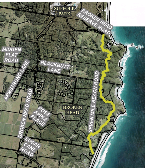
Report No. 7.1 Shared Zone - Seven Mile Beach Road, Broken Head
File No: I2017/1079
SUMMARY
Council has received requests from local residents to
introduce a shared zone within Seven Mile Beach Road, Broken Head. Such a
request will need to meet the requirements and approval of the road authority,
being Roads and Maritime Services (RMS).
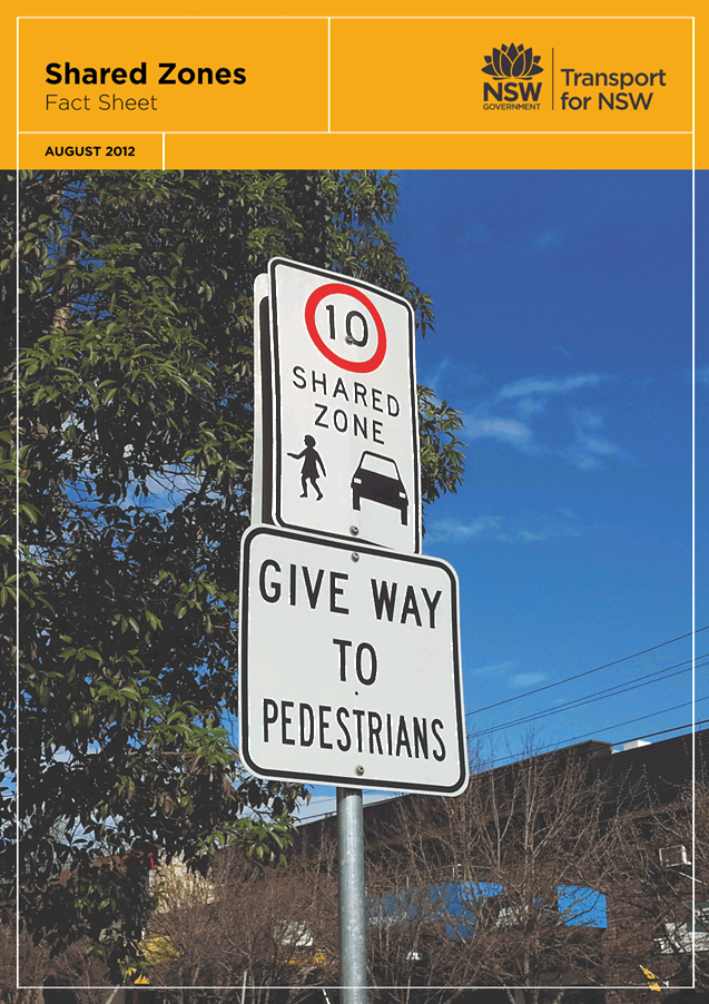
RMS provides technical direction and fact sheet outlining the
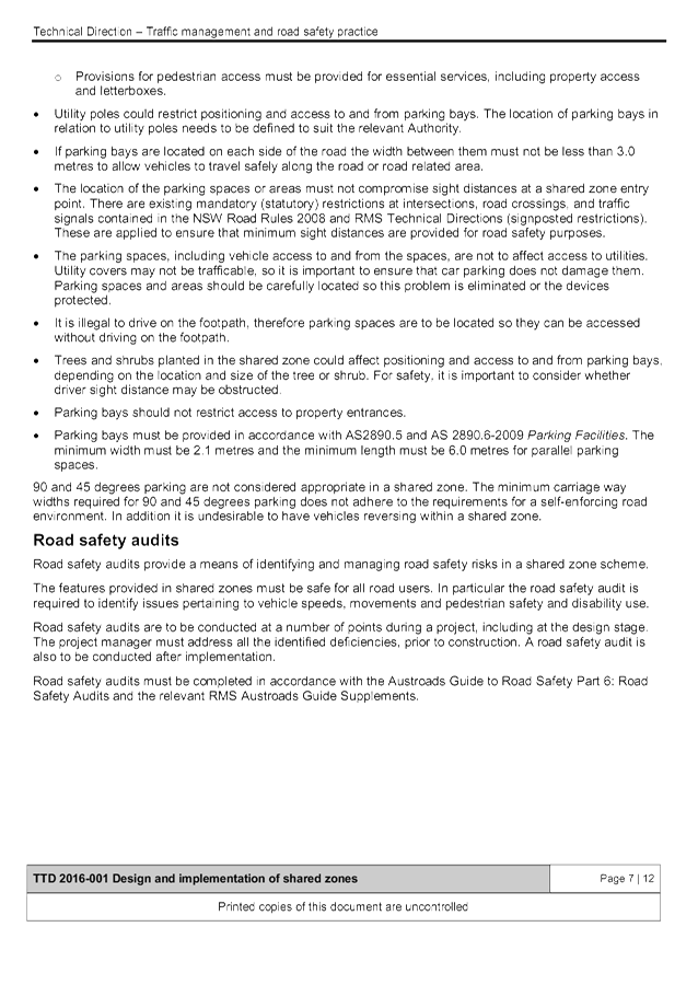
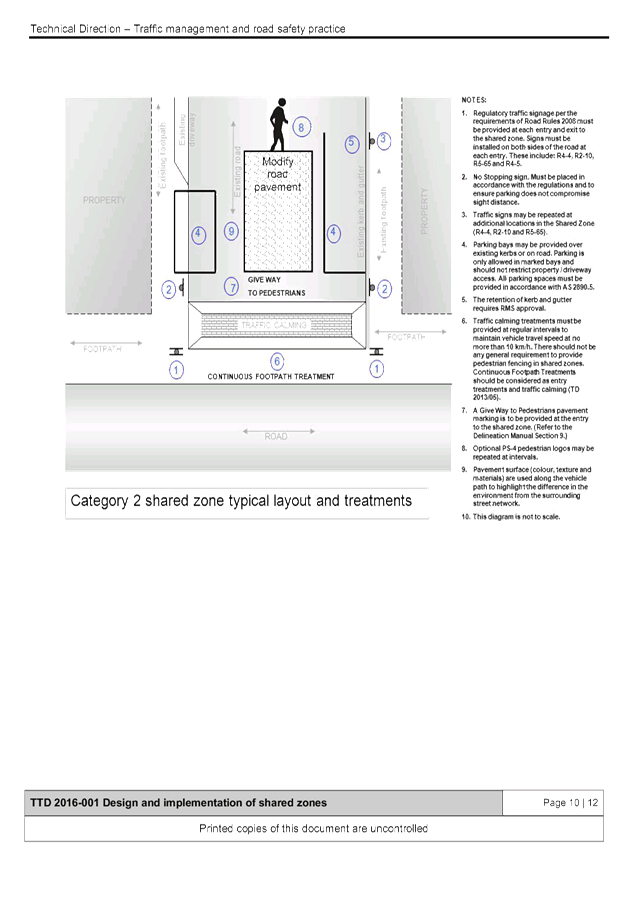
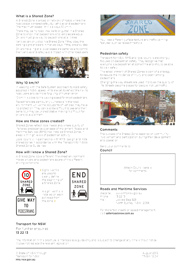
criteria for the establishment of a shared zone. A 2012 RMS fact sheet states:
· A Shared Zone
is a road or network of roads where the road space is shared safely by vehicles
and pedestrians.
· The maximum
speed limit is always 10 km/h.
· There may be no
road lines, kerb or gutter in a Shared Zone to show that pedestrians and
vehicles are equal.
· Drivers must
give way to pedestrians at all times.
· Vehicles can
only stop in a Shared Zone if they obey the parking signs and park in marked
bays, if they are provided.
· Drivers
travelling at a lower speed are better able to control their vehicles and
safely avoid impact with other road users.
OFFICER RECOMMENDATION
1. That the concerns of local residents and
their request for a shared zone within Seven Mile Beach Road, Broken Head be
noted.
2. That Council does not support any further
consideration or review into the request for a shared zone within Seven Mile
Beach Road, Broken Head.
LINKAGE TO OUR COMMUNITY STRATEGIC PLAN
|
Theme
|
Community Infrastructure
|
Services and infrastructure
that sustains, connects and integrates our communities and environment.
|
|
Objective
|
CI2
|
Provision of essential
services
|
|
Strategy
|
CI2.3
|
Provide roads and drainage infrastructure
within the Shire
|
|
Measures
|
CI2.G
|
Provide road, drainage and transport infrastructure within
the Shire
|
BACKGROUND
Seven
Mile Beach Road is a 4.8 km rural no through road located at Broken Head, which
allows access to 31 adjacent residential land parcels. It is
predominantly unsealed except for a small sealed section in the middle near
house no 248.
Following
the Council receiving ongoing complaints and requests from local residents,
there have been several meetings between local residents, NSW Police, National
Parks & Wildlife Services and Council staff. The key issues raised were:
· Illegal camping
· Camp fires (potential for bush fires)
· Parking
· Speed of vehicles
· Access for emergency services
· Environmental damage to the nature reserve
· Dead wildlife
· Antisocial and inappropriate behaviour
· Graffiti
· Defecation in the reserve and on the roadside
· Vandalism to public property and signage
· Inability of other road users (cyclists, walkers and
runners) to safely use the road.
The
residents have requested that a shared zone be implemented over the full length
of Seven Mile Beach Road.
The
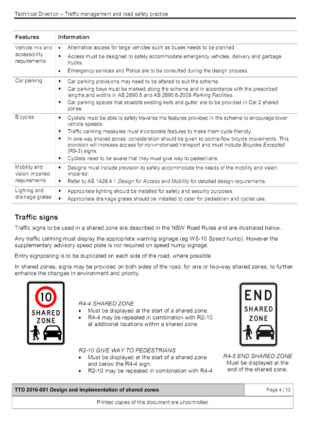
relevant RMS Technical Direction (Feb 2016, 2016/001) for the design and
implementation of shared zones, including provision for parking, provides
further detail and specific requirements, including the two categories of
shared zone, either:
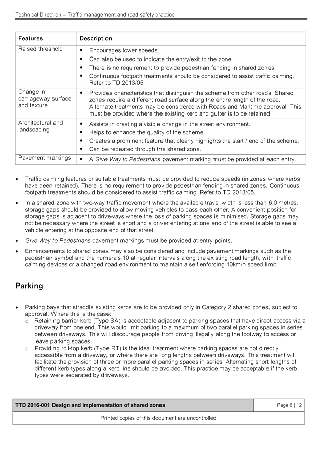
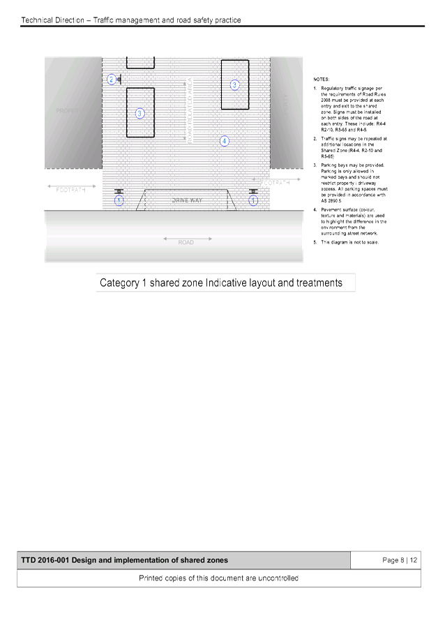
· Category 1 – on a road related area with different
colour and texture surface from surrounding roads and typically does not have
kerbs; or
· Category 2 – on a road which includes footpath
parking and has substandard footpath widths, retains kerbs and has traffic
calming devices and treatments to regulate traffic speeds to 10km/h.
In
addition, the Technical Direction (TD) also states that shared zones may be
appropriate ‘where there are comparatively high pedestrian
volumes’.
The TD
also outlines various design principles, traffic calming measures and
considerations in regard to landscaping and furniture, provision for mobility
and vision impaired people and parking.
In
summary, the RMS documents indicate that shared zones are typically used in
urban and built environments where pedestrian numbers are significant and their
needs are to be given a greater priority than other road or road related areas.
Seven
Mile Beach Road does not meet such requirements and would require substantial
upgrading to do so. Currently most of the near 5km length of this no through
road is unsealed and narrow (<5m width). There are no footpaths and as with
most unsealed roads there is no constructed kerb or gutter or street lighting.
Parking
is restricted in most sections through the enforcement of the No Stopping
regulation which is signed both sides of the road. In contrast, permissible
roadside parking typically is located where road width allows and occurs
informally by the absence of restrictions as opposed to the provision of
permissible in defined parking areas that are signed, paved and marked.
These
existing conditions however are typical of such a rural road environment which
provides access to the adjacent residential blocks. While traffic count
data is old (2003, approx. 200 vehicles per day) the number of residential
blocks indicate volumes would be low most days and times whereas traffic peaks
is presumed to coincide with visitor numbers (no data) for the nearby beaches.
Similarly,
while there is no pedestrian count to quantify numbers it can be assumed
however that most visitors drive to their destination along this road on at
least two grounds. Firstly, Seven Mile Beach Road is approx. 3km from its
closest largest urban environment (Suffolk Park); a distance which makes the
generation of high pedestrian only activity unlikely. Secondly, the number of
adjacent properties is the most likely source of pedestrian only movements. However,
their low number would not be considered “comparatively high”.
Another
factor to consider would be road safety. However, the crash data (1 crash
in last 5 years; being off-road, no injury, due to speed) does not support a
shared zone; neither does the rural setting and the presumed low speed, traffic
and pedestrian movements. As such, it is most unlikely RMS approval (or
even support for further investigation) would be forthcoming and therefore it
is recommended that no further consideration be given to the creation of a
shared zone within Seven Mile Beach Road, Broken Head.
KEY ISSUES
· Visitors/tourists are currently breaking the law by camping
overnight – safety concern, intoxicated people, rubbish & waste left,
camp fires/gases stoves used near bush land.
· Vehicle parked illegally – road is narrow with
limited parking where road width allows, parked vehicles blocking access for
emergency services.
COUNCIL IMPLICATIONS
§ Budget/Financial
No actions recommended
that require a budget.
§ Asset Management
§ No actions recommended that create
assets..
§ Policy or Regulation
R4-4 Shared Zone is not delegated
to Council for authorisation.
§ Consultation
Consultation would be
required to be undertaken.
§ Legal and Risk Management
By lowering the speed
of vehicles and making them aware of pedestrians along Seven Mile Beach Road
the consequences of a pedestrian / vehicle strike are greatly reduced.
|
RECOMMENDATION:
1. That
the concerns of the local residents and their request for a shared zone
within Seven Mile Beach Road, Broken Head be noted.
2. That
Council does not support any further consideration or review into the request
for a shared zone within Seven Mile Beach Road, Broken Head.
|
Attachments:
1 NSW
Government - Transport Roads & Maritime Services - Technical Direction
Traffic Management & Road Safety Practice - Design & implementation of
shared zones including provision for parking, E2017/86494
, page 6⇩
2 NSW
Government - Transport for NSW - Shared Zones Fact Sheet, E2017/86496 , page 6⇩
Matters for Traffic Engineering Advice 7.1 - Attachment 1
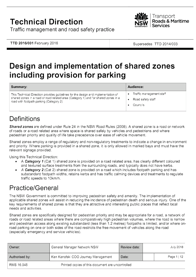
Matters for Traffic Engineering Advice 7.1 - Attachment 2
Local Traffic Committee Meeting 7.2
Report No. 7.2 Event Road Closures - Byron Bay Triathlon 2018 (for comment only)
File No: I2017/1248
SUMMARY
Council has received a proposal
from QSM Sports for the Byron Bay Triathlon 2018. The proposal has two
models for consideration by the Local Traffic Committee (LTC).
This report is purely for
consideration and comment and is not for endorsement of the actual event.
OFFICER RECOMMENDATION
That the comments from the Local
Traffic Committee, as relates to the proposed options for the Byron Bay
Triathlon 2018, be provided to the event organisers.
LINKAGE TO OUR COMMUNITY STRATEGIC PLAN
|
Theme
|
Economy
|
A sustainable and diverse
economy which provides innovative employment and investment opportunities in
harmony with our ecological and social aims.
|
|
Objective
|
EC1
|
A diverse economic base and
support for local businesses.
|
|
Strategy
|
EC1.4
|
Support sporting and cultural
events in Byron Shire.
|
|
Measures
|
EC1.B
|
Increase the sustainability of events in which Council is
involved.
|
BACKGROUND
Before the event organisers proceed
with the event application and traffic management plan submission, they have
requested that the LTC review and provide feedback on the two proposed models
for the Byron Bay Triathlon 2018.
In 2017 a new model was trialled
with the goal of reducing closure times for communities south of the Byron CBD
by providing gaps in the race to relieve built up traffic. As a result, the
overall race time on roads increased; but depending on the suburb, closure
times were reduced. Traffic management and detour management was comprehensive
throughout the effected roads; nevertheless, delays were experienced in Suffolk
Park and at Bangalow Road. The delays, particularly around Suffolk Park, again
caused upset and this was compounded as inclement weather impacted the forecast
athlete times. As a result, the road remained closed after the time posted on
VMS boards and as advised over the phone earlier in the week.
Moving forward, the priority for
the event organisers is for stakeholders to maintain an acceptable level of
safety for the participants and that the model should continue to include a
road completely closed for as short as time possible.
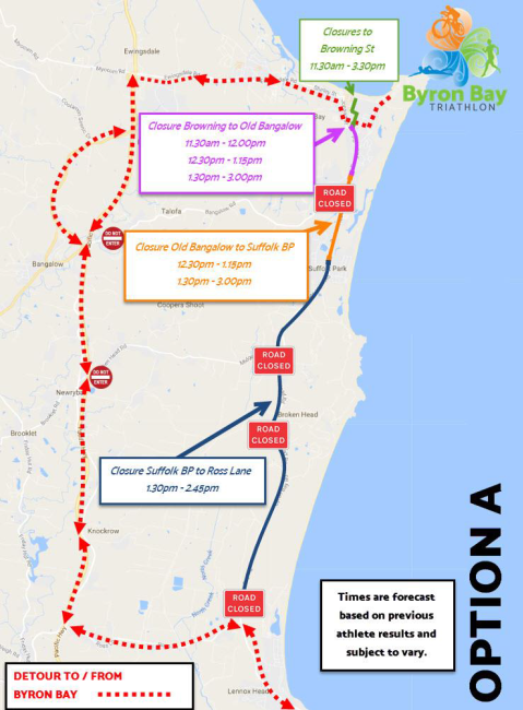
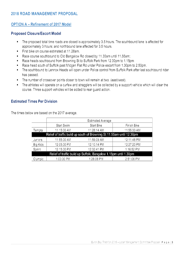
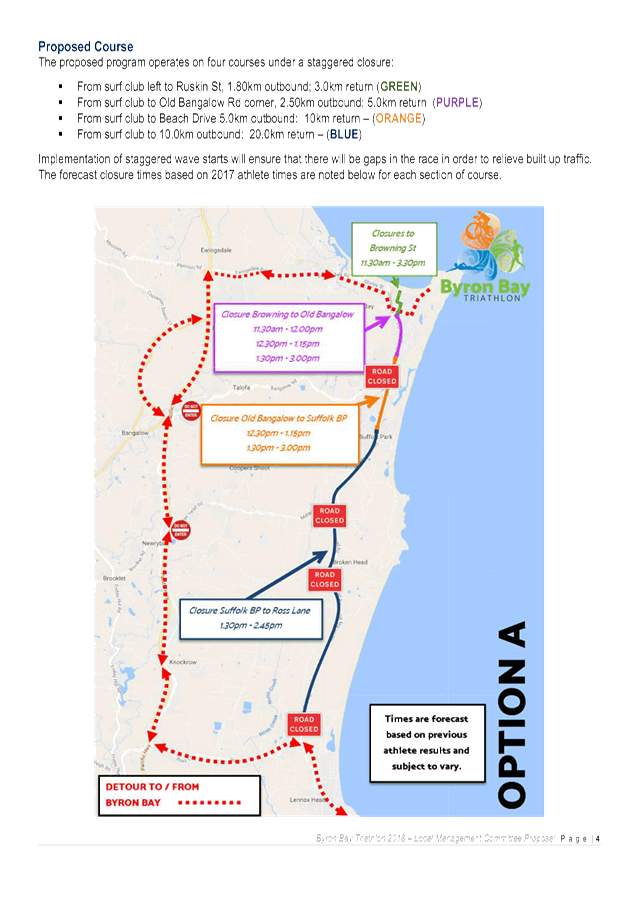
Model A – Refinement
of 2017 Model
The proposed total time roads are
closed is approximately 3.5 hours. The southbound lane is affected for
approximately 3 hours; and northbound lane affected for 3.5 hours. The proposed
model operates on four courses under a staggered closure, which will ensure
that there will be gaps in the race in order to relieve built up traffic.
This model includes temporary
road closures at:
1. Browning Street
· 11:30am-03:30pm
2. Browning Street to Old Bangalow Road
· 11:30am-12:00pm
· 12:30pm-1:15pm
· 1:30pm-3:00pm
3. Old Bangalow Road to Suffolk Park BP
· 12:30pm-1:15pm
· 1:30pm-3:00pm
4. Suffolk Park BP to Ross Lane
· 1:30pm-2:45pm
Figure 1 –
Model A: Proposed road closures
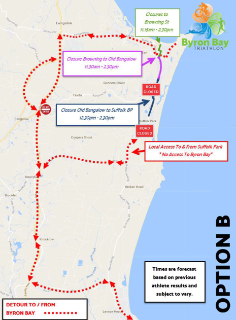
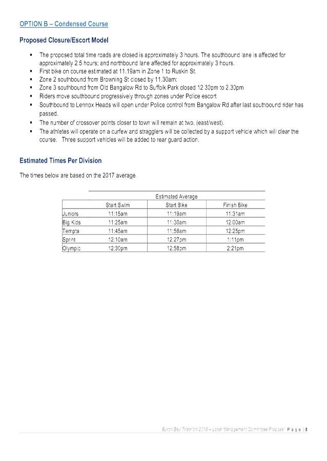
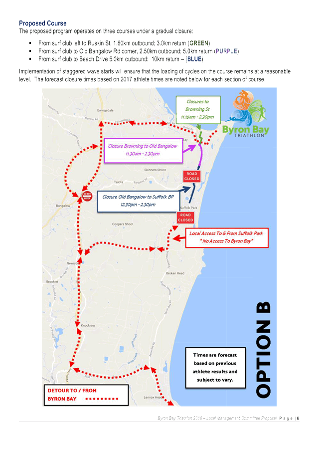
Model B – Condensed
Course
The proposed total time roads are closed is approximately 3
hours. The southbound lane is affected for approximately 2.5 hours; and
northbound lane affected for approximately 3 hours. The proposed model operates
on three courses under a gradual closure; which will ensure that the loading of
cycles on the course remains at a reasonable level.
This model includes temporary road closures at:
1. Browning Street
· 11:15am-02:30pm
2. Browning Street to Old Bangalow Road
· 11:30am-2:30pm
3. Old Bangalow Road to Suffolk Park BP
· 12:30pm-2:30pm
Figure 2 –
Model B: Condensed Course
|
RECOMMENDATION:
That the comments from the Local Traffic Committee, as
relates to the proposed options for the Byron Bay Triathlon 2018, be provided
to the event organisers.
|
Attachments:
1 Byron Bay
Triathlon 2018 - Proposed Options, E2017/87270
, page 6⇩
Matters for Traffic Engineering Advice 7.2 - Attachment 1
Local Traffic Committee Meeting 8.1
Development Applications
Report No. 8.1 DA 10.2016.632.1 - Subdivision of One Lot into Two Lots - 103
Paterson Street, Byron Bay
File No: I2017/1147
SUMMARY
Council has received a Section
82A application (E2017/83306) from Byron Bay Planning & Property
Consultants on behalf of the owners Mr M F & Mrs D M Williams regarding a
review of refusal of DA 10.2016.632.1 dated 5 May 2017 for the proposed
subdivision one (1) lot into three (3) lots and removal of seven (7) trees to
be amended to two (2) lot subdivision and removal of six (6) trees at Lot 101
DP 839601, 103 Paterson Street, Byron Bay.
It is requested that the Local
Traffic Committee (LTC) review the intersection layout proposed in the
application and provide feedback to the Planning Team for consideration.
OFFICER RECOMMENDATION
That the LTC review the intersection layout proposed in the
application and provided comments for the consideration of the Planning Team.
LINKAGE TO OUR COMMUNITY STRATEGIC PLAN
|
Theme
|
Environment
|
Our Natural and built environment is improved for each
generation.
|
|
Objective
|
EN2
|
Sustainable towns, villages and rural settlements that:
respect our natural environment; create an inclusive social environment, and
integrate harmoniously with the character of local areas; and provide more
inclusive social environments.
|
|
Strategy
|
EN2.1
|
Implement innovative and sustainable urban design to:
a) Enhance the distinctive qualities of towns and
villages.
b) Reduce urban development impacts on the environment.
c) Encourage developments with reduced reliance on cars.
d) Provide for sustainability outcomes in the development
of private lands.
|
|
Measures
|
EN2.1A&B
|
a) Increase in sustainability outcomes in the management
of Council controlled lands.
b) Implementation of relevant legislative provisions within
statutory timeframes.
|
BACKGROUND
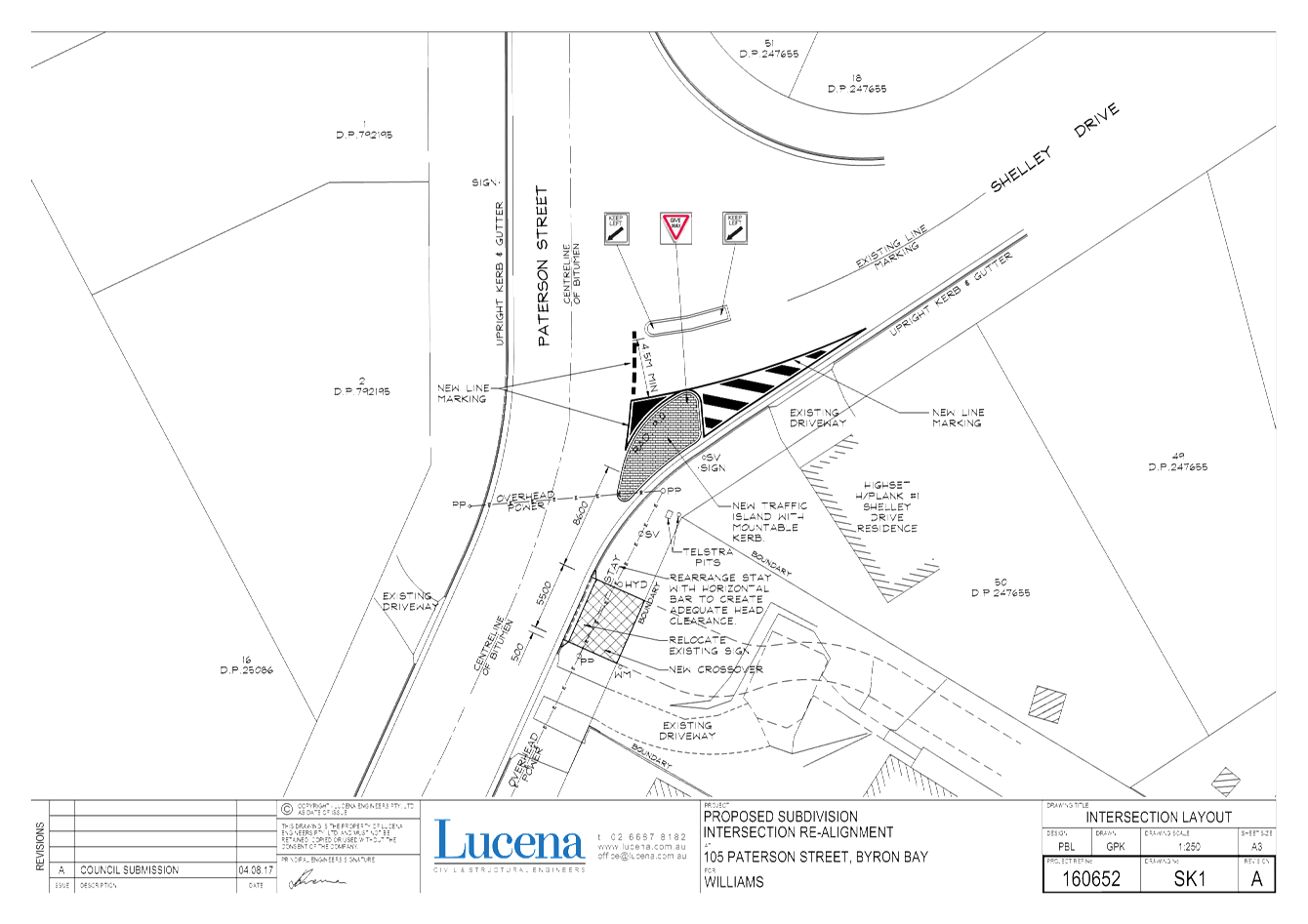
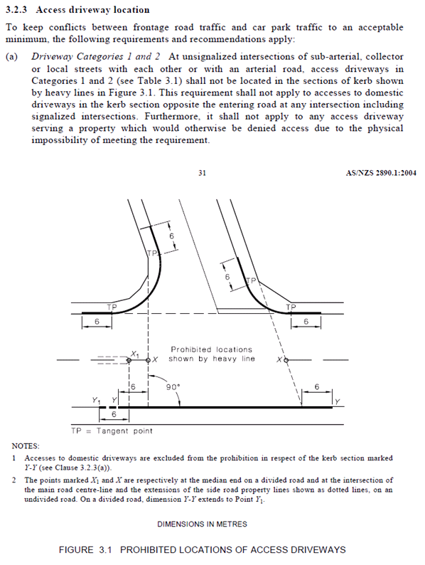
The applicant wishes to construct
a concrete island, signposting and line marking at the intersection of Paterson
Street and Shelley Drive to regulate traffic by reducing the existing
carriageway width in accordance with the attached plan. The reason the applicant
is proposing these works is to facilitate improved vehicular access to the site
for the existing dwelling and the proposed subdivision. The works will
allow a new driveway to be constructed to the site that complies with clause
3.2.3 of AS/NZS 2890.1:2004.
Authority from Council in its
capacity as delegate of Roads and Maritime Services (RMS) must be obtained for
the installation of the proposed prescribed traffic control devices shown in
the attached plans.
The Local Traffic
Committee’s advice is required in accordance with the RMS document,
Delegation to Councils – Regulation of Traffic.
|
RECOMMENDATION:
That the Local Traffic Committee’s
comments relating to DA 10.2016.632.1 be provided to the Council Planning
Team.
|
Attachments:
1 Lucena
Civil & Structural Engineers - Intersection Layout - Drawing No SK1A, E2017/84762 , page 6⇩
Development Applications 8.1 - Attachment 1