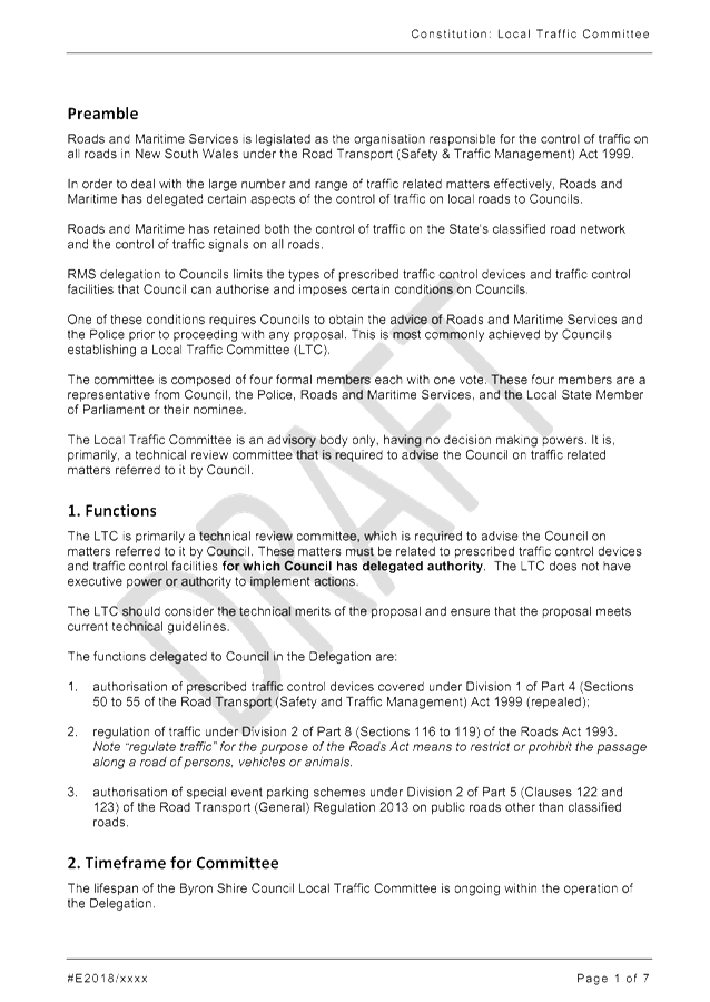
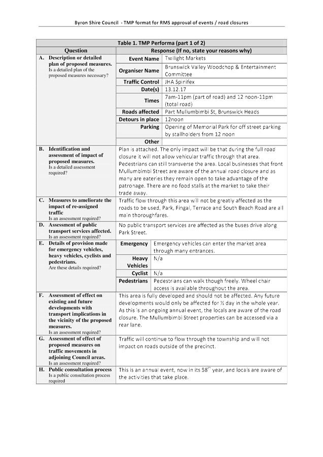
Local Traffic Committee Meeting
A Local Traffic Committee Meeting of
Byron Shire Council will be held as follows:
|
Venue
|
Conference Room, Station Street, Mullumbimby
|
|
Date
|
Tuesday, 18 September 2018
|
|
Time
|
10.30am
|
|
Committee
Members
|
Peter Stevens – Roads and
Maritime Services
Linda Makejev – Roads and Maritime Services
Snr Constable David Brigg – Police
Cr Basil Cameron
Tamara Smith MP
|

Phillip Holloway
Director Infrastructure Services I2018/1746
Distributed 11/09/18
Local Traffic Committee Meeting
BUSINESS OF MEETING
1. Apologies
2. Declarations of Interest
– Pecuniary and Non-Pecuniary
3. Adoption of Minutes from
Previous Meetings
3.1 Local
Traffic Committee Meeting held on 26 June 2018
3.2 Extraordinary
Local Traffic Committee Meeting held on 31 July 2018
4. Matters Arising
5. Outstanding
Issues/Resolutions
6. Regulatory Matters
6.1 Parking
for volunteers vehicles at RFS Mullumbimby Brigade........................................ 3
6.2 Events
- Mullumbimby Music Festival 2018 - Road Closure............................................ 5
6.3 Request
for No Stopping - 12 Browning Street, Byron Bay........................................... 14
6.4 Event
Road Closures - Brunswick Woodchop Twilight Markets 2018........................... 16
7. Matters for Traffic Engineering Advice
7.1 Events
- Byron Bay Triathlon 2019 - Traffic Management............................................. 21
7.2 Car
Share Scheme, Byron and Mullumbimby - 12 Month Pilot................................... 144
7.3 Brunswick
Heads Boat Harbour Master Plan - Traffic, Access and Parking Options. 154
7.4 Bangalow
Primary School - Parking and Traffic Management ................................... 165
7.5 Adoption
of Constitution for Local Traffic Committee.................................................. 168
Local Traffic Committee Meeting 6.1
Regulatory Matters
Report No. 6.1 Parking for volunteers vehicles at RFS Mullumbimby Brigade
File No: I2018/1151
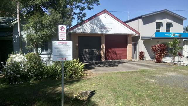
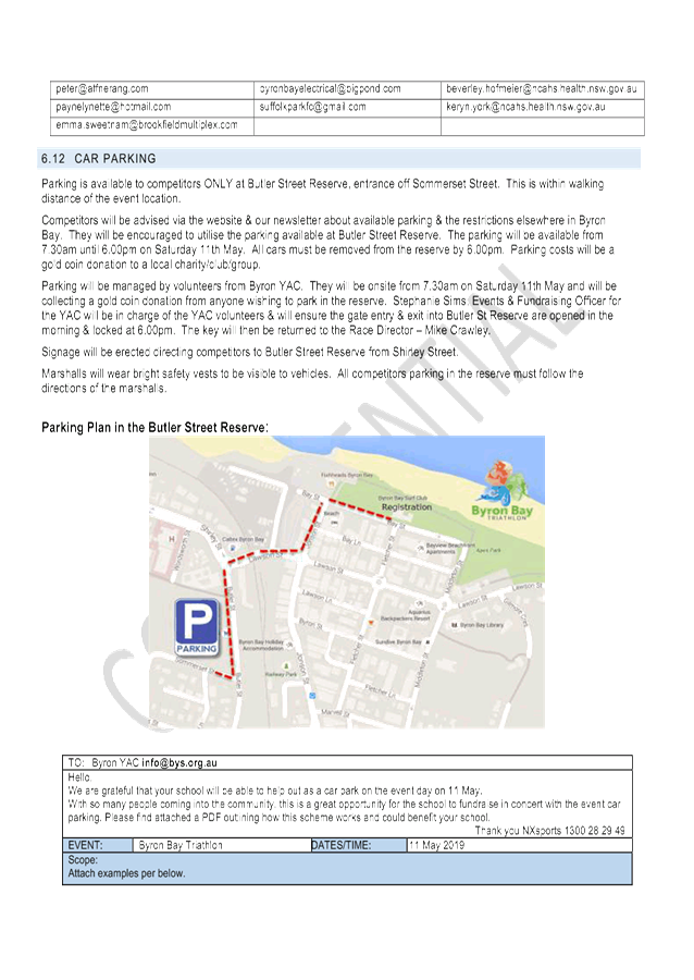
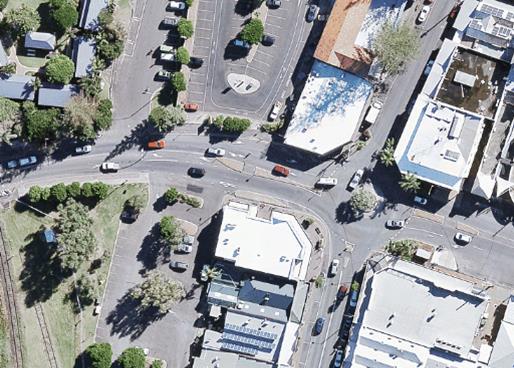
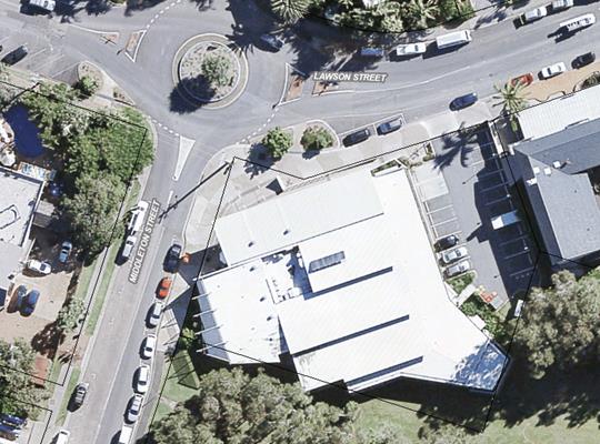
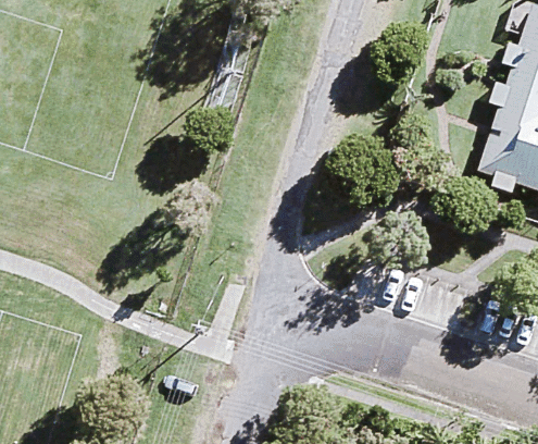
Mullumbimby RFS have requested Council to provide dedicated
parking for volunteers vehicles in Gordon Street, Mullumbimby, adjacent the RFS
Mullumbimby brigade building.
LTC are asked to consider if it is appropriate to provide
dedicated parking areas, with associated pavement and bitumen sealing works, for
private vehicles of volunteers within the road reserve to the exclusion of all
other road users.
BACKGROUND
Council receives regular requests from RFS Mullumbimby
volunteers to provide dedicated parking for volunteers vehicles in Gordon
Street Mullumbimby adjacent the RFS Mullumbimby brigade building.
Council has previously installed No
Parking – Authorised Vehicles Excepted signage in this location (as
indicated in the photograph below) in response to a RFS request and Council
resolution in 2016.
Authorised Vehicles are considered
to be vehicles owned and/or provided by an Authority, in this case the RFS,
clear signed and marked as a vehicle operated by the authority with associated
warning light system.
The current request is for parking
for volunteer parking (i.e. non authorised vehicles).
The Mullumbimby RFS is located in
the vicinity of the Ambulance and Mullumbimby Fire Station.
|
RECOMMENDATION:
That LTC recommend Council provide dedicated
parking for volunteers private vehicles in Gordon Street at the Mullumbimby
RFS brigade.
or
That LTC recommend Council not provide dedicated
parking for volunteers private vehicles in Gordon Street at the Mullumbimby
RFS brigade.
|
Local Traffic Committee Meeting 6.2
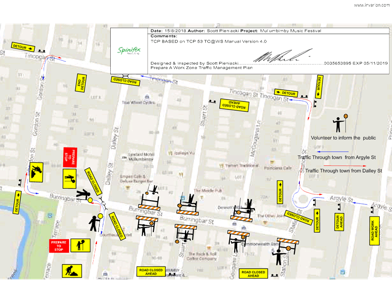
Report No. 6.2 Events - Mullumbimby Music Festival 2018 - Road Closure
File No: I2018/1571
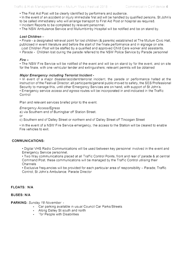
SUMMARY
Council has received an
application, Traffic Management Plan (TMP) and Traffic Control Plan (TCP) from
Planners North for the Mullumbimby Music Festival 2018 to be held between
Thursday 15 November 2018 and Monday 19 November 2018, including a Street
Parade to be held on Sunday 18 November 2018.
LTC are requested to endorse, the
temporary traffic management and regulatory changes within the Traffic Control
Plans, as relates to the Mullumbimby Music Festival 2018 to be held between
Thursday 15 November 2018 and Monday 19 November 2018, subject to specified
conditions.
BACKGROUND
The Mullumbimby Music Festival is
in its ninth year and this will be the seventh year that the Street Parade will
be conducted. The fun musical Street Parade, with professional musicians
and students, is always well attended; with no problems or safety issues have
been reported in the past. This year it is intended to march down the
main street of Mullumbimby, Burringbar Street, and will be conducted in the
same way as previous events.
Following are the proposed
temporary road closures for the whole event:
· Dalley
Street, between Tincogan Street and Burringbar Street, between 11:00am and
12:00noon on Sunday 18 November 2018 - Street Parade;
· Burringbar
Street, between Station Street and Dalley Street, effective between 10:45am and
11:15am on Sunday 18 November 2018 - Street Parade;
· Cenotaph
Lane (formerly known as Lane 7), between Dalley Street and east of the fire
station driveway and Murphys Lane (formerly known as Lane 2), effective from
4:00pm Thursday 15 November 2018 through to 8am Monday 19 November 2018; and
· Murphys
Lane, between Cenotaph Lane and Tincogan Street, effective from 4:00pm Thursday
15 November 2018 through to 8am Monday 19 November 2018.
There will be use of the single
event shuttle bus, “The Magic Bus” (double decker), operating
between venues. A TCP will establish the management of pick-up and set down
locations.
COUNCIL IMPLICATIONS
§ Budget/Financial
The event organisers to be
invoiced for the relevant Approval of Road Events pursuant to s144 of the Roads
Act fee as per the Fees & Charges 2018/19.
§ Asset Management
N/A
§ Policy or Regulation
Regulatory traffic signage as delegated
to council for authorisation in conjunction with NSW Road Rules.
§ Consultation
A condition of the
endorsement of this event is that appropriate consultation is undertaken, which
may include:
· Advertising the
impact of the event in the local newspaper and on the Council website.
· Informing
community and business that are directly impacted.
· Liaising with bus
and taxi operators.
· Consulting with
emergency services.
§ Legal and Risk Management
Event organiser is required to
hold $20m public liability insurance cover which is valid for the event.
|
RECOMMENDATION:
1. That
the Traffic Management Plan and Traffic Control Plan/s as relates to the
Mullumbimby Music Festival 2018, to be held between Thursday 15 November 2018
and Monday 19 November 2018, which includes the temporary road closures
below, be endorsed between these times:
a) Dalley
Street, between Tincogan Street and Burringbar Street, between 11:00am and
12:00noon on Sunday 18 November 2018 - Street Parade;
b) Burringbar
Street, between Station Street and Dalley Street, effective between 10:45am
and 11:15am on Sunday 18 November 2018 - Street Parade;
c) Cenotaph
Lane, between Dalley Street and east of the fire station driveway and Murphys
Lane, effective from 4:00pm Thursday 15 November 2018 through to 8am Monday
19 November 2018; and
d) Murphys
Lane, between Cenotaph Lane and Tincogan Street, effective from 4:00pm
Thursday 15 November 2018 through to 8am Monday 19 November 2018.
2. That
the approval provided in Part 1 is subject to:
a) separate
approvals by NSW Police and RMS being obtained;
b) implementation
of the approved Traffic Management Plan and Traffic Control Plan/s by those
with appropriate RMS accreditation and the holding of current and appropriate
levels of insurance and liability cover;
c) that
each temporary bus stop, as required by the event, be established in
accordance with the accredited Traffic Control Plan/s;
d) the
event organiser:
i) advertising
the impact of the event via a notice in the local weekly paper a minimum of
one week prior to the operational impacts taking effect, noting it must
include the event name, specifics of any traffic impacts or road closures and
times, alternative route arrangements, event organiser, a personal contact
name and a telephone number for all event related enquiries or complaints;
ii) providing
a copy of the advert for Council's web page;
iii) the
written concurrence of the Fire Stations on both Gordon Street and Dalley
Street, be obtained and copies provided to Council;
iv) informing
community and businesses that are directly impacted (eg adjacent to the
event) via written information which is delivered to the property in a timely
manner so as to document, consider and respond to any concerns raised;
v) arranging
for private property access and egress affected by the event;
vi) liaising
with bus and taxi operators and ensuring arrangements are made for provision
of services during conduct of the event;
vii) consulting
with emergency services and any identified issues be addressed;
viii) holding
$20m public liability insurance cover which is valid for the event;
ix) paying
of Council’s Road Event Application Fee prior to the event.
|
Attachments:
1 Mullumbimby
Music Festival 2018, E2018/75035 , page 8⇩ 
2 FINAL
Traffic Management Plan Mullum Music Fest 2018, E2018/75033 , page 9⇩ 
Regulatory Matters 6.2 - Attachment 1
Regulatory Matters 6.2 - Attachment 2
Local Traffic Committee Meeting 6.3
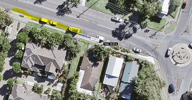
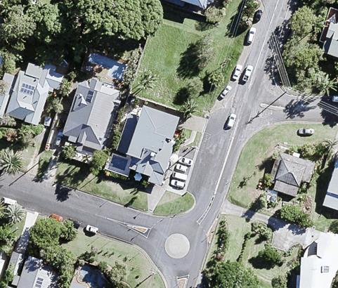
Report No. 6.3 Request for No Stopping - 12 Browning Street, Byron Bay
File No: I2018/1586
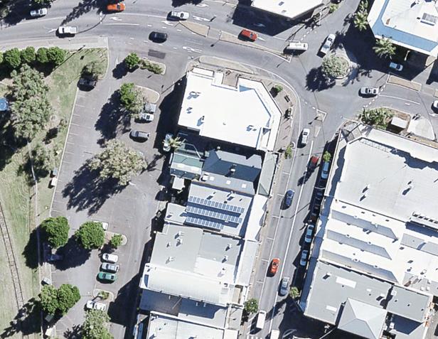
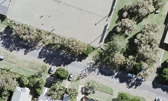
Council’s Resource Recovery team has received a
request to restrict parking for the frontage of 12 Browning Street, Byron Bay
to better facilitate waste collection services. (Refer to blue line below.)
BACKGROUND
DA10.2016.392.1 granted development consent for 13 * 3
bedroom townhouses.
Bins for the development must be presented on Browning
Street. Subsequent to development consent being granted it has been identified
that cars parked on Browning Street in the vicinity of the development
potentially prevent waste collection trucks accessing these bins.
To provide unrestricted access to bins it is requested that
appropriate signage be installed to ensure no parking between 6pm – 8pm. These
hours are designed to coincide with existing signage and waste collection
hours.
This request is the same as a previous approval granted to
the adjoining property, 6-8 Browning Street, where LTC recommended (on April
2016) “No Stopping” for the times and days of waste services
only. In the photo shown below the “No Stopping” zone approved
in April 2016 is shown below in yellow. The blue line indicates the
approximate zone forming part of this current request.
KEY ISSUES
1. Council
currently unable to guarantee waste collection for 12 Browning St due to
potential parked cars blocking bin access.
2. LTC
approved similar request in April 2016 for 6-8 Browning St.
3. The
request requires RMS consent as Browning St is a Classified Road
COUNCIL IMPLICATIONS
§ Budget/Financial
The cost of modifying parking by
implementing new signage and line marking will require expenditure from
Council’s Resource Recovery budget.
§ Asset Management
Not Applicable
§ Policy or Regulation
Delegated
to Council for authorisation in conjunction with:-
o Actions required to control traffic – Part 8
(Sections 114 to 124) Roads Act, 1993.
o Traffic Control Devices –Part 5 (Sections 18-22) Road
Transport (Safety and Traffic Management) Act, 1999.
o No Stopping and No Parking Signs and Road Markings –
Division 2, NSW Road Rules 168.
|
RECOMMENDATION:
That “No Stopping” apply at the
frontage of 12 Browning Street, Byron Bay for the times and day of waste
services only.
|
Local Traffic Committee Meeting 6.4
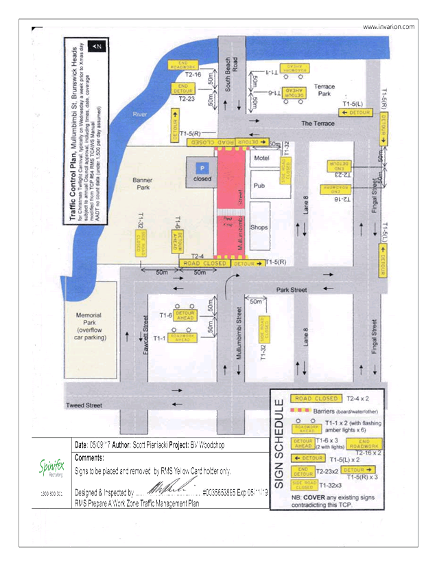
Report No. 6.4 Event Road Closures - Brunswick Woodchop Twilight Markets 2018
File No: I2018/1683
SUMMARY
Council has received an application from the Brunswick
Valley Woodchop & Entertainment Committee Inc for the Twilight Markets to
be held Wednesday, 19 December 2018 and the Fireworks Night to be held
Saturday, 19 January 2019.
The application includes the Traffic Management Plan (TMP)
and Traffic Control Plan (TCP) from the 2017 event.
LTC are requested to endorse the Twilight
Markets to be held on Wednesday 19 December 2018 and the Fireworks Night to be
held on Saturday 19 January 2019, subject to specified conditions including the
provision of updated temporary traffic management and Traffic Control Plans to
Council.
BACKGROUND
The Twilight Markets continue to
be a success and bring huge crowds to Brunswick Heads. The event
organisers are requesting:
1. Closure of Mullumbimbi Street, between The Terrace and
Park Street, as follows:
a) Closure of the area bounded by the nose-in parking and
centre parking bay from 7:00am until 11:00pm. This is the u-shaped
provision for parking that is adjacent Banner Park in the vicinity of the
children's play area.
b) Two (2) temporary designated ‘Disability
Parking’ spaces outside of the hotel during the morning. The existing two
(2) spaces will be closed off.
c) Closure of the remaining section of ‘through
road’ between The Terrace and Park Street from 12:00noon until 11:00pm.
2. Opening of Memorial Park for parking, as follows:
a) Twilight markets - Wednesday, 19 December 2018 from
12:00noon. This will allow stallholders to get their vehicles off the
street before the markets start at 3pm.
b) Fireworks Night – Saturday, 19 January 2019 from
6:00pm. This will allow for people attending the carnival/housie, and
through to when the fireworks take place at 9pm, to park off the streets.
Appropriately Accredited (JHA)
staff will be requested to put out the early blockades and the temporary
designated Disability Parking signs as per the TCP. Market staff will relocate
the blockades at 12:00noon. Market staff will remove the road closed
signs and Disability Parking and store these securely with McGregor's
Amusements for collection of JHA the next day.
As in the past McGregor's
Amusement will move their ride during the night of Tuesday 18 December 2018 and
place it over the centre parking bays for erection the next afternoon. This
effectively blocks off most of the area mentioned in item 1 above and the early
road closure will ensure that vehicles are not parked indefinitely in that area
(eg patrons of the hotel) once the premises are open for business.
COUNCIL IMPLICATIONS
§ Budget/Financial
The event organisers to be
invoiced for the relevant Approval of Road Events pursuant to s144 of the Roads
Act fee as per the Fees & Charges 2018/19.
§ Asset Management
N/A
§ Policy or Regulation
Regulatory traffic signage as delegated
to council for authorisation in conjunction with NSW Road Rules.
§ Consultation
A condition of the
endorsement of this event is that appropriate consultation is undertaken,
including:
· Advertising the
impact of the event in the local newspaper and on the Council website.
· Informing
community and business that are directly impacted.
· Liaising with bus
and taxi operators.
· Consulting with
emergency services.
§ Legal and Risk Management
Event organiser is required to
hold $20m public liability insurance cover which is valid for the event.
|
RECOMMENDATION:
1. That
the Twilight Markets to be held on Wednesday 19 December 2018, which includes
the temporary road closure/s below, be endorsed between these times:
a) Mullumbimbi
Street Brunswick Heads, between The Terrace and Park Street on Wednesday 19
December 2018, as per the following:
i) Closure
of the area bounded by the nose-in parking and centre parking bay from 7:00am
until 11:00pm. This is the u-shaped provision for parking that is adjacent
Banner Park in the vicinity of the children's play area;
ii) Two
(2) temporary designated ‘Disability Parking’ spaces be created
outside of the hotel during the morning, with signage to be installed by
appropriately accredited persons in conjunction with the implementation of
the TCP. The existing 2 spots will have been closed off;
iii) Closure
of the remaining section of ‘through road’ between The Terrace
and Park Street from 12:00noon until 11:00pm.
b) Opening
of Memorial Park for parking on Wednesday, 19 December 2018 from 12:00 noon
to allow stallholders to get their vehicles off the street before the markets
start at 3:00pm.
2. That
the Fireworks Night to be held on Saturday 19 January 2019, which includes
the opening of Memorial Park for parking from 6:00pm be endorsed.
3. That
the approval provided in Part 1 and Part 2 is subject to:
a) separate
approvals by NSW Police and RMS being obtained;
b) the
event organiser provide council with an updated Traffic Management Plan and
Traffic Control Plan for the 2018 event;
c) implementation
of the approved Traffic Management Plan and Traffic Control Plan by those
with appropriate RMS accreditation and the holding of current and appropriate
levels of insurance and liability cover;
d) the
impact of the event be advertised, and charged at cost to the organisers, via
a notice in the local weekly paper a minimum of one week prior to the
operational impacts taking effect, noting it must include the event name,
specifics of any traffic impacts or road closures and times, alternative
route arrangements, event organiser, a personal contact name and a telephone
number for all event related enquiries or complaints;
e) the
event be notified on Council’s web page;
f) the
event organiser:
i) informing
community and businesses that are directly impacted (eg adjacent to the
event) via written information which is delivered to the property in a timely
manner so as to document, consider and respond to any concerns raised;
ii) arranging
for private property access and egress affected by the event;
iii) liaising
with bus and taxi operators and ensuring arrangements are made for provision
of services during conduct of the event;
iv) consulting
with emergency services and any identified issues be addressed;
v) holding
$20m public liability insurance cover which is valid for the event;
vi) paying
of Council’s Road Event Application Fee prior to the event.
|
Attachments:
1 Twilight
Markets & Fire Works - TMP, E2017/87031
, page 19⇩ 
2 Twilight
Markets & Fire Works - TCP, E2017/87013
, page 20⇩ 
Regulatory Matters 6.4 - Attachment 1
Regulatory Matters 6.4 - Attachment 2
Local Traffic Committee Meeting 7.1
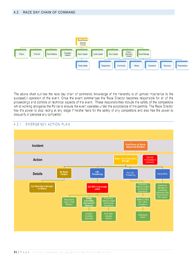
Matters for Traffic Engineering Advice
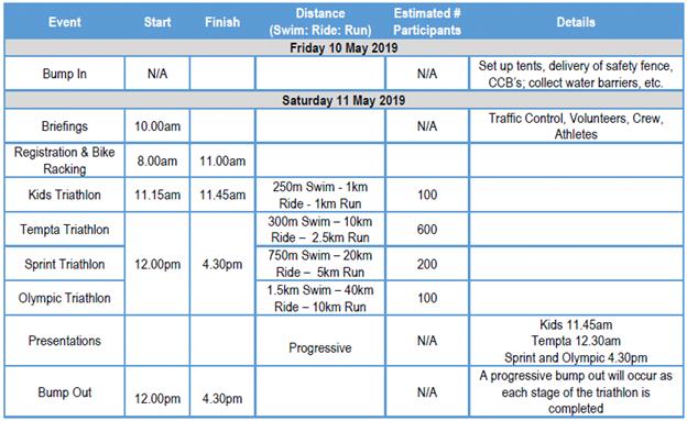
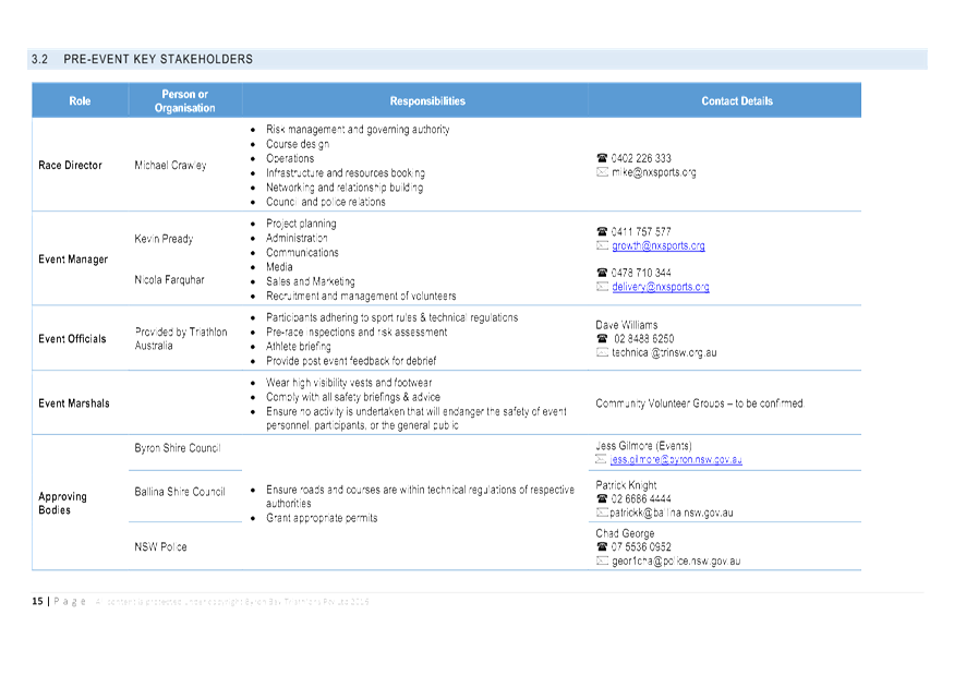
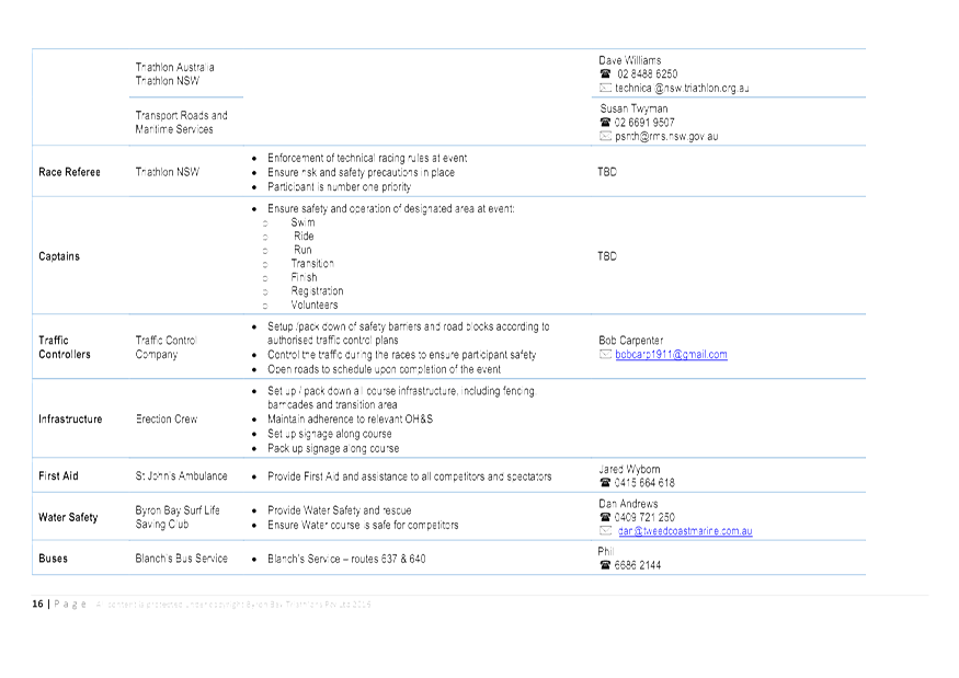
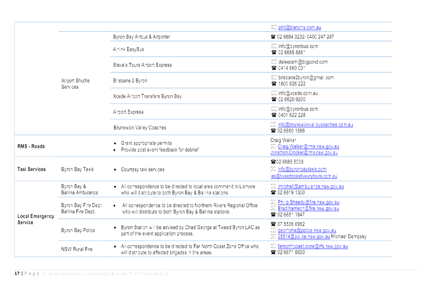
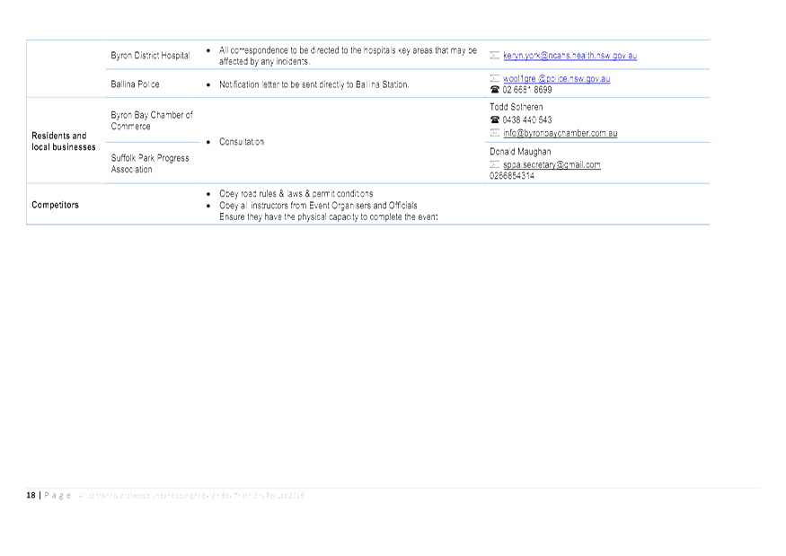
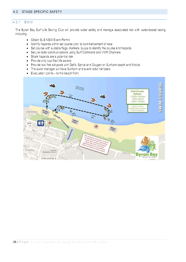
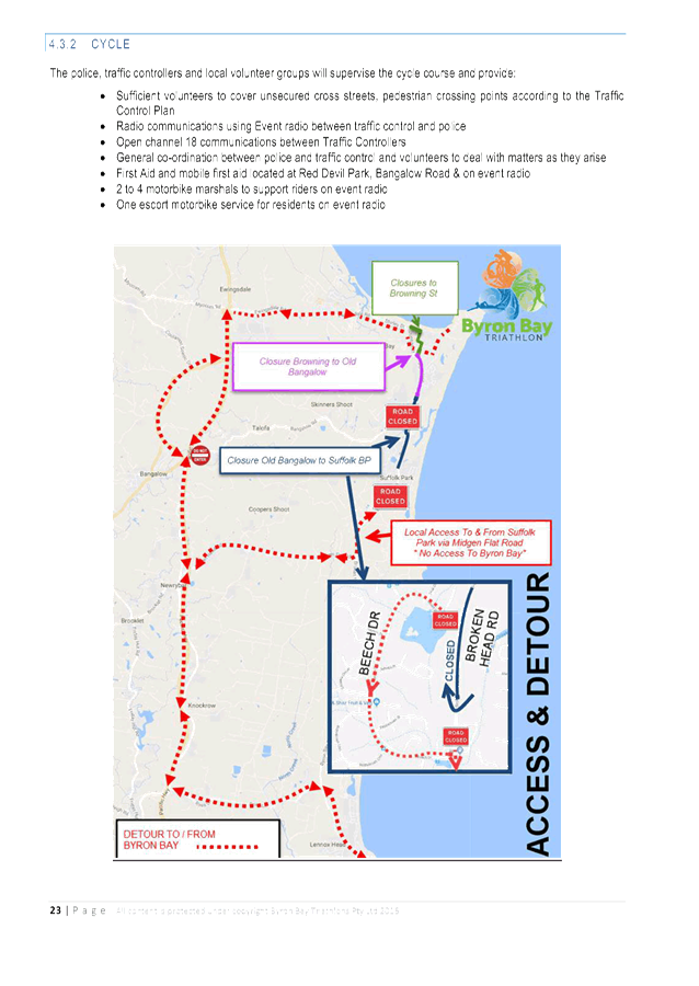
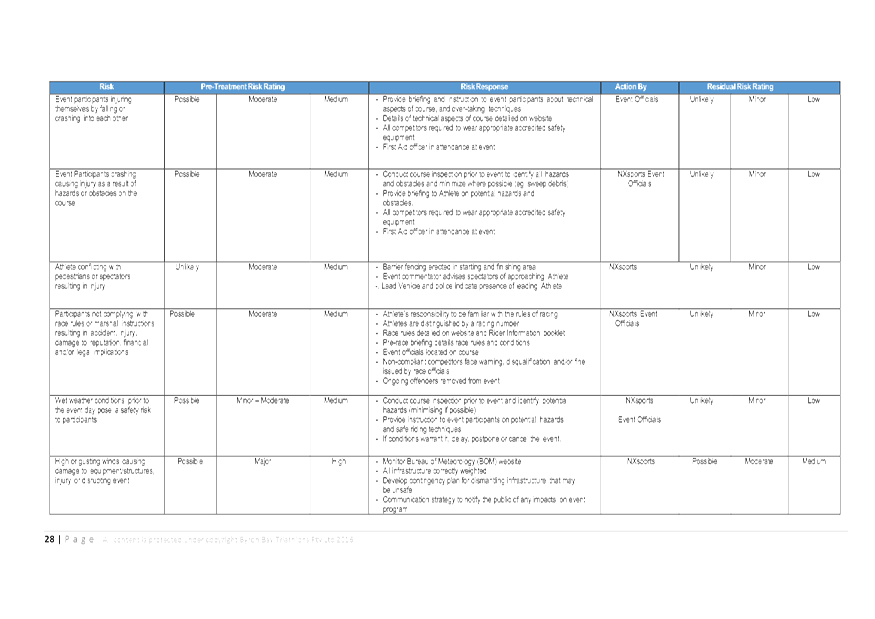
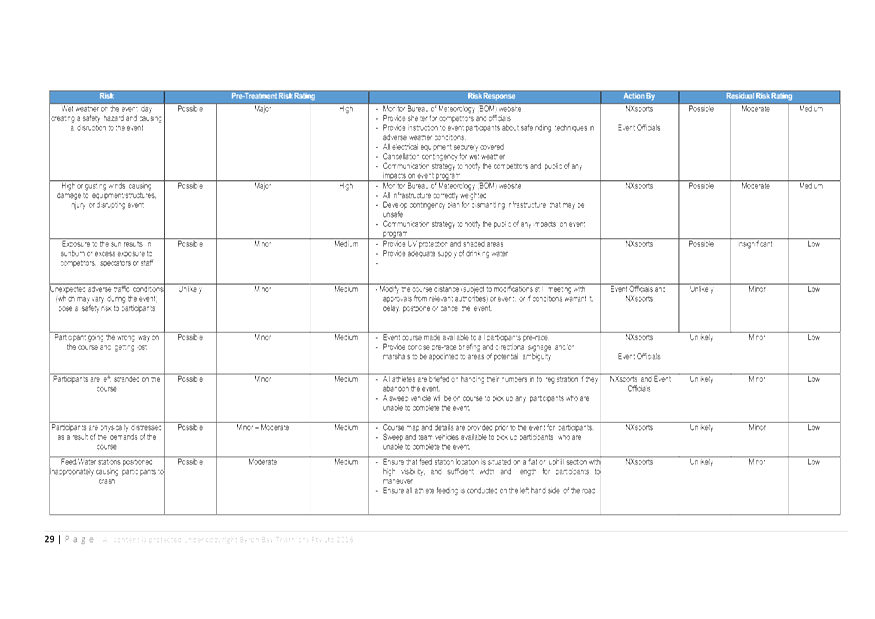
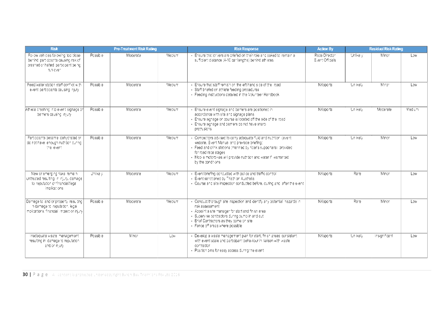
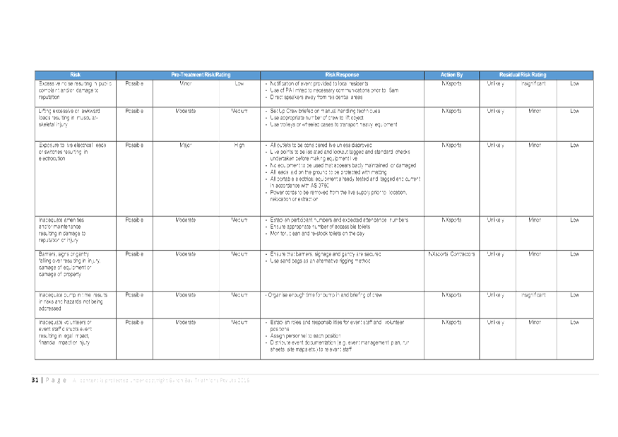
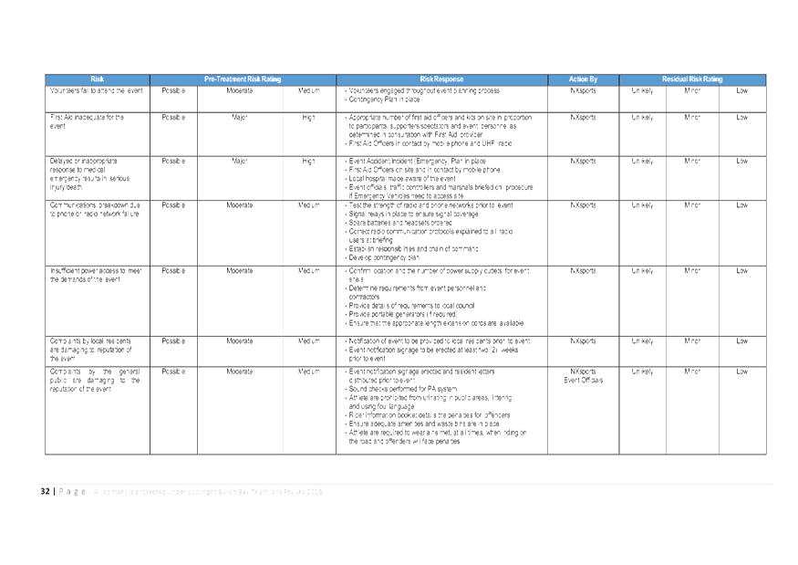
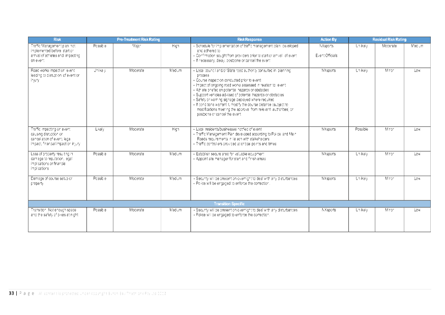
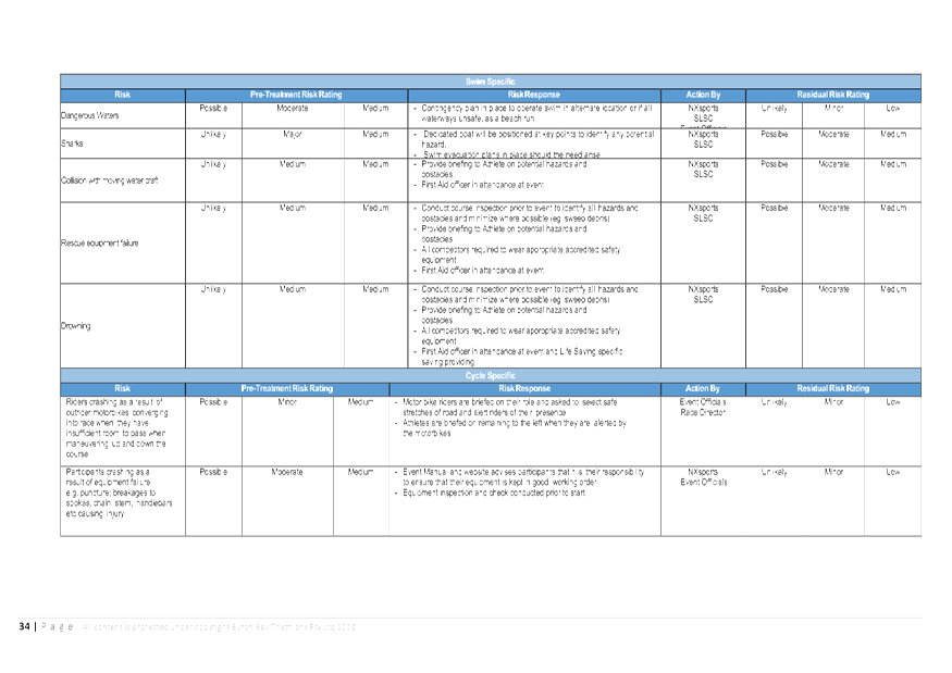
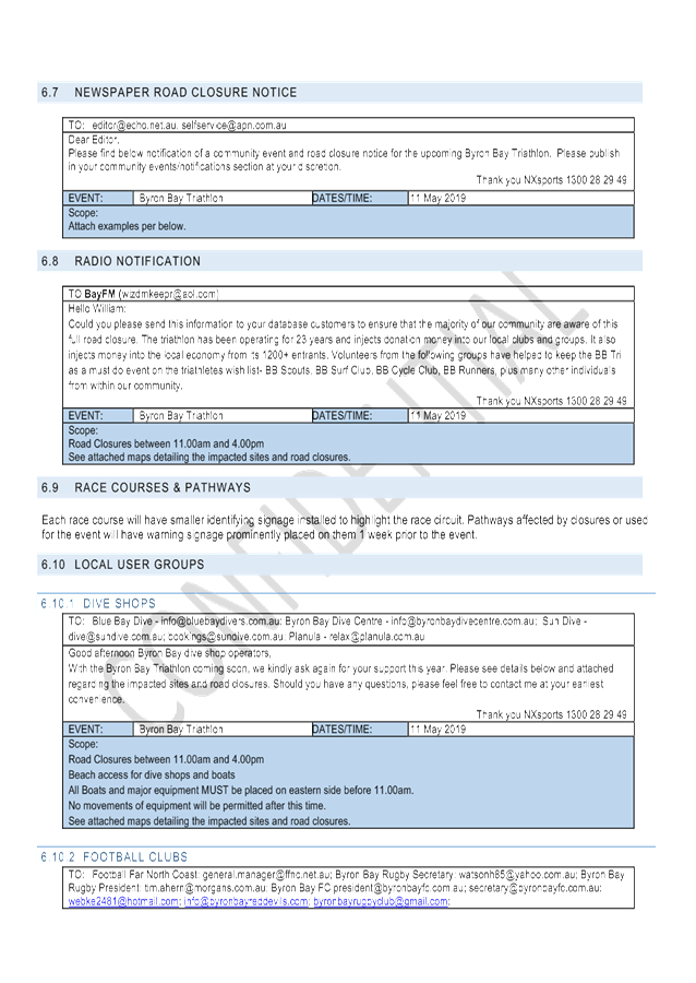
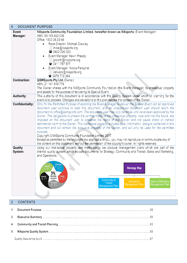
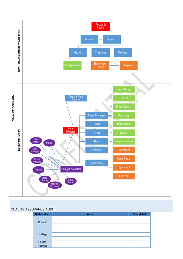
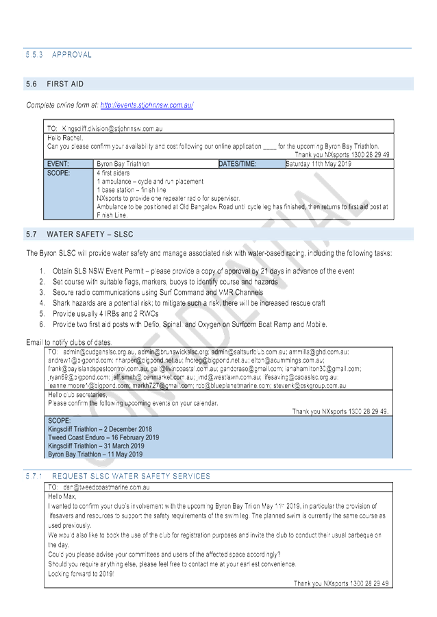
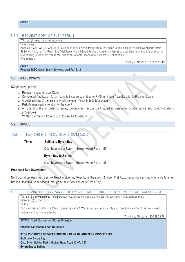
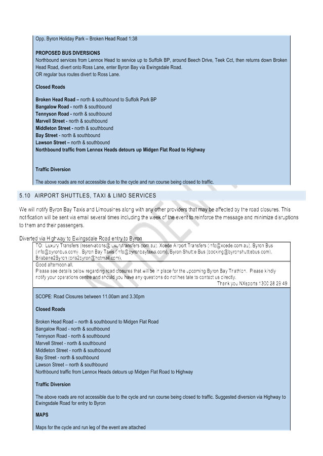
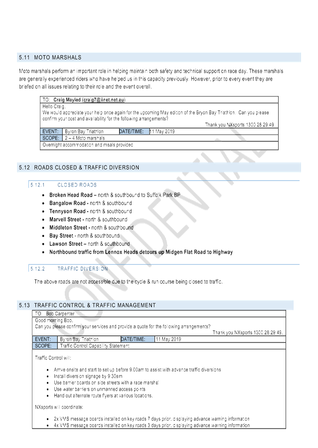
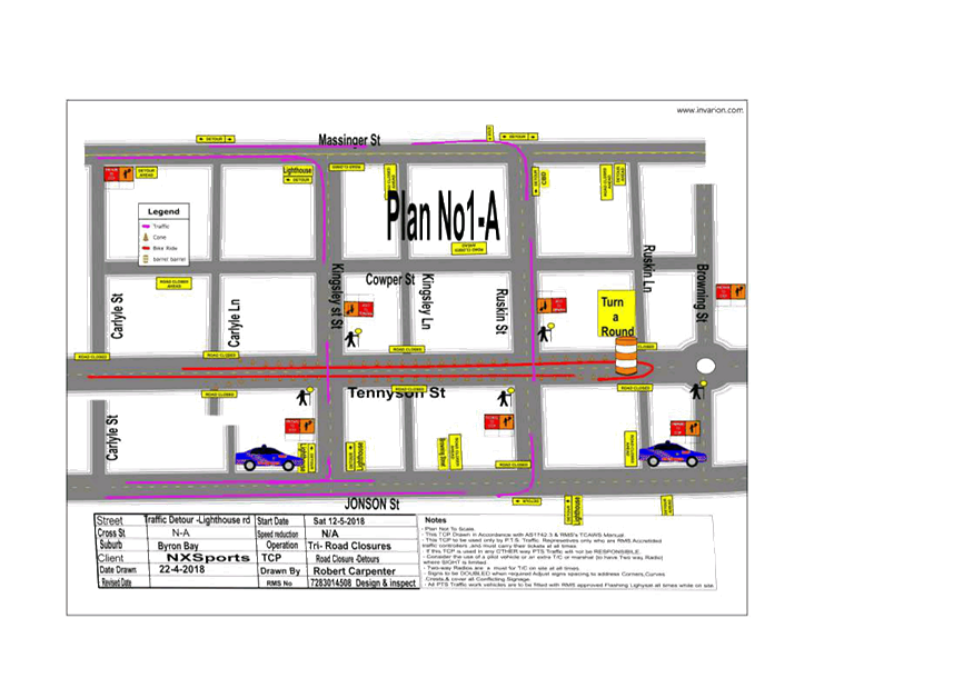
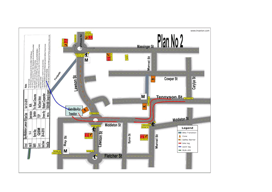
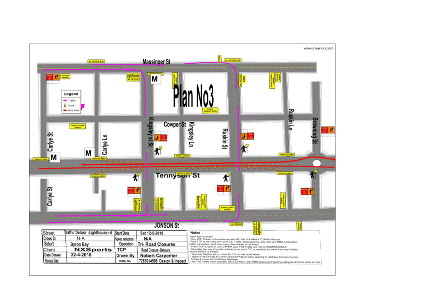
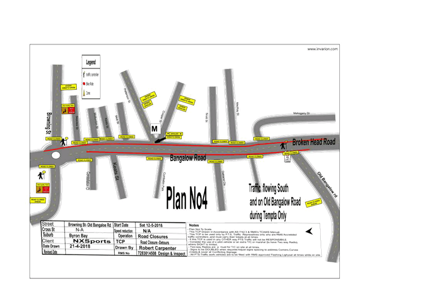
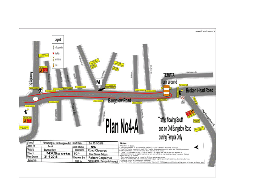
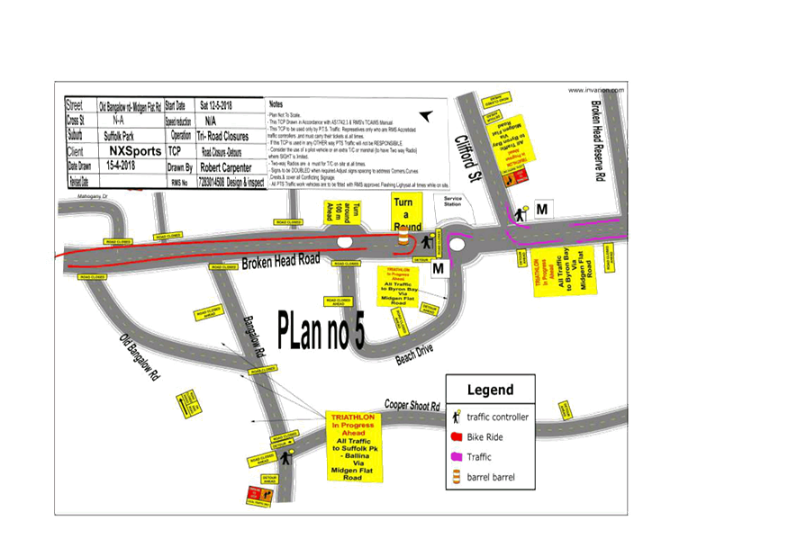
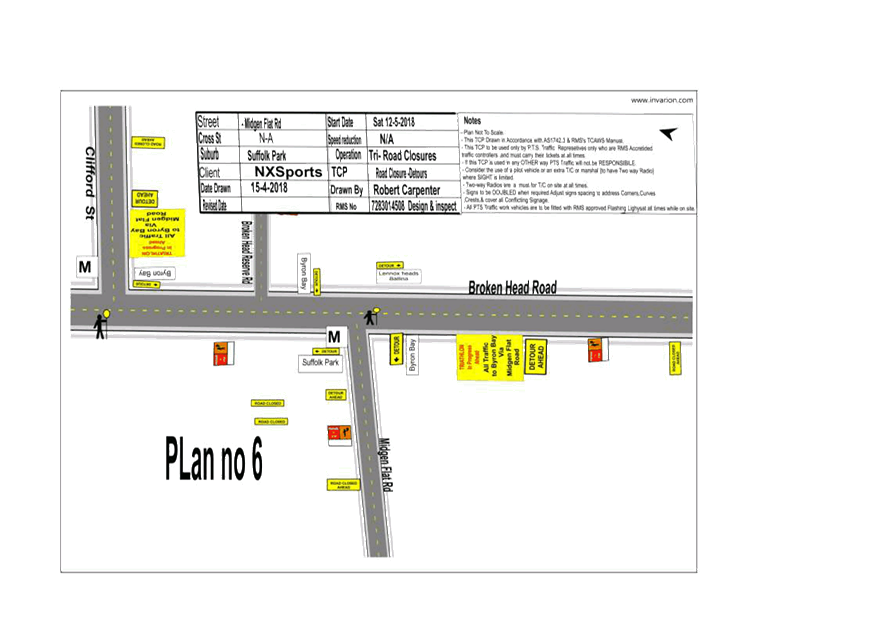
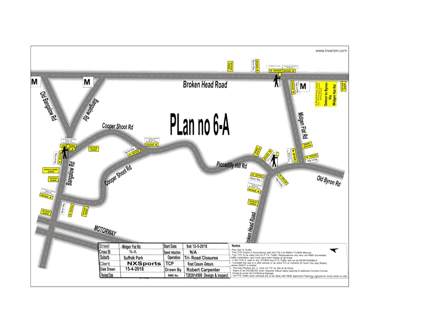
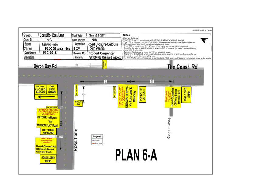
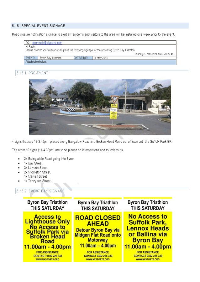
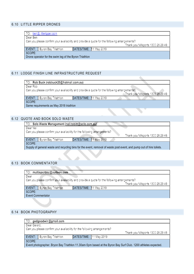
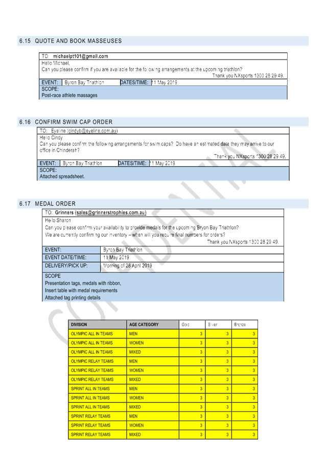
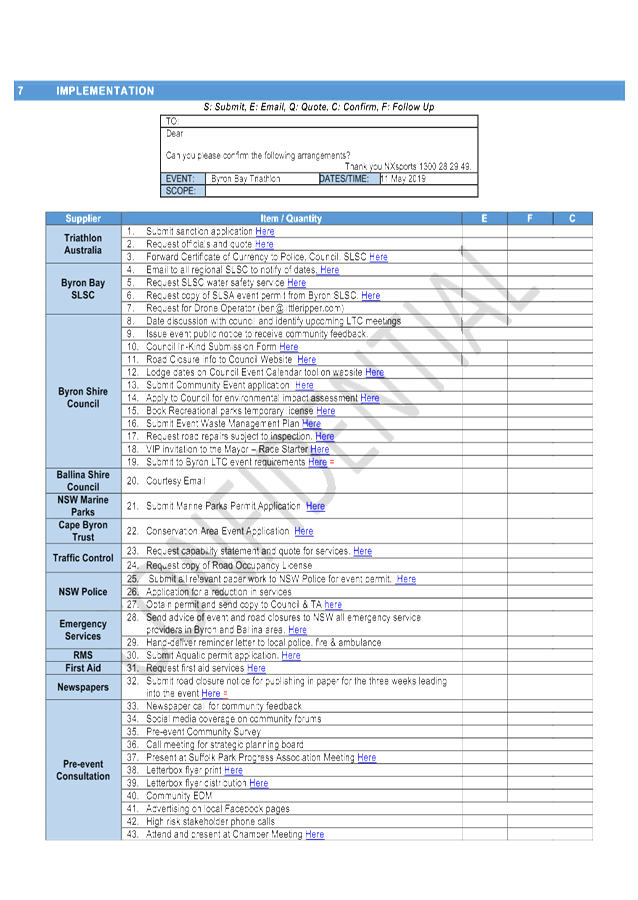
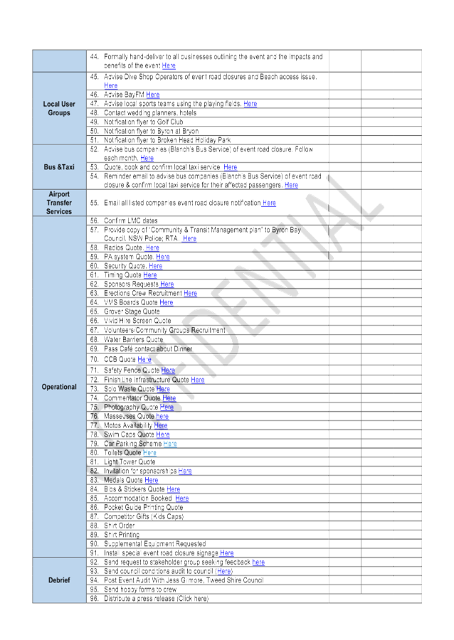
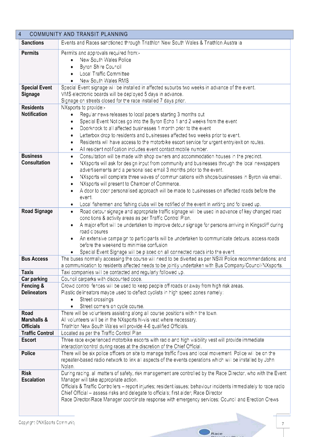
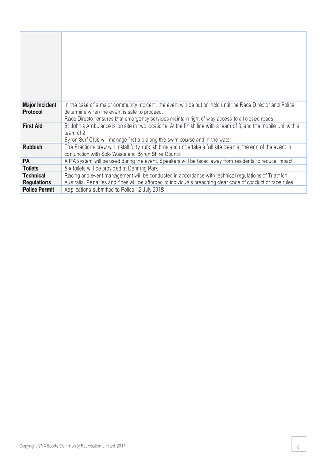
Report No. 7.1 Events - Byron Bay Triathlon 2019 - Traffic Management
File No: I2018/1338
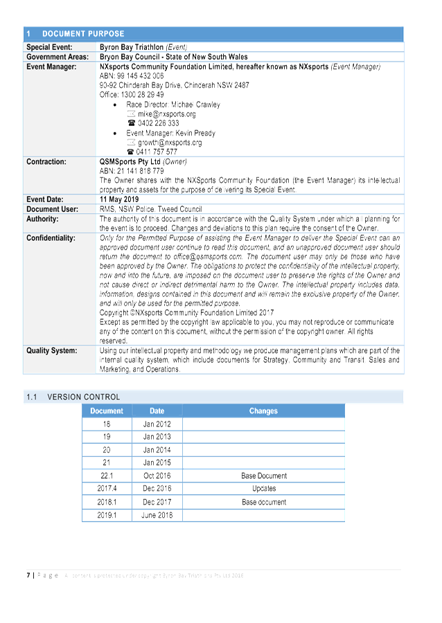
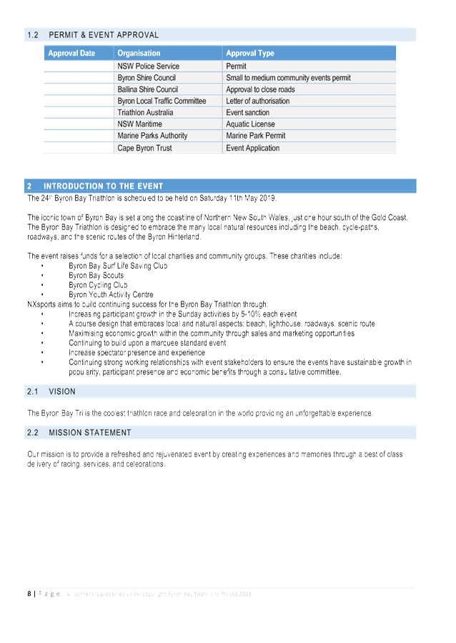
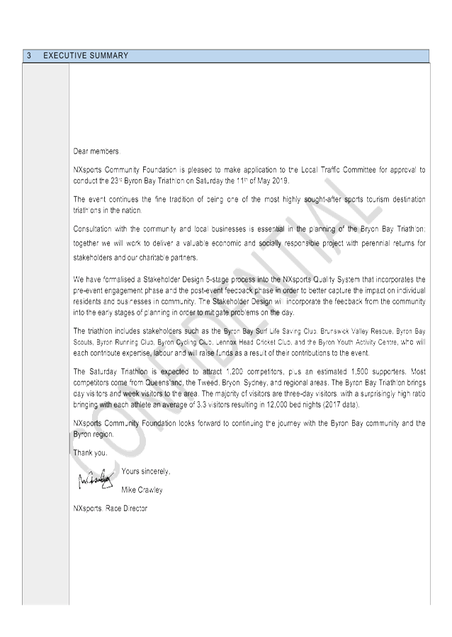
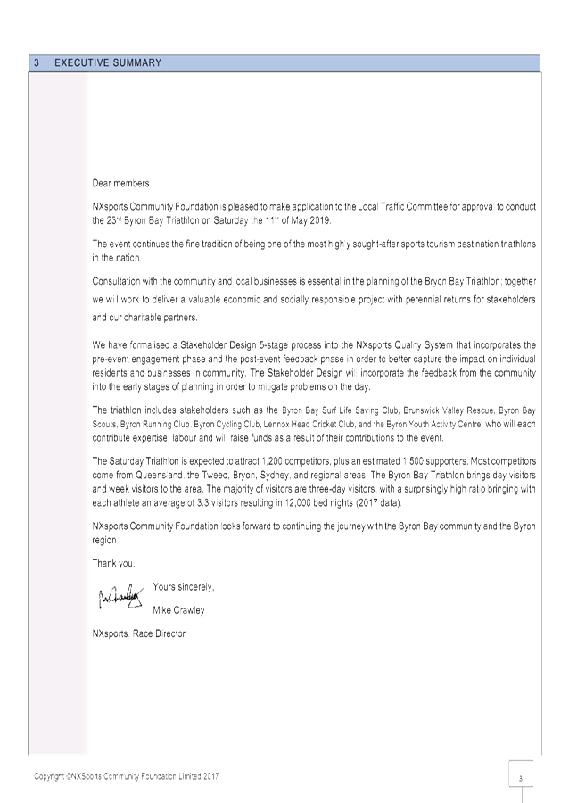
Summary
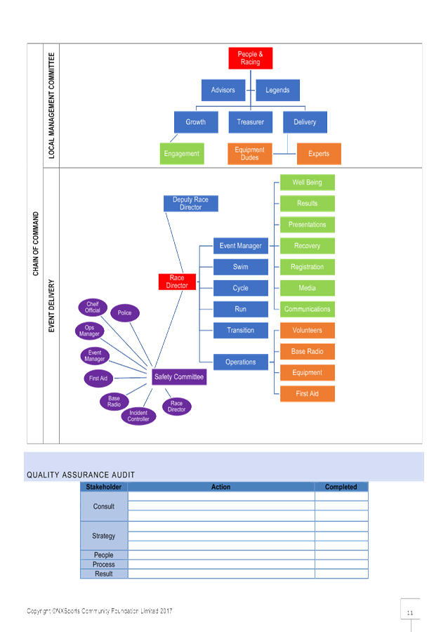
Council has received an event
application from NXsports Community Foundation for the 2019 Byron Bay Triathlon
to be held on Saturday 11 May.
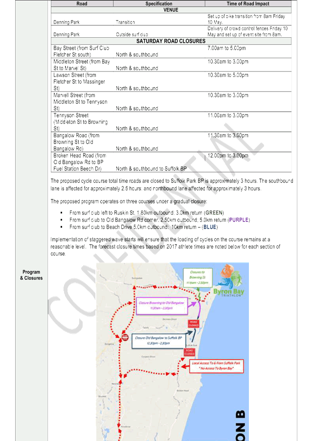
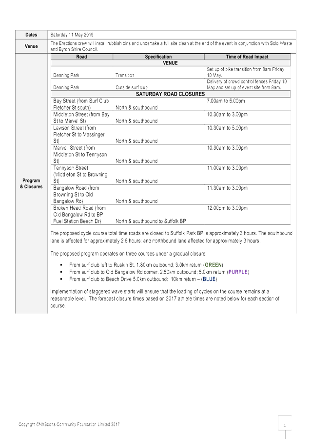
The event proposes several roads
to be closed within Byron Bay CBD. The shortest road closer is proposed
to be 3 hours (Broken Head Road between Old Bangalow Rd and BP Fuel Station
Beech Dr) with the longest road closure proposed to be 10 hours (Bay St in
front of the Surf Club).
Background
This event was reported to the
LTC in 19 September 2017 for consideration of and for comments to be provided
by LTC for the 2 options routes being considered by the event organisers for
the 2018 event.
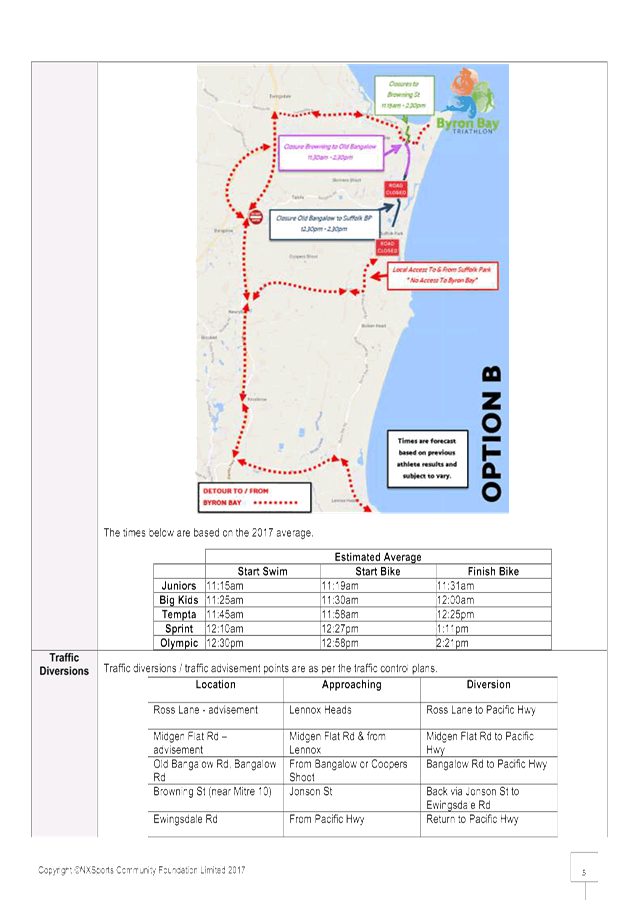
LTC meeting comments were
supportive of the Option B route as there was less impact on the community with
less road closure – this option was then put in place for the 2018 event.
The 2019 event proposes the same Option B route.
The event organiser’s
application includes relevant traffic management documents based on Option B as
implemented successfully for the 2018 event.
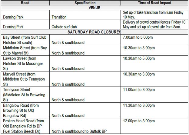
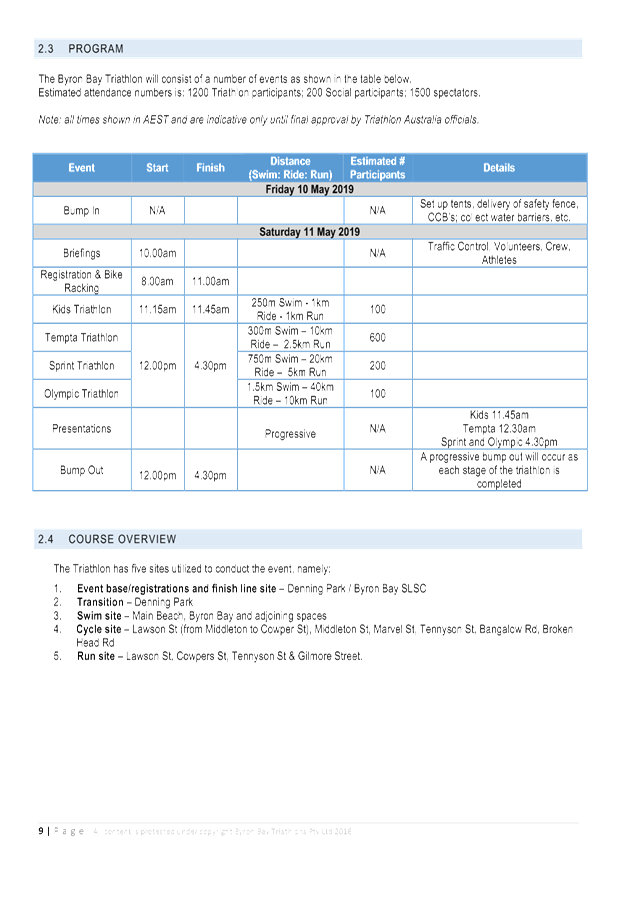
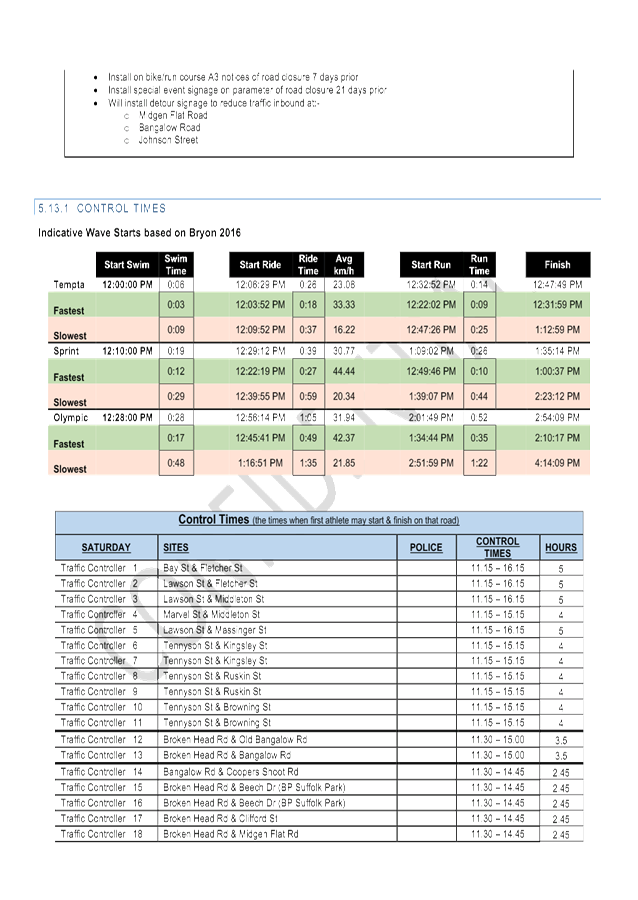
Event Timetable
The table below present the timing of the event from bump in
to bump out.
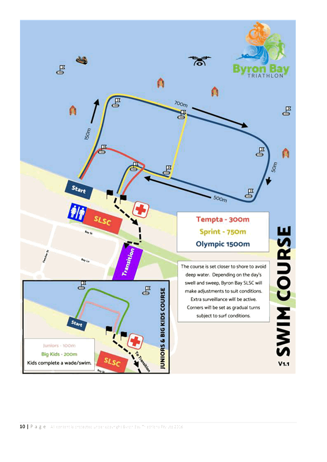
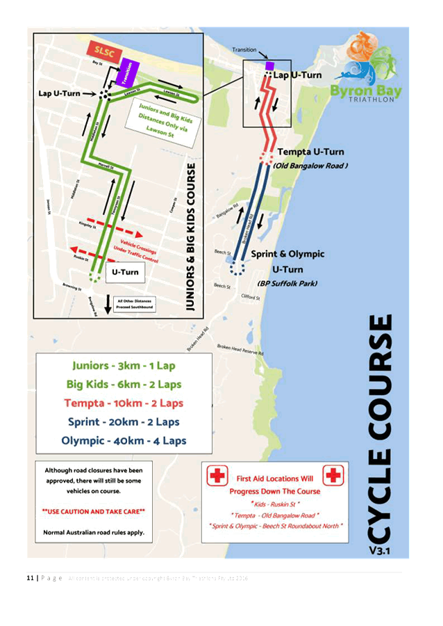
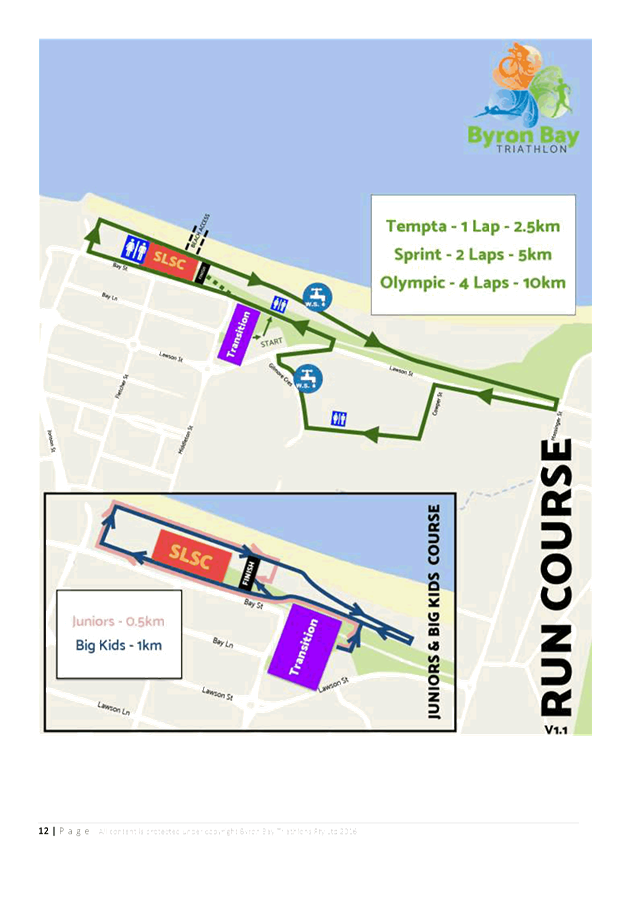
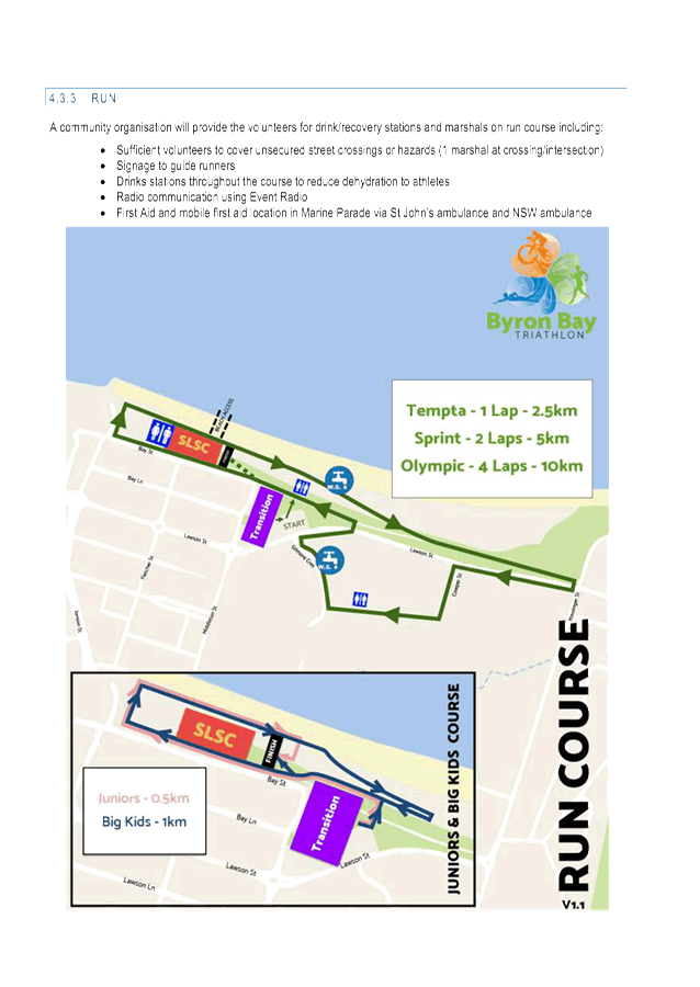
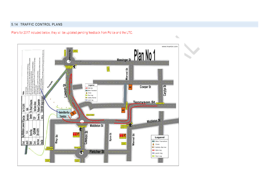
Event Course
Figure 1 presents the event course and roads required
to be closed for bike course.
Figure 2 presents the event course and roads required
to be closed for the run course
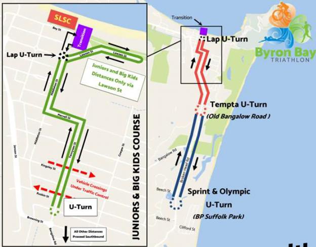
Figure 1
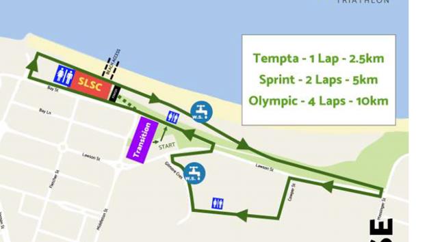
Figure 2
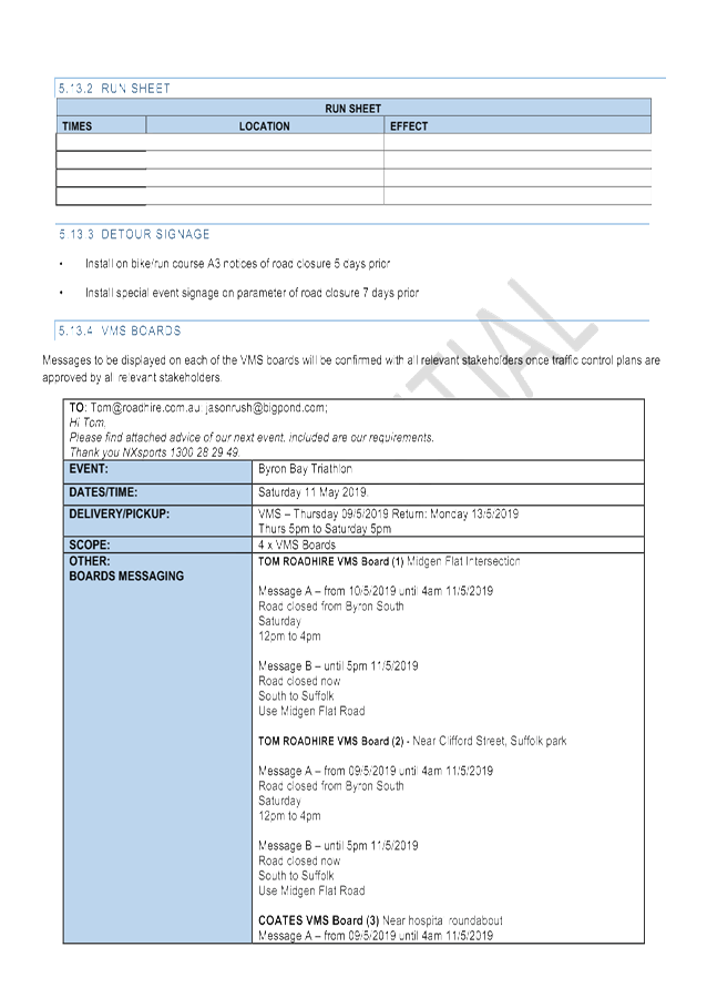
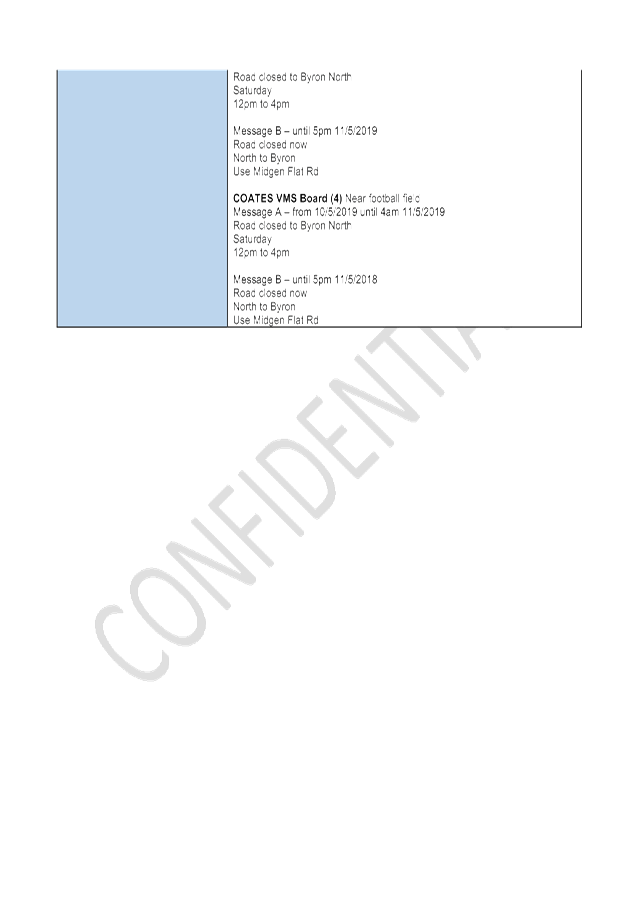
Proposed Road Closures
The timing of proposed road closures is as follows in the
table below and is proposed to be managed via a TMP and TCP, refer to attached
documents.
COUNCIL IMPLICATIONS
§ Budget/Financial
The event organisers to be
invoiced for the relevant Approval of Road Events pursuant to s144 of the Roads
Act fee as per the Fees & Charges 2018/19.
§ Asset Management
N/A
§ Policy or Regulation
Regulatory traffic
signage associated with the TCP as delegated to council for authorisation in
conjunction with NSW Road Rules.
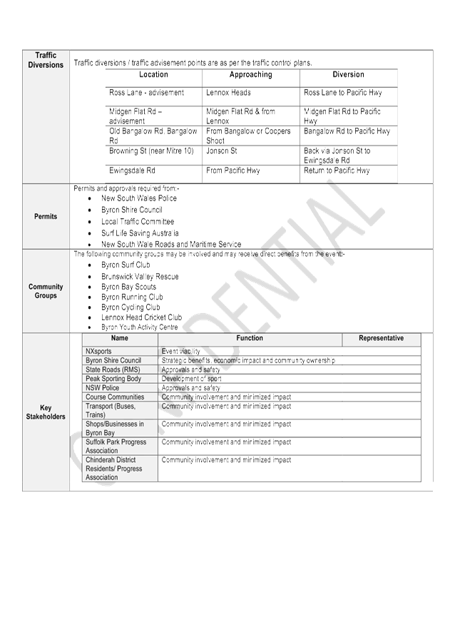
§ Consultation
After the 2018 event
the applicant undertook a post event review with key stakeholders. The 2019
event has been modified to take into account feedback from these stakeholders.
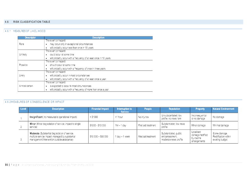
§ Legal and Risk Management
A risk assessment has been
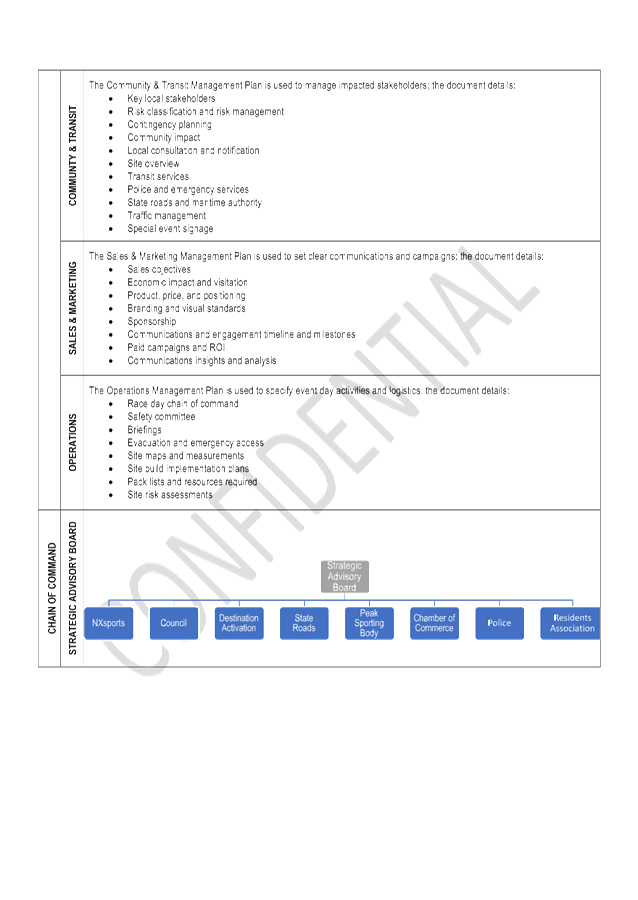
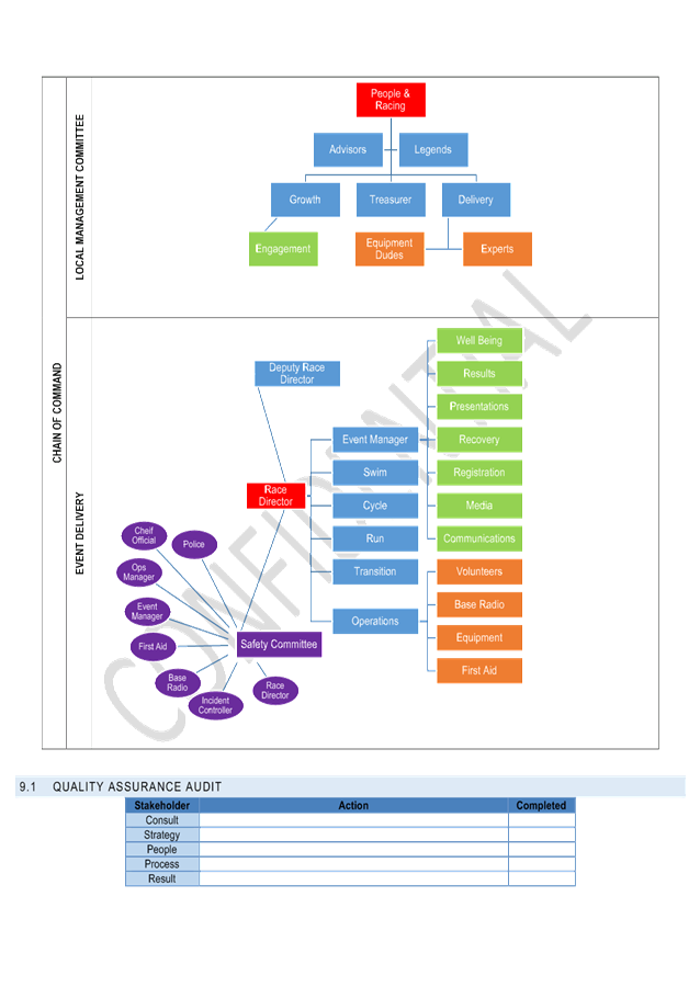
undertaken as part of the attached Community & Transit Management Plan.
|
RECOMMENDATION:
1) That
the Byron Bay Triathlon to be held on Saturday 11 May 2019, which includes
the temporary road closures below and Denning Park access, be endorsed
between these times:
Endorse
the Traffic Management Plans for the 2019 Byron Bay Triathlon to be held on
Saturday 11 May 2019 3) That
the approval provided in Part 1 and Part 2 is subject to:
a) separate
approvals by NSW Police and RMS being obtained;
b) the
event organiser provide council with an updated Traffic Management Plan and
Traffic Control Plan for the 2019 event, if required by the Police and RMS;
c) implementation
of the approved Traffic Management Plan and Traffic Control Plan by those
with appropriate RMS accreditation and the holding of current and appropriate
levels of insurance and liability cover;
d) the
impact of the event be advertised, and charged at cost to the organisers, via
a notice in the local weekly paper a minimum of one week prior to the
operational impacts taking effect, noting it must include the event name,
specifics of any traffic impacts or road closures and times, alternative
route arrangements, event organiser, a personal contact name and a telephone
number for all event related enquiries or complaints;
e) the
event be notified on Council’s web page;
f) the
event organiser:
· informing
community and businesses that are directly impacted (eg within road closure
zones) via written information which is delivered to the property in a timely
manner so as to document, consider and respond to any concerns raised;
· arranging for
private property access and egress affected by the event;
· liaising with
bus, taxi and waste operators and ensuring arrangements are made for
provision of services during conduct of the event;
· consulting
with emergency services and any identified issues be addressed;
· holding $20m
public liability insurance cover which is valid for the event;
· paying of
Council’s Road Event Application Fee prior to the event.
Provide the committee comments to the Events Team and
Event Organisers
|
Attachments:
1 BBT19
Community and Transit Management Plan - 2019.1, E2018/74974 , page 27⇩
2 BBT19
Letter to Byron Local Traffic Committee, E2018/74975
, page 133⇩
Matters for Traffic Engineering Advice 7.1 - Attachment 1
Matters for Traffic Engineering Advice 7.1 - Attachment 1
Matters for Traffic Engineering Advice 7.1 - Attachment 1

Matters for Traffic Engineering Advice 7.1 - Attachment 1
Matters for Traffic Engineering Advice 7.1 - Attachment 1
Matters for Traffic Engineering Advice 7.1 - Attachment 1
Matters for Traffic Engineering Advice 7.1 - Attachment 1


Matters for Traffic Engineering Advice 7.1 - Attachment 1
Matters for Traffic Engineering Advice 7.1 - Attachment 1


Matters for Traffic Engineering Advice 7.1 - Attachment 2
Local Traffic Committee Meeting 7.2
Report No. 7.2 Car Share Scheme, Byron and Mullumbimby - 12 Month Pilot
File No: I2018/1441
Overview
Council has previously endorsed a Car Share Policy and an
Expression of Interest process to determine whether a car share scheme might be
viable in Byron Bay and Mullumbimby.
The expression of interest process identified that there are
at least four (4) existing car share operators keen to establish in the
Shire. It also identified at least two key land owners who would be
willing to host car share spaces on their commercial sites.
Liaison with the operators indicates that around 10 spaces
would be required to ensure that the 12-month pilot project would be viable.
A report has been prepared for the September Council
meeting, recommending that Council endorse proceeding to the pilot, by inviting
the interested operators to apply to lease public car spaces in Byron Bay, and
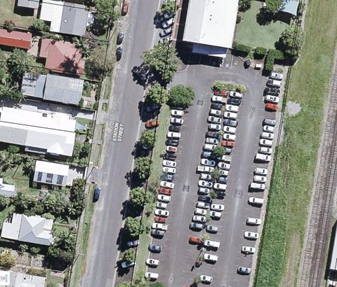
spaces within Council’s car park at Station Street Mullumbimby.
At this stage, the final number of public spaces would be
subject to negotiation with the successful operator. Indicative locations
for the spaces are shown in the attached plans.
The spaces will need to be line marked and sign posted, to
be provided exclusively for the successful car share operator, who will lease
the spaces from Council. Some of the spaces will be within paid parking
areas.
The circles in red below show the preferred locations for
the bays in Byron Bay (see further details in Attachment 1). Council have
engaged the neighbours surrounding these bays to seek feedback. Bays are
also preferred in the Mullumbimby Public Car Park behind Council offices.
The circles in blue below show alternative locations for the
bays.
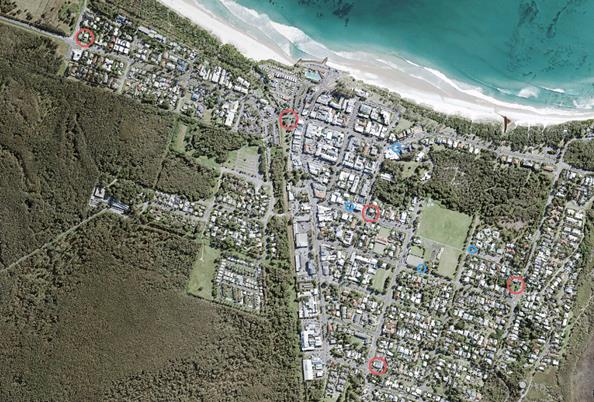
Attachment 1 (E2018/67288) identifies each location.
Neighbour Consultation
Neighbours (land owners and commercial residents) within
close proximity to the preferred potential bays were sent a letter and a fact
sheet and were invited to submit their feedback. The below table gives a
summary of what has been heard so far.
|
Location
|
Summary
|
|
Shirley Street
|
|
Neighbour 1
|
Intersection too congested. Further
east on Shirley Street would be better.
|
|
Neighbour 2
|
Great idea and location
|
|
Marvell Street
|
|
Neighbour 1
|
Commercial area of Marvell
Street would be better. This is residential area.
|
|
Massinger Street
|
|
Neighbour 1
|
Intersection too busy, closer to
beach or rec grounds better
|
|
Neighbour 2
|
Detrimental here: more illegal
parking, more parking/congestion in short street
|
|
Neighbour 3
|
Location is fine.
|
|
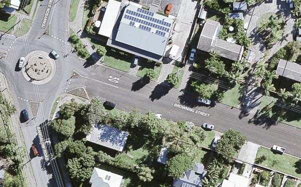
Browning Street
|
|
|
No responses at this time
|
|
Lawson Street South
|
|
Landowner 1
|
Not in South car park. North
Lawson Street would be better. Two bays here would be detrimental to
business.
|
|
Tenant 1
|
Okay, but no more than 2x. North
would be better.
|
|
RECOMMENDATION:
That the Local Traffic Committee select and
approve a minimum of 10 car parking spaces to be designated as car share bays.
|
Attachments:
1 Car Share:
Potential Bay Locations - LTC, E2018/67288
, page 146⇩
Matters for Traffic Engineering Advice 7.2 - Attachment 1
Preferred
Locations for Car Share Bays – Prior to
Neighbourhood Engagement.
-neighbours
of these locations have been consultant.
1. Lawson
Street South (3), Operational Land. Two locations would be used here for the
pilot, a third would be saved for future potential expansion of the car share
scheme.

2. Marvell
Street (2)

3. Massinger
Street (2)

4. Browning
Street (2) – dependent on new tenant of corner block

5. Station
St Mullumbimby (4), Operational Land.
Two locations would be used here for the
pilot, a third would be saved for future potential expansion of the car share
scheme.

6. Shirley
Street West (3)
Two locations would be used here for the
pilot, a third would be saved for future potential expansion of the car share
scheme.

Alternative Locations
1. First
Sun Caravan Park Entrance (2), Operational Land.

2. Library
(2), Operational Land.

3. Marvell
Street (2)
Residential neighbour would prefer the cars
to be located closer to the commercial area of Marvell Street.

4. Marvell
Street East of the Recreational Grounds
Residents around Massinger Street believe
outside the topshop on Massinger Street is too congested.

5. Marvell
Street East of the Recreational Grounds, grassed area could be formalised
Residents around Massinger Street believe
outside the Topshop on Massinger Street is too congested.

6. Carlyle
Street outside the Recreational Grounds and Tennis Court could be formalised
Residents around Massinger Street believe
outside the Topshop on Massinger Street is too congested.

Local Traffic Committee Meeting 7.3
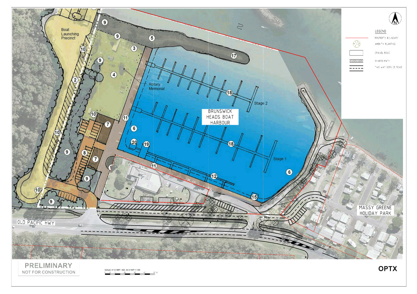
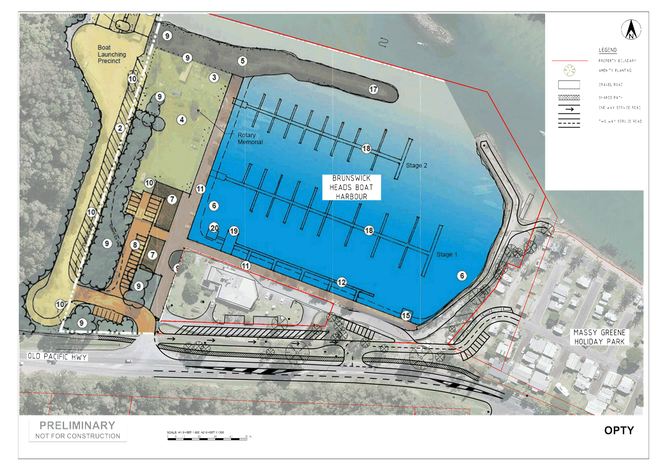
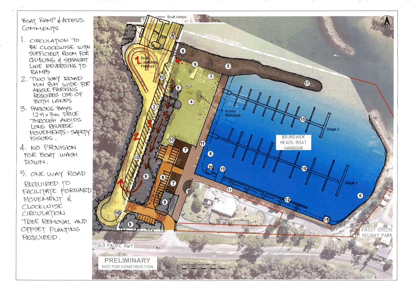
Report No. 7.3 Brunswick Heads Boat Harbour Master Plan - Traffic, Access and
Parking Options
File No: I2018/1084
SUMMARY
This report outlines the various options being considered in
developing the Brunswick Heads Boat Harbour Master Plan to manage traffic,
access and parking arrangements on the Old Pacific Highway and seeks comments,
recommendations and advice on any preferred option from the Committee
BACKGROUND
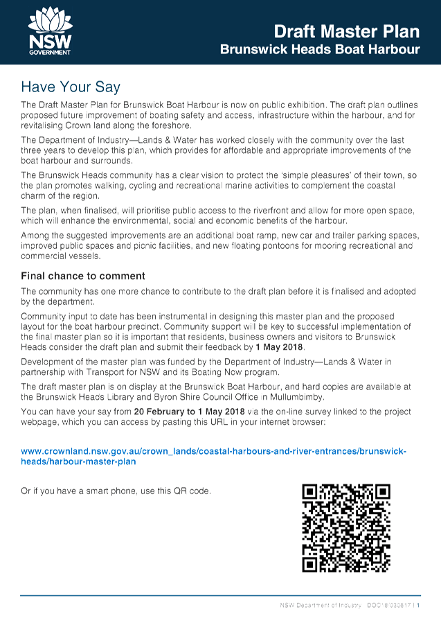
In February 2018 the Department of Industry—Lands
& Water issued a Fact Sheet outlining their Draft Master Plan for Brunswick
Boat Harbour. Following an on site meeting (May 2018) with representatives from
Crown Lands Council staff drafted a modified layout for Crown Lands to consider
addressing potential concerns relating to traffic access and parking layout.
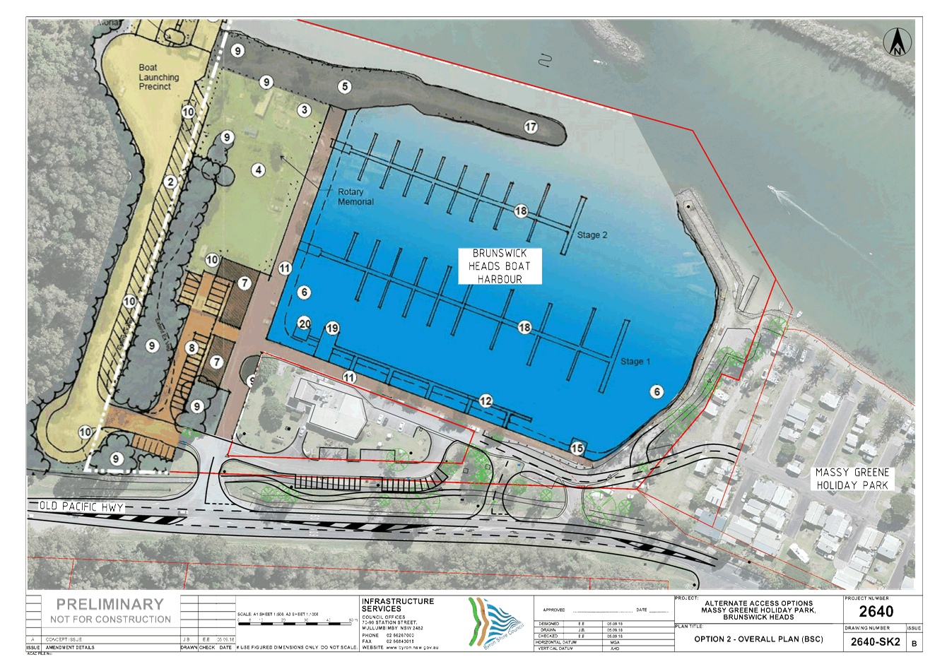
Figure 1 presents the Draft Master Plan for
Brunswick Boat Harbour issued by the Department of Industry—Lands &
Water. Refer to attachment 1 for details relating to the DPI proposal.
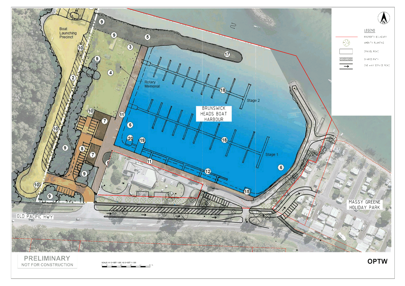
Figure 2 presents Council’s proposed
modified layout submitted to Crown Lands for consideration, refer to attachment
2.
Council also assisted Crown Lands by drafting a number of
sketched options to ensure all options were to the same scale and able to be
directly compared.
Attachment 3 provides detail in respect of the
options drafted for Crown Lands in relation to access and parking in the Old
Pacific Highway corridor and attachment 4 provides Council’s
comments in relation to the redevelopment of the boat handling facilities with
particular reference to traffic management and boat parking with suggestions
for Crown Lands to consider in developing the final layout for this area.
In relation to access and parking on the Old Pacific
Highway, the primary difference between the two draft layouts is that the DPI
proposes 90 degree car parking off the traffic lane and modifies a currently
left out only exit to a entry/exit on the eastern side of the project. In
contrast, Council proposes no car parking with direct access off the Old
Pacific Highway and suggests a relocation of a new entry/exit further west from
the existing to provide for better vehicle storage for the right turn and
improved stacking within the intersection access road leg.
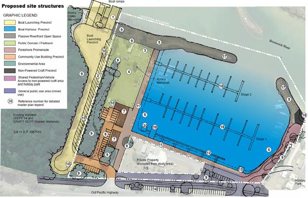
Figure 1 – Draft Master Plan - DPI
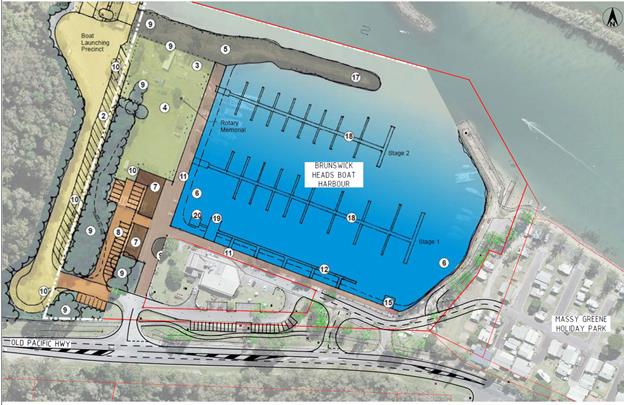
Figure 2 – Byron Shire Council Preferred Access
Arrangements
COUNCIL IMPLICATIONS
§ Budget/Financial
No known budget or financial cost
to Council outside of the Stakeholder consultation process.
§ Asset Management
Additional carparking
within the road reserve and associated signage.
§ Policy or Regulation
Compliance to be in accordance
with NSW Road Rules, Australian Standards, Austroads and RMS Parking guidelines
§ Consultation
Crown Lands has undertaking
stakeholder engagement with the community and Council has been in discussion
with Crown Lands.
§ Legal and Risk Management
Minor
Risk assessment has been undertaken in an informal manner as part of
Council’s modified proposed layout.
|
RECOMMENDATION:
That the committee’s comments and
recommendations be provided to Crown Lands to assist in developing the
Brunswick Heads Boat Harbour Master Plan
|
Attachments:
1 Brunswick
Heads Boat Harbour Submission Concept Plan 2640-SK2B, E2018/74972 , page 157⇩
2 Brunswick
Heads Boat Harbour 20 Feb 2018 - Fact Sheet Consultation on Draft Master
Plan, E2018/74973 , page 158⇩
3 Brunswick
Heads Boat Harbour - 2640_CROWN CONCEPT OPTIONS.pdf, E2018/75307 , page 160⇩
4 brunswick
Heads Boat Harbour Master Plan - boating area comments 16-8-18.pdf, E2018/75309 ,
page 164⇩
Matters for Traffic Engineering Advice 7.3 - Attachment 1
Matters for Traffic Engineering Advice 7.3 - Attachment 2
Matters for Traffic Engineering Advice 7.3 - Attachment 3

Matters for Traffic Engineering Advice 7.3 - Attachment 4
Local Traffic Committee Meeting 7.4
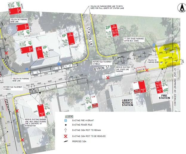
Report No. 7.4 Bangalow Primary School - Parking and Traffic Management
File No: I2018/1709
SUMMARY
This report seeks support from the LTC to amend the existing
time limited parking scheme, as required, in the vicinity of the Bangalow State
School.
BACKGROUND
The existing Bangalow State School children’s crossing
on Byron Street is not currently used by the school as the existing traffic
conditions along Byron Street are considered unsafe.
A RMS grant has been identified to fund investigations, with
the potential for additional funding for implementation. No designs have
been developed as yet, though on site discussions have occurred with Council
and RMS representatives to confirm the intent of the project which is likely to
include:
• Relocation and
formalisation of children's crossing Bangalow Road.
• Bus zone relocation,
Bangalow Road.
• Signage and delineation
improvements to Bangalow school zone.
Council installed a time limited parking scheme around the
Bangalow Village Centre this year, including the Bangalow State School area.
Project implementation will potentially impact several car
parking spaces, a bus stop zone and regulatory signage and line marking in the
vicinity of the children’s crossing. Several car spaces may need to be
deleted and / or relocated, along with associated signage. As these works will
involve direct consultation with RMS and in order to facilitate timely
implementation, LTC is requested to approve and support the envisaged
modifications as outlined above.
The figures below shows the recently installed time limited
parking scheme signage layout in the vicinity of the Bangalow State School. The
areas highlighted in yellow indicate the location off the existing unused
children’s crossing.
COUNCIL IMPLICATIONS
§ Budget/Financial
Expected costs are associated
with relocating signage and line markings.
§ Asset Management
No impact on existing
asset management requirements.
§ Policy or Regulation
Compliance to be in accordance
with NSW Road Rules, Australian Standards, Austroads and RMS Parking guidelines
§ Consultation
RMS is a significant stakeholder
who have been and will continue to be consulted as part of the pedestrian
crossing project.
§ Legal and Risk Management
No risk
assessment has been undertaken as yet as no design work has commenced for the
project..
|
RECOMMENDATION:
That Council support modifications to the
Bangalow Village Centre time limited parking scheme and regulatory signage
and line marking, in the vicinity of Bangalow State School to implement the
following changes developed in consultation with the RMS:-
1. Relocation
and formalisation of children's crossing Bangalow Road.
2. Bus
zone relocation, Bangalow Road.
3. Signage
and delineation improvements to Bangalow school zone.
|
Local Traffic Committee Meeting 7.5
Report No. 7.5 Adoption of Constitution for Local Traffic Committee
File No: I2018/1684
At Local Traffic Committee meeting of 16 January 2018, the
committee discussed matters in relation to Report No.6.1 – Council
resolutions and Recommendation Processes.
From those discussions, a draft constitution for the Local
Traffic Committee was developed and presented to the Local Traffic Committee at
the 15th May meeting where the Local Traffic Committee recommended:
That the draft constitution attached to this
report is noted and the committee comments be provided to finalise the
constitution document prior to adoption by Council.
At the 23 August 2018 ordinary Council meeting,
Council resolved as follows:
18-498 Resolved that
Council adopt the following Committee Recommendation(s):
Report No. 6.2 Draft
Constitution for Local Traffic Committee
File No: I2018/905
Committee Recommendation 6.2.1
That the draft constitution
attached to this report be reviewed by members and the committee comments be
presented at the next committee meeting for adoption.(Cameron/Richardson)
The committee is requested to review the final document and
recommend that Council adopt the 2018 Local Traffic Committee Constitution, in
accordance with RMS guidelines and any other regulations, and procedures
relating to the delegation to Councils, as set out in Section 50 of the
Transport Administration Act 1998.
|
RECOMMENDATION:
That Council adopt the
2018 Constitution for the Local Traffic Committee.
|
Attachments:
1 DRAFT
Constitution Local Traffic Committee 2018 (version 003), E2018/72629 , page 169⇩
Matters for Traffic Engineering Advice 7.5 - Attachment 1