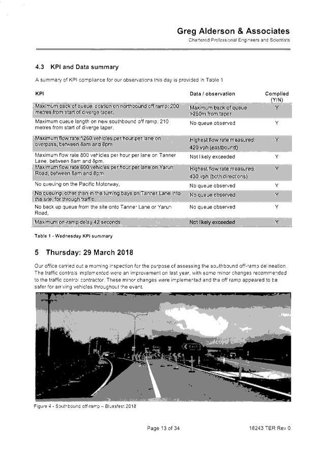
Local Traffic Committee Meeting
A Local Traffic Committee Meeting of
Byron Shire Council will be held as follows:
|
Venue
|
Conference Room, Station Street, Mullumbimby
|
|
Date
|
Tuesday, 20 November 2018
|
|
Time
|
10.30am
|
|
Committee
Members
|
Katherine Boulton – Roads and
Maritime Services
Snr Constable David Brigg – Police
Cr Basil Cameron
Tamara Smith MP
|

Director Phil
Holloway
Director Infrastructure Services I2018/2183
Distributed 13/11/18 (amended
15/11/18)
Local Traffic Committee Meeting
BUSINESS OF MEETING
1. Apologies
2. Declarations of Interest
– Pecuniary and Non-Pecuniary
3. Adoption of Minutes from
Previous Meetings
3.1 Local
Traffic Committee Meeting held on 18 September 2018
3.2 Extraordinary
Local Traffic Committee Meeting held on 21 September 2018
4. Matters Arising
5. Outstanding
Issues/Resolutions
6. Regulatory Matters
6.1 Events
- Anzac Day 2019 - Road Closures in Byron, Mullumbimby, Brunswick Heads,
Bangalow........................................................................................................................................... 3
6.2 Events
- Bangalow Christmas Eve Carnival 2018 - Road Closure................................ 10
6.3 Events
- Ballina to Byron Bay Coastal Charity Walk 26 May 2019................................ 17
6.4 Events
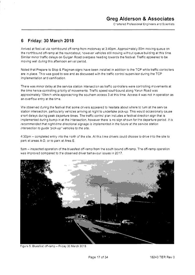
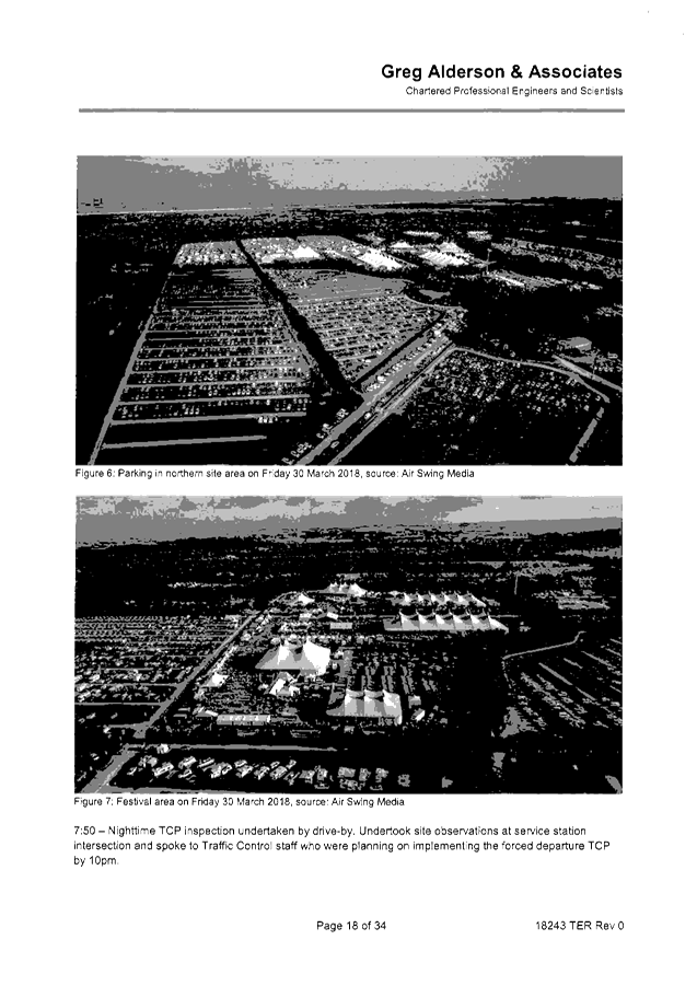
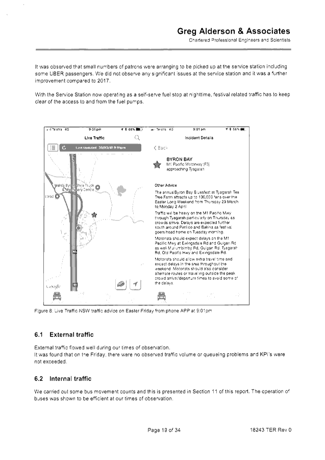
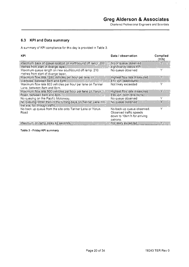
- Byron Bay Bluesfest 2019................................................................................ 21
6.5 Events
- Mullum2Bruns Paddle 2019 ............................................................................. 82
6.6 Endorsement
of no entry signage associated with driveway crossing under S138 of the Roads
Act......................................................................................................................................... 89
6.7 Ewingsdale
Road Roundabouts - Lane Modifications.................................................... 92
7. Matters for Traffic Engineering Advice
7.1 Bangalow
Primary School - Parking, Traffic and School Zone Management ............ 115
7.2 Yelgun
Rest Area - Parking for Driver Reviver Volunteers.......................................... 120
7.3 Adoption
of Constitution for Local Traffic Committee.................................................. 123
7.4 Mercato
Car Park - Concept Temporary Access ........................................................ 123
Local Traffic Committee Meeting 6.1
Regulatory Matters
Report No. 6.1 Events - Anzac Day 2019 - Road Closures in Byron, Mullumbimby,
Brunswick Heads, Bangalow
File No: I2018/1568
BACKGROUND
Each year the RSL sub-branches of Byron Bay, Mullumbimby,
Bangalow and Brunswick Heads arrange their respective annual ANZAC Day street
parade.
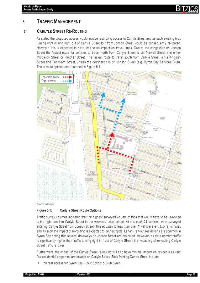
All four have confirmed that little to no change to previous
years are sought. The route of each parade is shown below, noting that:
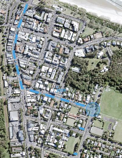
- Byron
Bay : as per previous years, the Dawn
Service requires closure of the Tennyson Street and Marvell Street intersection
between 4.30am and 5.30am and then again (approximately at 11am) when the
parade reaches the gates to conduct the main service.
Council implements such measures including
signed detours at the intersections prior at Marvell and Middleton Street and
at both the Kingsley Street and Carlyle Street intersections on Tennyson
Street.
As for the parade, it is held under Police
escort after it gathers at 10:15am off-road (Beach Hotel) at Bay and Jonson
Street, then at 10.30am proceeds south down Jonson Street, left into Marvell
Street to its end at the Memorial Gates on Tennyson Street.
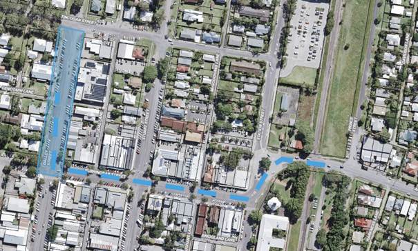
- Mullumbimby: the parade will again be held under Police escort
commencing this year at 10.50am from Apex Park via Burringbar Street to
concluding at the cenotaph on Dalley Street and that Council is to close Dalley
Street to traffic between Burringbar Street and Tincogan Street between 8am and
12noon with signed detours in place.
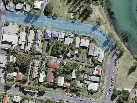
- Brunswick
Heads : Police involvement with both
an escort and closing of the road on Fawcett Street between 430am and
630am. No Council involvement requested.
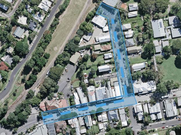
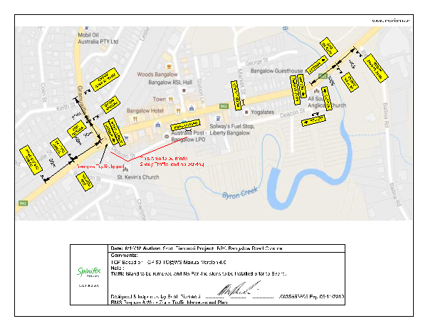
- Bangalow
: the sub branch have confirmed the
parade forms by 10.45am in front of the Bangalow Hotel in Byron Street,
and sets out by 11am east to the intersection at Station Street, then turns
left (north) to the front of the RSL Memorial Hall on Station Street for wreath
laying and ceremony through to 11.45am. Council therefore are to
implement the following:
o by 10.40am through
to end of event, close:
§ Station Street north of
Byron Street,
§ Byron Street west of
Station Street, and
§ provide signed detours
south along Station Street to and via Deacon Street.
o by 10.45am, close:
§ Byron Street at the east
bound leg of the Granuaille Road and Lismore Road roundabout.
o Once parade has
departed Byron Street remove the two Byron Street closures.
In general it should be noted previous year’s events
have not resulted in any reported safety concern, and the road closures are
typically less than one hour duration and signed detours are implemented.
Therefore given the above, and that the local events are
part of a well known and anticipated nation wide annual tradition, the usual
conditions imposed on road events (for example event organisers to notify local
residents and emergency providers, etc) is not typically applied, hence their
omissions from the recommendation now tabled.
KEY ISSUES
1. Police are involved in all except the Bangalow
parade.
2. Council will implement a TCP, where a parade
does not occur under police escort.
COUNCIL IMPLICATIONS
§ Budget/Financial
The event organisers
have been invoiced $0.00 as they are exempt from the relevant Approval of Road
Events pursuant to s144 of the Roads Act fee as per the Fees & Charges
2016/17.
§ Asset Management
Not applicable.
§ Policy or Regulation
TCP’s
as per RMS - Traffic Control at Work Sites, Version 5
Road
Signs as per AS1742 series
§ Consultation
A condition of the
endorsement of this event is that appropriate consultation is undertaken,
including:
1. Advertising
the impact of the event in the local newspaper and on the Council website.
2. Informing
community and business that are directly impacted.
3. Liaising
with bus and taxi operators.
4. Consulting
with emergency services.
§ Legal and Risk Management
Were
parades are occurring under police escort police approval must be obtained and
Council consent not required.
Where a
parade does not occurs under police escort the parade is to be undertaken under
Council implement traffic control.
The
Bangalow road closure directly affects RMS controlled asset - Lismore to
Bangalow Road (B62) and RMS controlled Granuaille Road. RMS Traffic Engineering
Department is to separately approve the TMP and TCP.
|
RECOMMENDATION:
1. That Council:
a) endorse the ANZAC Day
Parades for 25 April 2018 for the Return Services League sub branches of
Byron Bay, Mullumbimby, Bangalow and Brunswick Heads / Billinudgel;
b) assists, where requested
and required, with implementing the necessary temporary road closures and
detours;
c) place advertisements in a
local weekly newspaper a minimum of one week prior to the operational impacts
taking effect, noting it must include the event name, specifics of any
traffic impacts or road closures and times, alternative route arrangements,
event organiser, a personal contact name and a telephone number for all event
related enquiries or complaints;
d) Notify the event on
Council’s webpage.
2. That
the event organiser:
a) obtain separate approvals
by NSW Police and RMS, noting that the Bangalow event is on a state road or
may impact the state road network;
b) undertake consultation
with community and affected businesses including adequate response/action to
any raised concerns;
c) undertake consultation
with emergency services and any identified issues addressed;
d) holding $20m public
liability insurance cover which is valid for the event.
3. That
the approvals provided above are subject to NSW Police approval being
obtained and that each event is undertaken either or both under Police escort
or traffic control and/or Council’s implemented traffic control.
|
Local Traffic Committee Meeting 6.2
Report No. 6.2 Events - Bangalow Christmas Eve Carnival 2018 - Road Closure
File No: I2018/1573
SUMMARY
Council has received an application, Traffic Management Plan
(TMP) and Traffic Control Plan (TCP) from the Bangalow Chamber of Commerce for
the Bangalow Christmas Eve Carnival 2018 to be held Monday 24 December 2018.
LTC is requested to endorse the
temporary traffic management and regulatory changes within the Traffic Control
Plans, as relates to the Bangalow Christmas Eve Carnival to be held on Monday
24 December 2018, subject to specified conditions.
BACKGROUND
The Bangalow Christmas Eve
Carnival is an annual community event with performers, food vendors and
carnival rides. It is anticipated that there will be approximately 2,000
attendees.
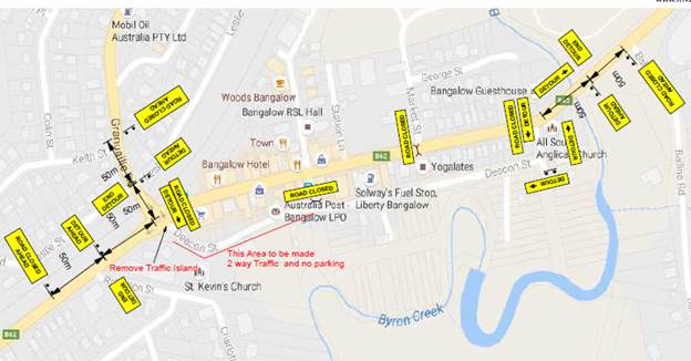
It is proposed that Byron Street
will be closed between 3:30pm and 10:00pm on Monday 24 December 2018.
There will be detours in place to allow traffic to continue to flow.
Traffic will be directed through Deacon Street, which will facilitate two-way
traffic flow.
Parking will be available at the
Bangalow Showgrounds, which will allow pedestrians to have access to the
carnival without the need to cross a trafficable road.
COUNCIL IMPLICATIONS
§ Budget/Financial
The event organisers to be
invoiced for the relevant Approval of Road Events pursuant to s144 of the Roads
Act fee as per the Fees & Charges 2018/19.
§ Asset Management
N/A
§ Policy or Regulation
Regulatory traffic signage as
delegated to council for authorisation in conjunction with NSW Road Rules.
§ Consultation
A condition of the
endorsement of this event is that appropriate consultation is undertaken,
including:
· Advertising the
impact of the event in the local newspaper and on the Council website.
· Informing
community and business that are directly impacted.
· Liaising with bus
and taxi operators.
· Consulting with
emergency services.
§ Legal and Risk Management
Event organiser is required to
hold $20m public liability insurance cover which is valid for the event.
|
RECOMMENDATION:
1. That
Council approve the Traffic Management Plan (TMP) and Traffic Control Plan
(TCP) for the Bangalow Christmas Eve Carnival 2018 to be held Monday 24
December 2018, that includes the temporary road closure below:
a) Byron
Street, Bangalow between Ashton Street and Granuaille, between 3:30pm and
10:00pm.
2. That
the approval provided in Part 1 is subject to:
a) separate
approvals by NSW Police and RMS being obtained, noting that the traffic
control plan is partially located on a state road;
b) implementation
of the approved Traffic Management Plan and Traffic Control Plan, including
the use of signed detours, as designed and implemented by those with
appropriate accreditation;
c) that
the impact of the event be advertised via a notice in the local weekly paper
a minimum of one week prior to the operational impacts taking effect, noting
it must include the event name, specifics of any traffic impacts or road
closures and times, alternative route arrangements, event organiser, a personal
contact name and a telephone number for all event related enquiries or
complaints;
d) the
event be notified on Council’s webpage;
e) the
event organiser:
i) undertake
consultation with community and affected businesses including adequate
response/action to any raised concerns;
ii) undertake
consultation with emergency services and address any identified issues;
iii) holding
$20m public liability insurance cover which is valid for the event;
iv) paying
Council’s Road Event Application Fee prior to the event.
|
Attachments:
1 Bangalow
Christmas Eve TCP, E2018/85842 , page 13⇩ 
2 Bangalow
Christmas Eve Carols - TMP, E2018/85841
, page 14⇩ 
Regulatory Matters 6.2 - Attachment 1
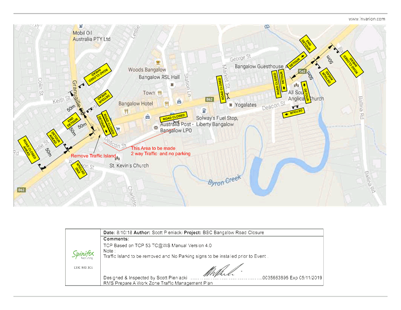
Regulatory Matters 6.2 - Attachment 2
|
Table 1. TMP Performa (part 1 of
2)
|
|
Question
|
Response (If no, state your
reasons why)
|
|
A. Description
or detailed plan of proposed measures.
Is a detailed
plan of the proposed measures necessary?
|
Event Name
|
BANGALOW
CHRISTMAS EVE CARNIVAL 2018
|
A.
Organiser Name |
BANGALOW
CHAMBER OF COMMERCE
|
A.
Traffic Control |
SPINIFEX
GROUP
|
A.
Date(s) |
24/12/2018
|
A.
Times |
3.30 PM
TO 10 PM
|
A.
Roads affected |
Byron
Street will be closed between 3.30pm and 10pm.
|
A.
Detours in place |
Yes.
Through Deacon Street (this will become two-way traffic).
|
A.
Parking |
Yes. At
the Bangalow Showgrounds.
|
A.
Other |
N/A
|
|
B. Identification
and assessment of impact of proposed measures.
Is a detailed
assessment required?
|
There
should be limited impact on traffic as the TCP has the required details to
address the necessary measures. There will be detours in place to allow
traffic to continue to flow. Pedestrians will have access to the Carnival
without the need to cross a trafficable road.
|
|
C. Measures
to ameliorate the impact of re-assigned traffic
Is an
assessment required?
|
Traffic
flow will remain unhindered with Deacon street becoming a two way with heavy
vehicles advised in advance. Police and traffic controllers will be in place to
direct traffic.
|
|
D. Assessment
of public transport services affected.
Is an
assessment required?
|
Public
transport companies will be advised and there have not been issues in
previous years.
|
|
E. Details
of provision made for emergency vehicles, heavy vehicles, cyclists and
pedestrians.
Are these
details required?
|
Emergency
|
Emergency
vehicles will have unimpeded access as required.
|
A.
Heavy Vehicles |
Heavy
vehicles will be advised in advance of event road closures and detours.
|
A.
Cyclist |
Access
to Byron Street will still be available as the road closure does not involve
erecting structures or marquees.
|
A.
Pedestrians |
Parking
will be accommodated in the Bangalow Show grounds with pedestrians having
access to the Carnival without crossing a trafficable road.
Access
to Byron Street will still be available as the road closure does not involve
erecting structures or marquees.
|
|
F. Assessment
of effect on existing and future developments with transport implications in
the vicinity of the proposed measures.
Is an
assessment required?
|
Not
applicable due to low scale of closure and temporary period of closure. All
residents and businesses will be able to access their properties via Deacon
Street. There will be no burden of a major detour.
|
|
G. Assessment
of effect of proposed measures on traffic movements in adjoining Council
areas.
Is an
assessment required?
|
There
will be little to no effect on adjoining areas as the detour is limited.
|
|
H. Public
consultation process
Is a public
consultation process required
|
Standard
consultation will be undertaken - event to be advertised in the local
newspaper and on Byron Shire Council website.
|
|
I. Terrorism
controls in place
|
Due
to the nature and small scale of the event there are no Terrorism controls in
place as it has been assessed as a low risk. The likelihood of a errant
vehicle running through the witches hats or
traffic
controls is low. The Police have been advised about this event.
|
|
|
|
|
Figure 1. Sketch of the site.
|
http://www.rms.nsw.gov.au/business-industry/partners-suppliers/documents/technical-manuals/tmplan_v2.pdf
Local Traffic Committee Meeting 6.3
Report No. 6.3 Events - Ballina to Byron Bay Coastal Charity Walk 26 May 2019
File No: I2018/1925
The 2019 Ballina to Byron Bay Coastal Charity Walk will be
held on Sunday 26 May 2019
0700 – 1700 and is the 8th consecutive year for the
Charity Walk. Organisers anticipate 1,800 to 2,000 participants (capped
at 2,500 attendees).
For 2019 the event organisers are not closing roads, they
will remain open with participants directed by Traffic Controllers and Traffic
Control Plans.
The Ballina to Byron Bay Coastal Charity Walk, in aid of the
Westpac Rescue Helicopter, to be held Sunday, 26 May 2019 starts at Missingham
Park in Ballina, and follows the coastline north to Lennox Head, Broken Head,
Tallows Beach to Cape Byron Lighthouse finishing at Denning Park in Byron Bay,
next to the Surf Life Saving Club, a distance of 37km.
The specific route within Byron can be summarised as:
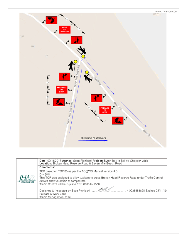
· Along Seven Mile
Beach then onto Seven Mile Beach Road.
· Along Seven Mile
Beach Road through to Broken Head Reserve Road intersection.
· Traffic
Controllers are proposed at this intersection with signage.
· East along Broken
Head Reserve Road to Tallows Beach.
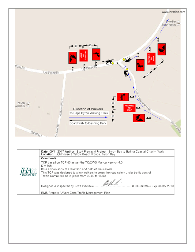
· Along Tallows
Beach then through the National Park to Lighthouse Road.
· Traffic
controllers with signage are proposed at the location where walkers enter
Lighthouse Road.
· East along
Lighthouse Road to the Lighthouse.
· Through the
national park to Marine Parade at Wategos.
· Along Marine
Parade and the national park to The Pass.
· Along Clarkes
Beach and Main Beach to Denning Park.
|
RECOMMENDATION:
1. That
Council support the Westpac Life Saver Rescue Helicopter fundraiser, Ballina
to Byron Coastal Charity Walk, to be held Sunday 26 May 2019.
2. That
Councils support in Part 1 is subject to:
a) An
updated Traffic Control Plan and Traffic Management Plan in accordance with
the current version of RMS Technical Manual – Traffic Control at Work
Sites by a person with appropriate accreditation.
b) Implementation
of the Traffic Management Plan and Traffic Control Plans as designed by those
with appropriate accreditation and implemented by people with appropriate
accreditation, including traffic controllers.
c) That
the impact of the event be advertised via a notice in the local weekly paper
a minimum of one week prior to the operational impacts taking effect, noting
it must include the event name, specifics of any traffic impacts or road
closures and times, alternative route arrangements, event organiser, a
personal contact name and a telephone number for all event related enquiries
or complaints.
d) The
event be notified on Council’s webpage.
e) The
event organiser:
i) Undertake
consultation with community and affected businesses including adequate
response/action to any raised concerns.
ii) Undertake
consultation with emergency services and any identified issues addressed.
iii) Holding
$20m public liability insurance cover which is valid for the event.
iv) Paying
Council’s Road Event Application Fee prior to the event.
f. The
use of marshals along Marine Parade who, for the purpose of aiding and forming
participants into walking groups, are to undertake their duties in accordance
with a pre-event risk assessment and management plan, a copy of which is to
be provided to Council prior to the event.
3. That
the approval in Part 1 is also subject to the following in regard to the use
of Seven Mile Beach Road, that is:
a) signage,
which specifies the date, hours and nature of the event, be positioned at the
entrance and exit of Seven Mile Beach Road one week prior to the event;
b) on
the day of the event, at 500m intervals, and facing both directions of
travel, signs advising of “ Special Event - Charity Walk Ahead”
(or similar) are installed prior, and removed after, the event occurs; and
c) a
safety induction for participants advising of hazards be provided.
|
Attachments:
1 Ballina to
Byron Bay Coastal Charity Walk 2019 - TCPs, E2018/80909
, page 19⇩
Regulatory Matters 6.3 - Attachment 1
Local Traffic Committee Meeting 6.4
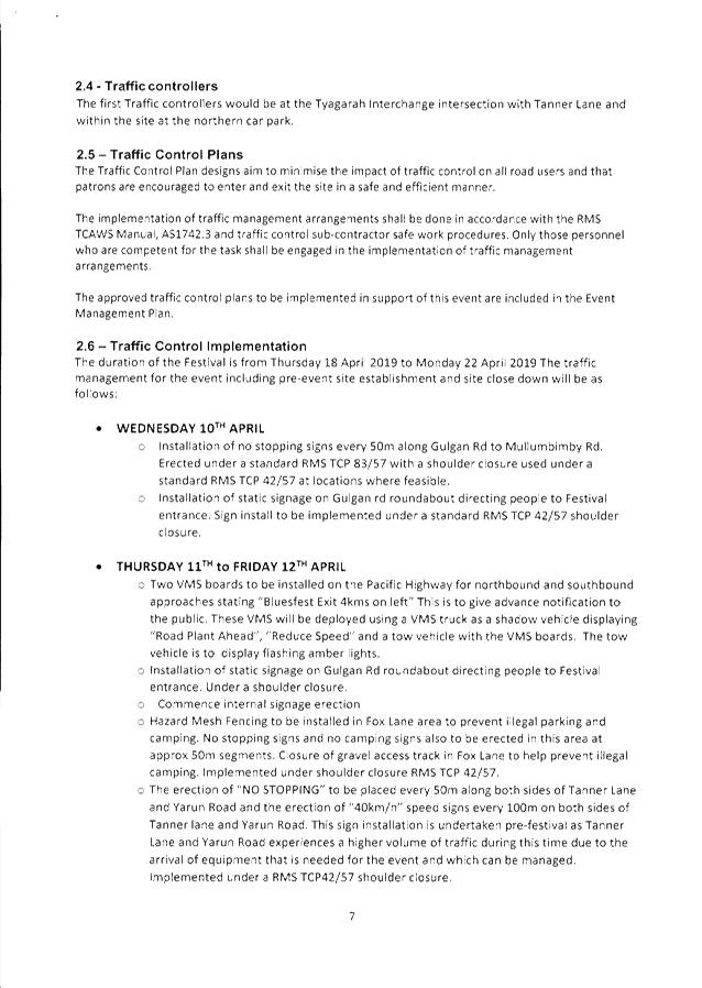
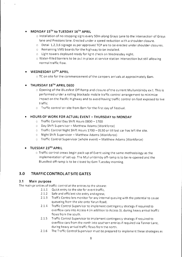
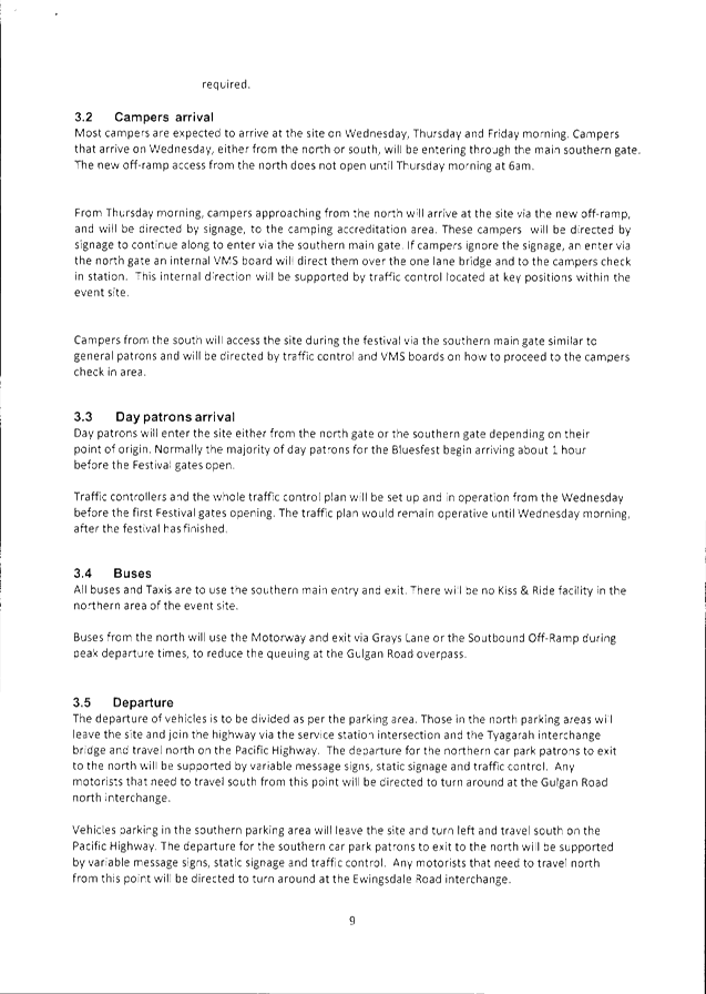
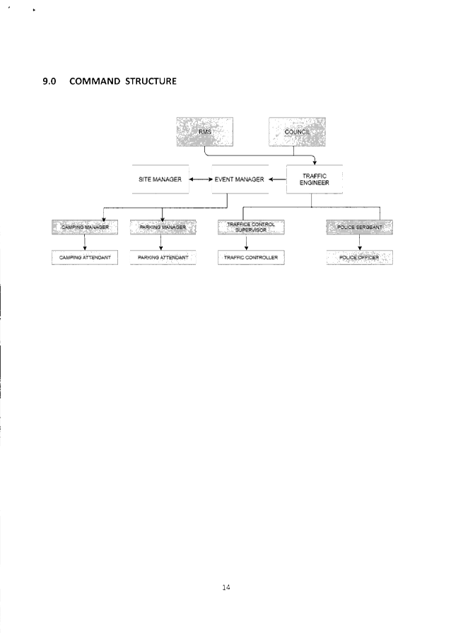
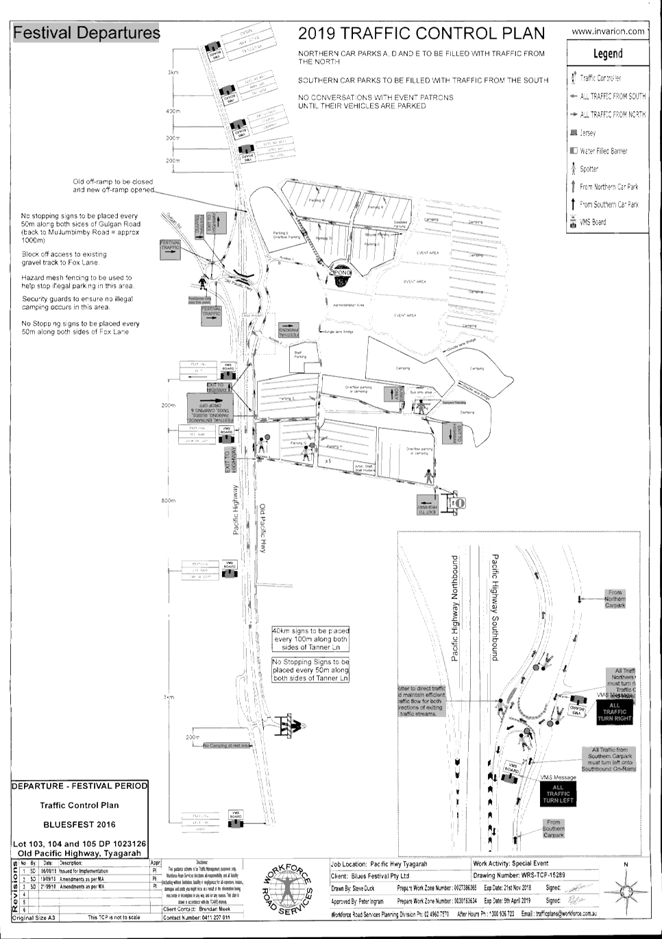
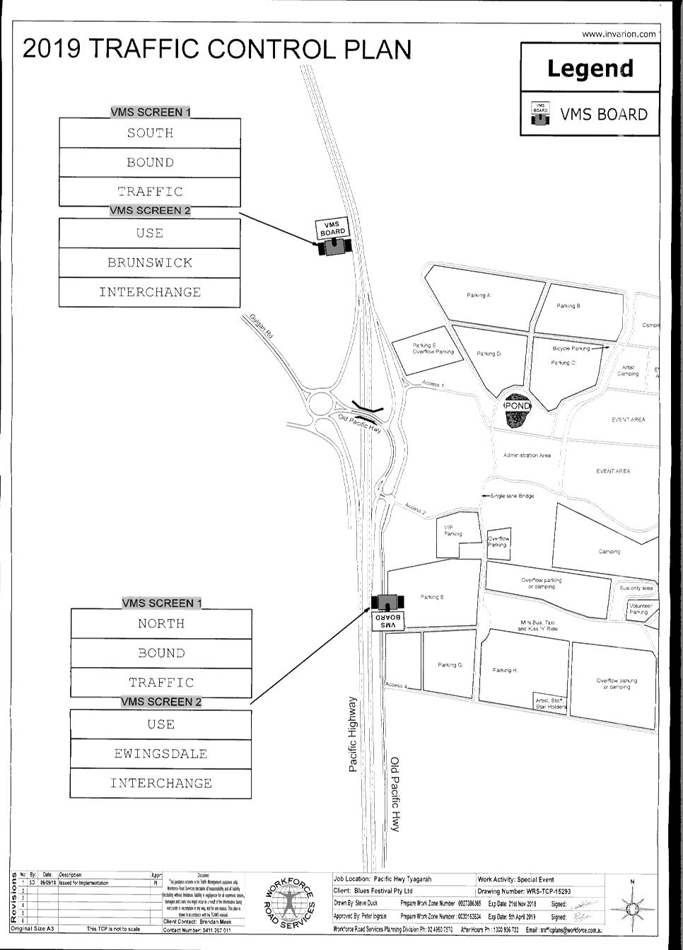
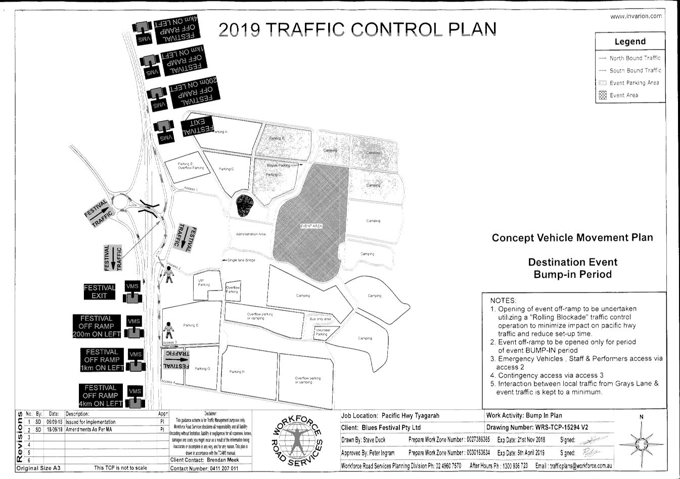
Report No. 6.4 Events - Byron Bay Bluesfest 2019
File No: I2018/1936
SUMMARY
Council has received an event Traffic Management Plan (TMP)
and Traffic Control Plan (TCP) for Byron Bay Bluesfest 2019 to be held on
Thursday 29 March 2018 to Monday 2 April 2018.
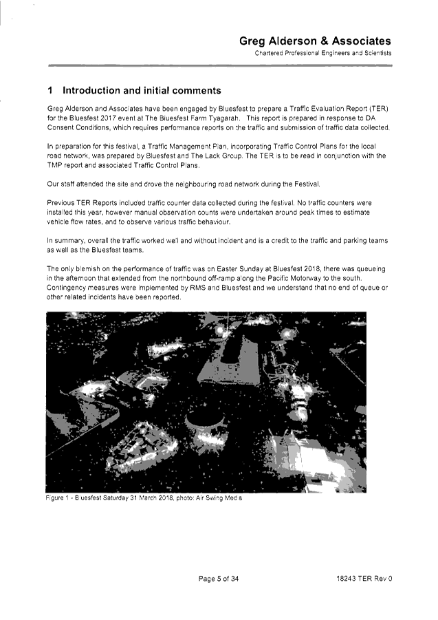
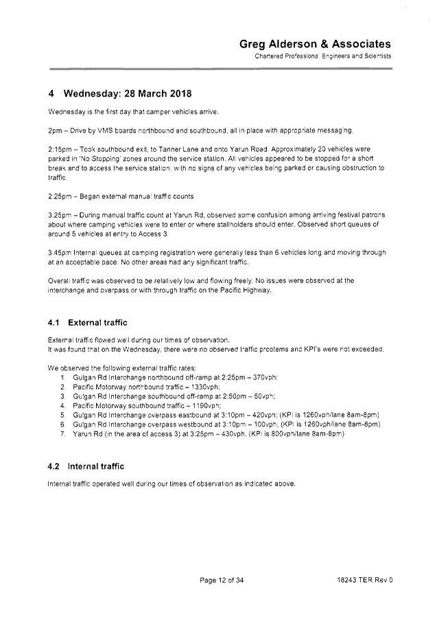
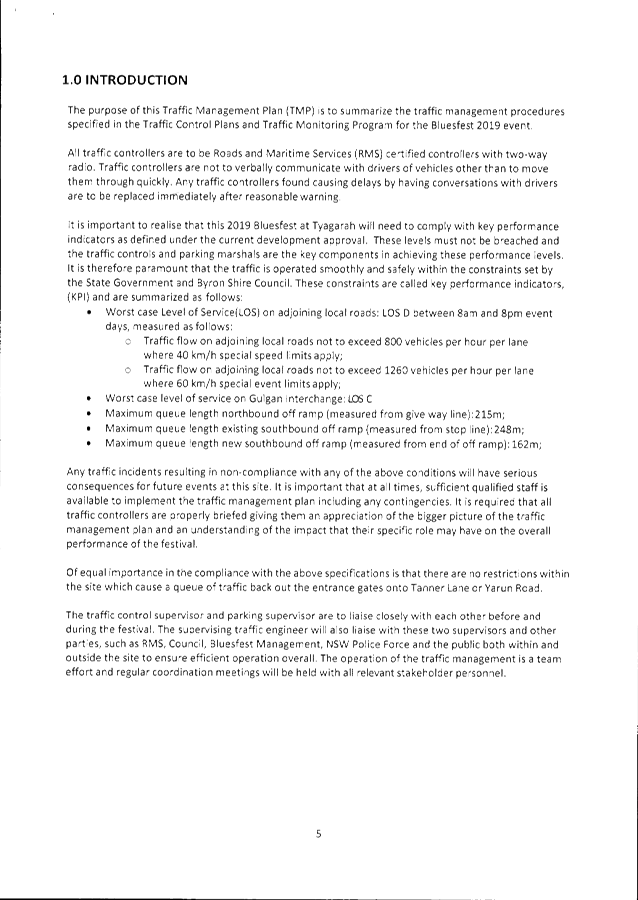
BACKGROUND
2018 Traffic Debrief
The attached Traffic Evaluation Report by Greg Alderson
& Associates (attachment 1) provides a debrief summary and assessment on
how traffic management for the 2018 event, held Thursday March 29 to Monday
April 2. As per previous years, Bluesfest was required and will be
required for 2019 to meet specific traffic management KPI’s as part
conditions of consent (DA10.2013.128.1 and DA10.2014.753.1).
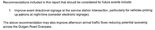
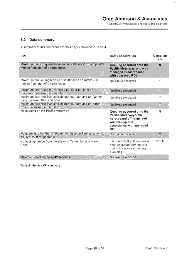
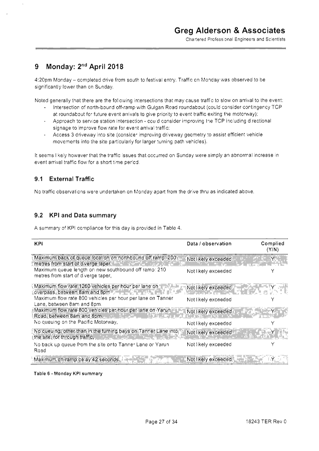
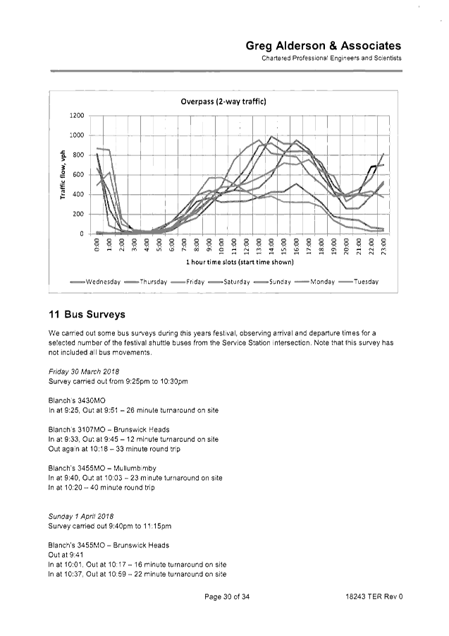
The debrief report identifies the event met all of its
traffic management KPI’s except for two on Sunday April 1st,
refer to section 8 of attachment 1. In summary, traffic queued back onto
the motorway for approximately half an hour and was managed by implementing
their contingency measures.
The only recommendations made by the debrief report is shown
below. This recommendation has been incorporated into the 2019 TMP and are
shown below.
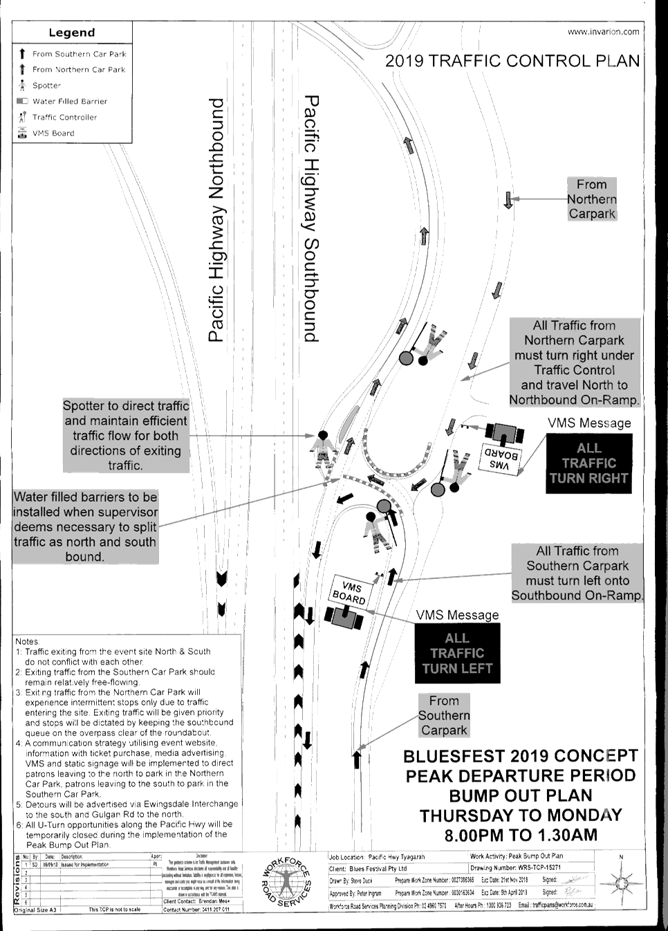
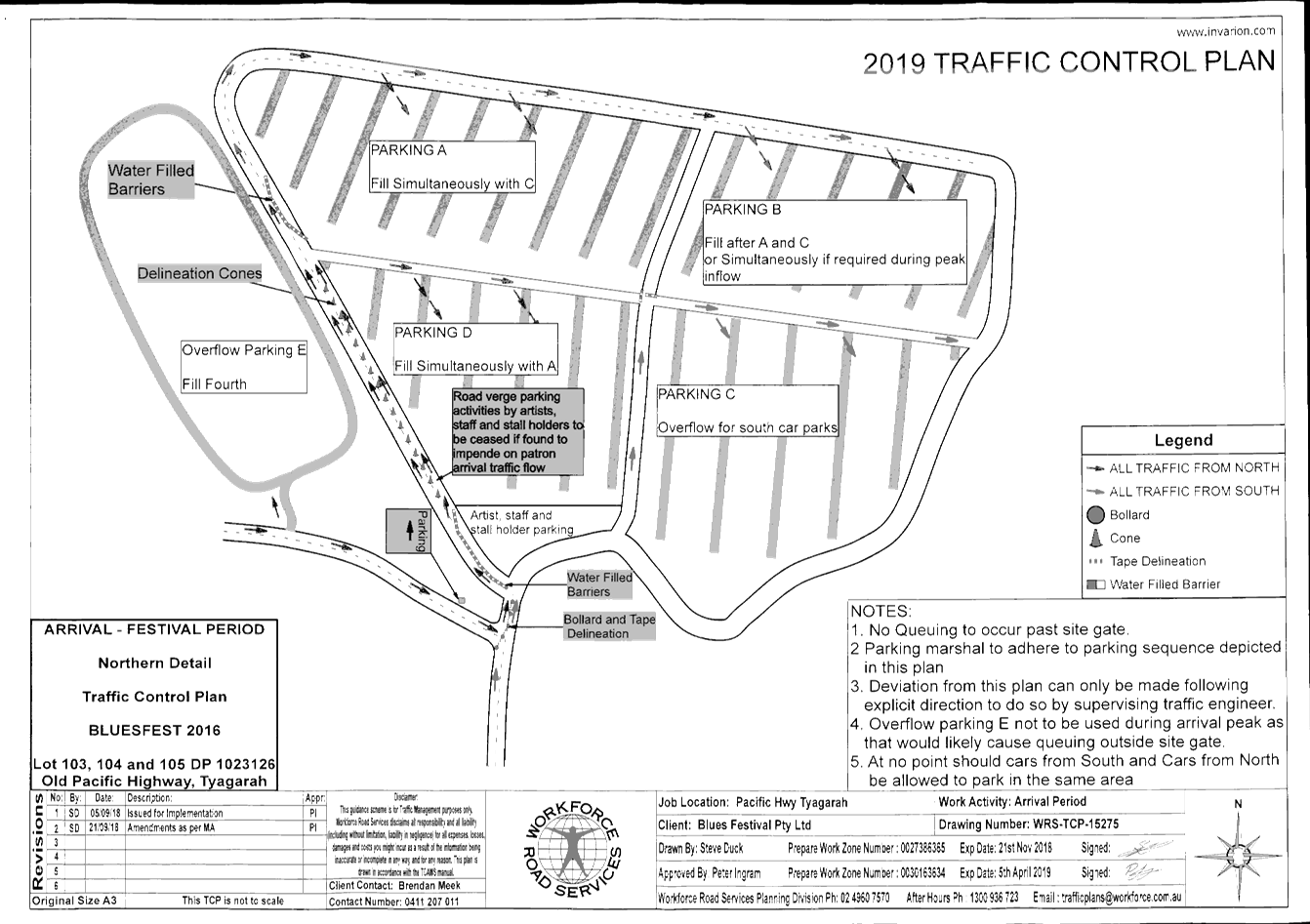
2019 Traffic Control Plans
The proposed 2019 traffic control plans are virtually the
same as 2018 with minor amendments, such as an additional traffic controller
during site egress.
Bluesfest have changed traffic control companies as a result
of traffic management concerns.
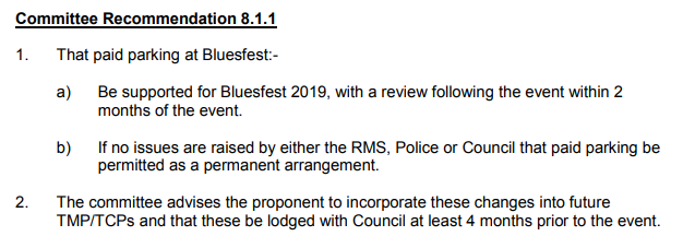
Paid Parking
Paid Parking is to be introduced as part of 2019 event and
was supported by the Local Traffic Committee at the 26 June 2018 LTC meeting
and adopted by Council at the 2nd August 2018 Council meeting. Paid
parking was adopted with the following requirement:
The events development consent (10.2013.128.3) has been
amended to ensure the above requirements are met. The attached 2019 Traffic
Management Plan also takes into account the introduction of Paid Parking
(attachment 2, section 7).
KEY ISSUES
1. Congestion
onto the Pacific Highway if not managed correctly.
2. RMS
Traffic Engineering Department requires separate approval of the TMP and TCP.
COUNCIL IMPLICATIONS
§ Budget/Financial
The event organisers to
pay the relevant Approval of Road Events fee pursuant to s144 of the Roads
Act as per the Fees & Charges 2017/18.
§ Asset Management
Not applicable.
|
RECOMMENDATION:
1. That
Council endorse the recommendations of the Local Traffic Committee for the
Byron Bay Bluesfest 2019 to be held on Thursday 18 April 2019 to Monday 22
April 2019.
2. That
the approval provided in Part 1 is subject to:
a.
separate approvals by NSW Police and RMS being
obtained, noting that the event is
on a state road or may impact the state road network
b. implementation
of the approved Traffic Management Plan and Traffic Control Plan,
including the use of signed detours, as designed and implemented by those
with appropriate accreditation
c. that
the impact of the event be advertised via a notice in the local weekly paper
a minimum
of one week prior to the operational impacts taking effect, noting it must
include the event name, specifics of any traffic impacts or road closures and
times, alternative route arrangements, event organiser, a personal contact name
and a telephone number for all event related enquiries or complaints
d. the
event be notified on Council’s webpage
e. the
event organiser is to:
i. undertake
consultation with community and affected businesses including adequate
response/action to any raised concerns
ii. undertake
consultation with emergency services and any identified issues addressed
iii. hold
$20m public liability insurance cover which is valid for the event
iv. pay
Council’s Road Event Application Fee prior to the event
|
Attachments:
1 Bluesfest
2018 - debrief document - Traffic Evaluation Report by Greg Alderson &
Associates May 2018, E2018/55043
, page 24⇩ 
2 Letter
from Bluesfest Services Pty Ltd - Bluesfest 2019 Traffic Management Plan, S2018/12788 , page 58⇩ 
Regulatory Matters 6.4 - Attachment 1


Regulatory Matters 6.4 - Attachment 2

Regulatory Matters 6.4 - Attachment 2
Regulatory Matters 6.4 - Attachment 2
Regulatory Matters 6.4 - Attachment 2
Regulatory Matters 6.4 - Attachment 2
Local Traffic Committee Meeting 6.5
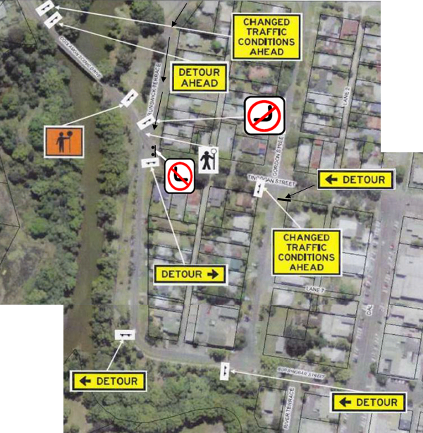
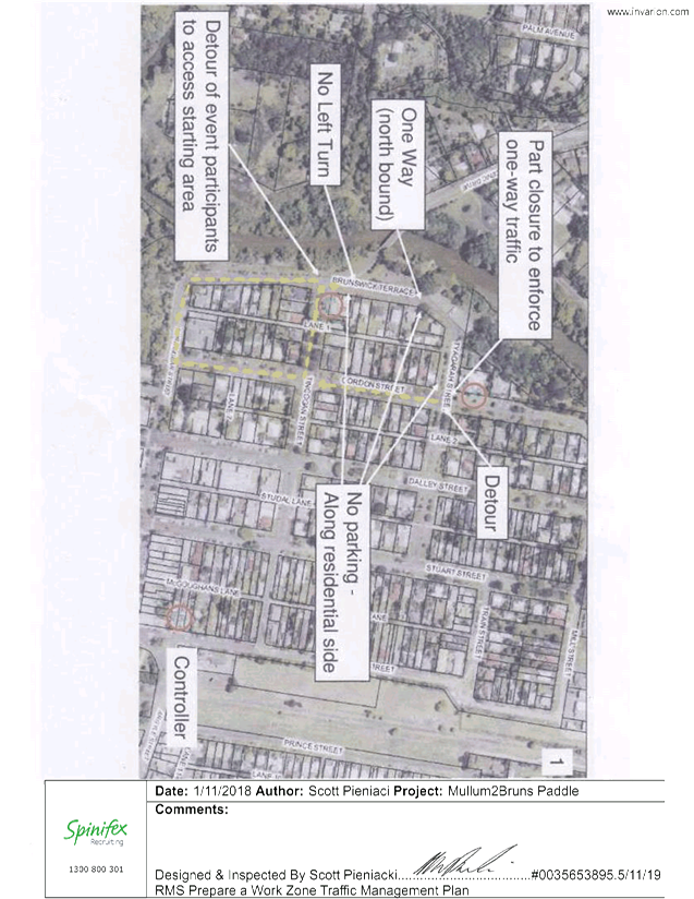
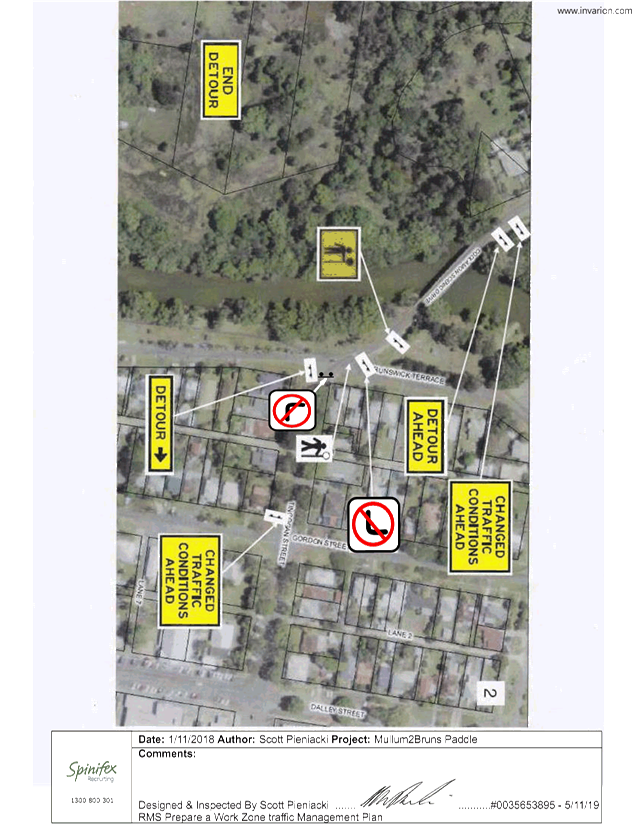
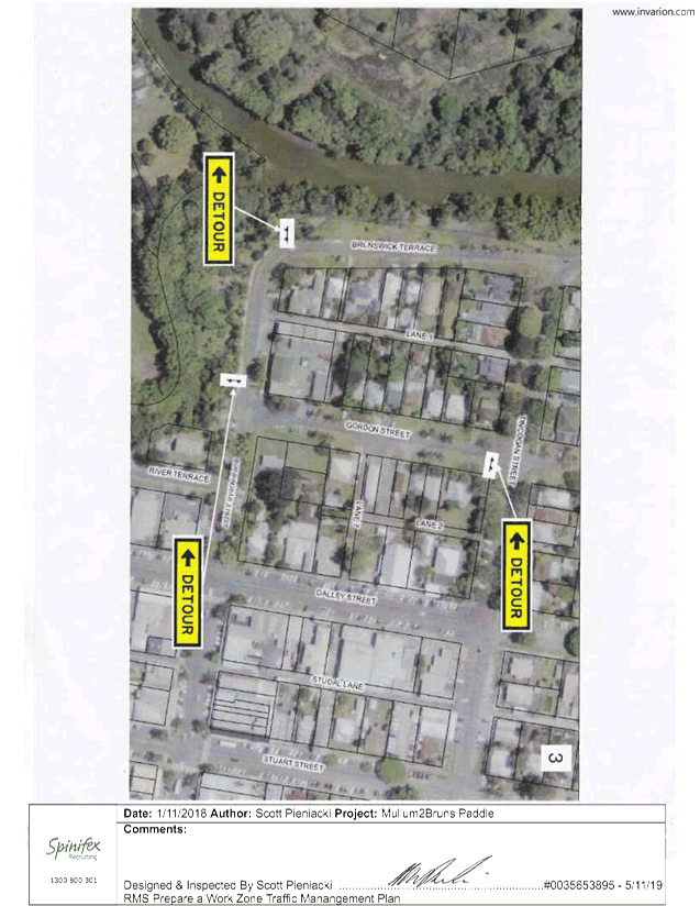
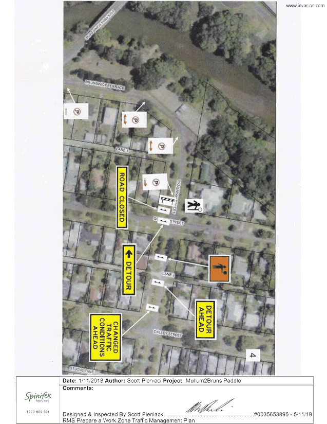
Report No. 6.5 Events - Mullum2Bruns Paddle 2019
File No: I2018/1937
SUMMARY
Council has received an application, Traffic Management Plan
(TMP) and Traffic Control Plan (TCP) from the Mullum2Bruns Paddle Committee for
the Mullum2Bruns Paddle 2019 to be held Sunday 26 May 2019.
BACKGROUND
As in past years the Paddle Committee is requesting
permission for temporary one-way traffic of Brunswick Terrace, between Tincogan
Street and Tyagarah Street, Mullumbimby, between 6:00am and 10:00am. This will
allow for the registrations and start of the 2019 Mullum2Bruns Paddle to be
held on Sunday 26 May 2019.
Brunswick Terrace is to be one way in the vicinity adjacent
to launch and registration area, shown below. Traffic control with detours and
no parking signs along the one way part of Brunswick Terrace is proposed to
control traffic.
Uniformed Marine Rescue personnel will be patrolling the
homes opposite the registration area to ensure that participants are not
parking in front of or across driveways, thereby minimising inconvenience to
the residents.
Participants will be diverted along the southern part of
Brunswick Terrace to the intersection of Brunswick Terrace & Tincogan
Street to enable them to cross to the starting area. The JHA traffic
controllers will hold traffic crossing to the registration zone until there is
spaces for them to unload their craft.
A letter box drop would be done 2 weeks prior to the event
informing residents in the surrounding streets of the temporary one way traffic
closures.
COUNCIL IMPLICATIONS
§ Budget/Financial
The event organisers to be
invoiced for the relevant Approval of Road Events pursuant to s144 of the Roads
Act fee as per the Fees & Charges 2017/18.
§ Asset Management
N/A
§ Policy or Regulation
Regulatory traffic signage as
delegated to council for authorisation in conjunction with NSW Road Rules.
§ Consultation
A condition of the endorsement
of this event is that appropriate consultation is undertaken, which may
include:
· Advertising the
impact of the event in the local newspaper and on the Council website.
· Informing
community and business that are directly impacted.
· Liaising with bus
and taxi operators.
· Consulting with
emergency services.
§ Legal and Risk Management
Event organiser is required to
hold $20m public liability insurance cover which is valid for the event.
|
RECOMMENDATION:
1. That
Council approve the Traffic Management Plan and Traffic Control Plans for the
Mullum2Bruns Paddle 2019 to be held Sunday 26 May 2019, that includes the
temporary road closure below:
a) Brunswick
Terrace, Mullumbimby, between Tincogan Street and Tyagarah Street (to become
one-way traffic), between 06:00am and 10:00am on Sunday 26 May 2019.
2. That
the approval provided in Part 1 is subject to:
a) implementation
of the approved Traffic Management Plan and Traffic Control Plan, including
the use of signed detours, as designed and implemented by those with
appropriate accreditation;
b) that
the impact of the event be advertised via a notice in the local weekly paper
a minimum of one week prior to the operational impacts taking effect, noting
it must include the event name, specifics of any traffic impacts or road
closures and times, alternative route arrangements, event organiser, a
personal contact name and a telephone number for all event related enquiries
or complaints;
c) the
event be notified on Council’s webpage;
d) the
event organiser:
i) undertake
consultation with community and affected businesses including adequate
response/action to any raised concerns;
ii) undertake
consultation with emergency services and any identified issues addressed;
iii) holding
$20m public liability insurance cover which is valid for the event;
iv) paying
Council’s Road Event Application Fee prior to the event.
v) Undertake
a debrief within two weeks of the event involving event staff, Police (if
they had incidents) and traffic controllers. A debrief report is to be
submitted to Council with any future event application.
|
Attachments:
1 Mullum2Bruns
Paddle TCP 1, E2018/87321 , page 85⇩ 
2 Mullum2Bruns
Paddle TCP 2, E2018/87322 , page 86⇩
3 Mullum2Bruns
Paddle 3, E2018/87324 , page 87⇩
4 Mullum2Bruns
Paddle TCP 4, E2018/87325 , page 88⇩
Regulatory Matters 6.5 - Attachment 1
Regulatory Matters 6.5 - Attachment 2
Regulatory Matters 6.5 - Attachment 3
Regulatory Matters 6.5 - Attachment 4
Local Traffic Committee Meeting 6.6
Report No. 6.6 Endorsement of no entry signage associated with driveway crossing
under S138 of the Roads Act
File No: I2018/2025
Council received a driveway crossing application for Lot 2
DP 1206972, known as: 2 Bangalow Road Byron Bay. The driveway will have
frontage to Bangalow Road, classified road MR545 (see aerial image of site). The
proposed driveway will be located 25 metres south of the Browning Street
roundabout (see plan image of part site with driveway). The driveway is located
and aligned in accordance with an active DA consent No. 10.2007.406.7.
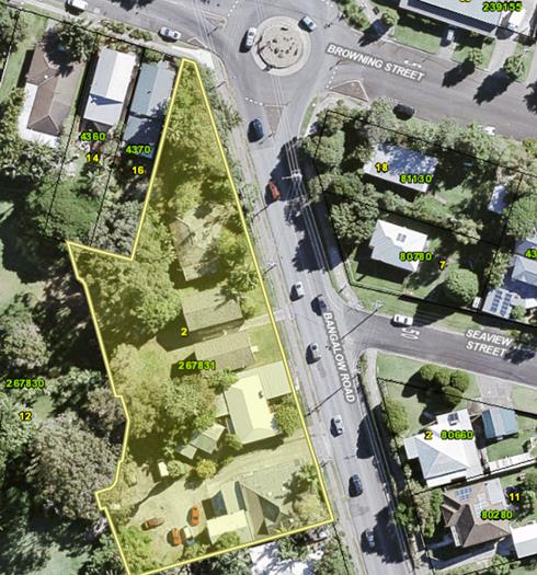
Fig. 1 Site Location
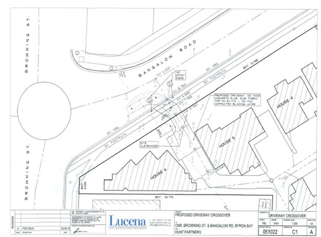
Fig. 2 - Site driveway details
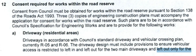
Condition No.12 from DA10.2007.406.7 requires the driveway
to be located as shown above and to be left out only.

Two standard “No Entry” signs are
proposed. One to be located either side of the driveway.
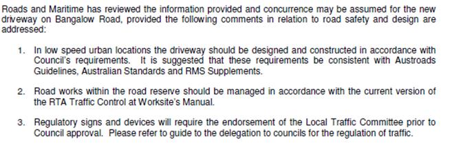
A referral to the RMS was undertaken and assumed concurrance
was granted on the 25.9.2018 for the proposed driveway (E2018/79664) subject
to;
|
RECOMMENDATION:
That Council supports the proposed use of
“No Entry” signage and the location of ‘No Entry’
signage for proposed driveway crossing fronting Bangalow Road, Byron Bay in
attachment (S2018/10695).
|
Local Traffic Committee Meeting 6.7
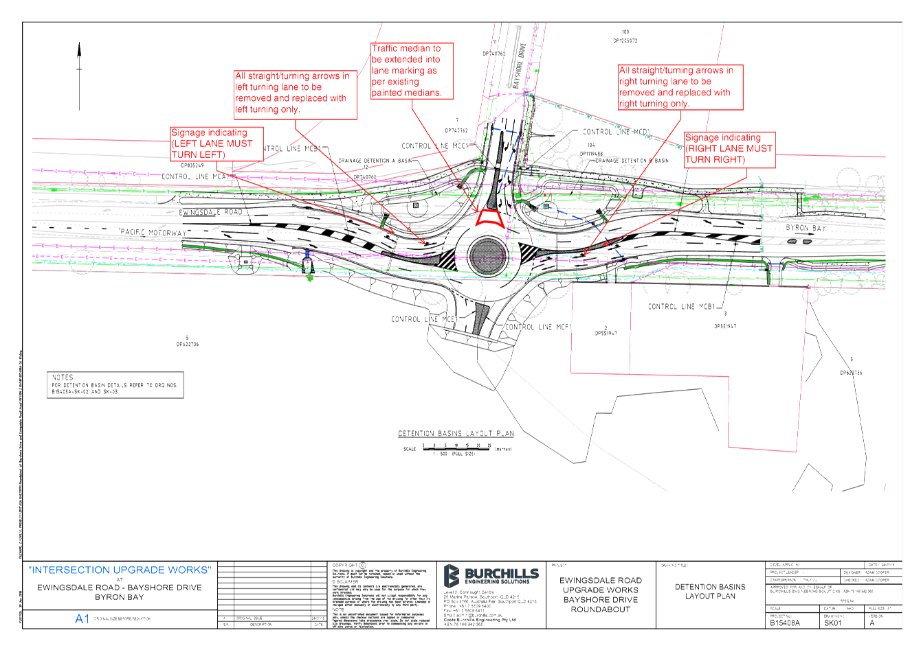
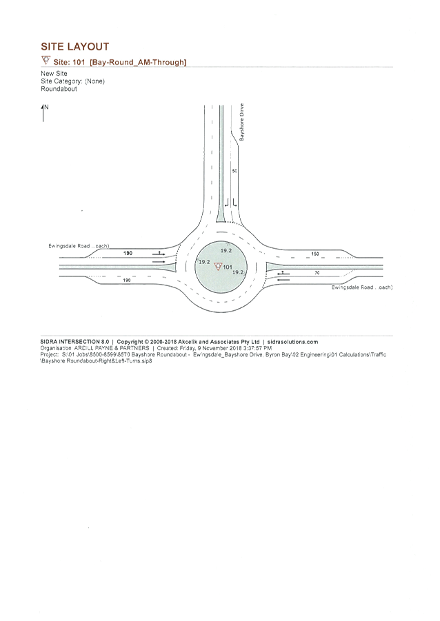
Report No. 6.7 Ewingsdale Road Roundabouts - Lane Modifications
File No: I2018/2127
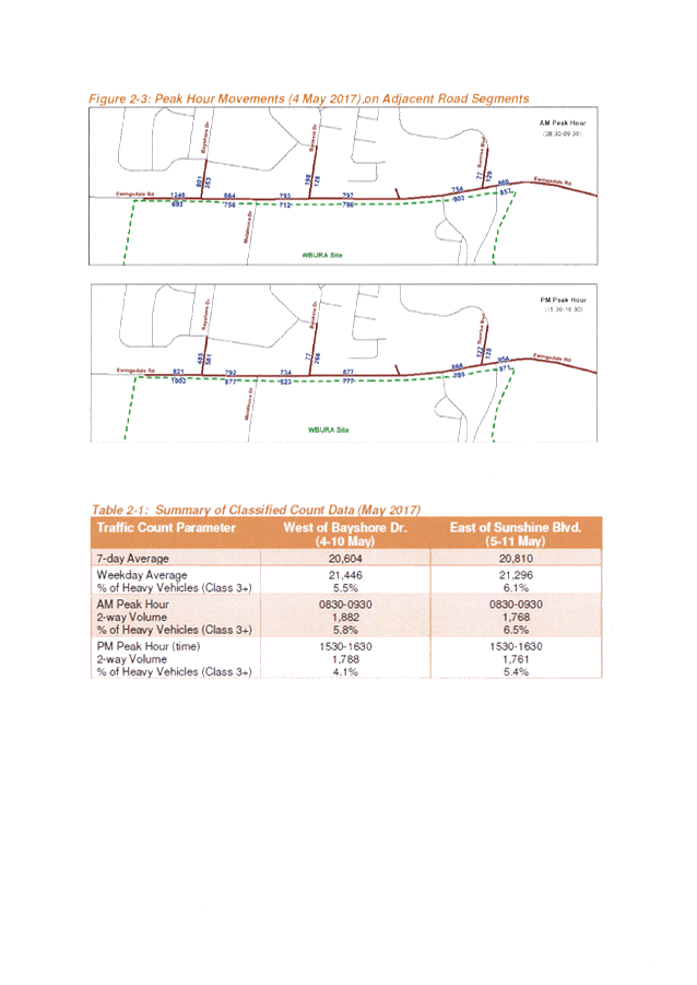
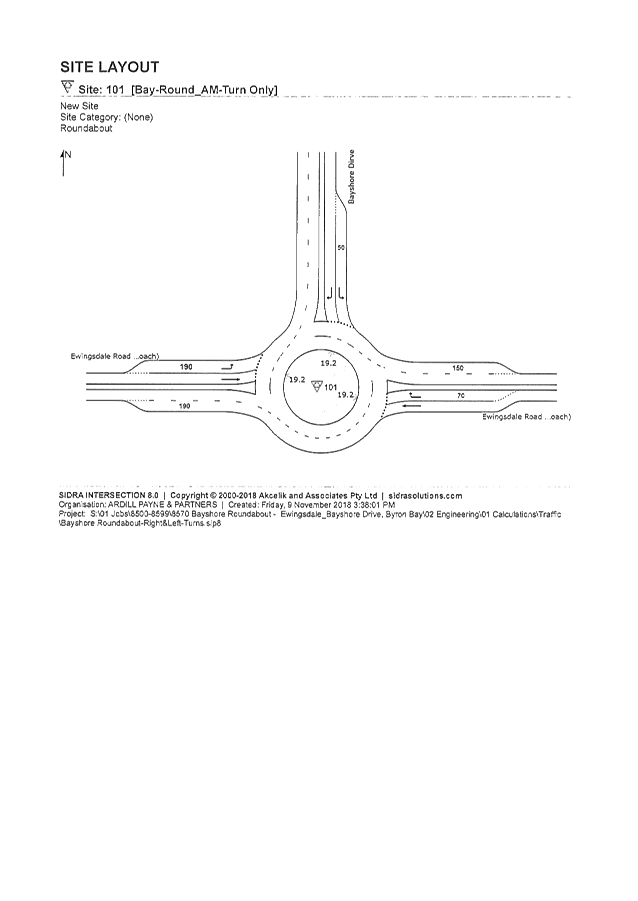
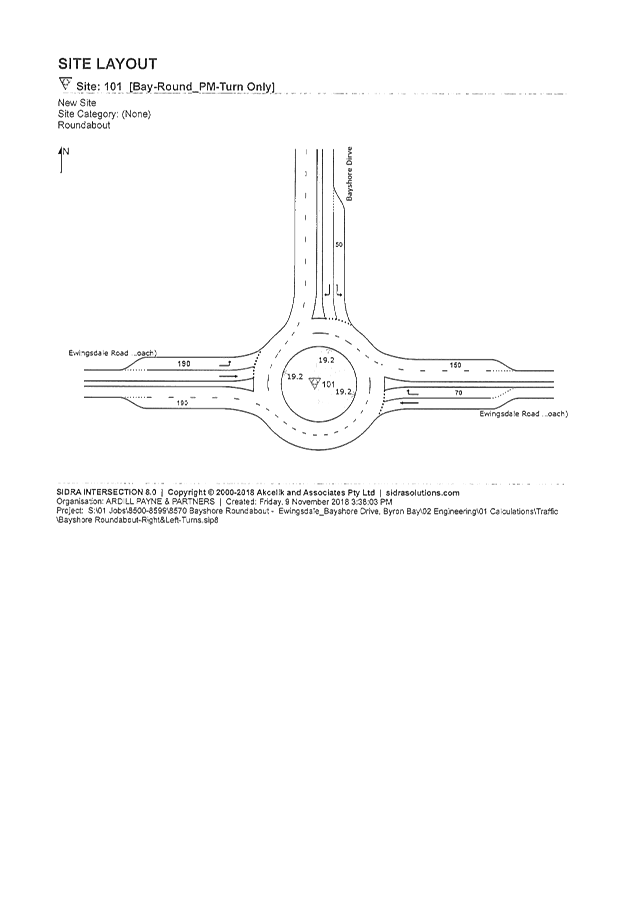
The Bayshore Drive and Sunrise Boulevard roundabouts are
part of the overall upgrade strategy for Ewingsdale Road to two lanes in either
direction, however they have been constructed in isolation and therefore
require some modification to make them safer for the existing situation, tying
into single lanes in either direction outside the limits of works. It is
therefore proposed that the following modifications be made;
Bayshore Drive Roundabout Eastbound;
· Outer Lane will
become left turn only, with the arrows being modified and signs added
indicating that the left lane must turn left at Bayshore Drive. A painted
median will be included on the roundabout to reinforce this.
· Inner Lane will be
the straight through lane for traffic to continue to Byron Bay.
Bayshore Drive Roundabout Westbound;
· Inner Lane will
become right turn only, with the arrows being modified and signs added
indicating that the right lane must turn right at Bayshore Drive. No median is
required here as it is the inner lane making the turning movement.
· Outer Lane will be
the straight through lane for traffic to continue to the Pacific Highway.
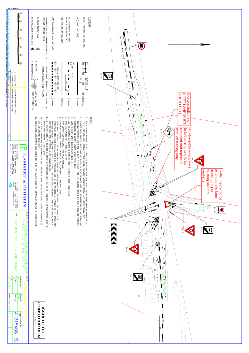
Sunrise Boulevard Roundabout Eastbound
· Outer Lane will
become left turn only, with the arrows being modified and signs added
indicating that the left lane must turn left at Sunrise Boulevard. A painted
median will be included on the roundabout to reinforce this.
· Inner Lane will be
the straight through lane for traffic to continue to Byron Bay.
Sunrise Boulevard Roundabout Westbound;
· No modifications
made, as it would require motorists to merge into the outer lane to continue
straight through to the Pacific Highway, but this would be a counterintuitive
manoeuvre to drivers. Furthermore, the outer lane has a bus stop and driveway
to the Belongil Fields Caravan Park at the western end of the works that means
the two lanes is more relevant here.
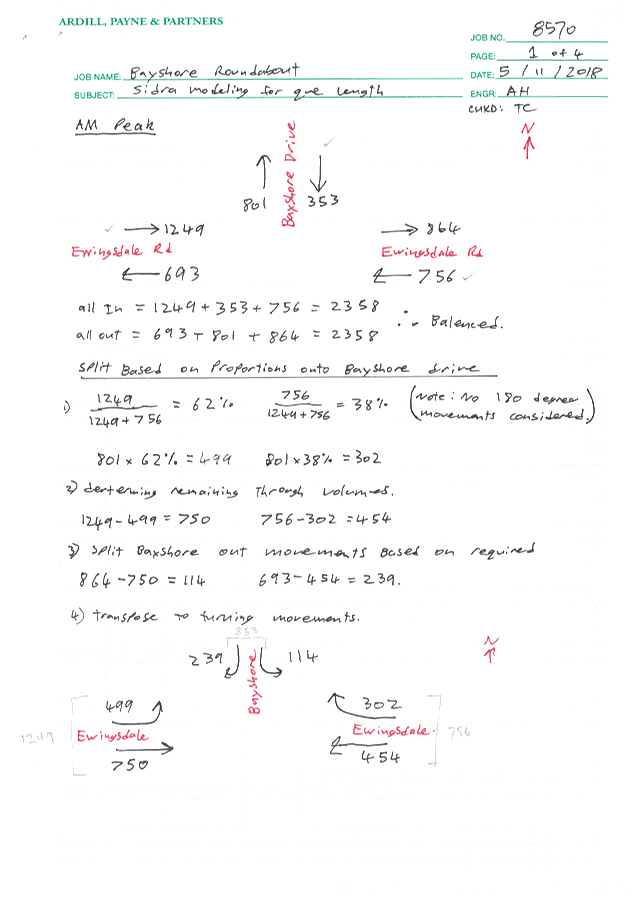
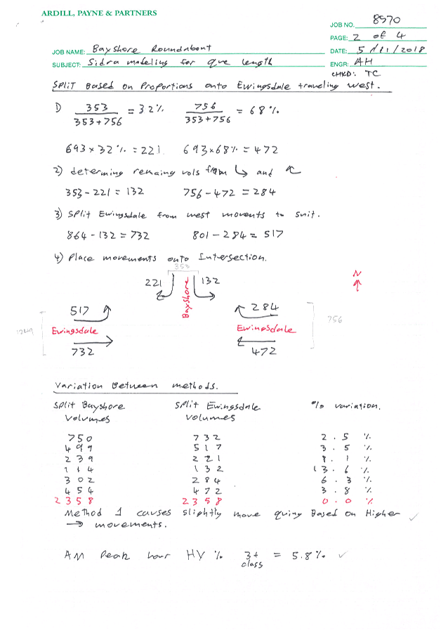
Rationale for the lane modifications being made to these
roundabouts;
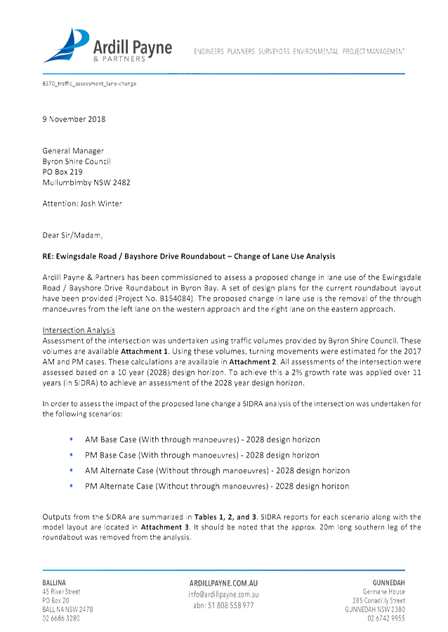
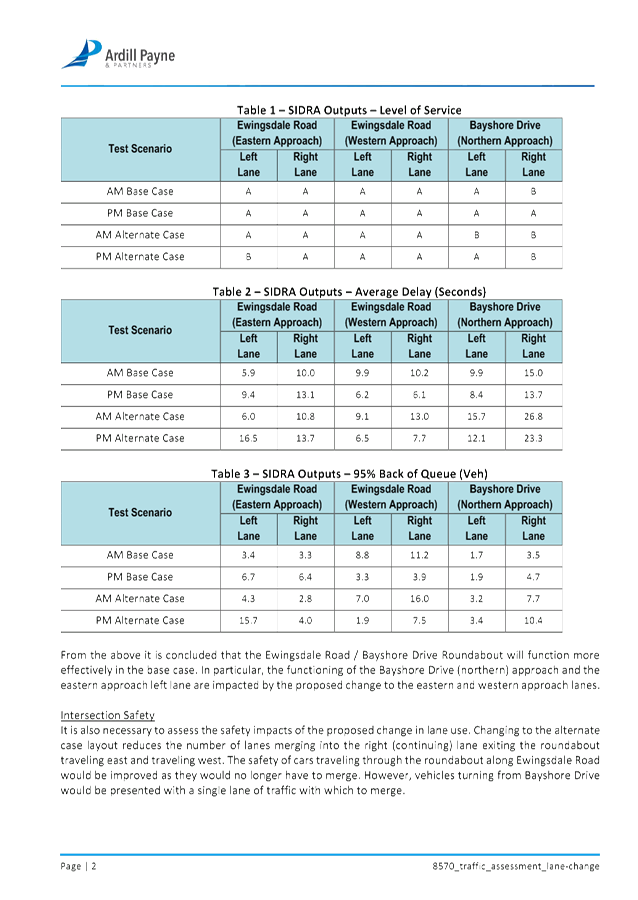
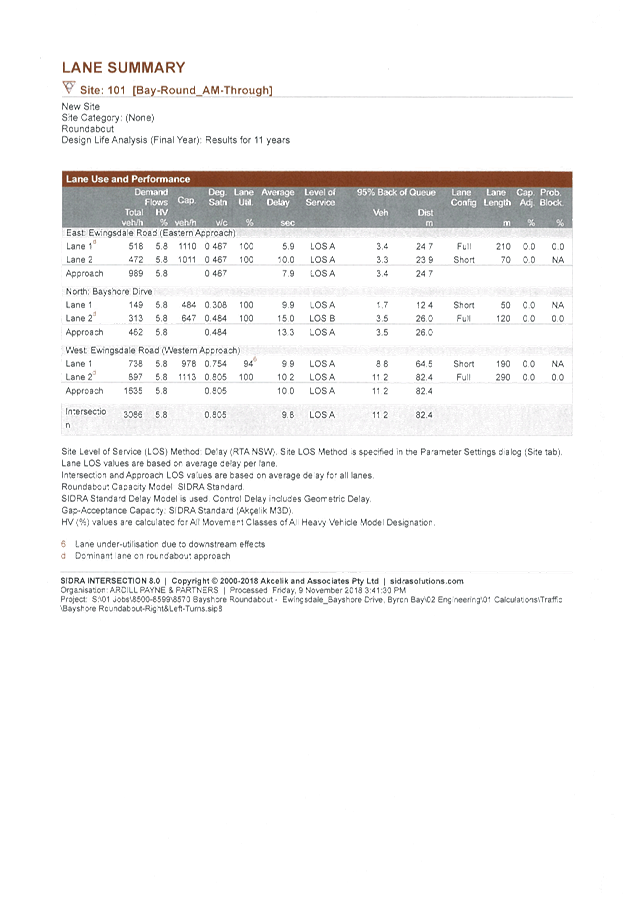
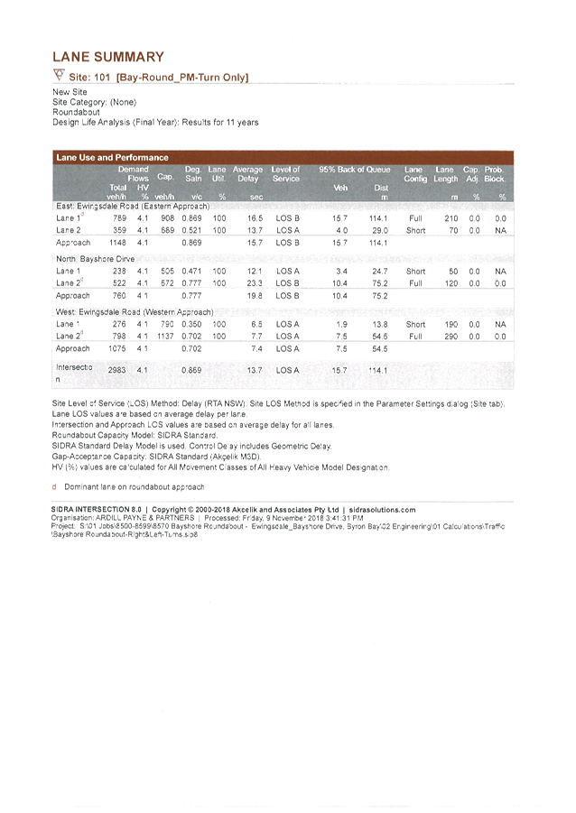
Council staff procured a
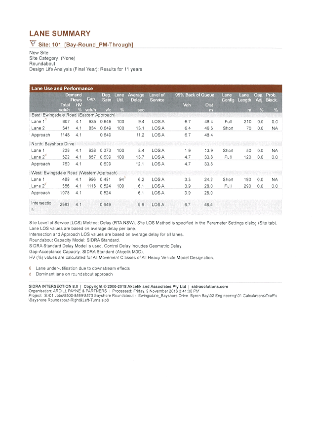
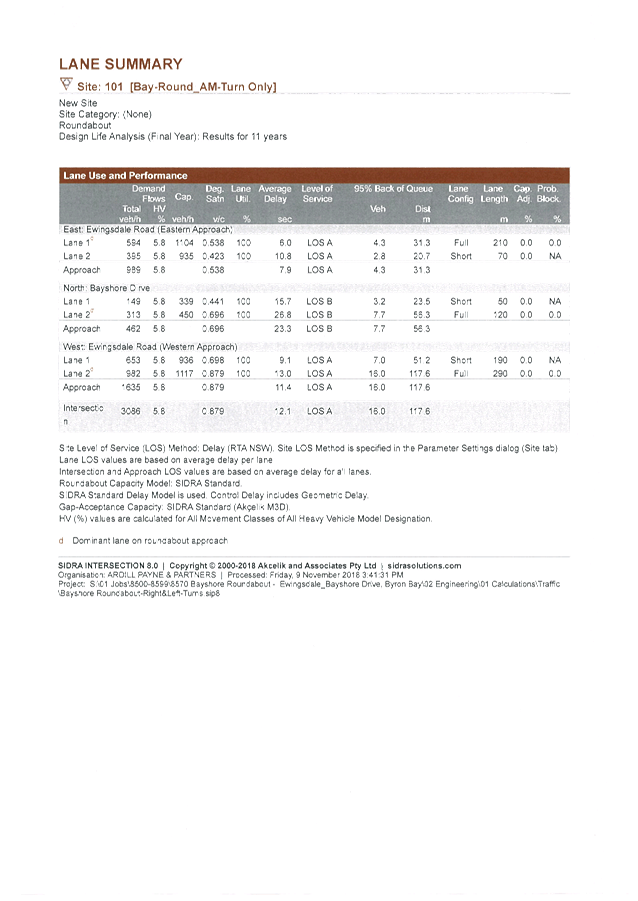
report from Ardill Payne and Partners, which details the Level of Service that
would be provided with the proposed linemarking at the Bayshore Drive
Roundabout. In all cases this remains a Level of Service of B or greater, which
is acceptable. Council received a number of Customer Requests from the
community requesting that the Sunrise Boulevard Roundabout be modified in this
way (eastbound only) in order the make the roundabout more functional when
entering from Sunrise Boulevard. The report from Ardill Payne and Partners also
talks to the safety aspect of the changes and advises that the changes would
reduce the number of merge manoeuvres and therefore reduce the potential for
conflict and improve safety at the intersection.
Rationale for when the lane modifications will be
reversed;
When Ewingsdale Road is
duplicated between these two roundabouts in the future, the lane modifications
at both roundabouts will be modified as part of those works back to dual lane
ability, with a merge east of Sunrise Roundabout and west of Bayshore
Drive. When Ewingsdale Road (and Belongil Bridge) are duplicated in the
future, there will be no merge east and west of the roundabouts, however as
Ewingsdale Road is single lane east and west of these roundabouts, its seems
logical for the roundabouts to function more as a single lane roundabout for
the east-west movements until the duplication is constructed.
|
RECOMMENDATION:
That Council endorse the modifications to the
lane markings and signage for the Bayshore Drive and Sunrise Boulevard
roundabouts on Ewingsdale Road as per attachments 1 (E2018/88733) and 2
(E2018/88732).
|
Attachments:
1 Bayshore
RAB - Additional Line Marking Plan, E2018/88733
, page 94⇩
2 Sunrise
RAB - Additional Line Marking Plan, E2018/88732
, page 95⇩
3 24.2015.48.1
- Bayshore RAB - APP Traffic Assessment Lane Change, E2018/90166 , page 96⇩
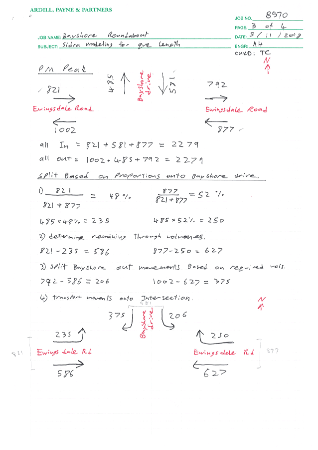
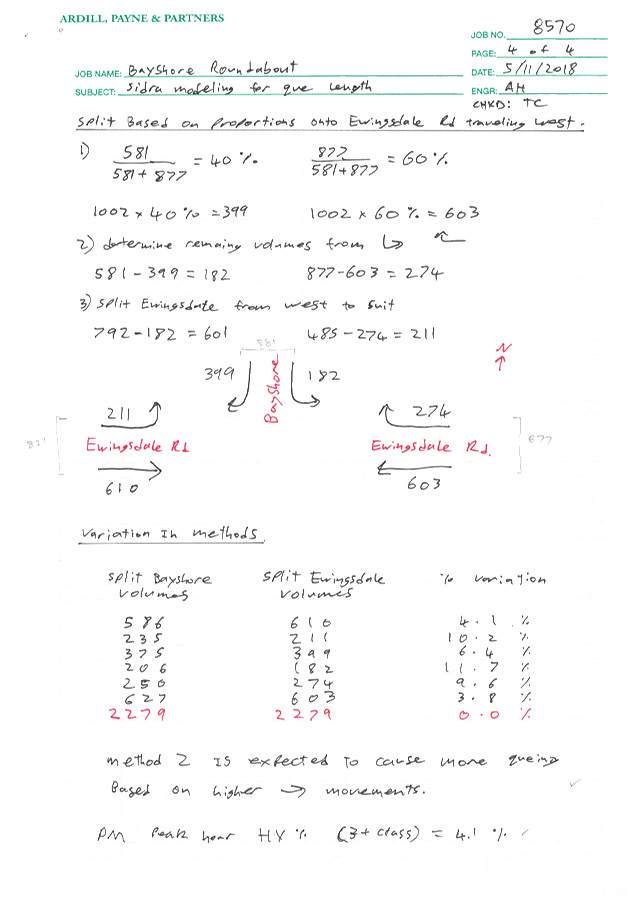
Regulatory Matters 6.7 - Attachment 1
Regulatory Matters 6.7 - Attachment 2
Regulatory Matters 6.7 - Attachment 3


Local Traffic Committee Meeting 7.1
Matters for Traffic Engineering Advice
Report No. 7.1 Bangalow Primary School - Parking, Traffic and School Zone
Management
File No: I2018/1869
SUMMARY
This report seeks support from the LTC to amend the existing
time limited parking scheme, school bus zone and children’s crossing in
the vicinity of the Bangalow Public School as a safety issue initiated by RMS.
BACKGROUND
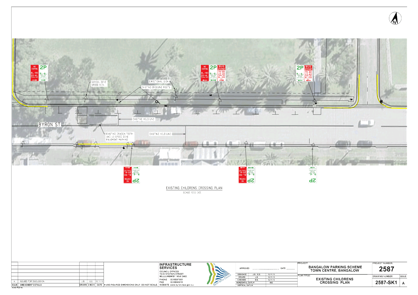
The existing Bangalow Public School children’s
crossing on Byron Street is not currently used by the school as the existing
traffic conditions along Byron Street are considered unsafe.
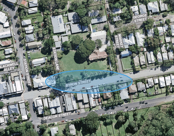
Fig. 1 - Site Locality Plan
A RMS grant has been provided to Council to fund
investigations and to develop a design to amend the existing time limited
parking scheme, school bus zone and children’s crossing.
The existing parking and bus zone layout and associated line
marking and signage is depicted in the attached drawing, 2578-Bangalow School
Crossing – SK1 (E2018/90717).
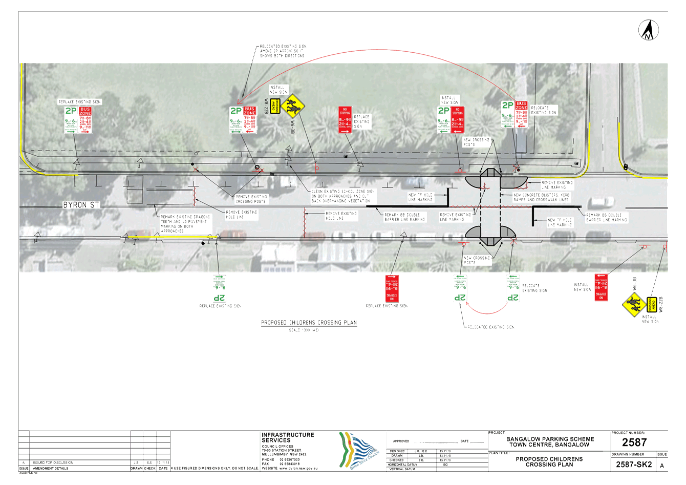
Council has prepared a plan of the proposed modifications.
See attached plan 2578-Bangalow School Crossing – SK2 (E2018/90718).
The proposal includes:-
• Relocation and
formalisation of children's crossing Byron Street.
• Bus zone relocation, Byron
Street.
• Signage and delineation
improvements for parking, bus zone and Bangalow school zone.
Council installed a time limited parking scheme around the
Bangalow Village Centre this year, including the Bangalow Public School area.
The proposal will require modifications to this scheme.
Project implementation will potentially impact several car
parking spaces, a bus stop zone and regulatory signage and line marking in the
vicinity of the children’s crossing. Several car spaces will need to be
deleted and / or relocated, along with associated signage. As these works will
involve direct consultation with RMS and the Public School and in order to
facilitate timely implementation, LTC is requested to approve and support the
modifications.
COUNCIL IMPLICATIONS
§ Budget/Financial
Council does not currently have
an identified budget to implement these proposed changes. Accordingly, the
works cannot be implemented until funds are made available by way of grant, for
example, to meet the estimated costs associated with community consultation and
completing the works as detailed on the proposed plan, relocating signage
and line markings and the installation of traffic islands and the like.
§ Asset Management
No impact on existing
asset management requirements.
§ Policy or Regulation
Compliance to be in accordance
with NSW Road Rules, Australian Standards, Austroads and RMS Parking guidelines
§ Consultation
RMS and the Bangalow Public
School are significant stakeholders who have been and will continue to be
consulted as part of the pedestrian crossing project. In addition,
consultation with the broader Bangalow community is envisaged prior to the
works being implemented.
§ Legal and Risk Management
No risk
assessment has been undertaken as yet however WHS and other environmental
management matters will be considered prior to undertaking site work for the
project..
|
RECOMMENDATION:
That Council support modifications to the
Bangalow Village Centre time limited parking scheme and regulatory signage
and line marking, in the vicinity of Bangalow Public School to implement the
following changes developed in consultation with the RMS and the School:-
1. Relocation
and formalisation of children's crossing Byron Street.
2. Bus
zone relocation, Byron Street.
3. Signage
and delineation improvements to Bangalow school zone.
|
Attachments:
1 2587_BANGALOW
SCHOOL CROSSING_SK1 - Existing layout.pdf, E2018/90717
, page 118⇩
2 2587_BANGALOW
SCHOOL CROSSING_SK2 - proposed layout.pdf, E2018/90718
, page 119⇩
Matters for Traffic Engineering Advice 7.1 - Attachment 1
Matters for Traffic Engineering Advice 7.1 - Attachment 2
Local Traffic Committee Meeting 7.2
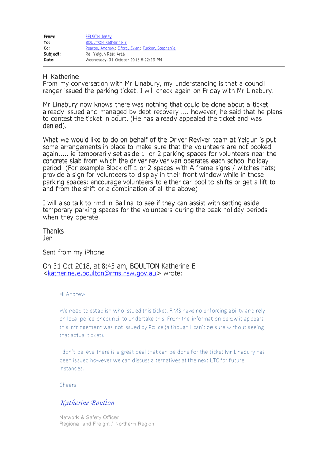
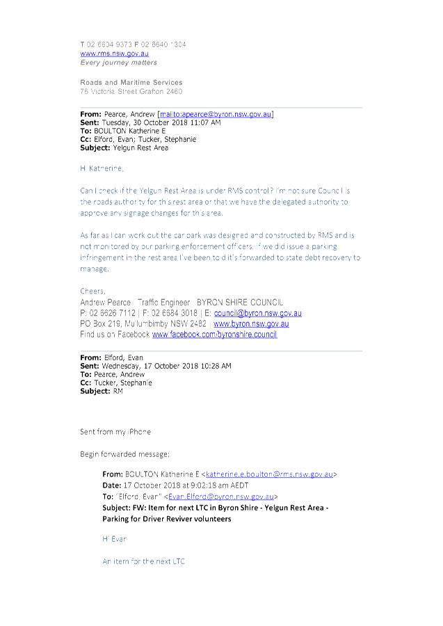
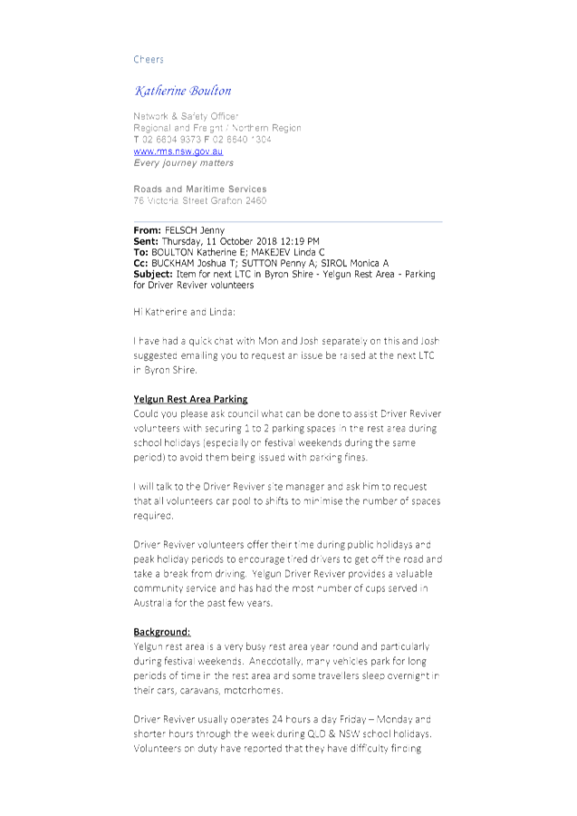
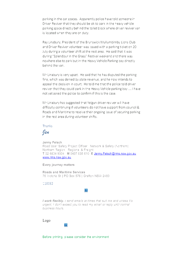
Report No. 7.2 Yelgun Rest Area - Parking for Driver Reviver Volunteers
File No: I2018/1978
RMS have requested council investigate securing one or two
parking spaces for Driver Reviver volunteers in the Yelgun Rest Area during
school holidays, and especially on festival weekends during the same period to
avoid them being issued with parking fines.
|
RECOMMENDATION:
That Council support the RMS request to
investigate appropriate options to secure up to 2 car spaces for Driver
Reviver volunteers at the Yelgun Rest Area or alternative options that
protect volunteers from being issued parking fines.
|
Attachments:
1 Email from
RMS Re: Yelgun Rest Area (PDF version), E2018/90964
, page 121⇩
Matters for Traffic Engineering Advice 7.2 - Attachment 1
Local Traffic Committee Meeting 7.3
Report No. 7.3 Adoption of Constitution for Local Traffic Committee
File No: I2018/2032
At the Local Traffic Committee meeting of 16 January 2018,
the committee discussed matters in relation to Report No.6.1 – Council
resolutions and Recommendation Processes.
From those discussions, a draft constitution for the Local
Traffic Committee was developed and presented to the Local Traffic Committee at
the 15th May meeting where the Local Traffic Committee recommended:
That the draft constitution attached to this
report is noted and the committee comments be provided to finalise the
constitution document prior to adoption by Council.
At the 23 August 2018 ordinary Council meeting,
Council resolved as follows:
18-498 Resolved that
Council adopt the following Committee Recommendation(s):
Report No. 6.2 Draft
Constitution for Local Traffic Committee
File No: I2018/905
Committee Recommendation 6.2.1
That the draft constitution
attached to this report be reviewed by members and the committee comments be
presented at the next committee meeting for adoption. (Cameron/Richardson)
The committee is requested to review the final document and
recommend that Council adopt the 2018 Local Traffic Committee Constitution, in
accordance with RMS guidelines and any other regulations, and procedures
relating to the delegation to Councils, as set out in Section 50 of the
Transport Administration Act 1998.
|
RECOMMENDATION:
That Council adopt the
2018 Constitution for the Local Traffic Committee.
|
Attachments:
1 DRAFT
Constitution Local Traffic Committee 2018 (version 003), E2018/72629 , page 123⇩ 
Matters for Traffic Engineering Advice 7.3 - Attachment 1
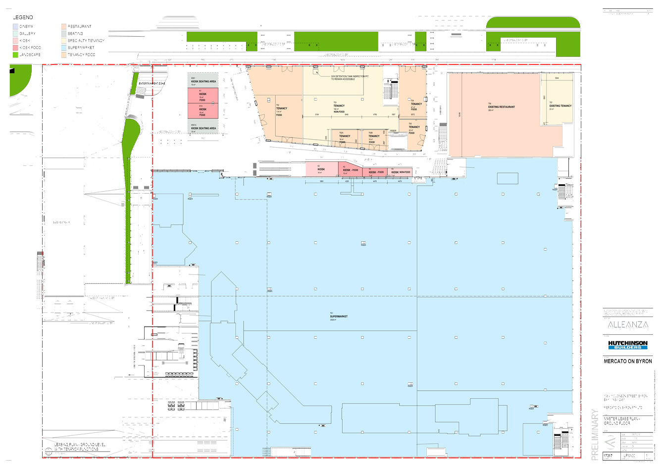
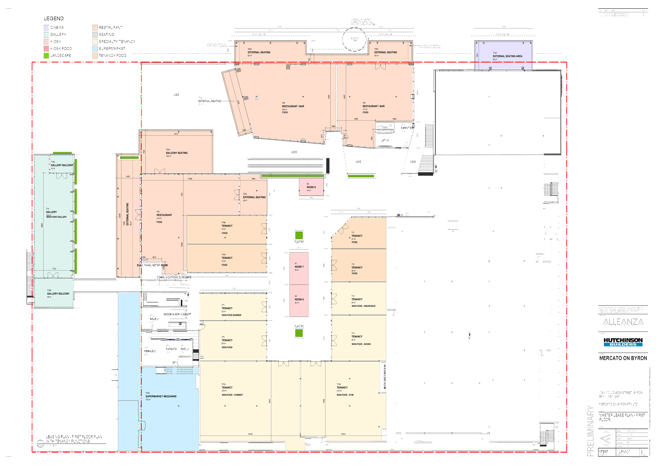
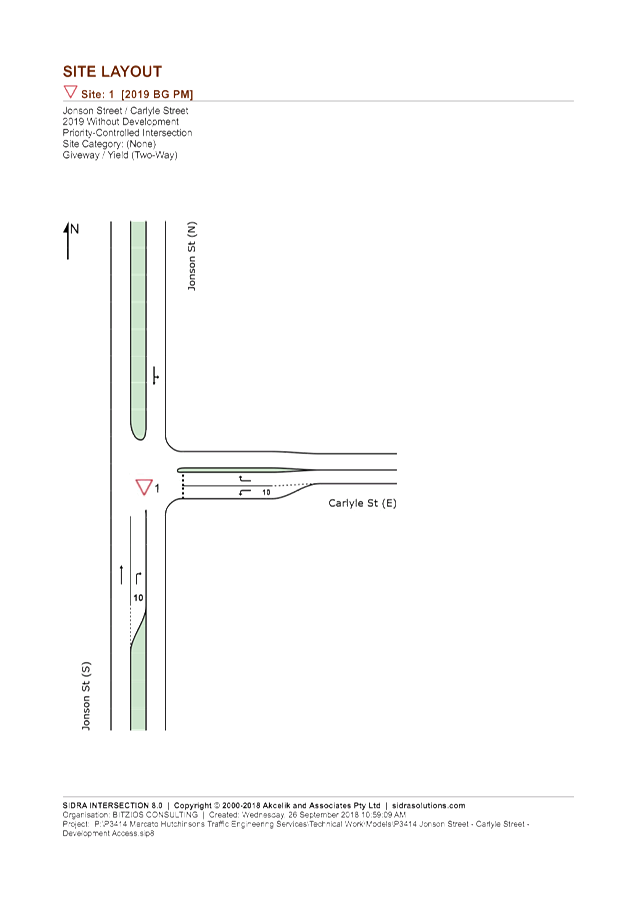
Local Traffic Committee Meeting 7.4
Report No. 7.4 Mercato Car Park - Concept Temporary Access
File No: I2018/2176
Summary
Council is seeking traffic related advice from the Local
Traffic Committee in relation to the concept temporary access arrangements into
the Mercato basement car park over the Christmas holiday period and until the
development officially opens in March 2019.
Background
On 20 November
2014, Council granted development consent (10.2013.587.1) for the redevelopment
of existing shopping centre to create a ground floor supermarket, first floor
retail shops, restaurants, bowling alley (recreation facility), art gallery
(commercial premises), cinema complex (place of assembly) and basement car
parking providing 328 car parking spaces on two (2) levels (known as Mercato
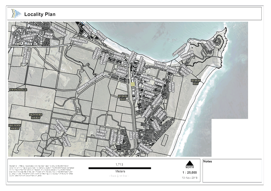
On Byron) at 112-114 Jonson Street BYRON BAY (see Figure
1, Site Location). A number of modifications have subsequently been
approved with the latest development consent being 10.2013.587.4.
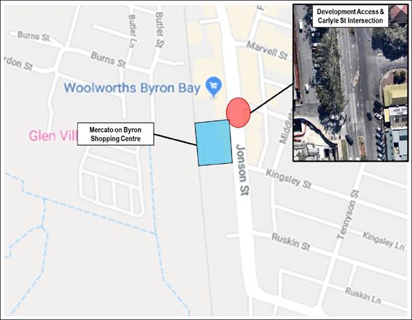
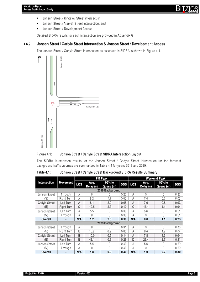
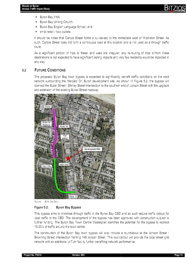
Figure 1. Site
Location
As a part of the
development application, a Transport and Traffic Assessment was prepared by TTM
and submitted in July 2014. Construction of the new shopping centre began early
2017, following the demolition of the existing shops. The development is
scheduled to be operational by March 2019.
A condition of
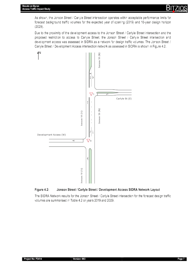
the development consent requires a roundabout at the Jonson Street / Carlyle
Street intersection and a short right-turn pocket for southbound traffic on
Jonson Street to access the development. The applicant submitted
engineering plans in accordance with the development consent for approval under
section 138 of the Roads Act 1993. However, Council and Roads and
Maritime Services (RMS) have raised several matters regarding safety and operations
of the proposed roundabout and access layout. These matters include:-
· the roundabout creates significant
deflection for southbound traffic and very little deflection for northbound
traffic on Jonson Street. This is not desirable from a design perspective
as it will encourage higher speeds for northbound traffic and reduce safety;
· the design has not adequately addressed
safety for turning traffic, including service vehicles. Circulating, entering
and exiting turning paths have not been provided, including the impact of the
short right turn storage bay on Jonson Street;
· the design proposes a new pedestrian link
across Jonson Street on the southern leg of the roundabout, utilising the
roundabout splitter islands. Splitter islands are only intended for minimal
usage. Safer pedestrian facilities should be located clear of the
roundabout to avoid conflicts with entering and exiting traffic;
· it is understood that there may be an
opportunity to explore options to rationalise and consolidate access to
adjacent development at this location which could address the above concerns.
This is supported in the first instance; and
· it is understood the development is
planning to open in March 2019. If the road works have not been
completed, then consideration could be given to developing a Traffic Management
Plan for the interim period. Any road works within the road reserve
should be managed in accordance with the current version of the RTA Traffic
Control.
As such, a
solution is required to provide access to the development without adversely
impacting the safety and efficiency of the surrounding road network.
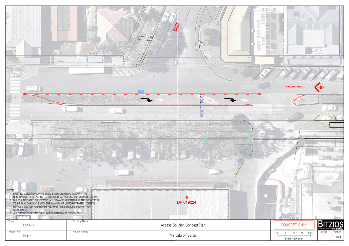
On 8 October 2018, the applicant submitted a traffic impact
study (Mercato on Byron, Access Traffic Impact Study prepared by Bitzios dated
8 October 2018 – Attachment 2). Council staff reviewed the traffic
impact study and advised the applicant the following by email on 23 October
2018:
The proposed intersection treatment by
Bitzios Consulting (Project No. 3414, Version 3 dated 8 October 2018) will only
provide a temporary solution to the traffic issues as a result of the
development, however it will fail within the design horizon. Whereas, the
recommendation from the TTM report which was accepted by Council as part of the
development consent will provide an acceptable treatment past the design
horizon. The proposed intersection treatment will have adverse impacts in the
local street network due to the re-routing
of traffic which is an unacceptable outcome and therefore is not supported.
An acceptable treatment must be provided
to maintain the safety and efficiency of the traffic in Jonson St over the
design horizon without impacting on the local street network.
Further investigation of the following options
may be considered:
1. Relocate
site access directly at the currently approved roundabout at the intersection
of Jonson and Carlyle Streets; and
2. Retain
the site access location with the currently approved roundabout but with left
in left out only at the site access and provision of a roundabout at the
intersection of Jonson and Kingsley Streets to facilitate development traffic
from the north entering the site.
Report
Approval has been sought to operate the basement carpark of
the Mercato on Byron under a traffic management plan as an interim solution
until the final access arrangements have been resolved with Council and RMS.
It is proposed for the basement car park for the Mercato on
Byron to be operational and utilised before the Christmas period, however it
should be noted that the shopping centre is not expected to be operational
until March 2019.
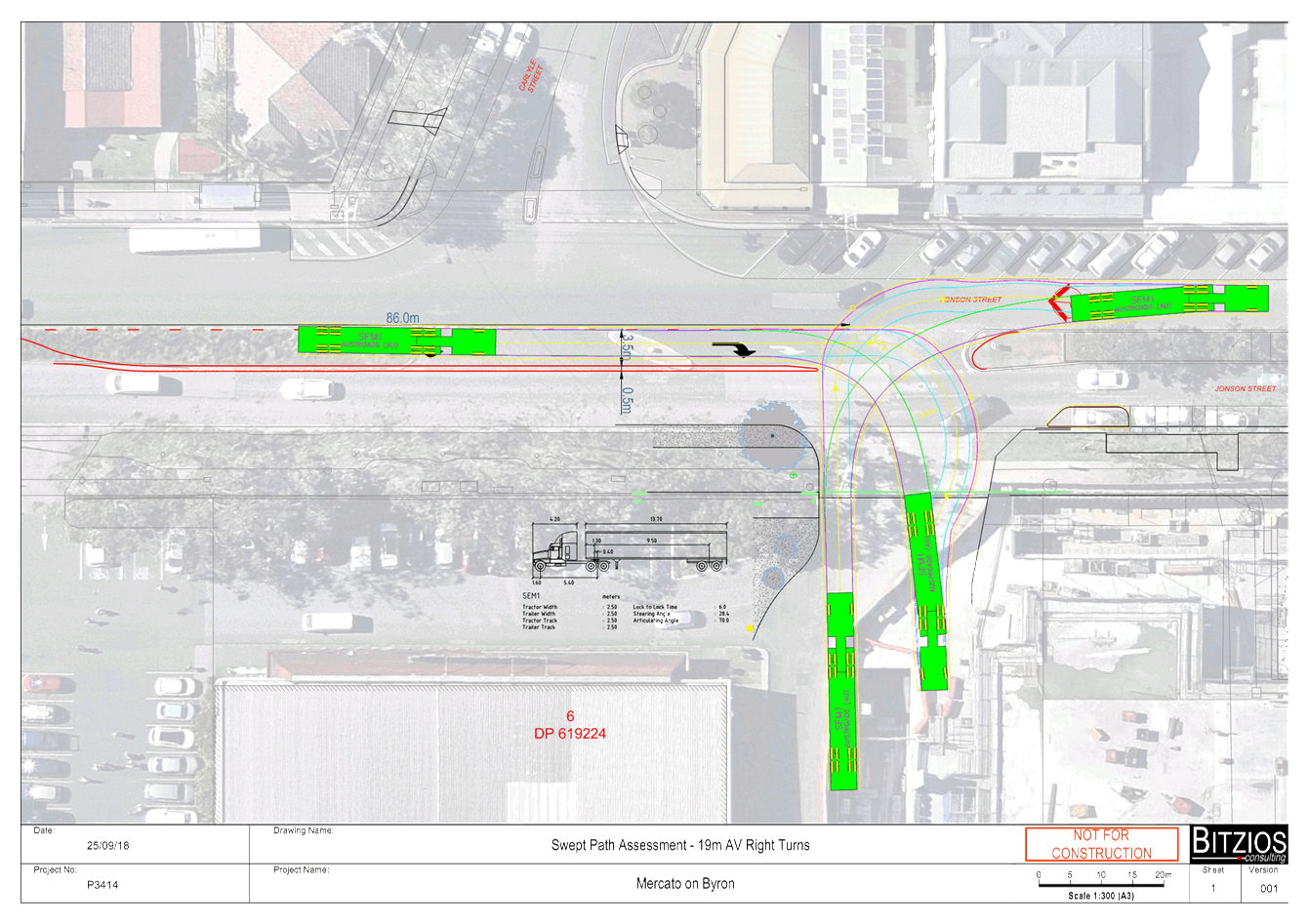
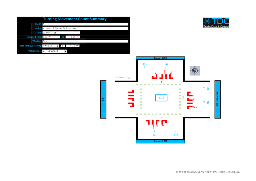
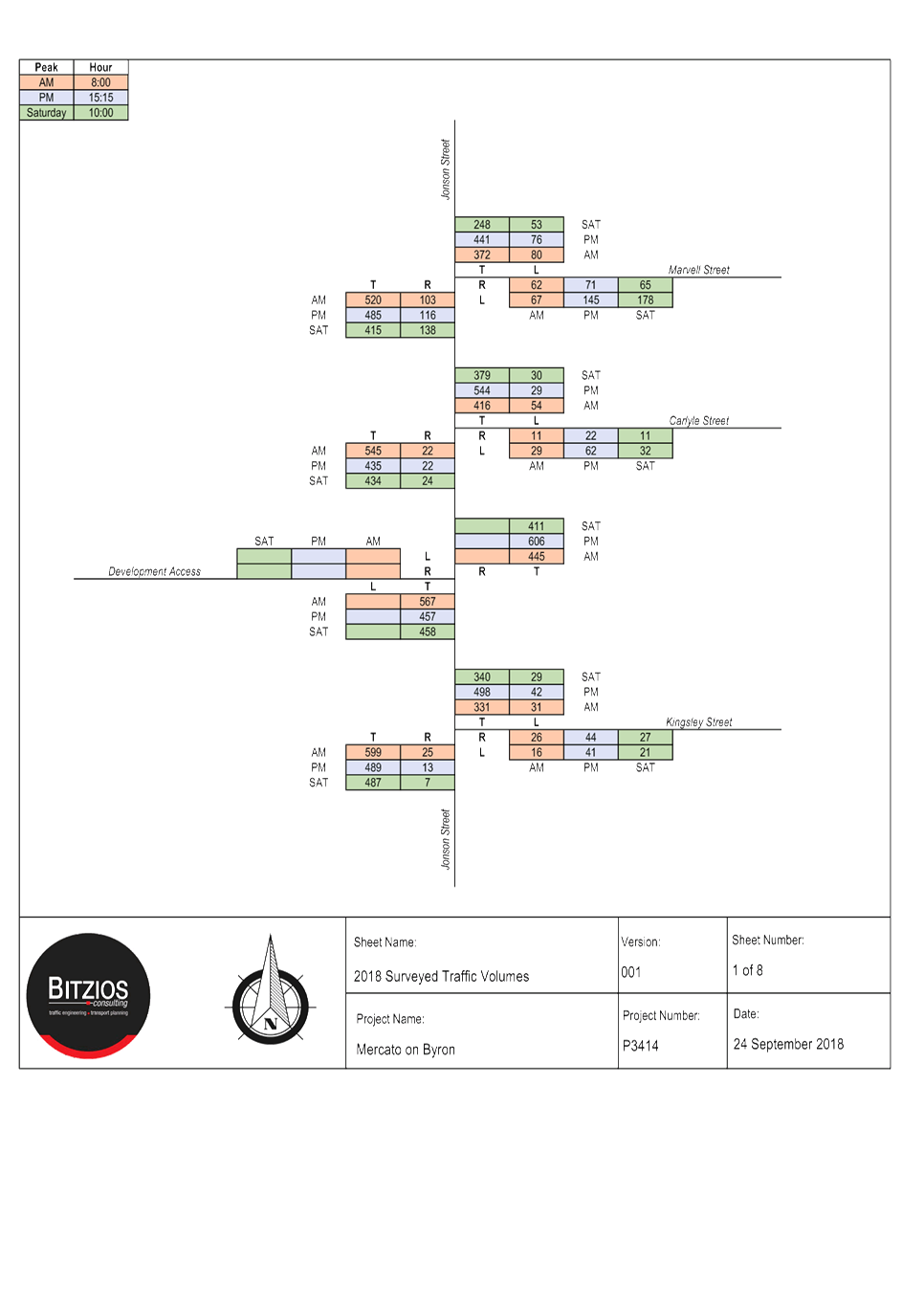
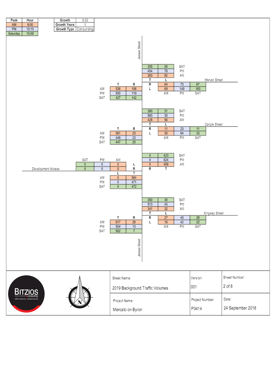
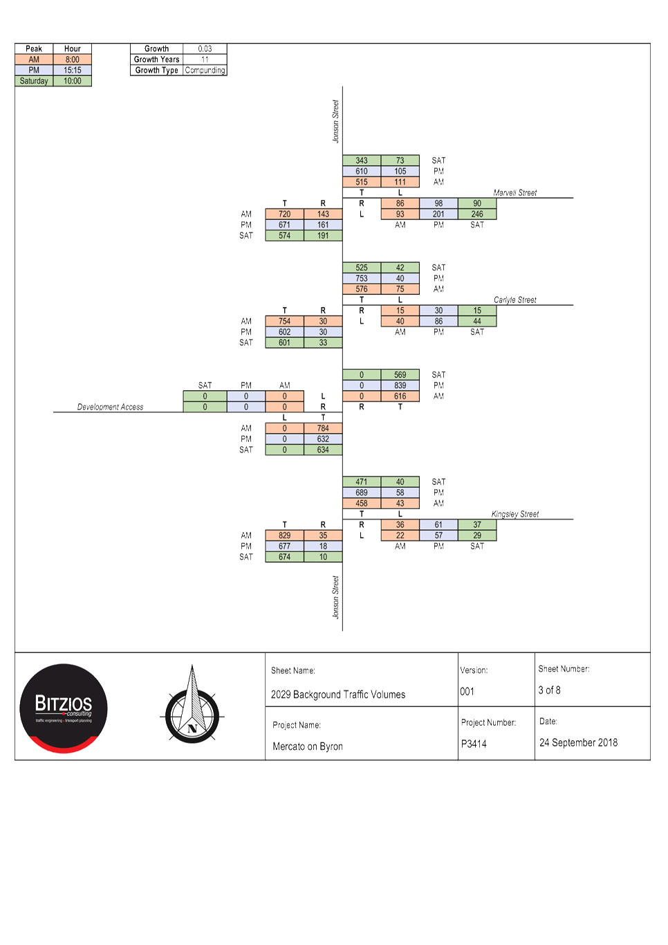
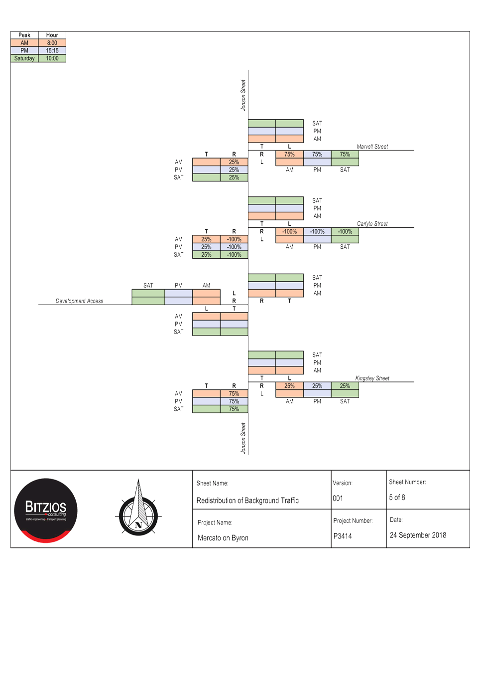
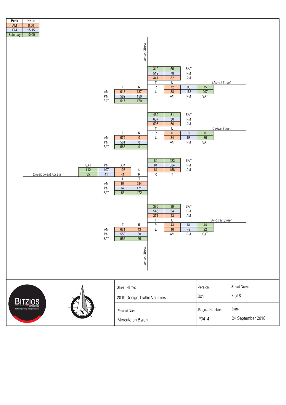
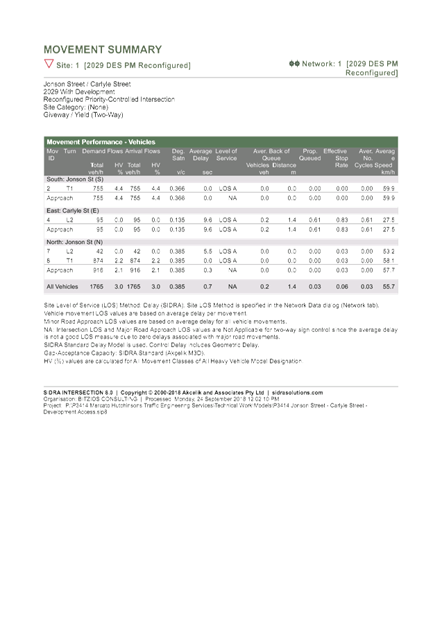
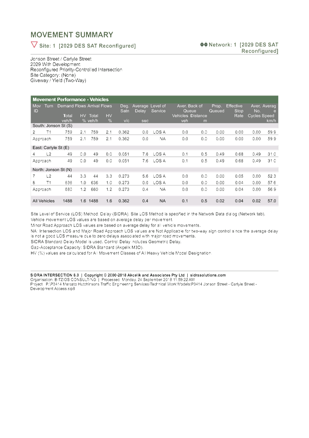
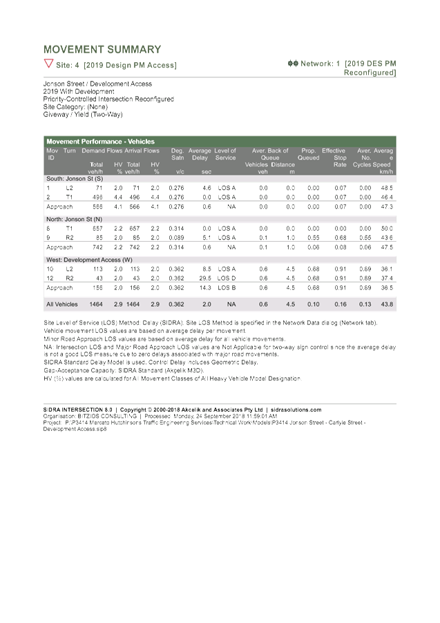
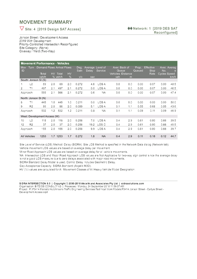
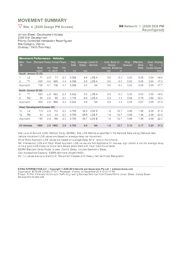
A traffic impact study (Mercato on Byron, Access Traffic
Impact Study prepared by Bitzios dated 8 October 2018 – Attachment 2) was
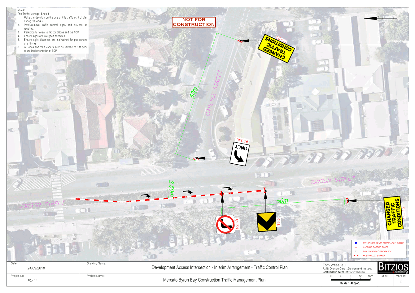
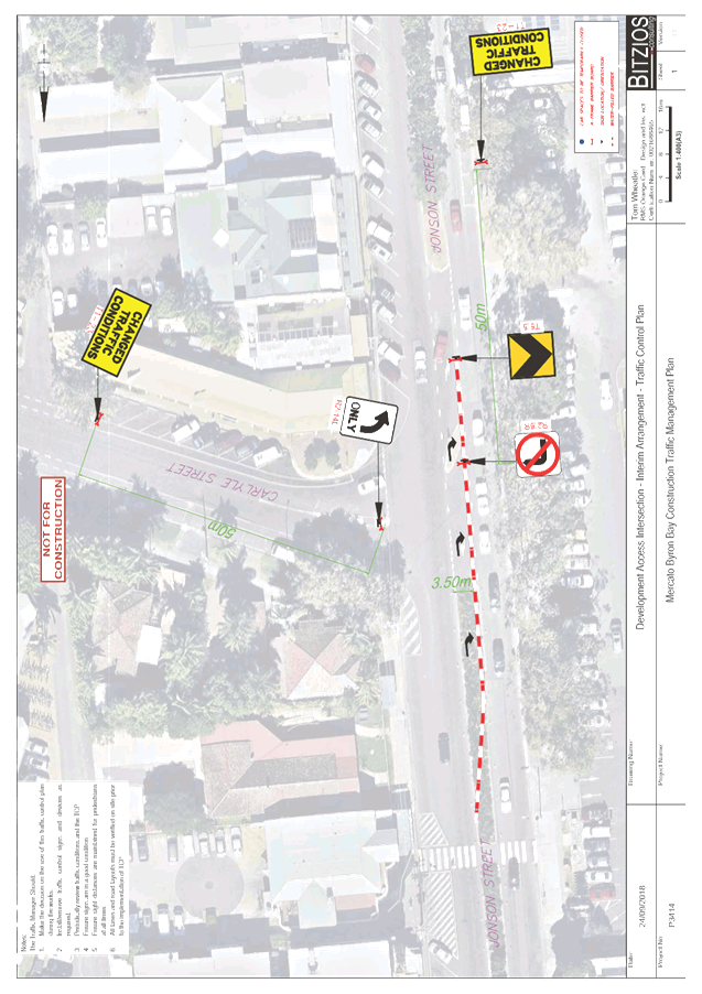
submitted to Council for consideration, which includes a traffic control plan showing an interim access solution to be
installed until the ultimate solution is constructed. A copy of the TCP is
attached – Attachment 3.
Development Engineering staff have raised the following
concerns with the submitted TCP (Option 1):-
· the
proposed intersection treatment will have adverse impacts in the local street
network due to the re-routing of local traffic away from the Carlyle Street and
Jonson Street intersection;
· existing
traffic islands must be removed for the temporary arrangements to function as
designed; and
· articulated
vehicles are unable to make a left turn out of the development site.
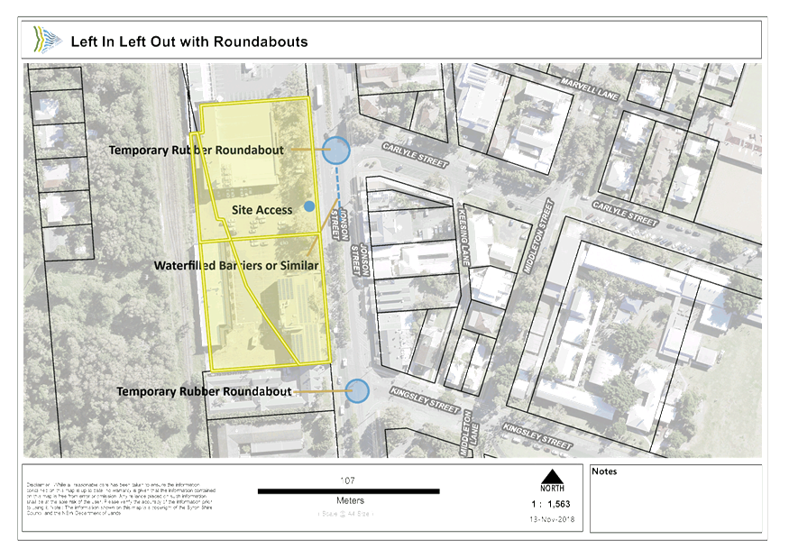
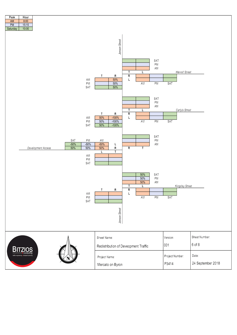
Development engineering staff suggest an alternate option
(Option 2) as a trial for an ultimate solution with left in left out only at
the site access and temporary roundabouts at the Carlyle Street and Jonson
Street intersection and the Kingsley Street and Jonson Street intersection
– see Attachment 4. No design details have been prepared for this option
and as such issues have not been investigated but it is noted that existing
traffic islands must also be removed for this traffic arrangement.
Traffic engineering advice is sought from LTC on the most
appropriate option for an interim solution to allow the operation of the
carpark under a traffic management plan.
Committee Comments and Advice:
|
RECOMMENDATION:
That the committee comments and advice be
provided to Council’s Development Engineers.
|
Attachments:
1 Mercato -
Locality Plan, E2018/90785 , page
123⇩
2 Mercato
Temporary Access - Traffic Impact Study, E2018/90786
, page 123⇩ 
3 Mercato
Temporary Access TCP, E2018/90790
, page 123⇩
4 Mercato -
Alternate Left In Left Out Option, E2018/90792
, page 123⇩
Matters for Traffic Engineering Advice 7.4 - Attachment 1
Matters for Traffic Engineering Advice 7.4 - Attachment 2
Matters for Traffic Engineering Advice 7.4 - Attachment 2
Matters for Traffic Engineering Advice 7.4 - Attachment 2

Matters for Traffic Engineering Advice 7.4 - Attachment 2
Matters for Traffic Engineering Advice 7.4 - Attachment 2
Matters for Traffic Engineering Advice 7.4 - Attachment 2
Matters for Traffic Engineering Advice 7.4 - Attachment 2

Matters for Traffic Engineering Advice 7.4 - Attachment 2
Matters for Traffic Engineering Advice 7.4 - Attachment 2

Matters for Traffic Engineering Advice 7.4 - Attachment 2


Matters for Traffic Engineering Advice 7.4 - Attachment 2

Matters for Traffic Engineering Advice 7.4 - Attachment 2


Matters for Traffic Engineering Advice 7.4 - Attachment 2


Matters for Traffic Engineering Advice 7.4 - Attachment 3
Matters for Traffic Engineering Advice 7.4 - Attachment 4