Coastal Estuary Catchment Panel Meeting
A Coastal Estuary Catchment Panel
Meeting of Byron Shire Council will be held as follows:
|
Venue
|
Conference Room, Station Street, Mullumbimby
|
|
Date
|
Thursday, 14 March 2019
|
|
Time
|
11.30am
|
Phil Holloway
Director Infrastructure Services I2019/377
Distributed 07/03/19
What is a “Conflict of Interests” - A conflict of
interests can be of two types:
Pecuniary - an interest that a person has in a matter because of a reasonable
likelihood or expectation of appreciable financial gain or loss to the person
or another person with whom the person is associated.
Non-pecuniary – a private or personal interest that a Council
official has that does not amount to a pecuniary interest as defined in the
Local Government Act (eg. A friendship, membership of an association, society
or trade union or involvement or interest in an activity and may include an
interest of a financial nature).
Remoteness – a person does not have a pecuniary interest in a matter
if the interest is so remote or insignificant that it could not reasonably be
regarded as likely to influence any decision the person might make in relation
to a matter or if the interest is of a kind specified in Section 448 of the
Local Government Act.
Who has a Pecuniary Interest? - a person has a pecuniary interest in a
matter if the pecuniary interest is the interest of the person, or another
person with whom the person is associated (see below).
Relatives, Partners - a person is taken to have a pecuniary interest in a
matter if:
§ The person’s
spouse or de facto partner or a relative of the person has a pecuniary interest
in the matter, or
§ The person, or a
nominee, partners or employer of the person, is a member of a company or other
body that has a pecuniary interest in the matter.
N.B. “Relative”, in relation to a person means any of the
following:
(a) the
parent, grandparent, brother, sister, uncle, aunt, nephew, niece, lineal
descends or adopted child of the person or of the person’s spouse;
(b) the
spouse or de facto partners of the person or of a person referred to in
paragraph (a)
No Interest in the Matter - however, a person is not taken to have a
pecuniary interest in a matter:
§ If the person is
unaware of the relevant pecuniary interest of the spouse, de facto partner,
relative or company or other body, or
§ Just because the
person is a member of, or is employed by, the Council.
§ Just because the
person is a member of, or a delegate of the Council to, a company or other body
that has a pecuniary interest in the matter provided that the person has no
beneficial interest in any shares of the company or body.
Disclosure and participation in meetings
§ A Councillor or a
member of a Council Committee who has a pecuniary interest in any matter with
which the Council is concerned and who is present at a meeting of the Council
or Committee at which the matter is being considered must disclose the nature
of the interest to the meeting as soon as practicable.
§ The Councillor or
member must not be present at, or in sight of, the meeting of the Council or
Committee:
(a) at any
time during which the matter is being considered or discussed by the Council or
Committee, or
(b) at any
time during which the Council or Committee is voting on any question in
relation to the matter.
No Knowledge - a person does not breach this Clause if the person did
not know and could not reasonably be expected to have known that the matter
under consideration at the meeting was a matter in which he or she had a
pecuniary interest.
Participation in Meetings Despite Pecuniary Interest (S 452 Act)
A Councillor is not prevented from taking part in the consideration or
discussion of, or from voting on, any of the matters/questions detailed in
Section 452 of the Local Government Act.
Non-pecuniary Interests - Must be disclosed in meetings.
There are a broad range of options available for managing conflicts &
the option chosen will depend on an assessment of the circumstances of the
matter, the nature of the interest and the significance of the issue being
dealt with. Non-pecuniary conflicts of interests must be dealt with in at
least one of the following ways:
§ It may be appropriate
that no action be taken where the potential for conflict is minimal.
However, Councillors should consider providing an explanation of why they
consider a conflict does not exist.
§ Limit involvement if
practical (eg. Participate in discussion but not in decision making or
vice-versa). Care needs to be taken when exercising this option.
§ Remove the source of
the conflict (eg. Relinquishing or divesting the personal interest that creates
the conflict)
§ Have no involvement by
absenting yourself from and not taking part in any debate or voting on the
issue as if the provisions in S451 of the Local Government Act apply
(particularly if you have a significant non-pecuniary interest)
RECORDING OF VOTING ON PLANNING MATTERS
Clause 375A of the Local Government Act 1993
– Recording of voting on planning matters
(1) In this section, planning
decision means a decision made in the exercise of a function of a council
under the Environmental Planning and Assessment Act 1979:
(a) including a decision
relating to a development application, an environmental planning instrument, a
development control plan or a development contribution plan under that Act, but
(b) not including the making of
an order under Division 2A of Part 6 of that Act.
(2) The general manager is
required to keep a register containing, for each planning decision made at a
meeting of the council or a council committee, the names of the councillors who
supported the decision and the names of any councillors who opposed (or are
taken to have opposed) the decision.
(3) For the purpose of
maintaining the register, a division is required to be called whenever a motion
for a planning decision is put at a meeting of the council or a council committee.
(4) Each decision recorded in
the register is to be described in the register or identified in a manner that
enables the description to be obtained from another publicly available
document, and is to include the information required by the regulations.
(5) This section extends to a
meeting that is closed to the public.
Coastal Estuary Catchment Panel Meeting
BUSINESS OF MEETING
1. Apologies
2. Declarations of Interest
– Pecuniary and Non-Pecuniary
3. Adoption of Minutes from
Previous Meetings
3.1 Coastal
Estuary Catchment Panel Meeting held on 29 November 2018
4. Staff Reports
Infrastructure Services
4.1 Water
Sensitive Urban Design Policy and Strategy Update............................................. 5
4.2 Belongil
Creek Entrance Opening Strategy - Update..................................................... 57
4.3 Item
for the Panel Requested by Duncan Dey - review Council's Policy 14/006 on
Climate Change....................................................................................................................................... 180
Staff Reports - Infrastructure Services 4.1
CONFIRMATION OF MINTUES FROM PREVIOUS MEETING
1.
That the minutes
of the Coastal Estuary Catchment Panel Meeting held on 29 November 2018
be confirmed.
2.
That, at the
Ordinary Meeting held on 28 February 2019, The minutes of the meeting held on
29 November 2018 were noted, and:
a) the
Panel Recommendations for Report 4.1 adopted by Council without changes,
and the
b) the
Panel Recommendations for Report 4.2 not adopted by Council, but instead the
Management Recommendation adopted as follows:
That Council continues the current format of the Coastal
Estuary Panel and continue to report the recommendations of the Panel to
Council for consideration for the remainder of the term of this Council.
Staff Reports - Infrastructure Services
Report No. 4.1 Water
Sensitive Urban Design Policy and Strategy Update
Directorate: Infrastructure
Services
Report
Author: James
Flockton, Drain and Flood Engineer
File No: I2019/132
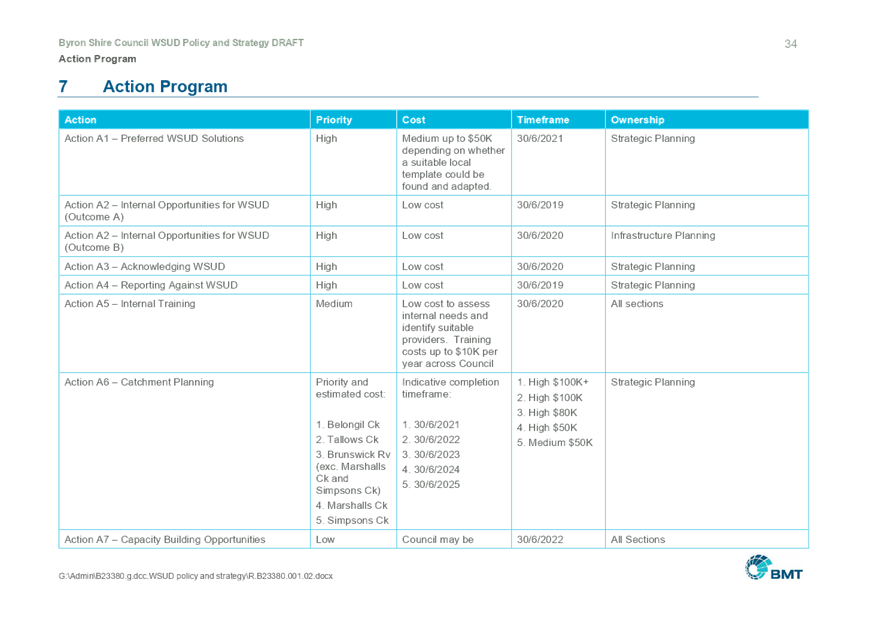
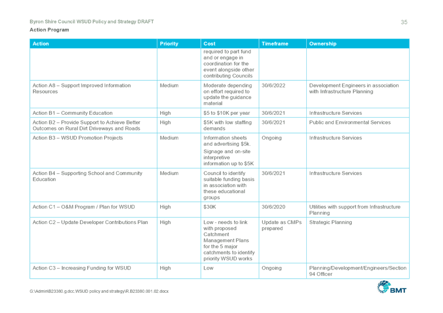
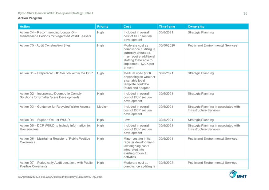
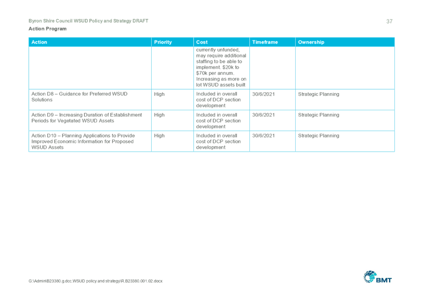
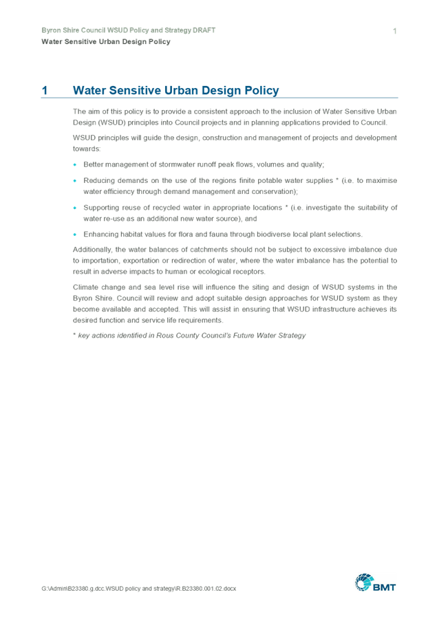
Summary:
Consultants BMT have been developing Councils Water
Sensitive Urban Design policy and strategy. To date BMT have completed
workshops with staff and the panel regarding the direction and outcomes
expected or desired from the policy and strategy.
Following these workshops a draft Water Sensitive Urban
Design policy and strategy document has been prepared.
This report provides the Panel members with the draft
document for review and finalisation at this meeting so a briefing /
presentation can then be made to Council at a Strategic Planning Workshop and
ultimately reported to Council to adopt the draft and place on public
exhibition and invite public submissions.
|
RECOMMENDATION:
1. That
the Draft Water Sensitive Urban Design policy and strategy be presented to a
Council Strategic Planning Workshop.
2. That
following the presentation to the Strategic Planning Workshop, the Draft
Water Sensitive Urban Design policy and strategy be adopted and placed on
public exhibition and submissions invited.
|
Attachments:
1 Water
Sensitive Urban Design (WSUD) Draft Policy and Strategy, E2019/15788 ,
page 6⇩ 
Report
Consultant BMT were engaged to prepare a Water Sensitive
Urban Design (WSUD) policy and strategy for Byron Shire.
Following engagement BMT have attended workshops at Council
with the Coastal Estuary Catchment Panel and the Water and Sewer Advisory
Committee. A separate workshop directly with staff was also held.
Following these workshops
BMT have developed a draft WSUD policy and strategy for comment.
The draft WSUD
policy and strategy is provided at attachment 1.
Comments from the panel
can be received and discussed at the meeting. BMT will be available to discuss
the document at the meeting; however, no presentation is planned. It is
intended at this meeting to review and finalise the Draft WSUD policy and
strategy.
Next Steps
The panel’s comments
will be taken on board at the panel meeting and amendments made to the draft
document as required.
It is recommend:-
· that there be a briefing / presentation of the Draft
WSUD policy and strategy to a Council Strategic Planning Workshop
· the Draft WSUD policy and strategy then be reported
to Council to adopt the draft and place on public exhibition and invite public
submissions.
Financial Implications
There are no implications at this time but adoption of the WSUD
policy and strategy will result in the need for actions being funded and
resourced appropriately in the future. The decision to fund or resource
any action will ultimately come down to the standard budget process.
All adopted actions will be considered in Council’s
budget at the appropriate year, with reference to the resolution number.
Council will need to provide budgets for the actions to proceed.
Statutory and Policy Compliance Implications
There are no Statutory and Policy Compliance Implications at
this time.
Staff Reports - Infrastructure Services 4.1 - Attachment 1
Staff Reports - Infrastructure Services 4.2
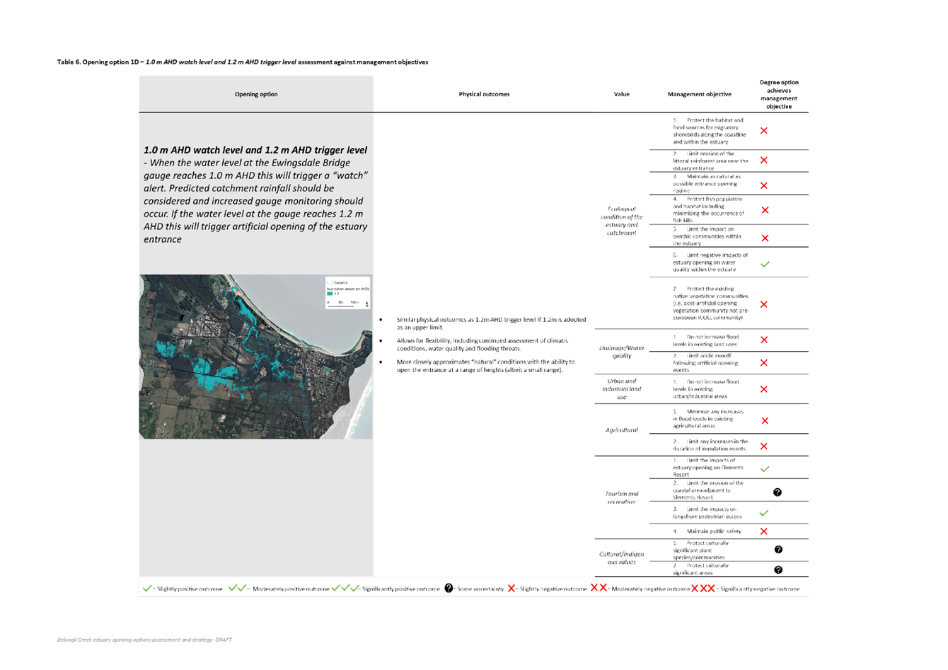
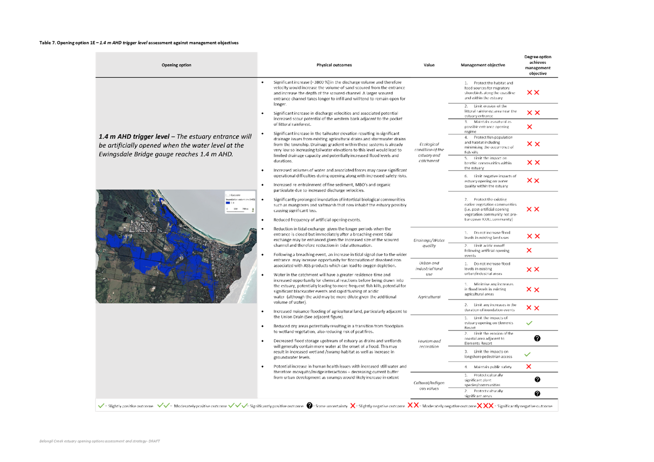
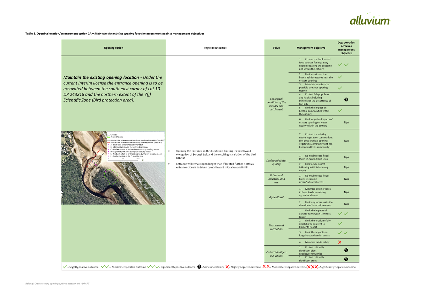
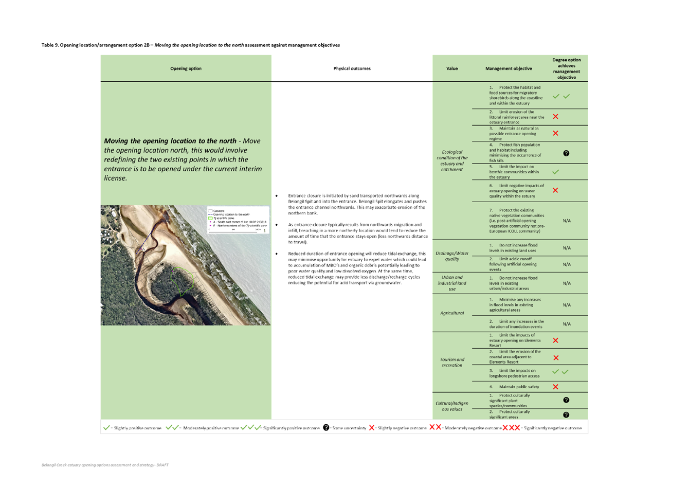
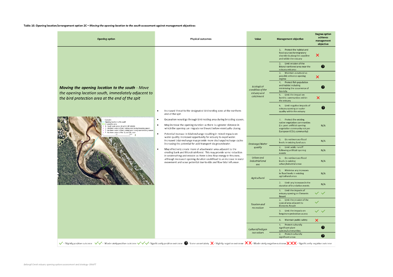
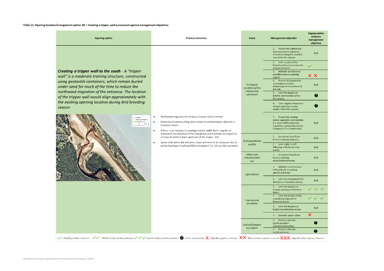
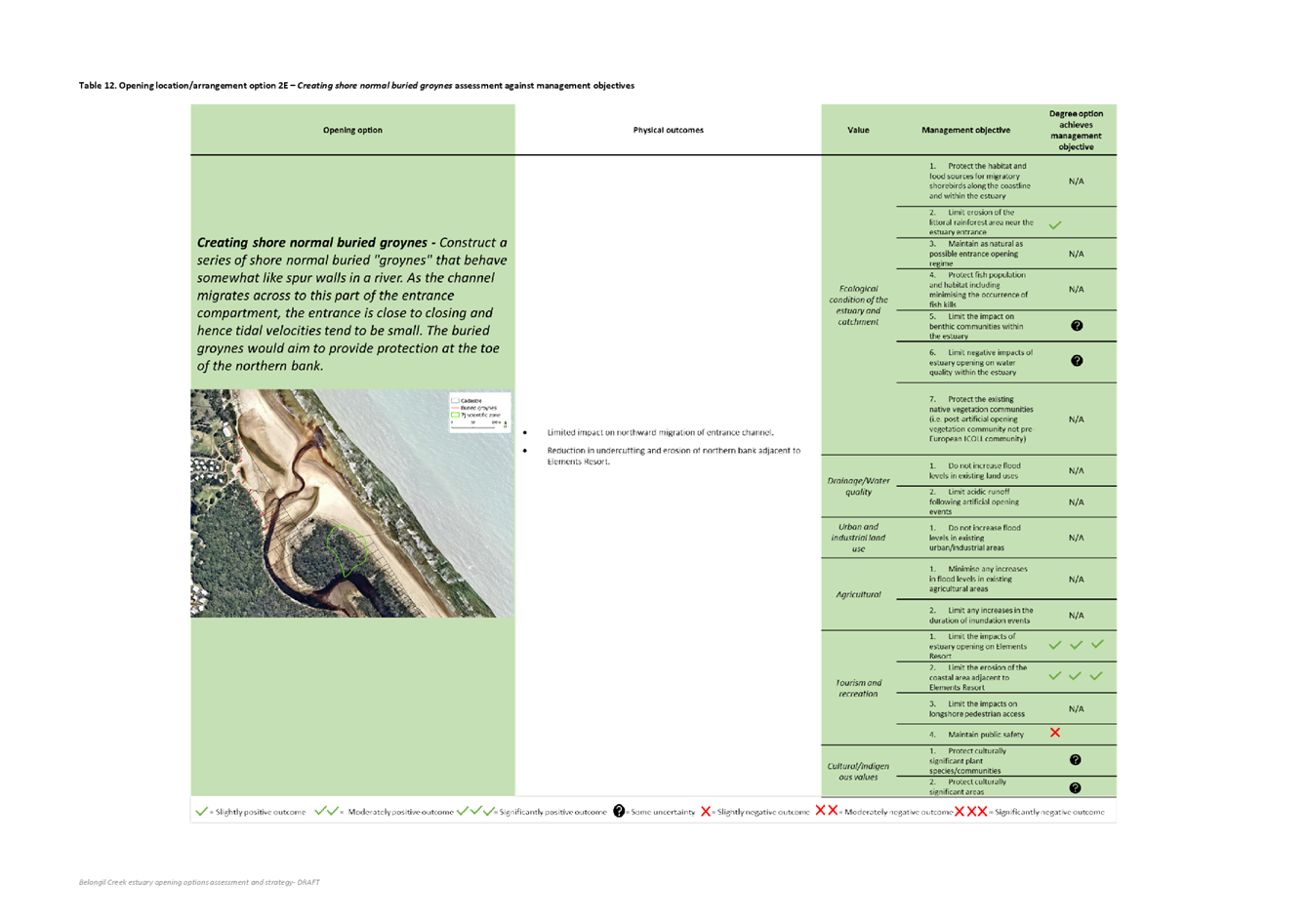
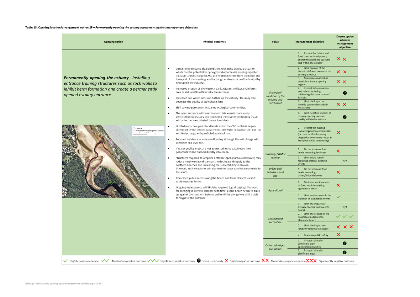
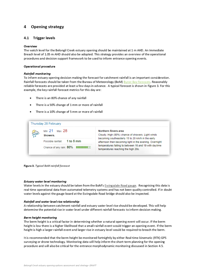
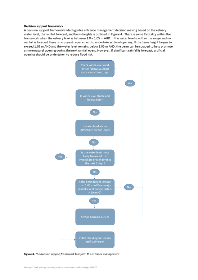
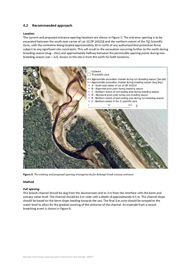
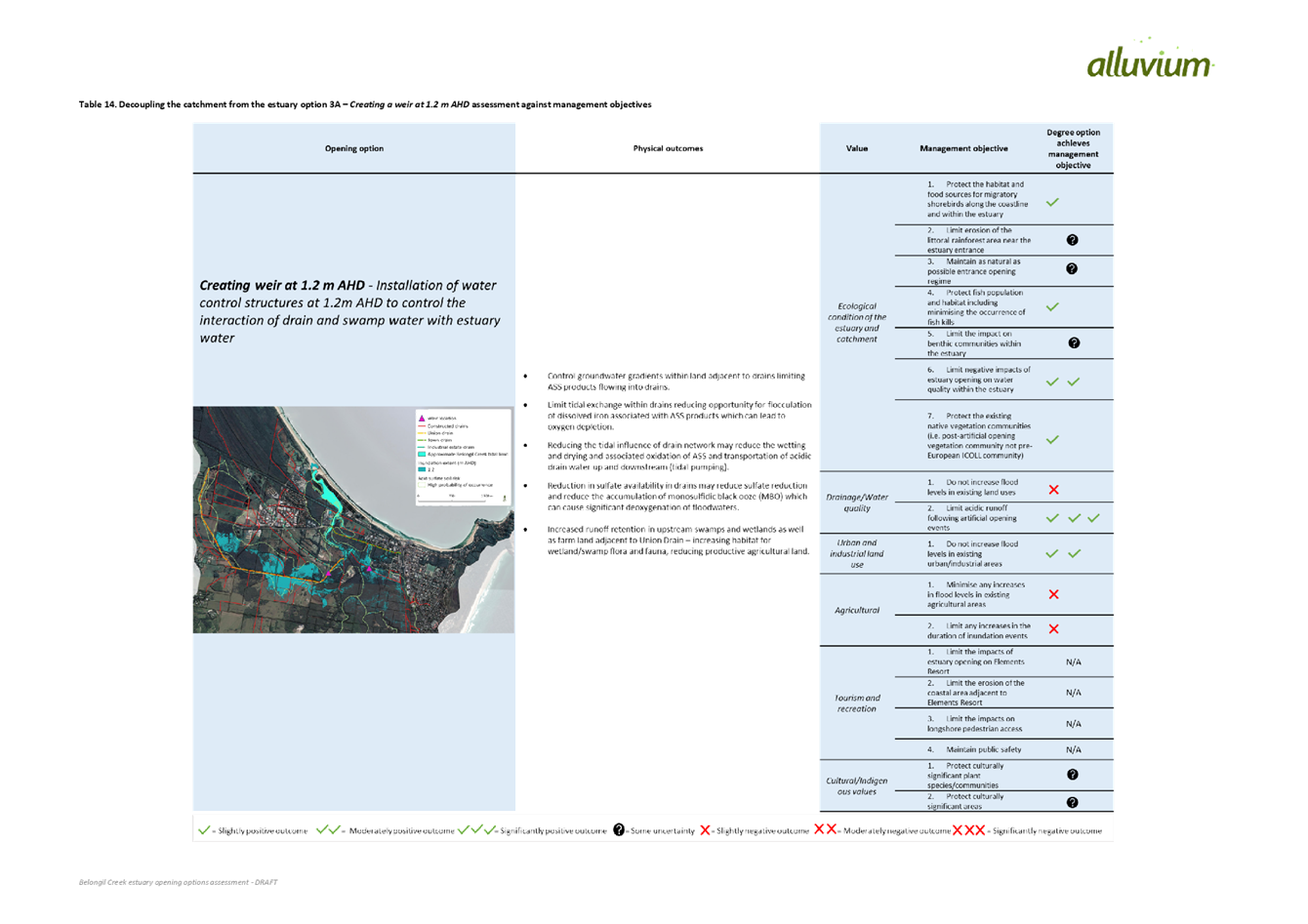
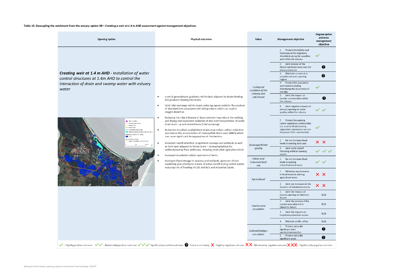
Report No. 4.2 Belongil
Creek Entrance Opening Strategy - Update
Directorate: Infrastructure
Services
Report
Author: James
Flockton, Drain and Flood Engineer
File No: I2019/273
Summary:
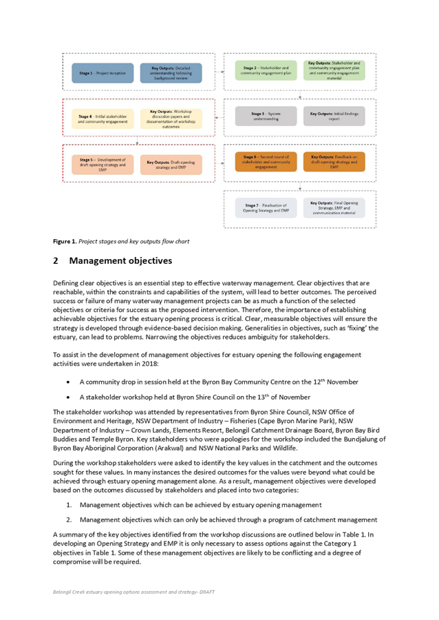
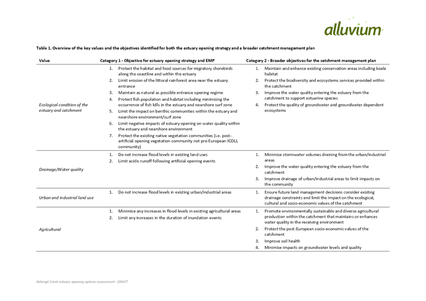
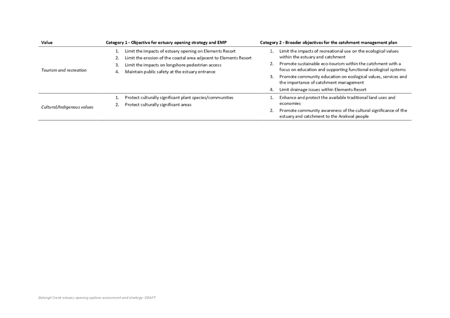
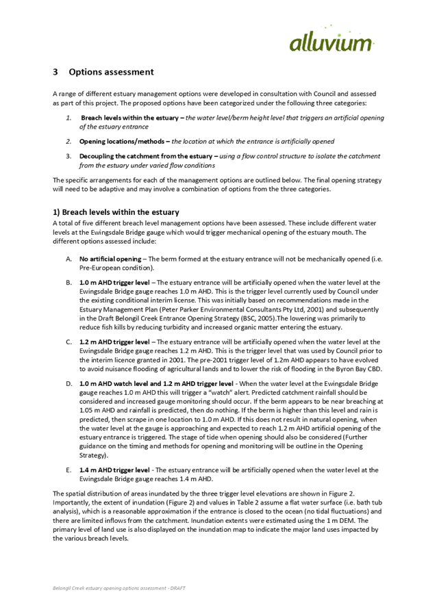
Consultants Alluvium have completed stakeholder workshops
and previously provided the initial findings report for the Belongil Creek
Entrance Opening Strategy.
The draft Options Assessment has now been completed and is
provided to the panel in this report.
Following discussion at the meeting the Options Assessment
will be finalised and the Entrance Opening Strategy prepared.
|
RECOMMENDATION:
That the Coast Estuary
Catchment Panel support finalisation of the Options Assessment (E2019/15408)
and proceeding with the Entrance Opening Strategy as per the assessment
recommendation.
|
Attachments:
1 Belongil
Entrance Opening Strategy DRAFT Options Assessment Stakeholder Consultation -
Comments from Mark Tidswell, E2019/17527
, page 58⇩ 
2 24.2009.10.1
- Belongil Creek Opening Strategy Options Assessment - DPI Fisheries comments, E2019/14665 ,
page 146⇩ 
3 Belongil
Creek Entrance Opening Strategy - options assessment and draft strategy, E2019/15408 ,
page 149⇩ 
Report
Consultants Alluvium have been working on the Belongil Creek
Entrance Opening Strategy. To date they have completed panel
presentations, stakeholder workshops, community drop in session and the initial
findings report.. The initial findings report was previously reported and
presented to the panel.
Alluvium has since been working with on the Belongil
Entrance Opening Strategy – Options Assessment.
The draft Options Assessment has been reviewed by staff and
provided to all key stakeholders for comment.
Comments were received from Mark Tidswell and DPI Fisheries
and both provided at attachment 1 and 2.
These comments have been addressed within the draft Options
Assessment where appropriate and possible. Some comments are more relevant to
the Belongil Catchment Issues Study, which is a separate project that will be
reported separately. These comments will be addressed within the issues
study.
The current version of the Options Assessment is provided at
attachment 3.
Alluvium will also present the Options Assessment to the
panel and the meeting. Time to make comment and raise questions will be
provided during and after the presentation.
Next Steps
Following any amendments as recommended by the panel, the
recommended options will be developed into an Entrance Opening Strategy for
review by the panel.
An Environmental Management Plan will also be prepared to
support the Entrance Opening Strategy.
Both will be provided to stakeholders for review and then to
the panel at the next meeting of the panel in August. Following approval
these documents can be reported to Council for adoption.
Once adopted staff can use these documents to obtain new
permits for the opening. Once permits have been obtained the Entrance
Opening Strategy can be implemented under the license.
Financial Implications
There are no financial implications to this report.
Statutory and Policy Compliance Implications
There are no statutory or policy compliance implications to
this report.
Staff Reports - Infrastructure Services 4.2 - Attachment 1


Staff Reports - Infrastructure Services 4.2 - Attachment 2
Staff Reports - Infrastructure Services 4.2 - Attachment 3

Staff Reports - Infrastructure Services 4.3
Report No. 4.3 Item
for the Panel Requested by Duncan Dey - review Council's Policy 14/006 on
Climate Change
Directorate: Infrastructure
Services
Report
Author: Dominika
Tomanek, Executive Assistant Infrastructure Services
File No: I2019/370
Summary:
This report has presented topic for discussion as requested
by panel member Duncan Dey.
|
RECOMMENDATION:
That the Panel discuss the issue.
|
Attachments:
1 Policy:
Climate Change Strategic Planning (Adopted 26 June 2014 Effective 21 July 2014
in conjunction with DCP 2014 (Current_Policies), E2014/43283 , page 181⇩ 
Report
It was requested by panel member Duncan Dey to table the
following item at the next Coastal Estuary Catchment Panel meeting.
Information provided by Duncan Dey:
As Background, the Policy is a
product of the Council 2012-16 that that I was on.
As attached, it was adopted in
June 2014 based on the original of 2009 from which my Council removed items
such as sensitivity testing for scenarios of higher rainfall. This was
raised by Matthew in an address to your Planning Meeting of 21 February.
An ideal time for major review of the Policy is after the IPCC releases its
review of climate change including predictions of Sea Level Rise. Such
predictions are heavily concerned with the timing of SLR in years ahead.
A simpler approach is to separate the debate about when certain rises
occur from the debates around what happens when they occur. In that
regard we should also consider Policy to examine the matters separately, thus
leaving the timing question to planners and what-if questions to engineers.
Neither profession can respond to the bundle.
While the concept above may seem radical, the reinstatement of storm rainfall
sensitivity testing is not. It should be done now.
Financial Implications
Not Applicable
Statutory and Policy Compliance Implications
Not Applicable
Staff Reports - Infrastructure Services 4.3 - Attachment 1

BYRON SHIRE COUNCIL
POLICY NO 14/006
CLIMATE CHANGE STRATEGIC PLANNING
INFORMATION
ABOUT THIS DOCUMENT
|
Date Adopted by
Council
|
12 November 2009
|
Resolution No.
|
09-968
|
|
Policy Responsibility
|
|
|
Review Timeframe
|
Annual or as new
information becomes available
|
|
Last Review Date:
|
June 2014
|
Next Scheduled Review
Date
|
|
Document History
|
Doc No.
|
Date Amended
|
Details Comments eg
Resolution No.
|
|
821831
|
Created January 2009
|
DRAFT as per Resolution
08-700
|
|
842993
|
Created April 2009
|
DRAFT with amendments as
per Resolution 09-136
|
|
864518
|
Created June 2009
|
Public Exhibition Draft
as per resolution 09-435
|
|
894194
|
Created September 2009
|
Public Submission Draft
for Council consideration at meeting 22 October 2009
|
|
#908785
|
12/11/09
|
Adopted 12/11/09 Res No.
09-968
|
|
E2013/75179
|
|
DRAFT to 20 March 2014
Ordinary Meeting
|
|
E2014/20025
|
20 March 2014
|
Res 14-118 - Public
exhibition version
|
|
E2014/26920
|
10 June 2014
|
DRAFT to 26 June 2014
Extraordinary Meeting
|
|
E2014/43283
|
26 June 2014
|
Adopted Version,
Effective 21/07/14 – Res 14-315
|
Further Document
Information and Relationships
|
Related Legislation
|
Environmental
Assessment and Planning Act 1979
|
|
Related Policies
|
|
|
Related Procedures/
Protocols, Statements, documents
|
Intergovernmental Panel
on Climate Change (IPCC), ‘Climate Change 2013: The Physical Science
Basis, Summary Report for Policymakers’ document, which was
released in late 2013 and can be viewed at: http://www.ipcc.ch/report/ar5/wg1/docs/WGIAR5_SPM_brochure_en.pdf
NSW Chief Scientist &
Engineer, Assessment of the science behind the NSW Government’s sea
level rise planning benchmarks, April 2012. www.chiefscientist.nsw.gov.au/__.../CSE-Report-Sea-Level-Rise-Benchmarks
_.pdf
Intergovernmental Panel
on Climate Change (IPCC), Climate Change 2007: The Physical Science
Basis. http://www.ipcc.ch/
Department of
Environment and Climate Change (DECCW) Floodplain Risk Management Guideline: Practical
Consideration of Climate Change, 25 October 2007. http://www.pittwater.nsw.gov.au/__data/assets/pdf_file/0016/34630/DECCW_FRM_Guideline_Practical_
Consideration_of_Climate_Change_25-10-07.pdf
Commonwealth Scientific
and Industrial Research Organisation (CSIRO), Projected Changes in
Climatology Forcing for Coastal Erosion in NSW, August 2007.
http://www.environment.nsw.gov.au/resources/climatechange/nswdnrreportv1020070824.pdf
Australian Government,
Department of the Environment and Water Resources: Climate Change
Adaptation Actions for Local Governments, 2007. http://www.climatechange.gov.au/impacts/publications/local-government.html
SMEC ‘Belongil
Creek: Impact of Climate Change on Tailwater Level (Sea Level Rise)’,
Discussion Paper, July 2007.(#694571)
NSW Coastline Management
Manual. http://www.environment.gov.au/coasts/publications/nswmanual/index.html
Byron Shire Greenhouse
Action Strategy, 2008. http://www.byron.nsw.gov.au/publications
Byron Shire Local
Environmental Study, 2008. http://www.byron.nsw.gov.au/publications
Climate Change Risk
Assessment – (note: information arising from current grant funded work)
Draft Byron Local
Environmental Plan 2014 (gazetted [insert date])
International Council
for Local Environmental Initiatives (ICLEI), Local Government Climate
Change Adaptation Toolkit, March 2009. http://www.iclei.org/fileadmin/user_upload/documents/ANZ/CCP/CCP-AU/Projects/AI/AdaptationToolkit/Toolkit_CCPAdaptation_Final.pdf
Sea Level Rise Policy
Statement, 2009 Department of Environment and Climate Change NSW http://www.environment.nsw.gov.au/climateChange/sealevel.htm
Byron and Tweed Shire Councils: Climate Change Risk Assessment, Final Report, May 2009, GHD
Byron and Tweed Shire Councils Climate Change Adaptation Action Plan, June 2009, GHD
Byron Shire Climate
Change Adaptation Implementation Schedule #977169
Australia’s Biodiversity and Climate Change: A strategic
assessment of the vulnerability of Australia’s biodiversity to climate
change, Australian Government, 2009.
http://www.climatechange.gov.au/impacts/pubs/biodiversity-vulnerability-assessment.pdf
|
This page has been intentionally left blank.
TABLE OF CONTENTS
1. NAME OF THE POLICY AND COMMENCEMENT. 1
2. OBJECTIVES.. 1
3. POLICY STATEMENTS.. 1
3.1 Climate Change Parameters. 1
3.2 2050 Climate Change Planning Horizon. 1
3.3 2100 Climate Change Planning Horizon. 2
3.4 Strategic Land-use Planning. 2
3.5 Flood Studies and Floodplain Management Plans. 2
3.6 Coastline Management Planning. 3
3.7 Biodiversity Planning. 3
3.8 Biophysical and Socio-economic Thresholds. 4
3.9 Review of Current Plans. 4
3.10 Review of Climate Change Parameters. 4
3.11 Resourcing. 4
4. DEFINITIONS.. 5
This page has been intentionally left blank.
Policy No. 14/006
|
POLICY TITLE
|
Climate Change
Strategic Planning
|
1. NAME
OF THE POLICY AND COMMENCEMENT
This
Policy is known as the Byron Shire Council Climate Change Strategic Planning
Policy (‘Policy’). It sets out Byron Shire
Council’s policy position relating to climate change.
The
current Policy was adopted by resolution of Council (Res 14-315) on 26 June
2014, to be effective 21 July 2014.
2. OBJECTIVES
· To
set out Council’s accepted climate change parameters to inform the
decision making process for strategic, infrastructure and operational planning.
· To
mitigate impacts associated with climate change on future generations through
commitment to the precautionary principle.
· To
review climate change parameters as further information becomes available from
leading government organisations.
3. POLICY STATEMENTS
3.1 Climate Change Parameters
The following global climate change parameters (relative to
reference period 1986-2005) will be considered for Council’s strategic,
infrastructure and operational planning:
a) temperature
increases of 0.4oC to 2.6 oC by 2065 and 0.3oC
to 4.8 oC by 2100
b) sea-level
rises of 17 - 38cm by 2065 and 26 - 82cm by the end of this century
c) increases
in rainfall intensities by the end of this century.
Notes:
All
parameters have been taken from the Intergovernmental Panel on Climate Change,
‘Climate Change 2013 The Physical Science Basis, Summary Report for
Policymakers’ document, which was released in late 2013 and can be viewed
at: http://www.ipcc.ch/report/ar5/wg1/docs/WGIAR5_SPM_brochure_en.pdf
In
the absence of more current scientific analysis at a regional level, sea level
rise parameters shall be applied in accordance with DECCW Sea Level Rise Policy
Statement April 2009 as considered adequate by the most recent NSW Chief
Scientist report (April 2012).
3.2 2050 Climate Change Planning Horizon
With the exception of development in
new release areas, certain rezoning proposals, critical facilities and special
purpose facilities, a 2050 Climate Change Flood Planning horizon will be used
for any strategic, infrastructure and operational planning document or designs
that may be affected by climate change.
3.3 2100 Climate Change Planning Horizon
A 2100 Climate Change Flood Planning
Horizon will be used for the purpose of all development in new release areas,
certain rezoning proposals, critical facilities and special purpose facilities.
3.4 Strategic Land-use Planning
If an adopted Flood Study or
Floodplain Management Plan either does not exist, or does exist but has not
suitably considered climate change in accordance with this Policy, then the
following will be used:
a) For
developments and major infrastructure upgrades that are subject to a
requirement for the completion of a new flood study, climate change effects for
the relevant planning horizon must be addressed in accordance with Section 3.5
of this policy.
b) For
other development the following generally equates to the Projected 2050 Flood
Planning Level for habitable development.
Where the site of the development is:
i) At
or below 4m AHD an additional 0.4m shall be applied to the estimated 1 in 100
year flood level, or highest known flood level where no flood study exists, in
addition to the normal 0.5m freeboard.
ii) Above
4m AHD then the estimated 1 in 100 year flood level, or highest known flood
level where no flood study exists shall be used, together with the normal 0.5m
freeboard.
If an adopted Flood Study or
Floodplain Management Plan does exist which suitably considers climate change
in accordance with this Policy, then the following minimum flood planning
levels apply:
i) Projected
2100 flood planning level for development in new release areas, rezonings,
critical facilities and special purpose facilities.
ii) Projected
2050 flood planning level for all other development.
3.5 Flood Studies and Floodplain Management
Plans
Flood studies will model the 1 in 100
year event using an envelope approach. The Climate Change Flood Planning
Scenarios in Table 1 provide the climate change effects that are to be
considered.
The envelope approach will model two
separate events for each scenario and combine the worst results from each run
to create the inundation map for that scenario. One event will be an ocean
dominated event that uses the 100 year ocean (storm event) level with a 20 year
Average Recurrence Interval (ARI) rainfall event. The other will be a rainfall
dominated event that uses the 20 year ocean (storm event) level with a 100 year
ARI rainfall event.
All Council flood studies and 2100
climate change flood planning horizon developments will also model the three
sensitivity scenarios in Table 1, which are designed to consider how sensitive
the catchment is to rainfall intensity increases and a large combination event
(i.e. a 100 year Annual Recurrence Interval (ARI) rainfall and ocean level
event). This is because the catchments within Byron Shire are short and sharp
catchments, which are close to the ocean, therefore, it is not unusual for the
Shire’s coastal communities to experience an event with both rainfall and
ocean levels peaking close to each other.
The climate change related sensitivity
analyses add climate change ocean effects to the usual sensitivity analyses
involved in flood and flood risk management studies undertaken in accordance
with the NSW Floodplain Development Manual (i.e. using rainfall intensity
only).
For the purposes of the Byron LEP
2014, the ‘100 year in 2100 (FPL event)’ in Table 1 below is
adopted as representing the Future Flood
Planning Level.
|
Table 1:
Climate Change Scenarios for use in Flood Modelling and Flood Planning
|
|
Scenario
|
Predicted Sea
Level Rise
(Metres above 1990 mean sea levels)
|
Catchment
inflow (rainfall event)
|
Ocean Boundary Peak Tailwater Condition in (M)AHD
|
Increase in
rainfall intensity
|
|
|
100 year event
Current
Conditions
|
0
|
20 year ARI
100 year ARI
|
*2.6 (Ocean
Dominated)
2.2 (Rain
Dominated)
|
0
|
|
|
100 year event
in 2050
|
0.4
|
20 year ARI
100 year ARI
|
2.6 (Ocean
Dominated)
2.4 (Rain
Dominated)
|
0
|
|
|
100 year event
in 2100 (FPL event)
|
0.9
|
20 year ARI
100 year ARI
|
3.1 (Ocean
Dominated)
2.9 (Rain
Dominated)
|
0
|
|
|
Sensitivity test
1
|
0.4
|
20 year ARI
100 year ARI
|
2.6 (Ocean
Dominated)
2.4 (Rain
Dominated)
|
10%
|
|
|
Sensitivity test
2
|
0.9
|
20 year ARI
100 year ARI
|
3.1 (Ocean
Dominated)
2.9 (Rain
Dominated)
|
30%
|
|
|
Sensitivity test
3
|
0.9
|
100 year ARI
|
3.1
(Ocean & Rainfall Dominated)
|
30%
|
|
|
Source:
Figures are in accordance with recommendations from DECCW Sea Level Rise
Policy Statement April 2009 and DECCW Practical Consideration of Climate
Change guideline 2007.
*The 100 year peak ARI ocean level of 2.6m AHD is
based on a coastal assessment undertaken
nearly 30 years ago and includes, wave
and wind set up and barometric pressure effects. It is considered to have
some allowance for sea level rise but the amount is unknown. It is the
accepted level across the state for the 100 year flood tailwater condition and its application in Byron Shire dates back to the
Brunswick River Flood Study (1986) and Belongil Creek Flood Study (1986)..
|
|
|
|
|
|
|
|
|
|
|
3.6 Coastline Management Planning
Sea level rise parameters to be
applied for the purposes of coastline management planning are in accordance
with DECCW Sea Level Rise Policy Statement April 2009, as considered adequate
by the most recent NSW Chief Scientist report (April 2012).
3.7 Biodiversity Planning
Impacts to coastline, coastal
floodplain and river /waterway biodiversity due to coastal erosion and
shoreline recession, salt water intrusion to ground water, and tidal inundation
and changes to hydraulic behaviour of waterways result in: habitat loss;
habitat fragmentation; habitat squeeze; increased competition; and ecosystem
health decline.
Therefore, appropriate buffering of
natural ecosystems from development is to be incorporated into strategic plans,
land use controls and development proposals to allow room for the migration of
those communities as sea levels rise and/or changes in hydraulic behaviour of
waterways are realised.
Also, current and potential future
wildlife corridors are to be identified and protected via land use controls to
allow for the survival and adaptation of ecological communities and associated
biodiversity.
3.8 Biophysical and Socio-economic Thresholds
Biophysical and socio-economic
thresholds are limits of their resilience beyond which it is assumed that
irreversible degradation may ensue. The precautionary principle is a
response to uncertainty in the face of poorly understood thresholds. In
the absence of adequate data to determine thresholds or direction from State
Government Council will apply the precautionary principle.
3.9 Review of Current Plans
Council’s planning and strategic
documents and infrastructure policies, where their content may be affected by
climate change, will be reviewed to incorporate the impacts of the Climate
Change Flood Planning Scenarios and Climate Change Parameters, as funding and
resources, including grants, permit.
3.10 Review of Climate
Change Parameters
Climate Change Parameters will be
reviewed and/or updated upon receipt of more current scientific analysis,
including further Intergovernmental Panel on Climate Change (IPCC) reports
and/or Commonwealth Scientific and Industrial Research Organisation (CSIRO) or
NSW Government Department recommendations.
3.11 Resourcing
Council will pursue grant
opportunities to further examine climate change issues as they affect planning
and infrastructure provisions.
4. DEFINITIONS
Annual
exceedance probability (AEP) is the chance of a flood of a given or
larger size occurring in any one year, usually expressed as a percentage.
For example, if a peak flood discharge of 100 m3/s has an AEP of 1%,
it means that there is a 1% chance of a peak flood discharge of 100m3/s
or larger occurring in any one year.
Average
recurrence interval (ARI) is the long term average number of years
between the occurrence of a flood as big as or larger than the selected event.
For example floods with a discharge as great as or greater than the 20 year ARI
flood event will occur on average once every 20 years. ARI is another way of
expressing the likelihood of occurrence of a flood event.
Critical Facilities are uses where any inundation or loss of
function in an extreme flood would represent an unacceptable level of risk. It
includes emergency services organisations (SES HQ, Police Stations, Fire
Stations (including rural bushfire), Ambulance Stations, Hospitals), Public
Halls (where used for flood evacuation centre), Intensive Aged Care, Nursing
Homes, Telephone Exchanges, Telecommunication Repeaters, Flood Evacuation
Centres and Flood Refuges, and Critical Service Facility Components (e.g.
essential components of sewage treatment plants, essential water supply
reservoirs).
Flood Planning Level (FPL) has the same meaning
as in Byron LEP 2014. It is the combination of flood levels (derived from
significant historical flood events or floods of specific AEP) and freeboard
selected for floodplain risk management purposes, as determined in management
studies and incorporated in management plans. The required FPL varies with land
use.
Freeboard
is a factor of safety to provide reasonable certainty that the risk exposure
selected in deciding on a particular flood chosen as the basis for the
particular Flood Planning Level (FPL) is actually provided, and is incorporated
into the FPL. The freeboard is the difference between the particular FPL and
the flood used to derive it and may vary with different land uses, parts of the
floodplain or types of mitigation works.
New Release Areas
refer to largely undeveloped sites that have been rezoned or subdivided for
urban development (ie. residential, industrial, commercial) purposes in
accordance with this Policy.
Projected 2050 flood planning level means the level of a projected 2050 climate change flood
event derived in accordance with Section 3.5 of this policy plus 0.5m
freeboard.
Projected 2100 flood planning level means the level of a projected 2100 climate change flood
event derived in accordance with Section 3.5 of this policy plus 0.5m
freeboard.
Special
Purpose Facilities means infrastructure, community service and
other developments where use of the General FPL is considered to represent an
unacceptable level of risk for the type of development. Included in this
category are developments such as: generating works; sub stations; liquid fuel
depots; units for aged persons (other than self-care); retirement villages
(other than self-care); schools; and hazardous industries.