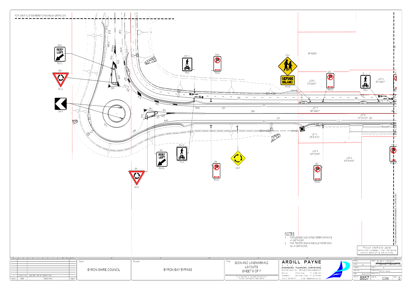
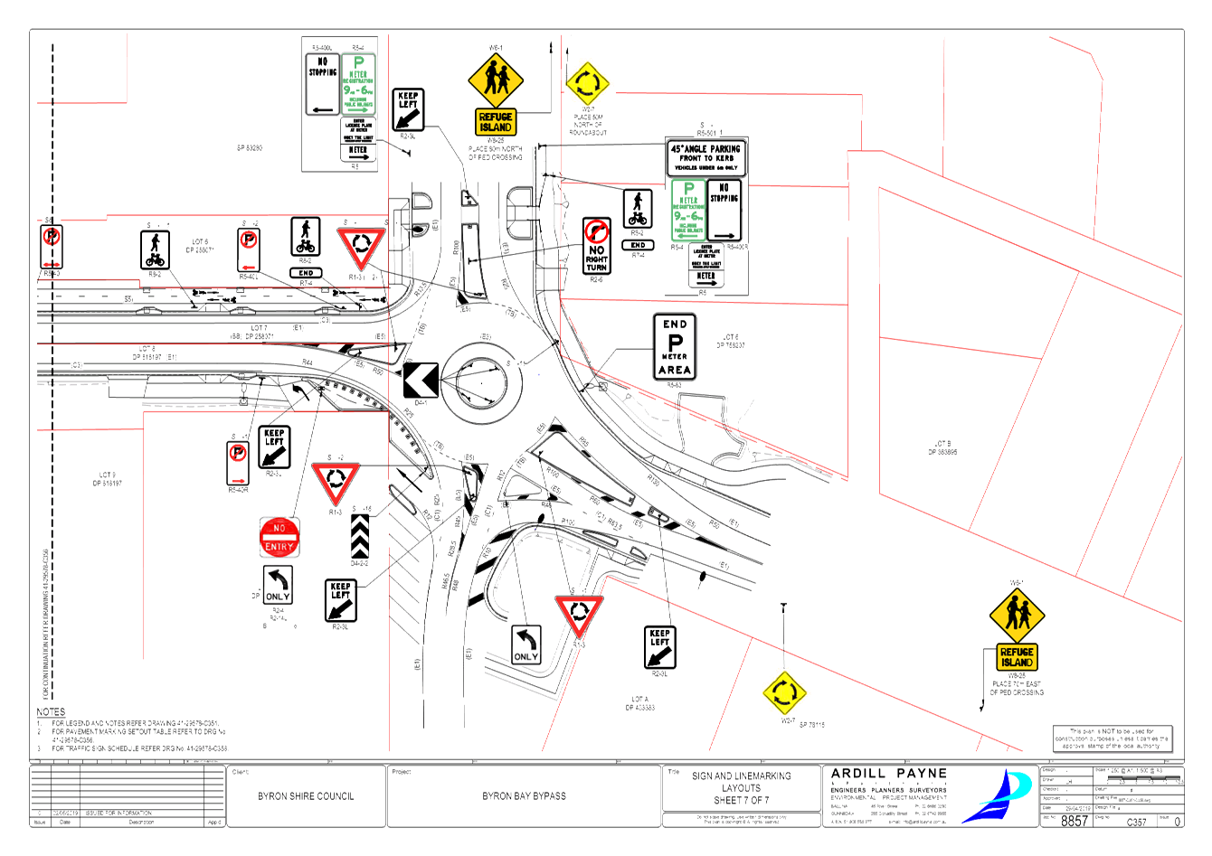
Regulatory Matters
Report No. 6.1 Regulatory Signage - Byron St, BANGALOW - extend motorcycle parking,
provide loading zone
File No: I2019/407
SUMMARY
Council staff recommends making two amendments to the
Bangalow Parking Scheme, namely:
1. Amend
the existing shared bus zone / 2P car spaces at the western end of Byron St
(adjacent to the Lismore Rd / Byron St intersection) to become a shared bus
zone and loading zone.
2. Amend
one 1P car space adjacent to the Bangalow Hotel into motor cycle parking.
Refer to Figure 1 below for the locations under discussion.
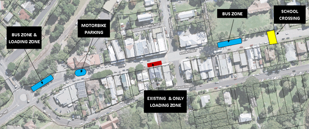
Figure 1: Locality plan of motorcycle parking and shared
bus / loading zone
BACKGROUND
Motorcycle Parking
Concerns have been raised by members of the Bangalow
community that service vehicles parking adjacent to the Bangalow Hotel are
frequently colliding with and damaging the Bangalow Hotel awning. Service
vehicles use this space as there are no loading bays at the western end of
Byron St. The need for an additional loading zone will be discussed below.
As a result, it is recommended to convert one 1P car space
in front of the Bangalow Hotel into motor cycle parking and install a rubber stop
to prevent service vehicles using the space (refer to Figure 2 below for the
location and figure 3 for an example of damage done to the awning). This will
result in the loss of one 1P space.
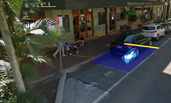
Figure 2: proposed motorcycle parking and rubber stop.
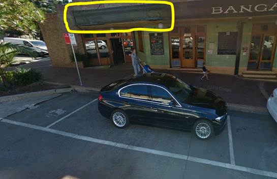
Figure 3: Photo illustrating the damage being done to the
awning
Share Loading Zone / Bus Zone
Currently there is only one loading zone servicing the main
street, Byron Street – refer to figure 1 for the location of the only and
existing loading zone in Byron St. This loading zone is on the south side of
Byron Street, near the intersection of Station Street. There is no
loading zone to service the western end of Byron St. As a result, service
vehicles park in 1P car spaces along Byron Street to deliver goods to shops.
It is, therefore, recommended to provide a second loading
zone at the western end of Byron Street. In particular, there is a Bus
Stop near the intersection of Byron Street and Granuaille Road used between
7.30am-8.30am and 3.30-4.30pm. It is recommended combining this Bus Stop
as a Loading Zone, outside the Bus Stop hours of operation.
Currently the bus stop doubles as two 1P car spaces outside
of Bus Zone hours. Therefore, converting these two 1P car spaces to a
Loading Zone would result in the loss of two 1P spaces.
The combination of the motorcycle parking and creation of a
shared bus zone / loading zone will result in the loss of 2 1P car spaces
within the Bangalow parking scheme. The loss of three spaces is balanced
by the creation of a loading zone which will significantly improve servicing to
shops along the western end of Byron Street and minimise the damage occurring
to the Bangalow Hotel awning.
|
RECOMMENDATION:
That Council amend the Bangalow Parking scheme
as follows:
1. That
Council change the shared bus zone / 2P car spaces on the north side
of Byron St and adjacent to the Lismore Road / Byron Street intersection into
a shared bus zone / loading zone.
2. That
Council change the one 1P car space adjacent to the existing two motorcycle
spaces in front of the Bangalow Hotel into additional motorcycle
parking.
|
Report No. 6.3 Signage requests from Compliance Team - Paterson St, Byron Bay; New
Brighton Rd, New Brighton; Wilfred St, Billinudgel; Sunrise Blvd, Byron Bay
File No: I2019/679
BACKGROUND
Council’s Parking Enforcement team have identified
traffic and parking issues in four locations and the Traffic Engineer has
provided regulatory signage recommendations for Local Traffic Committee
approval.
The four locations are as follows:
1. Paterson
St, Byron Bay from Lighthouse Rd to Kipling Street on the eastern side
2. New
Brighton Rd, New Brighton at the corner of New Brighton Road and Casons
Road
3. Wilfred
St, Billinudgel outside the Rural Fire Service Station
4. Sunrise
Blvd, Byron Bay adjacent to the Discovery Parks Caravan Park
PATERSON ST
This area has become an illegal camping hotspot especially
during the busy periods with numerous amounts of resident complaints.
Parking enforcement officers are unable to adequately enforce this location due
to lack of signage. See figure 1 for locality view and figure 2 for street
view.
Recommendation: It is recommended installing
“No Parking” signage along the western edge of Paterson St as shown
in Figure 3 below and as summarised in the table below. The sign layout
shown in Figure 3 is considered to be indicative and dependant of actual site
conditions encountered during installation.
|
Location (see fig.3)
|
Code
|
Description
|
|
A
|
R5-41R
|
No Parking (symbolic) 1am-6am (right arrow)
|
|
B, C
|
R5-41B
|
No Parking (symbolic) 1am-6am (both arrow)
|
|
D
|
R5-41L
|
No Parking (symbolic) 1am-6am (left arrow)
|
Financial implication: The estimated cost to supply
and install 4 “no camping” signs and poles is approximately $1000
($500 for 4 signs, 4 posts and foundations + $300 for 2 workers for 3 hours)
Other Considerations: While the Enforcement Team have
not highlighted the western side of Paterson St as a concern it is considered
that camping on the western side of Paterson St may result.
However, this can be identified and managed, as required, if and when this
happens.
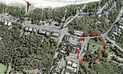
Figure 1. Paterson St locality plan
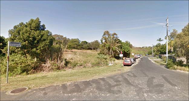
Figure 2. Paterson Street, street view
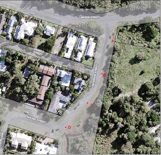
Figure 3. Paterson Street proposed signage locations
NEW BRIGHTON RD
The area in the vicinity of the corner of New Brighton Road
and Casons Road, New Brighton – refer to Figure 4 below
Council’s Enforcement Team have received numerous
customer requests concerning this location – vehicles parked on the
corner as well as along New Brighton Rd, adjacent to the river, creating line
of sight issues for vehicles trying to leave Casons Road. Refer to Figure
5 for the typically location cars park.
Recommendation: Install 3 “No
Stopping” signs on southern side of New Brighton Road as shown in Figure
6. Note the location of signs shown in Figure 6 is indicative and
dependant on actual site conditions encountered during installation.
Typically, two sign are to be placed on New Brighton Rd
between Casons Lane and Park Street and one sign on Casons Lane approximately
15 metres along Casons Road from the intersection.
Financial Implication: The estimated cost to supply
and install 3 “no stopping” signs and poles is approximately $650
($350 for 3 signs, 3 posts and foundations + $300 for 2 workers for 3 hours)
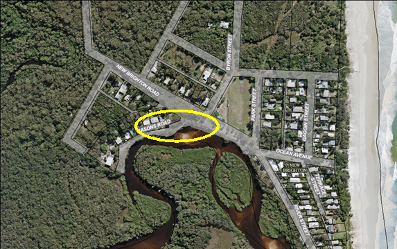
Figure 4. Cason’s Rd locality plan
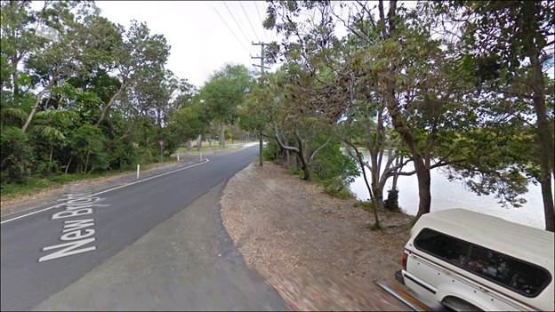
Figure 5. Casons Rd street view
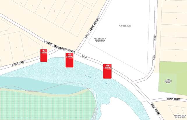
Figure 6. Cason’s Rd proposed signage locations
WILFRED STREET
The Billinudgel Fire Station on
Wilfred St, Billinudgel – Refer to Figure 7. Council’s
Enforcement Team have received a request from the Rural Fire Service in
relation to vehicles parking in front of the Billinudgel fire station on
Wilfred St.. This blocks access/egress for emergency vehicles,
particularly when the Billinudgel hotel is busy with events. The addition
of “No Stopping” signs will help reduce the potential for vehicles
to block egress for the fire trucks.
It is noted that there are
currently already No Parking signs located at the driveway entrance to the
Rural Fire Service as circled in blue in Figure 8. The RFS have indicated
they believe the No Stopping signs will provide a greater deterrence.
Recommendation: Replace the two “No
Parking” signs with two “No Stopping - Authorised Vehicles
Only” signs.
Financial Implication: $100 for two signs.
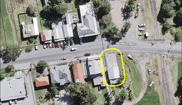
Figure 7. Wilfred St, locality view
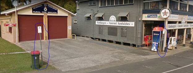
Figure 8 Wilfred St, street view
SUNRISE BOULEVARD
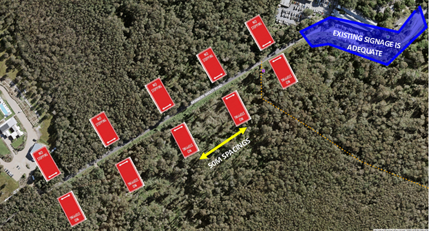
Sunrise Blvd, Byron Bay adjacent to the Discovery Parks
Caravan Park – refer to Figure 9.
Council’s enforcement team have stated that cars park
along both sides of Sunrise Blvd, from the Ewingsdale Rd intersection and along
Sunrise Blvd for approximately 200m. Of particular concern are cars half
parked on the road half on the verge on top of a pedestrian footpath along the
eastern edge, resulting in a substantially reduced road width and pedestrian
hazard. In addition, it creates a significant line of sight issue for cars
egressing Discovery Park. To eliminate the hazard Council’s
Enforcement Team have requested the installation on No Stopping sign along the
lengths sown in Figure 9. No signage is considered required along the
western edge shown in yellow as there appears to be sufficient room to parallel
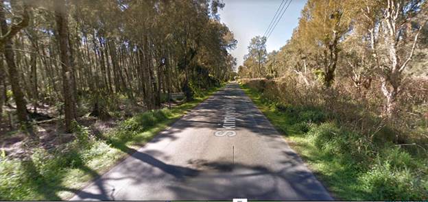
park well off the carriageway – refer to Figure 9 and 10.
To the north of the Discovery Park Driveway is a long bend
along which cars park as well – refer to Figure 11. The volume of cars
parked here is expected to increase when the No Stopping signs are installed
along the southern end of Sunrise Blvd. This is why the Enforcement Team have
requested the signs be continued around the bend, as shown in Figure 9.
Note, the proposed number of signs and sign locations is
approximate and to be confirmed on site depending on site conditions.
The car parking is a result of a popular café located
at the entrance to Discovery Park. Instead of parking on site the cars
are parking along Sunrise Blvd.
Recommendation: Install
regulatory signage as follows:
1. “No
Stopping” signs on the eastern side of the Sunrise Blvd from the
Ewingsdale Rd intersection and extending for approximately 200m. A new sign to
be installed at approximately 50m intervals and as required
2. “No
Stopping” signs installed on the western side of Sunrise Blvd from the
Ewingsdale Rd intersection and extending for approximately 70m.
3. R7-5a
“Parallel Parking Only” signs installed on the western side of
Sunrise Blvd commencing at chainage 70m and extending for approximately 70m to
chainage 140m.
4. “No
Stopping” signs installed on the western and eastern side of Sunrise Blvd
from approximate chainage 140m and extending approximately 100 to chainage 240m
Financial Implication: The estimated cost to supply
and install 3 Parallel Parking sign and 14 “No Stopping” signs and
17 poles is approximately $3000 ($2000 for 17 signs, 17 posts and foundations +
$1000 for 2 workers for 8 hours)
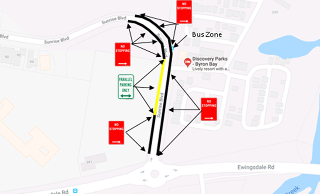
Figure 9 Sunrise Blvd, locality and proposed signage locations
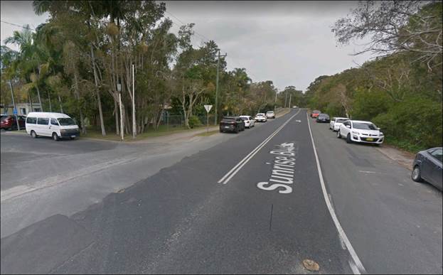
Figure 10. Sunrise Blvd, street view from entry to caravan park
looking south to Ewingsdale Rd
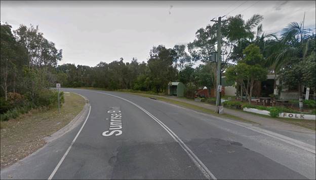
Figure 11. Sunrise Blvd, street view from entry of caravan park
looking north
|
RECOMMENDATION:
That Council approve the following:-
1. At
Paterson St, Byron Bay, install regulatory “No Parking 1am –
6am” signs on eastern side of Paterson St between Lighthouse Rd and
Kipling St.
2. At
New Brighton, install 3 regulatory “No Stopping” signs. Two signs
on southern side of New Brighton Rd between Park St intersection and Casons
Rd intersection. Install one “No Stopping” sign approximately 15
metres along Casons Rd from the intersection.
3. Across
the driveway entrance of the Rural Fire Service on Wilfred St, Billinudgel
replace the two “No Parking” signs with two “No Stopping
Authorised Vehicles Only” signs.
4. At
Sunrise Blvd, Byron Bay install regulatory signage as indicated in Figure
9:-
4.1
“No Stopping” signs on the eastern side of the Sunrise
Blvd from the Ewingsdale Rd intersection and extending for approximately
200m. A new sign to be installed at approximately 50m intervals and as
required
4.2 “No
Stopping” signs installed on the western side of Sunrise Blvd from the
Ewingsdale Rd intersection and extending for approximately 70m.
4.3
“Parallel Parking Only” signs installed on the western side of
Sunrise Blvd commencing at chainage 70m and extending for approximately 70m
to chainage 140m.
4.4
“No Stopping” signs installed on the western and eastern side of
Sunrise Blvd from approximate chainage 140m and extending approximately 100
to chainage 240m
|