Local Traffic Committee Meeting
A Local Traffic Committee Meeting of
Byron Shire Council will be held as follows:
|
Venue
|
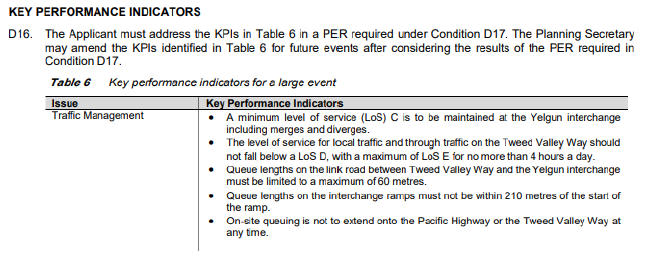
Conference Room, Station Street, Mullumbimby
|
|
Date
|
Tuesday, 10 September 2019
|
|
Time
|
10.30am
|
|
Committee
Members
|
Katherine Boulton – Roads and
Maritime Services
Snr Constable Chris Davis – Police
Cr Basil Cameron
Tamara Smith MP
|
Phillip Holloway
Director Infrastructure
Services I2019/1397
Distributed 03/09/19
Local Traffic Committee Meeting
BUSINESS OF MEETING
1. Apologies
2. Declarations of Interest
– Pecuniary and Non-Pecuniary
3. Adoption of Minutes from
Previous Meetings
3.1 Local
Traffic Committee Meeting held on 30 July 2019
4. Matters Arising
5. Outstanding
Issues/Resolutions
6. Regulatory Matters
6.1 Event
Road Closures - Brunswick Woodchop Twilight Markets 2019............................. 3
6.2 Bay
Lane - No Stopping.................................................................................................... 9
6.3 Lee
Lane - No Parking 1am-7am.................................................................................... 11
6.4 Events
- Falls Festival 2019/20 - Road Closures........................................................... 13
6.5 Events
- INGENUITY Sculpturefest Mullumbimby - Brunswick Terrace Road Closure 19
7. Matters for Traffic Engineering Advice
7.1 Tincogan
St - Intersection Priorities................................................................................ 23
7.2 Seven
Mile Beach Road - Community Concerns.......................................................... 27
Local Traffic Committee Meeting 6.1
Regulatory Matters
Report No. 6.1 Event Road Closures - Brunswick Woodchop Twilight Markets 2019
File No: I2019/1150
SUMMARY
Council has received an application from the Brunswick
Valley Woodchop & Entertainment Committee Inc for the Twilight Markets to
be held Wednesday, 18 December 2019 and the Fireworks Night to be held
Saturday, 11 January 2020.
LTC are requested to endorse the road
closures proposed as part of the Twilight Markets to be held on Wednesday, 18
December 2019, subject to specified conditions including the provision of
updated temporary traffic management and Traffic Control Plans to Council.
The application includes the Traffic Management Plan (TMP)
and Traffic Control Plan (TCP) from the 2017 event to illustrate the proposal.
BACKGROUND
The Twilight Markets continue to
be a success and bring huge crowds to Brunswick Heads. The event
organisers are requesting:
1. Closure of Mullumbimbi Street, between The Terrace and
Park Street, as follows:
a) Closure of the off-street car park adjacent to the
Banner Park children's play area from 7:00am until 11:00pm.
b) Two (2) temporary designated ‘Disability
Parking’ spaces outside of the hotel during the morning. The existing two
(2) spaces in the off-street car park will be closed off.
c) Closure of Mullumbimbi St between The Terrace and Park
Street from 12:00noon until 11:00pm.
2. Opening of Memorial Park for parking, as follows. This
is for background information and does not require LTC endorsement:
a) Twilight markets - Wednesday, 19 December 2018 from
12:00noon. This will allow stallholders to get their vehicles off the
street before the markets start at 3pm.
b) Fireworks Night – Saturday, 19 January 2019 from
6:00pm. This will allow for people attending the carnival/housie, and
through to when the fireworks take place at 9pm, to park off the streets.
Appropriately accredited staff
will be requested to put out the early blockades and the temporary designated Disability
Parking signs as per the TCP. Market staff will relocate the blockades at 12:00noon.
Market staff will remove the road closed signs and Disability Parking and store
these securely with McGregor's Amusements for collection the next day.
As in the past, McGregor's
Amusement will move their ride during the night of Tuesday 17 December 2019 and
place it over the centre parking bays for erection the next afternoon. This
effectively blocks off most of the area mentioned in item 1 above and the early
road closure will ensure that vehicles are not parked indefinitely in that area
(eg patrons of the hotel) once the premises are open for business.
COUNCIL IMPLICATIONS
§ Budget/Financial
The event organisers to be
invoiced for the relevant Approval of Road Events pursuant to s144 of the Roads
Act fee as per the Fees & Charges 2018/19.
§ Asset Management
N/A
§ Policy or Regulation
Regulatory traffic signage as delegated
to council for authorisation in conjunction with NSW Road Rules.
§ Consultation
A condition of the
endorsement of this event is that appropriate consultation is undertaken,
including:
· Advertising the
impact of the event in the local newspaper and on the Council website.
· Informing
community and business that are directly impacted.
· Liaising with bus
and taxi operators.
· Consulting with
emergency services.
§ Legal and Risk Management
Event organiser is required to
hold $20m public liability insurance cover which is valid for the event.
|
RECOMMENDATION:
1. That
Council endorse the following road closures and works associated with the
Twilight Markets to be held on Wednesday, 18 December 2019:
a) Mullumbimbi
Street, Brunswick Heads between The Terrace and Park Street on
Wednesday, 18 December 2019, as per the following:
i) Closure
of the Mullumbimbi Street off-street car park adjacent to the Banner Park
children's play area from 7:00am until 11:00pm.
ii) Two
(2) temporary designated ‘Disability Parking’ spaces be created
outside of the hotel during the morning, with signage to be installed by
appropriately accredited persons in conjunction with the implementation of
the TCP.
iii) Closure
of Mullumbimbi St between The Terrace and Park Street from 12:00noon until
11:00pm.
2. That
the endorsement provided in Part 1 is subject to:
a) separate
approvals by NSW Police and RMS being obtained, as required;
b) the
Traffic Management Plan and Traffic Control Plan(s) for the 2019/20 event be
updated by those with relevant and current RMS accreditation;
c) implementation
of the Traffic Management Plan and Traffic Control Plan by those with
appropriate RMS accreditation and the holding of current and appropriate
levels of insurance and liability cover;
d) the
impact of the event be advertised, and charged at cost to the organisers, via
a notice in the local weekly paper a minimum of one week prior to the
operational impacts taking effect, noting it must include the event name,
specifics of any traffic impacts or road closures and times, alternative
route arrangements, event organiser, a personal contact name and a telephone
number for all event related enquiries or complaints;
e) the
event be notified on Council’s web page;
f) the
event organiser:
i) informing
community and businesses that are directly impacted (eg adjacent to the
event) via written information which is delivered to the property in a timely
manner so as to document, consider and respond to any concerns raised;
ii) arranging
for private property access and egress affected by the event;
iii) liaising
with bus and taxi operators and ensuring arrangements are made for provision
of services during conduct of the event;
iv) consulting
with emergency services and any identified issues be addressed;
v) holding
$20m public liability insurance cover which is valid for the event;
vi) paying
of Council’s S144 Road Event Application Fee prior to the event.
|
Attachments:
1 Twilight
Markets & Fire Works - TMP, E2017/87013
, page 7⇩ 
2 Twilight
Markets & Fire Works - TMP, E2017/87031
, page 8⇩
Regulatory Matters 6.1 - Attachment 1
Regulatory Matters 6.1 - Attachment 2
Local Traffic Committee Meeting 6.2
Report No. 6.2 Bay Lane - No Stopping
File No: I2019/1233
Background
The operator of the Bay Motel, Byron Bay has requested
Council to install No Stopping signs along their full rear frontage of Bay
Lane.
Access into Bay Motel Car park is off Bay St as shown below
in Figure 1. Given the narrow nature of the site traffic flows one way through
the site and exits via Bay Lane. Refer to Figure 1 below.
Figure 1 – Flow of traffic into and through the
site.
Figure 2 below shows cars parked adjacent to the Bay Motel
exit point on Bay Lane. Cars frequently park in this area as there is no time
limit. These cars restrict the ability for cars to exit the Bay Motel safely
and has resulted in several cars hitting the Motel fence in an effort to avoid
parked cars.
Figure 2 – Cars parked on Bay Lane in front of
Motel exit point.
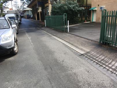
Figure 3 below shows recommended layout for the proposed No
Stopping signage. The signs are to be located on the south side of Bay Lane
between the Bay Lane Loading Zone and the Byron Bay Beach Hostel basement
driveway.
Figure 3 – Proposed location of 2 No Stopping
signs.
|
RECOMMENDATION:
That Council endorse the installation of 2 No Stopping
signs on the south side of Bay Lane between the Bay Lane Loading Zone and the
Byron Bay Beach Hostel basement driveway.
|
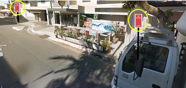
Local Traffic Committee Meeting 6.3
Report No. 6.3 Lee Lane - No Parking 1am-7am
File No: I2019/1239
Background
Council’s Parking Enforcement Officers have requested
the installation of No Parking 1am-7am signs within Lee Lane, Byron Bay. The
purpose of the signage is to address the problem of illegal camping. Regulatory
signage will enable officers to infringe the vehicles rather than the occupants
who are frequently backpackers and sometimes aggressive.
Given most illegal campers are backpackers they frequently
move on and the infringement is ignored with no consequences.
The time requested (1am – 7am) has not been previously
adopted by Council. Council has typically adopted either 1am - 5am or 1 am -
6am. However, Council’s Parking Enforcement Officers have noted they
commence their shifts at 6am and are not able to address the issue of illegal
camping with the time limit 1am-5am or 1am – 6am.
As a general trend, and as new signs are installed, the
Parking Enforcement Team would like to adopt No Parking 1am-7am in areas
outside of the main Townships (such as Byron Bay, Mullumbimby, Brunswick Heads)
and maintain No Parking 1am-6am within the towns to accommodate early morning
workers.
The photo below indicates the location of Lee Lane.
|
RECOMMENDATION:
That Council endorse the installation of No
Stopping 1am-7am along the full length of Lee Lane, Byron Bay.
|
Local Traffic Committee Meeting 6.4
Report No. 6.4 Events - Falls Festival 2019/20 - Road Closures
File No: I2019/1261
SUMMARY
Council has received an
application to regulate traffic and parking from Greg Alderson & Associates
on behalf of Look Up and Live Pty Ltd for Falls Festival 2019/20 at
North Byron Parklands in Yelgun, which is to be held during the New
Year’s period of 2019/20.
The festival will be held from 31
December 2019 to 2 January 2020.
Camper bump in will commence on
30 December 2018 and camping areas close on 3 January 2019.
LTC is requested to endorse the application
to regulate traffic and parking and endorse a condition requiring a traffic
management plan and associated traffic control plans be developed by a person
with relevant RMS accreditation, subject to additional conditions outlined
below in the recommendations.
BACKGROUND
The Falls Festival was held at
North Byron Parklands for the first time during the 2013/14 New Year’s
Eve period and has been held for the past 5 years under a 5 year temporary
approval. This year North Byron Parklands has now been granted permanent
approval. The number of patrons for the 2019/20 event is capped at
25,000, which is the same as last year.
To date the Falls Festival has a
good history of traffic management with no KPI breaches observed during the
18/19 event. For 2017/18 traffic queuing was a problem at the start of the
event as campers converged on the site. This was managed better in 2018/19 and
will be managed again this year through allowing campers to arrive a day early
to spread their arrival over 2 days.
Traffic Management
Generally traffic management will
remain substantially the same as last year. However, as stated within the draft
TMP (see attached), following on from the Traffic Evaluation Report
observations and recommendations for previous Falls Festival events, together
with updated approvals provided under State Significant Development 8169
Development Consent, it is proposed to implement the following traffic
improvements for the 19/20 event:
· Gates
will be open from 29 December (subject to ticket sales exceeding 20,000) to
allow an additional day for camping patrons to arrive before the event
commences;
· Contingency
TCP is included for managing queueing incident that may have the potential to
impact the Pacific Motorway;
· New
egress route for Northbound traffic via new Gate E to Wooyung Rd, together with
associated TCPs.
Note, Wooyung Rd is within Tweed
Shire. This new egress point is for departing campers and is expected to
noticeably help reduce traffic impacts within Byron Shire.
A No Stopping zone is proposed on
Tweed Valley Way and Brunswick Valley Way from Shara Boulevarde in the south to
the Byron Shire boundary in the north. The purpose of this is two-fold:
· Eliminate
parking by patrons not familiar with the area on Tweed Valley Way which is a
high speed road;
· Improve
tools to manage trespassers, in particular from the north.
Below are two snippets from the
draft TCP to illustrate the above proposed traffic control:
Figure 1 – No Stopping
Plan
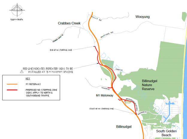
Figure 2 – Speed Zone Plan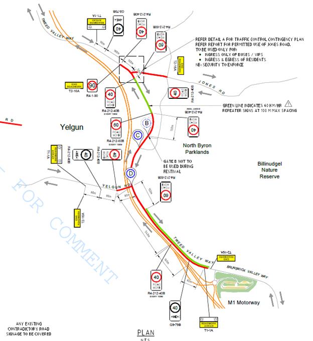
As part of the new state approval
the applicant must meet the following conditions in relation to traffic
management:
Traffic Monitoring
As stated within the draft TMP
Although no traffic
controllers are required to manage traffic under normal conditions, traffic
controllers would need to be on call to assist in managing queues during any
queuing on the public road that may occur as a result of unforeseen
circumstances. Back of queue warning vehicles would need to be available to
warn inbound vehicles on the public road of any queues ahead. It is the
responsibility of the festival management to ensure the public road is
monitored and potential queuing is predicted in advance of any queuing
appearing.
KEY ISSUES
1. This
is the first year the site has approval for permanent use.
2. A
new northern egress point through to Wooyung Rd (Tweed Shire) for campers is
being trial.
3. Separate
approval of the TMP & TCP required by the RMS Traffic Engineering Department.
COUNCIL IMPLICATIONS
§ Budget/Financial
The event organisers to be
invoiced for the relevant Approval of Road Events pursuant to s144 of the Roads
Act fee as per the Fees & Charges 2018/19.
§ Asset Management
N/A
§ Policy or Regulation
Regulatory traffic signage as delegated
to council for authorisation in conjunction with NSW Road Rules.
Traffic management is to be in
accordance with Australian Standards and RMS guidelines.
§ Consultation
A condition of the
endorsement of this event is that appropriate consultation is undertaken,
including:
· Advertising the
impact of the event in the local newspaper and on the Council website.
· Informing
community and business that are directly impacted.
· Liaising with bus
and taxi operators.
· Consulting with
emergency services.
§ Legal and Risk Management
Congestion caused by the
event will directly affect a RMS controlled asset – Pacific Highway. Separate
approval of the TMP & TCP required by the RMS Traffic Engineering
Department.
|
RECOMMENDATION:
That Council endorse the Falls Festival 2019/20 to be
held at the North Byron Parklands site, Yelgun from 31 December 2019 to 2
January 2020, inclusive, subject to the following conditions: -
a) Separate
approvals by NSW Police and RMS being obtained;
b) The
development of a Traffic Management Plan and Traffic Control Plan(s) by those
with relevant RMS accreditation. These plans are to be submitted to Byron
Shire Council at least 2 months prior to the event for approval of traffic
regulation on roads under Byron Shire control;
c) The
Traffic Management Plan and the Traffic Control Plan to be implemented by
those with relevant and current RMS accreditation;
d) The
temporary ‘No Stopping’ where applied, including on Brunswick
Valley Way and Tweed Valley Way (between Shara Boulevard and north to the
Shire boundary), is implemented prior to the event and in accordance with
relevant state requirements and Australian Standards;
e) A
communications protocol be developed and maintained by those involved in the
implementation of traffic management including monitoring during the event
and ability to implement contingency plans as and when directed;
f) Monitoring
of vehicle volumes that arrive and depart the festival site and on the local
road network;
g) The
holding of an event debrief within the month following the festival which
includes but not limited to Council, RMS and Police;
h) The
event organiser:
i) advertising
the impact of the event via a notice in the local weekly paper a minimum of
one week prior to the operational impacts taking effect, noting it must
include the event name, specifics of any traffic impacts or road closures and
times, alternative route arrangements, event organiser, a personal contact
name and a telephone number for all event related enquiries or complaints;
ii) providing
a copy of the advert for Council's web page;
iii) give
consideration of any submissions received;
iv) informing
community and businesses that are directly impacted (e.g. adjacent to the
event) via written information which is delivered to the property in a timely
manner so as to document, consider and respond to any concerns raised;
v) arranging
for private property access and egress affected by the event;
vi) liaising
with bus and taxi operators and ensuring arrangements are made for provision
of services during conduct of the event;
vii) consulting
with emergency services and any identified issues be addressed;
viii) holding
$20m public liability insurance cover which is valid for the event.
ix) paying
of Council’s Road Event Application Fee prior to the event.
|
Local Traffic Committee Meeting 6.5
Report No. 6.5 Events - INGENUITY Sculpturefest Mullumbimby - Brunswick Terrace
Road Closure
File No: I2019/935
SUMMARY
The 2019 INGENUITY Sculpturefest is to be held from Tuesday
12 to Tuesday 26 November 2019. Previously, INGENUITY closed off Brunswick
Terrace only for the purpose of reducing traffic flows and thereby increase the
ambience. The road closure was not to manage any risk.
INGENUITY are concerned they will not have sufficient funds
to fund the development of relevant TMP / TCP’s and the installation of
traffic control. However, in anticipation that a source is found to fund these
requirements they are seeking Council’s support to close Brunswick
Terrace, subject to the relevant conditions.
BACKGROUND
This is the second year of this event, relating to approved
DA 10.2014.248.1 “Creation of sculpture walk with 13 permanent public art
sites and public land” on road reserve, Burringbar Street, and Brunswick
Terrace Mullumbimby.
The organisers (Creative Mullumbimby Inc) have a Memorandum
of Understanding: Public Art Partnership with Council, and are working with the
public art panel to commission and manage the sculpture projects according to
the above DA, and to coordinate and produce Mullumbimby Community Sculpture
Festival, which was first held in November 2018.
The event organisers are also applying to close Brunswick
Terrace between Burringbar Street and Tincogan Street for the duration of the
event – subject to funding. The Traffic Control Plan for last years event
has been provided below and this year’s event will be based on the same
plan, subject to relevant conditions. The applicant is currently preparing a
Traffic Management Plan which will be submitted to Council prior to the event.
Traffic impacts will occur between Tuesday 12 to Tuesday 26
November 2019.
COUNCIL IMPLICATIONS
§ Budget/Financial
The event organisers will be invoiced the following fees:
- Approval of Road Events pursuant to s144 of the Roads Act
(Advertising of event and staff time to process) and
§ Asset Management
Not applicable
§ Policy or Regulation
Regulation of traffic
and parking to be in accordance with relevant NSW legislation and RMS
guidelines.
Traffic management
plans and traffic control plans to be developed by person(s) with relevant and
current RMS accreditation.
Traffic control plans to be implemented
by person(s) with relevant and current RMS accreditation.
§ Consultation
A condition of the
endorsement of this event is that appropriate consultation is undertaken,
including:
1. Advertising
the impact of the event in the local newspaper and on the Council website.
2. Informing
community and business that are directly impacted.
3. Liaising
with bus and taxi operators.
4. Consulting
with emergency services.
§ Legal and Risk Management
Appropriate approvals and
insurances are required as a condition of the endorsement for this event.
Figure 1. Brunswick Terrace, Mullumbimby road closure
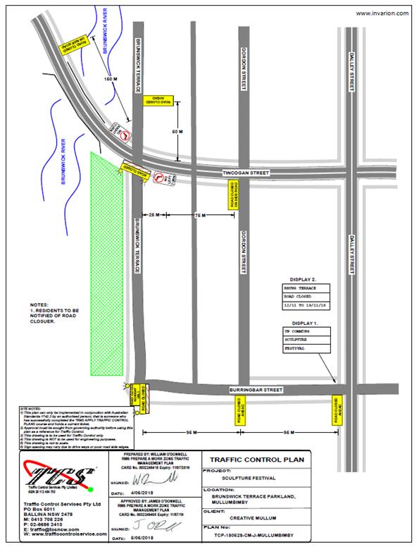
|
RECOMMENDATION:
1. That
Council permit the following road closures and associated traffic control for
the INGENUITY Sculpturefest event to be held from Tuesday 12 to Tuesday 26
November 2019:
a. Brunswick
Terrace, Mullumbimby, between Tincogen Street and Riley Lane
2. That
the approval provided in Part 1 is subject to:-
a. separate
approvals by NSW Police and RMS being obtained, as required;
b. the
development of a Traffic Management Plan and Traffic Control Plan(s) for the
2020 event by those with relevant and current RMS accreditation if regulation
of traffic is undertaken;
b. the
Traffic Control Plan, if required, being implemented by those with relevant
and current RMS accreditation;
c. that
the impact of the event be advertised via a notice in the local weekly paper
a minimum of one week prior to the operational impacts taking effect, noting
it must include the event name, specifics of any traffic impacts or road
closures and times, alternative route arrangements, event organiser, a
personal contact name and a telephone number for all event related enquiries
or complaints;
d. the
event be notified on Council’s webpage;
e. the
event organiser:-
i) undertake
consultation with community and affected businesses including adequate
response/action to any raised concerns;
ii) undertake
consultation with emergency services and any identified issues addressed;
iii)
hold $20m public liability insurance cover which is valid for the event;
iv) pay
Council’s Road Event Application Fee prior to the event;
|
Local Traffic Committee Meeting 7.1
Matters for Traffic Engineering Advice
Report No. 7.1 Tincogan St - Intersection Priorities
File No: I2019/1386
Background
Council staff has received a request for the Local Traffic
Committee to provide advice on possible changes to Give Way signs at Tincogan St
/ Dalley streets intersection and the Tincogan St / Stuart St intersection.
Currently traffic on Tincogan St must give way to traffic on
Dalley St and Stuart St as seen in Figure 1 below.
Figure 1: Tincogan St / Dalley St Intersection
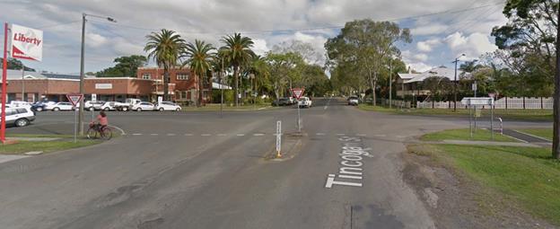
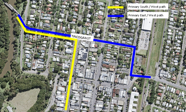
Figure 2 below shows the typical traffic path (refer to blue
line) for cars travelling east west through Mullumbimby.
Figure 2: Plan view of Mullumbimby and travel paths
Previous Reports
LTC Reports
This matter has been brought to LTC previously in 2014 where
LTC recommended the following:
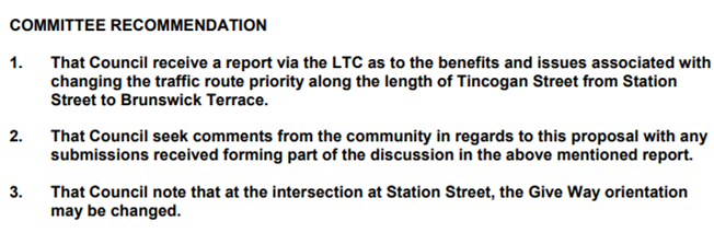
Council resolved to adopt the above LTC resolution at the 7
August 2014 Council meeting. No additional Council comments were provided.
Internal Correspondence
Internal Council correspondence indicate that alternate
intersection designs such as a roundabout was considered at the Dalley St /
Tincogan St intersection. No action was taken in regards to this consideration.
Mullumbimby Movement Strategy
A final version of the Mullumbimby Movement Strategy was
submitted to Council. This strategy identifies a number of Town Centre
Alternate Routes. Some of the options highlight Tincogan as the primary pathway
through Mullumbimby to reduce the traffic flow along Burringbar St. Other
options direct traffic along different routes. Consideration should be given to
the Mullumbimby Movement Strategy and the preferred Town Centre Alternate
Route. However, this has not been resolved by Council as yet.
Traffic Considerations
In changing the Give Way Priority it is considered there are
many issues for and against the matter.
Traffic Data
Anecdotally, Tincogan St is perceived as the primary path
east west through Mullumbimby and to Woolworths if arriving from the west.
However, Council has no current traffic data for Tincogan St or the adjoining
network to confirm traffic patterns.
A substantial volume of traffic arrives from the south along
Dalley St and turn left towards Main Arm. However, objectively, it is unclear
if the majority of traffic arrives at the Tincogan St / Dalley St intersection
from the east or from the south.
Speed
It is anticipated if the Dalley St / Tincogan St and Stuart
St / Tincogan St intersection give way priorities are changed then speeding
along Tincogan may become a significant concern. It is, therefore, considered
appropriate that if the intersection priority is changed then a wider design
should be undertaken to consider traffic calming measures along Tincogan St to
minimise speeding.
Woolworths
It is also acknowledged that the Tincogan St / Station St
intersection and Woolworths entrance are known to be areas of concern. While
the Woolworths car park entrance is officially left out only many cars turn
right to access Tincogan St. Woolworths and Council have indicated previously
their interest in redesigning the location of the Woolworth carpark entrance.
In addition, the Station St / Tincogan St intersection is
narrow and known to be difficult for heavy vehicles to turn left into Tincogan
St off Station St.
Consideration has been given to installing a median in this
location to control right turn movements from the Woolworths carpark however
there is insufficient room to install a median and maintain swept paths for
larger vehicles turning left from Station St into Tincogan St. Currently larger
vehicles have to cross the centreline of Station Street to perform this
movement and changing intersection priorities along Tincogan St may increase
the volume of traffic at the Station St / Tincogan St intersection and
exacerbate traffic conflict at this intersection.
Federation Bridge to Dalley St
Unimpeded traffic flow enters Tincogan St from the west
which has priority from the Federation Bridge through the Brunswick Terrace and
Gordon st intersections until reaching Dalley St.
Traffic speed of vehicles over this section of Tincogan St
from Main Arm is anecdotally regarded as high. Changing intersection priorities
may result in cars continuing to speed along Tincogan east of Dalley and even
Stuart St.
Changes to Tincogan St intersection priorities should
consider how traffic speeds are to be managed at the western end of Tincogan
St.
Shops
Along Tincogan St, between Dalley St and Stuart St is a
strip of popular shops: cafes, auto repairs, dance studio, bike shop and motor
cycle repair. This strip of Tincogan St currently has high parking demand with
high turnover. Parking is 90’ angle parking with cars required to reverse
out to exit.
Consideration would need to be given to the potential
conflicts that would emerge with cars accessing / exiting these spaces and with
an increase in traffic speed that may result from changing the intersection
priorities.
|
RECOMMENDATION:
That Local Traffic Committee provide advice on
possible changes to Give Way signs at Tincogan St / Dalley streets
intersection and the Tincogan St / Stuart St intersection.
|
Local Traffic Committee Meeting 7.2
Report No. 7.2 Seven Mile Beach Road - Community Concerns
File No: I2019/1389
Summary
Community members of Seven Mile Beach Road have requested an
opportunity to explain further their concerns with speed, aggressive driving
and parking dangerously on what is now a mixed use dead end road funnelling to
the Reserve beaches.
Background
Community members from Seven Mile Beach Road have been in
consultation with Council for a number of years and have presented Council with
a number of concerns they would like to see addressed. Below is a list of the
issues identified from various correspondences over these years.
Identified Issues
· Increased visitor
numbers
· Significant
traffic volumes
· Illegal Camping
and associated problems (litter, noise, fires, defecation, etc)
· Illegal dumping
and litter
· Alcohol
· Dogs
· Intruders
· Area is isolated, remote
and out of sight
· Excessive speeding
· Parking chaos
· Traffic chaos
· Cars driving along
the middle of the road
· Wildlife hit by
cars
· Byron pay parking
is encouraging people to Broken Head where it is free
· Pedestrian safety
· Dust
· Environmental
pollution
· Poor road surface
· No NPWS plan of
management for Broken Head Reserve
· People creating
their own paths to the beach and getting into trouble
· Poor / ill-defined
walkways to the beaches and associated risk to visitors
· Life saving resources
being stretched to rescue increasing visitor numbers
· No pedestrian
access along Seven Mile Beach Rd
Requested Solutions
· Increase Council
enforcement;
· Increased police
enforcement;
· Reduce or restrict
vehicle numbers that are entering Seven Mile Beach Rd;
· Restrict the
number of cars to the area to the number of car parks available;
· Seal Seven Mile
Beach Rd (or portions of) with keep left signage and linemarking;
· Convex mirrors at
dangerous corners;
· Formalise car
parks (seal, bollards, linemarking and signage);
· Paid Parking;
· Signage and
linemarking to improve parking compliance;
· Permanent traffic
counters;
· Pedestrian walkway
from Broken Head Reserve Rd to Kings Beach car park, or further;
· National Park
Pass;
· Boom gate across
either across Seven Mile Beach Rd or Broken Head Reserve Rd;
· Gate off or close
entrance to Seven Mile Beach Rd;
· A curfew on Seven
Mile Beach Rd;
· Reduced speed
limit;
· Make Seven Mile
Beach Rd a Shared Zone;
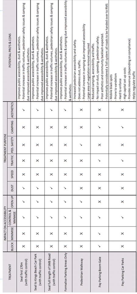
It is noted that the above requested solutions are aimed at
impact accessibility is several ways, namely: block access, minimise / reduce
access, control / manage access or open up access.
At the end of this report is a matrix developed by Council
reviewing the impact key Requested Solutions would have on accessibility and
which Identified Issue the solution would address.
Key Meetings
· 19/7/19 - Council,
community reps and National Parks and Wildlife Services
· 26/3/18 &
2/7/18 – Council, two community groups and state agency meetings
Sample Correspondence
· 14/3/19 Director
correspondence outlining Councils Long Term and Short Term Actions;
· 23/7/19 Resident
1 email outlining Identified Issues as listed above;
· 29/5/19 Resident
1 email outlining Identified Issues as listed above;
· 9/3/17 Resident
2 email outlining Identified Issues as listed above;
Resolutions
· 17-677 Allocate
$20,000 to investigate road upgrades
· 18-239 Install
No Stopping along the full length of Seven Mile Beach Road;
· 18-544 Investigate
various solutions to Seven Mile Beach Rd;
· 18-803 Acknowledge
Broken Head Reserve as biodiversity hotspot to access grant options;
Reports
· I2018/1357 Council
report giving investigation updates.
· I2017/1434 Council
report investigating the option of a Shared Zone.
· I2018/2362 Council
report advising how best to manage dust and silt impacts
· E2018/24348 Meeting
minutes for 26/3/18 meeting
· E2018/38473 Report
presenting 5 traffic management options and associated costs
o Transfer road to residents
($80-130k) – not
supported at the 2/7/18 meeting
o Gate road to public
($80-180k) –
not supported at the 2/7/18 meeting
o Dedicate road to NPWS
($30-60k) –
supported at the 2/7/18 meeting
o Install traffic calming
devices (3-4.4m)
§ Option 1 - Maintain Gravel Road: $460-574k
§ Option 2 - Seal Road to Kings car
park and Pay Parking: $930-1.28m
§ Option 3 - Fully Sealed Road: $3.014m-4.4m
o Access via Blackbutt Lane and
partial closure of Seven Mile Beach Rd ($5.8-8.1m)
· E2018/56081 Meeting
Minutes for 2/7/18 meeting
Additional Actions
· Survey of Brays
Beach and Whites Beach car parks
· Signage
o NPWS have updated signage at
the walkway entrances to each beach
o No Stopping signage along the
full length of Seven Mile Beach Rd
o Warning signs targeting
parking, camping, fires etc.
· Traffic
Classifiers installed for 6 months between November 2019 – April 2019.
· Investigated the
option of a Shared Zone. Seven Mile Beach Road does not meet the warrants
(I2017/1434).
Below is a table summarising the key Identified Issues,
Proposed Solutions and their impact on accessibility. The comments and any
recommendation are sought from the committee in respect of possible management
options for traffic and parking impacts on Broken Head Reserve Road and Seven
Mile Beach Road.
|
RECOMMENDATION:
That committee comments and recommendations be
provided to Council staff currently investigating management options for
Broken Head Reserve Road and Seven Mile Beach road traffic and parking
impacts.
|