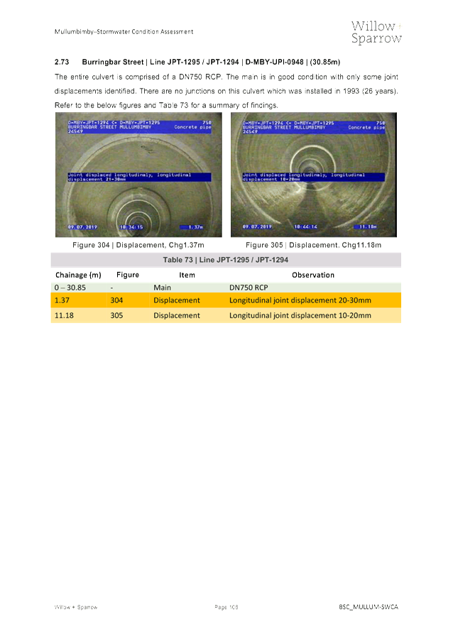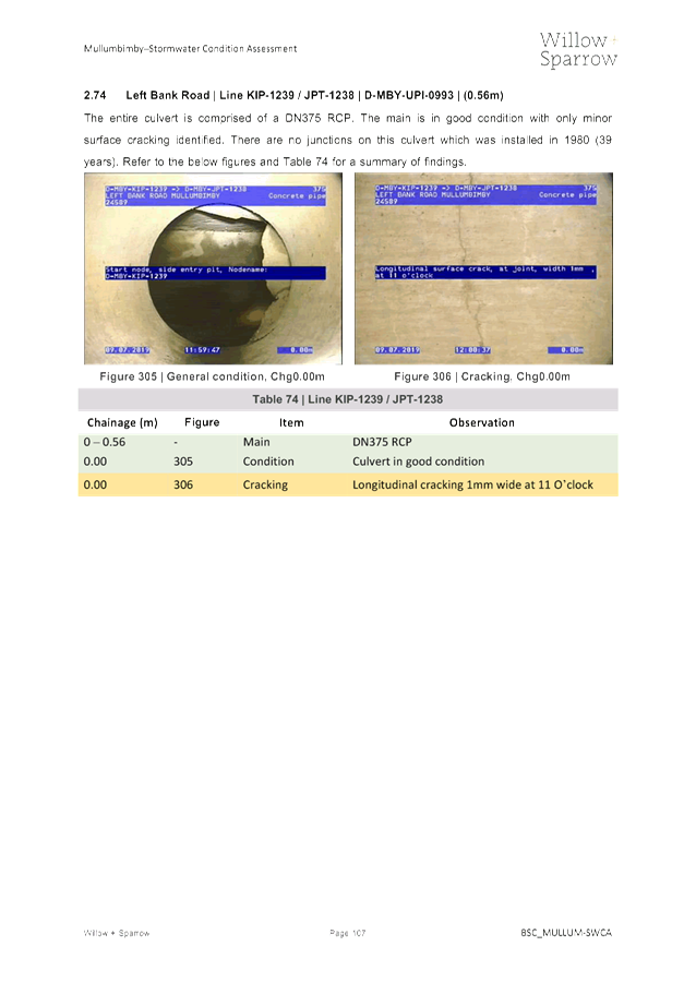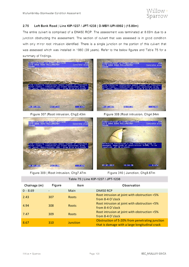
Water, Waste and Sewer Advisory Committee Meeting
A Water, Waste and Sewer Advisory
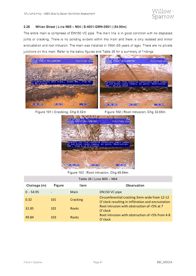
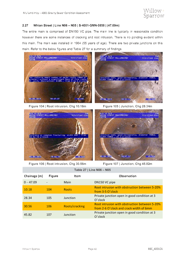
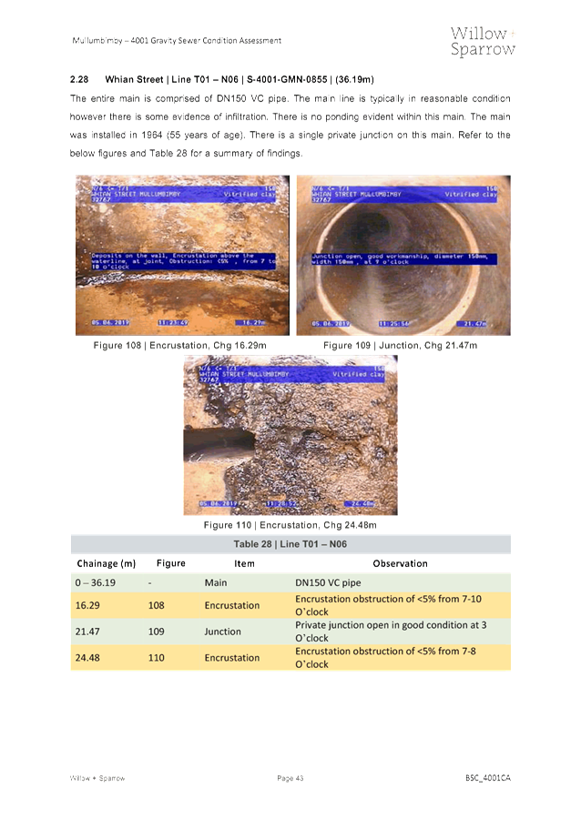
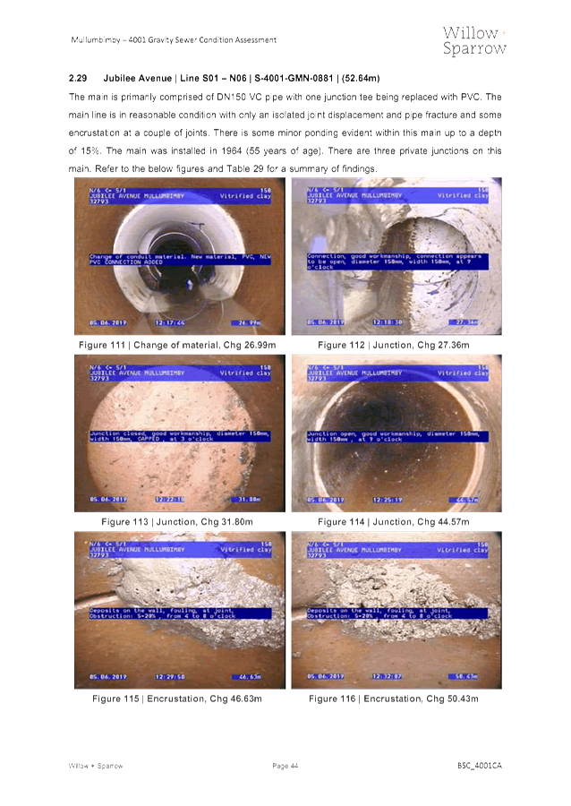
Committee Meeting of Byron Shire Council will be held as follows:
|
Venue
|
Conference Room, Station Street, Mullumbimby
|
|
Date
|
Thursday, 30 January 2020
|
|
Time
|
11.30am
|
Phil Holloway
Director Infrastructure
Services I2020/79
Distributed 23/01/20
What is a “Conflict of Interests” - A conflict of
interests can be of two types:
Pecuniary - an interest that a person has in a matter because of a reasonable
likelihood or expectation of appreciable financial gain or loss to the person
or another person with whom the person is associated.
Non-pecuniary – a private or personal interest that a Council
official has that does not amount to a pecuniary interest as defined in the Code
of Conduct for Councillors (eg. A friendship, membership of an association,
society or trade union or involvement or interest in an activity and may
include an interest of a financial nature).
Remoteness – a person does not have a pecuniary interest in a matter
if the interest is so remote or insignificant that it could not reasonably be
regarded as likely to influence any decision the person might make in relation
to a matter or if the interest is of a kind specified in the Code of Conduct
for Councillors.
Who has a Pecuniary Interest? - a person has a pecuniary interest in a
matter if the pecuniary interest is the interest of the person, or another
person with whom the person is associated (see below).
Relatives, Partners - a person is taken to have a pecuniary interest in a
matter if:
§ The person’s
spouse or de facto partner or a relative of the person has a pecuniary interest
in the matter, or
§ The person, or a
nominee, partners or employer of the person, is a member of a company or other
body that has a pecuniary interest in the matter.
N.B. “Relative”, in relation to a person means any of the
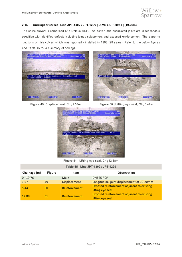
following:
(a) the
parent, grandparent, brother, sister, uncle, aunt, nephew, niece, lineal
descends or adopted child of the person or of the person’s spouse;
(b) the
spouse or de facto partners of the person or of a person referred to in
paragraph (a)
No Interest in the Matter - however, a person is not taken to have a
pecuniary interest in a matter:
§ If the person is
unaware of the relevant pecuniary interest of the spouse, de facto partner,
relative or company or other body, or
§ Just because the
person is a member of, or is employed by, the Council.
§ Just because the
person is a member of, or a delegate of the Council to, a company or other body
that has a pecuniary interest in the matter provided that the person has no
beneficial interest in any shares of the company or body.
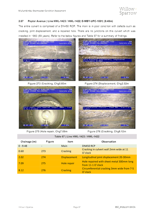
Disclosure and participation in meetings
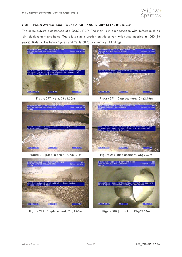
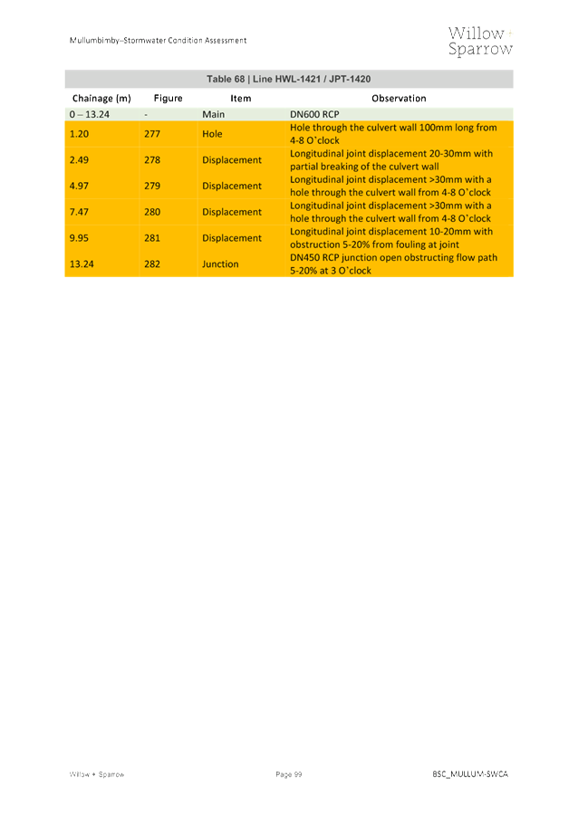
§ A Councillor or a
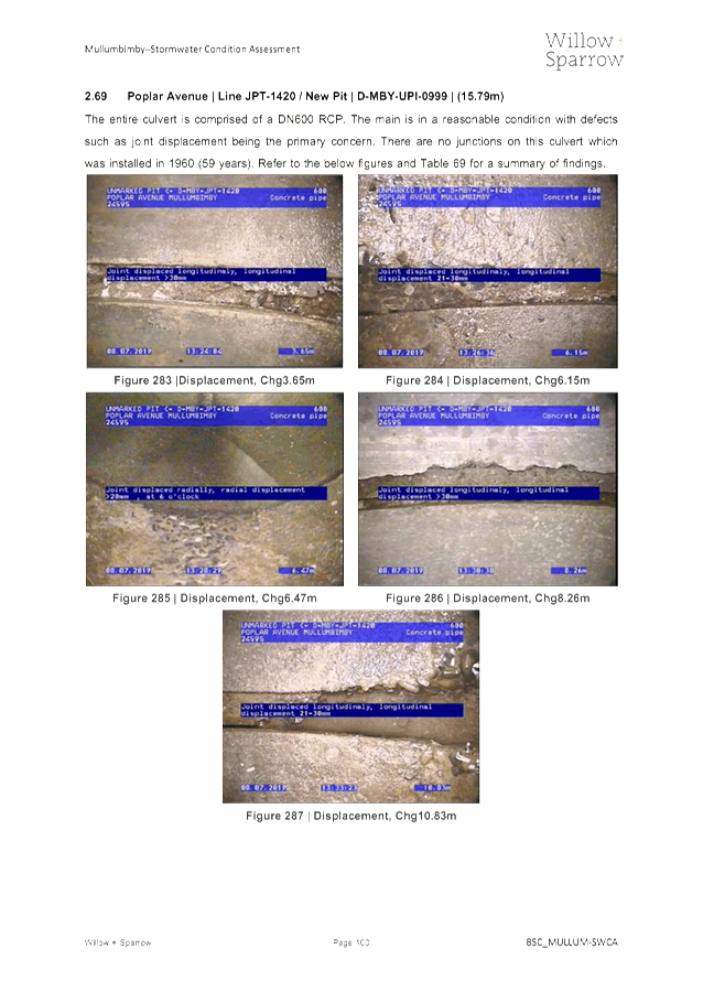
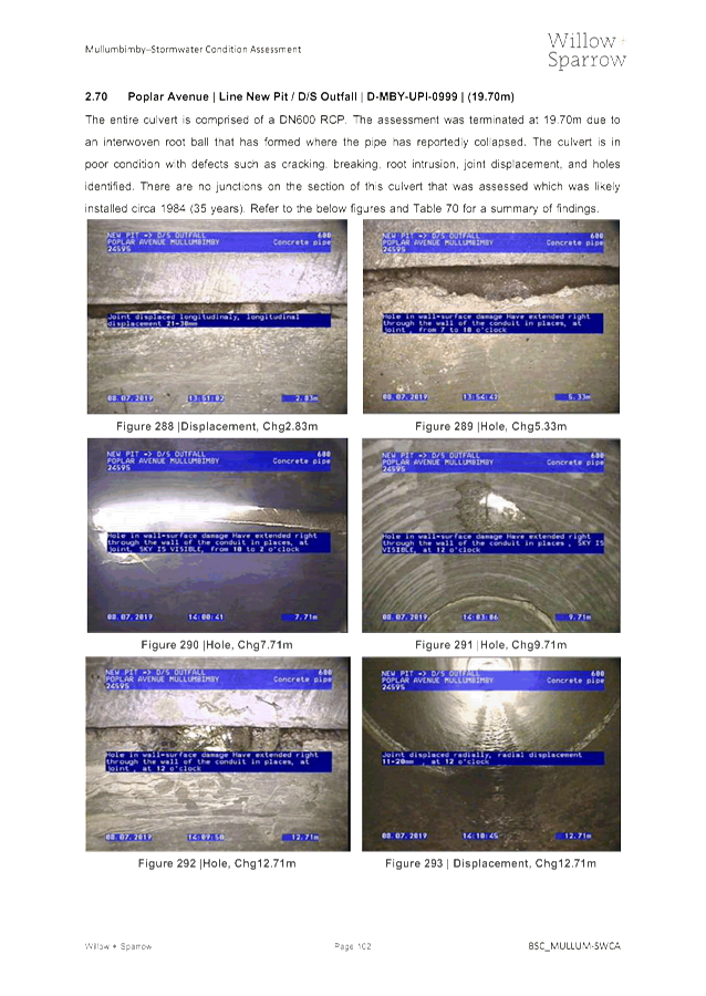
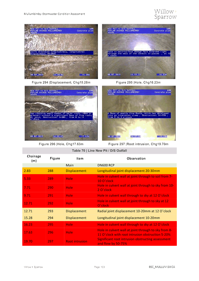
member of a Council Committee who has a pecuniary interest in any matter with
which the Council is concerned and who is present at a meeting of the Council
or Committee at which the matter is being considered must disclose the nature
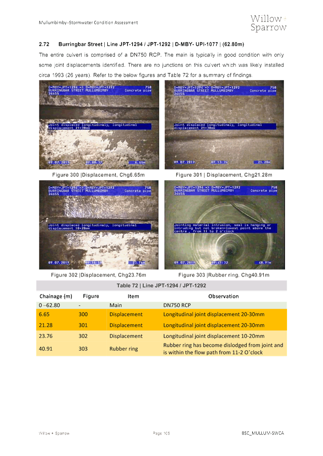
of the interest to the meeting as soon as practicable.
§ The Councillor or
member must not be present at, or in sight of, the meeting of the Council or
Committee:
(a) at any
time during which the matter is being considered or discussed by the Council or
Committee, or
(b) at any
time during which the Council or Committee is voting on any question in
relation to the matter.
No Knowledge - a person does not breach this Clause if the person did
not know and could not reasonably be expected to have known that the matter
under consideration at the meeting was a matter in which he or she had a
pecuniary interest.
Non-pecuniary Interests - Must be disclosed in meetings.
There are a broad range of options available for managing conflicts &
the option chosen will depend on an assessment of the circumstances of the
matter, the nature of the interest and the significance of the issue being
dealt with. Non-pecuniary conflicts of interests must be dealt with in at
least one of the following ways:
§ It may be appropriate
that no action be taken where the potential for conflict is minimal.
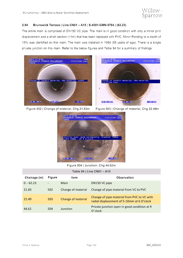
However, Councillors should consider providing an explanation of why they
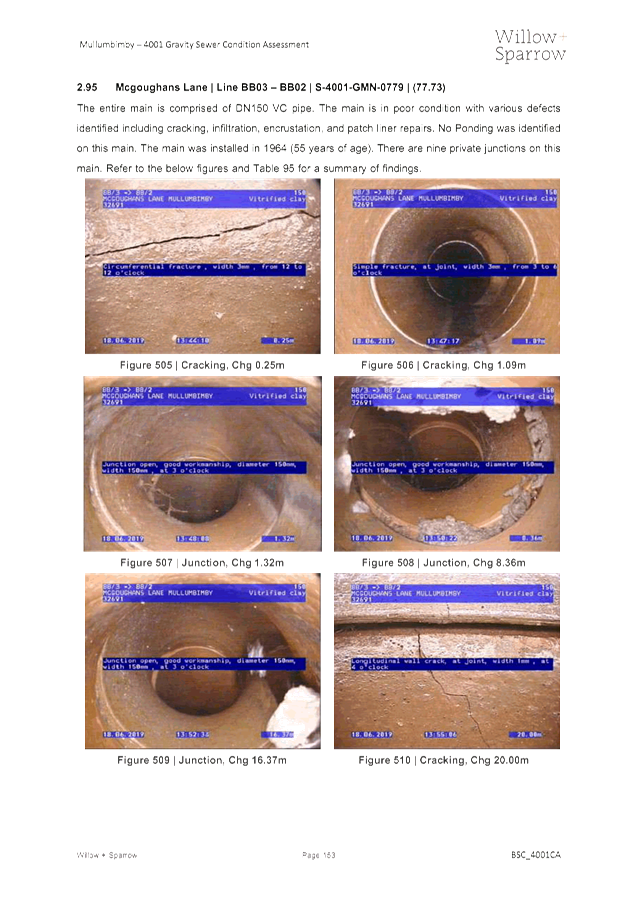
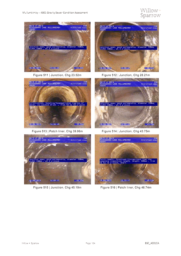
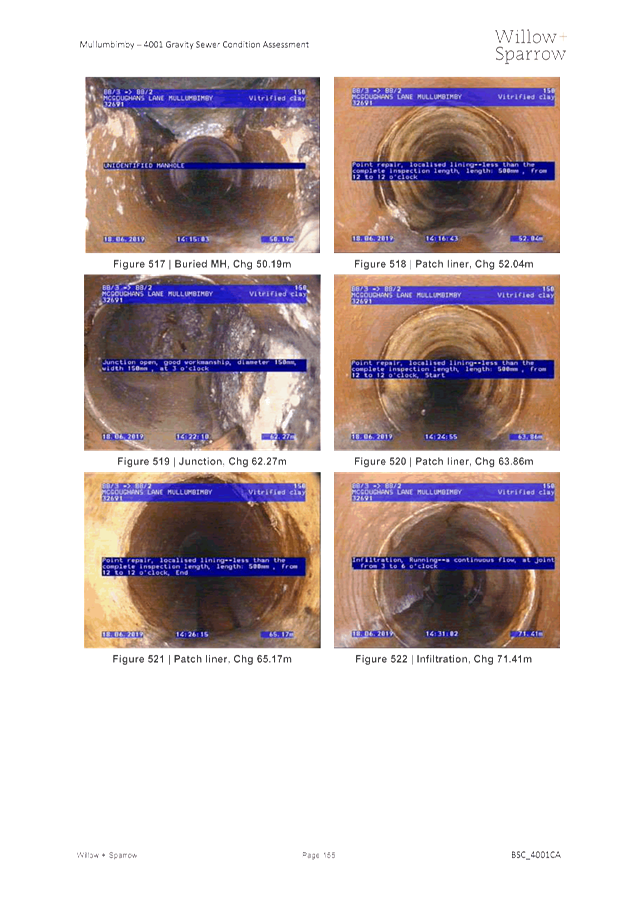
consider a conflict does not exist.
§ Limit involvement if
practical (eg. Participate in discussion but not in decision making or
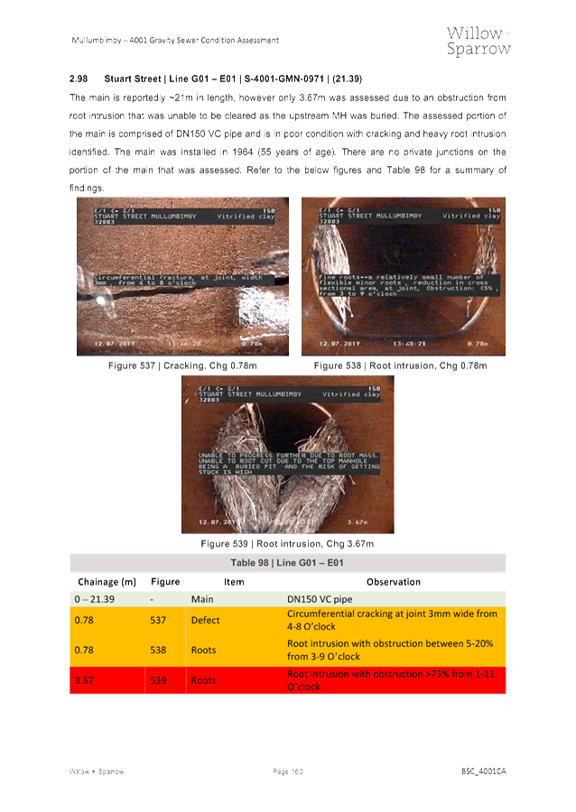
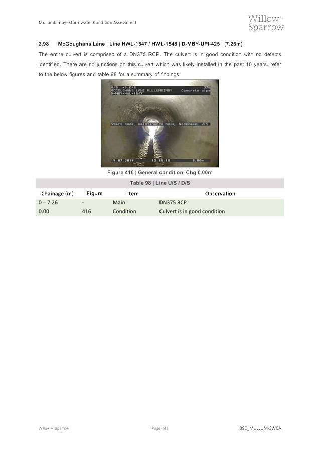
vice-versa). Care needs to be taken when exercising this option.
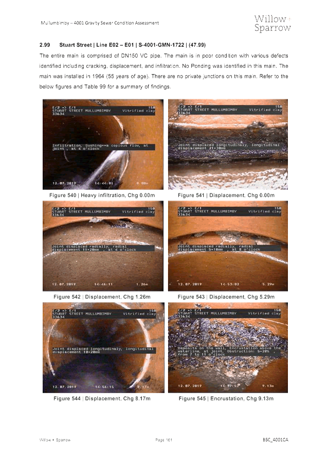
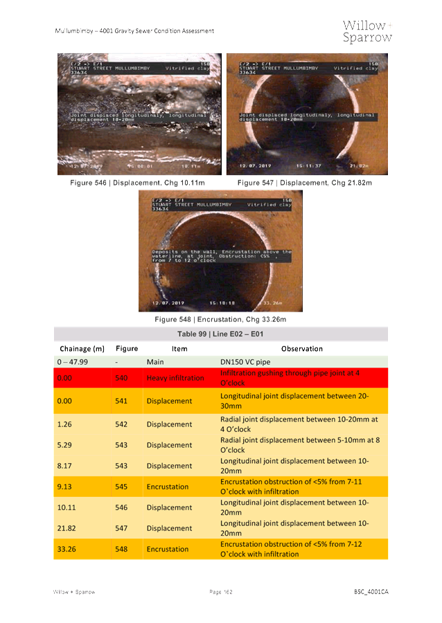
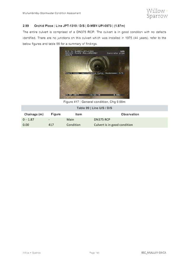
§ Remove the source of
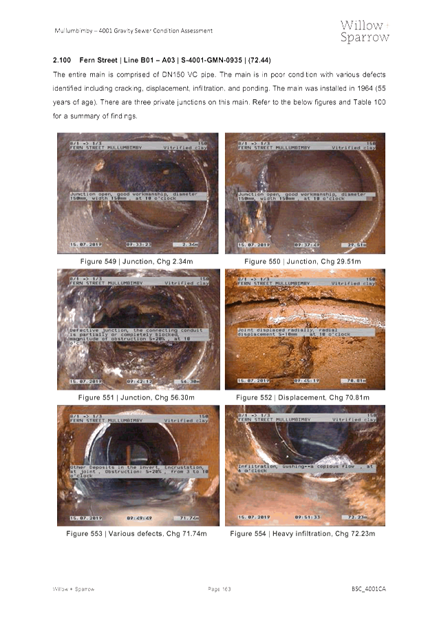
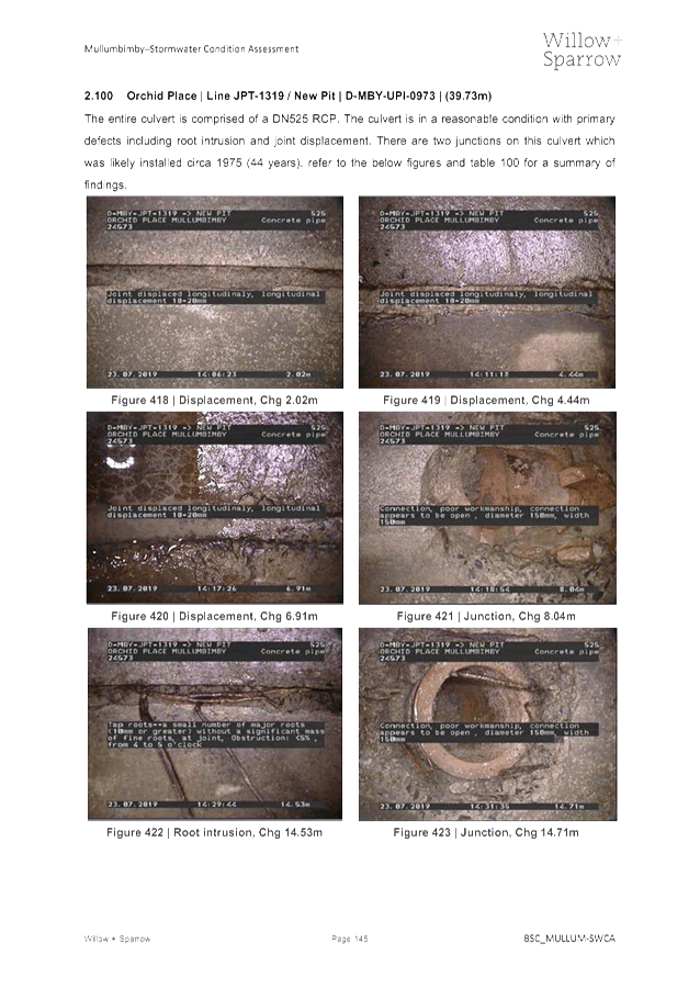
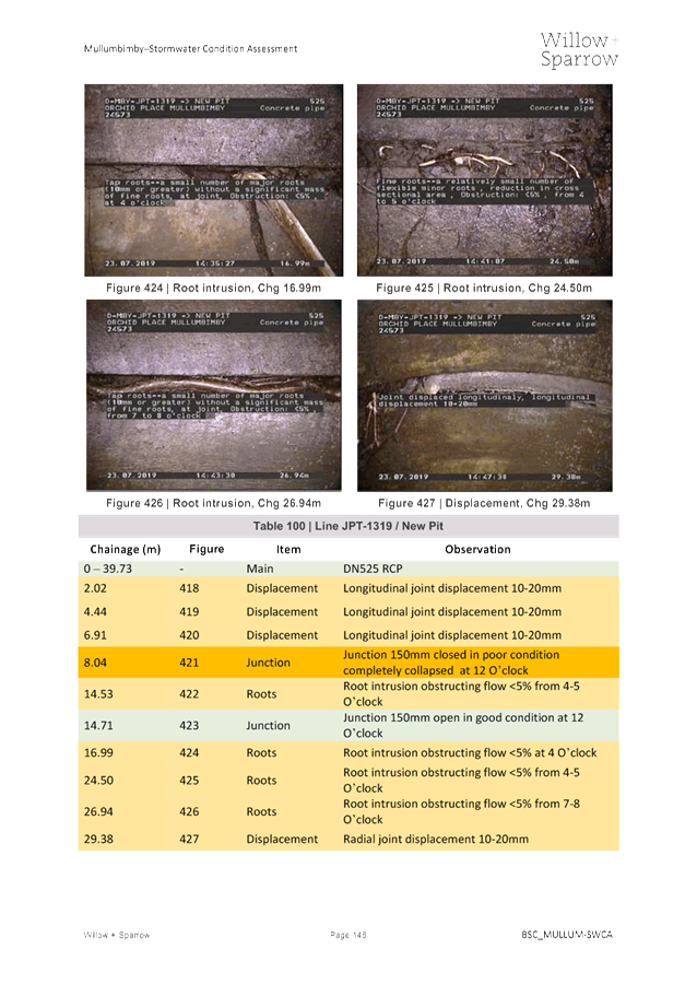
the conflict (eg. Relinquishing or divesting the personal interest that creates
the conflict)
§ Have no involvement by
absenting yourself from and not taking part in any debate or voting on the
issue as of the provisions in the Code of Conduct (particularly if you have a significant
non-pecuniary interest)
RECORDING OF VOTING ON PLANNING MATTERS
Clause 375A of the Local Government Act 1993
– Recording of voting on planning matters
(1) In this section, planning
decision means a decision made in the exercise of a function of a council
under the Environmental Planning and Assessment Act 1979:
(a) including a decision
relating to a development application, an environmental planning instrument, a
development control plan or a development contribution plan under that Act, but
(b) not including the making of
an order under that Act.
(2) The general manager is
required to keep a register containing, for each planning decision made at a
meeting of the council or a council committee, the names of the councillors who
supported the decision and the names of any councillors who opposed (or are
taken to have opposed) the decision.
(3) For the purpose of maintaining
the register, a division is required to be called whenever a motion for a
planning decision is put at a meeting of the council or a council committee.
(4) Each decision recorded in
the register is to be described in the register or identified in a manner that
enables the description to be obtained from another publicly available
document, and is to include the information required by the regulations.
(5) This section extends to a
meeting that is closed to the public.
Water, Waste and Sewer Advisory Committee
Meeting
BUSINESS OF MEETING
1. Apologies
2. Declarations of Interest
– Pecuniary and Non-Pecuniary
3. Adoption of Minutes from
Previous Meetings
3.1 Water,
Waste and Sewer Advisory Committee Meeting held on 10 October 2019
3.2 Extraordinary
Water, Waste and Sewer Advisory Committee Meeting held on 14 November 2019
4. Staff Reports
Infrastructure Services
4.1 Inflow
and Infiltration - Sewer Asset Management........................................................... 4
4.2 Effects
of water mining in Byron and surrounding shires on groundwater resources.. 553
4.3 Condition
9. Additional Load at Byron STP................................................................... 748
4.4 Byron
Bay Integrated Water Management Reserve.................................................... 783
4.5 Nutrient
Loading in the Belongil..................................................................................... 794
Staff Reports - Infrastructure Services 4.1
Staff Reports - Infrastructure Services
Report No. 4.1 Inflow
and Infiltration - Sewer Asset Management
Directorate: Infrastructure
Services
Report
Author: Jason
Stanley, Systems Planning Officer
File No: I2019/2060
Summary:
Following a review of the 30 year capital works plan, it was
identified that various gravity sewer assessments within the Mullumbimby area
were scheduled for renewal over the coming years. It was agreed that
condition assessments of both the gravity sewer and adjacent stormwater assets
would be undertaken to verify whether these assets were in a state that
warranted their renewal.
The assessments in Mullumbimby have since been completed and
the findings identified that various assets are presenting a high risk to
Council that should be remedied in a risk based manner. This report
presents the findings of these assessments as well as identifying the proposed
way forward with regards to the ongoing management of the gravity sewer and
stormwater network.
|
RECOMMENDATION:
That Committee note the report.
|
Attachments:
1 Mullumbimby
Catchment 4001 - Sewer Main Inflow and Infiltration Report - Willow and
Sparrow, E2019/69598 , page 12⇩ 
2 Mullumbimby
Catchment 4001 - Sewer Maintenance Hole Inflow and Infiltration Report - Willow
and Sparrow.pdf, E2019/80301 , page 241⇩ 
3 Mullumbimby
Catchment 4001 - Storm Water Main Inflow and Infiltration Report - Willow and
Sparrow, E2019/71131 , page 325⇩ 
4 Final
Stormwater MH condition assessment report.pdf, E2019/80295 , page 530⇩ 
REPORT
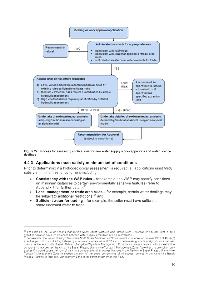
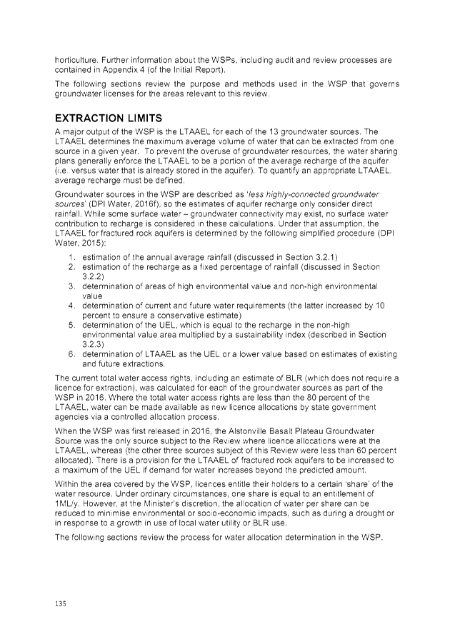
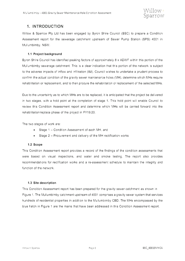
1. Introduction
This report provides a summary of
the findings relating to the sewer infrastructure that is located within sewer
catchment 4001 in Mullumbimby which accounts for approximately 4km of the 195km
gravity sewer network. The intent of this report is to provide a summary of the
findings from the condition assessment works within Mullumbimby, present the
subsequent recommendations from these assessments and proposal for the ongoing
management of the remainder of the sewer network.
2. Background
Inflow and
Infiltration (I&I) is the process of groundwater and stormwater entering
into the sewer network.
Following a
review of the 30 year capital program, it was identified that 40 gravity sewer
mains within the Mullumbimby catchment were proposed for renewal within the
2022-2031 horizon. This prompted some flow monitoring of the network to
identify if I&I was an issue which is a high level indication of the
networks condition. It was identified that I&I was evident, hence detailed
investigations were undertaken to determine each individual assets overall
condition and consequence of failure scores to establish the subsequent overall
risk rating.
3. Scope
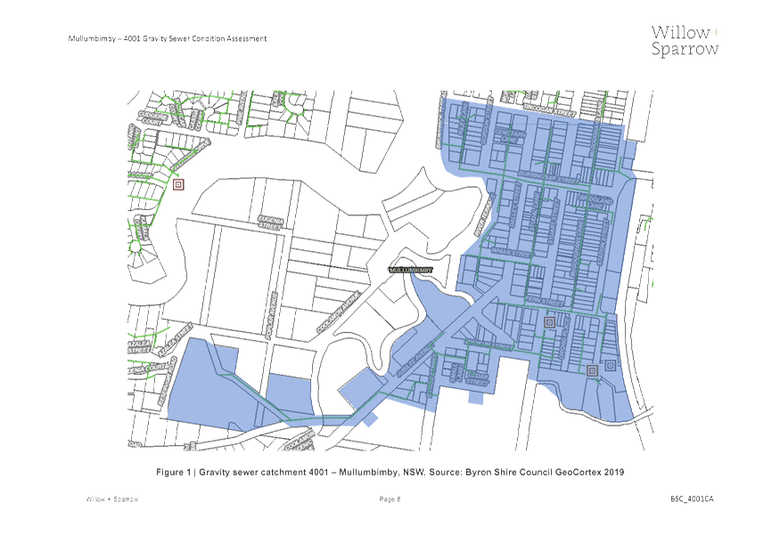
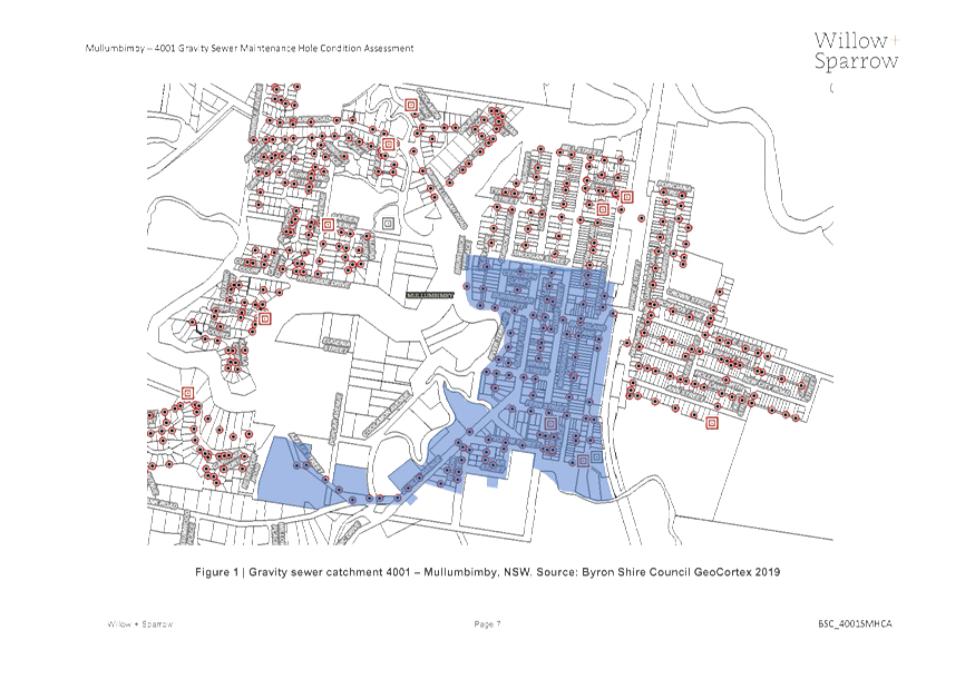
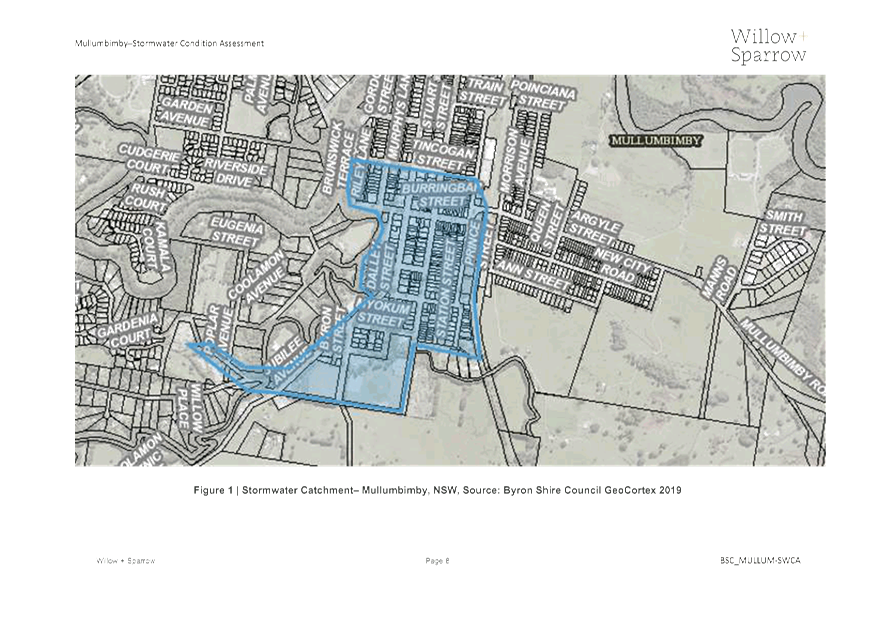
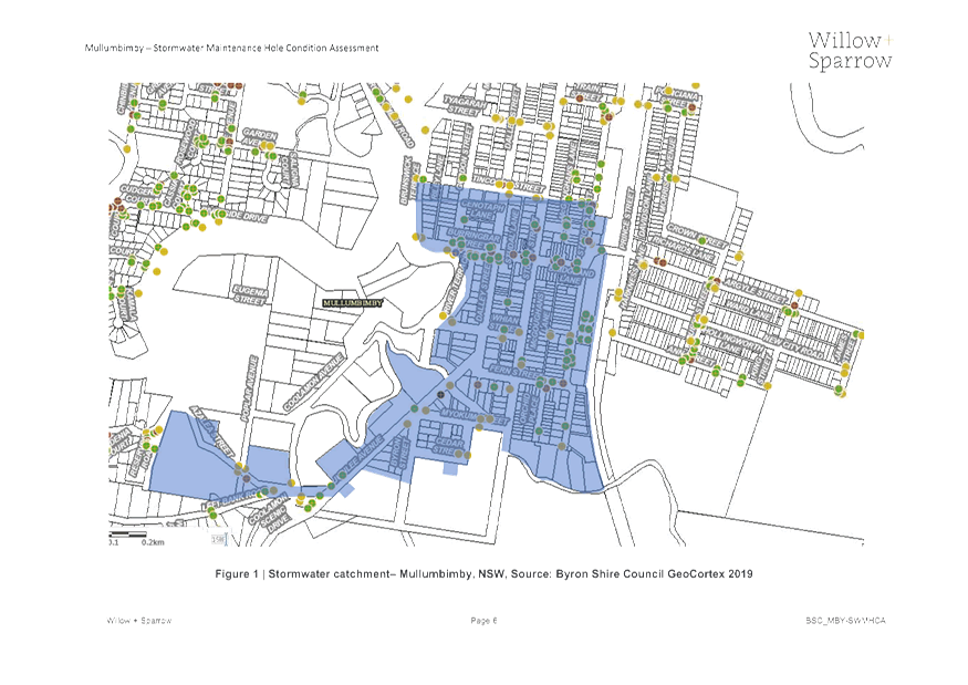
3.1 Location
The current scope
of works for this project has focused on a small catchment of the gravity sewer
network upstream of sewer pump station (SPS) 4001 within Mullumbimby including
the stormwater network encompassed by the blue hatch in the below map.
Mullumbimby is a low lying town that is located adjacent to the Brunswick
River. This portion of the sewer catchment consists largely of Vitrified
Clay (VC) pipe which is prone to brittle failure (cracking) and is therefore
subject to high rates of I&I.
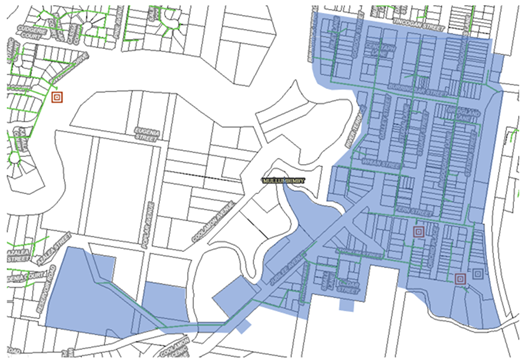
Figure 1 –
Mullumbimby Condition Assessment Scope Extent
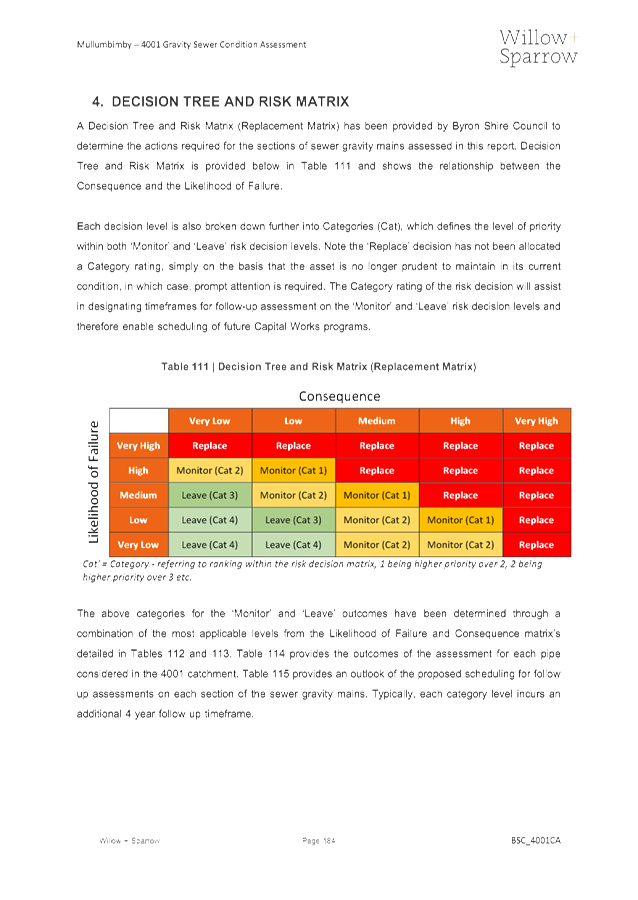
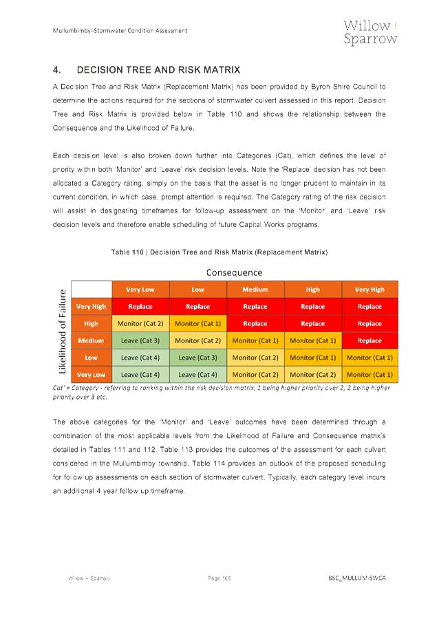
3.2 Condition
Assessment
Following the
conclusive data obtained from the flow monitoring that identified I&I as an
issue for this portion of Mullumbimby’s sewage catchment, detailed
assessments of both the sewage and stormwater network were undertaken.
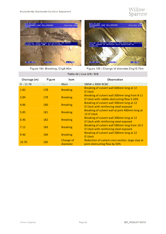
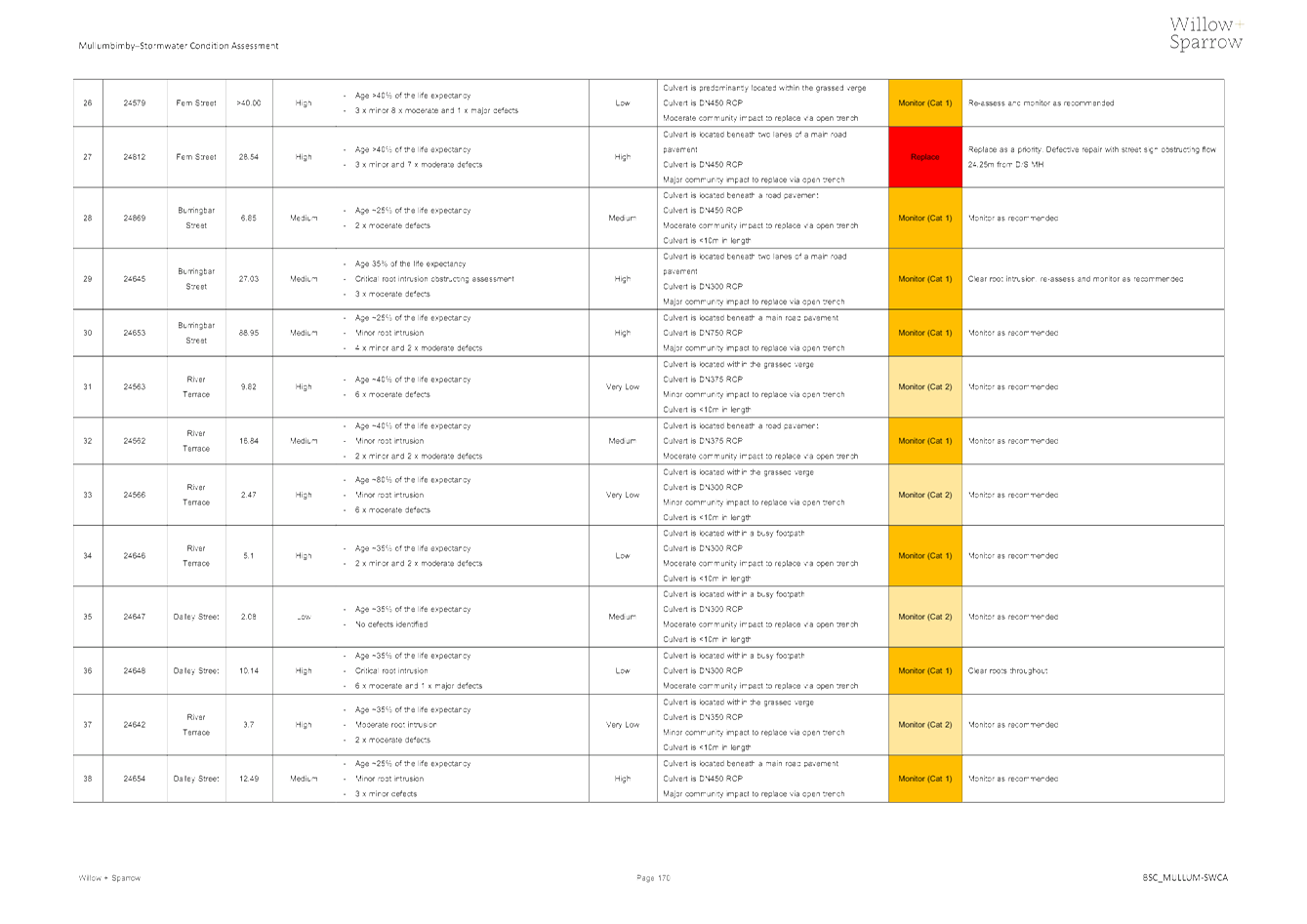
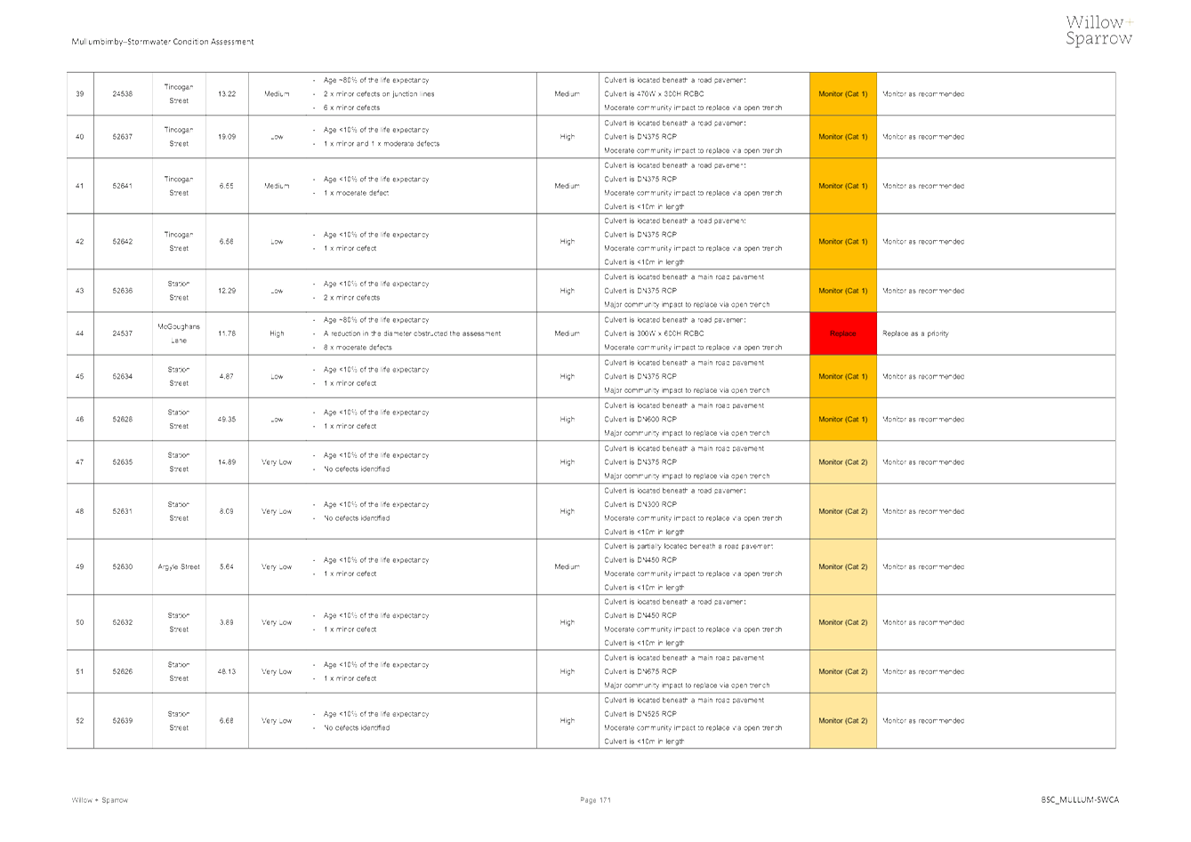
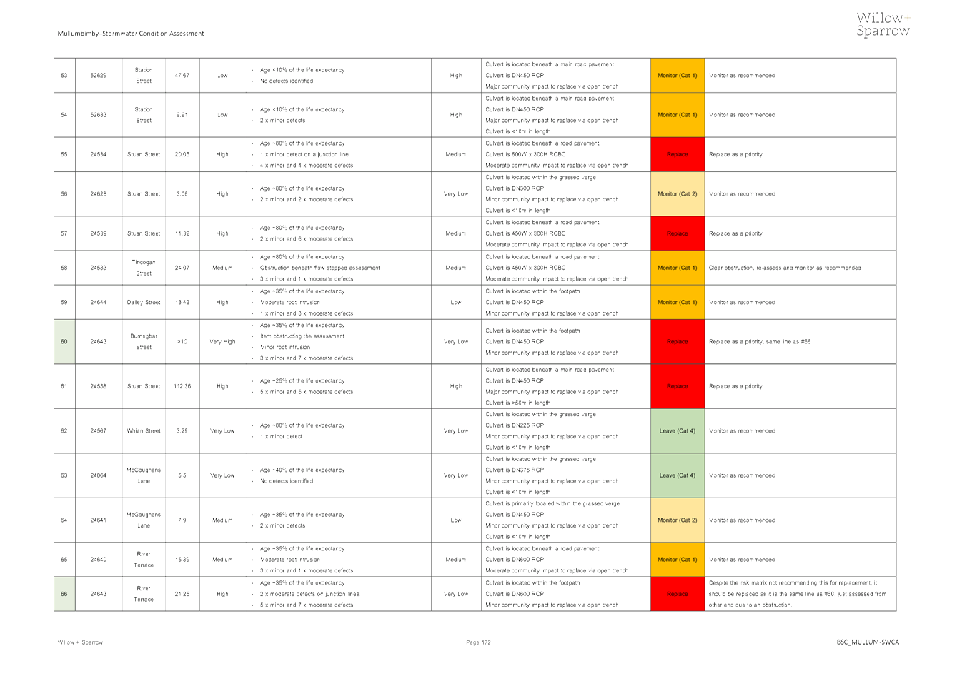
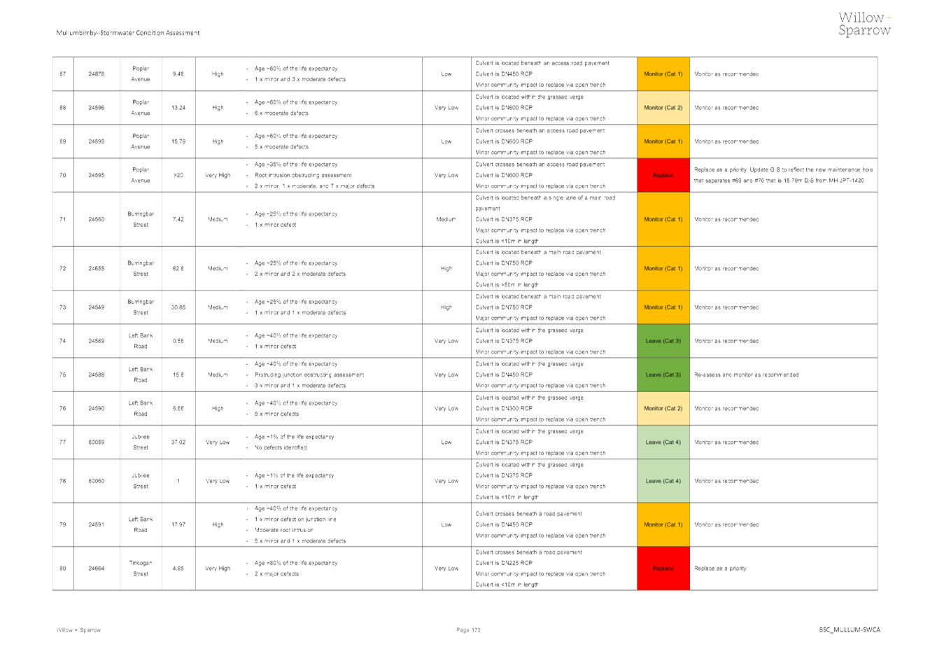
These assessments consisted of CCTV of sewer mains and stormwater culverts,
visual inspections of maintenance structures, as well as smoke testing to
identify potential points of entrance and incorrect stormwater connections to
sewer mains.
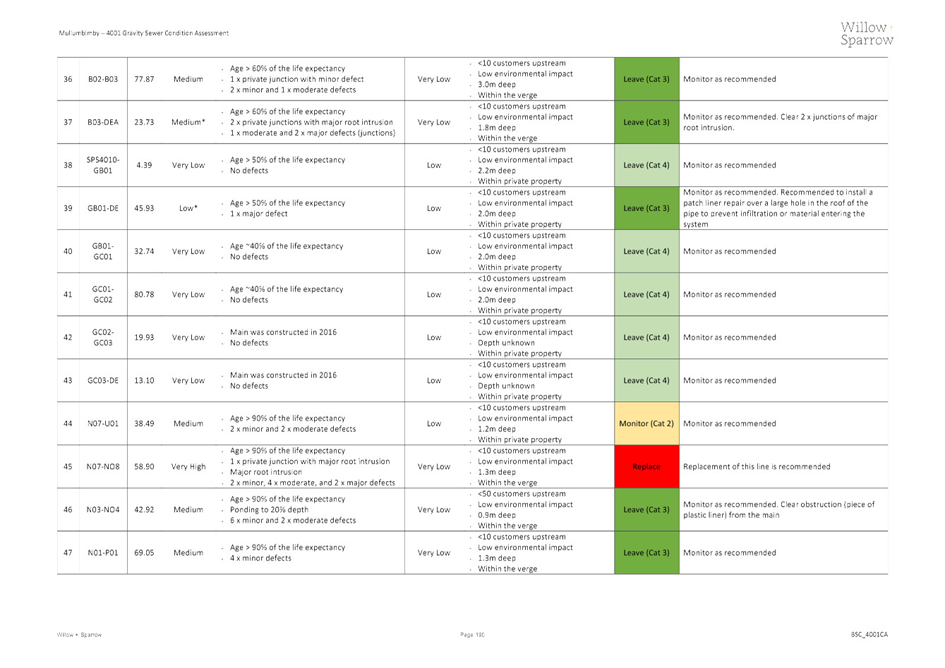
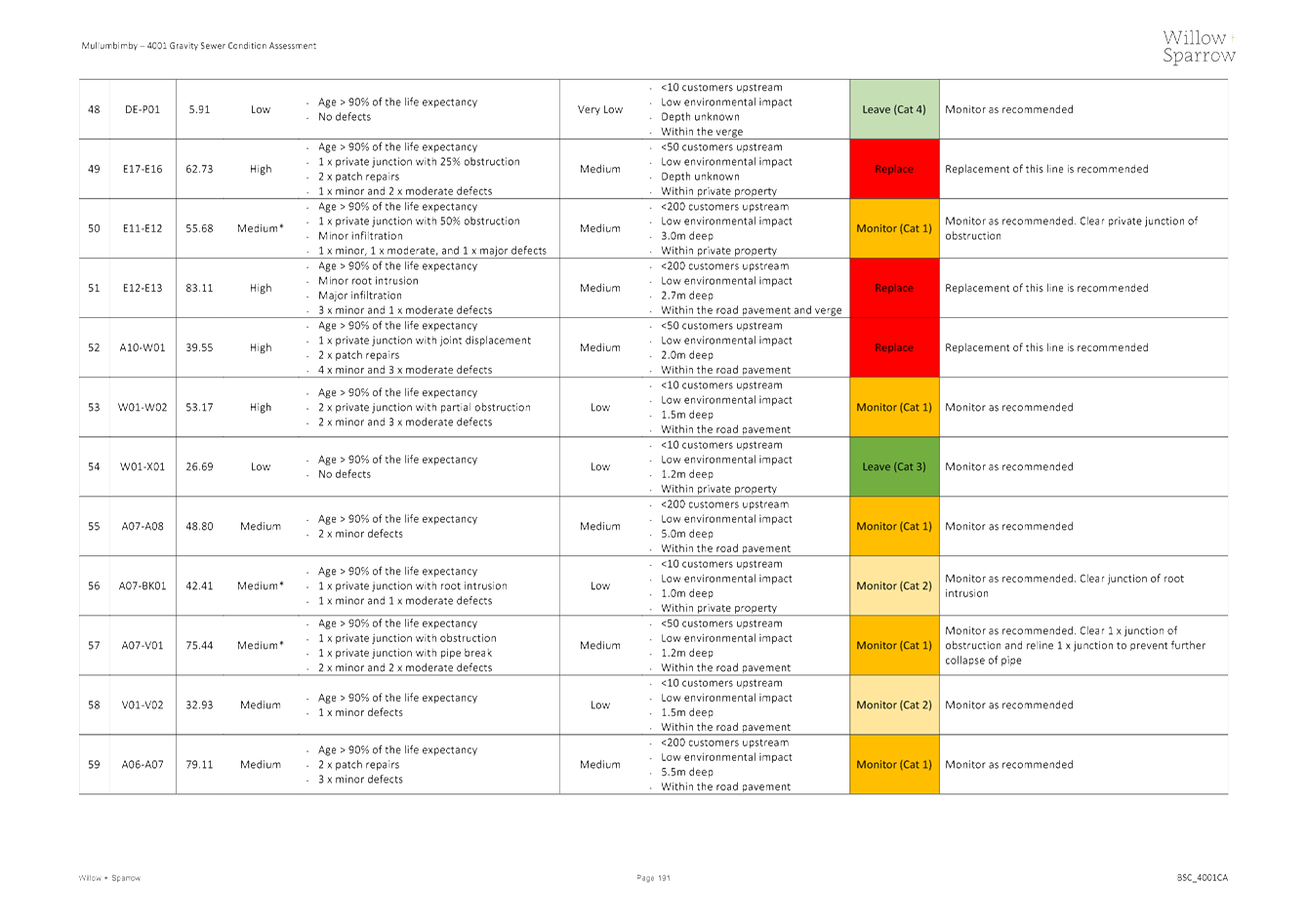
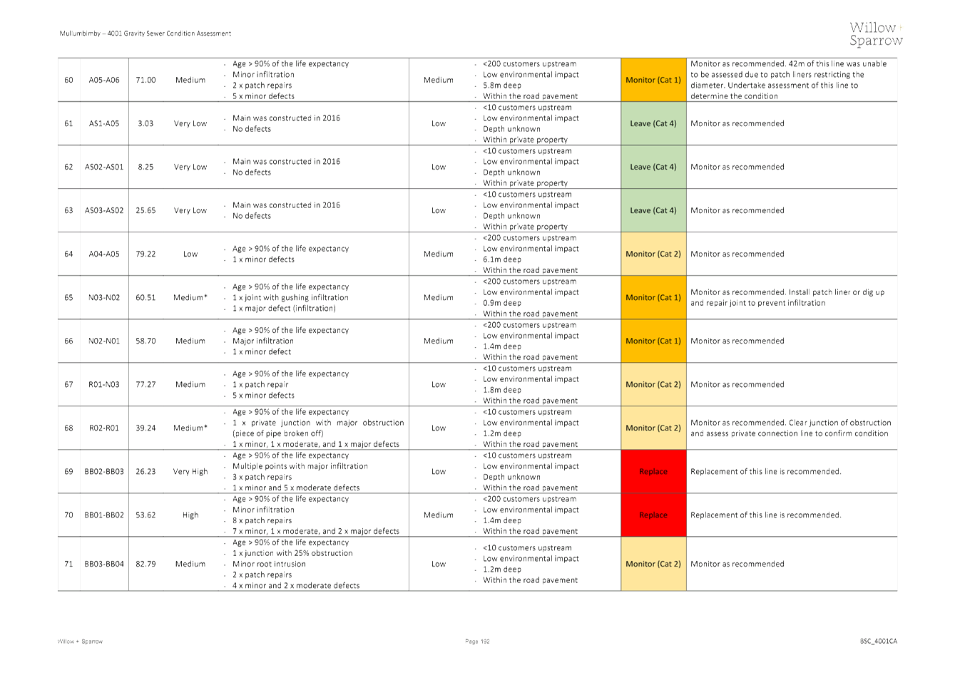
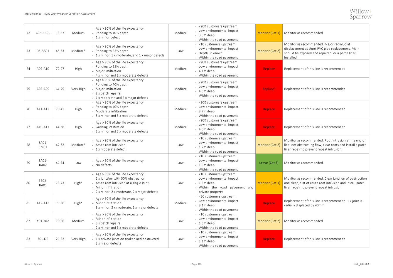
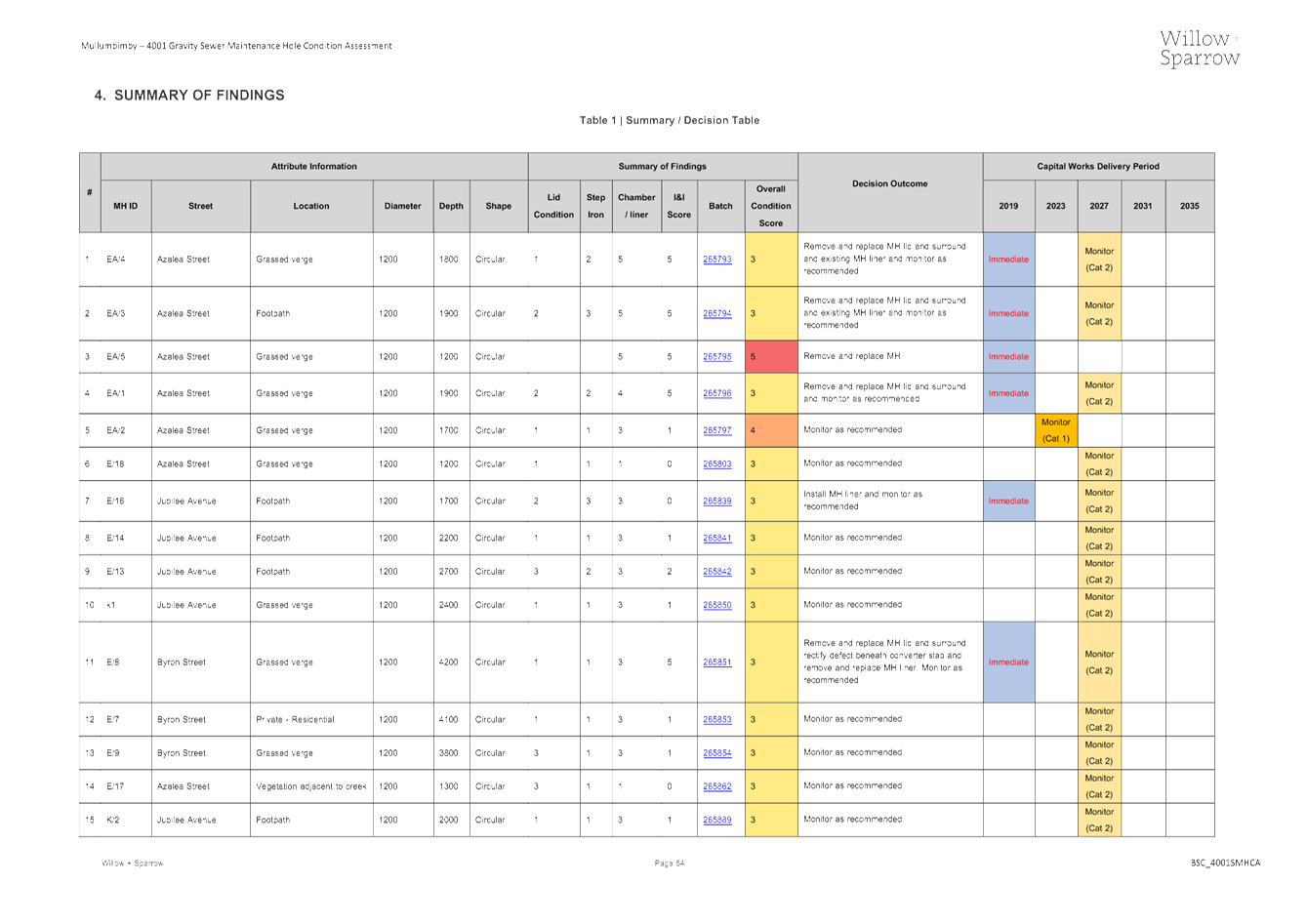
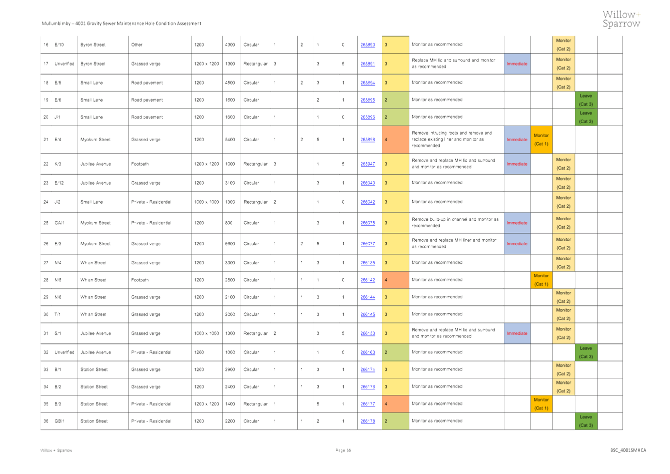
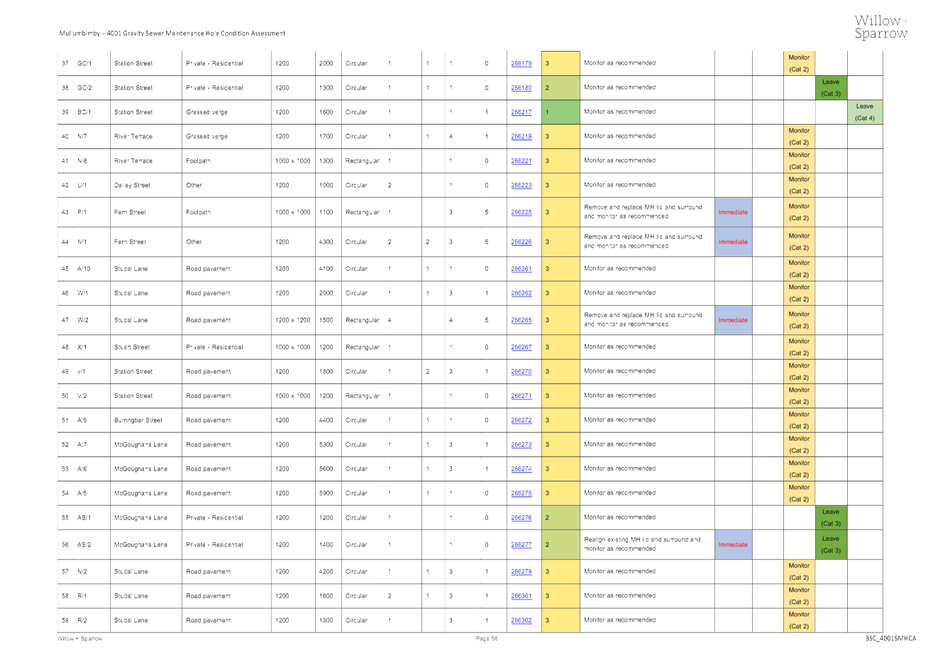
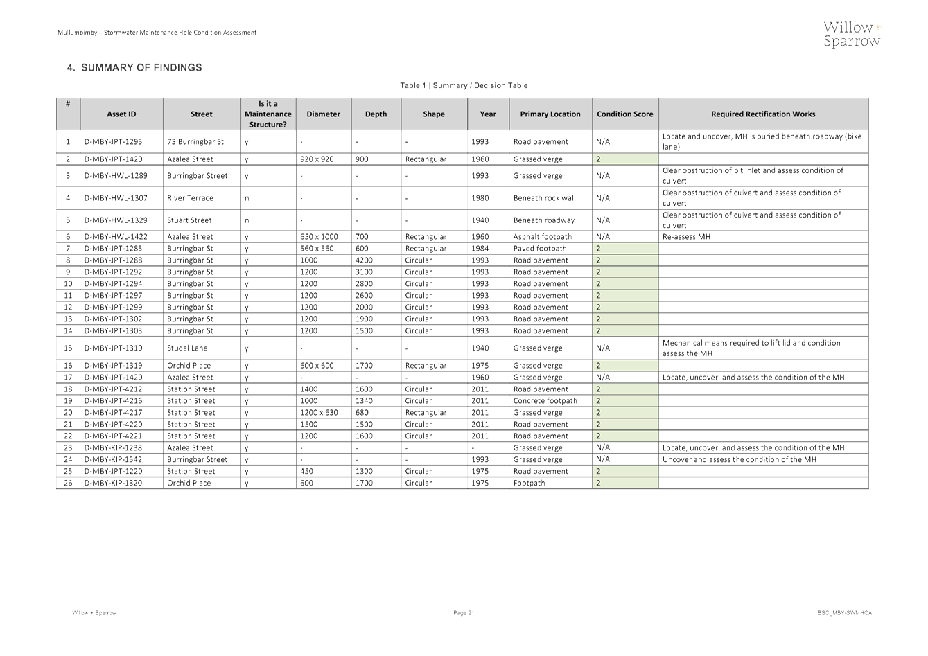
The findings from
the above assessments have all been documented in detailed condition assessment
reports which can be found on HPE content manager (E2019/69598, E2019/80301,
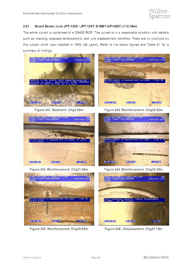
E2019/71131, and E2019/80295). These condition assessment reports provide
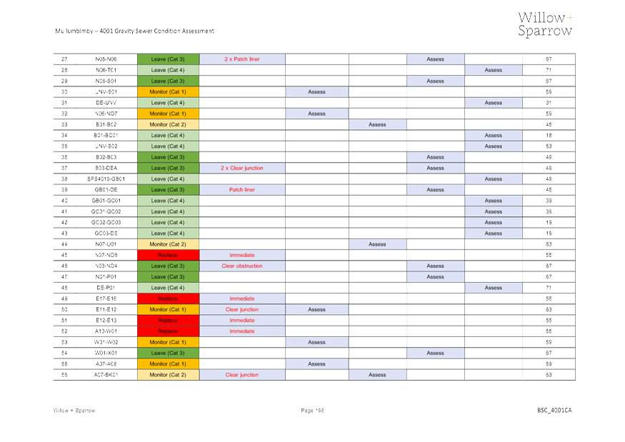
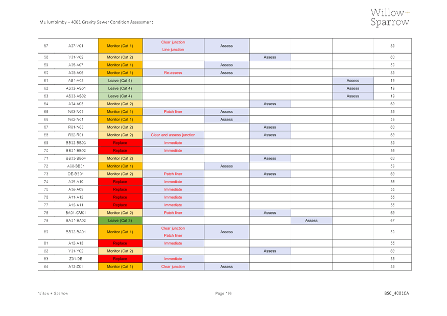
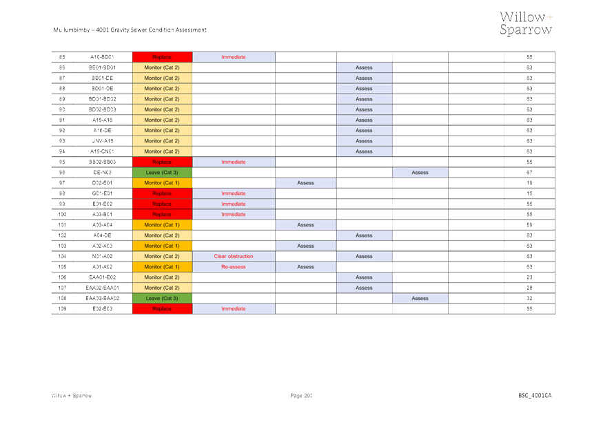
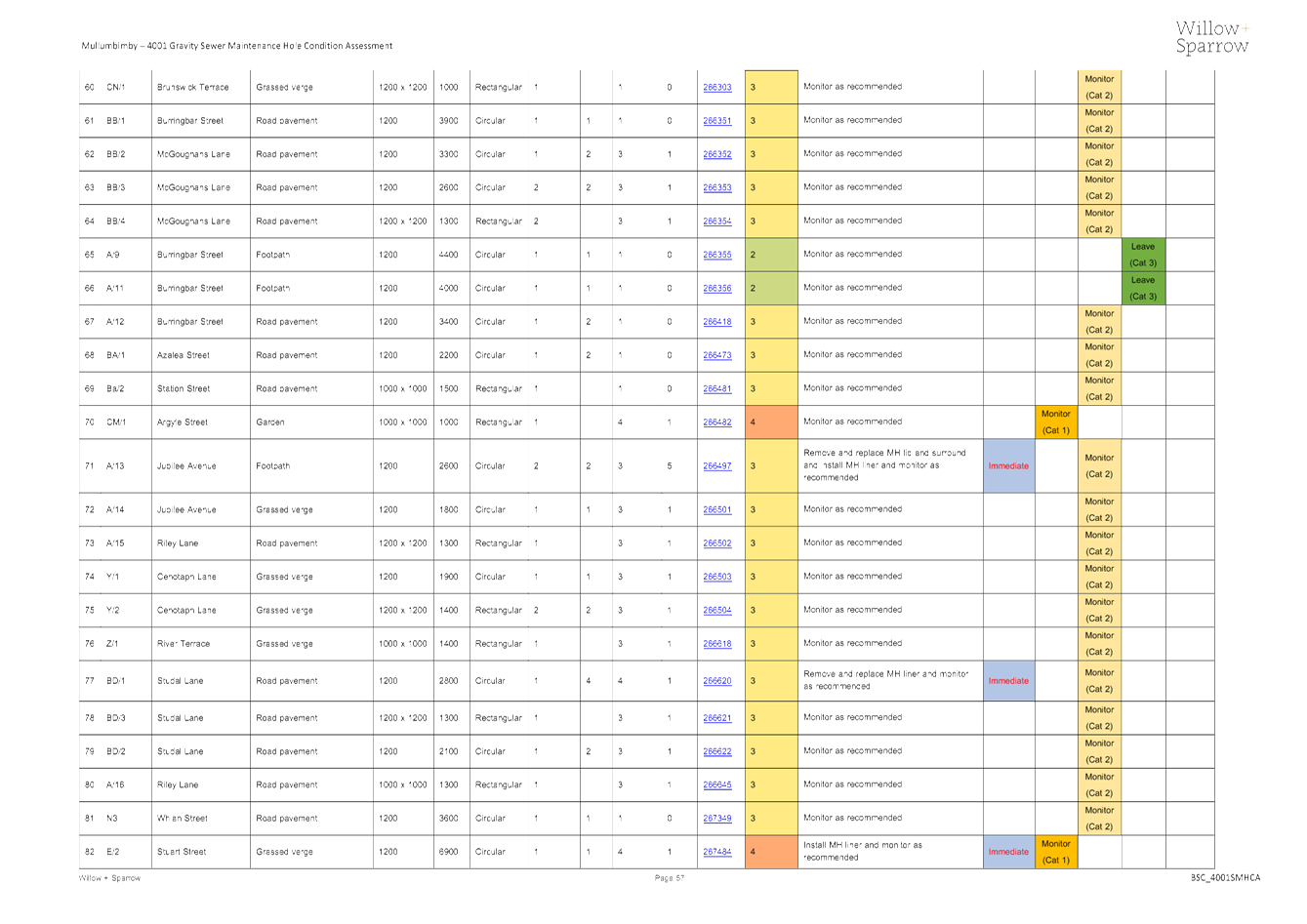
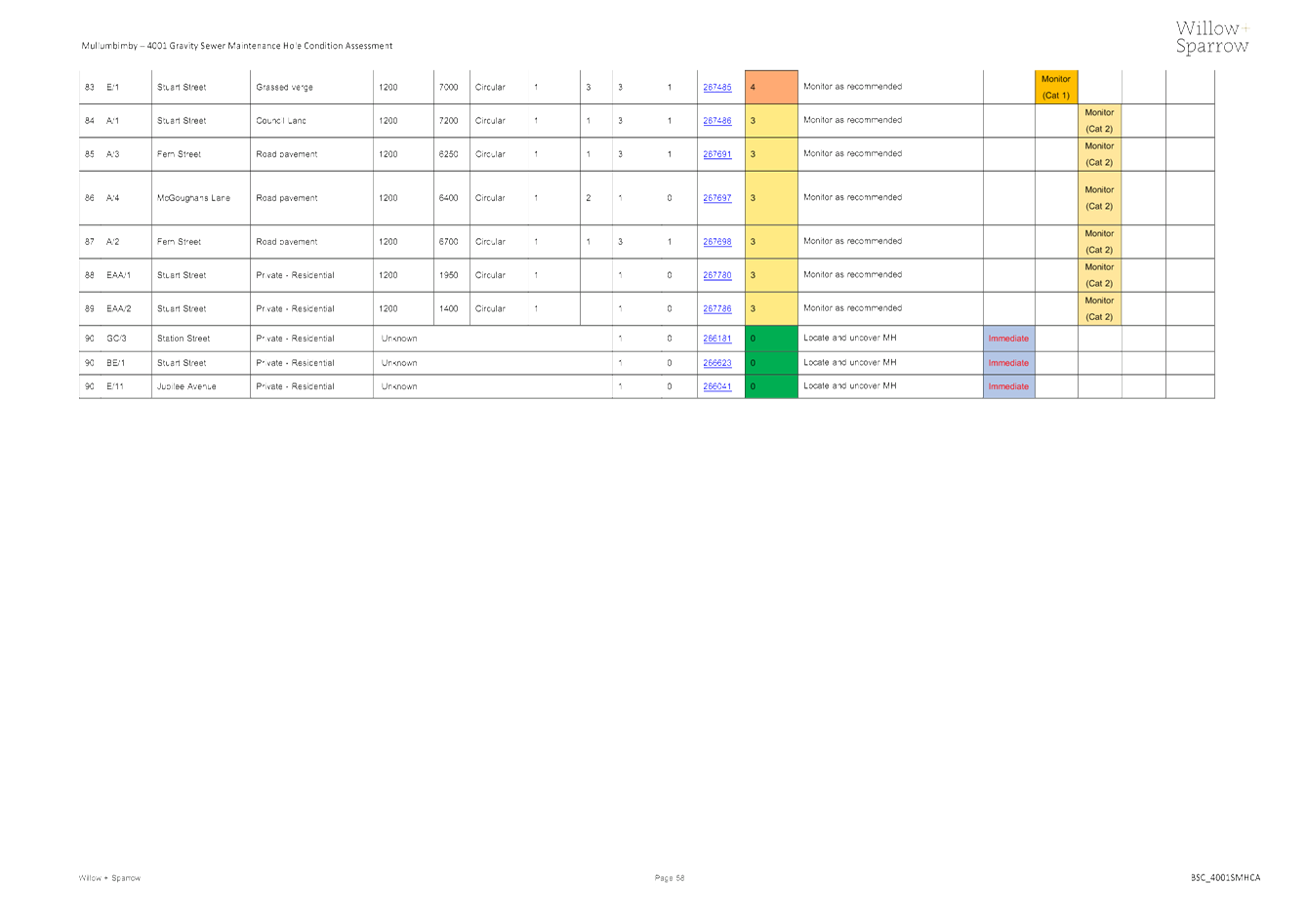
a summary of each assets condition score. Each asset was assigned a
consequence of failure based on the impact of the asset’s failure and
subsequent repair/replacement which then allowed an overall risk rating to be
assigned. With these risk scores being considered, capital renewal and minor
rectification works have been prioritised as well as a return schedule for the
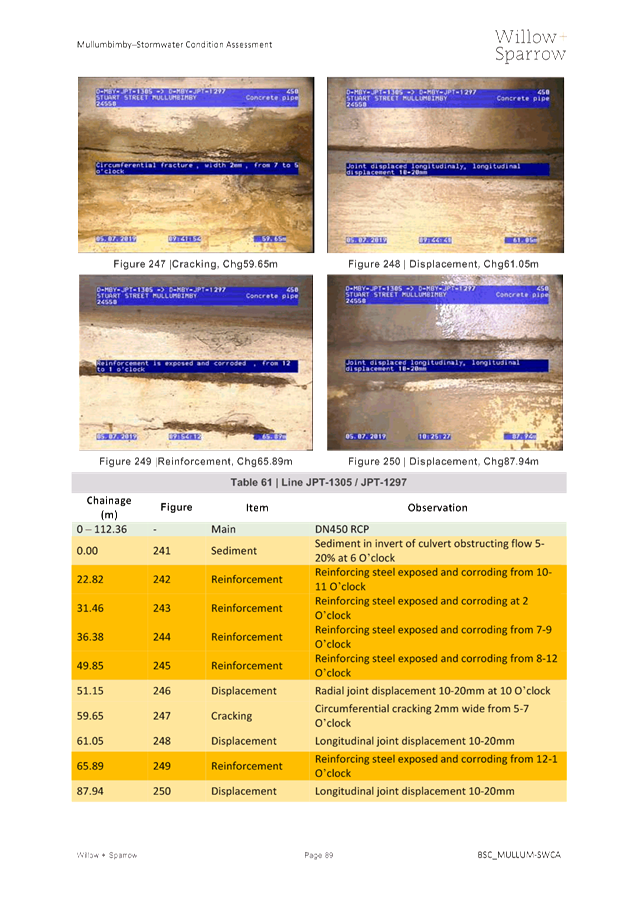
future assessment of each asset.
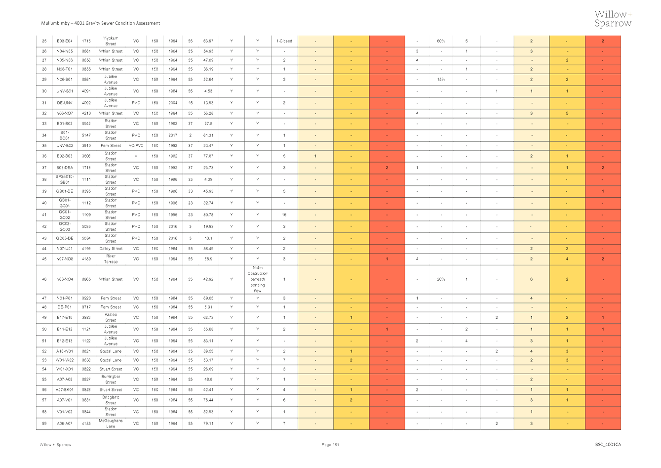
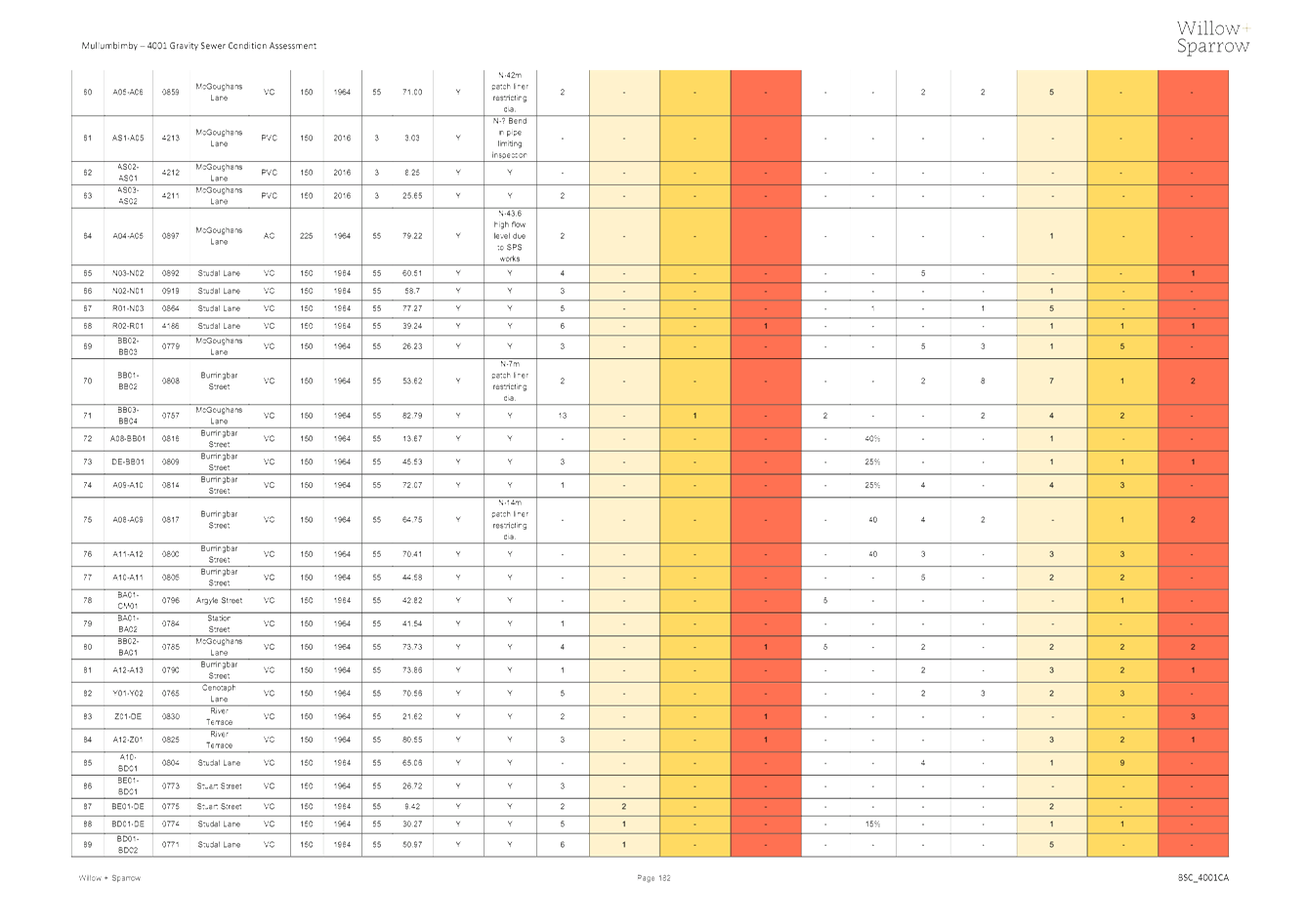
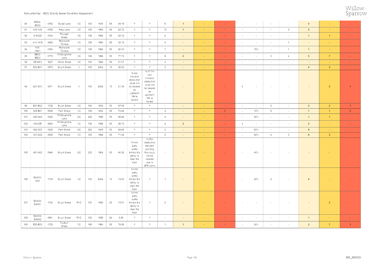
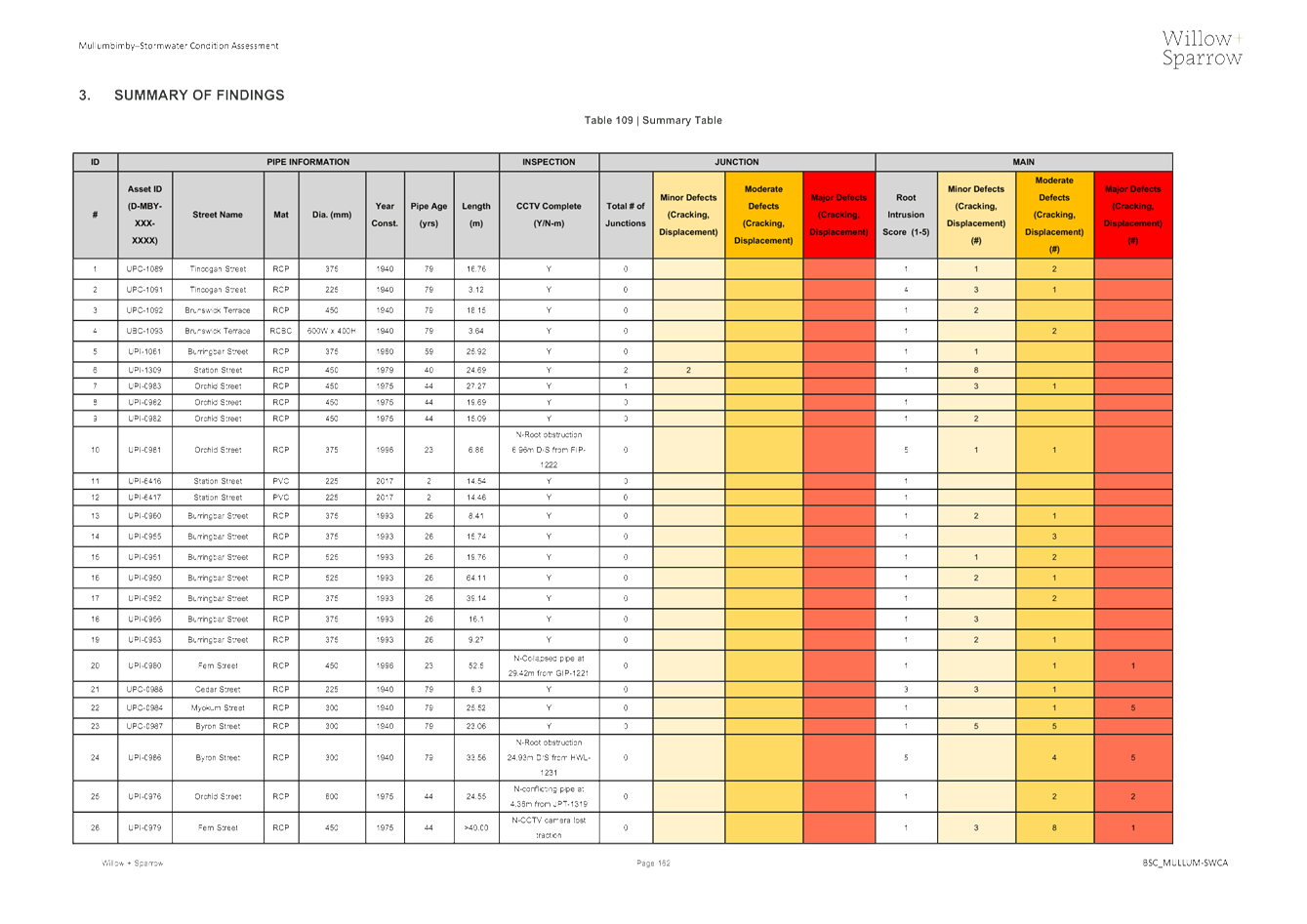
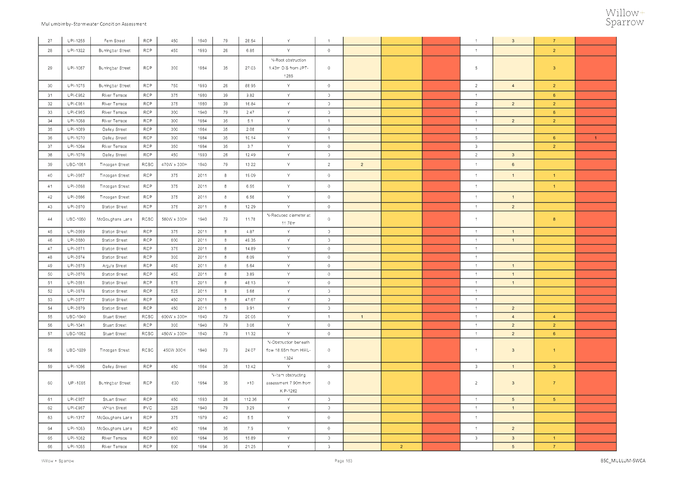
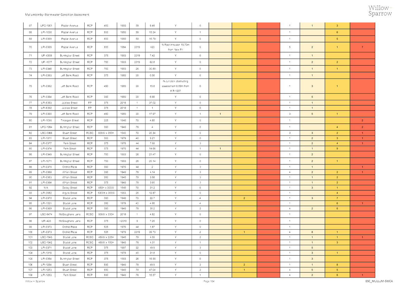
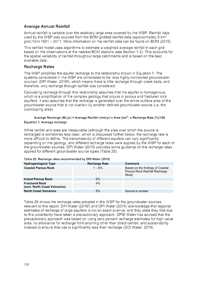
4. Mullumbimby
Assessment Findings
4.1 Overall
Asset Risk
In total there were
109 sewer mains and 107 stormwater culverts that were assessed including the
associated maintenance holes. It was apparent through the development of the
condition assessment reports that the stormwater culverts and sewer mains that
were initially constructed in the 1940s and 1960s respectively were subject to
significant deterioration and had not been sufficiently maintained. Below are
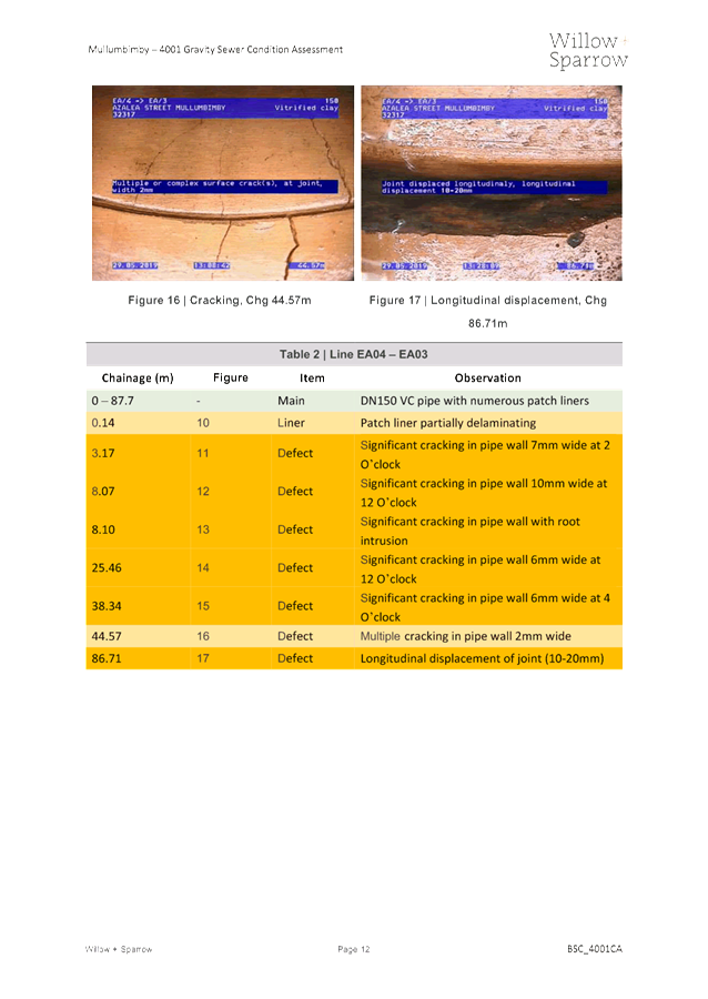
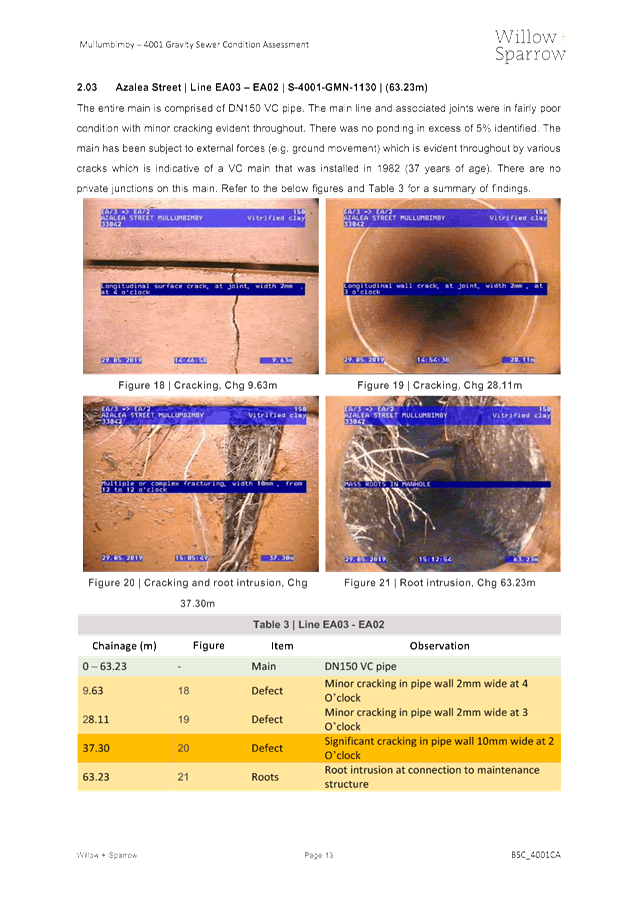
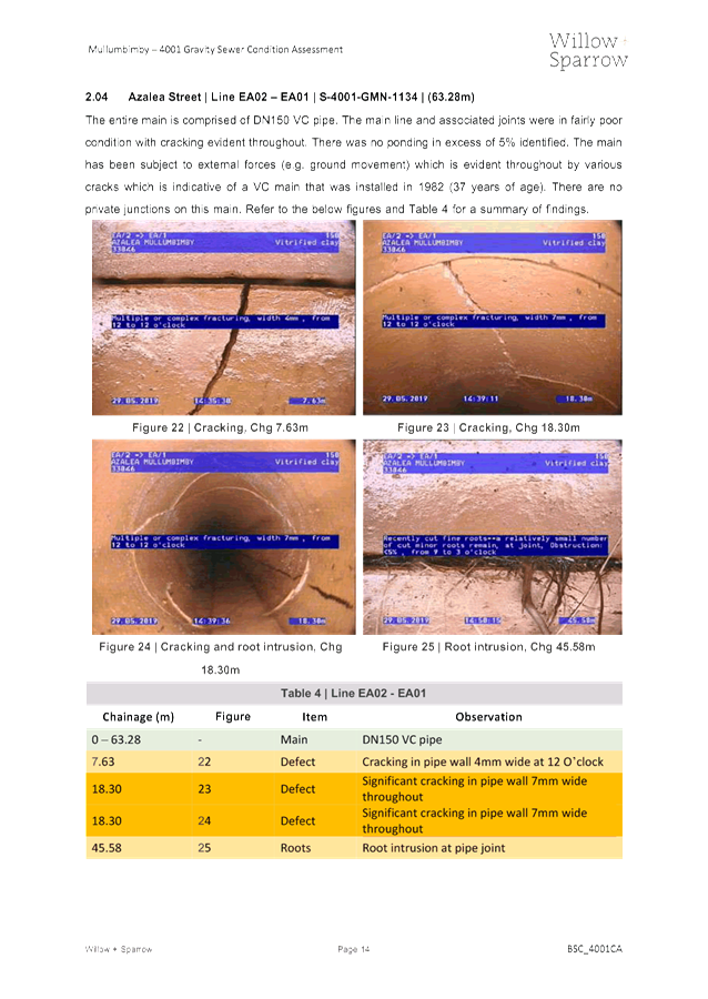
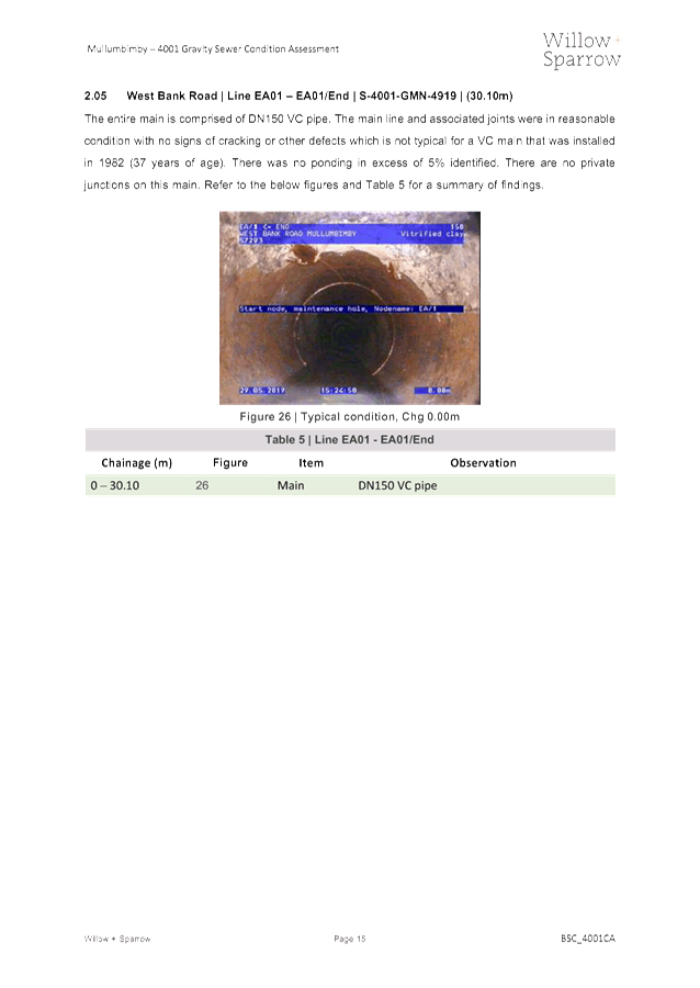
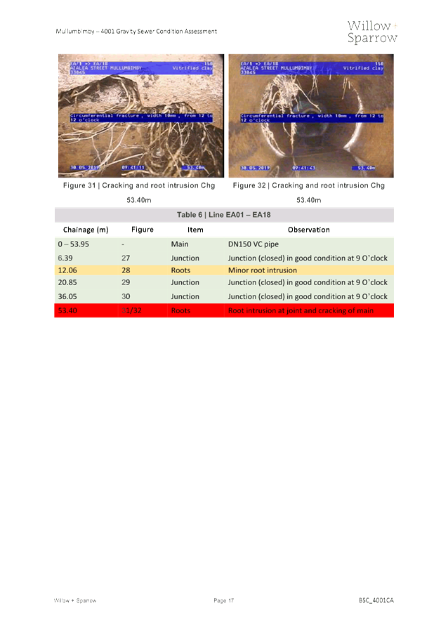
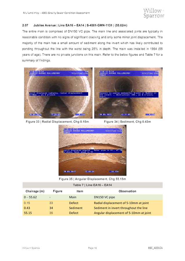
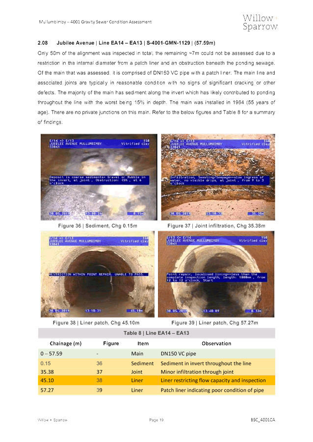
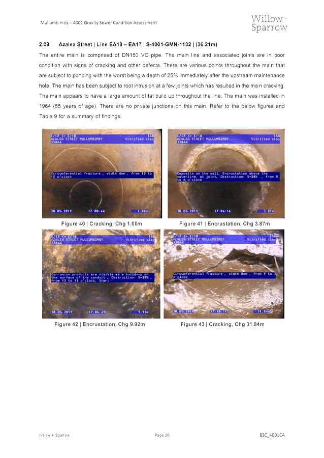
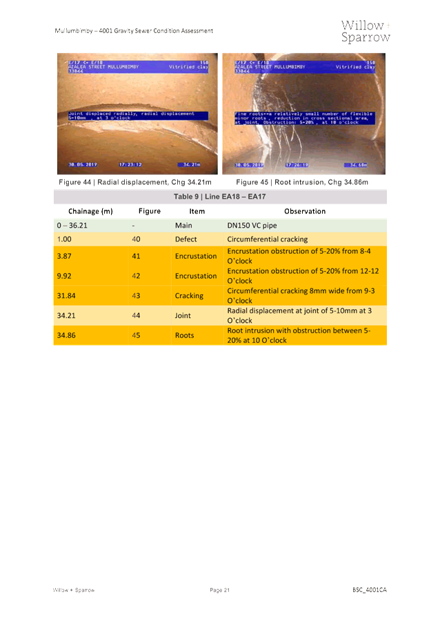
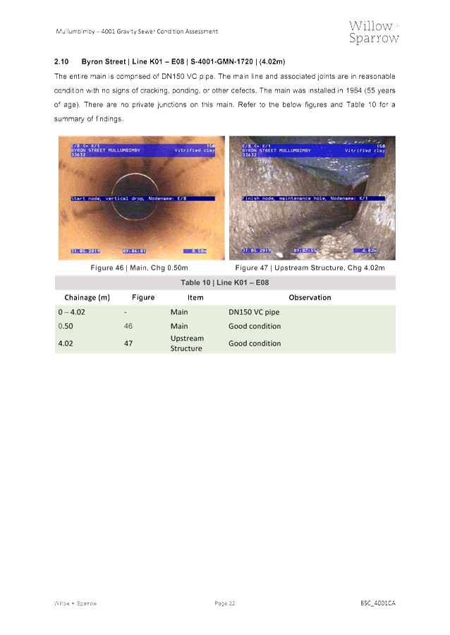
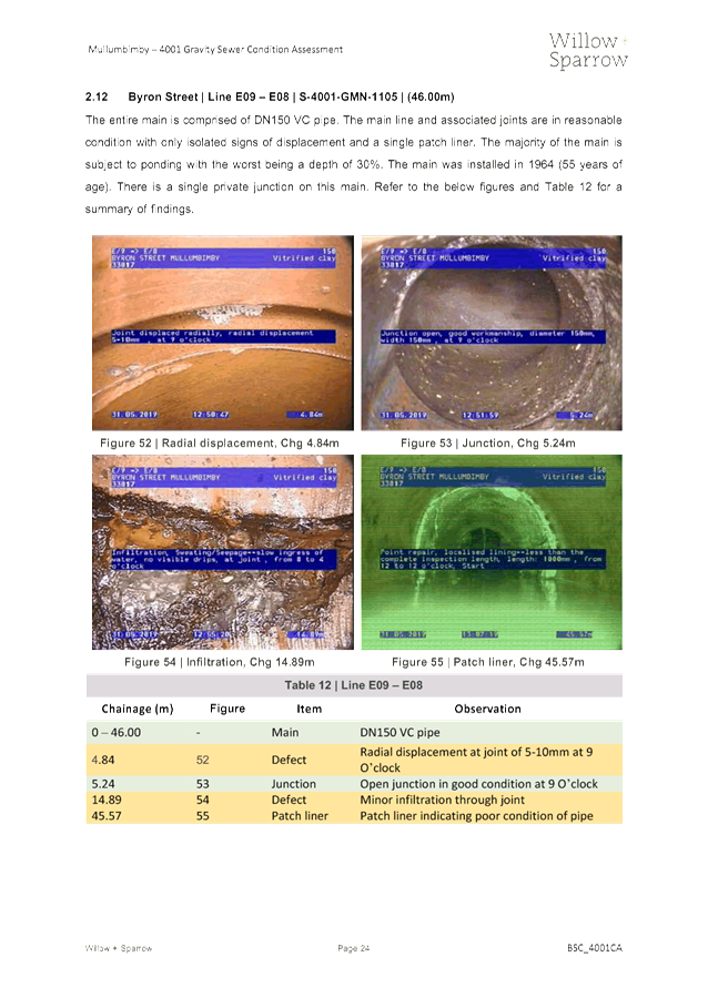
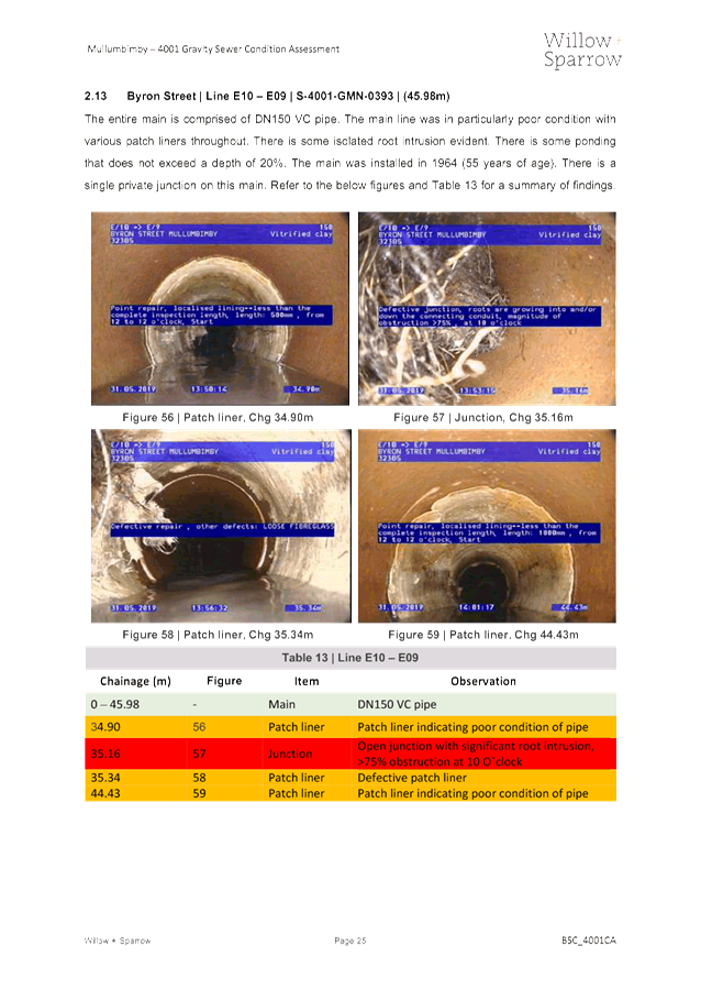
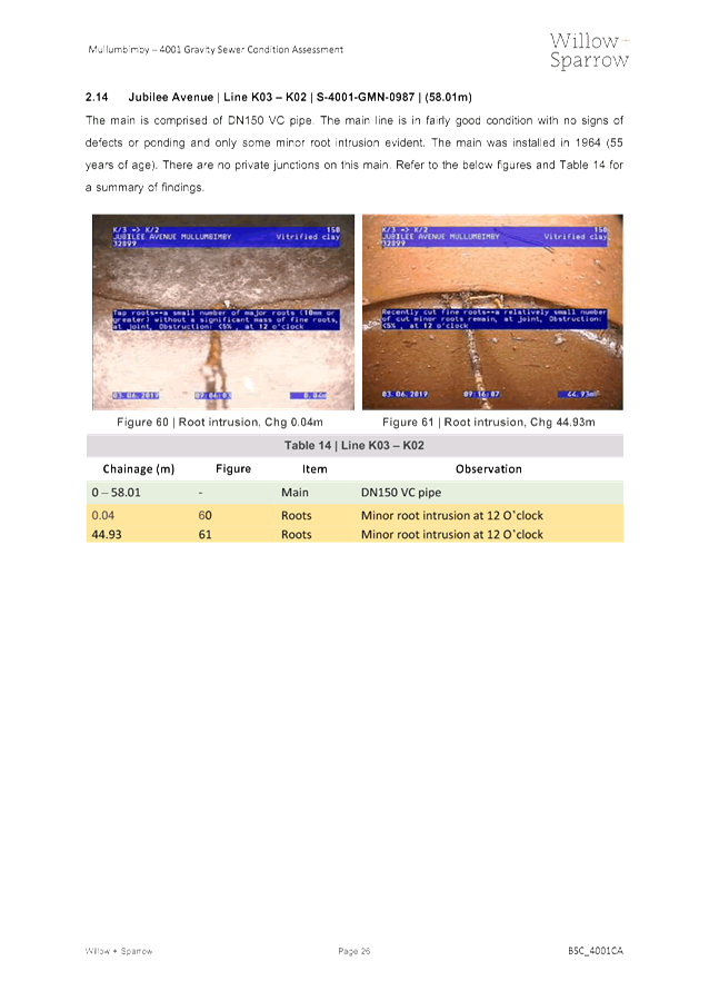
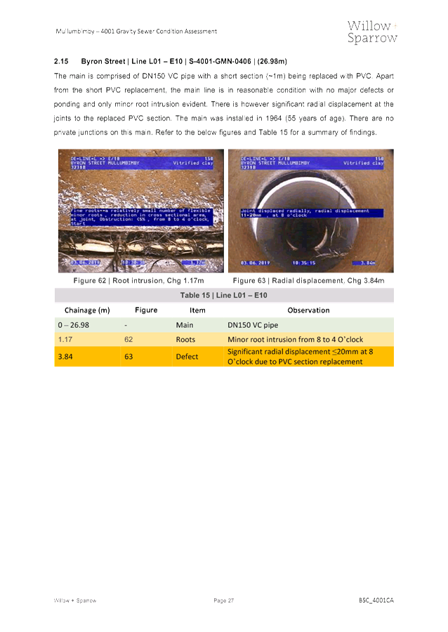
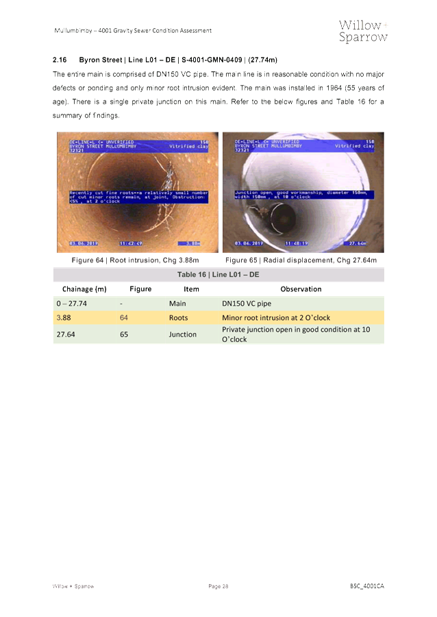
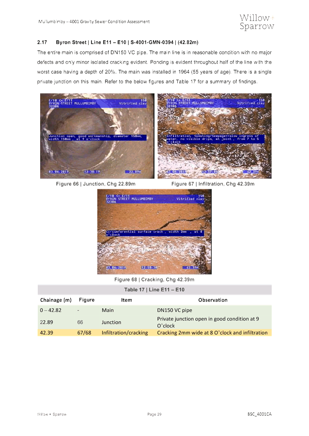
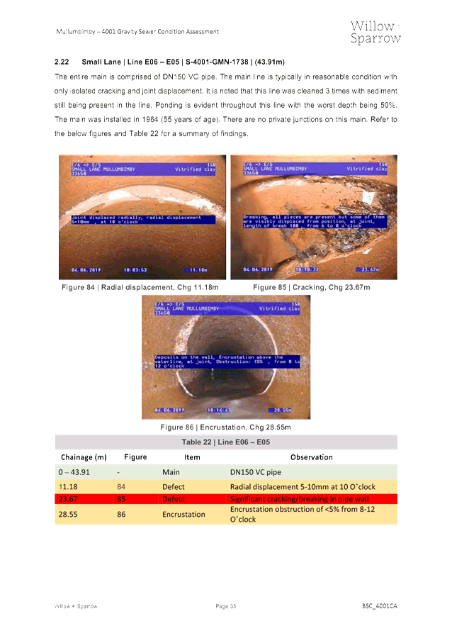
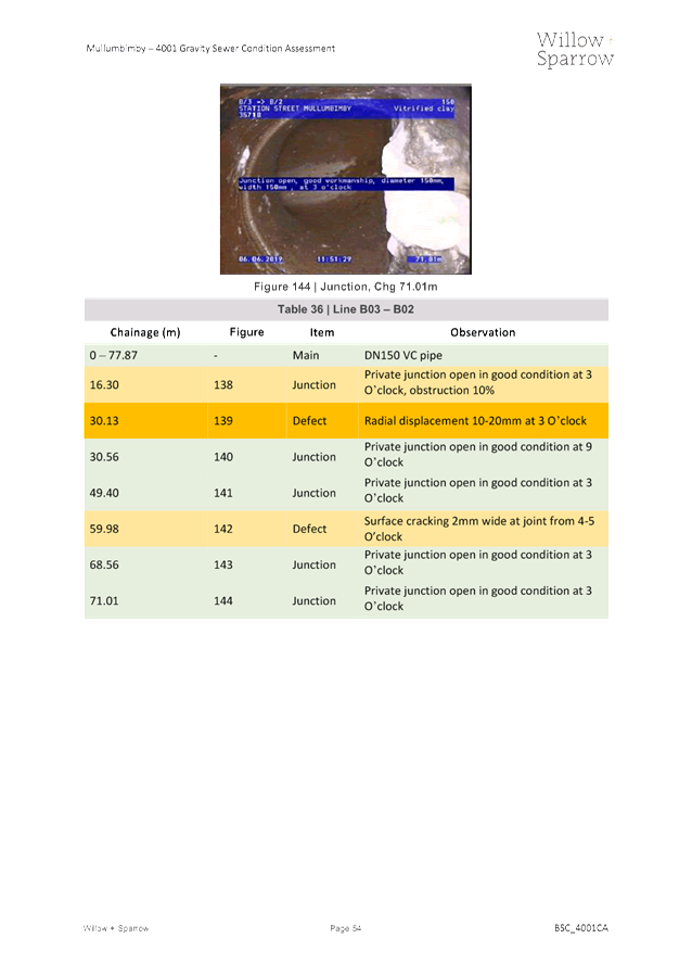
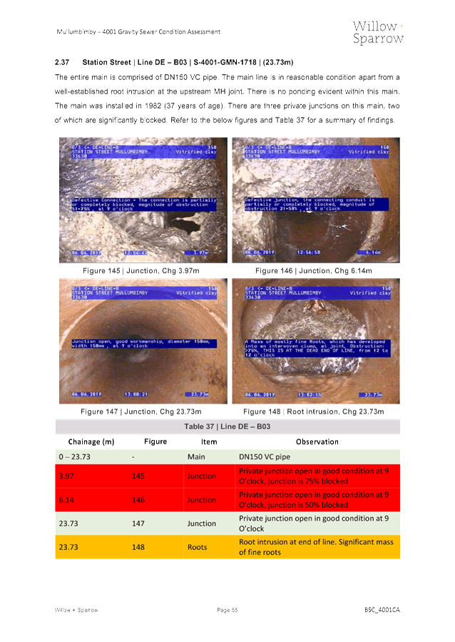
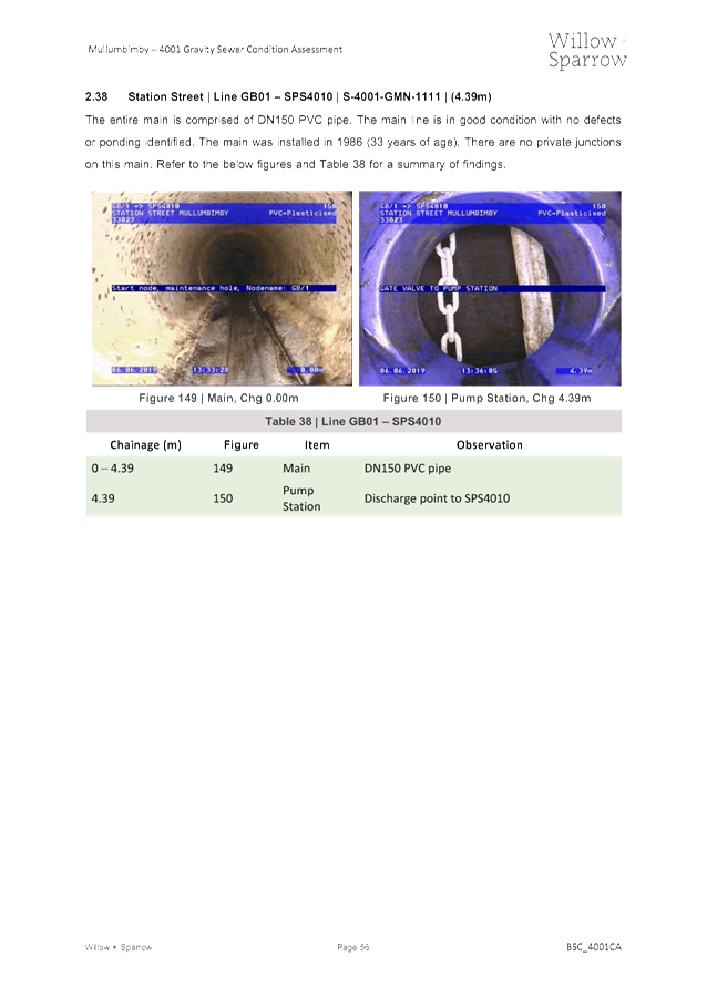
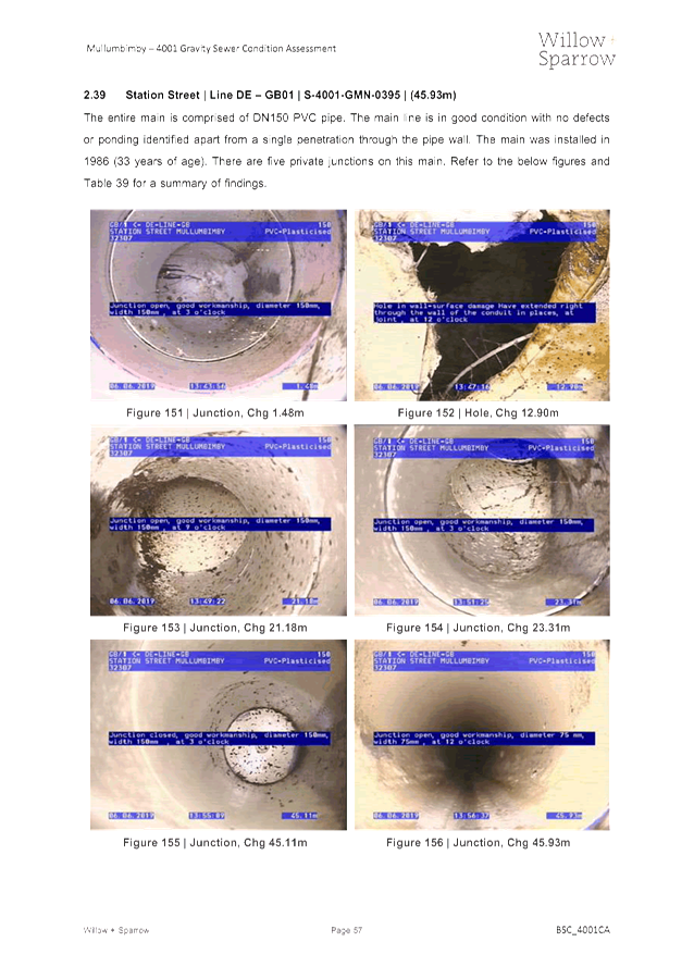
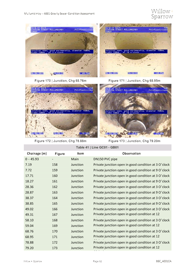
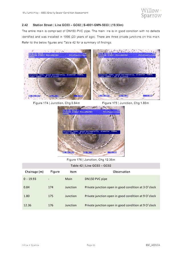
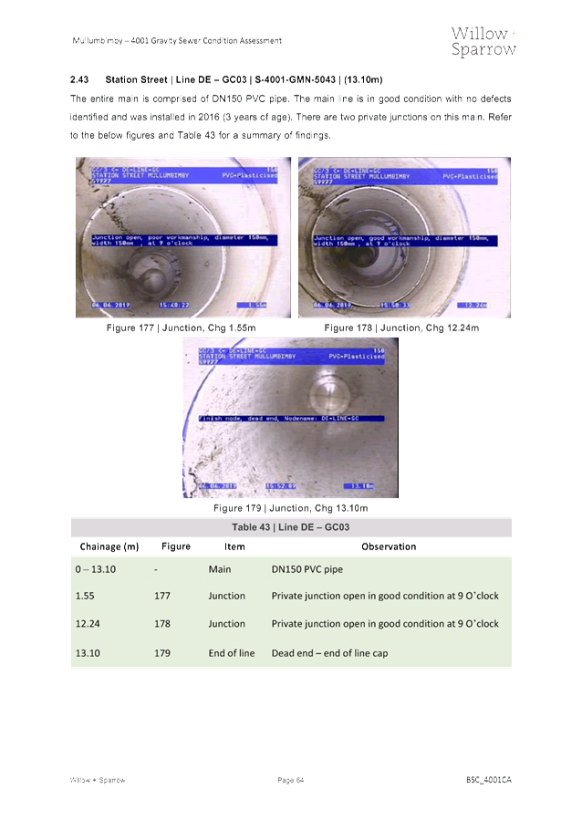
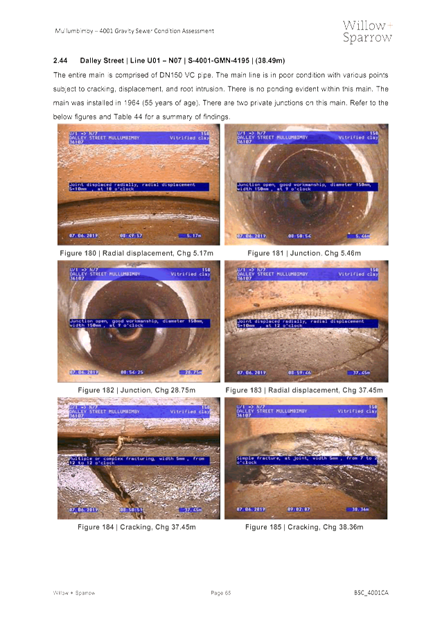
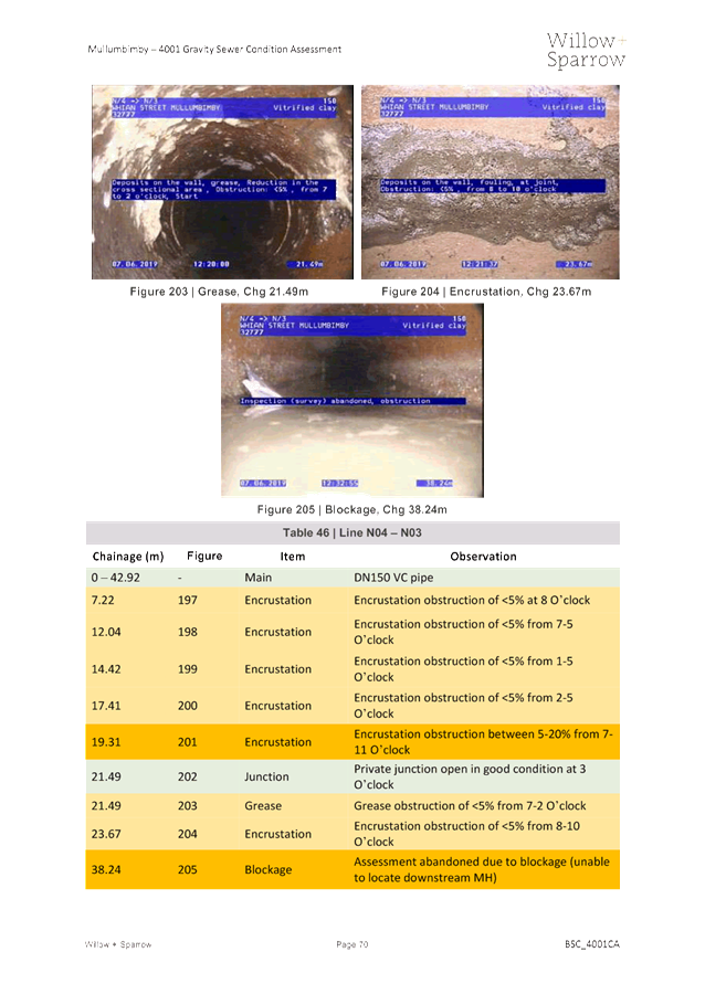
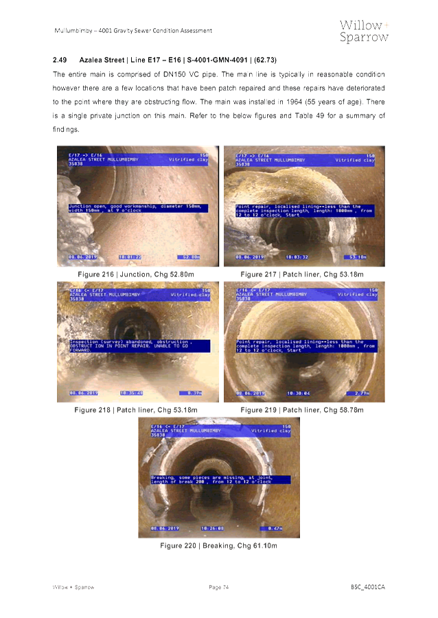
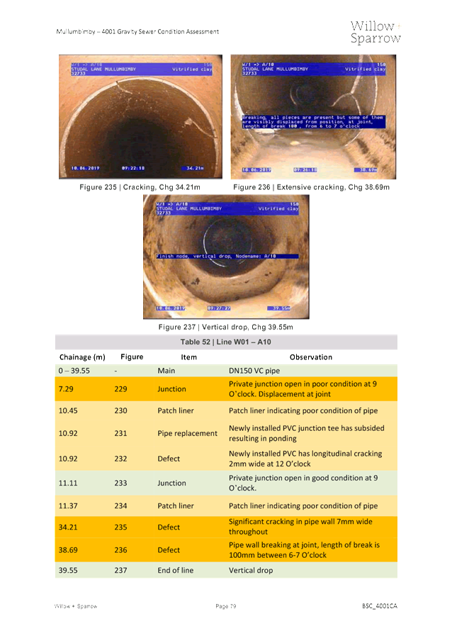
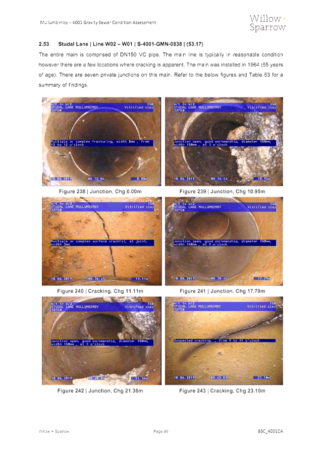
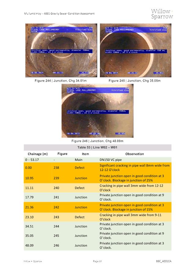
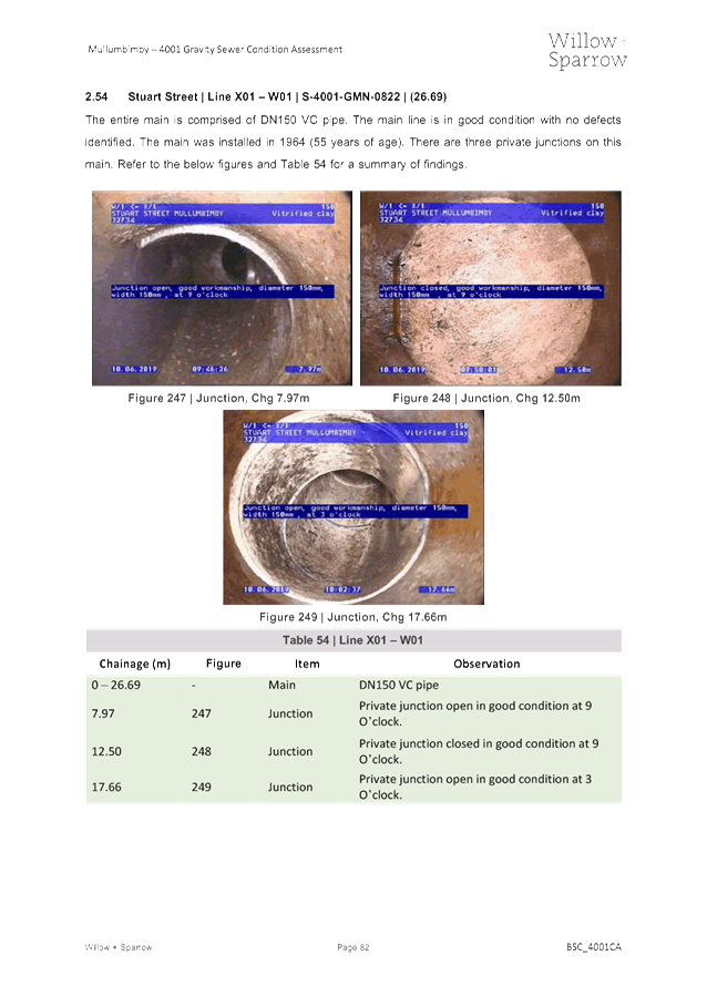
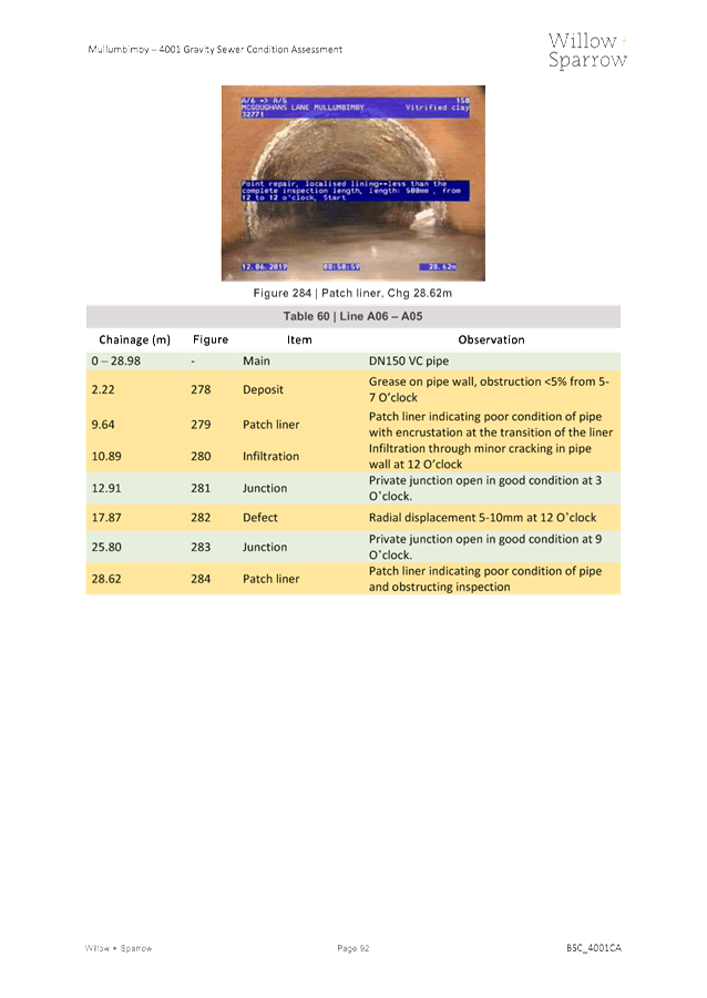
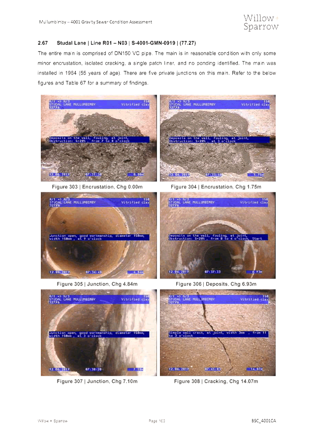
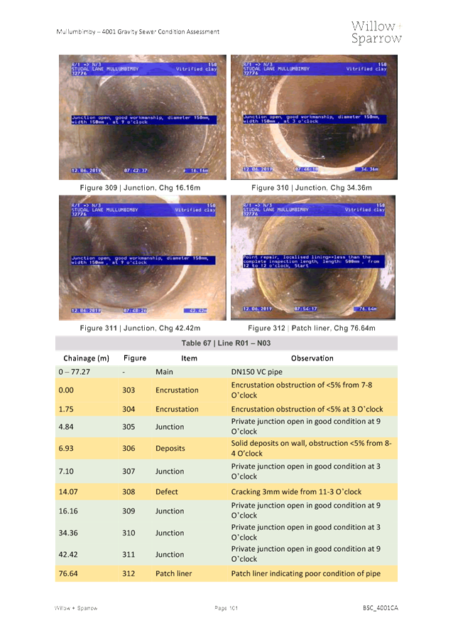
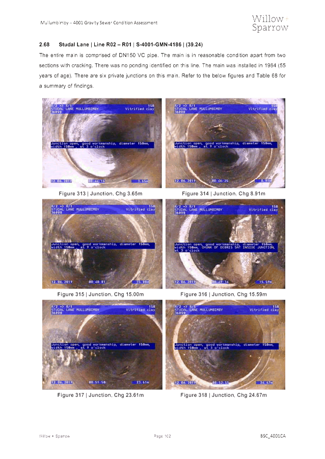
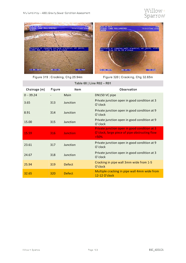
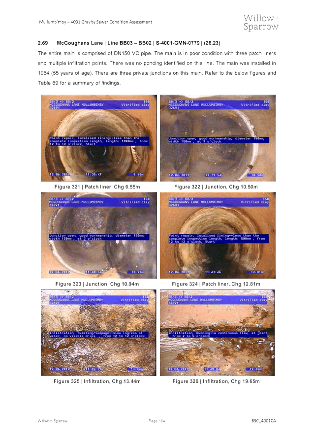
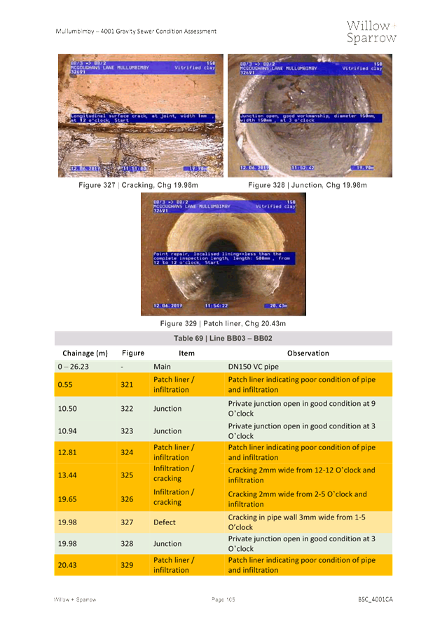
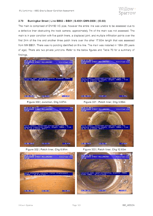
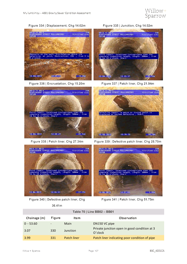
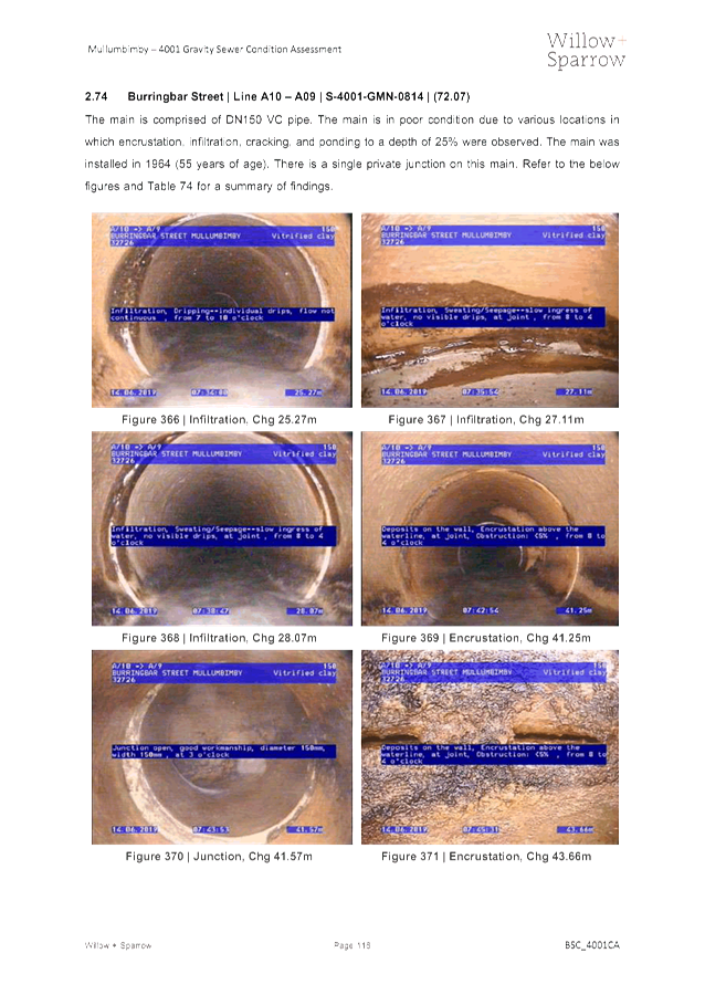
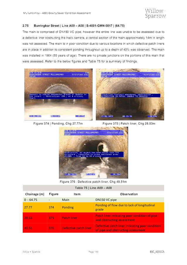
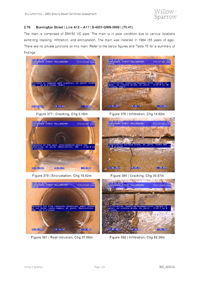
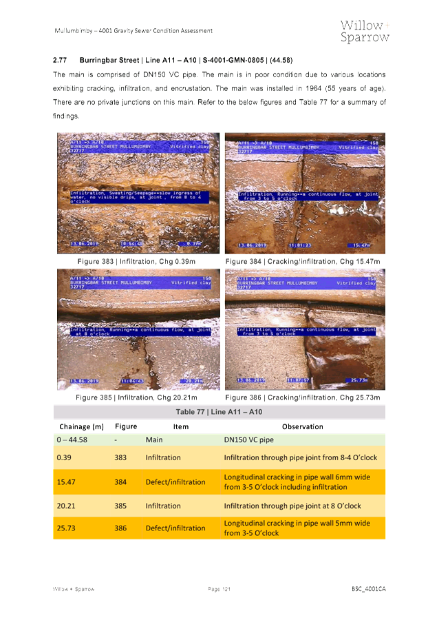
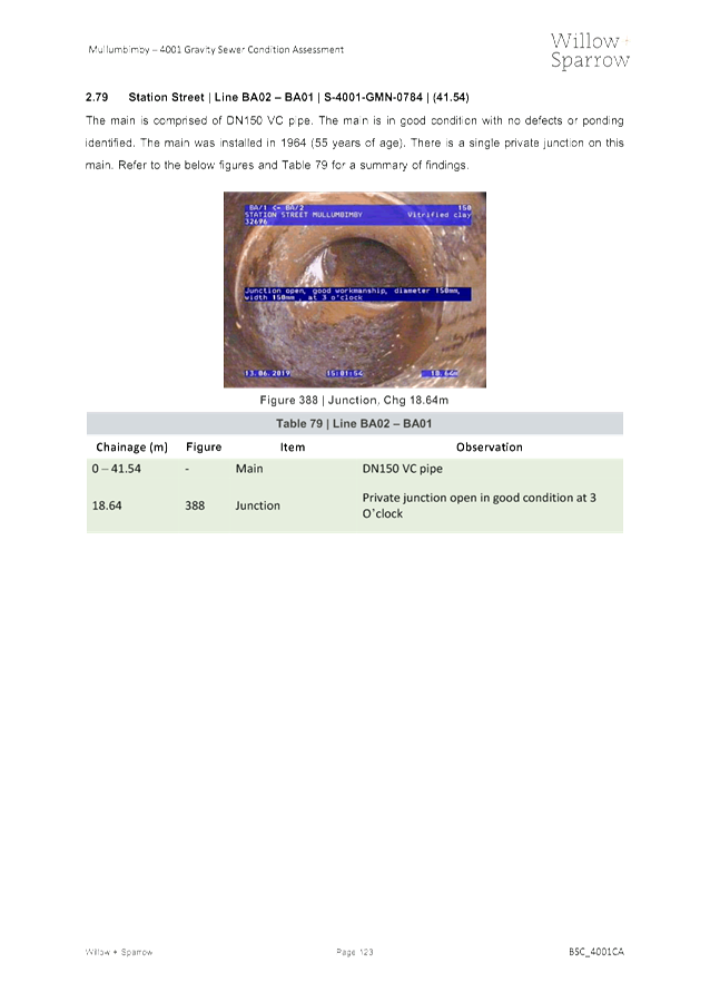
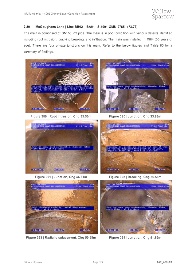
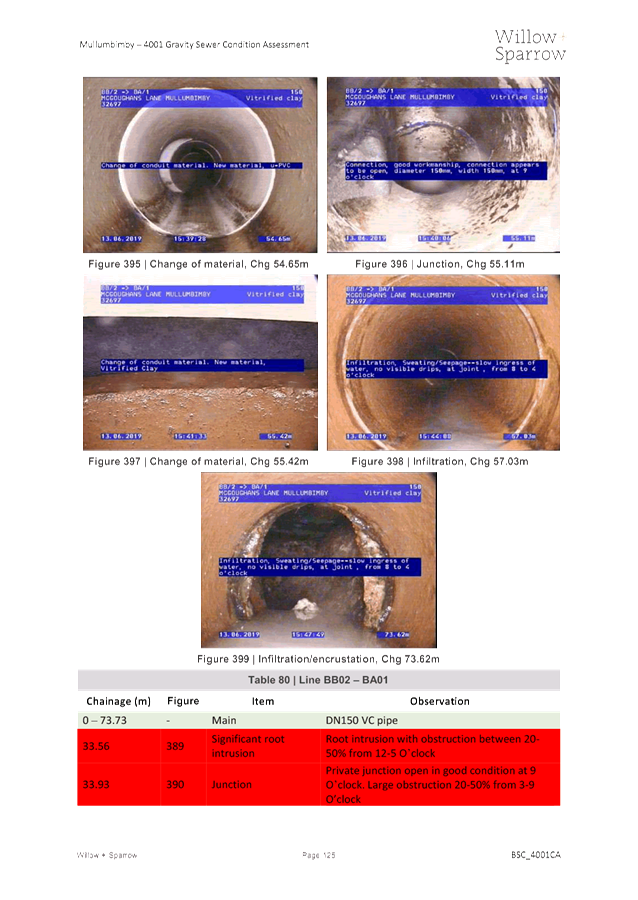
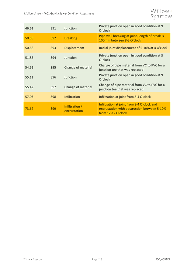
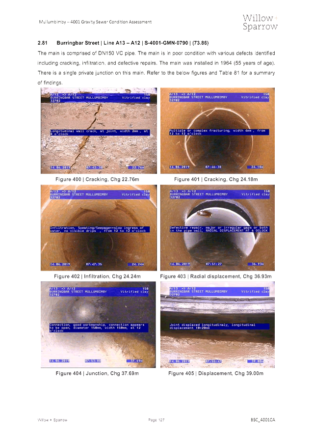
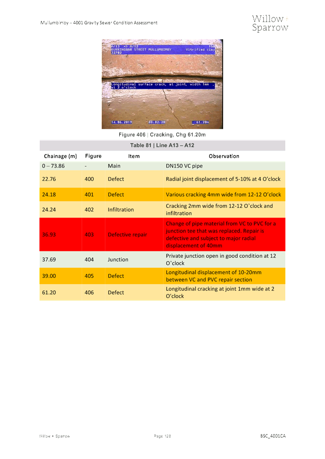
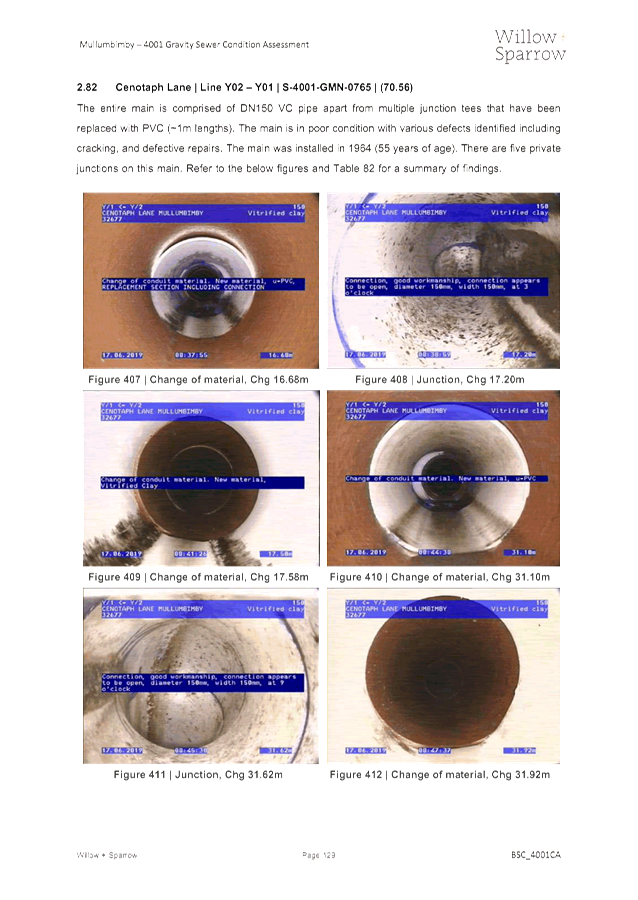
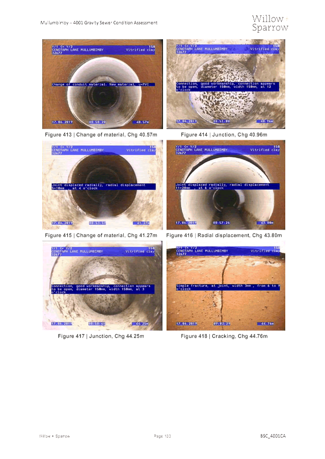
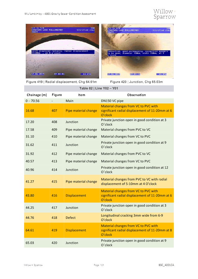
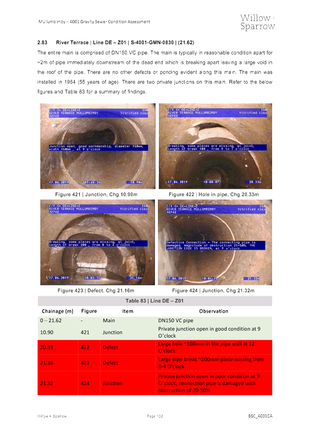
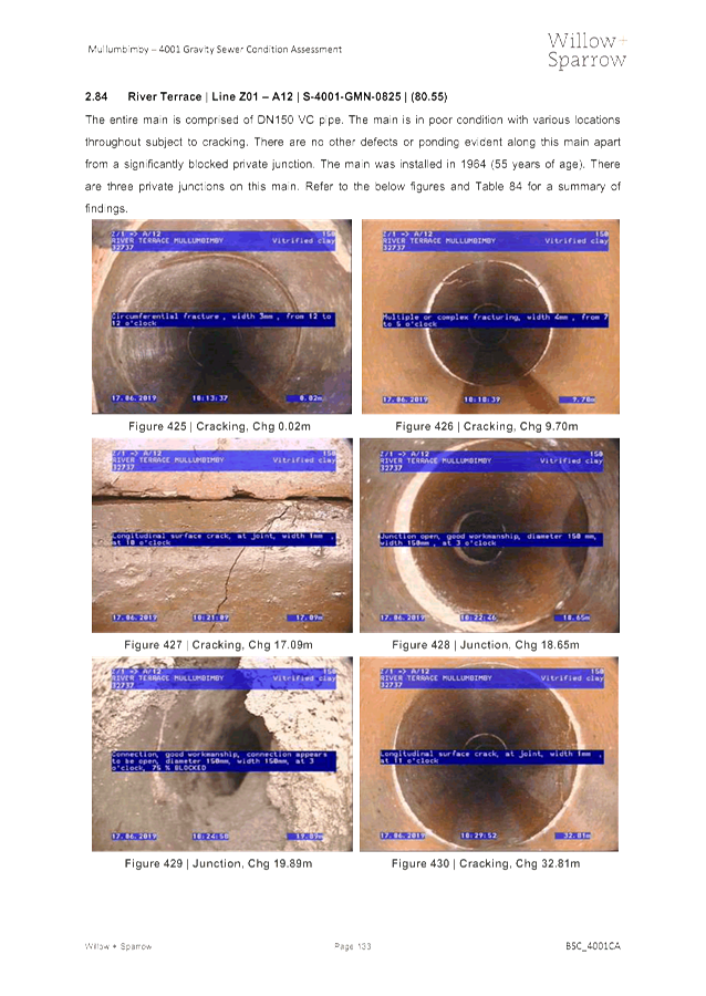
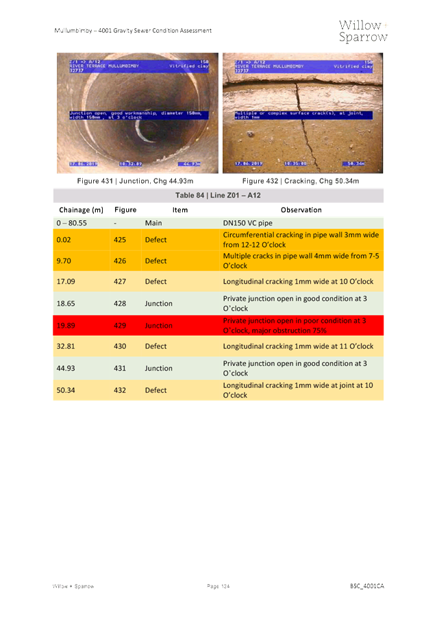
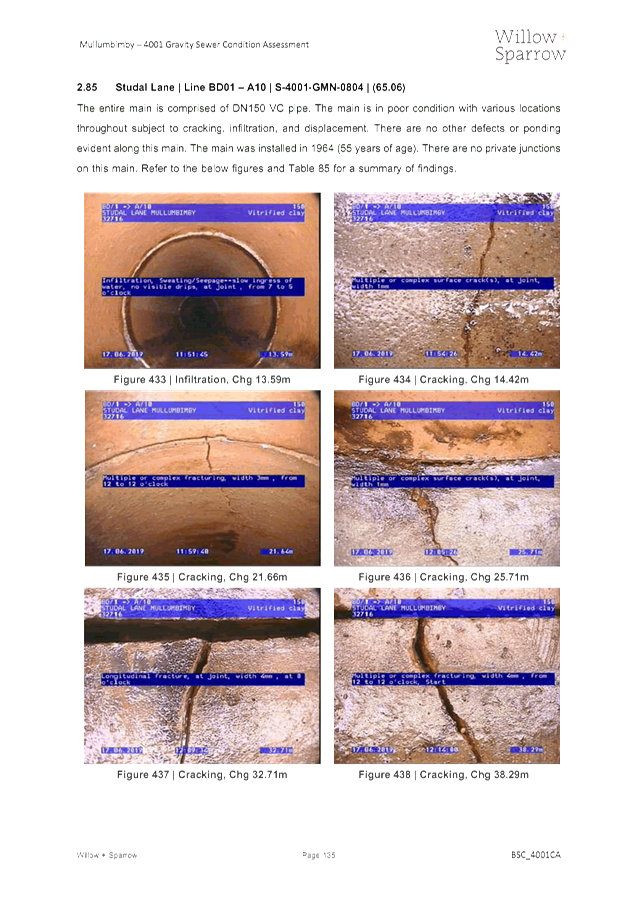
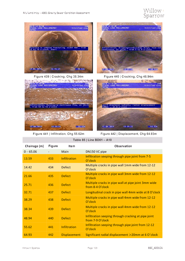
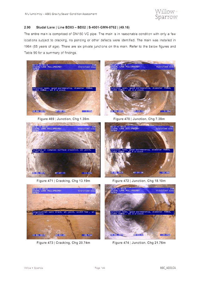
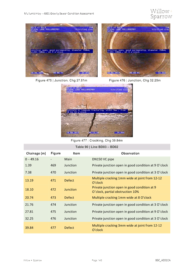
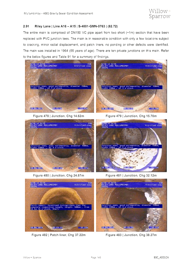
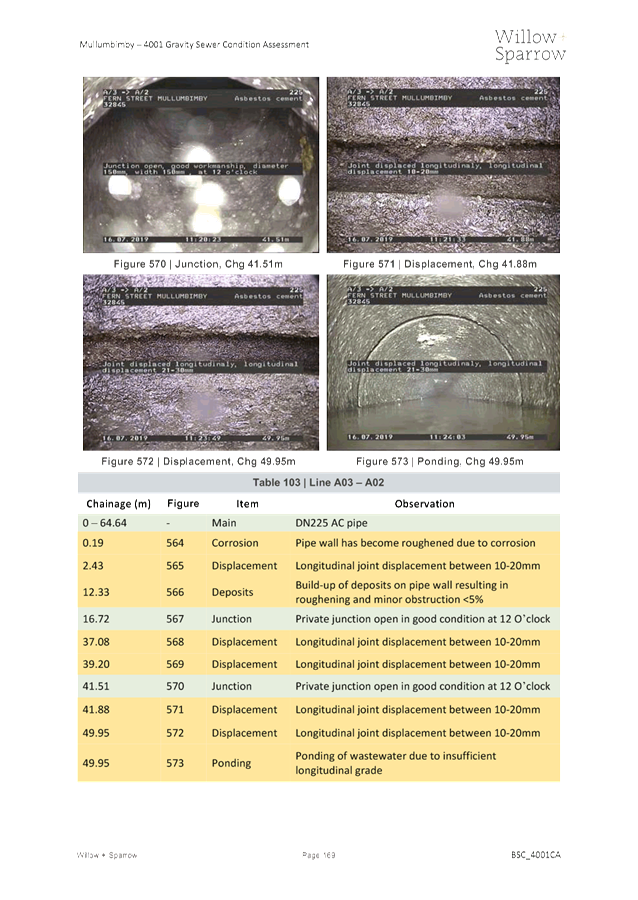
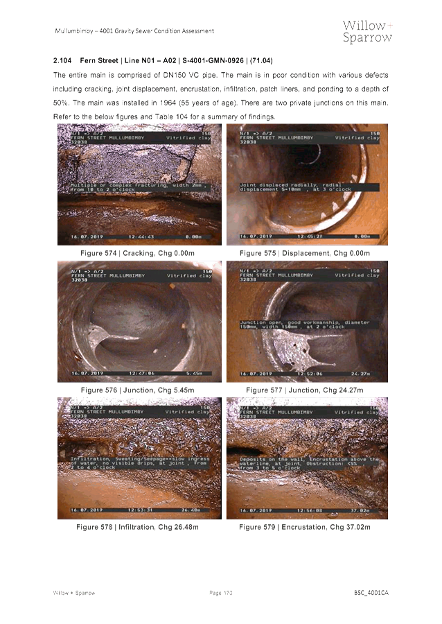
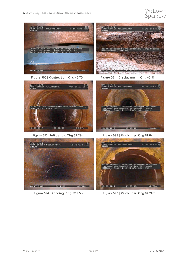
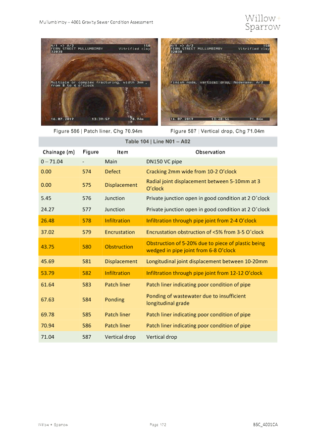
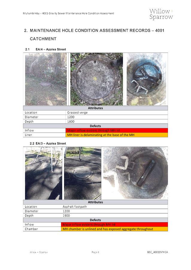
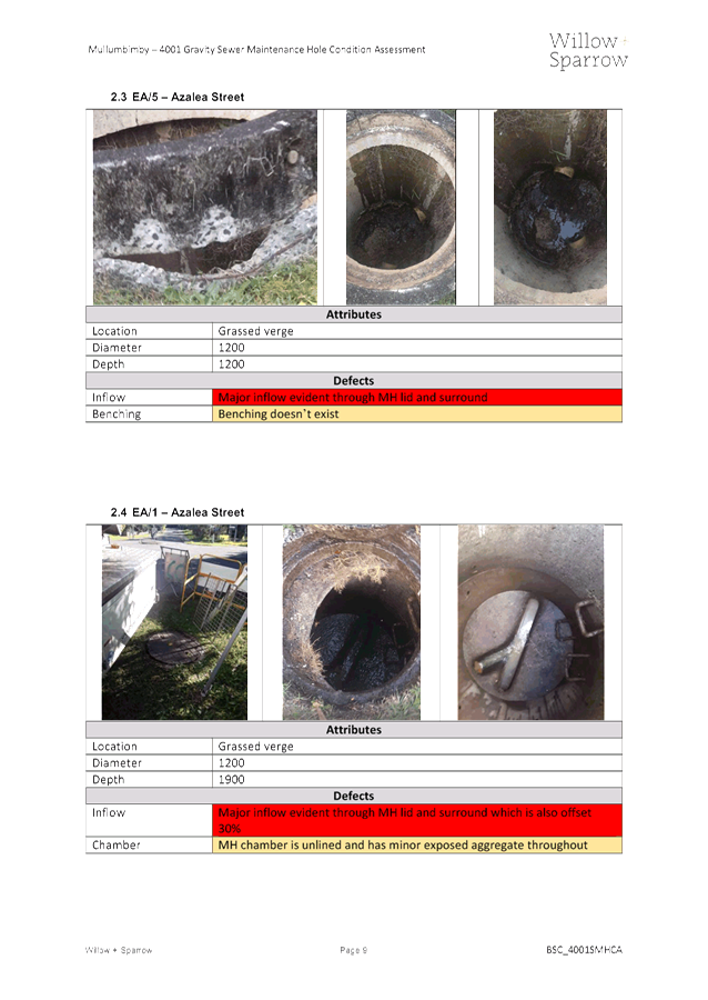
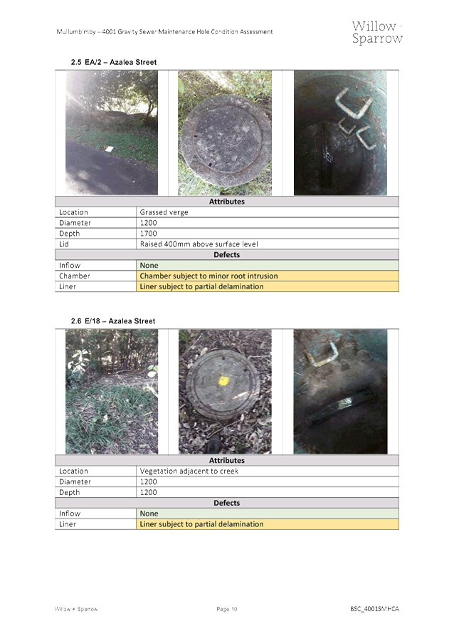
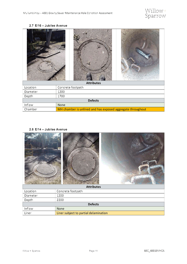
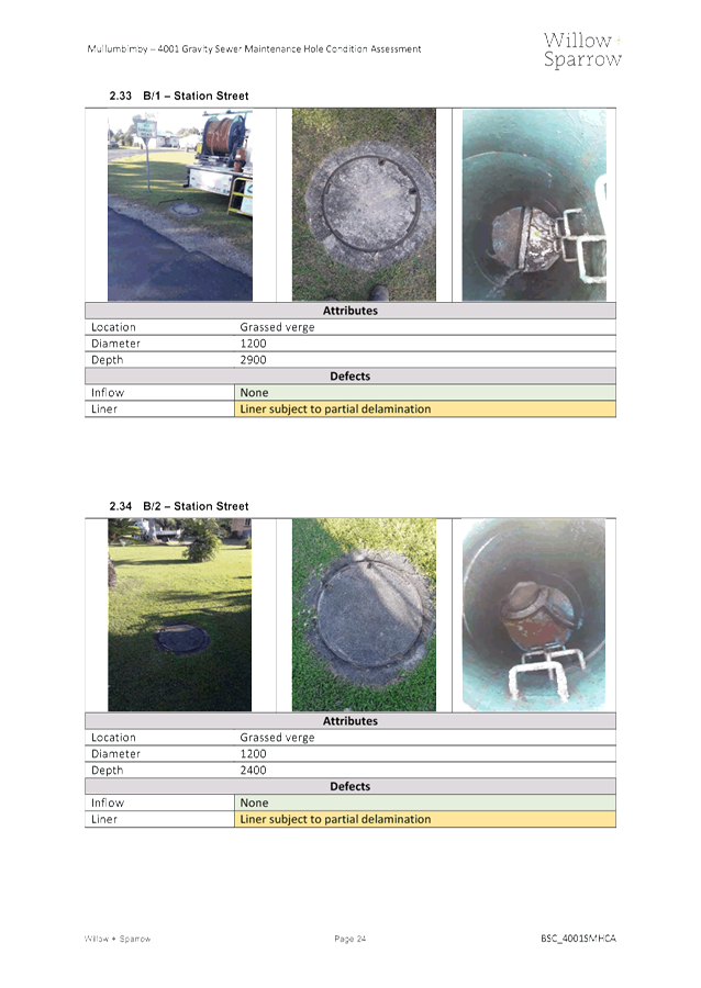
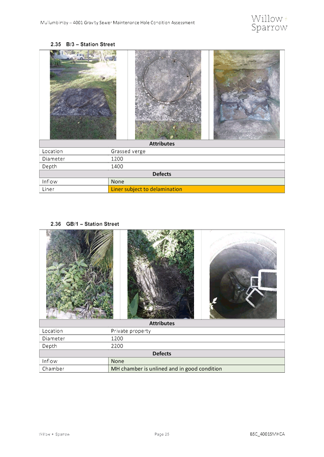
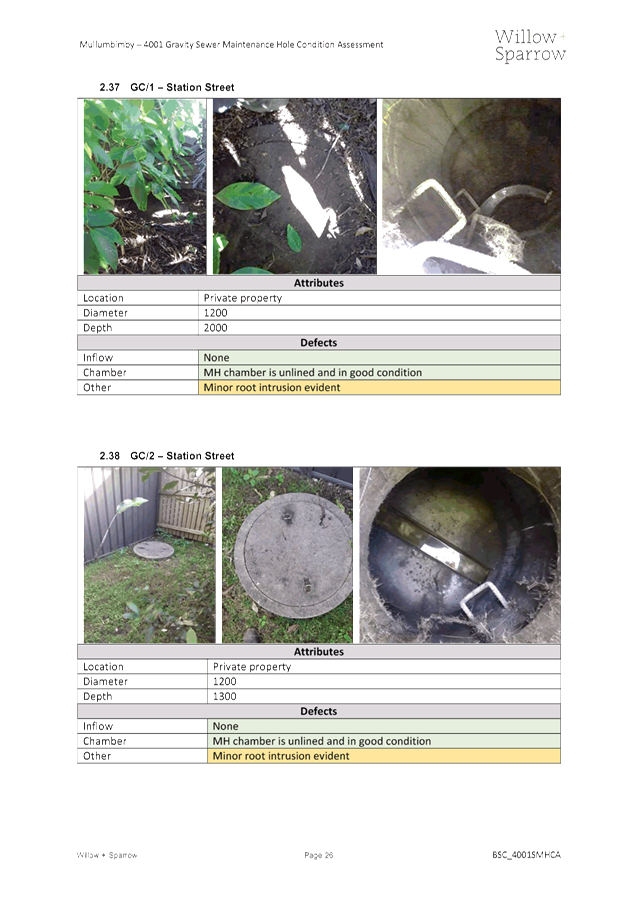
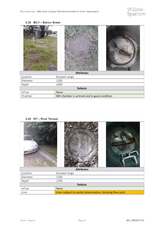
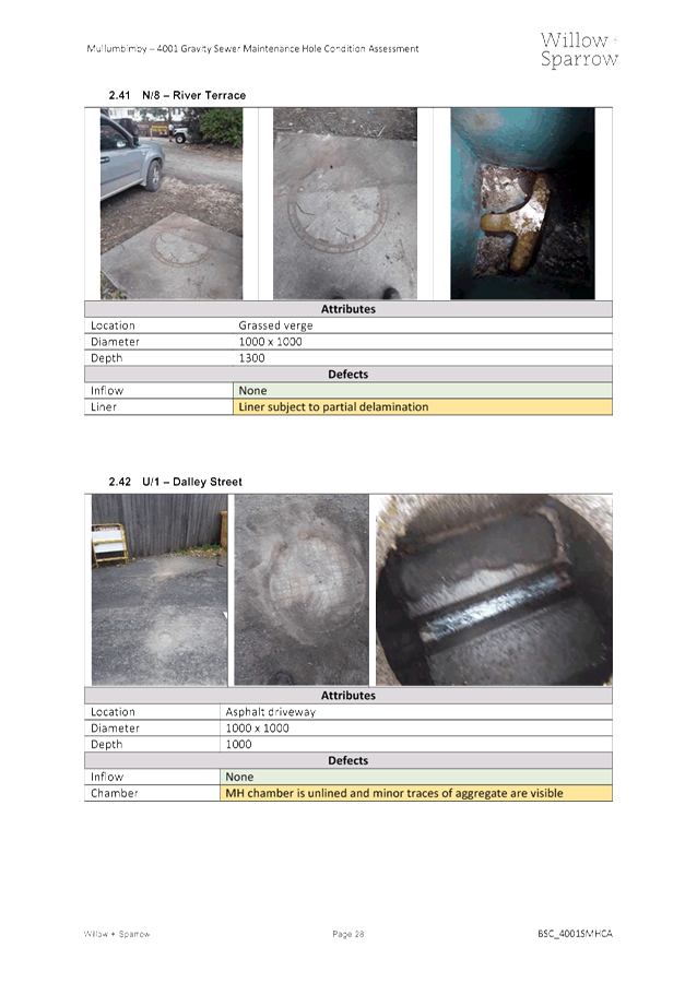
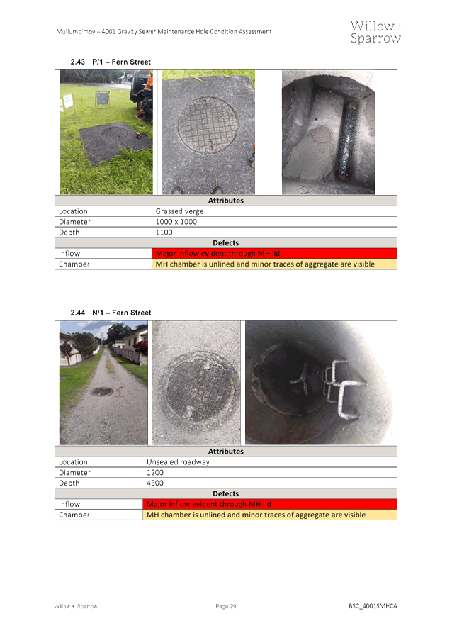
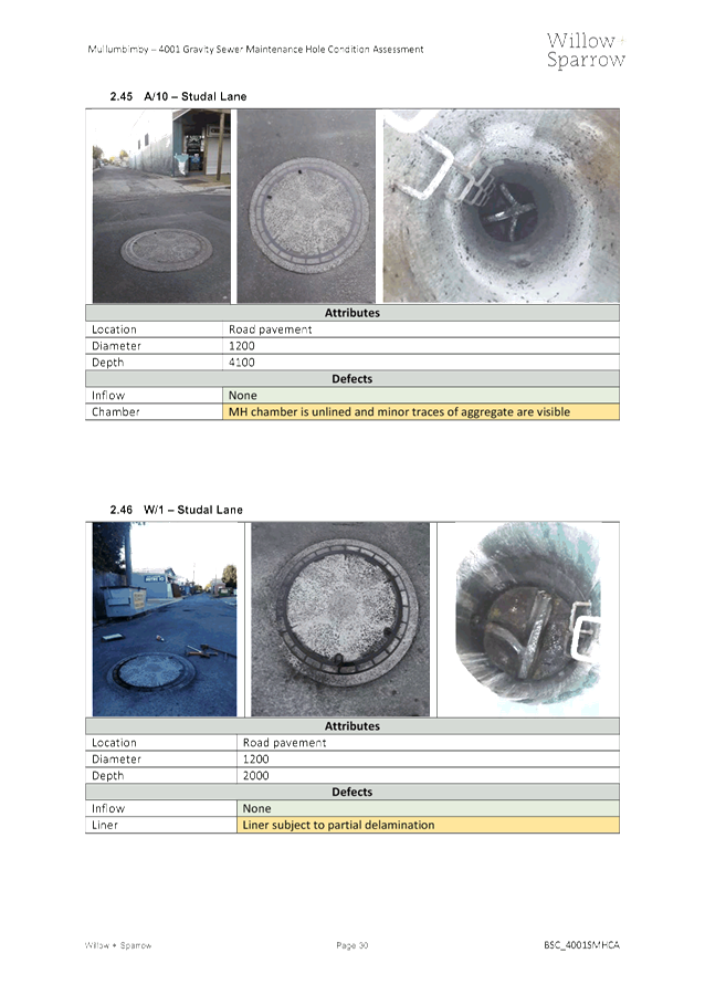
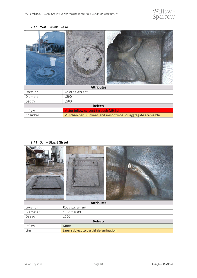
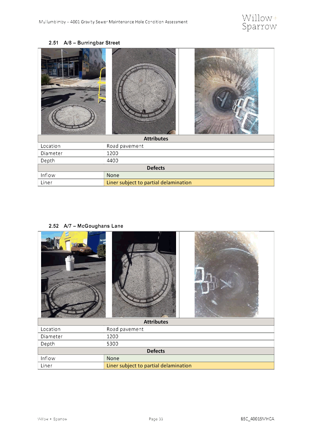
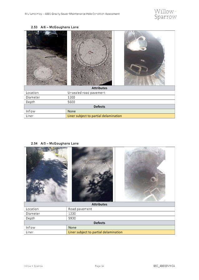
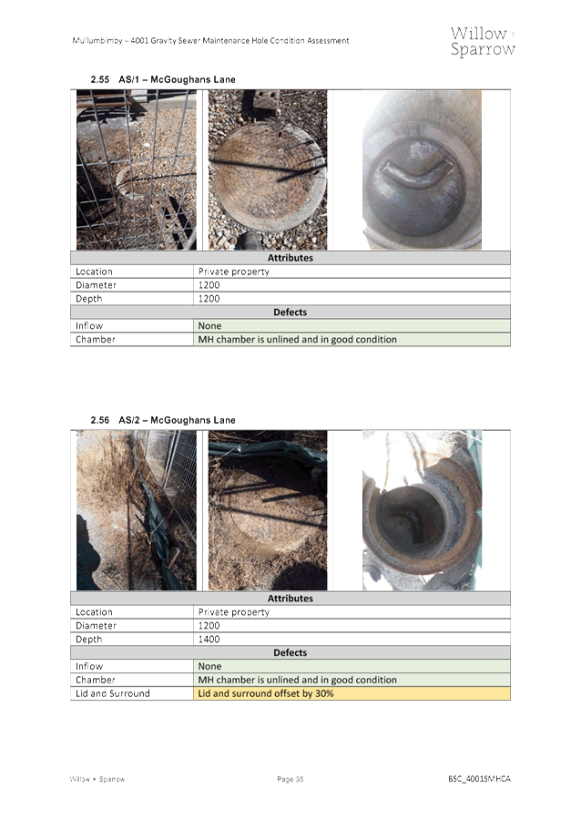
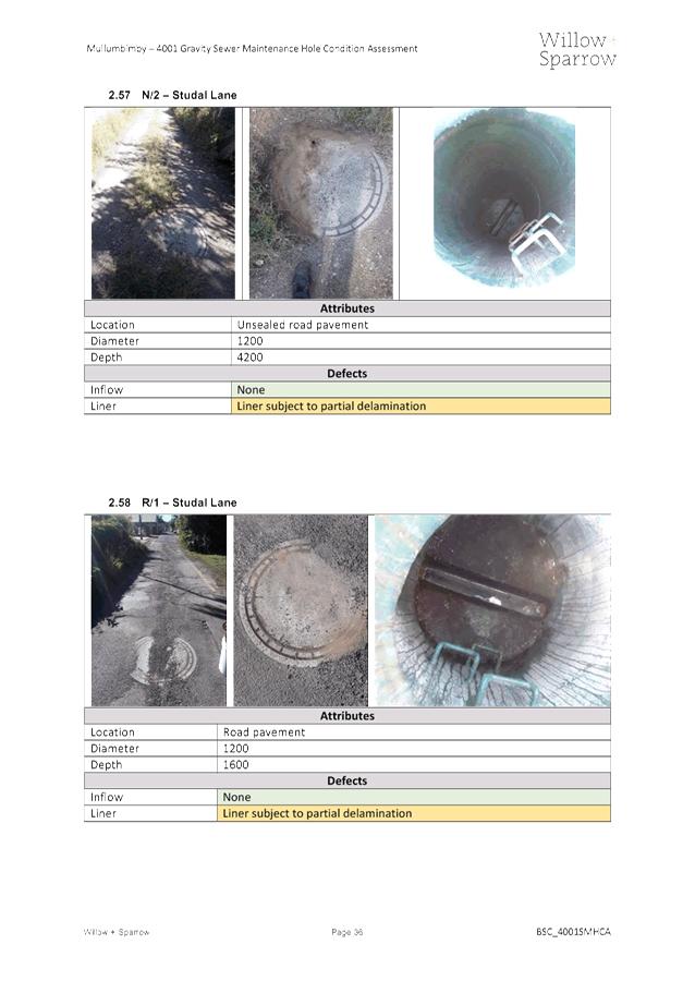
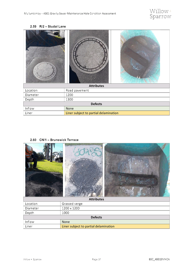
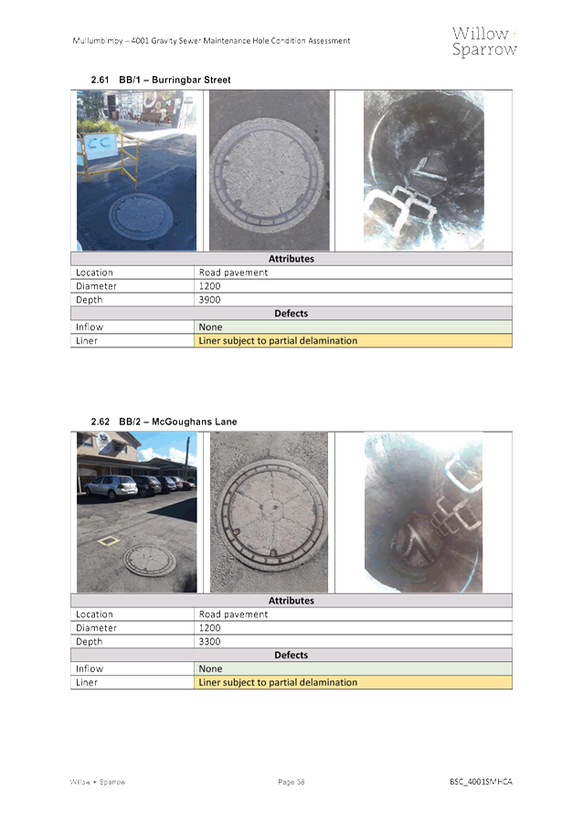
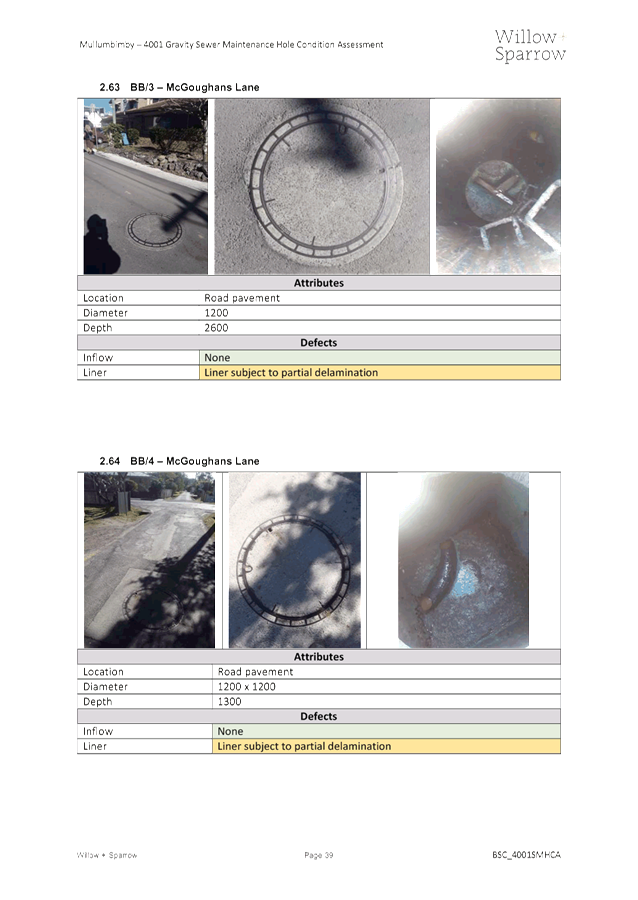
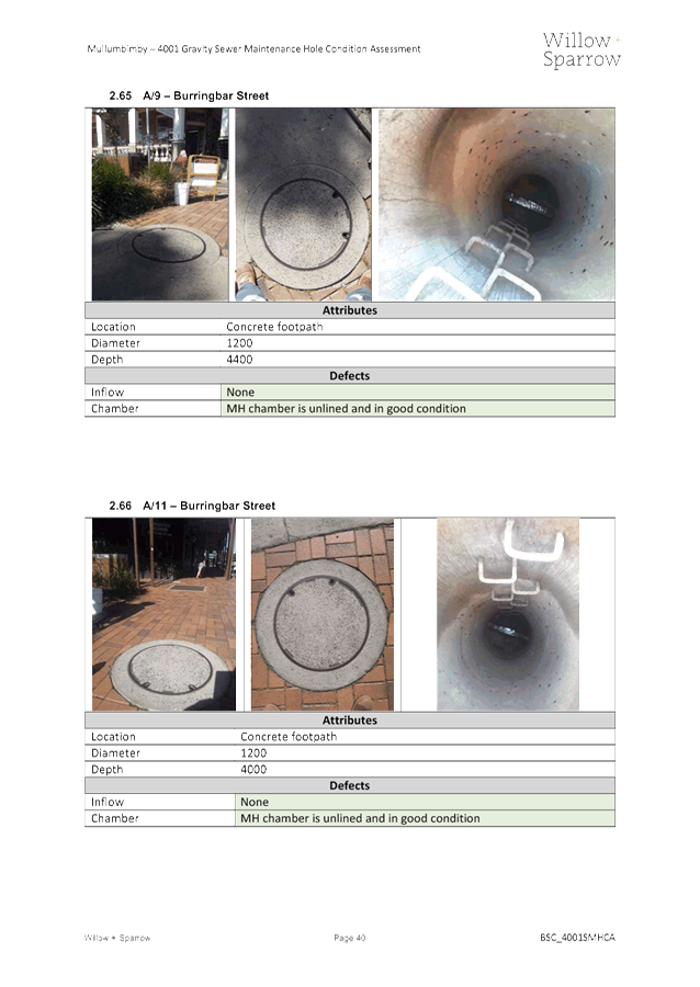
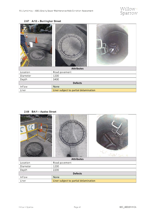
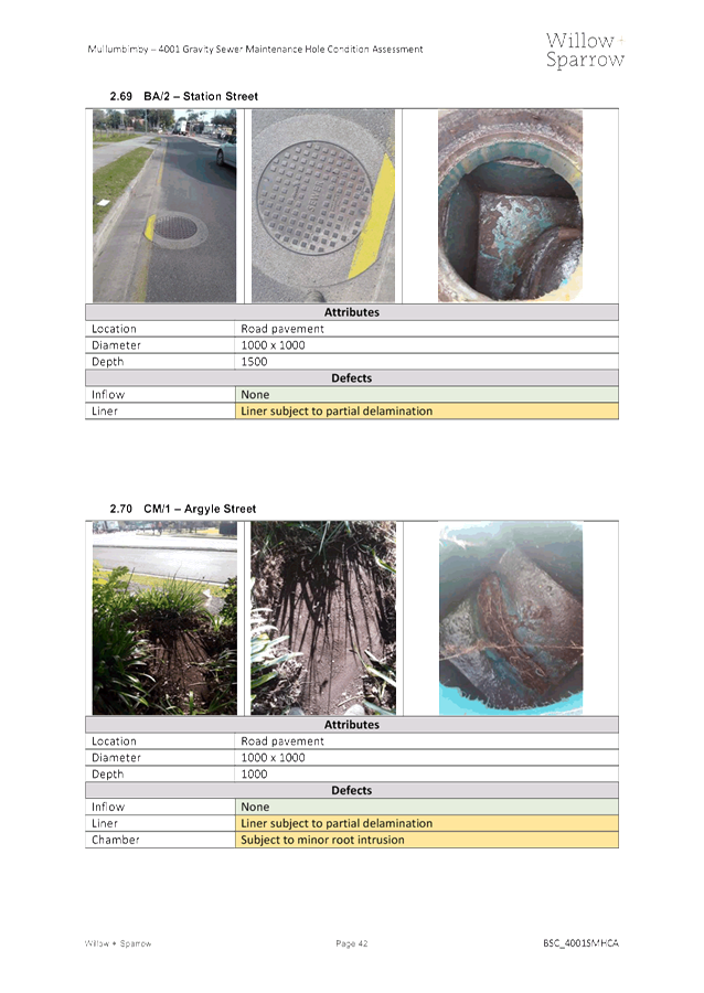
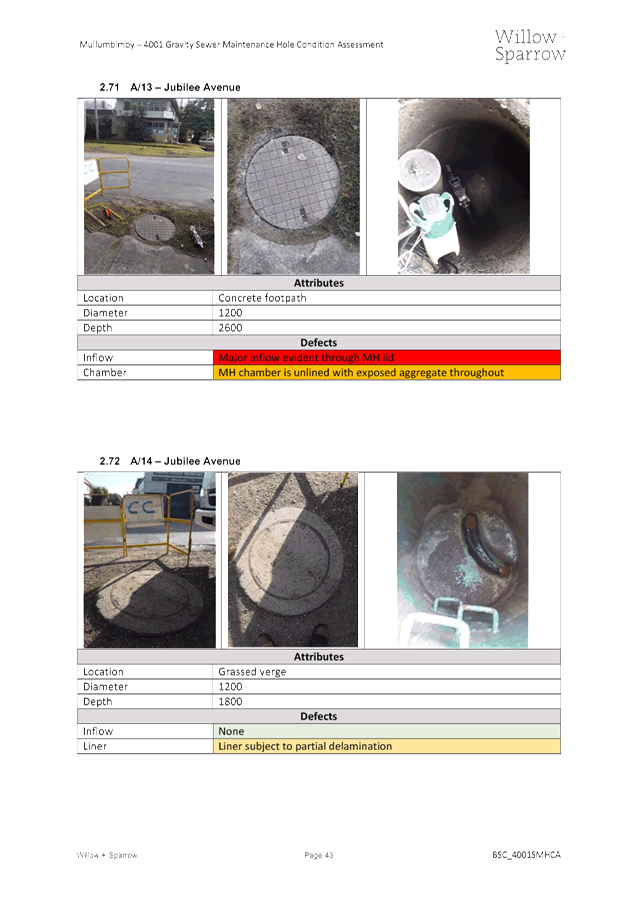
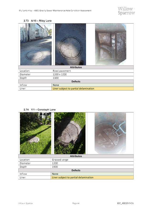
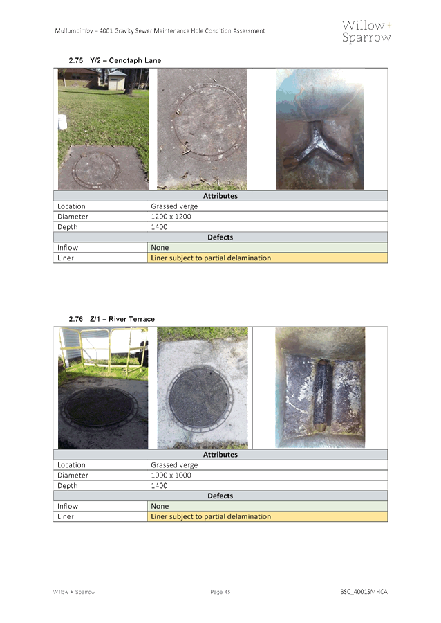
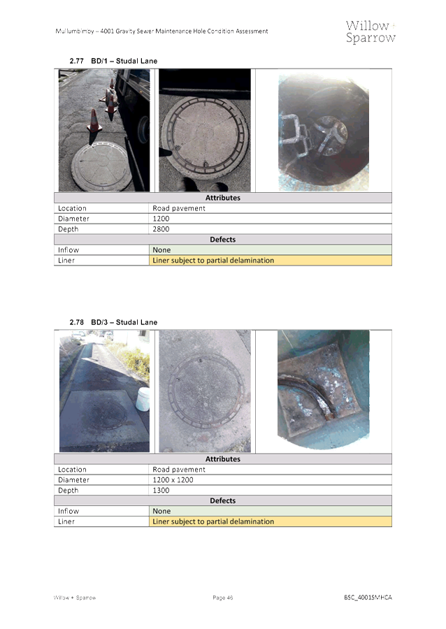
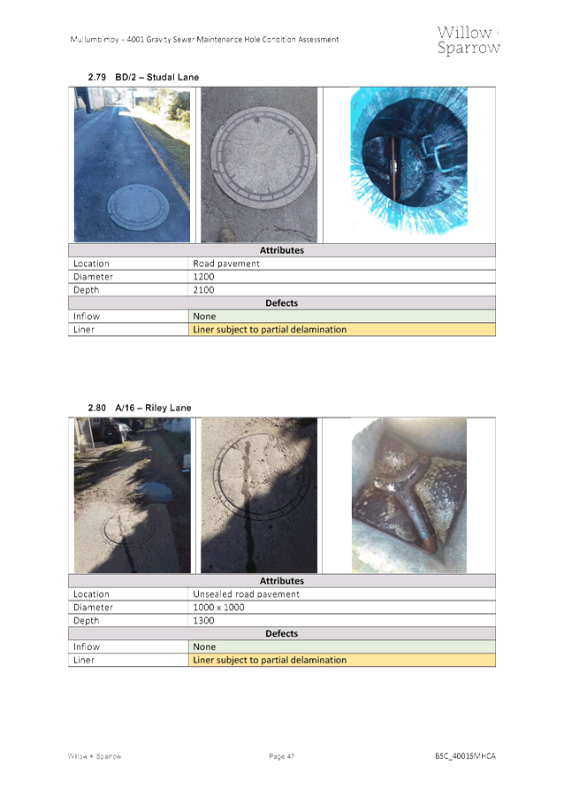
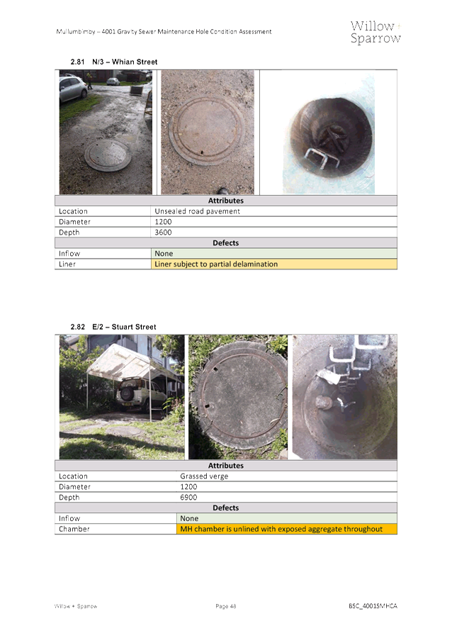
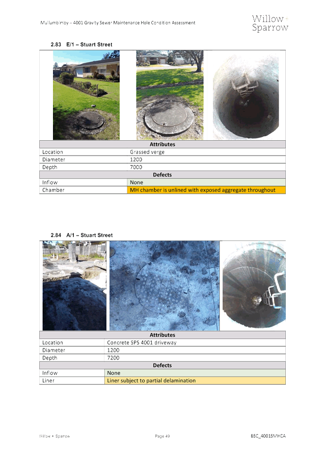
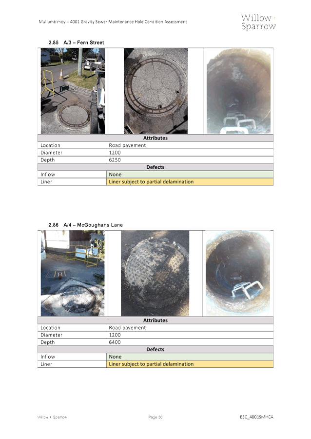
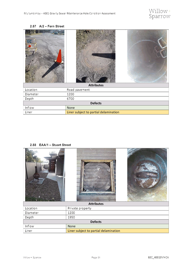
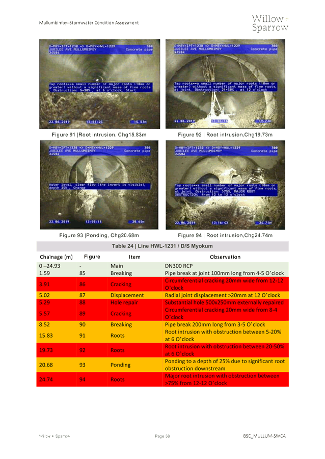
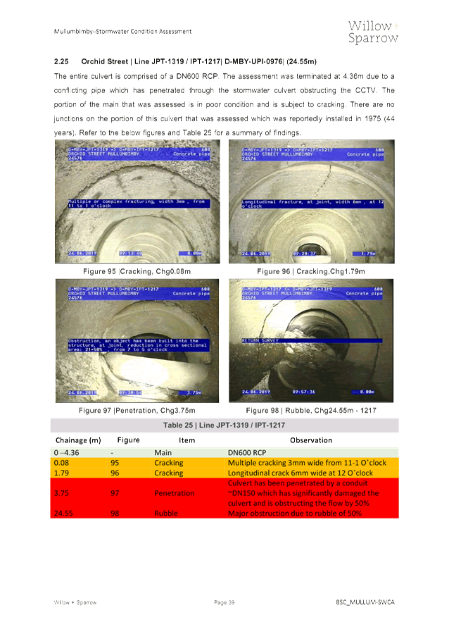
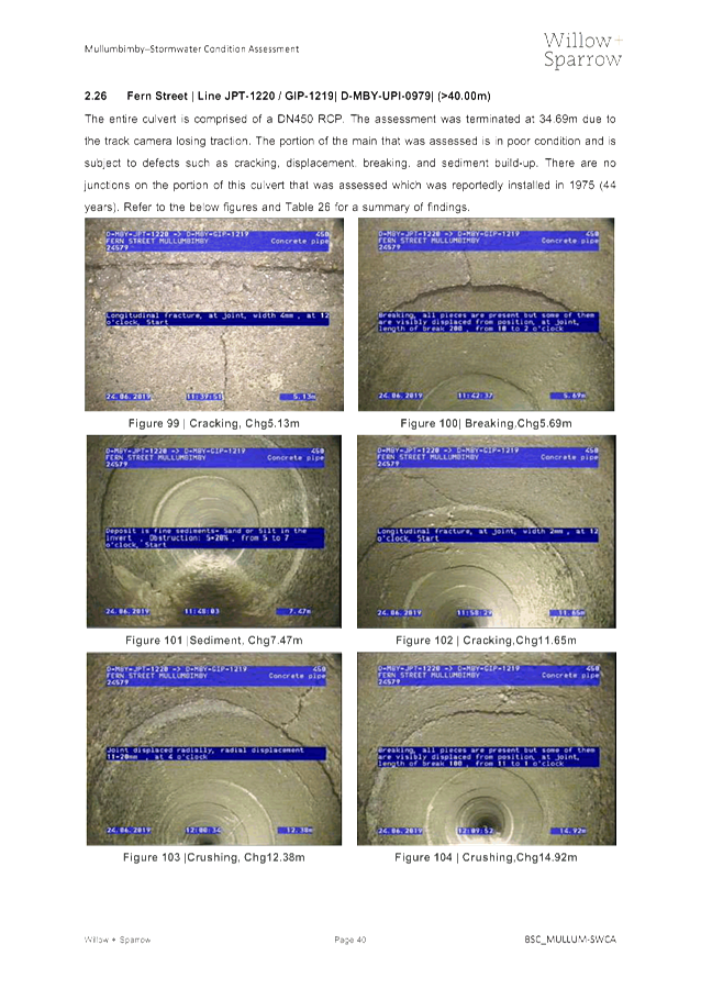
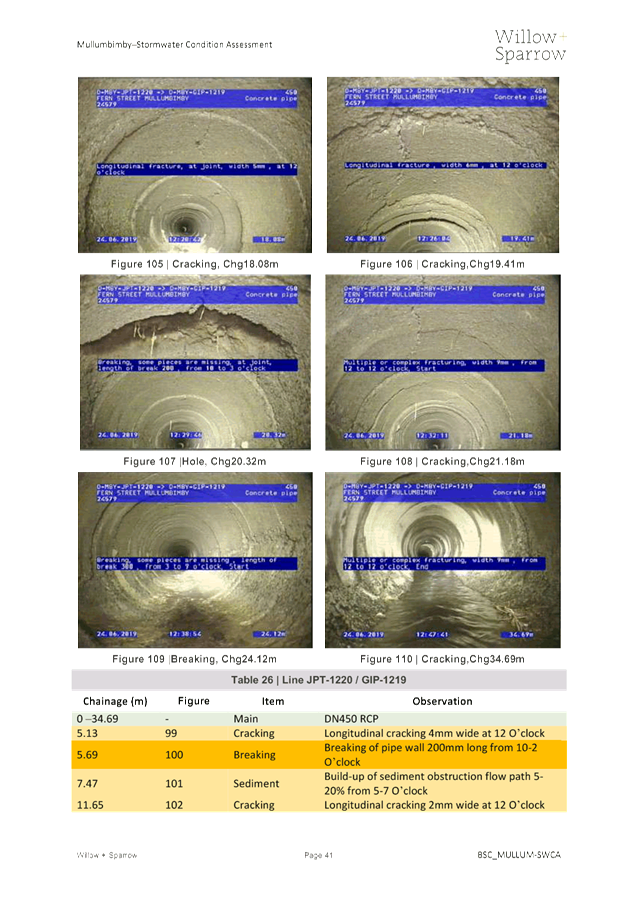
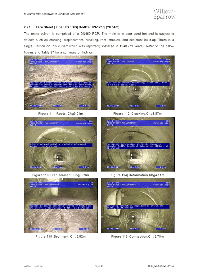
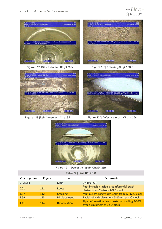
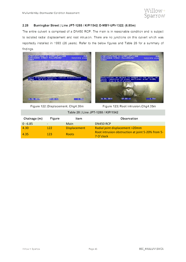
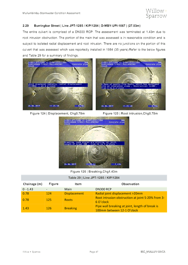
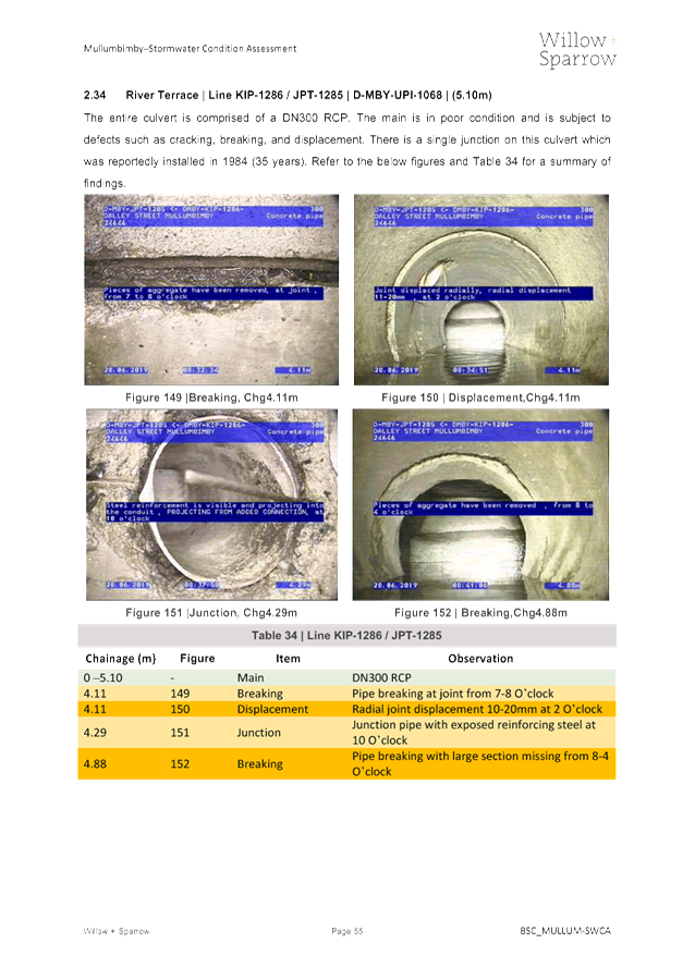
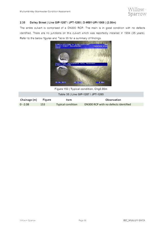
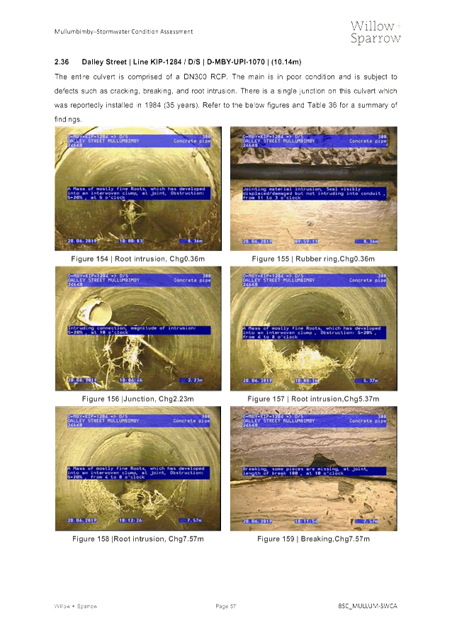
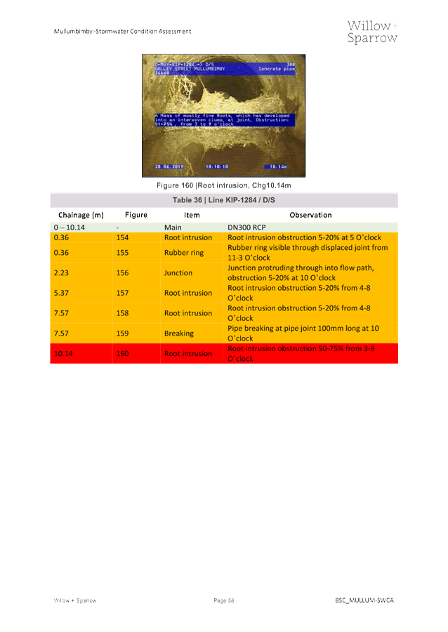
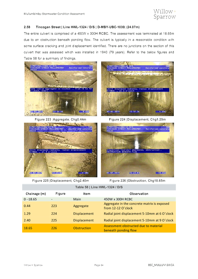
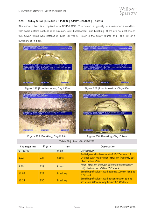
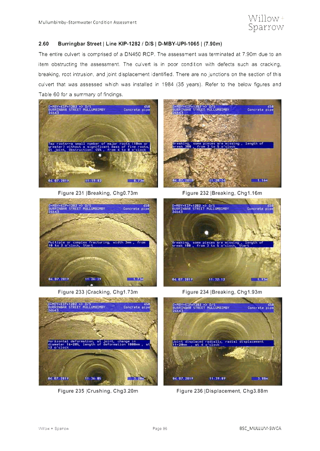
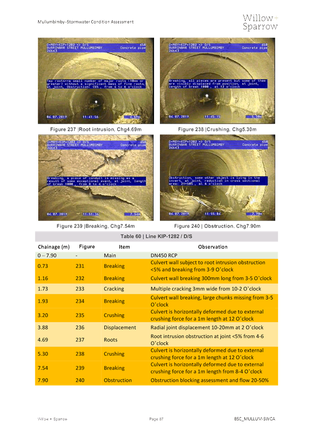
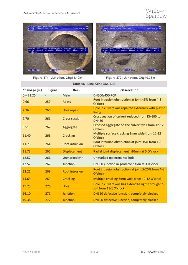
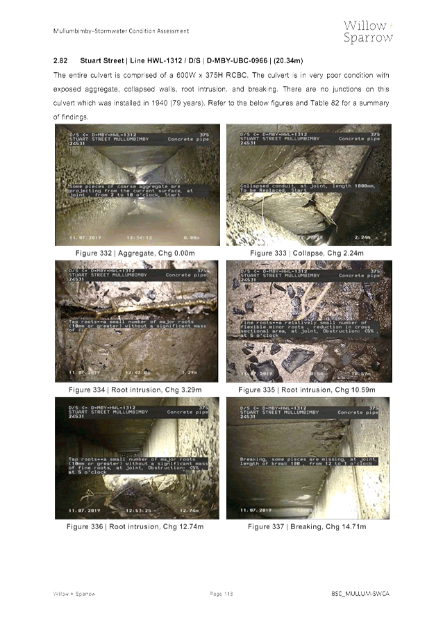
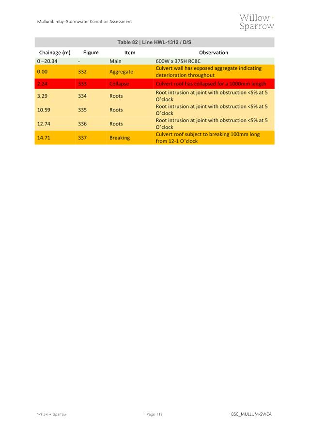
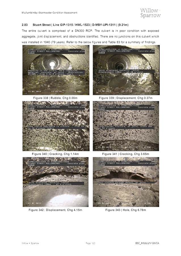
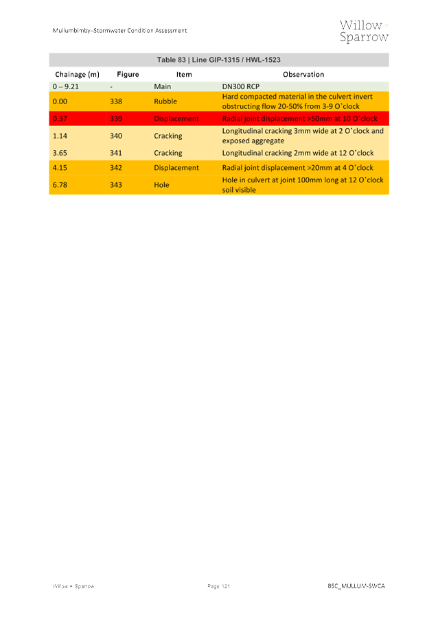
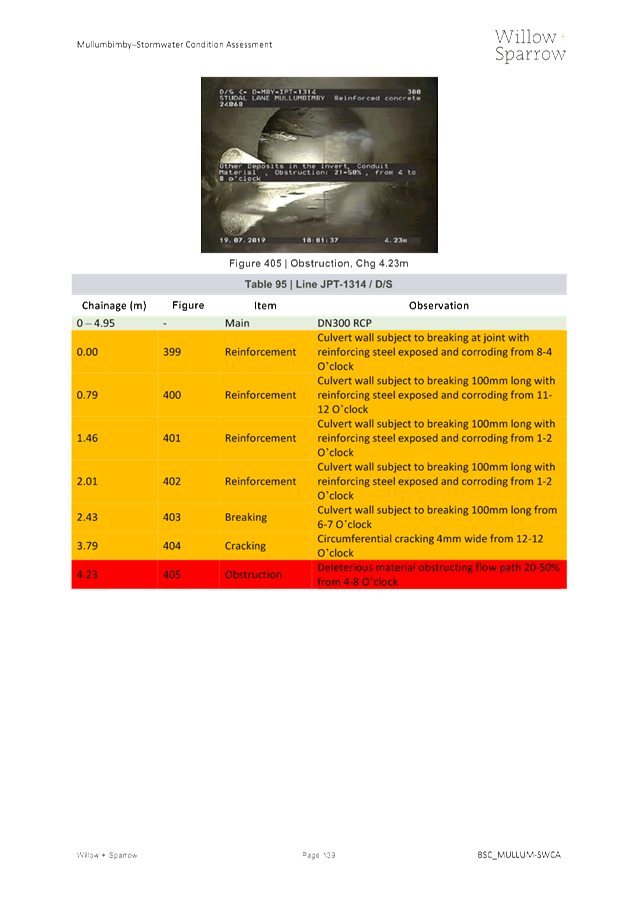
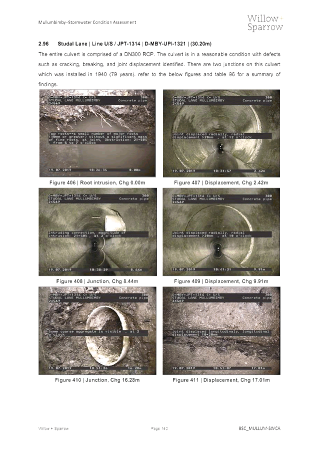
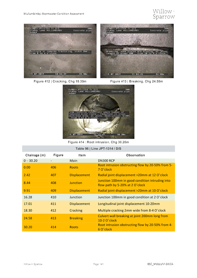
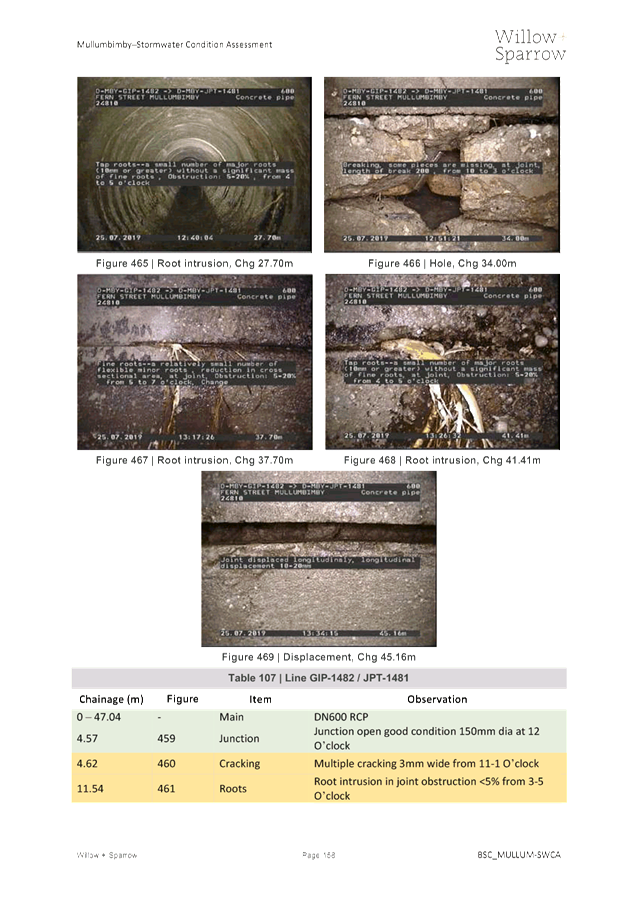
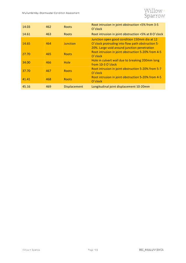
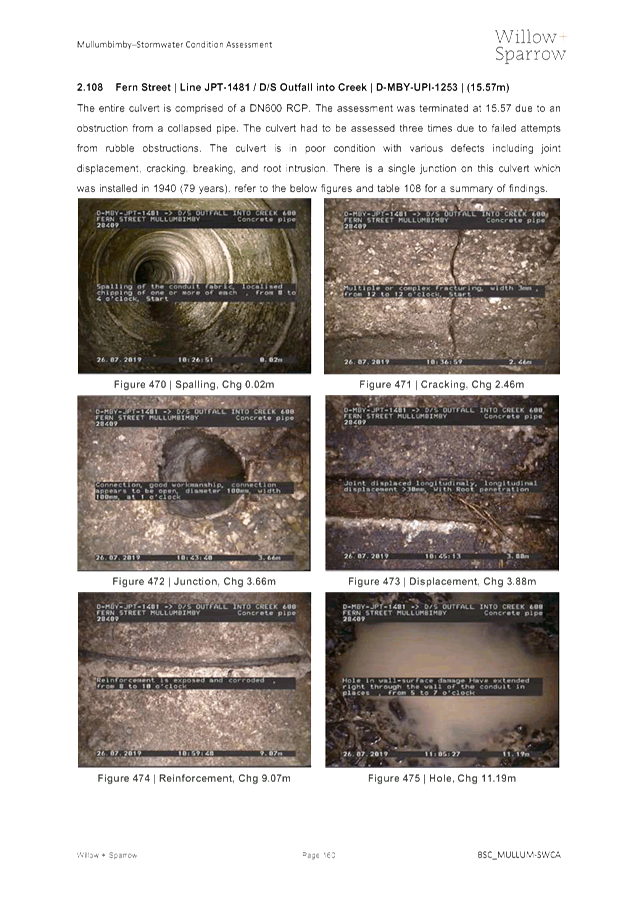
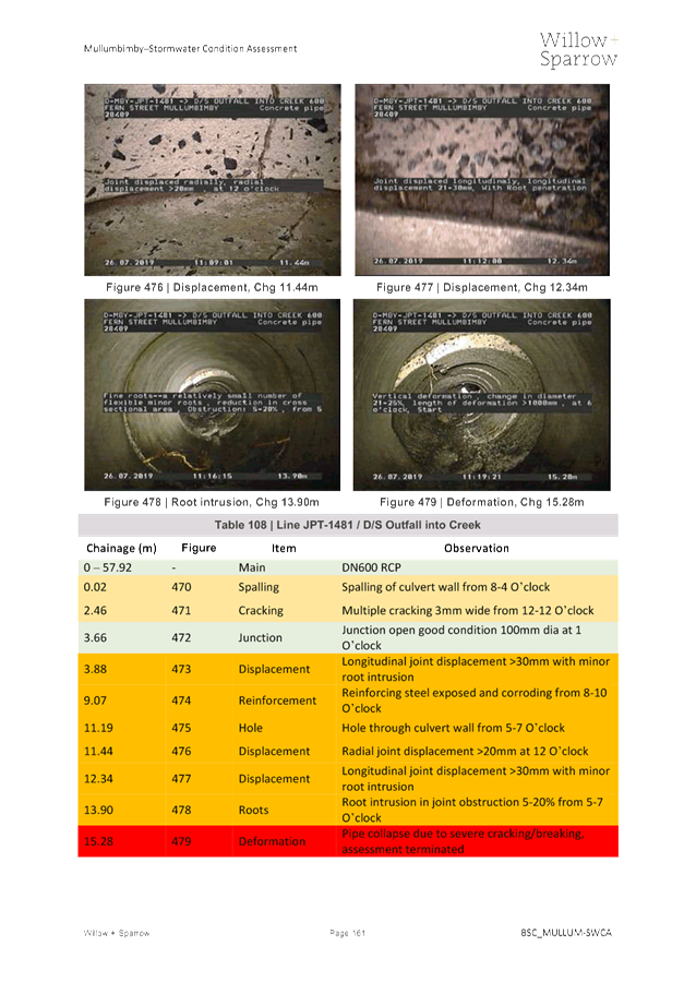
some images of the existing sewer mains that were assessed.
|
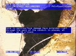
Hole in
pipe wall
|
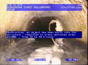 Defective
pipe repair Defective
pipe repair
|
|
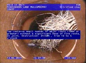 Major root
intrusion Major root
intrusion
|
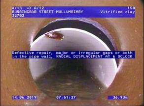
Major displacement at pipe
replacement
|
|
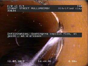 Heavy
infiltration Heavy
infiltration
|
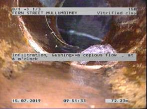 Heavy
infiltration Heavy
infiltration
|
|
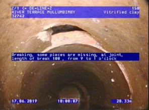 Hole in
pipe wall Hole in
pipe wall
|
 Major root
intrusion Major root
intrusion
|
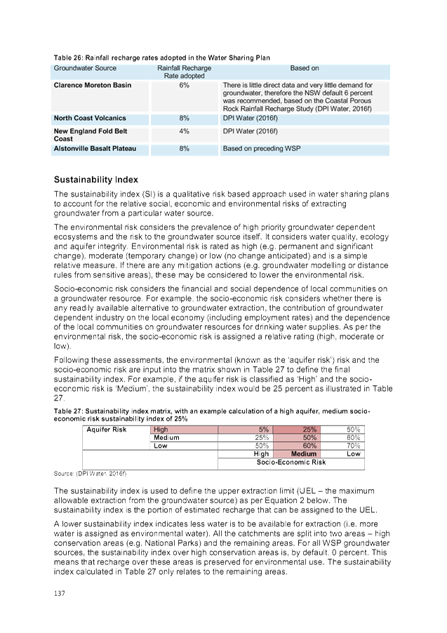
Figure 3 presents
the overall risk score summary for both the sewer mains and stormwater
culverts.
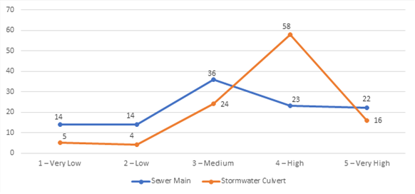
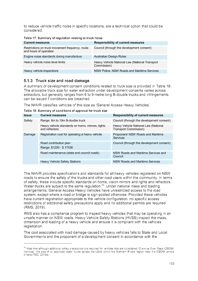
Figure 3 – Risk
Score Summary
From Figure 3, it can be
determined that 41% of the sewer network and 69% of the stormwater network
within the project extent is either a high or very high risk of failure.
The risks that
BSC is responsible for managing include but are not limited to the following:
a) Pipe
collapse resulting in expensive emergency rectification works
b) Increased
on-going sewerage operational costs due to capturing, transferring, and
treating both groundwater and stormwater that infiltrates the sewer network
c) Poor
conveyance of stormwater that can lead to flooding, resulting in damage to
property and road infrastructure
d) Extensive
infiltration into the sewer network that results in the migration of supportive
material beneath road pavements which can result in the undermining of
pavements resulting in their collapse (sink hole).
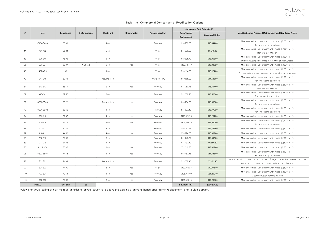
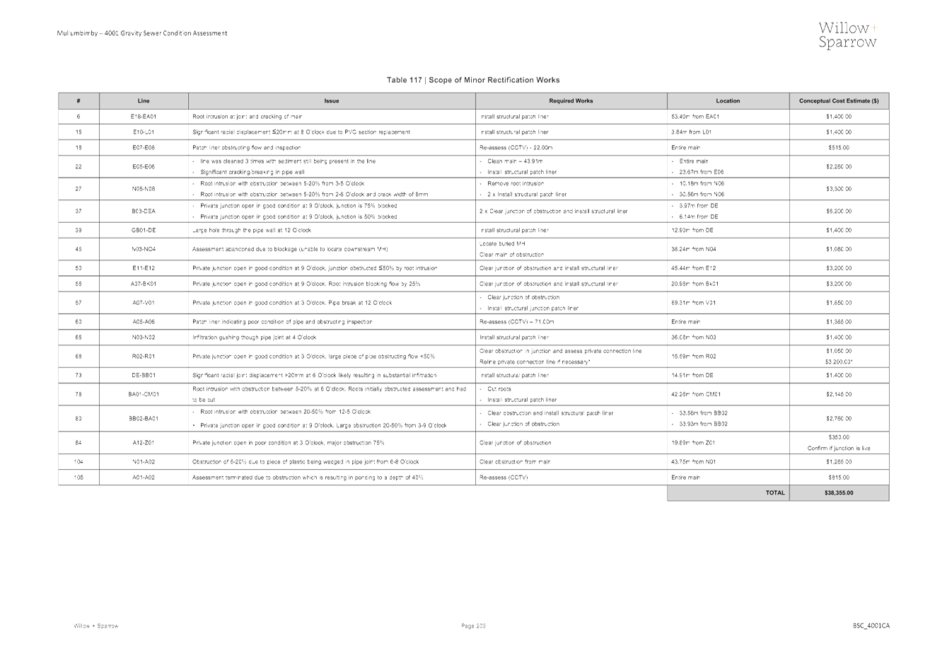
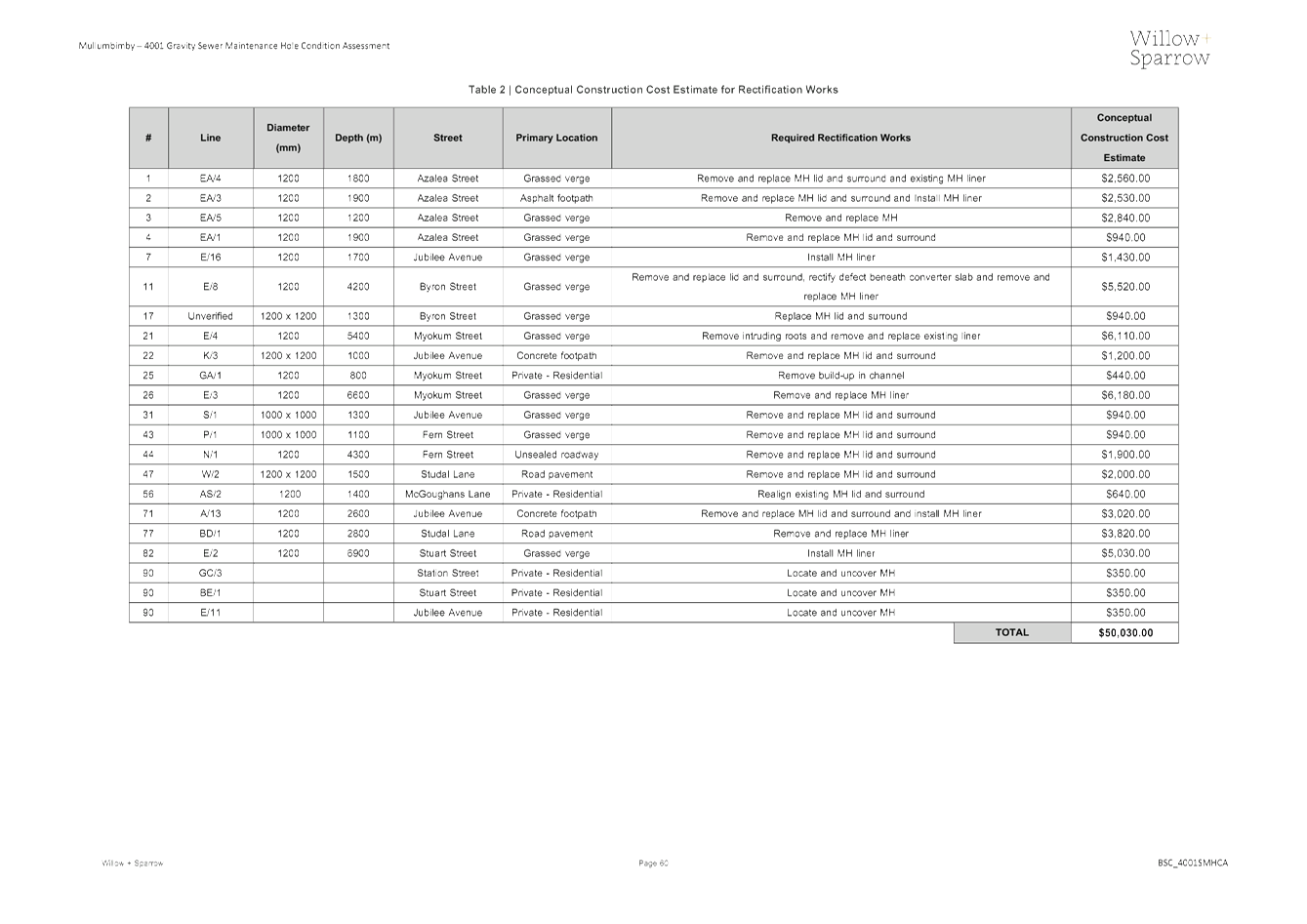
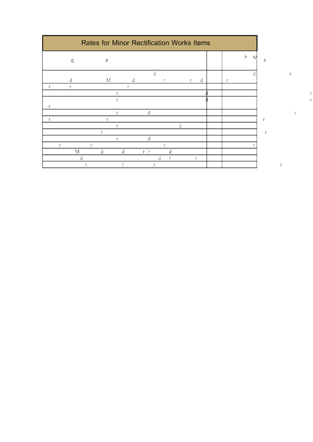
4.2 Proposed
Rectification Works
In order to mitigate the risks
that BSC is responsible for managing, a summary of the proposed renewal and
minor rectification works for FY19/20 are noted in Table 1 below with the
overall conceptual construction cost estimate for each asset type.
Table 1 – Proposed
Rectification Works FY19/20
|
Asset Type
|
# Assets
Assessed
|
# Assets to
Rectify
|
Nature of
Scope
|
Estimated
Cost (±20%)
|
|
Gravity
sewer main
|
109
|
26
|
Renewal
|
$400,000
|
|
20
|
Rectification / maintenance
|
$40,000
|
|
Sewer MH
|
92
|
20
|
Rectification / maintenance
|
$50,000
|
|
Stormwater
culvert
|
107*
|
21
|
Renewal
|
$580,000
|
|
9
|
Rectification / maintenance
|
$20,000
|
|
Stormwater MH
|
24
|
7
|
Rectification / maintenance
|
$5,000
|
|
*The
assessment of only 92 stormwater mains could be completed due to obstructions
|
Sewer
Subtotal
|
$490,000
|
|
Stormwater
Subtotal
|
$605,000
|
|
TOTAL
|
$1,095,000
|
It should also be noted that
budget for the necessary rectification of the highest priority stormwater
culverts within Mullumbimby has not yet been established. A report
specific to the asset management of the stormwater network is being submitted
to the Transport and Infrastructure Advisory Committee (TIAC) in order to
request funding.
Furthermore, in addition to the
above scoped works there are various other assets within this catchment that
have been assessed that can be justified for renewal over the subsequent years
subject to budget availability and prioritisation against assets within other
catchments.
5. Timing
The proposed sewer renewal and
rectification / maintenance works have been verified and supported by Utilities
officers and management and will be going to tender in December 2019 with an
estimated completion before the end of FY19/20. It should be noted that
this scope also includes the stormwater culvert and stormwater MH rectification
/ maintenance works totalling an estimated construction cost of $25,000 that
will be funded by the available sewer capital budget. Therefore, the
total estimated construction cost of the proposed sewer / stormwater works is
$515k (excl GST).
As for the stormwater culvert
renewals ($580k), budget needs to be sourced to facilitate these works prior to
tendering and undertaking the construction works. A report has been
presented to the Transport and Infrastructure Advisory Committee concerning the
budget associated with the required stormwater rectification works as well as
the ongoing management of the stormwater network.
6. Renewal
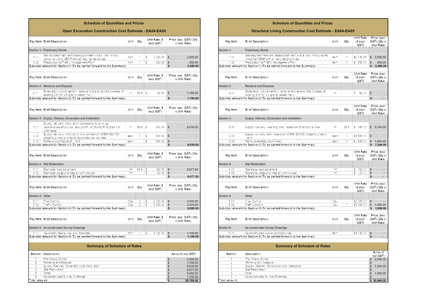
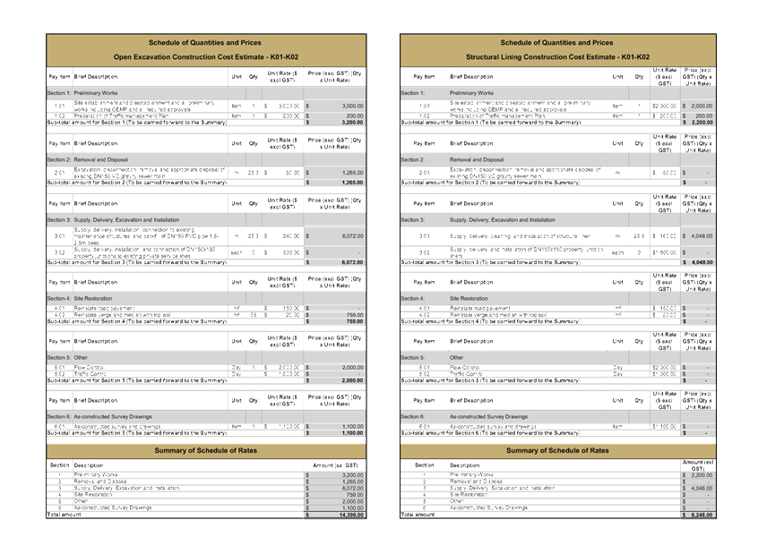
Methodology
With advancements in technology
and products, in some instances there are now alternative options to
traditional open trench excavation “remove and replace”
methods. There are various structurally integral liners that can be
installed to rehabilitate pipes and culverts that are in poor condition.
Fortunately, it has been identified that all of the gravity sewer mains that
are proposed for rectification can be done so with a structural liner.
Advantages of this methodology include:
a) Increased
expediency of rectification works
b) Reduced
capital expenditure (typically >50% savings)
c) Reduced
community impact (traffic, noise, dust, amenity, etc.)
d) Reduced
exposure to high risk works for site personnel
Depending on the type of
structural liner, they can be easily removed if required without damaging the
existing “host” pipe / culvert and typically have a design life of
at least 50 years.
7. Budget
The existing budget for FY19/20
for the Mullumbimby sewer catchment is $590k. Spend/committed to date is $262k.
Hence the remaining sewer budget is approximately $328k. An additional $200k
will likely be required to facilitate these works including their management.
However, this additional budget will be requested once external contractor
price submissions have been received.
8. Ongoing
Assessment
As the assessment of the
Mullumbimby sewer and stormwater catchment has revealed the poor condition of a
large portion of the catchment (41% sewer and 69% stormwater). It is evident
that other portions of the BSC network may be in particularly poor condition as
well. This presents various previously noted risks to BSC all of which have the
potential to adversely impact on the public perception of BSC.
It is proposed in future to
replicate the approach that has been adopted for this portion of the
Mullumbimby catchment, and apply it to the remainder of the network in a
prudent and efficient manner. However, due to a lack of funding for the
stormwater network which has been highlighted in a report that is being
presented to the Transport and Infrastructure Advisory Committee (TIAC), the
gravity sewer main assessments in FY19/20 will have to be undertaken in
isolation without stormwater.
A desktop risk analysis has been
developed for the gravity sewer network based on various criteria such as age,
depth, material composition, downstream peaking factors, etc. This risk
analysis model enables the Asset Management team to identify the assets that
are likely to be the highest risk to Byron Shire Council, and therefore the
highest priority for assessment. Two of the highest risk sewer catchments
in Byron Bay and Ocean Shores (3002 and 5012) totalling a length of 22.65km
will be assessed in FY19/20 to gain a comprehensive understanding of their
condition to enable the asset management team to manage any identified risks
accordingly.
Though as previously noted, the
intent is to undertake future assessments of both the sewer and stormwater
infrastructure in concurrence due to the following benefits that this approach
presents:
a) BSC
will have accurate information to support the prudent and efficient asset
management of its gravity sewer and stormwater infrastructure.
b) Cost
savings due to single establishments for camera and assessment crews in
addition to an increased length of CCTV assessments which will result in
economies of scale.
c) A
reduction in the impact to community from noise, amenity, traffic control, etc.
due to the elimination of repeat works in the same areas.
It is imperative that BSC gains a
comprehensive understanding of the condition of its gravity sewer and
stormwater networks to ensure that their integrity and function are maintained
in order to manage the associated risks accordingly.
Below is a summary of the
proposed accelerated assessment program from the gravity sewer network risk
analysis for the next 5 years. This accelerated program aims to
compensate for the lack of assessments that have been undertaken
historically. The summary in Table 2, details the lengths to be assessed
and the estimated assessment cost.
Table 2 – Proposed 5
Year Works Summary
There is currently $5M available
for the ongoing management of the gravity sewer network over the next 5 years
inclusive of Year 1 (FY19/20). This budget has been apportioned $2.5M to the
Mullumbimby catchment and $2.5M to the remainder of the sewer network. When
considering the degree of urgent rectification works that were required
following the Mullumbimby assessment, it is likely that the budget of $5M over
5 years will be insufficient to adequately manage the sewer network.
However, the Asset Management team will have a better understanding of the
budget that will be required following the completion and risk assignment of
the 3002 and 5012 sewer catchments scheduled for completion in FY19/20. Following
this, if required, a report will be presented to the WWSC with justification
supporting an increase in the available budget.
9. Conclusion
Given the findings of the
assessments that were undertaken in a relatively small portion of the
Mullumbimby township, it is strongly recommended that ongoing condition
assessments are undertaken for both the remainder of the gravity sewer and
stormwater networks. This will provide BSC with the necessary information
to manage identified risks in a prudent and efficient manner.
Furthermore,
there are advantages to undertaking the assessments of these two networks in
parallel. Economies of scale will dictate that an increase in value for
money will be achieved in addition to other benefits such as reduced
establishments and interruption to the community.
A report providing an update will
be presented to the WWSC following the completion of the 3002 and 5012 gravity
sewer condition assessments in FY19/20 noting whether additional budget is
required to continue with the ongoing assessments and required rectification
works over the five year window to FY23/24.
Staff Reports - Infrastructure Services 4.1 - Attachment 1

Staff Reports - Infrastructure Services 4.1 - Attachment 2

Staff Reports - Infrastructure Services 4.1 - Attachment 3
Staff Reports - Infrastructure Services 4.1 - Attachment 4


Staff Reports - Infrastructure Services 4.2
Report No. 4.2 Effects
of water mining in Byron and surrounding shires on groundwater resources
Directorate: Infrastructure
Services
Report
Author: Dean
Baulch, Principal Engineer, Systems Planning
File No: I2019/2131
Summary:
The NSW Chief Scientist & Engineer undertake an
independent review of the impacts of the bottled water industry on groundwater
resources in the Northern Rivers region of NSW. The effects appear to be
negligible.
Rous Water through its Future Water Supply Strategy is
conducting investigation for groundwater sources.
|
RECOMMENDATION:
That the Committee
note the report.
|
Attachments:
1 Independent
review of the impacts of the bottled water industry on groundwater resources in
the Northern Rivers region of NSW - Final Report - NSW Chief Scientist &
Engineer - 31 October 2019, E2019/91097
, page 555⇩
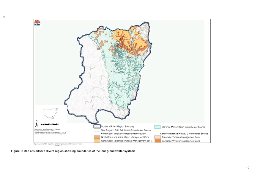
REPORT
At the Council Meeting of 22 November 2018, it adopted the
following Committee Recommendation as Resolution
18-742:
2. That Council request
information from surrounding shires, Rous County Council, Southern Cross
University and DOI on:
a) Current water extraction quantities
and locations
b) Research on short term and long term
impacts of these activities on aquifers and ground water resources. (Richardson/Hackett)
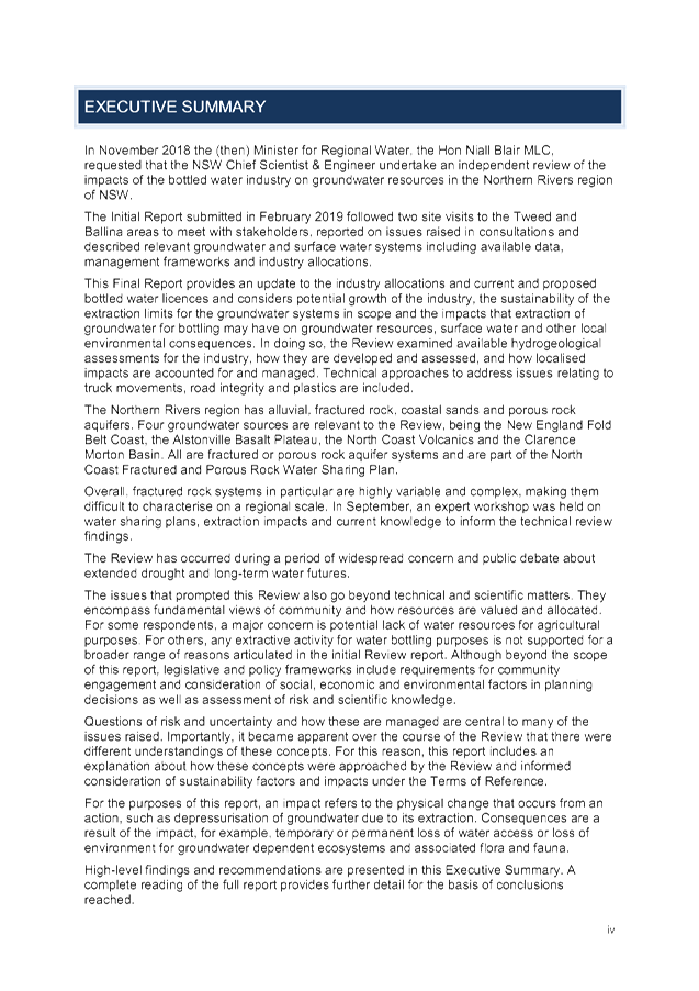
In November 2018 the (then) Minister for Regional Water, the
Hon Niall Blair MLC, requested that the NSW Chief Scientist & Engineer
undertake an independent review of the impacts of the bottled water industry on
groundwater resources in the Northern Rivers region of NSW. This was
finalised on 31 October 2019, see attachment 1.
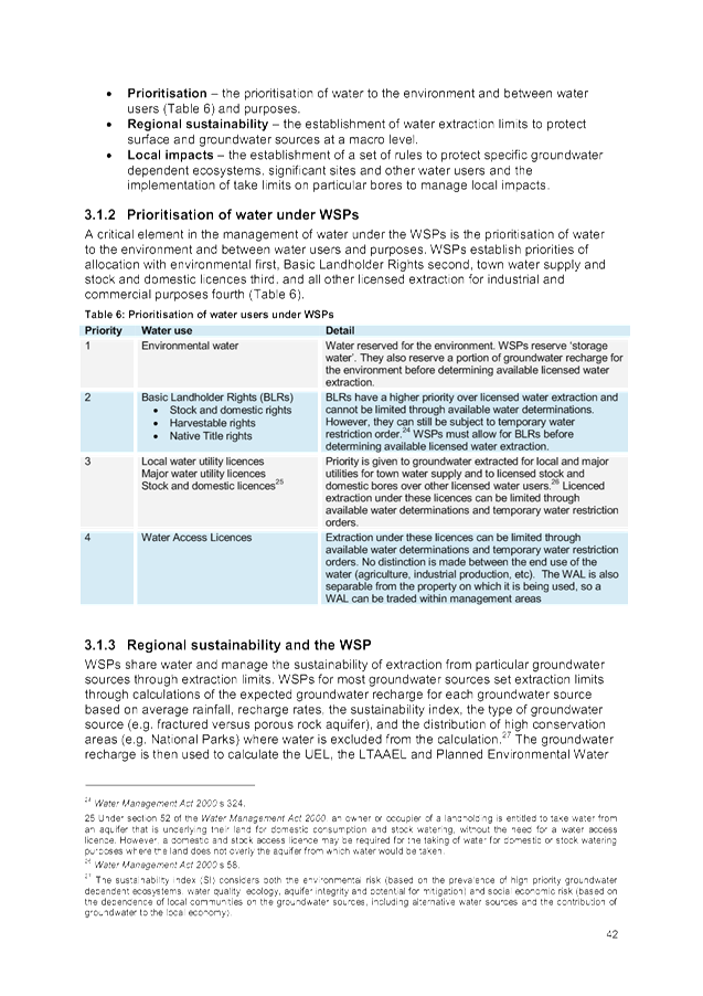
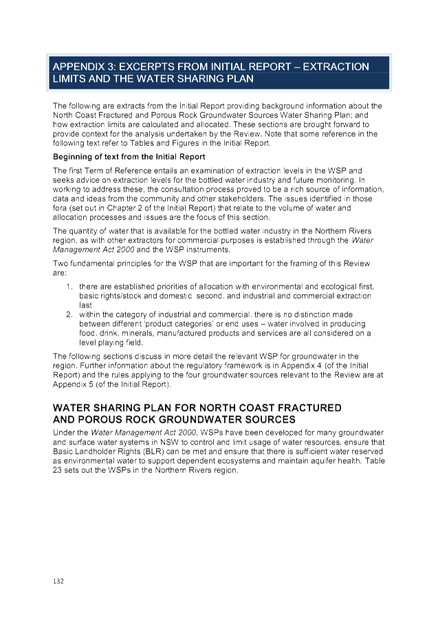
A critical element in the management of water under the Water
Sharing Plans (WSPs) is the prioritisation of water to the environment and
between water users and purposes. WSPs establish priorities of allocation with
environmental first, Basic Landholder Rights second, town water supply and
stock and domestic licences third and all other licensed extraction for
industrial and commercial purposes fourth.
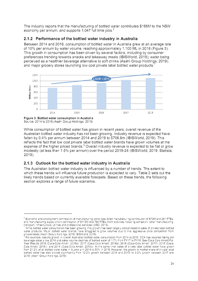
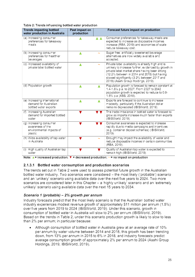
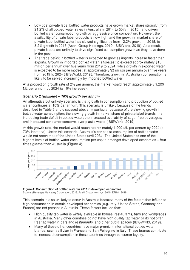
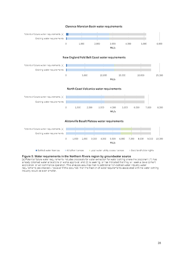
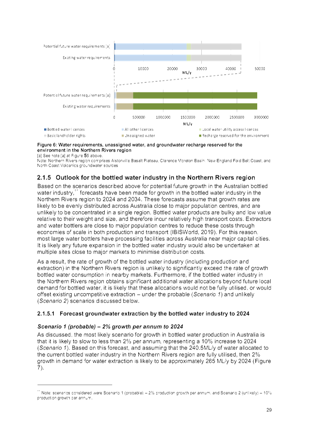
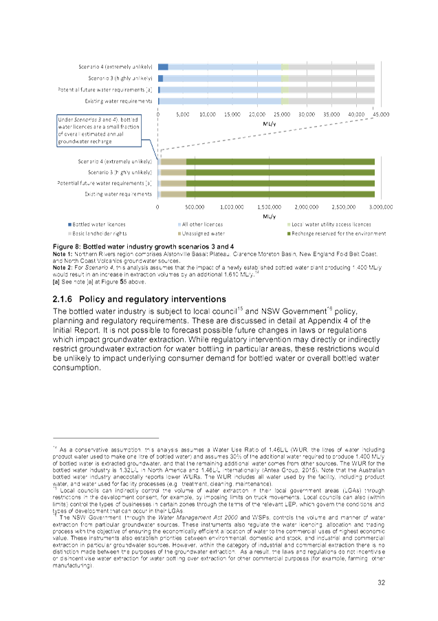
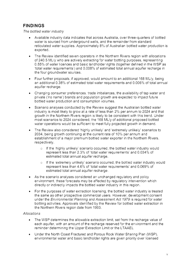
The Review identified seven operators in the Northern Rivers
region with allocations of 240.5 ML/y who are actively extracting for water
bottling purposes, representing 0.55% of water licences and basic landholder
rights (together defined in the Water Sharing Plans as ‘total water
requirements’) and 0.008% of estimated total annual aquifer recharge in
the four groundwater sources. The report does not include the location of
individual extraction licences.
Rous Water through its Future Water Supply Strategy is
conducting investigation for groundwater sources.
Staff Reports - Infrastructure Services 4.2 - Attachment 1


Staff Reports - Infrastructure Services 4.3
Report No. 4.3 Condition
9. Additional Load at Byron STP
Directorate: Infrastructure
Services
Report
Author: Dean
Baulch, Principal Engineer, Systems Planning
File No: I2019/2155
Summary:
This report is for Council information and reviews
compliance with the Byron Bay Sewerage Augmentation Scheme - Conditions of
Approval (2002). Condition 9(iii) requires that sufficient reuse (recycled
water) capacity be available before the acceptance of any additional load at
the treatment plant.
In the years since the approval was granted (2002 to date),
2,408 Equivalent Tenements (ET) have been approved, resulting in an additional
load of 1.42ML/day at the treatment plant. The current day operating capacity
of the reuse system equates to 2.02ML/day or 3,427ET. Therefore the reuse
system provides sufficient capacity to accommodate the additional load as
defined in the Conditions of Approval
This report is a response to resolution 540 point 5, 6 and
19-598 point 2 and 3.
|
RECOMMENDATION:
That Council:-
1. Note that
compliance with Condition 9 of the Approval is satisfactory.
2. That
staff investigate and recommend a modern day industry method for calculating
Average Dry Weather Flow that can be applied consistently across all of
Council’s Sewage Treatment Plants.
|
Attachments:
1 Byron Bay
Sewerage Augmentation Scheme - Conditions of Approval, DM387682 , page 753⇩
2 ASSESSING
THE DEMANDS & SUPPLY CAPACITY OF THE BYRON BAY URBAN RECYCLED WATER SCHEME
- Planit Consulting 2018, E2019/93964
, page 763⇩
REPORT
|
19 - 540
|
Resolved that Council adopt the following
Committee Recommendation(s):
Report No. 4.2 Byron
Bay Integrated Management Reserve Update
File No: I2019/1588
Committee Recommendation
1. (…)
5. That
listing for Byron Bay STP Catchment of sewage load resulting from Development
Consents after 9 December 2002 (or similar) be brought to the next WWSAC.
6. That
Council note that Byron Bay STP capacity was reassessed in recent
years.
7. That
Council note that when ADWF reaches 80% of plant capacity (assessed in 2002
as 6.95 ML/day) Condition 6 requires action by Council.
|
|
19 - 598
|
Resolved
that Council adopt the following
Committee and Management Recommendation(s):
Report No. 4.1 Byron
Bay Integrated Management Reserve - Byron Bay STP Catchment
File No: I2019/1847
Committee
Recommendation 4.1.1
1. That
the Council note the report.
2. That
a report on Byron Bay STP Catchment sewerage load resulting from Development
consents after 9 December 2002 (or similar) be brought to the next meeting of
WWSAC.
3. That
the Conditions of Consent for the Byron Bay STP be included with the Report.
|
In 2002 the Byron Sewage
Augmentation Scheme was approved. This scheme comprised of the upgrading of
West Byron Sewage Treatment Plant (STP), decommissioning of South Byron STP,
construction of a sewerage transfer pipeline between South Byron STP and West
Byron STP, and upgrading of associated pumping stations.
Byron Sewerage Augmentation
Scheme was put to a special meeting of Council, held at Council’s
chambers on 9 December 2002. The resolution (02–1329) of Byron Shire
Council adopted the Conditions of Approval (see Attachment 1) for the Scheme.
The Waste and Water Sewage
Advisory Committee recently requested information regarding Council’s
compliance with the consent conditions of the report. The Committee’s
request was specifically related to Condition 9 of the resolution. This report
also expands into other related parts of the “Conditions of
Consent”.
The section from Condition 9 of the Approval that has raised
the query is Condition 9(iii), which states, “Additional load at West
Byron STP will not be accepted until: availability of sufficient reuse capacity
to accommodate 100% of the volume of treated effluent generated by the
additional load”.
“Additional Load” is defined in the report as
“any sewage load resulting from development consents after the date of
this approval”. Date of Approval is 9 December 2002.
From December 2002 to the end of November 2019, 2,408
additional sewer Equivalent Tenements (ET) have been approved by Council
through development consents.
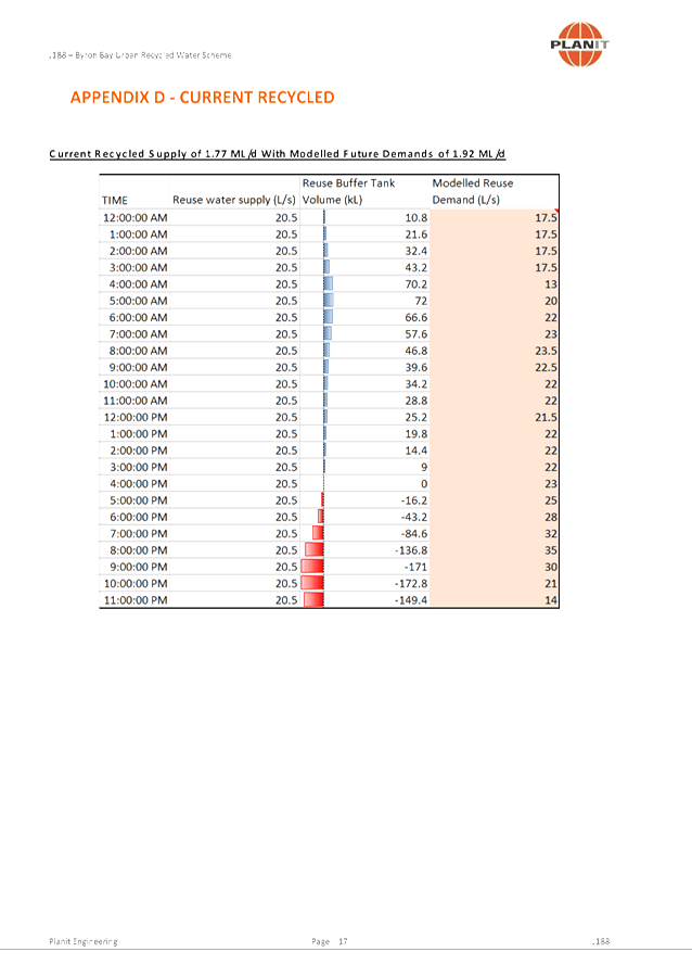
The theoretical capacity of the effluent reuse system is
1.77 ML/d (3,000ET). This was modelled by Planit Consulting in 2018 (see
Attachment 2). The current day operating capacity of the reuse system to
produce treated effluent is 26 Litres per second or 2.25ML/day less 10% of
water for filter backwash purposes equates to 2.02ML/day or 3,427ET.
Therefore the reuse system provides sufficient capacity to accommodate the
additional load as defined above.
As stated the current operational capacity of the effluent
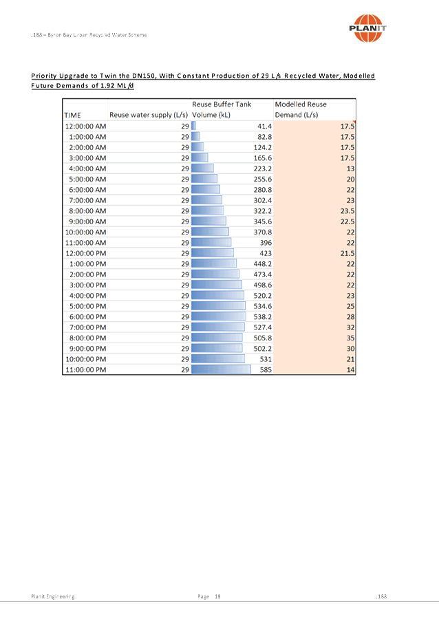
reuse system is 2.02ML/day (January 2020). This is planned to be increased to
2.77ML/day (4,695ET) in the current financial year by carrying out pipework
modifications and upgrades at the plant.
|
Summary
|
Current
ET
|
Available Capacity
(ET)
|
|
Condition 9(iii) Additional Load Calculation
|
2,408
|
-
|
|
Theoretical effluent reuse system capacity 2018
|
3,000
|
592
|
|
Current effluent reuse system capacity 2020
|
3,427
|
1,019
|
|
Future effluent reuse system capacity >2021
|
4,695
|
2,287
|
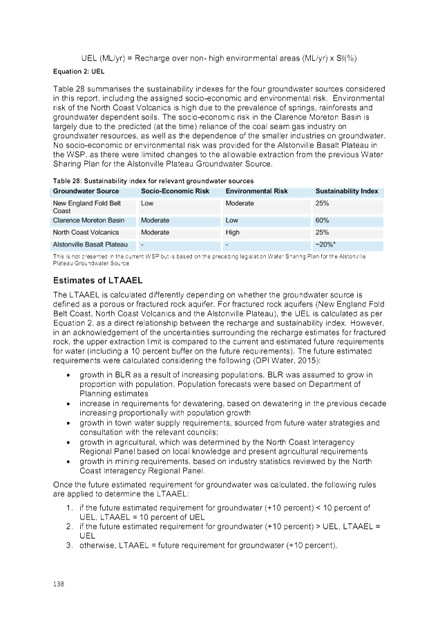
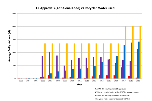
It is important to note the difference between actual use of
the reuse system and the capacity of the system. Actual use is dependent
on environmental conditions – factoring in rainfall and drought.
The number of users is the other large factor in taking up the reuse effluent
volume - more customers obviously increases demand and consumption. The
following graph shows the actual reused volume used against the additional
load.
The current Byron Shire Recycled
Water Management Strategy 2017 – 2027, adopted by Council, sets out the
strategic direction for recycled water management in the Byron Shire. In order
to meet the key direction targets of the Strategy as well as Condition 9(iii),
various infrastructure projects are required to be constructed. Included in the
Strategy is development of the rural and environmental scheme along the Western
Corridor. Council is currently investigating the supply options to the
Western and Southern Corridors. Potential customers identified to the
west include “The Farm”, “Sea Peace”, Cape Nursery and
several macadamia farmers. Along the Southern Corridor there are a number
of macadamia farmers who have requested connection to the scheme. The
supply to each customer will be assessed on its merits (cost/benefit analysis).
The first customer identified
for connection to the scheme along the Western Corridor is “The
Farm” due to the close proximity to existing infrastructure. This
customer is expected to be connected early in the 2020/2021 financial
year. The supply to the Western and Southern Corridors will meet the
Strategy’s planned focus to be of beneficial use in rural and
environmental applications.
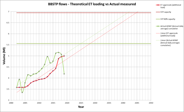
Condition 6 of the “Conditions of Approval” also
states that when the ADWF reaches 80% of treatment capacity, investigations
must commence to identify feasible strategies for the management of sewage
flows above the capacity of the plant. Following the flow trends from 2002 to
current (27 November 2019), the plants 80% capacity is expected to be reached
in 2025. Council staff will continue to monitor the inflows into the plant and
once 80% capacity is reached, will commence investigation of strategies for
management of sewage flows.
The following graph shows the flow trend for the Byron
STP. The data points above and below the linear trend are an indication
of wetter or dryer than average years. The current drought conditions
being experienced are evident in the 2019 flow data values.

The actual ADWF figures are an average of the full years
flow totalised daily at the Byron STP. The top 20% and bottom 10% of data was
removed from the calculations to exclude rainfall effect and recording
anomalies from the figures used. The result is the annual ADWF. Within
Byron Bay the ADWF varies according to the season. There is a summer peak
in Dec/Jan and over Easter; a winter low and the "shoulder period"
during the remaining time. This creates a range that is not reflected in
the graph or data. The actual flow reflected is an average of the
year’s data.
The data shows that the actual and derived (through ET
calculations) ADWF trends over the past 15 years are tracking parallel to each
other, indicating a level of certainty with the figures used. Based on the last
15 years of actual flow data, the Byron STP is expected to reach capacity in
2042.
The method stipulated in the
“Conditions of Approval” states the definition for ADWF as
“the average flow over a period of not less than five (5) consecutive
days with no rainfall, with no more than 5mm of rain in the preceding ten (10)
days”. Using this method, there is the potential to obtain skewed
results due to the large flow variations over the three flow periods. ADWF
in the winter can be as low as 60% of the summer peak. In order to ensure
the actual annual average was calculated, the entire year’s data has been
used.
On 22 March 2018 Council
Resolution 18-193 adopted the Policy - Water and Sewer Equivalent Tenements
2018 that includes the Dry Weather Flow definition:
The average daily flow to the
treatment works during seven consecutive days without rain (excluding a period
which includes public holidays) following seven days during which the rainfall
did not exceed 0.25 millimetres on any one day.
The above highlights that we have
varying definitions for calculating ADWF and we now have an opportunity to
update this calculation/condition in line with modern day industry methods that
can also be applied consistently across all of Council’s treatment
plants.
Staff Reports - Infrastructure Services 4.3 - Attachment 1
Byron
Bay Sewerage Augmentation Scheme – Conditions of Approval
General
1. The
proposal shall be carried out in accordance with:
(i) the
proposal contained in the EIS and SIS Byron Bay Sewerage Augmentation Scheme
dated 30 August 2001 prepared for Byron Shire Council by Environmental
Resources Management Australia Pty Ltd, subject to modifications to the
proposal as described in the document Byron Bay Sewerage Augmentation
Representations Report (the Representations Report) prepared for Byron
Shire Council by Environmental Resources Management Australia Pty Ltd dated
September 2002;
(ii) all
identified procedures, safeguards and mitigation measures identified in the
EIS, SIS, and Representations Report;
(iii) the
conditions of concurrence imposed by the Director–General of the NPWS in
the document Concurrence Report for the Proposed Establishment of a
24 ha Melaleuca Regeneration Area, West Byron Sewage Treatment Plant
dated June 2002 prepared by NPWS Conservation Programs and Planning
Division–Northern Directorate; and
(iv) the conditions of approval imposed by
Byron Shire Council.
In the event of any inconsistency between the conditions
imposed by Council (these conditions) and recommendations contained in the EIS,
SIS or Representations Report, these conditions shall prevail.
Notwithstanding the above, in the event of any inconsistency
between the concurrence conditions imposed by the Director–General of the
NPWS and these conditions, the recommendations in the EIS, SIS, or
Representations Report, the concurrence conditions imposed by the
Director–General of the NPWS shall prevail.
These conditions do not relieve Council
of the obligation to obtain all other necessary approvals, licences or permits
required under any other Act. Without affecting the generality of the
foregoing, Council shall comply with the terms and conditions of such
approvals, licences and permits.
Finalisation of draft Byron Bay
Effluent Management Strategy
2. Council
shall, as soon as practicable but no later than six (6) months from the date of
this approval, finalise the draft Byron Bay Effluent Management Strategy.
As part of finalisation of the draft strategy, Council shall:
· consult
with the EPA, and take into account any comments it may have with regard to the
implementation of the strategy; and
· include
provision for the periodic review of the strategy, this period to be no greater
than five (5) years.
Definitions
3. For
the purposes of implementation of these approval conditions, the following
definition of ‘Average Dry Weather Flow’ (ADWF) shall apply:
‘The average flow
over a period of not less than five (5) consecutive days with no rainfall, with
no more than 5 mm of rain in the preceding ten (10) days.’
The efficacy of this definition shall be reviewed no later
than 12 months from the date of commissioning of the West Byron STP
augmentation and at 12 month intervals thereafter. The review shall
include consultation with relevant stakeholders, including, but not limited to:
DLWC, the Byron Bay Wastewater Steering Committee. If deemed appropriate,
this definition may be amended, subject to a process including consultation
with relevant stakeholders.
4. For
the purposes of implementation of these approval conditions, the following
definition of ‘additional load’ shall apply:
‘Additional
load is any sewage load resulting from development consents after the date of
this approval.
5. For
the purposes of implementation of these approval conditions, the following
definition of ‘reuse project’ shall apply:
‘An enterprise utilising treated effluent under a valid Environment
Protection Licence where required, holding a valid contract with Council, and
with all required infrastructure in place and operational.
West Byron STP Capacity
6. West
Byron STP shall not accept flows for treatment in excess of 6.95 ML/day
(ADWF). This is the plant’s treatment capacity. Council shall
continuously monitor the Average Dry Weather Flow entering the upgraded West
Byron STP to assess the load on the plant in relation to the plant’s
treatment capacity. When 80% treatment capacity is reached, Council shall
investigate feasible strategies for management of sewage flows above the
capacity of the plant. In the event that load exceeds 100% treatment
capacity, Council shall meet to discuss appropriate courses of action to
prevent further exceedances.
7. The
load which shall be received at West Byron STP at the time of commissioning of
the upgraded plant shall be limited to the load from the West Byron catchment
at that time.
8. The
transfer of sewage flows from South Byron STP to West Byron STP catchment shall
be conditional upon:
(i) West
Byron STP satisfactorily meeting all applicable performance requirements as per
construction contract requirements and as specified in the plant’s
Environment Protection Licence and in this approval; and
(ii) the
availability of a reuse project(s) capable of accepting a minimum of
326 ML/yr of treated effluent as determined in the Effluent Management
Strategy.
9. Additional
load at West Byron STP will not be accepted until:
(i) the
transfer of 100% of the sewage flows from South Byron catchment;
(ii) West Byron
STP satisfactorily meeting all applicable performance requirements as specified
in the plant’s Environment Protection Licence and in this approval;
(i) availability
of sufficient reuse capacity to accommodate 100% of the volume of treated
effluent generated by the additional load; and
(iv) availability
of treatment capacity as defined in Approval Condition 6 above.
Effluent Quality Standard for
West Byron STP
10. Unless
otherwise determined by the EPA, treated effluent produced by West Byron STP,
as measured at the licensed STP outlet (unless otherwise indicated), shall meet
the following quality standards:
|
Parameter
|
Abbreviation
|
Units
|
Standard
(90th percentile)
|
|
Biochemical Oxygen Demand
|
BOD5
|
mg/L
|
10
|
|
Suspended solids
|
SS
|
mg/L
|
15
|
|
Total Nitrogen
|
TN
|
mg/L
|
3 (50th %ile)
|
|
Total Phosphorus
|
TP
|
mg/L
|
0.5 / 0.31
|
|
Faecal Coliforms
|
FC
|
cfu/100 mL
|
200
|
1 At
the licensed STP outlet and wetland outlet respectively
The
quality of treated effluent delivered to reuse sites shall be subject to
separate determination.
Nutrient Load Limit for West
Byron STP
11. Nutrient
loads discharged to Belongil Creek, as measured at the outlet of the
constructed wetland, shall not exceed 1,502 kg per year for Total Nitrogen
and 300 kg per year for Total Phosphorus.
. Council
shall continuously monitor nutrient loads discharged to the Belongil
Creek. Determination of nutrient loads shall be based on a minimum of
weekly sampling continuously averaged over a two month period, converted to an
equivalent annual load.
In the event that the equivalent annual nutrient load for
either Total Nitrogen or Total Phosphorus exceeds 80% of the applicable limits
specified in this Approval Condition, Council shall investigate feasible
management strategies to reduce loads below 80%.
In the event that the equivalent
annual nutrient load for either Total Nitrogen or Total Phosphorus exceeds 100%
of the applicable limits specified in this Approval Condition, Council shall
meet to discuss appropriate courses of action to prevent further exceedances.
Byron Bay Wastewater Steering
Committee
12. The
Byron Bay Wastewater Steering Committee shall be consulted with respect to all
matters relating to wastewater management (including reuse) for Byron
Bay. Council shall review the need for the Byron Bay Wastewater Steering
Committee upon commissioning of the West Byron STP and adoption of the Byron
Bay Effluent Management Strategy.
Construction Environmental
Management Plan
13. Prior to the
commencement of construction works, Council shall prepare a Construction Environmental
Management Plan (CEMP). The plan shall be prepared in consultation with
the EPA, NPWS, DLWC, the Byron Bay Wastewater Steering Committee, and any other
relevant party. The plan shall also be prepared in accordance with these
conditions of approval, all relevant Acts and Regulations, and accepted
environmental management best practice.
14. The CEMP
shall address, but not be limited to, the following:
(i) specific
environmental management objectives and strategies for the main environmental management
elements and include, but not be limited to: water quality; noise and
vibration; air quality/odours; erosion and sedimentation; access and traffic;
property acquisition and/or adjustments; heritage and archaeology; groundwater;
contamination; waste/resource management; flora and fauna; weed control; acid
sulphate soils, hydrology and flooding; geotechnical issues; visual screening,
landscaping and rehabilitation; hazards and risks; energy use, resource use and
recycling; and utilities;
(ii) identification
of the statutory and other obligations which Council is required to fulfil
during project construction including all approvals and
consultations/agreements required from authorities and other stakeholders, and
key legislation and policies which control the Proponent’s construction
of the project;
(iii) definition
of the role, responsibility, authority, accountability and reporting of
personnel relevant to the EMP;
(iv) measures to avoid and/or control the
occurrence of environmental impacts;
(v) measures
(where practicable and cost effective) to provide positive environmental
offsets to unavoidable environmental impacts;
(vi) environmental
management procedures for all construction processes which are important for
the quality of the environment in respect of permanent and/or temporary works;
(vii) monitoring, inspection,
and test plans for activities and environmental qualities which are
important to the environmental management of the project including performance
criteria, specific tests, protocols (eg frequency and location) and procedures
to follow;
(viii) steps Council intends
to take to ensure that all plans and procedures are being complied with; and
(ix) consultation
requirements with relevant government agencies.
15. The CEMP
shall be made publicly available.
Community Notification
16. Throughout
the construction phase, Council shall keep the local community informed of the
progress of the project including any traffic disruptions and controls,
construction of temporary detours, changes to local access and any work
required outside normal construction hours.
17. At
least one week prior to commencement of construction of the transfer pipeline,
Council shall provide written information to affected residents of properties
adjoining the pipeline route regarding the timing and duration of the works.
Contact Telephone Number and
Complaints Register
18. Prior to the
commencement of construction works, Council shall establish and publicly
advertise a contact telephone number to operate for the duration of the
construction period, to allow any member of the public to make a complaint or
comment about the construction works. The contact telephone number shall
be staffed during normal business hours. An initial response to any
complaints received shall be provided within 2 (two) working days and, where
required, a more detailed response within 10 (ten) working days.
19. Council shall
establish a complaints register to record details of any complaints received.
Construction Contractor’s
Environmental Management Responsibilities
20. Construction
tenders must include suitable documentation of accreditation in accordance with
the Construction Policy Steering Committee’s Environmental Management
Systems Guidelines.
21. In the
assessment of tenders for construction of the proposal, Council shall include
as a key evaluation criterion, the tenderer’s demonstrated commitment to
environmental management and track record in this regard.
22. Council shall
require that the successful contractor includes as part of its project team, an
environmental adviser with appropriate qualifications in environmental
management and/or environmental auditing. Council shall define the role
of the environmental adviser in the contract documentation for the project and
the role shall include undertaking regular environmental compliance audits,
providing training in environmental issues for the contractor’s personnel
and overseeing implementation of contractor’s environmental management
responsibilities.
Construction Stage
Environmental Audit
23. On
at least one occasion, at a time approximately midway through the construction
period, Council shall engage an appropriately qualified and experienced
environmental auditor to conduct an audit of the construction activities with
respect to compliance with these conditions of approval, the measures contained
in the EIS and the requirements of any other licences or approvals. Where
required, the audit shall include recommendations to address any identified
non–compliances.
Construction Hours
24. All
construction activities shall be undertaken between 7.00 am to
6.00 pm Monday to Friday, 8.00 am to 1.00 pm Saturdays with no
work on Sundays or Public Holidays except for construction work which fulfils
the following:
(i) any
works which do not cause noise emissions to be audible at any nearby
residential property;
(ii) the delivery
of materials which is required outside these hours requested by the police or
other authorities for safety reasons; or
(iii) emergency
work to avoid the loss of lives and/or property, and/or to prevent environmental
harm.
Construction Noise
25. Council shall
prepare a Noise Management Plan for inclusion in the CEMP which will identify
practical and cost–effective noise abatement measures to be implemented
with the objective of meeting the following construction noise level criteria:
(i) for
construction periods of four weeks or less, the L10 noise level,
when measured over a period of not less than 15 minutes when the construction
site is in operation, must not exceed the background level by more than
20 dB(A);
(ii) for
construction periods of greater than four weeks and not exceeding
26 weeks, the L10 level, measured over a period of not less
than 15 minutes when the construction site is in operation, must not exceed the
background level by more than 10 dB(A); and
(iii) for
construction periods greater than 26 weeks, the L10 level, measured
over a period of not less than 15 minutes when the construction site is in
operation, must not exceed the existing background noise level by more than
5 dB(A).
A value of 5 dB(A) shall be added to the sound pressure
levels recorded from the construction activities if the noise is substantially
tonal or impulsive in character.
Erosion and Sedimentation
Control
26. As part of
the CEMP, Council shall prepare a detailed Erosion and Sedimentation Control
Plan which details principles and measures to be implemented during
construction including the following:
(i) installation
of erosion and sediment control structures around stockpiles and downslope of
excavation areas;
(ii) minimisation
of cleared areas; and
(iii) ongoing
revegetation of disturbed areas.
The Plan shall be prepared in
consultation with the EPA and DLWC
27. As
part of the CEMP, Council shall develop, in consultation with the EPA, a water
quality monitoring program and incident response procedure to detect and manage
any incidences of pollution of waterways by effluent during construction.
Air Quality
28. During
construction, Council shall implement dust suppression measures on unsealed
roads and on spoil stockpiles to minimise dust generation.
Landscape and Rehabilitation
29. As part of the
CEMP, Council shall prepare a landscape plan detailing landscaping and
revegetation works to be undertaken at the West Byron STP site, the South Byron
STP site and along the transfer pipeline route.
Traffic Management
30. As part of
the CEMP, Council shall prepare a Traffic Management Plan detailing measures to
be implemented to minimise disruption to traffic during the construction of the
transfer pipeline. The Procedure shall include a protocol for notifying
properties adjoining the pipeline route of the construction works. The Plan
shall include, but not be limited to, consideration of the following management
measures:
(i) need
for road closures and detours;
(ii) temporary
reduction of lane widths on Ewingsdale Road;
(iii) reduced
construction speed zone limit; and
(iv) locations for safe
parking of construction vehicles.
Indigenous Heritage
31. Council shall
ensure that a qualified archaeologist is present during ground–disturbing
construction works in Survey Units 2 and 4 and during initial planting works in
Survey Unit 5. If any potential sites or artefacts of indigenous heritage
significance are identified, work in the immediate area shall cease and the
NPWS, Arakwal Aboriginal Corporation, and Byron Shire Council Aboriginal
Consultative Committee consulted to determine the most appropriate course of
action.
32. The Arakwal
Aboriginal Corporation shall be invited to undertake monitoring during
construction activities in areas of potential cultural heritage sensitivity.
33. As part of
the induction and training program for personnel involved in the project
construction, the requirements of the National Parks and Wildlife Act 1974 in
relation to indigenous heritage shall be addressed.
34. If any
construction work is undertaken on land subject to a Native Title Claim, a
process of consultation must be undertaken with the relevant claimant group.
Non-indigenous Heritage
35. During
construction works, an exclusion zone of at least 10 m radius is to be
established around the Byron Bay Railway Station and Stationmaster’s
Residence, and the Railway Water Tower. No construction work shall be
undertaken within this exclusion zone.
36. Council shall
consult with the NSW Heritage Office to develop a suitable research design to
undertake an archaeological assessment of the pipeline route through the
identified area. The assessment shall be undertaken prior to the
commencement of construction and an excavation permit under the provisions of
the Heritage Act 1977 obtained if required.
Waste Management
37. As
part of the CEMP, Council shall prepare a Waste Management Plan to address the
management of wastes during construction works. The Plan shall identify
requirements for waste avoidance, reduction, reuse and recycling. It
shall also detail requirements for handling, stockpiling and disposal of wastes
specifically spoil, contaminated soil or water, demolition material, cleared
vegetation, oils, greases, lubricants, sanitary wastes, timber, glass, metal,
etc. It shall also identify any site for final disposal of any
material. Any waste material that is unable to be reused, reprocessed or
recycled shall be disposed of to a landfill licensed by the EPA to receive that
type of waste.
Commissioning of Upgraded West
Byron STP
38. The construction
EMP shall include specific risk management measures to minimise the likelihood
of disruption to operation of West Byron STP during connection of new
infrastructure.
39. The
construction EMP shall also identify appropriate contingency measures for
implementation in the event that problems are encountered with connection of
the new infrastructure.
40. The EPA shall
be consulted with respect to the development of the above mentioned risk
management and contingency measures.
Operational Environmental
Management Plan
41. Council shall
formally adopt an Operational Environmental Management Plan (OEMP) for the
upgraded West Byron STP no later than one month prior to the commissioning of
the plant. The plan shall be prepared in consultation with the EPA, NPWS,
DLWC, BBWSC, the Belongil Swamp Private Drainage Board and any other relevant
stakeholder. The plan shall be prepared in accordance with these
conditions of approval, all relevant Acts and Regulations and accepted
environmental management best practice.
42. The OEMP
shall address, but not be limited to, the following:
(i) identification
of the statutory and other obligations which Council is required to fulfil
including all licences/approvals and consultations/agreements required from
authorities and other stakeholders, and key legislation and policies which
control Council’s operation of West Byron STP;
(ii) ongoing
consultation with all relevant stakeholders;
(iii) details of
a monitoring program to be implemented including sampling strategies and
protocols to ensure the quality of the monitoring program;
(iv) steps Council
intends to take to ensure that all plans and procedures are being complied
with;
(v) relevant
provisions of the Belongil Estuary Management Plan; and
(vi) management
strategies employed for: effluent reuse options; effluent management including
monitoring at discharge points in terms of quality and quantity, groundwater
levels; groundwater quality monitoring; biosolids disposal; noise; water
quality; air quality (including dust and odours); health and public safety;
landscaping and maintenance and issues relating to flora and fauna; security;
waste/resource minimisation, management, removal and disposal; hydrology and
flooding; hazards and risks, and emergency response plans; energy use and
measures for minimisation.
43. The OEMP
shall be made publicly available.
44. A suitably
qualified and experienced consultant shall be engaged to provide advice on the
inherent uncertainties associated with the results generated by the computer
simulation model(s) used in the environmental assessment. Relevant
information regarding this uncertainty shall be addressed in preparation of the
operational EMP. The findings of the investigation shall be made publicly
available.
Monitoring
45. As part of
the OEMP, Council shall, in consultation with relevant stakeholders,
prepare and implement a Monitoring and Impact Verification Plan (MIVP).
The MIVP shall be prepared within three (3) months of commissioning of the
augmented West Byron STP and shall address all applicable matters as identified
in the EIS, SIS, NPWS Concurrence Report, Representations Report and any other
relevant documents.
Monitoring activities which do not fall under a specific
licence, permit or other form of approval shall be reviewed annually and
amended as appropriate. The review process shall also include
consultation with appropriate State government agencies and other relevant
stakeholders.
The results of all monitoring and assessments of impact
prediction accuracy shall be incorporated into the annual report detailing the
performance of the sewerage system.
Decommissioning of South Byron
STP
46. Subject to
the satisfactory performance of the augmented West Byron STP in accordance with
all applicable licence and approval conditions, the decommissioning of the
South Byron STP site, as described in the EIS, shall be completed within twelve
(12) months of the permanent transfer of South Byron STP sewage catchment flows
to West Byron STP.
47. Council
shall ensure the Environment Protection Licence for South Byron STP is retained
until such time it has been adequately demonstrated that West Byron STP is
operating in accordance with applicable performance requirements as specified
in the West Byron STP Environment Protection Licence and in this approval.
Operation Stage Environmental
Audit
48. Twelve (12)
months following handover of the upgraded plant by the construction contractor,
Council shall engage an appropriately qualified and experienced environmental
auditor to conduct an audit of the plant’s operation with respect to
compliance with these conditions of approval, the measures contained in the EIS
and the requirements of any other licences or approvals. Where required,
the audit shall include recommendations to address any identified
non–compliances. The findings of the audit shall be made publicly
available.
Sewerage System Performance
Reporting
49. Council shall
prepare an annual report detailing the performance of the sewerage system with
respect to all performance objectives specified in all applicable licences and
approvals. For the second and subsequent years of operation of West Byron
STP, the report shall include comparisons with preceding years. The
report shall be made publicly available at no cost to interested parties.
Constructed Wetland Performance
50. Commissioning
of the augmented West Byron STP shall be conditional upon completion of all
required works associated with establishment of the constructed wetland at
least 12 months prior to commissioning.
51. Prior to
commissioning of the upgraded wetland, suitable criteria shall be developed to
provide an objective measure of the success or otherwise of the upgraded
wetland and its readiness for incorporation into the STP process train.
Water Quality
52. Prior to the
commissioning of the project and as part of the OEMP, Council shall prepare, to
the satisfaction of the EPA, a detailed operation stage Water Quality
Monitoring Program which shall address, but not be limited to, the following:
(i) water
quality monitoring locations, including locations upstream and downstream of
the wetland system;
(ii) frequency of
sampling;
(iii) testing and
verification protocols;
(iv) reporting
mechanisms; and
(v) actions to be
undertaken if non–compliance with specified water quality parameters is
identified.
53. Notwithstanding
item (v) in Approval Condition 52, in the event that the performance of the
augmented West Byron STP does not meet the limits of the EPA Environment
Protection Licence for three (3) consecutive months, Council shall suspend
acceptance of any additional load until satisfactory resolution of the issues
contributing to the non–compliances. Additional loads shall only be
accepted following satisfactory compliance with the specified water quality
parameters for a period of three (3) consecutive months from the date of
resolution.
54. As part of
the OEMP, Council shall, in consultation with the EPA, develop a monitoring and
verification protocol to verify the predicted benefits to water quality in
Tallow Creek as a result of the project.
Acid Sulphate Soils
55. As part of
the OEMP, Council shall prepare an Acid Sulphate Soils (ASS) Management Plan
outlining measures to identify areas of ASS and management measures to be implemented.
The Plan shall be prepared in accordance with the Acid Sulfate Soils Manual
(ASSMAC, 1998) and any subsequent revisions.
Groundwater
56. As part of
the OEMP, Council shall consult with the DLWC with regard to the most suitable
locations for regional bores for the timely detection of off–site
waterlogging. Council shall also consult with the DLWC regarding
technical details for the configuration of additional groundwater monitoring
bores.
Drainage Management Plan
57. As part of
the OEMP, Council shall, in consultation with the Belongil Swamp Private
Drainage Board, develop and implement a Drainage Management Plan which shall
address, but not be limited to:
(i) drainage
charges;
(ii) flow and
water quality monitoring;
(iii) access and
drain maintenance; and
(iv) erosion control.
58. Council shall
enter into negotiations with the Belongil Swamp Private Drainage Board
regarding contributing (financially and/or as otherwise agreed) toward the
maintenance of the Board’s drains used by Council for the conveyance of
treated effluent to Belongil Creek. As far as practicable, negotiations
shall be finalised prior to the commissioning of the augmented West Byron STP.
Flora and Fauna
59. Council shall
investigate the specific habitat requirements of the Comb–crested Jacana
(Irediparra gallinacea) with respect to the species’
minimum water depth requirements and incorporate this into the operating
strategy for Cell H. This investigation shall be completed prior to
commissioning of the upgraded West Byron STP.
Odour Management
60. As part of
the OEMP, Council shall prepare an Odour Complaint Response Procedure which
outlines the actions to be undertaken, including monitoring, if a complaint is
received in relation to odour levels in the vicinity of West Byron STP or the
transfer pipeline.
Review/Reporting Periods
61. Unless
otherwise stated, the timing of all annual reviews and reporting shall coincide
with any similar review/reporting required under the plant’s Environment
Protection Licence.
Staff Reports - Infrastructure Services 4.3 - Attachment 2


Staff Reports - Infrastructure Services 4.4
Report No. 4.4 Byron
Bay Integrated Water Management Reserve
Directorate: Infrastructure
Services
Report
Author: Bryan
Green, Water Sewer Systems Environment Officer
File No: I2020/53
Summary:
This report is in response to questions raised by the Waste
and Water Sewage Advisory Committee, and subsequent recommendation 19-540 and
19-597 that a report be submitted to Council an update whether Byron Bay
Wetland Cells are lined (or not), report on information provided by State
authorities and Historical Society regarding the existence and whereabouts of
the Sand Mine Drain in the vicinity of the Byron STP.
|
RECOMMENDATION:
That Council note the report
|
Attachments:
1 West Byron
Sewerage Treatment Plant Wetlands - Cell J Infiltration Trial.tr5, DM515792 , page 789⇩
REPORT
The following questions were required to be answered from
Council Resolution 19-540. These questions address Council Resolution 19-597:
.
|
19 - 540
|
Resolved that
Council adopt the following Committee Recommendation(s):
Report No. 4.2 Byron
Bay Integrated Management Reserve Update
File No: I2019/1588
Committee Recommendation
1. That
Council note the report
2. That
Council acknowledge that Wetland cells at Byron Bay STP are lined as follows:
a) Cells
D, E, and I are lined;
b) Cell
H behaves as if its lined; and
c) F
and G are not lined
3. That
Council contact relevant state authorities and Byron Bay Historical Society
to search their archive for reports on the Sand mining activities around
Byron Bay and Suffolk Park and especially near Byron Bay STP
4. When
this information has been assembled, Council consider a site visit for
committee members.
5. That
listing for Byron Bay STP Catchment of sewage load resulting from Development
Consents after 9 December 2002 (or similar) be brought to the next WWSAC.
6. That
Council note that Byron Bay STP capacity was reassessed in recent
years.
7. That
Council note that when ADWF reaches 80% of plant capacity (assessed in 2002
as 6.95 ML/day) Condition 6 requires action by Council.
|
|
19 - 597
|
Resolved
that Council adopt the following Committee Recommendation(s):
Report No. 14.3 Report of
the Water, Waste and Sewer Advisory Committee Meeting held on 14 November
2019
File
No: I2019/1588
Committee Recommendation
1. That
Council note the minutes of the Water, Waste and Sewer Advisory Committee Meeting
held on 14 November 2019.
2. That
Council adopt the previous minutes and that the item be put in the next
Agenda clarifying the sentence at 4.2 about the behaviour of Wetlands cells H
and J.
|
Res 19-540 point 1: That Council note the
report
Noted – no action required.
Res 19-540 point 2: That Council acknowledge that
Wetland cells at Byron Bay STP are lined as follows:
a) Cells
D, E, and I are lined;
b) Cell
H behaves as if its lined; and
c) F
and G are not lined
And Res 19-597 point 2: (…) the
item be put in the next Agenda clarifying the sentence at 4.2 about the
behaviour of Wetlands cells H and J.
Staff Response: According to the Byron Wetlands
Construction Site Engineer, during the 2004-05 construction period:
· Cells E, I and J are
lined with a clay liner; unfortunately no works-as-executed records are
available for this work.
· These cells were
excavated down to indurated sand, bund walls raised from the indurated sand,
sealed with clay lining.
· Due to budget
constraints, Cell D was lined with mixture of compacted imported fill.
· Research conducted
shows Cell H could not be identified whether the Cell is lined or has not been
lined. However, it must be noted that during the 10 years of observation Cell H
has shown characteristics and behaviours that the cell has been lined with
organic materials. This suggests evaporation appears to be the only mechanism
evident thereby limiting impact to groundwater, levels and quality. .
Cell G and F were existing cells with community committees
nominating retaining these cells as habitat / treatment cells.
No records to date have been found to identify if these two
cells were lined or not.
The Site Engineer’s reporting may be in disagreement
with other sources to claim the wetland cells are not lined; however, this
could be attributed to a difference in terminology and understandings of what
lining technique of lining was used.
According to the report West Byron Sewerage Treatment Plant
Wetlands – Cell J Infiltration Trial (DM515792), Cell J showed evidence
of leakage and percolation of up to 2 mm/day. However, evidence from
other similar ecosystems showed that over a number of years benthic material
such as suspended solids, detritus and other materials sealed of wetlands,
thereby creating a natural liner. To further support this theory, during
Council’s operational maintenance of the Cells, the lengthy drying times
suggest that evaporation is the only mechanism at play.
Res 19-540 point 3:
That Council contact relevant State authorities and Byron
Bay Historical Society to search their archive for reports on the Sand mining
activities around Byron Bay and Suffolk Park and especially near Byron Bay STP.
Staff Response: The response from NSW Minerals
Council, which is the leading industry association representing the
state’s minerals industry (http://www.nswmining.com.au/) claimed they
have no knowledge of a sand mine drain in the area and Council contact Norm
Graham, NPWS. Council Staff has submitted this report to the committee at
previous meetings.
Further, Council is waiting on a response from the
Historical Society.
The documents tabled include:
· The EIS surface
and groundwater conceptual and numerical models of the Byron Bay STP area and
surroundings.
· Specific studies
of proposals for remediation of the Sand Mine Drain upstream from the Byron Bay
STP area.
· A geology and geomorphology
Study combine with a historical study of the mineral sand mining activities in
the Byron Bay area.
· The 2009 Belongil
Creek Flood Study.
· The 2015 Belongil
Creek Floodplain Risk Management Study and Plan.
· Technical
Memorandum - Sandmining drain/track status and impact on Belongil catchment
The table below shows information recently collated in
relation to the Sand Mine Drain.
|
Document Location
|
Date
|
Document title
|
Author
|
Relevant information
|
|
E2020/3308
|
2001-05-01
|
West Byron Bay Sewerage
Treatment Plant - Effluent Management Study, Phase 2
|
PPK Environment &
Infrastructure Pty Ltd. A Parsons Brinckerhoff Company
|
Surface and Ground Water
information of the BBSTP The 2001 EIS information was based on this report
|
|
E2016/73776
|
2001-08-30
|
Byron Bay Sewerage Augmentation
Scheme - Environmental Impact Statement for NSW Department of Land and Water
Conservation and Byron Shire Council - Volume Two
|
Environmental Resources
Management Australia Pty.
|
Subchapter 9.2.2 Drainage
Network - Belongil Catchment
|
|
E2016/73776
|
2001-08-30
|
Byron Bay Sewerage Augmentation
Scheme - Environmental Impact Statement for NSW Department of Land and Water
Conservation and Byron Shire Council - Volume Two
|
Environmental Resources
Management Australia Pty.
|
Groundwater boreholes in
relevant areas for this investigation, Groundwater model, impacts and
conclusions
|
|
E2020/3310
|
2003-10-09
|
Proposal to Reduce Groundwater
Flow from the Sandmine Drain near Byron Bay
|
|
Complete study of the drain,
including Remediation Options, etc
|
|
E2020/3298
|
2004-05-03
|
The Geology and Geomorphology of
The Cape Byron Headland Reserve and The History of Mineral Sand Mining in the
Byron Bay Area
|
Cape Byron Headland Reserve /
Southern Cross University
|
Information of the area and the
mining activity related including historical documentation
|
|
E2020/3299
|
2006-03-01
|
Tyagarah Drain Remediation Trial
Project - Concept Design - Draft
|
Prepared by David Pont (Southern
Cross University) for the NSW Department of Environment and Conservation
(NPWS) and Byron Shire Council as a community service
|
Complete study of the drain,
including Remediation Options, Ecology, Hydrology, Hydraulics, etc.
|
|
E2018/22152
|
2009-11-12
|
Belongil Creek Flood Study
|
SMEC AUSTRALIA PTY LTD
|
The Belongil Creek Flood Study
constitutes the first stage of the management process for the Belongil Creek
catchment. It has been prepared for Byron Shire Council by SMEC Australia Pty
Ltd to define flood behaviour under current conditions. The study has been
completed in accordance with the NSW Floodplain Development Manual, 2005.
|
|
E2015/16795
|
2015-03-01
|
Belongil Creek Floodplain Risk
Management Study and Plan
|
BMT WBM Pty Ltd
|
This Floodplain Risk Management
Study (FRMS) draws together a wide range of floodplain management options
which have been investigated and is the result of a detailed investigation
and consideration of flood risk across the study area.
|
|
E2019/3138
|
2018-11-13
|
Technical Memorandum -
Sandmining drain/track status and impact on Belongil catchment
|
Australian Wetlands Consulting
Pty Ltd
|
Assessment of the disused
sandmining track/drain system that runs north from the West Byron Sewage
Treatment Plant (WBSTP). The aim of the assessment is to provide a report on
the current status of the track/drain and its impact on the Belongil Creek
catchment.
|
There is no evidence in any of the above-noted reports of
any historical sand mine drains in the vicinity of the Byron Bay STP or
wetlands.
Further to Question 2, above, BSC staff found no evidence in
any of these documents regarding any impact from the Byron Bay STP or wetlands
to the Industrial Estate or Belongil Catchment due to a sand mining drain
intersecting operational lands. Regardless, if segments of any historical
drains from sand mining still exist, it is highly improbable that are still
directly hydraulically connected to the Belongil Catchment because of the soil
compaction from railway ballast, Ewingsdale Road and the Industrial Estates
compacted buildings foundations and compacted road bases.
Council has no evidence from water quality monitoring that
there is uncontrolled short-circuiting of nutrients from the Byron Bay STP to
the Belongil Catchment.
Res 19-540 point 4:
When this information has been assembled, Council
consider a site visit for committee members.
Staff Response: Recommended when information from
Byron Bay Historical Society has been received.
Res 19-540 point 4:
That listing for Byron Bay STP Catchment of sewage load
resulting from Development Consents after 9 December 2002 (or similar) be
brought to the next WWSAC
Staff Response: See report I2019/2155
Res 19-540 point 5:
That Council note that Byron Bay STP capacity was
reassessed in recent years
Staff Response: Noted
Res 19-540 point 6:
That Council note that when ADWF reaches 80% of plant
capacity (assessed in 2002 as 6.95 ML/day) Condition 6 requires action by
Council.
Staff Response: Noted, See report I2019/2155 on this
agenda.
Staff Reports - Infrastructure Services 4.4 - Attachment 1
West
Byron Sewage Treatment Plant Wetlands
Cell J Infiltration Trial
8th March 2005 to 6th April 2005
Michael Bingham and John Murtagh
Background:
West Byron Sewage Treatment
Pant Wetlands are a composite of five complete, constructed effluent polishing
wetland cells (cells E, F, G, I, J) one incomplete (D) and another utilised as
wildlife habitat (H).
Cell
E (2.07ha) was completed including planting with five varieties of wetland
macrophytes (reeds) December 23 2005. Cells F (2.14ha) and G (1.96ha) are
planted primarily with melaleucas and are bisected by what is known as the
‘central channel’, they have been in use since the early nineties.
Cell I (3.77ha) encloses the ‘typha’ paddock that developed when
effluent discharged from the old wetlands and wetted this area over the years.
Cell
J (3.51ha), the subject of this trial, was completed in April 2004 and is
planted out with six varieties of wetland macrophytes.
Cell
J description:
Cell
J is 3.51ha in area; it is surrounded by berms constructed with clay cores on
the all sides excluding the inflow (northern) side. Cell J has a sloping bed of
1:1000; this means that the base at the outflow (southern end) is 300mm lower
than the inflow end.
The
cell base was covered with a variable 300mm layer of blended topsoil medium for
the macrophytes to grow in. This topsoil was a blend of 50%sand, 40% organic
material (sludge, soil and composted plant matter) and clay (10%).
Cell
J is filled utilising a ‘bubbler’ pipe system and outfall is
controlled using six adjustable ‘flood gate’ structures, another
floodgate connects cell I and J towards the southern end of the common berm.
The invert of the outfall structures is 3.29m AHD. The base is higher, along most
of its length, than the base of cell I. Cell I was mostly dry throughout the
trial and no seepage was evident from cell J into cell I along the common berm.
At
the commencement of the trial Cell J had approximately 90-95% vegetation cover
comprising of the six wetland macrophyte species and a variety of terrestrial
weed species. (Macrophyte planting numbers, layout and species list are
available if required).
Purpose:
Since
none of the wetland cells have been lined with impervious material the
infiltration trial was conducted to quantify water losses through
evapotranspiration and percolation. The results and conclusions should provide
useful information in discerning the wetlands water budget and may also provide
some confidence to government agencies such as DIPNR regarding impacts on water
tables.
Method:
Cell
J was ‘filled’ until water covered the top end of cell J at a depth
of approximately 200mm; this meant that water depth at the outfall (southern)
end of cell J was approximately 500mm.
The
cell was left for 4 days to allow water levels to equalize since the
macrophytes provide some hydraulic resistance to the spread of water and could
influence depth readings if measurements commenced immediately after flooding.
The
cell was locked down to prevent accidental flows into the cell and measuring
devices installed.
The
measuring devices were composed of two 30 cm plastic rulers attached to two
outfall structures. The rulers were set at the 20cm mark against permanent
marks made on the outfall structures in the case that they may become dislodged
they could be reset. Measurements to the nearest millimetre were taken daily.
The time and measurement along with rainfall data were entered onto a
spreadsheet along with any erroneous observations. Measurements were then
converted to AHD.
Some
on-site weather information was obtained from a local weather station.
Unfortunately the station was offline for part of the trial; it was reinstalled
after servicing on the 11th of March. David Bonner provided the data
collected since then. Evaporation was also estimated from the pan evaporation
recordings at Alstonville weather station.
A
water quality sample was taken from the cell before discharge of the waters on
Wednesday the 6th April.
Erroneous
observations:
· After flooding the cell a wet spot developed along the
eastern side of cell J, indicating some losses along this side these losses
were considered minimal and could not be measured.
· A minor dribble was evident in the collection drain
along the southern end this stopped after 7 days. These losses were also
considered to be of irrelevant volumes.
· The trial was also utilised to control some of the
terrestrial weeds. Considerable ‘browning off’ of terrestrial weeds
such as paspalum was observed as the trial progressed.
Results:
Daily
measurements of cell evaporation and the corresponding pan evaporation at
Alstonville are given in the Appendix. Over several weekends, when the reading
was a composite of several days, the mean daily evaporation and the corresponding
mean pan evaporation were used in the analysis.
Because
the cell evaporation measurements were taken at different times each day,
individual recorded values spanned 19-31 hours. This introduced an error when
the observed evaporation was treated as a daily rate but no attempt was made to
adjust the rates because the errors were self correcting with an over-reading
on one day being followed by an under-estimate on the next. Such errors
increased the scatter around the trend line that was used in the analysis but
did not have an important effect on the parameters of the line.
Figure
1 shows the scatter plot between pan evaporation at Alstonville and cell
evaporation.
Figure
1 The relation between pan evaporation at
Alstonville and cell evaporation.
The
trend line had a slope of 0.83 and an intercept of 2.09 mm/d.
The
slope represented the net effect of three factors:
1. The pan coefficient
which adjusted for differences between pan and reference evapotranspiration,
and would equal 0.8 for the exposure conditions at Alstonville;
2. The crop coefficient
that adjusted for differences between reference and plant evapotranspiration.
Published coefficients for wetland species (FAO 1998) vary during the year,
rising to a mid-growing season value of 1.2 for a reed swamp in standing water,
cattails and bulrushes.
3. Differences in
evaporation rates between Alstonville and Byron Bay. Measurements of
evapotranspiration (Penman-Monteith calculation) at Byron Bay during July 2002
to December 2003 averaged 153% of the pan evaporation at Alstonville
(David Bonner pers comm.). The difference was even larger when the pan readings
were adjusted to reference evapotranspiration to correspond to the
Penman-Monteith calculation. The difference between the two localities is much
larger than would be expected and should be confirmed before it is used to
adjust Alstonville readings to Byron Bay equivalents. Until that is done, the
reference evaporation rates at the two localities were assumed to be the same
for the current investigation.
With
a pan coefficient of 0.8 and an Alstonville/Byron Bay adjustment of 1.0, the
slope of 0.83 translates to a crop coefficient of 1.04. That was accepted as a
reasonable late-season coefficient for the wetland species, but also note the
following discussion on seasonal effects.
The
intercept of 2.09 mm/d was taken as an estimate of the mean percolation rate
from the cell.
Extrapolation of results to other months
Several
factors could change the cell evaporation in other months:
· Based on published coefficients, the crop coefficients
could fall as low as 0.6 in the coldest months, and rise to 1.2 in the warmest.
These changes would alter the slope of the trend line;
· The rate of percolation would vary with the hydraulic
head between the water level in the cell and the height of the surrounding
watertable.
Because
of these effects, the estimates of cell water use could be improved by
repeating the current experiment during mid-winter, and again during
mid-summer.
Conclusions:
Using
the current results and the mean pan evaporation at Alstonville, and ignoring
any monthly differences in the crop coefficient and rate of percolation, the
estimated monthly rate of water removal is given in Table 1.
Table 1 The estimated
evapotranspiration and percolation from cell J using the parameters from the
trend line in Figure 1, and ignoring the possibility of monthly changes in the
crop coefficient and rate of percolation.
|
Month
|
Evapo-transpiration (mm/d)
|
Percolation (mm/d)
|
Total (mm/d)
|
Total (ML/mth)
|
|
January
|
4.81
|
2.09
|
6.90
|
7.5
|
|
February
|
4.15
|
2.09
|
6.24
|
6.1
|
|
March
|
3.57
|
2.09
|
5.66
|
6.2
|
|
April
|
2.74
|
2.09
|
4.83
|
5.1
|
|
May
|
2.24
|
2.09
|
4.33
|
4.7
|
|
June
|
2.08
|
2.09
|
4.17
|
4.4
|
|
July
|
2.24
|
2.09
|
4.33
|
4.7
|
|
August
|
2.91
|
2.09
|
5.00
|
5.4
|
|
September
|
3.82
|
2.09
|
5.91
|
6.2
|
|
October
|
4.23
|
2.09
|
6.32
|
6.9
|
|
November
|
4.57
|
2.09
|
6.66
|
7.0
|
|
December
|
5.06
|
2.09
|
7.15
|
7.8
|
|
Mean
|
3.41
|
2.09
|
5.50
|
72.0 /yr
|
Note:
The
trial can easily be repeated whenever any of the mature cells are flooded for
weed management.
APPENDIX - DAILY RESULTS
|
Recording
date
|
Water removed (mm/d)
|
Alstonville pan evaporation (mm/d)
|
|
9/3/05
|
5
|
4.8
|
|
10/3/05
|
10
|
5.2
|
|
11/3/05
|
4
|
4.8
|
|
14/3/05
|
4.3
|
4.0
|
|
15/3/05
|
7.5
|
3.8
|
|
16/3/05
|
7.5
|
4.6
|
|
17/3/05
|
2.0
|
4.0
|
|
18/3/05
|
4.0
|
2.2
|
|
20/3/05
|
6.5
|
5.4
|
|
21/3/05
|
6.0
|
6.0
|
|
22/3/05
|
6.0
|
3.2
|
|
23/3/05
|
6.0
|
4.6
|
|
24/3/05
|
5.0
|
5.2
|
|
25/3/05
|
5.0
|
5.0
|
|
26/3/05
|
5.0
|
4.4
|
|
27/3/05
|
6.0
|
2.8
|
|
28/3/05
|
6.0
|
4.2
|
|
29/3/05
|
6.0
|
4.0
|
|
30/3/05
|
6.5
|
2.6
|
|
31/3/05
|
0.5
|
2.0
|
|
1/4/05
|
2.0
|
4.8
|
|
2/4/05
|
3.6
|
6.5
|
|
3/4/05
|
4.4
|
6.9
|
|
4/4/05
|
5.0
|
6.3
|
|
5/4/05
|
4.0
|
4.0
|
|
6/4/05
|
2.0
|
5.7
|
Staff Reports - Infrastructure Services 4.5
Report No. 4.5 Nutrient
Loading in the Belongil
Directorate: Infrastructure
Services
Report
Author: Bryan
Green, Water Sewer Systems Environment Officer
File No: I2020/56
Summary:
This report is in response to questions raised by the Waste
and Water Sewage Advisory Committee, and subsequent recommendation that a
report be submitted to Council to address the following:
|
18-690
|
Resolved that Council adopt the following Committee Recommendation(s):
Report No. 4.5 Nutrient Loading
in the Belongil
File No:
I2018/1704
Committee Recommendation 4.5.1
1. That
Council note that consent conditions in clause 11 of the approval under
Council res 02-1329 have been exceeded for short periods during the past 15
months
2. That
Council determine a new methodology to calculate nutrient discharge into the
Belongil to satisfy both Council Resolution 02-1329 and the Recycled Water
Management Strategy 2017-27
3. That
Council consider measures for overcoming these exceedances.
|
|
RECOMMENDATION:
That the
committee note the report
|
REPORT
Committee recommendation
1. That Council note that consent conditions in Clause 11
of the approval under Council Re 02-1329 have been exceeded for short period
during the past 15 months.
Clause 11 states
Nutrient Load Limit for West Byron STP
· Nutrient loads
discharged to Belongil Creek, as measured at the outlet of the constructed
wetland, shall not exceed 1,502 kg per year for Total Nitrogen and 300 kg per
year for Total Phosphorus.
· Council shall
continuously monitor nutrient loads discharged to the Belongil Creek.
Determination of nutrient loads shall be based on a minimum of weekly sampling
continuously averaged over a two month period, converted to an equivalent
annual load.
· In the event that
the equivalent annual nutrient load for either Total Nitrogen or Total
Phosphorus exceeds 80% of the applicable limits specified in this Approval
Condition, Council shall investigate feasible management strategies to reduce
loads below 80%.
· In the event that
the equivalent annual nutrient load for either Total Nitrogen or Total
Phosphorus exceeds 100% of the applicable limits specified in this Approval
Condition, Council shall meet to discuss appropriate courses of action to
prevent further exceedances.
As this is an annual nutrient load calculation, it is not clear
how the question relates to exceedance of nutrient loads for short periods
during the past 15 months.
As per Council EPA licence 3404, Total Nitrogen and Total
Phosphorus samples are collected fortnightly at the constructed wetland outlet
and calculated using the EPA approved “source monitoring” method, EPA
Load Calculation Protocol.
Nevertheless, if the question relates to the previous 15
months from the meeting date, 18 October 2018, then there was a 80% and 100%
percentile Total Nitrogen exceedance during the April 2017 to April 2018 EPA
reporting period. There may be other plausible reasons for these
exceedances and will require further investigation however the most feasible may
be the high rainfall during the March / April / May / June 2017 months and the
February / March / Apr 2018 months. See table below.
During high rainfall events the flows through the wetlands
are accelerated thereby reducing hydraulic retention time i.e. the high flows
limit wetland plants ability to uptake the nutrients thereby skewing the
monthly nutrient load output consequently the annual average nutrient loads.
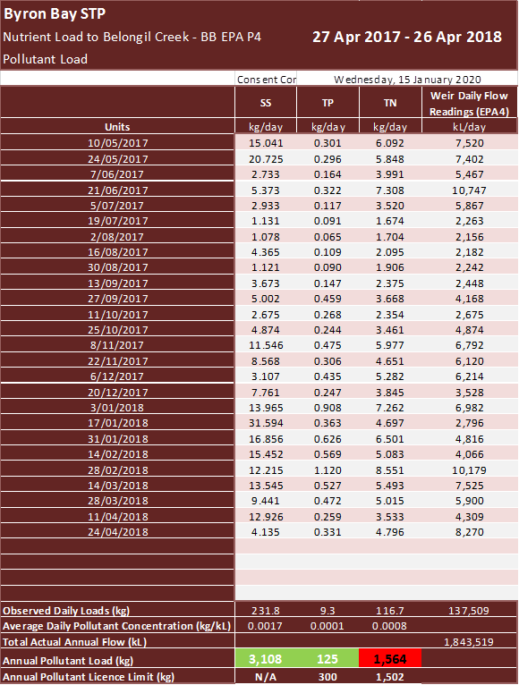
2. That Council determine a new methodology to calculate
nutrient discharge into the Belongil to satisfy both Council Res 02-1329 and
the Recycled Water Management Strategy 2017-27.
In 2016 Council engaged Australian Wetlands Consultancy to
design and install a v-notch weir to measure wetland discharge flows from EPA4.
The v-notch weir enabled accurate measurement of flows to
support annual nutrient load calculations whereas previous wetland discharge
flows were calculated using a complex water mass balance calculation which
included rainfall and evapotranspiration.
3. That Council consider measures for overcoming these
exceedances.
It is almost impossible to mitigate against increased
nutrient loads during high rainfall events.
Literature reviews identify this is a natural occurring
event across most natural wetlands.
Therefore it is not financially viable to conduct research
and develop innovation to overcome these incidences.
The abstracts below are
provided to further support the observations in the Byron Wetlands that it is
challenging to prevent high nutrient release during high rainfall events and
therefore are not unique when compared to natural wetland systems.
Committee members can access
these abstracts via the link provided and purchase the full article at their
own cost.
Resources:
1. Raisin
G.W; Mitchell
D.S; Croome
R.L, September 1997,The effectiveness of a small constructed wetland in ameliorating
diffuse nutrient loadings from an Australian rural catchment, viewed 15 25 January 2020 [https://www.sciencedirect.com/science/article/abs/pii/S0925857497000165]
2. Chescheir,
G.M., Gilliam, J.W., Skaggs, R.W. et al. Nutrient and sediment removal in
forested wetlands receiving pumped agricultural drainage water, viewed 15
January 2020, 30 [https://link.springer.com/article/10.1007/BF03160842#citeas]