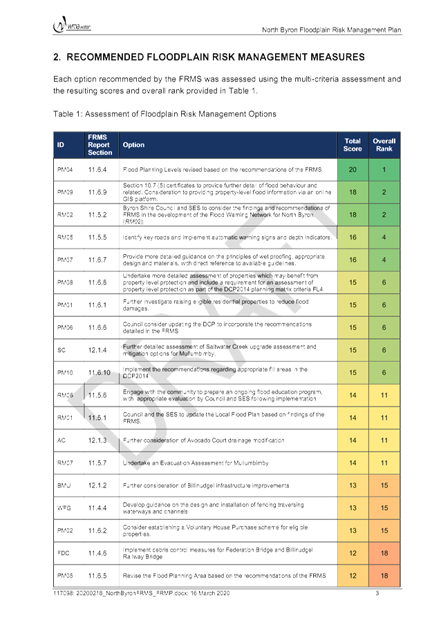
Byron Shire Floodplain Risk Management Committee Meeting
A Byron Shire Floodplain Risk Management
Committee Meeting of Byron Shire Council will be held as follows:
|
Venue
|
Conference Room, Station Street, Mullumbimby
|
|
Date
|
Tuesday, 24 March 2020
|
|
Time
|
2.00pm
|
Phillip
Holloway
Director Infrastructure Services I2020/436
Distributed 17/03/20
What is a “Conflict of Interests” - A conflict of
interests can be of two types:
Pecuniary - an interest that a person has in a matter because of a reasonable
likelihood or expectation of appreciable financial gain or loss to the person
or another person with whom the person is associated.
Non-pecuniary – a private or personal interest that a Council
official has that does not amount to a pecuniary interest as defined in the Code
of Conduct for Councillors (eg. A friendship, membership of an association,
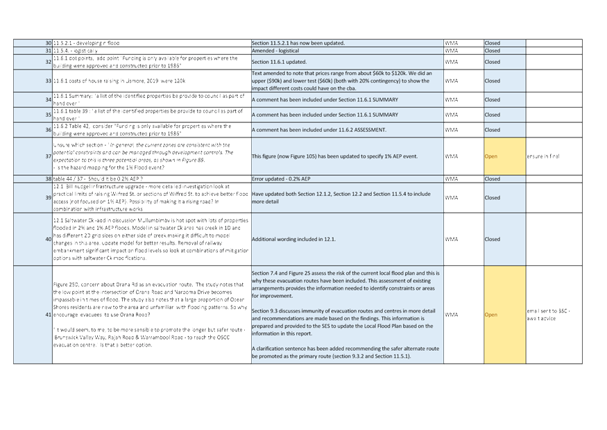
society or trade union or involvement or interest in an activity and may
include an interest of a financial nature).
Remoteness – a person does not have a pecuniary interest in a matter
if the interest is so remote or insignificant that it could not reasonably be
regarded as likely to influence any decision the person might make in relation
to a matter or if the interest is of a kind specified in the Code of Conduct
for Councillors.
Who has a Pecuniary Interest? - a person has a pecuniary interest in a
matter if the pecuniary interest is the interest of the person, or another
person with whom the person is associated (see below).
Relatives, Partners - a person is taken to have a pecuniary interest in a
matter if:
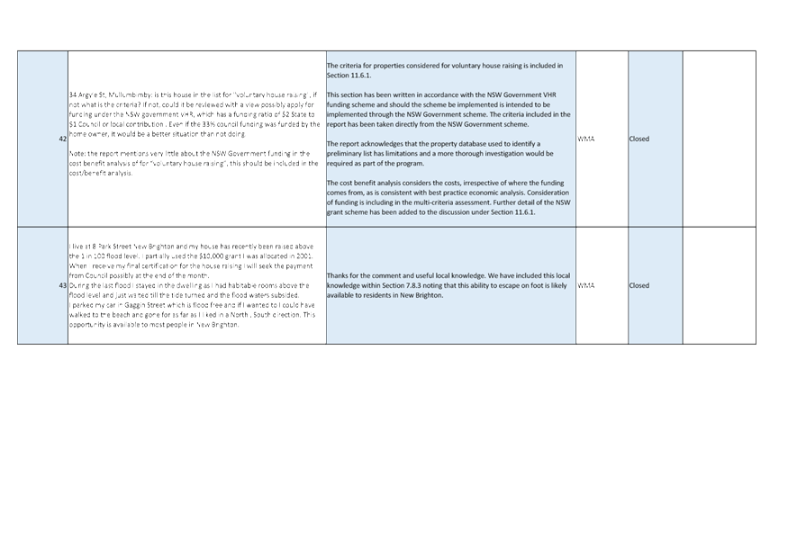
§ The person’s
spouse or de facto partner or a relative of the person has a pecuniary interest
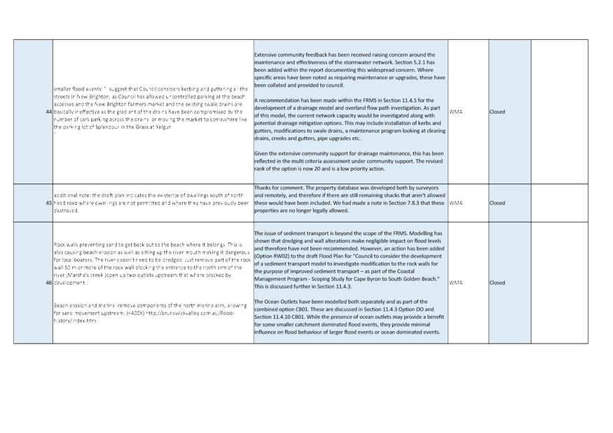
in the matter, or
§ The person, or a
nominee, partners or employer of the person, is a member of a company or other
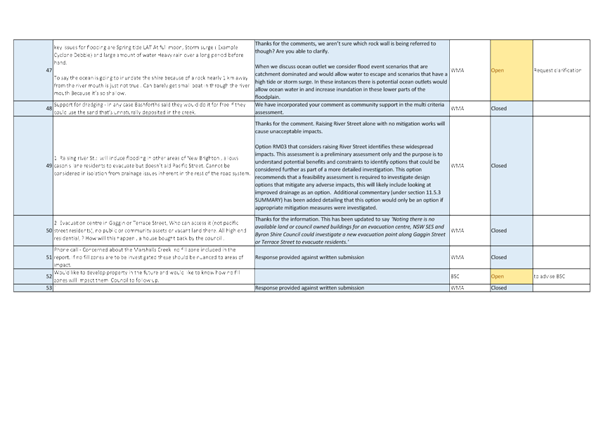
body that has a pecuniary interest in the matter.
N.B. “Relative”, in relation to a person means any of the
following:
(a) the
parent, grandparent, brother, sister, uncle, aunt, nephew, niece, lineal
descends or adopted child of the person or of the person’s spouse;
(b) the
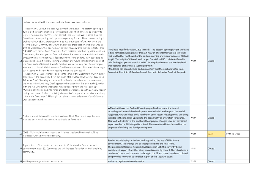
spouse or de facto partners of the person or of a person referred to in
paragraph (a)
No Interest in the Matter - however, a person is not taken to have a
pecuniary interest in a matter:
§ If the person is
unaware of the relevant pecuniary interest of the spouse, de facto partner,
relative or company or other body, or
§ Just because the
person is a member of, or is employed by, the Council.
§ Just because the
person is a member of, or a delegate of the Council to, a company or other body
that has a pecuniary interest in the matter provided that the person has no
beneficial interest in any shares of the company or body.
Disclosure and participation in meetings
§ A Councillor or a
member of a Council Committee who has a pecuniary interest in any matter with
which the Council is concerned and who is present at a meeting of the Council
or Committee at which the matter is being considered must disclose the nature
of the interest to the meeting as soon as practicable.
§ The Councillor or
member must not be present at, or in sight of, the meeting of the Council or
Committee:
(a) at any
time during which the matter is being considered or discussed by the Council or
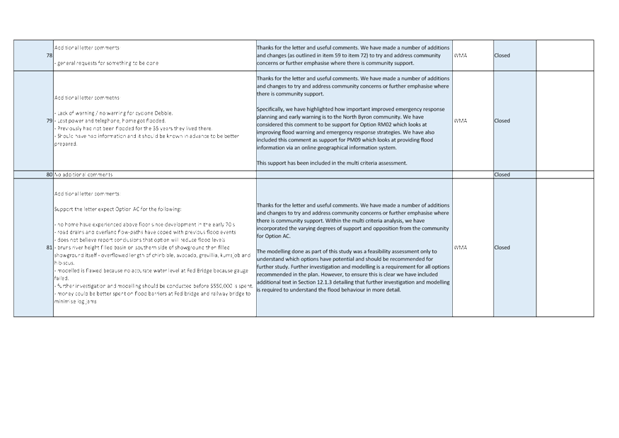
Committee, or
(b) at any
time during which the Council or Committee is voting on any question in
relation to the matter.
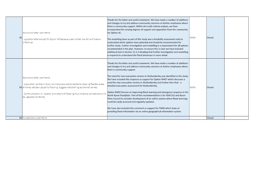
No Knowledge - a person does not breach this Clause if the person did
not know and could not reasonably be expected to have known that the matter
under consideration at the meeting was a matter in which he or she had a
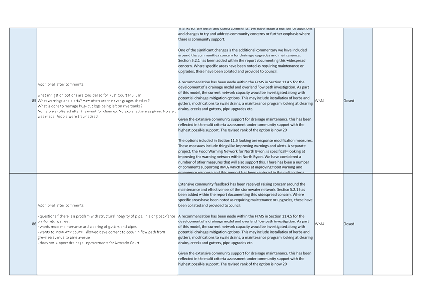
pecuniary interest.
Non-pecuniary Interests - Must be disclosed in meetings.
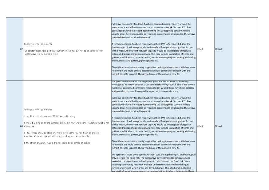
There are a broad range of options available for managing conflicts &
the option chosen will depend on an assessment of the circumstances of the
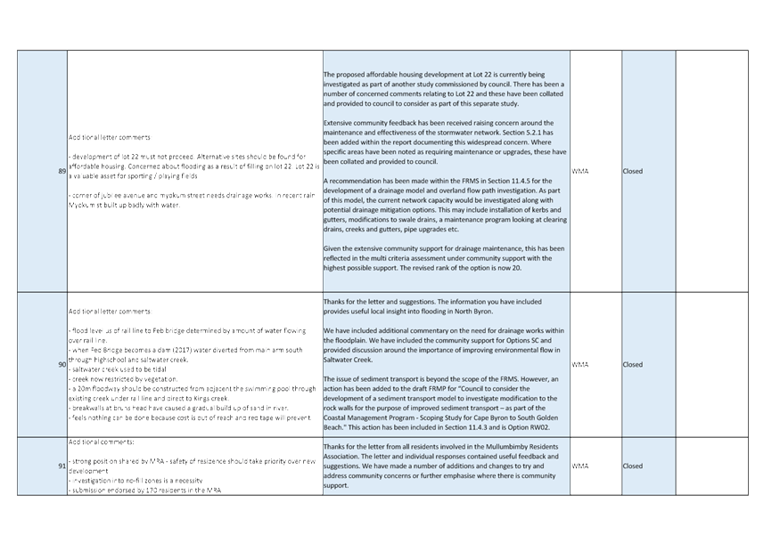
matter, the nature of the interest and the significance of the issue being
dealt with. Non-pecuniary conflicts of interests must be dealt with in at
least one of the following ways:
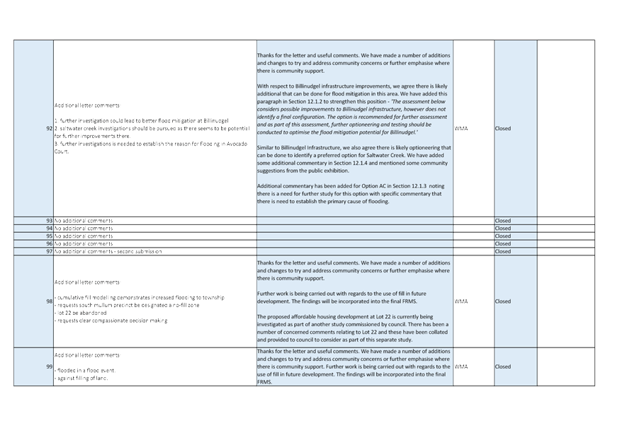
§ It may be appropriate
that no action be taken where the potential for conflict is minimal.
However, Councillors should consider providing an explanation of why they
consider a conflict does not exist.
§ Limit involvement if
practical (eg. Participate in discussion but not in decision making or
vice-versa). Care needs to be taken when exercising this option.
§ Remove the source of
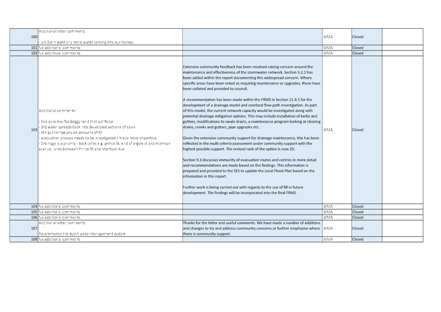
the conflict (eg. Relinquishing or divesting the personal interest that creates
the conflict)
§ Have no involvement by
absenting yourself from and not taking part in any debate or voting on the
issue as of the provisions in the Code of Conduct (particularly if you have a significant
non-pecuniary interest)
RECORDING OF VOTING ON PLANNING MATTERS
Clause 375A of the Local Government Act 1993
– Recording of voting on planning matters
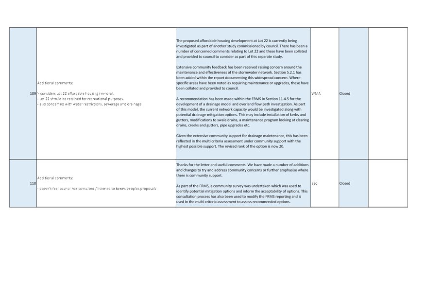
(1) In this section, planning
decision means a decision made in the exercise of a function of a council
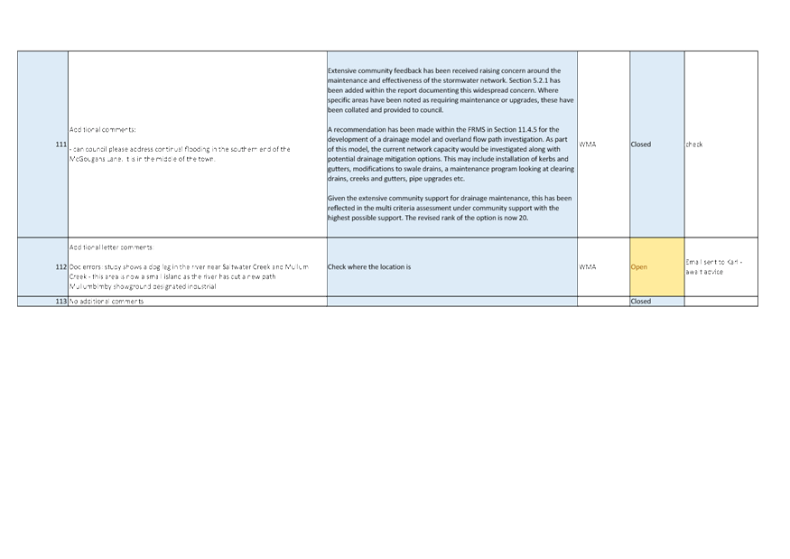
under the Environmental Planning and Assessment Act 1979:
(a) including a decision
relating to a development application, an environmental planning instrument, a
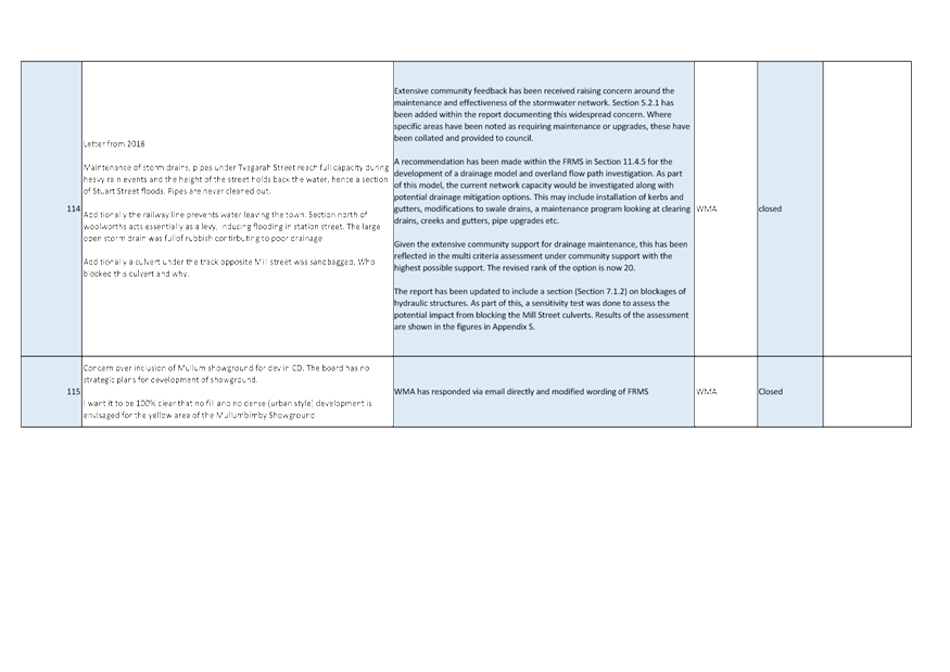
development control plan or a development contribution plan under that Act, but
(b) not including the making of
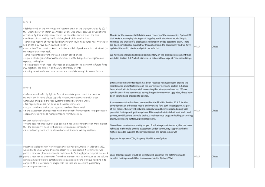
an order under that Act.
(2) The general manager is
required to keep a register containing, for each planning decision made at a
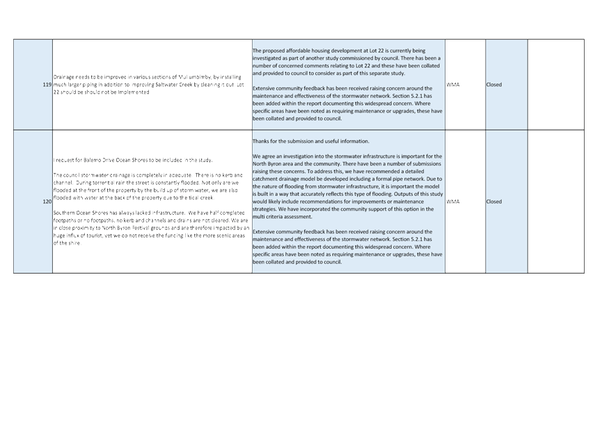
meeting of the council or a council committee, the names of the councillors who
supported the decision and the names of any councillors who opposed (or are
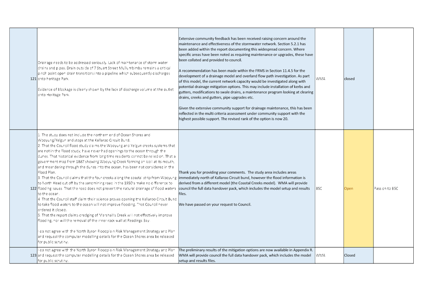
taken to have opposed) the decision.
(3) For the purpose of
maintaining the register, a division is required to be called whenever a motion
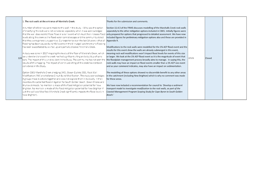
for a planning decision is put at a meeting of the council or a council
committee.
(4) Each decision recorded in
the register is to be described in the register or identified in a manner that
enables the description to be obtained from another publicly available
document, and is to include the information required by the regulations.
(5) This section extends to a
meeting that is closed to the public.
Byron Shire Floodplain Risk Management
Committee Meeting
BUSINESS OF MEETING
1. Apologies
2. Declarations of Interest
– Pecuniary and Non-Pecuniary
3. Adoption of Minutes from
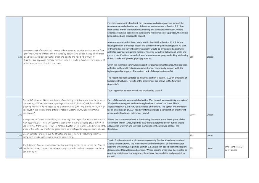
Previous Meetings
3.1 Byron
Shire Floodplain Risk Management Committee Meeting held on 26 November 2019
4. Staff Reports
Infrastructure Services
4.1 Minutes
of previous Byron Shire Floodplain Risk Management Committee Meeting...... 4
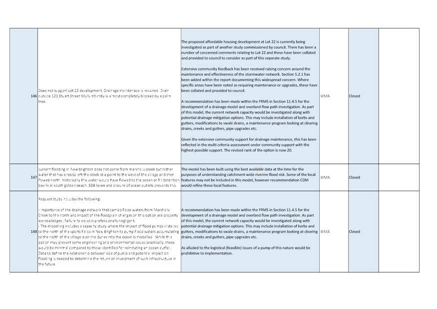
4.2 Draft
North Byron Floodplain Risk Management Study and Plan.................................. 10
4.3 Discussion
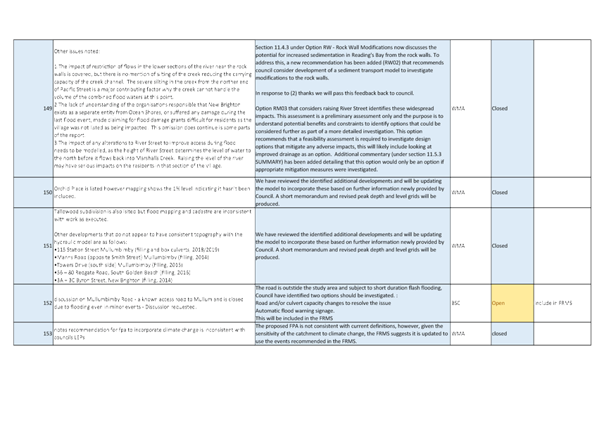
of item requested by committee member Duncan Dey reagrding filling in no-fill
zone of Marshalls Creek floodplain.............................................................................................. 65
4.4 Discussion
of item requested by Cr Lyon....................................................................... 72
Staff Reports - Infrastructure Services 4.1
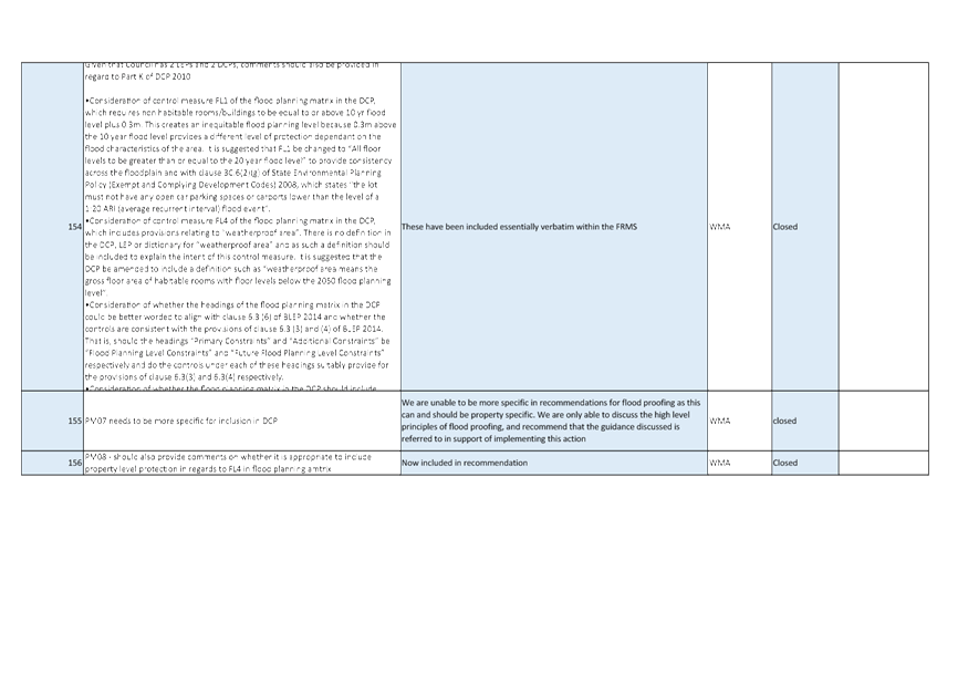
Staff Reports - Infrastructure Services
Report No. 4.1 Minutes
of previous Byron Shire Floodplain Risk Management Committee Meeting
Directorate: Infrastructure
Services
Report
Author: Dominika
Tomanek, Executive Assistant Infrastructure Services
File No: I2020/431
Summary:
The previous minutes of Byron Shire Floodplain Risk
Management Committee Meeting are attached to the report.
|
RECOMMENDATION:
That Committee note the report.
|
Attachments:
1 Minutes
26/11/2019 Byron Shire Floodplain Risk Management Committee, I2019/1928 ,
page 6⇩ 
REPORT
The minutes of the Byron Shire Floodplain Risk Management
Committee Meeting held on 26 November 2019 are attached. The minutes were
reported to the 12 December 2019 Council Meeting which resulted in resolutions
19-669.
|
19-669
|
Resolved: that Council adopt the following
Committee Recommendation(s):
Report No. 4.1 North
Byron Floodplain Risk Management Study Draft Document
File No: I2019/1832
Committee Recommendation:
1. That
Council support the public exhibition of the Draft North Byron Floodplain
Risk Management Study Attachment 1 and 2 (E2019/83311 and E2019/83313) from
20 January to 21 February 2020.
2. That
Council delegate staff the authority to make minor amendments to the Draft
North Byron Floodplain Risk Management Study documents, in consultation with
support from the Floodplain Management Committee, prior to it going on public
exhibition in January 2020.
(Lyon/Spooner)
|
Legal/Statutory/Policy Considerations
N/A
Financial Considerations
N/A
Consultation and Engagement
N/A
Staff Reports - Infrastructure Services 4.1 - Attachment 1

Byron Shire Floodplain Risk Management Committee Meeting
|
Venue
|
Conference Room, Station Street, Mullumbimby
|
|
Date
|
Tuesday, 26 November 2019
|
|
Time
|
2pm
|
Minutes of the Byron
Shire Floodplain Risk Management Committee Meeting held on Tuesday,
26 November 2019
File No: Error! Unknown document
property name.
PRESENT: Cr
A Hunter and Cr M Lyon
Staff: James
Flockton (Flood and Drainage Engineer)
Dominika
Tomanek (Minute Taker)
Invited
Members: Peter Mair (SES), and Martin Rose (Environment and Heritage), Karl
Allen
Community: Robyn
Bolden, Rebecca Brewin, Steve Keefe, Duncan Dey and Matthew Lambourne
Visitors: Ella
Harrison (WMA Water), Katrina Smith (WMA Water)
Cr Lyon (Chair)
opened the meeting at 2:09 pm and acknowledged that the meeting
was being held on Bundjalung Country.
Apologies:
Phil Holloway (Director Infrastructure Services)
Andrew Page (Cape Byron Marine Park)
Cr Richardson
Toong Chin (Environment and Heritage)
Cr J Hackett
Susan Skyvington
Declarations of
Interest – Pecuniary and Non-Pecuniary
There were no declarations of
interest.
Adoption of
Minutes from Previous Meetings
|
Committee
Recommendation:
That the minutes of the Byron Shire Floodplain Risk
Management Committee Meeting held on 24 September 2019 be confirmed.
(Dey/Lyon)
The recommendation was put to the vote and declared carried.
|
Note: The
minutes of the meeting held on 24 September 2019 were noted, and the Committee
Recommendations adopted by Council, at the Ordinary Meeting held on 24 October
2019.
Business Arising from Previous Minutes
There was no business arising
from previous minutes.
Staff Reports - Infrastructure Services
|
Report No. 4.1 North
Byron Floodplain Risk Management Study Draft Document
File No: I2019/1832
|
|
Committee
Recommendation:
1. That
Council support the public exhibition of the Draft North Byron
Floodplain Risk Management Study Attachment 1 & 2 - (E2019/83311 &
E2019/83313) from 20 January to 28 February 2020.
2. That
Council delegate staff the authority to make minor amendments to the Draft
North Byron Floodplain Risk Management Study documents, in consultation with support
from the Floodplain Management Committee, prior to it going on public
exhibition in January 2020.
(Hunter/Lyon)
The recommendation was put to
the vote and declared carried.
|
There being no further business the meeting concluded at 4:00pm.
Staff Reports - Infrastructure Services 4.2
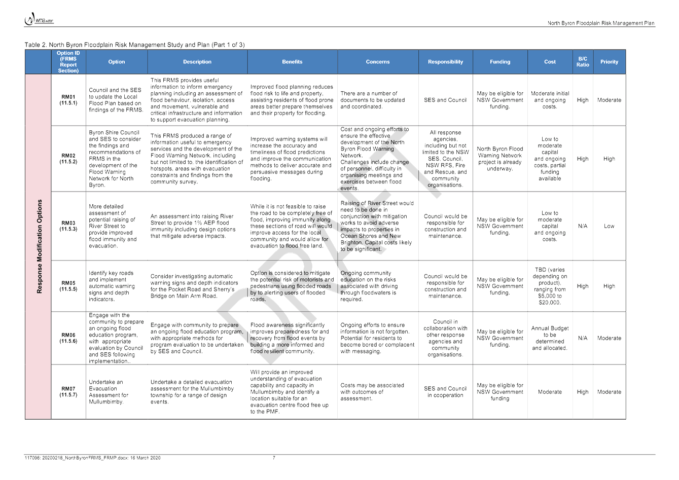
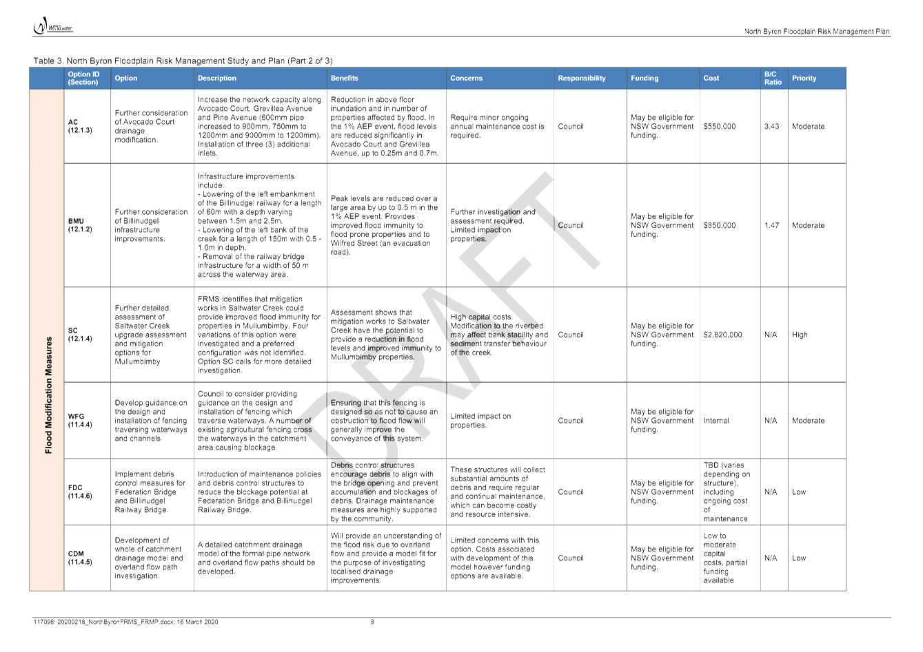
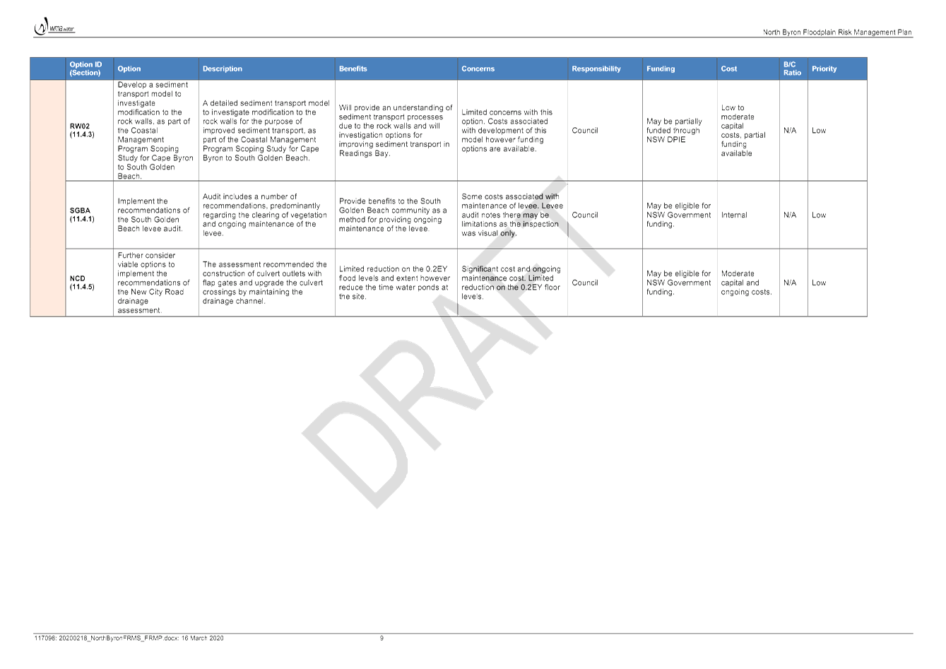
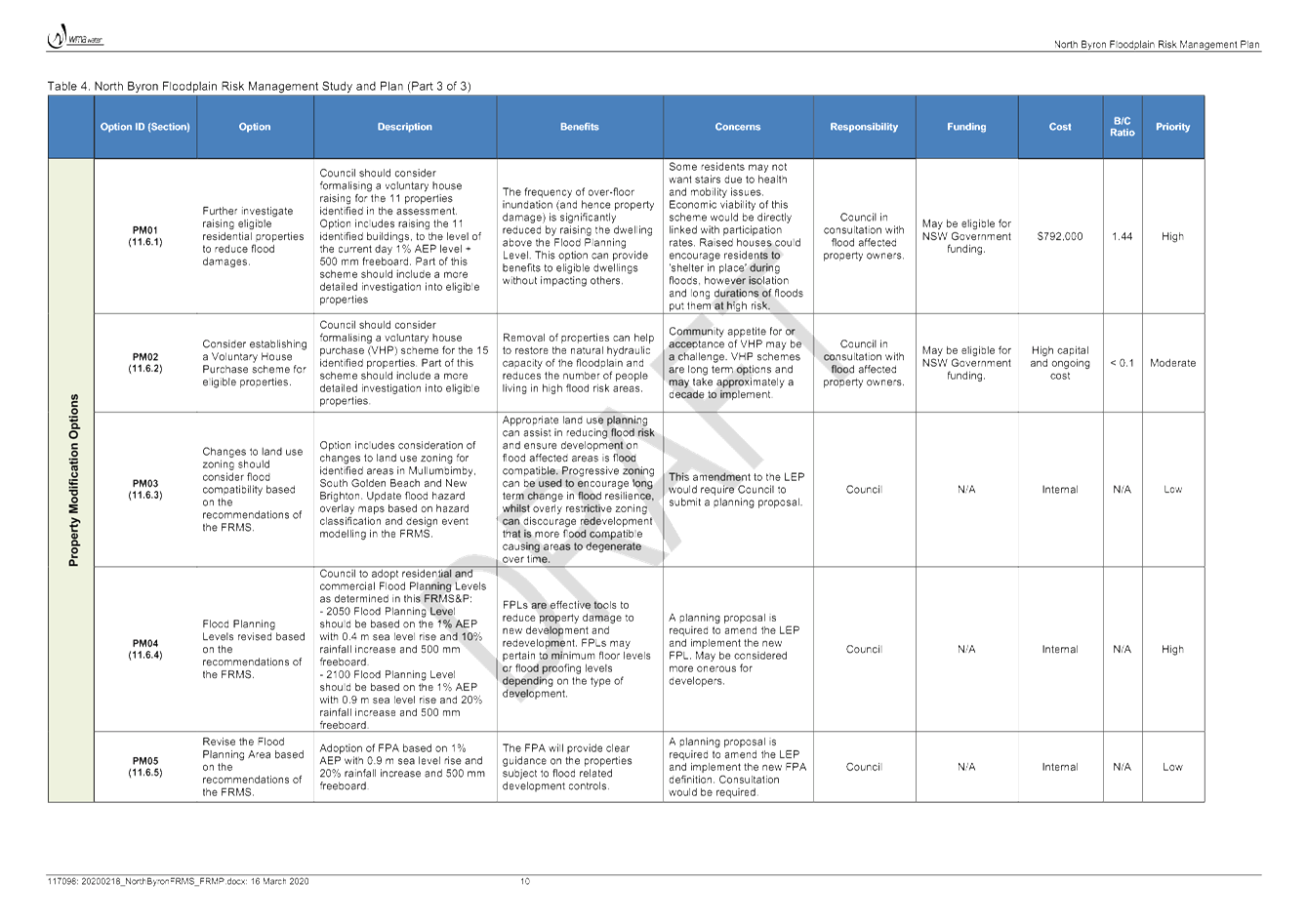
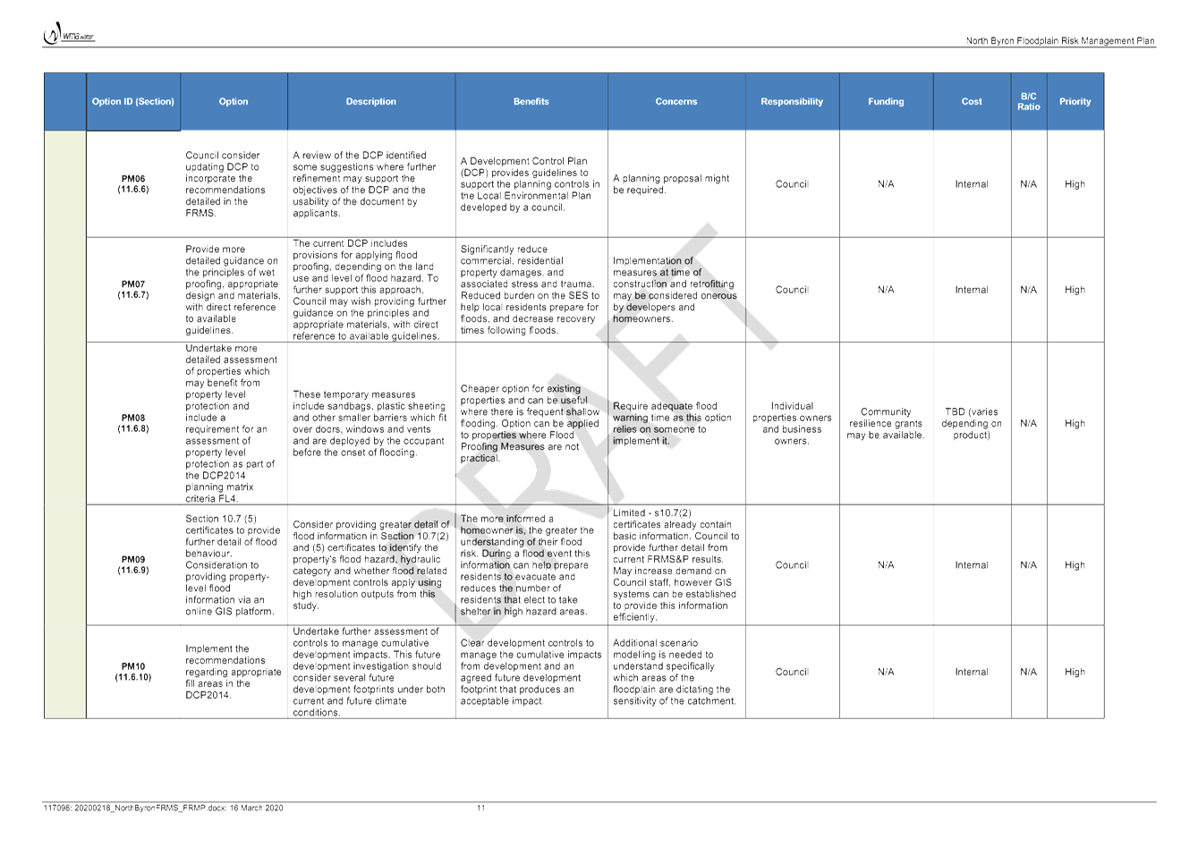
Report No. 4.2 Draft
North Byron Floodplain Risk Management Study and Plan
Directorate: Infrastructure
Services
Report
Author: James
Flockton, Drain and Flood Engineer
File No: I2020/418
Summary:
As per Council resolution the
Draft North Byron Floodplain Risk Management Study has been to public
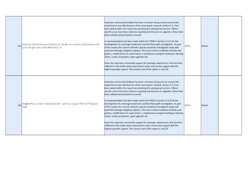
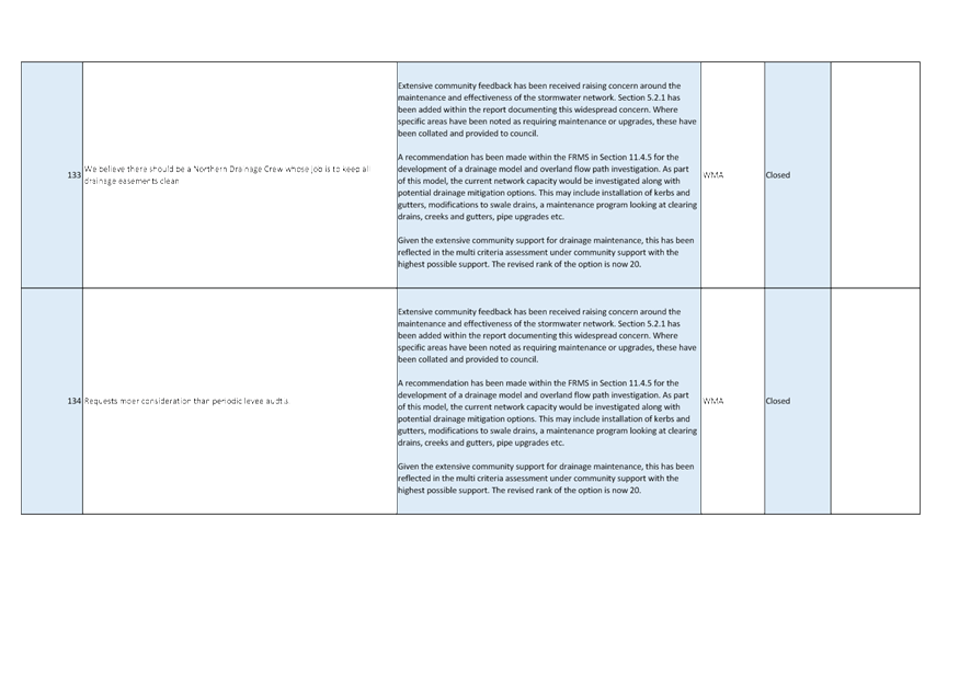
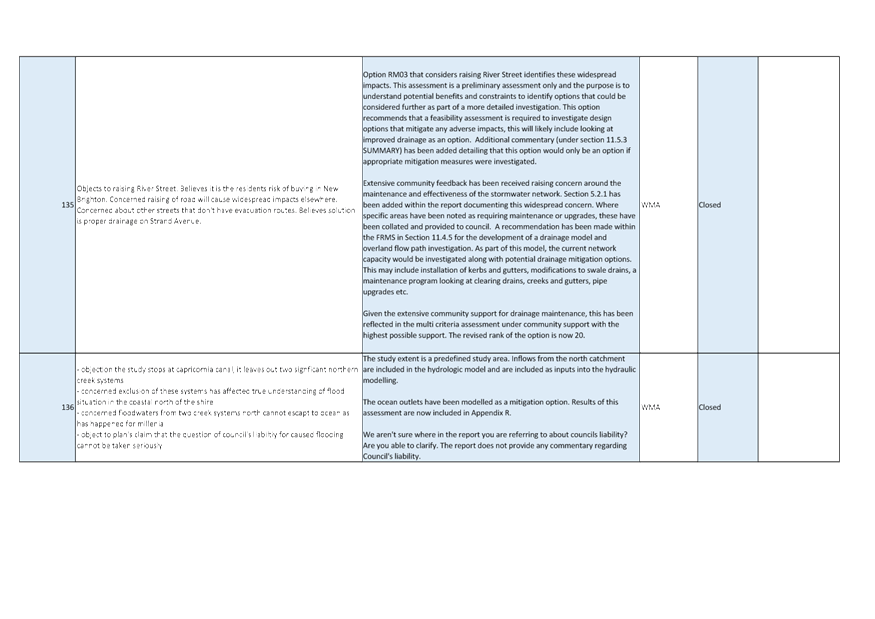
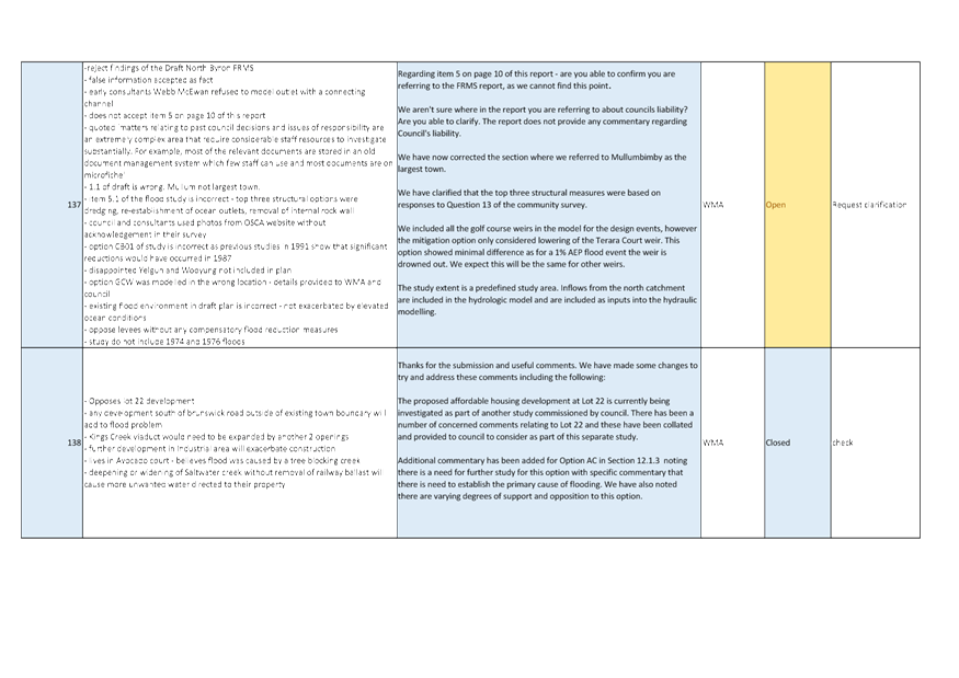
exhibition for 28 days. 75 Submissions and 158 comments were received at the
close of this process.
All comments have been
addressed and The Draft North Byron Floodplain Risk Management Plan is now
ready for committee review and public exhibition.
|
RECOMMENDATION:
Committee Recommendation:
1. That
Council support the public exhibition of both the Draft North Byron
Floodplain Risk Management Study and Plan documents from 27 April to 25 May
2020.
2. That
the community should be commended for the interest and time they have taken
to review and comment on the first exhibition stage of this project.
|
Attachments:
1 North
Byron FRMS&P - FRMS Consultation Comments Report, E2020/19721 , page 13⇩
2 North
Byron FRMS&P - Draft Floodplain Management Plan, E2020/19724 , page 49⇩ 
REPORT
At Council meeting on 12 December 2019 the following was
resolved:-
That Council adopt the
following Committee Recommendation(s):
Report No. 4.1 North
Byron Floodplain Risk Management Study Draft Document
File No: I2019/1832
Committee Recommendation:
1. That
Council support the public exhibition of the Draft North Byron Floodplain Risk
Management Study Attachment 1 and 2 (E2019/83311 and E2019/83313) from 20
January to 21 February 2020.
2. That
Council delegate staff the authority to make minor amendments to the Draft
North Byron Floodplain Risk Management Study documents, in consultation with
support from the Floodplain Management Committee, prior to it going on public
exhibition in January 2020.
(Lyon/Spooner)
As per this Council resolution the Draft North Byron
Floodplain Risk Management Study was updated and has been to public exhibition
for 28 days.
75 Submissions and 158 comments were received at the close
of this process. It is noted this was an overwhelming amount of comments;
previous flood reports have not received been close to this level of
interest. This kind of interest helps the final document become a more
accepted and much better plan that it would be without these comments and the
community should be commended for their interest in this project.
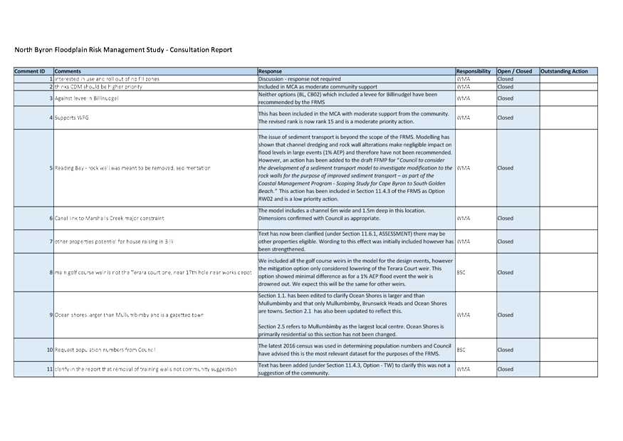
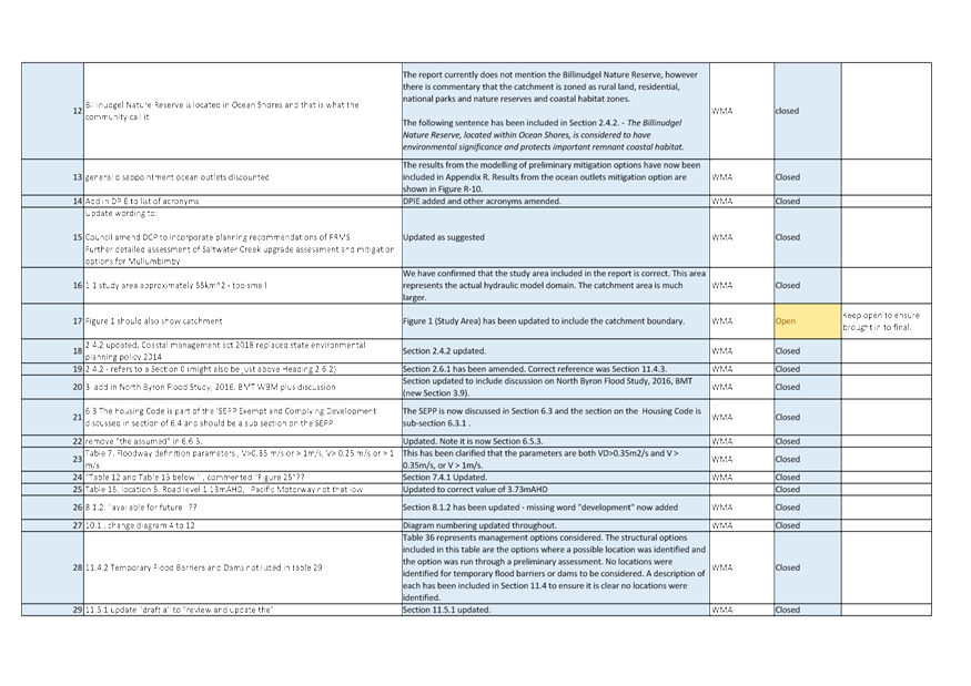
Consultant WMA Water have now reviewed and responded to all
the comments.
The complete submission report is provided at attachment 1
(E2020/19721).
Where possible the Draft North Byron Floodplain Risk
Management Study has been amended appropriately. If this was not possible
the reasons for no amendment have been given in the submissions report.
Following completion of amendments noted above The Draft
North Byron Floodplain Risk Management Study and Plan is now ready for
committee review and public exhibition.
In consultation with staff, WMA Water have prepared the
Draft Floodplain Management Plan in accordance with assessment results, public
consultation results and various discussions at previous committee
meeting. This should result in a Draft Floodplain Management Plan that
can be largely supported by the committee.
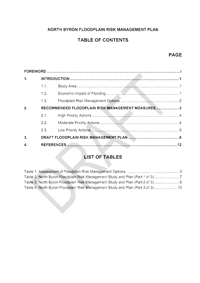
The Draft North Byron Floodplain Risk Management Plan is
provided at attachment 2 (E2020/19724). It is proposed that that both the
updated draft Study and Plan documents be provided in order to show the
community how the study has been changed following public exhibition and to
provide context to those reading the Floodplain Management Plan.
The updated Study document is not currently complete,
however, it is planned to be complete when the committee meeting minutes are
reported to Council for approval to exhibit both to the community. All
amendments will be made in accordance with the report provided at attachment 1.
Key issues
This project is now on a critical
path in order to allow the current Council to consider the final adoption of
the Draft North Byron Floodplain Risk Management Study and Plan in their
current term. The following milestones remain.
|
Draft Plan to Council for
Exhibition approval
|
23/04/2020
|
|
Plan Exhibition for 4 weeks
(All of May)
|
25/05/2020
|
|
Council report for Final
Draft Plan to Council for adoption– Report to manager deadline
|
01/06/2020
|
|
Grant Milestone - Flood Risk
Management Study & Plan Adopted
|
14/06/2020
|
|
Final Report to DPIE
|
14/06/2020
|
|
Final Draft Plan to Council
for adoption
|
25/06/2020
|
Next steps
Upon completion of the public
exhibition period the Draft North Byron Floodplain Risk Management Study and
Plan will be amended as required and presented to Council for adoption as per
the above milestones.
The committee may request the
above timeline be changed to allow the committee to review the exhibition
comments and report amendments prior to the final Draft North Byron Floodplain
Risk Management Study and Plan being presented to Council. However, it is
noted that this will extend the project period into a period when the Council
enters caretaker mode, therefore, the plan will not be able to be adopted until
after a new Council is elected.
All committee members will have
the ability to comment on the final documents via the Council meeting business
paper. Should an issue arise that cannot be resolved without committee support
staff will have no option but delay the project and hold a meeting of the
committee.
Legal/Statutory/Policy Considerations
NSW Councils are expected to prepare Floodplain Risk
Management Studies and Plans for flood prone catchments within their local
government areas. These documents must be prepared in accordance with
State Government Policy.
The NSW Floodplain Development Manual 2005 is the current
policy used by State Government for the preparation of such documents.
This project is following the methods prescribed in the NSW
Floodplain Development Manual for completing Floodplain Risk Management Studies
and Plans.
Financial Considerations
There are not financial issues with this stage of the
project.
Consultation and Engagement
As per public exhibition process.
Staff Reports - Infrastructure Services 4.2 - Attachment 1

Staff Reports - Infrastructure Services 4.2 - Attachment 2
Staff Reports - Infrastructure Services 4.3
Report No. 4.3 Discussion
of item requested by committee member Duncan Dey reagrding filling in no-fill
zone of Marshalls Creek floodplain
Directorate: Infrastructure
Services
Report
Author: Dominika
Tomanek, Executive Assistant Infrastructure Services
File No: I2020/427
Summary:
This report has presented topic for discussion as requested
by committee member Duncan Dey.
|
RECOMMENDATION:
That Council note the report.
|
REPORT
It was requested by committee member Duncan Dey to table the
following item at the next Byron Shire Floodplain Committee meeting.
1. Duncan
Dey’s enquiry and Director’s response to date on filling in no-fill
zone of Marshalls Creek floodplain.
On 5 March 2020 the committee member Duncan Dey asked the
below question:
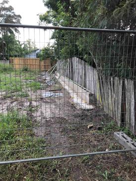
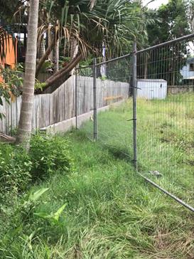
Attached are photos of notices
on the site and of a block-wall built for the purpose of taking fill at South
Golden Beach, within a no-fill zone declared under the Marshalls Creek
Floodplain Management Plan.
Could you and the Chair of the
Floodplain Committee (Cr Lyon, I think) please put this matter on the Agenda
for our meeting scheduled for 24 March? Please include the following, my
view and a question on the matter.
My view is that Council and the
state have invested deeply and behaved cordially to come up with Plans (like
the one being developed right now) for sharing the joys and burdens of
occupying floodplains. What is happening at 1 Kallaroo Circuit seems to
break all those rules. If this is accepted, why would anyone conform to a
Floodplain Management Plan.
My question is how did this
happen?
Council has been notified by
other shocked residents of the area.
People known to be involved
include:
- Mark Thomas of Coastline
Certification;
- Council's Greg Smith and Dylan
Johnstone.
Director responded to the question
on 10 March 2020 as below;
The development you have
requested information about was approved by Council but the construction
certificate and construction is being managed by a private certifier. Conditions
of consent required the floor levels to be raised to the currently adopted 2050
Flood Planning Level to comply with Council’s minimum floor level
requirements. This is higher than the surrounding developments due to
changes in flood planning heights, following revised flood studies and plans
that considered more recent flood events and Council’s climate change
parameters, since adoption of the 1997 Marshalls Creek Floodplain Management
Plan.
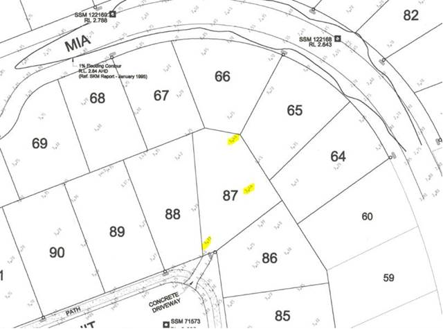
The land was originally filled
to above the 1 in 100 year flood level in the early 2000s (WAE plans are dated
30/1/2002) as part of the "Fern Beach Estate" subdivision, which was
approved by the Land and Environment Court in 1997.
As identified in the work as
executed (WAE) plans (extract below), the level of the land is in the order of
3.5m AHD and the 100 year flood level was estimated to be 3.2m AHD in the Tweed
– Byron Coastal Creeks Flood Study (March 2010).
The Tweed Byron Coastal Creeks
Flood Study, Byron Shire Council Climate Change Assessment (March 2010)
indicates a 2050 flood level in the vicinity of the site of 3.3m AHD (figure
3-2) and does not identify the site as being in a flood hazard area (figure
3-4). It is also noted that the land is not identified as being in a flood
hazard area in figure 106 of the recently exhibited draft North Byron Flood
Plain Management Study.
Accordingly, the development is
consistent with the flood planning matrix in Chapter C2 of Council’s DCP
2014, which does not prohibit filling in the “No Hazard” flood
hazard areas.
Further the above court ruling
effectively removed the no fill area over this area of land. Therefore Council
does not have an avenue to successfully stop filling in this area.
It is also noted that The North
Byron Floodplain Management Plan, which is coming soon, will update all the no
fill areas compared to the 1997 Flood Plan and this area is unlikely to be
covered by a no fill zone.
We do not believe Council is able to prevent this filling
from occurring, however, we are working with the certifier to reduce the fill
where practical to ensure the finished development does not create any
stormwater drainage issues for the neighbouring properties.
Council has also received correspondence from neighbour
raising similar concerns and will respond accordingly following further
discussions with the Certifier.
Extract of WAE Plans:
Extract of Figure 3-4 of Tweed Byron Coastal Creeks Flood
Study, Byron Shire Council Climate Change Assessment (March 2010):
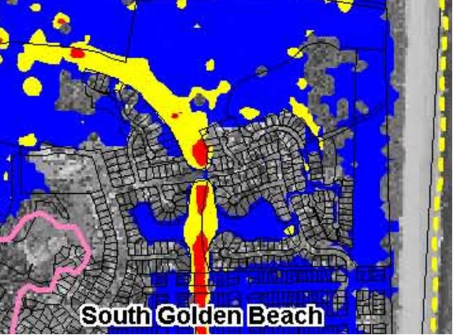
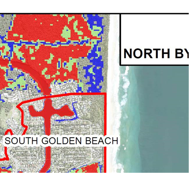
Extract of Figure 106 of the recently exhibited draft
North Byron Flood Plain Management Study:
Legal/Statutory/Policy
Considerations
NSW Councils are expected to prepare Floodplain Risk
Management Studies and Plans for flood prone catchments within their local government
areas. These documents must be prepared in accordance with State
Government Policy.
The NSW Floodplain Development Manual 2005 is the current
policy used by State Government for the preparation of such documents.
This project is following the methods prescribed in the NSW
Floodplain Development Manual for completing Floodplain Risk Management Studies
and Plans.
Financial Considerations
There are not financial issues with this stage of the
project.
Consultation and Engagement
This issue was relates to an approved DA, therefore the
Manager Sustainable Development, Development Engineering Supervisor and Team
Leader Planning Services were consulted with in developing this response.
Staff Reports - Infrastructure Services 4.4
Report No. 4.4 Discussion
of item requested by Cr Lyon
Directorate: Infrastructure
Services
Report
Author: Dominika
Tomanek, Executive Assistant Infrastructure Services
File No: I2020/429
Summary:
This report has presented topic for discussion as requested
by Cr Lyon.
|
RECOMMENDATION:
That Council note the report
|
REPORT
It was requested by the chairman of the committee Cr Lyon to
table the following item at the next Byron Shire Floodplain Risk Management
Committee meeting.
1. Discussion
whether New Brighton is being catered for appropriately in these flood
mitigation conversations as a concern has been expressed that it is too focused
on Billinudgel.
2. Condition of the "Drainage
Easement" between Rangal Road and Gloria Street, South Golden Beach/Ocean
Shore.
In relation to the item 1, the
management advice is as below:
New Brighton is a low lying area impacted by both flood and
coastal hazards. It is staff opinion that the Floodplain Risk Management
Study has considered this area to level feasible. Large scale
redevelopment and filling of the area is the only possible solution to prevent
the area flooding and this level of works is unrealistic.
The Floodplain Management Plan recommends the raising of
access roads to improve access during a flood event and the drainage
investigations recommended can investigate drainage improvements to reduce the
impacts of smaller events and rainfall in the run up to a flood. These are
considered the only realistic options available to this area.
In relation to the item 2, Cr Lyon
received the enquiry from the Byron Shire resident as below:
The condition of the drainage easement between Rangal
Road and Gloria Street, South Golden Beach, is of serious concern to me, it
"should" drain into the Capricornia Channel if allowed and the water
eventually should be released into the Yelgen and Marshalls Creeks. AT THE
MOMENT IT IS BLOCKED
I have spent the summer clearing the vegetation and dumped green waste,
predominantly palm fronds from the easement behind me - a lot of physical
effort for a 74 year old woman. However, I am unable to clear the entire
easement. A few other neighbours have also been diligent.
As one progresses west along the easement, conditions get worse and worse.
THERE IS AN ENORMOUS AMOUNT OF ACCUMULATED VEGETATION, DUMPED GREEN GARDEN
WASTE, ESPECIALLY PALM FRONDS AND GENERAL DEBRIS. At one stage there is a
LARGE GOLDEN CANE PALM growing right in the middle of what should be the
channel, a broken down fence and part of a recently constructed garden shed.
I am unable to walk along the easement and the water is unable to flow except
when the drain is in full flood. Directly behind my property the flood waters
are barely moving. As a result the waters are stagnating in large pools. These
are now filled with a BROWNY GREEN, FUZZY, SLIMY SLUDGE that stinks. The
local sewer runs parallel with the easement and the condition of the the
waters, indicates that it may have overflowed during the recent rains. This
situation has created a DANGEROUS ENVIRONMENTAL HAZARD for children, animals
and the community at large.
I ask that council complies with it's commitment to maintain the drainage
system, as per it's responsibility for managing flood affected areas and FREE
THIS EASEMENT AS A MATTER OF URGENCY BEFORE PEOPLE START TO GET SICK.
Utilities Department Team Leader (Stormwater and Sewer
Maintenance) walked the easement and met with residents on the 24th
February 2020.
Works will require an excavator, bobcat and a couple of
trucks and take approximately 5 days to complete.
Tree roots will need to be removed or ground down to reduce
vegetation build up and some stands of clumping palms and two palm trees will
need to be removed along with garden waste.
The drain requires reshaping to regain some fall towards the
flood pump.
Council will do a letter drop to the residents explaining
what will be done and also a request for people to stop putting garden waste in
the easement and use the green bins provided.
Works are currently planned to be carried out from the 30th
March to the 3rd April 2020.
Legal/Statutory/Policy Considerations
NSW Councils are expected to prepare Floodplain Risk
Management Studies and Plans for flood prone catchments within their local
government areas. These documents must be prepared in accordance with
State Government Policy.
The NSW Floodplain Development Manual 2005 is the current
policy used by State Government for the preparation of such documents.
This project is following the methods prescribed in the NSW
Floodplain Development Manual for completing Floodplain Risk Management Studies
and Plans.
Provision of stormwater infrastructure is a legitimate
function of local government under the Local Government Act 1993. To the
extent that the provision of stormwater infrastructure protects public roads,
other infrastructure, Council land, Crown land, Private land and the
community. Council is also responsible for drainage under the Roads Act
1993.
In all cases, Council must meet its obligation to provide a
satisfactory and safe level of drainage for the Shire’s residents and a
drainage network which is maintained in a condition which is not likely to
endanger the Shire’s residents during or after a rainfall event.
Financial Considerations
There are not financial issues.
Consultation and Engagement
Only as per the public exhibition process for the study
document.