Notice of Meeting
Coastal and ICOLL Advisory Committee
Meeting
A Coastal and ICOLL Advisory Committee Meeting of Byron Shire Council will be held as follows:
|
Venue
|
Conference Room, Station Street, Mullumbimby
|
|
Date
|
Thursday, 20 October 2022
|
|
Time
|
11.30am
|
Phil Holloway
Director Infrastructure
Services
I2022/1441
Distributed
13/10/22

What is a “Conflict of Interests” - A conflict of
interests can be of two types:
Pecuniary - an interest that a person has in a matter because of a reasonable
likelihood or expectation of appreciable financial gain or loss to the person
or another person with whom the person is associated.
Non-pecuniary – a private or personal interest that a Council
official has that does not amount to a pecuniary interest as defined in the
Code of Conduct for Councillors (eg. A friendship, membership of an
association, society or trade union or involvement or interest in an activity
and may include an interest of a financial nature).
Remoteness – a person does not have a pecuniary interest in a matter
if the interest is so remote or insignificant that it could not reasonably be
regarded as likely to influence any decision the person might make in relation
to a matter or if the interest is of a kind specified in the Code of Conduct
for Councillors.
Who has a Pecuniary Interest? - a person has a pecuniary interest in a
matter if the pecuniary interest is the interest of the person, or another
person with whom the person is associated (see below).
Relatives, Partners - a person is taken to have a pecuniary
interest in a matter if:
·
The
person’s spouse or de facto partner or a relative of the person has a
pecuniary interest in the matter, or
·
The
person, or a nominee, partners or employer of the person, is a member of a
company or other body that has a pecuniary interest in the matter.
N.B. “Relative”, in relation to a person means any of the
following:
(a) the parent,
grandparent, brother, sister, uncle, aunt, nephew, niece, lineal descends or
adopted child of the person or of the person’s spouse;
(b) the spouse
or de facto partners of the person or of a person referred to in paragraph (a)
No Interest in the Matter - however, a person is not taken to have a
pecuniary interest in a matter:
·
If
the person is unaware of the relevant pecuniary interest of the spouse, de
facto partner, relative or company or other body, or
·
Just
because the person is a member of, or is employed by, the Council.
·
Just
because the person is a member of, or a delegate of the Council to, a company
or other body that has a pecuniary interest in the matter provided that the
person has no beneficial interest in any shares of the company or body.
Disclosure and participation in meetings
·
A
Councillor or a member of a Council Committee who has a pecuniary interest in
any matter with which the Council is concerned and who is present at a meeting
of the Council or Committee at which the matter is being considered must
disclose the nature of the interest to the meeting as soon as practicable.
·
The
Councillor or member must not be present at, or in sight of, the meeting of the
Council or Committee:
(a) at any time during which the
matter is being considered or discussed by the Council or Committee, or
(b) at any time during which the
Council or Committee is voting on any question in relation to the matter.
No Knowledge - a person does not breach this Clause if the person did
not know and could not reasonably be expected to have known that the matter
under consideration at the meeting was a matter in which he or she had a
pecuniary interest.
Non-pecuniary Interests - Must be disclosed in meetings.
There are a broad range of options available for managing conflicts &
the option chosen will depend on an assessment of the circumstances of the
matter, the nature of the interest and the significance of the issue being
dealt with. Non-pecuniary conflicts of interests must be dealt with in at
least one of the following ways:
·
It
may be appropriate that no action be taken where the potential for conflict is
minimal. However, Councillors should consider providing an explanation of
why they consider a conflict does not exist.
·
Limit
involvement if practical (eg. Participate in discussion but not in decision
making or vice-versa). Care needs to be taken when exercising this
option.
·
Remove
the source of the conflict (eg. Relinquishing or divesting the personal
interest that creates the conflict)
·
Have
no involvement by absenting yourself from and not taking part in any debate or
voting on the issue as of the provisions in the Code of Conduct (particularly
if you have a significant non-pecuniary interest)
RECORDING OF VOTING ON PLANNING MATTERS
Clause 375A of the Local Government Act
1993 – Recording of voting on planning matters
(1) In this section, planning
decision means a decision made in the exercise of a function of a council
under the Environmental Planning and Assessment Act 1979:
(a) including a decision relating to a development
application, an environmental planning instrument, a development control plan
or a development contribution plan under that Act, but
(b) not including the making of an order under that Act.
(2) The general manager is required to keep a register
containing, for each planning decision made at a meeting of the council or a
council committee, the names of the councillors who supported the decision and
the names of any councillors who opposed (or are taken to have opposed) the
decision.
(3) For the purpose of maintaining the register, a division
is required to be called whenever a motion for a planning decision is put at a
meeting of the council or a council committee.
(4) Each decision recorded in the register is to be described
in the register or identified in a manner that enables the description to be
obtained from another publicly available document, and is to include the
information required by the regulations.
(5) This section extends to a meeting that is closed to the
public.
OATH AND AFFIRMATION FOR COUNCILLORS
Councillors are
reminded of the oath of office or affirmation of office made at or before their
first meeting of the council in accordance with Clause 233A of the Local
Government Act 1993. This includes undertaking the duties of the office of
councillor in the best interests of the people of Byron Shire and the Byron
Shire Council and faithfully and impartially carrying out the functions,
powers, authorities and discretions vested under the Act or any other Act
to the best of one’s ability and judgment.
BUSINESS OF MEETING
1. Apologies
2. Declarations
of Interest – Pecuniary and Non-Pecuniary
3. Adoption of Minutes from
Previous Meetings
3.1 Adoption
of Minutes from 30 June 2022 meeting..................................................... 6
4. Staff Reports
Sustainable Environment and
Economy
4.1 Council's
Integrated Management System (IMS) and ICOLLs - presentation on ICOLL
management and flooding.......................................................................................... 17
4.2 Update
on the development of Coastal Management Programs (CMPs) for the Byron Shire
Coastline............................................................................................................. 20
4.3 Bringing
Back the Bruns - project update................................................................ 33
4.4 Update
of Constitution and New Members.............................................................. 42
Adoption of Minutes from Previous Meetings 3.1
Adoption of Minutes from Previous Meetings
Report No. 3.1 Adoption of Minutes from 30 June 2022 meeting
Directorate: Sustainable Environment and Economy
Report Author: Michelle
Chapman, Project Support Officer
File No: I2022/1282
RECOMMENDATION:
That the minutes of the Coastal and ICOLL Advisory
Committee Meeting held on 30 June 2022 be confirmed.
Attachments:
1 Minutes
30/06/2022 Coastal and ICOLL Advisory Committee, I2022/758 , page 10⇩ 
Report
The attachment to this report provides the minutes of the
Coastal and ICOLL Advisory Committee Meeting of 30 June 2022 .
Report to Council
The minutes were reported to Council on 29 September 2022. Comments
In accordance with the Committee Recommendations, Council
resolved the following:
22-522 Resolved that
Council notes the minutes of the Coastal and ICOLL Advisory Committee Meeting
held on 30 June 2022.
22-524 Resolved that Council adopts the following
Committee Recommendations:
Report No. 3.1 Update on the development of Coastal
Management Programs (CMPs) for the Byron Shire Coastline
File No: I2022/61
Committee Recommendation 3.1.1
That the Coastal and ICOLL Advisory Committee:
1. Notes
the legislated process and associated extended timeframes associated with
preparing Coastal Management Program(s) under the NSW Coastal Management
Framework.
2. Advises
Council that a particular hazard at Belongil namely end of wall effect on
estuary opening needs consideration in the Stage 2 Coastal Hazard Assessment
Study.
3. Advises
Council that there is a need to recognise ‘coastal squeeze’ as a
threat on both the coast and in the estuaries.
4. Advises
Council that there is a need to recognise the important shorebird breeding,
feeding and roosting area at Belongil and Marshalls Creek.
22-524 Resolved: that Council adopts the following Committee
Recommendations:
Report No. 3.4 Review Constitution of Coastal and
ICOLL Advisory Committee
File No:
I2022/682
Committee Recommendation 3.4.1
1. That
the Coastal and ICOLL Advisory Committee recommends to Council to adopt the
constitution at Attachment 1 (E2022/11708) with the following changes:
a) Amend
the name of the committee to Coast and ICOLL Advisory Committee.
b) Amend
2a. Purpose to:
Advise Council in the development of Coastal Management
Programs for the Shire’s coast, estuary and ICOLLs
c) Amend
2b. Purpose to:
Advise on projects, plans and strategies related to the
coast, estuary and ICOLLs.
d) Update
5. Membership to read:
“Membership
is to include:
· 2 Councillors
· 6 relevantly
qualified community representatives
Representatives from:
· Department of
Planning and Environment
· DPI Fisheries -
Cape Byron Marine Park
· National Parks and
Wildlife Service
· Crown Lands
· State Emergency
Services
· Transport for NSW
· Bundjalung of
Byron Bay Aboriginal Corporation (Arakwal)
· Jali Local
Aboriginal Land Council
· Tweed Byron Local
Aboriginal Land Council
· Byron Shire
Council General Manager (or staff member delegate)”
Note: Staff members and state
agency representatives participating on the Committee do not have any voting
entitlements.
e) Amend
7. Quorum to:
A quorum is to constitute at least half the number of
community members and Councillors plus one (resulting half numbers go down),
one of which is to be a Councillor.
The General Manager or delegate, who must be a member of
staff, is to attend the committee meeting and is not counted in the quorum for
the meeting.
State government and indigenous organisation representatives
do not form part of the quorum.
f). Amend
10a. Voting to:
Each member of the Committee (with the exception of Council
staff and state government agency representatives) is to have one vote, with
the Chairperson to have the casting vote in addition to a deliberate vote.
g) Amend
10 Voting to include:
Representatives of Bundjalung of Byron Bay Aboriginal
Corporation (Arakwal), Jali Local Aboriginal Land Council and Tweed Byron Local
Aboriginal Land Council can elect to have voting rights
The constitution has been updated accordingly and is
available on Council’s website.
Adoption
of Minutes from Previous Meetings 3.1 - Attachment 1

Staff Reports - Sustainable Environment and Economy 4.1
Staff Reports - Sustainable Environment and
Economy
Report No. 4.1 Council's
Integrated Management System (IMS) and ICOLLs - presentation on ICOLL
management and flooding
Directorate: Sustainable
Environment and Economy
Report Author: Scott
Moffett, Drainage & Flood Engineer, IS - Works - Infrastructure Planning
Orla Seccull, Coastal & Estuary Officer
File No: I2022/977
Summary:
In 2019, post the Tallow Creek fish kill event, an Internal
Working Group was established for internal communications, decision making and
distribution of roles/responsibilities within Council related to the management
of Tallow and Belongil ICOLLs.
Team ICOLL are responsible for the management of flooding
risk, stormwater/drainage and estuary, coastal and biodiversity management
related to the Tallow and Belongil ICOLLs and wider catchment.
This presentation to the Coast and ICOLL Advisory Committee
aims to provide an overview of the primary platform used to inform flood risk
management - Council’s Integrated Management System (IMS) and Dashboard.
The presentation will be live and interactive outlining the various intel, data
and flood risk considerations.
RECOMMENDATION:
That the Coast and ICOLL Advisory Committee note
the presentation.
Report
In 2019, post the Tallow Creek fish kill event, an Internal
Working Group was established for internal communications, decision making and
distribution of roles/responsibilities within Council related to the management
of Tallow and Belongil ICOLLs. The group is named ‘Team ICOLL’ and
includes:
1. Director Infrastructure
Services (For final approvals and Working Group Owner)
2. Operations Coordinator
3. Coastal &
Biodiversity Coordinator
4. Coast and Estuary
Officer
5. Flood and Drainage
Engineer
6. Media Communications
Coordinator
The role of the group is to oversee ICOLL management and
entrance activities (i.e. mechanical opening or berm scrapes) and to ensure
environmental and technical information has been adequately considered prior to
an activity. The responsibility or decision to open an ICOLL (or not) is held
at the Director level, with the group providing guidance based on an informed
process and reporting to the Director of Infrastructure Services (IS).
Team ICOLL are responsible for the management of flooding
risk, stormwater/drainage and estuary, coastal and biodiversity management
related to the Tallow and Belongil ICOLLs and wider catchment.
The group meets each Tuesday morning to review current
climatic, water level and sandbar conditions for the day to day management of
the ICOLLs, along with discussion of strategic projects or other related work.
This presentation to the Coast and ICOLL Advisory Committee
aims to provide an overview of the primary platform used to inform flood risk
management - Council’s Integrated Management System (IMS) and Dashboard.
The presentation will be live and interactive outlining the various intel, data
and flood risk considerations.
Strategic Considerations
Community Strategic Plan
and Operational Plan
|
CSP Objective
|
CSP Strategy
|
DP Action
|
Code
|
OP Activity
|
|
3: Nurtured Environment
We nurture and enhance the natural
environment
|
3.3: Protect the health of our coastline, estuaries,
waterways, and catchments
|
3.3.2: Floodplain management - Mitigate the impact of
flooding on private and public property
|
3.3.2.1
|
Revise entrance management activities and arrangements
for Tallow Creek
|
|
3: Nurtured Environment
We nurture and enhance the natural environment
|
3.3: Protect the health of our coastline, estuaries,
waterways, and catchments
|
3.3.2: Floodplain management - Mitigate the impact of
flooding on private and public property
|
3.3.2.3
|
Floodplain Risk Management Committee coordination
|
Legal/Statutory/Policy
Considerations
Coastal Management Act 2016
Entrance Opening Strategies, Flood Studies and the
Floodplain Development Manual
Financial Considerations
Budget allocation of approx. $50K for Tallow and Belongil
ICOLL management (environmental monitoring and entrance management activities)
is required each year for ICOLL management in accordance with permit and
licence approvals. Depending on entrance activities this budget may be
sufficient or exhausted any given year.
Consultation and
Engagement
N/A
Staff Reports - Sustainable Environment and Economy 4.2
Report
No. 4.2 Update on the
development of Coastal Management Programs (CMPs) for the Byron Shire Coastline
Directorate: Sustainable
Environment and Economy
Report Author: Chloe
Dowsett, Biodiversity and Sustainability Coordinator
Orla Seccull, Coastal & Estuary Officer
File No: I2022/978
Summary:
For a small coastal council, we have a large coastline with
high coastal risks to manage. A CMP is necessary to effectively assess and
prioritise risks and manage current and emerging issues under the NSW Coastal
Management Framework and to allow access to the Coast and Estuary grant funding
for implementation of key actions.
Council is in the process of preparing Coastal Management
Programs (CMPs) under the legislated NSW Coastal Management Framework
comprising the Coastal Management Act 2016, SEPP (Coastal Management)
2018 (now replaced by the SEPP (Resilience and Hazards) 2021) and
the Coastal Management Manual (OEH, 2018). A CMP is a five-stage process from
scoping through to implementation with the purpose of setting the long-term
strategy for the coordinated management of the coastal zone. Council has
completed and adopted two Stage 1 CMP scoping studies covering both the open
coast and the Belongil and Tallow Creek estuaries, but has not yet commenced
the CMP process for the Brunswick River estuary. Each scoping study sets out a
forward plan outlining the proposed way forward for the next stages of CMP
development, and the estimated budget to complete those stages which has
informed the current budget.
Council is currently in Stage 2 of the CMP process for the
open coast and Belongil and Tallow Creek estuaries. This stage comprises
additional technical studies to confirm current knowledge on key issues and
concerns and to fill information gaps that are critical to the development of
management strategies and actions that will occur in the next stage (Stage 3).
A summary of the status of these Stage 2 studies is provided in Table 1 of this
report.
This report provides the Coastal and ICOLL Advisory
Committee members:
· an update on the
status of the development of CMPs and CMP projects for the Byron Shire
coastline;
· an outline of key
issues being encountered which is affecting Council in progressing with our
CMPs and the steps being taken to resolve current issues;
· an outline of the
subsequent stages in the process of developing and implementing a CMP and the
recommended pathway forward for CMP preparation to accelerate the approach;
and
· next steps to be
undertaken.
The next update on the status of projects and CMP
preparation will be reported to the first Coastal and ICOLL Advisory Committee
meeting in 2023.
RECOMMENDATION:
That the Coastal and ICOLL Advisory Committee notes the
update of the development of CMPs and CMP projects for the Byron Shire
coastline, issues being encountered, recommended pathway forward and next steps
for CMP preparation.
Overview
For a small coastal council we have a large coastline with
high coastal risks to manage. A CMP is necessary to effectively assess and
prioritise risks and manage current and emerging issues under the NSW Coastal
Management Framework and to allow access to the Coast and Estuary grant funding
for implementation of key actions.
This report to the Coastal and ICOLL Advisory Committee
provides an update on the coastal planning process, the status of the
development of CMPs and CMP projects for the Byron Shire coastline, key issues
being encountered and the recommended pathway forward.
Status of CMP development and project update
A detailed discussion of coastal planning in Byron Shire is
provided in the Coastal and ICOLL Advisory Committee report from 30 June 2022.
In summary Council is in the process of preparing Coastal
Management Programs (CMPs) under the legislated NSW Coastal Management
Framework comprising the Coastal Management Act 2016, SEPP (Coastal
Management) 2018 (now replaced by the SEPP (Resilience and Hazards)
2021) and the Coastal Management Manual (OEH, 2018).
The coastal zone comprises the natural coastal features such
as open beaches, dunes, rock platforms, headlands, coastal lakes/lagoons,
coastal wetlands, littoral rainforests, marine waters and estuaries (Tallow
Creek, Belongil Creek, Ti Tree Lake and the tidal length of the Brunswick River
and its tributaries including Marshalls Creek and Simpsons Creek). It also
includes land adjacent to coastal wetlands and littoral rainforests (a 100m
buffer) and adjacent to marine and estuarine waters (typically within 500m).
These features are comprised of one of four types of “coastal management
areas”, including the coastal wetlands and littoral rainforests area,
coastal environment area, coastal use area, and coastal vulnerability area
under the overarching State Environmental Planning Policy (Resilience and
Hazards) 2021 and are viewable on Council’s online mapping too: Online mapping
tools - Byron Shire Council (nsw.gov.au). Though there is provision to
include a Coastal Vulnerability Area within this SEPP mapping, no such map has
yet been created.
A CMP is a five-stage process from scoping through to implementation
with the purpose of setting the long-term strategy for the coordinated
management of the coastal zone. Council has completed and adopted two Stage 1
CMP scoping studies covering both the open coast and the Belongil and Tallow
Creek estuaries, but has not yet commenced the CMP process for the Brunswick
River estuary (refer Figure 1 for current status). Each scoping study sets out
a forward plan outlining the proposed way forward for the next stages of CMP
development, and the estimated budget to complete those stages which has
informed the current budget.
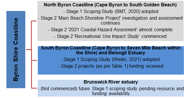
Figure 1: Byron Shire
Council’s status on developing CMPs
Council is currently in Stage 2 of the CMP process for the
open coast and Belongil and Tallow Creek estuaries which comprises additional
technical studies to confirm current knowledge on key issues and concerns and
to fill information gaps that are critical to the development of management
strategies and actions that will occur the next stage (Stage 3). A summary of the
status of these Stage 2 studies is provided below in Table 1. Unless otherwise
stated these projects have been partially funded by the project partner, the
NSW Department of Planning and Environment (DPE) through the Coast and Estuary
Grants Program, which recently increased the funding ratio to 2
(DPE):1(Council). Several medium and low priority studies recommended for stage
2 are pending availability of other funding sources or can otherwise be
completed during CMP implementation.
Table 1: Stage 2 High Priority Projects Planned and Underway
|
Project Name
|
Brief Description
|
Status/ Expected Completion
|
|
Main Beach Shoreline Project
|
A design investigation for the modification of the coastal
protection works at Main Beach, Byron Bay between the Surf Club and First Sun
Holiday Park. The investigation looks at how we can best protect Byron Bay
Town Centre from coastal erosion now and into the future.
|
This study had been delayed resulting in a departure from
the original timing commitment but is now back on track. Cause of delay is
outlined further below in this report.
The detailed technical investigation now complete with the
draft report recently reviewed by staff. Next steps are:
· External
Technical Review (expert and DPE)
· Report to
Executive Team
· Report to
Council
The identification and evaluation of the preferred design
option will be undertaken during Stage 3 of CMP preparation.
|
|
Coastal Hazard Assessment Review and Update
|
This study is the third major investigation into coastal processes,
sand movements and hazards in the Byron region following PWD’s
investigation in the 1978 and BMT 2013 study. Assessment and analysis
of current and future risks to the coastal zone from hazards.
|
This study has been delayed resulting in a major departure
from the original timing commitment but is now back on track. Cause of delay
is outlined further below in this report.
Draft deliverables are due mid-October.
Next steps are:
· Internal staff
review
· External
Technical Review (expert and DPE)
· Report to
Executive Team
· Presentation and
Discussion of Hazard Outputs*
· Report to
Council
*Presentation and Discussion of
Hazard Outputs (2-hr presentation)’: on a suitable date from
mid-November (TBC).
Committee members will be invited to attend this workshop.
|
|
Water Quality Source Tracking and Control Program for
Belongil Creek and Tallow Creek
|
Water pollution of the Tallow Creek and Belongil Creek
estuaries from a variety of sources was identified as a key threat to coastal
values as identified in the Scoping Study for the southern Byron Shire
coastline.
Will identify risks associated with water pollution in
Tallow and Belongil Creek catchments and will identify opportunities for
improving water quality for further consideration at Stage 3.
|
Delayed.
Funding announced June 2022.
Preferred consultant identified. Requires small variation
to grant funding.
Aligns with other work being undertaken within the
resource recovery team on litter.
Expected timeframe for commencement – end of year.
|
|
Identifying risks to cultural and ecological values and
low-lying assets in Tallow Creek and Belongil Creek ICOLLs associated with
entrance opening strategies
|
Essentially this study was aimed at preparing a new
entrance opening strategy (EOS) for Tallow Creek and advising on
recommendations to amend the Belongil Creek Opening Strategy at the next
two-year review, along with undertaking the necessary preliminary supporting
studies (i.e. literature review, engagement with Arakwal, case study for
other NSW ICOLLs, assessment of nuisance flood risk, identification
improvements to decision support frameworks etc).
|
Funding announced in June 2022.
Consultant proposals significantly overbudget.
Council reduced the scope of this study to undertake
preliminaries only, i.e. project would exclude actual drafting and
finalisation of amended or new EOS’ and associated broader stakeholder
engagement and exhibition. Amendments to EOS’ can occur at a later
stage of the CMP.
Currently assessing proposals on reduced scope.
May require variation to grant funding (to reduce scope).
May seek assistance from DPE in delivery of engagement.
|
|
Identifying barriers and opportunities for improvement
associated with Council’s coastal planning controls and processes
|
Essentially an audit of Council’s coastal planning
framework to provide advice on pathways for Council to transition into a more
current and streamlined planning framework (such as recommended mapping and
amendments and justification for changes) whilst retaining or improving on
the level of protection offered by existing controls. It also includes:
· consideration of
mapping and inclusion of a Coastal Vulnerability Area into the planning
scheme
· review of
coastal wetlands and littoral rainforest areas mapping*
· preliminary
mapping of known and predictive cultural heritage and values in the coastal
zone of the Shire including significant consultation with Aboriginal cultural
representatives*
*These components have been removed – refer column
on right.
|
Funding announced in June 2022.
Very limited appetite from consultants to undertake the
full scope of work and submitted proposals were significantly over budget. A
significant deterrent for consultants was the complexity of working with
culturally sensitive information with multiple organisations in the
coastal zone.
Council reduced the scope of this study to remove the
coastal wetland and littoral rainforest mapping review as well as the
preliminary cultural heritage mapping which can be done at a later date or
separate to the CMP process).
Currently assessing proposals on reduced scope.
May require variation to grant funding (to reduce scope).
|
|
Evidence based research of the impacts of recreational and
tourism use on coastal habitats and wildlife*
*Identified as a medium priority study in CMP Scoping
Studies.
|
Funded 100% through the DPE’s Biodiversity
Conservation Division.
Will provide evidence-based information on the effects of
recreational uses on wildlife and habitats in the coastal area, and to
investigate novel solutions to manage impacts, e.g. through the development
and delivery of access and other facilities within the coastal zone and
development of a policies and/or plans.
|
Consultant (BMT WBM) engaged.
Staff and stakeholder engagement undertaken in September
2022.
Completion expected by mid-2023.
|
Current issues being
encountered in CMP development
There are several key issues being encountered which is
affecting Council in progressing with our CMPs. These include:
Lengthy grant funding application assessment and
approval:
· Funding through
the Coast and Estuary Grants Program is generally announced by the Minister. It
took 7 months for the Southern CMP Stage 2 funding to be announced and this
delay in the approval of funding has directly affected project timeframes and
delivery of the stages of the CMP process. It is staff’s view that
studies/projects outlined in the forward plan should be funded automatically as
they have been reviewed and endorsed by DPE Regional Staff. This feedback has
been provided to DPE.
Consultant project work delays and unexpected challenges:
· Data
delays and additional work required to incorporate key datasets. For example in
relation to the Shire Wide Coastal Hazard Assessment the consultant has
completely digitised the 1883 bathymetry survey (i.e. all 7097 soundings
(points) displayed on these detailed charts).
· Co-ordination
between the Coastal Hazard Assessment (CHA) and the Main Beach Shoreline
Project to ensure consistency. Refinement and re-work of elements has been
needed to ensure fit for purpose.
· CHA
study area challenges due to highly dynamic area in which techniques applied
successfully in other areas have been more difficult than expected. For example
the analysis on entrance stability using Inlet Tracker Tool (for of entrance
position/width) history back 30-year. A considerable amount of time has been
spent trying to get this work but is hampered by the size of the entrance
opening in the study area compared to the resolution of the satellite imagery
used in the tool. As such the consultant has had to devise alternative
approaches for these aspects and this has taken longer.
Consultant staffing resources:
· Difficulties
due to COVID and other sickness and injuries regularly effecting staff
availability.
Consultant availability and apathy towards CMP works:
· The
recent flood events have provided a large resource of new work for consultants
in the NRM space (flood modelling, flood insurance claims etc) and has directly
affected consultant availability.
· There
is also a general apathy towards working in the CMP space altogether with
consultants citing insufficient Council budgets and changing goalposts for coastal
management set by the State government (e.g. during CMP review) as key factors.
This issue is anticipated to be resolved as Council, state agencies and
consultants become increasingly familiar with the new coastal management
framework.
Increased consultant costs:
· Consultant
costs have increased substantially in the past two years.
Guidance to local councils (or lack thereof):
· New
information has recently been provided on how to include broader catchment
issues and effectively integrate catchment, coast and marine policy and
governance.
· There
was a lack of guidance on the preparation of coastal management area maps,
specifically for a Coastal Vulnerability Area. However, more recently several
information sheets are now available along with the Coastal Management Manual
which provide guidance.
Steps being taken to
resolve current issues
Steps being taken to resolve some of the issues being
experienced include closer consultation with DPE staff, comprising:
1. A
regular forum for council staff to discuss CMP preparation with other local
council practitioners and DPE staff is being coordinated by DPE.
a. The forum provides an
informal opportunity to hear from other Council practitioners working to
prepare CMPs and DPE in relation to further technical advice and
guidance.
b. The first
‘North-East CMP Roundtable’ was held on Wednesday 18 May 2022. It
was clear at the first meeting that other councils are experiencing similar
issues. A second meeting was conducted on 22 August 2022.
c. Other state agencies
will be invited to the meetings on a need’s basis.
2. Regular
meetings with individual DPE regional staff assigned to the Byron Shire coastal
portfolio to discuss Byron’s CMP development and trouble shoot issues
being encountered and ways to move forward. The recommended pathway forward
outlined in this report has been developed in close consultation with
DPE.
Next stages in CMP
development
The subsequent stages in the process of developing and
implementing a CMP are:
· Stage 3 –
Identify and evaluate options (through risk assessment and cost, benefit
analysis) that reduce exposure to coastal hazards, address coastal management
issues and take advantage of opportunities;
· Stage 4 –
Prepare, exhibit, finalise, certify and adopt a CMP (leading to
implementation). A CMP must be certified by the Minister to access funding for
implementation under the Coast and Estuary Grants program; and
· Stage 5 –
Implement, monitor, evaluate and report.
It was always anticipated that pending the outcome of Stage
2 studies, Council will consider whether to prepare a CMP for the entire Byron
Shire coastal zone, or whether to prepare two or more CMPs. Due to the issues
being encountered and the time required to progress through the stages, it is
recommended that the CMP’s henceforth be divided into separate
geographical areas of the coastal zone. This means that CMPs can progress
independently from each other at different rates depending on further work
(Stage 2 studies) that need to be completed, whilst acknowledging the overlap
between each CMP and continuing to utilise relevant data obtained for one CMP
for other CMPs.
The CMPs recommended for the Byron Shire coastal zone are:
1. CMP
for Tallow Estuary – includes estuary/ICOLL and catchment issues and
actions including entrance opening/management activities (EOS) for flood
mitigation.
2. CMP
for Belongil Estuary - includes estuary/ICOLL and catchment issues and
actions including entrance opening/management activities (EOS) for flood
mitigation.
3. CMP
for the Byron Shire Open Coast – includes the entire Byron Shire open
coast split into 3 management segments such as Cape Byron to South of the LGA
border; Cape Byron to the Brunswick River; Brunswick River to the North of the
LGA border. The spatial extents not yet confirmed and subject to refinement.
4. CMP
for the Brunswick River Estuary (not yet commenced) at a later date.
Splitting the CMPs into the proposed areas provides a better
opportunity to streamline studies and is the preferred approach for more
refined/targeted community engagement and stakeholder consultation. It also
makes sense that the higher priority, higher risk/complexity areas will take
longer to complete Stage 3 and 4 than some of the less exposed/risk or complex
areas (i.e. Open Coast vs Tallow Estuary). By separating into smaller areas,
certification risk is lowered.
It is noted that certification risk remains with such a
broad CMP for the Byron Shire Open Coast – as a sticking point in any one
area (i.e. Belongil) could result in a delay in certification or failure of
certification. Belongil remains a high priority for CMP preparation, however,
should it result in delay for progress of a CMP for the northern or
southern areas splitting the CMP for the Byron Shire Open Coast into smaller
open coast CMPs could be considered.
The recommended pathway for CMP preparation is supported by
DPE staff along with the suggested approach to accelerate the CMPs by
overlapping Stage 2 and Stage 3. The overlapping of these stages is being
undertaken elsewhere in NSW by coastal councils, by moving through the stages
concurrently (where possible).
Stage 3 is options development and evaluation, including
community/stakeholder engagement to arrive at agreed preferred
option/prioritised actions for each CMP. Stage 4 is preparation, exhibition and
certification of the CMP. Stage 3 and Stage 4 are generally combined into
one grant application and one consultant brief. It is recommended that Stage 3
commences as Stage 2 studies are being completed with outcomes incorporated as
they are known. Stage 4 will follow on once Stage 2 and 3 are fully complete.
Waiting for the completion of all stage 2 studies prior to
submitting Stage 3 & 4 grant applications for funding is likely 12
months away, with the addition of funding assessment potentially taking up to 6
months. This may mean that commencement of Stage 3 is up to 18 months away for
CMPs. As such, it is recommended that Stage 3 & 4 combined application is
prepared as soon as possible to ensure unnecessary delays in the CMP process
are avoided.
Accelerating the approach requires high level of
collaboration between Council, DPE and consultant. This is collaboration is
confirmed and being implemented through the regular catchups, meeting and
coordination between staff.
Next Steps
· Staff
and project consultants will continue to progress the development of CMPs for
the Byron Shire Coastline and related projects.
· Staff
will commence preparing Stage 3 and Stage 4 grant application for the Open
Coast CMP.
· A
Presentation and Discussion of Hazard Outputs (2-hr presentation) for the
Coastal Hazard Study is expected to be held on a suitable date from
mid-November (TBC) which committee members will be invited to participate.
· The
next update on the status of projects and CMP preparation will be reported to
the first Coastal and ICOLL Advisory Committee meeting in 2023.
Strategic Considerations
Community Strategic Plan
and Operational Plan
|
3: Nurtured Environment
We nurture and enhance the natural environment
|
3.3: Protect the health of our coastline, estuaries,
waterways, and catchments
|
3.3.1: Coastal Management Program planning and
implementation - Undertake Coastal Management Program planning and implementation
|
3.3.1.1
|
Identify coastal hazard risks to the Byron Shire
coastline
|
|
3: Nurtured Environment
We nurture and enhance the natural environment
|
3.3: Protect the health of our coastline, estuaries,
waterways, and catchments
|
3.3.1: Coastal Management Program planning and
implementation - Undertake Coastal Management Program planning and
implementation
|
3.3.1.2
|
Identify risks to cultural and ecological values and
assets in Tallow and Belongil Creek ICOLLs
|
|
3: Nurtured Environment
We nurture and enhance the natural environment
|
3.3: Protect the health of our coastline, estuaries,
waterways, and catchments
|
3.3.1: Coastal Management Program planning and
implementation - Undertake Coastal Management Program planning and
implementation
|
3.3.1.3
|
Identify ICOLL water quality pollution sources
|
|
3: Nurtured Environment
We nurture and enhance the natural environment
|
3.3: Protect the health of our coastline, estuaries,
waterways, and catchments
|
3.3.1: Coastal Management Program planning and
implementation - Undertake Coastal Management Program planning and
implementation
|
3.3.1.6
|
Assess concept options for the modification of the
Jonson Street coastal protection works (Main Beach Shoreline Project)
|
|
3: Nurtured Environment
We nurture and enhance the natural environment
|
3.3: Protect the health of our coastline, estuaries,
waterways, and catchments
|
3.3.1: Coastal Management Program planning and
implementation - Undertake Coastal Management Program planning and
implementation
|
3.3.1.8
|
Identify and evaluate management options and
opportunities for addressing threats to the Byron Shire coastline
|
|
3: Nurtured Environment
We nurture and enhance the natural environment
|
3.3: Protect the health of our coastline, estuaries,
waterways, and catchments
|
3.3.2: Floodplain management - Mitigate the impact of
flooding on private and public property
|
3.3.2.1
|
Revise entrance management activities and arrangements
for Tallow Creek
|
|
3: Nurtured Environment
We nurture and enhance the natural environment
|
3.3: Protect the health of our coastline, estuaries,
waterways, and catchments
|
3.3.2: Floodplain management - Mitigate the impact of
flooding on private and public property
|
3.3.2.2
|
Review entrance management activities and arrangements
for Belongil Creek
|
Legal/Statutory/Policy
Considerations
Coastal Management Act (2016), SEPP (Resilience
and Hazards) 2021 (which replaces the SEPP (Coastal Management) 2018),
Coastal Manual and associated Toolkit provided by the NSW State Government.
Financial Considerations
An existing budget is allocated to the development of
Coastal Management Programs for FY2022/23. Additional budget will be requested
for continue of CMP preparation into FY2023/24
Consultation and
Engagement
DPE Water, Floodplains and Coast (North East), Senior Coast
and Estuaries Officer Zoe Immisch has reviewed this report and endorses the
content, specifically the way forward.
Staff Reports - Sustainable Environment and Economy 4.3
Report
No. 4.3 Bringing Back the
Bruns - project update
Directorate: Sustainable
Environment and Economy
Report Author: Chloe
Dowsett, Biodiversity and Sustainability Coordinator
Orla Seccull, Coastal & Estuary Officer
File No: I2022/1092
Summary:
The Bringing Back the Brunswick Project (also known as
‘Bringing Back the Bruns’) is a collective initiative based on the
idea that the Brunswick River offers a unique opportunity to undertake an
Australian first whole-of catchment river rehabilitation project that aims to
achieve real, measurable benefits to the river ecosystem and community.
Significant management issues face the Brunswick catchment
and ‘Bringing back the Bruns’ offers the unique and unrivalled
opportunity to rehabilitate an entire riverine catchment in a strategic and
staged approach over a number of years to produce a permanent, positive outcome
for future generations to enjoy.
A number of projects and initiatives have been implemented
recently focussing on the Brunswick Catchment. This report provides an update
on the various projects to improve the health of the Brunswick River catchment
in an on-going and continuous effort to ‘Bringing Back the Bruns’.
RECOMMENDATION:
That the Coast and ICOLL Advisory Committee note
the update.
Background
Bringing Back the Bruns is a large-scale collective
initiative that is proposed to be delivered over many years with an end goal of
returning the Brunswick River to as natural a state as feasible. The scope for
the project is based on the idea that the Brunswick River offers a unique
opportunity to undertake an Australian first whole-of catchment river
rehabilitation project that aims to achieve real, measurable benefits to the
river ecosystem and community.
Key issues
Significant management issues
facing the Brunswick catchment include:
· Unrestricted
livestock access to the riparian zone resulting in destabilised and failed
riverine banks and excessive nutrient inputs.
· Historic
clearing of riparian vegetation and proliferation of exotic weeds (e.g. Camphor
Laurel).
· Construction
of over 20 waterway crossings on the main river, with over 15 of these
structures acting as barriers to native fish migration.
· Sedimentation
of instream pools resulting in diminishing riverine habitat and reduced
ecological diversity.
· Significant
bank slumping within the estuarine zone resulting from excessive wave action.
Solutions and Benefits
‘Bringing back the Bruns’ offers the unique and
unrivalled opportunity to rehabilitate an entire riverine catchment in a
strategic and staged approach over a number of years to produce a permanent,
positive outcome for future generations to enjoy.
Solutions and benefits
include:
1. Fencing and revegetation of the
riverine corridor (> 70 km) to reinstate a healthy riparian zone that will
benefit instream and terrestrial flora and fauna.
2. Stabilisation of highly eroded banks
through revegetation to improve habitat values and limit point source sediment
and nutrient input into the river. Some structural works such as regrading or
bank protection with logs or rock is required in some locations.
3. Reconstruction of waterway crossings to
improve the safety of vehicle access during high flows while also reinstating
unimpeded fish migration from the estuary to the headwaters.
4. Cleaner, healthier water for the
community to enjoy now and for future generations.
This report provides an update on the various projects that
have been (or are being) implemented to improve the Brunswick River and
catchment in an on-going and continuous effort to ‘Bring Back the
Bruns’.
Projects
Causeways and Reinstating Fish Passage
Initial works began many
years ago in 2005 with projects like the Coral Avenue Causeway upgrade at
Mullumbimby. This causeway prohibited fish from migrating upstream during
low-flow conditions, is owned by Council, serviced by 19 landholders and was
prioritised as the top road crossing barrier for remediation.
Microsoft
Word - Case Study_Coral Avenue.doc (nsw.gov.au)
In
2018 Council received grant funding from the NSW Department of Primary
Industries (DPI) to install new causeways and reinstate fish passage in the
Brunswick River by removing fish barriers to open upstream habitat. The
$274,600 grant under the NSW DPI Flagship Fish Habitat Grants Program was
matched with funding ($274,600) from Council to upgrade two causeways in the
mid-reaches of the Brunswick River.
The
project complemented another grant from the DPI Fisheries Habitat Action
program saw the upgrade of six old causeways to fish friendly crossings and the
removal of three redundant low-level fish barriers / causeways. The projects
have opened up 7km of upstream habitat which now allows 27.4km of fish passage
to the estuary mouth. The restoration works will have long-term positive effects
on fish species including the iconic Australian Bass, which live in the upper
freshwater reaches of the river and migrate to the lower Brunswick Estuary for
breeding.
The
project now ensures fish have access to 90 per cent of the river for 100 per
cent of the year. Prior to the projects, fish including bass and mullet could
only migrate to the upper reaches of the Brunswick River for around ten days
every year when high rainfall allowed fish to swim up and over the impeding
causeways. Local residents have also benefited from safer vehicle access.
Riparian Restoration – Mullumbimby
Council completed works along a stretch of Council managed
land on the northern bank of the Brunswick River from the Mullumbimby
Showgrounds 1.8km (approx. 3.6ha) downstream towards Mullumbimby town centre.
The project included planting of at least 400 trees and community capacity
building with regard to better management of the riparian zone in their
neighbourhood.
Council’s
bush regeneration team is currently working on 57 bushland sites (238 Hectares)
across the shire. The total area being worked by Council’s bush
regeneration team along the Brunswick River is 14 sites, 57 Hectares and 6,260m
of river bank. The work conducted on these sites included tree planting, installation
of nest boxes, weed control and fencing to exclude stock from riparian areas.
This is set to increase in the near future with recent funding provided by
Local Land Services to address priority erosion sites.
The benefits to our community and the environment include:
· The establishment of thousands of new plants and trees.
· Helping to create a continuous fauna/flora corridor for the
length of the Brunswick River from the mountains to the sea.
· Creating habitat/food for aquatic and terrestrial animals.
· Vegetation along river banks creates a wind break for
adjoining farms reducing erosion and moisture evaporation rates and providing
shade for stock.
· Vegetation in riparian zones improves water quality by
filtering herbicides, pesticides, stock manure and fertilisers resulting in
cleaner water.
· Fencing stock from riparian zones decreases erosion and
improves water quality as stock cause erosion by collapsing river banks and
eating vegetation along the bank leaving it bare and susceptible to further
erosion when it rains or floods.
Brunswick Valley Landcare actively undertakes projects at
various sites within the catchment to reinstate a healthy riparian zone and
improve terrestrial flora and fauna habitat.
A brief snapshot of some
recent projects is provided below:
· BVL
Saving our Species Phyllanthus microcladus project – working on 5
sites along the Brunswick River undertaking weed control and monitoring of
species density and health.
· BVL
locality group Heritage Park Maslen Arboretum – volunteer group meets
every Saturday morning to carry out weeding, maintenance and planting in the
arboretum.
· BVL
locality group Mullumbimby Town – volunteer group meets once a month to
work on 4 sites along the creek in Mullumbimby town - weeding, maintenance and
planting.
Fish Habitat Restoration - Mullumbimby
Fish Habitat Restoration Program – works delayed
due to approvals process
The project on the Brunswick River in Mullumbimby has been
delayed this year due to complexity of permitting and. Pending suitable
weather, erosion control works by Soil Conservation Service will commence once
all approvals have been obtained. Due to constraints within the planning
framework, development assessment and approval was required which has delayed
the timeframe for implementation of the works.
Subsequent to the river stabilisation works, riparian
revegetation will be carried out with the help of Ozfish and the Brunswick
Heads Angling and Deep-Sea Fishing Club.
The project is being developed in
partnership with North Coast Local Land Services (NCLLS). NCLLS are managing
the design, supply and construction. Council will manage the landholder and community
engagement components. The property is just downstream from Mullumbimby, behind
‘The Paddock’. The landowner will be contributing a considerable
amount to the project in fencing and re-vegetation, with Council providing
in-kind contribution.
River Clean-ups and Waste
Post-flood Shoreline Clean-up of the Brunswick River
Estuary
Council, along with other land and
water managers in the coastal environment were aware of and concerned about the
significant amount and type of flood debris that had accumulated on the
beaches, rivers and shorelines of the Byron Shire as a result of the flood
events in February and March 2022. However, plans to coordinate a clean-up were
hampered by health and safety concerns i.e. risk of bacterial/viral infection
and potential for contact with hazardous materials.
In due course, the EPA extended
their existing Shoreline Clean-up and Maintenance program established in
response to the March 2021 flooding to also include clean-up of the more recent
floods. The program aims to ensure flood generated anthropogenic debris and
eligible green waste is removed from impacted shorelines and waterways on land
owned or managed by local government or on Aboriginal community title. The
program is co-funded by the NSW and Commonwealth Governments.
A preliminary survey of the
Brunswick River Estuary was coordinated by DPE, Marine Rescue Brunswick Heads,
the SES and Council staff to log the location and type of debris and collate
together with reports from the public.
The shoreline clean-up of the
Brunswick River was carried out by contractors in late August 2022 covering the
Shires beaches and the navigable portion of the Brunswick River (approximately
Mullumbimby High School) and the lower parts of Marshalls Creek and Simpsons
Creek.
The Program excludes private land,
public land managed by Crown Lands or by National Parks, and flood debris
located in mangroves or other sensitive areas where the environmental damage
that would be caused during its removal would outweigh the benefit achieved.
In total, the contractors logged
500 discrete debris reports for works undertaken on the Brunswick River and
Byron LGA beaches. A total of approximately 60m3 of anthropogenic
waste was removed.
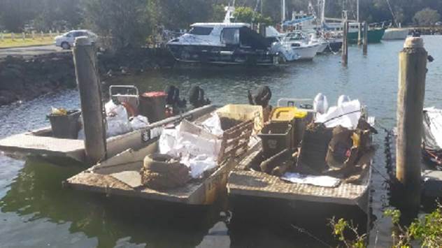
Photo of
debris during collection from the Brunswick river estuary
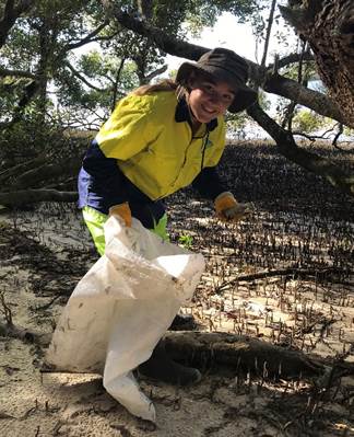
Photos of
recent Brunswick River clean-up
A similar land-based program is
currently underway to remove flood debris in public managed land within the
catchments.
Waste and Litter Surveys
Council has been collecting litter and undertaking surveys
throughout the Shire including sites along the Brunswick River since 2017,
collecting almost 15 000 pieces of litter so far. We have used this data to
guide our litter prevention and waste reduction campaigns including Butt Free
Byron Shire and our new project ‘Bring it Back Bruns’ – a
pilot reusable container project to tackle single-use takeaway items which that
have become a big litter problem.
Other Projects
Partnerships
Council regularly supports and partners with organisations
such as Positive Change for Marine Life, a local environmental
group who have implemented a River Warriors Campaign for the Brunswick River.
This campaign involves regular clean-ups along the River, ecological monitoring
and on-ground restoration of identified priority areas.
Next steps
Staff to continue to explore all
grant and alternate funding opportunities as they arise including partnerships,
to support new projects that contribute to ‘Bringing back the
Bruns’ and related projects. Further, updates on the ‘Bringing back
the Bruns’ and related projects to be provided at future Council
meetings.
Strategic Considerations
Community Strategic Plan
and Operational Plan
|
CSP Objective
|
CSP Strategy
|
DP Action
|
Code
|
OP Activity
|
|
3: Nurtured Environment
We nurture and enhance the natural environment
|
3.1: Partner to nurture and enhance our biodiversity,
ecosystems, and ecology
|
3.1.3: Habitat restoration - Restore degraded areas that
provide high environmental or community value
|
3.1.3.4
|
Investigate grant opportunities for improving the
Brunswick Estuary ecosystems and river health.
|
|
3: Nurtured Environment
We nurture and enhance the natural environment
|
3.1: Partner to nurture and enhance our biodiversity,
ecosystems, and ecology
|
3.1.3: Habitat restoration - Restore degraded areas that
provide high environmental or community value
|
3.1.3.5
|
Deliver Federal Fish Habitat Restoration Project
|
|
3: Nurtured Environment
We nurture and enhance the natural environment
|
3.5: Minimise waste and encourage recycling and resource
recovery practices
|
3.5.2: Recycling - Work with business and tourism sector
to reduce waste to landfill
|
3.5.2.2
|
Implement reusable takeaway container pilot program in
Brunswick Heads
|
Recent
Resolutions
Legal/Statutory/Policy
Considerations
Marine Estate Management Act 2014
Coastal Management Act 2016
Financial Considerations
Currently there is no general Council budget allocation for
the ‘Bringing Back the Bruns’ collective initiative/projects in the
2022/23 budget. Significant funding would be required to implement the
‘Bringing back the Bruns’ which could be accessed via funding
sources from local, regional, State, and federal grants.
Staff will continue to explore all grant and alternate
funding opportunities as they arise including partnerships, to support new
projects that contribute to ‘Bringing back the Bruns’ and related
projects.
Consultation and
Engagement
Internal consultant has been undertaken with relevant staff
to develop this report.
Staff Reports - Sustainable Environment and Economy 4.4
Report
No. 4.4 Update of
Constitution and New Members
Directorate: Sustainable
Environment and Economy
Report Author: Michelle
Chapman, Project Support Officer
File No: I2022/1283
Summary:
At 29 September 2022 Council meeting, the Committee’s
constitution was adopted and three new community representatives were
appointed.
The constitution has been updated accordingly and is
attached for your information.
RECOMMENDATION:
That the Coast and ICOLL Advisory Committee note
the report and adopted constitution.
Attachments:
1 Coast
and ICOLL Advisory Committee Constitution 2022 Adopted 29 September 2022 Res
22-525, E2022/96730 , page 45⇩ 
Report
At 29 September 2022 Council meeting, the Constitution was
adopted with the committee’s recommendations from 30 June 2022 meeting
(see adoption of minutes report for changes).
Council also considered a report ‘Replacement of
Community Members to Advisory Committees’ and appointed three new
community representatives to the Coast & ICOLL Advisory Committee. This
brings the number of community representatives to 7, lieu 6 quoted in the draft
constitution.
We welcome new members:
· Lauren Morgan
· Bill Payne
· Matthew Lambourne
It was also resolved:
· that
in the case of future resignations from
Advisory Committees that replacement community members be appointed from the recommended
list of previous applicants, and where no suitable or available applicants
exist applications for new members are then advertised.
· that Cr Lyon be appointed as the alternate to the
Coast and ICOLL Advisory Committee in place of Cr Ndiaye.
The constitution has been updated
and is attached for your information. It is also available on Council’s
website at Advisory
Committees - Byron Shire Council (nsw.gov.au)
Strategic Considerations
Community Strategic Plan
and Operational Plan
Recent
Resolutions
· 22-518
· 22-524
Legal/Statutory/Policy
Considerations
n/a
Financial Considerations
n/a
Consultation and
Engagement
n/a
Staff
Reports - Sustainable Environment and Economy 4.4 - Attachment 1