
Agenda
Extraordinary Meeting
Tuesday, 28 November 2017
held at Council Chambers, Station Street, Mullumbimby
commencing at 4.00pm

Mark Arnold
Acting General Manager
Agenda
Extraordinary Meeting
Tuesday, 28 November 2017
held at Council Chambers, Station Street, Mullumbimby
commencing at 4.00pm
Mark Arnold
Acting General Manager
CONFLICT OF INTERESTS
What is a “Conflict of Interests” - A conflict of interests can be of two types:
Pecuniary - an interest that a person has in a matter because of a reasonable likelihood or expectation of appreciable financial gain or loss to the person or another person with whom the person is associated.
Non-pecuniary – a private or personal interest that a Council official has that does not amount to a pecuniary interest as defined in the Local Government Act (eg. A friendship, membership of an association, society or trade union or involvement or interest in an activity and may include an interest of a financial nature).
Remoteness – a person does not have a pecuniary interest in a matter if the interest is so remote or insignificant that it could not reasonably be regarded as likely to influence any decision the person might make in relation to a matter or if the interest is of a kind specified in Section 448 of the Local Government Act.
Who has a Pecuniary Interest? - a person has a pecuniary interest in a matter if the pecuniary interest is the interest of the person, or another person with whom the person is associated (see below).
Relatives, Partners - a person is taken to have a pecuniary interest in a matter if:
§ The person’s spouse or de facto partner or a relative of the person has a pecuniary interest in the matter, or
§ The person, or a nominee, partners or employer of the person, is a member of a company or other body that has a pecuniary interest in the matter.
N.B. “Relative”, in relation to a person means any of the following:
(a) the parent, grandparent, brother, sister, uncle, aunt, nephew, niece, lineal descends or adopted child of the person or of the person’s spouse;
(b) the spouse or de facto partners of the person or of a person referred to in paragraph (a)
No Interest in the Matter - however, a person is not taken to have a pecuniary interest in a matter:
§ If the person is unaware of the relevant pecuniary interest of the spouse, de facto partner, relative or company or other body, or
§ Just because the person is a member of, or is employed by, the Council.
§ Just because the person is a member of, or a delegate of the Council to, a company or other body that has a pecuniary interest in the matter provided that the person has no beneficial interest in any shares of the company or body.
Disclosure and participation in meetings
§ A Councillor or a member of a Council Committee who has a pecuniary interest in any matter with which the Council is concerned and who is present at a meeting of the Council or Committee at which the matter is being considered must disclose the nature of the interest to the meeting as soon as practicable.
§ The Councillor or member must not be present at, or in sight of, the meeting of the Council or Committee:
(a) at any time during which the matter is being considered or discussed by the Council or Committee, or
(b) at any time during which the Council or Committee is voting on any question in relation to the matter.
No Knowledge - a person does not breach this Clause if the person did not know and could not reasonably be expected to have known that the matter under consideration at the meeting was a matter in which he or she had a pecuniary interest.
Participation in Meetings Despite Pecuniary Interest (S 452 Act)
A Councillor is not prevented from taking part in the consideration or discussion of, or from voting on, any of the matters/questions detailed in Section 452 of the Local Government Act.
Non-pecuniary Interests - Must be disclosed in meetings.
There are a broad range of options available for managing conflicts & the option chosen will depend on an assessment of the circumstances of the matter, the nature of the interest and the significance of the issue being dealt with. Non-pecuniary conflicts of interests must be dealt with in at least one of the following ways:
§ It may be appropriate that no action be taken where the potential for conflict is minimal. However, Councillors should consider providing an explanation of why they consider a conflict does not exist.
§ Limit involvement if practical (eg. Participate in discussion but not in decision making or vice-versa). Care needs to be taken when exercising this option.
§ Remove the source of the conflict (eg. Relinquishing or divesting the personal interest that creates the conflict)
§ Have no involvement by absenting yourself from and not taking part in any debate or voting on the issue as if the provisions in S451 of the Local Government Act apply (particularly if you have a significant non-pecuniary interest)
RECORDING OF VOTING ON PLANNING MATTERS
Clause 375A of the Local Government Act 1993 – Recording of voting on planning matters
(1) In this section, planning decision means a decision made in the exercise of a function of a council under the Environmental Planning and Assessment Act 1979:
(a) including a decision relating to a development application, an environmental planning instrument, a development control plan or a development contribution plan under that Act, but
(b) not including the making of an order under Division 2A of Part 6 of that Act.
(2) The general manager is required to keep a register containing, for each planning decision made at a meeting of the council or a council committee, the names of the councillors who supported the decision and the names of any councillors who opposed (or are taken to have opposed) the decision.
(3) For the purpose of maintaining the register, a division is required to be called whenever a motion for a planning decision is put at a meeting of the council or a council committee.
(4) Each decision recorded in the register is to be described in the register or identified in a manner that enables the description to be obtained from another publicly available document, and is to include the information required by the regulations.
(5) This section extends to a meeting that is closed to the public.
BYRON SHIRE COUNCIL
Extraordinary Meeting
BUSINESS OF Extraordinary Meeting
2. Declarations of Interest – Pecuniary and Non-Pecuniary
3. Notices of Motion
3.1 Compliance - Belongil and Brunswick Dunes................................................................... 5
3.2 Biosecurity......................................................................................................................... 8
3.3 Instant Hotel TV Show..................................................................................................... 13
4. Petitions
4.1 No Paid Parking in Brunswick Heads............................................................................. 14
5. Submissions and Grants
5.1 Byron Shire Council Submissions and Grants as at 1 November 2017......................... 15
6. .. Delegates' Reports
7. Staff Reports
Corporate and Community Services
7.1 Review of Natural Disaster Response Protocols ........................................................... 18
7.2 Meeting Schedule 2018................................................................................................... 26
7.3 Audit, Risk and Improvement Committee Membership................................................. 30
7.4 North Byron Parklands Regulatory Working Group - Community Representatives...... 32
Sustainable Environment and Economy
7.5 Biodiversity Conservation Strategy Update.................................................................... 34
7.6 PLANNING - 10.2017.360.1 Rural Tourist Accommodation Comprising Four (4) Cabins at 75 Rifle Range Road, Bangalow ................................................................................................. 37
7.7 PLANNING - 10.2017.270.1 Multi dwelling housing comprising eight (8) dwellings, Strata Title subdivision to create eight (8) Strata Lots and Common Property and Tree Removal (17 trees) at 6 and 6A Canowindra Court South Golden Beach............................................................ 50
7.8 PLANNING - Site-specific Planning Proposals considered as part of the Rural Land Use Strategy process............................................................................................................................ 70
7.9 Further update on Resolution 17-191 Secondary Dwelling Conditions.......................... 76
7.10 Review of the Biodiversity and Sustainability Panel....................................................... 78
Infrastructure Services
7.11 Former Mullumbimby Hospital - Contamination Review................................................ 81
7.12 Tree Removals Railway Park Byron Bay....................................................................... 84
7.13 Bangalow STP Membrane Replacement....................................................................... 93
8. Confidential Reports
Infrastructure Services
8.1 Confidential - Council Tender for the Multi Use of Byron Shire Rail Corridor........ 95
Councillors are encouraged to ask questions regarding any item on the business paper to the appropriate Executive Manager prior to the meeting. Any suggested amendments to the recommendations should be provided to the Administration section prior to the meeting to allow the changes to be typed and presented on the overhead projector at the meeting.
Notices of Motion 3.1
Notice of Motion No. 3.1 Compliance - Belongil and Brunswick Dunes
File No: I2017/1723
|
I move that Council:
1. Receives a report at the December meeting detailing current compliance priorities.
2. Receives a report at the December meeting that provides updates on:
a) Actions that have been taken or are planned to be taken to prevent illegal camping, dumping and other damaging activities at the Belongil sand dunes following the latest clean-up that occurred on October 24. b) Actions that have been taken or are planned to be taken to prevent damage to sand dunes at Brunswick Heads.
3. Receives a report on current strategies in place for providing assistance to people who are homeless that have been or may be impacted by the actions above.
|
Signed: Cr Michael Lyon
Councillor’s supporting information:
Both Belongil and Brunswick Heads sand dunes are essential components of Byron Shire’s world class beaches, requiring careful protection not only for the amenity of residents and tourists, but also to protect the fragile health of our heavily used coastline. The Belongil sand dunes have had a history of illegal camping, dumping and otherwise damaging activities and thanks to the compliance and clean up efforts of staff and residents this year there has been a decline in these activities and several fines issued.
Similarly, the sand dunes at Brunswick Heads have often been the site of illegal fires and people otherwise walking through areas that are essential to leave undisturbed to protect ecosystems. As summer approaches, there is a tendency for these damaging activities to increase in frequency. As such, it is an important time to prioritise the protection of both of these areas and, for Belongil, maintain positive changes that have occurred and ensure the area does not become repopulated with illegal campers.
Staff comments by Shannon Burt, Director, Sustainable Environment and Economy:
(Management Comments must not include formatted recommendations – resolution 11-979)
Council continues to confront the complex issue of illegal camping activity in the Shire and the rubbish left behind, and the impact that it has on the sensitive dune environments of places like Belongil and Brunswick.
It is an issue all-year round but it gets worse during the school holidays and summer months.
Council’s Enforcement Team regularly arranges for proactive patrols with the Police and clean up days with Infrastructure Services staff. On these days staff clean up faeces, toilet paper, domestic waste, tents and furniture in large volumes. This is an extremely costly exercise for Council in both staff time and money, and challenging for staff confronted with the task.
Photos staff clean up 24 October 2017:
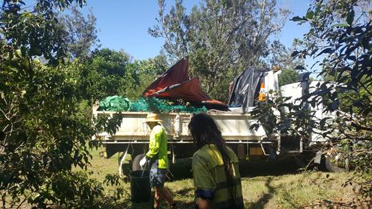
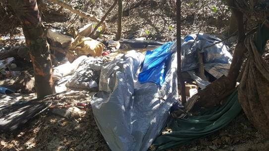
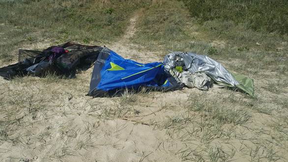
On this day, 6 staff were on duty, they detected about 15 camp sites half of which were abandoned. 12 fines were issued. Multiple truck loads of rubbish removed.
The fines for illegal camping range from an on-the-spot fine of $110 to a maximum of $2,200.
Of the people spoken to: 2 were local homeless, 4 were German nationals, 1 was American, 5 were from out of town.
Council staff have raised the issue of illegal camping with campervan companies, and the Rural Fire Service, National Parks and Wildlife Service, and NSW Police are aware of the problem.
Staff are also in discussions with the above agencies to develop strategies to tackle the problem in a more proactive way, which can be reported back to Council in December.
The annual Compliance Priorities Program will also be reported to Council in December, following a workshop with Councillors.
Financial/Resource/Legal Implications:
Enforcement Activities managed within existing staff resource and budget under the Compliance Priority Program.
Is the proposal consistent with any Delivery Program tasks?
Yes - SC2.2.2 Implement community regulation and enforcement activities.
BYRON SHIRE COUNCIL
Notices of Motion 3.2
Notice of Motion No. 3.2 Biosecurity
File No: I2017/1724
|
I move:
1. That a report to Council be prepared on the potential impacts of the new Biosecurity Act (2017) on the draft Rural Land Use Strategy (RLUS);
2. That the report pay
particular attention to: a) biosecurity considerations in Land Use Conflict Risk Assessment (LUCRA); b) the potential for biosecurity risks to agriculture as a result of increased agritourism, and; c) the potential risk to Byron Shire’s biodiversity as a result of agritourism;
3. That Council consider including biosecurity management as a factor in the RLUS, and
4. That Councillors hold a workshop with a view to developing a Shire-wide Biosecurity Policy.
|
Signed: Cr Cate Coorey
Councillor’s supporting information:
In April 2017 Council discussed the draft Biosecurity Act 2015.
The 10 Acts being wholly repealed when the Biosecurity Act 2015 commences are:
· Animal Diseases and Animal Pests (Emergency Outbreaks) Act 1991
· Apiaries Act 1985
· Deer Act 2006
· Fertilisers Act 1985
· Non-Indigenous Animals Act 1987
· Noxious Weeds Act 1993
· Plant Diseases Act 1924
· Stock (Chemical Residues) Act 1975
· Stock Diseases Act 1923
· Stock Foods Act 1940
·
The Acts being partly repealed when the Biosecurity Act 2015 commences are:
· Fisheries Management Act 1994 (Aquatic Biosecurity)
· Stock Medicines Act 1989
· Local Land Services Act 2013 (Part 10 Pests)
· Wild Dog Destruction Act 1921
The Biosecurity Act 2015 came into effect in June 2017 with an update to cattle management provisions in October 2017. In light of the soon to be completed Rural Land Use Strategy, it seems timely to consider biosecurity as an essential issue on rural land.
Additionally, in protecting the biodiversity of our native environment, biosecurity must be considered. Australia’s island status has conferred us an advantage when it comes to biosecurity but there are still threats and the chances of these are increasing.
With increasing numbers of travellers to Byron, the increase of food and farm tours (agritourism) and the co-location of agriculture and tourism, there are many new challenges to be met. Some of these are perhaps unique to Byron Shire as we are a high visitation area that is also a highly productive agricultural area and a biodiversity hotspot.
Byron has a name as a centre for premium products and quality, low food production is a growing industry. Council has pesticide free/low pesticde policies but to enable to be low pesticide we have to be vigilant and not allow pests into our farms or forests in the first place.
Myrtle rust is a fungal disease which infects plants in the Myrtaceae family. Common Australian Myrtaceae species include eucalyptus, willow myrtle, turpentine, bottlebrush, paperbark, tea tree and lilly pilly. Severe infections can see plants die. As just one example the further depleting eucalyptus just for koalas is enormous.
Since myrtle rust was first detected in NSW in April 2010 it has spread across the
eastern Australian landscape in bushland reserves, home gardens, commercial operations, parks and street plantings. Over 300 hosts have been recorded so far.
Something as small as a fungus spore can have disastrous consequences.
Agriculture is a high-risk industry in regards to pest, diseases and weeds and the introduction of any of these can decimate an agricultural industry and a farmer’s income for many years. Generally speaking Byron Shire Council has not had as big an agritourism sector as some other LGAs. In other areas businesses engaging in agritourism have been imposed with tighter restrictions than are currently permitted in Byron.
Agritourism was introduced on the rural zoning so that farmers could value add to their existing businesses and create a supplementary income stream. Agritourism is ancillary to the agriculture on the site and generally small groups that can be supervised and managed by the agritourism operator, e.g. 20 school children or groups of 5 -10 tourists being taken through the site of a bee farmer. The tourists are shown the hives and honey extraction techniques, partake in some activities related to the venture i.e making honey bee wax wraps, served a morning tea and then take home some honey.
In most such operations there is a visitor register or log and usually a biosecurity declaration to sign along with some sort of biosecurity awareness education before entering the site. Visitors then either “wash down” their boots/shoes in a “wash down” station area with disinfectant and/or put on clean gum boots provided by the agricultural entity, or put on plastic footwear protectors. If visitors do not meet the requirements for entry then they must be denied entry due to the risks associated.
Any person who deals with biosecurity matter or a carrier and who knows, or ought reasonably to know, the biosecurity risk posed or likely to be posed by the biosecurity matter, carrier or dealing has a biosecurity duty to ensure that, so far as is reasonably practicable, the biosecurity risk is prevented, eliminated or minimised.
The risks to Australian plants and animals from poor biosecutry management is very real as detailed. ‘Australia’s Biosecurity Future – preparing for future biological challenges’. CSIRO, 2014. pp 4-5.
Biosecurity Implications on Agriculture:
· The number of international tourist arrivals for Australia continues to increase
· We continue to see an increase in the movement of goods and vessels around the world, in line with growing global trade
· In a globalised world, bioterrorism (including agroterrorism) is a potential threat
· We are also seeing greater movement of goods across our interstate borders
· Increased travel creates opportunities for infectious diseases, including those resistant to antibiotics and antiviral medications, to enter Australia
· Increased movement of people and goods can help to bring pests or diseases into the country that could impact on our environment or primary industries
· A general disconnection from primary production in Australia is leading to a lack of understanding of biosecurity issues and their impacts
· Changing consumer expectations require new and adaptive biosecurity capabilities
· The ongoing expansion of our cities is changing interactions between people, wildlife, agriculture and disease vectors, increasing risks such as zoonotic disease
· It is important to engage with peri-urban/amateur producers as part of the biosecurity community to improve their understanding of biosecurity risks and their adoption of biosecurity practices …
· An ageing population is leading to a decline in biosecurity specialists and experienced farmers, with a lack of younger talent to fill the gaps created
· Biosecurity investment does not appear to be keeping pace with the growing challenges we face
· A lack of biosecurity specialists and investment could limit our ability to prevent and respond to shocks
Biosecurity Implications on Biodiversity:
· Significant biodiversity loss can decrease the resilience of our natural environment to pests and diseases
· The management of invasive species can be a valuable and cost-effective tool in curbing biodiversity losses
· Biodiversity can provide a number of benefits, such as ecosystem services (e.g. pollination). Understanding the interconnections between biodiversity and biosecurity may therefore prove to be a vital component of biosecurity management
Objects of Biosecurity Act
(1) The primary object of this Act is to provide a framework for the prevention, elimination and minimisation of biosecurity risks posed by biosecurity matter, dealing with biosecurity matter, carriers and potential carriers, and other activities that involve biosecurity matter, carriers or potential carriers.
(2) The other objects of this Act are as follows:
(a) to promote biosecurity as a shared responsibility between government, industry and communities,
(b) to provide a framework for the timely and effective management of the following:
(i) pests, diseases, contaminants and other biosecurity matter that are economically significant for primary production industries,
(ii) threats to terrestrial and aquatic environments arising from pests, diseases, contaminants and other biosecurity matter,
(iii) public health and safety risks arising from contaminants, non-indigenous animals, bees, weeds and other biosecurity matter known to contribute to human health problems,
(iv) pests, diseases, contaminants and other biosecurity matter that may have an adverse effect on community activities and infrastructure,
(c) to provide a framework for risk-based decision-making in relation to biosecurity,
(d) to give effect to intergovernmental biosecurity agreements to which the State is a party,
(e) to provide the means by which biosecurity requirements in other jurisdictions can be met, so as to maintain market access for industry.
Staff comments by Sharyn French, Manager Environmental and Economic Planning, Sustainable Environment and Economy:
(Management Comments must not include formatted recommendations – resolution 11-979)
On 1 July 2017, the Biosecurity Act 2015 and Biosecurity Regulations 2017 commenced providing specific legal requirements for state-level priority weeds and high-risk activities.
Council at the 20 April 2017 meeting considered a report on the then draft Biosecurity Regulations and Resolved 17-141 that Council note:
1. The information contained in this report on the draft Biosecurity Regulation 2016.
2. That Council staff are undertaking an internal peer review of the draft Integrated Weed Strategy March 2016.
3. That Council staff are developing a Directions Document to provide a continued direction for reducing the use of pesticide on Council land in the long term.
4. The potential for the 'Small Steps to Healthy Rural Roadsides' measures to reduce chemical use and improve biodiversity on rural roadsides.
For a copy of the report: http://byron.infocouncil.biz/Open/2017/04/OC_20042017_AGN_605.htm#PDF2_ReportName_3823
In relation to items 1 to 3 of this NOM, the Biosecurity Act 2015 and Biosecurity Regulations 2017 have direct relevance to the development of the Integrated Pest Management Policy and Strategy (Resolution 13-621) and to some degree the review of Council’s Biodiversity Conservation Strategy (Resolution 14-334). The legislation has less relevance to Council’s Rural Land Use Strategy, which was adopted at the 26 October 2017 meeting (Resolution 17-504).
The social, economic and environmental implications arising from the Biodiversity Act and Regulation will be addressed in the Integrated Pest Management Policy and Strategy and the review of the Biodiversity Conservation Strategy.
The development of both the Integrated Pest Management Policy and Strategy and the Biodiversity Conservation Strategy will respond to major changes in legislation and regional plans and strategies, including but not limited to:
· NSW Biosecurity Act 2015
· NSW Biosecurity Strategy 2013-2021
· Biodiversity Conservation Act 2016
· Australian Weed Strategy and Intergovernmental Agreement on Biosecurity
· North Coast Regional Strategic Weed Management Plan 2017-22
The Integrated Pest Management Strategy will consider all pests as defined by the Biosecurity Act 2015:
Pest means a species, strain or biotype of a plant or animal, or a disease agent, that has the potential to cause, either directly or indirectly, harm to (a) human, animal or plant health or (b) the environment.
A presentation on the review of the Biodiversity Conservation Strategy was provided to the Biodiversity and Sustainability Panel at their 12 October 2017 meeting and can be accessed here:
Two reports in this meeting agenda provide Council with an update on both the Integrated Pest Management Policy and Strategy and Biodiversity Conservation Strategy.
In relation to item 4 of this NOM, that Councillors hold a workshop with a view to developing a shire-wide Biosecurity Policy, Council has already resolved (Resolution 13-621) to prepare an Integrated Pest Management Policy which will articulate Council’s direction and obligations including those under the Biosecurity Act and Regulation. The development of this Policy will be work shopped with both Council and the Biodiversity and Sustainability Panel as outlined in the accompanying report to this meeting.
Financial/Resource/Legal Implications:
The preparation of the Integrated Pest Management Strategy and the review of the Biodiversity Conservation Strategy are provided for in the existing 2017/18 budget.
Is the proposal consistent with any Delivery Program tasks?
Yes.
EN1.1.1 Protect and enhance our natural environment and biodiversity.
· Prepare a Shire Wide Integrated Pest Management Strategy
· Continue to undertake the Biodiversity Strategy review
BYRON SHIRE COUNCIL
Notices of Motion 3.3
Notice of Motion No. 3.3 Instant Hotel TV Show
File No: I2017/1728
|
1. Council write to the production company involved in the production of the ‘Instant Hotel’ program;
2. Council issues a media release, including to national media, announcing that holiday letting is illegal and that they do not support it or this TV program
|
Signed: Cr Cate Coorey
Councillor’s supporting information:
“Gold Coast vs. Byron Bay for holiday honours - new reality TV series “Instant Hotel” recently premiered on Channel 7.
Staff comments by Shannon Burt, Director, Sustainable Environment and Economy:
(Management Comments must not include formatted recommendations – resolution 11-979)
Instant Hotel is a new reality show currently screening on Channel Seven, where property owners turn their homes into Instant Hotels.
Episode 3 featured a property on Red Gate Road at South Golden Beach. Council has had more than 21 complaints about this property in the last two years and issued a $3,000 on-the-spot fine to the owner of the premises on 2 November 2017, in relation to unauthorised activities.
A media release was issued by Council 10 November 2017 about this property and its inclusion in the TV show. The production company has now been made aware of this media release.
http://www.byron.nsw.gov.au/media-releases/2017/11/10/no-place-for-instant-hotels-in-byron-shire
Further, enforcement options are now being considered by staff with regard to the unauthorised use and activities on this property.
Financial/Resource/Legal Implications:
Managed within existing staff resource and budget under the Compliance Priority Program.
Is the proposal consistent with any Delivery Program tasks?
Yes - SC2.2.2 Implement community regulation and enforcement activities.
BYRON SHIRE COUNCIL
Petitions 4.1
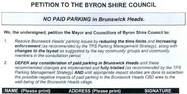
Petition No. 4.1 No Paid Parking in Brunswick Heads
Directorate: Infrastructure Services
Report Author: Joshua Winter, Civil Engineer
File No: I2017/1708
Theme: Community Infrastructure
Roads and Maritime Services
At Council’s Extraordinary meeting held on 2 November 2017 The Mayor tabled a petition containing 4412 signatures which states:
Comments from Infrastructure Services:
All of the issues regarding paid parking in Brunswick Heads have been included in the report to Council’s ordinary meeting on 23 November 2017 titled “Brunswick Heads parking Strategy”.
|
RECOMMENDATION: 1. That the petition objecting to Paid Parking in Brunswick Heads be noted.
2. That the petition be considered by Councillors when discussing the Brunswick Heads Parking Strategy report at the 23 November 2017 ordinary meeting of Council.
|
BYRON SHIRE COUNCIL
Submissions and Grants 5.1
Report No. 5.1 Byron Shire Council Submissions and Grants as at 1 November 2017
Directorate: Corporate and Community Services
Report Author: Jodi Frawley, Grants Co-ordinator
File No: I2017/1571
Theme: Corporate Management
Governance Services
Summary:
Council have submitted applications for a number of grant programs which, if successful, would provide significant funding to enable the delivery of identified projects. This report provides an update on these grant submissions.
|
RECOMMENDATION: That Council note the report. |
1 November
Grants Report, E2017/103488 ⇨
![]()
Report
This report provides an update on grant submissions including funding applications submitted, potential funding opportunities and those awaiting notification.
In accordance with Part 2 of Resolution 17-539 adopted by Council at its 2 November 2017 Extraordinary Meeting (17-539), officers are not proceeding with any grant applications for the Cavanbah Centre Swimming Pool.
Funding Applications – Successful
· Koala Corridors Project, Saving Our Species (NSW Office of Environment and Heritage) - $40,000
Funding opportunities identified for consideration by staff
· Byron Bay Town Centre Bypass, Growing Local Economies, (NSW Government)
· McGettigans Lane to Pacific Highway, Growing Local Economies, (NSW Government)
· Clifford Street Roundabout, Growing Local Economies, (NSW Government)
· Byron Bay Town Centre Bypass, Growing Local Economies, (NSW Government)
· CPTED for Byron Bay Town Centre, Safer Communities Fund (Australian Government)
· Agricultural Extension and Innovation, National Landcare Program: Smart Farming Partnerships (Australian Government)
· Agricultural Outreach, National Landcare Program: Smart Farming Small Grants (Australian Government)
· Enviro-poles for Cigarette Litter Reform, Council Litter Prevention Program (NSW Government)
· Illegal Camping Litter Prevention at Belongil Beach, Council Litter Prevention Program (NSW Government)
Funding submissions submitted and awaiting notification
· 3D Mapping Tool, Smart Cities and Suburbs, (Australian Government)
· Shark Smart Alert and Advice System, Shark Management Strategy Program (NSW Government)
· Byron Bay Bypass, Regional Jobs and Investment Package for North Coast NSW (Australian Government)
· Brunswick Harbour Boat Ramp, NSW Boating Now (RMS, NSW Government)
· 622 Bangalow Road Safety Treatments, Safer Roads including Black Spot Funding (Roads and Maritime Services, NSW Government)
· Bridges for the Bangalow Agricultural Area, Fixing Country Roads (NSW Government Restart NSW)
· Brunswick Library renovation and extension, Regional Cultural Fund (Regional Growth Fund, NSW Government)
· Byron Seniors Week (Family and Community Services, NSW Government)
· Byron Trails, Northern Rivers Business Recovery Program (Commonwealth-NSW National Disaster Relief and Recovery) Emergency Relief Information, Northern Rivers Business Recovery Program (Commonwealth-NSW National Disaster Relief and Recovery)
· Billi’s Back, Northern Rivers Business Recovery Program (Commonwealth-NSW National Disaster Relief and Recovery)
· Northern Rivers Resilience Masterclasses, Northern Rivers Business Recovery Program (Commonwealth-NSW National Disaster Relief and Recovery)
· Brunswick River Causeway Removal, Habitat Action Grants (Dept of Industry – Fisheries, NSW Government )
· Clarks Beach Amenities, Stronger Country Communities Fund (Regional Growth Fund, NSW Government)
· Heritage House, Bangalow, Stronger Country Communities Fund (Regional Growth Fund, NSW Government)
· Waterlily Playscape, Ocean Shores, Stronger Country Communities Fund (Regional Growth Fund, NSW Government)
· Refurbishment of Sandhills Childcare Centre, Stronger Country Communities Fund (Regional Growth Fund, NSW Government)
· Byron Shire Bike Plan, Active Transport (Roads and Maritime Services, NSW Government)
· Pedestrian and Access Mobility Plan, Active Transport (Roads and Maritime Services, NSW Government)
· Cycle/walking paths, Broken Head road (Suffolk Park to Byron Bay), Active Transport (Roads and Maritime Services, NSW Government)
· Cycle/walking paths, Lismore Road, Active Transport (Roads and Maritime Services, NSW Government)
· Cycle/walking paths, Ewingsdale Road, Active Transport (Roads and Maritime Services, NSW Government)
· Cycle/walking paths, Balemo Road, Active Transport (Roads and Maritime Services, NSW Government)
· Illegal Dumping and Littering in Byron Shire, Combatting Illegal Dumping: Clean Up and Prevention Program, (NSW Environmental Protection Agency)
Additional information on the grant submissions made and or pending is provided in Attachment 1 – Grants report as at 1 November 2017
Financial Implications
If Council is successful in obtaining the identified grants more than $14 million would be achieved which would provide significant funding for Council projects. Some of the grants require a contribution from Council (either cash or in-kind) and others do not. Council’s contribution is funded. The potential funding and allocation is noted below:
|
Requested funds from funding bodies |
14,794,817 |
|
Council cash contribution |
9,053,932 |
|
Council in-kind Contribution |
190,748 |
|
Other contributions |
10,575,562 |
|
Funding applications submitted and awaiting notification (total project value) |
34,615,059 |
Statutory and Policy Compliance Implications
Council is required under Section 409 3(c) of the Local Government Act 1993 to ensure that ‘money that has been received from the Government or from a public authority by way of a specific purpose advance or grant, may not, except with the consent of the Government or public authority, be used otherwise than for that specific purpose’. This legislative requirement governs Council’s administration of grants.
BYRON SHIRE COUNCIL
Staff Reports - Corporate and Community Services 7.1
Staff Reports - Corporate and Community Services
Report No. 7.1 Review of Natural Disaster Response Protocols
Directorate: Corporate and Community Services
Report Author: Jessica Orr, Strategic Risk and Improvement Coordinator
Sarah Ford, Manager Community Development
Anna Vinfield, Manager Corporate Services
James Flockton, Drain and Flood Engineer
File No: I2017/1361
Theme: Corporate Management
Governance Services
Summary:
This Report responds to the Mayoral Minute No. 8.1 – Review of Natural Disaster Response Protocols (RES 17-130) made at Council’s ordinary meeting of 2 April 2017.
Since the March 2017 Ex-Tropical Cyclone Debbie disaster event, Council has undertaken a variety of activities and developed resources to facilitate an improved pre and post event response and recovery, noting that no event is ever the same. Some of the key resources Council has in place include:
· Byron Shire Council Emergency Communications Plan
· Byron Shire Council Fact Sheet: What to do in an emergency or disaster?
· Community relationships, coordination of community organisations or volunteer groups
This report addresses the key points raised in the Mayoral Minute, provides an overview of the SES debrief held with Councillors and articulates Councillor’s role during a natural disaster.
|
RECOMMENDATION: 1. That Council supports the proposed SES approach to creating a ‘Community Action Team/s’ in the Northern Rivers regional community, and that when the framework for this approach is finalised by the SES, that it be the subject of a further report to Council.
2. That Council note the work that has been undertaken so far in improving Council’s business continuity and disaster recovery efforts.
3. That Council receive a further report on the operations of the South Golden Beach flood pump following the consideration of the Peer Review of South Golden Beach Flood Pump (#E2017/103521) by staff.
4. That Council request that a finalised Business Continuity/Disaster Recovery Plan be reported to Council by Corporate and Community Services by mid 2018. |
1 Confidential - Draft Emergency Communications Plan supercedes E2017/64654, E2017/93620
2 Confidential - Fact sheet - what to do in a disaster, E2017/101552
3 Confidential - Peer Review of South Golden Beach Flood Pump (Prepared by Jacobs), E2017/103521
4 SES
presentation - recommendations from review of operational response to Norther
Rivers floods, E2017/104277 ⇨
![]()
5 SES
Presentation to Byron Council Nov 2017, E2017/105034
⇨
![]()
6 SES
Community Action Teams Presentation, E2017/105036
⇨
![]()
Report
Background
Byron Shire Council and its residents experienced significant rainfall from Ex Tropical
Cyclone Debbie from 28 March 2017 which resulted in major flooding across the northern sections of the Shire including areas of Billinudgel, Mullumbimby, Ocean Shores, New Brighton and the Hinterland. The impacts were both significant to those communities and to the wider community with significant property damage, social and emotional impacts to residents and businesses. The event raised a number of concerns regarding Council’s and other agencies' effectiveness and responsiveness during and post the event.
Mayoral Minute No. 8.1 – Review of Natural Disaster Response Protocols (RES 17-130) was made at Council’s ordinary meeting of 2 April 2017. The following key issues were raised and addressed below:
· Response to extreme weather and disaster communication protocols
· Review of successes, failings and inefficiencies of Council operated or maintained infrastructure during the April flood event
· Council’s community support protocols and approach
· Review organisational preparedness including
A Notice of Motion was considered by Council at its Extraordinary meeting held on 2 November meeting. Council resolved via Resolution 17-538 as follows:
· Invite the State Emergency Service (SES) to provide a briefing to Council on current efforts to establish ‘Community Action Teams’ (CATs) as part of forward planning and responsiveness to flood events in local communities.
· Determine and provide support to potential CAT formation within the Byron Shire in conjunction with the SES and local communities.
· Develop a response plan as to how Council will respond to flood events with particular focus on the coordination of information and resources required by the community during and in the immediate aftermath of a flood.
· Implement a communications strategy to ensure widespread community understanding of Council’s role during and in response to a flood event.
· Consider funding and resources necessary to support these initiatives and provide a report to Council by the end of 2017.
This report also addresses the key points from the Notice of Motion.
Council wrote to the Minister for Police and Emergency Services seeking support for an independent review of the flood response in Byron Shire following Ex-Tropical Cyclone Debbie.
NSW Police Deputy Commissioner Dave Owens had been engaged to undertake this review of both Lismore City and Tweed Shire Council and Council officers requested that Mr Owen's brief be extended to include Byron Shire Council. The Minister responded that many of the findings of the independent review provide opportunities for improvement to response processes and systems and that the NSW SES could brief Council on these recommendations – these are detailed in section 3: ‘SES debrief’ of this report.
Council is committed to being involved in regional forums and aiming to achieve best practice in disaster response. Officers recently attended a regional forum for ‘Disaster Ready Councils’ hosted by Hunter Joint Organisation of Councils and funded by the State Government’s new Office of Emergency Management (OEM) unit. The forum was highly relevant and practical in delving into the question of “Is your Council disaster ready?” Outcomes for Council in attending the regional forum include continuing to be part of the state wide conversation on disaster planning and response support, ensuring that Byron Shire Council’s voice is heard, awareness of training and resources offered by the OEM in assisting councils to become disaster ready and access to new forms of relief funding.
Response to issues raised in Mayoral Minute
1. Response to extreme weather and disaster communication protocols
Council has developed an Emergency Communication Plan (attached to this report) which outlines in detail how and when it will communicate with the community and staff as an event approaches and unfolds. This includes a detailed list of steps that may be taken including the platform of communication and frequency. For example, posting on social media at regular intervals, working with Customer Service to update after-hours phone messaging, regular updates of the Byron Shire Council website, Council E-news, media releases and SMS messaging alerts.
Council is continuing to investigate the use of SMS messaging to update, inform and alert residents at times of extreme weather events. It is also worth noting that the SES manages this process and is investigating improvements to its system.
As a disaster or emergency event unfolds, Council will continue to liaise with Emergency Services and recognised providers of relevant information such as the SES, RFS, Bureau of Meteorology and ABC radio (as the local emergency services broadcaster), to provide the broadest possible coverage of an event.
To address the high workload in the communications area approaching, during and after a disaster event, Council acknowledges that additional resources may be required. Managers are asked to reallocate their staff where possible to provide customer service or communications assistance during a disaster event, where their core duties are not essential. This will be a decision of the Crisis Management Team (CMT).
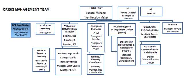
The table below establishes Council’s CMT, highlighting the key roles for leadership, decision making and support that will be required to be taken on by Council staff before, during and after a disaster event.
As an emergency or disaster unfolds, the CMT will meet regularly throughout the event, at least once daily to support, coordinate and plan action and response efforts. Role descriptions of each position will be developed with guidance on who communicates with who and responsibilities. Depending on the context of the emergency or disaster unfolding, different key support staff and managers / executive will take a lead role in informing decision-making and directing resources. For example, where the disaster is a cyber terrorism attack, Manager Business Systems & Technology will play a lead role, rather where the disaster is a natural disaster, Infrastructure Services Director and relevant Managers for works, open spaces, utilities and assets, and community development will play a lead role.
2. Review of successes, failings and inefficiencies of Council operated or maintained infrastructure during the April flood event
Council’s road networks and assets performed as designed and received minimal damage in comparison to the size of the event.
Council’s flood pump in South Golden Beach operated and reduced flood water to a degree until it tripped and couldn’t be restarted until safe access was available. Previous discussion has been held around operational issues with the pump and staff recently received a third party review into the pump stations design, operation and capacity. The review raised a number of concerns for operational staff to consider.
The South Golden flood pump report is attached to this report (attachment 3) for information only. Noting that the report has just been received and staff are working through the recommendations. The consultant responsible for the pump station design has previously confirmed to Council that it was built as per the design. Therefore, the likely intention moving forward is to discuss the results of the peer review of the pump station with the designers, before Council considers taking the matter further. Infrastructure Services will present a further report to Council on the outcomes at the earliest opportunity.
Council has investigated the flexibility of increasing the opening hours at the Myocum Resource and Recovery Centre within Environment Protection Agency (EPA) operation licence. The EPA have advised it will be lenient on licence conditions and regulation of waste management facilities in response to flood clean-up operations, thus enabling extended operating hours at the Byron Resource Recovery Centre. Staff will maintain open communication with the EPA in the lead up and recovery phases of future events to facilitate any clean-up operations.
Post the March 2017 flood event, Council staff have undertaken tender processes to establish panels of providers for plant hire (in collaboration with Tweed Council who also had a similar issue in response to the flood) and garden waste/tree clearing services. This provides Council with the ability to immediately engage a number of local contractors, at a predetermined plant hire rate, to conduct clean-up works in a disaster event.
In the lead up to any future potential event, staff will contact contractors to ensure availability and immediate response if required. Experience from the March 2017 flood has shown that contractors will have capacity to provide necessary plant as they generally cannot perform their core construction activities during/post significant wet weather events.
Council’s drainage maintenance crew has been working in the Billinudgel area to remove debris and vegetation from open drains, works to date have been very successful and the local community have been appreciative. Council’s maintenance crew is also planning to remove vegetation and debris from the main drains in South Golden Beach before Christmas, these drains supply the flood pump station. A general green waste collection is being considered as part of this work to help reduce the debris load on the pump station.
Council’s position on the Mud Army
The concept of a Mud Army (as seen in the 2011 Brisbane floods) is one of several community response options that Council is currently considering in terms of involvement, coordination and support during an emergency event. Council is progressing, in conversation with the SES and the Northern Rivers regional community, with investigation of volunteer models that harness the community spirit and eagerness of residents to support their neighbours and local community.
The State Emergency Service (SES) presented to Councillors at the 9 November Strategic Planning Workshop. This presentation outlined community preparedness for future natural disasters including the potential formation of ‘Community Action Teams’ as part of forward planning and responsiveness to flood events in local communities.
It is anticipated that the formation of a ‘Community Action Team’ (CATs) would allow the region to harness the supportive spirit of the community in the preparation and response phase (as is the case with the Mud Army example in the recovery phase) in coordinating volunteers and support initiatives as an event unfolds and in the recovery phase. This is part of a broader community discussion and Council will receive updates as it progresses.
It has been anticipated that the CATs will mature and evolve to deal with all natural disaster situations, not just floods (as seen in NSW near the Victorian border). The CATs would be coordinated by SES community liaison officers with Council involvement. Council is likely to be requested to assist with resourcing certain emergency or disaster equipment, currently being discussed to assist local communities. This is particularly relevant where local communities and residents may not be immediately accessible and to support such communities to be able to assist each other at the local level.
Infrastructure Services will prepare a further report to Council on the proposed CAT framework and resourcing implications once SES have finalised the arrangements.
3. Council’s community support protocols and approach
The Northern Rivers region is still in the flood recovery phase from the March 2017 Ex-Tropical Cyclone Debbie events. Council is in contact with various community and government organisations concerning the ongoing recovery and learning efforts, taking into account scope for improvement and partnering into the future.
A series of regional forums were held in Byron Bay in June 2017, with service providers and the volunteer sector participating three focus groups in the homelessness, community services and mental health sectors. A Regional Action Plan was developed, which assisted in securing Community Recovery Funding from Office of Emergency Management. Two Community Development Officer positions have been funded for twelve months to implement key activities from the Regional Action Plan. Community Development Officers are based in Lismore and Tweed. The Tweed Community Development Officer covers the Tweed, Byron and Ballina Shires, and Council staff are working collaboratively to develop mutually agreed deliverables.
Additional regional Community Recovery Fund projects funded by Office for Emergency Management include:
· Mental health awareness training for government and community agencies
· Mental health awareness workshops for the community
· Disaster preparedness workshops for Community Service Organisations
· Community Engagement Flood Resilience Building Program
A regional learning from the March 2017 flood event is the need for strong coordination of community volunteers in order to maximise the impact of community good will and avoid duplication and ensure residents affected by natural disaster receive clear messaging in relation to assistance. Council is working with key service providers to develop a local community response protocol which will include the development of a mechanism to effectively harness community volunteers in relation to provision of support for disaster affected residents. Delays in this process are being experienced as service providers are still assisting people affected by flood, some of whom are making contact with key service providers for support for the first time. Further, local Councils are responsible for the joint implementation, project planning and oversight of the Community Development positions, as well as taking a lead roll in ensuring the effective delivery of the additional regional recovery project listed above. The CATs proposed by the SES could be the appropriate mechanism for this.
A key learning regionally from Ex-Tropical Cyclone Debbie was the complexity of facilitating community donations and administering and awarding donations to businesses and individuals. Council referred community to Mullumbimby and District Neighbourhood Centre (MDNC) to make donations for Ex-Tropical Cyclone Debbie. MDNC has deductible gift recipient status and an online donation tool. MDNC donates 100% of donations to community and was seen as a strong and trusted community to administer donations.
If Council wishes to take carriage of natural disaster donations, a robust system of criteria will need to be established prior to any community donations received. This can be achieved by working with other Local Council’s to learn from their experiences.
Council is committed to participating in the development of a Regional Community Recovery Plan, anticipated to be completed by December 2018. One of the tasks involved in the development of the Regional Community Recovery Plan will be establishing agreement between key service organisations in relation to recovery plan development, implementation and annual review.
SES debrief
SES representatives attended the Councillor’s strategic planning workshop on 9 November to present on key lessons learnt arising from Ex-Tropical Cyclone Debbie weather event and the ongoing recovery efforts in the region. The SES highlighted a number of local, regional and state outcomes that have been realised out of this event and that action is being taken on. SES held nine post-flood forums across the region.
The presentation is attached to this report.
Key SES outcomes from the forums and the Independent Review of the NSW State Emergency Service Operational Response - Northern Rivers Floods March 2017 report from Dave Owens include:
· Review operational readiness, including local and regional resources, training, skills register and availability for deployment;
· Consider implementation of a triage procedure for flood rescues, in consultation with other Emergency Services for a standardised risk based approach to flood rescue;
· Formalise new process for the issuing of Evacuation Orders into Policy;
· Liaise with the appropriate NSW Government Agencies to ensure stronger linkages are forged at a local level between emergency responders, local councils and community development professionals; and
· Become a recognised authority for land use planning purposes, having greater involvement in floodplain development with Local Councils and that their input is mandatory before any consent by council is given in flood planning areas.
Role of Councillors
A learning from the March event was to identify specific role for Councillors during an event.
During an event, Councillors will receive regular updates from the CMT as information becomes available (this is articulated in the internal fact sheet on ‘what to do in an emergency’). The Emergency Communications Plan highlights that during an event or emergency, the media spokespeople for Council are the Mayor, General Manager and Council’s Local Emergency Management Officer.
Council staff, particularly members of the CMT, may be reallocated to undertake specific duties, other than their regular responsibilities, to support the community and Council’s service provision during an emergency or disaster.
It is anticipated that a workshop be held with Councillors at the January 2018 strategic planning workshop to develop a detailed fact sheet, as well as share key information from the CMT, on the role of Councillors in supporting the community and Council operations, before, during and in the recovery of an event.
Next steps
Council is continuing to develop its business continuity / disaster recovery resources internally for the organisation and externally to support the Byron Shire community and the Council services during an emergency or disaster. Council is currently investigating software options to support a business continuity and disaster preparedness framework. At the time of writing this report, a presentation with Council managers and key staff is taking place on 13 November from Continuity2, presenting their business continuity management system software as an option for Council to consider in terms of the most appropriate process and system.
Council will take a lead role and work with Office of Emergency Management to develop a data collection tool and will support the community service sector to understand and utilize the tool as soon as a natural disaster is declared.
Council will continue to play a lead role in advocating for community payments and grants in the wake of natural disasters and will, where appropriate, submit grant funding applications, or support key organisations to do so.
As noted staff will hold a workshop with Councillors in early 2018 to articulate ‘what to do in an emergency’.
Council staff are reviewing the recommendations of the South Golden Beach flood pump peer review report and will prepare a further report on progressing the implementation of the reports recommendations.
A Regional Community Recovery Plan will be delivered by December 2018.
Financial Implications
Where Council seeks to further develop its business continuity and disaster recovery plan framework and software, this may require additional funding from across business units – this isn’t currently allocated in the 2017/18 budget.
In relation to national disaster relief funding, the Office of Emergency Management has recently confirmed that mitigation and betterment funding will form a part of the new arrangements. Under the new system the “like for like” requirement will be removed and councils will be able to add their own funding for betterment to reconstruction and repair projects. This was previously not permitted. The criteria for spending these funds are still being clarified with the Commonwealth. The Policy for how NSW will distribute this funding is still under consideration.
The resourcing requirements of CATs are still being determined as the SES has not finalised their preferred model.
It is anticipated that the implementation of the emergency communications plan will be accommodated within existing budget allocations.
The resource implications of the South Golden Beach flood pump report are being reviewed by staff.
While the financial impact on affected residents and businesses was significant, the financial implications on Council were minor. Only a small number of Council assets and infrastructure were impacted and these were covered by flood insurance.
Statutory and Policy Compliance Implications
Local Government NSW actively represents council interests in dealing with the NSW and Australian Governments on the range of issues concerning emergency management.
The State Emergency and Rescue Management Act 1989 (NSW) outlines emergency management obligations at the local level in Division 3 of the Act. This includes outlining the functions of the Local Emergency Management Committees and providing for where 2 or more local government areas agree (with the approval of the Minister) they will be permitted to combine their emergency management arrangements, such is the case with the combined Tweed-Byron Local Emergency Management Committee.
BYRON SHIRE COUNCIL
Staff Reports - Corporate and Community Services 7.2
Report No. 7.2 Meeting Schedule 2018
Directorate: Corporate and Community Services
Report Author: David Royston-Jennings, Corporate Governance Officer
File No: I2017/1497
Theme: Corporate Management
Governance Services
Summary:
The proposed schedule of dates, times and places for Council’s Ordinary Meetings, Strategic Planning Workshops, Advisory Committees and Panels in 2018 is recommended for adoption.
|
RECOMMENDATION: 1. That Council adopts the following schedule of Ordinary Meetings and Strategic Planning Workshops (SPW) for 2018:
2. That Council adopts the following schedule of Advisory Committee and Panel meetings for 2018:
3. That Council endorses the following schedule of Planning Review Committee meetings for 2018:
4. That Council endorses the following schedule of Local Traffic Committee meetings for 2018:
5. That the Ordinary Meetings be held in the Council Chambers, Mullumbimby with a start time of 9.00am.
6. That the Code of Meeting Practice be amended to reflect the adopted meeting schedule and times. |
||||||||||||||||||||||||||||||||||||||||||||||||||||||||||||||||||||||||||||||||||||||
1 Council
Meeting Matrix 2018, E2017/102958
⇨
![]()
Report
The schedule has been prepared with consideration to events, such as public holidays and conferences. Listed below is the proposed 2018 Meeting Schedule:
|
Date (2018) |
Meeting/Workshop (Thursday 9am) |
|
25 January |
SPW |
|
1 February |
Ordinary |
|
8 February |
SPW |
|
22 February |
Ordinary |
|
8 March |
SPW |
|
22 March |
Ordinary |
|
5 April |
SPW |
|
19 April |
Ordinary |
|
10 May |
SPW |
|
24 May |
Ordinary |
|
7 June |
SPW |
|
21 June |
Ordinary |
|
Mid-year recess |
|
|
2 August |
Ordinary |
|
9 August |
SPW |
|
23 August |
Ordinary |
|
6 September |
SPW |
|
20 September |
Ordinary |
|
4 October |
SPW |
|
18 October |
Ordinary |
|
8 November |
SPW |
|
22 November |
Ordinary |
|
6 December |
SPW |
|
13 December |
Ordinary |
· The 2018 National General Assembly of Local Government will not affect the meeting dates as it is scheduled to be held from 17-20 June 2017 in Canberra.
· The date for the LGNSW Annual Conference 2018 has not yet been determined however based on previous Conference dates, it will most likely not affect the proposed meeting dates.
· Easter public holidays will not affect the meeting dates as they fall during the dates 31 March -2 April 2018.
As the proposed schedule includes two February meetings, a Strategic Planning Workshop is required during the January recess period.
Financial Implications
Should Council resolve to hold evening Council meetings, extra financial implications for meetings would include payment of overtime for staff below the level of senior management should they be required to answer questions during the meeting, as well as for minute taking staff (one minute taker per evening meeting).
Statutory and Policy Compliance Implications
Point 4.1 of Councils Code of Meeting Practice will require amending to reflect the adopted meeting schedule and times, specifically that meetings will not be held once every 3 weeks. Schedule B will also require amending at point 1 under the heading of Planning Review Committee.
BYRON SHIRE COUNCIL
Staff Reports - Corporate and Community Services 7.3
Report No. 7.3 Audit, Risk and Improvement Committee Membership
Directorate: Corporate and Community Services
Report Author: David Royston-Jennings, Corporate Governance Officer
File No: I2017/1673
Theme: Corporate Management
Councillor Services
Summary:
Councillor Martin has resigned from the Audit, Risk and Improvement Committee. In accordance with the Constitution for this Committee, a new member must be appointed. The purpose of this report is to seek a new member to this Committee.
|
RECOMMENDATION: 1. That Council acknowledge the resignation of Councillor Martin from the Audit, Risk and Improvement Committee. 2. That Council appoint Councillor _____________ as the new Councillor representative to the Audit, Risk and Improvement Committee. |
1 Constitution
of Internal Audit, Risk and Improvement Committee, E2017/101975 ⇨
![]()
Report
At its 29 September 2016 Extraordinary meeting, Council appointed (16-482) Councillors Martin, Cameron and Hunter to the Audit, Risk and Improvement Committee.
As per the Committee’s constitution (endorsed by Council at its 22 June 2017 meeting, resolution 17-233) membership comprises six members consisting of three councillors and three relevantly qualified external representatives. Council’s General Manager and External Auditor shall be available to attend all meetings but are not members of the Committee and do not have voting rights.
Councillor Martin expressed her desire to resign from this Committee on 31 October 2017.
The Audit, Risk and Improvement Committee requires a Councillor to fill this vacancy in accordance with the Committee’s Constitution.
Committee meetings are held as required, although generally every quarter for approximately two hours during business hours. The next meeting of the Audit, Risk and Improvement Committee is to be held at 2.00pm on 30 November at Council’s Administration Building.
Financial Implications
Nil.
Statutory and Policy Compliance Implications
The Audit, Risk and Improvement Committee Constitution specifies that the Committee is to comprise three Councillor Members.
BYRON SHIRE COUNCIL
Staff Reports - Corporate and Community Services 7.4
Report No. 7.4 North Byron Parklands Regulatory Working Group - Community Representatives
Directorate: Corporate and Community Services
Report Author: David Royston-Jennings, Corporate Governance Officer
File No: I2017/1729
Theme: Corporate Management
Governance Services
Summary:
North Byron Parklands have requested that Council endorse the extension of the appointment time of the three incumbent Community Representatives on the regulatory working group to 31 December 2018. Trial events have been approved on the site until August 2019.
|
RECOMMENDATION: That Council endorse the extension of the appointment time (to 31 December 2018) of the three incumbent Community Representatives to the North Byron Parklands Regulatory Working Group within the bounds of the consent.
|
Report
In 2012 the New South Wales Planning Assessment Commission approved a five year trial of the North Byron Parklands festival site at Yelgun. A condition of the consent requires North Byron Parklands to form the North Byron Parklands Regulatory Working Group (RWG) to oversee the environmental performance of events during the trial period.
At its Ordinary Meeting on 17 November 2016, Council resolved to appoint Laurel Cohn and Ray Darney to the North Byron Parklands RWG (16-595). Council further resolved at its 15 December 2016 to also appoint Derek Harper to the RWG (16-675). These Community Representatives were appointed until 31 December 2017, as this was the initial termination date of the trial prior to the recent extension until August 2019.
With the approved extension of trial events at the North Byron Parklands site, North Byron Parklands have requested that Council endorse the extension of the appointment time of the three incumbent Community Representatives within the bounds of the consent.
The constitution outlines that the group must comprise at least two representatives of the local community nominated by the Council who are appointed on a rotational basis for no longer than two years. The extension of time to December 2018 is within the constitution.
Peter Ryan, Chair of the North Byron Parklands RWG, has stated that the incumbent Community Representatives are working well together, demonstrating a good grasp of the issues and are constructive in bringing forth issues and recommendations, and fulfilling their roles.
Mr Ryan has also confirmed with the incumbent Community Representatives, North Byron Parklands Management, and the Department of Planning and Environment, that maintaining consistency within the RWG for the extended period is supported. The incumbents have also confirmed their desire to continue in their roles.
Financial Implications
The continuation of the working group is within allocated budgets.
Statutory and Policy Compliance Implications
The New South Wales Planning Assessment Commission approved in April 2012 a five year trial of the North Byron Parklands festival site at Yelgun. This approval included a consent condition that requires the proponent to form the North Byron Parklands Regulatory Working Group.
The purpose of the RWG being to oversee the environmental performance of events, during the trial period. The related condition is reproduced below:-
“C2 Regulatory Working Group – constitution and role
The proponent must establish a Regulatory Working Group (RWG) to oversee the environmental
performance of events during the trial period. The RWG must:
(a) comprise at least one (1) representative of the proponent, Office
of Environment and Heritage, Roads and Traffic Authority, NSW Police, State Emergency Services, Rural Fire Service and Council, where these parties agree to be part of the RWG, or as otherwise agreed to by the Director-General;
(b) comprise at least two (2) representatives of the local community nominated by the Council. Community representatives are appointed on a rotational basis with a representative not exceeding two (2) years;
(c) be chaired by a chairperson, whose appointment has been approved by the Director-General;
(d) meet at least once prior to the first trial event to review the proposed management in relation to:
· the Habitat Restoration Program;
· the Marshalls Ridge wildlife corridor,
· impacts on threatened species and endangered ecological communities;
· monitoring protocols for preconstruction ecological surveying ;
· illegal camping;
· litter;
· provision of security services;
· noise;
· event traffic and car parking;
· flooding;
· bushfires; and,
· evacuation procedures.
(e) meet to review the proponent’s performance with respect to environmental management and
community relations for events held during a reporting period and where appropriate, make
recommendations to the Director General on measures or strategies to improve performance for
future trial events;
(f) undertake periodic inspections of the site; and,
(g) review community concerns or complaints with respect to environmental management and
community relations.
Note: The RWG is an advisory committee. The Department and other relevant agencies are responsible for ensuring that the
proponent complies with this approval.”
BYRON SHIRE COUNCIL
Staff Reports - Sustainable Environment and Economy 7.5
Staff Reports - Sustainable Environment and Economy
Report No. 7.5 Biodiversity Conservation Strategy Update
Directorate: Sustainable Environment and Economy
Report Author: Clare Manning, Biodiversity Officer
File No: I2017/1549
Theme: Ecology
Planning Policy and Natural Environment
Summary:
To provide an update on the progress of the Byron Biodiversity Conservation Strategy review.
1. Ensure the Strategy is consistent with regional plans, strategies completed since 2004
Complete
2. Ensure the Strategy is consistent with legislative changes completed since 2004.
Complete
3. Ensure the Strategy is reflective of current research and best practise into biodiversity conservation and management priorities.
In progress
4. Review vegetation mapping to reflect changes in vegetation extent over time and improve accuracy.
Complete
5. Identify new actions to be included to direct future work priorities following consultation and input from stakeholders and the community.
In progress
|
RECOMMENDATION: That Council note the update provided in this report and the revised schedule to review the Biodiversity Conservation Strategy.
|
Report
Council’s 2017-18 Operational Plan lists the continued review of the Byron Biodiversity Conservation Strategy 2004 as a key activity (EN 1.1.3).
The Byron Biodiversity Conservation Strategy 2004 (Strategy) is the key document which provides a framework and guidance to Council and the community in managing Byron’s biodiversity. The Strategy identifies the values of the Shire, the threats that are impacting on those values and provides a detailed plan of action with a wide range of actions intended to eliminate threatening processes and protect and restore habitat.
In response to major changes in legislation and regional plans and strategies including but not limited to the Biosecurity Act 2015, Biodiversity Conservation Act 2016, Regional Weed Strategy 2017-22, Council staff have completed 2-years of consultation with the State Government and reviewed a collection of complex and extensive mapping.
To guide conservation land management programs, future planning instruments and land uses, including the review of the Strategy, Rural Land Use Strategy, Environmental Zones, Integrated Pest Management Strategy, and Byron Shire Flying-fox Camp Management Plan and assist with Development Applications, this has included a review of Byron Shire’s vegetation classification mapping.
Additionally, Council staff have completed a full review of High
Environmental Vegetation mapping and Bush Fire Prone Vegetation mapping. Designed
to protect land that is of important environmental value, the review of Environmental
Zone mapping is currently on public exhibition.
Revised Delivery Timetable
A revised Strategy will aim to highlight what Council should do in the next 10-years, what hurdles Council might face, and what Council may need to do to continue to protect and restore Byron’s biodiversity that will be shaped by population growth, consumption patterns and climate change.
The revised Strategy will aim to serve as a roadmap for Council’s stewardship of our local environment. To guide our planning decisions and policy making in all those areas that has the ability to influence or impact on the environment.
However, due to extensive mapping work, complex changes in legislation combined with competing priorities delivery of the Strategy has been revised.
The Biodiversity & Sustainability Panel (Panel) have been consulted on the revised timeframe and the development of the Strategy will be worked though the Panel.
The timetable to deliver the draft Strategy is provided below:
|
Milestone |
Complete By |
|
Revitalise the Biodiversity Conservation Strategy working group
|
End Nov 2017 |
|
Identify & engage a consultant e.g. environmental economist
|
End Nov 2017 |
|
Review alignments and relevance new Council strategies, master plans and initiatives e.g. Zero Emissions Byron |
End Feb 2018 |
|
Review and identify cross-sectoral integration of biodiversity conservation in the public and private sector |
End Mar 2018 |
|
Draft Biodiversity Conservation Strategy in consultation with stakeholders |
End Apr 2018 |
|
Draft Biodiversity Conservation Strategy placed on public exhibition for a period of six weeks |
End Jun 2018 |
|
Review submissions
|
Mid Aug 2018 |
|
Biodiversity Conservation Strategy reported to the next available council meeting |
Post Aug 2018 |
Financial Implications
Under the 2017-18 Environment Levy, Council have allocated $20,000 to continue to prepare the Strategy. Council staff will contribute to preparing the Strategy by undertaking project management and drafting of the Strategy with support from the Biodiversity & Sustainability Panel.
Statutory and Policy Compliance Implications
Nil
BYRON SHIRE COUNCIL
Staff Reports - Sustainable Environment and Economy 7.6
Report No. 7.6 PLANNING - 10.2017.360.1 Rural Tourist Accommodation Comprising Four (4) Cabins at 75 Rifle Range Road, Bangalow
Directorate: Sustainable Environment and Economy
Report Author: Simone Reeves, Planner
File No: I2017/1660
Theme: Ecology
Development and Approvals
Proposal:
|
Proposal description: |
Tourist and Visitor Accommodation Comprising Four (4) Cabins |
|
Property description: |
LOT: 39 DP: 625255 |
|
75 Rifle Range Road BANGALOW |
|
|
Parcel No/s: |
76780 |
|
Applicant: |
Balanced Systems Planning Consultants |
|
Owner: |
Legate Pty Ltd |
|
Zoning: |
RU1 Primary Production/1B1 Agricultural Protection |
|
Date received: |
7 July 2017 |
|
Integrated Development: |
Yes |
|
Public notification or exhibition: |
- Level 2 advertising under DCP 2014 Part A14 – Public Notification and Exhibition of Development Applications - Exhibition period: 27/07/17 to 09/08/17 - Submissions received: Nineteen (19) |
|
Planning Review Committee: |
28 September 2017 – Council to determine |
|
Issues: |
- Koalas - Bushfire Prone land; - Small Scale
|
Summary:
Development approval is sought for tourist and visitor accommodation comprising four cabins at 75 Rifle Range Road. The subject property is zoned RU1 Primary Production and 1B1 Agricultural Protection pursuant to Byron LEP 2014 and 1988 Respectively. The property has an area of 39.15 hectares and historically has been utilised for farming purposes with limited grazing of livestock currently undertaken on the land. The property still retains paddocks of pasture, but also contains large vegetated areas dominated by camphor laurel.
The four cabins are proposed in the vicinity of the existing dwelling with access provided from Rifle Range Road via the existing driveway. The cabins are single storey with one single bedroom disabled cabin, with the remaining cabins comprising 2 bedrooms each. Each cabin comprises bathroom facilities and a small kitchen/living area opening onto a small deck area.
The proposed development is consistent with the relevant environmental planning instruments and planning controls applicable to the site including the LEP and DCP provisions for this type of development. Concern was raised in relation to koalas in the area and on the property. In this regard the land is not considered to be Core Koala Habitat under SEPP 44, however the applicant has proposed to remove camphor laurel on the land and plant some 3600 native trees and further enhance habitat for Koalas and other native fauna in the Bangalow area. Appropriate conditions of consent are recommended including measures to controls cats and dogs and vehicle speeds within the development. It is considered the proposal raises no significant issues in terms of environmental impacts which cannot be managed through reasonable and relevant conditions of approval, and the site is considered suitable for the development. As such the application is recommended for approval subject to conditions of consent.
NOTE TO COUNCILLORS:
In accordance with the provisions of S375A of the Local Government Act 1993, a Division is to be called whenever a motion for a planning decision is put to the meeting, for the purpose of recording voting on planning matters. Pursuant to clause 2(a) under the heading Matters to be Included in Minutes of Council Meetings of Council's adopted Code of Meeting Practice (as amended) a Division will be deemed to have been called by the mover and seconder of all motions relating to this report.
|
RECOMMENDATION: That Pursuant to Section 80 of the Environmental Planning and Assessment Act 1979, development application no. 10.2017.360.1 for Tourist and Visitor Accommodation Comprising Four (4) Cabins, be granted consent subject to the conditions listed in Attachment 2 #2017/103454. |
1 Proposed
Plans 10.2017.360.1Rifle Range Rd Bangalow, E2017/102018
⇨
![]()
2 proposed
conditions of consent 10.2017.360.1 Rifle Range Rd Bangalow, E2017/103454 ⇨
![]()
3 SEPP 44
Report prepared by Peter Parker , E2017/102023
⇨
![]()
4 Confidential - submissions received, E2017/102286
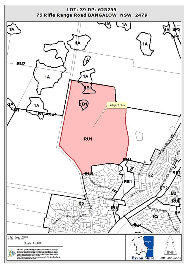
Assessment:
1. INTRODUCTION
1.1. History/Background
The subject allotment was registered 08 July 1982. The existing dwelling on the site was approved 26 November 1981 under Development Consent BA81/2722.
A planning proposal for Seniors Housing under State Environmental Planning Policy (Housing for Seniors or People with a Disability) 2004 did not proceed as a Site Suitability Certificate was refused by the New South Wales Department of Planning and Environment in June 2016.
No further development application history applies to the site.
1.2. Description of the proposed development
This application seeks approval for Tourist and Visitor Accommodation Comprising Four (4) Cabins as detailed within plans enclosed at Attachment 1
Cabin 1 has been identified as being suitable for persons with a disability with access via a 1:14 ramp and contains a single bedroom, bathroom and combined kitchenette, dining and living room and deck area.
Cabins 2, 3 and 4 are identical to each other and contains two (2) bedrooms each bathroom and combined kitchenette, dining and living room and deck area.
Vehicular access for the proposed cabins will utilise a proposed extension of the existing driveway access road located off Rifle Range Road.
Environmental works are also proposed i.e. clearing of some camphor laurel and planting of 3600 koala food source trees.
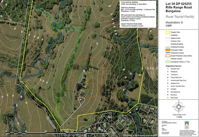
1.3. Description of the site

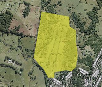
2. SUMMARY OF EXTERNAL REFERRALS
NSW Rural Fire Service
Under section 79BA of the Act, Council must be satisfied prior to making a determination for development on bush fire prone land, that the development complies with the document ‘Planning for Bush Fire Protection 2006’. The site is bush fire prone land. The development application was referred to the NSW Rural Fire Service for approval under Section 100B of the Rural Fires Act 1993. The RFS have issued general terms of approval which have been incorporated into the conditions of consent. .
3. SECTION 79C – MATTERS FOR CONSIDERATION – DISCUSSION OF ISSUES
Having regard to the matters for consideration detailed in Section 79C(1) of the Environmental Planning and Assessment Act 1979 (EP&A Act 1979), the following is a summary of the evaluation of the issues.
3.1 State Environmental Planning Instruments
|
|
Satisfactory |
Unsatisfactory |
|
State Environmental Planning Policy No 44—Koala Habitat Protection |
☒ |
☐ |
|
Consideration: No native vegetation removal proposed. The applicant undertook an extensive site survey of the site that identified less than 15% of the site as containing koala food trees. As such, a Koala Plan of Management cannot be requested. Notwithstanding, the applicant proposes the planting of 900 koala food trees per cabin which will likely create koala habitat for those specimens recorded on adjoining allotments. It is considered the proposal complies with this Policy. |
||
|
State Environmental Planning Policy No 55—Remediation of Land |
☒ |
☐ |
|
Consideration: The Decommissioned Rifle Range Cattle Dip Site is located on the subject site approximately between 200 and 250m south west of the proposed cabins. The dip site is downslope of the proposed cabins. The dip site lease lapsed on 30/06/2001 and has been capped and decommissioned. A Preliminary Site Investigation (PSI) was undertaken by Balanced Systems Planning Consultants (June 2017). The PSI included an assessment of site history and soil sampling and analyses for metals, organochlorins and organophoshates. The PSI found no evidence of contamination and conduced that the site for the proposed cabins is suitable for the proposed use. No further investigation is warranted.
Note: Decommissioned means all the standing structures, shed, fencing and roof have been dismantled. The bath itself, if present, is emptied of all chemical fluid and may have contaminated timbers from the roof and draining pen put into it and then is capped with concrete lids. The bath may have already been demolished prior to decommissioning in which case it is usually smashed and buried. An information plaque is attached to one of the concrete lids to indicate its Departmental file number, dip name and direction of the dipping. Clean soil may be spread around the bath to run flush with the bath edge and then grassed. The draining pen concrete floor is usually left intact so as not to disturb the possibly contaminated soil.
|
||
|
☒ |
☐ |
|
|
Consideration: The subject site is a large rural block (39.15ha), currently used for a residence pin addition to cattle grazing. Surrounding land uses include, residential development to the south and rural activities to the west, north and east. Of some significance in terms of potential land use conflicts is the intensive horticulture i.e. macadamia plantation located on lower land to the east. The proposed cabins are to be the located on a ridge some 264m from the macadamia plantation and therefore outside the nominal 200m buffer in Byron Shire Council Development Control Plan (BSDCP) 2014. It is not envisaged that the proposed development will result in significant land use conflicts with surrounding land uses and is considered to achieve the Principles as stipulate in Section 7 of this Policy. |
||
4.2A Byron Local Environmental Plan 2014 (LEP 2014)
LEP 2014 is an applicable matter for consideration in the assessment of the subject development application in accordance with subsection 79C(1) of the EP&A Act 1979 because it applies to the subject land and the proposed development. The LEP 2014 clauses that are checked below are of relevance to the proposed development:
Note: The proposed structures are wholly located within the portion of land mapped as RU1 Primary Production. As such, an assessment against BLEP 1988 or BSDCP 2010 is not applicable.
In accordance with BLEP 2014 clauses 1.4 and 2.1 – 2.3:
(a) The proposed development is defined in the LEP 2014 Dictionary as ‘tourist and visitor accommodation which means a building or place that provides temporary or short-term accommodation on a commercial basis, and includes any of the following:
(a) backpackers’ accommodation,
(b) bed and breakfast accommodation,
(c) farm stay accommodation,
(d) hotel or motel accommodation,
(e) serviced apartments,
but does not include:
(f) camping grounds, or
(g) caravan parks, or
(h) eco-tourist facilities’.
(b) The land is within the RU1 Primary Production according to the Land Zoning Map;
(c) The proposed development is permissible with consent; and
(d) Regard is had for the Zone Objectives as follows:
RU1 Primary Production
The objectives of the RU1 Primary Production zone are:
· ‘To encourage sustainable primary industry production by maintaining and enhancing the natural resource base;
· To encourage diversity in primary industry enterprises and systems appropriate for the area;
· To minimise the fragmentation and alienation of resource lands;
· To minimise conflict between land uses within this zone and land uses within adjoining zones;
· To encourage consolidation of lots for the purposes of primary industry production;
· To enable the provision of tourist accommodation, facilities and other small-scale rural tourism uses associated with primary production and environmental conservation consistent with the rural character of the locality; and
· To protect significant scenic landscapes and to minimise impacts on the scenic quality of the locality’.
The proposal provides small scale tourist accommodation that is consistent with the rural use and character of the allotment. The proposed cabins being located within an existing cleared portion of the site and ensures that the rural and environmental qualities of the site are preserved and do not conflict with the primary use of the subject site i.e. agriculture or adjacent and adjoining rural land uses. The proposal can be conditioned to ensure that the scenic landscape of the site is enhanced.
4.3 Height of buildings
Council’s Height of buildings map stipulates a maximum height of 9m from natural ground level. The proposed maximum height for the cabins is 4.5 metres.
5.9 Preservation of Trees or Vegetation
Whilst this development standard has since been repealed, the provision still applies as the development application was lodged prior to its being repealed. Notwithstanding, the applicant does not propose the clearing of any native vegetation. As such, it is considered to comply with the standard and associated development control chapter i.e. B2 Preservation of Trees and Other Vegetation.
6.2 Earthworks
The proposal requires minimal earthworks that with conditions of approval relating to soil and erosion measures, should not have an adverse impact on the environment.
6.3 Flood planning
The proposed cabins are located on a portion of the site that is not flood prone. In addition Council’s Development Engineer has assessed the proposal and has deemed the proposal as having suitable access.
6.5 Drinking water catchments
Whilst being located within a drinking water catchment area, the proposed on site wastewater system is of a sufficient distance away from any watercourse, with the system being compliant with Council’s requirements.
6.6 Essential services
Each cabin will be provided with harvested rainwater, electricity and telecommunications. An onsite wastewater management system solution will be utilised and has been considered acceptable by Council’s Environmental Health Officer.
6.8 Rural and nature-based tourism development
‘Small scale’ means a scale that is small enough to be generally managed and operated by the principal owner living on the property. As such, conditions of approval will be imposed pertaining to the management of the cabins by the principal owner living on the property. It is noted that the present development controls permit additional cabins given the size of the size allotment and the proposal of four (4) cabins is considered to be small. In this regard the applicant could have sought approval for up to 6 cabins with 2 bedrooms each.
The proposal will not have a significant adverse impact on agricultural production, amenity or significant features of the natural environment of the site and is considered complementary to the rural or environmental attributes of the land and its surrounds.
4.3 Any proposed Instrument that has been the subject of public consultation and has been notified to the consent authority
Draft State Environmental Planning Policy (Coastal Management) 2016 (CM SEPP). The proposal is unlikely to conflict with this Policy as the site is not within the coastal zone.
4.4A Byron Shire Development Control Plan 2014 (DCP 2014)
DCP 2014 is an applicable matter for consideration in the assessment of the subject development application in accordance with subsection 79C(1) of the EP&A Act 1979 because it applies to the land to which LEP 2014 applies. The DCP 2014 Parts/Chapters that are checked below are of relevance to the proposed development:
B2 Preservation of trees and other vegetation
The proposal does not include the removal of native vegetation. Some camphor laurels will be removed and their removal is considered as exempt from requiring development consent.
Note: The applicant proposes to plant 3600 koala food trees wholly within the site as per the Byron Rural Settlement Strategy 1988. As such, it is considered
B3 Services
The proposal provides for essential services in the form of harvest water and an onsite sewerage management system that was deemed acceptable by Council’s Environmental Health Officer.
B6 Buffers and Land Use Conflict
Given the distance between the proposed cabins and adjoining rural land uses in excess of 200 metres as well as more than 140 metres to adjacent residential activities, it is considered that the proposal will not result in land use conflicts.
B8 Waste Minimisation and Management
A Site Waste Minimisation and Management Plan was submitted by the applicant and considered to be satisfactory. Conditions of approval will be imposed with regards to the implementation of this plan.
C3 Visually Prominent Sites, Visually Prominent Development and View Sharing
The proposal is of small-scale that and unlikely to generate adverse impacts on visual quality and scenic quality of the Shire. The tourist and visitor accommodation is single storey and will not obstruct views from another property or disrupt the skyline.
C4 Development in a Drinking Water Catchment
The site is considered suitable for an onsite wastewater management system that has been assessed and considered satisfactory with Council requirements.
The proposal includes principles of water sensitive urban design with regards to the harvesting of rainwater whilst the proposed accessway/driveway extension minimises the amount of cut and fill required to provide suitable access and stormwater management that will not have an adverse impact on the drinking water catchment.
D2 Residential Accommodation and Ancillary Development in Rural Zones
Chapter D3 Tourist Accommodation requires the development to be consistent with the character and design of the rural zone with boundary setbacks being observed. The proposal provides in excess of 100 metres to Rifle Range Road with 141 metres to the southern adjoining boundary and 262 metres to the eastern closest side boundaries.
D3 Tourist Accommodation
The proposed facility is considered ‘small-scale’ and will not conflict with the high ecological value vegetation located along the northern boundary of the site. The applicant proposes the planting of 3600 koala food trees and the proposed operational regime has been considered so as to ensure it does not adversely affect agricultural productivity or create land use conflict issues. As such, it is considered that the proposal achieves the objectives of the Byron Rural Settlement Strategy 1988.
The proposed structures are single storey and are compatible with the character and amenity of the locality.
The proposed cabins have a gross floor area of 58.91m² each and a combined bedroom number of seven (7) bedrooms with development controls permitting a maximum of twelve (12) bedrooms for allotments that in in excess of 20 hectares.
The cabins are clustered approximately 30 metres apart with the first cabin being 37.35 metres from the existing primary dwelling. This cabin also caters for persons with a disability with disabled access being provided.
All weather access and car parking arrangements have also been provided.
4.5 Any Planning Agreement or Draft Planning Agreement?
|
|
Yes |
No |
|
Is there any applicable planning agreement or draft planning agreement? |
☐ |
☒ |
4.6 Environmental Planning and Assessment Regulation 2000 Considerations
|
Clause |
This control is applicable to the proposal: |
I have considered this control as it relates to the proposal: |
If this control is applicable, does the proposal comply? |
|
92 |
No |
N/A |
N/A |
|
93 |
Yes |
Yes |
Yes |
|
94 |
No |
N/A |
N/A |
|
94A |
No |
N/A |
N/A |
4.7 Any coastal zone management plan?
|
|
Satisfactory |
Unsatisfactory |
N/A |
|
Is there any applicable coastal zone management plan? |
☐ |
☐ |
☒ |
4.8 The likely impacts of that development, including environmental impacts on both the natural and built environments, and social and economic impacts in the locality
|
Impact on: |
Likely significant impact/s? |
|
Natural environment |
No. The proposal will not have a significantly adverse impact on the natural environment of the locality. Should the application be approved 3600 native trees will be planted and a number of camphor laurel will be removed providing an environmental benefit for native flora and fauna. |
|
Built environment |
No. The proposal will not have a significantly adverse impact on the built environment of the locality. |
|
Social Environment |
No. The proposal will not have a significant social impact on the locality. |
|
Economic impact |
No. The proposal will not have a significant economic impact on the locality. |
4.9 The suitability of the site for the development
The site is considered suitable for the proposed tourist accommodation as it is located within a relatively isolated area of the site with sufficient separation from adjoining residential zoned allotments with the nearest being approximately 200m away and further away than the existing dwelling contained within the site.
4.10 Submissions made in accordance with this Act or the regulations
The proposal was publicly notified from 27 July 2017 to 9 August 2017. A total of nineteen (19) submissions were received during and after this period. An outline of planning concerns raised and often repeated amongst the authors is addressed below. Matters that do not relate to section 79c of the Environmental Planning and Assessment Act 1979 have been excluded from this Report.
Land owner is not proposed to be on site
Conditions of approval will be imposed relating to the site owner/leasee/caretaker being on site at such times the property is being utilised by visitors and residing in the main dwelling house
Increased traffic will result in increased noise and dust
The proposal is not considered to create any greater noise or dust levels than would be imposed by exempt agricultural development on the site. The proposal was assessed by Council’s Development Engineer who has considered the proposal is acceptable.
Tourist development close to residences adversely impacts on amenity and privacy and increases noise
The proposal is not considered to be close to residential development. Notwithstanding, conditions of approval pertaining to neighbourhood amenity must be complied with at all times.
Access to the site is in an unsafe location for the number of vehicles
Access to the site is considered suitable for this small scale development. Appropriate conditions to apply.
Does not comply with the North Coast Regional Plan
The North Coast Regional Environmental Plan was repealed. The North Coast Regional Plan 2036 also does not apply to the development as it relates solely to the strategic planning of a locality and applies only to planning proposals to which the application is not.
Inappropriate location
Tourist and visitor accommodation is a permissible use within the RU1 Primary Production zone. The proposed cabins are more than 140 metres from the adjoining boundaries with even further setbacks provided to dwellings within adjacent residential zoned allotments.
Lack of qualifications of person who addressed SEPP 44
The individual who addressed SEPP 44 in the first instance is a qualified Ecologist. Given the submissions raised the applicant was requested to provide further address. It is considered the Consultant who has provided advice on the matter is suitably qualified.
Koala Plan of Management (KPOM) required for site
It is considered that the site does not contain potential or core koala habitat and as such a Koala Plan of Management is not required. Notwithstanding the applicant is proposing remove camphor laurel and plant some 3600 native trees which will provide improved habitat for koalas and other native species of flora.
Site forms a koala corridor with no consideration given to koalas
The applicants in depth survey and willingness to provide 3600 koala food trees within the site, demonstrates the applicants consideration to koalas within the immediate locality. Notwithstanding, conditions of approval have been imposed in relation to koala safety long term i.e. vehicle speeds and the keeping of dogs and cats within the site. The proposal provides a suitable response to the Koala issue
Undesirable precedence to be set
The proposal complies with all relevant SEPP’s, BLEP 2014 and BSDCP 2014. As such, the proposal does not set an undesirable precedent.
4.11 Public interest
The proposed development is unlikely to prejudice or compromise the public interest or create an undesirable precedent.
4.12 Section 5A of the EP&A Act 1979 – Significant effect on threatened species
Having regard to sections 5A, 5C and 5D of the EP&A Act 1979, there is unlikely to be a significant effect on threatened species, populations or ecological communities, or their habitats as a result of the proposed development as the cabins will be located wholly within a cleared portion of the site, with the nearest vegetation being identified as camphor laurel. Whilst koalas have been regularly spotted within the camphor laurel located along Rifle Range Road, koalas have not been recorded within the site. Notwithstanding, the applicant has agreed to plant a total of 3600 koala food trees within the subject site. In addition, conditions of approval will also be imposed relating to the keeping of dogs and cats and vehicle speeds within the site.
As such, it is unlikely that the proposal will have a significant adverse affect on threatened species.
4.13 Section 5B of the EP&A Act 1979 – Have regard to register of critical habitat
The NSW Critical Habitat Register does not identify any critical habitat on or adjacent to the site.
5. DEVELOPER CONTRIBUTIONS
5.1 Water & Sewer Levies
No Section 64 levies will be required.
5.2 Section 94 Contributions
Section 94 Contributions will be payable.
6. CONCLUSION
The proposed development is consistent with the relevant environmental planning instruments and planning controls applicable to the site. The proposal raises no significant issues in terms of environmental impacts which cannot be managed through reasonable and relevant conditions of approval. As such, the site is considered suitable for the development.
7. RECOMMENDATION
It is recommended that pursuant to Section 80 of the Environmental Planning and Assessment Act 1979, development application no. 10.2017.360.1 for Tourist and Visitor Accommodation Comprising Four (4) Cabins, be granted consent subject to conditions of approval.
DISCLOSURE OF POLITICAL DONATIONS AND GIFTS
|
Has a Disclosure Statement been received in relation to this application |
No |
|
Have staff received a ‘gift’ from anyone involved in this application that needs to be disclosed. Where the answer is yes, the application is to be determined by the Director or Manager of the Planning, Development and Environment Division. |
No |
Provide Disclosure Statement register details here: Nil.
BYRON SHIRE COUNCIL
Staff Reports - Sustainable Environment and Economy 7.7
Report No. 7.7 PLANNING - 10.2017.270.1 Multi dwelling housing comprising eight (8) dwellings, Strata Title subdivision to create eight (8) Strata Lots and Common Property and Tree Removal (17 trees) at 6 and 6A Canowindra Court South Golden Beach
Directorate: Sustainable Environment and Economy
Report Author: Greg Smith, Team Leader Planning Services
File No: I2017/1672
Theme: Ecology
Development and Approvals
Summary:
|
Proposal description: |
Multi dwelling housing comprising eight (8) dwellings, Strata Title subdivision to create eight (8) Strata Lots and Common Property and Tree Removal (17 trees) |
|
Property description: |
LOT: 11 DP: 1225527, LOT: 12 DP: 1225527 |
|
6 & 6A Canowindra Court SOUTH GOLDEN BEACH |
|
|
Parcel No/s: |
268380, 268381 |
|
Applicant: |
Ardill Payne & Partners |
|
Owner: |
JBPB Holdings Pty Ltd & L & K Burke Holdings Pty Ltd |
|
Zoning: |
R2 Low Density Residential |
|
Date received: |
29 May 2017 |
|
Integrated Development: |
Yes |
|
Public notification or exhibition: |
- Level 2 advertising under DCP 2014 Part A14 – Public Notification and Exhibition of Development Applications - Exhibition period: 15/6/17 to 28/6/17 - Submissions received: 11 |
|
Planning Review Committee |
28 September 2017 |
|
Delegation to determination: |
Council |
|
Issues: |
· Minimum lot size, with clause 4.6 request for variation · Bush fire prone land, · Acid Sulfate Soils and Flood Prone Land · Building height plane, privacy · Tree removal, compensatory planting |
|
Summary:
The DA proposes multi dwelling housing comprising eight (8) dwellings in a two storey configuration with ground level garages and upper level residential areas on land at 6 and 6A Canowindra Court, South Golden Beach. The property has an area of 1835.8m2 and is zoned R2 Low Density Residential pursuant to Byron LEP 2014. The dwellings are modest in area with seven units comprising 3 bedrooms and 1 unit being a two bedroom unit. Upper level decks and open space are orientated to the north.
The proposed development is permissible with consent in the R2 zone and satisfies the minimum lot area on 1000m2 for multi dwelling housing development as prescribed under Clause 4.1E.
The proposal also includes a Strata Title subdivision to create eight (8) lots, with the lots ranging in areas from approximately 111.9m2 to 185.5m2 and do not comply with the minimum lot size development standard of 600m2. The DA is supported by a written request for a variation pursuant to clause 4.6 of the LEP. The circumstances of the case warrant a more flexible approach to the application of the minimum lot size development standard having regards to the permissibility of the primary use, and the Applicant’s variation request is supported in this instance.
The development includes the removal of 17 trees however these are to be compensated by additional plantings and landscaping of the site. Conditions of consent are recommended in this regard.
Eleven public submissions have been received in relation to this proposal raising a range of issues including flooding, sewer capacity, traffic impacts, parking, density and privacy. The site is alos constrained by acid sulphate soils and bushfire. Having regard to the size of the site and the design of the development these matters have been adequately dealt with.
The application is recommended for approval subject to conditions of consent.
|
|
|
RECOMMENDATION: That pursuant to Section 80 of the Environmental Planning & Assessment Act 1979, Development Application 10.2017.270.1 for multi dwelling housing comprising eight (8) dwellings, Strata Title subdivision to create eight (8) Strata Lots and Common Property and Tree Removal (17 trees), be granted consent subject to the conditions listed in Attachment 2 #E2017/101883.
|
1 Proposed
Plans prepared by Ardill Payne , E2017/101880
⇨
![]()
2 conditions
of consent , E2017/104959 ⇨
![]()
3 Confidential - submisisons received, E2017/102270
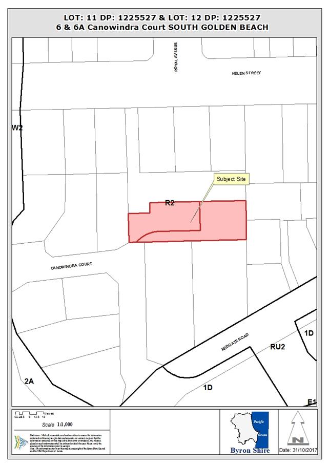
Report
1. INTRODUCTION
1.1. History/Background
DA 10.2013.575.1 for Three lot Torrens Title subdivision of one existing lot, construction of a six car carport, Strata Title subdivision of existing units and tree removal (6 trees) was approved on 15/4/2014, and modified by way of section 96 Application No. 10.2013.575.2 on 17/10/2014. The approved subdivision was registered by way of DP 1225527 on 25/10/2016, creating Lots 11 and 12 upon which the development under DA 10.2017.270.1 is proposed to be carried out.
1.2. Description of the proposed development
This application seeks approval for multi dwelling housing comprising 8 dwellings, Strata Title subdivision to create 8 Strata Lots and Common Property and tree removal (17 trees). There are 4 proposed two storey buildings with each accommodating 2 attached dwellings. Each proposed dwelling has 3 bedrooms except for proposed Unit 1 which has 2 bedrooms. Each dwelling is provided with a double garage and laundry space at ground floor level, and habitable rooms at the first floor level. Each dwelling is provided with ground floor open space, and other than Unit 1, a first floor level north facing deck. The dwellings are accessed via a common driveway adjacent to the southern boundary of the site.
The application also proposes Strata Title subdivision of the development, comprising 8 Lots accommodating one of the proposed units, and Common Property. The area of each proposed lot is as follows:
|
Lot |
Size |
|
1 |
111.9m2 |
|
2 |
155.3m2 |
|
3 |
155.3m2 |
|
4 |
155.3m2 |
|
5 |
155.3m2 |
|
6 |
155.3m2 |
|
7 |
155.3m2 |
|
8 |
185.5m2 |
|
Common Property |
606.6m2 (by deduction from the total site area) |
The application also includes the removal of garden and native vegetation including four lilly pillys, three paperbarks, two swamp oaks and a pandanus palm.
1.3. Description of the site
|
Land is legally described as |
LOT: 11 DP: 1225527, LOT: 12 DP: 1225527 |
|
Property address is |
6 and 6A Canowindra Court, South Golden Beach |
|
Land is zoned: |
R2 Low Density Residential |
|
Land area is: |
1835.8m2 |
|
Other constraints include: |
Flood liable Land, Bush fire prone land, Acid sulfate soils |


2. SUMMARY OF REFERRALS
|
Referral |
Issue |
|
Rural Fire Service (100B) |
No objections subject to conditions. Refer to Doc #E2017/72020 and see below. |
3. SECTION 79BA – BUSH FIRE PRONE LAND
The DA proposes subdivision of bush fire prone land and was referred to the NSW Rural Fire Service as integrated development. The RFS provided its general terms of approval and bush fire safety authority which are included in the recommendation of this Report to be imposed on the development consent.
4. SECTION 79C – MATTERS FOR CONSIDERATION – DISCUSSION OF ISSUES
Having regard to the matters for consideration detailed in Section 79C(1) of the Environmental Planning & Assessment Act 1979 (EP&A Act), the following is a summary of the evaluation of the issues.
4.1 State Environmental Planning Instruments
|
|
Satisfactory |
Unsatisfactory |
|
State Environmental Planning Policy No 55—Remediation of Land |
ý |
☐ |
|
Consideration: Council’s Environmental Health Officer confirmed that SEPP 55 was considered for the above mentioned DA 10.2013.575.1.
|
||
|
State Environmental Planning Policy No 71—Coastal Protection |
ý |
☐ |
|
Consideration: The proposed development is satisfactory having regard to the relevant considerations under SEPP 71.
|
||
|
ý |
☐ |
|
|
Consideration: The proposed development is satisfactory having regard to the provisions of SEPP (Infrastructure) 2007.
|
||
4.2A Byron Local Environmental Plan 2014 (LEP 2014)
LEP 2014 is an applicable matter for consideration in the assessment of the subject development application in accordance with subsection 79C(1) of the EP&A Act because it applies to the subject land and the proposed development. The LEP 2014 clauses that are checked below are of relevance to the proposed development:
|
Part 1 |
ý1.1| ý1.1AA| ý1.2| ý1.3| ý1.4| ýDictionary| ý1.5| ý1.6| ý1.7| ý1.8| ☐1.8A| ý1.9| ☐1.9A |
|
Part 2 |
ý2.1| ý2.2 | ý2.3 |ýLand Use Table | ☐2.4 | ☐2.5 | ý2.6 | ☐2.7 | ☐2.8 |
|
Part 3 |
☐3.1| ☐3.2| ☐3.3 |
|
Part 4 |
ý4.1| ☐4.1A| ☐4.1AA| ☐4.1B |☐4.1C| ☐4.1D| ý4.1E| ☐4.2| ☐4.2A| ☐4.2B| ☐4.2C| ☐4.2|ý4.3|ý4.4 |☐4.5 |ý4.6 |
|
Part 5 |
☐5.1| ☐5.2| ☐5.3| ☐5.4| ý5.5| ☐5.6| ☐5.7| ☐5.8| ☐5.9| ☐5.9AA| ý5.10| ☐5.11| ☐5.12| ☐5.13 |
|
Part 6 |
ý6.1| ☐6.2| ý6.3| ☐6.4| ☐6.5| ý6.6| ý6.7| ☐6.8| ☐6.9 |
In accordance with LEP 2014 clauses 1.4 and 2.1 – 2.3:
(a) The proposed development is defined in the LEP 2014 Dictionary as multi dwelling housing with ancillary demolition and tree removal, and subdivision of land;
(b) The land is within the R2 Low Density Residential according to the Land Zoning Map;
(c) The proposed development is permitted with consent; and
(d) Regard is had for the Zone Objectives as follows:
|
Zone Objective |
Consideration |
|
To provide for the housing needs of the community within a low density residential environment. |
The proposed development provides for the housing needs of the community within a low density residential environment. |
|
To enable other land uses that provide facilities or services to meet the day to day needs of residents. |
The proposal is not a land use other than housing, and would not hinder but would instead support any other land use that provides facilities or services to meet the day to day needs of residents. |
The remaining checked clauses have been taken into consideration in the assessment of the subject development application in accordance with subsection 79C(1) of the EP&A Act.
|
LEP Summary of Requirement |
Proposed |
||||||
|
Clause 4.1 Minimum subdivision lot size (1) The objectives of this clause are as follows: (a) to ensure that lot sizes are compatible with local environmental values and constraints, (b) to facilitate efficient use of land resources for residential and other human purposes.
(2) This clause applies to a subdivision of any land shown on the Lot Size Map that requires development consent and that is carried out after the commencement of this Plan.
(3) The size of any lot resulting from a subdivision of land to which this clause applies is not to be less than the minimum size shown on the Lot Size Map in relation to that land.
|
The proposed Strata Title lots do not comply with the Lot Size Map, and this is addressed below.
|
||||||
|
4.1E Minimum lot sizes for dual occupancies, multi dwelling housing and residential flat buildings (1) The objective of this clause is to achieve planned residential density in certain zones. (2) Development consent may be granted to development on a lot in a zone shown in Column 2 of the table to this clause for a purpose shown in Column 1 of the table opposite that zone, if the area of the lot is equal to or greater than the area specified for that purpose and shown in Column 3 of the table.
|
The site area of 1835.8m2 complies with the 1000m2 minimum requirement for multi-dwelling housing
|
||||||
|
4.3 Height of buildings (1) The objectives of this clause are as follows: (a) to achieve building design that does not exceed a specified maximum height from its existing ground level to finished roof or parapet, (b) to ensure the height of buildings complements the streetscape and character of the area in which the buildings are located, (c) to minimise visual impact, disruption of views, loss of privacy and loss of solar access to existing development. (2) The height of a building on any land is not to exceed the maximum height shown for the land on the Height of Buildings Map.
|
The proposed height of approximately 7.2m complies with the 9m maximum height requirement. |
||||||
|
4.4 Floor space ratio (1) The objectives of this clause are as follows: (a) to ensure that new buildings are appropriate in relation to the character, amenity and environment of the locality, (b) to enable a diversity of housing types by encouraging low scale medium density housing in suitable locations, (c) to provide floor space in the business and industrial zones adequate for the foreseeable future, (d) to regulate density of development and generation of vehicular and pedestrian traffic, (e) to set out maximum floor space ratios for dual occupancy in certain areas. (2) The maximum floor space ratio for a building on any land is not to exceed the floor space ratio shown for the land on the Floor Space Ratio Map. (2A) Despite subclause (2), the maximum floor space ratio for dual occupancies on land in Zone R2 Low Density Residential is 0.5:1.
|
The proposed floor space ratio of approximately 0.40:1 complies with the 0.5:1 maximum floor space ratio requirement. |
||||||
|
5.5 Development within the coastal zone The objectives of this clause are as follows: (a) to provide for the protection of the coastal environment of the State for the benefit of both present and future generations through promoting the principles of ecologically sustainable development, (b) to implement the principles in the NSW Coastal Policy,
|
Whilst within the coastal zone, the development raises no issues regarding foreshore access; effluent disposal and stormwater are to be connected to existing infrastructure. The property is also landward of the defined coastal erosion zones.
|
||||||
|
5.10 Heritage conservation … (2) Requirement for consent Development consent is required for any of the following: (a) demolishing or moving any of the following or altering the exterior of any of the following (including, in the case of a building, making changes to its detail, fabric, finish or appearance): (i) a heritage item, (ii) an Aboriginal object, (iii) a building, work, relic or tree within a heritage conservation area, (b) altering a heritage item that is a building by making structural changes to its interior or by making changes to anything inside the item that is specified in Schedule 5 in relation to the item, (c) disturbing or excavating an archaeological site while knowing, or having reasonable cause to suspect, that the disturbance or excavation will or is likely to result in a relic being discovered, exposed, moved, damaged or destroyed, (d) disturbing or excavating an Aboriginal place of heritage significance, (e) erecting a building on land: (i) on which a heritage item is located or that is within a heritage conservation area, or (ii) on which an Aboriginal object is located or that is within an Aboriginal place of heritage significance, (f) subdividing land: (i) on which a heritage item is located or that is within a heritage conservation area, or (ii) on which an Aboriginal object is located or that is within an Aboriginal place of heritage significance. … (7) Archaeological sites The consent authority must, before granting consent under this clause to the carrying out of development on an archaeological site (other than land listed on the State Heritage Register or to which an interim heritage order under the Heritage Act 1977 applies): (a) notify the Heritage Council of its intention to grant consent, and (b) take into consideration any response received from the Heritage Council within 28 days after the notice is sent. (8) Aboriginal places of heritage significance The consent authority must, before granting consent under this clause to the carrying out of development in an Aboriginal place of heritage significance: (a) consider the effect of the proposed development on the heritage significance of the place and any Aboriginal object known or reasonably likely to be located at the place by means of an adequate investigation and assessment (which may involve consideration of a heritage impact statement), and (b) notify the local Aboriginal communities, in writing or in such other manner as may be appropriate, about the application and take into consideration any response received within 28 days after the notice is sent.
|
The site does not contain a heritage item. There is no indication of the site containing an archaeological site or Aboriginal place of heritage significance. |
||||||
|
6.1 Acid sulfate soils Development consent must not be granted under this clause for the carrying out of works unless an acid sulfate soils management plan has been prepared for the proposed works in accordance with the Acid Sulfate Soils Manual and has been provided to the consent authority.
|
The site is class 2 for potential acid sulfate soils. The DA was accompanied by an acid sulphate soils management plan which was considered by Council’s Environmental Health Officer who recommended conditions accordingly. |
||||||
|
6.2 Earthworks (3) In deciding whether to grant development consent for earthworks (or for development involving ancillary earthworks), the consent authority must consider the following matters: (a) the likely disruption of, or any detrimental effect on, drainage patterns and soil stability in the locality of the development, (b) the effect of the development on the likely future use or redevelopment of the land, (c) the quality of the fill or the soil to be excavated, or both, (d) the effect of the development on the existing and likely amenity of adjoining properties, (e) the source of any fill material and the destination of any excavated material, (f) the likelihood of disturbing relics, (g) the proximity to, and potential for adverse impacts on, any waterway, drinking water catchment or environmentally sensitive area, (h) any appropriate measures proposed to avoid, minimise or mitigate the impacts of the development.
|
Development consent is sought for the proposed earthworks as required by this clause.
Minor works are proposed for footings and services. |
||||||
|
6.3 Flood planning Development consent must not be granted to development on land to which this clause applies unless the consent authority is satisfied that the development: (a) is compatible with the flood hazard of the land, and (b) will not significantly adversely affect flood behaviour resulting in detrimental increases in the potential flood affectation of other development or properties, and (c) incorporates appropriate measures to manage risk to life from flood, and (d) will not significantly adversely affect the environment or cause avoidable erosion, siltation, destruction of riparian vegetation or a reduction in the stability of river banks or watercourses, and (e) is not likely to result in unsustainable social and economic costs to the community as a consequence of flooding. |
The site is flood liable land. The applicant has proposed to locate all habitable areas at the first floor level above the minimum floor level for this area of South Golden Beach/ North Ocean Shores. Conditions of Consent recommended in term of the minimum floor level and services located below this level. |
||||||
|
6.6 Essential services Development consent must not be granted to development unless the consent authority is satisfied that any of the following services that are essential for the development are available or that adequate arrangements have been made to make them available when required: (a) the supply of water, (b) the supply of electricity, (c) the disposal and management of sewage, (d) stormwater drainage or on-site conservation, (e) suitable vehicular access.
|
The subject allotments are capable of being provided with the essential services including water, electricity, sewage disposal, stormwater drainage and suitable vehicular access, to the satisfaction of relevant Council Engineers, and subject to conditions. |
4.1 Minimum Subdivision Lot Size
The Lot Size Map shows a minimum lot size of 600m2 for this site. Proposed Strata Lots 11 to 14 comply with the minimum lot size planning control. Proposed Strata Lots 1 to 10 do not comply, with lot sizes as follows:
|
Lot |
Size |
Variation |
|
1 |
111.9m2 |
81.4% |
|
2 |
155.3m2 |
74.1% |
|
3 |
155.3m2 |
74.1% |
|
4 |
155.3m2 |
74.1% |
|
5 |
155.3m2 |
74.1% |
|
6 |
155.3m2 |
74.1% |
|
7 |
155.3m2 |
74.1% |
|
8 |
185.5m2 |
69.1% |
The Applicant has submitted a written clause 4.6 variation request as follows:
1. Introduction – Summary of proposed development
The development application proposes multi dwelling housing comprising eight (8) dwellings, Strata Title subdivision to create eight (8) Strata Lots and Common Property and Tree Removal (17 trees).
2. Clause 4.6 Exceptions to Development Standards
LEP 2014 clause 4.6 allows the granting of a development consent, even though the development would contravene a development standard. However Council must first consider a written request from the Applicant that seeks to justify the contravention of the development standard by demonstrating:
(a) that compliance with the development standard is unreasonable or unnecessary in the circumstances of the case, and
(b) that there are sufficient environmental planning grounds to justify contravening the development standard.
Council must be satisfied that the Applicant’s written request has adequately addressed the matters required to be demonstrated and that the proposed development will be in the public interest because it is consistent with the objectives of the particular standard and the objectives for development within the zone in which the development is proposed to be carried out (noting that the concurrence of the Secretary is not required to be obtained in this instance).
3. The Development Standard to be varied
The development standard to be varied is the minimum lot size planning control of 600m2 applicable to this site under LEP 2014 clause 4.1 as described above.
The minimum lot size planning control is a development standard in accordance with the applicable definition in section 4 of the Environmental Planning and Assessment Act 1979 because it is a provision of an environmental planning instrument in relation to the carrying out of development, being a provision by or under which requirements are specified or standards are fixed in respect of any aspect of that development, being the area of land.
4. Extent of Variation to the Development Standard
The extent of the variation ranges from 69.1% to 81.4% as indicated in the table above.
5. Objective of the Development Standard
The objectives of the development standard, as outlined in subclause 4.1(1) are:
(a) to ensure that lot sizes are compatible with local environmental values and constraints; and
(b) to facilitate efficient use of land resources for residential and other human purposes.
6. Objectives of the Zone
The objectives of the R2 Low Density Residential Zone are stated and have been addressed in this section above.
7. Assessment – the specific questions to be addressed:
(a) Clause 4.6(3)(a) – Is compliance with the development standard unreasonable or unnecessary in the circumstances of the case?
The clause 4.6 written request submitted in support of the DA advises as follows in this regard:
“· compliance with the minimum lot size standard for the proposed Strata Title subdivision of the proposed multi dwelling housing development is unreasonable and unnecessary due to the fact that the wording of Clause 4.1(4) was clearly not intended to restrict the minimum lot sizes for Strata Title lots
· prior to the court case, Councils were routinely approving Strata Title subdivisions of multi dwelling housing developments on the basis that the mapped minimum lot size map did not apply to such – in fact, if it were not for the court case, Councils would be continuing to grant consent to such”.
Requiring compliance with the development standard would result in the proposed Strata Lots being inconsistent with the proposed built form and site layout. The proposed subdivision does not have any visible component and has no impact upon the environment of the locality. Requiring compliance with the development standard would be unreasonable and unnecessary in the circumstances of the case.
(b) Clause 4.6(3)(b) – Are there sufficient environmental planning grounds to justify contravening the development standard?
The clause 4.6 written request submitted in support of the DA advises as follows in this regard:
“· as detailed below, if not for the fact that the subject land is mapped as being bushfire prone, the proposed Strata Title subdivision of the multi dwelling housing development would comprise “exempt development” pursuant to Clause 3.1 and Schedule 2 of the BLEP 2014 – there is no rational planning reason as to how or why Strata subdivision can be prohibited if it does not comply with the mapped minimum lot size on land that is mapped as being bushfire prone, but is then permitted as exempt development if the land is not mapped as being bushfire prone”.
The environmental planning grounds are particular to the site and sufficient to justify contravening the development standard. These include that the buildings to be Strata subdivided are the subject of the same development assessment which is the component of the development that would cause environmental impacts if any, there are no required site works or landscape disturbance associated with the subdivision, and the proposed variation does not create any significantly adverse social, environmental or economic impacts in the locality.
(c) Clause 4.6(4)(a)(ii) – Is the proposed development in the public interest? Is it consistent with the objectives of the standard and the zone as set out above?
The clause 4.6 written request submitted in support of the DA advises as follows in this regard:
“· there will not be any adverse impacts on the public interest and no public benefit in maintaining the development standard in this instance – it is actually submitted that it is an ideal mechanism to allow the continued Strata Title subdivision of multi dwelling housing developments on residential zoned land in accordance with the original intent of Clause 4.1(4)”.
The proposal is consistent with the objectives of the development standard and the zone for site specific reasons as follows:
(a) Objectives of the Standard
· The proposed lot sizes are compatible with local environmental values and constraints. The proposed lot sizes will not cause any adverse environmental impacts and are in keeping with the proposed built form and site layout.
· The proposed lot sizes support the efficient use of land resources for residential purposes.
(b) Objectives of the R2 Zone
· The proposed Strata Title subdivision supports the development to provide for the housing needs of the community within a low density residential environment.
· The proposal is not a land use other than housing, and would not hinder but would instead support any other land use that provides facilities or services to meet the day to day needs of residents.
The proposal produces a better planning outcome than one that strictly complies with the development standard because requiring strict compliance would result in lot sizes that are not in keeping with the proposed built form and site layout. The proposed Strata Title subdivision is in the public interest. The circumstances of the case warrant a more flexible approach to application of the lot size development standard, and the Applicant’s variation request is supported in this instance.
4.3 Any proposed Instrument that has been the subject of public consultation and has been notified to the consent authority
|
|
Yes |
No |
|
Is there any applicable planning agreement or draft planning agreement? |
ý |
☐ |
|
Consideration: Draft SEPP (Coastal Management) 2016 applies to the site, which is within the proposed Coastal Environment Area and Coastal Use Area.
In relation to the proposed Coastal Environment Area, the proposal is satisfactory having regard to clause 14 of the draft SEPP because the proposal:
(a) is not likely to cause significant adverse impacts on the biophysical, hydrological (surface and groundwater) and ecological environment; (b) is not likely to significantly impact on geological and geomorphological coastal processes and features or be significantly impacted by those processes and features; (c) is not likely to have an adverse impact on the water quality of the marine estate (within the meaning of the Marine Estate Management Act 2014), in particular, having regard to the cumulative impacts of the proposed development on the marine estate including sensitive coastal lakes; (d) is not likely to have an adverse impact on native vegetation and fauna and their habitats, undeveloped headlands and rock platforms; (e) will not adversely impact Aboriginal cultural heritage and places; (f) incorporates water sensitive design, including consideration of effluent and stormwater management; and (g) will not adversely impact on the use of the surf zone.
In relation to the proposed Coastal Use Area, the proposal is satisfactory having regard to clause 15 of the draft SEPP because:
(a) the proposed development: (i) maintains existing, safe public access to and along the foreshore, beach, headland or rock platform; (ii) minimises overshadowing, wind funnelling and the loss of views from public places to foreshores; (iii) will not adversely impact on the visual amenity and scenic qualities of the coast, including coastal headlands; (iv) will not adversely impact on Aboriginal cultural heritage and places; and (v) will not adversely impact on use of the surf zone, and
(b) Council has taken into account the type and location of the proposed development, and the bulk, scale and size of the proposed development. |
||
4.4A Byron Shire Development Control Plan 2014 (DCP 2014)
DCP 2014 is an applicable matter for consideration in the assessment of the subject development application in accordance with subsection 79C(1) of the EP& A Act because it applies to the land to which LEP 2014 applies. The DCP 2014 Parts/Chapters that are checked below are of relevance to the proposed development:
|
Part A |
ý |
|
Part B Chapters: |
ýB2| ýB3| ýB4| ýB5| ýB6| ýB7| ýB8| ýB9| ☐B10| ýB11| ýB12| ýB13| ýB14 |
|
Part C Chapters: |
☐C1| ýC2| ýC3| ☐C4 |
|
Part D Chapters |
ýD1| ☐D2| ☐D3| ☐D4| ☐D5| ýD6| ☐D7| ☐D8 |
|
Part E Chapters |
☐ E1| ☐E2| ☐E3| ☐E4| ☐E5| ☐E6| ☐ E7 |
Chapter B2 – Preservation of Trees and Other Vegetation
The application proposes tree removal as follows:
|
Tree ID No. |
Common Name |
Scientific Name |
DBH (cm) |
~Canopy Spread (m2) |
~Height (m) |
|
1. |
Pandanus |
Pandanus tectorius |
19 |
12.6 |
10 |
|
4. |
Golden Penda |
Xanthostemon chrysanthus |
29 |
19.6 |
11 |
|
5. |
Lilly Pilly |
Acmena smithii |
17 |
12.6 |
10 |
|
6. |
Swamp Oak |
Casuarina glauca |
35 |
28.3 |
15 |
|
8. |
Swamp Oak |
Casuarina glauca |
6 |
4.9 |
3 |
|
9. |
Red Apple |
Acmena ingens |
17 |
12.6 |
12 |
|
10. |
Paperbark |
Melaleuca quinquenervia |
35 |
19.6 |
12 |
|
11. |
Riberry |
Syzygium luehmannii |
14 |
12.6 |
8 |
|
12. |
Paperbark |
Melaleuca quinquenervia |
30 |
15.7 |
12 |
|
13. |
Paperbark |
Melaleuca quinquenervia |
27 |
12.6 |
12 |
|
14. |
Lilly Pilly |
Acmena smithii |
20 |
12.6 |
7 |
|
15. |
Water Gum |
Tristaniopsis laurina |
30 |
19.6 |
11 |
|
16. |
Lilly Pilly |
Acmena smithii |
16 |
12.6 |
7 |
|
17. |
Lilly Pilly |
Acmena smithii |
18 |
12.6 |
7 |
|
25. |
Creek Sandpaper Fig |
Ficus coronata |
9 |
9.6 |
7 |
|
26. |
Red Apple |
Acmena ingens |
19 |
9.6 |
6 |
|
30. |
Brush Cherry |
Syzygium australe |
9 |
9.6 |
6 |
|
|
|
|
|
|
|

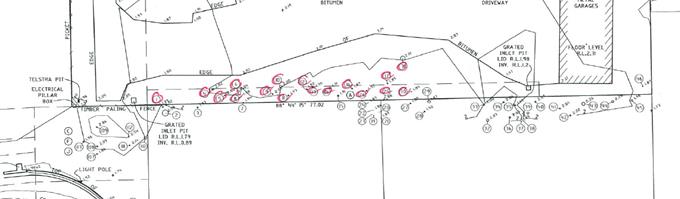
No species of conservation significance were recorded. The >10m high Swamp Oak, Paperbarks and Water Gum (5 trees in total) are considered to be of medium ecological/aesthetic value requiring the provision of 5 compensatory plants per removed tree. The other 12 trees are considered to be of low ecological/aesthetic value requiring the provision of 1 compensatory plant per removed tree. This requires a minimum of 5 x 5 + 12 x 1 = 37 compensatory plants and a condition requiring a landscaping plan is included in the Recommendation of this Report below accordingly. The DA is accompanied by an indicative landscape plan which indicates the provision of more than 37 plants.
Chapter B3 – Services
The subject allotments are capable of being provided with the essential services including water, electricity, sewage disposal, stormwater drainage and suitable vehicular access, to the satisfaction of relevant Council Engineers, and subject to conditions.
Chapter B4 – Traffic Planning, Vehicle Parking, Circulation and Access
Each dwelling is required to be provided with 2 car parking spaces. Each dwelling is provided with a double garage. 2 visitor parking spaces are also required, and these are provided at the western end of the site, visible from the road frontage. The proposal complies in relation to provision of parking facilities and Council’s Development Engineer raised no objection n the basis of circulation and access.
Chapter B9 – Landscaping
Prescriptive measure 2 of B9.4.1 Landscape Principles requires the provision of 90m2 of landscaped area per large dwelling (ie. 8 large dwellings x 90m2 per dwelling = 720m2) less the totals of the approved private courtyards. That is, the area of the landscaped area for the development is able to include the approved private courtyards as long as the total of approved private courtyards and common landscaped area is 720m2. The development provides for approximately 710m2 which is only slightly less than the requirement. The application demonstrates that the proposal will provide for a reasonable level of landscaped area through plantings with each property containing small but functional courtyards area for residents needs. The proposal is considered to be satisfactory having regards to the applicable objectives and performance criteria under B9.4.1. Conditions to apply for landscaping to be completed.
Chapter C2 – Areas Affected by Flood
A flood planning level for this development is 3.4m AHD applies to the site. The residential areas of each dwelling are set at a minimum of 4.94m AHD which complies with Councils flood requirements. The plans indicate that only garage / storage and laundry internal uses are to occur at the ground floor level which is below the flood planning level.
Chapter D1 – Residential Accommodation in urban, Village & Special Purpose Zones
The proposal does not comply with D1.2.2 Setbacks from Boundaries, Prescriptive Measure 3 – minimum setbacks for multi dwelling house, requiring 3m between buildings on a site. The proposed setback between buildings is 2m.
However the proposed development complies with the Objectives and Performance Criteria underpinning this design element for the following reasons:
1. The proposal minimises impacts upon the existing streetscapes and development in the locality due to the properties location.
2. The proposal achieves good orientation and spacing of residential developments to achieve high quality living environments relative to sunlight, shade, wind and weather protection, residential amenity and proximity of neighbouring development.
3. The proposal achieves effective use of the site to create useable and liveable private open space and courtyards.
4. The proposal represents appropriate siting and design in the surrounding urban residential area.
5. Private open space and common landscaped areas of the site are useable as part of the living environment available for the occupants of the development. Landscaped areas are
provided in the visually prominent part of the site to the west of the building to visually soften the built form from the public perspective.
6. The proposed front setback complies with the minimum of 4.5m/5.5m. The proposed development is appropriately designed for vehicular safety and visibility. The dwellings are oriented to take advantage of the open northerly aspect, including open space and decking. The proposed 2m setback areas are not readily visible in the streetscape. Car parking is either incorporated into each dwelling or visitor parking that is visually softened by landscaping.
7. The variation will not have a significant impact in terms of streetscape, amenity, privacy, views and access of surrounding properties, road status, traffic impacts, sight lines or BCA compliance.
In relation to D1.2.1 Building Height Plane, the development encroaches into the building height plane as projected from the northern and eastern boundaries of the site. The northern boundary adjoins land in the same ownership as the site, however the encroachment still needs to be considered with reference to the applicable DCP 2014 provisions. In accordance with Prescriptive Measure 2, given that the site is flood liable land, Council is able to consider an exemption to the building height plane in relation to one or more boundaries because the floor level is required to be above ground level to comply with Council’s requirement’s for flood protection. This exemption is applicable to a point, however the development could have been designed to comply with both flood protection and building height plane requirements. However, having regard to the Dual Path Assessment, the non-compliance meets the D1.2.1 Objectives and Performance criteria for the following reasons:
Performance Criteria
1. The proposed development has been design to minimise overshadowing, privacy and view impacts;
2. The development is designed to promote energy efficiency and to optimise use of winter sunlight and summer shade; and
3. The development is designed to ensure that the windows of living areas (decks, living rooms, bedrooms, kitchens, etc.) of development on adjoining properties will retain full solar access between the hours of 9.00am to 3.00pm on any day;
and hence:
Objectives
1. The proposal will not have a significant impact in terms of solar access on adjoining properties to the north and east, or on the views from adjacent existing buildings. The proposal incorporates privacy screens to the upper floor level balconies, and the east facing windows are highlight windows, to ensure that the development does not have significant privacy impacts on neighbouring properties; and
2. The occupants of the development will enjoy the optimum use of winter sunlight and summer shade. The privacy screens are to be designed so as to allow sunlight penetration and minimise privacy impacts to northern and eastern neighbouring properties.
In relation to D1.2.4 Character & Visual Impact:
Performance Criteria
1. Site, building and landscaping design appropriately addresses the climate;
2. The street face of the eastern most building, together with the space between it and the street, contribute to the general attractiveness of the streetscape by means of good design, appropriate materials and landscaping, noting that the view of the site north along Canowindra Court is not of buildings but rather of driveway, visitor parking and landscaping;
3. The development has been designed to minimise loss of privacy for the reasons indicated above;
4. There is a reasonable degree of integration with the existing built and natural environment, balanced with the desirability of providing for variety in the streetscape;
5. Long, straight wall areas have been avoided by visually breaking up the development into separate buildings and wall plane changes, varied setbacks and building material combinations;
6. Decks are provided for visual, climatic and energy efficiency reasons;
7. Well-designed overhanging eaves are provided to protect against heavy rainfall and summer sun, while allowing winter sun penetration; and
8. Building materials are compatible in character with the surrounding environment. The proposed roofs are of a “medium” non-highly reflective colour (ie. not white or light-coloured) and “Colorbond” finish. Details of building materials and surface colours have been submitted for assessment with a DA;
and hence:
Objectives
1. The development appropriately retains and enhances the unique character of this part of the Byron Shire and its distinctive (as applicable) landscapes, ecology, towns, villages and natural areas; and
2. The development appropriately respects and complements those aspects of the area’s natural and built environment that are important to its existing character.
The proposed development is demonstrated to meet the relevant Objectives of DCP 2014.
In relation to D1.6.1, each dwelling has access to an individual courtyard at ground level having a minimum area of 30m2 and a minimum length and width each of 4 metres, not including any area used exclusively for the circulation or parking of vehicles. The courtyards include access to winter sunshine and landscaped areas. Upper level decks are provided for solar access, to enable sea breexzes to be captured and for general outdoor living purposes.
4.5 Any Planning Agreement or Draft Planning Agreement?
|
|
Yes |
No |
|
Is there any applicable planning agreement or draft planning agreement? |
☐ |
ý |
|
Consideration: Not applicable.
|
||
4.6 Environmental Planning & Assessment Regulation 2000 Considerations
|
Clause |
This control is applicable to the proposal: |
I have considered this control as it relates to the proposal: |
If this control is applicable, does the proposal comply? |
|
92 |
Yes |
Yes |
Yes |
|
93 |
N/A |
N/A |
N/A |
|
94 |
N/A |
N/A |
N/A |
|
94A |
N/A |
N/A |
N/A |
4.7 Any coastal zone management plan?
|
|
Satisfactory |
Unsatisfactory |
Not applicable |
|
Is there any applicable coastal zone management plan? |
|
☐ |
x |
|
Consideration: Not applicable.
|
|||
4.8 The likely impacts of that development, including environmental impacts on both the natural and built environments, and social and economic impacts in the locality
|
Impact on: |
Likely significant impact/s? |
|
Natural environment |
No. The proposal will not have a significantly adverse impact on the natural environment of the locality. |
|
Built environment |
No. The proposal will not have a significantly adverse impact on the built environment of the locality. |
|
Social Environment |
No. The proposal will not have a significant social impact on the locality. |
|
Economic impact |
No. The proposal will not have a significant economic impact on the locality. |
Are there any Council Policies that are applicable to the proposed development?
Council’s ET Engineer has raised no objection to the proposal on the basis of Council’s Policy 4.20: Building over Pipelines and other Underground Structures.
4.9 The suitability of the site for the development
The site is serviced and is suitable for the proposed development.
4.10 Submissions made in accordance with this Act or the regulations
The development application was publicly exhibited. There were 11 submissions made on the development application which raised the following matters:
High risk flooding, flood water contamination, emergency service and other inaccessibility due to flooding, stormwater drainage, flood water displacement due to the proposed development
Council’s Development Engineer raised no objections to the proposal on the basis of flood planning, confirming that the development conforms to the requirements of LEP 2014 clauses 6.3 and 6.4, and DCP 2014 Chapter C2 in relation to flood planning, floodplain risk management, flood study requirements, minimum floor levels, flood planning matrix, flood proofing and special provisions. Conditions are recommended in this regard.
The Development Engineer also raised no objections to the proposal on the basis of stormwater management, confirming that the development conforms to the requirements of LEP 2014 clause 6.6, and DCP 2014 Chapter B3 Services in relation to stormwater drainage, development application requirements, properties adjacent to or containing waterways and site drainage. Conditions are recommended in this regard, including provision of on-site stormwater detention.
It is considered stormwater and flooding can be appropriately managed
Sewer impact / overflow
Council’s Water and Sewer Engineers have raised no objection to the proposal on the basis of the capacity of the existing sewerage system, and there is no “moratorium” in place in terms of development in the Ocean Shores area. .
Traffic and road safety impacts, road damage, lack of footpath, garbage collection in Redgate Road, Garbage bin storage in Redgate Road amenity impacts, On-site bin storage
The proposal has access to the local road networks which is considered capable of handling the additional traffic generated by this development. The parent allotment which was subdivided to create the subject allotments and Lot 10 to the north had frontage to both Helen Street and Canowindra Court. The subdivision resulted in Lot 10 gaining access off Helen Street and the subject Lots 11 and 12 gaining access off Canowindra Court. The proposed development complies with that approved access arrangement. Conditions to apply in terms of constructing driveways and internal access roads and parking areas. In terms of bin storage, adequate area is provided onsite for land owners to store garbage bins within the confines of each property.
Access and visitor parking inadequacy, Overflow parking to be in Canowindra Court
The proposal complies with the number of parking spaces as required under DCP 2014 Chapter B4.2.5 including visitor spaces.
Traffic and occupant noise impacts
The use of the site for normal domestic purposes is not expected to cause significant noise impacts, including vehicle movement noise, in the locality. No objections were raised by Council’s Environmental Health Officer in relation to noise impacts.
Loss of privacy, visual and amenity impacts, no screening trees, vehicle headlight impacts to neighbouring properties
The development complies with the building height plane as projected from the southern boundary and appropriately addresses privacy impacts to the southern neighbouring property. Proposed Unit 1 is set well back from the western side boundary. Unit 8 encroaches into the building height plane as projected from the eastern boundary however the dwelling incorporates appropriate privacy measures such as screening the eastern side of the proposed rear verandah and highlight (1.5m high sill) east facing windows.
The proposed development is provided with landscaping for visual softening, and a 1.8m high fence is required to all neighbouring property boundaries for general privacy, security purposes and to block out headlights.
Removal of vegetation screening loss of privacy and a visual eyesore, loss of wildlife corridor, compensatory planting, inadequate proposed landscaping
The development complies with the building height plane as projected from the southern property boundary to ensure that privacy impacts are minimised. Compensatory planting is provided for the proposed tree removal, as described by this Report above. Landscaping, including compensatory planting of the site, is the subject of a recommended condition of consent. The driveway along the southern boundary will be below standard fence level and is not required to be landscaped.
Reduction of the separation between the unit blocks from 3m to 2m
This Report addresses the separation between buildings prescriptive measure non-compliance in section 4.4A above.
High density proposal, possible transient population during festivals, overcrowding, undesirable precedent and change in character of the area
The proposed development is in a low density residential zone, but meets the requirements for multi dwelling housing as specified under Byron LEP 2014. The property is of a reasonable size (over 1800m2), whilst the eight dwellings are modest in area and amenity as opposed to more high end accommodation proposed in other parts of the shire. Conditions of consent are recommended to prohibit the use of the dwellings as tourist and visitor accommodation and holiday letting.
Bush fire prone area, asset protection zone not contained within site
The NSW Rural Fire Service has assessed the proposal with respect to bush fire hazard characteristics of the site and surrounds, and recommends conditions relating to for example, maintaining the entire site as an asset protection (thereby not relying on neighbouring properties).
No construction certificate means plans can be changed
A certifying authority must not issue a construction certificate for building work unless the design and construction of the building (as depicted in the plans and specifications and as described in any other information furnished to the certifying authority) are not inconsistent with the development consent.
Minimum lot size of 600m2
This Report considers a clause 4.6 written request for variation in section 4.2A above.
Impact upon property values
This is not a matter for consideration of such significance as to warrant refusal of the development application.
4.11 Public interest
The proposed development is unlikely to prejudice or compromise the public interest or create an undesirable precedent.
4.12 Section 5A of the EP&A Act – Significant effect on threatened species
Having regard to sections 5A, 5C and 5D of the EP&A Act, there is unlikely to be a significant effect on threatened species, populations or ecological communities, or their habitats as a result of the proposed development because the site is not mapped as containing any threatened fauna habitat and no species of conservation significance are proposed to be removed.
4.13 Section 5B of the EP&A Act – Have regard to register of critical habitat
The NSW Critical Habitat Register does not identify any critical habitat on or adjacent to the site.
5. DEVELOPER CONTRIBUTIONS
Water and Sewer and Section 94 Contributions are payable. Conditions to apply.
6. CONCLUSION
The application is considered to have sufficient merit to warrant approval subject to conditions of consent.
7. DISCLOSURE OF POLITICAL DONATIONS AND GIFTS
|
Has a Disclosure Statement been received in relation to this application |
No |
|
Have staff received a ‘gift’ from anyone involved in this application that needs to be disclosed. Where the answer is yes, the application is to be determined by the Director or Manager of the Planning, Development and Environment Division. |
No |
Provide Disclosure Statement register details here: Not applicable
BYRON SHIRE COUNCIL
Staff Reports - Sustainable Environment and Economy 7.8
Report No. 7.8 PLANNING - Site-specific Planning Proposals considered as part of the Rural Land Use Strategy process
Directorate: Sustainable Environment and Economy
Report Author: Alex Caras, Land Use Plannning Coordinator
File No: I2017/1686
Theme: Ecology
Planning Policy and Natural Environment
Summary:
Council at its 26 October 2017 Ordinary Meeting considered a report on the draft Rural Land Use Strategy and resolved (in part) to:
“4. Receive a report at the meeting on 23 November 2017 regarding site specific planning proposals being considered as part of the RLUS including at 74 Charltons Road, Federal”.
This report presents a summary of the relevant information in response to the above resolution.
NOTE TO COUNCILLORS:
In accordance with the provisions of S375A of the Local Government Act 1993, a Division is to be called whenever a motion for a planning decision is put to the meeting, for the purpose of recording voting on planning matters. Pursuant to clause 2(a) under the heading Matters to be Included in Minutes of Council Meetings of Council's adopted Code of Meeting Practice (as amended) a Division will be deemed to have been called by the mover and seconder of all motions relating to this report.
|
RECOMMENDATION: That Council: 1. Note the information contained in this report. 2. Resolve not to proceed any further with the Planning Proposals contained in Attachments 1 and 2 to this report, as they do not satisfy the Rural Land Use Strategy criteria for future rural lifestyle living opportunities or accord with the State/regional policy framework (namely the North Coast Regional Plan and s117 Ministerial Direction 5.3). 3. Notify the Applicants of Council’s decision not to proceed and their opportunity to request the relevant Planning Panel to review council’s decision within 42 days of being notified.
|
1 Copy of
Planning Proposal and draft RLUS submission for Lot 11 DP 1039847 - 74
Charlton’s Road Federal, E2017/103100
⇨
![]()
2 Copy of
Planning Proposal for CT subdivision of Lot 3 DP 732638 Englishes Road_Upper
Coopers Creek, E2017/103101 ⇨
![]()
3 Letter to
applicants re planning proposals for 74 Charltons Road Federal and Englishes
Road Upper Coopers Creek_July2015, E2017/103104
⇨
![]()
Report
Council at its 26 October 2017 Ordinary Meeting considered a report on the draft Rural Land Use Strategy and resolved the following:
Resolution 17-504
1. Note the update on priority actions progressed to date as contained in Table 1 of this report;
2. Adopt the proposed amendments to the draft Rural Land Use Strategy (RLUS) and supporting documents, as contained in Table 2 and Table 3 of this report, to enable submission to Department of Planning & Environment;
3. Delegate authority to the Director Sustainable Environment & Economy to amend the draft Rural Land Use Strategy in relation to any consequential (non-policy) and/or other minor editorial amendments required for clarity or accuracy, prior to submitting to Department of Planning & Environment for final endorsement; and
4. Receive a report at the meeting on 23 November 2017 regarding site specific planning proposals being considered as part of the RLUS including at 74 Charltons Road, Federal.
This report presents a summary of the relevant information in response to item ‘4’ of the above resolution.
Background
Council at the 8 August 2013 meeting resolved (Res. 13-388) to include six properties on the Byron LEP 2014 Multiple Occupancy and Community Title Map. Only one property was supported for inclusion on the Map by the Minister for Planning & Environment’s delegate when the LEP was gazetted.
The then Director Environment and Planning wrote to the remaining five property owners to advise them of their options as to how the following properties could progress towards a rural multiple occupancy development. At the time two options were provided:
Ø be considered during preparation of Council’s Rural Land Use Strategy; or
Ø prepare a planning proposal to amend the Byron LEP 2014 ahead of Council completing the Rural Land Use Strategy.
Council subsequently received planning proposals for two properties: (i) Lot 11 DP 1039847, 74 Charlton’s Road, Federal and (ii) Lot 3 DP 732638 Englishes Road, Upper Coopers Creek.
These sites are shown in Figures 1 & 2 below.
A copy of the planning proposals and supporting information are contained in Attachment 1 (‘Charltons Road’) and Attachment 2 (‘Englishes Road’).
As the timing of the planning proposals received coincided with preparation of a new Rural Land Use Strategy (RLUS), both applicants were sent a letter advising that their respective planning proposals would now be considered as part of the strategy process. Specifically, these areas would be “assessed against the site selection criteria being developed as part of this wider land use strategy review. This will determine if the site has merit to be zoned for rural settlement purposes.” A copy of the letters sent to both applicants is contained in Attachment 3.
This is consistent with Resolution 16-286 relating to other sites identified in Report No 13.11 - Request for an Early Implementation Program to supplement Council’s Rural Lands Strategy Initiative, in which Council resolved:
Resolution 16-286
“Resolved that Council not support the “Early Implementation Program to supplement Council’s Rural Land Use Strategy Initiative and instead consider these properties in the Byron Rural Land Use Strategy now under preparation.”
Because both applicants were advised that their planning proposals would now be assessed under the RLUS framework, it was not intended at the time to have them separately determined by Council. Instead the more detailed site information contained in the planning proposals would be considered against the RLUS policy directions and site selection criteria, with any final Council decision to coincide with adoption of the RLUS.
Although both applicants had an opportunity to make further submissions during the RLUS exhibition process, Council only received submissions for ‘74 Charlton’s Road’. This resulted in an oversight in which the ‘Englishes Road’ site was not included in the 26 October RLUS report to Council.
Figure 1: Lot 11 DP 1039847, 74 Charlton’s Road, Federal
Figure 2: Lot 3 DP 732638, Englishes Road, Upper Coopers Creek
Assessment against site selection criteria in Rural Land Use Strategy (as adopted)
Table 1 below shows the relevant criteria applied in assessing these sites for ‘future rural lifestyle living opportunities’ in the adopted Rural Land Use Strategy (as identified in RLUS Maps 4, 4a).
Table 1 – RLUS criteria for identifying ‘future rural lifestyle living opportunities’
|
Criteria |
74 Charltons Road, Federal |
Englishes Road, Upper Coopers Creek |
|
i) situated west of the Pacific Highway (undeveloped sites only) AND within a 5 km radius of a town with a high school; and
|
Ï
Outside 5km service catchments of Mullumbimby & Byron Bay |
Ï
Outside 5km service catchments of Mullumbimby & Byron Bay
|
|
ii) not identified in a draft or adopted strategy for future urban purposes, or for future village / urban development in this strategy; and
|
P |
P |
|
iii) contains at least 10ha of unconstrained land AND does not require access through constrained land, as identified in Table 1 of the Site Suitability Criteria and Mapping Methodology; and
|
Ï
No unconstrained land due to the following: - regionally significant farmland (entire site) - slope > 25% (part of site)
|
Ï
No unconstrained land due to the following: - regionally significant farmland (entire site) - within 100m buffer to river in a drinking water catchment (part of site) - extreme bushfire risk (part of site) - slope > 25% (part of site) - HEV vegetation (part of site)
|
|
iv) can be adequately serviced by existing or committed road infrastructure at a standard suitable for the predicted level and type of traffic resulting from development, at no cost to the wider community
|
Ï
Located outside 5km major service catchment and in an area that cannot be serviced adequately by existing or committed road infrastructure.
|
Ï
Located outside 5km major service catchment and in an area that cannot be serviced adequately by existing or committed road infrastructure.
|
P= satisfies criteria Ï= does not satisfy criteria
In summary, neither site satisfies the RLUS criteria for future rural lifestyle living opportunities nor accords with the State/regional policy framework (namely the North Coast Regional Plan and s117 Ministerial Direction 5.3 - Farmland of State and Regional Significance on the NSW Far North Coast). It is therefore recommended that both of these planning proposals not proceed any further.
Opportunity for Applicants to request a pre-Gateway review
The Environmental Planning and Assessment Regulation 2000 (EP&A Regulation) requires councils to notify a proponent when the council decides not to prepare a planning proposal. The proponent then has 42 days from notification to request the relevant Planning Panel to review council’s decision.
Accordingly both applicants should be notified of Council’s decision not to proceed with their respective planning proposals, as recommended in this report.
Financial Implications
The cost of assessing both of these planning proposals as part of the Rural Land Use Strategy process has been met by Council.
Statutory and Policy Compliance Implications
The Rural Land Use Strategy is consistent with the relevant Commonwealth, State and Regional policy frameworks.
BYRON SHIRE COUNCIL
Staff Reports - Sustainable Environment and Economy 7.9
Report No. 7.9 Further update on Resolution 17-191 Secondary Dwelling Conditions
Directorate: Sustainable Environment and Economy
Report Author: Shannon Burt, Director Sustainable Environment and Economy
File No: I2017/1688
Theme: Ecology
Development and Approvals
Summary:
Council considered Report 13.21 Update on Resolution 17-1891 Secondary Dwellings at the Ordinary Meeting on 26 October 2017, and requested that a further report on item 2 be presented at the November meeting. In particular, the final number of responses to the letter sent, and next steps for enforcement of non compliant developments. Item 2 is in bold.
Council resolution 17-191 is provided below.
17-191 Resolved:
1. That Council recognises community concerns regarding the lack of affordable housing in Byron Shire and concerns that secondary dwellings, as defined and facilitated by the NSW State Environmental Planning Policy (Affordable Rental Housing) 2009, are being used for tourism purposes via short term letting, holiday letting Air Bnb and similar online platforms.
2. That Council responds to concerns and compliance issues by:
a) contacting all property owners with a secondary dwelling (granny flat) approved since the
passage of Council Resolution 11-268 and seek property owners’ confirmation that they
are complying with their approval and/or conditions of consent with the regard to the
Environmental Planning Assessment Act and to Byron Shire Council Resolution 11-268.
b) developing a form that seeks the owners signature regarding compliance with consent
and Resolution 11-268 for inclusion with the correspondence to be returned to council
within 30 days.
3. That a report be received from staff informing Council as to the outcome of 2(a) and (b).
4. Request staff to commence the process to amend clause 2.14 in the 2012 Byron Developer Contributions Plan to provide that the clause does not apply to secondary dwellings used for tourism purposes.
5. Request staff to commence an evaluation of Council’s policy of waiving Council S64 and S94 contributions for secondary dwellings as a means to support affordable housing and provide recommendations to strengthen affordability outcomes of secondary dwellings.
6. Request staff to identify how the Affordability Housing SEPP 2009 could be applied to establish an exception from Council S64 and S94 for ‘affordable rental accommodation’.
7. That a further report be furnished to Council on points 5 and 6 above.
This report provides an update on item 2 by staff.
|
RECOMMENDATION: That Council note the report.
|
Report
As requested by Council at the Ordinary Meeting 26 October 2017, a further update on item 2 of Resolution 17-191 is provided below.
… 2. That Council responds to concerns and compliance issues by:
a) contacting all property owners with a secondary dwelling (granny flat) approved since the passage of Council Resolution 11-268 and seek property owners’ confirmation that they are complying with their approval and/or conditions of consent with the regard to the Environmental Planning Assessment Act and to Byron Shire Council Resolution 11-268.
b) developing a form that seeks the owners signature regarding compliance with consent and Resolution 11-268 for inclusion with the correspondence to be returned to council within 30 days.
Letters and form sent to 598 property owners on 13 September 2017. Only 143 have been returned as of 6 November 2017. Copy of letter and form link below:
http://byron.infocouncil.biz/Open/2017/10/OC_26102017_ATT_611_WEB.htm
Based on the above, the next steps for staff are to write again to those properties that have not responded to provide a further, brief, opportunity to do so.
Where a reasonable suspicion exists of unauthorised activity staff will consider the commencement of enforcement proceedings for the offence of development not in accordance with development consent
The reasonable suspicion must be held by the investigating official who is to commence proceedings. The investigating official must be able to form that view in the circumstances of the particular matter. Each case must be dealt with on its merits.
Financial Implications
Staff resourcing and any enforcement proceedings need to be managed within the existing budget allocation.
Statutory and Policy Compliance Implications
Environmental Planning and Assessment Act 1979 and related regulations
BYRON SHIRE COUNCIL
Staff Reports - Sustainable Environment and Economy 7.10
Report No. 7.10 Review of the Biodiversity and Sustainability Panel
Directorate: Sustainable Environment and Economy
Report Author: Shannon Burt, Director Sustainable Environment and Economy
File No: I2017/1707
Theme: Ecology
Planning Policy and Natural Environment
Summary:
At the Biodiversity and Sustainability Panel (Panel) meeting held 12 October 2017, a discussion was had about the Panel and a recommendation made:
That staff prepare a report on the terms of reference for the Biodiversity and Sustainability Panel including alternate membership options, meeting process and procedures for the next available Council meeting.
In response to this recommendation, this report is provided for Council consideration on the existing Panel membership, meeting process and procedures.
|
RECOMMENDATION: 1. That Council agree to the overarching concept of a new Biodiversity Advisory Group and Sustainability and Emissions Reduction Advisory Group, so that the model and terms of reference and membership can be drafted with the existing nominated Councillors Richardson, Hunter and Martin.
2. That Council receive a further report to confirm the model and terms of reference and membership of the new Biodiversity Advisory Group and Sustainability and Emissions Reduction Advisory Group in February 2018.
3. That the first meetings of the new Biodiversity Advisory Group and Sustainability and Emissions Reduction Advisory Group occur before May 2018.
|
Report
At the Biodiversity and Sustainability Panel (Panel) meeting held 12 October 2017, a discussion was had about the Panel and a recommendation made:
That staff prepare a report on the terms of reference for the Biodiversity and Sustainability Panel including alternate membership options, meeting process and procedures for the next available Council meeting.
It was agreed that the current Panel is not being challenged with strategic issues and therefore has lost momentum and members interest.
Existing constitution and Panel information below:
http://www.byron.nsw.gov.au/committees/biodiversity-and-sustainability-panel
The Panel as it presently meets has a very broad purpose that includes implementation of the relevant biodiversity and sustainability strategies as well associated projects, funding opportunities and partnership potential.
Examples of Biodiversity projects currently include: Review of the Biodiversity Conservation Strategy (see report I2017/1549), Integrated Pest Management Strategy and Policy (see report I2017/1527), Vegetation Mapping, Bushfire Prone Land Mapping, Koala Plan of Management and associated projects, Flying Fox Management Plan, Graminoid Clay Health project, Habitat and Corridor works.
Examples of Sustainability and Emissions Reduction projects currently include: Council’s 100% Emissions Reduction Strategy, Support Zero Emissions Byron Initiatives, Local Energy Trading and Local Network charges, Renewable Energy projects Council and community, Climate Change and Energy reporting, Food Security initiatives.
Given the above, it is difficult for one single Panel meeting of 2 hours each quarter to respond to all of the above with a representative and or engaging agenda. Further, Panel members may or may not choose to attend meetings depending on the agenda, and whether or not it includes discussion on their core interests. This presents issues for quorum at times.
To address this, the opportunity now exists to consider disbanding the Panel and replacing it with two separate ‘Advisory Groups’; one for Biodiversity the other Sustainability and Emissions Reduction. These Advisory Groups would operate like the masterplan guidance groups which have proved extremely successful in terms of expert community participation and engagement.
This model would also allow for maximum flexibility in meeting times/dates and formats such as field days, workshops with guest speakers, industry leaders, experts from outside of Byron for perspective or comment. The current Panel Constitution as stipulated does not enable this to occur.
To move this proposal forward, staff recommend that Council agree to the overarching concept of a new Biodiversity Advisory Group and Sustainability and Emissions Reduction Advisory Group and that the model and terms of reference and membership be finalised with the existing nominated Councillors Richardson, Hunter, and Martin by years end. That a further report to Council follow to confirm the above in February 2018.
Financial Implications
Costs associated with the new Advisory Groups would need to be met within the existing operational budget and staff resources.
Statutory and Policy Compliance Implications
Delivery Program CM2.1.2 Incorporate inclusive community consultation and stakeholder engagement in Council decision making.
BYRON SHIRE COUNCIL
Staff Reports - Infrastructure Services 7.11
Staff Reports - Infrastructure Services
Report No. 7.11 Former Mullumbimby Hospital - Contamination Review
Directorate: Infrastructure Services
Report Author: Phil Warner, Manager Assets and Major Projects
File No: I2017/1554
Theme: Community Infrastructure
Projects and Commercial Opportunities
Summary:
The purpose of this report is to present to Council the report prepared by consultants HBI on the review of contamination at the former Mullumbimby Hospital in response to Council resolution 17- 269.
|
RECOMMENDATION: That Council receive a further report on the projected costs of contaminated site management, site holding costs, demolition of all structures and full site remediation for the Mullumbimby Hospital property. |
1 170805
Byron Council Review of Mullumbinby Hospital ACM Management Report Final, E2017/101652 ⇨
![]()
Report
At the 22 June meeting Council resolved in part:
17-269 Resolved (in part):
2. That Council engage independent consultants to peer review the hazmat reports prepared for
NSW Health for the former Mullumbimby Hospital site.
Consultants Healthy Buildings International (HBI) were engaged to conduct the review. The HBI report is attached.
HBI variously conclude in the report:
· the investigations and assessments conducted to date are thorough and the professional advice contained therein consistent with industry best practice.
· the unstable and degraded friable ACMs (limpet) on all the roof system/ceiling spaces at the facility, except Block B (Birthing Unit), coupled with the deteriorating roof structure, presents a very high risk to users and occupiers of the facility as well as the surrounding community.
· the level of degradation of the friable ACMs (limpet) on the roof and in roof spaces is extremely advanced and any failure of the enclosure system could result in wide spread contamination for the Facility and the surrounding areas.
· it is HBI’s opinion that an asbestos control strategy comprising ACM management could not be feasibly instigated and maintained to permit future use of the Facility, with associated risk acceptable to all stakeholders.
· based on the guidelines prescribed in the Code of Practice How to Manage and Control Asbestos in the Workplace, the appropriate method for management of the unstable friable ACMs at the Facility is removal, including removal from within wall cavities, which will require at least partial (i.e. one skin of a ventilated double brick wall) demolition of external and internal walls.
Based on the HBI report, it is recommended that Council receive a further report on the projected costs of contaminated site management, site holding costs, demolition of all structures and full site remediation for the Mullumbimby Hospital property.
Financial Implications
Advice has been received from NSW Health regarding a quote obtained for demolition of the hospital buildings. This quote for $1.8 million specified some exclusions and there is no provision for project management, contract documentation and contingency. The total cost of contaminated site management, site holding costs, building demolition, and full site remediation is likely to be significantly higher than $1.8m.
Site holdings costs will be incurred from the time Council owns the property until the majority of the site is handed over to a principal contractor for the demolition and remediation of this highly contaminated site. Holding costs will include the secure perimeter fencing, on site security guard, security patrols, building integrity inspections, air quality monitoring in accordance with the asbestos management plan, investigations of unlawful entry, rectification of any security breaches such as damaged windows, doors or stolen fixtures such as fire extinguishers, ground maintenance and professional services for asbestos management and incident management. It is understood that these costs have been very high for NSW Health.
Statutory and Policy Compliance Implications
Purchase of the Mullumbimby Hospital site will result in significant operational costs that are unlikely to be offset by income for an as yet unknown period of time.
Upon completion of the proposed purchase Council will assume the significant WH&S responsibilities associated with such a contaminated site. Some of the contamination risks can be managed through rigorous deployment of isolation, containment and exclusion practices under the requirements of an asbestos management plan. However, risks such as the deteriorated roof will only be resolved once demolition is complete.
BYRON SHIRE COUNCIL
Staff Reports - Infrastructure Services 7.12
Report No. 7.12 Tree Removals Railway Park Byron Bay
Directorate: Infrastructure Services
Report Author: Michael Matthews, Manager Open Space and Resource Recovery
File No: I2017/1687
Theme: Community Infrastructure
Open Space and Recreation
Summary:
This report outlines the decision making process and background to the undertaking of recent works within Railway Park and process used in obtaining all relevant approvals and requirements prior to works (including tree removal). These works included the removal of the garden beds fronting Jonson street within Railway Park, whilst retaining all vegetation over 2m within these beds and the removal of three (3) trees described by staff as:-
1. Eucalyptus Dunnii approximately 12m tall estimated 30 years old
2. Archontophoenix cunninghamiana approximately 12m tall estimated 30 years old and
3. Sterculia quadrifida estimated 6m and estimated as 8 years old.
This report also provides background information in relation to the relocation notification issued to Byron Environment Centre (BEC).
This report also provides information specific to the Tourism Demand Driver Infrastructure (TDDI) funded redevelopment of Railway Park and its program interrelationship with Operational Actions performed.
|
RECOMMENDATION: That Council:-
1. Note the report.
2. Finalise concept plans of Railway Square Beatification Plan and report to Council in accordance with resolution 17-555.
|
1 Tree /
Vegetation Removal - Approval Pathways, E2017/104389
⇨
![]()
2 BBTCM
Leadership Team Meeting August 2017, E2017/104726
⇨
![]()
3 Letter to
BEC in accordance with resolution 17-555, E2017/105004
⇨
![]()
Report
Council at is Extra- Ordinary Meeting of 2 November 2017 resolved an urgency motion in relation to Works in Railway Park, Byron Bay:-
17-555 Resolved that Council:
1. Withdraw the relocation notice to the BEC from the rotunda inside Railway Park.
2. Receive a report at the next Ordinary meeting, outlining the decision making process to
undertake the works and the process in obtaining all relevant approvals and requirements prior to works (including tree removal), and this review be completed and reported back to Council, with any forthcoming recommendations.
3. Do not undertake any further infrastructure or landscaping works in Railway Park until formal adoption of a railway square beautification plan at an Ordinary Council Meeting.
Background
The Better Byron Crew (BBC) is tasked with maintenance, refurbishment, renewal, minor capital works and litter collection within the Byron Town Centre. The BBC delineated service area has recently been reduced to increase levels of service across assets within the town.
The reduced BBC service area was in response to concerns raised with BBC service levels on particular assets such as the town’s garden beds and litter removal performance along foreshore assets.
Detailed review of service levels across assets was undertaken.
This review identified that the level of resourcing for the town centre was insufficient to meet the expected standards. It was identified that the area serviced by the BBC had undergone significant creep since the establishment of the Town dedicated crew without a realistic increased in resource allocation.
From this review, perceived performance matters that directly relate to expected levels of service of highly visual assets were addressed by the General Manager via direction to staff to:-
· Reduce the BBC delineated area;
· Increase litter collection servicing during weekends on the foreshore assets; and
· Divert saved resource into garden bed maintenance.
One area identified as receiving a poor level of service was the garden beds of Railway Park fronting Jonson Street.
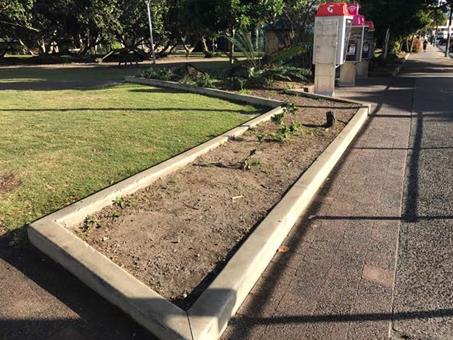
Fig 1 - Railway Park, Jonson Street garden Beds (facing north from Exeloos)
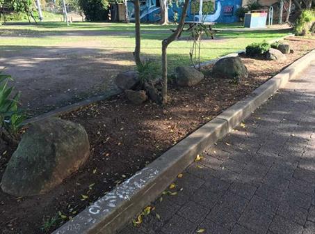
Fig 2 - Railway Park, Jonson Street garden Beds (Facing North West)
The review identified a number of reasons why performance of this asset was poor.
These reasons included poor initial design, high adjacent pedestrian traffic, pedestrians short circuiting existing pathways causing damage to garden bed amenity, high number of assets assigned to the BBC relative to team size and change in work practices.
One significant change in work practices was the ceasing of herbicide use within the town and high public use parks.
Traditional maintenance practice within garden was the use of selective herbicide to manage weed growth in garden beds. This practice involved the use of a wick application to control weeds (method consists of a wick soaked in herbicide which the wetted wick is used to wipe or brush selectively onto the weed). This method was ceased in 2015 and replaced with a labour intensive hand weed program of the 151 individual garden beds within the Byron Township.
Throughout the Byron town centre, the BBC has been progressively improving garden bed function and amenity through edging and heavy hardwood chip mulching. This work suppresses weed growth, reducing labour intensive hand weeding and changes pedestrian behaviour through making it more difficult/ less favourable for pedestrians to ‘short cut’ across garden assets.
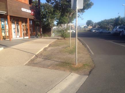
Fig 3a - Before photo of SW corner of Bay and Jonson Street – simple turf solution
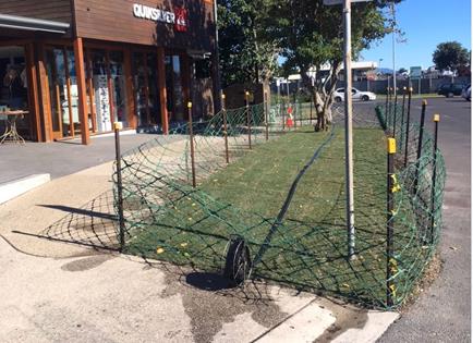
Fig 3b -After photo of SW corner of Bay and Jonson Street – simple turf solution
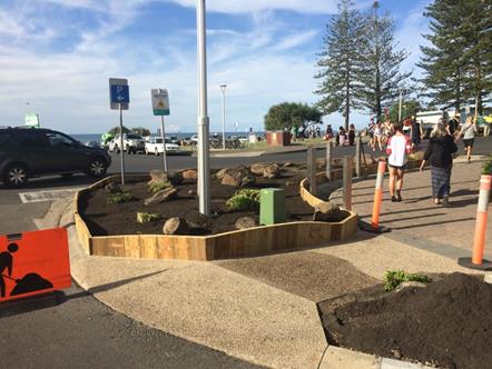
Fig 4 - Works in progress prior to Mulch being applied, South East corner Jonson and Bay Street
Fig 5 - Completed works, garden bed in front of Fish Heads
In discussions with a Landscape architect in relation to Railway Park, it was agreed that due to pedestrian volumes within this precinct, removal of these beds in there current form was operationally preferred.
On Thursday the 12th October, direction was given to-
Have BBC remove the garden bed along Jonson Street between the Café and the Exeloos:-
· Remove the designated tree adjacent to the café (with TPO Cert) as agreed at a site meeting with Councils engaged landscape architect and Director of SEE;
· Remove the playground;
· Remove the two large metal barriers in the car park near the Countrylink building; and
· Under the supervision of the arborist and landscape architect have a tree doctor/men with chain saws sculpt the trees in the park to create a play feature.
These directions were given on the basis of routine renewal maintenance activities that aligned with the scope of works that the BBC regularly performed.
Prior to this work, Railway Park was identified, through the development and adoption of the Town Centre Master Plan (BTCMP), as a primary Open Space that is best developed as a common gathering point for leisure and recreation.
With the adoption of the BTCMP, funding was sort under the Tourism Demand Driver Infrastructure (TDDI) Program for redevelopment of Railway Park to that of which meets the vision and spirit of the Master plan. Council was successful in the receipt of $260,000 on a 50/50 basis for the redevelopment of this park on the basis that works are to be complete within the current financial year.
Program management of the TDDI integrated projects was assigned to the Major Projects and Major Projects staff developed the delivery plan and the associated communication and engagement plan.
The communication and engagement plan was reported to the Executive Team on 7 June 2017 and the minutes state: Executive Team endorsed the draft Communication and Engagement Plan for the Railway Precinct TDDI Grant Program.
In conjunction with the grant and more broadly in the context of implementation of the Byron Bay Town Centre Master Plan, a landscape architect was engaged to prepare a concept design for the upgrade of Railway Park.
Railway Park (Railway Square) had been identified as a key catalyst site within the adopted Byron Bay Town Centre Master Plan and had been discussed with the Byron Bay Town Centre Master Plan Leadership Group including a design charrette undertaken in July 2017 by the group.
The concept design for the upgrade of Railway Park envisaged the relocation of the BEC rotunda to another location. It is understood that this was also discussed by the Byron Bay Town Centre Master Plan Leadership Group (Refer Attachment 2)
In association with the implementation of the communication and engagement plan, correspondence was prepared and sent to stakeholders including neighbouring landowners and businesses, community organisations with an interest in the park and internal BSC staff. The correspondence included an initial introductory letter regarding the project, meetings as required and a later letter introducing the concept design.
The email to the Convenor of the Byron Environment Centre Inc records that several attempts were made to contact the Byron Environment Centre. A request was made to work (16 October 2017) together to relocate the rotunda with a target for completion being 13 December 2017.
An extract from Council email (16 October 2017) is as follows:-
As an introduction to the draft concept design, Council has
received community feedback via the Byron Bay Town Centre Master Plan
Leadership Team that the BEC kiosk in Railway Square would best be located
elsewhere. Relocating the kiosk would improve community and visitor use of the
park by increasing access and egress through the park and increasing visibility
and community safety in line with CPTED (crime prevention through environmental
design) principles.
I have searched and consulted within Council for a license, lease or other
agreement for the kiosk being placed in its current position and cannot find
any such document. If you have one on file, could you please provide it so that
we can consider the agreement in context of the project.
Council would like to have the kiosk relocated by 13 December 2017.
If you could please advise an alternate site for the kiosk at your earliest
convenience that would be much appreciated.
Council is willing to assist BEC with the physical relocation of the kiosk
structure to your new location and we're happy to discuss the details of this
with you.
The 13 December 2017 date was proposed by staff to incorporate it in the preliminary works program but to allow time to effectively plan for careful relocation with an aim to preserve of the Arakwal Art.
Upon receiving the email of 19 October 2017, the Convenor of the Byron Environment Centre Inc wrote to Councillors on 23 October 2017 claiming an ‘eviction’ notice had been served.
A key part of the consultation for the proposed upgrade of Railway Park was liaison with the Arakwal. A site meeting occurred on 17 October at which Operational staff requested to be in attendance to confirm early works scope.
Council staff was advised by the Arakwal representative that there was support for the park upgrade and a request was made that the cultural artwork on the rotunda be considered for preservation and, at minimum, provision made for incorporating local indigenous art in the new designs.
The concept plan for the Railway Park upgrade was presented by Councils engaged Landscape architect to the BBTCMPLG on 25 October 2017.
It is understood that there was no further contact with Mr Lazarus (Convenor Byron Environment Centre Inc) regarding relocation of the rotunda prior to the Council meeting on 2 November.
At the 2 November 2017 meeting Council resolved 17-555.
In accordance with part 1 of the resolution a letter (#E2017/103282 – Attachment 3) has been sent to the BEC on 6 November 2017.
Tree Removal and Landscape works (works as was performed)
At the August meeting of the Byron Bay Town Centre Masterplan (BBTCM) Guidance Group it was agreed that an arborist would be engaged to review trees in Railway Park to inform the planning work being undertaken by the landscape architect in Railway Park.
A botanist was engaged to assess trees in Railway Park in consultation with the landscape Architect and advice on 9 September 2017.
Staff met with the landscape architect to discuss the draft plans being prepared for the park and as a result it was agreed that it would be desirable for trees to be removed as part of the redevelopment and that an arborists report had indicated that at least one tree was potentially dangerous. Both the botanist and landscape architect agreed that the forest gum was a limb shedding species
On the Friday the 13th October 2017, Manager of Open Space and Resource Recovery relayed direction to staff to review and action necessary approvals for removal of the designated tree adjacent to the northern boundary of the reserve.
A Tree Removal for Public Infrastructure Permit Form, Issued under Chapter B2 – Preservation of Trees and other vegetation of the Byron Shire Development Control Plan 2014 was provided to the Manager Open Space and Resource Recovery Manager on the 16th October specifying the removal of three (3) trees, theses tress being:-
1. Eucalyptus Dunnii approximately 12m tall (estimated 30 years old)
2. Archontophoenix cunninghamiana approximately 12m tall (estimated 30 years old); and
3. Sterculia quadrifida estimated 6m (estimated 8 years old).
Additional trees that were sort for removal were identified as trees to be removed as part of the early works program for the parks redevelopment.
The Eucalyptus Dunni, was considered by staff as presenting risk to users of the park through exposed roots and as a future risk of limb shredding as known limb shredding species.
Management staff provided permit form for directorate signature.
This completed permit was provided to operational staff for engagement of a level 5 qualified arborist contractor to undertake the works.
Considerations and steps used by staff in reviewing and actioning the approval included:-
· 14th October - Review of the Infrastructure SEPP guidelines
· Inspection and documenting trees to be removed as above-mentioned.
· Consultation with SEE Directorate on the 16th October 2017.
· Actioned advice received from SEE that the Infrastructure Services Approval Pathway and Permit form could be used as IS were the approving agency (Refer Attachment 1)
Operational staff installed site fencing on Tuesday 24th around the garden beds including the Rotunda in preparation to separate the public from the works to ensure public safety. It should be noted that staff provided access to the Rotunda at all times outside of physical works.
On the Wednesday 25th October 2017 Staff met with Byron Community Centre to relay imminent works and address any possible impacts to the Artesian markets licenced each Saturday night within the park.
Tree Removals Wednesday 25th October
Due to the vegetation removal scope, operational staff identified the need to engage a qualified arborist to remove the trees, as this type of work falls outside the BBC scope of services.
At the time of the works, operational staff had a contracted service undertaking tree works on a number of Norfolk Pines, including one complete removal for reasons of Dead Dying or Dangerous provisions.
The specifications for these works required the Contractor to hold, as a minimum an AQF 3 in arboriculture with supervision from an arborist qualified to a minimum of AQF 5 in Arboriculture. This contracted engagement was expanded to include these tree removal works in the park.
All works were completed by Friday 27th October enabling uninterrupted use by the Artisan Markets held on the night of Saturday the 28th October 2017.
Fig 6 - Completed works, Railway Park garden beds adjacent to Jonson Street
Financial Implications
Works performed funded from town centre upgrades budget.
Statutory and Policy Compliance Implications
Trees removed under Removal for Public Infrastructure Permit Form.
No other approvals were identified as being required for the scope of works as performed.
BYRON SHIRE COUNCIL
Staff Reports - Infrastructure Services 7.13
Report No. 7.13 Bangalow STP Membrane Replacement
Directorate: Infrastructure Services
Report Author: Dean Baulch, Principal Engineer, Systems Planning
File No: I2017/1730
Theme: Community Infrastructure
Sewerage Services
Summary:
Bangalow sewage treatment plant (STP) was commissioned in 2007 and Suez Water Technologies & Solutions (formerly GE) supplied the ZeeWeed 500D membranes. These membranes are a proprietary product and have proven themselves to be an effective treatment unit.
The membranes are now 9 years old and show wear and tear on the modules, module headers, plastic assembly parts and potting areas. The cassette frame is still in good condition. However, there is a risk of catastrophic failure of membranes which could lead to a critical down time of the plant.
It is not possible to seek solutions from alternative suppliers (i.e. this is a specialist product) and it is recommended that Council accept that the supply and install of these membrane units by the proprietary supplier.
|
RECOMMENDATION: That Council:-
1. Resolves in accordance with Section 55(3)(i) of the Local Government Act, to not issue a request for tender for the supply of membrane units for Bangalow STP because the products required are proprietary products and a satisfactory result would not be achieved by inviting tenders; and
2. Delegates the General Manager to enter into a contract with Suez WT&S for the supply of the membranes for $249,657 (ex GST) in accordance with the attached proposal from Suez WT&S.
|
1 Confidential - Suez WT&S - Proposal for the Bangalow STP Membrane Replacement & Cassette Refurbishment - November 2017, E2017/103976
Report
Bangalow STP relies on the membrane system which, in simple terms, filters the influent sewage by sucking it through many tubes arranged in modules or banks instead of using large sized civil structure like those clarifiers located at West Byron STP and Brunswick Valley STP. Bangalow STP produces high quality effluent using the current membrane system.
Bangalow sewage treatment plant was commissioned in 2007 and Suez Water Technologies & Solutions (formerly GE) supplied the ZeeWeed 500D membranes. These membranes are a proprietary product and have proven themselves to be an effective treatment unit. The membranes are nearing the end of their useful life and Council requested Suez Water Technologies & Solutions (WT&S) to check the system operation in accordance with established best practices of membrane systems with an emphasis on condition assessment of the membranes.
Comments from the condition report are as follows:
The membranes are now 9 years old and show wear and tear on the modules, module headers, plastic assembly parts and potting areas. The cassette frame is still in good condition. However, there is a risk of catastrophic failure of membranes which could lead to a critical down time of the plant. Therefore, Suez recommends planning for the membrane renewal by either replacing by new cassettes and membrane modules or reconditioning the cassette with new modules and assembly kit.
Suez (WT&S) also recommends installing the membrane system to their proprietary LEAP cassette which will provide cost benefits from reduced maintenance and power (i.e. electricity).
The Bangalow STP is sensitive to power interruption and process outages. High risk is posed to the treatment plant process and its capacity to take sewerage flows from Bangalow if the operation is required to move away from the current technology and the proprietary membrane system it uses. A further risk exists as it will also take an extended amount of time to find or assess an alternative solution or product to rival the ZeeWeed membranes.
Financial Implications
The Council approved budget of 2017/18 identified replacement of the membranes at a budget value of $605,000.
There is a saving involved in the purchase of the units from the proprietary supplier at a value of $249,657.00 (excluding GST).
Statutory and Policy Compliance Implications
Section 55 of the Local Government Act requires Council to invite tenders before entering into any contract with a value of $150,000 and over.
There are exceptions to this provided under the Act.
Section 55(3)(i) of the Act states that a tender is not required “because of extenuating circumstances, remoteness of locality or the unavailability of competitive or reliable tenderers, a council decides by resolution (which states the reasons for the decision) that a satisfactory result would not be achieved by inviting tenders”.
It is not possible to seek solutions from alternative suppliers (i.e. this is a specialist product) and it is recommended that Council accept the supply of these membrane units by the proprietary supplier Suez Water Technologies & Solutions.
BYRON SHIRE COUNCIL
Confidential Reports - Infrastructure Services 8.1
Confidential Reports - Infrastructure Services
Report No. 8.1 Confidential - Council Tender for the Multi Use of Byron Shire Rail Corridor
Directorate: Infrastructure Services
Report Author: Joshua Winter, Civil Engineer
Evan Elford, Team Leader Infrastructure Planning
File No: I2017/1710
Theme: Community Infrastructure
Local Roads and Drainage
Summary:
At the Ordinary meeting on 20 April 2017, Council resolved 17-142 to endorse proceeding to tender and to allocate a budget to complete the works identified in the Request for Tender document presented at the meeting. The Request for Tender document was later refined as per the resolution, in consultation with the Mayor and Deputy Mayor. An extract from the RFT document containing the final consultant requirements is attached to this report (E2017/95905). The memo approving proceeding to invite Tenders is E2017/85995.
Tenders have since been assessed in accordance with the provisions of the Local Government (General) Regulation 2005 and this report seeks Council acceptance to award the Contract to the recommended tenderer.
RECOMMENDATION:
1. That pursuant to Section 10A(2)(c) and (d)i of the Local Government Act, 1993, Council resolve into Confidential Session to discuss the report Council Tender for the Multi Use of Byron Shire Rail Corridor.
2. That the reasons for closing the meeting to the public to consider this item be that the report contains:
a) information that would, if disclosed, confer a commercial advantage on a person with whom the Council is conducting (or proposes to conduct) business
b) commercial information of a confidential nature that would, if disclosed prejudice the commercial position of the person who supplied it
3. That on balance it is considered that receipt and discussion of the matter in open Council would be contrary to the public interest, as:
Disclosure would reveal commerical information supplied by potential Consultants which could prejudice Council entering into a Contract.
OR, ALTERNATIVELY WHERE THE MEETING IS NOT PROPOSED TO BE CLOSED:
RECOMMENDATION:
1. That pursuant to Section 11(3) of the Local Government Act, 1993, resolve that the Annexures to the report, Council Tender for the Multi Use of Byron Shire Rail Corridor are to be treated as confidential as they relate to matters specified in s10A(2)(c) and s10A(2)(d)i of the Local Government Act 1993.
2. That Council adopt the recommendation set out on the final page of the Report.
1 Confidential - 2017-0037 - RFT Request for Tender - Multi Use Byron Shire Rail - Panel Recommendation Report SIGNED, E2017/95814
2 2017-0037 - Multi Use Byron Shire Rail Corridor – RFT – Extract Part A4, E2017/95905