Agenda
Planning
Meeting
Thursday,
21 February 2019
held
at Council Chambers, Station Street, Mullumbimby
commencing
at 11.00am
 Public Access relating to items
on this Agenda can be made between 11.00am and 11.30am on the day of the
Meeting. Requests for public access should be made to the General Manager
or Mayor no later than 12.00 midday on the day prior to the Meeting.
Public Access relating to items
on this Agenda can be made between 11.00am and 11.30am on the day of the
Meeting. Requests for public access should be made to the General Manager
or Mayor no later than 12.00 midday on the day prior to the Meeting.
Mark
Arnold
General
Manager
What is a “Conflict of Interests” - A conflict of
interests can be of two types:
Pecuniary - an interest that a person has in a matter because of a reasonable
likelihood or expectation of appreciable financial gain or loss to the person
or another person with whom the person is associated.
Non-pecuniary – a private or personal interest that a Council
official has that does not amount to a pecuniary interest as defined in the
Local Government Act (eg. A friendship, membership of an association, society
or trade union or involvement or interest in an activity and may include an
interest of a financial nature).
Remoteness – a person does not have a pecuniary interest in a matter
if the interest is so remote or insignificant that it could not reasonably be
regarded as likely to influence any decision the person might make in relation
to a matter or if the interest is of a kind specified in Section 448 of the
Local Government Act.
Who has a Pecuniary Interest? - a person has a pecuniary interest in a
matter if the pecuniary interest is the interest of the person, or another
person with whom the person is associated (see below).
Relatives, Partners - a person is taken to have a pecuniary interest in a
matter if:
§ The person’s
spouse or de facto partner or a relative of the person has a pecuniary interest
in the matter, or
§ The person, or a
nominee, partners or employer of the person, is a member of a company or other
body that has a pecuniary interest in the matter.
N.B. “Relative”, in relation to a person means any of the
following:
(a) the
parent, grandparent, brother, sister, uncle, aunt, nephew, niece, lineal
descends or adopted child of the person or of the person’s spouse;
(b) the
spouse or de facto partners of the person or of a person referred to in
paragraph (a)
No Interest in the Matter - however, a person is not taken to have a
pecuniary interest in a matter:
§ If the person is
unaware of the relevant pecuniary interest of the spouse, de facto partner,
relative or company or other body, or
§ Just because the
person is a member of, or is employed by, the Council.
§ Just because the
person is a member of, or a delegate of the Council to, a company or other body
that has a pecuniary interest in the matter provided that the person has no
beneficial interest in any shares of the company or body.
Disclosure and participation in meetings
§ A Councillor or a
member of a Council Committee who has a pecuniary interest in any matter with
which the Council is concerned and who is present at a meeting of the Council
or Committee at which the matter is being considered must disclose the nature
of the interest to the meeting as soon as practicable.
§ The Councillor or
member must not be present at, or in sight of, the meeting of the Council or
Committee:
(a) at any
time during which the matter is being considered or discussed by the Council or
Committee, or
(b) at any
time during which the Council or Committee is voting on any question in
relation to the matter.
No Knowledge - a person does not breach this Clause if the person did
not know and could not reasonably be expected to have known that the matter
under consideration at the meeting was a matter in which he or she had a
pecuniary interest.
Participation in Meetings Despite Pecuniary Interest (S 452 Act)
A Councillor is not prevented from taking part in the consideration or
discussion of, or from voting on, any of the matters/questions detailed in
Section 452 of the Local Government Act.
Non-pecuniary Interests - Must be disclosed in meetings.
There are a broad range of options available for managing conflicts &
the option chosen will depend on an assessment of the circumstances of the
matter, the nature of the interest and the significance of the issue being
dealt with. Non-pecuniary conflicts of interests must be dealt with in at
least one of the following ways:
§ It may be appropriate
that no action be taken where the potential for conflict is minimal.
However, Councillors should consider providing an explanation of why they
consider a conflict does not exist.
§ Limit involvement if
practical (eg. Participate in discussion but not in decision making or
vice-versa). Care needs to be taken when exercising this option.
§ Remove the source of
the conflict (eg. Relinquishing or divesting the personal interest that creates
the conflict)
§ Have no involvement by
absenting yourself from and not taking part in any debate or voting on the
issue as if the provisions in S451 of the Local Government Act apply
(particularly if you have a significant non-pecuniary interest)
RECORDING OF VOTING ON PLANNING MATTERS
Clause 375A of the Local Government Act 1993
– Recording of voting on planning matters
(1) In this section, planning
decision means a decision made in the exercise of a function of a council
under the Environmental Planning and Assessment Act 1979:
(a) including a decision
relating to a development application, an environmental planning instrument, a
development control plan or a development contribution plan under that Act, but
(b) not including the making of
an order under Division 2A of Part 6 of that Act.
(2) The general manager is
required to keep a register containing, for each planning decision made at a
meeting of the council or a council committee, the names of the councillors who
supported the decision and the names of any councillors who opposed (or are
taken to have opposed) the decision.
(3) For the purpose of maintaining
the register, a division is required to be called whenever a motion for a
planning decision is put at a meeting of the council or a council committee.
(4) Each decision recorded in
the register is to be described in the register or identified in a manner that
enables the description to be obtained from another publicly available
document, and is to include the information required by the regulations.
(5) This section extends to a
meeting that is closed to the public.
Planning Meeting
BUSINESS OF Planning Meeting
1. Public Access (only on items on the agenda)
2. Apologies
3. Declarations of Interest
– Pecuniary and Non-Pecuniary
4. Adoption of Minutes from
Previous Meetings
4.1 Nil
5. Reservation of Items for
Debate and Order of Business
6. Staff Reports
Sustainable Environment and Economy
6.1 Report
of the Planning Review Committee Meeting held on 29 November 2018........... 4
6.2 26.2015.7.1
- 268 Ewingsdale Road Rezoning Planning Proposal (Ex-Sunnybrand Site) 6
6.3 Council's
Climate Change Adaptation Processes - Update Report................................ 14
6.4 PLANNING
- Land and Evironment Court Proceedings DA 10.2018.110.1 Yoga retreat and
camping ground, Coolamon Scenic Drive Mullumbimby.............................................................. 21
6.5 PLANNING
- Submissions Report on the draft Bangalow Village Plan......................... 26
6.6 PLANNING
- 10.2017.678.1 Demolition of existing buildings and construction of two (2)
residential flat buildings, containing 17x3 bedrooms and 2 x 4 bedroom
dwellings including swimming pool, landscaping, basement car parking and strata
subdivision............................................. 32
6.7 26.2018.2.1
- Planning Proposal for an amendment to Byron LEP 2014 and Byron LEP 1988 to
permit Community Title subdivision and dwellings at Lot 1 DP 1031848, Broken
Head Road, Broken Head (The Linnaues Estate)............................................................................................ 56
6.8 PLANNING
- 10.2018.372.1 Use of Dwelling House to Create Dual Occupancy (detached) at
361 Huonbrook Road Huonbrook.......................................................................................... 62
7. Confidential Reports
Sustainable Environment and Economy
7.1 Confidential - PLANNING - Car Share
Pilot Implementation................................. 78
7.2 Confidential - Mullumbimby
Administration Building Solar Carpark - Award of Tender 2018-0060......................................................................................................................................... 80
Councillors are
encouraged to ask questions regarding any item on the business paper to the
appropriate Director prior to the meeting. Any suggested amendments to the
recommendations should be provided to Councillor Support prior to the meeting
to allow the changes to be typed and presented on the overhead projector at the
meeting.
Staff Reports - Sustainable Environment and Economy 6.1
Staff Reports - Sustainable Environment and
Economy
Report No. 6.1 Report
of the Planning Review Committee Meeting held on 29 November 2018
Directorate: Sustainable
Environment and Economy
Report
Author: Chris
Larkin, Manager Sustainable Development
Noreen Scott, EA Sustainable
Environment and Economy
File No: I2018/2186
Theme: Sustainable Environment and Economy
Development and Certification
Summary:
This report provides the outcome of the Planning Review
Committee meeting held on 29 November 2018.
|
RECOMMENDATION:
That Council note the report of the Planning Review
Committee meeting held on 29 November 2018.
|
Report:
The meeting commenced at 4:35pm
and concluded at 4:45pm.
Present: Crs Hackett,
Lyon, Hunter
Staff: Chris Larkin
(Manager Sustainable Development)
Apologies: Crs Coorey,
Cameron
The following development
application was reviewed with the outcome shown in the final column.
|
DA No.
|
Applicant
|
Property Address
|
Proposal
|
Exhibition
Submission/s
|
Reason/s
Outcome
|
|
10.2018.498.1
|
The Kollective
|
LOT: 1 DP: 1210449
18 Sunrise Boulevard
BYRON BAY
|
Four (4) Boarding House Suites in Addition to Approved Two
(2) Boarding Houses each Containing Nine (9) Accommodation Units and One (1)
Managers Residence
|
Level 2
18/10/185 to 31/10/18
7 submissions
|
To be determined under
delegated authority
|
Staff Reports - Sustainable Environment and Economy 6.2
Report No. 6.2 26.2015.7.1
- 268 Ewingsdale Road Rezoning Planning Proposal (Ex-Sunnybrand Site)
Directorate: Sustainable
Environment and Economy
Report
Author: Steve
Daniels, Project Officer - Planning Reforms
File No: I2018/2407
Theme: Sustainable Environment and Economy
Planning Policy and Natural Environment
Summary:
In August 2016 Council
considered a Planning Proposal to rezone 268 Ewingsdale Road, described as part
Lot 181 in DP 755695 from RU2 Rural Landscape to IN2 Light Industrial zone, a
site plan is provided in Figure 1. Council resolved (16-474) to
forward the Planning Proposal to the NSW Department of Planning and Environment
for a Gateway determination. Support for the planning proposal was
based primarily on the need for additional industrial zoned land within the
Shire and the close proximity of the site to the existing arts and industry
estate and the adjacent industrial zoned area (West Byron), however support was
conditional on technical studies being prepared to determine if the site is
suitable for the proposed industrial use.
The NSW Department of
Planning & Environment issued a Gateway determination to proceed with the
planning proposal on the merits noted above, and provided a list of technical
studies that would need to be prepared prior to public exhibition of the
Planning Proposal.
In accordance with the
Gateway determination, the proponent has now provided Council with a number of
studies analysing the suitability of the site for industrial uses. The
studies have been reviewed by the relevant Council officers and each has raised
concerns, noting that further work is required. The concerns are mainly
based on issues relating to:
· Flooding
and stormwater drainage
· Impact
on the Belongil Creek
· Traffic
· Groundwater
· Acid
Sulfate Soils.
Council’s engineers and
environmental officers have requested further information before they are able
to provide accurate advice on whether the site, in its entirety or in portion,
is suitable for industrial uses. The proponent has
expressed willingness to complete the additional studies and is prepared to
reconsider the development footprint if necessary.
This report presents three
options for Council’s consideration as to how the planning proposal is to
proceed. The recommended option is to place the Planning Proposal on hold
until the development applications for West Byron have been determined.
The West Byron urban release area adjoins the subject site.
Whilst it is noted that the
determination of this Planning Proposal must not be based solely on the details
of the development applications for West Byron, it would be beneficial for the
determination of the West Byron applications to be known before making
decisions on the future of this site due to the similar environmental
challenges, site constraints and external impacts.
NOTE TO COUNCILLORS:
In accordance with the
provisions of S375A of the Local Government Act 1993, a Division is to be
called whenever a motion for a planning decision is put to the meeting, for the
purpose of recording voting on planning matters. Pursuant to clause 2(a)
under the heading Matters to be Included in Minutes of Council Meetings of
Council’s adopted Code of Meeting Practice (as amended) a Division will
be deemed to have been called by the mover and seconder of all motions relating
to this report.
|
RECOMMENDATION:
1. That
future work on the Planning Proposal be put on hold until the adjacent
development applications relating to West Byron, particularly the portion
relating to industrial zoned land, have been determined.
2. That
following the determination of development applications relating to West
Byron, Council receive a further report to consider options for this Planning
Proposal.
|
Attachments:
1 Attachment
1 - 26.2015.7.1 Planning Proposal for 268 Ewingsdale Road, Byron Bay - Gateway
Version (Revised for DPE additional information request), E2016/92541 
2 Attachment
2 - 26.2015.7.1 Market report Byron Industrial lands 280616 - Ex Sunnybrand
site, E2016/63614 
3 Attachment
3 - 26.2015.7.1 Gateway determination for PP_2016_BYRON_007_00 - 268
Ewingsdale Road (16/2/2016), E2017/11916

4 Form of
Special Disclosure of Pecuniary Interest, E2012/2815
REPORT
Background
In 2016 a Planning Proposal was
submitted to Council for the rezoning of 268 Ewingsdale Road, described as Lot
181/755695 (Figure 1) from RU2 Rural Landscape to IN2 Light Industrial
zone. The Planning Proposal is appended to this report as Attachment 1.
The previous land use was a
poultry production and processing facility with 8 large sheds for poultry
storage orientated east-west on the western portion of the site. The
north-east corner of the site contained the processing facilities, and to the
south of the processing area a wastewater oxidation pond.
Presently, there are two large
sheds (formerly chicken storage) on the north-west corner of the site
that are used for vehicle
storage and a number of warehouses and sheds on the north-western
corner of the site that are used
for a variety of business including a gym and food distributors.
The site is bounded by
Ewingsdale Road and the Byron Regional Sports and Cultural Centre to the
north and land gazetted under the
Coastal Management SEPP occurs immediately south of the site. The Island
Quarry and the wetland are located to the west and the proposed West Byron Urban
Land Release area adjoins the site to the east.
The Planning Proposal also affects
a Crown Land drainage reserve that traverses the site north east / south west
and is described as part lot 7022 DP 1113424.
The Planning Proposal initially submitted to the NSW
Department of Planning & Environment for a Gateway determination was not
yet supported by the necessary technical studies relevant to the site and the
proposed land use. Staff support for the Planning Proposal to go to a
Gateway determination was conditional on the applicant undertaking site
specific studies. The merits for Council
staff support are summarised below:
· There is a need for industrial land in the Shire -
industrial lands assessment appended as Attachment 2
· It will add to the stock of zoned industrial land which is
limited, yet in demand. It will assist Council to match zoned industrial
land with the needs of its growing economy
· The subject land is immediately adjacent to a zoned
industrial area (West Byron) and across the road from the zoned Byron Arts and
Industry Estate
· It is a logical extension to an existing urban area and not
a freestanding new area
· It will not cause oversupply problems that will affect
other zoned employment lands
· It will be a step towards planning for industrial needs as
a local response to the loss of a significant local employer (the chicken
processing factory) in 2014.
At the ordinary meeting of August
25 2016 Council considered the Planning Proposal and resolved (16-474) that
Council:
a) Forward
the Planning Proposal to amend Byron LEP 2014 (Attachment 1) to the NSW
Department of Planning and Environment for a Gateway Determination, conditional
on the applicant:
i) as part of the
planning proposal, formally entering into a voluntary planning agreement to
upgrade the Cavanbah roundabout to a ‘dual lane, concrete
roundabout’ with a fourth leg to the south required to service the
proposed industrial development of the subject land; and
ii) completing site specific
studies on flooding impacts (including filling and drainage), traffic, water
and sewerage, bushfire hazard, acid sulfate soils, ecology, Aboriginal heritage
and land contamination from past use. These studies must be prepared to
Council’s satisfaction prior to public exhibition of the Planning
Proposal; and
b) Request
the Department of Planning and Environment retain delegated authority to make
the LEP Amendment, as the subject land is not identified as a future urban
release area and is outside the Town and Village Growth boundary for Byron Bay
in the Far North Coast Regional Strategy.
A Gateway determination was
received in February 2017 (Attachment 3) and was conditional on the
applicant undertaking site specific studies on:
· Flora and fauna
· Flooding impact
· Acid sulfate soils
· Aboriginal cultural heritage
· Potential site contamination
· Bushfire
· Traffic impacts
· Infrastructure and services provision
· Stormwater management to and from the site
· Impacts on the adjoining SEPP 14 wetlands of the proposed
future industrial use of the site.
The applicant completed and
submitted these studies. Council staff have since reviewed the studies
and recommend that further studies are needed before it can be decided if
continued support can be given for the proposed rezoning.
The additional studies required
include:
· Detailed acid sulfate soils assessment in context of a
hydrological assessment,
· Hydrological assessment and water management plan,
· SEPP55 groundwater investigations,
· A revised Flora
and Fauna/threatened species assessment,
· A tree/vegetation
survey,
· Pre and post development flow assessment of the Belongil
Creek ICOLL,
· Revised engineering assessment,
· Revised stormwater assessment,
· Revised flood impact study,
· Revised traffic analysis.
Key issues that must be addressed are outlined below.
Key issues
Flooding
The issues and contributing
factors for flooding on this site raise concern. The site has areas of
high hazard flooding in the current climate 100 year flood event. Those
areas will be inappropriate for development unless filled. These areas
are mainly the Coastal wetland to the southern end of the site and it is
recommended by the flood engineer that these areas do not get rezoned.
The proposed flood planning level (FPL) considers the 2050
FPL. It is the request of the flood engineer that flood investigation
considers fill levels that meet the 2100 FPL. This revised study must
show no or minimal off site flood impact if the rezoning is to be supported.
Belongil Creek and Wetlands
There is a significant risk that
Impacts from earthworks, filling and draining are likely to occur on adjacent
coastal wetlands and the Belongil estuary. The site is constrained by
mapping under the Coastal Management SEPP which maps both ‘Coastal
Wetlands’ and ‘Proximity Area to Coastal Wetlands’ on the
site. Any clearing, earthworks (including the depositing of material on
land), constructing a levee, draining the land or environmental protection
works within the mapped wetlands requires an Environmental Impact
Statement. This poses concern for future development applications post
rezoning. Rezoning of land for industrial purposes within 100 metres of a
coastal wetland needs to be carefully considered. At this stage Council
staff have suggested that potential impacts could be reduced by rezoning a
smaller development area towards the north of the site.
The combination of this proposal and all the other
development proposals in the catchment could change the system from an
intermittently closed and open lake/lagoon (ICOLL) to a permanently open
mouth. This is an off-site impact that is not acceptable. It is
noted that a pre and post development flow assessment should also consider
total volumes leaving the site because volume rather than flow is likely to
create more of an issue to the ICOLL.
It is vitally important that any development clearly
demonstrate that no off-site impacts will occur to the adjacent wetland of very
high conservation value. This will require additional studies.
Council’s ecologist recommends that the full 100m buffer to the
contiguous adjoining wetlands be retained and not rezoned to industrial use to
protect and avoid impacts to Coastal Wetlands and their habitat.
Stormwater
Due to the flat nature of the site
it has not been proven to Councils satisfaction that the site has sufficient
grade for all the proposed water sensitive urban design (WSUD) ideas presented
in the stormwater assessment. This would get resolved during the detailed
design at development application stage (post rezoning), however the
capacity for the site to achieve WSUD outcomes needs to be demonstrated in the
Planning Proposal if the rezoning is to be supported. Results
of the additional groundwater study will determine whether the proposed
infiltration is achievable.
Space will also need to be
available to satisfactorily treat stormwater run-off from the site before it
enters the Coastal Wetland area.
Council’s flood engineer has recommended that a
revised engineering assessment be prepared that aligns with Council’s
Climate Change Policy and provides details of the grade of the catchment
diversion system to prove self-clearing is achievable.
Flora and Fauna
The site contains freshwater
wetlands and Swamp Sclerophyll Forest with a rainforest understorey. The
applicant has provided a fauna assessment of likely threatened species however
little emphasis has been placed on species known to occur in very close proximity
to the site. Therefore, further studies are required, including
survey data that shows record of the Wallum Sedge Frog if present.
The southern portion of the site
is important to improve wetland connectivity, retain existing habitat and
provide vegetated buffers to mapped Coastal Wetlands. A 100m buffer is
mapped around the Coastal Wetland to the south, west and east of the property
and covers some two-thirds of the site. Any works in this buffer would
require Clause 10 and 11 of the Coastal Management SEPP to be addressed at the
development application stage, or alternatively, excluded from the area
proposed to be rezoned to IN2.
Under Clause 11 of the SEPP, development can be permitted
within the buffer zone however the consent authority would need be satisfied
that there will be no significant impact. Further studies are required
into the groundwater and hydrology of the site to determine the flow on impact
to the wetlands.
Acid Sulphate Soils
The site is constrained by acid sulphate soils and potential
contamination in both soil and groundwater. Extensive earthworks will be
required on this site to remove peat, treat soft soils and then fill the site
with clean material - this poses concern to Council staff. There are no
local sites from which fill can be sourced, and it should be noted that this
site will likely compete with West Byron for clean fill. This will
increase truck movements to get material on and off site and must be
considered.
The study prepared by the
proponent concludes that an Acid Sulphate Soil Management Plan would be
required to prevent the risk of acid sulphate soil exposure. However, due
to the high water table further studies are required to assess mobilisation of
contamination in groundwater.
Groundwater
The land is constrained by an
extremely high water table. The groundwater is highest at the Southern
end of the site, closest to the Coastal Wetland, but is noted to be close to
the surface for most of the year. The study completed by the proponent
recommends water sensitive urban design to avoid significant changes in
groundwater and the ecosystems they support. Further studies will need to
be carried out to determine the potential impacts of any industrial development
on the groundwater and hereafter on the ecosystems of the wetlands.
Traffic
It is noted that the rezoning of
the site has the potential to noticeably increase the volume of heavy vehicles
along Ewingsdale Rd and increase turning movements at the Cavanbah Centre
Roundabout – which would become the main entrance to the site with the
current entrance being closed. A voluntary planning agreement (VPA) to
upgrade the roundabout is required by the Gateway determination.
Council’s traffic engineer has requested a revised
traffic analysis before further recommendations can be given, noting issues in
the methodology used to determine traffic generation figures. It is stated that expected traffic generation
resulting from the West Byron urban release area must also be included in the
assessment, as the timeline for development would likely see the West Byron
urban release area developed prior to the proposed industrial park for this
site (should the current development applications be approved). Council
would also need the chance to review the original traffic survey data, and not
just extractions of the traffic survey the applicant undertook in May 2017.
Options going forward
1. Place the Planning Proposal on hold until
the West Byron Development Applications have been determined (recommended
option)
The site is located adjacent to the area of land known as
West Byron which is currently awaiting determination of two development
applications. From these applications, it is understood by Council that
the West Byron urban release area has complex issues similar to those faced by
this planning proposal. It is important that Council recognises these
challenges and takes them into consideration when deciding to move forward with
a rezoning in the same vicinity.
While some of the site issues relating to West Byron may not
be solved by the current development applications, it cannot be said that any
future development application lodged on this site would follow suit.
Sensitive design in accordance with the specifications of the site could lead
to a development application with suitable solutions. The Planning
Proposal must be assessed on its own merits and on the premise of whether the
site is suitable for industrial uses.
That being said, it is critical that Council understands the
site in context of its proximity to West Byron and the potential cumulative
impact of development in this area on the adjoining wetland and Belongil
catchment. It would therefore be beneficial for Council to know the
determinations of development applications for adjoining lands currently being
assessed by the Joint regional Planning Panel (JRPP) prior to making any rushed
decisions on the Planning Proposal at hand.
2. Move
forward with the planning proposal, requesting additional studies from the
applicant, with the potential to rezone a reduced section of the parcel to IN2
and work on revising the concept plan for a smaller footprint
Based on the information received thus far, rezoning a
portion of the site to the north, while leaving the southern part site as RU2
or applying an environmental zone, may help address some of the site
issues. This is due to site constraints becoming more pronounced as the
land slopes away to the south, as well as the proximity of the southern portion
of the site to the adjoining wetland.
The environmental health officer, ecologist and flood
engineer have so far suggested that rezoning a smaller portion of the site,
with focus on the northern extent, could lead to an acceptable outcome.
Of course, further studies will be needed before accurate recommendations can
be given.
3. Cease
work on the Planning Proposal and withdraw support
Due to the concerns raised by the initial studies, primarily
groundwater, flood, stormwater and traffic, one option would be to withdraw Council
support and leave the site to remain zoned RU2.
Withdrawing support at this time and ceasing work on the
Planning Proposal would save the applicant the time and cost of the additional
studies if in the future Council’s political support for the project is
going to be lacking nevertheless. However, the applicant would like the
opportunity to produce the additional studies and work with Council on finding
the best solution for the Shire. The applicant is also aware that
depending on the review of these additional studies Council may subsequently withdraw
support if further negative impacts, with no solutions, are revealed.
It must also be noted that, should Council withdraw support
at this point in time, the applicant could take on ownership of the Planning
Proposal and seek a review by the NSW Department of Planning & Environment. It is unknown what the outcome would be under this
scenario and all options must be taken into consideration. The DPE could
allow this Planning Proposal to proceed to public exhibition without the
additional studies if they believe the current studies are sufficient.
STRATEGIC CONSIDERATIONS
Community Strategic Plan and
Operational Plan
|
CSP Objective
|
L2
|
CSP Strategy
|
L3
|
DP Action
|
L4
|
OP Activity
|
|
Community
Objective 4: We manage growth and change responsibly
|
4.3
|
Promote and
support local business development, education and employment opportunities
|
|
|
|
|
Legal/Statutory/Policy Considerations
The relevant legal/statutory/policy considerations have been
noted above.
Financial Considerations
Being an applicant funded Planning Proposal, all costs
associated with the proposed rezoning will be borne by the applicant.
Consultation and Engagement
If Council proceeds with the Planning Proposal, consultation
with the community and relevant government agencies will take place during the
public exhibition period and in accordance with the Gateway determination.
Staff Reports - Sustainable Environment and Economy 6.3
Report No. 6.3 Council's
Climate Change Adaptation Processes - Update Report
Directorate: Sustainable
Environment and Economy
Report
Author: Hayley
Briggs, Sustainability and Emissions Reduction Officer
File No: I2019/25
Theme: Sustainable Environment and Economy
Planning Policy and Natural Environment
Summary:
This
report provides an update on Council’s climate change adaptation
processes as requested by Council at the 13 December 2018 meeting (Res
18-841).
Climate change adaptation
processes in Byron Shire currently occur at Council and at the regional level
through Rous County Council and the New South Wales Government. Byron Shire
Council supports Rous County Council who is planning for a reduced water supply
in the region, and participates in regional adaption measures coordinated by
the New South Wales Office of Environment and Heritage.
Council
itself has been active in the climate change adaptation space for some time,
but delivery of actions has been piecemeal. In 2008, Byron and Tweed Shire
Councils were jointly awarded federal government funding to engage a consultant
to undertake a comprehensive risk assessment of the potential impacts of
climate change on Council services and activities, and to recommend possible
adaptation planning processes. From this work,
Council resolved to adopt a Climate Change Adaptation Implementation
Schedule (which included additional actions
separately identified by Council). While the Schedule was not resourced,
Council has still been somewhat proactive in the adaptation space with some
actions being delivered through other projects on an ad hoc basis.
Council’s most comprehensive current climate change adaptation document,
the Climate Change Strategic Planning Policy, provides guidance
on future flood, coastline management and biodiversity planning.
Due
to the age of the Climate Change Adaptation Implementation Schedule
and the fact that it was not resourced or implemented in a consistent manner, it is recommended that Council develop an updated
Climate Change Adaptation Implementation Plan.
|
RECOMMENDATION:
That Council consider the development of an updated
Climate Change Adaptation Implementation Plan for Council operations in the
preparation of the draft 2019/20 Operational Plan and an allocation of
$80,000 in the preparation of the draft 2019/20 Budget.
|
Attachments:
1 Byron and
Tweed Shire Councils Climate Change Risk Assessment Final Report, May 2009, DM862857 
2 Byron and
Tweed Shire Councils Climate Change Adaptation Action Plan, June 2009, DM877053
3 Byron
Shire Climate Change Adaptation Implementation Schedule - with recommended
amendments from Res 10-408, DM977169

REPORT
At the ordinary Council Meeting of
13 December 2018, Council passed Resolution 18-841 requesting
staff provide an update report to the next available meeting on Council’s
climate change adaptation processes for rising temperatures, emergencies, asset
maintenance, and water resources in a changing environment.
Background
There are two main policy
responses to climate change: mitigation and adaptation.
Mitigation addresses the root
causes of climate change by reducing greenhouse gas emissions. Council has been
conducting work in the mitigation space since 2004 and continues to do so with
its goals of net zero emissions for Council operations by 2025 and 100%
renewable energy by 2027.
Adaptation is the process by which
strategies to moderate, cope with and take advantage of the consequences of
climatic events, are enhanced, developed, and implemented (United Nations
Development Programme, 2005). Adaptation can be either a planned,
proactive response to climate change or a reactive adjustment to climate change
impacts after they have occurred.
Proactive adaptation processes in Byron Shire are currently
occurring here at Council as well as at the regional level through Rous County
Council and the New South Wales (NSW) Government. Given that climate change is
a global phenomenon that will not affect Byron Shire in isolation, coordinated
regional approaches often deliver the most effective outcomes.
Council strategies and policies
Council has been engaged in climate change adaptation work
for over a decade. In May 2008 Byron Shire Council and Tweed Shire Council were
jointly awarded funds from the Australian Department of Climate Change for the
joint project ‘Assessing Climate Change Risks and Adaptation Strategy
Development in the NSW Northern Rivers Region’ under the Local
Adaptation Pathways Program (LAPP). The Program was overseen by
Council’s then Sustainability Officer and facilitated by way of
consultancy with input from a cross-section of Council staff during a series of
workshops held in both Local Government Areas.
The LAPP project was based on the understanding that the
level of uncertainty of climate change projections compounds the ability of
local government to prioritise adaptation responses to unavoidable climate
change. The project aimed to identify strategies to minimise potential adverse
impacts on Council services and assets caused by climate change, develop and
implement robust adaptation responses and integrate priority actions into
Council’s management, operations and strategic planning framework.
In August 2008, GHD were successful in being awarded the
tender for the project and subsequently engaged to deliver the following
process:
1. Establish
the context of climate change risk management for Byron / Tweed Shires.
2. Deliver
a Contextual Workshop for selected Council staff.
3. Deliver
a Risk Assessment Workshop for selected Council staff.
4. Prepare
a Risk Assessment Report for council operations and responsibilities.
5. Deliver
an Adaptation Workshop for selected Council staff.
6. Prepare
an Adaptation Action Plan for council operations and responsibilities.
The Risk Assessment and Adaptation Action Plan
reports (Attachments 1 & 2) provided background, contextual information
used in the preparation of the Byron Shire Climate Change Adaptation
Implementation Schedule (Attachment 3). At the 27 May 2010 meeting, Council
adopted the Implementation Schedule (Res-10-408). The Implementation
Schedule included GHD’s suggested adaptation actions for a number of
the hazards identified in the reports, as well as four further adaptation
actions identified independently by Council (being action items 2.6, 4.4, 8.1 and
8.2 in the Implementation Schedule). The LAPP project concluded on 31
August 2009.
Complementing Council’s
work with GHD around this time was the development of the Climate Change
Strategic Planning Policy, which was adopted by Council on 12 November 2009
(Res-09-968). This policy is aimed mainly at future flood planning, but also
incorporates coastline management planning and biodiversity planning. It was
updated on 26 June 2014 (Res 14-315) and is scheduled for review again in 2019.
Its three objectives are:
· to set out
Council’s accepted climate change parameters to inform the decision
making process for strategic, infrastructure and operational planning;
· to mitigate
impacts associated with climate change on future generations through commitment
to the precautionary principle; and
· to review climate
change parameters as further information becomes available from leading
government organisations.
Delivery of actions
Whilst the 2010 Implementation Schedule was not
resourced and therefore not implemented in a systematic manner, in the
intervening years Council has delivered some (or part of some) of the actions
through other mechanisms. Examples include:
· Hazard 2:
Increased Flood Level and Frequency – Adaptation Action 2.1:
Review
infrastructure
design standards for public works (including ensuring Council’s
existing Climate Change Strategic Planning Policy is integrated with the
Shire-wide Development Control Plan [DCP]).
- All
adopted flood studies and management plans post-2009 have incorporated climate
change considerations e.g. see the Tallow Creek Floodplain Risk Management
Study and Plan. Further, Council has since incorporated the Climate
Change Strategic Planning Policy into Chapter C2 (clause C2.16) of DCP 2014
and the flood planning provisions in that Chapter were developed having regard
to the overall framework of that policy.
· Hazard 3:
Introduction and Proliferation of Exotic Species – Adaptation
Action 3.3 Develop Pest Species Management Plan.
- Council’s
current Feral Animal Management Plan is being reviewed. A new Pest
Animal Management Plan is being prepared in accordance with the NSW
Biosecurity Act 2015 and Local Land Services Act 2013 and
consultation with the community, to manage pest animals in the Shire. The draft
plan was available for public comment for 6 weeks from 9 August to 21 September
2018. Submissions have been assessed and are being reported to the Biodiversity
Advisory Committee in February 2019.
· Hazard 6:
Coastal Erosion and Impacts of Coastal Development – Adaptation
Action 6.2 Finalise and implement Coastal Zone Management Plan.
- Council’s
existing coastal management activities and previous Coastal Zone Management
Plans (CZMPs) are currently being revised under the coastal planning process in
accordance with the Coastal Management Act 2018. Council has commenced
preparing a Coastal Management Program for the area from Cape Byron to South
Golden Beach with Stage One of the process (Scoping Study) due to be completed
by May 2019.
- The
new Coastal Management Program will focus on coastal hazards. Two areas of
concern where property and/or infrastructure are at risk are Belongil Beach and
New Brighton Beach, and the review will concentrate on these zones. Community
consultation was held in late 2018 with public agency and Council engagement
planned for February 2019.
While adaptation actions for waste management,
infrastructure and processes were not included in the Implementation
Schedule, the Resource Recovery Team has been working for a number of years
to manage risks. Examples include:
· continual upgrades
to the Byron Resource Recovery Centre to improve environmental performance in
extreme weather events;
· production of
compost to assist in local soil health and resistance to long drought periods;
· cessation of
landfilling operations in the Shire which reduces the environmental risks
associated with an operational landfill during such events; and
· disaster
management planning to enable Council to better manage waste after extreme
weather events.
Asset management in relation to flooding is included in the Implementation
Schedule, however general asset management in relation to increased
temperatures, etc. is not explicitly mentioned. Currently, Council’s Asset
Management Policy and draft Transport Asset Management Plan do not
specifically reference climate change adaptation measures. The Asset Management
Team will soon be introducing a climate change factor into its Predictive
Modelling for future asset capital works programs, but have advised that the
factor is quite low so the impact may be negligible. Whether this factor will
apply to new work only or to the renewal of existing infrastructure as well is
yet to be confirmed. In relation to undertaking infrastructure works under
increased temperature conditions, the Asset Management Team advised that the
timing of works may be scheduled for early morning, late afternoon or overnight
to ensure worker safety.
Regional adaptation measures
In addition to the above measures, Council participates in
regional adaption measures coordinated by Rous County Council and the NSW
Office of Environment and Heritage.
Rous County Council
Byron Shire Council supports Rous County Council (RCC) who
is planning for a reduced water supply in the region. RCC performs three main
functions for local councils in the NSW Far North Coast region: delivery of the
bulk water supply, flood mitigation (not emergency response to flooding)
and weed biosecurity. The second two functions are not relevant to climate
change adaptation processes in Byron Shire.
The North Coast Region’s
existing water sources can comfortably meet demand for water in the short to
medium term; however the availability of water for North Coast LGAs in the
future is much less certain. To maintain a sustainable water supply for
the region in the face of a changing climate and increased population, RCC has
developed a suit of three policy documents: Future Water Strategy,
Drought Management Plan and Regional Demand Management Plan. The
Future Water Strategy projects future water needs and provides a
framework for long-term water planning and infrastructure development in the
Region. The Drought Management Plan aims to ensure continued water supply during drought
conditions in order to meet water user, public health and firefighting needs.
The Regional Demand Management Plan describes the water supply demand
management initiatives to be implemented in the local government areas of
Ballina, Byron, Lismore and Richmond Valley over the next four years (2019
– 2022). As a constituent council, Byron
Shire Council is directly affected by, and has actively participated in the
development of all three documents.
NSW Office of Environment and Heritage
The NSW Office of Environment and Heritage (OEH) manages the
state’s approach to climate change adaptation. At the information
dissemination level, OEH administers the Adapt NSW website (https://climatechange.environment.nsw.gov.au/),
the central information hub for understanding and adapting to climate change in
NSW.
At the policy level, OEH developed a process to enable
regional adaptation and planning by working with local government, agencies and
other local stakeholders to identify and understand regional climate
vulnerabilities. NSW local government areas were grouped into seven regional
zones for assessment, and in 2014 the North Coast’s vulnerability to
climate change was examined in the North Coast Integrated Regional
Vulnerability Assessment (IRVA). Council staff participated in the workshops
along with representatives from human services, landscapes and ecosystems,
industries, settlements and infrastructure, and emergency management sectors in
order to understand the vulnerability of the region to the forecast effects of
climate change. The local knowledge was incorporated into two reports:
· North Coast IRVA
Volume 1: identifies regional climate change vulnerabilities and canvasses action
to reduce them through a coordinated response.
· North Coast IRVA
Volume 2: presents the detailed results of the sector workshops.
The North Coast Enabling Regional Adaptation (ERA) project
is the follow-on to the IRVA process. In 2018, representatives from Council
again attended workshops held across the North Coast to revise the initial
vulnerability assessment and identify and develop adaptation models for the
following key regional systems:
· energy;
· settlements;
· tourism;
· biodiversity;
· food and
agricultural;
· emergency
management;
· infrastructure and
water; and
· communities.
The North Coast ERA report is currently being drafted. It
will go to the Department of Premier and Cabinet’s Regional Leadership
Executive for endorsement in the first half of 2019 before publication later
this year. Examples of key projects likely to be included are as follows:
· Climate resilient
energy infrastructure and pricing project
· Northern Rivers
100% Renewable Energy transition to 2050
· North Coast Electric
Vehicle Network
· Climate Adaption
into Business Management Practices
· Social Licence to
Support Sustainable Agriculture
· Cross Dependency
Risk Analysis of Critical Infrastructure
· Investment
Generation Innovation Hub
· Mapping High Risk
Assets to Identify Infrastructure Hot Spots
· Person-Centred
Emergency Preparedness
· Sharing Knowledge
Projects with Aboriginal and Torres Strait Islander Communities
· Sustainable
Housing Project
· Urban Environment
Intelligence
· Sustainable Events
Project.
Community led climate change
Council at the 31 October 2018
meeting resolved (18-680) to seek the Sustainability and Emission
Reduction Advisory Committee’s (SERAC) input to convene a community-led
Climate Emergency Guidance Group. The Guidance Group’s purpose is to
develop a Shire-wide Community Climate Emergency Plan to further enhance
resilience and reduce climate impacts.
Acknowledging that Council was not
resourced to undertake the work, SERAC recommended amongst other things
(Resolution 18-737) that Council support the guidance
group through facilitation of the initial meeting.
The first meeting of the Community Climate Change Emergency Plan was held on 7
December 2018 and successive meetings have been held since.
The work of the community led
Guidance Group is focused on community adaptation to climate change impacts and
will complement the work recommended to update the Climate Change Adaptation
Implementation Plan for Council Operations.
Options
Council does not currently have a single overarching climate
change adaptation document. The 2010 Byron Shire Climate Change Adaptation
Implementation Schedule was not resourced and climate change adaptation
processes have been incorporated into some Council policies, plans and
strategies on an ad hoc basis since then. Given the amount of time that has
passed since the adoption of the Implementation Schedule, a review would
be necessary before considering implementing any more of the suggested
adaptation actions. A review and update of the 2009 Risk Assessment and Adaptation
Action Plan reports would be required to provide the background information
necessary for updating the Implementation Schedule.
Council has two options going forward:
1) Business
as usual. Council can continue to incorporate climate change adaptation
processes into its plans and policies on an ad hoc basis and as guided by the
regional approach.
2) Develop
an updated Climate Change Adaptation Implementation Plan for Council Operations
This would include reviewing the
existing Byron Tweed Climate Change Risk Assessment (Attachment 1) and Climate
Change Adaptation Action Plan (Attachment 2) reports and the 2010 Byron Shire
Climate Change Adaptation Implementation Schedule (Attachment 3). Costs would
be in the order of $80,000. Funding to implement individual projects would be
determined on a case by case basis and require separate funding support.
It is recommended that Council proceed with option 2.
References
United Nations Development Programme (2005). Adaptation
Policy Frameworks for Climate Change. Developing Strategies, Policies and
Measures, Ed. Bo Lim, Erika Spanger-Siegfried, Co-authors Ian Burton,
Elizabeth Malone, and Saleemul Huq.
STRATEGIC CONSIDERATIONS
Community Strategic Plan and
Operational Plan
|
CSP Objective
|
L2
|
CSP Strategy
|
L3
|
DP Action
|
L4
|
OP Activity
|
|
Community
Objective 3: We protect and enhance our natural environment
|
3.3
|
Partner to
protect and enhance the health of the Shire’s coastlines, estuaries,
waterways and catchments
|
3.3.1
|
Implement
Coastal Management Program
|
3.3.1.1
|
Finalise and
implement Coastal Zone Management Plan Eastern Precincts Byron Bay Embayment
|
|
Community
Objective 3: We protect and enhance our natural environment
|
3.3
|
Partner to
protect and enhance the health of the Shire’s coastlines, estuaries,
waterways and catchments
|
3.3.1
|
Implement
Coastal Management Program
|
3.3.1.2
|
Prepare Coastal
Management Program scoping study for New Brighton and Byron Bay Embayment
Western Precincts
|
|
|
|
|
|
|
|
|
Legal/Statutory/Policy
Considerations
Byron Shire Council Climate Change Strategic Planning Policy
Financial Considerations
The costs to develop an updated Climate Change Adaptation
Implementation Schedule will be considered in the preparation of the
draft 2019/20 Operational Plan and budget.
Consultation and Engagement
Council staff
Coastal & Biodiversity Coordinator, Sustainable
Environment & Economy
Manager Works, Infrastructure Services
Team Leader Infrastructure Planning, Infrastructure Services
Asset Management Coordinator, Infrastructure Services
Team Leader Resource Recovery and Quarry, Infrastructure
Services
Development Engineering Supervisor, Infrastructure Services
Flood and Drainage Engineer, Infrastructure Services
External to Council
Senior Team Leader, Regional Preparedness, NSW Office of
Environment and Heritage
Staff Reports - Sustainable Environment and Economy 6.4
Report No. 6.4 PLANNING
- Land and Evironment Court Proceedings DA 10.2018.110.1 Yoga retreat and
camping ground, Coolamon Scenic Drive Mullumbimby
Directorate: Sustainable
Environment and Economy
Report
Author: Rob Van
Iersel, Major Projects Planner
File No: I2019/68
Theme: Sustainable Environment and Economy
Development and Certification
Summary:
Development Application 10.2018.110.1 was received on 23
February 2018. It proposed development of a rural property on the edge of
Mullumbimby (1897 Coolamon Scenic Drive) for the purposes of a yoga/ wellness
retreat and camping ground.
Public exhibition of the application resulted in 328
objections and 12 letters of support.
The DA was reported to the Council meeting of 27 June 2018,
where Council resolve to refuse it (Res 18-424).
An application was lodged with Council on 18 October 2018 to
review the determination of the DA. That application was supported by
amended plans reducing the number of camping sites from 239 to 122 and
redesigning the proposed day spa building.
The review application was publicly exhibited resulting in
269 objections and 28 letters of support.
The review application has not yet been determined.
An appeal against Council’s refusal of the DA was
lodged with the Land & Environment Court on 4 December 2018. The
appeal seeks to rely upon the amended plans (i.e. reduced camping numbers) to
challenge the refusal.
The currently proposed amendments do not adequately address
the concerns and issues that resulted in refusal of the application.
In respect of the Land & Environment Court proceedings
staff are currently preparing a detailed Statement of Facts and Contentions
that will form the basis of Council’s defence of the refusal.
The Land & Environment Court proceedings are being
managed by Council’s legal services team who have instructed a member of
its legal services panel to appear.
NOTE TO COUNCILLORS:
In accordance with the
provisions of S375A of the Local Government Act 1993, a Division is to be
called whenever a motion for a planning decision is put to the meeting, for the
purpose of recording voting on planning matters. Pursuant to clause 2(a)
under the heading Matters to be Included in Minutes of Council Meetings of Council's
adopted Code of Meeting Practice (as amended) a Division will be deemed to have
been called by the mover and seconder of all motions relating to this report.
|
RECOMMENDATION:
That Council note the report regarding Land and
Environment Court proceedings relating to refusal of Development Application
10.2018.110.1, which proposed a yoga retreat and camping ground at Coolamon
Scenic Drive Mullumbimby.
|
REPORT
Development Application 10.2018.110.1 was received on 23
February 2018. It proposed development of a rural property on the edge of
Mullumbimby for the purposes of a yoga/ wellness retreat involving:
· a large central
hall;
· 12 self-contained
cabins;
· 239 camp sites;
· a day spa;
· staff facilities
(lunch room, showers, etc.);
· an office/ kiosk
building; and
· ancillary works
including tree clearing, internal road/ earthworks and access improvements
(including construction of a bridge over Chinbible Creek, outside of the
property, to connect to Chinbible Drive).
The property is located at 1897 Coolamon Scenic Drive, as
shown in Attachment 1. It has an area of 16.63ha and the majority of the
site is zoned RU2 Rural Landscape under Byron Local Environmental Plan 2014.
Public exhibition of the application resulted in 328
objections and 12 letters of support.
The DA was reported to the Council meeting of 27 June 2018,
where Council resolve to refuse it (Res 18-424).
An application was lodged with Council on 18 October 2018 to
review the determination of the DA. That application was supported by
amended plans reducing the number of camping sites from 239 to 122 and
redesigning the proposed day spa building. The amended development site
plan is contained in Attachment 2.
The review application was publicly exhibited, resulting in
269 objections and 28 letters of support.
It is considered that the amendments to the proposal do not
adequately address the concerns and issues that resulted in refusal of the
application.
An appeal against Council’s refusal of the DA was
lodged with the Land & Environment Court on 4 December 2018. The
appeal, when lodged, was against Council’s refusal based on the original
plans. The applicant now seeks to rely upon the amended plans (i.e. reduced
camping numbers) to challenge the refusal.
When the matter was before the
Land and Environment Court on 21 January 2019 Council’s position was that
the Applicant required the leave of the Court to rely on the amended plans for
the reason that the appeal relates to the original determination (for which the
relevant development and plans are those that were the subject of the original
determination).
The Applicant submitted that leave
was not required because the amended plans submitted with the review request
should be taken to have amended the development application.
The Court held that leave of the
Court should be sought to rely on the amended plans.
The Court made the following
orders:
1. The Applicant is granted leave to rely on
amended plans being those filed with the class 1 application.
2. The Applicant is to pay the
Respondent’s costs thrown away as a result of the amendment of the application
under s 8.15(3) Environmental Planning and Assessment Act 1979 as agreed
or assessed.
3. The Respondent is to file it’s
Statement of Facts and Contentions by 15 February 2019.
4. The matter
is listed for further directions on 18 February 2019.
Key issues
The proposed development raises a
number of significant issues, primarily relating to the scale of the
development. In summary, key issues include:
· inconsistency with Byron LEP 2014 – cl 6.8 specifies
that rural tourism can only be approved if it is small scale, which is defined
in the LEP as a scale that
is small enough to be generally managed and operated by the principal owner
living on the property.
· ecological impacts associated with
construction and use of the development;
· bush fire risk associated with the scale
and nature of the use; and
· a range of engineering issues, including
traffic and access, earthworks, flooding and stormwater drainage.
Options
The options available at this time are to:
· defend the appeal; or
· choose not to defend.
Not defending the appeal will
allow the appeal to be determined solely on the Applicant’s case. Given
the significance of the issues associated with this application, this option is
not recommended.
The General Manager has been
delegated the powers and the functions of the Council in respect of legal
proceedings. In respect of the defence of legal proceedings the General
Manager’s delegation is limited to those proceedings in which
Council’s solicitor’s estimate, in writing, that the legal costs of
the proceedings will be less than $50,000.
Council has been advised by its
external solicitors that their fee estimate is $43,900 on the basis that the
matter proceeds to a conciliation conference of 1 day in duration and
thereafter to a hearing of not more than 2 days in duration.
The General Manager has authorised
Legal Counsel to engage external solicitors in Council’s active role in
the proceedings.
Next steps
Council’s Statement of Facts
and Contentions, required by the Court by 15 February 2019, are required to be
with Council’s solicitors by 8 February 2019. The Statement of Facts and
Contentions will form the basis of the defence of the appeal.
In addition to Council planning
and engineering staff, ecological and bushfire consultants are to be/have been
engaged to provide expert witness in regard to the contentions.
STRATEGIC CONSIDERATIONS
Community Strategic Plan and Operational Plan
|
CSP Objective
|
L2
|
CSP Strategy
|
L3
|
DP Action
|
L4
|
OP Activity
|
|
Community
Objective 4: We manage growth and change responsibly
|
4.1
|
Support the
visions and aspirations of local communities through place-based planning and
management
|
4.1.3
|
Manage
development through a transparent and efficient assessment process
|
4.1.3.1
|
Assess and
determine development applications
|
|
Community
Objective 5: We have community led decision making which is open and
inclusive
|
5.6
|
Manage
Council’s resources sustainably
|
5.6.13
|
Manage the
delivery of high quality cost effective legal services
|
5.6.13.2
|
Represent
Council’s legal interests
|
|
|
|
|
|
|
|
|
|
|
|
|
|
|
|
Legal/Statutory/Policy Considerations
This
report provides information to Council regarding an upcoming Land and
Environment Court matter.
Financial
Considerations
An order for costs thrown away by the Applicant seeking to
rely on amended plans has been made. In Class 1 proceedings in the Land and
Environment Court the Court is not to make an
order for the payment of costs unless the Court considers that the making of an order as to the whole or
any part of the costs is fair and reasonable in the circumstances.
Consultation
and Engagement
Not
required at this time.
Staff Reports - Sustainable Environment and Economy 6.5
Report No. 6.5 PLANNING
- Submissions Report on the draft Bangalow Village Plan
Directorate: Sustainable
Environment and Economy
Report
Author: Luke
Munro, Planner
Jamie Van Iersel, Planner - Place
Planner
File No: I2019/85
Summary:
In 2016 Council resolved (16-623) to prepare a
masterplan for the village of Bangalow through a participative planning process
by establishing the Bangalow Guidance Group.
A draft Plan, The Bangalow Village Plan - Visions and Initiatives,
was subsequently developed. The draft Plan presents the synthesis of visions
and initiatives and outlines a recommended framework to guide the future of
Bangalow. It is a strategic plan that aims to document the visions for
Bangalow and lists a range of initiatives that would contribute to the visions
being achieved. The intent of the Bangalow Village Plan is to guide
future development and evolution of the village by clearly articulating the future
desired character. Having an adopted Village Plan will support grant
applications and guide amendments to planning controls in the near future.
At the ordinary meeting of 18 October 2018 Council resolved
(18-683) to exhibit the draft Bangalow Village Plan
– Vision and Ideas for a 6 week period. The exhibition period ran
between 5 November 2018 and 17 December 2018. Council received valuable
and constructive feedback during this period from the community.
During this time Council spoke with 211 community members
and received 99 written comments. From all of the feedback, the majority
related to the initiatives and no comments were received on the visions. Feedback
indicated support for the creation of a network of walk and cycle paths
throughout Bangalow. The activation of the rail corridor as a pedestrian/cycle
pathway from Rifle Range Road to the sportsfields received a notable amount of
support.
Attachment 2 to this report shows further detail of the
submissions and comments received. More commentary on the submissions is contained
in the body of this report.
The report also tables the changes that have been made to
the draft Bangalow Village Plan since the exhibition period.
It is recommended that Council adopt the revised Bangalow
Village Plan following community feedback (Attachment 1)
Following the endorsement of the Bangalow Village Plan:
Visions and Initiatives, the preparation of the Bangalow Village Plan
– Implementation Plan will follow. The implementation plan will
prioritise the project ideas and initiatives according to community feedback
received during the exhibition period and available funding.
NOTE TO COUNCILLORS:
In accordance with the
provisions of S375A of the Local Government Act 1993, a Division is to be
called whenever a motion for a planning decision is put to the meeting, for the
purpose of recording voting on planning matters. Pursuant to clause 2(a)
under the heading Matters to be Included in Minutes of Council Meetings of
Council's adopted Code of Meeting Practice (as amended) a Division will be
deemed to have been called by the mover and seconder of all motions relating to
this report.
|
RECOMMENDATION:
That Council:
1. Adopt
the Bangalow Village Plan: visions and initiatives – Attachment 1 (#E2019/8581)
with any necessary amendments to the Plan required for the purposes of proof
reading and formatting edits.
2. Note
following adoption of the Bangalow Village Plan: Visions and Initiatives, the
preparation of an Implementation Plan will commence to prioritise the community
priority projects identified during exhibition and the Implementation Plan
will be considered in future budget processes.
3. Recommence
work on preparing a Development Control Plan (DCP) for Bangalow town centre
(started in accordance with Resolution 14-315), which acknowledges the
initiatives from the Bangalow Village Plan and community priorities to
prepare a structure plan to inform the future DCP amendments for
Station Street and the area known as ‘The Triangle’, and
consider a budget allocation to enable this work in the 2019/20 budget
process.
|
Attachments:
1 Attachment
1 - 20190204 - Bangalow Village Plan - Ideas and Initiatives, E2019/8581
2 Attachment
2 - 20190204 - 2018 - BVP Consultation Comments, E2019/8583
3 Attachment
3 - 20190204 - Changes Made to draft Bangalow Village Plan, E2019/8582
REPORT
Background
In 2016 Council resolved (16-623) to prepare a
masterplan for the village of Bangalow through a participative planning process
with the Bangalow Guidance Group.
Key outcomes that Council and the community are seeking from
the plan and the process include:
· greater
involvement of Bangalow residents in Council decision-making about their town;
· a shared
vision for the future – to get everyone ‘rowing’ in the same
direction (including Council, community groups and private developers);
· better
integration, coordination and sequencing of activities in Bangalow, including
the delivery of infrastructure by Council;
· to inspire
and drive change by trialling some new ideas, temporary events and creative
initiatives in the public domain; and
· to ensure
that the things people love about Bangalow – such as its small town feel,
heritage character, rural setting and natural environment – are conserved.
The process commenced in late 2015 with a community survey, which
received 300 responses. Results of the survey are included in the appendix to
the draft Bangalow Village Plan (Attachment 2).
A two-day Place Creation Workshop followed in March 2016, attended
by 31 representatives from Bangalow community groups, the Mayor, Councillors
and Council staff. Workshop participants were invited to continue their
involvement by becoming members of a community Guidance Group.
The Bangalow Guidance Group was formed in June 2016,
comprising 19 community members and 3 Councillors. It has met regularly
since then and, through a series of participative workshops, assisted Council
staff in developing the draft Village Plan.
A draft Plan was subsequently developed. The draft
Plan presents the synthesis of visions and initiatives and outlines a
recommended framework to guide the future of Bangalow. It is a strategic plan
that aims to document the visions and values for Bangalow. The intent of
the Bangalow Village Plan is to guide future development and evolution of the
village by clearly articulating the future desired character. Having an
adopted Village Plan will support grant applications and guide amendments to
planning controls in the near future.
At Council’s 18 October 2018 meeting Council
resolved (18-683) to exhibit the draft Bangalow Village Plan:
visions and initiatives for a 6 week period. The exhibition period ran
between November 5 2018 and December 17 2018. Council received valuable
and constructive feedback during this period from the community.
Outcomes of Public Exhibition
The results from the public engagement process have allowed
for the finalisation of the draft Plan and will now enable the development of a
detailed Implementation Plan/ program and future governance structure to assist
in project delivery, consistent with Council’s Community Strategic Plan,
Operational and Delivery Plans.
Full
details of the responses received have been included in Attachment 2.
Overall, from all the feedback received relating to the Plan
Council received overwhelming support for the rail corridor to be activated as
a pedestrian/cycle pathway. Support was received for the rail way to
connect pedestrians/cyclists all the way from Bangalow to Byron, however the
community expressed satisfaction with the linkage being between Rifle Range
Road and the sports fields as a first stage.
The mention of pedestrian and cyclist connectivity came up a
lot throughout the exhibition period, whether it be requests for additional
linkages or repair of current pathways.
Other
themes that came up were:
· Review
of the DCP to address building design, heritage, landscaping and advertising
controls (including structure plan for ‘The Triangle’).
· The
roads need fixing as a safety matter on the entrance to Bangalow from both
sides,
· The
speed limits need addressing on the entrance roads and the main street of
Bangalow,
· Prioritising
and improving the pedestrian experience within the Bangalow Village centre,
· More
needs to be done for social inclusion and community services ie pool, library,
youth support etc.
Since the close of the public exhibition, the Bangalow
Village Plan has been amended in accordance with submissions received (Attachment
1). The Plan requires some formatting and minor edits before finalising.
Changes made to the Plan
Changes made to the draft Bangalow Village Plan
– Vision and Ideas are identified in Attachment 3
Moving Forward – Implementation Plan
Following the adoption of the Bangalow Village Plan
– Vision and Ideas and subject to resolution from Council the
Guidance Group will proceed with the development of the Bangalow Village
Plan – Implementation Plan to prioritise the initiatives contained
within the Bangalow village Plan.
The members of the Guidance Group will be asked if they wish
to continue to help develop the Implementation Plan and to agree on the
preferred method in the preparation of the Implementation Plan.
Prioritisation of the initiatives will be generally in
accordance in Councils forward planning and operational budget and the feedback
received during the public exhibition of the draft Bangalow Village Plan
– Vision and Ideas which identified the highest priority issues for
residents and visitors to Bangalow.
The priority projects as identified through community
feedback include:
· Creating
a network of walk and cycle paths throughout Bangalow with the most important
link being the creation of a combined walk and cycle pathway in the rail
corridor extending from Rifle Range Road to the Sports fields.
· Reviewing
the existing planning controls to protect the heritage character of the village
and village centre with the focus on the creation of a structure plan to inform
future Development Control Plan amendments for Station Street and the area
known as ‘The Triangle’.
· Improving
the pedestrian experience within the village centre through improved shade,
street trees, seating, shared pedestrian zones and periphery car parks.
· Reducing
the speed limits on the entrance roads and main street of Bangalow.
· Improved
community services and social inclusion.
Consultation
and Engagement
As
the document has been drafted in collaboration with the Guidance Group, it was
important to Council that the wider community had the opportunity to review and
make comment on the Plan. Council sought to ensure that the exhibition
period was open to all and wide reaching.
The
draft Bangalow Village Plan was on public exhibition from November 5 until
December 17 2018. To publicise the exhibition, and inform the community
on how to make comment, the following actions were undertaken:
· Letterbox drop to the urban Bangalow residents
(excluding ‘no junk mail’),
· Advertisement in the Echo,
· Advertisements in Bangalow and Coorabell primary
school newsletters,
· Advertisement in the Bangalow Herald – a local
monthly magazine,
· Videos/posts on social media,
· Radio interviews (BayFM and ABC),
Feedback
was welcomed via:
· Face-to-face discussions/written notes at a marquee
stall in Bangalow (211 attendees)
· Online survey (57 responses)
· Online pinning of ideas on a map (8 contributors with
25 contributions)
· Email or letter (17 submissions)
· In person with Council staff through one-on-one
meetings for those who could not attend a stall.
Throughout
the exhibition, staff set up a marquee on three separate occasions from 10am
– 4pm in Fire Station Park on Byron Street, Bangalow. Staff also
set up a marquee at the Bangalow Farmers Markets from 8am – 11am on two
occasions.
The
intention of these stalls was to have a visual and physical presence in the
village to ensure that awareness of the Bangalow Village Plan and its
exhibition could be widespread. The marquee was established in a way that
community members could sit down with staff to discuss the project, read the
draft Plan, fill in a survey or leave additional comments. On all five
occasions staff received both great quantity and quality of community
feedback. It is believed that having a presence in the village was
successful and aided the relationship between Council and the community, not
just on this project.
Additionally,
an online platform was available for the public to take part in a survey or pin
their additional ideas on a map of the village.
STRATEGIC CONSIDERATIONS
Community Strategic Plan and Operational Plan
|
CSP Objective
|
L2
|
CSP Strategy
|
L3
|
DP Action
|
L4
|
OP Activity
|
|
Community
Objective 4: We manage growth and change responsibly
|
4.1
|
Support the
visions and aspirations of local communities through place-based planning and
management
|
4.1.1
|
Develop,
implement and update Place Plans that promote place-based forward planning
strategies and actions
|
4.1.1.3
|
Finalise
Bangalow Village Plan
|
|
|
|
|
|
|
|
|
|
|
|
|
Legal/Statutory/Policy Considerations
N/A
Financial
Considerations
Funds
have been allocated in the 2018/19 budget to finalise the development of the
Bangalow Village Plan.
Funding
for implementing priority projects such as development of a structure plan to
inform future Development Control Plan amendments for Station Street and the
area known as ‘The Triangle’, will be included in Council’s
2019/20 budget process for consideration.
Staff Reports - Sustainable Environment and Economy 6.6
Report No. 6.6 PLANNING
- 10.2017.678.1 Demolition of existing buildings and construction of two (2)
residential flat buildings, containing 17x3 bedrooms and 2 x 4 bedroom
dwellings including swimming pool, landscaping, basement car parking and strata
subdivision
Directorate: Sustainable
Environment and Economy
Report
Author: Patricia
Docherty, Planner
Noreen Scott, EA Sustainable
Environment and Economy
File No: I2019/87
Proposal:
|
DA No:
|
10.2017.678.1
|
|
Proposal description:
|
Demolition of existing buildings and construction of two
(2) residential flat buildings, containing 17x3 bedrooms and 2 x 4 bedroom
dwellings including swimming pool, landscaping, basement car parking and
strata subdivision.
|
|
Property description:
|
LOT: 1 DP: 1098133, LOT: 3 SEC: 52 DP: 758207
|
|
19-21 Shirley Street BYRON BAY, 17 Shirley Street BYRON
BAY
|
|
Parcel No/s:
|
239941, 122220; Part 268566
|
|
Applicant:
|
Mr M Scott
|
|
Owner:
|
Wollongbar Motel
|
|
Zoning:
|
R3 Medium Density Residential (LEP 2014); 7(f2) Coastal Lands
(LEP 1988
|
|
Date received:
|
29 November 2017
|
|
Integrated / Designated Development:
|
☒
Integrated
|
☐
Designated
|
☐
Not applicable
|
|
Concurrence required
|
Rural Fire Service – Section 100B of Rural Fires Act
|
|
Public notification or exhibition:
|
- Level
2 advertising under DCP 2014 Part A14 – Public Notification and
Exhibition of Development Applications
- Exhibition
period: 21/12/2017 - 10/01/2018
- Submissions received:
Five (5)
|
|
Planning Review Committee:
|
Not applicable
|
|
Concurrent approvals (S68/138):
|
Not applicable
|
|
Variation request
|
☒
Clause 4.6
|
☐
SEPP 1
|
☐
Not applicable
|
|
Delegation to determination:
|
Council
|
|
Issues:
|
· Clause 4.6
Variation - Height
· Bushfire Safety
Authority
· Crown
Development Approval boundary adjustment
· Part 7 (f2)
Coastal Erosion Zone Hazard Area LEP 2014 & LEP 1988 – no
construction.
· SEPP 65
Apartment Design – Principle 8
· Public
submissions
|
Summary:
The proposed development is consistent with the relevant
environmental planning instruments and planning controls applicable to the
site. The proposal raises no significant issues in terms of environmental
impacts which cannot be managed and the site is considered suitable for the
development. The application is recommended for approval subject to conditions
of deferred commencement consent.
NOTE TO COUNCILLORS:
In accordance with the
provisions of S375A of the Local Government Act 1993, a Division is to be
called whenever a motion for a planning decision is put to the meeting, for the
purpose of recording voting on planning matters. Pursuant to clause 2(a)
under the heading Matters to be Included in Minutes of Council Meetings of
Council's adopted Code of Meeting Practice (as amended) a Division will be
deemed to have been called by the mover and seconder of all motions relating to
this report.
|
RECOMMENDATION:
That pursuant to
Section 4.16 of the Environmental Planning & Assessment Act 1979,
development application no. 10.2017.678.1 for demolition of existing buildings and construction of two
(2) residential flat buildings, containing 17x3 bedrooms and 2 x 4 bedroom
dwellings including swimming pool, landscaping, basement car parking and
strata subdivision, be granted Deferred
Commencement (deferral period 12 months).
|
Attachments:
1 10.2017.678.1
_Consolidated Drawings, E2019/7412

2 18082-1A
DRAFT DEPOSITED PLAN.pdf, E2019/7415
3 RECOMMENDED
CONDITIONS OF DEFERRED COMMENCEMENT CONSENT 10.2017.678.1, E2019/7408
4 submissions
received, E2019/8726
REPORT
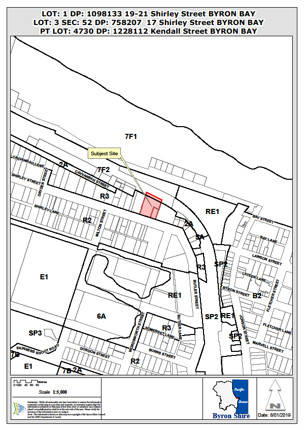
Assessment:
1. INTRODUCTION
1.1. History/Background
Council records of previous approvals:
5.1987.95.1 approved the construction of a motel and
manager’s residence. The approved plans indicated a total of 4 x 2
bedroom and 8 x 1 bedroom units. Bed numbers were not specified in the consent.
5.1998.215.1 approved Motel Additions and limited the
operation of the motel to a total of 40 persons, including the manager’s
residence
10.2000.476.1 approved Motel additions (new office).
10.2000.648.1, as modified, approved Motel additions
- construction of a first floor addition for an additional 5 motel rooms (i.e.
10 single beds or 5 double beds) - to the rear of the existing motel,
additional car parking and tree removal.
10.2004.346.1 approved Change of use – existing
motel to hostel (50 beds). Alterations that were within the scope of this
consent – e.g. change of use of manager’s residence to lower floor
common eating area and upper floor communal area – have not been
undertaken. Council’s Authority data base records no Construction
Certificate issued for DA 10.2004.346.1
10.2006.689.1 approved an amended car parking
arrangement to increase the on-site parking provision by 19 spaces. This
application was initially refused and, following amendment, approved via a S82A
Review. The new parking arrangement has not been constructed.
10.2010.196.1 refused change of use motel to hostel
of 73 rooms 208 beds in a 2 x 3 storey buildings with basement parking, bar
kitchen dining area & pool.
10.2013.595.1 DA withdrawn for use of an existing
motel up to 26 days a year for weddings.
The following two (2) development approvals are of
particular relevance to the proposal:
10.2016.55.1 Development
Application for Demolition of existing buildings and construction of two (2)
Residential Flat Buildings, Including Swimming Pool, Landscaping and Strata
Subdivision, consent granted 15 December 2016.
10.2018.73.1 Crown
Development Application for Boundary Adjustment (land subdivision), consent
granted 13 June 2018.
1.2. Description
of the proposed development
The development description is detailed below:
1. The demolition of the existing Wollongbar Motel and
adjoining dwelling, and limited tree removal;
2. The erection of 2 buildings comprising;
· No. 1
(north) containing 8 residential flats across 3 levels
· No. 2
(south) containing 11 residential flats across 3 levels
· Basement
car parking for 43 cars;
· Provision
of ancillary communal facilities, landscaping,17 bicycle spaces, storage and
infrastructure; and
· Strata
subdivision
The DA is similar to previously approved DA10.2016.55.1 and
proposes to increase the total number of units by 2 apartments by changing
configuration and reducing apartments (three (3) to two (2)) on upper level of
building no 1 and provision of additional level on building no 2 to provide
three (3) apartments. The north building is not changing location from that
approved by the DA10.2016.55.1. The proposed materials are the same as that
approved for both buildings.
The proposal
seeks a deferred commencement for registration of a subdivision of land that
was approved
13 June 2018 under DA10.2018.73.
The proposed total floor space ratio is 0.6:1 and the
maximum height of building 1 is 9.77m above existing ground level and building
2 is 9.88m above existing ground level. The applicant has submitted a
variation request under Clause 4.6 of Byron LEP 2014 to justify the variation
to the 9 metre maximum height. The proposed non-compliance with the
building height can be largely attributed to the existing variation in the
level of the land.
The subject site contains trees associated with Littoral
Rainforest which is identified as an Endangered Ecological Community (EEC). The
proposed development is not considered likely to have a significant impact on
the Littoral Rainforest EEC subject to conditions requiring:
· A detailed tree
protection plan to be prepared prior to construction and implemented throughout
the construction phase;
· provision of a
buffer between any tree protection zone and proposed Building No.1;and
· relocate the
proposed decking/path passing through the EEC area to the western side of
Building No.1.
The
proposal is considered to satisfy the provisions of State Environmental
Planning Policy No.65 Design Quality of Residential Apartment
Development. However, it is noted that
the development does not provide for any one or two bedroom dwellings in terms
of housing diversity or choice.
The
proposed three and four bedroom dwellings are able to provide for family
accommodation which is a desirable form of apartment size
in the context of existing housing stock and recent approvals of smaller
dwellings in this area.
There is a minor encroachment of the Building Height Plane
(BHP) adjacent to the eastern boundary for Building No.2. The proposal also involves
a minor encroachment within the specified 9 metre front setback to Shirley
Street. These encroachments are considered acceptable for the reasons detailed
in this report.
The subject site adjoins the north coast rail corridor to
the north. Conditions have been included to address potential noise and
vibration issues, and to protect the rail asset.
The application was notified in accordance with the Level 2
provisions of Council’s DCP 2014. Five submissions were received and have
been considered in this assessment.
Part of the site is currently zoned under LEP 1988 and it is
considered that the proposal avoids any construction on land zoned under Zone
It is considered the proposed development satisfies the
applicable planning controls including Byron LEP 2014 and Byron DCP 2014. The
proposed development has sufficient planning merit to warrant approval subject
to conditions of deferred commencement consent.
1.3. Description
of the site
|
Land is legally described as
|
LOT: 1 DP: 1098133, LOT: 3 SEC: 52 DP: 758207, Part LOT
4730 DP 1228112
|
|
Property address is
|
19-21 Shirley Street BYRON BAY, 17 Shirley Street BYRON
BAY
|
|
Land is zoned:
|
R3 Medium Density Residential
|
|
Land area is:
|
4,542.1m² (comprising 3,149 m² +
781.7m² + 611.4m²)
|
|
Property is constrained by:
|
Bushfire prone land
Acid Sulfate Soils Class 5
High Environmental Value – Littoral Rainforests
& Coastal Vine Thickets
|
Existing land use on Lot 1 is a Motel
comprising; 23 rooms, 51 beds, reception and services area including laundry, 3
bedroom managers accommodation, swimming pool and entertainment / event area,
landscaping and car parking for 26 vehicles.
Existing land use on Lot 3 is a Dwelling
erected approximately 1930-40’s timber framed clad in fibre
cement/asbestos sheeting with iron roof. The dwelling contains 3 bedrooms,
kitchen, lounge/dining area and has a floor area of approx. 180m2. A
garage and 2 other outbuildings clad in fibre cement / asbestos sheeting are
also on the land.
Surrounding land uses in the
Shirley Street locality (particularly along the northern side) comprises
predominately 2 and 3 storey buildings used for residential and short term
tourist accommodation. The buildings along the northern side comprise a mix of
older single storey dwellings (used for a range of service uses) and recently
erected or renovated 2 and 3 storey buildings used for residential and short
term tourist accommodation.
The site includes 611.4m² of land adjoining Lot 1 DP
1098133 along the northern boundary, approximately 10 m metres from the
centreline of the existing rail tracks. A Crown development
application for the boundary adjustment was approved in 2018. This
portion of rail land will be consolidated with that owned by Wollongbar
Property Pty Ltd. The functionality of the rail corridor will not be affected -
this land is not required for the purposes of public rail transport. It
is noted that similar subdivisions have occurred in the rail corridor west of
Byron Bay in the past where part of the land is surplus to rail infrastructure
requirements.
The land is approximately 150m
to the beach via the existing walking track and 340m from the Byron Bay central
business district via Shirley Street.
2. SUMMARY OF
REFERRALS
|
Referral
|
Issue
|
|
Development Engineer*
|
No objections subject to conditions. Refer to Doc # A2017/31858
and # E2019/6768
|
|
Building Surveyor
|
No objections. Refer to Doc # A2017/31587
|
|
S64 / Systems Planning Officer*
|
No objections subject to conditions. Refer to Doc # A2018/23558
|
|
S94 / Contributions Officer*
|
No objections subject to conditions. Refer to Doc # E2018/70999
|
|
Rural Fire Service (100B)*
|
No objections subject to conditions. Refer to Doc #
E2018/67699
|
|
John Holland Rail
|
No specific response to referral. Delegate of the
owner consent lodged with the DA documentation. Refer to Doc # E2017/110735
(pg. 11-12 of 251)
|
|
Transport for NSW
|
Owners consent granted and lodged with the DA
Documentation. Refer to Doc # E2017/110735 (pg. 10 of 251)
|
* Conditions provided in the above referral are included
in the Recommendation of this Report below.
3. SECTION 4.14
– BUSH FIRE PRONE LAND
Under section 4.14 of the Act, Council must be satisfied
prior to making a determination for development on bush fire prone land, that
the development complies with the document Planning for Bush Fire Protection
2006. The site is bush fire prone land. The development application was
referred to the NSW Rural Fire Service, which provided conditions which are
reflected in the Recommendation of this Report below.
EFFECT OF 10/50 RULE ON SIGNIFICANT VEGETATION
The parcel of land is located in a designated 10/50
vegetation entitlement clearing area. However, the online tool has identified
that the land parcel may exclude or otherwise restrict your clearing under the
10/50 Code. No clearing is permitted for the purposes of the 10/50 rule
based on the presence of High Environmental Value – Littoral Rainforests
& Coastal Vine Thickets.
4. SECTION 4.15C
– MATTERS FOR CONSIDERATION – DISCUSSION OF ISSUES
Having regard to the matters for consideration detailed in
Section 4.15(1) of the Environmental Planning & Assessment Act 1979
(EP&A Act), the following is a summary of the evaluation of the issues.
4.1 State Environmental
Planning Instruments
|
|
Satisfactory
|
Unsatisfactory
|
|
State
Environmental Planning Policy No 55—Remediation of Land
|
☒
|
☐
|
|
Consideration:
The site is suitable for the proposed development with
consideration for whether the land is contaminated and that the land can be
made suitable for the proposed use:
Preliminary
Contaminated Land Assessment No. 16117_SEPP 55.docx prepared by Greg Alderson
& Associates dated 10th December 2015. The report finds
that results from soil sampling undertaken revealed that concentrations of
heavy metals are within reporting guidelines set out in Table 1A(1) of
NEPM 1999 (2013) under Residential A, using ‘adjusted acceptable
levels,’ while EILs were calculated for the site using the
urban/residential sensitivity levels.
The
report found that The concentration of lead in Composite Sample 2 was
above the adjusted acceptable limit of 75mg/kg triggering analysis of the
individual samples of the composite. The results of the analysis provided
that the concentration in the individual samples, although elevated, were
below the conservative HIL for Residential A. It is recommended that
waste soils be removed from the site and disposed at a licenced waste
facility. A condition has been imposed.
The
subject site is likely to have contained fibro buildings prior to the
construction of the current motel. To ensure that any buried rubbish or
contaminated materials uncovered following demolition are managed in
accordance with statutory requirements, it is further recommended that the
applicant provide to Council an Unexpected Findings Protocol prepared
by a suitably qualified professional.
Conditions have been
recommended to ensure that demolition, construction and building works are in
accordance with the UFP.
In accordance with the
assessment of DA 10.2016.55.1 it is recommended that waste soils be removed
form the site and disposed at a licenced waste facility. A condition
has been imposed.
To ensure that any buried
rubbish or contaminated materials uncovered following demolition are managed
in accordance with statutory requirements, it is further recommended that the
applicant provide to Council an Unexpected Findings Protocol (UFP) prepared
by a suitably qualified professional.
Conditions have been recommended to ensure that
demolition, construction and building works are in accordance with the UFP.
The site is considered to be clear from radioactivity /
radioactive sands according to Byron Bay Radiation Maps from DECC Radiation
Unit - Refer to CM Doc # DM742313 and 742315.
The nearest dip site is located over 900 metres to the
north west in the vicinity of Kendall Street.
No further investigation is required at this stage.
|
|
State
Environmental Planning Policy No 65—Design Quality of Residential
Apartment Development
|
☒
|
☐
|
|
Consideration: *See a summary
assessment of the proposal having regard to SEPP No.65 immediately following
this table.
|
|
State Environmental Planning
Policy No 71 – Coastal Protection
|
☒
|
☐
|
|
SEPP 71 was repealed on 3 April 2018, however still
applies under Clause 21 of SEPP (Coastal Management) 2018. The development
application was lodged prior to the commencement of SEPP (Coastal Management)
2018.
Council must have regard for the
matters of consideration under Parts 2 and 4 of SEPP No. 71 when assessing
development within the coastal zone. These matters include:
· retention of existing public access to the coastal
foreshore
· impact of effluent disposal on water quality
· development must not discharge untreated stormwater into
a coastal water body
Consideration:
· The proposal has
no impact on public access to the coastal foreshore.
· No effluent is
proposed to be disposed other than to Council’s sewerage system.
· Stormwater
– A condition has been included to require separate approval of the
stormwater management plan including details of the method of treating
stormwater runoff.
|
|
State Environmental Planning Policy (Building
Sustainability Index: BASIX) 2004
|
☒
|
☐
|
|
Consideration: A Basix Certificate was submitted with the
application.
|
|
State
Environmental Planning Policy (Infrastructure) 2007
|
☒
|
☐
|
|
Consideration:
The application was referred to the relevant NSW rail
authority. Issues raised relate to depth of excavation and proximity of
the rail corridor, geotechnical details, noise and vibration. Conditions have
been included to address these issues.
Beach access across rail corridor shown requires separate
approval from NSW Government.
The proposed development has frontage to a classified
road. The proposed development is considered acceptable having regard to the
matters in Clause 101. The application for a construction certificate must
include plans and specifications that demonstrate the inclusion of acoustic
treatments recommended in Section 7 of report entitled Wollongbar Property
PTY 17-21 Shirley Street Byron Bay Acoustic Assessment for Development’
prepared by GHD dated December 2015.
|
State Environmental Planning Policy No.65 - Design
Quality of Residential Apartment Development
Clause 28 Determination
of Development Applications
(2) In determining a development application for consent to
carry out development to which this Policy applies, a consent authority is to
take into consideration (in addition to any other matters that are required to
be, or may be, taken into consideration):
(a) the advice (if any) obtained from the design
review panel, and
(b) the design quality of the development when
evaluated in accordance with the design quality principles, and
(c) the Apartment Design Guide.
Assessment:
The
Minister has not formed a Design Review Panel for the Byron Shire Local
Government Area accordingly no advice has been received.
The
applicant has submitted a Statement prepared by a Registered Architect
specifically addressing each of the nine (9) design quality principles of Context and neighbourhood character, Built form and
scale, Density, Sustainability, Landscape, Amenity, Safety, Housing diversity
and social interaction and Aesthetics.
It
is considered the proposed design has adequately addressed each of the design
quality principles apart from Principle 8: Housing Diversity and Social
Interaction which states:
Principle 8: Housing Diversity and Social
Interaction
Good design achieves a mix of apartment sizes,
providing housing choice for different demographics, living needs and household
budgets.
Well designed apartment developments respond to
social context by providing housing and facilities to suit the existing and
future social mix. Good design involves practical and flexible features,
including different types of communal spaces for a broad range of people,
providing opportunities for social interaction amongst residents.
All
of the proposed dwellings contain three and (2x) four bedrooms with relatively
larger apartment floor areas. This proposal does not provide for any single or
two bedroom dwellings and it may be considered that the proposal does not
provide for housing diversity or housing choice.
This
matter was considered in detail under DA 10.2016.55.1 report to Council (Doc No
# I2016/1170)
Notwithstanding
the above, the proposed development is considered to add to housing diversity
and choice within the Byron Bay township for the following reasons:
· Council has approved in excess of 500 secondary
dwellings over the past 5 years, consisting of one or two bedrooms. One hundred
and twenty one of these dwellings are located in Byron Bay, and a further sixty
nine in Suffolk Park.
· Generally, the proposed three bedroom apartments
are a less common apartment type in Byron Bay with single and two bedroom
apartments being more commonplace;
· The three bedroom apartments are able to provide
for family accommodation (including families comprising two adults with two or
more children), whilst the design also lends itself to home office/ working
arrangements ;
· Currently under construction and in close proximity
(at the corner of Kendall Street and Ewingsdale Road) is a multi dwelling
housing development comprising 12 single bedroom dwellings.
It
is considered the three and four bedroom dwellings are an appropriate response
to the site and economic factors currently driving the residential
market.
The applicant has
submitted a statement prepared by a Registered Architect specifically
addressing Part 3 Siting the Development and Part 4 Designing the Building. The
proposed development is considered to be a satisfactory response to the Design
Guide.
4.2A Byron Local Environmental Plan 2014 (LEP 2014)
LEP 2014 is an applicable matter for consideration in the
assessment of the subject development application in accordance with subsection
4.15(1) of the EP&A Act because it applies to the subject land and the
proposed development.
In accordance with LEP 2014 clauses 1.4 and 2.1 – 2.3:
(a) The
proposed development is defined in the LEP 2014 Dictionary as Residential flat
building;
(b) The
land is within the R3 Medium Density Residential according to the Land Zoning
Map;
(c) The
proposed development is permissible with consent; and
(d) Regard
is had for the Zone Objectives as follows:
|
Zone Objective
|
Consideration
|
|
· To provide for
the housing needs of the community within a medium density residential environment.
· To provide a
variety of housing types within a medium density residential environment.
· To enable other
land uses that provide facilities or services to meet the day to day needs of
residents.
|
It is considered that the proposed development of 19
residential apartments is satisfactory with regards to the objectives of the
zone.
|
The relevant clauses have been taken into consideration in
the assessment of the subject development application in accordance with
subsection 4.15(1) of the EP&A Act. The proposed development complies with
all of these clauses (in some cases subject to conditions and/or to the
satisfaction of other assessing officers), except in relation to which
considered further as follows:
Clause 4.6 – Request to vary building height
1. Non-compliance
with Clause 4.3 Height of buildings (Clause 4.6 assessment)
Clause 4.6(3) specifies:
(3) Development
consent must not be granted for development that contravenes a development
standard unless the consent authority has considered a written request from the
applicant that seeks to justify the contravention of the development standard
by demonstrating:
(a) that
compliance with the development standard is unreasonable or unnecessary in the
circumstances of the case, and
(b) that
there are sufficient environmental planning grounds to justify contravening the
development standard.
(4)
Development consent must not be granted for development that contravenes a
development standard unless:
(a) the consent
authority is satisfied that:
(i) the
applicant’s written request has adequately addressed the matters required
to be demonstrated by subclause (3), and
(ii) the
proposed development will be in the public interest because it is consistent
with the objectives of the particular standard and the objectives for
development within the zone in which the development is proposed to be carried
out, and
(b) the concurrence of the Secretary has been
obtained.
Assessment: A written
request has been submitted by the applicant seeking to justify a building
height variation. The maximum height of the proposed building is calculated to
9 metres.
The max height of roofs of the
buildings is:
Building No. 1 - 9.77m (8.6%
variation)
Building No. 2 - 9.88m (9.8%
variation)
The written request indicates that a small section of the
roof parapet safety rail of Building No. 2 will have a height of 9.99m (11%
variation) above existing ground level.
The applicant has provided matters to justify the proposed contravention;
the relevant matters are assessed as follows:
- The
proposed 0.88m height variation is considered minor in nature. The level of the
site varies by across the proposed footprint of both buildings and the proposed
non-compliance with the building height can be largely attributed the existing
variation in the level of the land.
- The
height of the adjacent building at No.9 Shirley Street is higher than the
proposed height of Building No.1 (RL14.64). The proposed increase in height and
bulk of the building is considered to be compatible with the existing
streetscape.
Building No. 1 approved in
DA No. 10.2016.55.1
in
part exceeded 9m from existing
ground level.
There was previously
only 1 point on Building No. 2 that
exceeded 9m from existing ground level by more than
10% and that was located at the roof parapet / safety rail of Building No.
2. Building parapet design levels / heights have been reviewed to ensure development does not exceed 9m by more than 10%.
The sections in the clause 4.6 report show the ‘height
control – building envelope’ plan shows those parts of the roof and
parapet that exceed 9m from existing ground level in perspective
diagrams.
The isometric models of
the approved development shown in grey over the red plane are parts of the
approved buildings that exceed 9m above existing ground level:
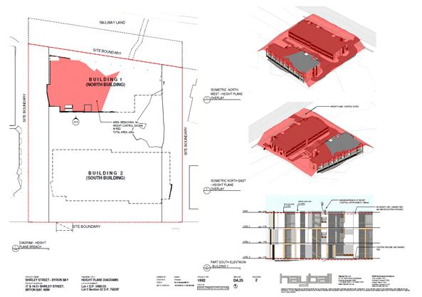
The isometric
models of the proposed development shown in grey
over the green plane
are parts of the proposed buildings that exceed
9m
above existing ground level:
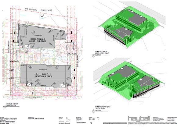
The plans of
the building elevations show the
height relative to existing ground level. The difference and
irregular existing levels across the site gives
rise to the proposed departure from strict compliance
with the 9m building height.
The variation is reasonable.
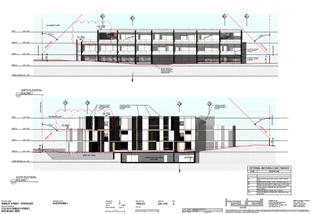
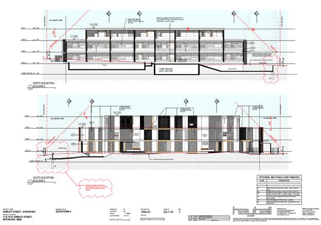
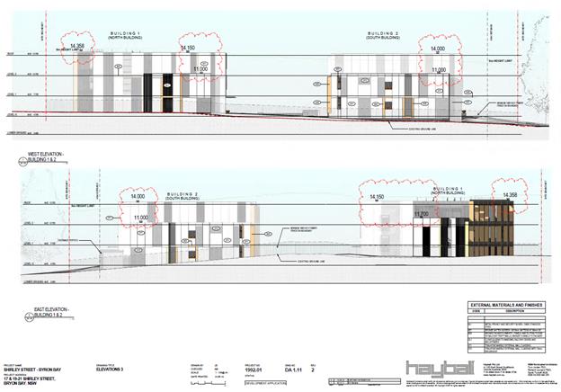
The development is visually
different to development on adjoining
land. It is compatible in height, bulk and
scale and will sit in the existing streetscape as shown in the streetscape
elevation:
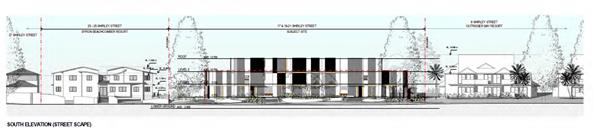
Council can be satisfied that the three storey buildings are
consistent with character of the Shirley Street locality and will minimise
visual impact, disruption of views, loss of privacy and loss of solar access to
existing development.
The proposed building provides for generous
side setbacks and, at the upper level,
the side setbacks
are increased further
again. The maximum
height of the proposed
buildings is comparable
to the maximum height of the ridgelines of the pitched roofs of adjacent properties, and also with the ridgeline
of the motel which it is replacing.
The established trees to the front setback are to be retained, and supplemented with new planting.
A comparison of the current, approved and proposed elevations
demonstrate that the frontage can be considered to complement the streetscape
and character of the north Shirley Street area:
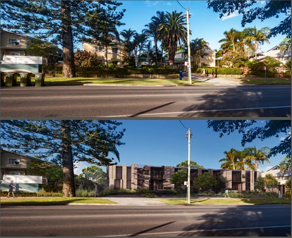
Current and approved
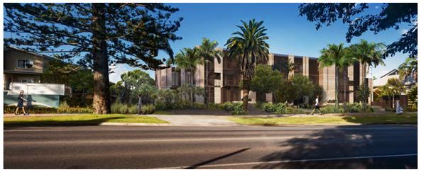
Proposed
It is considered that the development standard (height of
buildings) has been demonstrated to be unreasonable or unnecessary in the
circumstances of this case.
It is considered that the applicant’s written request
has adequately addressed the matters required to be demonstrated in subclause
3.
The objectives of Clause 4.3 (height of buildings) are as
follows:
(a) to
achieve building design that does not exceed a specified maximum height from
its existing ground level to finished roof or parapet,
(b) to
ensure the height of buildings complements the streetscape and character of the
area in which the buildings are located,
(c) to
minimise visual impact, disruption of views, loss of privacy and loss of solar
access to existing development.
(2)
The height of a building on any land is not to exceed the maximum height shown
for the land on the Height of Buildings Map.
It is considered the proposed height of the building
satisfies the objectives of Clause 4.3. The proposed building height is not
considered to be excessive in the immediate streetscape and should not detract
from the character of the area.
The proposed portion of Building No.1 exceeding the height
limit should not result in any unacceptable overshadowing of neighbouring
properties. Subject to conditions relating to privacy screens the proposed
development should not result in any unacceptable loss of privacy to any
neighbouring property.
No written objection has been received relating to the loss
of views. The proposal is not considered likely to result in any significant
loss of views by neighbouring properties.
The proposed development is considered to be generally
consistent with the objectives of the R3 Medium Density Residential Zone as
these objectives do not refer to built form.
The concurrence of the Secretary has been obtained. Concurrence
of the Secretary is able to be assumed for non-compliances with Clauses 4.6
(pursuant to NSW Planning System Circular PS 18-003).
Note. the assessing officer has confirmed that
the calculation of
gross floor plan area and floor space
ratio (FSR) is consistent with
the definition for gross floor area in the Byron LEP 2014. There is no variation
required to the FSR development standards.
Acid Sulfate Soils
Acid Sulfate Soils was considered in the assessment of
DA10.2016.55.1 and all relevant conditions of consent have been repeated in the
recommended conditions of consent below:
Preliminary Acid Sulfate Soil Assessment No. 16117_SEPP
55.docx prepared by Greg Alderson & Associates dated 10th
December 2015 indicates that potential acid soil is likely to be located at
0.0m AHD at approximately 4m below the natural ground level. Works for
the development including excavation required for the basement car parks and
stormwater detention tank are not likely to intercept these soils.
Notwithstanding the lowest excavation is at approximately 1.2AHD with the water
table depth being recorded at around 1.6-1.7AHD. dewatering is likely to
be required. The applicant is required to submit a Dewatering Management
Plan and Groundwater Contingency Plan for approval prior to issue of a
Construction Certificate. Information provided by the applicant dated 24/5/16
(#2016/7607) confirms that no infrastructure will be installed below the
basement.
4.2B Byron Local Environmental Plan 1988 (LEP 1988)
LEP 1988 is an applicable matter for consideration in the
assessment of the subject development application in accordance with subsection
4.15(1) of the EP&A Act because it applies to the subject land and the
proposed development.
The relevant clauses have been taken into consideration in
the assessment of the subject development application in accordance with
subsection 4.15(1) of the EP&A Act.
The part of the site subject to Byron LEP 1988 clauses will
not include any building or structures and it is therefore considered to be of
limited relevance to the proposed development. The proposed
development complies with LEP 1988 (in some cases subject to conditions and/or
to the satisfaction of other assessing officers).
4.3 Any proposed Instrument
that has been the subject of public consultation and has been notified to the
consent authority
State Environmental Planning Policy (Coastal Management)
2018
State Environmental Planning Policy (Coastal Management)
2018 (the Coastal management SEPP) commenced on 3 April 2018. The SEPP
forms part of a suite of legislative changes which included the introduction of
the Coastal Management Act 2016 and the repeal of SEPP 14—Coastal
Wetlands, SEPP 26—Littoral Rainforests and SEPP 71—Coastal
Protection.
Clause 21 of the SEPP provides that the former planning
provisions continue to apply (and the SEPP does not apply) to a development
application lodged, but not finally determined, immediately before the
commencement of the policy. ‘Former planning provisions’ is defined
in clause 21 as follows:
former planning provisions means:
(a) the
provisions of each of the following Policies as in force immediately before the
Policy’s repeal:
(i) State Environmental Planning Policy No 14—Coastal
Wetlands,
(ii) State Environmental Planning Policy No 26—Littoral
Rainforests,
(iii) State Environmental Planning Policy No 71—Coastal
Protection, and
(b) the
provisions of State Environmental Planning Policy (Infrastructure) 2007 that
would be in force if that Policy had not been amended by this Policy.
The subject application was lodged prior to the introduction
of the Coastal Management SEPP.2018. Accordingly, the development application
has been assessed in accordance with applicable former planning provisions.
4.4A Byron Shire Development Control Plan 2014
(DCP 2014)
DCP 2014 is an applicable matter for consideration in the
assessment of the subject development application in accordance with subsection
4.15(1) of the EP& A Act because it applies to the land to which LEP 2014
applies.
The relevant Parts/Chapters have been taken into
consideration in the assessment of the subject development application in
accordance with subsection 4.15(1) of the EP&A Act. The proposed
development is demonstrated to meet the relevant Objectives of all relevant
Parts/Chapters (in some cases subject to conditions and/or to the satisfaction
of other assessing officers).
Issues:
Building height plane and front set back encroachments were
assessed under DA 10.2016.55.1. The proposed development reduces the
encroachment on the building height plane previously approved and the set backs
are generally consistent with those assessed and approved under DA
10.2016.55.1.
1. Building
height plane encroachments
Section D1.2.1 Building Height Plane specifies, in part:
1. The building height plane in
combination with boundary setbacks prescribed in this DCP, and building height prescribed
in the Byron LEP 2014, form the maximum building envelope for all residential
development other than for shop top housing and ancillary dwellings in Zones
IN1, IN2 and B7.
2. An exemption from the building height plane may be
considered in relation to one or more boundaries in the following
circumstances:
- where the floor level is required to be
above ground level to comply with Council’s requirements for flood
protection; or
- for the zero lot line boundaries of semi-detached
dwellings and attached dwellings; or
- in circumstances referred to in Prescriptive
Measure 2. of Section D1.2.2 (see following).
2. Minimum Side
and Rear Boundary Setbacks
a) Side
and rear setbacks are to be a minimum 900mm, with all dwellings also complying
with the requirements of the building height plane.
b) In
urban residential areas, Council may consent to the construction of one or more
building walls set back less than 900mm from a side or rear boundary, such that
the building/s cannot comply with the building height plane, where:
i) such wall or walls contain
no openings; and
ii) it is
demonstrated to Council's satisfaction that the development, if carried out,
would improve the siting or orientation of the dwelling/s or the provision of
private open space; and would not significantly:
· increase
the overshadowing of adjoining properties; or
reduce the level of privacy enjoyed by adjoining
properties.
Assessment: The proposed development encroaches the BHP adjacent to
the eastern side boundary. The proposed encroachments are considered acceptable
in this instance as it would not significantly increase the level overshadowing
of adjoining properties and would not reduce the level of privacy enjoyed by adjoining
properties.
The
applicant has submitted shadow diagrams which identify the existing two-storey
Outrigger Bay Resort development on the adjoining allotment to the east
(No.9-13 Shirley Street). The shadow diagrams illustrate that the shadows cast
from the proposed buildings result in limited overshadowing of the neighbouring
property at the winter solstice. The proposal is considered acceptable having
regards to the minimum setbacks to the side boundary and the performance
criteria and objectives underpinning this design element in the DCP.
The Clause 4.6 objection lodged with the DA to vary the 9m building height was submitted with building
height plane drawings from existing ground levels.
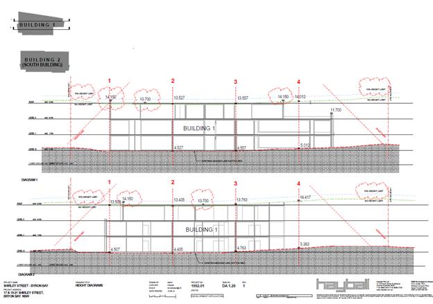
Building 1 Building
Height Plane- Proposed
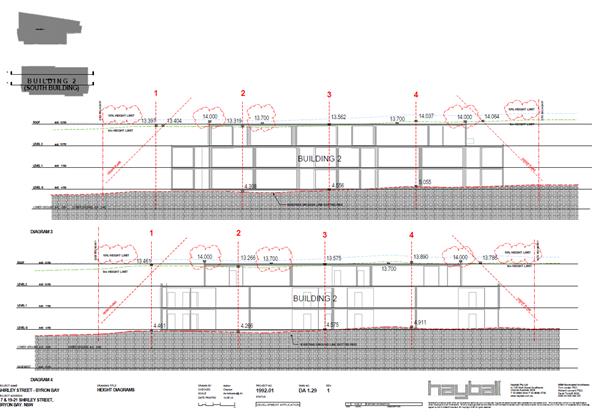
Building 2 – Building Height Plane
3. Front
setback encroachment
Objectives
1. To achieve varied and interesting
streets that complement and harmonise with existing and planned streetscapes
and development in the locality.
2. To achieve good orientation and
spacing of residential developments that achieve high quality living
environments relative to sunlight, shade, wind and weather protection,
residential amenity and proximity of neighbouring development.
3. To achieve effective use of allotments
to create useable and liveable private open space and courtyards.
4. To provide flexibility in siting
and design of dwelling house development in urban residential areas.
Performance Criteria
(extracts only)
The setback from a street
frontage for a building that is part of a residential development will be
determined on its merits, having regard to:
a) the
Objectives;
b) any
provisions of this DCP applying to the specific location;
c) the
position of any existing buildings in the locality;
d) the size
and shape of the allotment;
e) the
effect on vehicular safety and visibility, particularly on corner sites;
f) the
orientation of the allotment and the proposed dwelling with regard to the sun
and prevailing winds;
g) the
proposed location of any private open space, courtyard or landscaped areas;
h) the
facade of the proposed building or buildings which will face the street and the
proposed landscape treatment of that part of the allotment which is visible
from the street;
i) the
location and treatment of any car parking areas or car parking structures on
the site.
When considering applications
for variations to minimum setbacks nominated below in the Prescriptive
Measures, Council will have regard to:
a) the
Objectives;
b) compliance
with the Performance Criteria;
c) the visual
impact of the variation on the streetscape;
d) the
impact of the variation on the amenity, privacy, views and access of
surrounding properties;
e) the existing
and future status of the road;
f) potential
traffic impacts and required sight lines as per AS2890; and
g) compliance
with the Building Code of Australia.
Assessment:
Section D1.2.2 Setbacks from Boundaries specifies a minimum
setback of 9.0 metres from the primary front boundary to a classified road.
Having regard to the Objectives and Performance Criteria of Section D1.2.2 it
is considered that the proposed front setback is acceptable in view of the
following matters:
· the main
building line is setback 8.3m with a portion of the building being 7.3m (the
proposed main building encroaches 1.7m and 2.7m forward of the minimum
setback);
· the proposed
variation to the front setback will not detract from the amenity, views or
access of surrounding properties;
· existing
buildings on adjoining allotments have a similar front setback (adjacent
building at 9-13 Shirley Street (Outrigger Bay Resort) has a front setback of
5.81m, 23-25 Shirley Street has a front setback of 8.83m and 27 Shirley Street
has a front setback of 6.07m);
· the proposed
development is considered to be compatible with the streetscape,
· the proposed
development is capable of compliance with the Building Code of Australia and
sight lines as per AS2890.
Having regard to the performance
criteria and objectives underpinning this design element a variation to the
numerical standard is supported in this instance.
4.4B Byron Shire Development Control Plan 2010 (DCP 2010)
DCP 2010 is an applicable matter for consideration in the
assessment of the subject development application in accordance with subsection
4.15(1) of the EP& A Act because its purpose is to provide planning
strategies and controls for various types of development permissible in
accordance with LEP 1988.
The part of the site subject to Byron DCP 2010 will not
include any building or structures and it is therefore considered to be of
limited relevance to the proposed development. The relevant
Chapters/Parts have been taken into consideration in the assessment of the
subject development application in accordance with subsection 4.15(1) of the
EP&A Act. The proposed development is demonstrated to meet the relevant
Objectives of DCP 2010 (in some cases subject to conditions and/or to the
satisfaction of other assessing officers).
4.5 Any Planning Agreement or
Draft Planning Agreement?
Not applicable
4.6 Environmental Planning
& Assessment Regulation 2000 Considerations
|
Clause
|
This control is applicable to the proposal:
|
I have considered this control as it relates to the
proposal:
|
If this control is applicable, does the proposal
comply?
|
|
92
|
Yes
|
Yes
|
Yes
|
|
93
|
No
|
N/A
|
N/A
|
|
94
|
No
|
N/A
|
N/A
|
|
94A
|
No
|
N/A
|
N/A
|
|
97
|
Yes
|
Yes
|
Yes
|
* Non-compliances and any other significant issues
discussed below
Clause 97 Modification or surrender of development
consent or existing use right
(cf clause 68 of EP&A Regulation 1994)
A condition of consent is recommended that the applicant
surrender DA 10.2016.55.1 and also to surrender existing use rights for tourist
accommodation on the site prior to issue of a construction certificate.
4.7 Any Coastal Zone Management
Plan?
|
|
Satisfactory
|
Unsatisfactory
|
Not applicable
|
|
Is there any applicable coastal zone management plan?
|
☐
|
☐
|
☒
|
|
Consideration: There is no coastal zone management plan in
force at this time.
|
4.8 The likely impacts of that
development, including environmental impacts on both the natural and built
environments, and social and economic impacts in the locality
|
Impact on:
|
Likely significant impact/s?
|
|
Natural environment
|
No. The proposal will not have a significantly adverse
impact on the natural environment of the locality.
|
|
Built environment
|
No. The proposal will not have a significantly adverse
impact on the built environment of the locality.
|
|
Social Environment
|
No. The proposal will not have a significant social impact
on the locality.
|
|
Economic impact
|
No. The proposal will not have a significant economic
impact on the locality.
|
The proposed development is considered to be compatible with
the built form of existing medium density development within the immediate
area. The proposal is compatible with the natural environment and unlikely to
result in any unacceptable impacts.
The proposal will provide for positive economic impacts
during the construction phase in terms of employment and building suppliers and
associated multiplier effects are expected through the local economy, whilst
socially the development will deliver additional housing.
The proposed development has been assessed in accordance
with Council Policies that are applicable to the proposed development.
4.9 The suitability of the site
for the development
Having regard to the site constraints of bush fire prone
land, coastal erosion and acid sulphate soils, the site is considered to be
suitable for the proposed development subject to the conditions included in the
recommendation.
The subject site adjoins the north coast rail corridor to
the north. Conditions have been included to address potential noise and
vibration issues.
4.10 Submissions made in accordance with
this Act or the regulations
The development application was publicly exhibited.
There were 5 submissions made against the development application. The
issues raised in the submissions are considered further as follows:
Issue – use of railway land
Response: The site includes 611.4m² of land
adjoining Lot 1 DP 1098133 along the northern boundary, approximately 10 m
metres from the centreline of the existing rail tracks. A Crown
development application for the boundary adjustment was approved in
2018. This portion of rail land will be consolidated with that owned by
Wollongbar Property Pty Ltd. The functionality of the rail corridor will not be
affected - this land is not required for the purposes of public rail
transport. It is noted that similar subdivisions have occurred in the
rail corridor west of Byron Bay in the past where part of the land is surplus
to rail infrastructure requirements.
Issue
– increase in bulk and scale
Response:
Bulk and scale was considered in the assessment of DA No. 10.2016.55.1 and
further in this assessment with a minor change to what is approved.
The
width of both buildings remains as approved in DA No. 10.2016.55.1. The height
of Building No. 2 will increase, though the difference is considered
justifiable with consideration for the provisions of Clause 4.6 in Byron LEP
2018.
Issue
– traffic generation
Response:
Council development engineers have assessed the additional 2 residential flats
and it is considered:
DA
102017.55.1 estimated 110 DVT’s based on 6.5 DVT’s per 3 bedroom
unit. Increasing the development by 2 * 4 bedroom units is not expected to be a
concern in regards to traffic. Given the sites proximity to the main centre the
actual traffic volume will be somewhat lower than 133 DVT’s.
Issue
– ensuring use of residential flats preventing use for tourists
Response:
The land use zone is R3-medium density residential, which permits residential
flat buildings. The existing motel is an ‘existing use’ as motels
are a prohibited development in the R3 zone.
A
condition of consent requiring the surrender of the previous DA 10.20165.55.1
and also to surrender existing use rights for the purposes of tourist and
visitor accommodation is included in the recommendation.
4.11 Public interest
The proposed development is unlikely to prejudice or
compromise the public interest or create an undesirable precedent.
5. DEVELOPER
CONTRIBUTIONS
5.1 Water & Sewer Levies
Section 64 levies will be payable.
5.2 Section 7.11 Contributions
Section 7.11 Contributions will
be payable.
This development will result in
an increased demand for public facilities and it is appropriate to impose a
condition of consent requiring the payment of contributions.
The credit for the site is
calculated as follows:
|
Development Type
|
Standard
Unit
|
Quantity
|
ET Rate (ET/unit)
|
|
|
1993 & 2001 S94 Plans
|
|
|
Managers Residence
(3 Bedrooms)
|
Dwelling
|
1
|
1
|
1.00
|
|
No. One Bedroom
Motel rooms
|
Room
|
19
|
0.25
|
4.75
|
|
No. Two Bedroom
Motel rooms
|
Room
|
8
|
0.5
|
4
|
|
Total
|
|
|
|
9.75
|
6. CONCLUSION
The proposed development is consistent with the relevant
environmental planning instruments and planning controls applicable to the
site. The proposal raises no significant issues in terms of environmental
impacts which cannot be managed and the site is considered suitable for the
development. The application is recommended for approval subject to conditions
of deferred commencement consent.
7. REASONS
FOR DECISION, HOW COMMUNITY VIEWS WERE ADDRESSED
Note:
From July 1 2018, Council’s are required to give and publicly notify
reasons for a range of planning decisions where they are deciding if
development should proceed to help community members to see how their views
have been taken into account and improve accountability to stakeholders. A
statement of reasons for the determination of this application is provided
below.
|
Statement of Reasons
|
|
The proposed development complies with the provisions of
Byron Local Environmental Plan 1988.
|
|
The proposed development complies with the provisions of
Byron Local Environmental Plan 2014.
|
|
The proposed development complies with relevant State
Environmental Planning Policies
|
|
The proposed development complies with relevant provisions
of Development Control Plan 2014
|
|
The proposed development complies with relevant provisions
of Development Control Plan 2010
|
|
The proposed development complies with Environmental
Planning & Assessment Regulation 2000 considerations.
|
|
The proposed development complies with the Coastal Zone
Management Plan.
|
|
The proposed development will not have significant adverse
impact on the natural, built or social environment or economic impacts on the
locality.
|
|
The proposed development is considered suitable for the
proposed site.
|
|
The development application was notified/advertised in
accordance with Development Control Plan 2014. Issues raised in the
submissions have been addressed during assessment of the application.
|
|
The proposed development is unlikely to prejudice or
compromise the public interest.
|
|
How community views were addressed
|
|
The DA was advertised in accordance with Development
Control Plan 2014. The submissions received were considered on merit and
addressed during assessment of the application.
To view the considerations, please contact Council to view
a copy of the assessment report relating to this DA.
|
8. DISCLOSURE OF
POLITICAL DONATIONS AND GIFTS
|
Has a Disclosure Statement been received in relation
to this application
|
No
|
|
Have staff received a ‘gift’ from anyone
involved in this application that needs to be disclosed. Where the answer is
yes, the application is to be determined by the Director or Manager of the
Planning, Development and Environment Division.
|
No
|
Provide Disclosure Statement register details here: Not
applicable
Staff Reports - Sustainable Environment and Economy 6.7
Report No. 6.7 26.2018.2.1
- Planning Proposal for an amendment to Byron LEP 2014 and Byron LEP 1988 to
permit Community Title subdivision and dwellings at Lot 1 DP 1031848, Broken
Head Road, Broken Head (The Linnaues Estate)
Directorate: Sustainable
Environment and Economy
Report
Author: Steve
Daniels, Project Officer - Planning Reforms
File No: I2019/103
Summary:
Council has
received a planning proposal to amend Byron LEP 2014 and Byron LEP 1988. The
planning proposal is to include Lot 1 DP 1031848 (The Linnaeus Estate, Broken
Head) in Schedule 1 of BLEP 2014 and Schedule 8 of BLEP 1988 to permit the
Community Title subdivision of the land to create 33 small lots, with the
balance in a single community lot. The use of the small lots for dwellings is
foreshadowed subject to future development consent. The planning proposal is
consistent with the Byron Rural Land Use Strategy 2017 and the North Coast
Regional Plan.
It is recommended that Council proceed with the planning
proposal as submitted and forward it to the Department of Planning and
Environment for a Gateway Determination.
|
RECOMMENDATION:
That Council:
1. Request
the NSW Department of Planning and Environment to issue a Gateway
determination for the planning proposal, as included at Attachment 1 (E2018/87474)
which proposes to include Lot 1 DP 1031848 (The Linnaeus Estate, Broken Head)
in Schedule 1 of BLEP 2014 and Schedule 8 of BLEP 1988 to permit the
Community Title subdivision of the land to create 33 small lots, with the
balance in a single community lot.
2. Obtain
any further studies from the applicant if required
by the Gateway determination. Then undertake public exhibition of the
planning proposal and government agency consultation based on the Gateway
determination; and
3. Receive
a further report post-exhibition about issues raised in public and/or
government agency submissions received (if any).
|
Attachments:
1 26.2018.2.1
- Planning Proposal for Amendment of Byron LEP 2014 and Byron LEP 1988 –
Lot 1 DP 1031848, The Coast Road, Broken Head - Version 1 (Gateway), E2018/87474
REPORT
Subject Land
The subject land is described as
Lot 1 DP 1031848, The Coast Road, Broken Head (The Linnaeus Estate). It is an
area of 111 hectares with a 1500 metre beach frontage and a 530 metres frontage
to The Coast Road. It is located on the boundary with Ballina Shire
immediately south of Broken Head. It has a series of approvals relating
to its use as a private education facility. These approvals include 33
accommodation units of which 20 have been built.
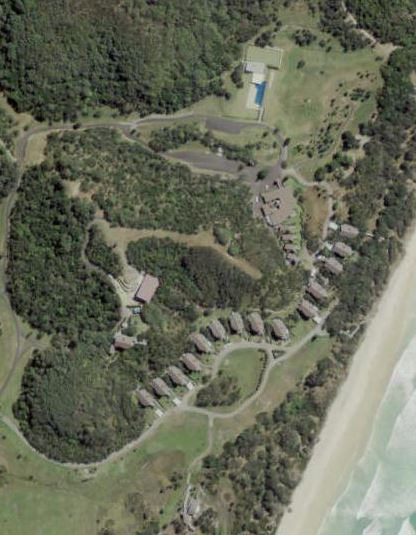
Subject
site (in part) showing existing structures
The Planning Proposal
The planning proposal
(Attachment 1) will permit:
§ A
subdivision using a neighbourhood community title scheme creating a total of 33
neighbourhood lots with a minimum size of 250m2 each. Each lot
can be privately owned. It will also include one lot comprising the residue of
the land that will be in shared ownership.
§ Each
privately owned lot to contain only one dwelling.
The proponent has lodged the planning proposal because the
amendment will permit the subdivision of the existing and approved
accommodation units allowing clear title to each of them. Community Title will
replace the complex trust/lease/deed arrangement currently in place. Each
accommodation unit can be used as a dwelling if the owners obtain Council
consent.
Past
Council Resolutions on this Planning Proposal
On 2 February 2015 Council considered a draft
Planning Proposal for an amendment to the Byron LEP 2014 to rezone land and
permit Community Title at Lot 1 DP 1031848, The Coast Road, Broken Head (The
Linnaeus Estate). The planning proposal was unsolicited and submitted by the
landowners. Council resolved as follows:
15-029 Resolved:
1. That
Council decline to proceed with the attached planning proposal to amend Byron
LEP 2014.
2. That
Council investigate the suitability of the site for Community Title subdivision
during preparation of the Byron Urban and Rural Housing Strategy.
3. That
Council defer any new zonings on the site until after release of the final E
zone review report.
4. That,
at the next general update of Byron LEP 2014, Council agree to amend the SP1
zone on Lot 1 DP 1031848 to refer to a private education facility and amend
Schedule 1 to define private education facility and specifically permit it as a
use on the subject land.
In July 2018 the NSW Department of Planning
and Environment agreed to the Byron Rural Land Use Strategy. This Strategy now
includes the subject land.
New zones on the subject land are still
being considered as part of the E zone review and this is subject to a separate
planning proposal.
Council has amended the current SPI zone
(as part of the LEP housekeeping amendments gazetted in 2017) to refer to
“Mixed Use Development”. Mixed use development
means a building or place comprising 2 or more different land uses. Additionally, the amendment identified the
SP1 zoned land as “Area D” on the Additional Permitted Uses Map and
is subject to clause ‘8’ in Schedule 1 of Byron LEP 2014. The
additional permitted use is as follows:
8 Use of
certain land at Coast Road, Broken Head
(1) This
clause applies to land at The Coast Road, Broken Head (known as the Linnaeus
Estate) being part of Lot 1, DP 1031848, and identified as “Area D”
on the Additional Permitted Uses Map.
(2) Development
for the purposes of mixed use development that includes tourist or visitor
accommodation is permitted with development consent.
(3) Development
consent may only be granted under this clause if the consent authority is
satisfied that the proposed development:
(a) is
ancillary to a lawful existing land use, and
(b) is
for the purpose of providing education or training for professional and
personal development through a variety of academic, cultural and vocational
programs.
Council has previously considered
the draft Planning Proposal at the 22 November 2018 meeting and resolved (18-760)
to defer decision on the Planning Proposal for further consideration at a
Strategic Planning Workshop and a site visit for councillors. The matter was
considered at the 7 February 2019 Strategic Planning Workshop and the site
visit has been scheduled for the 21 February 2019 prior to the council meeting.
Key
Issues
Byron Rural Land Use Strategy
Byron Rural Land Use Strategy 2017 has
identified the subject land as a “priority
site for future rural lifestyle living opportunities”. The subject
land is identified for “Community Title conversion of approved
accommodation units only (i.e. no additional dwelling yield)”. This
strategy was endorsed by the NSW Department of Planning and Environment
(DPE) in July 2018.
North Coast Regional Plan
As it is now in the Byron Rural Land Use
Strategy 2017, it is consistent with the North Coast Regional Plan 2036 which
states: “New rural residential housing will not be
permitted in the coastal strip, unless the land is already zoned for this
purpose, or is identified in a Department endorsed current or future local
growth management strategy (or rural residential land release strategy).”
Amending Two LEPs
The subject land is currently zoned under both Byron LEP 1988 (BLEP88) and Byron LEP 2014 (BLEP14). It is a complex
mix of land use zones. The approved 33 accommodation structures are
located partly in the SP1 Mixed Use zone under BLEP 2014 and partly
within the 5A Special Uses, 7D Scenic Escarpment, and 7F1 Coastal
Lands zones under BLEP 1988. If only one of the LEPs is amended then
only part of the site can be subdivided under community title. A development
consent issued under one LEP cannot apply to land to which a different LEP
applies. Preliminary contact with DPE officers indicated it would
consider amending both BLEP 2014 and BLEP 1988 in these circumstances.
Coastal Erosion
Part of the subject land is affected by coastal erosion both
in the immediate and long term (100 year projection). A map showing the
projected erosion lines as mapped in Byron DCP 2010 Part J is included in the
Planning Proposal. As many as 15 of the 33 approved accommodation
structures may be affected by coastal processes over the long term. The structures
are all approved and 20 have been built already. With the prospective
subdivision and dwelling consent process Council has the ability to impose
conditions requiring dwellings to be removed when the erosion threat is
imminent. These conditions have been imposed on past approvals for
accommodation on this site.
SEPP Coastal Management
The subject land is partly affected by coastal environment
area, coastal use area, coastal wetlands and littoral rainforest mapping under
SEPP (Coastal Management) 2018. The accuracy of this mapping is disputed
by the landowner and Council staff agrees that not all of it is accurate,
however this will need to be resolved as a separate process. The
provisions of the SEPP will apply to the subject land as per the maps that
prevail at the time a development application is being assessed. This is not a
matter that should delay this planning proposal.
S. 9.1 Ministerial Directions (previously s. 117)
The planning proposal is justifiably inconsistent with
certain Section 9.1 directions because it:
· has
not yet been referred to RFS for bushfire consideration (Direction 4.4)
· introduces
site specific provisions (Direction 6.3)
· enables
increased development on land identified as being affected by current or future
coastal hazard (Direction 2.2)
· restricts
the potential development of resources on the site (Direction 1.3)
These justifiable inconsistencies are all discussed in more
detail in the planning proposal.
Past DAs
Linnaeus Estate has two substantive approvals being DA
98/0146 which was issued by the Land and Environment Court in 1998 (and amended
by consent orders in 2001, 2002, and 2004) and DA 10.2013.600.1.
DA 98/0146 issued in 1998 permitted a private education
facility which included 30 buildings of which 24 were accommodation units
(inclusive of 2 staff residences and disabled accommodation) with
self-contained facilities for sleeping and cooking meals. No laundries were
permitted in the accommodation units. There was also a camping ground and
community buildings.
A subsequent amendment in 2001 increased accommodation unit
floor areas from 110 sq metres to 123 sq metres (Type A units) and from 106 sq
metres to 118 sq metres (Type B units). External decking was also added to
accommodation units.
In 2002 an amendment was sought to the main communal
building. This amendment expanded the approved disabled accommodation
unit (attached to the communal building) from 1 unit to 4 detached units,
bringing the total number of approved accommodation units to 27.
In 2003 two further modifications were lodged to increase
daily sewage disposal from 6000 litres per day to 16,800 litres per day;
increase maximum number of persons on site from 72 to 112; permit laundry
facilities in the accommodation units; and provide additional areas for treated
wastewater to be dispersed. These were agreed to by the Court in 2004.
DA 10.2013.600.1 was approved in 2014 by Council and
permitted the reconfiguration of the private education accommodation by
deletion of the camping sites and replacement with six additional accommodation
units. The use of these buildings must cease if the erosion escarpment comes
within 50 metres of the buildings the subject of this consent.
In total, 33 accommodation units (inclusive of 2 staff
residences) are approved for the site and indicated on the proposed lot layout
in Appendix 1 to the planning proposal (Attachment A).
Options
to Move Forward
1. Proceed with the
planning proposal and request DPE to proceed to issue a Gateway determination
for the planning proposal as attached to this report
2. Don’t proceed
with the planning proposal and provide reasons to the applicant
Conclusion
Council has anticipated this
planning proposal in response to the subject land being identified in the Byron
Rural Land Use Strategy 2017. There is sufficient information to support the
planning proposal as submitted and forward it to the Department of Planning and
Environment for a Gateway Determination. This forms the basis of the
report recommendation.
STRATEGIC CONSIDERATIONS
Community Strategic Plan and Operational Plan
|
CSP Objective
|
L2
|
CSP Strategy
|
L3
|
DP Action
|
L4
|
OP Activity
|
|
Community Objective
4: We manage growth and change responsibly
|
4.2
|
Support
housing diversity in appropriate locations across the Shire
|
4.2.1
|
Establish
planning mechanisms to support housing that meets the needs of our community
|
|
|
|
|
|
|
|
|
|
|
|
|
|
|
|
Legal/Statutory/Policy Considerations
The relevant legal/statutory/policy
considerations have been noted above.
Financial
Considerations
If Council chooses to proceed with the planning proposal, it
will be at the proponent’s expense as a landowner initiated planning
proposal. Full cost recovery of the remaining stages will be required by
Council. If the applicant chooses not to pay then the planning proposal
will not proceed.
If Council chooses not to proceed
then the matter does not incur any additional costs.
Consultation
and Engagement
If Council chooses to proceed with
the planning proposal, it will be forwarded to the NSW Department of Planning
& Environment for a Gateway determination.
Staff Reports - Sustainable Environment and Economy 6.8
Report No. 6.8 PLANNING
- 10.2018.372.1 Use of Dwelling House to Create Dual Occupancy (detached) at
361 Huonbrook Road Huonbrook
Directorate: Sustainable
Environment and Economy
Report
Author: Dylan
Johnstone, Planner
File No: I2019/116
Proposal:
|
DA No:
|
10.2018.372.1
|
|
Proposal description:
|
Use of Dwelling House to Create Dual Occupancy (detached)
|
|
Property description:
|
LOT: 2 DP: 860652
|
|
361 Huonbrook Road HUONBROOK
|
|
Parcel No/s:
|
210910
|
|
Applicant:
|
Mr S Toneguzzo
|
|
Owner:
|
E-Synergies.Com Pty Ltd
|
|
Zoning:
|
RU2 Rural Landscape / PART DM Deferred Matter (1a General
Rural Zone)
|
|
Date received:
|
27 July 2018
|
|
Integrated Development:
|
No
|
|
Public notification or exhibition:
|
- Level
1 advertising under DCP 2014 Part A14 – Public Notification and
Exhibition of Development Applications
- Exhibition
period: 10/08/2018 to 23/08/2018
- Submissions received:
One
|
|
Planning Review Committee:
|
Not applicable
|
|
Other approvals (S68/138):
|
Not applicable
|
|
Delegation to determination:
|
Council
|
|
Issues:
|
· Clause 4.6
variation
· Deferred
Commencement Building Information Certificate required
· Bush fire prone
land
· Cattle Dip
Buffer
|
Summary:
This application seeks development consent for use of
Dwelling House to Create Dual Occupancy (detached) at 361 Huonbrook Road
Huonbrook. The property is partly zoned RU2 Rural Landscape and 1(a) General
Rural under Byron LEP 2014 and LEP 1988, respectively. The subject property has
an area of 10.68 ha and contains an existing approved dwelling house, a
restaurant and a number of shed structures.
The proposal is generally consistent with Council’s
planning controls other than the separation distance provisions under Byron LEP
2014.
The proposed separation
distance between the existing approved dwelling and the subject building is
120m which does not comply with the maximum permitted separation
distance between detached dual occupancy dwellings of 100m as required by Clause 4.2D of
Byron LEP 2014. A Clause 4.6 variation request was submitted by the applicant.
In this regard the subject building has existed for at least 20 years and
strict compliance with the development standard would require either the
demolition of the existing building, and construction of a new dwelling, or the
relocation of the existing building. Either of these scenarios would come at a
significant cost to the landowner and it is considered a more efficient use of
resources to utilise the existing building. There is a gully located
immediately to the east of the building therefore it is not practical to either
relocate the dwelling or construct an expanded dwelling module to reduce the
separation distance between dual occupancy dwellings. It is
considered that strict compliance with the 100m maximum separation distance
between detached dual occupancy dwellings is unreasonable and unnecessary in
this circumstance.
The existing building (the subject of the application) to
date has not generated detrimental impacts upon the built or natural
environment and is able to be recommended for approval subject to conditions of
consent.
NOTE TO COUNCILLORS:
In accordance with the
provisions of S375A of the Local Government Act 1993, a Division is to be
called whenever a motion for a planning decision is put to the meeting, for the
purpose of recording voting on planning matters. Pursuant to clause 2(a)
under the heading Matters to be Included in Minutes of Council Meetings of Council's
adopted Code of Meeting Practice (as amended) a Division will be deemed to have
been called by the mover and seconder of all motions relating to this report.
|
RECOMMENDATION:
That pursuant
to Section 4.16 of the Environmental Planning & Assessment Act 1979,
development application 10.2018.372.1 for use of dwelling house to create dual occupancy (detached), be granted consent subject to conditions in Attachment
3 #E2019/8091.
|
Attachments:
1 Proposed
Plans 361 Huonbrook Rd, Huonbrook, E2019/8049
2 submission
received 10.2018.372.1, E2018/73095
3 Deferred
Conditions of consent, E2019/8091
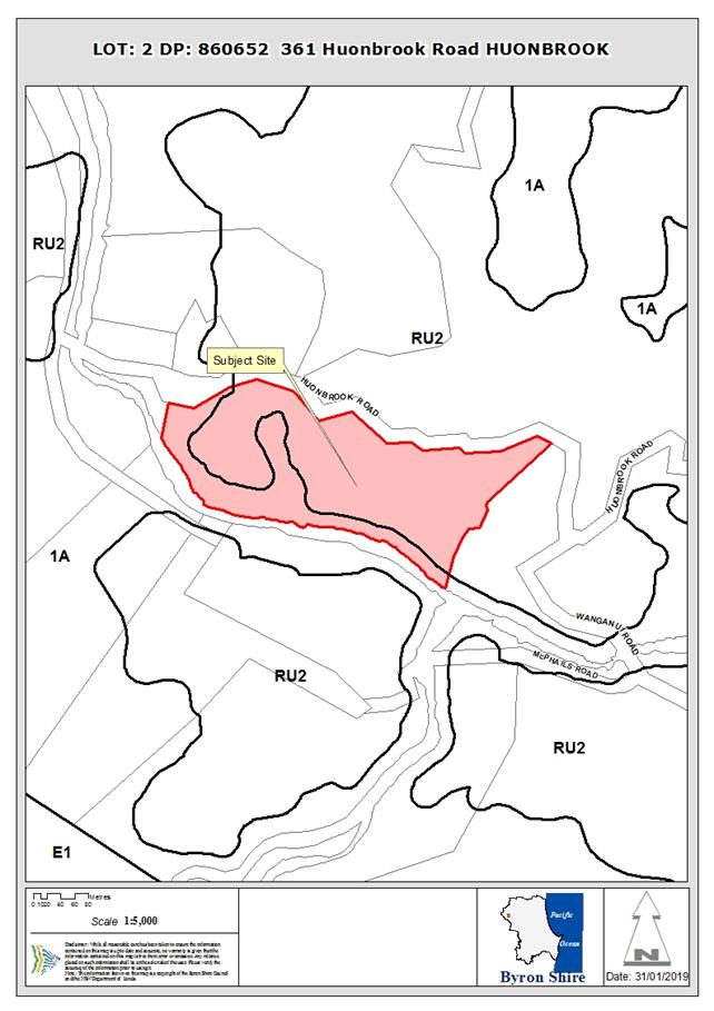
Assessment:
1. INTRODUCTION
1.1. History/Background
BA239/76 – Dwelling and Shed – approved 01/11/76
10.2005.225.1 – Conversion of unauthorised dwelling
into a farm shed – approved 18/05/05
10.2007.423.1 – Alterations and Additions to existing
dwelling – approved 03/01/08
10.2007.423.2 – S96 for modifications to roof area
– approved 29/05/08
10.2007.775.1 – Swimming pool – approved 20/02/08
10.2015.102.1 – Rural Industry – approved
06/07/15
10.2016.11.1 – Restaurant – approved 12/04/16
10.2016.11.2 – S96 to create alternate dining area
– approved 13/11/17
The existing building subject to this application has been
located on the site for an extended period. No approval for the construction of
the subject building could be located. At some time prior to April 2005 the
subject building was constructed and was being used as a residence. Development
Application 10.2005.225.1 was lodged and consent granted on 17 May 2005 for
Conversion of unauthorised dwelling into a farm shed. Since this consent was
granted the building has been reinstated as a residence without approval. The
subject application seeks to obtain consent for the lawful use of this building
as a dwelling house to create a dual occupancy (detached).
1.2. Description
of the proposed development
This application seeks approval for Use of Dwelling House to
Create Dual Occupancy (detached). The existing building contains three (3)
bedrooms, is constructed of timber with a raised floor due to the slope of the
land and has a colourbond roof. The proposed/existing separation distance
between the two dwellings forming the dual occupancy (detached) is
approximately 120m.
1.3. Description
of the site
|
Land is legally described as
|
LOT: 2 DP: 860652
|
|
Property address is
|
361 Huonbrook Road HUONBROOK
|
|
Land is zoned:
|
RU2 Rural Landscape / PART DM Deferred Matter
|
|
Land area is:
|
10.88 m2
|
|
Property is constrained by:
|
Bushfire prone land
High Conservation Value
Dip Site
Cattle Dip Buffer
|
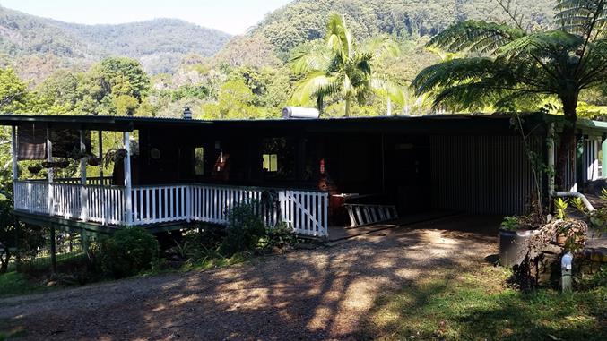
Existing dwelling to
create dual occupancy looking SW
Access to existing
dwelling showing gully located between the two existing dwellings looking W
2. SUMMARY OF
REFERRALS
|
Referral
|
Issue
|
|
Environmental Health Officer
|
No objections to the proposal subject to conditions.
|
|
Development Engineer
|
No objections to the proposal subject to conditions.
|
|
Building Surveyor
|
No objections to the proposal subject to conditions.
|
|
S7.11 / Contributions Officer
|
No objections to the proposal subject to condition.
|
|
Rural Fire Service (4.14)
|
No objections to the proposal subject to conditions.
|
3. SECTION 4.14
– BUSH FIRE PRONE LAND
Under section 4.14 of the Act, Council must be satisfied
prior to making a determination for development on bush fire prone land, that
the development complies with the document Planning for Bush Fire Protection
2006. The site is bush fire prone land. The development application was
referred to the NSW Rural Fire Service, which provided conditions which are
reflected in the Recommendation of this Report below.
EFFECT OF 10/50 RULE ON SIGNIFICANT VEGETATION
The site is a designated 10/50 vegetation clearing
entitlement area. The only vegetation to be potentially impacted is camphor
laurel therefore no further investigation is required.
4. SECTION 4.15C
– MATTERS FOR CONSIDERATION – DISCUSSION OF ISSUES
Having regard to the matters for consideration detailed in
Section 4.15(1) of the Environmental Planning & Assessment Act 1979
(EP&A Act), the following is a summary of the evaluation of the issues.
4.1 State Environmental
Planning Instruments
|
|
Satisfactory
|
Unsatisfactory
|
|
State
Environmental Planning Policy No 55—Remediation of Land
|
☒
|
☐
|
|
Consideration:
Assessing Environmental Health
Officer commented “The proposed dwelling has been used informally as
a residence for many years. While it is located in a rural area the site has
been utilised for residential use for an extended period in conjunction with
an adjoining restaurant/café on the subject site.
No further investigation is
warranted.”
|
|
State
Environmental Planning Policy (Building Sustainability Index: BASIX) 2004
|
☒
|
☐
|
|
Consideration:
BASIX Certificate required for:
• New
dwellings
• Alterations
> $50,000.00
• Pools
> 40,000 kl
BASIX certificate has been
provided.
|
|
State
Environmental Planning Policy (Rural Lands) 2008
|
☒
|
☐
|
|
Consideration:
Clause 7 identifies Rural
Planning Principles to be considered for development.
The Rural Planning
Principles are as follows:
(a) the promotion and
protection of opportunities for current and potential productive and
sustainable economic activities in rural areas,
(b) recognition of the
importance of rural lands and agriculture and the changing nature of
agriculture and of trends, demands and issues in agriculture in the area, region
or State,
(c) recognition of the
significance of rural land uses to the State and rural communities, including
the social and economic benefits of rural land use and development,
(d) in planning for
rural lands, to balance the social, economic and environmental interests of
the community,
(e) the identification
and protection of natural resources, having regard to maintaining
biodiversity, the protection of native vegetation, the importance of water
resources and avoiding constrained land,
(f) the provision of
opportunities for rural lifestyle, settlement and housing that contribute to
the social and economic welfare of rural communities,
(g) the consideration
of impacts on services and infrastructure and appropriate location when
providing for rural housing,
(h) ensuring
consistency with any applicable regional strategy of the Department of
Planning or any applicable local strategy endorsed by the Director-General.
The proposal is consistent with
these principles.
|
4.2A Byron Local Environmental Plan 2014 (LEP 2014)
LEP 2014 is an applicable matter for consideration in the
assessment of the subject development application in accordance with subsection
4.15(1) of the EP&A Act because it applies to the subject land and the
proposed development. The following LEP 2014 clauses are of relevance to the
proposed development:
Land Use Table
In accordance with LEP 2014 clauses 1.4 and 2.1 – 2.3:
(a) The
proposed development is defined in the LEP 2014 Dictionary as Dual Occupancy
(detached);
(b) The
land is within the RU2 Rural Landscape / PART DM Deferred Matter (1a General
Rural Zone) according to the Land Zoning Map (the existing building is located
entirely on land zoned RU2);
(c) The
proposed development is permitted with consent; and
(d) Regard
is had for the Zone Objectives as follows:
|
Zone Objective
|
Consideration
|
|
To encourage sustainable
primary industry production by maintaining and enhancing the natural resource
base
|
The proposal will not impact on the agricultural viability
of the land or adjoining lands
|
|
To maintain the rural
landscape character of the land
|
The proposed dual occupancy (detached) is consistent with
the existing character of the locality
|
|
To provide for a range
of compatible land uses, including extensive agriculture.
|
The proposal is compatible with adjoining land uses
|
|
To enable the provision
of tourist accommodation, facilities and other small-scale rural tourism uses
associated with primary production and environmental conservation consistent
with the rural character of the locality.
|
The proposal is associated with residential purposes only
|
|
To protect significant
scenic landscapes and to minimise impacts on the scenic quality of the
locality.
|
The proposed dual occupancy (detached) is located to
ensure the minimisation of impacts on the environment and scenic qualities in
the locality.
|
Clause 4.1E Minimum lot sizes for dual occupancies, multi
dwelling housing and residential flat buildings
The property has an area of 10.68 hectares, which satisfies
the requirement for a minimum lot size of 4,000m2 for a Dual
Occupancy (detached) in the RU2 zone.
Clause 4.2A Erection of
dwelling houses and dual occupancies on land in certain rural zones
The land contains an existing dwelling, approved by Council
consent BA239/76. A dual occupancy is permitted on the land with Council
consent.
Clause 4.2D Erection of dual
occupancies (detached) and secondary dwellings in Zones RU1 and RU2
The application proposes a
separation distance of 120m between the two dwellings which does not comply
with the permitted 100m maximum separation distance – see below.
|
What clause does the development not comply with and
what is the nature of the non-compliance?
|
Further consideration, including whether the
development application is recommended for approval or refusal accordingly
|
|
4.2D Erection of dual occupancies
(detached) and secondary dwellings in Zones RU1 and RU2
(2) Development consent
must not be granted to development for the purpose of a dual occupancy
(detached) or secondary dwelling on land in Zone RU1 Primary Production or
Zone RU2 Rural Landscape unless the consent authority is satisfied that:
(a) the development
will not impair the use of the land for agriculture or rural industries, and
(b) each dwelling
will use the same vehicular access to and from a public road, and
(c) any dwellings
will be situated within 100 metres of each other, and
(d) the land is
physically suitable for the development, and
(e) the land is
capable of accommodating the on-site disposal and management of sewage for
the development, and
(f) the development
will not have an adverse impact on the scenic amenity or character of the
rural environment.
|
A Clause 4.6 variation has been submitted by the applicant
and is discussed below.
|
Clause 4.3 Height of
Buildings
The proposed new dwelling complies with the permitted 9.0m
maximum building height.
Clause 4.6 Exceptions to
Development Standards
The clause 4.6 variation request has been submitted because
the proposed development contravenes the development standard outlined within
Clause 4.2D(2)(c), which requires each dwelling to be situated within 100
metres of each other. The applicant’s variation request has been
considered with reference to relevant matters as follows:
1. Introduction
– Summary of proposed development
The development application seeks
consent for Use of Dwelling House to Create Dual Occupancy (detached).
2. Clause 4.6
Exceptions to Development Standards
Clause 4.6 of Byron LEP 2014 is
accessible via: http://www.legislation.nsw.gov.au/fragview/inforce/epi+297+2014+pt.4-cl.4.6+0+N?tocnav=y
3. The
Development Standard to be varied
The development standard to be
varied is contained in LEP 2014 subclause 4.2D(2)(c), which is accessible via: http://www.legislation.nsw.gov.au/fragview/inforce/epi+297+2014+pt.4-cl.4.2d+0+N?tocnav=y
The 100m maximum separation
distance is a development standard in accordance with the applicable definition
in section 1.4 of the Environmental Planning and Assessment Act 1979
because it is a provision of an environmental planning instrument in relation
to the carrying out of development, being a provision by or under which
requirements are specified or standards are fixed in respect of any aspect of
that development.
4. Extent of
Variation to the Development Standard
The application seeks consent for
the use of an existing dwelling, to create a dual occupancy (detached), with a
separation distance of 120m from the existing approved dwelling, which does not
comply with the maximum 100m separation distance permitted.
The extent of the variation is
20%.
5. Objective
of the Development Standard
The objectives of the development
standard are outlined in LEP 2014 subclause 4.2D(1), which states:
a. to provide alternative accommodation for rural
families and workers,
b. to ensure that development is of a scale and
nature that is compatible with the primary production potential, rural
character and environmental capabilities of the land,
c. to set out consent considerations for development
of dual occupancies (detached) and secondary dwellings to address matters such
as access, siting, land suitability and potential impacts
6. Objectives
of the Zone
The objectives of the RU2 Rural
Landscape Zone which applies to the location of the proposed dual occupancy
(detached) are stated in the Land Use Table to LEP Part 2:
· To encourage sustainable primary industry production by maintaining and
enhancing the natural resource base.
· To maintain the rural landscape character of the land.
· To provide for a range of compatible land uses, including extensive
agriculture.
· To enable the provision of tourist accommodation, facilities and other
small-scale rural tourism uses associated with primary production and environmental
conservation consistent with the rural character of the locality.
· To protect significant scenic landscapes and to minimise impacts on the
scenic quality of the locality.
7. Assessment
– the specific questions to be addressed:
(a) Clause
4.6(3)(a) – Is compliance with the development standard unreasonable or
unnecessary in the circumstances of the case?
The existing building subject to
this application has been located on the site for an extended period. No
approval for the construction of the subject building could be located. At some
time prior to April 2005 the subject building was constructed and was being
used as a residence. Development Application 10.2005.225.1 was lodged and
consent granted on 17 May 2005 for Conversion of unauthorised dwelling into a
farm shed. Since this consent was granted the building has been reinstated as a
residence without approval. The subject application seeks to obtain consent for
the lawful use of this building as a dwelling house to create a dual occupancy
(detached).
The applicant has argued that it
is unreasonable and unnecessary to comply with the 100m maximum separation
distance as the building is unable to be relocated and has remained in this
location for at least twenty years without adverse impact on the environment.
Requiring compliance with the
development standard would essentially require either the demolition of the
existing building, and construction of a new dwelling, or the relocation of the
existing building. Either of these scenarios would come at a significant cost
to the landowner and it is considered a more efficient use of resources to
utilise the existing building. Demolition or relocation of the existing
building could create privacy/ amenity issues with the existing approved
dwelling if the proposed dual occupancy dwelling was located to comply with the
development standard and avoid potential impacts on vegetation having a high
ecological value.
(b) Clause
4.6(3)(b) – Are there sufficient environmental planning grounds to
justify contravening the development standard?
The land contains a certified
organic farm which will not be significantly impacted There is no loss of
agricultural productivity on the land as the building has existed for at least
20 years. The proposed use of the building will not present any land use
conflict issues with adjoining land which consists of small rural lifestyle
lots and hobby farms. There is a gully located immediately to the east of the
building therefore it is not practical to either relocate the dwelling or
construct an expanded dwelling module to reduce the separation distance between
dual occupancy dwellings.
The use of
the two buildings as a dual occupancy (detached) contributes to provision of
rural housing whilst not significantly affecting the existing character,
amenity or landscape of the locality. The proposed variation does not create
any significantly adverse social, environmental or economic impacts in the
locality. There are sufficient environmental planning grounds to justify
contravening the development standard.
(c) Clause
4.6(4)(a)(ii) – Is the proposed development in the public interest? Is it
consistent with the objectives of the standard and the zone as set out above?
The proposal
provides an opportunity for a dual occupancy (detached) in an area that is
identified as appropriate through zoning provisions. The proposal contributes
to the provision of residential housing in a rural setting whilst preserving,
and minimising impacts on, environmentally sensitive locations and scenic
quality. The proposal is compatible with the agricultural potential, rural
character and environmental capabilities of the land. The proposal does not
result in any significant conflict between land uses within the applicable zone
and land uses within adjoining zones. The proposal is consistent with the
objectives of the development standard and the zone. The proposed development
is not significantly contrary to the public interest because it will not
adversely affect the welfare and wellbeing of the broader public.
The proposed development would
produce a better planning outcome than one that strictly complies with the
development standard because compliance with the 100m maximum separation
distance between dwellings would result in a number of potential issues. Such
issues include the demolition of an existing structure, removal of vegetation
identified as having high ecological value, and amenity issues with the
existing approved dwelling if the proposed dual occupancy dwelling was located
to avoid the area of high ecological value vegetation.
There would be no benefit in
relation to the natural or built environment, or with respect to social and
economic impacts on the locality in requiring strict compliance with the 100m maximum
separation distance between dwellings. The circumstances of the case warrant a
more flexible approach to application of the separation distance development
standard. The Applicant’s variation request is supported and the
development application is recommended for approval despite the non-compliance.
(d) Clause
4.6(4)(b) – Has the concurrence of the Secretary been obtained?
The NSW Department of Planning and Environment Planning
Circular PS18-003 provides that the Secretary’s concurrence may not be
assumed by a delegate of council if the development contravenes a numerical
standard by greater than 10%.
The application proposes the use of an existing structure as
a Dwelling House to Create Dual Occupancy (detached) with a separation distance
of 120m from the existing dwelling which does not comply with the maximum 100m
separation distance permitted. The extent of the variation is 20%.
In accordance with PS18-003 the application must be determined by the elected
Councillors.
The Applicant’s variation request is supported and the
development application is recommended for approval despite the non-compliance.
Clause 6.6 Essential Services
Potable water is proposed to supply the development through rainwater
tanks. Electricity and telephone services are available to the land and can
reasonably be extended to service the dwelling subject to this application. The
application has demonstrated that the disposal of wastewater via an on-site
sewage management system can be achieved on the site. The site is accessed by a
single driveway to Huonbrook Road.
4.2B Byron Local Environmental Plan 1988 (LEP 1988)
The existing building is located entirely on land zoned RU2
under LEP 2014 however existing internal vehicular access traverses an area
zoned 1(a) under LEP 1988.
LEP 1988 is an applicable matter for consideration in the
assessment of the subject development application in accordance with subsection
4.15(1) of the EP&A Act because it applies to the subject land and the
proposed development. The following LEP 1988 clauses are of relevance to the
proposed development:
In accordance with LEP 1988 clauses 5, 8 and 9:
(a) The
proposed development is defined in the LEP 1988 Dictionary as Dual Occupancy;
(b) The
land is within the 1 (a) General Rural Zone according to the map under LEP
1988;
(c) The
proposed development is permitted with consent; and
(d) The
proposed development is consistent with the relevant objectives of the Zone for
the following reasons:
|
Zone Objective
|
Consideration
|
|
(a) to
encourage and permit a range of uses creating a pattern of settlement, at a
scale and character that maintains or enhances the natural, economic,
cultural, social and scenic amenity of the rural environment of the Shire of
Byron,
|
The existing access is proposed to service an existing
building to be used as a dwelling house and is of a scale and character that
complements the existing natural environment and does will not adversely
affect the existing amenity of the area
|
|
(b) to
encourage and permit a pattern of settlement which does not adversely affect
the quality of life of residents and visitors and maintains the rural
character,
|
|
(c) to ensure
development only occurs on land which is suitable for and economically
capable of that development and so as not to create conflicting uses,
|
|
(d) to allow
the use of land within the zone for agricultural purposes and for a range of
other appropriate purposes whilst avoiding conflict between other uses and
intensive agriculture,
|
|
(e) to
identify lands (shown hatched on the map) which in the opinion of the council
possess a limited capability for more intensive uses or development,
|
|
(f) to
restrict the establishment of inappropriate traffic generating uses along
main road frontages other than in road side service areas,
|
|
(g) to ensure
sound management of land which has an extractive or mining industry potential
and to ensure that development does not adversely affect the potential of any
existing or future extractive industry,
|
|
(h) to enable
the provision of rural tourist accommodation and facilities only where such
facilities are compatible with the form and density of the nature of the
locality, and
|
|
(i) to permit
the development of limited light industries which do not pose any adverse
environmental impact, (eg software manufacture and film processing), and
|
|
(j) to ensure
that the development and use of land shown cross-hatched on the map adjacent
to areas of significant vegetation and wildlife habitat do not result in any
degradation of that significant vegetation and wildlife habitat, and that any
development conserves and protects and enhances the value of the fauna and
flora.
|
Clause 52 Tree Preservation
An area mapped as High
Ecological Value vegetation (subtropical rainforest) exists within close
proximity to the existing internal driveway servicing the existing building
proposed to be used as a dual occupancy dwelling. Any vegetation removal
required to upgrade internal access will be limited to camphor laurel therefore
no further assessment required.
4.3 Any proposed Instrument
that has been the subject of public consultation and has been notified to the
consent authority
Not applicable
4.4A Byron Shire Development Control Plan 2014 (DCP
2014)
DCP 2014 is an applicable matter for consideration in the
assessment of the subject development application in accordance with subsection
4.15(1) of the EP& A Act because it applies to the land to which LEP 2014
applies. The following DCP 2014 chapters are of relevance to the proposed
development:
B2 Preservation of Trees and
other Vegetation
RFS conditions require a 9m
Asset Protection Zone to be provided to the east of the existing structure
proposed to be used as a dual occupancy dwelling. This is adjacent to an area mapped
as High Ecological Value vegetation (subtropical rainforest) The only
vegetation to be potentially impacted is camphor laurel therefore no further
investigation is required.
B3 Services
The application has demonstrated that the proposed
development will be adequately serviced including the provision of an onsite
sewage management system. A recommended condition of consent will require the
provision of a 40,000L rainwater tank.
B6 Buffers and Minimising
Land Use Conflict
The proposed new dwelling house is located adjacent to small
rural holdings that are not utilised for any significant primary production
purposes. Therefore the proposal is unlikely to present any significant land
use conflict issues.
D2.2.3 Character and Visual Impact
The existing building proposed to be used as a dual
occupancy dwelling has been constructed to complement the contours of the land
and minimise the visual impact on the surrounding area. The land slopes to the
south from Huonbrook Rd and the existing building is largely screened from the
road by vegetation surrounding the building. The land is bounded to the south
by Coopers Creek and riparian vegetation along the creek largely screens the
existing building from adjoining and surrounding land.
D2.5 Dual Occupancies and Secondary Dwellings
D2.5.1 On-site Car Parking
There are abundant areas on the site to provide car parking,
behind the front building setback, to service each of the dwellings of the
proposed dual occupancy (detached).
D2.5.2 Character and Siting of Dwellings
The proposed dual occupancy (detached) is located 120m apart
which does not comply with the maximum permitted separation distance of 100m. A
clause 4.6 variation was submitted in accordance with LEP 2014 and is discussed
in section 4.2A of this report.
D2.5.5 Adjoining and Nearby Development
The land contains a certified organic farm which will not be
significantly impacted. The proposed use of the building will not present any
land use conflict issues with adjoining land which consists of small rural
lifestyle lots and hobby farms.
The existing building proposed to be used as a dual
occupancy dwelling has been constructed to complement the contours of the land
and minimise the visual impact on the surrounding area. The land slopes to the
south from Huonbrook Rd and the existing building is largely screened from the
road by vegetation surrounding the building. The land is bounded to the south
by Coopers Creek and riparian vegetation along the creek largely screens the existing
building from adjoining and surrounding land.
The proposal does not present any significant impacts on
privacy or existing views from neighboring dwellings.
4.4B Byron Shire Development Control Plan 2010 (DCP 2010)
DCP 2010 is an applicable matter for consideration in the
assessment of the subject development application in accordance with subsection
4.15(1) of the EP& A Act because it applies to the land to which LEP 1988
applies. The following DCP 2010 chapters are of relevance to the proposed
development:
Chapter 1: Part G Vehicular Circulation and Parking
The application proposes the utilisation of an existing
internal driveway that traverses an area zoned 1(a) (General Rural Zone) under
LEP 1988 and is therefore subject to the provisions of DCP 2010.
Internal driveway access will require regrading with sealed
pavement required for grades greater than 12% - a condition of consent is
recommended. The access way to the existing building proposed for use as a
dwelling is in poor condition. This access is required to be upgraded to
provide a minimum 3m wide 150mm gravel pavement - a condition of consent
is recommended.
There is adequate room on site to allow vehicles to enter
and exit in a forward direction.
4.5 Any Planning Agreement or
Draft Planning Agreement?
|
|
Yes
|
No
|
|
Is there any applicable planning agreement or draft
planning agreement?
|
☐
|
☒
|
|
Consideration:
|
4.6 Environmental Planning
& Assessment Regulation 2000 Considerations
|
Clause
|
This
control is applicable to the proposal:
|
I have
considered this control as it relates to the proposal:
|
If
this control is applicable, does the proposal comply?
|
|
92
|
No
|
N/A
|
N/A
|
|
93
|
No
|
N/A
|
N/A
|
|
94
|
No
|
N/A
|
N/A
|
|
94A
|
No
|
N/A
|
N/A
|
* Non-compliances and any other significant issues
discussed below
4.7 Any coastal zone management
plan?
|
|
Satisfactory
|
Unsatisfactory
|
Not applicable
|
|
Is there any applicable coastal zone management plan?
|
☐
|
☐
|
☒
|
|
Consideration:
|
4.8 The likely impacts of that
development, including environmental impacts on both the natural and built
environments, and social and economic impacts in the locality
|
Impact on:
|
Likely significant impact/s?
|
|
Natural environment
|
No. The proposal will not have a significantly adverse
impact on the natural environment of the locality.
|
|
Built environment
|
No. The proposal will not have a significantly adverse
impact on the built environment of the locality.
|
|
Social Environment
|
No. The proposal will not have a significant social impact
on the locality.
|
|
Economic impact
|
No. The proposal will not have a significant economic
impact on the locality.
|
Are there any Council Policies that are applicable to the
proposed development?
The proposed development complies with Council’s
development-related policies (in some cases subject to conditions and/or to the
satisfaction of other assessing officers).
4.9 The suitability of the site
for the development
The site is a serviced, unconstrained property and is
suitable for the proposed development.
4.10 Submissions made in accordance with
this Act or the regulations
The development application was publicly exhibited .
There was one submission made on the development
application:
|
Issue
|
Comment
|
|
The land already contains 2 dwellings
|
The land contains an existing approved dwelling house and
the subject application seeks consent for the use of an existing building as
a dwelling to create a dual occupancy (detached). The land also contains an
approved restaurant and a number of sheds. During site inspection by Council
staff there was no evidence that any of these sheds are being used for
habitable purposes.
|
|
Cars associated with the existing restaurant on the land
are parking on the public road
|
The application has demonstrated suitable car parking for
each of the dwellings.
|
|
Suitability of Huonbrook Road to accommodate additional
traffic
|
The proposal will not have a significant traffic impact on
Huonbrook Road.
|
|
Impact on biodiversity values
|
The land contains areas mapped as having high ecological
value however, as the building subject to this application is existing, the
proposal will not have a significant impact on these areas.
|
|
Impacts of water extraction licence
|
This is a matter for Water NSW and not relevant to this
application.
|
|
Rainwater tanks should be provided to reduce stormwater
runoff to Coopers Creek
|
A condition of consent is recommended to require a 40,000L
rainwater tank
|
4.11 Public interest
The proposed development is unlikely to prejudice or
compromise the public interest or create an undesirable precedent.
5. DEVELOPER
CONTRIBUTIONS
5.1 Water & Sewer Levies
No Section 64 levies will be required.
5.2 Section 7.11 Contributions
Section 7.11 Contributions will
be payable.
6. DISCLOSURE OF
POLITICAL DONATIONS AND GIFTS
|
Has a Disclosure Statement been received in relation
to this application
|
No
|
|
Have staff received a ‘gift’ from anyone
involved in this application that needs to be disclosed. Where the answer is
yes, the application is to be determined by the Director or Manager of the
Planning, Development and Environment Division.
|
No
|
Provide Disclosure Statement register details here: Not
applicable
7. CONCLUSION
The proposed development is consistent with the relevant
environmental planning instruments and planning controls applicable to the
site. The proposal raises no significant issues in terms of environmental
impacts which cannot be managed and the site is considered suitable for the
development. The application is recommended for approval subject to conditions
of consent.
8. REASONS FOR
DECISION, HOW COMMUNITY VIEWS WERE ADDRESSED
|
Statement of Reasons
|
|
The proposed development will not have significant adverse
impacts on the natural, built or social environment or economic impacts on
the locality.
|
|
The proposed development is considered suitable for the
proposed site.
|
|
The proposed development is unlikely to prejudice or
compromise the public interest.
|
|
How community views were addressed
|
|
The DA was advertised in accordance with Level 1
notification as per Development Control Plan 2014. All issues raised within
submissions have been taken into consideration in determininq this
application.
|
9. RECOMMENDATION
It is recommended that
pursuant to Section 4.16 of the Environmental Planning & Assessment Act
1979, development application no. 10.2018.372.1 for Use of Dwelling House to Create Dual Occupancy (detached), be granted
Deferred Commencement (deferral period 2
years) subject to conditions listed in Attachment 3 # E2019/8091.
Confidential Reports - Sustainable Environment and Economy 7.1
Confidential Reports - Sustainable Environment
and Economy
Report No. 7.1 Confidential - PLANNING - Car Share
Pilot Implementation
Directorate: Sustainable
Environment and Economy
Report
Author: Sam
Tarrant, Planning Support Officer
Jamie Van Iersel, Planner - Place
Planner
File No: I2018/2396
Theme: Sustainable Environment and Economy
Planning Policy and Natural Environment
Summary:
At the meeting of 22 February 2018, Council resolved (18-115)
to support the progression of a car share 12 month pilot and the public
exhibition of Council’s Car Share Policy. Following the public
exhibition, because no submissions were received, the Car Share Policy was
adopted in line with the original Council resolution (18-115).
At the meeting 31 October 2018, Council resolved (18-696)
to endorse a number of locations suitable for the exclusive use of car share
bays. The Local Traffic Committee have also endorsed the location of the
bays and the erection of signage and line marking.
In December, Council staff opened an online application
process, accompanied by the Car Share Implementation Procedure, whereby all
eligible car share operators could apply. Applications closed 7 January
and two applications were received.
This report includes a summary and detailed attachments of
applications received.
Both providers bring positive benefits to the Shire and have
their own strengths. Based on the objectives and criteria set out within
the Procedure, the report includes a recommended operator for Council’s
endorsement.
FOR COUNCILLORS
In accordance with the
provisions of S375A of the Local Government Act 1993, a Division is to be
called whenever a motion for a planning decision is put to the meeting, for the
purpose of recording voting on planning matters. Pursuant to clause 2(a)
under the heading Matters to be Included in Minutes of Council Meetings of
Council's adopted Code of Meeting Practice (as amended) a Division will be
deemed to have been called by the mover and seconder of all motions relating to
this report.
RECOMMENDATION:
1. That
pursuant to Section 10A(2)(d)i of the Local Government Act, 1993, Council
resolve into Confidential Session to discuss the report PLANNING - Car Share
Pilot Implementation.
2. That
the reasons for closing the meeting to the public to consider this item be that
the report contains:
a) commercial
information of a confidential nature that would, if disclosed prejudice the
commercial position of the person who supplied it
3. That
on balance it is considered that receipt and discussion of the matter in open
Council would be contrary to the public interest, as:
the report contains details of
the commercial assets held, and to be potentially used, by each operator as
well as a recommended operator for Council to proceed with.
Attachments:
1 Confidential
- Car Share Application 1, E2019/3833
2 Confidential
- Car Share Application 2, E2019/3834
Confidential Reports - Sustainable Environment and Economy 7.2
Report No. 7.2 Confidential - Mullumbimby
Administration Building Solar Carpark - Award of Tender 2018-0060
Directorate: Sustainable
Environment and Economy
Report
Author: Tania
Crosbie, Economy and Sustainability Coordinator
File No: I2019/146
Summary:
On 14 December 2018, the General Manager, under delegated
authority, approved the use of the open tender method to invite tenderers for
Contract 2018-0060 Mullumbimby Administration Solar Carpark.
The request for tender was advertised from the 18 December
2018 to 29 January 2019.
Tenders were received from the following organisations:
· Autonomous Energy
Pty Ltd
· Energy Australia
Pty Ltd
· Kerfoot Pty Ltd
· SAE Group Pty Ltd.
Tenders have been assessed in accordance with the provisions
of the Local Government (General) regulations 2005. This report
summarises the background and assessment of the tenders and provides a
recommendation to award the tender contract 2018-0060.
RECOMMENDATION:
1. That
pursuant to Section 10A(2)(d)i and (d)iii of the Local Government Act, 1993,
Council resolve to move into Confidential Session to discuss the report
Mullumbimby Administration Building Solar Carpark - Successful Tenderer Report.
2. That
the reasons for closing the meeting to the public to consider this item be that
the report contains:
a) commercial
information of a confidential nature that would, if disclosed prejudice the
commercial position of the person who supplied it
b) information
that would, if disclosed, reveal a trade secret
3. That
on balance it is considered that receipt and discussion of the matter in open
Council would be contrary to the public interest, as:
This report is confidential as
it relates to the evaluation and recommendation of a tenderer.
Attachments:
1 Confidential
- 24.2018.75.1 - MABSC - RFT 2018-0060 - Evaluation Report (Issue 2), E2019/9274