What is a “Conflict of Interests” - A conflict of
interests can be of two types:
Pecuniary - an interest that a person has in a matter because of a reasonable
likelihood or expectation of appreciable financial gain or loss to the person
or another person with whom the person is associated.
Non-pecuniary – a private or personal interest that a Council
official has that does not amount to a pecuniary interest as defined in the
Local Government Act (eg. A friendship, membership of an association, society
or trade union or involvement or interest in an activity and may include an
interest of a financial nature).
Remoteness – a person does not have a pecuniary interest in a matter
if the interest is so remote or insignificant that it could not reasonably be
regarded as likely to influence any decision the person might make in relation
to a matter or if the interest is of a kind specified in Section 448 of the
Local Government Act.
Who has a Pecuniary Interest? - a person has a pecuniary interest in a
matter if the pecuniary interest is the interest of the person, or another
person with whom the person is associated (see below).
Relatives, Partners - a person is taken to have a pecuniary interest in a
matter if:
§ The person’s
spouse or de facto partner or a relative of the person has a pecuniary interest
in the matter, or
§ The person, or a
nominee, partners or employer of the person, is a member of a company or other
body that has a pecuniary interest in the matter.
N.B. “Relative”, in relation to a person means any of the
following:
(a) the
parent, grandparent, brother, sister, uncle, aunt, nephew, niece, lineal
descends or adopted child of the person or of the person’s spouse;
(b) the
spouse or de facto partners of the person or of a person referred to in
paragraph (a)
No Interest in the Matter - however, a person is not taken to have a
pecuniary interest in a matter:
§ If the person is
unaware of the relevant pecuniary interest of the spouse, de facto partner,
relative or company or other body, or
§ Just because the
person is a member of, or is employed by, the Council.
§ Just because the
person is a member of, or a delegate of the Council to, a company or other body
that has a pecuniary interest in the matter provided that the person has no
beneficial interest in any shares of the company or body.
Disclosure and participation in meetings
§ A Councillor or a
member of a Council Committee who has a pecuniary interest in any matter with
which the Council is concerned and who is present at a meeting of the Council
or Committee at which the matter is being considered must disclose the nature
of the interest to the meeting as soon as practicable.
§ The Councillor or
member must not be present at, or in sight of, the meeting of the Council or
Committee:
(a) at any
time during which the matter is being considered or discussed by the Council or
Committee, or
(b) at any
time during which the Council or Committee is voting on any question in
relation to the matter.
No Knowledge - a person does not breach this Clause if the person did
not know and could not reasonably be expected to have known that the matter
under consideration at the meeting was a matter in which he or she had a
pecuniary interest.
Participation in Meetings Despite Pecuniary Interest (S 452 Act)
A Councillor is not prevented from taking part in the consideration or
discussion of, or from voting on, any of the matters/questions detailed in
Section 452 of the Local Government Act.
Non-pecuniary Interests - Must be disclosed in meetings.
There are a broad range of options available for managing conflicts &
the option chosen will depend on an assessment of the circumstances of the
matter, the nature of the interest and the significance of the issue being
dealt with. Non-pecuniary conflicts of interests must be dealt with in at
least one of the following ways:
§ It may be appropriate
that no action be taken where the potential for conflict is minimal.
However, Councillors should consider providing an explanation of why they
consider a conflict does not exist.
§ Limit involvement if
practical (eg. Participate in discussion but not in decision making or
vice-versa). Care needs to be taken when exercising this option.
§ Remove the source of
the conflict (eg. Relinquishing or divesting the personal interest that creates
the conflict)
§ Have no involvement by
absenting yourself from and not taking part in any debate or voting on the
issue as if the provisions in S451 of the Local Government Act apply
(particularly if you have a significant non-pecuniary interest)
RECORDING OF VOTING ON PLANNING MATTERS
Clause 375A of the Local Government Act 1993
– Recording of voting on planning matters
(1) In this section, planning
decision means a decision made in the exercise of a function of a council
under the Environmental Planning and Assessment Act 1979:
(a) including a decision
relating to a development application, an environmental planning instrument, a
development control plan or a development contribution plan under that Act, but
(b) not including the making of
an order under Division 2A of Part 6 of that Act.
(2) The general manager is
required to keep a register containing, for each planning decision made at a
meeting of the council or a council committee, the names of the councillors who
supported the decision and the names of any councillors who opposed (or are
taken to have opposed) the decision.
(3) For the purpose of
maintaining the register, a division is required to be called whenever a motion
for a planning decision is put at a meeting of the council or a council
committee.
(4) Each decision recorded in
the register is to be described in the register or identified in a manner that
enables the description to be obtained from another publicly available
document, and is to include the information required by the regulations.
(5) This section extends to a
meeting that is closed to the public.
Staff Reports - Infrastructure Services 4.1
Staff Reports - Infrastructure Services
Report No. 4.1 North
Byron Flodplain Risk Management Study and Plan - Update
Directorate: Infrastructure
Services
Report
Author: James
Flockton, Drain and Flood Engineer
File No: I2019/840
Summary:
Following the previous North Byron Floodplain Risk
Management Study and Plan update report and Floodplain Management Committee
Meeting, WMA Water has been working on various aspects of the Floodplain Risk
Management Study.
Various modelling results are provided in this report for
discussion with the committee at the upcoming meeting.
|
RECOMMENDATION:
1. That
Council approve the design event modelling mapping for inclusion in the final
Floodplain Risk Management Study and Plan documentation.
2. That
Council approve the following mitigation options as the second set of flood mitigation
options for assessment in the study:
• Lowering
of the Ocean Shores Golf Course Weirs
• Removal
of the Ocean Shores Golf Course Weirs
• Removal
of the Brunswick River Training Walls
• Levee
for Mullumbimby
• Billinudgel
Infrastructure improvements
• Upstream
storage
• Reduction
of debris collection risk at Federation Bridge
• Dredging
extended to side tributaries in Mullumbimby
· Additional Rock
Wall alteration
3. That
in order for project delivery and grant milestone targets to be met Council approve
changes to the current 2019 Floodplain Management Committee Meeting Schedule.
The 31 October 2019 meeting be moved to the end of September 2019 and an
additional meeting is added at the end of November 2019.
|
Attachments:
1 North
Byron FRMS&P - FMC 5 Memo to committee, E2019/39800
, page 9⇩ 
REPORT
Floodplain Management Committee Meeting Number 4 resulted in
finalisation of the calibration results and acceptance of the North Byron Flood
Study.
The model is now considered being fit for purpose for preparing
the draft Floodplain Risk Management Study. As such, it has now been possible
to commence a number of the modelling elements required for the Floodplain Risk
Management Study. Namely:
1. Draft revised
design event maps
2. Draft revised
climate change maps
3. Draft blockage
sensitivity assessment
4. Draft
mitigation results for six scenarios
5. Establishing
the base case property database
Point’s 1 to 4 are provided at attachment 1.
The following section describes the modelling which has been
undertaken, this is for discussion at the upcoming Floodplain Management
Committee meeting. These sections will be presented and discussed at the
committee meeting.
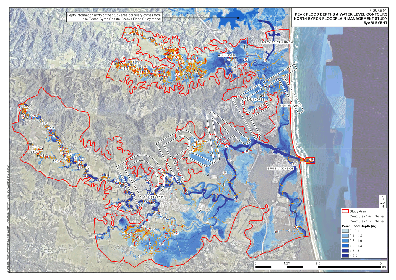
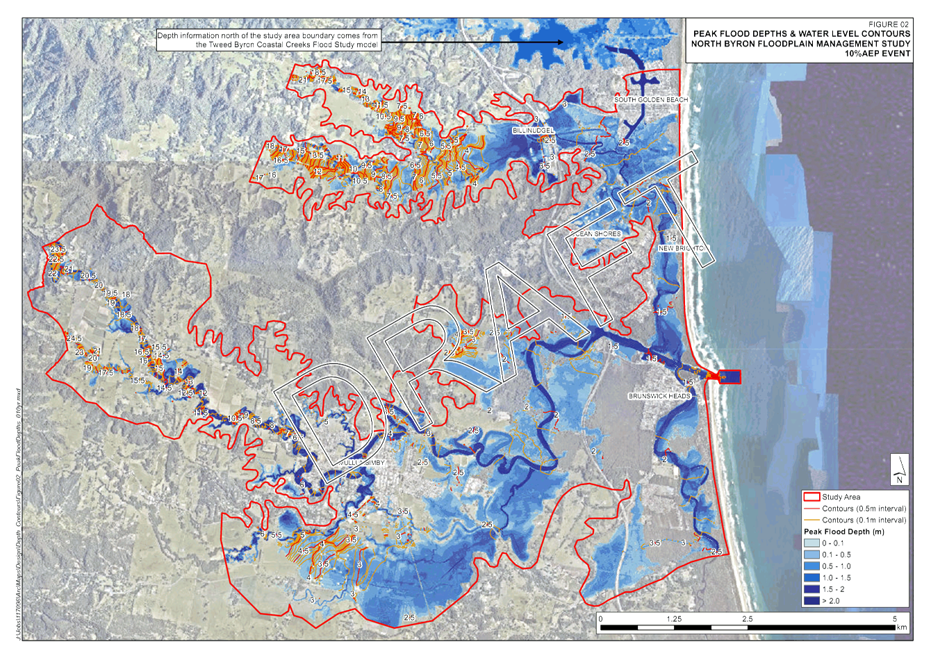
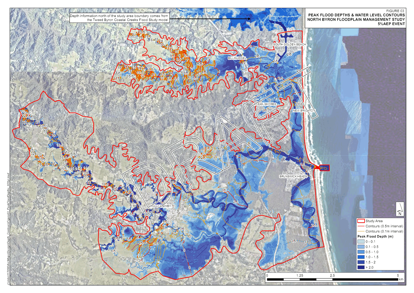
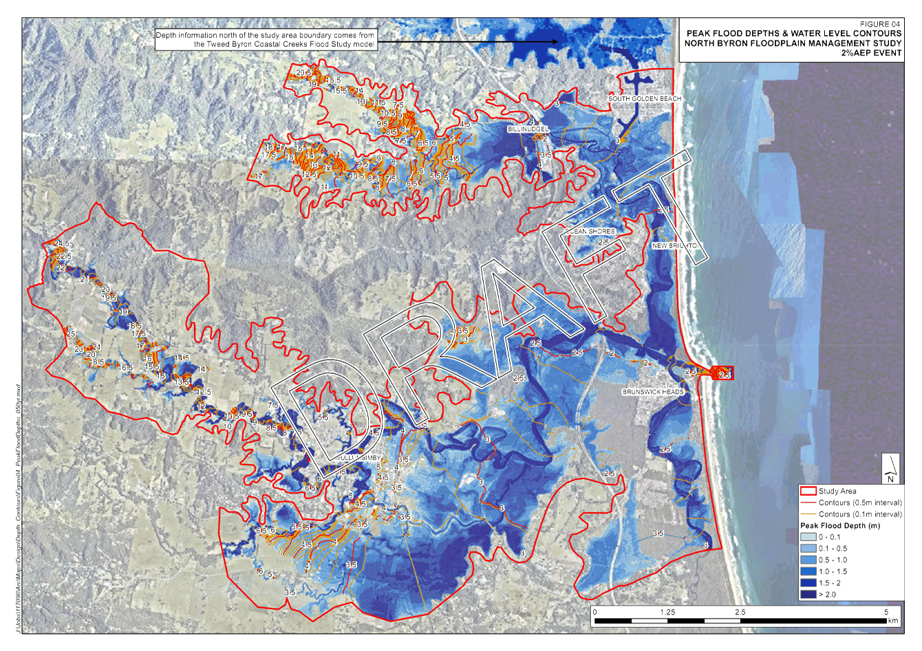
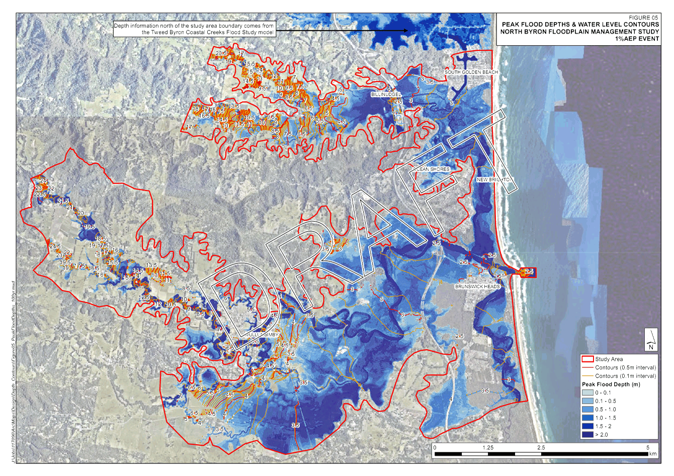
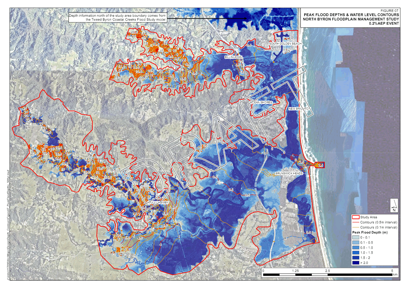
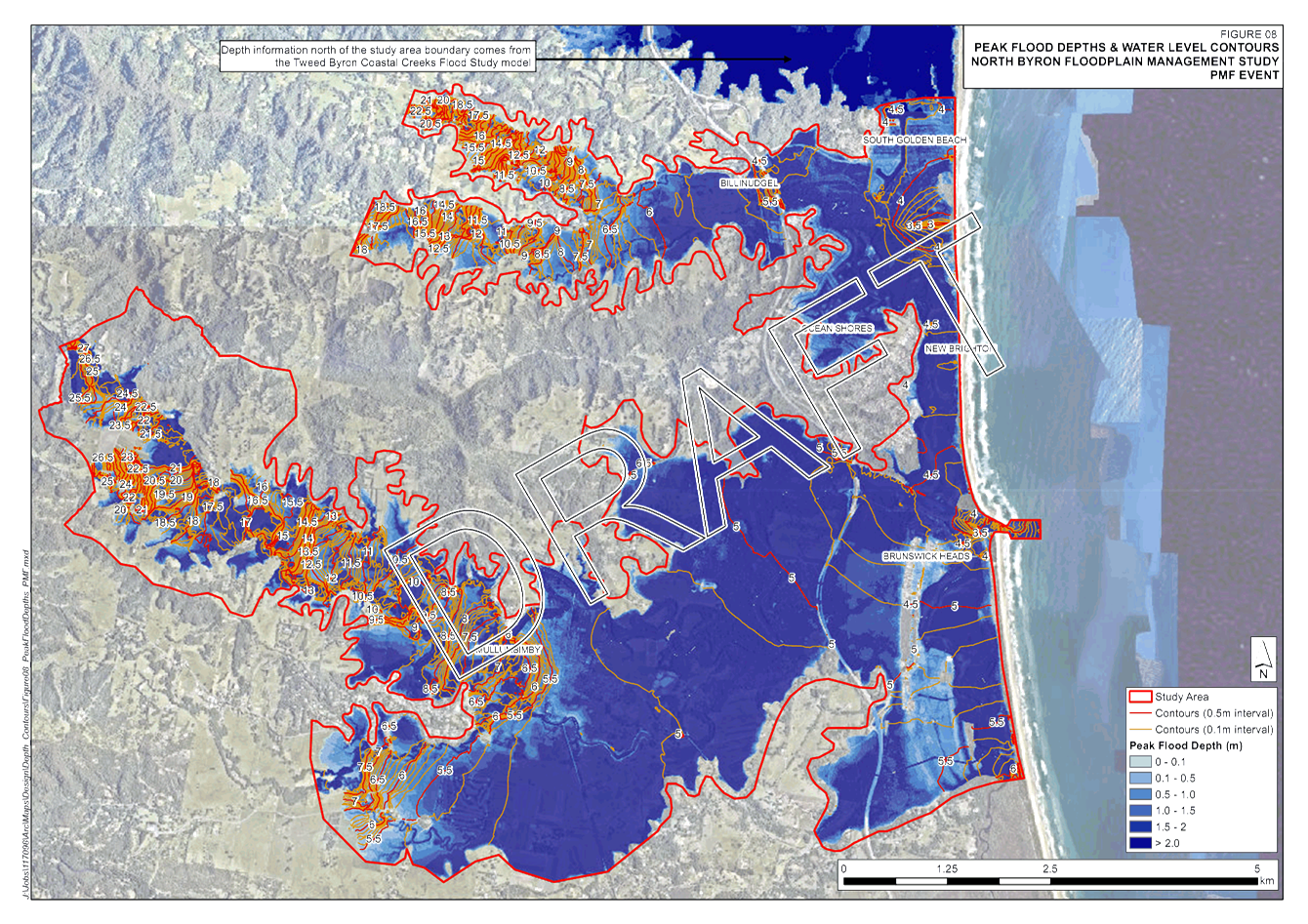
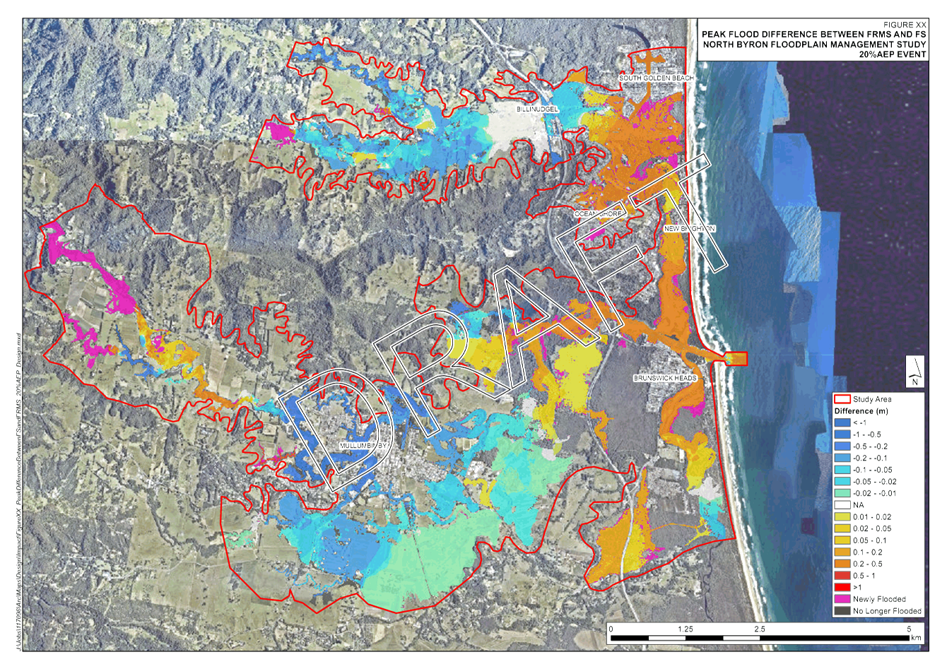
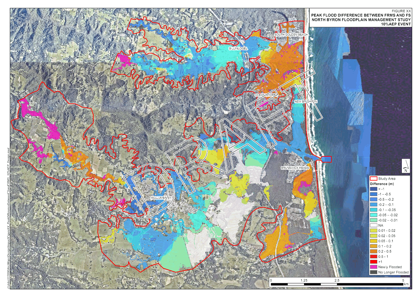
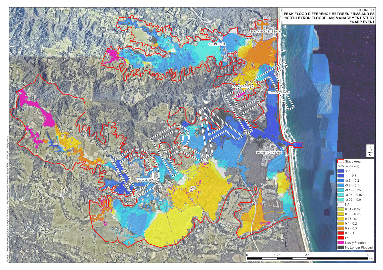
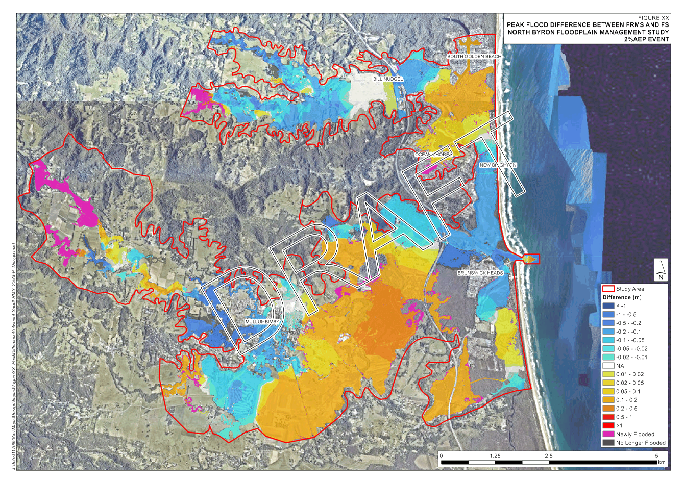
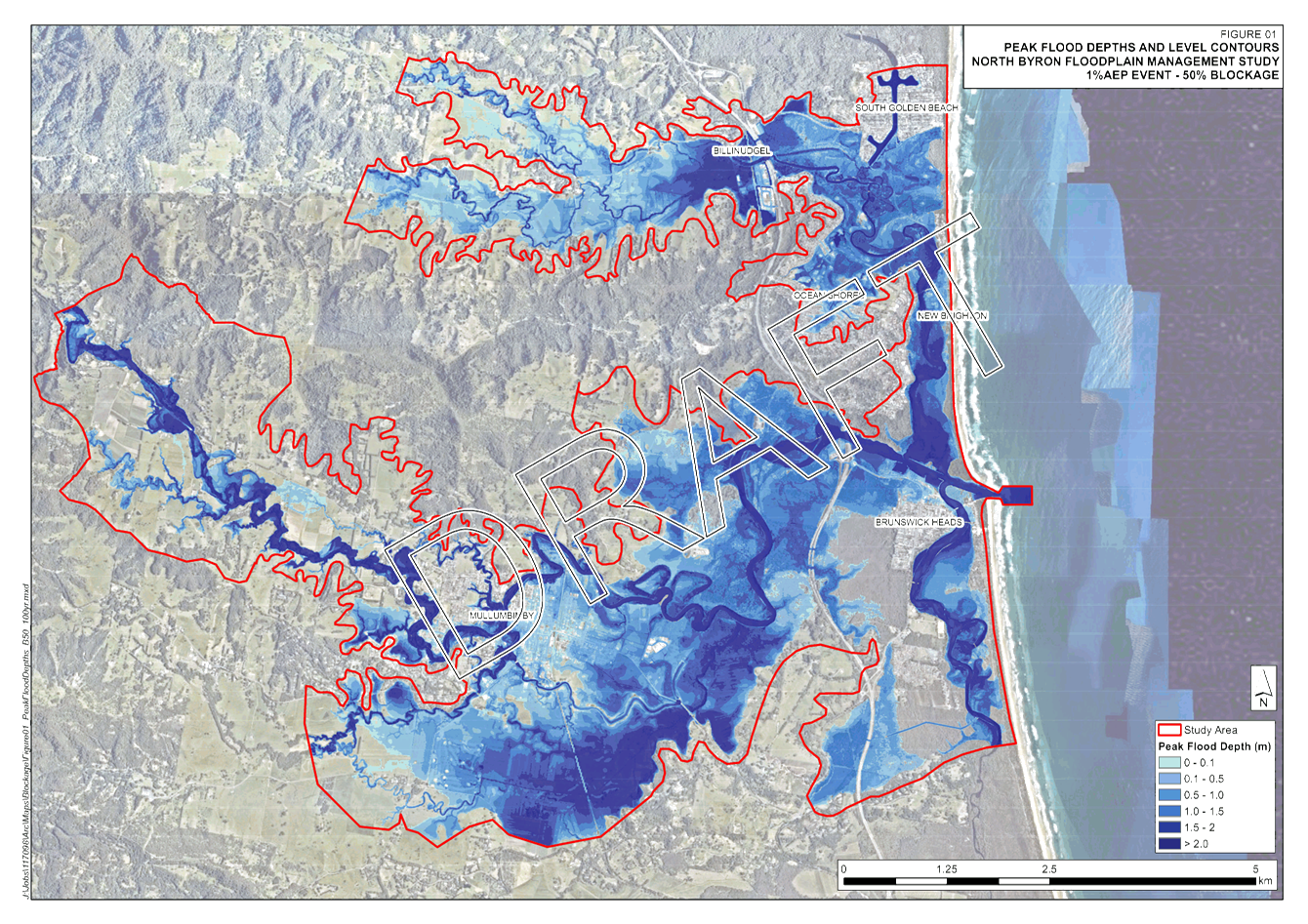
Design Events
New design events, in accordance with the tender specification,
have been modelled using the updated Flood Model and are provided in Attachment
1 for review.
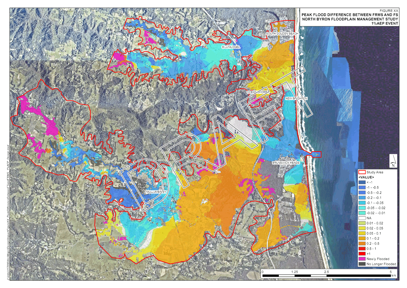
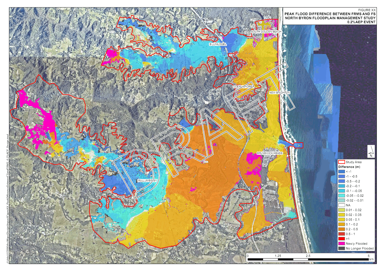
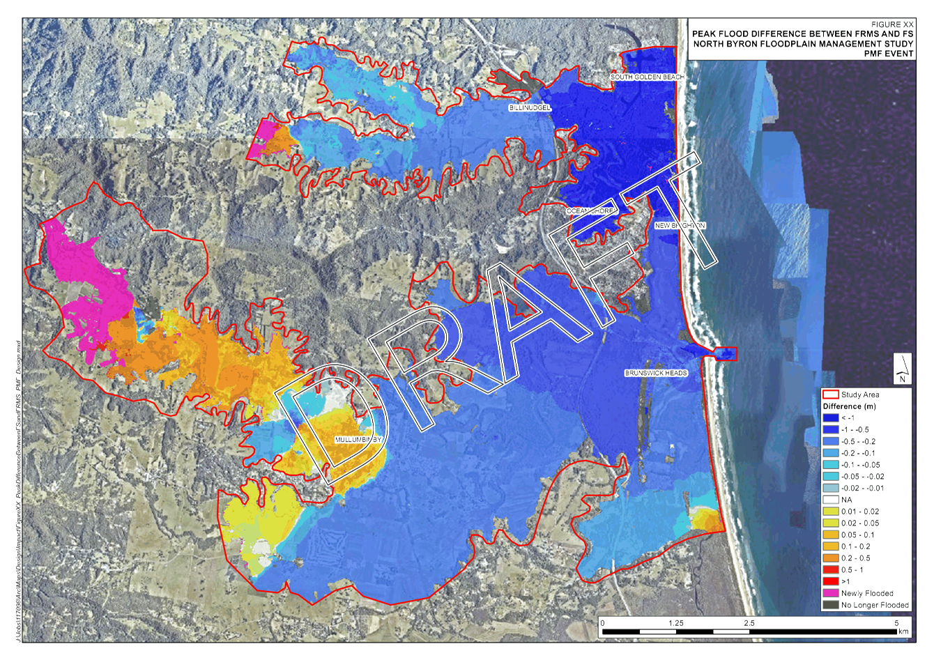
WMA Water have analysed the differences between these and the BMT
Flood Study mapping. In some locations there are some notable changes to the
outputs, however these can all be related to the model upgrades. A brief
summary of the key changes is provided below.
Upper Catchment
The hydraulic model was extended into the upper catchment (Main
Arm and the Pocket) – resulting in "Newly Flooded" areas in
these locations
The extension of the model has
also impacted flood levels at the pervious upstream
boundary, however these impacts
are localised and to be expected.
Brunswick River:
1. The Brunswick River bend losses in Mullumbimby were
reduced to improve calibration. This has caused a decrease in flood levels
upstream of Mullumbimby and an increase in flood levels downstream. This is
most apparent for more frequent events.
2. The Brunswick River downstream boundary condition
was updated for design events based on the latest Floodplain Risk Management
Guideline on Modelling the interaction of Catchment Flooding and Oceanic
Inundation in Coastal Waterways. For the 1% AEP and higher (0.5% AEP, 0.2%
AEP and PMF), the guideline recommends adopting a peak ocean water level of 2.10m AHD. The Flood Study used a
2.60m AHD level based on “a coastal assessment undertaken some 20 years
ago” (Flood Study, Ch8.6, p95). This change has resulted in
reduced flood levels at Brunswick mouth and upstream and is most evident in the
PMF.
Simpsons Creek:
1. The Brunswick Heads domain was updated to be
modelled using a 5m grid. This area of the model includes Simpsons Creek. This
refined modelling coupled with the changes in the hydrological model, increases
the flood levels upstream of the town.
Marshalls Creek:
1. The Railway Bridge modelling at Billinudgel was
refined and structures were added under the highway. These improvements to
modelling in this location and combined with the updated hydrology has reduced
flood levels upstream of Billinudgel.
2. In South Golden Beach and Ocean Shores, the flood
levels have increased in all events except the PMF. Significant changes in this
area include, a smaller grid size in Ocean Shores and updates to Marshalls
Creek bathymetry. These changes have, impacted flood levels in this area.
3. Updates to the hydrology has increased Yelgun Creek
inflow through Kallaroo Circuit, impacting flood level in the Capricornia Canal
up to Marshalls Creek.
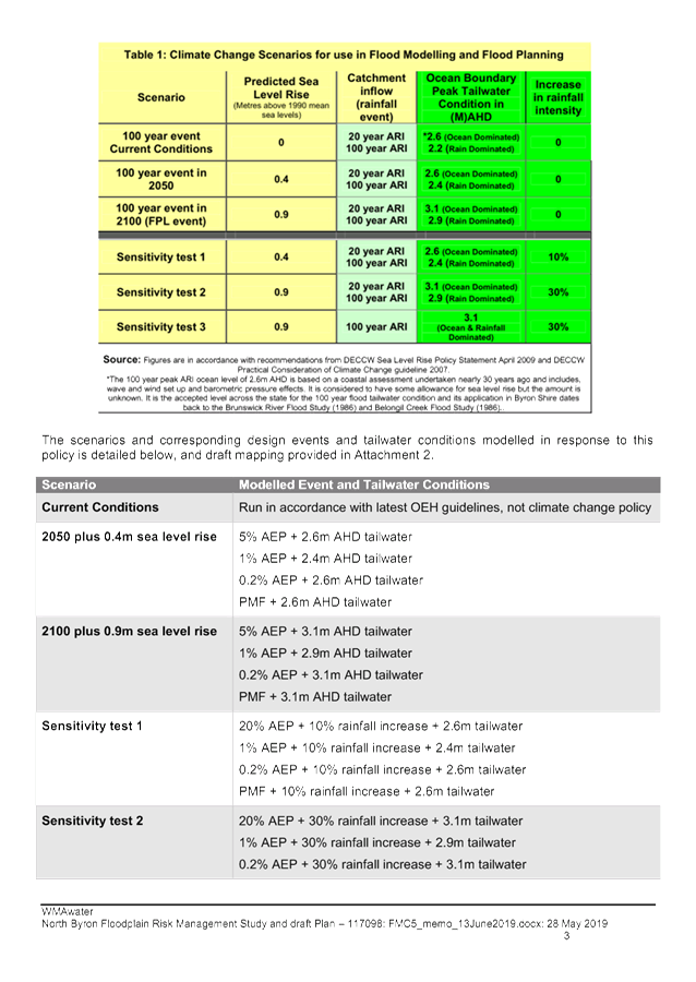
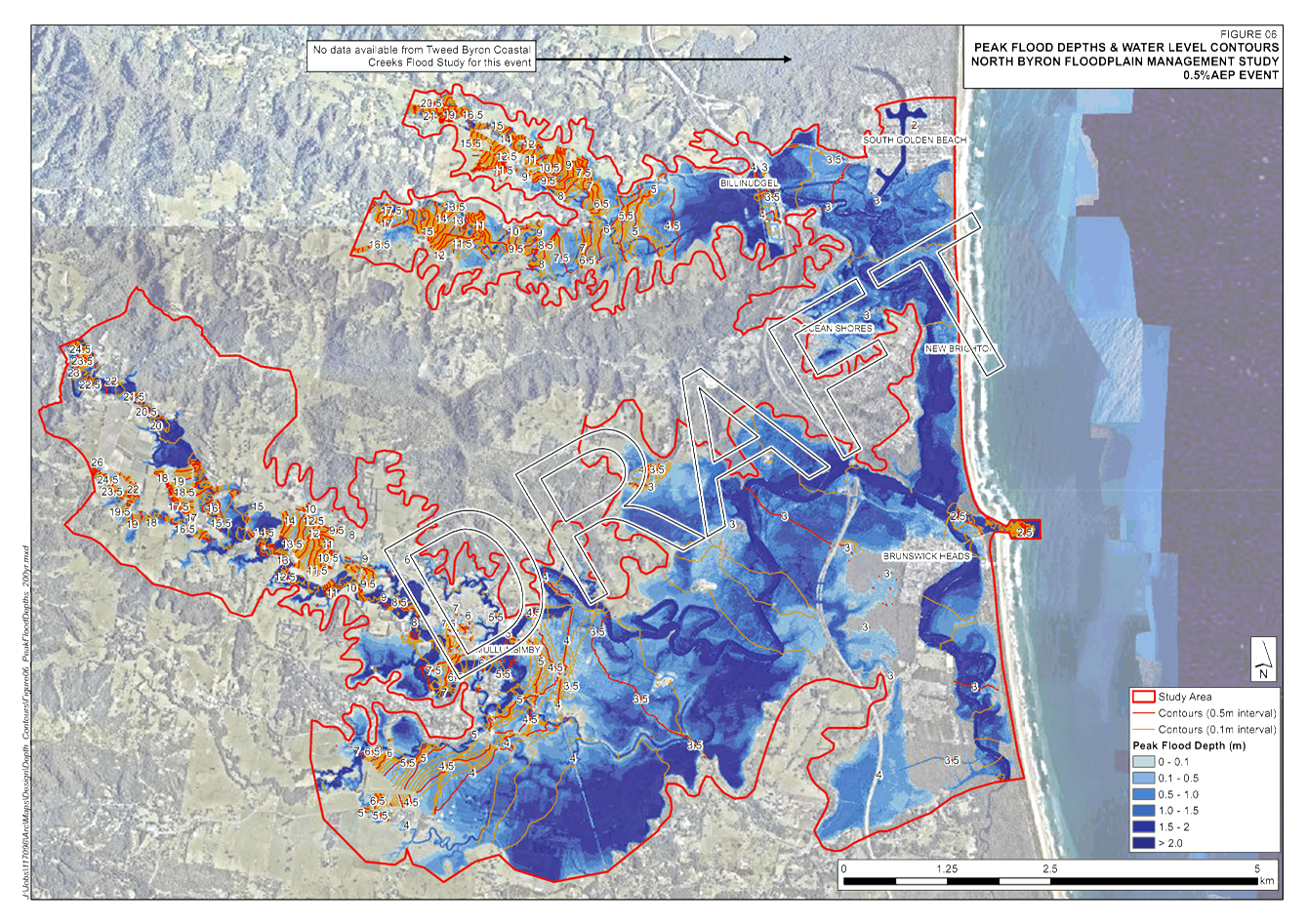
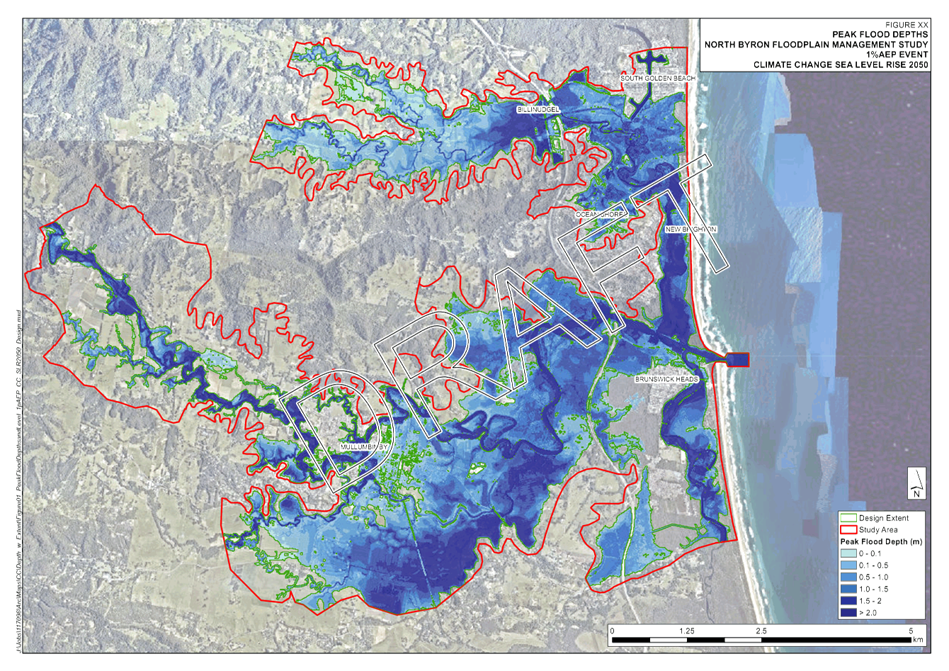
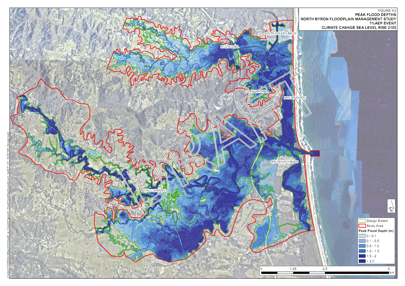
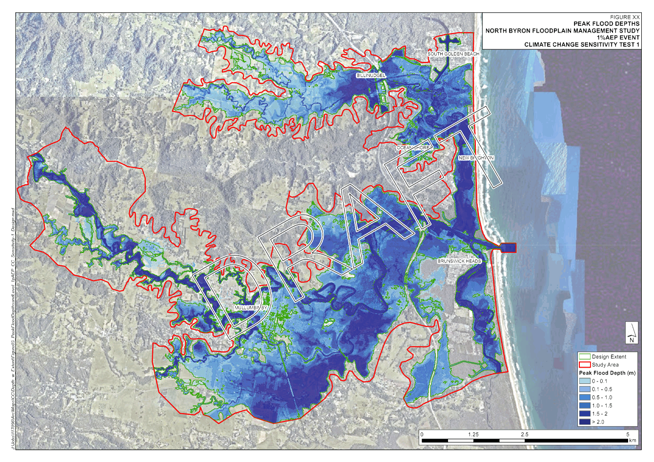
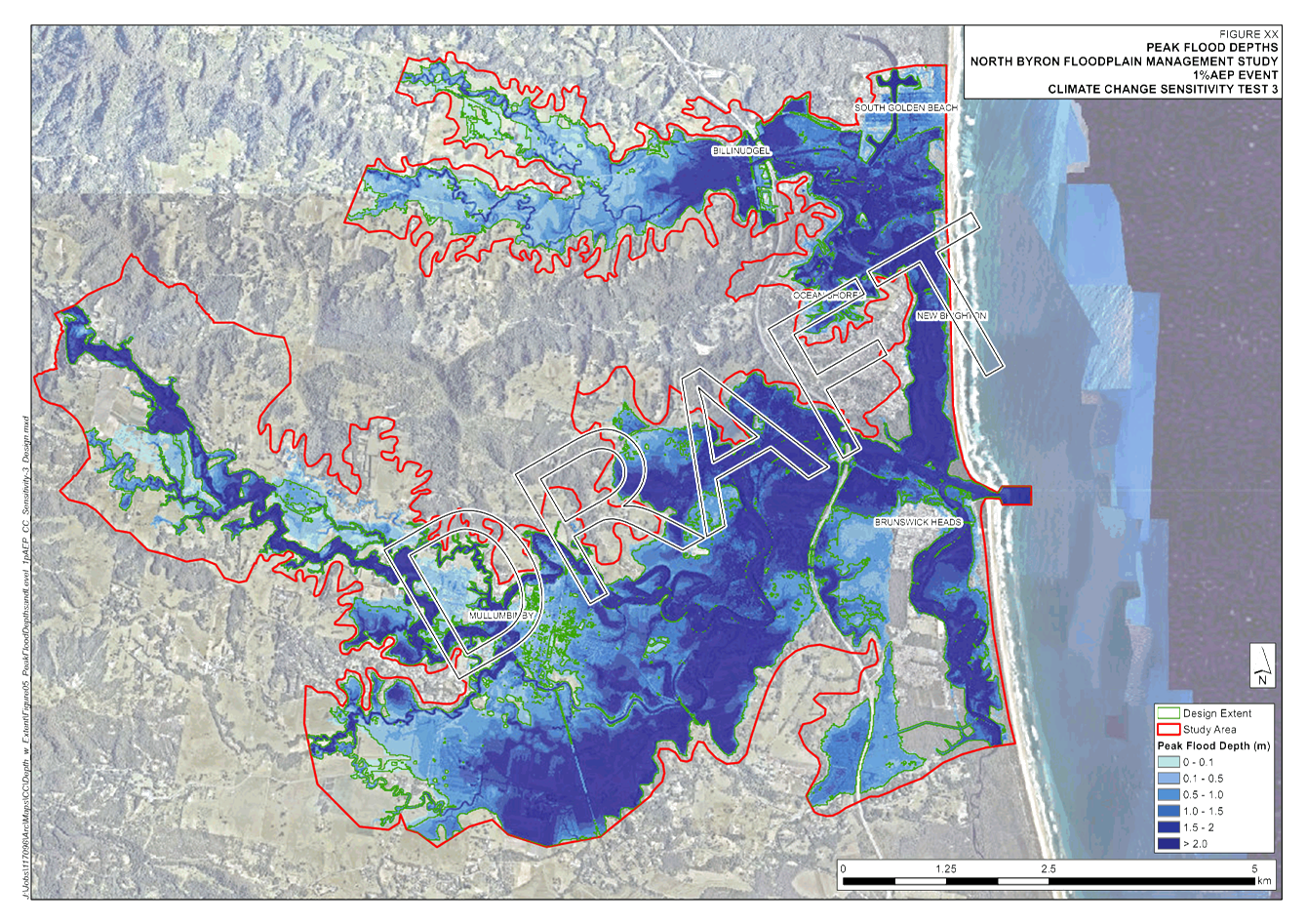
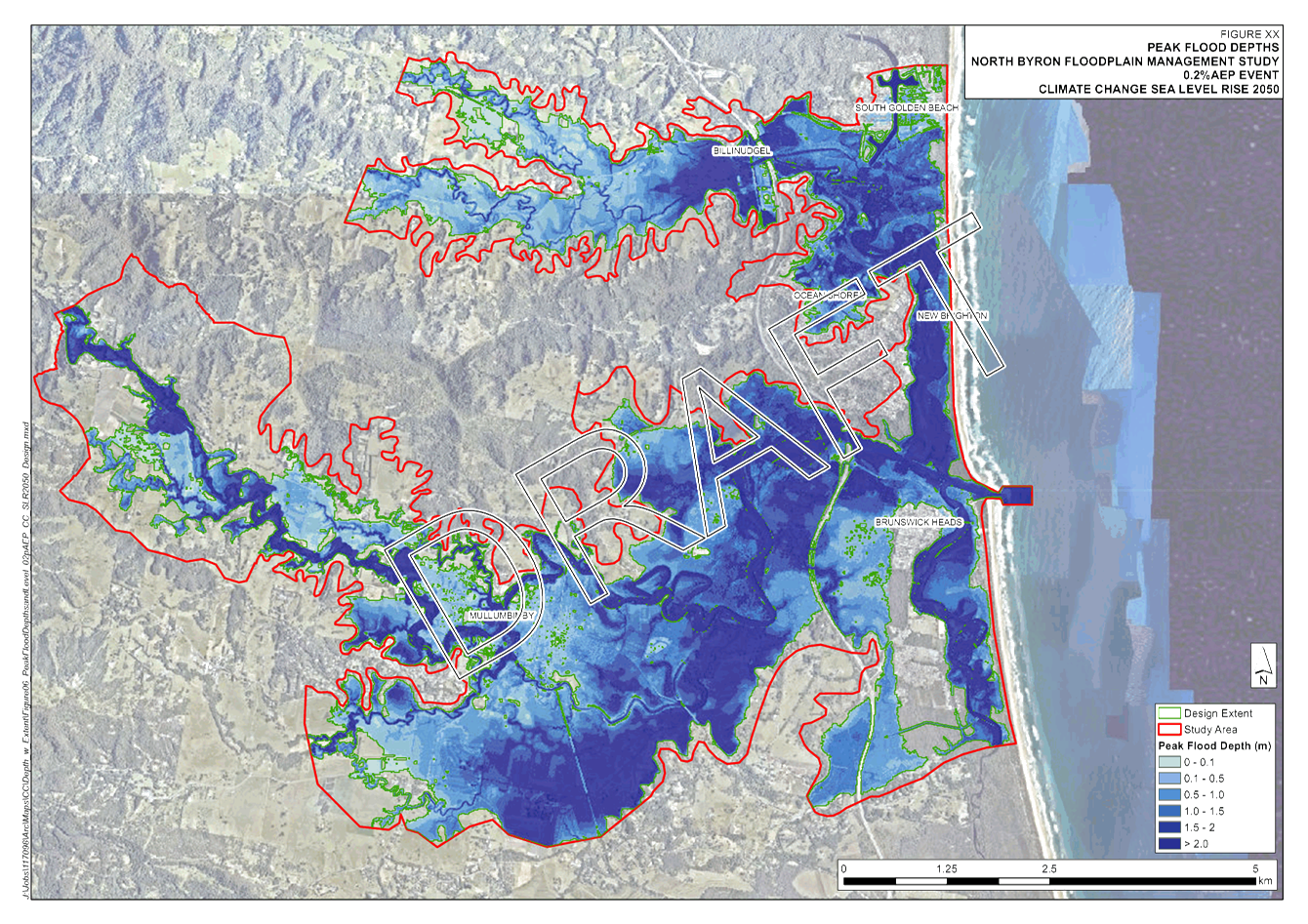
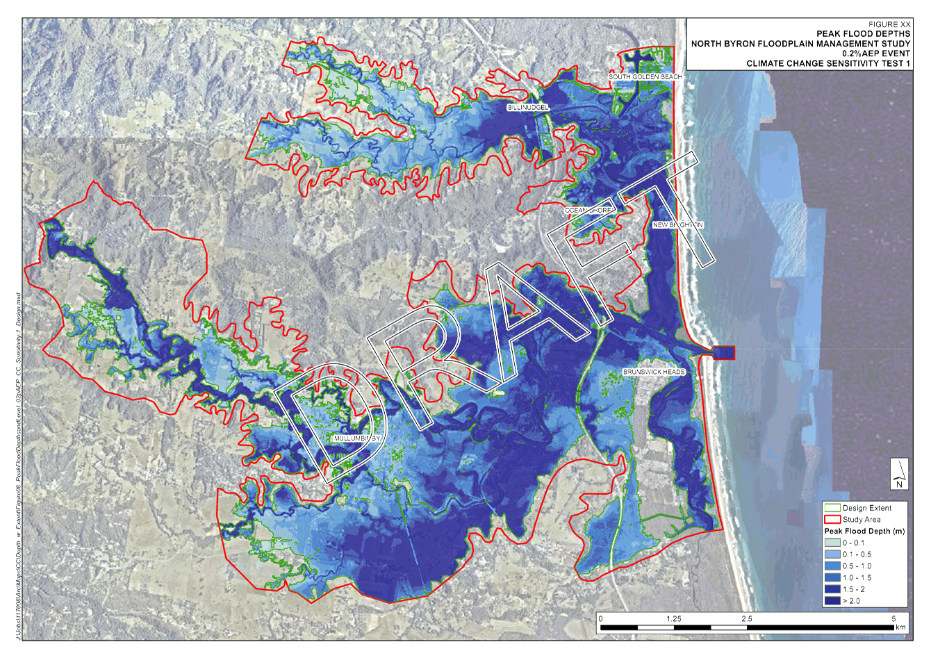
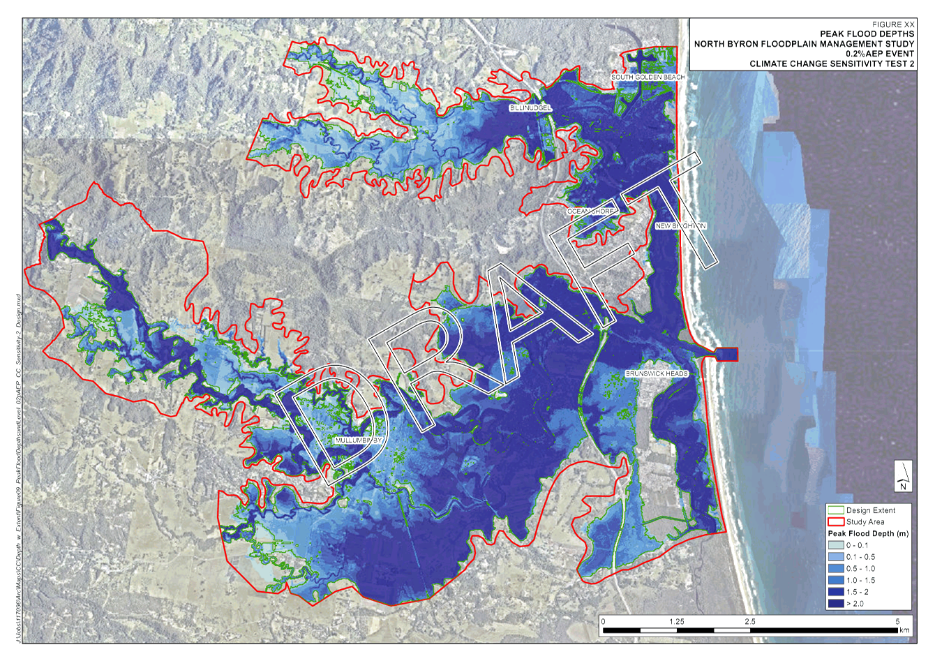
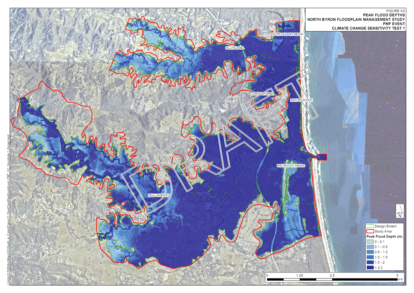
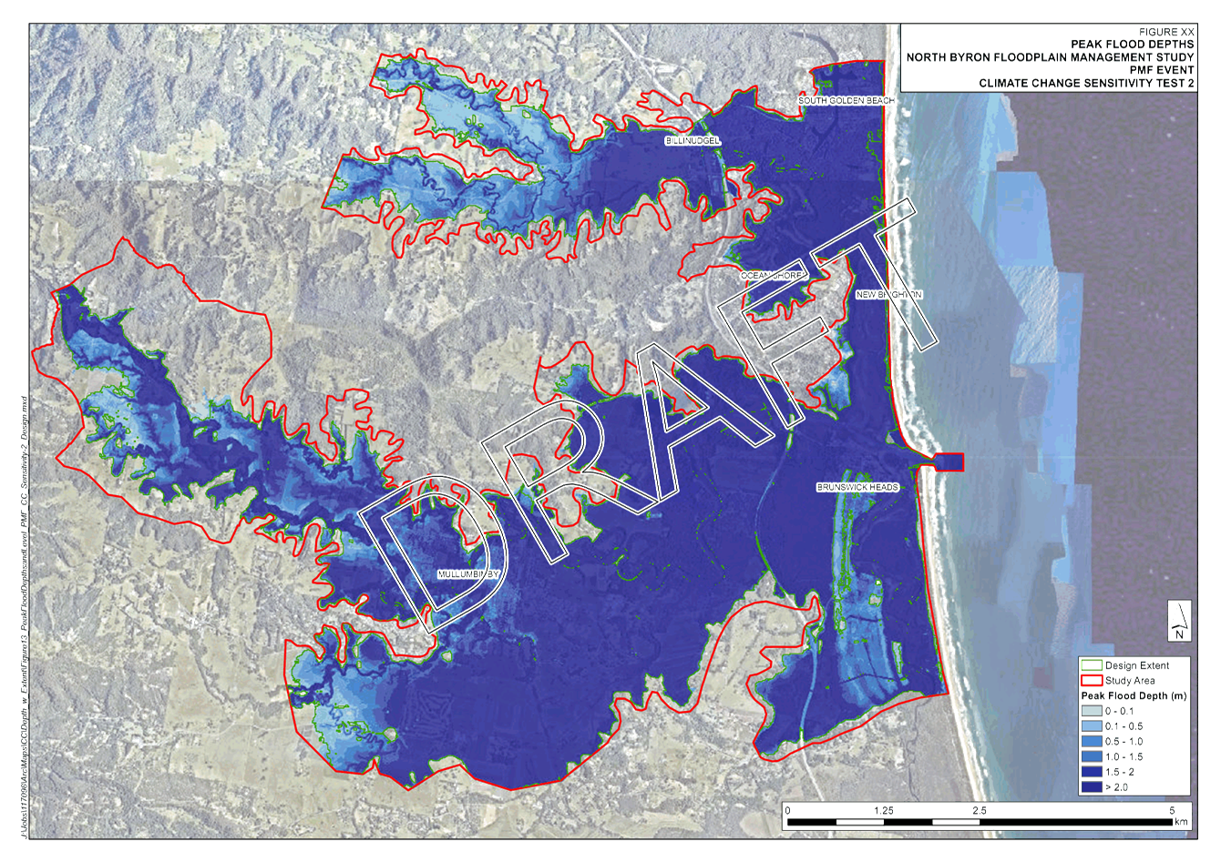
Climate Change Sensitivity
Attachment 1 provides details on
the scenarios used to assess Climate Change Sensitivity and the flooding
results from these scenario’s.
It is noted the current climate
conditions have been run in accordance with the latest Office of Environment
and Heritage (OEH) guidelines (OEH Floodplain Risk Management Guide - Modelling
the Interaction of Catchment Flooding and Oceanic) rather than Council policy.
This is considered to be current best practice and will be the recommended
method within the coming Climate Change Policy update.
This methodology has lowered the
current climate 100 year ocean level to 2.1m AHD. From previous reviews of
ocean levels it appeared the old level of 2.6m AHD included an allowance for
climate change, therefore, the lowering of water levels for current climate is
not surprising.
Further details on OEH policy
can be found at https://www.environment.nsw.gov.au/-/media/OEH/Corporate-Site/Documents/Water/Floodplains/modelling-catchment-flooding-oceanic-inundation-150769.pdf?la=en&hash=41092E03528FEF91161826E5FE5D9E5CD2D13598
Further analysis on the results
of this mapping and recommendations will be provided at the meeting and the
next FMC meeting. These results have been recently mapped and not been
investigated to date.
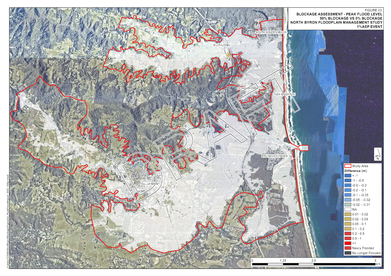
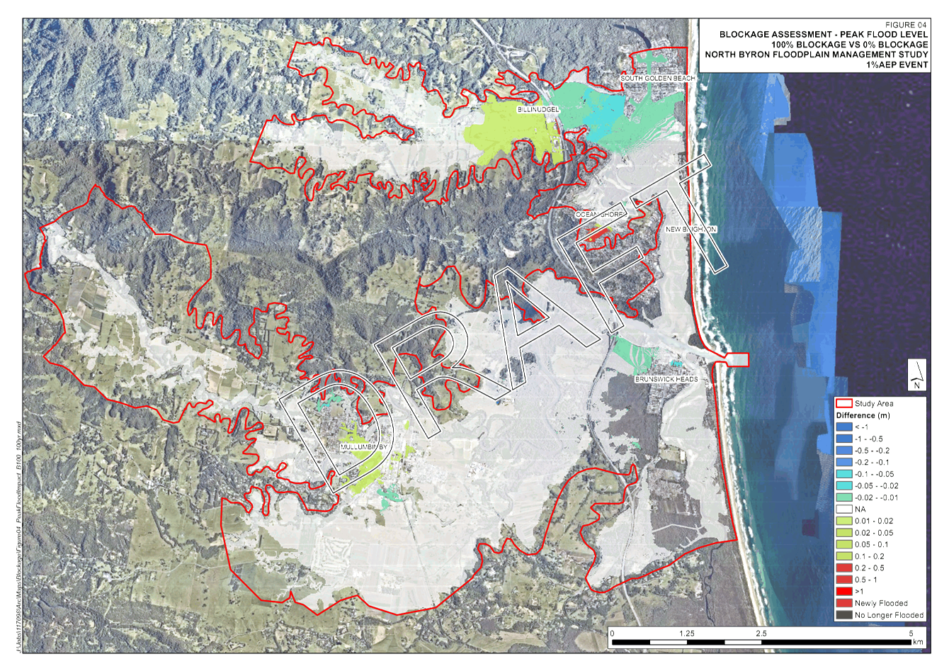
Hydraulic Structures Blockage
Sensitivity Assessment
The hydraulic structures represented in the model have been tested for their sensitivity to potential
debris blockage
during an event.
Any structure
less than 7m in the diagonal has been assumed either 50% or 100%
blockage and modelled for the 1% AEP event. Draft mapping is presented in Attachment 1. Compared to the base case (no blockage), there
is minimum impact as a result of blockage,
as most of the
major structures are far greater in
size than the blockage threshold.
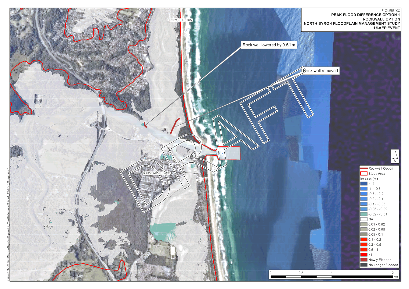
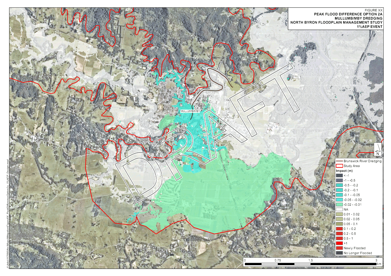
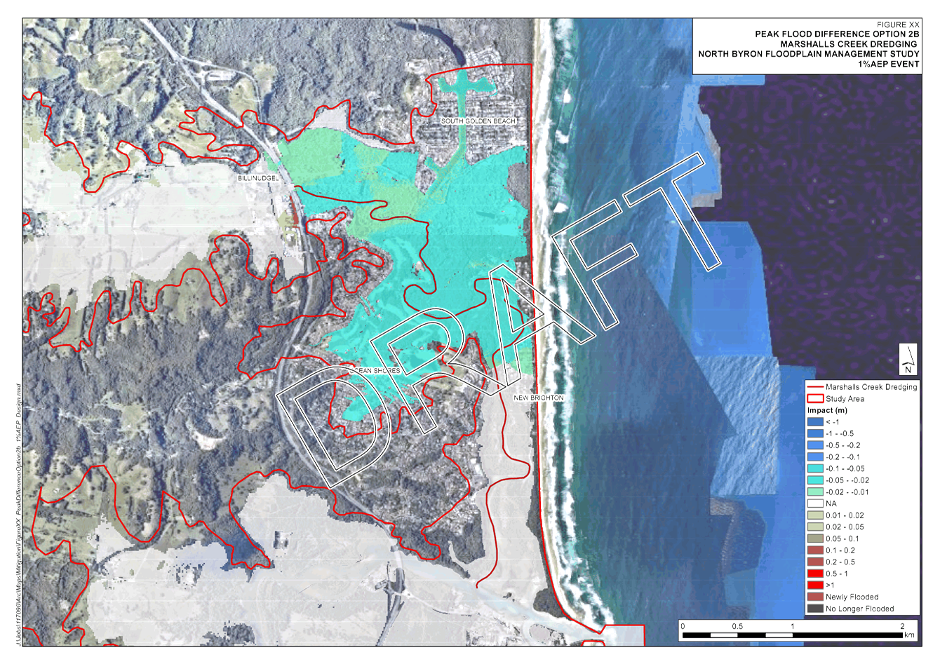
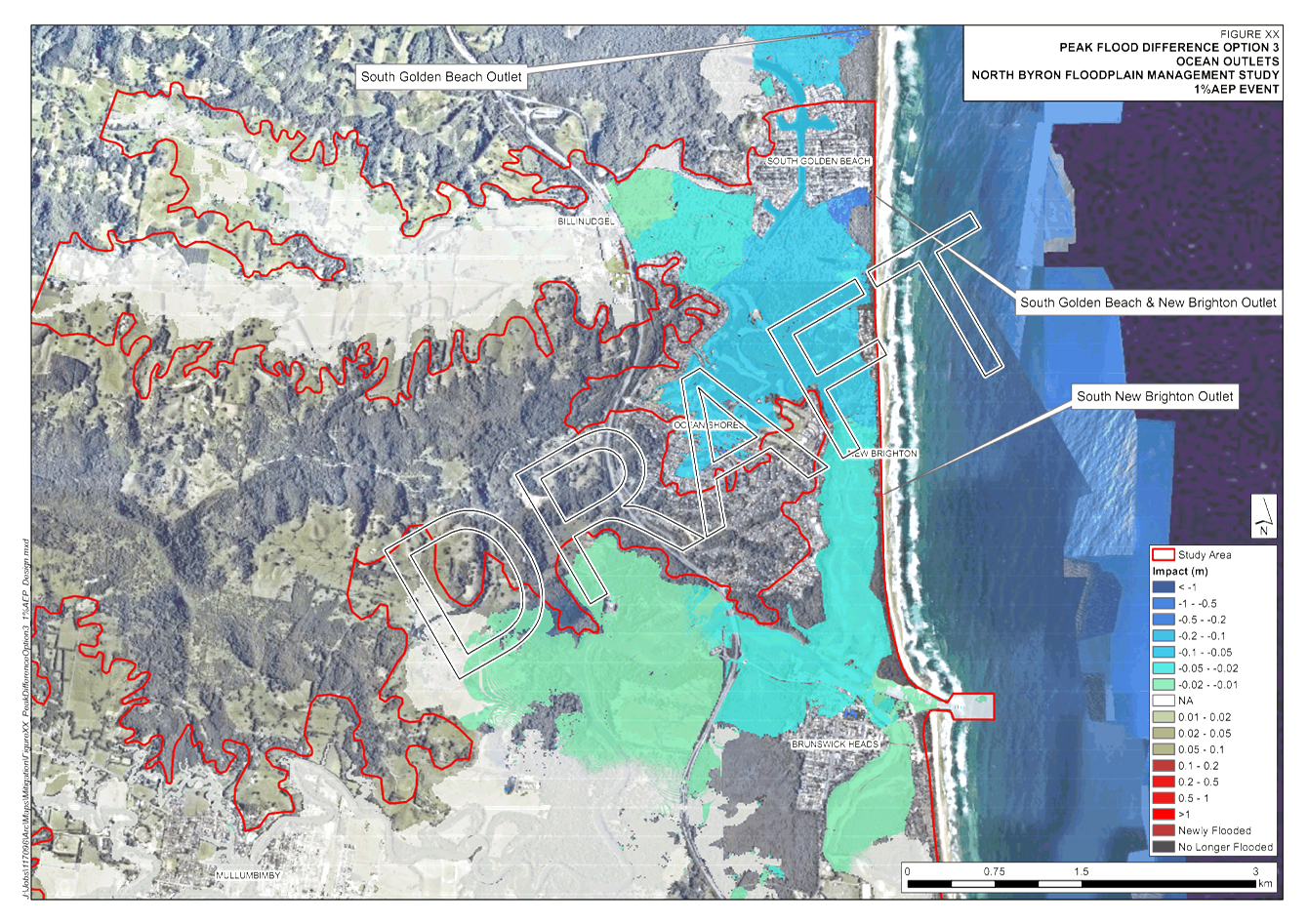
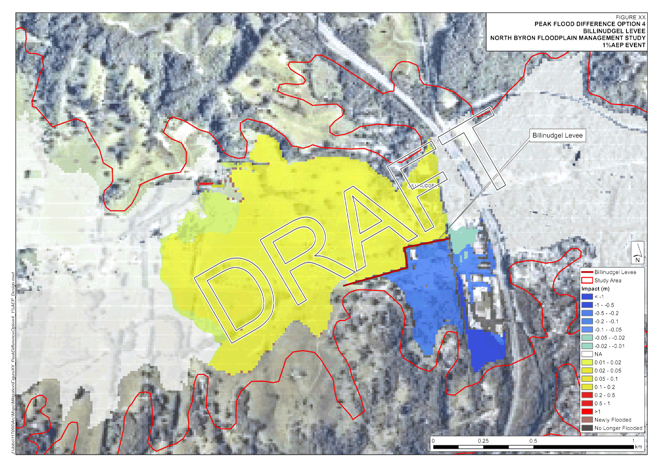
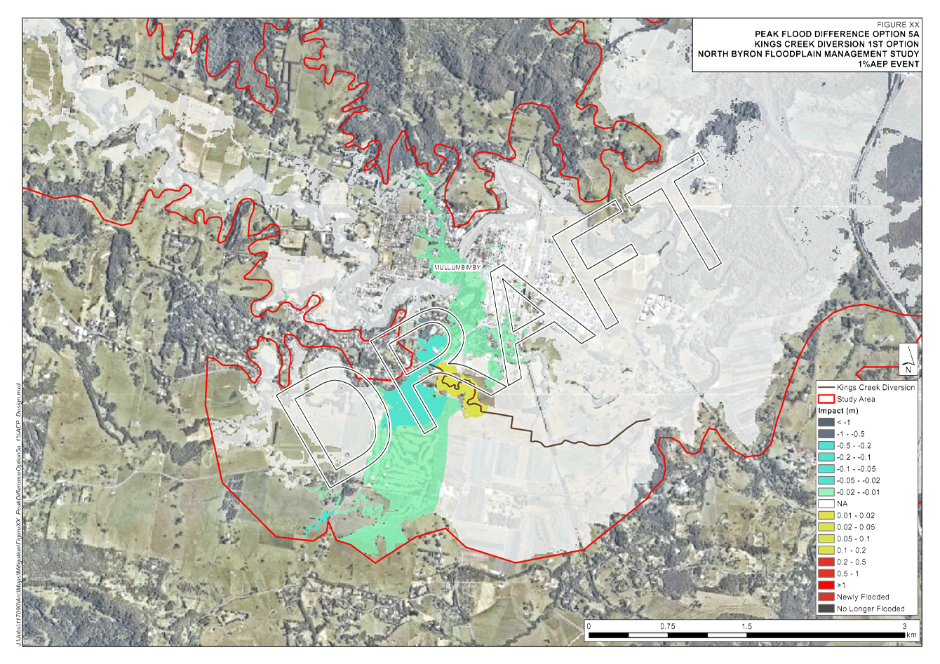
Early Mitigation Options
Draft results from six of the early identified mitigation options have been modelled and presented in Attachment
5 for the 1% AEP design
event only, namely:
1. Modification to Brunswick River mouth rock wall
alignment;
2. Dredging
of lower Marshalls
Creek;
3. Dredging
Brunswick River at Mullumbimby;
4. Two
ocean outlets (in combination);
5. Levee
at Billinudgel
(one iteration);
6. Diversion
of Kings Creek.
Further analysis on the results
of this mapping and recommendations will be provided at the meeting and the
next FMC meeting. These results have been recently mapped and not been
investigated to date.
The below database will be used
to advise what reductions in flood levels mean in terms of reducing damage to
property and other associated impacts to property owners.
Property Database
The floor level and property
survey combined with the FRMS modelling has been used to establish the base
case property database. For every property in the catchment results from the
design event and scenario mapping are extracted. This database not only forms
the basis for flood damage assessment, it is also becomes a useful tool for
identifying vulnerable properties and localised hotspots. An example will be
shown at the FMC meeting, however, the database has a large file size making
provision to the committee difficult.
Key issues
A
rigorous review of the existing flood model is of the utmost importance for the
North Byron Floodplain Risk Management Study and Plan. Therefore it is
important the committee review the mapping provided and provide comment at the
meeting.
Next steps
Over
the coming months the Draft Floodplain Risk Management Study document will be
prepared and reported to the committee as it progresses.
Moving forward, work will
continue on analysing the existing flood risk with development of Flood
Emergency Response Classifications, identification of evacuation capability,
Climate Change results and the flood damages assessment. Further potential mitigation
options will be identified and reporting on the results of these options in
detail. A list of further mitigation options will be identified for initial
desktop evaluation, with further modelling of the short-listed options.
Other
future tasks include:
1. Drainage assessments for
Mullumbimby and Brunswick Heads,
2. Land use planning
assessment and cumulative development impacts assessment.
3. Further mitigation
modelling and associated assessments,
4. Emergency Management tasks
include Education material, Evacuation Plans and Evacuation Centre Reviews and
Flood emergency response classifications.
5. levee overtopping / failure
assessment
The
Draft Floodplain Risk Management Plan will be prepared once the draft study
document has been finalised and received support from the committee.
Legal/Statutory/Policy Considerations
NSW Councils are expected to
prepare Floodplain Risk Management Studies and Plans for flood prone catchments
within their local government areas. These documents must be prepared in
accordance with State Government Policy.
The NSW Floodplain Development
Manual 2005 is the current policy used by State Government for the preparation
of such documents.
This project is following the
methods prescribed in the NSW Floodplain Development Manual for completing
Floodplain Risk Management Studies and Plans.
Financial
Considerations
There are no financial
consideration for the committee to consider within this report.
Consultation
and Engagement
The
Office of Environment and Heritage have been consulted between FMC meetings to
ensure they are aware of where the project has been heading.