Local Traffic Committee Meeting
A Local Traffic Committee Meeting of
Byron Shire Council will be held as follows:
|
Venue
|
Conference Room, Station Street, Mullumbimby
|
|
Date
|
Tuesday, 12 May 2020
|
|
Time
|
10.30am
|
|
Committee
Members
|
Ian Shanahan – Transport for NSW
Snr Constable Chris Davis – Police
Cr Basil Cameron
Tamara Smith MP
|

Phillip
Holloway
Director Infrastructure Services I2020/712
Distributed 05/05/20
BUSINESS OF MEETING
1. Apologies
2. Declarations of Interest
– Pecuniary and Non-Pecuniary
3. Adoption of Minutes from
Previous Meetings
3.1 Local
Traffic Committee Meeting held on 10 March 2020
3.2 Extraordinary
Local Traffic Committee Meeting held on 16 April 2020
4. Matters Arising
5. Outstanding
Issues/Resolutions
6. Regulatory Matters
6.1 Massinger
Street, Byron Bay - No Stopping Yellow Lines................................................ 3
6.2 Bayshore
Drive - No Parking Area 1am-5am................................................................... 8
6.3 Ocean
Shores Public School............................................................................................ 9
6.4 Byron
Street Connection - Shared Zone......................................................................... 17
7. Matters for Traffic Engineering Advice
7.1 Paterson
St, Byron Bay - Parking Concerns................................................................. 19
8. Development Applications
8.1 DA
10.2019.6161.1 - Mixed Use Commercial/ Residential Development, cnr Jonson
& Browning Streets Byron Bay........................................................................................................... 21
Regulatory Matters
Report No. 6.1 Massinger Street, Byron Bay - No Stopping Yellow Lines
File No: I2020/430
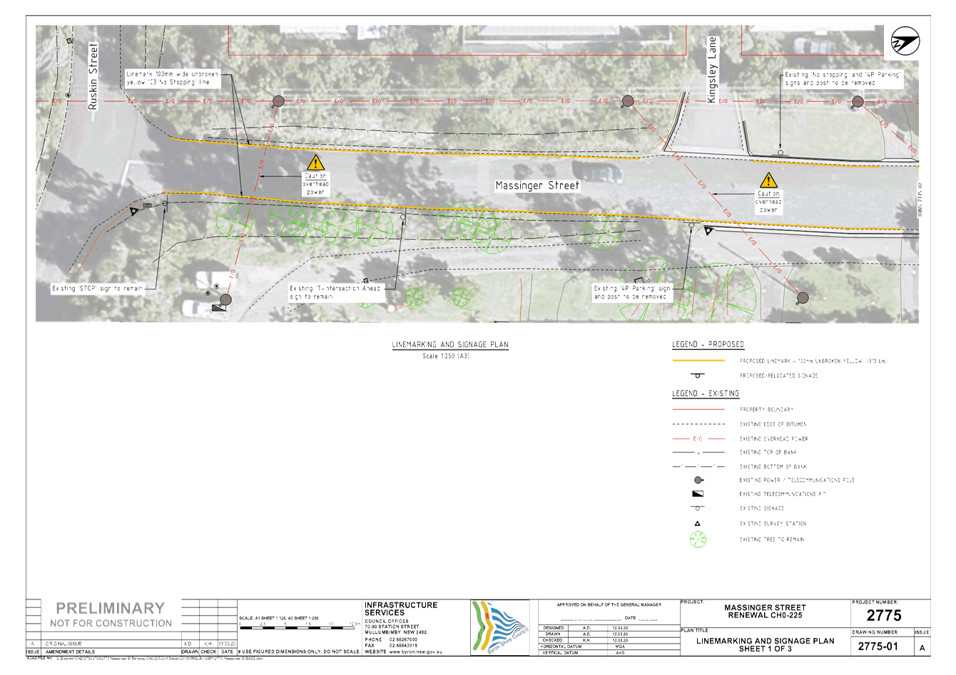
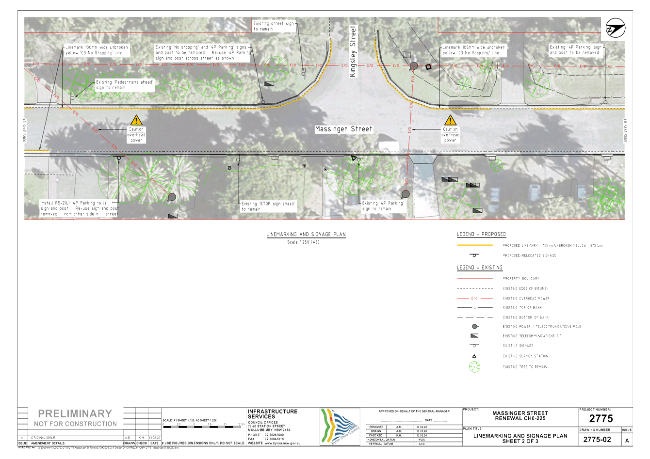
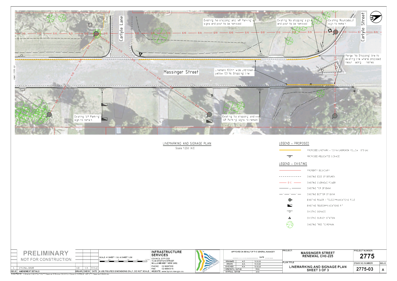
Council is undertaking works to improve the southern end of
Massinger Street, Byron Bay.
Figure 1 below shows the location of the works.
Figure 2 & 3 show street view images of the works area,
image taken July 2019. Attachment 1 shows the proposed design.
Attachment 1 shows the proposed works and extent.
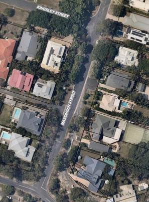
Figure 1 – Location of works extend from Ruskin St to
just north of Kingsley St.
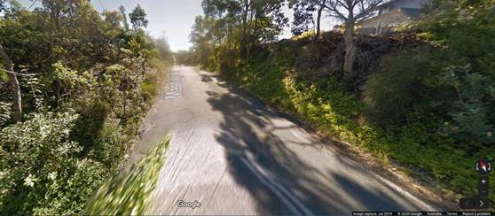
Figure 2 – Southern end of
works at the intersection with Ruskin Street looking north.
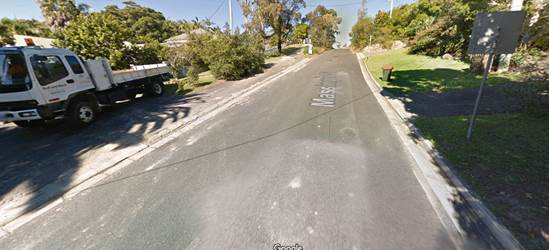
Figure 3 – Northern end of
works looking south towards Ruskin Street.
The regulatory matters of note in
Attachment 1 are:
· Introduction of No Stopping yellow lines from the
intersection of Ruskin Street and extending north just past Kingsley
Lane. Note from Figure 2 there is no safe parking on the road shoulder.
· The removal of 10m of 4P parking from Kingsley Lane to the
first driveway. This is outside the pay parking precinct and is part of a
Council created residential permit zone called Massinger Street Precinct.
These works are proposed as it is
not considered safe to permit parking in this region of Massinger Street.
|
RECOMMENDATION:
That Council support the installation of “No
Stopping” yellow lines on both sides of the southern end of Massinger
Street, Byron Bay, with the extent of the yellow line to be generally in
accordance with Attachment 1 (#E2020/20126).
|
Attachments:
1 2775_Massinger
St-Prelim Set, E2020/20126 , page 5⇩ 
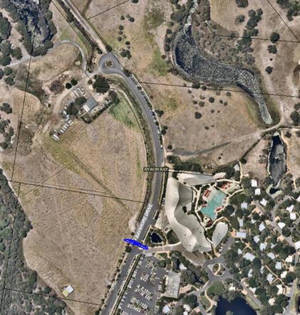
Report No. 6.2 Bayshore Drive - No Parking Area 1am-5am
File No: I2020/439
Council’s compliance and enforcement team have noticed
the northern end of Bayshore Drive, Byron Bay, has become a significant concern
in relation to illegal camping area. As a result they have requested No Parking
Area 1am – 5am signs be installed at the location shown by the blue line
in the snippet below. This is approximately road chainage 1,400m.
This location would allow the enforcement team to better
manage illegal camping at the northern end of Bayshore Drive.
|
RECOMMENDATION:
That Council support the installation of a No
Parking Area – (1am-5am) sign at approximate road chainage 1,400m.
|
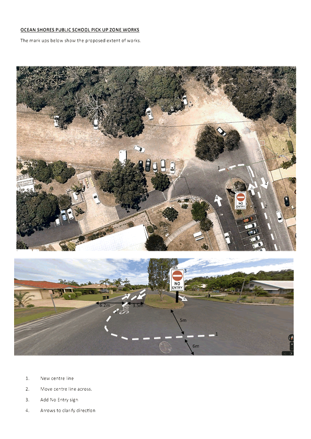
Report No. 6.3 Ocean Shores Public School
File No: I2020/643
In response to concerns raised by the Ocean Shores Public
School relating to safety around their pick up / drop off zone Council, in
consultation with TfNSW, has undertaken works to address these concerns.
These works consist of both regulatory and non regulatory
delineation and signage, as well as infrastructure to improve parking and
traffic flow.
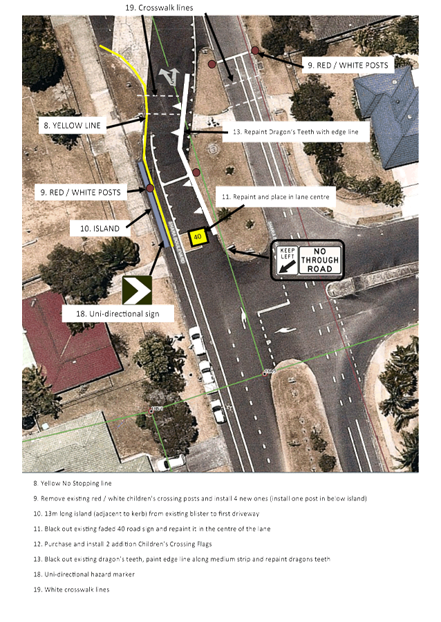
Refer to Attachment 1 for the concept design.
Given the perceived urgency of the safety concerns TfNSW has
already approved both the funding and the scope of works with the goal of
undertaking the works during the April school holidays.
As a result these works have already occurred but still need
to be supported by LTC and approved by Council.
The regulatory matters of note within the attached concept
design are:
· No Entry sign at
the northern end of the drop off / pick up zone (page 1 of Attachment 1)
· Move the Shara
Blvd Centre line west approximately 1m to provide safer parking along the
eastern side of Shara Blvd (page 1)
· One way sign at
the southern entrance to the drop off / pick up zone (page 2)
· No Stopping yellow
lines around the existing blister / island at the entrance to the drop off /
pick up zone which extends for approximately 13m south (page 2 and 3)
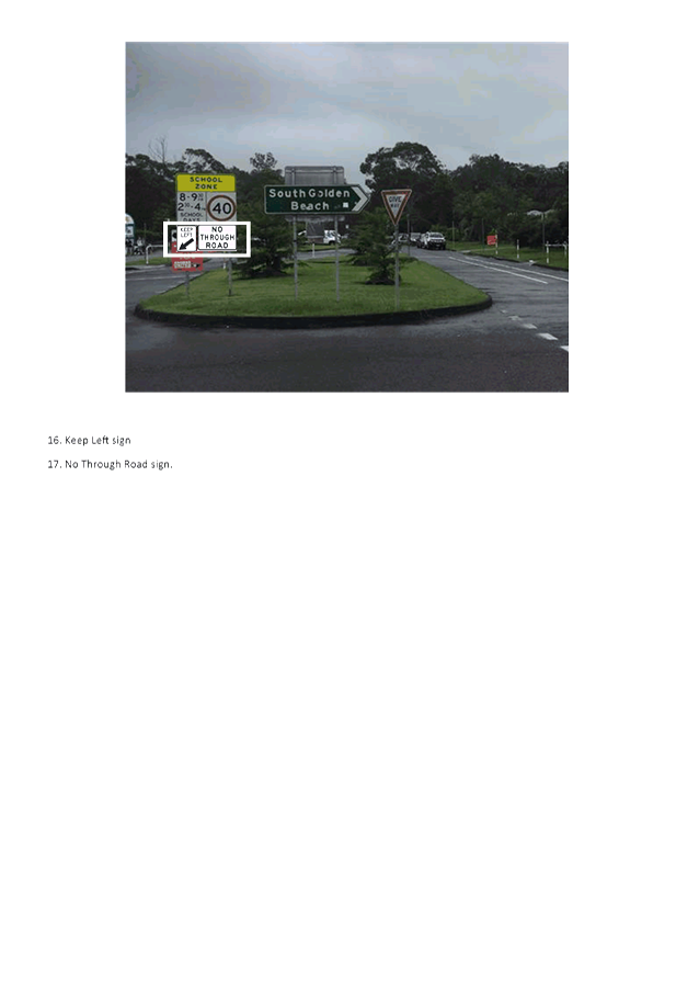
· Keep left (page 3
and 5)
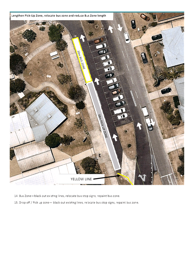
· Modify the length
of the Bus Zone and Pick Up Zone (page 4)
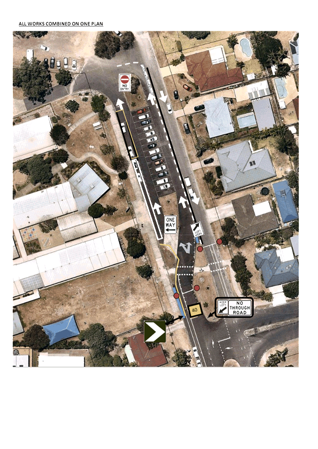
Note: page 6 of attachment 1 provides all proposed works on
one plan.
While undertaking the works outlined in Attachment 1 crews
on site identified an additional area of potential confusion at the very
northern end of Shara Blvd. At the very northern end of Shara Blvd there are
multiple lines of movement making it potentially unclear who gives way. To
better regulate traffic flow in this area Council obtained TfNSW permission to
install a Give Way Sign and a Give Way TB Line in the location shown below. An
additional Give Way Sign Ahead (symbolic) sign was also installed in the
general location shown below.
|
RECOMMENDATION:
That Council endorse the works undertaken at Ocean
Shores Public School to help address safety concerns.
|
Attachments:
1 Ocean
Shores Public School - Pick up Zone Works - Concept, E2020/29656 , page 11⇩ 
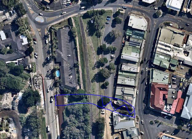
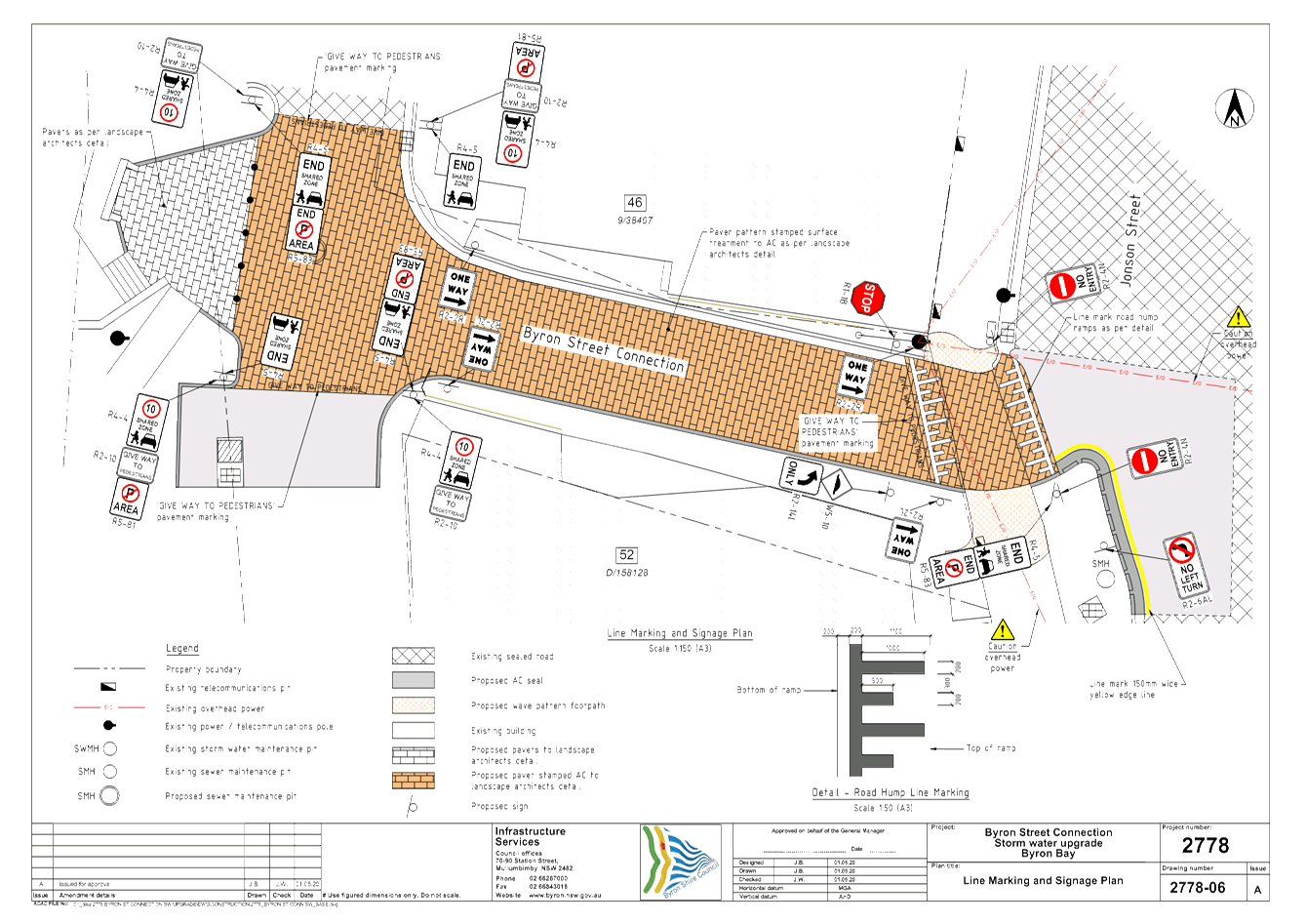
Report No. 6.4 Byron Street Connection - Shared Zone
File No: I2020/676
Council is in the process of designing a pedestrian
connection between Jonson Street and Butler Street, Byron Bay.
As part of this pedestrian connection Council is requesting
consent to establish a Shared Zone over a road related area as shown in the
figure below. The Blue line shows the proposed full extent of the
pedestrian access way. The blue zig zag line shows the general location
of the proposed Shared Zone. Refer to Attachment 1 for the proposed
design and regulatory signage and line marking.
TfNSW have requested this item be brought to the LTC.
|
RECOMMENDATION:
That Council support the establishment of a
Shared Zone and the associated regulatory signage and linemarking. The
location and design of the Shared Zone is to be generally in accordance with
Attachment 1 (E2020/31355)
|
Attachments:
1 Byron
Street Connection - Shared Zone, E2020/31355
, page 18⇩ 
Matters for Traffic Engineering Advice
Report No. 7.1 Paterson St, Byron Bay - Parking Concerns
File No: I2020/573
Over the past 12 months local
residents and compliance officers have raised a number of issues relating to
the area around Daniels Lane, Paterson Street and Kipling Street, Byron Bay.
In particular, Council has
received a number of phone calls from 2 residents, on Paterson St and one on
Daniel Street. The concerns relate to traffic and parking congestion. In
addition, Councils compliance officers have highlighted on going parking issues
restricting access for waste collection along Paterson Street and illegal
camping near the northern entrance to Paterson Street.
These matters have been raised in
recent LTC meetings and are summarised in Figure 1 below.
· “No Parking 1am-6am” along the north eastern
side of Paterson St entrance,
· “No Stopping” along the northern side of Daniel
Street,
· “No Stopping” along the south eastern side of
Paterson St.
The yellow lines in Figure 1 show
the extent of the above signage.
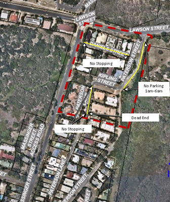
Figure 1 – Location under
consideration shown by RED dashed line
Paterson St, Daniels St and
Kipling St form an isolated network of roads. The southern end of Paterson St
is a dead end at the location identified in figure 1. Access into this area is
off Lawson St (via Paterson St) and Massinger St (via Daniel St).
Despite these recent but limited
parking restrictions introduced to the area it remains a popular spot for all
day and all night parking. One resident highlighted that Cabins in the caravan
park are often used by multiple friends and only one car is allowed with each
cabin. As a result, the other cabin residents park their cars for days at a
time in front of 98 Paterson St (on the corner of Lawson St and Paterson St).
In addition, No Parking along the
north eastern entrance of Paterson Street has moved cars to the western side of
Paterson Street entrance. Throughout most of this area there is nothing
to prevent All Day or All Night parking.
Rather than tackle issues
piecemeal it is recommended to treat this area as a whole area and adopt a
whole of area parking strategy. It is again noted this is a defined area
disconnected from other road networks and particularly popular due to its
proximity to the each and caravan park.
To this end there are several
options Council can consider:-
1. Introduce 4P time limit across the whole
area as 4P is the time limit along Massinger.
· This would require the Massinger Parking Permit Precinct to
be expanded to include this area.
2. Introduce a No Parking Area 1am to 6am
3. Introduce Pay Parking as part of the new pay
parking tender to commence December 2020
· This would require Parking Permits to be planned as it
would be the first residential area with pay parking.
4. A combination of all the above
|
RECOMMENDATION:
That Council:-
1. Prepare
a parking Plan of Management for the following area and submit it to LTC for recommendations
and Council for approval:-
i. Paterson Street
from Lawson Street to the dead end
ii. Daniels Street, and
iii. Kipling Street, Byron
Bay
2. The
Plan of Management is to consider the following options individually and in
combination:-
i. Introducing
pay parking;
ii. Introducing 4P time
limits
iii. Extending the Massinger
Permit Scheme to the area
iv. Any other options
identified during this process.
.
|
Development Applications
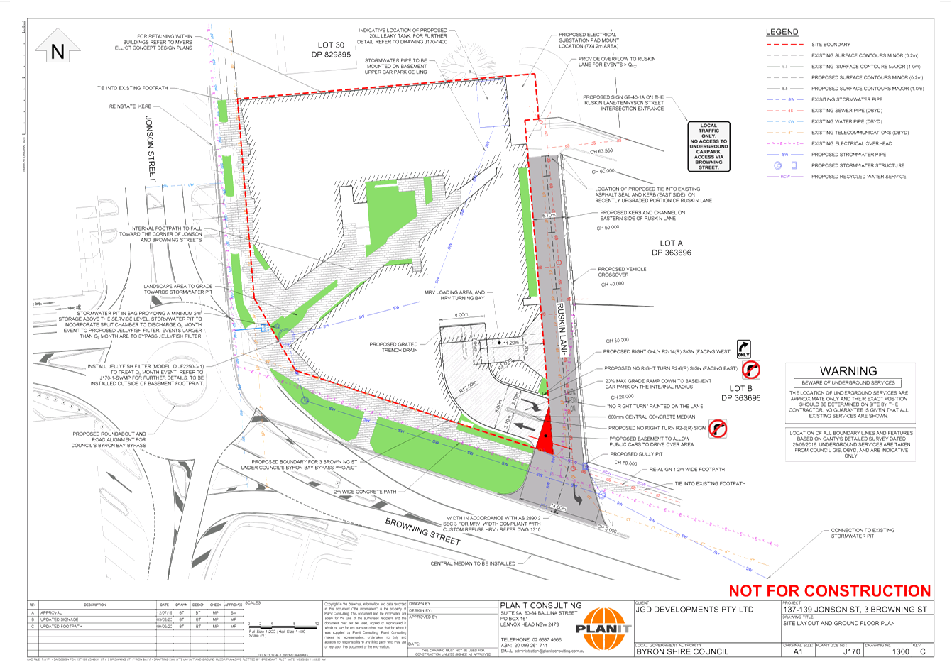
Report No. 8.1 DA 10.2019.6161.1 - Mixed Use Commercial/ Residential Development,
cnr Jonson & Browning Streets Byron Bay
File No: I2020/545
SUMMARY
Council has received a Development Application (DA
10.2019.616.1) from Mr M Scott, on behalf of JGD Developments Pty Ltd for a
mixed use development comprising commercial premises, café, and shop top
housing. The development is located on the south-west corner of the
Jonson Street/ Browning Street intersection in Byron Bay.
BACKGROUND
The committee dealt with a previous development application
on this property, for a similar, although larger scale, development (DA
10.2017.510.1).
The previous DA was refused by the Northern Regional
Planning Panel for a number of planning reasons, primarily associated with the
height of the proposed building.
The applicant has redesigned the development, mainly by removing
the top floor of the previous design, and has also deleted the previously
proposed child care centre.
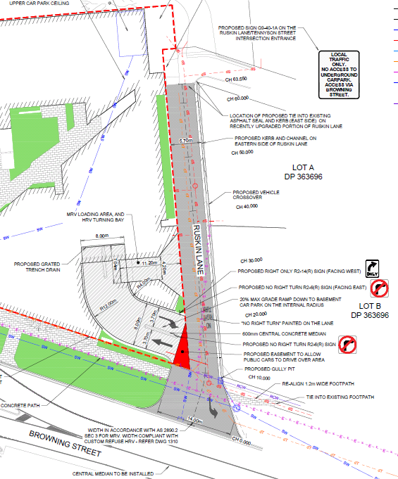
THE CURRENT PROPOSAL
The current application proposes retail and commercial uses
at ground level, including a café, and two (2) levels of residential
apartments above, with a total of 28 units. As with the previous
application, two levels of basement car parking are proposed, with access from
the rear of the development via Ruskin Lane.
The site is located at the corner of Jonson and Browning Streets,
Byron Bay, adjacent to the proposed Byron Bypass roundabout. Ruskin Lane,
which is currently a sealed two-way lane, adjoins the eastern boundary of the
site.
At the north-eastern corner of the development site, Ruskin
Lane turns to the east to join with Tennyson Street. This east-west
section, while not restricted or sign-posted as one-way, has a width of only
3m.
The traffic study submitted with the application estimates
that the completed development will generate:
· 163 AM peak
hour trips;
· 117 PM peak
hour trips; and
· 976 daily
trips.
Access arrangements are shown in the attached engineering
plan, and the extract below. A number of key management measures are
proposed, including:
· a central
median within Browning Street, to prevent right turns in and out of the lane;
· orientation
of the exit from the basement car park ramp to discourage left turns into
Ruskin Lane; and
· signage
location at various locations (as shown) prohibiting turns that would increase
traffic on the main parts of Ruskin Lane, and advisory signage at the Ruskin
Lane/ Tennyson Street intersection.
The effect of the measures is to limit traffic impacts
adjacent to the (new) Byron Bypass roundabout to be constructed at the Jonson/
Browning Street intersections, by limiting access to Ruskin Lane to left in/
left out only, and to limit addition traffic on Ruskin Lane by confining that
traffic to the short section at its entrance, and discouraging traffic exiting
the basement car park from turning left to travel into Ruskin Lane.
A full review of potential traffic impacts, will be included
in the DA assessment report to be considered at the Council (Planning) meeting
in the future. The development is traffic generating development
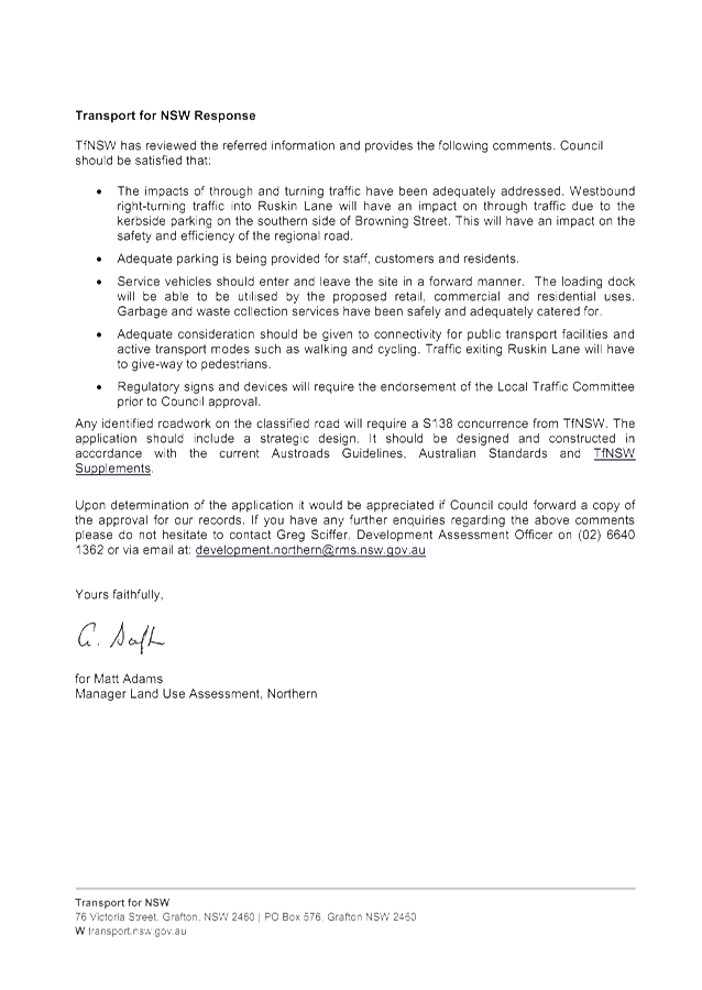
as defined in SEPP (Infrastructure) 2007, and Transport for NSW were therefore
given an opportunity to comment on the application. The response is in
Attachment 2, and outlines a range of matters for Council’s consideration
and will be included in staff final DA Assessment report.
Transport for NSW also advise that regulatory signs and
devices will require the endorsement of the Local Traffic Committee prior to
Council approval.
The proposed regulatory signs and devices are shown in
Drawing Number 1300 Rev C, prepared by Planit, dated 09/03/2020, at Attachment
1. The signs include:
· Advisory
sign – “Local traffic only. No access to underground
carpark. Access via Browning Street” – to be located adjacent
to the Ruskin Lane/ Tennyson Street intersection;
· “No
right turn” painted on the southbound lane within Ruskin Lane on approach
to access ramp;
· Regulatory
sign “No right turn” adjacent to access ramp, facing north, up the
lane;
· Regulatory
sign “”Right turn only” at edge of access ramp, facing back
into the ramp.
COUNCIL IMPLICATIONS
· Budget/Financial
There will be no costs to
Council. All signage and control devices would be provided at the
developers’ cost.
· Asset
Management
N/A
· Policy
or Regulation
Delegated to council
for authorisation in conjunction with prescribed traffic control devices -
division 1 of Part 4 (Sections 50 to 55) of the Road Transport (Safety and
Traffic Management) Act, 1999.
· Consultation
The application was
referred to RMS for comment.
· Legal
and Risk Management
The development will
result in increased pedestrian and vehicular activity at the Ruskin Lane /
Browning St intersection and the Bypass Roundabout
|
RECOMMENDATION:
That the Local Traffic Committee endorse the
regulatory signs and devices as shown in Drawing Number 1300 Rev C, prepared
by Planit, dated 09/03/2020, in Attachment 1 (E2020/26813).
|
Attachments:
1 10.2019.616.1
Traffic regulatory and advisory signs, E2020/26813
, page 24⇩ 
2 10.2019.616.1
RMS Response, E2020/25257 , page 25⇩