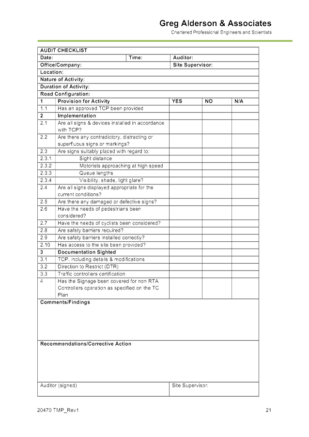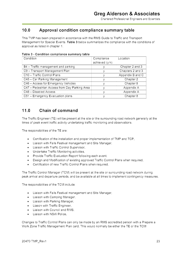
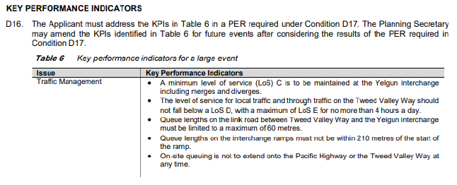
Local Traffic Committee Meeting
A Local Traffic Committee Meeting of
Byron Shire Council will be held as follows:
|
Venue
|
Conference Room, Station Street, Mullumbimby
|
|
Date
|
Tuesday, 28 July 2020
|
|
Time
|
10.30am
|
|
Committee
Members
|
Ian Shanahan – Transport for NSW
Snr Constable Chris Davis – Police
Cr Basil Cameron
Tamara Smith MP
|
Phillip
Holloway
Director Infrastructure Services I2020/1084
Distributed 21/07/20
Local Traffic Committee Meeting
BUSINESS OF MEETING
1. Apologies
2. Declarations of Interest
– Pecuniary and Non-Pecuniary
3. Adoption of Minutes from
Previous Meetings
3.1 Local
Traffic Committee Meeting held on 12 May 2020
4. Matters Arising
5. Outstanding
Issues/Resolutions
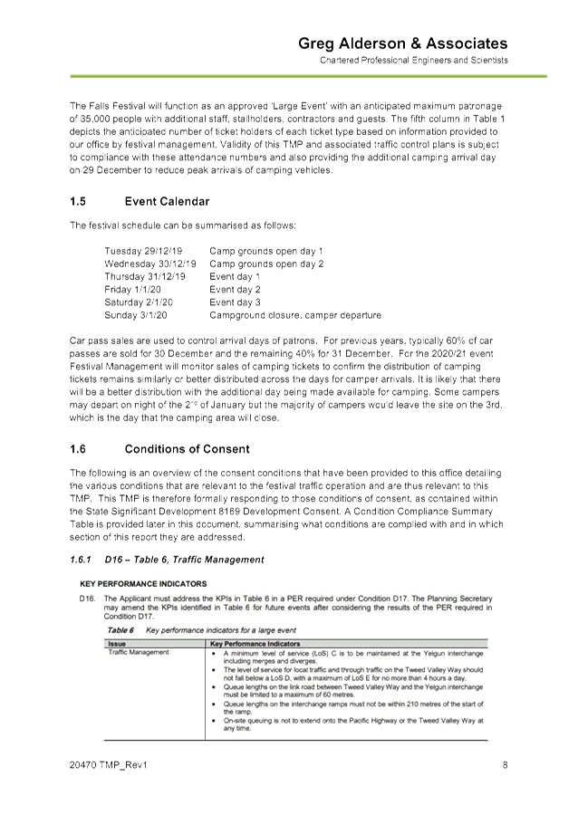
6. Regulatory Matters
6.1 Bay
Lane, Byron Bay - Proposed Closure Update........................................................... 3
6.2 Event
- Falls Festival....................................................................................................... 12
6.3 Events
- Mullum2Bruns Paddle 20 September 2020...................................................... 56
6.4 Events
- Bangalow Billycart Derby 2020 - Byron Street Road Closure 20 September 2020 59
6.5 Byron
to Suffolk Cycleway - Changes to Bangalow Road............................................. 64
7. Matters for Traffic Engineering Advice
7.1 Road
Safety Awareness................................................................................................. 75
7.2 Event
- Chincogan Charge - 19 September 2020.......................................................... 78
7.3 Events
- Byron Coast Charity Walk 12 September 2020............................................... 87
8. Development Applications
8.1 Event
- Byron Sunrise Run and Swim (was Byron Triathlon) 18 October 2020............ 99
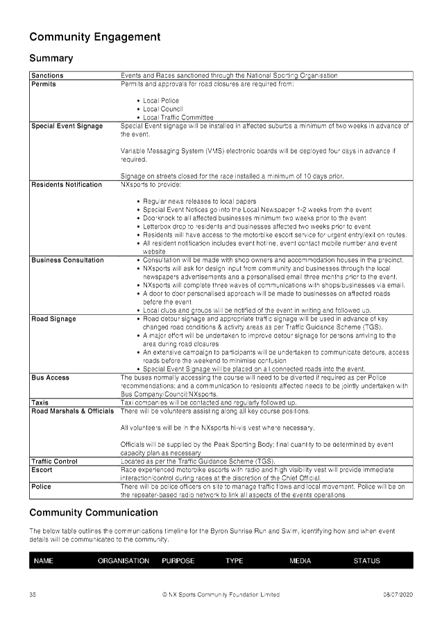
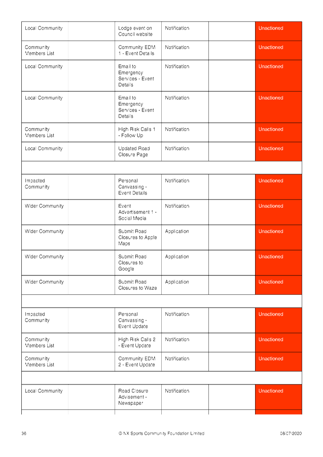
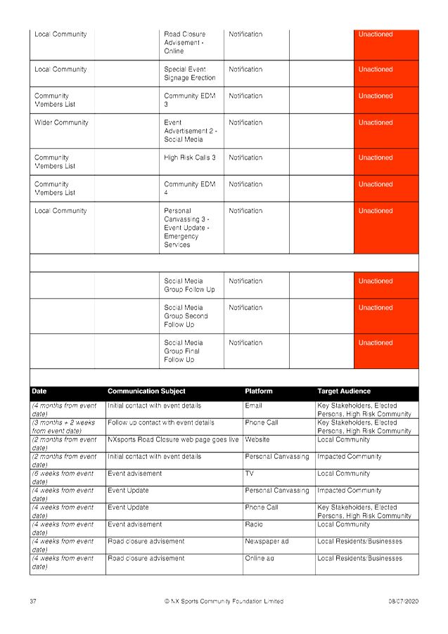
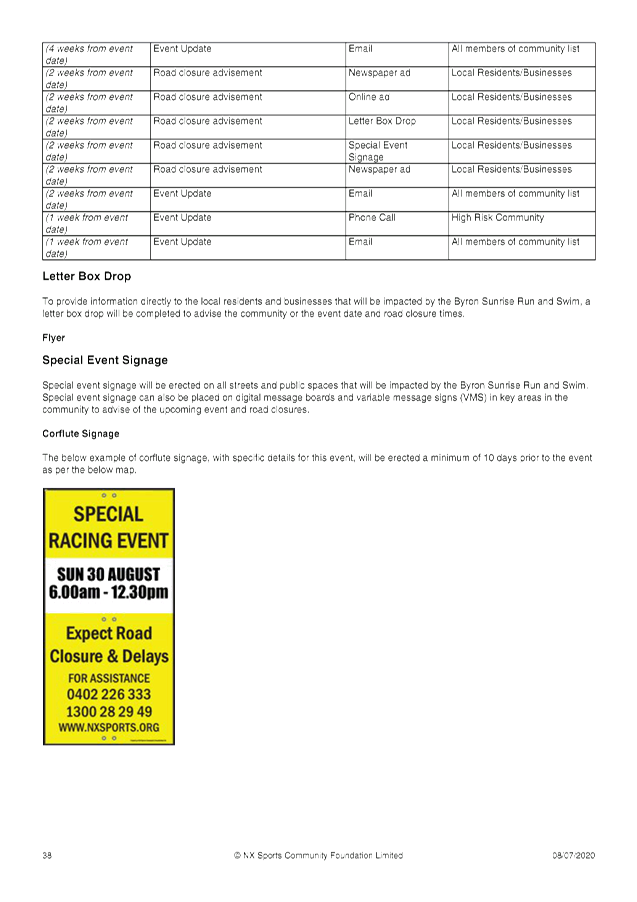
Local Traffic Committee Meeting 6.1
Regulatory Matters
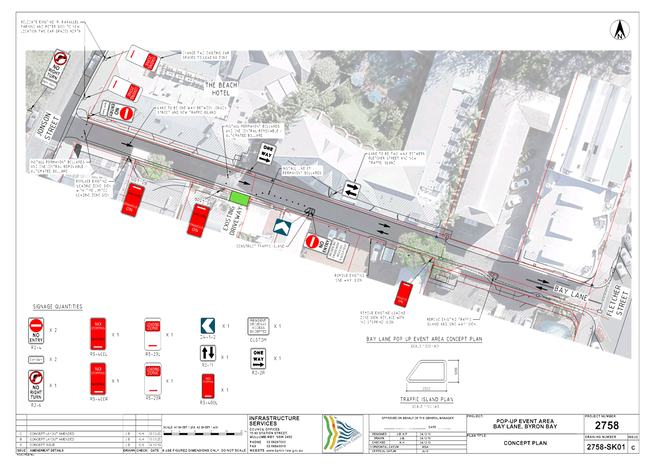
Report No. 6.1 Bay Lane, Byron Bay - Proposed Closure Update
File No: I2019/2137
Summary
A report was brought to the 29th November 2019
LTC meeting recommending changes to traffic conditions within Bay Lane, Byron
Bay between Jonson Street and Fletcher Street to pedestrianise the laneway
(Attachment 1).
The original concept design submitted with the November 2019
report is also provided (Attachment 2).
The LTC recommendations were adopted by Council at the 12th
December 2020 Council meeting.
It has been subsequently identified that there is a
residential driveway located at approximate chainage of 30m. This
driveway provides access for 10 tourist accommodation units. The design
and location of the driveway meant it was previously missed during site
inspections. However, during stakeholder engagement it has now been
identified.
As a result, Council proposes to modify the Bay Lane design
and is submitting the modified design to the LTC for their information
(attachment 3).
It is noted that recommendation 1c) states: Detail design
to be generally in accordance with attached drawing E2019/79917 and must
include appropriate regulatory signage and relevant time plates;
Council believes the proposed modifications are generally in
accordance with the attached drawing E2019/79917. However, for the sake
of openness staff thought it prudent to inform LTC of the changes.
The modification primarily consists of the driveway mid way
along Bay Lane and the introduction of bollards between the driveway and the
traffic Island mid way along Bay Lane.
Note, the removal of the loading zone from Bay Lane and the
introduction of a new loading zone on Jonson St near the entrance to Bay Lane
was addressed at the November LTC meeting under a separate report. The
loading zone and no stopping signage have been shown to ensure both projects
tie in together.
The development approval for the Beach Hotel has been
reviewed and staff can confirm a condition of consent is for the Beach Hotel to
service their business via an on-site loading bay.
The recommendation below is an exact copy of the
recommendation supported in the November 2019 LTC meeting, however, the drawing
reference number has been changed to reflect the proposed modifications.
|
RECOMMENDATION:
That Council supports:-
1. The
people-focused activation of Bay Lane, Byron Bay through regulating access of
vehicles into Bay Lane, subject to the following:-
a) Vehicle
access within Bay Lane, between chainages CH 0-75m (approx.), be prohibited
generally between 5pm to 5am;
b) Vehicle
access between chainages CH 0-75m be permitted generally between 5am to 5pm;
and
c) Detail
design to be generally in accordance with attached drawing E2020/29627 and
must include appropriate regulatory signage and relevant time plates;
2. The
following modifications to traffic flow in Bay Lane:-
a) Maintaining
one way traffic flow between chainages 0-75m (approx.);
b) Change
traffic flow to two way between chainages 75-150m; and
c) Detail
design to be generally in accordance with attached drawing E2020/29627 and
must include appropriate regulatory signage and relevant time plates.
|
Attachments:
1 Report
19/11/2019 Local Traffic Committee Bay Lane - Traffic Management, I2019/1514 ,
page 5⇩ 
2 Concept -
Bay Lane modifications, E2019/79917
, page 10⇩ 
3 Bay Lane -
2758_SK01-C, E2020/29627 , page 11⇩
Regulatory Matters 6.1 - Attachment 1
Report No. 6.4 Bay Lane - Traffic Management
File No: I2019/1514
Summary
This report seeks Council’s support to manage
vehicular access to the western portion of Bay Lane, Byron Bay.
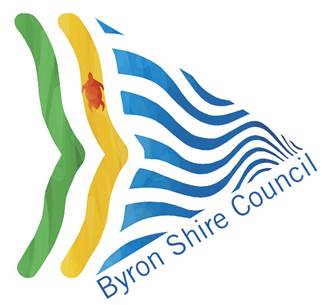
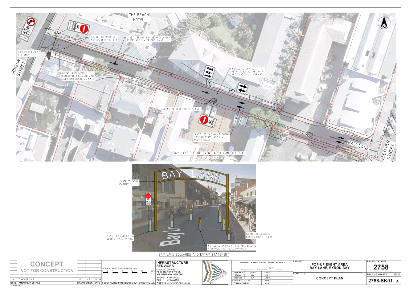
Bay Lane is a one way (west to east) service laneway
connecting Jonson Street and Fletcher Street. The length of road under
consideration is approximately 75m. Refer to Figure 1 for the section
under consideration.
It is proposed to permit vehicular access into the section
of Bay lane between 5am to 5pm and to prohibit vehicular access between 5pm to
5am.
It is proposed to do this through a combination of
regulatory signage, modifying traffic flow directions and installation of
traffic control devices that are non regulatory and not part of the LTC
process.
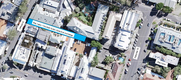
Figure 1 –
Bay Lane proposed controlled access.
Project
Concept
Refer to Attachment 1 for Council’s concept design to
control access into Bay Lane between 5pm and 5am.
The street landscape would not be altered and Bay Lane would
maintain its laneway feel. It is proposed to regulate vehicular access off
Jonson St into Bay Lane in the following manner:
i. Permit vehicular access into Bay
Lane off Jonson St between 5am to 5pm;
ii. Prohibit vehicular access into
Bay Lane off Jonson St 5pm to 5am;
iii. Install a No Entry sign (R2-4n) at the
Jonson St / Bay Lane entrance with a 5m – 5am time plate (R5-603).
iv. Install a No Right Turn sign (R2-6) at the
Jonson St / Bay Lane entrance with a 5m – 5am time plate (R5-603).
v. Install one way painted and signage
arrows, as required.
Note: Attachment 1 shows a concept entry statement
that may be installed to create a visual feature that helps calm traffic
entering the laneway between 5am – 5pm and increase pedestrian safety.
It’s wide enough to permit service vehicle access. A removable
bollard may be installed, as required, across the entrance of Bay Lane to acts
as Hostile Vehicle Mitigation device if an event is held within the laneway
between 5pm to 5am. The visual feature shown in attachment 1 is not a
regulatory feature and is just indicative of what could be done to help
increase pedestrian safety, particularly between 5pm to 5am.
Two (2) car parks gain access off Jonson St at
approximate chainage 80m. To maintain access to these car parks between 5pm and
5am the following modifications are proposed to regulate traffic at the eastern
end of Bay Lane.
i. Install a blister with No Entry
signage at CH75m to prevent cars travelling west past this point. The image
below illustrates what this structure would look like.
ii. Remove on street loading bays
along the full length of Bay Lane.
iii. Change traffic flow to permit two-way
access off Fletcher St. Note, Bay Lane carriage width between chainage 80m-120m
is 5.5m. Between CH 120m and 150m Bay Lane carriage width is 7m. Between CH
120-150m Bay Lane is currently 2-way to permit access to a youth hostel
basement car park.
Note: Attachment 1 shows a concept removable bollard
may be installed adjacent to the mid point blister, as required, to act as
Hostile Vehicle Mitigation device if an event is held within the laneway
between 5pm to 5am. The bollard would not
be a regulatory feature and is just indicative of what could be done to help
increase pedestrian safety between 5pm-5am.
Background
The project aims to create an iconic place making venue
in the heart of Byron Bay where patrons come and experience a Melbourne Laneway
type feel with pop up stalls, lighting and music.
Figure 2 below shows a montage of venues similar to
the style Byron Shire Council is attempting to create between 5pm to 5am
through regulating traffic as proposed above.
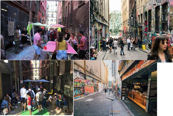
Figure 2 –
Montage of laneway venues that priorities pedestrian
Traffic
Data
Two traffic counts have been done in Bay Lane: 1)
August 2017, located 30m west of the Fletcher St intersection, and 2) Oct 2019 30m
east of Jonson St. These counts reveal almost identical traffic patterns as
seen in the virtual counts shown below:
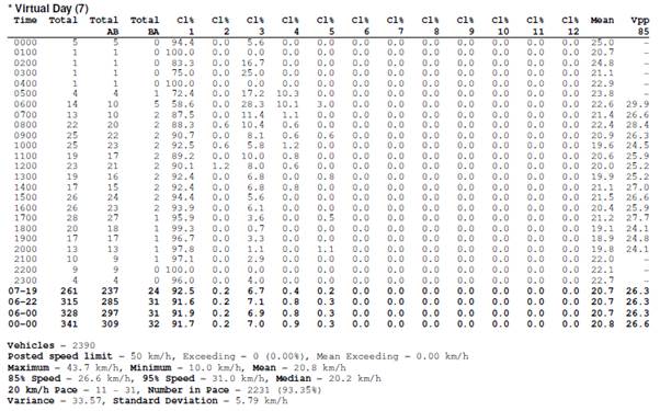
Another traffic count was done between 14th
Oct to 23 Oct 2019 with the follow summary data:
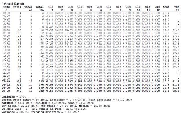
Based on the Virtual Week from this count:
· Total daily traffic was approximately 340vpd
· 91% were Class 1 vehicles suggesting most vehicles are
patrons of car parks east of the lane closure.
· Peak traffic volumes were between 8am-6pm.
· 85th % speed are between 22-26km/hr
· Between 5pm-5am total traffic volumes were between
115-120 vehicles.
Based on the above, traffic volumes impacted by
traffic regulation between 5pm-5am is considered to be minimal.
|
RECOMMENDATION:
That Council supports:-
1. The
people focused activation of Bay Lane through regulating access of vehicles
into Bay Lane, subject to the following:
a) Vehicle
access within Bay Lane, between chainages CH 0-75m (approx.), be prohibited
generally between 5pm to 5am;
b) Vehicle
access between chainages CH 0-75m be permitted generally between 5am to 5pm;
c) Detail
design to be generally in accordance with attached drawing E2019/79917 and
must include appropriate regulatory signage and relevant time plates;
2. The
following modifications to traffic flow in Bay Lane:
a) Maintaining
one way traffic flow between chainages 0-75m (approx.);
b) Change
traffic flow to two way between chainages 75-150m;
c) Detail
design to be generally in accordance with attached drawing E2019/79917 and
must include appropriate regulatory signage and relevant time plates;
|
Attachments:
1 Concept -
Bay Lane modifications, E2019/79917
Regulatory Matters 6.1 - Attachment 2
Regulatory Matters 6.1 - Attachment 3
Local Traffic Committee Meeting 6.2
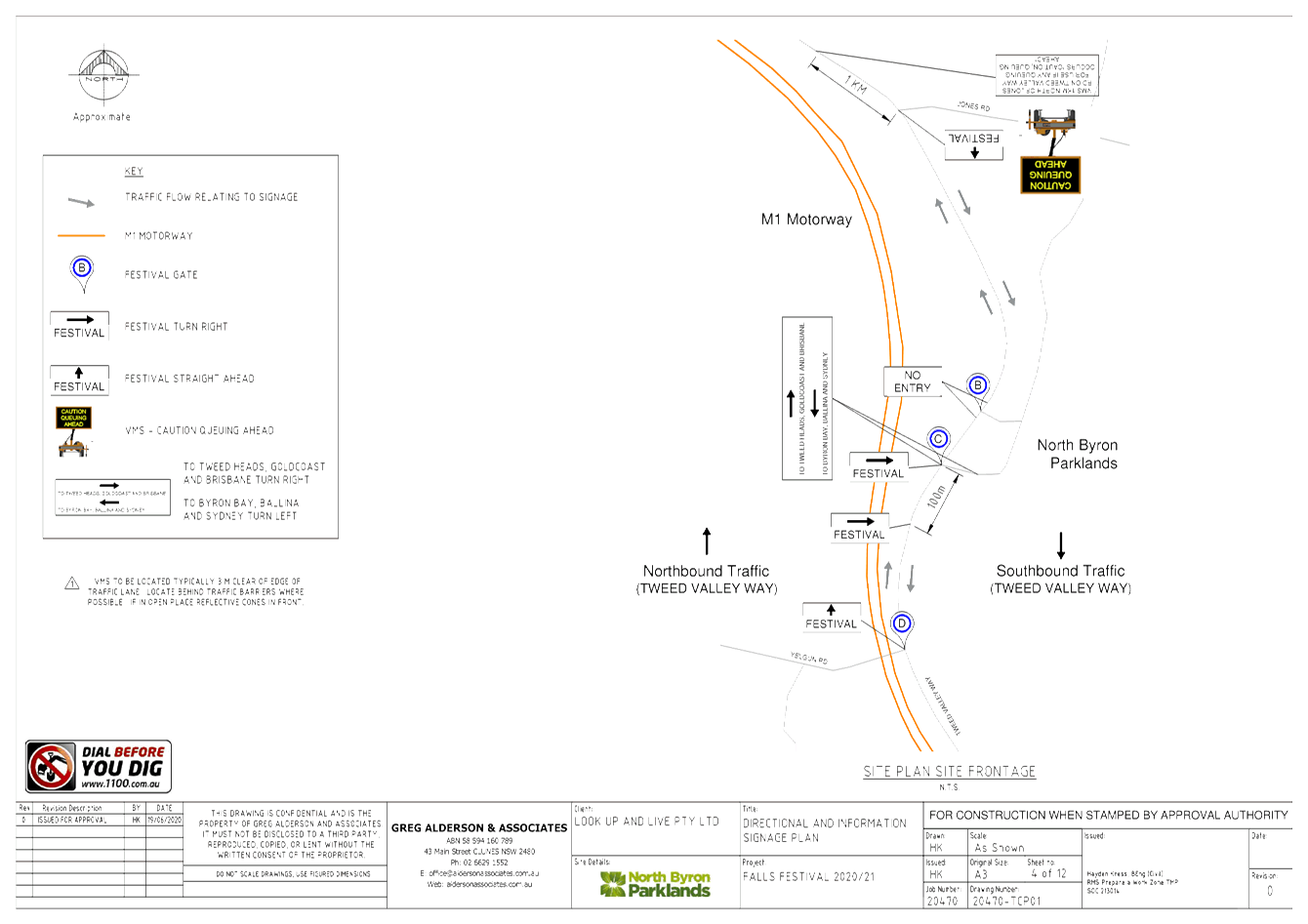
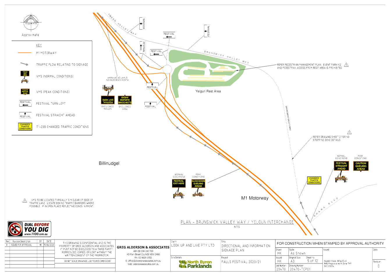
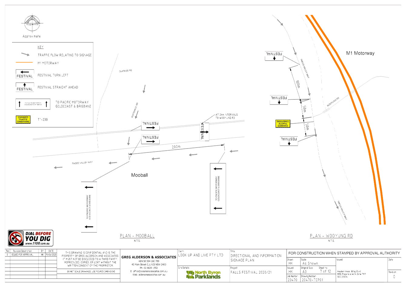
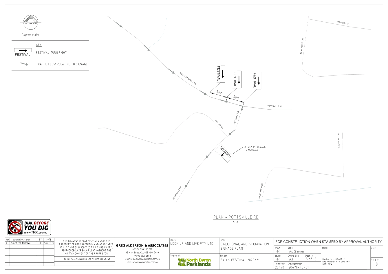
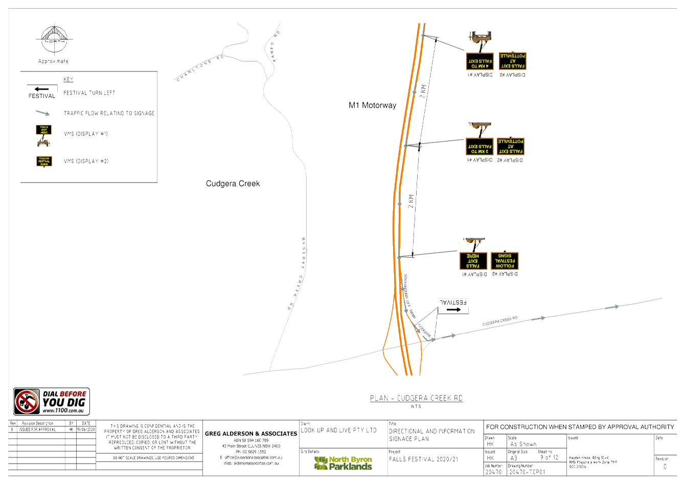
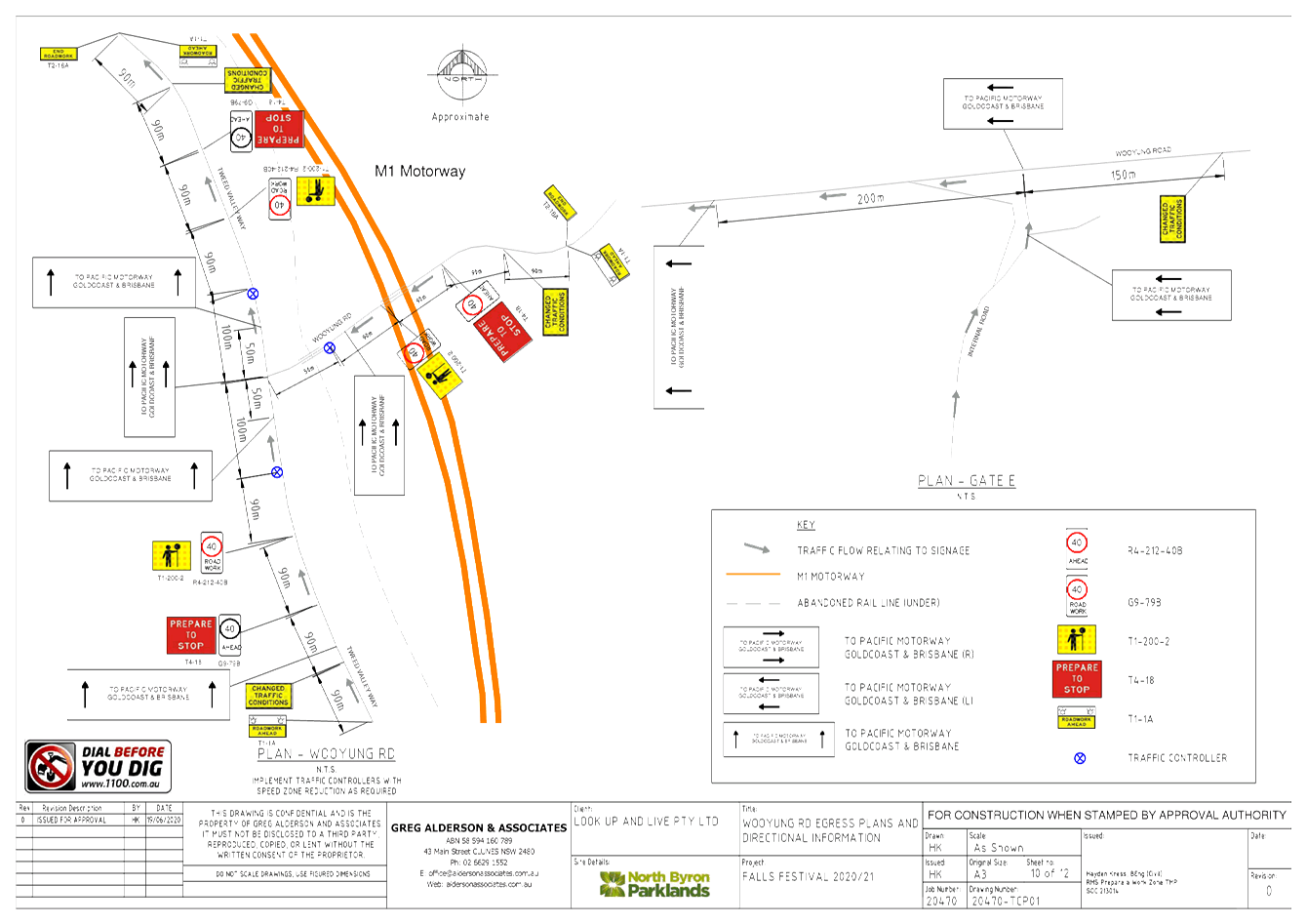
Report No. 6.2 Event - Falls Festival
File No: I2020/952
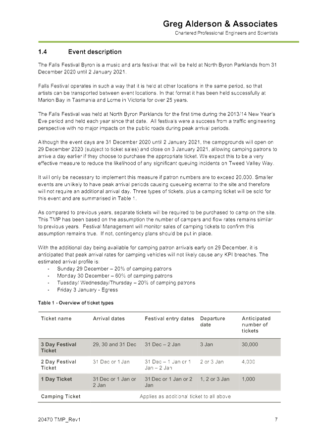
SUMMARY
This report is for the 2020/21
Falls Festival to run between 31 December 2020 to 2nd January 2021.
Camping areas will open 29th
December 2020 and close 3rd January 2021 to help spread traffic
volumes across a wider period.
The proposed TMP and TCP are
identical to last year which is considered to have run well.
BACKGROUND
North Byron Parklands has been
granted permanent approval and for this event they anticipate up to 35,000
patrons and 3,000 staff and guests.
Traffic Management
Conditions of approval require a
comprehensive traffic monitoring program which has been undertaken diligently
each year.
Generally traffic management will
remain substantially the same as last year. However, as stated within the draft
TMP (see attachment 1), following on from the Traffic Evaluation Report
observations and recommendations for previous Falls Festival events, together
with updated approvals provided under State Significant Development 8169
Development Consent, it is proposed to implement the following traffic
improvements for the 19/20 event:
· Gates
will be open from 29 December (subject to ticket sales exceeding 20,000) to
allow an additional day for camping patrons to arrive before the event
commences;
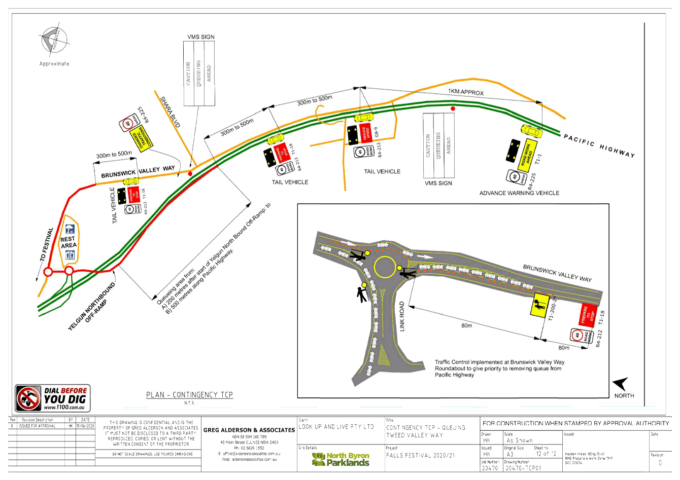
· Contingency
TCP is included for managing queueing incident that may have the potential to
impact the Pacific Motorway;
· New
egress route for Northbound traffic via new Gate E to Wooyung Rd, together with
associated TCPs.
Note, Wooyung Road is within
Tweed Shire. This egress point is for departing campers and is expected to
noticeably help reduce traffic impacts within Byron Shire.
A number of traffic regulation
measures are proposed for Tweed Valley Way and surrounding roads, namely:
A reduced speed zone on Tweed
Valley Way is proposed from approximately 540m south-east of
Yelgun Road to 100m north of
Jones Road. This is designed to improve safety with respect to traffic
leaving the site as well as traffic queued in the right turn lane on Tweed
Valley Way. This reduced speed zone is continued to Jones Road similarly
as was done during previous festivals for service vehicles entering and exiting
A No Stopping zone is proposed on
Tweed Valley Way and Brunswick Valley Way from Shara Boulevarde in the south to
the Byron Shire boundary in the north. The purpose of this is two-fold:
· Eliminate
parking by patrons not familiar with the area on Tweed Valley Way which is a
high speed road;
· Improve
tools to manage trespassers, in particular from the north.
Below are two snippets from the
TCP to illustrate the above proposed traffic control:
Figure 1 – No Stopping
Plan
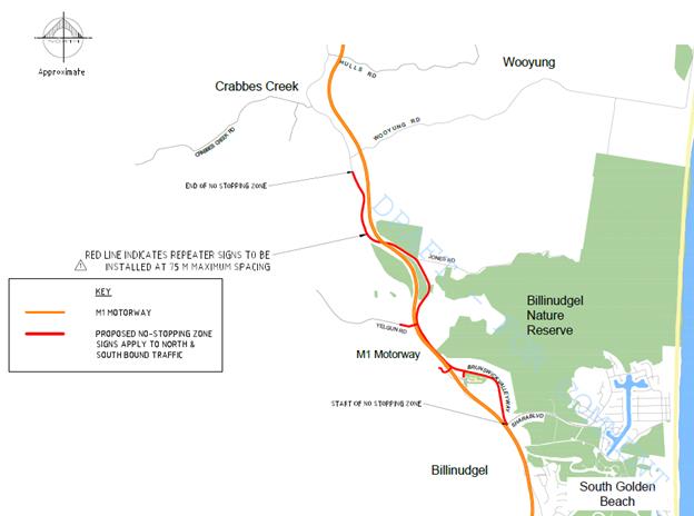
Figure 2 – Speed Zone Plan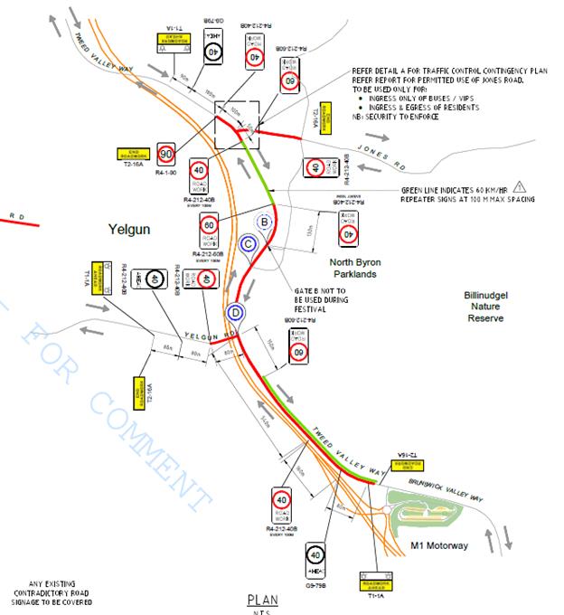
As part of the new state approval
the applicant must meet the following conditions in relation to traffic
management:
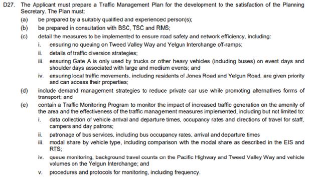

Traffic Monitoring
As stated within the draft TMP:
Although no traffic
controllers are required to manage traffic under normal conditions, traffic
controllers would need to be on call to assist in managing queues during any
queuing on the public road that may occur as a result of unforeseen
circumstances. Back of queue warning vehicles would need to be available to
warn inbound vehicles on the public road of any queues ahead. It is the
responsibility of the festival management to ensure the public road is
monitored and potential queuing is predicted in advance of any queuing
appearing.
KEY ISSUES
1. A
northern egress point through to Wooyung Rd (Tweed Shire) was adopted last year
and is being adopted again.
2. Separate
approval of the TMP & TCP required by the RMS Traffic Engineering
Department.
COUNCIL IMPLICATIONS
§ Budget/Financial
The event organisers are to be
invoiced for the relevant Approval of Road Events pursuant to s144 of the Roads
Act fee as per the Fees & Charges 2018/19.
§ Asset Management
N/A
§ Policy or Regulation
Regulatory traffic signage as delegated
to council for authorisation in conjunction with NSW Road Rules.
Traffic management is to be in
accordance with Australian Standards and RMS guidelines.
§ Consultation
A condition of the
endorsement of this event is that appropriate consultation is undertaken,
including:
· Advertising the
impact of the event in the local newspaper and on the Council website.
· Informing
community and business that are directly impacted.
· Liaising with bus
and taxi operators.
· Consulting with
emergency services.
§ Legal and Risk Management
Congestion caused by the
event will directly affect a RMS controlled asset – Pacific Highway. Separate
approval of the TMP & TCP required by the RMS Traffic Engineering
Department.
|
RECOMMENDATION:
That Council endorse the Falls Festival 2020/21 to be
held at the North Byron Parklands site, Yelgun from 31 December 2020 to 2
January 2021 (with campers arriving from 29th December 2020 and
allowed to depart no later than 3rd January 2021), inclusive,
subject to the following conditions: -
a) Separate
approvals by NSW Police and RMS being obtained;
b) The
development of a Traffic Management Plan and Traffic Control Plan(s) by those
with relevant RMS accreditation. These plans are to be submitted to Byron
Shire Council at least 2 months prior to the event for approval of traffic
regulation on roads under Byron Shire control;
c) The
Traffic Management Plan and the Traffic Control Plan to be implemented by
those with relevant and current RMS accreditation;
d) The
temporary ‘No Stopping’ where applied, including on Brunswick
Valley Way and Tweed Valley Way (between Shara Boulevard and north to the
Shire boundary), is implemented prior to the event and in accordance with
relevant state requirements and Australian Standards;
e) A
communications protocol be developed and maintained by those involved in the
implementation of traffic management including monitoring during the event
and ability to implement contingency plans as and when directed;
f) Monitoring
of vehicle volumes that arrive and depart the festival site and on the local
road network;
g) The
holding of an event debrief within the month following the festival which
includes but not limited to Council, RMS and Police;
h) The
event organiser:
i) advertising
the impact of the event via a notice in the local weekly paper a minimum of
one week prior to the operational impacts taking effect, noting it must
include the event name, specifics of any traffic impacts or road closures and
times, alternative route arrangements, event organiser, a personal contact
name and a telephone number for all event related enquiries or complaints;
ii) providing
a copy of the advert for Council's web page;
iii) give
consideration of any submissions received;
iv) informing
community and businesses that are directly impacted (e.g. adjacent to the
event) via written information which is delivered to the property in a timely
manner so as to document, consider and respond to any concerns raised;
v) arranging
for private property access and egress affected by the event;
vi) liaising
with bus and taxi operators and ensuring arrangements are made for provision
of services during conduct of the event;
vii) consulting
with emergency services and any identified issues be addressed;
viii) holding
$20m public liability insurance cover which is valid for the event; and
ix) paying
of Council’s Road Event Application Fee and Local Traffic Committee Fee
prior to the event.
|
Attachments:
1 Falls
Festival 2020-21 TMP, E2020/52226
, page 19⇩
2 Falls
Festival 2020-21 TCP, E2020/52225
, page 44⇩ 
Regulatory Matters 6.2 - Attachment 1


Regulatory Matters 6.2 - Attachment 2
Local Traffic Committee Meeting 6.3
Report No. 6.3 Events - Mullum2Bruns Paddle 20 September 2020
File No: I2020/1041
SUMMARY
Council received an application, Traffic Management Plan
(TMP) and Traffic Control Plan (TCP) from the Mullum2Bruns Paddle Committee for
the Mullum2Bruns Paddle 2020 to be held Sunday 24 May 2020. This was approved
by the LTC and Council res 20-084.
Due to the impact of COVID-19 the M2B Paddle committee have
proposed an alternative date of Sunday 20 September 2020, if the event is able
to proceed at that time under the current public health order.
BACKGROUND
The following is a cut and paste from the January 2020 LTC
meeting which supported the 2020 Mullum2Bruns event with the relevant dates
changes.
As in past years the Paddle Committee is requesting
permission for temporary one-way traffic of Brunswick Terrace, between Tincogan
Street and Tyagarah Street, Mullumbimby, between 6:30am and 10:00am.
This will allow for the registrations and start of the 2020
Mullum2Bruns Paddle to be held on Sunday 20 September 2020.
Brunswick Terrace is to be one-way in the vicinity adjacent
to the launch and registration area. The direction of traffic flow is shown
below with blue lines.
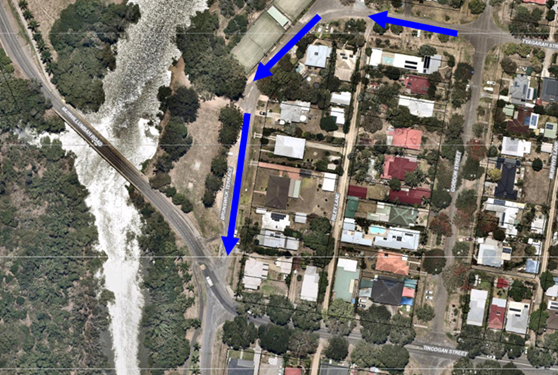
The turn from Tincogan Street into Brunswick Terrace will
have a “no right turn “sign also a “no left turn” into
Brunswick Terrace when coming off the Federation Bridge into Brunswick Terrace.
Traffic control with relevant detour signs will be installed
at the approaches to the impacted area. Plus no parking signs along the
one way part of Brunswick Terrace is proposed to control traffic.
Uniformed Marine Rescue personnel will be patrolling the
homes opposite the registration area to ensure that participants are not
parking in front of or across driveways, thereby minimising inconvenience to the
residents.
Participants will be diverted along the southern part of
Brunswick Terrace to the intersection of Brunswick Terrace & Tincogan
Street to enable them to cross to the starting area. The traffic
controllers will hold traffic crossing to the registration zone until there are
spaces for them to unload their craft.
A letter-box drop would be done 2 weeks prior to the event, informing
residents in the surrounding streets of the temporary one-way traffic closures.
COUNCIL IMPLICATIONS
§ Budget/Financial
The event organisers to be
invoiced for the relevant Approval of Road Events pursuant to s144 of the Roads
Act fee as per the Fees & Charges 2019/20.
§ Asset Management
N/A
§ Policy or Regulation
Regulatory traffic signage as delegated
to council for authorisation in conjunction with NSW Road Rules.
§ Consultation
A condition of the
endorsement of this event is that appropriate consultation is undertaken, which
may include:
· Advertising the
impact of the event in the local newspaper and on the Council website.
· Informing
community and business that are directly impacted.
· Liaising with bus
and taxi operators.
· Consulting with
emergency services.
§ Legal and Risk Management
Event organiser is required to
hold $20m public liability insurance cover which is valid for the event.
|
RECOMMENDATION:
1. That
Council endorse the Mullum2Bruns Paddle 2020 to be held Sunday 20 September
2020, that includes the temporary road closure below:
- Brunswick
Terrace, Mullumbimby, between Tincogan Street and Tyagarah Street (to become
one-way traffic), between 06:30am and 10:00am on Sunday 20 September 2020.
2. That
the approval provided in Part 1 is subject to:
a) the
development of a Traffic Management Plan and Traffic Control Plan(s) for the
2020 event by those with relevant and current RMS accreditation;
b) the
Traffic Control Plan being implemented by those with relevant and current RMS
accreditation;
c) that
the impact of the event be advertised via a notice in the local weekly paper
a minimum of one week prior to the operational impacts taking effect, noting
it must include the event name, specifics of any traffic impacts or road
closures and times, alternative route arrangements, event organiser, a
personal contact name and a telephone number for all event related enquiries
or complaints;
d) the
event be notified on Council’s webpage;
e) the
event organiser:
i) undertake
consultation with community and affected businesses including adequate
response/action to any raised concerns;
ii) undertake
consultation with emergency services and any identified issues addressed;
iii) holding
$20m public liability insurance cover which is valid for the event;
iv) paying
Council’s Road Event Application Fee prior to the event;
v) undertake
a debrief within two weeks of the event involving event staff, Police (if
they had incidents) and traffic controllers; and
vi) Submit
a debrief report to Council with any future event application.
|
|
|
Local Traffic Committee Meeting 6.4
Report No. 6.4 Events - Bangalow Billycart Derby 2020 - Byron Street Road Closure
20 September 2020
File No: I2020/1042
SUMMARY
Council received an event application from the Bangalow
Lions Club for the annual Bangalow Billy Cart Derby to be held on Sunday 17 May
2020. This was approved by the LTC
and by Council resolution 20-238.
Due to the impact of COVID-19 the Bangalow Billycart Derby
team have proposed an alternative date of Sunday 20 September 2020, if the
event is able to proceed at that time under the current public health order.
BACKGROUND
The following comments are a cut and paste from the March
2020 LTC meeting which supported the event.
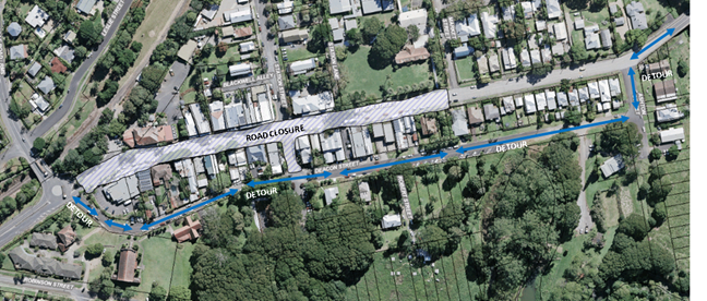
The format will be the same as previous years, with traffic
diverted via Deacon Street. The Figure below summarises the area of road
closure and proposed detour around the road closure adopted for all past
events.
KEY ISSUES
While the TCP has not been finalised yet the following items
were noted from past years:
1. The
proposed TCP places signage on Lismore to Bangalow Road (B62) and TfNSW
controlled Granuaille Road.
2. The
western end of Deacon Street is a laneway not suitable to Heavy Vehicles as a
detour to the Pacific Highway. However, the volume of HV on Sunday’s is
very limited and not been a concern for previous years.
COUNCIL IMPLICATIONS
§ Budget/Financial
The event organisers
have been invoiced $356.00 for the relevant Approval of Road Events pursuant to
s144 of the Roads Act fee as per the Fees & Charges 2018/19.
§ Asset Management
Not applicable.
§ Policy or Regulation
All traffic control plans
are to be developed and implement by people with the appropriate level and type
of accreditation.
§ Consultation
A condition of the
endorsement of this event is that appropriate consultation is undertaken,
including:
1. Advertising
the impact of the event in the local newspaper and on the Council website.
2. Informing
community and business that are directly impacted.
3. Liaising
with bus and taxi operators.
4. Consulting
with emergency services.
§ Legal and Risk Management
This road closure directly
affects TfNSW controlled asset – Lismore to Bangalow Road (B62) and TfNSW
controlled Granuaille Road. TfNSW Traffic Engineering Department requires
separate approval of the TMP and TCP.
|
RECOMMENDATION:
1. That Council endorse the Bangalow Billy Cart Derby
to be held on Sunday 20 September 2020, that includes the temporary road
closure below:
a. Byron
Street, Bangalow between Ashton Street and Granuaille Road, between 6am and 4pm
on Sunday 20 September 2020.
2. That
the approval provided in Part 1 is subject to:-
a. Separate
approvals by NSW Police and RMS being obtained, noting that the event is on a
state road or may impact the state road network;
b. Traffic
Control Plan(s) to be developed by people with the appropriate TfNSW
accreditation;
c. Traffic
Control Plan(s) to be implemented by people with appropriate accreditation;
d. That
the impact of the event be advertised via a notice in the local weekly paper
a minimum of one week prior to the operational impacts taking effect, noting
it must include the event name, specifics of any traffic impacts or road
closures and times, alternative route arrangements, event organiser, a
personal contact name and a telephone number for all event related enquiries
or complaints; and
e. The
event notified on Council’s webpage.
3. That the event
organiser:-
a. Undertake
consultation with community and affected businesses including adequate
response/action to any raised concerns;
b. Undertake
consultation with emergency services and any identified issues addressed;
c. Holding
$20m public liability insurance cover which is valid for the event; and
d. Pays
Council’s Road Event Application Fee prior to the event.
|
|
|
Attachments:
1 Bangalow
Billycart Derby - Traffic Management Plan (TMP) 2020, E2020/46679 , page 62⇩ 
Regulatory Matters 6.4 - Attachment 1
Traffic Management Plan
Bangalow
Billycart Derby, 20th September 2020
a. Description:
The plan involves the temporary closure of Byron Street Bangalow between the
hours of 6.00am to 4.00pm on Sunday 20th September 2020.
b. Impact
of Proposed Measures: No significant traffic movement impact is expected in the
village as traffic is diverted along Deacon Street.
c. Measures
to re-assign traffic: As in previous years the Bangalow Police change the
signage for Deacon Street to restrict parking and make it two- way traffic for
the period of the temporary closure. Barricades and signage is placed on Byron
Street at the intersection of Granuaille Road and Market Street to direct
traffic into Deacon Street.
d. Public
Transport Services: there is no impact on Public Transport Services.
e. Emergency
vehicles, heavy vehicles, cyclists and pedestrians: There is no impact on the
movement of these instances along Deacon Street.
f. Assessment
of effect on existing and future developments: As far as existing developments
are concerned there are no transport implications. Until they are advertised I
have no ability to respond to future developments.
g. Effects
on Adjoining Council areas: there is no effect on traffic movements in
adjoining council areas.
h. Public
consultation process: The proposed event has been organised for the past 20
i.
years by either the Bangalow Lions Club or the Bangalow Chamber of Commerce
with support from the local community. The proposed event dates have already
been advertised on the Bangalow Chamber of Commerce web site and their Facebook
page to alert businesses, residents and visitors. Signage is put up around
Bangalow at least one month prior to the event. All the public schools in the
shire are notified at least 3 months prior to the event. Since the event began
there have been no adverse impacts on the village.
Yours sincerely
Richard Millyard
Bangalow Lions Club
Co-ordinator
Bangalow
Billycart Derby
Local Traffic Committee Meeting 6.5
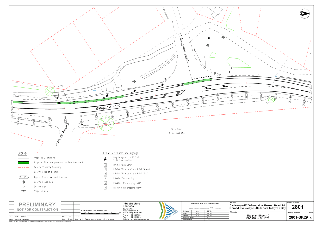
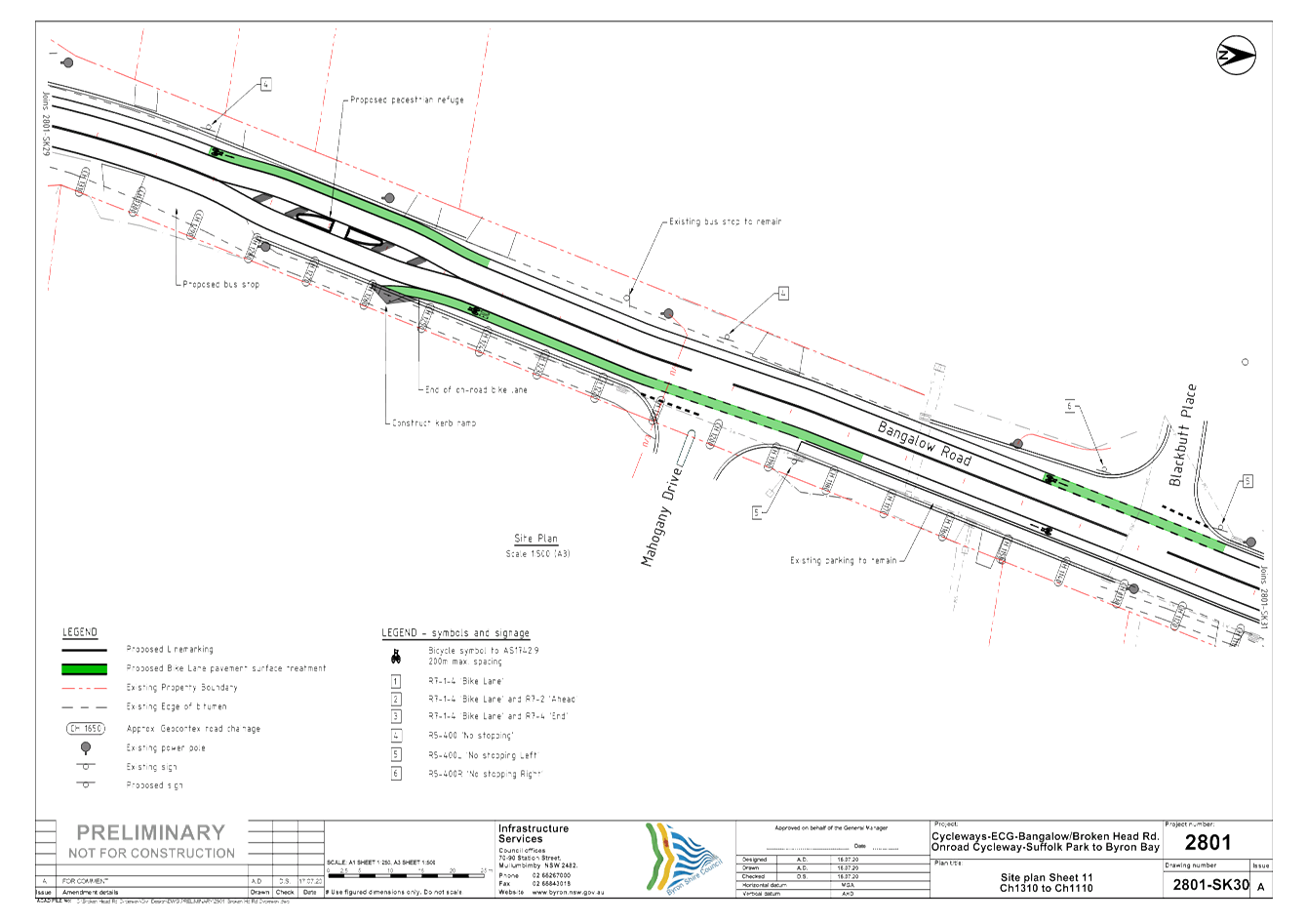
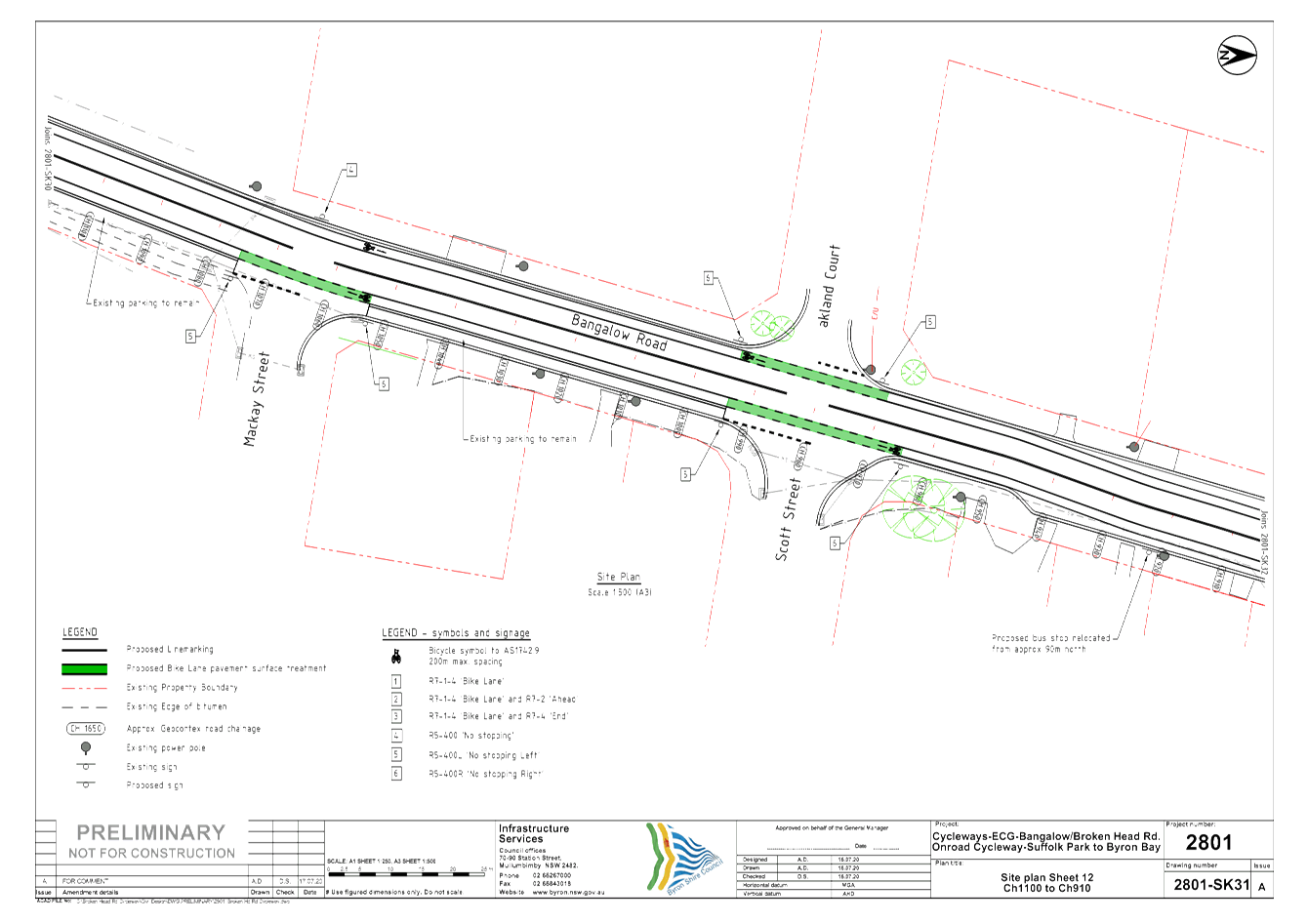
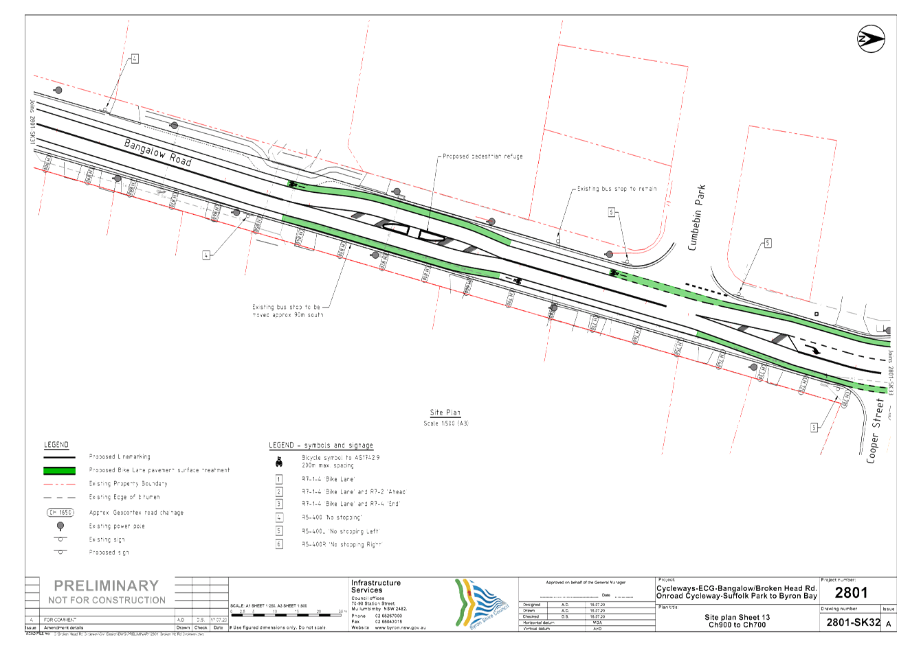
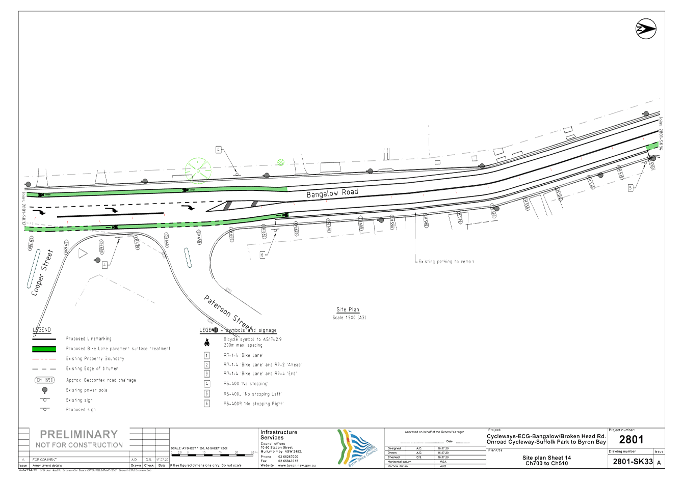
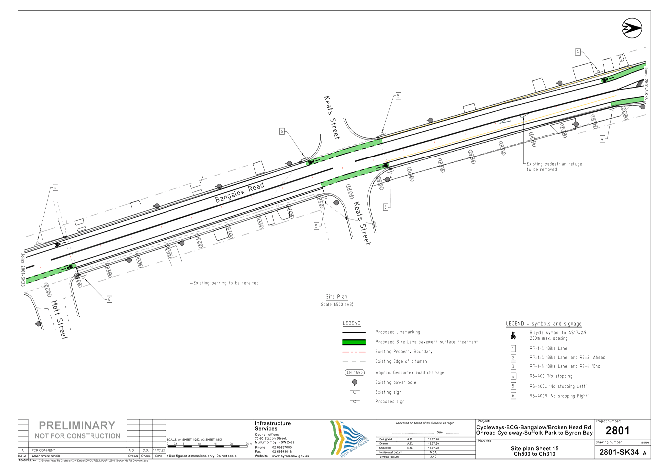
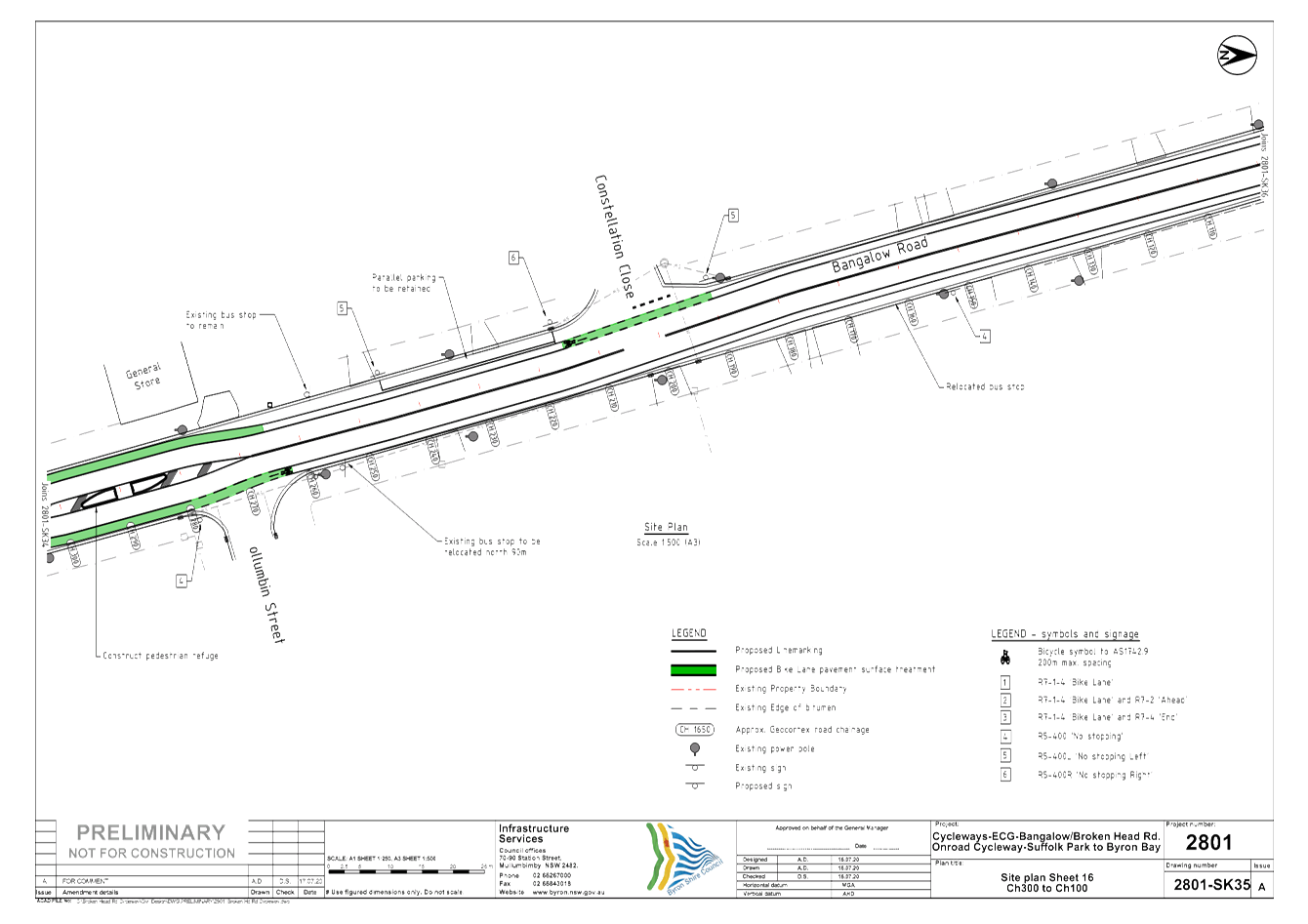
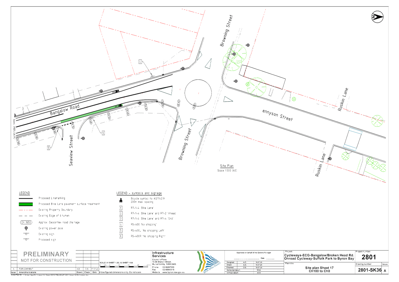
Report No. 6.5 Byron to Suffolk Cycleway - Changes to Bangalow Road
File No: I2020/1061
Background
Safe cycling infrastructure connecting Byron Bay and Suffolk
Park has been requested by the community and adjacent schools for many
years. This project became the subject of a detailed investigation in
2017/18 that considered site constraints and developed multiple options,
resulting in a preferred concept design that was endorsed by Council as
follows:
Res 19-066
Resolved:
1. That
the results of the public exhibition of the Byron Bay to Suffolk Park Cycleway
Investigation be noted.
2. That
the public submissions, which are confidential attachments to the report, be
noted and replies provided advising of Council’s decision.
3. That
Council:
a) Proceed
with the Proposed Option Concept Design (Option 2B for the northern section and
Option 1 for the Central and Southern sections) as the basis for development of
the Byron Bay to Suffolk Park Cycleway.
b) Proceed
with Option 2B for the Northern Section, noting that:
i. Parking,
impact to resident access and safety is carefully considered during the development
of the detailed design.
ii. Option
4 should continue to be considered as a potential option for additional future
works beyond the upgrade of the study corridor.
c) Consider
each of the suggestions submitted as part of the public exhibition process
during the development of the detailed design, and implement/include in the
design if suit able and feasible.
d) Undertake
consultation with The Byron Bay General Store during the development of the
detailed design and further progress of the project.
e) Endorse
the proposed naming the of the cycleway, as the ‘Ben Donohoe Memorial
Cycle Way’.
This project was identified as Priority A in the Bike Plan,
adopted in October 2019, and supports the goal of creating a cycle-friendly
town in the Byron Bay Town Centre Masterplan.
Further information on the project and investigation
including links to the report and endorsed concept designs can be found at the
following links (due to large file sizes):
· https://www.yoursaybyronshire.com.au/byron-bay-suffolk-park-cycleway
· https://www.byron.nsw.gov.au/Services/Footpaths-and-cycleways/Byron-Bay-to-Suffolk-Park-Cycleway
Recent successful applications for funding through TfNSW and
RMS Active Transport programs have enabled this project to proceed to detailed
design and construction. Stages 1 and 2 are complete and preparations for
Stages 3 and 4 of this project are well underway.
Report
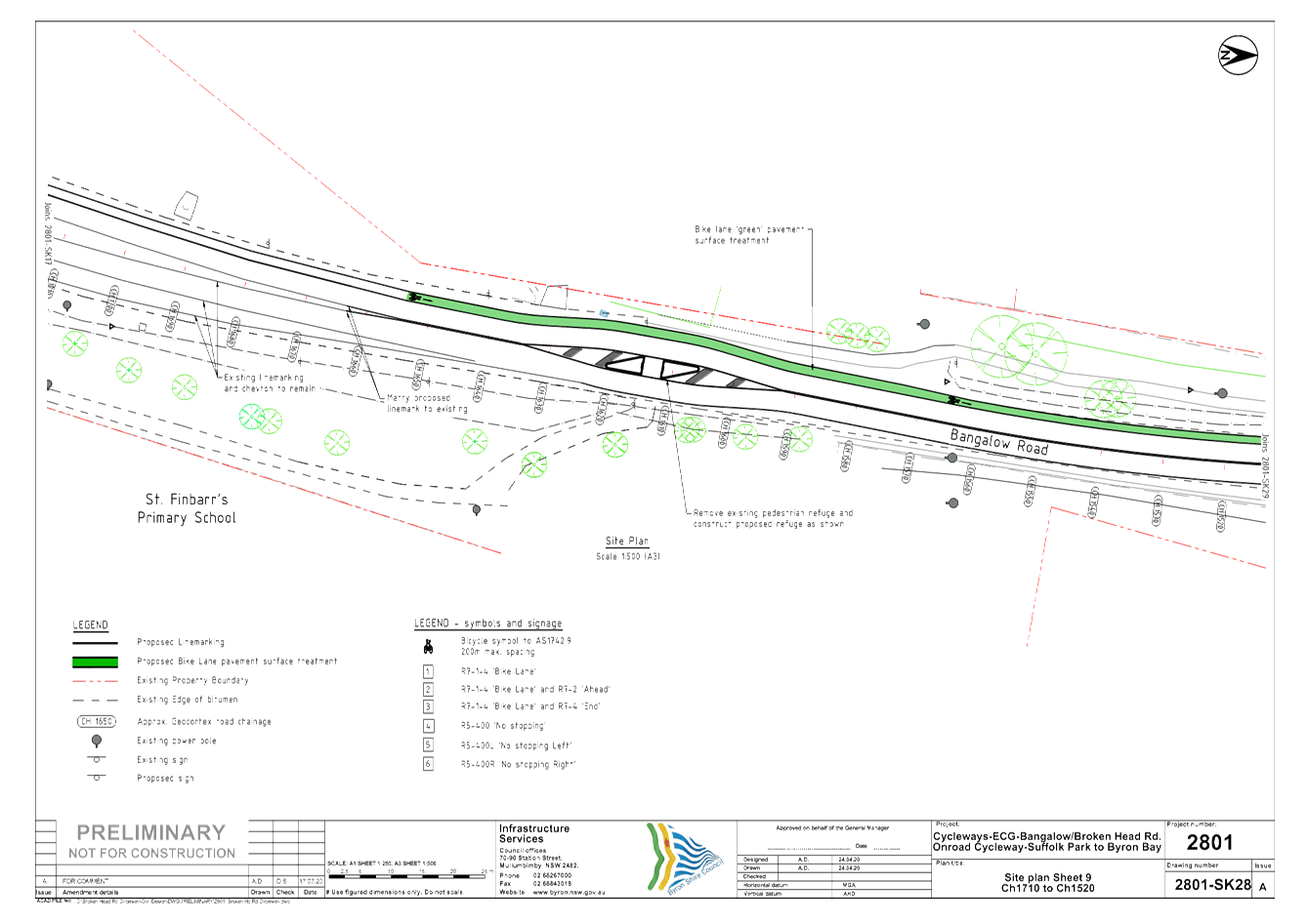
Endorsement is sought for proposed changes to Bangalow Road
between Browning Street and St Finbarr’s Primary School. The
detailed design attached to this report (E2020/53823) documents these changes,
which include modification of existing road alignment, lane widths,
line-marking, signage, bus-stop locations, crossings, and parking, as well as
the addition of crossings and on-road cycle lanes.
It should be noted that this detailed design deviates from
the original endorsed concept design in that the original design called for
parking to be removed on the west side of Bangalow Road (and left on the east
side where possible) to allow space for on-road cycle lanes. An issue was
identified in that this scenario would force northbound busses to block the
northbound vehicle lane when stopping to drop-off or pick-up passengers,
causing safety and traffic issues. The detailed design resolves this
issue as it has the road deviating slightly at several locations throughout the
corridor, allowing suitable space for bus stops to prevent this conflict.
This change has resulted in less parking overall, but will improve traffic flow
and allow for parking to be retained on both sides of Bangalow Road, rather
than only one side.
Considerations have been made and consultation has taken
place in accordance with the resolution. Crossings and cycling
infrastructure have been included in line with the outcomes of the Bike Plan
and PAMP.
Following LTC endorsement, detailed designs will be
finalised and consulted upon with the community. As such, precise
locations of lines, signs and crossings are yet to be determined. Should
any changes be necessary to the regulatory infrastructure within these drawings
prior to construction, approval will be sought through LTC.
Due to time constraints on this project, the detailed design
supplied is the most up-to date version available at the issue of the
agenda. The design will be further refined, revised and re-issued prior
to the meeting, with as much notice given as possible.
|
RECOMMENDATION:
That Council supports the modification of
Bangalow Road as per the detailed designs (E2020/53823) including the
following:-
a) Adjustment
of the existing road alignment, lane widths, line-marking, signage, bus-stop
locations and crossings;
b) Addition
of crossings, a bus stop and on-road cycle lanes.
c) The
removal of some parking on both sides of Bangalow Road where necessary to
enable space for bus stops and cycle lanes.
Report writer: Have you
mentioned an attachment in your recommendation? If so, include the TRIM
number in brackets eg “…Attachment 1 (E2017/1234)…”
It’s necessary for the minutes document.
|
|
|
Attachments:
1 E2020
53823 24.2017.86.1 - 2801r2 - Byron to Suffolk Cycleway Detailed Design Stage 3
& 4 - LTC - 20 July 2020, E2020/53823
, page 66⇩ 
Regulatory Matters 6.5 - Attachment 1
Local Traffic Committee Meeting 7.1
Matters for Traffic Engineering Advice
Report No. 7.1 Road Safety Awareness
File No: I2020/805
SUMMARY
The purpose of this report is to gain advice from the members of the Local
Traffic Committee in regards to regulatory issues and resources that may
support a road safety awareness campaign.
As way of background, a Notice of
Motion was raised by Cr Cameron to address access and safety for Byron Shire
road users. As a result, Council passed the following resolution with the last
item the reason for this LTC report:
1. That
Council note the report.
2. That
Council continue consultation with RMS and internally to develop
a potential position description for the role of Road Safety Officer.
3. That
Council undertake a review of the budget to confirm there are
adequate funds available to fund up to $40,000 to $50,000 for a Road Safety
Officer with RMS to fund the other 50% of the role.
4. That
Council support the General Manger undertaking a review of the
staff structure to confirm where a Road Safety Officer would be accommodated
within the organisational structure.
5. That
Council consider the development of a road safety campaign by way of a report
to TIAC incorporating a discussion of items:
a) Development of
an ongoing road safety awareness campaign to highlight access and safety for
all road users with consultation at all stages with residents, active and
vehicular road user groups, taking account of the steps set out in this motion.
b) Conducting road
safety forums with residents
i) To highlight the needs of all road users and
promote safe practices that help to keep vulnerable road users safe, and
ii) Seek feedback on safety and access issues
that assist in the effective delivery of a road safety awareness
campaign.
c) Providing a
review of effective road safety awareness campaigns/options in both rural and
urban contexts
d) Considering
consultative actions for the development and delivery of a campaign.
e) Setting out a
timeline of action for the development and delivery of a campaign
f) Providing
advice on effective general signage to raise awareness of access and safety
issues for placement on rural and urban roads with particular emphasis on known
issues and locations including without limitation, active transport users on
rural and urban roads, school bus times on rural roads and school zones
g) Providing
further advice on the potential employment of a Road Safety Officer to support
and conduct a road safety awareness campaign
6. That
Council provide a report to the next Local Traffic Committee meeting seeking
advice from RMS, NSW Police and the local Member on regulatory issues,
available programs, funding and compliance actions to support a road safety
awareness campaign.
REPORT
Based on the above resolution, Council staff now request advice
from TrfNSW (formerly RMS), NSW Police and the local Member on regulatory
issues, available programs, funding and compliance actions to support a road
safety awareness campaign.
Council staff also request advice on:
· The effectiveness of such campaigns,
· recommended safety issues to address,
· recommended actions to undertake,
· effective general signage to raise awareness of access and
safety in rural and urban environments.
Resolution Item 2 and 3
It is noted that a business case was submitted for a Road
Safety Officer (RSO) in the 2020/21 financial year. The business case has been
supported, but with significant funding restriction resulting from Covid-19
Council’s 2020/21 budget did not include a RSO.
Recent discussions were also held between Chantal Ensbey
from TfNSW and several Council staff regarding the funding and position
description associated with a RSO. TfNSW are providing Council with the
latest version of the Local Government Road Safety Program Guideline that
includes a position description for Road Safety Officers. It is noted
that at least 50% of the RSO position must be committed to work directly
relevant to TfNSW Road Safety Programs.
Miscellaneous
Additional discussions with
TfNSW covered funding for road safety workshops and programs, such as, funding
for Active Transport safety workshops or programs to coincide with the recent
opening of several cycle ways around Byron Shire. The goal is to undertake
these workshops within the 2020/21 financial year.
It is noted that
Council staff are actively looking to value add road safety items where project
funding permits. An example of this is the recent upgrade of Main Arm Road
where the project was delivered under budget. This cost saving then allowed
Council to complete additional safety treatments in accordance with the
recommended treatments options. In this case additional speed signage was
recommended and Council purchased a Speed Radar Sign following consultation
with TrfNSW staff. This treatment has two benefits; improving safety for road
users and reducing wildlife road kill. Research undertaken by Councils
Biodiversity Officer has confirmed speed radar signs as the most effective
means to manage speed and therefore wildlife safety in rural areas.
It is staff’s
long term goal to accrue as many of these signs as funding permits to rotate
around rural areas of the Shire given they are considered one of the most
effective safety measure identified.
It is also noted that:
· Council has recently developed a Pedestrian
Access and Mobility Plan, Bike Plan, and several Master Plans for key towns. In
addition, it is in the process of developing an Integrated Transport Management
Plan.
· Council receives funding for Black Road Project
and Safer Roads grants to improve known areas of road safety concerns within
the Shire.
|
RECOMMENDATION:
That the Local Traffic Committee provide
comments and advice to staff as requested.
|
Local Traffic Committee Meeting 7.2
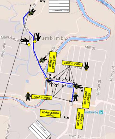
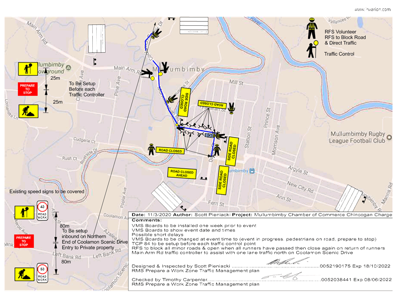
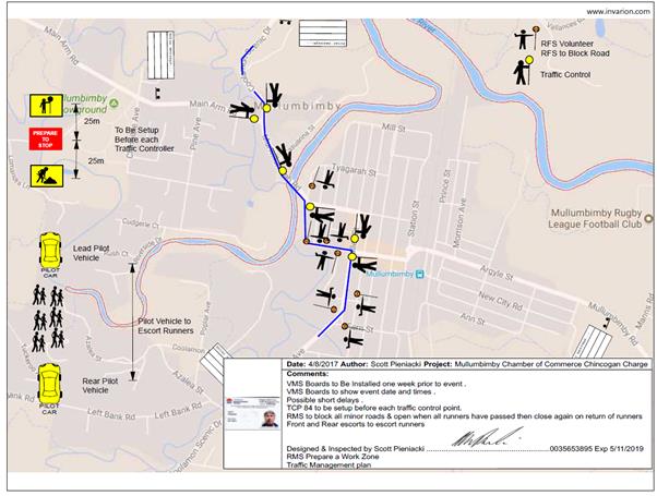
Report No. 7.2 Event - Chincogan Charge - 19 September 2020
File No: I2020/950
SUMMARY
Council has received an event application and Traffic
Control Plan (TCP) for the Chincogan Charge 2020 to be held on Saturday 19
September 2020.
BACKGROUND
For
the 2020 event the organisers are proposing to follow the same course as 2019
with runners starting and finishing near Mullumbimby Police Station. The
road course will require actions to control traffic and the implementation of
prescribed traffic control devices such as No Parking signs to control
vehicles. 500 participants are expected.
The
figure below shows the expected impact on roads. The blue line indicates
the approximate running path within the road reserve and the following major
impacts are planned:
· Dalley Street, between the Post
Office and the Civic Hall is expected to be closed between 12.30-5.30pm
· Mullwillumbah Road, at Federation
Bridge to Main Arm Rd to be controlled by traffic controllers. The South
bound lane will be used for contraflow traffic controlled by Traffic
Controllers. Traffic will be allowed to access Main Arm Road in-between
competitors. Traffic will be controlled at this point between 12.35-5.30pm
· Coolamon Scenic Drive from Main
Arm Rd to 1913 Coolamon Scenic Drive. The South bound lane will be used
for contraflow traffic controlled by Traffic Controllers. Traffic will be
allowed to access Main Arm Road in-between competitors. Traffic will be controlled at this
point between 12.40-5.30pm
· Once competitors cross the finish
line they will move onto the footpath and head to the Mullumbimby Civic
Memorial Hall for the presentation.
· The race itself is expected to
finish at 4pm with presentations from 4-5.30pm.
The event
co-ordinators have provided a Traffic Management Plan and a Traffic Control
Plan. Both are provided at attachment 1 & 2..
KEY ISSUES
1. The interaction of live traffic and the 500 participants
running and walking.
2. Traffic
control undertaken by RFS volunteers who may not have the appropriate RMS
issued tickets for ‘Traffic Control’ and ‘Implement Traffic
Control Zone’.
3. Road closures affect traffic between the hours of 8.00am
and 5.30pm at various locations
4. Poor natural lighting is available from 5.30pm so all
participants to complete race by this time.
5. Possible
obstruction of emergency services (Police, Fire Brigade) due to road closures
in the immediate vicinity.
COUNCIL IMPLICATIONS
§ Budget/Financial
The
event organisers will be invoiced the following fees
- LTC application fees in
accordance with Byron Shire Council 2020/21 Fees and Charges;
- Approval of
Road Events pursuant to s144 of the Roads Act (Advertising of event and staff
time to process); and
- Development
Certification fees – section 138 with fees being the fee applicable at
the date of payment.
§ Asset Management
Not applicable.
§ Policy or Regulation
Delegated to Council
for authorisation in conjunction with:-
- Actions
required to control traffic – Part 8 (Sections 114 to 124) Roads Act, 1993.
- Prescribed
traffic control devices – division 1 of Part 4 (Sections 50 to 55) Road
Transport (Safety and Traffic Management) Act, 1999.
- R5041 No
Parking (specified times) – NSW Road Rules 168, $108 fine.
§ Consultation
A condition of the endorsement
of this event is that appropriate consultation is undertaken, including:
1. Advertising
the impact of the event in the local newspaper and on the Council website.
2. Informing
community and business that are directly impacted.
3. Liaising
with bus and taxi operators.
4. Consulting
with emergency services.
§ Legal and Risk Management
Under the NSW Rural Fire Service - Service Standard 1.3.2,
Powers of Officers (19 March
2013) Version Number 3.2;
Clause 2.2 An Officer may:
(b) if he or she is the officer
in charge of a brigade or group of brigades, close any
street or public place in the
vicinity of a fire, incident or other emergency to traffic;
This event is not classified as an emergency therefore the
RFS Volunteers will not be able to
use the powers outlined in the service standard. To
legally control traffic each RFS volunteer
traffic controller will require a RMS issued ‘Traffic
Controller’ ticket. The RFS volunteer traffic
controller supervisor must have a RMS issued
‘Implement Traffic Control Plans’ ticket to set out
signage as per the Traffic Control Plan.
|
RECOMMENDATION:
That Council support the Chincogan Charge 2020 to be
held on Saturday 19 September 2020, between 8:00am and 5:30pm, subject to:-
1. Traffic
control plan(s) and a Traffic Management Plan (TMP) being designed by those
with the appropriate and relevant NSW (RMS) accreditation. The TCP(s) and TMP
to include the closure of Dalley Street between Burringbar Street and
Tincogan Street between 12.30pm-5.30pm;
2. The
TCP to be generally in accordance with document E2020/46680 (Attachment 1);
3. Implementation
of the approved Traffic Management Plan and Traffic Control Plan/s by those
with appropriate RMS accreditation and the holding of current and appropriate
levels of insurance and liability cover;
4. Separate
approvals by NSW Police and RMS being obtained;
5. The
impact of the event be advertised via a notice in the local weekly paper a
minimum of one week prior to the operational impacts taking effect,
noting it must include the event name, specifics of any traffic impacts or
road closures and times, alternative route arrangements, event organiser, a
personal contact name and a telephone number for all event related enquiries
or complaints;
6. The
event be notified on Council’s webpage;
7. Informing
community and businesses that are directly impacted (e.g. adjacent to the
event) via written information which is delivered to the property in a timely
manner so as to document, consider and respond to any concerns raised;
8. Undertake
consultation with emergency services and any identified issues addressed;
9. Hold
$20m public liability insurance cover which is valid for the event
10. Pay
Council’s Road Event Application Fee and LTC application Fee prior to
the event
|
Attachments:
1 Event -
Chincogan Charge 2020 - Traffic Control Plan - Mullumbimby Chamber of Commerce,
E2020/46680 , page 82⇩
2 Event -
Chincogan Charge 2020 - Traffic Management Plan - Mullumbimby Chamber of
Commerce, E2020/46683 , page 83⇩
Matters for Traffic Engineering Advice 7.2 - Attachment 1
|
Table
1. TMP Performa (part 1 of 2)
|
|
Question
|
Response (If no, state your
reasons why)
|
|
A. Description
or detailed plan of proposed measures.
Is a detailed
plan of the proposed measures necessary?
|
Event Name
|
Chincogan
Charge 2020
|
A.
Organiser
Name |
Jenelle
Stanford, Mullumbimby Chamber of Commerce
T. +61 2
6684 2127 M. +61 418 487 178
stationery.mullumnews@gmail.com
|
A.
Traffic
Control |
Mullumbimby
Fire Service
Set out
signs and control traffic
Mullumbimby
Fire Service – Volunteer Traffic Control and Spinefix
|
A.
Date(s) |
19/09/2019
|
A.
Times |
12:30 -
17:30
|
A.
Roads
affected |
· Dalley St from
(12:30 – 13:30)
· Dalley St to Tincogan street
(13:00 – 17:00)
· Murwillumbah Rd (13:00 –
17:30)
· Murwillumbah Rd to Coolamon Scenic
Drive (13:00 – 17:30)
|
A.
Detours
in place |
Traffic
control in place with one lane of traffic in both directions for all roads
affected.
|
A.
Parking |
Parking
is available for competitors at
· Ex services club car park and
surrounding town
Parking
for spectators is available at:
· 100+ @ Mullumbimby Civic Memorial
Hall Block
· Access to emergency services is to
be maintained by traffic control devices
|
A.
Other |
Parking
Signs on Ewingsdale Rd and tunnel rd
|
|
B. Identification
and assessment of impact of proposed measures.
Is a detailed
assessment required?
|
During
each stage of the event, Volunteer's with lime green shirts stating
‘volunteer’, red and blue arrows will show participants the
route. A 40km/hr speed zone with Witches hats will be used to separate
participants from the live traffic.
Due to
the low traffic volume and low participant volume it is unlikely for a
pedestrian and vehicle incident to occur.
Traffic Controls - Stage 1 (12:30 – 17:30)
The
Post Office to the Civic Hall intersection will be closed for the event,
traffic controllers in place with 40km/hr speed zone, witches hats and all
traffic in the Southbound lane in one direction from Tincogan street to
Murwillumbah Rd.
|
|
Table 1. TMP Performa (part 2 of
2)
|
|
Question
|
Response (If no, state your
reasons why)
|
|
C. Identification
and assessment of impact of proposed measures.
Is a detailed
assessment required? (Continued)
|
Traffic Controls - Stage 2 (12:35 – 17:30)
Mullwillumbah
Rd at Federation Bridge to Main Arm Rd to be controlled by traffic
controllers. The South bound lane will be used for contraflow traffic
controlled by Traffic Controllers. Traffic will be allowed to access Main Arm
Road in-between competitors.
Traffic Controls – Stage 3 (12:40 –
17:30)
Coolamon
Scenic Drive from Main Arm Rd to 1913 Coolamon Scenic Drive. The South bound
lane will be used for contraflow traffic controlled by Traffic Controllers.
Traffic will be allowed to access Main Arm Road in-between competitors.
When
this stage is completed with the last Southbound participate a vehicle will
sweep up any participants who exceed the do not finish time.
Once
competitors cross the finish line they will move onto the footpath and head
to the Mullumbimby Civic Memorial Hall for the presentation.
Presentation (16:00 – 17:30)
After
the presentation in the closed street they can access the Ex Services Club.
|
|
D. Measures
to ameliorate the impact of re-assigned traffic
Is an
assessment required?
|
This
event will not impact the state arterial network. However vehicles will
expect delays trying to access Mullumbimby from Ocean Shores or Main Arm
Road.
500
participants are expected on the course however that are no traffic flow data
available at this time.
A
presentation at 16:00 – 17:00 is planned for Dalley street around the
Mullumbimby Civic Memorial Hall
|
|
E. Assessment
of public transport services affected.
Is an
assessment required?
|
Event
organisers will advise all Public Transport Services of the event and road
closures.
Public
transport services will be given priority to proceed through the stages.
Private
vehicles will be able to use public parking available in Mullumbimby.
|
|
Table 1. TMP Performa (part 2 of
2)
|
|
Question
|
Response (If no, state your
reasons why)
|
|
F. Details
of provision made for emergency vehicles, heavy vehicles, cyclists and
pedestrians.
Are these
details required?
|
Emergency
|
Emergency
vehicles will have right of way on all stages.
The
NSW fire and rescue has created an Emergency Evacuation Plan for this event.
|
A.
Heavy Vehicles |
Heavy
vehicles will have priority on the affected roads. Being the weekend not many
heavy vehicles are expected.
|
A.
Cyclist |
Cyclist
will have to follow traffic control in place and abide by road rules.
|
A.
Pedestrians |
The
existing footpath network will remain open. Conflicts between participants
and pedestrians is classified as a low risk and not being controlled.
|
|
G. Assessment
of effect on existing and future developments with transport implications in
the vicinity of the proposed measures.
Is an
assessment required?
|
Residents are likely to be delayed
due to the contraflow traffic arrangements.
Mullumbimby Community Market
(08:00 to 14:00) is on but at the other end of town
A quick Google search has not
identified any other major events in Mullumbimby that weekend including the
showground’s.
|
|
H. Assessment
of effect of proposed measures on traffic movements in adjoining Council
areas.
Is an
assessment required?
|
No
adjoining Council areas are to be affected by this event.
|
|
I. Public
consultation process
Is a public
consultation process required
|
The
event organisers are using printed media, internet, socials and signage to
make the public aware of the event.
|
|
J. Terrorism
controls in place
|
Due
to the nature and small scale of the event there are no Terrorism controls in
place as it has been assessed as a low risk.
The
Police have been advised about this event.
|
Figure 1. Sketch of the site.
|
http://www.rms.nsw.gov.au/business-industry/partners-suppliers/documents/technical-manuals/tmplan_v2.pdf
Local Traffic Committee Meeting 7.3
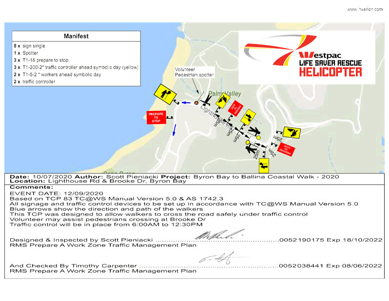
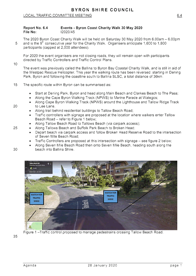
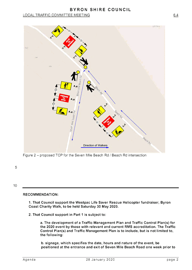
Report No. 7.3 Events - Byron Coast Charity Walk 12 September 2020
File No: I2020/1040
The Byron Charity Walk 2020 is seeking to gain LTC support
and Council approval to change the date of the event.
In January 2020 the organisers gained approval to run the
event on Saturday 30th May 2020. However, due to Covid-19 the event
was postponed.
It is now proposed to run the 2020 Byron Coast Charity Walk
on Saturday 12 September 2020 from 6.00am – 6.00pm. However, Services NSW
have confirmed the Charity Walk is currently classified as a public gathering
which permits a maximum of 20 people.
If the classification changes in time the organisers would
like to proceed with the 12th September date for the event using the
previously approved TMP and TCP.
However, if the restrictions remain in place and prevent a
12th September date the organisers propose a contingency date of
Saturday 7th November.
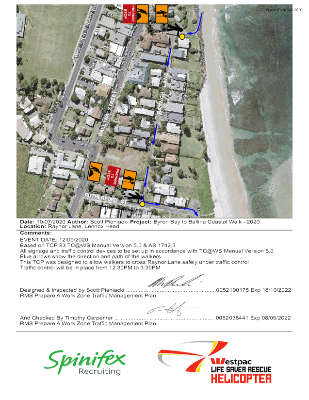
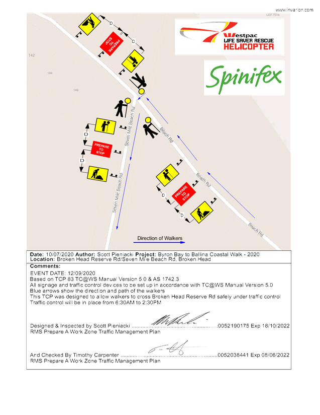
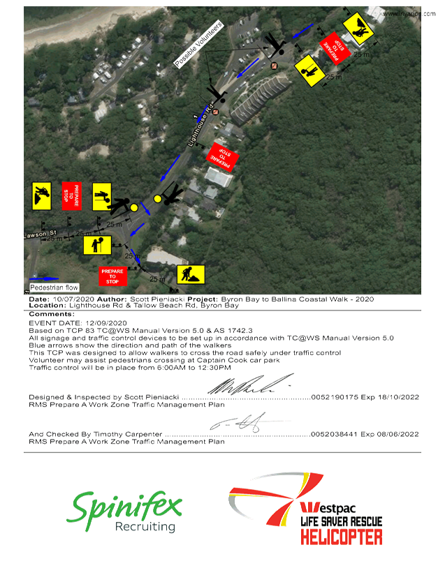
The proposed route has not changed. For a copy of the
previous LTC report and proposed TCP’s refer to the attachments.
The recommendations below are cut and paste from the January
LTC minutes with the dates changed.
|
RECOMMENDATION:
1.
That Council support the Westpac Life Saver Rescue Helicopter fundraiser,
Byron Coast Charity Walk, to be held Saturday 12 September 2020, with an
alternative date of Saturday 7 November 2020.
2.
That Council support in Part 1 is subject to:-
a. The
development of a Traffic Management Plan and Traffic Control Plan(s) for the
2020 event by those with relevant and current RMS accreditation. The
Traffic Control Plan(s) and Traffic Management Plan is to include, but is not
limited to, the following:
(i) signage,
which specifies the date, hours and nature of the event, be positioned at the
entrance and exit of Seven Mile Beach Road one week prior to the event;
(ii) on
the day of the event, at 500m intervals, and facing both directions of
travel, signs advising of “ Special Event – Charity Walk
Ahead” (or similar) are installed prior, and removed after, the event
occurs; and
(iii)
a safety induction for participants advising of hazards be provided.
b. Implementation
of the Traffic Management Plan and Traffic Control Plans as designed by those
with appropriate accreditation and implemented by people with appropriate
accreditation, including traffic controllers.
c That
the impact of the event be advertised via a notice in the local weekly paper
a minimum of one week prior to the operational impacts taking effect, noting
it must include the event name, specifics of any traffic impacts or road
closures and times, alternative route arrangements, event organiser, a
personal contact name and a telephone number for all event related enquiries
or complaints.
d. The
event is notified on Council’s webpage.
e. The
event organiser:
i) Undertake
consultation with affected community and businesses including adequate
response/action to any raised concerns.
ii) Undertake
consultation with emergency services and any identified issues addressed.
iii) Holding
$20m public liability insurance cover which is valid for the event.
iv) Paying
Council’s Road Event Application Fee prior to the event.
|
|
|
Attachments:
1 Event
information - Byron Coastal Walk - 12 September 2020 - Northern NSW Rescue
Helicopter Service - Traffic control plans attached . Notification of
alternative dates due to COVID-19, E2020/51850
, page 89⇩
2 Event
information - Byron Coastal Walk - 12 September 2020 - Northern NSW Rescue
Helicopter Service - Traffic control plan - Raynor Lane, Lennox Head, E2020/51848 , page 92⇩
3 Event
information - Byron Coastal Walk - 12 September 2020 - Northern NSW Rescue Helicopter
Service - Traffic control plan - Broken Head Reserve Rd & Seven Mile
Beach Rd, E2020/51847 , page 93⇩
4 Event
information - Byron Coastal Walk - 12 September 2020 - Northern NSW Rescue
Helicopter Service - Traffic control plan - Lighthouse Rd & Tallow Beach Rd
(2), E2020/51846 , page 94⇩
5 Event
information - Byron Coastal Walk - 12 September 2020 - Northern NSW Rescue
Helicopter Service - Traffic control plan - Lighthouse Rd & Brooke Dr, E2020/51845 ,
page 95⇩
6 Report 28
01 2020 Local Traffic Committee Events - Byron Coast Charity Walk 30 May 2020, E2020/54165 ,
page 96⇩
Matters for Traffic Engineering Advice 7.3 - Attachment 1

Matters for Traffic Engineering Advice 7.3 - Attachment 2
Matters for Traffic Engineering Advice 7.3 - Attachment 3
Matters for Traffic Engineering Advice 7.3 - Attachment 4
Matters for Traffic Engineering Advice 7.3 - Attachment 5
Matters for Traffic Engineering Advice 7.3 - Attachment 6
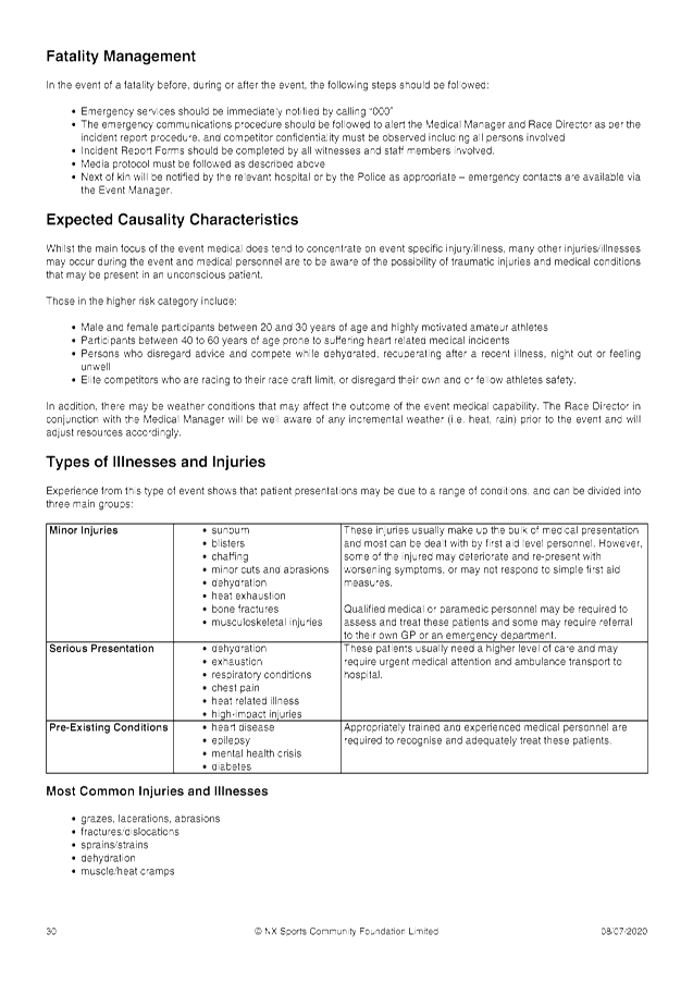
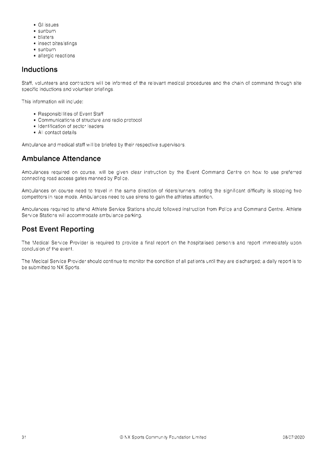
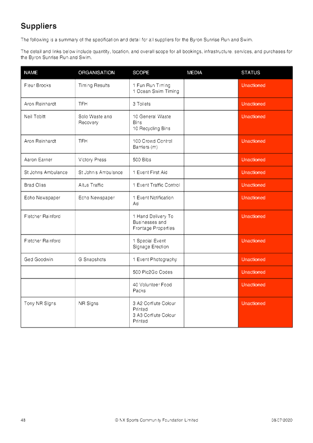
Local Traffic Committee Meeting 8.1
Development Applications
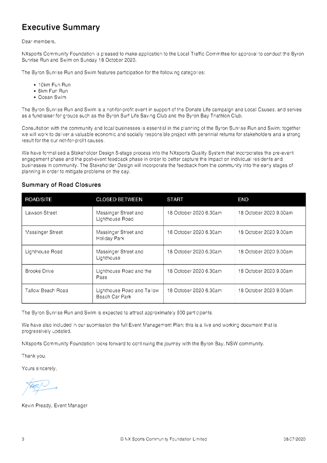
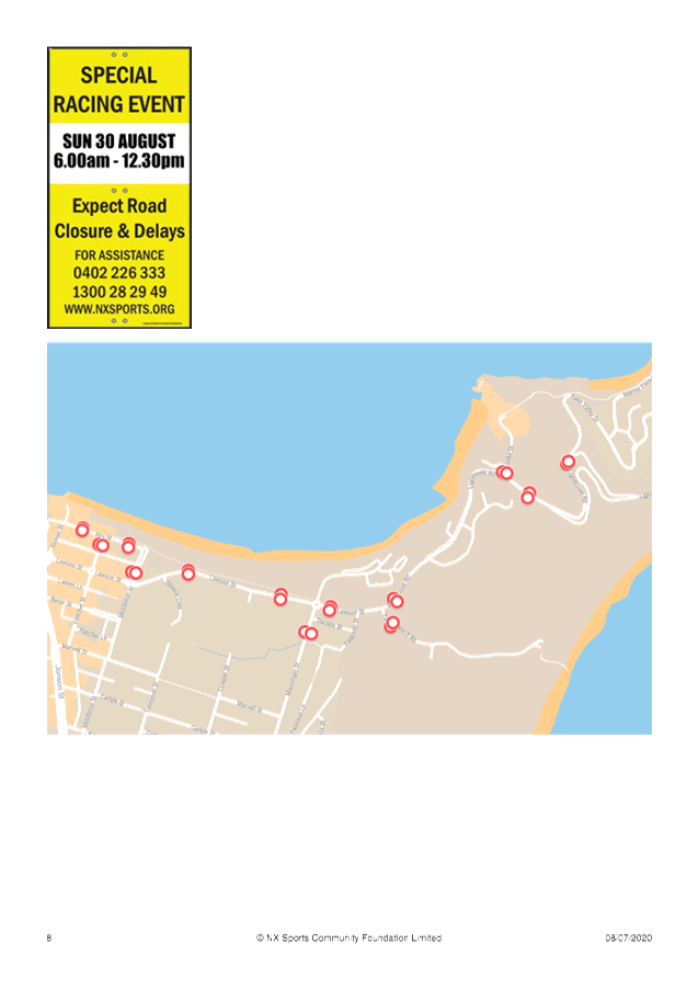
Report No. 8.1 Event - Byron Sunrise Run and Swim (was Byron Triathlon) 18 October
2020
File No: I2020/1043
SUMMARY
Council received an event application for the 2020 Byron Bay
Triathlon to be held on Saturday 9th May 2020. This was
approved by the LTC and Council res 20-083. Due to the impact of COVID-19 the
Byron Triathlon team have proposed an alternative event and date, the Byron
Sunrise Run and Swim – proposed to be held on Sunday 18 October 2020. If
the event is able to proceed at that time under the current NSW Public Health
Order.
The Byron Sunrise Run and Swim is a not-for-profit event in
support of the Donate Life campaign and Local Causes, and serves as a
fundraiser for groups such as the Byron Surf Life Saving Club and the Byron Bay
Triathlon Club.
The event will not be the usual
triathlon event, rather an ocean swim and a lighthouse fun run. There will be
much less road impact due to the cancellation of the cycling aspect of the
event and therefore reduced course size.
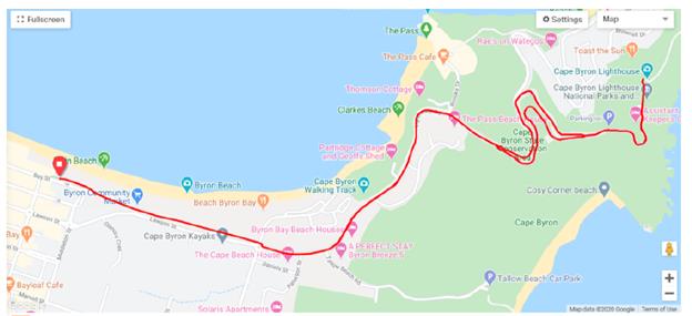
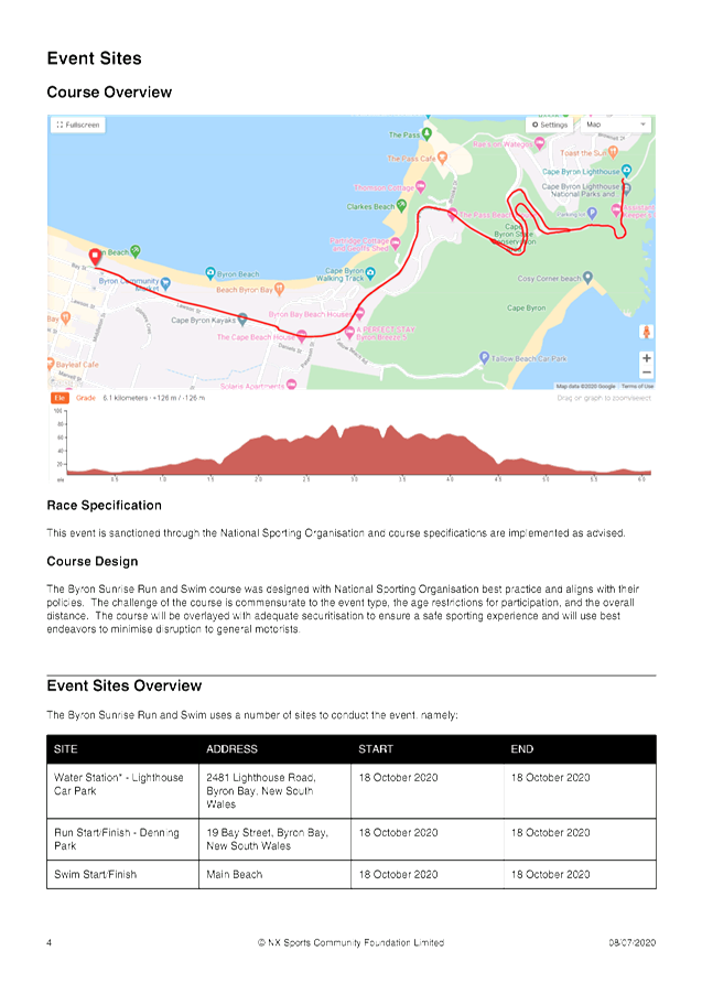
Event Course
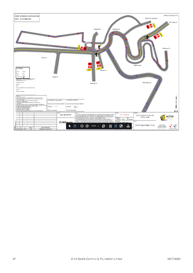
Figure 1 presents the event course and roads required
to be closed for the fun run course.
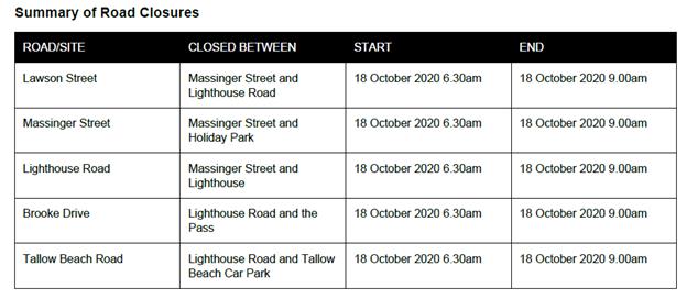
Proposed Road Closures
The proposed road closures and the time of the closures is
shown below.
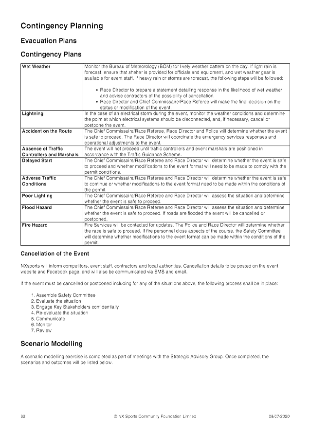
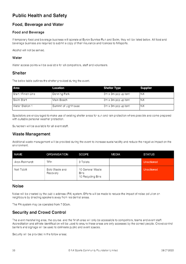
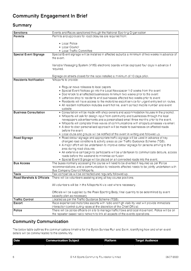
Traffic Control
It is proposed to manage traffic during the above road
closures through the implementation of Traffic Control Plans and the support of
police from the Tweed-Byron District. These have been included in the recommendations
below.
|
RECOMMENDATION:
1. That
Council endorse the Byron Sunrise Run and Swim to be held on Sunday 18
October 2020, which includes the temporary road closures detailed within
report I2020/1043
2. That
the approval provided in Part 1 is subject to:-
a) Separate
approvals by NSW Police and RMS being obtained, as required;
b) The
development of a Traffic Management Plan and Traffic Control Plans for the
2020 event by those with relevant and current RMS accreditation;
c) The
Traffic Control Plan being implemented by those with relevant and current RMS
accreditation;
d) The
impact of the event be advertised, and charged at cost to the organisers, via
a notice in the local weekly paper a minimum of one week prior to the operational
impacts taking effect, noting it must include the event name, specifics of
any traffic impacts or road closures and times, alternative route
arrangements, event organiser, a personal contact name and a telephone number
for all event related enquiries or complaints;
e) the
event be notified on Council’s web page;
f) The
event organiser:
i) informing
community and businesses that are directly impacted (eg within road closure
zones) via written information which is delivered to the property in a timely
manner so as to document, consider and respond to any concerns raised;
ii) arranging
for private property access and egress affected by the event;
iii) liaising
with bus, taxi and waste operators and ensuring arrangements are made for
provision of services during conduct of the event;
iv) consulting
with emergency services and any identified issues be addressed;
v) holding
$20m public liability insurance cover which is valid for the event;
vi) paying
of Council’s Road Event Application Fee prior to the event; and
vii) paying
of Council’s local traffic committee application fee prior to the
event.
|
Attachments:
1 Event
information - Byron Sunrise Run and Swim (was Byron Triathlon pre-COVID) - 18
October 2020 - letter to Local Traffic Committee, E2020/51855 , page 102⇩
2 Event
information - Byron Sunrise Run and Swim - 18 October 2020 - Notification of
alternative dates and event changes due to COVID-19, E2020/51858 , page 114⇩
3 Event
information - Byron Sunrise Run and Swim - 18 October 2020 - Notification of
alternative dates and event changes due to COVID-19 - Event Management Plan, E2020/51857 , page 117⇩
Development Applications 8.1 - Attachment 1


Development Applications 8.1 - Attachment 2
Development Applications 8.1 - Attachment 3