Extraordinary Local Traffic Committee Meeting
An Extraordinary Local Traffic Committee Meeting of Byron
Shire Council will be held as follows:
|
Venue
|
Meeting Room 1 Mullumbimby
|
|
Date
|
Wednesday, 27 January 2021
|
|
Time
|
10:30am
|
|
Committee Members
|
Ian Shanahan – Transport for NSW
Snr
Constable Chris Davis – Police
Cr
Basil Cameron
Tamara
Smith MP
|
Phillip Holloway
Director Infrastructure
Services
I2021/71
Distributed
20/01/21
Extraordinary
Local Traffic Committee Meeting
BUSINESS OF MEETING
1. Apologies
2. Declarations
of Interest – Pecuniary and Non-Pecuniary
3. Adoption
of Minutes from Previous Meetings
3.1 Local
Traffic Committee Meeting held on 3 November 2020
3.2 Extraordinary
Local Traffic Committee Meeting held on 8 December 2020
4. Matters
Arising
5. Outstanding
Issues/Resolutions
6. Regulatory Matters
6.1 Yellow
Line - Lighthouse Rd, Wategos...................................................................... 4
6.2 Tincogan
Street Intersection Priorities....................................................................... 6
6.3 Burringbar
St - Talking Street.................................................................................... 12
6.4 On-Road
Cycleway Connection - Bangalow/Browning/Tennyson Roundabout 23
7. Development Applications
7.1 Mixed
Use Development - Jonson St / Browning St.............................................. 25
Local Traffic Committee Meeting 6.1
Regulatory Matters
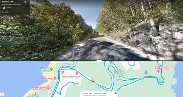
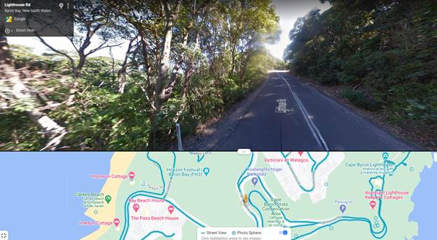
Report No. 6.1 Yellow Line - Lighthouse Rd, Wategos
File No: I2021/65
Staff are seeking Council resolution to install yellow
lines along Lighthouse Road between Brooke Drive and Marine Parade, Wategos,
see figure 1 below for the location.
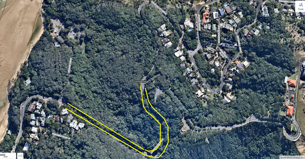
Figure 1 – location of requested yellow lines.
Figure 2 below shows the typical cross section of the
road at two locations along its length. As seen in these figures below
there are narrow gravel shoulders used as informal pedestrian access to Wategos
and the Lighthouse. The frequent conflict is that cars often park across
these gravel shoulders where people then walk to the Lighthouse. This
creates a hazard for pedestrians using the path and that cars end up partially
on the path and partially on the road.
Council proposes to install a yellow line in the
location shown in figure 1 to eliminate this unsafe parking location.
Where the eastern extent of the proposed yellow line ends there is already
existing yellow lines through to Marine Parade.
|
RECOMMENDATION:
That Council
endorse the installation of yellow lines along Lighthouse Road from the
Brooke Drive intersection extending through to the start of Palm Valley
Drive.
|
Local Traffic Committee Meeting 6.2
Report
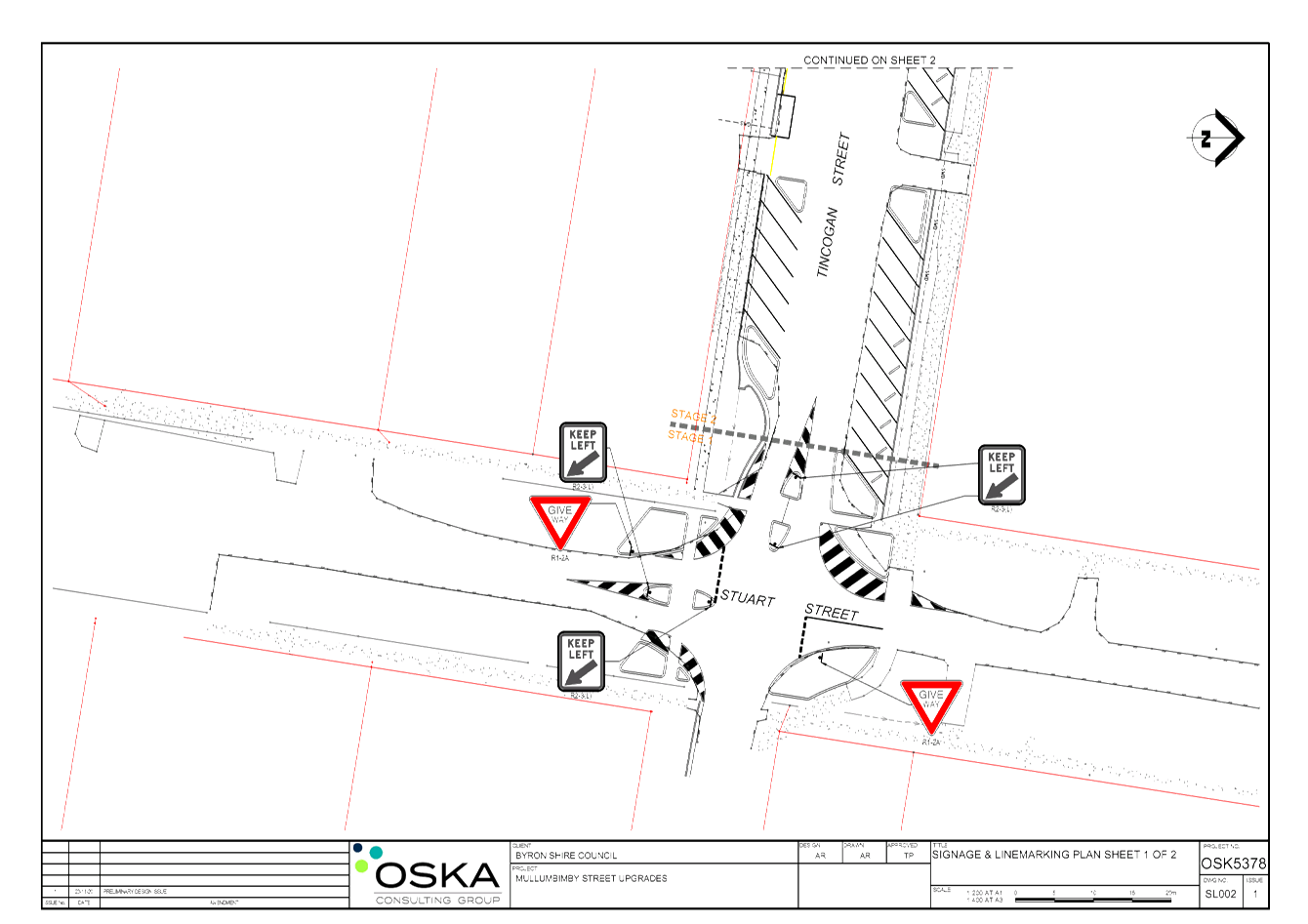
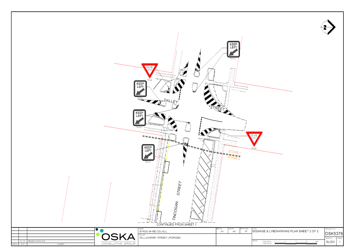
No. 6.2 Tincogan Street Intersection Priorities
File No: I2021/66
This report seeks LTC support for the reprioritisation of give way signs
on Tincogan Street at the Dalley Street and Stuart Street Interesctions in
order to provide East-West traffic priority in Tincogan Street.
Currently traffic on Tincogan Street must give way to
traffic on Dalley Street and Stuart Street as seen in Figure 1 below.
Figure 1: Tincogan St / Dalley St Intersection
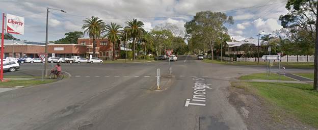
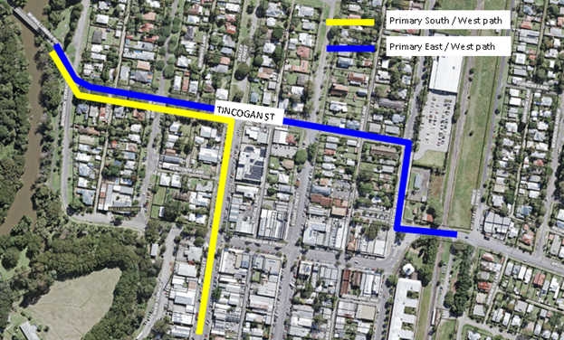
Figure 2 below shows the typical traffic paths through
Mullumbimby. Refer to blue line for vehicles travelling east / west and yellow
for vehicles traveling south / west.
Figure 2: Plan view of Mullumbimby and travel paths
Previous Reports
This matter was brought to LTC previously in 2014 and
2019. In 2014 LTC recommended the following:
Committee
Recommendation
1. That Council receive a report via the
LTC as to the benefits and issues associated with changing the traffic route
priority along the length of Tincogan Street from Station Street to Brunswick
Terrace.
2. That Council seek comments from the
community in regards to this proposal with any submissions received forming
part of the discussion in the above mentioned report.
3. That Council note that at the
intersection at Station Street, the Give Way orientation may be changed.
Council resolved to adopt the above LTC resolution at
the 7 August 2014 Council meeting. No additional Council comments were
provided.
This matter was also brought to LTC in September 2019
where the benefits and issues associated with the priority change were
discussed. LTC made the following recommendations:
Committee
Recommendation
1. That Council note the Committee’s comments on
possible changes to Give Way signs at Tincogan Street / Dalley Streets
intersection and the Tincogan Street / Stuart Street intersection.
2. That Council
note the correspondence from the Mullumbimby Residents Association to the
Director Infrastructure Services dated 6th September 2019,
(E2019/67997) and consult with residents of Mullumbimby.
3. That Council
investigate Active Transport Funding FY20/21 for pedestrian protection in this
area.
Council resolved (19-485) to adopt the above LTC
resolution, with the exception of item 3, at the 26 September 2019 Council
meeting.
Through the above reporting, Council has shown clear
support for the changes in intersection priority at the time of reporting.
Mullumbimby Masterplan/Community Consultation
In December 2019, Council adopted the Mullumbimby
Masterplan which supports the reprioritisation of give way signs on Tincogan
Street to facilitate east-west traffic priority as well as to realign the
intersections at the Stuart and Dalley Streets to improve safety and traffic
flow.
Proposed Design
The preliminary design has been appended to this
report. Note, details related to kerb buildouts, drainage, parking,
landscaping is subject to change and are not regulatory devices requiring LTC
review. Only proposed regulatory signs and lines require LTC consideration.
Construction Scheduling
Council aims to commence works to coincide with the
Burringbar Talking Street Project. The purpose of this project is to reduce the
amount of through traffic along Burringbar Street by diverting traffic along
alternate routes such as Tincogan Street via Station Street in order to
circumnavigate the Mullumbimby commercial area.
The works associated with the intersection changes are
proposed to occur in the following stages due to budget and resource
requirements::
Stage 1: Linemarking and
signage – December 2020
Stage 2: Installation of
pedestrian refuges, some landscaping and kerb buildouts – early to mid
2021
Stage 3: Connectivity between
Dalley and Stuart Streets including parking – longer term
Staged Construction Considerations
Pedestrian Safety
As seen in the proposed design, improved traffic
control and pedestrian safety will be addressed through kerb extensions and
pedestrian refuges. The goal of these is to narrow the intersection, aid
in managing speed and provide improved pedestrian safety at the Dalley and
Stuart Street intersections with Tincogan Street.
The period between Stage 1 (line marking and signage)
and Stage 2 (kerb buildouts) works may represent a risk to pedestrians in this
regard. An interim solution to help address this risk may be to line mark
chevrons where future kerb extensions are proposed, potentially in combination
with guide posts or temporary reflective pavement markers. These items are not
regulatory devices but are mentioned to highlight Council’s steps to improve
pedestrian safety.
Shops
Along Tincogan St, between Dalley St and Stuart St is
a strip of popular shops, cafes, auto repairs, dance studio, bike shop and
motor cycle repair. This strip of Tincogan St currently has high parking
demand with high turnover. Parking is 90’ angle parking with cars
required to reverse out to exit.
The proposed design will reduce the amount of parking
in this area due in part to the kerb extensions. This area will need to be
monitored to address any potential conflicts arising from the proposed
intersection works. Undertaking stage 1 works first will help identify matters
that could be addressed as part of stage 2 and 3.
Funding
Stage 1 and 2 works to change the priority at Dalley
and Stuart Streets are specifically referenced and scoped tasks under the
funding agreement for Council’s Election Commitment Grant which is
aimed to address the Impacts of Tourism on infrastructure evidenced in Byron
Shire.
|
RECOMMENDATION:
That Council implement the priority changes to give
way signs on Tincogan Street at the intersections of the Dalley Street and
Stuart Street, Mullumbimby in order to provide priority to east-west traffic
movements in Tincogan Street.
|
Attachments:
1 24.2020.19.1
- Tincogan Intersections Preliminary Design - LTC, E2020/94815 , page 10⇩ 
Regulatory Matters 6.2 - Attachment 1
Local Traffic Committee Meeting 6.3
Report
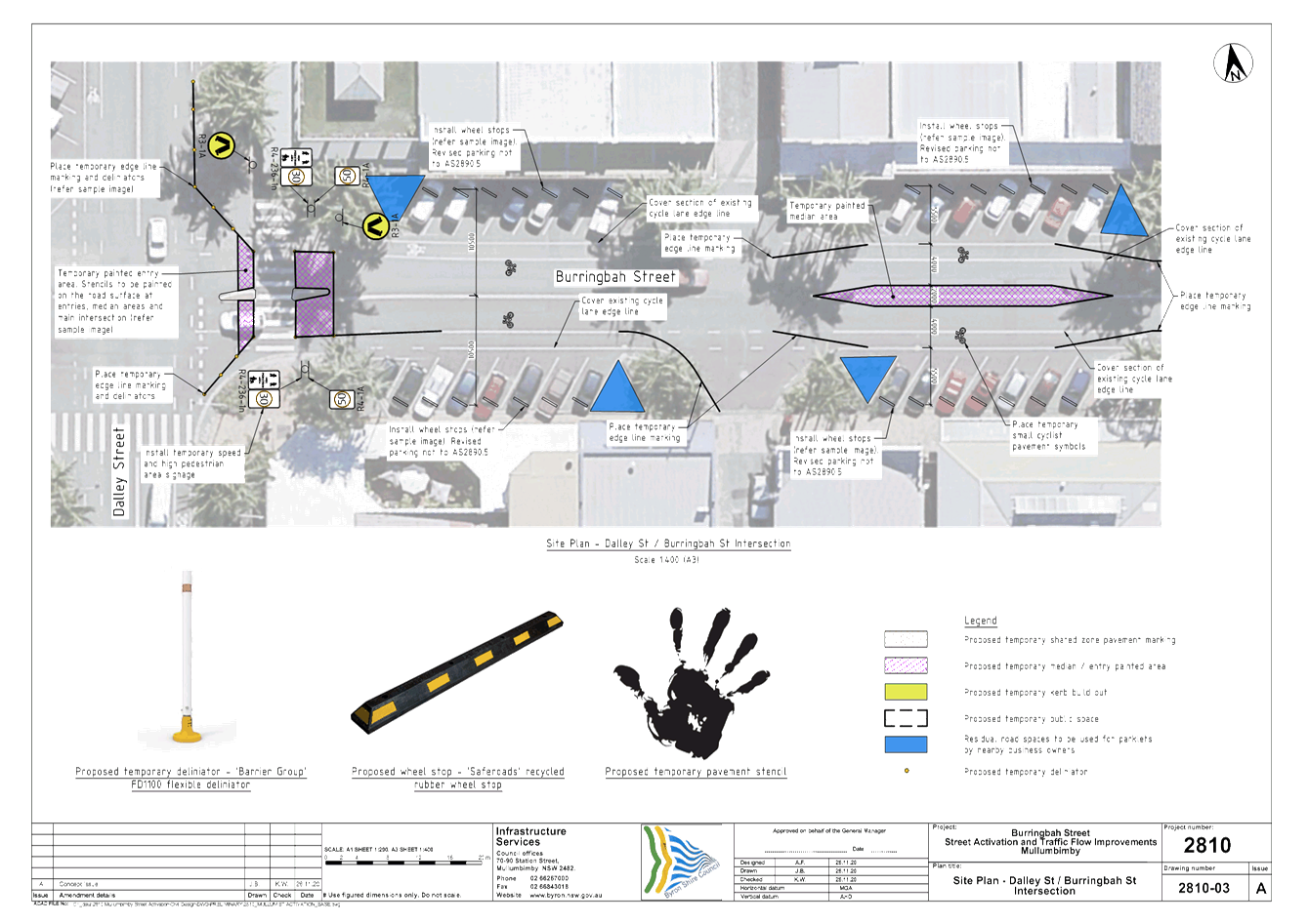
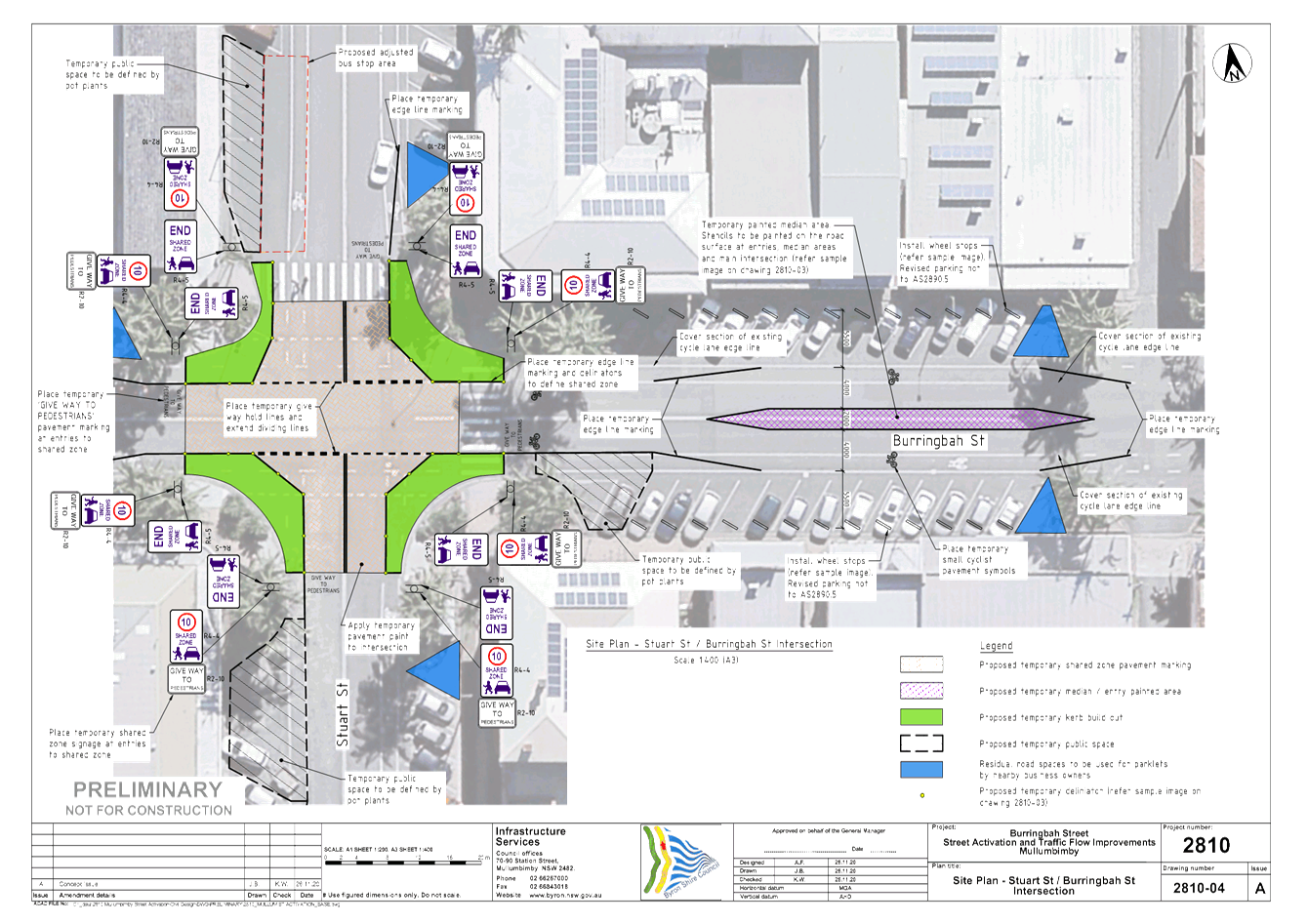
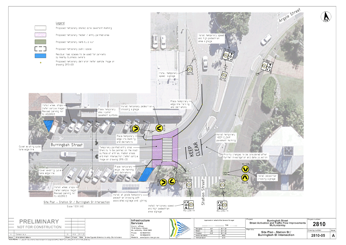
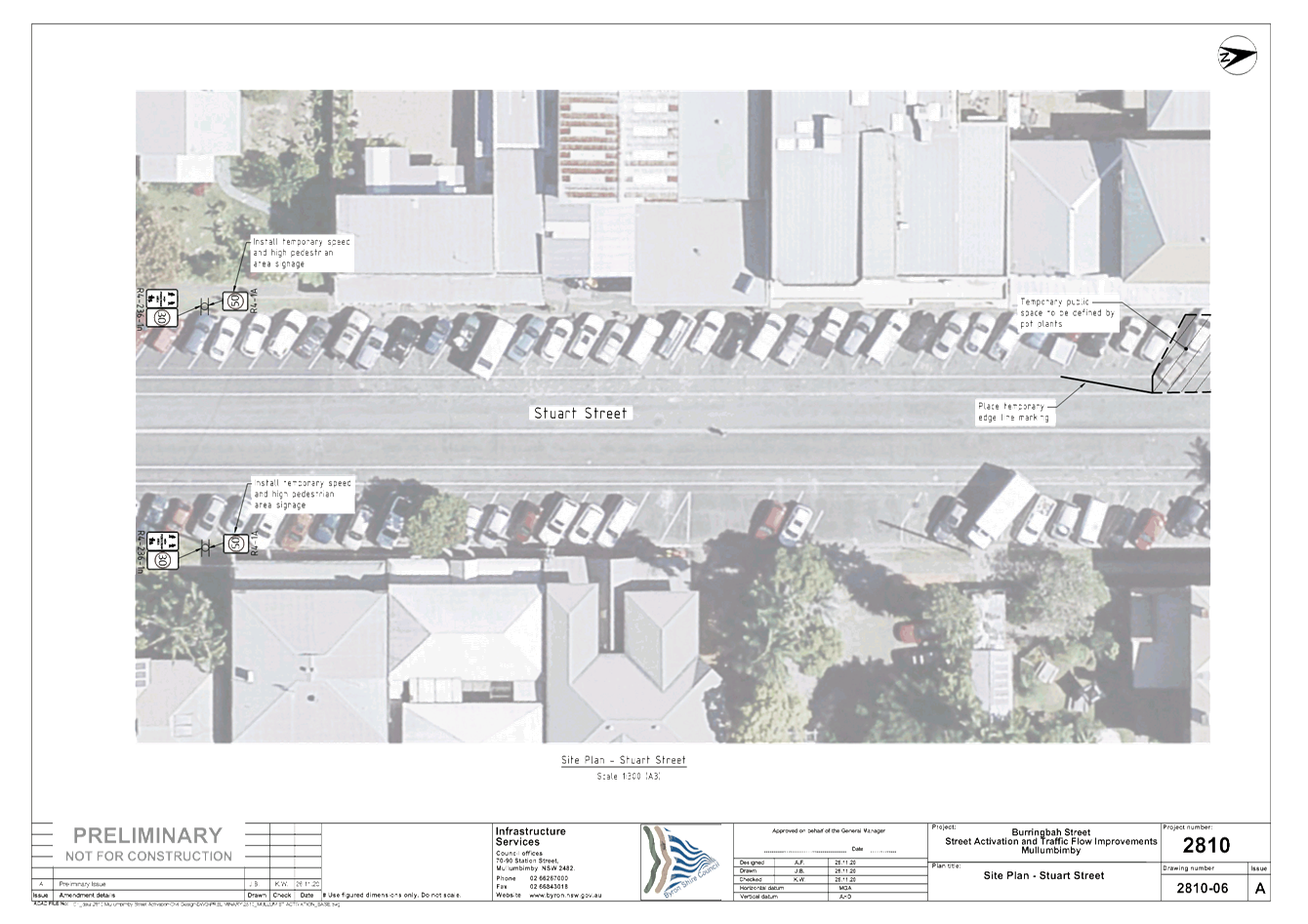
No. 6.3 Burringbar St - Talking Street
File No: I2021/67
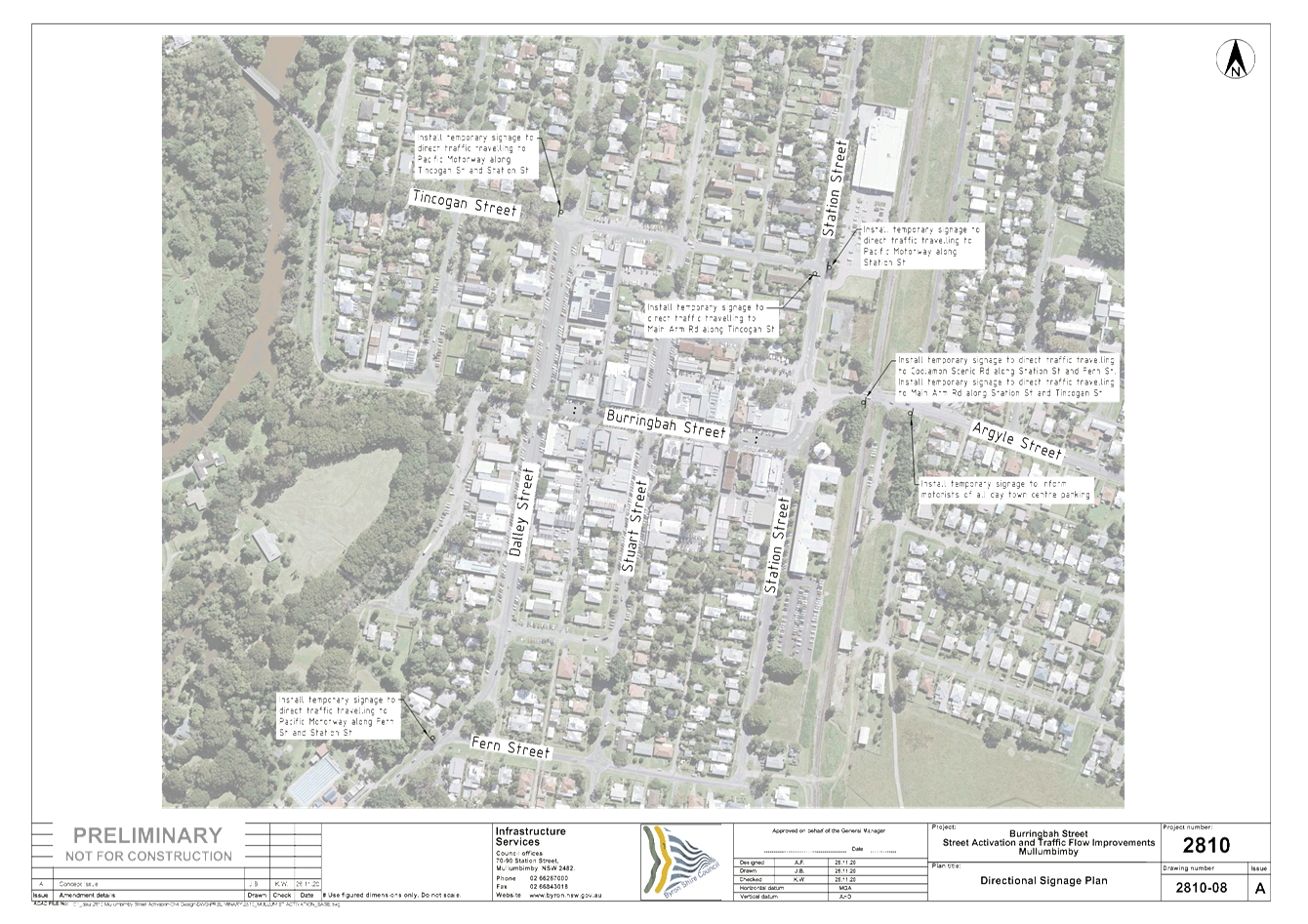
Council has been awarded funding from the NSW State
Government to trial temporary treatments including speed reductions and
parklets in Burringbar Street, Mullumbimby. The purpose of this trial is
to reduce vehicle movements through and on Burringbar Street within the town
centre, provide a safer space for cyclists and pedestrians as well as promote
social interaction through “activating” areas of the street.
The trial also aligns with the Council endorsed Mullumbimby Masterplan.
A similar report was submitted to the November 2020
LTC meeting. However, a number of design features have been amended. As a
result it was considered prudent to resubmit the design to LTC for support.
The following regulatory signs, lines and devices
require LTC endorsement:
1. Speed reduction from 50km/h to 10km/h
covering the intersection of Burringbar Street and Stuart Street and extending
approximately 10m out from the intersection in all directions (refer attached
plans).
2. Speed zone reduction for the remainder
of Burringbar Street and Stuart Street commercial areas from 50km/h to 30km/h
(refer attached plans).
3. Amendments to the existing delineation
along the length of Burringbar Street to incorporate features such as the
following in accordance with the attached plans.
a. Removal of cycle lane to trial mixed
traffic (vehicle and cycle) lanes as per the Byron Shire Bike Plan
b. Widen centre lines in some locations
c. Install wheel stops to prevent cars
encroaching onto footpath and in some places push car back 1-2m from gutter to
enhance pedestrian activation of footpath areas.
4. At the November LTC report additional
crossings were proposed at the Stuart St Burringbar St intersection. Due to the
proposed 10k/h shared zone these crossings are no longer needed. The cost of
street lighting at these crossings was also prohibitively expensive. These
crossings have been removed from the attached plans.
5. Note that the intersection priority
change previously discussed at Station and Burringbar Street will not form part
of the first stage of works. A new pedestrian crossing is still planned
on Burringbar Street near the Station Street intersection (refer attached
plans).
6. Regulatory linemarking and signage
associated with the above.
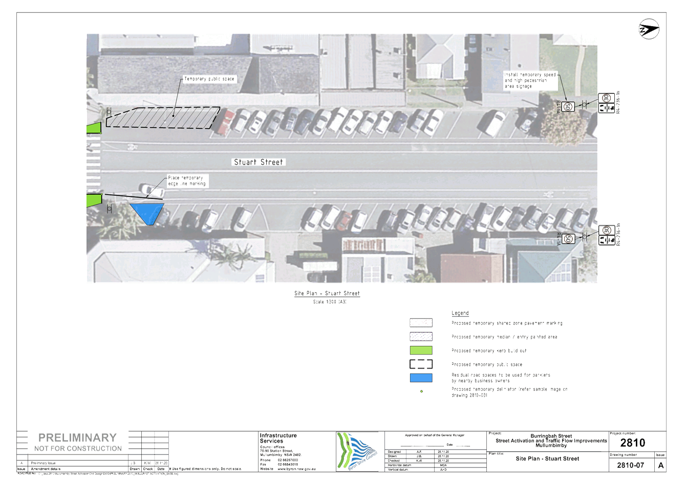
Other
items are proposed as part of the Burringbar Street Talking Street grant which
are not regulatory items. These include
1. Painted stencils (to be designed by a
local artist) are to be painted onto road surfaces at key locations as noted on
the attached plans.
2. Several temporary parklets and public
spaces along Burringbar Street and Stuart Street.
3. Temporary painted thresholds, median
areas and intersection treatments
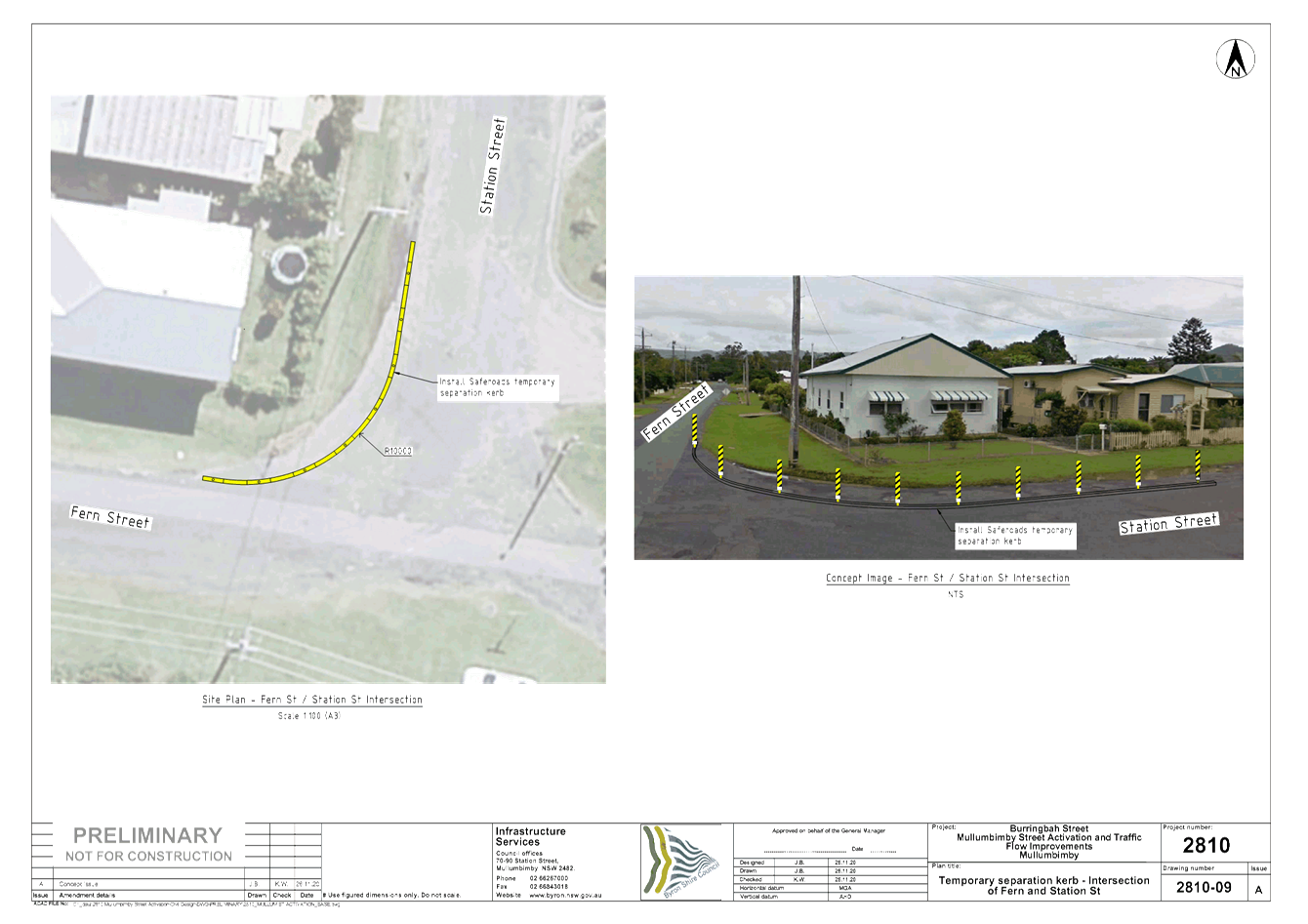
4. Temporary separation kerb and guide
posts at Station Street / Fern Street intersection.
|
RECOMMENDATION:
That Council
endorse the regulatory signs, lines and devices presented in attachment 1
(E2020/95475).
|
Attachments:
1 Burringbar
St - Talking Streets Activation, E2020/95475
, page 14⇩ 
Regulatory Matters 6.3 - Attachment 1
Local Traffic Committee Meeting 6.4
Report
No. 6.4 On-Road Cycleway Connection -
Bangalow/Browning/Tennyson Roundabout
File No: I2021/68
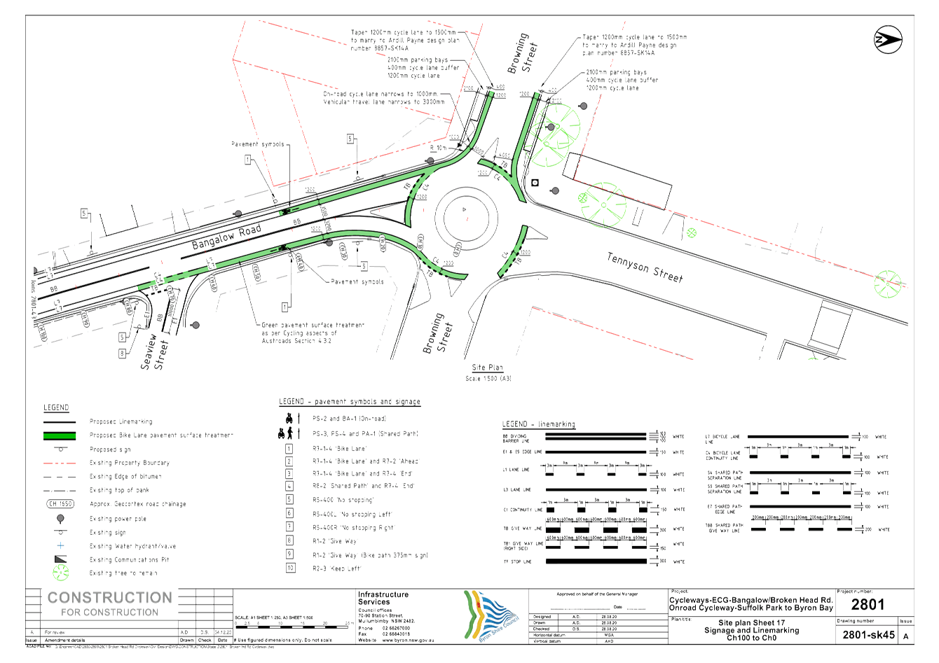
There are currently two separate on-road cycleway
projects running concurrently, being the Byron Bay Bypass and the Byron to
Suffolk cycleway projects.
Upon review of both projects, it has been identified
that neither project included markings on the Bangalow/Browning/Tennyson
roundabout to provide connectivity between the two.
Therefore, this has been designed and is presented for
endorsement and will be installed within the month of December 2020 in
conjunction with the other two projects.
This will provide connectivity for an on-road cycleway
from Suffolk Park to just south of the Shirley/Butler/Lawson roundabout on the
Byron Bay Bypass project.
|
RECOMMENDATION:
That Council endorse the attached plans for the On-Road Cycleway Connection at
Bangalow/Browning/Tennyson Roundabout pavement marking and signage to be
installed (#E2020/97761).
|
Attachments:
1 24.2017.86.1
- 2801-SK45 - Byron to Suffolk Cycleway - Browning St Roundabout Bypass
Connection, E2020/97761 , page 24⇩ 
Regulatory Matters 6.4 - Attachment 1
Local Traffic Committee Meeting 7.1
Development Applications
Report No. 7.1 Mixed Use Development - Jonson St /
Browning St
File No: I2021/69
Council has received a Roads Act application
associated with a mixed use development on the corner of Jonson St and Browning
St, Byron Bay. The development was previously reported to May 2020 LTC
meeting and was not supported. This development application was subsequently
granted approval through the Land and Environment Court.
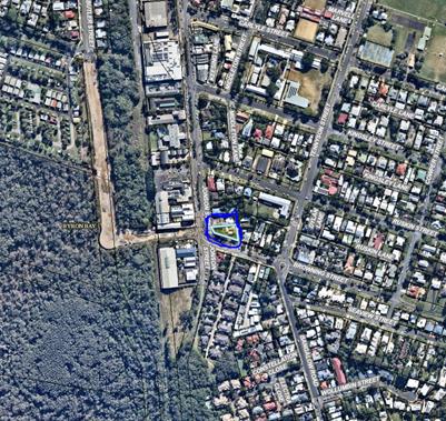
Refer to the image below for its location circled in
blue.
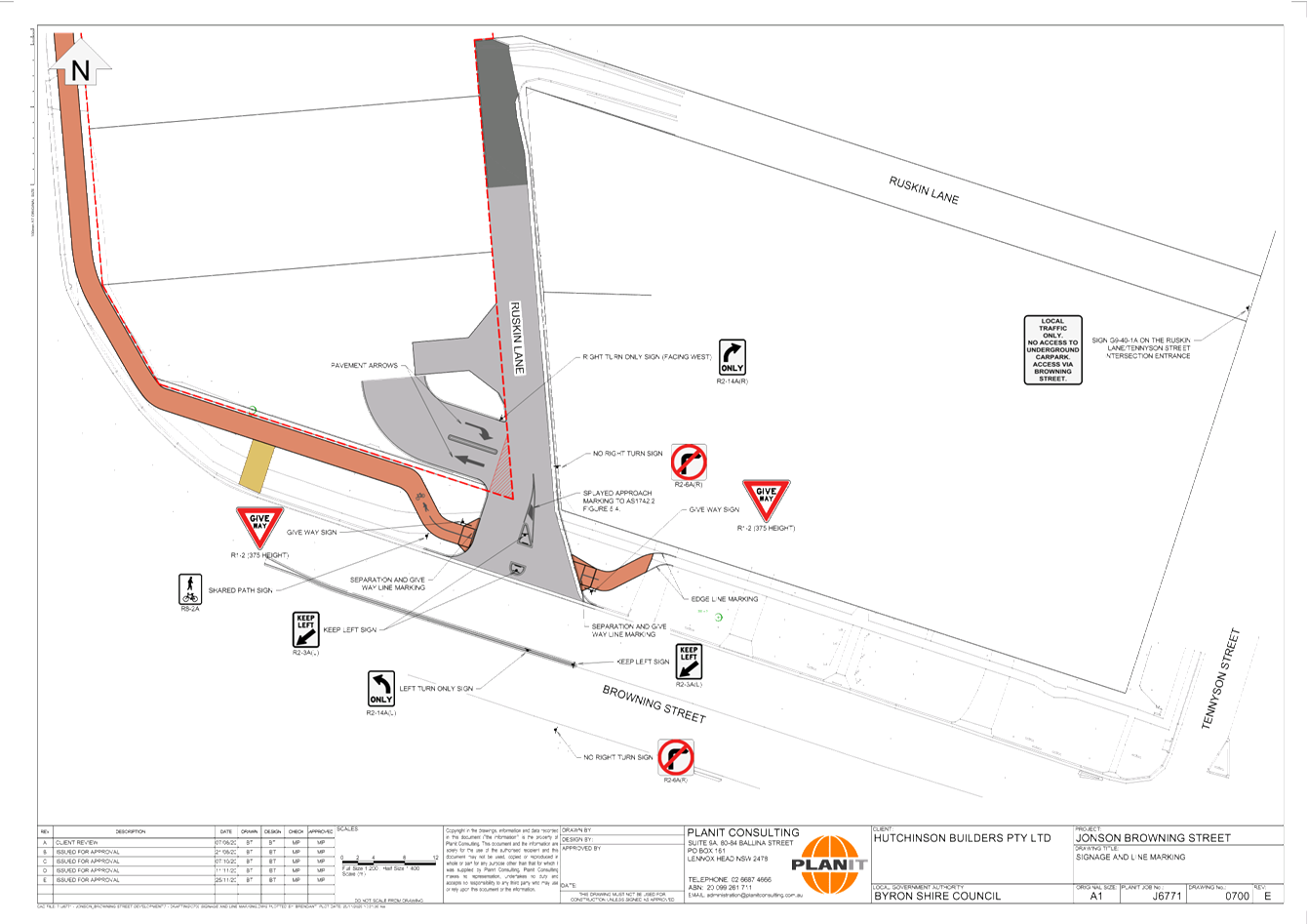
It is noted that both Jonson St and Browning St are
regional roads requiring TfNSW concurrence for the works on Browning St and Jonson
St. Council’s Development Engineer Gray Blunden has confirmed TfNSW
have given concurrence for the installation of a median strip on Browning
Street at the Marvel Lane / Browning St intersection. Refer to attachment 2 for
the letter confirming this concurrence and attachment 1 for its location.
Below are the conditions of consent imposed on the DA
approval:
Condition 24 (part of):
· Intersection with Browning St in accordance
with Planit drawing J170-1300 Rev C dated 9/3/20, except for the following:
- “No Right Turn” signage is to
comply with the relevant standards of Transport for NSW;
- a “No Right Turn” sign is to be
located on the eastern side of Ruskin Lane opposite the basement access ramp,
so as to be clearly visible to southbound vehicles within the lane;
- a “No Right Turn” sign is to be
located on the southern side of Browning Street opposite the Ruskin Lane
intersection;
- a “Left Turn Only” sign is to
be located either on the central median in Browning Street, or at junction of
Ruskin Lane and Browning Street, to be clearly visible to vehicles exiting the
lane;
- the left arrow and words “no right
turn” proposed to be painted on the Ruskin Lane pavement are not
approved;
-
Driveway (commercial areas):
A driveway in accordance with Council’s standard “Northern
Rivers Local Government Development Design & Construction Manuals and
Standard Drawings”. The footpath crossing must be designed to
provide a cross fall of 1 % or 1:100 (maximum 2.5% or 1 in 40) for a width of
at least 2.4 metres to provide for pedestrians with access disabilities.
· Provision must be made to prevent the
ingress of flood waters into the basement carpark. Driveway ramps that allow
for the ingress of rainwater are to be predominantly covered, with a maximum
area of 60m2 only that is exposed to direct rainfall.
· Provision must be made to prevent vehicles
from turning left into Ruskin Ln using raised island and line marking; and
It is confirmed Attachment 1 has incorporated the
above conditions into the design.
The purpose of this LTC report is to gain Council
support for the proposed regulatory signage shown in attachment 1. Note,
the General Manager does not intend to use delegated authority to adopt the LTC
recommendations. Any LTC recommendation for this report will proceed to
the next 2021 Council meeting.
|
RECOMMENDATION:
That Council
approve the regulatory signage shown in Attachment 1 (E2020/95011) which is
associated with development application 10.2019.616.1 and Roads Act
application 51.2019.616.2.
|
Attachments:
1 0700
SIGNAGE AND LINE MARKING, E2020/95011
, page 27⇩ 
2 Service
NSW (RMS) - 51.2019.616.1 - TfNSW Concurrance, E2020/94813 , page 28⇩
Development Applications 7.1 - Attachment 1
Development Applications 7.1 - Attachment 2