Local Traffic Committee Meeting
A Local Traffic Committee Meeting of Byron Shire Council
will be held as follows:
|
Venue
|
Conference Room, Station Street, Mullumbimby
|
|
Date
|
Tuesday, 13 April 2021
|
|
Time
|
10.30am
|
|
Committee Members
|
Ian Shanahan – Transport for NSW
Detective
Chief Inspector Matt Kehoe – Police
Cr
Basil Cameron
Tamara
Smith MP
|
Phillip Holloway
Director Infrastructure
Services
I2021/586
Distributed
06/04/21
Local
Traffic Committee Meeting
BUSINESS OF MEETING
1. Apologies
2. Declarations
of Interest – Pecuniary and Non-Pecuniary
3. Adoption
of Minutes from Previous Meetings
3.1 Local
Traffic Committee Meeting held on 16 February 2021
3.2 Extraordinary
Local Traffic Committee Meeting held on 16 March 2021
4. Matters
Arising
5. Outstanding
Issues/Resolutions
6. Regulatory Matters
6.1 Azalea
St Intersecion Upgrade.................................................................................... 4
6.2 Brunswick
Heads Parking Limit Review.................................................................. 14
6.3 Traffic
Management for Festival of the Stone......................................................... 21
6.4 Event
- Byron Triathlon - 9 May 2021....................................................................... 47
Local Traffic Committee Meeting 6.1
Regulatory Matters
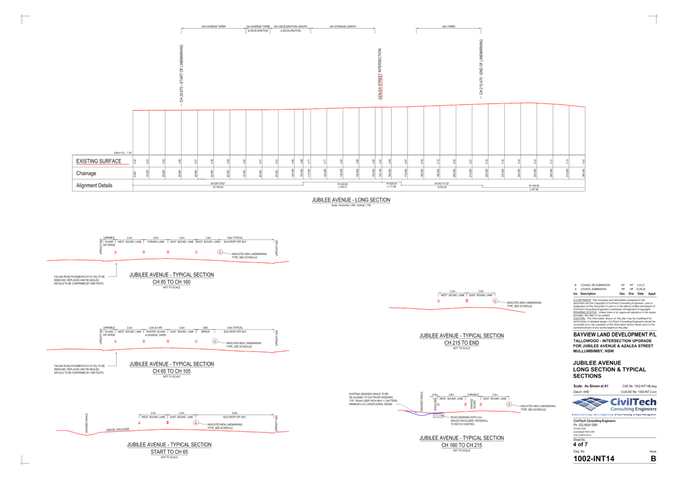
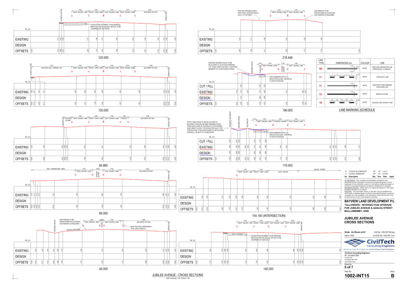
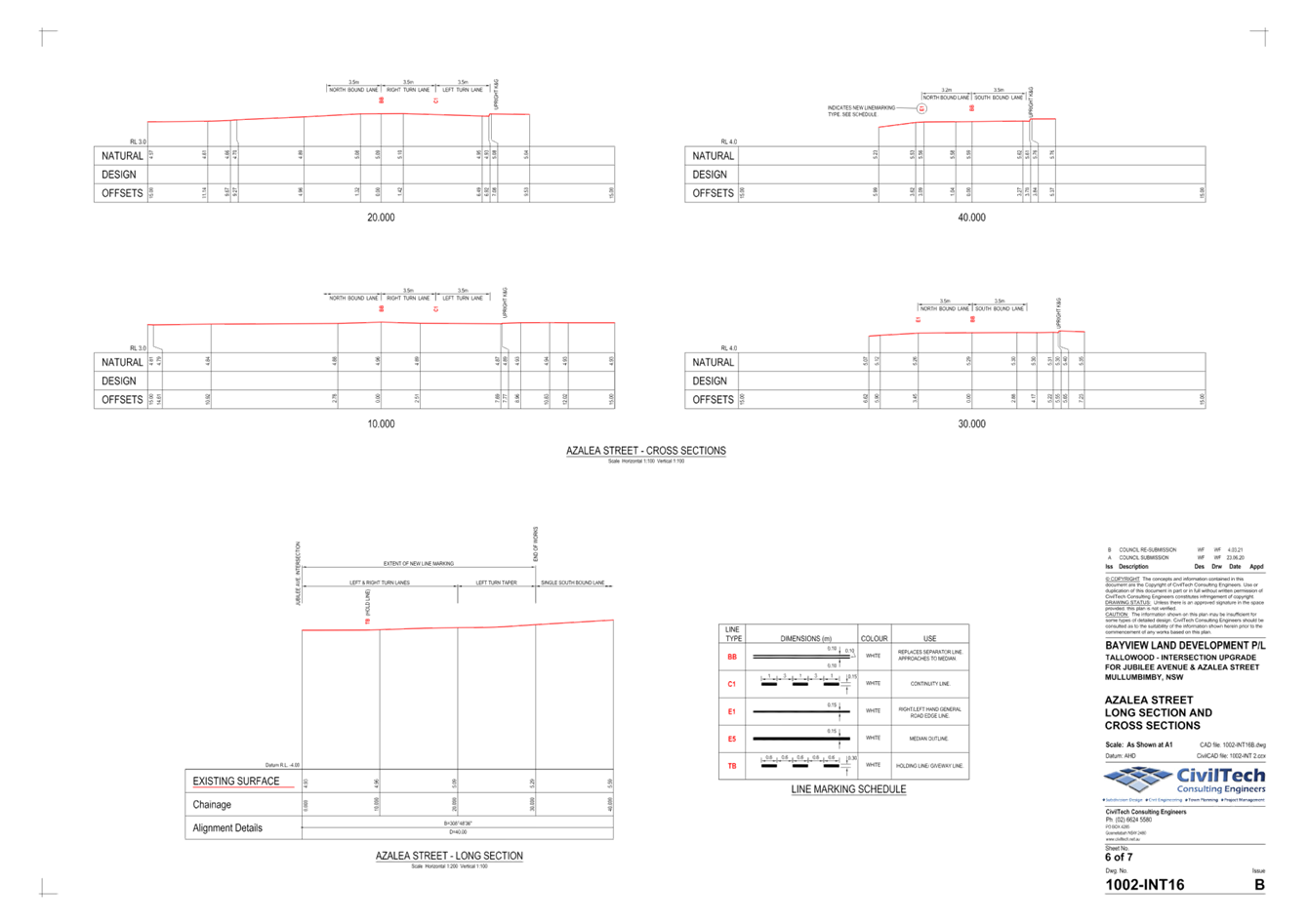
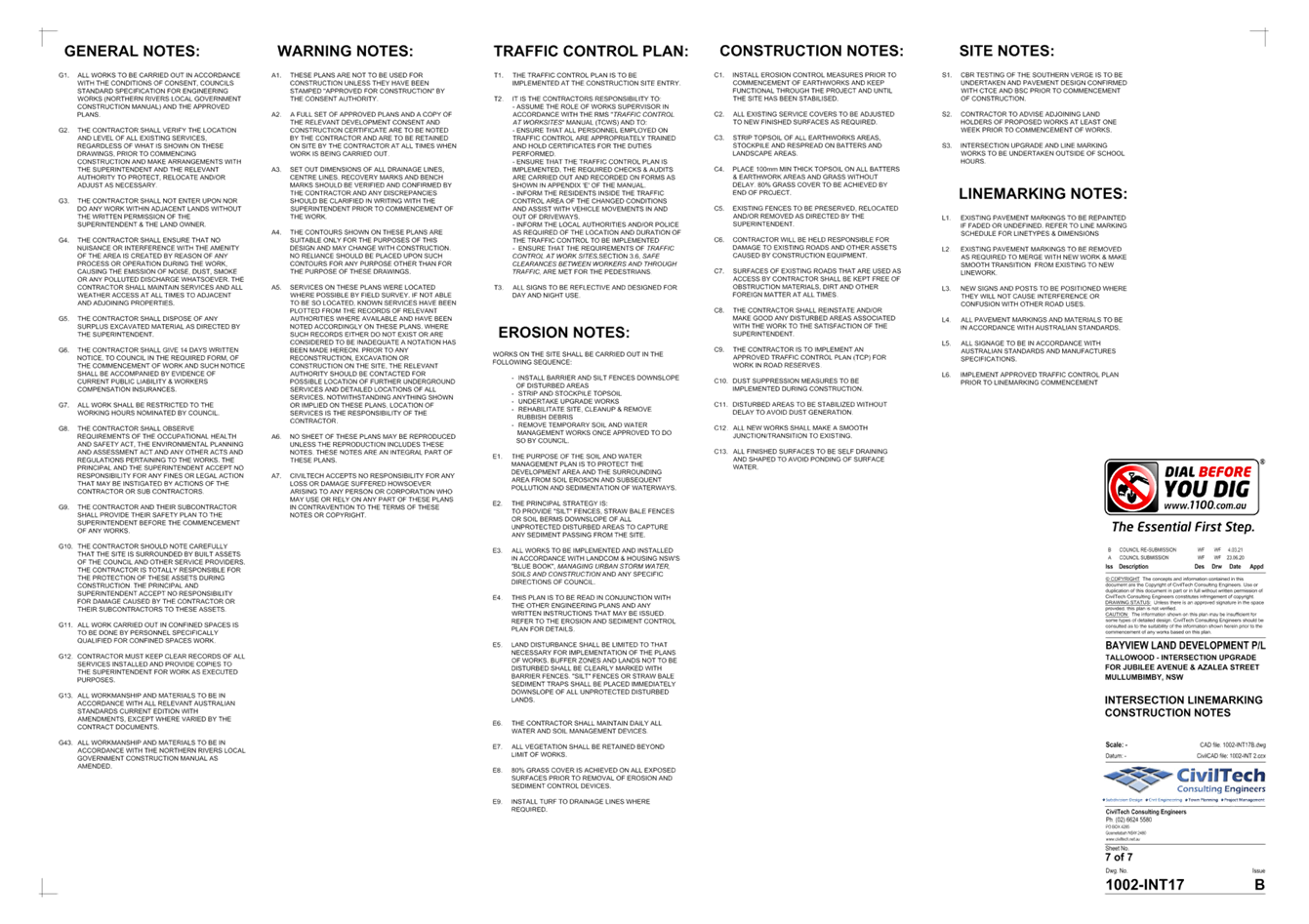
Report No. 6.1 Azalea St
Intersecion Upgrade
File No: I2021/372
The purpose of this report is to gain LTC and Council
support for regulatory changes to the Azalea Street / Jubilee Avenue
intersection as outlined below.
Works associated with this
intersection were taken to the previous 16th February LTC meeting and comments
were provided to the developer. Amended plans to address the issues
raised by LTC’ where applicable’ have now been submitted.
Committee Comments
The following committee comments
were made at the February LTC meeting and noted in the minutes:
Questions
about whether Jubilee Ave will be widened to provide for cyclists. Further
construction of the intersection will be required in future if additional
residential developments occur in Tallowood Estate. The committee discussed the
requirement of Coral Ave to be sealed, which will result in a southwest link
(linking Main Arm Rd, Coral Ave, Clays Rd, Plover Parkway, Tuckeroo Ave,
Left Bank Rd, Azalea St) and will create additional traffic movements at this
intersection.
Cameron:
Has there been any assessment on impacts on bus movements in this area?
Concerns about cyclist safety on both sides of Jubilee Ave (at Mullumbimby
Rural Co-op) where there is not sufficient shoulder for cyclists and
pedestrians.
Blunden:
No allowance has been made for pedestrian movements. As with most shire
roads there will be between 500-1000mm room for cyclists. Boundary of
Rural Co-op to be established. Drainage will be as existing.
Committee
discussed the issue of carpark driveway and bus turning circle, looking to
formalise right turn out of Co-op.
The
barrier fence between the bus lanes and Jubilee Ave will remain, possibly be
extended.
Shanahan:
1. There needs to be gap in the chevron line-marking so that buses can exit.
2.
Council should consider removing the bus-sized rectangle line marking (bus
waiting area near centre of road). 3. The three arrows (indicating
traffic lane is for vehicles going straight ahead) adjacent to the co-op are
not required, and will only create more line maintenance work for council.
Shanahan:
Reminder that LTC cannot impose DA conditions, LTC is for technical review
only.
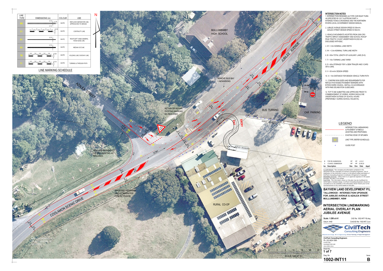
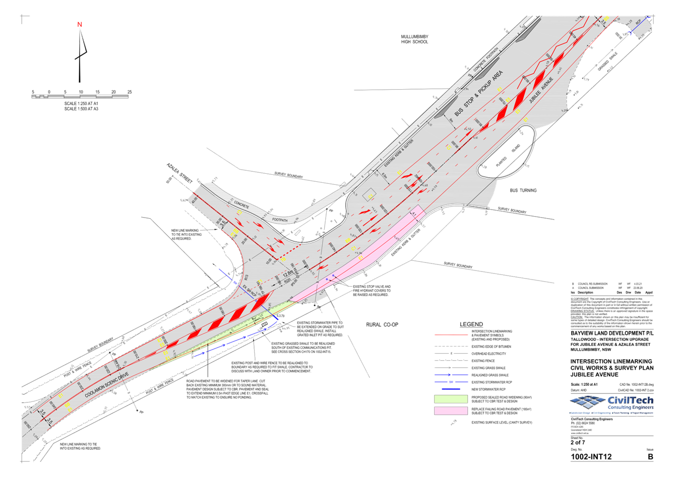
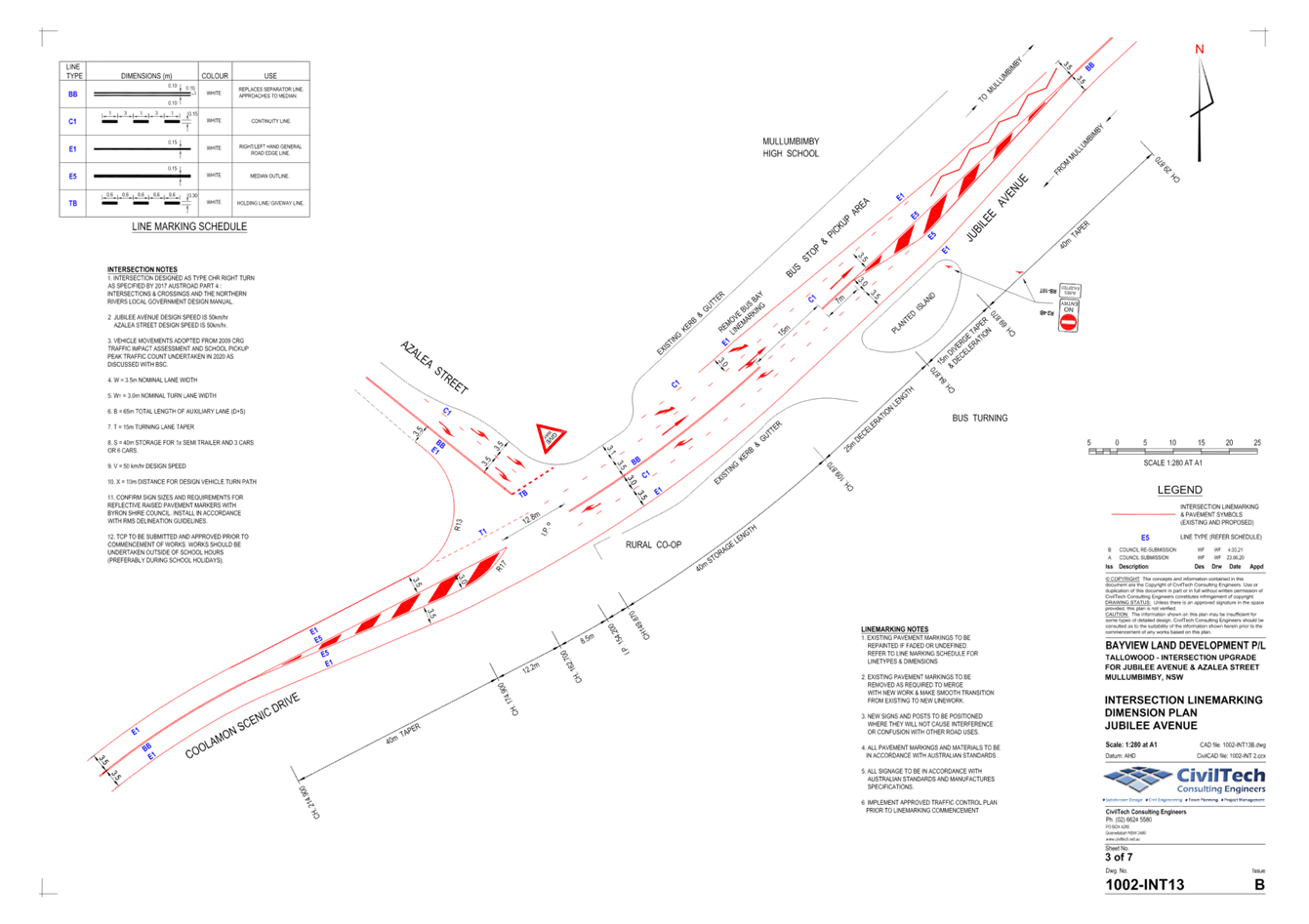
Design Amendments
In response to the above comments,
there is an existing footpath & bike path located on the northern side of
Jubilee Avenue. The Byron Shire Council 10 Year Bike Plan adopted in 2019
does not require any additional provision for cyclists in the area of the
proposed intersection upgrade.
Pedestrians and Cyclists are to be
encouraged to use the existing path on the northern side of Jubilee
Avenue. Encouraging pedestrians and cyclists to use the southern side of
the road would increase points of conflict with the bus turnaround and traffic
entering and leaving the service station.
In regards to Bus movements, the
following design changes have been made:
· A gap
in the chevron line marking for the bus turnaround and service station traffic
has been provided. This has been shifted west to allow for easier access in and
out of the service centre.
· Guide
posts are to be provided to formalise a single entry and exit point for the
service station. These posts will prevent vehicle access from the station
into the bus turning area.
· The
bus parking line marking rectangle will be removed.
· The 3
west bound through arrows have been removed.
· No
Entry signs and Buses Excepted signs are to be provided to the bus turnaround
area.
· Extending
the median and barrier fence is not required.
Council’s
Development Engineer has confirmed Attachment 1 has incorporated the above
conditions into the design.
Background Information
To help with background
information the following explains the project history.
Council received a Construction
Certificate application associated with stage 7 of the Tallowood estate
development in Mullumbimby for 32 new residential lots. As part of the
approved D.A (10.2018.305.1) consent condition 9 imposed the following
requirement:
9.
Engineering Construction Plans
Three
(3) copies of engineering construction plans and specifications must accompany
the Construction Certificate application demonstrating compliance with
Council's standards for the required engineering works.
Each set
of drawings must be accompanied by a Certification Report which must be signed
by a suitably qualified Civil Engineer or Registered Surveyor. The
Certification Report will comprise the certificate and check lists set out in
Annexure DQS-A of the Northern Rivers Local Government Development & Design
Manuals.
The
information shown on the drawings must be logically collected on discrete
sheets generally in accordance with Annexure DQS-B and the Sample Drawings of
the Northern Rivers Local Government Development & Designs. The
drawings are to provide for the following works:
a) Azalea
St & Jubilee St Intersection upgrade
The
intersection shall be upgraded to provide a Channelised Right Turn Treatment in
accordance with Figure A3 of Austroads Guide to Road Design.
RECOMMENDATION:
That Council support the proposed regulatory
signs, lines and devices presented in Attachment 1 (E2021/51345) for works
associated with the Azalea St / Jubilee Ave, Mullumbimby intersection.
Attachments:
1 1002 -
Jubilee Avenue Intersection Upgrade - Issue B, E2021/51345 , page 7⇩ 
Regulatory Matters 6.1 - Attachment 1
Local Traffic Committee Meeting 6.2
Report
No. 6.2 Brunswick
Heads Parking Limit Review
File No: I2021/482
At the Council Meeting of 25th March 2021, Council resolved to implement changes to parking time
limits in Brunswick Heads, as per Council Resolution 21-099:
1.
That Council adopts the Preferred Layout, Figure 4 (as per attachment 2 - E2021/34931)
and with the adjustments in 2, 3, and 4 below and implements the proposed
parking time limits once approved by the Local Traffic Committee.
2.
That Council allocates 4 car parking spaces adjacent to the Brunswick Heads
SLSC for club use and 4 parking permits once approved by the Local Traffic
Committee.
3.
The 2P limit in Zone 1 on Tweed Street should be extended to Booyun Street.
This is due to demand for parking in this area surrounding the IGA
4.
The 4P Zone 2 should be extended north on Tweed Street adjacent to the real
estate agent’s office
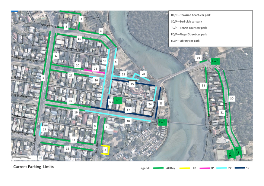
Current Parking
Arrangement
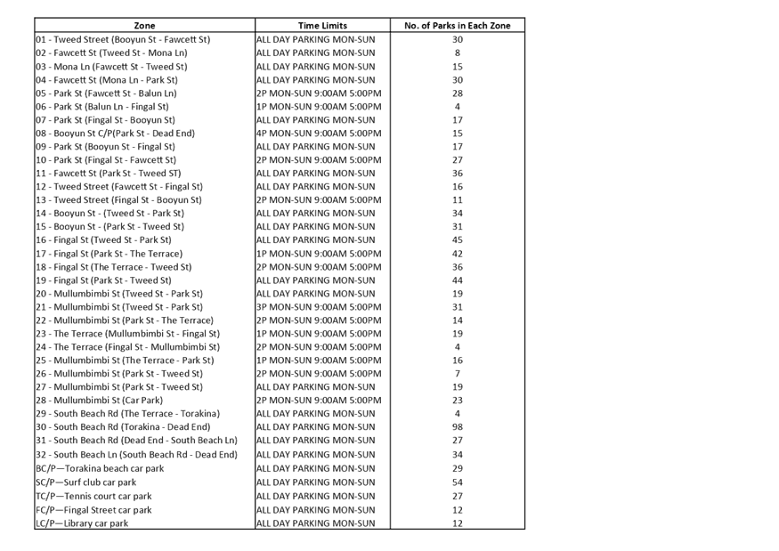
Figure 1 below illustrates the location of
each time zone and current time limits within each zone. It has been identified
through a recent parking scheme review of Brunswick Heads and feedback from the
local community that parking management is highly congested a requires improved
management. The proposed time limit changes are designed to improve parking
management.
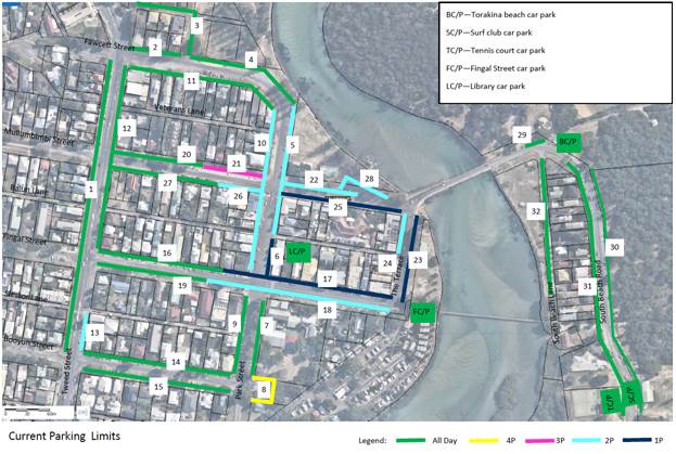
Figure 1. Current Parking Limits
Issues with the current parking layout include consistently
high occupancy rates in the CBD, Beach and School Precincts. The majority
of carparks in these areas exceed an average of 80% capacity over the study
period.
The Compliance Team has reported issues with illegal camping
in the Beach Precinct. Staff indicated that unrestricted parking in the Beach
Precinct enables campers to establish patterns of gathering in carparks and
remaining for extended periods of time.
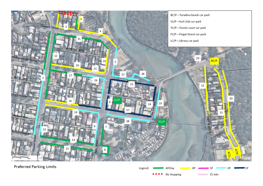
Recommended Changes
The updated parking limits shown in the above resolution and
below Figure 2 (see also Attachment 1) are based on advice received from
parking consultants TPS and modified slightly based on community surveys, staff
and councillor feedback.
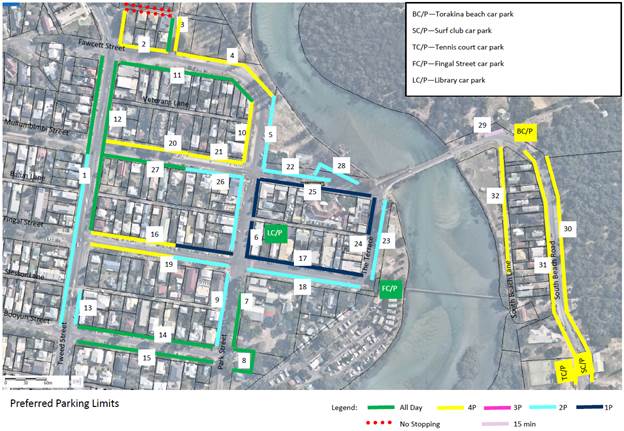
Figure 2. Proposed Parking Limits
The peak high demand locations are around the CBD block and
along the beach front areas. The aim is to manage time limits more closely in
these areas and encourage longer term parking towards the fringes of the CBD.
The proposed time limits can be summarised as;
· 1P around the CBD
block
· 2P immediately
surrounding the CBD block
· 4P on the fringes
of the CDB block, including:
o Along the beach front area as this
matches the expected recreational uses
o Western fringes of the CBD (Fawcett
Street, Mullumbimbi Street, Tweed Street, Park Street and Fingal Street).
· A 15 minute drop
off zone introduced at Torakina Beach.
· No Stopping
introduced on Mona Lane.
This plan promotes consistency of limits, minimises multiple
changes in limits in each precinct.
The Compliance Team support minimising the changes in
parking limits at mid-block locations. Keeping parking limits consistent for
whole blocks where possible leads to less confusion of time limits. For
consistency Council staff also recommend removing the existing 3hr parking on
Mullumbimbi Street.
Higher turnover parking is planned adjacent to highly
frequented park and riverside locations to encourage parking adjacent to
recreation areas and minimise frequent road crossings by pedestrians.
No parking is recommended on Mona Lane as parking on the
verges of this narrow lane represents a safety risk. The carriageway is
too narrow to allow two-way traffic and parking.
Additional Requests
Council also resolved to provide 4
allocated spaces to the Brunswick Head Surf Life Saving Club and an additional
4 parking permits.
RECOMMENDATION:
That Council note LTC’s endorsement of
resolution 21-099.
Attachments:
1 Brunswick
Heads Expanded Parking Limits Final Council Resolved, E2021/50167 , page 18⇩ 
Regulatory Matters 6.2 - Attachment 1
Local Traffic Committee Meeting 6.3
Report
No. 6.3 Traffic
Management for Festival of the Stone
File No: I2021/562
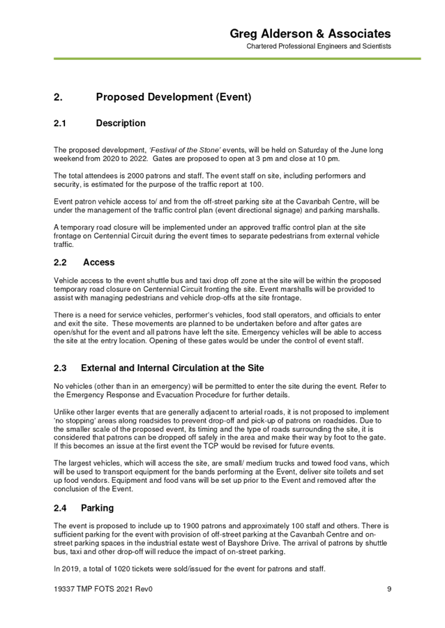
Council has granted consent to Development Application (DA)
10.2019.154.1, as amended by 10.2019.154.2, for a one-day festival over three
consecutive years from 2020 to 2022 at the Stone and Wood micro-brewery site in
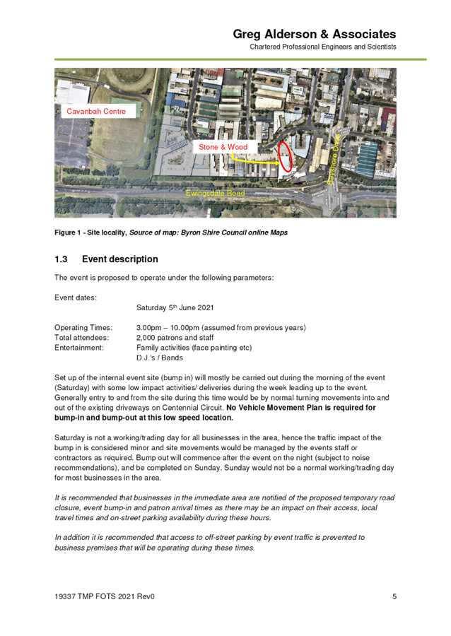
the Byron Arts and Industrial Estate.
Up to 2,000 persons are expected to attend each event
inclusive of patrons and staff. Food and entertainment will be provided
along with alcoholic beverages in accordance with liquor licencing
requirements. Gates are proposed to open at 3 pm and close at 10 pm.
Council previously approved a modification of the
development consent (10.2019.154.2) to enable shuttle bus services to utilise
the closed road/drop off zone in Centennial Circuit in front of the site,
subject to approval of a Traffic Management Plan (TMP) and Traffic Control Plan
(TCP).
Council is currently assessing an application to further
modify the development consent to enable taxi and Uber drop-off and pickup in
front of the brewery in addition to shuttle bus and elderly and people with
disability.
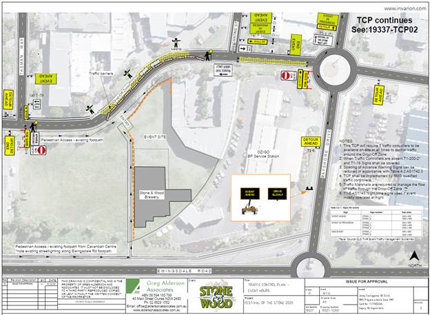
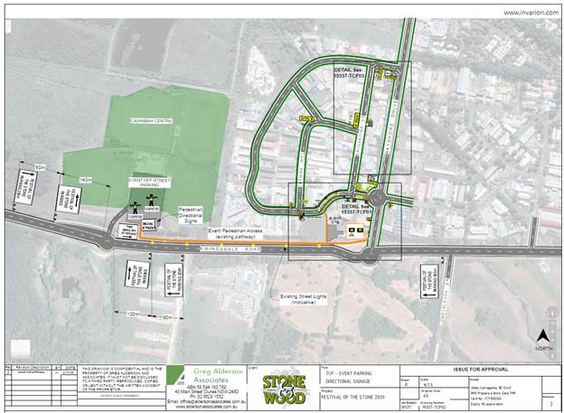
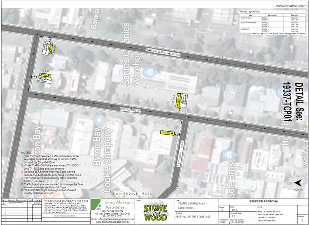
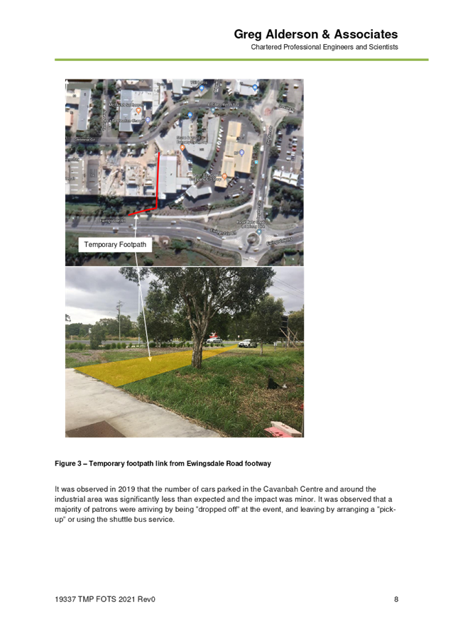
The applicant has submitted a TMP with relevant TCPs for
approval. Please refer to Attachment 1 (E2021/50419).
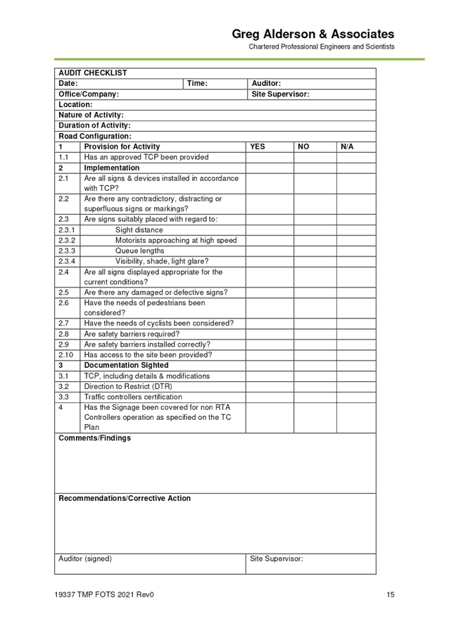
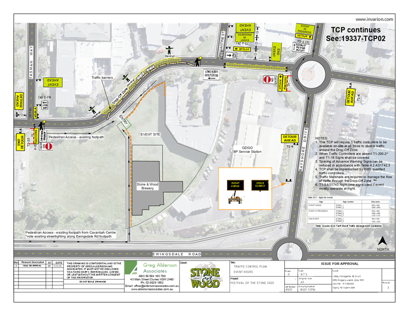
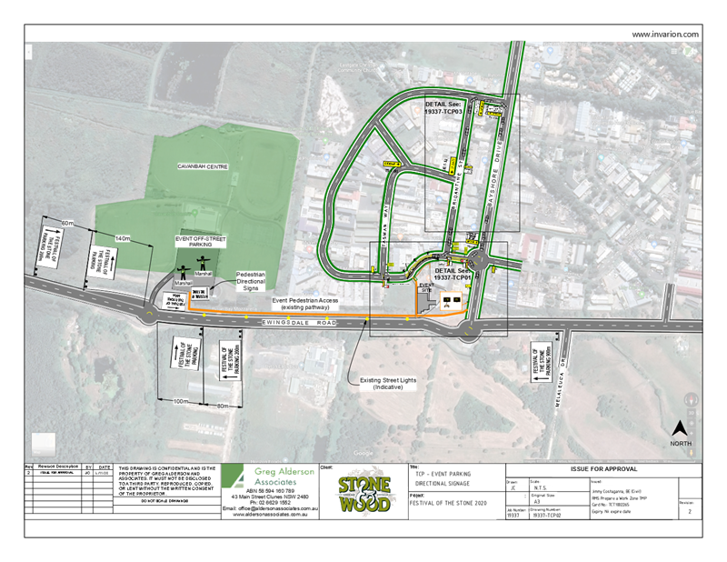
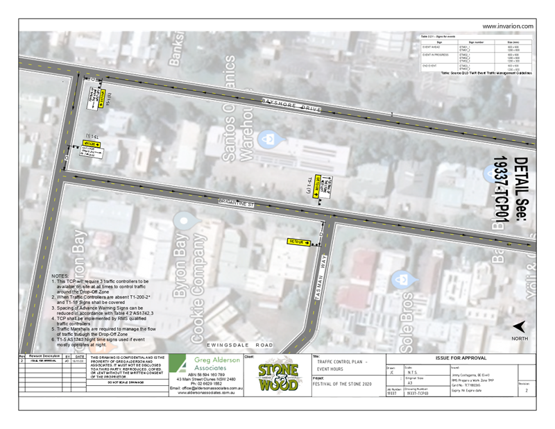
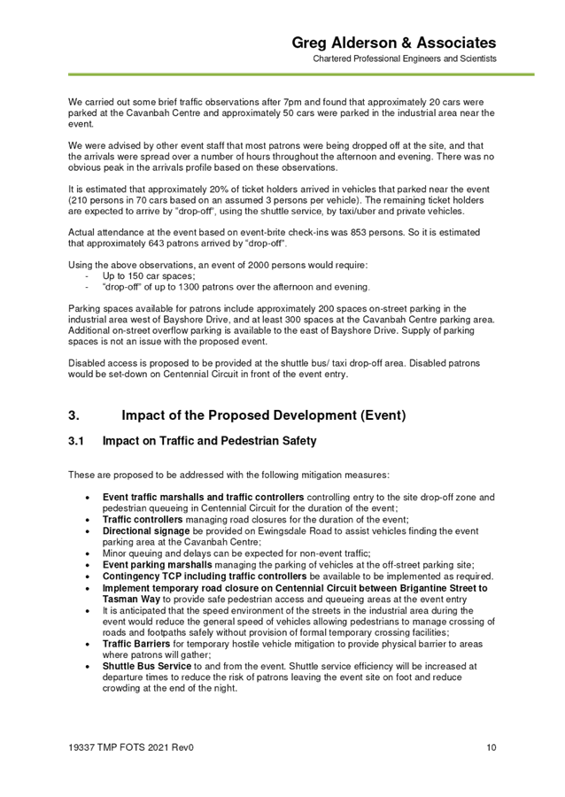
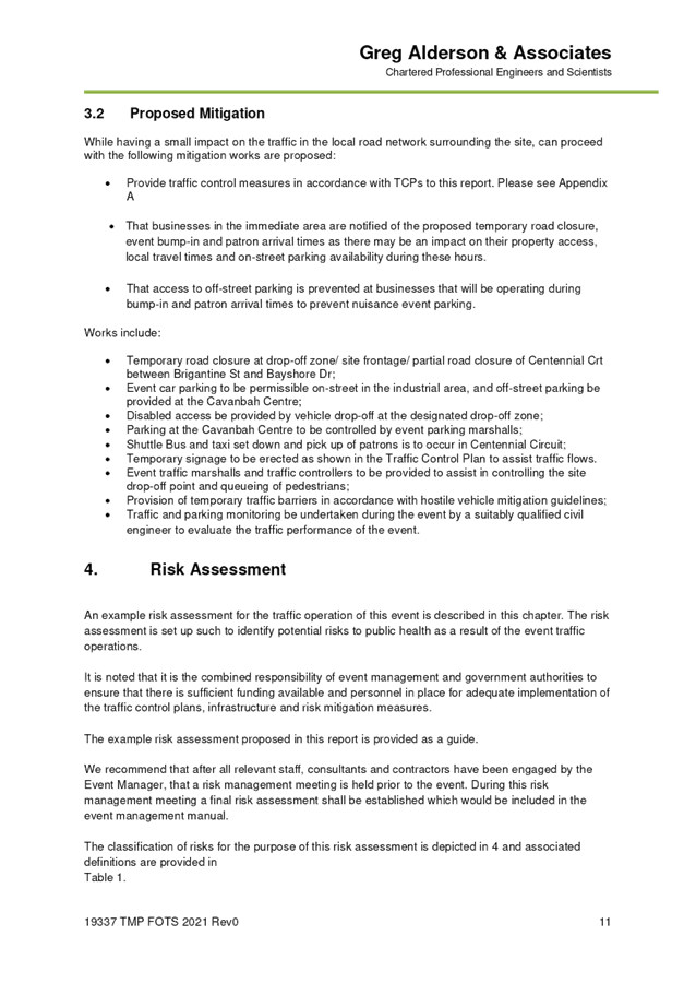
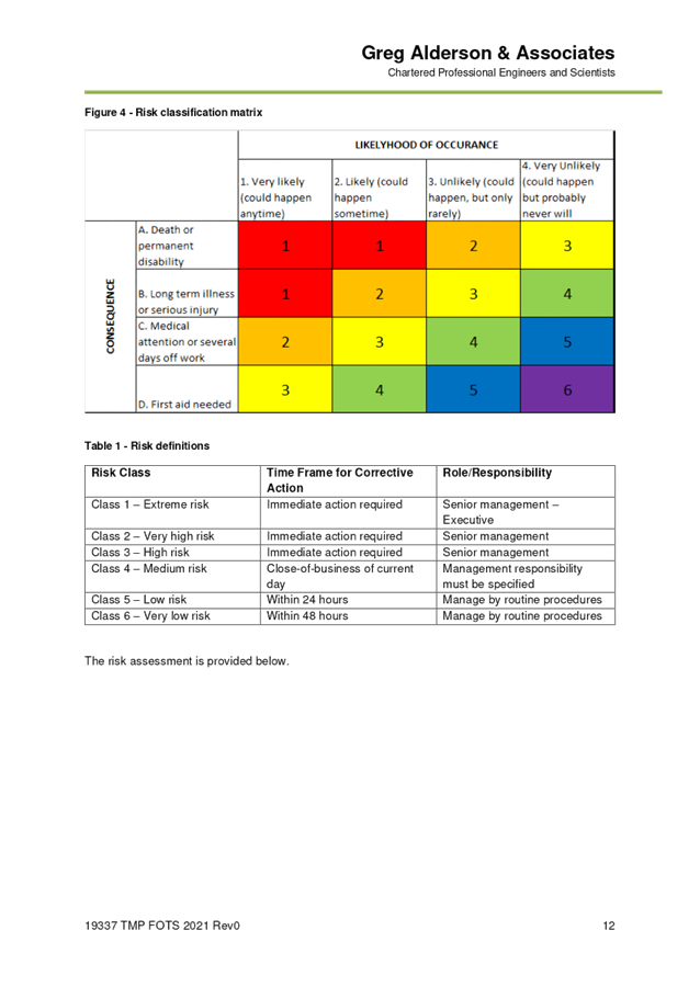
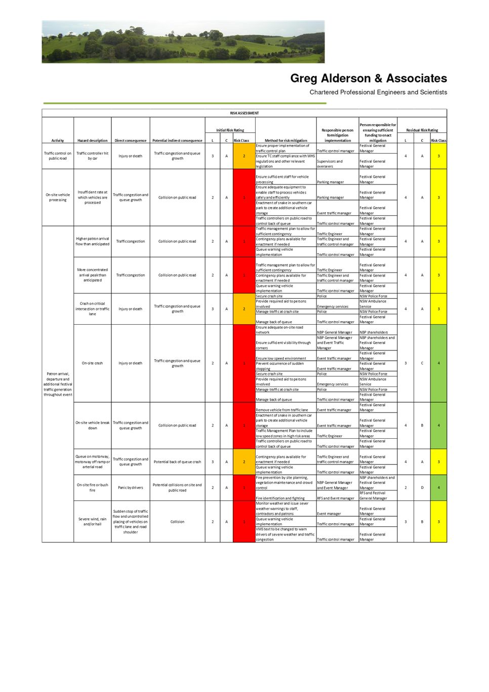
The TMP proposes the following mitigation measures to
address impacts on traffic and pedestrian safety:
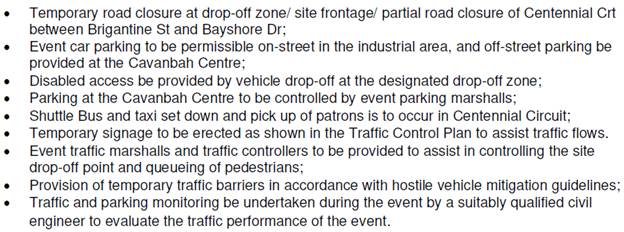
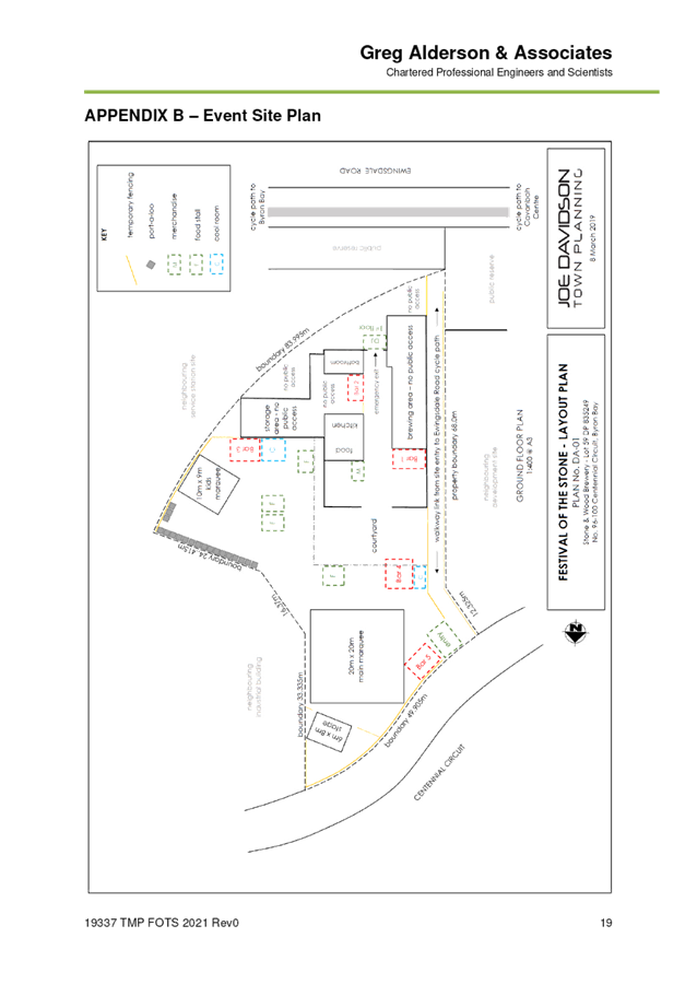
The TCP propose regulatory signage and road closures
requiring Local Traffic Committee approval as indicated in the attachment and
following images.
RECOMMENDATION:
That Council approve the Traffic Management Plan
and Traffic Control Plan for the 2021 Festival of the Stone in Attachment 1
(E2021/50419).
Report writer: Have you mentioned
an attachment in your recommendation? If so, include the TRIM number in
brackets eg “…Attachment 1 (E2017/1234)…” It’s
necessary for the minutes document.
Attachments:
1 TMP and
TCPs for 2020 Festival of the Stone, E2021/50419
, page 25⇩
Regulatory Matters 6.3 - Attachment 1
Local Traffic Committee Meeting 6.4
Report
No. 6.4 Event
- Byron Triathlon - 9 May 2021
File No: I2021/588
Summary
The Local Traffic Committee considered a report on this
event on the 16 February 2021 meeting and adopted staff recommendations, with
an additional requirement of VMS board. LTC minutes where adopted by Council at
the 25 March 2021 meeting. (Res 21-091)
This report is being presented to the committee as the event
date has changed from Saturday 8 May to Sunday 9 May 2021. This matter is
also being reported to the 22 April 2021 Council meeting as the minutes of the
committee will not be ratified by Council on time for the event to take
place. There are no other changes to the event as previously considered.
A copy of the report that was presented to the 16 February
2021 meeting is replicated below with date change to the Sunday 9 May 2021.
Copy of report to 16
February meeting with dates changed:
Council has received an event application for the 2021 Byron
Bay Triathlon to be held on Sunday 9 May 2021. The course used by the
swim, run and cycling legs are the same as previous years. The event organisers
are seeking support for the proposed road closures.
1,375 participants are expected as part of the event.
It is noted the following the 2019 event concerns were
raised with extent and duration of road closures created by this event.
Byron Bay continues to grow as a town, which is resulting in more traffic on
the roads, therefore the impacts of this event will be greater each year.
Discussions were held at this time; however, a solution for the traffic impacts
was not forthcoming.
The Byron Bay Bypass is proposed to open in February
2021. The potential impact of the new bypass on the proposed road
closures and circuits is unknown. Therefore, it is recommended that the
proposed event be approved. However, should further complaint be received
post the 2021 event, the event organisers will be advised they need to
investigate an alternate route or less road closures for future events.
2021 Event Course
The run leg of the triathlon will require traffic control
within Lawson Street. Refer to Figure 1 for the Run leg.
The cycle leg will require significant traffic
control. Refer to Figure 2 for a map of the cycle leg.
The Middleton Street car park will be closed and used as a
Transition zone, as per previous years.
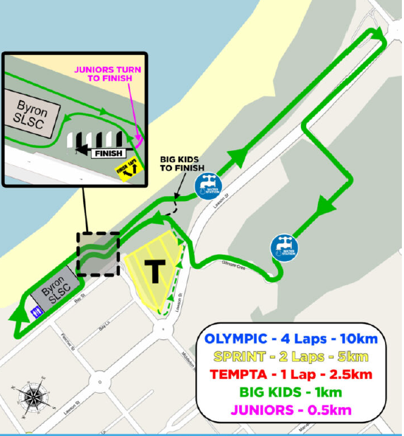
Figure 1 –
Run leg
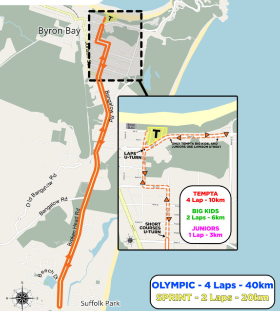
Figure 2 –
Cycle leg
Proposed Road Closures
The proposed road closures and the time of the closures are
shown in the table below. These details are taken from the following
weblink listed in the submitted Community & Transit Management Plan: https://www.google.com/maps/d/viewer?mid=1rd14gIsxDXUiP8pBzyrSYqJThzPk3Kzy&z=16.
It is noted in the table provided in the application, the
proponents proposed that Bay Street is to be closed between the surf club and
Fletcher St. This would prevent the use of Main Beach Car Park and Lawson
St North car parks as there would be no exit route. It is considered the
closure of Bay Street between the surf club and Fletcher St is a typographic
error and should be that Bay St is closed between Fletcher St and Middleton
Street, with access to the Main Beach Car Park not closed. The table
below, from the application, has been modified to reflect that change which has
also been included in the recommendations.
|
ROAD
|
CLOSED BETWEEN
|
START TIME
|
END TIME
|
|
Bay St
|
Fletcher St
– Middleton St (both ways)
|
9 May 2021, 05.00
|
9 May 2021, 17.00
|
|
Middleton St
|
Bay St –
Marvell St (both ways)
|
9 May 2021,05.00
|
9 May 2021, 15.00
|
|
Lawson St
|
Fletcher St
– Massinger St (both ways)
|
9 May 2021,05.00
|
9 May 2021, 17.00
|
|
Marvell St
|
Middleton St
– Tennyson St (both ways)
|
9 May 2021, 10.30
|
9 May 2021, 15.00
|
|
Tennyson St
|
Marvell St
– Browning St (both ways)
|
9 May 2021, 10.30
|
9 May 2021, 15.00
|
|
Bangalow Rd
|
Browning St
– Old Bangalow Rd (both ways)
|
9 May 2021, 11.30
|
9 May 2021, 15.00
|
|
Broken Head Rd
|
Old Bangalow Rd
– Beech St, north roundabout (both ways)
|
9 May 2021, 11.30
|
9 May 2021, 15.00
|
To summarise the table above, the following roads are
proposed to be closed from 5am to 5pm:
· Bay St -
from Fletcher St to Middleton St
· Lawson
St -
Fletcher St to Massinger St
The following requirements have been
included in the recommendation:
· Access
from main beach car park to Fletcher St to be unrestricted at all times
· Access
to Lawson St between Fletcher St and Middleton St to be permitted at all times.
The following roads are proposed to be closed from 10.30
– 3.00pm:
· Middleton St -
from Lawson St to Marvel St
· Marvel St -
from Middleton St to Tennyson St
· Tennyson St -
from Marvell St to Browning
The following roads are proposed to be closed from 11.30
– 3.00pm:
· Bangalow Rd -
from Browning St to Broken Head Rd
· Broken Head Rd -
from Bangalow Rd to 166 Broken Head Rd
Traffic Control
It is proposed to manage traffic during the above road
closures through the implementation of Traffic Control Plans and the support of
police from the Tweed-Byron District.
The police at the previous meetings indicated their support
for the proposed closures as they were based on the 2019 plan and had been
agreed upon in consultation with the event organisers.
RECOMMENDATION:
That:
1. That Council endorse the Traffic Management and
Traffic Control Plans for the Byron Bay Triathlon to be held on Sunday 9th May
2021, which includes the following temporary road closures below:
|
CLOSED STREETS
|
BETWEEN
|
TIMES
|
|
Bay St
|
Fletcher St to
Middleton St (both directions)
|
5am-5pm
|
|
Middleton St
|
Bay St to Marvel
St
(both directions)
|
5am-3pm
|
|
Lawson St
|
Middleton St to Massinger
St (both directions)
|
5am-5pm
|
|
Marvell St
|
Middleton St to
Tennyson St (both directions)
|
10.30am-3pm
|
|
Tennyson St
|
Marvell St to
Browning St (both directions)
|
10.30-3pm
|
|
Bangalow Rd
|
Browning St to
Old Bangalow Rd (both directions)
|
11.30am-3pm
|
|
Broken Head Rd
|
Old Bangalow Rd
to BP Service Station Beech Drive (both directions)
|
11.30am-3pm
|
2. That the approval provided in Part 1 and Part 2 is
subject to:
a) separate
approvals by NSW Police and RMS being obtained;
b) the
event organiser provide council with an updated Traffic Management Plan
and Traffic Control Plan for the 2021 event, if required by the Police and RMS;
c) development
and implementation of a Traffic Management Plan and Traffic Control Plan(s) by
those with appropriate TfNSW accreditation and the holding of current and
appropriate levels of insurance and liability cover;
d) the
impact of the event be advertised, and charged at cost to the organisers, via a
notice in the local weekly paper and VMS boards a minimum of one week prior to
the operational impacts taking effect, noting it must include the event name,
specifics of any traffic impacts or road closures and times, alternative route
arrangements, event organiser, a personal contact name and a telephone number
for all event related enquiries or complaints;
e) the
event be notified on Council’s web page with the event organiser
supplying Council with the relevant information;
f) Access
from main beach car park to Fletcher St is to be unrestricted at all times.
g) Access
to Lawson St between Fletcher St and Middleton St to be permitted at all times.
3. That the event organisers:
a) inform
the community and businesses that are directly impacted (eg within road closure
zones) via written information which is delivered to the property in a timely
manner so as to document, consider and respond to any concerns raised;
b) arranging
for private property access and egress affected by the event;
c) liaising
with bus, taxi and waste operators and ensuring arrangements are made for
provision of services during conduct of the event;
d) consulting
with emergency services and any identified issues be addressed;
e) holding
$20m public liability insurance cover which is valid for the event;
· paying
Council’s Road Event Application Fee prior to the event.