Local Traffic Committee Meeting
A Local Traffic Committee
Meeting of Byron Shire Council will be held as follows:
|
Venue
|
Conference Room, Station Street, Mullumbimby
|
|
|
Date
|
Tuesday, 17 August 2021
|
|
|
Time
|
10.30am
|
|
|
Committee
Members
|
Ian Shanahan – Transport for NSW
Detective
Chief Inspector Matt Kehoe – Police
Cr
Basil Cameron
Tamara
Smith MP
|
|
|
|
|
|
Phillip Holloway
Director Infrastructure
Services
I2021/1293
Distributed
10/08/21
Local Traffic Committee
Meeting
BUSINESS OF MEETING
1. Apologies
2. Declarations
of Interest – Pecuniary and Non-Pecuniary
3. Adoption
of Minutes from Previous Meetings
3.1 Local
Traffic Committee Meeting held on 15 June 2021
4. Matters
Arising
5. Outstanding
Issues/Resolutions
6. Regulatory
Matters
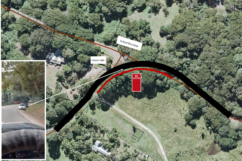
6.1 Lilium
Love Cafe, Huonbrook Rd (No Stopping)....................... 5
6.2 Car
share - request from provider Popcar for four additional designated parking
bays......................................................... 7
6.3 No
Parking 1am-5am - Massinger St, Byron Bay.................... 18
6.4 Event
application - Compass Club East Marathon - Byron Bay 20
7. Matters
for Traffic Engineering Advice
7.1 Speed
Zone Reviews........................................................... 25
8. Development
Applications
8.1 5 Lot
sub-divsion - 84-92 Broken Head Road......................... 27
8.2 Mercato
on Byron - Amendment to Development Consent Conditions of Approval......................................................... 33
Local Traffic Committee Meeting 6.2
Report No. 6.2 Car share - request from
provider Popcar for four additional designated parking bays
File No: I2021/726
The purpose of this report is to seek Local Traffic
Committee support for car share service Popcar to lease 4 additional designated
parking bays in Byron Bay.
Popcar currently operates out of 10 bays in Byron Shire: 2
in Mullumbimby and 8 in Byron Bay.
Background
In June 2019, car share service Popcar was designated 10
parking bays in the Shire to operate from. At the 18 June 2020 Ordinary
Meeting, Council resolved that staff liaise with Popcar and the Local Traffic
Committee about possible expansion of car parking spaces (resolution 20-271).
At the 24 June 2021 Council Meeting, Council noted that
community usage of the share cars increased notably in 2020/21 compared to the
12 month trial in 2019/20 (bookings increased by 157% and hours booked
increased by 238%). Council also noted that Popcar’s proposal for 6
additional parking bays in Byron Bay would be reported to Council through the
17 August 2021 Local Traffic Committee Meeting (resolution 21-200).
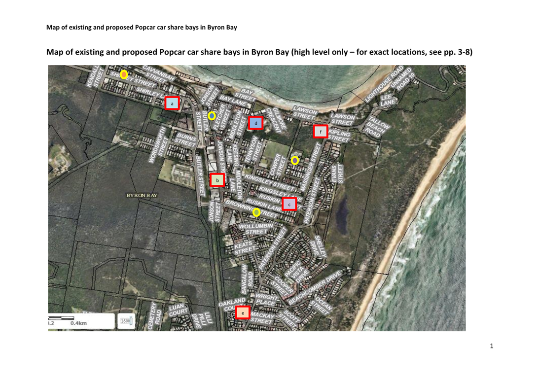
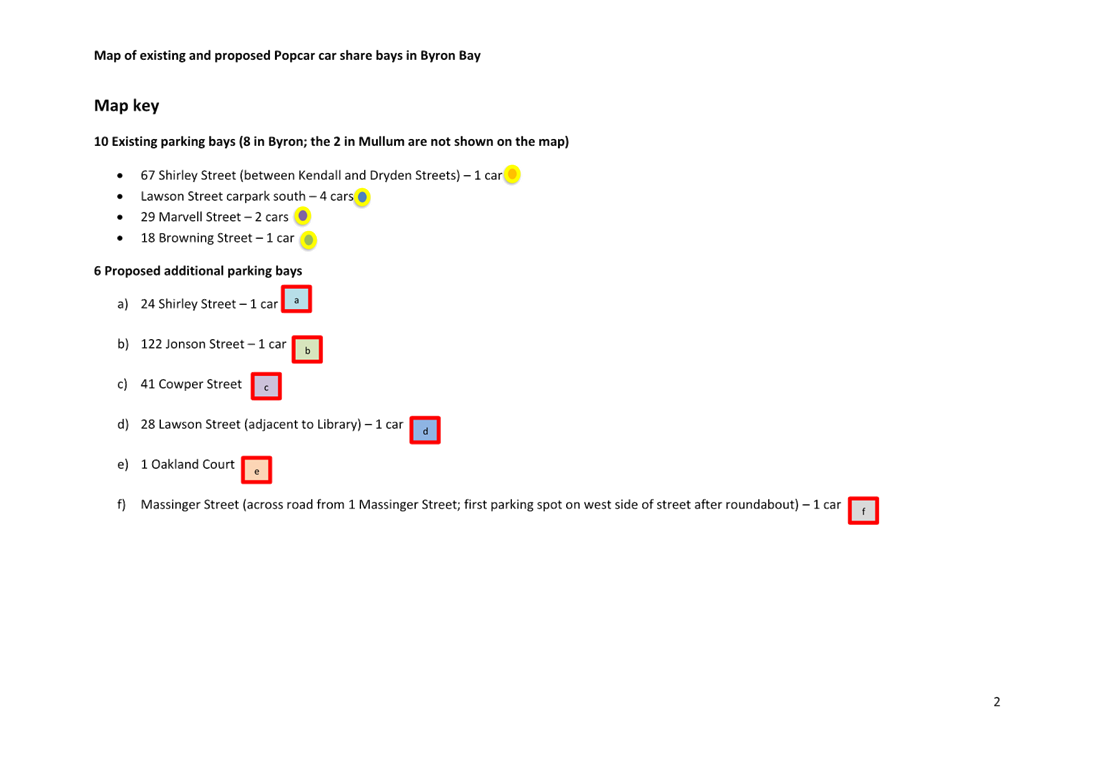
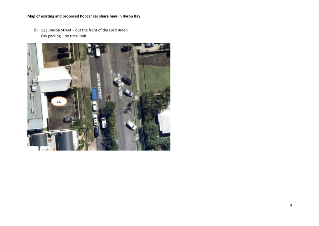
Proposed additional bays: locations, neighbour feedback
and recommendations
Popcar approached Sustainability staff to propose 6
additional parking bays in Byron Bay, at the following locations:
a) 32
Shirley Street
b) 139
Jonson Street
c) 26
Ruskin Street
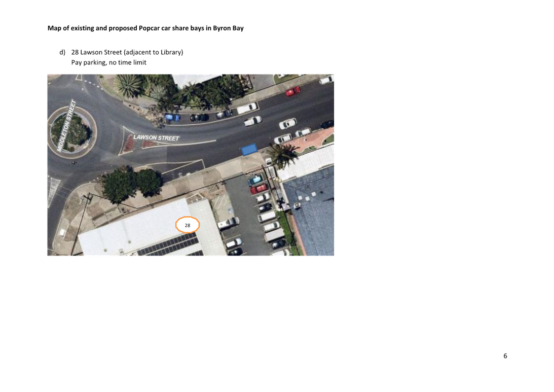
d) 28
Lawson Street
e) 97-101
Bangalow Road
f) Clarkes
Beach Carpark
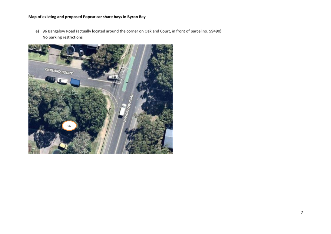
Two of the locations ((e) & (f)) were immediately
flagged as unsuitable. The location on Bangalow Road is now a bike lane,
and Clarkes Beach carpark is Crown Land and would involve a separate process
that Popcar wasn’t prepared to undertake. A letter box drop was
done for the other four locations, and Manager Social & Cultural Planning
was advised of location (d) as it is adjacent to the Byron Bay Library.
Feedback can be found in Attachment 1 (E2021/97431).
Based on the feedback, and in consultation with
Council’s Traffic Engineer, Sustainability staff suggested alternative
locations to Popcar for (a), (b), and (c), as well as alternative suggestions
for the immediately dismissed (e) and (f). Location (d) received no feedback.
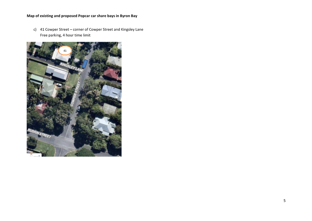
Popcar approved of the suggested new locations, and a mailout was done to
neighbours of the following addresses:
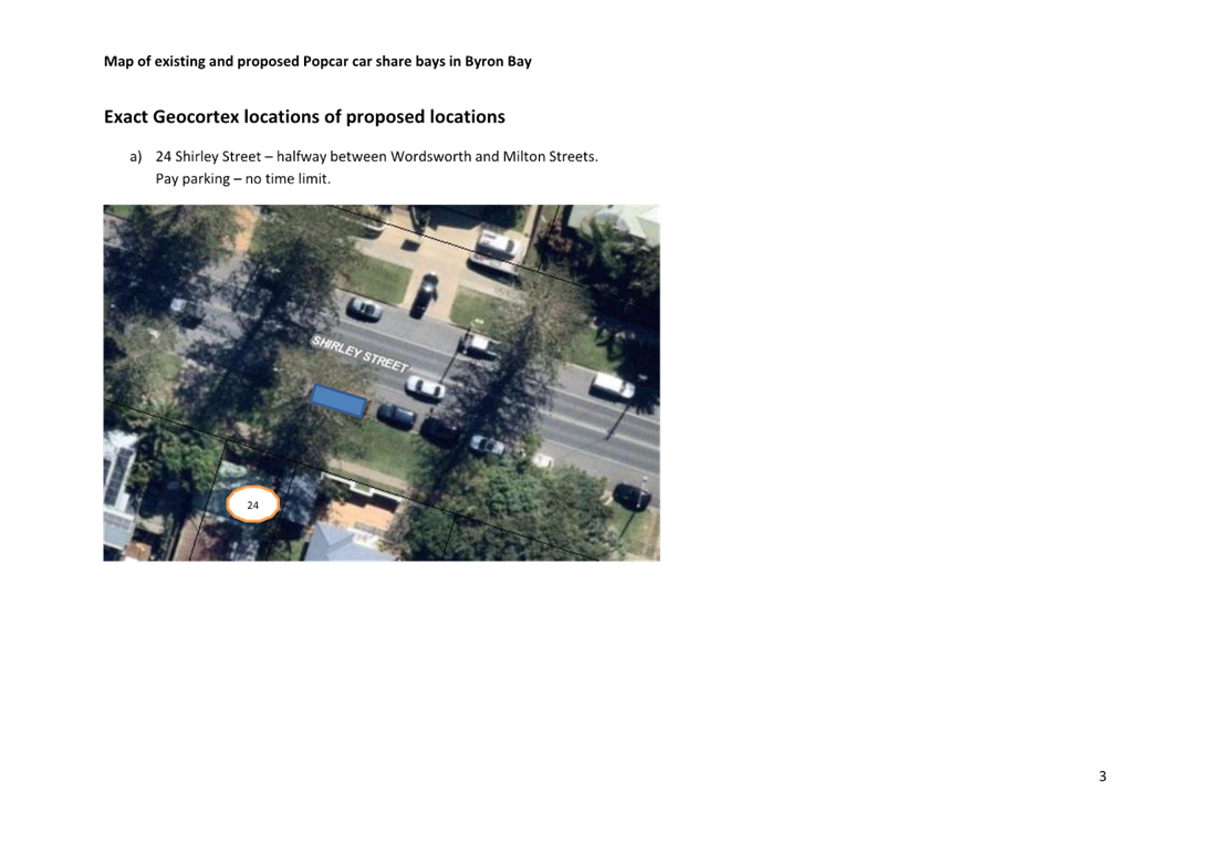
a) 24
Shirley Street
b) 122
Jonson Street
c) 41
Cowper Street
d) 28
Lawson Street (no mail out done; deemed not necessary as no feedback received
from initial letterbox drop)
e) 1
Oakland Court
f) 1
Massinger Street
For a map of the proposed locations see Attachment 2
(E2021/97219). For neighbour feedback on the locations see Attachment 3
(E2021/97432). Neighbour feedback for the second round of proposed
locations can be summarised as follows:
|
Location
|
Summary of
feedback
|
|
a) 24 Shirley Street
|
No feedback in round 2.
|
|
b) 122 Jonson Street
|
No feedback in round 2.
|
|
c) 41 Cowper Street
|
Overwhelming negative feedback from
numerous neighbours.
|
|
d) 28 Lawson Street
|
Did not send mailout as no feedback was
received in round 1 letterbox drop; was not considered necessary.
|
|
e) 1 Oakland Court
|
Overwhelming negative feedback from
numerous neighbours.
|
|
f) 1 Massinger Street
|
Two pieces of feedback received: one
supporting and one not supporting.
|
Given that community usage trends have been increasing
notably since 2019, staff consider Popcar’s request for additional bays
reasonable and support the four proposed bays with minimal or no negative
feedback on (a) Shirley, (b) Jonson, (d) Lawson and (f) Massinger
Streets. Given the negative community feedback on proposed bays on (c)
Cowper Street and (e) Oakland Court, staff do not recommend proceeding with
those bays. [The reasoning for suggesting car share bays in those
predominantly residential locations is because there is a significant amount of
holiday accommodation in those areas (holiday houses on and near Cowper Street
and a motel on Oakland Court).]
As an alternative, staff recommend that two further
additional bays be considered once the four recommended additional bays have
been operational until 29 July 2022 (when the leases for the current and
additional bays will be up for review by Council and Popcar will have had time
to assess the usage of the additional bays). Council’s Traffic Engineer
has suggested Carlyle Street as a potential location for the bays (north side
of road between Tennyson and Cowper Streets, adjacent to the Recreational
Grounds). This location is currently unmarked gravel/grass parking but
has been earmarked for asphalting and line marking in the coming 12 months if
funding allows. Popcar was amenable to this location and is happy to
wait.
RECOMMENDATION:
That LTC support the car
share service ‘Popcar’, to lease four additional designated parking
bays in Byron Bay at the following locations:
a) 24
Shirley Street
b) 122
Jonson Street
c) 39
Lawson Street
d) 1
Massinger Street
Attachments:
1 Confidential
- Car share - Popcar proposed additional bays - Feedback round 1 (May letter
box drop), E2021/97431
2 Car
share - Popcar map of additional proposed locations June 2021, E2021/97219 ,
page 10⇩ 
3 Confidential
- Car share - Popcar proposed additional bays - Feedback round 2 (June
mailout), E2021/97432
Regulatory
Matters 6.2 - Attachment 2

Local Traffic Committee Meeting 6.3
Report No. 6.3 No Parking 1am-5am -
Massinger St, Byron Bay
File No: I2021/1130
The purpose of this report is to request the installation of
No Parking 1am – 5am signs in Massinger Street, Byron Bay on the east and
west side shown below:

This equates to about 6-8 signs, 3-4 on each side of
Massinger St. This request has been made by local residents who are
concerned with the growing number of camper vans parking in this section
overnight. The request also has the support of Council’s enforcement
team.
RECOMMENDATION:
That Council supports the installation of No
Parking - 1am-5am signs on the east and west side of Massinger Street, between
Lawson Street and 27 Massinger Street, Byron Bay.
Local Traffic Committee Meeting 6.4
Report No. 6.4 Event application - Compass
Club East Marathon - Byron Bay
File No: I2021/1168
Council has received an application for a new event, the
fifth in a marathon series at each of Australia's compass points. The Byron
event will be Compass Club East Marathon.
The event includes a 42km full marathon and a 21km half
marathon, combining 12km of road running around the Byron Bay lighthouse and
30km of beach running on Tallow Beach.
The event is proposed for Sunday 7
November 2021, with set up from 4am, and pack down by 4pm. The application is
for 200 competitors.
The image below shows the proposed
route and impacted roads. In summary, the route follows the following
approximate path:
· Start / finish point is halfway down Tallows Beach. Refer
to the blue circle in the image below.
· Courses heads north along the beach towards Tallows Beach
Road
· North along Tallows Beach Road to Lighthouse Road (subject
to NPWS support)
· East along Lighthouse Road to the lighthouse
· Return along Lighthouse Road and Tallows Beach Road to
Tallows Beach
· South along Tallows Beach to Broken Head
· From Broken Head return north to finish line.
· It is proposed to control traffic along Lighthouse Road
between 6am to 8am. Full traffic access will be reinstated after 8am. This is
included in the recommendations.

It is proposed
that runners will utilise the Byron Bay High School car park (subject to the
school's permission).
The organiser
anticipates that being an inaugural event, there would be a maximum of 200
runners, up to 75 runners in the 42km and 125 runners in the 21km event.
To ensure the event remains manageable for the first occasion it is recommended
capping the event to a maximum of 200 competitors.
While a TMP or
event specific TCP have not been submitted, a TCP related to the 2016 Byron
Half Marathon has been submitted to demonstrate the expected road closures
outlined above for Tallows Beach Road and Lighthouse Road. Refer to attachment
1.

RECOMMENDATION:
That Council support the 7 November 2021 Compass Club
East Marathon, subject to:
1. Traffic Guidance Scheme(s)
and a Traffic Management Plan being designed and implemented by those with the
appropriate and relevant TfNSW accreditation.
2. The Traffic Management Plan
and Traffic Guidance Scheme(s) are to include the following:
a. Traffic along Lighthouse
Road is to be managed only between 6am to 8am. Unrestricted access is to
commence along Lighthouse Road after 8am.
b. Local traffic access along
Lighthouse Road is to be permitted, under controlled conditions, between
6am-8am.
3. Separate approvals by NSW
Police, TfNSW, Cape Byron Headland Trust, Byron Bay High School and Dept. of
Education being obtained.
4. The event organiser:
i) advertising
the impact of the event via a notice in the local weekly paper a minimum of one
week prior to the operational impacts taking effect;
ii) advertising
material must include the event name, specifics of any traffic impacts or road
closures and times, alternative route arrangements, event organiser, a personal
contact name and a telephone number for all event related enquiries or
complaints;
iii) providing copy
of the advert for Council's web page;
iv) informing
community and businesses that are directly impacted (e.g. adjacent to the
event), including The Pass Café, Lighthouse Café and North Coast
Holiday Park Clarkes Beach, via written information which is delivered to the
property in a timely manner so as to document, consider and respond to any concerns
raised;
v) arranging
for private property access and egress affected by the event;
vi) liaising with
bus and taxi operators and ensuring arrangements are made for provision of
services during conduct of the event;
vii) consulting with
emergency services with any identified issues being addressed;
viii) holding $20m public
liability insurance cover which is valid for the event; and payment of
Council’s Road Event application fee prior to the event.
Attachments:
1 Event
application - Compass Club East Marathon - 7 November 2021 - Traffic control
plan for Lighthouse Road, Byron Bay, E2021/95336
, page 24⇩
Regulatory
Matters 6.4 - Attachment 1

Local Traffic Committee Meeting 7.1
Matters for Traffic Engineering Advice
Report No. 7.1 Speed Zone Reviews
File No: I2021/1002
The purpose of this report is to present known speed zone
requests for LTC comment.
Below is a table summarising known
speed zone reviews raised with TfNSW since the last LTC meeting and which staff
are aware of.
|
Road
|
Extents
|
Current Speed
|
Requested Speed
|
Requested by
|
Status
|
|
McAuleys Lane
|
Mullumbimbi Rd
intersection and west for 1.6km
|
100
|
<100
|
Community
|
Pending
|
|
Alcorn St
|
All
|
50
|
<50
|
Community email
|
-
|
|
New Brighton Rd
|
Redgate Rd to Casons Rd
|
50
|
40
|
Community email
|
|
|
Paterson St
|
Browning St to Bangalow Rd
|
50
|
<50
|
Community email
|
|
|
Coolamon Scenic Drive
|
Azalea St to Myocum Rd
|
100
|
50 to south of the Golf Club
|
Community email
|
|
|
Seven Mile Beach Rd
|
Full length
|
100
|
<50
|
Community submission pending
|
|
RECOMMENDATION:
That Council note the speed zone reviews raised
with TfNSW as listed in the report.
Local Traffic Committee Meeting 8.1
Development Applications
Report No. 8.1 5 Lot sub-divsion - 84-92
Broken Head Road
File No: I2021/1131
Council has received a Subdivision Works Certificate
application (11.2019.429.1) and associated Roads Act application
(51.2019.429.1) for a 5 Lot subdivision at 84-92 Broken Head Road, Byron Bay.
The applications propose works on Broken Head Road, including
central median, precast recycled plastic kerb with safety guide post and
cycleway improvements, as identified in plans submitted with the above
applications – refer Attachment 1 (E2021/97196).
Broken Head Road is a classified (regional) road, requiring TfNSW
concurrence for these works. TfNSW have given concurrence, subject to
conditions, for the installation of a raised island and recycled plastic
barrier kerb with safety guide post – refer Attachment 2 (E2021/97200).
Refer to image below for the site location circled in
blue.

Below are the conditions of consent imposed on the DA
approval:
Condition
5 (part of):
a)
Kerb & Gutter, Road Shoulder Construction
Kerb and gutter, road shoulder and
associated drainage construction, footpath formation including any necessary
relocation of services across the frontage of the subdivision.
b) Upgrading
of the channelised intersection linemarking into a raised island
Upgrading works in accordance with
the annotated Lucena Engineers drawing 180610 ENT1 Rev B dated 22/4/20. Roads
and Maritime’s concurrence of the design is required prior to
Council’s approval of works on classified (Regional) roads.
c) Footpath Reconstruction
Reconstruction of the
existing footpath for the full frontage of the development in accordance with
the annotated Lucena Engineers drawing 180610 ENT1 Rev B dated 22/4/20.
d) Driveway
A nine (9) metre wide driveway for
proposed Lot(s) 1, 2, 3, 4 & 5.
The purpose of this LTC report is to gain Council support
for the proposed regulatory signage shown in attachment 1. Note, the
General Manager does not intend to use delegated authority to adopt the LTC
recommendations. Any LTC recommendation for this report will proceed to
the next 2021 Council meeting.
RECOMMENDATION:
That Council approve the regulatory devices, signage and
line marking shown in Attachment 1 (E2021/97196) which is associated with
development application 10.2019.429.1 and Roads Act application 51.2019.429.1.
Attachments:
1 11.2019.429.1-
external road works plan, E2021/97196
, page 29⇩
2 11.2019.429.1
- TfNSW Concurrence for Roadworks, E2021/97200
, page 30⇩
Development
Applications 8.1 - Attachment 1

Development
Applications 8.1 - Attachment 2


Local Traffic Committee Meeting 8.2
Report No. 8.2 Mercato on Byron - Amendment to Development Consent Conditions of
Approval
File No: I2021/1186
Development
Application seeks to modify the conditions of consent of DA10.2013.587.1 (as
amended). The conditions identified to be modified in the application
involve a new access arrangement, new design of Jonson Street and Carlyle
Street intersection and pedestrian crossing in Jonson Street, Byron Bay.
The proposal also will involve the reconfiguration of the development access to
limit the traffic flows of the development into a left-in and left-out movement
in Jonson Street.

Locality Plan
The following conditions of DA10.2013.587.7 are proposed to
be modified.
23) Consent required for works within the road reserve
Consent from Council, with
concurrence from Roads & Maritime Services (RMS), must be obtained for
works within the road reserve pursuant to Section 138 of the Roads Act 1993.
Three (3) copies of engineering construction plans must accompany the
application for consent for works within the road reserve.
All regulatory signs and
markings must be approved by Council’s Local Traffic Committee prior to
approval of the works.
Such plans are to be in
accordance with Council’s current Design & Construction Manuals and
are to provide for the following works:
e) Roundabout
A roundabout at the Jonson Street / Carlyle Street intersection in accordance with AustRoads, Part 4B: Roundabouts.
The design is to address pedestrians, cyclist movements (preferably by bicycle
lanes), siting, signs, linemarking, parking restrictions and night-time
visibility. The pavement in the roundabout must be upgraded to a concrete pavement
designed for the expected traffic loads and there turning movements. The design
plans are to include swept paths demonstrating that the roundabout can
accommodate u-turns for heavy rigid and articulated vehicles.
g) Taxi Zone
A taxi zone with suitable tapers to allow smooth access from
the traffic lane, accommodating a minimum of 2 taxis, on Jonson Street adjacent
to the frontage of the site. The taxi zone is to be designed in accordance with
AS 2890.5-1993: Parking facilities - On-street parking and AS 1742.11-1999:
Manual of uniform traffic control devices - Parking controls. The design is to
address the NSW Taxi Council Taxi Zone Guidelines, including but not limited to
signage, line marking, parking restrictions, shelter, seating, kerb side space,
trolley stowage, lighting and disability access.
The following are the proposed modified conditions. See
attachment 1 (E2021/80545).
23) Consent required for
works within the road reserve
Consent from Council, with
concurrence from Roads & Maritime Services (RMS), must be obtained for
works within the road reserve pursuant to Section 138 of the Roads Act 1993.
Three (3) copies of engineering construction plans must accompany the
application for consent for works within the road reserve.
All regulatory signs and
markings must be approved by Council’s Local Traffic Committee prior to
approval of the works.
Such plans are to be in
accordance with Council’s current Design & Construction Manuals and
are to provide for the following works:
e) Site access from
Jonson St
Access to the site is to
be provided from Jonson Street via a left in/left out arrangement only, in
accordance with Functional Layout - Proposed Access Arrangement, prepared by
TTM, dated 23 April 2021, drawing number 18GCT0271-14, version A.
g) Taxi Zone
A taxi zone with suitable tapers to allow smooth access from
the traffic lane, accommodating a minimum of 1 taxi, on Jonson Street
adjacent to the frontage of the site. The taxi zone is to be designed in
accordance with AS 2890.5-1993: Parking facilities - On-street parking and AS
1742.11-1999: Manual of uniform traffic control devices - Parking controls. The
design is to address the NSW Taxi Council Taxi Zone Guidelines, including but
not limited to signage, line marking, parking restrictions, shelter, seating,
kerb side space, trolley stowage, lighting and disability access.
It is noted that Jonson St is currently a classified
road. TfNSW concurrence is required to determine the suitability of the
proposed intersection treatment in Jonson St and Carlyle St and proposed access
design of the development. TfNSW have given comments to Council requiring
further consideration to assess traffic impact and design requirements to
comply with the safety and traffic efficiency requirements in Jonson St and to
seek Local Traffic Committee comments. See attachment 2 (E2021/95176) and
attachment 3 (E2020/46550).
The purpose of this LTC report is to seek comment as recommended by
TfNSW and approval for the following:
DA Matters
1. Removal of the Roundabout Treatment
at the intersection of Jonson St & Carly St intersection as recommended in
development condition 23e) of DA10.2013.587.1;
2. Approve the Priority Intersection
Treatment subject to traffic efficiency assessment and detailed design as part
of Section 138 Roads Act Application no. 51.2021.1035.1; and
3. Approve the location of the
Pedestrian Aids as recommended in development condition 23f) of
DA10.2013.587.1.
Regulatory Matters
1. Approve
the existing Taxi Zone as recommended in development condition 23g) of
DA10.2013.587.1;
2. Approve
the existing Bus Zone as recommended in development condition 23h) of
DA10.2013.587.1;
3. Approve the existing Motorcycle
parking and advise parking timing limit is required; and
4. Approve Regulatory signage of
the priority intersection treatment at the intersection of Jonson St &
Carlyle St.
Discussion
DA Matters
1. Removal of the Roundabout and
installation of Priority Intersection Treatment at the intersection of Jonson
St and Carlyle St.
This matter has already been argued in the Land &
Environment Court with case name on 30 October 2020.
· Item
24 of the judgement acknowledges “that the construction of the
roundabout at the intersection of Carlyle and Jonson Streets, as envisaged
under Condition 23(e), was “not warranted by the Mercato
development”.
· Item
25 of the judgement states: “The Court should consider imposing one of
two alternative version of modified Condition 23(e) that they proposed, as
follows:
(1) the
Applicant explained that whilst initially it had sought to modify the
conditions of the original consent by deletion of Condition 23(e), it now
sought to amend that application and proposed that Condition 23(e) be modified
to read as follows:
“Site
access and Jonson Street/Carlyle Street
Access to the development
sites and Carlyle Street, is to be constructed as shown in the ‘Access
Arrangement drawing P3414 1 005’ and in accordance with AustRoads, Part
4A: Unsignalised and Signalised Intersections (2017 Edition).
The design plans are to
include swept paths demonstrating that the access can accommodate u-turns for
heavy rigid and articulated vehicles.”
(2) The
Respondent, while not opposing the Court granting leave to the Applicant to
amend its modification application, nevertheless proffered an alternate
Condition 23(e) for imposition by the Court as follows:
“Jonson Street
Within 3 months of
Modification Application No. 10.2013.587.5 being approved, the Applicant shall
lodge an application with Council for the installation of a traffic
island/median on Jonson Street and a mountable roundabout at the intersection
of Jonson and Kingsley Street in accordance with Concept plan Number 2814
– CP01 Issue B dated 3/7/20 prepared by Byron Shire Council and with
AustRoads.
The design is to address
pedestrians, cyclist movements (preferably by bicycle lanes), siting, signs,
linemarking, parking restrictions and night-time visibility.
The design plans are to
include swept paths demonstrating that the median strip exit on Jonson Street
is of suitable width to accommodate heavy rigid and articulated vehicles.
The island must include
a mountable section that is able to be traversed by trucks turning right out of
the site, whilst also being undesirable for cars. Appropriate signage must also
be provided at the driveway to enforce this restriction.
The works the subject of
the above application shall be completed by the Applicant within 6 months of
any consent being granted by the Council in relation to such an
application.”
· Item
49 of the judgement states: “Based on my
findings above (at [37] and [43), I conclude that the Applicant’s proposed modified
Condition 23(e) is contrary to the provisions of cl 101(2)(b) of SEPP (at [15) as I am not satisfied that the efficiency and safety, and
as a consequence the ongoing operation, of the classified road will not be
adversely affected by the development should the Applicant’s proposed
Condition 23(e) be imposed.”
· Item
61 of the judgement states: “Having
considered the submissions of the Parties, I agree with the submission of the
Applicant in relation to the Respondent’s alternative Condition 23(e)
that, without a detailed design for the alternative roundabout at the
intersection of Jonson and Kingston Streets, it is not possible for the Court
to determine that the works that would be required to fulfil the condition were
feasible and reasonable, for the reasons that the Applicant provided above (at
[58]).”
· Item
64 of the judgement states: “Having
considered the submissions of the Parties, and the testimony of the experts, I
conclude that:
(1) the
Applicant’s proposal to modify Condition 23(e) of consent no.
10.2013.587.1 is not approved for reasons provided above at [49];
(2) the
Respondent’s proposed alternative modified Condition 23(e) is also not
approved for reasons provided above at [61].
· Item
65 of the judgement states: “I note that, as
a consequence of the dismissal of the Applicant’s appeal in relation to
its proposed modification application, as well as the non-imposition of the
Respondent’s proposed alternative condition 23(e), as identified by the
expert traffic engineers (see above at [24), the matter of the safe and efficient access to, and
egress from, the Subject Site remains unresolved”
2. Approval
of the location of the Pedestrian Aids
It is anticipated that the
construction of a new pedestrian crossing will reduce the parking supply in
Jonson St. The following criteria has been applied to determine the most
suitable location of the pedestrian crossing;
· to ensure minimal number of existing parking spaces are
affected; and
· to provide direct/efficient and safe passage of pedestrians
to eastern side of Jonson St.
A
comparison was made to the originally approved location of the pedestrian
crossing against the new location according to the criteria above.


Original approved
location
Proposed Location
Original approved Location in
DA10.2013.587.1
This is situated near the
development access (see above). This location will reduce the angle
parking supply by a maximum of 3 parking spaces on the east side of Jonson St
and no reduction of parking spaces west of Jonson St. A net parking
supply reduction of three (3).
This location is close to Mercato
building’s main entrance providing the shortest distance for pedestrians (approximately
5m) to gain entry and exit of the development and currently being used by the
majority of pedestrian crossing in the Jonson St.

It is envisaged that the
pedestrian crossing will be constructed within the raised island as shown on
the access layout of the development (see below) and the maximum sized vehicle
accessing the site is an articulated vehicle (AV). As shown below, the
location of the raised island does not interfere against the traffic lines of
the maximum sized vehicle accessing the development site.

AV Accessing the Site prepared by TTM - DA10.2013.587.5
(7/3/19)
Proposed Location
The proposed location is situated
near Kingsley St intersection (see above). The proposal will involve the
removal of one taxi rank space to accommodate a ramp down for pedestrians to
cross the street. The works will also involve a ramp on the other side of
the street with complimenting landscaping, new line marking and the relocation
of one car space to make room for the pedestrian ramp across the road.
The proposal offers more details
than the approved location however the proposal will provide a greater impact
to the supply of the existing taxi ranks adjacent the development and parking.
The proposal also offers to
relocate one angle car space close to Kingsley St intersection. This proposal
does meet the no-stopping distance space requirement near a priority
intersection (minimum 10m). The net parking supply reduction are three
(3) angle parking and one (1) taxi rank. No justification provided why
the reduction of one (1) taxi rank is acceptable.
This location also provides a
longer travel path from the main entrance of Mercato to travel approximately
forty (40m) minimum along the frontage of the development.
Comparison between the approved
and proposed location
The comparison based on the
criteria above found that the originally approved location in DA10.2013.587.1
will provide a more suitable location than the new proposal.
It is recommended that the new
proposal is not supported and the adoption of the approved location in
DA10.2013.587.1 be endorsed.
Regulatory Matters
· It is noted that
the taxi and bus zones are the requirements of the DA.
The installation of the taxi
zone, bus zone and motorbike parking in front of the development was made
without a Section 138 Roads Act approval and without
consultation with LTC.
The existing linemarking must be
upgraded to the current standard.
· Regulatory signage
of the priority intersection treatment at the intersection of Jonson St &
Carlyle St be assessed as part of Section 138 Roads Act approval.
RECOMMENDATION:
1. That
Local Traffic Committee provides the following traffic related advice:
a) Removal of the Roundabout Treatment at the intersection of
Jonson St & Carly St intersection from condition 23e) of DA10.2013.587.1
(as amended) is supported.
b) The proposed Priority Intersection Treatment is supported subject
to traffic efficiency assessment and detailed design as part of a Section 138
Roads Act Application.
c) The Pedestrian Aids required by condition 23f) of
DA10.2013.587.1 (as amended) be located adjacent to the driveway access for the
site, subject to a detailed design as part of a Section 138 Roads Act
Application.
2. That
Council approve the regulatory signs, linemarking and traffic devices for the
following:
a) The
existing Taxi Zone, Bus Zone and Motorcycle parking (currently unauthorised by
Local Traffic Committee and Roads Act consent),
subject a detailed design as part of a Section 138 Roads Act Application for
the repainting of the linemarking to the relevant standards.
b) The proposed Priority Intersection Treatment, subject to a detailed
design as part of a Section 138 Roads Act Application.
Attachments:
1 10.2013.587.9
- Ltr_GP0133_210519_Mercato on Byron S4.55 for 10.2013.587.8_PAN-102736, E2021/80545 , page 42⇩
2 CNR-23748
- DA102013.587.9 - Referral of DA - comments from TfNSW, E2021/95176 , page 51⇩
3 RMS
Response - 10.2013.587.5 - Mercato on Byron Johnson Street Byron Bay, E2020/46550 ,
page 51⇩
Development
Applications 8.2 - Attachment 1


Development
Applications 8.2 - Attachment 2


Development
Applications 8.2 - Attachment 3