Notice of Meeting
Floodplain Management Advisory Committee
Meeting
A Floodplain Management Advisory Committee Meeting of Byron Shire Council will be held as follows:
|
Venue
|
Conference Room, Station Street, Mullumbimby
|
|
Date
|
Tuesday, 14 February 2023
|
|
Time
|
9.00am
|
Phil Holloway
Director Infrastructure
Services
I2023/165
 Distributed
08/02/23
Distributed
08/02/23
Amended
10/02/2023
What is a “Conflict of Interests” - A conflict of
interests can be of two types:
Pecuniary - an interest that a person has in a matter because of a reasonable
likelihood or expectation of appreciable financial gain or loss to the person
or another person with whom the person is associated.
Non-pecuniary – a private or personal interest that a Council
official has that does not amount to a pecuniary interest as defined in the
Code of Conduct for Councillors (eg. A friendship, membership of an
association, society or trade union or involvement or interest in an activity
and may include an interest of a financial nature).
Remoteness – a person does not have a pecuniary interest in a matter
if the interest is so remote or insignificant that it could not reasonably be
regarded as likely to influence any decision the person might make in relation
to a matter or if the interest is of a kind specified in the Code of Conduct
for Councillors.
Who has a Pecuniary Interest? - a person has a pecuniary interest in a
matter if the pecuniary interest is the interest of the person, or another
person with whom the person is associated (see below).
Relatives, Partners - a person is taken to have a pecuniary
interest in a matter if:
·
The
person’s spouse or de facto partner or a relative of the person has a
pecuniary interest in the matter, or
·
The
person, or a nominee, partners or employer of the person, is a member of a
company or other body that has a pecuniary interest in the matter.
N.B. “Relative”, in relation to a person means any of the
following:
(a) the parent,
grandparent, brother, sister, uncle, aunt, nephew, niece, lineal descends or
adopted child of the person or of the person’s spouse;
(b) the spouse
or de facto partners of the person or of a person referred to in paragraph (a)
No Interest in the Matter - however, a person is not taken to have a
pecuniary interest in a matter:
·
If
the person is unaware of the relevant pecuniary interest of the spouse, de
facto partner, relative or company or other body, or
·
Just
because the person is a member of, or is employed by, the Council.
·
Just
because the person is a member of, or a delegate of the Council to, a company
or other body that has a pecuniary interest in the matter provided that the
person has no beneficial interest in any shares of the company or body.
Disclosure and participation in meetings
·
A
Councillor or a member of a Council Committee who has a pecuniary interest in
any matter with which the Council is concerned and who is present at a meeting
of the Council or Committee at which the matter is being considered must
disclose the nature of the interest to the meeting as soon as practicable.
·
The
Councillor or member must not be present at, or in sight of, the meeting of the
Council or Committee:
(a) at
any time during which the matter is being considered or discussed by the
Council or Committee, or
(b) at
any time during which the Council or Committee is voting on any question in
relation to the matter.
No Knowledge - a person does not breach this Clause if the person did
not know and could not reasonably be expected to have known that the matter
under consideration at the meeting was a matter in which he or she had a
pecuniary interest.
Non-pecuniary Interests - Must be disclosed in meetings.
There are a broad range of options available for managing conflicts &
the option chosen will depend on an assessment of the circumstances of the
matter, the nature of the interest and the significance of the issue being
dealt with. Non-pecuniary conflicts of interests must be dealt with in at
least one of the following ways:
·
It
may be appropriate that no action be taken where the potential for conflict is
minimal. However, Councillors should consider providing an explanation of
why they consider a conflict does not exist.
·
Limit
involvement if practical (eg. Participate in discussion but not in decision
making or vice-versa). Care needs to be taken when exercising this
option.
·
Remove
the source of the conflict (eg. Relinquishing or divesting the personal
interest that creates the conflict)
·
Have
no involvement by absenting yourself from and not taking part in any debate or
voting on the issue as of the provisions in the Code of Conduct (particularly
if you have a significant non-pecuniary interest)
Committee members are reminded that they should declare and manage all
conflicts of interest in respect of any matter on this Agenda, in accordance
with the Code of Conduct.
RECORDING OF VOTING ON PLANNING MATTERS
Clause 375A of the Local Government Act
1993 – Recording of voting on planning matters
(1) In this section, planning
decision means a decision made in the exercise of a function of a council
under the Environmental Planning and Assessment Act 1979:
(a) including a decision relating to a development
application, an environmental planning instrument, a development control plan
or a development contribution plan under that Act, but
(b) not including the making of an order under that Act.
(2) The general manager is required to keep a register
containing, for each planning decision made at a meeting of the council or a
council committee, the names of the councillors who supported the decision and
the names of any councillors who opposed (or are taken to have opposed) the
decision.
(3) For the purpose of maintaining the register, a division
is required to be called whenever a motion for a planning decision is put at a
meeting of the council or a council committee.
(4) Each decision recorded in the register is to be described
in the register or identified in a manner that enables the description to be
obtained from another publicly available document and is to include the
information required by the regulations.
(5) This section extends to a meeting that is closed to the
public.
OATH AND AFFIRMATION FOR COUNCILLORS
Councillors are
reminded of the oath of office or affirmation of office made at or before their
first meeting of the council in accordance with Clause 233A of the Local
Government Act 1993. This includes undertaking the duties of the office of
councillor in the best interests of the people of Byron Shire and the Byron
Shire Council and faithfully and impartially carrying out the functions,
powers, authorities and discretions vested under the Act or any other Act
to the best of one’s ability and judgment.
BUSINESS OF MEETING
1. Apologies
2. Declarations
of Interest – Pecuniary and Non-Pecuniary
3. Adoption of Minutes from
Previous Meetings
3.1 Adoption
of Minutes from Previous Meeting.............................................................. 6
4. Staff Reports
Infrastructure Services
4.1 Byron
Shire Council-Strategic Fill Policy.................................................................. 17
4.2 Modelling
of Various Flow Scenarios at South Golden Beach............................. 24
4.3 Hydrology
Inputs to the North Byron 2020 Flood Model....................................... 26
4.4 Byron
Shire Post 2022 Flood Analysis Update....................................................... 31
Adoption of Minutes from Previous Meetings 3.1
Adoption of Minutes from Previous Meetings
Report No. 3.1 Adoption of Minutes from Previous Meeting
Directorate: Infrastructure Services
Report Author: Dominika
Tomanek, Executive Assistant Infrastructure Services
File No: I2023/156
RECOMMENDATION:
That the minutes of the Floodplain Management Advisory
Committee Meeting held on 11 October 2022 be confirmed.
Attachments:
1 Minutes
11/10/2022 Floodplain Management Advisory Committee, I2022/1412 , page 10⇩ 
Report
The attachment to this report provides the minutes of the
Floodplain Management Advisory Committee Meeting of 11 October 2022 .
Report to Council
The minutes were reported to Council on 27 October 2022.
Comments
In accordance with the Committee Recommendations, Council
resolved the following:
|
22-603
|
Resolved that Council adopt the following
Committee Recommendations:
Report No. 4.1 Report in
response to Res 22-461 Outcome of NSW Flood Inquiries
Committee Recommendation 4.1.1
1. That
the Committee notes the recommendations of the two NSW Flood Inquiry reports
and that staff have commenced work to identify relevant actions to be pursued
through Local, State and Federal avenues.
2. That
Council support staff also working to support the following recommendations
of the Parliamentary Inquiry:
a) Recommendation
10 - Work with the community broadcasting sector to identify ways in which
community broadcasters could be better supported to provide critical services
during natural disasters, with a view to providing them adequate long term
funding.
b) Recommendation
15 - . Ensure that the current review of evacuation centres considers the
role, accreditation and support of community evacuation centres, with the
outcomes of this review to be made public and incorporated into the update of
state emergency plans.
c)
Recommendation 19 - Establish a standing workforce from within the public
service to staff evacuation and recovery centres, with this workforce to be
trained ahead of time and mobilised as soon as a natural disaster occurs.
|
|
22-604
|
Resolved that Council adopts the following
Committee Recommendations:
Report No. 4.2 Resolution
22-360 - Decreasing risk on the Shire's floodplain
Committee Recommendation 4.2.1
That the Floodplain Management Advisory Committee:
1. Notes
the report on Resolution 22-360 and that Council staff continue to undertake
technical work and receive reports from various sources to assist our
community’s flood event recovery and reconstruction actions.
2. Notes
that updates to the Committee and Council will be provided periodically on
this work.
|
|
22-605
|
Resolved that Council adopts the following
Committee Recommendation:
Report No. 4.3 Flood Levee
Repair and Maintenance Program-Department Regional NSW
Committee Recommendation 4.3.1
The Floodplain Management Advisory Committee recommends
that Council note the current Flood Levee Repair and Maintenance
Program-Department Regional NSW.
|
|
22-606
|
Resolved that Council adopts the following
Committee Recommendation:
Report No. 4.4 Byron Shire
Post 2022 Flood Analysis Update
Committee Recommendation 4.4.1
That the Floodplain Management Advisory Committee
recommends that Council note the report and further
report be presented at the next Floodplain Management Advisory Committee
meeting.
|
|
22-607
|
Resolved that
Council adopts the following Committee Recommendation:
Report No. 4.5 Capricornia
Canal and Marshalls Creek
Committee Recommendation
4.5.1
That Council notes that the
actions proposed in Attachment 2 to the report 4.5 of Floodplain Management
Advisory Committee Agenda (E2022/70063) will be completed prior to
Council further considering the funding and completion of the scope of works
provided in Attachment 1 to the report 4.5 of Floodplain Management Advisory
Committee Agenda (E2022/77663).
|
|
22-608
|
Resolved that
Council adopts the following Committee Recommendations:
Report No. 4.6 Byron Bay
Drainage Upgrade Project
Committee Recommendation
4.6.1
That the Floodplain Management
Advisory Committee recommend that Council:
1. Notes
the current progress of the Byron Bay Drainage Strategy.
2. Support
the project team in commencing development of a Communications Plan with
Council’s Communications Team.
|
|
22-609
|
Resolved that Council adopts the following
Committee Recommendation as amended:
Report No. 4.7 Byron Shire
Council Flood Risk Management Plan-Actions and Accomplishments
File No: I2022/1264
Recommendation 4.7.1
That Council endorses
the updated Byron Shire Council Flood Mitigation Program (E2022/89966 which
was Attachment 1 to report 4.7 of Floodplain Management Advisory Committee
Agenda for 11 October) and make that priority listing of projects public and
searchable via keywords like “Byron Shire Flood Mitigation
Program”.
|
Adoption
of Minutes from Previous Meetings 3.1 - Attachment 1


Staff Reports - Infrastructure Services 4.1
Staff Reports - Infrastructure Services
Report No. 4.1 Byron
Shire Council-Strategic Fill Policy
Directorate: Infrastructure
Services
Report Author: Scott
Moffett, Drainage & Flood Engineer, IS - Works - Infrastructure Planning
File No: I2023/113
Summary:
Council adopted the North Byron
Floodplain Risk Management Study in 2020. This study includes areas
within the Brunswick River catchment that have been designated as no fill
zones.
Council has recently been awarded
Department of Planning and Environment grant funding to update the Belongil and
Tallow Creek Flood Risk Management Studies and Plans. Following this update,
new no fill zones will be designated for both study catchments.
Currently the 2014 Byron Shire
Council Development Control Plan has two specific Chapters that address and
constitutes Council’s no fill policy. These Chapters are:
· Chapter B14: Excavation and Fill (Development
Control Plan 2014 - Byron Shire Council (nsw.gov.au)
· Chapter
C2: Areas Affected by Flood (Development
Control Plan 2014 - Byron Shire Council (nsw.gov.au)
This report discusses Councils
current and future direction for no filling in the shire.
RECOMMENDATION:
That the Floodplain Management Advisory Committee:
1. Notes
the current summary of the 2014 Byron Shire Council Development Control Plan.
2. Recommends
the 2014 Byron Shire Council Development Control Plan be updated as a priority
to reference the 2020 North Byron Floodplain Risk Management Study.
3. Acknowledges
and discusses Cr Dey’s proposal.
Attachments:
1 Background
on No Fill Policy - Author Duncan Dey, E2023/13872
, page 23⇩
Report
Council adopted the North Byron Floodplain
Risk Management Study in 2020. This study includes areas within the Brunswick
River catchment that have been designated as no fill zones.
Council has recently been awarded
Department of Planning and Environment grant funding to update the Belongil and
Tallow Creek Flood Risk Management Studies and Plans. Following this update,
new or updated no fill zones will be designated for both catchments.
Currently the 2014 Byron Shire
Council Development Control Plan has two specific Chapters that address and
constitutes Council’s no fill policy. These Chapters are:
· Chapter B14: Excavation and Fill (Development
Control Plan 2014 - Byron Shire Council (nsw.gov.au)
· Chapter
C2: Areas Affected by Flood (Development
Control Plan 2014 - Byron Shire Council (nsw.gov.au)
Currently these chapters refer to
Belongil and Tallow Flood Studies correctly, however. the out-of-date Brunswick
River Flood Study is referred to for Brunswick Heads. However, the no
fills zones in the currently adopted plan as being implemented by Council
planning team.
Below is Cr Council Dey’s Background on No Fill Policy
and proposal - Author Duncan Dey, 16th January 2023 (E2023/13872).
flooding in 2022
The flood year just gone saw many undesirable
outcomes of various scales on floodplains. They highlight the real
culprit in relation to floodplain management: Filling on Floodplains.
1. First cab of the rank was
West Byron, approved just before the big floods and after unprecedent
months of Court deliberation, with expert reports saying nothing to see
here.
Most coastal rivers have a ‘bladder’ or
broad-water for storing floodwater before it reaches the sea. These occur
inland as well (Lake Menindee, for example). Catchment water spreads
while the sea is up and waits its turn to use a usually narrow exit once sea
levels have fallen.
The narrowness of the ‘exit’ is of
benefit when the ocean is in storm, and at which time it is also an
‘entrance’.
The Court’s experts will have written reports
that comply with rules and regs on flooding, but not that deal with the
truth. Catchment water MUST be able spread. Traditional hydrology
has always failed to deal with the catchment ocean interface. We are still
learning on this.
The Court has failed to encompass the principle that
nature’s landscape is the correct one.
2. Next offence was at a
much smaller scale. A house slab was put up on 0.4m of fill in South
Golden Beach, to comply with a floor level requirement due to flooding but
to break a no-fill vision of the developer. The property was landlocked
by neighbouring residential Lots and now sheds runoff onto them.
The issue should have been foreseen prior to DA
approval. Plans for the proposal were badged No Fill but the slab on
ground builder knew only one method of raising the slab.
3. The third offence was
snuck through in Prince Street Mullumbimby, under the state’s
post-flood emergency powers. How urgent was this housing when eleven
months after the flood nobody is housed? Council put forward this
flood-prone site on a list of government-owned sites. We were told this
site was OK because the pods will be on wheels (eg. caravans). A better
solution to the question would have been to find private land that was not
flood-prone.
4. The fourth offence also
happened under the radar. A large pad was created with fill on the north
bank of Marshalls Creek. Soil appears of the order of 2m deep but has
not been measured. It includes a steep bank of loose soil along the wet
edge of the waterway.
No planning process was involved here.
Enforcement includes an Order to Restore but with a relaxed timeframe that
encompasses a whole wet season.
The proposed Policy should guide enforcement
activities, as well as limit legal placement.
There are alternatives to fill, if development on
floodplains is necessary. These include building on piers, so that there
is no impact on flood flow and flood storage.
Authorities and much of our society has yet to
escape the colonial mentality that nature does not know best and that engineers
can do better. We can’t – the landscape as sculpted over
millennia should be our teacher, not a playground for bulldozers.
PROPOSAL: that Council develop a
Policy of No Fill on Floodplains with a vision of the Policy being carried
through into LEP and DCP changes that implement it (i) for planning matters,
(ii) for private and government projects including roads and other
infrastructure; (iii) for enforcement.
Key issues
Ensuring development is
appropriate in the shire.
Given all no fill zones from
within the current adopted flood plans are being implemented by Council
planning team, despite the DCP not being update, this issue is not significant.
Options
To
ensure continuation and appropriate no fill zones in the shire the 2014 Byron
Shire Council Development Control Plan (DCP) needs to updated to reflect the
most current Floodplain Management Plans. This can be done in two ways.
1. Update
the DCP to reflect the new North Byron Floodplain Risk Management Study in 2020
now and then further update it later when the Belongil and Tallow Flood Study
updates are adopted.
2. Update
the DCP for all catchments when the Belongil and Tallow Flood Study updates are
adopted.
Next steps
Update the
2014 Byron Shire Council Development Control Plan to reference the currently
adopted North Byron Floodplain Risk Management Study.
Undertake the updates of the
Belongil and Tallow Creeks Floodplain Risk Management Studies and Plans.
Update the 2014 Byron Shire
Council Development Control Plan to reference the future adopted Belongil and
Tallow Creeks Floodplain Risk Management Studies and Plans.
Strategic Considerations
Community Strategic Plan
and Operational Plan
There are no current Operational Plan actions that relate to
no fill zones.
Legal/Statutory/Policy
Considerations
The Floodplain
Development Manual supports the policy and guides councils through the
floodplain risk management process. The manual helps councils develop and
implement local floodplain risk management plans and outlines the technical
assistance provided by the NSW Government.
The manual details
the roles and responsibilities of various NSW agencies and includes information
on:
· the preparation of flood studies, floodplain risk
management studies and plans
· floodplain risk management options
· flood planning levels and areas
· hydraulic and hazard categorisation
· emergency response planning.
The manual was
gazetted in 2005 as the manual relating to the development of flood-liable land
for the purposes of section 733 of the Local
Government Act 1993.
Appendix J, Section J2.1.1 and J2.1.2 describe zoning and
development controls that Council can utilise to address no fill zones. Section
J2.1.2 specifically discusses in general fill or excavation in the
floodplain. The Floodplain Development Manual
was specifically referred to during the preparation of 2014 Byron Shire Council
Development Control Plan.
The Floodplain Development Manual
can be found at Floodplain
Development Manual (nsw.gov.au).
Financial Considerations
Nil.
Consultation and
Engagement
All adopted Flood Plans have been through a thorough
consultation process.
Staff
Reports - Infrastructure Services 4.1 - Attachment 1
Staff Reports - Infrastructure Services 4.2
Report
No. 4.2 Modelling of
Various Flow Scenarios at South Golden Beach
Directorate: Infrastructure
Services
Report Author: Scott
Moffett, Drainage & Flood Engineer, IS - Works - Infrastructure Planning
File No: I2023/89
Summary:
A community member of the Flood
Advisory Committee has requested a discussion on a strategy of removing
(modelling) varying rates of floodwater from the floodplain at locations north
and south of the South Golden Beach levees to establish a return on investment
for engineering solutions that could achieve those rates.
This report provides a discussion
point to allow the discussion to occur.
RECOMMENDATION:
That the Floodplain Management Advisory Committee
discusses a strategy of removing (modelling) varying rates of floodwater from
the floodplain at locations north and south of the South Golden Beach levees to
establish a return on investment for engineering solutions that could achieve
those rates.
Report
A
community member of the Flood Advisory Committee has requested a discussion on
a strategy of removing (modelling) varying rates of floodwater from the
floodplain at locations north and south of the South Golden Beach levees to
establish a return on investment for engineering solutions that could achieve
those rates.
Time will be provided at the meeting for the committee
member to explain and discuss the proposal.
The committee recommendation can be amended as required at
the meeting.
Strategic Considerations
Community Strategic Plan
and Operational Plan
Not applicable
Recent Resolutions
Not applicable
Legal/Statutory/Policy
Considerations
Not applicable
Financial Considerations
Currently there is no budget allocated for any proposed
works.
Consultation and
Engagement
Not applicable
Staff Reports - Infrastructure Services 4.3
Report
No. 4.3 Hydrology Inputs
to the North Byron 2020 Flood Model
Directorate: Infrastructure
Services
Report Author: Scott
Moffett, Drainage & Flood Engineer, IS - Works - Infrastructure Planning
File No: I2023/88
Summary:
Following the adoption by Council
of the North Byron Flood Risk Management Study and Plan, various community
groups have asked the question of whether the North Byron regional modelling
has included hydrological modelling of the Marshalls Creek floodplain including
consideration of inflows and outflows from the adjacent catchments (those
feeding the Billinudgel Nature Reserve, and Brunswick River), to ensure that
those flows are accounted for in Councils modelling.
This report discusses what has
been included in the study.
RECOMMENDATION:
That the Floodplain Management Advisory Committee
notes that all catchment inflows are included in the Council adopted North
Byron Flood Risk Management Study.
Attachments:
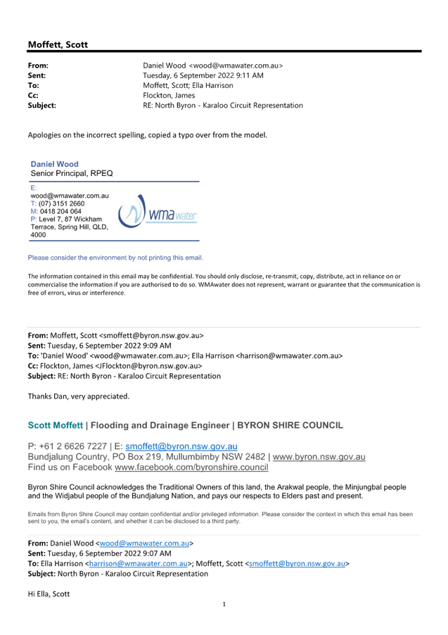
1 Email
from WMA regarding North Byron Flood Model Hydrology, E2023/9670 , page 29⇩ 
Report
Following
the adoption by Council of the North Byron Flood Risk Management Study and
Plan, various community groups have asked the question of whether the North
Byron regional modelling has included hydrological modelling of the
Marshalls Creek floodplain including consideration of inflows and outflows from
the adjacent catchments (those feeding the Billinudgel Nature Reserve, and
Brunswick River), to ensure that those flows are accounted for in Councils
modelling.
The adopted North Byron Flood Risk
Management Study modelling includes all hydrological inflows into the Brunswick
River catchment basin. The study can be found on the Byron Shire Council
website.
North
Byron Floodplain Risk Management Study and Plan - Byron Shire Council
(nsw.gov.au)
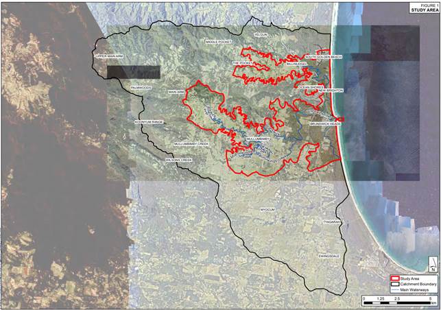 Figure 1 (NBFRMS)-Study
area including hydrological catchment boundary
Figure 1 (NBFRMS)-Study
area including hydrological catchment boundary
The study area (Figure 1) for the
North Byron studies consists of the Brunswick River, Marshalls Creek and
Simpsons Creek catchments, located in the north part of the Byron Shire Council
Local Government Area (LGA).
Marshalls Creek is the northern
major tributary of the Brunswick River, with a catchment area of approximately
42 km2 and includes the town of Ocean Shores and the villages of
Billinudgel, South Golden Beach and New Brighton. Marshalls Creek flows south
parallel to the coastal dune system prior to joining the Brunswick River.
The catchment is traversed by the Pacific Highway and the railway line.
To the north, the catchment links to the Yelgun catchment at Kallaroo Circuit
in the Capricornia Canal.
The Brunswick River catchment
covers an area of approximately 111 km2 and includes the major towns
of Mullumbimby and Brunswick Heads. It is also bisected in a north-south
direction by the Pacific Highway and railway line.
To the south, the Simpsons Creek
catchment, covers an area of approximately 66 km2. Its confluence
with the Brunswick River is on the southern bank, opposite Marshalls Creek
confluence. (North Byron Floodplain Risk Management Plan, Section 2.1, Page 6).
Further inflow / outflows from the
north of the shire (catchments in Tweed Shire) are discussed the letter
provided in attachment 1 from consultant WMA. Kallaroo Circuit Bund is used as
a hydraulic control point and boundary condition because water at this location
can flow in both directions depending upon rainfall location and water
levels. The previous Coastal Creeks Flood Study modelled all catchments
combined and allowed for this boundary conditions to be derived for the North
Byron Flood Study and Plan.
All other outflows are derived
from bathymetry (underwater survey) for creek systems and terrain models when
modelled water levels are above the bathymetry survey.
Strategic Considerations
Community Strategic Plan
and Operational Plan
Not applicable
Recent Resolutions
Not applicable
Legal/Statutory/Policy
Considerations
Not applicable
Financial Considerations
Not applicable
Consultation and
Engagement
Not applicable
Staff
Reports - Infrastructure Services 4.3 - Attachment 1

Staff Reports - Infrastructure Services 4.4
Report
No. 4.4 Byron Shire Post
2022 Flood Analysis Update
Directorate: Infrastructure
Services
Report Author: Scott
Moffett, Drainage & Flood Engineer, IS - Works - Infrastructure Planning
File No: I2023/67
Summary:
Following the recent flooding and rainfall events in 2022,
Council has been working closely with State Emergency Services (SES), the
Department of Planning & Environment (DPE) and flooding consultants to
undertake a post event data collection and summary report.
This report provides a summary of actions and ongoing
activities for discussion by the Floodplain Management Advisory Committee
(FMAC).
Draft reports have been received
by DPE and are currently undergoing quality assurance and technical review.
RECOMMENDATION:
That the Floodplain Management Advisory Committee
recommends:
Council notes the report and the Floodplain Management
Advisory Committee.
Report
Following the recent flooding and rainfall events in 2022,
Council has been working closely with State Emergency Services (SES), the
Department of Planning & Environment (DPE) along with flooding consultants
to undertake a post event/s data collection and summary report.
Council initiated the first phase
internal post event survey protocols immediately following the recent events.
Council’s Flood and Drainage Engineer was contacted by SES to collaborate
in obtaining post event survey marks.
SES contracted Public Works
Advisory (PWA) to provide survey resourcing across the Byron Shire. DPE
then became involved to oversee the data collection. Council’s
Flood and Drainage Engineer worked closely with SES, DPE and PWA to isolate the
areas of interest with a focus on the main urbanised areas of the shire.
Post event survey has now been
completed, including an SES, DPE and PWA, along with Council undertaking
quality assurance checks. This data is now available for use by
Council. Survey has covered the Brunswick River, Belongil, Tallow Creek
catchments and Bangalow.
Council also initiated the second
phase of post event survey protocols. This involved releasing media
alerts to all shire residents to ask for assistance with collection of
additional private property survey. This initiative was very successful
with over 200 responses received. Council has mobilised survey resources
collected all data from this survey.
DPE have agreed to fund all the
post event technical analysis.
The post event technical analysis
will cover the Brunswick River, Belongil, Tallow Creek catchments and Bangalow.
Consultants WMA have been commissioned by DPE for the Brunswick River catchment
and BMT have been commissioned by DPE for the Belongil and Tallow Creek
catchments. QIT, Council Emergency Dashboard provider have also been
commissioned to undertake a post event analysis of Councils flood warning
system.
There is a large amount of works
involved to complete the post event technical analysis and current estimates
from DPE and consultants is likely to take two to three months as a minimum.
DPE has recently extended their
proposed delivery month tentatively to February 2023. Staff understand
that many flood specialist consultants are experiencing staff change and staff
resourcing issues which has caused delays.
Post such significant flood events
it is natural that the industry will be under pressure from flood related areas
including; insurance companies, developers and local governments.
Draft reports have been received
by DPE and are currently undergoing quality assurance and technical review.
Key issues
· Timing of works (reliance on DPE and third-party
consultants)
· Privacy of data
Next steps
· Review draft post event technical analysis
· Finalise reporting and report back to the Floodplain
Management Advisory Committee
Financial Considerations
· Council’s
Flood and Drainage Engineer’s time and resource allocation
· All other
activities are fully funded by DPE and SES (approx. $150 000)
Consultation and
Engagement
Community consultation has been in the form of digital flood
survey mark requests via media releases and Council’s website.