Notice of Meeting
Local
Traffic Committee Meeting
A Local Traffic Committee
Meeting of Byron Shire Council will be held as follows:
|
Venue
|
Conference Room, Station Street, Mullumbimby
|
|
Date
|
Tuesday, 7 February 2023
|
|
Time
|
10.30am
|
Phil Holloway
Director Infrastructure
Services
I2023/130
Distributed
1/02/23

Local Traffic Committee
Meeting
BUSINESS OF MEETING
1. Apologies
2. Declarations
of Interest – Pecuniary and Non-Pecuniary
3. Adoption
of Minutes from Previous Meetings
3.1 Local
Traffic Committee Meeting held on 15 November 2022
3.2 Extraordinary
Local Traffic Committee Meeting held on 30 November 2022
4. Matters
Arising
5. Outstanding
Issues/Resolutions
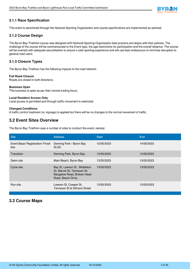
6. Development Applications
6.1 10.2022.488.1
- Stone and Wood............................................................................... 3
7. Events
7.1 Byron
Bay Triathlon and Byron Lighthouse Run May 2023.................................. 67
7.2 Event
- Westpac Helicopter Byron Coastal Charity Walk – April 29................. 115
7.3 Byron
Community Markets - Temporary Road Closure...................................... 119
7.4 2023
Bluesfest - Traffic Management Plan........................................................... 127
Local Traffic Committee Meeting 6.1
Development Applications
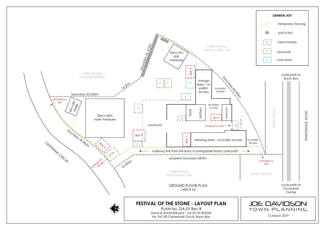
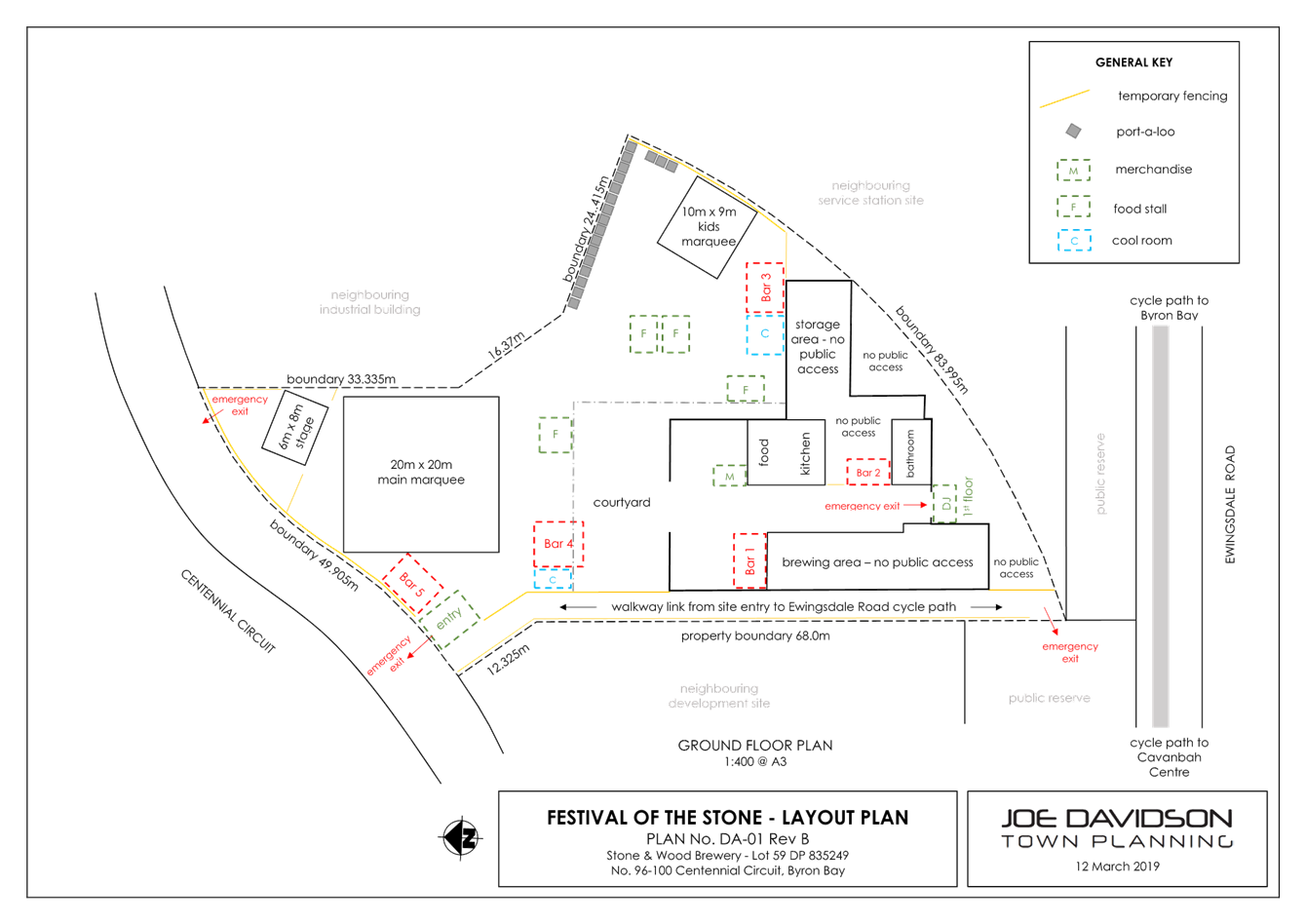
Report No. 6.1 10.2022.488.1 - Stone and Wood
File No: I2023/116
SUMMARY
This development application seeks approval to hold a
community event “Festival of the Stone” held twice a year and over
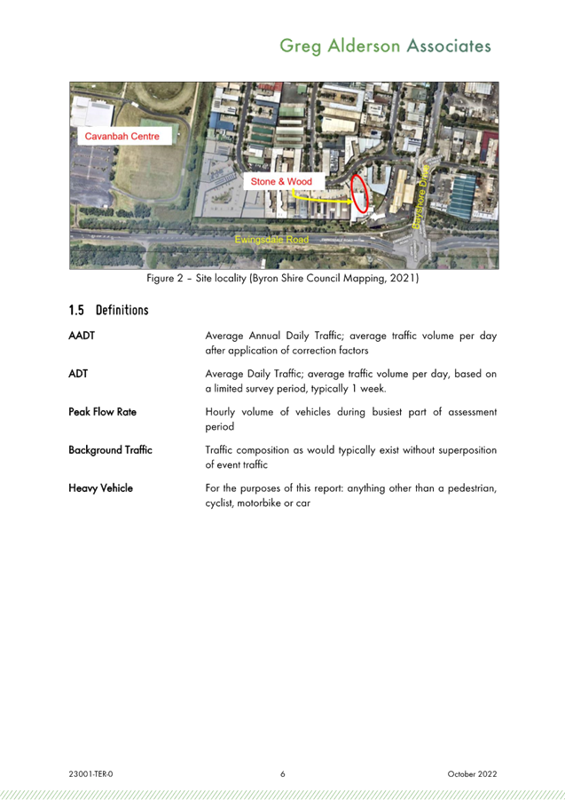
a 5-year approval period commencing 2023 on Lot 59 in DP 835349, being 96-100
Centennial Circuit, Byron Bay.
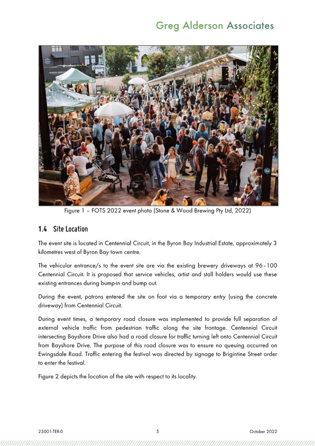
Up to 2,000 patrons including are
expected to attend each event inclusive of event organisers, contractors, and
staff. Food and entertainment will be provided along with alcoholic
beverages in accordance with liquor licencing requirements.
The development application is
seeking support for the temporary road closure of Centennial Avenue and
erection of temporary signage in the public road reserve along Ewingsdale Road,
Bayshore Drive, Centennial Circuit, Brigantine St and Tasman Way.
The Festival of the Stone has been
successfully run since 2020 with the same number of patrons and arrangements
(traffic management, temporary road closure and carparking) and there has been
no reports of incidents and traffic issues within the surrounding road network
recorded during the event.
The committee’s
recommendations have been considered and formed part of the conditions of
consent in the current development application.
OFFICER RECOMMENDATION
That
Council endorse “Festival of the Stone” event to be held twice a
year and over a period of 5-years commencing 2023 on Lot 59 in DP 835349, being
96-100 Centennial Circuit, Byron Bay in accordance with the Local Traffic
Committee’s recommendation on 28th January 2020.
BACKGROUND
The Traffic Management Plan (TMP)
of the first Festival of the Stone held at 96-100 Centennial Circuit, Byron Bay
was considered by the Local Traffic Committee (LTC) on 28 January 2020.
The committee endorses the Officers recommendation subject to the following:
Committee Recommendation:
1. That Council endorse the Festival of the
Stone to be held on Saturday 6 June 2020, in accordance with the Local Traffic
Committee recommendations.
2. That
the endorsement provided in Part 1 is subject to:-
a) Separate approvals by NSW Police and TfNSW
being obtained, as required;
b) The development of a Traffic Management Plan
and Traffic Control Plan(s) the event by those with relevant and current TfNSW
accreditation;
c) The Traffic Control Plan, if required, being
implemented by those with relevant and current TfNSW accreditation;
d) The
Traffic Management Plan and Traffic Control Plans are to include the following
amendments:
i. All parking and vehicular drop-off including
shuttle bus, taxi, Uber & other mode of transportation for the event shall
utilise the Cavanbah Centre. The car parking area in Cavanbah Centre must be
maintained during the event and returned to pre-festival conditions. Any damage
to the car parking area shall be repaired immediately and all cost shall be
borne by the consent holder;
ii. Drop-off & Pick-up of elderly and
people with disability shall be undertaken at the existing northern access of
the site and assisted with event personnel; and
iii. No drop-off & pick-up permitted along
Centennial Circuit other than elderly and people with disability
iv. Entry into the event is to be via Ewingsdale Road
and Bayshore Drive/Centennial Circuit (north intersection)
v. Exit from the event site is to be via
Bayshore Drive/Centennial Circuit (north intersection)
vi. Entry/Exit via Cavanbah Centre
e) The event is notified on Council’s
webpage.
f) The event organiser:
i. Holding $20m public liability
insurance cover which is valid for the event.
ii. Undertaking consultation with emergency
services and any identified issues addressed.
iii. Undertaking consultation with community and
affected businesses including adequate response/action to any raised concerns.
iv. Paying Council’s Road Event Application Fee
prior to each event.
v. Development approval conditions of consent
PROPOSAL
The Festival of the Stone event be
held twice a year and over a 5-year approval period commencing 2023 on
Lot 59 in DP 835349, being 96-100 Centennial Circuit, Byron Bay.
The festival has been held several
times at the Stone and Wood brewery in 96-100 Centennial Avenue since
2019. All parameters of the former events are the same as the current
proposal.
The following are the parameters
of the proposal: -
1. Numbers of Patrons
Patron numbers are limited to a maximum of 2000 patrons
including 100 event staff, contractors & organizer.
2. Event
Operating Hours
· Saturday (only) – Event 3.00pm – 10.00pm
· Saturday (only) – Bump-in before the event
· Sunday (only) – Bump-out
Parking
Parking for the event is to be
provided at the Cavanbah Centre plus the on-street parking in the surrounding
road network during the event. Patrons can access the site from the
Cavanbah Centre on foot via a pedestrian walkway connecting to Ewingsdale Road.
Shuttle bus parking is proposed having a drop-off area in Centennial Circuit in
accordance with the supporting Traffic Management Plan (TMP) and supporting
Traffic Evaluation Report prepared by Greg Alderson and Associates with report
number 23001 dated 31 October 2022.
There have no reports or
complaints of parking deficiency recorded in the previous events.
Public transport
The traffic report notes that a
shuttle bus service is being arranged with local bus operators to provide
transport for patrons from Byron Bay Town Centre to the site and return.
Patrons from other areas like Suffolk Park will need to arrange transport by
other means to Byron Bay for shuttle to the event.
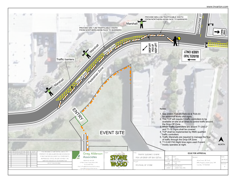
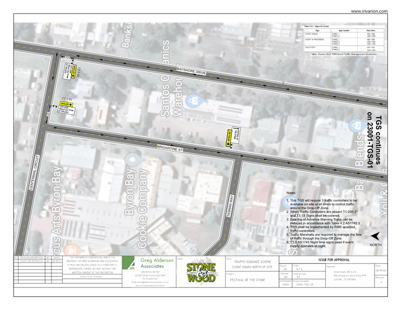
Pedestrian network
Majority of the patrons are
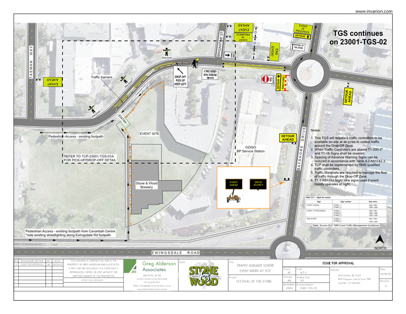
dropped off in Cavanbah Centre. A supporting Traffic Guidance Scheme
(Greg Alderson & Associates drawing 23001-TGS-02) been submitted to
facilitate efficient and safe pedestrian movement between Cavanbah Centre and
the Event site.
Traffic impact
Majority of the traffic generated
by the proposal accesses the Cavanbah Centre. Traffic utilised the
existing roundabout and are directed by Traffic Controllers to facilitate
efficient traffic movement in Cavanbah Centre to minimise traffic impact in the
Ewingsdale Road.
Traffic heading towards the
Industrial area is directed to access the northern intersection of Centennial
Circuit and Bayshore Drive to ensure there is plenty of storage within the
entry of the development site to minimise traffic impact in Ewingsdale Road.
The supporting Traffic Guidance
Scheme drawing 23001-TGS-02 prepared by Greg Alderson and Associates will
facilitate the routing of traffic and manage the pedestrian heading towards the
venue.
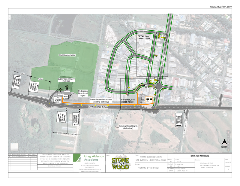
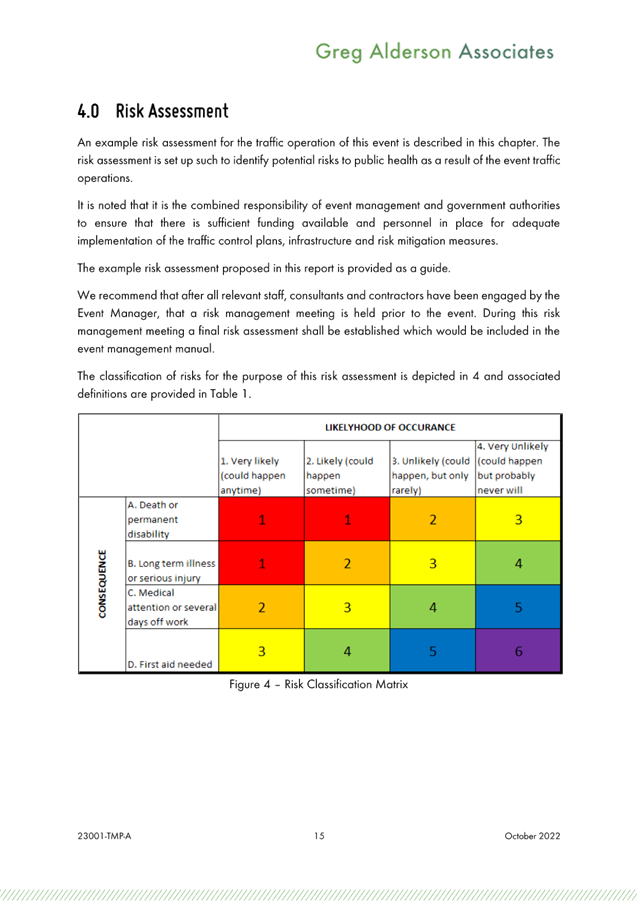
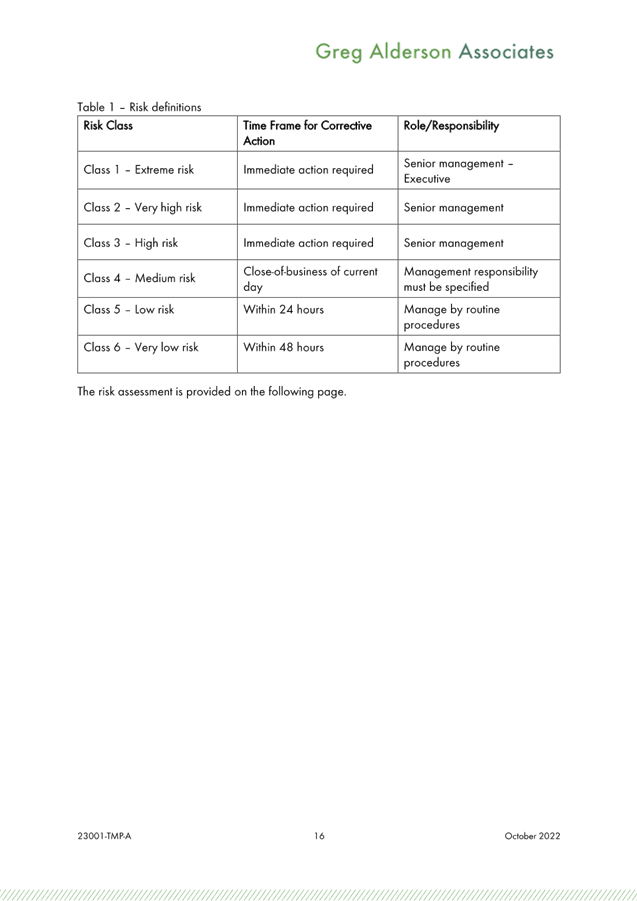
Key Issues
Potential safety issues and
movement conflicts are:
· Queueing
of drop-off vehicles in Centennial Circuit and Brigantine Street;
· Vehicles
turning into the Industrial area from Ewingsdale Road;
· Vehicles
from the event car parking areas, set-down and pick-up areas leaving the event;
· Pedestrians
crossing roads in the industrial area and queuing at the entry on arrival;
· Patrons
leaving the event site and seeking transport;
· Service
and emergency vehicles entering and leaving the event site;
· Hostile
Vehicle Mitigation
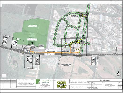
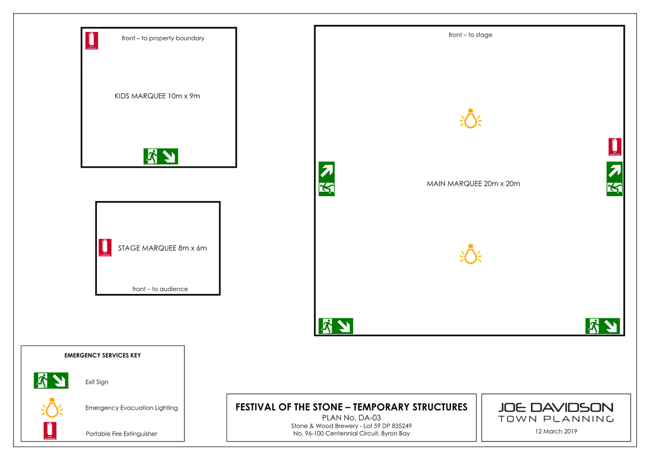
Figure 1 – TGS for Parking and Traffic
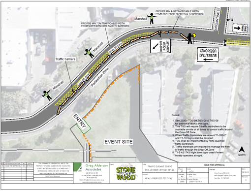
Figure 2 – TGS for Proposed Temporary Road Closure
Figure 1 and Figure 2 are updated
versions of the previously approved Traffic Control Plans (TCP).
The implementation of the TCP in
the 2019 event addressed all the key issues identified in the during the event
and have been mitigated and resulted in no traffic flow or safety issues.
COUNCIL IMPLICATIONS
Budget/Financial
The event organisers will be invoiced the following fees as
appropriate:
- Approval
of Road Events pursuant to s144 of the Roads Act (Advertising of event and
staff time to process), and
- Development
Certification fees – section 138 with fees being the fee applicable as at
the date of payment.
Asset Management
Not applicable.
Policy or Regulation
Delegated to Council for authorisation in conjunction with:
- Actions
required to control traffic- Part 8 (Sections 114 to 124) Roads Act, 1993.
- Prescribed
traffic control devices - division 1 of Part 4 (Sections 50 to 55) Road
Transport (Safety and Traffic Management) Act, 1999.
- R5-1-3
Parking (Disable) – NSW Road Rules 203, $541 fine
- R5-400
No Stopping - NSW Road Rules 167, $253 fine
- R5-41
No Parking (specified times) - NSW Road Rules 168, $108 fine.
Consultation
A condition of the endorsement of this event is that
appropriate consultation is undertaken, including:
1. Advertising
the impact of the event in the local newspaper and on the Council website.
2. Notifying
businesses that are directly impacted by the temporary road closure.
3. Liaising
with bus and taxi operators.
4. Consulting
with emergency services.
Legal and Risk Management
If vehicles cause congestion in Centennial Circuit and
Bayshore Drive then this could directly impact in MR545 - Classified Road
– Ewingsdale Road. Appropriate approvals and insurances should be
required as a condition of the endorsement for this event
RECOMMENDATION:
That Council endorse “Festival of the Stone”
event to be held on a Saturday, twice a year, and over a period of 5-years commencing
2023 on Lot 59 in DP 835349, being 96-100 Centennial Circuit, Byron Bay in
accordance with the Local Traffic Committee’s recommendation on 28th
January 2020
That the
endorsement provided is subject to
a. Separate
approvals by NSW Police and TfNSW being obtained, as required;
b. The
development of a Traffic Management Plan and Traffic Control Plan(s) the event
by those with relevant and current TfNSW accreditation;
c. The
Traffic Guidance Scheme, if required, being implemented by those with relevant
and current TfNSW accreditation;
d. The
Traffic Management Plan and Traffic Control Plans are to include the following
amendments:
i. All
parking and vehicular drop-off including shuttle bus, taxi, Uber & other
mode of transportation for the event shall utilise the Cavanbah Centre. The car
parking area in Cavanbah Centre must be maintained during the event and
returned to pre-festival conditions. Any damage to the car parking area shall
be repaired immediately and all cost shall be borne by the consent holder;
ii. Drop-off
& Pick-up of elderly and people with disability shall be undertaken at the
existing northern access of the site and assisted with event personnel;
iii. No
drop-off & pick-up permitted along Centennial Circuit other than elderly
and people with disability
iv. Entry
into the event is to be via Ewingsdale Road and Bayshore Drive/Centennial
Circuit (north intersection)
v. Exit
from the event site is to be via Bayshore Drive/Centennial Circuit (north
intersection)
vi. Entry/Exit
via Cavanbah Centre
e. The
event is notified on Council’s webpage.
f. The
event organiser:
i. Holding
$20m public liability insurance cover which is valid for the event.
ii. Undertaking
consultation with emergency services and any identified issues addressed.
iii. Undertaking
consultation with community and affected businesses including adequate
response/action to any raised concerns.
iv. Paying
Council’s Road Event Application Fee prior to each event.
g)
Development approval conditions of consent
Attachments:
1 10.2022.488.1
- Traffic Management Plan, E2022/109095
, page 11⇩ 
2 10.2022.488.1
- Traffic evaluation report, E2022/109096
, page 47⇩ 
Development
Applications 6.1 - Attachment 1

Development
Applications 6.1 - Attachment 2


Local Traffic Committee Meeting 7.1
Events
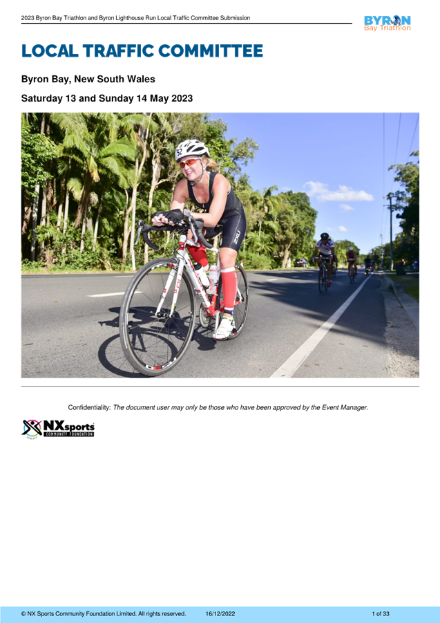
Report No. 7.1 Byron Bay Triathlon and Byron Lighthouse Run May 2023
File No: I2022/1912
Council has received an application for the Byron Bay
Triathlon to be held on Saturday 13 May 2023 and the Byron Lighthouse Run to be
held on Sunday 14 May 2023.
The Byron Bay Triathlon was previously approved by the Local
Traffic Committee (LTC) and by Council resolution 22-101.
The Byron Lighthouse Run was previously approved by LTC for
their annual event which used to be held in October (was not part of the Byron
Bay Triathlon weekend previously).
RECOMMENDATION:
1. That
Council support the Byron Bay Triathlon to be held on Saturday 13 May 2023 and
the Byron Lighthouse Run to be held on Sunday 14 May 2023.
2. That
Council support in Part 1 is subject to:
a) separate
approvals by NSW Police and TfNSW being obtained;
b) the
event organiser provide council with an updated Traffic Management Plan
and Traffic Guidance Scheme/s for the 2023 event;
c) development
and implementation of a Traffic Management Plan and Traffic Guidance Scheme/s
by those with appropriate TfNSW accreditation and the holding of current and
appropriate levels of insurance and liability cover;
d) the
impact of the event be advertised, and charged at cost to the organisers, via a
notice in the local weekly paper a minimum of one week prior to the operational
impacts taking effect, noting it must include the event name, specifics of any
traffic impacts or road closures and times, alternative route arrangements,
event organiser, a personal contact name and a telephone number for all event
related enquiries or complaints;
e) the
event be notified on Council’s web page with the event organiser
supplying Council with the relevant information;
f) Access
from main beach car park to Fletcher St is to be unrestricted at all times.
g) Access
to Lawson St between Fletcher St and Middleton St to be permitted at all times.
3. The
event organiser to:
a) inform
the community and businesses that are directly impacted (e.g. within road
closure zones) via written information which is delivered to the property in a
timely manner so as to document, consider and respond to any concerns raised;
b) arranging
for private property access and egress affected by the event;
c) liaising
with bus, taxi and waste operators and ensuring arrangements are made for
provision of services during conduct of the event;
d) consulting
with emergency services and any identified issues be addressed;
e) holding
$20m public liability insurance cover which is valid for the event;
f) paying Council’s
Road Event Application Fee prior to the event.
Attachments:
1 Byron
Bay Triathlon and Lighthouse Run LTC Submission 2023, E2022/129373 , page 77⇩ 
2 NSW
Police approval to conduct the 2023 Byron Bay Triathlon on Byron Shire Roads, E2023/6201 , page 110⇩ 
Summary
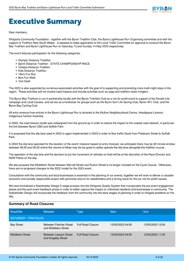
Council has received an event application for the 2023 Byron
Bay Triathlon to be held on Saturday 13 May 2023 and the Byron Lighthouse Run
to be held on Sunday 14 May 2023.
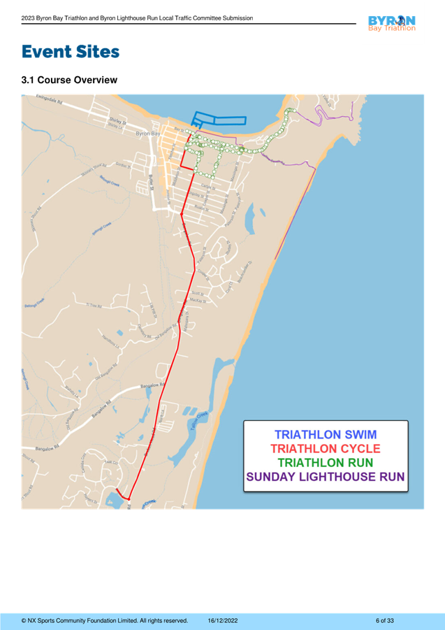
1,800 participants are expected over the event weekend.
The Byron Bay Triathlon course used by the swim and run legs
are the same as previous years. The cycle leg has been changed. The other
change is the additional of the Byron Bay Lighthouse Run to the Byron Bay
Triathlon weekend program – this event was previously held annually in
October. The event organisers are seeking support for the proposed road
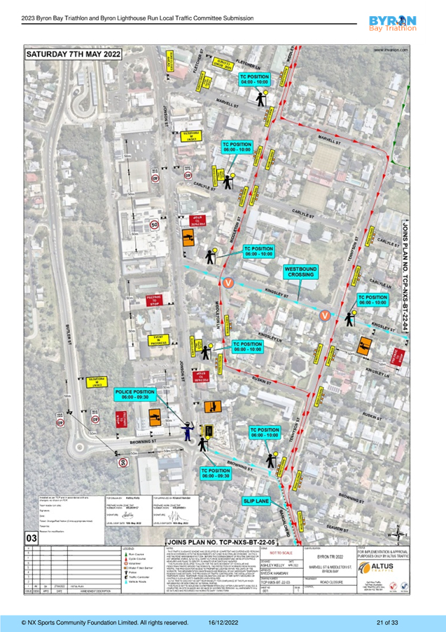
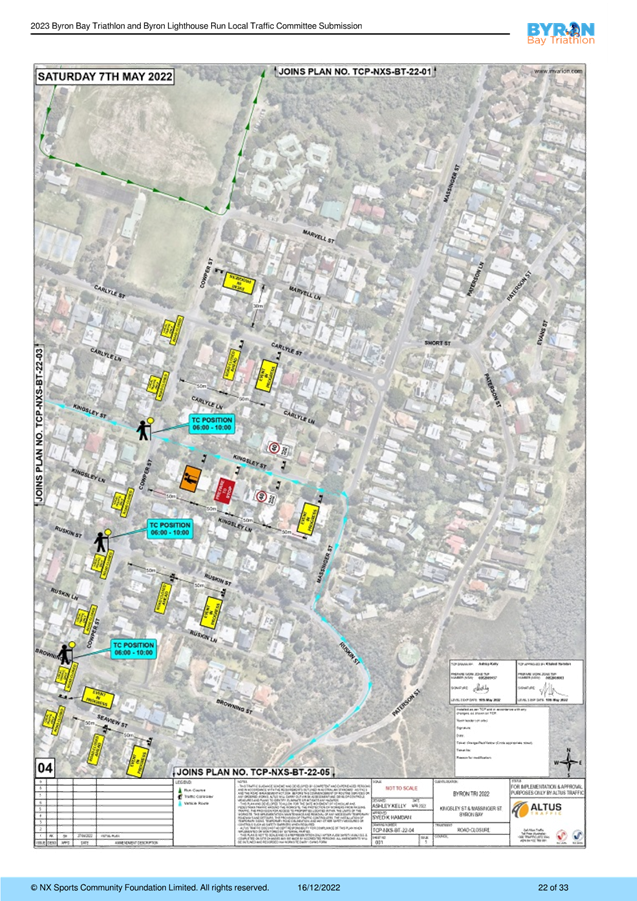
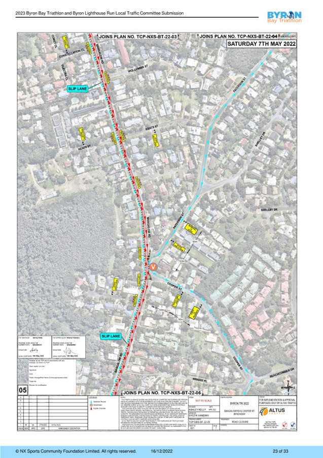
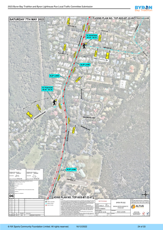
closures for both events.
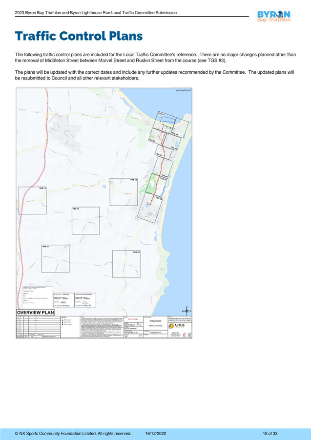
Event Overview
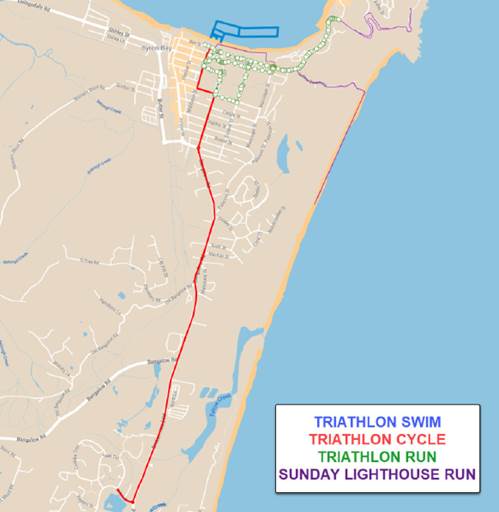
Figure 1 – Overall map of both
events
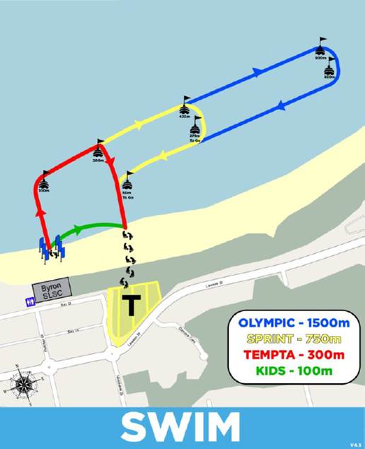
Figure 2 – Swim leg for
triathlon
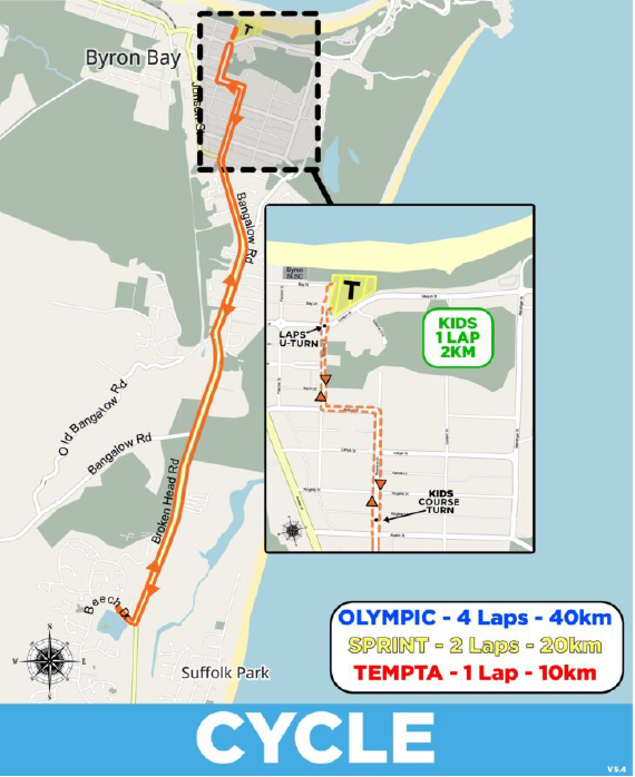
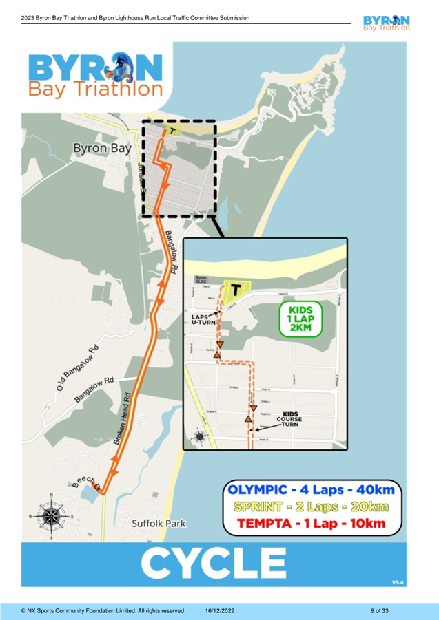
Figure 3 – Cycle leg for
triathlon
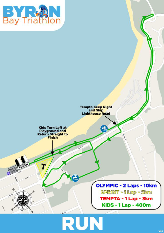
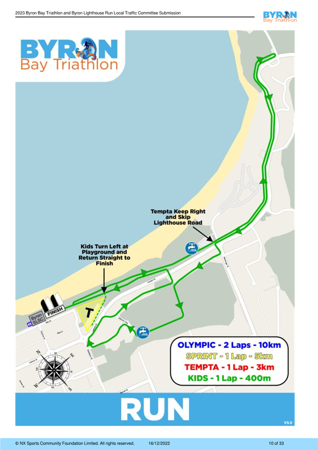
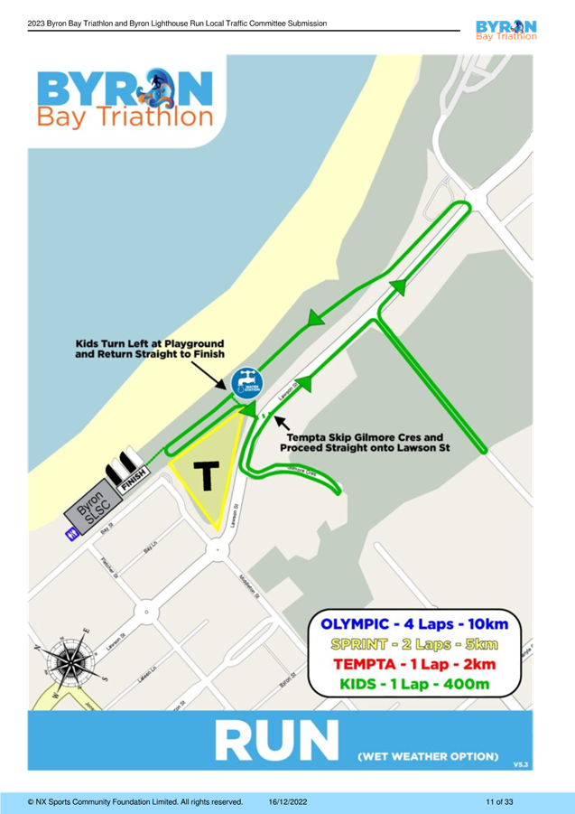
Figure 4 – Run leg for triathlon
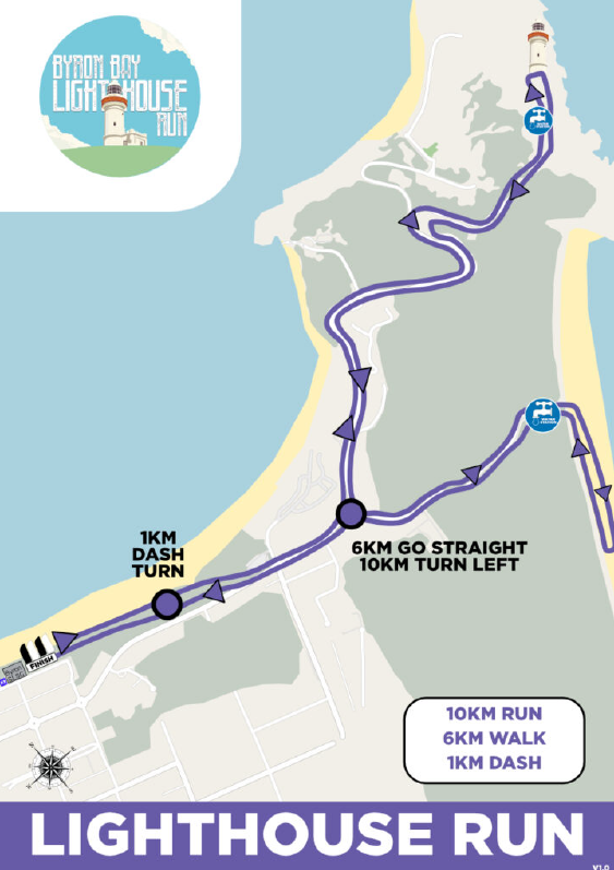
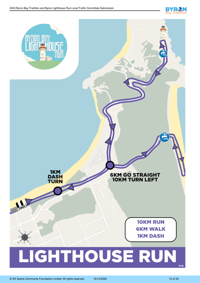
Figure 4 – Lighthouse run legs
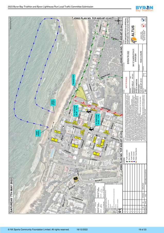
Changes
to the cycle leg are as follows:
· The operation of
the slip lane may need to be halted for a 30 minute period around 8am due to
the anticipated volume of cycle participants. Slip lane operation and the
decision to put the movement of vehicles on hold will be at the discretion of
the Race Director and NSW Police on the day.
· Middleton Street
(between Marvell Street and Ruskin Street) has been removed from the cycle
course.
The
proposed road closures and time of closures are shown in the tables
below. These are also shown in Attachment 1 - Event submission document
(E2022/129373).
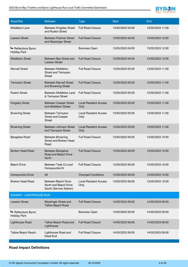
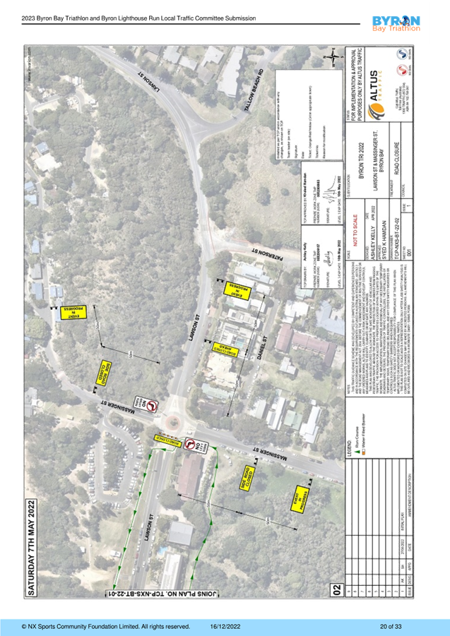
Proposed Road Closures
Table 1 - Saturday Triathlon
|
Road
|
Closed between
|
Type
|
Start time
|
Finish time
|
|
Bay St
|
Fletcher St – Middleton St
|
Full road
closure
|
13 May 2023, 04.00
|
13 May 2023, 12.00
|
|
Middleton
St
|
Lawson
St – Kingsley St
|
Full
road closure
|
13 May
2023, 04.00
|
13 May
2023, 11.00
|
|
Middleton Lane
|
Kingsley St – Ruskin St
|
Full road closure
|
13 May 2023, 04.00
|
13 May 2023, 11.00
|
|
Lawson
St
|
Fletcher
St – Massinger St
|
Full
road closure
|
13 May
2023, 04.00
|
13 May
2023, 12.00
|
|
Reflections Holiday Park
|
|
Business Open
|
13 May 2023, 04.00
|
13 May 2023, 12.00
|
|
Middleton
St
|
Bay St
– Lawson St
|
Full
road closure
|
13 May
2023, 04.00
|
13 May
2023, 12.00
|
|
Marvell St
|
Middleton St – Tennyson St
|
Full road closure
|
13 May 2023, 05.00
|
13 May 2023, 11.00
|
|
Tennyson
St
|
Marvell
St – Browning St
|
Full
road closure
|
13 May
2023, 05.00
|
13 May
2023, 11.00
|
|
Ruskin St
|
Middleton Ln – Tennyson St
|
Full road closure
|
13 May 2023, 05.00
|
13 May 2023, 11.00
|
|
Kingsley
St
|
Cowper
St – Middleton St
|
Local
Resident Access Only
|
13 May
2023, 05.00
|
13 May
2023, 11.00
|
|
Browning St
|
Tennyson St – Cowper St
|
Local Resident Access Only
|
13 May 2023, 05.00
|
13 May 2023, 11.00
|
|
Browning
St
|
Jonson
St – Tennyson St
|
Local
Resident Access Only
|
13 May
2023, 05.00
|
13 May
2023, 11.00
|
|
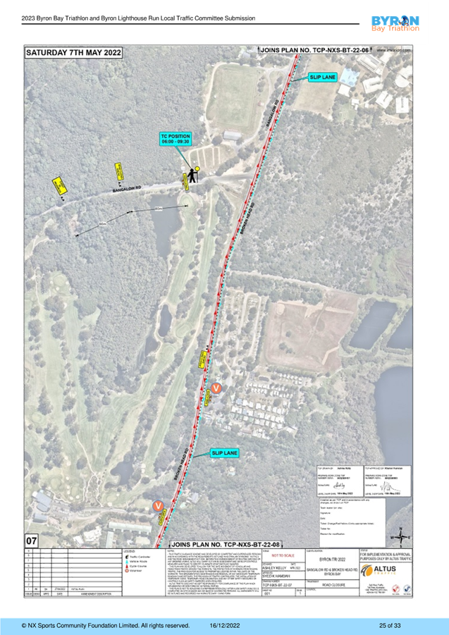
Bangalow Rd
|
Browning St – Broken Head Rd
|
Full road closure
|
13 May 2023, 06.00
|
13 May 2023, 10.00
|
|
Broken
Head Rd
|
Bangalow
Rd – Beech Dr North
|
Full
road closure
|
13 May
2023, 06.00
|
13 May
2023, 10.00
|
|
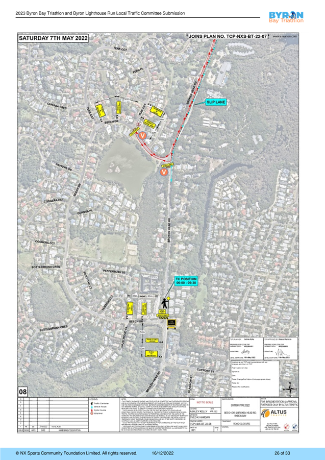
Beech Dr
|
Teak Cct – Honeysuckle Dr
|
Full road closure
|
13 May 2023, 06.00
|
13 May 2023, 10.00
|
|
Honeysuckle
Dr
|
All
|
Changed conditions
|
13 May
2023, 06.00
|
13 May
2023, 10.00
|
|
Broken Head Rd
|
Beech Dr North – Beech Dr South (service station)
|
Local Resident Access Only
|
13 May 2023, 06.00
|
13 May 2023, 10.00
|
To summarise the table above, the
following roads are proposed to be impacted in the following ways at various
periods between the hours of 4am and 12pm on Saturday 13 May:
Full road closure
· Bangalow Rd (Browning St – Broken Head Rd)
· Bay St (Fletcher St – Middleton St)
· Beech Dr (Teak Cct – Honeysuckle Dr)
· Broken Head Rd (Bangalow Rd – Beech Dr)
· Lawson St (Fletcher St – Massinger St)
· Marvell St (Middleton St – Tennyson St)
· Middleton St (Lawson St – Kingsley St and Bay St
– Lawson St)
· Middleton Ln (Kingsley St – Ruskin St)
· Ruskin St (Middleton Ln – Tennyson St)
· Tennyson St (Marvell St – Browning St)
Local Resident Access Only
· Broken Head Rd (Beech Dr North – Beech Dr South
service station)
· Browning St (Tennyson St – Cowper St and Jonson St
– Tennyson St)
· Kingsley St (Cowper St – Middleton St)
Changed Conditions (traffic
control treatment only)
· Honeysuckle Dr (All)
Table 2 - Sunday Lighthouse Run
|
Road
|
Closed between
|
Type
|
Start time
|
Finish time
|
|
Lawson St
|
Massinger St – Tallow Beach Rd
|
Full road closure
|
14 May 2023, 06.00
|
14 May 2023, 09.00
|
|
Reflections
Holiday Park
|
|
Business
open
|
14 May
2023, 06.00
|
14 May
2023, 09.00
|
|
Lighthouse Rd
|
Tallow Beach Rd – Lighthouse
|
Full road closure
|
14 May 2023, 06.00
|
14 May 2023, 09.00
|
|
Tallow
Beach Rd
|
Lighthouse
Rd - dead end
|
Full
road closure
|
14 May 2023,
06.00
|
14 May
2023, 09.00
|
To summarise the table above, the
following roads are proposed to be impacted by full road closures between the
hours of 6am and 9am on Sunday 14 May:
Full road closure
· Lawson St (Massinger St – Tallow Beach Rd)
· Lighthouse Rd (Tallow Beach Rd - Lighthouse)
· Tallow Beach Rd (Lighthouse Rd – dead end)
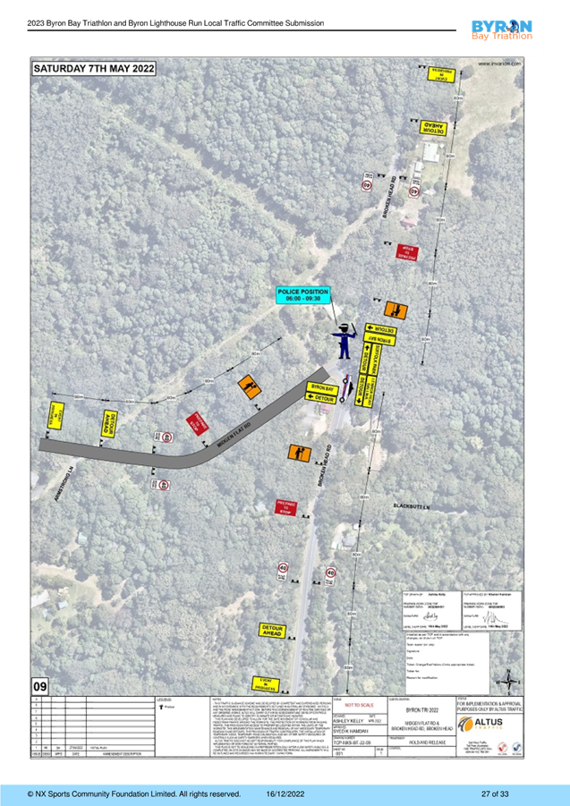
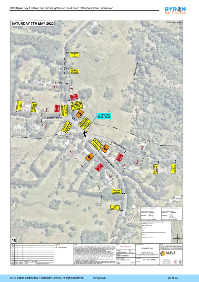
Traffic Control
It is proposed to manage traffic during the above road
closures through the implementation of Traffic Guidance Schemes and the support
of police from the Tweed-Byron District. See Attachment 2 for confirmation of
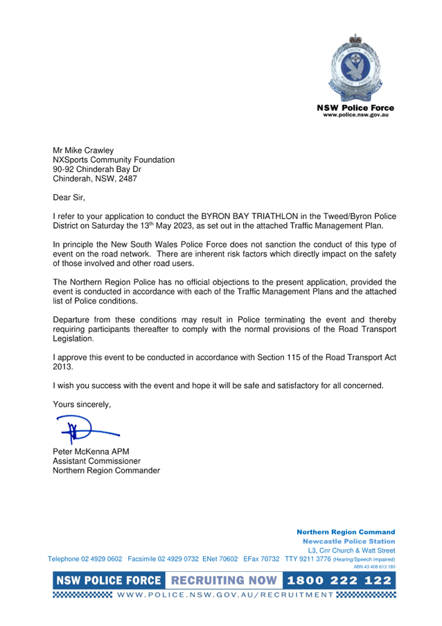
NSW Police approval to conduct the 2023 event on Byron Shire roads.
Events 7.1 - Attachment 1
Events 7.1 - Attachment 2
Local Traffic Committee Meeting 7.2
Report
No. 7.2 Event - Westpac Helicopter Byron Coastal
Charity Walk – April 29
File No: I2023/52
The 2023 Byron Coast Charity Walk will be held on Saturday
29 April 2023 from 5.00am – 5.00pm. The Byron Coastal Charity Walk
will be celebrating 10 years in 2023 and organisers anticipate 800 to 1,000
participants.
The majority of the Charity Walk will be along beaches and
footpaths. There are two locations within Council’s delegated
authority where walkers will be required to walk along the road with associated
traffic control: Lighthouse Road and Seven Mile Beach Road.
The walking route will start in Dening Park, Byron Bay and
typically follows the coastline south to Ballina SLSC, a total distance of
36km.
The images below show the key sections of the walk and areas
where traffic control is proposed are circled in blue. In figure 1 traffic
control is proposed on Lighthouse Road as the walk heads towards Tallows
Beach. In figure 2 traffic control is proposed at the entrance to Seven
Mile Beach Road.
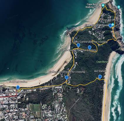
Figure 1 – Lighthouse Road
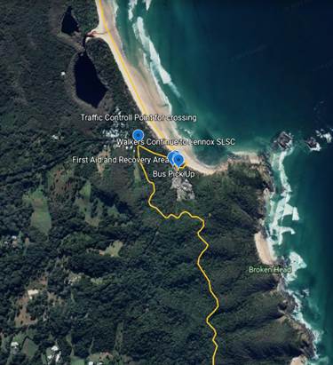
Figure 2 – Seven Mile Beach Road
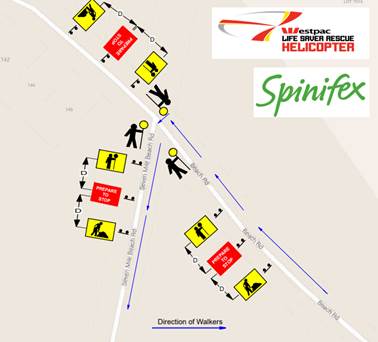
Figure 3 – Proposed TGS for the Seven Mile Beach Road
entrance (refer Figure 2). The Traffic Control is to be in place from 6.30am to
2.30pm.
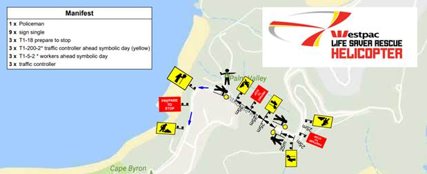
Figure 4 – Traffic control proposed for eastern
section Lighthouse Road. Coming down from Lighthouse Road (refer to Figure 1).
Traffic control to be in place from 6am to 12.30pm.
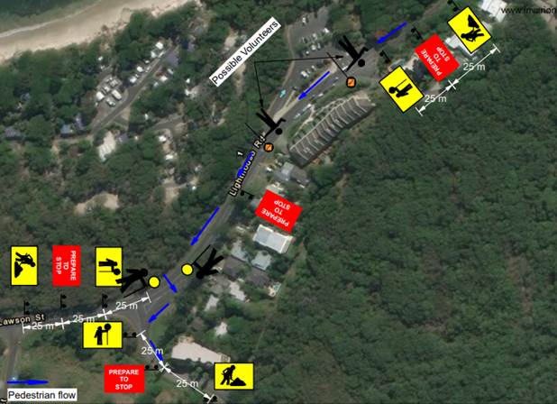
Figure 5 – Traffic control proposed for the western
section of Lighthouse Road entering Tallow Beach Road (refer to Figure
1). Traffic control to be in place between 6am to 12.30pm.
RECOMMENDATION:
1. That
Council support the Westpac Life Saver Rescue Helicopter fundraiser, Byron
Coast Charity Walk, to be held Saturday 29 April 2023 from 5.00am –
5.00pm
2. That
Council support in Part 1 is subject to:
a) The development of a
Traffic Guidance Scheme (TGS) and Traffic Management Plan(s) for the 2023 event
by those with relevant and current TfNSW accreditation. The TGS(s) and Traffic
Management Plan is to include, but is not limited to, the following:
b) Signage, which specifies
the date, hours and nature of the event, be positioned at the entrance and exit
of Seven Mile Beach Road one week prior to the event;
c) On the day of the
event, at 500m intervals on Seven Mile Beach Road, and facing both directions
of travel, signs advising of “ Special Event – Charity Walk
Ahead” (or similar) are installed prior, and removed after, the event
occurs;
d) A safety induction for
participants advising of hazards be provided.
e) Implementation of
the Traffic Management Plan and Traffic Guidance Scheme/s as designed by those
with appropriate accreditation and implemented by people with appropriate
accreditation, including traffic controllers.
3. The
event organiser to:
a) Advertise the impact
of the event, via a Variable Message Sign on site and notice in the local
weekly paper, a minimum of one week prior to the operational impacts taking
effect, noting it must include the event name, specifics of any traffic impacts
or road closures and times, alternative route arrangements, event organiser, a
personal contact name and a telephone number for all event related enquiries or
complaints;
b) Arrange for the event to
be notified on Council’s webpage a minimum one week prior to the TGS
being implemented;
c) Undertake
consultation with affected community and businesses including adequate
response/action to any raised concerns.
d) Undertake consultation
with emergency services and any identified issues addressed.
e) Holding $20m public
liability insurance cover which is valid for the event.
f) Paying
Council’s Road Event Application Fee prior to the event.
Local Traffic Committee Meeting 7.3
Report
No. 7.3 Byron Community Markets - Temporary Road
Closure
File No: I2023/106
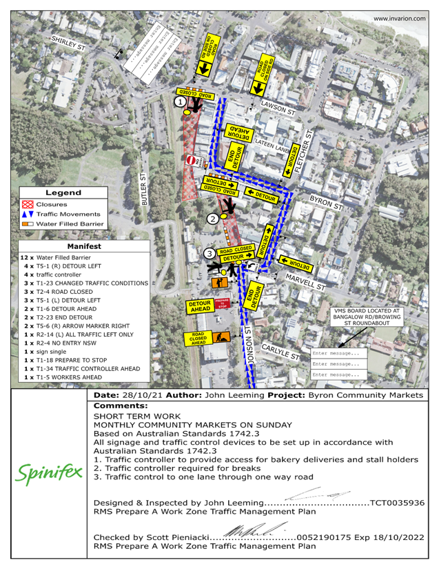
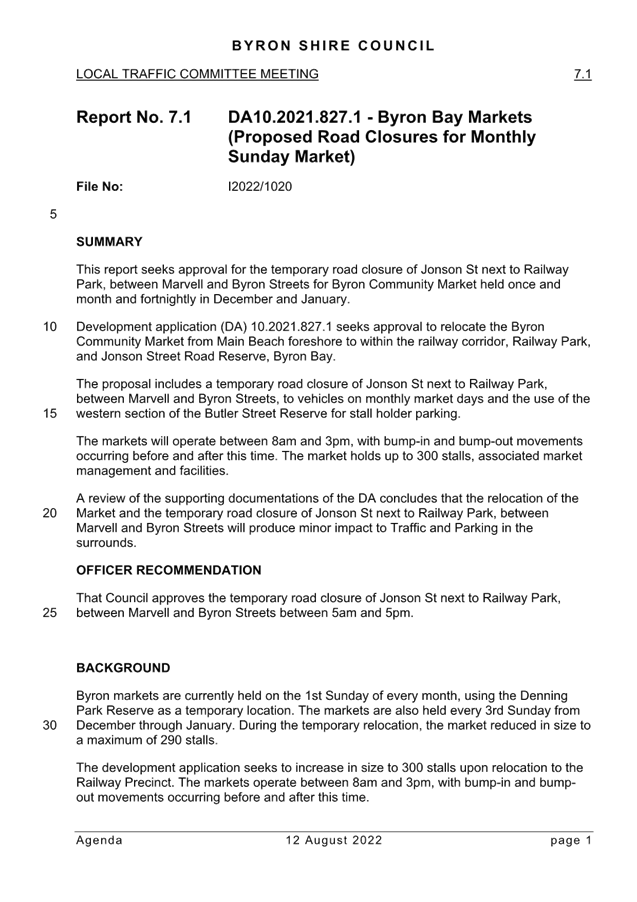
This report seeks
approval for the temporary road closure of Jonson Street, Byron Bay next to
Railway Park, between Marvell and Byron Streets for Byron Community Market held
once a month and fortnightly in December and January.
The proposal includes a
temporary road closure of Jonson Street next to Railway Park, between Marvell
and Byron Streets, to vehicles on monthly market days and the use of the
western section of the Butler Street Reserve for stall holder parking, refer to
attachment 1 (E2021/149504) for Traffic Guidance Scheme.
The markets will
operate between 8am and 3pm, with bump-in and bump-out movements occurring
before and after this time. The market holds up to 300 stalls, associated
market management and facilities.
A review of the supporting
documentations of the DA concludes that the relocation of the Market and the
temporary road closure of Jonson St
next to Railway Park, between Marvell and Byron Streets will produce minor impact to Traffic and Parking in the
surrounds.
This was previously approved by the Local Traffic Committee
(LTC) and Council resolution number 22-451 (recommendation below).
Addition information regarding the DA can
be found in the original report (attachment 2 – I2022/1020).
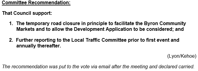
RECOMMENDATION:
That Council approves the temporary road closure of Jonson Street, Byron
Bay next to Railway Park (between Marvell and Byron Streets), to facilitate
Byron Community Market on Sundays between 5am and 5pm, monthly, except between
December and January which will be fortnightly
Attachments:
1 10.2021.827.1
- Traffic Plan, E2021/149504 ,
page 121⇩ 
2 LTC_12_08_2022_LTCR_Byron
Bay_Community_Markets, E2023/9059
, page 122⇩ 
Events 7.3 - Attachment 1
Events 7.3 - Attachment 2
Local Traffic Committee Meeting 7.4
Report
No. 7.4 2023 Bluesfest - Traffic Management Plan
File No: I2023/114
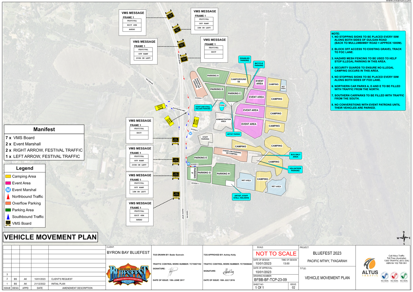
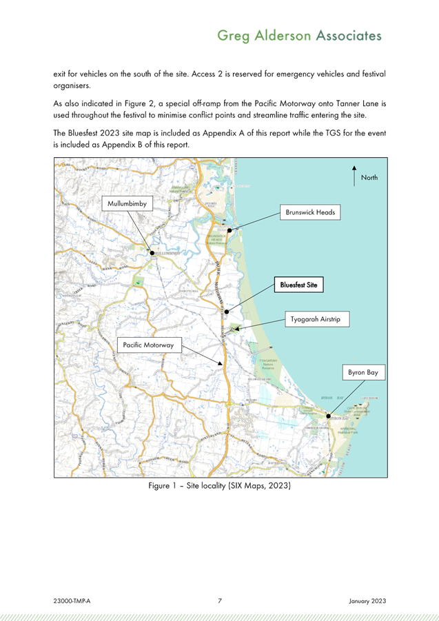
Bluesfest plans to run the 2023 event
over the Easter Long Weekend: Wednesday 5th April 2023
to Tuesday 11 April 2023.
DA10.2014.753.7 permits the event to run
and Bluesfest have now submitted traffic management plans and traffic control
plans in accordance with the conditions of consent for DA 10.2014.753.7.
Council’s Development Engineer has
reviewed the submitted TMP and TGS and confirms they meet the conditions of
consent requirements. For reference the two specific traffic related
conditions have been inserted below.
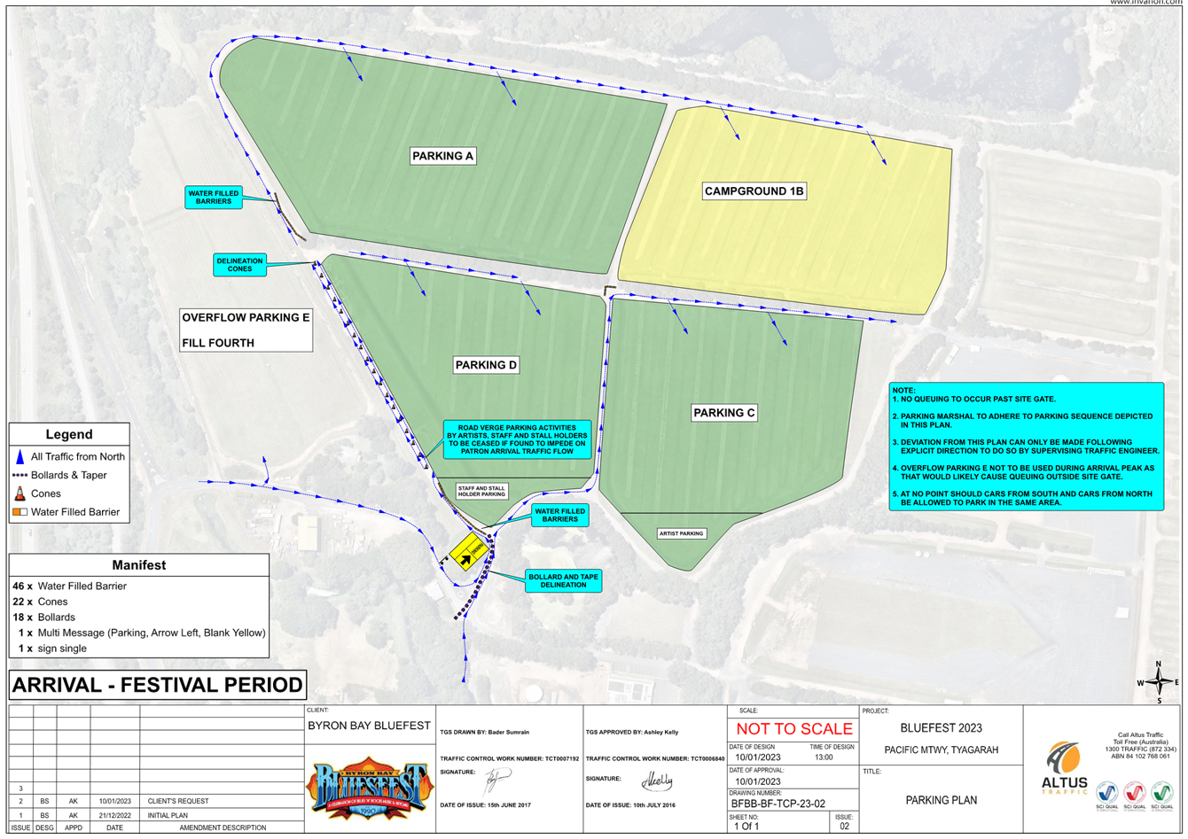
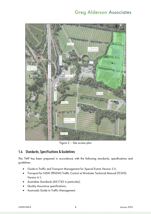
2023 Traffic Management Plan Summary
The conditions of consent incudes a
number of KPI’s set by TfNSW that must be met in regard to traffic
management.
The main issue with the 2022 Bluesfest
event was queuing on the Pacific Motorway for a period of time on Goof
Friday. This years TMP includes a variety of measures to including
monitoring of traffic conditions, internal queue lengths and traffic flow and
abandonment of paid parking scanning if that is causing delays in vehicles
getting into the site.
‘Event Only’ Park and Ride
Offerings
The Bluesfest 2023 Traffic Management
Plan does not propose any ‘Event Only’ park and ride facilities,
thereby no assessment of off-site parking implications are considered.
The event shall cater for conventional bus and taxi rank services as per last
year.
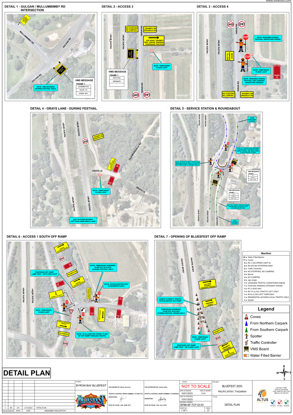
DA 10.2014.753.7 CONDITIONS
57A. Detailed
Traffic Monitoring for the 2020 Easter Bluesfest Event
A detailed traffic monitoring report to
be undertaken of traffic associated with the 2020 Easter Bluesfest Event on the
affected road network including the Pacific Motorway, Gulgan Road, Yarun,
Tanners and Grays Lane for the duration of the event starting on Thursday
Morning at 8am and ending on Tuesday 5pm. Any increase in traffic movements on
the surrounding road network must be identified and mitigating/ management
measures identified for implementation in future events and incorporation into
the relevant traffic management plans. SIDRA
modelling based on recent peak hour intersection traffic counts, two-way
distributions, and calibrated to observed site conditions must be included in
the report together with bus patronage and pick up / drop off data.
Additional queuing of traffic on the
Pacific Highway associated with the event cannot be supported. The report to be
provided to the Roads and Maritime Service and a copy furnished to
Council.
61. Transport Management Plan
The submission of a Transport
Management Plan (TMP) prepared in accordance with the “Guide to Traffic
and Transport Management for Special Events”, to Council for approval at
least 90 days prior to the commencement of the first event under Stage 1. The
Transport Management Plan to be broken into three parts to delineate management
measures for small, medium and large events. The plan to be robust to enable it
to be used for a variety of small, medium and large events annually.
a) The
Transport Management Plan must include, but not be limited to:
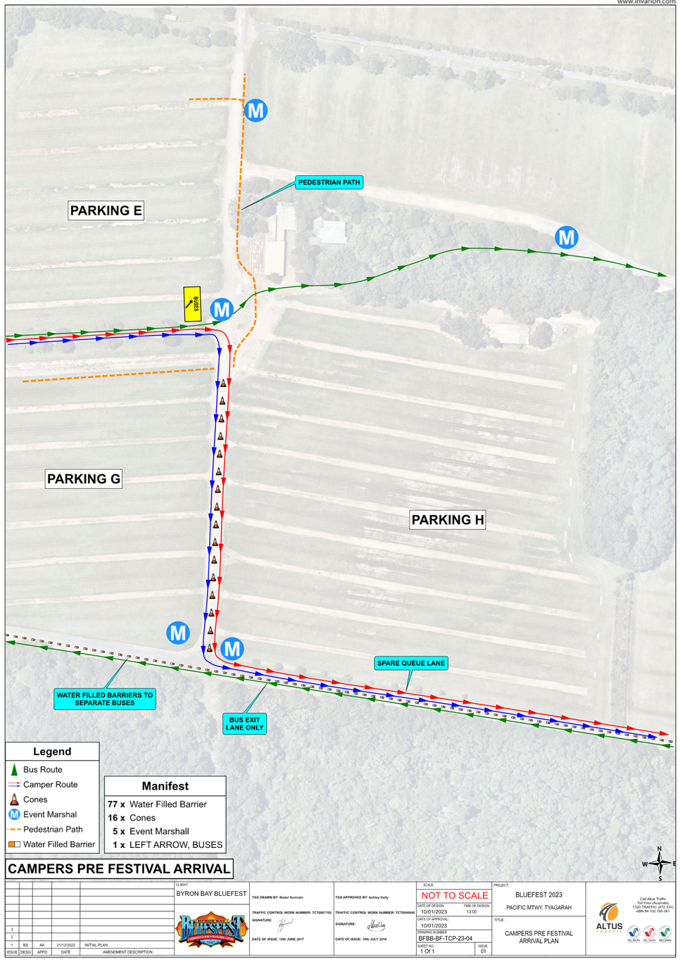
i Details
for the efficient management of parking, including provision for overflows from
the southern parking area to the northern parking area. The management of
overflow parking must ensure that the overflow vehicles exit the site from
where they entered the site.
ii. A
contingency plan for unplanned incidents that may disrupt traffic and transport
before, during or after the event. The contingency plan must be fully
documented and include emergency contact names and phone numbers.
iii. A copy of an
approved Traffic Control Plan.
b) The
Traffic Control Plan (TCP) must address the following matters:
i. The
TCP must be designed in accordance with the requirements of the Roads and
Maritime Services’ Manual, Traffic Control at Work Sites Version 2, and
the current Australian Standards, Manual of Uniform Traffic Control Devices
Part 3, ‘Traffic Control Devices for Works on Roads’.
ii. The
TCP must be prepared by a suitably qualified and RMS accredited Work Site
Traffic Controller.
iii. The
regulation of traffic must be authorised under the Roads Act 1993 and the use
of traffic control devices authorised under the Road Transport (Safety &
Traffic Management) Act 1999.
iv. Reduced speed
zones must be approved by the Roads and Maritime Services.
v. There is to be
no impact on through travel times on the pacific Highway
vi. The TCP must
incorporate a monitoring program to assess the traffic volumes and peak parking
numbers associated with each event. Twenty four hour traffic counts are to be
undertaken before, during and after the first two medium and large events (and
as further required by Council or the Roads and Maritime Service) for the
traffic on the frontage and surrounding roadways.Such report must include
details demonstrating compliance with the conditions of consent relating to
traffic management including the requirements of the RMS provided below. From
time to time aerial photography of the site and surrounds at regular intervals
before during and after the event, including peak traffic and parking periods
should be undertaken to support the traffic monitoring report.
vii. The TCP must
provide for all relevant conditions of the Roads and Maritime Services.
viii. The TCP
must be submitted to the Local Traffic Committee prior to approval under the
Roads Act 1993 and adequate time must be allowed for this to occur and for the
preparation of any necessary reports and amendments necessary to meet the Local
Traffic Committee recommendations.
ix. The TCP must
satisfactorily address any concerns or issues raised by the Council, Police
and/or Roads and Maritime Services from previous events.
x. The TCP must
ensure access to surrounding and neighbouring properties at all times including
the wrecker and service station.
xi. The TCP must
provide appropriate signage to prohibit parking in the surrounding road network
and to prohibit access to the airport by festival patrons. Adequate provision
must be made to allow residents of Grays Lane to park in Tanner Lane near the
end of Grays Lane when through access is closed due to flood. Permanent
“No Parking” signs in Grays Lane from the Pacific Highway to the
Tyagarah Nature Reserve boundary will be considered as a permanent management
arrangement.
xii. Entrance to
Grays Lane East of Yarun Road to be restricted to residents and their guests
for the duration of the festival to prevent the parking of vehicles in Grays
Lane.
xiii. The TCP to
factor in that local roads operate a Level of Service D or better between the
hours of 8am and 8pm on event days. The ramps of the Gulgan Road Interchange
with the Pacific Highway to operate at Level of Service C or better at event
times (See Figure 3.1 Levels of Service Flow rates Austroads Guide to
Traffic Management Part 3 and Highway Capacity Manual)
xiv. The TCP to
include provision so that Traffic queuing on the Gulgan road off ramps does not
exceed stopping sight distances for 110 km/h speeds. (See RMS supplements and
Austroads Guide to road Design Part 3 Section 5.3.1 for stopping sight
distances)
c) The
Transport Management Plan and Traffic Control Plans to be reviewed on an annual
basis and where required such plans to be updated accordingly taking into
consideration changing traffic conditions, altered management arrangements and
other issues as identified by the Roads and Maritime Service, Council or the
Regulatory Working Group to ensure the safety and efficiency of the road
network.
d) The
Transport Management Plan and Traffic Guidance Scheme for the temporary use of
the camping ground in conjunction with the Splendour in the Grass Festival is
to be reviewed at the end of the event and a report prepared by a suitably
qualified traffic engineer to identify the effectivity and performance of the
Traffic Management Plan including measures to improve the safety and efficiency
of the surrounding road network. The report shall be submitted to Council and
reviewed by the Splendour in the Grass/ North Byron Parklands Regulatory Working
Group
Note: Access/
Egress from, and to, the Pacific Highway to Grays Lane to be closed in the
future by the TfNSW. The Transport Management Plan and Traffic Control Plan to
reflect proposed changes to this intersection. Traffic management documents to be in accordance with
current standards and terminology as stipulated by TfNSW
RECOMMENDATION:
1. That
Council endorse the regulatory traffic management facilities and devices,
including signs and traffic controller provisions proposed for the Council
controlled public road network as outlined in attachments 1 and 2 (E2023/9632,
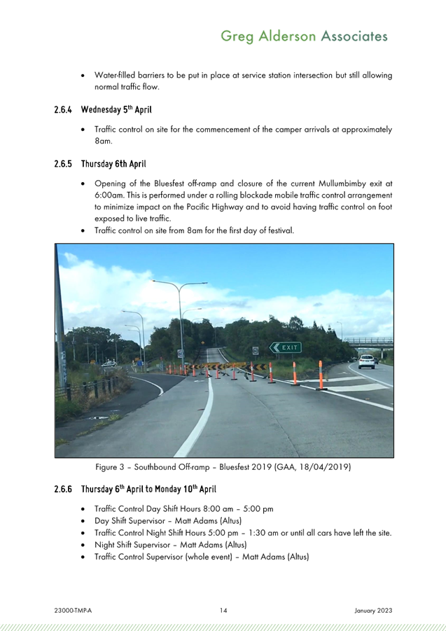
E2023/9636) for the Byron Bay Bluesfest 2023 to be held on Thursday 6 April
2023 to Monday 10 April 2023, subject to:
a) Separate
approvals by NSW Police and TfNSW being obtained, noting that the event is on a
state road or may impact the state road network;
b) The
event be held through the implementation of the events Traffic Management Plan
and Traffic Control Plan(s) as per attachments 1 and 2 (E2023/9632,
E2023/9636)The Traffic Management Plan is to include contingency measures in
case the level of queuing fails to meet KPI requirements. It is noted that such
queuing may be caused by the introduction of paid parking.
c) The
Traffic Management Plan and the Traffic Control Plan(s) to be implemented by
those with relevant and current TfNSW accreditation;
d) Traffic
camera data recorders or similar be used to obtain an accurate record of
traffic impacts at KPI queue locations;
e) That
the impact of the event be advertised via a notice in the local weekly paper a
minimum of one week prior to the operational impacts taking effect, noting it
must include the event name, specifics of any traffic impacts or road closures
and times, alternative route arrangements, event organiser, a personal contact
name and a telephone number for all event related enquiries or complaints;
2. That
the event organiser:
a) advertise
the impact of the event via a notice in the local weekly paper a minimum of one
week prior to the operational impacts taking effect, noting it must include the
event name, specifics of any traffic impacts or road closures and times,
alternative route arrangements, event organiser, a personal contact name and a
telephone number for all event related enquiries or complaints;
b) provide
a copy of the advert for Council's web page;
c) give
consideration of any submissions received;
d) inform
community and businesses that are directly impacted (e.g. adjacent to the
event) via written information which is delivered to the property in a timely
manner so as to document, consider and respond to any concerns raised;
e) arrange
for private property access and egress affected by the event;
f) liaise
with bus and taxi operators and ensuring arrangements are made for provision of
services during conduct of the event;
g) consult
with emergency services and any identified issues be addressed;
h) holding
$20m public liability insurance cover which is valid for the event;
i) paying
Council’s Road Event Application Fee prior to the event.
Attachments:
1 10.2014.753.7
51.2023.1002.1 - Bluesfest 2023 TMP, E2023/9632
, page 132⇩ 
2 10.2014.753.7
51.2023.1002.1 Bluesfest 2023 TGS, E2023/9636
, page 174⇩
Events 7.4 - Attachment 1


Events 7.4 - Attachment 2