 Agenda
Ordinary Meeting

Thursday, 27 April 2023
Agenda
Ordinary Meeting
Thursday, 27 April 2023
Agenda Ordinary Meeting
held at the Conference Room, Station Street, Mullumbimby
commencing at 9:00am
Public access relating to items on this agenda can be made between 9:00 and 10:30 am on the day of the meeting. Requests for public access should be made to the General Manager or Mayor no later than 12:00 midday on the day prior to the meeting.

Mark Arnold
General Manager
CONFLICT OF INTERESTS
What is a “Conflict of Interests” - A conflict of interests can be of two types:
Pecuniary - an interest that a person has in a matter because of a reasonable likelihood or expectation of appreciable financial gain or loss to the person or another person with whom the person is associated.
Non-pecuniary – a private or personal interest that a Council official has that does not amount to a pecuniary interest as defined in the Code of Conduct for Councillors (eg. A friendship, membership of an association, society or trade union or involvement or interest in an activity and may include an interest of a financial nature).
Remoteness – a person does not have a pecuniary interest in a matter if the interest is so remote or insignificant that it could not reasonably be regarded as likely to influence any decision the person might make in relation to a matter or if the interest is of a kind specified in the Code of Conduct for Councillors.
Who has a Pecuniary Interest? - a person has a pecuniary interest in a matter if the pecuniary interest is the interest of the person, or another person with whom the person is associated (see below).
Relatives, Partners - a person is taken to have a pecuniary interest in a matter if:
· The person’s spouse or de facto partner or a relative of the person has a pecuniary interest in the matter, or
· The person, or a nominee, partners or employer of the person, is a member of a company or other body that has a pecuniary interest in the matter.
N.B. “Relative”, in relation to a person means any of the following:
(a) the parent, grandparent, brother, sister, uncle, aunt, nephew, niece, lineal descends or adopted child of the person or of the person’s spouse;
(b) the spouse or de facto partners of the person or of a person referred to in paragraph (a)
No Interest in the Matter - however, a person is not taken to have a pecuniary interest in a matter:
· If the person is unaware of the relevant pecuniary interest of the spouse, de facto partner, relative or company or other body, or
· Just because the person is a member of, or is employed by, the Council.
· Just because the person is a member of, or a delegate of the Council to, a company or other body that has a pecuniary interest in the matter provided that the person has no beneficial interest in any shares of the company or body.
Disclosure and participation in meetings
· A Councillor or a member of a Council Committee who has a pecuniary interest in any matter with which the Council is concerned and who is present at a meeting of the Council or Committee at which the matter is being considered must disclose the nature of the interest to the meeting as soon as practicable.
· The Councillor or member must not be present at, or in sight of, the meeting of the Council or Committee:
(a) at any time during which the matter is being considered or discussed by the Council or Committee, or
(b) at any time during which the Council or Committee is voting on any question in relation to the matter.
No Knowledge - a person does not breach this Clause if the person did not know and could not reasonably be expected to have known that the matter under consideration at the meeting was a matter in which he or she had a pecuniary interest.
Non-pecuniary Interests - Must be disclosed in meetings.
There are a broad range of options available for managing conflicts & the option chosen will depend on an assessment of the circumstances of the matter, the nature of the interest and the significance of the issue being dealt with. Non-pecuniary conflicts of interests must be dealt with in at least one of the following ways:
· It may be appropriate that no action be taken where the potential for conflict is minimal. However, Councillors should consider providing an explanation of why they consider a conflict does not exist.
· Limit involvement if practical (eg. Participate in discussion but not in decision making or vice-versa). Care needs to be taken when exercising this option.
· Remove the source of the conflict (eg. Relinquishing or divesting the personal interest that creates the conflict)
· Have no involvement by absenting yourself from and not taking part in any debate or voting on the issue as of the provisions in the Code of Conduct (particularly if you have a significant non-pecuniary interest)
RECORDING OF VOTING ON PLANNING MATTERS
Clause 375A of the Local Government Act 1993 – Recording of voting on planning matters
(1) In this section, planning decision means a decision made in the exercise of a function of a council under the Environmental Planning and Assessment Act 1979:
(a) including a decision relating to a development application, an environmental planning instrument, a development control plan or a development contribution plan under that Act, but
(b) not including the making of an order under that Act.
(2) The general manager is required to keep a register containing, for each planning decision made at a meeting of the council or a council committee, the names of the councillors who supported the decision and the names of any councillors who opposed (or are taken to have opposed) the decision.
(3) For the purpose of maintaining the register, a division is required to be called whenever a motion for a planning decision is put at a meeting of the council or a council committee.
(4) Each decision recorded in the register is to be described in the register or identified in a manner that enables the description to be obtained from another publicly available document, and is to include the information required by the regulations.
(5) This section extends to a meeting that is closed to the public.
OATH AND AFFIRMATION FOR COUNCILLORS
Councillors are reminded of the oath of office or affirmation of office made at or before their first meeting of the council in accordance with Clause 233A of the Local Government Act 1993. This includes undertaking the duties of the office of councillor in the best interests of the people of Byron Shire and the Byron Shire Council and faithfully and impartially carrying out the functions, powers, authorities and discretions vested under the Act or any other Act to the best of one’s ability and judgment.
1. Public Access
3. Attendance by Audio-Visual Link
4. Requests for Leave of Absence
5. Declarations of Interest – Pecuniary and Non-Pecuniary
6. Tabling of Pecuniary Interest Returns (Cl 4.14 Code of Conduct for Councillors)
7. Adoption of Minutes from Previous Meetings
7.1 Ordinary Meeting held on 23 March 2023 (Agendas and Minutes - Byron Shire Council (nsw.gov.au))
8. Reservation of Items for Debate and Order of Business
9. Mayoral Minute
10. Notices of Motion
10.1 LGNSW Water Management Conference 2023........................................................ 9
10.2 Dingo Protection and Wild Dog Pest Management Plan revisal.......................... 12
10.3 Legrope enforcement on Byron Shire beaches...................................................... 25
11. Petitions
12. Delegates' Reports
13. Staff Reports
General Manager
13.1 Licence to Mullumbimby Sustainability Education and Enterprise Development Incorporated.................................................................................................................. 31
Corporate and Community Services
13.2 Grants March 2023...................................................................................................... 36
13.3 Public Exhibition of draft 2023/24 Operational Plan, Budget, and Revenue Policy........................................................................................................................................ 42
13.4 Review of Council Policies - 2022-2023................................................................... 58
13.5 Council Investments - 1 March 2023 to 31 March 2023........................................ 65
Sustainable Environment and Economy
13.6 Main Beach Shoreline Project - Project Overview and Outcomes of the Technical Assessment of Concept Options including Recommendations and Next Steps 74
13.7 PLANNING - 10.2020.651.1 Staged Affordable Housing Development comprising Nine (9) Boarding Houses, Community Building, Managers Residence and Strata Subdivision to create Three (3) Lots and a Common Lot at 2 Bangalow Road, Byron Bay................................................................................................................................. 96
13.8 Outcome of Request for Proposal: Affordable Housing - 57 Station Street, Mullumbimby............................................................................................................... 124
Infrastructure Services
13.9 Heritage Park Mullumbimby - Draft Landscape Masterplan............................... 130
13.10 Byron Shire Rail with Trail (Update)....................................................................... 136
13.11 Submissions - Fees and Charges - Use of car parking spaces for construction purposes...................................................................................................................... 145
14. Reports of Committees
Corporate and Community Services
14.1 Report of the Arts and Creative Industries Advisory Committee Meeting held on 16 March 2023................................................................................................................. 150
Sustainable Environment and Economy
14.2 Report of the Coast and ICOLL Advisory Committee Meeting held on 14 February 2023............................................................................................................................. 152
14.3 Report of the Housing and Affordability Advisory Committee Meeting held on 16 March 2023............................................................................................................................. 157
14.4 Report of the Climate Change and Resource Recovery Advisory Committee Meeting held on 16 March 2023............................................................................................. 159
Infrastructure Services
14.5 Report of the Water and Sewer Advisory Committee Meeting held on 30 March 2023...................................................................................................................................... 161
14.6 Report of the Moving Byron Advisory Committee Meeting held on 30 March 2023...................................................................................................................................... 165
15. Questions With Notice
Nil
Questions with Notice: A response to Questions with Notice will be provided at the meeting if possible, that response will be included in the meeting minutes. If a response is unable to be provided the question will be taken on notice, with an answer to be provided to the person/organisation prior to the next Ordinary Meeting and placed on Councils website www.byron.nsw.gov.au/Council/Council-meetings/Questions-on-Notice
Councillors are encouraged to ask questions regarding any item on the business paper to the appropriate Director prior to the meeting. Any suggested amendments to the recommendations should be provided to Councillor Support prior to the meeting to allow the changes to be typed and presented on the overhead projector at the meeting.
Notices of Motion 10.1
Notices of Motion
Notice of Motion No. 10.1 LGNSW Water Management Conference 2023
File No: I2023/539
I move that Council:
1. Recognises the value of Councillors attending conferences to expand and update their knowledge in fields relevant to Council’s activities.
2. Supports the registration, travel and accommodation for Cr Dey and Cr …………. to attend the Water Management Conference 2023.
3. Registers those Councillors this week prior to the end of the early-bird fee offer on 28 April.
Signed: Cr Duncan Dey
Councillor’s supporting information:
The annual Water Management Conference looks at technical innovations and best practice in water governance and management. Attendees will hear from leading researchers, practitioners and industry experts who explore practical solutions to water and sewerage treatment.
A conference theme is:
Work "Together towards tomorrow" for water security in rural and regional NSW.
The early-bird registration fee is $675, as opposed to $820 after 28 April.
It being winter and Parkes being west of the Great Dividing Range, I also seek Council’s support for walled accommodation as well as for travel.
Staff comments
by Amber Evans-Crane, Governance Support Officer:
The Water Management Conference 2023 is scheduled to be held Monday 26 – Wednesday 28 June 2023 in Parkes, NSW.
Councillor attendance at this Conference is subject to the Councillor Expenses and Facilities Policy which stipulates that Council will meet the reasonable cost of registration fees, transportation and accommodation associated with attendance. As per Clause 6.40, in assessing a Councillor request to attend a conference, the following factors must be considered:
1. Relevance of the topics and presenters to current Council priorities and business and the exercise of the Councillor’s civic duties
2. Cost of the event in relation to the total remaining budget.
Regarding point 1, the draft Conference program currently includes:
· Welcome reception
· Choice of:
o Infrastructure - Strategic infrastructure decisions providing water security for rural and regional NSW.
o Innovation and Technology - Explore innovative solutions to the challenges faced by local water utilities.
o Resilience and recovery from drought, fire and floods - Strategies for building resilience against climate volatility.
· Site visit to treatment plants
· Panel discussions and presentations:
o Addressing the challenges of providing quality water supply to rural and remote communities.
o A water work force for the future
o Managing drinking water during extreme events
o Pros and cons of dam infrastructure
o Cybersecurity issues facing local water utilities
o Supporting local councils in preparing for / responding to climate volatility
o Town Water Risk Reduction Program Phase 2
o Collaborative approach to water management
o Net Zero Councils - Sewage and Water Treatment Efficiency Toolkit
o Water as an economic driver
· Conference dinner
Regarding point 2, the registration and associated costs for the Conference are as follows:
Costs: (per delegate)
Registration Fee (Early Bird until 28 April 2023) $ 675.00
Accommodation (2 nights) $ 280.00*
Travel (Flights) $ 600.00*
Total: $1,555.00*
*Approximate
Cancellations dated on or before COB Monday 29 May 2023 will incur a cancellation fee of $220, after that there will be no refunds.
Delegate report
Following the Conference, Councillor/s are requested to submit a delegate’s report in writing to an Ordinary Meeting of Council on the aspects of the conference, seminar, workshop, or function relevant to Council business and or the local community.
Financial/Resource/Legal Implications:
Of the $31,500 allocated for Councillors attendance at Conferences and Professional Development in the 2022/23 Financial Year, 64% has been spent, with approximately $11,353 remaining at the time of writing. Councillors should consider the equitable use of the remaining funds to ensure professional development opportunities are accessible to all councillors.
Is the proposal consistent with any Delivery Program tasks?
|
CSP Objective |
CSP Strategy |
DP Action |
Code |
OP Activity |
|
1:
Effective Leadership |
1.1: Enhance trust and accountability through open and transparent leadership |
1.1.2: Governance - Ensure legislative compliance and support Councillors to carry out their civic duties |
1.1.2.3 |
Provide administrative support to Councillors to carry out their civic duties |
BYRON SHIRE COUNCIL
Notices of Motion 10.2
Notice of Motion No. 10.2 Dingo Protection and Wild Dog Pest Management Plan revisal
File No: I2023/544
I move that Council:
1. Recognises that dingoes are native animals with an important ecological role, and are worthy of protection and care;
2. Acknowledges the deep connection between dingoes and Aboriginal Australians, and endeavours to respect this connection in relevant actions of the Council;
3. Recognises that the term ‘wild dogs’ is frequently and incorrectly used to describe dingoes or dingo-hybrids;
4. Commits to end the practices of trapping, baiting, shooting and otherwise killing dingoes as a lethal management strategy endorsed and managed by the Council;
5. Actively provides information to re-educate residents of the Byron Shire Council about the value, importance and mistreatment of dingoes and importance of responsible domestic pet ownership;
6. Actively engages with stakeholders about new research into effective, non-lethal tools and practices to manage coexistence with dingoes on private property;
7. Revises and amends the Byron Shire Council’s Wild Dog Pest Management Plan to reflect updated language, strategies and education policies accordingly.
8. Writes a letter on behalf of the Council to the Hon. Penny Sharpe MLC, Minister for the Environment and Heritage, to call for dingoes to be a protected animal under the Biodiversity Conservation Act 2016 (NSW), with all other relevant policies and management plans updated to reflect this protected status, to ensure this protected status is reflected in the implementation of the Biosecurity Act 2015 (NSW), and to ban the use of 1080 as an inhumane and indiscriminate poison.
9. Writes a letter on behalf of the Council to the Hon. Tanya Plibersek MP, Federal Minister for Environment and Water, to call for dingoes to be included in the list of threatened species protected by the Environment Protection and Biodiversity Conservation Act 1999 (Cth), or to be included in a special list of non-threatened species to be protected by the Environment Protection and Biodiversity Conservation Act 1999 (Cth).
Signed: Cr Sama Balson
Councillor’s supporting information:
Recognising Dingoes as important Australian native species
Dingoes inhabited Australia long before European colonisation. The earliest mitochondrial DNA data provides evidence that dingoes inhabited Australia at least 18,000 years ago.
As an iconic Australian animal, the legal treatment of dingoes is significant at both a domestic and international level, warranting careful consideration from all levels of government.
Dingoes are incorrectly called ‘wild dogs’
According to research, over 90% of so-called ‘wild dogs’ in NSW are dingo or dingo-hybrids.
A recent study examined the genetics of 5,039 “wild dogs”, finding almost all had predominantly dingo ancestry. The majority of these wild dogs in fact appeared to be purely or dominantly dingoes.
“A shift in terminology from wild dog to dingo would better reflect the identity of these wild canids and allow more nuanced debate about the balance between conservation and management of dingoes in Australia.”
According
to results reported to the Byron Shire Biodiversity Committee, all of the
trapped and destroyed “wild dogs” in the past 12 months were
classified as Dingo Hybrids.
The mating strategy of dingoes in the wild is widely regarded as monogamous,
they have small family units, their hunting behaviour is different from
unrestrained roaming domestic dogs. Educating the community on responsible pet
management as well as non lethal animal management can help protect dingoes,
wildlife and grazing stock.
Dingoes are deeply connected to Aboriginal Australians
The dingo is culturally very important to many First Nations people. Dingoes are a totem animal for some language groups including here on Bundjalung country. Dingoes play a central role in the Dreamtime and the Dreaming across the country.
With an innate skill for finding water and surviving in arid environments, dingoes have been known to lead humans to hidden water sources. Indigenous stories also honour the travels of ancestral dingoes, which map song lines and pathways between water sources.
It is said locally that dingoes on Bundjalung country are still known to walk in the footsteps of the ancestors and follow original people’s walking trails.
Dingoes commonly cohabited with humans, valued for their ability to protect in both physical and spiritual realms. Dingoes who cohabited while young would generally return to the wild once mature, retaining their wild nature.
“They were adopted into Aboriginal society, maintaining a symbiotic partnership that lasted thousands of years, and for this reason have been celebrated as a cultural keystone species.”
Dingoes play an essential ecological role
As a keystone species and an apex land-based predator in Australia, dingoes play a central ecological role. Any removal, decline or shifts in distribution of an apex predator significantly disrupts an ecosystem.
Dingoes are a threatened species, facing multiple threats from extensive lethal control programs and habitat fragmentation. Dr Cairns, a leading expert on dingoes, believes their indiscriminate killing disrupts the structure of family packs, affecting their natural social groups. This can leave young dingoes fending for themselves, starving and can disrupt the natural breeding cycles with other dingoes, which are less frequent than that of dogs.
Australia has the world’s highest rate of extinction among mammals, and Dr Cairns suggests killing dingoes could be partly to blame. “If we don’t have them [apex predators], then ecosystems get out of whack,” she says. “You have much more diverse and also resilient ecosystems where there are dingoes.”
Australia wide, the impact is well evidenced in studies around exclusion fencing, which is a common dingo control method. The most famous fence spans 5,600 km across several Eastern states, including NSW. Research data has shown that the ecosystems are healthier and more resilient on the dingo side of the fence, with more small native mammals and a natural balance in species. By contrast, the dingo-exclusion side of the fence has seen larger numbers of kangaroos, cats, rabbits and foxes.
Current control methods inflict cruelty and suffering
Control
methods include ground baiting, aerial baiting, trapping, shooting and fencing.
The most commonly used bait poison is called ‘1080’. RSPCA Australia has found the use of 1080
to be ‘inhumane’, with fully conscious animals suffering
convulsions, mania, vomiting, whimpering and muscle spasms. Furthermore, the
baits are indiscriminate, meaning a wide range of species suffer
poisoning.
The type of traps used will depend on the State or Territory laws. Generally, spring-loaded steel or padded jaw traps are used to catch dingoes. Traps are known to cause immense and prolonged suffering, often breaking bones and tearing muscles as animals are trapped or try to escape. While immobilised and in pain, dingoes are also vulnerable to exposure, dehydration, starvation and other kinds of predation. Given the remote nature of traps, dingoes often remain trapped and in pain for days before being found. The suffering is exacerbated in some states where traps are laced with a suffocating poison called Strychnine. RSPCA Australia has said the use of this poison is not humane.
Shooting is a typically imprecise and risky method of killing dingoes. As with
the shooting of other wildlife, animals are highly likely to suffer extreme
stress, fear, pain and severe injury from non-lethal shots. Unfortunately,
mis-shots are inevitable.
The use of exclusion fencing creates new risks for animal welfare. Animals such
as kangaroos, wallabies, echidnas and goannas may become entrapped, including
in high-stress situations when being chased or escaping wildfire. Animals who
are entrapped may be severely injured or may suffer a slow death from exposure.
Research shows non-lethal alternatives are effective
More farmers are increasingly discovering the benefits of non-lethal control methods and coexistence with dingoes.
In the case of crop farmers, studies have shown that dingoes can reduce competition for pasture from wild herbivores.
Graziers have also found benefit in coexistence with dingoes. Not only do dingoes deter other animals such as foxes and cats, but a recent report found that the use of guardian animals and/or the use of sensory deterrents (such as light, sound or smell) to be effective non-lethal management practices.
Dingoes can be allies for graziers by reducing the competition for pasture from wild herbivores such as kangaroos and goats, as well as removing non-native species from the area, such as cats, rabbits and foxes.
Dingoes lack protection at both a state and federal level
Dingoes are the only native mammal not protected in NSW. Schedule 5 of the Biodiversity Conservation Act 2016 (NSW) outlines protected animals, which includes native mammals of any species except for dingoes. This means dingoes have no protections under this Act.
NSW defines ‘wild dog’ as any dog living in the wild, including homeless domestic dogs, dingoes and hybrids. Part 3 of the Biosecurity Act 2015 (NSW) establishes a General Biosecurity Duty requiring any person dealing with biosecurity to take reasonable measures to prevent, minimise or eliminate the risk. This applies to wild dog populations, as wild dogs have been classified as a ‘priority pest animal’ in various State management strategies.
In regard to Federal legislation, dingoes are not included in the list of threatened species protected by the Environment Protection and Biodiversity Conservation Act 1999 (Cth), meaning they are not protected by national environmental law.
Supporting links:
Please watch the video below:
https://hsi.org.au/australian-wildlife-habitats/coexisting-with-wildlife/
References:
https://hsi.org.au/wp-content/uploads/2023/03/HSI-Predator-Smart-Farming-Digital.pdf
https://hsi.org.au/australian-wildlife-habitats/coexisting-with-wildlife/
https://www.defendthewild.org/dingo-killing
https://besjournals.onlinelibrary.wiley.com/doi/10.1111/1365-2664.12378
https://onlinelibrary.wiley.com/doi/full/10.1002/ece3.3487
https://www.publish.csiro.au/am/pdf/AM20055
https://theconversation.com/killing-dingoes-is-the-only-way-to-protect-livestock-right-nope-200905
https://www.dingoden.net/noble-spirit.html
https://hsi.org.au/wp-content/uploads/2023/03/HSI-Predator-Smart-Farming-Digital.pdf
Staff comments
by Shannon Burt, Director, Sustainable Environment and Economy:
The Biodiversity Advisory Committee received Report No. 4.6 Dingo Protection and Wild Dog Pest Management Plan revisal at its meeting on 16 February 2023. The content is copied below as it speaks directly to this Notice of Motion.
This report was in response to Committee Recommendation (15 September 2022):
That the Biodiversity Advisory Committee notes the report and requests a report for further information regarding the wild dog DNA results.
(Balson/Millard)
“Wild dogs (Canis familiaris) have been present in Australia for at least 3,500 years. They were likely introduced into northern Australia by seafarers from South-East Asia and traded with the First Australians. Once in Australia these dogs were likely traded between First Australians nations people and at some stage became feral and widespread. Genetic testing has indicated that current dingoes derive from several introductions, but as more samples are tested from a wider area, this conclusion might change. The taxonomy of the dingo has been the subject of considerable debate ranging from it being considered a distinct native species to an ancient breed of dog.
Modern dogs have been introduced into Australia over the past 230 years since Europeans first colonised the continent in 1788. These dogs have subsequently interbred with dingoes and contributed to the ever-broadening gene pool of the Australian wild dog population. Today, we use the term “wild dog” to encompass all wild-living dogs, be they pure dingoes, hybrids of dingoes with modern dogs, or free-living modern dog breeds. This is pragmatic because it is impossible to tell the breeding of most wild dogs by simply looking at them”. (Extracted from Freney et al, 2022).
The debate among academics is ongoing regarding the classification of a dingo according to the percentage of pure dingo DNA. One example is dingo purity categories, as classified by Stephens et al. (2015), Cairns et al. (2019), and Cairns et al. (2021), which define a dingo as containing over 75% dingo DNA, and a dingo with dog ancestry as having 50-75% dingo DNA. While anything below 50% dingo DNA is classified as either a feral dog with dingo ancestry, or simply a feral dog. This research builds upon Wilton’s (2001) more informal definitions of a pure dingo being 100% dingo DNA, a three-quarter dingo having 75% dingo DNA, and a half dingo or hybrid containing approximately 50% dingo DNA.
Others argue that outside of science, hybridisation of dingoes is not an issue as the hybrids are performing the same ecosystem services as pure dingoes (Hytten, K. 2009).
National Study
The most significant dingo dataset to date was recently analysed to find that 99% of wild canids tested in Australia were either pure dingo or dingo-dominant hybrids (Cairns et al., 2021). The study indicated (but did not qualify) that most hybridisation is taking place in NSW and Victoria due to long-term lethal control methods (e.g. aerial baiting) being used (which may disrupt wild dog social structures) and higher human densities having higher domestic dog populations in South East Australia. In NSW 98.5% of wild canids tested had 50-100% dingo ancestry.
The research analysed DNA from 5039 wild dogs to explore patterns of domestic dog ancestry in dingoes and observations of feral domestic dogs across the continent (Figure 1).
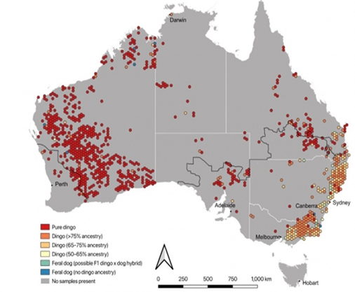
Points highlighted in this study include:
· The study implied that most hybridisation was taking place in NSW and Victoria due to long-term lethal control methods (aerial baiting) being used and higher human densities having higher domestic dog populations, potentially fracturing dingo social structures and creating more opportunity for contact between domestic dogs and dingoes.
· Dingo DNA may not be uniform across the country – broader sampling is required across Australia to capture regional genetic variation. It is possible that some dingoes are misclassified as hybrids because of regional variation.
· Only 31 of the 5039 dogs sampled had no evidence of dingo DNA and were classed as feral dogs, therefore implying that Australia does not have a feral dog problem and that dingo-dog interbreeding in the wild is not as common as previously thought.
· True feral dog populations are rare, globally, and tend to be sustained only where dogs have access to human resources (food, water).
· Canids with pure dingo DNA were found across Australia, therefore it could be assumed that the breed will survive as it has had over 230 years of hybridisation to this point.
· Management of feral, stray or roaming domestic dogs should focus on spaying, neutering, keeping pets and working animals under control and keeping animals confined during the night. Responsible pet ownership and continued exclusion of domestic dogs from protected areas can reduce the occurrence of future dingo – dog hybridisation events.
Local Studies:
· Below are the results of two local studies of wild dog DNA. The results are consistent with the observations in the Australia-wide study, being a high percentage of modern dog found in the hybrids caught in our region, where populations live in close proximity to humans.
· The first study was conducted by Byron Shire Council in 2012 (Table 1) and the most recent data is extracted from an unpublished paper from Local Land Services titled Using DNA for Managing Wild Dogs in the North Coast Local Land Services region, November 2022 (Table 2). The Regional (LLS North Coast Region) average percent of dingo DNA from 338 samples is 69.83%.
· Because of statistical uncertainty and geographic variation, a conservative error of approximately ±10% was estimated. Consequently, any sample with over 90% dingo ancestry were considered highly likely to be a pure dingo and any sample below 10% were most likely a pure modern dog
Table 1. Results of Dingo purity analysis, Byron Shire 2012
|
Sample |
% of Dingo DNA |
Comments |
|
80 |
Hybrid |
|
|
2 |
67 |
Hybrid |
|
3 |
51 |
Hybrid |
|
4 |
66 |
Hybrid |
|
5 |
58 |
Hybrid |
|
6 |
71 |
Hybrid |
|
7 |
62 |
Hybrid |
|
8 |
61 |
Hybrid |
|
9 |
52 |
Hybrid |
|
10 |
81 |
Hybrid |
|
11 |
75 |
Hybrid |
|
12 |
58 |
Hybrid |
|
13 |
56 |
Hybrid |
|
14 |
66 |
Hybrid |
|
15 |
54 |
Hybrid |
|
16 |
69 |
Hybrid |
|
17 |
74 |
Hybrid |
|
18 |
70 |
Hybrid |
|
19 |
70 |
Hybrid |
|
20 |
66 |
Hybrid |
|
21 |
69 |
Hybrid |
|
22 |
53 |
Hybrid |
|
23 |
71 |
Hybrid |
|
24 |
68 |
Hybrid |
|
25 |
55 |
Hybrid |
|
26 |
74 |
Hybrid |
|
27 |
56 |
Hybrid |
|
Average |
65% |
|
Table 1 illustrates result of Dingo purity analysis on 27 wild dogs trapped in Byron Shire in 2012. Average percentage of dingo DNA is 65%. (Helix Molecular Solutions P/L).
Table 2. Results of Dingo purity analysis, Byron Shire 2013-2022
|
Sample |
% of Dingo DNA |
Comments |
|
1 |
71 |
Hybrid |
|
2 |
69 |
Hybrid |
|
3 |
84 |
Hybrid |
|
4 |
66 |
Hybrid |
|
5 |
40 |
Hybrid |
|
6 |
65 |
Hybrid |
|
7 |
51 |
Hybrid |
|
8 |
84 |
Hybrid |
|
9 |
56 |
Hybrid |
|
10 |
66 |
Hybrid |
|
11 |
57 |
Hybrid |
|
12 |
61 |
Hybrid |
|
13 |
78 |
Hybrid |
|
Average |
65% |
|
Table 2 illustrates the result of dingo purity analysis on 13 wild dogs trapped, baited or road killed in Byron Shire between 2013 and 2022. Average percentage of dingo DNA is 65%. (Data extracted from Using DNA for Managing Wild Dogs in the North Coast Local Land Services region, November 2022)
What does Council do?
To fulfill its Biosecurity obligation (under the NSW Biosecurity Act 2015), Council engages a trapper to minimise the risk to the community, agriculture and the local wildlife as per the North Coast Local Land Services North Coast Regional Pest Management Plan (2017). Councils’ trapper monitors and traps wild dogs, cats and foxes on Council lands including the West Byron Wetlands, Byron Resource Recovery Centre and the STP on Valances Rd Mullumbimby. If resources allow and Councils needs have been met, the contracted trapper may trap on private lands to reduce impacts on wildlife or primary production.
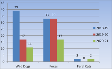
Fig 2. Shire wide trapping results 2018-2021
Pest animal trapping is carried out as an action under the Byron Shire Pest Animal Management Plan (2018-2023) which is guided by the North Coast Regional Pest Management Plan (2017).
Council has just entered into a contract for the next phase of trapping program commencing April-June 2023. If Council decides to curtail this program then we need to consider any obligations to pay out the contract, and how we meet our biosecurity obligations in the absence of hybrid dogs/dingoes being listed as protected. Council’s trapping program does not use 1080 poisoning or strychnine. We employ a trapper who uses soft jaw traps only and has very strict protocols regarding regularly checking his traps, so trapped animals are definitely not left for days before being found.
Byron Shire Council
Extract from Pest Animal Management Plan (2018-2023) – Executive Summary.
The Byron Shire Council Pest Animal Management Plan 2018-23 provides a framework for the management of pest animals on Council managed land but with opportunities for Council to assist with pest animal management on private land when funds allow.
The Plan enables Council to meet its statutory requirements under the NSW Biosecurity Act 2015 and Local Land Services Act 2013, whilst fostering a collaborative, cross-tenure approach to pest animal management.
Under the Biosecurity Act 2015 all land managers, regardless of whether on private or public lands have a shared responsibility to manage pests and their impacts.
To meet these legislative requirements, Council will focus efforts on Council owned and managed land. Council will support private land managers to fulfil their obligation to manage pest animals and encourage a collaborative approach by offering technical advice and support and acting as a conduit between relevant stakeholders. Where additional or new financial resources can be secured to allow Council to undertake off-tenure management, the Plan identifies priority target areas on private land where Council may undertake targeted pest animal management. Efforts will be prioritised based on opportunities to complement existing pest control programs, and in areas with high environmental, cultural, social and economic values.
The Plan provides desired outcomes, objectives, and actions to address and manage the impacts of pest animals. These actions are based on the principles of pest animal management being, prevention, eradication, containment, and asset protection. Objectives include increasing community understanding of the benefits of integrated pest animal management, encouraging community-led, coordinated, and integrated pest animal control activities, using safe, effective and humane approaches to pest animal management and promoting research and development.
Priority pest animals were selected based on regional strategies, local impacts, and community consultation, and include free-ranging dogs (wild dogs), European red fox, feral cats, European rabbit, Indian myna and cane toads. Aquatic and insect pest are not included in the Plan. The strategic actions and species-specific actions will guide targeted control of priority pest animals as well as emerging and alert species. The Plan also provides an implementation program that outlines measures of success, stakeholders, and responsibilities, and incorporates mechanisms for monitoring, evaluation and reporting of the Plan’s effectiveness.
The Plan draws on the experience and knowledge of multiple stakeholders including but not limited to private trappers, NSW State Government agencies and local community members who provided advice and input during the development phase. Our Plan has been developed to ensure that Council meets its statutory obligations, but also complement cooperative management of pest animals undertaken by public and private land managers across Byron Shire. Priorities for pest management within the Shire are identified, and strategies that address the environmental, social, economic and cultural impacts of pests are established.
Council’s Pest Animal Management Plan will be reviewed in 2023-2024. This will be an appropriate opportunity to strategically consider how Council manages wild dogs on its land. The review of the PAMP will need to include a review of new and emerging research relating to dingoes and wild dogs, consultation with our rural landholder community (in particular graziers and Landcare groups), traditional owners and Local Land Services.
It will be particularly important to consider how Council and other landholders can meet their biosecurity obligations in the absence of trapping. New research is emerging regarding alternative ways to protect stock from dog attack, including use of guardian animals. However, case studies are relatively few, particularly for this Northern Rivers region, and it will be important to seek advice from landholders with on-ground experience of managing this issue.
Council continues to promote responsible domestic pet ownership, e.g., through the Bow Wow Leash Me Now campaign and community engagement programs under development through the Northern Rivers Koala Network [any other PES programs??]. Review of the PAMP will also provide an opportunity to look into ways to promote responsible domestic pet ownership.
North Coast Local Land Services
Extract from the North Coast Regional Pest Animal Management Plan:
5.12 Wild Dog
Wild Dog distribution
Wild Dogs are present throughout the North Coast region, usually at medium densities. They are found in residential and peri-urban areas, on small, private blocks, on neighbouring agricultural lands (including leased and licensed land), in livestock production areas, crown lands, public estates, parks and reserves. Predation and hybridisation by Wild Dogs are recognised as a key threatening process in NSW (NSW Scientific Committee 2009).
Management goal
The goal of Wild Dog management at the regional scale is asset-based protection (manage pest animal populations). Australian dingoes are not an unequivocally defined species or sub-species, and so dingoes of any kind do not meet the criteria for listing as a threatened species (Allen et al. 2017). This means that they can be controlled where they are considered to be a pest.
Management strategies focus on asset protection. However as both wild dogs and the assets (e.g. people, livestock, domestic pets, native fauna) are widespread throughout the region and wild dogs have the ability to repopulate management areas in a short time period, there is a need for tenure-neutral, partnership based, landscape scale strategies that address both current and future impacts. (Tables 5.11a-5.11b).
Regional management focus
A North Coast Regional Wild Dog Management Plan (NCLLS 2015) has been prepared. It is consistent with the national and State plans, guides regional management, and is the main tool to implement Wild Dog management under this Regional Strategic Pest Animal Management Plan.
The balance between Wild Dog management and Dingo conservation is an important consideration in the region. The primary focus of Wild Dog management is reducing the negative impacts of wild dogs on commercial livestock (cattle and sheep) and hobby farms (cattle, sheep and other small ruminants) across the region. In doing so, finding a balance between managing wild dogs in areas where they have negative impacts and conserving dingoes is important.
The NSW Wild Dog Management Strategy 2017-2021 (DPI 2017) promotes a balance between managing wild dogs in areas where they have negative impacts and preserving the ecological role of dingoes. Strategy 1.2.2 Conservation of dingoes in the NSW Wild Dog Management Strategy requires that this plan and regional Wild Dog Management Plans focus control on areas where the risk of negative impacts are greatest, and not undertake control in parts of the landscape where the risk of negative impacts from wild dogs is low, which allows wild dogs to fulfil their natural ecological role.
Involvement of relevant local stakeholders in the development of cooperative and tenure neutral local Wild Dog management plans will be important to achieving balanced social, economic, and environmental outcomes.
The focus on this plan is:
· to develop local Wild Dog plans. (Byron Shire falls within one of 23 local areas, and a Wild Dog plan will be developed by LLS in future under the NSW Wild Dog Management Strategy).
· to raise land manager awareness of their obligations of undertaking Wild Dog control in key areas identified in local plans
· to promote effective cross tenure, cooperative asset protection strategies and landscape scale management programs that address impacts.
Reference List:
· Freney S. Sawyers, E., Kitchener, D., Fleming, P., (2022). Using DNA for Managing Wild Dogs in the North Coast Local Land Services region. (Unpublished).
· Cairns, K. M., Nesbitt, B. J., Laffan, S. W., Letnic, M., & Crowther, M. S. (2020). Geographic hot spots of dingo genetic ancestry in southeastern Australia despite hybridisation with domestic dogs. Conservation Genetics, 21(1), 77-90.
· Cairns, K. M., Crowther, M. S., Nesbitt, B., & Letnic, M. (2021). The myth of wild dogs in Australia: are there any out there?. Australian Mammalogy, 44(1), 67-75.
· Stephens, D., Wilton, A. N., Fleming, P. J., & Berry, O. (2015). Death by sex in an Australian icon: A continent‐wide survey reveals extensive hybridization between dingoes and domestic dogs. Molecular Ecology, 24(22), 5643-5656.
· Wilton, A. N. (2001, January). DNA methods of assessing dingo purity. In A Symposium on the Dingo (pp. 49-56). PO Box 20, Mosman NSW 2088, Australia: Royal Zoological Society of New South Wales.
· Hytten, K. (2009) Dingo dualisms: Exploring the ambiguous identity of Australian dingoes Australian Zoologist (2009) 35 (1): 18–27
Financial/Resource/Legal Implications:
Points 5, 6 and 7 in particular are not resourced. Should Council want these considered, a scope of works and budget bid for the next operational plan and budget FY 23/24 needs to be prepared and endorsed by Council.
Further and of note, Council’s Pest Animal Management Plan will be reviewed in 2023-2024. This will be an appropriate opportunity to strategically consider how Council manages wild dogs on its land and can take into account points 5,6 and 7.
Further and as stated above, Council has just entered into a contract for the next phase of trapping program commencing April-June 2023. If Council decides to curtail this program, then we need to consider any obligations to pay out the contract, and how we meet our biosecurity obligations in the absence of hybrid dogs/dingoes being listed as protected.
Is the proposal consistent with any Delivery Program tasks?
|
CSP Objective |
CSP Strategy |
DP Action |
Code |
OP Activity |
|
3: Nurtured Environment |
3.1: Partner to nurture and enhance our biodiversity, ecosystems, and ecology |
3.1.2: Pest and weed management - Use best practice land management to improve ecological resilience and reduce threats to biodiversity |
3.1.2.1 |
Implement Dog, fox and cat trapping program. |
BYRON SHIRE COUNCIL
Notices of Motion 10.3
Notice of Motion No. 10.3 Legrope enforcement on Byron Shire beaches
File No: I2023/552
I move that Council:
1. Notes that the Local Government Act 1993, S.633(4)(c) could empower a local council to require the use of leg ropes as 'water-based recreational equipment'.
2. Notes that Section 633(1) and S.633(4)(c) of the Local Government Act makes it an offence for a person in a place listed in the section to act contrary to a notice installed by Council.
3. Seeks to address issues of community safety in the surf by installing notices requiring relevant board riders to wear a leg rope in the surf and that the proposed notices would:
a) apply to a person in the sea adjacent to Council’s area (section 633(1));
b) be installed by Council on its own land, or seek the relevant land owner’s consent (e.g., on land owned by the National Parks and Wildlife Service regarding the Pass or Wategos beaches, Byron Bay) (in accordance with section 633(3)); and
c) relate to the use of surfboards in the surf (633(4)(c) and 633(5))
d) advise that breaches of the notice will attract a fine
4. Adds the non-wearing of leg ropes as a compliance priority area
5. Prepares a community education campaign around this issue and a broader ranging media campaign that could reach beyond Byron Shire to potential visitors.
Attachments:
1 NSW
Office Sport legropes, E2023/36848
![]()
Signed: Cr Cate Coorey
Councillor’s supporting information:
This issue has been brought to our attention yet again with the recent, serious accident at Broken Head involving an out-of-control surfboard, with no leg rope attached, striking another surfer.
Media interest always surrounds these events, and they could become preventable with some community education and enforcement. People are looking to Byron to take the lead on this issue as we have tried in the past to address it with minimal success.
I believe that, in concert with our expressed desire to see more and increased application of fines to dog owners who have their dogs in locations that they shouldn’t have, the regulation of leg-ropes could be undertaken when compliance officers are in the beach areas.
If we provide signage at key entry points to the beach, then there is justification to issue a fine. In the same way that issuing fines to dog owners is not without its challenges, it nevertheless should not preclude us from finding ways to create an enforcement notice and take enforcement action to show that we mean it. This is a long-held wish of residents, including the majority of the surfing fraternity, especially on our most crowded surf breaks.
As confirmed by Council’s Legal Services Officer, Ralph James, the Local Government Act gives Council powers to regulate some beach activities.
Section 633(1) makes it an offence for a person in a place listed in the section to act contrary to a notice installed by Council. While the section is primarily intended to deal with nude bathing, it extends to other beach activities:
633 Bathing (including nude bathing) and other water-based recreational activities
(1) A person who, in a place being—
(a) a public bathing place under the control of a council, or
(b) a river, watercourse or tidal or non-tidal water, or
(c) the sea adjacent to (although outside) an area, or
(d) a public place adjacent to any of those places, fails to comply with the terms of a notice erected by the council is guilty of an offence.
Maximum penalty—10 penalty units [$1,100].
Under section 633(1), the relevant ‘place’ in the context of the leg rope issue is ‘the sea adjacent to (although outside) an area’.
The ‘area’ for the purpose of the sub-section is the relevant Council area (see LG Act Chapter 9, Part 1). A Council area does not comprise the coastal waters beyond the low tide mark (LG Act section 205(1)).
Section 633(1) provides the offence. Section 633(3) then states where Council can install a notice:
(3) A council may erect a notice—
(a) on land vested in or under the control of a council, or
(b) on any other land, with the consent of the person who owns or controls the land.
Sections 633(4) limits the subject matter of a Council notice and 633(5) allows flexibility in the subject matter’s application:
(4) The terms of a notice referred to in this section may relate to one or more of the following—
(a) the conduct and costume of the bathers in the place,
(b) the use of the place (or any part of the place open to public view) for the purposes of nude bathing,
(c) the use of water-based recreational equipment in the place.
(5) The terms of a notice referred to in this section may—
(a) apply generally or be limited in their application by reference to specified exceptions or factors, or
(b) apply differently according to different factors of a specified kind,or may do any combination of those things.
In addition to section 633, LG Act section 670 imposes obligations on Council regarding notices installed under Chapter 16:
670 Notices and signs
(1) A person who fails to comply with the terms of a notice or sign referred to in this Chapter is not guilty of an offence unless the notice or sign—
(a) is clearly legible, and
(b) where it relates to—
(i) the whole of a parcel of public land, is exhibited at each entrance to the parcel of public land or in a conspicuous place in or in the vicinity of the parcel of public land, or
(ii) part only of a parcel of public land, is exhibited at each entrance to that part or in a conspicuous place in or in the vicinity of that part, or
(iii) a building, is exhibited (as may be appropriate) either inside or at or near the entrance to the building.
(2) The council has the onus of proving that the notice or sign complies with this section.
Regulation possible
Applying the above provisions to a proposed leg rope regulation, it’s possible that Council could install notices requiring relevant board riders to wear a leg rope in the surf. The proposed notice:
• Would apply to a person in the sea adjacent to Council’s area (section 633(1));
• Could be installed by Council on its own land, or would need the relevant land owner’s consent (e.g., on land owned by the National Parks and Wildlife Service regarding the Pass or Wategos beaches, Byron Bay) (section 633(3)); and
• Would relate to the use of surfboards in the surf (633(4)(c) and 633(5)).
• Would be valid provided it was ‘legible’ (whether such a notice also needs to be ‘conspicuous’ under section 670 is another matter. Given the notice would relate to the ocean, this area isn’t a ‘parcel of public land’ to which the ‘conspicuous’ requirement in section 670(1)(b) is tied).
Supporting note: Legrope War Lost At The Pass
https://www.swellnet.com/news/swellnet-dispatch/2023/04/06/legrope-war-lost-the-pass
Staff comments
by Ralph James Legal Counsel
While regulation is possible, it would be very difficult for Council to enforce. This is because of the elements of the offence and the evidence needed to establish them.
The offence of not complying with a proposed leg rope regulation is not just about engaging in certain conduct (not wearing a leg rope) but engaging in that conduct contrary to a notice.
For Council to establish the offence to the criminal standard (i.e., beyond a reasonable doubt) Council would need to show both that a surfer wasn’t wearing a leg rope in the water and that the accused reasonably passed near enough to a notice prior to entering the water that they could be said to have acted contrary to it.
It is not clear how Council enforcement officers could reasonably gather evidence of these elements to prove beyond a reasonable doubt that a person acted contrary to the relevant notice.
While section 633 makes no express reference to a person’s proximity to a notice, the section arguably implies a reasonable proximity between the two for someone to breach the section (for instance, if a surfer entered the beach at the Pass and surfed without a leg rope on, Council couldn’t reasonably rely on a notice installed at Captain Cook beach to prosecute them).
In cases Council has run before the Local Court regarding the existing Council notice regime under section 632 of the LG Act (which is similar to section 633), the Court has considered the distance between the relevant notice and the regulated conduct important when deciding whether an offence has been committed.
Unlike, for example, a road rule based on signage – like stopping contrary to a no stopping sign, where there is a generally a close physical proximity between the conduct (stopping) and the relevant sign, and where the subject vehicle is stationary – a Council notice prohibiting surfing without a leg rope would likely involve a large distance between the notice and the regulated conduct (with the regulating conduct being undertaken by a surfer constantly on the move in the line-up).
If the proposed notice is placed at a formed entrance to the beach – and many beach entrances currently display Council other notices installed under section 632 – there will be a potentially significant distance between the notice and the contrary conduct.
Alternatively, if Council placed the notices on the beach itself to have them closer to the water, the near limitless water entry points for surfers could make it even more difficult for Council to establish that the relevant person was located within reasonable proximity to a notice.
Wherever a notice was installed, Council enforcement officers would need to be in two places to have evidence of the breach (one place for the notice and one for the conduct), rather than just one.
Short of a Council enforcement officer spotting a constantly moving surfer in the water not wearing a leg rope, and also seeing where they entered the beach relative to a notice (or having a third party prepared to give evidence in court about these facts), a prosecution for a breach of LG Act section 633(1) is highly unlikely.
Beyond the evidentiary difficulties Council would face in proving an offence, the penalty notice amount for not complying with a sign installed under LG Act section 633 is only $75. This is the lowest penalty notice amount under the LG Act. This penalty – combined with the low risk of being caught – isn’t likely to deter surfers who don’t want to wear a leg rope.
The small penalty notice amount is also likely to mean that the cost to Council of installing notices and trying to enforce them would comfortably outweigh any revenue generated by the offence.
There are other reasons why notices regarding leg ropes wouldn’t deter people from not wearing them, but regarding Council’s ability to legally regulate this issue, there are strong reasons why the LG Act will not provide an adequate solution.
In summary, Council could potentially by notice require a surfer to wear a leg rope in the water. However, the difficulty of enforcing such a notice means it is unlikely to be effective.
I would anticipate a close to 0% successful prosecution rate on any fine that was court elected.
Jim Roberts – Coordinator Open Space
There are at least 26 designated beach access points in the Byron Shire. New signage would be required at each access point. Signage would require ongoing maintenance, graffiti removal and replacement annually. Estimate of costs as a minimum would be $20,800 installation costs and $2,080 per year ongoing costs.
Financial/Resource/Legal Implications:
The financial and legal implications are outlined in the body of this report.
Resourcing of relevant staff is already limited.
Is the proposal consistent with any Delivery Program tasks?
Yes
|
CSP Objective |
CSP Strategy |
DP Action |
Code |
OP Activity |
|
2:
Inclusive Community |
2.2: Enhance safety and contribute to the physical, mental, and spiritual health and well being of our people |
2.2.2: Public health - Protect, promote and control risks to public health |
2.2.2.4 |
Monitor, investigate and respond to public and environmental health matters through proactive inspections and surveillance programs |
BYRON SHIRE COUNCIL
Staff Reports - General Manager 13.1
Staff Reports - General Manager
Report No. 13.1 Licence to Mullumbimby Sustainability Education and Enterprise Development Incorporated
Directorate: General Manager
Report Author: Paula Telford, Leasing and Licensing Coordinator
File No: I2023/326
Summary:
Council is proposing to grant Mullumbimby Sustainability Education and Enterprise Development Incorporated a new five-year licence for occupation of part of Lot 22 DP 1073165, 156 Stuart Street Mullumbimby, for the purpose of an enterprise garden.
This report set out terms and conditions of the proposed licence.
RECOMMENDATION:
That Council delegates to the General Manager the authority to grant to Mullumbimby Sustainability Education and Enterprise Development Incorporated the following licence:
a) over the land only being part Folio 22/1073165,
b) term 5-years no holding over or renewal options,
c) base rent of $490 (excluding GST) per annum and increased by Consumer Price Index All Groups Sydney annually thereafter,
d) for the purpose of an enterprise garden within the meaning of Councils Community Garden Policy 2022,
e) the Licensee to pay all outgoings and hold all insurances required to operate an enterprise garden,
f) the Licensee to obtain planning approval for all structures on the land, and
g) the Licensor to pay all annual fixed rates and charges.
Report
The Mullumbimby Sustainability Education and Enterprise Development Incorporated (‘Mullum S.E.E.D’) holds a temporary licence, on a month-by-month tenure, over part Folio 22/1073165 known as the Mullumbimby Community Garden.
Council resolved (19-287) to offer a short-term licence to Mullum S.E.E.D to allow Council to undertake a review of its Community Garden Policy. Evolving uses of the land by Mullum S.E.E.D, necessitated a Policy review to widen the definition of a community garden.
Council resolved (22-137) to adopt the Community Garden Policy 2022 to include a wider definition of a community garden to incorporate an ‘Enterprise Garden’.
An Enterprise Garden allows for a traditional community garden on the land and other activities associated with a Men’s Shed, permaculture, a rainforest seedling nursery and other environmental enterprises uses under auspices of Mullum S.E.E.D. An Enterprise Garden only applies to part Folio 22/1073165.
In response to Mullum S.E.E.D’s wider use of the land as an Enterprise Garden, Mullum S.E.E.D has renamed the Mullumbimby Community Garden to the Mullum S.E.E.D Eco Hub.
The land
Folio 22/1073165 is Council owned land classified as community land and categorised for general community use.
The Plan of Management over the land expressly authorises the grant of maximum 5-year licence over part of the land for a community garden.
Proposed licence
Council is proposing to grant the following licence to Mullum S.E.E.D:
· over the land only being part Folio 22/1073165,
· term 5-years no holding over or renewal options,
· base rent of $490 (excluding GST) per annum and increased by Consumer Price Index All Groups Sydney annually thereafter,
· for the purpose of an enterprise garden within the meaning of Councils Community Garden Policy 2022,
· the Licensee to pay all outgoings and hold all insurances required to operate an enterprise garden,
· the Licensee to obtain planning approval for all structures on the land, and
· the Licensor to pay all annual fixed rates and charges.
Public consultation
Council publicly advertised the proposed licence in the Byron Shire Echo Newspaper on 22 February 2023 and on Council’s website between 22 February 2023 and 22 March 2023.
Council received no submissions concerning the proposed licence.
Council received a submission from Mullum S.E.E.D relating to an error in the wording of the public notice whereby Council stated that Mullum S.E.E.D would be managing the Mullumbimby Community Gardens.
Mullumbimby Community Gardens Inc is a separate incorporated body that manages and maintains the grounds of an area agreed upon with Mullum S.E.E.D in an auspiced agreement.
In response to the submission Council amended wording of the public notice to clearly show the distinction between the Mullum S.E.E.D Eco Hub and the Mullumbimby Community Gardens Incorporated.
This report recommends a new 5-year licence is granted to Mullum S.E.E.D over part Folio 22/1073165.
Strategic Considerations
Community Strategic Plan and Operational Plan
|
CSP Objective |
CSP Strategy |
DP Action |
Code |
OP Activity |
|
3:
Nurtured Environment |
3.2: Deliver initiatives and education programs to encourage protection of our environment |
3.2.2: Environmental education and awareness - Coordinate and support environmental education to the community |
3.2.2.5 |
Continue to support existing community gardens |
Recent Resolutions
· 19-287, 22-137.
Legal/Statutory/Policy Considerations
s47 Leases, licences and other estates in respect of community land—terms greater than 5 years
(1) If a council proposes to grant a lease, licence or other estate in respect of community land for a period (including any period for which the lease, licence or other estate could be renewed by the exercise of an option) exceeding 5 years, it must:
(a) give public notice of the proposal (including on the council’s website), and
(b) exhibit notice of the proposal on the land to which the proposal relates, and
(c) give notice of the proposal to such persons as appear to it to own or occupy the land adjoining the community land, and
(d) give notice of the proposal to any other person, appearing to the council to be the owner or occupier of land in the vicinity of the community land, if in the opinion of the council the land the subject of the proposal is likely to form the primary focus of the person’s enjoyment of community land.
(2) A notice of the proposal must include:
• information sufficient to identify the community land concerned
• the purpose for which the land will be used under the proposed lease, licence or other estate
• the term of the proposed lease, licence or other estate (including particulars of any options for renewal)
• the name of the person to whom it is proposed to grant the lease, licence or other estate (if known)
• a statement that submissions in writing may be made to the council concerning the proposal within a period, not less than 28 days, specified in the notice.
(3) Any person may make a submission in writing to the council during the period specified for the purpose in the notice.
(4) Before granting the lease, licence or other estate, the council must consider all submissions duly made to it.
s47A Leases, licences and other estates in respect of community land—terms of 5 years or less
(1) This section applies to a lease, licence or other estate in respect of community land granted for a period that (including any period for which the lease, licence or other estate could be renewed by the exercise of an option) does not exceed 5 years, other than a lease, licence or other estate exempted by the regulations.
(2) If a council proposes to grant a lease, licence or other estate to which this section applies:
(a) the proposal must be notified and exhibited in the manner prescribed by section 47, and
(b) the provisions of section 47 (3) and (4) apply to the proposal, and
(c) on receipt by the council of a written request from the Minister, the proposal is to be referred to the Minister, who is to determine whether or not the provisions of section 47 (5)–(9) are to apply to the proposal.
(3) If the Minister, under subsection (2) (c), determines that the provisions of section 47 (5)–(9) are to apply to the proposal:
(a) the council, the Minister and the Director of Planning are to deal with the proposal in accordance with the provisions of section 47 (1)–(8), and
(b) section 47 (9) has effect with respect to the Minister’s consent.
Policy Community Gardens 2022
Financial Considerations
Mullum S.E.E.D to pay annual base rent of $490 (exclusive of GST) per annum. Annual rent to be increased annually thereafter by Consumer Price Index All Groups Sydney for the current quarter.
Mullum S.E.E.D must pay all outgoings and produce required insurances required to operate an Enterprise Garden on the land. As the licence is over the land only, Mullum S.E.E.D is wholly responsible, at its cost, for all improvements built on the land.
Council to subsidise annual fixed rates and charges payable on the land.
Consultation and Engagement
Council publicly advertised the proposed licence in the Byron Shire Echo Newspaper on 22 February 2023 and on Council’s website between 22 February 2023 and 22 March 2023.
BYRON SHIRE COUNCIL
Staff Reports - Corporate and Community Services 13.2
Staff Reports - Corporate and Community Services
Report No. 13.2 Grants March 2023
Directorate: Corporate and Community Services
Report Author: Donna Johnston, Grants Coordinator
File No: I2023/488
Summary:
Council has submitted applications for sixteen Grant programs which, if successful, would provide funding to enable the delivery of identified projects. This report provides an update on grant applications.
RECOMMENDATION:
That Council notes the Report and Attachment 1 (#E2023/36688) for Byron Shire Council’s Grant submissions as at 31 March 2023.
1 Grant
submissions as at 31 March 2023, E2023/36688
![]()
Report
Currently Council has sixteen Grant submissions awaiting determination (refer to Grants Submissions as at 31 March 2023 (Attachment 1 E2023/36688).
Successful applications
Council has been advised that it has been awarded the following projects:
NSW Office of Sport – Essential Sports Priority Program
· Bangalow Sports Fields Lighting – grant funding $795,350. Council contribution - $0
Transport for NSW - Fixing Local Roads Round 4
· Left Bank Road rehabilitation - grant funding $1,588,151. Council contribution - $0
Unsuccessful / withdrawn applications
Notification has been received on the following unsuccessful applications:
Transport for NSW - Fixing Local roads Round 4
· Suffolk Park reseal program - Grant funding $958,076
· Bangalow reseal program - Grant funding $971,371
Grant funding awarded to Left Bank Road.
Australian Government - Disaster Ready Fund - EOI via NSW Government
• Sandhills Wetlands. Grant funding $3,181,974. Total project $7.1 million
No feedback provided within notification. Feedback session has been scheduled during April.
Applications submitted
The following applications were submitted during March 2023.
|
Funding Body |
Funding scheme |
Project name |
Total project |
Amount requested |
Council |
|
NSW EPA |
Local Government Waste Solutions Fund Round 1 |
Wash On Wheels - mobile wash events trailer |
$256,260 |
$192,000 |
$64,260 (in-kind) |
|
Department of Regional NSW |
Community Assets Program |
Council Chambers betterment program |
$802,226 |
$469,871 |
$0 |
|
Department of Regional NSW |
Community Assets Program |
Mullumbimby Pool - new filters |
$187,386 |
$187,386 |
$0 |
|
Department of Regional NSW |
Community Assets Program |
Cavanbah Centre - south car park asphalt rehabilitation |
$437,341 |
$437,341 |
$0 |
|
Department of Regional NSW |
Community Assets Program |
Mullumbimby Heritage Park - concrete path |
$500,000 |
$500,000 |
$0 |
|
Department of Regional NSW |
Community Assets Program |
Mullumbimby Recreation Grounds - car park asphalt rehabilitation |
$903,594 |
$903,594 |
$0 |
|
Australian Government - Department of Industry, Science and Resources |
Reducing Light Pollution in Coastal Communities |
Coastal Light Management Plan |
$49,500 |
$49,500 |
$0 |
|
Department of Planning and Environment |
2022-23 NSW Flood Recovery and Resilience Grant Program |
Broken Head Road crossing - design |
$100,000 |
$100,000 |
0 |
|
Department of Planning and Environment |
2022-23 NSW Flood Recovery and Resilience Grant Program |
Coogera Circuit Detention Upgrade - design |
$100,000 |
$100,000 |
0 |
Upcoming Grant opportunities
Litter Prevention Grants Program: grants available (nsw.gov.au) – closes 17 April 2023.
The NSW Government has opened the Waste and Sustainable Materials Strategy 2041 Litter Prevention Grants Program with up to $10 million available.
Funding is provided under three streams:
• Stream 1: Small-scale, on-ground projects (3 to12 months)
• Stream 2: Strategic development and capacity building (3 to 12 months)
• Stream 3: Own It and Act strategic implementation (maximum 3 years)
All initiatives must contribute to reducing litter in NSW and engage the community in delivering local, regional or statewide litter prevention outcomes.
Application is being prepared for Stream 2:
· Litter Prevention Plan and Roadmap – Grant funding $83,000
Byron Shire Council has achieved its targets and undertaken the various actions outlined in the organisations previous Litter and Illegal Dumping Education and Enforcement Plan. In order to continue to prevent litter in the Shire and reduce the environmental, social and economic impacts, an updated long-term strategic plan is required. This strategic plan will guide the direction for the organisation in litter and illegal dumping prevention over the next five years (2024-2029)
Floodplain management grants | NSW Environment and Heritage – closes 17 April 2023
The Floodplain Management Program provides financial support to local Councils and eligible public land managers to help them manage flood risk in their communities. The program supports the implementation of the NSW Government's Flood Prone Land Policy, which is outlined in the Floodplain Development Manual.
Council is not eligible to apply for Voluntary House Raising or Purchasing. This program is now being rolled out under the Resilient Homes Program | NSW Government program.
Application is being prepared for:
· Saltwater Creek - upgrade assessment and mitigation options for Mullumbimby. Design only.
This project is the next prioritised project from the Flood Mitigation Works Program.
Strategic Considerations
Community Strategic Plan and Operational Plan
|
CSP Objective |
CSP Strategy |
DP Action |
Code |
OP Activity |
|
1: Effective Leadership |
1.3: Ethical and efficient management of resources |
1.3.1: Financial Management - Ensure the financial integrity and sustainability of Council through effective financial management |
1.3.1.9 |
Coordinate grant applications to support the delivery of Council projects and services within management plans, masterplans, strategic plans, Council resolutions and high priority actions from feasibility studies; and support the management of successful grants |
Legal/Statutory/Policy Considerations
Under section 409 3(c) of the Local Government Act 1993 Council is required to ensure that ‘money that has been received from the Government or from a public authority by way of a specific purpose advance or Grant, may not, except with the consent of the Government or public authority, be used otherwise than for that specific purpose’. This legislative requirement governs Council’s administration of Grants.
Financial Considerations
If Council is successful in obtaining the identified Grants, this would bring funding sought to approximately $21 million which would provide significant funding for Council projects. Some of the Grants require a contribution from Council (either cash or in-kind) and others do not. Council’s contribution is funded.
The potential funding is detailed below:
Funding applications submitted and
awaiting notification (total value) $25,979,258
Requested funds from funding bodies $22,567,643
Council contribution cash $15,000
Council co-contribution in-kind $139,246
Other contributions $3,257,369
Funding determined in March 2023
Successful
applications
$2,383,501 (total project value)
Unsuccessful/withdrawn
applications
$9,050,943 (total project value)
Consultation and Engagement
Cross-organisational consultation has occurred in relation to the submission of relevant Grants, and the communication of proposed grant applications.
BYRON SHIRE COUNCIL
Staff Reports - Corporate and Community Services 13.3
Report No. 13.3 Public Exhibition of draft 2023/24 Operational Plan, Budget, and Revenue Policy
Directorate: Corporate and Community Services
Report Author: Heather Sills, Manager Corporate Services
James Brickley, Manager Finance
File No: I2023/555
Summary:
The Community Strategic Plan, the Delivery Program and the Operational Plan form part of the Integrated Planning and Reporting Framework which is a requirement under the Local Government Act 1993 (Sections 402 to 406).
Council’s Operational Plan articulates the key activities to be delivered in a financial year based on the community objectives in the Byron Shire Community Strategic Plan 2023 and the priorities in the 4-year Delivery Program. 2023/24 will be the second year of the Delivery Program 2022-26.
Council’s Statement of Revenue Policy includes Budget Estimates, Rates and Charges, Borrowings, and Fees and Charges.
This report recommends placing the Draft 2023/24 Operational Plan and Statement of Revenue Policy, subject to any amendments, on public exhibition for 28 days.
RECOMMENDATION:
That the Draft Operational Plan 2023/24 (Attachment 1 #E2023/32929) and associated Draft 2023/24 Budget Estimates (Attachment 2 #E2023/37453), Draft 2023/24 Statement of Revenue Policy including Fees and Charges (Attachment 3 #E2023/37451) be placed on public exhibition for a period of 28 days.
1 DRAFT
Operational Plan 2023/24, E2023/32929
![]()
2 DRAFT
Detailed Budget Estimates for Public Exhibition, E2023/37453 ![]()
3 DRAFT
2023/2024 Statement of Revenue Policy including Fees and Charges for Public
Exhibition, E2023/37451 ![]()
4 DRAFT
2023/24 Fees and Charges increasing greater than CPI and proposed new fees, E2023/37532 ![]()
Report
All Councils in NSW use the IP&R framework to guide their planning and reporting activities. The Community Strategic Plan, the Delivery Program and the Operational Plan form part of the Integrated Planning and Reporting Framework which is a requirement under the Local Government Act 1993.
Overview of Integrated Planning and Reporting
The Integrated Planning and Reporting (IPR) Framework includes:
· 10 year Community Strategic Plan reflecting the aspirations, needs, and priorities of the local community
· The Resourcing Strategy, addressing sustainable long term financial, asset management and workforce planning;
· A four year Delivery Program outlining Council's activities planned for Council term
· Annual Operational Plan consisting of actions identified to be undertaken each year to meet the Delivery Program commitments; together with the related budget, statement of revenue policy, and fees and charges.
The diagram below is extracted from the IPR Guidelines and highlights the relationship and hierarchy of the strategies and plans.
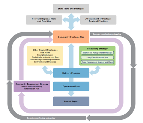
Draft 2023/24 Operational Plan
The Delivery Program is supported by an annual operational plan which details the individual projects and activities that will be undertaken each year to achieve the commitments of the delivery program. The Operational Plan must include the Council’s annual budget, along with Council’s Statement of Revenue Policy, which sets the proposed rates, fees and charges for that financial year.
The draft Operational Plan 2023/24 is grouped under the five Community Strategic Plan community objectives, which are:
· Effective Leadership – we have effective decision making and community leadership that is open and informed
· Inclusive Community – we have an inclusive and active community where diversity is embraced and everyone is valued
· Nurtured Environment – we nurture and enhance the natural environment
· Ethical Growth – we manage growth and change responsibly
· Connected Infrastructure – we have connected infrastructure, transport, and facilities that are safe, accessible, and reliable
Within each theme the Operational Plan is structured according to the Delivery Plan priorities. Each Operational Plan activity has is coded, and details included about the activity, competition statement, due date, and responsible unit. Links to relevant Council Resolutions, the Disability Inclusion Action Plan, and Recovery Action Plan are also referenced.
The draft Operational Plan 2023/24 is included at Attachment 1.
Draft 2023/24 Budget Estimates (Statement of Revenue Policy)
The Draft 2023/24 Budget Estimates are based on the 31 December 2022 Quarterly Budget Review with various changes to reflect updated costs of service delivery developed from the input received from each Council Directorate. Results from the 31 March Quarterly Budget Review are yet to be finalised and considered by Council which will happen during May 2023 and any outcome from that review is yet to be incorporated into the Draft 2023/24 Budget Estimates.
The Draft 2023/24 Budget Result on a Consolidated (All Funds) basis forecasts a balanced budget result as outlined below at Table 1.
Table 1 – Forecast Budget Result 2023/24 Consolidated (All Funds)
|
Item |
Amount $ |
|
Operating Result |
|
|
Operating Revenue |
115,290,100 |
|
Less: Operating Expenditure |
96,953,100 |
|
Less: Depreciation |
20,523,000 |
|
Operating Result – Surplus/(Deficit) |
(2,185,900) |
|
|
|
|
Funding Result |
|
|
Operating Result – Surplus/(Deficit) |
(2,185,900) |
|
Add: Non cash expenses – Depreciation |
20,523,000 |
|
Add: Capital Grants and Contributions |
147,024,800 |
|
Add: Loan Funds Used |
4,630,000 |
|
Add: Asset Sales |
0 |
|
Less: Capital Works |
170,061,700 |
|
Less: Loan Principal Repayments |
4,098,400 |
|
Funding Result – Surplus/(Deficit) (Cash Movement) |
(4,168,200) |
|
Reserves Movement – Increase/(Decrease) |
(4,168,200) |
|
Overall Budget Result – Surplus/(Deficit) (Operating + Funding) |
(0) |
The detailed Draft 2023/24 Budget Estimates are included at Attachment 2. Table 1 indicates a forecasted balanced budget result, and this relates to the General Fund. The forecast General Fund Unrestricted Cash Balance position based on the draft budget included at Table 1 is outlined in Table 2 below:
Table 2 – Forecast General Fund Unrestricted Cash Balance
|
Item |
$ |
|
Forecast unrestricted cash balance to 30 June 2022 at 31 December 2022 Quarterly Budget Review |
(205,000) |
|
Add: Estimated Draft 2023/24 Budget result |
0 |
|
Forecast unrestricted cash balance at 30 June 2024 |
(205,000) |
In addition to Table 1 above, budgeted financial statements incorporating an Operating Statement and Cash Flow Statement have been produced. These financial statements, replicating the format of Council’s Annual Financial Statements, are included in Attachment 2 as part of the Operational Plan, along with a one-page summary of all Council budget program outcomes. Reserve balances are outlined in the detailed budget estimates provided at Attachment 2.
Council’s financial position
In producing the proposed draft budget outcome for 2023/2024 Council has had to take dividends from some of its reserves and other funds again which is not sustainable.
The difficulty of balancing the proposed 2023/2024 budget position has been compounded by the following factors also on a consolidated all funds basis:
· Superannuation guarantee increasing from 10.5% to 11.0%
· Pay Award increase of 4% budgeted (yet to be confirmed pending finalisation of the new Local Government State Award)
· Insurance premiums of up to 14% estimated increase
· Increased contribution to Richmond Tweed Regional Library
· Proposed increased payments to Rous County Council for bulk water purchases 11.70%
It is vital for Council to consider the financial impacts of future decisions, given its current financial position. Whilst the 2023/24 draft budget is the largest budget in the history of the Council, it is principally due to the level of proposed infrastructure restoration works from the February/March 2022 Flood events that will be grant funded – approximately $143.1million. This is outlined in a new budget program titled ‘Infrastructure Recovery’.
It is becoming increasingly difficult for Council to fund its operations with the current revenue base for the following reasons:
· It is no longer able to provide any general revenue funding towards capital works.
· Traditional levels of maintenance funding in the General Fund cannot be sustained.
· Council not able to increase its expenditure budgets to keep pace with inflation. Indexation has generally been reduced to 2% compared to inflation currently at 6.8%.
· Council’s revenue base is also subject to variability in that revenue levels derived are dependent upon demand and use of the services but the cost of those services are often fixed.
· The growing reliance on grant funding as a means to fund works or projects is a risk given that the significant levels of grant funding received or to be received in recent times cannot be assumed will be continued.
· The inability to incorporate any new budget bids or requests.
· No capacity to increase any service level without corresponding additional revenue to fund or reduction in a service level elsewhere amongst Council services to compensate.
It is expected Council will be provided with an updated Long Term Financial Plan (LTFP) in the lead up to the final adoption of the 2023/24 Delivery Plan, Operational Plan and Revenue Policy. The LTFP will be essential in supporting Council’s financial projections whilst balancing community demands and expectations.
Table 2 also suggests that Council has depleted its unrestricted cash balance. Council’s goal is to maintain this balance at $1million so, over time, will need to recover this balance to provide Council with a buffer against of any unforeseen expense. It is hoped the current projected unrestricted cash balance deficit of $205,000 can be addressed upon finalisation of the 31 March 2023 Quarterly Budget Review potentially back to a $0 result.
Given the magnitude of the proposed infrastructure recovery works, Council must also pay serious attention to its cash flow position. Current experience with the flood recovery suggests there can be significant lag time between when Council undertakes works and is reimbursed by government through natural disaster funding. Given the scale of proposed works, there is the potential to significantly impact the Council’s ability to pay its way whilst awaiting funding payments. This may also impact Council’s ability to do other things aside from flood recovery.
In terms of the draft 2023/24 budget position outlined in this report, further review will be undertaken during the public exhibition period to consider any new information and or outcomes from the 31 March 2023 Quarterly Budget Review with any adjustments reported to the proposed 22 June 2023 Council Meeting.
To arrive at the Draft Budget Results outlined in Table 1 for the 2023/24 financial year, Council’s revenue and operational expenses are expected to be derived from the following sources and allocated respectively as outlined in the graphs below:
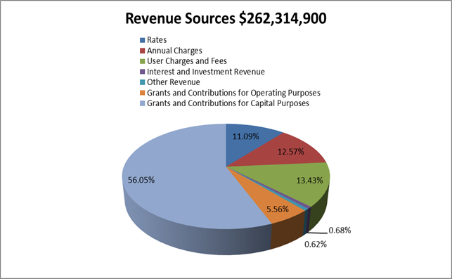
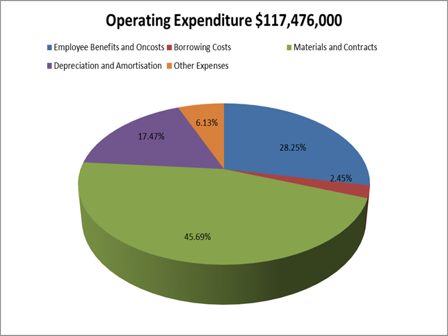
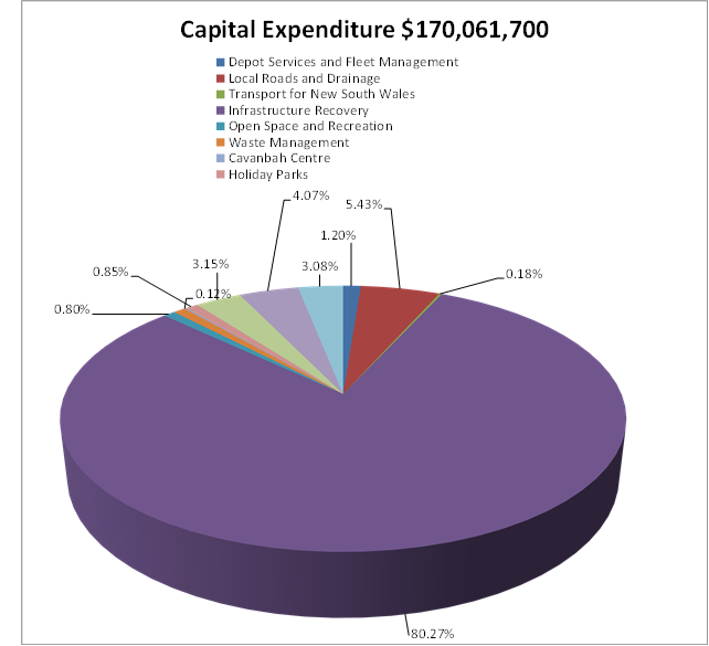
In addition to the operational aspects of the proposed Draft 2023/24 Budget Estimates, Council is proposing a capital works program of $170.062million. By Fund, the projected capital works are:
· General Fund $157.911million
· Water Fund $6.915million
· Sewerage Fund $5.236million
Specific capital works projects have been detailed in Attachment 2. As in previous years, the General Fund is presented in a different format, to improve the disclosure of funding sources for specific projects including:
· Developer contribution funding to describe the specific part of the Developer contribution plan and catchment that is providing the funding for a project.
· Where reserve funds are funding a project, identification of the reserve being utilised.
· Separation of funding provided by the 2017/18 Special Rate Variation (SRV) for which Council has reporting obligations for 10 years from 2017/18.
Of the $170.061million for capital works related to the General Fund, the following major components are proposed:
· Local Roads and Drainage $9.236million
· Infrastructure Recovery $136.512million – new budget program for infrastructure restoration associated with February/March 2022 flood events
· Open Space and Recreation $1.359million
· Waste Management $1.430million
· Holiday Parks $1.446million
· Facilities Management $5.361million including $4.737million for the redevelopment of the former Byron Hospital (Byron Community Hub).
The Draft 2023/24 Budget Estimates also propose new loan borrowings of $4.630million to fund the following projects:
· Byron Community Hub (former Byron Bay Hospital redevelopment) $3.500million
· Suffolk Beachfront Holiday Park Compliance Program $170,000
· Suffolk Beachfront Holiday Caravan Park Replacement $960,000
The amount of actual loan funds Council will need to borrow may be reduced pending how the above projects proceed: Council decision to proceed formally, and capital expenditure reviews submitted to the Office of Local Government where required.
Draft General Land Rates and Charges (Statement of Revenue Policy)
The Draft 2023/24 Revenue Policy includes the proposed general land rating structure, consistent with the structure revised by Council for the 2017/18 financial year. This is outlined in Attachment 3. Whilst the general land rating structure is the same in terms of yield split, categorisation and retaining the use of a minimum rate subject to an ad valorem rate, Council has needed to incorporate new land values with a 2022 base date for the purposes of general land rating for 2023/24 provided by the NSW Valuer General.
Whilst the new land values were subject to a Councillor Workshop on 2 March 2023 where their impacts throughout the Shire were presented, the overall 95.8% increase does not yield Council any additional general land rate income due to rate pegging and the ceiling applied to general land rate income. The consequence of the new land values will result in a decrease of the ad valorem rate to compensate. Some ratepayers, however, will see substantial increases in the general land rate due to the value of their land relative to other ratepayers in their respective rating category. Some ratepayers will also see decreases in their general land rates.
The rating structure also incorporates the approved rate peg of 4.60% determined by the Independent Pricing and Regulatory Tribunal (IPART) representing the standard rate peg of 3.70% plus a population increase factor of 0.90%.
The proposed general land rating structure included in the Draft 2023/24 Statement of Revenue Policy provided at Attachment 3 is proposed as follows:
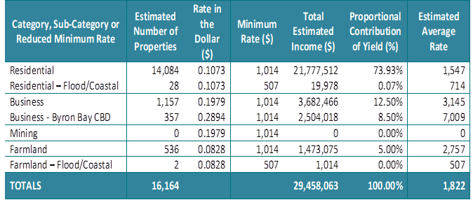
Following the presentation to the 2 March 2023 Councillor Workshop, Councillors sought further modelling on two scenarios being:
· Scenario 1 – retain the 2022/23 minimum rate of $969 and not increase this by the 4.6% rate peg to $1,014 as proposed.
· Scenario 2 – retain the 2022/23 minimum rate but further reduce it by 2% or $19 to $950.
Scenario 2 was not modelled as the differences throughout the rating structure from Scenario 1 would be so small.
Scenario 1 was modelled, and this created the following outcomes as discussed at the Councillor Workshop on 6 April 2023:
· Reducing the minimum rate from $1,014 to $969 reduces the number of properties subject to the minimum rate by 726 assessments being 706 residential, 19 business and 1 farmland.
· Land value where the ad valorem rate applies for residential category reduces from $945,014 to $885,740.
· Given the high proportion of strata titled properties, 33.9%, the reduction in the minimum rate for Scenario 1 only seems to have impact in the urban areas of the Shire but not the rural areas.
· The reduction of the minimum rate from $1,014 to $969 requires the redistribution of $318,225 in general land rate income through needing to change the ad valorem rate. There would be 7,325 out of 16,164 assessments paying the minimum rate and of the 7,325 paying the minimum 2,486 of these are strata titled assessments.
· The maximum benefit any property subject to a minimum rate would receive is $45 i.e. the difference between the proposed minimum of $1,014 and the minimum of Scenario 1 $969.
· The maximum additional rates any one property would pay through the redistribution is an additional $567 in the residential category with this assessment having a land value of $27million.
Should Council wish to adopt the general land rating structure outlined in Scenario 1, it would need to alter the proposed Draft 2023/24 Statement of Revenue Policy provided at Attachment 3 through resolution prior to public exhibition to incorporate the following values for minimum rates and ad valorem rates designated with the heading Scenario 1 with the proposed in the Draft 2023/24 Statement of Revenue Policy provided as comparison:
|
Category, Sub-Category or Reduced Minimum Rate |
Estimated Number of Properties |
Ad valorem Rate in the Dollar ($) Scenario 1 |
Minimum Rate ($) Scenario 1 |
Ad valorem Rate in the Dollar ($) Proposed |
Minimum Rate ($) Scenario Proposed |
|
Residential |
14,084 |
0.1094 |
969 |
0.1073 |
1,014 |
|
Residential – Flood/Coastal |
28 |
0.1094 |
485 |
0.1073 |
507 |
|
Business |
1,157 |
0.1992 |
969 |
0.1979 |
1,014 |
|
Business - Byron Bay CBD |
357 |
0.2898 |
969 |
0.2894 |
1,014 |
|
Mining |
0 |
0.1992 |
969 |
0.1979 |
1,014 |
|
Farmland |
536 |
0.0828 |
969 |
0.0828 |
1,014 |
|
Farmland – Flood/Coastal |
2 |
0.0828 |
485 |
0.0828 |
507 |
|
TOTALS |
16,164 |
|
|
|
|
The following graph tries to illustrate the comparison of the two general land rating scenarios to identfy possible general land rates payable depending upon rating category and land value, however as the overall redistribution is small compared to the quantum of general land rates able to be levied, it does not illustrate any signficiant difference between the two scearios but does outline indicative general land rates payable for each category and each scenario depending upon land value:
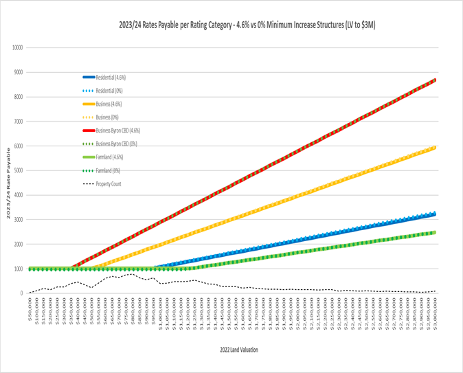
Irrespective of which general land rating structure Council selects, it will need to derive $29.455million in allowable general land rating income inclusive of the 4.6% rate peg.
In respect of other charges, the Draft 2023/24 Statement of Revenue Policy includes:
· Waste Charges – increase of 10.00% for residential and 15.00% for commercial as. Council is facing increased costs for waste transportation and disposal including waste levy charges.
· Water access charges increasing by 7.00% and usage charges increasing by 11.00% due to Rous County Council bulk water charge increase of 11.70%.
· Sewerage charge - increased by 7.00%.
· The stormwater charge has not increased. It is a regulated charge that has not changed over the last seventeen years.
For the average residential ratepayer, the increases proposed for 2023/24 to general land rates and charges if a fully serviced property will increase from $4,237 in 2022/23 to $4,541 in 2023/24, an overall increase of $304.00 or 7.17%.
Draft Fees and Charges (Statement of Revenue Policy)
The Draft 2023/24 Fees and Charges have been reviewed by the respective program managers and included at Attachment 3 as part of the Draft 2023/24 Statement of Revenue Policy. Where possible, fees have been altered/increased to reflect the following:
· Increases in the Consumer Price Index (CPI)/Indexation – 7.3% at the time of preparation.
· Review of fees and charges including benchmarking/cost of service provision and where possible, introduction of new fees to assist Council to generate additional/ enhanced revenue.
· Regulated fees updated to reflect latest changes in legislative regulations.
The 2023/24 Draft Fees and Charges have seen a review of a number of Council’s Hall/Community Centre which has resulted in the creation of some new fees. It is understood this outcome has been undertaken in consultation with the respective Committees.
Council will also be considering a report at this Ordinary Meeting of Council concerning the fees to apply for the use of car parking spaces for construction following public exhibition of the proposed fees to which sixteen submissions have been received. The respective fees and charges for this purpose contained in Attachment 4 have been indexed based off the current 2022/2023 fee and charge structure. Depending on Council’s resolution on this matter, the outcome will also need to be updated in the Draft 2023/24 fees and charges prior to public exhibition.
Provided at Attachment 4 for the information of Councillors is a report that identifies changes to proposed fees and charges that are greater than the general indexation of 7.3%. Some of these are due to the nature of the fee and rounding with those highlighted in yellow in Attachment 4 indicative of a new fee to be implemented.
At the time of preparing the Draft 2023/24 Statement of Revenue Policy, the statutory fees for a Section 603 certificate and the proposed interest rate to be charged on outstanding general land rates and charges has not been advised by the Office of Local Government. These two items will be reported to Council at the 22 June 2023 Ordinary Meeting for adoption based on the determination advised by the Office of Local Government which should be advised to Council by then.
Strategic Considerations
Community Strategic Plan and Operational Plan
|
CSP Objective |
CSP Strategy |
DP Action |
Code |
OP Activity |
|
1: Effective Leadership |
1.1: Enhance trust and accountability through open and transparent leadership |
1.1.1: Leadership - Enhance leadership effectiveness, capacity, and ethical behaviour |
1.1.1.3 |
Develop 2023/24 Operational Plan |
Recent Resolutions
· 22-335 – adoption of the Byron Shire Community Strategic Plan 2023
· 22-332 – adoption of the Delivery Program 2022-26
Legal/Statutory/Policy Considerations
The requirements for Integrated Planning and Reporting are governed by Sections 402-406 of the Local Government Act 1993.
Section 404 requires that a council must have a 4-year delivery program detailing the principal activities to be undertaken within available resources.
Section 405 outlines the Operational Plan requirements including public exhibition and timeframes.
The specific statements required by Council to be disclosed as part of its Revenue Policy are determined by Clause 201 of the Local Government (General) Regulation 2005.
Detailed requirements are outlined in the Integrated Planning and Reporting Guidelines and Handbook.
Financial Considerations
As outlined in the report.
Consultation and Engagement
In accordance with the Local Government Act, the draft Operational Plan (including the annual budget, revenue policy, and fees and charges) must be exhibited for 28 days. Prior to the adoption the Operational Plan, Council must consider any submissions received during the exhibition period.
Feedback will be sought primarily through Your Say Byron Shire. Public notices and media releases will also be distributed.
Two Community Conversations are scheduled to be held, the first on 2 May (in person) and 10 May (online) as part of the exhibition period. These sessions will provide members of the community an opportunity to discuss how the budget and operational plan have been developed, and projects planned for the 2023/24 financial year. Any input provided by the community as an outcome of the community conversations will be included as a submission to be considered by Council when adopting the final plans.
Separately Council will receive a Report at its 25 May 2023 Ordinary meeting entitled “Compliance Priorities Program Report 2022”. This program and the allocation of resources will be workshopped by Councillors in early May. It is understood that Councillors are seeking further details on unauthorised camping and parking patrols, animal enforcement and education programming.
The outcome of this process may have an impact on both the Operational Plan and Budget, when considered by Council in June, which could include the reallocation of existing resources and or the allocation of new resources. This process will run along side the exhibition process to enable the Council to respond to a number of enforcement issues currently being raised with Council by the community.
BYRON SHIRE COUNCIL
Staff Reports - Corporate and Community Services 13.4
Report No. 13.4 Review of Council Policies - 2022-2023
Directorate: Corporate and Community Services
Report Author: Mila Jones, Governance and Internal Audit Coordinator
File No: I2023/412
Summary:
As part of Council’s compliance framework, an annual review of Council policies is undertaken, and reports are provided to Council on the status of this review program. Four policies are discussed in this report, two policies are being recommended for updating and two are proposed to be repealed as the information is contained elsewhere, for example as required by legislation or because the policy is not viable.
Updated policies
· Disposal of Assets Policy
· Land Acquisition and Disposal Policy
· Strategic Partnerships Policy (previously Supporting Partnerships Policy) and associated Unsolicited Proposals Guidelines
Recommended for repeal
· Urban Recycled Water Connections Policy
· Water Conservation Policy
RECOMMENDATION:
1. That the following policies be placed on public exhibition for the reasons stated alongside it for 28 days to allow for submissions:
a) Disposal of Assets Policy 2023 – as updated and shown in track changes at Attachment 1 (E2023/32428)
b) Strategic Partnerships Policy 2023 – as updated and shown in track changes at Attachment 2 (E2023/32764) and associated Unsolicited Proposals Guidelines at Attachment 3 (E2023/23342)
c) Land Acquisition and Disposal Policy 2023 – as updated and shown in track changes at Attachment 4 (E2023/32441)
d) Urban Recycled Water Connections Policy 2019 – to be repealed
e) Water Conservation Policy 2019 – to be repealed
2. That:
a) should there be no submissions received for a policy, then the updated or repealed policy is endorsed from the date after the close of the exhibition period; and,
b) should submissions be received on a policy, that policy be reported back to Council noting the submissions and any amendments made as a result of the feedback received.
Attachments:
1 DRAFT
Policy: Disposal of Assets 2023, E2023/32428
![]()
2 DRAFT
Policy: Strategic Partnerships 2023, E2023/32764
![]()
3 DRAFT
Guideline: Unsolicited Proposals 2023, E2023/23342
![]()
4 DRAFT
Policy: Land Acquisition and Disposal 2023, E2023/32441
![]()
Report
An important element of public sector governance is establishing key policies and ensuring they are available, regularly updated and monitored for compliance.
An annual review of Council’s policies is coordinated by the Governance and Internal Audit Coordinator and undertaken with relevant document development officers.
A rolling four year policy review timetable assists the review process. Since 1 July 2022, 12 policies have been reviewed and either endorsed by the Executive Team (where there were minor amendments only) or by Council (for major amendments/repeals). As at 31 March 2023 approximately 94% of all Council policies are either current, have been submitted to Council for review at this meeting, or a review has been initiated.
The status of Council’s 96 policies as at 31 March 2023 is:
|
Status as at |
Number |
Percentage |
|
Current |
71 |
74% |
|
Submitted to Council |
5 |
5% |
|
Review Initiated |
14 |
15% |
|
Overdue for Review |
6 |
6% |
|
Total Policies |
96 |
100% |
When reviewing our policies, Council’s Corporate Documents Standard provides the following guidance to staff:
A Policy sets out Byron Shire Council’s position on a specific matter – a formal statement of intent and non-discretionary governing principles that apply to Byron Shire Council’s practice. The principles are derived from and shaped by the law and regulations that apply, community expectations, and the values and mission contained in the adopted Community Strategic Plan. A Policy is a concise document that may facilitate, enable or constrain practice, standard, guidelines or delegated functions but does not prescribe in detail how to perform certain functions - instead it provides a framework for action with its primary role being to guide the achievement of the adopted strategic goals and ensure legislative compliance.
The most recent developments in legislative requirements, and the community’s and Council’s position on certain matters have been checked for each policy to determine whether a policy required updating, or whether a policy was still necessary. A policy may no longer be necessary, for instance, if legislation now wholly covers Council’s policy position, or if a Policy reflects legislation that no longer exists.
Table 1: Updated Policies
The following policies which have been updated by staff have been reviewed by the Executive Team and are recommended for adoption.
|
Policy |
Directorate |
Action taken |
|
Disposal of Assets Policy (Attachment 1) |
Corporate and Community Services |
This Policy has been reviewed by the Strategic Contracts and Procurement Coordinator and Manager Finance who propose a number of administrative amendments as well as including extra detail in the Policy Principles section which states: |
|
Strategic Partnerships Policy (Attachment 2) Unsolicited Proposals Guidelines (Attachment 3) |
Corporate and Community Services |
This Policy has been reviewed the Manager Corporate Services. The title has been changed from “Supporting Partnerships” to “Strategic Partnerships”. The policy outlines the partnership pathways available and is consistent with statutory requirements relating to tendering and public private partnerships. The Unsolicited Proposals Guidelines have also been developed to support this type of partnership arrangement with Council. |
|
Land Acquisition and Disposal Policy (Attachment 4) |
Infrastructure Services |
This Policy has been reviewed by Legal Counsel and the Roads and Property Officer who propose the track changed amendments based on revised property acquisition standards and updated statutory forms under the relevant legislation. |
Table 2: Policies recommended for repeal
The following policies which have been reviewed by staff are proposed for repeal for the reasons stated.
|
Policy |
Directorate |
Reason for repeal |
|
Infrastructure Services |
This Policy has been reviewed by the Utilities and Finance staff. The following reasons have been provided that this Policy be repealed: - With regard to recovering costs of any upfront installation by applying the drinking water rate to recycled water consumption and applying interest: Council has no billing mechanism in place to automatically switch the tariff from drinking water to recycled water when the installation cost is recovered. - Current section 60 approval does not allow the use of recycled water internally, therefore the policy has no effect. - The limitation on the use of the recycled water makes the policy redundant nearly on its own. It would appear its overall intent cannot be fulfilled. - The policy states that charges for trade waste will be based on drinking water consumption plus recycled water consumption. If the recycled water consumption can only be used for irrigation outside, that would suggest the trade waste charging in the Policy is unfair and difficult to justify. - The Policy is silent about Section 67 of the Act regarding private works if there is any notion of subsidy in any proposed private connection, as any subsidisation of private works requires a Council resolution to do so in advance of the work commencing. - There has not been extensive take up of the policy. |
|
|
Sustainable Environment and Economy Infrastructure Services |
This Policy has been reviewed by staff. This Policy was created in 1994. Since then, many other water conservation policies, plans and legislation has come into effect to remove the need for this standalone policy. This includes: - State legislation BASIX for residential development. - Local Environmental Plan and Development Control Plan requirements - Council Plan, Policy, and Best Practice -Infrastructure Services Utilities Overview Presentation |
Issues
Due to resourcing constraints and the need to reprioritise work following the disaster events in early 2022, a number of policies currently being reviewed or overdue have been reprioritised to 2023-2024.
Strategic Considerations
Community Strategic Plan and Operational Plan
|
CSP Objective |
CSP Strategy |
DP Action |
Code |
OP Activity |
|
1:
Effective Leadership |
1.1: Enhance trust and accountability through open and transparent leadership |
1.1.1: Leadership - Enhance leadership effectiveness, capacity, and ethical behaviour |
1.1.1.1 |
Coordinate Council's annual policy review program, update and publish adopted policies |
|
Recent Resolutions
Nil relating to this report.
Legal/Statutory/Policy Considerations
Each policy is reviewed to ensure consistency with the relevant legislation, agency guidelines, rules or protocols.
Councils have a number of statutory policies that it must adopt the rest are optional. These optional policies are useful to:
· reflect a council’s key issues and responsibilities
· guide staff and ensure consistency
· clearly inform the public of a council’s commitments
Clause 3.1(b) of the Codes of Conduct for Staff and for Councillors provides that council officials must not conduct themselves in a manner that is contrary to a council’s policies. If adopted by a council, a breach of a policy will be a breach of the council’s code of conduct.
Community Strategic Plan (CSP)
The CSP is the top-level document for Council which sets out the community’s and council’s aspirations.
As such they give guidance for developing policies, which should reflect and be consistent with the CSP. The CSP is reviewed every four years and therefore policies need to be reviewed at this time also.
Financial Considerations
There are no financial considerations.
Consultation and Engagement
Prior to this Council Meeting the following staff were consulted:
· Relevant document development officers
· Managers
· Executive Team
Following this Council Meeting the documents will be placed on public exhibition to receive submissions.
BYRON SHIRE COUNCIL
Staff Reports - Corporate and Community Services 13.5
Report No. 13.5 Council Investments - 1 March 2023 to 31 March 2023
Directorate: Corporate and Community Services
Report Author: James Brickley, Manager Finance
File No: I2023/512
Summary:
This report includes a list of investments and identifies Council’s overall cash position for the period 1 March 2023 to 31 March 2023 for information.
This report is prepared to comply with Section 212 of the Local Government (General) Regulation 2021.
RECOMMENDATION:
That Council notes the report listing Council’s investments and overall cash position as of 31 March 2023.
Report
Council has continued to maintain a diversified portfolio of investments. As of 31 March 2023, the average 90-day bank bill rate (BBSW) for the month was 3.57%. Council’s performance for March 2023 was 3.47%.
As investments mature Council should begin to see increased rates due to the recent Reserve bank increase in cash rates. The table below identifies the investments held by Council as at 31March 2023
Schedule of Investments held as at 31 March 2023
|
Purch Date |
Principal ($) |
Description |
CP* |
Rating |
Maturity Date |
No Fossil Fuel |
Type |
Int. Rate |
Current Value ($) |
|
15/11/18 |
1,000,000.00 |
NSW Treasury Corp (Green Bond) |
N |
AAA |
15/11/28 |
Y |
B |
3.00% |
974,750.00 |
|
20/11/18 |
1,000,000.00 |
QLD Treasury Corp (Green Bond) |
N |
AA+ |
22/03/24 |
Y |
B |
1.78% |
996,110.00
|
|
28/03/19 |
1,000,000.00 |
National Housing Finance & Investment Corporation |
Y |
AAA |
28/03/29 |
Y |
B |
2.38% |
935,660.00
|
|
21/11/19 |
1,000,000.00 |
NSW Treasury Corp (Sustainability Bond) |
N |
AAA |
20/03/25 |
Y |
B |
1.25% |
960,860.00
|
|
27/11/19 |
500,000.00 |
National Housing Finance & Investment Corp |
Y |
AAA |
27/05/30 |
Y |
B |
1.52% |
434,200.00
|
|
15/06/21 |
500,000.00 |
National Housing Finance & Investment Corp |
Y |
AAA |
01/07/31
|
Y |
B |
1.99% |
503,190.00
|
|
06/09/21 |
1,000,000.00 |
Northern Territory TCorp |
N |
Aa3 |
15/12/26 |
Y |
B |
1.40% |
1,000,000.00 |
|
16/09/21 |
1,000,000.00 |
QLD Treasury Corp (Green Bond) |
N |
AA+ |
02/03/32 |
Y |
B |
1.83% |
805,020.00 |
|
22/12/22 |
1,000,000.00 |
Macquarie Bank Ltd |
P |
AA- |
27/04/23 |
N |
TD |
3.97% |
1,000,000.00 |
|
04/01/23 |
2,000,000.00 |
NAB |
P |
AA- |
04/05/23 |
N |
TD |
3.97% |
2,000,000.00 |
|
05/01/23 |
2,000,000.00 |
NAB |
N |
AA- |
05/05/23 |
N |
TD |
4.07% |
2,000,000.00 |
|
05/01/23 |
1,000,000.00 |
NAB |
N |
AA- |
05/04/23 |
N |
TD |
3.95% |
1,000,000.00 |
|
09/01/23 |
2,000,000.00 |
NAB |
N |
AA- |
11/04/23 |
N |
TD |
3.95% |
2,000,000.00 |
|
24/01/23 |
1,000,000.00 |
Macquarie Bank Ltd |
N |
AA- |
26/04/23 |
N |
TD |
4.09% |
1,000,000.00 |
|
01/02/23 |
2,000,000.00 |
NAB |
N |
AA- |
02/05/23 |
N |
TD |
3.95% |
2,000,000.00 |
|
14/02/23 |
2,000,000.00 |
NAB |
N |
AA- |
14/06/23 |
N |
TD |
4.20% |
2,000,000.00 |
|
14/02/23 |
1,000,000.00 |
Macquarie Bank Ltd |
N |
AA- |
16/05/23 |
N |
TD |
4.10% |
1,000,000.00 |
|
21/02/23 |
1,000,000.00 |
Macquarie Bank Ltd |
N |
AA- |
23/05/23 |
N |
TD |
4.21% |
1,000,000.00 |
|
21/02/23 |
2,000,000.00 |
NAB |
N |
AA- |
21/06/23 |
N |
TD |
4.24% |
2,000,000.00 |
|
23/02/23 |
1,000,000.00 |
Macquarie Bank Ltd |
N |
AA- |
25/05/23 |
N |
TD |
4.21% |
1,000,000.00 |
|
23/02/23 |
2,000,000.00 |
Bank of QLD |
P |
BBB+ |
23/06/23 |
N |
TD |
4.30% |
2,000,000.00 |
|
28/02/23 |
2,000,000.00 |
NAB |
N |
AA- |
28/06/23 |
N |
TD |
4.31% |
2,000,000.00 |
|
03/03/23 |
1,000,000.00 |
Macquarie Bank Ltd |
N |
AA- |
01/06/23 |
N |
TD |
4.27% |
1,000,000.00 |
|
13/03/23 |
2,000,000.00 |
NAB |
N |
AA- |
13/06/23 |
N |
TD |
4.30% |
2,000,000.00 |
|
16/03/23 |
1,000,000.00 |
AMP Bank |
N |
BBB |
15/06/23 |
N |
TD |
3.95% |
1,000,000.00 |
|
23/03/23 |
1,000,000.00 |
Macquarie Bank Ltd |
N |
AA- |
22/06/23 |
N |
TD |
4.43% |
1,000,000.00 |
|
23/03/23 |
1,000,000.00 |
Macquarie Bank Ltd |
N |
AA- |
29/06/23 |
N |
TD |
4.43% |
1,000,000.00 |
|
28/03/23 |
1,000,000.00 |
Police Bank |
P |
BBB |
26/07/23 |
Y |
TD |
4.35% |
1,000,000.00 |
|
N/A |
28,434,917.03
|
CBA Business Saver |
P |
AA- |
N/A |
N |
CALL |
3.25% |
28,434,917.03
|
|
N/A |
659,150.78
|
CBA Business Saver – Tourism Infrastructure Grant |
N |
AA- |
N/A |
N |
CALL |
3.70% |
659,150.78
|
|
N/A |
10,271,857.43 |
Macquarie Accelerator Call |
N |
A |
N/A |
N |
CALL |
3.35% |
10,271,857.43 |
|
Total |
75,365,925.24 |
|
|
|
|
|
AVG |
3.47% |
74,975,715.24 |
|
Note 1. |
CP = Capital protection on maturity |
|||
|
|
|
|||
|
|
N = No Capital Protection |
|||
|
|
Y = Fully covered by Government Guarantee |
|||
|
|
P = Partial Government Guarantee of $250,000 (Financial Claims Scheme) |
|||
|
|
|
|||
|
Note 2. |
No Fossil Fuel ADI |
|||
|
|
Y = No investment in Fossil Fuels |
|||
|
|
N = Investment in Fossil Fuels |
|||
|
|
U = Unknown Status |
|||
|
|
|
|
|
|
|
|
|
|
|
|
|
Note 3. |
Type |
Description |
|
|
|
|
B |
Bonds |
Principal can vary based on valuation, interest payable via a fixed interest, payable usually each quarter. |
|
|
|
FRN |
Floating Rate Note |
Principal can vary based on valuation, interest payable via a floating interest rate that varies each quarter. |
|
|
|
TD |
Term Deposit |
Principal does not vary during investment term. Interest payable is fixed at the rate invested for the investment term. |
|
|
|
CALL |
Call Account |
Principal varies due to cash flow demands from deposits/withdrawals. Interest is payable on the daily balance. |
|
Environmental and Socially Responsible Investing (ESRI)
An additional column has been added to the schedule of Investments to identify if the financial institution holding the Council investment has been assessed as a ‘No Fossil Fuel’ investing institution. This information has been sourced through www.marketforces.org.au and identifies financial institutions that either invest in fossil fuel related industries or do not. The graph below highlights the percentage of each classification across Council’s total investment portfolio in respect of fossil fuels only.
The notion of Environmental and Socially Responsible Investing is much broader than whether a financial institution as rated by ‘marketforces.org.au’ invests in fossil fuels or not. Council’s current Investment Policy defines Environmental and Socially Responsible Investing at Section 4.1 of the Policy which can be found on Council’s website.
Council may from time to time have an investment with a financial institution that invests in fossil fuels but is nevertheless aligned with the broader definition of Environmental and Socially Responsible investments.
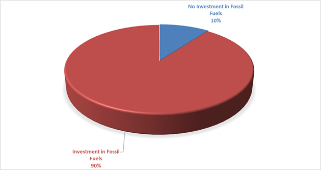
Investment Policy Compliance
The below table identifies compliance with Council’s Investment Policy by the proportion of the investment portfolio invested with financial institutions, along with their associated credit ratings compared to parameters in the Investment Policy. The parameters are designed to support prudent short and long-term management of credit risk and ensure diversification of the investment portfolio. Note that the financial institutions currently offering investments in the ‘ethical’ area are still mainly those with lower credit ratings (being either BBB or not rated at all i.e., credit unions).
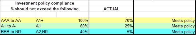
NSW Treasury Corporation Compliance – Loan Borrowing Conditions
Council has borrowed loans through NSW Treasury Corporation under the Local Government Low Cost Loans Initiative. As part of these loan borrowings, NSW Treasury Corporation has placed restrictions on where Council can invest based on the credit rating of the financial institution, the term of the investment and counterparty limit.
NSW Treasury Corporation has reviewed Council’s Investment Portfolio and reminded Council it needs to remain within the investment parameters outlined in the accepted loan agreements. Council currently complies with T Corp Borrowing conditions as indicated in the table below:
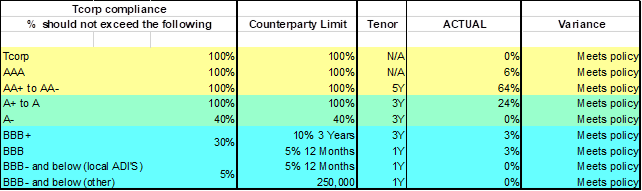
Council had discussions with NSW Treasury Corporation and indicated it would start reporting the compliance in the monthly investment report to Council. Council is able to hold existing investments not in compliance until maturity but must ensure new investments meet the compliance requirements.
Meeting the NSW Treasury Corporation compliance means Council will be limited in taking up investments that may be for purposes associated with Environmental and Socially Responsible outcomes. Investments which do not comply with NSW Treasury Corporation requirements and investments with financial institutions that do not support fossil fuels will have to be decreased due to their credit rating status or lack of credit rating.
The investment portfolio is outlined in the table below by investment type for the period 1 March 2023 to 31 March 2023:
Dissection of Council Investment Portfolio as at 31 March 2023
|
Investment Linked to: |
Current Market Value ($) |
Cumulative Unrealised Gain/(Loss) ($) |
|
|
29,000,000.00 |
Term Deposits |
29,000,000.00 |
0.00 |
|
28,434,917.03
|
CBA Business Saver |
28,434,917.03
|
0.00 |
|
659,150.78
|
CBA Business Saver – Tourism Infrastructure Grant |
659,150.78
|
0.00 |
|
10,271,857.43 |
Macquarie Accelerator |
10,271,857.43 |
0.00 |
|
7,000,000.00 |
Bonds |
6,609,790.00 |
(390,210.00) |
|
75,365,925.24 |
|
74,975,715.24 |
(390,210.00) |
Council’s overall ‘cash position’ is not only measured by funds invested but also by the funds retained in its consolidated fund or bank account for operational purposes. The table below identifies Council’s overall cash position for the month of March 2023 as follows:
Dissection of Council’s Cash Position as at 31 March 2023
|
Principal Value ($) |
Current Market Value ($) |
Cumulative Unrealised Gain/(Loss) ($) |
|
|
Investments Portfolio |
|||
|
Term Deposits |
29,000,000.00 |
29,000,000.00 |
0.00 |
|
CBA Business Saver |
28,434,917.03
|
28,434,917.03
|
0.00 |
|
CBA Business Saver – Tourism Infrastructure Grant |
659,150.78
|
659,150.78
|
0.00 |
|
Macquarie Accelerator |
10,271,857.43 |
10,271,857.43 |
0.00 |
|
Bonds |
7,000,000.00 |
6,609,790.00 |
(390,210.00) |
|
Total Investment Portfolio |
75,365,925.24 |
74,975,715.24 |
(390,210.00) |
|
Cash at Bank |
|||
|
Consolidated Fund |
1,241,829.72 |
1,241,829.72 |
0.00 |
|
Total Cash at Bank |
1,241,829.72 |
1,241,829.72 |
0.00 |
|
Total Cash Position |
76,607,754.96 |
76,217,544.96 |
(390,210.00) |
Strategic Considerations
Community Strategic Plan and Operational Plan
|
CSP Objective |
CSP Strategy |
DP Action |
Code |
OP Activity |
|
1: Effective Leadership |
1.3: Ethical and efficient management of resources |
1.3.1: Financial Management - Ensure the financial integrity and sustainability of Council through effective financial management |
1.3.1.6 |
Maintain Council's cash flow |
Legal/Statutory/Policy Considerations
In accordance with Section 212 of the Local Government (General) Regulation 2021, the Responsible Accounting Officer of Council must provide Council with a monthly report detailing all monies it has invested under section 625 of the Local Government Act 1993.
The Report must be presented at the next Ordinary Meeting of Council after the end of the month being reported. The current Council Meeting cycle does not always allow this to occur, especially as investment valuations required for the preparation of the report are often received after the deadline for the submission of reports. Endeavours are being made to achieve a better alignment and for some months this will require reporting for one or more months.
Council’s investments are made in accordance with section 625(2) of the Local Government Act 1993 and Council’s Investment Policy. The Local Government Act 1993 allows Council to invest money as per the Minister’s Order – Forms of Investment, last published in the Government Gazette on 11 March 2011.
Council’s Investment Policy includes the objective of maximising earnings from authorised investments and ensuring the security of Council Funds.
Financial Considerations
Council uses a diversified mix of investments to achieve short, medium, and long-term results.
BYRON SHIRE COUNCIL
Staff Reports - Sustainable Environment and Economy 13.6
Staff Reports - Sustainable Environment and Economy
Report No. 13.6 Main Beach Shoreline Project - Project Overview and Outcomes of the Technical Assessment of Concept Options including Recommendations and Next Steps
Directorate: Sustainable Environment and Economy
Report Author: Chloe Dowsett, Biodiversity and Sustainability Coordinator
File No: I2023/308
Summary:
This report provides:
· A summary of the project background, project components/phases and project delivery.
· An overview of the key outcomes of the detailed technical assessment completed of the shortlisted design options and the final report (Attachment 1).
· An overview of the implications for options to carry forward based on the outcomes of the detailed technical assessment.
· Recommendations and next steps in project delivery and the pathway for evaluation and selection of the preferred option for modification of the coastal protection works.
In 2019, Council engaged Bluecoast to deliver the first stage of the Main Beach Shoreline Project (MBSP). The MBSP is a design investigation using multiple lines of evidence to investigate options and solutions for modification of the Jonson Street protection works (JSPW) at Main Beach, Byron Bay.
The JSPW are a public asset that provide a significant role in protecting the Byron Bay town centre and foreshore from the First Sun Holiday Park to the Byron Bay Surf Life Saving Club from coastal erosion and inundation.
A rigorous 3-phased approach has been undertaken by a project team of world-class professionals who have assessed and analysed the most cost-effective options for modification of the structure to find the best solution. The most recent body of work completed by Bluecoast Consulting Engineers and the project team is the detailed technical assessment of the shortlisted design options:
· Option 2 – berm rock revetment and pathway
· Option 5 – protective structure moved landward by 10m
· Option 6 – protective structure moved landward by 30m
· Option 7 – existing structure upgraded to contemporary standards.
The objective of the technical assessment was to develop an understanding of the likely physical response of the coastal environment to each shortlisted design (i.e. what is the predicted change to the beach between leaving the structure as is versus removal of spur groynes to moving the structure landward) with consideration of:
· Changes to the way sand moves around the JSPW and the effect of this on adjacent shorelines and coastal profile including Main Beach and Clarkes Beach to the east, and Belongil Beach to the west (Figure 2).
· Surfing amenity noting the highly regarded surf quality from time to time in the surf zone adjacent the JSPW.
The detailed technical assessment consisted of two interrelated lines of investigation:
1. A geomorphic assessment which uses a largely data-driven approach to summarise relevant coastal processes occurring in the Byron Bay embayment and infer the relative effects of the shortlisted design options on long term coastal processes.
2. Application of numerical modelling tools to predict the response of the coastal environment to each shortlisted design relative to the existing situation.
The technical assessment is now complete with the Technical Assessment Report, Numerical modelling and geomorphic assessment of concept options, Bluecoast Consulting Engineers, (April 2023) provided in Attachment 1.
Key outcomes of the geomorphic assessment are:
· Headland bypassing around Cape Byron results in a highly variable sand supply to the southern embayment (Little Wategos to the JSPW) with the annual range estimated to be from around 150,000 to over 900,000m3/year. When coupled with the wave propagation characteristics of the embayment, the variable sand supply leads to a highly variable shoreline in the southern embayment.
· Sand movement pathways within the embayment follow two pathways: a littoral pathway (4m water depth) and a cross-embayment pathway. Based on sand volume changes determined from repeat surveys the relative split between the two pathways, when averaged across the embayment, has been calculated to be 70 : 30 (littoral : cross embayment). This is revised from previous assessments that assumed a 50 : 50 split between the pathways.
· The embayment geomorphic structure, including bedrock and coffee rock reefs and outcrops influence wave propagation, sand movements, shoreline dynamics and surfzone morphology in the embayment. The embayment’s hard substrate reduces the volume of sand that can be stored in the southern embayment.
· Good surfing conditions are believed to be related to the wave pre-conditioning (owing to Middle Reef), the distribution of surfzone coffee rock and headland bypassing which results in a ‘bulge’ morphology when the southern embayment is full of sand.
· The JSPW interacts with the embayment’s natural sand movements, with the level of interaction (over the medium to long-term) controlled by the amount of sand in the Main Beach compartment, which in turn is a function of headland bypassing and wave climate.
Key outcomes of the numerical modelling assessment are outlined below.
· Significant wave focusing areas over the reefs (rock outcrops) affect the westward alongshore surfzone current by causing alongshore accelerations/decelerations which also influence the location and behaviour of rip currents.
· All options have minimal and largely localised changes to nearshore wave conditions, however, for higher tides and/or lower beach levels alongshore surfzone currents are changed from all options except Option 7.
· Outputs from the SWASH simulations at The Wreck surf spot during typical surfing conditions shows that the options do not significantly affect the wave heights or currents in this high value recreational area. Similar results, with no significant change in wave heights, current or wave breaking pattern, are observed in the simulations for the area immediately seaward of the JSPW. This is an area known to provide good surf from time to time. [As demonstrated in the geomorphic assessment, good surfing conditions are believed to be related to the wave pre-conditioning (owing to Middle Reef), the distribution of surfzone coffee rock and headland bypassing which results in a ‘bulge’ morphology when the southern embayment is full of sand].
· While the options lead to a localised increase in current speeds these are in line with adjacent speeds. The removal of the central groyne which acts as an obstacle, as is the case for all but Option 7, would see a minor but positive improvement in swimmer and surfer safety. The swimmer safety implications of these results should be discussed with local NSW Surf Life Saving representatives in the next evaluation stages.
· All options that substantially realign the JSPW landward (i.e. Option 2, Option 5 and Option 6) result in a net reduction in beach volume (i.e. shoreline recession) at Main Beach with a corresponding advance in the beach volume/shoreline at Belongil Beach. The realignment of the shoreline in response to these options is not consistent but rather depends on the condition of the Main Beach shoreline. The shoreline change is most prominent when the Main Beach shoreline is in a more ‘eroded’ (or landward) condition and negligible when Main Beach is in a naturally accreted state. On average the estimated shoreline change for these options are in the range of -5 to -12m at Main Beach and +5m to +10m at Belongil Beach.
· Of the two options that realign the rock revetment landward, there is not a substantial difference in the shoreline response between Option 5 (10m realignment) and Option 6 (30m realignment).
· Option 7, which upgrades the structure to contemporary standards while largely retaining the existing footprint, results in only minor shoreline changes.
· The model demonstrates that headland bypassing and the variability it causes to Main Beach’s sand supply is the principal factor controlling shoreline dynamics along Main Beach and that is likely to remain the case irrespective of the option implemented.
Implications for Options to Carry Forward:
The technical assessment of the four shortlisted design options has highlighted similar performance outcomes for the two landward realignment options, Option 5 (10m realignment) and Option 6 (30m realignment). This is principally observed in the similar predicted shoreline response of these two options due to the diminishing additional sand bypassing that would be expected for Option 6. Similarly, surf amenity and swimmer safety outcomes from the modelling and the amount of wave overtopping predicted showed only marginal differences between these two options.
Based on these results, Option 5 and Option 6 do not appear to be sufficiently different from a technical performance perspective to warrant further evaluation of both options.
Where Option 5 and Option 6 are materially different is in the level of foreshore amenity provided and in the cost of construction. The difference in foreshore amenity, is largely due to the permanent change to the size and character of the iconic Main Beach foreshore area under the more significant 30m landward alignment (Option 6).
In considering which options to carry forward from this technical assessment, it is recommended Council consider the likely outcome of further economic appraisal and/or multi-criteria assessment of Option 6. Economically, the lower benefits associated with loss of public and private assets/revenue and foreshore amenity coupled with the higher construction cost would mean that Option 6 will almost certainly compare poorly against Option 5. Similarly, the permanent change to the character of the location would be unlikely to perceived positively by all sectors of the community.
Recommendations:
The information presented in the Technical Assessment Report provides the basis for further development and evaluation of the shortlisted options to allow selection of the preferred option to carry forward for detailed design, seeking approvals and implementation.
Based on the results of the technical assessment, it is recommended that Council consider the elimination of Option 6 from the shortlisted options based on the likely outcome of further economic appraisal and/or multi-criteria assessment of Option 6 and permanent change to the character of the location.
Next Steps:
Next steps include:
· Any further engineering design development of the shortlisted options (i.e. Option 2, Option 5 and Option 7) taken forward sufficient to inform cost estimates for each design.
· An economic appraisal (e.g. cost benefit analysis (CBA)) to examine the relative costs and economic benefits of each of the shortlisted options.
· A multi-criteria assessment (MCA) would be informed by further community consultation and explore the non-economic factors including the social and environmental aspects of the shortlisted design options.
The MBSP is considered within the processes involved in preparation of the Coastal Management Program (CMP) for the open coast of the Byron Shire coastline and is part of the overall CMP preparation. The project is a Stage 2 study within CMP preparation and the outcomes of the investigation are being fully synchronised and incorporated within the overall CMP preparation.
The pathway for evaluation and determination of the preferred option for modification of the coastal protection works is through the next stage of the CMP process, being Stage 3. This provides a holistic and embayment wide approach to coastal management.
Once the preferred design is selected by Council and the design further developed, it is recommended that the final alignment, footprint, levels and planform of the preferred design be subject to further detailed technical assessment to confirm the findings presented in the Technical Assessment Report. This future body of work will likely be completed as an action for implementation in the certified CMP.
RECOMMENDATION:
That Council:
1. Notes the findings and outcomes of the Technical Assessment Report, Numerical modelling and geomorphic assessment of concept options, Bluecoast Consulting Engineers (April 2023) as presented in Attachment 1.
2. Endorses the elimination of Option 6 (protective structure moved landward by 30m) from the shortlisted options based on the key findings of the Technical Assessment Report.
3. Notes the three shortlisted design options to progress to evaluation and determination of the preferred option for modification of the coastal protection works through stage 3 of CMP preparation are:
a) Option 2 - berm rock revetment and pathway;
b) Option 5 - protective structure moved landward by 10m; and
c) Option 7 - existing structure upgraded to contemporary standards.
4. Notes that the Technical Assessment Report will be provided on the project webpage.
5. Notes that a presentation will be provided to the Coast and ICOLL Advisory Committee at the 16 May 2023 meeting.
Attachments:
1 Main
Beach Shoreline Project - Technical Assessment Report, Numerical
modelling and geomorphic assessment of concept options, Bluecoast Consulting
Engineers (April 2023), E2022/92974
![]()
Report
This Report:
· A summary of the project background, project components/phases and project delivery.
· An overview of the key outcomes of the detailed technical assessment completed of the shortlisted design options and the final report (Attachment 1).
· An overview of the implications for options to carry forward based on the outcomes of the detailed technical assessment.
· Recommendations and next steps in project delivery and they pathway for evaluation and selection of the preferred option for modification of the coastal protection works.
Information/Background:
In 2019, Council engaged Bluecoast to deliver the first stage of the Main Beach Shoreline Project (MBSP). The MBSP is a design investigation using multiple lines of evidence to investigate options and solutions for modification of the Jonson Street protection works (JSPW) at Main Beach, Byron Bay. The project’s first stage is focused on finding the solution for modification of the works that will give the best possible outcomes for Main Beach, Byron Bay and adjacent areas.
The JSPW are a public asset that provide a significant role in protecting the Byron Bay town centre and foreshore from the First Sun Holiday Park to the Byron Bay Surf Life Saving Club from coastal erosion and inundation. The MBSP is an important project for the community of Byron Shire, with the intent to improve the current situation. Through modification of the works, significant public benefit will be gained through improving coastal protection of the town centre, enhancing recreational amenity, improving public safety, and improving public access and use of the foreshore and beach.
Project Components:
A rigorous 3-phased approach has been undertaken by a project team of world-class professionals who have assessed and analysed the most cost-effective options for modification of the structure to find the best solution.
A significant amount of work has been completed to date. A series of reports have been developed as part of the project which are provided on Council’s webpage and outlined in Table 1.
Table 1. Project reports
|
Project phase |
Project reports |
Date |
Refer to this document for: |
|
Phase 1 |
Condition Assessment Report |
20 February 2020 |
· Coastal engineering condition assessment undertaken on the JSPW |
|
Phase 1 |
Baseline Understanding Report |
30 July 2021 |
· Assessment of existing situation · Coastal processes summary · Identification of opportunities associated with MBSP |
|
Phase 2 |
Concept Design Development Report |
3 November 2020 |
· A summary of the project’s critical factors · Preliminary design of seven concept options for the MBSP |
|
Phase 2 |
Assessment of alternative concept (Option 8) |
3 November 2020 |
· Assessment of a further alternative concept (Option 8) |
|
Phase 3 |
Technical Assessment Report - Numerical modelling and geomorphic assessment of concept options |
This report (Attachment 1) April 2023
|
· Geomorphic assessment to infer effects of the shortlisted designs on long term coastal processes · Application of numerical modelling tools to predict the response of the coastal environment to each shortlisted design |
Baseline Understanding
This phase involved a comprehensive review of all relevant previous studies, data sets and the current condition of the coastal structures was completed to provide a baseline understanding for the project including the community and cultural values of the area. The team monitored shoreline change as well as local waves, currents and sea levels and simulated waves that occurred over the last 30 years. This helped to understand the underlying coastal processes driving increasing erosion and flooding risk. Combining this information highlights the opportunities and constraints of the proposed modification of the coastal structure.
Phase 2
Development of Concept Design Options
This phase determined a set of suitable concept designs that offer a range of viable solutions. A standardised options assessment was undertaken that considered the positive and negative aspects of each option using a wide range of criteria - including coastal protection, the natural environment, community values, ecology and economics. Key stakeholders and broader community engagement was undertaken to inform the evaluation process, which in collaboration with the specialist team resulted in the selection of the most suitable options to take forward for detailed assessment.
Council resolved to endorse the top seven concept options for key stakeholder and broader community engagement, being:
· Option 1 – rock revetment and stepped concrete seawall
· Option 2 – berm rock revetment and pathway
· Option 3 – detached groyne
· Option 4 – artificial headland with sand bypassing
· Option 5 – protective structure moved landward by 10m
· Option 6 – protective structure moved landward by 30m
· Option 7 – existing structure upgraded to contemporary standards.
An alternative Option 8 was also assessed in accordance with the overall project objectives. However, the findings of the assessment concluded that the alternative Option 8 was not considered feasible and as such it was not added to the top seven options for broader engagement.
Community engagement was undertaken along with key stakeholder consultation during December 2020 and January 2021. The aim of the community consultation was to gain an appreciation of what the community value most about Main Beach and to inform the selection / development of the top three (3) preferred discrete options to progress to the next phase of the project, being the detailed technical investigation (outcomes are provided in this report).
The recommended three shortlisted design options to take forward and progress to detailed investigation were:
· Option 2 – berm rock revetment and pathway
· Option 5 – protective structure moved landward by 10m
· Option 7 – existing structure upgraded to contemporary standards.
A report was tabled at the Council Meeting of 28 October 2021, outlining the results of community consultation and feedback received during the engagement period. During the discussion of concept options to progress there was slight misunderstanding and misinterpretation of the landward alignment options as to how far the options were proposed to be realigned. As such, Council endorsed the following three options to take forward and progress to detailed investigation:
· Option 2 – berm rock revetment and pathway
· Option 6 - protective structure moved landward by 30m
· Option 7 - existing structure upgraded to contemporary standards.
The difference in the Council endorsed options is the substitution of Option 5 with Option 6.
The objective of the MBSP is to find the best solution for modification of the works that will give the best possible outcomes for Main Beach, Byron Bay and adjacent areas. Due to the time and cost taken to set up numerical modelling tools an assessment of both realignment options was undertaken (i.e. Option 5 and Option 6).
As such Bluecoast have assessed a shortlist of four options
– Option 2, Option 5, Option 6 and Option 7. Figure 1 below provides an
illustration of the shortlisted options. 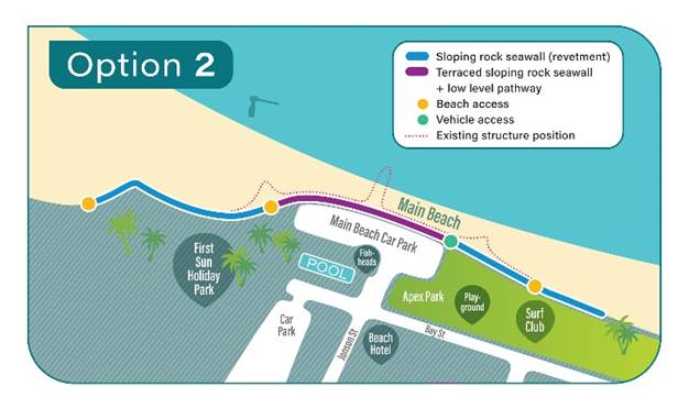
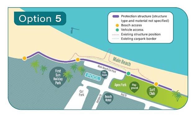
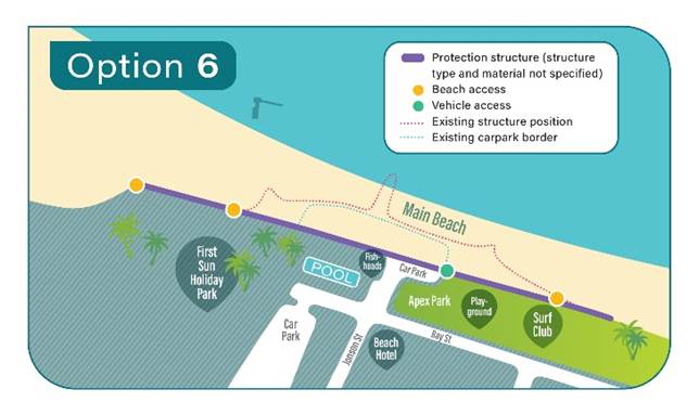
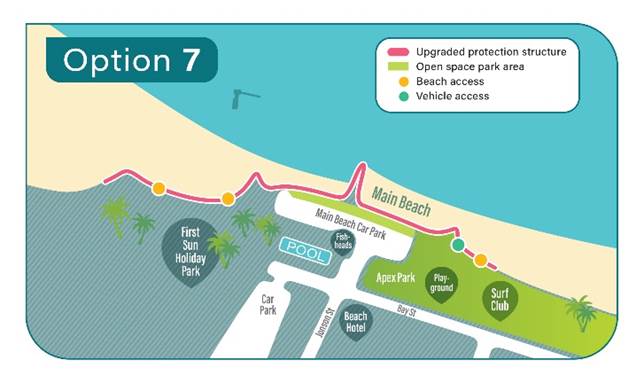
Figure 1. Illustration of the shortlisted options.
Table 2 provides an outline of the key design elements of the shortlisted options.
Table 2. Summary of the key design elements in each shortlisted option.
|
Option |
Alignment |
Material |
Groynes |
|
Option 2 – berm rock revetment and pathway |
Current alignment |
Predominately rock revetment with inclusion of shared path on lower level (berm) |
All groynes removed |
|
Option 5 – protective structure moved landward by 10m |
Landward alignment (10m) |
Predominately rock revetment |
All groynes removed |
|
Option 6 – protective structure moved landward by 30m |
Landward alignment (30m) |
Predominately rock revetment |
All groynes removed |
|
Option 7 - existing structure upgraded to contemporary standards |
Current alignment |
Rock revetment |
All groynes retained |
Phase 3
Detailed Technical Assessment of Shortlisted Design Options:
By applying robust coastal science, including advanced computer modelling, the performance of the selected options is predicted. To ensure confidence in the predicted outcomes a multiple lines of evidence approach was adopted combining science, real data and engineering knowledge.
· Changes to the way sand moves around the JSPW and the effect of this on adjacent shorelines and coastal profile including Main Beach and Clarkes Beach to the east, and Belongil Beach to the west (Figure 2).
· Surfing amenity noting the highly regarded surf quality from time to time in the surf zone adjacent the JSPW.
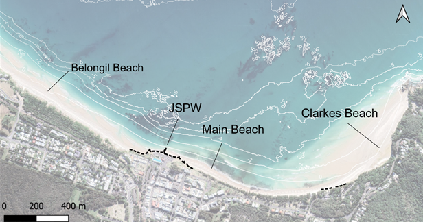
Figure 2. The JSPW and adjacent beaches.
The detailed technical assessment consisted of two interrelated lines of investigation:
1. A geomorphic assessment which uses a largely data-driven approach to summarise relevant coastal processes occurring in the Byron Bay embayment and infer the relative effects of the shortlisted design options on long term coastal processes.
2. Application of numerical modelling tools to predict the response of the coastal environment to each shortlisted design relative to the existing situation.
Significant delay to completion of this component of the project was experienced due to:
· Consultant staff capacity and resources due to COVID.
· Co-ordination with the Coastal Hazard Assessment for the Byron Shire Coastline to ensure consistency.
· Data delays and additional work required to incorporate key datasets.
· Unexpected challenges encountered and rework, refining and redoing of elements of the assessment to ensure it is fit for purpose. For example, creation of bespoke shoreline modelling.
The technical assessment is now complete with the Technical Assessment Report, Numerical modelling and geomorphic assessment of concept options, Bluecoast Consulting Engineers, (April 2023) provided in Attachment 1.
Geomorphic Assessment
A baseline geomorphic assessment was completed to explain the most relevant coastal processes occurring in the Byron embayment that influence the response to the JSPW. The assessment adopts a data-driven approach to infer the rates and pathways of sand movements. At its centre is an analysis of the study areas’ sand budget, which maps historical sand volume changes in 41 coastal sand cells. The most likely drivers for the observed coastal changes are described based on observational data, previous literature, state-of-the-art numerical modelling and coastal processes knowledge. Wherever possible, multiple lines of evidence have been used to cross-check, validate and provide greater confidence in the findings.
The baseline geomorphic assessment considers the existing conditions (base case) of the JSPW and the embayment more broadly. Limitations are stated and uncertainty has been quantified for some of the findings.
Key outcomes of the geomorphic assessment are:
· Headland bypassing around Cape Byron results in a highly variable sand supply to the southern embayment (Little Wategos to the JSPW) with the annual range estimated to be from around 150,000 to over 900,000m3/year. When coupled with the wave propagation characteristics of the embayment, the variable sand supply leads to a highly variable shoreline in the southern embayment.
· Sand movement pathways within the embayment follow two pathways: a littoral pathway (4m water depth) and a cross-embayment pathway. Based on sand volume changes determined from repeat surveys the relative split between the two pathways, when averaged across the embayment, has been calculated to be 70 : 30 (littoral : cross embayment). This is revised from previous assessments that assumed a 50 : 50 split between the pathways.
· The embayment geomorphic structure, including bedrock and coffee rock reefs and outcrops influence wave propagation, sand movements, shoreline dynamics and surfzone morphology in the embayment. The embayment’s hard substrate reduces the volume of sand that can be stored in the southern embayment.
· Good surfing conditions are believed to be related to the wave pre-conditioning (owing to Middle Reef), the distribution of surfzone coffee rock and headland bypassing which results in a ‘bulge’ morphology when the southern embayment is full of sand.
· The JSPW interacts with the embayment’s natural sand movements, with the level of interaction (over the medium to long-term) controlled by the amount of sand in the Main Beach compartment, which in turn is a function of headland bypassing and wave climate.
Numerical Modelling
Following the geomorphic assessment application of numerical models was undertaken comprising:
1. A detailed wave and flow model capable of reproducing wave breaking and wave-generated currents along Main Beach was developed using the SWASH model. The SWASH model provides detailed information on the transformation of waves over the Byron embayment and its shallow reefs. The model identifies wave energy hot spots and shadows emanating from the shallow reefs and the effect this wave pre-conditioning has on nearshore hydrodynamics. The SWASH model confirms alongshore surfzone currents, driven by wave radiation stresses caused by wave breaking, go westward at the project site.
2. A wave and water level model focussing on wave overtopping of the structure.
3. Bespoke shoreline modelling which provides information on the expected response of the coastal environment at Main Beach (to the east) and Belongil Beach (to the west) following construction of each of the shortlisted design options.
Key outcomes of the numerical modelling assessment are outlined below.
Comparison of the SWASH modelling results allow the effects of the shortlisted JSPW design options on the nearshore wave and hydrodynamics to be predicted, with key outcomes being:
· Significant wave focusing areas over the reefs (rock outcrops) affect the westward alongshore surfzone current by causing alongshore accelerations/decelerations which also influence the location and behaviour of rip currents.
· All options have minimal and largely localised changes to nearshore wave conditions, however, for higher tides and/or lower beach levels alongshore surfzone currents are changed from all options except Option 7.
· Outputs from the SWASH simulations at The Wreck surf spot during typical surfing conditions shows that the options do not significantly affect the wave heights or currents in this high value recreational area. Similar results, with no significant change in wave heights, current or wave breaking pattern, are observed in the simulations for the area immediately seaward of the JSPW. This is an area known to provide good surf from time to time. [As demonstrated in the geomorphic assessment, good surfing conditions are believed to be related to the wave pre-conditioning (owing to Middle Reef), the distribution of surfzone coffee rock and headland bypassing which results in a ‘bulge’ morphology when the southern embayment is full of sand].
· While the options lead to a localised increase in current speeds these are in line with adjacent speeds. The removal of the central groyne which acts as an obstacle, as is the case for all but Option 7, would see a minor but positive improvement in swimmer and surfer safety. The swimmer safety implications of these results should be discussed with local NSW Surf Life Saving representatives in the next evaluation stages.
XBeach modelling focused on wave overtopping. It demonstrated that overtopping of the current JSPW far exceeds the safe limits for people on the seawall crest for the present-day 100-year average recurrence interval (ARI) water level and wave conditions. Damage to assets may also occur under this condition. The design options all significantly reduce overtopping to safer levels under present-day conditions. For future sea level rise scenarios, Option 2, Option 5 and Option 6 perform well but Option 7 does not and would require adaptation to maintain safe overtopping.
The bespoke shoreline modelling provides information on the expected response of the coastal environment at Main Beach (to the east) and Belongil Beach (to the west) following construction of each of the shortlisted design options. Based on the amount of sand bypassing the JSPW under base case and project cases, the model quantifies the relative amount of beach volume and shoreline change expected at the adjacent beaches. Key outcomes are:
· All options that substantially realign the JSPW landward (i.e., Option 2, Option 5 and Option 6) result in a net reduction in beach volume (i.e., shoreline recession) at Main Beach with a corresponding advance in the beach volume/shoreline at Belongil Beach. The realignment of the shoreline in response to these options is not consistent but rather depends on the condition of the Main Beach shoreline. The shoreline change is most prominent when the Main Beach shoreline is in a more ‘eroded’ (or landward) condition and negligible when Main Beach is in a naturally accreted state. On average the estimated shoreline change for these options are in the range of -5 to -12m at Main Beach and +5m to +10m at Belongil Beach.
· Of the two options that realign the rock revetment landward, there is not a substantial difference in the shoreline response between Option 5 (10m realignment) and Option 6 (30m realignment).
· Option 7, which upgrades the structure to contemporary standards while largely retaining the existing footprint, results in only minor shoreline changes.
· The model demonstrates that headland bypassing and the variability it causes to Main Beach’s sand supply is the principal factor controlling shoreline dynamics along Main Beach and that is likely to remain the case irrespective of the option implemented.
Implications for Options to Carry Forward:
The purpose of the technical assessment report is not to arrive at a preferred design option for the modification of the JSPW. However, the technical assessment of the four shortlisted design options has highlighted similar performance outcomes for the two landward realignment options, Option 5 (10m realignment) and Option 6 (30m realignment). This is principally observed in the similar predicted shoreline response of these two options due to the diminishing additional sand bypassing that would be expected for Option 6. Similarly, surf amenity and swimmer safety outcomes from the modelling and the amount of wave overtopping predicted showed only marginal differences between these two options.
Based on these results, Option 5 and Option 6 do not appear to be sufficiently different from a technical performance perspective to warrant further evaluation of both options.
Where Option 5 and Option 6 are materially different is in the level of foreshore amenity provided and in the cost of construction. The difference in foreshore amenity, is largely due to the permanent change to the size and character of the iconic Main Beach foreshore area under the more significant 30m landward alignment (Option 6).
As outlined in the Table 3 below, the car park, Fishheads café as well as a proportion of Apex Park would be lost or relocated under Option 6.
Table 3. Summary of the assets lost or relocated with realignment.
|
Asset |
Option 5 (10m realignment) |
Option 6 (30m realignment) |
|
Car park |
· 88% of paved area retained · 55 of 95 car parks retained · Footpath relocated |
· 31% of paved area retained · 10 of 95 car spaces retained · Footpath relocated |
|
Apex Park |
· 82% of grassed area retained |
· 80% of grassed area retained |
|
Council building (Fishheads Café) |
· Retained |
· Removed or relocated |
|
Memorial Swimming Pool |
· Retained |
· Pool footprint is retained but there would be a partial removal of the pool complex. |
|
First Sun Holiday Park |
· Retained |
· Retained |
Regarding anticipated costs, both Option 5 and Option 6 reconstructed landward of the existing revetment would offer some benefits in the ease of excavation to the required toe depths (i.e., protection from tides and waves). However, the excavation and removal of the existing structures, carparks, footpaths, services, and foreshore park would be costly. It would be more disruptive to traffic, beach and foreshore access and patrons of the pool and Fishheads Café when compared to other options. Given the extra 20m or realignment required for Option 6, the extra excavation, material removal and asset relocation/realignment costs and the level of disruption would be significantly greater than Option 5.
In considering which options to carry forward from this technical assessment, it is recommended Council consider the likely outcome of further economic appraisal and/or multi-criteria assessment of Option 6. Economically, the lower benefits associated with loss of public and private assets/revenue and foreshore amenity coupled with the higher construction cost would mean that Option 6 will almost certainly compare poorly against Option 5. Similarly, the permanent change to the character of the location would be unlikely to perceived positively by all sectors of the community.
Recommendations:
The information presented in the Technical Assessment Report provides the basis for further development and evaluation of the shortlisted options to allow selection of the preferred option to carry forward for detailed design, seeking approvals and implementation. Based on the results of the technical assessment, Option 5 and Option 6 do not appear to be sufficiently different from a technical performance perspective to warrant further evaluation of both options.
Next Steps:
Next steps include:
· An economic appraisal (e.g., cost benefit analysis (CBA)) to examine the relative costs and economic benefits of each of the shortlisted options. In addition to the technical aspects considered in the Technical Assessment Report the economic appraisal would explore benefits/costs associated with:
o beach and foreshore amenity
o coastal erosion risk to assets in Byron Bay town centre, Main Beach along Apex Park, Clarkes Beach and Belongil Beach
o public safety
o access and pedestrian movements across the project area.
· A multi-criteria assessment (MCA) would be informed by further community consultation and explore the non-economic factors including the social and environmental aspects of the shortlisted design options.
The MBSP is considered within the processes involved in preparation of the Coastal Management Program (CMP) for the open coast of the Byron Shire coastline and is part of the overall CMP preparation. The project is a Stage 2 study within CMP preparation and the outcomes of the investigation are being fully synchronised and incorporated within the overall CMP preparation.
The pathway for evaluation and determination of the preferred option for modification of the coastal protection works is through the next stage of the CMP process, being Stage 3. This provides a holistic and embayment wide approach to coastal management.
Once the preferred design is selected by Council and the design further developed, it is recommended that the final alignment, footprint, levels and planform of the preferred design be subject to further detailed technical assessment to confirm the findings presented in the Technical Assessment Report. This future body of work will likely be completed as an action for implementation in the certified CMP.
Strategic Considerations
Community Strategic Plan and Operational Plan
|
CSP Objective |
CSP Strategy |
DP Action |
Code |
OP Activity |
|
3:
Nurtured Environment |
3.3: Protect the health of our coastline, estuaries, waterways, and catchments |
3.3.1: Coastal Management Program planning and implementation - Undertake Coastal Management Program planning and implementation |
3.3.1.6 |
Assess concept options for the modification of the Jonson Street coastal protection works (Main Beach Shoreline Project) |
Recent Resolutions
· 18-104 Design Options for the Jonson Street Protection Works
· 18-839 Modification of the Jonson Street Protection Works (Main Beach) - Defining Project Objectives
· 19-320 Tender Evaluation - Design Investigation for the Modification of the Jonson Street Protection Works
· 20-347 Main Beach Shoreline Project - preliminary options assessment and stakeholder engagement
· 20-435 Main Beach Shoreline Project - preliminary options assessment and stakeholder engagement
· 20-436 Main Beach Shoreline Project - preliminary options assessment and stakeholder engagement
· 20-730 Main Beach Shoreline Project - community consultation on the 7 options
· 21-463 Main Beach Shoreline Project - outcome of community consultation on the 7 options
Legal/Statutory/Policy Considerations
The NSW Coastal Management Framework in NSW comprises the following elements:
· the Coastal Management Act 2016
· the State Environmental Planning Policy (Resilience and Hazards) 2021 (CM SEPP)
· the NSW Coastal Management Manual (OEH, 2018).
Council is presently preparing a Coastal Management Programs (CMP) for the Byron Shire coastline. The purpose of the CMP will be to set the long-term strategy for the management of the coastal zone, addressing priority open coast management issues and actions to address the issues, with a focus on achieving the objectives of the CM Act.
The Main Beach Shoreline Project investigation is considered within the processes involved in preparation of the CMP and is part of the overall CMP preparation. The project is a Stage 2 study within CMP preparation.
The outcomes of the investigation will be fully synchronised and incorporated within the overall CMP preparation, hence the evaluation and selection of the preferred modification design will be completed in Stage 3 of the CMP development. This provides a holistic and embayment wide approach to coastal management.
Financial Considerations
The MBSP is an important component of the strategic and long-term planning and management of a priority Council asset. There are identified safety risks of the sub-standard state of the JSPW and associated risks identified in various reports which advise of repair.
A budget allocation has been made for FY2023/24 for CMP Stages 3 & 4 which will include economic appraisal and MCA evaluation and selection of the preferred modification design.
Consultation and Engagement
A Community and Stakeholder Engagement Plan was developed for the project as a whole with a variety of engagement and consultation methods and activities provided over the life of the project between 2019 and 2023.
Key consultation and engagement activities associated with the Technical Assessment Report are outlined in the table below.
Post adoption of the Technical Assessment Report to Council, the report will be provided on Council’s project webpage.
|
Who was consulted? |
How did consultation occur? e.g. email, verbal etc |
Comments/Feedback |
|
Department of Planning and Environment (DPE) staff from the Water, Floodplains and Coast (North East) Biodiversity and Conservation Division |
Peer review of report. Comments received in report and via external comments and response register |
Comments received and incorporated into final report. |
|
Royal Haskoning (DHV), expert coastal engineer |
Peer review of report. Comments received via external comments and response register |
Comments received and incorporated into final report. |
|
Council Executive Team |
Monthly Meeting |
Report provided on technical assessment outcomes. Feedback received and incorporated into project delivery. |
|
Byron Shire Councillors |
Strategic Planning Workshop |
Presentation provided to Councillors on outcomes. Feedback received and incorporated into final report. |
|
Masterplan Guidance Group – Byron Bay Town Centre |
Monthly meeting |
Presentation provided to group members on outcomes. |
|
Coast and ICOLL Advisory Committee Meeting |
Quarterly meeting (TBC 16 May 2023) |
Presentation to be provided to committee members on outcomes.
|
BYRON SHIRE COUNCIL
Staff Reports - Sustainable Environment and Economy 13.7
Report No. 13.7 PLANNING - 10.2020.651.1 Staged Affordable Housing Development comprising Nine (9) Boarding Houses, Community Building, Managers Residence and Strata Subdivision to create Three (3) Lots and a Common Lot at 2 Bangalow Road, Byron Bay
Directorate: Sustainable Environment and Economy
Report Author: Rob Van Iersel, Contract Planner
Chris Larkin, Manager Sustainable Development
File No: I2022/475
Proposal:
|
DA No: |
10.2020.651.1 |
||
|
Proposal description: |
Staged Affordable Housing Development comprising Nine (9) Boarding Houses, Community Building, Manager’s Residence and Strata Subdivision to create Three (3) Lots and a Common Lot |
||
|
Property description: |
LOT: 2 DP: 1206972 |
||
|
2 Bangalow Road BYRON BAY |
|||
|
Parcel No/s: |
267831 |
||
|
Applicant: |
Planners North |
||
|
Owner: |
Daygage Pty Ltd & Mr E W Pearce & Mrs R G Hunt & Others |
||
|
Zoning: |
R2 Low Density Residential |
||
|
Date received: |
14 December 2020 |
||
|
Integrated / Designated Development: |
☒ Integrated |
☐ Designated |
☐ Not applicable |
|
Concurrence required |
No |
||
|
Public notification or exhibition: |
- Level 2 advertising under DCP 2014 Part A14 – Public Notification and Exhibition of Development Applications - Exhibition period: 10/1/21 to 24/1/21 - Submissions received: Three (3) - Submissions acknowledged: ☒ Yes ☐ No ☐ N/A |
||
|
Planning Review Committee: |
Not applicable |
||
|
Variation request |
Clause 4.6 |
||
|
Issues: |
· Design changes improve |
||
Summary:
The DA proposes Staged Affordable Housing Development comprising Nine (9) Boarding Houses, Community Building, Managers Residence and Strata Subdivision to create Three (3) Lots and a Common Lot.
The proposal involves alterations and additions to five existing houses, construction of four new houses and a combined manager’s residence/ community building. The houses are configured and will be used as boarding houses.
The proposal replaces a previous scheme approved by Council on 9 April 2009 under DA 10.2007.406.1.
That approved development incorporated subdivision of the land to create two lots, Lot 1 containing medium density development and Lot 2, which is subject of the current application.
The land was subdivided in accordance with Consent 10.2007.406.1.
Consent 10.2007.406.1 was lawfully commenced and remains valid.
The current application proposes some design modifications to the approved buildings on Lot 2, but is generally consistent with the development approved in 2009. The primary reason for the design changes is to widen the sewer easement across the site from 3.5m to 4.5m, as requested by Council. This results in the realignment of proposed dwelling 7 and the proposed manager’s residence / community building.
The proposed development will result in a total of 80 bedrooms, one more than the 79 bedrooms approved under 10.2007.406.1. The development has the capacity to accommodate a maximum of 108 people plus a site manager.
The design changes to that approved in 2009 primarily increase the number of self-contained boarding house rooms, as opposed to the previous single bedrooms with shared facilities. In this way, the development is more like a conventional boarding house than the approved development, which was configured more like a hostel.
This accords with the landowners’ stated intent of providing affordable housing options for workers.
The proposed development will be achieved though:
· alterations and additions to five (5) existing dwellings (houses 1 – 5 on plans);
· the construction of four (4) new dwellings; and
· the construction of a manager’s residence, which includes reception, community rooms, a laundry and a kitchen/café for residents.
Parking for 41 vehicles, 16 motorcycles and 25 bicycles is provided, which is generally consistent with the previous approval.
Council approved a Voluntary Planning Agreement (VPA) for the site under DA 10.2007.406.1 (S2014/4271), which required the owner to provide a specified number of rooms at discounted rental rates for a specified period. It also required Council to levy developer contributions and water and sewer levies at a specified discounted rate.
An updated VPA has been submitted with the current application, with the only change being an update to the development partners subject to the agreement.
Since entering into the previous VPA, Council’s Development Contributions Plan has been amended and now provides opportunity for exemptions for private boarding houses, group homes and affordable housing.
This has been applied by way of a suspension of payment of the required contributions whilst ever the subject housing remains affordable.
It is considered that this is an appropriate exemption to be provided for the subject application and will negate the need for the VPA.
Council’s Development Engineer recommends a deferred commencement consent, requiring updated plans to demonstrate that internal access and parking will meet relevant Australian and Council standards, given that the plans submitted with the DA were substandard in that regard.
NOTE TO COUNCILLORS:
In accordance with the provisions of S375A of the Local Government Act 1993, a Division is to be called whenever a motion for a planning decision is put to the meeting, for the purpose of recording voting on planning matters. Pursuant to clause 2(a) under the heading Matters to be Included in Minutes of Council Meetings of Council's adopted Code of Meeting Practice (as amended) a Division will be deemed to have been called by the mover and seconder of all motions relating to this report.
RECOMMENDATION:
That, pursuant to Section 4.16 of the Environmental Planning & Assessment Act 1979, Development Application No. 10.2020.651.1 for Staged Affordable Housing Development comprising Nine (9) Boarding Houses, Community Building, Managers Residence and Strata Subdivision to create Three (3) Lots and a Common Lot, be approved subject to the recommended conditions in Attachment 1 (E2023/35369) to this Report.
Attachments:
1 DA
10.2020.651.1 - Draft Conditions for Council report, E2023/35369 ![]()
2 DA
10.2020.651.1 - Development plans, E2022/104726
![]()
3 DA
10.2020.651.1 - Comparison of proposed development with that approved under
10.2007.406.1, E2022/42694 ![]()
4 DA
10.2020.651.1 - clause 4.6 Variation request, E2020/102360
![]()
5 DA
10.2020.651.1 - Proposed planning agreement, E2020/102355
![]()
6 DA
10.2020.651.1 redacted submissions, E2022/101309
![]()
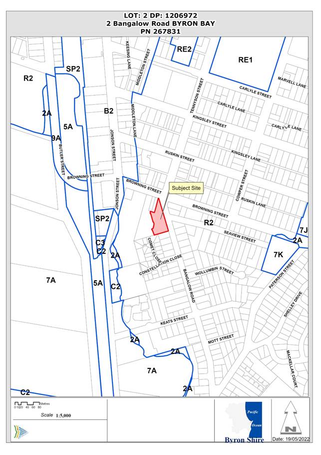
Assessment:
1. INTRODUCTION
History/Background
Council records indicate the following development approval history for the property:
|
DA No. |
Description |
Outcome |
Date |
|
5.1997.248.1 |
Residential Flat Building – 8 x 2 storey townhouses |
Withdrawn/Cancelled |
01/10/997 |
|
10.2007.406.1 |
Affordable housing comprising change of use of 5 existing dwellings and erection of 4 new houses for use as boarding houses; medium density development comprising 12 new dwellings; Torrens title and strata title subdivision; staging of development |
Deferred Approval |
09/04/2009 |
|
10.2007.406.2 |
S96 extend timeframe to satisfy deferred commencement |
Deferred Approval |
24/05/2010 |
|
10.2007.406.3 |
S96 to change proposed 6 lot Torrens title subdivision to 2 lot Torrens title subdivision |
Approved |
28/06/2012 |
|
10.2007.406.4 |
S96 to amend deferred commencement condition |
Approved |
19/05/2011 |
|
10.2007.406.5 |
S96 to extend commencement period |
Approved |
28/11/2011 |
|
10.2007.406.6 |
S96 to extend the deferred commencement period |
Approved |
27/12/2012 |
|
10.2007.406.7 |
S96 to extend the deferred commencement period and correct errors |
Approved |
08/11/2013 |
|
10.2007.654.1 |
Urban subdivision of existing 11 Torrens title lots to create four (4) |
Withdrawn/Cancelled |
05/05/2010 |
|
10.2008.693.1 |
A mixed Torrens and community title subdivision |
Withdrawn/Cancelled |
05/05/2010 |
The development consent issued under 10.2007.406.1 related to a larger site comprising Lots 5 – 13 DP 4544 and Lot 21 and 22 DP 829621. The deferred commencement requirement of this consent was for the landowners to enter into a Planning agreement with Byron Shire Council as per Council Resolution 08-690.
The first consent modification (10.2007.406.2) approved an extension of the timeframe for satisfaction of the deferred commencement requirement to “within 24 months of 29 April 2009”. Subsequent modifications further increased the time period.
Satisfaction of the deferred commencement requirement and commencement of the development approved under DA 10.2007.406.1 was achieved prior to the lapsing date of 29/4/2014.
DA consent 10.2007.406.1 (as amended) therefore remains valid.
The current DA relates to Lot 2 of the 2-lot subdivision approved under the second modification to the original consent (10.2007.406.3). This subdivision was stage 1 of DA 10.2007.406.1 and was registered on 7/10/2015.
Description of the proposed development
This development application seeks approval for:
· A staged affordable housing development, comprising nine (9) boarding houses and a community building / manager’s residence; and
· Strata subdivision to create three (3) lots and associated common property.
The proposed development provides a total of 80 bedrooms and will accommodate a maximum of 108 people plus a site manager. This will be achieved though:
· Alterations and additions to five (5) existing dwellings (houses 1 – 5 on plans);
· The construction of four (4) new dwellings; and
· The construction of a community/manager building which includes reception, community rooms, a laundry and a kitchen/café for residents (see Figure 1).
Parking for 41 cars, 16 motorcycles and 25 bicycles will be provided.
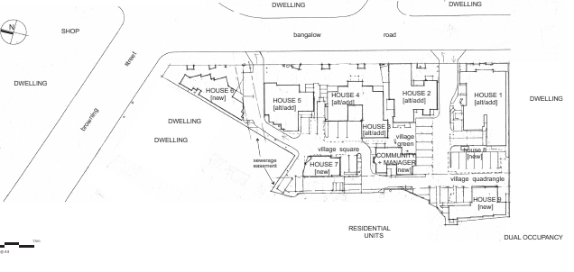
Figure 1. Applicant’s Site Plan (Plan 3.1 in SEE)
The development would be undertaken in five stages being (see Figure 2):
· Stage 1: Houses 6 & 9, 8 car parking spaces
· Stage 2: House 8 & Community/Manager building, 11 car parking spaces
· Stage 3: Houses 2 & 7, 15 car parking spaces
· Stage 4: Houses 3,4 & 5, 7 car parking spaces
· ![]()
Stage 5: House 1
Figure 2. Applicant’s Staging Plan
A full plan set for the current DA is Attachment 2 to this report.
Attachment 3 contains a comparison of the proposed development with that previously approved under DA 10.2007.406.1.
In summary, the design changes provide for an increase in self-contained studio rooms as opposed to the number of single bedrooms with shared facilities as previously approved. There is an associated reduction in communal facilities, although each building still includes communal living and kitchen spaces.
There is an overall decrease in floor area for the boarding house buildings of approx. 8m2.
The community building / manager’s residence is approx. 62m2 larger in floor area, primarily by providing more residential space and amenity for the manger’s residence.
Overall, the design changes provide for accommodation that is more suitable for a boarding house, with the ensuite studios providing for longer tenancies, whereas the previously approved layout was suitable for hostel-type stays, with bedrooms and shared facilities.
Description of the site
The subject site is located to the south of the Bangalow Road, Browning Street, Tennyson Street round-about with primary frontage to Bangalow Road. It is bounded by commercial premises, residential dwellings, and multi dwelling housing developments.
The property contains five (5) dwellings with three (3) access points at Bangalow Road, and several mature trees at the western and northern property boundaries. It is traversed by a sewer easement near the western boundary and through the body of the property to the north (see Figure 3).
Figure 3. Aerial photo with land zoning overlay with subject property identified by yellow polygon (top image), Land title for subject property (bottom image).
![]()
|
Land is legally described |
LOT: 2 DP: 1206972 |
|
|
Property address |
2 Bangalow Road BYRON BAY |
|
|
Land is zoned: |
R2 Low Density Residential |
|
|
Land area is: |
3,936m2 |
|
|
Property is constrained by:
|
Acid Sulfate Soils (Class 5) Bushfire prone land (Vegetation buffer mapped in extreme south-western corner) High Environmental Value vegetation (coastal swamp forest) |
|
|
Is a BDAR required due to the location of the proposed development? |
☐ Yes ☒ No |
|
|
Are there any easements in favour of Council affecting the site? |
☒ Yes ☐ No |
|
|
Is there a Vegetation Management Plan which might affect the proposal? |
☐ Yes ☒ No |
|
|
Is there a Voluntary Planning Agreement which might affect the proposal? |
☒ Yes ☐ No |
|
The most recent site inspection was conducted in March 2023.
|
Photo 1 - View northwest to the south-eastern corner of the site from the east side of Bangalow Road |
Photo 2 - View west to the site from the east side Bangalow Road at the Seaview Street intersection |
|
Photo 3 - View south of the southern property boundary showing the neighbouring residences |
Photo 4 - View west of the southern section of the western property boundary showing the neighbouring residences |
|
Photo 5 – View south-west over the middle section of the western boundary of the property showing neighbouring residences |
Photo 6 - View north along the northern section of the western boundary of the property |
|
Photo 7 – Mature trees located along the western boundary of the property |
|
2. SUMMARY OF REFERRALS
|
Referral |
Issue |
|
Environmental Health Officer |
No objections subject to conditions. Refer to Doc #A2020/45358 |
|
Development Engineer |
No objections subject to conditions. Refer to Doc #E2022/83722 |
|
Building Surveyor |
No objections subject to conditions. Refer to Doc #A2020/45365 |
|
S64 / Systems Planning Officer |
No objections subject to conditions. Standard contributions are applicable. Refer to Doc #A2021/18593 |
|
S94 / Contributions Officer |
Developer contributions are applicable, with payment of 50% able to be deferred whilst ever the development provides affordable housing. Refer to Doc #A2020/45359 |
|
Rural Fire Service (100B/4.46/4.47) |
See Section 3. below |
3. SECTION 4.14 – BUSH FIRE PRONE LAND
The site is bush fire prone land and consequently the proposed strata subdivision requires a bush fire safety authority under s.100B of the Rural Fires Act 1997. Accordingly, the proposal is integrated development under sections 4.46 and 4.47 of the EP&A Act. The Rural Fire Service (RFS) provided a bush fire safety authority and general terms of approval (GTAs) for the development on 24 February 2021 (Ref: DA20210121000221).
Effect of the 10/50 Rule on Significant Vegetation - The subject site is in a designated 10/50 vegetation entitlement clearing area (online tool accessed 26/4/22). Accordingly, vegetation may be cleared on the property without consent in accordance with the 10/50 Vegetation Clearing Code of Practice for New South Wales, which will include vegetation mapped by Council as high environmental value.
4. SECTION 4.15C – MATTERS FOR CONSIDERATION – DISCUSSION OF ISSUES
Having regard to the matters for consideration detailed in Section 4.15(1) of the Environmental Planning & Assessment Act 1979 (EP&A Act), the following is a summary of the evaluation of the issues.
State Environmental Planning Instruments
|
|
Satisfactory |
Unsatisfactory |
|||
|
State Environmental Planning Policy (Resilience and Hazards) 2021 |
☒ |
☐ |
|||
|
Consideration: Council’s Environmental Health Officer reviewed the information provided and made the following comments in relation to land contamination (cl.4.6): Preliminary Contaminated Site Investigation undertaken by EES in 2007 has been provided by Kate Singleton via email on 04/05/2021. The report has been reviewed and the site is deemed suitable for the proposed development. Notwithstanding investigations were limited to 1.5m depth. As such excavations and/or disturbance exceeding 1.5m will require subsequent approval from Council. This requirement is consistent with recommendations provided by council for (#DA10.2007.406.1). Please see recommended condition below. Further, given the site was identified on council mapping layers as ‘unhealthy building land’ an Unexpected Findings Protocol must also be submitted to Council for approval prior to the issue of a construction certificate for the development. Works for all stages must be undertaken in accordance with the UFP. |
|||||
|
State Environmental Planning Policy (Affordable Rental Housing) 2009 |
☒ |
☐ |
|||
|
Consideration: This SEPP was repealed in November 2021 upon commencement of SEPP (Housing) 2021. Based on the savings and transitional provisions (Schedule 7A) in SEPP (Housing) 2021, the SEPP (Affordable Housing) 2009 applies to the subject application because it was lodged prior to November 2021. The proposed development provides nine (9) boarding houses and a communal / manager’s residence. Division 3 of the SEPP applies to boarding house development. It provides a range of standards and considerations relevant to applications on land zoned R2 Low Density Residential, where the site is located within 400m walking distance to land zoned B2 Local Centre.
The subject site is within ~120m of a Local Centre (B2) zone as shown below. Clause 29 outlines a range of standards that cannot be used to refuse consent, relating to issues such a floor space ratio, building height, landscaping, solar access and parking. These standards are not directly relevant, as refusal of this application is not recommended. Clause 30 specifies that Council must not consent to a boarding house development on land zoned R2 Low Density Residential unless it is satisfied that: a) if a boarding house has 5 or more of the boarding rooms, at least one communal living room will be provided Complies. The application proposes nine individual boarding houses. Each contains more than five boarding rooms, and each contains a communal living area. b) no boarding room will have a gross floor area (excluding any area used for the purposes of private kitchen or bathroom facilities) of more than 25 square metres Complies. A variety of room sizes are proposed, but none are larger than 25m2 in area. c) no boarding room will be occupied by more than 2 adult lodgers Complies. All rooms are single or double. d) adequate bathroom and kitchen facilities will be available within the boarding house for the use of each lodger Complies. There is a combination of ensuite rooms and communal bathrooms. A number of rooms include small kitchenettes, but all houses include communal kitchen facilities. e) if the boarding house has capacity to accommodate 20 or more lodgers, a boarding room or on site dwelling will be provided for a boarding house manager Complies. A manager’s residence is provided. f) (repealed) g) if the boarding house is on land zoned primarily for commercial purposes, no part of the ground floor of the boarding house that fronts a street will be used for residential purposes unless another environmental planning instrument permits such a use The land is not zoned for commercial purposes. h) at least one parking space will be provided for a bicycle, and one will be provided for a motorcycle, for every 5 boarding rooms The proposal includes 80 boarding rooms, requiring 16 motorcycles and bicycle spaces. The application proposes 16 motorcycles spaces and 25 bicycles spaces. Clause 30AA requires that a consent authority must not grant development consent to a boarding house on land within Zone R2 Low Density Residential unless it is satisfied that the boarding house has no more than 12 boarding rooms. None of the individual buildings contain more than 12 boarding rooms. Clause 30A requires that a consent authority must not consent to development to which this Division applies unless it has taken into consideration whether the design of the development is compatible with the character of the local area. Existing houses 1-5 have been in place for a number of decades and present in the streetscape as single dwellings. This is consistent with the local residential character. The addition of the new houses will increase the density of buildings within the site and require the removal of a number of mature trees. While this will alter the existing site character, the density is consistent with that in the immediate vicinity. The loss of mature trees will be offset over time as new site landscaping matures. |
|||||
|
State Environmental Planning Policy (Building Sustainability Index: BASIX) 2004 |
☒ |
☐ |
|||
|
Consideration: The proposal is BASIX affected development and a Multi Dwelling BASIX Certificate was provided with the application. The BASIX Certificate covers House 6, 7, 8 and 9 and the Communal/Manager’s building. Individual BASIX Certificates have been provided for the alterations and additions to House 1, 2, 3, 4 and 5. |
|||||
|
State Environmental Planning Policy (Biodiversity and Conservation) 2021 |
☒ |
☐ |
|||
|
Consideration: The property is within the koala planning area under the Byron Coast Comprehensive Koala Plan of Management (BCCKPoM) but is less than 1ha in area, is not within the West Byron Koala Management Precinct and does not include mapped koala habitat under the BCCKPoM. |
|||||
|
State Environmental Planning Policy (Transport and Infrastructure) 2021 |
☒ |
☐ |
|||
|
Consideration: None of the buildings, yet to be constructed, are within the setbacks to electrical infrastructure (based on Council’s GIS) that would require referral of the development application to Essential Energy (cl.2.48). |
|||||
Byron Local Environmental Plan 2014 (LEP 2014)
LEP 2014 is an applicable matter for consideration in the assessment of the subject development application in accordance with subsection 4.15(1) of the EP&A Act because it applies to the subject land and the proposed development. The LEP 2014 clauses that are checked below are of relevance to the proposed development:
|
Part 1 |
☒1.1 | ☒1.1AA | ☒1.2 | ☒1.3 | ☒1.4 | ☒Dictionary | ☒1.5 | ☒1.6 | ☒1.7 | ☒1.8 | ☒1.9 | ☒1.9A |
|
Part 2 |
☒2.1 | ☒2.2 | ☒2.3 | ☒2.6 | ☒Land Use Table |
|
Part 4 |
☒4.3 | ☒4.4 | ☒4.5 | ☒4.6 |
|
Part 6 |
☒6.1 | ☒6.2 | ☒6.6 | |
In accordance with LEP 2014 clauses 1.4 and 2.1 – 2.3:
(a) The proposed development is defined in the LEP 2014 Dictionary as Boarding houses (see Note); and in the EP&A Act (s.6.2) as subdivision of land;
(b) The land is within the R2 Low Density Residential according to the Land Zoning Map;
(c) The proposed development is Permitted with Consent; and
(d) Regard is had for the Zone Objectives as follows:
|
Zone Objectives – R2 |
Consideration |
|
· To provide for the housing needs of the community within a low density residential environment. · To enable other land uses that provide facilities or services to meet the day to day needs of residents. |
The proposal provides an affordable housing option for the community within a low-density residential context and environment. |
Note: The community building and manager’s residence have been considered as ancillary to the primary development purpose of boarding houses.
4.3 Height of buildings
Based on the elevations provided, the maximum building height appears to be 8.4m for House 8. Not all elevations include annotated maximum building heights, and the SEE does not provide a description of building heights. All buildings appear, however, to be under the maximum allowable building height of 9m.
4.4 Floor space ratio (FSR)
The gross floor area (GFA) of the development is 2,266.9m², resulting in an FSR of 0.576:1, which exceeds the maximum allowable FSR for the property of 0.5:1. A written request seeking to vary the FSR development standard was provided with the application and is considered below.
The previous scheme approved under DA10.2007.406.1 had a floor area of 2,213m², which was an FSR of 0.562:1.
6.1 Acid sulfate soils
An acid sulfate soils assessment was provided with the application (‘Potential Acid Sulfate Soils Investigation’, Soil Pacific, 21 June 2004) which identified areas on the subject site as acid sulfate soils. Council’s Environmental Health Officer made the following comments in relation to acid sulfate soils and the proposed development:
· The report does not relate to the current development footprint or development staging; and
· If approved, a detailed Acid Sulfate Soils Management Plan should be required to be submitted to, and approved by, Council prior to the issue of the first construction certificate for the development (Stage 1).
6.7 Affordable housing in residential and business zones
The proposed boarding houses provide affordable housing.
The remaining clauses of the LEP have been taken into consideration in the assessment of the subject development application in accordance with Section 4.15 of the EP&A Act. The proposed development complies with all these clauses (in some cases subject to conditions and/or to the satisfaction of other assessing officers), except in relation to Clause 4.4 which is considered further as follows:
|
What clause does the development not comply with and what is the nature of the non-compliance? |
Further consideration, including whether the development application is recommended for approval or refusal accordingly |
|
Clause 4.4 – Floor Space Ratio |
See discussion above and under Clause 4.6 below. |
4.6 Exceptions to development standards
The applicant has sought a variation to clause 4.4 Floor space ratio. The proposed FSR of 0.576:1 is an exceedance of the development standard (0.5:1) by 15.2%. The applicant has submitted a written request that strict compliance with the development standard is unreasonable and unnecessary and that there are sufficient environmental grounds to vary the controls as:
It is considered that strict compliance with the development standard is unreasonable in the circumstances of the case and that there are sufficient environmental grounds to vary the development standard for the following reasons:
· the additional floor space ratio will have minimal impact on the character of the locality as most new buildings will be partially hidden from the street by existing buildings and the development is not substantially different from that previously approved for the site (DA 10.2007.406.1).
· the development will require removal of existing vegetation, some of which is mapped as high environmental value, however the tree removal was previously approved for the site (DA 10.2007.406.1).
· Council previously approved a variation to the floor space ratio of 0.562:1 for a similar development on the site (DA 10.2007.406.1).
Further, the proposal is in the public interest having regard to the objectives of the development standard and zone, in that it will provide a diversity of housing types (being boarding houses that are to provide affordable housing) within a low-density residential environment in a suitable location, being close to Byron Bay town centre.
As the development contravenes the development standard by more than 10% the concurrence of the Secretary cannot be assumed by a delegate of Council (Planning Circular: 20-002 Variations to development standards). However, the concurrence of the Planning Secretary is not required provided the development application is determined by Council.
It is recommended that the development standard can be varied in this instance, as:
a) The development is satisfactory having regard to the requirements outlined in clause 4.6;
b) The development is satisfactory having regard to applicable Department of Planning, Infrastructure and Environment Circulars;
c) The development is satisfactory having regard to relevant caselaw;
d) The DA demonstrates that compliance is with the development standard is unreasonable;
e) The DA demonstrates that there are sufficient environmental planning grounds to justify contravening the standard;
f) The DA demonstrates that that the development in the public interest; and
g) The DA demonstrates that the development is consistent with the objectives of the standard and the zone.
Any proposed Instrument that has been the subject of public consultation and has been notified to the consent authority
No proposed Environmental Planning Instruments of relevance to the proposed development were identified.
Byron Shire Development Control Plan 2014 (DCP 2014)
DCP 2014 is an applicable matter for consideration in the assessment of the subject development application in accordance with subsection 4.15(1) of the EP& A Act because it applies to the land to which LEP 2014 applies. The DCP 2014 Parts/Chapters that are checked below are of relevance to the proposed development:
|
Part A |
☒ |
|
Part B Chapters: |
☒ B1| ☒ B3| ☒ B4| ☒ B5| ☒ B7| ☒ B8| ☒ B9| ☒ B12| ☒ B13| ☒ B14 |
|
Part D Chapters |
☒ D1| ☒ D6| |
|
Part E Chapters |
☐ E1| ☐ E2| ☐ E3| ☐ E4| ☒ E5| ☐ E6| ☒ E7| ☐ E8 |
B1: Biodiversity
The SEE states that “The only vegetation removal proposed comprises two (2) palms planted as landscaping for the existing site”. It would appear that this statement is referring to vegetation additional to that permitted for removal by the previous consent for the site (DA 10.2007.406.1).
The proposal will require removal of vegetation for the new buildings and asset protection zones for new and existing buildings, some of which are mature native vegetation and/or within areas mapped as high environmental value vegetation (see photos).
While the application does not include a sufficiently legible tree removal and retention plan or any details of vegetation that would require removal to facilitate the development, it is noted that the same amount of clearing was approved under DA10.2007.406.1. That approval remains valid and can be acted upon.
Further, the Rural Fires Act 10/50 Rule applies to the property and allows vegetation within 10m of the dwellings to be cleared, which in practical terms would be all vegetation on the site.
Consequently, while the development is not consistent with the development envelope controls (B1.2.1) and ecological assessment requirements (B1.2.4), this is not considered to be sufficient to justify refusal of the application.
B3: Services and B4: Traffic Planning, Vehicle Parking, Circulation and Access
Council’s Development Engineer has raised some outstanding issues regarding access and internal manoeuvring, but considers that these issues can be adequately addressed. As such a deferred commencement consent is recommended, requiring submission and approval of updated access plans before the consent can become active.
B5: Providing for Cycling
Chapter B4.2.12 of the DCP requires 1 bicycle space per bed for a boarding house, which would require parking for 80 bikes.
However, State Environmental Planning Policy (Affordable Rental Housing) 2009 contains a requirement for one bicycles space for every 5 boarding rooms, which requires 16 bike spaces.
The SEPP overrides the DCP in this regard.
The proposed development provides 25 bicycle parking bays.
B8: Waste Minimisation and Management
Proposed waste minimisation and management for the development was reviewed by Council’s Resource Recovery Officer who noted the following:
· The systems proposed for reducing and sorting waste thus reducing overall landfill waste are acceptable.
· Based on removal of the third crossover, there are no issues with available kerbside space regardless of maximum bins at the kerb.
· Whilst bin collection is occurring, the cycle lane will be blocked, and vehicles will need to cross the double-lines to pass the garbage truck. This is a traffic management issue which should be reviewed by an expert/engineer.
In regard to this last point, a condition is recommended to the effect that, in the case that bin collection creates significant traffic impacts, the proponent will need to arrange a private waste contractor to undertake regular bin collection from within the site.
B9: Landscaping
The landscape plans submitted with the application are not sufficiently legible and are not accompanied by any explanation of the proposed landscaping for the site contrary to B9.2.2, B9.2.3, B9.3.1 and B9.12.4.
A condition of consent is recommended requiring detailed compliant landscape plans to be submitted with the first Construction Certificate application.
B12: Social Impact Assessment
The application did not include a current social impact assessment despite being required by B12.1.3 for “affordable housing accommodating more than 40 residents” and “boarding houses, accommodating 20 or more residents”.
In the circumstances, given that there is a valid existing approval for the same quantum of residents, it is considered that a social impact assessment is not required.
It is also noted that the design changes proposed in the current application, allow the houses to operate as boarding houses for extended occupation, rather than the approved configuration which was more akin to a hostel.
B13: Access and Mobility
Boarding houses are required to meet several requirements in relation to accessibility (B13.2.3). The proposal includes ten (10) accessible boarding rooms but does clearly demonstrate all relevant accessibility requirements for the development are, or can be, met. A condition of consent is recommended in this regard.
D1: Residential Accommodation in Urban, Village and Special Purpose Zones
D1.2 General Provisions
The SEE states that the proposed development complies with the relevant general provisions, except for:
· Building height plane (D1.2.1) – in relation to Houses 6 and 9;
· Setbacks from boundaries (D1.2.2) – in relation to Houses 2 and 6; and
· Fences (D1.2.5) – a 1.8m high fence along the Bangalow Road frontage is proposed (the maximum allowable street front fence height is 1.2m).
It is noted that most of these non-compliances relate to existing dwellings. A comparison of the previously approved development footprint (DA10.2007.406.1) and proposed development footprint are provided below:
![]()
D1.8 Boarding Houses
See consideration of SEPP (Affordable Rental Housing) 2009 above.
D6: Subdivision
Strata Subdivision of the development is proposed, to create 3 Strata Lots and a Common Lot, as shown below.
Strata subdivision plan
The SEE did not include a consideration of the subdivision design guidelines (D6.2.1). It is acknowledged that some design criteria may not be relevant to strata subdivision, however landscaping and stormwater management are relevant here and associated issues with these criteria are discussed above.
E5: Certain Locations in Byron Bay
The subject site appears to be within Pocket B, for which the character narrative allows for a diverse range of housing types and styles, generally limited to a maximum of two storeys (E5.8.4). The proposed development is not inconsistent with this character narrative.
These checked Parts/Chapters have been taken into consideration in the assessment of the subject development application in accordance with Section 4.15 of the EP&A Act. The proposed development complies with all sections of these Parts/Chapters (in some cases subject to conditions and/or to the satisfaction of other assessing officers), except in relation to certain prescriptive measures which are considered above.
Environmental Planning & Assessment Regulation 2021 Considerations
|
Clause |
This control is applicable to the proposal: |
I have considered this control as it relates to the proposal: |
If this control is applicable, does the proposal comply? |
|
61 Additional matters |
Yes |
Yes |
Standard condition requiring demolition to be in accordance with Australian Standard to be included if development approved. |
|
62 Fire Safety |
No |
N/A |
N/A |
|
64 Building upgrade |
Yes |
Yes. Referred to Building Certifier |
Building Certifier satisfied matters can be addressed by conditions and/or construction certificate |
The likely impacts of that development, including environmental impacts on both the natural and built environments, and social and economic impacts in the locality
|
Impact on: |
Likely significant impact/s? |
|
Natural environment |
The proposal may have an adverse impact on the natural environment of the locality through removal of high environmental value vegetation. However, an existing valid approval is in place that allows removal of this vegetation. That approval could be acted upon with no further assessment or approval required. |
|
Built environment |
The proposal will have minimal impact on the built environment of the locality. Five of the nine houses existing, and the new houses will be located behind these existing structures. The locality contains a range of housing types and densities, similar to that proposed. |
|
Social Environment |
The proposal will have a positive social benefit in providing a diversity of housing options, particularly by way of more affordable rental options. It is also noted that the design changes provide for a significant increase in self-contained rooms, making the development more of a conventional boarding house, rather than the hostel-type development as previously approved. |
|
Economic impact |
The proposal will not have a significant economic impact on the locality, although the boarding house can provide affordable accommodation for local workers, which is a critical economic need for Byron Bay. |
|
Construction Impacts |
The development will generate minor impacts during its construction. Conditions of consent are recommended to control hours of work, builders waste, construction noise, installation of sedimentation and erosion control measures and the like to ameliorate such impacts. |
Council Policies that are applicable to the proposed development:
|
Council Policy |
Consideration |
|
Building in the Vicinity of Underground Infrastructure Policy 2020 |
See s.64 referral |
|
See EHO referral |
|
|
See Development Engineer referral |
|
|
See s.64 referral |
|
|
See s.64 referral |
The suitability of the site for the development
The site is in an urban location, with access to services, in an area characterised by mixed housing types and densities, and is in close walking distance to the Byron Bay town centre.
Further, five of the houses exist and have been used as boarding houses/ hostel for many years.
The site is suitable for the development as proposed.
Submissions made in accordance with this Act or the regulations
The development application was publicly exhibited
There were 3 submissions made on the development application:
- 1 For
- 2 Against
-
|
Key issues raised in submissions |
Consideration |
|
Concern boarding houses will be holiday let |
As noted above, the current design for the houses is consistent with a conventional boarding house. The current design is less likely to operate as a holiday hostel than that previously approved. |
|
Tree removal |
As noted above, there is an existing valid development consent which provides for the same quantum of tree removal as currently proposed. |
|
Noise/amenity impacts |
Council’s Environmental Health Officer did not identify any specific land use conflicts likely to result from the development. |
|
Privacy impacts (particularly on neighbouring residential dwellings) |
Some of the new buildings will be located near the boundary to adjoining residential dwellings. · House 6 is progressively set back from the boundary with screens proposed for most upstairs windows (see west elevation). · House 8 has two decks on the south façade that will overlook the neighbouring property to the south one of which encroaches the building height plane. Privacy screens can be conditioned · House 9 has a deck on the south and west facades. Some screens are proposed for west facing upstairs windows and the deck on the west façade. House 7 and the community/manager’s building appear to have reasonable setbacks to the west boundary. Housing density and setbacks are consistent with existing development in this locality. A condition is recommended requiring privacy screens for all external balconies located close to property boundaries. |
|
Overdevelopment / contrary to zone objectives in that the development is not “low density” |
The proposed development does exceed the maximum floor space ratio for the site. However, the development backs onto a multi dwelling housing development which appears to have a similar density. |
Public interest
The proposed development is in the public interest by providing affordable rental housing options that are particularly suitable for low paid workers.
5. DEVELOPER CONTRIBUTIONS
Water & Sewer Levies
Section 64 levies will be payable.
The previously approved development – 10.2007.406.1 – was subject to a Voluntary Planning Agreement, which included a commitment by Council to reduce the Section 64 levies, by applying a rate of 0.125 ETs per bed.
An updated VPA has been submitted with the application, proposing the same reduced ET rate.
The current applicable rate is 0.33 ET per bed for water and bulk water and 0.5 ET per bed for sewer. There is no provision within the current Developer Servicing Plan for a reduction in contributions for affordable housing, and Council’s Systems Planning Officer recommends that the current contributions should be levied, as the waster/ sewer loads are not influenced by the amount of rent paid.
The difference between the current applicable contributions and those that might be applicable at the proposed reduced ET rate equates to 16.75 ET for water and bulk water and 35.0 ET for sewer.
Developer Contributions
Section 7.11 Contributions will be payable.
Clause 2.15 of the current Developer Contributions Plan allows for the payment of the calculated contributions to be suspended whilst ever the development is used for affordable housing.
In this case, the total amount of contributions has been calculated at $560,219.96.
Planning Agreement
In 2014, Council approved a planning agreement (VPA) relating to the approved development under DA 10.2007.406.1 (S2014/4271). The VPA appears to waive half of the development application fees and offer the developer reduced development contributions in return for the provision of affordable housing on the site.
The VPA contains a complex methodology which requires the proponent to provide a specified number of rooms at discounted rental rates for certain specified periods.
While it was signed by proponents and Council in 2014, it does not appear that it has yet been enacted, as contributions for the boarding house component have not yet been paid.
Given that the scale of the current development has been reduced from that approved under 10.2007.406.1, which included and adjoining medium density housing proposal and land subdivision as well as the proposed boarding houses, it is considered that the complexities of the VPA are no longer required.
The boarding rooms will, by their nature, be rented at rates less than conventional houses or units in the area, ensuring that the development continues to provide an affordable housing option in town.
Suspending the payment of the Developer Contributions whilst ever the development is used for affordable housing is consistent with the current Contributions Plan and has been used in other cases to provide an incentive for the housing to remain affordable.
It is recommended that Council not pursue the VPA in this case, and apply the developer contributions and water and sewer levies as recommended in the conditions of approval.
6. DISCLOSURE OF POLITICAL DONATIONS AND GIFTS
|
Disclosure details |
Response |
|
Has a Disclosure Statement been received in relation to this application? If Yes, Provide Disclosure Statement register reference: 91. |
Yes ☐ No ☒ |
|
Have staff received a ‘gift’ from anyone involved in this application that needs to be disclosed. |
Yes ☐ No ☒ |
7. CONCLUSION
The DA proposes an affordable housing project, being a staged development, comprising nine (9) boarding houses and a community building / manager’s residence. Five of the houses exist and will be renovated and upgraded. The application also proposes the strata subdivision of the development to create three lots and associated common property.
The proposed development is satisfactory having regard to the provisions of relevant environmental planning instruments and planning controls applicable to the site. The proposal raises no significant issues in terms of environmental impacts which cannot be managed. The site is a serviced, relatively unconstrained property and is considered suitable for the proposed development.
Importantly, a valid existing consent is in place for a very similar development of the site. The design changes proposed in the current application provide for more self-contained accommodation, and will more like a conventional boarding house that the previously approved design, which was configured more akin to a hostel,
The application appropriately addresses the relevant constraints applying to the site and is recommended for approval subject to the conditions listed in the Recommendation of this Report.
BYRON SHIRE COUNCIL
Staff Reports - Sustainable Environment and Economy 13.8
Report No. 13.8 Outcome of Request for Proposal: Affordable Housing - 57 Station Street, Mullumbimby
Directorate: Sustainable Environment and Economy
Report Author: Shannon Burt, Director Sustainable Environment and Economy
Esmeralda Davis, Director Corporate and Community Services
File No: I2023/515
Summary:
On 25 August 2022 Council resolved (Res 22-413) to work with Landcom to run a Request for Proposal (RFP) to test the market and identify a preferred Community Housing Provider (CHP) to deliver the Affordable Housing project at 57 Station Street Mullumbimby.
This followed an earlier Report and resolution (Res 22-120) on 14 April 2022 to, amongst other matters, enter into a Project Agreement with Landcom to facilitate both parties working together on this development.
The RFP was released by Landcom to the CHP market on 15 September 2022 and closed at 11.59pm AEDT on 14 November 2022.
At the closing date/time, two non-conforming tenders were received from:
o Link Wentworth
o Community Housing Limited.
Submissions have been assessed in accordance with the provisions of the Local Government (General) Regulations 2021 and Evaluation Plan, by a panel which included two representatives from Council and two representatives from Landcom. This report summarises the background and assessment of the submissions and provides a recommendation not to award the tender based on the information outlined in the Evaluation Report.
RECOMMENDATION:
That Council:
1. Declines to award the Tender for a Community Housing Provider to deliver the Affordable Housing project at 57 Station Street Mullumbimby as per the attached Evaluation Report at Confidential Attachment E2023/37998, noting the significant changes to the market since this process was commenced which has been pivotal in the recommendation.
2. Notes that a further briefing to discuss future options in relation to this project will be provided to Councillors at the May Councillor Workshop.
3. Notes that, following the Councillor Workshop briefing, a further report will be provided to Council with a recommendation for next steps regarding the Affordable Housing project at 57 Station Street Mullumbimby.
1 Confidential - 57 Station Street Mullumbimby Evaluation Report, E2023/37998
Report
On 15 September 2022 the General Manager, under delegated authority, approved the release of a Request for Proposal (RFP) to test the market and identify a preferred Community Housing Provider (CHP) to deliver the Affordable Housing project at 57 Station Street Mullumbimby, in accordance with Res 22-413 from the 25 August 2022 meeting.
This followed an earlier report and resolution (Res 22-120) on 14 April 2022 to, amongst other matters, enter into a Project Agreement with Landcom to facilitate both parties working together on this development.
The RFP was released by Landcom to the CHP market on 15 September 2022 and closed at 11.59pm AEDT on 14 November 2022.
At the closing date/time, two non-conforming tenders were received from:
o Link Wentworth
o Community Housing Limited.
The Request for Proposal sought a CHP to deliver approximately 32 diverse, affordable and sustainable dwellings at 57 Station Street, Mullumbimby for the local community.
Byron Shire Council owns the Land, Landcom’s role is to engage a CHP to deliver the
Project based on the Desired Project Outcomes and to obtain the Development Consent.
Submissions were assessed in accordance with the provisions of the Local Government (General) Regulations 2021 and Evaluation Plan, by a panel which included two representatives from Council and two representatives from Landcom.
Market feedback from this RFP process was that the 49-year lease term is not viable, with the two non-conforming submissions based on the freehold transfer of title of the land.
The two non-conforming submissions were reviewed by the Evaluation Committee to the extent of:
· Understanding why the original 49-year lease terms were not considered viable by the market;
· Understanding of the commercial offers received;
· Overall condition, capacity and experience of the Respondents (although this was not scored); and
· Overall housing need (although this was not scored).
A Commercial Advice Report was provided to the Evaluation Committee in November 2022, outlining the predominant reasons that the 49-year lease is not considered viable by the respondents, and these findings are presented in the attached Evaluation Report.
Whilst the RFP and Landcom’s Terms and Conditions of the Market Process allowed for non-conforming tenders to be submitted, it is considered that the two submissions did not provide terms that would be acceptable to Council in their current form and would not warrant further evaluation or scoring against the criteria for the current RFP, in accordance with the Evaluation and Probity Plan Details.
Furthermore, Council representatives on the evaluation panel advised that direct negotiations could not occur with the two Respondents based on the non-conforming submissions due to significant deviation from the original RFP terms (lease versus freehold) and probity concerns.
As a result, it was agreed by the Evaluation Committee, and observed by the probity adviser, to terminate the current market process in accordance with the Market Process Terms and Conditions for the RFP. It was also agreed that a new market process could be commenced (subject to endorsement from Council) that includes a 99-year lease tenure term (or as otherwise agreed).
Next steps
Acknowledging the significant changes to the market, including escalated construction costs, interest rate rises and changes to external funding opportunities that have impacted responses to the RFP, it was considered appropriate to further consider the next steps for this project.
On 30 March 2023 a meeting was held with representatives from Landcom and Byron Shire Council to discuss the potential next steps in relation to this progress and following this meeting, it was agreed that a further briefing be provided to Councillors at the 4 May Councillor Workshop.
Financial Considerations
Not applicable as no tender has been awarded.
Statutory and Policy Compliance Considerations
The process has been undertaken in accordance with Council’s Purchasing and Procurement Policy, and the provisions of the Local Government (General) Regulation 2021.
The Local Government (General) Regulations 2021 define the options available to Council. An extract is provided below.
Local Government (General) Regulation 2021 - Reg 178
178 Acceptance of tenders
(1) After considering the tender submissions for a proposed contract, the council must either—
(a) accept the tender submission that, having regard to all the circumstances, appears to it to be the most advantageous, or
(b) decline to accept any of the tender submissions.
(1A) Without limiting subsection (1), in considering the tender submissions for a proposed contract for the performance of domestic or other waste management services, the council must take into account whether or not existing workers (within the meaning of section 170) will be offered employment or engagement on terms and conditions comparable to those applicable to the workers immediately before the tender submissions.
(2) A council must ensure that every contract it enters into as a result of a tender submission accepted by the council is with the successful tenderer and in accordance with the tender (modified by any variation under section 176). However, if the successful tender submission was made by the council (as provided for in section 55(2A) of the Act), the council is not required to enter into any contract in order to carry out the requirements of the proposed contract.
(3) A council that decides not to accept any of the tender submissions for a proposed contract or receives no tender submissions for the proposed contract must do one of the following—
(a) postpone or cancel the proposal for the contract,
(b) invite, in accordance with section 167, 168 or 169, fresh tender submissions based on the same or different details,
(c) invite, in accordance with section 168, fresh applications from persons interested in making a tender submission for the proposed contract,
(d) invite, in accordance with section 169, fresh applications from persons interested in making a tender submission for contracts of the same kind as the proposed contract,
(e) by resolution of the council, enter into negotiations with any person (whether or not the person was a tenderer) with a view to entering into a contract in relation to the subject matter of the tender,
(f) carry out the requirements of the proposed contract itself.
(4) If a council resolves to enter into negotiations as referred to in subsection (3)(e), the resolution must state the following—
(a) the council’s reasons for declining to invite fresh tender submissions or applications as referred to in subsection (3)(b)–(d),
(b) the council’s reasons for determining to enter into negotiations with the person or persons referred to in subsection (3)(e).
Council’s endorsement of the recommendation to decline to award the tender as recommended in the attached Evaluation Report is sought.
Staff Reports - Infrastructure Services 13.9
Staff Reports - Infrastructure Services
Report No. 13.9 Heritage Park Mullumbimby - Draft Landscape Masterplan
Directorate: Infrastructure Services
Report Author: Malcolm Robertson, Manager Open Space and Facilities
File No: I2022/1272
Summary:
This report seeks Council approval to place the draft Landscape Masterplan for Heritage Park, Mullumbimby on public exhibition.
The draft plan has been developed in consultation with key stakeholders and interested community. Proposed landscape treatments and design strategies for Heritage Park are designed to promote environmental, cultural, and open space outcomes in a space that is a celebration of the diverse local community.
Establishing a shared vision for the park will enable any future works within the park to progress towards agreed outcomes. The plan will also assist with future project priorities and staging, fund allocation, and potential grant applications.
RECOMMENDATION:
That Council:
1. Approves public exhibition of the Draft Landscape Masterplan for Heritage Park, Mullumbimby for a minimum of 28 days; and
2. Receives a further report on the outcomes from the consultation process.
Attachments:
1 Heritage
Park- Landscape Master Plan DRAFT C, E2023/34236
![]()
Report
Council’s goal is to ensure residents and visitors to Mullumbimby can enjoy an attractive and accessible Heritage Park that includes spaces that are inclusive, safe, comfortable, and enjoyable to be in and around.
This draft Masterplan is intended to provide a framework and implementation plan for the future development, upgrade and management of Heritage Park to allow it to evolve into a quality recreation park. with the following core considerations:
• Connections to Palm Park along the Brunswick River
• Access to the Brunswick River for canoe and kayak launching and fishing
• Picnic facilities that support social gatherings
• Internal walking paths
The draft plan is aimed at protecting and enhancing Mullumbimby’s green and leafy character and allowing reconnection with the river. There are specific actions to restore riparian vegetation and to upgrade Heritage Park public facilities
Key objectives are to:
· Ensure everyone can find their way to, in and around Heritage Park with layout and wayfinding allowing for accessible ease of movement throughout the parklands and connectivity both across parkland spaces and to adjacent urban areas
· Ensure parkland infrastructure is accessible and facilitates inclusive social interaction
· Ensure specific consideration of natural materials and use of natural landscaping so that any infrastructure aligns as much as possible both aesthetically and physically with the natural landscape.
· Identify opportunities for enhancement of the play space with imaginative play elements.
· Identify opportunities to accommodate requirements for recreational access to the Brunswick River
· Consider options to improve safe pedestrian crossing treatments over Tincogan Street.
· Ensure parklands user safety including consideration of Crime Prevention Through Environmental Design principles, sightlines, lighting, and passive surveillance.
Key issues addressed
· ACCESSIBILITY & CONNECTIVITY
Most people utilising the park access via walking. Pedestrian access will be prioritised as the main access strategy to the site. Much of the park and particularly the Heritage Park and Heritage Park West sections are currently characterised by a lack of constructed paths and poor accessibility. In many areas existing paths are also no longer fit for purpose. This significantly reduces the accessibility of the park and the potential benefits and amenity that this linear park space offers the community.
A critical requirement of the masterplan process and any future works is improving accessibility within the park. Improving accessibility within the park not only increases the potential park uses and users but also opens the opportunity for connecting the park to Mullumbimby town centre circulation, thereby providing benefits to both.
· HYDROLOGY & DRAINAGE
Much of the park is in flood flow zones and all of it is in potential inundation areas. The park is also the location of much of the town centre's 'end of line' drainage- being the discharge point for much of the street networks drainage. This causes significant erosion and maintenance stress as well as linear connectivity disruptions within the park.
Existing key drainage locations will be upgraded to ensure positive drainage throughout the site. The main upgrades proposed will be planted drainage swales, rain gardens and regrading of some areas to limit pooling of water. These works can also positively impact the biodiversity of the park and add to existing environmental education assets such as the Arboretum.
· VEHICULAR ACCESS
The two current onsite car parks are at the north-eastern river access and the western boat ramp area. Both areas are unsealed and are heavily degraded. The onsite car parking and vehicular access consumes large expanses of the park in valuable positions, meaning these areas cannot be used as public open recreational space.
Prioritising people oriented open space and riparian health will mean the removal of informal car parking and vehicular access from the northern end of the park.
Car parking to the western river access will be upgraded and rationalised with accessible car parking. On-street car parking and existing car parking near the tennis court will be retained and upgraded. This will improve safety, ecological issues, and enhance usable public open space.
· TINCOGAN STREET INTERSECTION
Improving the safety of the Tincogan Street / Brunswick Terrace intersection was a key outcome of the site analysis and community consultation. Changes are required to the intersection to improve pedestrian and vehicular safety. Adjustments are proposed including pedestrian refuge traffic islands, carriageway adjustment and adoption of left hand turn only for vehicles entering Tincogan Street from Brunswick Terrace or entering Brunswick Terrace from Tincogan Street
· ECOLOGY & HABITAT
The Heritage Park Landscape Masterplan Biodiversity Assessment identified threatened flora species within the arboretum and within the riparian vegetation along Mullumbimby Creek. Lowland rainforest in the arboretum and extending along the Brunswick River is characteristic of the Threatened Ecological Community (TEC) ‘Lowland Rainforest in the NSW North Coast and Sydney Basin Bioregions’. These identified flora species and communities should be protected with no works impacting them.
Vegetation within the park provides habitat for several threatened fauna species, including a colony of Grey-headed Flying-foxes and Black Flying-foxes. All works within the masterplan and future detail design will be required to adhere to recommendations and considerations within the Heritage Park Landscape Masterplan Biodiversity Assessment.
Reducing the destruction and loss of the riparian zones is imperative for the environmental and ecological health of the site. Riparian vegetation along the riverbanks is essential for bank stability and the protection of the park and wildlife habitat. Strengthening of the riparian zones will be undertaken by implementing planting strategies to reinforce the existing riparian corridors and removal of weed species. In areas where the riparian vegetation has been impacted, planting areas will be widened. Vehicle access to riparian areas will be managed and/or removed.
The Brunswick River riparian zones are a significant ecological asset. Existing ecological measures should be maintained and enhanced where possible. Examples include the installation of nest boxes (existing and proposed) through the Arboretum and several other site areas.
Existing habitat as noted in the 'Biodiversity Assessment' will be retained and protected with recommendations in this report followed throughout planning and construction.
· IMPROVING LIMITED & AGING INFRASTRUCTURE
Upgrades and refurbishments to existing infrastructure as well as additional facilities will be incorporated into the park. Upgrades to the shelters, playground, benches, picnic tables, pathways, bridges, drainage systems, car parking, and river access will be included. This will create a more usable, appealing and welcoming space for a wide range of community members. Existing infrastructure should be retained where possible.
· BOAT RAMP RIVER ACCESS & OPEN SPACE USE
There are currently formal and an informal boat ramps in Heritage Park West and Heritage Park respectively. The formal boat ramp is under-utilised due to poor access and insufficient river depths. The informal boat ramp is having significant negative impacts on riparian health.
Maintaining and formalising boat access within Heritage Park will result in significant loss of public open space in the future as accommodations are made for required vehicle movements and associated parking. This runs counter to community desires for maximising usable open space in the Heritage Park sector.
Beyond the park boundaries the small village residential streets are already under strain from increasing traffic movements and parking. Encouraging large vehicles and boat trailers into these streets long term does not represent a sound future strategy for promoting safe streets and viable public open space outcomes for the community.
The solution promoted in this masterplan is to provide 'soft' river access from within the park- kayaks, canoes-and relocate boat access facilities to river areas outside of the town centre of Mullumbimby. This is a strategy used in similar country river towns.
Next steps
Following consideration of feedback through the Public Exhibition of the draft Masterplan, required revision will be undertaken prior to returning to Council seeking formal adoption.
Ongoing maintenance and management by Council and Landcare will continue to ensure community vision is achieved and external funding will be sought to allow for staged construction of planned upgrades.
Strategic Considerations
Community Strategic Plan and Operational Plan
|
CSP Objective |
CSP Strategy |
DP Action |
Code |
OP Activity |
|
5: Connected
Infrastructure |
5.4: Provide accessible community facilities and open spaces |
5.4.2: Parks and open spaces - Provide and maintain active and passive recreational community space that is accessible and inclusive for all |
5.4.2.4 |
Complete Landscape Master planning for Heritage Park, Mullumbimby and seek funding opportunities for implementation |
Previous Resolutions;
21-375
1. That Council allocates $20,000 from the existing $87,300 budget allocated to Heritage Park Infrastructure Works to fund development of a Masterplan for Mullumbimby Heritage Park.
2. That Council note Resolution 21-293.
3. That the Masterplan is to ensure that pedestrian and cycle links between Palm Park, Heritage Park and across Tincogan Street are improved to a safe accessible standard for all users.
Financial Considerations
Adoption of the Landscape Masterplan will enable detail design considerations and creation of “shovel ready” plans for future grant funding.
Consultation and Engagement
Initial external consultation has been undertaken with TBLALC, Arakwal Board, Mullumbimby Residents Association, Maslen Arboretum representatives, Creative Mullum, the Byron Place Planning Collective, and casual park users.
BYRON SHIRE COUNCIL
Staff Reports - Infrastructure Services 13.10
Report No. 13.10 Byron Shire Rail with Trail (Update)
Directorate: Infrastructure Services
Report Author: Therese Black, Business Analyst
File No: I2023/215
Summary:
The purpose of this report is to provide an update on the progress of the “Byron Shire Rail with Trail” project in accordance with Council Resolutions 20-127, 20-572, 21-234, 21-389, 22-224, 22-409 and 22-412, and to seek closure of resolutions where appropriate.
Regionally there has been significant progress on the Northern Rivers Rail Trail, with three LGAs securing Government funding to undertake further Concept design and feasibility for the NRRT. Also, the NRJO has successfully secured $500,000 in funding to conduct further business case and feasibility work for those unfunded sections of the Northern Rivers Rail Trail.
The Tweed section (24 kms from Murwillumbah to Crabbes Creek) opened on 1 March 2023; the Richmond Valley section (13.2 kms from Bentley to Casino) is due to start construction with the removal of all rail infrastructure completed and is forecast to open in early January 2024; and Lismore is currently undertaking concept design for the 16.3 kms from Bentley to South Lismore with a proposed opening date of August 2025.
RECOMMENDATION:
That Council closes Resolutions 20-127, 21-234 and 21-389, with the remaining actions being duplicated within the following outstanding Resolutions:
1. 20-572
2. 22-224,
3. 22-409; and
4. 22-412.
Report
The purpose of this Report is to provide:
1. An update on the progress of the 132 kms that make up the Northern Rivers Rail Trail; and
2. An update on the progress of the Byron Shire “Rail with Trail” project in accordance with Council Resolutions 20-127, 20-572, 21-234, 21-389, 22-224, 22-409 and 22-412.
Northern Rivers Rail Trail
Over the past 4 years Council staff have been working to reactivate the rail corridor that traverses the Northern Rivers in conjunction with our neighbouring Councils. The four LGAs which make up the Northern Rivers Rail Trail are Richmond Valley, Lismore, Tweed and Byron.
In 2020, the Northern Rivers Rail Trail Inc was formed.
The Northern Rivers Rail Trail is envisioned as a staged project to deliver a 132 kilometre shared-user path from Murwillumbah to Casino, which once operated as the branch line of the North Coast Rail Line and ceased operation in April 2004.
The Northern Rivers Rail Trail will be constructed in four stages, each delivered separately by the four local Councils, as funding allows.
Stage 1: The Tweed: Murwillumbah to Crabbes Creek (24 kms) $14.9m; under construction and due for completion February 2023 and opened on 1 March 2023.
Stage 2: Richmond Valley: Casino to Bentley (13.2 kms) $7.5m; under construction and due for completion December 2023; Opening early Jan 2024
Stage 3: Lismore: Bentley to South Lismore $9.9m; Concept Design is underway, with construction set to start in August 2023 and opening is forecast in August 2025.
Stage 4: Byron Shire (not yet funded)
The Northern Rivers Rail Trail Marketing Plan and branding were developed and funded by Tweed Shire Council.
There is a Northern Rivers Rail Trail Governing Committee that Council staff attend.
Quarterly Update - Activities undertaken in response to Council Resolutions:
Provided below is an update on activities undertaken in response to Res 20-127:
1. Commence planning for a rail link connecting Mullumbimby and Byron Bay as part of a multi-use activation of the rail corridor.
(Ongoing - Workshops were held in November 2020 and March 2021 with representatives from TfNSW along with other key NSW Government departments.)
2. Incorporate the project as a key element of the draft Integrated Transport Strategy, which is supported by Park and Ride and other measures to promote active and public transport development within the Strategy.
(Completed - Council has incorporated the activation of the Rail Corridor into the Integrated Transport Strategy - Moving Byron as a key element.)
3. Prepare an economic and social business plan including development of a governance framework to support the project.
(The governance of Rail Trails has become clearer as a result of legislative changes. With respect to Rail with Trail, the investigation of potential governance models will require funding)
4. Provide notice of the intention to establish a rail link to Infrastructure Australia, Infrastructure NSW, TfNSW and other relevant agencies to seek advice on funding criteria and project development.
(Completed – Letters to the above were sent on 19 June 2020. A single response has been received from Chris Hanger, noting the Government will require the following evidence of a viable and sustainable business model; have undertaken effective community consultation and engagement with adjacent landholders that demonstrates overwhelming community support; and have addressed issues relating to potential biosecurity concerns.)
5. Investigate Federal, NSW and other funding bodies to identify funding sources including, but not limited to tourism, infrastructure, transport and climate change mitigation/adaption grants with a priority focus on funding vegetation removal within the rail corridor.
(Ongoing – funding opportunities are being assessed as they are identified to support this project. TfNSW have made $100,000 available specifically for gaining approval to remove vegetation in the rail corridor between Mullumbimby and Byron Bay.
Based on the experience of neighbouring Local Government Areas, there appears to be funding support to complete the missing sections of the NRRT.)
6. Actively seek expressions of interest from potential operators interested in providing commuter shuttle and visitor-oriented services.
(To be commenced concurrently or after the detailed engineering assessment has been completed. Refer Resolutions 22-409 and 22-412.)
7. Seek support including funding through Federal and NSW Ministers for Transport, Hon. Tamara Smith MP, Hon. Ben Franklin MLC and Hon. Justine Elliot MP.
(Completed – Letters have been sent.)
8. Receive six monthly reports on progress.
(Ongoing – This report continues the cycle of every quarter due to the requirements of the Operations Plan.)
9. The business plan be included in the 20/21 Operational Plan, forward Delivery Plans and draft budget.
(Completed – included in the 20/21 Operational Plan.)
10. Item 2 above be funded from the existing Integrated Transport Strategy budget.
(Completed – Incorporating the activation of the rail corridor into the Integrated Transport Strategy – Moving Byron, together with recommended projects and actions, has been and will continue to be funded from the existing Integrated Transport Strategy – Moving Byron.)
11. Implement Actions 4, 5, 7 and 8 immediately and include as part of a rail link project in the 20/21 Operational Plan and forward Delivery Plans that includes item 6 above as an action as well as consideration of a budget for project management.
(Completed. Item 6 – no budget allocation is available.)
Provided below is an update on activities undertaken in response to Res 20-572:
1. That Council prioritises the section of rail corridor between Bayshore Drive and Tyagarah for investigation into the alternatives including multi use.
(Noted prioritization beyond Part 1 of Res 20-127)
2. That Council seeks community and local Land Care support to carry out environmental works on the rail corridor between Bayshore Drive and Tyagarah for removal of unwanted vegetation.
(Formal approval is required via a Third-Party Works application. The rigorous requirements, particularly with respect to WH&S, would make this difficult.)
3. That Council seeks funding for the clearing of the vegetation on the line
(As per Part 5 Res 20-127)
4. That Council, when funding is available, commissions a structural assessment and cost estimate of a sample of the timber bridges suitable for facilitating movement up to a weight that can support light rail and very light rail options outlined in the MURC.
(As per Part 11 Res 20-127, no funding has been allocated for engineering assessment.)
Provided below is an update on activities undertaken in response to Res 21-234:
1. That Council continues to work with Transport for NSW on the delivery of outcomes articulated in Resolutions 20-127 and 20-572 and requests that TFNSW expedites a workshop meeting.
(As per Part 1 Res 20-127, recent discussions indicate a further workshop maybe held.)
2. Seek TFNSW funding to clear vegetation from the rail corridor.
(As per Part 5 Res 20-127)
3. Proactively engages with state and federal governments regarding funding for multi-use activation of the rail corridor.
(Grant funding opportunities are being investigated. Based on the experience of neighbouring Local Government Areas, there appears to be funding and support to complete the Northern Rivers Rail Trail.)
Provided below is an update on activities undertaken in response to Res 21-389:
That Council continues to work with Transport for NSW on the delivery of outcomes articulated in Resolutions 20-127, 20-572, and 21-234
(Responses to Resolutions 20-127,20-572 and 21-234 are detailed above)
Provided below is an update on activities undertaken in response to Res 22-224:
1. Continues to work with Transport for NSW on the delivery of outcomes articulated in Resolutions 20-127, 20-572, 21-234 and 21-389.
(Ongoing)
2. Continues to seek funding opportunities to allow reactivation of the rail corridor within the Byron Shire.
(Ongoing)
3. Engages in discussions with Lismore City Council regarding collaboration on improved public transport strategies and use of the rail corridor.
(Liaison occurs at a range of forums)
4. Writes to Tamara Smith MP to inform her of the current status of the $100,000 funding from TfNSW for the clearing of the rail corridor and the difficulties with complying with the timelines for the approval of the licence to undertake the clearing.
(A funding extension was achieved, and approval has now been given by TfNSW for consultants to access the rail corridor to commence preparation of all the supporting studies required to gain approval for vegetation removal. It is anticipated the Third Party Works Licence application for vegetation removal will be lodged late 2023)
Provided below is an update on activities undertaken in response to Res 22-409:
1. Notes the removal of train tracks from the rail corridor north of Byron Shire following Tweed Shire Council’s decision to implement a bike path in the rail corridor in their Shire.
2. Receives a report on the rail corridor from Mullumbimby station through to the northern shire border:
a) Identifying known constraints of a trail beside the rail for the length of this section
b) Detailing any offers or interest received from commercial or other operators to reinstate a form of rail transport in this section
c) Identifying cost savings that may be realised by utilising the corridor as part of the Mullum to Brunswick bike trail
d) Providing a cost estimate and identifying funding sources for converting and then maintaining this corridor section as a bike and pedestrian track
e) Detailing any benefits to the broader ‘Northern River Rail Trail’ of connecting to the Tweed section
Provided below is an update on activities undertaken in response to Res 22-412:
1. Notes the previous unanimous support of council for the utilisation of the Rail Corridor through Bangalow from Rifle Range Road for bike and pedestrian travel
2. Receives a report on the rail corridor from Bangalow station through to Binna Burra:
a) Identifying known constraints of a trail beside the rail for the length of this section
b) Detailing any offers or interest received from commercial or other operators to reinstate a form of rail transport in this section
c) Provide a cost estimate for implementing and maintaining annually a bike and pedestrian track along the rail corridor:
i. from the Bangalow Station to Rifle Range Road
ii. from the Bangalow Station to the Bangalow Industrial Estate
iii. from the Bangalow Station to Binna Burra
d) Detailing any benefits to the community of building a bike and pedestrian track as above.
(Consultants Burchills have been engaged to prepare the report and it is anticipated this will be presented to the June meeting of Council)
Key issues
TfNSW have made available $100,000, specifically for vegetation removal within the rail corridor between Mullumbimby and Byron Bay, this requires a detailed Third Party Works (TPW) application that must be supported by separate studies covering the areas of environment (ecology, threatened species etc), operations, engineering, WH&S, access, and the proposed works methodology.
In turn, completion of the required detailed TPW application required a separate application and approval process for the consultants to access the rail corridor. This took approximately 8 months and consultant assessments will commence in April 2023 with a view to completing the TPW application late in 2023.
The detailed process of compiling the TPW application is likely to provide updated information on the degraded condition of the rail corridor and associated infrastructure between Mullumbimby and Byron Bay.
There has been correspondence to Council seeking to ensure any rail trail option is also available for equestrian purposes.
Options
Amongst the many options available to Council to reactivate the rail corridor in the Byron Shire, are the following:
1. Continue to support “Rail with Trail” for the whole length of the rail corridor.
2. Focus on the Rail option from Byron Bay to Mullumbimby as stage 1.
3. Focus the Rail option from Byron Bay to Mullumbimby and Byron to Bangalow whilst pursuing a Rail Trail for the remainder of the corridor.
4. Focus on the Rail Trail option for the whole corridor in the context of the Northern Rivers Rail Trail (NRRT) and working with the three LGAs within the Northern Rivers region and other levels of government.
All options are currently unfunded.
Next steps
The important next steps to realise the reactivation of the Byron Shire Rail Corridor include:
· Completion of the reports associated with Res 22-409 & 22-412.
· Completion of the detailed assessments and Third Party Works application for vegetation removal in the rail corridor
· Continued participation in the Northern Rivers Rail Trail Governing Committee and development of the major Northern Rivers Joint Organisation business case
· Continued liaison with TfNSW and the Department of Regional NSW to discuss potential funding sources and infrastructure options.
Strategic Considerations
Community Strategic Plan and Operational Plan
|
CSP Objective |
CSP Strategy |
DP Action |
Code |
OP Activity |
|
Community Objective 1: We have infrastructure, transport and services which meet our expectations |
1.3: Support, through partnership, a network of integrated sustainable transport options |
1.3.1: Ensure an integrated and accessible transport network (SP) |
5.1.4.1 |
Investigate use of the rail corridor |
Recent Resolutions
|
Report |
Resolution |
|
Report to Council – 25 August 2022 (I2022/1157 – Western Rail Corridor Utilisation) |
Resolution 22-412 (Open) |
|
Report to Council – 25 August 2022 (I2022/1156 – North Rail Corridor Utilisation) |
Resolution 22-409 (Open) |
|
Report to Council – 26 May 2022 (I2022/621 – Byron Shire Rail with Trail Update) |
Resolution 22-224 (Open) |
|
Report to Council – 23 September 2021 (I2022/1538 – Byron Shire Rail with Trail Update) |
Resolution 21-389 (Open) |
|
Report to Council – 24 June 2021 (I2022/1080 – Byron Shire Rail with Trail Update) |
Resolution 21-234 (Open) |
|
Report to Council – 25 February 2021 |
Resolution 21-053 (Closed) |
|
NoM – 22 October 2020 (I2022/1685 – MURC Bayshore DR to Tyagarah) |
Resolution 20-572 (Open) |
|
Report to Council – 24 September 2020 |
Resolution 20-518 (Closed) |
|
Report to Council – 26 March 2020 (I2020/479 – Byron Shire Rail with Trail Update) |
Resolution 20-127 (Open) Key working resolution for this project (the primary subject of this report) |
|
Report to Council - 28 Nov 2019 |
Resolution 19-616 (Closed as per 21-053) |
|
Report to Council - 27 June 2019 |
Resolution 19-335 (Closed as per 20-518) |
Legal/Statutory/Policy Considerations
Not applicable
Financial Considerations
Implementation of all options require external funding.
Consultation and Engagement
Key Stakeholders
Government: TfNSW, NSW State and Federal Government representatives.
Neighbouring Shire Councils: Tweed, Lismore and Richmond Valley, Northern Rivers Joint Organisation (NRJO) and Northern Rivers Rail Trail Inc. (NRRT).
BYRON SHIRE COUNCIL
Staff Reports - Infrastructure Services 13.11
Report No. 13.11 Submissions - Fees and Charges - Use of car parking spaces for construction purposes
Directorate: Infrastructure Services
Report Author: Judd Cornwall, Traffic & Transport Engineer
File No: I2023/489
Summary:
This report provides Council with the submissions received during the public exhibition of the fees relating to the “use of Council land/road reservice to enable construction work, events, or temporary use.”
There were 16 submissions received, 15 in support of the proposed amended fees and 1 submission opposed to the amended fees.
In accordance with Council must consider the submissions made prior to adopting the proposed amendments to the fees.
RECOMMENDATION:
That Council considers the submissions made and adopts the amended fees for “Use of Council land/road reserve to enable construction work, events or temporary use” to commence from 1 May 2023.
1 Fees
and Charges Submissions - Use of Council Land/ Road Reserve to Enable
Construction Work, Events or Temporary Use, E2023/33529
![]()
Report
During the public exhibition of Council’s 2022/23 Integrated Planning and Reporting documents, including Revenue policy in May 2022, Council received numerous submissions in relation to ‘hoarding fees’. At the time, Council resolved on the fees in table 1 below with resolution 22-332 part 4 requiring that Council further consider options regarding the fee structure for use of parking spaces and road reserves adjacent to construction sites for construction temporary use and events.
Table 1: Adopted 2022/23 fees and charges regarding the use car parking spaces for construction purposes.
|
Fee name and description |
Fee amount |
|
Application fee |
$180.00 |
|
(Eg. Hoarding, scaffolding, fencing, works zones, other temporary structures or traffic control device/s) |
|
|
Inspection fee |
$200.00 |
|
per hour (minimum 2 inspections with application – further inspections to be paid as required, eg. change to work zone) |
|
|
Urgency fee |
$200.00 |
|
Where use is required within 10 working days of the application being lodged. |
|
|
Low Impact Occupation of Council Land |
$1.00 per m2 / day |
|
Where pedestrian, cyclist and vehicular traffic are not disrupted, includes public reserves |
|
|
$3.00 per m2 / day |
|
|
1. Where the footpath / verge area is closed to pedestrians and/or cyclists. 2. Where an elevated gantry is installed, fees will be charged for the set up and takedown down then charged at a low impact Occupation rate for the period of occupation. |
|
|
Road Closure (full and partial) |
$13.00 per m2 / day |
|
Where the traffic lanes are closed to traffic. |
|
Following a review of the fee structure and consultation with Councillors at a Councillor Workshop, a subsequent report was provided to Council in February 2023. The report proposed an amended fee structure (table 2).
Whilst Council wants to discourage the use of public property for construction, in cases where the impacts are unavoidable and can be managed/mitigated adjacent the development it is proposed that Council minimise the charges. Therefore, for carparking spaces that are within a pay parking zone the charges are proposed to be charged at $105/6LM per day adjacent the property rather than the $120 per space shown in the current policy.
Most of the pay parking in the Shire is angle parking, where each space occupies approximately 2.5m of lineal kerb space, based on the current charges this translates to roughly $288/6LM per day. The proposed charge relates to the current charge for non-pay parking space ($60/space), plus the revenue generated by one space ($45).
For non-pay parking spaces, it is proposed that Council maintain the current $60 charge per day but charge per 6LM of kerb space rather than per space. For a comparison Tweed Shire are currently charging $79/6LM/day.
Where the impact on car parking opportunity extends past the frontage of the development it is proposed that this extra space is charged as double the rate per 6LM/day in each case (non-pay parking and pay parking) to help discourage impacts on surrounding businesses and residents.
Table 2: Proposed changes to charges regarding the use car parking spaces for construction purposes.
|
Use of Council land/road reserve to enable construction work, events or temporary use |
|
|
Frontage parking – non pay parking location |
$60/6LM/day |
|
Frontage parking – pay parking location |
$105/6LM/day |
|
Extended frontage parking (additional space extending past development frontage)- non-pay parking location |
$120/6LM/day |
|
Extended frontage parking (additional space extending past development frontage)- non-pay parking location |
$210/6LM/day |
In accordance with s610F of the Local Government Act 1993, Council resolved (23-044) to place the proposed fees for “Use of Council land/road reserve to enable construction work, events or temporary use” on public exhibition for a period of 28 days.
During the exhibition period, 16 submissions were received. 15 submissions expressed support for the amended fees and 1 submission opposed to the amended fees. Details of the submissions are provided in attachment 1.
Strategic Considerations
Community Strategic Plan and Operational Plan
|
CSP Objective |
CSP Strategy |
DP Action |
Code |
OP Activity |
|
5: Connected Infrastructure |
5.2: Connect the Shire through integrated transport services |
5.2.4: Parking - Manage parking through effective controls that support Movement and Place Plans and are coordinated with other initiatives such as park and ride |
5.2.4.2 |
Maintain Byron Bay Paid Parking System |
|
4: Ethical Growth |
4.1: Manage responsible development through effective place and space planning |
4.1.1: Development assessment - Manage development through a transparent and efficient assessment process |
4.1.1.2 |
Certify development in accordance with relevant legislation. |
Recent Resolutions
· 22-332 part 4 (Prepares a report to be delivered in September to provide options regarding fee structure for use of parking spaces and road reserves adjacent to construction sites for construction temporary use and events with the financial implications).
· 23-044 – public exhibition of the proposed fees
Legal/Statutory/Policy Considerations
This report complies with the requirements set by s610F of the Local Government Act 1993:
610F Public notice of fees
(1) A council must not determine the amount of a fee until it has given public notice of the fee in accordance with this section and has considered any submissions duly made to it during the period of public notice.
Financial Implications
It is ultimately difficult to determine any potential revenue loss from the revised fee structure as the amount generated is contingent upon level of development.
For reference, revenue generated in the 2021/22 financial year amounted to $732,000.
BYRON SHIRE COUNCIL
Reports of Committees - Corporate and Community Services 14.1
Reports of Committees - Corporate and Community Services
Report No. 14.1 Report of the Arts and Creative Industries Advisory Committee Meeting held on 16 March 2023
Directorate: Corporate and Community Services
Report Author: Emily Fajerman, Community & Cultural Development Coordinator
File No: I2023/415
Summary:
The Arts and Creative Industries Advisory Committee met on 16 March 2023 and attached are the Minutes for noting by Council.
RECOMMENDATION:
1. That Council notes the minutes of the Arts and Creative Industries Advisory Committee Meeting held on 16 March 2023.
Report
The attachment to this Report provides the Minutes of the Arts and Creative Industries Advisory Committee Meeting of 16 March 2023 for determination by Council. The Agenda for this meeting can be located on Council’s website at:
The following item was considered by the Committee:
Report 4.1 Events Strategy - Initial engagement
the Byron Shire Events Strategy’s engagement of the Tilma Group. The Tilma Group is undertaking consultation and engagement for the Events Strategy and will collaborate with the Business, Industry and Visitor Economy (BIVE) team. Linda Tillman led a discussion with the Committee focusing on current challenges and opportunities for the industry.
Financial Implications
As per the Reports listed within the Arts and Creative Industries Advisory Committee Meeting of 16 March 2023.
Statutory and Policy Compliance Implications
As per the Reports listed within the Arts and Creative Industries Advisory Committee Meeting of 16 March 2023.
BYRON SHIRE COUNCIL
Reports of Committees - Sustainable Environment and Economy 14.2
Reports of Committees - Sustainable Environment and Economy
Report No. 14.2 Report of the Coast and ICOLL Advisory Committee Meeting held on 14 February 2023
Directorate: Sustainable Environment and Economy
Report Author: Michelle Wilde, Project Support Officer
File No: I2023/248
Summary:
This report provides the Minutes of the Coast and ICOLL Advisory Committee meeting of 14 February 2023 for determination by Council.
RECOMMENDATION:
1. That Council notes the minutes of the Coast and ICOLL Advisory Committee Meeting held on 14 February 2023.
1 Minutes
14/02/2023 Coast and ICOLL Advisory Committee, I2023/161 ![]()
Report
The attachment to this Report provides the minutes of the Coast and ICOLL Advisory Committee Meeting of 14 February 2023 for determination by Council. The Agenda for this meeting can be located on Council’s website at:
The following items were considered by the Committee:
Report No. 4.1 Meeting Schedule for 2023 Coast and ICOLL Advisory Committee
This report advises committee members of the scheduled committee meeting dates for 2023 and informs of the process for agendas.
Report No. 4.2 Main and Clarkes Beach Dune Recovery Project - Summary Report
A Summary Report of the project components, methodology, costs, outcomes and lessons learnt has been compiled and is provided in Attachment 1.
Report No. 4.3 Update on the development of Coastal Management Programs (CMPs) for the Byron Shire Coastline
This report provides the Coast and ICOLL Advisory Committee members a 3-monthly brief update on the progress of the development of CMPs and CMP projects for the Byron Shire coastline.
Committee Recommendation
Report No. 3.1 Adoption of Minutes from 20 October 2022 meeting
File No: I2023/40
Committee Recommendation 3.1.1
1. That the draft minutes be amended with the addition of a part 2 under report 4.2 saying that members of the Committee will be briefed on parameters used in the Coastal Hazard Assessment.
2. That the amended minutes of the Coast and ICOLL Advisory Committee Meeting held on 20 October 2022 be confirmed.
Management Comments
In accordance with the Committee Recommendation, Management provide the following additional information:
The Committee recommendation to make an addition to the Minutes of the 20 October 2022 was a meeting process error. From the Code of Meeting Practice 2022, “any debate on the confirmation of the minutes is to be confined to whether the minutes are a full and accurate record of the meeting they relate to”, therefore no additions can be made to a recommendation within the Minutes.
Regarding the Committee’s recommendation to be briefed on parameters used in the Coastal Hazard Assessment (CHA) regarding the 20 October 2022 Report 4.2 - Update on the development of Coastal Management Programs (CMPs) for the Byron Shire Coastline, staff provide the following comments:
· The approach, parameters and inputs (i.e. Method Paper) to the probabilistic coastal erosion hazard assessment for the Byron Shire coastline undertaken forms a chapter of the CHA study which is currently in preparation (near complete).
· The Committee will be provided the Coastal Hazard Assessment Study for the Byron Shire Coastline once complete.
· Once the Coastal Hazard Assessment study is complete, members of the Committee will be offered the opportunity to attend a Key Stakeholder Presentation on the outcomes of the study.
· The Department of Planning and Environment have also offered to hold a separate small briefing with Committee members on the methodology of probabilistic erosion hazard modelling. If accepted, this briefing would best be conducted prior to the presentation on the outcomes of the study.
Management alternatively recommends:
That Council note the Coast & ICOLL Advisory Committee will be:
a. provided the Coastal Hazard Assessment Study for the Byron Shire Coastline once complete.
b. offered the opportunity to attend a Key Stakeholder Presentation on the outcomes of the Coastal Hazard Assessment once complete.
c. briefed by the Department of Environment and Planning on probabilistic erosion hazard assessment.
The remainder of the Committee recommendations are supported by management and are provided in the attachment to this report.
Financial Implications
As per the Reports listed within the Coast and ICOLL Advisory Committee Meeting of 14 February 2023.
Statutory and Policy Compliance Implications
As per the Reports listed within the Coast and ICOLL Advisory Committee Meeting of 14 February 2023.
BYRON SHIRE COUNCIL
Reports of Committees - Sustainable Environment and Economy 14.3
Report No. 14.3 Report of the Housing and Affordability Advisory Committee Meeting held on 16 March 2023
Directorate: Sustainable Environment and Economy
Report Author: Noreen Scott, EA Sustainable Environment and Economy
File No: I2023/398
Summary:
The report provides the minutes of the Housing and Affordability Advisory Committee Meeting of 16 March 2023 for determination by Council.
RECOMMENDATION:
That Council notes the minutes of the Housing and Affordability Advisory Committee Meeting held on 16 March 2023.
1 Minutes
16/3/2023 Housing and Affordability Advisory Committee, I2023/379 ![]()
Report
The attachment to this Report provides the Minutes of the Housing and Affordability Advisory Committee Meeting of 16 March 2023 for determination by Council. The Agenda for this Meeting can be located on Council’s website at:
Agenda of Housing and Affordability Advisory Committee Meeting - Thursday, 16 March 2023 (infocouncil.biz) The committee recommendations are supported by management and are provided in the attachment to this report.
Summary of Reports
Report No. 4.1 Housing Initiative and Project Updates
File No: I2023/286
Committee Recommendation 4.1.1
That the Housing and Affordability Advisory Committee notes the update on current initiatives and projects being progressed by Council staff.
Report No. 4.2 Housing SEPP amendments update
File No: I2023/290
Committee Recommendation 4.2.1
That the Housing and Affordability Advisory Committee notes the report.
Financial Implications
As per the Reports listed within the Housing and Affordability Advisory Committee Meeting of 16 March 2023.
Statutory and Policy Compliance Implications
As per the Reports listed within the Housing and Affordability Advisory Committee Meeting of 16 March 2023.
BYRON SHIRE COUNCIL
Reports of Committees - Sustainable Environment and Economy 14.4
Report No. 14.4 Report of the Climate Change and Resource Recovery Advisory Committee Meeting held on 16 March 2023
Directorate: Sustainable Environment and Economy
Report Author: Michelle Wilde, Project Support Officer
File No: I2023/481
Summary:
This report provides the minutes of the Climate Change and Resource Recovery Advisory Committee Meeting held on 16 March 2023.
RECOMMENDATION:
That Council notes the minutes of the Climate Change and Resource Recovery Advisory Committee Meeting held on 16 March 2023.
1 Minutes
16/03/2023 Climate Change and Resource Recovery Advisory Committee, I2023/364 ![]()
Report
The attachment to this Report provides the Minutes of the Climate Change and Resource Recovery Advisory Committee Meeting of 16 March 2023 for determination by Council. The Agenda for this Meeting can be located on Council’s website at:
https://byron.infocouncil.biz/RedirectToDoc.aspx?URL=Open/2023/03/HAAAC_16032023_MIN_1666.PDF
The committee recommendations are supported by management and are provided in the attachment to this report.
Summary of Reports
Report No. 4.1 Meeting Schedule for 2023 Climate Change and Resource Recovery Advisory Committee
1. The Committee noted the scheduled meeting dates and times for 2023.
2. The Committee requested that 4 additional items be put onto the agenda for the next upcoming meeting.
Report No. 4.2 Resource Recovery Project Updates
The Committee noted the update on current projects and programmes being undertaken by Council staff.
Report No. 4.3 Annual Emissions Inventory for Council Operations
The Committee noted the report.
Financial Implications
As per the Reports listed within the Climate Change and Resource Recovery Advisory Committee Meeting of 16 March 2023.
Statutory and Policy Compliance Implications
As per the Reports listed within the Climate Change and Resource Recovery Advisory Committee Meeting of 16 March 2023.
BYRON SHIRE COUNCIL
Reports of Committees - Infrastructure Services 14.5
Reports of Committees - Infrastructure Services
Report No. 14.5 Report of the Water and Sewer Advisory Committee Meeting held on 30 March 2023
Directorate: Infrastructure Services
Report Author: Dominika Tomanek, Executive Assistant Infrastructure Services
File No: I2023/536
Summary:
The attachment to this report provides the minutes of the Water and Sewer Advisory Committee Meeting of 30 March 2023 for determination by Council.
RECOMMENDATION:
1. That Council notes the minutes of the Water and Sewer Advisory Committee Meeting held on 30 March 2023.
|
2. That Council adopts the following Committee Recommendations:
Report No. 4.1 Review of Council's Onsite Sewage Management Strategy 2001 and Onsite Sewage Management Guidelines 2004 File No: I2023/251
Committee Recommendation 4.1.1 That Water and Sewer Advisory Committee: 1. Notes the draft Onsite Sewage Management Strategy and draft Onsite Sewage Management Guidelines; and 2. Request staff to convene a meeting with available committee members prior to reporting documents in point 1 to Council prior to exhibition.
|
1 Minutes
30/03/2023 Water and Sewer Advisory Committee, I2023/474 ![]()
Report
The attachment to this report provides the minutes of the Water and Sewer Advisory Committee Meeting of 30 March 2023 for determination by Council. The agenda for this meeting can be located on Council’s website at:
Agenda of Water and Sewer Advisory Committee Meeting - Thursday, 30 March 2023 (infocouncil.biz)
The following items were considered by the Committee:
Report No. 4.1 Review of Council's Onsite Sewage Management Strategy 2001 and Onsite Sewage Management Guidelines 2004
Council’s Environmental Health team together with Tim Fitzroy of Fitzroy & Associates, have conducted a review of Council’s Onsite Sewage Management Strategy 2001 and Onsite Sewage Management Guidelines 2004.
Report No. 4.2 Q1 - Utilities Works Delivery Program Update
This report summaries the performance of Utilities Department delivery from December 2022 to February 2023.
Report No. 4.3 Mullumbimby Water Supply Strategy - Members' Motions
The report has been created as requested by members of Water and Sewer Committee to discuss Mullumbimby Water Supply Strategy.
Committee Recommendation
The committee recommendations are supported by management and are provided in the attachment to this report.
Financial Implications
As per the Reports listed within the Water and Sewer Advisory Committee Meeting of 30 March 2023.
Statutory and Policy Compliance Implications
As per the Reports listed within the Water and Sewer Advisory Committee Meeting of 30 March 2023.
BYRON SHIRE COUNCIL
Reports of Committees - Infrastructure Services 14.6
Report No. 14.6 Report of the Moving Byron Advisory Committee Meeting held on 30 March 2023
Directorate: Infrastructure Services
Report Author: Dominika Tomanek, Executive Assistant Infrastructure Services
File No: I2023/537
Summary:
The Attachment to this Report provides the Minutes of the Moving Byron Advisory Committee Meeting of 30 March 2023 for determination by Council.
RECOMMENDATION:
1. That Council notes the minutes of the Moving Byron Advisory Committee Meeting held on 30 March 2023.
1 Minutes
30/03/2023 Moving Byron Advisory Committee, I2023/435
![]()
Report
The attachment to this Report provides the Minutes of the Moving Byron Advisory Committee Meeting of 30 March 2023 for determination by Council. The agenda for this meeting can be located on Council’s website at:
Agenda of Moving Byron Advisory Committee Meeting - Thursday, 30 March 2023 (infocouncil.biz)
The following items were considered by the Committee:
Report No. 4.1 Discussion Items
Three items will be discussed at today’s meeting:
1. TfNSW Integrated Transport Management Plan
2. E-Bus Proposal
3. Tweed Rail Trail
Committee Recommendation
The committee recommendations are supported by management and are provided in the attachment to this report.
Financial Implications
As per the Reports listed within the Moving Byron Advisory Committee Meeting of 30 March 2023.
Statutory and Policy Compliance Implications
As per the Reports listed within the Moving Byron Advisory Committee Meeting of 30 March 2023.