 Agenda
Ordinary (Planning) Meeting
 |
Thursday, 14 April 2022
Agenda
Ordinary (Planning) Meeting
|
Agenda Ordinary (Planning) Meeting
held at the Conference Room, Station Street, Mullumbimby
commencing at 11.00am
Public access relating to items on this agenda can be made between 11:00am and 11:30am on the day of the meeting. Requests for public access should be made to the General Manager or Mayor no later than 12:00 midday on the day prior to the meeting.

Mark Arnold
General Manager
CONFLICT OF INTERESTS
What is a “Conflict of Interests” - A conflict of interests can be of two types:
Pecuniary - an interest that a person has in a matter because of a reasonable likelihood or expectation of appreciable financial gain or loss to the person or another person with whom the person is associated.
Non-pecuniary – a private or personal interest that a Council official has that does not amount to a pecuniary interest as defined in the Code of Conduct for Councillors (eg. A friendship, membership of an association, society or trade union or involvement or interest in an activity and may include an interest of a financial nature).
Remoteness – a person does not have a pecuniary interest in a matter if the interest is so remote or insignificant that it could not reasonably be regarded as likely to influence any decision the person might make in relation to a matter or if the interest is of a kind specified in the Code of Conduct for Councillors.
Who has a Pecuniary Interest? - a person has a pecuniary interest in a matter if the pecuniary interest is the interest of the person, or another person with whom the person is associated (see below).
Relatives, Partners - a person is taken to have a pecuniary interest in a matter if:
· The person’s spouse or de facto partner or a relative of the person has a pecuniary interest in the matter, or
· The person, or a nominee, partners or employer of the person, is a member of a company or other body that has a pecuniary interest in the matter.
N.B. “Relative”, in relation to a person means any of the following:
(a) the parent, grandparent, brother, sister, uncle, aunt, nephew, niece, lineal descends or adopted child of the person or of the person’s spouse;
(b) the spouse or de facto partners of the person or of a person referred to in paragraph (a)
No Interest in the Matter - however, a person is not taken to have a pecuniary interest in a matter:
· If the person is unaware of the relevant pecuniary interest of the spouse, de facto partner, relative or company or other body, or
· Just because the person is a member of, or is employed by, the Council.
· Just because the person is a member of, or a delegate of the Council to, a company or other body that has a pecuniary interest in the matter provided that the person has no beneficial interest in any shares of the company or body.
Disclosure and participation in meetings
· A Councillor or a member of a Council Committee who has a pecuniary interest in any matter with which the Council is concerned and who is present at a meeting of the Council or Committee at which the matter is being considered must disclose the nature of the interest to the meeting as soon as practicable.
· The Councillor or member must not be present at, or in sight of, the meeting of the Council or Committee:
(a) at any time during which the matter is being considered or discussed by the Council or Committee, or
(b) at any time during which the Council or Committee is voting on any question in relation to the matter.
No Knowledge - a person does not breach this Clause if the person did not know and could not reasonably be expected to have known that the matter under consideration at the meeting was a matter in which he or she had a pecuniary interest.
Non-pecuniary Interests - Must be disclosed in meetings.
There are a broad range of options available for managing conflicts & the option chosen will depend on an assessment of the circumstances of the matter, the nature of the interest and the significance of the issue being dealt with. Non-pecuniary conflicts of interests must be dealt with in at least one of the following ways:
· It may be appropriate that no action be taken where the potential for conflict is minimal. However, Councillors should consider providing an explanation of why they consider a conflict does not exist.
· Limit involvement if practical (eg. Participate in discussion but not in decision making or vice-versa). Care needs to be taken when exercising this option.
· Remove the source of the conflict (eg. Relinquishing or divesting the personal interest that creates the conflict)
· Have no involvement by absenting yourself from and not taking part in any debate or voting on the issue as of the provisions in the Code of Conduct (particularly if you have a significant non-pecuniary interest)
RECORDING OF VOTING ON PLANNING MATTERS
Clause 375A of the Local Government Act 1993 – Recording of voting on planning matters
(1) In this section, planning decision means a decision made in the exercise of a function of a council under the Environmental Planning and Assessment Act 1979:
(a) including a decision relating to a development application, an environmental planning instrument, a development control plan or a development contribution plan under that Act, but
(b) not including the making of an order under that Act.
(2) The general manager is required to keep a register containing, for each planning decision made at a meeting of the council or a council committee, the names of the councillors who supported the decision and the names of any councillors who opposed (or are taken to have opposed) the decision.
(3) For the purpose of maintaining the register, a division is required to be called whenever a motion for a planning decision is put at a meeting of the council or a council committee.
(4) Each decision recorded in the register is to be described in the register or identified in a manner that enables the description to be obtained from another publicly available document, and is to include the information required by the regulations.
(5) This section extends to a meeting that is closed to the public.
BUSINESS OF Ordinary (Planning) Meeting
1. Public Access
3. Requests for Leave of Absence
4. Declarations of Interest – Pecuniary and Non-Pecuniary
5. Tabling of Pecuniary Interest Returns (Cl 4.9 Code of Conduct for Councillors)
6. Adoption of Minutes from Previous Meetings
6.1 Ordinary (Planning) Meeting held on 10 March 2022
7. Reservation of Items for Debate and Order of Business
8. Mayoral Minute
9. Notices of Motion
9.1 Non-compliant companion animals..................... 7
10. Petitions
11. Submissions and Grants
12. Delegates' Reports
13. Staff Reports
Sustainable Environment and Economy
13.1 PLANNING - 10.2021.524.1 - Use of Existing Building as a Secondary Dwelling including Alterations and Additions.................................. 13
13.2 Supplementary Report - Resolution 21-221 - Report No 9.2 - Multiple Occupancies and Rural Workers Cottages............................................. 42
13.3 Byron Shire Council and Landcom Project Agreement for an Affordable Housing Development on 57 Station Street Mullumbimby 47
13.4 Selection of community representatives for Northern Joint Regional Planning Panel............ 54
13.5 PLANNING - Report of the Planning Review Committee held 17 March 2022........................ 58
13.6 PLANNING - DA 10.2021.707.1 - Stage 1: Dwelling House, Stage 2: construction of new dwelling house and change of use of existing dwelling to a secondary dwelling....................... 60
14. Reports of Committees
Infrastructure Services
14.1 Report of the Local Traffic Committee Meeting held on 4 April 2022......................................... 76
15. Questions With Notice
Nil
Councillors are encouraged to ask questions regarding any item on the business paper to the appropriate Director prior to the meeting. Any suggested amendments to the recommendations should be provided to Councillor Support prior to the meeting to allow the changes to be typed and presented on the overhead projector at the meeting.
BYRON SHIRE COUNCIL
Notices of Motion 9.1
Notice of Motion No. 9.1 Non-compliant companion animals
File No: I2022/283
1. Notes the recent perceived increase in the number of dogs visible in the Shire;
2. Acknowledges that a ‘Dogs in Public Spaces’ Strategy is being developed but the Community Engagement stage has been delayed by the recent floods;
3. Shares the concern of many residents and visitors at the numbers of dogs in sensitive ecological areas and on public beaches and barking dogs in residential areas;
4. Notes that there is substantial evidence demonstrating that the presence of dogs has a negative impact on biodiversity;
5. Notes the priorities regarding dogs and cats in the adopted (Council Ordinary 24/3/22) Compliance Priorities Program Report 2021; and
a) requests staff to put further priority and emphasis on nuisance or off-leash dogs in environmentally sensitive areas such as Lilly Pilli, Belongil and Tallows estuaries and adjacent beaches,
b) requests staff to put further enforcement priority and emphasis on off-leash dogs in towns and villages,
c) enhances community messaging of 5(a) and 5(b) through local media and any other channels,
d) conveys the same to tourism and accommodation operators;
6. Prepares a six-month review report, including any barriers to compliance in this area; and
7. Continues to work with NPWS to discourage the presence of dogs in National Parks and reserves.
Signed: Cr Michael Lyon and Cr Cate Coorey
Councillor’s supporting information:
From the Compliance Priorities Program Report 2021:
Very High Priority 1.3
Dangerous and/or menacing dogs;
High Priority 2.4
Uncontrolled dogs and/or cats including those kept on land where Policy or
Development consent prohibits it.
Routine Priority 4.1
Companion animals with a high emphasis on high visibility enforcement and public education
|
Customer Request Management Received 2021 |
|
|
|
Dogs Attacks |
101 |
|
|
Dogs Barking |
128 |
|
|
Dogs Found |
123 |
415 |
|
Dogs Nuisance |
292 |
|
|
Dogs Restricted |
5 |
|
|
TOTAL |
649 |
|
|
Companion Animal related penalty infringements issued on daily patrols |
57
|
$23,115 value of fines |
There appears to be an increase of dogs in the Shire in public places. News reports say that there is an overall increase of dogs Australia wide: https://www.dailytelegraph.com.au/news/nsw/australian-pet-ownership-reaches-record-high-during-covid-pandemic/news-story/3d6bafa280bd2715056c28a4961aeecd
Dogs with well-behaved owners are not the focus of this NoM - rather, it is people who do not control their dogs in places where they should be controlled. Byron can only be dog-friendly if dogs and their owners are people and wildlife-friendly. Many people are experiencing being uncomfortable or threatened by the presence of dogs and they are often frightening to children. Dogs have been seen running on beaches where they are not allowed, disturbing beachgoers and attacking other dogs. I have seen dogs chasing wallabies. It is terrifying for the wallaby but I have had an owner say to me that it’s just the dog having a bit of fun. It can literally cause the animal to die of fright.
Byron has a strong history of preserving and protecting wildlife but this is being eroded by increasing numbers of visitors into wild areas and local people whose actions threaten our biodiversity. The world is in a biodiversity crisis, caused by human activity – particularly habitat loss or incursions into habitat.
The presence of dogs as an inhibitor of bird activity is well researched, eg:
https://www.researchgate.net/publication/6055768_Four-legged_friend_or_foe_Dog_walking_displaces_native_birds_from_natural_areas
Peter B. Banks and
Jessica V. Bryant. School of Biological, Earth and Environmental Sciences,
University of New South Wales.
STUDY USED SEVERAL NATIONAL PARKS SITES WITH:
1. PERSON WALKING WITH DOG
2. PERSON WALKING ALONE
3. CONTROL – NO WALKING ACTIVITY
Cautious conservation managers and government legislation typically ban domestic dogs from sensitive areas such as national parks and reserves, however, these bans induce strong protest from dog-walking lobbyists who cite a lack of evidence because multispecies responses of wildlife to dog walking are unknown.
Dog walking caused a 41% reduction
in the numbers of bird individuals detected and a 35% reduction in species
richness ( compared with untreated controls)
Humans walking alone also induced
some disturbance but typically less than half that induced by dogs . Ground
dwelling birds appeared most affected; 50% of the species recorded in control
sites were absent from dog-walked sites.
For birds which did not flee the
site, there were 76% fewer individuals within 10 m of when dog walking occurred
compared with control sites, suggesting that birds were seeking refuge away
from the immediate vicinity of the threat.
In the experiment testing bird responses to single and multiple walkers without dogs, bird abundance did not change with the addition of another human. This confirms that birds responded uniquely and additively when do and additively when dogs accompany walkers.
Even dogs restrained on leads can
disturb birds sufficiently to induce displacement and cause a depauperate local
bird fauna.
These effects were in excess of significant impacts caused by human disturbance, which also caused decline in diversity and abundance. Responses to transient human disturbance are well known.
Staff comments
by Sarah Nagel, Manager Public and Environmental Services, Sustainable Environment and Economy:
(Management Comments must not include formatted recommendations – resolution 11-979)
Staff have spoken to Cr Lyon and Cr Coorey prior to the agenda being published to clarify this notice of motion.
Section 32A of the Companion Animals Act defines a ‘nuisance dog’ to be:
(a) is habitually at large, or
(b) makes a noise, by barking or otherwise, that persistently occurs or continues to such a degree or extent that it unreasonably interferes with the peace, comfort or convenience of any person in any other premises, or
(c) repeatedly defecates on property (other than a public place) outside the property on which it is ordinarily kept, or
(d) repeatedly runs at or chases any person, animal (other than vermin and, in relation to an animal, otherwise than in the course of droving, tending, working or protecting stock) or vehicle, or
(e) endangers the health of any person or animal (other than vermin and, in relation to an animal, otherwise than in the course of droving, tending, working or protecting stock), or
(f) repeatedly causes substantial damage to anything outside the property on which it is ordinarily kept.
Pursuant to Council’s 2022 Compliance Priorities Program, dangerous or menacing dogs fall within the category of ‘very high priority’, uncontrolled dogs fall with the category of ‘high priority’ and noise disturbance (barking dogs) falls with the category of ‘high priority.
Council’s Animal Enforcement Officers patrol areas that have been identified as non-compliant and areas that are notified to Council by the community. Officers also investigate reports of nuisance dogs in accordance with Council’s Enforcement Policy. Officers undertaking these duties are ‘Authorised Officers’ pursuant to the Companion Animals Act 1998 and undertake their duties with the ability to exercise discretion.
Any approach to enforcement of Companion Animal Act offences must be consistent with the intent and objectives of the relevant legislation (including the Companion Animals Act 1998), procedural fairness, natural justice, due process, the NSW Ombudsman’s Enforcement Guidelines for Councils, Council’s Enforcement Policy and Council’s 2022 Compliance Priorities Program.
The concerns relating to nuisance dogs in environmentally sensitive areas is acknowledged. The concerns relating to off-leash dogs and barking dogs in towns and villages is acknowledged.
Staff can improve community safety in these areas though prompt and effective responses via visible and targeted patrols of areas with high reports of non-compliance with proactive enforcement of Companion Animals Act offences.
Staff can enhance community messaging through local media and other means; as well as conveying this message to tourism and accommodation operators.
Staff can prepare a six-month report reviewing progress and noting any barriers to compliance in this area.
Staff will continue to work with NPWS to discourage the presence of dogs in National Parks and Reserves.
Financial/Resource/Legal Implications:
Nil
Is the proposal consistent with any Delivery Program tasks?
Yes
2.4.3.5 Provide Companion Animal Management Services
2.4.3.6 Facilitate Companion Animal Education
|
CSP Objective |
CSP Strategy |
DP Action |
Code |
OP Activity |
|
Community Objective 2: We cultivate and celebrate our diverse cultures, lifestyle and sense of community |
2.4: Enhance community safety and amenity while respecting our shared values |
2.4.3: Enhance public safety, health and liveability through the use of council's regulatory controls and services |
2.4.3.5 |
Provide companion animal management services |
|
Community Objective 2: We cultivate and celebrate our diverse cultures, lifestyle and sense of community |
2.4: Enhance community safety and amenity while respecting our shared values |
2.4.3: Enhance public safety, health and liveability through the use of council's regulatory controls and services |
2.4.3.6 |
Facilitate companion animals education |
Staff Reports - Sustainable Environment and Economy 13.1
Staff Reports - Sustainable Environment and Economy
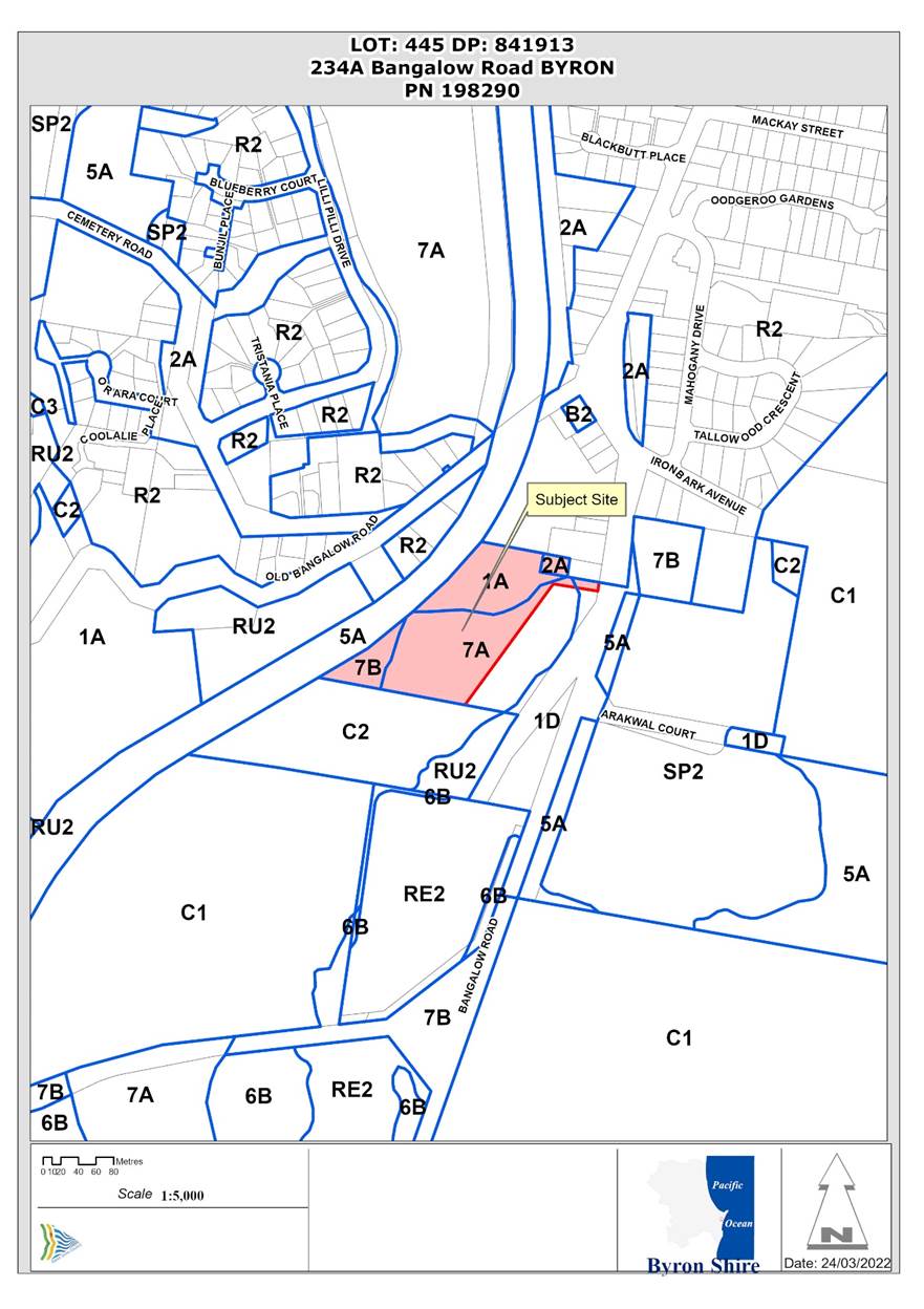
Report No. 13.1 PLANNING - 10.2021.524.1 - Use of Existing Building as a Secondary Dwelling including Alterations and Additions
Directorate: Sustainable Environment and Economy
Report Author: Ben Grant, Planner
File No: I2022/162
Proposal:
|
DA No: |
10.2021.524.1 |
||||||
|
NSW PP |
PAN-135317 |
||||||
|
Proposal description: |
Use of Secondary Dwelling with Alterations and Additions |
||||||
|
Property description: |
LOT: 445 DP: 841913 |
||||||
|
234A Bangalow Road BYRON BAY |
|||||||
|
Parcel No/s: |
198290 |
||||||
|
Applicant: |
Town Planning Studio Pty Ltd |
||||||
|
Owner: |
Ms O L De Looze & Mrs M Mouncey |
||||||
|
Zoning: |
DM Deferred Matter Byron LEP 1988 |
||||||
|
Date received: |
9 March 2021 |
||||||
|
Integrated / Designated Development: |
☐ Integrated |
☒ Designated |
☐ Not applicable |
||||
|
Public notification or exhibition: |
- Level 2 advertising under DCP 2014 Part A14 – Public Notification and Exhibition of Development Applications - Exhibition period: 17/9/21 to 14/10/21 - Submissions received: Nil - Submissions acknowledged: ☐ Yes ☐ No ☒ N/A |
||||||
|
Other approvals |
☐ N/R |
☐ W & S (68) |
☐OSMS (68) |
☐ ST (68) |
☐ RA (138) |
||
|
Other: |
|
||||||
|
Planning Review Committee: |
Not applicable |
||||||
|
Variation request to Development Standards under an EPI (eg clause 4.6) |
Not applicable
|
||||||
|
Delegation to determine |
Council (Designated Development) |
||||||
|
Issues: |
· APZ within Coastal Wetlands Area Map. |
||||||
|
BCA Classification required? |
☒ Yes - BCA Classification – 1(a) ☐ No |
||||||
Summary:
This development application seeks consent for the use of an existing building as a secondary dwelling plus alterations and additions involving the reconfiguration of the floor plan and modification to the external walls, windows, and doors. The building is a former garage and storage shed located in the north-western corner of the property, approximately 30m from Bangalow Road.
This application has been lodged in response to compliance action by Council and seeks to regularise the current use of the building as a dwelling.
To meet bushfire planning requirements, a 20-metre asset protection zone (APZ) will need to be established around the proposed secondary dwelling. The APZ partially intersects with the coastal wetlands and littoral rainforests area map, which operates under State Environmental Planning Policy (Coastal Management) 2018. Clause 10 of this policy states that ‘any development’ (including asset protection zones) that occurs within the coastal wetlands area is designated development.
Applications for designated development and must be determined by Council.
The application was advertised and notified for a period of 28 days between 17 September 2021 and 10 October 2021 in accordance with the Byron Community Participation Plan and no submissions were received from the public during this time. Submissions from the NSW Department of Planning, Industry and Environment (DPIE), NSW Rural Fire Service and the Biodiversity Conservation Division of the DPIE were received which are detailed further in the body of this report.
In terms of environmental impacts, an assessment of the proposal demonstrates that no vegetation will need to be removed to establish the asset protection zone, apart from potential pruning or removal of minor non-native landscape species outside the mapped coastal wetlands and biodiversity values mapped areas. To ensure the APZ is established without significantly affecting the environment, a condition is recommended for a Vegetation Fuel Management Plan to be prepared and approved by Council prior to the issue of a construction certificate.
The proposed development is considered to satisfactory having regard to the relevant environmental planning instruments and planning controls applicable to the site and is recommended for approval subject to the conditions listed in Attachment 1.
NOTE TO COUNCILLORS:
In accordance with the provisions of S375A of the Local Government Act 1993, a Division is to be called whenever a motion for a planning decision is put to the meeting, for the purpose of recording voting on planning matters. Pursuant to clause 2(a) under the heading Matters to be Included in Minutes of Council Meetings of Council's adopted Code of Meeting Practice (as amended) a Division will be deemed to have been called by the mover and seconder of all motions relating to this report.
RECOMMENDATION:
That pursuant to Section 4.16 of the Environmental Planning & Assessment Act 1979, Development Application No. 10.2021.524.1 for use of existing building as a secondary dwelling including alterations and additions, be granted consent subject to the conditions of approval shown at Attachment 1 (E2022/27570).
Attachments:
1 Recommended
Conditions of Consent, E2022/27570
![]()
2 Plans
and Photos, E2021/105458 ![]()
3 Ecological
Assessment Report, E2021/105459 ![]()
4 Agency
Submissions on EIS, E2022/27573 ![]()
Report
1. INTRODUCTION
1.1. History relevant to the development application
The property was originally part of a larger parcel known as Lot 234 that was subdivided in 1994. Survey information and historical records indicate that a garage and shed has existed on the property since at least 1983. The building was described as a car garage in a subdivision application 92/240 dated 1992. The shed/garage was separated from the residence at 234 Bangalow Road following subdivision in August 1994.
1.2. Previous approvals
The following applications are relevant to the current proposal:
· DA 92/456 for earthworks, refused on 21 April 1993.
· DA 92/240 for re-subdivision of land into two lots, approved 17 December 1992.
· BA 93/2622 for a dwelling house, approved on 4 February 1994.
· BA 94/2570 for a swimming pool, approved 15 September 1994.
· DA 2019/288 for use of part shed as a secondary dwelling, withdrawn 14 June 2019.
1.3. Description of the proposed development
This development application seeks consent for the use of an existing building as a secondary dwelling including changes to the external elevations and floor plan.
· Change of use from class 10(a) garage to class 1(a) secondary dwelling.
· Alterations to the external façade of the building near Bedroom 1.
· Conversion of the existing living area into a non-habitable ‘breezeway’, including partial demolition of external living room wall.
· Alteration to internal floor plan to create a 58m2 secondary dwelling with two-bedrooms, combined living room/kitchen and bathroom.
· Retention of attached brick ‘storeroom’ with toilet on the western side of the building.
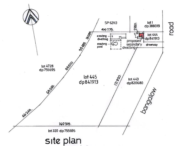
Figure 1: Site plan extract showing location of proposed secondary dwelling.
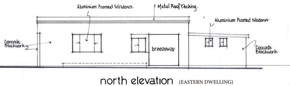
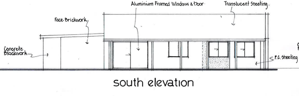
Figure 2: North and south elevations.1.4. Description of the site
A site inspection was carried out on 30 September 2021
The subject site is a 2.28-hectare parcel of land situated on the southern outskirts of Byron Bay. The lot has a hatchet configuration with a 10m access handle connecting to western side of Bangalow Road. The site is relatively flat and drains away from the road towards an area of forested wetlands to the south-west. The western boundary of the property is formed by the non-operational North Coast Railway line.
The site contains an existing four-bedroom dwelling and swimming pool, dating to the early 1990’s, and a former shed and garage that has been converted into a secondary dwelling in the north-eastern corner of the property. Vegetation is mostly lawn and landscaped gardens in the central portion of the site, while the southern end and peripheries are covered by coastal swamp forest vegetation which connects with a larger wetland area to the south-west.
Surrounding development to the north and west is residential in nature, consisting of dwelling houses, dual occupancies and multi dwelling housing. Land to the south is undeveloped Crown land covered in dense coastal swamp forest. St Finbarr’s Primary School is located on the eastern side of Bangalow Road approximately 100m from the site.
The land is subject to flooding from Belongil Creek and is identified as bushfire prone land. There are no known covenants or restrictions on use affecting the property.
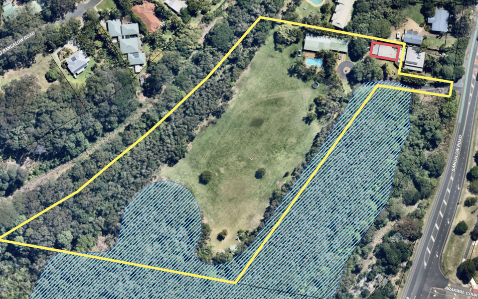
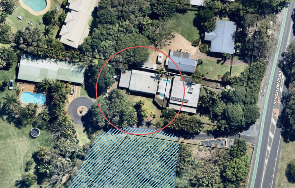
Figure 1: Aerial photo with Coastal Wetlands Area Map overlay. Secondary dwelling outlined in red.
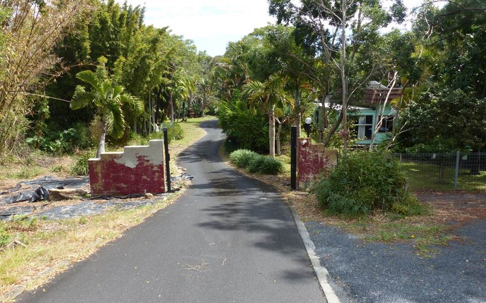
Photo 1: Driveway from Bangalow Road leading into the site, looking due west.

Photo 2: Coastal Swamp Forest vegetation on the southern side of the driveway.
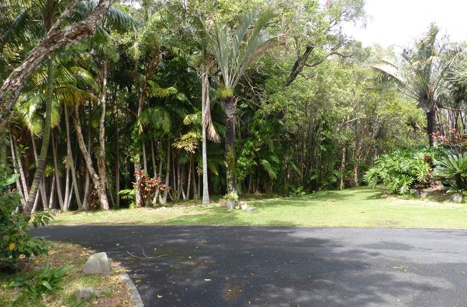
Photo 3: Coastal swamp forest on adjoining Crown land, looking south.
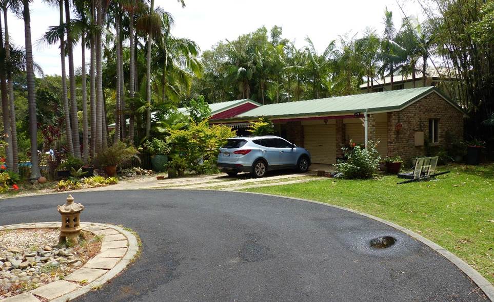
Photo 4: Existing dwelling brick dwelling dating to the early 1990’s.
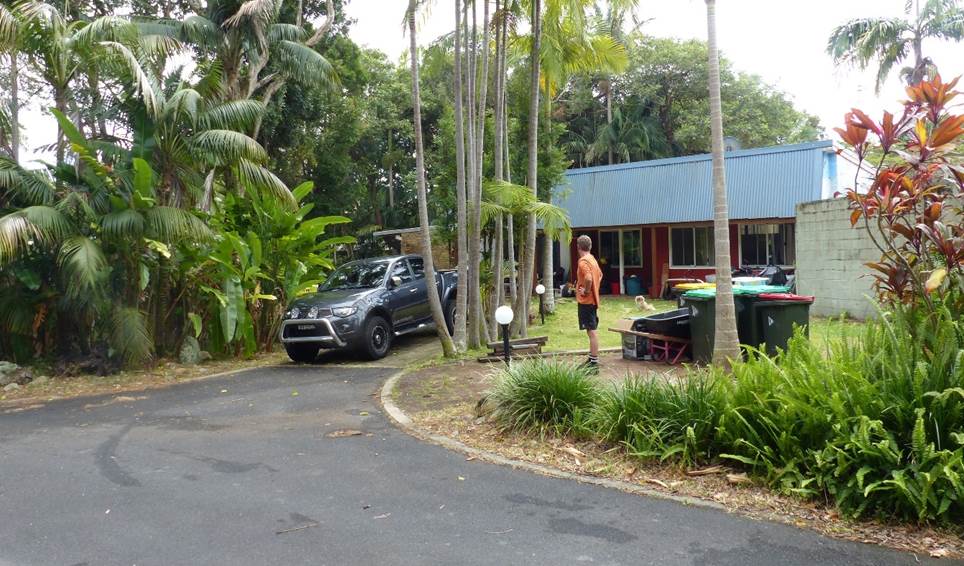
Photo 4: Proposed secondary dwelling, looking north-west.
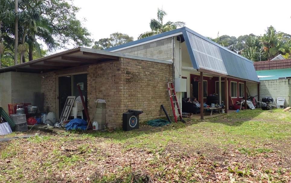
Photo 5: View of brick storeroom attached to the proposed secondary dwelling, looking north-east.
2. SUMMARY OF REFERRALS
Internal Referrals
|
Issue |
|
|
Development Engineer |
Council’s Development Engineer commented that the proposal could be supported from an engineering perspective subject to conditions of consent. Sufficient room exists on site for car parking and stormwater can be discharged via on-site detention and infiltration. In relation to flooding, the proposal will not cause measurable impacts on the flow characteristics of flood waters and has a slab height of 3.8m AHD which is above the 1 in 100-year flood level. |
|
Building Surveyor |
Council’s Building Surveyor stated that the proposed secondary dwelling is capable of complying with the National Construction Code. The building will require upgrading to the requirements of Class 1a construction. Details are to be provided in the construction certificate application. |
|
S64 / Systems Planning Officer |
Councils System Planning Officer noted that water and sewer levies would be payable for the additional dwelling. |
|
S94 / Contributions Officer |
The proposal will result in an increase in population. Development contributions are payable. |
|
Natural Resource Planner |
Council’s Natural Resource Planner concluded the proposal can be supported from an ecological perspective, subject to appropriate conditions of consent. He noted that the proposal includes the establishment of an asset protection zone within a mapped coastal wetland area and is therefore designated development. The application was accompanied by an EIS and ecological assessment report which both state that the proposal would not include clearing of native vegetation within the mapped coastal wetland area. To ensure this occurs, a condition for a Vegetation and Fuel Management Plan is recommended that includes the requirement that no existing native vegetation within the mapped coastal wetland area is to be impacted. |
External Referrals
|
Referrals |
Issue |
|
Rural Fire Service (S4.14) |
The Application was referred to the NSW Rural Fire Service for comment. Conditions were provided on 29-10-2021 recommending the new dwelling be upgraded to comply with BAL-29 construction. |
|
Department of Planning & Environment (DPIE) |
DPIE raised no specific objections to the proposal. A note was added reminding Council of its responsibility to forward public submissions to the Planning Secretary prior to determination of the DA. A letter was uploaded to the planning portal informing that no public submissions had been received. |
|
DPIE Biodiversity Conservation Division |
The Application was referred to the Biodiversity Conservation Division (BCD) of DPIE for comment. BCD stated they were satisfied that any impacts associated with the proposal relating to biodiversity flooding and coastal and estuary matters have been addressed in the EIS. No specific comments or conditions were provided. |
3. SECTION 4.14 – BUSH FIRE PRONE LAND
The site is mapped as bush fire prone land. The proposed secondary dwelling is located adjacent to an expanse of coastal swamp forest on Crown land to the south which poses a bushfire hazard.
The development application was forwarded to the NSW Rural Fire Service (RFS) who provided a set of suggested bushfire conditions which are included in the recommendations of this report.
The existing building will need to be upgraded to meet BAL-29 level of construction and will require a 20m wide asset protection zone (APZ) to be established around the new dwelling. Details of the materials and construction methods are to be supplied for approval with the construction certificate. Further discussion around the environmental impacts of the APZ are discussed in section 4.6 of this report.
4. SECTION 4.15C – MATTERS FOR CONSIDERATION – DISCUSSION OF ISSUES
Having regard to the matters for consideration detailed in Section 4.15(1) of the Environmental Planning & Assessment Act 1979 (EP&A Act), the following is a summary of the evaluation of the issues.
4.1. State Environmental Planning Instruments (SEPPs)
SEPP No 55—Remediation of Land
SEPP 55 requires the consent authority to consider if the land is contaminated and, if so, whether the land needs to be remediated before it will be suitable for the proposed use.
The site has a long history of residential use and is not listed on the Council or EPA contaminated land registers. There are no records of potentially contaminating land uses or radioactive mineral sands occurring on or near the site. The land is considered suitable for ongoing residential use in its current condition and does not require remediation.
SEPP (Affordable Rental Housing) 2009
State Environmental Planning Policy (Affordable Rental Housing) 2009 applies to secondary dwellings located on residential zoned land. The SEPP permits secondary dwellings with consent and sets key development standards in relation to maximum floor area and floor space ratio (FSR) for secondary dwellings.
|
Compliance |
Comment |
|
|
Clause 52 Development may be carried out with consent. |
Yes |
The site is zoned 2(a) Residential under LEP 1988 which is equivalent to the R2 Low Density Residential zone in the Standard Instrument LEP. The proposal is permitted with consent in the 2(a) zone via Clause 22 of the ARH SEPP. |
|
Clause 22(3) (a) – floor space ratio |
Yes |
The total floor area of the principal dwelling and secondary dwelling is less than the maximum FSR under LEP 1988 of 0.5:1. |
|
Clause 22(3) (a) – maximum floor area |
Yes |
The total floor area must not exceed 60m2. The secondary dwelling has a total floor area of 59.5m2. |
|
22(4) – standards by which consent cannot be refused. |
Yes |
Council cannot refuse to grant consent on the following grounds: · The site area is at least 450m2. · No additional parking is provided on site. The site is greater than 450m2 and has adequate room to provide informal carparking if required. |
SEPP (Building Sustainability Index: BASIX) 2004
A valid BASIX certificate has been supplied with the application. Commitments for energy, water and thermal comfort are shown on the DA plans.
State Environmental Planning Policy (Coastal Management) 2018
Part of the site is within the Coastal Wetlands and Littoral Rainforest Area Map under the Coastal Management SEPP. A 20m asset protection zone is required for bushfire protection, which intersects with part of the mapped wetland area near the southern boundary of the driveway handle.
The APZ triggers Clause 10 of the SEPP which provides that any development or removal of vegetation in a mapped coastal wetland is designated development. A diagram illustrating the intersection of the Coastal Wetlands Area Map and the APZ is shown in Figure 2.
Clause 10 Development on certain land within coastal wetlands and littoral rainforests area
(1) The following may be carried out on land identified as “coastal wetlands” or “littoral rainforest” on the Coastal Wetlands and Littoral Rainforests Area Map only with development consent—
(a) the clearing of native vegetation within the meaning of Part 5A of the Local Land Services Act 2013,
(b) the harm of marine vegetation within the meaning of Division 4 of Part 7 of the Fisheries Management Act 1994,
(c) the carrying out of any of the following—
(i) earthworks (including the depositing of material on land),
(ii) constructing a levee,
(iii) draining the land,
(iv) environmental protection works,
(d) any other development.
(2) Development for which consent is required by subclause (1), other than development for the purpose of environmental protection works, is declared to be designated development for the purposes of the Act.
(3) Despite subclause (1), development for the purpose of environmental protection works on land identified as “coastal wetlands” or “littoral rainforest” on the Coastal Wetlands and Littoral Rainforests Area Map may be carried out by or on behalf of a public authority without development consent if the development is identified in—
(a) the relevant certified coastal management program, or
(b) a plan of management prepared and adopted under Division 2 of Part 2 of Chapter 6 of the Local Government Act 1993, or
(c) a plan of management under Division 3.6 of the Crown Land Management Act 2016.
(4) A consent authority must not grant consent for development referred to in subclause (1) unless the consent authority is satisfied that sufficient measures have been, or will be, taken to protect, and where possible enhance, the biophysical, hydrological and ecological integrity of the coastal wetland or littoral rainforest.
An Environmental Impact Statement (EIS) has been provided in accordance with the Secretary’s requirements which addresses the likely impacts of the proposal on the environment.
The EIS and ecological assessment report both state that the proposal would not include clearing of native vegetation within the mapped coastal wetlands or biodiversity values mapped areas. To ensure the adjoining wetland is protected, a condition is recommended that requires a Vegetation and Fuel management Plan to be prepared that will include a requirement that no existing native vegetation within the mapped coastal wetland area is to be impacted. Council’s Natural Resource Planner commented that the proposal was able to be supported on ecological grounds subject to this requirement.
It is noted that the Biodiversity and Conservation Division of DPIE also reviewed the EIA and ecological report and raised no concerns about potential impacts of the development on the environment. Subject to appropriate conditions, the proposal is unlikely to have an adverse effect on the biophysical, hydrological and ecological integrity of the coastal wetland in accordance with the requirements of Clause 10.
Clause 11 Development on land in proximity to coastal wetlands or littoral rainforest
(1) Development consent must not be granted to development on land identified as “proximity area for coastal wetlands” or “proximity area for littoral rainforest” on the Coastal Wetlands and Littoral Rainforests Area Map unless the consent authority is satisfied that the proposed development will not significantly impact on—
(a) the biophysical, hydrological or ecological integrity of the adjacent coastal wetland or littoral rainforest, or
(b) the quantity and quality of surface and ground water flows to and from the adjacent coastal wetland or littoral rainforest.
(2) This clause does not apply to land that is identified as “coastal wetlands” or “littoral rainforest” on the Coastal Wetlands and Littoral Rainforests Area Map.
Assessment:
The proposed development will not result in any additional hard surfaces around the site or increase the roofed area of the existing building. The proposal will not significantly alter the quality or quantity of surface water entering the adjoining wetland or affect the biophysical, hydrological or ecological integrity of the surrounding area. The proposal satisfactorily addresses the requirements of Clause 11.
Clause 15 Development in coastal zone generally—development not to increase risk of coastal hazards
Development consent must not be granted to development on land within the coastal zone unless the consent authority is satisfied that the proposed development is not likely to cause increased risk of coastal hazards on that land or other land.
Assessment:
The proposal relates to an existing building that is above the flood planning levels. The proposed secondary dwelling is unlikely to increase the risk of coastal hazards within the stie or on adjoining land.
The site has a frontage to Bangalow Road which is identified by Transport for NSW as a Regional Classified Road. Pursuant to Clause 101 of SEPP Infrastructure, Council must not grant consent unless it is satisfied of the following matters:
Clause 101 Development with frontage to classified road
(1) The objectives of this clause are—
(a) to ensure that new development does not compromise the effective and ongoing operation and function of classified roads, and
(b) to prevent or reduce the potential impact of traffic noise and vehicle emission on development adjacent to classified roads.
(2) The consent authority must not grant consent to development on land that has a frontage to a classified road unless it is satisfied that—
(a) where practicable and safe, vehicular access to the land is provided by a road other than the classified road, and
(b) the safety, efficiency and ongoing operation of the classified road will not be adversely affected by the development as a result of—
(i) the design of the vehicular access to the land, or
(ii) the emission of smoke or dust from the development, or
(iii) the nature, volume or frequency of vehicles using the classified road to gain access to the land, and
(iv) the development is of a type that is not sensitive to traffic noise or vehicle emissions, or is appropriately located and designed, or includes measures, to ameliorate potential traffic noise or vehicle emissions within the site of the development arising from the adjacent classified road.
Assessment:
In this case it is not practical to provide access to the site by a road other than Bangalow Road. No change or upgrade to the existing access point is required and the proposal will generate only a minimal increase in traffic. The proposal will not be significantly affected by traffic noise or vehicles emissions and is satisfactory having regard to the matters for consideration under Clause 101 of SEPP Infrastructure.
SEPP (Koala Habitat Protection) 2021
The Byron Shire Draft Koala Plan of Management (Byron KPoM), as published on the NSW planning portal, is taken to be an approved koala plan of management for the purposes of this policy. Accordingly, the Byron KPoM is required to be considered in determining the application pursuant to clause 10 of the SEPP.
Clause 10 Development assessment process—approved koala plan of management for land
(1) This clause applies to land to which this Policy applies and to which an approved koala plan of management applies.
(2) The council’s determination of the development application must be consistent with the approved koala plan of management that applies to the land.
The site is greater than 1 ha in area and is within the Koala Planning Area. Therefore, the CKPoM applies. Council’s Natural Resource Planner noted there is a small area of mapped koala habitat in the south-west corner of the site, however, given that the proposed development is relatively distant from the mapped koala habitat, and the land directly impacted by the development is not koala habitat, it is considered that in this instance the proposal can be considered compliant with koala planning requirements of the KPoM and the SEPP.
4.2A Byron Local Environmental Plan 2014 (LEP 2014)
The entire site is identified as a ‘deferred matter’ and is subject to the provisions of Byron LEP 1988. LEP 2014 is therefore not a relevant matter for assessment.
4.2B Byron Local Environmental Plan 1988 (LEP 1988)
LEP 1988 is an applicable matter for consideration in the assessment of the subject development application in accordance with subsection 4.15(1) of the EP&A Act because it applies to the subject land and the proposed development. The LEP 1988 clauses that are checked below are of relevance to the proposed development:
|
Part 1 |
☒1| ☒2| ☒2A| ☒3| ☒4| ☒5| ☒LEP 1988 Dictionary| ☒7 |
|
Part 2 |
☒8| ☒9 |
|
Part 3 |
☒17| ☒24| ☒36| ☒40| ☒45| ☒49| ☒52| ☒64B |
In accordance with LEP 1988 clauses 5, 8 and 9:
(a) The proposed development is defined a dwelling house under LEP 1988 and a secondary dwelling under State Environmental Planning Policy (Affordable Rental Housing) 2009. Permissibility is granted via the state policy which prevails over LEP 1988 to the extent of any inconsistencies.
(b) The land is within the LEP1988 2(a) (Residential Zone) according to the map under LEP 1988;
(c) The proposed development is permissible in the zone (as per the state policy); and
(d) The proposed development is consistent with the relevant objectives of the Zone for the following reasons:
|
Consideration |
|
|
(a) to make provision for certain suitable lands, both in existing urban areas and new release areas, to be used for the purposes of housing and associated neighbourhood facilities of high amenity and accessibility, |
The proposal is consistent with the zone objectives, particularly objective (b) to encourage a range of housing types in appropriate locations. |
|
(b) to encourage a range of housing types in appropriate locations, |
|
|
(c) to enable development for purposes other than residential purposes only if it is compatible with the character of the living area and has a domestic scale and character, and |
|
|
(d) to control by means of a development control plan the location, form, character and density of permissible development. |
|
Compliance |
Comment |
|
|
Clause 17 Dual occupancy |
Yes |
Clause 22 of ARH SEPP makes secondary dwellings permissible with consent in all residential zones. With respect to permissibility and land use definitions, the provisions of the ARH SEPP prevail over the dual occupancy provisions of Clause 17. |
|
Clause 24 Development of flood liable land |
Yes |
Council’s Development Engineer commented that the proposed secondary dwelling was above the 100-year flood level and would not alter the movement of floodwaters in the surrounding area. |
|
Clause 36 Development adjoining wetland
|
Yes |
(3) The council shall not consent to the carrying out of development on or adjoining or contiguous to land within Zone No 7 (a) unless it has taken into consideration— (a) the likely effects of the development on the flora and fauna found in the wetland, (b) the likely effects of the development on the water table, and (c) the effect on the wetlands of any proposed clearing, draining, excavating or filling. Adjoining land to the south is densely covered by coastal swamp forest and is zoned 7(a) (Wetlands Zone) under LEP 1988. Council’s Natural Resource Planner concluded that the proposal will not have a significantly adverse effect on flora or fauna in the area, given the minor nature of the development and negligible vegetation removal involved in establishing the asset protection zone. No excavation is proposed which would lower the water table and the proposal does not involve any draining, clearing or filling of the wetland. |
|
Clause 40 Height |
Yes |
A maximum height of 9m is permitted. The proposed secondary dwelling is single storey with a maximum height of approximately 3m. |
|
Clause 45 Provision of services
|
Yes |
Adequate arrangements are in place, or can be made subject to conditions, for the provision of sewerage, drainage and water services to the land. |
4.3 Any proposed Instrument that has been the subject of public consultation and has been notified to the consent authority
The site is scheduled to be rezoned to part C2 Environmental Conservation and part RU2 Rural Landscape in Stage 3 of Council’s E-zones Planning Proposal. Land surrounding the proposed secondary dwelling will be zones RU2. The proposed secondary dwelling will be permissible under the proposed zoning of the land and is generally consistent with the intended future planning for the area.
4.4 Byron Shire Development Control Plan 2010 (DCP 2010)
DCP 2010 is an applicable matter for consideration in the assessment of the subject development application in accordance with subsection 4.15(1) of the EP& A Act because its purpose is to provide planning strategies and controls for various types of development permissible in accordance with LEP 1988. The DCP 2010 Chapters/Parts that are checked below are of relevance to the proposed development:
|
Chapter 1 Parts: |
☒A| ☒C| ☒F| ☒G| ☒H| ☒K| ☒ N |
These checked Chapters/Parts have been taken into consideration in the assessment of the subject development application in accordance with Section 4.15 of the EP&A Act. The proposed development is demonstrated to meet the relevant Objectives of DCP 2010 (in some cases subject to conditions and/or to the satisfaction of other assessing officers).
Chapter 1: Part C Residential Development
|
Provision |
Compliance |
Comment |
|
C2.3 Element – Buffer Areas |
Yes |
The proposal has adequate buffers from intensive agriculture establishments, quarries, sewage treatment plants and the like. |
|
C2.5 Element – Building Height Plane |
No, but considered acceptable |
The building has a nil boundary setback to the north and east, resulting in non-compliance with the building envelope. Refer to DCP 2010 Issues Section. |
|
C2.6 Element – Setback from Street, Side and Rear Boundaries |
No, but considered acceptable |
900mm minimum side and rear boundary setback required. The proposal has a nil setback to the northern and eastern boundaries. Refer to DCP 2010 Issues Section. |
|
C3.1 Element – Visual Impact |
Yes |
The proposed dwelling is not visible from the street or public domain. |
|
C3.5 Element – Minimum Lot Sizes and Street Frontages |
No, but considered acceptable |
Requirement Area: 800 m2; Frontage 15 m. Proposal The site is a hatchet shaped lot with an area of 2.4 hectares. The access handle is 10m wide at the street frontage. The site has sufficient area and dimensions to ensure residential development will be compatible with the existing and planned character of the locality. |
|
C5.1 Element – On-Site Car Parking |
Yes |
Clause 22 of the ARH SEPP provides that Council cannot refuse an application for a secondary dwelling due to a lack of car parking. The SEPP provision prevails over requirements for carparking in DCP 2010. It is noted that adequate room exists for informal parking on the site. |
|
C5.2 Element – Character |
Yes |
The proposed dwelling is not clearly visible from any public places and therefore will not have an adverse effect on the character of the surrounding area. It is expected that the appearance of the of the building will be improved as part of the proposed upgrades. |
|
C5.3 Element – Density Control |
Yes |
Requirement Floor space ratio must be less than 0.5:1. 25% of the site must comprise absorbent surfaces. Proposal The development has a FSR of 0.017:1. ~98% of the site is absorbent surfaces. |
|
C5.5 Element – Private Open Space |
Yes |
Requirement Each dwelling must have a minimum landscaped area of 90m2, so located that each dwelling-house will have access to an area of private open space at natural ground level, not located in the front setback, having a minimum area of 30m2 and a minimum length and width each of 4m, excluding any area used for vehicle circulation or parking. Proposal There is approximately 250m2 of landscaped area on residential zoned land surrounding the secondary dwelling. Approximately 90m2 of useable private open space is available on the grassed area to the southern side of the dwelling. |
|
C5.6 Element – Adjoining and Adjacent Development |
Yes |
Requirement Where an application proposes the construction of a second dwelling on already developed land and the surrounding development is single storey, Council will require the proposed building to be single storey. Council will only consider dual occupancy development where the following objectives have been met: · adequate provision for reasonable protection of existing views from neighbouring houses. · adequate provision for privacy of the proposed dwelling-house(s)(D) and any adjacent dwelling-house(s)( · adequate provision for access to natural light and solar access for the proposed dwelling-house(s)(D) and any adjacent dwelling-house(s) · maintenance of the character and neighbourhood amenity of the adjoining residential area. Proposal The proposed secondary dwelling is an existing single storey and does not interfere with the views, privacy or solar access of neighbouring residences. |
Chapter 1: Part K – Flood Liable Lands
|
Provision |
Compliance |
Comment |
|
K2.1 Element - Flood Standards |
Yes |
The secondary dwelling will not be unduly affected by the 1% Annual Exceedance Probability (AEP) flood. |
|
K2.2 Element – Development Criteria |
Yes |
The building is above the 1% AEP flood planning level. Council’s Development Engineer noted that the use of flood compatible materials is not required. |
Chapter 1: Part N – Stormwater Management
|
Provision |
Compliance |
Comment |
|
N4.1 Element – Site Drainage |
Yes, subject to conditions |
The existing building has no guttering, resulting in roof water being discharged directly to the ground. Council’s Development Engineer commented that stormwater can be discharged within the site due to large site area and no immediate downstream properties. On site stormwater detention and treatment is not required as the impervious area is less than 150m2 and the site has large areas of grass and vegetation which will act as a treatment system for the overland flow. A condition is recommended for appropriate discharge of stormwater and erosion controls to be implemented during construction. |
4.5. DCP 2010 – Discussion of Issues
C2.5 Element – Building Height Plane
The existing building has a nil setback to the eastern boundary which results in the building height plane passing through a point half-way up the eastern elevation. The location of the building on the neighbouring boundary is the result of a historic subdivision that occurred in 1992.
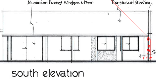
Figure 4: Extent of building height plane encroachment (red).
The proposal is considered to satisfy the relevant performance criteria and objectives of Element C2.5 for the following reasons:
· The building has existed in its current location for several decades does not cause significant overshadowing of the living areas and windows and of the neighbouring dwelling at 234 Bangalow Road between 9.00am and 3.00pm at midwinter.
· Views and privacy of neighbouring dwellings will not be adversely affected given the building is already existing and is single storey.
· The proposal relates to the adaptive reuse of an existing building which has a nil setback and therefore strict compliance is not possible in the circumstances other than to require partial demolition of the building.
4.6 Environmental Planning & Assessment Regulation 2000 Considerations
Clause 81 Forwarding of submissions to Planning Secretary
The development application was advertised and notified for a period of 28 days in accordance with the requirements of the Act and Regulation and no submissions were received during this time. A letter was sent to the Planning Secretary on 24 March 2022 advising that no public submissions had been received.
Cause 92 Additional matters that consent authority must consider
A condition is recommended that requires all demolition works associated with the proposed building alterations be carried out in accordance with AS 2601 – the demolition of structures.
Clause 93 Fire safety and fire safety considerations
Details of fire safety and building code compliance are to be provided with the construction certificate application.
Clause 94 Consent authority may require buildings to be upgraded
The building will need to be upgraded to comply with BAL-29 construction as per the RFS recommendations. Details of the building upgrades are to be provided for approval with the construction certificate application.
4.7 The likely impacts of that development, including environmental impacts on both the natural and built environments, and social and economic impacts in the locality
|
Impact on: |
Likely significant impact/s? |
|
Natural environment |
The proposal will not have a significantly adverse impact on the natural environment of the locality. Council’s Natural Resource Planner recommended a Vegetation and Fuel Management Plan be prepared prior to the issue of a construction certificate to ensure impacts from the asset protection zone are appropriately managed.
|
|
Built environment |
No. The proposal will not have a significantly adverse impact on the built environment of the locality. |
|
Social Environment |
No. The proposal will not have a significant social impact on the locality. |
|
Economic impact |
No. The proposal will not have a significant economic impact on the locality. |
|
Construction Impacts |
The development will generate minor impacts during its construction. Conditions of consent recommended to control hours of work, builders waste, construction noise, installation of sedimentation and erosion control measures and the like to ameliorate such impacts. |
4.8 The suitability of the site for the development
The site attributes are suitable for the proposed development.
4.9 Submissions made in accordance with this Act or the regulations
The development application was publicly exhibited and notified for a period of 28 days in accordance with DCP 2010 and the Byron Shire Community Participation Plan. A copy of the application was also referred to government agencies with a perceived interest in the application, being the NSW Rural Fire Service and the Department of Planning Infrastructure and Environment (DPIE), including DPIE’s Biodiversity Conservation Division.
Public submissions
There were no public submissions made on the development application.
Agency submissions
The RFS responded with a set of recommended conditions to manage bushfire risk.
DPIE and BCD acknowledged submission of the application and the EIS but made no specific comments. RFS and BCD responses can be found in Attachment 4.
4.9 Public interest
The proposed development is unlikely to prejudice or compromise the public interest or create an undesirable precedent.
4.10 Requirements for designated development
Section 4.16 (9) of the Act provides that a consent authority must not determine an application for designated development until after the submission period has expired, or, if a submission is made within the submission period, until after 21 days following the date on which a copy of the submission is forwarded to the Planning Secretary.
A consent authority must not determine a development application for designated development—
(a) until after the submission period (within the meaning of Schedule 1) has expired, or
(b) if a submission is made with respect to the application within the submission period, until after 21 days following the date on which a copy of the submission is forwarded to the Planning Secretary have expired.
The application was advertised and notified for a period of 28 days between 17 September and 14 October 2021 and no public submissions were received during this time. Council is able to determine the application.
5. DEVELOPER CONTRIBUTIONS
5.1 Water & Sewer Levies
The proposal will increase load onto Council’s water and sewer services. Levies under Section 64 of the Water Management Act 2000 are payable.
5.2 Developer Contributions
The proposal will result in an increase in population. Section 7.11 Contributions are payable.
6. CONCLUSION
The DA proposes Use of Secondary Dwelling with Alterations and Additions.
The proposed development is satisfactory having regard to the relevant environmental planning instruments and planning controls applicable to the site. The proposal raises no significant issues in terms of environmental impacts which cannot be managed, and the site is considered suitable for the development. The application appropriately addresses the relevant constraints applying to the site and is recommended for approval subject to the conditions listed in Attachment 1.
BYRON SHIRE COUNCIL
Staff Reports - Sustainable Environment and Economy 13.2
Report No. 13.2 Supplementary Report - Resolution 21-221 - Report No 9.2 - Multiple Occupancies and Rural Workers Cottages
Directorate: Sustainable Environment and Economy
Report Author: Shannon Burt, Director Sustainable Environment and Economy
File No: I2022/212
Summary:
Council considered Report No. 13.7 Council Resolutions Quarterly Review - Q2 - 1 October to 31 December 2021Agenda of Ordinary Meeting - Thursday, 24 February 2022 (infocouncil.biz).
The staff recommendation in relation to several resolutions to be closed was:
RECOMMENDATION:
1. That Council notes the information provided in this report on active Council Resolutions in Attachment 1 (#E2021/155913).
2. That Council notes the completed Resolutions in Attachment 2 (#E2021/155914).
3. That Council endorses the closure of Resolutions 20-203, 20-727, 21-221, 21-20 273, and 21-275 as identified in Table 1: Council resolutions that are to be closed; and included in the completed Resolutions in Attachment 2 (#E2021/155914).
Resolution 22-044 at the meeting however did not endorse the closure of Resolution 21-221.
This report provides a discussion of this resolution and recommends its closure.
RECOMMENDATION:
That Council endorses the closure of Resolution 21-221.
Attachments:
1 Confidential - Letter from Northern Rivers Intentional Communities with Legal Advice, E2022/25683
2 Letter
to Northern Rivers Intentional Communities - Pathway for secondary dwellings
and dual occupancies on Intentional Communities, E2022/21840 ![]()
3 Confidential
- Legal advice from Council's Solicitor, E2022/28319
Report
Council resolved at the Ordinary meeting 24 February 2022, to not endorse the closure of Resolution 21-221. This report provides a discussion of this resolution and recommends its closure.
Council at the Ordinary Meeting of 24 June 2021 considered a Notice of Motion No. 9.2 Multiple Occupancies and Rural Workers Cottages Agenda of Ordinary Meeting - Thursday, 24 June 2021 (infocouncil.biz)
21-221 Resolved that Council:
1. Prepares a report exploring the possibilities, hurdles, and opportunities for continuing Multiple Occupancies and Community Title as a pathway to providing more options for accessible and affordable housing in the Byron Shire.
2. Prepares a report on pathways to encourage the use of rural workers’ cottages to provide accommodation for farmers wanting to live and work on the land.
3. Progress points 1 and 2 as part of the review of the RLUS to commence FY21/22. Noting this review will enable a fresh dialogue with relevant state government agencies on the current needs of our rural community five years on from the original RLUS adoption.
Separate and subsequently, Council at the Ordinary (Planning) meeting of 5 August 2021 considered Notice of Motion No. 9.5 MOs and CTs – pathway for secondary dwellings and dual occupancies Agenda of Ordinary (Planning) Meeting - Thursday, 5 August 2021 (infocouncil.biz)
21-275 Resolved that Council investigates how to enable a workable pathway to facilitate secondary dwellings on Multiple Occupancies and to facilitate secondary dwellings and/or dual occupancies on Community Titles.
Multiple Occupancies (MO) and rural Community Title (CT) developments have had various approval pathways in the past.
Both resolutions requested a further report on the current pathways to enable new MO or CT development and to facilitate secondary dwellings on existing MOs and to facilitate secondary dwellings and/or dual occupancies on existing CTs.
Report No 13.11 - Resolution 21-221 Multiple Occupancies and Rural Workers Cottages & Resolution 21-275 MOs and CTs - pathway for secondary dwellings and dual occupancies was presented to Council Agenda of Ordinary (Planning) Meeting - Thursday, 4 November 2021 (infocouncil.biz), where Council resolved:
21-498 Resolved that Council:
1. Notes the staff update on Resolution 21-221 Multiple Occupancies and Rural Workers Cottages & Resolution 21-275 MOs and CTs - pathway for secondary dwellings and dual occupancies.
2. Requests staff to prepare and submit a planning proposal to the Department of Planning Industry and Environment for Gateway Determination to amend clauses 4.1B and 4.2B Byron Local Environmental Plan 2014 to:
i. remove the restriction of one dwelling per neighbourhood lot and make any other necessary changes to permit dual occupancy and secondary dwellings on existing Multiple Occupancy and rural Community Title development: and
The Northern Rivers Intentional Communities presented to that meeting at public access.
In relation to Resolution 21-498 (1) the report was noted given that the details and pathways provided in the report — being DA and or LEP amendment (see 2) — and that otherwise there will be further consideration of MO/CTs in the RLUS review in the coming year.
In relation to Resolution 21-498 (2)(i), staff prepared a Planning Proposal, and submitted it to the DPE 3 February 2022. The DPE requested additional information from staff prior to their issue of a gateway determination to enable public exhibition. The process for this is withdrawal of the original planning proposal from the planning portal and re lodgement of an updated planning proposal once all matters raised have been addressed by the council.
The updating of our planning proposal has taken into consideration Council’s own legal advice (Confidential Attachment 3). An updated planning proposal PP-2022-1110 was re lodged 30 March 2022 and is now under assessment by DPE.
In relation to Resolution 21-498 (2)(ii), there will be further consideration of the MO/CT assessment criteria in the RLUS review in the coming year which will also need to have regard to DPI’s agricultural land mapping and land use strategy/policy position (once finalised).
Further to the above, the members of the Northern Rivers Intentional Communities met with staff and the Mayor after this meeting (November 2021) about the same issue. Advice given was consistent with the reports to Council and resolutions by Council as current and being those under action by staff.
The only matter outstanding from the above meeting was for staff to respond to the group about their advice presented to the meeting from their Solicitor Jonathan Marquet. Confidential Attachment 1. A staff response to the group was sent Attachment 2.
More recently, an email from the Northern Rivers Intentional Communities was sent to Councillors about Report No. 13.7 Council Resolutions Quarterly Review - Q2 - 1 October to 31 December 2021Agenda of Ordinary Meeting - Thursday, 24 February 2022 (infocouncil.biz) prior to the meeting.
The group presented to that meeting at public access.
Council at that meeting resolved to close Resolutions 21-275 and 21-498 but not Resolution 21-221.
Staff have addressed all relevant aspects of the three resolutions and recommends closure Resolution 21-221 occur now.
Strategic Considerations
Community Strategic Plan and Operational Plan
|
CSP Objective |
CSP Strategy |
DP Action |
Code |
OP Activity |
|
Community Objective 4: We manage growth and change responsibly |
4.1: Support the visions and aspirations of local communities through place-based planning and management |
4.1.3: Manage development through a transparent and efficient assessment process |
4.1.3.11 |
Prepare and assess Planning Proposals and Development Control Plans, and amend Local Environmental Plan maps |
Recent Resolutions
· 21-221
Legal/Statutory/Policy Considerations
As discussed in the report.
Financial Considerations
Not applicable to the report.
Consultation and Engagement
BYRON SHIRE COUNCIL
Staff Reports - Sustainable Environment and Economy 13.3
Report No. 13.3 Byron Shire Council and Landcom Project Agreement for an Affordable Housing Development on 57 Station Street Mullumbimby
Directorate: Sustainable Environment and Economy
Report Author: Shannon Burt, Director Sustainable Environment and Economy
File No: I2022/213
Summary:
The purpose of this report is to seek Council endorsement of a Project Agreement with Landcom to facilitate both parties working together on an affordable housing development on 57 Station Street Mullumbimby.
RECOMMENDATION:
That Council:
1. Notes the overview of who Landcom is, and their experience in delivering affordable housing projects (Attachment 1 #E2022/29946);
2. Notes the project rationale and the preliminary concept plan prepared for an affordable housing development on 57 Station Street, Mullumbimby (Attachment 2 #E2022/29947);
3. Endorses the Mayor to sign a Project Agreement in the form of a Terms Sheet Agreement (Confidential Attachment 3 #E2022/29948) with Landcom to facilitate work with Council on an affordable housing project on 57 Station Street Mullumbimby.
Attachments:
1 Landcom
Overview, E2022/29946 ![]()
2 Project
rationale and preliminary concept plan, E2022/29947
![]()
3 Confidential - Project Agreement, E2022/29948
Report
Background
Council considered and supported a Mayoral Minute on 27 February 2020 to give in principle support to establishing affordable housing on Council owned car parks.
Due to COVID-19 restrictions the scope of the resolution was changed to an online expression of interest.
The most recent report is 13.21 Housing above Council owned Car Parks Agenda of Ordinary (Planning) Meeting - Thursday, 5 August 2021 (infocouncil.biz), and resolution follow:
21-302 Resolved:
1. That Council re-confirms the in-principle support to facilitating the establishment of diverse and affordable housing on suitable Council owned car parks.
2. That should discussions with interested housing providers continue, the outcomes be reported to Council, to determine if the project/s have merit and can proceed.
In April 2021, Landcom’s Partnership and Business Development Team approached Council staff to discuss how it could work with Council to progress affordable housing projects on suitable Council lands in Byron Shire (including Council owned carparks). The carpark on 57 Station Street was identified as a potential project site. Its land use zoning, town centre location, and size made it the most suitable of car park sites for discussion.
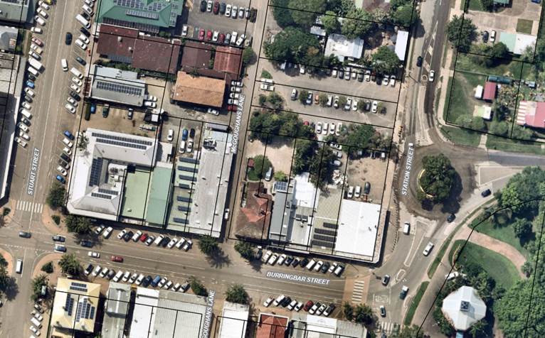
Figure below shows the site 57 Station Street outlined in red
![]()
Landcom
Landcom, is the NSW Government’s housing and property group, a State-Owned Corporation that works with government, the private and not-for-profit sectors, to deliver affordable housing projects.
Their portfolio minister is The Hon. Anthony Roberts MP Minister for Planning, and Minister for Homes.
There is a clear alignment of values between Landcom and Council when it comes to housing needs and delivery.
|
Landcom |
Byron Shire Council
|
|
We believe everyone deserves a place to call home. A place that is safe and affordable where individuals, families and communities can thrive, seek comfort, and enjoy. A place where people can truly live not just reside. |
Byron Shire towns and villages will offer a diversity of housing to meet the needs of its community both now and in the future. Greater housing diversity will create a more self-sufficient Shire so that residents do not have to move outside the Shire to find the housing they want.
|
|
Delivering more affordable housing is complex and requires a collaborative approach. Landcom is focussed on partnership delivery models working with Local Government, Community Housing Providers and NHFIC.
|
Council’s Supporting Partnerships Policy facilitates open and transparent partnerships to deliver services to the community. The policy establishes a framework to assess if a partnership approach is the best project delivery mechanism to achieve economic, social, environmental and cultural/governance outcomes.
|
|
Deliver housing projects that provide social and economic benefits to the people of NSW. Our modelling helps determine the optimal structure and affordable housing mix that best meets Council’s objectives and balance of financial outcomes and community benefit.
|
More diverse housing such as town houses, units and apartments will be located in locations with convenient access to shops, services, transport and open space, where it is easy to walk or cycle. Council has resolved to provide in-principle support to facilitating the establishment of diverse and affordable housing on suitable Council owned car parks.
|
|
Our affordable housing projects focus on low to moderate income households. The makeup of these households includes many key workers such as nurses, police, paramedics, childcare workers, retail workers and cleaners.
|
Residents will be able to find housing that suits their current and future needs in terms of type, tenure, size and cost. |
Landcom perform the following main functions:
Advise • NSW Government and other partners on planning and development solutions for urban management
Advocate • Call out the obstacles that limit housing diversity and affordability outcomes • Through collaboration identify and inform industry reform
Deliver • Strategic and complex projects. • Innovative solutions in housing supply, diversity, and affordability
Landcom as a government agency, is in a unique position to work across sectors in this regard:
1. Landowners: in addition to development on its own land, Landcom offers government, councils and Community Housing Providers landowners a pathway to unlock their land to deliver financial and social value.
2. Community Housing Providers (CHP): Landcom provides CHPs with attractive delivery models providing flexibility, capital efficiency and development management capability, as well as access to land.
3. National Housing Finance and Investment Corporation (NHFIC): Unlocking a co-ordinated model with NHFIC to provide financing will provide leverage to fully scale up the delivery model.
To do this Landcom enter partnerships with relevant stakeholders. These partnerships typically are a Project Agreement in the form of a Terms Sheet Agreement (TSA) depending on the individual needs of the stakeholder and project.
It is also worth noting that one of the initiatives in the Byron Shire Council Regional Housing Taskforce submission: was “establishing relationships and building partnerships with housing providers like Landcom and Community Housing Organisations to support and or undertake joint venture developments for housing.” The TSA approach for a housing project is consistent with this initiative.
Submission to the Regional Housing Taskforce - Byron Shire Council (nsw.gov.au)
Project concept plan
The project seeks to deliver an affordable housing development for people on low – moderate incomes. A preliminary concept design of the development (Attachment 2) shows up to 29 dwellings, with a mix of studios, 1 and 2 bedrooms and some commercial space possible.
At this time the ground floor is proposed to provide car spaces with a dual purpose of being available to the community during the day and the tenants at night. Separate to this project, Council is also continuing to look at securing additional land in Mullumbimby for town centre overflow car parking use, as previously identified through both the Mullumbimby Masterplan and Mullumbimby Parking Study. This is to ensure that a project such as this, does not decrease the current number of available car parking spaces for community use that generally exist on public and private land across the whole of the town centre area presently.
Terms Sheet Agreement (TSA)
The purpose of this report is to seek Council endorsement of a Project Agreement in the form of a Terms Sheet Agreement (Confidential Attachment 3) with Landcom to facilitate both parties working together on development of an affordable housing project on 57 Station Street Mullumbimby.
The TSA is to be a non-binding agreement with the following scope proposed:
The Purpose – The purpose of the TSA is to give Council and Landcom 6 months to:
· Develop and agree a concept design for development of 57 Station Street Mullumbimby for affordable housing
· Confirm a Community Housing Provider to partner to develop and manage the Project
· Investigate options to secure project funding with NHFIC
· Undertake full due diligence on the site
· Agree legal contracts
· Obtain all required approvals
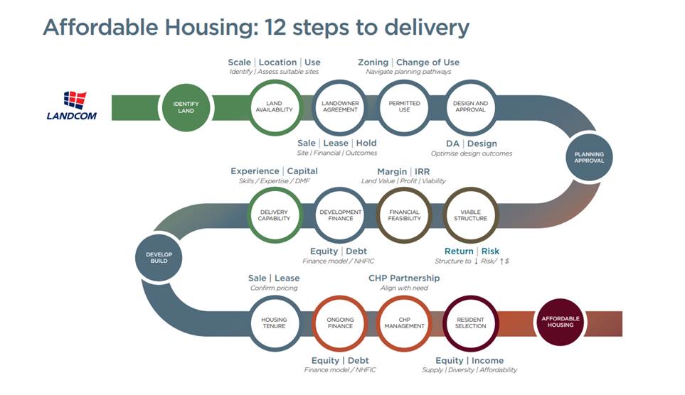
Using a 12-step process, Landcom partners with Council to select a Community Housing Provider delivery partner and work collaboratively to optimise the planning, design, financing and housing delivery outcomes for all stakeholders.
Project Objectives – The objectives underpinning the Project are:
· Develop the optimum amount of affordable housing that meets the community’s needs
· Long-term tenure of the property as affordable housing
· Council to retain ownership (freehold or 99-year lease) of the car park
· Council contributes land only, with no additional funds required
· Landcom to perform its obligations on a “cost recovery” basis
Project Control Group (PCG) – During the 6-months term of the TSA, Landcom and Council will form a PCG that meets monthly.
Contract – The intention is to enter binding contracts at the end of the 6-month term, subject only to development consent being granted in respect of the Project.
Council has a history of entering into agreements like a memorandum of understanding (MoU), Letter of Understanding (LoU) and the like with various state agencies and other organisations.
An example of this, is the current MoU that Council has with North Coast Community Housing.
Report No. 13.12 Memorandum of Understanding between Byron Shire Council and North Coast Community Housing Agenda of Ordinary (Planning) Meeting - 21 November 2019 (infocouncil.biz)
19-565 Resolved that Council endorse the Memorandum of Understanding and approve of its signing by the Mayor along with North Coast Community Housing to facilitate work with Council on affordable housing issues affecting the Byron Shire.
The benefits of project agreements (to both parties) can include:
· Greater levels of trust, respect and understanding between the parties.
· Enhanced planning processes for community development and the delivery of dynamic programs, activities and services involving the broader community.
· Increased knowledge, information, and resource sharing between the parties.
· Achievement of mutually desired outcomes.
Strategic Considerations
Community Strategic Plan and Operational Plan
|
CSP Objective |
CSP Strategy |
DP Action |
Code |
OP Activity |
|
Community Objective 4: We manage growth and change responsibly |
4.3: Promote and support local business development, education and employment opportunities |
4.3.1: Facilitate and support sustainable development of our business community |
4.3.1.2 |
Continue to strengthen partnerships between Council and the business community |
|
Community Objective 4: We manage growth and change responsibly |
4.2: Support housing diversity in appropriate locations across the Shire |
4.2.1: Establish planning mechanisms to support housing that meets the needs of our community |
4.2.1.3 |
Progress governance framework and partnerships for the delivery of diverse housing |
Recent Resolutions
· 21-302
Legal/Statutory/Policy Considerations
The Supporting Partnerships Policy was adopted by Council in 2017 with the purpose of facilitating open and transparent partnerships to deliver services to the community. The policy establishes a framework to assess if a partnership approach is the best project delivery mechanism to achieve economic, social, environmental, and cultural/governance outcomes. Under the terms of the Policy, a TSA is an acceptable form of agreement between parties.
The TSA sets in place some parameters around which discussions continue, allowing Landcom to complete due diligence and further design iterations. It also establishes consideration of the roles of the parties and how the project would be delivered.
Council’s legal team has reviewed the Project Agreement and has not flagged any risks associated with this agreement.
Financial Considerations
There are several matters that need to be resolved in more detail between Landcom and Council including the: design, structure, financial feasibility, and legislative compliance of the project. These matters will be the subject of further discussions and reports to Council as required under the TSA.
Consultation and Engagement
BYRON SHIRE COUNCIL
Staff Reports - Sustainable Environment and Economy 13.4
Report No. 13.4 Selection of community representatives for Northern Joint Regional Planning Panel
Directorate: Sustainable Environment and Economy
Report Author: Shannon Burt, Director Sustainable Environment and Economy
File No: I2022/221
Summary:
At the 3 February 2022 extraordinary meeting, Council resolved to seek community members for appointment to represent Council on the Northern Regional Planning Panel. Council received six expressions of interest.
RECOMMENDATION:
That Council:
1. Nominates two community members and two alternative community members for appointment to represent Council on the Northern Regional Planning Panel.
2. Notifies the Planning Panel Secretariat of the community members.
3. Thanks all nominees for their interest and time in submitting an Expression of Interest.
Attachments:
1 Confidential - Expressions of interest - Northern Regional Planning Panel 2022-2025, E2022/22809
Report
At the 3 February 2022 extraordinary meeting, Council resolved (22-033) to seek community members for appointment to represent Council on the Northern Regional Planning Panel (Panel).
Resolved 22-033:
That Council:
1. Notes that the Northern Regional Planning Panel comprises three members appointed by the state plus two appointed by Council, and alternates for when they aren’t available.
2. Advertises immediately for two Council-appointed members and two alternates for the Panel, via Expressions of Interest by the end of February.
3. Thanks current Council-appointed members David Brown and Joe Vescio for their service to the Shire and asks them to continue in that role until new members are appointed and encourage them to re-apply via the process above.
4. Receives a report in April or sooner on the EoI’s received and a Confidential assessment of them.
5. Notifies the Planning Panel Secretariat of the above.
6. Notes that, in selecting members, Council should have regard to any conflict of duties that would be created for a person nominated to the Panel if they are in any way responsible or involved in the assessment of matters to be determined by the Panel or involved in voting or deliberating on matters that come before the Panel.
Under the Environmental Planning & Assessment Act 1979, a Council is to nominate two representatives as nominees for the purposes of the Panel, at least one of whom has expertise in planning, architecture, heritage, the environment, urban design, land economics, traffic and transport, law, engineering, or tourism.
A Panel is comprised of five members:
· three appointed by the Minister
· two appointed by the relevant local council.
Each Panel also includes alternates to act in place of the permanent members if they are unavailable for any reason.
Council resolved to call for two Council appointed community members and two alternates for this Panel.
This report has been prepared so that Council can consider the nominations received by expression of interest and decide on community Panel members. Council received six expressions of interest.
The expressions of interest received are attached in Confidential Attachment 1.
Part 3 of the resolution invited the current community Panel members to reapply.
Part 4 of the resolution asked for staff to complete an assessment of each of the expressions of interest received. Staff however have not undertaken this directly, as they believe it is the role of the Councillors to assess the suitability or not of each nomination.
Notwithstanding the above, given the type of development application going to the Panel and community interest in same, it is staff recommendation that Council selects representatives, who live within Byron Shire, have expertise relevant to the type of development being assessed, and represent community values and sentiment on development.
Part 5 of the resolution, states also, in selecting members, Council should have regard to any conflict of duties that would be created for a person nominated to the Panel if they are in any way responsible or involved in the assessment of matters to be determined by the Panel or involved in voting or deliberating on matters that come before the Panel.
Strategic Considerations
Community Strategic Plan and Operational Plan
|
CSP Objective |
CSP Strategy |
DP Action |
Code |
OP Activity |
|
Community Objective 4: We manage growth and change responsibly |
4.1: Support the visions and aspirations of local communities through place-based planning and management |
4.1.3: Manage development through a transparent and efficient assessment process |
4.1.3.1 |
Assess and determine development applications |
Recent Resolutions
· Northern Regional Planning Panel Membership (Resolution 22-033)
Legal/Statutory/Policy Considerations
All regional panel members are expected to follow the regional panel’s operational procedures and to adhere to the regional panel’s code of conduct.
Financial Considerations
Each council may determine an appropriate level of remuneration for that person, by arrangement with that member, with your Council’s current rates used as a guide when determining appropriate remuneration rates. The rates of renumeration used are those set by the Minister. The fees associated with preparing for and attending the Panel can vary per development application. There is no specific corporate governance budget allocation for these payments.
Consultation and Engagement
The Expression of Interest was on public exhibition between 8 February and 4 March 2022.
BYRON SHIRE COUNCIL
Staff Reports - Sustainable Environment and Economy 13.5
Report No. 13.5 PLANNING - Report of the Planning Review Committee held 17 March 2022
Directorate: Sustainable Environment and Economy
Report Author: Chris Larkin, Manager Sustainable Development
Noreen Scott, EA Sustainable Environment and Economy
File No: I2022/232
Summary:
This report provides the outcome of the Planning Review Committee (PRC) held on 17 March 2022.
NOTE TO COUNCILLORS:
In accordance with the provisions of S375A of the Local Government Act 1993, a Division is to be called whenever a motion for a planning decision is put to the meeting, for the purpose of recording voting on planning matters. Pursuant to clause 2(a) under the heading Matters to be Included in Minutes of Council Meetings of Council's adopted Code of Meeting Practice (as amended) a Division will be deemed to have been called by the mover and seconder of all motions relating to this report.
RECOMMENDATION:
That Council endorses the outcomes of the Planning Review Committee meeting held on 17 March 2022.
Report
The Planning Review Committee meeting was held on 17 March 2022. The meeting commenced at 12.20pm and concluded at 1.45pm.
Councillors: D. Dey, A. Hunter, M. Swivel, S. Balson, S. Ndiaye, P. Westheimer
Apologies: C. Coorey, M. Lyon, A. Pugh
Staff: Chris Larkin (Manager Sustainable Development)
The following development applications and s4.55 application were reviewed with the outcome shown in the final column.
|
DA No. / Applicant |
Property Address / Proposal |
Consultation / Submissions |
Reason/s / Outcome |
|
|
10.2020.458.1 Newton Denny Chapelle |
7 Tweed Street BRUNSWICK Demolition of Existing Structures and Construction of a Mixed-Use Development Comprising of a Specialised Retail Premises, Business Premises and Two (2) Shop Top Housing Dwellings |
Level 2 21/09/20 to 4/10/20 27 submissions against
|
Council b. Validity of the matters raised in the public submissions e. The perceived public significance of the application. |
|
|
10.2021.582.1 Chincogan Property Developments Pty Ltd |
8 Kumbellin Glen OCEAN SHORES Demolition of Existing Dwelling and Construction of Multi Dwelling Housing comprising of Six (6) Dwellings |
Level 2 24/11/21 to 07/12/21
10 submissions against |
Staff |
|
|
DA No. / Applicant |
Property Address / Proposal |
Consultation / Submissions |
Reason/s / Outcome |
|
|
10.2012.237.3 Mr S C Marcellos |
234 Coopers Shoot Road S.4.55 to Alter the Building Envelope on Lot 3 of DP 1185876 |
Level 2 1/12/21-14/12/21
1 submission against
|
Staff |
|
BYRON SHIRE COUNCIL
Staff Reports - Sustainable Environment and Economy 13.6
Report No. 13.6 PLANNING - DA 10.2021.707.1 - Stage 1: Dwelling House, Stage 2: construction of new dwelling house and change of use of existing dwelling to a secondary dwelling
Directorate: Sustainable Environment and Economy
Report Author: Lachlan Wall, Gateway Planner
File No: I2022/245
Proposal:
|
DA No: |
10.2021.707.1 |
||||||
|
NSW PP |
PAN-163068 |
||||||
|
Proposal description: |
Stage 1: New Dwelling House Stage 2: New Dwelling House and Change of Use of Existing Dwelling House to a Secondary Dwelling |
||||||
|
Property description: |
LOT: 20 DP: 1252223 |
||||||
|
15 Clover Hill Circuit BANGALOW |
|||||||
|
Parcel No/s: |
269658 |
||||||
|
Applicant: |
Balanced Systems Planning Consultants |
||||||
|
Owner: |
Mr D M Bridgstock & Ms V C Rudd |
||||||
|
Zoning: |
R2 Low Density Residential |
||||||
|
Date received: |
11 November 2021 |
||||||
|
Integrated / Designated Development: |
☐ Integrated |
☐ Designated |
☒ Not applicable |
||||
|
Concurrence required |
No |
||||||
|
Public notification or exhibition: |
- Level 1 advertising under Council’s Community Participation Plan. - Exhibition period: 23 November 2021 to 6 December 2021. - Submissions received: 6 - Submissions acknowledged: ☒ Yes ☐ No ☐ N/A |
||||||
|
Other approvals |
☒ N/R |
☐ W & S (68) |
☐OSMS (68) |
☐ ST (68) |
☐ RA (138) |
||
|
Other: |
|
||||||
|
Variation request to Development Standards under an EPI (eg clause 4.6) |
Not applicable |
||||||
|
Estimated cost |
$1,095,000.00 |
||||||
|
Delegation to determine |
Council |
||||||
|
Issues |
Rear boundary setback View loss and view sharing |
||||||
Summary:
The Development application is seeking approval for the construction of a new dwelling house and secondary dwelling to be undertaken in two (2) stages with the smaller dwelling house to be constructed first. The second stage of the development involves the construction of the larger dwelling and changing the use of the existing dwelling constructed in stage 1 to a secondary dwelling.
Both stages of the development involve landscaping works as an integral part of the development design as a direct response to objections received during the assessment of this application.
The subject property is zoned R2 Low Density Residential under Byron Local Environmental Plan 2014 and raises no issues in terms of the relevant planning controls under the LEP or other applicable planning instrument.
The application was notified and advertised for a period of 14 days between 23 November 2021 to 6 December 2021 and six (6) objections were received, raising issues relating to a non-compliance with Chapter E2 Bangalow of the BDCP 2014, and the resultant impacts to views, privacy, and amenity caused by the rear dwelling (secondary dwelling). On review of the DCP, the section of this plan referenced have been removed with a DCP amendment (Council Resolution 21-479 - dated 4 November 2021) In this regard the previous section of the DCP required a 5-metre landscape buffer to be provided adjacent to the boundary at the subdivision stage. The matter was raised with the applicant who rightly advised the provisions are no longer in the DCP, and there were no restrictions on title requiring such a buffer to be provided. The applicant however has amended the plans and provided an increased 3 metre setback to the rear boundary from the original 1.3 metres which is to be landscaped. A 1.8 metre boundary fence is also proposed. It is considered the rear dwelling with a maximum height of 4.5 metres is unlikely to adversely affect the views and privacy of the surrounding neighbourhood considering its location within an urban area, and the topography of the land.
In conclusion the proposal is satisfactory and is recommended for approval, subject to conditions of consent.
NOTE TO COUNCILLORS:
In accordance with the provisions of S375A of the Local Government Act 1993, a Division is to be called whenever a motion for a planning decision is put to the meeting, for the purpose of recording voting on planning matters. Pursuant to clause 2(a) under the heading Matters to be Included in Minutes of Council Meetings of Council's adopted Code of Meeting Practice (as amended) a Division will be deemed to have been called by the mover and seconder of all motions relating to this report.
RECOMMENDATION:
That pursuant to Section 4.16 of the Environmental Planning & Assessment Act 1979, Development Application No. 10.2021.707.1 for Stage 1: New Dwelling House Stage 2: New Dwelling House and Change of Use of Existing Dwelling House to a Secondary Dwelling, be granted consent subject to the conditions of approval shown at Attachment 1 (E2022/27735).
1 DA
10.2021.707.1 Conditions of consent, E2022/27735
![]()
2 DA
10.2021.707.1 Architectural plans, E2022/27733
![]()
3 Confidential - DA 10.2021.707.1 Submissions, E2022/27234
Assessment:
1. INTRODUCTION
History/Background
There is no relevant applications on the property to date other than its subdivision approval under development consent DA10.2011.474.1 on 9 August 2012 which resulted in the lot being created.
An AHIMS search of the property was undertaken which indicated no aboriginal sites or places are recorded in or near the subject site.
Description of the proposed development
This application seeks approval for Stage 1: New Dwelling House Stage 2: New Dwelling House and Change of Use of Existing Dwelling House to a Secondary Dwelling as follows:
Stage 1
The proposed dwelling in stage 1 is a single storey, 2-bedroom dwelling with attached raised decks to the southern and western facades of the dwelling. A footpath from the proposed car parking area to this dwelling is also to be constructed during this stage.
The car parking area to be constructed in stage 1 is uncovered and surfaced with permeable pavers within the site.
Landscaping for the dwelling to the rear (northern) boundary is also to be undertaken and completed during this stage.
Stage 2
The dwelling constructed in stage 1 is to become a secondary dwelling with no change to the form of this dwelling.
A new dwelling is to be constructed as the primary dwelling which is split-level in design with a two-car garage underneath the dwelling. The primary dwelling contains 3 bedrooms, with a large deck on the western elevation that wraps around to the street frontage. A second private deck is attached to the master bedroom that looks west
Access for the secondary dwelling is provided by way of a gravel path that runs along the eastern side boundary. The remainder of the site is to be landscaped during this period.
Description of the site
The site is currently vacant with two (2) large trees located within the property boundary on the western boundary that are proposed to be retained. The land is zoned R2 Low density residential and has an area of approximately 838 m2. The site slopes down to the road, with a fall of approximately 9.5m over the property from the rear boundary to the street. Adjacent properties to the north are slightly elevated again and overlook the subject site.
Subject site with 2 metre contours overlaid
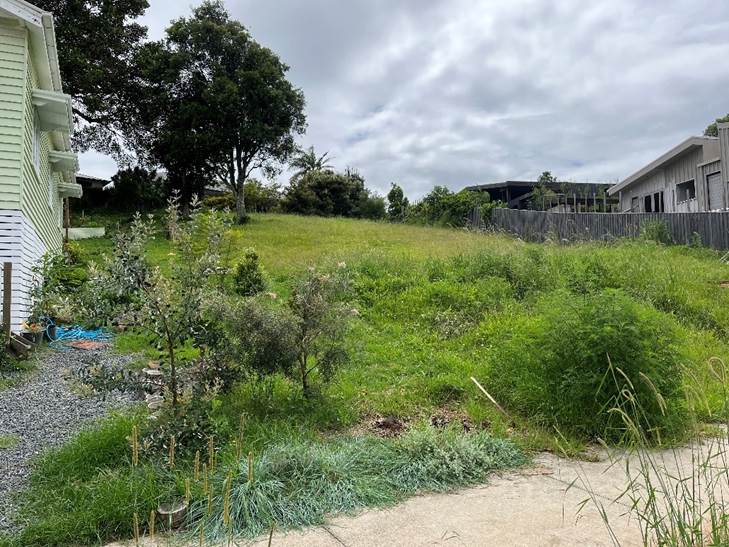
View of site from Clover Hill Circuit
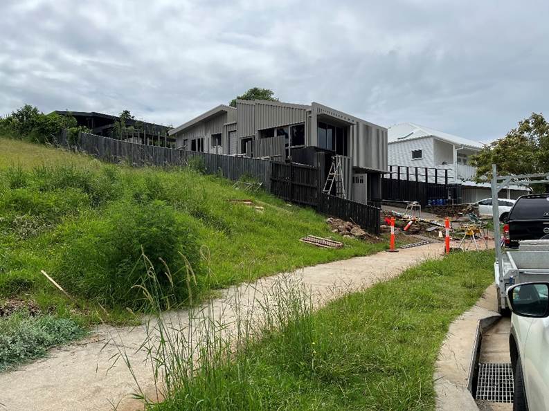
View from street frontage east over adjoining property
|
Land is legally described |
LOT: 20 DP: 1252223 |
|
Property address |
15 Clover Hill Circuit BANGALOW |
|
Land is zoned: |
R2 Low Density Residential |
|
Land area is: |
838.1 m2 |
2. SUMMARY OF REFERRALS
|
Referral |
Issue |
|
Development Engineer |
No objections subject to conditions. |
|
S64 / Systems Planning Officer |
No objections subject to conditions. |
|
S7.11 / Contributions Planner |
No objections subject to conditions. |
Issues: Council notes a street tree (tulipwood) has been removed that was planted at the subdivision stage. Conditions to apply to ensure it is replaced.
3. SECTION 4.14 – BUSH FIRE PRONE LAND
4. SECTION 4.15C – MATTERS FOR CONSIDERATION – DISCUSSION OF ISSUES
Having regard to the matters for consideration detailed in Section 4.15(1) of the Environmental Planning & Assessment Act 1979 (EP&A Act), the following is a summary of the evaluation of the issues.
State Environmental Planning Policies (SEPP)
|
Considerations |
Satisfactory |
Unsatisfactory |
|
SEPP Resilience and Hazards 2021 Consideration: Property was considered a the subdivision stage as suitable for residential use. |
☒ |
☐ |
|
SEPP (Affordable Rental Housing) 2009 Consideration: the development complies with the requirements of clause 22 of this SEPP. Subject to conditions, the development will comply with clause 24. |
☒ |
☐ |
4.2A Byron Local Environmental Plan 2014 (LEP 2014)
In accordance with LEP 2014 clauses 1.4 and 2.1 – 2.3:
(a) The proposed development is defined in the LEP 2014 Dictionary as dwelling house, secondary dwelling;
(b) The land is within the R2 Low Density Residential according to the Land Zoning Map;
(c) The proposed development is permitted with consent; and
(d) Regard is had for the Zone Objectives as follows:
|
Zone Objective |
Consideration |
|
• To provide for the housing needs of the community within a low-density residential environment. |
The development provides additional dwellings within a low-density zone |
|
• To enable other land uses that provide facilities or services to meet the day to day needs of residents. |
N/A |
It is noted that the subject property has sufficient area for a dual occupancy
The remaining underlined clauses have been taken into consideration in the assessment of the subject development application in accordance with Section 4.15 of the EP&A Act. The proposed development complies with all clauses of LEP 2014 (in some cases subject to conditions and/or to the satisfaction of other assessing officers).
Clause 4.3 Height of Buildings
The dwelling is a maximum of 7m in height
The secondary dwelling is a maximum of 4.5m in height
The development complies with this clause.
Clause 4.4 Floor Space Ratio
The proposal will have a total GFA of 193 m2, a Floor Space Ration of 0.23:1.0, and complies with the 0.5:1.0 FSR provisions under the LEP.
Clause 5.4 Controls relating to miscellaneous permissible uses
5.4(9) The proposed secondary dwelling with a floor area of 54 m2 complies with this clause.
Clause 6.2 Earthworks
Earthworks are proposed that require consent to be granted under this clause.
(a) the likely disruption of, or any detrimental effect on, drainage patterns and soil stability in the locality of the development,
the earthworks proposed are to a maximum of 3.075m in depth, to provide for the garage underneath the proposed primary dwelling (to be constructed in stage 2). Compliance with the Building Code of Australia will ensure structural adequacy and will be certified at the construction stage.
(b) the effect of the development on the likely
future use or redevelopment of the land,
The form and scale of the earthworks proposed are consistent with the character
of the area
The development is considered that it will not have a significant impact on the future use or redevelopment of the land given the residential nature of the area.
(c) the quality of the fill or the soil to be excavated, or both,
The quality of the excavated material has been previously
assessed for potential contamination as identified in the 2011 subdivision
consent. Conditions are recommended for the excavated material to be
transported from the site and disposed of lawfully.
(d) the effect of the development on the existing and likely amenity of adjoining properties.
The extent of the earthworks, combined with the design have taken into account the amenity of adjoining properties as the additional depth of earthworks proposed lowers the total overall height of the building
(e) the source of any fill material and the destination of any excavated material,
Excavated material that is removed from the site must be managed in accordance with EPA guidelines. The final destination of the excavated material is not known but can be managed adequately subject to conditions.
(f) the likelihood of disturbing relics,
An AHIMS search was undertaken for this property that did not identify any known sites or relics within proximity to the development site. the area is heavily disturbed from the subdivision construction works previously. Condition recommended
(g) the proximity to, and potential for adverse impacts on, any waterway, drinking water catchment or environmentally sensitive area,
The development is located approximately 270m from the Byron Creek to the west. An offshoot of the creek runs in a south-east direction along the southern edge of the Clover hill circuit area. Given the separation of the subject site to the creek, and other dwellings and the road network, no adverse impacts are expected as a result of this development to the waterway or drinking water catchment.
(h) any appropriate measures proposed to avoid, minimise or mitigate the impacts of the development.
Suitable conditions for erosion and sediment control measures have been recommended will adequately manage the potential impacts the earthworks may have.
The development complies with this clause.
Clause 6.5 Drinking water catchments
The site is identified as land within the drinking water catchment map. It
is considered that there will be no adverse impact on the quality and quantity
of water entering the drinking water storage. As the site is located within an
urban area and is capable of draining all stormwater into Council’s
stormwater and sewage systems.
Conditions imposed on the consent for erosion and sediment control plan to be
prepared before construction starts will adequately manage the
impacts.
Clause 6.6 Essential Services
Connections to water, sewage, stormwater disposal and electricity were provided to the site at the subdivision stage. The application proposes a driveway which will provide suitable vehicular access.
The proposal raises no other issues under the LEP.
4.3 Any proposed Instrument that has been the subject of public consultation and has been notified to the consent authority
No draft instruments apply to this application.
4.4A Byron Shire Development Control Plan 2014 (DCP 2014)
B14 Excavation and fill
B14.1 General Excavation and Fill requirements and
B14.2 Excavation and fill for Car Parking
Excavation greater than 1m in depth for the dwelling house and 2m for the garage have been proposed for the stage 2 dwelling. The variation is considered appropriate as it lowers the total height of the dwelling
Excavation required for Dwelling 2 complies with the requirements of this B14.1.
It is considered that the application has adequately addressed the objectives and performance criteria of this chapter and the design presented is reasonable approach given the characteristics of the site and is consistent with the streetscape character of the area.
The variation can be supported.
Chapter D1 Residential Accommodation in Urban, Village and
Special Purpose Zones
D1.2.1 Building Height Plane
Dwelling 2 (the secondary dwelling) complies with this Control.
Dwelling 1 (the primary dwelling to be built as stage 2) seeks a variation to this control. and is discussed below.
Shadow Diagrams have been provided that illustrate the shadowing impact of the proposed dwellings.
The variation to the control includes sections of the roof form and guttering to both side boundaries. The extent of the variation varies as the slope of the site rises and becomes compliant at the rear of the proposed stage 2 dwelling.
The variation to the western side boundary includes a small section of the roof form and guttering, and the awning over the main entry to this dwelling. This non-compliance achieves compliance with the BHP envelope at the rear of this dwelling. The non-compliance is managed in 3 main ways.
1. The plans provided show timber privacy & sun screens at this entry way, this provides privacy for both the adjoining property and for the dwelling as residents of the secondary dwelling move to and from the secondary dwelling.
2. Landscaping is also provided between this timber privacy screen and the boundary to further offset the impacts the variation may cause.
3. An existing 1.8m high timber fence currently exists on the property boundary.
Due to the inherent topography of the land it is clear that most dwellings in this area of Clover Hill Circuit are none compliant to varying degrees to the two side boundaries. This is visible with both adjoining developments to this property especially where the dwellings are elevated at the street frontage. Due to the orientation of the land these dwellings will either overshadow neighbours on one side in the morning and then overshadow the other neighbour in the afternoon. Similarly the proposed development will receive similar overshadowing from its neighbours to a degree particularly in midwinter. Having regards to the character of the neighbouring residential development, the encroachments are considered acceptable in this instance.
Chapter C3 Visually Prominent Sites, visually prominent development, and view sharing
The site does not meet the criteria to be defined as a visually prominent site, or visually prominent development as defined within chapter A of the BDCP 2014. However, an objection was received relating to the impact of the loss of views as a result of this development and an assessment of the LEC planning principles for the consideration of visual impacts is given below
1. An Assessment of the value of the view that may be affected.
The view of the adjoining properties to the north may hold, is of a land view that does not contain any landmarks, or iconic views (e.g., Cape Byron Lighthouse), or ocean / water views. The view is likely partial given the existing development through the Clover Hill Circuit subdivision. The development does not dominate the skyline due to the setbacks and overall height of the proposed dwellings. The highest part of the dwelling is located towards the street and the built form of the proposed dwellings steps back into the hill as it moves up the hill.
2. Consider from what part of the property the views are obtained
Views from adjoining properties are obtained from within the dwellings, or within rear yards of the dwellings to the north which are of generally comprised of single storey built forms. These views may be sitting or standing views.
3. Assessment of the extent of the impact
The extent of the built from extends across 70% of the width of the lot. it is considered that the view loss is negligible given the overall height of the structure is under 5m, when viewed from the adjoining property that may be impacted by the development. The total height of the proposed secondary dwelling is 4m (inclusive of the depth of excavation) proposed. When viewed from the properties to the north the height of the dwelling is 2.2 – 2.8m above the ground level of the adjoining property.
4. Assessment of the reasonableness of the proposal that is causing the impact.
The development complies with the height of building, and setback planning controls. It is unreasonable to expect that full 180-degree views, are possible to be retained as indicated within the objection received. Further it is more unreasonable to retain such views when sitting.
The provision of a 3m setback to the rear boundary (increased from 1.3m in the original application), and the addition of a 1.8m high fence provides sufficient privacy and noise mitigation that can be reasonably expected within an urban area. The visual impact of this development is acceptable and the view sharing is achievable. The development is considered reasonable design response to the site.
Chapter E2 Bangalow
The subject property is located within Pocket D under Clause E2.2.3. The provisions state:
Ballina Road and Clover Hill is the most recent area undergoing development for housing. Containing smaller pockets of R3 Medium Density zoned land, this area has capacity to improve housing diversity in Bangalow. A number of low rise medium density residential developments are currently underway on land to the east of Ballina Road. The area also contains investigation areas identified for affordable housing contributions. In all areas front fences and walls do not dominate the public domain instead they respond to and complement the context and character of the street or lane
It is considered the development responds well to the site and steps up the hill to limit the overall height of the building. The property has a narrow frontage to the street with landscaping proposed either side of the driveway. No front fence is proposed and the dwellings design provides for casual surveillance by way of decks overlooking the strteet for casual
4.5 Environmental Planning & Assessment Regulation 2000 Considerations
|
Clause |
This control is applicable to the proposal: |
I have considered this control as it relates to the proposal: |
If this control is applicable, does the proposal comply? |
|
92 |
No |
N/a |
N/a |
|
93 |
No |
N/a |
N/a |
|
94 |
No |
N/a |
N/a |
|
94A |
No |
N/a |
N/a |
* Non-compliances and any other significant issues discussed below
4.6 The likely impacts of that development, including environmental impacts on both the natural and built environments, and social and economic impacts in the locality
|
Impact on: |
Likely significant impact/s? |
|
Natural environment |
No. The proposal will not have a significantly adverse impact on the natural environment of the locality. |
|
Built environment |
No. The proposal will not have a significantly adverse impact on the built environment of the locality. |
|
Social Environment |
No. The proposal will not have a significant social impact on the locality, other than the provision of additional housing for residents on flood free land. |
|
Economic impact |
No. The proposal will not have a significant economic impact on the locality other than increased building activity as a result of the approval and associated multiplier effects |
|
Construction Impacts |
The development will generate minor impacts during its construction. Conditions of consent recommended to control hours of work, builders waste, construction noise, installation of sedimentation and erosion control measures and the like to ameliorate such impacts. |
Are there any Council Policies that are applicable to the proposed development?
|
Council Policy |
Consideration |
|
Building in the Vicinity of Underground Infrastructure Policy 2020 |
Council’s ET engineer has required compliance with this policy given the easement for sewer that crosses the property. Condition recommended. |
4.7 The suitability of the site for the development
The site is a serviced, unconstrained property and is suitable for the proposed development.
4.8 Submissions made in accordance with this Act or the regulations
The development application was publicly exhibited
There were 6 submissions made on the development application:
|
Submission key concerns |
Comment |
|
Development does not comply with chapter E2 Bangalow of the BDCP 2014, Section E2.6.6 Buffers and Environmental Corridors and the requirement to provide a 5m wide landscape buffer at the rear property boundary. |
This chapter of the DCP was modified by Council on 4 November 2021 (Res 21-479). This requirement no longer applies to the area. Notwithstanding the applicant has amended the plans to increase the setback from 1.3 metres to the 3 metres from the rear boundary and a 1.8m high timber fence. The setback is to be landscaped. It is noted that there is no easement on the title that a 5m wide landscape buffer is provided. |
|
Does not comply with Clause 4.3 height of buildings causing significant loss of views, privacy and visual impact. |
The proposed rear dwelling is single storey with a maximum height of 4.5 metres. Proposal complies with the 9 metre height limits, and it is considered acceptable in terms of visual impact and privacy. Any loss of views from the development are considered negligible as discussed above. |
|
Use of secondary dwelling once main residence has been completed |
Condition recommended that do not permit either dwelling to be used for short term holiday letting (STRA). |
|
Noise impacts |
Noise from construction is managed by conditions of consent. Noise from the general use of a dwelling cannot be restricted by a condition of consent. Should either property be used as a STRA that creates impacts to the amenity of adjoining properties. Then a noise complaint is either managed by Council’s compliance team, or the police in an emergency. |
4.9 Public interest
The proposed development is unlikely to prejudice or compromise the public interest or create an undesirable precedent.
5. DEVELOPER CONTRIBUTIONS
5.1 Water & Sewer Levies
Section 64 levies will be payable.
5.2 Developer Contributions
Section 7.11 Contributions will be payable.
6. DISCLOSURE OF POLITICAL DONATIONS AND GIFTS
|
Disclosure details |
Response |
|
Has a Disclosure Statement been received in relation to this application? If Yes, Provide Disclosure Statement register reference: 91. |
Yes ☐ No ☒ |
|
Have staff received a ‘gift’ from anyone involved in this application that needs to be disclosed. |
Yes ☐ No ☒ |
7. CONCLUSION
The proposed development is a satisfactory response to the site and the applicable planning controls that govern the residential development. The application is recommended for approval subject to conditions of consent.
Reports of Committees - Infrastructure Services 14.1
Reports of Committees - Infrastructure Services
Report No. 14.1 Report of the Local Traffic Committee Meeting held on 4 April 2022
Directorate: Infrastructure Services
Report Author: Michelle Wilcox, Traffic & Parking Systems Officer
File No: I2022/306
Summary:
The attachment to this report provides the minutes of the Local Traffic Committee Meeting held on 4 April 2022 for determination by Council.
Council’s action on the LTC advice will be:
a) If Council is in agreement with the LTC unanimous support then the proposal may be approved. In these cases there is no conflict between Council and the advice of the LTC, consequently there is no need for Council to inform TfNSW or the NSW Police representatives of the decision.
b) If Council is in agreement with the LTC unanimous support, but no longer wants to proceed, the proposal may still be rejected.
c) If Council is in agreement with the LTC unanimous decline then the proposal may be rejected. Again there is no conflict between Council and the advice of the LTC. Consequently there is no need for Council to inform TfNSW or the NSW Police representatives of the decision.
d) If Council decides to proceed with a proposal where the advice of the LTC is not unanimous support, then the Council must first advise the TfNSW and the NSW Police representatives in writing of their intention to approve the proposal. TfNSW or the NSW Police may then lodge an appeal to the Regional Traffic Committee (RTC).
e) If Council decides to proceed with a proposal where the advice of the LTC is a unanimous decline, then the Council must first advise the TfNSW and NSW Police representatives in writing of their intention to approve the proposal. TfNSW or the NSW Police may then lodge an appeal to the RTC.
Due to the fact that the TfNSW and the NSW Police have the power to appeal certain decisions of the Council, the LTC cannot provide its advice to Council until both TfNSW and the NSW Police have provided their vote on the issue.
RECOMMENDATION:
1. That Council notes the minutes of the Local Traffic Committee Meeting held on 4 April 2022.
1 Minutes
04/04/2022 Local Traffic Committee Extraordinary, I2022/301 ![]()
Report
The attachment to this report provides the minutes of the Local Traffic Committee Meeting of 4 April 2022 for determination by Council. The agenda for this meeting can be located on Council’s website at:
Agenda of Extraordinary Local Traffic Committee Meeting - Monday, 4 April 2022 (infocouncil.biz)
This report contains the recommendations of the Local Traffic Committee (LTC) meeting held on 4 April 2022.
Committee Recommendation
Committee Recommendation 6.1.1
1. That Council endorse the regulatory traffic management facilities and devices, including signs and traffic controller provisions proposed for the Council controlled public road network as outlined in attachments 1, 2 and 3 (E2022/29888, E2022/29889, E2022/29894) for the Byron Bay Bluesfest 2022 to be held on Thursday 14 April 2022 to Monday 18 April 2022. Subject to:
a) Separate approvals by NSW Police and TfNSW being obtained, noting that the event is on a state road or may impact the state road network;
b) The event be held through the implementation of the events Traffic Management Plan and Traffic Control Plan(s) as per attachments 1, 2 and 3 (E2022/29888, E2022/29889, E2022/29894).
c) The Traffic Management Plan is to include contingency measures in case the level of queuing fails to meet KPI requirements. It is noted that such queuing may be caused by the introduction of paid parking.
d) The Traffic Management Plan and the Traffic Control Plan(s) to be implemented by those with relevant and current TfNSW accreditation;
e) Traffic camera data recorders or similar be used to obtain an accurate record of traffic impacts at KPI queue locations;
f) That the impact of the event be advertised via a notice in the local weekly paper a minimum of one week prior to the operational impacts taking effect, noting it must include the event name, specifics of any traffic impacts or road closures and times, alternative route arrangements, event organiser, a personal contact name and a telephone number for all event related enquiries or complaints;
2. That The event organiser:
i) advertise the impact of the event via a notice in the local weekly paper a minimum of one week prior to the operational impacts taking effect, noting it must include the event name, specifics of any traffic impacts or road closures and times, alternative route arrangements, event organiser, a personal contact name and a telephone number for all event related enquiries or complaints;
ii) provide a copy of the advert for Council's web page;
iii) give consideration of any submissions received;
iv) inform community and businesses that are directly impacted (e.g. adjacent to the event) via written information which is delivered to the property in a timely manner so as to document, consider and respond to any concerns raised;
v) arrange for private property access and egress affected by the event;
vi) liaise with bus and taxi operators and ensuring arrangements are made for provision of services during conduct of the event;
vii) consult with emergency services and any identified issues be addressed;
viii) holding $20m public liability insurance cover which is valid for the event;
ix) paying of Council’s Road Event Application Fee prior to the event.
Management Comments
The committee recommendations are supported by management and are provided in the attachment to this report.
Financial Implications
As per the Reports listed within the Local Traffic Committee Meeting of 4 April 2022.
Statutory and Policy Compliance Implications
As per the Reports listed within the Local Traffic Committee Meeting of 4 April 2022.