Notice of Meeting
Floodplain Management Advisory Committee
Meeting
A Floodplain Management Advisory Committee Meeting of Byron Shire Council will be held as follows:
|
Venue
|
Conference Room, Station Street, Mullumbimby
|
|
Date
|
Tuesday, 16 May 2023
|
|
Time
|
11.30am
|
Phil Holloway
Director Infrastructure
Services
I2023/716
 Distributed
09/05/23
Distributed
09/05/23
What is a “Conflict of Interests” - A conflict of
interests can be of two types:
Pecuniary - an interest that a person has in a matter because of a reasonable
likelihood or expectation of appreciable financial gain or loss to the person
or another person with whom the person is associated.
Non-pecuniary – a private or personal interest that a Council
official has that does not amount to a pecuniary interest as defined in the
Code of Conduct for Councillors (eg. A friendship, membership of an
association, society or trade union or involvement or interest in an activity
and may include an interest of a financial nature).
Remoteness – a person does not have a pecuniary interest in a matter
if the interest is so remote or insignificant that it could not reasonably be
regarded as likely to influence any decision the person might make in relation
to a matter or if the interest is of a kind specified in the Code of Conduct
for Councillors.
Who has a Pecuniary Interest? - a person has a pecuniary interest in a
matter if the pecuniary interest is the interest of the person, or another
person with whom the person is associated (see below).
Relatives, Partners - a person is taken to have a pecuniary
interest in a matter if:
·
The
person’s spouse or de facto partner or a relative of the person has a
pecuniary interest in the matter, or
·
The
person, or a nominee, partners or employer of the person, is a member of a
company or other body that has a pecuniary interest in the matter.
N.B. “Relative”, in relation to a person means any of the
following:
(a) the parent,
grandparent, brother, sister, uncle, aunt, nephew, niece, lineal descends or
adopted child of the person or of the person’s spouse;
(b) the spouse
or de facto partners of the person or of a person referred to in paragraph (a)
No Interest in the Matter - however, a person is not taken to have a
pecuniary interest in a matter:
·
If
the person is unaware of the relevant pecuniary interest of the spouse, de
facto partner, relative or company or other body, or
·
Just
because the person is a member of, or is employed by, the Council.
·
Just
because the person is a member of, or a delegate of the Council to, a company
or other body that has a pecuniary interest in the matter provided that the
person has no beneficial interest in any shares of the company or body.
Disclosure and participation in meetings
·
A
Councillor or a member of a Council Committee who has a pecuniary interest in
any matter with which the Council is concerned and who is present at a meeting
of the Council or Committee at which the matter is being considered must
disclose the nature of the interest to the meeting as soon as practicable.
·
The
Councillor or member must not be present at, or in sight of, the meeting of the
Council or Committee:
(a) at
any time during which the matter is being considered or discussed by the
Council or Committee, or
(b) at
any time during which the Council or Committee is voting on any question in
relation to the matter.
No Knowledge - a person does not breach this Clause if the person did
not know and could not reasonably be expected to have known that the matter
under consideration at the meeting was a matter in which he or she had a
pecuniary interest.
Non-pecuniary Interests - Must be disclosed in meetings.
There are a broad range of options available for managing conflicts &
the option chosen will depend on an assessment of the circumstances of the
matter, the nature of the interest and the significance of the issue being
dealt with. Non-pecuniary conflicts of interests must be dealt with in at
least one of the following ways:
·
It
may be appropriate that no action be taken where the potential for conflict is
minimal. However, Councillors should consider providing an explanation of
why they consider a conflict does not exist.
·
Limit
involvement if practical (eg. Participate in discussion but not in decision
making or vice-versa). Care needs to be taken when exercising this
option.
·
Remove
the source of the conflict (eg. Relinquishing or divesting the personal
interest that creates the conflict)
·
Have
no involvement by absenting yourself from and not taking part in any debate or
voting on the issue as of the provisions in the Code of Conduct (particularly
if you have a significant non-pecuniary interest)
Committee members are reminded that they should declare and manage all
conflicts of interest in respect of any matter on this Agenda, in accordance
with the Code of Conduct.
RECORDING OF VOTING ON PLANNING MATTERS
Clause 375A of the Local Government Act
1993 – Recording of voting on planning matters
(1) In this section, planning
decision means a decision made in the exercise of a function of a council
under the Environmental Planning and Assessment Act 1979:
(a) including a decision relating to a development
application, an environmental planning instrument, a development control plan
or a development contribution plan under that Act, but
(b) not including the making of an order under that Act.
(2) The general manager is required to keep a register
containing, for each planning decision made at a meeting of the council or a
council committee, the names of the councillors who supported the decision and
the names of any councillors who opposed (or are taken to have opposed) the
decision.
(3) For the purpose of maintaining the register, a division
is required to be called whenever a motion for a planning decision is put at a
meeting of the council or a council committee.
(4) Each decision recorded in the register is to be described
in the register or identified in a manner that enables the description to be
obtained from another publicly available document and is to include the
information required by the regulations.
(5) This section extends to a meeting that is closed to the
public.
OATH AND AFFIRMATION FOR COUNCILLORS
Councillors are
reminded of the oath of office or affirmation of office made at or before their
first meeting of the council in accordance with Clause 233A of the Local
Government Act 1993. This includes undertaking the duties of the office of
councillor in the best interests of the people of Byron Shire and the Byron
Shire Council and faithfully and impartially carrying out the functions,
powers, authorities and discretions vested under the Act or any other Act
to the best of one’s ability and judgment.
BUSINESS OF MEETING
1. Apologies
2. Declarations
of Interest – Pecuniary and Non-Pecuniary
3. Adoption of Minutes from
Previous Meetings
3.1 Adoption
of Minutes from Previous Meeting.............................................................. 6
4. Staff Reports
Infrastructure Services
4.1 Federation
Bridge Debris Contol Measures............................................................ 15
4.2 North
Byron Sky Pump Proposal............................................................................... 74
4.3 Byron
Drainage Upgrade Strategy............................................................................ 81
4.4 Byron
Shire Post 2022 Flood Analysis Update....................................................... 89
Adoption of Minutes from Previous Meetings 3.1
Adoption of Minutes from Previous Meetings
Report No. 3.1 Adoption of Minutes from Previous Meeting
Directorate: Infrastructure Services
Report Author: Dominika
Tomanek, Executive Assistant Infrastructure Services
File No: I2023/678
RECOMMENDATION:
That the minutes of the Floodplain Management Advisory
Committee Meeting held on 14 February 2023 be confirmed.
Attachments:
1 Minutes
14/02/2023 Floodplain Management Advisory Committee, I2023/168 , page 9⇩ 
Report
The attachment to this report provides the minutes of the
Floodplain Management Advisory Committee Meeting of 14 February 2023 .
Report to Council
The minutes were reported to Council on 23 March 2023.
Comments
In accordance with the Committee Recommendations, Council
resolved the following:
|
23-091
|
Resolved that
Council adopts the following Committee Recommendations:
Report No. 4.1 Byron Shire Council-Strategic Fill Policy
Committee Recommendation 4.1.1
That the Floodplain Management Advisory
Committee advises Council:
1. That
committee members will meet between quarterly meetings to consider;
a) changes
to strengthen Chapters B14 and C2 of the 2014 Byron Shire Council Development
Control Plan in relation to Fill on Floodplains;
b) the
value of a broader Policy that goes beyond what the DCP can achieve in
limiting Fill on Floodplains;
and
that the support of appropriate planning staff would be greatly appreciated
in such considerations.
2. To
resolve that the 2014 Byron Shire Council Development Control Plan should be
updated as a priority each and every time a Floodplain Risk Management Study
is created or updated within the Shire or across our Shire boundaries (eg the
Tweed – Byron Coastal Creeks Flood Study of 2010).
3. To
update the 2020 North Byron Floodplain Risk Management Study as soon as
possible to reflect the February 2022 flood event.
4. To
update the 2020 North Byron Floodplain Risk Management Plan as soon as
possible to reflect changes caused by the February 2022 flood event.
|
|
23-092
|
Resolved that
Council adopts the following Committee Recommendation:
Report No. 4.2 Modelling of
Various Flow Scenarios at South Golden Beach
Committee Recommendation
4.2.1
That Council includes in the
information it will disseminate under AGRN1012 -Local Government Recovery
Grant Program results of a basic review of extracting water from the
floodplain north of New Brighton.
|
|
23-093
|
Resolved that
Council adopts the following Committee Recommendations:
Report No. 4.3 Hydrology
Inputs to the North Byron 2020 Flood Model
Committee
Recommendation 4.3.1
That Council:
1. Notes
that all catchment inflows are included in the Council adopted North Byron
Flood Risk Management Study; and
2. Includes
in the information it will disseminate under Local Government AGRN1012 -
Recovery Grant Program results discussed by WMA in Attachment 1 of this
report.
|
|
23-094
|
Resolved that
Council adopts the following Committee Recommendations:
Report No. 4.4 Byron Shire
Post 2022 Flood Analysis Update
Committee Recommendation
4.4.1
That Council:
1. Notes
the report to the Floodplain Management Advisory Committee; and
2. Circulates
the 2022 Flood Analysis Reports as soon as they are available and then call
an extraordinary Committee meeting to consider the reports.
|
Adoption
of Minutes from Previous Meetings 3.1 - Attachment 1

Staff Reports - Infrastructure Services 4.1
Staff Reports - Infrastructure Services
Report No. 4.1 Federation
Bridge Debris Contol Measures
Directorate: Infrastructure
Services
Report Author: Scott
Moffett, Drainage & Flood Engineer, IS - Works - Infrastructure Planning
File No: I2023/651
Summary:
Byron Shire Council (BSC) has commissioned Arcadis to
undertake an assessment of possible control measures (structural or otherwise)
to resolve the issues associated with accumulation of debris under Federation
Bridge.
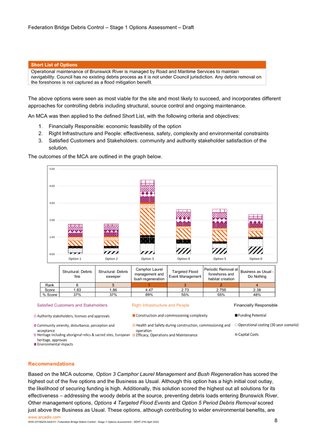
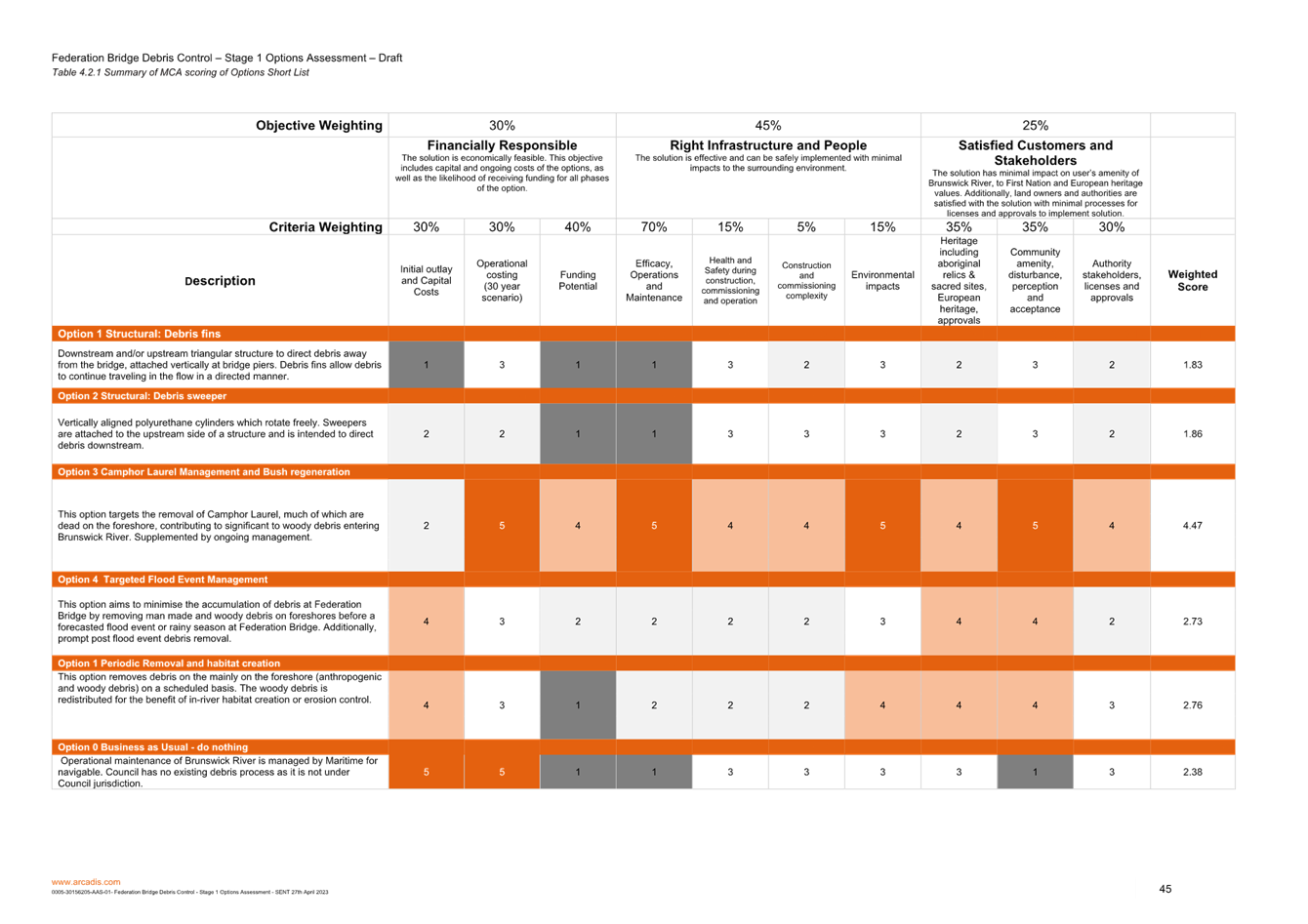
This report discusses the outcomes of the options
investigation and shows that option 3 is the preferred option.
Council staff and Arcadis will present the project to the
Floodplain Advisory Committee.
RECOMMENDATION:
That the Floodplain Management Advisory Committee
notes the attached report, the presentation and approves the preferred option 3
in accordance with the multi criteria analysis detailed within Attachment 1
(E2023/41906) Federation Bridge Debris Control Options Assessment
Attachments:
1 0005-30156205-AAS-01-
Federation Bridge Debris Control - Stage 1 Options Assessment - SENT 27th April
2023, E2023/41906 , page 18⇩
Report
Byron Shire Council (BSC) have commissioned Arcadis to
undertake an assessment of possible control measures (structural or otherwise)
to resolve the issues associated with accumulation of debris under Federation
Bridge.
Stage 1 of the project provides the options assessment and
recommended option to then be carried forward into Stages 2 and 3, design and
implementation.
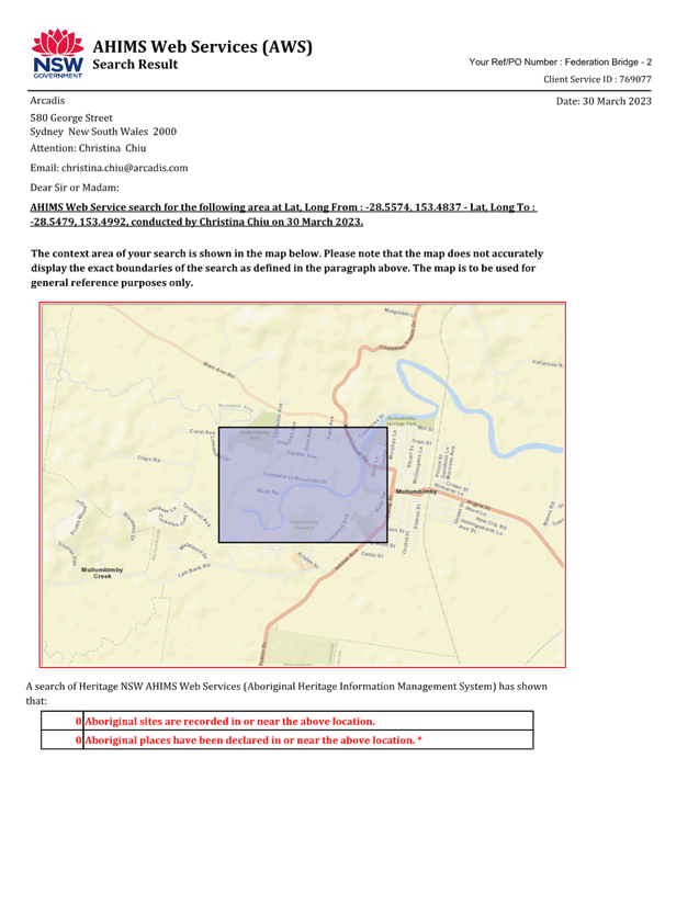
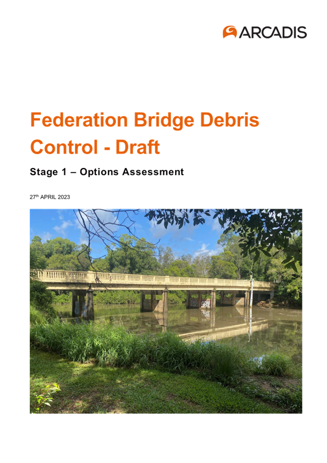
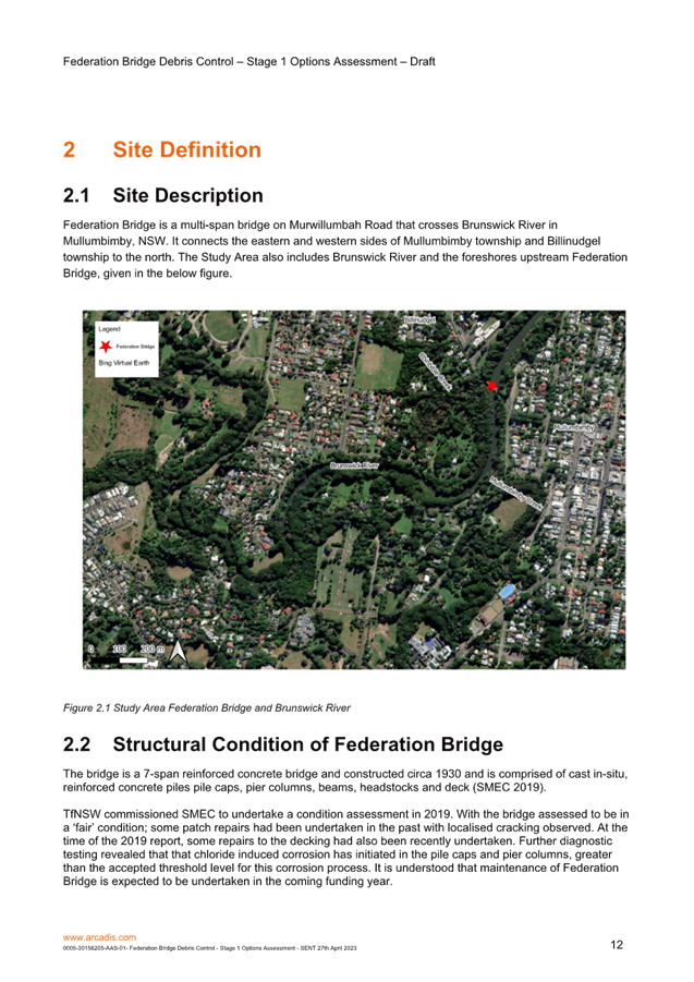
Federation Bridge is a multi-span bridge on Murwillumbah
Road that crosses Brunswick River in Mullumbimby, NSW and connects the eastern
and western sides of Mullumbimby township and Billinudgel township to the
north.
The requirement for debris controls measures for Federation
Bridge to be investigated, were based on one of the recommended outcomes given
in the North Byron Floodplain Risk Management Plan (FRMP) (WMA, 2020a).
Due to the substantial community support for debris control measures,
implementing debris control measures for Federation Bridge was adopted as a
high priority in the North Byron FRMP.
The first stage was to undertake the options assessment, via
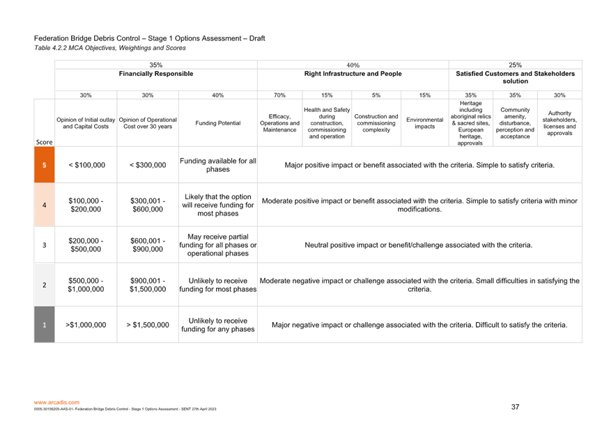
a Multi-Criteria Analysis (MCA) process to determine the most viable debris
control measure’s available in order to minimise the debris accumulation
under Federation Bridge, and to reduce the impact of debris especially during
flood events.
Attachment 1 provides an overview and the outcomes of the
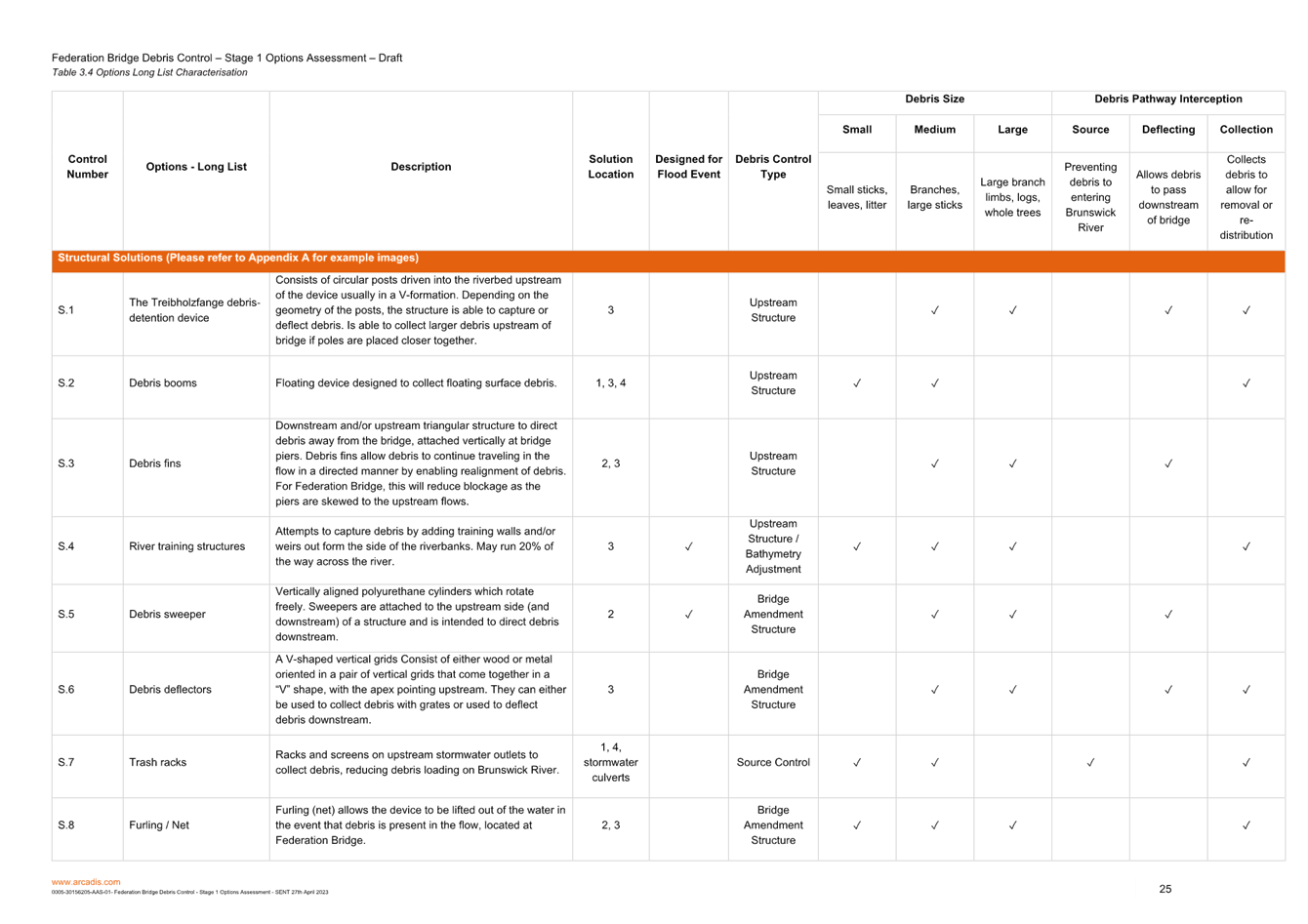
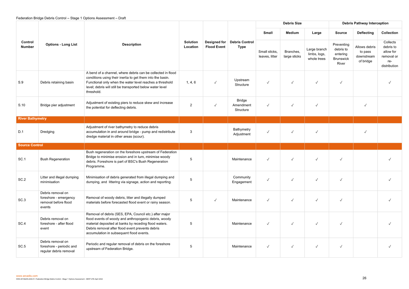
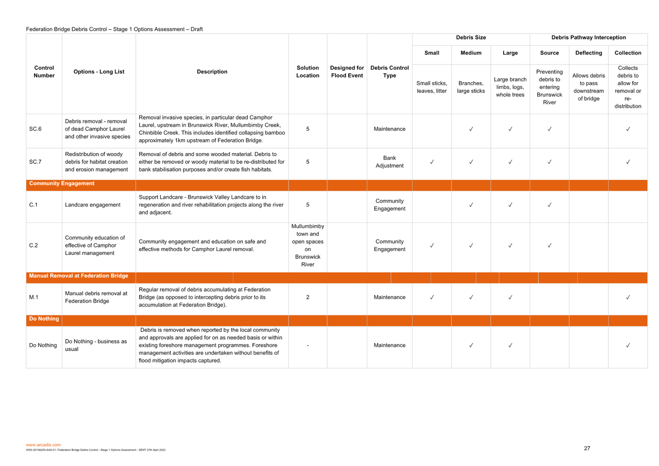
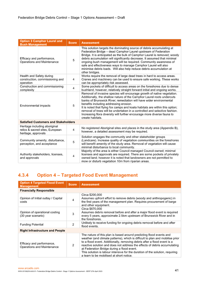
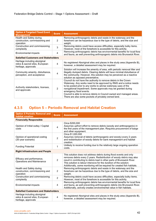
options assessment investigation. The report nominates option 3 as the
preferred option.
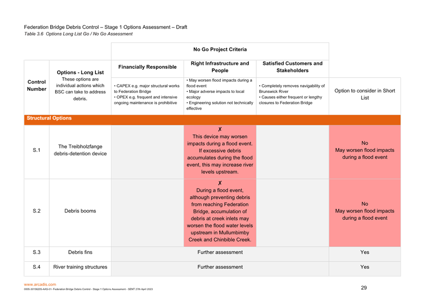
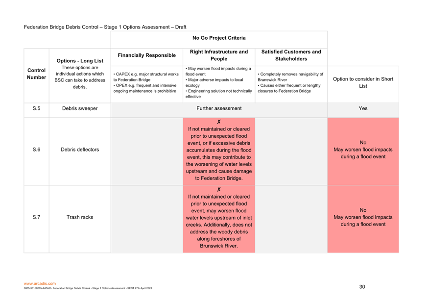
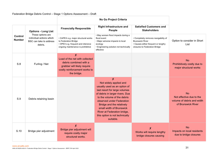
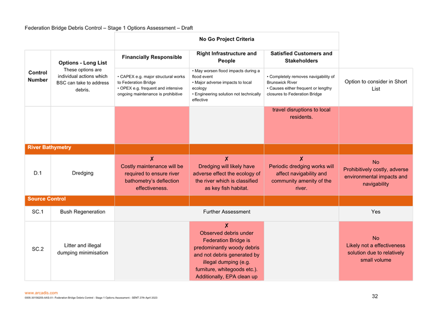
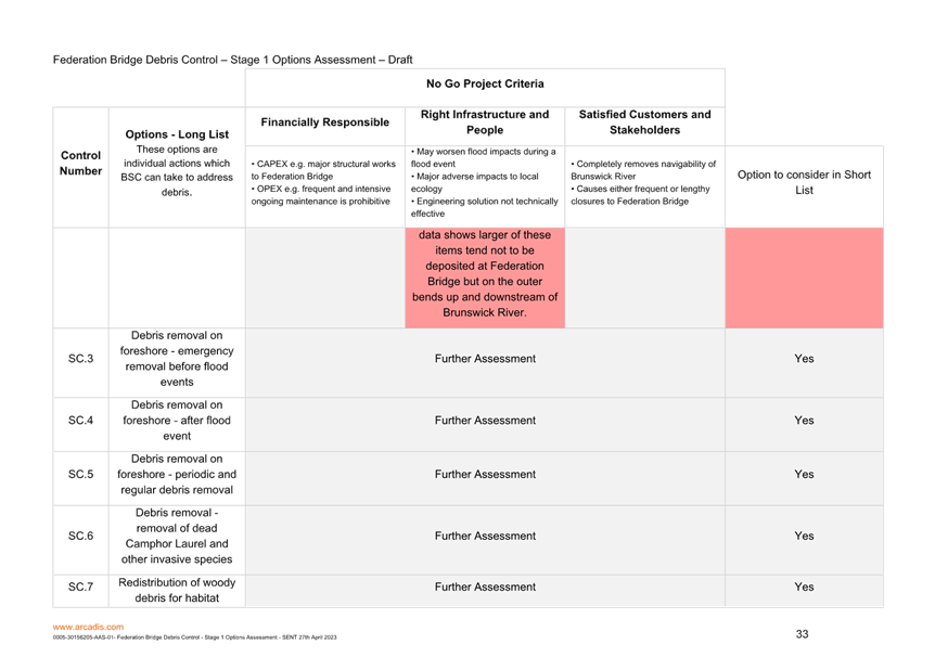
Key issues
Structural options versus
non-structural options have been assessed. All structural options came
with downsides therefore a non-structural options has been recommended within
the report.
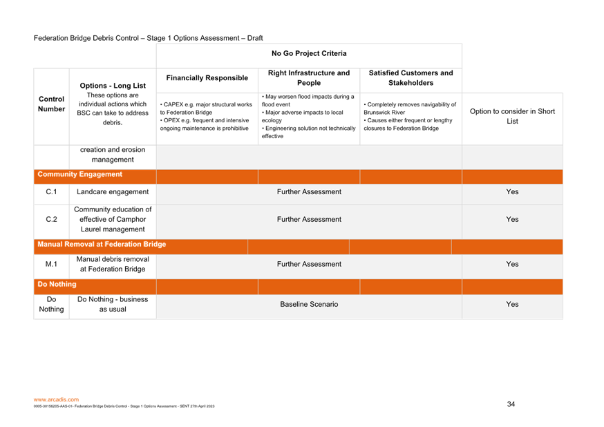
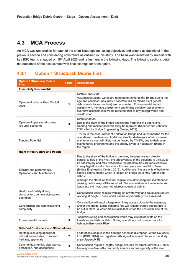
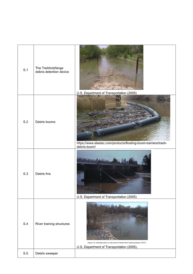
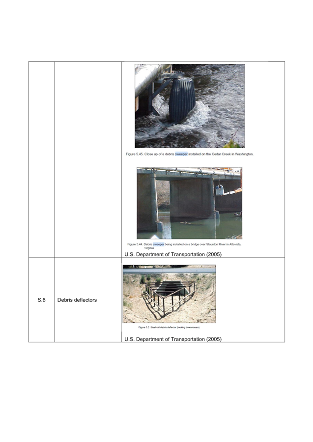
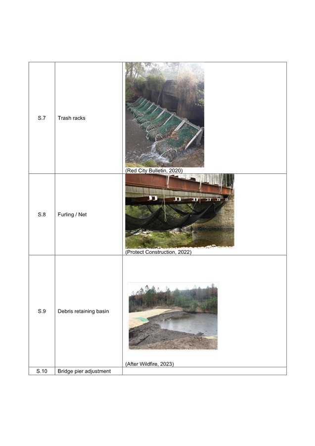
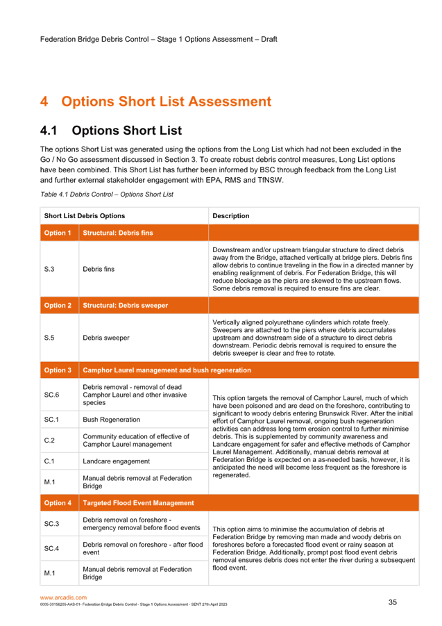
Options
1) Structural: Debris fins
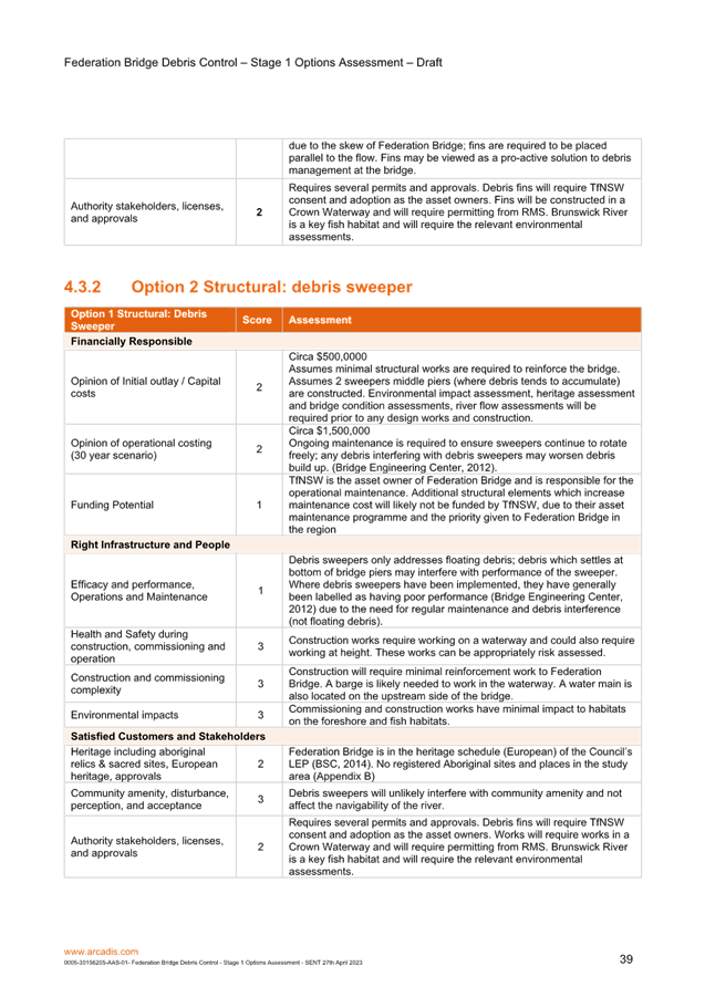
2) Structural: Debris sweeper
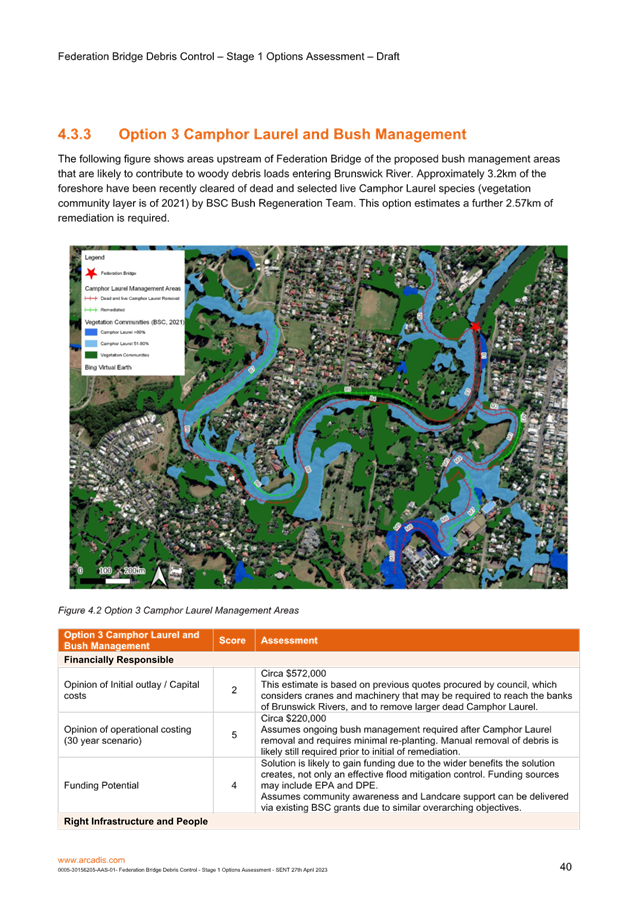
3) Camphor Laurel management and bush
regeneration (preferred option)
4) Targeted Flood Event Management
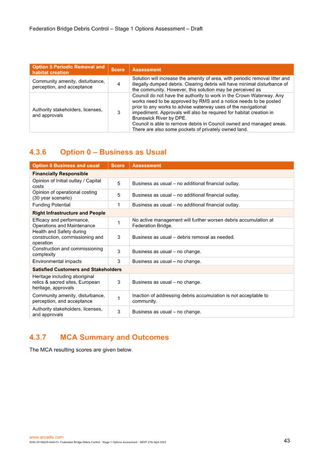
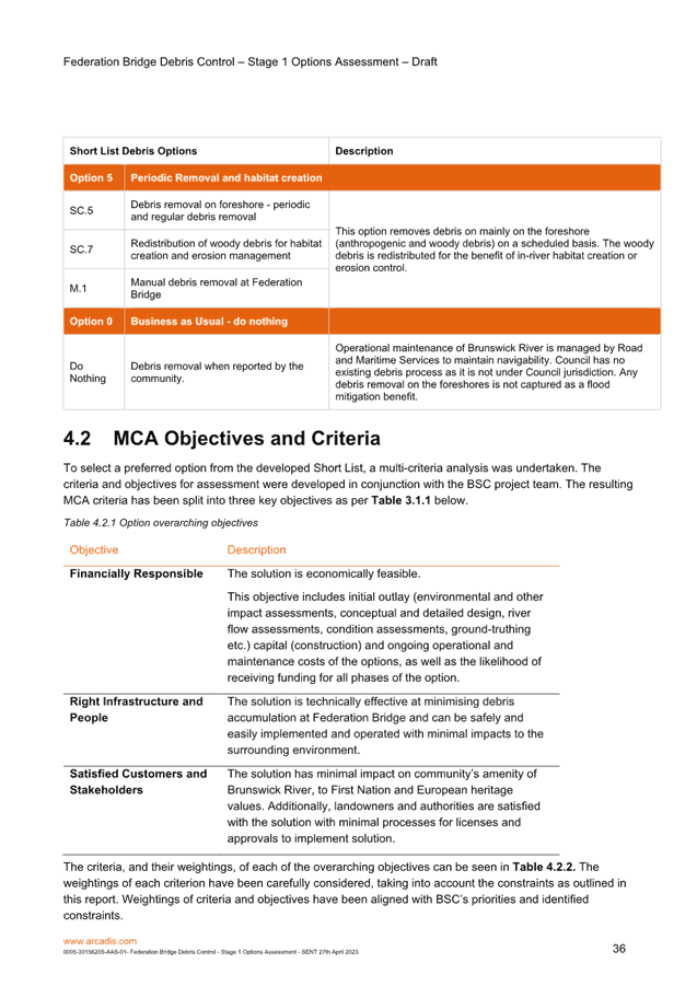
5) Periodic Removal and habitat creation
6) Business as Usual - do nothing
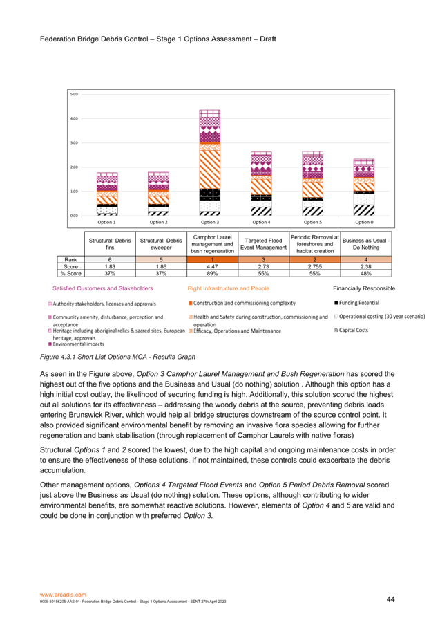
Next steps
· Attachment 1
provides the outcome of the options assessment. Option 3 is shown to be the
preferred option based on the MCA.
· Explore
potential fundings options and develop a business case, which outlines flood
mitigation benefits as well as wider environmental and community benefits.
Legal/Statutory/Policy
Considerations
The Floodplain
Development Manual supports the policy and guides councils through the
floodplain risk management process. The manual helps councils develop and
implement local floodplain risk management plans and outlines the technical
assistance provided by the NSW Government.
The manual details
the roles and responsibilities of various NSW agencies and includes information
on:
· the preparation of flood studies, floodplain risk
management studies and plans
· floodplain risk management options
· flood planning levels and areas
· hydraulic and hazard categorisation
· emergency response planning.
The manual was
gazetted in 2005 as the manual relating to the development of flood-liable land
for the purposes of section 733 of the Local
Government Act 1993.
Financial Considerations
Refer to attached report. Further
funding will be required for the construction or on ground works stage.
Consultation and
Engagement
Key stakeholder consultation was undertaken as part of this
project. This included all State and Federal agencies including the
Environmental Protection Agency (EPA), Transport for NSW, Martine Services,
Fisheries in additional to Councils bush regeneration team.
Staff
Reports - Infrastructure Services 4.1 - Attachment 1

Staff Reports - Infrastructure Services 4.2
Report
No. 4.2 North Byron Sky
Pump Proposal
Directorate: Infrastructure
Services
Report Author: Scott
Moffett, Drainage & Flood Engineer, IS - Works - Infrastructure Planning
File No: I2023/652
Summary:
On 24th March 2023 Council resolved the following
committee recommendation (23-092)
Council adopts the following Committee Recommendation:
· Report No. 4.2 Modelling
of Various Flow Scenarios at South Golden Beach File No: I2023/89
Committee Recommendation 4.2.1
That Council includes in the information it will
disseminate under AGRN1012 -Local Government Recovery Grant Program results of
a basic review of extracting water from the floodplain north of New Brighton.
This report addresses this
resolution and other actions requested by the committee.
RECOMMENDATION:
That the Floodplain Management Advisory Committee
recommends Council support the proposed scope for the North Byron Sky Pumps
Proposal
Report
On 24th March 2023 Council resolved the following
committee recommendation (23-092)
Council adopts the following Committee Recommendation:
· Report No. 4.2 Modelling
of Various Flow Scenarios at South Golden Beach File No: I2023/89
Committee Recommendation 4.2.1
That Council includes in the information it will
disseminate under AGRN1012 -Local Government Recovery Grant Program results of
a basic review of extracting water from the floodplain north of New Brighton.
In order to achieve this action it
is proposed to model a ‘Sky Pumps’ scenario in the North Byron
Flood Model. The following is the proposed scope.
Model two versions of the 100 year
flood to understand the pump volumes, rates and size that would be required to
prevent a prescribed amount of flooding for each event scenario
Develop and run the following
scenarios in the North Byron Flood Model
· Flood Event Scenario A - A ocean dominated 100 year flood
with a 100 year tail water of 2.6m AHD and 100 year rainfall.
· Flood Event Scenario B - A 100 year flood with 100 year
rainfall flood and a 20 year climate change tailwater boundary condition.
Each Flood Event Scenario above
will assess three ‘Sky Pumps’ operating together. The location of
the pumps is provided in the below images. The pumps will run together in three
different set ups.
Set Up One – Commence
pumping when water levels reach 200mm below the 100 year flood peak for the
location. The pumps are to be sized to prevent any water level increase above
the turn on level for the duration on the flood.
Set Up Two - Commence pumping when
water levels reach 400mm below the 100 year flood peak for the location.
The pumps are to be sized to prevent any water level increase above the turn on
level for the duration on the flood.
Set Up Three - Commence pumping
when water levels reach 600mm below the 100 year flood peak for the
location. The pumps are to be sized to prevent any water level increase
above the turn on level for the duration on the flood.
The term ‘Sky Pump’
has been used because for assessment purposes the discharge water from the
pumps will disappear into the aether. The purpose of this assessment is
to understand the extraction volumes and rates required to achieve three
different flood mitigation outcomes. Disposal of this water will be
investigated further if required following this initial investigation.
Typical costs to achieve the
desired mitigation volumes and rates will also be discussed.
The three ‘Sky Pump’
locations is shown in the below images. They were selected on the basis
that they are:
· Low elevation (around 1.2m/ 1.3 AHD), hence will be an area
that will be inundated early in a flood event
· Still have semi-intact remnant drainage channels that will
carry floodwater from overflow from Marshalls Creek or Billinudgel Nature
Reserve
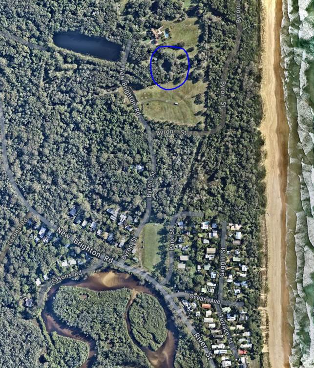
Locations are:
1. North of sports field at
New Brighton (153.5491, -28.5037) – this land is
privately owned.
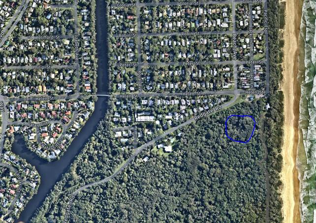
2. South of levee at SGB
(154.5499, -28.4984) – this land is a mix of Crown and National Parks
land.
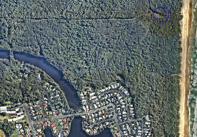
3. Remnant dredged channel
from 1970s in Billinudgel Nature Reserve (intersects remnant channel which
carried water to Helen Street outlet) (153.5506, -28.4856) - this land is
privately owned, however, some National Parks land is to the south.
Location One:
Location two:
Location 3:
Key issues
The proposal does simplify a complicated flood mitigation
scenario; therefore, the assessment does have its limitations. However, the
proposal will provide a simple understanding of potential extraction volumes
and rates required to achieve three different flood mitigation outcomes. This
will help with community understanding what is needed to achieve these
scenarios.
Disposal of pumped water will not be considered; this would
need to be understood better as it could make pumping a very costly or
difficult mitigation solution.
Next steps
The proposed scope will be added
to an existing Request For Quote for a Third Party Peer review and community
consultation process on Council previous flood mitigation investigations in the
North of the shire.
Recent Resolutions
· 23-092
Legal/Statutory/Policy
Considerations
The Floodplain
Development Manual supports the policy and guides councils through the
floodplain risk management process. The manual helps councils develop and
implement local floodplain risk management plans and outlines the technical
assistance provided by the NSW Government.
The manual details
the roles and responsibilities of various NSW agencies and includes information
on:
· the preparation of flood studies, floodplain risk
management studies and plans
· floodplain risk management options
· flood planning levels and areas
· hydraulic and hazard categorisation
· emergency response planning.
The manual was
gazetted in 2005 as the manual relating to the development of flood-liable land
for the purposes of section 733 of the Local
Government Act 1993.
Financial Considerations
This assessment will be funded under an existing grant
funded catchment assessment.
Consultation and
Engagement
Staff met with Robert Crossley, his group and Cr Lyon and Cr
Hunter to discuss the proposed scope on Friday 28th April 2023.
Staff Reports - Infrastructure Services 4.3
Report
No. 4.3 Byron Drainage
Upgrade Strategy
Directorate: Infrastructure
Services
Report Author: Scott
Moffett, Drainage & Flood Engineer, IS - Works - Infrastructure Planning
File No: I2023/653
Summary:
The Byron Bay Drainage Upgrade Strategy is a Floodplain
Management Measure in the Council adopted Belongil Creek Floodplain Risk
Management Plan (2015).
The project is funded by the "Preparing Australian
Communities" grant to develop the drainage strategy through Concept Design
to Detailed Design. Essentially developing a construction ready project.
This report provides a status update for the project.
RECOMMENDATION:
That the Floodplain Management Advisory Committee
notes the update on the Byron Drainage Upgrade Strategy.
Report
The Byron Bay Drainage Upgrade Strategy is a Floodplain
Management Measure in the Council adopted Belongil Creek Floodplain Risk
Management Plan (2015).
The project is funded by the "Preparing Australian
Communities" grant to develop the drainage strategy through Concept Design
to Detailed Design. Essentially developing a construction ready project.
The project has three proposed stages that make up the Byron
Bay Drainage Upgrades. They can be delivered separately or together as follows:
· Town Centre
– Includes upgrades of the gravity drainage system within the town
centre.
· Shirley Street
– Includes construction of the towns main pump station, a levee
protecting the properties of the Shirley Street area from regional flooding and
installation of flood pumps to cater for local drainage within the leveed area.
· Cowper Street
– Includes construction of a flood storage basin (Sandhills wetland) and
upgrades to Cowper Street pipe outlet to Clarkes Beach. It also includes
upgrades to cross drainage linkages between the Town Centre drainage, Cowper
Street trunk drainage and possible flood pump. (The Sandhills Wetland can be
delivered separately to the peripheral works).
There are 5 stages to deliver the detailed design of the
drainage upgrades. The scope, status, dependencies and timeframes are summarised
below:
|
Stage
|
Scope
|
Status
|
Dependencies
|
Program Timeframe
|
|
1
|
Strategy Review
Deliverable: Strategy Review report identifying issues
with the current strategy and opportunities for optimisation in concept
design
|
100%
Completed
|
Data Collection
|
14/4/2023
|
|
2
|
Detailed Survey of project area
|
80% Completed
|
|
30/4/2023
|
|
3
|
Concept Design of drainage upgrades
|
|
3a
|
Deliverable:
Draft Concept Design Drawings and report including flood
modelling results and mapping
|
0%
|
Completion of survey
Sandhills Wetland Design
Byron Town Centre Masterplan
Clarks Beach Masterplan
|
25/8//2023
|
|
3b
|
Councillor Workshop
|
0%
|
Project review and general concept discussion
|
July 2023
|
|
3c
|
Deliverable:
Final Concept Design Drawings and report
|
0%
|
Consultation and information sessions with community
Draft Review and milestone Meeting with Technical Staff
|
11/9/2023
|
|
3d
|
Councillor Workshop
Report to Council General Meeting
Council Adoption of Concept Design
|
0%
|
Finalisation of Concept Design
|
Oct 2023
|
|
4
|
Environmental Assessment
Deliverable: Environmental studies, documentation and
proposed approvals
|
0%
|
Identification of planning and regulatory pathways
(Note that timing will vary depending on specialist
studies and need for EIS)
Finalise Concept Design
|
6/11/2023
|
|
5
|
Detailed Design
Deliverable: Construction drawings and specifications
|
0%
|
Council adoption of concept design
Pot holing to obtain utility depths
Environmental assessments and approvals
Electrical design and Essential Energy approvals (for pump
stations)
|
26/3/2024
|
Key issues
The project scope overlaps with several other Council
projects currently in progress and future masterplan projects. The drainage
design upgrades will need to integrate with:
· Sandhill’s
Wetland – The detailed design of the Sandhills Wetland is complete, and
EIS is currently being prepared.
· Road
Reconstruction projects - Including the underground drainage upgrades with road
reconstruction / renewals is the best delivery method for Council. It
benefits the community by minimising disruption and avoids the costs associated
with temporary works or reinstatement costs that would be necessary if drainage
works were solely undertaken separately from road works.
· The detailed
design of the drainage upgrades will cover the necessary underground works
required within the footprint of the Lawson Street and Byron Street Road
reconstruction projects currently in Councils Capital Works program.
· Consultant Engeny
will work with the Place Manager for Byron Bay to develop a civil works scoping
report for locations where the road and footpath shape will likely remain
unchanged or changed. The locations where change is warranted or planned
would be the higher priority for full street upgrades. This reporting
will help guide full street upgrade designs that need to be prepared.
· The Clarks Beach
Master Plan is about to commence on Main Beach reserve and will need to include
any upgrade works that will be required to the Cowper Street Outfall.
This is in the early stages and will be a point of discussion at steering
committee meetings.
· Byron Bay Town
Centre Master Plan -The drainage strategy has also been requested / listed at
the next Byron Town Centre Master Plan meeting for a presentation / briefing
for early April to coincide with the completion of the Drainage Strategy Review
Report.
The current contracted program from Engeny is currently
delivering detail design in March 2024 ahead of the grant deadline of August
2024, however the following external dependencies present risks to delivery to
the contracted program:
· Council approval
of the Concept Design may extend delivery deadlines if staff are not confident
to proceed with detail design following the Councillor Workshop.
· Consultation with
affected property owners– The extent of properties directly affected by
the proposed upgrades (such as properties adjoining levees and pump stations)
will be identified at the concept design stage. Additional consultation with
individual properties may be required depending on the design impacts.
· Environmental
Assessments and obtaining environmental approvals. Whilst most of the
drainage upgrades would be considered exempt development or development with
without consent, it is possible that parts of the project could trigger third
party referrals/ approvals (such as Crown Lands, Cultural Heritage assessments,
Cape Byron Marine Park Authority etc). Further an EIS maybe required for some
elements.
· Essential Energy
Certified Design for electrical upgrades. The currently adopted preferred
drainage strategy for Byron Town drainage includes flood pumps. Pump
installations may require electrical upgrades if electric pumps are adopted and
existing power supplies cannot meet pump demands. The scope of electrical
design will not be confirmed until concept design and the current program does
not have allowance for obtaining Essential Energy approvals. This may delay
delivery of parts of the detailed design of pumps, should they be included in
upgrades
If any of the above project dependencies are encountered the
Engeny contracted program maybe extended via an extension of time request. This
will be reported via the PRG. Under the grant funding agreement, the project currently
has a 5 month delivery buffer.
See Risk Register in: Pulse
| Enterprise Risk Management
Next steps
· Finalise survey
· Continue with concept design
· Commence regular meetings with the internal Project
Reference Group
Strategic Considerations
Community Strategic Plan
and Operational Plan
|
CSP Objective
|
CSP Strategy
|
DP Action
|
Code
|
OP Activity
|
|
5:
Connected Infrastructure
We have connected infrastructure, transport, and facilities that are safe,
accessible, and reliable
|
5.3:
Invest in renewable energy and emerging technologies
|
5.3.1:
Future needs - Plan for the infrastructure needs of the current and future
population
|
5.3.1.1
|
Review
and update 10 year Flood and Drainage Renewal and Upgrade program
|
Recent Resolutions
Not applicable
Legal/Statutory/Policy
Considerations
The Floodplain Development Manual supports the policy and
guides councils through the floodplain risk management process. The manual
helps councils develop and implement local floodplain risk management plans and
outlines the technical assistance provided by the NSW Government.
The manual details
the roles and responsibilities of various NSW agencies and includes information
on:
· the preparation of flood studies, floodplain risk
management studies and plans
· floodplain risk management options
· flood planning levels and areas
· hydraulic and hazard categorisation
· emergency response planning.
The manual was
gazetted in 2005 as the manual relating to the development of flood-liable land
for the purposes of section 733 of the Local
Government Act 1993.
Financial Considerations
Budget
– $1.28M
To
date, Council has committed $315K which covers the Engineering design and
survey up to completion of concept design.
Detailed
Design is a provisional item in the contract for Engineering Design and will be
subject to final pricing at the completion and adoption of concept design when
the scope can be confirmed. Environmental planning assessments are
excluded from the Engeny’s engineering design scope and is subject to a
separate engagement. Preparation of RFQ documentation will be undertaken in
April with appointment of a planning consultant planned for early May 2023.
Project
is currently projected to be delivered under budget.
Should Council be successful in
securing funding for the construction of the drainage upgrades, Council should
aim to not commence any works on ground until Winter 2024 at the earliest.
Accelerating the detailed design carries risks and tendering should be carried
out on a finalised holistic design.
Consultation and
Engagement
A communication plan is currently being prepared with
Council’s Comms team and will be the first point of discussion at the
first internal Project Reference Group meeting and Floodplain Management
Advisory Committee
Staff Reports - Infrastructure Services 4.4
Report
No. 4.4 Byron Shire Post
2022 Flood Analysis Update
Directorate: Infrastructure
Services
Report Author: Scott
Moffett, Drainage & Flood Engineer, IS - Works - Infrastructure Planning
File No: I2023/654
Summary:
Following the recent flooding and rainfall events in 2022,
Council has been working closely with State Emergency Services (SES), the
Department of Planning & Environment (DPE) and flooding consultants to
undertake a post event data collection and summary report.
This report provides a summary of actions and ongoing
activities for discussion by the Floodplain Management Advisory Committee
(FMAC).
Draft reports have been received
by DPE and are currently undergoing quality assurance and technical review.
RECOMMENDATION:
That the Floodplain Management Advisory Committee
recommends:
Council notes the report, the update by DPE and the
Floodplain Management Advisory Committee minutes.
Report
Following the recent flooding and rainfall events in 2022,
Council has been working closely with State Emergency Services (SES), the
Department of Planning & Environment (DPE) along with flooding consultants
to undertake a post event/s data collection and summary report.
Council initiated the first phase
internal post event survey protocols immediately following the recent
events. Council’s Flood and Drainage Engineer was contacted by SES
to collaborate in obtaining post event survey marks.
SES contracted Public Works
Advisory (PWA) to provide survey resourcing across the Byron Shire. DPE
then became involved to oversee the data collection. Council’s
Flood and Drainage Engineer worked closely with SES, DPE and PWA to isolate the
areas of interest with a focus on the main urbanised areas of the shire.
Post event survey has now been
completed, including an SES, DPE and PWA, along with Council undertaking
quality assurance checks. This data is now available for use by
Council. Survey has covered the Brunswick River, Belongil, Tallow Creek
catchments and Bangalow.
Council also initiated the second
phase of post event survey protocols. This involved releasing media
alerts to all shire residents to ask for assistance with collection of
additional private property survey. This initiative was very successful
with over 200 responses received. Council has mobilised survey resources
collected all data from this survey.
DPE have agreed to fund all the
post event technical analysis.
The post event technical analysis
will cover the Brunswick River, Belongil, Tallow Creek catchments and Bangalow.
Consultants WMA have been commissioned by DPE for the Brunswick River catchment
and BMT have been commissioned by DPE for the Belongil and Tallow Creek
catchments. QIT, Council Emergency Dashboard provider have also been
commissioned to undertake a post event analysis of Councils flood warning
system.
There is a large amount of works
involved to complete the post event technical analysis and current estimates
from DPE and consultants is likely to take two to three months as a minimum.
DPE has recently extended their
proposed delivery. Staff understand that many flood specialist consultants are
experiencing staff change and staff resourcing issues which has caused delays.
Post such significant flood events
it is natural that the industry will be under pressure from flood related areas
including; insurance companies, developers and local governments.
Draft reports have been received
by DPE and are currently undergoing quality assurance and technical review.
Key issues
· Timing of works (reliance on DPE and third-party
consultants)
· Privacy of data
Next steps
· Review draft post event technical analysis
· Finalise reporting and report back to the Floodplain Management
Advisory Committee
Financial Considerations
· Council’s
Flood and Drainage Engineer’s time and resource allocation
· All other
activities are fully funded by DPE and SES (approx. $150 000)
Consultation and
Engagement
Community consultation has been in the form of digital flood
survey mark requests via media releases and Council’s website.