Notice of Meeting
Moving Byron Advisory Committee Meeting
A Moving Byron Advisory Committee Meeting of Byron Shire Council will be held as follows:
|
Venue
|
Conference Room, Station Street, Mullumbimby
|
|
Date
|
Thursday, 31 August 2023
|
|
Time
|
2.00pm
|
Phil Holloway
Director Infrastructure
Services
I2023/1268
Distributed
25/08/23

What is a “Conflict of Interests” - A conflict of
interests can be of two types:
Pecuniary - an interest that a person has in a matter because of a reasonable
likelihood or expectation of appreciable financial gain or loss to the person
or another person with whom the person is associated.
Non-pecuniary – a private or personal interest that a Council
official has that does not amount to a pecuniary interest as defined in the
Code of Conduct for Councillors (eg. A friendship, membership of an
association, society or trade union or involvement or interest in an activity
and may include an interest of a financial nature).
Remoteness – a person does not have a pecuniary interest in a matter
if the interest is so remote or insignificant that it could not reasonably be
regarded as likely to influence any decision the person might make in relation
to a matter or if the interest is of a kind specified in the Code of Conduct
for Councillors.
Who has a Pecuniary Interest? - a person has a pecuniary interest in a
matter if the pecuniary interest is the interest of the person, or another
person with whom the person is associated (see below).
Relatives, Partners - a person is taken to have a pecuniary
interest in a matter if:
·
The
person’s spouse or de facto partner or a relative of the person has a
pecuniary interest in the matter, or
·
The
person, or a nominee, partners or employer of the person, is a member of a
company or other body that has a pecuniary interest in the matter.
N.B. “Relative”, in relation to a person means any of the
following:
(a) the parent,
grandparent, brother, sister, uncle, aunt, nephew, niece, lineal descends or
adopted child of the person or of the person’s spouse;
(b) the spouse
or de facto partners of the person or of a person referred to in paragraph (a)
No Interest in the Matter - however, a person is not taken to have a
pecuniary interest in a matter:
·
If
the person is unaware of the relevant pecuniary interest of the spouse, de
facto partner, relative or company or other body, or
·
Just
because the person is a member of, or is employed by, the Council.
·
Just
because the person is a member of, or a delegate of the Council to, a company
or other body that has a pecuniary interest in the matter provided that the
person has no beneficial interest in any shares of the company or body.
Disclosure and participation in meetings
·
A
Councillor or a member of a Council Committee who has a pecuniary interest in
any matter with which the Council is concerned and who is present at a meeting
of the Council or Committee at which the matter is being considered must
disclose the nature of the interest to the meeting as soon as practicable.
·
The
Councillor or member must not be present at, or in sight of, the meeting of the
Council or Committee:
(a) at
any time during which the matter is being considered or discussed by the
Council or Committee, or
(b) at
any time during which the Council or Committee is voting on any question in
relation to the matter.
No Knowledge - a person does not breach this Clause if the person did
not know and could not reasonably be expected to have known that the matter
under consideration at the meeting was a matter in which he or she had a
pecuniary interest.
Non-pecuniary Interests - Must be disclosed in meetings.
There are a broad range of options available for managing conflicts &
the option chosen will depend on an assessment of the circumstances of the
matter, the nature of the interest and the significance of the issue being
dealt with. Non-pecuniary conflicts of interests must be dealt with in at
least one of the following ways:
·
It
may be appropriate that no action be taken where the potential for conflict is
minimal. However, Councillors should consider providing an explanation of
why they consider a conflict does not exist.
·
Limit
involvement if practical (eg. Participate in discussion but not in decision
making or vice-versa). Care needs to be taken when exercising this
option.
·
Remove
the source of the conflict (eg. Relinquishing or divesting the personal
interest that creates the conflict)
·
Have
no involvement by absenting yourself from and not taking part in any debate or
voting on the issue as of the provisions in the Code of Conduct (particularly
if you have a significant non-pecuniary interest)
Committee members are reminded that they should declare and manage all
conflicts of interest in respect of any matter on this Agenda, in accordance
with the Code of Conduct.
RECORDING OF VOTING ON PLANNING MATTERS
Clause 375A of the Local Government Act
1993 – Recording of voting on planning matters
(1) In this section, planning
decision means a decision made in the exercise of a function of a council
under the Environmental Planning and Assessment Act 1979:
(a) including a decision relating to a development
application, an environmental planning instrument, a development control plan
or a development contribution plan under that Act, but
(b) not including the making of an order under that Act.
(2) The general manager is required to keep a register
containing, for each planning decision made at a meeting of the council or a
council committee, the names of the councillors who supported the decision and
the names of any councillors who opposed (or are taken to have opposed) the
decision.
(3) For the purpose of maintaining the register, a division
is required to be called whenever a motion for a planning decision is put at a
meeting of the council or a council committee.
(4) Each decision recorded in the register is to be described
in the register or identified in a manner that enables the description to be
obtained from another publicly available document and is to include the
information required by the regulations.
(5) This section extends to a meeting that is closed to the
public.
OATH AND AFFIRMATION FOR COUNCILLORS
Councillors are
reminded of the oath of office or affirmation of office made at or before their
first meeting of the council in accordance with Clause 233A of the Local
Government Act 1993. This includes undertaking the duties of the office of
councillor in the best interests of the people of Byron Shire and the Byron
Shire Council and faithfully and impartially carrying out the functions,
powers, authorities and discretions vested under the Act or any other Act
to the best of one’s ability and judgment.
BUSINESS OF MEETING
1. Apologies
2. Declarations
of Interest – Pecuniary and Non-Pecuniary
3. Adoption of Minutes from
Previous Meetings
3.1 Adoption
of Minutes from Previous Meeting.............................................................. 6
4. Staff Reports
Infrastructure Services
4.1 Active
Transport Plan Update.................................................................................... 13
4.2 Raftons
Road Shared Path Consultation and Direction........................................ 62
4.3 Kolora
Way - Alternative Scope of Works................................................................ 72
4.4 Moving
Byron Integrated Transport Plan - Implementation and Strategic Alignment........................................................................................................................................ 86
Adoption of Minutes from Previous Meetings 3.1
Adoption of Minutes from Previous Meetings
Report No. 3.1 Adoption of Minutes from Previous Meeting
Directorate: Infrastructure Services
Report Author: Dominika
Tomanek, Executive Assistant Infrastructure Services
File No: I2023/1169
RECOMMENDATION:
That the minutes of the Moving Byron Advisory Committee
Meeting held on 15 June 2023 be confirmed.
Attachments:
1 Minutes
15/06/2023 Moving Byron Advisory Committee, I2023/934
, page 8⇩ 
Report
The attachment to this report provides the minutes of the
Moving Byron Advisory Committee Meeting of 15 June 2023 .
Report to Council
The minutes were reported to Council on
Comments
In accordance with the Committee Recommendations, Council
resolved the following:
|
|
Resolved:
Report No.
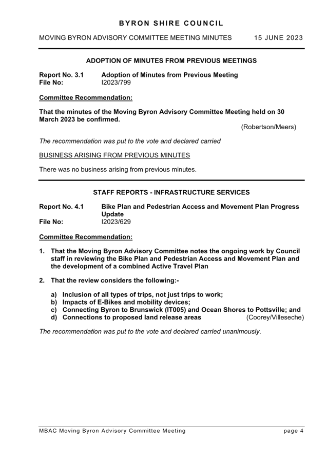
4.1 Bike Plan and Pedestrian Access and Movement Plan Progress Update
Committee Recommendation 4.1.1
1. That
the Moving Byron Advisory Committee notes the ongoing work by Council staff
in reviewing the Bike Plan and Pedestrian
Access and Movement Plan and the development of a combined
Active Travel Plan
2. That
the review considers the following:-
a) Inclusion
of all types of trips, not just trips to work;
b) Impacts of
E-Bikes and mobility devices;
c) Connecting
Byron to Brunswick (IT005) and Ocean Shores to Pottsville; and
d) Connections to
proposed land release areas
|
Adoption
of Minutes from Previous Meetings 3.1 - Attachment 1

Staff Reports - Infrastructure Services 4.1
Staff Reports - Infrastructure Services
Report No. 4.1 Active
Transport Plan Update
Directorate: Infrastructure
Services
Report Author: Judd
Cornwall, Traffic & Transport Engineer
Shelley Flower, Road Safety Officer
File No: I2023/955
Summary:
As requested in the last Moving Byron Advisory Committee
meeting held on 15 June, this report provides more detail on the work Council
staff have undertaken in the mid-life review of the Pedestrian Access and
Mobility Plan (PAMP) and Bike Plan and discusses future steps for the Committee’s
consideration.
Unfortunately, due to Council and Committee meeting timings
and the Councillor’s mid-year break, the Committee recommendations have
not yet been reported to Council. However, they will be reported at the
next Council meeting on 24 August.
The Committee recommendations are as follows:
1.
That the Moving Byron Advisory Committee notes the ongoing work by Council
staff in reviewing the Bike Plan and
Pedestrian Access and Movement Plan and the development of a
combined Active Travel Plan
2. That
the review considers the following:-
a) Inclusion of
all types of trips, not just trips to work;
b) Impacts
of E-Bikes and mobility devices;
c) Connecting
Byron to Brunswick (IT005) and Ocean Shores to Pottsville; and
d) Connections to
proposed land release areas
RECOMMENDATIONS:
That the Moving Byron Advisory Committee support:
1. The
draft Active Transport Plan being placed on public exhibition; and
2. Finalisation
of the Active Transport Plan based on public exhibition and survey results be
reported to the Moving Byron Advisory Committee
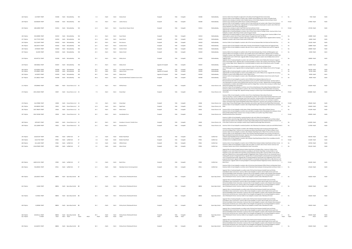
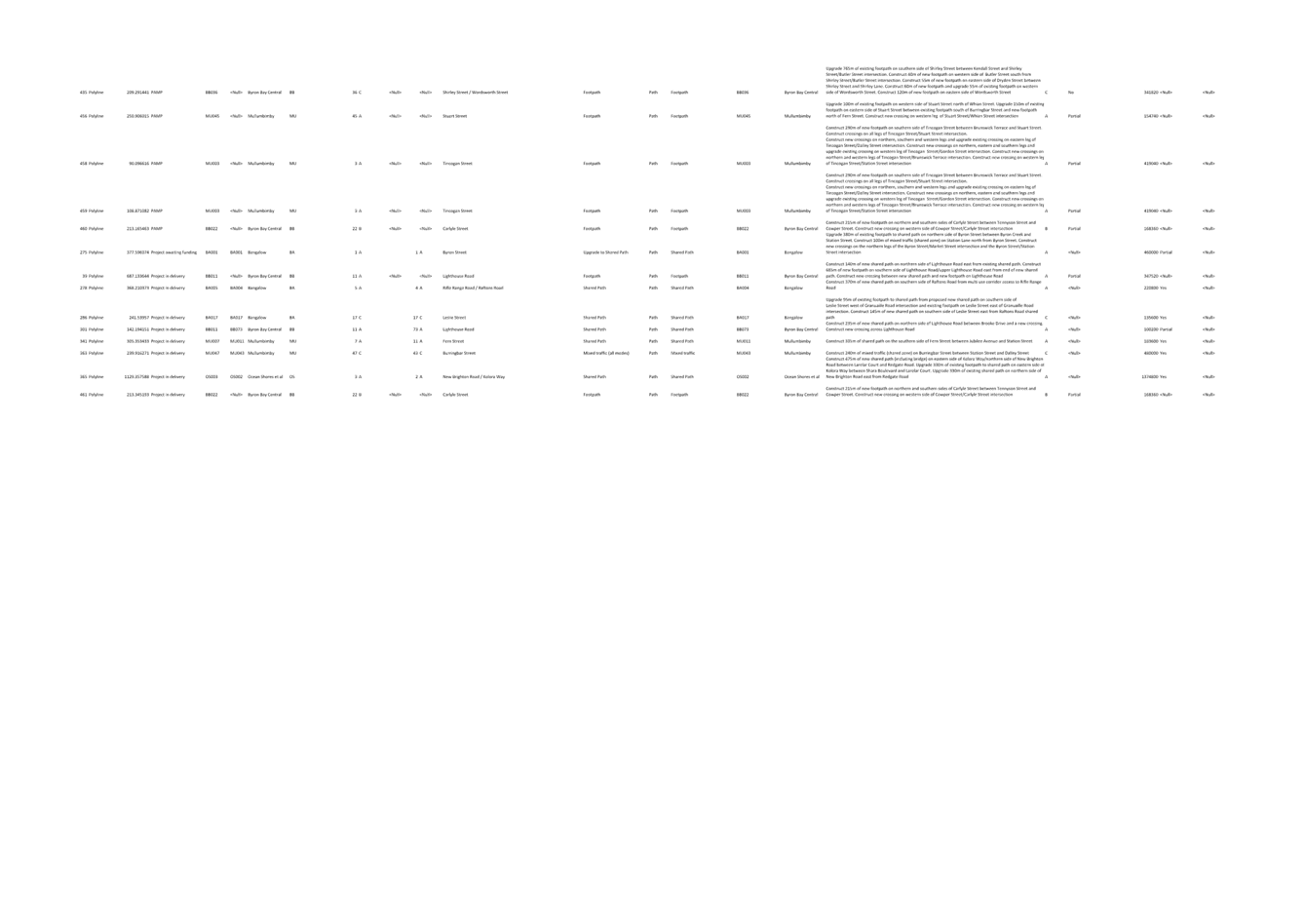
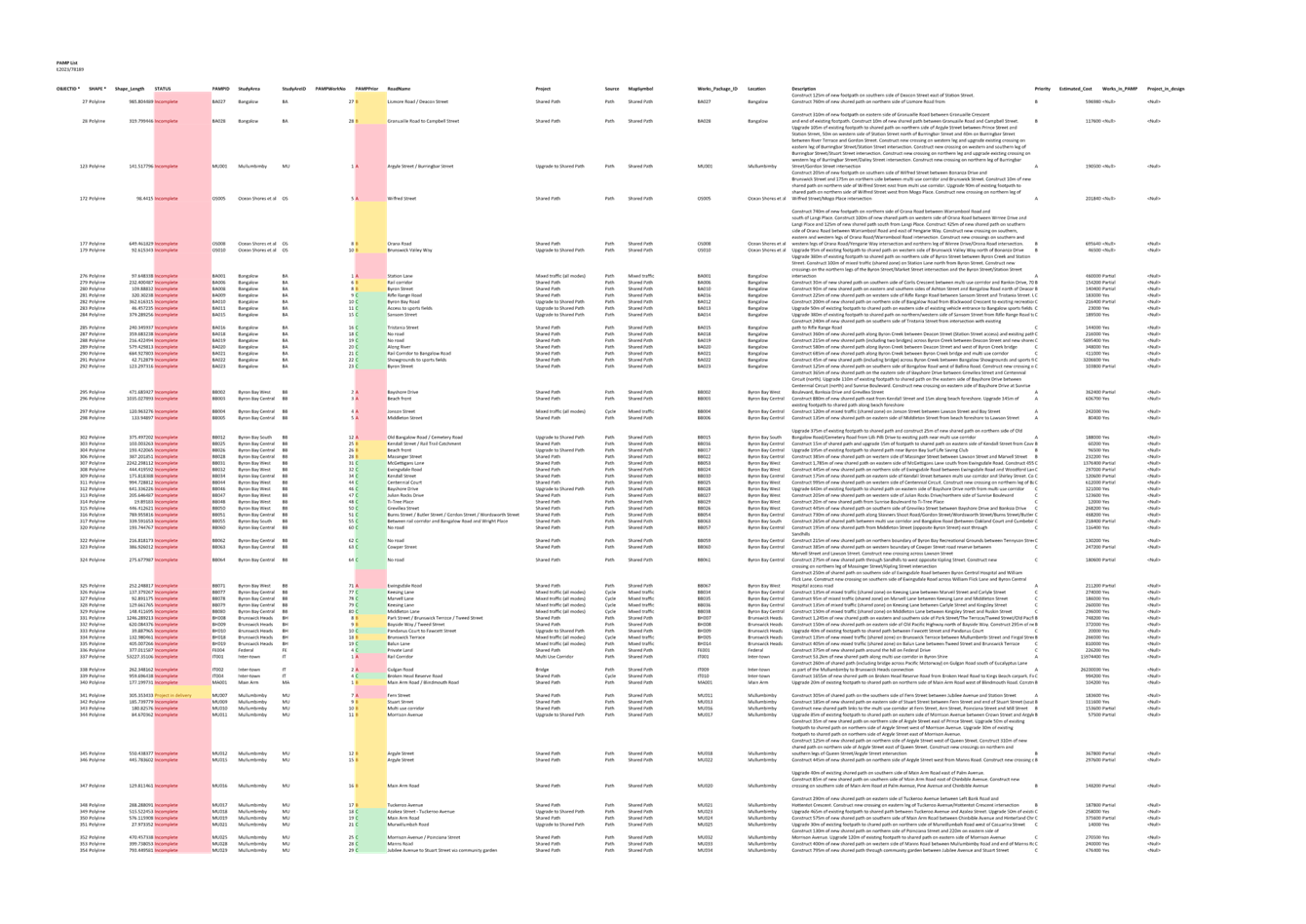
Attachments:
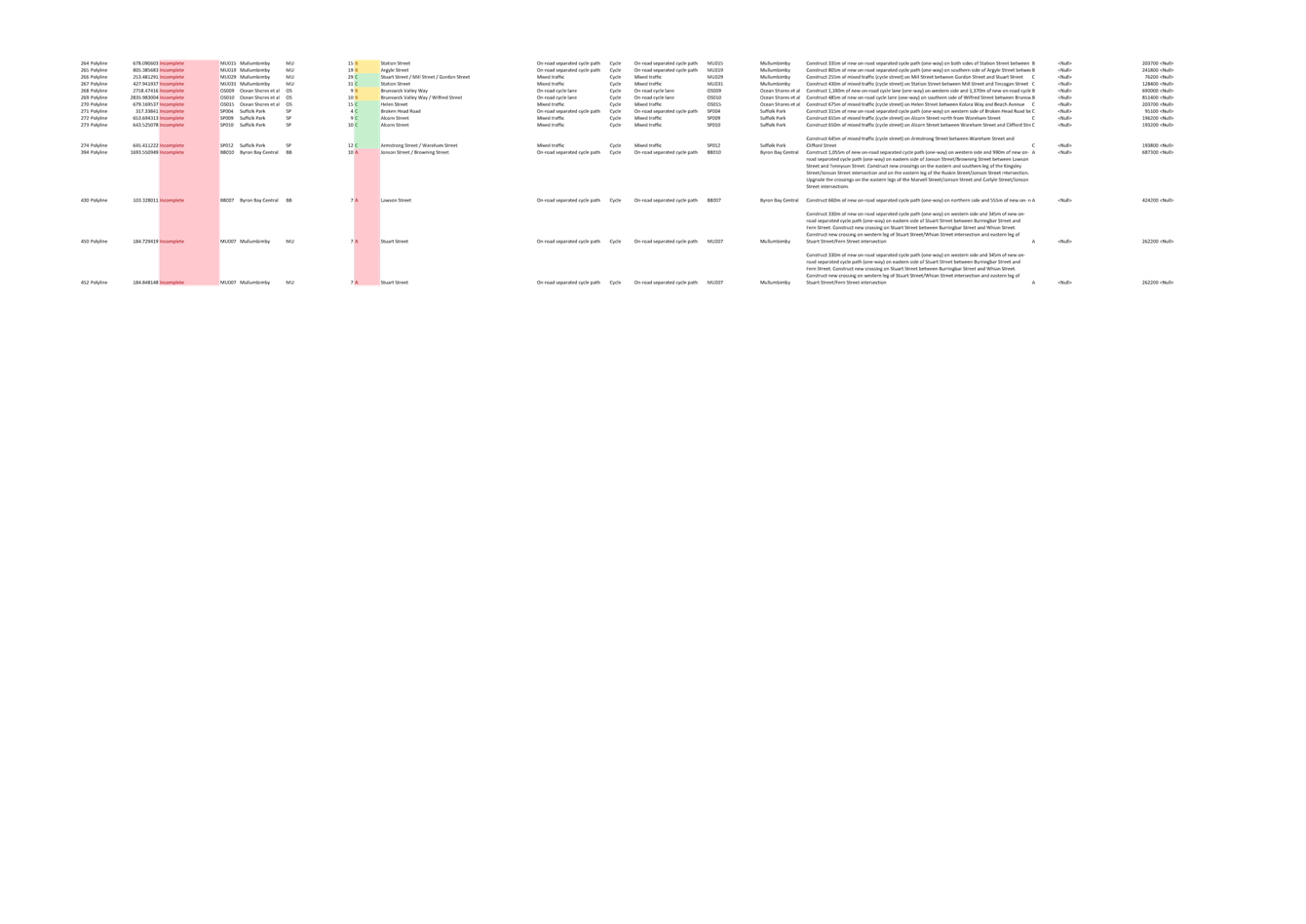
1 PAMP
& Bike Plan Combined List, E2023/78189
, page 34⇩ 
2 Byron
Active Transport Plan, E2023/76375
, page 49⇩
Report
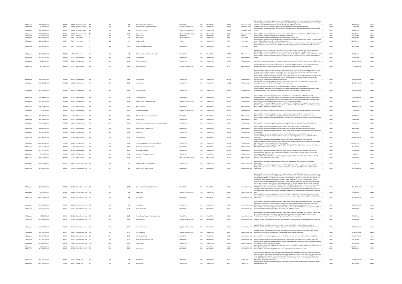
Actions completed by Council staff since the last Committee
report include:
1. Review of the PAMP and
Bike Plan to identify completed projects.
Refer table 1 below for completed, underway and shovel
ready projects. Completed projects are also shown as green lines in the
figures below.
Table 2 shows projects under design and as yellow lines in
the figures.
Table 3 shows construction ready projects.
Refer to Attachment 1 for PAMP & Bike Plan Combined
List spreadsheet for a full list of all Active Transport projects, including
incomplete projects.
2. Draft Active Transport
Plan prepared as per Attachment 2. This document is very preliminary at
this stage and will continue to be developed and presented at each Moving Byron
Committee as it is developed further.
Completed Projects
Table 1: Completed Projects (also shown as green in Figures
below)
|
PAMP/
BP ID
|
Location
|
Road
Name / Project
|
Type
|
|
BA004, BA008
|
Bangalow
|
Deacon Street Shared
Path
Deacon Street, Ashton
Street
|
Shared Path
|
|
BB007,
BB010, BB027, BB031, BB032, BB036, BB037, BB058, BB059
|
Byron Bay
Central
|
Byron
Bypass
Shirley
Street, Butler Street, Lawson Street, Browning Street, along rail corridor,
across rail line, through park
|
Footpaths,
shared paths, off-road and on-road separated cycle paths
|
|
BB061
|
Byron Bay Central
|
Gilmore Crescent /
Tennyson Street
|
Shared Path
|
|
BB009
|
Byron Bay
Central
|
Tennyson
Street
|
Shared Path
|
|
BB012, BB013, BB081,
SP002, SP003
|
Byron Bay South
Suffolk Park
|
Byron to Suffolk Cycle
Way
Broken Head Road,
Bangalow Road
|
On-road cycle lane,
shared paths
|
|
BB010
|
Byron Bay
West
|
Through
private lot (laneway) from Banksia Drive to Bayshore Drive
|
Shared Path
|
|
BB001
|
Byron Bay West
|
Ewingsdale Road missing
link
|
Shared Path
|
|
IT004
|
Inter-town
|
Broken Head
Reserve Road
|
Shared Path
|
|
MU026
|
Mullumbimby
|
Argyle Street
|
Footpath
|
|
MU007,
MU045
|
Mullumbimby
|
Stuart
Street
|
Footpaths,
on-road separated cycle path
|
|
OS009
|
Ocean Shores
|
Balemo Drive
|
Shared Path
|
|
MU003
|
Mullumbimby
|
Tincogan
Street
|
Footpath
|
Figure 1: BA004, BA008 - Deacon
Street shared path, Bangalow
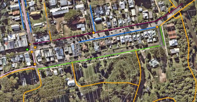
Figure 2: BB007 to BB059 - Byron
bypass on-road cycle way and shared paths - Shirley Street, Butler Street,
Browning Street
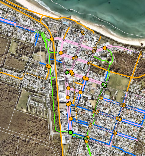
Figure 3: BB061 - Gilmore Crescent
shared path
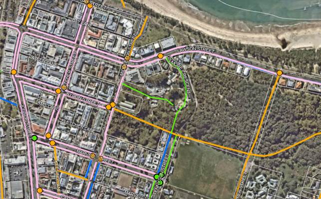
Figure 4: BB009 - Tennyson Street
shared path
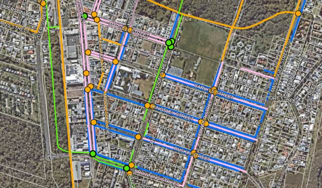
Figure 5: BB012 to SP003 - Byron
Bay to Suffolk Park on-road cycle way, shared paths and pedestrian refuges,
Broken Head Road
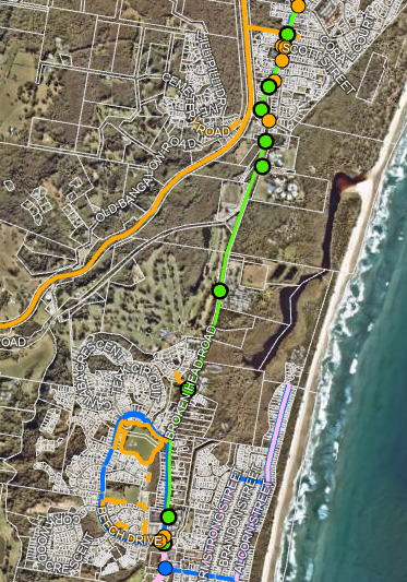
Figure 6: BB010 - Banksia Drive to
Bayshore Drive shared path
Figure 7: BB001 - Ewingsdale missing
link shared path
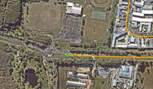
Figure 8: IT004 - Broken Head
Reserve Road, Broken Head shared path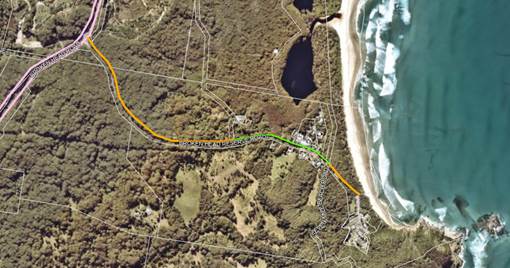
Figure 9: MU026 – Argyle
Street footpath, Mullumbimby
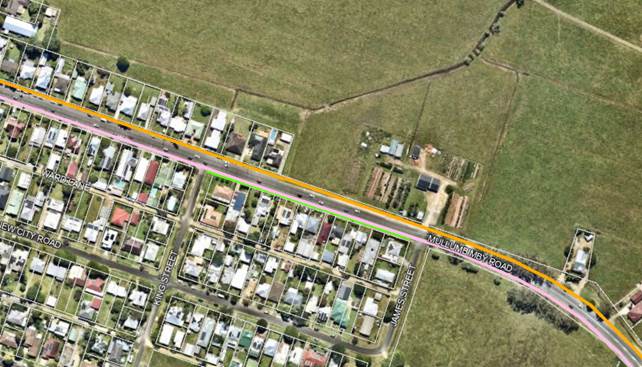
Figure 10: MU007, MU045 - Stuart
Street on-road cycle way and footpath, Mullumbimby
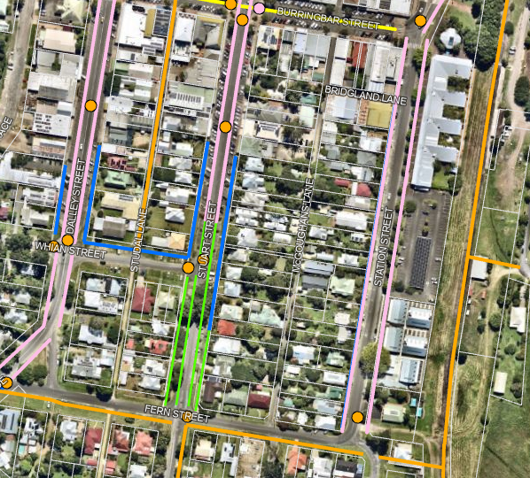
Figure 11: OS009 - Balemo Drive
shared path, Ocean Shores
Figure 12: MU003 – Tincogan
Street, Mullumbimby

Projects currently in delivery
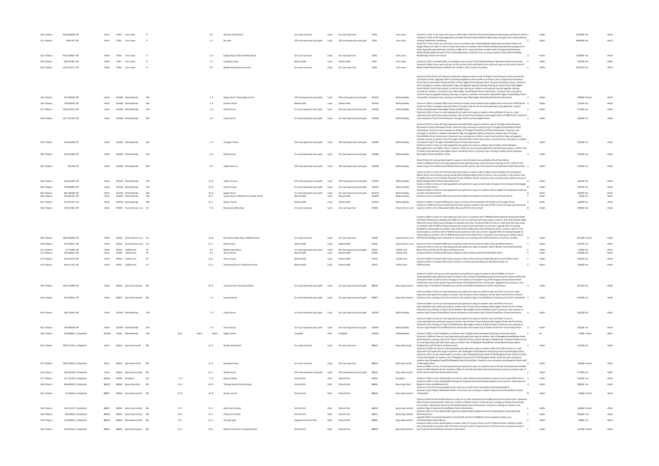
Table 2: Projects currently in delivery (shown as yellow in
Figures below)
|
PAMP/ BP
ID
|
Location
|
Road
Name
|
Type
|
|
BB011/ BB073
|
Byron Bay Central
|
Lighthouse Road
|
Footpath
|
|
BA005/
BA004, BA017
|
Bangalow
|
Raftons
Road / Leslie Street
|
Shared Path
|
|
MU047/ MU043
|
Mullumbimby
|
Burringbar Street
|
Mixed traffic (all
modes)
|
|
MU007/
MU011
|
Mullumbimby
|
Fern Street
|
Shared Path
|
|
BB022/
BB051
|
Byron Bay
|
Carlyle
Street
|
Footpath
(upgrade to shared path)
|
|
OS003/
OS002
|
Ocean
Shores
|
New
Brighton Road / Kolora Way
|
Shared Path
|
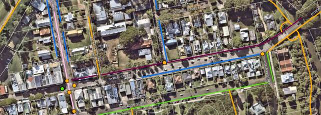
Figure 13: BB011 - Lighthouse Road
shared path
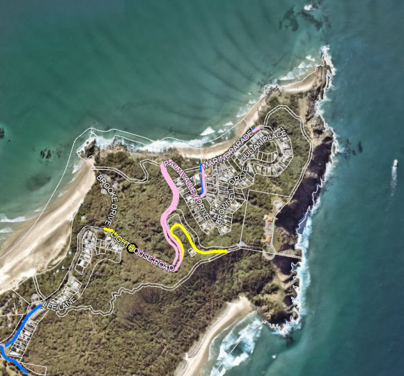
Figure 14: BA005 - Raftons Road
shared path, Bangalow
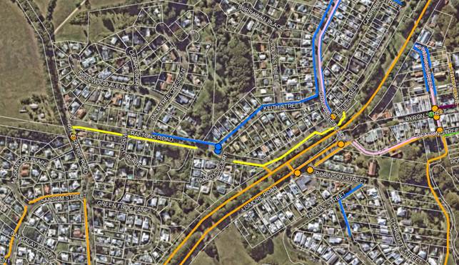
Figure 15: MU047 - Talking Streets
project – mixed traffic area Burringbar Street, Mullumbimby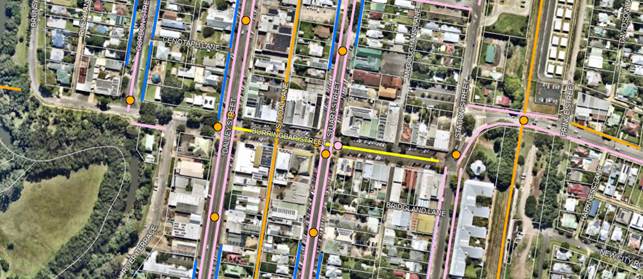
Figure 16: MU007, MU011 - Fern
Street, Mullumbimby shared path
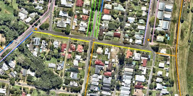
Figure 17: BB022 - Carlyle Street,
Byron Bay shared path
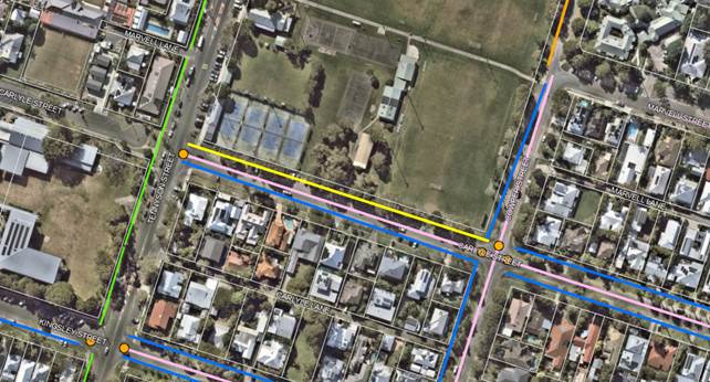
Figure 18: OS003 –
Kolora Way shared path, Ocean Shores
Construction Ready Projects (projects awaiting funding)
Table 3: Construction Ready Projects (shown as dark purple
in Figure below)
|
PAMP/ BP
ID
|
Location
|
Road
Name
|
Type
|
|
BA001
|
Bangalow
|
Byron Street
|
Upgrade to Shared Path
|
Figure 19: BA001 –
Byron Street shared path, Bangalow
Projects not completed
There are approximately 267 incomplete PAMP and Bike Plan
projects listed in the spreadsheet at Attachment 1.
The main reasons these have not been completed are as follows:
· Limited
funding and resources.
· Prioritisation
of other infrastructure projects which improve community safety.
· Generally, Priority A items have
been prioritised over Priority B & C items. However, where other works
were occurring, we have incorporated Priority B & C items to achieve costs
savings or form projects that will better obtain grant funding. It has
also been difficult to prioritise Priority A projects against other Priority A
projects. To improve this, we propose to develop an overarching
Shire-wide priority plan.
· The proposed works were not
feasible / safe. For example, in the Byron Bypass project, a shared path
was provided on Shirley Street, rather than on-road cycleways, as there was
insufficient road width due to existing car parking and property boundaries.
Key issues
1. This update is a mid review with the main goal being to
combine PAMP and Bike Plan actions into one document and allow the community
the opportunity update future needs. This will completed using exisitng staff
resources.
If funding were available Council
could engage an external consultant to undertake in-depth transport study and
research that would lead to a more resolved Active Transport Plan.
However, as there is no funding currently available for this, we are proposing
to use existing Council staff to manage the essential aspects of this work only
(refer Next Steps section below for details). The additional scope that
could be undertaken by a consultant includes:
a. Incorporation/review of NSW government transport and
infrastructure guidelines (refer details outlined in the Draft Active Transport
Plan).
b. Current transport mapping methods (including assessment of
future demand based on planning and land developments).
c. Review of newly constructed cycleways (e.g. Suffolk to
Byron) to determine their success and assist in the planning for future cycle
networks.
d. Detailed pedestrian traffic counts with a breakdown by
demographic.
e. In-depth community consultation such as face to face
surveys.
2. Ensuring
community consultation is targeted and specific including:
a. Selecting
survey questions which meet requirements.
b. Ensuring
the community is made aware of the public exhibition and a broad response is
received.
Next steps
1. Further development of the draft Active Transport Plan.
2. Update existing online mapping (PAMP and Bike Plan maps) to
a single Active Transport Network Map. This will be based on:
a. Existing paths and Incomplete projects nominated in the PAMP
and Bike Plan.
b. Community feedback received since adoption of the PAMP and
Bike Plan (e.g. Connecting Byron to Brunswick (IT005) and Ocean Shores to
Pottsville).
c. Review of Federal Village Masterplan to assess active
transport aspects and what can be achieved in line with network planning (the
other existing Masterplans were reviewed during initial creation of the PAMP
and Bike Plan).
d. Shire Disability Inclusion Action Planning (DIAP) to assess
accessibility needs.
e. Staff workshop to review mapping and develop a Shire-wide
priority plan (incorporating potential future “rail trail”).
3. Community survey on draft Active Transport Plan and map.
Including online mapping to allow community to locate comments and additional
path aspirations.
4. Review of community feedback, including “ground
truthing” and updates to documentation.
5. Reporting on community consultation outcomes to Moving
Byron Advisory Committee.
6. Finalisation and adoption of Active Transport Plan by
Council.
Strategic Considerations
Community Strategic Plan
and Operational Plan
|
CSP Objective
|
CSP Strategy
|
DP Action
|
Code
|
OP Activity
|
|
5:
Connected Infrastructure
We have connected infrastructure, transport, and facilities that are safe,
accessible, and reliable
|
5.1: Provide
a safe, reliable, and accessible transport network
|
5.1.3:
Active transport - pedestrians and cycleways - Deliver the actions identified
in the Pedestrian Access and Mobility Plan and in the Bike Plan
|
5.1.3.2
|
Review
and update 10 year Active Transport program
|
Recent Resolutions
Resolution 23-075 from Council meeting held on 23 March
2023:
That the Infrastructure Committee supports the Pedestrian
Access and Mobility Plan and Bike Plan being reviewed, combined into an Active
Transport Action Plan and consulted to the community as part of the 2023/24
Operational Plan actions. (Lyon/Westheimer)
Note – the Moving Byron Committee Minutes from 16 June
2023 are to be reported to the 24 August 2023 Council meeting.
Legal/Statutory/Policy
Considerations
1. Disability
Discrimination Act 1992 Part 2 Division 2 Section 23
The Disability Discrimination Act 1992 (DDA) makes it
unlawful to discriminate against a person, in many areas of public life,
including employment, education, getting or using services, renting or buying a
house or unit, and accessing public places, because of their disability.
2. Council
Policy “Planting and landscaping on footpath zones and nature strips
within road reserves and drainage easements 2020” sets out the required
clearance zones for landscaping to ensure safe use for pedestrians, etc.
This will be considered when planning the Active Transport Network Map.
3. Council
Policy “Register of roads maintained by Council 2021” states that
works should only occur on roads which are Council’s responsibility to
maintain. Roads which are not Council’s responsibility are shown in
Council’s GIS mapping. The Active Transport Network Map planning will
exclude these roads.
4. Council’s
“Water Sensitive Urban Design Policy and Strategy 2023” notes the
action to identify Council projects that could include WSUD. The Active
Transport Plan may need to include consideration of porous path surfaces over
impervious surfaces, subject to practicality, safety and cost requirements.
Financial Considerations
As noted in the Key Issues section under item 1, Council
does not have the budget to engage a consultant to undertake a more thorough
review. The work outlined under the Next Steps section will be undertaken
by internal staff.
Consultation and
Engagement
Council undertook a significant
amount of valuable community consultation in the creation of the PAMP and Bike
Plan. The act of combining these two plans into a single Active Transport
Plan is to remove duplication and ensure ongoing alignment with community
needs.
It is proposed to use the Your
Say platform for this round of community consultation including survey
questions and an interactive map that the community can place markers on to
indicate areas of concern.
Proposed survey questions are as
follows (these are the original PAMP questions):
1. Where do you live?
2. What towns (or areas) do you walk, roll or
cycle around most within the Byron Shire? This might include the places
you live, work, go to school, play sport or visit for recreation.
3. What age group do you belong to?
4. What best describes the reasons you choose
to walk (or use a wheelchair, mobility scooter, walking frame or similar) in
the Byron Shire?
a. If you answered 'other' - please explain.
5. What best describes the reasons you choose
to ride a bicycle in Byron Shire? (please select all relevant choices).
a. If you answered 'other' - please explain.
6. Which modes of travel do you use on
footpaths and shared paths in Byron Shire? (please select all relevant
choices).
a. Describe the other mode/s of travel you use.
7. If you are a walker, how many times a week
would you walk to get where you want to go?
8. If you ride a bicycle, how many times a week
would you cycle to get where you want to go?
9. If you are not able to walk or cycle, what
other means do you use to get where you want to go?
a. Please explain what other means of travel
you use.
10. If you walk, how many times a week would you walk for
recreation or exercise only?
11. If you ride a bicycle, how many times a week do you
cycle for recreation or exercise only?
12. How many times a week do you use a wheelchair, mobility
scooter, walking frame or other types of assistance to get to where you want to
go?
13. What are the biggest challenges you face when using the
footpath network in Byron Shire?
14. Please describe the other barriers you encounter that
are specific to your experiences of walking.
15. What are the biggest challenges you face when cycling
in Byron Shire?
16. Please describe the other barriers you encounter
related specifically to cycling.
17. What improvements could be made that may encourage you
to use Byron Shire's footpath network more?
18. What other improvements would you like to see?
19. What improvements could be made that may encourage you
to cycle more in Byron Shire?
20. What other improvements would you like to see?
21. From your experiences, how would you rate the current
footpath network for each of the criteria?
22. From your experiences, how would you rate the current
cycle network for each of the criteria?
23. Are you a parent or carer (including grandparent or
relative) of dependent children? If so, please provide your thoughts on
the experience of using footpaths and cycleways to get you to where you want to
go in the Byron Shire.
24. What could be done to improve the footpath network
within your suburb/town and neighbourhood? (If describing a particular section
of footpath, please indicate location using closest available address)
25. What could be done to make the experience of cycling
better in your suburb/town, within your neighbourhood and across the Shire? (If
describing a particular section of cycleway, please indicate location using
closest available address)
26. Would you be likely to walk or cycle more often if
these changes were implemented?
27. If there was a bike/foot path in the rail corridor that
linked towns, would you use it?
28. Do you have any additional ideas, observations or
comments you would like to share?
29. Please provide your email if you would like to be kept
updated on the project as it progresses.
Staff
Reports - Infrastructure Services 4.1 - Attachment 1


Staff
Reports - Infrastructure Services 4.1 - Attachment 2


Staff Reports - Infrastructure Services 4.2
Report
No. 4.2 Raftons Road
Shared Path Consultation and Direction
Directorate: Infrastructure
Services
Report Author: Judd
Cornwall, Traffic & Transport Engineer
File No: I2023/956
Summary:
This
project aims to provide a new path to create a safe and accessible alternative
transport route for the local community. It will link residences with the
local community children's centre, businesses, workplaces, schools and
services.
The bulk of the path is
priority A in Council’s adopted Pedestrian Access and Mobility Plan
(PAMP). Staff have included a section of priority C path in Leslie Street
to ensure the project is complete link to Bangalow. This will ensure it
has good outcomes that will help attract grant funding for construction.
The project entails
approximately 500m of shared pathway including a bridge crossing to safely link
commuters to the existing pathways. Two options for the Raftons Road
pathway section and a single alignment for the Leslie Street section were
presented to the community for feedback.
Feedback from the community did
not provide a clear preference for the alignment from the options proposed
refer to attachments 1 and 2.
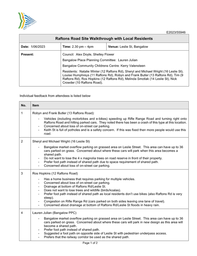
The purpose of this report is
to gain approval for a scope change based on communications during a site
walkthrough with directly impacted residents (refer to attachment 3, Community
feedback notes).
RECOMMENDATION:
That the Moving Byron Committee endorses a scope change
for the Raftons Road shared footpath to a 1.2m – 1.5m pedestrian path.
Attachments:
1 Option
1 - Raftons Rd Footpath Alignment, E2023/84689
, page 68⇩ 
2 Option
2 - Raftons Rd Footpath Alignment, E2023/84690
, page 69⇩
3 Raftons
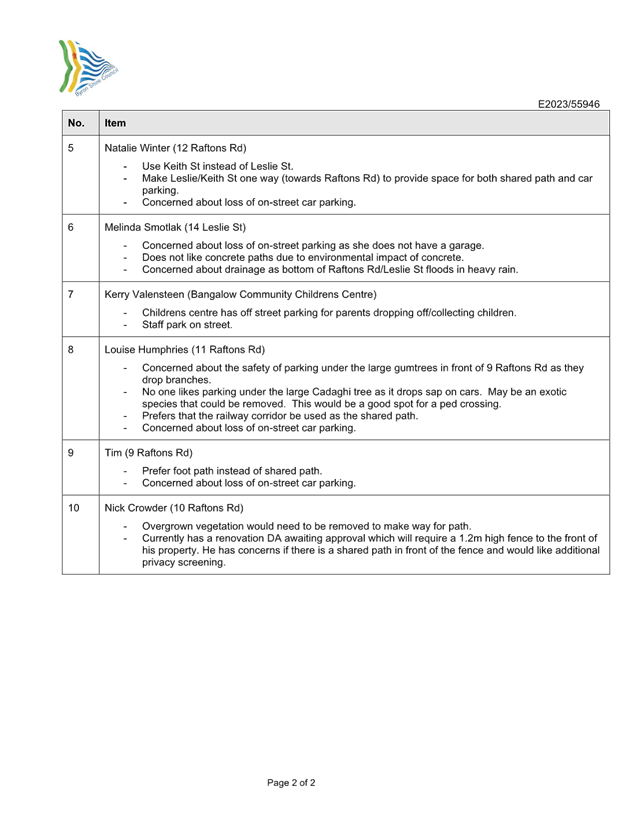
Road Site Walkthrough 1 June 2023 - Community Feedback, E2023/55946 , page 70⇩ 
Report
This
report identifies the project background, issues, and proposes recommendations
for the most appropriate way forward.
Key issues
Following
the development of feasible concept alignment options, it was identified that
either option had significant impacts. One would result in a drastic
reduction of the number of available on-street carparking spaces and the other
the removal of established trees (in which Koalas have been sighted with
supporting evidence) or parking losses.
Options
The
shared pathway link extends from the intersection of Rifle Range Road and
Raftons Road to approximately 18 Leslie Street (~500m in length). The
project is split by a pedestrian bridge directly opposite the Bangalow
Community Childrens Centre. Section A runs between Rifle Range Road and
the pedestrian bridge and contains two options, Section B runs from the
pedestrian bridge to 18 Leslie St and only a single alignment exists for this
portion.
Section A
Option 1
This alignment runs along the
northern verge of Raftons Road. It has a short deflection into the roadway to
avoid conflicting with mature gum trees at the front of 9 Raftons Road.
It requires a 15m long pedestrian bridge across a small waterway at the front
of 8 Raftons Road. The alignment consists of three road crossings of Rifle
Range Road, Palm Tree Crescent, and Raftons Road. A total of 19 street
carparking spaces will be lost as part of this option. Established trees
could be removed to save the parking, but this outcome is not supported.
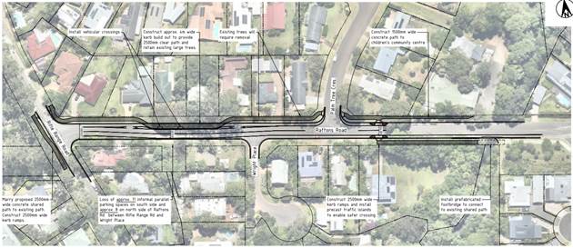
Figure 1: Option 1
Alignment
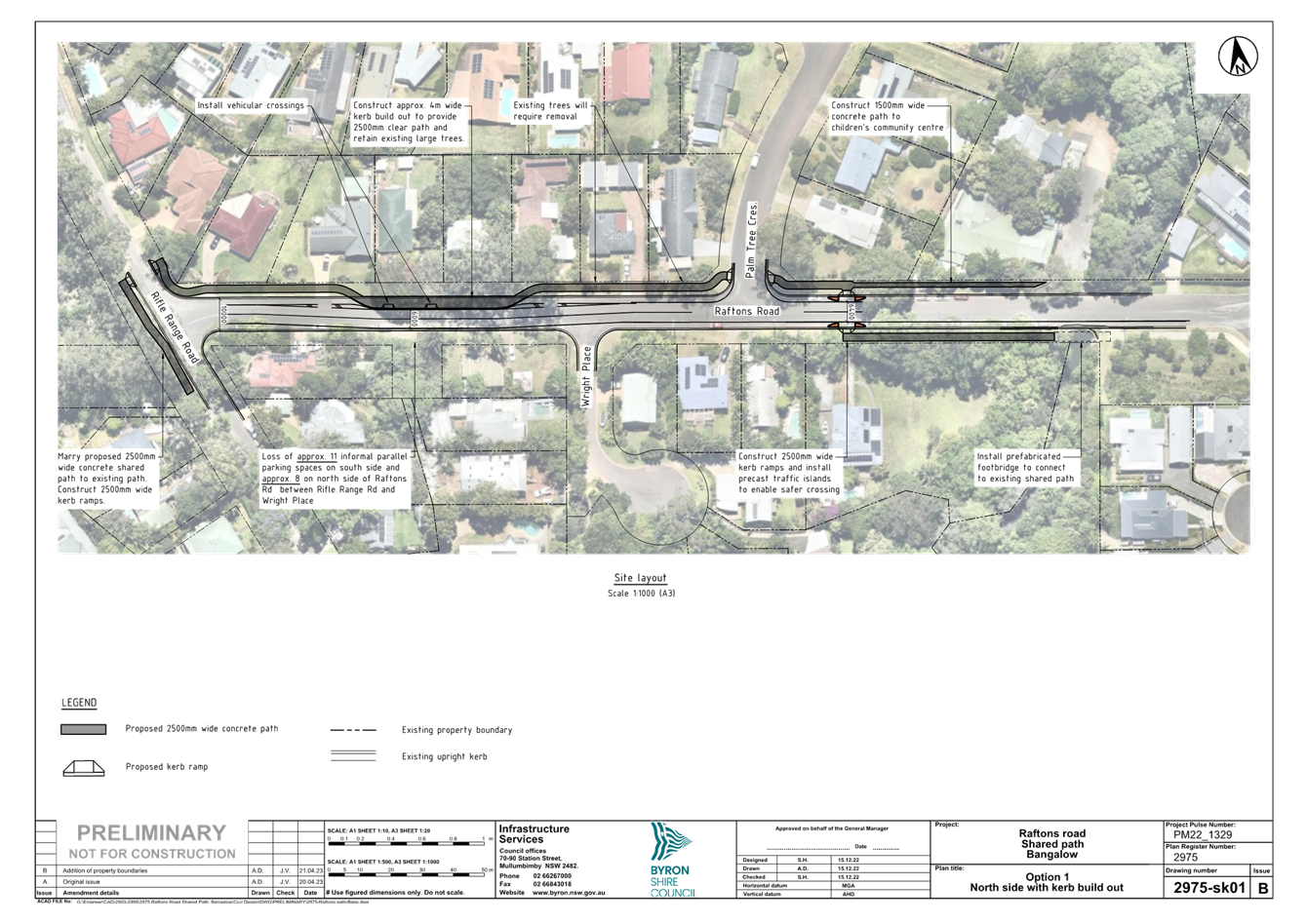
Option 2
This alignment runs along the
southern verge of Raftons Road. It requires a 3.5m widening of the
southern verge of Raftons Road to accommodate the 2.5m wide shared pathway and
to account for the vehicle crossover vertical geometry tie-ins to the existing
roadway. It requires a 15m long pedestrian bridge across a small waterway
at the front of 8 Raftons Road. This alignment also has three road
crossings of Rifle Range Road, Wright Place, and Raftons Road. A total of
34 street carparking spaces will be lost as part of this option.
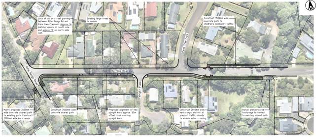
Figure 2: Option 2
Alignment
Section B (Leslie Street)
Single Alignment
The proposed alignment along
the Leslie Street section of the project runs along the Eastern verge of Leslie
Street. It requires the removal of several small established trees that are not
of ecological significance. A short section of 375mm diameter stormwater
pipe will be installed beneath the proposed pathway in addition to two kerb
inlet pits and kerb and channel for the approximate 170m length of the
alignment.
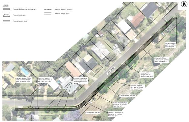
Figure 3: Leslie Street
Section B
Proposed Solution
The majority of community feedback directly related to
active use was regarding speeding and safe crossing opportunities. The
concerns with the proposed options were the loss of kerbside parking and
impacts on community plantings within the road reserve. This link is identified
within the current PAMP as a high priority; accordingly, a suitable solution
still needs to be found.
Following the consultation process staff now propose a
low-impact 1.2-1.5m pedestrian footpath to cater to the current pedestrian
demand. This decision also considers the possibility of a high-capacity
active link in the vicinity (within the rail corridor) adjacent to Lismore
Road, between Rifle Range Road and Granuaille Road. The minimized path
width should provide the necessary space to stay within the road reserve
without reducing the travel path (road), removing kerbside parking, and
allowing us to navigate around community plantings (as shown in the high-level
concept below, Figure 4)
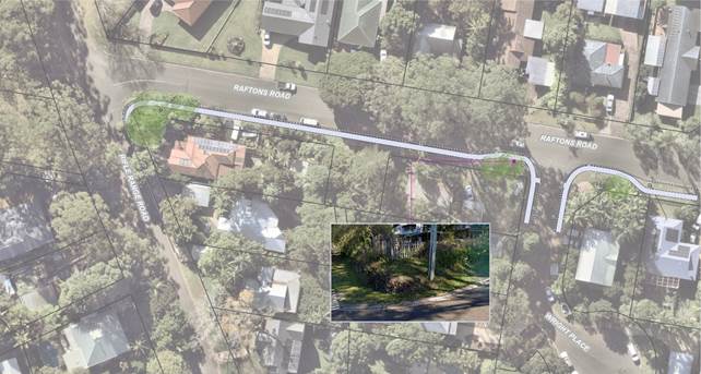
Figure 5: Section A 1.5m
path visualisation.
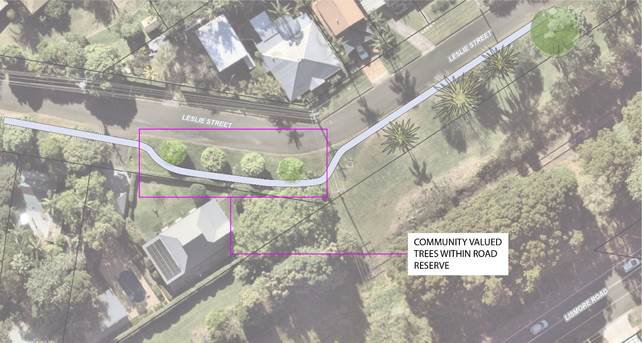
Figure 6: Section B 1.5m
path visualisation.
Next steps
· Council support option
· Finalise 1.2m-1.5m path design
· Seek grant funding for construction.
Strategic Considerations
Community Strategic Plan
and Operational Plan
|
CSP Objective
|
CSP Strategy
|
DP Action
|
Code
|
OP Activity
|
|
5: Connected Infrastructure
|
5.2: Connect the Shire through integrated transport
services
|
5.2.2: Public transport - Advocate for public transport services
across Byron Shire that are convenient, regular, and easy to access
|
5.2.2.1
|
Advocate and apply for grants that improve accessibility
to various transport options across the shire
|
Financial Considerations
Once the project is construction ready staff will seek State
funding to construct.
Consultation and
Engagement
Staff have reached out to all relevant stakeholders through
the original PAMP and Bike Plan consultations. We have also engaged the
community through a survey “letter drop” and interested parties
have attended a site walk through.
Staff are now proposing a new minimised option which will be
presented to the community following its development and feasibility
investigations.
Staff
Reports - Infrastructure Services 4.2 - Attachment 1
Staff
Reports - Infrastructure Services 4.2 - Attachment 2

Staff
Reports - Infrastructure Services 4.2 - Attachment 3
Report No. 4.3 Kolora
Way - Alternative Scope of Works
Directorate: Infrastructure
Services
Report Author: Joshua
Walton, Project Engineer
File No: I2023/649
Summary:
Council has previously identified that the installation of a
new pedestrian and cyclist access bridge/path across Yelgun Creek adjacent the
Kolora Way Bridge on New Brighton Road, New Brighton as a priority
project.
A report was presented at the 23 June 2022 Council Meeting
regarding the funding allocations for this project. Council resolved (22-322):
1. That
Council notes the report.
2. That
staff commence the detailed design and planning activities for the Kolora Way
Shared Path Project on the basis that the proposed funding in the 2022/23
budget is sufficient to cover market costs relating to planning and design.
The purpose of this report is to
highlight issues that have arisen in the planning phase and further discuss
alternative scope proposals to council prior to moving forward. Following
further investigation, the proposed budget for this project is not sufficient
to cover the planning and design costs.
RECOMMENDATION:
That Council supports:
1. A
‘Have Your Say’ survey being undertaken to determine community
opinion on the Kolora Way Bridge alternate options;
2. A
two month one lane bridge trial at Kolora Way as part of the ‘Have Your
Say’ process; and
3. The
Moving Byron Advisory Committee receives a further report upon completion of
items 1 & 2.
Report
Background Information
Council has previously identified that the installation of a
shared path and footbridge across Yelgun Creek adjacent the Kolora Way Bridge
on New Brighton Road, New Brighton as a priority project.
The project is considered a priority A project as defined in
Council’s Pedestrian Access and Mobility Plan.
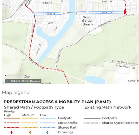
Figure 1
– Excerpt from Council’s Pedestrian Access and Mobility Plan
showing priority pedestrian connections in New Brighton
The objective of the project is to provide safer access
across Yelgun Creek for pedestrians and cyclists of all abilities as well as
enable safer access to nearby villages, schools and amenities.
A mapped Coastal Wetland area exists within the proposed
shared path project footprint. It was understood upon recommending this project
that construction within this wetland area would trigger an Environmental
Impact Statement (EIS), a process which is associated with additional costs and
project planning timeframes. However, the exact costs and timeframes were
unknown until a Request for Secretaries Environmental Assessment Requirements (SEAR’s)
was formally submitted to the NSW Department of Planning, outlining the full
scope of the project. This represented a significant risk to the project
budget in the design/planning phase.
The Kolora Way Shared Path Project has a total funding
allocation of $169,000 in the 2022/23 budget.
Following the Council meeting in, June 2022, Council staff
completed a Request for SEAR’s. This request was completed to
assess the degree of environmental reporting required to prepare an EIS.
Upon receipt of the SEAR’s, Council received an updated quote for
completion of an EIS, at a value of $250,000 excl. GST. The current
project budget is insufficient to cover the costs of the EIS.
Options
1. Increase
the project budget
2. Not
proceed with the project
3. Consider
alternate options
It is noted that recent
bridge inspections have highlighted significant upcoming costs to renew Helen
Street footbridge. The super structure is in good condition, but all
timber above this needs to be replaced. Detailed estimates have not been
prepared but it is likely to in the region of $500,000 and is required in next
financial year.
Given this and the additional
funds to bring Kolora Way footbridge to a construction ready project, staff
have investigated alternative options, as per option 3 above. These are
detailed within the key issues section of this report.
Key Issues
Pedestrian Safety Across the Kolora Way Bridge
This project was triggered as a response to a request from a
local resident to address pedestrian safety on Kolora Way and it is priority A
project within Council’s Pedestrian Access and Mobility Plan.
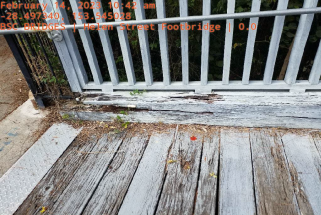
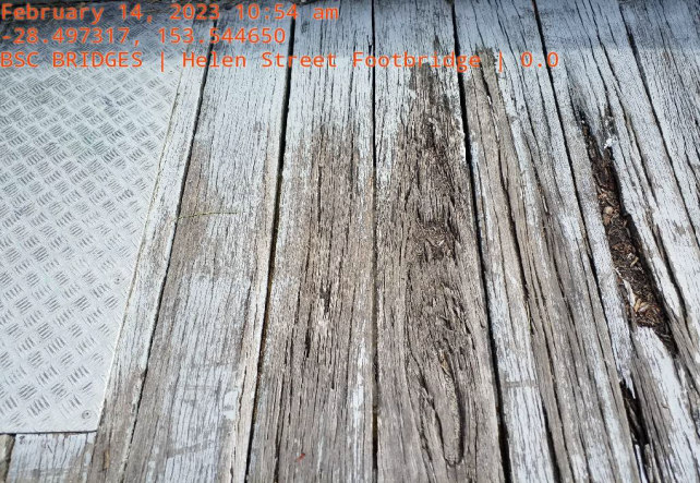
Helen Street Footbridge
The Helen Street Footbridge has
been assessed as having a Class 4 condition report.
A Class 4 Condition Report
is defined as ‘Poor: Asset is in poor condition or is faulty. It
needs urgent attention to return it to a useable condition and or significant
renewal/rehabilitation is required to reduce risk’, as per Councils
‘Transport Asset Management Plan.’
Helen Street footbridge does have
funding in the current financial year, however, it is insufficient to complete
the needed works and higher priority works are required on Orana Road Bridge,
therefore, these funds need to be reallocated. The designs for the bridge
repairs are proposed for completion this financial year and construction is
proposed in next financial year.
Council Officers have a high-level
estimate for a full replacement of all parts of the bridge above the
superstructure. As this bridge is above Yelgun Creek. Further planning will
need to be undertaken to assess the accuracy of this figure, plus various
approvals.
The decking on Helen Street
Footbridge is currently a hazard to pedestrians and cyclists (see images
below).

Canowindra Court Detour
As an alternative option staff have reviewed the impacts of
not proceeding with the Kolora Way footbridge and proving an alternate safe
route for pedestrians and bikes.
The potential Canowindra Court detour option away from
Kolora Way Footbridge is shown in the image below.
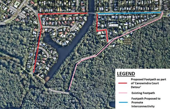
A desktop review of the proposed
footpath infrastructure shows the below constraints:
· The proposed construction may involve vegetation removal.
· Community land will be utilised in some locations.
· Constraints may limit the footpath to 1.2m wide in some
areas.
Further investigation will be
required if a concept design process is supported.
To aid consideration of this
alternate route, various trip options have reviewed and are provided below.
The image below provides various
trip routes and their distances:
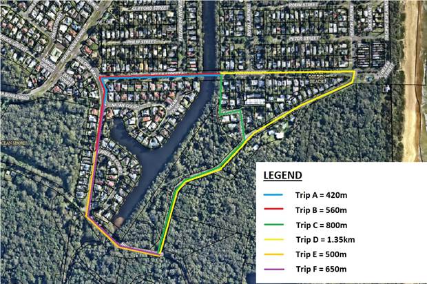
These trip routes have been
considered against three scenarios, from the starting location to the
intersection of Redgate Road and New Brighton Road:
Scenario 1 – Pedestrian
Bridge is built across Yelgun Creek.
Scenario 2 – ‘Canowindra
Court Detour’ is constructed including paths along trip routes B, plus C.
Scenario 3 –
‘Canowindra Court Detour’ is constructed including paths along trip
routes B, plus D.
Example 1 - Larelar Court
There are 23 Properties on Larelar
Court, the trip distance options are provided below. If the proposed Canowindra
Court detour was constructed the 23 properties on Larelar Court would have a
minimum detour of 860m compared to the Kolora Way route.
|
Scenario
|
Trip
|
Distance to the end of Redgate
Road (m)
|
|
1
|
E
|
500
|
|
2
|
B + C
|
1360
|
|
3
|
B + D
|
1910
|
Example 2 – Natan Court
There are 40 Properties on Natan
Court, the trip distance options are provided below. If the proposed Canowindra
Court detour was constructed the 40 properties on Natan Court would have a
minimum detour of 570m compared to the Kolora Way route.
|
Scenario
|
Trip
|
Distance to the end of Redgate
Road (m)
|
|
1
|
F
|
650
|
|
2
|
A + C
|
1220
|
|
3
|
A + D
|
1720
|
Example 3 Shara Boulevard
There are 160 Properties on On
Shara Boulevard & Streets Branching Off Shara Boulevard (Banool Circuit,
Gira Place, Hart Court & Eloura Court), the trip distance options are
provided below.
If the proposed Canowindra Court
detour was constructed the 40 properties on Shara Boulevard would have a
minimum detour of 400m compared to the Kolora Way route.
|
Scenario
|
Distance to the end of Redgate
Road (m)
|
|
1
|
700
|
|
2
|
1100
|
|
3
|
1700
|
Example 4 – Elizabeth
Avenue
There are 60 Properties on
Elizabeth Avenue & Streets Branching Off Elizabeth Avenue (Gloria Street,
Clifford Street and Philip Street) the trip distance options are provided
below.
If the proposed Canowindra Court
detour was constructed the 60 properties on Elizabeth Avenue would have a
minimum detour of 400m compared to the Kolora Way route.
If the proposed Canowindra Court
detour was constructed the 60 properties on Elizabeth Avenue and connecting
streets would benefit from the Canowindra Court detour.
|
Scenario
|
Distance to the end of Redgate
Road (m)
|
|
1
|
1000
|
|
2
|
950
|
|
3
|
1500
|
This review shows that the main
purpose of the Kolora Way Footbridge would be to avoid an 850m detour for 23
properties, a 570m detour for 40 properties and a minor detour of 400m for 160
properties.
High level costs estimate to
complete this project are $1,400,000. This does not include the essential
works required on Helen Street Footbridge.
An 850m detour is not small, but
570m and 400m could be considered small. It maybe more appropriate to
spend this $1,400,000 on infrastructure that benefits a greater number
residents than 23 properties or infrastructure that benefits all these
residents and more.
Therefore, staff believe that the
Canowindra Court detour and additional paths are more appropriate
solution. The finance section provides further details on high level cost
estimates.
The main advantages of the
Canowindra Court Detour, are:
• The
crossing for pedestrians and cyclists over the canal is facilitated by existing
infrastructure.
• Allows
for funding to be spent on interconnectivity of South Golden Beach.
• Directs
pedestrians and cyclists away from the Kolora Way bridge crossing.
• Provides
cost savings (see finance section).
Further analysis is required for
staff to provide an accurate estimate for the works proposed. However,
part of the recommendation provided by council officers includes the
appropriation of funds for scoping the proposed detour.
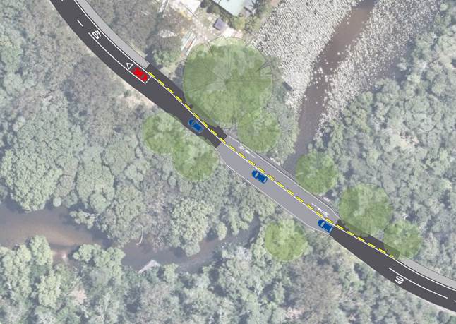
One Lane Bridge Kolora Way
To further support this option
staff have been investigating an additional option to create a one lane bridge
at Kolora Way and allow pedestrians cross on existing infrastructure.
This options still requires
further investigation to confirm sight distances are acceptable and a
supporting 40km/h speed limit would be support by TfNSW. There is value
in trialling this option, if feasible, as part of a public consultation
process.
An example layout is provided
below.
Next steps
The recommended next steps are as follows:
· Install temporary
direction priority at Kolora Way Bridge for 2 months.
· Gather public
opinion in relation to alternative ideas. This could be in the form of a
‘Have Your Say’.
· Complete draft
planning processes for alternative scope of works, including concept estimation
and design for Canowindra Way detour.
· Report
back to the Moving Byron Advisory Committee.
Community
Consultation
Council staff recommend, prior to the commencement of
detailed design process for either options a ‘Have Your Say’ survey
be sent to residents, targeted in the above study area, to ascertain the
frequency and mode of transport used to commute from their property to New
Brighton. This ‘Have Your Say’ survey would be supported by a
letter drop to residents, informing them that a Council survey may directly
affect them.
It is important to note that by not completing the Kolora
Way Footbridge project, Council would be avoiding constructing within an
environmentally sensitive area.
If the Canowindra Way Detour is supported the community would
all be notified via a letter drop of details pertaining to safest pedestrian
routes for transit from South Golden Beach to New Brighton. As well as
receive informative brochures in relation to this council decision.
Previous Council
Resolution
A report was presented at the 23 June 2022 Council Meeting
regarding the funding allocations for this project. Council resolved (22-322):
1. That
Council notes the report.
2. That
staff commence the detailed design and planning activities for the Kolora Way
Shared Path Project on the basis that the proposed funding in the 2022/23
budget is sufficient to cover market costs relating to planning and design.
Financial Considerations
|
Options
|
Detailed Design
($)
|
Construction ($)
|
Total ($)
|
|
Kolora Way Footbridge
|
250,000
|
1,150,000
|
1,400,000
|
|
Detour Through
Carowindra Drive (not including cost of Helen Street Footbridge Renewal)
|
100,000
|
700,000
|
800,000
|
|
Expected Cost
Savings from Detouring Through Carowindra Drive
|
150,000
|
450,000
|
600,000
|
The alternative scope of works is based on initial
assumptions made by staff and will need to be properly estimated, to calculate
an accurate estimate of project costs.
Strategic Considerations
Community Strategic Plan
and Operational Plan
|
CSP Objective
|
CSP Strategy
|
DP Action
|
Code
|
OP Activity
|
|
Community Objective
1: We have infrastructure, transport and services which meet our
expectations
|
1.1: Provide a road network
which is safe, accessible and maintained to an acceptable level of service
|
1.1.3: Prioritise road
network asset renewal and upgrade programs in line with Community Solutions
Panel values (SP)
|
1.1.3.16
|
Deliver Kolora Way Footpath
and Bridge Upgrade
|
Legislation
Provision of active transport infrastructure is a legitimate
function of local government under the Local Government Act 1993. To the
extent that the provision of active transport infrastructure provides community
members with cost effective infrastructure, leading to safer commutes.
Resolving as recommended demonstrates that Council is
carrying out its functions as best possible within Council resources and
capacities as competing priorities permit.
Staff Reports - Infrastructure Services 4.4
Report
No. 4.4 Moving Byron
Integrated Transport Plan - Implementation and Strategic Alignment
Directorate: Infrastructure
Services
Report Author: Judd
Cornwall, Traffic & Transport Engineer
File No: I2023/1255
Summary:
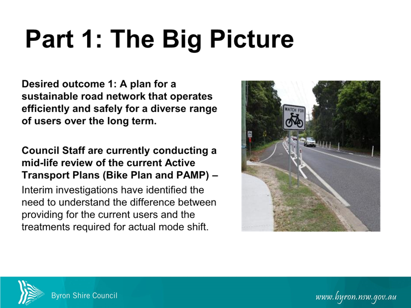
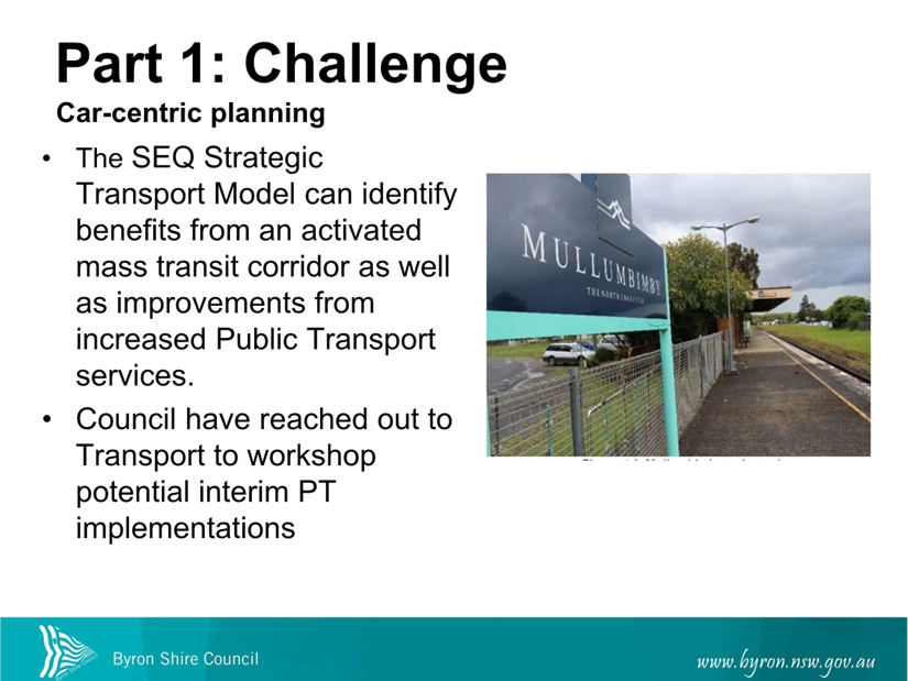
This report is to discuss some of the expected outcomes
within the Moving Byron Integrated Transport Plan in relation to our (Councils)
collaborative works with Transport for New South Wales.
Due to the timelines being to short produce a full report, a
Powerpoint presentation has been prepared instead.
Attachment 1 provides a PDF of the powerpoint presentation,
this will be presented and discussed at the meeting.
RECOMMENDATION:
That the Moving Byron Committee note that this
report is for discussion purposes only.
Attachments:
1 Moving
Byron Implementation Update_Moving Byron Committee_31 August_2023, E2023/87383 , page 87⇩ 
Staff
Reports - Infrastructure Services 4.4 - Attachment 1