 Agenda
Ordinary (Planning) Meeting

Thursday, 12 October 2023
Agenda
Ordinary (Planning) Meeting
Thursday, 12 October 2023
Agenda Ordinary (Planning) Meeting
held at Council Chambers, Station Street, Mullumbimby
commencing at 11.00am
Public access relating to items on this agenda can be made between 11:00am and 11:30am on the day of the meeting. Requests for public access should be made to the General Manager or Mayor no later than 12:00 midday on the day prior to the meeting.

Mark Arnold
General Manager
CONFLICT OF INTERESTS
What is a “Conflict of Interests” - A conflict of interests can be of two types:
Pecuniary - an interest that a person has in a matter because of a reasonable likelihood or expectation of appreciable financial gain or loss to the person or another person with whom the person is associated.
Non-pecuniary – a private or personal interest that a Council official has that does not amount to a pecuniary interest as defined in the Code of Conduct for Councillors (eg. A friendship, membership of an association, society or trade union or involvement or interest in an activity and may include an interest of a financial nature).
Remoteness – a person does not have a pecuniary interest in a matter if the interest is so remote or insignificant that it could not reasonably be regarded as likely to influence any decision the person might make in relation to a matter or if the interest is of a kind specified in the Code of Conduct for Councillors.
Who has a Pecuniary Interest? - a person has a pecuniary interest in a matter if the pecuniary interest is the interest of the person, or another person with whom the person is associated (see below).
Relatives, Partners - a person is taken to have a pecuniary interest in a matter if:
· The person’s spouse or de facto partner or a relative of the person has a pecuniary interest in the matter, or
· The person, or a nominee, partners or employer of the person, is a member of a company or other body that has a pecuniary interest in the matter.
N.B. “Relative”, in relation to a person means any of the following:
(a) the parent, grandparent, brother, sister, uncle, aunt, nephew, niece, lineal descends or adopted child of the person or of the person’s spouse;
(b) the spouse or de facto partners of the person or of a person referred to in paragraph (a)
No Interest in the Matter - however, a person is not taken to have a pecuniary interest in a matter:
· If the person is unaware of the relevant pecuniary interest of the spouse, de facto partner, relative or company or other body, or
· Just because the person is a member of, or is employed by, the Council.
· Just because the person is a member of, or a delegate of the Council to, a company or other body that has a pecuniary interest in the matter provided that the person has no beneficial interest in any shares of the company or body.
Disclosure and participation in meetings
· A Councillor or a member of a Council Committee who has a pecuniary interest in any matter with which the Council is concerned and who is present at a meeting of the Council or Committee at which the matter is being considered must disclose the nature of the interest to the meeting as soon as practicable.
· The Councillor or member must not be present at, or in sight of, the meeting of the Council or Committee:
(a) at any time during which the matter is being considered or discussed by the Council or Committee, or
(b) at any time during which the Council or Committee is voting on any question in relation to the matter.
No Knowledge - a person does not breach this Clause if the person did not know and could not reasonably be expected to have known that the matter under consideration at the meeting was a matter in which he or she had a pecuniary interest.
Non-pecuniary Interests - Must be disclosed in meetings.
There are a broad range of options available for managing conflicts & the option chosen will depend on an assessment of the circumstances of the matter, the nature of the interest and the significance of the issue being dealt with. Non-pecuniary conflicts of interests must be dealt with in at least one of the following ways:
· It may be appropriate that no action be taken where the potential for conflict is minimal. However, Councillors should consider providing an explanation of why they consider a conflict does not exist.
· Limit involvement if practical (eg. Participate in discussion but not in decision making or vice-versa). Care needs to be taken when exercising this option.
· Remove the source of the conflict (eg. Relinquishing or divesting the personal interest that creates the conflict)
· Have no involvement by absenting yourself from and not taking part in any debate or voting on the issue as of the provisions in the Code of Conduct (particularly if you have a significant non-pecuniary interest)
RECORDING OF VOTING ON PLANNING MATTERS
Clause 375A of the Local Government Act 1993 – Recording of voting on planning matters
(1) In this section, planning decision means a decision made in the exercise of a function of a council under the Environmental Planning and Assessment Act 1979:
(a) including a decision relating to a development application, an environmental planning instrument, a development control plan or a development contribution plan under that Act, but
(b) not including the making of an order under that Act.
(2) The general manager is required to keep a register containing, for each planning decision made at a meeting of the council or a council committee, the names of the councillors who supported the decision and the names of any councillors who opposed (or are taken to have opposed) the decision.
(3) For the purpose of maintaining the register, a division is required to be called whenever a motion for a planning decision is put at a meeting of the council or a council committee.
(4) Each decision recorded in the register is to be described in the register or identified in a manner that enables the description to be obtained from another publicly available document, and is to include the information required by the regulations.
(5) This section extends to a meeting that is closed to the public.
OATH AND AFFIRMATION FOR COUNCILLORS
Councillors are reminded of the oath of office or affirmation of office made at or before their first meeting of the council in accordance with Clause 233A of the Local Government Act 1993. This includes undertaking the duties of the office of councillor in the best interests of the people of Byron Shire and the Byron Shire Council and faithfully and impartially carrying out the functions, powers, authorities and discretions vested under the Act or any other Act to the best of one’s ability and judgment.
BUSINESS OF Ordinary (Planning) Meeting
1. Public Access
3. Attendance by Audio-Visual Link
4. Requests for Leave of Absence
5. Declarations of Interest – Pecuniary and Non-Pecuniary
6. Tabling of Pecuniary Interest Returns (Cl 4.14 Code of Conduct for Councillors)
7. Adoption of Minutes from Previous Meetings
7.1 Ordinary (Planning) Meeting held on 14 September 2023
8. Reservation of Items for Debate and Order of Business
9. Notices of Motion
9.1 Status reporting on Development Applications (DAs) with bodies like the Northern Regional Planning Panel (NRPP)................................................................................ 8
9.2 Wallum DA10.2021.575.1 referral and assessment............................................... 12
9.3 Waiver of contributions on secondary dwellings..................................................... 18
10. Mayoral Minute
11. Petitions
12. Delegates' Reports
13. Staff Reports
Corporate and Community Services
13.1 Determination of the Number of Councillors for the 2024-2028 Term of Office 20
Sustainable Environment and Economy
13.2 PLANNING - DA 10.2023.63.1 - Dwelling house to create dual occupancy (detached), recreation building, tennis court and demolition of unauthorised dual occupancy (detached) – 20 Fig Tree Lane Myocum.................................................................. 23
13.3 PLANNING - Brunswick Heads Heritage Conservation Area and Heritage Material and Colours Guide 26.2022.9.1........................................................................................ 42
13.4 PLANNING - 10.2023.103.1 - Use of existing building as a workshop, storage and carport - 484 Upper Wilsons Creek Road Upper Wilsons Creek......................... 47
13.5 PLANNING - Planning Proposal 26.2021.5.1 – 114 Stewarts Road Clunes..... 67
13.6 PLANNING - 10.2014.361.4 s4.55 modification to relocated cafe from ground floor of the existing Waves Motel to a proposed rooftop terrace at 35 Lawson Street, Byron bay.................................................................................................................................. 77
13.7 PLANNING - Report of the Planning Review Committee held 7 September 2023 99
13.8 Amendment to Fees and Charges 2023/24 - Reinstatement of use of Council land/road reserve to enable construction work events or temporary use......... 102
No table of contents entries found.
14. Questions With Notice
14.1 South Golden Beach and Marshall Creek flood areas........................................ 108
14.2 Changing the Criteria for Northern Rivers Reconstruction Corporation (NRRC) Funding........................................................................................................................ 109
14.3 Wallum Development Application at Bayside Brunswick Heads....................... 110
Questions with Notice: A response to Questions with Notice will be provided at the meeting if possible, that response will be included in the meeting minutes. If a response is unable to be provided the question will be taken on notice, with an answer to be provided to the person/organisation prior to the next Ordinary Meeting and placed on Councils website www.byron.nsw.gov.au/Council/Council-meetings/Questions-on-Notice
Councillors are encouraged to ask questions regarding any item on the business paper to the appropriate Director prior to the meeting. Any suggested amendments to the recommendations should be provided to Councillor Support prior to the meeting to allow the changes to be typed and presented on the overhead projector at the meeting.
BYRON SHIRE COUNCIL
Notices of Motion 9.1
Notice of Motion No. 9.1 Status reporting on Development Applications (DAs) with bodies like the Northern Regional Planning Panel (NRPP)
File No: I2023/1472
I move that Council:
1. Notes that:
a) Council was not the determining authority for DA10.2021.575.1 (lodged in September 2021, proposing residential subdivision into 127 Lots on sensitive low-lying land at Bayside Brunswick) but did evaluate the proposal and did in April 2023 provide the determining authority Northern Regional Planning Panel with a recommendation to approve;
b) The Council elected in December 2021 was not made aware of the DA until the imminent loss of environment due to its May 2023 approval was highlighted in August 2023 by concerned community members.
c) A scenario in 2022 over another DA (10.2021.170.1) determined by the NRPP on the “Linnaeus Estate” at Broken Head included an alert also by community members and led to Council resolving in June 2022 (Res 22-244):
i. That Councillors receive, on the day after it is lodged with the Northern Regional Planning Panel, a copy of the Assessment Report prepared by Council staff for DA 10.2021.170.1 for 27 cabins, 7 other buildings, alterations & additions, earthworks, vegetation removal, and change of use of 14 units from educational to tourism on the “Linnaeus Estate” at Broken Head.
ii. That the elected Council note that Council’s submission should not be prepared by persons involved in the assessment of the application but could be prepared by another council officer, or a consultant
2. Receives status reports monthly to each Ordinary (Planning) Meeting on all DA’s that are being processed by Council for determination by other bodies such as the Northern Regional Planning Panel.
Signed: Cr Duncan Dey
Councillor’s supporting information:
Councillors represent their electors, the residents and ratepayers of the Shire. One of the most important roles of Councillors in Byron Shire is to determine Development Applications. Hundreds of DA’s are lodged and determined each year. In some years that tally reaches over a thousand.
Over the years, the state through politicians of both persuasions has invented ways of divesting Council of its planning powers by putting them into the hands of others (who aren’t locally elected).
One such invention was the creation of Regional Planning Panels. When a DA is bigger, or more expensive, or somehow rises over thresholds at which the state determines that we Councillors become incompetent, the DA is sent off to be determined by such a Panel.
Other diversion mechanisms exist and the state may well be considering more right now.
So that elected Councillors and the public can at least be informed and remain aware of such DA’s, let’s have a system of information about them.
Staff comments
by Shannon Burt, Sustainable Environment and Economy:
There are several ways that (community and) Councillors in particular are able to access specific information and status reports on Development Applications.
· Each week a list of new Development Applications that have been lodged in the previous week is uploaded to the Councillor Dashboard. These lists are available for the full term of the Council. This gives inter alia address, development description and DA number to enable further updates to be requested and searches to be undertaken as per below.
· The online DA tracker and Planning Portal provide real time access to Development Applications lodged, on exhibition, under assessment and determined. Byron Shire Council - Application Tracker
· The Sydney and Regional Planning Panels web page has a Byron Shire project page for regionally significant development proposals. PPS search | Planning Portal - Department of Planning and Environment (nsw.gov.au)
· The Independent Planning Commission has a Byron Shire case page for state significant development proposals Independent Planning Commission - Cases (nsw.gov.au)
In addition to the above, Resolution 22-559 in response to Notice of Motion No. 9.1 Council report to NRPP on Linnaeus DA 10.2021.170.1 Agenda of Ordinary (Planning) Meeting - Thursday, 13 October 2022 (infocouncil.biz) provided:
Resolved 22-559
1. That Councillors receive, as a standard procedure, a copy of the Assessment Report prepared by Council staff for any DA that is to be determined by the Northern Regional Planning Panel on the next working day after it is lodged on the Planning Portal.
2. That Council seeks advice from the NSW Department of Planning and Environment a method and timeframe by which a Council could make a timely submission to a Planning Panel in line with the procedure described in the Department’s own Sydney and Regional Planning Panels operational procedures (clause 11.12).
In response to point 1, a link to the Sydney and Regional Planning Panel project page for any Northern Regional Planning Panel Development Application hearing has been emailed to councillors at the appropriate times.
Note an email was sent to Councillors dated 11 April 2023 for:
Planning panel reference number PPSNTH-134 (DA 10.2021.575.1) Subdivision to create One Hundred and Thirty-One (131) Lots Brunswick Head
The Panel Hearing was scheduled for the 18 April 2023.
In relation to Point 2, an email was sent to Councillors on 9 December 2022 with the response from the Planning Panel Secretariat.
In response to item 2 of the Notice of Motion, development applications may be determined by the Northern Region Planning Panel where regionally significant development; Independent Planning Commission where state significant development, and the Land and Environment Court where appeals are lodged.
The number and frequency of development applications to these are unknown and in staff opinion not of a volume to require a specific monthly report to council.
That being said staff will look at how these applications, where identified in the pre-lodgement review, can be highlighted in the weekly Councillors listing.
Financial/Resource/Legal Implications:
Council and staff need to observe relevant Council and Planning Panel Operational Procedures and Code of Conduct.
Is the proposal consistent with any Delivery Program tasks?
|
CSP Objective |
CSP Strategy |
DP Action |
Code |
OP Activity |
|
1: Effective Leadership |
1.1: Enhance trust and accountability through open and transparent leadership |
1.1.2: Governance - Ensure legislative compliance and support Councillors to carry out their civic duties |
1.1.2.3 |
Provide administrative support to Councillors to carry out their civic duties |
BYRON SHIRE COUNCIL
Notices of Motion 9.2
Notice of Motion No. 9.2 Wallum DA10.2021.575.1 referral and assessment
File No: I2023/1477
I move that Council:
1. Notes at least one request has been made (on 14 September 2023) asking the federal Minister for the Environment to call in the next development Stages of Bayside Brunswick (DA10.2021.575.1) under the Environment Protection and Biodiversity Conservation (EPBC) Act 1999 and to determine the project's impacts on Matters of National Environmental Significance (MNES) including nationally listed Threatened Species such as:
a) the critically endangered Mitchells Rainforest Snail; and
b) the Wallum Sedge Frog.
and priority species under the federal Threatened Species Action Plan including:
a) Koala;
b) Native Guava; and
c) Australasian Bittern.
2. Redacted in accordance with Council’s Code of Meeting Practice
3. Receives assessments of the Amended Management Plans submitted to Council for the development at Bayside Brunswick (DA10.2021.575.1) to ensure that those Plans comply with Consent Conditions set by the NRPP and with federal, state and local regulations, including separate assessments of Plans for:
a) Vegetation Management (Condition 6);
b) Wallum Froglet Management (Condition 7);
c) Construction Environmental Management (Condition 8);
d) Updated Surface and Groundwater Management (Condition 9);
e) Stormwater Maintenance Management (Condition 12);
f) Cultural Heritage Site Inspection (Condition 18).
4. Engages reputable expert(s) to indicate whether the drainage problem noted under Condition 11b (no slope in the proposed North South Drain) can be overcome at all, and whether the required minimum 0.25% gradient can be achieved (both under current sea levels and under those indicated for the future, including for the year 2100 and beyond and including the possibility that flood levels will be found to be higher after re-calibration of computer models following the 2022 flood event).
5. Determines at a Council meeting the suitability of those Amended Plans and the efficacy of the proposed stormwater system after considering:
a) the assessments resulting from Parts 3 and 4 above; and
b) return correspondence from the Federal Government resulting from Part 1 above (some words and a number redacted in accordance with Council’s Code of Meeting Practice).
Attachments:
2 Ecological
Concerns, E2023/100681 ![]()
3 Confidential - Legal advice, E2023/102266
Signed: Cr Duncan Dey
Councillor’s supporting information:
This site has been proposed and assessed for over 15 years. In 2008 in the State Planning Director-General's Environmental Assessment Requirements (DGRS) for the site (page 1 of 9) stated "If your proposal includes any actions that could have a significant impact on matters of National Environmental Significance (NES), it will require an additional approval under the Commonwealth Environment Protection and Biodiversity Conservation Act 1999 (EPBC Act). This approval is in addition to any approvals required under NSW legislation".
The NSW Department of Planning and Environment (DPE) under Clause 34A(3) of the Biodiversity Conservation (Savings & Transitional) Regulation 2017, has approved the removal of some of the threatened species habitat identified in the Concept Plan Approval for this development. However, it appears there are some Matters of National Environmental Significance (MNES) outstanding and yet to be addressed.
For instance, the NRPP asked that the Vegetation Management Plan (VMP) address the critically endangered Mitchells Rainforest Snail (MRS) but this has not happened. Instead, a Condition of Consent now requires a Plan for the MRS (Condition 6b: provide details for the ongoing vegetation management of the Mitchells Rainforest snail habitat in Management Zones 1 and 4 and its long term protection).
Mapped within the VMP is an area of the Endangered Ecological Community Swamp Sclerophyll forest that will be completely cleared. This EEC is potential habitat for the MRS. Under the EPBC Act and MNES guidelines, an action will require approval from the Minister if the action has, will have, or is likely to have, a significant impact on a matter of national environmental significance.
To ensure MRS habitat is protected and enhanced the plan must also address impacts that could be caused by stormwater entering potential MRS habitat. Enhancement of that habitat must be in line with guidelines set out in the Byron Shire Council DCP Biodiversity chapter, such as buffers for EECs etc.
Further, as the MRS is a MNES, there is a case for Council to:
a) acknowledge the Clause 34A exemption issued on 30 March 2023, but recognise that this does not ensured all residual impacts of the proposed development on biodiversity values will been offset or mitigated to satisfy 4(b)BIODIVERSITY CONSERVATION (SAVINGS AND TRANSITIONAL) REGULATION 2017 - REG 34A;
b) recognise that not all Commonwealth listed MNES have been adequately considered in the application for Clause34a;
c) recognise that ‘suitable offsets must be additional to what is already required, determined by law or planning regulations or agreed to under other schemes or programs’ (Principle 6 of the Environmental Offsets Policy); and
d) acknowledge that the EPBC listed Vulnerable Wallum sedge frog (Litoria olongburensis) has not been adequately considered in the Revised Wallum Froglet Management Plan which focuses on the Wallum froglet (Crinia tinnula).
The following threatened fauna species have been recorded at the site and are listed in the proponent’s Vegetation Management Plan (JWA 2011, AWC 2022):
• Common Planigale (Planingale maculata)
• Eastern Osprey (Pandion cristatus)
• Glossy Black-cockatoo (Calyptorhynchus lathami)
• Greater Broad-nosed Bat (Scoteanax rueppellii)
• Grey-headed Flying-fox (Pteropus poliocephalus)
• Koala (Phascolarctos cinereus)
• Large Bent-winged Bat (Miniopterus orianae oceanensis)
• Little Bent-winged Bat (Miniopterus australis)
• Olongburra Frog (Litoria olongburensis)
• Pale-vented Bush-hen (Amaurornis moluccana)
• Southern Myotis (Myotis macropus)
• Wallum Froglet (Crinia tinnula)
• White-bellied Sea-eagle (Haliaeetus leucogaster)
• White-throated Needletail (Hirundapus caudacutus).
Qualified professional ecologists have identified that there are likely to be further MNES on this site but not listed in the Plans available to date for public viewing.
Staff comments
by Ralph James Legal Counsel and Shannon Burt, Director Sustainable Environment and Economy
Part 1
Noted.
Part 2
Council’s Code of Meeting Practice provides, at 3.20, that the general manager must not include in the agenda for a meeting of the council any business of which due notice has been given if, in the opinion of the general manager, the business is, or the implementation of the business would be, unlawful….
Council’s Code of Meeting Practice provides, at 10.6, that the chairperson must rule out of order any motion or amendment to a motion that is:
(a) unlawful or the implementation of which would be unlawful, or
(b) ultra vires for Council,….
The word "must", or a similar term, used in relation to a function indicates that the function is required to be exercised.
The General Manager has been provided with legal advice from Council's external lawyers Marsdens Law Group. That advice is at Confidential Attachment 3.
For the reasons stated in the advice the General Manager, in accordance with clause 3.20 of Council's Code of Meeting Practice has excluded part 2 of the Notice of Motion from the agenda for the meeting.
Accordingly, part 2, and that part of part 5 which references part 2, must be excluded from the agenda.
If part 2, or words which have the same meaning and obligation were to be placed before the meeting, the Mayor, as Chairperson, must act in accordance with clause 10.6.
Parts 3 and 4
Should Council resolve in accordance with part 3 and 4 it will be necessary for council to engage external consultants to be engaged to complete to review of reports against the consent conditions. There will need to be multiple consultants and the cost of these is unknown and can only be estimated to be of the order of $50k.
Part 5
The consultants who prepare reports in accordance with part 3 and 4 will need to have appropriate expertise i.e. be a person who has specialised knowledge based on the person’s training, study or experience (an expert).
The Land and Environment Court has stated that the opinion of an expert should satisfy tests:
· the expert opinion is to involve specialised knowledge — the opinion of the expert must be within a field of knowledge that the law recognises as one on which expert evidence can be called
· the witness expressing the opinion is to be qualified — the witness must be qualified as an expert in the recognised field of knowledge and have acquired specialised knowledge based on the person’s training, study or experience
· the expert opinion is to have a basis — the opinion of the witness must be wholly or substantially based on the specialised knowledge and the factual basis of the opinion must be disclosed and proven by admissible evidence.
Part 5, should Council resolve accordingly, requires Councillors to determine at a Council meeting the suitability of the amended Management Plans and the efficacy of the proposed stormwater system after considering the expert reports. Councillors will be called upon to review the opinion of experts.
Councillors should be cautious to avoid the conditions of the development the subject of the development consent being reconsidered. A development consent has an “enduring nature”, meaning it runs with the land and endures for the benefit of the original Applicant and all subsequent owners and occupiers of that land (Lake Macquarie City Council v Australian Native Landscapes Pty Ltd (No 2) [2015] NSWLEC 114). It also remains valid and must be treated as such unless and until it is declared invalid by a court of competent jurisdiction (Swadling v Sutherland Shire Council [1994] NSWLEC 45). If the requirements in the various conditions are disputed on their merits, the only mechanism to address this would be through a challenge to the validity of the development consent.
There is no mechanism for Council to unilaterally modify the conditions of the development consent so that they have some different operation than what is presently provided for.
Financial/Resource/Legal Implications:
As set out above.
Is the proposal consistent with any Delivery Program tasks?
|
CSP Objective |
CSP Strategy |
DP Action |
Code |
OP Activity |
|
1: Effective Leadership |
1.1: Enhance trust and accountability through open and transparent leadership |
1.1.1: Leadership - Enhance leadership effectiveness, capacity, and ethical behaviour |
1.1.1.7 |
Provide in-house legal advice to the organisation to inform decision making and minimise organisational risk
|
BYRON SHIRE COUNCIL
Notices of Motion 9.3
Notice of Motion No. 9.3 Waiver of contributions on secondary dwellings
File No: I2023/1480
I move that Council receives a report by December outlining the mechanisms, if any, whereby we could constrain the future use of a secondary dwelling for the purposes of providing affordable and/or permanent accommodation, in exchange for a waiver of contributions.
Signed: Cr Michael Lyon
Councillor’s supporting information:
Council has in the past had a policy of waiving contributions on secondary dwellings, in the hope it would stimulate affordable accommodation. We are currently investigating multiple properties who have used their secondary dwellings for holiday letting in contravention of their consent conditions. It seems that relying on the enforcement of consent conditions to achieve outcomes in this space is flawed. I wonder whether through a different mechanism, either a VPA, or some kind of external lease or contract, we could achieve the same aim. This may help people downsize into their newly built secondary dwelling to allow the kids to have the house, or could allow children to house their parent/s.
Staff comments
by Shannon Burt, Director, Sustainable Environment and Economy:
The Notice of Motion acknowledges the previous waiving of contributions that Council put in place for the period early 2011- 2018.
Council resolved at this time to waive the requirement to pay section 94 and section 64 charges for secondary dwellings.
The purpose of the waiver was to promote housing affordability. The waiver applied to secondary dwellings approved under the terms of the then State Environmental Planning Policy (Affordable Rental Housing) 2009 (SEPP).
The waiver was discontinued in 2018 as it was found to not be achieving its intended affect due to matters such as short-term rental usage of the approved secondary dwellings instead of long-term rental usage.
Various reports to Council discuss this.
More recently, the Independent Planning Commission Advice Report on the Byron Shire Short Term Rental Accommodation Planning Proposal stated extract page iv:

And recommended:

This Notice of Motion is consistent with this recommendation.
As such staff will work on a report to one of the December meetings of Council on mechanisms to achieve a restriction on the use of secondary dwellings for the purpose of affordable and/or permanent rental accommodation, in exchange for a waiver or deferral of development contributions.
Financial/Resource/Legal Implications:
None specific to this motion.
Is the proposal consistent with any Delivery Program tasks?
|
CSP Objective |
CSP Strategy |
DP Action |
Code |
OP Activity |
|
4: Ethical Growth |
4.2: Enable housing diversity and support people experiencing housing insecurity |
4.2.3: Legislation changes - Establish planning mechanisms and advocate for changes to legislation to support housing that meets the needs of our community |
4.2.3.1 |
Prepare submission/s on draft changes to State government planning policy or legislative reforms |
BYRON SHIRE COUNCIL
Staff Reports - Corporate and Community Services 13.1
Staff Reports - Corporate and Community Services
Report No. 13.1 Determination of the Number of Councillors for the 2024-2028 Term of Office
Directorate: Corporate and Community Services
Report Author: Heather Sills, Manager Corporate Services
File No: I2023/1455
Summary:
The Local Government Act 1993 (Act) requires Council to determine the number of Councillors for the following term of office. The Act requires the number of Councillors to be at least 5 and not more than 15. Council currently has 9 Councillors, including the Mayor.
The report further outlines the requirements for a constitutional referendum to give effect to a change in the number of Councillors.
RECOMMENDATION:
That in accordance with section 224(2) of the Local Government Act 1993 Council determine the number of Councillors for the 2024-2028 term of office to remain as 9 (including the Mayor).
Report
Council is required, under s224(2) of the Local Government Act 1993 (Act), to determine the number of Councillors for the following term of Council.
The Office of Local Government have advised that a determination should be made even if no change is proposed. The Act states that this determination is to be made at least 12 months prior to the election. However, the Office of Local Government have confirmed that they omitted to provide this information to Councils and that there would be no penalty for considering the report outside the 12-month period, provided there is no change the number of Councillors.
If Council proposes to change the number of Councillors, it must, before determining the number, obtain approval for the change at a constitutional referendum.
As no referendum to change the number of Councillors has been undertaken, the number of Councillors is to remain at 9, including the Mayor.
Referendum
The Act requires the number of Councillors to be at least 5 and not more than 15. Council may consider increasing or decreasing the number of Councillors from the 2028-2032 election, by way of a referendum.
In accordance with s16 of the Act, approval for the following changes must be given by way of a constitutional referendum:
(a) divide its area into wards or abolish all wards in its area,
(b) change the basis on which the mayor attains office (that is, by election by the councillors or by election by the electors),
(c) increase or decrease the number of councillors in accordance with the limits under section 224,
(d) change the method of ordinary election of councillors for an area divided into wards.
Advice has been provided by the NSW Electoral Commission which outlines that the legislated cut-off date for a council poll or constitutional referendum question(s) to be asked at the next local government election is the date of the close of rolls (Monday 5 August 2024). However, they strongly encourage Councils to provide questions by the end of June 2024. This will enable the Commission to review the questions and print the ballot papers ready for council approval before finalising.
The decision made at a constitutional referendum binds the Council until changed by a subsequent constitutional referendum.
Council Poll
Council may take a poll of electors for its information and guidance on any matter. The outcome of a poll is not binding on Council.
A Council poll or constitutional referendum may be taken on any Saturday, including the Saturday of an ordinary election.
Strategic Considerations
Community Strategic Plan and Operational Plan
|
CSP Objective |
CSP Strategy |
DP Action |
Code |
OP Activity |
|
1: Effective Leadership |
1.1: Enhance trust and accountability through open and transparent leadership |
1.1.1: Leadership - Enhance leadership effectiveness, capacity, and ethical behaviour |
1.1.1.9 |
Prepare for the 2024 Local Government Election |
Legal/Statutory/Policy Considerations
s224(2) of the Act requires Council to determine the number of Councillors for the following term of office.
224 How many councillors does a council have?
(1) A council must have at least 5 and not more than 15 councillors (one of whom is the mayor).
(2) Not less than 12 months before the next ordinary election, the council must determine the number, in accordance with subsection (1), of its councillors for the following term of office.
(3) If the council proposes to change the number of councillors, it must, before determining the number, obtain approval for the change at a constitutional referendum.
Financial Considerations
Should Council resolve to conduct a referendum at the next election, it is estimated that additional costs would be 10% of the total election cost, being approximately $30,000.
Consultation and Engagement
Consultation on the number of Councillors for the 2024-2028 term of Council is not required.
If Council proposes to change the number of councillors, it must, before determining the number, obtain approval for the change at a constitutional referendum.
BYRON SHIRE COUNCIL
Staff Reports - Sustainable Environment and Economy 13.2
Staff Reports - Sustainable Environment and Economy
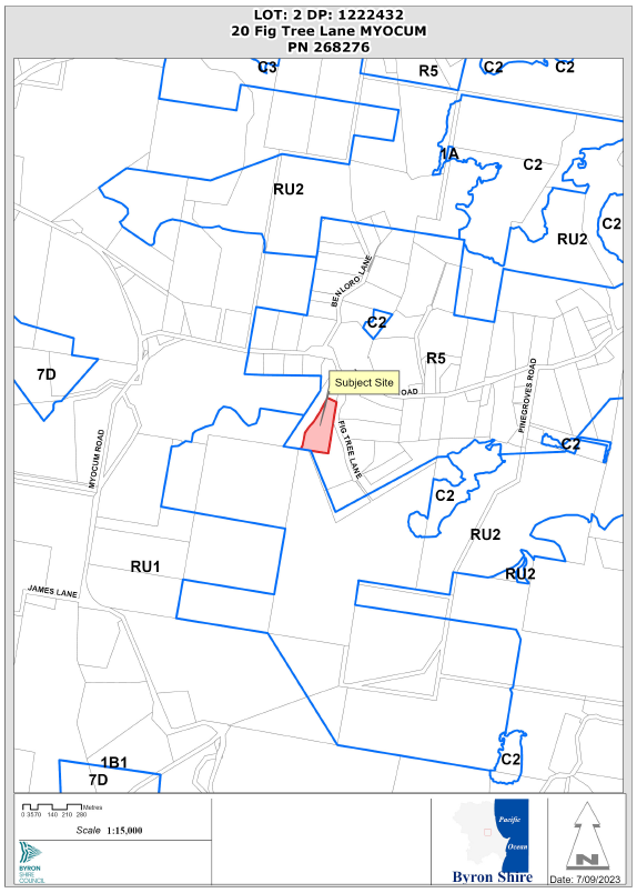
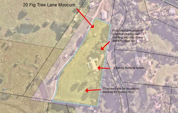
Report No. 13.2 PLANNING - DA 10.2023.63.1 - Dwelling house to create dual occupancy (detached), recreation building, tennis court and demolition of unauthorised dual occupancy (detached) – 20 Fig Tree Lane Myocum.
Directorate: Sustainable Environment and Economy
Report Author: Greg Yopp, Planner
File No: I2023/1354
Proposal:
|
Proposal description: |
Dwelling house to create dual occupancy (detached), recreation building, tennis court and demolition of unauthorised dual occupancy (detached) |
||||||
|
Property description: |
LOT: 2 DP: 1222432 |
||||||
|
20 Fig Tree Lane MYOCUM |
|||||||
|
Parcel No/s: |
268276 |
||||||
|
Applicant: |
Davis Architects |
||||||
|
Owner: |
Ms K J Luland & Mr A R Fahey |
||||||
|
Zoning: |
R5 Large Lot Residential |
||||||
|
Date received: |
28 March 2023 |
||||||
|
Integrated / Designated Development: |
☐ Integrated |
☐ Designated |
☒ Not applicable |
||||
|
Concurrence required |
No |
||||||
|
Public notification or exhibition: |
- Level 2 advertising under Council’s Community Participation Plan. - Exhibition period: 5 April 2023 to 20 April 2023 - Submissions received: 3 - Submissions acknowledged: ☒ Yes ☐ No ☐ N/A |
||||||
|
Concurrent approvals included with DA |
☐ N/A |
☐ W & S (68) |
☒OSMS (68) |
☐ ST (68) |
☐ RA (138) |
||
|
Other: |
|
||||||
|
Planning Review Committee |
Not applicable |
||||||
|
Variation request to Development Standards under an EPI (eg clause 4.6) |
Not applicable
|
||||||
|
Estimated cost |
$1,094,500.00 |
||||||
|
Issues |
· Submissions · Earthworks · Scale of the ancillary recreation building · Tennis court lights |
||||||
Summary:
The DA proposes a dwelling house to create dual occupancy (detached), recreation building, tennis court and demolition of unauthorised dual occupancy (detached).
The proposed development is satisfactory having regard to the relevant environmental planning instruments and planning controls applicable to the site. Three (3) submissions were lodged against the proposal. The DA was subsequently amended in response to the submissions. The amended proposal raises no significant issues in terms of environmental impacts which cannot be managed. The site is a serviced, unconstrained property and is considered suitable for the proposed development.
The application appropriately addresses the relevant constraints applying to the site and is recommended for approval subject to the conditions listed in the Recommendation of this Report below.
NOTE TO COUNCILLORS:
In accordance with the provisions of S375A of the Local Government Act 1993, a Division is to be called whenever a motion for a planning decision is put to the meeting, for the purpose of recording voting on planning matters. Pursuant to clause 2(a) under the heading Matters to be Included in Minutes of Council Meetings of Council's adopted Code of Meeting Practice (as amended) a Division will be deemed to have been called by the mover and seconder of all motions relating to this report.
RECOMMENDATION:
That Pursuant to Section 4.16 of the Environmental Planning & Assessment Act 1979, Development Application No. 10.2023.63.1 for dwelling house to create dual occupancy (detached), recreation building, tennis court and demolition of unauthorised dual occupancy (detached), be granted consent subject to the conditions of approval in Attachment 1 (#E2023/94290).
Attachments:
1 10.2023.63.1
Conditions of consent, e2023/94290
![]()
2 10.2023.63.1
Architectural plans, e2023/75372 ![]()
3 10.2023.63.1
Form Submissions, e2023/94293 ![]()
4 10.2023.63.1
Submission, e2023/94030 ![]()
Assessment:
1. INTRODUCTION
History/Background
|
Application |
Proposal |
Determination |
|
DA 10.2017.15.1 |
Tree removal one (1) tree |
Approved 25/1/2017 |
|
DA 10.2017.242.1 |
Earthworks and retaining wall |
Approved 9/10/2017 |
|
CDC 16.2018.51.1 |
New dwelling |
Approved 13/6/2018 |
|
CDC 16.2018.54.1 |
Dwelling house |
Approved 26/6/2018 |
CDC 16.2018.51.1 and CDC 16.2018.54.1 both approved the same dwelling house and involved a private certifier. The purpose of the issuance of these to CDC’s is unclear. Council’s building surveyor indicated that there could have either been a procedural error or a modification. Notwithstanding this uncertainty, the dwelling house is approved and constructed.
Description of the proposed development
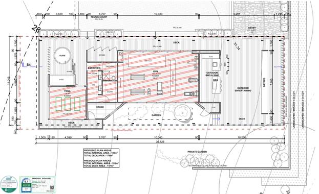
This application seeks approval for dwelling house to create dual occupancy (detached), recreation building, tennis court and demolition of unauthorised dual occupancy (detached). Refer to Figure 1. Details of the proposal follow. (Architectural plans located at Attachment 2 to this report)
· Demolition of existing unauthorised second dwelling (located adjacent to the site of the proposed dwelling house that will create a dual occupancy (detached)). Refer to Figure 2.
· New two storey dwelling house that will create a dual occupancy (detached). The dwelling includes: Upper level - two bedrooms, bathroom, kitchen, living and deck; Lower level - outdoor siting area. Proposed finish a combination of rendered blockwork, painted in dark grey tone, natural basalt sone, vertical hardwood screening and dark grey Colourbond roof. It is noted that there is no laundry in the plans so a consent condition will address this issue. Refer to Figure 3.
· Recreation building with 100m2 Gross Floor Area and 179m2 deck. The internal area includes a yoga room, bathroom with sauna, gym and store areas. The deck area includes a plunge pool and BBQ area. Proposed finish includes a combination of rendered blockwork, painted in dark grey tone, natural basalt sone, vertical hardwood screening and dark grey Colourbond roof. Associated retaining walls. Refer to Figures 4 & 5.
· Tennis court adjacent to the proposed recreation building. 4 x 5.5m light poles proposed to be turned off by 9.00pm. Associated retaining walls. Refer to Figure 4.
· Walking paths to connect the two dwelling houses and the recreation building.
· Enhancement of the bush fire safety measures in accordance with the bush fire assessment report.
Figure 1 – Site plan with proposed development
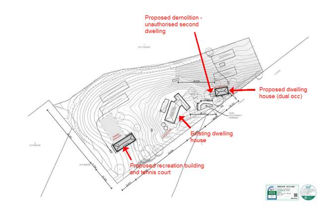
Figure 2 - Unauthorised second dwelling proposed for demolition
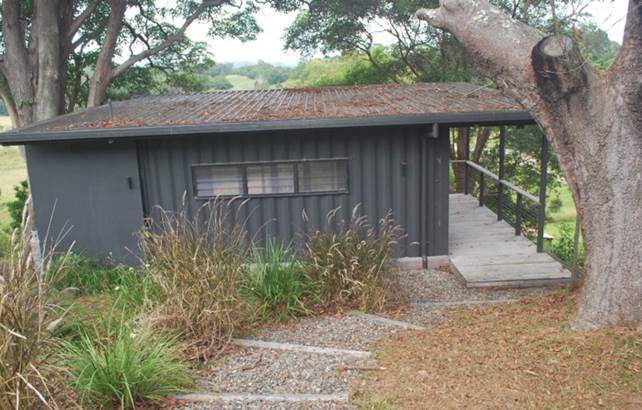
Figure 3 – North and west elevation proposed dwelling house (dual occupancy detached)

Figure 4 – Sketch render recreation building and tennis court

Figure 5 – Floor plan recreation building
Description of the site
Figure 6 – Aerial site view with LEP land zoning overlay
A site inspection was carried out on 5 April 2023
|
Land is legally described |
LOT: 2 DP: 1222432 |
|
|
Property address |
20 Fig Tree Lane MYOCUM |
|
|
Land is zoned: |
R5 Large Lot Residential |
|
|
Land area is: |
2.5ha |
|
|
Property is constrained by:
|
Flood Liable Land – The proposed development site is not flood prone land. The flood liable component of the allotment is limited to approximately 40m2 of the south western corner. Bushfire prone land |
|
|
|
Is a BDAR required due to the location of the proposed development? |
☐ Yes ☒ No |
|
|
Are there any easements in favour of Council affecting the site? |
☐ Yes ☒ No |
|
|
Is there a Vegetation Management Plan which might affect the proposal? |
☐ Yes ☒ No |
|
|
Is there a Voluntary Planning Agreement which might affect the proposal? |
☐ Yes ☒ No |
2. SUMMARY OF REFERRALS
Referrals for this application are detailed below
|
Referral |
Issue |
|
Environmental Health Officer* |
No objections subject to conditions. The proposal also includes lighting for the tennis court with 4 x 5.5m high light poles with LED lighting. Lights are proposed to be turned off by 9.00pm each night. The EHO has provided an appropriate condition of consent, that requires, inter alia, lighting to be designed in accordance with AS4282-2019. |
|
Development Engineer |
No objections subject to conditions. |
* Conditions provided in the above referral are included in the conditions of consent (Attachment 1 to this report)
Proposed tennis court lights
The proposed LED lighting was raised in submissions. Online comparisons of types of lighting by commercial providers are readily available. These comparisons indicate that LED (light emitting diode) lighting effectively lights desired areas while minimising illumination of unwanted areas such as adjoining properties. In comparison, HID (high intensity discharge) lighting creates a higher level of light pollution. Notwithstanding the issue of light pollution, illumination of the tennis court in a residential zone, will potentially increase the level of use of the facility into hours that may not be compatible with normal residential use. For this reason, it is considered reasonable to permit illumination of the tennis court up until 9.00pm on Friday and Saturday evenings only. An appropriate condition of consent is recommended.
3. SECTION 4.14 – BUSH FIRE PRONE LAND
10/50 Rule
The subject allotment is located in a designated 10/50 vegetation entitlement clearing area (Refer to search result below).

There is no vegetation identified in Council’s High Environmental Values mapping within 10m of the proposed development. There is no vegetation on the subject allotment included on the Biodiversity Values Map.
4. SECTION 4.15C – MATTERS FOR CONSIDERATION – DISCUSSION OF ISSUES
Having regard to the matters for consideration detailed in Section 4.15(1) of the Environmental Planning & Assessment Act 1979 (EP&A Act), the following is a summary of the evaluation of the issues.
State Environmental Planning Policies (SEPP)
|
Considerations |
Satisfactory |
Unsatisfactory |
|
Biodiversity and Conservation SEPP 2021 Consideration: The development is proposed on cleared areas of the site. There is no vegetation on the subject allotment included on the Biodiversity Values Map. Planted rainforest trees exist adjacent to the southern half of the eastern boundary and this vegetation is well clear of the proposed development.
|
☒ |
☐ |
|
Resilience and Hazards SEPP 2021 Consideration: Council’s Environmental Health Officer is satisfied that the proposal warrants no further investigation with regards potential contaminated land.
|
☒ |
☐ |
|
Transport and Infrastructure SEPP 2021 Consideration: The proposed development did not require referral under the provisions of this SEPP.
|
☒ |
☐ |
|
SEPP (Building Sustainability Index: BASIX) 2004 Consideration: The DA is accompanied with a BASIX Certificate No. 1360073S, dated 20 February 2023.
|
☒ |
☐ |
4.1 Byron Local Environmental Plan 2014 (LEP 2014)
LEP 2014 is an applicable matter for consideration in the assessment of the subject development application in accordance with subsection 4.15(1) of the EP&A Act because it applies to the subject land and the proposed development. The LEP 2014 clauses that are checked below are of relevance to the proposed development:
|
Part 1 |
☒1.1 | ☒1.1AA | ☒1.2 | ☒1.3 | ☒1.4 | ☒Dictionary | ☒1.5 | ☒1.6 | ☒1.7 | ☒1.8 | ☐1.8A | ☒1.9 | ☐1.9A |
|
Part 2 |
☒2.1 | ☒2.2 | ☒2.3 | ☒Land Use Table | ☐2.4 | ☐2.5 | ☐2.6 | ☒2.7 | ☐2.8 |
|
Part 3 |
☐3.1 | ☐3.2 | ☐3.3 |
|
Part 4 |
☐4.1 | ☐4.1A | ☐4.1AA | ☐4.1B | ☐4.1C | ☐4.1D | ☐4.1E | ☐4.1F | ☐4.2 | ☐4.2A | ☐4.2B | ☐4.2C | ☐4.2D | ☒4.3 | ☐4.4 | ☐4.5 | ☐4.6 |
|
Part 5 |
☐5.1 | ☐5.2 | ☐5.3 | ☐5.4 | ☐5.6 | ☐5.7 | ☐5.8 | ☐5.10 | ☐5.11 | ☐5.12 | ☐5.13 | ☐5.14 | ☐5.15 | ☐5.16 | ☐5.17 | ☐5.18 | ☐5.19 | ☐5.20 | ☐5.21 | ☐5.22 |
|
Part 6 |
☐6.1 | ☒6.2 | ☐6.4 | ☐6.5 | ☒6.6 | ☐ 6.7 | ☐6.8 | ☐6.9 | ☐6.11 | ☐ 6.12 | ☐6.13 | ☐6.14 | ☐6.15 | ☐6.16 |
In accordance with LEP 2014 clauses 1.4 and 2.1 – 2.3:
(a) The proposed development is defined in the LEP 2014 Dictionary as dwelling house to create dual occupancy (detached); The proposed recreation building and tennis court are not defined and are deemed ancillary to the dual occupancy and residential use of the land.
(b) The land is within the R5 Large Lot Residential according to the Land Zoning Map;
(c) The proposed development is permissible with consent; and
(d) Regard is had for the Zone Objectives as follows:
|
Zone Objective |
Consideration |
|
To provide residential housing in a rural setting while preserving, and minimising impacts on, environmentally sensitive locations and scenic quality. |
Consistent There are no mapped environmentally sensitive areas, as defined in LEP 2014 clause 3.3, on or surrounding the subject allotment. The subject allotment is not on a ridgetop location, moreover the proposal will be well screened from the Fig Tree Lane frontage due to the existing vegetation |
|
To ensure that large residential lots do not hinder the proper and orderly development of urban areas in the future. |
The existing large residential lots were strategically located so as not to hinder the orderly development of future urban areas. |
|
To ensure that development in the area does not unreasonably increase the demand for public services or public facilities. |
The proposed dwelling house (dual occupancy) and ancillary development will not unreasonably increase demand for public services or public facilities. |
|
To minimise conflict between land uses within this zone and land uses within adjoining zones. |
There are no evident land use conflicts associated with the proposed development within Zone R5 and the adjoining Zones RU1 and RU2. |
The remaining checked clauses have been taken into consideration in the assessment of the subject development application in accordance with Section 4.15 of the EP&A Act. The proposed development complies with all clauses of LEP 2014 (in some cases subject to conditions and/or to the satisfaction of other assessing officers).
4.2 Any proposed Instrument that has been the subject of public consultation and has been notified to the consent authority
Not applicable.
4.4 Byron Shire Development Control Plan 2014 (DCP 2014)
DCP 2014 is an applicable matter for consideration in the assessment of the subject development application in accordance with subsection 4.15(1) of the EP& A Act because it applies to the land to which LEP 2014 applies. The DCP 2014 Parts/Chapters that are checked below are of relevance to the proposed development:
|
Part A |
☒ |
|
Part B Chapters: |
☐ B1 | ☐ B2 | ☒ B3 | ☒ B4 | ☐ B5 | ☒ B6 | ☐ B7 | ☒ B8 | ☒ B9 | ☐ B10 | ☐ B11 | ☐ B12 | ☐ B13 | ☒ B14 | ☐ B15 |
|
Part C Chapters: |
☐ C1 | ☐ C2 | ☐ C3 | ☐ C4 |
|
Part D Chapters |
☒ D1 | ☐ D2 | ☐ D3 | ☐ D4 | ☐ D5 | ☐ D6 | ☐ D7 | ☐ D8 | ☐ D9 |
|
Part E Chapters |
☐ E1 | ☐ E2 | ☐ E3 | ☐ E4 | ☐ E5 | ☐ E6 | ☐ E7 | ☐ E8 | ☐ E9 | ☐ E10 |
These checked Parts/Chapters have been taken into consideration in the assessment of the subject development application in accordance with Section 4.15 of the EP&A Act. The proposed development is demonstrated to meet the relevant Objectives of all relevant Parts/Chapters (in some cases subject to conditions and/or to the satisfaction of other assessing officers).
Further details are provided regarding DCP Chapter B14 (Excavation and Fill) D1 (Residential Accommodation in Urban, Village and Special Purpose Zones)
|
DCP Provision |
Staff assessment comment |
|
General Provisions |
|
|
B14.2 Excavation and Fill in all Zones Prescriptive Measures
|
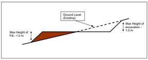
Earthworks associated with the proposed recreation building and tennis court exceed 1m. The proposed cut on the north western corner of the tennis court is in the vicinity of 3m and a maximum cut of approximately 2.5m is associated with the proposed recreation building. The proposed earthworks are deemed appropriate in this instance for the following reasons: · The proponent moved the proposed tennis court and recreation building to the north west in order to address concerns raised in submissions, thus requiring more earthworks. · All earthworks will be terraced so as not to exceed 1m in height · Geotechnical reporting required prior to CC · Detailed plans for retaining walls required prior to CC · The proposed earthworks are consistent with the Objectives and Performance Criteria |
|
D1.2.1 Building Height Plane |
The proposed development is located well clear of all boundaries. |
|
D1.2.2 Setbacks from Boundaries · 4.5m local roads · Side and rear setbacks 1.5m for dual occupancy |
The proposed dwelling house 4.5m front setback and well exceeds 1.5m side and rear setbacks on this 2.5ha allotment. Proposes ancillary recreation building and tennis court – 32m front setback; 23m side setback; 46m rear setback. |
|
D1.2.3 Privacy · Screening required when there is a direct view into private open space of an adjoining dwelling · Screening required where decks, terraces and balconies are within 4m from a side or rear boundary |
The proposed development does not have a direct view into the private open space of an adjoining dwelling. No external living areas within 4m from side or rear boundaries. |
|
D1.2.6 Character and Visual Impact · Siting, design & character · Address climate · Streetscape · Minimise privacy loss · Integrate with built and natural environment · Long straight walls discouraged · Verandahs, balconies and protected outdoor spaces · Eaves · Compatible building materials |
The proposed development is consistent with the Objectives and Performance Criteria. |
|
Dual Occupancy and Semi-Detached Dwellings |
|
|
D1.5.1 On-Site Car Parking · 2 spaces for each dwelling |
The proposed dwelling house includes two car parking spaces with appropriate internal access and manoeuvring. |
|
D1.5.2 Character · Consider topography and slope · Minimise loss of privacy · Avoid mirror image · Accessible private open space |
The proposed dwelling house is consistent with these Performance Criteria. |
|
D1.5.3 Adjoining and Adjacent Development · Protect existing views · Provide for privacy · Natural light and solar access · Maintenance of character and neighbourhood amenity |
The proposed dwelling house is consistent with these Prescriptive Measures. |
|
D1.5.4 Private Open Space · Minimum area 30m2, not in front setback, minimum length and width 4m. · Not include any areas used for on-site waste water management. |
The proposed dwelling house is consistent with these Prescriptive Measures. |
|
D1.5.5 Landscaping · Refer to Chapter B9 |
Extensive existing landscaping already on site. |
|
D1.5.6 Soundproofing · Minimise sound and vibration impacts upon occupants of surrounding dwellings |
The proposed dwelling house is spatially separated to the extent that soundproofing is not required. |
|
Studios |
|
|
D1.12.1 Studios · Same lot as dwelling · Maximum 60m2 GFA · No internal partitions other than necessary for ablutions · Not contain kitchen, sink or the like to enable food preparation · Not used as separate habitation · 40m from the main dwelling |
There are no explicit provisions in the Byron DCP for recreation buildings ancillary to dwelling houses. Consequently, consideration was given to the Studio provisions and also having regard to the large 2.5ha site and the significant boundary setbacks. Details follow: · The original GFA of 200m2 was reduced to 100m2. · 45m at the closest point from main dwelling house. · Internal partitions the bathroom facilities. · Setbacks – 23m side; 32m front, 46m rear. · The front and side setbacks were significantly increased in response to public submissions. · 180m2 deck area not included in GFA. · Outdoor BBQ area includes sink. This is deemed appropriate for a building. · Recreation building and associated tennis court ancillary to residential use of the site. · Conditions can be used to control the use of the building and the hours of operation of tennis court lights.
|
4.5 Environmental Planning and Assessment Regulation 2021 considerations
|
|
Applicable to the proposal: |
Considered the control as it relates to the proposal: |
If this control is applicable, does the proposal comply? |
|
Section 61 - Additional matters that consent authority must consider |
☒ Yes ☐ No |
☒ Yes ☐ No ☐ NA |
☒ Yes ☐ No ☐ NA |
|
Section 62 - Consideration of fire safety |
☐ Yes ☒ No |
☐ Yes ☐ No ☒ NA |
☐ Yes ☐ No ☒ NA |
|
Section 64 - Consent authority may require upgrade of buildings |
☐ Yes ☒ No |
☐ Yes ☐ No ☒ NA |
☐ Yes ☐ No ☒ NA |
|
Section 63 - Considerations for erection of temporary structures |
☐ Yes ☒ No |
☐ Yes ☐ No ☒ NA |
☐ Yes ☐ No ☒ NA |
* Non-compliances and any other significant issues discussed below
4.6 The likely impacts of that development, including environmental impacts on both the natural and built environments, and social and economic impacts in the locality
4.6.1
|
Impact on: |
Likely significant impact/s? |
|
Natural environment |
No. The proposal will not have a significantly adverse impact on the natural environment of the locality. |
|
Built environment |
No. The proposal will not have a significantly adverse impact on the built environment of the locality. |
|
Social Environment |
No. The proposal will not have a significant social impact on the locality subject to conditions. |
|
Economic impact |
No. The proposal will not have a significant economic impact on the locality. |
|
Construction Impacts |
No. The development will generate minor impacts during its construction. Conditions of consent recommended to control hours of work, builders waste, construction noise, installation of sedimentation and erosion control measures and the like to ameliorate such impacts. |
4.6.2 Marine Estate Management Act 2014
The development is unlikely to have an effect on the plants or animals within the Cape Byron Marine Park or their habitat.
4.6.3 Council Policies applicable to the proposed development?
No applicable policies.
4.7 The suitability of the site for the development
The site is a serviced, unconstrained property and is suitable for the proposed development.
4.8 Submissions made in accordance with this Act or the regulations
The development application was publicly exhibited
There were three (3) submissions made against the development application. Two (2) submissions were from private individuals and one (1) from a local MP on behalf of one of the other submitters. Refer to Attachments 3 and 4 of this report for redacted copies of submissions.
A submissions analysis is provided in the table below.
Table - Submissions Analysis
|
Issue |
Staff Response |
|
Use of the term “clubhouse” for the recreation building – concern non residents will use the facility on a commercial basis. |
The use of the term “clubhouse” by the applicant was unfortunate as it is not a true description of the proposed use. The proposed recreation building is ancillary to the residential use of the site. There is no separate access to the building or adjacent tennis court. Appropriate conditions of consent recommended. |
|
The “clubhouse” [sic] and tennis court are excessive in size and major concerns include tennis court lighting, noise and loss of amenity. |
The proposal was amended by the applicant in response to concerns from Council staff and submitters. The GFA of the recreation building was reduced from 200m2 to 100m2. The side setback was increased to 23m and the front setback was increased to 33m. Appropriate conditions of consent are recommended to control the type of lighting and the hours of use. These measures will serve to maintain the residential amenity of the area. Online comparisons of types of lighting by commercial providers are readily available. These comparisons indicate that LED (light emitting diode) lighting effectively lights desired areas while minimising illumination of unwanted areas such as adjoining properties. In comparison, HID (high intensity discharge) lighting creates a higher level of light pollution. Notwithstanding the issue of light pollution, illumination of the tennis court in a residential zone, will potentially increase the level of use of the facility into hours that may not be compatible with normal residential use. For this reason, it is considered reasonable to permit illumination of the tennis court up until 9.00pm on Friday and Saturday evenings only. An appropriate condition of consent is recommended. |
|
The proposed secondary dwelling exceeds the prescribed LEP GFA |
The proposed dwelling house will create a dual occupancy (detached). It is not a secondary dwelling. Moreover, the proposed dwelling house consists of 2 bedrooms and at around 150m2 GFA, the size of the building is very modest. |
|
Fire access to the secondary dwelling [sic] is problematic. |
The DA is accompanied by a Bush Fire Assessment Report prepared by a BPad Certified Bush Fire Expert. The report provides appropriate requirements for bush fire safety. These requirements will form conditions of consent. |
|
Parking and traffic generation. |
Council’s Development Engineer has assessed the DA and, subject to conditions of consent the proposal is compliant with DCP requirement. |
|
Concern about alternative use for the proposed development. |
Appropriate conditions of consent recommended. |
|
Concern about use for short term stays and associated noise, car parking issues and drug needles. |
Short Term Rental Accommodation under Part 6 of SEPP (Housing) 2021. All landowners are required to comply with these requirements. The adjoining residents have recourse under the SEPP regarding adverse impacts. Notwithstanding the SEPP, conditions of consent are recommended that clearly indicate that the proposal is approved for residential use only. |
4.9 Public interest
The proposed development is unlikely to prejudice or compromise the public interest or create an undesirable precedent.
5. DEVELOPER CONTRIBUTIONS
5.1 Water & Sewer Levies
No Section 64 levies will be required.
5.2 Developer Contributions
Section 7.11 Contributions will be payable.
6. DISCLOSURE OF POLITICAL DONATIONS AND GIFTS
|
Disclosure details |
Response |
|
Has a Disclosure Statement been received in relation to this application? If Yes, Provide Disclosure Statement register reference: 91. |
Yes ☐ No ☒ |
|
Have staff received a ‘gift’ from anyone involved in this application that needs to be disclosed. |
Yes ☐ No ☒ |
7. CONCLUSION
The DA proposes a dwelling house to create dual occupancy (detached), recreation building, tennis court and demolition of unauthorised dual occupancy (detached).
The proposed development is satisfactory having regard to the relevant environmental planning instruments and planning controls applicable to the site. Three (3) submissions were lodged against the proposal. The DA was subsequently amended to response to the submissions. The amended proposal raises no significant issues in terms of environmental impacts which cannot be managed. The site is a serviced, unconstrained property and is considered suitable for the proposed development.
The application appropriately addresses the relevant constraints applying to the site and is recommended for approval subject to the conditions listed at Attachment 1 to this Report.
BYRON SHIRE COUNCIL
Staff Reports - Sustainable Environment and Economy 13.3
Report No. 13.3 PLANNING - Brunswick Heads Heritage Conservation Area and Heritage Material and Colours Guide 26.2022.9.1
Directorate: Sustainable Environment and Economy
Report Author: Roseanna Meech, Planner
File No: I2023/1231
Summary:
The purpose of this report is to present the options to move forward with the planning proposal (Attachment 1) for heritage amendments in line with the Byron Shire Heritage Strategy (2020–2024).
Additionally, the report discusses the outcomes of the ‘Colour Schemes for Historic Buildings and Conservation Areas Report’ outlining the best outcomes for moving forward with a guiding document to best protect and maintain built heritage within the Shire.
RECOMMENDATION:
That Council:
1. Notes community feedback on the heritage colours and supports the further development of a heritage colour palette for heritage conservation areas and items;
2. Proceeds with a Planning Proposal that seeks to amend Byron LEP 2014 to the Department of Planning & Environment for gateway determination by selecting either:
Option 1: the Planning Proposal in (Attachment 1 – E2022/106357) that seeks to amend Byron LEP 2014 to introduce new heritage items (6 in total) and include a new Heritage Conservation Area within Brunswick Heads.
OR
Option 2: an amended Planning Proposal seeking only to amend Byron LEP 2014 to introduce 6 new heritage items only.
3. Forwards the preferred Planning Proposal to the NSW Department of Planning and Environment for a gateway determination;
4. Pending a positive gateway determination, undertakes public exhibition of the Planning Proposal in accordance with the determination requirements;
5. Considers a submissions report post exhibition that includes any recommended changes to the Planning Proposal for final adoption.
1 26.2022.9.1
Heritage Planning Proposal - Version for Council report, E2022/106357 ![]()
Report
Proposed Local Environmental Plan amendments to list new heritage items and
Brunswick Heads Heritage Conservation Area
The Brunswick Heads Progress Association, Chamber of Commerce and Historical Society put forward a request for a Heritage Conservation Area (HCA) to be established to protect the character of Brunswick Heads. Council Resolved 21-005 to adopt the recommendation of the Heritage Panel to consider parts of Brunswick Heads as a Heritage Conservation Area. As per the Resolution a Historic Heritage Assessment was prepared to identify the heritage significance and values of the village by Councils Heritage Advisor, Clarence Heritage.
Informal community consultation was undertaken prior to the matter being considered at Council for the formal listing process and Planning Proposal. Of the submissions received, there were eight (8) submissions in support of the HCA and items listings and nine (9) submissions against.
Following consultation, a report was prepared recommending that Council endorse a Planning Proposal (Attachment 1) to amend Byron LEP 2014 to list several items and introduce a HCA within Brunswick Heads.
At the 8 December 2023 Council (Planning) Meeting, it was Resolved (22-686) that Council defers consideration of the Heritage Amendments to Byron LEP 2014 and refers the matter to a Councillor Workshop in 2023.
The Planning Proposal and Brunswick Heads HCA was discussed at a Councillor Workshop on 1 June 2023. The discussion around the implications of a HCA within Brunswick Heads was raised in relation to potential impacts on housing delivery. In order to proceed with the recommendation and to continue to introduce new heritage-listed properties within the Shire, two options on how to best proceed have been discussed.
Options
The options available are to:
OR
Forward an amended Planning Proposal seeking to amend Byron LEP 2014 to introduce new heritage items ONLY to the Department of Planning & Environment for gateway determination. This Planning Proposal would include only the six (6) items for listing.
Feedback on heritage colours in the Byron Shire
In response to issues relating to use of non-heritage colours on works within heritage conservation areas, it was Resolved (22-455) that ‘Council reviews the colour restrictions applying to houses in the general heritage conservation area with a view to liberalising the range of colours from which a homeowner may choose’.
A Colour Schemes for Historic Buildings and Conservation Areas Report was prepared by Council’s Heritage Advisor, Clarence Heritage. The report was referred to the Heritage Advisory Committee, and then to Council who further resolved (22-600) ‘Requests Council to clarify the existing preferred heritage colour range and conduct community consultation in reference to Council resolution 22-455’.
This report provides an overview of the background and use of heritage colours along with examples to assist property owners and developers to choose the most appropriate materials and colours for heritage works. It also includes recommendations for wording changes to Chapter C1 ‘Non-indigenous Heritage’ of the Development Control Plan 2014.
The report and supporting documentation were placed on public exhibition during March 2023 asking for feedback on current colour schemes, possible changes to the Development Control Plan to loosen restrictions on the range of colours used and any other feedback about heritage colours.
There were twenty-four (24) Submissions received. The feedback from the submissions was discussed at a Councillor Workshop on 1 June 2023.
Camden Material and Colour Guide
Following feedback and through the identification of similar documents including the Camden Material and Colour Guide, there is the opportunity to further revise the document.
A new Material and Colours Guide will take onboard the submissions received and incorporate a broader range of colours and materials that will continue to contribute and complement heritage items and development.
Similar to the guide prepared by Camden Council, the document will look to provide clarity of built heritage of the Shire and to assist in working with specific materials and colours for heritage buildings. This may include the detailing of different housing styles and precinct character profiles.
Next steps
The Planning Proposal (Attachment 1) will be amended to accord with any resolution of Council and sent to Department of Planning for a gateway determination, followed by public exhibition.
A Material and Colours Guide will be prepared and reported back to Council for adoption.
Strategic Considerations
Community Strategic Plan and Operational Plan
|
CSP Objective |
CSP Strategy |
DP Action |
Code |
OP Activity |
|
4: Ethical Growth |
4.1: Manage responsible development through effective place and space planning |
4.1.4: LEP & DCP - Review and update the Local Environmental Plan and Development Control Plans |
4.1.4.3 |
Develop stand-alone Local Environmental Plan 2014 amendment to introduce new heritage-listed properties |
Recent Resolutions
· 21-005 - 11 February Council (Planning) Meeting
· 22-600 - Report of the Heritage Advisory Committee Meeting held on 15 September 2022
· 22-686 - 8 December Council (Planning) Meeting
Legal/Statutory/Policy Considerations
The Byron Shire Heritage Strategy (2020–2024) includes the following action in relation to the local area’s heritage:
Identify Heritage Items in the Byron Shire and list them in the Local Environmental Plan - Maintain, review, and update the Byron LEP 2014 Heritage Schedule and accompanying State Heritage Inventory database.
Financial Considerations
This is a Council initiated planning proposal and will be funded from within existing budgets.
Consultation and Engagement
The planning proposal will be exhibited in accordance with the gateway determination and Council’s Community Participation Plan. Notification of the planning proposal exhibition will be sent to directly landowners of affected properties.
BYRON SHIRE COUNCIL
Staff Reports - Sustainable Environment and Economy 13.4
Report No. 13.4 PLANNING - 10.2023.103.1 - Use of existing building as a workshop, storage and carport - 484 Upper Wilsons Creek Road Upper Wilsons Creek
Directorate: Sustainable Environment and Economy
Report Author: Lachlan Wall, Land Use Planner
File No: I2023/1257
Proposal:
|
DA No: |
10.2023.103.1 |
|
Planning Portal ref |
PAN-316189 |
|
Proposal description: |
Use of existing building as a workshop, storage and carport |
|
Parcel No/s: |
99160 |
|
Applicant: |
Mr J W Pascoe |
|
Owner: |
Mr J W & Mrs G L Pascoe |
|
Zoning: |
C2 Environmental Conservation / PART RU2 Rural Landscape |
|
Date received: |
6 April 2023 |
|
Concurrence required |
No |
|
Public notification or exhibition: |
- Level 2 advertising under Council’s Community Participation Plan. - Exhibition period: 18/04/2023 – 01/05/2023 - No Submissions were received. |
|
Estimated cost |
$2,000.00 |
|
Issues |
Bonafides of the use as a shed / workshop Existing use rights Geotechnical stability Vegetation removal Non-compliance with Clause 4.3 Height of buildings. |
Summary:
This Development Application seeks consent for the use of an existing building as a workshop, storage and carport at 484 Upper Wilsons Creek Road Upper Wilsons Creek. The structure is ancillary to the existing dwelling on the site. Based on a review of aerial photography, the building was likely constructed in the late 1980’s by previous landowners without development consent or building approval. It is understood the building has been used for residential purposes in the past.
The subject property is zoned RU2 Rural Landscape and C2 Environmental Conservation. The structure that is the subject of this development application is entirely located within the C2 Environmental Conservation zoned land.
The structure as built does not comply with Section 4.3 Height of Buildings with a maximum height of 10.125m exceeding the acceptable 9 m height provision. The application is not accompanied by a written request to vary this development standard pursuant to Section 4.6 of the Byron Local Environmental Plan 2014. Further, the building does not look like or feel like a shed and outwardly has the strong appearance of a dwelling house, whilst the building is incompatible for the storage of machinery, vehicles, tractors and the like, as required under Chapter D2 (D2.7.2) of DCP 2014.
The applicant has argued that the property enjoys existing use rights and therefore the proposal is not a prohibited land use within the C2 zone. In this regard, if the property does enjoy existing use rights, the building as constructed with its excessive height and lack of bonafides in terms of a shed would never have been approved, as designed and constructed. It is noted compliance action has been carried out and the court ordered that the building did not need to be demolished but could not be used until such time as development application process was completed.
An alternative path forward for the landowner is to seek an LEP amendment to legitimise the building as a dwelling house under Pathway 2 of the Unauthorised Dwelling Guidelines 2022. The merits of such a proposal have not been examined in detail, and consideration of geotechnical constraints and any additional clearing for bushfire protection purposes beyond what has already occurred on the site would be required. It would be up to the landowner to initiate and pay all fees associated with such a planning proposal.
In conclusion the proposal is not in the public interest to be approved as a shed and the development application is recommended for refusal.
NOTE TO COUNCILLORS:
In accordance with the provisions of S375A of the Local Government Act 1993, a Division is to be called whenever a motion for a planning decision is put to the meeting, for the purpose of recording voting on planning matters. Pursuant to clause 2(a) under the heading Matters to be Included in Minutes of Council Meetings of Council's adopted Code of Meeting Practice (as amended) a Division will be deemed to have been called by the mover and seconder of all motions relating to this report.
RECOMMENDATION:
1. That pursuant to Section 4.16 of the Environmental Planning & Assessment Act 1979, Development Application No. 10.2023.103.1 for Use of Existing Building as a Workshop, Storage and Carport, be refused for the following reasons:
a) Pursuant to section 4.15 (1)(a) of Environmental Planning and Assessment Act 1979, The proposed use is a prohibited land use and is inconsistent with the objectives of the C2 Environmental Conservation Zone of the Byron Local Environmental Plan 2014.
b) Pursuant to section 4.15 (1)(a)(i) of Environmental Planning and Assessment Act 1979, The development does not comply with Clause 4.3 Height of Buildings of the Byron Local Environmental Plan 2014.
c) Pursuant to section 4.15 (1)(a)(iii) of Environmental Planning and Assessment Act 1979, the development does not comply with D2.7.2 Farm Buildings, sheds and other structures of the Byron Development Control Plan 2014.
f) Pursuant to section 4.15 (1)(c) of Environmental Planning and Assessment Act 1979, the development is not suitable for the site as the application has not provided a geotechnical investigation report that demonstrates that the site is safe from further landslip or subsidence at, above or below the subject structure.
2. That the landowner be advised of an alternative path forward to seek an LEP amendment to legitimise the building as a dwelling house under Pathway 2 of the Unauthorised Dwelling Guidelines 2022. The planning proposal would seek to amend Byron Local Environmental Plan 2014 to include the property in Schedule 1 to enable development consent to be sought for a dual occupancy on the subject land.
3. That the landowner be given 6 months from the date of Council’s decision to either lodge a planning proposal as per 2 or a new development application to modify the building such that it is capable of being granted development consent for a lawful use in the C2 Environmental Conservation.
1 Attachment
1 - Architectural plans, E2023/88361
![]()
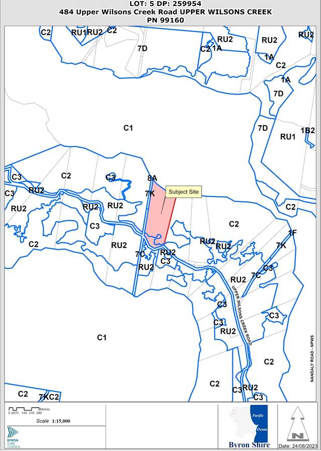
Assessment:
INTRODUCTION
History/Background
A search of Council records indicates the following Development history.
DA 83/142 Dwelling House – approved 23/4/1983 and subsequent
BA 83/2164 – Dwelling House – approved 26/05/1983.
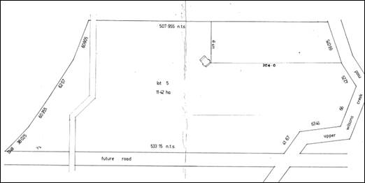
Figure 1: site plan of BA 6.1983.2164.1 showing approximate location of the dwelling approved by this BA. No shed or second dwelling is located on the plans
This application has been lodged in response to ongoing compliance action undertaken by Council. Prior to the lodgement of this development application a Building information certificate was refused for the use of this structure as a new dwelling to create a dual occupancy (detached) on 29/02/2022. Council reference 50.2022.40.1.
Subsequent to the refusal of the building Certificate 50.2022.40.1, the property owner appealed the Stop Use and Demolish Works orders, Council reference 75.2022.10.1 and 75.2022.11.1. These orders were amended by Court order on 28/02/2023 as follows:
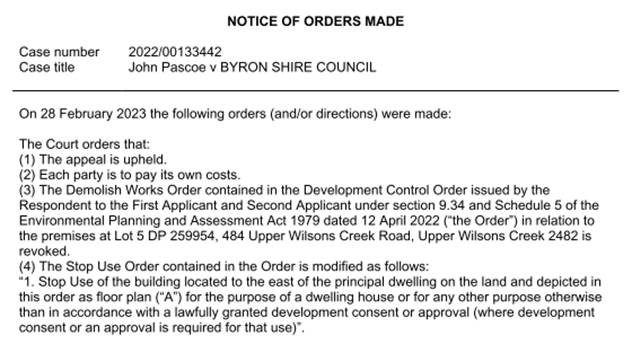
Description of the proposed development
This application seeks approval for Use of Existing Building as a Workshop, Storage and Carport. The workshop is a large two storey structure with a maximum height of 10.125m with a floor area of 132m2. And contains a mezzanine floor area above the first floor.
The structure also contains a 16m2 balcony on the northern elevation of the first floor, with separate entrances to each level are provided. The application describes the shed as being constructed in the “mid 1980’s” however has not provided evidence to substantiate this claim.
The Application describes the development for which consent is sought as “to use the existing building as a workshop, storage and carport in association with the existing dwelling house”. The uses within the structure
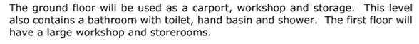
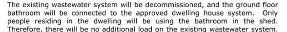
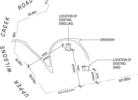
Figure 2 extract of site plan showing location of structure.
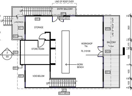
Figure 3 first floor plan

Figure 4 ground floor plan

Figure 5 Southern elevation

Figure 6 Western elevation
Description of the site
|
Land is legally described |
LOT: 5 DP: 259954 |
|
|
Property address |
484 Upper Wilsons Creek Road UPPER WILSONS CREEK |
|
|
Land is zoned: |
C2 Environmental Conservation / PART RU2 Rural Landscape |
|
|
Land area is: |
11.42 ha |
|
|
Property is constrained by:
|
Bushfire prone land |
|
|
|
Is a BDAR required due to the location of the proposed development? |
☒ No* |
|
|
Are there any easements in favour of Council affecting the site? |
☒ No |
|
|
Is there a Vegetation Management Plan which might affect the proposal? |
☒ No |
|
|
Is there a Voluntary Planning Agreement which might affect the proposal? |
☒ No |
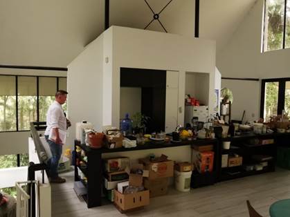
Figure 7 first floor

Figure 8 ground floor of structure

Figure 9 view from outside overlooking deck and stairs providing access to first floor
SUMMARY OF REFERRALS
|
Referral |
Issue |
|
Environmental Health Officer |
If approved an OSSM approval will be required under S68 of the Local Government Act 1993. |
|
Building Surveyor |
If approved a BIC will be required for the structure |
SECTION 4.14 – BUSH FIRE PRONE LAND
Under section 4.14 of the Act, Council must be satisfied prior to making a determination for development on bush fire prone land, that the development complies with the document ‘Planning for Bush Fire Protection 2019’’. The site is bush fire prone land however in accordance with section 8.3.2 Class 10 structures of PBP 2019, there is no bush fire protection requirements for Class 10a buildings located more than 6m from a dwelling in bush fire prone areas.
SECTION 4.15C – MATTERS FOR CONSIDERATION – DISCUSSION OF ISSUES
Having regard to the matters for consideration detailed in Section 4.15(1) of the Environmental Planning & Assessment Act 1979 (EP&A Act), the following is a summary of the evaluation of the issues.
State Environmental Planning Policies (SEPP)
|
Considerations |
Satisfactory |
Unsatisfactory |
|
Biodiversity and Conservation SEPP 2021 Consideration: Chapter 3 Koala habitat protection 2020 This chapter does not apply to the site as the site as the works are not located within land zoned RU1, RU2 or RU3, or an equivalent zone and no further consideration of this chapter is required. It is noted that the presence of koala have been recorded within the area, within the adjoining National Parks & Wildlife Service owned land to the north and south. |
☒ |
☐ |
Byron Local Environmental Plan 2014 (LEP 2014)
In accordance with LEP 2014 clauses 1.4 and 2.1 – 2.3:
(a) The proposed development is defined in the LEP 2014 Dictionary as shed;
(b) The land is within the C2 Environmental Conservation / RU2 Rural Landscape according to the Land Zoning Map. The development footprint is within the C2 Environmental Conservation land only;
(c) The proposed development is Prohibited in the zone; and
(d) Regard is had for the Zone Objectives as follows:
|
Zone Objective – C2 Zone |
Consideration |
|
To protect, manage and restore areas of high ecological, scientific, cultural or aesthetic values. To prevent development that could destroy, damage or otherwise have an adverse effect on those values. |
It is somewhat difficult to consider the proposed shed and its subsequent use which is prohibited in the zone protects, manages or restores the areas of high ecological, scientific, cultural or aesthetic values, unless it is recognised that the site enjoys existing use rights. This is discussed below. |
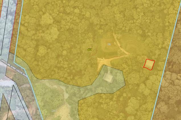
Figure 10 part aerial image of the site with zoning map overlay shown. Red square shows the location of the building footprint
Division 4.11 – Existing Uses
The area of the site was rezoned to C2 Environmental Conservation in 2022, prior to this rezoning, the site was zoned 7 (c) Water Catchment Zone and 7 (k) Habitat Zone. The structure as built was built wholly within the 7 (c) zoned land. Sheds in the C2 Zone are prohibited under Byron LEP 2014
This applicant argued the property enjoys existing use rights and therefore the proposed shed is a permissible land use despite the prohibition under Byron LEP 2014,with the applicants legal advice contending that the area around the existing dwelling has rights to be utilised for further residential purposes ancillary to that dwelling. In this regards there is case law to that effect, however on review of those cases and in particular Saffioti v Kiama Municipal Council 2017 NSWLEC 65 and the subsequent appeals and reviews in Saffioti v Kiama Municipal Council (2018) NSWLEC 1426, and Saffioti v Kiama Municipal Council (2019) NSWLEC 57, such use rights were found to exist, but this did not mean that other planning controls, and the merits of the proposal were then thrown out. The existing use rights only enable the applicant to resolve the permissibility issue. The other nuance with this case law is that Saffioti was seeking consent to actually build a dwelling on the land as opposed to seeking consent for the use of a structure that have been constructed without consent or approval.
Applying this to this application this means the shed despite its prohibition in the C2 Zone, is permissible with consent.
The applicant has not provided any specific detail as to
when the building was erected, such as a Statutory Declaration from the
previous owner, long term residents in the area or the builder or tradesmen
that worked on the structure. On review of historical aerial photography, the
building appears to have been erected sometime in the late 1980’s. In the
1991 aerial image below the roof structure can be seen. The red arrow on the
image below indicates the likely roof area of a structure. 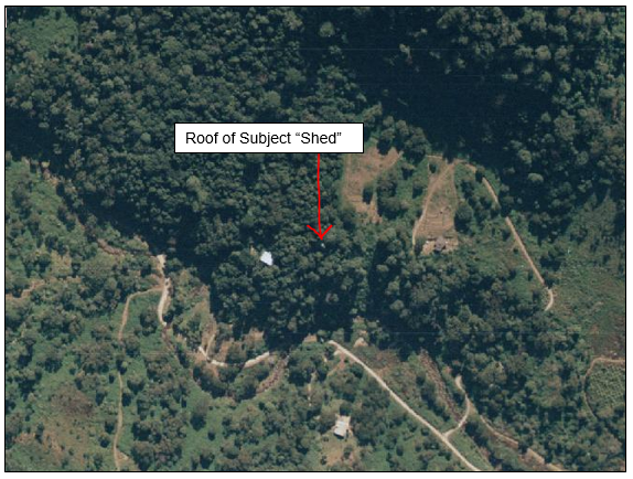
Figure 11 Aerial – 26/7/91 (NSW Spatial Services)
Since 1991, an area around the approved dwelling and shed has been cleared. A review of Council records does not reveal any approval for clearing of this land.

Figure 12 Curent Aerial – Councils GIS 2023
Clause 4.3 Height of Building
The plans submitted with the application show the maximum height of the building, as constructed is shown at 10.125m (south elevation). The proposed building is non-complaint with the height controls and is not supported.
Clause 4.6 Exceptions to Development Standards
The development does not comply with Clause 4.3 Height of building and the application is not accompanied by a written request to vary the development standard. Council has no power to set aside this control as it has not been established that consent for the structure was not required or obtained prior to its construction.
Any proposed Instrument that has been the subject of public consultation and has been notified to the consent authority
No proposed instruments apply to the site.
Byron Shire Development Control Plan 2014 (DCP 2014)
The following provisions are specific to the proposal and issues that it raises.
D2.7.2 Farm Buildings, sheds and other structures.
Section D2.7.2 sets out provisions for farm sheds and the like and those dwellings being converted to farm sheds. The objectives state:
Objectives
1. To specify criteria for establishment of farm buildings
2. To maintain the character and amenity of the Shire’s Rural Zones.
3. To minimise conflicts between developments in Rural Zones.
Comment: The shed exceeds 9m in height, this variation to a development standard has not been applied for as part of this application and is not supported. The additional height is unreasonable, unnecessary and detracts from the character and amenity of the rural area. Had consent been sorted to build this structure, then a 9 metre height limit is highly likely to have been enforced. Opportunities would exist to make modifications to the building to bring it into compliance, however this would be subject to design and engineering and modified plans being submitted to Council. This has not been proposed.
Performance Criteria
1. Farm buildings must observe the road and boundary setback requirements specified in Section D2.2.2 and the character and visual impact requirements specified in Section D2.2.3
2. Determination of siting, extent and nature of development must be consistent with the provisions of Chapter B6 Buffers and Minimising Land Use Conflict.
3. Fencing, particularly adjoining E-zones, should aim to reduce negative impacts on native wildlife by complying with the Wildlife Friendly Fencing guidelines.
4. Fencing in flood prone areas should aim to meet the guidelines set out in the “Riparian Fences Guides”.
5. Dwelling house to shed conversions should include at a minimum the removal of the kitchen cooking and washing facilities to facilitate use for agricultural needs which may include the addition of a roller door. This should include the removal of any non-structural internal partitions.
6. Sheds should be open, have minimal dividing walls and plumbing and be suitable for machinery and vehicle storage. Plans of decommissioning should be included with Development Applications seeking to change the use of the building from a dwelling to a shed.
Comment:
Criteria 5 and 6 are of significance to the proposal considering the building has been constructed as a dwelling house. It is somewhat difficult to characterise the structure as a shed, when its long term use has been a dwelling and it has been sold to the current land as a dwelling. 484 Upper Wilsons Creek Road, Upper Wilsons Creek, NSW 2482 (realestate.com.au) Further the outward appearance of the building is that it is a dwelling, whilst the internal finishings such as flooring and plasterboard walls also do not give off the appearance that is a shed.
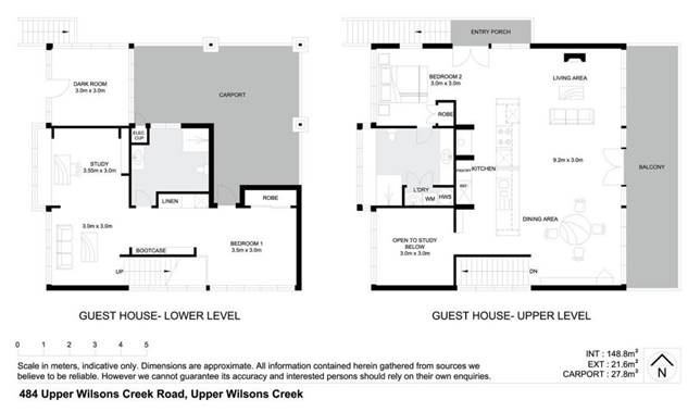
Figure 13: floor plans from the real estate website
The plans have not demonstrated that the structure is intended for agricultural use, or the storage of machinery, vehicles tractors or the like, and no alterations are proposed to the external appearance of the building to facilitate its proposed use as a shed.
Conclusion: The proposal does not give the appearance of a farm shed or storage shed and its usability as such is highly questionable considering the buildings materials and finish. The proposal is considered to be inconsistent with the DCP provisions.
Environmental Planning and Assessment Regulation 2021 considerations
The proposal raises no issues under the EPA Regulations
The likely impacts of that development, including environmental impacts on both the natural and built environments, and social and economic impacts in the locality
|
Impact on: |
Likely significant impact/s? |
|
Natural environment |
If approved, the proposal will not have a significantly adverse impact on the natural environment of the locality, provided no further land is cleared around the building.
|
|
Built environment |
The proposal as constructed breaches the 9 metre height limit. In the absence of any variation requests to the height controls it is considered that the structure if to be approved should be redesigned to comply with the controls as specified under the LEP.
|
|
Social Environment |
The proposal will not have a significant social impact on the locality. |
|
Economic impact |
The proposal will not have a significant economic impact on the locality. |
|
Construction Impacts |
If approved the structure is built and construction works would be limited to further works to modify the waste water system associated with the structure.
|
4.6.3 Council Policies applicable to the proposed development?
|
Council Policy |
Consideration |
|
A Building information certificate would be required for this structure if approved |
The suitability of the site for the development
During the site inspection it was noted that the property, as had others in the areas of Upper Wilsons Creek, Huonbrook, and Upper Main Arm had been subject to landslip during the 2022 flood event. This landslip commenced approximately 43m south of the subject structure and 26m to the east of the existing dwelling on the property. No works had been undertaken to further arrest the potential for further landslips, other than removal of fallen trees within this area and the reconstruction of the driveway since the flood event. The application was not accompanied by a geotechnical investigation that considered the likelihood of this structure being affected by landslip, or subsidence at, above or below the structure in light of this event.
The site has not demonstrated that it is suitable for the development.
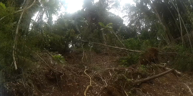
Figure 14: Landslip taken from driveway access to site looking uphill (north)
It is considered there is a lack of evidence to demonstrate the site is suitable for the development.
Submissions made in accordance with this Act or the regulations
The development application was publicly exhibited
No submissions were received.
Public interest
Considering the bonafides of the application as a shed, the height of the building, the site suitability issues in terms of landslip, approval of the development is likely to prejudice or compromise the public interest and has the potential to create an undesirable precedent. The application is recommended for refusal.
Alternative Options for the Structure.
An option would exist for the applicant to relodge this application with more detail including a Geotech report and with other changes to the building, such as amendments to the buildings height and more into compliance with the shed provisions contained within DCP 2014. Considering the properties location near the end of Upper Wilsons Creek Road and towards the Border with Tweed Shire, Approval of the structure as is may result in the building reverting back to a dwelling again without the appropriate approvals.
In the event the Geotechnical issues can be overcome, the applicant could also be invited to lodge a Planning Proposal in accordance with Councils Unauthorised Dwelling Policy.
Unauthorised dwellings - Byron Shire Council (nsw.gov.au)
Such a Planning Proposal would also need to investigate bushfire and ecology constraints as it is likely some clearing around the building if approved as a dwelling would result. If the planning proposal proceeded the subject property would be included in Schedule 1 which overcomes any permissibility issues relating to the C2 Environmental Conservation Zones.
DEVELOPER CONTRIBUTIONS
The proposal generates no nexus to levy contributions
DISCLOSURE OF POLITICAL DONATIONS AND GIFTS
|
Disclosure details |
Response |
|
Has a Disclosure Statement been received in relation to this application? If Yes, Provide Disclosure Statement register reference: 91. |
Yes ☐ No ☒ |
|
Have staff received a ‘gift’ from anyone involved in this application that needs to be disclosed. |
Yes ☐ No ☒ |
CONCLUSION
The DA proposes the use of an existing building as a workshop, storage and carport. The bonafides of the building as a shed is highly questionable considering the appearance and layout of the structure, and it history as a dwelling house. Further the building has been constructed in excess of the 9 metre height limit, and there is no environmental planning grounds as to why the height limit should be varied, and just because it is constructed is not a reason. The applicant also has not addressed the potential for the building to be affected by land slip and the site is considered not suitable for the proposed development based on the information provided. In conclusion the application is recommended for refusal.
BYRON SHIRE COUNCIL
Staff Reports - Sustainable Environment and Economy 13.5
Report No. 13.5 PLANNING - Planning Proposal 26.2021.5.1 – 114 Stewarts Road Clunes
Directorate: Sustainable Environment and Economy
Report Author: Dylan Johnstone, Development Investigations Lead
File No: I2023/1326
Summary:
The subject land contains an existing unauthorised dwelling. Aerial photography indicates that the dwelling has existed since at least 1987.
During assessment of the planning proposal, it was discovered that the existing dwelling is partially located on Council’s road reserve. To rectify this encroachment, a road closure is required in addition to dedication of neighbouring land to Council as road reserve. The proponent has commenced this process.
This Planning Proposal is the result of Action No. 22 of the Byron Shire Rural Land Use Strategy 2017 (BSRLS) which recommends investigation into a strategic framework for resolving dwelling entitlement issues. This action provides the strategic basis for the subject planning proposal, which is considered the best means to obtain development consent for use of the existing dwelling.
The subject land is partially affected by the probable maximum flood and is mapped as bush fire prone land. These issues are addressed to the satisfaction of Council. The proposal generates minimal additional traffic movements and does not require any upgrading of Stewarts Road.
The planning proposal is consistent with the North Coast Regional Plan 2041. The site is located west of the Pacific Highway and is therefore not located in the coastal strip.
The planning proposal is also consistent with the Council adopted Local Strategic Planning Statement and 10 year + Community Strategic Plan 2022 (CSP), the relevant SEPPs and the majority of relevant section 9.1 Directions; and where inconsistencies occur, they can be justified or addressed with further information.
It is recommended that the planning proposal be forwarded to the NSW DPE for a Gateway determination so that it can proceed to public exhibition (subject to compliance with any Gateway conditions).
The planning proposal, as attached to this report, includes supporting information and studies that are required to be placed on public exhibition and available for agency consultation.
NOTE TO COUNCILLORS:
In accordance with the provisions of S375A of the Local Government Act 1993, a Division is to be called whenever a motion for a planning decision is put to the meeting, for the purpose of recording voting on planning matters. Pursuant to clause 2(a) under the heading Matters to be Included in Minutes of Council Meetings of Council's adopted Code of Meeting Practice (as amended) a Division will be deemed to have been called by the mover and seconder of all motions relating to this report.
RECOMMENDATION:
That Council:
1. Proceeds with the planning proposal as attached to this report (Attachment 1 – E2023/99264) to amend LEP 2014 to permit a dwelling with consent on the subject land;
2. Notes that the encroachment of the existing dwelling on Council’s road reserve will be addressed as a separate process to the planning proposal;
3. Forwards the planning proposal to the NSW Department of Planning and Environment for a Gateway determination;
4. Pending a positive Gateway determination and completion of further studies by the applicant (if required), undertakes public exhibition of the planning proposal in accordance with the determination requirements;
5. Considers submissions report post-exhibition that includes any recommended changes to the planning proposal for final adoption.
Attachments:
1 26.2021.5.1
- Draft Planning Proposal for Council - 114 Stewarts Road Clunes, E2023/99264 ![]()
2 26.2021.5.1
- Preliminary Contaminated Land Assessment - 114 Stewarts Road Clunes, E2021/111287 ![]()
3 26.2021.5.1
- On-site Wastewater Management Assessment - 114 Stewarts Road Clunes, E2021/111284 ![]()
4 26.2021.5.1
- Bushfire Assessment - 114 Stewarts Road Clunes, E2021/111286 ![]()
5 26.2021.5.1
- Traffic Safety Assessment - 114 Stewarts Road Clunes, E2021/111289 ![]()
6 26.2021.5.1
- Survey of dwelling encroachment - 114 Stewarts Road Clunes, E2023/94388 ![]()
7 26.2021.5.1
- Letter of offer for Voluntary Planning Agreement - 114 Stewarts Road Clunes, E2021/111292 ![]()
Background
Council resolution 20-283 dated 18 June 2020 included a request that staff “prepare an Unauthorised Residential Accommodation Policy as a matter of priority to confirm the planning pathways and consequences for unauthorised residential accommodation seeking regularisation in Byron Shire”. This resolution also included “that in the meantime any planning proposal or development application lodged with Council for existing (as of 18 June 2020) unauthorised residential accommodation comply with the requirements of the Unauthorised Residential Accommodation Policy or for those applications lodged prior to the Policy being adopted the principles as presented in this report”.
Council resolution 20-417 dated 27 August 2020 resolved that the Draft Byron Shire Unauthorised Dwellings Policy be placed on public exhibition with a submissions report to be sent back to Council following the exhibition.
As a result of issues raised in public submissions, the Draft Unauthorised Dwellings Policy was converted to a guideline document for internal use by staff to outline the process for reactive investigations initiated by complaints and owner-initiated actions.
One of the planning pathways identified in the guideline is “pathway 2” which provides that, where land does not have a dwelling entitlement and contains an existing unapproved dwelling, a planning proposal may be submitted to seek to amend LEP 2014 to permit the dwelling on the land with development consent.
Subject Land
Historically, Lot 10 was previously part of a much larger rural land holding which was operated as a dairy farm for a significant portion of the 1900s, until its closure in 1974. Following the closure of the dairy farm, the larger land holding was subject to a number of subdivisions, resulting in the current lot configuration. The subject site is described as a “concessional allotment” which was not allocated a dwelling entitlement at the time of its registration in 1976.
Council received a planning proposal in July 2021 requesting an amendment to Byron LEP 2014 to obtain a dwelling entitlement for Lot 10 DP 586360 which has an area of approximately 2.9 hectares (see Figures 1 & 2 below). The street address is 114 Stewarts Road, Clunes. The subject land contains an existing unauthorised dwelling and ancillary outbuildings.
Flood information available to Council indicates that the majority of the site (including the site of the existing dwelling) is not inundated during the Probable Maximum Flood (PMF).
The land has been largely cleared of vegetation historically though there has been some regrowth of camphor laurel along the western boundary, subtropical rainforest along the northern boundary, landscape plantings around the dwelling, and a planted orchard in the south of the site. The subtropical rainforest is mapped as High Environmental Value Vegetation. This vegetation is located approximately 90m from the existing dwelling and will not be impacted by the proposal.
The entire site is mapped as bushfire prone land however a Bushfire Assessment Report has been submitted to demonstrate that the proposal can reasonably comply with the requirements of Planning for Bush Fire Protection 2019. Consultation with the Rural Fire Service will be undertaken as part of this Planning Proposal.

Figure 1: Subject land - 114 Stewarts Road, Clunes (Lot 10 DP 586360)
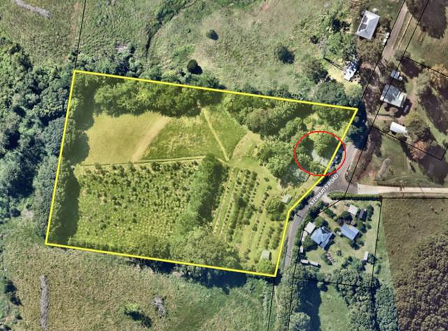
Figure 2: Existing dwelling
Planning Proposal
The planning proposal lodged by the proponent (Attachment 1) requests an amendment to Byron LEP 2014 to obtain a dwelling entitlement for Lot 10 DP 586360 on land zoned RU2.
The land contains an existing dwelling and the aim of the planning proposal is to establish a legislative mechanism to permit the lawful use of the dwelling with development consent.
Specifically, the planning proposal seeks to add the land to Byron LEP 2014: Part 6 – Additional local provisions to permit a dwelling with consent on Lot 10 DP 586360.
Planning Framework
North Coast Regional Plan
The site is located west of the Pacific Highway and is therefore not located in the coastal strip.
The most relevant NCRP objective is Objective 1: Provide well located homes to meet demand. The most relevant strategy is 1.2 Local Council plans are to encourage and facilitate a range of housing options in well located areas.
The proposal is consistent with the objectives and strategies of the NCRP and is consistent with Action No. 22 of the Byron Shire Rural Land Use Strategy 2017 (BSRLS) which recommends investigation into a strategic framework for resolving dwelling entitlement issues. This strategy was endorsed by the NSW DPE in July 2018.
Local Strategic Planning Statement
Council adopted a Local Strategic Planning Statement in September 2020 and it was subsequently agreed to by DPE.
The relevant planning priority in the LSPS (page 37) is:
“3. Support housing diversity and affordability with housing growth in the right locations.”
This planning proposal will be adding to the supply of housing stock in the shire by providing a mechanism to legalise an existing dwelling and is consistent with the adopted LSPS.
Site Specific Issues
Building encroachment on road reserve
During assessment of the planning proposal it became apparent that the existing dwelling may be located on Council’s road reserve.
Staff requested a survey to confirm the extent of any encroachment. A survey was provided demonstrating a significant encroachment of the dwelling by 7.82m on Council’s road reserve (Attachment 6).
Given the extent of the encroachment, Council staff provided the proponent with the following options:
1. Move the encroaching buildings / structures off the road reserve if they are built in a way that they could be moved.
2. Demolish the encroaching building / structures.
3. Negotiate with local landowners to realign the road reserve at nil cost to Council. This was identified as the most complex option. For this option to progress Council staff required the proponent to provide a proposed layout plan from which any potential issues could be identified.
The proponent chose to proceed with option 3 and a proposed layout plan was submitted.
The submitted layout plan was deemed unsatisfactory by Council staff as the proposed road reserve is too narrow and constrained for any potential future road changes. The proponent was advised that the minimum road reserve width is required to be 20m.
The proponent subsequently provided an alternate plan of realignment with a minimum 18m road reserve width representing a 10% variation to the typical 20m width.
Following an inspection by Council staff it was deemed that the proposed variation to allow a minimum road reserve width of 18m is appropriate in the circumstances.
To progress the rectification of this encroachment, the proponent has engaged with Council staff to undertake a road closure (for the portion of road reserve required to be obtained by the proponent) and with the neighbour on the eastern side of Stewarts Road for dedication of land to Council as road reserve. The road closure needs to be placed on a 28 day notification period with notification letters required to be sent to adjoining land owners who have the opportunity to make a submission. Crown and other state authorities also need to be advised of the closure. Following this, a resolution of Council is also required. The dedication of land to Council as road reserve will require a boundary adjustment.
It is estimated that the above process will take approximately 12 months to complete.
Council staff have determined that the road closure and dedication of land to Council as road reserve can take place as a separate process to the Planning Proposal and the encroachment can be rectified as part of a future Development Application seeking consent for the use of the subject dwelling. Staff are of the view that it would be an undesirable outcome to delay progression of the Planning Proposal until the encroachment is rectified.
Flooding
Flood modelling information available to Council indicates that the majority of the site (including the site of the existing dwelling) is not inundated during the Probable Maximum Flood (PMF).
Access to the site during a flood will not be compromised due to the elevation of the roadway and due to the slope of the site. There is no need to evacuate during a flood as the site has land above the PMF.
Traffic and roads
Stewarts Road has approximately 99 vehicles per day (2007 traffic counts) and is not expected to carry more than 150 vehicles per day. The road formation ranges from 4.5m to 5m and is sealed with grass verges. Council’s adopted engineering standards (Northern Rivers Local Government Development Design and Construction Manuals) requires a road formation for such daily traffic flows of a 6m seal with 0.5m shoulders. The current road formation does not comply with Council’s standards irrespective of a dwelling on the subject site and it is reasonable for the current formation to serve the additional 9 to 10 daily trips for a dwelling. It is noted that the additional traffic loading is only theoretical as the dwelling has been in use.
Bush fire
The entire site is mapped as bush fire prone land containing vegetation Category 3 (medium risk).
A Bushfire Assessment Report has been submitted to demonstrate that the proposal can reasonably comply with the requirements of Planning for Bush Fire Protection 2019. Asset Protection Zones have been identified within the report which can be achieved without removing any significant vegetation.
Council staff will consult with the Commissioner of the NSW Rural Fire Service following receipt of a gateway determination.
Land contamination
The applicant has supplied a preliminary contaminated land assessment carried out in accordance with the contaminated land planning guidelines. The subject land was identified as previously being used for agriculture (orchards) however the risk of significant contamination is negligible.
It is considered that soil sampling of the building envelope can occur at the DA stage, including any remedial works. Albeit the likelihood of organophosphates or organochlorine residues being present from historical use is low given the semi-volatile nature of these contaminants. Therefore the site is considered to be suitable and/or (can be made suitable after remediation) for the intended land use.
Aboriginal cultural heritage
The Jali and Ngulingah LALCs and the Arakwal Corporation will be consulted as part of the public exhibition of the planning proposal following a gateway determination. An AHIMS search undertaken by the applicant did not identify any aboriginal sites or places within proximity of the subject site.
Ecology
The land has been largely cleared of vegetation for dairy farming historically though there has been some regrowth of camphor laurel along the western boundary, subtropical rainforest along the northern boundary, landscape plantings around the dwelling, and a planted orchard in the south of the site. The subtropical rainforest is mapped as High Environmental Value Vegetation. This vegetation is located approximately 90m from the existing dwelling and will not be impacted by the proposal.
Developer Contributions / Planning Agreement
The planning proposal seeks to amend LEP 2014 so that a dwelling is permitted with consent on the subject site.
If a dwelling is permitted on the site, this will create additional demands on rural roads, community facilities, open spaces etc. Such demands are captured by the Byron Shire Developer Contributions Plan 2012 which requires a monetary contribution in accordance with the Plan and Section 7.11 of the Environmental Planning and Assessment Act 1979.
Ordinarily contributions would be paid at the time of subdivision for creating a lot with a dwelling entitlement equivalent to one Standard Dwelling Unit (SDU) (3 bedroom dwelling or greater). However, for the purposes of this planning proposal, there is no clear mechanism within the Contributions Plan for applying developer contributions.
Therefore, the submitted planning proposal has included a letter of offer to enter into a planning agreement with Council (Attachment 7). The offer proposes payment of a monetary contribution which is equivalent to one SDU.
Council staff have no justification to require additional contributions over and above the demand normally generated for a rural dwelling under the terms of the Contributions Plan 2012.
However, Council may resolve to apply different terms in the planning agreement if deemed reasonable and appropriate in the circumstances.
A formal agreement will need to be drafted and exhibited concurrently with the planning proposal.
Next steps
There are three options for Council to consider:
1. Proceed with the planning proposal contained in Attachment 1 to this report, which will facilitate the lawful use of the existing dwelling with Council consent. This option is subject to any requirements imposed by DPE in its Gateway determination; or
2. Proceed with the planning proposal in a modified form other than the version attached to this report; or
3. Not proceed with the planning proposal and advise the applicant accordingly.
There is sufficient information to support the planning proposal (see Attachments 2-7) and proceed to a Gateway submission. It is considered that no additional studies are required prior to public exhibition and agency consultation.
Strategic Considerations
Community Strategic Plan and Operational Plan
|
CSP Objective |
CSP Strategy |
DP Action |
Code |
OP Activity |
|
4: Ethical Growth |
4.1: Manage responsible development through effective place and space planning |
4.1.4: LEP & DCP - Review and update the Local Environmental Plan and Development Control Plans |
4.1.4.1 |
Assess requests to amend Local Environmental Plans and/or Development Control Plans including maps in accordance with legislative requirements. |
Recent Resolutions
· 20-283: that staff prepare an Unauthorised Residential Accommodation Policy as a matter of priority to confirm the planning pathways and consequences for unauthorised residential accommodation seeking regularisation in Byron Shire.
· 20-417: that the Draft Byron Shire Unauthorised Dwellings Policy be placed on public exhibition with a submissions report to be sent back to Council following the exhibition.
· 21-448: that Council agrees to the Draft Unauthorised Dwellings Policy being converted to a guideline document for internal use by staff to outline the process for reactive investigations initiated by complaints and owner-initiated actions.
Legal/Statutory/Policy Considerations
The relevant legal/statutory/policy considerations have been noted above.
Financial Considerations
If Council chooses to proceed with the planning proposal, it will be at the proponent’s expense as a landowner-initiated planning proposal. Full cost recovery of the remaining stages will be required by Council. If the applicant chooses not to pay then the planning proposal will not proceed. If Council chooses not to proceed, then the matter does not incur any additional costs.
Consultation and Engagement
If Council chooses to proceed with the planning proposal, it will be forwarded to the NSW Department of Planning & Environment for a Gateway determination. A positive determination will identify public exhibition requirements and government agency consultation requirements.
BYRON SHIRE COUNCIL
Staff Reports - Sustainable Environment and Economy 13.6
Report No. 13.6 PLANNING - 10.2014.361.4 s4.55 modification to relocated cafe from ground floor of the existing Waves Motel to a proposed rooftop terrace at 35 Lawson Street, Byron bay
Directorate: Sustainable Environment and Economy
Report Author: Chris Larkin, Manager Sustainable Development
File No: I2023/1344
Proposal:
|
Modification No |
10.2014.361.4 |
||
|
Planning Portal Ref |
PAN-272941 |
|
|
|
Proposed modification |
S4.55 to Relocate Part of a Food and Drink Component previously Approved within an Existing Motel Development from the Ground Floor to a Roof Terrace Area |
||
|
Original Development |
Alterations and additions to existing motel |
||
|
Type of modification sought |
4.55(2) Other modifications |
||
|
Property description |
LOT: 7 SEC: 8 DP: 758207 |
||
|
35 Lawson Street BYRON BAY |
|||
|
Parcel No/s |
116660 |
||
|
Applicant |
The Trustee for MP MANAGEMENT (AUST) HOLDINGS TRUST |
||
|
Owner |
MP Pacific Investments Pty Ltd |
||
|
Zoning |
E1 Local Centre |
||
|
Date received |
2 November 2022 |
||
|
Original DA determination date |
22 October 2014 |
||
|
Integrated Development |
No |
||
|
Public notification or exhibition |
- Level 2 advertising under the Byron Shire Council Community Participation Plan. - Exhibition period: 17/11/2022 to 30/11/2022 - Submissions received: 25 submitters (15 in support, 10 objections) |
||
|
Delegation to determination |
Council |
||
|
Issues |
· Building height · Car parking · Café/ restaurant capacity · Noise and amenity impacts |
||
Summary:
An application has been received to modify the approved building to relocate a food and drink premises, previously approved as a coffee shop within the ground floor lobby of the motel, to a create proposed rooftop café/ restaurant with a four storey form.
In addition to a 60-seat capacity seating area, this will include an enclosed kitchen/ back of house, toilets, storeroom, lift and stairway access to the roof, roof garden including a water feature, and a raised planter box around the roof’s perimeter.
A pergola structure is proposed above the seating area, with retractable shade cover, and bi-fold doors and windows to enclose the seating area.
The proposed modifications increase the maximum building height by approx. 2.7m above the previously approved roof line.
The roof level over the back of house facilities will be approx. 2.7m above the approved roof level (approx. 28% increase), with the pergola structure approx. 2.0m above the approved roof level (approx. 21% increase).
Based on the submitted plans, the area of the combined back of house and pergola area is approx. 240m2.
Other proposed modifications include:
· introduction of EV charging stations into the basement car park;
· provision of a “dumbwaiter” to link kitchen on ground floor with rooftop café/ restaurant; and
· amended access to the rooftop terrace to provide stair and lift access from level 2.
The proposed rooftop facilities significantly increase the height of the approved building, which was originally approved already with a variation to the 9m maximum height limit.
The floor space and capacity of the rooftop café/ restaurant is significantly in excess of the originally approved coffee shop, generating the need for additional car parking, which cannot be provided on site.
The proposed modification application is not in accordance with the relevant environmental planning instruments, including Byron Local Environmental Plan 2014 and Byron DCP 2014 and the section 4.55 application is recommended for refusal on the grounds listed in the Recommendation of this Report below.
NOTE TO COUNCILLORS:
In accordance with the provisions of S375A of the Local Government Act 1993, a Division is to be called whenever a motion for a planning decision is put to the meeting, for the purpose of recording voting on planning matters. Pursuant to clause 2(a) under the heading Matters to be Included in Minutes of Council Meetings of Council's adopted Code of Meeting Practice (as amended) a Division will be deemed to have been called by the mover and seconder of all motions relating to this report.
RECOMMENDATION:
It is recommended, pursuant to Section 4.55 of the Environmental Planning & Assessment Act 1979, that Application No. 10.2014.361.4, for S4.55 to Relocate Part of a Food and Drink Component previously Approved within an Existing Motel Development from the Ground Floor to a Roof Terrace Area, be refused for the following reasons:
1. Pursuant to section 4.15(1)(a)(i) of the Environmental Planning and Assessment Act 1979, the proposed development does not comply with Clause 4.3 Height of buildings under Byron Local Environmental Plan 2014.
2. Pursuant to section 4.15(1)(a)(i) of the Environmental Planning and Assessment Act 1979, the proposed development does not comply with Clause 4.4 Floor space ratio under Byron Local Environmental Plan 2014.
3. Pursuant to Section 4.15(1)(a)(iii) of the Environmental Planning and Assessment Act 1979, the proposed development does not comply with Chapter B4 Byron Development Control Plan 2014.
4. Pursuant to Section 4.15(1)(a)(iii) of the Environmental Planning and Assessment Act 1979, the proposed development does not comply with Chapter E10 Byron Development Control Plan 2014.
5. Pursuant to Section 4.15 (1)(b) of the Environmental Planning and Assessment Act 1979, the proposed development is likely to result in adverse environmental impacts on both the natural and built environments, and social impacts in the locality for the occupants of that environment.
6. Pursuant to Section 4.15(1)(d) of the Environmental Planning & Assessment Act 1979, the proposed development is not in the public interest with regards for relevant matters for consideration raised in properly made submissions received by Council.
Attachments:
1 10.2014.361.4
- Architectural Plans, E2023/95284
![]()
2 Confidential - 10.2014.361.4 submission received, E2023/97568
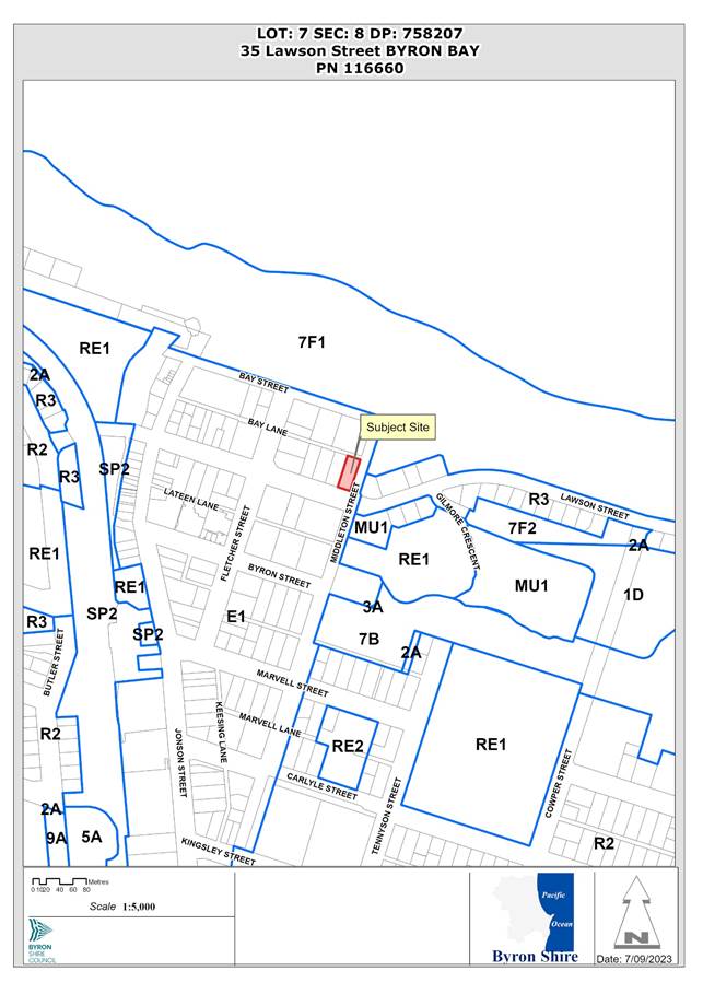
Assessment:
1. INTRODUCTION
1.1. History/Background

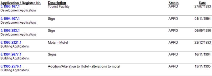
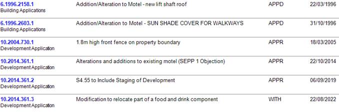
Consent 10.2014.361.1 approved alterations to the existing Waves Motel, involving reconstruction of the top floor to provide four (4) penthouse units and a swimming pool. This involved a redesigned roof, removing the existing curved roof elements, which slightly lowered the overall building height.
The existing lift (and lift overrun) were maintained. Other minor changes included amendments to the basement to better facilitate the 27-car parking spaces and reorientating a stairwell on the first floor. No works were proposed on the ground floor.
The consent was modified under 10.2014.361.2 to stage the approved works. The Stage 1 works (modification to car park access ramp) were commenced and the consent therefore remains valid.
Modification application 10.2014.361.3 was lodged in later 2022, proposing similar rooftop modifications as the current application, but was subsequently withdrawn by the applicant.
1.2. Description of the proposed development
This application seeks approval to modify the approved building to relocate a previously approved “coffee shop”, located within the ground floor lobby of the motel, from the ground floor to a new roof terrace area.
The relocation includes upgrading the food and drink premises from a coffee shop to a café/ restaurant with a 60-seat capacity seating area. It also proposes an enclosed kitchen/ back of house, toilets, storeroom, lift and stairway access to the roof; an open roof garden including a water feature, and a raised planter box around the roof’s perimeter.
A pergola structure is proposed above the seating area, with retractable shade cover, and bi-fold doors and windows enclose the seating area.
Other proposed modifications include:
· Introduction of EV charging stations into the basement car park;
· Provision of a “dumbwaiter” to link kitchen on ground floor with rooftop café/ restaurant; and
· Amend access to rooftop terrace to provide stair access from level 2.
Rooftop Restaurant/ Café:
Development consent 10.2014.361.1 approved changes to the upper floors of the existing motel building. The ground floor of the building, therefore, remains as originally approved under 5.1993.267.1 (see below).
The “coffee shop” was approved as an open area within the hotel lobby, with the approved plans showing a floor area of approx. 38m2 (see Figure 1).
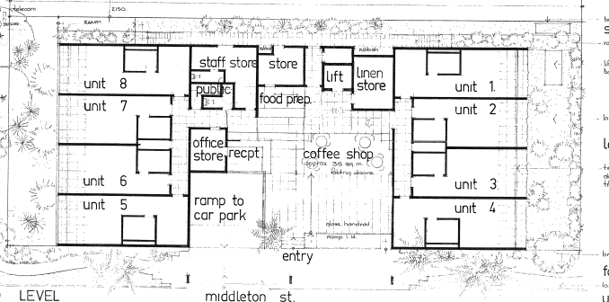
Figure 1: Existing ground floor as approved
The current proposal looks to relocate this approved “coffee shop” to a rooftop terrace, to create a new café/ restaurant.
The proposed café/ restaurant will have a capacity of 60 seats. It has a total area of approx. 240m2, including ‘back of house’, with a seating area of approx. 115m2. The kitchen/ back of house is within an enclosed area on the western side of the roof, and includes toilets and a storeroom, with solar panels proposed on the roof of this enclosure.
It is proposed to open to the general public in addition to guests of the hotel and will be licenced.
Proposed hours of operation are:
· Breakfast – 7am to 10:30am seven days per week
· Lunch and Dinner – Monday to Thursday – 10:30am – 10:00pm; Friday to Sunday – 10:30am – 11:00pm.
The proposed amendments to the roof include:
· Accessible toilet;
· Servery/bar and back of house;
· Storage/cool room;
· Pergola over the restaurant seating area, with external bifold doors;
· Landscaping works including turfed roof garden, planter boxes, rooftop water feature; and
· Solar panels.
Access to the restaurant/ café is proposed by way of stairs from Level 2. An existing lift connects the ground floor to Level 2, and a new smaller lift is proposed to extend to the roof.
Figure 2: Proposed Roof Plan

The pergola will be open to the sky but provides opportunity for a retractable shade cloth or similar to be strung across. The pergola has bifold doors around the perimeter to contain noise after 6pm.
Other Proposed Amendments
Other proposed changes include:
· Provision of an internal ‘dumbwaiter’ adjacent to the existing lift, linking the kitchen on the ground floor to the rooftop café/ restaurant (dumbwaiter also extends to basement).
· Addition of three (3) EV chargers into the basement car park.
· New stairs linking the second floor pool deck to the rooftop café/ restaurant. To maintain accessibility a separate lift will is also proposed to link the second floor to the rooftop.
· Solar panels are proposed, located on the roof of the rooftop kitchen/ back of house and amenities.
1.3. Description of the site
The site was inspected on 24 August 2023.
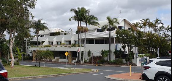
|
Land is legally described |
LOT: 7 SEC: 8 DP: 758207 |
||
|
Property address |
35 Lawson Street BYRON BAY |
||
|
Land is zoned: |
E1 Local Centre |
||
|
Land area is: |
1,012m2 |
||
|
Constraints: |
Acid Sulfate Soils (Class 5) |
||
|
|
Bushfire Prone Land (Vegetation Buffer) |
||
|
|
Coastal Erosion (Precinct 2) |
||
|
|
Flood Prone Land (southern part of site) |
||
|
|
Is a BDAR required due to the location of the proposed development? |
☐ Yes ☒ No |
|
|
|
Are there any easements in favour of Council affecting the site? |
☐ Yes ☒ No |
|
|
|
Is there a Vegetation Management Plan which might affect the proposal? |
☐ Yes ☒ No |
|
|
|
Is there a Voluntary Planning Agreement which might affect the proposal? |
☐ Yes ☒ No |
|
The property contains the existing Waves Motel and is located in the Byron CBD, with easy pedestrian access to shops, restaurants and the beach. Surrounding development comprises a mixture of tourist accommodation and commercial/ retail businesses.
The motel contains 20 units, two of which are approved for residential use (top level), and a basement car park for 27 vehicles. Development consent 10.2014.361.1 provides for conversion of the top floor to create four (4) units. The first stage of that consent has been activated, and the consent remains valid, although the top floor renovations have not yet been undertaken.
2. SECTION 4.55(2)
|
Section 4.55(2) |
The Applicant is a person entitled to act on the consent. The applicable provisions of the Regulation are considered below. The development to which the consent as modified relates is substantially the same as the originally approved development. The proposed development remains for alterations and additions to an existing motel. The application retains the overall built form approved under DA 10.2014.361.1 (as modified), noting that the main modification is the relocation of part of the approved ground floor restaurant/café to the roof level and including landscaping, solar panels, water saving provisions and electric vehicle charging stations. Consultation was not required with the Minister, public authority or an integrated development approval body in relation to the original development application. Public notification of the application, including consideration of any submissions received if applicable, is discussed in this report below. |
|
Section 4.55(3) |
Section 4.15(1) matters are considered below. |
|
Section 4.55(4) |
The modification to the development consent is not the granting of a consent. The modified consent becomes the consent. |
|
Section 4.55(6) |
The deemed refusal provisions are noted. |
|
Section 4.55(8) |
The Court was not involved in the original development consent and is not involved in the current section 96 application. |
3. ENVIRONMENTAL PLANNING AND ASSESSMENT REGULATION 2021
|
Part 5, Division 1 |
Landowner’s consent has been provided with the application. The application has been made via the Planning Portal and is in the approved form and contains all the information and documents sufficient for it to be properly assessed. In accordance with the Regulation, motel accommodation is not BASIX development. |
|
Section 106 |
The original development application was not for designated development, State significant development, nominated integrated development, threatened species development, Class 1 aquaculture development or to development consent granted by the Court on appeal. |
|
Section 107 |
The application was advertised in accordance with Council’s Community Participation Plan, in the same way as the original application. |
|
Section 109 |
The were no concurrence authorities and approval bodies for the original development application. |
4. SUMMARY OF REFERRALS
|
Referral |
Issue |
|
Environmental Health Officer |
No objections subject to conditions, following receipt of updated acoustic assessment. I accept the acoustic consultants’ modelling and findings, except for their suggestion to allow the use of the evening shoulder period background noise levels as the target noise criteria. The suggestion is that the background noise levels experienced during the evening period should continue to apply for the 10pm - 11pm period, when setting the Project Noise Trigger Levels. This argument is used to justify the operation of the business beyond 10pm. It is clear in the provided background noise level assessment, and background noise level assessments from assessments conducted at 33 Lawson St, that the ambient noise in the area drops rapidly after 10pm. Especially for those residents most affected by the development, which are screened by the Waves Motel from the town centre and the traffic on Lawson St. The proposed café/bar is supported however operations after 10pm are not supported, in order to minimise the risk of sleep disturbance to the surrounding residents. |
|
Development Engineer |
Car parking assessment - a total requirement for 34 spaces, the site contains 27 spaces, with no opportunity to provide the deficit of 7 spaces.
|
|
ET Engineer |
No objections subject to conditions. |
5. SECTION 4.14 – BUSH FIRE PRONE LAND
Under section 4.14 of the Act, Council must be satisfied prior to making a determination for development on bush fire prone land, that the development complies with the document Planning for Bush Fire Protection 2019. The site was not bush fire prone land at the time of the original consent. However, it has since become bush fire prone land through updated bush fire prone land mapping.
The bush fire prone land map extract below shows that the site is within the 100m buffer to mapped bush fire hazard vegetation. However, the only mapped hazard vegetation within 100m of the site is the parkland area on the eastern side of Middleton Street between the Library and the Court House.
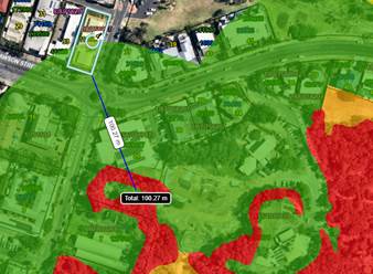
The part of the hazard that is within 100m of the site is considered to be a modified landscapes and the exclusions of AS 3959 are considered to apply, and is not required to be considered for the purposes of Planning for Bush Fire Protection 2019, because it is vegetation regarded as low threat due to factors such as flammability, moisture content or fuel load, being a maintained public reserve and parkland.
EFFECT OF 10/50 RULE ON SIGNIFICANT VEGETATION
There is no significant vegetation on the site which might be adversely affected by the 10/50 Rule requiring a protective condition.
6. SECTION 4.15 – MATTERS FOR CONSIDERATION – DISCUSSION OF ISSUES
Having regard to the matters for consideration detailed in Section 4.15(1) of the Environmental Planning & Assessment Act 1979 (EP&A Act), the following is a summary of the evaluation of the issues.
6.1. State Environmental Planning Instruments
|
Considerations |
Satisfactory |
Unsatisfactory |
|
Biodiversity and Conservation SEPP 2021 Consideration: There is no high environmental value vegetation or potential koala habitat mapped for this site. |
☒ |
☐ |
|
Resilience and Hazards SEPP 2021 Consideration: Council’s Environmental Health Officer raised no objection to the original DA in relation to potential contamination, noting that the proposal represents the continuation of the approved residential land use. Council’s EHO raised no objection to the proposed modification in this regard. Coastal Management The site is mapped as: · partly in Coastal Environment Area (northern part of property) · wholly within the Coastal Use Area · partly within proximity area to Coastal Wetland – wetland mapped to the south of library site. The proposed development does not raise any issues associated with coastal impact considerations within the SEPP. |
☒ |
☐ |
6.2. Byron Local Environmental Plan 2014 (LEP 2014)
In accordance with LEP 2014 clauses 1.4 and 2.1 – 2.3:
(a) The overall development is defined in the LEP 2014 Dictionary as hotel or motel accommodation, which is a type of tourist and visitor accommodation. The rooftop café/ restaurant is defined as restaurant or café, which is a type of food and drink premises.
(b) The land is within the E1 Local Centre zone according to the Land Zoning Map;
(c) The modified development remains permitted with consent; and
(d) The modified proposal remains satisfactory having regard to the Zone Objectives.
Clause 4.3 Height of buildings
The Height of Buildings Map specifies a maximum height of 9m for this site.
The existing building, as approved under 5.1993.167.1, has a maximum height of approx. 11m to the ridge of the curved roof elements.
The building modifications approved under DA 10.2014.361.1 provide for a maximum height of approx. 9.5m-10m to roof level, with a lift overrun at a maximum height of approx. 11.5m.
The building as proposed in this modification application includes rooftop facilities at the following heights:
· balustrades – approx. 10.5m
· pergola over café/ restaurant – approx. 11.5m
· roof over back of house facilities (including solar panels) – approx. 12.2m
· top of roof lift – approx. 12.1m
The proposed modifications therefore increase the maximum building height by approx. 2.7m above the previously approved roof line, and approx. 1.3m above the previously approved lift overrun.
The roof level over the back of house facilities will be approx. 2.7m above the approved roof level (approx. 28% increase), with the pergola structure approx. 2m above the approved roof level (approx. 21% increase).
Based on the submitted plans, the area of the combined back of house and pergola area is approx. 240m2.
The further variation to the roof height is not supported as there are no valid environmental grounds or planning reasons to vary the height limit further than originally approved, and he application is not supported.
Clause 4.4 Floor space ratio
The FSR map indicates a maximum FSR of 1.3:1 for this site.
The definition of gross floor area means the sum of the floor area of each floor of a building measured from the internal face of external walls. It excludes plant rooms, lift towers and stairs.
Based on this definition, the back of house facilities generate additional floor space of approx. 40m2.
The application indicates that the approved building has an FSR of 1.38:1. The addition of 40m2 of floor space, increases the FSR to 1.4:1, increasing the exceedance of the standard from 6.1% to 7.6%.
The further variation to the FSR is not supported as there are no environmental or planning reasons to support this level of intensification to the approved development.
6.3. Any proposed Instrument that has been the subject of public consultation and has been notified to the consent authority
There are no proposed instruments of significant applicability to the proposal.
6.4. Byron Shire Development Control Plan 2014 (DCP 2014)
The following comments are provided on the relevant chapters of the DCP 2014 pertinetn to this application.
B4 Traffic and Parking
Council’s Development Engineer’s parking assessment is outlined below:
· Parking Assessment
Current Proposal 10.2014.361.4
Café:
· Up to 60 pax
· Open up to 10PM Monday to Thursday
· Open up to 11PM Friday to Sunday
· Number of Staff to be between 3 to 8


Restaurant (11 spaces)
Parking Supply = 220m2 GFA x 1 space per 20m2 GFA = 11 spaces
Motel/Hotel (23 spaces)
Parking Supply = 22 rooms x 1 space per room = 22 spaces
On-site Manager = 1 space
Total Parking Supply required is 34 spaces
Outcome
· Parking Available = 27 parking spaces
· Deficiency of 7 parking spaces
The proposed development is non complaint with the car parking requirements contained in Council’s Development Control plan and there is no opportunity to provide more onsite spaces on this site. The applicant has not offered any alternative to address the car parking deficiency and the application is therefore not supported.
E10 Byron Bay Town Centre
E10.2.3 Built form – Relevant Prescriptive Measures:
2. Where the Byron LEP 2014 Height of Buildings Map specifies a maximum height of 9m, buildings must not contain more than two storeys.
The subject development has been approved in a three storey built form and already exceeds the 9 m height limit. The additional facilities on the roof now give the building a four storey built form in an area which the planning controls specify a two storey built form. In the event that the proposal needs to have a larger restaurant café area to be financially viable this could be designed into the third level around the swimming pool at the expense of a tourist unit or two, and without adding further to the approved bulk, scale, and height of the development. This would be a matter for the applicants to consider as an alternative and resubmit at an appropriate time.
3. Roof-top recreation or commercial facilities must not contravene the maximum building height standard.
As discussed above, the proposed rooftop facilities contravene the maximum building height, above the height exceedance approved under 10.2014.361.1.
4. Buildings are to have minimum floor to ceiling heights of:
a. ground floor: 4.0m
b. first floor: 3.3m
c. second floor: 2.7m
The building does not comply but is subject of an existing approval.
E10.2.9 Roof form, access and use – Relevant Prescriptive Measure
5. Roof-top recreation spaces should be intended primarily for the occupants of that building, and should not be readily accessible to the general public
The rooftop café/ restaurant is proposed to be open to the general public.
The proposed development is non complaint with the DCP provisions. The applicant has not offered any justification for the non-compliance and, as such, the application is recommended for refusal.
6.5. Environmental Planning & Assessment Regulation 2021 Considerations
|
Clause |
This control is applicable to the proposal: |
I have considered this control as it relates to the proposal: |
If this control is applicable, does the proposal comply? |
|
61 |
Yes |
Yes |
Yes |
|
62 |
No |
N/A |
N/A |
|
64 |
No |
N/A |
N/A |
6.6. The likely impacts of that development, including environmental impacts on both the natural and built environments, and social and economic impacts in the locality
|
Impact on: |
Likely significant impact/s? |
|
Natural environment |
No. The proposal will not have a significantly adverse impact on the natural environment of the locality. |
|
Built environment |
Yes. The proposal will have a significantly adverse impact on the built environment of the locality. The existing building immediately adjacent to the site, to the west, is single-storey in height, containing an older-style motel. It is reasonable to expect that site to be redeveloped in the future, and approval of the additional height exceedance proposed in the current application would set a precedent for such redevelopment. |
|
Social Environment |
Yes. The proposal creates the potential for a significant social impact on the locality in terms of noise from late night patrons. These impacts could be managed through strict adherence with the recommendations of the acoustic report submitted with the application if the application was approved. |
|
Economic impact |
No. The proposal will not have a significant economic impact on the locality. |
|
Construction Impacts |
No. The proposal will not generate impacts during construction. Existing conditions of consent to control hours of work, builders waste, construction noise, installation of sedimentation and erosion control measures and the like to ameliorate such impacts are not proposed to be modified. |
It is considered the proposal should be refused based on the potential impacts on the built environment, particularly associated with the increased building height and non-compliance with the relevant development standard.
6.7. The suitability of the site for the development
The site is a serviced property with access to water, sewer, drainage, electricity and communication services. The site is suitable for tourist and visitor accommodation use.
Notwithstanding, the site is not suitable for the proposed modification to the original development without adversely impacting adjoining properties and cannot be accommodated within the site without significant breaches of Council's development standards and development control requirements.
6.8. Submissions made in accordance with this Act or the regulations
The application was publicly exhibited. There were 25 submissions made on the application:
· 10 in objection
· 15 in support
|
Issue |
Consideration |
|
Objection |
|
|
Amenity impacts associated with noise and lighting from patrons of the rooftop café/ restaurant Noise amelioration measures of concern – rely on closing of bifold doors after 6pm – difficult to enforce. |
An acoustic assessment has been submitted in support of the application concluding that, subject to a number of recommendations, the proposal will be within acceptable levels of the relevant noise criteria. Recommendations include closing the bifold doors after 6.00pm, limiting patron numbers to a maximum of 60, restricting access to the rooftop gardens to hotel guests, and no live music. Council’s Environmental Health Office has reviewed the report and accepts its conclusion, other than recommending that the hours of operation be limited to 10.00pm rather than 11.pm as proposed. Lighting plans have also been submitted showing downward facing lights within rooftop area, with minimal light spill. Compliance with the acoustic report recommendations would be the responsibility of the restaurant operator and there is potential for local conflicts if all recommendations are not strictly enforced. |
|
Development is not compatible with character and amenity of the immediate area. |
The submission suggests that the immediate area contains tourist accommodation largely frequented by couples and families staying in short term accommodation, which is somewhat removed from the restaurant and night-life venues in the Town centre. While the site is located at the edge of the town centre, there are other night-life venues close by, notably the Aquarius Backpackers Hotel across the road. There are, however, no commercial rooftop premises in the immediate area. |
|
Development exceeds the height limit and existing approval provide an already considerable height concession. |
The issue of building height is discussed in detail above, noting that the proposed modifications propose a significant increase in height of the building, which was previously approved above the 9m height limit. |
|
Support |
|
|
Most of the rooftop facilities will not be visible from the street. |
The architect’s render is shown below, indicating that the eastern part of the bifold doors would be visible from Middleton Street and the beachfront open space to the east.
Night-time views would be exacerbated by the café/ restaurant lighting. |
|
Proposed rooftop restaurant will add to the Town Centre’s tourism offering. Support for open-air restaurant. |
The potential benefits of additional Town Centre commercial / tourism facilities need to be balanced with the requirements of existing legislation and policy. |
|
Moving café from lobby space to rooftop will provide a better facility. |
As above, potential benefits need to balanced with the requirements of existing legislation and policy |
6.9. Public interest
The original application was approved with an exceedance of the 9.0m maximum building height largely because the roof height was consistent with the existing curved roof elements of the motel building.
The proposed amendment now seeks approval for additional height and what is partially a fourth storey, which was not envisaged in the original proposal. It is considered the proposal is likely to prejudice or compromise the public interest and create an undesirable precedent.
Council previously considered the building height limit for this part of the Town Centre when updating Town Centre Planning Controls in May 2021. The potential to increase the 9.0m building height limit for this area of the town centre was specifically considered at that time and rejected. In the absence of any planning proposals to further amend or review the LEP, it is clear the Council seeks to limit building height in this area of Byron Bay accordingly.
Based on the maintenance of the 9.0m limit for this section of the Town Centre, and the relationship of the building to its neighbours and adjoining public spaces, the additional height proposed by this modification is not considered to be in the public interest.
7. DEVELOPER CONTRIBUTIONS
7.1. Water & Sewer Levies
Section 64 levies will be payable.
7.2. Section 7.11 Contributions
No Section 7.11 Contributions will be required.
8. CONCLUSION
The proposed modification with its additional roof top level and increased floor area is not supported. The proposed rooftop facilities significantly increase the height of the approved building, which was originally approved with a variation to the 9m maximum height limit.
The additional height exceedance is also inconsistent with the DCP provisions for the town centre and a further variation to the height controls are not supported. The floor space and capacity of the rooftop café/ restaurant is significantly in excess of the originally approved coffee shop, generating the need for additional car parking, which cannot be provided on site.
The section 4.55 application is recommended for refusal on the grounds listed in the recommendation of this report.
BYRON SHIRE COUNCIL
Staff Reports - Sustainable Environment and Economy 13.7
Report No. 13.7 PLANNING - Report of the Planning Review Committee held 7 September 2023
Directorate: Sustainable Environment and Economy
Report Author: Chris Larkin, Manager Sustainable Development
File No: I2023/1378
Summary:
This report provides the outcome of the Planning Review Committee (PRC) held on 7 September 2023.
NOTE TO COUNCILLORS:
In accordance with the provisions of S375A of the Local Government Act 1993, a Division is to be called whenever a motion for a planning decision is put to the meeting, for the purpose of recording voting on planning matters. Pursuant to clause 2(a) under the heading Matters to be Included in Minutes of Council Meetings of Council's adopted Code of Meeting Practice (as amended) a Division will be deemed to have been called by the mover and seconder of all motions relating to this report.
RECOMMENDATION:
That Council endorses the outcomes of the Planning Review Committee meeting held 7 September 2023.
Report
The Planning Review Committee meeting was held on 7 September 2023. The meeting commenced at 4:35pm and concluded at 5:10pm.
Councillors: Mayor Cr M Lyon, Cr A Hunter, Cr D Dey, Cr P Westheimer.
Apologies: Cr S Ndiaye, Cr S Balson.
Staff: Chris Larkin (Manager Sustainable Development), Shannon Burt (Director of Sustainable Environment & Economy)
Conflict of Interest: None declared.
The following development applications were reviewed with the outcome shown in the final column.
|
DA No. / Applicant |
Property Address / Proposal |
Consultation / Submissions |
Reason/s / Outcome |
|
10.2023.230.1 |
1390 Hinterland Way Temporary Use of land for Function Centre |
Level 1 18/7/23 to 31/7/23 6 submissions |
The perceived public significance of the application Council |
|
10.2023.149.1 |
114 Old Bangalow Rd Use of Alterations to Garage and Use of Swimming Pool Amenities Building |
Level 2 27/6/23 to 10/7/23 1 submission |
Staff Delegation |
|
10.2023.29.1 |
18 Gardenia Court Subdivision One (1) Lot into Two (2) Lots and Dwelling House on Lot 1 |
Level 1 17/28/23 to 2/3/23
|
Staff Delegation |
The following development applications were reviewed with the outcome shown in the final column.
Council determined the following original development applications. The S.4.55 applications to modify those consents were referred to the Planning Review Committee to decide if the modification applications can be determined under delegated authority with the outcome shown in the final column.
|
DA No. / Applicant |
Property Address / Proposal |
Consultation / Submissions |
Reason/s / Outcome |
|
10.2021.153.2 |
121 Orana Road Modification - 4.55 to modify roof colour from “Colorbond Windspray” to “Colorbond Surfmist” and to delete Swimming Pool from House B |
Level 1
19/7/23 to 1/8/2023 9 submissions |
Staff Delegation |
|
10.2021.291.4 |
116-118 Jonson St Modification - Demolition of the existing backpacker's hostel and construction of Mixed-Use development comprising Retail Premises and Serviced Apartments |
Level 2 28/7/20 to 10/8/23 1 submission
|
Staff Delegation |
|
10.2017.198.2 |
9 Station Street Modification to Mixed Use Development Comprising Commercial Premises (for use as Shop, Restaurant or Cafe or Office Premises) and Shop Top Housing
|
Level 2 10/8/23 to 23/8/23 3 submissions |
Staff Delegation |
BYRON SHIRE COUNCIL
Staff Reports - Sustainable Environment and Economy 13.8
Report No. 13.8 Amendment to Fees and Charges 2023/24 - Reinstatement of use of Council land/road reserve to enable construction work events or temporary use
Directorate: Sustainable Environment and Economy
Report Author: Kylie Grainey, Business Improvement Officer
Heather Sills, Manager Corporate Services
File No: I2023/1484
Summary:
The reinstatement of fees for the use of Council land or road reserves to enable construction works, events or temporary use were exhibited between 29 August and 27 September 2023.
Five submissions supporting the reinstatement of these fees were received.
This report seeks adopt the fees and incorporate them into the 2023/24 fees and charges.
RECOMMENDATION:
That Council adopt the fees for use of Council land/road reserve to enable construction work events or temporary use as exhibited:
- Application fee - $215
(Eg. Hoarding, scaffolding, fencing, works zones, other temporary structures or traffic control device/s)
- Inspection fee - $215
per hour (minimum 2 inspections with application – further inspections to be paid as required, eg. change to work zone)
- Urgency fee - $215
Where use is required within 10 working days of the application being lodged.
- Low Impact Occupation of Council Land - $1.00 per m2 / day
Where pedestrian, cyclist and vehicular traffic are not disrupted, includes public reserves.
- Footpath / verge closure - $3.00 per m2 / day
§ Where the footpath / verge area is closed to pedestrians and/or cyclists.
§ Where an elevated gantry is installed, fees will be charged for the set up and takedown down then charged at a low impact Occupation rate for the period of occupation.
- Road Closure (full and partial) $13.00 per m2 / day
Where the traffic lanes are closed to traffic.
Report
Fees for the use of Council land or road reserves to enable construction works, events or temporary were inadvertently removed from Council’s Fees and Charges earlier in 2023.
A report (13.12) to the Ordinary meeting on 24 August 2023 recommended exhibiting the previously approved fees for reinstatement into the 2023/24 Fees and Charges.
The proposed fees exhibited between 29 August and 27 September 2023 on Council’s website. During this period, five submissions supporting the proposed fees were received. The submissions are provided below.
This report seeks adopt the fees and incorporate them into the 2023/24 fees and charges.
Proposed fees
- Application fee - $215
(Eg. Hoarding, scaffolding, fencing, works zones, other temporary structures or traffic control device/s)
- Inspection fee - $215
per hour (minimum 2 inspections with application – further inspections to be paid as required, eg. change to work zone)
- Urgency fee - $215
Where use is required within 10 working days of the application being lodged.
- Low Impact Occupation of Council Land - $1.00 per m2 / day
Where pedestrian, cyclist and vehicular traffic are not disrupted, includes public reserves.
- Footpath / verge closure - $3.00 per m2 / day
§ Where the footpath / verge area is closed to pedestrians and/or cyclists.
§ Where an elevated gantry is installed, fees will be charged for the set up and takedown down then charged at a low impact Occupation rate for the period of occupation.
- Road Closure (full and partial) $13.00 per m2 / day
Where the traffic lanes are closed to traffic.
Submissions
|
1. |
I am writing to support the proposed fees for the use of Council land and road reserves for construction work, events or temporary use. We thank Council for fixing the problem of the disproportionate fees last year and we are humbly seeking to have these fees retained moving forward. There isn’t any desire or incentive on the part of a developer to use public land for longer than is absolutely necessary. |
|
2. |
I would like to support the reduction of fees for use of council land/road reserve to allow contractors and all those involved with the upgrade of the Byron town buildings, surroundings and infrastructure to occur cost effectively. Thankyou |
|
3. |
Dear Council
Staff, |
|
4. |
I attended
public access regarding this matter back in June 2022. Councillors listened
at that time and I was most grateful, as were many others affected by the
fees and charges at that time. |
|
5. |
There are so
many costs associated with delivering a development. Some of this have risen
so dramatically in the past couple of years that a project that looked viable
at one time may not be 12 or even three months later. There is a perception
that developers are greedy, that they could be seen as a “cash
cow” for a community in challenged times. However the reality is that
it is nearly impossible to build at this time, given the fluctuating building
costs, lack of staffing and contractors. Communities need quality
developments and to be able to provide these a developer needs a level playing
field to begin with. They need to be given a fair chance. Otherwise we are
going to see more and more projects not going ahead. We will see quality
finishes pared back to bring costs down. So I am in favour of retaining the
reasonable fees that were put forward earlier for use of Council land and
road reserve. |
Strategic Considerations
Community Strategic Plan and Operational Plan
|
CSP Objective |
CSP Strategy |
DP Action |
Code |
OP Activity |
||
|
4: Ethical
Growth |
4.1: Manage responsible development through effective place and space planning |
4.1.1: Development assessment - Manage development through a transparent and efficient assessment process |
4.1.1.2 |
Certify development in accordance with relevant legislation. |
||
Recent Resolutions
· 22-332 part 4 (Prepares a report to be delivered in September to provide options regarding fee structure for use of parking spaces and road reserves adjacent to construction sites for construction temporary use and events with the financial implications).
· 23-115 –adoption of the amended fees for “Use of Council land/road reserve to enable construction work, events or temporary use” to commence from 1 May 2023.
· 23-280 – adoption of 2023/24 Fees and Charges
· 23-368 - reinstate footpath usage fees for use of Council land/road reserve to enable construction work events or temporary use
Legal/Statutory/Policy Considerations
This report proposes changes to the current revenue policy as it proposes to reintroduce fees for the use of council land / road reserves. s610F of the Local Government Act 1993 requires the public notice of fees, where fees are proposed to be amended outside adoption of the Operational Plan, as outlined below:
610F Public notice of fees
1) A council must not determine the amount of a fee until it has given public notice of the fee in accordance with this section and has considered any submissions duly made to it during the period of public notice.
2) Public notice of the amount of a proposed fee must be given (in accordance with the regulations) in the draft operational plan for the year in which the fee is to be made.
3) However,
if, after the date on which the operational plan commences—
a) a new service is provided, or the nature or extent of an existing service is changed, or
b) the regulations in accordance with which the fee is determined are amended, the council must give public notice (in accordance with section 705) for at least 28 days of the fee proposed for the new or changed service or the fee determined in accordance with the amended regulations.
Financial Considerations
The adoption of these fees will reinstate charges for use of Council land/road reserves to enable construction work, events or temporary use.
Consultation and Engagement
The amendments to fees and charges were exhibited between 29 August and 27 September 2023.
BYRON SHIRE COUNCIL
Questions With Notice 14.1
Question with Notice No. 14.1 South Golden Beach and Marshall Creek flood areas
File No: I2023/1447
At Council’s Planning Meeting held on 14 September 2023, Kathy Norley, representing South Golden Beach Community, asked the following question which was taken on notice:
When did the North Byron Flood Management Plain with no fill change? Information suggests an “Amendment” was made in Council approximately 2 years ago.
Is there still no fill in the Marshall Creek flood plain, and if not, who changed it, why not and who is going to be responsible for any future flooding that may occur when this has been allowed to happen?
Response Director: Infrastructure Services
Marshalls Creek Catchment was assessed under the North Byron Floodplain Risk and Management Study and Plan (NBFRMS&P). The NBFRMS&P was placed on public exhibition in April 2020. It was endorsed by the Floodplain Management Advisory Committee on 20 August 2020 subject to further investigation and modelling of flood mitigation activities such as dredging/ocean outfalls/training walls and bund modifications.
These scenarios were investigated & assessed within the adopted NBFRMSP.
Full Council endorsed the North Byron Floodplain Risk and Management Study and Plan at its meeting held on 26 November 2020
Here is a link to that document North Byron Floodplain Risk Management Study and Plan - Byron Shire Council (nsw.gov.au) which is located on Council’s Website
The adopted report included information in respect to fill exclusion zones covering the Marshalls Creek Catchment.
The Fill Exclusion Layer is publicly available on Council’s Online Mapping site. The layer is located under the Flood Information Layer. Here is a link to Council’s online mapping system. Byron Shire Council Web Map (arcgis.com)
BYRON SHIRE COUNCIL
Questions With Notice 14.3
Question with Notice No. 14.2 Changing the Criteria for Northern Rivers Reconstruction Corporation (NRRC) Funding
File No: I2023/1448
At Council’s Ordinary Meeting held on 14 September 2023, Noelle Maxwell, representing Byron Shire Flood Recovery Group, asked the following question which was taken on notice:
How can we change the criteria that everyone in the Byron Shire has had to meet for NRRC funding?
Response A/Director Corporate and Community Services:
It has been assumed this question relates to the Resilient Homes Program (RHP), previously administered by the Northern Rivers Reconstruction Corporation (NRRC), which is now administered through NSW Reconstruction Authority (since the amalgamation of NRRC into NSW Reconstruction Authority earlier in 2023). The criteria for the RHP is established by the NSW Government. Council recognises that many residents of Byron Shire have been excluded from the RHP eligibility criteria and that this is a very disappointing outcome for disaster impacted people. It is Council’s understanding that the available RHP funding will be allocated based on the established eligibility criteria, and that further funding has not (to date) been made available. Should further funding be available for RHP, it is Council’s assumption that changes to the eligibility criteria could be considered by NSW Reconstruction Authority as a way to assist more disaster impacted people.
In April 2023 Council facilitated a public meeting online with the then Northern Rivers Reconstruction Corporation who provided an outline of the RHP program and there was the opportunity for questions to the Corporation to be raised. A link to this meeting can be found here: Byron Shire Council Community Meeting with the Northern Rivers Reconstruction Corporation - YouTube
Given the RHP program is not controlled by Council, Council cannot change the eligibility criteria for the RHP program as it stands but there is information at the following link that includes how to apply, internal review and appeals along with individual and exceptional circumstances policy and frequently asked questions that may be of assistance.
Resilient Homes Program | NSW Government
Aside from the information above, unfortunately the question raised cannot be directly answered by Council as the RHP is managed by the NSW Government.
Question with Notice No. 14.3 Wallum Development Application at Bayside Brunswick Heads
File No: I2023/1476
Cr Dey asks the following questions:
The NRPP determined DA 10. 2021.575.1 in May 2023 after public exhibition garnered 13 submissions against the proposal as submitted in 2021. Since then several ecologists and others have raised issues about the development. Some of these go to processes which are now complete but there is still value in responding to such questions. I therefore ask:
1. Page 11 of the DA assessment report states that a BDAR (Biodiversity Development Assessment Report) is required. I understand that that BDAR was completed by AWC in 2022. Is the BDAR publicly available?
2. Are the offsets described in the BDAR on land which will be newly conserved or on land already due for conservation (for instance, conservation as proposed in the Coastal SEPP or in DCP2010)? Unless land is offset off the property, the overall site suffers a net loss of biodiversity.
3. Page 33 of the DA assessment report states "prior to the issue of a Construction Certificate for each stage...". In May was "Stage 1 for 26 Lots in an approved concept plan" approved or was the whole "Staged Subdivision to create One Hundred and Twenty Seven lots"?
4. Did Council have a suitably qualified ecologist review the ecological aspects of the DA, especially Plans like the Vegetation Management Plan (VMP)?
5. Will consideration of the Mitchells Rainforest Snail be included in the Amended VMP required under Consent Condition 6 and will this aspect be reviewed by a suitably qualified ecologist?
6. Does the requirement articulated in the 2010 DCP for the site still hold sway in requiring that the development "Retain as many scribbly gums as practical as landscape features"? Why is this requirement not factored into the development footprint?
7. Has the downstream land owner given permission for the disposal of stormwater from the approved development? I understand National Parks once refused permission to allow the release of stormwater into the nature reserve.
Response Director Sustainable Environment and Economy:
1. Page 11 of the DA assessment report states that a BDAR (Biodiversity Development Assessment Report) is required. I understand that that BDAR was completed by AWC in 2022. Is the BDAR publicly available?
BDAR was lodged as a contingency in case Clause 34a application was not successful. Transitional arrangements are provided by Clause 34A, Biodiversity Conservation Savings &Transition Regulation (S&T Regulation) to recognise past offsetting agreements secured as part of a concept plan approval or a relevant planning arrangement. These offsets were established in the Concept Plan. Accordingly, the BDAR was not ultimately required and hence formed no part of the assessment process.
Open access information for councils includes information about development applications made on or after 1 July 2010 including associated documents and records of decisions.
Link here for Access to information - Byron Shire Council (nsw.gov.au)
2. Are the offsets described in the BDAR on land which will be newly conserved or on land already due for conservation (for instance, conservation as proposed in the Coastal SEPP or in DCP2010)? Unless land is offset off the property, the overall site suffers a net loss of biodiversity.
Offsets for the project were established in the Concept Plan Approval and are entirely contained within the subject site.
3. Page 33 of the DA assessment report states "prior to the issue of a Construction Certificate for each stage...". In May was "Stage 1 for 26 Lots in an approved concept plan" approved or was the whole "Staged Subdivision to create One Hundred and Twenty-Seven lots"?
The Development Consent covers all stages of the subdivision, with the SWC to be also completed in stages.
4. Did Council have a suitably qualified ecologist review the ecological aspects of the DA, especially Plans like the Vegetation Management Plan (VMP)?
Yes, a suitably qualified ecologist reviewed the ecological aspects of the DA.
5. Will consideration of the Mitchells Rainforest Snail be included in the Amended VMP required under Consent Condition 6 and will this aspect be reviewed by a suitably qualified ecologist?
Consent conditions did not require consideration of the Mitchells Rainforest Snail. The BDAR report did not identify this as a candidate species and noted that ‘potential habitat… is highly degraded and lacks typical rainforest elements associated with the species’.
Requirements under Condition 6 will be reviewed by a suitably qualified ecologist.
6. Does the requirement articulated in the 2010 DCP for the site still hold sway in requiring that the development "Retain as many scribbly gums as practical as landscape features"? Why is this requirement not factored into the development footprint?
Clause 3B (2)(f) of Schedule 2 to the Part 3A transitional provisions applies to Concept Plan approvals and provides that, "any environmental planning instrument or any development control plans do not have effect to the extent to which they are inconsistent with the terms of the approval of the concept plan". Reference is also made to the fact the DCP provides considerably larger residential footprint than that approved by the JRPP. In this regard, the DCP provides for residential housing and public roads to be developed into the western and eastern areas of the site which are now set for conservation and an Environmental Protection land zoning at the request of the Proponent. To this end, it is worth noting that significant areas of residential zoned land (approx. 9.5ha) are not being developed in the approved layout.
7. Has the downstream land owner given permission for the disposal of stormwater from the approved development? I understand National Parks once refused permission to allow the release of stormwater into the nature reserve.
The subdivision is designed so as to preserve the pre-development flow and water quality. Hence, whilst a drainage easement exists to drain water to the southern property, the approved subdivision does not direct any increase in the current level of stormwater entering the southern property.