Notice of Meeting
Local Traffic Committee Meeting
A Local Traffic Committee Meeting
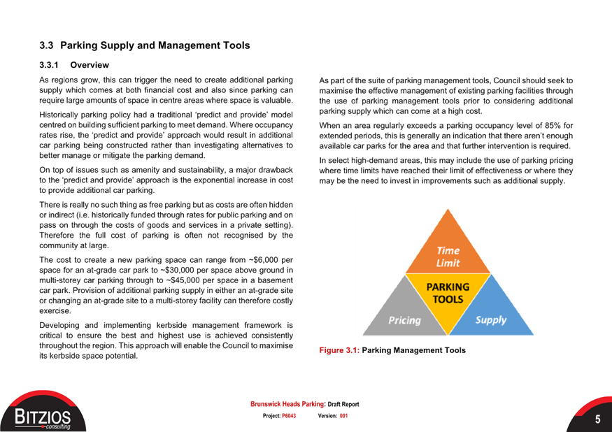
of Byron Shire Council will be held as follows:
|
Venue
|
Conference Room, Station Street, Mullumbimby
|
|
Date
|
Tuesday, 12 December 2023
|
|
Time
|
10.30am
|
Phil Holloway
Director Infrastructure
Services
I2023/1960
Distributed
05/12/23

Local Traffic Committee Meeting 6.1
Regulatory Matters
Report No. 6.1 McGettigans Ln/Ewingsdale Dr - Intersection Safety
Improvements
File No: I2023/1542
Background
The subject intersection has had
numerous complaints regarding sight distance and pedestrian safety. The
diagram below outlines the current issues expressed by the community
(Ewingsdale Community Association) these issues have also been validated
on-site.
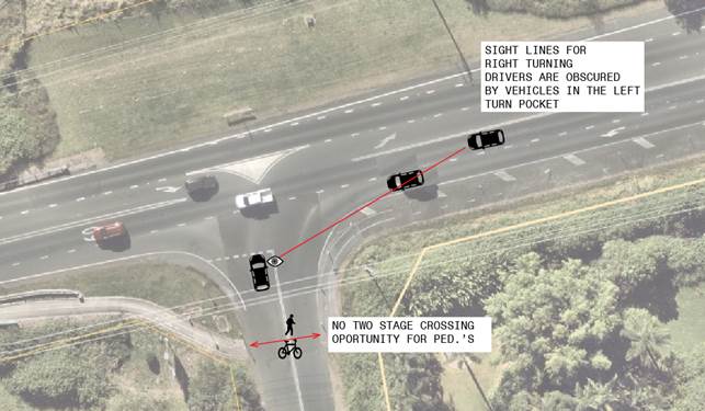 Figure 1: Safety Issues
From an operational perspective,
modelling has indicated that the right-turn movement from the minor leg
(Mcgettigans Lane) is at/overcapacity (please refer to table 1). The
afternoon peak encounters downstream issues stemming from the Hospital
intersection and M1 interchange, posing additional safety concerns with
vehicles queued across the intersection.
Furthermore, it has been observed
that individuals are hesitant to use the seagull-type exit merge on Ewingsdale
Road. Drivers were observed to avoid the seagull acceleration lane when
turning right from McGettigans Lane, opting to either stop and wait in the
middle or execute the turn in a single manoeuvre.
Table 1: Sidra
output (2023AM) best case (McGettigans Lane leg only)
|
Vehicle Movement Performance
|
|
Mov
ID
|
Turn
|
Mov
Class
|
Demand Flows
|
Arrival Flows
|
Deg.
Satn
|
|
Aver.
Delay
|
Level of
Service
|
|
95% Back Of Queue
|
Prop.
Que
|
|
Eff.
Stop Rate
|
Aver.
No. of
Cycles
|
Aver.
Speed
|
|
[ Total
|
HV ]
|
[ Total
|
HV ]
|
[ Veh.
|
Dist ]
|
|
|
|
veh/h
|
%
|
veh/h
|
%
|
v/c
|
|
sec
|
|
|
veh
|
m
|
|
|
|
|
km/h
|
|
South:
Mcgattigans Ln
|
|
1
|
L2
|
All MCs
|
93
|
2.3
|
93
|
2.3
|
0.163
|
|
10.4
|
LOS B
|
|
0.6
|
4.0
|
0.61
|
|
0.83
|
0.61
|
49.4
|
|
3
|
R2
|
All MCs
|
113
|
2.8
|
113
|
2.8
|
1.035
|
|
143.8
|
LOS F
|
|
7.4
|
53.4
|
1.00
|
|
1.66
|
4.02
|
18.2
|
|
Approach
|
205
|
2.6
|
205
|
2.6
|
1.035
|
|
83.6
|
LOS F
|
|
7.4
|
53.4
|
0.82
|
|
1.29
|
2.48
|
25.5
|
|
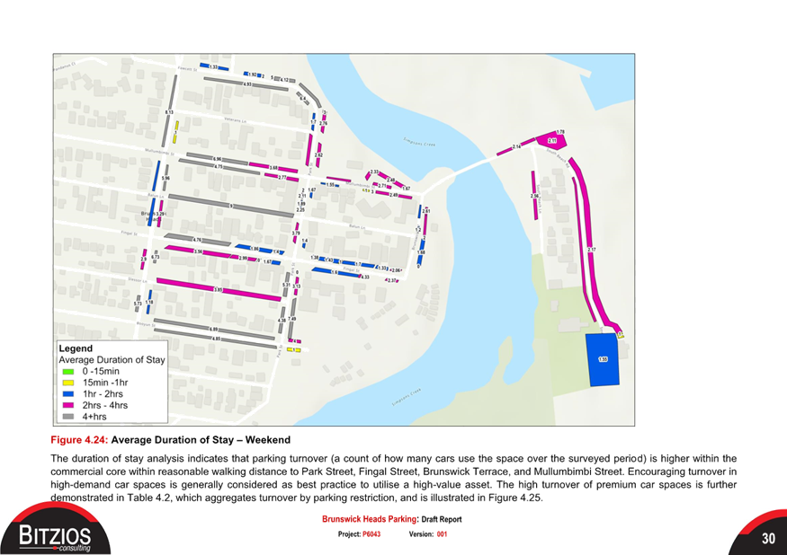
An investigation into the most recent 10 years of crash data
(refer to figure 2 and table 2) has revealed that there is no common specific
crash type at the subject intersection. However, considering the reported
near-miss incidents and the potential for serious injury or death in the event
of a through-right type crash resulting from the previously mentioned issues,
Council staff are currently exploring short-term, low-cost interim treatments
to enhance safety at the intersection. It is worth noting that State
planning investigations are currently underway for the ultimate upgrade of Ewingsdale
Rd, likely encompassing improvements at intersections throughout the corridor.
Figure 2: Crash diagram
(10-year crash data)
Table 2: Summarised
10-year Crash Data (McGettigans Ln/Ewingsdale Rd)
|
Reporting year
|
Degree of crash
|
RUM - code
|
RUM
|
|
2016
|
Moderate Injury
|
10
|
Cross traffic
|
|
2018
|
Serious Injury
|
30
|
Rear end
|
|
2020
|
Moderate Injury
|
71
|
Off rd left => obj
|
|
2021
|
Moderate Injury
|
74
|
On road-out of cont.
|
|
2023
|
Minor/Other Injury
|
30
|
Rear end
|
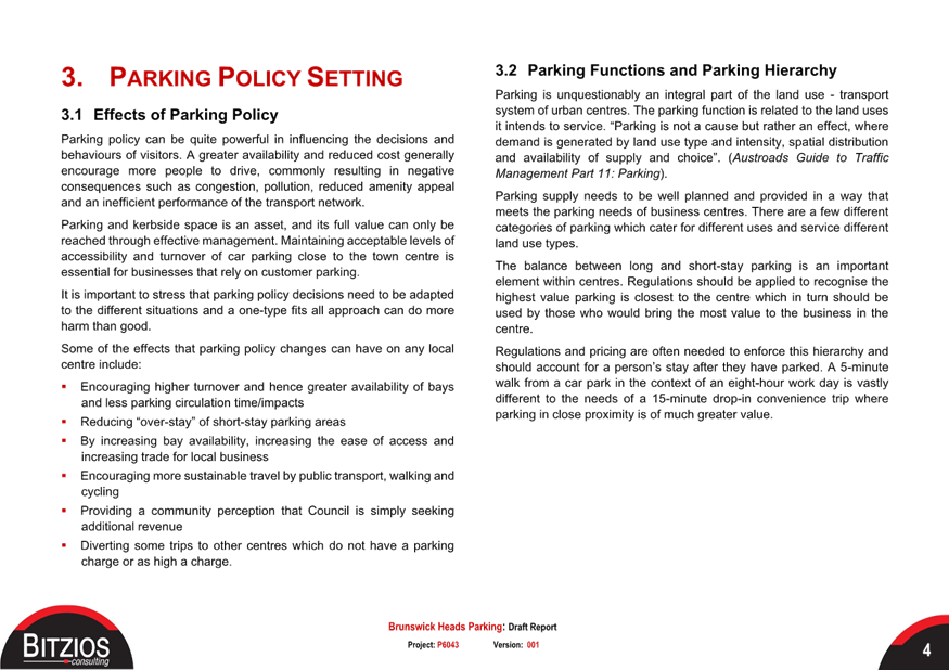
Purpose
The purpose of this report is to
gain endorsement “in principle” for the upgrade treatments shown in
figure 3, contained within this report (below).
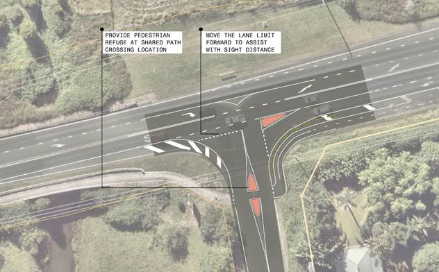
Figure 3: Ewingsdale
Rd / McGettigans Ln Upgrade Concept
RECOMMENDATION:
That the Local Traffic Committee support the interim
safety improvement treatments proposed at the intersection of Ewingsdale Road /
McGettigans Lane.
Local Traffic Committee Meeting 6.2
Report
No. 6.2 Potential Pay Parking Scheme - Brunswick
Heads
File No: I2023/1947
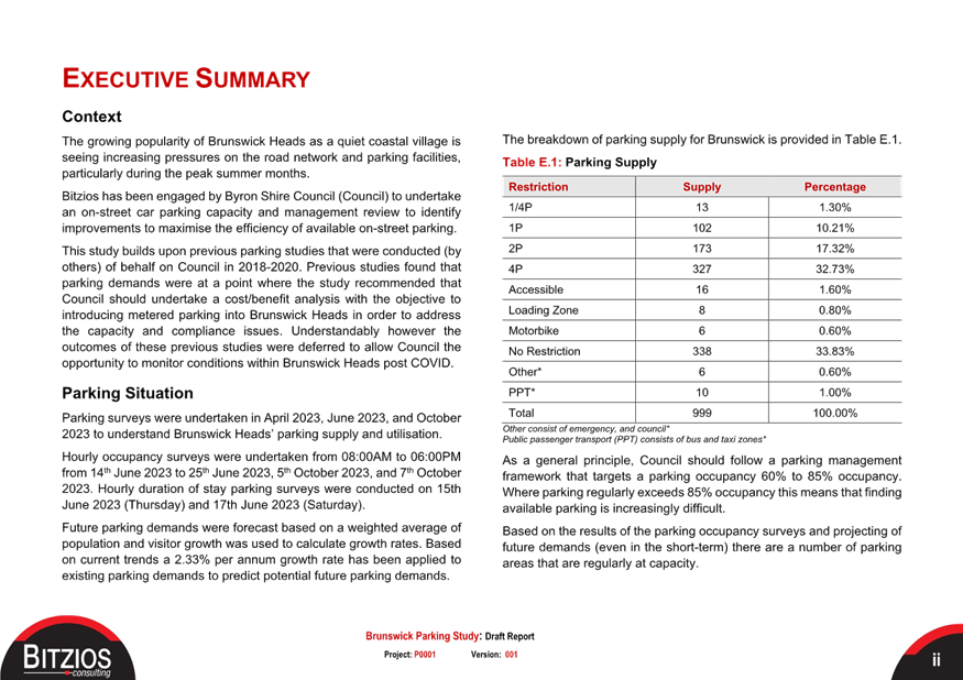
Background
Council is potentially looking at introducing a pay parking
scheme based on the outcomes from a recent study undertaken at Brunswick Heads
(attachment 1).
The purpose of this report is to gain endorsement for the
pay parking scheme in principle based on the information and recommendations
contained within attachment 1. It does not consider the machines or other
regulatory devices at this time, these items will be reported to LTC at a later
date should the scheme be endorsed at Council.
Report
The purpose of the recent review
was to assess the outcomes resulting from the implementation of parking improvements
based on recommendations from earlier parking studies for Brunswick
Heads. These improvements involved modifications to the timed
restrictions aimed at encouraging better parking turnover and providing more
people with the opportunity to enjoy and conduct business in the town.
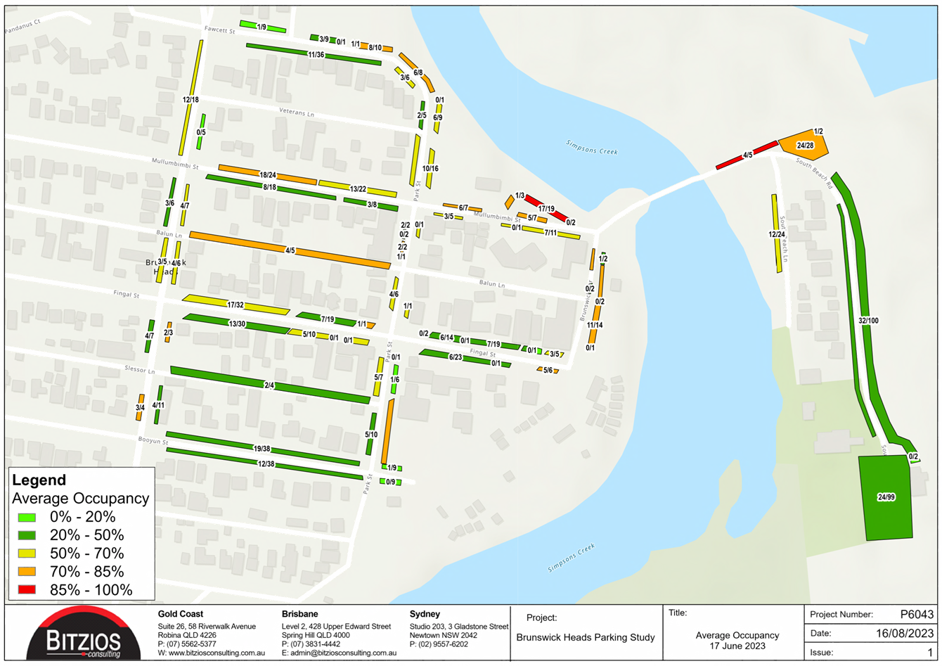
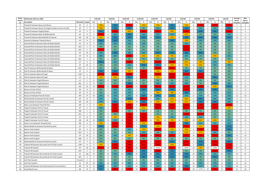
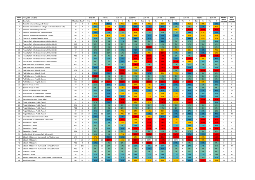
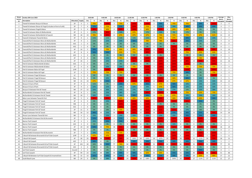
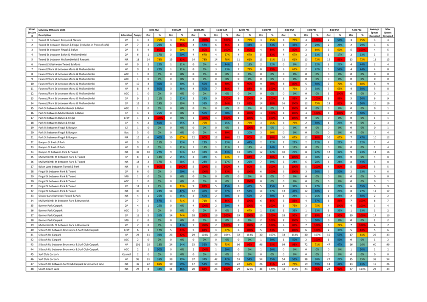
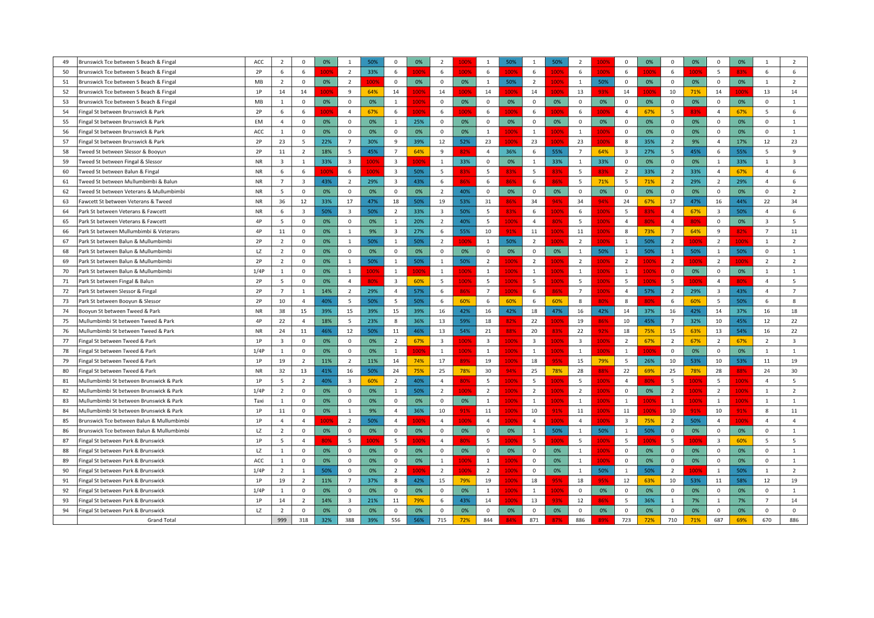
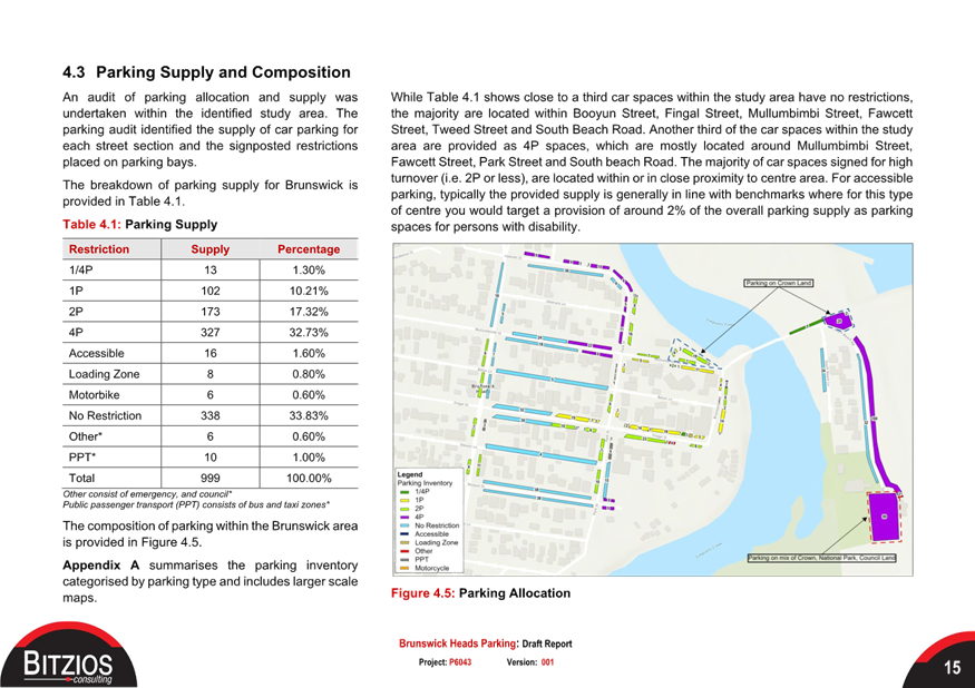
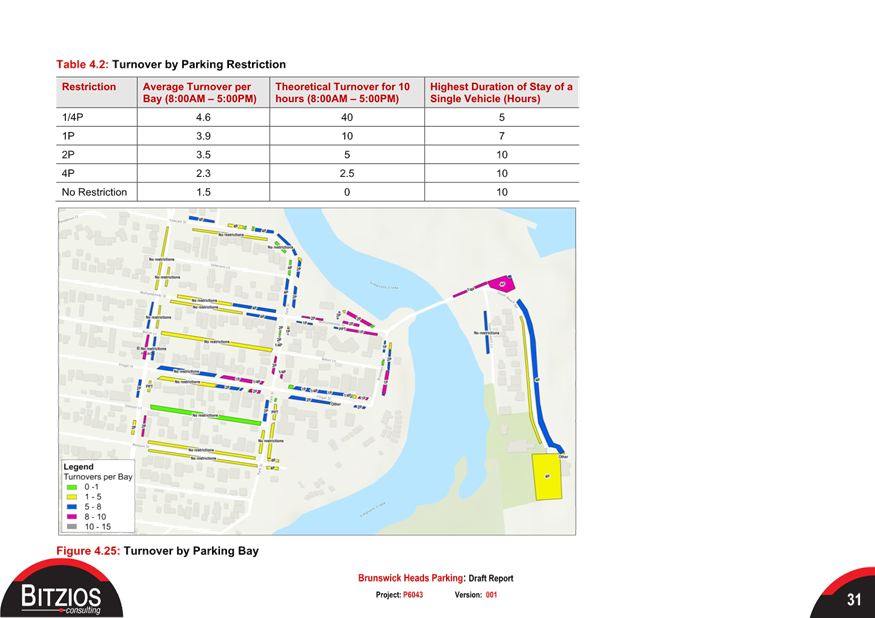
Please refer to Figure 1 which
shows the current restrictions previously recommended.
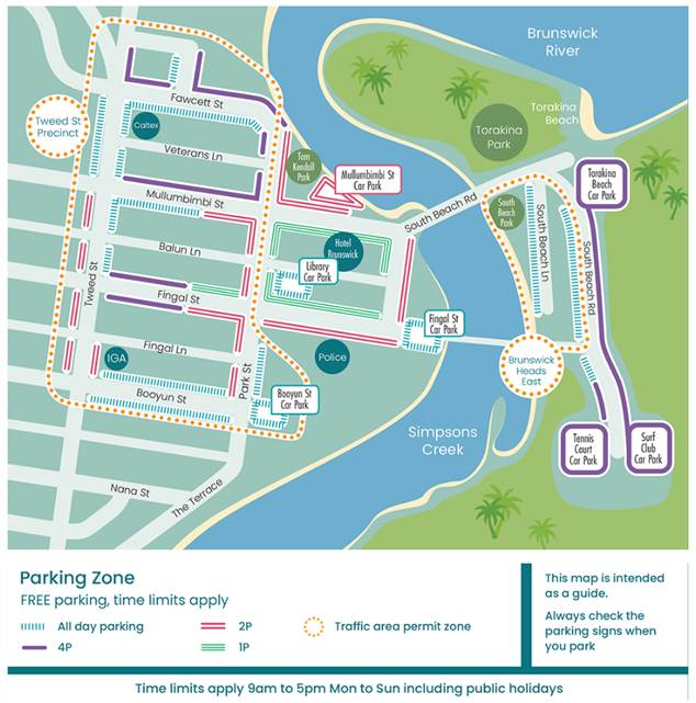
Figure 1:
Current parking restrictions within Brunswick Heads
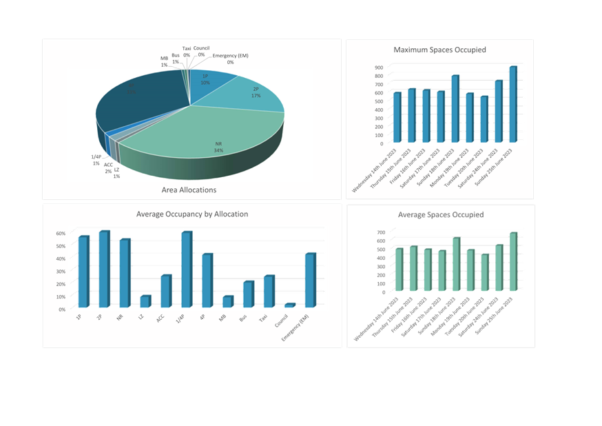
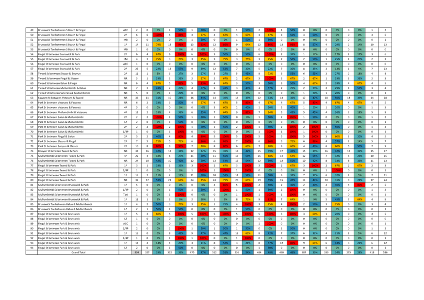
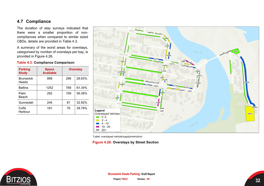
Parking assessment findings
Following an investigation of
previous parking survey data and results from the validation parking surveys
undertaken within this review there was found to be no significant improvement
to occupancy from an overstay and turnover perspective. A detailed
explanation of these findings can be found within part 4. Current Parking
Situation, of the attached report (attachment 1).
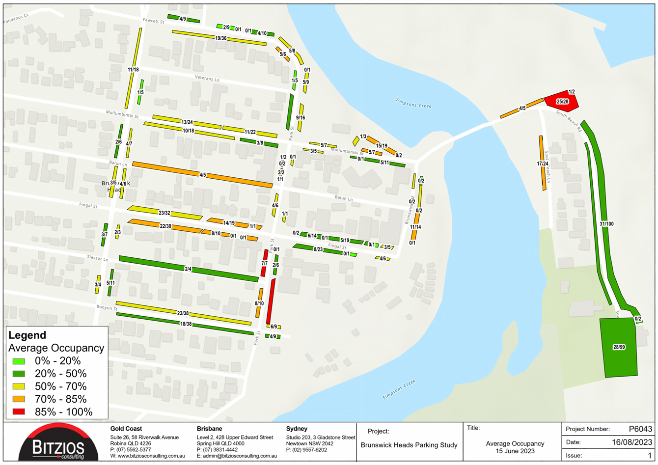
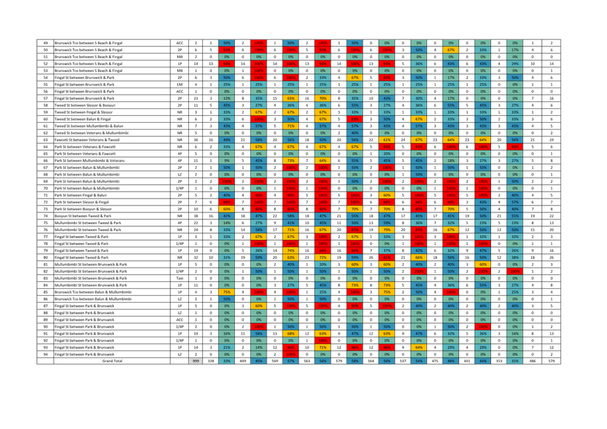
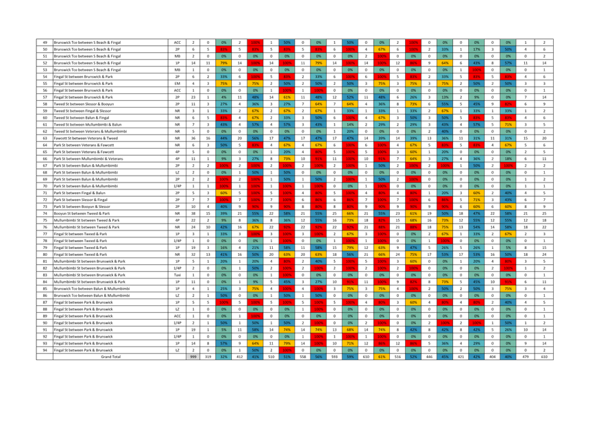
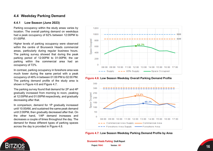
One of the main takeaways from the
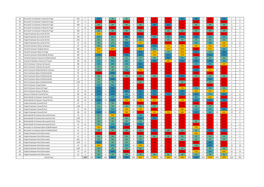
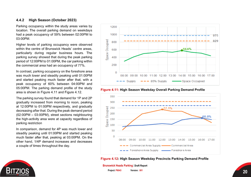
study was that during this low season, considering weather conditions etc. the
centre of town is still reaching a trigger point for further intervention (72%
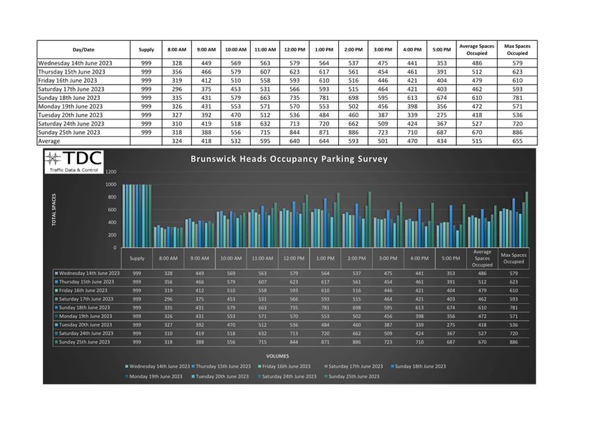
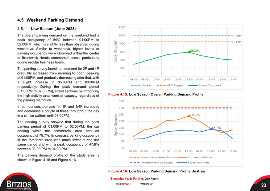
occupancy) when considering growth (Please refer to figure 2).
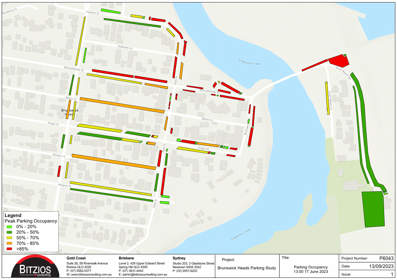
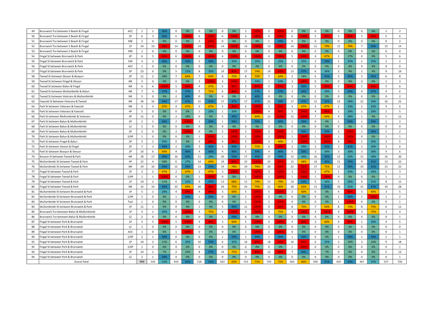
On the day of the surveys which
produced figure 2 (below) the weather was generally poor, from a beachgoing
perspective. This indicates that from a base background parking demand
point of view, under poor weather and weekday conditions Brunswick is still
approaching capacity in the commercial precinct without the tourist overlay.
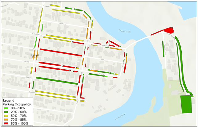
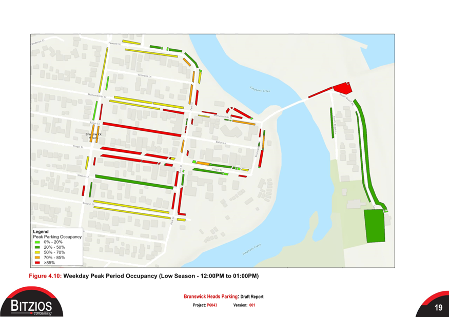
Figure 2: Weekday Parking
occupancy (low season)
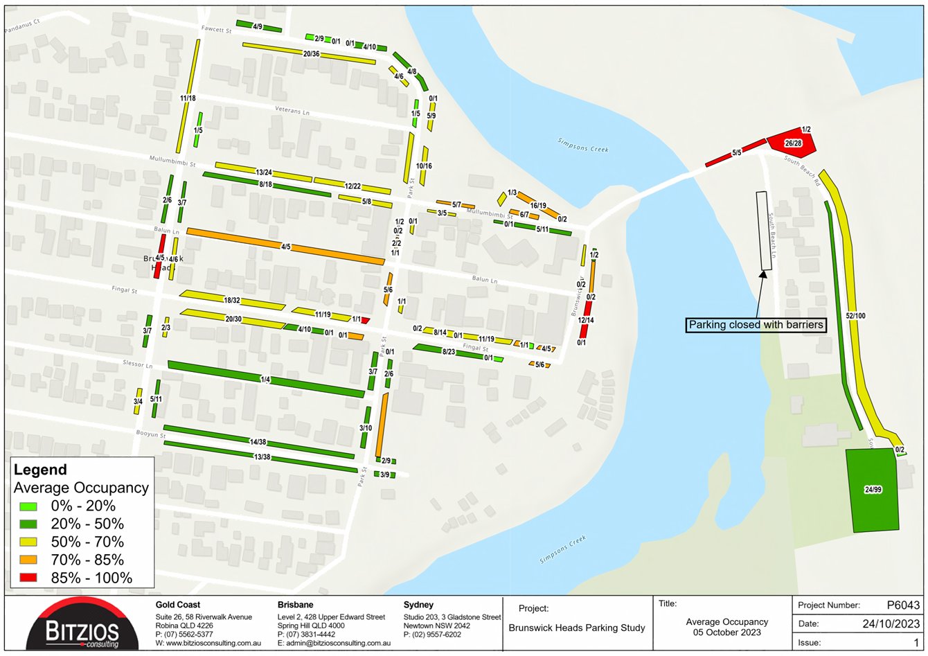
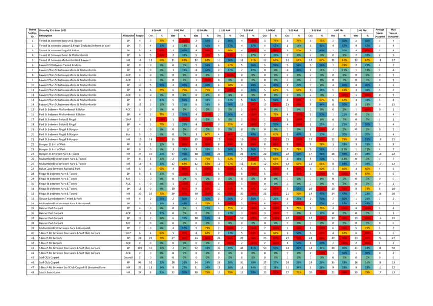
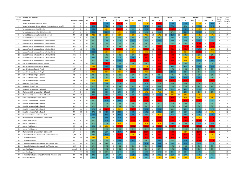
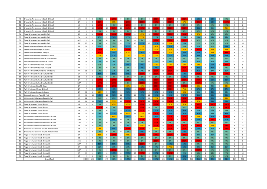
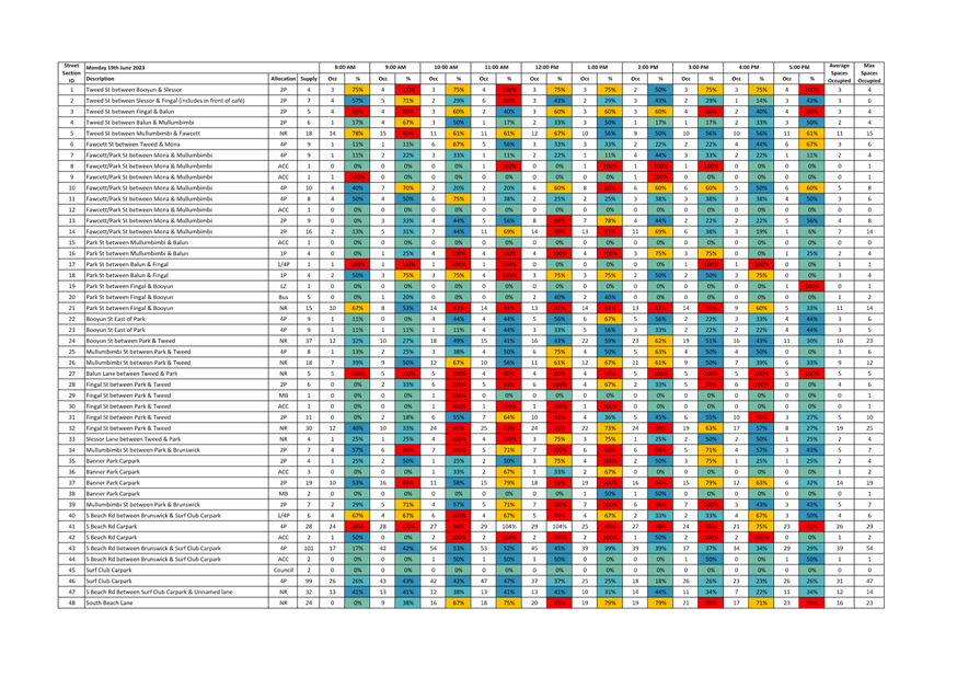
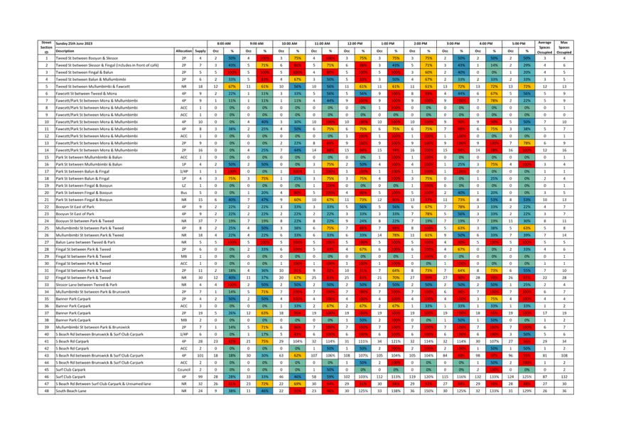
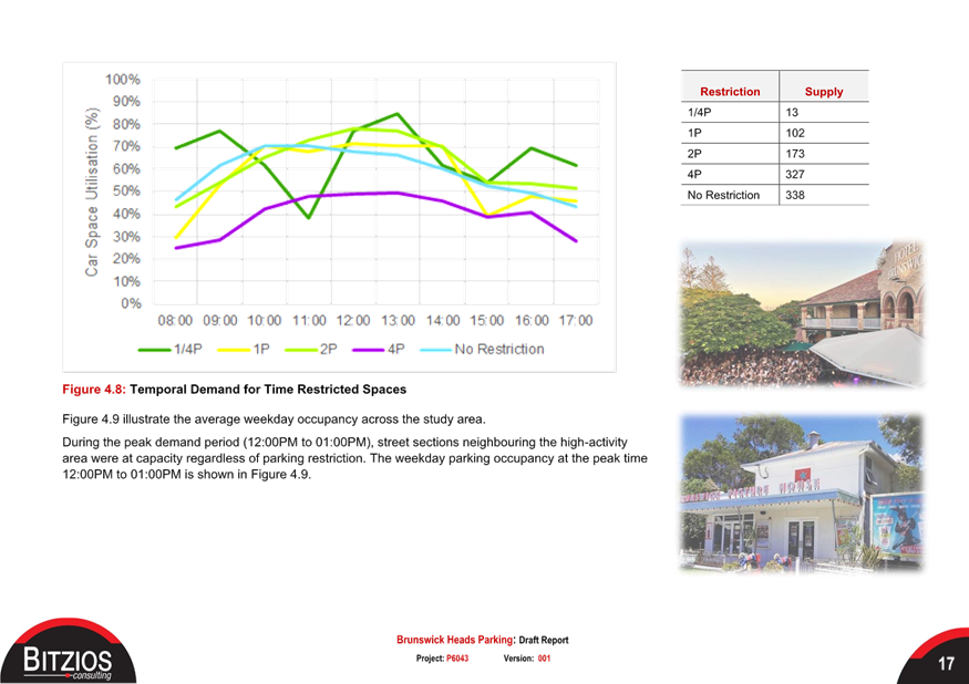
Parking surveys were also
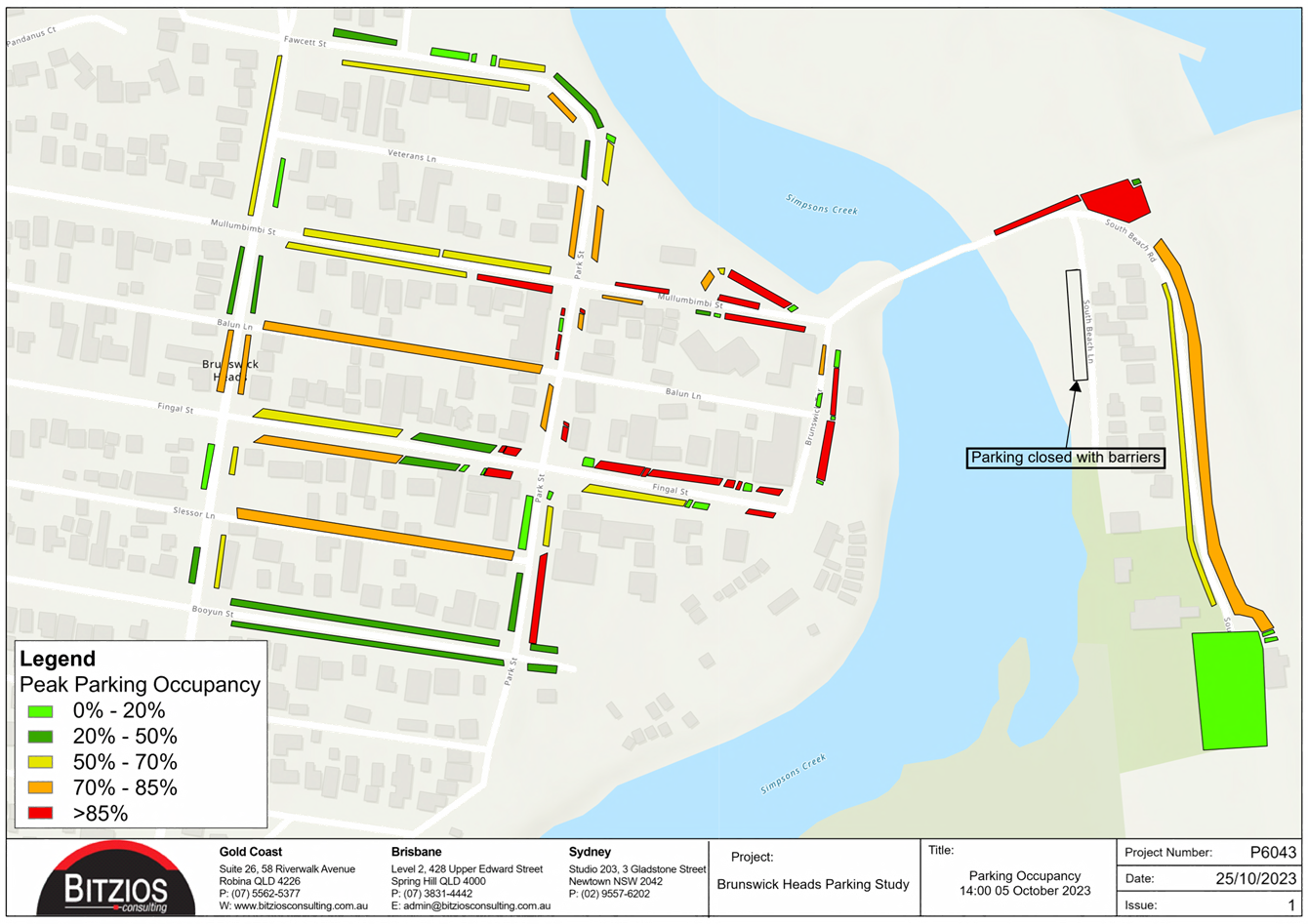
undertaken during the peak season (October, fine weather), which indicated that
the weekday parking demand within the centre of town reached 77% occupancy,
with the foreshore reaching around 60% occupancy. It is worth noting that
it is hard to give a true indication of occupancy given that some areas are not
maximised to the full potential due to un-formalised and underutilised kerb
space. A detailed breakdown of this assessment can be found within
attachment 1 contained within this report in section 4.4.2. The figure below
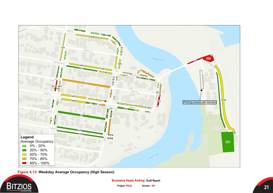
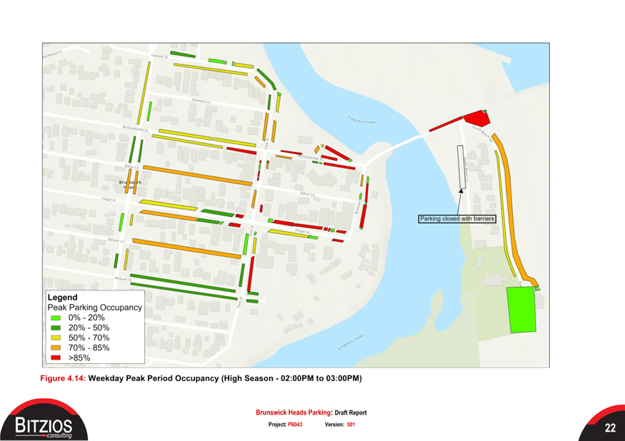
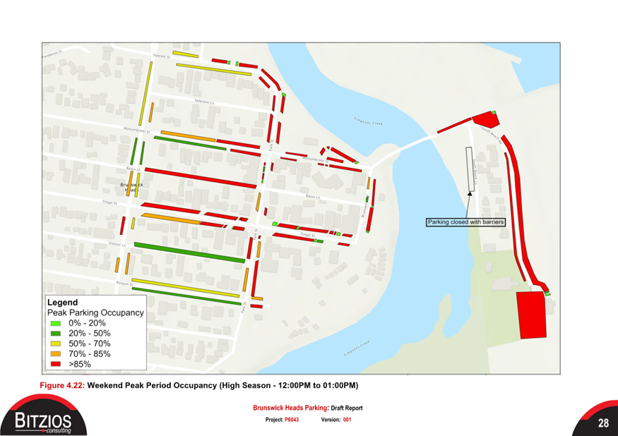
(figure 3) shows the peak demand for the weekday, high season.
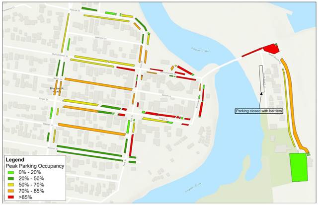
Figure 3: Weekday peak parking
occupancy (High season)
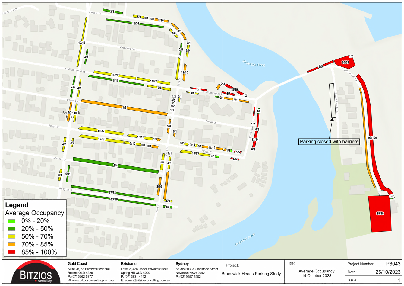
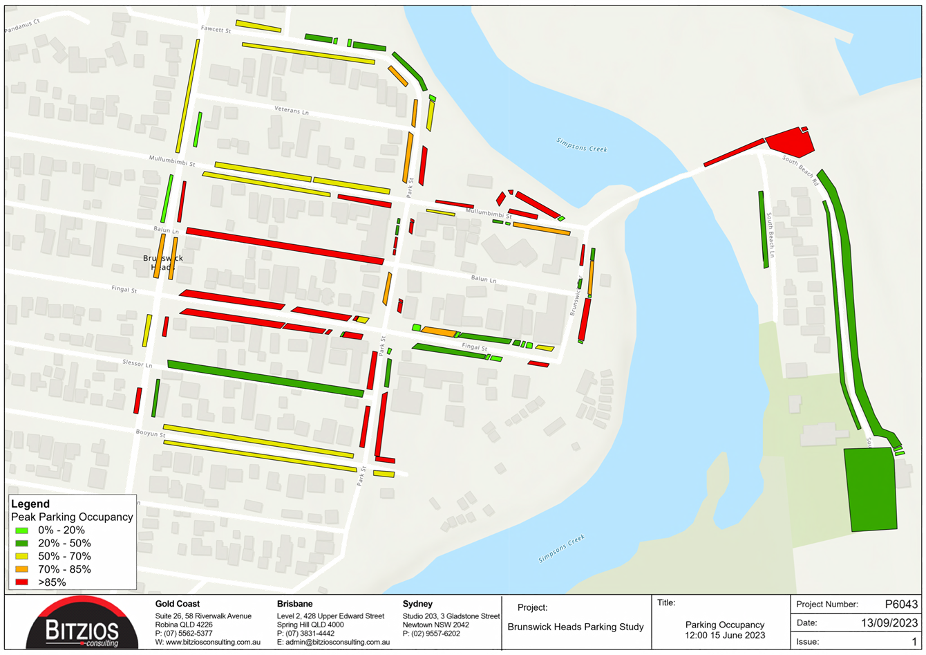
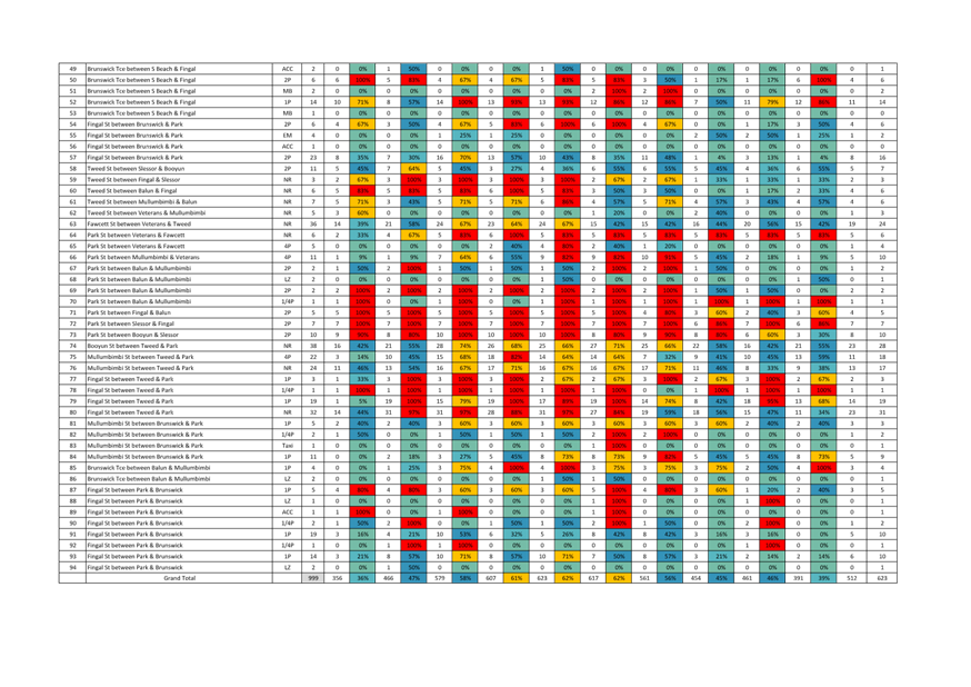
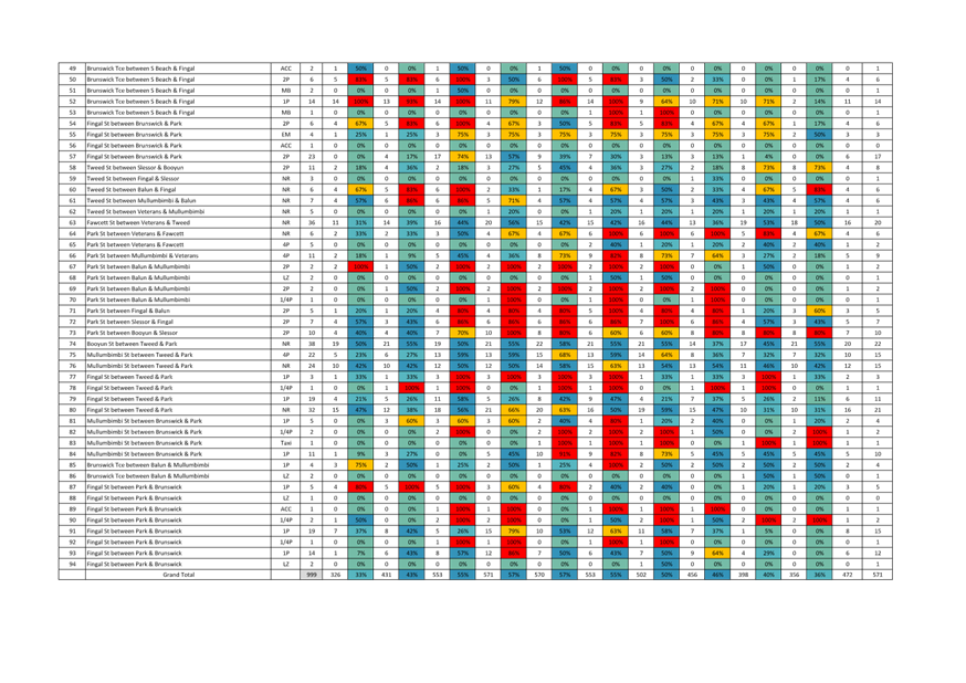
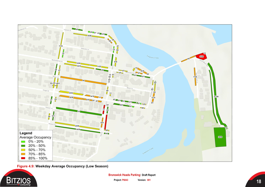
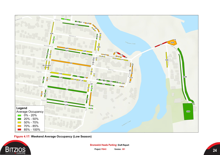
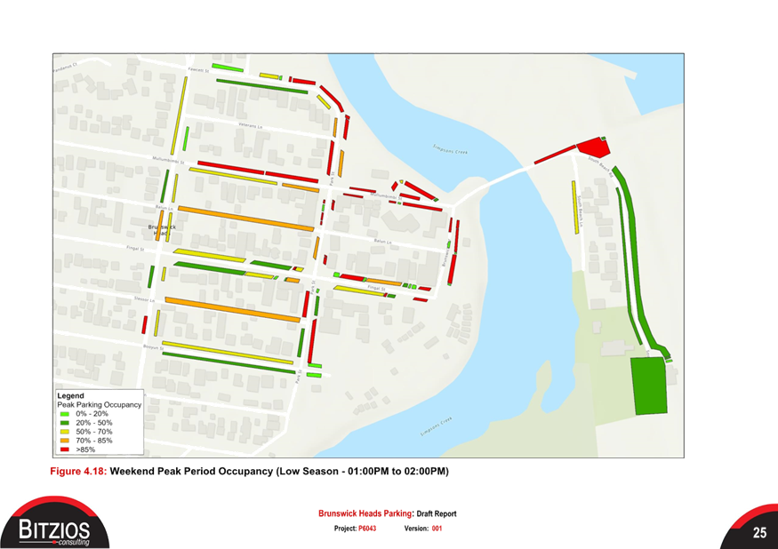
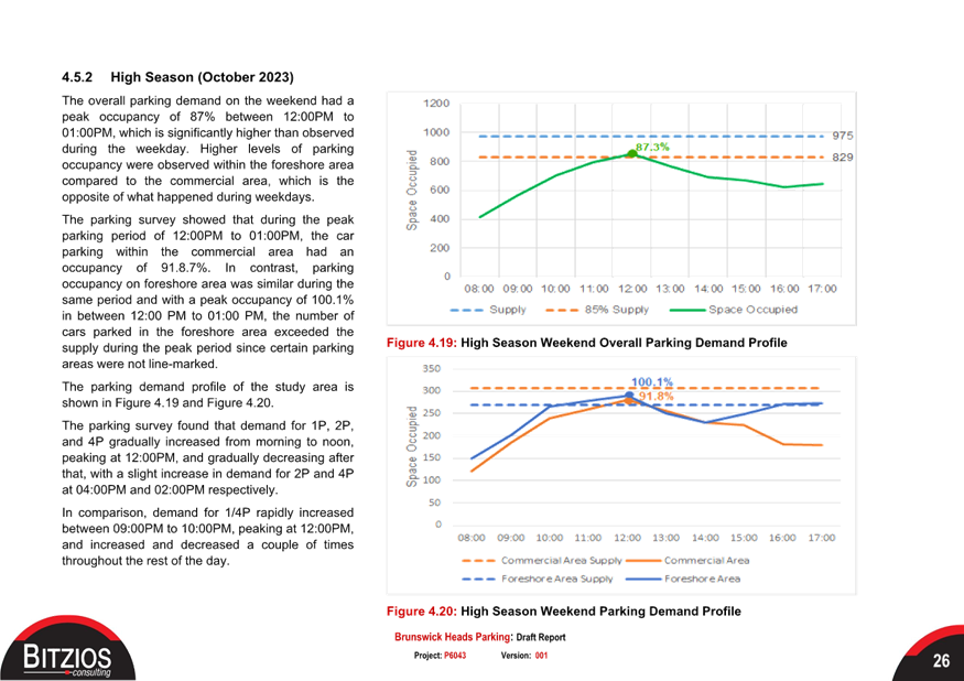
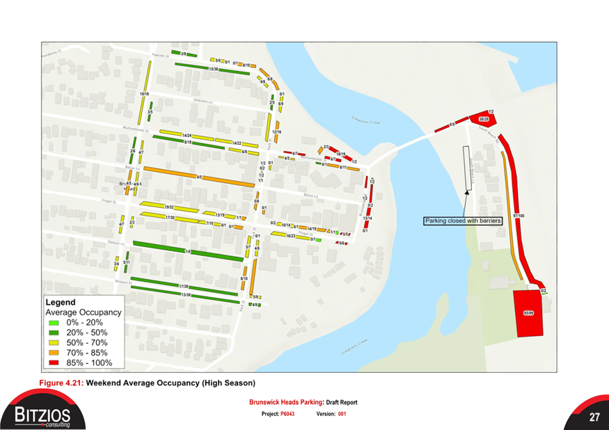
The weekend peak parking demand as
expected reaches capacity at the peak in town (85% occupancy) during the low
and high periods.
The high season weekend peak
period for the high season is well over capacity (please refer to figure 4).
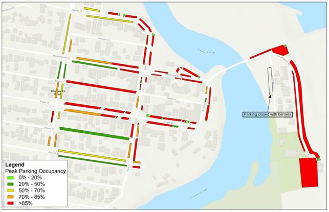
Figure 4: Weekend peak, high
season parking occupancy
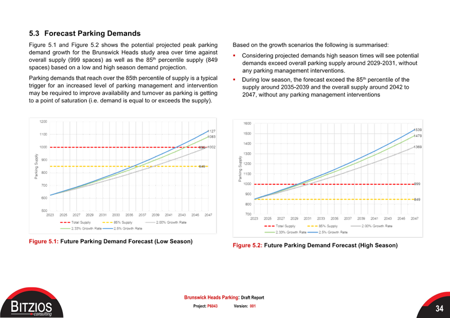
Forecasted parking demand
The anticipated parking
demand is determined by various growth factors outlined in the attached report
(Attachment 1, Part 5, Future Parking Demand).
This assessment
suggests that in the short term, the growth analysis indicates an increase in
demand for the core Brunswick center, rising from 72% weekday occupancy to 81%
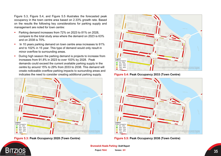
by 2028 (please refer to Figure 5).
Additionally, it is
anticipated that the projected peak parking demands in the foreshore parking
area could surpass the current available parking supply by approximately 20% to
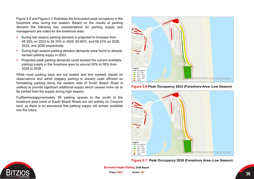
50% from 2028 to 2038. Figure 5: 2028 forecasted parking demand
Summary
Parking demands in the
town center, even during the low season, have reached a point where an update
to the parking management regime needs to be considered in the short term.
Reducing time limits is
an option, but it would be too restrictive and would require significant
enforcement to ensure compliance. Additional formalised parking
(surfacing, signs/lines) would help increase supply but would come at a
substantial cost, given that much of the kerbside within Brunswick is unsealed.
Following the
consultants' review, they have concluded that the implementation of pay parking
would be the most effective way to achieve improved parking outcomes.
Therefore, several
options were analysed to determine which paid parking scenario would best
enhance parking efficiency throughout the township (please refer to Attachment
1, Part 7, Pay Parking Assessment for further details).
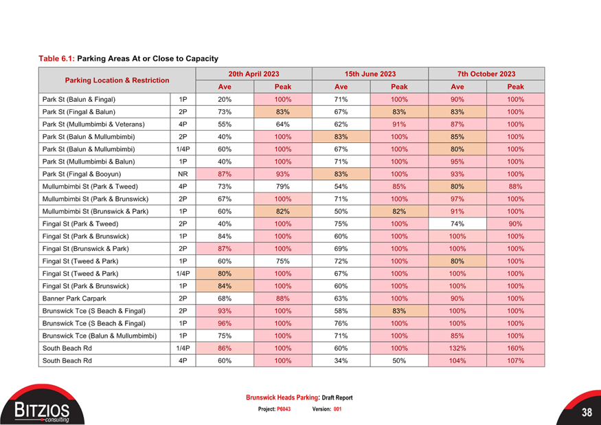
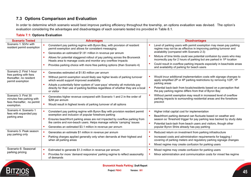
A summary of the different parking
scenarios is presented below (Table 2: Pay parking options and evaluation).
Table 2: Pay parking
options and evaluation
|
Scenario Tested
|
Advantages
|
Disadvantages
|
|
Scenario 1: $3/hr with resident permit exemption
|
▪ Consistent pay parking regime with Byron Bay, with
provision of resident permit exemption and allows for consistent messaging
▪ Generates an estimated $1.81 million in revenue per annum
▪ Allows for potential staggered rollout of pay parking across the
Brunswick Heads area to manage costs and monitor any overflow impacts
▪ Provides parking choice with more free parking options (than Scenario
4)
|
▪ Level of parking users with permit exemption may mean
pay parking
regime may not be as effective in improving parking turnover and
availability (compared with Scenario 2-3)
▪ Mixture of time limits could see potential confusion by users who may
incorrectly pay for 2 hours of parking but are parked in 1P location
▪ Could result in overflow parking impacts especially in beachside
areas
and availability of parking for beach users
|
|
Scenario 2: First 1-hour
free parking with fees
thereafter, no resident
permit exemption
|
▪ Generates estimated at $1.83 million per annum
▪ Without permit exemption would likely see higher levels of parking
turnover which would support improved availability
▪ Adopts a potentially fairer system of ‘user-pays’ whereby
all motorists pay
directly for their use of parking facilities regardless of whether they are a
local
or visitor
|
▪ Would incur additional implementation costs with signage
changes to apply simplified 2P or 4P parking restrictions by removing 1/2P,
1P parking areas
▪ Potential back-lash from locals/residents based on a perception
that he pay parking regime differs from that of Byron Bay
▪ Without permit exemption may result in increased level of overflow
parking impacts to surrounding residential areas and the foreshore
precinct
|
|
Scenario 3: First 30
minutes free parking with
fees thereafter, no permit
exemption.
|
▪ Generates higher revenue compared with Scenario 1 and 2
in the order of
$2M per annum
▪ Would result in highest levels of parking turnover of all options
|
|
Scenario 4: Scenario 1 fees with expanded pay parking area
|
▪ Consistent pay parking regime with Byron Bay with
provision resident permit exemption and inclusion of popular foreshore
parking
▪ Ensures beachfront parking areas are not impacted by overflow parking
from the centre and non-beach users. Helps manage vehicle
‘camping’ issues
▪ Generates an estimated $3.1 million in revenue per annum
|
▪ Higher initial capital cost for implementation
▪ Beachfront parking demand can fluctuate based on weather and
season so ‘threshold trigger for pay parking less backed by study data
▪ Potential back-lash from beach users and visitors, though other
popular Byron Shire already has pay parking
|
|
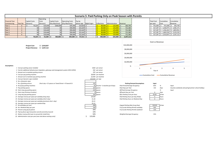
Scenario 5: Peak season pay parking only
|
▪ Generates an estimate $1 million in revenue per annum
▪ Parking charges applied generally only when demands at their highest
and when all parking areas
|
▪ Reduced return on investment from parking infrastructure
▪ Increased costs and administration requirements for bagging /covering
of parking meters and regulatory parking signage changes
▪ Mixed regime may create confusion for parking users
|
|
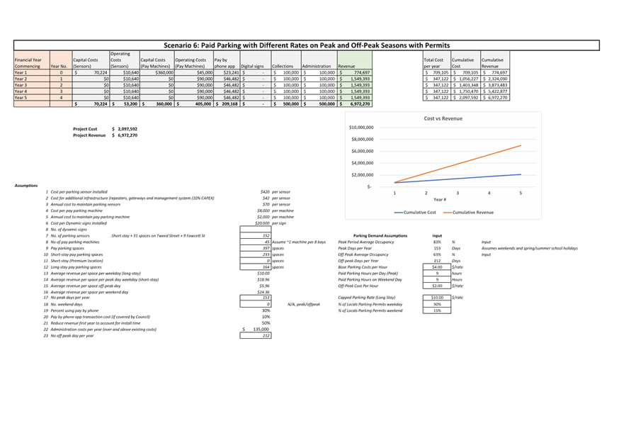
Scenario 6: Seasonal parking pricing
|
▪ Estimated to generate $1.3 million in revenue per annum
▪ Provides for more ‘demand responsive’ parking regime to
reflect seasonality of demands
|
▪ Mixed regime may create confusion for parking users
▪ Minor administration and communication costs for mixed fee regime
|
Based on the results of the pay parking assessment and
workshop discussions (Councillor Workshop on 2 November 2023), the consultant
has recommended that Scenario 1 or Scenario 4 be the preferred options to
progress the implementation of pay parking in Brunswick Heads. While
Scenario 2 or 3 would likely achieve more optimal parking management outcomes
for turnover and availability, there is a need to consider the local context,
given:
· The growing
parking pressures in the centre are a result of increasing tourists and visitor
demands in Brunswick Heads.
· Nearby in Byron
Bay, pay parking has been implemented with a resident permit exemption and
other permit provisions for workers.
· Across other
benchmarking examples, some form of resident permit is provided (for a fee).
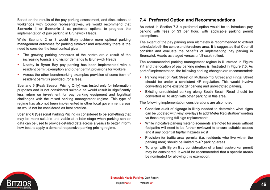
Council staff support the consultant’s recommendation,
particularly regarding the lower hourly parking rate, which will lessen the
impact of a reduction in visitation. Staff believe that the 4B boundary
option would be the best scenario, as the 4A staged approach (town then
foreshore after 2 years) would be unpredictable and likely have a significant
impact on the foreshore in terms of nuisance camping and all-day parking
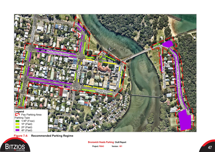
(please refer to figures 6 and 7 for the Option 4 pay parking boundary).
This option would not alter the current time limit restrictions within
Brunswick Heads.
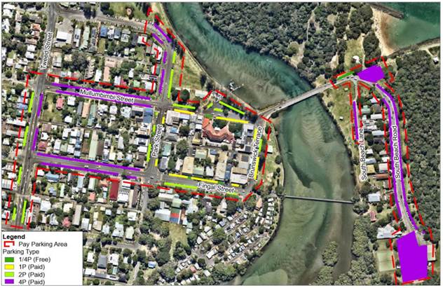
Figure 6: Recommended
parking regime boundary (no change to current parking time restrictions)
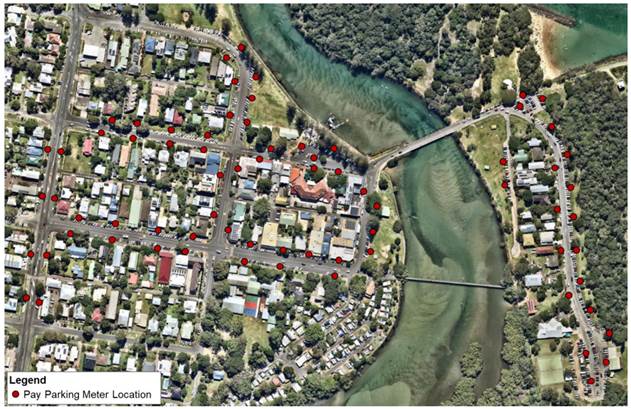
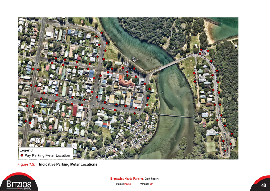
Figure 7: Parking meter
location (preferred parking regime)
RECOMMENDATION:
That the Local Traffic Committee: -
1. Endorse
the proposed of Brunswick Heads pay parking regime in principle (only) as
scenario 4 (extended boundary) contained within this report.
2. Note
that the implementation of this regime is still subject to Council approval.
Attachments:
1 Brunswick
Heads Parking Study Report (Draft)_17 November 2023, E2023/120356 , page 17⇩ 
Regulatory
Matters 6.2 - Attachment 1


Local Traffic Committee Meeting 6.3
Report
No. 6.3 Somerset Street, Byron Bay - Permit Holder
Exception
File No: I2023/1948
The purpose of this report is to gain Local Traffic
Committee endorsement for the change to the existing No Parking 1am – 6am
signs to include an exception for our current resident parking area permit
holders (refer to figure 1). This is to allow resident to park in their street
overnight while still mitigating nuisance camping.
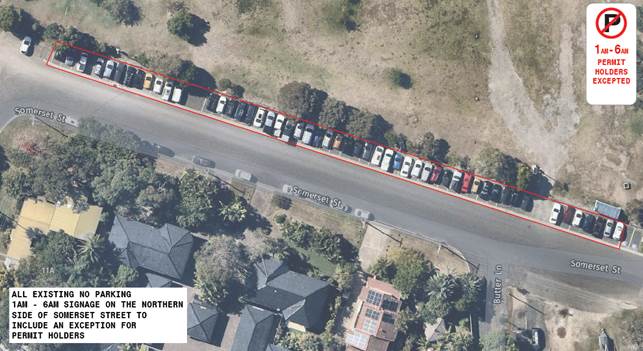
Figure 1:
Permit holder excepted locality map/plan
RECOMMENDATION:
That the Local Traffic Committee endorse the permit
holder exception for the current “No Parking” area on the northern
side of Somerset Street, Byron Bay (between Butler Street and Wordsworth
Street).
Local Traffic Committee Meeting 7.1
Matters for Traffic Engineering Advice
Report No. 7.1 Jubilee Avenue, School Traffic Operations - Potential
Improvements
File No: I2023/1867
Background
Numerous stakeholders have approached Council staff
regarding traffic safety concerns adjacent or related to Mullumbimby High
School.
These issues are generally only experienced during the
school peak periods (7:30 – 9:00am and 2:30 – 4pm) and any
improvements will be spread across three different landholders/custodians
(Council, NSW Department of Education and the Mullumbimby Co Op/Service Station).

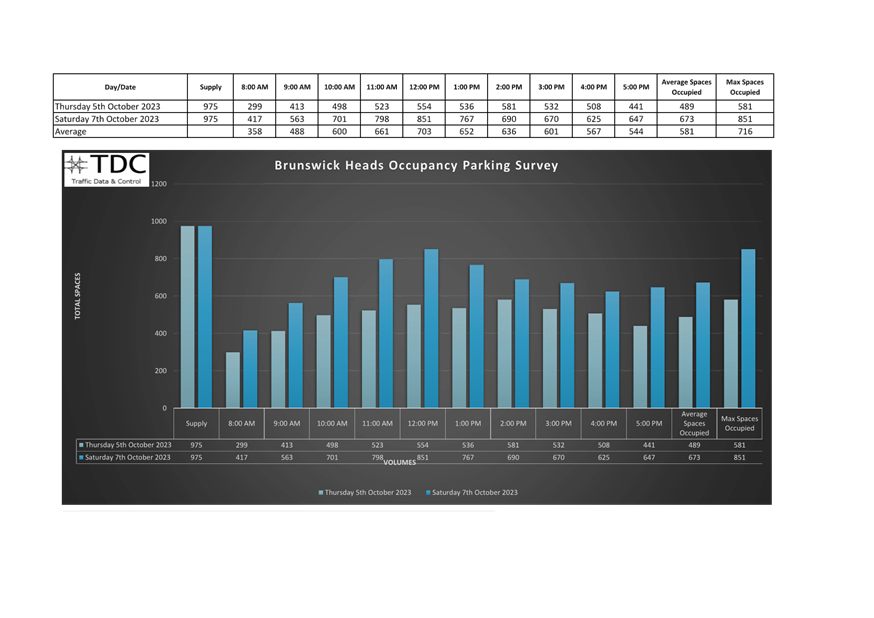
Figure 1: Locality map
landowners
Issues
Bus turn-around facility (refer to figure 2)
· Multiple access
points to the Co-op that cross conflict points with no delineation.
· High speed exits
at bus turn around facility for co-op access.
· Poor sight lines when
exiting the facility
Pedestrian Crossing (Mullumbimby High School)
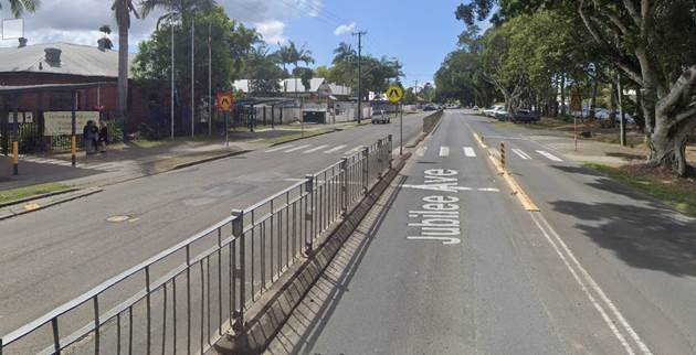
Figure 3: Pedestrian
crossing, Jubilee Ave, Mullumbimby, adjacent Mullumbimby High School
· Sight distance
issues from median/pedestrian fencing,
· Pedestrians are
crossing three lanes of traffic,
· Driver behavioural
issues at the crossing due to extended queueing during school peaks (kids are
not platooned),
· School bus, drop
off islands creating significant accessibility issues for kids getting on and
off the bus,
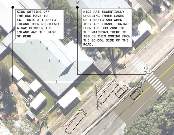
Figure 4: Issues diagram
un-supervised school pedestrian crossing
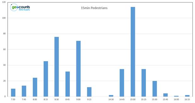
Figure 5: School day
pedestrian crossing volume data (15 minute intervals)
Purpose
The purpose of this report is to present possible safety
improvement treatments (short term) for the issues on Jubilee Avenue,
Mullumbimby (outlined above) and gain support for further investigation should
the treatments be found to be appropriate.
Please see concepts below for comment and consideration.
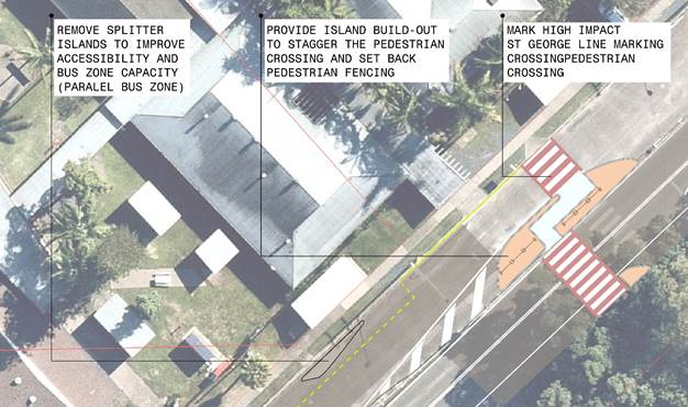 Figure 6: Mullumbimby High pedestrian crossing
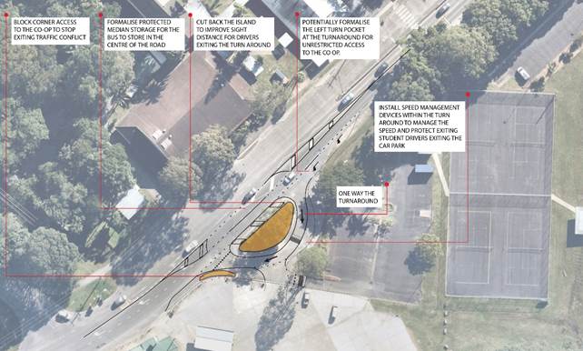 Figure 7: School bus turnaround
Stakeholder Engagement
Council have been talking with the Department of Education
(including the principal of the High School) regarding concept development for
the treatment of the issues contained within this report. However,
funding and resourcing has been hard to achieve.
Council has recently (23/11/2023) met with the Police and
the Co Op to discuss these issues on-site. It has been recommended by the
Police that we bring these concerns to the Local traffic committee for
discussion.
There have been numerous discussions with Transport for New
South Wales who are currently assisting with potential avenues for funding.
RECOMMENDATION:
That the Local Traffic Committee endorse the
safety upgrade treatments for the School Bus Turnaround and the Pedestrian
Crossing adjacent to the Mullumbimby High School (figures 6 and 7) in principle
for further discussions with the Dept of Education.