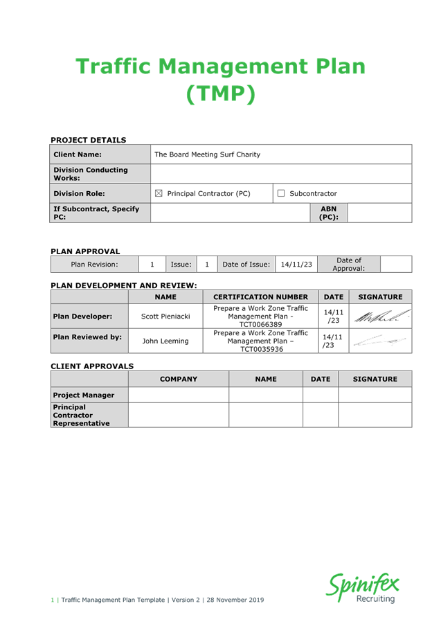
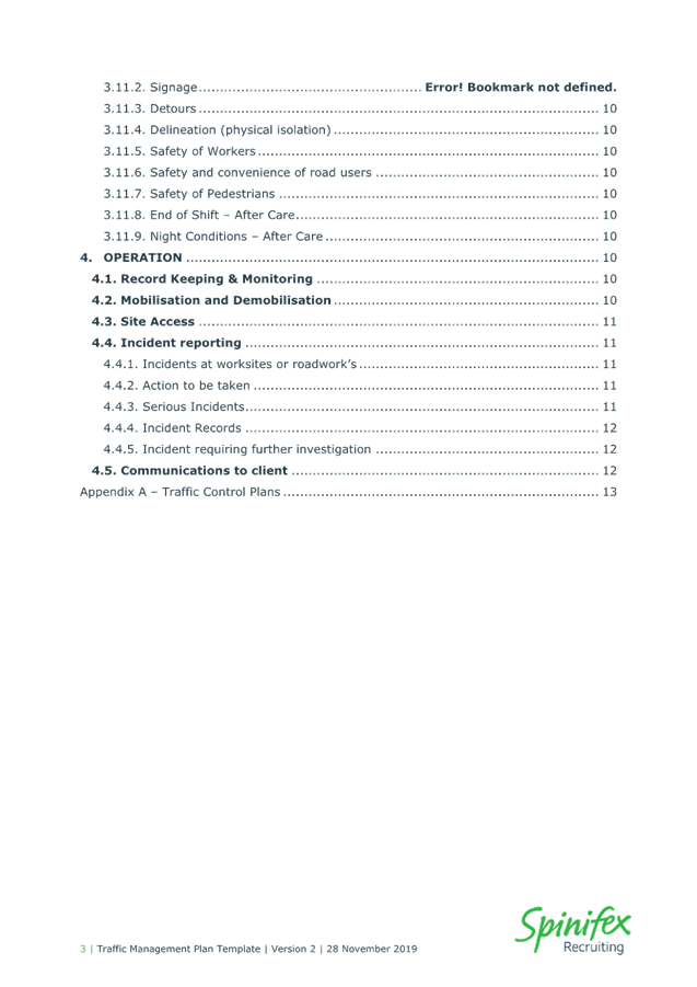
Notice of Meeting
Local Traffic Committee Meeting
A Local Traffic Committee Meeting
of Byron Shire Council will be held as follows:
|
Venue
|
Conference Room, Station Street, Mullumbimby
|
|
Date
|
Tuesday, 13 February 2024
|
|
Time
|
11.30am
|
Phil Holloway
Director Infrastructure
Services
I2024/166
Distributed
07/02/24

Local Traffic Committee
Meeting
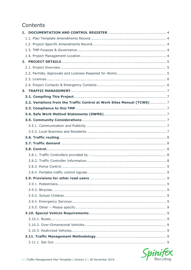
BUSINESS OF MEETING
1. Apologies
2. Declarations
of Interest – Pecuniary and Non-Pecuniary
3. Adoption
of Minutes from Previous Meetings
3.1 Local
Traffic Committee Meeting held on 31 December 2023
4. Matters
Arising
5. Outstanding
Issues/Resolutions
6. Regulatory Matters
6.1 Event
- Anzac Day 2024 - Road Closures in Byron Bay, Mullumbimby, Brunswick Heads and
Bangalow..................................................................................................... 3
6.2 Blues
Festival 2024 Traffic Managment Plan............................................................ 9
6.3 Event
- Mullum2Bruns Paddle 2024 - 2026............................................................. 82
6.4 Rifle
Range Road Intersection Upgrade.................................................................. 91
7. Matters for Traffic
Engineering Advice
7.1 Adaptive
Pro Surf Championship - 17 March 2024.............................................. 127
7.2 Belongil
- Kendall Street to Childe Street Local Traffic Mangement................. 145
8. Events
8.1 Event
- Westpac Helicopter Byron Coastal Charity Walk – 4th May 2024....... 163
8.2 Event
- Bangalow Billycart Derby May 2024......................................................... 175
8.3 Chincogan
Charge - September 2024................................................................... 180
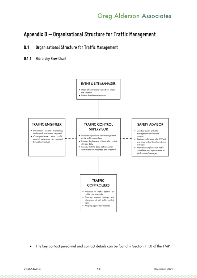
Local Traffic Committee Meeting 6.1
Regulatory Matters
Report No. 6.1 Event - Anzac
Day 2024 - Road Closures in Byron Bay, Mullumbimby, Brunswick Heads and
Bangalow
File No: I2024/86
BACKGROUND
Each year the RSL sub-branches of Byron Bay, Mullumbimby,
Bangalow and Brunswick Heads arrange their respective annual ANZAC Day street
parade.
At this stage it is expected that little to no change to
previous years will occur. The route of each parade is shown below, noting
that:
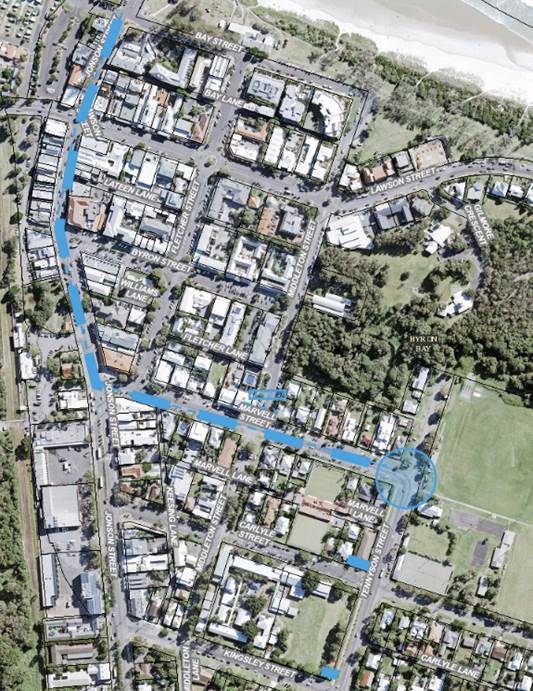
Byron Bay:
As per previous years, the Dawn Service
requires closure of the Tennyson Street and Marvell Street intersection between
4.30am and 5.30am and then again (approximately at 11am) when the parade
reaches the gates to conduct the main service.
Council implements such measures including
signed detours at the intersections of Marvell and Middleton Street and at both
the Kingsley Street and Carlyle Street intersections on Tennyson Street.
The parade, is held under Police escort
after it gathers at 10:15am off-road (Beach Hotel) at Bay and Jonson Street,
then at 10.30am proceeds south down Jonson Street, left into Marvell Street to
its end at the Memorial Gates on Tennyson Street.
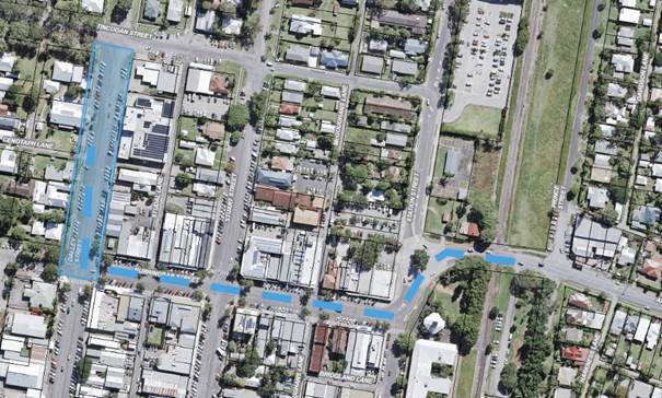
Mullumbimby:
The parade will again be held under Police
escort commencing this year at 10.50am from Apex Park via Burringbar Street to
concluding at the cenotaph on Dalley Street and that Council is to close Dalley
Street to traffic between Burringbar Street and Tincogan Street between 8am and
12noon with signed detours in place.
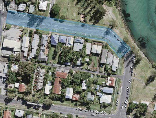
Brunswick Heads:
Police involvement with both an escort and
closing of the road on Fawcett Street between 4.30am and 6.30am. No Council
involvement requested.
Bangalow:
The sub branch have
confirmed the parade forms by 10.45am in front of the Bangalow Hotel in Byron
Street, and sets out by 11am east to the intersection at Station Street, then
turns left (north) to the front of the RSL Memorial Hall on Station Street for
wreath laying and ceremony through to 11.45am. Council therefore are to implement
the following:
o by
10.40am through to end of event, close:
§ Station
Street north of Byron Street,
§ Byron
Street west of Station Street, and
§ provide
signed detours south along Station Street to and via Deacon Street.
o by
10.45am, close:
§ Byron
Street at the east bound leg of the Granuaille Road and Lismore Road
roundabout.
o Once
parade has departed Byron Street remove the two Byron Street closures.
In general it should be noted previous year’s events
have not resulted in any reported safety concern, and the road closures are
typically less than one hour duration and signed detours are implemented.
Therefore given the above, and that the local events are
part of a well known and anticipated nation wide annual tradition, the usual
conditions imposed on road events (for example event organisers to notify local
residents and emergency providers, etc) is not typically applied, hence their
omissions from the recommendation now tabled.
RECOMMENDATION:
1. That the Local Traffic Committee:
a)
endorse the ANZAC Day Parades for 25 April 2024 for the Return Services League
sub branches of Byron Bay, Mullumbimby, Bangalow and Brunswick Heads /
Billinudgel for 3 years.
b)
assists, where requested and required, with implementing the necessary
temporary road closures and detours;
d) Notify
the event on Council’s webpage.
2. That the event organiser:
a) obtain
separate approvals by NSW Police and TfNSW, noting that the Bangalow event is
on a state road or may impact the state road network;
b)
undertake consultation with community and affected businesses including
adequate response/action to any raised concerns;
c)
undertake consultation with emergency services and any identified issues
addressed;
d)
holding $20m public liability insurance cover which is valid for the event.
3. That
the approvals provided above are subject to NSW Police approval being obtained
and that each event is undertaken either or both under Police escort or traffic
control and/or Council’s implemented traffic control.
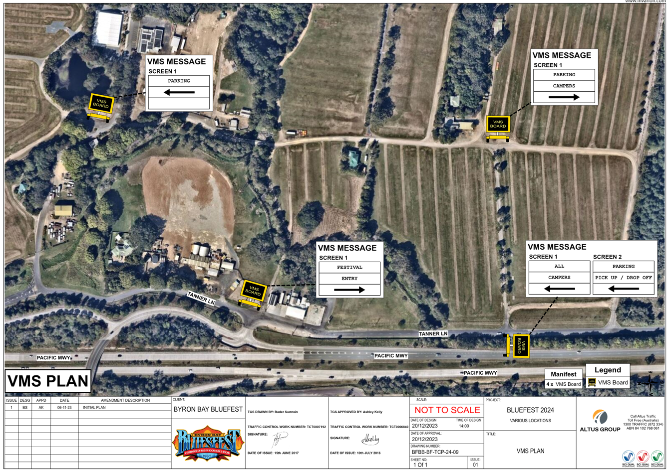
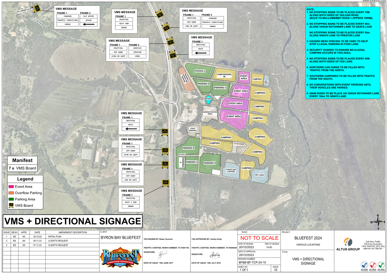
Local Traffic Committee Meeting 6.2
Report
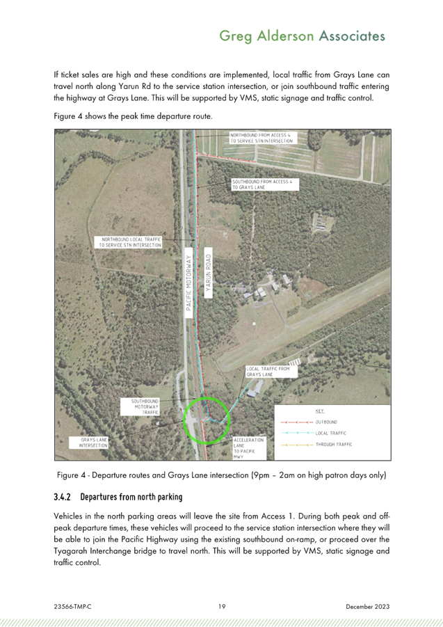
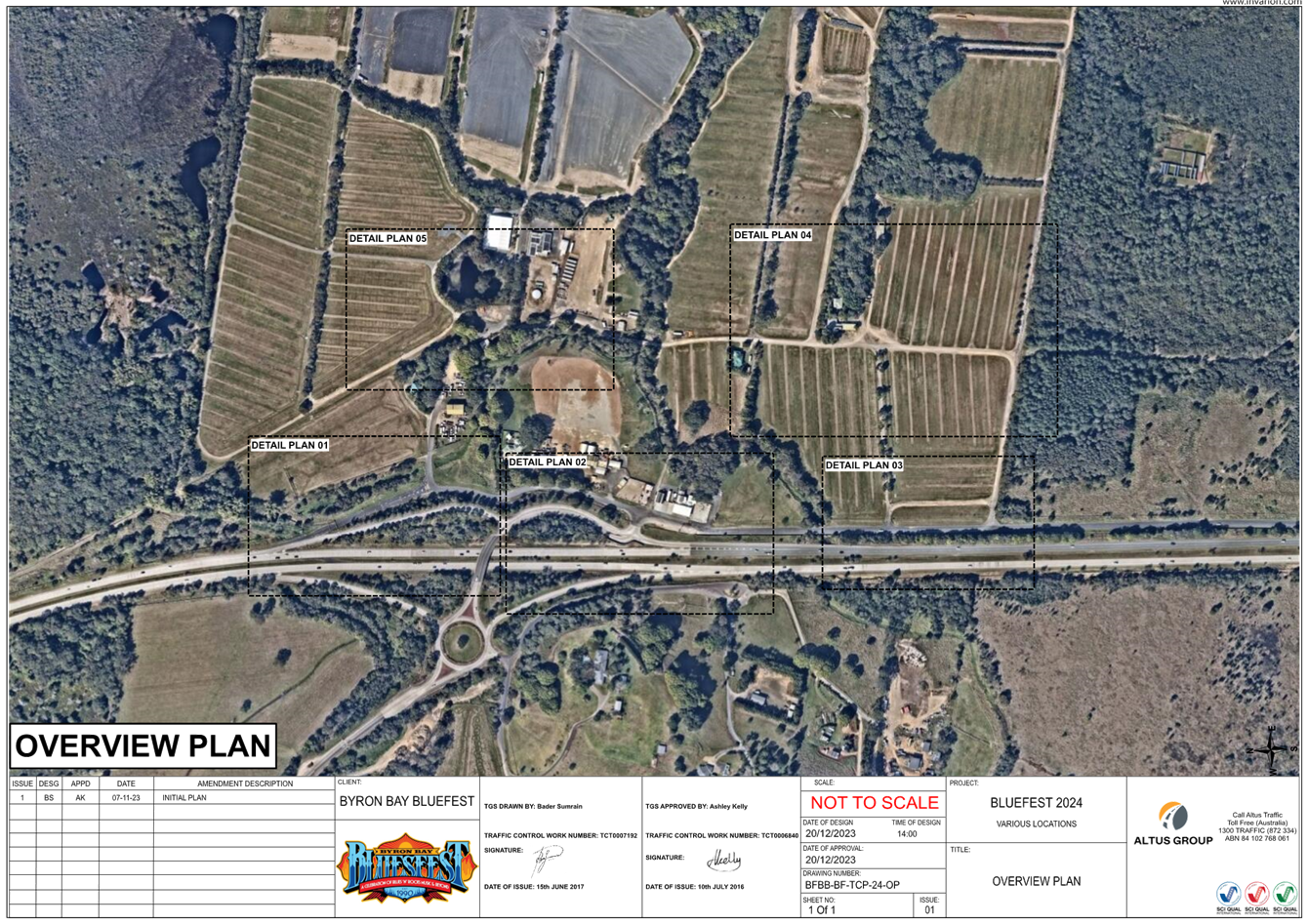
No. 6.2 Blues Festival 2024 Traffic Managment Plan
File No: I2023/2081
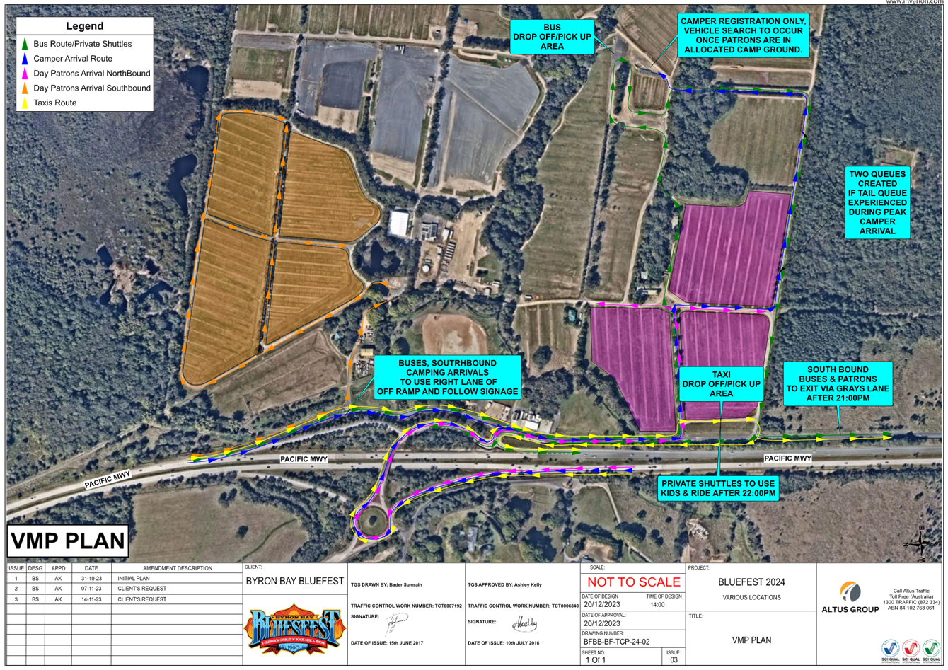
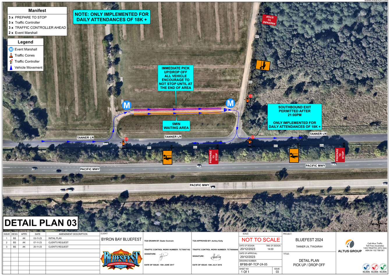
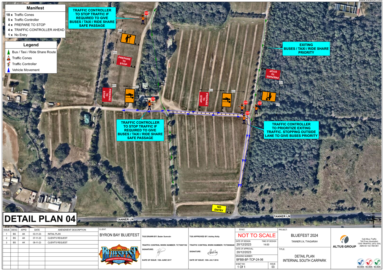
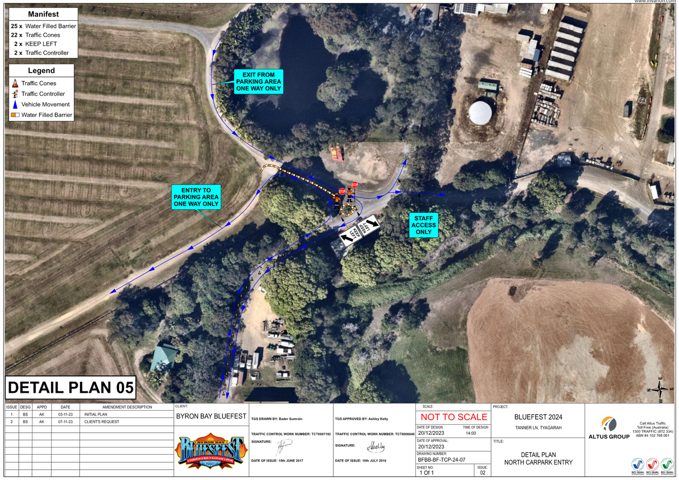
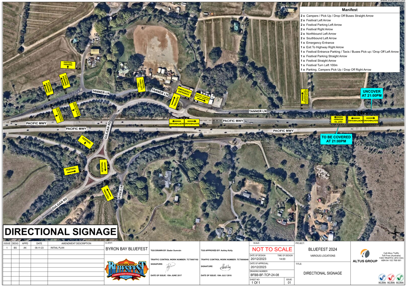
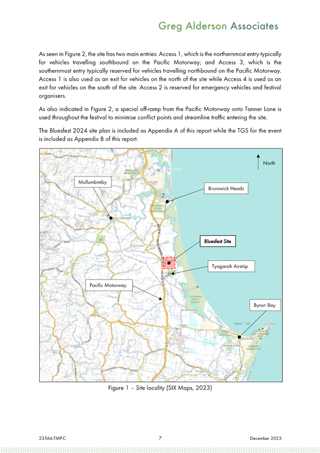
Bluesfest plans to run the 2024 event
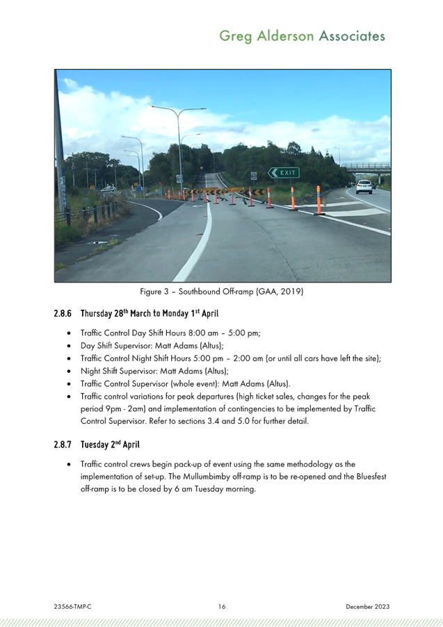
over the Easter Long Weekend: Thursday 28th March 2024
to Monday 1 April 2024 in accordance with DA10.2014.753.7.
Access to the camp grounds will be
available from Wednesday 27th March until the 2nd April
2024.
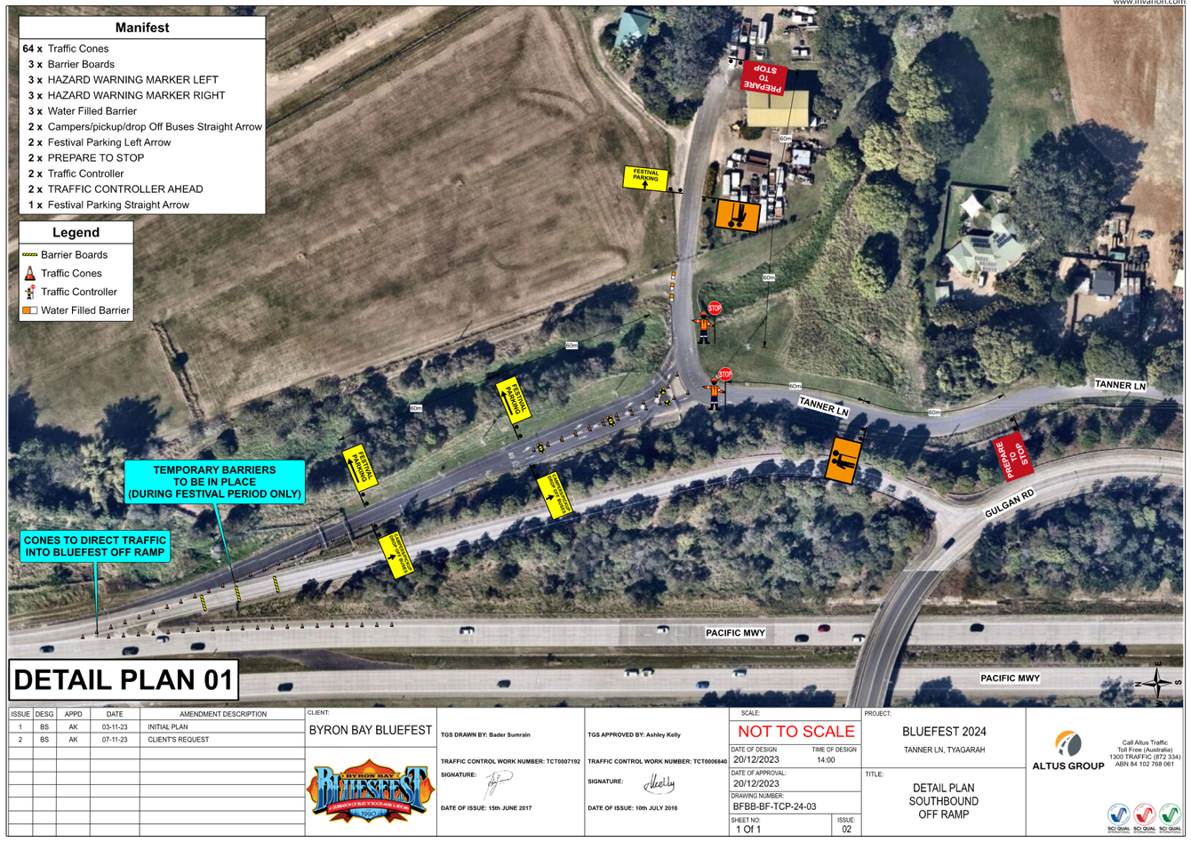
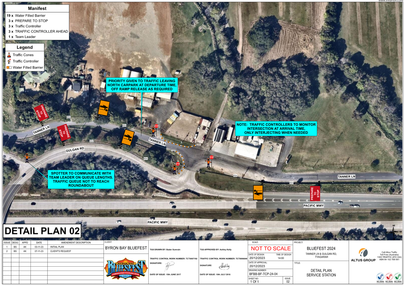
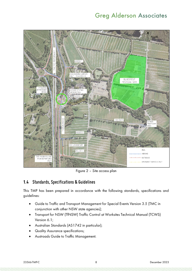
Bluesfest have submitted a traffic
management plan (TMP) and traffic guidance scheme (TGS) in accordance with the
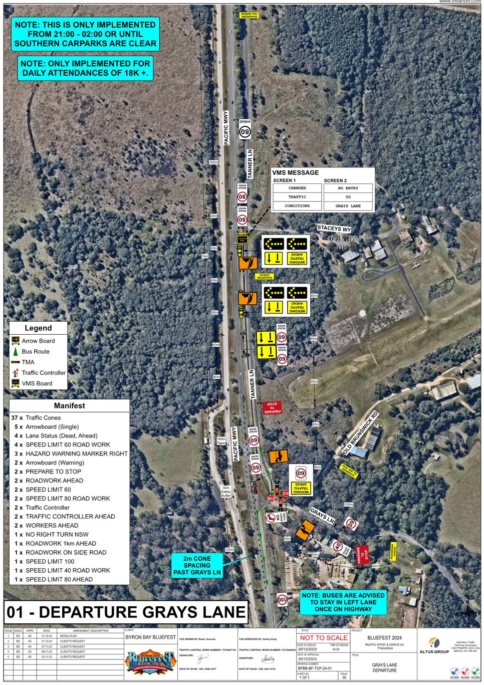
conditions of consent for DA 10.2014.753.7. The TMP includes a trigger point to
be enforced to open Grays Lane in the south, only if ticket sales are
greater than 18000 a day with gates to be open from 9pm-2am ONLY.
Council’s Development Engineer has
reviewed the submitted TMP and TGS and confirms they meet the conditions of
consent requirements. For reference the specific traffic related
condition have been inserted below.
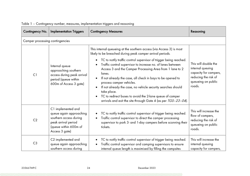
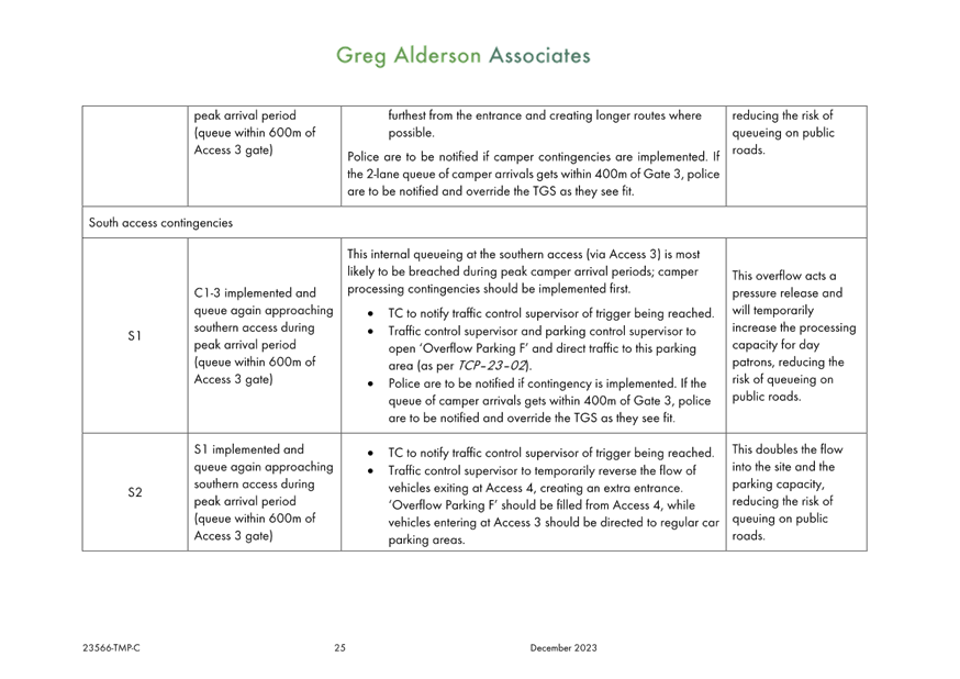
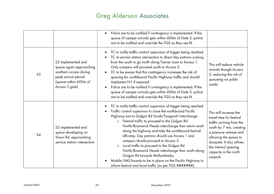
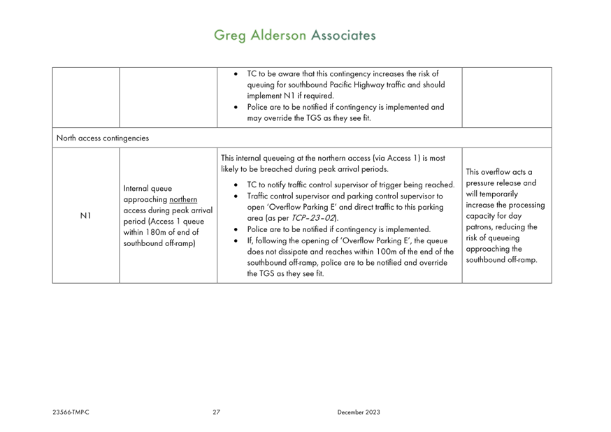
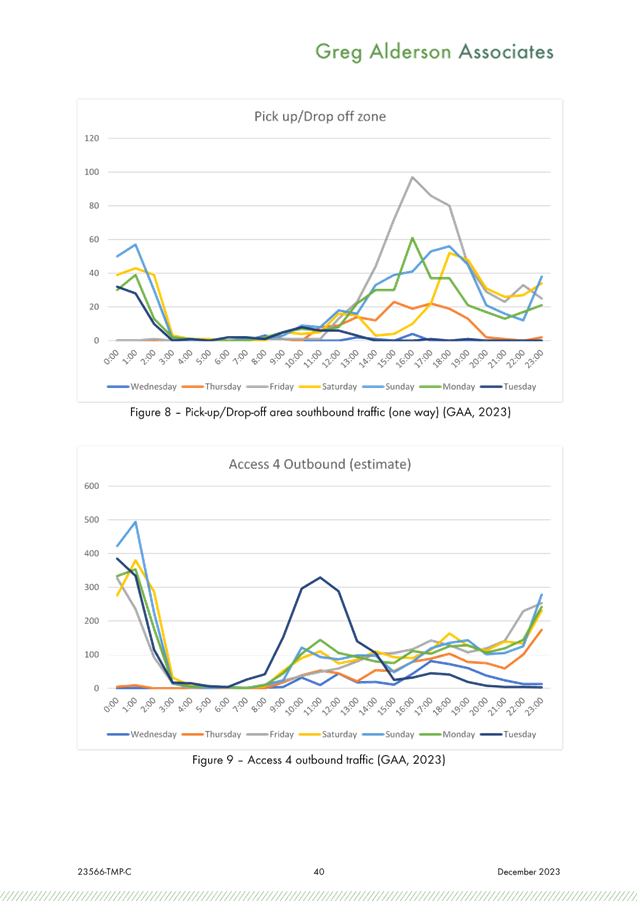
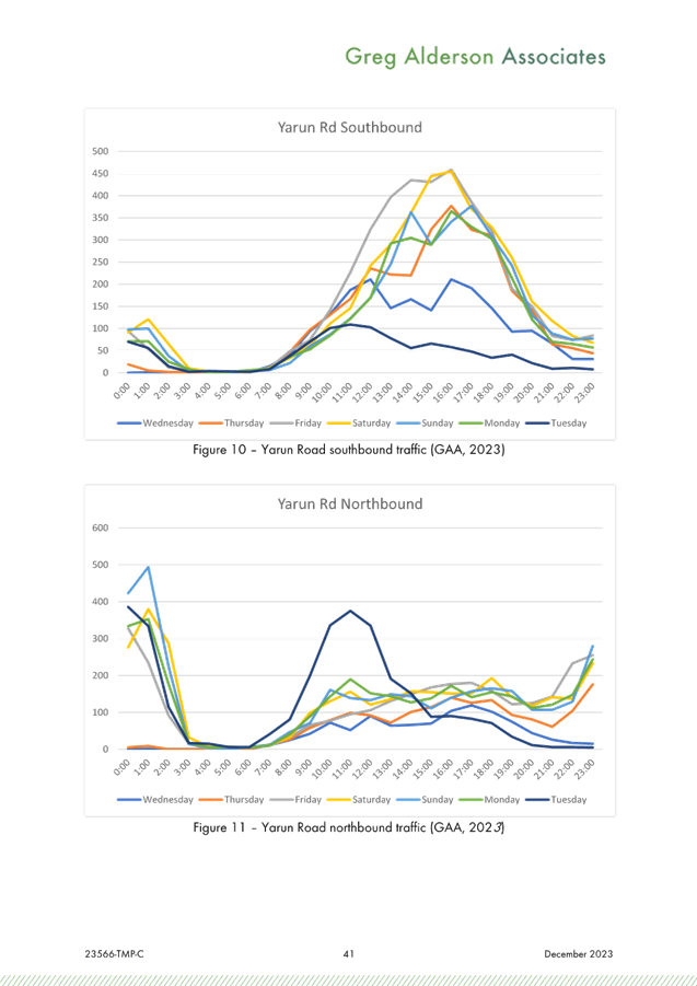
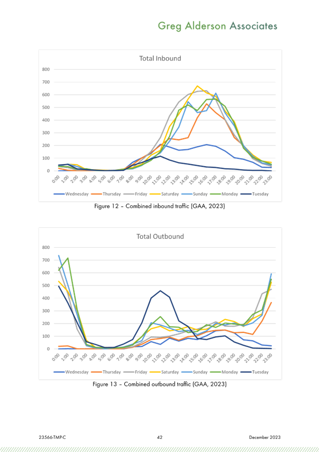
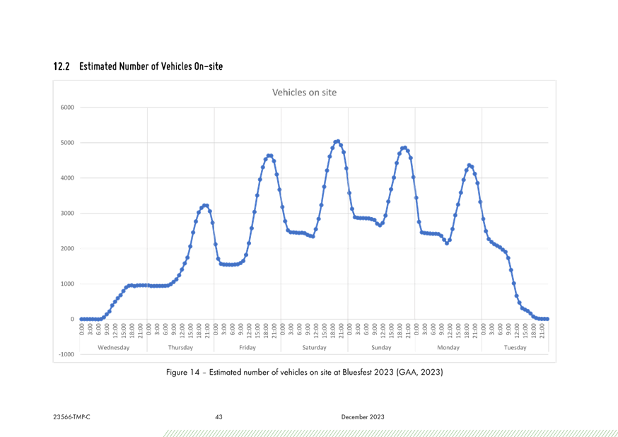
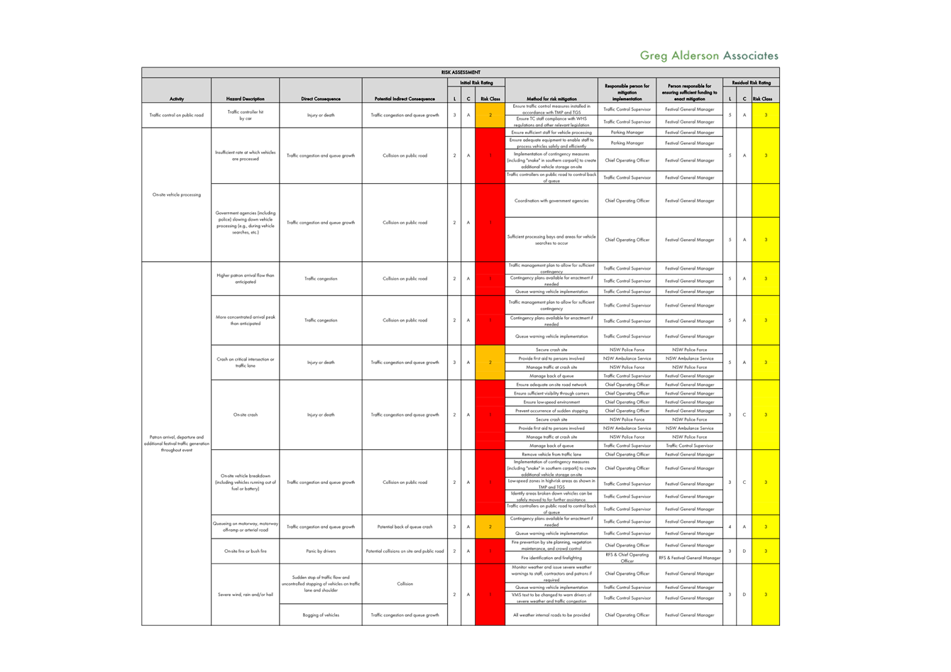
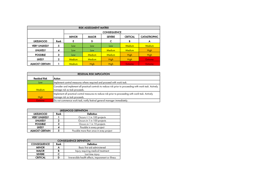
Contingency plans (refer table 1 in the
TMP) have been designed to manage the flow of traffic in the event of an
incident or if traffic queues appear as though they may breach KPIs. These contingency
plans have been designed with the intent of increase traffic flow from the
public roads onto the site before any of the KPIs are breached. These
contingency plans are to be implemented by festival management, with
notification of any contingency implemented to be given to the relevant parties
(traffic control supervisor, police, safety advisor, traffic engineer, etc.).
DA 10.2014.753.7 CONDITIONS
The following conditions are relevant:
61. Transport Management Plan
The submission of a Transport
Management Plan (TMP) prepared in accordance with the “Guide to Traffic
and Transport Management for Special Events”, to Council for approval at
least 90 days prior to the commencement of the first event under Stage 1.
The Transport Management Plan to be
broken into three parts to delineate management measures for small, medium and
large events. The plan to be robust to enable it to be used for a variety of
small, medium and large events annually.
a) The
Transport Management Plan must include, but not be limited to:
i Details
for the efficient management of parking, including provision for overflows from
the southern parking area to the northern parking area. The management of
overflow parking must ensure that the overflow vehicles exit the site from
where they entered the site.
ii. A
contingency plan for unplanned incidents that may disrupt traffic and transport
before, during or after the event. The contingency plan must be fully
documented and include emergency contact names and phone numbers.
iii. A copy of an
approved Traffic Control Plan.
b) The
Traffic Control Plan (TCP) must address the following matters:
i. The
TCP must be designed in accordance with the requirements of the Roads and
Maritime Services’ Manual, Traffic Control at Work Sites Version 2, and
the current Australian Standards, Manual of Uniform Traffic Control Devices
Part 3, ‘Traffic Control Devices for Works on Roads’.
ii. The
TCP must be prepared by a suitably qualified and RMS accredited Work Site
Traffic Controller.
iii. The
regulation of traffic must be authorised under the Roads Act 1993 and the use
of traffic control devices authorised under the Road Transport (Safety &
Traffic Management) Act 1999.
iv. Reduced
speed zones must be approved by the Roads and Maritime Services.
v. There
is to be no impact on through travel times on the pacific Highway
vi. The
TCP must incorporate a monitoring program to assess the traffic volumes and
peak parking numbers associated with each event. Twenty four hour traffic
counts are to be undertaken before, during and after the first two medium and
large events (and as further required by Council or the Roads and Maritime
Service) for the traffic on the frontage and surrounding roadways.Such report
must include details demonstrating compliance with the conditions of consent
relating to traffic management including the requirements of the RMS provided
below. From time to time aerial photography of the site and surrounds at
regular intervals before during and after the event, including peak traffic and
parking periods should be undertaken to support the traffic monitoring report.
vii. The TCP must
provide for all relevant conditions of the Roads and Maritime Services.
viii. The TCP
must be submitted to the Local Traffic Committee prior to approval under the
Roads Act 1993 and adequate time must be allowed for this to occur and for the
preparation of any necessary reports and amendments necessary to meet the Local
Traffic Committee recommendations.
ix. The TCP
must satisfactorily address any concerns or issues raised by the Council,
Police and/or Roads and Maritime Services from previous events.
x. The
TCP must ensure access to surrounding and neighbouring properties at all times
including the wrecker and service station.
xi. The
TCP must provide appropriate signage to prohibit parking in the surrounding
road network and to prohibit access to the airport by festival patrons.
Adequate provision must be made to allow residents of Grays Lane to park in
Tanner Lane near the end of Grays Lane when through access is closed due to
flood. Permanent “No Parking” signs in Grays Lane from the
Pacific Highway to the Tyagarah Nature Reserve boundary will be considered as a
permanent management arrangement.
xii. Entrance to
Grays Lane East of Yarun Road to be restricted to residents and their guests
for the duration of the festival to prevent the parking of vehicles in Grays
Lane.
xiii. The TCP to
factor in that local roads operate a Level of Service D or better between the
hours of 8am and 8pm on event days. The ramps of the Gulgan Road Interchange
with the Pacific Highway to operate at Level of Service C or better at event
times (See Figure 3.1 Levels of Service Flow rates Austroads Guide to
Traffic Management Part 3 and Highway Capacity Manual)
xiv. The TCP to
include provision so that Traffic queuing on the Gulgan road off ramps does not
exceed stopping sight distances for 110 km/h speeds. (See RMS supplements and
Austroads Guide to road Design Part 3 Section 5.3.1 for stopping sight
distances)
c) The
Transport Management Plan and Traffic Control Plans to be reviewed on an annual
basis and where required such plans to be updated accordingly taking into
consideration changing traffic conditions, altered management arrangements and
other issues as identified by the Roads and Maritime Service, Council or the
Regulatory Working Group to ensure the safety and efficiency of the road
network.
d) The
Transport Management Plan and Traffic Guidance Scheme for the temporary use of
the camping ground in conjunction with the Splendour in the Grass Festival is
to be reviewed at the end of the event and a report prepared by a suitably
qualified traffic engineer to identify the effectivity and performance of the
Traffic Management Plan including measures to improve the safety and efficiency
of the surrounding road network. The report shall be submitted to Council and
reviewed by the Splendour in the Grass/ North Byron Parklands Regulatory
Working Group
Note: Access/
Egress from, and to, the Pacific Highway to Grays Lane to be closed in the
future by the TfNSW. The Transport Management Plan and Traffic Control Plan to
reflect proposed changes to this intersection. Traffic management documents to be in accordance with
current standards and terminology as stipulated by TfNSW
RECOMMENDATION:
1. That
Council endorse the regulatory traffic management facilities and devices,
including signs and traffic controller provisions proposed for the Council controlled
public road network as outlined in attachment 1 (E2023/135660) for the Byron
Bay Bluesfest 2024 to be held on Thursday 28 March 2024 to Monday 1 April 2024,
subject to:
a) Separate
approvals by NSW Police and TfNSW being obtained, noting that the event is on a
state road or may impact the state road network;
b) The
event be held through the implementation of the events Traffic Management Plan
and Traffic Control Plan(s) as per attachment 1 (E2023/135660) The Traffic
Management Plan is to include contingency measures in case the level of queuing
fails to meet KPI requirements. It is noted that such queuing may be caused by
the introduction of paid parking.
c) The
Traffic Management Plan and the Traffic Control Plan(s) to be implemented by
those with relevant and current TfNSW accreditation;
d) Traffic
camera data recorders or similar be used to obtain an accurate record of
traffic impacts at KPI queue locations;
e) That
the impact of the event be advertised via a notice in the local weekly paper a minimum
of one week prior to the operational impacts taking effect, noting it must
include the event name, specifics of any traffic impacts or road closures and
times, alternative route arrangements, event organiser, a personal contact name
and a telephone number for all event related enquiries or complaints;
2. That
the event organiser:
a) advertise
the impact of the event via a notice in the local weekly paper a minimum of one
week prior to the operational impacts taking effect, noting it must include the
event name, specifics of any traffic impacts or road closures and times,
alternative route arrangements, event organiser, a personal contact name and a
telephone number for all event related enquiries or complaints;
b) provide
a copy of the advert for Council's web page;
c) give
consideration of any submissions received;
d) inform
community and businesses that are directly impacted (e.g. adjacent to the
event) via written information which is delivered to the property in a timely
manner so as to document, consider and respond to any concerns raised;
e) arrange
for private property access and egress affected by the event;
f) liaise
with bus and taxi operators and ensuring arrangements are made for provision of
services during conduct of the event;
g) consult
with emergency services and any identified issues be addressed;
h) holding
$20m public liability insurance cover which is valid for the event;
i) paying
Council’s Road Event Application Fee prior to the event.
Attachments:
1 51.2023.1065.1
- Bluesfest 2024 TMP, E2023/135660
, page 13⇩ 
Regulatory
Matters 6.2 - Attachment 1

Local Traffic Committee Meeting 6.3
Report
No. 6.3 Event
- Mullum2Bruns Paddle 2024 - 2026
File No: I2024/94
SUMMARY
Council is expecting the annual application from the
Mullum2Bruns Paddle Committee for the Mullum2Bruns Paddle 2024 to be held
Sunday 19 May 2024 and looking to gain approval for 3 years to 2026.
BACKGROUND
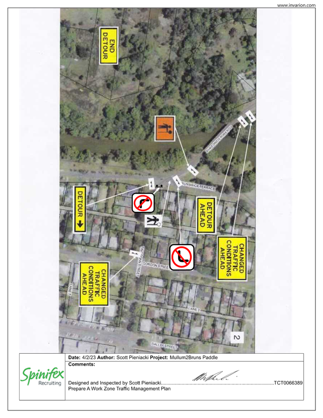
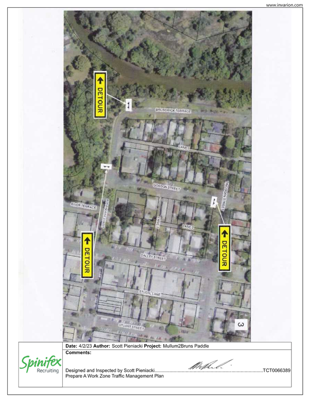
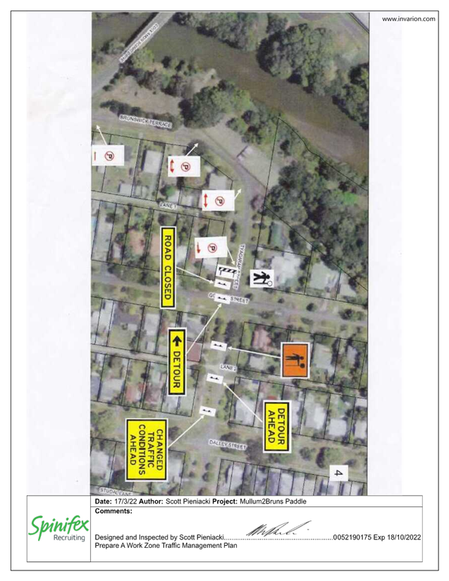
The event will be the same as the
previous Traffic Management Plan and Traffic Guidance Scheme (TGS). The 2022
TGS has been attached for reference but has not yet been updated to reflect
2024 dates. Below is a general summary of what traffic control is
proposed as part of the 2024 event.
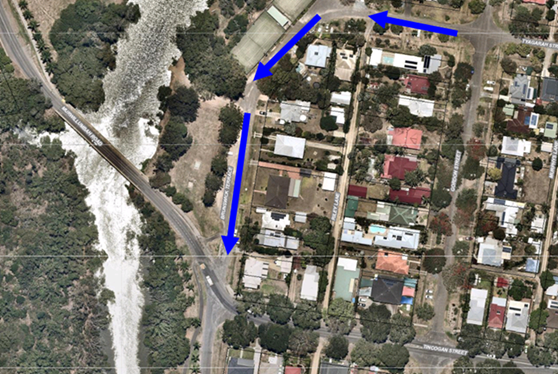
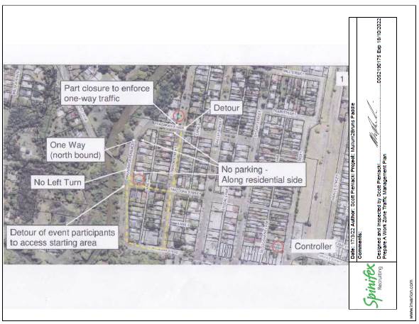
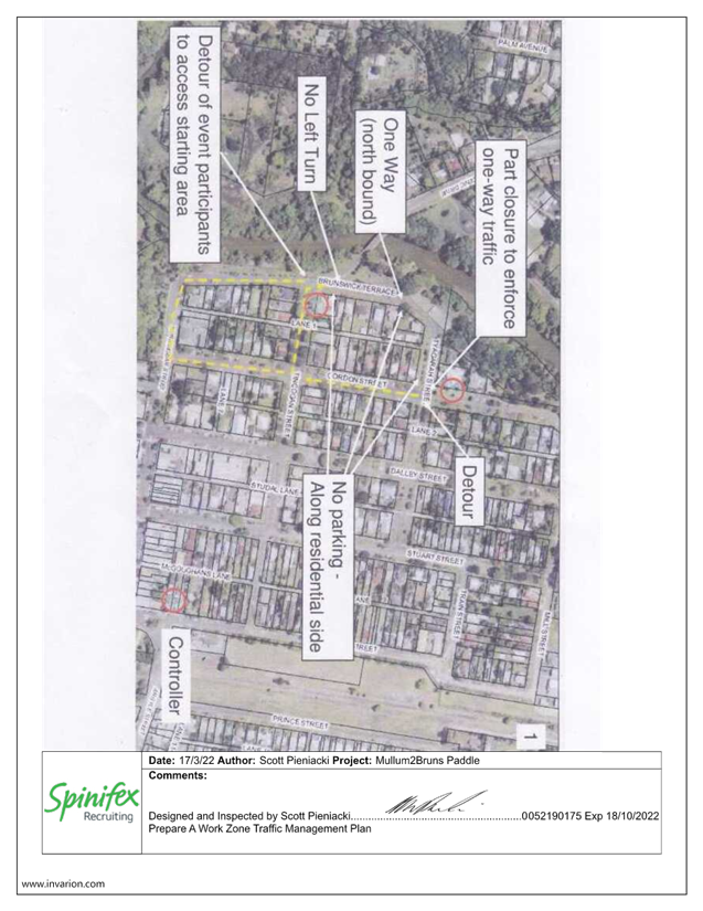
To ensure greater safety around
the registration and marshalling area the event proposes temporary one-way
traffic off Brunswick Terrace, between Tincogan Street and Tyagarah Street,
Mullumbimby, between 6:30am and 10:00am. The direction of the one way is
shown in the image below.
Additional traffic control
measures proposed include:
The right turn off Tincogan Street
into Brunswick Terrace to have a “no right turn” sign
· The left turn off Tincogan St into Brunswick Terrace to
have a “no left turn”
· Relevant detour signs will be installed at the approaches
to the impacted area
· No parking signs along the one way part of Brunswick
Terrace
· Participants will be diverted along the southern part of
Brunswick Terrace to the intersection of Brunswick Terrace & Tincogan
Street to enable them to cross to the starting area. The traffic
controllers will hold traffic crossing to the registration zone until there are
spaces for them to unload their craft.
· Uniformed Marine Rescue personnel will be patrolling the
homes opposite the registration area to ensure that participants are not
parking in front of or across driveways, thereby minimising inconvenience to
the residents.
· A letter-box drop will be done 2 weeks prior to the event,
informing residents in the surrounding streets of the temporary one-way traffic
closures.
RECOMMENDATION:
That the Local Traffic Committee endorse the
Mullum2Bruns Paddle 2024 to be held Sunday 19 May 2024 and valid for 3 years to
2026 and subject to:
1. The development
and implementation of a Traffic Management Plan (TMP) and Traffic Guidance
Scheme(s) (TGS) by those with appropriate NSW accreditation.
2. The TMP
and TGS is to include, but not limited to, the following:
a) One
way traffic along Brunswick Terrace, Mullumbimby, between 06:30am and 10:00am
on Sunday 19 May 2024. The one way is to be from Tyagarah Street to Tincogan
Street;
b) The
right turn off Tincogan Street into Brunswick Terrace to have a “no right
turn” sign;
c) The
left turn off Tincogan St into Brunswick Terrace to have a “no left
turn”;
d)
Relevant detour signs at the approaches to the impacted area;
e) No
parking signs along the one way part of Brunswick Terrace.
3) The
event organiser to:
a)
Advertise the impact of the event, via a Variable Message Sign on site and
notice in the local weekly paper, a minimum of one week prior to the
operational impacts taking effect, noting it must include the event name,
specifics of any traffic impacts or road closures and times, alternative route
arrangements, event organiser, a personal contact name and a telephone number
for all event related enquiries or complaints;
b)
Arrange for the event to be notified on Council’s webpage a minimum one
week prior to the TGS being implemented;
c)
undertake consultation with relevant community and affected businesses
including adequate response/action to any raised concerns during and after the
event;
d)
undertake consultation with emergency services and any identified issues
addressed;
e) hold
$20m public liability insurance cover which is valid for the event.
Attachments:
1 Event
- Mullum2Bruns Paddle [1] TMP 2023, E2023/35385
, page 86⇩ 
2 Event
- Mullum2Bruns Paddle [2] TMP - 2023, E2023/35388
, page 87⇩
3 Event
- Mullum2Bruns Paddle [3] TMP - 2023, E2023/35390
, page 88⇩
4 Event
- Mullum2Bruns Paddle [4] TMP - 2023, E2023/35392
, page 89⇩
5 Event
- Mullum2Bruns Paddle [5] TMP - 2023, E2023/35394
, page 90⇩
Regulatory
Matters 6.3 - Attachment 1
Regulatory
Matters 6.3 - Attachment 2
Regulatory
Matters 6.3 - Attachment 3
Regulatory
Matters 6.3 - Attachment 4
Regulatory
Matters 6.3 - Attachment 5
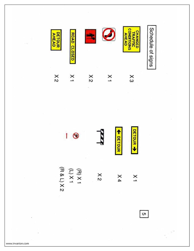
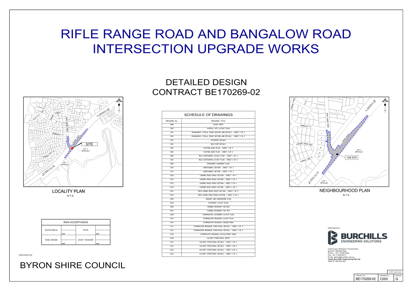
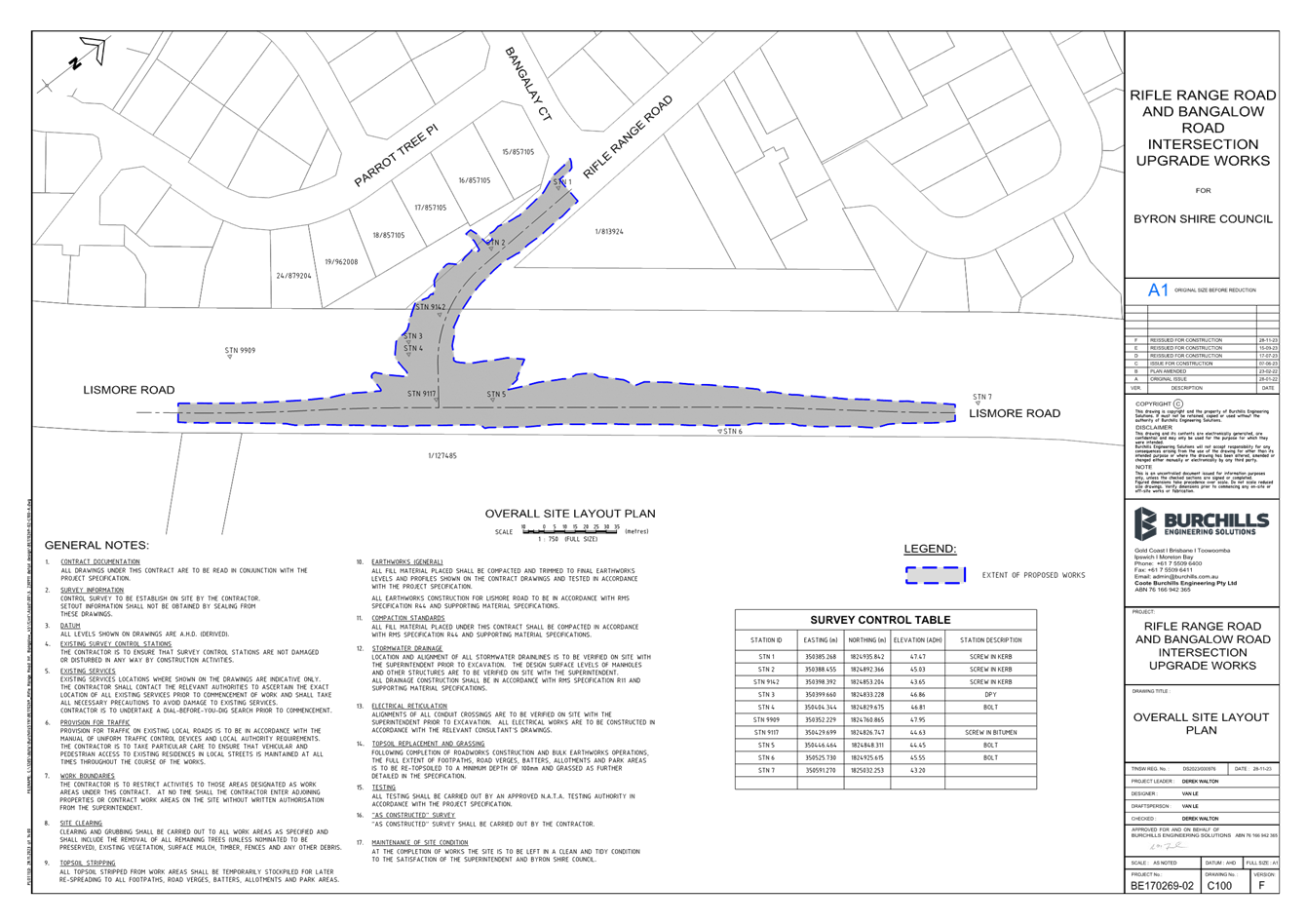
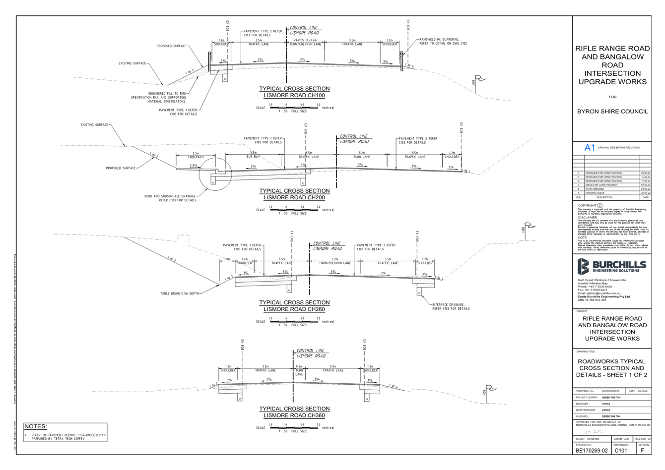
Local Traffic Committee Meeting 6.4
Report
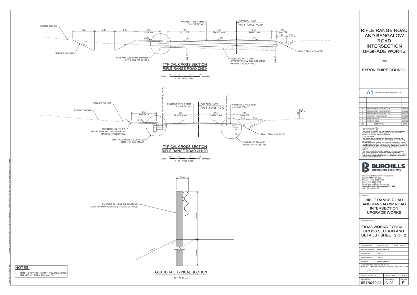
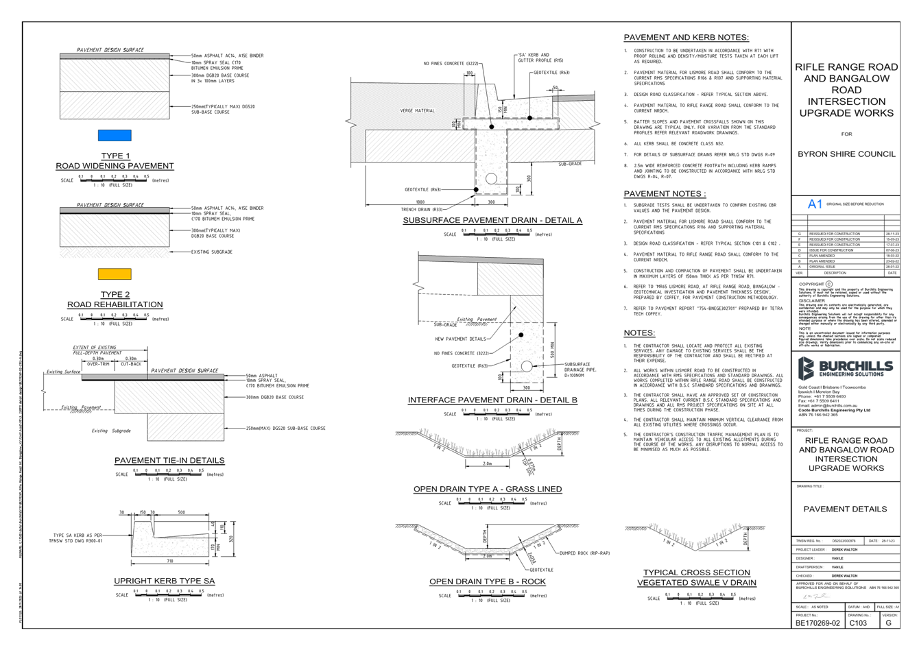
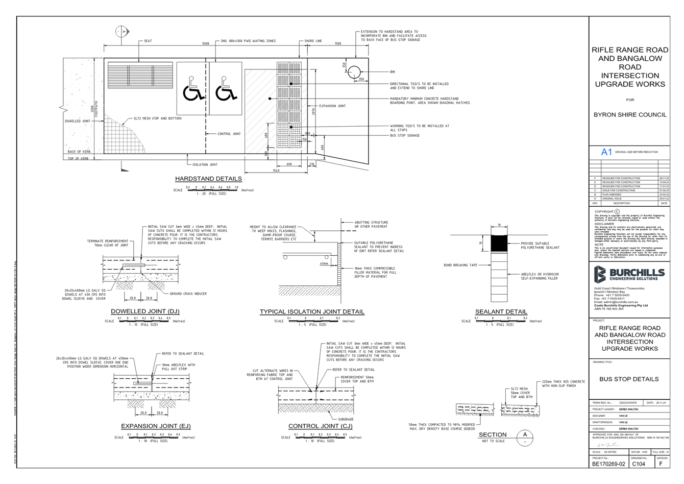
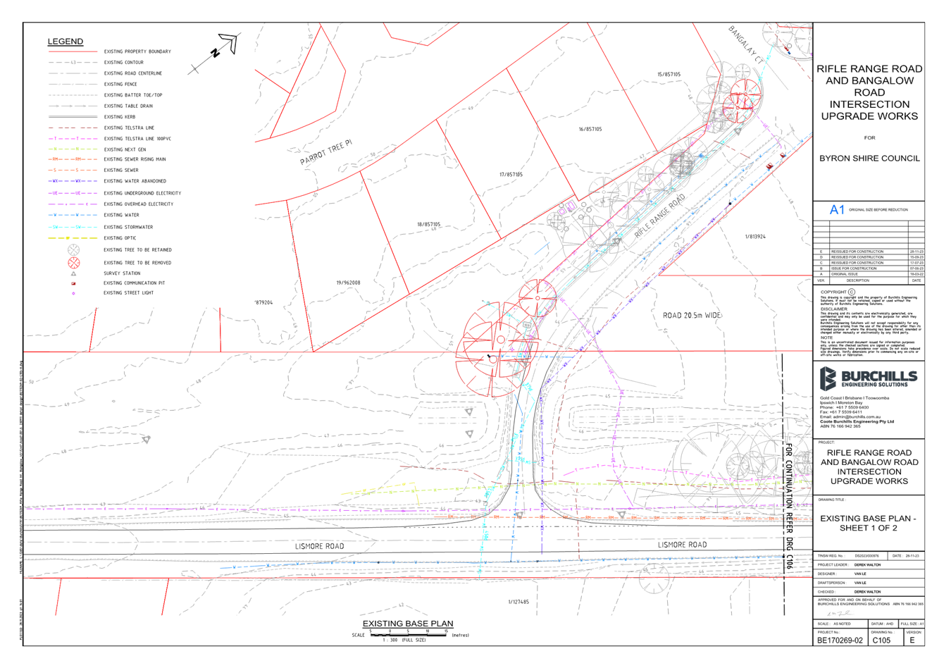
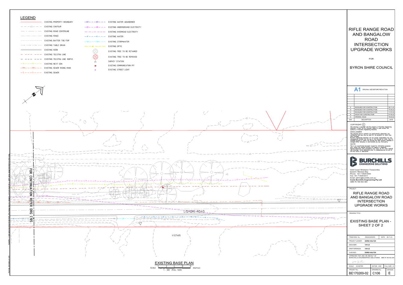
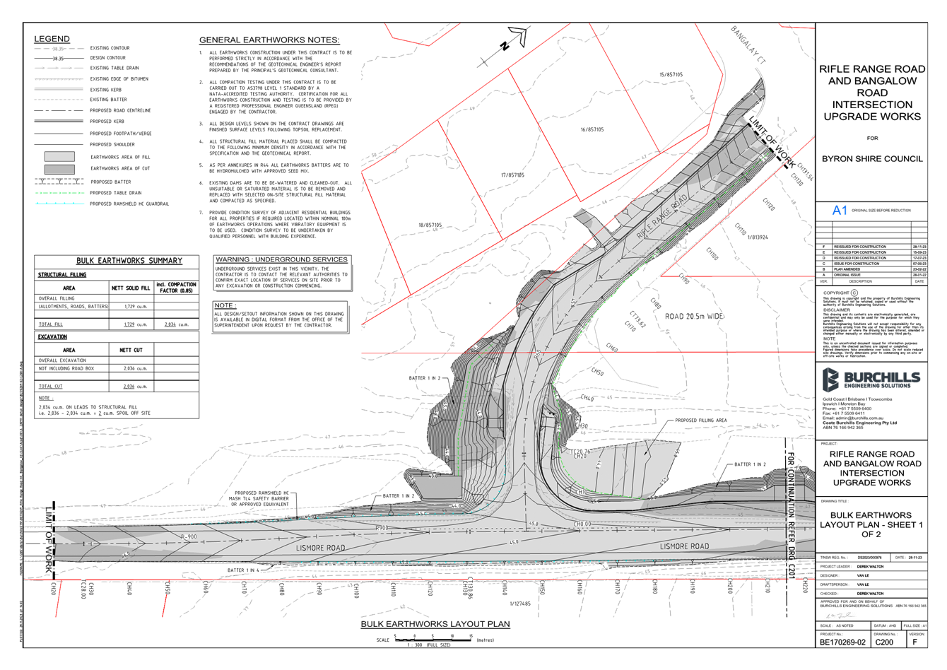
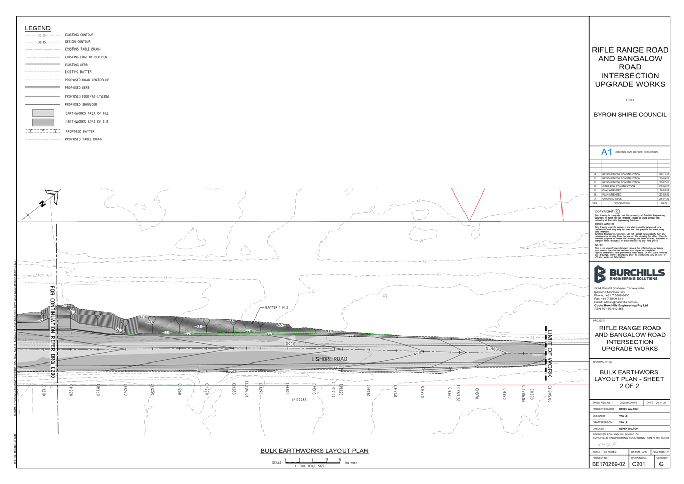
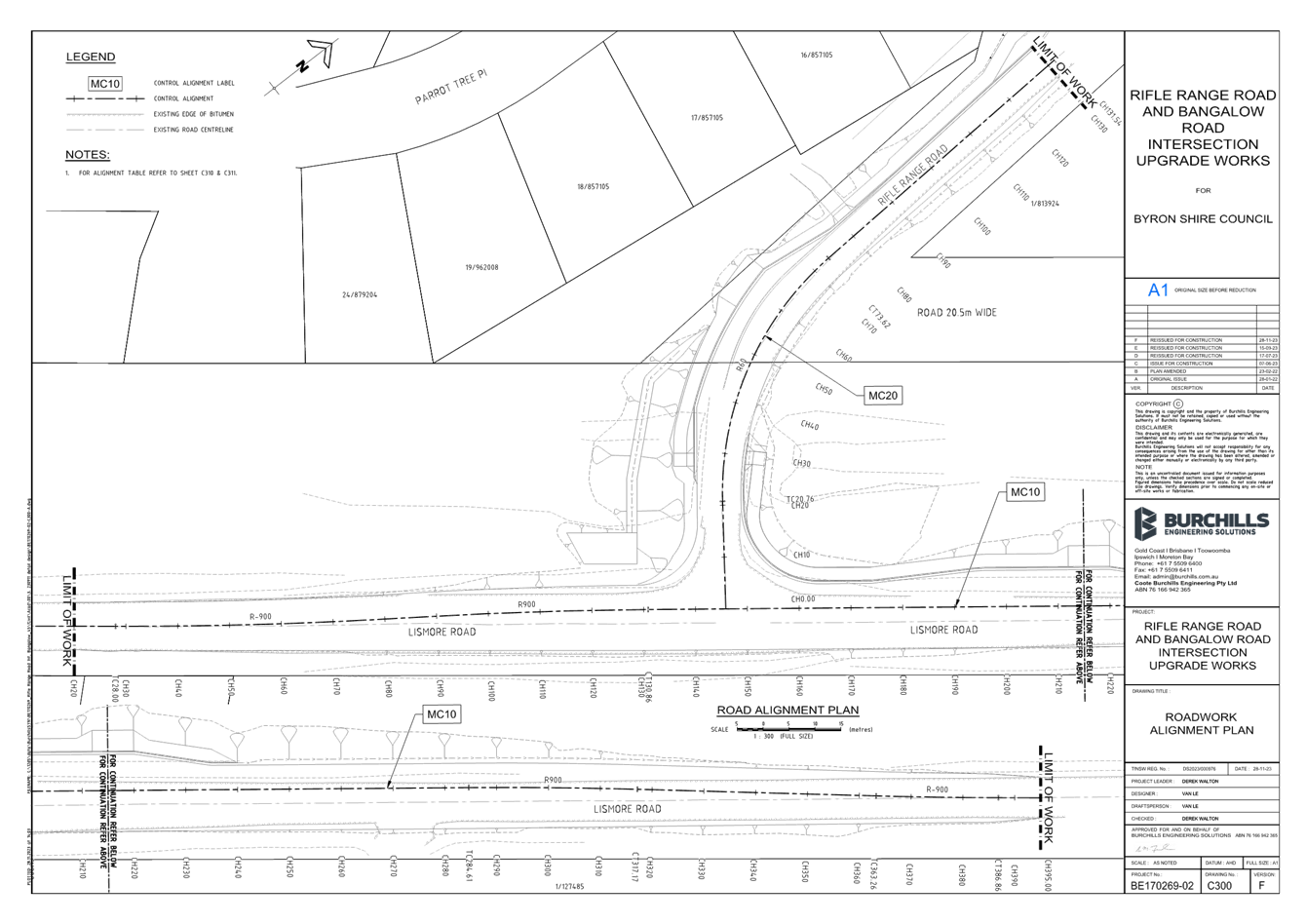
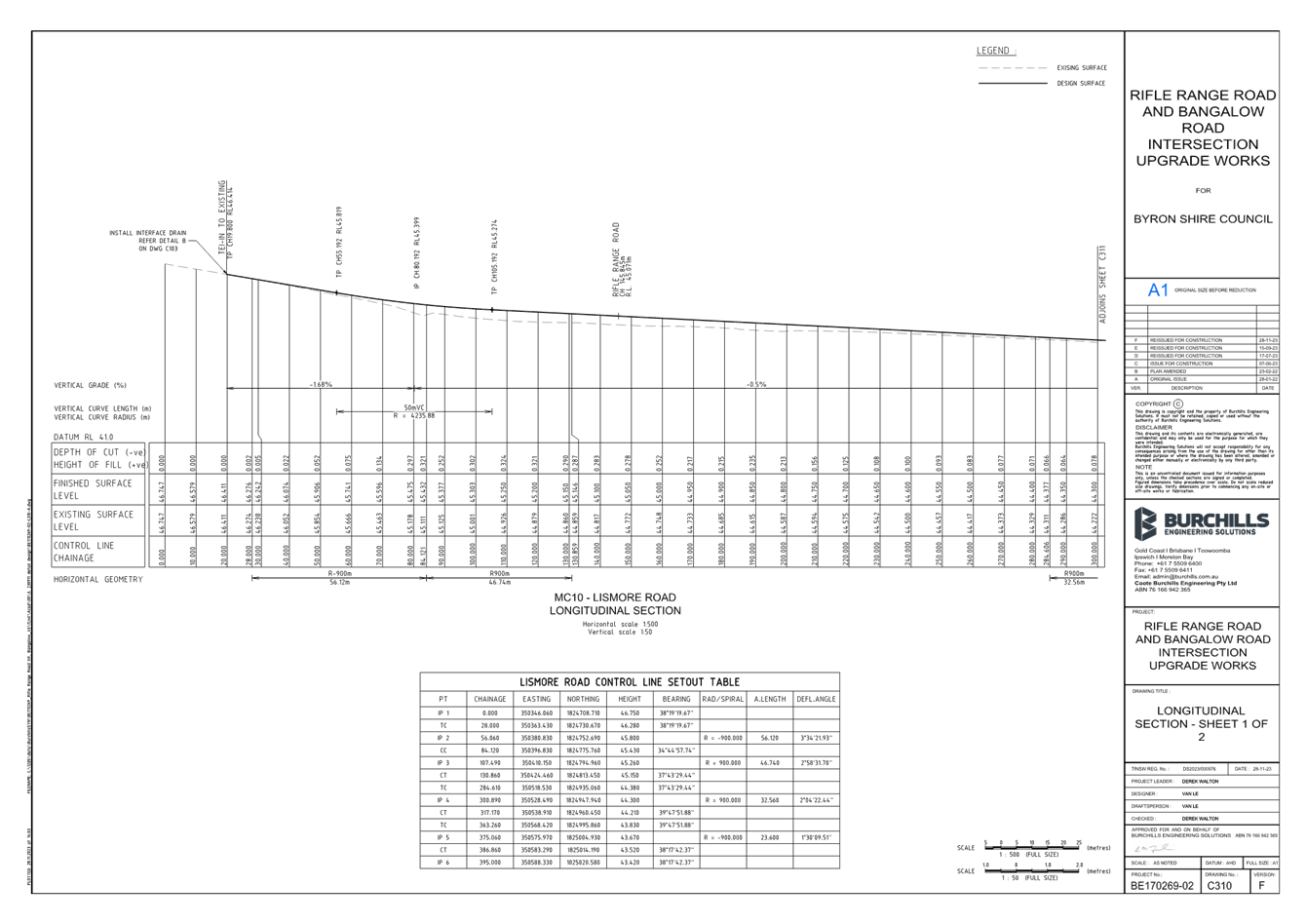
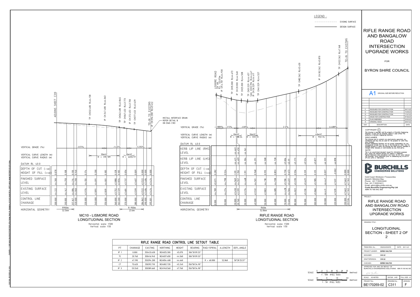
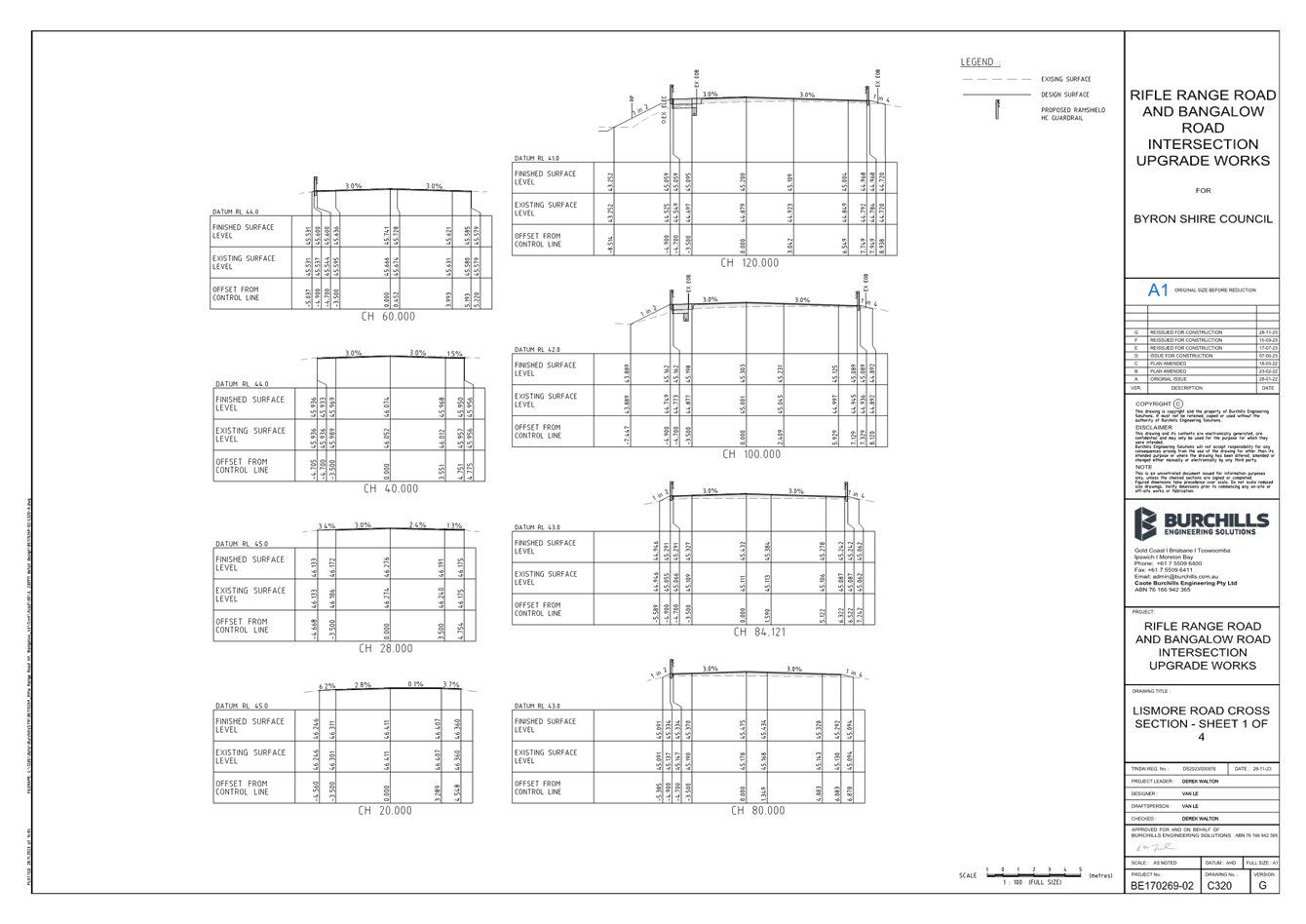
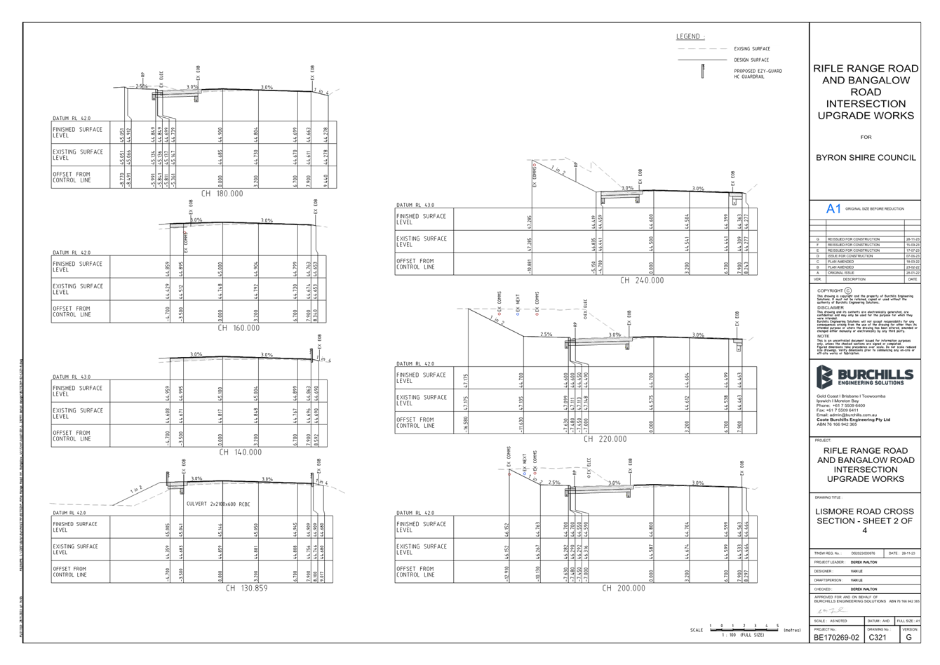
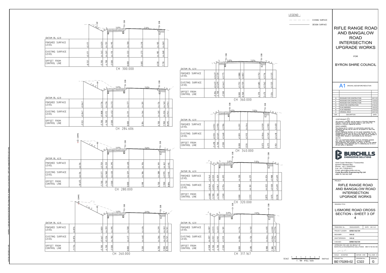
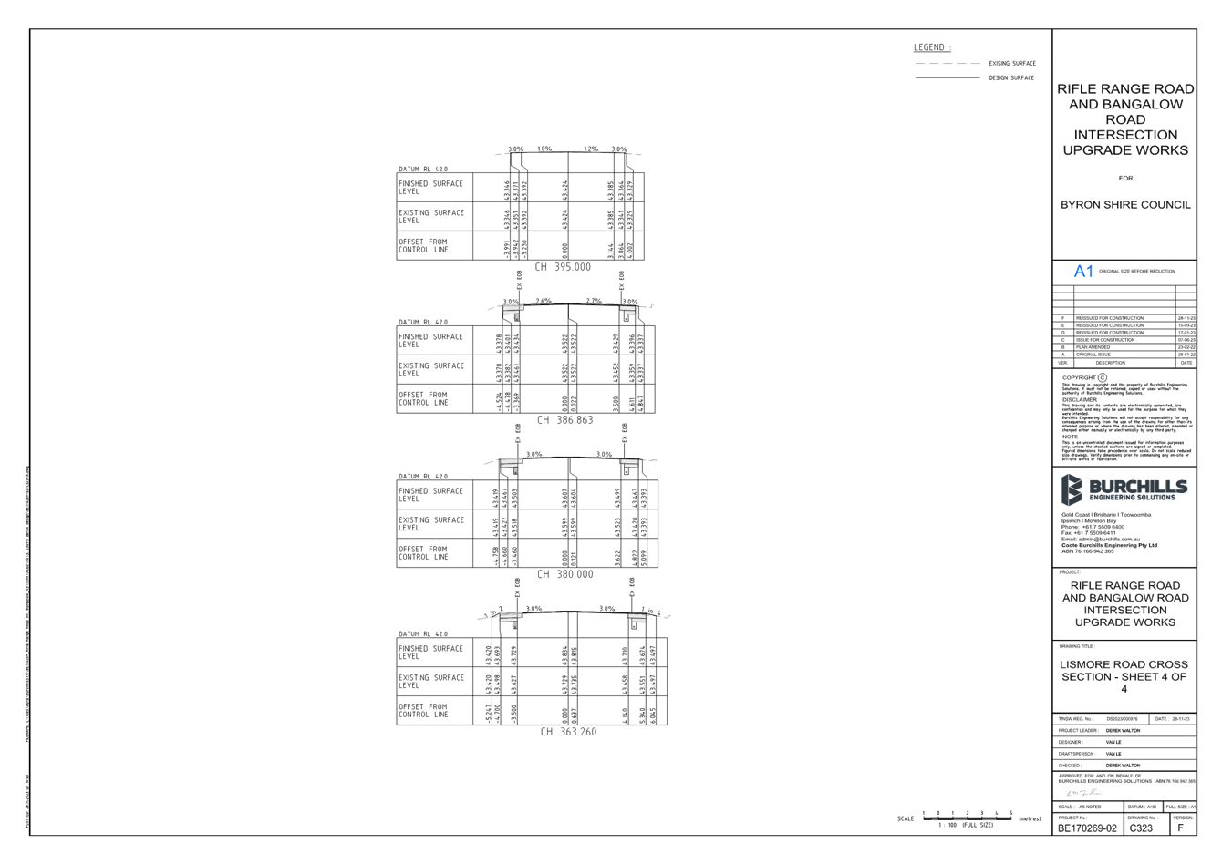
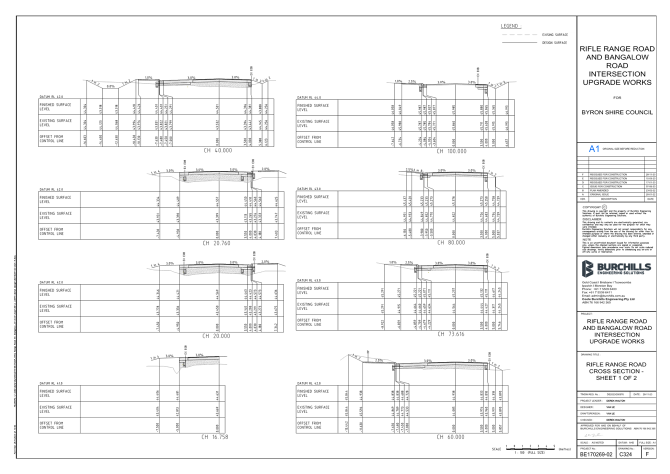
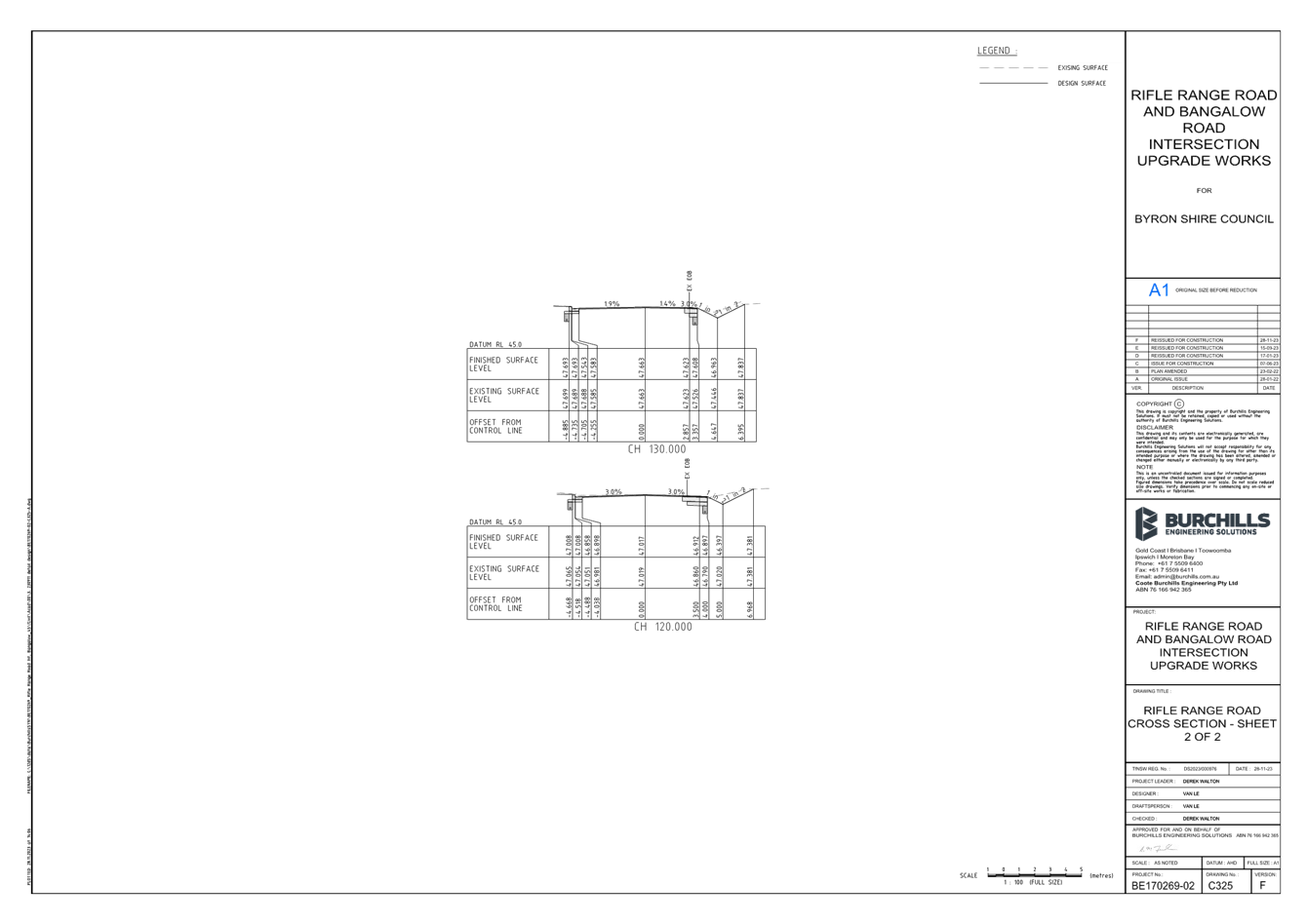
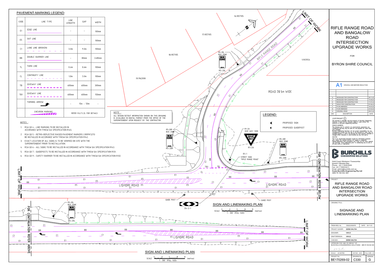
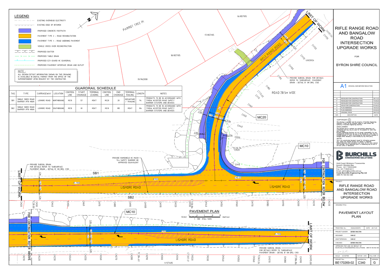
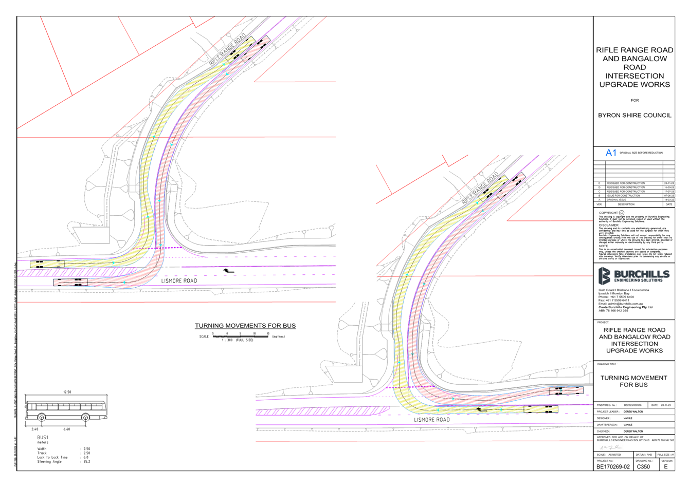
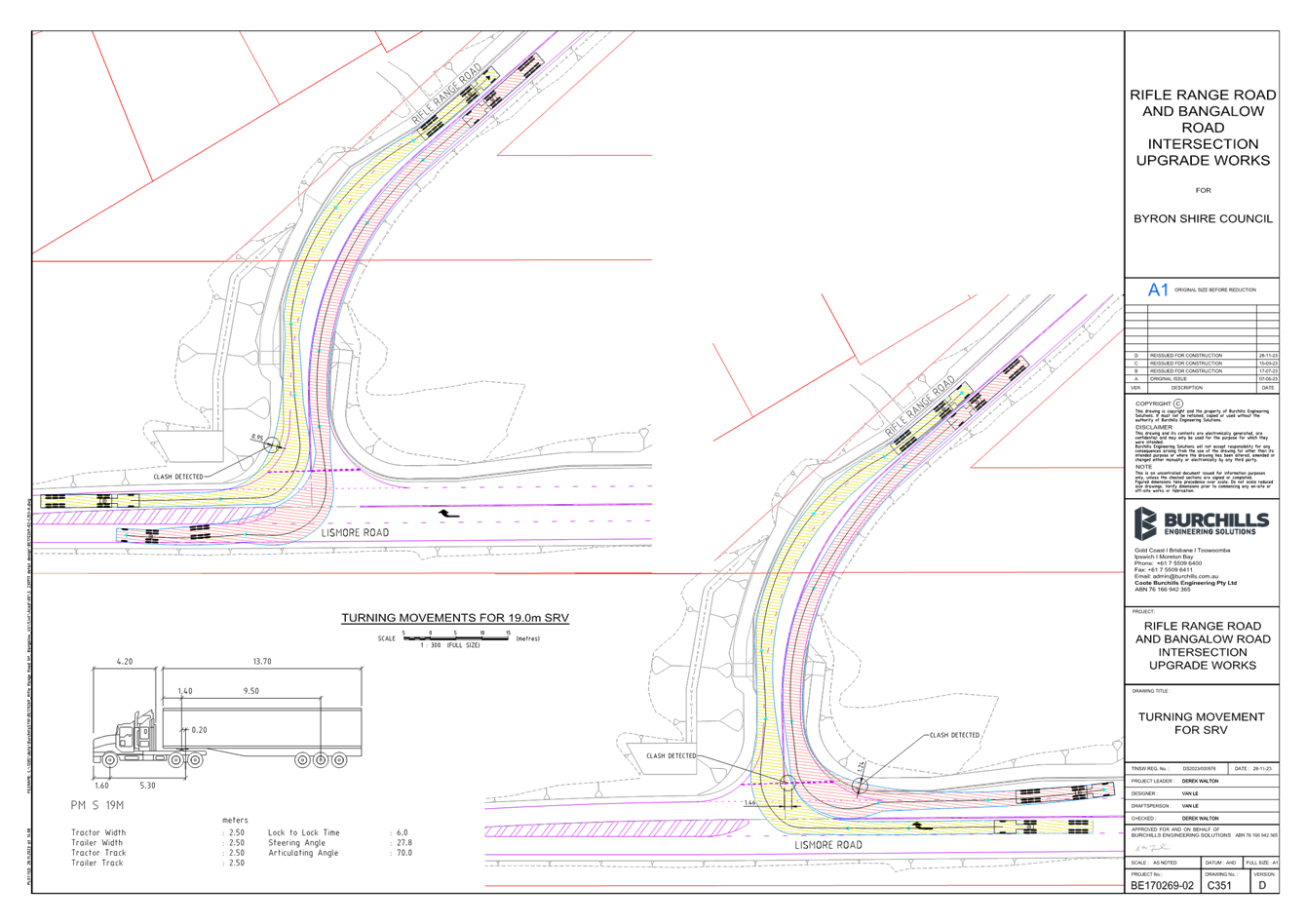
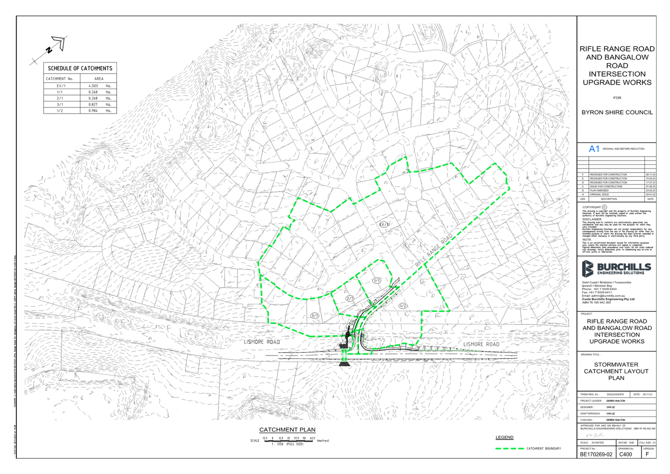
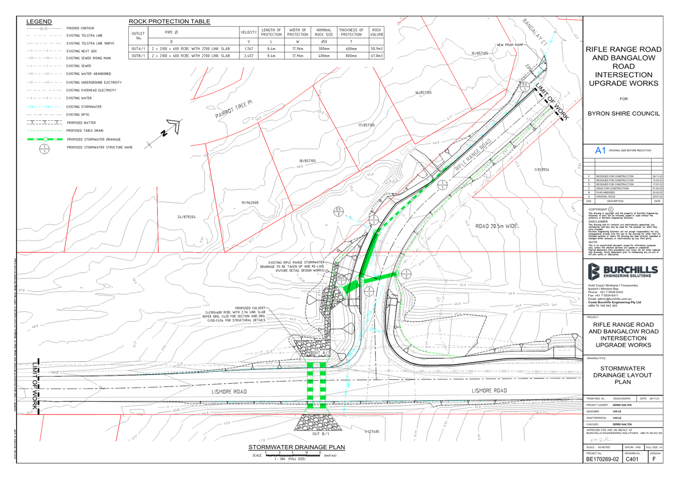
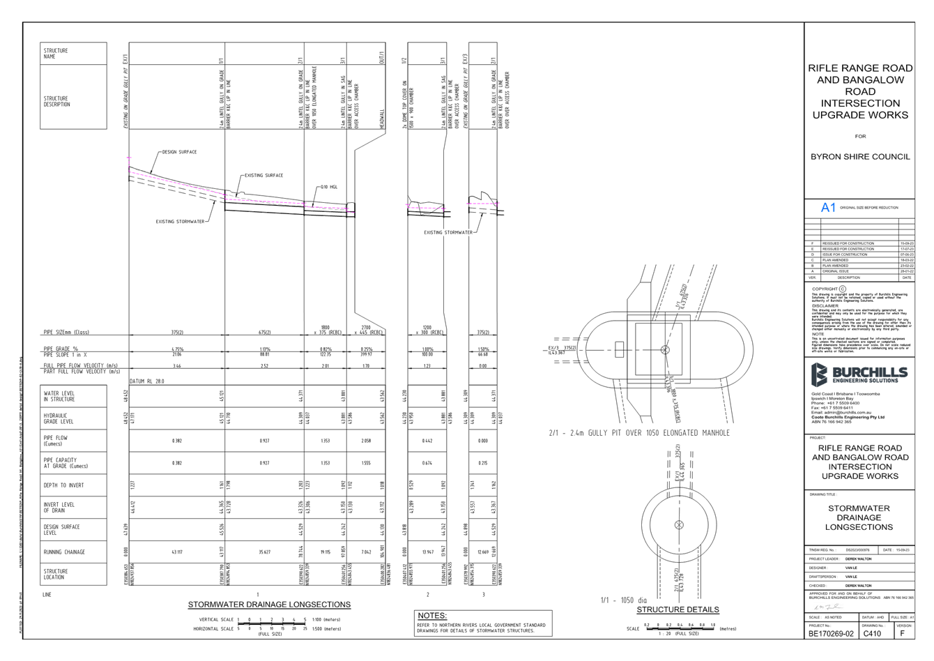
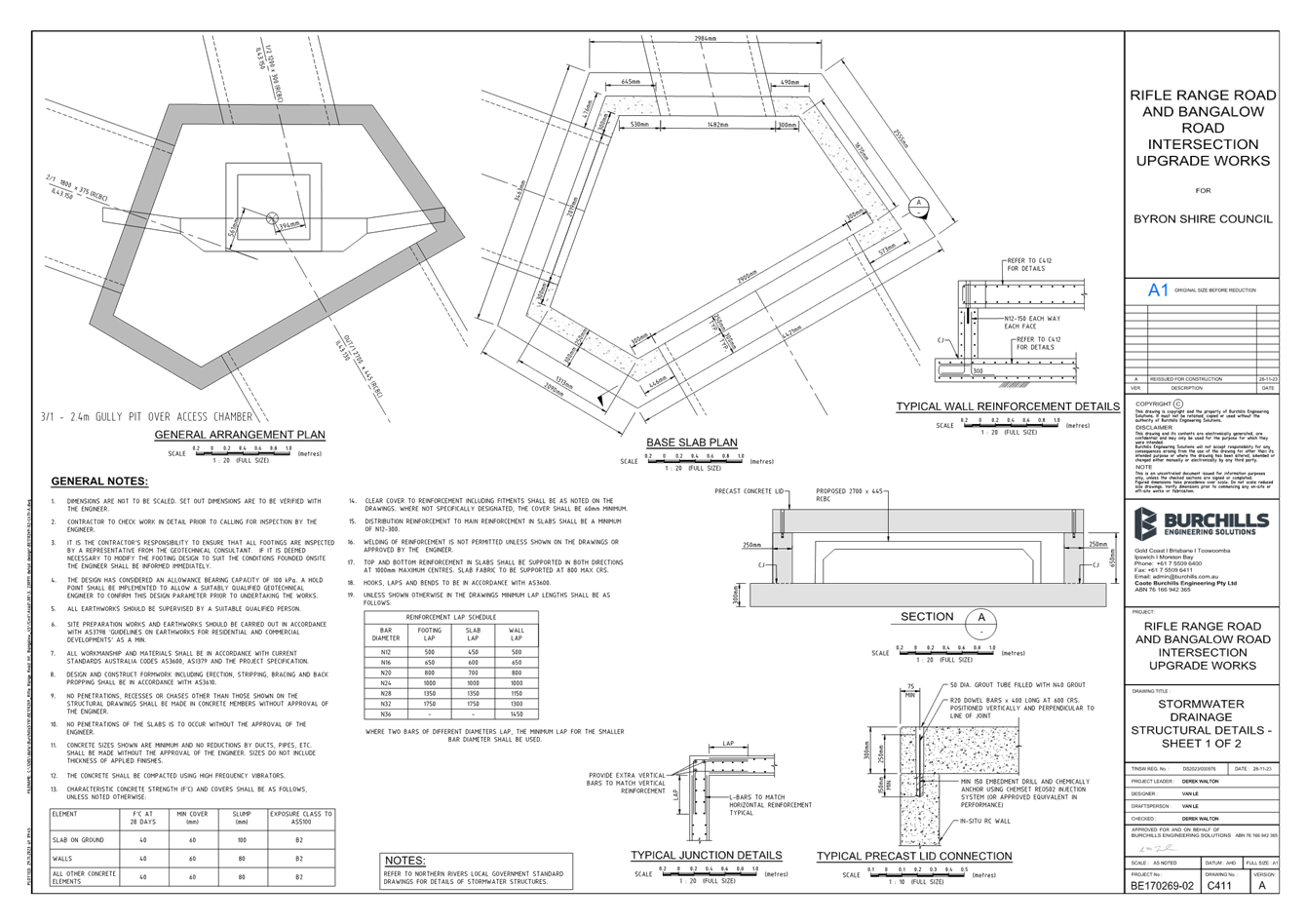
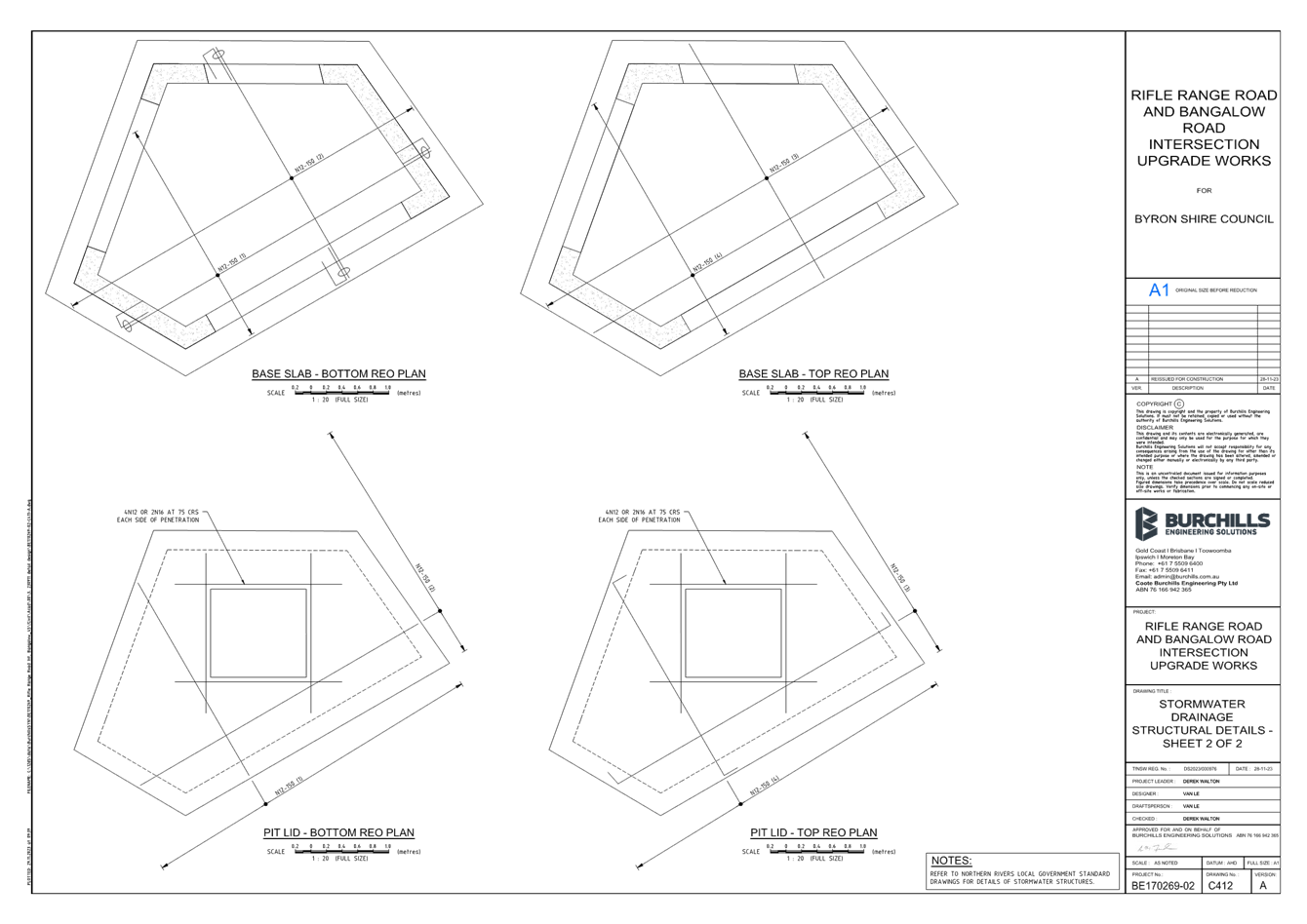
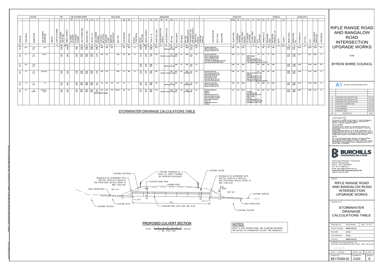
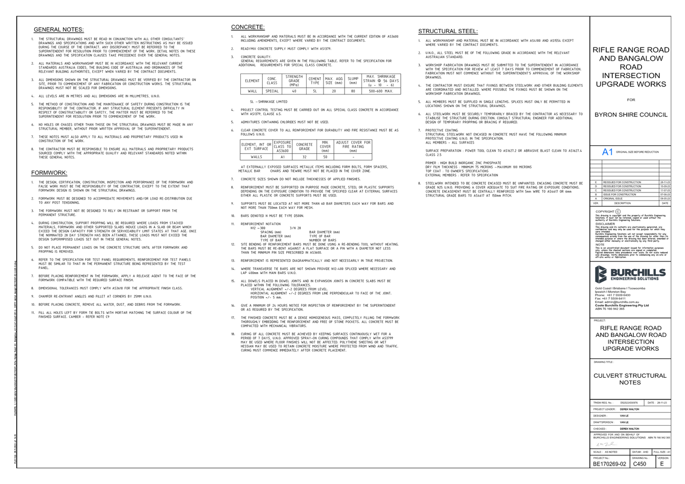
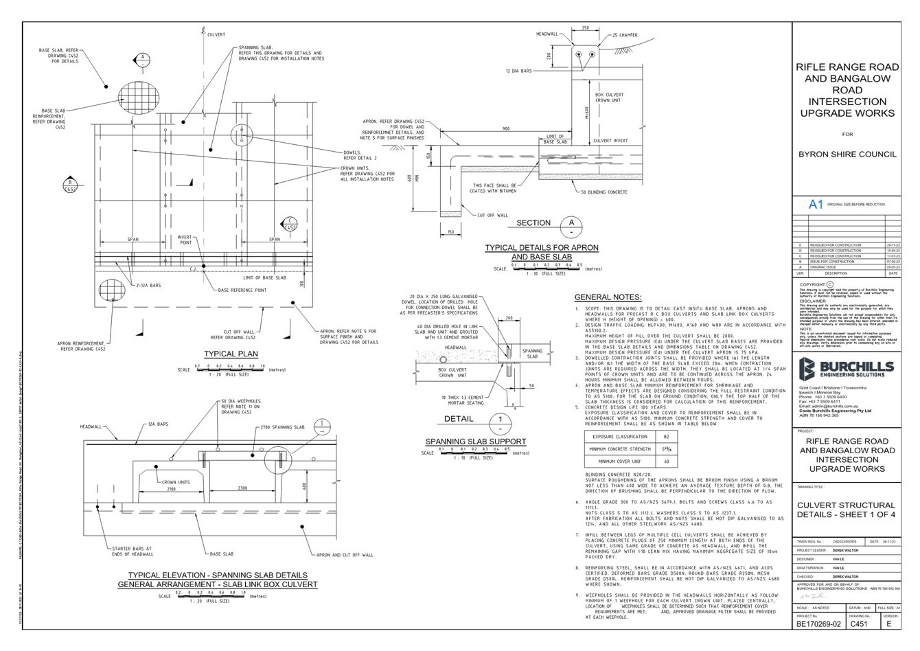
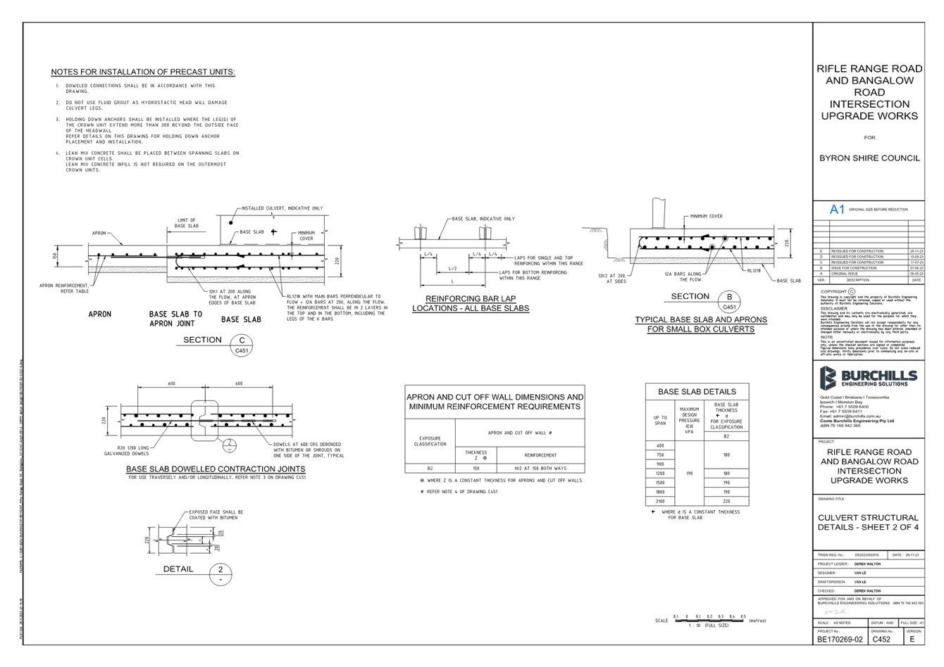
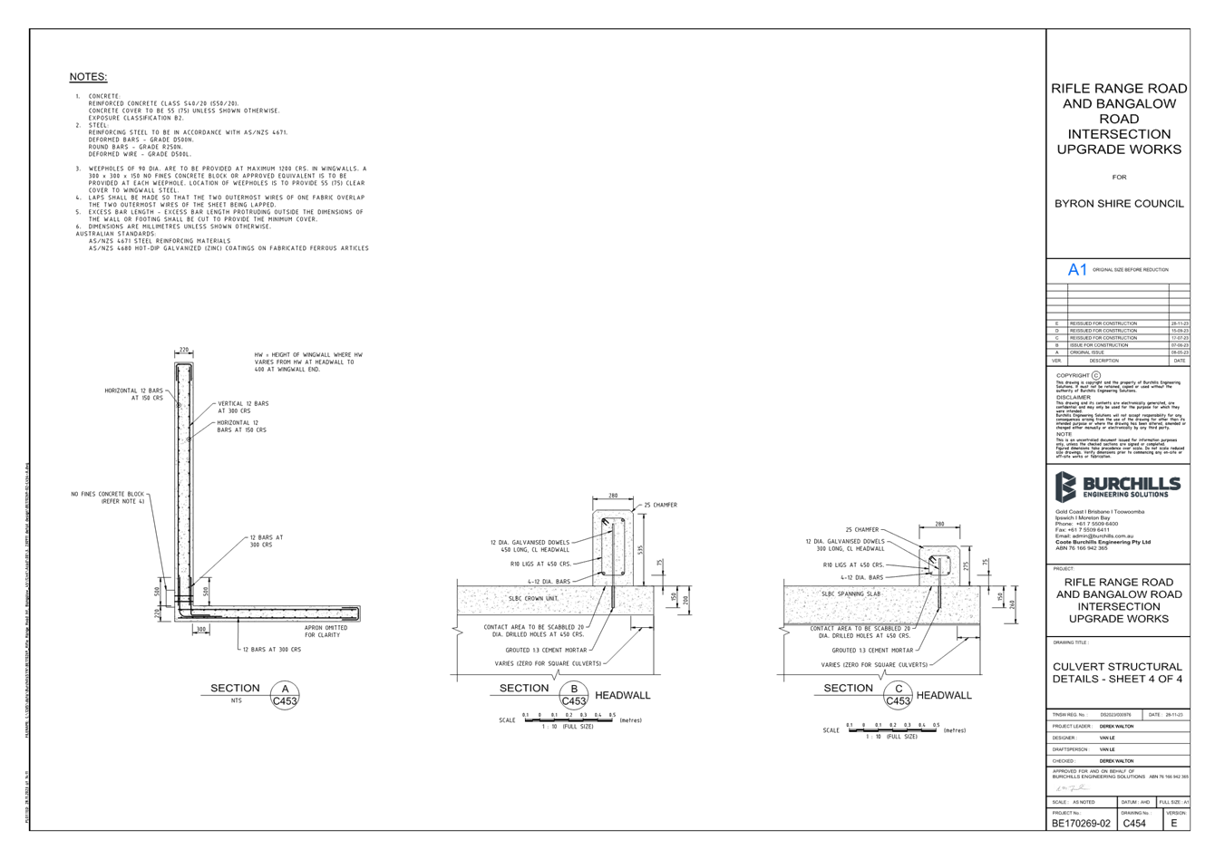
No. 6.4 Rifle Range Road Intersection Upgrade
File No: I2024/113
The purpose of this report is to gain Council support for
the proposed changes to Rifle Range Road, Bangalow shown in Attachment 1
(E2024/7781).
Byron Shire Council is managing the upgrade of the
intersection of Lismore Road which is a State Road with Council’s Rifle
Range Road.
The plans have undergone a thorough review process with
Transport for NSW as part of the concept and detailed design reviews required
to obtain construction approval under the terms of the Works Authorisation
Deed.
The proposed upgrade will include installation of stormwater
infrastructure, bus stop facilities, pedestrian footpaths, improving the general
safety and operation of this intersection.
The upgrade of Lismore Road and Rifle Range Road
intersection is regularly inundated during minor storm events and requires
upgrading to improve safety for all road users, including motorists, cyclists
and pedestrians. The upgrade to raise the road levels and improve the
stormwater infrastructure will improve the general safety and operation of this
intersection.
The design also proposes to formalise a channelised right
turn onto Rifle Range Road in accordance with current standards. The aim
of this dedicated right turn lane is to reduce the potential for rear end
collisions with vehicles undertaking the right turn manoeuvre onto Rifle Range
Road.
Finally, the design proposes to incorporate new dedicated bus
stops on both Rifle Range Road (northbound) and Lismore Road (eastbound).
This is to facilitate pick ups/drop offs, in particular for school buses, and
to ensure buses are prioritised over cars utilising the verge to park during
school peak hours.
A Road Safety Audit (RSA) has been undertaken on the design
and the findings incorporated into the construction plans.
RECOMMENDATION:
That Council supports the signage, line markings, bus
stops and traffic control devices associated with the Rifle Range Road
intersection works as shown in Attachment 1 (E2024/7781)
Attachments:
1 BE170269-02-Rifle
Range Road_04_COMB, E2024/7781 ,
page 93⇩
Regulatory
Matters 6.4 - Attachment 1

Local Traffic Committee Meeting 7.1
Matters for Traffic Engineering Advice
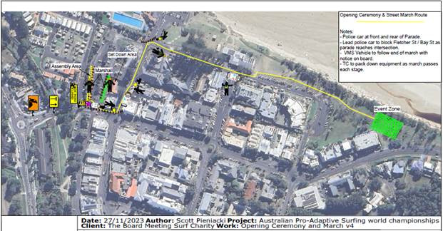
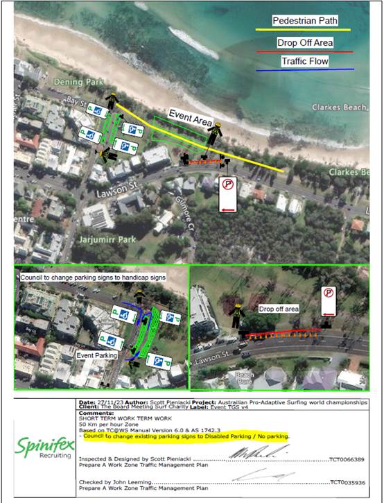
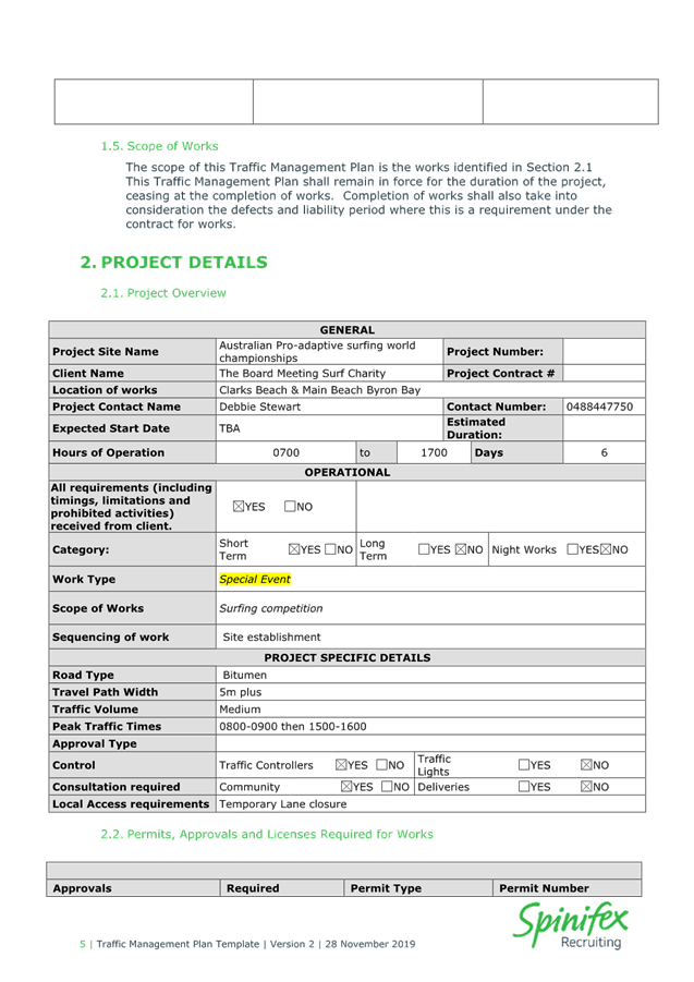
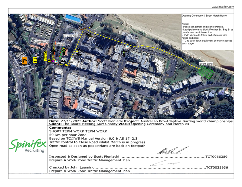
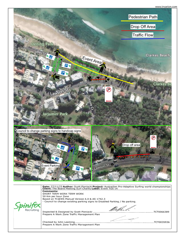
Report No. 7.1 Adaptive Pro Surf Championship - 17 March 2024
File No: I2024/79
Council has received an application for the 2024 Adaptive
Pro Surf Championship
This report is to keep members of the LTC informed of road
closures and traffic measures to be put in place at the upcoming event.
Opening Ceremony and Event:
RECOMMENDATION:
1. That
the Local Traffic Committee support the Adaptive Pro Surf Competition 17 March
2024 to 22nd March 2024.
2. That
Council support in Part 1 is subject to:
a) separate
approvals by NSW Police and TfNSW being obtained;
b) the
event organiser providing council with an updated Traffic Management Plan and
Traffic Guidance Scheme/s for the event;
c) development
and implementation of a Traffic Management Plan and Traffic Guidance Scheme/s
by those with appropriate TfNSW accreditation and the holding of current and
appropriate levels of insurance and liability cover;
d) the
impact of the event be advertised, and charged at cost to the organisers, via a
notice in the local weekly paper and Variable Message Signage (VMS) a minimum
of one week prior to the operational impacts taking effect, noting it must
include the event name, specifics of any traffic impacts or road closures and
times, alternative route arrangements, event organiser, a personal contact name
and a telephone number for all event related enquiries or complaints;
e) the
event be notified on Council’s web page and social media with the event
organiser supplying Council with the relevant information;
f)
access to Lawson Street is to be unrestricted at all times.
3. The
event organiser to:
Attachments:
1 Event
- Adaptive Pro - Draft TMP submitted 5/12/23, E2023/128526
, page 130⇩ 
Matters
for Traffic Engineering Advice 7.1 - Attachment 1


Local Traffic Committee Meeting 7.2
Report
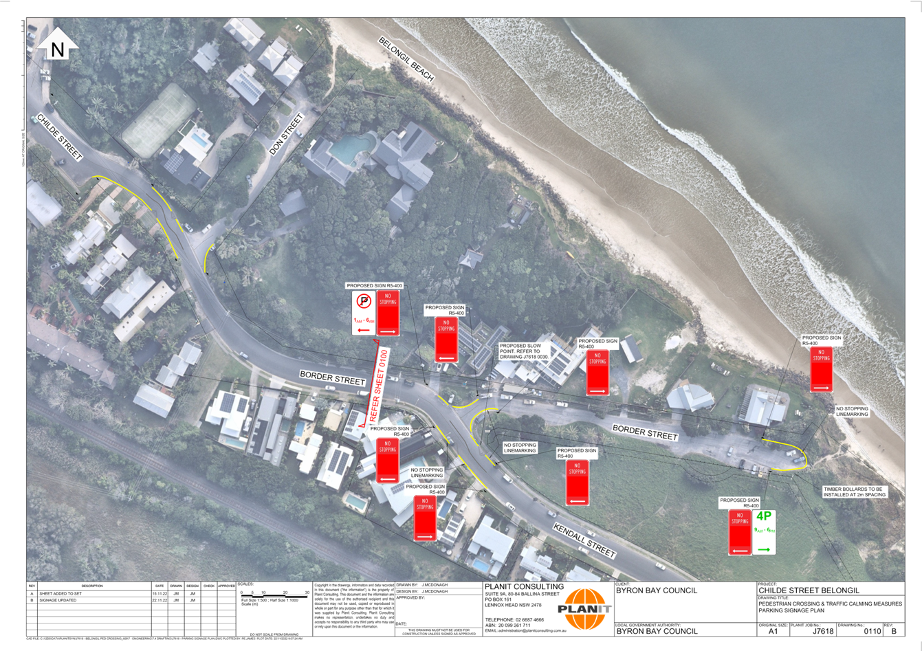
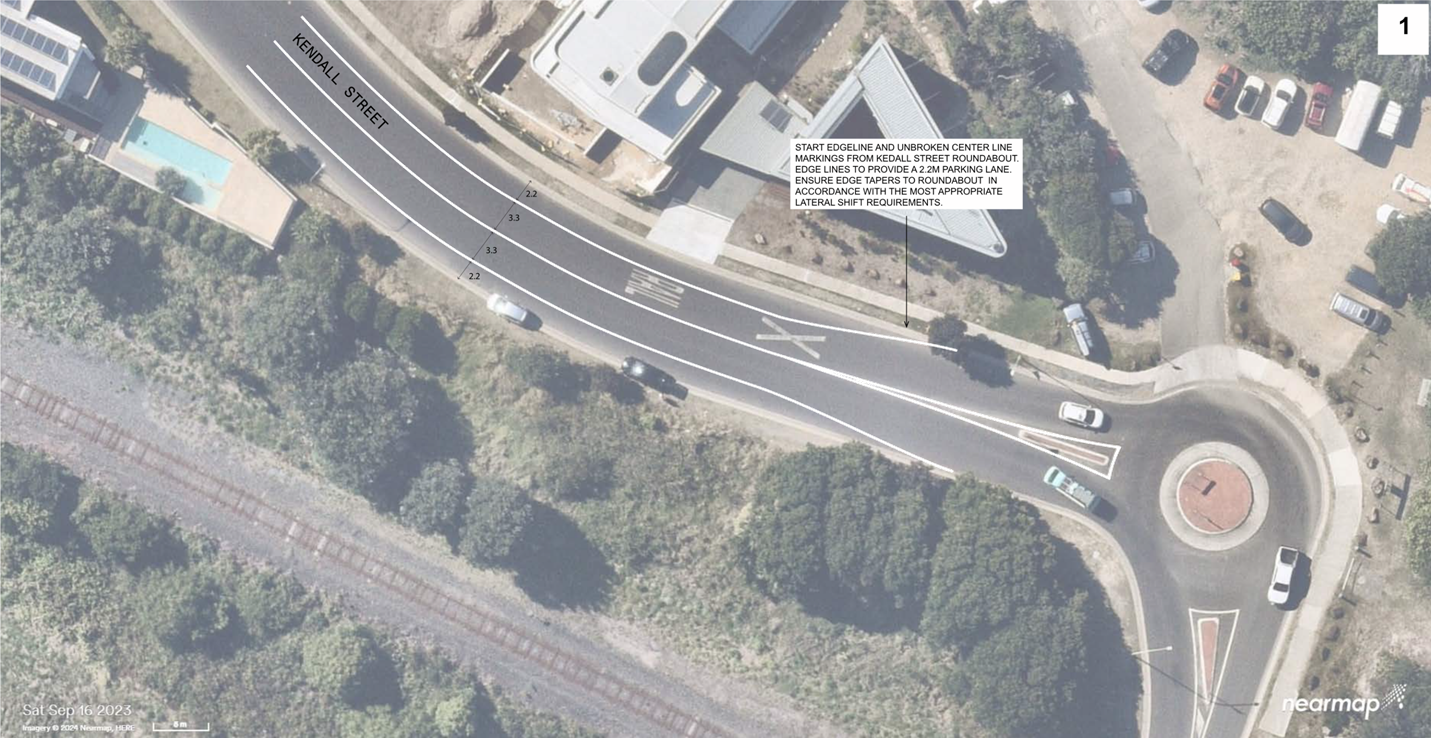
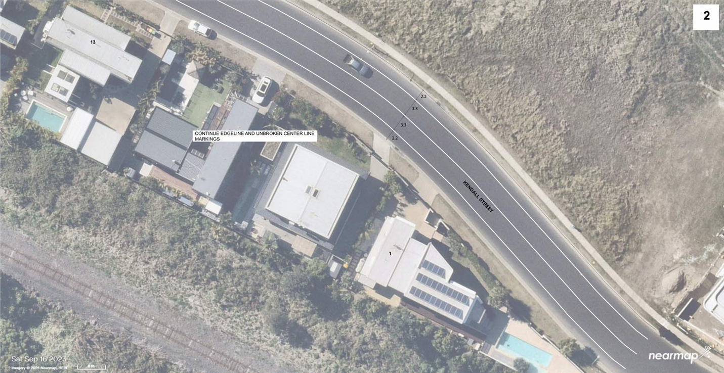
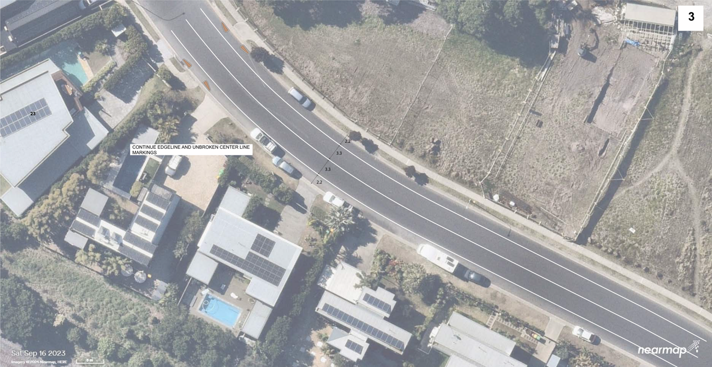
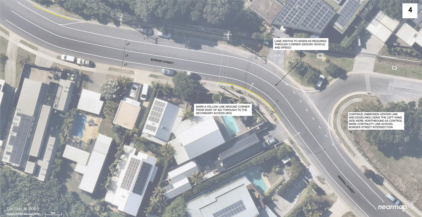
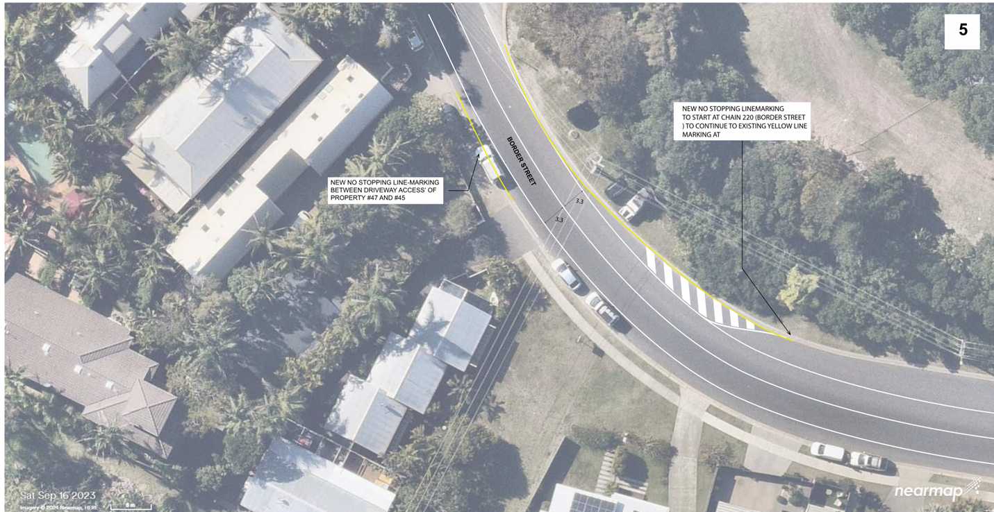
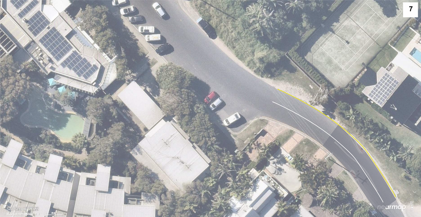
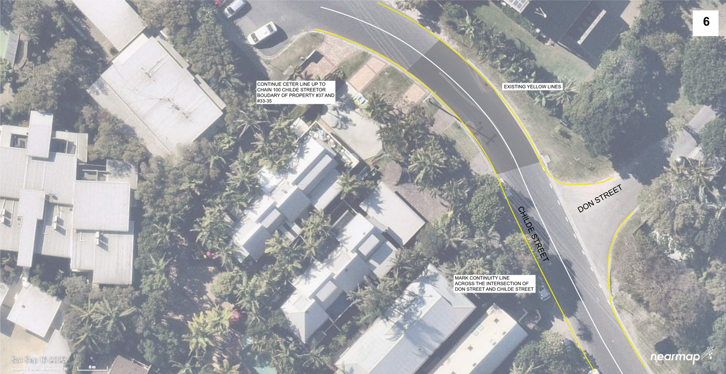
No. 7.2 Belongil - Kendall Street to Childe Street
Local Traffic Mangement
File No: I2024/111
The purpose of this report is to gain Local Traffic
Committee endorsement for the implementation of line-marking and no stopping
restrictions throughout the Belongil area from Kendall Street through to Childe
Street to manage driver behaviour.
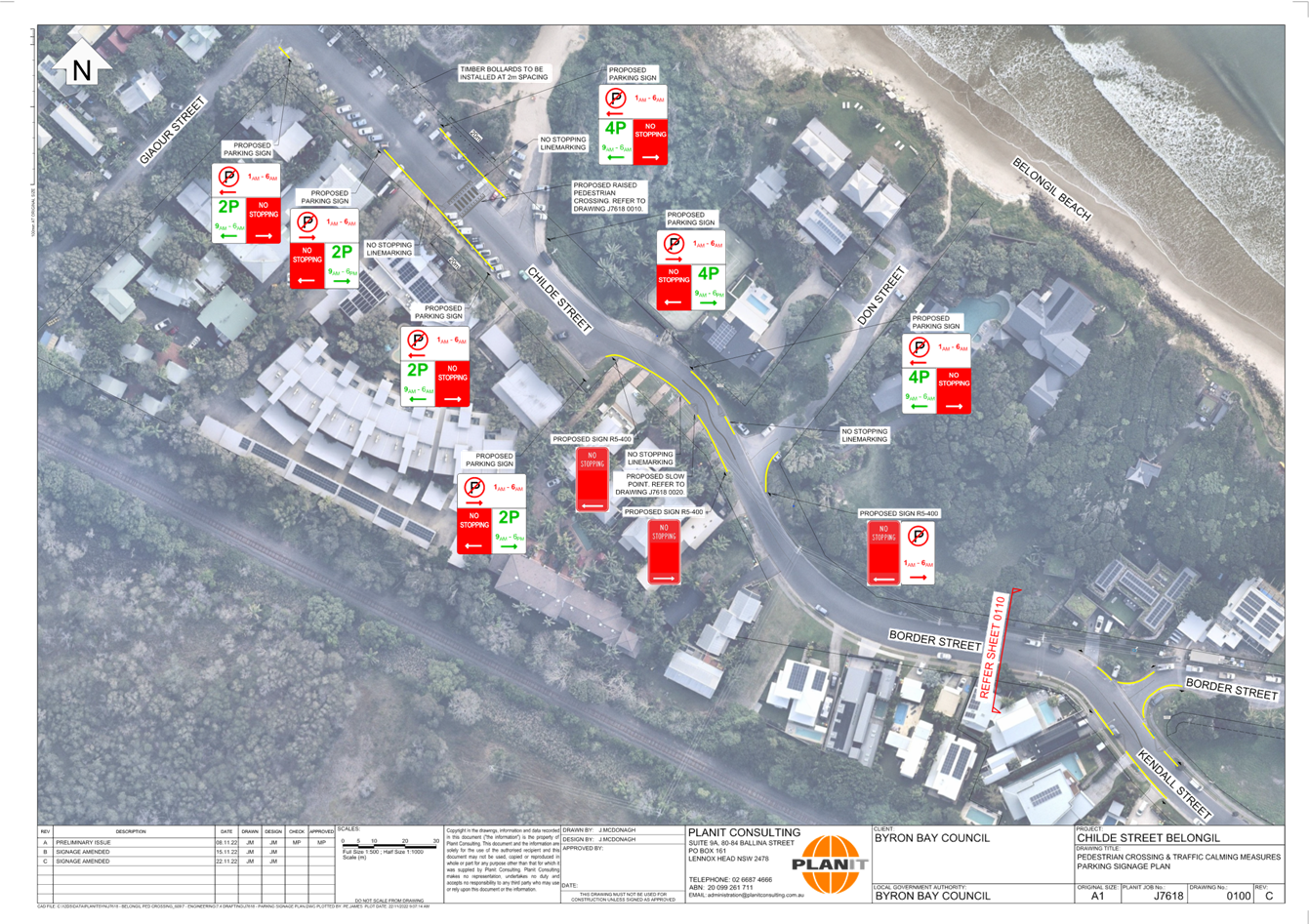
Background
Council previously gained endorsement for the installation
of LATM devices through the subject area (refer to attachments 1 and 2).
However, following the installation there was issues with driver compliance
(refer to figure 1). Drivers were commonly observed to proceed in a straight
line through the chicane into the path of on-coming drivers avoiding the need
to slow down. These devices also removed a significant amount of parking
adjacent residential properties.
Due to the safety issues associated with these devices staff
removed the devices and associated restrictions.
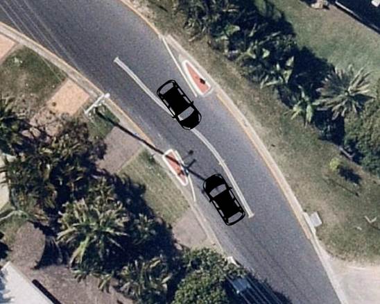
Figure 1: Safety issue
Kendall St and Childe St traffic management device
Proposed Solution
Following the removal of the chicanes staff are proposing a
less invasive speed management treatment for the area. This proposal includes
line-marking the travel lanes to provide a narrowing effect which can reduce
the likelihood of speeding. Currently the road is un-marked, and due to the
width (11m) people are willing to drive further to the right of the road due to
the lack of channelisation. Line-marking the area should channelise most drivers
further to the left while providing a narrower travel path while potentially
slowing vehicle speeds (refer to attachment 3).
RECOMMENDATION:
That the Local Traffic Committee endorse the
line-marking traffic management treatments proposed in attachment three of this
report for installation.
Attachments:
1 Minutes
30/11/2022 Local Traffic Committee Extraordinary, I2022/1779 , page 147⇩
2 Belongil
Parking Changes, E2022/117545 ,
page 154⇩ 
3 Belongil_LATM_Treatment_Concept_Not_For_Construction_23_01_2024,
E2024/7208 , page 156⇩
Matters
for Traffic Engineering Advice 7.2 - Attachment 1

Matters
for Traffic Engineering Advice 7.2 - Attachment 2
Matters
for Traffic Engineering Advice 7.2 - Attachment 3
Local Traffic Committee Meeting 8.1
Events
Report No. 8.1 Event - Westpac Helicopter Byron Coastal Charity Walk
– 4th May 2024
File No: I2024/89
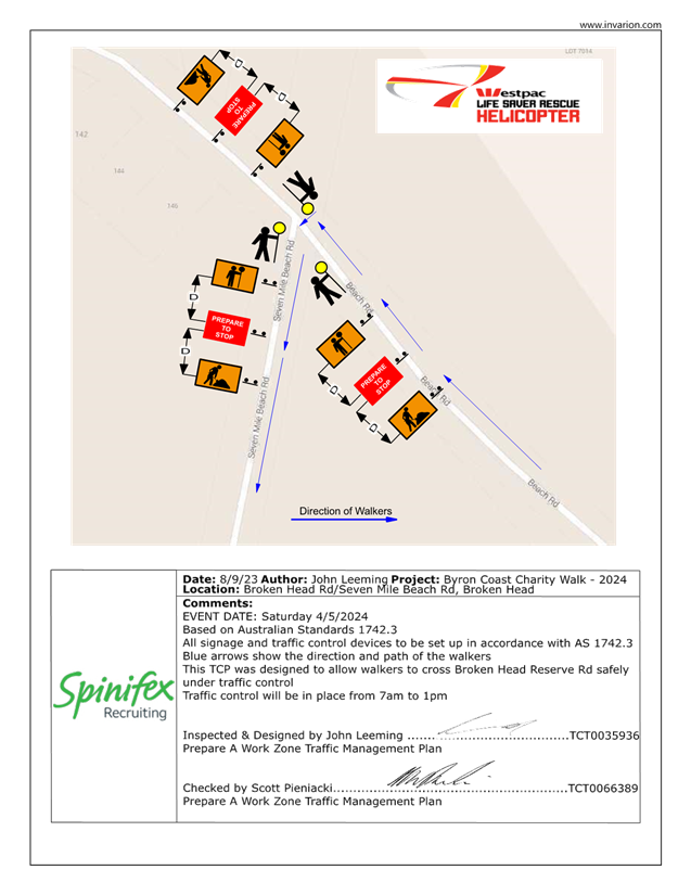
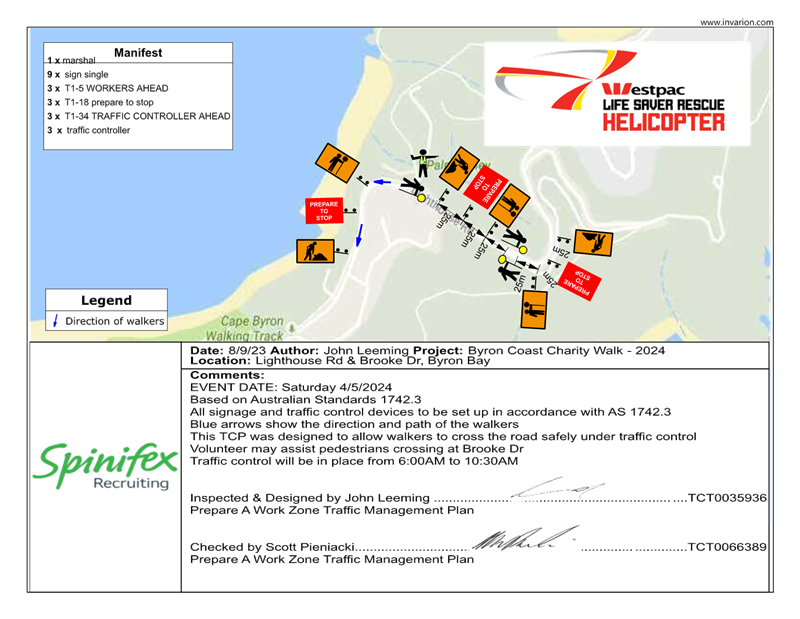
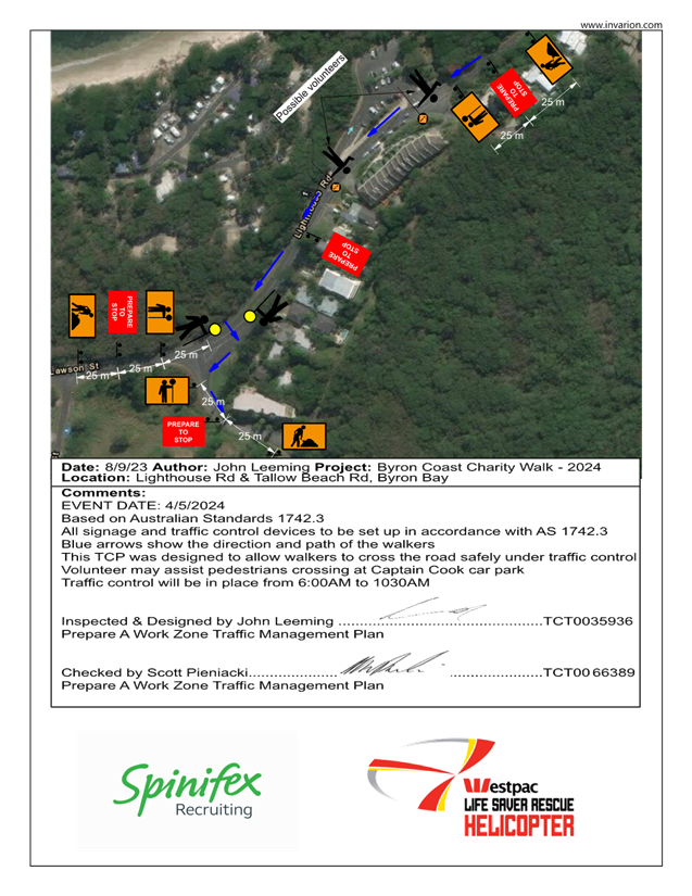
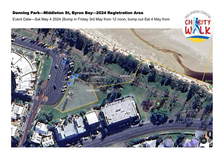
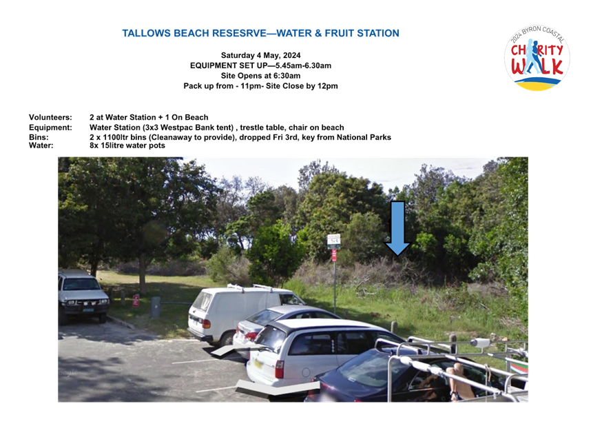
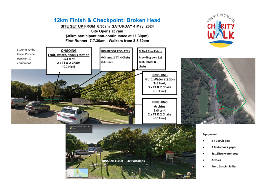
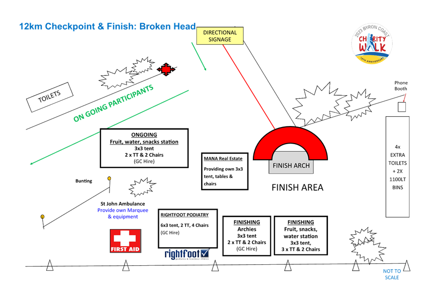
The 2024 Byron Coast Charity Walk will be held on Saturday 4th
May from 6.00am – 5.00pm. The organisers anticipate 750 participants.
The majority of the Charity Walk will be along beaches and
footpaths. There are two locations within Council’s delegated authority
where walkers will be required to walk along the road with associated traffic
control: Lighthouse Road and Seven Mile Beach Road.
The walking route will start in Dening Park, Byron Bay and
typically follows the coastline south to Ballina SLSC, a total distance of
36km.
The images below show the key sections of the walk and areas
where traffic control is proposed are circled in blue. In figure 1 traffic
control is proposed on Lighthouse Road as the walk heads towards Tallows Beach.
In figure 2 traffic control is proposed at the entrance to Seven Mile Beach
Road.
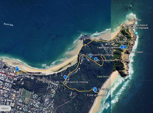
Figure 1 – Lighthouse Road
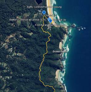
Figure 2 – Seven Mile Beach Road
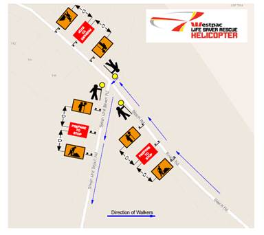
Figure 3 – Proposed TGS for the Seven Mile Beach Road
entrance (refer Figure 2). The Traffic Control is to be in place from 7am to
1pm.
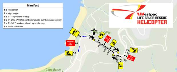
Figure 4 – Traffic control proposed for eastern
section Lighthouse Road. Coming down from Lighthouse Road (refer to Figure 1).
Traffic control to be in place from 6am to 10.30pm.
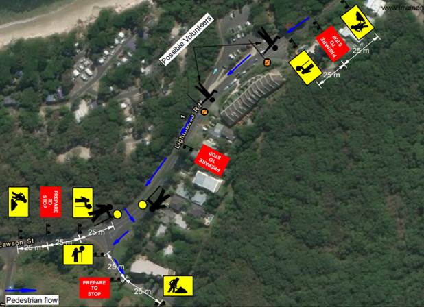
Figure 5 – Traffic control proposed for the western
section of Lighthouse Road entering Tallow Beach Road (refer to Figure 1.)
Traffic control to be in place between 6am and 10.30pm
RECOMMENDATION:
1. That
the Local Traffic Committee supports the Westpac Life Saver Rescue Helicopter
fundraiser, Byron Coast Charity Walk, to be held Saturday 4th May
2024 from 6.00am – 5.00pm
2. That
Council support in Part 1 is subject to:
a) The development of a
Traffic Guidance Scheme (TGS) and Traffic Management Plan(s) for the 2024 event
by those with relevant and current TfNSW accreditation. The TGS(s) and Traffic
Management Plan is to include, but is not limited to, the following:
b) Signage, which specifies
the date, hours and nature of the event, be positioned at the entrance and exit
of Seven Mile Beach Road one week prior to the event;
c) On the day of the
event, at 500m intervals on Seven Mile Beach Road, and facing both directions
of travel, signs advising of “Special Event – Charity Walk
Ahead” (or similar) are installed prior, and removed after, the event
occurs;
d) A safety induction for
participants advising of hazards be provided.
e) Implementation of the
Traffic Management Plan and Traffic Guidance Scheme/s as designed by those with
appropriate accreditation and implemented by people with appropriate
accreditation, including traffic controllers.
3. The
event organiser to:
a) Arrange for the
event to be notified on Council’s webpage a minimum one week prior to the
TGS being implemented;
b) Undertake consultation
with affected community and businesses including adequate response/action to
any raised concerns.
c) Undertake
consultation with emergency services and any identified issues addressed.
d) Holding $20m public
liability insurance cover which is valid for the event.
e) Paying
Council’s Road Event Application Fee prior to the event.
Attachments:
1 Event
- TGS - Byron Coastal Walk 2024 - Broken Head Reserve Rd Seven Mile Beach
Rd, E2024/8663 , page 168⇩ 
2 Eent
- TGS - Byron Coastal Walk 2024 - Lighthouse Rd Brooke Dr, E2024/8664 , page 169⇩ 
3 Event
- TGS - Byron Coastal Walk 2024 - Lighthouse Rd Tallow Beach Rd, E2024/8665 , page 170⇩
4 Event
- W'Pac Byron Coast Charity Walk 2024 - Denning Park START, E2024/8668 , page 171⇩
5 Event
- W'Pac Byron Coast Charity Walk 2024 - Tallows Beach Access, E2024/8669 , page 172⇩ 
6 Event
- W'Pac Byron Coast Charity Walk 2024 - Broken Head 12km FINISH, E2024/8671 ,
page 173⇩
Events 8.1 - Attachment 1
Events 8.1 - Attachment 2
Events 8.1 - Attachment 3
Events 8.1 - Attachment 4
Events 8.1 - Attachment 5
Events 8.1 - Attachment 6
Local Traffic Committee Meeting 8.2
Report
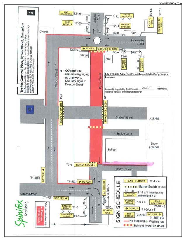
No. 8.2 Event - Bangalow Billycart Derby May 2024
File No: I2024/97
Council is anticipating on receiving an application for the Bangalow
Billycart Derby to be held on Sunday 19 May 2024.
The Billy Cart Derby has been previously approved by the
Local Traffic Committee (LTC) and by Council resolution 22-343.
RECOMMENDATION:
1. That
the Local Traffic Committee support the Bangalow Billycart Derby to be held on
19 May 2024.
2. That
the Local Traffic Committee support in Part 1 is subject to:
a) separate
approvals by NSW Police and TfNSW being obtained;
b) the
event organiser providing council with an updated Traffic Management Plan and
Traffic Guidance Scheme/s for the event;
c) development
and implementation of a Traffic Management Plan and Traffic Guidance Scheme/s
by those with appropriate TfNSW accreditation and the holding of current and
appropriate levels of insurance and liability cover;
d) the
impact of the event be advertised, and charged at cost to the organisers, via a
notice in the local weekly paper and appropriate Variable Message Signage a
minimum of one week prior to the operational impacts taking effect, noting it
must include the event name, specifics of any traffic impacts or road closures
and times, alternative route arrangements, event organiser, a personal contact
name and a telephone number for all event related enquiries or complaints;
e) the
event be notified on Council’s web page with the event organiser supplying
Council with the relevant information.
3. The
event organiser to:
a) inform
the community and businesses that are directly impacted (e.g. within road
closure zones) via written information which is delivered to the property in a
timely manner so as to document, consider and respond to any concerns raised;
b) arranging
for private property access and egress affected by the event;
c)
liaising with bus, taxi and waste operators and ensuring arrangements are made
for provision of services during conduct of the event;
d) consulting
with emergency services and any identified issues be addressed;
e) holding
$20m public liability insurance cover which is valid for the event;
f) paying Council’s
Road Event Application Fee prior to the event;
g) not
place any signage on the road related area of the Pacific Highway.
Attachments:
1 Bangalow
Billycart - Traffic Control Plan 2023, E2023/15909
, page 179⇩
Background
The Bangalow Billycart Derby is an
annual event held by the Bangalow Lions Club. It’s been taking place
since the first event in 1994.
The event took a 2 year hiatus due
to COVID-19 and flood events, but ran another successful event in September
2022.
The format of the event is the
same as in previous years, with traffic detoured through Deacon Street.
Event Overview
As a family friendly community
event, the focus of the day
is not the speed of the entries but family fun for participants and spectators.
The Grand Parade is a highlight, the event also features local bands, vintage
cars, schools, local clubs, scouts and celebrities.
The event involves the temporary
closure of a section of Byron Street, between the Granuaille Road roundabout
and Ashton Street intersection, with a traffic detoured through Deacon Street,
the temporary closure will be in place between 6am and 5pm.
Key Issues
1. The
proposed TGS places signage on Lismore to Bangalow Road (B62) and TfNSW
controlled Granuaille Road.
2. The
western end of Deacon Street is a laneway not suitable to Heavy Vehicles as a
detour to the Pacific Highway. However, the volume of HV on Sunday’s is
very limited and not been a concern for previous years.
Council Implications
Financial Considerations
Nil.
Asset Management
Not applicable.
Policy or Regulation
All TGS’s are to be developed and
implement by people with the appropriate level and type of accreditation.
Consultation
A condition of the endorsement of this
event is that the event organisers conduct appropriate community consultation,
including:
1. Advertising
the impact of the event in the local newspaper and on the Council website.
2. Informing
community and business that are directly impacted.
3. Liaising
with bus and taxi operators.
4. Consulting
with emergency services.
Legal and Risk Management
This road closure directly affects TfNSW
controlled asset – Lismore to Bangalow Road (B62) and TfNSW controlled
Granuaille Road. TfNSW Traffic Engineering Department requires separate
approval of the TMP and TGS.
Events 8.2 - Attachment 1
Local Traffic Committee Meeting 8.3
Report
No. 8.3 Chincogan Charge - September 2024
File No: I2024/98
Council is in anticipation to receive an application for the
Chincogan Charge to be held on Saturday 15 September 2024.
This was previously approved by the Local Traffic Committee
(LTC) and by Council resolution 22-084.
RECOMMENDATION:
1.
That the Local Traffic Committee support the Chincogan Charge to be held on
Saturday 15 September 2024.
2. That
the Local Traffic Committee support in Part 1 is subject to:
a) separate
approvals by NSW Police and TfNSW being obtained;
b) the
event organiser providing council with an updated Traffic Management Plan and
Traffic Guidance Scheme/s for the event if required;
c) development
and implementation of a Traffic Management Plan and Traffic Guidance Scheme/s
by those with appropriate TfNSW accreditation and the holding of current and
appropriate levels of insurance and liability cover;
d) the
impact of the event be advertised, and charged at cost to the organisers, via a
notice in the local weekly paper and Variable Message Signage (VMS) a minimum
of one week prior to the operational impacts taking effect, noting it must
include the event name, specifics of any traffic impacts or road closures and
times, alternative route arrangements, event organiser, a personal contact name
and a telephone number for all event related enquiries or complaints;
e) the
event be notified on Council’s web page and social media with the event
organiser supplying Council with the relevant information;
3. The
event organiser to:
a) inform
the community and businesses that are directly impacted (e.g. within road
closure zones) via written information which is delivered to the property in a
timely manner so as to document, consider and respond to any concerns raised;
b) arranging
for private property access and egress affected by the event;
c)
liaising with bus, taxi and waste operators and ensuring arrangements are made
for provision of services during conduct of the event;
d) consulting
with emergency services and any identified issues be addressed;
e) holding
$20m public liability insurance cover which is valid for the event;
f)
not place any signage on the road related area of the Pacific Highway.
Attachments:
1 Event
- Chincogan Charge 2024 - 2026 V2 (003) TMP, E2024/6279
, page 184⇩
Background
For
the 2022 event the organisers followed the same course as 2020 (the 2021 event
was cancelled due to COVID) with runners starting and finishing near
Mullumbimby Police Station.
The
road course will require actions to control traffic and the implementation of
prescribed traffic control devices such as No Parking signs to control
vehicles. 500 participants are expected.
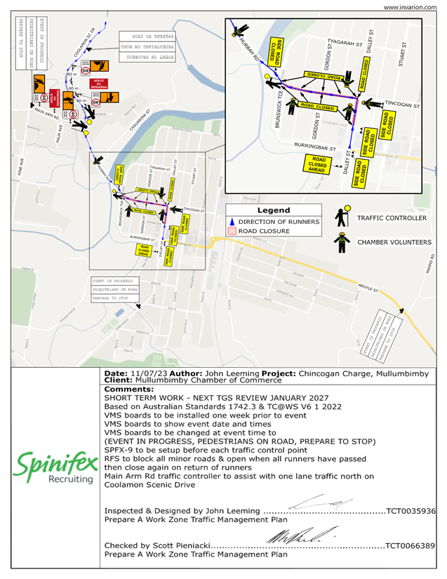
Event Overview
The
organisers have submitted a 2023 TGS the image below shows the expected impact
on roads. The blue line indicates the approximate running path within the road
reserve and the following major impacts are planned:
· Dalley
Street, between the Post Office and the Civic Hall is expected to be closed
between 12.30-5.30pm
· Murwillumbah
Road, at Federation Bridge to Main Arm Rd to be controlled by traffic
controllers. The South bound lane will be used for contraflow traffic
controlled by Traffic Controllers. Traffic will be allowed to access Main Arm
Road in-between competitors. Traffic will be controlled at this point between
12.35-5.30pm
· Coolamon
Scenic Drive from Main Arm Rd to 1913 Coolamon Scenic Drive. The South bound
lane will be used for contraflow traffic controlled by Traffic Controllers.
Traffic will be allowed to access Main Arm Road in-between competitors. Traffic
will be controlled at this point between 12.40-5.30pm
· Once
competitors cross the finish line they will move onto the footpath and head to
the Mullumbimby Civic Memorial Hall for the presentation.
· The race itself is
expected to finish at 4pm with presentations from 4-5.30pm.
Events 8.3 - Attachment 1