 Agenda
Ordinary Meeting

Thursday, 24 April 2025
Agenda
Ordinary Meeting
Thursday, 24 April 2025
Agenda Ordinary Meeting
held at Council Chambers, Station Street, Mullumbimby
commencing at 3:00 PM
Public access relating to items on this agenda can be made between 3:00pm and 4:00pm on the day of the meeting. Requests for public access should be made to the General Manager or Mayor no later than 12:00 midday on the day prior to the meeting.

Mark Arnold
General Manager
CONFLICT OF INTERESTS
What is a “Conflict of Interests” - A conflict of interests can be of two types:
Pecuniary - an interest that a person has in a matter because of a reasonable likelihood or expectation of appreciable financial gain or loss to the person or another person with whom the person is associated.
Non-pecuniary – a private or personal interest that a Council official has that does not amount to a pecuniary interest as defined in the Code of Conduct for Councillors (eg. A friendship, membership of an association, society or trade union or involvement or interest in an activity and may include an interest of a financial nature).
Remoteness – a person does not have a pecuniary interest in a matter if the interest is so remote or insignificant that it could not reasonably be regarded as likely to influence any decision the person might make in relation to a matter or if the interest is of a kind specified in the Code of Conduct for Councillors.
Who has a Pecuniary Interest? - a person has a pecuniary interest in a matter if the pecuniary interest is the interest of the person, or another person with whom the person is associated (see below).
Relatives, Partners - a person is taken to have a pecuniary interest in a matter if:
· The person’s spouse or de facto partner or a relative of the person has a pecuniary interest in the matter, or
· The person, or a nominee, partners or employer of the person, is a member of a company or other body that has a pecuniary interest in the matter.
N.B. “Relative”, in relation to a person means any of the following:
(a) the parent, grandparent, brother, sister, uncle, aunt, nephew, niece, lineal descends or adopted child of the person or of the person’s spouse;
(b) the spouse or de facto partners of the person or of a person referred to in paragraph (a)
No Interest in the Matter - however, a person is not taken to have a pecuniary interest in a matter:
· If the person is unaware of the relevant pecuniary interest of the spouse, de facto partner, relative or company or other body, or
· Just because the person is a member of, or is employed by, the Council.
· Just because the person is a member of, or a delegate of the Council to, a company or other body that has a pecuniary interest in the matter provided that the person has no beneficial interest in any shares of the company or body.
Disclosure and participation in meetings
· A Councillor or a member of a Council Committee who has a pecuniary interest in any matter with which the Council is concerned and who is present at a meeting of the Council or Committee at which the matter is being considered must disclose the nature of the interest to the meeting as soon as practicable.
· The Councillor or member must not be present at, or in sight of, the meeting of the Council or Committee:
(a) at any time during which the matter is being considered or discussed by the Council or Committee, or
(b) at any time during which the Council or Committee is voting on any question in relation to the matter.
No Knowledge - a person does not breach this Clause if the person did not know and could not reasonably be expected to have known that the matter under consideration at the meeting was a matter in which he or she had a pecuniary interest.
Non-pecuniary Interests - Must be disclosed in meetings.
There are a broad range of options available for managing conflicts & the option chosen will depend on an assessment of the circumstances of the matter, the nature of the interest and the significance of the issue being dealt with. Non-pecuniary conflicts of interests must be dealt with in at least one of the following ways:
· It may be appropriate that no action be taken where the potential for conflict is minimal. However, Councillors should consider providing an explanation of why they consider a conflict does not exist.
· Limit involvement if practical (eg. Participate in discussion but not in decision making or vice-versa). Care needs to be taken when exercising this option.
· Remove the source of the conflict (eg. Relinquishing or divesting the personal interest that creates the conflict)
· Have no involvement by absenting yourself from and not taking part in any debate or voting on the issue as of the provisions in the Code of Conduct (particularly if you have a significant non-pecuniary interest)
RECORDING OF VOTING ON PLANNING MATTERS
Clause 375A of the Local Government Act 1993 – Recording of voting on planning matters
(1) In this section, planning decision means a decision made in the exercise of a function of a council under the Environmental Planning and Assessment Act 1979:
(a) including a decision relating to a development application, an environmental planning instrument, a development control plan or a development contribution plan under that Act, but
(b) not including the making of an order under that Act.
(2) The general manager is required to keep a register containing, for each planning decision made at a meeting of the council or a council committee, the names of the councillors who supported the decision and the names of any councillors who opposed (or are taken to have opposed) the decision.
(3) For the purpose of maintaining the register, a division is required to be called whenever a motion for a planning decision is put at a meeting of the council or a council committee.
(4) Each decision recorded in the register is to be described in the register or identified in a manner that enables the description to be obtained from another publicly available document, and is to include the information required by the regulations.
(5) This section extends to a meeting that is closed to the public.
OATH AND AFFIRMATION FOR COUNCILLORS
Councillors are reminded of the oath of office or affirmation of office made at or before their first meeting of the council in accordance with Clause 233A of the Local Government Act 1993. This includes undertaking the duties of the office of councillor in the best interests of the people of Byron Shire and the Byron Shire Council and faithfully and impartially carrying out the functions, powers, authorities and discretions vested under the Act or any other Act to the best of one’s ability and judgment.
BUSINESS OF Ordinary Meeting
1. Public Access
3. Attendance by Audio-Visual Link
4. Requests for Leave of Absence
5. Declarations of Interest – Pecuniary and Non-Pecuniary
6. Tabling of Pecuniary Interest Returns (Cl 4.14 Code of Conduct for Councillors)
7. Adoption of Minutes from Previous Meetings
7.1 Ordinary Meeting held on 27 March 2025
8. Reservation of Items for Debate and Order of Business
9. Notices of Motion
9.1 Potential site for expanded crisis, emergency or temporary accommodation...... 8
9.2 Byron Shire Biodiversity: Supporting Wildlife Corridors, Koala Habitat Protection and Ending Native Forest Logging.................................................................................... 11
9.3 Emergency Housing Village....................................................................................... 17
9.4 In principal support for using the church on Argyle St for accommodation........ 22
9.5 Reiterate Council's support for local decision making........................................... 26
9.6 Enforcement Action on Unauthorised Dwellings..................................................... 29
10. Mayoral Minute
11. Petitions
12. Delegates' Reports
13. Staff Reports
General Manager
13.1 Brunswick Heads Visitor Centre Contribution......................................................... 33
Corporate and Community Services
13.2 Grants April 2025......................................................................................................... 38
13.3 Councillor Expenses and Facilities Policy................................................................ 45
13.4 Requests for Financial Assistance - Ocean Shores Art Expo and Bangalow Film Festival........................................................................................................................... 58
13.5 Council Investments - 1 March 2025 to 31 March 2025........................................ 64
Sustainable Environment and Economy
13.6 PLANNING - 26.2022.3.1 Submissions report for Stage 4 C zones Planning Proposal........................................................................................................................................ 71
13.7 Draft Pest Animal Management Plan 2025 - 2030 for Public Exhibition............. 82
13.8 Update Resolution 24-440 Grant Application for Lot 22 Masterplan................... 92
Infrastructure Services
13.9 Naming of Unnamed Laneway, Suffolk Park........................................................... 99
13.10 Bangalow Road, Cooper Street and Paterson Street Intersection, Byron Bay - Traffic and Safety Assessment............................................................................................ 104
13.11 Piccabeen Park Bangalow - Parking Signage...................................................... 122
13.12 Brunswick Heads Laneways Traffic Investigation................................................ 130
14. Reports of Committees
Corporate and Community Services
14.1 Report of the Audit, Risk and Improvement Committee Meeting held on 18 February 2025............................................................................................................................. 141
Sustainable Environment and Economy
14.2 Report of the Coast and ICOLL Advisory Committee Meeting held on 20 March 2025...................................................................................................................................... 144
Infrastructure Services
14.3 Report of the Local Traffic Committee Meeting held on 1 April 2025............... 146
15. Questions With Notice
Nil
Questions with Notice: A response to Questions with Notice will be provided at the meeting if possible, that response will be included in the meeting minutes. If a response is unable to be provided the question will be taken on notice, with an answer to be provided to the person/organisation prior to the next Ordinary Meeting and placed on Councils website www.byron.nsw.gov.au/Council/Council-meetings/Questions-on-Notice
Councillors are encouraged to ask questions regarding any item on the business paper to the appropriate Director prior to the meeting. Any suggested amendments to the recommendations should be provided to Councillor Support prior to the meeting to allow the changes to be typed and presented on the screen at the meeting.
Notices of Motion 9.1
Notices of Motion
Notice of Motion No. 9.1 Potential site for expanded crisis, emergency or temporary accommodation
File No: I2025/467
I move that Council:
1. Acknowledges the limited availability of crisis, emergency, and temporary accommodation options in the Byron Shire, which support individuals experiencing domestic and family violence, as well as those who are, or are at risk of experiencing homelessness including women, men, young people, and families, noting that Byron Shire has the highest number of rough sleepers of any Local Government area in the State;
2. Notes that one of the limited options for crisis accommodation for families experiencing domestic violence is facilitated by Council, on land leased to a crisis accommodation provider. (The address of the land is confidential to protect the personal safety of the vulnerable people accessing services at the address and to maintain law and order.); and
3. Requests staff to investigate and present to a Councillor workshop options and pathways for expansion of the existing accommodation uses such as for more crisis, emergency, temporary or other accommodation, noting relevant considerations and constraints.
Signed: Cr Asren Pugh
Councillor’s supporting information:
The land in question, managed by Byron Shire Council, is zoned RU1 and contains one small dwelling. For more than two decades, the dwelling has been leased to a not-for-profit organisation to provide temporary crisis accommodation. This land has previously been identified as a potential site for expanded crisis/temporary accommodation uses, however the site is constrained. There are considerations that will need to be worked through including safety, suitability, land tenure, planning pathways, environmental and physical constraints (e.g. planning for bushfire, potential contamination, vegetation management etc) and utilities services (sewerage and water). There will also be feasibility and funding considerations.
The intent of this motion is to authorise staff to begin the process investigating the steps required to enable this land to be made available for expanded accommodation (crisis, emergency or temporary) and the potential models of delivery for example development and/or operation by a not-for-profit community housing provider or the NSW Government. In the longer term, this initiative could provide much-needed support for vulnerable individuals and families.
Staff comments
by Esmeralda Davis, Director Corporate and Community Services and Shannon Burt, Director Sustainable Economy and Environment
Temporary and Crisis Accommodation in Byron Shire is scarce. This is supported by research carried out in 2023 by Homelessness NSW, which found the capacity of supply to meet demand for temporary accommodation in Northern NSW = 1.2 out of 5.
In the Byron Shire, Homes NSW provides 3 options (with none accepting men) and an accredited Community Housing Provider (CHP) operates one crisis accommodation property and two transitional share house properties.
There are various models of temporary accommodation defined into three broad categories:
Emergency Temporary Accommodation: For people who are ineligible for social housing, but who are experiencing a short-term housing crisis due to an extreme situation (e.g. Natural Disaster). Examples include Mobile Motor Homes, Caravan Parks, and Campgrounds. People may also be allocated a social housing property to stay in temporarily.
‘Temporary’ or ‘Crisis’ Accommodation: Short Term, emergency housing provided by the Department of Communities and Justice to people who are homeless, at risk of homelessness, low-income earners seeking social or affordable housing, Aboriginal and Torres Strait Islander individuals, and those experiencing family or domestic violence. Even though temporary accommodation is funded by the Government, often Temporary Accommodation is provided by the private sector (e.g. motels, caravan parks, boarding houses).
‘Transitional Accommodation’ or ‘Transitional Housing’: Transitional accommodation is supported independent housing for clients transitioning from homelessness (including crisis accommodation) to longer term independent living. Generally, transitional accommodation will be for up to 18 months. Clients may be housed alone or under a shared tenancy arrangement. Generally, people living in THM properties will be allocated a support worker to assist with addressing barriers to maintaining housing. Exit pathways may include Social Housing or Private Rental, depending on the person’s needs.
In relation to Point 3: Requests staff to investigate and present to a Councillor workshop options and pathways for expansion of the existing accommodation uses such as for more crisis, emergency, temporary or other accommodation, noting relevant considerations and constraints
If the proposal moves forward, staff will review the necessary planning steps to figure out the best way to get approval for the type of accommodation being considered. This could involve submitting a development application, rezoning the land, or both. Each option has different requirements, timelines, and possible outcomes, and these will all be carefully considered.
Financial/Resource/Legal Implications:
Some of the investigation work can be covered by existing Program Budgets.
The preparation of a development application, rezoning or both will incur additional program costs resourcing requirements. These are unknown currently.
The costs associated with the infrastructure / servicing of the site are also unknown.
Is the proposal consistent with any Delivery Program tasks?
Yes
|
CSP Strategy |
DP Action |
|
|
2: Inclusive Community |
2.5: Create social impact and initiatives that address disadvantage
|
2.5.3: Rough sleepers - Work in partnership to reduce and end rough sleeping through community action |
|
4: Ethical Growth |
4.2: Enable housing diversity and support people experiencing housing insecurity |
4.2.2: Partnerships and pilots to address housing needs - Investigate partnerships and pilots that deliver an innovative and affordable housing model for the Shire |
|
4: Ethical Growth |
4.2: Enable housing diversity and support people experiencing housing insecurity |
4.2.3: Legislation changes - Establish planning mechanisms and advocate for changes to legislation to support housing that meets the needs of our community
|
Notices of Motion 9.2
Notice of Motion No. 9.2 Byron Shire Biodiversity: Supporting Wildlife Corridors, Koala Habitat Protection and Ending Native Forest Logging
File No: I2025/473
I move that Council:
1. Thanks Bangalow Koalas for their ongoing extraordinary conservation efforts and for inviting councillors to participate in tree planting activities as they approach their milestone of 500,000 trees planted by the end of 2025 and acknowledges the vital conservation work being undertaken by local organisations including Friends of the Koala, Northern Rivers Wildlife Hospital and Byron Bay Wildlife Hospital.
2. Receives a report to the June 2025 meeting on the integration of wildlife corridor planning in Council's strategic land use documents, including completed, planned and potential actions to incorporate wildlife corridor planning in the Local Environmental Plan and Development Control Plan.
3. Reaffirms Council's commitment to restoring native habitat and supporting wildlife corridors in the Byron Shire through initiatives including:
a) Implementation of the Byron Shire Coastal Koala Plan of Management;
b) Council support (advertising, organisation and financial support) for community-led habitat restoration and bush regeneration initiatives; and
c) Promotion of the Byron Wildlife Corridors System to landowners and residents
4. Advocates to the State and Federal Governments to protect biodiversity and critical habitat by:
a) Ending native forest logging across Australia;
b) Implementing an immediate moratorium on clearing koala habitat;
c) Establishing the Great Koala National Park as promised by the NSW Government;
d) Closing loopholes in the Environment Protection and Biodiversity Conservation Act that exempt native forest logging from federal environmental protections.
Signed: Cr Michelle Lowe and Cr Delta Kay
Councillor’s supporting information:
This motion recognises the critical work being done by local conservation organisations and strengthens Council's advocacy for the protection of native forests and wildlife.
Bangalow Koalas has become one of the region's most successful community-led conservation initiatives, with their ambitious goal of planting 500,000 trees by the end of 2025 creating vital wildlife corridors across the Northern Rivers. Their invitation for councillors to participate in upcoming planting events represents an important opportunity for Council to demonstrate its commitment to biodiversity protection.
The Byron Wildlife Corridors System provides a strategic framework for habitat restoration and wildlife movement across the Shire. By better integrating wildlife corridor planning into Council's strategic documents, we can better protect these crucial ecological connections while providing clarity for landowners about how they can contribute to biodiversity conservation.
Australia's native forests are among Earth's most biodiverse ecosystems, providing critical habitat for threatened wildlife including koalas. Despite the koala being listed as endangered in NSW in 2022, logging continues in areas of high conservation value, including in proposed areas of the Great Koala National Park.
The Black Summer bushfires of 2019-2020 devastated wildlife populations across NSW, yet outdated Regional Forest Agreements continue to exempt native forest logging from national environmental protections, allowing the destruction of critical habitat to continue.
While Council has limited direct authority over native forest logging, we have a responsibility to advocate to other levels of government on issues that affect our local environment. The survival of Byron Shire's unique biodiversity depends not only on local conservation efforts but also on broader environmental protection actions.
This motion builds on Council's existing environmental protection work and aligns with Strategy 3.1 of the Community Strategic Plan 2032 to "Partner to nurture and enhance biodiversity, ecosystems, and ecology."
Staff comments
by Shannon Burt, Director, Sustainable Environment and Economy:
Staff comments in relation to items 2-3 are provided below.
2. Receives a report to the June 2025 meeting on the integration of wildlife corridor planning in Council's strategic land use documents, including completed, planned and potential actions to incorporate wildlife corridor planning in the Local Environmental Plan and Development Control Plan.
Councillors should refer to Report No. 13.3 Byron Shire Wildlife Corridor System Agenda of Ordinary (Planning) Meeting - Thursday, 7 December 2023 for a detailed summary of where the wildlife corridor map sits within Council’s strategic land use documents.
Some key points from this report are provided below. They may also like to look at the frequently asked questions relating to land use planning at Wildlife Corridors map - Byron Shire Council
· The primary intention of the wildlife corridor system is to provide a decision planning tool to help Council and other conservation groups to plan and prioritise habitat restoration. As per Council Resolution 23-594, Council endorsed the Byron Shire Wildlife Corridor System as a conservation planning tool to support and encourage wildlife habitat restoration.
· The corridor map is non-statutory because Council’s Local Environment Plan (LEP) 2014 already protects high conservation value land in Byron Shire, as Conservation Zones (C-Zones), which have been identified through on-ground assessments and an extensive landholder consultation and engagement process. The wildlife corridor map is a GIS model, based on vegetation mapping, threatened species records, topography, climate, protected areas and land use constraints. To implement a statutory wildlife corridor map would require ground truthing of every parcel within the corridor, and species-specific surveys to determine what areas are being used as a corridor. Council does not have the resources to do this.
· When the wildlife corridor map went on public exhibition, the key community concerns raised related to restrictions on land use planning. The community is not going to get behind this map and proactively restore habitat if it is perceived as another planning restriction, that penalises landholders who have already created or protected wildlife habitat and creates additional costs for landholders to carry out permitted land uses or compliant development. There is a real risk that using the map to restrict land use may discourage people from planting/restoring habitat, for fear of what restrictions this may create for them in future.
· The wildlife corridors do not include all the high environmental value vegetation in Byron Shire. They also include a lot of cleared farmland (because our habitat is fragmented). Native vegetation threatened species habitat, areas of high environmental value and areas that maintain habitat connectivity are already protected under DCP Chapter B1 (see B1.2.1), whether within or outside of wildlife corridors.
· Additionally, Council’s Guidelines for preparing Vegetation Management Plans or Biodiversity Conservation Management Plans (E2019/31834 - Developing Vegetation and Biodiversity Conservation Management Plans - Byron Shire Council (nsw.gov.au)), require that wildlife corridors are identified on VMP and BCMP site maps so that these areas can be considered as priority areas for planned management and restoration activities (e.g. tree planting required for tourist cabins).
3. Reaffirms Council's commitment to restoring native habitat and supporting wildlife corridors in the Byron Shire through initiatives including:
a. Implementation of the Byron Shire Coastal Koala Plan of Management;
Byron CKPOM is being implemented by Council’s Koala Project Officer, who works 3 days/week, with support from the rest of the Biodiversity Team. Koala habitat restoration projects done by Council include:
- Koala Connections - $360,000 – 54ha restored/planted
- Byron Habitat Corridors – $60,000 ET Grant – restored/planted 17.55ha
- Koala Food for the Future – $18,750 grant – restored/planted 11.5ha
- NSW Koala Strategy Grant 2022 - $101.212 – restored/planted 7ha
- NSW koala strategy grant 2023 - $15,000 – habitat maintenance 13ha
- Koala Ark project – $85,000 – 42.5ha restoration
Currently Council is working to deliver the Northern Rivers Watershed Initiative – planting and restoring 20.76ha of riparian corridors across 11 sites. We are also supporting Brunswick Valley Landcare’s Caring for Catchment’s riparian habitat restoration project and have recently provided letters of support for other local habitat restoration projects proposed by BVL, Envite, Goonengerry Landcare and Zero Emissions Byron.
b. Council support (advertising, organisation and financial support) for community-led habitat restoration and bush regeneration initiatives; and
Council supports BVL through partnership on multiple projects (currently Caring for Catchments, Northern Rivers Watershed Initiative and creation of the Revegetating Streams of the Brunswick Catchment booklet. Council has an MOU with BVL and provides office space for staff as well as funding of $22,800/year.
Council supports Bangalow Koalas through regular meetings, collaboration on planting projects (e.g. koala food tree plantings at Bangalow STP) and promotion of their planting events. Council supports other koala conservation groups (WWF, IFAW, FOK) via our ongoing partnership through the Northern Rivers Regional Koala Network.
Other partnerships include supporting WIRES through flying fox projects and supporting Byron Bird Buddies as part of the Cockatoos and Curlews project.
c. Promotion of the Byron Wildlife Corridors System to landowners and residents
The wildlife corridor map is available on Council’s website Wildlife Corridors map - Byron Shire Council, and is easily accessible via the Online Map & Zoning Tools - Byron Shire Council web page. The original map has been converted into an interactive map, through which users can zone in on their property and explore and print a list of suitable native species to plant. The web page also links to other relevant local habitat creation and restoration resources. The interactive map and web page was launched on 14 February 2025 at a joint BVL-Council-LLS event promoting our new booklet Revegetating Streams of the Brunswick Catchment. the map was also promoted in Council’s December 2024 Sustainability E-News.
Financial/Resource/Legal Implications:
Projects and Programs are funded and managed through annual Budget and Grant allocations.
Is the proposal consistent with any Delivery Program tasks?
|
CSP Objective |
CSP Strategy |
DP Action |
Code |
OP Activity |
|
3: Nurtured Environment |
3.1: Partner to nurture and enhance biodiversity, ecosystems, and ecology |
3.1.1: Native species - Use best practice land management to improve ecological resilience and reduce threats to biodiversity |
3.1.1.10 |
Support and promote restoration of Byron Shire wildlife corridors |
|
3: Nurtured Environment |
3.1: Partner to nurture and enhance biodiversity, ecosystems, and ecology |
3.1.1: Native species - Use best practice land management to improve ecological resilience and reduce threats to biodiversity |
3.1.1.9 |
Seek funding to implement the Biodiversity Conservation Strategy, Coastal Koala Plan of Management, Pest Animal Management Plan and Flying Fox Camp Management Plan |
|
3: Nurtured Environment |
3.1: Partner to nurture and enhance biodiversity, ecosystems, and ecology |
3.1.1: Native species - Use best practice land management to improve ecological resilience and reduce threats to biodiversity |
3.1.1.3 |
Partner with the Northern Rivers Koala Network and Northern Rivers Koala Partnership to progress delivery of Byron Shire Koala Plan of Management and NSW Koala Strategy |
|
3: Nurtured Environment |
3.2: Deliver initiatives and education programs to encourage protection of the environment |
3.2.2: Environmental education and awareness - Coordinate and support environmental education to the community |
3.2.2.1 |
Support Brunswick Valley Landcare to deliver the Land for Wildlife Program and biodiversity enquiries |
Notices of Motion 9.3
Notice of Motion No. 9.3 Emergency Housing Village
File No: I2025/475
I move that Council:
1. Investigates and presents at a Councillor Workshop, potential Council-owned or managed land that could be suitable for an emergency housing village for people experiencing homelessness in Byron Shire, including the planning pathways required to enable such a use.
2. Subject to point 1 identifying suitable option/s, requests a report which outlines the findings, proposed next steps and resource allocation required to enable the progression of this initiative. This may include:
a) Identified suitable sites that could accommodate an emergency housing village, including required planning pathways
b) Infrastructure requirements and estimated costs
c) Grant funding opportunities that could support the establishment of the village
d) Potential management models for the village, including partnership opportunities with local service providers
3. Engages with key stakeholders including local homelessness service providers, Housing NSW, the Byron Shire Homelessness Working Group, and people with lived experience of homelessness at the appropriate time, to inform this initiative.
Signed: Cr Sarah Ndiaye and Cr Elia Hauge
Councillor’s supporting information:
Byron Shire has one of the highest rates of homelessness in regional NSW. According to recent data, there are approximately 348 people sleeping rough in our Shire, while the social housing waitlist exceeds 10 years with over 400 applicants as of January 2025.
Our housing crisis is worsening, not improving.
While state and federal governments have continued to talk about but not deliver any meaningful change in this space in line with their responsibilities, we are put in a position where there is critical need for safe and secure emergency and interim options. While it is outside the remit of local government, we have a moral responsibility to deliver it out of necessity. This is particularly critical given the upcoming closure of the Bayside Brunswick Heads Pod Village and the eviction of residents from these 27 dwellings.
This Notice of Motion seeks to build on the existing Ending Rough Sleeping Byron Shire Project by investigating a practical solution that could provide immediate relief to those sleeping rough in our community. An emergency housing village, or “Dignity Village” would provide safe, temporary accommodation with basic amenities while more permanent housing solutions are progressed. Successful models for a Dignity Village exist in Portland, Oregon, and Culver City, California (as the “Safe Sleep” program), including designated safe spaces for people living in vehicles, places for rough sleepers to stay without fear of being moved on, and simple accommodations with shared facilities and access to support services. These models demonstrate that well-managed transitional housing can provide dignity, safety, and community connection for people experiencing homelessness.
The Operational Plan 2024/25 includes activity 2.5.3.3 "Coordinate the backbone function for the Ending Rough Sleeping collaboration" and 2.5.3.5 "Develop Homelessness Action Plan in consultation with stakeholders." This motion directly supports these planned activities by investigating a practical initiative that could form part of the broader homelessness response. The 2022-2026 Delivery Program under Priority 2.5.3 specifically identifies "Work in partnership to reduce and end rough sleeping through community action" as a key focus area for Council. Additionally, the Community Strategic Plan 2032 under Strategy 2.5 commits Council to "Create social impact and initiatives that address disadvantage." Housing affordability and availability was identified as a major community concern during the development of the draft Community Strategic Plan 2035, making this a timely initiative that responds to community priorities. The investigation would include consideration of management models that empower residents and create pathways to more permanent housing.
The investigation would identify potential funding sources, including from other levels of government, to minimise financial impact on Council's budget. The report would also investigate opportunities to partner with community housing providers and local support services to establish and manage the village.
Staff comments
By Shannon Burt, Director Sustainable Environment and Economy, and Esmeralda Davis, Director Corporate and Community Services
The need to increase local emergency housing is aligned with existing community priorities and evidenced by local data. Shortcomings exist across the full range of housing options and include, but are not limited to, emergency housing, refuge accommodation, temporary and transitional accommodation, supportive housing, and social and affordable housing.
The following definitions can support shared understanding of relevant models and typologies that are the focus of this Notice of Motion (NoM).
Emergency Temporary Accommodation: For people who are ineligible for social housing, but who are experiencing a short-term housing crisis due to an extreme situation (e.g Disaster). Examples include ‘Pod Villages’, motor homes, caravan parks, and campgrounds. People may also be allocated a social housing property to stay in temporarily.
Temporary or ‘Crisis’ Accommodation: Short-term, emergency housing provided by the Department of Communities and Justice to people who are homeless, at risk of homelessness, low-income earners seeking social or affordable housing, Aboriginal and Torres Strait Islander people, and people experiencing family or domestic violence. Even though temporary accommodation is funded by the Government, often Temporary Accommodation is provided by the private sector (e.g motels, caravan parks, boarding houses). Temporary Accommodation is extremely limited and often unavailable.
Transitional Accommodation or Transitional Housing: Transitional accommodation is supported independent housing for people transitioning from homelessness (including crisis accommodation) to longer term independent living. Generally, transitional accommodation will be for up to 18 months. Clients of existing services may be housed alone or under a shared tenancy arrangement. Generally, people living in transitional properties will be allocated a support worker to assist with addressing barriers to maintaining housing. Exit pathways may include social housing or private rental, depending on the person’s needs.
Preliminary consideration of key elements
Any emergency housing initiative would need to incorporate key elements of effective and appropriate accommodation provision, including:
· Skilled staffing and access to appropriate, trauma-informed support
· Flexible length of stay, depending on people’s needs and circumstances
· Clear pathways to other forms of housing, including stable, secure housing
· Good practice, inclusive design, informed by trauma-informed, culturally appropriate and safety-oriented standards and practices
Housing stability should be the ultimate goal of all efforts to end homelessness, including emergency accommodation.
The recommendation is best addressed in 3 stages:
Stage 1: Property audit and site availability
Work on an updated property audit of Council owned or managed properties for the use of community groups as per Resolution 24-503 is progressing. Stage 1 site availability is dependent on this audit.
Stage 2: Site suitability review, planning steps, and approval pathways
The establishment of an emergency housing village on a preferred site will then need to consider the location, site suitability, current land use rules, any site limitations, and the availability of infrastructure and services.
If a proposal moves forward, staff will also need to review the necessary planning steps to determine the best approval pathway for the type of accommodation being considered. This could involve submitting a development application, rezoning the land, or both. Each option has different requirements, timelines, and possible outcomes, and these will all be carefully considered.
Stage 3: Cost considerations, infrastructure needs, funding opportunities, and stakeholder input.
Subject to Stage 1 results, a deeper dive into the costs associated with the development of a preferred site for an ‘emergency housing village’ would follow. This deep dive would address Infrastructure requirements and estimated costs, grant funding opportunities that could support the establishment of the village and potential management models for the village, including partnership opportunities with local service providers.
Stage 3 could occur concurrent with Stage 2 to enable stakeholder input into the village planning and delivery model.
Financial/Resource/Legal Implications:
Some investigations, like the updated property audit are covered by existing Program Budgets.
The preparation of any development application, rezoning or both to enable an emergency housing village will incur additional program costs resourcing requirements. These are unknown currently.
Estimated and real costs to establish, service and operate an emergency housing village on a preferred site are also unknown currently.
Is the proposal consistent with any Delivery Program tasks?
|
CSP Objective |
CSP Strategy |
DP Action |
|
2: Inclusive Community |
2.5: Create social impact and initiatives that address disadvantage |
2.5.3: Rough sleepers - Work in partnership to reduce and end rough sleeping through community action |
|
4: Ethical Growth |
4.2: Enable housing diversity and support people experiencing housing insecurity |
4.2.2: Partnerships and pilots to address housing needs - Investigate partnerships and pilots that deliver an innovative and affordable housing model for the Shire |
|
4: Ethical Growth |
4.2: Enable housing diversity and support people experiencing housing insecurity |
4.2.3: Legislation changes - Establish planning mechanisms and advocate for changes to legislation to support housing that meets the needs of our community |
Notices of Motion 9.4
Notice of Motion No. 9.4 In principal support for using the church on Argyle St for accommodation
File No: I2025/477
I move that Council:
1. Acknowledges the limited availability of crisis, emergency, and temporary accommodation options in the Byron Shire, which support individuals experiencing domestic and family violence, as well as those who are, or are at risk of experiencing homelessness including women, men, young people, and families, noting that Byron Shire has the highest number of rough sleepers of any local government area in the State.
2. Notes that the Seventh Day Adventist Church on Argyle Street, Mullumbimby is currently for sale
3. Gives in principal support for using this property for affordable, temporary, emergency or other form of appropriate accommodation, subject to all applicable planning and other rules and due diligence on any proposal.
4. Writes to relevant NSW Government Ministers and Departments, including the Housing Minister Rose Jackson, drawing their attention to the opportunities provided by the site for accommodation.
5. Writes to appropriate Community Housing Providers, including Northern Rivers Housing, Social Futures and Momentum Collective, drawing their attention to the opportunities provided by the site.
6. Ensures that there is appropriate consultation with the community and stakeholders about this proposal if there is government or not for profit interest in moving forward
Signed: Cr Asren Pugh
Councillor’s supporting information:
The property sits at 14-18 Argyle Street, Mullumbimby. It is a significant block that could potentially provide a great site for a suitable form of accommodation. You can see more details on the real estate listing - https://www.domain.com.au/14-18-argyle-street-mullumbimby-nsw-2482-2019658282
This motion does not intend to commit council to partner or provide financial support to the project, but rather to advocate for the NSW Government and/or housing providers to look into utilising the site for accommodation.
Staff comments
by Esmeralda Davis, Director Corporate & Community Services and Shannon Burt, Director Sustainable Environment and Economy
Temporary and Crisis Accommodation in Byron Shire is scarce. This is supported by research carried out in 2023 by Homelessness NSW, which found the capacity of supply to meet demand for temporary accommodation in Northern NSW = 1.2 out of 5.
In the Byron Shire, Homes NSW provides 3 options (with none accepting men) and an accredited Community Housing Provider (CHP) operates one crisis accommodation property and two transitional share house properties .
There are various models of temporary accommodation defined into three broad categories:
Emergency Temporary Accommodation: For people who are ineligible for social housing, but who are experiencing a short-term housing crisis due to an extreme situation (e.g Natural Disaster). Examples include Mobile Motor Homes, Caravan Parks, and Campgrounds. People may also be allocated a social housing property to stay in temporarily.
‘Temporary’ or ‘Crisis’ Accommodation: Short Term, emergency housing provided by the Department of Communities and Justice to people who are homeless, at risk of homelessness, low-income earners seeking social or affordable housing, Aboriginal and Torres Strait Islander individuals, and those experiencing family or domestic violence. Even though temporary accommodation is funded by the Government, often Temporary Accommodation is provided by the private sector (e.g. motels, caravan parks, boarding houses).
‘Transitional Accommodation’ or ‘Transitional Housing’: Transitional accommodation is supported independent housing for clients transitioning from homelessness (including crisis accommodation) to longer term independent living. Generally, transitional accommodation will be for up to 18 months. Clients may be housed alone or under a shared tenancy arrangement. Generally, people living in THM properties will be allocated a support worker to assist with addressing barriers to maintaining housing. Exit pathways may include Social Housing or Private Rental, depending on the person’s needs.
Currently, the available funding models to support the establishment of local crisis and temporary accommodation include:
Homelessness Innovation Fund: The NSW Budget includes $527 million in frontline homelessness services including an innovation fund, funding for crisis accommodation, supporting frontline services to meet operational funding gaps and growing capacity of Aboriginal Community Controlled Organisations.
NHIF CT- The National Housing Infrastructure Facility Crisis and Transitional Housing (NHIF CT):
NHIF CT presents NSW with an excellent opportunity to secure up to $304.3 million for crisis and transitional housing for youth who are experiencing, or are at particular risk of, homelessness, and women or children who are experiencing family violence.
The Commonwealth Government has released the program Guidelines for the NHIF CT and EOI’s are expected to open in mid-April. The Guidelines and more information about the program and the application process are available on the Housing Australia website. The NSW Statement of Priorities.
The property referred to in this Notice of Motion is located over three parcels:
Parcel No: 21140 | Lot 1 DP188423
Parcel No: 108920 | Lot 20 DP12448
Parcel No: 145450 | Lot 19 DP12448
Address: 14-18 Argyle Street, MULLUMBIMBY
Owner: Australian Conference Association Ltd
The property is currently zoned R2 Low Density Residential under the Byron Local Environmental Plan (LEP) 2014. This zoning allows for a range of suitable residential accommodation types, subject to development consent under either the LEP 2014 or the Housing SEPP 2021.
However, any future design or development would need to carefully consider site-specific constraints—such as flood risk—which may affect what can be built and how the site is used.
Staff are aware of a number of instances where this opportunity has previously been raised with Homes NSW representatives, the NSW Reconstruction Authority and Ministers Jackson and Scully. If resolved by Council, staff will prepare the required correspondence to Ministers and Community Housing Providers in accordance with this resolution.
Financial/Resource/Legal Implications:
The correspondence can be prepared within existing resources.
Is the proposal consistent with any Delivery Program tasks?
Yes
|
CSP Objective |
CSP Strategy |
DP Action |
Code |
OP Activity |
|
2: Inclusive Community |
2.5: Create social impact and initiatives that address disadvantage |
2.5.2: Advocacy - Advocate for services and funding to enhance social outcomes across the Shire |
2.5.2.1 |
Develop an understanding of community needs to inform advocacy efforts that enhance social outcomes |
Notices of Motion 9.5
Notice of Motion No. 9.5 Reiterate Council's support for local decision making
File No: I2025/478
I move that Council:
1. Reiterates our position that as the level of government closest to our community, local councils are best placed to understand the needs and desires of their own local communities.
2. Reiterates our long-held position of advocating for our local council to retain as much decision-making power as possible.
3. Notes that Mullumbimby Residents Association has lodged a petition to the NSW Legislative Assembly that asks the NSW Government to “stop the [affordable housing] project at 57 Station Street”
4. Rejects calls by the Mullumbimby Residents Group for politicians in Sydney to override the decisions of our local council to build affordable housing.
5. Notes that it was reported in the Echo on 11 February that our local Member of Parliament, Tamara Smith is sponsoring the petition by the Mullumbimby Residents Association.
6. Writes to our local state Member of Parliament, Tamara Smith, regarding the above issues and requests that she withdraw her sponsorship of the petition to NSW Parliament by the Mullumbimby Residents Group and instead supports Council’s efforts to build affordable housing.
Signed: Cr Asren Pugh
Staff comments
by Heather Sills, Manager Corporate Services, Corporate and Community Services:
The matter relating to an affordable housing project at 57 Station Street has been before Council since as early as April 2022, at which time Council resolved (22-120) to enter an agreement in the form of a Terms Sheet Agreement with Landcom to facilitate work with Council on an affordable housing project on 57 Station Street Mullumbimby.
A subsequent tender process was endorsed by Council on 25 August 2022 by way of resolution 22-413. Council also resolved at this meeting to establish a web landing page for the project to deliver regular updates to the community about the project progression.
This webpage was published and continues to be maintained to ensure there is regular consultation at relevant stages in the project: Affordable Housing Project in Station Street Mullumbimby - Byron Shire Council
The tender was open between September and October 2022 inviting Community Housing Providers (CHP) to express interest.
In April 2023 Council resolved (23-148) not to award the tender for a CHP to deliver the project noting the significant changes to the market since this process was commenced which had been pivotal in the recommendation. A further briefing to discuss future options in relation to the project was held with Councillors and Landcom representatives.
Council resolved (23-300) on 22 June 2023 to update the agreement with Landcom and to proceed with a revised request for tender.
Council resolved to sell the land to the project’s preferred CHP, subject to the land being used for affordable housing. If this ceases, the land must be transferred back to Council.
Council considered a report providing an update to the previous resolution on 23 May 2024, and passed a formal resolution to enable the land transfer freehold title as per the agreed project terms, below.
24-253 Resolved that Council:
1. Notes the update to Resolution 23-300 (item 2) on the progress of the request for proposal (RFP) process outlined in this report.
2. Sells the land identified as lots 6, 7 and 8 in DP 2772 (together known as 57 Station Street, Mullumbimby (the Land)) to the project’s preferred community housing provider.
3. Proceeds with Resolution part two, subject to Council entering a contract for sale for the Land on terms satisfactory to it, including a covenant registered on the title that:
a) the land is only used for the purpose of affordable housing; and
b) requires the land be transferred back to Council if the land ceases to be used for the purpose of affordable housing.
Council is aware of the efforts by Mullumbimby Residents Association to have this project stopped, including through direct engagement with Councillors and staff, and via a petition to the NSW Legislative Assembly.
This type of project requires community consultation before a development application is lodged. The community, including the Mullumbimby Residents Association, will have further opportunities to have their say through this process and during the formal consultation period for the development application.
Should Council resolve to support the Notice of Motion, a letter will be sent to Tamara Smith MP. The letter will outline Council’s position and provide an overview of the process regarding 57 Station Street that has been followed to date. The letter will request that she withdraw her sponsorship of the petition and instead will seek her support for advancing Council’s efforts to develop affordable housing at 57 Station Street. This accords with the previous resolutions and Council's ongoing commitment to addressing the community’s housing needs.
Financial/Resource/Legal Implications:
Nil.
Is the proposal consistent with any Delivery Program tasks?
Yes.
|
CSP Objective |
CSP Strategy |
DP Action |
Code |
OP Activity |
|
4: Ethical Growth |
4.2: Enable housing diversity and support people experiencing housing insecurity |
4.2.2: Partnerships and pilots to address housing needs - Investigate partnerships and pilots that deliver an innovative and affordable housing model for the Shire |
4.2.2.2 |
In partnership with Landcom deliver affordable housing
|
Notices of Motion 9.6
Notice of Motion No. 9.6 Enforcement Action on Unauthorised Dwellings
File No: I2025/487
I move that Council:
1. Acknowledges the severe housing crisis affecting Byron Shire and recognises that evicting residents from unauthorised dwellings contributes to homelessness and community distress;
2. Requests legal advice on a suspension of action on eviction notices and demolition orders during the period the enforcement policy is being reviewed, or 12 months (whichever is longer), and a corresponding extension for the orders and notices enforced under the new policy;
3. Makes the legal advice described in Part 2 public; and
4. Requests a further report to Council by October 2025 on potential models for regularising unauthorised dwellings that reduce or defer upfront Development Application costs, particularly focusing on:
a) Options for alternative pathways such as staged payment plans for Development Application fees, particularly for large or complex DAs like Multiple Occupancies;
b) Exploring Grant opportunities, no-interest loan programs or hardship provisions to assist vulnerable residents with Development Application and associated consultant fees;
c) Innovative approaches adopted by other Councils facing similar challenges; and
d) Means of preventing the construction of further dwellings without authorisation.
Signed: Cr Elia Hauge
Councillor’s supporting information:
The February 2025 Council meeting (Resolution 25-040) resolved to review the Enforcement Policy (2024) and conduct a councillor workshop before June 2025 on this review, including "a compassionate approach to illegal works/unauthorized development enforcement action." This motion seeks information about current compliance action at Upper Main Arm and explores potential pathways to regularize unauthorized dwellings, particularly for residents facing financial hardship.
The current Enforcement Policy (2024) makes no reference to the "Unauthorised Dwelling Guidelines 2022" adopted by Council. This disconnect between policy documents has resulted in enforcement approaches that may not align with Council's broader strategic objectives around housing affordability and community wellbeing.
Byron Shire is experiencing an unprecedented housing crisis. The Community Strategic Plan 2032 identifies "Enable housing diversity and support people experiencing housing insecurity" (Strategy 4.2) as a key community priority. Evicting people from their homes when there are no viable alternatives directly contradicts this strategic objective.
Many unauthorised dwellings across our Shire have stood for decades – some for 20, 30, or even 50 years – and have become integral to our community's cultural identity and social fabric. These diverse living spaces represent the creative, alternative ethos that has defined Byron Shire's character and have provided much-needed housing diversity in a region where conventional housing is increasingly unaffordable. Multiple Occupancy properties in particular have enabled cooperative, low-impact living arrangements that foster community connection while providing housing options for those with limited means.
The prohibitive upfront costs of Development Applications create a significant barrier for vulnerable residents seeking to regularise their existing dwellings. This is particularly acute for residents of Multiple Occupancy properties, where the complexity of applications and associated professional reports can result in costs that are simply unattainable for many community members living in these alternative housing arrangements.
Council must not encourage the construction of further unauthorised dwellings, and while Council has legitimate responsibilities to ensure buildings meet safety standards and comply with planning regulations, a balanced approach is needed that considers the severe housing shortage and the human impact of enforcement actions. As noted at the February Council meeting, it is troubling that words like "care," "compassion," or "sensitivity" appear nowhere in our current enforcement policy.
The report requested in this motion will provide Council with important information about current compliance actions and explore innovative approaches to help residents regularize existing unauthorized dwellings through more financially accessible pathways. It does not prevent Council from taking appropriate action where genuine safety, public health, or significant environmental risks exist.
The financial implications of this motion are minimal as it involves requesting reports, not initiating new programs. The motion aligns with Council's commitment to social justice and community wellbeing as outlined in the Community Strategic Plan 2032.
Staff comments
by Shannon Burt, Director Sustainable Environment and Economy:
Council considered the matters raised in points 1-3 through a Mayoral Minute brought to the 10 April Planning Meeting, where it resolved (25-128) that Council:
1. Receives a report at the next available Council meeting on the current compliance action at Upper Main Arm, including a clear, chronological overview of events, as well as an outline of the legal framework and any relevant advice on enforcement provisions.
2. Notes that the report will be prepared in accordance with relevant guidelines for councillor involvement in enforcement matters, while giving due consideration to legal, privacy, and regulatory requirements.
In relation to point 5, which calls for a report to Council by October 2025 on potential models for regularising unauthorised dwellings and reducing or deferring upfront Development Application costs, Council may prefer a Councillor Workshop to further explore these options prior to a report. If so, the workshop from Res 25-040 could accommodate this discussion:
1. Acknowledges the work of the Public and Environmental Services Team
2. Notes the report on the 2024 Environment and Safety Priorities Program.
3. Requests a councillor workshop before June 2025 on:
a) a review of the enforcement policy, including appropriate community engagement;
b) the Environmental and Safety Priorities Program and STRA compliance; and
c) a compassionate approach to illegal works/unauthorized development enforcement action.
4. Writes to the Minister for Housing, who is responsible for the Government review into STRA, asking when the findings will be released and the progress of our and other STRA-impacted Councils in NSW’s requests for the registration fee for STRA to be increased, and handed over to Councils to pay for compliance.
The workshop would allow Council to understand regulatory constraints, while exploring ways to support residents in a manner that complies with the current legal framework and financial implications for doing so.
It's important to note that, the Council receives only minimal statutory DA and other fees for dealing with unauthorised dwellings matters. Most of the costs associated with regularising such unauthorised development fall outside the scope of Council to regulate or grant concessions for.
Further, Council has guidelines for how we investigate and respond to unauthorised dwellings. Unauthorised Dwelling Guidelines 2022(PDF, 189KB)
The guideline was designed to help inform the community about the three planning pathways available where unauthorised dwellings are identified.
These pathways are guided by legislation and planning controls to ensure:
· appropriate construction standards
· bushfire safety
· land and environmental constraints are applied consistently.
The guidelines support the Enforcement Policy 2020.
This Guideline has been used successfully by staff in responding to requests to resolve complex unauthorised development.
Financial/Resource/Legal Implications:
There are significant financial and legal implications for Council with this motion as drafted which need careful consideration.
Development Application fees are statutory fees and must be considered within the context of the NSW Environmental Planning and Assessment Regulation, which governs the fee structure. Schedule of planning and development fees and charges for 2024/25 financial year
A review of the Development Application fee mechanisms, described in point 5, is not currently resourced and will require allocation of staff time to be undertaken and reported back to Council by October 2025.
Is the proposal consistent with any Delivery Program tasks?
No.
Staff Reports - General Manager 13.1
Staff Reports - General Manager
Report No. 13.1 Brunswick Heads Visitor Centre Contribution
Directorate: General Manager
Report Author: Mark Arnold, General Manager
File No: I2025/472
This Report is prepared to allow Council to consider a request for a contribution from the Brunswick Heads Visitor Centre towards the operation of the Centre.
Council initially received a submission dated 12 March 2025 (refer Attachment 1.), from the Brunswick Heads Visitor Centre, which included two options, being:
Option 1 - $35,000 which would contribute towards the operation of the Centre
Option 2 - $45,000 which would fund option 1 and allow for the retention of the current staff hours for the two part time employees.
The Brunswick Heads Visitor Centre has since made a further request dated 9 April 2025 (refer Attachment 2.), seeking confirmation from Council that the $45,000 will be included in the 2025/26 Budget, and if this occurs, an advance payment of $20,000 against this contribution, payable in the 2024/25 Financial Year.
The advance has been requested to assist with cash flows in the 2024/25 financial year, due to the decline in revenue for this period, for a number of reasons including the impact on visitor numbers resulting from Ex TC Alfred.
The request of 9 April 2025 was sought by the General Manager at a meeting held 8 April 2025, to discuss potential support by Council for the Brunswick Heads Visitor Centre, to maintain operations to 30 June 2025.
That Council:
1. Include an additional contribution of $35,000 for the Brunswick Heads Visitor Centre in the draft 2025/26 Budget, funded from the Brunswick Heads Pay Parking scheme, and;
2. Makes an advance payment of $20,000 to the Brunswick Heads Visitor Centre, in the 2024/25 financial Year from the 2025/26 Financial Year budget allocation, to assist the Centre with the current cash flow issues impacting on the operation of the Centre.
Attachments:
1 Budget
submission - 2025 to 2026 - Brunswick Heads Visitor Centre - submitted 12 March
2025, E2025/39006 ![]()
2 Appeal
for Council support for the Brunswick Heads Visitor Centre dated April 2025, E2025/39014 ![]()
Report
This Report is prepared to allow Council to consider a request for a contribution from the Brunswick Heads Visitor Centre towards the operation of the Centre.
Council initially received a submission dated 12 March 2025 (refer Attachment 1.) from the Brunswick Heads Visitor Centre, which included two options, being:
Option 1 - $35,000 which would contribute towards the operation of the Centre
Option 2 - $45,000 which would fund option 1 and allow for the retention of the current staff hours for the two part time employees.
The Brunswick Heads Visitor Centre has since made a further request dated 9 April 2025 (refer Attachment 2.) seeking confirmation from Council that the $45,000 will be included in the 2025/26 Budget, and if this occurs, an advance payment of $20,000 against this contribution payable in the 2024/25 financial year.
The advance has been requested to assist with cash flows in the 2024/25 financial year, due to the decline in revenue for this period for a number of reasons, including the impact on visitor numbers resulting from Ex TC Alfred.
The request of 9 April 2025 was sought by the General Manager at a meeting held 8 April 2025, to discuss potential support by Council for the Brunswick Heads Visitor Centre, to maintain operations to 30 June 2025. The commitment being that the request would be reported to this Ordinary meeting. It should also be assumed that if Council determined to provide funding as per option 1 of $35,000 that an advance of $20,000 is required given the imminent closure of the Centre if funding is not provided.
The Brunswick Heads Visitor Centre has provided the following information in support of these requests.
“The Visitor Centre has a $25,000 surplus that we cannot access as it would leave us in an insolvent position should we have to close.
We believe the Visitor Centre is extremely important to Brunswick Heads and offers a community service for both Visitors and locals. Our local events are popular and bring much needed income into the community whilst promoting our Simple Pleasures ethos.
The Visitor Centre also supports our 90 members including VC members, Chamber Members who opt for Visitor Centre services and local holiday accommodation members.
We currently have around 9 volunteers in the Centre some of whom rely on weekly hours to fulfill their Centrelink obligations. They come to the centre and learn valuable skills to help them into future jobs.
The VC is not only contributing to taking care of Brunswick and our local businesses and tourism activities but serves as a conduit to the other areas in the Shire and the Northern Rivers. We help to promote what to do in the local area. We are looking forward to supporting the rail trail project in the future as we believe it will be beneficial for both out tourism industry and local businesses.
We are committed to continue to resolve ways we can remain as a self-funded centre into the future. The return of the Mullum2Bruns paddle next year, our new corporate sponsors and application for various grants and festival ideas will support that aim.”
The draft 2025/26 Budget which will be reported to Council on 8 May 2025, already includes a contribution of $10,000, being a contribution that has been included in the annual budget for a number of years.
It is understood that Option 1 would include this amount plus and an additional allocation of $25,000 and for Option 2 an additional amount of $35,000.
Strategic Considerations
Community Strategic Plan and Operational Plan
|
CSP Objective |
CSP Strategy |
DP Action |
Code |
OP Activity |
|
4: Ethical Growth |
4.4: Foster sustainable visitation and manage the impacts of tourism on the Shire |
4.4.3: Sustainable visitation - Investigate opportunities to mitigate peak tourist demands on local amenity and infrastructure |
4.4.3.1 |
Continue to liaise with our business and tourism industry |
Recent Resolutions
Legal/Statutory/Policy Considerations
Not Applicable
Financial Considerations
The draft 2025/26 Budget already includes an amount of $10,000, as a contribution towards the operations of the Brunswick Heads Visitor Centre. This amount has been included in a number of previous budgets, following a commitment from Council to contribute this amount on an annual basis.
The provision of an additional amount has been the subject of past discussion Brunswick Heads Visitor Centre. The allocation of any additional contribution being dependent on Council being able to identify a sustainable source to fund this contribution.
The implementation of the Brunswick Heads Pay Parking scheme is a sustainable source of funding.
On the basis that Council resolves to provide additional funding as a contribution towards the operations of the Brunswick Heads Visitor Centre, it is recommended that the funding for this amount in the 2025/26 Financial Year and future years be sourced from the Brunswick Heads Pay Parking scheme.
Should Council resolve to make this commitment and then it will need to determine whether it accedes to the request to provide an advance of $20,000 in the 2024/25 Financial Year, with this amount being shown in the 2024/25 Financial Statements as prepayment.
In doing this Council would require a tax invoice for the contribution dated before 30 June 2025 but clearly stating words to the effect of ‘Brunswick Heads Visitor Centre advance funding contribution for 2025/2026 financial year’ with a tax invoice value of $22,000 GST inclusive. The remainder of any funding contribution if determined by Council should be invoiced to Council after 1 July 2025. This will then show the total funding contribution applicable for the 2025/2026 financial year recognised and funded in the 2025/2026 financial year to the level that Council may determine.
All amounts indicated in this report are GST exclusive unless otherwise denoted.
Consultation and Engagement
On Tuesday, 8 April 2025 a request was made to the General Manager for an urgent meeting to discuss the future of the Brunswick Heads Visitor Centre. A meeting was convened and held on the same day.
At the meeting the future of the Centre was discussed, including the current cash flow issues. The request of the 9 April 2025 was invited when the Executive for the Centre advised that the Centre would close within the fortnight if additional support was not sourced.
It was agreed to report the request to this meeting, on the understanding that the Centre was able to continue to operations during period, pending a decision from Council.
Staff Reports - Corporate and Community Services 13.2
Staff Reports - Corporate and Community Services
Report No. 13.2 Grants April 2025
Directorate: Corporate and Community Services
Report Author: Donna Johnston, Grants Coordinator
File No: I2025/140
Summary:
Council is waiting on determination of 14 Grant Applications which, if successful, would provide funding to enable the delivery of identified projects. This report provides an update on Grant Applications.
RECOMMENDATION:
That Council notes the Grant Submissions Report for the month of March 2025 (Attachment 1 #E2025/35941).
1 Grants
awaiting determination - as at 31 March 2025, E2025/36285
![]()
Report
Currently Council has 14 grant applications awaiting determination (refer to Grants Submissions as of 31 March 2025 - Attachment 1, E2025/105637.
Successful applications
The following grant has been successful:
|
Funding body |
Funding scheme |
Project name |
Total project |
Amount requested |
Council |
|
NSW Premiers Department |
Local Small Commitments Allocation |
Brunswick Heads Sports Club Playground |
$180,658 |
$84,000 |
$96,658 |
Unsuccessful applications
No unsuccessful grant outcomes advised in March 2025.
Upcoming Grant opportunities
Program Floodplain Management Program 2025-26
Funding Body NSW Department of Climate Change, Energy, the Environment and Water
Close: 16 April 2025
Project: Brunswick River Catchment Floodplain Risk Management Study and Plan Update
Project $: $450,000
Grant $: $300,000
Council $: $150,000
Program Overview
The NSW Government provides technical and financial support to local government councils and eligible public land managers under the Floodplain Management Program (the program) to manage flood risk. The program’s primary objective is to support the implementation of the NSW flood prone land policy.
The program objectives are to provide technical and financial support to councils and eligible public land managers to:
· reduce the impacts of existing flooding and flood liability on communities and to reduce private and public losses resulting from floods
· make informed decisions on managing flood risk by preparing flood risk management plans (and associated background studies) under the flood risk management process
· implement flood risk management plans to reduce flood risk to both existing and future development, and reduce losses through a range of property, flood and response modification measures as outlined in the Flood risk management manual
· provide essential information to the NSW State Emergency Service to enable the effective preparation and implementation of local flood plans to deal with flood emergency response.
One third co-contribution is required to be provided by Council.
Application:
Brunswick River Catchment Floodplain Risk Management Study and Plan Update
This project will update the North Byron Floodplain Risk Management Study and Plan (FRMSP) following significant limitations identified after the 2022 flood events. The update is necessary due to:
· Outdated hydrologic modelling using unsupported software and approaches
· Underestimated rainfall patterns for events less frequent than 10% AEP
· Inaccurate flood frequency analysis not reflecting the 2022 event data
· Hydraulic model limitations failing to accurately represent inundation in key areas
· Inadequate representation of complex interactions between Marshalls Creek, Yelgun Creek, and Mooball Creek systems
The updated plan will be renamed to the Brunswick River Catchment Floodplain Risk Management Study and Plan.
The project will deliver updated hydrologic and hydraulic models using contemporary methods, revised flood frequency analysis, and improved understanding of catchment interactions. This will result in evidence-based mitigation strategies and enhanced community resilience through accurate flood risk data.
The $450,000 project will take approximately 2 years to complete. One third co-contribution is required to be provided by Council.
Program Floodplain Management Program 2025-26
Funding Body NSW Department of Climate Change, Energy, the Environment and Water
Close: 16 April 2025
Project: Bangalow Floodplain Risk Management Study and Plan
Project $: $150,000
Grant $: $100,000
Council $: $50,000
Budget Source: FY2026 Budget year bid $50,000 within Capital Works Program
Program Overview
The NSW Government provides technical and financial support to local government councils and eligible public land managers under the Floodplain Management Program (the program) to manage flood risk. The program’s primary objective is to support the implementation of the NSW flood prone land policy.
The program objectives are to provide technical and financial support to councils and eligible public land managers to:
· reduce the impacts of existing flooding and flood liability on communities and to reduce private and public losses resulting from floods
· make informed decisions on managing flood risk by preparing flood risk management plans (and associated background studies) under the flood risk management process
· implement flood risk management plans to reduce flood risk to both existing and future development, and reduce losses through a range of property, flood and response modification measures as outlined in the Flood risk management manual
· provide essential information to the NSW State Emergency Service to enable the effective preparation and implementation of local flood plans to deal with flood emergency response.
One third co-contribution is required to be provided by Council.
Application:
The flood study is required to inform upgrades and planning for Bangalow flood levels and stormwater infrastructure.
Based on gauge information the March 22 event was around 1m higher in the river than the Feb 22 event. Photos provided from the community show extensive flooding in the Feb 28th event. The model needs to be further calibrated to ensure the Feb event is accurately modelled. This modelling is currently underway.
Program Disaster Ready Fund - Round 3 - NSW Application | NSW Government
Funding Body NSW Reconstruction Authority (submits to Commonwealth)
Close: 16 April 2025
Project $: $10,000,000 (estimate – to be confirmed)
Grant $: $7,000,000
Council $: $0
Other $: $3,000,000 (NSW Infrastructure Betterment Fund)
Budget Source: Co-contribution source – NSW Infrastructure Betterment Fund
Program Overview
The objectives of the program are to:
· increase the understanding of natural disaster impacts, as a first step towards reducing the risk of future natural disaster impacts,
· increase the resilience, adaptive capacity and/or preparedness of governments, community service organisations and affected communities to future natural disasters to minimise the potential impact of natural hazards and reduce the risk of future natural disasters, and
· reduce the exposure to risk, harm and/or severity of a future natural disaster’s impacts, including reducing the recovery burden for governments, cohorts at disproportionate risk, and/or affected communities.
This program is administered by NSW Reconstruction Authority. Minimum 25% co-contribution is required.
Application:
Construction of the Cowper Street drainage works and Sandhills Estate Detention Basin.
Council was originally advised that the NSW co-funding from the Infrastructure Betterment Fund could not be used as a co-contribution; advice has since been received that has position has been reversed and the Infrastructure Betterment Fund is eligible.
Strategic Considerations
Community Strategic Plan and Operational Plan
|
CSP Objective |
CSP Strategy |
DP Action |
Code |
OP Activity |
|
1: Effective Leadership |
1.3: Ethical and efficient management of resources |
1.3.1: Financial Management - Ensure the financial integrity and sustainability of Council through effective financial management |
1.3.1.9 |
Coordinate grant applications to support the delivery of Council projects and services within management plans, masterplans, strategic plans, council resolutions and high priority actions from feasibility studies; and support the management of successful grants |
Legal/Statutory/Policy Considerations
Under section 409 3(c) of the Local Government Act 1993 Council is required to ensure that ‘money that has been received from the Government or from a public authority by way of a specific purpose advance or Grant, may not, except with the consent of the Government or public authority, be used otherwise than for that specific purpose’. This legislative requirement governs Council’s administration of Grants.
Financial Considerations
If Council is successful in obtaining the identified Grants, this would bring funding sought to approximately $12.4 million which would provide significant funding for Council projects. Some of the Grants require a contribution from Council (either cash or in-kind) and others do not. Council’s contribution is funded.
The potential funding is detailed below:
Funding applications submitted and
awaiting notification (total value) $30.3 million
Requested funds from funding bodies $28 million
Council contribution cash $2.3 million
Council co-contribution in-kind $147,000
Other contributions $0
Funding determined in March 2025:
Successful
applications
$180,658 (total project value)
Unsuccessful/withdrawn
applications
$0 (total project value)
Consultation and Engagement
Cross-organisational consultation has occurred in relation to the submission of relevant grants, and the communication of proposed grant applications.
Staff Reports - Corporate and Community Services 13.3
Report No. 13.3 Councillor Expenses and Facilities Policy
Directorate: Corporate and Community Services
Report Author: Heather Sills, Manager Corporate Services
File No: I2025/385
Summary:
Section 252 of the Local Government Act 1993 (LG Act) requires Council, within the first 12 months of each term of a Council, to adopt a Policy concerning the payment of expenses incurred or to be incurred by, and the provision of facilities to the Mayor, the Deputy Mayor, and the other Councillors in relation to discharging the functions of civic office.
A draft Councillor Expenses and Facilities Policy (Policy) has been prepared in accordance with the Office of Local Government’s better practice Councillors Expenses and Facilities Policy template.
The Policy enables the reasonable and appropriate reimbursement of expenses and provision of facilities to Councillors to help them undertake their civic duties. It ensures accountability and transparency and seeks to align Councillor expenses and facilities with community expectations. Councillors must not obtain private or political benefit from any expense or facility provided under the Policy.
This report seeks Council’s endorsement for public exhibition of the draft Policy.
RECOMMENDATION:
That:
1. In accordance with Section 253 of the Local Government Act 1993, Council endorses the Councillor Expenses and Facilities Policy (#E2024/95121) to be placed on public exhibition for a minimum period of 28 days.
2. In the event:
a) any Submissions are received on the draft Policy, those Submissions be reported back to Council, prior to the adoption of the Policy; and
b) no Submissions are received on the draft Policy, the Policy be adopted.
Attachments:
1 Draft
Councillor Expenses and Facilities Policy, E2024/95121
![]()
Report
The Councillor and Expenses Policy seeks to ensure transparency and good governance for the payment of Councillor expenses and provision of facilities. Council must review, exhibit, and adopt an expenses and facilities policy within the first 12 months of its term.
A review of the Policy was last undertaken in early 2022 to align with the Office of Local Government Better Practice Template. The Policy template was prepared to be consistent with the LG Act and Local Government (General) Regulation 2005 (the Regulation) and the Office of Local Government’s (OLG) Guidelines for the payment of expenses and provision of facilities for mayors and councillors in NSW (the Guidelines).
Variations to the Model Policy
A draft Policy with suggested amendments and comments is provided at Attachment 1.
The following items are changes included in the policy for consideration.
Table 1 – Items for Review
|
Model Policy |
Variation / Amendment |
|
|
Expense amounts |
The Model Policy does not suggest values for expense amounts. This is left to councils to determine. |
Expense limits have been proposed in the draft Policy based on previous years. This is further outlined in Table 2 of this report. |
|
Introduction |
Clause 1.6 is not included in the Model Policy. |
Recommend removing the previous Clause 1.6 which listed the requirements of Section 217 of the Local Government (General) Regulation. This detail is superfluous and not included in the Model Policy.
A statement remains that the Policy should be read in conjunction with the Code of Conduct and provides links to relevant OLG Circulars. |
|
General Travel Arrangements |
Councillors seeking to be reimbursed for use of a private vehicle must keep a log book recording the date, distance, and purpose of travel being claimed. |
Minor administrative change to refer to ‘log book’ as ‘record’ which is more consistent with current practices. |
|
Not specified in Model Policy |
Additional clause for clarity about the types of meetings or events that may be subject to travel expense reimbursement. |
|
|
Interstate, overseas and long distance intrastate travel expenses |
[Councils located on state borders may wish to include the following clause:] Given Council’s location [on or near] an interstate border, travel to [insert state name] will be considered as general travel. Arrangements and expenses for this travel will be governed by Clauses 6.1-6.4]. |
Additional clause included for travel to Queensland due to proximity to QLD border. |
|
Not provided in Model Policy |
Included additional clause 6.10: Where trains are used, the Council will provide first class travel, including a sleeping berth where necessary.
|
|
|
Travel expenses not paid by Council |
Not specified in Model Policy |
Additional clauses carried from previous version of the Policy:
6.17. Any time occupied or travel incurred, other than Council business, is not included in the calculation of expenses to be paid.
6.18. Council will not reimburse any travel claim made later than three months after the expenses were incurred, or without an official receipt for payments.
6.19. Councillors seeking to extend their travel while on a Council trip must notify the General Manager prior to making arrangements. Councillors will be responsible for all expenses associated with the extension of travel. |
|
Accommodation and Meals |
[Rural and regional councils may wish to include the following clause:] In circumstances where it would introduce undue risk for a councillor to travel to or from official business in the late evening or early morning, reimbursement of costs for accommodation and meals on the night before or after the meeting may be approved by the general manager. This includes where a meeting finishes later that 9.00pm or starts earlier than 7.00am and the councillor lives more than 50 kilometres from the meeting location. |
Additional clause included. |
|
Conferences, seminars, workshops, and functions |
Not specified in Model Policy |
Additional clauses 6.33 and 6.34 included to provide clarity on the conferences, seminars, workshops and functions to which this Policy applies and the types of expenses that will be reimbursed. |
|
Retention of ICT equipment purchased under the policy |
Option to include the following clause to clarify retention for items for which Councillors seek reimbursement:
“6.45. All items provided by Council or for which Council has paid via reimbursement remain the property of Council and are required to be returned subject to Clause 13.”
|
The intent of the policy is for Councillors to be provided with equipment to effectively perform their civic duties.
“4.1. Councillors must not obtain private or political benefit from any expense or facility provided under this Policy.”
Allowing Councillors to retain equipment paid for by Council either through direct purchase or reimbursement could be seen as giving a private benefit to that Councillor. This position has been confirmed by advice from the Office of Local Government. |
|
Payment of expenses for spouse/partner or accompanying person at conferences and official Council functions |
Not specified in Model Policy |
Additional clause 6.36 included to clarify that expenses for spouse/partner are to be borne by the Councillor, per previous versions of the Policy. |
|
Guidelines for Authorisation to attend conferences, seminars, workshops, and functions |
Approval to attend a conference or seminar is subject to a written request to the general manager |
Clauses 6.37 to 6.41 outline that a resolution of Council is required, and the process for obtaining approval, through a notice of motion. |
|
Reporting requirements following attendance at a conference, seminar, workshop, or function |
Not specified in Model Policy |
Additional clause 6.42 requiring a written Delegate’s Report to be submitted to an Ordinary Meeting of Council. |
|
Information and Communications Technology (ICT) Expenses |
Optional inclusion. |
In addition to reimbursement for the purchase of ICT equipment (per Table 2) Council will provide Councillors with a tablet at the commencement of their term in order to undertake their civic duties such as receiving and reading Council business papers and diary and appointment management. |
|
Councillors may seek reimbursement for applications on their mobile electronic communication device that are directly related to their duties as a councillor, within the maximum limit. |
6.44.1. Fixed landline and Mobile charges for: voice calls, data services, telephone/mobile line/handset rental:
a) Mayor – maximum as per Annexure CD b) Councillor – maximum as per Annexure CD c) Councillors can choose to have either: a mobile number, or landline number, or their official email address made public as their means of contact.
6.44.2. Computer hardware (including laptops, tablets and smartphones), printer, software, line installation and services
a) maximum as per Annexure CD (per Mayor/Councillor) for term of office, for purchase of equipment, software licenses/applications, consumables, protective covers or carry case for equipment and line installation (including one additional extension point for an existing phone line or one separate point for a dedicated line) as deemed necessary for business paper distribution, to work with documents supplied by Council and for communications. |
|
|
This point is addressed at Clause 13. |
Additional clause 6.45 for clarity that “All items provided by Council or for which Council has paid via reimbursement remain the property of Council and are required to be returned subject to Clause 13.” |
|
|
Special Requirement and Carer Expenses |
Not specified in Model Policy |
Inclusion of clause 6.5 for clarity: Atter approval, Council will reimburse actual expenses incurred by Councillors upon submission of a claim (in line with the Claims Procedure at Clause 11.7) supported by receipts and details of the activity attended. |
|
Councillor Assistance Program |
Not provided in Model Policy |
Council has a duty of care for the mental health and wellbeing of its employees and Councillors. Council will reimburse the cost of up to five sessions with a registered psychologist for each Councillor per calendar year. |
|
Fitness Passport |
Not provided in Model Policy |
Councillors are entitled to become members of Council’s Fitness Passport Program for the duration of their term of Council. |
|
Insurances |
Not specified in Model Policy |
Explanation provided to types of insurances. |
|
Legal Assistance |
Not specified in Model Policy |
Additional clause carried from previous version of the policy: Reimbursement of expenses for reasonable legal expenses must have Council approval by way of a resolution at a Council meeting prior to costs being incurred. |
|
Facilities |
Not provided in Model Policy |
Councillors will be provided with an email address |
|
Stationery |
The Model Policy provides clauses: 9.4 Council will provide the following stationery to councillors each year: · letterhead, to be used only for correspondence associated with civic duties · business cards · up to [insert] ordinary postage stamps · up to [insert] Christmas or festive cards per year for councillors and [insert] for the mayor. 9.5. As per Section 4, stamps shall only be used to support a councillor’s civic duties. Councillor mail will only be posted using the stamps provided. Any stamps not used will not be carried over to the next year’s allocation. |
The draft Policy aligns with current practice and provides for: · Access to electronic Councillor letterhead, to be used only for correspondence associated with civic duties · business cards using Council’s standard template and Logo
The other suggested items do not align with Council practices and priorities. |
|
Administrative Support |
Not specified in Model Policy |
Additional detail provided to specify the support provided. |
|
Additional Facilities for the Mayor |
[Where a vehicle is provided to the mayor, include Clauses 10.1-10.4]
10.1. Council will provide to the mayor a maintained vehicle to a similar standard of other council vehicles, with a fuel card. The vehicle will be supplied for use on business, professional development and attendance at the mayor's office.
10.2. The mayor must keep a log book setting out the date, distance and purpose of all travel. This must include any travel for private benefit. The log book must be submitted to council on a monthly basis.
10.3. The mayoral allowance will be reduced to cover the cost of any private travel recorded in the log book, calculated on a per kilometre basis by the rate set by the Local Government (State) Award.
10.4. A parking space at council’s offices will be reserved for the mayor’s council-issued vehicle for use on official business, professional development and attendance at the mayor’s office.
|
Consistent with previous Policy and practice, the draft Policy provides for “The vehicle will be supplied for use on business, professional development and reasonable personal use.”
The requirement to keep a log book has not been applied.
And further that “The vehicle is returned to Council after completion of his/her term of office, extended leave of absence or at the cessation of his/her civic duties.” |
|
Not provided in Model Policy |
Provision of a MasterCard with Council’s preferred banking institution to the value of $5,000 (see Claims Procedure at Clause 11.7) Note: All expenditure on the credit card must be in accordance with the provisions of the Policy and is not for private use. |
|
|
Approval, payment, and reimbursement arrangements |
Clauses define how reimbursements are to be claimed and paid |
Clauses amended to reflect current practice, however remain broadly consistent with Model Policy. |
|
Timeframe for submitting reimbursement claim |
Councillors must provide all claims for reimbursement within three months of an expense being incurred. Claims made after this time cannot be approved. |
In addition to 3 month provisions from Model Policy, additional clauses specifying that claims to end of financial year must be submitted in July, and Mayor’s MasterCard expenses but follow allowance claim form process. |
|
Return or retention of facilities |
Clause 13 currently states that: “Should a Councillor desire to keep any equipment allocated by Council, then this Policy enables the Councillor to make application to the General Manager to purchase any such equipment. The General Manager will determine an agreed fair market price or written down value for the item of equipment.”
Amendment: “Should a Councillor desire to keep any equipment allocated by Council, then this Policy enables the Councillor to make application to the General Manager to purchase any such equipment. The General Manager will determine an agreed fair market price or residual value based on ATO guidelines.”
|
For clarity. |
|
Home office expenses |
Recommend inclusion of a small amount ($500/Councillor each term) for ‘home office equipment’ that is not otherwise captured in the ICT equipment provision. For example, suitable chair, filing cabinet, etc.
Remove the specific reference to provision of a “four draw filing cabinet…” later in the policy, under general facilities. |
The OLG template provides for ‘home office expenses,’ however this is not currently included in the Policy. Given the changes to the Code of Meeting Practices allowing Councillors to attend Council Meetings remotely, it may be deemed appropriate to set aside a small amount for home office equipment, separate to the ICT equipment, for the purchase of a suitable chair for example.
|
|
Reporting |
The Model policy includes a clause that: “Detailed reports on the provision of expenses and facilities to councillors will be publicly tabled at a council meeting every six months and published in full on council’s website. These reports will include expenditure summarised by individual councillor and as a total for all councillors.” |
Council includes details of Councillor Expenses and Facilities in its Annual Report, in compliance with the LG Act and Regulations. Draft Policy amends the Policy summary to state: “Detailed reports on the provision of expenses and facilities to councillors will be included in Council’s Annual Report, in compliance with the requirements of the Section 217 of the Local Government (General) Regulation 2021.” |
Table 2 – Maximum Expense Amounts
The following maximum expense amounts are proposed in the draft Policy.
|
Expense or facility |
Clause |
Maximum amount |
Frequency |
|
General travel expenses |
6.2 6.6 |
$18,000 – total ($2,000 per Councillor as a general guide) |
Annual |
|
Council vehicle and fuel card |
10.1 |
Provided to the Mayor |
|
|
Reserved parking space at Council offices |
10.3 |
Provided to the Mayor |
|
|
Accommodation and meals |
6.20 |
As required – refer to Part B Monetary Rates of the NSW Crown Employees Award 2009 as a guide |
Per meal/ night |
|
Out of pocket expenses (attending conferences, workshops etc – eg meals, travel) |
6.33 |
$100/day |
As required |
|
Conference, seminar, workshop or function held in the local area |
6.39 |
$500/councillor (approved by the General Manager) |
As required |
|
Professional development including Conferences and Seminars |
6.26 6.31 |
$31,500 – total ($3,500 per Councillor as a general guide) |
Annual |
|
ICT equipment and consumables |
6.42 |
$7,500 per Councillor – term Provision of standard iPad on commencement of term |
Term |
|
ICT support services |
6.42 |
($200 per Councillor as a general guide) |
Annual |
|
Home office expenses |
6.53 |
$500 per Councillor |
Term |
|
Telephone (fixed line/mobile) |
6.43.1 |
$235 (Mayor) $200 (Councillors) |
Monthly |
|
Carer expenses |
6.47 |
$3,100 – total |
Annual |
|
Councillor Assistance Program |
6.54 |
5 sessions/councillor |
Annual |
|
Fitness Passport |
6.55 |
Subsidised and provided to all councillors |
Annual |
|
Access to facilities in Councillor room |
9.1 |
Provided to all councillors |
|
|
Furnished office and meeting space |
10.4 |
Provided to the Mayor |
|
|
Support staff |
9 & 10 |
Provided to all councillors |
|
|
Executive Assistant to the Mayor |
9 & 10 |
Provided to the Mayor |
|
|
MasterCard |
10.6 |
Provided to the Mayor ($5,000 value) |
|
Strategic Considerations
Community Strategic Plan and Operational Plan
|
CSP Objective |
CSP Strategy |
DP Action |
Code |
OP Activity |
|
1: Effective Leadership |
1.1: Enhance trust and accountability through open and transparent leadership |
1.1.2: Governance - Ensure legislative compliance and support Councillors to carry out their civic duties |
1.1.2.3 |
Provide administrative support to Councillors to carry out their civic duties |
Legal/Statutory/Policy Considerations
Section 252 of the Local Government Act 1993 (LG Act) requires Council, within the first 12 months of each term of a Council, to adopt a policy concerning the payment of expenses incurred or to be incurred by, and the provision of facilities to the mayor, the deputy mayor, and the other councillors in relation to discharging the functions of civic office.
Financial Considerations
Provision will be made in future Council budgets to accommodate the requirements of this policy.
Consultation and Engagement
Council must give public notice of its intention to adopt or amend a policy for the payment of expenses or provision of facilities, allowing at least 28 days for public submissions.
Council must consider any submissions and make appropriate changes.
Staff Reports - Corporate and Community Services 13.4
Report No. 13.4 Requests for Financial Assistance - Ocean Shores Art Expo and Bangalow Film Festival
Directorate: Corporate and Community Services
Report Author: Geeta Cheema, Manager Social & Cultural Planning
Emily Fajerman, Community & Cultural Development Coordinator
File No: I2025/452
Summary:
This report is provided to Council to consider a one-time hall hire fee waiver as a financial donation for two events, being (i) the Ocean Shores Art Expo held on 22 to 24 November 2024 and (ii) Bangalow Film Festival to be held on 30 April to 4 May 2025.
While Council is able to provide financial support through hall fee waivers, Council’s established funding programs should be used as the most equitable and transparent way to allocate Council funds to community initiatives and events.
RECOMMENDATION:
That Council:
1. Approves the facility hire fee waivers for the 2024 Ocean Shores Art Expo and 2025 Bangalow Film Festival as one-off financial assistance through the following:
a) Waiving the facility hire fees for the 2024 Ocean Shores Art Expo at no cost to the Ocean Shores Section 355 Committee totalling $1,050 as a Section 356 donation payable to the Ocean Shores Art Expo.
b) Waiving the facility hire fees for the 2025 Bangalow Film Festival amounting to $2,200 via a refund of hall hire fees by the Bangalow A&I Hall Section 355 Committee.
2. Advises the Applicants that future one-off requests for facility hire fee waivers should be sought through Council’s ongoing Grant programs outlined in this report under the heading ‘Available Council funding programs’.
1 Request
for Financial Assistance for Ocean Shores Community Centre Hire Fee for Ocean
Shores Arts Expo, E2025/39003 ![]()
2 Bangalow
Film Festival request to Bangalow A&I Hall Committee and Council for a hall
fee waiver, E2025/39002 ![]()
3 Bangalow
A&I Hall Committee Chair letter of support for Bangalow Film Festival fee
waiver, E2025/37729 ![]()
Report
Ocean Shores Arts Expo
Ocean Shores Arts Expo is an Other Incorporated Entity registered as a charity with the Australian Charities and Not-for-profits Commission (ACNC), ABN 94 936 792 307.
Ocean Shores Arts Expo (OSAE) was established by a group of Ocean Shores residents in 2004. The OSAE delivers an annual event at the Ocean Shores Community Centre to exhibit artworks and cultural performances. The Ocean Shores Art Expo aims to:
· connect people to the enduring power of art and creativity.
· promote the role of art as a means for individual and community wellbeing.
· promote inclusion with represented artists from many sections of the Community.
· provide artists with the avenue to creatively communicate diverse views about the past, present & future and
· promote responsible social, economic and environmental outcomes.
In 2024, the Expo was held on 22 – 24 November.
Bangalow Film Festival
Bangalow Film Festival (BFF) is an Australian Public Company registered as a charity with the Australian Charities and Not-for-profits Commission (ACNC), ABN 12 646 377 497. BFF was established by local creatives and since 2021 has been running an annual event at Bangalow A&I Hall to bring a curated selection of films to the area.
BFF was originally scheduled to deliver the 2025 film festival event 6 to 16 March at Bangalow A&I Hall. As a result of the anticipated cyclone event, on 5 March, Council closed all of its halls run by Section 355 Committees of Council to ensure public safety. This decision aligned with closure of libraries and the Cavanbah Centre. Following a safety inspection, Bangalow A&I Hall was reopened on 12 March. As a result of the facility closure, BFF rescheduled its event.
BFF rescheduled the event with a shortened program, to occur 30 April to 4 May 2025. Bump-in and bump-out time is scheduled for 29 April and 5 May. The shortened program incurs a $2,200 hire fee.
Fee waiver request:
Ocean Shores Arts Expo: $1,050 hire fee
Council received a letter (E2025/36561) on 11 November 2024 from Ocean Shores Art Expo: Marketing & Sponsorship requesting a fee waiver at Ocean Shores Community Centre due to financial hardship. There has been a delay in submitting this request to Council due to the January recess and staff changes.
Based on Council’s fees and charges for the 2024/25 financial year, the hire of Ocean Shores Community Centre as a special event for a full day is $350.00 per day or in the case of the Art Expo over three full days is $1,050.00 plus a $250.00 refundable bond.
The Ocean Shores Section 355 Committee of Council supports the fee waiver for the Ocean Shores Arts Expo on the proviso that Council provides the fee waiver as a donation directly to Ocean Shores Art Expo. If the Committee were to refund the fees waived, it would have financial impact on the income of the Ocean Shores Community Centre S355 Management Committee and they are not supportive of this.
Over the last 10 years, Council has financially supported OSAE through direct donations and sponsorship, the Mayor’s discretionary allowance and the Mayoral Fund ($300 in 2021-2022).
At the 26 October 2023 Ordinary Meeting, Council resolved to pay the hire fees ($1,050) at Ocean Shores Community Centre through reimbursement to OSAE (Resolution 23-498). In this instance Council did not require the S355 Committee to refund the fees but instead made a Section 356 donation to the Ocean Shores Art Expo.
Following the donation, OSAE was encouraged by Council to seek further financial support through Council’s three grant streams: Events Sponsorship Fund, Community Initiatives Program and the Mayoral Fund for future events rather than through a Council resolution each year. It does not appear that the OSAE has applied to these funding programs.
Bangalow Film Festival: $2,200 hire fee
BFF has requested a fee waiver due to the financial hardship associated with additional expenses of rescheduling the event following Council’s facility closure related to the recent anticipated cyclone event. At the time of the facility closure bump-in for the event had already commenced.
On 4 April 2025, the BFF event organiser made a fee waiver request to the Bangalow A&I Hall Committee, a Section 355 Committee of Council (E2025/37723). The BFF states that it incurred “serious financial damage to the organisers and being able to utilise the Hall at no cost would help us recoup some of our losses.” The Committee has written to Council staff to support the one-time requested fee waiver acknowledging the extenuating circumstances related to this year’s hire (E2025/37729). It the understanding of staff that the S355 Committee would provide the fee waiver if endorsed by Council through a refund of hire fees to BFF.
Based on Council’s fees and charges for the 2024/25 financial year, the hall hire fee for BFF hire from 30 April 2025 to 4 May 2025, plus bump-in and bump-out on 29 April 2025 and 05 May 2025 is $2,200 plus a $500 refundable bond.
Regardless of Council’s decision on the fee waiver, the $500 bond will be retained for the period of the event and refunded in accordance with bond refund policies.
Council has not previously supported BFF through a fee waiver or the Community Initiatives Program grant.
Available Council funding programs
Community Initiatives Program (CIP) Grant
Each year, Council invests in community projects that deliver positive social, cultural and environmental outcomes. Incorporated community organisations, and community groups auspiced by an incorporated organisation, are eligible to apply for CIP grants of up to $5,000.
Applications for the 2025 to 2026 CIP grant program are now open and successful applicants will be announced after the 28 August 2025 Council meeting.
Creative Public Spaces Grant
Each year, Creative Public Spaces (CPS) Small Grants seed fund art projects, creative activations and interventions in public spaces across the Byron Shire.
Grants of up to $5,000 are available to individual artists, creative producers and artist teams. Applications are assessed in accordance with the Creative Public Spaces Grant Guidelines, including ability to engagement audiences, appropriateness of the project to the site, viability and artistic merit.
Applications for the 2025 to 2026 CPS grant program are now open and successful applicants will be announced after the 28 August 2025 Council meeting.
Events and Festivals Sponsorship Fund
This Events and Festivals Sponsorship Fund aims to support local events and festivals that have positive environmental, social and economic outcomes. Successful applicants from the 2024 funding round received between $2500 and $5500.
Mayoral Fund
Council’s Mayor allocates community donations to support individuals and community groups as part of the Mayoral Fund. Each year there is a funding round which is assessed by the Mayor. Successful applicants from the 2023-24 Mayoral Fund received between $200 and $500 to support a community project.
Transparent and equitable allocation of funding
Moving forward, it is recommended that future applications for facility fee waiver apply through one of more of these Council funding opportunities or other external funding opportunities. Using the existing Council funding programs supports the equitable and transparent allocation of public funds. Aside from the Mayoral Fund, each of Council’s grant programs is assessed through a panel using established evaluation criteria. Following the panel’s recommendation, Council reviews and approves the donations.
Council staff continue to encourage community members to access other non-Council grant opportunities, for instance, available through state government and philanthropic bodies. Staff regularly provide letters of support to accompany grant applications.
Strategic Considerations
Community Strategic Plan and Operational Plan
|
CSP Objective |
CSP Strategy |
DP Action |
Code |
OP Activity |
|
|
2: Inclusive Community |
2.1: Foster opportunities to express, celebrate and participate in arts and cultural activity |
2.1.1: Public Art - Increase creativity in public spaces and build public art opportunities |
2.1.1.1 |
Support art and creative industries in the shire through advice, facilitation or coordination of policy, plans and projects |
|
|
Financial Considerations
Council has various processes in place to provide financial assistance to community organisations. Each of these has their respective application process and timing, and applications via these opportunities are encouraged to ensure an equitable and merit-based process and allocation of funding.
At outlined above, historically the Ocean Shores Arts Expo has received funding from Council as a fee waiver and through the Mayoral Discretionary Fund. The last donation ($1050) was made via a Council resolution (Res 23-498) in November 2023.
If Council determines to provide financial assistance to OSAE, funding could be identified in a future Quarterly Budget Review.
Bangalow Film Festival has not previously received financial support from Council.
If Council determines to provide financial assistance to BFF, funding will be provided through a refund of hall hire fees.
Staff Reports - Corporate and Community Services 13.5
Report No. 13.5 Council Investments - 1 March 2025 to 31 March 2025
Directorate: Corporate and Community Services
Report Author: James Brickley, Manager Finance
File No: I2025/523
Summary:
This Report includes a list of investments and identifies Council’s overall cash position for the period 1 March 2025 to 31 March 2025 for information.
This Report is prepared to comply with Section 212 of the Local Government (General) Regulation 2021.
RECOMMENDATION:
That Council notes the report listing Council’s investments and overall cash position as of 31 March 2025.
Report
Council has continued to maintain a diversified portfolio of investments. As of 31 March 2025, the average 90-day bank bill rate (BBSW) for the month was 4.12%. Council’s performance for March 2025 was 4.61%. Performance higher than the BBSW indicates that Council earned a better return on its short-term investments compared to the market average.
The table below identifies the investments held by Council as at 31 March 2025.
Schedule of Investments held as at 31 March 2025
|
Purch Date |
Principal ($) |
Description |
CP* |
Rating |
Maturity Date |
Fossil Fuel |
Type |
Int. Rate |
Current Value ($) |
||||
|
15/11/18 |
1,000,000.00 |
NSW Treasury Corp (Green Bond) |
N |
AAA |
15/11/28 |
N |
B |
3.00% |
964,560.00 |
||||
|
28/03/19 |
1,000,000.00 |
National Housing Finance & Investment Corporation |
Y |
AAA |
28/03/29 |
N |
B |
2.38% |
937,200.00
|
||||
|
27/11/19 |
500,000.00 |
National Housing Finance & Investment Corp |
Y |
AAA |
27/05/30 |
N |
B |
1.52% |
433,805.00
|
||||
|
15/06/21 |
500,000.00 |
National Housing Finance & Investment Corp |
Y |
AAA |
01/07/31
|
N |
B |
1.99% |
499,484.07
|
||||
|
06/09/21 |
1,000,000.00 |
Northern Territory TCorp |
N |
Aa3 |
15/12/26 |
N |
B |
1.40% |
1,000,000.00 |
||||
|
16/09/21 |
1,000,000.00 |
QLD Treasury Corp (Green Bond) |
N |
AA+ |
02/03/32 |
N |
B |
1.83% |
811,250.00 |
||||
|
30/10/23 |
850,000.00 |
Bank Australia Ltd |
P |
BBB+ |
30/10/26 |
N |
FRN |
5.84% |
858,268.75 |
||||
|
21/02/24 |
500,000.00 |
Bank Australia Ltd |
N |
BBB+ |
21/02/28 |
N |
FRN |
6.04% |
508,396.51 |
||||
|
09/10/24 |
4,000,000.00 |
Beyond Bank |
P |
BBB |
09/04/25 |
N |
TD |
5.00% |
4,000,000.00 |
||||
|
13/11/24 |
5,000,000.00 |
Bank of QLD |
P |
A- |
12/05/25 |
N |
TD |
5.12%
|
5,000,000.00 |
||||
|
27/11/24 |
1,000,000.00 |
Westpac Tailored |
P |
AA- |
27/11/25 |
N |
TD |
5.08% |
1,000,000.00 |
||||
|
02/12/24 |
5,000,000.00 |
NAB |
P |
AA- |
02/06/25 |
Y |
TD |
5.10% |
5,000,000.00 |
||||
|
05/12/24 |
5,000,000.00 |
Bank of QLD |
N |
A- |
03/06/25 |
N |
TD |
5.18% |
5,000,000.00 |
||||
|
02/01/25 |
1,000,000.00 |
Judo Bank |
P |
BBB- |
03/04/25 |
N |
TD |
4.85% |
1,000,000.00 |
||||
|
03/01/25 |
1,000,000.00 |
Bank of QLD |
N |
A- |
03/07/25 |
N |
TD |
5.00% |
1,000,000.00 |
||||
|
03/01/25 |
2,000,000.00 |
MyState Bank |
P |
BBB |
07/07/25 |
N |
TD |
5.00% |
2,000,000.00 |
||||
|
06/01/25 |
2,000,000.00 |
Bank of QLD |
N |
A- |
07/04/25 |
N |
TD |
4.75% |
2,000,000.00 |
||||
|
06/01/25 |
2,000,000.00 |
NAB |
N |
AA- |
07/04/25 |
Y |
TD |
5.00% |
2,000,000.00 |
||||
|
06/01/25 |
5,000,000.00 |
NAB |
N |
AA- |
07/04/25 |
Y |
TD |
5.00% |
5,000,000.00 |
||||
|
09/01/25 |
5,000,000.00 |
Beyond Bank |
N |
BBB |
10/04/25 |
N |
TD |
5.00% |
5,000,000.00 |
||||
|
13/01/25 |
5,000,000.00 |
Judo Bank |
N |
BBB- |
14/04/25 |
N |
TD |
5.00% |
5,000,000.00 |
||||
|
13/01/25 |
1,000,000.00 |
NAB |
N |
AA- |
14/04/25 |
Y |
TD |
4.95% |
1,000,000.00 |
||||
|
16/01/25 |
1,000,000.00 |
Judo Bank |
N |
BBB- |
17/04/25 |
N |
TD |
5.05% |
1,000,000.00 |
||||
|
28/01/25 |
1,000,000.00 |
NAB |
N |
AA- |
28/04/25 |
Y |
TD |
4.95% |
1,000,000.00 |
||||
|
30/01/25 |
1,000,000.00 |
AMP Bank |
N |
BBB+ |
01/05/25 |
Y |
TD |
5.00% |
1,000,000.00 |
||||
|
30/01/25 |
1,000,000.00 |
AMP Bank |
N |
BBB+ |
29/07/25 |
Y |
TD |
5.05% |
1,000,000.00 |
||||
|
17/02/25 |
1,000,000.00 |
Judo Bank |
N |
BBB- |
19/05/25 |
N |
TD |
4.75% |
1,000,000.00 |
||||
|
19/02/25 |
1,000,000.00 |
Judo Bank |
N |
BBB- |
21/05/25 |
N |
TD |
4.65% |
1,000,000.00 |
||||
|
19/02/25 |
2,000,000.00 |
Judo Bank |
N |
BBB- |
20/08/25 |
N |
TD |
4.70% |
2,000,000.00 |
||||
|
03/03/25 |
2,000,000.00 |
NAB |
N |
AA- |
02/06/25 |
Y |
TD |
4.70% |
2,000,000.00 |
||||
|
04/03/25 |
2,000,000.00 |
Beyond Bank |
N |
BBB |
02/09/25 |
N |
TD |
4.70% |
2,000,000.00 |
||||
|
04/03/25 |
2,000,000.00 |
Beyond Bank |
N |
BBB |
03/06/25 |
N |
TD |
4.65% |
2,000,000.00 |
||||
|
04/03/25 |
2,000,000.00 |
Judo Bank |
N |
BBB- |
03/06/25 |
N |
TD |
4.65% |
2,000,000.00 |
||||
|
12/03/25 |
1,000,000.00 |
Auswide Bank |
P |
BBB |
10/06/25 |
N |
TD |
4.65% |
1,000,000.00 |
||||
|
17/03/25 |
2,000,000.00 |
NAB |
N |
AA- |
16/06/25 |
Y |
TD |
4.70% |
2,000,000.00 |
||||
|
18/03/25 |
2,000,000.00 |
NAB |
N |
AA- |
16/06/25 |
Y |
TD |
4.75% |
2,000,000.00 |
||||
|
19/03/25 |
2,000,000.00 |
Auswide Bank |
N |
BBB |
18/06/25 |
N |
TD |
4.70% |
2,000,000.00 |
||||
|
21/03/25 |
2,000,000.00 |
Judo Bank |
N |
BBB- |
20/06/25 |
N |
TD |
4.70% |
2,000,000.00 |
||||
|
N/A |
21,758,204.68
|
CBA Business Saver |
P |
AA- |
N/A |
Y |
CALL |
4.10% |
21,758,204.68
|
||||
|
N/A |
209,954.26
|
CBA Business Saver – Tourism Infrastructure Grant |
N |
AA- |
N/A |
Y |
CALL |
4.10% |
209,954.26
|
||||
|
N/A |
1,935,036.19
|
Macquarie Accelerator Call |
P |
A |
N/A |
Y |
CALL |
4.20% |
1,935,036.19
|
||||
|
Total |
99,253,195.13 |
|
|
|
|
|
AVG |
4.61% |
98,916,159.46 |
||||
|
Note 1. |
CP = Capital protection on maturity |
|
||||||||||
|
|
|
|
||||||||||
|
|
N = No Capital Protection |
|
||||||||||
|
|
Y = Fully covered by Government Guarantee |
|
||||||||||
|
|
P = Partial Government Guarantee of $250,000 (Financial Claims Scheme) |
|
||||||||||
|
|
|
|
||||||||||
|
Note 2. |
Fossil Fuel ADI |
|
||||||||||
|
|
N = No investment in Fossil Fuels |
|
||||||||||
|
|
Y = Investment in Fossil Fuels |
|
||||||||||
|
|
U = Unknown Status |
|
||||||||||
|
|
|
|
|
|
||||||||
|
|
|
|
|
|
||||||||
|
Note 3. |
Type |
Description |
|
|
||||||||
|
|
B |
Bonds |
Principal can vary based on valuation, interest payable via a fixed interest, payable usually each quarter. |
|
||||||||
|
|
FRN |
Floating Rate Note |
Principal can vary based on valuation, interest payable via a floating interest rate that varies each quarter. |
|
||||||||
|
|
TD |
Term Deposit |
Principal does not vary during investment term. Interest payable is fixed at the rate invested for the investment term. |
|
||||||||
|
|
CALL |
Call Account |
Principal varies due to cash flow demands from deposits/withdrawals. Interest is payable on the daily balance. |
|
||||||||
Environmental and Socially Responsible Investing (ESRI)
An additional column has been added to the schedule of Investments to identify if the financial institution holding the Council investment has been assessed as a ‘Fossil Fuel’ investing institution. This information has been sourced through www.marketforces.org.au and identifies financial institutions that either invest in fossil fuel related industries or do not. The graph below highlights the percentage of each classification across Council’s total investment portfolio in respect of fossil fuels only.
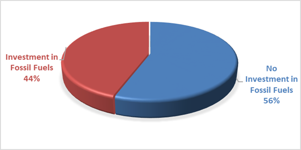
The notion of Environmental and Socially Responsible Investing is much broader than whether a financial institution as rated by ‘marketforces.org.au’ invests in fossil fuels or not. Council’s current Investment Policy defines Environmental and Socially Responsible Investing at Section 4.1 of the Policy which can be found on Council’s website.
Council may from time to time have an investment with a financial institution that invests in fossil fuels but is nevertheless aligned with the broader definition of Environmental and Socially Responsible investments. When this occurs, the investment will be marked as no fossil fuels given the investment purpose.
During the month of November 2024 as an example, Council undertook a reinvestment with Westpac Bank as a tailored deposit. The investment proceeds are utilised for environmental purposes as this investment in Climate Bond Ceritifed.
With the lifting of the NSW Treasury Corporation loan borrowing covenant on Council’s investments, growth has recommenced in acquiring investments not aligned with fossil fuels. Council’s portfolio reached its lowest point in August 2023 at 15% and as at 31 March 2025, the portfolio has been stable and is currently at 56%.
Investment Policy Compliance
The below table identifies compliance with Council’s Investment Policy by the proportion of the investment portfolio invested with financial institutions, along with their associated credit ratings compared to parameters in the Investment Policy. The parameters are designed to support prudent short and long-term management of credit risk and ensure diversification of the investment portfolio. Note that the financial institutions currently offering investments in the ‘ethical’ area are still mainly those with lower credit ratings (being either BBB or not rated at all i.e., credit unions).
The investment portfolio is outlined in the table below by investment type for the period 1 March 2025 to 31 March 2025:
|
Investment policy compliance |
|
|
||
|
% should not exceed the following |
ACTUAL |
|
||
|
|
|
|
|
|
|
AAA to AA |
A1+ |
100% |
48% |
Meets policy |
|
A+ to A- |
A1 |
60% |
15% |
Meets policy |
|
BBB to NR |
A2,NR |
40% |
37% |
Meets policy |
Dissection of Council Investment Portfolio as at 31 March 2025
|
Principal Value ($) |
Investment Linked to: |
Current Market Value ($) |
Cumulative Unrealised Gain/(Loss) ($) |
|
69,000,000.00 |
Term Deposits |
69,000,000.00 |
0.00 |
|
21,758,204.68 |
CBA Business Saver |
21,758,204.68 |
0.00 |
|
209,954.26
|
CBA Business Saver – Tourism Infrastructure Grant |
209,954.26
|
0.00 |
|
1,935,036.19 |
Macquarie Accelerator |
1,935,036.19 |
0.00 |
|
6,350,000.00 |
Bonds/Floating Rate Notes |
6,012,964.33 |
(337,035.67) |
|
99,253,195.13 |
Total |
98,916,159.46 |
(337,035.67) |
Council’s overall ‘cash position’ is not only measured by funds invested but also by the funds retained in its consolidated fund or bank account for operational purposes. The table below identifies Council’s overall cash position for the month of March 2025 as follows:
Dissection of Council’s Cash Position as at 31 March 2025
|
Item |
Principal Value ($) |
Current Market Value ($) |
Cumulative Unrealised Gain/(Loss) ($) |
|
Investments Portfolio |
|||
|
Term Deposits |
69,000,000.00 |
69,000,000.00 |
0.00 |
|
CBA Business Saver |
21,758,204.68 |
21,758,204.68 |
0.00 |
|
CBA Business Saver – Tourism Infrastructure Grant |
209,954.26 |
209,954.26 |
0.00 |
|
Macquarie Accelerator |
1,935,036.19 |
1,935,036.19 |
0.00 |
|
Bonds |
6,350,000.00 |
6,012,964.33 |
(337,035.67) |
|
Total Investment Portfolio |
99,253,195.13 |
98,916,159.46 |
(337,035.67) |
|
Cash at Bank |
|||
|
Consolidated Fund |
4,525,072.48 |
4,525,072.48 |
0.00 |
|
Total Cash at Bank |
4,525,072.48 |
4,525,072.48 |
0.00 |
|
Total Cash Position |
103,778,267.61 |
103,441,231.94 |
(337,035.67) |
Strategic Considerations
Community Strategic Plan and Operational Plan
|
CSP Objective |
CSP Strategy |
DP Action |
Code |
OP Activity |
|
1: Effective Leadership |
1.3: Ethical and efficient management of resources |
1.3.1: Financial Management - Ensure the financial integrity and sustainability of Council through effective financial management |
1.3.1.6 |
Maintain Council's cash flow |
Legal/Statutory/Policy Considerations
In accordance with Section 212 of the Local Government (General) Regulation 2021, the Responsible Accounting Officer of Council must provide Council with a monthly report detailing all monies it has invested under section 625 of the Local Government Act 1993.
The Report must be presented at the next Ordinary Meeting of Council after the end of the month being reported. The current Council Meeting cycle does not always allow this to occur, especially as investment valuations required for the preparation of the report are often received after the deadline for the submission of reports. Endeavours are being made to achieve a better alignment and for some months this will require reporting for one or more months.
Council’s investments are made in accordance with section 625(2) of the Local Government Act 1993 and Council’s Investment Policy. The Local Government Act 1993 allows Council to invest money as per the Minister’s Order – Forms of Investment, last published in the Government Gazette on 11 March 2011.Council’s Investment Policy includes the objective of maximising earnings from authorised investments and ensuring the security of Council Funds.
Financial Considerations
Council uses a diversified mix of investments to achieve short, medium, and long-term results.
Staff Reports - Sustainable Environment and Economy 13.6
Staff Reports - Sustainable Environment and Economy
Report No. 13.6 PLANNING - 26.2022.3.1 Submissions report for Stage 4 C zones Planning Proposal
Directorate: Sustainable Environment and Economy
Report Author: Alex Caras, Land Use Plannning Coordinator
File No: I2025/304
Summary:
The purpose of this submissions report is to present proposed changes to the Stage 4 Planning Proposal for Council’s adoption to enable submission to the NSW Department of Planning, Housing and Infrastructure (the Department) for finalisation.
The implementation of environmental (conservation and management) zones commenced in 2018 and is being delivered over several stages. To date Stages 1-3 are complete and have collectively resulted in a net gain of 1,420ha of C2 Environmental Conservation zones on private land, when compared to areas previously zoned 7a, 7b, 7k & 7j in Byron LEP 1988.
Stage 4 is the subject of this report. It seeks to apply approximately 2ha of C1 National Parks and Nature Reserves, 605 ha of C2 Environmental Conservation, 275 ha of C3 Environmental Management and 0.04 ha of C4 Environmental Living zones to a mix of land owned by public authorities and traditional owners and custodians, as well as private land deferred from the Stage 3 planning proposal (by the Department) to allow for further site investigations as part of this review. Stage 4 also applies to non-environmental zones where applicable.
The Stage 4 Planning Proposal (PP4) also amends other LEP 2014 maps such as Minimum Lot Size, Height of Building, Floor Space Ratio, Drinking Water Catchment, Acid Sulfate Soils and Multiple Occupancy & Community Title Maps.
PP4 was exhibited from 14 August to 27 October 2024. The 37 public submissions received can be categorised as follows:
· Landowner submissions — ‘Agreed’ E zone and non-E zone properties
· Landowner submissions —'Not Agreed’ E zone properties
· Government Agency submissions
· Other public submissions, including verbal and community/environmental groups (Conservation of North Ocean Shores (CONOS), Northern Rivers Guardians, South Golden Beach Community Association (SGBCA)
In response to the submission feedback some changes are proposed to the planning proposal mapping.
In relation to private land, there are twelve (12) properties where landowner agreement on proposed C zones either could not be reached, or no response was provided. Three (3) of these already have an existing environmental zone under LEP 1988 (namely 7a Wetlands, 7b Coastal Habitat and or 7k Habitat). An analysis of the outstanding 'Not Agreed' Stage 4 sites, including landowners’ reasons for not agreeing and Council’s response to these, is contained in Attachment 2.
As per the gateway determination conditions for this Planning Proposal, landowners whose land will be subject to a conservation zone will be notified in writing of Council’s decision and advised that they have 28 days to notify the Department to undertake an independent review of the proposed zoning of their property.
NOTE TO COUNCILLORS:
In accordance with the provisions of S375A of the Local Government Act 1993, a Division is to be called whenever a motion for a planning decision is put to the meeting, for the purpose of recording voting on planning matters. Pursuant to clause 2(a) under the heading Matters to be Included in Minutes of Council Meetings of Council's adopted Code of Meeting Practice (as amended) a Division will be deemed to have been called by the mover and seconder of all motions relating to this report.
RECOMMENDATION:
That Council:
1. In relation to Stage 4 C Zones Planning Proposal adopts:
a) the proposed LEP 2014 map changes for properties identified in Attachment 1; and
b) the proposed LEP 2014 zones (environmental and non-environmental) and consequential mapping for the ‘not agreed’ properties contained in Attachment 2;
2. Submits the updated Planning Proposal to the NSW Department of Planning, Housing and Infrastructure, as the plan-making authority in this instance, along with a request to make the final LEP for notification on the NSW Government legislation website.
3. Notes that, post consideration of the submissions and endorsement of the final planning proposal, landowners whose land will be subject to an C zone are to be notified in writing of Council's decision and advised that they have 28 days to notify the NSW Department of Planning, Housing and Infrastructure to request a review of the proposed zoning of their property.
Attachments:
1 26.2022.3.1
Summary of proposed E Zone Mapping Changes arising from Stage 4 Exhibition
(excluding Not Agreed outcomes), E2025/28244
![]()
2 26.2022.3.1
Detailed Profile of Not Agreed Properties C-Zones PP4 Post Exhibition, E2025/27580 ![]()
3 26.2022.3.1
Staff response to property-specific matters raised submission from DCCEEW RE:
Exhibition of Planning Proposal - Stage 4 C zone Implementation Program, E2025/35318 ![]()
4 26.2022.3.1
Copy of Government Agency Submissions, E2025/34947
![]()
5 26.2022.3.1
Summary of response to public submissions, including community/environmental
groups (CONOS, Northern Rivers Guardians, SGBCA), E2025/35317 ![]()
6 Confidential - 26.2022.3.1 Copy of Full Stage 4 C Zones Submissions (for Councillors only), E2025/37733
7 Form
of Special Disclosure of Pecuniary Interest, E2012/2815
![]()
Background
Council at its 22 March 2018 Ordinary Meeting resolved (Res 18-188) to implement the Department’s ‘Northern Councils E Zone Review Final Recommendations Report’ in several stages to deliver more timely and effective outcomes for affected landowners. An overview of the latest staged implementation program is shown below.
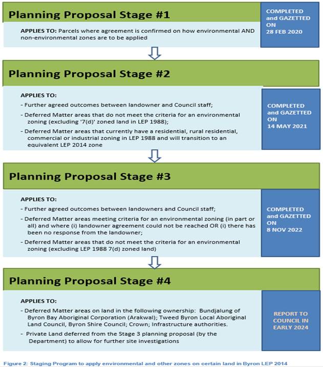
Stage 1 Planning Proposal (PP1)
PP1 applied environmental and non-environmental zones to 64 properties in the Shire based on agreed outcomes. This included approximately 340 ha of C2 Environmental Conservation zones and 60 ha of C3 Environmental Management zones (formerly E2 and E3 respectively).
Status: completed and gazetted on 28 February 2020.
Stage 2 Planning Proposal (PP2)
PP2 applied environmental and non-environmental zones to 619 properties in the Shire based on agreed outcomes. Approximately 1,485 ha of C2 Environmental Conservation zones and 400 ha of C3 Environmental Management zones (formerly E2 and E3 respectively) are applied in PP2. It also amends other LEP 2014 maps such as Minimum Lot Size, Height of Building, Drinking Water Catchment and Acid Sulfate Soils Maps.
Status: completed and gazetted on 14 May 2021.
Stage 3 Planning Proposal (PP3)
PP3 applied environmental and non-environmental zones to over 2,200 properties in the Shire, which included approximately 4,740 ha of C2 Environmental Conservation zones and 816 ha of C3 Environmental Management zones (formerly E2 and E3 respectively).
Status: completed and gazetted on 8 November 2022.
Stage 4 Planning Proposal (PP4) – subject of this report
This Planning Proposal represents Stage 4 (PP4) to integrate the remainder of deferred matters into the Byron LEP 2014, with exception of Coastal 7(f1) and 7(f2) zones and the 7(d) Scenic Escarpment zone, which will be considered under a separate process in consultation with the State Government.
PP4 includes land owned by public authorities and traditional owners and custodians, as well as private land deferred from the PP3 planning proposal (by the Department) to allow for further site investigations as part of this review.
Overall, PP4 seeks to apply environmental and non-environmental zones to 1,483 land parcels, of which 1,095 are road reserves (State, Crown or Council). The proposed environmental zones comprise approximately 2 ha of C1 National Parks and Nature Reserves, 605 ha of C2 Environmental Conservation, 275 ha of C3 Environmental Management and 0.04 ha of C4 Environmental Living zones.
In relation to the PP4 Planning Proposal, Council at its 18 April 2024 Ordinary Meeting resolved [Resolution 24-174] the following:
1. Submits the Planning Proposal contained in Attachment 1 (E2024/32968) to the NSW Department of Planning, Housing and Infrastructure for Gateway determination;
2. Pending Gateway determination, undertakes public exhibition of the Planning Proposal and consults with government agencies in accordance with the Gateway determination; and
3. Receives a Report outlining the exhibition outcomes.
The remainder of this report presents a summary of submissions (and other feedback) received during the exhibition of PP4 along with recommended LEP mapping amendments for adoption.
Report
PP4 was submitted to the Department for gateway determination in early June 2024. A positive gateway determination was received shortly after subject to the following conditions:
· Consulting with following government agencies (during exhibition):
- Biodiversity Conservation and Science Group
- National Parks and Wildlife Service
- NSW Rural Fire Service
- Department of Primary Industries
- NSW Mining, Exploration and Geoscience
- Tweed Byron LALC
- Bundjalung of Byron Bay Aboriginal Corporation (Arakwal)
· Amending the planning proposal as follows prior to exhibition:
o clearly articulate the Explanation of Provisions for the planning proposal, currently contained under the Objectives section of the proposal;
o determine the correct number of land parcels affected; and
o address the requirements of Section 9.1 Ministerial direction 4.2 Coastal Management, specifically completing section 3.2 of the NSW Coastal Design Guidelines and associated checklist.
· Notifying all affected landowners in writing of the planning proposal and the public exhibition arrangements
· When Council has considered the submissions received during public exhibition and has endorsed the final planning proposal, the landowners whose land will be subject to a conservation zone must be notified in writing of Council’s decision and advised that they have 28 days to notify the Department to undertake an independent review of the proposed zoning of their property.
· The final planning proposal is to detail how the E Zone application process for each property has been satisfied in accordance with the review recommendations.
PP4 was exhibited from 14 August to 27 October 2024 A copy of the information exhibited can be viewed at Proposed changes to conservation zones and other land use zones - Byron Shire Council
Consultation was undertaken in accordance with the gateway conditions above.
Council received thirty-seven (37) submissions that can be categorised as follows:
· Landowner submissions — ‘Agreed’ E zone and non-E zone properties – 7
· Landowner submissions —'Not Agreed’ E zone properties – 7
· Government Agency submissions – 5
· Other public submissions, including verbal submissions and community/ environmental groups (eg. CONOS, Northern Rivers Guardians, SGBCA) – 18
There are forty-nine landowners that Council has not had any response from throughout the engagement process. These properties have been included in PP4 ‘as exhibited’.
Landowner submissions — ‘Agreed’ E zone and non-E zone properties
There are seven (7) submissions where agreement was reached on proposed E zones and non-E zones. Details of these properties, including landowner feedback, are contained in Attachment 5.
Landowner submissions —'Not Agreed’ E zone properties
There are twelve (12) properties overall where landowner agreement on proposed C zones has not been reached. Three of these already have an existing environmental zone under LEP 1988 (i.e., 7a Wetlands, 7b Coastal Habitat and or 7k Habitat).
The proposed E zones largely relate to intact areas of high environmental value vegetation having one or more of the following attributes: Key Threatened Species Habitat; Endangered Ecological Communities; SEPP Coastal Wetlands; Over-cleared vegetation communities and/or riparian and estuarine vegetation on waterfront land.
Of the 22 ‘Stage 3’ sites deferred by the Department for further investigation, agreed outcomes have not been reached on eight (8) of these. Although proposed C zone areas on some of these properties has already been reduced (based on feedback from landowner), no agreement on the final amended zones could be reached.
Inevitably there will be a minority of landowners where there’s been (i) a change of mind about what was originally agreed to on their land, (ii) a change in ownership since an agreed outcome was reached or (iii) opposition to c zones throughout the c zone review process.
A detailed analysis of outstanding ‘not agreed’ properties, including landowners’ reasons for not agreeing and Council’s response to these, is contained in Attachment 2. The analysis of each property considers primary use(s) of the land together with historical aerial photography (mainly back to 1966), current aerial photography (e.g., Nearmaps), feedback from landowners, recent DA approvals, prior zoning, site inspections by Council Ecologist (including photo points) and/or drone footage.
RECOMMENDATION: That Council adopts the proposed LEP 2014 zones (environmental and non-environmental) and consequential mapping for each of the ‘not agreed’ properties contained in Attachment 2 (noting that these landowners will be notified in writing of Council's decision and advised that they have 28 days to notify the Department of Planning and Environment to request a review of the proposed zoning of their property).
Government Agency Submissions
In accordance with the gateway determination issued 13 June 2024, the public authorities listed above were consulted under section 3.34(2)(d) of the Act and/or to comply with the requirements of relevant section 9.1 Directions.
Crown Lands and Transport for NSW were also consulted about their respective properties in PP4.
Five (5) government agency responses were received, with only DCCEEW raising issues of concern about certain properties. The staff response to the property-specific matters raised in DCCEEW’s submission is contained in Attachment 3. A copy of all Government agency responses is contained in Attachment 4.
A summary of broader issues raised by DCCEEW and planning response to these is presented in Table 1 below.
Table 1 – Summary of Department of Climate Change, Energy, the Environment and Water (DCCEEW) recommendations and planning response
|
Issues raised |
Planning Response |
|
1. In accordance with the E Zone Review, the primary use of the land be identified by Council for each land parcel as follows and the appropriate C zone applied: 1a. For land with areas of native vegetation where ancillary land uses are absent or have not occurred in the last two years, the primary use of those parts of the land be determined as environmental conservation and the C2 zone applied where such land meets one or more of the criteria in Table 1 of the E Zone Review. 1b. For land with areas of native vegetation where ancillary uses, such as grazing, are present or have occurred in the last two years, the primary use of those parts of the land be determined as environmental management, and the C3 zone applied where such land meets one or more of the criteria in Table 1 or Table 2 of the E Zone Review. 1c. For land where landholders claim the primary use of the land is not environmental conservation or environmental management, they be required to provide evidence such as air photography, property development records, farm management plans, Private Native Forestry or Property Vegetation Plan approvals to justify their claims, and if not justified, the primary use be determined as per recommendations 1a and 1b above. |
Council has determined the primary use of individual land parcels using all relevant information available. This includes the characteristics of the land, its prior zoning, aerial photography, visual inspection, contact with landowners and other property information held by Council (e.g., development approvals; farmland rating status, Private Native Forestry or Property Vegetation Plan approvals). There may be instances where agreed zoning outcomes do not align precisely with the primary use(s) of the land but still deliver a better planning result DCCEEW’s request to provide more detailed justification of the primary land use(s) identified for each parcel of land would require a significant body of work and resources that go beyond any North Coast council’s capacity to implement the ‘Northern Councils E Zone Review Final Recommendations Report’. Undertaking such a detailed level of investigation on each land parcel is neither practical nor justified, noting that all landowners were given the opportunity to provide feedback on the primary use(s) identified for their land as part of the engagement process since 2017 (i.e. in addition to confirming vegetation accuracy). Where necessary, updates to ‘primary land use’ have been made because of landowner feedback received and or site investigations undertaken. |
|
2. To accord with the E Zone Review for land with areas subject to active revegetation works, habitat remediation or assisted natural regeneration: 2a. Where such works have been voluntarily revegetated by the current landowner, landowner consultation be undertaken by Council to seek the agreement of the relevant landowner to apply a C zone to those parts of the land, and if the landowner does not agree to the application of the C zone, mapped planning controls be applied to those parts of the land, noting the application of such controls do no need landholder agreement. 2b. Where such works have been funded or form part of a legal agreement, the C2 or C3 zone be applied to those parts of the land, noting landholder agreement is not required for applying C zones on such land. |
2a. – Where a landowner has voluntarily undertaken revegetation works and evidence of such works can be confirmed, staff have endeavoured to negotiate the best possible outcome for that property. Mapped overlays/planning controls will be considered in future planning proposals following completion of Stage 4. 2b. – A C2
Environmental Conservation zone and or |
|
3. Appendix 4 of the Planning Proposal be reviewed to: 3a. ensure all land parcels displayed in the Land Parcel Identification Map are listed in Tables 4.1 -4.12 of the Affected Land Parcel tables. 3b. ensure all entities listed in Tables 1 and 2 of the Northern Councils E Zone Review Final Recommendations Report contained in Council’s GIS database have been entered into the Land Parcel Identification table with the land then zoned according to those environmental criteria. |
3a. – Noted. 3b. – The environmental criteria listed in Tables 1 and 2 of the Northern Councils E Zone Review Final Recommendations Report is captured in the legend for each of the Land Parcel Identification tables in the Stage 4 planning proposal. The only exceptions to this are ‘culturally significant lands’ (C2 Criterium) which have not been mapped in Byron Shire, and nationally recognised ‘Rare, Endangered and Vulnerable Forest Ecosystems’ (C2 Criterium) that are not present in the LGA.
|
|
4. Council’s vegetation mapping layer be revised to ensure all vegetation communities associated with the floodplain that conform to the floristic descriptions identified by the NSW Threatened Species Scientific Committee determinations be mapped as Threatened Ecological Communities and the Planning Proposal amended accordingly. |
The C Zone mapping was undertaken in 2017. Since that time there have been updates to the vegetation mapping in Byron LGA and changes to the ecological communities listed in the Biodiversity Conservation Act 2016 and the Environment Protection and Biodiversity Conservation Act 1999. |
|
5. Based on the ecological condition of affected land parcels, the Planning Proposal be amended to zone all land that adjoins National Parks Estate to either C2 or C3 after confirming the presence of the relevant E zone criteria
|
This approach has been taken where practical and justified in PP4. However, a blanket application of this recommendation to all Council and or Crown land is not practical as there are also Operational needs (current and future), including Plans of Management, that must be accommodated under a future zoning. |
|
6. The Planning Proposal be amended to ensure vegetation growing within road reserves is zoned in accordance with Tables 1 and 2 of the Northern Councils E Zone Review, with zone boundaries mapped from the extent of the vegetation’s existing canopy. |
As per ‘5’ above, a blanket application of this recommendation to all Council and or Crown land is not practical as there are also Operational needs (current and future), including Plans of Management, that must be accommodated under a future zoning. Also, Council does not have the resources to accurately investigate and zone all vegetation growing within road reserves. |
RECOMMENDATION
In relation to the PP4, it is recommended that Council adopts:
a) the proposed LEP 2014 map changes for properties identified in Attachment 1; and
b) the proposed LEP 2014 zones (environmental and non-environmental) and consequential mapping for the ‘not agreed’ properties contained in Attachment 2;
to enable submission to the Department for finalisation.
Strategic Considerations
Community Strategic Plan and Operational Plan
|
CSP Objective |
CSP Strategy |
DP Action |
Code |
OP Activity |
|
Community Objective 3: We nurture and enhance our natural environment |
3.2: Deliver initiatives and education programs to encourage protection of the environment |
3.2.3: Planning - Plan to improve the quality of the natural environment |
3.2.3.5 |
Continue the E zone review (Action No.9 from Rural Land Use Strategy) |
Legal/Statutory/Policy Considerations
The process of applying C zones (previously E zones) and mapped overlays in Byron LEP 2014 is being undertaken in accordance with Section 9.1 Direction 3.4 – Application of C2 and C3 Zones and Environmental Overlays in Far North Coast LEPs. This direction specifically requires that a planning proposal that introduces or alters an E2 Environmental Conservation or E3 Environmental Management Zone, or an overlay and associated clause must be consistent with the Northern Councils E Zone Review Final Recommendations.
Financial Considerations
The remaining 2024/25 budget for the C zone Implementation program is sufficient to enable finalisation of PP4.
Consultation and Engagement
Consultation has been undertaken in accordance with the gateway determination issued 13 June 2024, with Crown Lands and Transport for NSW also consulted about their respective properties in PP4.
The Feedback received during exhibition has informed the proposed zoning of the respective land in this planning proposal.
Staff Reports - Sustainable Environment and Economy 13.7
Report No. 13.7 Draft Pest Animal Management Plan 2025 - 2030 for Public Exhibition
Directorate: Sustainable Environment and Economy
Report Author: Claudia Caliari, Biodiversity Projects Officer
File No: I2025/436
Summary:
The Byron Shire Pest Animal Management Plan (PAMP) is a framework to help Council meet its legislative obligations while supporting the community with updated pest management information. It applies to Council-owned and managed land and aligns with regional and state pest management strategies, addressing terrestrial vertebrate pest animals that threaten biodiversity, agriculture, cultural assets, and human health. The PAMP emphasizes the shared responsibility of all land managers in managing the biosecurity risks caused by pest animals and outlines strategies for controlling established and emerging pest species. The PAMP aims to minimize risks, protect the environment and ensure humane pest management, with an emphasis on collaboration with stakeholders, including First Nations groups.
The PAMP incorporates recent scientific findings and community feedback, including concerns about management options used by Council and about dingoes and wild dogs, emphasizing the need for balanced pest management that also conserves culturally significant species. It highlights the growing costs of pest control and the importance of preventing further invasions as the most cost-effective strategy.
This report seeks Council support for public exhibition of the PAMP for a period of six weeks anticipated to be from 01 May to 12 June 2025.
RECOMMENDATION:
That Council:
1. Approves the draft Pest Animal Management Plan (Attachment 1 - E2025/22626) for public exhibition;
2. Notes the draft Pest Animal Management Plan will be on public exhibition and open for feedback for a period of 6 weeks; and
3. Receives a Submissions Report following the public exhibition and feedback period for the draft Pest Animal Management Plan.
1 Final
draft Pest Animal Management Plan for endorsement for Public
Exhibition_February 2025, E2025/22626
![]()
Report
Council resolved 25-107 at the Planning Meeting 27 March 2025 to defer consideration of the Draft Pest Animal Management Plan 2025 - 2030 for Public Exhibition to enable further discussion of it at the next meeting.
The Byron Shire Pest Animal Management Plan (PAMP) is a framework to help Council meet its legislative obligations while supporting the community with relevant local information. The Plan applies to Council-owned and managed land. It sits under the North Coast Regional Strategic Pest Animal Management Plan (RSPAMP).
The revised PAMP was developed by Ecosure Environmental Consultancy, and when adopted will supersede Council’s Pest Animal Management Plan 2018-2023.
Pest animals are not defined by species but by the impact they cause to the environment, economy, or native wildlife. Pest animals are those that are recognised as a significant threat to biodiversity and agricultural productivity and have the ability to interfere with human health e.g. diseases, acute and chronic distress, depression and anxiety, and lifestyle. The species included in Council’s PAMP are those that have been defined as pest species in the RSPAMP.
The NSW Biosecurity Act 2015 (the Act) came into effect on 1 July 2017 and replaced all or part of 14 other Acts. Since pest animals do not respect boundaries like fences or government jurisdictions, the Act, alongside the Local Land Services Act 2013 (LLS Act), makes it clear that all land managers—whether on private or public land—have equal responsibility for managing biosecurity risks, including pest animals. This responsibility is known as the General Biosecurity Duty (GBD). Therefore, effective management of pest animals requires a clear and strong commitment from all levels of government, community groups, First Nations groups and the broader community.
Council’s PAMP follows a hierarchy of Federal, State and regional pest management strategies, recognising the impact pest species have in the broader landscape, and formally addresses only terrestrial vertebrate pests. Three pest categories (Table 1) are described in the plan: established species, emerging species and alert species. The category a species is included in may change over time due to the spread/containment of that species. In Council’s PAMP, actions are only given for “established” and “emerging species” (terrestrial vertebrate pests), not ‘Alert species’. This is basically due the dynamism, complexity and nature of those categorised as “Alert species”, management of which is coordinated and delivered by Department of Primary Industries and Regional Development (DPIRD; NSW Government):
Table 1 – Pest Categories
|
Category |
Description |
|
Established species |
Pest species that have already become established in the Byron Shire: cane toads, feral cats, foxes, hares, Indian myna, rabbits, wild dogs/dingoes. |
|
Emerging species |
Pest species that are established in nearby areas but not yet in Byron Shire, so there is a risk that they could become established in the Byron Shire: feral deer, feral goats and feral pigs. |
|
Alert species |
Species where efforts are required to prevent their incursion into Byron Shire, including red imported fire ants. Management of alert species is primarily coordinated and delivered by Department of Primary Industries and Regional Development (DPIRD; NSW Government). Alert Species for Byron Shire are identified at the time the Plan was prepared, acknowledging they can change over time. Landowners must always consult DPIRD to get the most up to date list of Alert Species. |
The PAMP is based on various legislative requirements, Commonwealth, State and regional strategies and plans. It also aligns with priorities identified in the Northern Rivers RSPAMP, recent research, local data, relevant stakeholder and broader community engagement, including input from First Nations Peoples (see further information under “Consultation and Engagement”).
Council’s primary objective is to fulfill its GBD to minimise risks associated with pest animals on Council owned and managed land, eliminating or minimising the risk in neighbouring land, emphasising humane and safe management approaches that are effective at reducing risk whilst protecting the environment, people and industries within the Shire. However, through our public consultation phase we learnt that there is scope for Council to act as a conduit between private landholders and the lead pest management agency in this region, Local Land Service (LLS), to strengthen understanding, coordination, collaboration and the provision of relevant local information to manage pest animals.
The revised PAMP has been developed to enable Council to respond to community enquiries and this includes controversial issues such as methods of control and recent scientific findings related to dingoes and wild dogs as well as the impact of cats (feral and free-roaming pets) and responsible pet ownership as this is affecting overall pest management.
In April 2023, Council passed a resolution (Council Resolution 23-124) acknowledging that dingoes are a native species essential to the culture of First Nations people and for ecosystem health, requiring care and attention. In following resolutions Council resolved that the PAMP review should include broader community engagement, collaboration with researchers, and input from traditional custodians to identify overall priorities and inform best practices for wild dog/dingo management including non-lethal options. It was resolved that the PAMP review should explore engagement with scientists to increase local wild dog/dingoes monitoring data and understanding of non-lethal management options, working with stakeholders to raise awareness about dingoes, with the findings being considered as part of the ongoing plan revision (August 2023: 23-351 and April 2024: 24-166). As a result of these resolutions, the revised PAMP has been developed both to guide the management of pest animals on Council owned and managed land and also to support Council’s decision making on these controversial pest management issues.
The draft PAMP outlines the necessary actions for effective pest management, including supporting DPIRD in local research and developing improved pest control strategies. It incorporates approaches to balance risk-based management of wild dogs with the conservation of dingoes, which are culturally significant to First Nations peoples and play a role in maintaining ecosystem services.
During development of the revised PAMP staff held First Nations stakeholder workshop to identify concerns and priorities with regards to best practice dingo management. These conversations are ongoing and further engagement is planned in 2025.
Staff have also been engaging with scientists to increase local dingo/wild dog monitoring data. To date we have successfully partnered with UNSW and Taronga Zoo for a UNSW Seed Funding grant of $29,532 to undertake preliminary camera monitoring of dingoes in sample areas in Byron Shire. In accordance with the draft PAMP, new research data will be used to guide future management.
The Plan also highlights the increasing and significant costs associated with managing pest animals. Preventing further invasions is identified as the most cost-effective strategy for pest control. To reduce the impacts of pest animals on the environmental, economic, social, and cultural values of Byron Shire, sustained funding is required both annually and long-term, extending beyond the five-year term of the draft Plan.
The draft Plan is ready for public exhibition proposed for a period of six weeks anticipated to be from 01 May to 12 June 2025.
Strategic Considerations
Community Strategic Plan and Operational Plan
|
CSP Objective |
CSP Strategy |
DP Action |
Code |
OP Activity |
|
1: Effective Leadership |
1.2: Engage and involve community in decision making |
1.2.1: Community-led decision making - Engage with community to inform Council decision making |
1.2.1.1 |
Provide opportunities for the community to have input, comment and feedback to Council on projects and matters of interest |
|
2: Inclusive Community |
2.2: Enhance safety and contribute to the physical, mental, and spiritual health and well being of the community |
2.2.4: Companion animals - Promote awareness of the requirements of the Companion Animals Act with respect to the ownership of companion animals |
2.2.4.3 |
Facilitate companion animals education |
|
2: Inclusive Community |
2.3: Respect Aboriginal culture, value cultural knowledge, and acknowledge history |
2.3.1: Aboriginal community and First Nations People - Develop strong and productive relationships that empower the Aboriginal community |
2.3.1.1 |
Continue working with Traditional Owners on land management matters |
|
2: Inclusive Community |
2.3: Respect Aboriginal culture, value cultural knowledge, and acknowledge history |
2.3.1: Aboriginal community and First Nations People - Develop strong and productive relationships that empower the Aboriginal community |
2.3.1.3 |
Enhance connection between Aboriginal stakeholders and Council |
|
2: Inclusive Community |
2.3: Respect Aboriginal culture, value cultural knowledge, and acknowledge history |
2.3.2: Aboriginal cultural expression - Support First Nations cultural expression |
2.3.2.1 |
Support public artworks and cultural activations led by Aboriginal people, that celebrate and respect Aboriginal and Torres Strait Islander history, stories, culture and expression |
|
2: Inclusive Community |
2.3 Respect Aboriginal culture, value cultural knowledge, and acknowledge history |
2.3.3 Support initiatives that maintain cultural connection to country and foster opportunities for Aboriginal people to live and work on country |
|
|
|
2: Inclusive Community |
2.3 Respect Aboriginal culture, value cultural knowledge, and acknowledge history |
2.3.4 Recognise and acknowledge the importance of valuing Aboriginal history and cultural knowledge |
|
|
|
3: Nurtured Environment |
3.1: Partner to nurture and enhance biodiversity, ecosystems, and ecology |
3.1.2: Pest and weed management - Use best practice land management to improve ecological resilience and reduce threats to biodiversity |
3.1.2.2 |
Implement Indian Myna Trapping program |
|
3: Nurtured Environment |
3.1: Partner to nurture and enhance biodiversity, ecosystems, and ecology |
3.1.2: Pest and weed management - Use best practice land management to improve ecological resilience and reduce threats to biodiversity |
3.1.2.3 |
Participate in Northern Rivers Feral Deer Management group |
|
3: Nurtured Environment |
3.1: Partner to nurture and enhance biodiversity, ecosystems, and ecology |
3.1.2: Pest and weed management - Use best practice land management to improve ecological resilience and reduce threats to biodiversity |
3.1.2.4 |
Undertake chemical free weed control program to high-use public areas including CBD streetscapes and playgrounds |
|
3: Nurtured Environment |
3.1: Partner to nurture and enhance biodiversity, ecosystems, and ecology |
3.1.2: Pest and weed management - Use best practice land management to improve ecological resilience and reduce threats to biodiversity |
3.1.2.7 |
Review of Pest Animal Management Plan |
Recent Resolutions
· 23-124
· 23-351
· 24-166
Legal/Statutory/Policy Considerations
A full summary of relevant legislation is provided in Appendix 5 of the draft PAMP (Attachment 1).
The PAMP sits under the RSPAMP and must comply with a variety of legal, statutory, and policy frameworks. This includes the Biosecurity Act 2015 (Commonwealth and NSW) describing the General Biosecurity Duty (GBD) to manage pests, adhering to public health regulations to reduce direct (E.g. predation) and indirect (E.g. diseases) risks spread by pests and the Prevention of Cruelty to Animals Act, ensuring humane treatment during pest control.
The PAMP also aligns with environmental protection laws like the EPBC Act and the Biodiversity Conservation Act (NSW), which protect biodiversity and threatened species. Additionally, it considers the cultural significance of species like dingoes to First Nations peoples.
The PAMP must also comply with the National Invasive Species Framework and facilitate collaboration with agencies like the LLS and DPIRD and local stakeholders. As such, long-term funding, clear engagement mechanisms, and stakeholder partnerships will be crucial in implementing and sustaining pest management efforts while minimizing their environmental, social, and economic impacts on the Shire.
The PAMP also aligns with a range of local Policies and Strategies such as:
· Byron Shire Council Integrated Pest Management Policy 2024-2028 and Byron Shire Council Integrated Pest Management Strategy 2019-2029: by eliminating or reducing the use of pesticides in Council owned and managed land and the commitment with continuous improvement
· Byron Shire Council Biodiversity Conservation Strategy 2020-2030: by controlling pests that harm native species
· Byron Shire Rural Land Use Strategy 2017: by providing local relevant information to broader community, acting as a conduit between local community and Local Land Services (pest control authority) and by fulfilling Council’s GBD
· Byron Shire Council Dogs in Public Spaces Strategy 2022-2032: by informing the community about the risks posed by free-roaming and abandoned animals can impact pest management efforts
Financial Considerations
The previous PAMP (2018-2023) was delivered with an annual budget $20,000 for the management of wild dogs, feral foxes, feral cats, and Indian Myna birds. When resources permitted, Council has also undertaken rabbit control. In 2024, a cane toad program was introduced, funded through the biodiversity budget.
Since 2018 pest animal management costs have increased, due to changes in contractor costs, fluctuations in pest animal numbers following extreme weather events, and the ongoing need to manage pest animals on all Council owned/managed land. Table 2 below summarises current pest animal management costs on Byron Shire Council land. These costs are an estimate and may be subject to change in future due to changes in contractor availability and changes in pest animal numbers and associated risks.
Table 2 – Pest animal management costs on Council land
|
Program: |
Estimated ongoing annual costs |
|
Foxes, feral cats, wild dogs/ dingoes and rabbits |
$30,000 |
|
Indian Myna |
$5,000 |
|
Cane Toad |
$8,000 |
|
TOTAL |
$43,000 |
Council provides an annual allocation of $43,000 to support delivery of the Pest Animal Management Plan. From time-to-time Council may also have the opportunity to apply for grants to support pest animal management at specific sites or for individual species, for example development of this revised PAMP was supported by a grant of $25,000 from DCCEEW. However, grant funding for pest management is inconsistent and on it’s on does not cover the cost of Council’s requirement to fulfill its General Biosecurity Duty on Council-managed land.
Consultation and Engagement
Phase 1
Extensive effort was made to engage with the community and other key stakeholders prior to development of the PAMP, so that key community issues and concerns could be considered in the plan. Engagement methods in this initial phase included:
· farmers market stalls,
· a workshop with First Nations stakeholders,
· email and social media engagements with private land managers and the broader community,
· an online survey.
Results from preliminary community engagements are detailed in Appendix 3 of the attached draft PAMP, and a summary of community engagement conducted to date is below:
· 78 respondents completed an online survey which was available 24 July-26 August 2024.
· 19 participants representing four groups (Arakwal, Madhima Gulgan Community Association, Minyumai rangers and Tweed Byron Local Aboriginal Land Council) attended the First Nations stakeholder workshop on 19 June 2024.
· 50 people were engaged at a local farmers’ market Council stall on 1-2 August 2024.
· 2 Facebook and 2 Instagram posts (23 July and 20 August) reached 2,240 people and had 327 post engagements (reactions, comments, clicks and shares).
· 11 local farmers replied to the Byron Farmers Network engagement email.
A preliminary draft of the PAMP was reviewed by key Council stakeholders and by North Coast Local Land Services.
Phase 2
This report seeks Council support to place the draft PAMP on public exhibition for a period of six weeks. The PAMP will be made available on Council’s website via a Your Say page, and advertised by two advertisements in the local paper, as well as via social media.
Following the public exhibition period, comments received will be considered during drafting of the final PAMP, with the final PAMP to be presented to Council by the end of 2025.
Staff Reports - Sustainable Environment and Economy 13.8
Report No. 13.8 Update Resolution 24-440 Grant Application for Lot 22 Masterplan
Directorate: Sustainable Environment and Economy
Report Author: Shannon Burt, Director Sustainable Environment and Economy
File No: I2025/494
Summary:
Council considered Notice of Motion No. 9.4 Grant Application for Lot 22 Masterplan Agenda of Ordinary Meeting - Thursday, 5 September 2024 and resolved as follows:
Resolved 24-440 that Council write to Mullum SEED advising it to consider lodging a formal proposal under Council’s Strategic Partnerships Policy with a view to applying for funding under the Regional Precincts and Partnerships Grant Program for a Place Plan for Lot 22 DP 1073165 in Mullumbimby, so that Council can assess the proposal under the Policy and any other applicable Policies and Guidelines.
This report provides an update on Resolution 24-440.
RECOMMENDATION:
That Council endorses the Memorandum of Understanding (Attachment 1 #2025/39320) and approves of its signing by the General Manager along with Mullum Seed to facilitate work with Council in applying for a Regional Precincts and Partnerships Program Grant.
Attachments:
1 Draft
MOU - Council and Mullum Seed - Regional Precinct Grant April 2025, E2025/39320 ![]()
Report
Council considered Notice of Motion No. 9.4 Grant Application for Lot 22 Masterplan Agenda of Ordinary Meeting - Thursday, 5 September 2024 and resolved as follows:
Resolved 24-440 that Council write to Mullum SEED advising it to consider lodging a formal proposal under Council’s Strategic Partnerships Policy with a view to applying for funding under the Regional Precincts and Partnerships Grant Program for a Place Plan for Lot 22 DP 1073165 in Mullumbimby, so that Council can assess the proposal under the Policy and any other applicable Policies and Guidelines.
Council then wrote to Mullum SEED, which led to another meeting between staff and Mullum SEED to discuss the next steps for a grant application under the Regional Precincts and Partnerships Program | Department of Infrastructure, Transport, Regional Development, Communications and the Arts (rPPP) for a Masterplan for Lot 22.
Having regard to the Council Supporting Partnership Policy, the proposal generally fails to meet the test of an ‘unsolicited proposal’ as it is not unique.
7.2 Uniqueness of Proposals - Proponents should only submit unsolicited proposals for products or services that Council would not generally seek out for its normal operations. Council is particularly interested in proposals for unique or innovative products and services.
Further, the Policy excludes the following types of ‘unsolicited proposals’ should it have met the test:
Council will not consider the following types of unsolicited proposals:
· Proponents with existing Council contracts or arrangements to provide goods or
· services seeking to bypass a future competitive process for those same goods or
· services.
· Proposals seeking to develop land that is not owned by (or vested to) Council or by
· the proponent.
· Proposals that do not contain a commercial proposition for Council.
· Proposals seeking only to change Council policy that have no associated project.
· Proposals to supply routine goods or services to Council.
· Proposals that are early concepts or lack detail.
· Proposals seeking grants, loans, bank guarantees or investment etc. from Council.
· Proposals seeking Council support for a “pilot” program.
· Proposals seeking to stop or suspend another Council process e.g. a compulsory
· acquisition.
· Proposals seeking an exclusive mandate, an exclusive opportunity or exclusive rights over a Council or community asset for a period of time so the Proponent can develop a feasibility study, “test something”, or undertake similar activities
Given the above Policy exclusion, instead, a Memorandum of Understanding (MOU) between Council and Mullum Seed to partner on a rPPP Grant Application for a Master Plan for Lot 22 is now proposed. (Attachment 1).
Should Council endorse the draft MOU, a Grant Application for a Master Plan for Lot 22 can be completed in collaboration with Mullum Seed and submitted to the rPPP.
The rPPP was originally intended to run over three years from 2023–24 to 2025–26. The rPPP has been extended to 30 June 2027. The project completion date under the updated guidelines is 31 March 2027. Applications remain open throughout the year subject to the availability of funding.
The rPPP Assessment Panel is expected to meet twice per year to assess the proposals across the rPPP funding streams, however, this may vary depending on the volume and nature of applications received.
Key issues
Master Plan proposal
As Councillors would be aware, a recent review of Lot 22 Plan of Management (POM) was adopted. Report No. 13.16 Plan of Management, Lot 22 DP 1073165, 156 Stuart Street Mullumbimby - public submissions report Agenda of Ordinary Meeting - Thursday, 27 February 2025
Figure 1: Site Plan for Lot 22 DP1073165 including existing licence areas.
The current PoM was developed in 2008 and needed updating to reflect current and potential future land uses, and constraints such as flooding. Importantly, the full extent of the Community Gardens operations was not covered in the 2008 PoM, and this was causing difficulties with approving development applications such as the Men’s Shed.
The PoM has now been updated as follows:
· the boundary of the Community Garden has been extended to align with their current footprint
· this section of land is being re-categorised from Sportsground to General Community Use
· the High Environmental Value vegetation on the northern boundary is being categorised to Natural Area - Bushland
· retain Sportsground category for the remainder of the land
· references to affordable housing have been removed
· the location of the dog park has been included
The PoM has also been reformatted and refreshed to ensure it complies with and acknowledges current legislation, polices and strategies.
The recent updates to the PoM however, did not consider a proposed swimming pool on the site (refer to Resolution 24-336, Aquatic Options Report). This is because the pool project is still in the early concept stage and will need more detailed consideration by Council before progressing.
In addition, the updates did not address several other important matters, including:
· A possible land swap of some of Lot 22 with Department of Education land
· Connections to the Rail Trail and other uses of the Rail Corridor
· The need for expanded sporting and community facilities
· Input from native title holders, community, business, sporting and environmental stakeholders on long term planning for the land
· Direct engagement with adjoining private landowners
· Its place within Precinct 4 – Saltwater Creek Precinct, Mullumbimby Masterplan
Because of these gaps, a broader and more thorough review of the PoM is still required.
To support this review, it is proposed that a comprehensive Masterplan be developed for the site. This Masterplan would help guide future planning and ensure all relevant issues and opportunities are considered.
To fund the development of this Masterplan, Council proposes to apply for a grant under Stream 1 of the rPPP. Council will be the applicant, as the landowner of Lot 22, which is classified as community land.
Regional Precincts and Partnerships Program
What is a precinct?
Regional precincts or ‘places of purpose’ are user-defined geographic areas that encompass multiple infrastructure elements delivered by various parties through long-term partnerships between multiple providers. Regional precincts may include business districts, neighbourhoods, activity centres, commercial hubs or community and recreational areas. The scale of regional precinct projects will vary depending on their location and objectives.
What is a Partnership?
Partnerships are intended to be multiple organisations working together with an aligned focus and intent to deliver a shared goal. The concept of a partnership is purposefully broad to allow a variety of organisations to come together to deliver place-based priorities
What are Eligible activities?
To be eligible your project must: § be aimed at meeting the objectives of the funding opportunity, as outlined in Section 2 § have at least $500,000 in eligible expenditure. Eligible activities must directly relate to the project and may include: § scoping, planning, design and consultation activities for the proposed precinct § development, formalisation and operation of partnership relationships and responsibilities § business cases and feasibility studies. The Minister may also approve other activities and studies which are linked to the objectives and outcomes of the Program, including geotechnical, surveying, flora and fauna, and heritage assessments and investigations.
Consideration of the above will be made, should Council endorse the draft MOU with Mullum Seed.
Strategic Considerations
Community Strategic Plan and Operational Plan
|
CSP Objective |
CSP Strategy |
DP Action |
Code |
OP Activity |
|
4: Ethical Growth |
4.2: Enable housing diversity and support people experiencing housing insecurity |
4.2.2: Partnerships and pilots to address housing needs - Investigate partnerships and pilots that deliver an innovative and affordable housing model for the Shire |
4.2.2.6 |
Revise Plan of Management for Lot 22, Mullumbimby |
Recent Resolutions
· Multiple with most recent 24-440
Financial Considerations
The current 2024/25 Operational Plan and the draft 2025/26 Operational Plan do not include the Grant Application and development of a Masterplan for Lot 22 as an activity.
If Council decides to make this a new priority, appropriate resourcing will be required. This may have implications for the delivery of existing projects and other emerging priorities.
Consultation and Engagement
Considered as part of any rPPP Grant proposal.
Staff Reports - Infrastructure Services 13.9
Staff Reports - Infrastructure Services
Report No. 13.9 Naming of Unnamed Laneway, Suffolk Park
Directorate: Infrastructure Services
Report Author: Tracy Armstrong, Roads & Property Officer
File No: I2025/90
Summary:
To seek Council endorsement for the naming of an unnamed laneway as “Coast Lane”, following public consultation and in accordance with NSW Geographical Names Board (GNB) regulations.
RECOMMENDATION:
That Council, in relation to the “Unnamed Laneway” adjoining Clifford Street, between Hayter and Alcorn Street, Suffolk Park (Image 1):
1. Endorses the name “Coast Lane”;
2. Staff submits the endorsed name to the NSW Geographical Names Board for concurrence, advertising, and Gazettal in accordance with regulation requirements; and
3. Approves new street name signs to be erected and funded from the General Fund Budget for Sign Maintenance.
1 Confidential - Resident Naming Proposal for Unnamed Road (laneway) adjoining Clifford Street, Suffolk Park, E2025/36765
2 Resident
Letter_ Unnamed laneway adjoining Clifford Street Suffolk Park_Public
Submission Phase, E2025/10635 ![]()
3 Advertising
for proposal of naming No Name to Coast Lane_Suffolk Park, E2025/9151 ![]()
4 Confidential - Public Submission Results_No Name Lane adjoining Clifford St Suffolk Park_April 2025, E2025/36736
Report
The laneway proposed for naming is located adjoining Clifford Street, between Hayter and Alcorn Streets, Suffolk Park and provides lane access to thirteen residential properties. This naming process was initiated by an adjoining resident following completion of a Development Application (DA10.2020.678.1), that required a laneway and driveway upgrade. Since completion of these works, the upgraded laneway is now actively used for property access. Naming Proposal submitted Attachment 1 (E2025/36765).
The primary reason for naming the laneway is to enhance public safety, particularly for emergency services, residents and visitors by ensuring properties are clearly identifiable. During the construction of the laneway upgrade, an incident occurred where emergency services were delayed for over ten minutes when trying to access the property due to the lack of a formal address or named access point. This delay highlighted the need for a clearly defined and gazetted laneway name.
Image 1 – Location of Unnamed Laneway, Suffolk Park.
The blue polygon defines location of unnamed lane adjoining Clifford Street.
Assessment of Proposed Name – Coast Lane
The proposed name Coast Lane satisfies NSW Geographical Names Board regulations as follows:
· Topographical relevance: The laneway is located within a coastal setting, and the name reflects this characteristic,
· Simplicity and clarity: The name is short, easy to pronounce, and suitable for communication in emergency situations,
· No duplication: The name is not in use elsewhere within Byron Shire,
· Non-commemorative constraints: As the name is not commemorative or symbolic, it does not trigger additional procedural requirements,
· Community support: The name was supported by 18 of 21 submissions received.
Community Consultation
Residents affected directly by the naming proposal were sent letters informing them of the proposed name and were requested to forward submissions Attachment 2 (E2025/10635).
The naming proposal was advertised in the Byron Echo on 29 January 2025, and Council Website Public Notices Attachment 3 (E2025/9151).
Throughout the 28-day consultation period a total of twenty one (21) submissions were received Attachment 4 (E2025/36736).
· 18 submissions supported the proposed name “Coast Lane”.
Supporters cited location relevance, simplicity, and safety benefits
· 3 submissions offered alternative naming suggestions, proposing a total of five alternative names:
- Reconciliation
- Tallow
- Bray
- Harry Bray
- Burugar
These alternatives were assessed against the NSW Geographical Names Board (GNB) regulations and found to be non-compliant as outlined below.
Assessment of Alternative Names
1.“Reconciliation”
This name is considered commemorative in nature, referencing a broader social or national movement.
Under GNB regulations, commemorative names, especially those related to Indigenous history or reconciliation, require extensive consultation with relevant Aboriginal groups and stakeholders, which was not undertaken in this case.
The GNB also discourages abstract or symbolic names that are not clearly tied to the immediate location.
2.“Tallow”
The name “Tallow” is already in use in a nearby location (Tallow Beach) and was rejected by the GNB due to eight (8) similar sounding names located within Byron Shire.
GNB regulations prioritises unique and unambiguous names, especially within the same Local Government Area.
3. “Bray”
The name “Bray” was rejected by the GNB due to four (4) similar sounding names located within a 20km radius (e.g. Bay Lane) within Byron Shire.
GNB regulations specifically seeks to avoid duplication or similar sounding names within the Local Government Area.
4. “Harry Bray”
It was noted in the submission that Harry Bray and his family resided in nearby Suffolk Park. In this case, while a local connection is acknowledged, the submission does not establish a significant or enduring link between Harry Bray and the specific laneway being named.
GNB regulations for commemorative naming requires the individual’s contribution to the specific area is demonstrated and well documented.
5. “Burugar”
“Burugar” is a Bundjalung word meaning sea, beach, or coast and has cultural and linguistic significance.
While the use of Aboriginal language names is encouraged under GNB regulations, it must be done in consultation with and endorsement from the relevant Aboriginal communities and language groups.
In this case, no evidence of consultation with the Bundjalung community or local Aboriginal Land Councils has been provided. As such, the use of “Burugar” does not comply with GNB protocols for Aboriginal naming.
Strategic Considerations
Community Strategic Plan and Operational Plan
|
CSP Strategy |
DP Action |
Code |
OP Activity |
|
|
1: Effective Leadership |
1.3: Ethical and efficient management of resources |
1.3.3: Asset Management - Maximise asset service delivery potential and take a proactive approach to lifetime asset maintenance |
1.3.3.8 |
Provide ongoing detailed road assessment and valuation for the purposes of purchase, closure and land sale as required |
Legal/Statutory/Policy Considerations
Byron Shire Council Street Name Register.
Council is able to name roads in accordance with the authority provided in Part 10, Division 4, Section 162 of the Roads Act 1993.
The procedure of naming roads, is dictated by Sections 7 to 10 within Part 2, Division 7 of the Roads Regulation 2018, which is available in detail at:
https://www.legislation.nsw.gov.au/view/whole/html/inforce/current/sl-2018-0512
Council is the authority to name this road and has done so in line with the below regulations:
· Road Regulations 2018 - Part 2 - Division 1 - Section 7 – Procedure for naming roads
· Roads Act 1993 - Division 4 - Section 162 - Naming of public roads
· New South Wales Address Policy – March 2015
· New South Wales Addressing User Manual – September 2016
· New South Wales Online Naming System – Geographical Names Board of New South Wales – June 2015
Financial Considerations
The funds for erection of the sign/s will come from the General Fund Budget allocation for Sign Maintenance.
Council will be required to pay for amendments to street name signage from the existing budget – approximately $500.
Staff Reports - Infrastructure Services 13.10
Report No. 13.10 Bangalow Road, Cooper Street and Paterson Street Intersection, Byron Bay - Traffic and Safety Assessment
Directorate: Infrastructure Services
Report Author: Shelley Currie, Road Safety Officer
File No: I2025/76
Summary:
Introduction
This report provides an update on Council resolution 24-133 parts 1 and 2, which state:
1. That the petition regarding the Traffic Impacts of Proposed Development at Lot 14, 58-60 Bangalow Road be noted.
2. That the petition be referred to the Director Infrastructure Services
The above petition requested that Council:
· undertake a current and future traffic study on the section of Bangalow Road between the Browning/Tennyson/Bangalow Road roundabout and the intersection of Bangalow Road with Old Bangalow Road.
· pay particular attention to the Cooper, Paterson and Bangalow Road intersection.
· develop and implement an appropriate proposal for mitigation of the impacts.
While the above doesn’t specifically request review of road safety, it’s assumed that this would also be included.
The extent of road requested is large (including side roads with high volumes of traffic) and it would require significant cost and time to undertake a traffic study of this magnitude. In addition, Council does not have funding for this work and would need to either reallocate funding from existing project budgets or seek external funding, both of these options would require additional time to implement.
Given the urgency of the petition, Council staff and Bitzios Consulting have worked together to provide the following traffic and safety review of the intersection of Cooper Street, Paterson Street, Bangalow Road and the new 58-60 Bangalow Road development access. Fortunately, this work can be completed in the short term using operational budgets. The full extent of Bangalow Road will be reviewed as part of longer term planning for the MR545 road network.
Traffic and Safety Assessment Summary
Paterson Street, Cooper Street and the new development access are all closely spaced along Bangalow Road and, therefore, any traffic interactions are shared between them.
At present, the existing intersections are generally within acceptable traffic management parameters, with the key exceptions being the back-to-back right turn pockets for Cooper Street and Paterson Street on Bangalow Road. However, this may be partly due to local traffic avoiding the intersection. Furthermore, the proposed development seeks to add additional traffic to the area.
There have been a small number of minor crashes in this area
In the short term, the following changes are recommended:
1. Install line marking and concrete islands to physically isolate the Cooper Street right turn pocket on Bangalow Road. This will prevent vehicles cutting across the lanes from both directions.
2. Prohibit right turns into and out of Paterson Street (i.e. left in / left out only) to reduce the risk of vehicle collisions.
3. Install a right turn pocket for the new development on Bangalow Road (as proposed at the Local Traffic Committee meeting held on 18 March 2025). This will provide storage and access for southbound traffic.
In the long term, strategic planning is required to assess improvements for the Bangalow Road / Broken Head Road corridor. Future growth is likely to lead to the corridor exceeding traffic capacity and any infrastructure changes will create traffic and safety impacts along the whole corridor. In addition, Council is continuing to liaise with Transport for NSW (TfNSW) regarding the reclassification of the MR545 from a regional road to a state road (extent of road is shown in Figure 1 below). This reclassification would allow TfNSW to manage this section of the road network and make significant improvements.
Figure 1: MR545 road network shown orange
RECOMMENDATION:
That Council:
1. Seeks community feedback on the following short term options:
a) prohibiting right turns into and out of Paterson Street
b) installation of line marking and concrete islands on the north bound right turn pocket on Bangalow Road which provides access to Cooper Street.
2. Continues to work with Transport for NSW on the reclassification of the MR545 road network from Regional Road to State Road.
3. Seeks funding for a safety and traffic study of the MR545 road network from Byron Bay to Suffolk Park to determine required upgrades for future growth.
Report
Background
The 58-60 Bangalow Road development has recently been completed, including an intersection with Bangalow Road to provide access. A petition was submitted to Council by local residents in response to this development, noting safety concerns with the development access and concerns about overuse of Paterson Street due to ‘rat-running’. To the south of the subject development is the Paterson Street and Cooper Street intersections with Bangalow Road. The locations of these intersections are shown in Figure 1 below.
Figure 1. Location map showing new development in relation to nearby intersections
The key details of the surrounding local network are as follows:
· Bangalow Road / Broken Head Road
o Provides the main southern connection between Byron Bay, Suffolk Park, Broken Head, Lennox Head and Ballina.
o Carries an average of 20,000 motor vehicles per day, including 7% heavy vehicles.
o Has a high amount of active transport use per day, probably due to the road being fairly flat and a direct route to Byron as well as the presence of the pedestrian and cycling infrastructure that runs between Byron Bay and Suffolk Park.
o Is a flat two-lane wide undivided road with on-road bicycle lanes, off-road footpaths and sections of line marked on-street parking.
o Has a 50km/h posted speed limit.
· Cooper Street:
o Provides local access to a residential catchment and an indirect connection to Byron Bay.
o Carries an average of 1,500 motor vehicles per day, including 5% heavy vehicles.
o Active transport user data unknown.
o Is a flat two-lane narrow undivided road with no pedestrian or cycle infrastructure and unmarked on-street parking.
o Has a 50km/h posted speed limit.
· Paterson Street
o Provides local access to a residential catchment and a connection to Byron Bay.
o Carries an average of 3,000 vehicles per day, including 4% heavy vehicles.
o Active transport user data is unknown but community have requested footpaths and advise that pedestrians are present. Also, Paterson St connects to bush walking tracks leading to Tallow Beach.
o Is a fairly steep two-lane narrow undivided road with no pedestrian or cycle infrastructure and unmarked on-street parking.
o Has a 50km/h posted speed limit.
· Lot 58-60 Development
o The Lot 58-60 development comprises 24 attached dwellings and 30 car parking spaces for both residents and visitors. Access is provided via the western side of Bangalow Road, north of Paterson Street.
o The proposed development includes plans to upgrade the development intersection with a short right-turning lane for southbound traffic along Bangalow Road.
o Future traffic turning into the development access from the north (right turning traffic) will potentially need to store on the road. This could cause traffic to attempt dangerous overtakes using the bicycle lane.
Key Issues and Findings
Community Feedback
The following concerns were identified in the resident petition:
· Turning into and out of residential side streets is getting worse and leading to risky driving decisions, particularly right turns into and out of Cooper Street.
· Intersection is complicated and dangerous due to proximity of Paterson and Cooper Streets and lack of traffic controls.
· Residential developments are increasing traffic volumes, particularly on Bangalow Road and Cooper Street.
· Locals avoid the intersection due to long delays in finding a gap in traffic and will instead use the back roads to get to Byron Bay. However, the back roads are much slower due to traffic calming treatments, multiple intersections, etc.
In addition, Council has received the following feedback from local residents:
· Locals using the intersection will often “go south to go north” (i.e. traffic will turn left onto Bangalow Road and then use another street further south to turn around and head north).
· Near misses occur when vehicles on side streets attempt to join northbound traffic on Bangalow Road.
· Near misses occur between vehicles and cyclists when vehicles turn from Bangalow Rd onto side streets.
· Lack of pedestrian infrastructure and vehicles speeding on Paterson Street.
· Suggestion of using a “dog-bone” style roundabout at the intersection of Cooper St/Paterson St/Bangalow Road.
Safety Review
A site visit was undertaken on 21 November 2024 to view existing conditions in the subject area. Key findings are as follows:
· Sight distances from side streets are generally compliant, given the straight and flat nature of Bangalow Road.
· The Paterson Street approach is steep and has a sharp curve where it connects to Bangalow Road.
· Vehicle speeds in this section of Bangalow Road are limited due to the presence of cyclists, high traffic volume and turning vehicles. This is reflected in the speed data which shows the 85th percentile speeds are below the posted speed limit of 50km/h on Bangalow Road. However, there may be a tendency of drivers to increase speed once they leave the congestion on Bangalow Road. Further traffic data would be required to confirm.
· Due to the crossfall of Bangalow Road and the slight bend near Paterson and Cooper Streets, vehicles travelling southbound will cross into the right turn pocket at Cooper Street when there is no oncoming traffic. This is illustrated in Figure 2.
Figure 2. Southbound Movement
· Vehicles turning right from Bangalow Road into Paterson Street often use the Cooper Street turn pocket, cutting across the lane. This is illustrated in Figure 3.
Figure 3. Northbound Movement
· Traffic turning out of Cooper Street often hesitates when vehicles cut through the Bangalow Rd right turn pockets and are effectively giving way to three lanes of traffic.
· Traffic turning out of the side streets generally hesitates when giving way to cyclists using the cycle lanes, due to the speed difference with vehicle traffic.
· No adverse behaviour was observed at the current development access, noting that the traffic volumes are quite low turning onto Bangalow Road and sight distances at this location are generally acceptable due to the flat and straight nature of Bangalow Road.
· 5 crashes have been recorded in this area between 2019 and 2023 as follows (see Figure 4):
o 3 moderate injury; 2 involving vehicles crashing into parked vehicles (A, B), 1 involving a cyclist crossing the road and getting hit by a vehicle (C).
o 1 minor injury involving a vehicle crashing into a parked vehicle (D).
o 1 non-casualty involving a vehicle turning left out of Paterson St hitting a vehicle heading north on Bangalow Road (E).
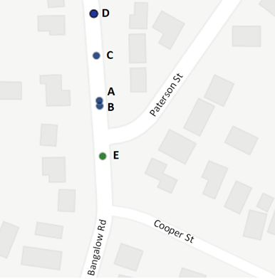
Figure 4. Crash map
This data is consistent with the number of crashes along the section of Bangalow Road between the Browning St roundabout and the intersection with Old Bangalow Road. The various crash types should be considered as part of the broader network review of Bangalow / Broken Head Road.
There is a reduced likelihood of crash types A, B & D recurring as parking has since been removed on the south bound side and the right turn pocket being constructed as part of the development access will remove the remaining parking on the north bound side.
Crash C occurred in 2020, just prior to completion of the Byron to Suffolk cycleway. Two new pedestrian refuge crossings were constructed as part of that project (located approx. 200m south and 350m north of the incident location) and should reduce future risk of this crash type.
Crash E is directly related to the Paterson St / Bangalow Road intersection and requires further investigation. However, for this crash to have occurred, at least one of the vehicles had to be outside the correct lane and may be related to the northbound movement issue shown in Figure 3. The proposed intersection changes should help channelise vehicle movements and reduce the risk of this crash type.
Traffic Review
SIDRA intersection modelling has been undertaken using 2022 and 2025 traffic counts in the subject area. The results of this modelling are shown in Table 1 below for both the current year (2025) and 10-year design horizon (2035), noting the following:
· Traffic for the development access was calculated using industry traffic generation rates as no data from here was collected.
· The overall level of service is taken from the worst leg of each intersection (the side street), in line with NSW modelling guidelines.
· The levels of service (LOS) used for this analysis are based on the below guidelines (extracted from RMS Guide to Traffic Generation Developments 2002). While not shown below, LOS F indicates that an intersection is over-capacity and safety issues are likely to occur.
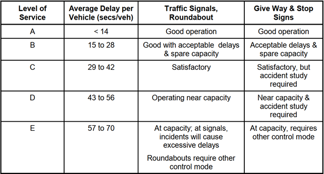
|
Intersection |
Average Delay and Level of Service |
|||
|
2025 |
2035 |
|||
|
AM |
PM |
AM |
PM |
|
|
1. Paterson Street |
21s (LOS B) |
24s (LOS B) |
65s (LOS E) |
75s (LOS F) |
|
2. Cooper Street |
22s (LOS B) |
28s (LOS B) |
257s (LOS F) |
230s (LOS F) |
Table 1: Intersection delays for Paterson and Cooper Streets in 2025 and 2035
As shown, the subject intersections currently have acceptable levels of service but are forecast to be over-capacity, based on future growth along Bangalow Road. Given these results, it is likely that the development access has a similar or better LOS due to its slightly lower volumes which occur to the north of the subject intersections.
Intersection Options
To mitigate existing and future issues at the subject intersections, the following options have been considered:
Option 1 – Removing right turns into and out of Paterson Street and improving the right turn pocket to Cooper Street using line marking and raised concrete islands.
This aims to prevent vehicles from using the right turn lane as a through lane, reduce the amount of vehicles using the intersection and Paterson St, removes the highest risk turning movements and may also reduce vehicle speeds on Paterson Street. While not removing the issue entirely, this would likely improve the current situation. Given the low speeds along this stretch of Bangalow Road, this is not expected to increase the risk of incidents significantly.
In the short-term, this should improve access for Cooper St traffic which does not have direct access via back roads to Byron Bay town centre. Paterson Street has a more direct connection to Byron Bay and the north-bound right turn movements out of the street are very low. The north-bound right turn movements into Paterson are quite high during the morning peak which may be causing the local resident concerns in relation to speeding, etc. Diverting this traffic may impact other areas of the Bangalow road network.
A north bound merge lane for Cooper St traffic was also considered but is not recommended as this “seagull” style intersection can cause more safety issues and there may be insufficient space for the merge lane.
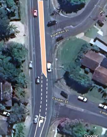
Figure 2. Right Turn Pocket Cooper St and concrete island preventing right turn access to Paterson St
The above sketch is indicative and is subject to civil design to ensure it’s cost effective, compliant and addresses key safety risks.
Option 2 – Traffic control changes on Paterson and Cooper Streets, including:
a) Add a northbound merge lane for right turns out of Paterson onto Bangalow. Allows vehicles turning right out of Paterson to better navigate multiple traffic lanes.
Most likely there is insufficient room for a merge lane, especially given the new right turn pocket for the development access. Also, the traffic turning right of Paterson is minimal.
b) Close the connection between Paterson Street and Bangalow Road and provide a north bound right turn lane for Cooper St. Significantly reduces vehicle and active transport user crash risk on Paterson Street and Bangalow Road. Significantly improves traffic flow on Bangalow Road. Reduces speeding behaviour on Paterson St.
Option 3 – Roundabout at the Cooper Street intersection
A roundabout will allow for greater traffic flow within the subject area, and potentially allow for turns to be banned at nearby accesses as the roundabout will allow for u-turns. Furthermore, a roundabout will slow vehicle speeds in the area which will reduce the risk and severity of any future safety issues.
As discussed in the intersection modelling results below, both a roundabout and signals will reach capacity if growth continues on Bangalow Road however, this would also indicate that majority of the other intersections along this corridor are also failing. As such, this option would need to be considered in line with strategic planning in the area and particularly the corridor. For instance, the roundabout to the north at Browning Street will be likely to experience these same high volumes and as such, also exceed its capacity.
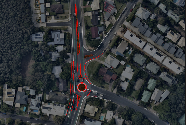
Figure 3. Indicative sketch of roundabout option
The above sketch is indicative and is subject to civil design to ensure it’s cost effective, compliant and addresses key safety risks.
Option 4 – Mini-roundabout at the Cooper Street intersection.
This option aims to reprioritise traffic (i.e. northbound traffic will have to give-way to sideroad traffic in this configuration) as per a standard roundabout but with a reduced footprint. The key difference is the diameter of the central island is greatly reduced, to fit in a standard road width, and required to be mountable for heavy vehicle movements. This intersection configuration is typically only used for low volume / low speed roads as safety concerns can arise as the mountable island does not force vehicles on the main road to slow down, particularly larger vehicles, which can increase the risk and severity of several crash types.
Option 5 – “Dog-bone” style roundabout covering the Cooper and Paterson Street intersections.
A “dog-bone” roundabout combines two intersections into a single larger intersection, essentially an elongated roundabout with four approaches. This treatment mitigates any complications with closely spaced roundabouts by combining them, avoiding majority of the affects of queues between intersections. This form has the benefit of slowing vehicle approach speeds in the same manner as a typical roundabout. An example of this intersection form is shown in Figure 4.
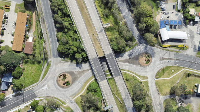
Figure 4. Example Dog-Bone Intersection Form (Kennedy Drive, Tweed Heads)
While this proposed form would likely see a benefit for safety and traffic flow while retaining all movements, the northern intersection (with Patterson Street) does not have sufficient space within the existing road reserve to accommodate such an intersection form and the Patterson Street approach would be unlikely to have sufficient sight distance for a safe approach.
Option 6 – Traffic lights at the Cooper Street intersection.
Traffic lights provide the ability to manage individual traffic movements generally without vehicles having to give-way to other traffic. As such, minor movements from the side streets can be catered for by limited green time with the majority of the priority being given to Bangalow Road. Assuming lane duplications aren’t required, signals can generally be provided with a limited footprint. Traffic lights also provide an opportunity to provide enhanced active transport infrastructure as is generally regarded as the highest order treatment for all road users.
Queues for a signalised intersection are generally higher than a roundabout form which has the potential to cause conflicts at nearby intersections depending on the overall growth of Bangalow Road. Furthermore, traffic signals do not physically slow vehicle speeds in low traffic conditions (outside of the AM and PM peaks).
Depending on the future growth of the corridor, a signalised intersection has a clear upgrade path and short lanes can be added for additional capacity for critical movements.
It should also be noted, as per Council resolution 25-067, any proposed traffic signals will require extensive community consultation prior to implementation.
Overall Outcomes
Options 3 to 6 aim to better manage vehicles from a performance and safety perspective. These intersection upgrades (except for the “dog-bone”) were only considered at Cooper Street as the road geometry is more suitable and the proposed changes would involve less cost than implementing the same at Paterson Street, due to the steeper grade and the bend where it meets Bangalow Road.
A roundabout form (Option 3), Dog-bone (Option 5), or signalisation (Option 6) would all address the main safety concern of a priority controlled right turn out of the side streets and aid the safety of the corridor by further slowing vehicles and managing flows. These options would also reduce delays and queues for the right turn into Cooper Street which is at capacity in the long term.
A small mountable roundabout (Option 4) would not be suitable at either location due to the high traffic volumes on Bangalow Road and number of heavy vehicles using this route. Furthermore, it would not slow vehicle volumes. As such, Option 3, 5, and 6 could be utilized from a safety perspective, assuming a compliant design with the relevant design aspects, but Option 4 is not recommended as it would not address the main safety issues and potential create new safety risks.
The dog-bone option would likely adequately address safety concerns and traffic management however, the Paterson Street portion of the combined intersection form would not be feasible due to the grades and width of the road.
The safety concerns relating to traffic queuing at the right turns into the development access from the north, can be addressed by allowing for a short channelised right turning lane as vehicles will not have to store within the main traffic lane. A design has been nominated in the DA which includes this but will need to be designed to the relevant design aspects.
Intersection options 2, 3 and 6 have been modelled based on the previous assumptions for the existing case analysis. Options 1, 4 and 5 have not been modelled due to following:
· Option 1 – This is a minor upgrade that will not have a significant impact on the traffic performance in the area.
· Option 4 – There are safety concerns with this option and SIDRA intersection software cannot replicate vehicle behaviour of a mountable island accurately.
· Option 5 – The northern section of the dog-bone would not be feasible within the available road width and steep grade on Paterson Street.
In addition to the above, the right turn bans at Paterson Street has been included in all options.
|
Intersection |
Average Delay and Level of Service |
|||
|
2025 |
2035 |
|||
|
AM |
PM |
AM |
PM |
|
|
Existing |
||||
|
1. Paterson Street |
21s (LOS B) |
24s (LOS B) |
65s (LOS E) |
75s (LOS F) |
|
2. Cooper Street |
22s (LOS B) |
28s (LOS B) |
257s (LOS F) |
230s (LOS F) |
|
Option 2 – Banned Right Turns at Paterson |
||||
|
1. Paterson Street |
7s (LOS A) |
9s (LOS A) |
10s (LOS A) |
10s (LOS A) |
|
2. Cooper Street |
24s (LOS B) |
28s (LOS B) |
257s (LOS F) |
232s (LOS F) |
|
Option 3 – Roundabout |
||||
|
1. Paterson Street |
7s (LOS A) |
12s (LOS A) |
10s (LOS A) |
10s (LOS A) |
|
2. Cooper Street |
11s (LOS A) |
17s (LOS B) |
70s (LOS E) |
70s (LOS E) |
|
Option 6 – Signalisation |
||||
|
1. Paterson Street |
7s (LOS A) |
9s (LOS A) |
10s (LOS A) |
10s (LOS A) |
|
2. Cooper Street |
17s (LOS B) |
28s (LOS B) |
59s (LOS E) |
28s (LOS B) |
In summary:
· Option 2 will work well for Paterson Street but will not help reduce delays at Cooper Street in the long term.
· Options 3 and 6 will be at / exceeding their capacity in future years on at-least one leg but will improve the existing situation.
· Upgrading the Bangalow/Cooper intersection form to either a roundabout or signals is recommended as it improves performance and will moderate traffic as volumes grow.
· If growth continues along Bangalow Road at the current rate, only banning right turns entirely will ease congestion. However, banning turns can create issues when drivers seek to make u-turns. Data collection and modelling is needed to help understand the issues and solutions.
· A safety and traffic study of the Bangalow / Broken Head Road corridor is recommended to ensure road changes are coordinated for future traffic growth and to ensure road safety.
Strategic Considerations
Community Strategic Plan and Operational Plan
There are no specific activities identified in the current Operational Plan for this project, however the long term planning for the MR545 will be included as part of the Integrated Transport Plan under OP action 5.2.3.5 and both the short and long term options will be reviewed as part of OP action 5.3.1.11 - Traffic, Transport and Active Transport Capital Works Business Cases Development.
A new Operational Plan action is recommended to ensure this work is included in future Council planning.
|
CSP Objective |
CSP Strategy |
DP Action |
Code |
OP Activity |
|
5: Connected Infrastructure |
5.2: Connect the Shire through integrated transport services |
5.2.3: Traffic management and reduced car dependence - Develop transport infrastructure and services that are accessible to all and meet a diverse range of needs and community expectations |
5.2.3.5 |
Develop an Integrated Transport Plan in collaboration with Transport for NSW |
|
5: Connected Infrastructure |
5.3: Invest in renewable energy and emerging technologies |
5.3.1: Future needs - Plan for the infrastructure needs of the current and future population |
5.3.1.11 |
Traffic, Transport and Active Transport Capital Works Business Cases Development |
Recent Resolutions
· 24-240
· 25-067
Legal/Statutory/Policy Considerations
Not applicable.
Financial Considerations
The cost of the works required for both the short and long term options will need to be assessed so that funding can be sought. However, the long term option will most likely require external funding via Transport for NSW grants.
Consultation and Engagement
No community consultation has been undertaken on the options identified in this report. It is recommended that local residents be consulted prior to implementation of any short term changes and the broader community on longer term plans.
Staff Reports - Infrastructure Services 13.11
Report No. 13.11 Piccabeen Park Bangalow - Parking Signage
Directorate: Infrastructure Services
Report Author: Shelley Currie, Road Safety Officer
File No: I2025/77
Summary:
This report provides a response to the below Council resolution 24-578 from the 5 December 2024 Council meeting.
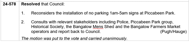
In addition to the above stakeholders, staff also consulted with Council’s parking services team, compliance services team, public space liaison officers and the rough sleeping team.
Consultation feedback indicated that use of Piccabeen Park as a place to stay overnight has occurred prior to the parking restrictions being installed. Council records indicate there was minimal impact and nuisance. However, NSW Police advised that they had observed an increase in the number of vehicles using the park each night – up to 30 in some cases. The signs were requested by police to avoid antisocial behaviour, amenity issues and nuisance.
Since the signage was installed, use of the area by overnight parkers has reduced but concerns regarding the impact and nuisance have increased. The Bangalow Men’s Shed have assisted and supported a number of rough sleepers to relocate.
Team Piccabeen, the Bangalow Men’s Shed and Bangalow Historical Society have stated that they don’t have concerns with people using the park overnight as long as it is managed respectfully. The regular Farmers Market at Piccabeen Park would be impacted if no restrictions were in place. As a result, staff conclude that removing the signage may negatively impact the current situation and the Farmers Market’s approved use of the space. Removing the signage would also completely prevent both NSW Police and Council’s compliance team from providing suitable enforcement in response to reported issues and behaviour.
RECOMMENDATION:
That Council:
1. Retains the existing parking restrictions in Piccabeen Park; and
2. Requests relevant staff to investigate ways to improve the amenity for park users (such as reducing the number of signs, reviewing toilet use, etc).
Report
On 28 March 2024, under Council resolution 24-123, Council endorsed the Local Traffic Committee recommendation to install a mixture of No Camping and No Parking 1am – 6am signage in and around Piccabeen Park in Bangalow (also known as the Bangalow Weir Parklands). See location below. This was in response to Bangalow Police feedback received in January 2024 regarding illegal camping activity occurring there. The signage allows both NSW Police and Council’s compliance team to respond to problematic vehicles that are parked in this location, between these hours.
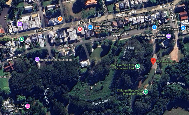
Since the signs were installed in October 2024, members of the Bangalow community who support rough sleepers have reported their view that people who normally seek their help have been absent. They raised concerns that the signs prevent people staying in the area who are in legitimate need of support. There is also a perception of increased anti-social behaviour in the area. Council staff have investigated these concerns and provide the following summary of feedback and recommendations.
Summary of feedback
NSW Police
· Requested Council install No Overnight parking signage in Piccabeen Park in January 2024.
· Prior to install of signage, NSW Police observed an increase in the number of vehicles using the park each night – up to 30 in some cases. The signs were requested to avoid anti-social behaviour, nuisance and amenity issues.
· Since the installation of the signs, there has been a reduction in the number of people camping at the location.
· NSW Police have not issued any infringements since installation of the signage and report they are aware of community sensitivities in the area.
· NSW Police remain of the opinion that it is beneficial to have the option to issue an infringement if any individual causes issues in this location.
Council’s compliance team
· A total of 19 infringements have been issued for overnight parking since the signage was installed.
· This is significantly lower than those issued in Byron Bay, Brunswick Heads and Suffolk Park during the same period. Bangalow has never been an unauthorised camping hotspot or an ongoing concern.
· Some of the rough sleepers are supported by Council’s Public Space Liaison Officers.
· Tweed & Ballina Shire Councils (which do not have pay parking) have advised they have observed an increase in rough sleeping in vans in their shires.
Council’s Public Space Liaison Officers
· PSLO’s increased morning rounds during November and December following community concerns and did not observe any notable difference in numbers compared to the past.
· No reports either of increased movement of rough sleepers to the hinterland areas.
Bangalow Historical Society
· Some people still camp in and around the Piccabeen Park car park area.
· Most appear to do so respectfully and cause no amenity or public safety concerns.
Team Piccabeen
· No consultation prior to signage being installed.
· Too much signage in park affecting the amenity of users.
· Prior to signage being installed, the park was used respectfully by a variety of overnight parkers.
· Since signs installed, park is used by unauthorised campers who cause amenity issues (e.g. using public toilet for showering and leaving area wet).
· Team Piccabeen receive calls from people wanting to book a camping spot at Piccabeen Park as Google notes it as a campground.
· Prefer signage to be removed from Piccabeen Park.
· Disabled toilet locked overnight, other toilets not. Disabled toilet lock on a timer but doesn’t always work and Piccabeen Park team have to unlock.
· Request for new affordable campsite in Bangalow region.
Mens Shed
· Piccabeen Park was being used by rough sleepers as it has a bathroom.
· Mens Shed/Bangalow CWA/Lions Club distribute approximately $3000 of food, food vouchers and petrol vouchers each week to both homeless and residents suffering financial hardship.
· Demographic approx. 1/3 young people under 30, 1/3 married/single women in cars, 1/3 families late 20s to mid-50s who are located across the shire.
· Since the parking signage was installed, the Mens Shed/CWA/Lions Club have helped relocate around 80% of the rough sleepers to other safe places. The other 20% he believes are ok but doesn’t know where they are staying.
· Prefer signage to be removed from Piccabeen Park.
Bangalow Farmers Market
· No concerns with use of park but have only started holding markets this year.
· Only aware of one rough sleeper using the verandah of Bangalow Heritage House.
Next Steps
· Parking restrictions 1am-6am remain in place to address any antisocial behaviour or public safety issues appropriately and proportionately within current resourcing.
· A review of the amount and location of signage in the park be undertaken to reduce clutter and ensure park amenity is not impacted.
· Council to continue to support rough sleepers via the Inclusive Community OP actions.
Strategic Considerations
Community Strategic Plan and Operational Plan
|
CSP Objective |
CSP Strategy |
DP Action |
Code |
OP Activity |
|
2: Inclusive Community |
2.5: Create social impact and initiatives that address disadvantage |
2.5.2: Advocacy - Advocate for services and funding to enhance social outcomes across the Shire |
2.5.2.1 |
Develop an understanding of community needs to inform advocacy efforts that enhance social outcomes |
|
2: Inclusive Community |
2.5: Create social impact and initiatives that address disadvantage |
2.5.3: Rough sleepers - Work in partnership to reduce and end rough sleeping through community action |
2.5.3.1 |
Respond to people experiencing homelessness and rough sleepers through engagement and referrals to appropriate support and housing services |
|
2: Inclusive Community |
2.5: Create social impact and initiatives that address disadvantage |
2.5.3: Rough sleepers - Work in partnership to reduce and end rough sleeping through community action |
2.5.3.3 |
Coordinate the backbone function for the Ending Rough Sleeping collaboration |
|
2: Inclusive Community |
2.5: Create social impact and initiatives that address disadvantage |
2.5.3: Rough sleepers - Work in partnership to reduce and end rough sleeping through community action |
2.5.3.4 |
Facilitate cross-directorate working group on homelessness to strengthen internal collaboration, knowledge exchange, advocacy, and planning |
|
2: Inclusive Community |
2.5: Create social impact and initiatives that address disadvantage |
2.5.3: Rough sleepers - Work in partnership to reduce and end rough sleeping through community action |
2.5.3.5 |
Develop Homelessness Action Plan in consultation with stakeholders |
|
2: Inclusive Community |
2.5: Create social impact and initiatives that address disadvantage |
2.5.3: Rough sleepers - Work in partnership to reduce and end rough sleeping through community action |
2.5.3.6 |
Investigate opportunities for enhancement of public amenities to assist people experiencing homelessness |
|
5: Connected Infrastructure |
5.2: Connect the Shire through integrated transport services |
5.2.4: Parking - Manage parking through effective controls that support Movement and Place Plans and are coordinated with other initiatives such as park and ride |
5.2.4.1 |
Undertake regular and frequent parking patrols to increase availability and turnover in the town and village centres and compliance with mobility parking |
Recent Resolutions
24-578
Legal/Statutory/Policy Considerations
As discussed in the report.
Financial Considerations
As discussed in the report.
Consultation and Engagement
As discussed in the report.
Staff Reports - Infrastructure Services 13.12
Report No. 13.12 Brunswick Heads Laneways Traffic Investigation
Directorate: Infrastructure Services
Report Author: Shelley Currie, Road Safety Officer
File No: I2025/164
Summary:
This report provides a response to Council resolution 24-364 part 2 shown below.
Resolved that Council:
1. Investigates, through the Local Traffic Committee, changes to Slessor Lane in Brunswick Heads, where recent development activity on the corner of Tweed Street is causing conflicts between patrons and residents, including investigating changing it to one-way out to Tweed Street.
2. Investigates other laneways in Brunswick Heads that may benefit from changes to traffic conditions.
RECOMMENDATIONS:
That Council:
2. Investigates traffic and parking restrictions at laneway intersections.
3. Advises residents of the outcome of this report and provide information relating to proposed changes and parking regulations.
4. Considers other resident concerns for inclusion in future works programs and plans.
Report
In early January 2025, Council issued a letter to approximately 260 residences located on or near laneways in Brunswick Heads (Attachment 1 Letter to Residents). This excluded South Beach Lane which is being reviewed separately under Council resolution 25-012.
The intent of the letter was to initiate discussion with residents on ways to improve traffic and parking management on the laneways. To start this conversation, the letter requested feedback on the following changes:
· reduced speed limit
· change from two-way to one-way traffic
· parking restrictions
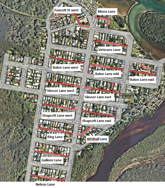
Figure 1: Laneway locations in Brunswick Heads
Council received a total of 58 submissions from the letterbox drop (Attachment 2 Stakeholder Engagement Register). Summary of the feedback on the proposed changes:
· 45% support one way traffic
· 60% support a speed reduction
· 71% support parking restrictions
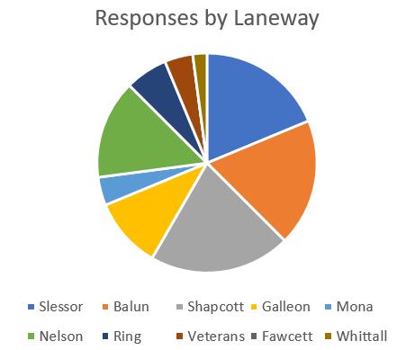
Figure 2: Pie chart showing number of responses by laneway
The above diagram shows that Shapcott, Balun and Slessor Lane residents provided the most feedback. No feedback was received for Balun Lane east (mostly businesses) or Fawcett St west.
The following key themes were noted by residents:
1. Parking and access concerns:
a) The laneways provide property access and parking for both multiple occupancy (e.g. unit blocks, dual occupancy, etc) and single dwellings.
b) Brunswick Heads has a high number of dwellings which can only be accessed from the laneway side.
c) Trades and businesses use laneways for parking which can affect property access.
d) Support for resident-only parking in laneways.
e) Lack of parking enforcement in laneways and Brunswick Heads generally.
f) Waste collection and emergency vehicle access, noting that waste collection only occurs on some laneways.
g) Council should review parking requirements for development applications relating to new dual occupancy dwellings and businesses.
h) More parking needed as parking options are limited since implementation of pay parking and other parking restrictions in town.
i) Prefer No Parking rather than No Stopping.
j) Confusion between No Parking (i.e. parking allowed for up to 2 mins to unload goods/passengers) and No Stopping (i.e. no parking allowed at any time, except in an emergency).
k) Removing parking may increase vehicle speeds on laneways.
l) Visual pollution caused by too much signage.
2. Laneway characteristics:
a) The laneways provide opportunities for social interactions between neighbours.
b) Each laneway should be assessed individually, as the environment and traffic volumes change as you move away from the town centre.
c) High amount of pedestrian and cyclist activity.
d) Animal deaths.
3. Road safety concerns:
a) Intersections with Tweed St, Byron St, Nana St, The Terrace, Booyun St and Park St have driver sight distance issues as well as pedestrian/cyclist safety concerns.
b) Traffic turning right from Tweed St onto laneways is dangerous.
c) Roundabout needed at intersection of Tweed and Mullumbimbi Streets.
4. Priorities:
a) Other improvements to Bruns township more important than traffic changes in the laneways (e.g. speed reduction, road improvements, public toilets, playgrounds, potholes, drainage, etc).
Council response to resident feedback
1. Parking and access concerns:
A number of residents use the laneways for property access as they don’t have access via the main streets (especially dual occupancy lots) and there have been instances where access is prevented due to vehicles parking in the laneways.
The residents believe that these access issues are mostly due to residents parking in the laneways and people avoiding pay parking, but in some areas this is also due to businesses using the laneways for customer/staff parking.
Under Council’s Development Control Plan 2014, there are minimum off-street parking rates applicable to properties when applying for development approval. However, these are only mandatory for new developments or existing developments which are undergoing significant extensions or a change of use which generates the need for more parking (e.g. significantly expanding an existing building or changing use from residential to commercial).
Existing properties often have historical consents with no off-street parking provision and there is no requirement to retrospectively create additional off-street parking, unless they make a significant change as noted above.
The other issue is that resident’s garages are not always used as garages and may be used for storage, extra bedrooms, etc. This results in more vehicles parking in the streets and laneways.
In addition, a number of laneways have no parking restrictions in place (other than road rules) which makes it difficult for Council parking enforcement staff to undertake compliance actions. Implementation of new parking restrictions will allow Council to provide better enforcement.
In the Next Steps section, Staff are recommending some changes which may help manage parking congestion.
2. Laneway characteristics:
Council recognises the importance of preserving the unique character and amenity of the laneways. Also, any solutions need to coordinate with the broader transport plan for the shire. For these reasons, these items should be considered as part of the Active Transport Plan (currently in draft), the Byron Shire Integrated Transport Plan (currently in draft) and the future Brunswick Heads Masterplan project.
3. Road safety concerns:
Council thanks the community for reporting these items.
The driver sight distance and right turning traffic concerns at intersections will be investigated in the short term.
The proposed roundabout for the intersection of Tweed and Mullumbimbi Streets involves significant cost and time to investigate and should be coordinated with the broader road network. Therefore, it is recommended that a transport review for Brunswick Heads be considered as part of the Byron Shire Integrated Transport Plan.
4. Priorities:
Generally, Council prioritise work based on risk and funding availability. However, we also consider community feedback and concerns, which is what has led to the current laneway traffic investigation.
A number of the proposed improvements identified by residents (e.g. public toilets, playgrounds, landscaping, speed reductions, long term road and drainage, etc) will be reviewed as part of the draft Byron Shire Integrated Transport Plan and/or the future Brunswick Heads Masterplan. Any urgent matters will be reviewed as part of Council’s usual maintenance activities.
In addition, Council hope to use revenue from the new pay parking scheme in Brunswick Heads to fund improvements in the township. Further details on this will be reported as part of Council resolution 24-131 part 3a.
Current laneway parking and traffic regulations
The only laneways with additional parking restrictions currently in place are Mona Lane, Veterans Lane and Balun Lane (east and mid only). In addition, as per Council resolution 24-590, Slessor Lane west will soon have No Stopping signage and line marking installed around the intersection with Tweed Street. See maps showing parking restrictions below (note - standard parking restrictions are not shown, e.g. around intersections).
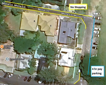
Figure 3: Mona Lane current parking restrictions
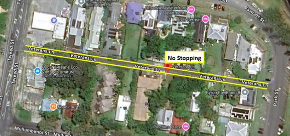
Figure 4: Veterans Lane current parking restrictions
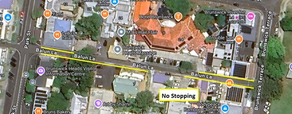
Figure 5: Balun Lane (east) current parking restrictions
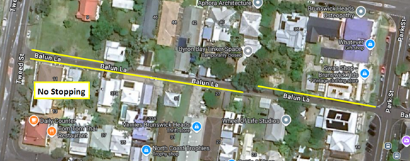
Figure 6: Balun Lane (mid) current parking restrictions
Next Steps
The feedback received from residents indicates a need to consider short and long term improvements to the laneways and Brunswick Heads township generally.
The following short term improvements aim to address immediate resident amenity and road safety concerns:
· No Parking restrictions with minimal signage, a free exemption for residents (limited to one vehicle per dwelling) and a clear zone during waste collection days (where required) on Balun Lane, Slessor Lane, Shapcott Lane, Galleon Lane, Nelson Lane, Ring Lane and Whittall Lane in Brunswick Heads.
· Investigation of traffic restrictions at various intersections (e.g. banning right turns and no stopping areas).
· Investigation of pothole and drainage repairs.
· Targeted community engagement (via letterbox drop) which provides information on the outcomes from this report and an explanation of parking and planning regulations.
Note - no changes are proposed to Mona Lane, Fawcett Street west and Veterans Lane.
The longer term improvements listed below will require significant funding, time and/or coordination with Council strategic planning:
· Proposed roundabout for the intersection of Tweed and Mullumbimbi Streets,
· Speed reduction in town centre and laneways. Any changes to speed limits require approval from TfNSW and may involve additional infrastructure works to implement.
· Traffic management improvements in the township generally (including one way laneways),
· Additional parking and/or improvements to existing parking,
· Active transport in laneways and at intersections with Park St and The Terrace.
Strategic Considerations
Community Strategic Plan and Operational Plan
|
CSP Objective |
CSP Strategy |
DP Action |
Code |
OP Activity |
|
5: Connected Infrastructure |
5.2: Connect the Shire through integrated transport services |
5.2.4: Parking - Manage parking through effective controls that support Movement and Place Plans and are coordinated with other initiatives such as park and ride |
5.2.4.1 |
Undertake regular and frequent parking patrols to increase availability and turnover in the town and village centres and compliance with mobility parking |
|
5: Connected Infrastructure |
5.2: Connect the Shire through integrated transport services |
5.2.4: Parking - Manage parking through effective controls that support Movement and Place Plans and are coordinated with other initiatives such as park and ride |
5.2.4.6 |
Implementation of Paid Parking Scheme in Brunswick Heads |
|
5: Connected Infrastructure |
5.3: Invest in renewable energy and emerging technologies |
5.3.1: Future needs - Plan for the infrastructure needs of the current and future population |
5.3.1.5 |
Report regulatory traffic matters and items requiring comment through the Local Traffic Committee for recommendation to Council for approval |
|
5: Connected Infrastructure |
5.3: Invest in renewable energy and emerging technologies |
5.3.1: Future needs - Plan for the infrastructure needs of the current and future population |
5.3.1.11 |
Traffic, Transport and Active Transport Capital Works Business Cases Development |
Recent Resolutions
· 24-131 Brunswick Heads Pay Parking Implementation – outstanding parts 3a and 4a will be addressed in future Council report.
· 24-364 Laneways in Brunswick Heads – relates to this report.
· 24-590 Slessor Lane, Brunswick Heads No Stopping Area – work to be completed before end June 2025.
· 25-012 South Beach Lane parking changes – to be addressed in future Council report.
Legal/Statutory/Policy Considerations
Not applicable
Financial Considerations
The costs associated with installation of new parking signage and line marking will most likely use budget remaining from the Brunswick Heads Pay Parking project.
Costs for repairs to potholes and drainage are subject to review of Council’s maintenance budget.
Consultation and Engagement
In early January 2025, Council conducted a letterbox drop to approximately 260 dwellings located on or adjacent to the laneways in Brunswick Heads requesting feedback on proposed traffic changes. 58 responses were received.
Following this report, Council staff will provide an update to residents who made submissions.
Council staff have also consulted internally with:
· Public and Environmental Services team in relation to resident parking concerns and proposed parking changes.
· Sustainable development team in relation to parking requirements for both residents and businesses.
Reports of Committees - Corporate and Community Services 14.1
Reports of Committees - Corporate and Community Services
Report No. 14.1 Report of the Audit, Risk and Improvement Committee Meeting held on 18 February 2025
Directorate: Corporate and Community Services
File No: I2025/379
Summary:
This report provides the minutes of the Audit, Risk and Improvement Committee Meeting of 18 February 2025 for determination by Council.
RECOMMENDATION:
1. That Council notes the minutes of the Audit, Risk and Improvement Committee Meeting held on 18 February 2025.
|
4. That Council adopts the following Committee Recommendation:
Report No. 5.2 2024 Year End Management Letter File No: I2025/93
Committee Recommendation 5.2.1 That Council notes the comments provided by Management in response to issues raised in the 2024 Year End Audit Management Letter (#E2025/12451). |
Report
This report provides the minutes of the Audit, Risk and Improvement Committee Meeting of 18 February 2025 for determination by Council.
The minutes for this meeting can be located on Council’s website at:
Minutes of Audit, Risk and Improvement Committee Meeting - Tuesday, 18 February 2025
The agenda for this meeting can be located on Council’s website at:
Agenda of Audit, Risk and Improvement Committee Meeting - Tuesday, 18 February 2025
The attachment numbers included in the recommendations to this Report follows the numbering of the Audit, Risk and Improvement Committee Meeting Agenda. Confidential attachments from that Agenda are available to Councillors by viewing the Agenda on the Hub.
Financial Implications
As per the Reports listed within the Audit, Risk and Improvement Committee Meeting of 18 February 2025.
Statutory and Policy Compliance Implications
As per the Reports listed within the Audit, Risk and Improvement Committee Meeting of 18 February 2025.
Reports of Committees - Sustainable Environment and Economy 14.2
Reports of Committees - Sustainable Environment and Economy
Report No. 14.2 Report of the Coast and ICOLL Advisory Committee Meeting held on 20 March 2025
Directorate: Sustainable Environment and Economy
File No: I2025/384
Summary:
This report provides the minutes of the Coast and ICOLL Advisory Committee meeting held on 20 March 2025.
RECOMMENDATION:
1. That Council notes the minutes of the Coast and ICOLL Advisory Committee Meeting held on 20 March 2025.
1 Minutes
of the Coast and ICOLL Advisory Committee Meeting - Thursday, 20 March 2025, I2025/319 ![]()
Report
The attachment to this report provides the minutes of the Coast and ICOLL Advisory Committee Meeting of 20 March 2025 for determination by Council.
The agenda for this meeting can be located on Council’s website at:
Agenda of Coast and ICOLL Advisory Committee Meeting - Thursday, 20 March 2025
The following items were considered by the Committee:
Report No. 4.1 Integrated Planning and Reporting
This Report provided an overview of Council’s Integrated Planning and Reporting Framework and priority areas for inclusion in Council’s delivery program. The Committee noted the Report. No action required by Council.
Report No. 6.1 Update on Coast and Estuary Projects and the Development of Coastal Management Programs (CMPs) for the Byron Shire Coastline
This Information Report provided Committee members a 3-monthly brief update on coast and estuary projects and progress of the development of Coastal Management Programs (CMPs) for the Byron Shire coastline. No action is required by Council.
Financial Implications
As per the Reports listed within the Coast and ICOLL Advisory Committee Meeting of 20 March 2025.
Statutory and Policy Compliance Implications
As per the Reports listed within the Coast and ICOLL Advisory Committee Meeting of 20 March 2025.
Reports of Committees - Infrastructure Services 14.3
Reports of Committees - Infrastructure Services
Report No. 14.3 Report of the Local Traffic Committee Meeting held on 1 April 2025
Directorate: Infrastructure Services
File No: I2025/440
Summary:
The attachment to this report provides the minutes of the Local Traffic Committee Meeting held on 1 April 2025 for determination by Council.
Council’s action on the LTC advice will be:
a) If Council is in agreement with the LTC unanimous support then the proposal may be approved. In these cases there is no conflict between Council and the advice of the LTC, consequently there is no need for Council to inform TfNSW or the NSW Police representatives of the decision.
b) If Council is in agreement with the LTC unanimous support, but no longer wants to proceed, the proposal may still be rejected.
c) If Council is in agreement with the LTC unanimous decline then the proposal may be rejected. Again there is no conflict between Council and the advice of the LTC. Consequently there is no need for Council to inform TfNSW or the NSW Police representatives of the decision.
d) If Council decides to proceed with a proposal where the advice of the LTC is not unanimous support, then the Council must first advise the TfNSW and the NSW Police representatives in writing of their intention to approve the proposal. TfNSW or the NSW Police may then lodge an appeal to the Regional Traffic Committee (RTC).
e) If Council decides to proceed with a proposal where the advice of the LTC is a unanimous decline, then the Council must first advise the TfNSW and NSW Police representatives in writing of their intention to approve the proposal. TfNSW or the NSW Police may then lodge an appeal to the RTC.
Due to the fact that the TfNSW and the NSW Police have the power to appeal certain decisions of the Council, the LTC cannot provide its advice to Council until both TfNSW and the NSW Police have provided their vote on the issue.
RECOMMENDATION:
1. That Council notes the minutes of the Local Traffic Committee Meeting held on 1 April 2025.
1 Minutes
01/04/2025 Local Traffic Committee, I2025/394
![]()
Report
The attachment to this report provides the minutes of the Local Traffic Committee Meeting of 1 April 2025 for determination by Council. The agenda for this meeting can be located on Council’s website at:
Agenda of Local Traffic Committee Meeting - Tuesday, 1 April 2025 This report contains the recommendations of the Local Traffic Committee (LTC) meeting held on 1 April 2025.
Financial Implications
As per the Reports listed within the Local Traffic Committee Meeting of 1 April 2025.
Statutory and Policy Compliance Implications
As per the Reports listed within the Local Traffic Committee Meeting of 1 April 2025.