Agenda
Ordinary
Meeting
Thursday,
23 November 2017
held
at Council Chambers, Station Street, Mullumbimby
commencing
at 9.00am
 Public Access relating to items
on this Agenda can be made between 9.00am and 10.30am on the day of the
Meeting. Requests for public access should be made to the General Manager
or Mayor no later than 12.00 midday on the day prior to the Meeting.
Public Access relating to items
on this Agenda can be made between 9.00am and 10.30am on the day of the
Meeting. Requests for public access should be made to the General Manager
or Mayor no later than 12.00 midday on the day prior to the Meeting.
Mark
Arnold
Acting
General Manager
What is a “Conflict of Interests” - A conflict of
interests can be of two types:
Pecuniary - an interest that a person has in a matter because of a reasonable
likelihood or expectation of appreciable financial gain or loss to the person
or another person with whom the person is associated.
Non-pecuniary – a private or personal interest that a Council
official has that does not amount to a pecuniary interest as defined in the
Local Government Act (eg. A friendship, membership of an association, society
or trade union or involvement or interest in an activity and may include an
interest of a financial nature).
Remoteness – a person does not have a pecuniary interest in a matter
if the interest is so remote or insignificant that it could not reasonably be
regarded as likely to influence any decision the person might make in relation
to a matter or if the interest is of a kind specified in Section 448 of the
Local Government Act.
Who has a Pecuniary Interest? - a person has a pecuniary interest in a
matter if the pecuniary interest is the interest of the person, or another
person with whom the person is associated (see below).
Relatives, Partners - a person is taken to have a pecuniary interest in a
matter if:
§ The person’s
spouse or de facto partner or a relative of the person has a pecuniary interest
in the matter, or
§ The person, or a
nominee, partners or employer of the person, is a member of a company or other
body that has a pecuniary interest in the matter.
N.B. “Relative”, in relation to a person means any of the
following:
(a) the
parent, grandparent, brother, sister, uncle, aunt, nephew, niece, lineal
descends or adopted child of the person or of the person’s spouse;
(b) the
spouse or de facto partners of the person or of a person referred to in
paragraph (a)
No Interest in the Matter - however, a person is not taken to have a
pecuniary interest in a matter:
§ If the person is
unaware of the relevant pecuniary interest of the spouse, de facto partner,
relative or company or other body, or
§ Just because the
person is a member of, or is employed by, the Council.
§ Just because the
person is a member of, or a delegate of the Council to, a company or other body
that has a pecuniary interest in the matter provided that the person has no
beneficial interest in any shares of the company or body.
Disclosure and participation in meetings
§ A Councillor or a
member of a Council Committee who has a pecuniary interest in any matter with
which the Council is concerned and who is present at a meeting of the Council
or Committee at which the matter is being considered must disclose the nature
of the interest to the meeting as soon as practicable.
§ The Councillor or
member must not be present at, or in sight of, the meeting of the Council or
Committee:
(a) at any
time during which the matter is being considered or discussed by the Council or
Committee, or
(b) at any
time during which the Council or Committee is voting on any question in
relation to the matter.
No Knowledge - a person does not breach this Clause if the person did
not know and could not reasonably be expected to have known that the matter
under consideration at the meeting was a matter in which he or she had a
pecuniary interest.
Participation in Meetings Despite Pecuniary Interest (S 452 Act)
A Councillor is not prevented from taking part in the consideration or
discussion of, or from voting on, any of the matters/questions detailed in
Section 452 of the Local Government Act.
Non-pecuniary Interests - Must be disclosed in meetings.
There are a broad range of options available for managing conflicts &
the option chosen will depend on an assessment of the circumstances of the
matter, the nature of the interest and the significance of the issue being
dealt with. Non-pecuniary conflicts of interests must be dealt with in at
least one of the following ways:
§ It may be appropriate
that no action be taken where the potential for conflict is minimal.
However, Councillors should consider providing an explanation of why they
consider a conflict does not exist.
§ Limit involvement if
practical (eg. Participate in discussion but not in decision making or
vice-versa). Care needs to be taken when exercising this option.
§ Remove the source of
the conflict (eg. Relinquishing or divesting the personal interest that creates
the conflict)
§ Have no involvement by
absenting yourself from and not taking part in any debate or voting on the
issue as if the provisions in S451 of the Local Government Act apply
(particularly if you have a significant non-pecuniary interest)
RECORDING OF VOTING ON PLANNING MATTERS
Clause 375A of the Local Government Act 1993
– Recording of voting on planning matters
(1) In this section, planning
decision means a decision made in the exercise of a function of a council
under the Environmental Planning and Assessment Act 1979:
(a) including a decision
relating to a development application, an environmental planning instrument, a
development control plan or a development contribution plan under that Act, but
(b) not including the making of
an order under Division 2A of Part 6 of that Act.
(2) The general manager is
required to keep a register containing, for each planning decision made at a
meeting of the council or a council committee, the names of the councillors who
supported the decision and the names of any councillors who opposed (or are
taken to have opposed) the decision.
(3) For the purpose of
maintaining the register, a division is required to be called whenever a motion
for a planning decision is put at a meeting of the council or a council
committee.
(4) Each decision recorded in
the register is to be described in the register or identified in a manner that
enables the description to be obtained from another publicly available
document, and is to include the information required by the regulations.
(5) This section extends to a
meeting that is closed to the public.
Ordinary Meeting
BUSINESS OF Ordinary Meeting
1. Public Access
2. Apologies
3. Requests for Leave of
Absence
4. Declarations of Interest
– Pecuniary and Non-Pecuniary
5. Tabling of Pecuniary
Interest Returns (s450A Local Government Act 1993)
6. Adoption of Minutes from
Previous Meetings
6.1 Byron
Shire Reserve Trust Committee held on 26 October 2017
6.2 Ordinary
Meeting held on 26 October 2017
6.3 Extraordinary
Meeting held on 2 November 2017
7. Reservation of Items for
Debate and Order of Business
8. Mayoral Minute
9. Notices of Motion
9.1 Parking
Permit Fee........................................................................................................... 6
9.2 Adani
Contracts............................................................................................................... 10
9.3 Compliance
- Belongil and Brunswick Dunes................................................................. 15
9.4 Biosecurity....................................................................................................................... 18
9.5 Trialling
Traffic Lights in Key Byron Bay Intersections................................................... 23
9.6 Instant
Hotel TV Show..................................................................................................... 27
10. Petitions
10.1 Tyagarah
Airfield Plan Management ............................................................................. 28
10.2 No
Paid Parking in Brunswick Heads............................................................................. 32
11. Submissions and Grants
11.1 Byron
Shire Council Submissions and Grants as at 1 November 2017......................... 33
12. Delegates' Reports
13. Staff Reports
Corporate and Community Services
13.1 Review
of Natural Disaster Response Protocols ........................................................... 36
13.2 Meeting
Schedule 2018................................................................................................... 44
13.3 Review
of Community Donations under Section 356 - new Community Initiatives Program 48
13.4 Council
Resolutions Quarterly Review - 1 July 2017 to 30 September 2017................ 51
13.5 Code
of Conduct Annual Report 1 September 2016 - 31 August 2017......................... 54
13.6 Council
Budget Review - 1 July 2017 to 30 September 2017........................................ 57
13.7 Council
Investments October 2017................................................................................. 67
13.8 Audit,
Risk and Improvement Committee Membership................................................. 74
13.9 Presentation
of 2016/2017 Financial Statements........................................................... 76
13.10 Sunshine
Cycles occupation of a site at First Sun Caravan Park (Lot 5 DP 827049)... 79
13.11 North
Byron Parklands Regulatory Working Group - Community Representatives...... 90
13.12 Amended
resolution - Aquisition of land included in Butler Street Reserve R88993...... 92
Sustainable Environment and Economy
13.13 PLANNING
- State Environmental Planning Policy No. 1 - Variations to development
standards - 1 July to 30 September...................................................................................................... 95
13.14 PLANNING
- Event Sites/ Function Centres in Rural Zones........................................ 100
13.15 PLANNING
- 26.2017.5.1 and 26.2017.6.1 Byron Bay Town Centre Masterplan Implementation -
Planning Proposals........................................................................................................ 107
13.16 Integrated
Pest Management Update........................................................................... 115
13.17 PLANNING
- 26.2017.4.1 - Planning Proposal for Rezoning and Reclassifying Part Lot 22 DP
1073165 Mullumbimby.................................................................................................. 118
13.18 Report
of the Planning Review Committee Meeting held on 19 October, 2017.......... 131
13.19 PLANNING
-10.2017.393.1 Detached Dual Occupancy Dwelling at 31 Pinegroves Road Myocum....................................................................................................................................... 133
13.20 Biodiversity
Conservation Strategy Update.................................................................. 153
13.21 PLANNING
- Resolution 17-260 Expression of Interest Land for Affordable Housing Update 156
13.22 PLANNING
- 10.2017.360.1 Rural Tourist Accommodation Comprising Four (4) Cabins at 75
Rifle Range Road, Bangalow ............................................................................................... 165
13.23 PLANNING
- 10.2017.270.1 Multi dwelling housing comprising eight (8) dwellings, Strata
Title subdivision to create eight (8) Strata Lots and Common Property and Tree
Removal (17 trees) at 6 and 6A Canowindra Court South Golden Beach.......................................................... 178
13.24 PLANNING
- Site-specific Planning Proposals considered as part of the Rural Land Use
Strategy process.......................................................................................................................... 198
13.25 Further
update on Resolution 17-191 Secondary Dwelling Conditions........................ 204
13.26 Review
of the Biodiversity and Sustainability Panel..................................................... 207
13.27 Supporting
Sustainable Agriculture and Agribusiness in Byron Shire........................... 210
Infrastructure Services
13.28 Mullumbimby
Parking Strategy..................................................................................... 220
13.29 Proposed
Boundary Adjustment and Sale of Part Council Drainage Reserve Lot 103 DP 842022....................................................................................................................................... 225
13.30 Land
purchase for access to Lot 4 Mullumbimby......................................................... 228
13.31 Former
Mullumbimby Hospital - Contamination Review.............................................. 230
13.32 Brunswick
Heads Parking Strategy.............................................................................. 233
13.33 Tree
Removals Railway Park Byron Bay..................................................................... 247
13.34 Bangalow
STP Membrane Replacement..................................................................... 256
13.35 Resolution
17-556 Additional information on Railway Park.......................................... 258
14. Reports of Committees
Infrastructure Services
14.1 Report
of the Byron Shire Floodplain Risk Management Committee Meeting held on 12
October 2017............................................................................................................................... 263
14.2 Report
of the Transport and Infrastructure Advisory Committee Meeting held on 2
November 2017....................................................................................................................................... 266
15. Questions
With Notice
15.1 Lot
2 DP 445771 Coopers Lane West........................................................................... 268
15.2 Sand
Quarry.................................................................................................................. 269
15.3 Dangerous
Dogs............................................................................................................ 270
15.4 Byron
Bypass................................................................................................................ 272
16. Confidential Reports
Infrastructure Services
16.1 Confidential - Tender 2017-0009
Construction of Sewerage Pump Station SPS5004 Ocean Shores........................................................................................................................... 274
16.2 Confidential - Council Tender for the
Multi Use of Byron Shire Rail Corridor...... 276
16.3 Confidential - Customer Service Front
Foyer Renovation Works........................ 278
Councillors are
encouraged to ask questions regarding any item on the business paper to the
appropriate Director prior to the meeting. Any suggested amendments to the
recommendations should be provided to Councillor Support prior to the meeting
to allow the changes to be typed and presented on the overhead projector at the
meeting.
Notices of Motion 9.1
Notices of Motion
Notice of Motion No. 9.1 Parking
Permit Fee
File No: I2017/1721
|
I move:
1. That
Council hold the current pay parking permit fees and administrative charges
at their current rates as follows for a period of three years:
a) The
parking permit administrative handling charge at $20.00;
b) The
shire resident or ratepayer exemption permit at $55.00 for a 12 month period;
c) The
Centrelink issued pensioner cardholder administrative charge at $20.00;
d) The
non-shire resident worker/volunteer exemption at $110.00 for a 12 month
period.
2. That
after this period of three years above these fees and charges revert to their
CPI indexing.
3. That
residents of Clunes and Newrybar be included into the residents exemption for
paid parking in Byron Shire.
|
Signed: Cr
Michael Lyon
Councillor’s
supporting information:
At the Ordinary Meeting of Council on 20 April 2017, Council
voted to exhibit the Draft Fees and Charges for the 2017/18 FY. After receiving
submissions, Council voted to adopt the Fees and Charges 17/18 at the Ordinary
Meeting on 22 June 2017. As a part of these Fees and Charges, pay parking
permit fees and administrative charges were increased across the board by a
minimum of 10%. I am moving this motion to reflect the fact that CPI over the
last 3 years has been between 1-2%, so a 10% jump seemed unreasonable. This
will hold the fees static until the review of Fees and Charges for the 2020/21
FY.
It is also worth noting that we have not yet considered how
to accommodate residents of Clunes and Newrybar who are regular visitors to
Bangalow. Whilst arguments have been raised about those residents not
having paid rates in our shire, this is not the only issue. We do not want paid
parking to have unintended negative effects on businesses in Bangalow which may
occur should those from border areas of neighbouring shires who consider it
their local area be unable to obtain an exemption.
Staff comments by Evan
Elford, Team Leader Infrastructure Planning, Infrastructure
Services:
(Management Comments must not include formatted
recommendations – resolution 11-979)
Staff managing Council’s pay parking scheme have been
reviewing the systems operations including the current applicable terms and
conditions and have identified a number of areas that could be modified
including a review of some fees and charges such as those identified in this
notice of motion. Any changes to Council’s adopted fees and charges
must be publicly exhibited for 28 days before Council can adopt the
changes.
Whilst the parking permit administrative handling and
Centrelink issued pensioner cardholder administrative fees are listed in
Council’s fees and charges they have not been applied to date in order to
lessen the initial burden on the community as pay parking was being
introduced. Council could consider removing the fees (1a. and 1c. on the
motion). They could also be retained subject to a review of the terms and
conditions as staff have identified that some people are making multiple
changes to permits and obtaining pensioner permits for a number of vehicles
they own.
With the impending commencement of the Bangalow Pay Parking
Scheme, staff are supportive of rural areas outside the shire that have a focus
on Bangalow being eligible to obtain e-permits.
However, there needs to be a clear definition of areas that
are eligible to ensure that management rules and processes are easy to
implement and that the system does equitably serve the surrounding rural
communities.
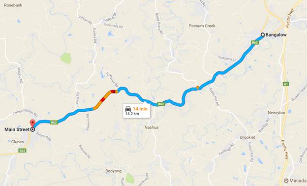
Figures 1 and 2 show the proximity of Newrybar and Clunes to
Bangalow respectively and demonstrates the difficulty in creating an equitable
system and determining which communities are eligible for inclusion.
Figures 3 and 4 show the travel times from Newrybar and
Clunes to Bangalow respectively and demonstrates there are likely to be other
rural communities and areas that may eligible for inclusion such as Brooklet,
Nashua, Possum Creek and Talofa. The village of Clunes is 14.2km from Bangalow.
Staff could prepare a report in relation to fees and charges
and the relevant terms and conditions for Council consideration prior to
advertising and adopting the changes. This process could be extended to
include consideration of matters such as eligibility for permits shire wide
which is one of the issues currently confronting the team implementing the
Bangalow Pay Parking Scheme as they address community concerns.
Figure 1. Newrybar Proximity to Bangalow
Figure 2. Clunes Proximity to Bangalow
Figure 3. Newrybar Travel Time to Bangalow
Figure 4. Clunes Travel Time to Bangalow
Financial/Resource/Legal Implications:
Staff could prepare a report to Council detailing potential
changes to fees and charges and terms and conditions to improve the operations
of the scheme to benefit residents and ratepayer as part of their systems management
role. There would be no loss of revenue as these fees are not currently
being levied however there would be an opportunity to recoup cost of staff
making numerous changes to permits if the fees were to apply to any permit
changes made after the initial free service. All changes to fees and
charges will need to be advertised for 28 days prior to adoption by Council.
Is the proposal consistent with any Delivery Program
tasks?
Yes
The proposal is consistent with delivery and management
tasks for the ongoing performance of Council’s pay parking systems and
Council’s commitment to customer service
Notices of Motion 9.2
Notice of Motion No. 9.2 Adani
Contracts
File No: I2017/1722
|
I move that Council:
1. Notes
the Stop Adani campaign event in Byron Bay and events around Australia for
the National Stop Adani Day of Action on 7 October 2017 to support the
farmers directly affected and the wider community's concerns over this mine.
2. Resolves
not to contract or engage in services under any existing contract with Downer
EDI or any of its subsidiaries, including the RPQ Group and NSW Spray Seal,
until they publicly withdraw from their agreement with Adani to construct and
operate the Carmichael mine and publicly renounce any further involvement
with Adani and the Carmichael mine.
3. Investigates
further companies to which at present or in the future Council may award
contracts that may have any involvement in contracting for the development
and operation of the Carmichael mine, or otherwise have ties to Adani.
4. Resolves
not to award future contracts to those companies identified in point three
that are involved with Adani or the construction of the Carmichael mine until
they renounce any involvement with Adani and the Carmichael mine.
5. Writes
to Downer EDI, the RPQ Group, NSW Spray Seal and any other companies
identified in point three alerting them to this motion and similar actions in
neighbouring Councils, and urging them to reconsider their involvement with
Adani and the construction of the Carmichael mine.
6. Writes
to the Prime Minister, the Hon. Mr Malcolm Turnbull and Queensland Premier,
the Hon. Annastacia Palaszczuk to express in the most respectful terms our
extreme concern about the Adani mine and alert them to the contents of this
motion.
|
Signed: Cr
Michael Lyon
Councillor’s supporting information:
If realised, the Adani Carmichael mine in Queensland’s
Galilee Basin would become the largest coal mine in Australia, and would
irrevocably undermine international efforts to limit global warming to 2
degrees Celsius. In order to prevent catastrophic climate change, 88% of the
world’s coal reserves must remain in the ground for a 50% chance at
meeting the 2 degree target. The opening of the Galilee Basin to coal mining
would have dire consequences for our planet’s future. If the Carmichael
mine went ahead, leading to the development of other mines in the Galilee
Basin, their potential combined maximum output would result in an annual output
of carbon emissions 1.3 times Australia’s total current emissions. With
the planet at a precarious tipping point, the idea of opening up a
never-before-mined region to the coal industry is deplorable.
In addition to the massive impact on climate change the
development of the Carmichael mine would have, there are also grave concerns
surrounding two of Australia’s most precious natural formations: the
Artesian Basin, Australia’s largest groundwater system, and the Great
Barrier Reef, one of the Seven Natural Wonders of the World. Adani has been
awarded a 60-year contract to extract unlimited water from the Artesian Basin,
a highly unusual move by the Queensland government, even more so because their
application was exempted from public submission and appeals. This puts farmers
whose livelihoods are dependent on being able to use water from Artesian bores
at risk, as the projected 12 billion litres Adani expects to extract annually
runs the serious risk of a significant drop in water pressure. This would not
only be ruinous for these farms, but also for the natural desert springs and
their unique species, which rely heavily on water pressure from the Artesian
Basin to exist. As with any coal mine, there is also a serious risk of
contamination of this incredible groundwater source. Additionally, the Adani
Carmichael mine is likely to have ruinous effects on the Great Barrier Reef, a
national treasure. Coal extracted at the Carmichael mine would pass through the
Abbot Point terminal, currently operated by an Adani-owned company that has
just been fined for releasing coal-laden stormwater eight times the permissible
level opposite from the Reef. Furthermore, proposed dredging to expand the
terminal to accommodate for increased output from the Carmichael mine is
notoriously awful for coral health, not to mention the fatal impacts of a
warming earth for the Great Barrier Reef. These impacts must be taken
seriously, because once set into motion, they will be irreversible.
As the Queensland government continues to support the
development of this enterprise, it is necessary that we, as a climate-conscious
Council, do everything in our power to stave off its realisation. Following
motions earlier this year to take action to encourage the big four banks to
pledge against supporting Adani financially, it is in our best interest to support
the national Stop Adani campaign’s efforts to boycott businesses
associated with the building of the Adani Carmichael mine. These companies
include NSW Spray Seal, a subsidiary of the RPQ Group, which is owned by Downer
EDI, the company engaged by Adani to take the lead in constructing mining and
other infrastructure for the Carmichael mine and operating the mine once
constructed. Tweed Shire Council and Lismore City Council have advanced similar
motions and it is important that we support our neighbouring Councils and take
our own strong stance against those that would support the development of this
disastrous mine.
Staff comments by Tony Nash, Manager Works, Infrastructure
Services Directorate:
(Management Comments must not include formatted recommendations
– resolution 11-979)
NOROC Tender
A panel tender was invited for Kyogle, Lismore, Richmond
Valley and Byron Council’s for the services of:
1. Bitumen
spray sealing
2. Asphalt
works
3. Stabilisation
works
Tenders were received for each type of work as per Table 1,
which has been listed in order of financial benefit to Council with the lowest
or most advantageous tender first on the list.
ie, for asphalt works, Fulton Hogan is less expensive
than Bitupave (Boral) which is less expensive than Downer.
Table 1:
|
Spray Seal
|
Asphalt
|
Stabilisation
|
|
NSW Spray Seal
|
Fulton Hogan
|
Downer
|
|
COLAS
|
Bitupave (Boral)
|
BMR Quarries
|
|
Bitupave (Boral)
|
Downer
|
Stabilised
Pavements Australia
|
|
Fulton Hogan
|
|
Each Council considered the tenders received and entered in separate
contracts applicable to their LGA.
The benefits of the combined tenders were the buying power
of 4 Council’s working collaboratively versus individually.
The companies are not located within our Council area and
the nearest offices / depots are as follows:
· NSW Spray Seals –
Chinderah NSW
· COLAS – Kempsey
NSW
· Bitupave – Lismore
NSW and Burleigh QLD
· Fulton Hogan - Burleigh
QLD
· Downer - Brisbane
QLD
· BMR Quarries –
Sydney NSW
· Stabilised pavements
Australia – Ormeau QLD
Byron has entered onto a panel contract with each company
for each of the 3 services of Bitumen spray sealing, Asphalt works and
Stabilisation works.
The contract works are activated when staff contact the
company, arrange works and raise a Purchase Order.
The panel contract allows staff to use different companies
for each service type if the least expensive contractor is not available and
the works are urgent and cannot wait.
In practice Byron has been able to undertake all of these
works with the least expensive contractors by working collaboratively with
them.
The price per type of service depends upon the size and type
of the works, eg, for bitumen spray sealing this is the area of works per site,
per visit to our area and the type of bitumen binder used.
Table 2 indicates the companies remaining if Downer and any
companies they own at this time, either in part of full, were to be excluded.
All percentages are the extra costs to use other than the
least expensive contractor if they are Downer or Downer owned companies.
The comparison is based on the scenarios and typical work
packages used at the time of tender evaluations.
Table 2:
|
Spray Seal
|
Price Effect
|
Asphalt
|
Price Effect
|
Stabilisation
|
Price Effect
|
|
NSW Spray Seal
|
N/A
|
Fulton Hogan
|
N/A - Fulton Hogan
and Boral Cheaper
|
Downer
|
N/A
|
|
COLAS
|
+ 3.1%
|
Bitupave (Boral)
|
BMR Quarries
|
+ 5.7%
|
|
Bitupave (Boral)
|
+ 4.3%
|
Downer
|
Stabilised
Pavements Australia
|
+ 38.9%
|
|
Fulton Hogan
|
+ 7.4%
|
|
As an example, the expenditure by Council with NSW Spray
Seals in 2016/17 was approximately $630,000, which includes any sealing works
for our capital road projects and for our Reseal Program, which had a total
budget of $840,600.
Noting that the reseal budget includes preparatory works and
the actual bitumen reseal works.
If the panel tender was available in 2016/17, the extra
costs for Council to use other than NSW Spray Seals would be as per Table 3
Table 3:
|
Spray Seal
|
Price Increase
|
|
NSW Spray Seal
|
$0
|
|
COLAS
|
$19,530
|
|
Bitupave (Boral)
|
$27,090
|
|
Fulton Hogan
|
$46,620
|
In 2017/18 our Reseal Program has a budget of $1.3M and our
roads capital works program is substantially larger than 2016/17, $41.5M v
$19M.
Supply of Bitumen Emulsion
Currently Downer supply bulk emulsion to Council for use
with our pothole patching truck under Contract 2015-0026.
The tendered prices for emulsion under 2015-0026 were as
follows:
Boral: $1.00/L
Downer: $0.98/L
Fulton Hogan: $1.01/L
Note the rates quoted above are GST-inclusive and fixed for
the contract term.
In 2016/17 we bought 160,000 Litres of emulsion. This meant
we would have spent the following had we engaged alternative suppliers:
Boral: $160,000
Downer: $156,800
Fulton Hogan: $161,600
We are contractually committed to purchasing emulsion from
Downer until 1 August 2018. The contract also has another extension option on
it.
In regards to the NoM potentially restricting our ability to
contract with Downer and related companies in the future, this will potentially
undermine the savings we can achieve through procurement. Downer is a major
player in the market and their presence helps maintain competitive tension in a
somewhat limited market. If Council decides not to contract with Downer
et al then it is likely that we will be paying significantly more for our road
building activities in the future which will have a direct impact on the
savings we are able to deliver through procurement as part of our Financial
Sustainability Plan.
Council may wish to consider a review mechanism/sunset
provision in the motion should the Adani Mine not proceed.
Financial/Resource/Legal Implications:
The implications are detailed earlier in the report.
Council has existing contracts with Downer and with
companies owned in part of full by Downer, some are panel contracts where the
use of other companies is more easily achievable, albeit at a higher
cost. Other contracts such as the bitumen emulsion supply contract,
2015-0026, are a single company contract with a fixed end date. The ability of
Council to cancel this contract and procure from another company needs to be
investigated in detail, both contractually and legally, before advice can be
provided.
Is the proposal consistent with any Delivery Program
tasks?
No
Notices of Motion 9.3
Notice of Motion No. 9.3 Compliance
- Belongil and Brunswick Dunes
File No: I2017/1723
|
I move:
1. That
Council receives a report at the December meeting detailing current
compliance priorities.
2. That
Council receives a report at the December meeting that provides updates on:
a) Actions
that have been taken or are planned to be taken to prevent illegal camping,
dumping and other damaging activities at the Belongil sand dunes following
the latest clean-up that occurred on October 24.
b) Actions
that have been taken or are planned to be taken to prevent damage to sand
dunes at Brunswick Heads.
|
Signed: Cr
Michael Lyon
Councillor’s supporting information:
Both Belongil and Brunswick Heads sand dunes are essential
components of Byron Shire’s world class beaches, requiring careful
protection not only for the amenity of residents and tourists, but also to
protect the fragile health of our heavily used coastline. The Belongil sand
dunes have had a history of illegal camping, dumping and otherwise damaging
activities and thanks to the compliance and clean up efforts of staff and
residents this year there has been a decline in these activities and several
fines issued.
Similarly, the sand dunes at Brunswick Heads have often been
the site of illegal fires and people otherwise walking through areas that are
essential to leave undisturbed to protect ecosystems. As summer approaches,
there is a tendency for these damaging activities to increase in frequency. As
such, it is an important time to prioritise the protection of both of these
areas and, for Belongil, maintain positive changes that have occurred and
ensure the area does not become repopulated with illegal campers.
Staff comments by Shannon Burt, Director, Sustainable
Environment and Economy:
(Management Comments must not include formatted
recommendations – resolution 11-979)
Council continues to confront the complex issue of illegal
camping activity in the Shire and the rubbish left behind, and the impact that
it has on the sensitive dune environments of places like Belongil and
Brunswick.
It is an issue all-year round but it gets worse during the
school holidays and summer months.
Council’s Enforcement Team regularly arranges for
proactive patrols with the Police and clean up days with Infrastructure
Services staff. On these days staff clean up faeces, toilet paper, domestic
waste, tents and furniture in large volumes. This is an extremely costly
exercise for Council in both staff time and money, and challenging for staff
confronted with the task.
Photos staff clean up 24 October 2017:
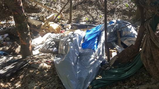

On this day, 6 staff were on duty, they detected about 15
camp sites half of which were abandoned. 12 fines were issued. Multiple truck
loads of rubbish removed.
The fines for illegal camping range from an on-the-spot fine
of $110 to a maximum of $2,200.
Of the people spoken to: 2 were local homeless, 4 were
German nationals, 1 was American, 5 were from out of town.
Council staff have raised the issue of illegal camping with
campervan companies, and the Rural Fire Service, National Parks and Wildlife
Service, and NSW Police are aware of the problem.
Staff are also in discussions with the above agencies to
develop strategies to tackle the problem in a more proactive way, which can be
reported back to Council in December.
The annual Compliance Priorities Program will also be reported
to Council in December, following a workshop with Councillors.
Financial/Resource/Legal Implications:
Enforcement Activities managed within existing staff
resource and budget under the Compliance Priority Program.
Is the proposal consistent with any Delivery Program
tasks?
Yes - SC2.2.2 Implement community regulation and enforcement
activities.
Notices of Motion 9.4
Notice of Motion No. 9.4 Biosecurity
File No: I2017/1724
|
I move:
1. That a report
to Council be prepared on the potential impacts of the new Biosecurity Act
(2017) on the draft Rural Land Use Strategy (RLUS);
2. That the report pay particular attention to:
a)
biosecurity considerations in Land
Use Conflict Risk Assessment (LUCRA);
b) the potential for biosecurity risks to
agriculture as a result of increased agritourism, and;
c) the
potential risk to Byron Shire’s
biodiversity as a result of agritourism;
3. That
Council consider including biosecurity management as a factor in the RLUS,
and
4. That
Councillors hold a workshop with a view to developing a Shire-wide
Biosecurity Policy.
|
Signed: Cr
Cate Coorey
Councillor’s
supporting information:
In April 2017 Council discussed the draft Biosecurity Act
2015.
The 10 Acts being wholly repealed when the Biosecurity
Act 2015 commences are:
· Animal
Diseases and Animal Pests (Emergency Outbreaks) Act 1991
· Apiaries
Act 1985
· Deer
Act 2006
· Fertilisers
Act 1985
· Non-Indigenous
Animals Act 1987
· Noxious
Weeds Act 1993
· Plant
Diseases Act 1924
· Stock
(Chemical Residues) Act 1975
· Stock
Diseases Act 1923
· Stock
Foods Act 1940
·
The Acts being partly repealed when the Biosecurity
Act 2015 commences are:
· Fisheries
Management Act 1994 (Aquatic Biosecurity)
· Stock
Medicines Act 1989
· Local
Land Services Act 2013 (Part 10 Pests)
· Wild
Dog Destruction Act 1921
The Biosecurity Act 2015 came into effect in June 2017 with
an update to cattle management provisions in October 2017. In light of
the soon to be completed Rural Land Use Strategy, it seems timely to consider
biosecurity as an essential issue on rural land.
Additionally, in protecting the biodiversity of our native
environment, biosecurity must be considered. Australia’s island status
has conferred us an advantage when it comes to biosecurity but there are still
threats and the chances of these are increasing.
With increasing numbers of travellers to Byron, the
increase of food and farm tours (agritourism) and the co-location of
agriculture and tourism, there are many new challenges to be met. Some of these
are perhaps unique to Byron Shire as we are a high visitation area that is also
a highly productive agricultural area and a biodiversity hotspot.
Byron has a name as a centre for premium products and
quality, low food production is a growing industry. Council has pesticide
free/low pesticde policies but to enable to be low pesticide we have to be
vigilant and not allow pests into our farms or forests in the first place.
Myrtle rust is a fungal
disease which infects plants in the Myrtaceae family. Common Australian
Myrtaceae species include eucalyptus, willow myrtle, turpentine, bottlebrush,
paperbark, tea tree and lilly pilly. Severe infections can see plants die. As
just one example the further depleting eucalyptus just for koalas is enormous.
Since
myrtle rust was first detected in NSW in April 2010 it has spread across the
eastern
Australian landscape in bushland reserves, home gardens, commercial operations,
parks and street plantings. Over 300 hosts have been recorded so far.
Something
as small as a fungus spore can have disastrous consequences.
Agriculture is a high-risk industry in regards to pest,
diseases and weeds and the introduction of any of these can decimate an
agricultural industry and a farmer’s income for many years. Generally
speaking Byron Shire Council has not had as big an agritourism sector as some
other LGAs. In other areas businesses engaging in agritourism have been imposed
with tighter restrictions than are currently permitted in Byron.
Agritourism was introduced on the rural zoning so that
farmers could value add to their existing businesses and create a supplementary
income stream. Agritourism is ancillary to the agriculture on the site and
generally small groups that can be supervised and managed by the agritourism
operator, e.g. 20 school children or groups of 5 -10 tourists being taken
through the site of a bee farmer. The tourists are shown the hives and honey
extraction techniques, partake in some activities related to the venture i.e
making honey bee wax wraps, served a morning tea and then take home some honey.
In most such operations there is a visitor register or log
and usually a biosecurity declaration to sign along with some sort of
biosecurity awareness education before entering the site. Visitors then either
“wash down” their boots/shoes in a “wash down” station
area with disinfectant and/or put on clean gum boots provided by the
agricultural entity, or put on plastic footwear protectors. If visitors
do not meet the requirements for entry then they must be denied entry due to
the risks associated.
Any person who deals with biosecurity matter or a carrier
and who knows, or ought reasonably to know, the biosecurity risk posed or
likely to be posed by the biosecurity matter, carrier or dealing has a
biosecurity duty to ensure that, so far as is reasonably practicable, the
biosecurity risk is prevented, eliminated or minimised.
The risks to Australian plants and animals from poor
biosecutry management is very real as detailed. ‘Australia’s
Biosecurity Future – preparing for future biological challenges’.
CSIRO, 2014. pp 4-5.
Biosecurity Implications on Agriculture:
· The number of international tourist arrivals for
Australia continues to increase
· We continue to see an increase in the movement
of goods and vessels around the world, in line with growing global trade
· In a globalised world, bioterrorism (including
agroterrorism) is a potential threat
· We are also seeing greater movement of goods
across our interstate borders
· Increased travel creates opportunities for
infectious diseases, including those resistant to antibiotics and antiviral
medications, to enter Australia
· Increased movement of people and goods can help
to bring pests or diseases into the country that could impact on our
environment or primary industries
· A general disconnection from primary production
in Australia is leading to a lack of understanding of biosecurity issues and
their impacts
· Changing consumer expectations require new and
adaptive biosecurity capabilities
· The ongoing expansion of our cities is changing
interactions between people, wildlife, agriculture and disease vectors,
increasing risks such as zoonotic disease
· It is important to engage with
peri-urban/amateur producers as part of the biosecurity community to improve
their understanding of biosecurity risks and their adoption of biosecurity
practices …
· An ageing population is leading to a decline in
biosecurity specialists and experienced farmers, with a lack of younger talent
to fill the gaps created
· Biosecurity investment does not appear to be
keeping pace with the growing challenges we face
· A lack of biosecurity specialists and investment
could limit our ability to prevent and respond to shocks
Biosecurity Implications on Biodiversity:
· Significant biodiversity loss can decrease the
resilience of our natural environment to pests and diseases
· The management of invasive species can be a
valuable and cost-effective tool in curbing biodiversity losses
· Biodiversity can provide a number of benefits,
such as ecosystem services (e.g. pollination). Understanding the
interconnections between biodiversity and biosecurity may therefore prove to be
a vital component of biosecurity management
Objects of Biosecurity Act
(1) The primary object of this
Act is to provide a framework for the prevention, elimination and minimisation
of biosecurity risks posed by biosecurity matter, dealing with biosecurity
matter, carriers and potential carriers, and other activities that involve
biosecurity matter, carriers or potential carriers.
(2) The other objects of this
Act are as follows:
(a) to promote biosecurity as a
shared responsibility between government, industry and communities,
(b) to provide a framework for
the timely and effective management of the following:
(i) pests,
diseases, contaminants and other biosecurity matter that are economically
significant for primary production industries,
(ii) threats to
terrestrial and aquatic environments arising from pests, diseases, contaminants
and other biosecurity matter,
(iii) public
health and safety risks arising from contaminants, non-indigenous animals,
bees, weeds and other biosecurity matter known to contribute to human health
problems,
(iv) pests,
diseases, contaminants and other biosecurity matter that may have an adverse
effect on community activities and infrastructure,
(c) to provide a framework for
risk-based decision-making in relation to biosecurity,
(d) to give effect to
intergovernmental biosecurity agreements to which the State is a party,
(e) to provide the means by
which biosecurity requirements in other jurisdictions can be met, so as to
maintain market access for industry.
Staff comments by Sharyn
French, Manager Environmental and Economic Planning, Sustainable Environment
and Economy:
(Management Comments must not include formatted
recommendations – resolution 11-979)
On 1 July 2017, the Biosecurity Act 2015 and Biosecurity
Regulations 2017 commenced providing specific legal requirements for
state-level priority weeds and high-risk activities.
Council at the 20 April 2017 meeting considered a report on
the then draft Biosecurity Regulations and Resolved 17-141 that
Council note:
1. The
information contained in this report on the draft Biosecurity Regulation 2016.
2. That
Council staff are undertaking an internal peer review of the draft Integrated
Weed Strategy March 2016.
3. That
Council staff are developing a Directions Document to provide a continued
direction for reducing the use of pesticide on Council land in the
long term.
4. The
potential for the 'Small Steps to Healthy Rural Roadsides' measures to reduce
chemical use and improve biodiversity on rural roadsides.
For a copy of the report: http://byron.infocouncil.biz/Open/2017/04/OC_20042017_AGN_605.htm#PDF2_ReportName_3823
In relation to items 1 to 3 of this NOM, the Biosecurity Act
2015 and Biosecurity Regulations 2017 have direct relevance to the development
of the Integrated Pest Management Policy and Strategy (Resolution 13-621)
and to some degree the review of Council’s Biodiversity Conservation
Strategy (Resolution 14-334). The legislation has less
relevance to Council’s Rural Land Use Strategy, which was adopted at the
26 October 2017 meeting (Resolution 17-504).
The social, economic and environmental implications arising
from the Biodiversity Act and Regulation will be addressed in the Integrated
Pest Management Policy and Strategy and the review of the Biodiversity
Conservation Strategy.
The development of both the Integrated Pest Management
Policy and Strategy and the Biodiversity Conservation Strategy will respond to
major changes in legislation and regional plans and strategies, including but
not limited to:
· NSW Biosecurity Act 2015
· NSW Biosecurity Strategy
2013-2021
· Biodiversity
Conservation Act 2016
· Australian Weed Strategy
and Intergovernmental Agreement on Biosecurity
· North Coast Regional
Strategic Weed Management Plan 2017-22
The Integrated Pest Management Strategy will consider all
pests as defined by the Biosecurity Act 2015:
Pest means a species, strain or biotype of a plant or
animal, or a disease agent, that has the potential to cause, either directly or
indirectly, harm to (a) human, animal or plant health or (b) the environment.
A presentation on the review of the Biodiversity
Conservation Strategy was provided to the Biodiversity and Sustainability Panel
at their 12 October 2017 meeting and can be accessed here:
http://byron.infocouncil.biz/RedirectToInvalidFileName.aspx?FileName=BIO_12102017_ATT_730.HTM*$PDF3_ATTACHMENT_4436_1
Two reports in this meeting agenda provide Council with an
update on both the Integrated Pest Management Policy and Strategy and
Biodiversity Conservation Strategy.
In relation to item 4 of this NOM, that Councillors hold a
workshop with a view to developing a shire-wide Biosecurity Policy, Council has
already resolved (Resolution 13-621) to prepare an Integrated Pest Management
Policy which will articulate Council’s direction and obligations
including those under the Biosecurity Act and Regulation. The development
of this Policy will be work shopped with both Council and the Biodiversity and
Sustainability Panel as outlined in the accompanying report to this meeting.
Financial/Resource/Legal Implications:
The preparation of the Integrated Pest Management Strategy
and the review of the Biodiversity Conservation Strategy are provided for in
the existing 2017/18 budget.
Is the proposal consistent with any Delivery Program
tasks?
Yes.
EN1.1.1 Protect and enhance our natural environment and
biodiversity.
· Prepare a Shire Wide
Integrated Pest Management Strategy
· Continue to undertake
the Biodiversity Strategy review
Notices of Motion 9.5
Notice of Motion No. 9.5 Trialling
Traffic Lights in Key Byron Bay Intersections.
File No: I2017/1727
|
I move that Council trial
traffic lights at the following locations;
a) the Bayshore Drive/Ewingsdale Road intersection
and
b) the Lawson/Jonson Street roundabout,
over the summer months of December 2017, January 2018
and February 2018.
|
Signed: Cr
Jan Hackett
Councillor’s supporting information:
· Residents,
workers and visitors who access Bayshore Drive for Sunrise, the Industrial
Estate and Elements et al, have had great difficulty exiting that road and
turning right onto Ewingsdale Road for almost 12 months, while the Sunrise
Boulevarde roundabout was being constructed.
· This
has led many to make risky u-turns on Ewingsdale Road to avoid long delays
– serious accidents waiting to happen.
· Despite
Sunrise Blvd roundabout now being complete, there's little sign of the queues
dissipating on Bayshore Drive, and with the summer months coming up, this
problem will continue.
· When
the construction of the Bayshore Drive roundabout commences in the new year,
lights will need to be in place anyway to keep traffic moving, much as they
were at the Sunrise Blvd. roundabout for a period of time.
· Residents,
workers and tourists who regularly use this intersection need a break from
lengthy queues and long delays, particularly over the hot summer months.
· Also,
traffick flow at this intersection needs to move well to prevent people using
the Sunrise Blvd roundabout instead and trucks and increased traffic travelling
through residential streets to find their way in and out of the area.
· These
lights also need not be temporary, as after the construction of the roundabout
they could still be used at certain times during heavy traffic flows to keep
everything moving.. I understand this is the case in Qld at difficult
intersections, roundabouts PLUS lights at peak times are now being used.
· With
regard to trialling lights at the Lawson/Jonson Streets roundabout - a traffic
movement study was conducted and reported back to the BBTCMPLG some months ago,
which noted that to keep future traffic flowing in and out of the centre of
Byron Bay, lights would ultimately have to be used at this juncture, like it or
not.
As we now have increased difficulty seeing traffic leave the town at that
point, and the
situation constantly becoming worse, trialling traffic lights over the
congested summer
months to see
if they work and gauge community response, seems to me to be a no brainer.
Despite the expected costs and approvals necessary from the RMS, I
believe our long term
solutions for traffic movements into and out of Byron Bay would benefit
greatly from a timely
trial in our peak summer months. The longer we debate this issue and put
off any test
actions, the greater our traffic movements and costings will become.
It is unknown when and if we can afford a mini bypass through Butler
Street. In the meantime,
something has
to be done.
Staff comments by Evan Elford, Team Leader Infrastructure
Planning, Infrastructure Services:
(Management Comments must not include formatted
recommendations – resolution 11-979)
Advice received to date from traffic consultants suggest
that a trial of traffic lights is not able to be done as traffic signal designs
and approvals processes are fairly comprehensive in nature including
assessments of the safety implications, etc.
Staff are unaware of traffic signal trials being done in the
past which is probably due to the strict rules and requirements relating to
signal lantern types, locations, numbers, conspicuity etc. which would normally
make a trial that expensive as not to be practical.
However, there are certainly temporary traffic signal
devices available of the type used in road construction zones and at events
although staff and consultants queried to date are not aware of temporary
pedestrian signals being installed in those circumstances.
The installation of traffic lights or signals may be
considered under 4 categories identified from RMS guidelines for Traffic
Signals as follows:
1. Portable
Traffic Signals - shared one lane roads for a short-term traffic control application.
Their primary use is as a shuttle control where a portion of the roadway has
been closed and a single lane is used alternatively by traffic approaching from
opposite directions.
2. Temporary
Traffic Signals - shared one lane roads - When a road or bridge is under repair
for longer than three months and a long stretch of one lane road is used
alternatively by traffic approaching from opposite directions, temporary
traffic signals can sometimes be used as a control.
3. Standard
Traffic Signals – Permanent installation to meet all design requirements
to suit a coordinated operation, even if coordination is not required in the
first instance. Nevertheless, they should be designed to suit SCATS operation
(Sydney Coordinated Adaptive Traffic System). A systems approach should be
adopted for all traffic signal designs so that all the implications to a
coordinated system are fully taken into account. Consultation with the RMS
officers responsible for each activity during the appropriate design stage is
essential to ensure that all their requirements are met.
4. Non
Standard Traffic Signals - A non-standard design is a design which proposes to
use any practice (including the operation of the signals) which is not
currently documented within the Traffic Signal Design manual. A nonstandard
design would typically be new or unique practice not previously used, or rarely
used, in RMS. When considering non-standard designs consultation should be
undertaken with the RMS Principal Manager Network Operations, and RMS Network
Operations’ Research Officer from the concept development stage through
to the final design. Non-standard designs may be prepared by external designers
but the external designers must work in close partnership with Road Design
Engineering and Network Operations.
The installation of temporary traffic signals at the
Bayshore Drive / Ewingsdale Road intersection and Jonson St / Lawson St
intersection are considered to fall under item 4 above i.e.. Non Standard
Traffic Signals due to their temporary or trial nature.
The approval process for non-standard designs is as follows:
1. An
initial concept plan needs to be developed in accordance with the RMS
guidelines and requires concurrence from RMS General Manager Road Network
Operations, RMS Principal Manager Network Operations and RMS Network
Operations’ Research Officer.
2. A
detailed design needs to be prepared requiring approval for its technical
correctness in accordance with relevant technical manuals and guidelines by an
appropriate authorised officer within the design consultancy (or appropriate
authority within RMS for RMS prepared designs). During the approval procedure
comment/agreement must be sought from authorised RMS officers responsible for
the adaptive, electrical and delineation features of the design. The design is
recommended for acceptance of its technical correctness by the Traffic Signal
Design Manager, Road Design Engineering. During this process comment/agreement
must be sought from authorised RMS officers responsible for the civil,
electrical and delineation features of the design.
3. The
design is recommended for acceptance by an authorised officer within RMS’
Network Operations section (including Regional Network Operations Officers).
This recommendation takes into account the impact the design will have on
overall network efficiency and compatibility with the surrounding network.
4. The
design is accepted by the appropriate RMS officer responsible for
implementation of the construction. This acceptance takes into account the
constructability of the design and suitability for the particular site and
project objectives.
Obviously, to meet these requirements involves a significant
amount of time such that any installation or trial would not be possible during
December 2017 to February 2018 as proposed.
The analysis for example at Bayshore Drive would need to
consider right turning movements into Bayshore Drive and the effect of queuing
to the traffic travelling from west as a result, this in turn would need an
assessment of the need for additional traffic lane inbound to cater for left
turn traffic from Ewingsdale into Bayshore Drive. The additional requirements
would form part of the RMS approval.
A further consideration is the potential delay to
advertising the construction tender for Bayshore Drive roundabout and the
negative impact that timing will have for Council to fulfil requirements for
current grant funding arrangements.
Staff have included in the next TIAC meeting (scheduled for
16 November) a discussion on pedestrian movements at Lawson Street, Byron Bay
(following a request from Cr Lyon) and staff are in the process of organising a
traffic consultant to attend a workshop briefing with Councillors regarding
traffic lights and roundabouts, scheduled for 7 December 2017. Temporary
Traffic management and controls are also being planned in this location to be
implemented over the Christmas period as was the case for last year.
Financial/Resource/Legal Implications:
To delay proceeding with the Bayshore Dr Roundabout and
trial traffic lights will put at risk current grant funding arrangements of
$2.6M.
No budget has been identified to carry out the trial or
engage suitably qualified consultants to design and obtain approval for traffic
light installations.
The design, approval and installation works could not be
completed within the available time to enable a trial to operate from December 2017
to February 2018.
A road authority may install temporary traffic lights for
roadworks but cannot install traffic lights to the standard required to manage
these intersections without RMS approval.
Is the proposal consistent with any Delivery Program
tasks?
The proposal in not consistent with any Delivery Program
tasks.
Notices of Motion 9.6
Notice of Motion No. 9.6 Instant
Hotel TV Show
File No: I2017/1728
|
1. That
Council write to the production company involved in the production of the
‘Instant Hotel’ program;
2. That
Council issues a media release, including to national media, announcing that
holiday letting is illegal and that they do not support it or this TV program.
|
Signed: Cr
Cate Coorey
Councillor’s supporting information:
“Gold Coast vs. Byron
Bay for holiday honours - new reality TV series “Instant Hotel”
recently premiered on Channel 7.
Staff comments by Shannon Burt, Director, Sustainable
Environment and Economy:
(Management Comments must not include formatted
recommendations – resolution 11-979)
Instant Hotel is a new reality show currently screening on
Channel Seven, where property owners turn their homes into Instant Hotels.
Episode 3 featured a property on Red Gate Road at South
Golden Beach. Council has had more than 21 complaints about this property
in the last two years and issued a $3,000 on-the-spot fine to the owner of the
premises on 2 November 2017, in relation to unauthorised activities.
A media release was issued by Council 10 November 2017 about
this property and its inclusion in the TV show. The production company has now
been made aware of this media release.
http://www.byron.nsw.gov.au/media-releases/2017/11/10/no-place-for-instant-hotels-in-byron-shire
Further, enforcement options are now being considered by
staff with regard to the unauthorised use and activities on this property.
Financial/Resource/Legal Implications:
Managed within existing staff resource and budget under the
Compliance Priority Program.
Is the proposal consistent with any Delivery Program
tasks?
Yes - SC2.2.2 Implement community regulation and enforcement
activities.
Petitions 10.1
Petitions
Petition No. 10.1 Tyagarah Airfield Plan Management
Directorate: Infrastructure Services
Report
Author: Michael
Matthews, Manager Open Space and Resource Recovery
File No: I2017/1508
Theme: Community Infrastructure
Open Space and Recreation
At Council’s Ordinary meeting held on 21 October
ordinary meeting a petition was tabled containing 281 signatures which states:
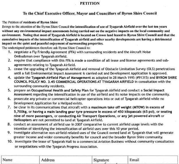
Comments from the Director Infrastructure Services:
1. negotiate a Fly Friendly Agreement (FFA) with
surrounding residents and the Aircraft Noise Ombudsman over Tyagarah Airfield.
Council
Resolved the following on 21 September 2017 (res 17-406)
Resolved that Air
Services Australia (ASA), the Aircraft Noise Ombudsman(ANO), non-profit tenants
at Tyagarah Airfield, commercial tenants at Tyagarah airfield, Tyagarah
Progress Association, land owners within 3km of Tyagarah airfield and
interested residents be invited to participate in an initial stakeholder meeting
facilitated by Council to consider the development of an FNA agreement in the
next three
months.
Staff are currently actioning
this resolution.
2. require that compliance with this FFA is made a condition
of all lease and license agreements and sub-agreements relating to Tyagarah
Airfield.
A Fly Neighbourly Agreement
(FNA), Fly Friendly Agreement (FFA), Fly Neighbourly Procedure (FNP) are all
voluntary code of practises and any mandatory aviation operating and safety
procedures (as well as any aviation requirements relevant to the area) have
precedence over a FNA, FFA, FNP in all circumstances. If a FNA was
Resolved to be established by Council, the contents of such agreement would
require legal review as to its use or linkage with existing or future lessee or
licensee holders.
3. cease the upgrading of the Tyagarah Airfield and
removal of Obstacle Limitation Survey (OLS) penetrations until a full
Environmental impact Assessment is carried out and Development Application is
approved.
Regarding vegetation management
works for OLS: Clause 22 of State Environmental Planning Policy
(Infrastructure) 2007, provides that development for the purposes of an airport
does not require development consent on land zoned RU2 Rural Landscape (i.e.
land at Tyagarah), where it is carried out by a public authority. As
such, maintenance work that is ancillary to an airport, such as vegetation
management, does not require consent in that zone.
As such, the work needs to be
assessed under Part 5 of the Environmental Planning and Assessment Act 1979,
and a Review of Environmental Factors (REF) was prepared to assist that
assessment for the vegetation maintenance works.
In relation to upgrading of the
airfield, structure planning work is continuing to examine options to optimise
future use of the land. In accordance with a previous resolution of
Council, these options will be the subject of a workshop with Councillors, to
explore future use of the land.
Removal of Obstacle Limitation
Surface (OLS) penetrations is considered routine maintenance work for the
purpose of air user safety and as such, this maintenance works shall continue
whilst the facility remains operational.
4. update the Tyagarah Airfield Plan of Management as
adopted in 28 March 1995 (#91315) and BYRON SHIRE COUNCIL policy No. 3.45
COMMERCIAL OPERATTONS AT TYAGARAH AIRFIELD in consultation with the surrounding
community residents.
It is agreed by staff that an
update of the POM is appropriate, like all other POM, public consultation forms
part of any substantial update or change to an existing Plan of Management.
5. prepare an Occupational Health and Safety Plan for
Tyagarah Airfield and conduct a Social lmpact Assessment regarding the intensification
in use of the airfield and its noise impacts on the community.
As above, structure planning
work is continuing to examine options to optimise future use of the land.
The preliminary results of that will be the subject of a future Councillors
workshop to determine the preferred future land use(s). Once that use has
been identified, a Social Impact Assessment and Noise Impact Assessment will be
undertaken, as required by the previous Council resolution.
6. prosecute any private or commercial helicopter
operations into or out of Tyagarah airfield while no Development Application
for a Helipad exists.
Helipads and or Heliports are
not permitted on the Tyagarah airfield. The unauthorised use of premises as a
helipad or heliport is therefore likely to constitute the offence of carrying
out development without development consent. This offence may attract an on the
spot fine of $3000 for an individual or $6000 for a corporation. In the case of
a prosecution the maximum penalty that can be imposed by the Local Court is
$110,000 or $1.1 million in the Land and Environment Court. Other enforcement
options are also available including notices, orders or injunctions.
7 . be clear in its communications that Aircraft with a maximum
take off weight (MTOW) in excess of 5,700kg, or having a main landing gear tyre
pressure in excess of 450 kilopascals (65 psi), or seating nine of more
passengers, or conducting Air Transport Operations, or any jet powered aircraft
or Helicopters are not permitted to land at Tyagarah Airfield.
Councils believes that it is
clear which directly relates to requirements of CAPP(92).
Note under CASA
regulations RPT operations are not permitted to land or take off
unregistered, uncertified airfields.
8. conduct an assessment of airfield use in 2OO7
comparative to current airfield usage levels with the intention of identifying
the intensification of airfield uses over this 10 year period.
As an unregistered uncertified
airfield, recording of every aircraft movement at the facility is not
mandated. Historically payment of fees in accordance with Councils fees
and charges utilised a somewhat honesty system. Staff in recent years
have invested considerable effort in ensuring that fees are paid by
users. For these reasons, staff are not able to calculate a
‘intensification’ figure that has any known level of confidence.
9 . investigate alternative non-airfield related uses of the
Council owned land at Tyagarah that will generate greater income and wider
community benefits for council and the broader Byron Shire community.
Airfield-related uses of the
land can be considered under the provisions of SEPP (Infrastructure)
2007.
Non-airfield related uses would
need to be permissible with consent in the RU2 Rural Landscape Zone.
Any other uses would require
amendment to the LEP and would need to be consistent with a relevant planning
strategy. There is no current strategy that would provide for
intensification of non-airfield related uses that are not consistent with the RU2
zoning.
10.
investigate the lease of Tyagarah Hall to a commercial Aviation Business
without community consultation or negotiations with the Tyagarah Progress
Association.
The GIS shows lot 49 DP 881232 as operational land owned by
Byron Shire Council in fee simple.
Council has the power to deal with the land as an individual
s220 (1) LGA.
Mandatory community consultation does not apply to
operational land.
The Tyagarah Hall is currently leased to Aussie Air Charter
& Training & terminates on 31/12/2019.
Any further lease must be offered by public tender as
required by ICAC direct negotiation guidelines.
The land is zoned RU2 Low Density Residential.
|
RECOMMENDATION:
1. That
the petition regarding Tyagarah Airfield Plan Management be noted.
2. That
the petition be referred to the Director Infrastructure Services.
|
Petitions 10.2
Petition No. 10.2 No Paid Parking in Brunswick Heads
Directorate: Infrastructure Services
Report
Author: Joshua
Winter, Civil Engineer
File No: I2017/1708
Theme: Community Infrastructure
Roads and Maritime Services
At Council’s Extraordinary meeting held on 2 November
2017 The Mayor tabled a petition containing 4412 signatures which states:
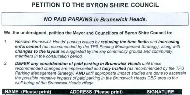
Comments from Infrastructure Services:
All of the issues regarding paid parking in Brunswick Heads
have been included in the report to Council’s ordinary meeting on 23
November 2017 titled “Brunswick Heads parking Strategy”.
|
RECOMMENDATION:
1. That
the petition objecting to Paid Parking in Brunswick Heads be noted.
2. That
the petition be considered by Councillors when discussing the Brunswick Heads
Parking Strategy report at the 23 November 2017 ordinary meeting of Council.
|
Submissions and Grants 11.1
Submissions and Grants
Report No. 11.1 Byron
Shire Council Submissions and Grants as at 1 November 2017
Directorate: Corporate
and Community Services
Report
Author: Jodi
Frawley, Grants Co-ordinator
File No: I2017/1571
Theme: Corporate Management
Governance Services
Summary:
Council have submitted applications for a number of grant
programs which, if successful, would provide significant funding to enable the
delivery of identified projects. This report provides an update on these
grant submissions.
|
RECOMMENDATION:
That Council note the report.
|
Attachments:
1 November
Grants Report, E2017/103488 ⇨

Report
This report provides an
update on grant submissions including funding applications submitted, potential
funding opportunities and those awaiting notification.
In accordance with Part 2 of
Resolution 17-539 adopted by Council at its 2 November 2017 Extraordinary
Meeting (17-539), officers are not proceeding with any grant applications for
the Cavanbah Centre Swimming Pool.
Funding Applications
– Successful
· Koala
Corridors Project, Saving Our Species (NSW Office of Environment and Heritage)
- $40,000
Funding opportunities
identified for consideration by staff
· Byron
Bay Town Centre Bypass, Growing Local Economies, (NSW Government)
· McGettigans
Lane to Pacific Highway, Growing Local Economies, (NSW Government)
· Clifford
Street Roundabout, Growing Local Economies, (NSW Government)
· Byron
Bay Town Centre Bypass, Growing Local Economies, (NSW Government)
· CPTED
for Byron Bay Town Centre, Safer Communities Fund (Australian Government)
· Agricultural
Extension and Innovation, National Landcare Program: Smart Farming Partnerships
(Australian Government)
· Agricultural
Outreach, National Landcare Program: Smart Farming Small Grants (Australian
Government)
· Enviro-poles
for Cigarette Litter Reform, Council Litter Prevention Program (NSW Government)
· Illegal
Camping Litter Prevention at Belongil Beach, Council Litter Prevention Program
(NSW Government)
Funding submissions
submitted and awaiting notification
· 3D
Mapping Tool, Smart Cities and Suburbs, (Australian Government)
· Shark
Smart Alert and Advice System, Shark Management Strategy Program (NSW
Government)
· Byron
Bay Bypass, Regional Jobs and Investment Package for North Coast NSW (Australian
Government)
· Brunswick
Harbour Boat Ramp, NSW Boating Now (RMS, NSW Government)
· 622
Bangalow Road Safety Treatments, Safer Roads including Black Spot Funding
(Roads and Maritime Services, NSW Government)
· Bridges
for the Bangalow Agricultural Area, Fixing Country Roads (NSW Government
Restart NSW)
· Brunswick
Library renovation and extension, Regional Cultural Fund (Regional Growth Fund,
NSW Government)
· Byron
Seniors Week (Family and Community Services, NSW Government)
· Byron
Trails, Northern Rivers Business Recovery Program (Commonwealth-NSW National
Disaster Relief and Recovery) Emergency Relief Information, Northern Rivers
Business Recovery Program (Commonwealth-NSW National Disaster Relief and
Recovery)
· Billi’s
Back, Northern Rivers Business Recovery Program (Commonwealth-NSW National
Disaster Relief and Recovery)
· Northern
Rivers Resilience Masterclasses, Northern Rivers Business Recovery Program
(Commonwealth-NSW National Disaster Relief and Recovery)
· Brunswick
River Causeway Removal, Habitat Action Grants (Dept of Industry –
Fisheries, NSW Government )
· Clarks Beach
Amenities, Stronger Country Communities Fund (Regional Growth Fund, NSW
Government)
· Heritage
House, Bangalow, Stronger Country Communities Fund (Regional Growth Fund, NSW
Government)
· Waterlily
Playscape, Ocean Shores, Stronger Country Communities Fund (Regional Growth
Fund, NSW Government)
· Refurbishment
of Sandhills Childcare Centre, Stronger Country Communities Fund (Regional
Growth Fund, NSW Government)
· Byron Shire
Bike Plan, Active Transport (Roads and Maritime Services, NSW Government)
· Pedestrian
and Access Mobility Plan, Active Transport (Roads and Maritime Services, NSW
Government)
· Cycle/walking
paths, Broken Head road (Suffolk Park to Byron Bay), Active Transport (Roads
and Maritime Services, NSW Government)
· Cycle/walking
paths, Lismore Road, Active Transport (Roads and Maritime Services, NSW
Government)
· Cycle/walking
paths, Ewingsdale Road, Active Transport (Roads and Maritime Services, NSW
Government)
· Cycle/walking
paths, Balemo Road, Active Transport (Roads and Maritime Services, NSW
Government)
· Illegal
Dumping and Littering in Byron Shire, Combatting Illegal Dumping: Clean Up and
Prevention Program, (NSW Environmental Protection Agency)
Additional information on the
grant submissions made and or pending is provided in Attachment 1 –
Grants report as at 1 November 2017
Financial Implications
If Council is successful in
obtaining the identified grants more than $14 million would be achieved which
would provide significant funding for Council projects. Some of the
grants require a contribution from Council (either cash or in-kind) and others
do not. Council’s contribution is funded. The potential funding and
allocation is noted below:
|
Requested funds from funding bodies
|
14,794,817
|
|
Council cash contribution
|
9,053,932
|
|
Council in-kind Contribution
|
190,748
|
|
Other contributions
|
10,575,562
|
|
Funding applications submitted and awaiting
notification (total project value)
|
34,615,059
|
Statutory and Policy
Compliance Implications
Council is required under
Section 409 3(c) of the Local Government Act 1993 to ensure that
‘money that has been received from the Government or from a public
authority by way of a specific purpose advance or grant, may not, except with
the consent of the Government or public authority, be used otherwise than for
that specific purpose’. This legislative requirement governs
Council’s administration of grants.
Staff Reports - Corporate and Community Services 13.1
Staff Reports - Corporate and Community
Services
Report No. 13.1 Review
of Natural Disaster Response Protocols
Directorate: Corporate
and Community Services
Report
Author: Jessica
Orr, Strategic Risk and Improvement Coordinator
Sarah Ford, Manager Community
Development
Anna Vinfield, Manager Corporate
Services
James Flockton, Drain and Flood
Engineer
File No: I2017/1361
Theme: Corporate Management
Governance Services
Summary:
This Report responds to the Mayoral Minute No. 8.1 –
Review of Natural Disaster Response Protocols (RES 17-130) made at
Council’s ordinary meeting of 2 April 2017.
Since the March 2017 Ex-Tropical Cyclone Debbie disaster
event, Council has undertaken a variety of activities and developed resources
to facilitate an improved pre and post event response and recovery, noting that
no event is ever the same. Some of the key resources Council has in place
include:
· Byron Shire
Council Emergency Communications Plan
· Byron Shire
Council Fact Sheet: What to do in an emergency or disaster?
· Community
relationships, coordination of community organisations or volunteer groups
This report addresses the key
points raised in the Mayoral Minute, provides an overview of the SES debrief
held with Councillors and articulates Councillor’s role during a natural
disaster.
|
RECOMMENDATION:
1. That
Council supports the proposed SES approach to creating a
‘Community Action Team/s’ in the Northern Rivers regional
community, and that when the framework for this approach is finalised
by the SES, that it be the subject of a further report to Council.
2. That
Council note the work that has been undertaken so far in improving
Council’s business continuity and disaster recovery efforts.
3. That
Council receive a further report on the operations of the South Golden
Beach flood pump following the consideration of the Peer Review of South
Golden Beach Flood Pump (#E2017/103521) by staff.
4. That
Council request that a finalised Business Continuity/Disaster Recovery Plan
be reported to Council by Corporate and Community Services by mid 2018.
|
Attachments:
1 Confidential
- Draft Emergency Communications Plan supercedes E2017/64654, E2017/93620
2 Confidential
- Fact sheet - what to do in a disaster, E2017/101552
3 Confidential
- Peer Review of South Golden Beach Flood Pump (Prepared by Jacobs), E2017/103521
4 SES
presentation - recommendations from review of operational response to Norther
Rivers floods, E2017/104277 ⇨

5 SES
Presentation to Byron Council Nov 2017, E2017/105034
⇨
6 SES
Community Action Teams Presentation, E2017/105036
Report
Background
Byron Shire Council and its
residents experienced significant rainfall from Ex Tropical
Cyclone Debbie from 28 March
2017 which resulted in major flooding across the northern sections of the Shire
including areas of Billinudgel, Mullumbimby, Ocean Shores, New Brighton and the
Hinterland. The impacts were both significant to those communities and to
the wider community with significant property damage, social and emotional
impacts to residents and businesses. The event raised a number of
concerns regarding Council’s and other agencies' effectiveness and
responsiveness during and post the event.
Mayoral Minute No. 8.1 – Review of Natural Disaster
Response Protocols (RES 17-130) was made at Council’s ordinary meeting of
2 April 2017. The following key issues were raised and addressed below:
· Response to
extreme weather and disaster communication protocols
· Review of
successes, failings and inefficiencies of Council operated or maintained
infrastructure during the April flood event
· Council’s
community support protocols and approach
· Review
organisational preparedness including
A Notice of Motion was
considered by Council at its Extraordinary meeting held on 2 November
meeting. Council resolved via Resolution 17-538 as follows:
· Invite the State
Emergency Service (SES) to provide a briefing to Council on current efforts to
establish ‘Community Action Teams’ (CATs) as part of forward
planning and responsiveness to flood events in local communities.
· Determine and
provide support to potential CAT formation within the Byron Shire in
conjunction with the SES and local communities.
· Develop a response
plan as to how Council will respond to flood events with particular focus on
the coordination of information and resources required by the community during
and in the immediate aftermath of a flood.
· Implement a
communications strategy to ensure widespread community understanding of
Council’s role during and in response to a flood event.
· Consider funding
and resources necessary to support these initiatives and provide a report to
Council by the end of 2017.
This report also addresses
the key points from the Notice of Motion.
Council wrote to the Minister
for Police and Emergency Services seeking support for an independent review of
the flood response in Byron Shire following Ex-Tropical Cyclone Debbie.
NSW Police Deputy Commissioner
Dave Owens had been engaged to undertake this review of both Lismore City and
Tweed Shire Council and Council officers requested that Mr Owen's brief be
extended to include Byron Shire Council. The Minister responded that many
of the findings of the independent review provide opportunities for improvement
to response processes and systems and that the NSW SES could brief Council on
these recommendations – these are detailed in section 3: ‘SES
debrief’ of this report.
Council is committed to being involved in regional forums
and aiming to achieve best practice in disaster response. Officers
recently attended a regional forum for ‘Disaster Ready Councils’
hosted by Hunter Joint Organisation of Councils and funded by the State
Government’s new Office of Emergency Management (OEM) unit. The
forum was highly relevant and practical in delving into the question of
“Is your Council disaster ready?” Outcomes for Council in attending
the regional forum include continuing to be part of the state wide conversation
on disaster planning and response support, ensuring that Byron Shire
Council’s voice is heard, awareness of training and resources offered by
the OEM in assisting councils to become disaster ready and access to new forms
of relief funding.
Response to issues
raised in Mayoral Minute
1. Response
to extreme weather and disaster communication protocols
Council has
developed an Emergency Communication Plan (attached to this report) which
outlines in detail how and when it will communicate with the community and
staff as an event approaches and unfolds. This includes a detailed list of
steps that may be taken including the platform of communication and frequency.
For example, posting on social media at regular intervals, working with
Customer Service to update after-hours phone messaging, regular updates of the
Byron Shire Council website, Council E-news, media releases and SMS messaging
alerts.
Council is
continuing to investigate the use of SMS messaging to update, inform and alert
residents at times of extreme weather events. It is also worth noting that the
SES manages this process and is investigating improvements to its system.
As a disaster or
emergency event unfolds, Council will continue to liaise with Emergency
Services and recognised providers of relevant information such as the SES, RFS,
Bureau of Meteorology and ABC radio (as the local emergency services
broadcaster), to provide the broadest possible coverage of an
event.
To address the high workload in the communications area
approaching, during and after a disaster event, Council acknowledges that
additional resources may be required. Managers are asked to reallocate their
staff where possible to provide customer service or communications assistance
during a disaster event, where their core duties are not essential. This
will be a decision of the Crisis Management Team (CMT).
The table below establishes Council’s CMT,
highlighting the key roles for leadership, decision making and support that
will be required to be taken on by Council staff before, during and after a
disaster event.
As an emergency or disaster unfolds, the CMT will meet
regularly throughout the event, at least once daily to support, coordinate and
plan action and response efforts. Role descriptions of each position will be
developed with guidance on who communicates with who and responsibilities.
Depending on the context of the emergency or disaster unfolding, different key
support staff and managers / executive will take a lead role in informing
decision-making and directing resources. For example, where the disaster is a
cyber terrorism attack, Manager Business Systems & Technology will
play a lead role, rather where the disaster is a natural disaster,
Infrastructure Services Director and relevant Managers for works, open spaces,
utilities and assets, and community development will play a lead role.
2. Review
of successes, failings and inefficiencies of Council operated or maintained
infrastructure during the April flood event
Council’s
road networks and assets performed as designed and received minimal damage in
comparison to the size of the event.
Council’s
flood pump in South Golden Beach operated and reduced flood water to a degree
until it tripped and couldn’t be restarted until safe access was
available. Previous discussion has been held around operational issues
with the pump and staff recently received a third party review into the pump
stations design, operation and capacity. The review raised a number of
concerns for operational staff to consider.
The South Golden
flood pump report is attached to this report (attachment 3) for information only.
Noting that the report has just been received and staff are working through the
recommendations. The consultant responsible for the pump station design has
previously confirmed to Council that it was built as per the design. Therefore,
the likely intention moving forward is to discuss the results of the peer
review of the pump station with the designers, before Council considers taking
the matter further. Infrastructure Services will present a further report to
Council on the outcomes at the earliest opportunity.
Council has investigated the flexibility of increasing the
opening hours at the Myocum Resource and Recovery Centre within Environment
Protection Agency (EPA) operation licence. The EPA have advised it will
be lenient on licence conditions and regulation of waste management facilities
in response to flood clean-up operations, thus enabling extended operating
hours at the Byron Resource Recovery Centre. Staff will maintain open
communication with the EPA in the lead up and recovery phases of future events
to facilitate any clean-up operations.
Post the March 2017
flood event, Council staff have undertaken tender processes to establish panels
of providers for plant hire (in collaboration with Tweed Council who also had a
similar issue in response to the flood) and garden waste/tree clearing
services. This provides Council with the ability to immediately engage a
number of local contractors, at a predetermined plant hire rate, to conduct
clean-up works in a disaster event.
In the lead up to
any future potential event, staff will contact contractors to ensure
availability and immediate response if required. Experience from the March 2017
flood has shown that contractors will have capacity to provide necessary plant
as they generally cannot perform their core construction activities during/post
significant wet weather events.
Council’s
drainage maintenance crew has been working in the Billinudgel area to remove
debris and vegetation from open drains, works to date have been very successful
and the local community have been appreciative. Council’s maintenance
crew is also planning to remove vegetation and debris from the main drains in
South Golden Beach before Christmas, these drains supply the flood pump
station. A general green waste collection is being considered as part of
this work to help reduce the debris load on the pump station.
Council’s
position on the Mud Army
The concept of a
Mud Army (as seen in the 2011 Brisbane floods) is one of several community
response options that Council is currently considering in terms of involvement,
coordination and support during an emergency event. Council is
progressing, in conversation with the SES and the Northern Rivers regional
community, with investigation of volunteer models that harness the community
spirit and eagerness of residents to support their neighbours and local
community.
The State Emergency
Service (SES) presented to Councillors at the 9 November Strategic Planning
Workshop. This presentation outlined community preparedness for future
natural disasters including the potential formation of ‘Community Action
Teams’ as part of forward planning and responsiveness to flood events in
local communities.
It is anticipated
that the formation of a ‘Community Action Team’ (CATs) would allow
the region to harness the supportive spirit of the community in the preparation
and response phase (as is the case with the Mud Army example in the recovery
phase) in coordinating volunteers and support initiatives as an event unfolds
and in the recovery phase. This is part of a broader community discussion
and Council will receive updates as it progresses.
It has been
anticipated that the CATs will mature and evolve to deal with all natural
disaster situations, not just floods (as seen in NSW near the Victorian
border). The CATs would be coordinated by SES community liaison officers
with Council involvement. Council is likely to be requested to assist with
resourcing certain emergency or disaster equipment, currently being discussed
to assist local communities. This is particularly relevant where local
communities and residents may not be immediately accessible and to support such
communities to be able to assist each other at the local level.
Infrastructure
Services will prepare a further report to Council on the proposed CAT framework
and resourcing implications once SES have finalised the arrangements.
3. Council’s
community support protocols and approach
The Northern Rivers region is still in the flood recovery
phase from the March 2017 Ex-Tropical Cyclone Debbie events. Council is
in contact with various community and government organisations concerning the
ongoing recovery and learning efforts, taking into account scope for
improvement and partnering into the future.
A series of regional forums were held in Byron Bay in June
2017, with service providers and the volunteer sector participating three focus
groups in the homelessness, community services and mental health sectors. A
Regional Action Plan was developed, which assisted in securing Community
Recovery Funding from Office of Emergency Management. Two Community
Development Officer positions have been funded for twelve months to implement
key activities from the Regional Action Plan. Community Development Officers
are based in Lismore and Tweed. The Tweed Community Development Officer
covers the Tweed, Byron and Ballina Shires, and Council staff are working
collaboratively to develop mutually agreed deliverables.
Additional regional Community Recovery Fund projects funded
by Office for Emergency Management include:
· Mental health
awareness training for government and community agencies
· Mental health
awareness workshops for the community
· Disaster preparedness
workshops for Community Service Organisations
· Community
Engagement Flood Resilience Building Program
A regional learning from the
March 2017 flood event is the need for strong coordination of community
volunteers in order to maximise the impact of community good will and avoid
duplication and ensure residents affected by natural disaster receive clear
messaging in relation to assistance. Council is working with key service
providers to develop a local community response protocol which will include the
development of a mechanism to effectively harness community volunteers in
relation to provision of support for disaster affected residents. Delays
in this process are being experienced as service providers are still assisting
people affected by flood, some of whom are making contact with key service
providers for support for the first time. Further, local Councils are
responsible for the joint implementation, project planning and oversight of the
Community Development positions, as well as taking a lead roll in ensuring the
effective delivery of the additional regional recovery project listed above. The
CATs proposed by the SES could be the appropriate mechanism for this.
A key learning regionally from Ex-Tropical Cyclone Debbie
was the complexity of facilitating community donations and administering and
awarding donations to businesses and individuals. Council referred community to
Mullumbimby and District Neighbourhood Centre (MDNC) to make donations for
Ex-Tropical Cyclone Debbie. MDNC has deductible gift recipient status and
an online donation tool. MDNC donates 100% of donations to community and was
seen as a strong and trusted community to administer donations.
If Council wishes to take carriage of natural disaster
donations, a robust system of criteria will need to be established prior to any
community donations received. This can be achieved by working with other
Local Council’s to learn from their experiences.
Council is committed to participating in the development of
a Regional Community Recovery Plan, anticipated to be completed by December
2018. One of the tasks involved in the development of the Regional
Community Recovery Plan will be establishing agreement between key service
organisations in relation to recovery plan development, implementation and
annual review.
SES debrief
SES representatives attended the Councillor’s
strategic planning workshop on 9 November to present on key lessons learnt
arising from Ex-Tropical Cyclone Debbie weather event and the ongoing recovery
efforts in the region. The SES highlighted a number of local, regional
and state outcomes that have been realised out of this event and that action is
being taken on. SES held nine post-flood forums across the region.
The presentation is attached to this report.
Key SES outcomes from the forums and the Independent Review
of the NSW State Emergency Service Operational Response - Northern Rivers
Floods March 2017 report from Dave Owens include:
· Review operational
readiness, including local and regional resources, training, skills register
and availability for deployment;
· Consider
implementation of a triage procedure for flood rescues, in consultation with
other Emergency Services for a standardised risk based approach to flood
rescue;
· Formalise new
process for the issuing of Evacuation Orders into Policy;
· Liaise with the
appropriate NSW Government Agencies to ensure stronger linkages are forged at a
local level between emergency responders, local councils and community
development professionals; and
· Become a
recognised authority for land use planning purposes, having greater involvement
in floodplain development with Local Councils and that their input is mandatory
before any consent by council is given in flood planning areas.
Role of Councillors
A learning from the March event was to identify specific
role for Councillors during an event.
During an event, Councillors will receive regular updates
from the CMT as information becomes available (this is articulated in the
internal fact sheet on ‘what to do in an emergency’). The
Emergency Communications Plan highlights that during an event or emergency, the
media spokespeople for Council are the Mayor, General Manager and
Council’s Local Emergency Management Officer.
Council staff, particularly members of the CMT, may be
reallocated to undertake specific duties, other than their regular
responsibilities, to support the community and Council’s service
provision during an emergency or disaster.
It is anticipated that a workshop be held with Councillors
at the January 2018 strategic planning workshop to develop a detailed fact
sheet, as well as share key information from the CMT, on the role of
Councillors in supporting the community and Council operations, before, during
and in the recovery of an event.
Next steps
Council is continuing to develop its business continuity /
disaster recovery resources internally for the organisation and externally to
support the Byron Shire community and the Council services during an emergency
or disaster. Council is currently investigating software options to
support a business continuity and disaster preparedness framework. At the
time of writing this report, a presentation with Council managers and key staff
is taking place on 13 November from Continuity2, presenting their business
continuity management system software as an option for Council to consider in
terms of the most appropriate process and system.
Council will take a lead role and work with Office of
Emergency Management to develop a data collection tool and will support the
community service sector to understand and utilize the tool as soon as a
natural disaster is declared.
Council will continue to play a lead role in advocating for
community payments and grants in the wake of natural disasters and will, where
appropriate, submit grant funding applications, or support key organisations to
do so.
As noted staff will hold a workshop with Councillors in
early 2018 to articulate ‘what to do in an emergency’.
Council staff are reviewing the recommendations of the South
Golden Beach flood pump peer review report and will prepare a further report on
progressing the implementation of the reports recommendations.
A Regional Community Recovery Plan will be delivered by
December 2018.
Financial Implications
Where Council seeks to
further develop its business continuity and disaster recovery plan framework
and software, this may require additional funding from across business units
– this isn’t currently allocated in the 2017/18 budget.
In relation to national
disaster relief funding, the Office of Emergency Management has recently
confirmed that mitigation and betterment funding will form a part of the new
arrangements. Under the new system the “like for like”
requirement will be removed and councils will be able to add their own funding
for betterment to reconstruction and repair projects. This was previously
not permitted. The criteria for spending these funds are still being clarified
with the Commonwealth. The Policy for how NSW will distribute this
funding is still under consideration.
The resourcing requirements
of CATs are still being determined as the SES has not finalised their preferred
model.
It is anticipated that the
implementation of the emergency communications plan will be accommodated within
existing budget allocations.
The resource implications of
the South Golden Beach flood pump report are being reviewed by staff.
While the financial impact on
affected residents and businesses was significant, the financial implications
on Council were minor. Only a small number of Council assets and
infrastructure were impacted and these were covered by flood insurance.
Statutory and Policy Compliance Implications
Local Government NSW actively
represents council interests in dealing with the NSW and Australian Governments
on the range of issues concerning emergency management.
The State Emergency and Rescue Management Act 1989
(NSW) outlines emergency management obligations at the local level in Division
3 of the Act. This includes outlining the functions of the Local
Emergency Management Committees and providing for where 2 or more local
government areas agree (with the approval of the Minister) they will be permitted
to combine their emergency management arrangements, such is the case with the
combined Tweed-Byron Local Emergency Management Committee.
Staff Reports - Corporate and Community Services 13.2
Report No. 13.2 Meeting
Schedule 2018
Directorate: Corporate
and Community Services
Report
Author: David Royston-Jennings,
Corporate Governance and Strategic Planning Officer
File No: I2017/1497
Theme: Corporate Management
Governance Services
Summary:
The proposed schedule of dates, times and places for Council’s
Ordinary Meetings, Strategic Planning Workshops, Advisory Committees and Panels
in 2018 is recommended for adoption.
|
RECOMMENDATION:
1. That
Council adopts the following schedule of Ordinary Meetings and Strategic
Planning Workshops (SPW) for 2018:
|
Date (2018)
|
Meeting/Workshop
(Thursday 9am)
|
|
25 January
|
SPW
|
|
1 February
|
Ordinary
|
|
8 February
|
SPW
|
|
22 February
|
Ordinary
|
|
8 March
|
SPW
|
|
22 March
|
Ordinary
|
|
5 April
|
SPW
|
|
19 April
|
Ordinary
|
|
10 May
|
SPW
|
|
24 May
|
Ordinary
|
|
7 June
|
SPW
|
|
21 June
|
Ordinary
|
|
2 August
|
Ordinary
|
|
9 August
|
SPW
|
|
23 August
|
Ordinary
|
|
6 September
|
SPW
|
|
20 September
|
Ordinary
|
|
4 October
|
SPW
|
|
18 October
|
Ordinary
|
|
8 November
|
SPW
|
|
22 November
|
Ordinary
|
|
6 December
|
SPW
|
|
13 December
|
Ordinary
|
2. That
Council adopts the following schedule of Advisory Committee and Panel
meetings for 2018:
|
Meeting
|
Date (2018)
|
|
Advisory Committees
|
|
Arakwal Memorandum of
Understanding
(Thursday 9.00am)
|
1 March
31 May
13 September
1 November
|
|
Finance
(Thursday 2.00pm)
|
15 February
17 May
16 August
15 November
|
|
Audit, Risk and
Improvement
(Thursday 11.30am)
* Extraordinary
|
15 February
17 May
16 August
*11 October
15 November
|
|
Transport and
Infrastructure
(Thursday 9.00am)
|
15 March
17 May
16 August
15 November
|
|
Water, Waste and Sewer
(Thursday 11.30am)
|
1 March
31 May
13 September
1 November
|
|
Byron Shire Floodplain
Risk Management
(Thursday 2.00pm)
|
1 March
31 May
13 September
1 November
|
|
Panels
|
|
Biodiversity and
Sustainability
(Thursday 11.30am)
|
29 March
28 June
30 August
|
|
Coastal Estuary
Catchment
(Thursday 2.00pm)
|
15 March
3 May
27 September
29 November
|
|
Communications
(Thursday 9.00am)
|
29 March
28 June
30 August
|
|
Heritage
(Thursday 2.00pm)
|
29 March
28 June
30 August
|
|
Public Art
(Thursday 9.00am)
|
15 February
3 May
9 August
29 November
|
|
Sustainable Economy
(Thursday 11.30am)
|
15 March
3 May
27 September
29 November
|
3. That
Council endorses the following schedule of Planning Review Committee meetings
for 2018:
|
Planning Review
Committee
|
|
Thursday 4.30pm
|
18 January
15 February
15 March
12 April
17 May
14 June
9 August
13 September
25 October
15 November
29 November
|
4. That Council endorses the
following schedule of Local Traffic Committee meetings for 2018:
|
Local Traffic Committee
|
|
Tuesday 10.00am
|
16 January
20 March
15 May
17 July
18 September
20 November
|
5. That
the Ordinary Meetings be held in the Council Chambers, Mullumbimby with a
start time of 9.00am.
6. That
the Code of Meeting Practice be amended to reflect the adopted meeting
schedule and times.
|
Attachments:
1 Council
Meeting Matrix 2018, E2017/102958
⇨

Report
The schedule has been prepared with consideration to events,
such as public holidays and conferences. Listed below is the proposed
2018 Meeting Schedule:
|
Date (2018)
|
Meeting/Workshop
(Thursday 9am)
|
|
25 January
|
SPW
|
|
1 February
|
Ordinary
|
|
8 February
|
SPW
|
|
22 February
|
Ordinary
|
|
8 March
|
SPW
|
|
22 March
|
Ordinary
|
|
5 April
|
SPW
|
|
19 April
|
Ordinary
|
|
10 May
|
SPW
|
|
24 May
|
Ordinary
|
|
7 June
|
SPW
|
|
21 June
|
Ordinary
|
|
Mid-year recess
|
|
2 August
|
Ordinary
|
|
9 August
|
SPW
|
|
23 August
|
Ordinary
|
|
6 September
|
SPW
|
|
20 September
|
Ordinary
|
|
4 October
|
SPW
|
|
18 October
|
Ordinary
|
|
8 November
|
SPW
|
|
22 November
|
Ordinary
|
|
6 December
|
SPW
|
|
13 December
|
Ordinary
|
· The
2018 National General Assembly of Local Government will not affect the meeting
dates as it is scheduled to be held from 17-20 June 2017 in Canberra.
· The
date for the LGNSW Annual Conference 2018 has not yet been determined however
based on previous Conference dates, it will most likely not affect the proposed
meeting dates.
· Easter
public holidays will not affect the meeting dates as they fall during the dates
31 March -2 April 2018.
As the proposed schedule includes two February meetings, a
Strategic Planning Workshop is required during the January recess period.
Financial Implications
Should Council resolve to
hold evening Council meetings, extra financial implications for meetings would
include payment of overtime for staff below the level of senior management
should they be required to answer questions during the meeting, as well as for
minute taking staff (one minute taker per evening meeting).
Statutory and Policy Compliance Implications
Point 4.1 of Councils Code
of Meeting Practice will require amending to reflect the adopted meeting
schedule and times, specifically that meetings will not be held once every 3
weeks. Schedule B will also require amending at point 1 under the heading
of Planning Review Committee.
Staff Reports - Corporate and Community Services 13.3
Report No. 13.3 Review
of Community Donations under Section 356 - new Community Initiatives Program
Directorate: Corporate
and Community Services
Report
Author: Joanne
McMurtry, Community Project Officer
File No: I2017/1526
Theme: Society and Culture
Community Development
Summary:
Council currently holds three policies where applications
can be made for community donations. In assessing applications in 2016, a
number of inequities and inefficiencies in the process were identified. In
recognition that a more strategic approach will provide better community
outcomes, Community Development staff have undertaken a review of Section 356
policies and revised them into one new policy renamed ‘Community
Initiatives Program (Seciton 356)’, and developed Guidelines for
applicants.
|
RECOMMENDATION:
1. That
the draft Community Initiatives Program (Section 356) Policy be placed
on public exhibition for a period of 28 days.
2. That
in the event:
a) that
any submissions are received on the draft Community Initiatives Program
(Section 356) Policy, that those submissions be reported back to
Council prior to the adoption of the policy;
b) that
no submissions are received on the draft Community Initiatives Program
(Section 356) Policy, that the Policy be adopted and incorporated into
Council’s Policy Register.
3. That the
contents of the accompanying Community Initiatives Program Guidelines be noted.
4. That in the
event that no submissions are received and the Community Initiatives Program
(Section 356) Policy is adopted, that advertising commence in January 2018 to
call for applications to the new Program for the 2017/18 financial
year.
|
Attachments:
1 Draft
Policy Community Initiatives Program (Section 356), E2017/104974 ⇨
2 Community
Initiatives Program Guidelines (Community Donations under section 356), E2017/104976 ⇨
Report
Council currently holds three policies where
applications can be made for community donations:
· Policy 3.13 Donations to
Community Organisations, Other Groups and Persons
· Policy 14/002 Section
356 Donations – Assistance for Festivals and Community Functions
· Policy 12/011 Section
356 Donations to Community Groups – Reimbursement of Council Application
Fees
Typically, Council advertises to call for applications to
these three policies around June/ July each year, an assessment of applications
is undertaken and recommendations to Council are made to allocate the funds
available in the Section 356 budget. A total of $45,200 is allocated in the
2017/18 budget.
During the 2016/17 round of community donations, 44 requests
for donations were received which equalled 388% of the available budget
allocation.
In assessing applications in 2016, many issues and concerns
with the current policies were noted including:
· Donations were not
linked to Council’s strategies or objectives as outlined in the Community
Strategic Plan;
· Individuals could apply,
e.g. ‘to assist appropriate private groups or person to achieve their
objectives’;
· Applications could be
made under three different policies which was confusing for community members
and staff;
· Applications could be
made under each policy by one person or organisation creating an opportunity
for multiple application by one individual or organisation;
· There was no upper limit
resulting in the funds being significantly oversubscribed;
· There was no acquittal
process in place, meaning Council did not know what the actual donation was
spent on and the community outcome or benefit.
In recognition that a more strategic approach will provide
better community outcomes, Community Development staff have undertaken a review
of Section 356 policies and revised them into one ‘Draft Community
Initiatives Program (Section 356) Policy’.
The review considered what other Councils do and other best
practice community development programs.
Best practice community development programs assessed
included:
· the Seattle
Neighbourhood Matching Fund (Jim Diers) http://www.neighborpower.org/;
· David Engwicht http://www.creative-communities.com/;
· Peter Kenyon and the
Bank of Ideas http://bankofideas.com.au/;
· Harwood Institute http://www.theharwoodinstitute.org/.
Based on best practice, success of community programs is
achieved when people have buy in and ownership, they are accountable for
achieving an outcome, and the outcome is related to an overall community
strategic goal.
The new draft policy includes:
· Relation to
Council’s Community Strategic Plan strategies and objectives (related to
a community goal);
· A provision for a
matching contribution, either in-kind or financial (buy in / ownership);
· An acquittal process
(accountability);
· The application must
note an incorporated association or other appropriate legally structured
organisation to receive the funds and that organisation will be required to
hold $20 million public liability insurance;
· Commercial organisations
or individuals are ineligible to apply;
· Applicants can apply for
a donation up to a maximum of $5,000;
· The policy and
guidelines outline eligible and ineligible projects and activities and the
assessment criteria that will be used
The acquittal process will allow the Community Development
team to measure outcomes of the Community Initiatives Program against
Council’s CSP strategies and share outcomes from Council’s
investments with the wider community.
If Council adopt this new approach to managing Section 356
Community Initiatives, staff will conduct an information session/ workshop for
potential applicants to begin a valuable dialogue about community projects
across the Shire. It will also allow for cross-collaboration and capacity
building for community organisations in applying for grant funds from a variety
of sources.
The goal of the new Draft Community Initiatives Program
(Section 356) Policy is to be broad enough to enable a range of future
community activities and projects to assist Council meet the community needs as
described in the Community Strategic Plan. The new draft also carries forward
some of the key features of the three policies it replaces.
If Council adopts the new draft policy, it will become one
of two policies related to Section 356 donations, the other policy currently in
place related to Section 356 is the Policy 12/008: Section 356 Donations
– Rates, Water and Sewerage Charges.
In addition to reviewing the policy, the Community
Development team have devised the Community Initiatives Program Guidelines, an
application form and an acquittal report template. Please find a copy of the
Guidelines in the attachments to this report.
Financial Implications
Council’s budget allocation for Section 356
unallocated funds include:
|
Donations to Community Organisations, Other Groups and
Persons
|
$36,200
|
|
Assistance for Festivals and Community Functions
|
$7,000
|
|
Donations to Community Groups – Reimbursement of
Council Application Fees
|
$2,000
|
|
Sub-Total
|
$45,200
|
|
Resolution 17-381*
|
-$3,000
|
|
TOTAL unallocated amount for 2017/18
|
$42,200
|
*Resolution 17-381 in part states: “Allocate $3,000
of Council’s Community Development Program’s unallocated S356
donations in the 2017/18 budget to support international relations”.
Statutory and Policy
Compliance Implications
Section 356 of the Local Government Act.
Staff Reports - Corporate and Community Services 13.4
Report No. 13.4 Council
Resolutions Quarterly Review - 1 July 2017 to 30 September 2017
Directorate: Corporate
and Community Services
Report
Author: David
Royston-Jennings, Corporate Governance Officer
File No: I2017/1532
Theme: Corporate Management
Governance Services
Summary:
This report provides an update on the status of Council
resolutions.
Following consultation with Councillors at a Strategic
Planning Workshop, staff have amended the format of the report on active
resolutions. At Councillors’ request, the report is now categorised by
Directorate, uses coloured indicators to demonstrate overdue items (from the
target completion date) and provides charts and tables to demonstrate the
information in a more user friendly format.
It should be noted that 79 resolutions have been completed
during the period 1 July to 30 September 2017, compared with 75 resolutions
completed within the same time period in 2016. There were 88 active
resolutions, with 72 overdue, as at 30 September 2017.
Resolutions could be overdue as a result of budget
constraints, staff resourcing, extended negotiations with stakeholders, or
other reasons.
|
RECOMMENDATION:
1. That
Council receive and note the information provided in this report on active
Council Resolutions in Attachment 1 (#E2017/104616).
2. That
Council note the completed Resolutions in Attachment 2 (#E2017/98426).
|
Attachments:
1 Completed
Council Resolutions 1 July 2017 - 30 September 2017, E2017/98426 ⇨
2 Active
Council Resolutions as at 30 September 2017, E2017/104616
⇨

Report
This report provides a quarterly
update on the status of Council Resolutions to 30 September 2017.
As at 30 September 2017:
· 79 resolutions were
completed since 1 July
· 88 resolutions remain active
· 72 resolutions were
overdue
The active Council resolutions per Council terms are
provided below:
· 64 active Council
Resolutions from current Council (2016-2020)
· 23 active Council
Resolutions from previous Council (2012-2016)
· 1 active Council
Resolutions from prior Council (2008-2012)
Resolutions completed during this reporting period include the
reclassification of land known as the former Mullumbimby Hospital site as
‘operational’, Bob Bellear Sports Field selected as the preferred
permanent name for the North Ocean Shores Sports Field, community
representatives appointed to the Heritage Panel and Floodplain Risk Management
Committee, Councillor Cameron was elected as Deputy Mayor, amendments to
Council’s fees and charges for 2017-18, adoption of the Road Airspace
Policy, and the establishment of the Mullumbimby Hospital Site Project
Reference Group.
Details of completed resolutions for the period are provided
at Attachment 1 (E2017/98426).
At its 24 August 2017 Ordinary meeting Council requested
(RES 17-362) a workshop to discuss the resolutions report including possible
layouts and methods of reporting.
At the 7 September Strategic Planning Workshop Councillors
discussed that:
· The report format be
more interactive
· Active resolutions be
categorised by Directorate
· The report use charts
and coloured indicators (such as traffic lights)
· Timeframes be based on
completion date rather than resolution date
· The resolutions be able
to be searched easily
· Comments reflect status
of the resolution or project, rather than internal allocation status.
Council’s website is being upgraded and the
interactive nature of the resolutions should be accommodated within the new
design. In the interim the majority of the discussion points have been
addressed and are accommodated in the Attachment 2 (E2017/104616). Key
modifications include:
· Rename of report to
‘active resolutions’ reflecting that projects are underway and not
necessarily overdue as the target date may be months into the future
· Resolutions grouped via
directorate
· Simplified information
– resolution number, meeting date, report title, resolution, target
completion date, comments and days overdue (colour coded by traffic lights
– 30days or under orange, over 30days red)
It should be noted that some resolutions are cut off if they
are a number of lines – this is a function of the minutes format and is
being investigated with the software provider.
Staff are continuing to review ways through which
Councillors and the community are informed of the status of resolutions,
providing information in a timely, transparent and easily understood format.
Financial Implications
A number of resolutions note that resource constraints limit
completion of action required.
Statutory and Policy Compliance Implications
· Council
requires a quarterly report be prepared to allow it to consider the six monthly
Operational Plan and Quarterly Budget reviews along with a review of Council
Resolutions.
· Implementation
of Council Resolutions in accordance with the Local Government Act 1993.
· This report
has been prepared in accordance with Part 3c) of Resolution 14-417.
Staff Reports - Corporate and Community Services 13.5
Report No. 13.5 Code
of Conduct Annual Report 1 September 2016 - 31 August 2017
Directorate: Corporate
and Community Services
Report
Author: Ralph
James, Legal Services Coordinator
File No: I2017/1546
Theme: Corporate Management
Governance Services
Summary:
Clause 12.1 of Council’s Policy 13/004
“Procedures for the Administration of Council’s Code of
Conduct” requires specified statistics concerning Code of Conduct
complaints made about Councillors and the General Manager to be reported to
Council within three months of the end of September each year. The Office of
Local Government fixes the reporting period as 1 September to 31 August. This
report covers the same period.
|
RECOMMENDATION:
That the Code of Conduct Annual Report for the
period 1 September 2016 to 31 August 2017 be noted.
|
Report
Council’s adopted Policy, “Procedures for the
Administration of Council’s Code of Conduct” (Procedures) provides,
in relation to reporting, as follows:
12.1 The Complaints Coordinator must arrange for the following
statistics to be reported to the council within 3 months of the end of
September of each year:
a) the total number of code of conduct
complaints made about Councillors and the General Manager under the Code of
Conduct in the year to September;
b) the number of code of conduct complaints
referred to a conduct reviewer;
c) the number of code of conduct complaints
finalised by a conduct reviewer at the preliminary assessment stage and the
outcome of those complaints;
d) the number of code of conduct complaints
investigated by a conduct reviewer;
e) the number of code of conduct complaints
investigated by a conduct review committee;
f) without identifying particular
matters, the outcome of code of conduct complaints investigated by a conduct
reviewer or conduct review committee under these procedures;
g) the number of matter reviewed by the Division
and, without identifying particular matters, the outcome of the reviews; and
h) The total cost of dealing with code of
conduct complaints made about Councillors and the General Manager in the year
to September, including staff costs.
12.2 The Council is to provide the Division with a report
containing the statistics referred to in clause 12.1 within 3 months of the end
of September of each year.
Council’s report to the
Office of Local Government was submitted within the required timeframe.
Breakdown of the statistics
reported to the Division
This breakdown includes 3
complaints made about Councillors carried over from the previous reporting
period and determined in this reporting period.
a) the total number of code of conduct complaints made
about Councillors and the General Manager under the Code of Conduct –
Councillors 11 (8 in this period/3 carried over) General Manager 0
b) the number of code of conduct complaints referred to
a conduct reviewer – 1 (carried over)
c) the number of code of conduct complaints finalised
by a conduct reviewer at the preliminary assessment stage and the outcome of
those complaints - 0
d) the number of code of conduct complaints
investigated by a conduct reviewer – 1
e) the number of code of conduct complaints
investigated by a conduct review committee – 0
f) without identifying particular matters, the
outcome of code of conduct complaints investigated by a conduct reviewer or
conduct review committee under these procedures – 1 breach identified
in the previous reporting period and subsequently referred to and determined by
the Division in the present reporting period.
g) (i) the number of matters reviewed by the Division -
1
(ii) without identifying
particular matters, the outcome of the reviews- Finalised (no action was
taken as the person concerned was no longer a councillor)
h) the total cost of dealing with code of
conduct complaints made about Councillors and the General Manager in the
reported period, including staff costs was nil. A total of $6,728 was
expended in the previous reporting in respect of the carried over matters.
Code of Conduct complaints against Councillors dealt with
by the General Manager.
Of the 10 matters dealt with by the General Manager, 0
matters remain pending an outcome at the time of reporting. The 10 Code of
Conduct complaints against Councillors were dealt with and finalised by the
General Manager.
The outcomes of the 10 finalised complaints were as follows:
1 matter was determined to be a complaint about a Councillor
in the Councillor’s private capacity. It was therefore not a Code of
Conduct matter.
4 matters were investigated as Code of Conduct matters, but
found not to establish a prima facie case.
The subject of 5 matters were assessed as involving Code of
Conduct issues relevant to all Councillors and were dealt with by way of
ongoing training. A submission on the topic was made to the OLG in respect of
the review of the model Code of Conduct. The subject matter is proposed as an
amendment to the Model Code of Conduct.
Nature of complaints
Councillors
Pecuniary - 4
Significant non-pecuniary – 1 (the carried over matter
sent to OLG)
Non-pecuniary - 0
Misconduct - 0
Other - 6
Financial Implications
Fees of $6,728 (which was from the previous reporting
period, carried over) incurred from external reviewer in one carried over matter.
Statutory and Policy
Compliance Implications
All complaints were dealt with in accordance with the Procedures and in
accordance with the timeframes required.
Mandatory reporting requirements have been met.
Staff Reports - Corporate and Community Services 13.6
Report No. 13.6 Council
Budget Review - 1 July 2017 to 30 September 2017
Directorate: Corporate
and Community Services
Report
Author: James
Brickley, Manager Finance
File No: I2017/1559
Theme: Corporate Management
Financial Services
Summary:
This report is prepared to comply with Regulation 203 of the
Local Government (General) Regulation 2005 and to inform Council and the
Community of Council’s estimated financial position for the 2017/2018
financial year, reviewed as at 30 September 2017.
This report contains an overview of the proposed budget
variations for the General Fund, Water Fund and Sewerage Fund. The
specific details of these proposed variations are included in Attachment 1 and
2 for Council’s consideration and authorisation.
Attachment 3 contains the Integrated Planning and Reporting
Framework (IP&R) Quarterly Budget Review Statement (QBRS) as outlined by
the Division of Local Government in circular 10-32.
|
RECOMMENDATION:
1. That
Council authorise the itemised budget variations as shown in Attachment 2
(#E2017/104035) which includes the following results in the 30 September 2017
Quarterly Review of the 2017/2018 Budget:
a) General
Fund – $161,900 decrease to the Estimated Unrestricted Cash Result
b) General
Fund - $1,651,500 increase in reserves
c) Water
Fund - $110,000 decrease in reserves
d) Sewerage
Fund - $15,000 decrease in reserves
2. That Council
adopt the revised General Fund Estimated Unrestricted Cash Result of
$940,600 for the 2017/2018 financial year as at 30 September 2017.
|
Attachments:
1 Budget
Variations for General, Water and Sewerage Funds, E2017/104033 ⇨
2 Itemised
Listing of Budget Variations for General, Water and Sewerage Funds, E2017/104035 ⇨
3 Integrated
Planning and Reporting Framework (IP&R) required Quarterly Review
Statement, E2017/104034 ⇨
Report
Council adopted the 2017/2018 budget on 22 June 2017 via
Resolution 17-268. It also considered and adopted the budget
carryovers from the 2016/2017 financial year, to be incorporated into the
2017/2018 budget at its Ordinary Meeting held on 24 August 2017 via Resolution 17-322.
Since that date, Council has reviewed the budget taking into consideration the
2016/2017 Financial Statement results and progress through the first quarter of
the 2017/2018 financial year. This report considers the September 2017
Quarter Budget Review.
The details of the budget review for the Consolidated,
General, Water and Sewer Funds are included in Attachment 1, with an itemised
listing in Attachment 2. This aims to show the consolidated budget position
of Council, as well as a breakdown by Fund and Principal Activity. The document
in Attachment 1 is also effectively a publication outlining a review of the
budget and is intended to provide Councillors with more detailed information to
assist with decision making regarding Council’s finances.
Contained in the document at Attachment 1 is the following
reporting hierarchy:
Consolidated Budget
Cash Result
General Fund Cash
Result Water Fund Cash Result Sewer
Cash Result
Principal Activity Principal
Activity Principal
Activity
Operating Income Operating
Expenditure Capital income Capital
Expenditure
The pages within Attachment 1 are presented (from left to
right) by showing the original budget as adopted by Council on 22 June 2017
plus the adopted carryover budgets from 2016/2017 followed by the resolutions
between July and September and the revote (or adjustment for this review) and
then the revised position projected for 30 June 2018 as at 30 September 2017.
On the far right of the Principal Activity, there is a
column titled “Note”. If this is populated by a number, it
means that there has been an adjustment in the quarterly review. This
number then corresponds to the notes at the end of the Attachment 1 which
provides an explanation of the variation.
There is also information detailing restricted assets
(reserves) to show Council estimated balances as at 30 June 2018 for all
Council’s reserves.
A summary of Capital Works is also included by Fund and
Principal Activity.
Office of Local Government Budget Review Guidelines:-
The Office of Local Government on 10 December 2010 issued
the new Quarterly Budget Review Guidelines via Circular 10-32, with the
reporting requirements to apply from 1 July 2011. This report includes a Quarterly
Budget Review Statement (refer Attachment 3) prepared by Council in accordance
with the guidelines.
The Quarterly Budget Review Guidelines set a minimum
standard of disclosure, with these standards being included in the Local
Government Code of Accounting Practice and Financial Reporting as mandatory
requirements for Council’s to address.
Since the introduction of the new planning and reporting
framework for NSW Local Government, it is now a requirement for Councils to
provide the following components when submitting a Quarterly Budget Review
Statement (QBRS):-
· A signed statement by
the Responsible Accounting Officer on Councils financial position at the end of
the year based on the information in the QBRS
· Budget review income and
expenses statement in one of the following formats:
o Consolidated
o By fund (e.g General, Water, Sewer)
o By function, activity, program etc
to align with the management plan/operational plan
· Budget Review Capital
Budget
· Budget Review Cash and
Investments Position
· Budget Review Key
performance indicators
· Budget Review Contracts
and Other Expenses
The above components are included in Attachment 3:-
Income and Expenditure Budget Review Statement by Type
– This shows Councils income and Expenditure by type. This has been
split by Fund. Adjustments are shown, looking from left to right.
These adjustments are commented on through the last 16 pages of Attachment 1.
Capital Budget Review Statement – This
statement identifies in summary Council’s capital works program on a
consolidated basis and then split by Fund. It also identifies how the
capital works program is funded. As this is the first quarterly review for the
reporting period, the Statement may not necessarily indicate the total progress
achieved on the delivery of the capital works program.
Cash and Investments Budget Review Statement – This
statement reconciles Council’s restricted funds (reserves) against
available cash and investments. Council has attempted to indicate an
actual position as at 30 September 2017 of each reserve to show a total cash
position of reserves with any difference between that position and total cash
and investments held as available cash and investments. It should be
recognised that the figure is at a point in time and may vary greatly in future
quarterly reviews pending on cash flow movements.
Key Performance Indicators (KPI’s) –
At this stage, the KPI’s within this report are:-
o Debt Service Ratio - This
assesses the impact of loan principal and interest repayments on the
discretionary revenue of Council.
o Rates and Annual Charges
Outstanding Ratio – This assesses the impact of uncollected rates and
annual charges on Councils liquidity and the adequacy of recovery efforts
o Asset Renewals Ratio – This
assesses the rate at which assets are being renewed relative to the rate at
which they are depreciating.
These may be expanded in future to accommodate any
additional KPIs that Council may adopt to use in the Long Term Financial Plan
(LTFP.)
Contracts and Other Expenses - This report highlights any
contracts Council entered into during the July to September quarter that are
greater then $50,000.
CONSOLIDATED RESULT
The following table provides a summary of the overall
Council budget on a consolidated basis inclusive of all Funds budget movements
for the 2017/2018 financial year projected to 30 June 2018 but revised as at 30
September 2017.
|
2017/2018 Budget Review Statement as at 30 September 2017
|
Original Estimate (Including Carryovers)
1/7/2017
|
Adjustments to 30 Sept 2017 including Resolutions*
|
Proposed 30Sept 2017 Review Revotes
|
Revised Estimate 30/6/2018 at 30/9/2017
|
|
Operating Revenue
|
76,828,000
|
0
|
2,530,900
|
79,358,900
|
|
Operating Expenditure
|
79,542,600
|
155,000
|
3,072,500
|
82,770,100
|
|
Operating Result –
Surplus/Deficit
|
(2,714,600)
|
(155,000)
|
(541,600)
|
(3,411,200)
|
|
Add: Capital Revenue
|
27,790,000
|
66,000
|
(1,897,700)
|
25,958,300
|
|
Change in Net Assets
|
25,075,400
|
(89,000)
|
(2,439,300)
|
22,547,100
|
|
Add: Non Cash Expenses
|
12,939,400
|
0
|
0
|
12,939,400
|
|
Add: Non-Operating Funds
Employed
|
2,160,000
|
0
|
2,516,000
|
4,676,000
|
|
Subtract: Funds Deployed for
Non-Operating Purposes
|
(64,587,000)
|
(400,000)
|
1,287,900
|
(63,699,100)
|
|
Cash Surplus/(Deficit)
|
(24,412,200)
|
(489,000)
|
1,364,600
|
(23,536,600)
|
|
Restricted Funds –
Increase / (Decrease)
|
(24,419,500)
|
(439,000)
|
1,526,500
|
(23,332,000)
|
|
Forecast Result for the
Year – Surplus/(Deficit) – Unrestricted Cash Result
|
7,300
|
(50,000)
|
(161,900)
|
(204,600)
|
|
|
|
|
|
|
GENERAL FUND
In terms of the General Fund projected Unrestricted Cash
Result the following table provides a reconciliation of the estimated position
as at 30 September 2016:
|
Opening Balance – 1
July 2017
|
$1,145,200
|
|
Plus original budget
movement and carryovers
|
$7,300
|
|
Council Resolutions July
– September Quarter
|
(50,000)
|
|
Recommendations within this
Review – increase/(decrease)
|
($161,900)
|
|
Forecast Unrestricted
Cash Result – Surplus/(Deficit) – 30 June 2018
|
($204,600)
|
|
Estimated Unrestricted
Cash Result Closing Balance – 30 June 2018
|
$940,600
|
The General Fund financial position overall has decreased by
$161,900 as a result of this budget review. The proposed budget changes
are detailed in Attachment 1 and summarised further in this report below.
Council Resolutions
Resolution 17-269 for the Mullumbimby Hospital Acquisition
in part 3 stated “That a budget of $50,000 be approved by the Council to
fund the independent peer review and that any remaining funds be used for
the forward planning process”. There was no suggested funding
source for this resolution and at this point no funding source has been
identified.
Budget Adjustments
The budget adjustments identified in Attachments 1 and 2 for
the General Fund have been summarised by Budget Directorate in the following table:
|
Budget Directorate
|
Revenue
Increase/
(Decrease) $
|
Expenditure
Increase/
(Decrease) $
|
Accumulated
Surplus (Working Funds) Increase/ (Decrease) $
|
|
General Manager
|
0
|
0
|
0
|
|
Corporate & Community Services
|
134,900
|
111,500
|
23,400
|
|
Infrastructure Services
|
3,721,300
|
3,847,200
|
(125,900)
|
|
Sustainable Environment & Economy
|
209,100
|
268,500
|
(59,400)
|
|
Total Budget Movements
|
4,065,300
|
4,227,200
|
(161,900)
|
Budget Adjustment Comments
Within each of the Budget Directorates of the General Fund,
are a series of budget adjustments identified in detail at Attachment 1 and
2. More detailed notes on these are provided in Attachment 1 but in
summary the major additional items included are summarised below by Directorate
and are included in the overall budget adjustments table above:
Corporate and Community Services
· In the General Purpose
Revenues Program an additional $42,400 in revenue has been recognised as the
allocation for Council’s 2017/2018 Financial Assistance Grant is more
than budgeted.
· In the Governance
Services Program it is proposed to increase expenditure by $15,000 for grant
management costs. This can be funded through the Grants Management
reserve.
· In the Sandhills
program, it is proposed to increase the budget for the installation of solar
panels ($12,600). This has no net effect on the result as all movements
are taken up through the Childrens’ Service reserve.
· In the Pubic Libraries
program, it is proposed to increase the budget for the installation of solar
panels ($60,000) and costs for concept plans for Brunswick Heads library
($5,300).
Infrastructure Services
· In the
Projects & Commercial Development program, it is proposed to increase
capital income due to the sale of land at Station Street Mullumbimby for
$1,300,000. This can be transferred to the Property Development reserve.
· In the Local Roads and
Drainage program, there are a number of adjustments outlined under Note 14 in
the Budget Variations explanations section of Attachment 1. Further
disclosure is included in the second page of Attachment 2 under the budget
program heading Local Roads and Drainage.
· In the Roads and
Maritime Services program (RMS) it is proposed to increase operating income and
expenditure by $1,742,700 to account for Natural disaster works from June 2016
($945,000) and March 2017 ($797,700).
· In the Open Space and
Recreation program, operating expenditure increased by $21,600 due to a request
for a budget for Shara Boulevard sportsfield maintenance of $60,000, reductions
of $40,100 against various park and reserve maintenance budgets and a support
service cost adjustment of $1,700. There are a number of capital
expenditure adjustments outlined under Note 16 in the Budget Variations
explanations section of Attachment 1. Further disclosure is included in
the third page of Attachment 2 under the budget program heading Open Space
& Recreation.
· In the Waste &
Recycling program It is proposed to increase operating income by $182,100 due
to the receipt of the Better Waste and Recycling grant ($74,500) and a grant
for the enhancement of the Resource Recovery Centre ($107,600). It is
proposed to increase operating expenditure by $245,000 for the Waste Management
Strategy ($130,000) and the Waste Compliance program ($114,000). It is
also proposed to make a support service adjustment of $2,500. It is
proposed to allocate a budget of $1,216,000 for capital income due to the sale
of land at Dingo Lane. This will be transferred to the Waste Management
reserve.
· In the Cavanbah Centre
program, it is proposed to decrease capital expenditure overall by $217,000 due
to estimated grant revenues for projects such as AFL Barrier Netting and
Grandstands and Aquatic Centre project as explained in Attachment 1 at Note 18.
· In the First Sun and
Suffolk Beachfront Holiday Parks program, it is proposed to increase the budget
by $20,000 at each site to continue painting for the year and $40,000 at First
Sun for Western Beach access. All adjustments are through the Holiday Park
reserve.
· In the Facilities
Management program it is proposed to increase operating expenditure by
$96,800. This is the excess that Council must pay relating to the flood
damage from March 2017
Sustainable Environment and Economy
· In the Development and
Certification program, it is proposed to increase income and expenditure by
$13,000 to budget for the Information and Technology Service fee. This
will fund the Process Improvement Officer. It is propose to add an
additional $35,000 to the DA fees received.
· In the
Planning Policy and Natural Environment Program, It is proposed to increase
income and expenditure to accommodate the Byron Habitat Corridors grant
($64,600), an increase to the Employment Land Strategy ($20,000), an increase
to Coastline Beach Scraping ($61,000 – to match grant funding) and an
increase for the Integrated Weed management Strategy ($20,000).
· In the Environment & Compliance program it is proposed
to increase the budget for licence plate recognition costs of $87,600.
This can be funded through the Paid Parking reserve.
WATER FUND
After completion of the 2016/2017
Financial Statements the Water Fund as at 30 June 2017 has a capital works
reserve of $4,953,000 and held $6,692,100 in section 64 developer
contributions.
The estimated Water Fund reserve
balances as at 30 June 2018, and forecast in this Quarter Budget Review, are
derived as follows:
Capital Works Reserve
|
Opening Reserve Balance at 1
July 2017
|
$4,953,800
|
|
Plus original budget reserve
movement
|
1,539,000
|
|
Less reserve funded carryovers
from 2016/2017
|
(124,800)
|
|
Resolutions July -
September Quarter – increase / (decrease)
|
0
|
|
September Quarterly Review
Adjustments – increase / (decrease)
|
(40,000)
|
|
Forecast Reserve Movement for
2017/2018 – Increase / (Decrease)
|
1,374,200
|
|
Estimated Reserve Balance at
30 June 2018
|
$6,328,000
|
Section 64 Developer
Contributions
|
Opening Reserve Balance at 1
July 2017
|
$6,692,100
|
|
Plus original budget reserve
movement
|
(1,874,000)
|
|
Less reserve funded carryovers
from 2016/2017
|
(2,645,300)
|
|
Resolutions July -
September Quarter – increase / (decrease)
|
0
|
|
September Quarterly Review
Adjustments – increase / (decrease)
|
(70,000)
|
|
Forecast Reserve Movement for
2017/2018 – Increase / (Decrease)
|
(4,589,300)
|
|
Estimated Reserve Balance at
30 June 2018
|
$2,102,800
|
Movements for Water Fund can be seen in Attachment 1 with a
proposed estimated decrease to reserves (including S64 Contributions) overall
of $110,000 from the 30 September 2017 Quarter Budget Review.
SEWERAGE FUND
After completion of the 2016/2017
Financial Statements the Sewer Fund as at 30 June 2017 has a capital works
reserve of $7,372,800 and plant reserve of $827,800. It also held
$9,583,600 in section 64 developer contributions.
Capital Works Reserve
|
Opening Reserve Balance at 1
July 2017
|
$7,372,800
|
|
Plus original budget reserve
movement
|
(1,008,100)
|
|
Less reserve funded carryovers
from 2016/2017
|
(102,200)
|
|
Resolutions July -
September Quarter – increase / (decrease)
|
0
|
|
September Quarterly Review
Adjustments – increase / (decrease)
|
24,000
|
|
Forecast Reserve Movement for
2017/2018 – Increase / (Decrease)
|
(1,086,300)
|
|
Estimated Reserve Balance at
30 June 2018
|
$6,286,500
|
Plant Reserve
|
Opening Reserve Balance at 1
July 2017
|
$827,800
|
|
Plus original budget reserve
movement
|
0
|
|
Less reserve funded carryovers
from 2016/2017
|
0
|
|
Resolutions July -
September Quarter – increase / (decrease)
|
0
|
|
September Quarterly Review
Adjustments – increase / (decrease)
|
(12,300)
|
|
Forecast Reserve Movement for
2017/2018 – Increase / (Decrease)
|
(12,300)
|
|
Estimated Reserve Balance at
30 June 2018
|
$815,500
|
Section 64 Developer
Contributions
|
Opening Reserve Balance at 1
July 2017
|
$9,583,600
|
|
Plus original budget reserve
movement
|
(188,800)
|
|
Less reserve funded carryovers
from 2016/2017
|
(1,949,600)
|
|
Resolutions July -
September Quarter – increase / (decrease)
|
0
|
|
September Quarterly Review
Adjustments – increase / (decrease)
|
(26,700)
|
|
Forecast Reserve Movement for
2017/2018 – Increase / (Decrease)
|
(2,165,100)
|
|
Estimated Reserve Balance at
30 June 2018
|
$7,418,500
|
Movements for the Sewerage Fund can be seen in Attachment 1
with a proposed estimated overall decrease to reserves (including S64
Contributions) of $15,000 from the 30 September 2017 Quarter Budget Review.
Legal Expenses
One of the major financial concerns for Council over
previous years has been legal expenses. Not only does this item represent a
large expenditure item funded by general revenue, but can also be susceptible
to large fluctuations.
The table that follows indicates the allocated budget and
actual legal expenditure within Council on
a fund basis as at 30 September 2017.
Total Legal Income & Expenditure as at 30 September
2017
|
Program
|
2017/2018
Budget ($)
|
Actual ($)
|
Percentage To
Revised Budget
|
|
Income
|
|
|
|
|
Legal Expenses Recovered
|
0
|
0
|
0%
|
|
Total Income
|
0
|
0
|
0%
|
|
|
|
|
|
|
Expenditure
|
|
|
|
|
General Legal Expenses
|
201,000
|
84,328
|
41.9%
|
|
Total Expenditure General Fund
|
201,000
|
84,328
|
41.9%
|
Note: The above table does not include costs incurred
by Council in proceedings after 30 September 2017 or billed after this
date. At the time of writing this report, Council has incurred an
additional $57,247 of expenditure in October and November 2017.
Byron Railway Precinct Projects
The adopted 2017/2018 Budget Estimates currently provides an
allocation of $500,000 funded from the Infrastructure Renewal Reserve for
projects related to the Byron Bay Master Plan – Railway Precinct. The 30
September 2017 Quarter Budget Review contains a proposal to reduce this allocation
by $260,700 to enable Council to match its contribution to the projects funded
by the $260,700 Tourism Demand Driver Infrastructure (TDDI) grant provided to
Council.
A summary of the current projects with proposed funded
budgets associated with the Byron Railway Precinct should Council adopt this
Quarterly Budget Review are outlined in the table below:
|
Job No
|
Project
|
Proposed Budget
2017/2018 $
|
Funding from TDDI
Grant $
|
Funding from
Infrastructure Renewal Reserve $
|
Funding from
Section 94
$
|
|
44283.014
|
Byron Bay Masterplan – Railway Precinct
|
239,300
|
0
|
239,300
|
0
|
|
4835.188
|
Byron St Connection Upgrade
|
139,000
|
69,500
|
69,500
|
0
|
|
4835.189
|
Railway Park Upgrade
|
237,500
|
118,700
|
118,700
|
0
|
|
4835.190
|
Visitor Centre Refurbishment
|
130,000
|
50,000
|
50,000
|
30,000
|
|
4835.191
|
Visitor Centre Technology Project
|
45,000
|
22,500
|
22,500
|
0
|
|
|
Total
|
790,800
|
260,700
|
500,000
|
30,000
|
With the addition of the TDDI grant revenue to
Council’s existing budget allocation of $500,000, there is now $790,800
available towards projects in the Byron Railway Precinct.
In relation to any further projects relating to the Byron
Railway Precinct in terms of budget allocation, these will be reported to
Council for consideration through the Budget Review process as they arise.
Financial Implications
The 30 September 2017 Quarter Budget Review of the 2017/2018
Budget has decreased the overall budget result by $161,900. As a result
there is a reduction of $161,900 to the estimated unrestricted cash balance
attributable to the General Fund, with this becoming an estimated $940,600 at
30 June 2018. This is below the adopted target of Council of
$1,000,000. It is recommended that Council will need to recover the
2017/2018 budget result to at least a balanced outcome over the remainder of the
2017/2018 financial year and be conscious of this when considering matters with
financial implications.
Statutory and Policy
Compliance Implications
In accordance with Regulation 203
of the Local Government (General) Regulation 2005 the Responsible Accounting
Officer of a Council must:-
(1) Not later than 2 months after the end of each quarter
(except the June quarter), the responsible accounting officer of a council must prepare and submit to the council a budget review statement that shows, by reference
to the estimate of income and expenditure set out in the statement of the council’s revenue policy included in the operational plan for the relevant year, a revised
estimate of the income and expenditure for that year.
(2) A budget review statement must include or be
accompanied by:
(a) a report as to whether or not the responsible
accounting officer believes that the statement indicates that the financial
position of the council is satisfactory, having regard to the original estimate
of income and expenditure, and
(b) if that position is unsatisfactory, recommendations
for remedial action.
(3) A budget review statement must also include any
information required by the Code to be included in such a statement.
Statement by Responsible Accounting Officer
This report indicates that the short term financial position
of the Council is still satisfactory for the 2017/2018 financial year, having
consideration of the original estimate of income and expenditure at the 30
September 2017 Quarter Budget Review.
This opinion is based on the estimated General Fund
Unrestricted Cash Result position and that the current indicative budget
position for 2017/2018 outlined in this Budget Review is recovered during the
remainder of the 2017/2018 financial year. It is most important this
occurs and the current projected budget deficit of $204,600 does not
deteriorate further.
There needs to be an awareness that any modifications
proposed for Council’s budget are not approved without consideration of
funding if additional expenditure is proposed through either reallocation of
existing budgets, additional revenue or available reserves.
Staff Reports - Corporate and Community Services 13.7
Report No. 13.7 Council
Investments October 2017
Directorate: Corporate
and Community Services
Report
Author: James
Brickley, Manager Finance
File No: I2017/1565
Theme: Corporate Management
Financial Services
Summary:
This report includes a list of investments and identifies
Council’s overall cash position for the month of October 2017 for
Council’s information.
This report is prepared to comply with Regulation 212 of the
Local Government (General) Regulation 2005.
|
RECOMMENDATION:
That the report listing Council’s
investments and overall cash position as at 31 October 2017 be noted.
|
Report
In relation to the investment portfolio for the month of October
2017, Council has continued to maintain a diversified portfolio of
investments. At 31 October 2017, the average 90 day bank bill rate (BBSW)
for the month was 1.70%. Council’s performance to 31 October 2017
is 2.45%. Council’s performance is again higher than the
benchmark. This is largely due to the active ongoing management of the
investment portfolio, maximising investment returns through secure term
deposits and purchasing floating rate notes with attractive interest rates.
The table below identifies the investments held by Council
as at 31 October 2017:
Schedule of
Investments held as at 31 October 2017
|
Purch Date
|
Principal ($)
|
Description
|
CP*
|
Rating
|
Maturity Date
|
No Fossil
Fuel ADI
|
Type
|
Interest Rate Per
Annum
|
Current Value
|
|
24/03/17
|
1,000,000
|
NAB Social Bond (Gender Equality)
|
N
|
AA-
|
24/03/22
|
N
|
B
|
3.44%
|
1,011,100.17
|
|
28/10/16
|
650,000
|
Teachers Mutual Bank
|
P
|
BBB+
|
28/10/19
|
Y
|
FRN
|
3.17%
|
653,642.89
|
|
31/03/17
|
1,000,000
|
CBA Climate Bond
|
N
|
AA-
|
31/3/22
|
N
|
FRN
|
3.25%
|
1,000,000.00
|
|
23/08/17
|
2,000,000
|
NAB
|
P
|
AA-
|
23/11/17
|
N
|
TD
|
2.47%
|
2,000,000.00
|
|
08/08/17
|
2,000,000
|
NAB
|
N
|
AA-
|
06/11/17
|
N
|
TD
|
2.45%
|
2,000,000.00
|
|
09/10/17
|
1,000,000
|
NAB
|
N
|
AA-
|
09/01/18
|
N
|
TD
|
2.51%
|
1,000,000.00
|
|
30/08/17
|
2,000,000
|
NAB
|
N
|
AA-
|
30/11/17
|
N
|
TD
|
2.23%
|
2,000,000.00
|
|
08/08/17
|
2,000,000
|
Bank of Queensland
|
P
|
BBB+
|
05/02/18
|
Y
|
TD
|
2.60%
|
2,000,000.00
|
|
02/08/17
|
2,000,000
|
Police Credit Union
|
P
|
NR
|
02/11/17
|
U
|
TD
|
2.55%
|
2,000,000.00
|
|
15/08/17
|
2,000,000
|
ME Bank
|
N
|
BBB
|
15/11/17
|
Y
|
TD
|
2.45%
|
2,000,000.00
|
|
08/08/17
|
2,000,000
|
ME Bank
|
P
|
BBB
|
08/11/17
|
Y
|
TD
|
2.45%
|
2,000,000.00
|
|
04/07/17
|
1,000,000
|
Bananacoast Credit Union
|
P
|
NR
|
04/01/18
|
Y
|
TD
|
2.70%
|
1,000,000.00
|
|
18/09/17
|
2,000,000
|
AMP Bank
|
P
|
A
|
18/12/17
|
N
|
TD
|
2.40%
|
2,000,000.00
|
|
08/09/17
|
2,000,000
|
NAB
|
N
|
AA-
|
08/12/17
|
N
|
TD
|
2.52%
|
2,000,000.00
|
|
30/08/17
|
2,000,000
|
ME Bank
|
N
|
BBB
|
30/11/17
|
Y
|
TD
|
2.45%
|
2,000,000.00
|
|
27/09/17
|
1,000,000
|
Bank of Queensland
|
N
|
BBB+
|
27/03/18
|
Y
|
TD
|
2.50%
|
1,000,000.00
|
|
04/10/17
|
2,000,000
|
Beyond Bank
|
P
|
BBB
|
21/12/17
|
Y
|
TD
|
2.40%
|
2,000,000.00
|
|
13/10/17
|
1,000,000
|
Auswide Bank Ltd
|
N
|
BBB-
|
15/01/18
|
Y
|
TD
|
2.50%
|
1,000,000.00
|
|
05/10/17
|
1,000,000
|
Police Credit Union
|
N
|
NR
|
05/04/18
|
U
|
TD
|
2.56%
|
1,000,000.00
|
|
15/08/17
|
1,000,000
|
Bank of Queensland
|
N
|
BBB+
|
12/01/18
|
Y
|
TD
|
2.55%
|
1,000,000.00
|
|
06/09/17
|
1,000,000
|
Bananacoast Credit Union
|
N
|
NR
|
07/03/18
|
Y
|
TD
|
2.60%
|
1,000,000.00
|
|
23/08/17
|
1,000,000
|
The Capricornian Credit Union
|
P
|
NR
|
23/11/17
|
Y
|
TD
|
2.50%
|
1,000,000.00
|
|
30/10/17
|
2,000,000
|
Beyond Bank
|
N
|
BBB
|
07/02/18
|
Y
|
TD
|
2.42%
|
2,000,000.00
|
|
04/10/17
|
2,000,000
|
Police Credit Union
|
N
|
NR
|
04/04/18
|
U
|
TD
|
2.70%
|
2,000,000.00
|
|
03/05/17
|
1,500,000
|
Auswide Bank Ltd
|
P
|
BBB-
|
08/11/17
|
Y
|
TD
|
2.68%
|
1,500,000.00
|
|
10/05/17
|
1,000,000
|
Auswide Bank Ltd
|
N
|
BBB-
|
15/11/17
|
Y
|
TD
|
2.70%
|
1,000,000.00
|
|
02/06/17
|
1,500,000
|
ME Bank
|
N
|
BBB
|
04/12/17
|
Y
|
TD
|
2.67%
|
1,500,000.00
|
|
05/06/17
|
1,000,000
|
Intech Bank Ltd
|
P
|
NR
|
05/12/17
|
Y
|
TD
|
2.80%
|
1,000,000.00
|
|
08/06/17
|
2,000,000
|
ME Bank
|
N
|
BBB
|
08/12/17
|
Y
|
TD
|
2.65%
|
2,000,000.00
|
|
05/07/17
|
1,500,000
|
Hunter United Employees Credit Union
|
P
|
NR
|
06/11/17
|
U
|
TD
|
2.85%
|
1,500,000.00
|
|
17/10/17
|
1,000,000
|
Police Credit Union
|
N
|
NR
|
17/04/18
|
U
|
TD
|
2.55%
|
1,000,000.00
|
|
17/07/17
|
1,000,000
|
Police Credit Union
|
N
|
NR
|
17/11/17
|
U
|
TD
|
2.65%
|
1,000,000.00
|
|
30/10/17
|
2,000,000
|
ME Bank
|
N
|
BBB
|
30/01/18
|
Y
|
TD
|
2.42%
|
2,000,000.00
|
|
03/08/17
|
1,000,000
|
Maitland Mutual Building Society
|
P
|
NR
|
03/11/17
|
Y
|
TD
|
2.50%
|
1,000,000.00
|
|
15/08/17
|
1,000,000
|
ME Bank
|
N
|
BBB
|
15/11/17
|
Y
|
TD
|
2.45%
|
1,000,000.00
|
|
17/08/17
|
1,000,000
|
AMP Bank
|
N
|
A
|
17/11/17
|
N
|
TD
|
2.45%
|
1,000,000.00
|
|
17/08/17
|
1,000,000
|
ME Bank
|
N
|
BBB
|
17/11/17
|
Y
|
TD
|
2.45%
|
1,000,000.00
|
|
17/08/17
|
1,000,000
|
Bank of Queensland
|
N
|
BBB+
|
19/02/18
|
Y
|
TD
|
2.55%
|
1,000,000.00
|
|
23/08/17
|
1,000,000
|
ME Bank
|
N
|
BBB
|
23/11/17
|
Y
|
TD
|
2.45%
|
1,000,000.00
|
|
24/08/17
|
1,000,000
|
ME Bank
|
N
|
BBB
|
24/11/17
|
Y
|
TD
|
2.45%
|
1,000,000.00
|
|
30/08/17
|
1,000,000
|
ME Bank
|
N
|
BBB
|
28/11/17
|
Y
|
TD
|
2.45%
|
1,000,000.00
|
|
31/08/17
|
2,000,000
|
NAB
|
N
|
AA-
|
12/12/17
|
N
|
TD
|
2.50%
|
2,000,000.00
|
|
31/08/17
|
2,000,000
|
NAB
|
N
|
AA-
|
18/12/17
|
N
|
TD
|
2.50%
|
2,000,000.00
|
|
01/09/17
|
1,000,000
|
NAB
|
N
|
AA-
|
02/01/18
|
N
|
TD
|
2.52%
|
1,000,000.00
|
|
05/09/17
|
1,000,000
|
Bananacoast Credit Union
|
N
|
NR
|
06/03/18
|
Y
|
TD
|
2.60%
|
1,000,000.00
|
|
15/09/17
|
1,000,000
|
Auswide Bank Ltd
|
N
|
BBB-
|
15/12/17
|
Y
|
TD
|
2.40%
|
1,000,000.00
|
|
15/09/17
|
1,000,000
|
Peoples Choice Credit Union
|
P
|
NR
|
15/03/18
|
Y
|
TD
|
2.55%
|
1,000,000.00
|
|
28/09/17
|
2,000,000
|
Rural Bank
|
P
|
BBB+
|
29/01/18
|
Y
|
TD
|
2.50%
|
2,000,000.00
|
|
28/09/17
|
1,000,000
|
NAB
|
N
|
AA-
|
29/12/17
|
N
|
TD
|
2.51%
|
1,000,000.00
|
|
04/10/17
|
1,000,000
|
NAB
|
N
|
AA-
|
05/03/18
|
N
|
TD
|
2.55%
|
1,000,000.00
|
|
04/10/17
|
1,000,000
|
NAB
|
N
|
AA-
|
04/01/18
|
N
|
TD
|
2.50%
|
1,000,000.00
|
|
04/10/17
|
1,000,000
|
NAB
|
N
|
AA-
|
05/02/18
|
N
|
TD
|
2.52%
|
1,000,000.00
|
|
11/10/17
|
1,000,000
|
Auswide Bank Ltd
|
N
|
BBB-
|
11/01/18
|
Y
|
TD
|
2.50%
|
1,000,000.00
|
|
20/10/17
|
1,000,000
|
NAB
|
N
|
AA-
|
20/01/18
|
N
|
TD
|
2.48%
|
1,000,000.00
|
|
23/10/17
|
1,000,000
|
Bank of Queensland
|
N
|
BBB+
|
23/04/18
|
Y
|
TD
|
2.55%
|
1,000,000.00
|
|
26/10/17
|
1,000,000
|
ME Bank
|
N
|
BBB
|
24/01/18
|
Y
|
TD
|
2.42%
|
1,000,000.00
|
|
N/A
|
1,567,714
|
CBA Business Online Saver
|
N
|
A
|
N/A
|
N
|
CALL
|
1.40%
|
1,567,714.21
|
|
Total
|
76,717,714
|
|
|
|
|
|
AVG
|
2.45%
|
76,732,457.27
|
|
Note 1.
|
CP = Capital protection on maturity
|
|
|
N = No Capital Protection
|
|
|
Y = Fully covered by Government Guarantee
|
|
|
P = Partial Government Guarantee of $250,000 (Financial
Claims Scheme)
|
|
|
|
|
Note 2.
|
No Fossil Fuel ADI
|
|
|
Y = No investment in Fossil Fuels
|
|
|
N = Investment in Fossil Fuels
|
|
|
U = Unknown Status
|
|
Note 3.
|
Type
|
Description
|
|
|
|
B
|
Bonds
|
Principal can vary based on
valuation, interest payable via a fixed interest, payable usually each
quarter.
|
|
|
FRN
|
Floating Rate Note
|
Principal can vary based on
valuation, interest payable via a floating interest rate that varies each
quarter.
|
|
|
TD
|
Term Deposit
|
Principal does not vary during investment term. Interest
payable is fixed at the rate invested for the investment term.
|
|
|
CALL
|
Call Account
|
Principal varies due to cash flow demands from
deposits/withdrawals, interest is payable on the daily balance.
|
Environmental and Socially
Responsible Investing
An additional column has been
added to the schedule of Investments above, to identify if the financial
institution holding the Council investment, has been assessed as a ‘No
Fossil Fuel’ investing institution. This information has been
sourced through www.marketforces.org.au and identifies financial
institutions that either invest in fossil fuel related industries or do
not. The graph below highlights the percentage of each classification
across Councils total investment portfolio in respect of fossil fuels only.
The notion of Environmental and
Socially Responsible Investing is much broader than whether a financial
institution as rated by ‘marketforces.org.au’ invests in fossil
fuels or not. Council current Investment Policy defines Environmental and
Socially Responsible Investing at Section 4.1 of the Policy.
Council’s Investment Policy can be found at the following link:
http://www.byron.nsw.gov.au/files/publications/council_investments_policy_2017.pdf
In this regard Council has an
additional two investments that are with financial instituions that invest in
fossil fuels but the purposes of the investments are in accord with the broader
definition of Environmentall and Socially Responsible investments as indicated
below:
1. $1,000,000 investment with the National Australia Bank maturing
on 24 March 2022 known as a Social Bond that promotes Gender Equity.
2. $1,000,000 investment with Commonwealth Bank maturing on 31
March 2022 known as a Climate Bond.
For the month of October 2017, as indicated in the table
below, there is a dissection of the investment portfolio by investment type:
Dissection
of Council Investment Portfolio as at 31 October 2017
|
Principal Value ($)
|
Investment Linked to:-
|
Current Market Value ($)
|
Cumulative Unrealised Gain/(Loss) ($)
|
|
72,500,000.00
|
Term Deposits
|
72,500,000.00
|
0.00
|
|
1,650,000.00
|
Floating
Rate Note
|
1,653,642.89
|
3,642.89
|
|
1,567,714.21
|
Business
On-Line Saver (At Call)
|
1,567,714.21
|
0.00
|
|
1,000,000.00
|
Bonds
|
1,011,100.17
|
11,100.17
|
|
76,717,714.21
|
|
76,732,457.27
|
14,743.06
|
The current value of an investment compared to the principal
value (face value or original purchase price) provides an indication of the
performance of the investment without reference to the coupon (interest) rate. The
current value represents the value received if an investment was sold or traded
in the current market, in addition to the interest received.
The table below provides a reconciliation of investment
purchases and maturities for month of October 2017 on a current market value
basis.
Movement in
Investment Portfolio – 1 to 31 October 2017
|
Item
|
Current
Market Value (at end of month) $
|
|
Opening Balance at
30 September 2017
|
76,230,039.91
|
|
Add: New
Investments Purchased
|
19,000,000.00
|
|
Add: Call Account Additions
|
0.00
|
|
Add: Interest from
Call Account
|
2,417.36
|
|
Less: Investments
Matured
|
18,000,000.00
|
|
Less: Call Account
Redemption
|
500,000.00
|
|
Less: Fair Value
Movement for period
|
0.00
|
|
Closing Balance at
31 October 2017
|
76,732,457.27
|
Investments
Maturities and Returns – 1 to 31 October 2017
|
Principal Value ($)
|
Description
|
Type
|
Maturity Date
|
Number of Days Invested
|
Interest Rate Per Annum
|
Interest Paid on Maturity $
|
|
2,000,000.00
|
Beyond Bank
|
TD
|
03/10/17
|
124
|
2.65%
|
18,005.48
|
|
2,000,000.00
|
Beyond Bank
|
TD
|
04/10/17
|
92
|
2.65%
|
13,358.90
|
|
2,000,000.00
|
Police Credit Union
|
TD
|
04/10/17
|
184
|
2.80%
|
28,230.14
|
|
1,000,000.00
|
Police Credit Union
|
TD
|
05/10/17
|
92
|
2.60%
|
6,553.42
|
|
1,000,000.00
|
NAB
|
TD
|
09/10/17
|
98
|
2.44%
|
6,551.23
|
|
1,000,000.00
|
Hunter United
Credit Union
|
TD
|
10/10/17
|
92
|
2.65%
|
6,679.45
|
|
1,000,000.00
|
Auswide Bank
|
TD
|
13/10/17
|
122
|
2.60%
|
8,690.41
|
|
1,000,000.00
|
Bananacoast Credit
Union
|
TD
|
13/10/17
|
122
|
2.60%
|
8,690.41
|
|
1,000,000.00
|
Police Credit Union
|
TD
|
17/10/17
|
104
|
2.60%
|
7,408.22
|
|
2,000,000.00
|
ME Bank
|
TD
|
23/10/17
|
108
|
2.55%
|
15,090.41
|
|
2,000,000.00
|
Beyond Bank
|
TD
|
30/10/17
|
103
|
2.65%
|
14,956.16
|
|
2,000,000.00
|
ME Bank
|
TD
|
30/10/17
|
94
|
2.45%
|
12,619.18
|
|
18,000,000.00
|
|
|
|
|
|
146,833.41
|
The overall ‘cash position’ of Council is not
only measured by what funds Council has invested but also by what funds Council
has retained in its consolidated fund or bank account as well for operational
purposes. In this regard, for the month of October 2017 the table below
identifies the overall cash position of Council as follows:
Dissection
of Council Cash Position as at 31 October 2017
|
Item
|
Principal Value ($)
|
Current Market Value ($)
|
Cumulative Unrealised Gain/(Loss) ($)
|
|
Investments
Portfolio
|
|
|
|
|
Term Deposits
|
72,500,000.00
|
72,500,000.00
|
0.00
|
|
Floating Rate Note
|
1,650,000.00
|
1,653,642.89
|
3,642.89
|
|
Business On-Line
Saver (At Call)
|
1,567,714.21
|
1,567,714.21
|
0.00
|
|
Bonds
|
1,000,000.00
|
1,011,100.17
|
11,100.17
|
|
Total Investment
Portfolio
|
76,717,714.21
|
76,732,457.27
|
14,743.06
|
|
|
|
|
|
|
Cash at Bank
|
|
|
|
|
Consolidated Fund
|
1,409,410.27
|
1,409,410.27
|
0.00
|
|
Total Cash at Bank
|
1,409,410.27
|
1,409,410.27
|
0.00
|
|
|
|
|
|
|
Total Cash
Position
|
78,127,124.48
|
78,141,867.54
|
14,743.06
|
Financial Implications
Council uses a diversified mix of investments to achieve
short, medium and long-term results.
Statutory and Policy
Compliance Implications
In accordance with Regulation 212 of the Local Government
(General) Regulation 2005, the Responsible Accounting Officer of Council must
provide Council with a monthly report detailing all monies Council has invested
under section 625 of the Local Government Act 1993.
The Report must be presented at the next Ordinary Meeting of
Council after the end of the month being reported. In this regard, the
current Council Meeting cycle does not always allow this to occur, especially
when investment valuations required for the preparation of the report, are
often received after the deadline for the submission of reports for the
meeting. Endeavours will be made to ensure the required report will be
provided to Council and this will for some months require reporting for one or
more months.
Council’s investments are carried out in accordance
with section 625(2) of the Local Government Act 1993 and Council’s
Investment Policy. The Local Government Act 1993 allows Council to invest money
as per the Ministers Order – Forms of Investment, last published in the
Government Gazette on 11 February 2011.
Council’s Investment Policy includes the objective of
maximising earnings from authorised investments and ensuring the security of
Council Funds.
Council at its Ordinary Meeting held 8 October 2015 resolved
through resolution 15-515 to insert a new objective into its adopted
Investment Policy, which gives a third tier consideration by Council to
Environmental and Socially Responsible Investments, when making investment
decisions.
Staff Reports - Corporate and Community Services 13.8
Report No. 13.8 Audit,
Risk and Improvement Committee Membership
Directorate: Corporate
and Community Services
Report
Author: David
Royston-Jennings, Corporate Governance and Strategic Planning Officer
File No: I2017/1673
Theme: Corporate Management
Councillor Services
Summary:
Councillor Martin has resigned from the Audit, Risk and
Improvement Committee. In accordance with the Constitution for this Committee,
a new member must be appointed. The purpose of this report is to seek a new
member to this Committee.
|
RECOMMENDATION:
1. That Council
acknowledge the resignation of Councillor Martin from the Audit, Risk and
Improvement Committee.
2. That
Council appoint Councillor _____________ as the new Councillor representative
to the Audit, Risk and Improvement Committee.
|
Attachments:
1 Constitution
of Internal Audit, Risk and Improvement Committee, E2017/101975 ⇨
Report
At its 29 September 2016 Extraordinary meeting, Council
appointed (16-482) Councillors Martin, Cameron and Hunter to the Audit, Risk
and Improvement Committee.
As per the Committee’s constitution (endorsed by
Council at its 22 June 2017 meeting, resolution 17-233) membership comprises six
members consisting of three councillors and three relevantly qualified external
representatives. Council’s General Manager and External Auditor shall be
available to attend all meetings but are not members of the Committee and do
not have voting rights.
Councillor Martin expressed her desire to resign from this
Committee on 31 October 2017.
The Audit, Risk and Improvement Committee requires a
Councillor to fill this vacancy in accordance with the Committee’s
Constitution.
Committee meetings are held as required, although generally
every quarter for approximately two hours during business hours. The next
meeting of the Audit, Risk and Improvement Committee is to be held at 2.00pm on
30 November at Council’s Administration Building.
Financial Implications
Nil.
Statutory and Policy Compliance Implications
The Audit, Risk and Improvement Committee Constitution
specifies that the Committee is to comprise three Councillor Members.
Staff Reports - Corporate and Community Services 13.9
Report No. 13.9 Presentation
of 2016/2017 Financial Statements
Directorate: Corporate
and Community Services
Report
Author: James
Brickley, Manager Finance
File No: I2017/1678
Theme: Corporate Management
Financial Services
Summary:
Council is required under Section 418 of the Local
Government Act 1993 to fix a meeting at which it presents the annual Audited
Financial Statements and Auditor’s Reports to the public. Council is
required to do this no later than five weeks after the Auditor’s Reports
are received by Council.
The Financial Statements for the financial year ended 30
June 2017 were reported to the Ordinary Meeting held on 26 October
2017 where Council adopted the Audited 2016/2017 Financial Statements and
Auditor’s Reports through resolution 17-449. This same
resolution resolved to present the Audited 2016/2017 Financial Statements and
Auditor’s Reports to the public at this Ordinary Meeting of Council.
The presentation of the Financial Statements and Auditors
Reports to the Public is required by Section 419(1) of the Local Government Act
1993 and does not have any impact on the content of the Financial Statements.
|
RECOMMENDATION:
That the Audited Financial Statements and Auditors
Reports for the 2016/2017 financial year be presented to the public in
accordance with Section 419(1) of the Local Government Act 1993.
|
Report
Council is required under Section 418 of the Local
Government Act 1993 to fix a meeting at which it presents the annual Audited
Financial Statements and Auditor’s Reports to the public. Council is
required to do this no later than five weeks after the Auditor’s Reports
are received by Council.
At the Ordinary Meeting of Council on 26 October 2017,
Council resolved in part:
17-449:
1. That Council suspend standing orders to allow for
a presentation from Council’s External Auditor.
2. That Council adopt the Draft 2016/2017 Financial
Statements incorporating the General Purpose Financial Statements, Special
Purpose Financial Statements and Special Schedules.
3. That Council to approve the signing of the
“Statement by Councillors and Management” in accordance with
Section 413(2)(c) of the Local Government Act 1993 and Regulation 215 of the
Local Government (General) Regulation 2005 in relation to the 2016/2017 Draft
Financial Statements.
4. That Council exhibit the Financial Statements and
Auditor’s Report and call for public submissions on those documents with
submissions closing on 30 November 2017 in accordance with Section 420 of the
Local Government Act 1993.
5. That the Audited Financial Statements and
Auditors Report be presented to the public at the Ordinary Meeting of Council
scheduled for 23 November 2017 in accordance with Section 418(1) of the Local
Government Act 1993.”
In accordance with Council’s resolution above, this
report is provided to present the 2016/2017 Financial Statements and Auditor’s
Reports to the Public.
At the Ordinary Council Meeting held on 26 October 2017,
Council received copies of the Financial Statements and Auditors Reports as
outlined in Attachments 1 to 4 of Report 13.9 – Draft 2016/2017 Financial
Statements to that Meeting.
The presentation of the Financial Statements to the Public
is a requirement by Section 419(1) of the Local Government Act 1993 and does
not have any impact on the content of the Financial Statements.
The Financial Statements and Auditors Reports have been
placed on public exhibition and advertised in accordance with Section 418(1) of
the Local Government Act 1993 with a closing date for submissions of 30
November 2017. Should any submissions be received they are required to be
forwarded to Council’s Auditor and will be advised to Councillors via
memo.
Presentation of the Financial Statements and Auditors
Reports to the Public is the last step in the legislative requirements
regarding the annual financial reporting.
Financial Implications
There are no financial or resource implications in
presenting the Financial Reports to the public.
Statutory and Policy Compliance Implications
In accordance with Section 418(1) of the Local Government
Act 1993, Council is required to fix a date for the meeting at which it
proposes to present its Audited Financial Statements and Auditors
Reports. It must also give public notice of the date fixed. Section
418(2) requires the date fixed for the meeting must be at least 7 days after
the date on which the notice is given but not more than five weeks after the
Auditors reports are given to the Council.
Section 419(1) of the Local Government Act 1993 requires
that Council must present its audited Financial Statements together with the
Auditors reports, at a meeting of the Council held on the date fixed for the
meeting. Council has advertised and previously resolved that this Ordinary
Meeting is when the Financial Statements and Auditors Reports will be
presented.
Section 420(1) of the Local Government Act 1993 provides
that any person may make submissions to Council with respect to the
Council’s audited Financial Statements or with respect to the Auditors
Reports. Section 420(2) of the Local Government Act 1993 requires a
submission must be in writing and must be lodged with Council within 7 days
after the date on which the Financial Statements and Auditors Reports are
presented to the public. Any submissions received by Council must be
referred to Council’s Auditor in accordance with Section 420(3) of the
Local Government Act 1993.
Staff Reports - Corporate and Community Services 13.10
Report No. 13.10 Sunshine
Cycles occupation of a site at First Sun Caravan Park (Lot 5 DP 827049)
Directorate: Corporate
and Community Services
Report
Author: Ralph
James, Legal Counsel
File No: I2017/1684
Theme: Corporate Management
Governance Services
Summary
On 2 November 2017 Council
resolved that a report be brought to the next meeting of Council on the trial
incubation project at First Sun Caravan Park.
On
16 December 2016 Council granted a licence to Luke Young trading as Sunshine
Cycles Pty Ltd to occupy land at Lot 5 DP 827049 being a site within the
visitor area of the First Sun Caravan Park.
The
licence term commenced on 16 December 2016 and expired six months thereafter.
The term of the license has been extended, by Council resolution, to a
non-defined date.
As at the date of
Council’s meeting Sunshine Cycles will have been in occupation of a site
at the First Sun Caravan Park for 11 months and 1 week (16 December 2016 to 23
November 2017).
The recommendation made to
Council would see the term of Sunshine Cycles occupation being 1 year and 1
week (16 December 2016 to 23 December 2017).
|
RECOMMENDATION:
1. That
this report be noted.
2. That
pursuant to clause 4.3 of the Licence for occupation of Council land
between Byron Shire Council and Luke Young, Council terminate the license
effective as at 23 December 2017.
3. That
notice of termination be provided to Luke Young forthwith.
|
Report
On 2 November 2017 Council
resolved as follows:
1. “That Council
support the progression of a Byron Innovation Incubation Program
including the models and list of potential sites identified in the report for
further investigation.
2. That part of this
work include:
i. scope the
‘types’ of businesses that would fit this model and research their
needs
ii. Develop the financial business
case for the models.
iii. Develop project plan and
budget to deliver the BIIP.
3. That staff present
a further report to Council on point 2 above in early 2018.
4. That upon the
establishment of the Strategic Business Panel, this program be listed for their
consideration, advice and input.
5. That
a report be brought to the next meeting of Council on the trial incubation
project at First Sun Caravan Park.”
This report addresses part 5 of Council’s resolution.
The Licence
,
On 16 December 2016, Council
granted a licence to Luke Young trading as Sunshine Cycles Pty Ltd to occupy
land at Lot 5 DP 827049 being a site within the visitor area of the First Sun
Caravan Park. The site is depicted the site is depicted in the following
map.
The licence term commenced on 16
December 2016 and expired six months thereafter. As is outlined in the
body of this report the term of the license has been extended to a non-defined
date.
The licence provides that
occupation of the licensed area continues after the expiry of the term on a
month-to-month basis which either party may terminate on one months notice at
any time.
The licence provides that the
licensee acknowledges that the licence does not contain any option for the
licensee to extend the licence beyond the term.
The licences granted in
consideration of the licensee paying $1 per month on demand.
To date Council has not made demand for payment and
consequently no payments have been made.
Occupation of the First Sun
Caravan Park site
As at the date of
Council’s meeting Sunshine Cycles will have been in occupation of a site
at the First Sun Caravan Park for 11 months and 1 week (16 December 2016 to 23
November 2017).
The recommendation made to
Council would see the term of Sunshine Cycles occupation being 1 year and 1
week (16 December 2016 to 23 December 2017)
History
Sunshine
Cycles, in all its dealings with Council, is represented by its founder, Luke
Young. Throughout this document, where the context permits, a reference to
Sunshine Cycles is a reference to a communication to or from Mr Young.
Sunshine Cycles made an
application to the 2016 Byron Bay Town Centre Placemaking Seed Fund.
That program was said to be a launchpad
initiative to quickly progress key strategies of the Masterplan relating to
revitalisation, beautification and activation that will result in a higher
level of connectedness for locals, opportunities for home grown enterprise and
inspiring visitor product.
It was said to allow council and the community to activate the town centre and
create a more vibrant public realm and will encourage innovation and
entrepreneurial partnerships by allowing quick implementation and small scale
activation, to test concepts for larger scale implementation.
The objectives of the program, inter-alia, were to:
- inspire
the use of underutilised and inactive spaces, such as laneways, shared zones,
streets, parks and reserves.
- Beautify
the town centre, which could include public art installations, laneway
beautification, pavement treatments, plantings, street furniture etc.
Sunshine Cycles was one of 28 applicants for funding. The
application was unsuccessful. Sunshine Cycles was advised of this on 16 June 2016.
Sunshine Cycles made contact with Council’s Economic
Development team.
Sent:
Wednesday, 24 August 2016 11:47 AM
“It was good to touch base about our Sunshine
Cycles solar powered electric business model for the Byron shire.
We have been busy acquiring components and developing the
idea and almost have our first prototype ready to go. We are developing a fully
automated, solar powered, locally manufactured, electric bike share system that
works from off grid, free energy, fully automated via smart app pods.
We really want to show you what’s possible and to
introduce the concept so you get to experience what we are all trying to
achieve. We will have the bikes and container ready for the first pod in
October. With the solar system to follow shortly. We hope to launch, self
funded, the first pod over summer to see how the system goes and develop the
automation and functionality to cater for users expectations. Following this we
will launch the next pod at another location out of town such as the Cavanbah
Centre in the new year. The third phase will be the fully automated app that
lets members access bikes as they need when they want. This will co-incide with
the third pod. Probably down towards suffolk park within the first 2 years.
I have been working with the BZE Transport group looking
into zero emission transport options for other forms too however I believe if
this is successful it will be a great asset for the Shire. We will be
continually developing to bring a new user friendly transport system to our
great community.
Our first priority is to obtain the necessary permits to
operate in town centre. We would be seeking a trial temporary pop-up shop
permit to test the system over summer and see whats needed to develop it
further. I will be on hand to operate this from 8-6 daily. We will have a full
callout availability for any bike issues and be complying with all relevant
codes and practices for electric bike rental.
The requirements for the first pods location to give us
the best shot of succeeding would be somewhere right in town where there is a
lot of thoroughfare and accessibility to the public. Somewhere with high
visibility, security and direct northern exposure for maximum sunshine for the
solar system. The Pods look great and serve as a visual creative site with
artwork on each one.
The best options we feel
would be;
1. east of the surf club in the
park next to carpark.
2. in the carpark (taking 2
carparks) around the pool area, either Northside or Southside with visibility
from the top of Johnson Street
3. near the visitor centre carpark
either north or south side with maximum sun exposure
4. near the round about on the
train reserve opposite the police station
These sites would give us maximum exposure to showcase
what we are doing and gain public interest and support. The sites give great
sun coverage, secure parking and street accessibility for potential customers.
If non of these sites are suitable we could look at
potentially another site however it must have the exposure we need to make the
trial feasible. The pods are fully relocatable so we could trial different
locations as we develop.
I have included some maps showing the locations we
request. The red and yellow squares show possible locations we feel would work
well for the initial trial. We would be happy to discuss the pro’s and
con’s with council and come to an agreement with the best initial trial
location.
It would be great to come and do a presentation of our
business model and discuss council requirements to proceed.”
Staff considered the concept and acted on Sunshine
Cycles’s overture in to make a presentation to Council. It should be
noted that the meeting was set up to allow Luke Young to present his model
– which was proposed as a trial.
Sent: Tuesday, 20 September 2016 6:34 PM
Subject: FW: Sunshine Cycles - Proposal for pod locations
“As you know Council has been perusing a
bike hire solution in Byron Bay for some time. Originally we were looking
at running something similar to Brisbane and Melbourne however upon some
research found that these initiatives have been heavily underwritten by the
Councils in those areas and probably not a viable option for us.
Luke Young from Sunshine Cycles approached us through the
Placemaking Seed Fund program process with a very innovative bike program
solution and one that I believe will encourage a shift to bike use and provide
a positive impact on the town centre.
I would like to propose that we invite Luke in to present
his project to us and for us to look at how we could support the venture with
no cost or low cost lease space for the first 12-18 months during the start up
and trial phases.
I suggest this as given own desire to bring this type of
product to the Shire and our own research discovery making us more aware of the
business case challenges that it could be a win win to support
Luke’s venture.
This project would also work well in terms of its
integration with the Stone & Wood bike racks project.
Please let me know if you are open to a presentation from
Luke in the first instance and I will arrange this for mid October.”
Off the back of this email a meeting was held on 17 October
2016 with the following staff members.
· General Manager
· Director Infrastructure
Services
· Manager and Open Spaces
· Economic Development
Coordinator
· Tourism officer
· Luke Young and his wife
Sunshine Cycles made a power point presentation and ran
through its business model. It also brought in a bike to demonstrate.
One of the outcomes of the meeting was that consideration
was to be given to leasing spaces to Sunshine Cycles on a trial basis. Councils
Infrastructure Services directorate was tasked with this looking at what open
spaces were available and suitable.
Thereafter various emails were exchanged between Sunshine
Cycles and Council staff.
By 5 December 2016 discussions had reached the point that
appropriate sites had been identified and narrowed to 3 in number and
consideration was being given to drawing an agreement between Council and
Sunshine Cycles in respect of the trial.
It emerged that the preferred site was one within First Sun
visitor car park.
On 16 December 2016 Council issued Luke Young trading as
Sunshine Cycles Pty Ltd a licence to occupy the site with was more particularly
described as Lot 5 DP 827049. The period of the agreement was six months.
The licence stipulated that its context was:
“to allow Young to occupy certain Council land for
the purpose of providing public transport (bicycles) to the Byron Shire
community on a trial basis (emphasis added).”
The consideration payable was $1 per month on demand.
Vacation of the site
As the end of the trial period approached Sunshine Cycles
made an unsolicited approach to Council staff (1 June 2017). That approach
included the words
“we would love to maintain our position as we gear
back up for the tourist season at the end of the year. We would like to have
the opportunity to discuss options as we would not be able to afford a lease
until things pick up again. At this time we would be happy to negotiate our
continued residence at this location as well as another location out of town
for Park and ride availability.”
The staff attitude to this request was that Sunshine Cycles
would be advised that Council is unable to extend the trial further and that he
should provide the information it had gathered from the trial so that it could
be compiled for reporting purposes.
On 9 June 2017 Sunshine Cycles was advised in the following
terms:
“Executive Management have advised that Byron Shire
Council is unable to extend the trial beyond the agreed period as direct
negotiations cannot be justified in this case in relation to guidelines around
competitive processes.”
In response, on 12 June 2017, Sunshine Cycles requested an
extension of his occupancy of the site until after the Splendour in the Grass
Festival being 21 July–23
July 2017.
On 16 Jun 2017, at 9:17 am, the Mayor wrote to all
Councillors and to nominated senior staff:
‘Hi all. I’ve been thinking about the space
we have provided for the electric bike guys in the front of First Sun Holiday
Park. We absolutely need to be fair and transparent when supporting new
businesses for locals and also need to have in place strict criteria for
selecting businesses that we wish to support, including not adversely affecting
other local businesses.
I think we have stumbled onto something pretty cool. It
is in a great location that could highlight a new local business and give them
a great kick start whilst providing 'reputational' benefit for us.
Is there any appetite for the following model:
1. Providing
this space for business support for young locals?
2. Providing 12 month peppercorn
leases for start ups, with no capacity to extend or double up or repeat.
3. The
business required to front up all establishment and infrastructure costs that
need to be update all year
4. We
advertise each year and Sasha Graham and the Economic Development Officer
select each years business. “
On 16 June 2017
Sunshine Cycles was advised that
“Executive
Management have advised that Council is unable to extend the trial period
beyond the license period which expires today, and operations are not to
continue beyond today also.
Please
remove the pod as soon as possible and please advise us of the removal date and
time so that we can advise management of First Holiday Park.”
The same day
Sunshine Cycles responded to staff. It requested information as to Council
exercising an option to enable it to remain on the site.
The following
is a notation made by staff on 21 June 2017 in respect of contact with Sunshine
Cycles on 19 June 2017:
“I
followed up this response (the response of 16 June 2017 set out above) with a
phone call on Monday, 19 June 2017 and was advised that Mr Young would like to
elevate his request to extend his tenure and had made application for Public
Access at tomorrow’s Council meeting”.
At 10:56am on
19 June 2017 the Mayor forwarded the following email to all Councillors and
nominated senior staff:
Sent: Monday, 19 June 2017 10:35 PM
“Hi all. I will be moving an urgency on this
matter. I will move that we develop and create a program for business support.
I consider it important that we create the transparent
and clear process as described already ….and establish spaces both on
this site, and on other identified sites-we could investigate opportunities in
railway square, the rail corridor, sandhills area, and other areas etc.
I believe we could also do more and actually help
businesses, with incubation support whilst they are there and all of this could
be developed by (staff).
This will cost council next to nothing but it will be a
terrific leg up to those who secure each years support.
I also believe, that if we agree with this, providing the
current site users the site until we are ready to replace them with the next
business would be appropriate. i’m not sure moving someone on and
having an empty space for a few months when we know we will refill it would be
a waste. I don’t believe 12 months is an overly long time to support
incubating a business.”
On 22 June 2017 Luke Young made a Public Access submission
to Council.
On 22 June 2017
the Mayor moved a Matter of Urgency - Innovative
Business Incubation
Program which resulted in the following being resolved:
1. “That
council prepare a report to outline the establishment of an Innovative Business
Incubation Program.
2. That
this report consider the following:
i. Providing
set term leases for start ups, with no capacity to extend or double up or
repeat
ii. The
business required to front up all establishment and infrastructure costs that
need to be relocatable, or possibly Council purchasing a temporary space charge
a low rate to pay back purchase costs
iii. The
advertising for expressions of interest on a cyclical basis for projects and
businesses to utilise council spaces to develop their innovative businesses
iv. Creation of a
criteria to adjudicate on applications, possibly including sustainability,
innovation, potential for scalability or employment growth
v. Identification
of possible sites for incubation spaces
vi. Possible
mentoring and incubation support
vii. Liaisons and
relationships with permanent businesses
viii. Levels
of subsidisation
3. That
the current business utilising the Council space at First Sun Holiday park
continue its operation until the program commences and the next recipient of
support takes its place and that the General Manager receives delegated
authority to negotiate a temporary lease. (emphasis added)
4. That
the report authors consult mentoring and business incubation groups and
chambers to assist the formulation of the
program.
(Richardson/Ndiaye)”
Part 3 of the motion sought to continue the operation of
Luke Young and Sunshine Cycles on the site for an undetermined period.
Sunshine Cycles continues to be in occupation of the site.
Legal nature of current occupation
The provisions of the existing licence which are applicable
to the continued occupation (in the absence of a lease) are:
3.1 In
consideration of $1 per month payable by the Licensee on demand, Council
grants and the Licensee accepts a licence of the Licensed Area for the
Permitted Use for the Term, subject to any rights of early termination
contained in this Licence.
3.2 This Licence confers no right of exclusive
possession of the Licensed Area to the Licensee and Council may at any time
exercise any of its rights as owner or controller of the Licensed Area.
3.3 The rights conferred by this Licence shall
rest in contract only and shall not create or confer upon the Licensee any
tenancy, estate or interest in or over the Licensed Area.
3.4 The Licensee is not permitted to use for the
purpose of the Licence any part of the Land other than the Licensed Area.
4.1
The Licence Term:
a) Commences
on the date both parties have executed the Licence (Agreement Date); and
b) Expires
six months from the Agreement Date.
4.2 Council does not need to provide any notice
to the Licensee that the Licence will expire at the end of the Term.
4.3 If, with Council’s
consent, the Licensee continues to occupy the Licensed Area after the Term, the
Licensee will occupy the Licensed Area on a month-to-month basis which:
a) Either party may
terminate on one month’s notice at any time; and
b) Is on the same terms
as this Licence.
4.4 The Licensee acknowledges that the Licence
does not contain any option for the Licensee to extend the Licence beyond the
Term.
Financial Implications
A certified practicing valuer was engaged on 4 September
2017 to prepare a commercial market valuation for the use of the site.
The agreed timeframe for completion of the valuation was 4 October 2017.
Subsequent to numerous follow up enquiries by staff, the valuer advised on 3rd
November that the report will be completed by 8 November 2017.
The intention of the valuation is to ascertain an
appropriate amount for the site. Mr Young was informed by email on 29
June 20/17, that when a value is determined it is intended to back date
payments to 17 June 2017.
Statutory and Policy
Compliance Implications
An Unsolicited Proposal is an approach to Council from
a Proponent with a proposal to deal directly with Council over a commercial
proposition, where Council has not requested the proposal. For present purposes
the approach of Sunshine Cycles is an unsolicited proposal.
There is no doubt that unsolicited proposals may be pursued
in justifying circumstances. Generally, unsolicited proposals and direct
negotiations with an individual or organisation would be considered where the
proposal has unique attributes such that others could not deliver with the same
value for money outcome.
Relevant to the present circumstances is the Guideline
produced by the NSW Government which provides that a proposal is not unique
and/or would be unlikely to be progressed where:
· The proponent has an
existing license to provide goods or services and seeks to bypass a future
tender process.
· The proposal embodies a
significant extension to an existing arrangement (or the next stage of a staged
project) on the basis that the proponent is already “on-site” or
has some other claimed advantages, absent of other “uniqueness”
criteria.
The Guideline in respect of unsolicited proposals refers to
a method of assessment.
The guideline identifies an assessment of value for money as
a criterion. In assessing value for money relevant questions are:
Does the proposal deliver value for money to Council?
A proposal is value for money if it achieves the required
project outcomes and objectives in an efficient, high quality, innovative and
cost effective way with appropriate regard to the allocation, management and
mitigation of risks.
While Value for Money will be tested appropriately in the
context of each specific proposal, factors that will be given consideration are
likely to include:
· Quality of all aspects of the
proposal, including: achievable timetable, clearly stated proposal objectives
and outcomes, design, community impacts, detailed proposal documentation and
appropriate commercial and/or contractual agreements (including any key
performance targets), and a clearly set out process for obtaining any planning
or other required approvals.
· Innovation in service delivery,
infrastructure design, construction methodologies, and maintenance.
It is more than a reasonable interpretation of the
circumstances of the licence granted to Sunshine Cycles, that a trial period
was appropriate to enable Council to assess its value for money in the above
context.
It is clear that the intention of Council in implementing
the trial was to enable Council to assess the project’s ability to
contribute to the activation of the Byron town centre and the creation of a
more vibrant public realm. The project was seen as being innovative and
entrepreneurial. It was a small scale activation. Council wished to assess its
potential.
It was intended that the period of occupation would be no
more than the six months trial.
Staff Reports - Corporate and Community Services 13.11
Report No. 13.11 North
Byron Parklands Regulatory Working Group - Community Representatives
Directorate: Corporate
and Community Services
Report
Author: David
Royston-Jennings, Corporate Governance Officer
File No: I2017/1729
Theme: Corporate Management
Governance Services
Summary:
North Byron Parklands have
requested that Council endorse the extension of the appointment time of the
three incumbent Community Representatives on the regulatory working group to 31
December 2018. Trial events have been approved on the site until August
2019.
|
RECOMMENDATION:
That Council endorse the extension of the appointment
time (to 31 December 2018) of the three incumbent Community Representatives
to the North Byron Parklands Regulatory Working Group within the bounds of
the consent.
|
Report
In 2012 the New South Wales Planning Assessment Commission
approved a five year trial of the North Byron Parklands festival
site at Yelgun. A condition of the consent requires North Byron
Parklands to form the North Byron Parklands Regulatory Working Group (RWG) to
oversee the environmental performance of events during the trial period.
At its Ordinary Meeting on 17 November 2016, Council
resolved to appoint Laurel Cohn and Ray Darney to the North Byron Parklands RWG
(16-595). Council further resolved at its 15 December 2016 to also appoint
Derek Harper to the RWG (16-675). These Community Representatives were
appointed until 31 December 2017, as this was the initial termination date of
the trial prior to the recent extension until August 2019.
With the approved extension of trial events at the North
Byron Parklands site, North Byron Parklands have requested that Council endorse
the extension of the appointment time of the three incumbent Community
Representatives within the bounds of the consent.
The constitution outlines that
the group must comprise at least two representatives of the local community
nominated by the Council who are appointed on a rotational basis for no longer
than two years. The extension of time to December 2018 is within the
constitution.
Peter Ryan, Chair of the North Byron Parklands RWG, has
stated that the incumbent Community Representatives are working well together,
demonstrating a good grasp of the issues and are constructive in bringing forth
issues and recommendations, and fulfilling their roles.
Mr Ryan has also confirmed with the incumbent Community
Representatives, North Byron Parklands Management, and the Department of
Planning and Environment, that maintaining consistency within the RWG for the
extended period is supported. The incumbents have also confirmed their desire
to continue in their roles.
Financial Implications
The continuation of the working group is within allocated
budgets.
Statutory and Policy Compliance Implications
The
New South Wales Planning Assessment Commission approved in April 2012 a five
year trial of the North Byron Parklands festival site at Yelgun. This approval
included a consent condition that requires the proponent to form the North
Byron Parklands Regulatory Working Group.
The
purpose of the RWG being to oversee the environmental performance of events,
during the trial period. The related condition is reproduced below:-
“C2 Regulatory
Working Group – constitution and role
The proponent must establish
a Regulatory Working Group (RWG) to oversee the environmental
performance of events during
the trial period. The RWG must:
(a) comprise at least one (1)
representative of the proponent, Office
of Environment and Heritage,
Roads and Traffic Authority, NSW Police, State Emergency Services, Rural Fire
Service and Council, where these parties agree to be part of the RWG, or as
otherwise agreed to by the Director-General;
(b) comprise at least two
(2) representatives of the local community nominated by the Council. Community
representatives are appointed on a rotational basis with a representative not
exceeding two (2) years;
(c) be chaired by a
chairperson, whose appointment has been approved by the Director-General;
(d) meet at least once prior
to the first trial event to review the proposed management in relation to:
· the Habitat Restoration
Program;
· the Marshalls Ridge
wildlife corridor,
· impacts on threatened
species and endangered ecological communities;
· monitoring protocols for
preconstruction ecological surveying ;
· illegal camping;
· litter;
· provision of security
services;
· noise;
· event traffic and car
parking;
· flooding;
· bushfires; and,
· evacuation procedures.
(e) meet to review the
proponent’s performance with respect to environmental management and
community relations for
events held during a reporting period and where appropriate, make
recommendations to the
Director General on measures or strategies to improve performance for
future trial events;
(f) undertake periodic
inspections of the site; and,
(g) review community concerns
or complaints with respect to environmental management and
community relations.
Note:
The RWG is an advisory committee. The Department and other relevant agencies
are responsible for ensuring that the
proponent complies with
this approval.”
Staff Reports - Corporate and Community Services 13.12
Report No. 13.12 Amended
resolution - Aquisition of land included in Butler Street Reserve R88993
Directorate: Corporate
and Community Services
Report
Author: Ralph
James, Legal Counsel
File No: I2017/1746
Theme: Corporate Management
Governance Services
Summary:
On 22 June 2017 Council
considered a report Acquisition of land included in Butler Street Reserve
R88993. Council resolved to acquire the land.
The Office of Local Government have advised that, in its
view, Council’s 22 June 2017 resolution to acquire the land will be
insufficient for the purpose of the application, and needs to be revisited.
OLG have provided the terms of a model a resolution. The
recommendation in this report is in terms of that model resolution.
|
RECOMMENDATION:
1. That Council make an application to the Minister and
the Governor for approval to acquire land described as land parcels included
in R88993:
Lot 389
DP 728537
Lot 390
DP 728538
Lot 391
DP 728539
Lot 392
DP 728539
PT Lot
393 DP 728539
by compulsory process under section 186(1) of the Local
Government Act 1993, and in accordance with the requirements of the Land
Acquisition (Just Terms Compensation) Act 1991, for the purpose of: 1)
ensuring Council complies with clause 61 of Crown licence RI 574216; 2)
allowing the land to be used consistently with Council’s adopted Byron
Bay town centre master plan; and 3) enabling the land to be retained in
community hands and used for a variety of public purposes, including those
contained in the current Plan of Management for the Butler Street Reserve.
2. That the land is
to be classified as operational land.
|
Attachments:
1 Report 22
06 2017 Council Aquisition of land included in Butler Street Reserve R88993, E2017/105014 ⇨
Report
On 22 June 2017 Council considered a report “Acquisition
of land included in Butler Street Reserve R88993”. A copy of the
report is attachment 1.
The substance of the report
was that on 7 April 2017 license RI 574216 was issued between the Minister
administering the Crown Land Act and Byron Shire Council in respect of the
whole of Lot 389 DP 728537, Lot 390 DP 728538 and Lot 391 DP 728539 (Reserve
889934 Public Recreation, notified 17 August 1973).
The license is pursuant to
the provisions of section 34A of the Crown Land Act and is subject to the terms
and conditions contained in “Schedule 1, and in any additional Schedules
or documents referred to in Schedule 1.”
Schedule 1 provides for
special conditions or provisions and that particularises those special
conditions or provisions as being set out in Schedule 2.
Clause 61 contained in
Schedule 2 provides that:
The
holder (Byron Shire Council) shall ensure that the compulsory acquisition of
the land within the premises pursuant to the Land Acquisition (Just Terms
Compensation) Act 1991 is finalised prior to the expiration of the term of this
licence
The licence expires on 12
March 2019.
On 22 June 2017 Council resolved
(17-267):
3. “That Council proceed to acquire land
parcels included in R88993:
Lot 389
DP 28537
Lot 390
DP 728538
Lot 391
DP 728539
Lot 392
DP 28539
PT Lot
393 DP 728539
subject
to agreement being reached to the satisfaction of both Council and the landowner
on the amount of compensation payable
4. That Council authorise the General Manager in
consultation with the Mayor to take the necessary steps to proceed with the
land acquisition, including but not limited to:
a)
negotiation with the landowner regarding the amount of compensation payable to
reach
agreement to the satisfaction of both Council and the landowner, and
b) affixing the Council seal
to all necessary documents that effect the acquisition.”
Staff have advanced the resolution. Included within staff
actions has been communications with the Office of Local Government. OLG have
advised that, in its view, Council’s 22 June 2017 resolution to acquire
the land will be insufficient for the purpose of the application, and needs to
be revisited.
OLG have provided the terms of a model a resolution. The
recommendation in this report is in terms of that model resolution.
Financial Implications
Nil in relation to this report.
Statutory and Policy
Compliance Implications
Councils are able to change their decisions by way of a
later decision. This is usually done by a motion to rescind or alter a
resolution.
However, the courts have held that it is not always
essential that a council expressly alter or rescind the resolution prior to
passing a later resolution which is inconsistent or in conflict with the
earlier decision. In other words, alteration or rescission can be implied. See Everall
v Ku-ring-gai Municipal Council (1991) 72 LGRA 369.
Staff Reports - Sustainable Environment and Economy 13.13
Staff Reports - Sustainable Environment and
Economy
Report No. 13.13 PLANNING
- State Environmental Planning Policy No. 1 - Variations to development
standards - 1 July to 30 September
Directorate: Sustainable
Environment and Economy
Report
Author: Chris
Larkin, Manager Sustainable Development
Noreen Scott, EA Sustainable Environment
and Economy
File No: I2017/969
Theme: Ecology
Development and Approvals
Summary:
This report has been provided as a requirement of the NSW
Department of Planning Circular PS-08-014, as amended by agreement to enable
the quarterly reporting of all development applications, where SEPP 1
variations have been granted under delegated authority. SEPP 1 only applies to
development applications submitted under Byron Local Environmental Plan 1988.
The report also provides an update where a variation has been granted under
Clause 4.6 of Byron LEP 2014.
The report is for information and noting purposes.
NOTE TO COUNCILLORS:
In accordance with the provisions of S375A of the Local
Government Act 1993, a Division is to be called whenever a motion for a
planning decision is put to the meeting, for the purpose of recording voting on
planning matters. Pursuant to clause 2(a) under the heading Matters to be
Included in Minutes of Council Meetings of Council's adopted Code of Meeting
Practice (as amended) a Division will be deemed to have been called by the
mover and seconder of all motions relating to this report.
|
RECOMMENDATION:
That Council note the report.
|
Report
In accordance with the NSW Department of Planning Circular
PS-08-014, all development applications where SEPP 1 variations have been
granted under delegated authority are to be reported to Council for
information. The report also includes development applications where a
variation has also been granted to development standards under Clause 4.6 of
Byron LEP 2014.
The period of reporting is for the 1 July 2017 to 30
September 2017. The following DA’s are outlined below:
|
DA No.
|
10.2017.79.1
|
|
Development
|
Consolidation of Two (2) Existing Flats into One (1)
Dwelling and Construction of a New Dwelling to Create a Dual Occupancy
(Attached) Demolition of Detached Garage, Tree Removal and Strata Subdivision
|
|
Property:
|
2 Bower Street BRUNSWICK HEADS
|
|
Lot and DP:
|
LOT: 12 SEC: 27 DP: 758171
|
|
Zoning:
|
R2 Low Density Residential
|
|
Development Standard being varied:
|
Clause 4.6 variation to clause 4.1E of Byron Local
Environmental Plan 2014 – 800m2 minimum lot size for
dual occupancies (attached) in the R2 Low Density Residential Zone.
|
|
Justification
|
· The
allotment already contained an attached dual occupancy dating to the
1970’s;
· Allowing a
variation enables rejuvenation of out dated housing stock in the area;
· The site
attributes are conducive to a dual occupancy (attached).
|
|
Extent of variation
|
40.4m2 (5%)
|
|
Concurrence
|
Delegated to Council
|
|
Determined Date
|
11 July 2017
|
|
|
|
DA No.
|
10.2016.425
|
|
Development
|
Subdivision to Create Three (3) Lots and Change of Use of
Existing Dwelling House and Rural Workers Dwelling to Dual Occupancy
(Detached)
|
|
Property:
|
149 Federal Drive EUREKA NSW 2480
|
|
Lot and DP:
|
LOT: 22 DP: 1014053
|
|
Zoning:
|
RU1 Primary Production/RU2 Rural Landscape/PART DM Deferred
|
|
Development Standard being varied:
|
Clause 4.6 Variation subclause 4.2D(2) of Byron Local
Environmental Plan 2014 -
|
|
Justification
|
The proposed location of the dual occupancy (detached)
dwelling at the entrance to the subject site had greater merit than trying to
demolish and relocate one of the dwellings 36m closer to the other to be
within 100m of the existing dwelling onsite. Reasons for this:
· Located in a
previously cleared area – thereby minimising the disturbance on the
site;
· Each of the
structures exists onsite already;
· The dual
occupancy dwellings accessed via a single driveway which minimises any
upgrades required for the existing access driveway through the site and/or
loss of mature macadamia trees as a result of any access upgrades.
|
|
Extent of variation
|
The extent of the variation to the 100m development
standard is therefore 36%.
|
|
Concurrence
|
Delegated to Council
|
|
Determined Date
|
28 September 2017
|
|
|
|
DA No.
|
10.2017.245.1
|
|
Development
|
New Dwelling to Create Dual Occupancy (Detached), New
Garage and Swimming Pool
|
|
Property:
|
1026 Friday Hut Road BINNA BURRA NSW 2479
|
|
Lot and DP:
|
LOT: 9 DP: 610194
|
|
Zoning:
|
RU2 Rural Landscape
|
|
Development Standard being varied:
|
Clause 4.6 variation to clause 4.2D of Byron Local
Environmental Plan 2014 – requirement for dual occupancies and
secondary dwellings in the RU1 and RU2 zone to utilise a shared vehicular
access and be no more than 100m apart.
|
|
Justification
|
· The
allotment is bisected by a gully and already contains two vehicular access
points. Creating a shared vehicular access would involve substantial
earthworks and engineering, potentially resulting in adverse environmental
and/or visual impacts.
· Strict
compliance with the 100m separation standard is impractical due to the presence
of a gully and other topographical constraints. A condition was imposed
requiring a 110m separation between the two dwellings.
|
|
Extent of variation
|
· Two vehicular
access points instead of one (utilise existing access points).
· 110m separation
(10%).
|
|
Concurrence
|
Delegated to Council
|
|
Determined Date
|
20 September 2017
|
|
|
|
DA No.
|
10.2016.818.1
|
|
Development
|
Use of a Building as a Dwelling to Create Dual Occupancy
(Detached), Demolition of Movie Room and use of a Building as an Art Studio
|
|
Property:
|
150 Tandys Lane BRUNSWICK HEADS NSW 2483
|
|
Lot and DP:
|
LOT: 5 DP: 863320
|
|
Zoning:
|
RU1 Primary Production / PART RU2 Rural Landscape / PART
DM Deferred Matter
|
|
Development Standard being varied:
|
Clause 4.6 variation to clause 4.2D of Byron Local Environmental
Plan 2014 – requirement for dual occupancies and secondary
dwellings in the RU1 and RU2 zone to utilise a shared vehicular access.
|
|
Justification
|
· The
allotment is bisected by Andersons Lane. The existing buildings have
frontages to different roads, making strict compliance impractical in the
circumstances.
|
|
Extent of variation
|
· Two vehicular
access points instead of one.
|
|
Concurrence
|
Delegated to Council.
|
|
Determined Date
|
9 August 2017
|
|
|
|
DA No.
|
10.2017.200.1
|
|
Development
|
Dwelling-house and swimming pool and demolition of
existing buildings (two SEPP 1 variations)
|
|
Property:
|
119 Possum Shoot Road COORABELL NSW 2482
|
|
Lot and DP:
|
LOT: B DP: 386324
|
|
Zoning:
|
7(d) (Scenic/Escarpment Zone) DM Deferred Matter
|
|
Development Standard being varied:
|
Clause 27 - Building lines along arterial roads & Clause
31 - Development on ridgetops – Byron Local Environmental Plan 1988
|
|
Justification
|
Clause 27
· The proposed dwelling-house appropriately ensures the
retention and enhancement of rural character and amenity along this road
corridor by ensuring appropriate setbacks and not significantly impacting on
the rural character, amenity and scenic qualities from the road perspective.
· The proposed dwelling-house will not be visible from
Coolamon Scenic Drive due to the existing landscaped earth berm, the vertical
separation of the dwelling from Coolamon Scenic Drive, and the proposed
setback.
· The proposed setback would not be out of character when
compared with the variety of other setbacks along the nearby stretch of
Coolamon Scenic Drive.
· It is unlikely that this road would be subject to road
widening in the near future that would be adversely affected by the proposed
setback.
· The development application includes landscaping to
visually soften the proposed development.
· Compliance with the standard would push the development,
including the bush fire mitigation inner protection area, further down the
slope into the site towards vegetated areas leading to likely vegetation
removal.
Clause
31
· The
proposed dwelling-house is set down below the crest of the ridgeline.
· The
proposed dwelling-house will not be overtly visible in the broader lower
areas below this part of the ridgeline, being only of low-key visibility to a
confined part of Myocum.
· The
proposed dwelling-house does not have an excessive scale in the overall
context of the range associated with the ridgeline.
· The visibility of the dwelling-house will be softened landscaping
and sympathetic colours and building materials
· No significant tree or vegetation removal is proposed.
|
|
Extent of variation
|
· Clause 27 is 69%
and Clause 31 100%
|
|
Concurrence
|
Delegated to Council
|
|
Determined Date
|
9 August 2017
|
|
|
|
|
DA No.
|
10.2017.236.1
|
|
Development
|
Strata Subdivision of an existing tourist facility (10
motel units and 4 serviced apartments) to create fourteen (14) Strata Lots
and Common Property
|
|
Property:
|
18-20 Bay Street BYRON BAY NSW 2481
|
|
Lot and DP:
|
LOT: 1 DP: 1076677
|
|
Zoning:
|
B2 Local Centre
|
|
Development Standard being varied:
|
Clause 4.1 2014 Byron Local Environmental Plan
|
|
Justification
|
· The
proposal produces a better planning outcome than one that strictly complies
with the development standard because requiring strict compliance would
result in lot sizes that are not in keeping with the approved and long
established built form. The circumstances of the case warranted a more
flexible approach to application of the lot size development standard.
|
|
Extent of variation
|
· the extent of
the variation ranges from 18% to 44.5%
|
|
Concurrence
|
Delegated to Council
|
|
Determined Date
|
8 September 2017
|
Financial Implications
Not applicable.
Statutory and Policy Compliance Implications
The report is provided as a requirement of NSW Department of
Planning circular PS-08-014. This circular can be viewed at http://www.planning.nsw.gov.au/planning-system-circulars.
Staff Reports - Sustainable Environment and Economy 13.14
Report No. 13.14 PLANNING
- Event Sites/ Function Centres in Rural Zones
Directorate: Sustainable
Environment and Economy
Report
Author: Rob Van
Iersel, Major Projects Planner
File No: I2017/1485
Theme: Ecology
Planning Policy and Natural Environment
Summary:
The recent public consultation undertaken for the draft
Rural Land Use Strategy highlighted a number of issues that were considered by
the community to be a priority for action. The appropriateness of wedding
sites in the rural area was one of these priority issues.
In recent years Council has received complaints regarding a
number of unauthorised wedding venues in the rural parts of the Shire,
resulting in a variety of compliance actions. A number of development
applications have also been dealt with, the majority of which have been
withdrawn or refused.
Under the current provisions of Byron Local Environmental
Plan 2014, wedding venues, which are defined as functions centres
for the purpose of the LEP, are prohibited in both the RU1 Primary Production
Zone and the RU2 Rural landscape Zone.
Previous development applications have therefore been lodged
under Clause 2.8 of the LEP, which allows consideration of any use on land on a
temporary basis, even if that use is otherwise prohibited, subject to a range
of merit considerations, including the potential for adverse amenity impacts.
A recent Land & Environment Court judgement in relation
to a wedding venue approval in Hawkesbury Shire has highlighted the absolute
nature of the controls included in Clause 2.8 (which is a Standard Template LEP
provision).
Council cannot approve a temporary use under that clause
unless it is satisfied that (amongst other things) there will not be any
adverse impacts on the amenity of the neighbourhood [emphasis added].
The key finding of the judgement was that this is absolute,
i.e. Council cannot turn its mind to whether a potential adverse impact might
be acceptable in the circumstances; if an adverse impact is identified, Council
is prevented from granting approval.
The wedding industry in Byron Shire is very large; estimated
to generate a total expenditure of $54M per annum; total wages of $21.6M per
annum and support 392 direct full-time and 314 indirect employees.
Weddings are the main type of rural functions, but demand
also exists in the rural area for other small commercial events, which would
also fall within the function centre definition.
Consultation with industry representatives, and with rural
residents previously impacted by unauthorised events, suggests that, on
appropriate sites, the adverse impacts of rural events can be managed, through
an approval process that combines a range of site location and event management
criteria.
A draft LEP provision is recommended that would allow
Council to support rural events in appropriate locations, where there is clear
separation between the event site and nearby dwellings, and with strict
operational and management controls that would ensure that individual events
would be managed to minimise noise and traffic.
NOTE TO COUNCILLORS:
In accordance with the
provisions of S375A of the Local Government Act 1993, a Division is to be
called whenever a motion for a planning decision is put to the meeting, for the
purpose of recording voting on planning matters. Pursuant to clause 2(a)
under the heading Matters to be Included in Minutes of Council Meetings of
Council's adopted Code of Meeting Practice (as amended) a Division will be
deemed to have been called by the mover and seconder of all motions relating to
this report.
|
RECOMMENDATION:
That Council prepare
a draft Planning Proposal to amend Byron Local Environmental Plan 2014 to
insert a clause permitting function centres with consent in zones RU1 and
RU2, subject to a range of controls which will manage impacts on existing
residents.
|
Attachments:
1 Attachment
1 Discussion Paper - Event Sites in Rural Area, E2017/104995 ⇨
Report
Overview
The draft Rural Land Use Strategy (RLUS) has been prepared
as part of a staged process that commenced in early 2015. The draft RLUS
will guide the future zoning and use, protection and/or
development of our rural lands over the next 20 years.
At the Ordinary Meeting of 20 April 2017 Meeting Council resolved (Resolution
17-126) to:
1. Exhibit for further community feedback and discussion the draft
Rural Land Use Strategy, supporting 'Policy Directions Paper', 'Site
Suitability Criteria and Mapping Methodology' and the draft 'Rural Land Use
Strategy Implementation Plan' for 28 days.
2. As part of the exhibition process encourage guidance from the
community on priorities for the 'Rural, Land Use Strategy Implementation Plan'.
3. That Council commence actioning priorities confirmed following the
exhibition process prior to the winter recess.
4. That a public communication and engagement strategy be created in
consultation with the Communications Panel to guide the exhibition process.
The exhibition of the draft RLUS was undertaken and reported
to the October meeting of Council. That report noted that the community
has identified rural wedding venues as one of the key policy issues for
Council.
The community response is a result of the increase in
functions held in the rural parts of the Shire over recent years, primarily
involving weddings.
The wedding industry has grown steadily within Byron Shire,
and rural venues continue to be in high demand.
An Economic Assessment Report, prepared by RPS Australia
East Pty Ltd, for a recent applicant, provided a summary of the industry:
§ Typical cost of a wedding:
$36,000-$39,000
§ Peak seasons: spring and autumn
§ Approx. 30 to 35 venues available
for weddings in the Shire (include restaurants and halls)
§ Estimated that between 600 and 700
weddings in the Shire annually
§ Up to 20 weddings per weekend in
peak season
§ Estimated that typical wedding
guest spends $200 per day
§ Direct annual local expenditure
attributed to destination weddings in the Shire: estimated to be
$25.4 million
§ Expenditure by guests while staying
in Shire: estimated to be $28.6 million
§ Total estimated expenditure: $54
million (13% of all tourist expenditure)
§ Total (direct) wages estimated to
be $21.6 million
§ Estimated to support 392 direct EFT
(equivalent full time) employees & 314 indirect EFT employees (6.5% of
Shire workforce)
Rural Wedding Venues:
In recent years, Council has received a substantial number
of complaints regarding a variety of unauthorised wedding venues in the rural
parts of the Shire, resulting in a variety of compliance actions. A
number of development applications have also been lodged and assessed, the
majority of which have been withdrawn or refused. Compliance action has
also been undertaken in a number of cases, resulting in fines and orders under
the Environmental Planning and Assessment Act 1979.
An analysis of known rural venues indicates that there is
significant variety in both location and in the distance to adjoining and
nearby dwellings. Correlating separation distance with complaints
received does not show any discernible pattern.
There are sites, for example, where there is a reasonably
large separation distance (closest neighbour approx. 225m away), that have been
subject to numerous complaints from neighbours. Conversely, there are
venues where there are reasonably close neighbours (approx. 125m away), where
Council has no record of complaints.
Sites with no history of complaints have an average of
approx. 250m to the nearest neighbouring dwelling (minimum: 115m; maximum:
350m) whereas sites where there is some history of complaints have an average
of approx. 160m (minimum: 55m; maximum: 330m).
This assessment indicates that, while separation from
neighbours can be an important aspect, protection of neighbourhood amenity
requires additional controls, relating primarily to the management of weddings
and events.
Existing Planning
Provisions:
Wedding venues are defined as functions centres
under Byron Local Environmental Plan 2014, and are prohibited in both the RU1 Primary
Production Zone and the RU2 Rural landscape Zone.
Previous development applications have been lodged under
Clause 2.8 of the LEP, which allows consideration of any use on land on a
temporary basis, even where that use if otherwise prohibited, subject to a
range of merit considerations, including the potential for adverse amenity
impacts.
A recent Land & Environment Court judgement in relation
to a wedding venue approval in Hawkesbury Shire has highlighted the absolute
nature of the controls included in Clause 2.8 (which is a Standard Template LEP
provision).
Council cannot approve a temporary use under that clause
unless it is satisfied that (amongst other things) there will not be any
adverse impacts on the amenity of the neighbourhood [emphasis added].
The key finding of the judgement was that this is absolute,
i.e. Council cannot turn its mind to whether a potential adverse impact might
be acceptable in the circumstances; if an adverse impact is identified, Council
is prevented from granting approval.
Noise and traffic are the key issues associated with events
on rural properties and have formed the basis of the majority of
complaints. Assessment of the complaints, and an overview of previous
development applications, indicates that it is exceedingly difficult to find a
situation where noise from a wedding event would not result in any
adverse impact on the amenity of the neighbourhood.
Only two applications have been approved, one at Myocum and
one at Ewingsdale, and in both cases, detailed acoustic assessments
demonstrated that event noise was not likely to be audible above the background
noise at the nearest dwellings.
Given the settlement pattern in the rural area, however, the
clause 2.8 provisions are likely to continue to prevent approval for event
sites in most locations within the RU1 and RU2 zones.
Preliminary Consultation:
In the preparation of this report, staff met with concerned
rural land owners and residents, at individual meetings, during consultation
events for the RLUS and by way of telephone conversations.
Residents routinely reported frustration with unauthorised
wedding events where noise resulted in serious disturbance. The ongoing
frequency of events was also a significant area of concern. A number of
rural residents were of the view that a smaller number of well managed events,
appropriately located, could be acceptable.
Staff have also had preliminary discussions with wedding
industry representatives who indicated a view that management of individual
events is key to minimising impacts on neighbours.
Participants within the industry have been coming together
in recent times, to form the Byron Wedding and Event Industry
Association. One of the aims of this association is to develop an
industry Code of Practice to guide the management of events.
The operators expressed a desire to work collaboratively
with Council in addressing issues around rural events and in developing and
refining their Code of Conduct.
Planning Options:
There are three options for Council:
1. Status
quo – rely on the provisions of clause 2.8 of the LEP as the only
mechanism to consider individual applications for rural events; or
2. Prohibit
rural events in RU1 and RU2 – amend clause 2.8 such that it cannot apply
to the temporary use of land in zones RU1 and RU2 for function centre; or
3. Permit
function centres, subject to development consent, in RU1 and RU2 – this
could be achieved by a stand-alone rural function centres provision or by
adding function centre to the list of development permissible with consent in
the zoning tables for those zones.
The demand for weddings and other functions in Byron Shire
is growing and is unlikely to decline in the foreseeable future.
Continuing to rely on the existing temporary use provisions
of the LEP for events in the rural zones will be problematic. The
absolute nature of the cl.2.8 controls provides a difficult hurdle. In
many cases, depending on the site, the frequency of events and the management
arrangements in place, it could be reasonable to conclude that potential
adverse amenity impacts could be acceptable, but it will remain difficult to
conclude that events would not have any adverse amenity impacts.
This status quo situation will continue to require
significant investigation and compliance resourcing associated with
unauthorised and uncontrolled venues in the Shire.
Similarly, given the ongoing industry demand, prohibiting
rural events completely is unlikely to stop unauthorised rural events and will
continue to require significant resourcing from Council.
A new provision in the LEP addressing rural events would
have the benefit of establishing a range of criteria around the location,
frequency and management of rural events, with the key aim of managing
potential amenity impacts.
Council could work with both the industry and with rural
residents to ‘fine-tune’ the LEP provisions to ensure that events
can only occur where the community can be assured that the events would be well
managed and that the resultant amenity impacts would be acceptable in the
circumstance of the particular site and its locality.
The following preliminary draft LEP clause is recommended:
Function Centres in Rural Zones:
(1) Despite any other
provision of this Plan, development may be carried out with development consent
for the purposes of a function centre on land in Zones RU1 Primary Production
and RU2 Rural Landscape.
(2) Development
consent must not be granted unless the consent authority is satisfied that:
(a) no
more than 20 events will occur at the site in any one calendar year and that
events will not occur over more than 2 consecutive weekends;
(b) events
will occur in a location that is a minimum of 500m from an existing dwelling house
on an adjoining property not in the same ownership;
(c) if
the land is zoned RU1 Primary Production, the property is used for an existing
agricultural purpose and will be continued to be used for farming;
(d) the use of the site
for events will not result in unacceptable adverse impacts on any adjoining
land or the amenity of the neighbourhood, particularly in relation to noise and
traffic; and
(e) the use of the site
for events will not result in any land use conflict in relation to adjoining or
nearby farming activities.
(3) Applications
for development consent for a rural function centre must include an Events
Management Plan, which contains (as a minimum) provisions that:
(a) ensure
that the majority of event attendees will be transported to and from each event
by bus; and
(b) require
all amplified activities (music, speeches, etc.) to be undertaken within a
temporary or permanent structure after 7.00pm; and
(c) ensure
that all amplified music will cease no later than 10:00pm; and
(d) ensure
that all event attendees will be off-site no later than 10.30pm; and
(e) outline
measures that will be in place to ensure predicted noise levels are not
exceeded at nearby dwellings; and
(f) provide
for the monitoring of noise generated at events and six-monthly reporting of
results to Council; and
(g) provide
for the notification of nearby residents prior to each event, including contact
details for an appropriate management person who can be contacted during each
event.
A Planning Proposal will need to be prepared to implement
this clause, and further community consultation would be undertaken before any
amendment to the LEP could be finalised.
Financial Implications
The cost of preparing a draft planning proposal would be met
by Council.
Statutory and Policy Compliance Implications
The recommendation will provide an approval framework for
rural events that allow Council to approve applications where it can be
demonstrated that the proposed use will not result in unacceptable impacts on rural
amenity.
The NSW Department of Planning & Environment recently
released a discussion paper relating to Primary Production and Rural
Development, signalling an intention to consolidate a range of existing
planning policies and provisions into a new State Environmental Planning Policy
for Rural Land.
Two of the key objectives of this policy update are to
protect good quality agricultural land, to ensure that it is retained for
framing, and to strengthen ‘right to farm’ legislation and minimise
rural land use conflict.
The recommended draft LEP provision (above) is consistent
with this approach in that it includes:
· a requirement in
relation to RU1 land (i.e. ‘best’ farm land), that a rural events
approval can only be considered where the property is actively being used, and
will continue to be used, for farming/ agriculture; and
· a provision to
ensure that a rural events use will not result in unacceptable amenity impacts
or other land use conflicts, particularly in relation to adjoining and nearby farming
activities.
These provisions ensure that the recommended approach will
be consistent with a new Rural SEPP.
Staff Reports - Sustainable Environment and Economy 13.15
Report No. 13.15 PLANNING
- 26.2017.5.1 and 26.2017.6.1 Byron Bay Town Centre Masterplan Implementation -
Planning Proposals
Directorate: Sustainable
Environment and Economy
Report
Author: Patricia
Docherty, Planner
File No: I2017/1499
Theme: Ecology
Planning Policy and Natural Environment
Summary:
This report presents two draft Planning Proposals to amend
the Byron Local Environmental Plan 2014 (LEP 2014). The attached Planning
Proposals are the result of a review of planning controls undertaken in
response to the Byron Bay Town Centre Masterplan (Masterplan).
It was identified during the Masterplan process that Byron
Bay’s Town Centre Planning controls need to be updated to reflect the
outcomes of the Masterplan to respond to the unique characteristics and
location of the Town Centre.
The draft amendments to LEP 2014 comprise two Planning
Proposals that can progress separately, based on complexity, urgency and risk
of delay:
· Planning Proposal
26.2017.5.1 relates primarily to temporary uses on land zoned RE1 Public
Recreation and SP2 Infrastructure (Rail Corridor and Car Park); and
· Planning Proposal
26.2017.6.1 relates to a comprehensive review of planning objectives and
development standards on land currently zoned B2 Local Centre within Byron Bay
Town Centre.
Further Planning Proposals will be prepared in 2018,
relating to permissibility and development standards affecting land zoned R3
Medium Density and heritage conservation areas within land zoned R2 Low Density
Residential.
Proposed amendment to Byron Development Control Plan 2014
(DCP) is necessary to support Planning Proposal 26.2017.6.1 (Byron Bay
Commercial Core). Draft amendment to the DCP is enclosed for
consideration.
The purpose of this report is to recommend that both
Planning Proposals 26.2017.5.1 and 26.2017.6.1 be approved by Council to
proceed to Gateway determination and for public exhibition.
NOTE TO COUNCILLORS:
In accordance with the
provisions of S375A of the Local Government Act 1993, a Division is to be
called whenever a motion for a planning decision is put to the meeting, for the
purpose of recording voting on planning matters. Pursuant to clause 2(a)
under the heading Matters to be Included in Minutes of Council Meetings of
Council's adopted Code of Meeting Practice (as amended) a Division will be
deemed to have been called by the mover and seconder of all motions relating to
this report.
|
RECOMMENDATION:
That Planning Proposal 26.2017.5.1 and Planning
Proposal 26.2017.6.1 be approved by Council to proceed to Gateway
determination and for public exhibition.
|
Attachments:
1 26.2017.5.1
Planning Proposal #1 Additional and temporary uses, E2017/104985 ⇨
2 26.2017.6.1
Planning Proposal #2 Byron Bay Town Centre Core(2), E2017/104991 ⇨
3 Draft DCP
Controls - Byron Bay Town Centre, E2017/104992
⇨
4 property_owners
(names redacted)_B2_BBTC, E2017/104940
⇨
5 Template -
Form of Special Disclosure of Pecuniary Interest, E2017/104993 ⇨
Report
The attached Planning Proposals are the result of a review
of planning controls, undertaken in response to the Byron Bay Town Centre
Masterplan, as noted at a meeting of Council on 2 February 2017 (Resolution
No. 17-005).
Draft amendments to Byron Local Environmental Plan (LEP)
2014 comprise two Planning Proposals that can progress separately, based on
complexity, urgency and risk of delay:
· Planning
Proposal 26.2017.5.1 relates primarily to temporary uses on land zoned RE1
Public Recreation and SP2 Infrastructure (Rail Corridor and Car Park); and
· Planning
Proposal 26.2017.6.1 relates to a comprehensive review of planning
objectives and development standards on land currently zoned B2 Local Centre
within Byron Bay Town Centre.
Planning Proposal 26.2017.5.1
The objective of Planning Proposal 26.2017.5.1 (Attachment
1) is to amend Byron Local Environmental Plan (LEP) 2014 to introduce various
planning provisions applicable to the subject land in parts of Byron Bay Town
Centre.
The intended outcomes of the amendments to the LEP
are:
1. To specify
additional permitted uses with consent under Schedule 1 on land at:
a. Butler Street
Reserve (Zone RE1 Public Recreation) to permit Car Parks and Passenger
Transport Facilities and facilitate the reduction of traffic congestion within
Byron Bay Town Centre;
b. Byron Bay Rail
Corridor State Heritage land (Zone SP2 Infrastructure- Rail Corridor) to permit
Markets and other temporary, creative pop-up activities that cannot otherwise
be approved as Exempt Development; and
c. Lawson Street
South Car Park (Zone SP2 Infrastructure - Car Park) to permit Markets.
2. To permit Single Temporary Events and Ceremonies in Schedule 2 as
Exempt Development in public reserves, public roads, car parks,
community land, showgrounds, church grounds, Crown land or other appropriate
outdoor areas.
3. To amend the
maximum period under Clause 2.8 Temporary use of land from 14 days to 52 days
in any period of up to 12 months to permit temporary events.
Planning Proposal 26.2017.05.1
relates specifically to land currently zoned RE1 Public Recreation and SP2 Infrastructure,
located within the following area of the Byron Bay Town Centre on Figure 1 and
described in Table 1:
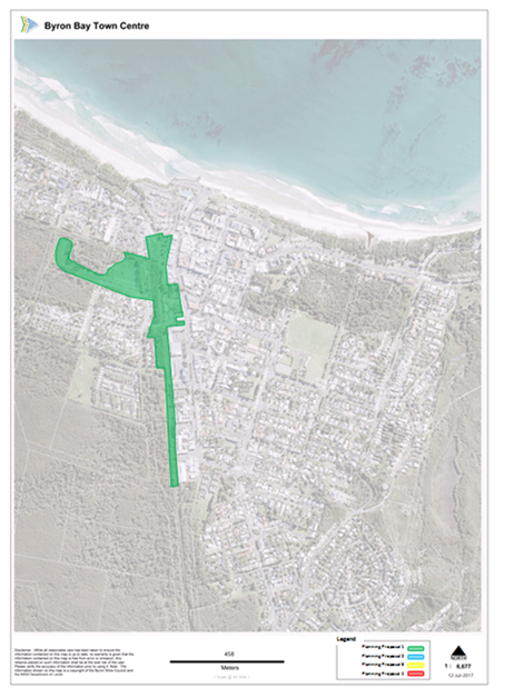
Figure 1 – Subject Land
Planning Proposal 26.2017.5.1
Table 1 – Subject Land
Property details
|
Site Name
|
Zone
|
Legal Description
|
Owner
|
|
Butler Street Reserve
|
RE1 Public Recreation
|
Part of Lot 389 in DP
728537
Lot 390 DP 728538
Part of Lot 391 in DP
728539
Part of Lot 392 in DP
728539
Part of Lot PT 393 in DP
728539
|
Crown Land / Byron Shire
Council
|
|
Byron Bay Rail Corridor
|
Zone SP2 Infrastructure
(Rail corridor)
|
Lot 4729 in DP 1228104
Lot 1 in DP 1001454
|
County Rail Infrastructure
Authority
|
|
Lawson Street South Car
Park
|
Zone SP2 (Car Park)
|
Lot 3 in DP 827049
|
Byron Shire Council
|
Planning Proposal 26.2017.06.1
The objective of Planning Proposal 26.2017.06.1 (Attachment
2) is to amend Byron Local Environmental Plan (LEP) 2014 to introduce various
planning provisions, applicable to the subject land in parts of Byron Bay Town
Centre.
The intended outcomes of the amendments to the LEP are:
1. To rezone all Zone
B2 Local Centre land in Byron Bay Town Centre to Zone B3 Commercial Core to
differentiate Byron Bay from other smaller Centres in Byron Shire.
2. To ensure the
Height of Building control, in metres, accurately represents Council’s
and the community’s strongly held vision to limit development to 3
storeys to preserve Byron Bay’s character and streetscape.
3. To ensure that
Floor Space Ratio controls accurately represents the underlying land use zone
and intended configuration of compact development within the proposed B3
Commercial Core Zone in Byron Bay Town Centre.
4. To require Active
Street Frontages for all development with frontages to key streets and
laneways; to encourage commercial activity as part of a mixed use development
within the proposed B3 Commercial Core Zone.
5. To minimise the
amount of vehicular traffic generated by development within Byron Bay Town
Centre and identify the maximum number of ancillary car parking spaces that may
be provided to service particular land uses as part of a mixed use development
the proposed B3 Commercial Core Zone.
6. To ensure new
development of a significant scale in Byron Bay Town Centre achieves principles
of Design Excellence and through the highest standard of architectural, urban
and landscape design; to deliver ecologically sustainable and resilient
buildings and public places.
Byron Development Control Plan 2014
These amendments will be
supported by proposed changes to Byron Development Control Plan 2014 (Attachment 3) to include controls that cannot be included in
the LEP, to address:
· The
number of storeys compatible with the character of the town centre and minimum
floor to ceiling heights specific to permissible land uses;
· Fine
grain architecture to reduce bulky development and restrict building lengths
relative to street widths; and
· Reduction
of cars by introducing alternative vehicle arrangements for residential
component of mixed use buildings and certain types of tourist and visitor
accommodation.
This Planning Proposal relates
to land currently zoned B2 Local Centre, located at Byron Bay Town Centre
within the following area: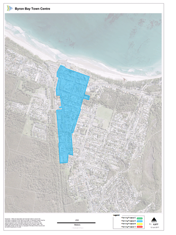 Figure 2 – Subject Land
Planning Proposal 26.2017.6.1
Figure 2 – Subject Land
Planning Proposal 26.2017.6.1
A complete list of property descriptions are
included in Attachment 4.
Byron LEP 2014 mapping
The Planning Proposals affect an area of land that spans
multiple LEP maps. On that basis Council will need to prepare spatial data to
amend the following maps in accordance with the NSW Standard Technical
Requirements for spatial datasets and maps.
Planning Proposal 26.2017.5.1 will require amendment to
Byron LEP 2014 Additional Permitted Uses Map - Sheet APU_003CC.
Planning Proposal 26.2017.6.1 will require amendments to the
following LEP maps:
1. Amend map sheet LZN -
Land Zoning_003CC
2. Amend map sheet HOB
– Height of Building Map_ 003CC
3. Amend map sheet FSR
– Floor Space Ratio Map _003CC
4. Add map sheet ASF
–Active Street Frontage Map_003CC
Consultation
Council will commence community consultation in accordance
with the Gateway Determination.
For the purposes of public notification, the
Planning Proposals are not considered to be low impact as outlined in
the Department of Planning and Environment’s A guide to preparing
local environmental plans. A 28 day public exhibition period
is recommended.
Notification of the
exhibited Planning Proposal will include:
· a newspaper
advertisement that circulates in the Byron LGA, which is the area affected by
the Planning Proposal.
· the web sites of Byron
Shire Council and the Department of Planning and Environment.
The proposed timeline for the completion of the
exhibition and amendment process is detailed in Part 6 of both Planning
Proposals.
Summary and conclusions
The Planning Proposals seek to rezone land and introduce
permissible uses, development standards and other local planning provisions to
implement the strategic objectives in the Byron Bay Town Centre Masterplan.
This Planning Proposals will not impact on environmental areas and are serviced
by urban infrastructure. The Planning Proposals will have positive
social and economic effects; offering additional employment and trading
opportunities for local people and businesses. Numerous social and
economic benefits are likely through increasing the efficient use of
developable lands for jobs and mixed used development including housing in an
existing centre.
The
proposed zoning changes are consistent with the North Coast Regional Plan 2036 and Council’s
Community Strategic Plan 2027. The land is
identified as an existing urban area. An assessment of the planning proposal indicates that it is
consistent with relevant SEPPs. It is consistent with all relevant s117
Directions.
There is sufficient information to enable Council to
support the planning proposal and forward it to the Department of Planning and
Environment for a Gateway determination.
Financial Implications
Should Council resolve to
progress the Planning Proposal, it would require Council commitment of staff
resources and any costs associated with public exhibition and additional
studies, if required by Gateway.
Statutory and Policy
Compliance Implications
The relevant policy considerations are addressed above and
would be further assessed in consideration of the Planning Proposal should
Council resolve to proceed to Gateway.
Staff Reports - Sustainable Environment and Economy 13.16
Report No. 13.16 Integrated
Pest Management Update
Directorate: Sustainable
Environment and Economy
Report
Author: Clare
Manning, Biodiversity Officer
File No: I2017/1527
Theme: Ecology
Planning Policy and Natural Environment
Summary:
To provide an update on the development of the Directions
Document aimed to offer continued direction for minimising the use of pesticide
on Council owned or managed land in the long term.
|
RECOMMENDATION:
That Council note the
update provided in the report by the Integrated Pest Management Working Group
on the Directions Document to inform the Byron Shire Integrated Pest
Management Policy and Strategy and the revised project timeframe.
|
Background
Council resolved 17-141 to prepare a Directions Document
aimed to offer continued direction for minimising the use of pesticide on
Council owned or managed land in the long term.
The Directions Document will include evidence based case
studies to help set a policy position. It will demonstrate that Council
staff are committed to practices that result in the minimal use of pesticides
while not lowering standards of practice and continue to meet our legislative
requirements by ensuring Integrated Pest Management (IPM) principles are
applied.
The Integrated Pest Management Working Group (Working Group)
continues to meet fortnightly to finalise the Directions Document.
Report
To help Council staff deliver the Directions Document, five
requests for quotes were recently sought, of which two consultants submitted a
quotation. In respect of the Request for Quotation, the Working Group is
pleased to advise that Tein McDonald & Associates quotation has been
accepted.
Tein McDonald & Associates have three decades familiarity
with the issues associated with minimising pesticides use in land and water
management, while not lowering standards of practice for land managers.
Additionally, Tein McDonald & Associates have experience of working with
all levels of government and the community including north coast communities, in
providing a voice of reason in the complex debate over pesticide use including a
strong familiarity with the international debate on the toxicity of glyphosate that
will be very helpful in assisting Council to develop practical short, medium
and long term strategies to minimise pesticide use.
However, as was highlighted by all submitting consultants, Tein
McDonald & Associates advised a delivery of the draft Directions Document
by mid-February 2018.
Revised Directions Document Timetable
Due to complexity and contentious nature of the issues combined
with competing priorities across Directorates and contractual requirements,
delivery of a draft Directions Document by 23 November 2017 is revised.
The Working Group has amended the timetable to deliver the
draft Directions Document and revised Integrated Pest Management Strategy as
per below:
1. Strategic
Planning Workshops 7 December 2017 and 25 January 2018.
2. Report
Draft Directions Document to Executive Team for comment end January 2018
3. Report
to and seek feedback from Biodiversity & Sustainability Panel end of
January 2018.
4. Report
to Council 22 March 2018 recommending that the draft Directions Document is
placed on public exhibition for a period of six weeks.
5. Deliver
a revised Byron Shire Integrated Pest Management Policy and Strategy 2018 third
quarter.
Financial Implications
The 2017-18 FY Environment Levy provides funds of $13,300.
On 4 August 2016, Council resolved 16-362 that:
1. a
peer review of the draft Integrated Weed Management Strategy against Council
resolution 13-621 and
2. an
allocation of $20,000 in the quarterly budget review to undertake the peer
review and detailed costed implementation plan.
The allocation of $20,000 was included in the September
budget review, to the 26 October 2017 Council meeting.
This will provide a total budget of $33,300.
It is envisioned that these funds will deliver the
Directions Document and a revised Byron Shire Integrated Pest Management Policy
and Strategy.
Statutory and Policy Compliance Implications
Improved alignment with the Australian Weed Strategy and
Intergovernmental Agreement on Biosecurity, NSW Biosecurity Act 2015 and NSW
Biosecurity Strategy 2013-2021.
Staff Reports - Sustainable Environment and Economy 13.17
Report No. 13.17 PLANNING
- 26.2017.4.1 - Planning Proposal for Rezoning and Reclassifying Part Lot 22 DP
1073165 Mullumbimby
Directorate: Sustainable
Environment and Economy
Report
Author: Shannon
Burt, Director Sustainable Environment and Economy
File No: I2017/1528
Theme: Ecology
Planning Policy and Natural Environment
Summary:
This report
presents a planning proposal for part Lot 22 DP 1073165, which seeks to alter
the land use zone to permit residential development with an emphasis on
affordable housing. It is also intended that the land be reclassified
from Community land to Operational land in this planning
proposal. It is also intended that provisions to encourage diverse and
affordable housing on key sites be inserted into Byron LEP 2014. The land
is entirely owned by Byron Shire Council.
The
planning proposal (Attachment 1) will:
§ Insert
R1 General Residential as a new zone in Byron LEP 2014
§ Rezone
approximately 22 hectares of the existing RE1 Public Recreation zone to R1
General Residential
§ Apply
a minimum lot size of 200 m2 to the R1 General Residential zone area
on Lot 22 DP 1073165
§ Reclassify
part Lot 22 DP 1073165 from Community to Operational to reflect the changes to
the zoning of the land and prospective change of land use
§ Insert
a Key Sites Map in Byron LEP 2014 and identify part Lot 22 DP 1073165 on that
map
§ Insert
new local provisions into Byron LEP 2014 to encourage diverse
and affordable housing on key sites identified on the Key Sites Map.
The balance of the site,
including the Mullumbimby community gardens, a small freshwater wetland, a
riparian strip near Saltwater Creek and an area east of the railway line, will
remain in its current mix of zones. A site analysis showing the key
features of the site, constraints and opportunities is at Attachment 2.
The planning proposal
will increase the opportunity for affordable residential development (up to 200
dwellings) in response to a documented demand and inadequate long-term
supplies. The land has been subject to a range of
studies and reports that support the extension of the residential zoned
area. Some additional studies and consultation are required.
It is an area that can be
economically serviced with urban infrastructure, and will allow innovative and
diverse housing that contributes to the local economy without creating concern
regarding social services. It will have no adverse impact on significant
agricultural lands. The flood hazard affected lands can be dealt with at
the development stage through land filling and floor levels.
The
planning proposal is consistent with relevant SEPPs. It is consistent
with most of the relevant s117 Directions, and where inconsistencies occur they
can be justified. It is consistent with the North Coast Regional Plan as
the site is identified as an existing urban area.
It is a
relatively minor expansion of an existing urban area that can provide land for
innovative, affordable housing to meet short-term market demand while Council
continues to investigate other options.
There is sufficient information to enable Council to support the
amended planning proposal and forward it to the Department of Planning and
Environment for a Gateway determination.
NOTE TO COUNCILLORS:
In accordance with the
provisions of S375A of the Local Government Act 1993, a Division is to be
called whenever a motion for a planning decision is put to the meeting, for the
purpose of recording voting on planning matters. Pursuant to clause 2(a)
under the heading Matters to be Included in Minutes of Council Meetings of Council's
adopted Code of Meeting Practice (as amended) a Division will be deemed to have
been called by the mover and seconder of all motions relating to this report.
|
RECOMMENDATION:
That Council:
1. Agree
to initiate the planning proposal to amend Byron LEP 2014 (Attachment 1) for
the reasons outlined in this report.
2. Forward
the planning proposal to the NSW Department of Planning and Environment for a
Gateway determination.
3. Agree
that staff can proceed to public exhibition of the planning proposal and
government agency consultation based on the Gateway determination issued by
the NSW Department of Planning and Environment, and report back to Council as
part of post-exhibition reporting.
|
Attachments:
1 Planning
Proposal Draft Gateway Version, E2017/103293
⇨
2 Site
Analysis , E2017/103182 ⇨

3 Extract
from Draft Byron Recreation Needs Assessment, E2017/103307
⇨
4 Ecological
Assessment prepared by Mark Fitgerald July 2017, E2017/103344 ⇨
5 Land use
Conflict Risk Assessment (LUCRA), E2017/103183
⇨
6 Flood
Assessment prepared by BMT WBM, E2017/103396
⇨
7 SEPP 55
prepared by Greg Alderson & Assoc , E2017/103333
⇨
8 Infrastructure
Plans , E2017/103215 ⇨
Report
The Planning Proposal
This planning proposal relates
to Council owned land located at the southern edge of Mullumbimby, described as
part Lot 22 DP 1073165. Lot 22 is an irregular shaped lot that is split
by a railway line and has part of its boundary to Saltwater Creek. It
includes Mullumbimby community gardens. It has a total area of approximately
29.2 hectares. Approximately 22 hectares is affected by zone changes in
this planning proposal. The balance of the zones within the subject land
will remain unchanged.
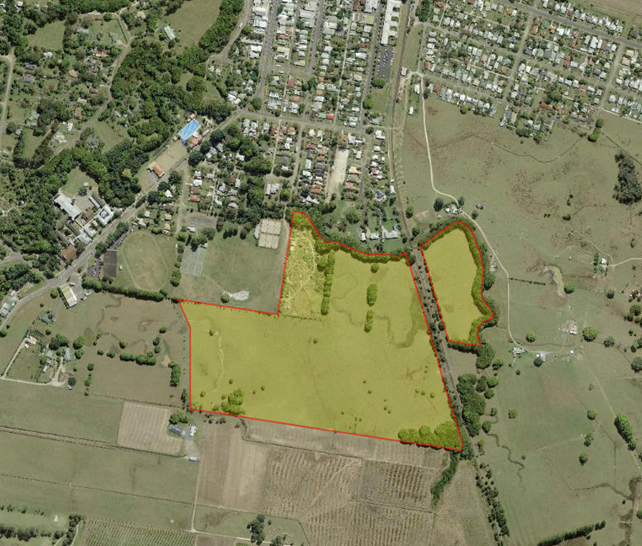
Lot 22 DP 1073165 – The parent lot
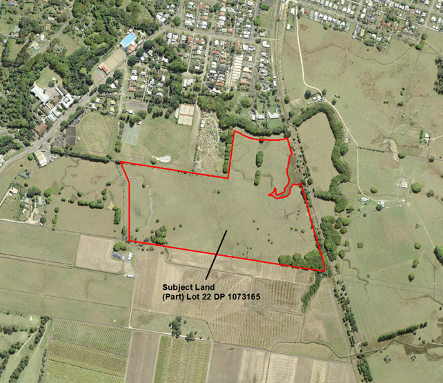
Part Lot 22 DP 1073165 as affected by this
planning proposal – The subject land
Current
Zones and Controls
Lot 22 DP 1073165 is zoned part
RE1 Public Recreation and part Deferred Matter under Byron LEP 2014. The
small area of Deferred Matter is zoned 7(B) Coastal Habitat under LEP
1988. The land zoned RE1 has no Minimum Lot Size or Floor Space Ratio but
has a Building Height of 9 metres. The land is classified as Community
land under the Local Government Act, 1993.
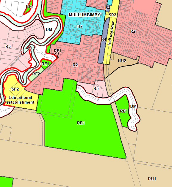
Current Byron LEP 2014 zoning
Proposed
Zones and Controls
The planning proposal (Attachment 1) will:
§ Insert R1 General Residential as a
new zone in Byron LEP 2014
§ Rezone approximately 22 hectares of
the existing RE1 Public Recreation zone to R1 General Residential
§ Apply a minimum lot size of 200 m2
to the R1 General Residential zone area on Lot 22 DP 1073165
§ Reclassify part Lot 22 DP 1073165
from Community to Operational to reflect the changes to the zoning of the land
and prospective change of land use
§ Insert a Key Sites Map in Byron LEP
2014 and identify part Lot 22 DP 1073165 on that map
§ Insert new local provisions into
Byron LEP 2014 to encourage diverse and affordable housing on
key sites identified on the Key Sites Map.
The balance
of Lot 22 will remain in its current mix of zones. The small area of
Deferred Matter cannot be amended by this planning proposal as it is not
subject to Byron LEP 2014. It can only be amended by also amending Byron
LEP 1988. It is not practicable that this be done as part of this
planning proposal and this area will remain as Deferred Matter for the time
being.
The land use
table for the proposed R1 General Residential zone and the proposed local
provisions for diverse housing and affordable housing are included as annexures
to the planning proposal in Attachment 1 to this report.

Part Lot 22 DP 1073165 to be
rezoned from RE1 Public Recreation zone to R1 General Residential.
Same area to be changed from Community to Operational
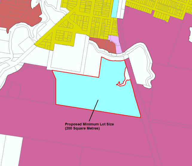
Part Lot 22 DP 1073165 to have
a Minimum Lot Size of 200 m2
Past
Council Resolutions on this Planning Proposal
Council
resolved on 22 June 2017 as follows:
1. Note
the Housing Issues Plan developed the result of the Byron Affordable Housing
Summit and support its use to inform part of the Residential Land Use Strategy
recommendations currently under preparation.
2. Support
further discussions with landowners of land in Attachment 1, and progression of
work necessary to establish the feasibility of the sites in Attachment 1 and
Attachment 2 for affordable housing; ……..; and where appropriate,
invite lodgement of Planning Proposals to rezone the land for this purpose.
Lot 22 DP 1073165 was identified
(in the report of 22 June) as Council land that should be considered for
affordable housing purposes through a planning proposal and subsequent
development.
Key
Issues
§ North Coast Regional Plan
§ Mullumbimby Settlement Strategy,
2003
§ Draft Residential Strategy
§ Draft Byron Recreation Needs
Assessment
§ Ecology
§ Regional farmland and LUCRA
§ Flood prone land
§ Contaminated land
§ Infrastructure
§ State policy and planning controls
§ Reclassification of Council land
§ Mullumbimby community gardens
§ A new residential zone
§ Diverse and affordable housing
provisions
§ Key
sites map
North
Coast Regional Plan
The subject
site is located within the Urban Growth Area boundary under the North Coast
Regional Plan 2036. This reflects that it was zoned for an urban use
(RE1 Public Recreation) at the time the NCRP was finalised. On
this basis, the planning proposal is consistent with the NCRP.
Analysis of the site against the
Urban Growth Area Variation Principles was undertaken as part of the supporting
information in the planning proposal (Attachment 1). The site is
consistent with these principles.
Mullumbimby
Settlement Strategy, 2003
The
Mullumbimby Settlement Strategy was prepared in 2003 and is now well out of
date. It does not identify the subject land as an
existing or future urban area. The land was purchased by Council in 2004,
and zoned for open space after that.
Byron Shire Preliminary Draft
Residential Strategy
The subject
land was included in the 2016 exhibited draft Byron residential strategy as
Area 13, even though it is already in an urban zone. Its proximity to the
urban area and potential for affordable housing is noted, subject to resolution
of flooding and proximity to farmland and the railway corridor. These
issues have been addressed in supporting information to this planning
proposal. The fact that the land is already in an urban zone (and
therefore does not need to be in the strategy), combined with the need for
affordable housing is the basis for the subject land preceding the final
revision of the Shire-wide residential strategy. A revised draft strategy
is proposed for exhibition in late 2017, and the subject land is to be included
in that strategy.
Draft Byron Recreation Needs Assessment
In 2017,
Council engaged consultants to prepare a recreation needs assessment to
increase its knowledge and understanding of the community’s recreation
and sporting needs, existing opportunities and relevant trends impacting on
recreation services or facility provision. The assessment aims to provide
Council a clear planning framework to 2036, which considers the
community’s current and future recreation and sporting demands, existing
options for meeting those demands, the nature of spaces required for particular
activities, and the types of services that support particular activities.
The draft assessment is due to be reported to Council by the end of 2017.
A draft document included a precinct analysis for Mullumbimby, which concluded
that Lot 22 was surplus to Council’s needs for sporting or recreation
(other than the area occupied by the Mullumbimby community gardens), and that
embellishment of other existing parks and reserves was a better option than new
areas such as Lot 22 (Attachment 3). If Council is successful in
reclassifying and rezoning part of Lot 22 then section 94 funds that were used
to acquire it could be returned and spent on embellishment of other parks.
Ecology
An ecological assessment carried
out for the subject land in July 2017 described it as a low-lying area of
largely cleared land currently used for cattle grazing and much modified by historical
land uses (Attachment 4). Vegetation is dominated by exotic pasture
species and weeds of pasture. Tree cover includes dense stands of Camphor
Laurel along Saltwater Creek and clumps of Camphor Laurel trees at scattered
locations. No threatened flora was present during targeted surveys in
July 2017, but a summer survey is recommended for the threatened species
Hairy-joint Grass and Missionary Nutgrass. No Endangered Ecological
Communities are currently present. The probability of threatened fauna
species being dependent upon the site in its current condition is low. A
survey of the site is recommended to determine if the threatened Common
Planigale is present. Three small wetlands with associated stream
channels are located near Saltwater and Kings Creeks. These wetlands are
areas with potential for rehabilitation and recovery of the freshwater wetland
and floodplain forest habitats. The larger one is in better condition
than the others and is recommended to remain in the RE1 zone (in lieu of any
environmental zones being available). On balance, the site does not have
high ecological values.
Regional
farmland and LUCRA
The site is mapped on the BSAL
maps as significant land but the Northern Rivers Farmland Mapping Project
identifies it as a committed urban area. The land has been grazed under
agistment since it was purchased by Council (in 2004) and zoned for Open
Space. It is not important farmland, and its use for residential
development will not fragment contiguous farmland. It does not have a
history of sugar cane production and will not impact on the viability of the
sugar industry or beef cattle industry on a local or regional basis.
A Land Use Conflict Risk
Assessment (LUCRA) has been undertaken (Attachment 5) which assessed the potential
for conflict between future residential land use and neighbouring agriculture
and the railway line. The imposition of suitable vegetated buffers as
part of future residential land use should ameliorate any issues. The
site is large enough to accommodate such buffers without impacting on
neighbouring land uses. This can be dealt with at the development stage.
Flood
prone land
The land is flood prone, however
a flood assessment indicates that parts of it can be filled to the flood
planning level without major impacts on surrounding land (Attachment 6).
This planning proposal affects
land that is mostly flood affected in a 100 year ARI event and totally affected
in a PMF event. It is a relatively low velocity area during flood events,
other than in the small watercourses that occur on the site. It is not a
floodway.
The land could be developed for
residential purposes if it is filled. Three fill scenarios were modelled
and design option 3, which has three fill pads and drainage reserves
between them, was modelled as having small but acceptable impacts on
surrounding rural land. It is the preferred fill option for this site.
On balance, the preferred fill
option would not cause significant flood impacts to other properties; would not
result in increased spending on flood mitigation, infrastructure or services;
and would not permit excessive development without consent.
When development in flood prone
areas is being contemplated, the provisions of existing clause 6.3 of
Byron LEP 2014 will apply at the development application stage.
Contaminated
land
A Preliminary Contamination
Report (Alderson and Associates, 2017) has been prepared for the subject site
(Attachment 7). There is no recorded dip site on the land. The
nearest dip site is north of Saltwater Creek (Mullumbimby Museum site), which
is about 200 metres north-west of the subject land. Contamination
testing on the community gardens site (located between the proposed rezoning
and the old dip site) found no evidence of hazardous material from the dip
site. The report did not identify any likelihood of contamination arising
from the dominant past use of the subject site for cattle grazing.
However, some parts of it may have been cropped in the 1970s, and further
testing of these areas is warranted at the development application stage.
Soil tests should also be undertaken in proximity to the disused rail line to
check for pesticides related to termite control and asbestos from train
brakes. The Preliminary Contamination Report confirms that the subject
site has a low likelihood of contamination and that further soil testing at the
development application stage is an appropriate response.
Infrastructure
Reticulated water supply is
possible via the existing Mullumbimby water supply system and the associated
Laverty’s Gap Weir storage. Reticulated water mains are close to
the site, at Jubilee Avenue and Stuart Street.
Sewerage service is possible via
the Mullumbimby sewerage system and the associated Brunswick Valley Sewage
Treatment Plant (Vallances Road). The sewerage reticulation system is close
to the site at Station Street. A larger pump and larger pipeline capacity
will be needed to get sewage from early stages to the STP. An additional
sewage pump station is likely to be required as development continues because
the site is quite flat.
Road access to the site is via
Byron Street and Stuart Street. The Stuart Street access has a causeway
crossing over Saltwater Creek that is suitable for pedestrian and bicycles but
would need upgrading for vehicles. Byron Street has an awkward
intersection with Jubilee Avenue. A better option in the longer term may
be to negotiate an access to Jubilee Avenue via the neighbouring land to the
west. This could be located to enable a roundabout inclusive of Azalea
Street, which could improve traffic movements generally in this location.
Reticulated power and
telecommunications are adjacent to the site and can be extended to it.
State infrastructure such as
schools and hospitals will be able to deal with the additional population if
the site is rezoned. Mullumbimby High School is 300 metres from the
site, and Mullumbimby Primary School is 1,000 metres away.
On balance, public
infrastructure is available or can be augmented to incorporate the proposed
residential development of the subject land. A series of infrastructure plans
are included in (Attachment 8).
State
policy and planning controls
The planning proposal is
generally consistent with applicable State Environmental Planning
Policies. The key SEPPs that require particular consideration are
SEPP 55 Remediation of Land and SEPP 71 Coastal
Protection. These are addressed in more detail in the attached planning
proposal (Attachment 1).
The planning proposal is
generally consistent with relevant Section 117 Directions. It is
justifiably inconsistent with Direction 1.3 Mining, Petroleum Production
and Extractive Industries; Direction 4.2 Mine Subsidence and Unstable
Land; Direction 4.3 Flood Prone Land;
and Direction 6.2 Reserving Land for Public Purposes. In all cases
the inconsistency is reasonable and should not inhibit the planning proposal
from receiving a Gateway determination.
All Section 117 Directions
are addressed in more detail in the attached planning proposal
(Attachment 1).
Reclassification
of Council land
The subject land is entirely
owned by Byron Shire Council and was purchased using section 94 funds for
future active (or passive) open space in 2004. In order to sell or lease
it for residential purposes (or other purposes permitted in the R1 zone),
Council needs to change its classification under the Local Government Act
1993 from Community to Operational. This planning proposal can
achieve that by including the land in the appropriate part of Schedule 4
of Byron LEP 2014. An information sheet summarising the circumstances of
the reclassification is an annexure to the planning proposal at
Attachment 1.
Mullumbimby
community gardens
Approximately 2.7 hectares
of Lot 22 was licensed to a group called Mullum SEED on 1 September
2014 for a five year period. The land was to be used for a community
garden. The garden was established and is active to this day. This
is an appropriate use of public open space, and the draft recreation needs
assessment acknowledged this area as part of the current supply of developed
recreation land available to the community. This planning proposal will
leave this area zoned RE1 under LEP 2014 and classified as Community land under
the Local Government Act 1993. The land is effectively excluded
from this planning proposal.
A
new residential zone
A key
reason for rezoning the subject land is to permit affordable residential
development that is well located in terms of access to services and
infrastructure. None of the existing residential zones include objectives
that relate to affordable housing. By using the previously unused
R1 General Residential zone, Council is able to shape a zone that includes
objectives such as:
§ To
provide a secure supply of affordable housing stock that meets the needs of low
to middle income residents.
§ To
enable the provision of non-residential land uses that are compatible with, and
do not place demands on services beyond the level reasonably required for,
residential use.
§ To
encourage adaptable housing that supports ageing in place.
Another reason is to provide a
broad range of dwelling options, including caravan parks. By including
caravan parks, Council can trigger “manufactured home estates”
pursuant to SEPP 36. This provides an opportunity to use low cost
(but not low quality) structures such as “tiny homes” that can be
used as affordable housing.
A new zone also permits Council
to provide a broad range of employment related land uses that are still
compatible with residential areas. This will allow future residents a
reasonable range of live/work opportunities that are often not available in
“traditional” residential neighbourhoods.
With the land being owned by
Council, it is able to further influence its ultimate development.
Diverse
and affordable housing provisions
Council has been keen to pursue
provisions in its LEP to promote diverse and affordable housing for some
time. In its draft Residential Strategy, Council stated it wanted
“Model controls that require affordable housing to be included in
developments”.
This planning proposal provides
an ideal opportunity to introduce these provisions into Byron LEP 2014.
They are based on similar provisions in other NSW LEPs, although in this case
they are not linked to development incentives. The logic is that if the
land is zoned R1 General Residential with a minimum lot size of 200 m2
and there is a full range of residential accommodation options available then
that is an incentive in itself. The key limitation to density (other than
lot size) would be building height and site design issues such as parking and
setbacks.
The diverse housing clauses
require at least 25% of dwellings to be one bedroom and not more than 25% of
dwellings can exceed three bedrooms. This emphasis on smaller sized homes
is consistent with Family and Community Housing advice (Expected Waiting
Times for Social Housing, 2015) that social housing waiting times in Byron
LGA are greater than ten years for dwellings with one, two or three
bedrooms. There is an identifiable pent up demand for affordable, smaller
size dwellings.
The requirement that 50% of new
dwellings be dedicated for 30 years to a registered community housing
provider is to ensure that a large proportion of new dwellings on key sites are
retained as affordable rental housing over the expected life of the dwelling.
The diverse and affordable
housing provisions apply only to land shown on the “key sites
map”. This means that if Council chooses to apply a residential
zone and not identify the land on the key sites map then the new clauses do not
apply and there is less opportunity to achieve affordable and diverse housing
outcomes.
Key
sites map
Introducing the “key sites
map” allows Council to target localities that it considers are
appropriate for affordable and diverse housing. In the first instance,
the only land on the map will be Council’s part Lot 22. Other
land owners may be willing to be included on the key sites map if they have
land that is suitable for affordable and diverse housing and are willing to
pursue that option. However, this land would have to be in an urban zone
already or be in an adopted residential strategy so that it could be
rezoned. It would also have to be able to be able to be serviced with
infrastructure. It could then be subject to a planning proposal and
considered on its merits.
Options
to Move Forward
There are
a number of options open to Council on this matter:
1. Proceed to a
Gateway determination with the attached planning proposal (Attachment 1).
2. Amend the planning
proposal and proceed to a Gateway determination.
3. Not proceed with
the planning proposal.
Conclusion
The planning proposal attached
to this report is consistent or justifiably inconsistent with State policies
and directions and the North Coast Regional Plan. It has sufficient merit
to be supported.
Council should proceed with this
planning proposal to amend Byron LEP 2014 to apply the new R1 General
Residential zone to part of Lot 22 DP 1073165 as shown in
Attachment 1. It should also amend the Minimum Lot Size maps for the
same area. It should also insert affordable and diverse housing
provisions into LEP 2014, and reference them to a new “key sites
map” that includes part Lot 22 DP 1073165.
Council should also proceed with
the reclassification of part of Lot 22 DP 1073165 to change that part
of the site from Community to Operational land under the Local Government
Act 1993. This should be undertaken in accordance with LEP Practice
Note PN 09-003.
Further
information or specialist reports that are required prior to exhibition of the planning
proposal include:
§ further
consultation with local Aboriginal groups
§ a
preliminary soil and geotechnical assessment of the site
§ a
summer survey for the threatened species Hairy-joint Grass and Missionary
Nutgrass
§ a
survey of the site to determine if the threatened Common Planigale is present.
Financial Implications
If Council chooses to proceed with the planning proposal, it
will be at its own expense given that Council owns the land and has initiated
the planning proposal. If the planning proposal is successful in changing
the zone of the land and reclassifying it to Operational then it will need to
repay an amount to section 94 funds. This money can then be spent on
open space and recreation needs in accordance with Council’s
Section 94 Contributions plan.
If Council chooses not to proceed then the matter does not
incur any additional costs.
Statutory and Policy
Compliance Implications
The relevant policy considerations are addressed above and
in the attached planning proposal.
Staff Reports - Sustainable Environment and Economy 13.18
Report No. 13.18 Report
of the Planning Review Committee Meeting held on 19 October, 2017
Directorate: Sustainable
Environment and Economy
Report
Author: Chris
Larkin, Manager Sustainable Development
File No: I2017/1536
Theme: Ecology
Development and Approvals
Summary:
This report provides the outcome of the Planning Review
Committee Meeting held on 19 October, 2017.
|
RECOMMENDATION:
That Council note the report.
|
Report:
The meeting commenced at 4:15pm
and concluded at 4:21pm.
Present: Crs, Martin,
Ndiaye, Hunter,
Staff: Chris Larkin
(Manager Sustainable Development).
Apologies: Crs
Richardson, Spooner, Lyon, Hackett, Cameron
The following development
application was reviewed with the outcome shown in the final column.
|
DA No.
|
Applicant
|
Property Address
|
Proposal
|
Exhibition
Submission/s
|
Reason/s
Outcome
|
|
10.2017.516.1
|
Ardill Payne & Partners
|
8 Coomburra Crescent
Ocean Shores
|
Subdivision to create four
(4) lots
|
Level 1
28/9/17 to 11/10/17
9 submissions
|
Staff
Delegated Authority
|
Staff Reports - Sustainable Environment and Economy 13.19
Report No. 13.19 PLANNING
-10.2017.393.1 Detached Dual Occupancy Dwelling at 31 Pinegroves Road Myocum
Directorate: Sustainable
Environment and Economy
Report
Author: Shannon
Burt, Director Sustainable Environment and Economy
File No: I2017/1547
Theme: Ecology
Development and Approvals
Proposal:
|
Proposal:
|
Dual occupancy (dwelling)
|
|
Property description:
|
Lot: 15 DP: 1030574
31 Pinegroves Road MYOCUM
|
|
Parcel No/s:
|
237962
|
|
Applicant:
|
Newton Denny Chapelle
|
|
Owner:
|
W and J Hunter
|
|
Zoning:
|
Zone No. RU1 Primary Production (actual dwelling site)
|
|
Date received:
|
21 July 2017
|
|
Integrated Development:
|
No
|
|
Public notification or exhibition:
|
- Level
1, advertising under DCP 2014 Part A14 – Public Notification and
Exhibition of Development Applications
- Exhibition
period: 3 August 2017 to 16 August 2017
- Submissions: For
= 0 Against = 0 Neutral/Other = 1
|
|
Other approvals (S68/138):
|
On site waste management system - new installation of
septic tank and reed bed
|
|
Planning Review Committee:
|
N/A
|
|
Delegation to determination:
|
Council
|
|
Issues:
|
· Unauthorised
structure
· Bushfire APZs
· Relinquish
previous consents
· No further
subdivision restriction on user
|
Summary:
The application proposes a dual occupancy (detached)
development on the subject land. The land is 48.89 hectares in area, accessed
off the end of Pinegroves Road, Myocum.
The proposed new dwelling is within Zone RU1 – Primary
Production Zone, and dual occupancy (detached) is permitted with Council
consent if the lot exceeds 4000 m2.
The Statement of Environmental Effects accompanying the DA
adequately addresses the LEP and DCP requirements and demonstrates that the
dual occupancy (detached) development of this site is appropriate, subject to
conditions.
Council’s Procedure No:
63. “Development Applications – Conflict of Interests”
requires that
development applications
submitted by a Councillor of Byron Shire Council to be assessed by
an independent consultant and be
determined by Council. This procedure is in response to
guidelines provided by the
Independent Commission Against Corruption which are intended to
assist councils to minimise the
potential for conflicts of interest to arise in the assessment of
development applications.
This report has been completed by Mike Svikis, being an
independent consultant.
NOTE TO COUNCILLORS:
In accordance with the
provisions of S375A of the Local Government Act 1993, a Division is to be
called whenever a motion for a planning decision is put to the meeting, for the
purpose of recording voting on planning matters. Pursuant to clause 2(a)
under the heading Matters to be Included in Minutes of Council Meetings of
Council's adopted Code of Meeting Practice (as amended) a Division will be
deemed to have been called by the mover and seconder of all motions relating to
this report.
|
RECOMMENDATION:
That pursuant to Section 80 of the Environmental
Planning & Assessment Act 1979, development application 10.2017.393.1 detached
dual occupancy dwelling development be granted consent subject to the
conditions listed in Attachment 2 #E2017/104997.
|
Attachments:
1 Proposed
Plans prepared by Steve Lampe designs , E2017/102789
⇨

2 Proposed
Conditions, E2017/104997 ⇨
3 Confidential
- submission received 10.2017.393.1, S2017/16222
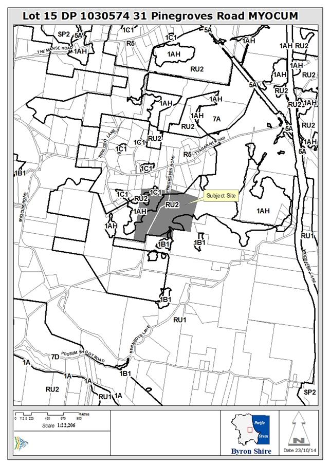
Assessment:
1. INTRODUCTION
1.1 History/Background
Lot 15 DP 1030574 is a 48.89 hectare lot that has a history
of use for cattle grazing. More recently the Land and Environment court issued
an approval for three farm buildings and 12 self-storage units as self-storage
premises. An approval was issued in 2001 for a small dwelling that has
been constructed. In 2005 a further approval was issued for a dwelling to
replace the original dwelling (DA 10.2005.367.1). Council records show a
private certifier issued a construction certificate on 15 November 2010 for
commencement of the 2005 consent so that it still applies to the subject land.
The only works that have taken place are a slab for a garage and a separate
electricity connection.
At the site inspection of 10 August 2017 it was noted that a
“studio” is located east of the proposed dual occupancy
dwelling. This studio appears to be occupied as a separate domicile and
has a water tank and wastewater disposal area marked on plans included with
this DA. Council has no record of approving this structure or its
wastewater disposal system. There is no record of compliance action in
relation to the occupation of the studio as a dwelling.
The land on which the dual occupancy dwelling is proposed is
zoned RU1 Primary Production under Byron LEP 2014 (Figure 1). Dual
occupancy (detached) is permitted with Council consent if the lot exceeds 4000
m2. Parts of the land are also zoned RU2 Rural Landscape, R5
large Lot Residential and Deferred Matter but they are not directly affected by
this proposal.

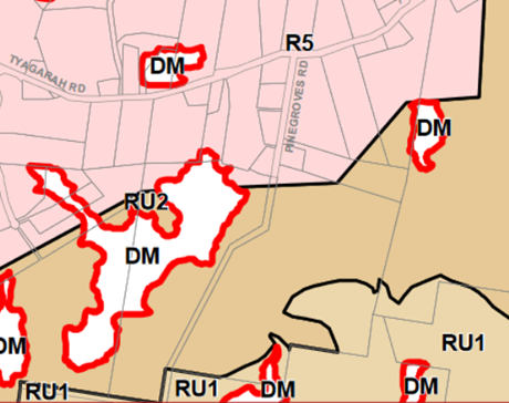
Figure 1: The land on which the dwelling is located is zoned
RU1 under Byron LEP 2014 (star marks location)
1.2 Description
of the site
The subject land is a 48.89 hectare rural lot (Lot 15 DP
1030574) located end of Pinegroves Road on the south side of a broader rural
residential area at Myocum. The lot includes an unmade road reserve. The
proposed dwelling site is accessed by a 4 metre wide bitumen sealed driveway
that also services the existing dwelling (that is located 27 metres away to the
south west). The driveway has a concrete culvert and causeway over a small
waterway that traverses the land. It is an all weather access to the subject
land.

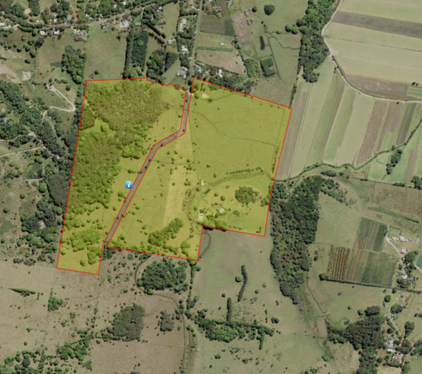
Figure 2: The land is a small farm with an approved dwelling
and multiple small farm buildings.
The majority of the property is open grazing land. It also
contains scattered areas of native vegetation including some forested wetlands
(#9001), rainforest (#9009), and wet sclerophyll (#2195) (Figure 3).
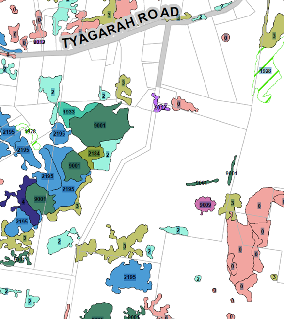
Figure 3: The land contains scattered areas of native
vegetation
Electricity and telephone are connected to the subject
land. Water is collected on site (tanks and dams). Wastewater is disposed
of on site. It is supplied with a Council solid waste and recycling service.
The proposed dwelling site is generally free from physical
constraints as it is on a cleared, elevated knoll above the flood planning
level. Lower parts of the subject land between the dual occupancy
dwellings and Pinegroves Road are flood affected. It is mapped as
regionally significant farmland.

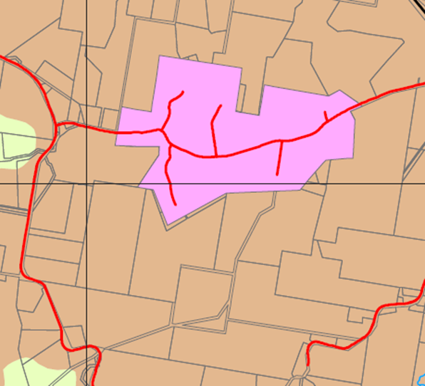
Figure 4: The land is regionally significant farm land
(brown colour)
1.3 Description
of the proposed development
The applicant wants to keep the existing original approved
(and constructed) dwelling and build a new five bedroom dwelling 27 metres away
to be used as a separate domicile. This additional dwelling is the
detached dual occupancy dwelling. The 2005 development consent for a
dwelling is to be forfeited and the existing studio made non inhabitable or removed.
A new on site waste water treatment system is proposed with
a 5000 litre septic tank and reed bed system. No native vegetation is to be
removed. The existing driveway will be used to access the detached dual
occupancy dwelling. The dwelling will be a single storey constructed with a
slab on ground, with weatherboard cladding and colourbond roof. It will
have an internal floor area of 326m2, and a roof area of 750m2.
A swimming pool is also proposed. The dwelling is to be occupied by
relatives of the owner.
2. SUMMARY
OF GOVERNMENT/EXTERNAL REFERRALS
|
|
Summary of Issues
|
|
Environmental Health Officer
|
Supported conditionally. Comments included in relevant
report sections.
|
|
Government Authorities –Rural Fire Service
|
Proposal referred to the Rural Fire Service under S79BA of
the EPA Act 1979. The proposal supported subject to conditions of consent
addressing the bushfire hazard as suggested by BCA Check.
|
3. SECTION
79C – MATTERS FOR CONSIDERATION – DISCUSSION OF ISSUES
Having regard for the matters for consideration detailed in
Section 79C(1) of the Environmental Planning & Assessment Act 1979, the
following is a summary of the evaluation of the issues.
State/Regional Planning
Policies and instruments - Issues
3.1. STATE/REGIONAL
PLANNING POLICIES AND INSTRUMENTS
|
Requirement
|
Requirement
|
Proposed
|
Complies
|
|
State Environmental
Planning Policy 55 – Remediation of Lands
|
A consent authority must not
consent to the carrying out of any development on land unless:
(a) it has considered
whether the land is contaminated, and
(b) if the land is
contaminated, it is satisfied that the land is suitable in its contaminated
state (or will be suitable, after remediation) for the purpose for which the
development is proposed to be carried out, and
(c) if the land
requires remediation to be made suitable for the purpose for which the
development is proposed to be carried out, it is satisfied that the land will
be remediated before the land is used for that purpose.
|
As part of DA 10.2000.383.1
for the subdivision of Lot 10 DP 854406 into 2 allotments Aspect North
undertook a SEPP 55 Preliminary Site Investigation (PSI) in February
2001. The PSI included a review of Site History and onsite sampling for
contaminates at the site of the proposed building envelope.
Following review of the
aforementioned PSI Council’s Environmental Officer, Simon Smith (2001)
determined that the Information regarding the site's history of land usage
is sufficient rigorous to conclude that potentially contaminating activities
are unlikely to have occurred on this property, especially in the vicinity of
the proposed dwelling site.
Land ownership and use was
tracked back to the1920s and there was no evidence that the site had been
used for anything other than grazing. The current owner has lived on the
subject land since 2004 and has not undertaken any contaminating uses on this
land in that time.
No further investigation is
warranted
|
Yes
|
|
State Environmental
Planning Policy (Building Sustainability Index:BASIX) 2004
|
(a) an application
for a development consent, complying development certificate or construction
certificate in relation to certain kinds of residential development must be
accompanied by a list of commitments by the applicant as to the manner in
which the development will be carried out, and
(b) the carrying
out of residential development pursuant to the resulting development consent,
complying development certificate or construction certificate will be subject
to a condition requiring such commitments to be fulfilled.
|
A BASIX certificate has been
prepared for the new dwelling dated 14 June 2017 (cert # 815796S_02).
In each category of water,
thermal comfort and energy the proposed dwellings meet or exceed the required
targets.
|
Yes
|
|
NSW Coastal Policy 1997
|
Clause 7 requires Council to
consider certain matters in determining a DA in the coastal zone. These are
set out in Clause 8 of the SEPP.
|
The subject land is set back
approximately 4.5 km from the high water mark at the nearest beach and it
therefore not in the coastal zone.
|
N/A
|
|
Building Code of Australia
|
N/A
|
N/A
|
|
|
Demolition
|
N/A
|
N/A
|
|
|
Disability Access (DDA)
|
Access for persons with
disabilities and integration into surrounding streetscapes without creating
barriers. (Council Res.10-1118)
|
No impact is anticipated from the
development on disability access in the surrounding streetscape.
|
Yes
|
*
Non-complying issues discussed below
3.2. BYRON
LOCAL ENVIRONMENTAL PLAN 2014
Zone: Zone No. RU1 – Primary Production
Definition: Dual occupancy (detached) dwelling
|
LEP Requirement
|
Summary of Requirement
|
Proposed
|
Complies
|
|
Meets zone objectives
|
1. To
encourage sustainable primary industry production by maintaining and
enhancing the natural resource base.
2. To
encourage diversity in primary industry enterprises and systems appropriate
for the area.
3. To
minimise the fragmentation and alienation of resource lands.
4. To
minimise conflict between land uses within this zone and land uses within
adjoining zones.
5. To
encourage consolidation of lots for the purposes of primary industry
production.
6. To
enable the provision of tourist accommodation, facilities and other
small-scale rural tourism uses associated with primary production and
environmental conservation consistent with the rural character of the
locality.
7. To
protect significant scenic landscapes and to minimise impacts on the scenic
quality of the locality.
|
The objectives of the RU1 zone apply most appropriately to
sites that are actively involved in primary production of some sort. In this
case a second dwelling will not encourage primary production (1) or diversity
in primary industry (2) because the land is already being grazed
commercially. It will allow relatives of the owner to live on the land and
this will assist with its maintenance. The second dwelling will not fragment
the land as no subdivision is proposed (3). It will have a neutral effect on
the conflict between land uses in adjacent zones (4) as the land is close to
the existing dwelling and well separated from neighbouring boundaries.
It will not encourage consolidation of lots as it is only one lot (5), but it
will not fragment lots either. Tourism uses are not proposed (6). The
dwelling is well hidden behind vegetation and will be difficult to see from
outside of the property (7). Scenic impact will be minimal.
|
Yes
|
|
Permissible use
|
Dual occupancy (detached or attached)
|
Dual occupancy (detached)
|
Yes
|
|
4.1E Minimum lot sizes for dual
occupancies, multi dwelling housing and residential flat buildings
|
This clause prescribes a minimum lot size for the RU1
Primary Production zone for a detached dual occupancy development of 4000m
2.
|
The subject land in this case is 48.89 hectares.
|
Yes
|
|
4.2A Erection of dwelling houses and
dual occupancies on land in certain rural zones
|
This clause sets out criteria for land zoned RU1 and RU2
that must be met if a dwelling or dual occupancy is to be permitted. Sub
clause (3) states that “Development consent must not be granted
for the erection of a dwelling house or a dual occupancy on land to which
this clause applies unless the land:
(a) is a lot that is at least the minimum lot
size shown on the Lot
Size Map in relation to that land, or
(b) is a lot created under this Plan (other
than under clause 4.2 (3)), or
(c) is a lot created before this Plan commenced
and on which the erection of a dwelling house or a dual occupancy was
permissible immediately before that commencement, or
(d) is a lot resulting from a subdivision for
which development consent (or equivalent) was granted before this Plan
commenced and on which the erection of a dwelling house or a dual occupancy
would have been permissible if the plan of subdivision had been registered
before that commencement, or
(e) would have been a lot referred to in
paragraph (a), (b), (c) or (d) had it not been affected by:
(i) a minor realignment of its boundaries that
did not create an additional lot, or
(ii) a subdivision creating or widening a
public road or public reserve or for another public purpose, or
(iii) a consolidation with an adjoining public
road or public reserve or for another public purpose.”
|
In this case the subject land is larger than the minimum
lot size shown on the Lot
Size Map. It therefore complies with 3(a).
|
Yes
|
|
4.2D Erection of dual occupancies
(detached) and secondary dwellings in Zones RU1 and RU2
|
(1) The objectives of this clause are as
follows:
(a) to provide alternative accommodation for
rural families and workers,
(b) to ensure that development is of a scale
and nature that is compatible with the primary production potential, rural
character and environmental capabilities of the land,
(c) to set out consent considerations for
development of dual occupancies (detached) and secondary dwellings to address
matters such as access, siting, land suitability and potential impacts.
(2) Development consent must not be granted to
development for the purpose of a dual occupancy (detached) or secondary
dwelling on land in Zone RU1 Primary Production or Zone RU2 Rural Landscape
unless the consent authority is satisfied that:
(a) the development will not impair the use of
the land for agriculture or rural industries, and
(b) each dwelling will use the same vehicular
access to and from a public road, and
(c) any dwellings will be situated within 100
metres of each other, and
(d) the land is physically suitable for the
development, and
(e) the land is capable of accommodating the
on-site disposal and management of sewage for the development, and
(f) the development will not have an adverse
impact on the scenic amenity or character of the rural environment.
|
In this case the development is to provide accommodation
for the landowners daughter and family (1)(a).
It is a large single storey dwelling that is consistent
with the rural character of the locality and wont imping on the grazing
capacity of the land (1)(b).
It is consistent with the siting and other issues as
follows:
(a) The subject land is used for grazing (and a
self-storage facility). The second dwelling is located away from both these
uses. The location on an elevated knoll near the existing dwelling is
appropriate.
(b) both dwellings will use the same driveway which
accesses Pinegroves Road at its termination.
(c) The second dwelling is to be located 27 metres north
east of the existing dwelling. This is well inside the 100 metre maximum distance.
(d) The elevated knoll is physically suitable for a
dwelling as it is above flood levels, has no history of land contamination
and limited native vegetation.
(e) An onsite wastewater management report accompanying
the DA confirms that the site is capable of dealing with the wastewater from
the proposed dwelling.
(f) The nearest dwelling on Pinegroves Road is more than
500 metres away and patches of vegetation will limit any visual impacts. The
nearest dwellings along Kennedys Lane to the south are more than 600 metres
away and are visually separated by the undulating topography. The
second dwelling will not impact on the rural character of the locality.
|
Yes
|
|
4.3 Height of buildings
|
This clause requires that buildings not exceed the height
shown on the Height of Buildings map. In this case the prescribed maximum
height is 9 metres.
|
The height of the proposed dwelling is approximately 7
metres above ground level at its highest. Most of the dwelling is
approximately 5 metres above ground level.
|
Yes
|
|
6.1 Acid Sulfate Soils
|
This clause requires ASS assessment if ASS are likely to
be disturbed on the site.
|
Part of the subject land that is low lying and classified
as ASS Class 3. However the elevated land on which the dwelling is to be
located in not mapped as ASS and is red volcanic soil.
|
Yes
|
|
6.2 Earthworks
|
Earthworks that require consent should have minimal impact
on environmental functions, neighbouring uses, cultural heritage and
surrounding land.
|
Earthworks are proposed to create a level site suitable
for a slab. The small amount f cut and fill will not affect the environment
or impact on neighbours or surrounding land.
|
Yes
|
|
6.3 Flood Planning
|
This clause requires that Council consider a range of
issues for any development at or below the flood planning level. The subject
land is partly below the flood planning level (1:100 ARI flood event plus 0.5
m freeboard).
|
The land on which the dual occupancy is proposed is
approximately 20 metres AHD. The floor level proposed is between 19.85
metres and 20.45 metres AHD. None of this land is flood affected.
The driveway back to Pinegroves Road is flood affected and
the site would be cut off for short periods during floods. However the
waterway is small and towards the upper end of a small coastal catchment that
drains to Simpsons Creek. Flood isolation is likely to be short duration.
|
Yes
|
|
6.6 Essential services
|
The development should have adequate
· water
· sewer
· electricity
· stormwater
· vehicle access
|
The land is not connected to a reticulated water supply or
sewerage. A 112,000 litre water tank will be used to meet BASIX
requirements. A new OSMS is proposed for wastewater. This has been
approved by Council’s EHO. Reticulated electricity is connected to the
site. Stormwater can be dealt with on site and a separate report has been
provided. Vehicle access is off Pinegroves Road. Internal driveways are
already in place.
|
Yes
|
* Non-complying issues
discussed below
Byron Local Environmental Plan
2014 - Issues
There are no issues of non-compliance with LEP 2014 that
raise any concerns.
Draft EPI that is or has been
placed on public exhibition and details of which have been notified to the
consent authority - Issues
There are no issues that relate to draft LEPs that have been
placed on public exhibition.
3.3 DEVELOPMENT
CONTROL PLANS
Development Control Plan 2014
Chapter B3 – Services
The purpose of this Chapter is to identify the minimum
requirements necessary to adequately service development for water, sewer,
stormwater management, on-site effluent disposal and other necessary
infrastructure. The site does not have reticulated town water supply or
sewerage. Reticulated power is connected to the site already as a result
of a previous approval for a dwelling.
An Onsite Wastewater Management Report dated 18 June 2017
has been prepared by Greg Devine Plumbing for the proposed 5 bedroom
dwelling. The proposed OSMS comprises a 5,000 litre septic tank with outlet
filter, 3, 3.0m long x 2.4m wide x 0.75m deep subsurface reed beds and 3, 20.0m
long x 2.0m wide x 0.450m deep Evapo Transpiration beds. Councils EHO has
agreed to this information subject to conditions.
The proposed OSMS is deemed to be satisfactory for the
proposed development. Further details are to be supplied as part of a
formal section 68 application required prior to the issue of construction
certificate.
Stormwater and drainage can be dealt with on this large
site. The application complies with the requirements in this
chapter.
Chapter B4 – Traffic Planning, Vehicle Parking
Circulation and Access
The purpose of this Chapter is to provide guidelines,
controls and standards for traffic planning, vehicle access, circulation and
parking for developments. The application provides for a shared bitumen
and gravel driveway access to each dwelling with the new dwelling having a
double garage and double car port. The shared driveway is in good condition and
has a concrete culvert over the waterway. The junction with Pinegroves Road is
at the termination of the road so traffic is light and slow and sight lines are
adequate. The dual occupancy dwelling exceeds the two space requirement
for a dwelling of three or more bedrooms. This complies with the parking
requirements of the DCP.
Chapter B6 – Buffers and Minimising Land Use
Conflicts
The purpose of this Chapter is to provide advice and
guidance on planning for land use compatibility, avoiding land use conflict and
the use of buffers. The application is located on a grazing property and
conflict with grazing is not anticipated. The nearest sugar cane production
area is approximately 185 metres to the north which slightly less than the
recommended 200 metre buffer. However, there is a substantial stand of
vegetation separating the land uses and the subject land is also well elevated
above the sugar cane area. The proposed dwelling is located 100 metres
from the north eastern boundary of the subject land and 70 metres from the
southern boundary of the subject land. They are the two closest boundaries.
Conflict with neighbouring land uses is not anticipated.
A detailed bushfire hazard assessment has been undertaken
(BCA Check) and supplied with the SEE. It was referred to RFS who support its recommendations.
It concludes that the closest vegetation is regrowth rainforest and that in
combination with the slope of the land the new dwelling can be erected without
native vegetation removal. It will have adequate buffers to be protected from
bushfire hazard.
It recommends (and RFS agrees):
· APZ of 8 m to
North East and 12 metres is all other directions
· Minimum 20,000
litres of water to be retained in a non-combustible tank (with appropriate
fittings, etc)
· Electricity and
gas supplies in accordance with PBP 2006
· Construction
standard to BAL 29 AS 3959-2009
· Landscaping to
comply with App 5 of PBP 2006
· Access is
compliant but reversing bay or turning area required
· Occupants to have
a bushfire survival plan
Chapter B8 – Waste Minimisation and Management
Council requires a Site Waste Minimisation and Management
Plan for dual occupancy development. No plan has been provided with the
statement of environmental effects. It should be provided as a condition
of approval prior to the issue of a construction certificate.
Chapter C2 – Areas Affected by Flood
The purpose of this chapter is to identify development
requirements for flood liable lands that are appropriate for the degree of
flood hazard on that land.
The land on which the dual occupancy is proposed is
approximately 20 metres AHD. The floor level proposed is between 19.85
metres and 20.45 metres AHD. None of this land is flood affected.
The driveway back to Pinegroves Road is flood affected and
the site would be cut off for short periods during floods. However the waterway
is small and towards the upper end of a small coastal catchment that drains to
Simpsons Creek. Flood isolation is likely to be short duration.
Chapter C3 - Visually Prominent Sites, Visually Prominent
Development and View Sharing
The subject land is not in the coastal zone and is not above
60 metres AHD. Therefore it is not a visually prominent site and this chapter
does not apply.
Chapter D2 – Residential Accommodation and
Ancillary Development in Rural Zones
The purpose of this chapter is to promote development
outcomes consistent with the character of the Shire and its rural lands. It
also requires that building forms need to be related to each other and to their
surroundings by careful attention to design, orientation, form, scale,
materials and landscaping.
Council agreed to modify this DCP chapter on 8th
October 2015 so it applies to detached dual occupancy and these changes
commenced on 29th October 2015.
D2.1 - Location and Siting of Residential Accommodation
and other Buildings
The proposed creation of a detached dual occupancy is
generally consistent with the aims and principles, etc of Byron Rural
Settlement Strategy 1998.
D2.2.2 - Setbacks from Boundaries
The dual occupancy will be set back approximately 500 metres
from Pinegroves Road (set back standard is 15 metres). It will be set back
approximately 650 metres from the north western boundary of the subject land
separated from it by a dense stand of windbreak trees. It will be about 100
metres from the north eastern lot boundary and 70 metres from the south eastern
boundary (side setback standard is on merit). The nearest neighbouring dwelling
is located about 500 metres to the north west on Pinegroves Road. The
application complies with the setback requirements of the DCP.
D2.2.3 - Character and Visual Impact
The dual occupancy is a large family dwelling with a
swimming pool. It is a single storey with corrugated iron roof and timber
weatherboard cladding. It is approximately 366 m2 in area.
Verandahs and extended eaves will assist in climate control. Materials will be
earth tones. It will blend in with its surroundings. The application
complies with the character requirements of the DCP.
D 2.5 - Dual Occupancies and Secondary Dwellings
Dual occupancy development in rural areas must be located
so that it does not create potential for conflict with adjoining land uses.
The major land use on surrounding land is grazing, with some
areas used to sugar cane production. The nearest sugar cane area is 185 metres
north of the subject land. The dwelling will be set back more than 50 metres
from the nearest neighbours grazing land use. The buffer distance listed in
Chapter B6 of the DCP is 200 m for sugar cane and “not an issue”
for grazing. The location meets the objectives of the DCP requirements.
Conflict is not anticipated with neighbouring land use. Access
arrangements to the dual occupancy are unlikely to generate conflict with
adjoining land uses.
Dual occupancies in rural areas must be located and
retained on the same legal title as the principal dwelling house on the
property, and may not be excised by subdivision.
The dual occupancy is proposed on the same lot as the
original dwelling and no subdivision is proposed. A condition will be used to
restrict further subdivision.
D2.5.1 – On site car parking
Driveways must be located and designed to minimise danger
to pedestrians and cyclists using the public road and to ensure that vehicles
do not need to reverse into or out of the driveway.
The existing driveway is sealed and has adequate sight lines
to the public road. Danger to pedestrians and cyclists will be minimal.
Vehicles can easily exit the subject land in a forward direction. The
application complies with the requirements of the DCP.
Car parking shall satisfy the requirements for on-site
car parking for dual occupancy development as set out in Chapter B4 Traffic
Planning, Vehicle Parking, Circulation and Access.
The prescribed car parking (from B4) is two spaces for the dual
occupancy dwelling of which at least one shall be a covered space. In
this case four covered spaces are proposed. The property is relatively flat and
could easily park dozens of cars. The application complies with the
requirements of the DCP for car spaces.
D2.5.2 - Character and Siting of Dwellings
To ensure that dual occupancy development is compatible
in character with development in the locality, provides adequate private open
space and addresses environmental, slope and drainage issues.
The dual occupancy will blend in easily with the locality
and will not be easily seen from Pinegroves Road or Tyagarah Road or the
nearest house due to vegetation and topography. Drainage issues can be
addressed on site with conditions. There are no slope issues as the dwelling
site is fairly flat. No vegetation is to be removed. Private open space is
defined by the north facing courtyard which includes a swimming pool.
To minimise the footprint of dual occupancy development
through location of dwellings and the use of shared services and common areas.
The new dwelling is located approximately 27 metres from the
existing dwelling (not more than 100 metres is prescribed). It occupies
approximately 900 m2 of the site but the majority of this is already
affected by an approved dwelling that was to be a replacement dwelling for the
original dwelling. The consent for the replacement dwelling will be forfeited
as a condition of any approval. The two dwellings share a driveway. The
application complies with the requirements of the DCP.
D2.5.4 - Private Open Space
To ensure that adequate accessible and useable open space
is provided to meet the recreational, gardening and landscape needs of
residents. The minimum private
open space area will be
30m2 and will have a minimum length and width
each of 4m, excluding any area used for vehicle
circulation or parking or onsite waste disposal.
The applicant has identified an area of private open space
on the site plans that includes a lawn area, a pool and a series of decks. All
up the area is approximately 300 m2 of private open space. The
application complies with the requirements of the DCP.
D2.5.5 - Adjoining and Nearby Development
Dual occupancy development must be located so that it
does not create potential conflict with adjoining agricultural activities or
other legitimate land uses.
The major land use on surrounding land is grazing, with some
areas used to sugar cane production. The nearest sugar cane area is 185 metres
north of the subject land. The dwelling will be set back more than 50 metres
from the nearest neighbours grazing land use. The buffer distance listed in
Chapter B6 of the DCP is 200 m for sugar cane and “not an issue”
for grazing. The location meets the objectives of the DCP requirements.
Conflict is not anticipated with neighbouring land use. Access
arrangements to the dual occupancy are unlikely to generate conflict with
adjoining land uses.
Dual occupancy development must be compatible with the
bulk, scale, height and character of the locality and nearby development.
Buildings in the locality are typically single storey
dwellings or farm sheds. Dwellings are often associated with outbuildings
including sheds and garages and animal shelters. The proposed dual occupancy
will use earth tones and will be well hidden behind existing vegetation.
It will be compatible with nearby development and complies with this aspect of
the DCP.
Dual occupancies must be compatible with the scenic
amenity of the locality.
The amenity of the locality is undulating partly open
grazing land and sugar cane land on low lying areas. There are scattered
areas of vegetation and private buildings throughout the landscape. Although a
substantial dwelling this dual occupancy proposed is compatible with the amenity
of this locality.
Adequate provision must be made for:
a) solar
access and privacy of the proposed dwelling(s) and any adjacent dwellings.
No adjacent dwellings will be
affected by privacy or overshadowing due to the separation distances and
vegetation. The solar access to the proposed dwelling is adequate with the
heaviest vegetation to the west where it will be shaded from the late afternoon
sun. Solar panels are shown on the building plans and are already installed on
the existing dwelling.
b) reasonable
protection of existing views and privacy from neighbouring houses.
The views of adjacent dwellings
will not be impacted by the dual occupancy.
c) access
to natural light and solar access for the proposed dwelling(s)and any adjacent
dwelling(s).
The site has good access to
natural light and the dual occupancy will face the north and east. Solar access
to the adjacent dwelling will remain unaffected.
The development complies with this aspect of the DCP.
Other Development Control
Plan/s - Issues
N/A
3.4 The likely impacts of that
development, including environmental impacts on both the natural and built
environments, and social and economic impacts in the locality
Subject to consent conditions the proposed detached dual
occupancy is not likely to result in any negative impacts on the natural and
built environment nor is it likely to negatively impact socially or
economically on the locale.
It is important that the existing consent for a replacement
dwelling (DA 10.2005.367.1) be surrendered to ensure that the subject land has
consent for only two dwellings.
It is also important that a dwelling located on the subject
land and marked on plans as a “studio” be rendered uninhabitable or
removed as a condition of consent for this dual occupancy dwelling. If it is to
remain as a non habitable structure then appropriate approvals will be required
including an approval for the onsite wastewater system attached to it.
3.5 The
suitability of the site for the development
The site has an adequate size and shape (and frontage) for a
detached dual occupancy development. It has a suitable elevated location for a
second dwelling that is still close to the original dwelling. No
significant native vegetation needs to be removed to enable the proposed dual
occupancy. A bushfire assessment has been undertaken and suitable buffers can
be established without vegetation removal. Internal and external access
is adequate. It is suitable for a detached dual occupancy development as proposed.
3.6 Submissions
made in accordance with this Act or the regulations
There was one submission made on the development application
from a resident of Pinegroves Road. The submission neither objects nor
supports the development but makes the following points:
1. It
is preferable to have a 5 bedroom dwelling at the above address than a
Transport Terminal or an industrial Self Storage business.
Planning Response: Preference
noted.
2. The
dwelling should be not more than 100 metre from the existing dwelling to
discourage subdivision.
Planning Response: The
dwelling is to be located 27 metres form the existing dwelling.
3. No
trees should be removed to enable the dual occupancy dwelling.
Planning Response: No
native vegetation is required to be removed to enable the proposed dual
occupancy dwelling to be built.
3.7 Public
interest
This development does not raise significant issues of public
interest. In amending its LEP and DCP in July 2015 Council expected it would
receive such applications.
4. DEVELOPER
CONTRIBUTIONS
4.1 Water
& Sewer Levies
The proposed dual occupancy (detached) will not be connected
to reticulated water or sewerage and no levies apply.
4.2 Section
94 Contributions
As there is an increase in the load on services and facilities
the following contributions will be required.
1) Developer
Contributions to be paid
Contributions set out in the
schedule at the end of this consent are to be paid to Council prior to the
release of a construction certificate. Contributions are levied in
accordance with the Byron Shire Developer Contributions Plan 2012 (as amended).
The Plan may be viewed on line at http://www.byron.nsw.gov.au/ or during
office hours at the Council Offices located at Station Street,
Mullumbimby. These contributions are to fund public amenities and
services as listed in the schedule. Additional details on the specific
amenities are to be found in the Byron Shire Developer Contributions Plan 2012
(as amended).
The contributions
in the schedule are current at the date of this consent. The
contributions payable will be adjusted in accordance with the relevant plan and
the amount payable will be calculated on the basis of the contribution rates
that are applicable at the time of payment. The schedule contains a
date for which the schedule remains valid, after this date you will have to
contact Council for an updated schedule.
PAYMENTS WILL ONLY BE ACCEPTED
BY CASH OR BANK CHEQUE.
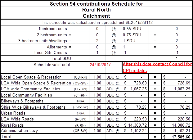
5. CONCLUSION
Council recognises the role of detached rural dual occupancy
development in allowing rural families to make better use of their land to
house family and rural workers, adding to the stock of rental accommodation and
widening the range of housing options in Byron Shire. Council wishes to
encourage dual occupancy developments which suit the differing needs of the
community and which enhance (or don’t degrade) the rural character of the
Shire and don’t cause conflicts with neighbouring land uses.
This proposal meets the Council’s requirements.
Conditional approval is appropriate.
6. DISCLOSURE
OF POLITICAL DONATIONS AND GIFTS
|
Has a Disclosure Statement been received in relation to
this application
|
No
|
|
Have staff received a ‘gift’ from anyone involved
in this application that needs to be disclosed. Where the answer is yes, the
application is to be determined by the Director or Manager of the Planning,
Development and Environment Division.
|
No
|
Provide Disclosure Statement register details here: Nil
Staff Reports - Sustainable Environment and Economy 13.20
Report No. 13.20 Biodiversity
Conservation Strategy Update
Directorate: Sustainable
Environment and Economy
Report
Author: Clare
Manning, Biodiversity Officer
File No: I2017/1549
Theme: Ecology
Planning Policy and Natural Environment
Summary:
To provide an update on the progress of the Byron
Biodiversity Conservation Strategy review.
1. Ensure the Strategy is
consistent with regional plans, strategies completed since 2004
Complete
2. Ensure the Strategy is
consistent with legislative changes completed since 2004.
Complete
3. Ensure the Strategy is
reflective of current research and best practise into biodiversity conservation
and management priorities.
In progress
4. Review vegetation mapping to
reflect changes in vegetation extent over time and improve accuracy.
Complete
5. Identify new actions to be
included to direct future work priorities following consultation and input from
stakeholders and the community.
In progress
|
RECOMMENDATION:
That Council note the update provided in
this report and the revised schedule to review the Biodiversity
Conservation Strategy.
|
Report
Council’s 2017-18 Operational Plan lists the continued
review of the Byron Biodiversity Conservation Strategy 2004 as a key activity
(EN 1.1.3).
The Byron Biodiversity Conservation Strategy 2004 (Strategy)
is the key document which provides a framework and guidance to Council and the
community in managing Byron’s biodiversity. The Strategy identifies
the values of the Shire, the threats that are impacting on those values and
provides a detailed plan of action with a wide range of actions intended to
eliminate threatening processes and protect and restore habitat.
In response to major changes in legislation and regional
plans and strategies including but not limited to the Biosecurity Act 2015,
Biodiversity Conservation Act 2016, Regional Weed Strategy 2017-22, Council
staff have completed 2-years of consultation with the State Government and
reviewed a collection of complex and extensive mapping.
To guide conservation land management programs, future
planning instruments and land uses, including the review of the Strategy, Rural
Land Use Strategy, Environmental Zones, Integrated Pest Management Strategy,
and Byron Shire Flying-fox Camp Management Plan and assist with Development
Applications, this has included a review of Byron Shire’s vegetation
classification mapping.
Additionally, Council staff have completed a full review of High
Environmental Vegetation mapping and Bush Fire Prone Vegetation mapping. Designed
to protect land that is of important environmental value, the review of Environmental
Zone mapping is currently on public exhibition.
Revised Delivery Timetable
A revised Strategy will
aim to highlight what Council should do in the next 10-years, what hurdles
Council might face, and what Council may need to do to continue to protect and
restore Byron’s biodiversity that will be shaped by population growth,
consumption patterns and climate change.
The revised Strategy will
aim to serve as a roadmap for Council’s stewardship of our local
environment. To guide our planning decisions and policy making in all those
areas that has the ability to influence or impact on the environment.
However, due to extensive mapping work, complex changes in
legislation combined with competing priorities delivery of the Strategy has
been revised.
The Biodiversity & Sustainability Panel (Panel) have
been consulted on the revised timeframe and the development of the Strategy
will be worked though the Panel.
The timetable to deliver the draft Strategy is provided below:
|
Milestone
|
Complete By
|
|
Revitalise the Biodiversity
Conservation Strategy working group
|
End Nov 2017
|
|
Identify & engage a
consultant e.g. environmental economist
|
End Nov 2017
|
|
Review alignments and
relevance new Council strategies, master plans and initiatives e.g. Zero
Emissions Byron
|
End Feb 2018
|
|
Review and identify
cross-sectoral integration of biodiversity conservation in the public and
private sector
|
End Mar 2018
|
|
Draft Biodiversity Conservation
Strategy in consultation with stakeholders
|
End Apr 2018
|
|
Draft Biodiversity Conservation
Strategy
placed on public
exhibition for a period of six weeks
|
End Jun 2018
|
|
Review submissions
|
Mid Aug 2018
|
|
Biodiversity
Conservation Strategy reported to the next available council meeting
|
Post Aug 2018
|
Financial Implications
Under the 2017-18 Environment Levy, Council have allocated
$20,000 to continue to prepare the Strategy. Council staff will contribute to
preparing the Strategy by undertaking project management and drafting of the
Strategy with support from the Biodiversity & Sustainability Panel.
Statutory and Policy Compliance Implications
Nil
Staff Reports - Sustainable Environment and Economy 13.21
Report No. 13.21 PLANNING
- Resolution 17-260 Expression of Interest Land for Affordable Housing Update
Directorate: Sustainable
Environment and Economy
Report
Author: Natalie
Hancock, Senior Planner
File No: I2017/1569
Theme: Ecology
Planning Policy and Natural Environment
Summary:
Council resolved in June 2017 (Resolution
17-260) to progress a number of actions to support affordable housing.
This report provides an update against items 2 and 5 of this Resolution:
2. Support
further discussions with landowners of land in Attachment 1, and progression of
work necessary to establish the feasibility of the sites in Attachment 1 and
Attachment 2 for affordable housing; and also site ‘17’ Saddle
Road land identified in the Draft Preliminary Residential Housing Strategy; and
where appropriate, invite lodgement of Planning Proposals to rezone the land
for this purpose.
5. Request
staff to progress an expression of interest process (with a prepared set of
guidelines) that will invite land owners to submit affordable housing proposals
for other land in the Byron Shire for the consideration of Council as part of
an early implementation program to supplement Council’s Residential Lands
Strategy
In relation to item 2, the meeting with the landowners was
held and subsequent to this meeting a Planning Proposal to rezone the Saddle
Road land was lodged for the purpose of housing, which included a component of
affordable housing. A report on the Planning Proposal is being prepared for
Council’s next meeting.
In relation to item 5, an expression of interest (EOI)
process was conducted and a total of 31 submissions were received. The EOI
submissions have been organised into three
categories:
· Category 1: Private land
owners (excluding Saddle Road locality)
· Category 2: Saddle Road
locality land owners
· Category 3: Council or
Crown land
An assessment of the potential suitability of lands under
Category 1 for affordable housing has been undertaken and recommendations for
each site are provided in this report.
For consistency this assessment process was also applied to
item 2 of Resolution 17-260 - private landowners sites at: 3 Poplar Street and
71 Main Arm Road for which an EOI was not received; and 2219 Coolamon Scenic
Drive for which a further late submission was received under the EOI process.
Category 2 is pending further consideration of a planning
proposal for Saddle Rd.
Category 3 Council or Crown land sites will be subject to a
further report to council.
NOTE TO COUNCILLORS:
In accordance with the
provisions of S375A of the Local Government Act 1993, a Division is to be
called whenever a motion for a planning decision is put to the meeting, for the
purpose of recording voting on planning matters. Pursuant to clause 2(a)
under the heading Matters to be Included in Minutes of Council Meetings of
Council's adopted Code of Meeting Practice (as amended) a Division will be
deemed to have been called by the mover and seconder of all motions relating to
this report.
|
RECOMMENDATION:
1. That
Council adopt recommendations 1.(a) – 1.(p) for the Expression of
Interest sites and Resolution 17-260 ‘Attachment 1’ sites, as
contained in Table 1 of this report;
2. That
Council require any further work to establish the feasibility of the
supported sites in Table 1 of this report to be consistent with the
Supporting Partnership Policy, as adopted by Council;
3. That
Council in relation to the Saddle Road EOI sites, no further action is to be
taken under Res 17-260 (Item 5) until the Planning Proposal assessment for
this locality has been completed and considered by Council;
4. That
in relation to the Council and Crown land EOI sites a further report will be
presented to Council on their potential for affordable housing against the
assessment criteria and methodology outlined in this report and any current
Council resolutions pertaining to the land.
|
Attachments:
1 Presentation
Saddle Road Landowners Meeting 30 Aug 2017, E2017/102145
⇨
2 Expression
of Interest Land for Affordable Housing Submissions Assessment Report , E2017/103317 ⇨
Report
The purpose of this report is to:
· Update Council on
Council Resolution 17-260 Item 2
· Update Council on
Expressions of Interest (EOIs) for affordable housing proposals in Byron Shire
under Council Resolution 17-260 Item 5.
· Provide an overview of the
assessment process guidelines used to determine suitable affordable housing
sites
· Obtain feedback from the
Council on how to proceed with EOIs on private lands
· Advise on a number of
EOIs related to land in the ownership/management of Byron Shire Council.
Information/Background:
Council at its 22 June 2017 Ordinary Meeting considered a
report on affordable housing options and resolved the following:
Resolution 17-260
1. Note
the Housing Issues Plan developed the result of the Byron Affordable Housing
Summit and support its use to inform part of the Residential Land Use Strategy
recommendations currently under preparation.
2. Support
further discussions with landowners of land in Attachment 1, and progression of
work necessary to establish the feasibility of the sites in Attachment 1 and
Attachment 2 for affordable housing; and also site ‘17’ Saddle
Road land identified in the Draft Preliminary Residential Housing Strategy; and
where appropriate, invite lodgement of Planning Proposals to rezone the land
for this purpose.
3. Request
staff to progress, in consultation with the community, work necessary to
support a possible Planning Proposal or any possible rezoning of land at the
Mullum Hospital Site.
4. Review
the mechanisms available to guide Council involvement in any public / private
housing development with respect to probity and process.
5. Request
staff to progress an expression of interest process (with a prepared set of
guidelines) that will invite land owners to submit affordable housing proposals
for other land in the Byron Shire for the consideration of Council as part of
an early implementation program to supplement Council’s Residential Lands
Strategy
6. Receive
a further report on points 2,3 and 5 above.
Resolution 17-260 Item 2: Saddle
Road update
A meeting was held with landowners on 30 August of
‘17’ Saddle Road land identified in the Draft Preliminary
Residential Housing Strategy. A copy of the presentation to the land owners is
provided in Attachment 1. Subsequent to this meeting a Planning Proposal to
rezone the land in the Saddle Road area was lodged in October for the purpose
of housing which included a component of affordable housing. A report on the
Planning Proposal is being prepared for Council’s 14 December 2017
meeting.
Resolution 17-260 Item 2: Attachment 1
& 2 (private landowners outside the Saddle Rd area) update
There were 3 private land owners identified in the 2
attachments to Council Report 13.16: 3 Poplar Street, 71 Main Arm Road and 2219
Coolamon Scenic Drive Mullumbimby. The Poplar Avenue and Main Arm Road sites
were shown to Council as part the draft Residential Strategy Councillor site
inspection day on 19 October 2017. For consistency in process all three sites
have been evaluated against the EOI site assessment criteria explained below.
Recommendations for these sites are contained in Table 1 of this report as to
their appropriateness to progress with a rezoning for the purpose of affordable
housing.
An ‘Expression of Interest: Land for Affordable
Housing - Submissions Assessment Report’ has been prepared for
Council’s consideration, Attachment 2 of this report. It contains further
details on the assessment of these sites as well as the other sites put forward
through the EOI submission process.
Resolution 17-260 Item 5: EOI
In relation to item 5 of the above resolution an EOI process
for affordable housing proposals in Byron Shire was open from 12 August to 12
September 2017. The EOI was designed to seek proposals for small, medium and
large-scale project ideas in both existing and potential future urban
areas. Respondents were encouraged to consider partnership opportunities with
land owners, private sector or community housing providers to deliver long term
affordable housing solutions in Byron Shire.
A total of 31 EOIs have been received, with 5 relating to
Byron Shire Council and/or Crown land (under Council management) and 11 for the
Saddle Road locality. One EOI was from a housing provider offering their
services for later in the process should the need arise.
Assessment criteria
Assessment criteria have been developed as a set
of guidelines to determine the strategic suitability of a given EOI site for
affordable housing. The criteria reflect relevant strategic considerations
regardless of land tenure and incorporate three Performance Objectives:
Performance objective 1: The
site should be functionally suited to residential development ¾ both from land capability and
infrastructure servicing standpoint
Performance objective 2: The site
should be located close to other residential development to enable integration
with local community
Performance objective 3: Aligns with
Council priorities for delivering ‘affordable housing’.
In support of the above performance objectives the
relevant site assessment criteria included:
· located within or in
close proximity to a Mixed Use, Residential or Village Zone (excluding R5 Large
Lot Residential Zone)
· safe and unconstrained
land generally unencumbered by:
- areas of high or
environmental, extractive resource or heritage value or areas mapped as
regionally significant farmland
- hazards or risks
such as 100yr flooding, coastal erosion, tidal inundation, slip, dunal
movement, extreme bushfire and slopes greater than 20%
· already connected, or
capable of being connected, to water and sewerage infrastructure that can
accommodate projected demand, at no additional cost to Council/community
· good access to town
centres offering the following opportunities:
- mixing
with a community
- employment
- essential
services, schools, shops,
- recreation,
parks and community space
- getting
around including cycle/walkways and public transport
- proximity
to social, family and other established support systems
- benefiting
those in housing and rental stress
- improved
housing choice and diversity
- permanently
secured housing stock for low to moderate income residents
The criteria accord with the site
suitability and mapping criteria applied to identify potential residential land
in both the adopted Rural Land Use Strategy and the draft Residential Strategy.
An ‘Expression of Interest: Land for Affordable
Housing - Submissions Assessment Report’ (Attachment 2 of this report)
provides a detailed assessment of the EOI submissions received. For
consideration purposes the EOI submissions have been organised into three categories:
· Category 1: Private land
owners (excluding Saddle Road locality)
· Category 2: Saddle Road
locality land owners (subject to consideration under Res. 17-260 Item 2 process)
· Category 3: Council or
Crown land
A summary of the recommendations for Category 1 sites is
provided in Table 1 below. Table 1 also includes a summary of the
recommendations for the 3 private landowners outside the Saddle Road Area identified
in Attachments 1 & 2 from item 2 of Resolution 17-260.
Category 2 is pending further consideration of a planning
proposal for Saddle Rd.
Table 2 below lists the Category 3 Council or Crown land
sites that were identified through the EOI process. These sites will be
subject to a further report to council on their potential for affordable
housing against the assessment criteria and methodology outlined in this report
and any current Council resolutions pertaining to the land.
Maps showing the location of Category 2 and 3 sites are
provided in the Expression of Interest: Land for Affordable Housing -
Submissions Assessment Report (Attachment 2).
The progression of work necessary to establish the
feasibility of the supported sites in Table 1 should be consistent with
Council’s Supporting Partnership Policy or similar to ensure the
opportunity to harness the innovation and capital of the non-government sectors
on private land to deliver better housing outcomes for the community is
compliant with Statutory requirements.
Table 1: Category 1 Site
Recommendations:
|
Site Address
|
Recommendation
|
|
11 Main Arm Road
Mullumbimby
|
1. (a)
That staff continue further discussions with the landowner
of 11 Main Arm Road and progression of work necessary to confirm the feasibility
of the site for affordable housing, and where appropriate invite lodgement of
a development application and/or planning proposal for this purpose.
|
|
1660 Coolamon Scenic Drive
Mullumbimby
|
1. (b)
That staff continue further discussions with the landowner
of 1660 Coolamon Scenic Drive and progression of work necessary to confirm
the feasibility of the site for affordable housing, and where appropriate
invite lodgement of a planning proposal for this purpose.
|
|
1B Ann
Mullumbimby
|
1. (c)
That staff continue further discussions with the landowner
of 1B Ann and progression of work necessary to confirm the feasibility of the
site for affordable housing, and where appropriate invite lodgement of a
planning proposal for this purpose.
|
|
75 Mullumbimby Road
Mullumbimby
|
1. (d)
That staff continue further discussions with the landowner
of 75 Mullumbimby Road and progression of work necessary to confirm the
feasibility of the site for affordable housing, and where appropriate invite
lodgement of a planning proposal for this purpose.
|
|
1897 Coolamon Scenic Drive
Mullumbimby
|
1. (e)
That the proponent for 1897 Coolamon Scenic Drive be
advised that their proposal is excluded from further consideration as part of
an early implementation program to supplement Council’s Residential
Strategy for affordable housing for the reasons that the access, flooding and
terrain constraints of the site do not render it suitable for affordable
housing.
|
|
2219 Coolamon Scenic Drive
Mullumbimby
|
1. (f)
That the proponent for 2219
Coolamon Scenic Drive be advised that their proposal for large lot community
title affordable housing is excluded from further consideration as part of an
early implementation program to supplement Council’s Residential
Strategy for the key reasons that part of the site has urban potential in the
long term, subject to adequate infrastructure servicing and it not located
close to other residential development to enable integration with local
community.
|
|
168 Rankin Drive
Bangalow
|
1. (g)
That staff continue further discussions with the landowner
of 168 Rankin Drive and progression of work necessary to confirm the
feasibility of the site for affordable housing, and where appropriate invite
lodgement of a development application and /or planning proposal for this
purpose.
|
|
76 Dudgeons Lane
Bangalow
|
1. (h)
That the proponent for 76 Dudgeons Lane be advised that
their proposal is excluded from further consideration as part of an early
implementation program to supplement Council’s Residential Strategy for
affordable housing for the key reasons that the land is regionally
significant farmland, within the buffer area for the sewerage treatment
plant, situated outside a preferred catchment area for urban expansion and
not located close to other residential development to enable integration with
local community.
|
|
239 - 245 Skinners
Shoot Road
Skinners Shoot
|
1. (i)
That the proponent for 239
- 245 Skinners Shoot Road be advised that their proposal is excluded from
further consideration as part of an early implementation program to
supplement Council’s Residential Strategy for affordable housing for
the key reasons that the land is situated outside a preferred catchment area
for urban expansion and not located close to other residential development to
enable integration with local community.
|
|
282 Skinners Shoot Road
Skinners Shoot
|
1. (j)
That the proponent for 282 Skinners Shoot Road be advised
that their proposal is excluded from further consideration as part of an
early implementation program to supplement Council’s Residential
Strategy for affordable housing key reasons that the land is situated outside
a preferred catchment area for urban expansion and not located close to other
residential development to enable integration with local community.
|
|
454 Middle Pocket Road
Middle Pocket
|
1. (k)
That the proponent for 454 Middle Pocket Road be advised
that their proposal is excluded from further consideration as part of an
early implementation program to supplement Council’s Residential
Strategy for affordable housing for the key reasons that the land is situated
outside a preferred catchment area for urban expansion and not located close
to other residential development to enable integration with local community.
|
|
919 Binna Burra Road
Federal
|
1. (l)
That the proponent for 919 Binna Burra Road be advised
that their proposal is excluded from further consideration as part of an
early implementation program to supplement Council’s Residential
Strategy for affordable housing for the key reasons that the land is State significant
farmland, not capable of being connected to sewer, situated outside a
preferred catchment area for urban expansion and not identified in the
Rural Land Use Strategy as a rural village expansion area.
|
|
137 Taylors Road
Eureka
|
1. (m)
That the proponent for 137 Taylors Road be advised that
their proposal is excluded from further consideration as part of an early
implementation program to supplement Council’s Residential Strategy for
affordable housing for the key reasons that the land is regionally
significant farmland, situated outside a preferred catchment area for urban
expansion and not located close to other residential development to enable
integration with local community.
|
|
188 Waltons Road
Eureka
|
1. (n)
That the proponent for 188 Waltons Road be advised that
their proposal is excluded from further consideration as part of an early
implementation program to supplement Council’s Residential Strategy for
affordable housing for the key reasons that the land is State and regionally
significant farmland, situated outside a preferred catchment area for urban
expansion and not located close to other residential development to enable
integration with local community.
|
|
71 Main Arm Road
Mullumbimby
|
1. (o)
That staff continue further discussions with the landowner
of 71 Main Arm Road and progression of work necessary to confirm the
feasibility of the site for affordable housing, and where appropriate invite
lodgement of a planning proposal application for this purpose.
|
|
3 Poplar Avenue
Mullumbimby
|
1.(p)
That the proponent for 3 Poplar Avenue be advised that
their proposal is excluded from further consideration as part of an early
implementation program to supplement Council’s Residential Strategy for
affordable housing for the reasons that the flooding constraints of the site
do not render it suitable for affordable housing.
|
Table 2: EOI submissions pertaining
to Council and/or Crown Land
|
EOI
Ref
|
Sites
|
Tenure
|
|
BSC 1
|
3 lots at Federal:
|
|
|
|
(i) Lot
7 DP 263974
Roses Road
|
Byron Shire Council
Community Land
|
|
|
(ii) Lot
90A DP374765 Coorabell Rd
|
Byron Shire Council
& Crown Land
|
|
|
(iii) Lot
89 755697
898 Binna Burra Rd
|
Byron Shire Council
& Crown Land
|
|
BSC 2
|
Mixed lots:
|
|
|
|
(i) Lot 12 DP1189646
Bayshore
Drive Site
|
Byron Shire Council
|
|
|
(ii) Lot 4 DP841846
"Leaf
Land"
|
Byron Shire Council
|
|
|
(iii) Lot 188 DP728535
Old
Mullumbimby Hospital site
|
Byron Shire Council
(Health Administration
Corporation)
|
|
|
(iv) Valances Road Land
|
Byron Shire Council
|
|
BSC 3
|
Lot 22 DP10731765
Mullumbimby Sporting Fields
|
Byron Shire Council
|
|
BSC 4
|
Lot 1 & 2 DP 573835
Old Suffolk Park Sewerage Plant Broken Head Road
Byron Bay
|
Byron Shire Council
|
|
BSC 5
|
Lot 4 DP 841856
"Leaf Land"
Mullumbimby
|
Byron Shire Council
|
Financial Implications
None from adoption of the recommendations in this report.
The progression of particular sites may require the entering
of a partnership or an agreement with Council to enable a secure supply of
affordable housing for the community and Council. Any financial implications
associated with completing such arrangements will be reported back to Council.
Statutory and Policy
Compliance Implications
The assessment criteria applied for the expression of
interest sites is consistent with the relevant Commonwealth, State and Regional
policy frameworks.
The requirement for any progression of work on Council land
must be consistent with the draft Supporting Partnership Policy, which has been
prepared having regard to the statutory requirements of the Local Government
Act and Regulations.
Staff Reports - Sustainable Environment and Economy 13.22
Report No. 13.22 PLANNING
- 10.2017.360.1 Rural Tourist Accommodation Comprising Four (4) Cabins at 75
Rifle Range Road, Bangalow
Directorate: Sustainable
Environment and Economy
Report
Author: Simone
Reeves, Planner
File No: I2017/1660
Theme: Ecology
Development and Approvals
Proposal:
|
Proposal description:
|
Tourist and
Visitor Accommodation Comprising Four (4) Cabins
|
|
Property description:
|
LOT: 39 DP: 625255
|
|
75 Rifle Range Road BANGALOW
|
|
Parcel No/s:
|
76780
|
|
Applicant:
|
Balanced Systems Planning Consultants
|
|
Owner:
|
Legate Pty Ltd
|
|
Zoning:
|
RU1 Primary Production/1B1 Agricultural Protection
|
|
Date received:
|
7 July 2017
|
|
Integrated Development:
|
Yes
|
|
Public notification or exhibition:
|
- Level 2 advertising
under DCP 2014 Part A14 – Public Notification and Exhibition of
Development Applications
- Exhibition
period: 27/07/17 to 09/08/17
- Submissions received: Nineteen
(19)
|
|
Planning Review Committee:
|
28 September 2017 – Council to determine
|
|
Issues:
|
- Koalas
- Bushfire
Prone land;
- Small
Scale
|
Summary:
Development approval is sought for tourist and visitor
accommodation comprising four cabins at 75 Rifle Range Road. The subject
property is zoned RU1 Primary Production and 1B1 Agricultural Protection
pursuant to Byron LEP 2014 and 1988 Respectively. The property has an area of
39.15 hectares and historically has been utilised for farming purposes with
limited grazing of livestock currently undertaken on the land. The property
still retains paddocks of pasture, but also contains large vegetated areas
dominated by camphor laurel.
The four cabins are proposed in the vicinity of the existing
dwelling with access provided from Rifle Range Road via the existing driveway.
The cabins are single storey with one single bedroom disabled cabin, with the
remaining cabins comprising 2 bedrooms each. Each cabin comprises bathroom
facilities and a small kitchen/living area opening onto a small deck area.
The proposed development is consistent with the relevant
environmental planning instruments and planning controls applicable to the site
including the LEP and DCP provisions for this type of development. Concern was
raised in relation to koalas in the area and on the property. In this regard
the land is not considered to be Core Koala Habitat under SEPP 44, however the
applicant has proposed to remove camphor laurel on the land and plant some 3600
native trees and further enhance habitat for Koalas and other native fauna in
the Bangalow area. Appropriate conditions of consent are recommended including
measures to controls cats and dogs and vehicle speeds within the development.
It is considered the proposal raises no significant issues in terms of
environmental impacts which cannot be managed through reasonable and relevant
conditions of approval, and the site is considered suitable for the
development. As such the application is recommended for approval subject to
conditions of consent.
NOTE TO COUNCILLORS:
In accordance with the
provisions of S375A of the Local Government Act 1993, a Division is to be
called whenever a motion for a planning decision is put to the meeting, for the
purpose of recording voting on planning matters. Pursuant to clause 2(a)
under the heading Matters to be Included in Minutes of Council Meetings of
Council's adopted Code of Meeting Practice (as amended) a Division will be
deemed to have been called by the mover and seconder of all motions relating to
this report.
|
RECOMMENDATION:
That pursuant to
Section 80 of the Environmental Planning and Assessment Act 1979,
development application no. 10.2017.360.1 for Tourist and
Visitor Accommodation Comprising Four (4) Cabins, be granted consent subject to the conditions
listed in Attachment 2 #2017/103454.
|
Attachments:
1 Proposed
Plans 10.2017.360.1Rifle Range Rd Bangalow, E2017/102018
⇨
2 proposed
conditions of consent 10.2017.360.1 Rifle Range Rd Bangalow, E2017/103454 ⇨
3 SEPP 44
Report, E2017/102023 ⇨
4 Confidential
- submissions received, E2017/102286
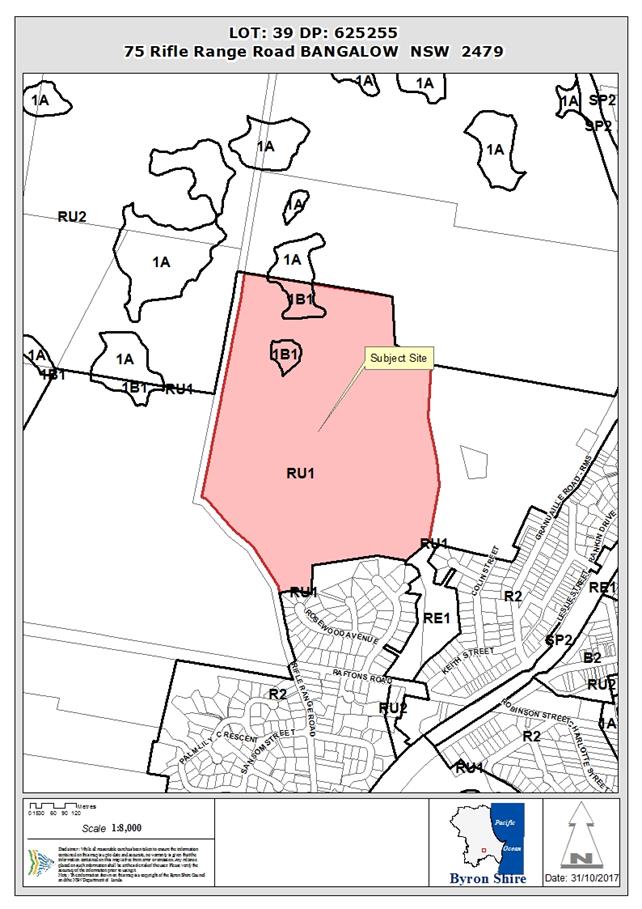
Assessment:
1. INTRODUCTION
1.1. History/Background
The subject allotment was
registered 08 July 1982. The existing dwelling on the site was approved 26
November 1981 under Development Consent BA81/2722.
A planning proposal for Seniors
Housing under State Environmental Planning Policy (Housing for Seniors or
People with a Disability) 2004 did not proceed as a Site Suitability
Certificate was refused by the New South Wales Department of Planning and
Environment in June 2016.
No further development
application history applies to the site.
1.2. Description
of the proposed development
This application seeks approval
for Tourist and Visitor
Accommodation Comprising Four (4) Cabins as detailed within plans
enclosed at Attachment 1
Cabin 1 has been identified as
being suitable for persons with a disability with access via a 1:14 ramp and
contains a single bedroom, bathroom and combined kitchenette, dining and living
room and deck area.
Cabins 2, 3 and 4 are identical
to each other and contains two (2) bedrooms each bathroom and combined
kitchenette, dining and living room and deck area.
Vehicular access for the proposed
cabins will utilise a proposed extension of the existing driveway access road located
off Rifle Range Road.
Environmental works are also proposed i.e. clearing of some
camphor laurel and planting of 3600 koala food source trees.
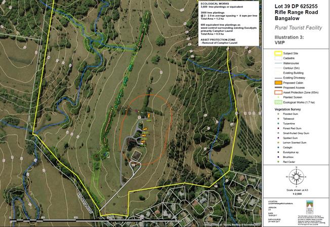
1.3. Description
of the site
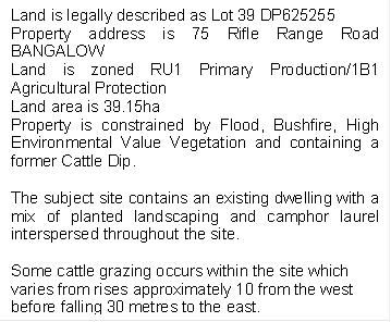
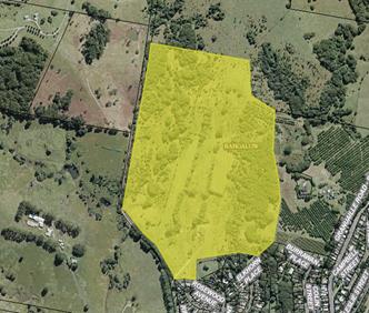
2. SUMMARY OF
EXTERNAL REFERRALS
NSW Rural Fire Service
Under section 79BA of the Act,
Council must be satisfied prior to making a determination for development on
bush fire prone land, that the development complies with the document
‘Planning for Bush Fire Protection 2006’. The site is bush fire
prone land. The development application was referred to the NSW Rural Fire
Service for approval under Section 100B of the Rural Fires Act 1993. The RFS
have issued general terms of approval which have been incorporated into the conditions
of consent. .
3. SECTION 79C
– MATTERS FOR CONSIDERATION – DISCUSSION OF ISSUES
Having regard to the matters for
consideration detailed in Section 79C(1) of the Environmental Planning and
Assessment Act 1979 (EP&A Act 1979), the following is a summary
of the evaluation of the issues.
3.1 State Environmental
Planning Instruments
|
|
Satisfactory
|
Unsatisfactory
|
|
State
Environmental Planning Policy No 44—Koala Habitat Protection
|
☒
|
☐
|
|
Consideration: No native
vegetation removal proposed. The applicant undertook an extensive site survey
of the site that identified less than 15% of the site as containing koala
food trees. As such, a Koala Plan of Management cannot be requested.
Notwithstanding, the applicant proposes the planting of 900 koala food trees
per cabin which will likely create koala habitat for those specimens recorded
on adjoining allotments. It is considered the proposal complies with this
Policy.
|
|
State
Environmental Planning Policy No 55—Remediation of Land
|
☒
|
☐
|
|
Consideration: The Decommissioned Rifle Range Cattle Dip Site is
located on the subject site approximately between 200 and 250m south west of
the proposed cabins. The dip site is downslope of the proposed cabins.
The dip site lease lapsed on 30/06/2001 and has been capped and
decommissioned. A Preliminary Site Investigation (PSI) was undertaken by
Balanced Systems Planning Consultants (June 2017). The PSI included an
assessment of site history and soil sampling and analyses for metals,
organochlorins and organophoshates. The PSI found no evidence of
contamination and conduced that the site for the proposed cabins is suitable
for the proposed use. No further investigation is warranted.
Note: Decommissioned means all the standing structures, shed,
fencing and roof have been dismantled. The bath itself, if present, is
emptied of all chemical fluid and may have contaminated timbers from the roof
and draining pen put into it and then is capped with concrete lids. The bath
may have already been demolished prior to decommissioning in which case it is
usually smashed and buried. An information plaque is attached to one of the
concrete lids to indicate its Departmental file number, dip name and
direction of the dipping. Clean soil may be spread around the bath to run
flush with the bath edge and then grassed. The draining pen concrete floor is
usually left intact so as not to disturb the possibly contaminated soil.
|
|
State Environmental
Planning Policy (Rural Lands) 2008
|
☒
|
☐
|
|
Consideration: The subject site
is a large rural block (39.15ha), currently used for a residence pin addition
to cattle grazing. Surrounding land uses include, residential
development to the south and rural activities to the west, north and east. Of
some significance in terms of potential land use conflicts is the intensive
horticulture i.e. macadamia plantation located on lower land to the east. The
proposed cabins are to be the located on a ridge some 264m from the macadamia
plantation and therefore outside the nominal 200m buffer in Byron Shire
Council Development Control Plan (BSDCP) 2014. It is not envisaged that the
proposed development will result in significant land use conflicts with
surrounding land uses and is considered to achieve the Principles as
stipulate in Section 7 of this Policy.
|
4.2A Byron Local Environmental
Plan 2014 (LEP 2014)
LEP 2014
is an applicable matter for consideration in the assessment of the subject
development application in accordance with subsection 79C(1) of the EP&A
Act 1979 because it applies to the subject land and the proposed
development. The LEP 2014 clauses that are checked below are of relevance to
the proposed development:
Note: The proposed structures are wholly located within the
portion of land mapped as RU1 Primary Production. As such, an assessment
against BLEP 1988 or BSDCP 2010 is not applicable.
In accordance with BLEP 2014 clauses 1.4 and 2.1 –
2.3:
(a) The proposed development is defined in the
LEP 2014 Dictionary as ‘tourist and visitor accommodation
which means a building or place that provides temporary or short-term
accommodation on a commercial basis, and includes any of the following:
(a) backpackers’ accommodation,
(b) bed and breakfast accommodation,
(c) farm stay accommodation,
(d) hotel or motel accommodation,
(e) serviced apartments,
but does not
include:
(f) camping grounds, or
(g) caravan parks, or
(h) eco-tourist facilities’.
(b) The
land is within the RU1 Primary Production according to the Land Zoning Map;
(c) The
proposed development is permissible with consent; and
(d) Regard
is had for the Zone Objectives as follows:
RU1 Primary Production
The objectives of the RU1 Primary Production zone are:
· ‘To
encourage sustainable primary industry production by maintaining and enhancing
the natural resource base;
· To
encourage diversity in primary industry enterprises and systems appropriate for
the area;
· To
minimise the fragmentation and alienation of resource lands;
· To
minimise conflict between land uses within this zone and land uses within
adjoining zones;
· To
encourage consolidation of lots for the purposes of primary industry
production;
· To
enable the provision of tourist accommodation, facilities and other small-scale
rural tourism uses associated with primary production and environmental
conservation consistent with the rural character of the locality; and
· To
protect significant scenic landscapes and to minimise impacts on the scenic
quality of the locality’.
The proposal provides small scale
tourist accommodation that is consistent with the rural use and character of
the allotment. The proposed cabins being located within an existing cleared
portion of the site and ensures that the rural and environmental qualities of
the site are preserved and do not conflict with the primary use of the subject
site i.e. agriculture or adjacent and adjoining rural land uses. The proposal
can be conditioned to ensure that the scenic landscape of the site is enhanced.
4.3 Height of buildings
Council’s Height of
buildings map stipulates a maximum height of 9m from natural ground level. The
proposed maximum height for the cabins is 4.5 metres.
5.9 Preservation of Trees or Vegetation
Whilst this development standard
has since been repealed, the provision still applies as the development
application was lodged prior to its being repealed. Notwithstanding, the
applicant does not propose the clearing of any native vegetation. As such, it
is considered to comply with the standard and associated development control
chapter i.e. B2 Preservation of Trees and Other Vegetation.
6.2 Earthworks
The proposal requires minimal
earthworks that with conditions of approval relating to soil and erosion
measures, should not have an adverse impact on the environment.
6.3 Flood planning
The proposed cabins are located
on a portion of the site that is not flood prone. In addition Council’s
Development Engineer has assessed the proposal and has deemed the proposal as
having suitable access.
6.5 Drinking water catchments
Whilst being located within a
drinking water catchment area, the proposed on site wastewater system is of a
sufficient distance away from any watercourse, with the system being compliant
with Council’s requirements.
6.6 Essential services
Each cabin will be provided with
harvested rainwater, electricity and telecommunications. An onsite wastewater
management system solution will be utilised and has been considered acceptable by
Council’s Environmental Health Officer.
6.8 Rural and nature-based
tourism development
‘Small scale’ means a scale that is small enough
to be generally managed and operated by the principal owner living on the
property. As such, conditions of approval will be imposed pertaining to the
management of the cabins by the principal owner living on the property.
It is noted that the present development controls permit additional cabins
given the size of the size allotment and the proposal of four (4) cabins is
considered to be small. In this regard the applicant could have sought
approval for up to 6 cabins with 2 bedrooms each.
The proposal will not have a significant adverse impact on
agricultural production, amenity or significant features of the natural
environment of the site and is considered complementary to the rural or
environmental attributes of the land and its surrounds.
4.3 Any
proposed Instrument that has been the subject of public consultation and has
been notified to the consent authority
Draft State Environmental
Planning Policy (Coastal Management) 2016 (CM SEPP). The proposal is unlikely
to conflict with this Policy as the site is not within the coastal zone.
4.4A Byron Shire Development Control Plan 2014
(DCP 2014)
DCP 2014 is an applicable matter
for consideration in the assessment of the subject development application in
accordance with subsection 79C(1) of the EP&A Act 1979 because it
applies to the land to which LEP 2014 applies. The DCP 2014 Parts/Chapters that
are checked below are of relevance to the proposed development:
B2 Preservation of trees and other
vegetation
The proposal does not include the
removal of native vegetation. Some camphor laurels will be removed and their
removal is considered as exempt from requiring development consent.
Note: The applicant proposes to plant 3600 koala food trees
wholly within the site as per the Byron Rural Settlement Strategy 1988. As
such, it is considered
B3 Services
The proposal provides for
essential services in the form of harvest water and an onsite sewerage
management system that was deemed acceptable by Council’s Environmental
Health Officer.
B6 Buffers and Land Use
Conflict
Given the distance between the
proposed cabins and adjoining rural land uses in excess of 200 metres as well
as more than 140 metres to adjacent residential activities, it is considered
that the proposal will not result in land use conflicts.
B8 Waste Minimisation and
Management
A Site Waste Minimisation and
Management Plan was submitted by the applicant and considered to be
satisfactory. Conditions of approval will be imposed with regards to the
implementation of this plan.
C3 Visually Prominent Sites,
Visually Prominent Development and View Sharing
The proposal is of small-scale
that and unlikely to generate adverse impacts on visual quality and scenic
quality of the Shire. The tourist and visitor accommodation is single storey
and will not obstruct views from another property or disrupt the skyline.
C4 Development in a Drinking
Water Catchment
The site is considered suitable
for an onsite wastewater management system that has been assessed and
considered satisfactory with Council requirements.
The proposal includes principles
of water sensitive urban design with regards to the harvesting of rainwater
whilst the proposed accessway/driveway extension minimises the amount of cut
and fill required to provide suitable access and stormwater management that
will not have an adverse impact on the drinking water catchment.
D2 Residential Accommodation
and Ancillary Development in Rural Zones
Chapter D3
Tourist Accommodation requires the development to be consistent with the
character and design of the rural zone with boundary setbacks being observed. The
proposal provides in excess of 100 metres to Rifle Range Road with 141 metres
to the southern adjoining boundary and 262 metres to the eastern closest side
boundaries.
D3 Tourist Accommodation
The proposed
facility is considered ‘small-scale’ and will not conflict
with the high ecological value vegetation located along the northern boundary
of the site. The applicant proposes the planting of 3600 koala food trees and
the proposed operational regime has been considered so as to ensure it does not
adversely affect agricultural productivity or create land use conflict issues.
As such, it is considered that the proposal achieves the objectives of the
Byron Rural Settlement Strategy 1988.
The proposed
structures are single storey and are compatible with the character and amenity
of the locality.
The proposed
cabins have a gross floor area of 58.91m² each and a combined bedroom
number of seven (7) bedrooms with development controls permitting a maximum of
twelve (12) bedrooms for allotments that in in excess of 20 hectares.
The cabins are
clustered approximately 30 metres apart with the first cabin being 37.35 metres
from the existing primary dwelling. This cabin also caters for persons with a
disability with disabled access being provided.
All weather
access and car parking arrangements have also been provided.
4.5 Any Planning Agreement or
Draft Planning Agreement?
|
|
Yes
|
No
|
|
Is there any applicable planning agreement or draft
planning agreement?
|
☐
|
☒
|
4.6 Environmental
Planning and Assessment Regulation 2000 Considerations
|
Clause
|
This control is applicable to
the proposal:
|
I have considered this
control as it relates to the proposal:
|
If this control is
applicable, does the proposal comply?
|
|
92
|
No
|
N/A
|
N/A
|
|
93
|
Yes
|
Yes
|
Yes
|
|
94
|
No
|
N/A
|
N/A
|
|
94A
|
No
|
N/A
|
N/A
|
4.7 Any coastal zone management
plan?
|
|
Satisfactory
|
Unsatisfactory
|
N/A
|
|
Is there any applicable coastal zone management plan?
|
☐
|
☐
|
☒
|
4.8 The
likely impacts of that development, including environmental impacts on both the
natural and built environments, and social and economic impacts in the locality
|
Impact on:
|
Likely significant impact/s?
|
|
Natural environment
|
No. The proposal will not have
a significantly adverse impact on the natural environment of the locality.
Should the application be approved 3600 native trees will be planted and a
number of camphor laurel will be removed providing an environmental benefit
for native flora and fauna.
|
|
Built environment
|
No. The proposal will not have
a significantly adverse impact on the built environment of the locality.
|
|
Social Environment
|
No. The proposal will not have
a significant social impact on the locality.
|
|
Economic impact
|
No. The proposal will not have
a significant economic impact on the locality.
|
4.9 The suitability of the site
for the development
The site is considered suitable
for the proposed tourist accommodation as it is located within a relatively
isolated area of the site with sufficient separation from adjoining residential
zoned allotments with the nearest being approximately 200m away and further
away than the existing dwelling contained within the site.
4.10 Submissions made in
accordance with this Act or the regulations
The
proposal was publicly notified from 27 July 2017 to 9 August 2017. A total of
nineteen (19) submissions were received during and after this period. An
outline of planning concerns raised and often repeated amongst the authors is
addressed below. Matters that do not relate to section 79c of the Environmental
Planning and Assessment Act 1979 have been excluded from this Report.
Land owner is not proposed to
be on site
Conditions of approval will be
imposed relating to the site owner/leasee/caretaker being on site at such times
the property is being utilised by visitors and residing in the main dwelling
house
Increased traffic will result
in increased noise and dust
The proposal is not considered to
create any greater noise or dust levels than would be imposed by exempt
agricultural development on the site. The proposal was assessed by
Council’s Development Engineer who has considered the proposal is
acceptable.
Tourist development close to
residences adversely impacts on amenity and privacy and increases noise
The proposal is not considered to
be close to residential development. Notwithstanding, conditions of approval
pertaining to neighbourhood amenity must be complied with at all times.
Access to the site is in an
unsafe location for the number of vehicles
Access to the site is considered
suitable for this small scale development. Appropriate conditions to apply.
Does not comply with the North
Coast Regional Plan
The North Coast Regional
Environmental Plan was repealed. The North Coast Regional Plan 2036 also
does not apply to the development as it relates solely to the strategic
planning of a locality and applies only to planning proposals to which the
application is not.
Inappropriate location
Tourist and visitor accommodation
is a permissible use within the RU1 Primary Production zone. The proposed
cabins are more than 140 metres from the adjoining boundaries with even further
setbacks provided to dwellings within adjacent residential zoned allotments.
Lack of qualifications of
person who addressed SEPP 44
The individual who addressed SEPP
44 in the first instance is a qualified Ecologist. Given the submissions raised
the applicant was requested to provide further address. It is considered the
Consultant who has provided advice on the matter is suitably qualified.
Koala Plan of Management
(KPOM) required for site
It is considered that the site
does not contain potential or core koala habitat and as such a Koala Plan of
Management is not required. Notwithstanding the applicant is proposing remove
camphor laurel and plant some 3600 native trees which will provide improved
habitat for koalas and other native species of flora.
Site forms a koala corridor
with no consideration given to koalas
The applicants in depth survey
and willingness to provide 3600 koala food trees within the site, demonstrates
the applicants consideration to koalas within the immediate locality.
Notwithstanding, conditions of approval have been imposed in relation to koala
safety long term i.e. vehicle speeds and the keeping of dogs and cats within
the site. The proposal provides a suitable response to the Koala issue
Undesirable precedence to be
set
The proposal complies with all
relevant SEPP’s, BLEP 2014 and BSDCP 2014. As such, the proposal does not
set an undesirable precedent.
4.11 Public interest
The proposed development is
unlikely to prejudice or compromise the public interest or create an
undesirable precedent.
4.12 Section 5A of the EP&A Act 1979
– Significant effect on threatened species
Having regard to sections 5A, 5C
and 5D of the EP&A Act 1979,
there is unlikely to be a significant effect
on threatened species, populations or ecological communities, or their habitats
as a result of the proposed development as the cabins will be located wholly
within a cleared portion of the site, with the nearest vegetation being
identified as camphor laurel. Whilst koalas have been regularly spotted within
the camphor laurel located along Rifle Range Road, koalas have not been
recorded within the site. Notwithstanding, the applicant has agreed to plant a
total of 3600 koala food trees within the subject site. In addition, conditions
of approval will also be imposed relating to the keeping of dogs and cats and
vehicle speeds within the site.
As
such, it is unlikely that the proposal will have a significant adverse affect
on threatened species.
4.13 Section 5B of the EP&A Act 1979
– Have regard to register of critical habitat
The NSW Critical
Habitat Register does not identify any critical habitat on or adjacent to the
site.
5. DEVELOPER
CONTRIBUTIONS
5.1 Water & Sewer Levies
No Section 64 levies will be required.
5.2 Section 94 Contributions
Section 94 Contributions will be
payable.
6. CONCLUSION
The proposed development is
consistent with the relevant environmental planning instruments and planning
controls applicable to the site. The proposal raises no significant issues in
terms of environmental impacts which cannot be managed through reasonable and
relevant conditions of approval. As such, the site is considered suitable for
the development.
7. RECOMMENDATION
It is recommended that pursuant to Section 80 of the Environmental
Planning and Assessment Act 1979, development application no. 10.2017.360.1 for Tourist and Visitor Accommodation Comprising Four (4) Cabins, be granted consent subject to conditions of
approval.
DISCLOSURE OF POLITICAL
DONATIONS AND GIFTS
|
Has a Disclosure Statement been
received in relation to this application
|
No
|
|
Have staff received a
‘gift’ from anyone involved in this application that needs to be
disclosed. Where the answer is yes, the application is to be determined by
the Director or Manager of the Planning, Development and Environment
Division.
|
No
|
Provide Disclosure Statement register details here: Nil.
Staff Reports - Sustainable Environment and Economy 13.23
Report No. 13.23 PLANNING
- 10.2017.270.1 Multi dwelling housing comprising eight (8) dwellings, Strata
Title subdivision to create eight (8) Strata Lots and Common Property and Tree
Removal (17 trees) at 6 and 6A Canowindra Court South Golden Beach
Directorate: Sustainable
Environment and Economy
Report
Author: Greg
Smith, Team Leader Planning Services
File No: I2017/1672
Theme: Ecology
Development and Approvals
Summary:
|
Proposal description:
|
Multi dwelling housing comprising eight (8) dwellings,
Strata Title subdivision to create eight (8) Strata Lots and Common Property
and Tree Removal (17 trees)
|
|
Property description:
|
LOT: 11 DP: 1225527, LOT: 12 DP: 1225527
|
|
6 & 6A Canowindra Court SOUTH GOLDEN BEACH
|
|
Parcel No/s:
|
268380, 268381
|
|
Applicant:
|
Ardill Payne & Partners
|
|
Owner:
|
JBPB Holdings Pty Ltd & L & K Burke Holdings
Pty Ltd
|
|
Zoning:
|
R2 Low Density Residential
|
|
Date received:
|
29 May 2017
|
|
Integrated Development:
|
Yes
|
|
Public notification or exhibition:
|
- Level
2 advertising under DCP 2014 Part A14 – Public Notification and
Exhibition of Development Applications
- Exhibition
period: 15/6/17 to 28/6/17
- Submissions received:
11
|
|
Planning Review Committee
|
28 September 2017
|
|
Delegation to determination:
|
Council
|
|
Issues:
|
· Minimum lot
size, with clause 4.6 request for variation
· Bush fire prone
land,
· Acid Sulfate
Soils and Flood Prone Land
· Building height
plane, privacy
· Tree removal,
compensatory planting
|
|
Summary:
The DA proposes multi dwelling housing comprising eight
(8) dwellings in a two storey configuration with ground level garages and
upper level residential areas on land at 6 and 6A Canowindra Court, South
Golden Beach. The property has an area of 1835.8m2 and is zoned R2
Low Density Residential pursuant to Byron LEP 2014. The dwellings are modest
in area with seven units comprising 3 bedrooms and 1 unit being a two bedroom
unit. Upper level decks and open space are orientated to the north.
The proposed development is permissible with consent in
the R2 zone and satisfies the minimum lot area on 1000m2 for multi
dwelling housing development as prescribed under Clause 4.1E.
The proposal also includes a Strata Title subdivision to
create eight (8) lots, with the lots ranging in areas from approximately
111.9m2 to 185.5m2 and do not comply with the minimum
lot size development standard of 600m2. The DA is supported by a
written request for a variation pursuant to clause 4.6 of the LEP. The
circumstances of the case warrant a more flexible approach to the application
of the minimum lot size development standard having regards to the
permissibility of the primary use, and the Applicant’s variation
request is supported in this instance.
The development includes the removal of 17 trees however
these are to be compensated by additional plantings and landscaping of the
site. Conditions of consent are recommended in this regard.
Eleven public submissions have been received in relation
to this proposal raising a range of issues including flooding, sewer
capacity, traffic impacts, parking, density and privacy. The site is alos
constrained by acid sulphate soils and bushfire. Having regard to the size of
the site and the design of the development these matters have been adequately
dealt with.
The application is recommended for approval subject to
conditions of consent.
|
|
RECOMMENDATION:
That pursuant to
Section 80 of the Environmental Planning & Assessment Act 1979,
Development Application 10.2017.270.1 for multi dwelling housing comprising eight (8) dwellings, Strata
Title subdivision to create eight (8) Strata Lots and Common Property
and Tree Removal (17 trees), be granted
consent subject to the conditions listed in Attachment 2 #E2017/101883.
|
Attachments:
1 Proposed
Plans prepared by Ardill Payne , E2017/101880
⇨
2 conditions
of consent , E2017/104959 ⇨
3 Confidential
- submisisons received, E2017/102270
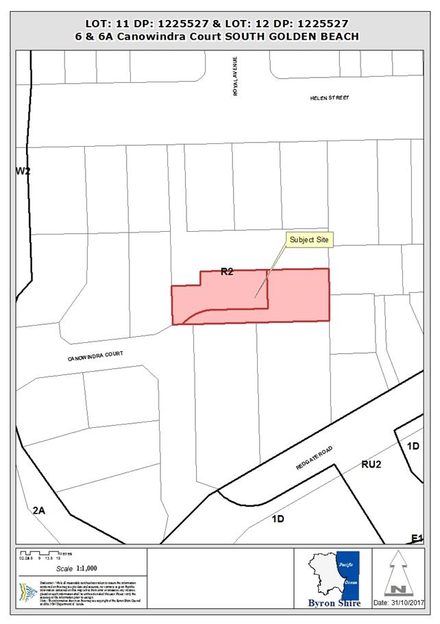
Report
1. INTRODUCTION
1.1. History/Background
DA 10.2013.575.1 for Three lot Torrens Title
subdivision of one existing lot, construction of a six car carport, Strata
Title subdivision of existing units and tree removal (6 trees) was approved on
15/4/2014, and modified by way of section 96 Application No. 10.2013.575.2
on 17/10/2014. The approved subdivision was registered by way of DP 1225527 on
25/10/2016, creating Lots 11 and 12 upon which the development under DA
10.2017.270.1 is proposed to be carried out.
1.2. Description
of the proposed development
This application seeks approval for multi dwelling housing
comprising 8 dwellings, Strata Title subdivision to create 8 Strata Lots and
Common Property and tree removal (17 trees). There are 4 proposed two storey
buildings with each accommodating 2 attached dwellings. Each proposed dwelling
has 3 bedrooms except for proposed Unit 1 which has 2 bedrooms. Each dwelling
is provided with a double garage and laundry space at ground floor level, and
habitable rooms at the first floor level. Each dwelling is provided with ground
floor open space, and other than Unit 1, a first floor level north facing deck.
The dwellings are accessed via a common driveway adjacent to the southern
boundary of the site.
The application also proposes Strata Title subdivision of
the development, comprising 8 Lots accommodating one of the proposed units, and
Common Property. The area of each proposed lot is as follows:
|
Lot
|
Size
|
|
1
|
111.9m2
|
|
2
|
155.3m2
|
|
3
|
155.3m2
|
|
4
|
155.3m2
|
|
5
|
155.3m2
|
|
6
|
155.3m2
|
|
7
|
155.3m2
|
|
8
|
185.5m2
|
|
Common Property
|
606.6m2
(by deduction from the total site area)
|
The application also includes the removal of garden and
native vegetation including four lilly pillys, three paperbarks, two swamp oaks
and a pandanus palm.
1.3. Description
of the site
|
Land is legally described as
|
LOT: 11 DP: 1225527, LOT: 12 DP: 1225527
|
|
Property address is
|
6 and 6A Canowindra Court, South Golden Beach
|
|
Land is zoned:
|
R2 Low Density Residential
|
|
Land area is:
|
1835.8m2
|
|
Other constraints include:
|
Flood liable Land, Bush fire prone land, Acid sulfate
soils
|
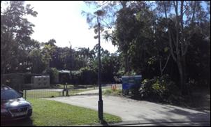
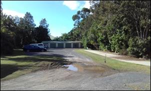
2. SUMMARY OF
REFERRALS
|
Referral
|
Issue
|
|
Rural Fire Service (100B)
|
No objections subject to conditions. Refer to Doc
#E2017/72020 and see below.
|
3. SECTION 79BA
– BUSH FIRE PRONE LAND
The DA proposes subdivision of bush fire prone land and was
referred to the NSW Rural Fire Service as integrated development. The RFS
provided its general terms of approval and bush fire safety authority which are
included in the recommendation of this Report to be imposed on the development
consent.
4. SECTION 79C
– MATTERS FOR CONSIDERATION – DISCUSSION OF ISSUES
Having regard to the matters for consideration detailed in
Section 79C(1) of the Environmental Planning & Assessment Act 1979
(EP&A Act), the following is a summary of the evaluation of the issues.
4.1 State Environmental
Planning Instruments
4.2A Byron Local Environmental
Plan 2014 (LEP 2014)
LEP 2014 is an applicable
matter for consideration in the assessment of the subject development
application in accordance with subsection 79C(1) of the EP&A Act because it
applies to the subject land and the proposed development. The LEP 2014 clauses
that are checked below are of relevance to the proposed development:
|
Part 1
|
ý1.1| ý1.1AA| ý1.2| ý1.3|
ý1.4| ýDictionary| ý1.5| ý1.6| ý1.7|
ý1.8| ☐1.8A| ý1.9|
☐1.9A
|
|
Part 2
|
ý2.1| ý2.2 | ý2.3 |ýLand
Use Table | ☐2.4
| ☐2.5 | ý2.6 | ☐2.7 | ☐2.8
|
|
Part 3
|
☐3.1|
☐3.2| ☐3.3
|
|
Part 4
|
ý4.1| ☐4.1A| ☐4.1AA| ☐4.1B |☐4.1C| ☐4.1D| ý4.1E| ☐4.2| ☐4.2A| ☐4.2B| ☐4.2C| ☐4.2|ý4.3|ý4.4
|☐4.5 |ý4.6
|
|
Part 5
|
☐5.1|
☐5.2| ☐5.3| ☐5.4| ý5.5| ☐5.6| ☐5.7| ☐5.8| ☐5.9| ☐5.9AA| ý5.10| ☐5.11|
☐5.12|
☐5.13
|
|
Part 6
|
ý6.1| ☐6.2| ý6.3| ☐6.4| ☐6.5| ý6.6| ý6.7|
☐6.8| ☐6.9
|
In accordance with LEP 2014 clauses 1.4 and 2.1 – 2.3:
(a) The
proposed development is defined in the LEP 2014 Dictionary as multi dwelling
housing with ancillary demolition and tree removal, and subdivision of land;
(b) The
land is within the R2 Low Density Residential according to the Land Zoning Map;
(c) The
proposed development is permitted with consent; and
(d) Regard
is had for the Zone Objectives as follows:
|
Zone Objective
|
Consideration
|
|
To provide for the housing needs of the
community within a low density residential environment.
|
The proposed development provides for the
housing needs of the community within a low density residential environment.
|
|
To enable other land uses that provide
facilities or services to meet the day to day needs of residents.
|
The proposal is not a land use other than
housing, and would not hinder but would instead support any other land use
that provides facilities or services to meet the day to day needs of
residents.
|
The remaining checked clauses have been taken into
consideration in the assessment of the subject development application in
accordance with subsection 79C(1) of the EP&A Act.
|
LEP Summary of Requirement
|
Proposed
|
|
Clause
4.1 Minimum subdivision lot size
(1) The objectives of this
clause are as follows:
(a) to ensure that lot
sizes are compatible with local environmental values and constraints,
(b) to facilitate
efficient use of land resources for residential and other human purposes.
(2) This clause applies to
a subdivision of any land shown on the Lot Size Map that requires development consent
and that is carried out after the commencement of this Plan.
(3) The size of any lot
resulting from a subdivision of land to which this clause applies is not to
be less than the minimum size shown on the Lot Size Map in relation to that land.
|
The proposed Strata Title lots do not comply with the Lot
Size Map, and this is addressed below.
|
|
4.1E Minimum lot sizes
for dual occupancies, multi dwelling housing and residential flat buildings
(1) The objective of this clause is to
achieve planned residential density in certain zones.
(2) Development consent may be granted
to development on a lot in a zone shown in Column 2 of the table to this
clause for a purpose shown in Column 1 of the table opposite that zone, if
the area of the lot is equal to or greater than the area specified for that
purpose and shown in Column 3 of the table.
|
Column 1
|
Column 2
|
Column 3
|
|
Multi dwelling housing
|
Zone R2 Low Density Residential
|
1,000 square metres
|
|
The site area of 1835.8m2
complies with the 1000m2 minimum requirement for multi-dwelling
housing
|
|
4.3 Height of buildings
(1) The objectives of this clause are
as follows:
(a) to achieve building design
that does not exceed a specified maximum height from its existing ground
level to finished roof or parapet,
(b) to ensure the height of
buildings complements the streetscape and character of the area in which the
buildings are located,
(c) to minimise visual impact,
disruption of views, loss of privacy and loss of solar access to existing
development.
(2) The height of a building on any
land is not to exceed the maximum height shown for the land on the Height of
Buildings Map.
|
The proposed height of
approximately 7.2m complies with the 9m maximum height requirement.
|
|
4.4 Floor space ratio
(1) The objectives of this clause are
as follows:
(a) to ensure that new buildings
are appropriate in relation to the character, amenity and environment of the
locality,
(b) to enable a diversity of
housing types by encouraging low scale medium density housing in suitable
locations,
(c) to provide floor space in the
business and industrial zones adequate for the foreseeable future,
(d) to regulate density of
development and generation of vehicular and pedestrian traffic,
(e) to set out maximum floor
space ratios for dual occupancy in certain areas.
(2) The maximum floor space ratio for
a building on any land is not to exceed the floor space ratio shown for the
land on the Floor Space Ratio Map.
(2A) Despite subclause (2), the
maximum floor space ratio for dual occupancies on land in Zone R2 Low Density
Residential is 0.5:1.
|
The proposed floor space ratio
of approximately 0.40:1 complies with the 0.5:1 maximum floor space ratio
requirement.
|
|
5.5 Development within the coastal zone
The objectives of this clause are as follows:
(a) to provide for the protection of the
coastal environment of the State for the benefit of both present and future
generations through promoting the principles of ecologically sustainable
development,
(b) to implement the principles in the NSW
Coastal Policy,
|
Whilst within the coastal
zone, the development raises no issues regarding foreshore access; effluent
disposal and stormwater are to be connected to existing infrastructure. The
property is also landward of the defined coastal erosion zones.
|
|
5.10 Heritage
conservation
…
(2) Requirement for consent Development
consent is required for any of the following:
(a) demolishing or moving any of
the following or altering the exterior of any of the following (including, in
the case of a building, making changes to its detail, fabric, finish or
appearance):
(i) a heritage item,
(ii) an Aboriginal object,
(iii) a building, work, relic or
tree within a heritage conservation area,
(b) altering a heritage item that
is a building by making structural changes to its interior or by making
changes to anything inside the item that is specified in Schedule 5 in
relation to the item,
(c) disturbing or excavating an
archaeological site while knowing, or having reasonable cause to suspect,
that the disturbance or excavation will or is likely to result in a relic
being discovered, exposed, moved, damaged or destroyed,
(d) disturbing or excavating an
Aboriginal place of heritage significance,
(e) erecting a building on land:
(i) on which a heritage item is
located or that is within a heritage conservation area, or
(ii) on which an Aboriginal
object is located or that is within an Aboriginal place of heritage
significance,
(f) subdividing land:
(i) on which a heritage item is
located or that is within a heritage conservation area, or
(ii) on which an Aboriginal
object is located or that is within an Aboriginal place of heritage
significance.
…
(7) Archaeological sites The consent
authority must, before granting consent under this clause to the carrying out
of development on an archaeological site (other than land listed on the State
Heritage Register or to which an interim heritage order under the Heritage
Act 1977 applies):
(a) notify the Heritage Council
of its intention to grant consent, and
(b) take into consideration any
response received from the Heritage Council within 28 days after the notice
is sent.
(8) Aboriginal places of heritage
significance The consent authority must, before granting consent under this clause
to the carrying out of development in an Aboriginal place of heritage
significance:
(a) consider the effect of the
proposed development on the heritage significance of the place and any
Aboriginal object known or reasonably likely to be located at the place by
means of an adequate investigation and assessment (which may involve
consideration of a heritage impact statement), and
(b) notify the local Aboriginal
communities, in writing or in such other manner as may be appropriate, about
the application and take into consideration any response received within 28
days after the notice is sent.
|
The site does not contain a
heritage item. There is no indication of the site containing an
archaeological site or Aboriginal place of heritage significance.
|
|
6.1 Acid sulfate soils
Development consent must not be granted
under this clause for the carrying out of works unless an acid sulfate soils
management plan has been prepared for the proposed works in accordance with
the Acid Sulfate Soils Manual and has been provided to the consent authority.
|
The site is class 2 for
potential acid sulfate soils. The DA was accompanied by an acid sulphate
soils management plan which was considered by Council’s Environmental
Health Officer who recommended conditions accordingly.
|
|
6.2 Earthworks
(3)
In deciding whether to grant development consent for earthworks (or for
development involving ancillary earthworks), the consent authority must
consider the following matters:
(a) the
likely disruption of, or any detrimental effect on, drainage patterns and
soil stability in the locality of the development,
(b) the
effect of the development on the likely future use or redevelopment of the
land,
(c) the
quality of the fill or the soil to be excavated, or both,
(d) the
effect of the development on the existing and likely amenity of adjoining
properties,
(e) the
source of any fill material and the destination of any excavated material,
(f) the
likelihood of disturbing relics,
(g) the
proximity to, and potential for adverse impacts on, any waterway, drinking
water catchment or environmentally sensitive area,
(h) any
appropriate measures proposed to avoid, minimise or mitigate the impacts of
the development.
|
Development consent is sought for the proposed earthworks
as required by this clause.
Minor works are proposed for footings and services.
|
|
6.3 Flood planning
Development consent must not be granted to
development on land to which this clause applies unless the consent authority
is satisfied that the development:
(a) is compatible with the flood
hazard of the land, and
(b) will not significantly
adversely affect flood behaviour resulting in detrimental increases in the
potential flood affectation of other development or properties, and
(c) incorporates appropriate measures
to manage risk to life from flood, and
(d) will not significantly
adversely affect the environment or cause avoidable erosion, siltation,
destruction of riparian vegetation or a reduction in the stability of river
banks or watercourses, and
(e) is not likely to result in
unsustainable social and economic costs to the community as a consequence of
flooding.
|
The site is flood liable land.
The applicant has proposed to locate all habitable areas
at the first floor level above the minimum floor level for this area of South
Golden Beach/ North Ocean Shores.
Conditions of Consent recommended in term of the minimum
floor level and services located below this level.
|
|
6.6 Essential services
Development consent must not be granted to development
unless the consent authority is satisfied that any of the following services
that are essential for the development are available or that adequate
arrangements have been made to make them available when required:
(a) the supply of water,
(b) the supply of electricity,
(c) the disposal and management of sewage,
(d) stormwater drainage or on-site
conservation,
(e) suitable vehicular access.
|
The subject allotments are
capable of being provided with the essential services including water,
electricity, sewage disposal, stormwater drainage and suitable vehicular
access, to the satisfaction of relevant Council Engineers, and subject to
conditions.
|
4.1 Minimum Subdivision Lot Size
The Lot Size Map shows a minimum lot size of 600m2
for this site. Proposed Strata Lots 11 to 14 comply with the minimum lot size
planning control. Proposed Strata Lots 1 to 10 do not comply, with lot sizes as
follows:
|
Lot
|
Size
|
Variation
|
|
1
|
111.9m2
|
81.4%
|
|
2
|
155.3m2
|
74.1%
|
|
3
|
155.3m2
|
74.1%
|
|
4
|
155.3m2
|
74.1%
|
|
5
|
155.3m2
|
74.1%
|
|
6
|
155.3m2
|
74.1%
|
|
7
|
155.3m2
|
74.1%
|
|
8
|
185.5m2
|
69.1%
|
The Applicant has submitted a written clause 4.6 variation
request as follows:
1. Introduction
– Summary of proposed development
The development application
proposes multi dwelling housing comprising eight (8) dwellings, Strata Title
subdivision to create eight (8) Strata Lots and Common Property and Tree
Removal (17 trees).
2. Clause
4.6 Exceptions to Development Standards
LEP 2014 clause 4.6 allows
the granting of a development consent, even though the development would
contravene a development standard. However Council must first consider a
written request from the Applicant that seeks to justify the contravention of
the development standard by demonstrating:
(a) that
compliance with the development standard is unreasonable or unnecessary in the
circumstances of the case, and
(b) that
there are sufficient environmental planning grounds to justify contravening the
development standard.
Council must be
satisfied that the Applicant’s written request has adequately addressed
the matters required to be demonstrated and that the proposed development will
be in the public interest because it is consistent with the objectives of the
particular standard and the objectives for development within the zone in which
the development is proposed to be carried out (noting that the concurrence of
the Secretary is not required to be obtained in this instance).
3. The
Development Standard to be varied
The development standard to be
varied is the minimum lot size planning control of 600m2 applicable
to this site under LEP 2014 clause 4.1 as described above.
The minimum lot size planning
control is a development standard in accordance with the applicable definition
in section 4 of the Environmental Planning and Assessment Act 1979 because it
is a provision of an environmental planning instrument in relation to the
carrying out of development, being a provision by or under which requirements
are specified or standards are fixed in respect of any aspect of that
development, being the area of land.
4. Extent
of Variation to the Development Standard
The extent of the variation ranges
from 69.1% to 81.4% as indicated in the table above.
5. Objective
of the Development Standard
The objectives of the development
standard, as outlined in subclause 4.1(1) are:
(a) to
ensure that lot sizes are compatible with local environmental values and
constraints; and
(b) to
facilitate efficient use of land resources for residential and other human
purposes.
6. Objectives
of the Zone
The objectives of the R2 Low
Density Residential Zone are stated and have been addressed in this section
above.
7. Assessment
– the specific questions to be addressed:
(a) Clause
4.6(3)(a) – Is compliance with the development standard unreasonable or
unnecessary in the circumstances of the case?
The clause 4.6 written request
submitted in support of the DA advises as follows in this regard:
“· compliance
with the minimum lot size standard for the proposed Strata Title subdivision of
the proposed multi dwelling housing development is unreasonable and unnecessary
due to the fact that the wording of Clause 4.1(4) was clearly not intended to
restrict the minimum lot sizes for Strata Title lots
· prior
to the court case, Councils were routinely approving Strata Title subdivisions
of multi dwelling housing developments on the basis that the mapped minimum lot
size map did not apply to such – in fact, if it were not for the court
case, Councils would be continuing to grant consent to such”.
Requiring compliance with the
development standard would result in the proposed Strata Lots being
inconsistent with the proposed built form and site layout. The proposed
subdivision does not have any visible component and has no impact upon the
environment of the locality. Requiring compliance with the development standard
would be unreasonable and unnecessary in the circumstances of the case.
(b) Clause
4.6(3)(b) – Are there sufficient environmental planning grounds to
justify contravening the development standard?
The clause 4.6 written request
submitted in support of the DA advises as follows in this regard:
“· as
detailed below, if not for the fact that the subject land is mapped as being
bushfire prone, the proposed Strata Title subdivision of the multi dwelling
housing development would comprise “exempt development” pursuant to
Clause 3.1 and Schedule 2 of the BLEP 2014 – there is no rational
planning reason as to how or why Strata subdivision can be prohibited if it
does not comply with the mapped minimum lot size on land that is mapped as
being bushfire prone, but is then permitted as exempt development if the land
is not mapped as being bushfire prone”.
The
environmental planning grounds are particular to the site and sufficient to
justify contravening the development standard. These include that the buildings
to be Strata subdivided are the subject of the same development assessment
which is the component of the development that would cause environmental
impacts if any, there are no required site works or landscape disturbance
associated with the subdivision, and the proposed variation does not create any
significantly adverse social, environmental or economic impacts in the
locality.
(c) Clause
4.6(4)(a)(ii) – Is the proposed development in the public interest? Is it
consistent with the objectives of the standard and the zone as set out above?
The clause 4.6 written request
submitted in support of the DA advises as follows in this regard:
“· there
will not be any adverse impacts on the public interest and no public benefit in
maintaining the development standard in this instance – it is actually
submitted that it is an ideal mechanism to allow the continued Strata Title
subdivision of multi dwelling housing developments on residential zoned land in
accordance with the original intent of Clause 4.1(4)”.
The proposal
is consistent with the objectives of the development standard and the zone for
site specific reasons as follows:
(a) Objectives of the Standard
· The proposed lot sizes are compatible with local environmental values
and constraints. The proposed lot sizes will not cause any adverse
environmental impacts and are in keeping with the proposed built form and site
layout.
· The proposed lot sizes support the efficient use of land resources for
residential purposes.
(b) Objectives of the R2 Zone
· The proposed Strata Title subdivision supports the development to
provide for the housing needs of the community within a low density residential
environment.
· The proposal is not a land use other than housing, and would not hinder
but would instead support any other land use that provides facilities or
services to meet the day to day needs of residents.
The proposal produces a better
planning outcome than one that strictly complies with the development standard
because requiring strict compliance would result in lot sizes that are not in
keeping with the proposed built form and site layout. The proposed Strata Title
subdivision is in the public interest. The circumstances of the case warrant a
more flexible approach to application of the lot size development standard, and
the Applicant’s variation request is supported in this instance.
4.3 Any proposed Instrument
that has been the subject of public consultation and has been notified to the
consent authority
|
|
Yes
|
No
|
|
Is there any applicable planning agreement or draft
planning agreement?
|
ý
|
☐
|
|
Consideration: Draft SEPP (Coastal Management) 2016
applies to the site, which is within the proposed Coastal Environment Area
and Coastal Use Area.
In relation to the proposed Coastal Environment Area, the
proposal is satisfactory having regard to clause 14 of the draft SEPP because
the proposal:
(a) is
not likely to cause significant adverse impacts on the biophysical,
hydrological (surface and groundwater) and ecological environment;
(b) is
not likely to significantly impact on geological and geomorphological coastal
processes and features or be significantly impacted by those processes and
features;
(c) is
not likely to have an adverse impact on the water quality of the marine
estate (within the meaning of the Marine Estate Management Act 2014), in
particular, having regard to the cumulative impacts of the proposed
development on the marine estate including sensitive coastal lakes;
(d) is
not likely to have an adverse impact on native vegetation and fauna and their
habitats, undeveloped headlands and rock platforms;
(e) will
not adversely impact Aboriginal cultural heritage and places;
(f) incorporates
water sensitive design, including consideration of effluent and stormwater
management; and
(g) will
not adversely impact on the use of the surf zone.
In relation to the proposed Coastal Use Area, the proposal
is satisfactory having regard to clause 15 of the draft SEPP because:
(a) the
proposed development:
(i) maintains existing,
safe public access to and along the foreshore, beach, headland or rock
platform;
(ii) minimises overshadowing,
wind funnelling and the loss of views from public places to foreshores;
(iii) will not adversely impact on
the visual amenity and scenic qualities of the coast, including coastal
headlands;
(iv) will not adversely impact on
Aboriginal cultural heritage and places; and
(v) will not adversely impact
on use of the surf zone, and
(b) Council
has taken into account the type and location of the proposed development, and
the bulk, scale and size of the proposed development.
|
4.4A Byron Shire Development Control Plan 2014
(DCP 2014)
DCP 2014 is an applicable matter for consideration in the
assessment of the subject development application in accordance with subsection
79C(1) of the EP& A Act because it applies to the land to which LEP 2014
applies. The DCP 2014 Parts/Chapters that are checked below are of relevance to
the proposed development:
|
Part A
|
ý
|
|
Part B Chapters:
|
ýB2| ýB3| ýB4| ýB5|
ýB6| ýB7| ýB8| ýB9|
☐B10| ýB11| ýB12| ýB13|
ýB14
|
|
Part C Chapters:
|
☐C1|
ýC2| ýC3| ☐C4
|
|
Part D Chapters
|
ýD1| ☐D2| ☐D3| ☐D4| ☐D5| ýD6| ☐D7| ☐D8
|
|
Part E Chapters
|
☐
E1| ☐E2| ☐E3| ☐E4| ☐E5| ☐E6| ☐ E7
|
Chapter B2 – Preservation of Trees and Other
Vegetation
The application proposes tree removal as follows:
|
Tree ID No.
|
Common Name
|
Scientific Name
|
DBH (cm)
|
~Canopy Spread (m2)
|
~Height (m)
|
|
1.
|
Pandanus
|
Pandanus tectorius
|
19
|
12.6
|
10
|
|
4.
|
Golden Penda
|
Xanthostemon
chrysanthus
|
29
|
19.6
|
11
|
|
5.
|
Lilly Pilly
|
Acmena smithii
|
17
|
12.6
|
10
|
|
6.
|
Swamp Oak
|
Casuarina glauca
|
35
|
28.3
|
15
|
|
8.
|
Swamp Oak
|
Casuarina glauca
|
6
|
4.9
|
3
|
|
9.
|
Red Apple
|
Acmena ingens
|
17
|
12.6
|
12
|
|
10.
|
Paperbark
|
Melaleuca quinquenervia
|
35
|
19.6
|
12
|
|
11.
|
Riberry
|
Syzygium luehmannii
|
14
|
12.6
|
8
|
|
12.
|
Paperbark
|
Melaleuca quinquenervia
|
30
|
15.7
|
12
|
|
13.
|
Paperbark
|
Melaleuca quinquenervia
|
27
|
12.6
|
12
|
|
14.
|
Lilly Pilly
|
Acmena smithii
|
20
|
12.6
|
7
|
|
15.
|
Water Gum
|
Tristaniopsis laurina
|
30
|
19.6
|
11
|
|
16.
|
Lilly Pilly
|
Acmena smithii
|
16
|
12.6
|
7
|
|
17.
|
Lilly Pilly
|
Acmena smithii
|
18
|
12.6
|
7
|
|
25.
|
Creek Sandpaper Fig
|
Ficus coronata
|
9
|
9.6
|
7
|
|
26.
|
Red Apple
|
Acmena ingens
|
19
|
9.6
|
6
|
|
30.
|
Brush Cherry
|
Syzygium australe
|
9
|
9.6
|
6
|
|
|
|
|
|
|
|

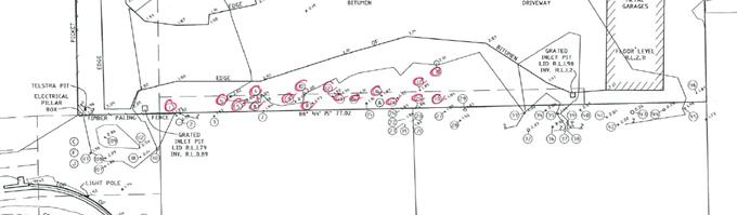
No species of conservation significance were recorded. The >10m high Swamp Oak, Paperbarks and Water Gum
(5 trees in total) are considered to be of medium ecological/aesthetic value
requiring the provision of 5 compensatory plants per removed tree. The other 12
trees are considered to be of low ecological/aesthetic value requiring the
provision of 1 compensatory plant per removed tree. This requires a minimum of
5 x 5 + 12 x 1 = 37 compensatory plants and a condition requiring a landscaping
plan is included in the Recommendation of this Report below accordingly. The DA
is accompanied by an indicative landscape plan which indicates the provision of
more than 37 plants.
Chapter B3 – Services
The subject allotments are capable of being provided with
the essential services including water, electricity, sewage disposal, stormwater
drainage and suitable vehicular access, to the satisfaction of relevant Council
Engineers, and subject to conditions.
Chapter B4 – Traffic Planning, Vehicle Parking,
Circulation and Access
Each dwelling is required to be provided with 2 car parking
spaces. Each dwelling is provided with a double garage. 2 visitor parking
spaces are also required, and these are provided at the western end of the
site, visible from the road frontage. The proposal complies in relation to
provision of parking facilities and Council’s Development Engineer raised
no objection n the basis of circulation and access.
Chapter B9 – Landscaping
Prescriptive measure 2 of B9.4.1 Landscape Principles
requires the provision of 90m2 of landscaped area per large dwelling
(ie. 8 large dwellings x 90m2 per dwelling = 720m2) less
the totals of the approved private courtyards. That is, the area of the
landscaped area for the development is able to include the approved private
courtyards as long as the total of approved private courtyards and common
landscaped area is 720m2. The development provides for approximately
710m2 which is only slightly less than the requirement. The
application demonstrates that the proposal will provide for a reasonable level
of landscaped area through plantings with each property containing small but
functional courtyards area for residents needs. The proposal is
considered to be satisfactory having regards to the applicable objectives and
performance criteria under B9.4.1. Conditions to apply for landscaping to be
completed.
Chapter C2 – Areas Affected by Flood
A flood planning level for this development is 3.4m AHD applies
to the site. The residential areas of each dwelling are set at a minimum of
4.94m AHD which complies with Councils flood requirements. The plans indicate
that only garage / storage and laundry internal uses are to occur at the ground
floor level which is below the flood planning level.
Chapter D1 – Residential Accommodation in urban,
Village & Special Purpose Zones
The proposal does not comply with D1.2.2 Setbacks from
Boundaries, Prescriptive Measure 3 – minimum setbacks for multi dwelling
house, requiring 3m between buildings on a site. The proposed setback between
buildings is 2m.
However the proposed development complies with the Objectives
and Performance Criteria underpinning this design element for the following
reasons:
1. The proposal minimises impacts
upon the existing streetscapes and development in the locality due to the
properties location.
2. The proposal achieves good
orientation and spacing of residential developments to achieve high quality
living environments relative to sunlight, shade, wind and weather protection,
residential amenity and proximity of neighbouring development.
3. The proposal achieves effective
use of the site to create useable and liveable private open space and
courtyards.
4. The
proposal represents appropriate siting and design in the surrounding urban
residential area.
5. Private
open space and common landscaped areas of the site are useable as part of the
living environment available for the occupants of the development. Landscaped
areas are
provided in the visually prominent
part of the site to the west of the building to visually soften the built form
from the public perspective.
6. The proposed front setback
complies with the minimum of 4.5m/5.5m. The proposed development is
appropriately designed for vehicular safety and visibility. The dwellings are
oriented to take advantage of the open northerly aspect, including open space
and decking. The proposed 2m setback areas are not readily visible in the
streetscape. Car parking is either incorporated into each dwelling or visitor
parking that is visually softened by landscaping.
7. The
variation will not have a significant impact in terms of streetscape, amenity,
privacy, views and access of surrounding properties, road status, traffic
impacts, sight lines or BCA compliance.
In relation to D1.2.1 Building Height Plane, the development
encroaches into the building height plane as projected from the northern and
eastern boundaries of the site. The northern boundary adjoins land in the same
ownership as the site, however the encroachment still needs to be considered
with reference to the applicable DCP 2014 provisions. In accordance with
Prescriptive Measure 2, given that the site is flood liable land, Council is
able to consider an exemption to the building height plane in relation to one
or more boundaries because the floor level is required to be above ground level
to comply with Council’s requirement’s for flood protection. This
exemption is applicable to a point, however the development could have been
designed to comply with both flood protection and building height plane requirements.
However, having regard to the Dual Path Assessment, the non-compliance meets
the D1.2.1 Objectives and Performance criteria for the following reasons:
Performance
Criteria
1. The
proposed development has been design to minimise overshadowing, privacy and
view impacts;
2. The
development is designed to promote energy efficiency and to optimise use of
winter sunlight and summer shade; and
3. The
development is designed to ensure that the windows of living areas (decks,
living rooms, bedrooms, kitchens, etc.) of development on adjoining properties
will retain full solar access between the hours of 9.00am to 3.00pm on any day;
and hence:
Objectives
1. The
proposal will not have a significant impact in terms of solar access on adjoining
properties to the north and east, or on the views from adjacent existing
buildings. The proposal incorporates privacy screens to the upper floor level
balconies, and the east facing windows are highlight windows, to ensure that
the development does not have significant privacy impacts on neighbouring
properties; and
2. The
occupants of the development will enjoy the optimum use of winter sunlight and
summer shade. The privacy screens are to be designed so as to allow sunlight
penetration and minimise privacy impacts to northern and eastern neighbouring
properties.
In relation to D1.2.4 Character & Visual Impact:
Performance
Criteria
1. Site,
building and landscaping design appropriately addresses the climate;
2. The
street face of the eastern most building, together with the space between it
and the street, contribute to the general attractiveness of the streetscape by
means of good design, appropriate materials and landscaping, noting that the
view of the site north along Canowindra Court is not of buildings but rather of
driveway, visitor parking and landscaping;
3. The
development has been designed to minimise loss of privacy for the reasons
indicated above;
4. There is
a reasonable degree of integration with the existing built and natural environment,
balanced with the desirability of providing for variety in the streetscape;
5. Long,
straight wall areas have been avoided by visually breaking up the development
into separate buildings and wall plane changes, varied setbacks and building
material combinations;
6. Decks
are provided for visual, climatic and energy efficiency reasons;
7. Well-designed
overhanging eaves are provided to protect against heavy rainfall and summer
sun, while allowing winter sun penetration; and
8. Building
materials are compatible in character with the surrounding environment. The
proposed roofs are of a “medium” non-highly reflective colour (ie.
not white or light-coloured) and “Colorbond” finish. Details of
building materials and surface colours have been submitted for assessment with
a DA;
and hence:
Objectives
1. The
development appropriately retains and enhances the unique character of this
part of the Byron Shire and its distinctive (as applicable) landscapes,
ecology, towns, villages and natural areas; and
2. The
development appropriately respects and complements those aspects of the
area’s natural and built environment that are important to its existing
character.
The proposed development is demonstrated to meet the
relevant Objectives of DCP 2014.
In relation to D1.6.1, each
dwelling has access to an individual courtyard at ground level having a minimum
area of 30m2 and a minimum length and width each of 4 metres, not
including any area used exclusively for the circulation or parking of vehicles.
The courtyards include access to winter sunshine and landscaped areas. Upper
level decks are provided for solar access, to enable sea breexzes to be
captured and for general outdoor living purposes.
4.5 Any Planning Agreement or
Draft Planning Agreement?
|
|
Yes
|
No
|
|
Is there any applicable planning agreement or draft
planning agreement?
|
☐
|
ý
|
|
Consideration: Not applicable.
|
4.6 Environmental Planning
& Assessment Regulation 2000 Considerations
|
Clause
|
This control is applicable to the proposal:
|
I have considered this control as it relates to the
proposal:
|
If this control is applicable, does the proposal
comply?
|
|
92
|
Yes
|
Yes
|
Yes
|
|
93
|
N/A
|
N/A
|
N/A
|
|
94
|
N/A
|
N/A
|
N/A
|
|
94A
|
N/A
|
N/A
|
N/A
|
4.7 Any coastal zone management
plan?
|
|
Satisfactory
|
Unsatisfactory
|
Not applicable
|
|
Is there any applicable coastal zone management plan?
|
|
☐
|
x
|
|
Consideration: Not applicable.
|
4.8 The likely impacts of that
development, including environmental impacts on both the natural and built
environments, and social and economic impacts in the locality
|
Impact on:
|
Likely significant impact/s?
|
|
Natural environment
|
No. The proposal will not have a significantly adverse
impact on the natural environment of the locality.
|
|
Built environment
|
No. The proposal will not have a significantly adverse
impact on the built environment of the locality.
|
|
Social Environment
|
No. The proposal will not have a significant social impact
on the locality.
|
|
Economic impact
|
No. The proposal will not have a significant economic
impact on the locality.
|
Are there any Council Policies that are applicable to the
proposed development?
Council’s ET Engineer has raised no objection to the
proposal on the basis of Council’s Policy 4.20: Building over Pipelines
and other Underground Structures.
4.9 The suitability of the site
for the development
The site is serviced and is suitable for the proposed
development.
4.10 Submissions made in accordance with
this Act or the regulations
The development application was publicly exhibited. There
were 11 submissions made on the development application which raised the
following matters:
High risk flooding, flood
water contamination, emergency service and other inaccessibility due to
flooding, stormwater drainage, flood
water displacement due to the proposed development
Council’s Development
Engineer raised no objections to the proposal on the basis of flood planning,
confirming that the development conforms to the requirements of LEP 2014
clauses 6.3 and 6.4, and DCP 2014 Chapter C2 in relation to flood planning,
floodplain risk management, flood study requirements, minimum floor levels,
flood planning matrix, flood proofing and special provisions. Conditions are
recommended in this regard.
The Development Engineer also
raised no objections to the proposal on the basis of stormwater management,
confirming that the development conforms to the requirements of LEP 2014 clause
6.6, and DCP 2014 Chapter B3 Services in relation to stormwater drainage,
development application requirements, properties adjacent to or containing
waterways and site drainage. Conditions are recommended in this regard,
including provision of on-site stormwater detention.
It is considered stormwater and
flooding can be appropriately managed
(a) Sewer
impact / overflow
Council’s Water and Sewer
Engineers have raised no objection to the proposal on the basis of the capacity
of the existing sewerage system, and there is no “moratorium” in
place in terms of development in the Ocean Shores area. .
Traffic and road safety impacts, road damage, lack of
footpath, garbage collection in Redgate Road, Garbage bin storage in Redgate
Road amenity impacts, On-site bin storage
The proposal has access to the
local road networks which is considered capable of handling the additional
traffic generated by this development. The parent allotment which was
subdivided to create the subject allotments and Lot 10 to the north had
frontage to both Helen Street and Canowindra Court. The subdivision resulted in
Lot 10 gaining access off Helen Street and the subject Lots 11 and 12 gaining
access off Canowindra Court. The proposed development complies with that
approved access arrangement. Conditions to apply in terms of constructing
driveways and internal access roads and parking areas. In terms of bin storage,
adequate area is provided onsite for land owners to store garbage bins within
the confines of each property.
Access and visitor parking
inadequacy, Overflow parking to be in Canowindra
Court
The proposal complies with the
number of parking spaces as required under DCP 2014 Chapter B4.2.5 including
visitor spaces.
Traffic and occupant noise
impacts
The use of the site for normal
domestic purposes is not expected to cause significant noise impacts, including
vehicle movement noise, in the locality. No objections were raised by
Council’s Environmental Health Officer in relation to noise impacts.
Loss of privacy, visual and amenity impacts, no
screening trees, vehicle headlight impacts to neighbouring properties
The development complies with
the building height plane as projected from the southern boundary and
appropriately addresses privacy impacts to the southern neighbouring property.
Proposed Unit 1 is set well back from the western side boundary. Unit 8
encroaches into the building height plane as projected from the eastern
boundary however the dwelling incorporates appropriate privacy measures such as
screening the eastern side of the proposed rear verandah and highlight (1.5m
high sill) east facing windows.
The proposed development is
provided with landscaping for visual softening, and a 1.8m high fence is
required to all neighbouring property boundaries for general privacy, security
purposes and to block out headlights.
Removal of vegetation
screening loss of privacy and a visual eyesore, loss of wildlife
corridor, compensatory planting, inadequate proposed landscaping
The development complies with
the building height plane as projected from the southern property boundary to
ensure that privacy impacts are minimised. Compensatory planting is provided
for the proposed tree removal, as described by this Report above. Landscaping,
including compensatory planting of the site, is the subject of a recommended
condition of consent. The driveway along the southern boundary will be below
standard fence level and is not required to be landscaped.
Reduction
of the separation between the unit blocks from 3m to 2m
This Report addresses the
separation between buildings prescriptive measure non-compliance in section
4.4A above.
High density proposal, possible
transient population during festivals, overcrowding, undesirable precedent and
change in character of the area
The proposed development is in a
low density residential zone, but meets the requirements for multi dwelling
housing as specified under Byron LEP 2014. The property is of a reasonable size
(over 1800m2), whilst the eight dwellings are modest in area and amenity as
opposed to more high end accommodation proposed in other parts of the shire.
Conditions of consent are recommended to prohibit the use of the dwellings as
tourist and visitor accommodation and holiday letting.
Bush fire prone area, asset protection zone not
contained within site
The NSW Rural Fire Service has
assessed the proposal with respect to bush fire hazard characteristics of the
site and surrounds, and recommends conditions relating to for example,
maintaining the entire site as an asset protection (thereby not relying on
neighbouring properties).
No construction certificate means plans can be changed
A certifying
authority must not issue a construction certificate for building work unless
the design and construction of the building (as depicted in the plans and
specifications and as described in any other information furnished to the
certifying authority) are not inconsistent with the development consent.
Minimum lot size of 600m2
This Report considers a clause
4.6 written request for variation in section 4.2A above.
Impact upon property values
This is not a matter for
consideration of such significance as to warrant refusal of the development
application.
4.11 Public interest
The proposed development is unlikely to prejudice or
compromise the public interest or create an undesirable precedent.
4.12 Section 5A of the EP&A Act –
Significant effect on threatened species
Having regard to sections 5A, 5C and 5D of the EP&A Act, there is unlikely to be a significant effect on threatened species,
populations or ecological communities, or their habitats as a result of the
proposed development because the site is not mapped as containing any
threatened fauna habitat and no species of conservation significance are
proposed to be removed.
4.13 Section 5B of the EP&A Act –
Have regard to register of critical habitat
The NSW Critical
Habitat Register does not identify any critical habitat on or adjacent to the
site.
5. DEVELOPER
CONTRIBUTIONS
Water and Sewer and Section 94 Contributions are payable.
Conditions to apply.
6. CONCLUSION
The application is considered to have sufficient merit to
warrant approval subject to conditions of consent.
7. DISCLOSURE OF
POLITICAL DONATIONS AND GIFTS
|
Has a Disclosure Statement been received in relation
to this application
|
No
|
|
Have staff received a ‘gift’ from anyone
involved in this application that needs to be disclosed. Where the answer is
yes, the application is to be determined by the Director or Manager of the
Planning, Development and Environment Division.
|
No
|
Provide Disclosure Statement register details here: Not
applicable
Staff Reports - Sustainable Environment and Economy 13.24
Report No. 13.24 PLANNING
- Site-specific Planning Proposals considered as part of the Rural Land Use
Strategy process
Directorate: Sustainable
Environment and Economy
Report
Author: Alex
Caras, Land Use Plannning Coordinator
File No: I2017/1686
Theme: Ecology
Planning Policy and Natural Environment
Summary:
Council at its 26 October 2017
Ordinary Meeting considered a report on the draft Rural Land Use Strategy and resolved
(in part) to:
“4. Receive a report at the meeting on 23 November 2017
regarding site specific planning proposals being considered as part of the RLUS
including at 74 Charltons Road, Federal”.
This report presents a summary of the relevant information
in response to the above resolution.
NOTE TO COUNCILLORS:
In accordance with the provisions
of S375A of the Local Government Act 1993, a Division is to be called whenever
a motion for a planning decision is put to the meeting, for the purpose of
recording voting on planning matters. Pursuant to clause 2(a) under the
heading Matters to be Included in Minutes of Council Meetings of Council's
adopted Code of Meeting Practice (as amended) a Division will be deemed to have
been called by the mover and seconder of all motions relating to this report.
|
RECOMMENDATION:
That Council:
1. Note
the information contained in this report.
2. Resolve not to proceed any further with the Planning
Proposals contained in Attachments 1 and 2 to this report, as they do not
satisfy the Rural Land Use Strategy criteria for future rural lifestyle
living opportunities or accord with the State/regional policy framework
(namely the North Coast Regional Plan and s117 Ministerial Direction 5.3).
3. Notify the
Applicants of Council’s decision not to proceed and their opportunity
to request the relevant Planning Panel to review council’s decision
within 42 days of being notified.
|
Attachments:
1 Copy of
Planning Proposal and draft RLUS submission for Lot 11 DP 1039847 - 74
Charlton’s Road Federal, E2017/103100
⇨

2 Copy of
Planning Proposal for CT subdivision of Lot 3 DP 732638 Englishes Road_Upper
Coopers Creek, E2017/103101 ⇨
3 Letter to
applicants re planning proposals for 74 Charltons Road Federal and Englishes
Road Upper Coopers Creek_July2015, E2017/103104
⇨
Report
Council at its 26 October 2017 Ordinary Meeting considered
a report on the draft Rural Land Use Strategy and resolved the following:
Resolution 17-504
1. Note
the update on priority actions progressed to date as contained in Table 1 of
this report;
2. Adopt
the proposed amendments to the draft Rural Land Use Strategy (RLUS) and
supporting documents, as contained in Table 2 and Table 3 of this report, to
enable submission to Department of Planning & Environment;
3. Delegate
authority to the Director Sustainable Environment & Economy to amend the
draft Rural Land Use Strategy in relation to any consequential (non-policy)
and/or other minor editorial amendments required for clarity or accuracy, prior
to submitting to Department of Planning & Environment for final
endorsement; and
4. Receive a
report at the meeting on 23 November 2017 regarding site specific planning
proposals being considered as part of the RLUS including at 74 Charltons Road,
Federal.
This report presents a summary of the relevant information
in response to item ‘4’ of the above resolution.
Background
Council
at the 8 August 2013 meeting resolved (Res. 13-388) to include six
properties on the Byron LEP 2014 Multiple Occupancy and Community Title
Map. Only one property was supported for inclusion on the Map by the Minister for Planning & Environment’s
delegate when the LEP was gazetted.
The
then Director Environment and Planning wrote to the remaining five property
owners to advise them of their options as to
how the following properties could progress
towards a rural multiple occupancy development. At the time two options
were provided:
Ø be considered during preparation of Council’s Rural
Land Use Strategy; or
Ø prepare a planning proposal to amend the Byron LEP 2014
ahead of Council completing the Rural Land Use Strategy.
Council subsequently received planning proposals for two
properties: (i) Lot 11 DP 1039847, 74 Charlton’s Road, Federal and
(ii) Lot 3 DP 732638 Englishes Road, Upper Coopers Creek.
These sites
are shown in Figures 1 & 2 below.
A copy of
the planning proposals and supporting information are contained in Attachment 1
(‘Charltons Road’) and Attachment 2 (‘Englishes Road’).
As the timing of the planning proposals received coincided
with preparation of a new Rural Land Use Strategy (RLUS), both applicants were
sent a letter advising that their respective planning proposals would now be
considered as part of the strategy process. Specifically, these areas
would be “assessed
against the site selection criteria being developed as part of this wider land
use strategy review. This will determine if the site has merit to be zoned for
rural settlement purposes.” A copy of the letters sent to both applicants is contained
in Attachment 3.
This
is consistent with Resolution 16-286 relating to other sites identified in
Report No 13.11 - Request for an Early Implementation Program to supplement Council’s
Rural Lands Strategy Initiative, in which Council resolved:
Resolution 16-286
“Resolved that Council not support the “Early
Implementation Program to supplement Council’s Rural Land Use Strategy
Initiative and instead consider these properties in the Byron Rural Land Use
Strategy now under preparation.”
Because
both applicants were advised that their planning proposals would now be
assessed under the RLUS framework, it was not intended at the time to have them
separately determined by Council. Instead the more detailed site information
contained in the planning proposals would be considered against the RLUS policy
directions and site selection criteria, with any final Council decision to
coincide with adoption of the RLUS.
Although
both applicants had an opportunity to make further submissions during the RLUS
exhibition process, Council only received submissions for ‘74
Charlton’s Road’. This resulted in an oversight in which the
‘Englishes Road’ site was not included in the 26 October RLUS report
to Council.
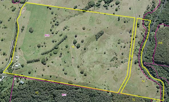
Figure 1: Lot 11 DP 1039847, 74 Charlton’s Road,
Federal
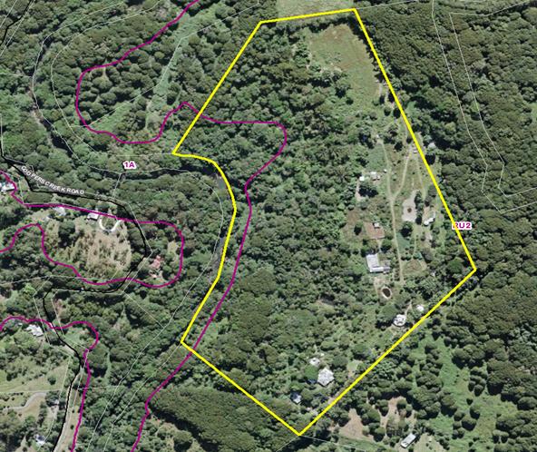
Figure 2: Lot
3 DP 732638, Englishes Road, Upper Coopers Creek
Assessment
against site selection criteria in Rural Land Use Strategy (as adopted)
Table 1
below shows the relevant criteria applied in assessing these sites for
‘future rural lifestyle living opportunities’ in the adopted Rural
Land Use Strategy (as identified in RLUS Maps 4, 4a).
Table 1 – RLUS criteria for identifying ‘future rural lifestyle
living opportunities’
|
Criteria
|
74
Charltons Road, Federal
|
Englishes
Road, Upper Coopers Creek
|
|
i) situated west of the Pacific Highway (undeveloped sites only) AND
within a 5 km radius
of a town with
a high school; and
|
Ï
Outside
5km service catchments of Mullumbimby & Byron Bay
|
Ï
Outside
5km service catchments of Mullumbimby & Byron Bay
|
|
ii) not identified in a draft or adopted strategy for future urban
purposes, or for future village / urban development in this strategy; and
|
P
|
P
|
|
iii) contains at least 10ha of unconstrained land AND does not
require access through constrained land, as identified in Table 1 of the Site
Suitability Criteria and Mapping Methodology; and
|
Ï
No
unconstrained land due to the following:
- regionally
significant farmland (entire site)
- slope
> 25% (part of site)
|
Ï
No
unconstrained land due to the following:
- regionally
significant farmland (entire site)
- within
100m buffer to river in a drinking water catchment (part of site)
- extreme
bushfire risk (part of site)
- slope
> 25% (part of site)
- HEV
vegetation (part of site)
|
|
iv) can be adequately serviced by existing or committed road
infrastructure at a standard suitable for the predicted level and type
of traffic resulting from development, at no cost to the wider community
|
Ï
Located
outside 5km major service catchment and in an area that cannot be serviced
adequately by existing or committed road infrastructure.
|
Ï
Located
outside 5km major service catchment and in an area that cannot be serviced
adequately by existing or committed road infrastructure.
|
P=
satisfies
criteria
Ï= does
not satisfy criteria
In summary,
neither site satisfies the RLUS criteria for future rural lifestyle living
opportunities nor accords with the State/regional policy framework (namely
the North Coast Regional Plan and s117 Ministerial Direction 5.3 - Farmland of
State and Regional Significance on the NSW Far North Coast). It is
therefore recommended that both of these planning proposals not proceed any
further.
Opportunity for Applicants to
request a pre-Gateway review
The Environmental Planning and Assessment Regulation
2000 (EP&A
Regulation) requires councils
to notify a proponent when the council decides not to prepare a planning proposal. The proponent then has 42 days from notification to request the relevant Planning
Panel to review council’s decision.
Accordingly both
applicants should be notified of Council’s decision not to proceed with
their respective planning proposals, as recommended in this report.
Financial Implications
The cost of assessing both of these planning proposals as
part of the Rural Land Use Strategy process has been met by Council.
Statutory and Policy Compliance Implications
The Rural Land Use Strategy is consistent with the relevant
Commonwealth, State and Regional policy frameworks.
Staff Reports - Sustainable Environment and Economy 13.25
Report No. 13.25 Further
update on Resolution 17-191 Secondary Dwelling Conditions
Directorate: Sustainable
Environment and Economy
Report
Author: Shannon
Burt, Director Sustainable Environment and Economy
File No: I2017/1688
Theme: Ecology
Development and Approvals
Summary:
Council considered Report 13.21 Update on Resolution 17-1891
Secondary Dwellings at the Ordinary Meeting on 26 October 2017, and
requested that a further report on item 2 be presented at the November meeting.
In particular, the final number of responses to the letter sent, and next steps
for enforcement of non compliant developments. Item 2 is in bold.
Council resolution 17-191 is provided below.
17-191 Resolved:
1. That Council recognises community
concerns regarding the lack of affordable housing in Byron Shire and concerns
that secondary dwellings, as defined and facilitated by the NSW State
Environmental Planning Policy (Affordable Rental Housing) 2009, are being used
for tourism purposes via short term letting, holiday letting Air Bnb and
similar online platforms.
2. That Council responds to concerns and compliance issues by:
a) contacting all property owners with a secondary
dwelling (granny flat) approved since the
passage of Council Resolution 11-268 and seek property
owners’ confirmation that they
are complying with their approval and/or conditions of
consent with the regard to the
Environmental Planning Assessment Act and to Byron
Shire Council Resolution 11-268.
b) developing a form that seeks the owners signature
regarding compliance with consent
and Resolution 11-268 for inclusion with the
correspondence to be returned to council
within 30 days.
3. That a report be received from
staff informing Council as to the outcome of 2(a) and (b).
4. Request staff to commence the
process to amend clause 2.14 in the 2012 Byron Developer Contributions Plan to
provide that the clause does not apply to secondary dwellings used for tourism
purposes.
5. Request staff to commence an
evaluation of Council’s policy of waiving Council S64 and S94
contributions for secondary dwellings as a means to support affordable housing
and provide recommendations to strengthen affordability outcomes of secondary
dwellings.
6. Request staff to identify how
the Affordability Housing SEPP 2009 could be applied to establish an exception
from Council S64 and S94 for ‘affordable rental accommodation’.
7. That a further report be furnished to Council on
points 5 and 6 above.
This report provides an update
on item 2 by staff.
|
RECOMMENDATION:
That Council note the report.
|
Report
As requested by Council at the
Ordinary Meeting 26 October 2017, a further update on item 2 of Resolution
17-191 is provided below.
… 2. That Council
responds to concerns and compliance issues by:
a) contacting all property owners with a secondary
dwelling (granny flat) approved since the passage of Council Resolution 11-268
and seek property owners’ confirmation that they are complying with their
approval and/or conditions of consent with the regard to the Environmental
Planning Assessment Act and to Byron Shire Council Resolution 11-268.
b) developing a form that seeks the owners signature
regarding compliance with consent and Resolution 11-268 for inclusion with the
correspondence to be returned to council within 30 days.
Letters and form sent to 598
property owners on 13 September 2017. Only 143 have been returned as of 6
November 2017. Copy of letter and form link below:
http://byron.infocouncil.biz/Open/2017/10/OC_26102017_ATT_611_WEB.htm
Based on the above, the next
steps for staff are to write again to those properties that have not responded
to provide a further, brief, opportunity to do so.
Where a reasonable suspicion
exists of unauthorised activity staff will consider the commencement of
enforcement proceedings for the offence of development not in accordance with
development consent
The reasonable suspicion must
be held by the investigating official who is to commence proceedings. The
investigating official must be able to form that view in the circumstances of
the particular matter. Each case must be dealt with on its merits.
Financial Implications
Staff resourcing and any enforcement proceedings need
to be managed within the existing budget allocation.
Statutory and Policy Compliance
Implications
Environmental Planning and Assessment Act 1979 and related
regulations
Staff Reports - Sustainable Environment and Economy 13.26
Report No. 13.26 Review
of the Biodiversity and Sustainability Panel
Directorate: Sustainable
Environment and Economy
Report
Author: Shannon
Burt, Director Sustainable Environment and Economy
File No: I2017/1707
Theme: Ecology
Planning Policy and Natural Environment
Summary:
At the Biodiversity and Sustainability Panel (Panel) meeting
held 12 October 2017, a discussion was had about the Panel and a recommendation
made:
That staff prepare a report on the terms of reference for
the Biodiversity and Sustainability Panel including alternate membership
options, meeting process and procedures for the next available Council meeting.
In response to this recommendation, this report is provided
for Council consideration on the existing Panel membership, meeting process and
procedures.
|
RECOMMENDATION:
1. That Council agree to the
overarching concept of a new Biodiversity Advisory Group and Sustainability
and Emissions Reduction Advisory Group, so that the model and terms of
reference and membership can be drafted with the existing nominated
Councillors Richardson, Hunter and Martin.
2. That Council receive a
further report to confirm the model and terms of reference and
membership of the new Biodiversity Advisory Group and Sustainability and
Emissions Reduction Advisory Group in February 2018.
3. That the first meetings of
the new Biodiversity Advisory Group and Sustainability and Emissions
Reduction Advisory Group occur before May 2018.
|
Report
At the Biodiversity and Sustainability Panel (Panel) meeting
held 12 October 2017, a discussion was had about the Panel and a recommendation
made:
That staff prepare a report on the terms of reference for
the Biodiversity and Sustainability Panel including alternate membership
options, meeting process and procedures for the next available Council meeting.
It was agreed that the current Panel is not being challenged
with strategic issues and therefore has lost momentum and members interest.
Existing constitution and Panel information below:
http://www.byron.nsw.gov.au/committees/biodiversity-and-sustainability-panel
The Panel as it presently meets has a very broad purpose
that includes implementation of the relevant biodiversity and sustainability
strategies as well associated projects, funding opportunities and partnership
potential.
Examples of Biodiversity projects currently include: Review
of the Biodiversity Conservation Strategy (see report I2017/1549), Integrated
Pest Management Strategy and Policy (see report I2017/1527), Vegetation
Mapping, Bushfire Prone Land Mapping, Koala Plan of Management and associated
projects, Flying Fox Management Plan, Graminoid Clay Health project, Habitat
and Corridor works.
Examples of Sustainability and Emissions Reduction projects
currently include: Council’s 100% Emissions Reduction Strategy, Support
Zero Emissions Byron Initiatives, Local Energy Trading and Local Network
charges, Renewable Energy projects Council and community, Climate Change and
Energy reporting, Food Security initiatives.
Given the above, it is difficult for one single Panel
meeting of 2 hours each quarter to respond to all of the above with a
representative and or engaging agenda. Further, Panel members may or may
not choose to attend meetings depending on the agenda, and whether or not it
includes discussion on their core interests. This presents issues for quorum at
times.
To address this, the opportunity now exists to consider
disbanding the Panel and replacing it with two separate ‘Advisory
Groups’; one for Biodiversity the other Sustainability and Emissions
Reduction. These Advisory Groups would operate like the masterplan
guidance groups which have proved extremely successful in terms of expert
community participation and engagement.
This model would also allow for maximum flexibility in
meeting times/dates and formats such as field days, workshops with guest
speakers, industry leaders, experts from outside of Byron for perspective or
comment. The current Panel Constitution as stipulated does not enable this to
occur.
To move this proposal forward, staff recommend that Council
agree to the overarching concept of a new Biodiversity Advisory Group and
Sustainability and Emissions Reduction Advisory Group and that the model and
terms of reference and membership be finalised with the existing nominated
Councillors Richardson, Hunter, and Martin by years end. That a further report
to Council follow to confirm the above in February 2018.
Financial Implications
Costs associated with the new Advisory Groups would need to
be met within the existing operational budget and staff resources.
Statutory and Policy
Compliance Implications
Delivery Program CM2.1.2 Incorporate inclusive
community consultation and stakeholder engagement in Council decision making.
Staff Reports - Sustainable Environment and Economy 13.27
Report No. 13.27 Supporting
Sustainable Agriculture and Agribusiness in Byron Shire
Directorate: Sustainable
Environment and Economy
Report
Author: Tania
Crosbie , Economy and Sustainability Tourism Coordinator
File No: I2017/1717
Theme: Economy
Economic Development
Summary:
Agriculture and value-adding agribusinesses are vital to
Byron Shire and the region. Visitors come for the ‘clean and
green’ produce for sale on the side of our roads, at our farmers markets
and our restaurants. Byron Shire needs to ensure that we have sustainable
farms, farmers and their produce in years to come.
We have a diverse and continually changing farming sector,
with economic and attitudinal research indicating that our farms and our farmers
are under pressure. Our community feels strongly about protecting our
farms and their produce.
This report proposes an action plan in order to meet
farmers’ needs and the key aims of our economic and land use
strategies. This action plan includes research (primary and secondary),
engagement, and employment of an agricultural extension office, establishment
of an agricultural cluster and then ongoing mentoring and support.
|
RECOMMENDATION:
That Council:
1. Acknowledge
the desktop research results and SWOT analysis into agriculture and
agribusiness.
2. Support
the next steps of the Byron Shire Sustainable Agriculture and Agribusiness
Project with further reports provided to Council following project
milestone achievements.
3. Note
that staff will be applying for grant and sponsorship funding to support the
Byron Shire Sustainable Agriculture and Agribusiness Project, and should this
grant be successful, Council will need to commit funding of $50,000 in the
2018/2019 and 2019/2020 financial years respectively.
|
Report
Agriculture and Agribusiness form the basis for many Council
and regional plans.
Agriculture and Agribusiness in Byron Shire Council
Council at the 26 October 2017, Ordinary meeting adopted the
Byron Shire Rural Land Use Strategy. This Strategy has the following key
actions that will be supported by the Sustainable Agriculture and Agribusiness
Project These actions are:
Table 1: Relevant actions
from the Byron Shire Rural Land Use Strategy
|
Action
No.
|
Action
|
|
35
|
Provide
information and advice on how to:
• undertake
cost-effective environmental enhancement works
• make
use of non market and market based incentives for environmental enhancement
works.
• manage weeds and pests
|
|
38
|
Provide
information and advice on how to:
• manage
weeds, disease and pests
• capture
and use water sustainably
• sustainably
farm
|
|
39
|
Investigate opportunities for
Council to partner with the community to ensure a long term future of
agriculture in the Shire
|
|
42
|
Work
with land owners of vacant or underused farm land that want to connect with
potential producers.
|
|
44
|
Support
community award programs and promotions that encourage sustainable rural land
use and management.
|
|
49
|
Promote
Byron Shire as a place where small scale food production is a viable
lifestyle and business opportunity.
|
Enterprising Byron clearly
identified agriculture and the value-adding provided by agribusinesses one of
the vital industry sectors in the strategy.
Table 2: Relevant Strategies
from the Enterprising Byron 2025 – Economic Development Strategy
|
Strategy No.
|
Strategy
|
Activity
|
|
3 d.
|
Develop industry access to new
and expanding markets
|
Support agribusiness in rural
areas to diversify and grow ‘on farm’ opportunities
|
|
4 d.
|
Develop the full potential and
capacity of Byron’s towns, villages and rural lands
|
Explore rural lands for
appropriate enterprise expansion and establishment opportunities recognising
the challenge of rural and urban relationships.
|
|
5 b.
|
Facilitate partnerships with
Council, Government Agencies and private investors.
|
Take a leadership role in
creating opportunities to showcase the Byron advantage and sustain the brand
value.
|
|
5 c.
|
Facilitate partnerships with
Council, Government Agencies and private investors.
|
Develop and promote projects
that showcase the synergy between our businesses and our communities.
|
|
6 b b.
|
Accelerate workforce
development, skills and training for the future.
|
Facilitate workforce
development strategies in regional farmer succession program.
|
|
8 b
|
Secure the competitive and
comparative advantage
|
Develop and implement the
Byron food production and manufacturing cluster supply chain strategy –
advancing industry visibility and capability.
|
|
8 c.
|
Secure the competitive and
comparative advantage
|
Identify and develop the
critical differentiators that contribute to the comparative advantage for all
business/enterprise.
|
|
8 d.
|
Secure the competitive and
comparative advantage
|
Share and utilise knowledge
from food economy improvements across all sectors.
|
Tourism plans clearly articulate the importance of
agri-tourism and farm tourism as keys to building a diverse tourism industry.
Table 3: Byron Shire Destination Management Plan
(DMP) 2014
|
Continue to support and foster the key experiences of high
quality local artisan, community, and farmers markets in the Shire.
|
|
Develop and implement a ‘Investment Opportunity
Plan’ including tourism, creative industries, agri-tourism, food and
heritage opportunities to attract private and public sector investment.
|
Table 4: Byron Shire Tourism Management Plan (TMP)
2008-2018
|
S3.2.6
|
Ensure
LEP and DCP processes encourage rural tourism developments in rural zones
that support Farm and Nature Tourism Business Development Program
recommendations and consider recommendations regarding rural tourism
development outlined in the 2002 Tourism Management Options Paper
|
|
S3.2.7
|
Ensure
future plans for rural tourism development are undertaken in consultation
with rural communities and assess infrastructure needs to support such
development
|
|
S8.1.5
|
Continue
to utilise existing programs such as the ST CRC Farm and Nature Tourism
program delivered by ARTRC as a means to provide assistance in product
development and consider new programs to support other product areas for e.g.
health & wellbeing
|
|
S8.2.2
|
Continue
to develop and promote exceptional food and wine as part of the visitor
experience
|
Destination NSW and Destination North Coast is developing a Northern
Rivers Food and Beverage Strategy from 2018. The first planning
meeting for this initiative was held on the 6th of November 2017.
BYRON SHIRE AGRICULTURE AND AGRIBUSINESS ACTION PLAN
As part of developing the Rural Land Use Strategy and
implementation of Enterprising Byron 2025, much of the groundwork has
commenced; desktop research and farmer interviews. In order to develop a
comprehensive action plan, a three-phased approach has been suggested.
1. Phase
1: Research. Build a psychographic and demographic picture of farming in
the Byron Shire.
2. Phase
2: Engagement and Planning – Build relationships and inclusive
plans to provide connection and direction.
3. Phase
3: Leading Success and Measuring – Provide support, education and
leadership.
The following Phase 1 actions have been completed.
Phase 1: Research.
Build a psychographic and demographic picture of farming in the Byron Shire.
a. Undertake desktop research into agricultural economics,
agribusiness and opportunities. All charts referred to in the
Economic Data Top Facts are contained within the attached appendix 1 at the end
of the report.
Economic Data Top Facts:
· From
2010/11 to 2015/16 Byron Shire has dropped $9.6 million dollars worth of
agricultural sales (from $112.7 million to $103.1 million).
· Top
three industries to lose sales are:
o Nuts
– just over $7 million
o Nurseries
and cut flowers – almost $3 million
o Other
fruit – almost $2 million.
· The
only two industries to increase sales were milk and vegetables – almost
$1 million each
· More
agricultural businesses (19) were lost from 2012 to 2016 from the Shire, making
it the most lost of all industries. Construction and Health Care and
Social Assistance added 130 businesses for the
same period.
· Byron
Shire has fewer agricultural workers than our Northern Rivers neighbours 4%
versus 7%. With agriculture losing around 50 jobs in the sector between
2010/11 and 2015/16.
· So overall the key
economic indicators for agriculture - employment, businesses, sales and dollar
value - all indicate a shrinking agricultural sector in Byron Shire.
b. Undertake exploratory
interviews with farming exemplars. Over 15 farmers were
interviewed. The information from the interviews
along with previous research formed the basis
for the following SWOT analysis. Farmers ranged from well established
mono-producers, small organic farmers, first-generation and young farmers to
high-profile value-add agri-businesses.
STRENGTHS,
WEAKNESSES, OPPORTUNITIES AND THREATS FOR
AGRICULTURE
AND AGRIBUSINESS IN BYRON SHIRE
|
STRENGTHS (Council & Industry)
|
WEAKNESSES (Council & Industry)
|
|
· Regional
strengths - Climate, rainfall, soils, skills & experience
· Sub-division of
farming land reduced
· Strong food
production organisations such as SustainFood, Northern Rivers Food and
tourism industry
· Established
community gardens and roadside stall culture
· Recognition
nationally and globally Byron produce as a ‘clean and green’ food
bowl and biosecurity
· Known for
macadamias and blueberries
· Marquee food
brands and business models that link to agricultural product and
production ie: Brookfarm and Salumi
· Leadership in
sustainable farming
· Examples of
biodiversity and bush regeneration management
· Recognition
that farming is important and key to our region
· New entrants
into farming profession – the increase in first generation farmer
· Council’s
Rural Land Use Strategy (RLUS)
· Location close
to SEQld and regional cities
· Proximity to
highway and airports
|
· Increased number
of older farmers
· Limited suitable
agricultural land
· Predominantly
smaller blocks
· Cost of labour
· Environmental
impacts
· Few food
processing facilities
· Reliance on
macadamias, sugar cane and avocadoes
· Lack of
affordable housing for farm workers
· Food security
within the region (as demonstrated during the April 2017 flood event)
· Lack of
direction and leadership in agriculture
· Pressure on
agricultural land for rural and urban residential and industrial use
· High barrier to
entry for young farmers to enter the sector
· Larger blocks of
land being lost to agriculture
· Increased land
values and cost of land
· Lack of research
· Planning
regulations
· More lifestyle
farmers and first generation farmers
· Closer to
Queensland than Sydney
· Few productive
partnerships, cooperatives or clusters
· Limited help
from government or funding bodies
· No wine or
cheese (traditional food trail) industries
· High costs
transport, energy, fertilizer, seed/plants equipment and infrastructure
|
|
OPPORTUNITIES
|
THREATS
|
|
· New techniques
in sustainable farming
· Native bush
foods being promoted and embraced within the BSC region
· Improved
technology
· Introduction of
new skills and business techniques and niche products
· Emerging
emissions reduction opportunities and carbon farming
· Increased
market demand for clean food from global markets
· Boutique and
niche markets
· Collaborative
and cooperative farming approaches and innovative farming models that have
worked in other communities and overseas
|
· Increased demand
for housing and industrial land
· Poor awareness
of economic and social significance
· Natural
disasters
· Disease and
pests
· Reduced market
opportunities for production
· Byron region is
not a focus for agricultural advocacy groups
· Market
protection and export issues
· Other regions
improving their value proposition
· Changes to NSW
and Federal government regulations and legislation leading to unforseen
consequences
· Changes in the
organic certification process impacting negatively on smaller producers
· Loss of
knowledge from farmers leaving the sector
|
Thank you to all the
farmers that contributed to this SWOT which was developed with the information
provided by farmers during our interviews and the Rural Land Use Discussion
Paper submitted by Representatives of the Horticulture, Boutique Agricultural,
Tourism, Food Processing Industries, Forest regenerators and Land Use Planning
and marketing Consultants 2015.
The following Phase 1 to 3
actions are still to be completed, but have delivery timeframes for 2018.
Phase One:
c. Conduct further
primary research to focus on the different types of farmers, their needs,
challenges and opportunities – being undertaken by consultant
with project delivery early 2018.
Scope
of Work – consultant to undertake:
Develop
framework for regional collaboration and growth in the agricultural and
agribusiness sector and the production to consumption value chain. The
consultant will recruit and engage with a cross section of farmers and
strategic partners, identify the opportunities, challenges and gaps in terms of
achieving the strategic aims as identified in our Council strategies.
Delivery
steps include:
· Understanding supply, demand and challenges and
opportunities for agriculture and agribusiness sector
· Identifying what we do well and what needs to improve
· Establish clear goals and how to achieve them
· Review options for a provenance framework and its role as a
foundation
· Create a framework for collaboration across the region and
across the production to consumption value chain.
d. Establish Agribusiness
cluster – to be established after the results of the
consultant’s recommendation and with input from Councillors for delivery
in 2018.
Phase 2: Engagement and
Planning – Build relationships and inclusive plans to provide
connection and direction.
a. Employ Agriculture (Extension)
Officer – This position exists in the Environmental and Economic Planning
division structure but is subject to funding. Funding sources being
scoped
b. Agriculture and Agribusiness
– Production and Promotion Symposium – Being costed and scoped
c. Develop Agriculture and
Agribusiness Action Plan – Based on the research, focus groups, symposium
and engagement. This would identify aims, targets and actions in order to
achieve targets.
Phase 3: Leading Success and Measuring –
Provide support, education and leadership for the sector in the long-term and
would depend on funding and industry direction.
a. Establish mentoring programs
b. Commence longevity research
study of agriculture and agribusiness in Byron Shire.
Financial Implications
There are two funding sources that will require support from
Council to pursue:
1. Australian
Government, Department of Agriculture and Water – Small Farms, Small
Grants
Grant information: Projects are sought that support local
on-ground projects across Australia that deliver against the priority outcome
of increasing the knowledge and capacity of farmers and fishers and
facilitating the adoption of tools, technologies and improved land management
practices to effectively, sustainably and productively manage Australia’s
natural resources and adapt to significant changes in climate, weather and
markets. Amount being applied for is $50,000 for two years (total $100,000)
which will require matched funds over 2018/19 and 2019/20 financial years.
This grant application is subject to the 2018/19 Forward
Budget Process and Council endorsement. Submission due: 7 December 2017.
If Council resolves to submit the grant application for the
purpose outlined in this report and should the grant application be successful,
it will need to ensure its funding contribution of $50,000 per annum for the
2018/2019 and 2019/202 financial years is committed before the budgets relevant
for those two financial years are determined. This commitment will in
2018/2019 and 2019/2020 reduce the ability of Council to allocate $50,000 to
any other purpose in those two financial years.
2. Sponsorship from
agricultural industry
Companies that gain support from the local agricultural
industry will be targeted and those who participate will be provided
recognition and the capacity to participate in the stakeholder
engagement. The sponsorships will comply with Council’s Sponsorship
Policy.
Policy Implications:
Delivery Program
2017-2021 EC1.2.1
Facilitate growth and development of our business community
including increasing access to new and existing markets.
Appendix 1:
CHART ONE:
Change in Agriculture Sales in Byron Shire from 2010/11
to 2015/16
|
|
2015/16
|
2010/11
|
|
|
Industry
|
$m
|
% total sales of all
industries
|
$m
|
% total sales of all
industries
|
Change from 2010/11 to
2015/16 - $m
|
|
Aquaculture
|
1.1
|
0
|
1.3
|
0.1
|
-.0.3
|
|
Forestry & Logging
|
1.6
|
0.1
|
1.5
|
0.1
|
+0.1
|
|
Fishing, Hunting &
Trapping
|
1.8
|
0.1
|
1.2
|
0.1
|
+0.5
|
|
Agriculture, Forestry &
Fishing Support Services
|
10.4
|
0.5
|
11.9
|
0.6
|
-1.6
|
|
Agricultural production
|
88.3
|
3.9
|
96.6
|
4.8
|
-8.4
|
|
Agricultural Industry TOTAL
|
103.1
|
4.5%
|
112.7
|
5.6%
|
-9.6
|
Clearly there has been a reduction in the two largest
sectors of agriculture (production and support), and overall a total decrease
of $9.6m, as the above table demonstrates.
CHART TWO:
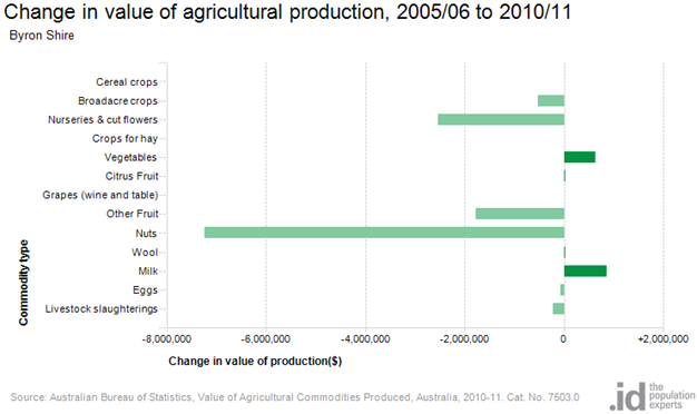
The table above clearly shows the change in values of
production within the Shire over the previous census period, with the only two
industries to grow being vegetables and milk production. New data will be
available in November 2017.
CHART THREE:
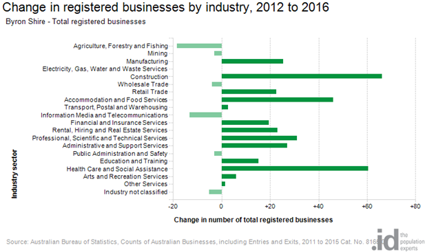
This table demonstrates that 20 agricultural businesses
de-registered in the four year period from 2012 to 2016.
CHART FOUR:
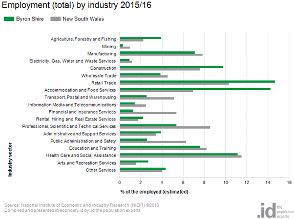
The above table demonstrates that as a region, compared with
the rest of NSW, we have a higher percentage of our workforce employed in
agriculture.
CHART FIVE:
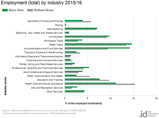
However this chart clearly shows that we have fewer employed
in agriculture than in the northern rivers area but with a higher percentage
employed in the accommodation and food services industry.
CHART SIX:
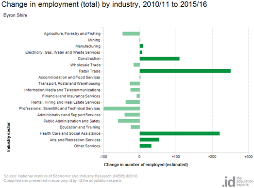
Staff Reports - Infrastructure Services 13.28
Staff Reports - Infrastructure Services
Report No. 13.28 Mullumbimby
Parking Strategy
Directorate: Infrastructure
Services
Report
Author: Joshua
Winter, Civil Engineer
Evan Elford, Team Leader
Infrastructure Planning
File No: I2017/1286
Theme: Community Infrastructure
Local Roads and Drainage
Summary:
Council resolved on 24 August
2017 via Resolution 17-373 to undertake investigation and community
consultation regarding the possible implementation of a revised parking
management strategy in the Mullumbimby Town Centre. The initial investigation
prepared by Traffic and Parking Systems Group (TPS) considered the current
demand and potential alternative arrangements, including alternative time
restrictions and the potential implications of introducing a pay parking
system. Council resolved not to pursue pay parking in Mullumbimby at this
stage.
Council staff have consulted with
the community regarding the changes to the time limits. The following key
points have been extracted from the online parking review survey (126
responses), which generally aligns with the discussions throughout the consultation:
· 89.7% of respondents generally travel to the Mullumbimby
town centre using their car (Q6)
· 56.3% of respondents are generally not at all or not very
satisfied with parking availability (Q11)
· 65.1% of respondents reported as 9:30AM to 2:30PM being the
most difficult time to park (Q13)
· 67.5% of respondents would support the time limit changes
identified in the TPS Report (Q14)
Based on the survey and
consultation feedback, it is proposed that the majority of the community agree
that there is an issue with parking in Mullumbimby, and would be supportive of
the parking time limits changing in line with the TPS report.
|
RECOMMENDATION:
1. That Council endorse the
implementation of the changes to parking time limits in the Mullumbimby town
centre, in line with Figure 1 in this report, being 1P throughout Burringbar
Street and the addition of 4P zones at the ends of Stuart and Dalley Streets,
with 2P remaining in place for the remainder of Stuart and Dalley Streets.
2. That the time limit changes
be reported to the Local Traffic Committee (LTC).
3. That Council approve a
budget of $15,000 to implement the revised parking time limits, from the Infrastructure
Renewal Reserve.
4. That Council receive a
report after twelve (12) months, to review:-
a) The effectiveness of the time limit changes in managing
parking turnover;
b) Infringement levels throughout the town centre; and
c) Based on the outcomes of a) and b) above, the
introduction a pay parking scheme to manage parking turnover and
effectiveness in accordance with the recommendations of the Traffic
and Parking Systems Group (TPS) report titled “Mullumbimby Town Centre
Parking Management Strategy” (#E2016/80919).
|
Attachments:
1 24 August
2017 Council Report Mullumbimby Parking Management Strategy, E2017/101924 ⇨
2 Excerpt
from MRCagney's Mullumbimby Movement Strategy, E2017/102139 ⇨
3 Detailed
Report Mullumbimby Parking Review Survey, E2017/102160
⇨
4 Text
Responses to Mullumbimby Parking Review Survey, E2017/102239 ⇨
5 Submissions
to Mullumbimby Parking Review Survey, E2017/102818
⇨
6 Concerns
Raised in Submissions Regarding Mullumbimby Parking Review, E2017/102843 ⇨

Report
Council Resolution 17-373 dated 24 August 2017 resolved as
follows:-
|
17-373 Resolved
1. That
Council note the Mullumbimby Town Centre Parking Management Strategy
(E2016/80919) prepared by Traffic and Parking Systems Group (TPS) as a basis
for community engagement.
2. That
consultation be undertaken with the Mullumbimby community regarding the
possible implementation of a revised parking layout in the town centre.
3. That
a budget of $10,000 is allocated from the Pay Parking Reserve to perform the
investigation and community consultation with the Mullumbimby community
regarding the possible implementation of a revised parking layout in the town
centre.
4. That
Council consider the results of the investigation and community consultation
at the 23 November 2017 meeting in determining its adoption of a possible
revised parking management strategy.
|
As per resolution item number 2,
the TPS Group report was used to consult with the community regarding the
proposed parking changes.
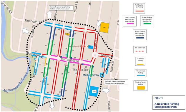
Figure 1 – Proposed Mullumbimby Parking
Management Plan
As per resolution item numbers 2
and 3, Council staff consulted with the community regarding the proposed
changes. The following community consultations were held:
· Drop in Sessions at the Council office in Mullumbimby
Monday
25 September 2017 from 8:30am – 4:30pm
Monday
9 October 2017 from 8:30am – 4:30pm
· Mullumbimby Farmers Market stall
Friday 29 September from 7am – 11am
Friday 13 October from 7am – 11am
· Public Exhibition open for submissions
Wednesday 20 September to Friday 20 October
· Online information portal and survey
Thursday
21 September to Friday 20 October
Results of Consultation
As per resolution item number 4,
staff have prepared this report to inform Council of the results of the
community engagement and online survey, in order to provide a recommendation to
move forward.
A summary of community engagement
and the online survey is provided in the report attachments, being;
· Excerpt
from MRCagney’s Mullumbimby Movement Strategy;
· Submissions
received during the exhibition period; and
· Survey
results from online survey.
Key issues raised in the
submissions received have been collated below.
Key issues raised in
submissions relevant to the changes in time limits
Due to Council not considering
pay parking, there were only a small number of submissions. The following
issues raised by the community during consultation are pertinent to
Council’s consideration of this matter:
· There
were a small number of residents that voiced that they would like pay parking
considered for Mullumbimby as well as Brunswick Heads.
In
response to this:
o Council resolved to
consider time limit changes only for Mullumbimby and may consider pay parking
in the future if the time limit changes do not effectively manage the available
parking.
· Submissions
were received regarding 15 minute parking outside the post office and the banks
and grocery stores.
In
response to this:
o If Council were to
introduce 15 minute parking outside all banks, it would impact the number of
available parks on Burringbar Street. Reducing the time limits to 1 hour and
enforcing the time limits should see sufficient available parks for banking and
grocery shoppers.
Staff Recommendation
The change to the parking time
limits are recommended to be reported to the Local Traffic Committee (LTC).
Based
on the survey and consultation feedback, it is proposed that the majority of
the community agree that there is an issue with parking in Mullumbimby, and
would be supportive of the parking time limits changing in line with the TPS
report.
On this basis the following
is recommended:-
1. That Council endorse the
implementation of the changes to parking time limits in the Mullumbimby town
centre, in line with Figure 1 in this report, being 1P throughout Burringbar
Street and the addition of 4P zones at the ends of Stuart and Dalley Streets,
with 2P remaining in place for the remainder of Stuart and Dalley Streets.
2. That
the time limit changes be reported to the Local Traffic Committee (LTC).
3. That Council approve a budget of
$15,000 to implement the revised parking time limits, from the Infrastructure
Renewal Reserve.
4. That
Council receive a report after twelve (12) months, to review:-
a) The effectiveness of the time limit changes in managing
parking turnover;
b) Infringement levels throughout the town centre; and
c) Based on the outcomes of a) and b) above, the introduction a
pay parking scheme to manage parking turnover and effectiveness in accordance
with the recommendations of the Traffic and Parking Systems Group (TPS) report
titled “Mullumbimby Town Centre Parking Management Strategy”
(#E2016/80919).
Subject to Council endorsement,
the following actions will be required to move forward:
· If adopted, notify the Local Traffic Committee
regarding Council’s resolution.
· Advise the Mullumbimby Masterplan Guidance Group of
Council’s resolution.
· Implement revised time zones (as per Figure 1).
Statutory and Policy Compliance Implications
As Council is the roads authority
for all roads in question, Council only needs to resolve to change the time
limits in order to implement these. No further approvals are required.
Financial Implications Moving Forward
It is estimated that a budget of
$15,000 will be required to implement the revised parking layout, consisting of
new and revised signage to clearly identify revised parking time limits.
This simply allows for modifying the existing signs designating the existing
time zones.
Staff Reports - Infrastructure Services 13.29
Report No. 13.29 Proposed
Boundary Adjustment and Sale of Part Council Drainage Reserve Lot 103 DP 842022
Directorate: Infrastructure
Services
Report
Author: Deanna
Savage, Administration Officer Infrastructure Services
File No: I2017/1529
Theme: Community Infrastructure
Asset Management
Summary:
To endorse the Sale of Part Council owned Drainage Reserve
Lot 103 DP 842022 operational land to adjoining land owner at SP 89597 11
Banksia Drive Byron Bay.
|
RECOMMENDATION:
1.
That Council endorse the Sale of Part
Council owned Drainage Reserve Lot 103 DP 842022 Operational Land to adjoining
land owner at 11 Banksia Drive Byron Bay SP 89597.
2.
That Council accept the Valuation report
completed by Opteon Property Group (Confidential Attachment 1 E2017/98002)).
3. Without limiting the
delegation to the General Manager to negotiate a contract suitable to the
Council, terms and conditions of the contract will include requirements for:
i. the applicant to pay all costs associated
with the purchase of Council’s operational land Drainage Reserve Part
Lot 103 DP 842022, including but not limited to:
a) Council
application fees
b) Council’s
surveyor's fees and survey, valuation and legal costs
c) All registration
fees
d) Legal costs
4.
That the applicant lodges a development
application for the boundary adjustment to coincide with the contract of sale.
5. That Council authorise
the affixing of the Council seal to and the signing of all documents
necessary to affect the sale and boundary adjustment.
|
Attachments:
1 Confidential
- Valuation Report Opteon Solutions Matthew Tall Part lot 103 DP 842022, E2017/98002
2 Land
Acquisition and Disposal Policy (current_policies), E2017/105002 ⇨
3 Letter
from David Hauserman & Bazil Manousis - Formal Request to Purchase Council
Land - 11 Banksia Drive Byron Bay, S2017/19511
⇨
Report
Council was approached in
February of 2016 by tenants of unit 5 11 Banksia Drive Byron Bay to try and
obtain some additional car parking spaces by way of leasing part lot 103 DP
842022. They were informed that Council could not deal with a tenant and
that if they wanted to move forward with the additional spaces it would have to
come from the owners of the property.
A Development Application
10.2016.468.1 was lodged by the owners of 11 Banksia Drive, the owners of
Strata Plan 89597 and approved with a condition of consent to lease a portion
of the drainage reserve (blue section in Figure 1 below) for the additional car
parks. This was presented to Council staff who then determined that this land
was surplus to Council’s drainage needs and that it could be sold with
Council’s approval to the adjoining land owners to accommodate the car
parks rather than leasing the land.
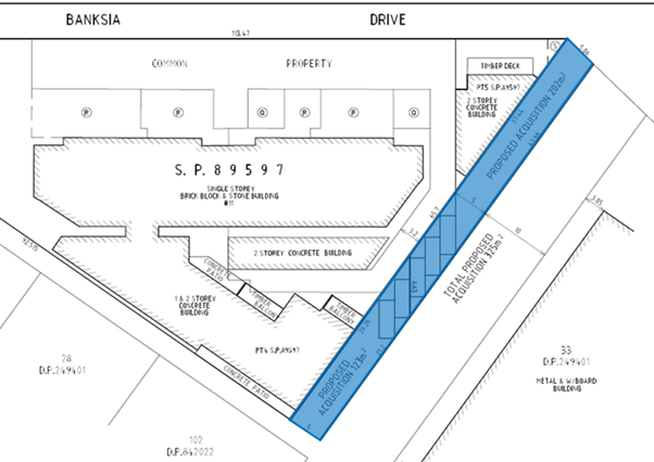
Figure
1
Council’s Drainage and Flood Engineer was initially
consulted and inspected the site from a drainage perspective. His comment
was that selling the portion of land indicated in blue Figure 1 above would not
create any drainage operational or maintenance issues for Council as long as
there was 10metres left in the remaining portion of land between the car parks
and the boundary line.
A Section 96 DA 10.2016.468.2 was submitted with the new car
parking configuration as per Figure 1 above. Council has also previously
passed the sale of drainage reserves in the area that has set precedence.
A Valuation was completed
by an independent valuer, Opteon Property Group (CONFIDENTIAL Attachment
1) for the approx. 325m2 part Council drainage
reserve Lot 103 DP 842022 Banksia Drive as indicated in Blue Figure 1.
The owners of SP 89597 approved the valuation and would like to move forward
with the purchase of the land. (Attachment 3) The purchase of the land has no bearing on the Development
Application and its subsequent approval.
Financial Implications
The applicant is to pay all costs associated with the
purchase of Council’s operational land Drainage
Reserve Part Lot 103 DP 842022, including but not limited to:
a) Council application fees
b) Council’s surveyor's
fees and survey, valuation and legal costs
c) All registration fees
d) Legal costs
Statutory and Policy Compliance Implications
The land is classified
Operational and there are no limitations on Council’s capacity to sell
the land.
Sale of Council land is
specifically exempt from the requirement to call tenders under the Section 55
(3) (d) of the Local Government Act 1993.
Pursuant to s377 of the Local
Government Act 1993, Council must resolve to buy or sell land, as it is a
non-delegable function, so a resolution of Council is required.
Council’s Land Acquisition and Disposal 2016
Section (6) Land Disposals.
Staff Reports - Infrastructure Services 13.30
Report No. 13.30 Land
purchase for access to Lot 4 Mullumbimby
Directorate: Infrastructure
Services
Report
Author: Phil
Warner, Manager Assets and Major Projects
File No: I2017/1530
Theme: Community Infrastructure
Projects and Commercial Opportunities
Summary:
Lot 4, DP 841856 is a 6.8
hectare land parcel owned by the sewer fund at the northern end of Station
Street, Mullumbimby.
The lot has no street
frontage and following negotiation, Council has the opportunity to purchase
land from Transport for NSW to secure permanent land access.
|
RECOMMENDATION:
1. That
Council authorise the General Manager to enter into contracts for the
purchase of part of Lot 2, DP1121508 to provide access to Lot 4,
DP841856, Station Street. Mullumbimby.
2. That
Council allocate a budget from the Sewer Fund for purchase to the
value nominated in the confidential attachment.
3. That
upon completion of the purchase, do all acts and things necessary to classify
the land as operational land.
|
Attachments:
1 Confidential
- CRN-162382 Valuation - Station Street Mullumbimby, E2017/101355
Report
Lot 4 Mullumbimby was
originally purchased by Council through the sewer fund for the purpose of
building a constructed wetland to improve the effluent quality being discharged
to the Brunswick River from the Mullumbimby Sewerage Treatment Plant (STP).
The wetland was never
constructed and Council completed the Brunswick Valley Sewerage Augmentation
Scheme in 2011, including closure of the old Mullumbimby STP.
Over the last decade there
have been a range of ideas investigated for a potential use of Lot 4 including
affordable housing and primitive camping. All the ideas have been
impacted by the fact there is no street frontage and secure vehicular access to
Lot 4.
Following extended liaison,
agreement has been reached with Transport for NSW for the potential purchase of
a section of the current rail corridor (being part of Lot 2, DP1121508) to
achieve permanent road access to Lot 4.
The land area is
approximately 3,500 m2 and 120 metres in length.
The proposed land purchase is
complementary to the proposed future uses of Council’s large property at
Vallances Road on the north side of the Brunswick River. The road access
will support potential pedestrian and cycle movement over the Brunswick River
and can also be a site for vehicle parking in association with the potential
use of Lot 4 and the Vallances Road property.
A valuation for the proposed
land purchase is attached in the confidential annexure.
Financial Implications
The sewer fund has sufficient reserves for the proposed land
purchase.
Statutory and Policy Compliance Implications
Local Government Act 1993
377 General power of the council to
delegate
1) A council may, by
resolution, delegate to the general manager or any other person or body (not
including another employee of the council) any of the functions of the council
under this or any other Act, other than the following:
(h) the compulsory acquisition, purchase, sale,
exchange or surrender of any land or other property (but not including the sale
of items of plant or equipment),
Staff Reports - Infrastructure Services 13.31
Report No. 13.31 Former
Mullumbimby Hospital - Contamination Review
Directorate: Infrastructure
Services
Report
Author: Phil
Warner, Manager Assets and Major Projects
File No: I2017/1554
Theme: Community Infrastructure
Projects and Commercial Opportunities
Summary:
The purpose of this report is
to present to Council the report prepared by consultants HBI on the review of
contamination at the former Mullumbimby Hospital in response to Council
resolution 17- 269.
|
RECOMMENDATION:
That Council receive a further report on the
projected costs of contaminated site management, site holding costs,
demolition of all structures and full site remediation for the Mullumbimby
Hospital property.
|
Attachments:
1 170805
Byron Council Review of Mullumbinby Hospital ACM Management Report Final, E2017/101652 ⇨
Report
At the 22 June meeting Council resolved in part:
17-269 Resolved (in part):
2. That
Council engage independent consultants to peer review the hazmat reports
prepared for
NSW Health for the former
Mullumbimby Hospital site.
Consultants Healthy Buildings International (HBI) were
engaged to conduct the review. The HBI report is attached.
HBI variously conclude in the report:
· the
investigations and assessments conducted to date are thorough and the
professional advice contained therein consistent with industry best practice.
· the unstable
and degraded friable ACMs (limpet) on all the roof system/ceiling spaces at the
facility, except Block B (Birthing Unit), coupled with the deteriorating roof
structure, presents a very high risk to users and occupiers of the facility as
well as the surrounding community.
· the level of
degradation of the friable ACMs (limpet) on the roof and in roof spaces is
extremely advanced and any failure of the enclosure system could result in wide
spread contamination for the Facility and the surrounding areas.
· it is
HBI’s opinion that an asbestos control strategy comprising ACM management
could not be feasibly instigated and maintained to permit future use of the
Facility, with associated risk acceptable to all stakeholders.
· based on the
guidelines prescribed in the Code of Practice How to Manage and Control
Asbestos in the Workplace, the appropriate method for management of the
unstable friable ACMs at the Facility is removal, including removal from within
wall cavities, which will require at least partial (i.e. one skin of a
ventilated double brick wall) demolition of external and internal walls.
Based on the HBI report, it is recommended that Council
receive a further report on the projected costs of contaminated site
management, site holding costs, demolition of all structures and full site
remediation for the Mullumbimby Hospital property.
Financial Implications
Advice has been received from
NSW Health regarding a quote obtained for demolition of the hospital buildings.
This quote for $1.8 million specified some exclusions and there is no provision
for project management, contract documentation and contingency. The total cost of
contaminated site management, site holding costs, building demolition, and full
site remediation is likely to be significantly higher than $1.8m.
Site holdings costs will be
incurred from the time Council owns the property until the majority of the site
is handed over to a principal contractor for the demolition and remediation of
this highly contaminated site. Holding costs will include the secure perimeter
fencing, on site security guard, security patrols, building integrity
inspections, air quality monitoring in accordance with the asbestos management
plan, investigations of unlawful entry, rectification of any security breaches
such as damaged windows, doors or stolen fixtures such as fire extinguishers,
ground maintenance and professional services for asbestos management and
incident management. It is understood that these costs have been very high for
NSW Health.
Statutory and Policy Compliance Implications
Purchase of the Mullumbimby Hospital site will result in
significant operational costs that are unlikely to be offset by income for an
as yet unknown period of time.
Upon completion of the proposed purchase Council will assume
the significant WH&S responsibilities associated with such a contaminated
site. Some of the contamination risks can be managed through rigorous
deployment of isolation, containment and exclusion practices under the
requirements of an asbestos management plan. However, risks such as the
deteriorated roof will only be resolved once demolition is complete.
Staff Reports - Infrastructure Services 13.32
Report No. 13.32 Brunswick
Heads Parking Strategy
Directorate: Infrastructure
Services
Report
Author: Joshua
Winter, Civil Engineer
Evan Elford, Team Leader
Infrastructure Planning
Tony Nash, Manager Works
File No: I2017/1556
Theme: Community Infrastructure
Local Roads and Drainage
Summary:
Council resolved on 24 August 2017 under Resolution 17-329
to undertake investigation and community consultation regarding the possible
implementation of a revised parking management strategy and/or a pay parking
scheme in the Brunswick Heads Town Centre.
The initial investigation prepared by Traffic and Parking
Systems Group (TPS) considered the current demand and potential alternative
arrangements including alternative time restrictions and the potential
implications of introducing a pay parking system.
Council staff consulted with the community regarding the
possible changes. The consultation period closed on 20 October 2017 and
included an online survey (235 responses) and a random Micromex phone survey
(200 surveys) as well as a number of drop in sessions and notifications to
residents and businesses to complete the surveys and/or provide a submission to
Council. 71 submissions were received. Late submissions were received up
to 27 October 2017.
Based on the survey and consultation feedback, it is
proposed that the majority of the Brunswick Heads community would be supportive
of the parking time limits changing to better manage parking in Brunswick
Heads, however contradictory to the Micromex survey; the online survey and
submissions were clearly against the introduction of pay parking, even if
Council was to dedicate all generated funds to projects in the Brunswick Heads
locality. There is an overwhelming fear that pay parking would
“ruin” Brunswick Heads and reduce business activity by up to
40%. However these same points were raised when introducing pay parking
in Byron Bay. Pay parking in Byron Bay has been a success for Council,
residents, property owners and business operators.
This report recommends the implementation of time limit
changes in Brunswick Heads.
Following the proposed time limit changes staff would
closely monitor parking demands, durations and infringements, undertake
additional number plate recognition surveys to determine tourist and visitor
impacts as a result of the changes and undertake further community consultation,
investigate and estimate costs associated with any identified infrastructure
upgrades to improve the parking scheme.
On completion of this work, staff prepare a detailed report
on outcomes with recommendations regarding the potential implementation of Pay
Parking in Brunswick Heads, including results of community consultation on the
dedication of revenue derived from a pay parking scheme in Brunswick Heads.
|
RECOMMENDATION:
1. That
Council endorse the implementation steps recommended in the Brunswick Heads
Parking Management Strategy as modified to;
a) Implement
revised time limits in the town centre immediately (as per point 2 below);
b) Closely
monitor parking demands, durations and infringements in the Town Centre Area
in particular with the objective to continuously quantify the appropriateness
of duration limits and to ‘track’ trends in the level of
infringement; and
c) Assess
the compliance with the revised time limits and associated infringements in
the management of parking turnover, following the implementation of the
revised time limits, in conjunction with any future consideration by Council
of the implementation of a pay parking scheme in Brunswick Heads.
2. That
Council endorse the implementation of the changes to the parking time limits
in Brunswick Heads, using the layout provided by the Brunswick Heads Chamber
of Commerce shown at Figure 2, incorporating the amendments identified in
Table 2.
3. That
Council seek Local Traffic Committee (LTC) endorsement of the parking time limit
changes.
4. That
Council negotiate any necessary agreement with Crown Lands to implement
parking schemes.
5. That
prior to the consideration of any Pay Parking Scheme for Brunswick Heads,
staff undertake further investigations and consultation and report to
Council in mid 2018 on revised parking arrangements and the cost of
infrastructure upgrade requirements in the following areas;
a) Booyun
Street, east of Park Street, in order to implement a Kiss and Ride School
drop off zone in this area;
b) Park
Street, between Fingal Street and Slessor Lane, to formalise parking whilst
maintaining the existing bus zone;
c) Parking
arrangements on South Beach Road, including dedicated parking for up to four
(4) Horse floats at the end of South Beach Road; and
d) Parking
arrangements in South Beach Lane
6. That
Council approve;
a) an
allocation of $115,000 to be funded from Section 94 Car Parking Brunswick
Heads to undertake the investigation works in items 5a) to 5d), inclusive;
and
b) the
allocation of $25,000 for the implementation or revised time limits
(including line marking) be funded from the existing signage program.
|
Attachments:
1 24 August
2017 Council Report Brunswick Heads Parking Management Strategy, E2017/103137 ⇨
2 Detailed
Report Brunswick Heads Parking Review Survey, E2017/103138
⇨
3 Brunswick
Heads Parking Estimated Revenue, E2017/103136
⇨
4 Text
Responses to Brunswick Heads Parking Review Survey, E2017/103141 ⇨
5 Confidential
- Submissions to Brunswick Heads Parking Review, E2017/103147
6 Brunswick
Heads Chamber Submission Final 20 10 17, E2017/103143
⇨
7 Brunswick
Heads Chamber Submission Parking layout-20-10-17, E2017/103142 ⇨
8 Brunswick
Heads School PC Submission Oct 2017, E2017/103144
⇨
9 Brunswick
Heads Submission Ocean Shores Tidy Town Committee, E2017/103145 ⇨
10 Brunswick Heads
Submission Easy Riders, E2017/103146
⇨
11 Micromex Brunswick
Heads Parking Study - 20171003, E2017/103148
⇨
12 Brunswick Heads Submission
Progress Association, E2017/103151
⇨
13 Confidential -
Brunswick Heads Submission Declan Curran, S2017/19024
14 Confidential -
Brunswick Heads Submission Brunswick Valley Woodchop & Entertainment
Committee, S2017/19031
15 Confidential - Brunswick
Heads Submission John Armstrong, S2017/18356
16 Confidential -
Brunswick Heads Submission Joan Ajala, S2017/19135
17 Confidential -
Brunswick Heads Submission Carolyn Armstrong, S2017/19223
18 Confidential -
Brunswick Heads Submission Margaret Thurecht, S2017/19221
19 Concerns Raised in
Submissions to Brunswick Heads Parking Strategy, E2017/103424 ⇨
20 Confidential -
Brunswick Heads Submission Kevin Thompson, E2017/103493
Report
Council Resolution 17-329 dated 24 August 2017 resolved as follows:-
17-329 Resolved
1. That
Council endorse the Brunswick Heads Town Centre Parking Management Strategy
(E2016/80884)
prepared by Traffic and Parking Systems Group (TPS) as a basis for
community
engagement.
2. That
consultation be undertaken with the Brunswick Heads community regarding the
possible implementation of a revised parking layout and pay parking scheme in
the town centre.
3. That
a budget of $15,000 is allocated from the Pay Parking Reserve to perform the
investigation
and community consultation with the Brunswick Heads community regarding the
possible implementation of a revised parking layout and pay parking scheme in
the town centre.
4. That
Council consider the results of the investigation and community consultation at
the 23
November
2017 meeting in determining its adoption of a possible revised parking
management
strategy and pay parking scheme.
In accordance with resolution
item numbers 1 and 2, the TPS Group report was used to consult with the
community regarding the proposed parking changes with submissions being
received up to 27 October 2017.
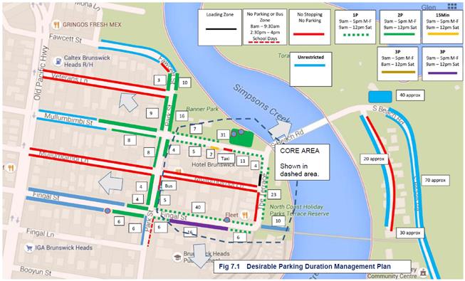
Figure 1 – TPS Consultant Proposed Brunswick
Heads Parking Management Plan
In accordance with resolution
item numbers 2 and 3, Council staff consulted with the community regarding the
proposed changes. The following community consultations were held:-
· Drop in to businesses in Brunswick Heads to discuss changes
and providing submissions
Tuesday
26 September from 8:30am – 4:00pm
· Drop in Session at the Brunswick Heads Library
Tuesday
10 October from 8:30am – 5:00pm
· Brunswick Heads market
Saturday
7 October from 7:00am – 1:00pm
· New Brighton farmers market
Tuesday
17 October from 7:00am – 11:00am
· Public Exhibition open for submissions
Wednesday
20 September to Friday 20 October
· Online information portal and survey
Thursday
21 September to Friday 20 October
· Meeting and open discussions with the following
Ø Brunswick Heads Chamber of Commerce
Ø Brunswick Heads Progress Association
Ø Brunswick Heads Public School
Ø Rotary Club members
Results of Consultation
In accordance with resolution
item number 4, staff have prepared this report to inform Council of the results
of the community engagement and online survey, in order to provide a
recommendation to move forward.
A summary of community engagement
and the online survey is provided in the report attachments, being;
· Submissions
received during the exhibition period;
· Survey
results from online survey; and
· Micromex
random survey report.
Survey Results
The following key points have been extracted from the online
survey - Attachment 2
· 83.8% of
respondents generally travel to Brunswick Heads town centre using their car (Q7);
· 64.8% of
respondents are at least somewhat satisfied generally with parking
availability (Q12);
· 60.9% of
respondents reported as 9:30AM to 2:30PM being the most difficult time to park (Q14);
· 64.7%
would at least somewhat support the time limit changes to better manage parking
(Q15);
· 73.6%
would not support a pay parking scheme in Brunswick Heads (Q16);
· This
dropped to 57% if Council were to dedicate all revenue to Brunswick Heads
projects (Q18);
The following key points have been extracted from the
Micromex random survey - Attachment 11:
· 73% of
respondents generally travel to Brunswick Heads town centre using their car (Q2);
· 53% of
respondents are at least somewhat satisfied generally with parking
availability (Q4d);
· 70-72%
reported that 9:30AM to 2:30PM was the most difficult time to park (Q6);
· 68% would
at least somewhat support the time limit changes to better manage parking (Q8a);
· 58% would
not support a pay parking scheme in Brunswick Heads (Q8b);
· This
dropped to 34% if Council were to dedicate all revenue to Brunswick Heads
projects (Q8d);
Submissions
A significant number of
submissions were received throughout the exhibition period including a
submission from the Brunswick Heads Chamber of Commerce that provided a copy of
their Fig 7.1 – Desirable Parking Duration Management Plan, that
had been developed in co-operation with the Brunswick Head Progress Association
(Figure 2).
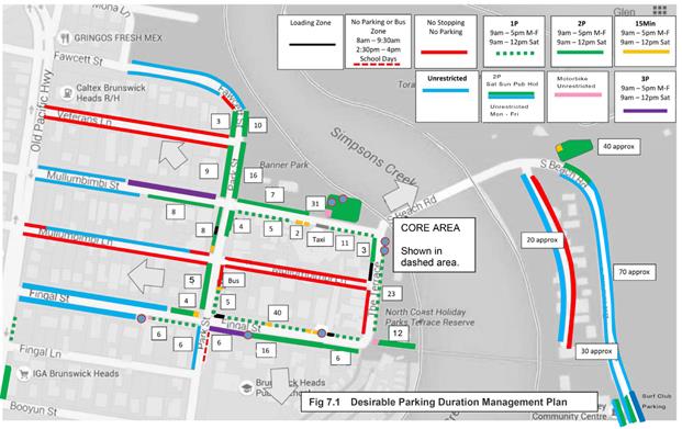
Figure 2 – Chamber of Commerce Proposed Brunswick
Heads Parking Layout
Table 1 provides a summary of the
key issues that were raised by the community during consultation and staff
commentary pertinent to Council’s consideration of this matter:
Table 1 – Submissions
Issues and Staff Comments
|
Item
|
Submission Issue
|
Staff Comment
|
|
1
|
There
is the general feeling that Brunswick Heads should not be compared to Byron
Bay and that the economic fragility of business in Brunswick Heads could not
sustain a financial downturn such that pay parking has the potential to
inflict on the town.
|
This
is a entirely valid concern that Council needs to consider prior to making a
decision for or against pay parking in Brunswick Heads
|
|
2
|
A
large majority of the respondents indicated that they would support the
changing of the time limits, with an increase in enforcement to change the
behaviour of parking users in Brunswick Heads.
|
Whilst
this is a valid point and would certainly change the behaviour of the
majority of users, it would also not be sustainable long term if parking
infringements dropped significantly. This would result in the cost of
enforcement not being sustainable for Council, to effectively enforce the
time limits and maintain correct behaviour. Then it is likely that as
enforcement would slowly drop as infringement revenue dropped, users would
revert to not abiding by the posted time limits.
|
|
3
|
There
is concern regarding the validity of the data collected throughout the online
and random phone surveys and that respondents were forced to answer questions
even if they didn’t want to.
|
Council staff that
worked with Micromex to write the questions had no intention to skew the
results either way, and there was still every opportunity to either agree or
disagree with the proposal. The results have been presented as-is, with
no attempt to cherry pick data in any of the questions. All questions
were required to be answered in order to receive the most accurate data, and
some of the data collated will be valuable for future project identification.
|
|
4
|
An
issue was raised that Council has not fulfilled the requirements to implement
a pay parking scheme according to RMS guidelines and that the TPS strategy
suggests trialling a change in time limits and enforcement prior to a pay
parking scheme.
|
Council,
as the roads authority, may introduce a pay parking scheme without RMS
approval, concurrence must be sought through the Local Traffic Committee
only. However as Council is using an electronic type permit system for
locals and businesses, RMS approval is required for this scheme. The RMS
requirement for pay parking is for it to be used to manage a parking demand
issue. There was a clear indication that there is a parking demand
issue in Brunswick Heads and although respondents indicated that they would
rather see this managed through changes to time limits and enforcement,
Council is within its power to proceed directly to a pay parking scheme if it
resolves to do so, with RMS approving the electronic permit scheme proposed
for locals and businesses
|
|
5
|
Lack
of 15 minute parking, disability access parking and loading zones in key
areas throughout the town centre
|
Council
have recommended the Brunswick Heads Chamber of Commerce layout with minor
amendments be adopted as the final time limit layout, which has considered
and located these at key points.
|
|
6
|
Amendment
to all day parking on South Beach Road to allow different options for beach
users.
|
This
issue can be reviewed in detail further however the Brunswick Heads Chamber
of Commerce layout does address the matter.
|
|
7
|
Lack
of motorbike parking in Brunswick Heads.
|
This
issue can be reviewed in detail further however the Brunswick Heads Chamber
of Commerce layout does address the matter.
|
|
8
|
Amendment
to laneway parking.
|
This
issue can be reviewed in detail prior to posting time limits however it is
anticipated that the issue can be addressed by adopting the Chamber of
Commerce layout.
|
|
9
|
There
is currently no school drop off ‘kiss and go’ area in Brunswick
Heads.
|
Council
staff met with school staff to discuss this issue and have identified that a
‘kiss & go’ zone could be implemented on Booyun Street, east
of Park Street.
This
will need to be implemented prior to the pay parking scheme, as this area
would become overflow parking if not formalised prior to the pay parking
scheme being introduced.
|
|
10
|
There
are no standing zones in place on Park Street from Fingal Street to Booyun
Street, which appear to remain in place when there was a school crossing at
this location previously.
|
Council
will remove these when the time limit signs are installed.
|
|
11
|
School
users have requested longer term parking adjacent to the school for events
and volunteers as school sessions are 2 hours long.
|
The
kiss and go zone in the car park at the end of Booyun Street could be used as
4 hour parking. This is likely to be the only change to the Chamber of
Commerce layout, being that the three hour zone proposed on Fingal Street
would remain as two hours, with 4 hour parking available further from the
town centre for school attendees.
|
|
12
|
Concerns
were raised regarding the impact of pay parking on low income families and
residents.
|
If
adopted, there would be a large number of all day (free) parking west of Park
Street that can be utilised if users do not wish to pay for parking.
Further, if a resident has the correct Centrelink concession card, they can
apply for an e-permit at no cost, allowing them to park throughout the shire
for free, whilst still abiding by the time limits.
|
|
13
|
Concerns
were raised regarding the overflow parking if pay parking is implemented,
both east of Simpson Creek and west of Park Street.
|
This
is a valid concern. If pay parking was adopted, Council could consider
implementing pay parking east of Simpson Creek, which would alleviate
overflow parking there, however streets west of Park Street will need to be
monitored and changes implemented as necessary.
|
|
14
|
There
are currently no parking signs in place on South Beach Road and South Beach
Lane to discourage illegal camping. Local residents have indicated that this
puts them at risk if they park their cars outside their house.
|
Council
needs to consider how this can be managed. Although the respondent indicated
that the parking rangers stated they were targeting campers, there needs to
be some formal instruction on how this can be managed and alternative signage
may need to be considered.
|
|
15
|
Suggestions
were made to include all parking east of Tweed Street as well as the boat
ramp in the pay parking scheme.
|
If
adopted, these areas should be monitored during the first twelve months, with
the pay parking area to be extended as required to effectively manage parking
throughout Brunswick Heads. It is not recommended to include these areas to
begin with.
|
|
16
|
There
is the belief that pay parking in Brunswick Heads will impact the tourism
industry in Brunswick.
|
This
is a valid concern that needs to be considered. It is difficult to determine
what effect it will have without trialling it for a minimum of twelve months.
|
|
17
|
Many locals
expressed their anger regarding the required purchase of an e-permit
exemption to park in their town.
|
If
adopted, there would be free, all day parking available for all parking
users, and the e-permit is available at the current fee of $55 per car, being
just over $1 per week.
|
|
18
|
A
number of issues regarding existing signage i.e. give way signs and no
parking signs.
|
A
full audit will be completed by staff within the parking area to ensure any
issues are rectified at the same time as the implementation of time limits
and/or pay parking.
|
|
19
|
The
Tennis Club is concerned that users will no longer wish to hire the courts if
they also have to pay for parking.
|
There
is no easy solution if pay parking was adopted. However if the users are
local, they have access to the e-permit, which would allow them to park
adjacent to or close to the tennis courts all year round, with all day
parking available close by. Tourists staying in Brunswick Heads could walk to
use the tennis courts, or park further away to avoid paying for parking.
|
|
20
|
A
proposal was introduced to change all laneways to one way, to allow more
parking and reduce the cost of formalising these.
|
Council
could consider this proposal as part of any future master plan for Brunswick
Heads. It is not within the scope of this report to propose this change as it
would have a much larger impact that would need to be consulted with the
residents that access these lanes.
|
|
21
|
It
was indicated that pay parking may make some essential services more
accessible for local residents, in particular the elderly (who usually
receive an e-permit at no cost) i.e. doctor, dentist, chemist etc.
|
This
would be the case if pay parking was implemented.
|
|
22
|
It
was proposed that large rocks should be used wherever vehicle access is to be
restricted.
|
Council
staff will consider the most appropriate method for managing vehicular access
when auditing the town centre.
|
|
23
|
The
Anglican church on Fingal Street has expressed concern that there may be an
effect on parking due to overflow of parking if pay parking is introduced.
|
This
issue would be present with or without pay parking, if time limits are abided
by. It will need to be monitored and the church will need to be consulted if
the pay parking scheme is implemented to determine if anything can be done to
assist.
|
|
24
|
A
comment was made regarding the fact that when pay parking was introduced in
Byron, it directed tourists to Brunswick Heads and not everyone is happy
about this.
|
Pay
parking may or may not have an effect on the number of tourists visiting
Brunswick Heads.
|
|
25
|
A
number of horse riding businesses that utilise Brunswick Heads for beach
riding experiences have expressed their concerns that there are no safe
places to park horse floats in the area.
|
Council
could consider providing up to four (4) horse float parks at the end of South
Beach Road when the car park is sealed and line marked. An interim solution
may be required until such time as this can take place. Staff will consult
with the horse riding community to determine an appropriate solution to the
current parking arrangements which are causing concerns.
|
|
26
|
Comments were made
regarding the relaxation of pay parking around events.
|
Council could consider
this for future events, though events are generally the busiest time in
Brunswick Heads when parking demand is at its highest. Irrespective of pay
parking, the time limits should be adhered to, with enforcement as required.
|
The introduction of time limited
parking to the town centre alone would potentially see increased pressure from
tourist utilising the existing parking in South Beach Road and South Beach Lane
if the bulk of that area was to be classified as unrestricted parking as
preferred by the Chamber of Commerce rather than parking in the town centre
area. This would then impact parking availability along the beachfront. It is
considered that this area should be changed to 4hr timed parking. Timed
parking limits also need consistency across the shire as this benefits both
users and enforcement officers.
Volunteers, those attending
school functions that extend beyond 2 hours and parking arrangements generally
in Fingal Street will be better served by implementing 2H parking in front of
the school and providing 4H parking on Booyun Street, east of Park
Street. This area is also suitable for implementing a “Kiss and
Go” drop off area.
Whilst generally supported by
staff, a number of modifications are recommended to be made to the Chamber of
Commerce time limit layout plan in association with time limit changes as
detailed above and in table 2.
Table 2 – Amendments
to Chamber of Commerce Layout – Time Limit Changes
|
Chamber of
Commerce Proposal
|
Amendment
|
|
Unrestricted Parking South Beach Road and South Beach Lane
|
4H Parking to ensure parking availability is maintained in
this area.
|
|
Time limits to apply 9am – 5pm Monday to Friday,
9am-12pm Saturday
|
Time limits to apply 9am – 6pm, 7 days a week for
consistency across Council’s parking areas
|
|
3H parking on Fingal Street
|
2H parking in Fingal Street. Introduce 4H parking on
Booyun Street, east of Park Street, which is an ideal location for school
attendees and maintains consistency in time limits across Council’s
parking areas.
|
Pay Parking Considerations
In addition to the comments
provided on the key issues raised in submissions, staff identified other areas
of concern requiring additional consideration and modification to the Chamber
of Commerce proposal due to the impacts parking time limit changes may have on
peripheral areas should Council also choose to implement pay parking.
Should pay parking be introduced
in the town centre the scheme should be extended to include South Beach Road
and South Beach Lane.
The operations of bus and parking
facilities near the school in Fingal and Park Streets and school event parking
and kiss and go drop off arrangements in Booyun Street need to be
rationalised.
The interim overflow parking
arrangements currently in place and the community requests to cater for more
appropriate horse float parking at South Beach Road need further investigation
and consultation.
Table 3 outlines a number of
suggested modifications to the Chamber of Commerce plan should Council resolves
to introduce pay parking.
Table 3 – Amendments
to Chamber of Commerce Layout required for Pay Parking
|
Chamber of Commerce
Proposal
|
Amendment
|
|
Unrestricted Parking South Beach Road and South Beach Lane
|
4H Parking plus meters if pay parking is adopted by
Council
|
|
Time limits to apply 9am – 5pm Monday to Friday,
9am-12pm Saturday
|
Time limits to apply 9am – 6pm, 7 days a week for
consistency across Council’s parking areas
|
|
3H parking on Fingal Street
|
2H parking in Fingal Street.
4H parking will be provided in the parking area to be
formalised on Booyun Street, east of Park Street, which is an ideal location
for school attendees and maintains consistency across Council’s parking
areas.
|
|
Bus zone only on west side of Park Street south of Fingal
Street
|
Implement combination bus zone and staff parking for
school staff in this location, with appropriate design and access time limits
in place for safety.
Supported by the School Principal
|
|
No ‘Kiss & Ride’ zone proposed for the
Brunswick Heads Public School
|
Implement ‘Kiss & Ride’ zone on Booyun
Street, east of Park Street, which is at the rear access gate of the school
and provides direct access and line of sight to school administration area.
Supported by the School Principal
|
|
No horse float parking proposed
|
Up to four (4) parks for horse floats to be provided at
the end of South Beach Road. Details to be developed in consultation
with horse riding community
|
Implementation Timeframe
& Land Tenure
Subject to Council endorsement,
the following actions will be required to move forward:-
· If adopted, notify the Local Traffic Committee.
· If adopted, negotiate agreement with Crown Lands where
necessary
· Advise the Brunswick Heads Chamber of Commerce,
Progress Association, School and the wider resident and business community of
Council’s resolution.
· Implement revised time zones (as per Figure 2 and any
amendments identified in table 2 or the adopted recommendations)
· Implement monitoring, further investigations and
reporting as identified to inform Council’s future deliberations in
determining potential implementation of a paid parking scheme for Brunswick
Heads to be reported mid 2018.
It is noted that there are
sections within the potential parking area that are partially located on Crown
Lands. Council will need to negotiate an agreement with Crown Lands in
order to implement time limit modification and pay parking in these areas:-
· Torakina
car park on South Beach Road
· Section
of Surf Life Saving Club area on South Beach Road
· Longitudinal
section of South Beach Road to the east
· Corner
of Fingal Street and The Terrace adjacent to the caravan park
· Portion
of car park outside the Brunswick Heads Hotel
Financial Implications
Should Council adopt proposed
time limit changes, it is estimated that a budget of $25,000 will be required
to implement the revised parking layout, consisting of new and revised signage
to clearly identify revised parking time limits. This simply allows for
modifying the existing signs designating the time zones.
Staff have identified the need
for further detailed investigation and consultation in relation to bus zone and
parking arrangements in Park Street, parking and kiss and go drop-off in Booyun
Street and parking generally in South Beach Road and South Beach Lane to
determine the final scope of and costs for infrastructure works to be reported
to Council.
Further, and generally in
accordance with the recommendations contained within the TPS report, a budget
of $10,000 is required to monitor parking demands, durations and infringements,
undertake additional number plate recognition surveys to determine tourist and
visitor impacts and report to Council.
Table 4 provides budget
requirements to complete these tasks noting that formalisation of a number of
areas throughout Brunswick Heads in conjunction with the implementation of a
revised limited scheme or a pay parking scheme is considered necessary to avoid
negatively affecting the surrounding areas.
Table 4 – PRELIMINARY
budget requirements to implement Brunswick Heads Parking Strategy
|
Item
|
Estimate
|
Description
|
|
Revised time limits
|
$25,000
|
Line marking and signs
|
|
Monitor Parking Demands etc
|
$10,000
|
Report on time limit change performance for further
consideration of pay parking
|
|
Park Street b/n Fingal Street and Booyun Street
|
$20,000
|
Investigate, consult and report on the implementation of
combination bus and parking zone, including survey, design, and associated
works
|
|
Booyun Street east of Park Street
|
$25,000
|
Investigate, consult and report on the implementation
‘Kiss & Ride’ zone and 3H parking, including survey, design
and associated works
|
|
South Beach Road & South Beach Lane
|
$60,000
|
Investigate, consult and report on the implementation and
Formalisation of parking east of Simpson Creek including Torakina Park and
Surf Club. Includes survey, design and associated works
|
|
TOTAL
|
$140,000
|
|
This estimate is proposed to be
funded in the following way:-
· $115,000
to be funded from Section 94 Car Parking Brunswick Heads (which has a current
balance of approximately $200,000)
· $25,000
(Line marking and Signs from existing Operating budget)
Statutory and Policy
Compliance Implications
Pay
Parking
As reported
in Council report 13.17 (attached); the following information details the
requirements for Council to implement a pay parking scheme.
RMS
guidelines contain details where Council must either comply or consider them,
and specifies where RMS concurrence or approval is needed. Both guidelines are
available online:
http://www.rms.nsw.gov.au/business-industry/partners-suppliers/documents/technical-manuals/payparkingv4.pdf
http://www.rms.nsw.gov.au/business-industry/partners-suppliers/documents/technical-manuals/permit-parking.pdf
The
guidelines are assumed to be current despite having reference to the now
repealed Road Transport (Safety and Traffic Management) Regulation 1999 which
has been replaced by the Road Transport (General) Regulation 2013 which
within Part 5 details parking schemes:
http://www.legislation.nsw.gov.au/maintop/view/inforce/subordleg+367+2013+cd+0+N
The RMS
guidelines empowers a parking authority (i.e. Council) to establish and operate
a parking scheme, be it a meter, ticket, phone or coupon system employed,
noting the model discussed within this report is akin to a Meter Parking Area
system based on ‘pay by plate’. This is possible as follows.
At s61 within
“Subdivision 1 Metered Parking Schemes” the following is stated:
A parking authority may set aside the
whole or any part of a road in its area of operations as a metered parking
area.
Note. Rules 207–1 and 207–2 of
the Road Rules 2014 make provision for parking in
metered parking areas. Clause 3 (1) defines a metered parking area and metered
parking space to have the same meanings as in rule 207–1.
As for
‘pay by plate’ this appears confirmed at s62 Parking Meters which
states:
(1) The
parking meter for a metered parking space must indicate:
….
(d) in the case
of a metered parking space for a registration metered parking area—that
the registration number of the vehicle must be entered for use of the parking
space.
Similarly,
the guidelines and regulation allow Council to fix fees for parking in metered
parking spaces by resolution of the Council and to charge different fees for
different areas, days or times of day should they wish. Nevertheless Council
need to adhere to the RMS guidelines where they are mandatory; and where they
are not they are considered good practice and recommended.
To date
Council have worked with the RMS through the LTC as per the guidelines to
establish the pay parking scheme in the Byron Bay town centre and Marine
Parade. This will need to continue if Council wish to proceed with the
parking scheme described, including exemptions, noting that the Pay Parking
guideline states Council as a parking authority:
…is not entitled to provide or to charge for parking in pay
parking spaces if it fails to comply with the RMS guidelines.
RMS guidelines have to date been
met and no objection received from the RMS. However no approval or
concurrence will be forthcoming from RMS regarding Brunswick Heads until
Council conclude and refer a completed parking study to them. The recommendation
made in this report seeks to provide staff such opportunity and avoid a
continuous feedback loop between Council and RMS.
As for a Resident Parking Permit
scheme, it is intended this be employed with the same arrangements as the
previously employed schemes for Byron Bay in residential streets for those that
reside in that street (and their guests) to be exempt through provision of a
resident’s scheme permit (preferably based on registration plate as
well).
As for
enforcing a Metered Parking Area (i.e. pay parking scheme) Rule 207 Road rules
2014 applies and reads as follows:
(6) Driver
must pay relevant parking fee for ordinary metered parking area
A
driver must not park in a metered parking space for an ordinary metered parking
area without paying the relevant parking fee for the space for at least the
minimum period of time for which parking in the space must be paid for.
(8) Driver
must enter registration number and pay relevant parking fee for registration
metered parking area
A driver must not park in a metered parking space for a registration metered
parking area without:
(a) entering
the registration number of the vehicle into the parking meter for the space,
and
(b) paying
the relevant parking fee for the space for at least the minimum period of time
for which parking in the space must be paid for.
As Part (6) states, the driver
must pay and while Part (8) requires the registration plate to be entered
and pay the relevant fee. In Council’s scenario of providing an
exemption to “paying the relevant parking fee” a pre-registered
registration plate entered at the meter would be akin to paying the fee.
However, if the registration was not entered, no payment would be made and the
offence of “Park without paying meter fee” would be committed.
As for enforcing a Resident
Parking Permit area the offence is typically aligned with parking beyond the
signed time limit, which of course does not apply to those exempt.
Staff Reports - Infrastructure Services 13.33
Report No. 13.33 Tree
Removals Railway Park Byron Bay
Directorate: Infrastructure
Services
Report
Author: Michael
Matthews, Manager Open Space and Resource Recovery
File No: I2017/1687
Theme: Community Infrastructure
Open Space and Recreation
Summary:
This report outlines the decision making process and
background to the undertaking of recent works within Railway Park and
process used in obtaining all relevant approvals and requirements prior to
works (including tree removal). These works included the removal of the
garden beds fronting Jonson street within Railway Park, whilst retaining all
vegetation over 2m within these beds and the removal of three (3) trees
described by staff as:-
1. Eucalyptus
Dunnii approximately 12m tall estimated 30 years old
2. Archontophoenix
cunninghamiana approximately 12m tall estimated 30 years old and
3. Sterculia
quadrifida estimated 6m and estimated as 8 years old.
This report also provides background information in relation
to the relocation notification issued to Byron Environment Centre (BEC).
This report also provides information specific to the
Tourism Demand Driver Infrastructure (TDDI) funded redevelopment of Railway
Park and its program interrelationship with Operational Actions performed.
|
RECOMMENDATION:
That Council:
1. Note
the report.
2. Finalise
concept plans of Railway Square Beatification Plan and report to Council in
accordance with resolution 17-555.
|
Attachments:
1 Tree /
Vegetation Removal - Approval Pathways, E2017/104389
⇨
2 BBTCM
Leadership Team Meeting August 2017, E2017/104726
⇨
3 Letter to
BEC in accordance with resolution 17-555, E2017/105004
⇨
Report
Council at is Extra- Ordinary
Meeting of 2 November 2017 resolved an urgency motion in relation to Works in
Railway Park, Byron Bay:-
17-555 Resolved that Council:
1. Withdraw the relocation notice to the BEC from the rotunda inside
Railway Park.
2. Receive a report at the next Ordinary meeting, outlining the
decision making process to
undertake
the works and the process in obtaining all relevant approvals and requirements
prior to works (including tree removal), and this review be completed and
reported back to Council, with any forthcoming recommendations.
3. Do not undertake any further infrastructure or landscaping works
in Railway Park until formal adoption of a railway square beautification plan
at an Ordinary Council Meeting.
Background
The Better Byron Crew (BBC)
is tasked with maintenance, refurbishment, renewal, minor capital works and
litter collection within the Byron Town Centre. The BBC delineated service area
has recently been reduced to increase levels of service across assets within
the town.
The reduced BBC service area
was in response to concerns raised with BBC service levels on particular assets
such as the town’s garden beds and litter removal performance along
foreshore assets.
Detailed review of service
levels across assets was undertaken.
This review identified that
the level of resourcing for the town centre was insufficient to meet the
expected standards. It was identified that the area serviced by the BBC
had undergone significant creep since the establishment of the Town dedicated
crew without a realistic increased in resource allocation.
From this review, perceived
performance matters that directly relate to expected levels of service of
highly visual assets were addressed by the General Manager via direction to
staff to:-
· Reduce the
BBC delineated area;
· Increase
litter collection servicing during weekends on the foreshore assets; and
· Divert
saved resource into garden bed maintenance.
One area identified as
receiving a poor level of service was the garden beds of Railway Park fronting
Jonson Street.
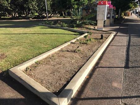
Fig 1 - Railway Park, Jonson Street garden Beds (facing north from
Exeloos)
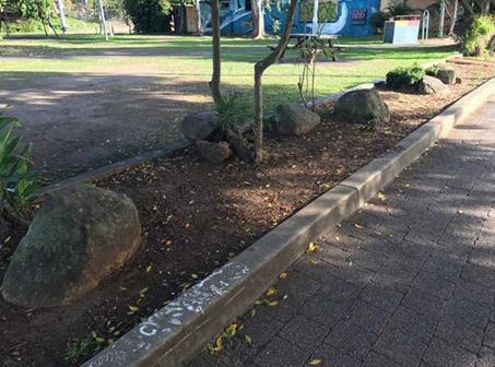
Fig 2 - Railway Park, Jonson Street garden Beds (Facing North West)
The review identified a
number of reasons why performance of this asset was poor.
These reasons included poor
initial design, high adjacent pedestrian traffic, pedestrians short circuiting
existing pathways causing damage to garden bed amenity, high number of assets
assigned to the BBC relative to team size and change in work practices.
One significant change in
work practices was the ceasing of herbicide use within the town and high public
use parks.
Traditional maintenance
practice within garden was the use of selective herbicide to manage weed growth
in garden beds. This practice involved the use of a wick application to control
weeds (method consists of a wick soaked in herbicide which the wetted wick is
used to wipe or brush selectively onto the weed). This method was ceased
in 2015 and replaced with a labour intensive hand weed program of the 151
individual garden beds within the Byron Township.
Throughout the Byron town
centre, the BBC has been progressively improving garden bed function and
amenity through edging and heavy hardwood chip mulching. This work
suppresses weed growth, reducing labour intensive hand weeding and changes
pedestrian behaviour through making it more difficult/ less favourable for
pedestrians to ‘short cut’ across garden assets.
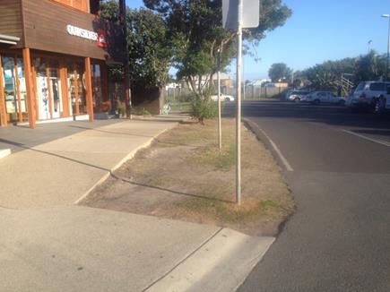
Fig 3a - Before photo of SW corner of Bay and Jonson Street –
simple turf solution
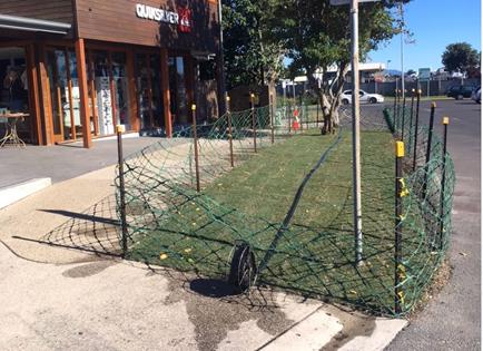
Fig 3b -After photo of SW corner of Bay and Jonson Street – simple
turf solution
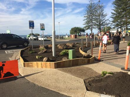
Fig 4 - Works in progress prior to Mulch being applied, South East
corner Jonson and Bay Street
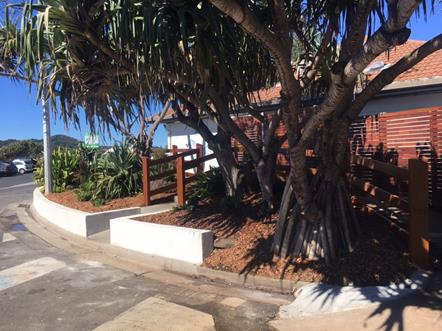
Fig 5 - Completed works, garden bed in front of Fish Heads
In discussions with a
Landscape architect in relation to Railway Park, it was agreed that due to
pedestrian volumes within this precinct, removal of these beds in there current
form was operationally preferred.
On Thursday the 12th
October, direction was given to-
Have BBC remove the garden
bed along Jonson Street between the Café and the Exeloos:-
· Remove the
designated tree adjacent to the café (with TPO Cert) as agreed at a site
meeting with Councils engaged landscape architect and Director of SEE;
· Remove the
playground;
· Remove the two large
metal barriers in the car park near the Countrylink building; and
· Under the
supervision of the arborist and landscape architect have a tree doctor/men with
chain saws sculpt the trees in the park to create a play feature.
These directions were given
on the basis of routine renewal maintenance activities that aligned with the
scope of works that the BBC regularly performed.
Prior to this work, Railway
Park was identified, through the development and adoption of the Town Centre
Master Plan (BTCMP), as a primary Open Space that is best developed as a common
gathering point for leisure and recreation.
With the adoption of the
BTCMP, funding was sort under the Tourism Demand Driver Infrastructure (TDDI)
Program for redevelopment of Railway Park to that of which meets the vision and
spirit of the Master plan. Council was successful in the receipt of $260,000
on a 50/50 basis for the redevelopment of this park on the basis that works are
to be complete within the current financial year.
Program management of the TDDI integrated projects was
assigned to the Major Projects and Major Projects staff developed the delivery
plan and the associated communication and engagement plan.
The communication and engagement plan was reported to the
Executive Team on 7 June 2017 and the minutes state: Executive Team endorsed
the draft Communication and Engagement Plan for the Railway Precinct TDDI Grant
Program.
In conjunction with the grant and more broadly in the
context of implementation of the Byron Bay Town Centre Master Plan, a landscape
architect was engaged to prepare a concept design for the upgrade of Railway
Park.
Railway Park (Railway Square)
had been identified as a key catalyst site within the adopted Byron Bay Town
Centre Master Plan and had been discussed with the Byron Bay Town Centre Master
Plan Leadership Group including a design charrette undertaken in July 2017 by
the group.
The concept design for the upgrade of Railway Park envisaged
the relocation of the BEC rotunda to another location. It is understood
that this was also discussed by the Byron Bay Town Centre Master Plan
Leadership Group (Refer Attachment 2)
In association with the implementation of the communication
and engagement plan, correspondence was prepared and sent to stakeholders
including neighbouring landowners and businesses, community organisations with
an interest in the park and internal BSC staff. The correspondence
included an initial introductory letter regarding the project, meetings as
required and a later letter introducing the concept design.
The email to the Convenor of the Byron Environment Centre
Inc records that several attempts were made to contact the Byron Environment
Centre. A request was made to work (16 October 2017) together to relocate
the rotunda with a target for completion being 13 December 2017.
An extract from Council email (16 October 2017) is as
follows:-
As an introduction to the draft concept design, Council has
received community feedback via the Byron Bay Town Centre Master Plan
Leadership Team that the BEC kiosk in Railway Square would best be located
elsewhere. Relocating the kiosk would improve community and visitor use of the
park by increasing access and egress through the park and increasing visibility
and community safety in line with CPTED (crime prevention through environmental
design) principles.
I have searched and consulted within Council for a license, lease or other
agreement for the kiosk being placed in its current position and cannot find
any such document. If you have one on file, could you please provide it so that
we can consider the agreement in context of the project.
Council would like to have the kiosk relocated by 13 December 2017.
If you could please advise an alternate site for the kiosk at your earliest
convenience that would be much appreciated.
Council is willing to assist BEC with the physical relocation of the kiosk structure
to your new location and we're happy to discuss the details of this with you.
The 13 December 2017 date was proposed by staff to
incorporate it in the preliminary works program but to allow time to
effectively plan for careful relocation with an aim to preserve of the Arakwal
Art.
Upon receiving the email of 19 October 2017, the Convenor of
the Byron Environment Centre Inc wrote to Councillors on 23 October 2017
claiming an ‘eviction’ notice had been served.
A key part of the consultation for the proposed upgrade of
Railway Park was liaison with the Arakwal. A site meeting occurred
on 17 October at which Operational staff requested to be in attendance to
confirm early works scope.
Council staff was advised by the Arakwal representative that
there was support for the park upgrade and a request was made that the cultural
artwork on the rotunda be considered for preservation and, at minimum,
provision made for incorporating local indigenous art in the new designs.
The concept plan for the
Railway Park upgrade was presented by Councils engaged Landscape architect to
the BBTCMPLG on 25 October 2017.
It is understood that there was no further contact with Mr
Lazarus (Convenor Byron Environment Centre Inc) regarding relocation of the
rotunda prior to the Council meeting on 2 November.
At the 2 November 2017 meeting Council resolved 17-555.
In accordance with part 1 of the resolution a letter (#E2017/103282
– Attachment 3) has been sent to the BEC on 6 November 2017.
Tree Removal and Landscape
works (works as was performed)
At the August meeting of the Byron Bay Town Centre
Masterplan (BBTCM) Guidance Group it was agreed that an arborist would be
engaged to review trees in Railway Park to inform the planning work being
undertaken by the landscape architect in Railway Park.
A botanist was engaged to assess trees in Railway Park in
consultation with the landscape Architect and advice on 9 September 2017.
Staff met with the landscape architect to discuss the draft
plans being prepared for the park and as a result it was agreed that it would
be desirable for trees to be removed as part of the redevelopment and that an
arborists report had indicated that at least one tree was potentially
dangerous. Both the botanist and landscape architect agreed that the
forest gum was a limb shedding species
On the Friday the 13th October 2017, Manager of Open Space
and Resource Recovery relayed direction to staff to review and action necessary
approvals for removal of the designated tree adjacent to the northern boundary
of the reserve.
A Tree Removal for Public Infrastructure Permit Form, Issued
under Chapter B2 – Preservation of Trees and other vegetation of the
Byron Shire Development Control Plan 2014 was provided to the Manager Open
Space and Resource Recovery Manager on the 16th October specifying the removal
of three (3) trees, theses tress being:-
1. Eucalyptus
Dunnii approximately 12m tall (estimated 30 years old)
2. Archontophoenix
cunninghamiana approximately 12m tall (estimated 30 years old); and
3. Sterculia
quadrifida estimated 6m (estimated 8 years old).
Additional trees that were sort for removal were identified
as trees to be removed as part of the early works program for the parks
redevelopment.
The Eucalyptus Dunni, was considered by staff as presenting
risk to users of the park through exposed roots and as a future risk of limb
shredding as known limb shredding species.
Management staff provided permit form for directorate
signature.
This completed permit was provided to operational staff for
engagement of a level 5 qualified arborist contractor to undertake the works.
Considerations and steps used by staff in reviewing and
actioning the approval included:-
· 14th October - Review of
the Infrastructure SEPP guidelines
· Inspection and
documenting trees to be removed as above-mentioned.
· Consultation with SEE
Directorate on the 16th October 2017.
· Actioned advice received
from SEE that the Infrastructure Services Approval Pathway and Permit form
could be used as IS were the approving agency (Refer Attachment 1)
Operational staff installed site fencing on Tuesday 24th
around the garden beds including the Rotunda in preparation to separate the
public from the works to ensure public safety. It should be noted that
staff provided access to the Rotunda at all times outside of physical works.
On the Wednesday 25th October 2017 Staff met with
Byron Community Centre to relay imminent works and address any possible impacts
to the Artesian markets licenced each Saturday night within the park.
Tree Removals Wednesday 25th October
Due to the vegetation removal scope, operational staff
identified the need to engage a qualified arborist to remove the trees, as this
type of work falls outside the BBC scope of services.
At the time of the works, operational staff had a contracted
service undertaking tree works on a number of Norfolk Pines, including one
complete removal for reasons of Dead Dying or Dangerous provisions.
The specifications for these works required the Contractor
to hold, as a minimum an AQF 3 in arboriculture with supervision from an
arborist qualified to a minimum of AQF 5 in Arboriculture. This
contracted engagement was expanded to include these tree removal works in the
park.
All works were completed by Friday 27th October
enabling uninterrupted use by the Artisan Markets held on the night of Saturday
the 28th October 2017.
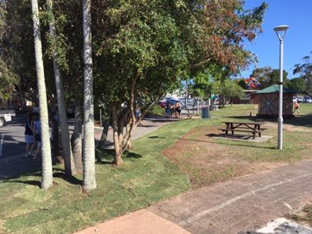
Fig 6 - Completed works, Railway Park garden beds adjacent to Jonson
Street
Financial Implications
Works performed funded from town centre upgrades budget.
Statutory and Policy
Compliance Implications
Trees removed under Removal for Public Infrastructure Permit
Form.
No other approvals were identified as being required for the
scope of works as performed.
Staff Reports - Infrastructure Services 13.34
Report No. 13.34 Bangalow
STP Membrane Replacement
Directorate: Infrastructure
Services
Report
Author: Dean
Baulch, Principal Engineer, Systems Planning
File No: I2017/1730
Theme: Community Infrastructure
Sewerage Services
Summary:
Bangalow sewage treatment plant (STP) was commissioned in
2007 and Suez Water Technologies & Solutions (formerly GE) supplied the
ZeeWeed 500D membranes. These membranes are a proprietary product and
have proven themselves to be an effective treatment unit.
The membranes are now 9 years old and show wear and tear on
the modules, module headers, plastic assembly parts and potting areas. The
cassette frame is still in good condition. However, there is a risk of
catastrophic failure of membranes which could lead to a critical down time of
the plant.
It is not possible to seek solutions from alternative
suppliers (i.e. this is a specialist product) and it is recommended that
Council accept that the supply and install of these membrane units by the
proprietary supplier.
|
RECOMMENDATION:
That Council:
1. Resolves
in accordance with Section 55(3)(i) of the Local Government Act, to not issue
a request for tender for the supply of membrane units for Bangalow STP
because the products required are proprietary products and a satisfactory
result would not be achieved by inviting tenders; and
2. Delegates the
General Manager to enter into a contract with Suez WT&S for the supply of
the membranes for $249,657 (ex GST) in accordance with the attached
proposal from Suez WT&S.
|
Attachments:
1 Confidential
- Suez WT&S - Proposal for the Bangalow STP Membrane Replacement &
Cassette Refurbishment - November 2017, E2017/103976
Report
Bangalow STP relies on the membrane system which, in simple
terms, filters the influent sewage by sucking it through many tubes arranged in
modules or banks instead of using large sized civil structure like those
clarifiers located at West Byron STP and Brunswick Valley STP. Bangalow
STP produces high quality effluent using the current membrane system.
Bangalow sewage treatment plant was commissioned in 2007 and
Suez Water Technologies & Solutions (formerly GE) supplied the ZeeWeed 500D
membranes. These membranes are a proprietary product and have proven
themselves to be an effective treatment unit. The membranes are nearing
the end of their useful life and Council requested Suez Water Technologies
& Solutions (WT&S) to check the system operation in accordance with
established best practices of membrane systems with an emphasis on condition assessment
of the membranes.
Comments from the condition report are as follows:
The membranes are now 9 years old and show wear and tear on
the modules, module headers, plastic assembly parts and potting areas. The
cassette frame is still in good condition. However, there is a risk of
catastrophic failure of membranes which could lead to a critical down time
of the plant. Therefore, Suez recommends planning for the membrane
renewal by either replacing by new cassettes and membrane modules or
reconditioning the cassette with new modules and assembly kit.
Suez (WT&S) also recommends installing the membrane
system to their proprietary LEAP cassette which will provide cost benefits from
reduced maintenance and power (i.e. electricity).
The Bangalow STP is sensitive to power interruption and
process outages. High risk is posed to the treatment plant process and
its capacity to take sewerage flows from Bangalow if the operation is required
to move away from the current technology and the proprietary membrane system it
uses. A further risk exists as it will also take an extended amount of
time to find or assess an alternative solution or product to rival the ZeeWeed
membranes.
Financial Implications
The Council approved budget of 2017/18 identified
replacement of the membranes at a budget value of $605,000.
There is a saving involved in the purchase of the units from
the proprietary supplier at a value of $249,657.00 (excluding GST).
Statutory and Policy Compliance Implications
Section 55 of the Local Government Act requires Council to
invite tenders before entering into any contract with a value of $150,000 and
over.
There are exceptions to this provided under the Act.
Section 55(3)(i) of the Act states that a tender is not
required “because of extenuating circumstances, remoteness of locality or
the unavailability of competitive or reliable tenderers, a council decides by
resolution (which states the reasons for the decision) that a satisfactory
result would not be achieved by inviting tenders”.
It is not possible to seek solutions from alternative
suppliers (i.e. this is a specialist product) and it is recommended that
Council accept the supply of these membrane units by the proprietary supplier Suez
Water Technologies & Solutions.
Staff Reports - Infrastructure Services 13.35
Report No. 13.35 Resolution
17-556 Additional information on Railway Park
Directorate: Infrastructure
Services
Report
Author: Shannon
McKelvey, Executive Manager, Organisation Development
File No: I2017/1740
Theme: Community Infrastructure
Open Space and Recreation
Summary:
This report provides information on the history, basis and
conditions under which the Byron Environment Centre occupies the rotunda in
Railway Park.
|
RECOMMENDATION:
That Council:
1. Note
the report.
2. Request
staff to commence work to include Railway Park in an updated Plan of
Management with the aim of completing the process by 30 June 2018.
3. Request
staff to enter into discussions with the Byron Environment Centre about the
future occupation/location of the rotunda structure and bring a report on the
outcome of those discussions back to the first Council meeting in 2018.
|
Attachments:
1 Email from
John Lazarus regarding BEC status in Railway Park and providing information to
inform the report prepared in accordance with Res 17-556, E2017/105104 ⇨
Report
On 2 November 2017 Council resolved:
17-556 “That
a report be received by Council outlining the history, basis and conditions
under which the Byron Environment Centre occupies the Rotunda in Railway
Park.”
To meet agenda deadlines, reports needed to be completed by
7 November 2017. From the research that has been able to be completed within
that period it appears:
1992 Council
acquired the former railway land that is Railway Park (Lot 2 DP 827049) from
state government. This departmental dealing also transferred to Council the
former Railway Station Masters Cottage and South Lawson Street carpark land.
25/6/1996 Council
adopted a Generic Plan of Management for Parks and Gardens which included and
covered Railway Park.
1997 The
Byron Environment Centre were given a 4 month lease over the Visitor
Information Centre “to provide tourist information seven … days
per week” at least between 10am and 4pm daily.
The lease was granted for an
initial 4 months while Council called expressions of interest for the future
operation of the Visitor Information Centre. Within 10 days Council had started
receiving complaints about the tourist information, or lack of it, that the BEC
were providing. At the end of that EOI process it appears that Council
initially resolved to grant BEC tourist information centre management rights
but then rescinded that resolution and proceeded with a fresh competitive
process for the management rights.
Council issued the BEC with a 3
month lease on the same terms ie ‘to provide tourist information seven
days per week’ while the competitive process was being run. During this
period Council continued to receive complaints about the poor standard of
visitor information services being provided by BEC.
In
August 1997 Council resolved to grant management rights to operate the Visitor
Information Centre to a Byron Bay Chamber of Commerce/Byron Shire Tourism
Association consortium.
Council wrote to BEC thanking them
for the services they had provided over recent months, advising that their
expression of interest had been unsuccessful and asking them to vacate the
Visitor Information Centre building at the end of their lease ie by 31 October
1997.
A
dispute arose with the BEC refusing to vacate the Visitor Information Centre at
the end of their lease. Amongst other things, while BEC had entered into
occupation under an initial 4 month lease, they refused to leave on the basis
of an argument that Council had no power to issue a lease to the selected
operator.
From the available information it
appears the dispute was resolved in late November 1997, after a claim had been
made against Council for damages arising from the delay caused by BEC’s
refusal to vacate the premises and Council had instructed solicitors to
commence a Supreme Court action to evict the BEC from the premises.
4/9/2001 Council
received a report on an offer by Byron Bay Chamber of Commerce to construct a
“demountable ‘gazebo’ in Railway Park”.
Staff noted that the construction
would be exempt development but recommended that Council defer consideration of
the proposal until the review of the Plan of Management was complete.
Res 01-1003 Council resolved to
allow the construction of the demountable busker’s gazebo to proceed.
20/5/2002 Byron
Environment Centre wrote to Council asking to “take over management of
the rotunda for use as an environmental information kiosk …” and
to “enclose the rotunda structure with hinged colourbond galvanised
panels to allow the site to be locked up when not in use ...”.
20/06/2002 Council
responded to Byron Environment Centre advising them, amongst other things, that
the Plan of Management for the site was under review and that Council “cannot
support your proposal at this time”.
Oct 2002 Byron
Environment Centre proceeded with construction activities without council
approval.
14/10/2002 Byron
Environment Centre wrote to Council stating amongst other things:
“When
we asked Council …[for] permission… to build our info kiosk in
Railway Park, your Mr Downes advised us that it was not possible because there
was no management plan …. We now ask Council, as we’ve gone to this
much trouble …. to allow ..[it] to stay until the Management Plan is
developed”.
29/10/2002 Byron
Environment Centre supplied what they referred to as a “Draft Interim
Management Plan for the Community Kiosk, Railway Park” and sought to
“manage the newly renovated Community Kiosk in Railway Park on behalf
of ourselves [BEC] and other community groups who wish to use it.”
The Management Plan was not in a form that could be a valid Plan of Management.
Oct 2002
–
May 2003 It
appears Council intended to proceed with removal of the structure (on the basis
that it was an inappropriate use of community land absent a Plan of Management
that permitted it and its structural integrity was unknown) and with
preparation of a site-specific Plan of Management for Railway Park.
18/3/2003 At
the Ordinary meeting a petition was tabled
containing 77 signatures regarding “Keep the BEC “Cubby-Tunda in
Railway Park”. Council resolved to note the petition 03-287.
29/4/2003 By
resolution 03-370 Council rescinded resolution 03-287.
07/05/2003 BEC
wrote to Council resubmitting their ‘Draft Interim Management Plan’
, arguing their case for keeping the ‘BEC CubbyTunda/Kiosk’ and
requesting that the “structure remains until it can be considered
under the proposal park plan of management”.
2005 After
extensive consultation and a public hearing Council resolved to defer adoption
of the then proposed Plan of Management for Railway Park “pending the
approval of a broader planning study for the historic precinct” and “consider
as part of the … quarterly financial review, the allocation of funding
for the development of the planning study…”. (NB time did
not permit further research of these resolutions).
13/11/2017 Council
received an email from the BEC providing information on the occupation of the
Rotunda, and to inform this report, prepared in accordance with Resolution
17-556. A copy of this email has been included at Attachment 1 to this Report.
In relation to the requested information on the basis and
conditions of occupation, it appears that the conversion of the structure was
not approved by Council and there is no record of any license, lease or other
documented authorisation for occupation for the structure. So, it seems that
the structure was enclosed and occupied in circumstances where the Byron
Environment Centre was aware that permission was required and had not been
obtained.
Under the 1996 Generic Plan of Management for Parks and
Gardens:
· A lease or a licence
over whole or part of the land can be granted to a private entity but only if
consistent with the use of the land for public purpose and council consults
with the community - the BEC do not appear to have ever held a lease or licence
over the structure.
· A public meeting is
required to be held to gauge community support if a substantial change to the
use of the park was proposed – no such public meeting was held as the
conversion of the structure from a public space to private use was not planned
or authorised by Council.
· A lease or licence could
only be granted where appropriate having regard to the activities carried out
by the proposed lessee/licensee, community need and opinion and provisions of
the Local Government Act – as the private use was not planned or
authorised, it is not known if the 3 pre-requisite requirements would have been
satisfied.
As there is no lawful lease or
licence over the space, it is likely that Byron Environment Centre’s
occupation of the structure is unauthorised. It also appears inconsistent with
the 1996 Generic Plan of Management and now also the requirements of the Local
Government Act 1993 as amended (due to changes made to the Act after 1996 but
before BEC took up occupation of the structure).
Now that Council is aware of
non-compliances with the Local Government Act, it is obligated to take
reasonable steps to rectify them. The steps Council can take include:
- Proceeding
to include Railway Park in an updated Plan of Management and then acting in
accordance with that Plan. To avoid the indefinite deferral that occurred with
this process last time, the Plan of Management process should have a definitive
end date (say by 30 June 2018) by which time either an updated Plan of
Management should have been adopted or other steps taken to regularise
unauthorised activity on community land. Work on identifying the best way
forward for a Plan of Management can commence immediately.
- Entering
into discussions with the Byron Environment Centre about the future
occupation/location of the Rotunda.
Financial Implications
Nil with regard to
preparation of this report.
Statutory and Policy Compliance Implications
It appears that BEC’s occupation of the structure in
Railway Park is contrary to the requirements of the Local Government Act.
Reports of Committees - Infrastructure Services 14.1
Reports of Committees - Infrastructure Services
Report No. 14.1 Report of the Byron Shire Floodplain Risk Management Committee
Meeting held on 12 October 2017
Directorate: Infrastructure Services
Report
Author: Dominika
Tomanek, Executive Assistant Infrastructure Services
James Flockton, Drain and Flood
Engineer
File No: I2017/1512
Theme: Community Infrastructure
Emergency Services and Floods
Summary:
That attachment to this report provides the minutes of Byron
Shire Floodplain Risk Management Committee Meeting of 12 October 2017 for
determination by Council.
|
RECOMMENDATION:
1. That
Council note the minutes of the Byron Shire Floodplain Risk Management
Committee Meeting held on 12 October 2017.
|
|
2. That Council
adopt the following Committee Recommendation(s):
Report No. 4.1 March 2017 Flood Event
File No:
I2017/1156
Committee Recommendation 4.1.1
1. That
Council note the report and existence of further report by Manly
Hydraulics Laboratory, prepared on a regional basis.
2. That
Committee members should provide feedback within 2 weeks regarding the draft,
with staff sending a reminder after one week.
|
|
3. That Council
adopt the following Committee Recommendation(s):
Report No. 4.2 North Byron Floodplain Risk
Management Study and Plan Tender
File No:
I2017/1356
Committee Recommendation 4.2.1
1. That
Council note the North Byron Floodplain Risk Management Study and Plan
Technical Brief (E2017/92200) including final updates from OEH.
2. That
Council staff and OEH note dissatisfaction expressed by some committee
members on consultants’ performance in preparing the preceding Flood
Study.
3. That
Council review and update its Climate Change Policy on the basis of recent
findings, including findings on regional rainfall changes.
|
|
4. That Council
adopt the following Committee Recommendation(s):
Report No. 4.3 Introduction to the Floodplain
Risk Management Process
File No:
I2017/1360
Committee Recommendation 4.3.1
That Council note the report.
|
Report
The attachment to this report provides the minutes of the
Byron Shire Floodplain Risk Management Committee Meeting of 12 October 2017 for
determination by Council. The agenda for this meeting can be located on
Council’s website at:
http://byron.infocouncil.biz/Open/2017/10/BSF_12102017_MIN_737.PDF
Committee Recommendation
The committee recommendations are supported by management
and are provided in the attachment to this report.
Financial Implications
As per the Reports listed within the Byron Shire Floodplain
Risk Management Committee Meeting of 12 October 2017.
Statutory and Policy
Compliance Implications
As per the Reports listed within the Byron Shire Floodplain
Risk Management Committee Meeting of 12 October 2017.
Reports of Committees - Infrastructure Services 14.2
Report No. 14.2 Report of the Transport and Infrastructure Advisory Committee
Meeting held on 2 November 2017
Directorate: Infrastructure Services
Report
Author: Dominika
Tomanek, Executive Assistant Infrastructure Services
File No: I2017/1713
Theme: Community Infrastructure
Roads and Maritime Services
Summary:
The attachment to this report provides the minutes of
Extraordinary Transport and Infrastructure Advisory Committee Meeting held on 2
November 2017 for determination by Council.
|
RECOMMENDATION:
1. That
Council note the minutes of the Transport and Infrastructure Advisory
Committee Meeting held on 2 November 2017.
|
|
2. That Council
adopt the following Committee Recommendation(s):
Report No. 4.1 Byron Bay (Browning St) to Suffolk
Park (Clifford St) Cycleway Investigation
File No:
I2017/1562
Committee Recommendation 4.1.1
1. That
the Committee:
a) thanks
PSA Consulting for the presentation on the draft Byron Bay (Browning St) to
Suffolk Park (Clifford St) Cycleway Investigation Report.
b) receives
further details and information regarding possible cost of infrastructure
relocation and parking implication within the Northern Section.
c) meets
for on-site inspection of Northern Section and considers issues arising on
extraordinary meeting.
2. That
the Council consider active transport wayfinding strategy for the Shire with
the particular attention to signage.
|
Report
The attachment to this report provides the minutes of the
Transport and Infrastructure Advisory Committee Meeting of 2 November 2017 for
determination by Council.
The agenda for this meeting can be located on
Council’s website at:
http://byron.infocouncil.biz/Open/2017/11/TIA_02112017_AGN_743_AT_EXTRA.PDF
Committee Recommendation
The committee recommendations are supported by management
and are provided in the attachment to this report.
Financial Implications
As per the Reports listed within the Transport and
Infrastructure Advisory Committee Meeting of 2 November 2017.
Statutory and Policy
Compliance Implications
As per the Reports listed within the Transport and
Infrastructure Advisory Committee Meeting of 2 November 2017.
Questions With Notice 15.1
Questions With Notice
Question with Notice No. 15.1 Lot
2 DP 445771 Coopers Lane West
File No: I2017/1662
|
At Council’s Ordinary Meeting held on 26 October
2017, Duncan Dey asked the following question which was taken on notice:
“Has the current owner and has a prospective buyer
of this property been given an indication that the two unapproved dwellings
(for which an Order to Demolish was issued in June 2017 for execution in
July) need now not be demolished and, if so, why?”
Response Director Sustainable Environment and
Economy:
The Order to demolish was withdrawn as result of the owner
entering into an undertaking to cease use of the dwellings and to progress a
development application (DA) for their authorisation. There is a current
Order in place to cease use of the dwellings that remains in place until a DA
has been submitted and determined. The dwellings in the meantime have
been vacated. The Order remains on the property even if the property is
sold. The property owner, prospective purchasers and the sales agent
are aware of the Order.
|
Questions With Notice 15.2
Question with Notice No.
15.2 Sand Quarry
File No: I2017/1663
|
At Council’s Ordinary Meeting held on 26 October
2017, Matthew O’Reilly asked the following question which was taken on
notice:
“Why has Byron
Council failed to take enforcement action, impose significant fines and make
an order to undertake full rehabilitation over the illegal unauthorised Sand
Quarry at 150 Tandy’s lane, beyond gaining an undertaking from the
developer that they will not take any more sand from the quarry in the future
and what are the circumstances by which Council has allowed this sand
obtained illegally for substantial commercial benefit to remain on the
Myocum site and not have it returned to the Tandy’s lane quarry site
where it was illegally obtained.”
Response Director Sustainable Environment and
Economy:
The present owner of the land comprising Wilson’s
sand quarry at 150 Tandys Lane Brunswick Heads inherited an existing lease
agreement over the quarry. That lease agreement permitted a third party, with
no interest in the land, to extract sand from the quarry. Therefore the land
owner had no authority to have the quarry closed.
In April 2016 the land owner and his planning consultant
sought advice from Council about closure of the quarry. At that time Council
had reason to believe the quarry was being operated in accordance with
continuing use rights which Council assessed to be a significant argument to
be considered in any proposed enforcement action under the Environmental
Planning and Assessment Act.
Council continued to carry out surveillance of the quarry.
As a result of a further complaint in October 2016 Council
had reason to issue a proposed Protection of the Environment Operations Act
Prevention Notice upon the operator of the quarry on 9 November 2016. After
negotiations with the quarry operator Council was able to successfully
facilitate closure of the quarry in January 2017 without the need for any
enforcement action or litigation.
The quarry pit has been reshaped and the land owner has
had discussions with Council about rehabilitation of the site, including
establishment of a natural wetland. Council was not in a position to use the
Environmental Planning and Assessment Act as a means of ordering
rehabilitation of the quarry or the taking of punitive enforcement action.
Council has investigated the Myocum Road premises and is
not in the possession of evidence to establish that a concrete batching plant
or other similar type of business is unlawfully operating from those
premises.
|
Questions With Notice 15.3
Question with Notice No. 15.3 Dangerous
Dogs
File No: I2017/1664
|
At Council’s Ordinary Meeting held on 26 October
2017, Angela Dunlop asked the following question which was taken on notice:
“Given that council’s compliance priority
program identifies dangerous dogs as a very high priority and given the
recent spate of reported dog attacks in our shire why do compliance staff not
have the common courtesy to acknowledge victims of attacks or indeed provide
an update of punitive actions taken regarding dogs and their owners in
response to the attacks. I am referring to actual, not alleged, incidents
where photographic evidence was supplied to staff and where a dog owner
admitted that his dog had indeed been involved in menacing a person. In fact,
I have been attacked in three separate incidents in the past six months in
South Golden Beach and New Brighton. Does one have to be hospitalised before
these aggressive dogs are taken off our streets, parks and beaches? I am aware
of many attacks that have gone unreported to council and is it any wonder, as
many people do not have the faith that staff will follow through on their
mandate to protect residents of our shire. One only has to cross our
shire’s boundaries into Tweed and Ballina shires to see that unleashed
and roaming dogs are a rarity, as they are, in most developed countries
throughout the world, yet in Byron shire they abound. Why is that so? Surely,
it’s time that all breaches of the Companion Animals Act were seriously
enforced. A firm message needs to be sent to those who routinely and
flagrantly breach these regulations. When will uncontrolled and aggressive
dogs finally be given the highest of compliance priorities so that our
community can rightfully and fearlessly reclaim our streets, parks and
beaches?”
Response Director Sustainable Environment and
Economy:
Council’s Enforcement Team takes dangerous dogs and
dog attacks as a serious matter and responds to all reported incidents as a
high priority. This includes attacks of other animals as well as
attacks of persons. There is no requirement for a victim to be
hospitalised for Council to prioritise an incident.
Three recent examples of Council’s approach to dog
attacks are as follows:
On 15 August 2017, Council received notification that a
dog attack of another animal had occurred in Federal. The complainant
had not obtained the name or address of the dog owner but gave a description
of the person to Council staff. As a result of enquiries by Council’s
Animal and Enforcement Support Officer a male person was identified as the
offender and as being in charge of a declared menacing dog at the time of the
attack. The male person was issued a Court Attendance Notice for being
in charge of a menacing dog which attacks and bites an animal. The
owner of the declared menacing dog was issued a Court Attendance Notice for
failing to comply with menacing dog requirements – i.e. no muzzle, no
collar and not under effective control. Both matters were listed for a
hearing at Mullumbimby Local Court were the two offenders both entered pleas
of guilty. The Court gave the owner of the menacing dog a Section 10
and no monetary penalty. The person in charge of the menacing dog at
the time of the attack was fined $1,000, costs of $500 and ordered to pay the
veterinary expenses of the victim. Council wrote to the victim
informing them of the Court Order and outlining the process to obtain the
relevant funds. If Council had issued fines in relation to the offences,
it is likely they would have been greater than those issued by the
Court. However, as this matter related to an attack by a menacing dog,
the legislation required the matter to go before the Local Court.
On 28 September 2017, Council received notification that a
dog attack of other animal had occurred at Mullumbimby Creek. Council
identified and located the owner of the offending dog. Council
identified that the dog had been declared menacing by Lismore Shire
Council. The dog was seized by Council staff and held at
Council’s pound until the dog was surrendered by its owner. The
dog was euthanized on 5 October 2017. The owner was issued a fine of
over $1,300 for failing to comply with menacing dog control
requirements. During this process the complainant was informed of all
steps taken by Council staff. The complainant and another person
advised Council, in writing, that they were very happy with the outcome.
On 29 September 2017, a female tourist was attacked by a
dog on New Brighton Beach. The victim of the attack reported the
incident to the police who forwarded the job to Council. Council
contacted the victim who provided descriptions of the dog but was unable to
identify/describe the dog owner. Despite this, Council’s Animal
and Enforcement Support Officer investigated the incident and identified the
owner. The owner initially denied involvement in the incident but
further steps by Council’s Animal and Enforcement Support Officer
resulted in the owner providing a full statement to Council and an intention
to fully compensate the victim. The victim was updated on each step of
the investigation – she was visited in person by Council staff on at
least four occasions and spoken to via telephone by Council staff on at least
eight occasions. The victim requested the full details of the dog owner
and was provided with those details by Council so that she could pursue civil
action. Council issued an Intention to Declare the dog Menacing in NSW
and the owner was issued with fines of over $1,600. Local police and
the victim have advised Council, in writing that they are very happy with the
outcome and the support that Council provided during the investigation.
The actions by Council resulted in the dog owner being fined more than recent
Court decisions and in the dog being subject to future control requirements
to ensure safety of the community.
Since 1 January 2017, Council have responded to 48
dog attacks, 437 complaints of nuisance dogs/barking dogs, 8 complaints of
nuisance dogs/unrestrained dogs, 177 missing dogs that were located and 10
miscellaneous dog complaints. During this period Council’s two Animal
and Enforcement Support Officers have also undertaken 137 patrols of off-lead
and on-lead dog exercise areas within the Shire.
Between 1 January 2017 and 31 October 2017, the
following fines were issued by Council in relation to dogs:
Seven fines for dog not wearing collar
tag
Seventeen fines for dog not under effective control in
public place
Two fines for greyhound not muzzled in public place
Five fines for dog not under control in prohibited place
Seven fines for failing to prevent dog from escaping
Twenty-six fines for failing to register dog
Seven fines for failing to comply with a nuisance order
Six fines for dog rushes/attacks
One fine for dangerous/menacing dog not under control
One fine for failing to comply with menacing dog
requirements
Five warning notices in relation to dogs and over 100
verbal warnings relating to dogs off-lead (educational) were also given
during this period.
Education is also a key component of the work that the
team undertakes. A current initiative with regard to responsible pet
ownership is the school calendar colouring competition which will result in
the calendars printed and available free of charge at a range of places
around the Shire including libraries. It will be a year-long reminder
about the importance of being a responsible pet owner. See http://www.byron.nsw.gov.au/responsible-pet-ownership
Further to the above, the team has been contacted recently
by other councils about our policies and processes (operating procedures)
about dogs, as they see Byron as a exemplar council given work loads and
resourcing. Staff are to be commended in this regard.
|
Questions With Notice 15.4
Question with Notice No.
15.4 Byron Bypass
File No: I2017/1665
|
At Council’s Ordinary Meeting held on 26 October
2017, John Anderson asked the following question which was taken on notice:
“Given the stringent conditions attached to the
Court’s approval of the wetlands portion of the Byron Bypass;
i. What
is Council’s latest estimate of the total cost of the project and the
timeline for completion;
ii. What
processes must Council follow in assessing the Butler Street portion of the
Bypass in terms of a Part V Application? (SEPP); and,
iii. Who is
to prepare the application and take the final determination?”
Response Director Infrastructure Services:
What is Council's latest estimate of the total
cost of the project and the timeline for completion
The latest cost estimate for total project cost is $22.5
million.
Completion of the project will be subject to obtaining
additional funding. The timing for additional funding is unknown.
What processes must Council follow in assessing
the Butler Street portion of the Bypass in terms of a Part V Application?
(SEPP)
The key requirements for an application under Part 5 of
the Environmental Planning and Assessment Act 1979 (EPA Act)
are that a determining authority is to examine and take into account to
the fullest extent possible all matters affecting or likely to affect the
environment by reason of an activity. The examination and account of those
matters takes the following form:
1. A
written assessment, known as a "Review of Environmental Factors" (REF),
is undertaken. The REF has been prepared by GHD.
2. The
REF is the document that records the examination and account of effects of
the environment under Part 5 of the EPA Act. The REF considers the following
matters (in summary only):
a. An assessment of
whether there is likely to be a significant effect on the environment
(including critical habitat) or threatened species, populations or ecological
communities, or their habitats (section 112 of the EPA Act). If so, an
Environmental Impact Statement (EIS) is required. In respect of the
REF prepared for the Butler Street portion, it has been determined that there
is not likely to be a significant effect on the environment and as such it
has been determined that an EIS is not required.
b. The REF examines and takes into account to the
fullest extent possible all matters affecting or likely to affect the
environment by reason of the Butler Street portion of the bypass (section 111
of the EPA Act).
c. The REF considers
a list of prescribed factors which must be considered in determining the
impact of a proposal on the environment, as set out in clause 228 of the
Environmental Planning and Assessment Regulation 2000 (EPA Regulation).
3. In
light of these matters and requirements, the REF considers a broad range of
matters in respect of the Butler street portion of the bypass, including
acoustic impacts, proposed acoustic measures, associated heritage
considerations, community submissions in respect of the proposed bypass,
landscape character, visual impacts, social and amenity impacts.
Who is to prepare the application and make the
final determination?
The REF has been prepared by GHD.
For the purposes of Part 5 of the EPA Act, Council as the
proponent of the activity is the "determining authority" with
respect to the carrying out of the Butler Street portion of the bypass.
Council is required to determine whether the requirements of Part 5 of the
EPA Act have been satisfied having regard to the assessment carried out in
the REF.
Some discrete parts of the Butler Street proposal require
separate approvals from the Heritage Council and the RMS.
In those circumstances RMS and the Heritage Council also
fit within the definition of "determining authorities" for the
assessment under Part 5 of the EPA Act. For example, the Heritage Council
becomes a "determining authority" under Part 5 of the EPA Act when
assessing the application for approval under section 57 of the Heritage
Act 1977, which relates to works within the curtilage of the Byron Railway
Station and yard group, which is listed on the State Heritage Register.
Although RMS and the Heritage Council fall within the
definition of "determining authorities", there is an exception that
applies to the application of Part 5 given that Council has already
undertaken the REF.
Section 110E(c) of the EPA Act provides that determining authorities are not subject to the key
requirements of Part 5 of the EPA Act (sections 111 and 112) if an activity
has been approved, or is to be carried out, by another determining authority
(in this case, Council) after environmental assessment has already occurred
under Part 5. RMS and the Heritage Council are likely to decide that
section 110E(c) applies to its assessment such that they are not required to
make a separate assessment under Part 5.
|
Confidential Reports - Infrastructure Services 16.1
Confidential Reports - Infrastructure Services
Report No. 16.1 Confidential - Tender 2017-0009
Construction of Sewerage Pump Station SPS5004 Ocean Shores
Directorate: Infrastructure
Services
Report
Author: Dean
Baulch, Principal Engineer, Systems Planning
File No: I2017/1685
Theme: Community Infrastructure
Sewerage Services
Summary:
Council’s current 2016
Developer Servicing Plan for Water Supply and Sewerage including the 30 Year
Capital Works Plan, adopted by Council Resolution 16-325, identifies elements
of the SPS5004 sewerage pump station for renewal.
This Ocean Shores, Rajah Road
sewerage pump station (SPS5004) required upgrade in relation to storage
capacity, internal fitting renewal, pump renewals, switchboard replacement and
valve replacement.
The purpose of this report is to
present to Council the outcome of a public tender for the supply and
construction of a sewerage pump station SPS5004 Rajah Road Ocean Shores.
Tenders have been assessed in accordance with the provisions
of the Local Government (General) Regulation 2005.
RECOMMENDATION:
1. That
pursuant to Section 10A(2)(c), (d)i and (d)ii of the Local Government Act,
1993, Council resolve into Confidential Session to discuss the report
CONFIDENTIAL Tender 2017-0009 Construction of Sewerage Pump Station SPS5004
Ocean Shores.
2. That
the reasons for closing the meeting to the public to consider this item be that
the report contains:
a) information
that would, if disclosed, confer a commercial advantage on a person with whom
the Council is conducting (or proposes to conduct) business
b) commercial
information of a confidential nature that would, if disclosed prejudice the
commercial position of the person who supplied it
c) information
that would, if disclosed, confer a commercial advantage on a competitor of the
council
3. That
on balance it is considered that receipt and discussion of the matter in open
Council would be contrary to the public interest, as:
(a) disclosure could adversely
impact Council's position in the upcoming negotiations.
OR, ALTERNATIVELY WHERE
THE MEETING IS NOT PROPOSED TO BE CLOSED:
RECOMMENDATION:
1. That
pursuant to Section 11(3) of the Local Government Act, 1993, resolve that the
Annexures to the report, CONFIDENTIAL Tender 2017-0009 Construction of Sewerage
Pump Station SPS5004 Ocean Shores are to be treated as confidential as they
relate to matters specified in s10A(2)(c), s10A(2)(d)i and s10A(2)(d)ii of the
Local Government Act 1993.
2. That
Council adopt the recommendation set out on the final page of the Report.
Attachments:
1 Confidential
- 10.2016.80.1 CONFIDENTIAL Tender Evaluation Report - SPS5004, E2017/102970
Confidential Reports - Infrastructure Services 16.2
Report No. 16.2 Confidential - Council Tender for the
Multi Use of Byron Shire Rail Corridor
Directorate: Infrastructure
Services
Report
Author: Joshua
Winter, Civil Engineer
Evan Elford, Team Leader
Infrastructure Planning
File No: I2017/1710
Theme: Community Infrastructure
Local Roads and Drainage
Summary:
At the Ordinary meeting on 20 April 2017, Council resolved 17-142
to endorse proceeding to tender and to allocate a budget to complete the works
identified in the Request for Tender document presented at the meeting. The
Request for Tender document was later refined as per the resolution, in
consultation with the Mayor and Deputy Mayor. An extract from the RFT
document containing the final consultant requirements is attached to this
report (E2017/95905). The memo approving proceeding to invite Tenders is
E2017/85995.
Tenders have since been assessed in accordance with the
provisions of the Local Government (General) Regulation 2005 and this report
seeks Council acceptance to award the Contract to the recommended tenderer.
RECOMMENDATION:
1. That
pursuant to Section 10A(2)(c) and (d)i of the Local Government Act, 1993,
Council resolve into Confidential Session to discuss the report Council Tender
for the Multi Use of Byron Shire Rail Corridor.
2. That
the reasons for closing the meeting to the public to consider this item be that
the report contains:
a) information
that would, if disclosed, confer a commercial advantage on a person with whom
the Council is conducting (or proposes to conduct) business
b) commercial
information of a confidential nature that would, if disclosed prejudice the
commercial position of the person who supplied it
3. That
on balance it is considered that receipt and discussion of the matter in open
Council would be contrary to the public interest, as:
Disclosure would reveal
commerical information supplied by potential Consultants which could prejudice
Council entering into a Contract.
OR, ALTERNATIVELY WHERE
THE MEETING IS NOT PROPOSED TO BE CLOSED:
RECOMMENDATION:
1. That
pursuant to Section 11(3) of the Local Government Act, 1993, resolve that the
Annexures to the report, Council Tender for the Multi Use of Byron Shire Rail
Corridor are to be treated as confidential as they relate to matters specified
in s10A(2)(c) and s10A(2)(d)i of the Local Government Act 1993.
2. That
Council adopt the recommendation set out on the final page of the Report.
Attachments:
1 Confidential
- 2017-0037 - RFT Request for Tender - Multi Use Byron Shire Rail - Panel
Recommendation Report SIGNED, E2017/95814
2 2017-0037
- Multi Use Byron Shire Rail Corridor – RFT – Extract Part A4, E2017/95905
Confidential Reports - Infrastructure Services 16.3
Report No. 16.3 Confidential - Customer Service Front
Foyer Renovation Works
Directorate: Infrastructure
Services
Report
Author: Colin
Sims, Project Officer
File No: I2017/1718
Theme: Corporate Management
Governance Services
Summary:
On 7 September 2017 the General
Manager under delegation approved staff to prepare and advertise tenders for Customer
Service Front Foyer Renovation Works
Tenders have been assessed in accordance with the provisions
of the Local Government (General) Regulation 2005.
RECOMMENDATION:
1. That
pursuant to Section 10A(2)(c) and (d)i of the Local Government Act, 1993,
Council resolve into Confidential Session to discuss the report CUSTOMER
SERVICE FRONT FOYER RENOVATION WORKS.
2. That
the reasons for closing the meeting to the public to consider this item be that
the report contains:
a) information
that would, if disclosed, confer a commercial advantage on a person with whom
the Council is conducting (or proposes to conduct) business
b) commercial
information of a confidential nature that would, if disclosed prejudice the
commercial position of the person who supplied it
3. That
on balance it is considered that receipt and discussion of the matter in open
Council would be contrary to the public interest, as:
(a) disclosure could prejudice
the Council's position in litigation; and (b) disclosure could adversely impact
Council's position in the upcoming negotiations.
OR, ALTERNATIVELY WHERE
THE MEETING IS NOT PROPOSED TO BE CLOSED:
RECOMMENDATION:
1. That
pursuant to Section 11(3) of the Local Government Act, 1993, resolve that the
Annexures to the report, CUSTOMER SERVICE FRONT FOYER RENOVATION WORKS are to
be treated as confidential as they relate to matters specified in s10A(2)(c)
and s10A(2)(d)i of the Local Government Act 1993.
2. That
Council adopt the recommendation set out on the final page of the Report.
Attachments:
1 Confidential
- RFT 2017-0046 Confidential Signed evaluation panel recommendation Report ~
Byron Shire Council Administration Centre Front Foyer Renovation Works, E2017/104255