Agenda
Planning
Meeting
Thursday,
20 June 2019
held
at Council Chambers, Station Street, Mullumbimby
commencing
at 11.00am
 Public Access relating to items
on this Agenda can be made between 11.00am and 11.30am on the day of the
Meeting. Requests for public access should be made to the General Manager
or Mayor no later than 12.00 midday on the day prior to the Meeting.
Public Access relating to items
on this Agenda can be made between 11.00am and 11.30am on the day of the
Meeting. Requests for public access should be made to the General Manager
or Mayor no later than 12.00 midday on the day prior to the Meeting.
Mark
Arnold
General
Manager
What is a “Conflict of Interests” - A conflict of
interests can be of two types:
Pecuniary - an interest that a person has in a matter because of a reasonable
likelihood or expectation of appreciable financial gain or loss to the person
or another person with whom the person is associated.
Non-pecuniary – a private or personal interest that a Council
official has that does not amount to a pecuniary interest as defined in the
Local Government Act (eg. A friendship, membership of an association, society
or trade union or involvement or interest in an activity and may include an
interest of a financial nature).
Remoteness – a person does not have a pecuniary interest in a matter
if the interest is so remote or insignificant that it could not reasonably be
regarded as likely to influence any decision the person might make in relation
to a matter or if the interest is of a kind specified in Section 448 of the
Local Government Act.
Who has a Pecuniary Interest? - a person has a pecuniary interest in a
matter if the pecuniary interest is the interest of the person, or another
person with whom the person is associated (see below).
Relatives, Partners - a person is taken to have a pecuniary interest in a
matter if:
§ The person’s
spouse or de facto partner or a relative of the person has a pecuniary interest
in the matter, or
§ The person, or a
nominee, partners or employer of the person, is a member of a company or other
body that has a pecuniary interest in the matter.
N.B. “Relative”, in relation to a person means any of the
following:
(a) the
parent, grandparent, brother, sister, uncle, aunt, nephew, niece, lineal
descends or adopted child of the person or of the person’s spouse;
(b) the
spouse or de facto partners of the person or of a person referred to in
paragraph (a)
No Interest in the Matter - however, a person is not taken to have a
pecuniary interest in a matter:
§ If the person is
unaware of the relevant pecuniary interest of the spouse, de facto partner,
relative or company or other body, or
§ Just because the
person is a member of, or is employed by, the Council.
§ Just because the
person is a member of, or a delegate of the Council to, a company or other body
that has a pecuniary interest in the matter provided that the person has no
beneficial interest in any shares of the company or body.
Disclosure and participation in meetings
§ A Councillor or a
member of a Council Committee who has a pecuniary interest in any matter with
which the Council is concerned and who is present at a meeting of the Council
or Committee at which the matter is being considered must disclose the nature
of the interest to the meeting as soon as practicable.
§ The Councillor or
member must not be present at, or in sight of, the meeting of the Council or
Committee:
(a) at any
time during which the matter is being considered or discussed by the Council or
Committee, or
(b) at any
time during which the Council or Committee is voting on any question in
relation to the matter.
No Knowledge - a person does not breach this Clause if the person did
not know and could not reasonably be expected to have known that the matter
under consideration at the meeting was a matter in which he or she had a
pecuniary interest.
Participation in Meetings Despite Pecuniary Interest (S 452 Act)
A Councillor is not prevented from taking part in the consideration or
discussion of, or from voting on, any of the matters/questions detailed in
Section 452 of the Local Government Act.
Non-pecuniary Interests - Must be disclosed in meetings.
There are a broad range of options available for managing conflicts &
the option chosen will depend on an assessment of the circumstances of the
matter, the nature of the interest and the significance of the issue being
dealt with. Non-pecuniary conflicts of interests must be dealt with in at
least one of the following ways:
§ It may be appropriate
that no action be taken where the potential for conflict is minimal.
However, Councillors should consider providing an explanation of why they
consider a conflict does not exist.
§ Limit involvement if
practical (eg. Participate in discussion but not in decision making or
vice-versa). Care needs to be taken when exercising this option.
§ Remove the source of
the conflict (eg. Relinquishing or divesting the personal interest that creates
the conflict)
§ Have no involvement by
absenting yourself from and not taking part in any debate or voting on the
issue as if the provisions in S451 of the Local Government Act apply
(particularly if you have a significant non-pecuniary interest)
RECORDING OF VOTING ON PLANNING MATTERS
Clause 375A of the Local Government Act 1993
– Recording of voting on planning matters
(1) In this section, planning
decision means a decision made in the exercise of a function of a council
under the Environmental Planning and Assessment Act 1979:
(a) including a decision
relating to a development application, an environmental planning instrument, a
development control plan or a development contribution plan under that Act, but
(b) not including the making of
an order under Division 2A of Part 6 of that Act.
(2) The general manager is
required to keep a register containing, for each planning decision made at a
meeting of the council or a council committee, the names of the councillors who
supported the decision and the names of any councillors who opposed (or are
taken to have opposed) the decision.
(3) For the purpose of maintaining
the register, a division is required to be called whenever a motion for a
planning decision is put at a meeting of the council or a council committee.
(4) Each decision recorded in
the register is to be described in the register or identified in a manner that
enables the description to be obtained from another publicly available
document, and is to include the information required by the regulations.
(5) This section extends to a
meeting that is closed to the public.
Planning Meeting
BUSINESS OF Planning Meeting
1. Public Access (only on items on the agenda)
2. Apologies
3. Declarations of Interest
– Pecuniary and Non-Pecuniary
4. Adoption of Minutes from
Previous Meetings
4.1 Planning
Meeting held on 16 May 2019
5. Reservation of Items for
Debate and Order of Business
6. Staff Reports
Sustainable Environment and Economy
6.1 Net
Zero Emissions Strategy for Council Operations 2025 - update on public
exhibition submissions and final Strategy.............................................................................................................. 5
6.2 26.2016.4.1
- Rural Event Sites Planning Proposal - Submissions Report and Next Steps 11
6.3 PLANNING
- 24.2018.64.1 - Submissions Report for DCP 2014 and 2010 Amendments -
Community Significant Development............................................................................. 33
6.4 Integrated
Pest Management Strategy for Public Exhibition.......................................... 37
6.5 PLANNING
- Employment Lands Strategy - Submissions Report................................ 41
6.6 Report
of Planning Review Committee held on 9 May 2019......................................... 55
6.7 PLANNING
- 26.2016.5.1 Environmental Zone Implementation Program: Stage 1 Planning
Proposal 'Submissions Report'....................................................................................................... 58
6.8 Lot
130 Tallowood Estate Mullumbimby......................................................................... 67
6.9 Rural
Tourism Accommodation Development............................................................... 73
6.10 PLANNING
- 10.2018.384.1 Use of existing structure as a Dwelling House and Alterations
and Additions to create Dual Occupancy (detached), Alterations and Additions to
existing Dwelling House including Expanded Dwelling Module, Tree Removal and
Upgrade existing Wastewater System at 183 Coopers West Lane Main Arm................................................................................. 84
6.11 PLANNING
- 10.2018.466.1 Demolish Existing Dwelling House and Construct New Dwelling
House and Swimming Pool at 61 Kingsley Street Byron Bay.................................................... 97
6.12 PLANNING
- 10.2017.399.2 - S4.55 to permit use of Cavanbah Centre carpark for the Byron
Farmers Market at 249 Ewingsdale Road Byron Bay.................................................. 112
6.13 PLANNING
-10.2018.486.1 Redevelopment of Brunswick Heads Surf Life Saving Club including
Demolition works and Construction of New Surf Club Building containing Training
Rooms, Storage Areas, Canteen, Amenities and Foyer at Ground Level and an
Additional Training Room, Bar Areas, Kitchen, Amenities, Storage Areas, Cool
Rooms, Function Area and Deck Areas within the Upper Floor at South Beach Road
Brunswick Heads............................................................. 120
6.14 PLANNING
- Proposed Amendments to Byron LEP 2014 and Byron DCP 2014 to incorporate
controls for manors houses and multiple dwelling houses (terrace houses) in
response to the Low Rise Medium Density Development Code.................................................................... 133
Councillors are
encouraged to ask questions regarding any item on the business paper to the
appropriate Director prior to the meeting. Any suggested amendments to the
recommendations should be provided to Councillor Support prior to the meeting
to allow the changes to be typed and presented on the overhead projector at the
meeting.
Staff Reports - Sustainable Environment and Economy 6.1
Staff Reports - Sustainable Environment and
Economy
Report No. 6.1 Net
Zero Emissions Strategy for Council Operations 2025 - update on public
exhibition submissions and final Strategy
Directorate: Sustainable
Environment and Economy
Report
Author: Coral
Latella, Sustainability Officer
Julia Curry, Sustainability and
Emissions Reduction Officer
File No: I2019/599
Summary:
At the Ordinary Meeting of 23 March 2017 Resolution 17- 086
was adopted and included two specific targets:
§ Council commits to
achieving 100% net Zero Emissions by 2025 in collaboration with Zero Emissions
Byron (ZEB).
§ Council commit itself to
source 100% of its energy through renewable energy within 10 years (2027).
On 2 August 2017, the Executive Team considered a follow up
report to Resolution 17-086 and considered the delivery of an Emissions
Reduction Strategy for Council, to meet these targets.
At the Ordinary Meeting of 13 December 2018, Council
resolved to endorse the draft Strategy for public exhibition (Res-18-841). The draft was placed on public
exhibition for six weeks from 27 February to 10 April 2019 and only one
submission was received from Zero Emissions Byron.
This report presents:
1) A summary of the submission received
during the public exhibition period on the draft Strategy, and how comments
have been incorporated (or not), into the final version.
2) Two major additions to the Strategy
since the Draft Strategy went to Council. These are the addition of the
trajectory model created by Sustainability Consulting Group Point
Advisory and a brief acknowledgement of
Council’s responsibility to report Scope 3 emissions.
3) The final emissions reduction strategy,
titled Net Zero Emissions Strategy for Council Operations 2025 (the Strategy), for Council’s endorsement.
The overall aim of the Strategy is to map a path for Council
action to achieve net zero emissions for Council operations.
|
RECOMMENDATION:
That Council endorse the attached final emissions
reduction strategy, titled Net Zero Emissions Strategy for Council
Operations 2025 (E2019/37526).
|
Attachments:
1 Final_Net
Zero Emissions Strategy for Council Operations 2025, E2019/37526 
2 Zero
Emissions Byron Submission to the Emissions Reduction Strategy - May 2019
Public Submission, E2019/40535
REPORT
At the Ordinary Meeting of 23 March 2017 Resolution 17- 086
was adopted, and included two specific targets:
§ Council commits to
achieving 100% net Zero Emissions by 2025 in collaboration with Zero Emissions
Byron (ZEB).
§ Council commit itself to
source 100% of its energy through renewable energy within 10 years (2027).
On 2 August 2017 the Executive Team considered a follow up
report to Resolution 17-086 and considered the delivery of an Emissions
Reduction Strategy for Council, to meet these targets.
At the Ordinary Meeting of 13 December 2018, Council
resolved to endorse the draft Strategy for public exhibition (Res-18-841). The draft was placed on public
exhibition for six weeks from 27 February to 10 April 2019 and only one
submission was received from Zero Emissions Byron (ZEB) which is summarised in
the table below.
Table 1 Summary of
comments on the draft Strategy from public submission.
|
Comment
|
Incorporated into
final Strategy?
|
Reason for inclusion /
exclusion
|
|
Chapter 3. Section 3.2:
Caution against using the term
"Carbon Neutral" unless they are committed to carbon neutral
certification under the National Carbon Offset Standard to ensure
accountability and avert reputational risk of 'greenwashing'. Fourth
point refers to "potentially NCOS but other options will also be
explored" - ZEB recommends NCOS as the most appropriate and consistently
applied way to demonstrate carbon neutrality as it is already being used by
many local governments in Australia.
|
Changes included in Strategy
|
Recommendation will be considered
when deciding on our course of action for certification of Council’s
carbon neutrality.
|
|
Chapter 4. Section 4.2.5.
Council has been using 100% offset
electricity since January this year. Currently that outcome is barely listed
- hidden in the text of Table 6. Recommend moving this from Table 6 (Projects
in the Pipeline) to section 4.2.5 (Completed actions).
|
Changes included in Strategy
|
Agree and recommendation included.
|
|
Chapter 4. Section 4.2.6.
Please add link to ZEB website
www.zerobyron.org. Could we have the opportunity to add some copy to indicate
the need for community support to ensure the success of ZEB’s targets
and how people could be involved (donations and volunteering)?
|
Unable to include.
|
Recommendation not included as
this Strategy focusses on Council operations.
|
|
Chapter 6. Section 6.3.
Table 6. Recommend adding new
column "by when" to provide better indication on time frames (even
by year would suffice) of the projects listed. Also outlined above,
either remove the Electricity Contract as a completed action, or reword to
state what element of the procurement is a "Project in the
Pipeline”.
|
Changes included in Strategy and
timelines included within the main project description rather than as a
separate column.
|
This recommendation provides more
clarity surrounding specific projects, and enables the reader to gain a
better understanding of how Council will reach net zero emissions by 2025.
|
|
Chapter 6: Step 3 and Step 4.
Recommend more active commitment
to action. Step three: replace "research potential new projects and
explore implementation plan outcomes" with "research and implement
new projects". "Step four: replace "research potential funding
opportunities for new projects" with "identify and apply for
funding opportunities”.
|
Unable to include.
|
Council cannot commit to
implementing projects without a Council resolution. We have worded the
actions listed in the Strategy deliberately to
reflect this.
|
|
Chapter
6. Section 6.6.
Recommend
adding "at least annually" to the second dot point about updating
the community emissions profile - currently listed "as needed".
Annually is appropriate to take into account changes in grid emissions that
are published at least once per year.
|
Unable to include.
|
Ironbark Consulting (who were contracted to measure the community
emissions) recommended that community emissions be tracked on an as-needed
basis, at most every two years and Council has included bi-annual tracking in
the forward budget.
|
|
One
point I would like to make is that the Council needs to engage and
communicate with the community a lot more to promote and really demonstrate what
projects and plans they are undertaking in this area. I have spoken to quite
a number of people in the shire and many have little or no idea the fantastic
projects completed or underway. perhaps this could be achieved online, be it
on council's webpage under 'latest news' as well as social media post with
regular updates
|
Changes included in Strategy.
|
The Sustainability Team will work
with the Communications Team to improve the promotion of Council’s
sustainability initiatives and projects.
|
Key Issues
There are two major additions to
the Strategy since the Draft Strategy went to Council. These are the addition
of the trajectory model created by Sustainability Consulting Group Point
Advisory and a brief acknowledgement of Council’s responsibility to report Scope 3
emissions.
1. BSC Trajectory Model
Byron Shire Council (BSC) engaged consultants from Point
Advisory to analyse and project BSC’s published greenhouse gas
inventory. This included landfill fugitive emissions, general electricity,
Sewage Treatment Plant fugitive emissions, fleet, street light electricity and
bottled gas. Using this information, Point Advisory built a trajectory
model enabling BSC to visualise its path to net zero emissions, through
emissions tracking and projection towards 2050. This model is a workable and
interactive trajectory tool that Council will use to workshop potential sources
of emissions reductions and theoretically examine different options to
achieving the 2025 target.
Point Advisory built two different versions of the
model to aid Council in its mission to reach net zero emissions by 2025:
· Business-as-usual
model – this model shows Council what future projected emissions will
look like if no further actions are taken to reduce CO2 emissions
(compared to March 2019). The emissions decrease that occurs from 2019 to 2030
is mainly due to decrease in landfill fugitive emissions and the
decarbonisation of the NSW electricity grid. Note the significant drop in
facility electricity from 2019-2020 – this difference represents
emissions reduction from one year of purchasing renewable energy
(‘GreenPower’) from Powershop for 100% of Council’s total
electricity use from facilities.
· Opportunity model
– This alternative model projects BSC’s emissions if
Council-specified actions are implemented, such as a continuing the contract
with Powershop to source 100% GreenPower. This model also illustrates the level
of emissions that will still need to be reduced or offset if Council wants
to achieve net zero emissions from 2025. This is known as the
‘abatement gap’.
Of
note, the following planned opportunities have been included in the model:
· Sewage Treatment
Plant (STP) fugitives reduced by installing a bioenergy plant at West Byron STP
in 2021.
· Reductions in
facility electricity use through the installation of solar PV at four sites by
2021, and an offset from the installation of a 5 MW solar PV installation at
Dingo Lane, Myocum.
· Upgrading select
street lighting to LEDs, thus reducing streetlight electricity emissions.
2. Acknowledgement of Scope 3
emissions
The decision to endorse the
gradual inclusion of missing Scope 1 and Scope 3 emissions into Council’s
emissions inventory for Council operations has been made in response to a
number of recommendations made by the Sustainability Team. The following
wording has now been included in the Strategy to clarify the importance of
measuring Scope 3 emissions, and what that means for Council –
“The
main standard to certify carbon neutrality in Australia is the National Carbon
Offset Standard for Organisations (NCOS). NCOS acknowledges that building a
comprehensive Scope 3 inventory is a ‘work-in progress’ for most
councils, and provides some leniency on current claims of ‘net zero
emissions’. Councils that have achieved ‘net zero’ status
typically report on Scope 1 and 2, and the more common and easily measured
Scope 3 sources such as paper usage, employee commuting and business travel.”
STRATEGIC CONSIDERATIONS
Community Strategic Plan and
Operational Plan
|
CSP Objective
|
L2
|
CSP Strategy
|
L3
|
DP Action
|
L4
|
OP Activity
|
|
Community
Objective 3: We protect and enhance our natural environment
|
3.2
|
Strive to
become a sustainable community
|
3.2.1
|
Work towards
Council's zero-emissions target
|
3.2.1.1
|
Prepare
Emissions Reduction Strategy
|
|
Community
Objective 3: We protect and enhance our natural environment
|
3.2
|
Strive to
become a sustainable community
|
3.2.1
|
Work towards
Council's zero-emissions target
|
3.2.1.4
|
Implement
actions to achieve zero emissions by 2025
|
Legal/Statutory/Policy Considerations
Council has no statutory obligations to produce an emission
reduction strategy.
Financial Considerations
The cost of preparing the draft Strategy is included in the
2018/19 budget.
Emissions reduction and the transition to 100% renewable
energy can both cost effective and save Council depending on the project.
Projects listed in the Strategy will need to be assessed for financial
viability on a case by case basis.
Consultation and Engagement
As per the project engagement plan.
Staff Reports - Sustainable Environment and Economy 6.2
Report No. 6.2 26.2016.4.1
- Rural Event Sites Planning Proposal - Submissions Report and Next Steps
Directorate: Sustainable
Environment and Economy
Report
Author: Rob Van
Iersel, Major Projects Planner
Isabelle Hawton, Planner
File No: I2018/2399
Theme: Sustainable
Environment and Economy
Planning
Policy and Natural Environment
Summary:
At the ordinary meeting of 21 June 2018, Council considered
a report summarising the results of preliminary community engagement regarding
a potential approval mechanism for weddings and events in the rural parts of
the shire. The report noted division within the community as to the best
ways to deal with issues associated with rural events.
At the meeting, Council resolved (18-404) to proceed
with a Planning Proposal to introduce a new local provision within BLEP 2014
relating to land zoned RU2 Rural Landscape and forward the planning proposal to
the Department of Planning and Environment for a Gateway Determination.
The aim of the proposal is to find a balance with events and
weddings occurring in the rural areas of the shire, whereby they can be
approved on suitable sites with a range of controls to limit the scale and
intensity of individual events.
Gateway was subsequently received and a six week engagement/
exhibition exercise was undertaken in November/ December 2018.
There was significant community interest in the engagement
activities, resulting in good attendance numbers at workshops held across the
Shire and numerous submissions and phone contact. In particular,
community members directly involved in the wedding/ events industry were well
represented.
Workshop summaries and submissions received are attached to
this report.
Overall, it is apparent that people involved in this
industry are supportive of a regulated approach that provides an approval
mechanism for events in the rural area.
It is also clear that divided opinions remain; some
respondents being of the view that the wedding industry is an important part of
the Shire that can be managed to avoid disturbance to neighbours; while others
are strongly opposed to such activities in the rural hinterland, concerned that
the approval mechanism will lead to a proliferation of event sites and that it
will not be possible to ensure that disturbance is avoided or minimised.
Submissions in support included suggestions that:
· there is definite
merit in restricting events to sites that are demonstrably suitable for such
use;
· applications
should, however, be assessed on their individual merits, rather than be
controlled by arbitrary numerical standards; and
· management of
events, and event attendees, is the key to avoiding disturbance, requiring
profession oversight.
In response to the suggested 8:00pm ‘curfew’,
industry representatives were united in their response that this would not work
and would decimate the industry or result in a continuation of the status quo
whereby wedding venues operate outside to the law.
Opposition submissions generally raised a lack of trust in
the ability of the Council and the industry to adequately manage
disturbance. Other issues raised included:
· objection to
‘commercialisation’ of the rural hinterland;
· concern that an
approval mechanism would lead to a proliferation of events in the hinterland
beyond Council’s ability to oversee and enforce;
· the quietness of
rural areas makes it virtually impossible to manage noise such that it does not
disturb neighbours.
Other feedback included:
· concerns that the
use of the standard definition of function centre is inappropriate as it
includes a wide range of uses that have the potential to be more intensive than
weddings and low scale events;
· suggestions that a
DA process is not appropriate and that prospective sites should be considered
by way of individual Planning Proposals for site-specific LEP amendments; and
· the approval
mechanism should not be restricted to land zoned RU2 Rural Landscape, and
should also be considered for land zoned RU1 Primary Production and R5 Large
Lot Residential.
Based on the engagement results, changes are proposed to the
draft clause as exhibited.
The primary recommendation is to proceed with a new land use
definition, avoiding the standard definition of function centre.
It is recommended that the term Rural Event
Site be used and that it be defined specifically for and within the
proposed new LEP clause to mean:
the temporary use of a building or
defined area within a property zoned RU2 Rural Landscape, where weddings and
other similar gatherings/ events are held for commercial purposes for a maximum
number of events in a three (3) year period, with a maximum of 150 attendees
per event, but does not include convention centres or exhibition centres or
music festivals.
Key aspects of this recommended definition include:
· limiting the use
to the RU2 Rural Landscape zone;
· clearly
establishing that the LEP provision is targeting a temporary use, with both a
maximum number of annual events and a restricted 3-year approval; and
· specifying a
maximum number of event attendees.
This report recommends that the proposed approval mechanism
not be extended to the RU1 Primary Industry or R5 Large Lot Residential zones,
for reasons outlined in this report.
Establishing the approval mechanism by way of a limited
three-year approval provides Council and the community an opportunity to ensure
that event use at an approved site continues in a manner that does not disturb
neighbours.
Approved sites would be able to apply toward the end of the
three year approval period, for another three years, thereby providing an
element of certainty for the industry.
This “rolling approval” system provides a
balanced approach, addressing the issues and concerns raised through the
engagement process and can provide a “win-win” situation that
provides for continuation of the industry, but within strict parameters and
controls that ensure minimal local disturbance.
Staff have obtained external legal advice regarding the
proposed new local LEP provision, which concludes that it is a reasonable
approach to the issue and is set out in a form that can be legally made and
enforced.
Given the changes recommended to the proposed LEP amendment
as exhibited, it is anticipated that an amended Gateway Determination will be
required, including a requirement for another round of community consultation.
Implementing a strict approval mechanism for rural event
sites could result in an unintentional consequence of increasing applications
for restaurants in the RU2 zone. Restaurants are permissible with consent
in the zone, and there are currently few controls/ provisions relating to that
use.
Consent is not required to use a legally approved restaurant
for the purposes of an event such as a wedding (as long as the primary use
remains a restaurant as opposed to a function centre).
Given this, it is also recommended that staff undertake a
review of existing planning controls (LEP & DCP) relating to restaurants in
the rural zones, with a view to ensuring that these controls adequately protect
rural amenity and prevent disturbance to neighbours.
|
RECOMMENDATION:
1. That
Council forward the amended Planning Proposal (Attachment 1 E2019/23021) to
NSW Department of Planning, Industry and Environment for an amended Gateway
Determination, to provide an approval mechanism for rural event sites in the
RU2 Rural Landscape Zone.
2. That,
following Gateway, if required, the Planning Proposal be publicly exhibited
for a period of 28 day and; following this time a further report be put to
Council.
3. That Council
review existing planning provisions relating to restaurants in the rural
zones, to ensure that the controls adequately protect rural amenity and
prevent disturbance to neighbours.
|
Attachments:
1 26.2016.4.1
Planning Proposal v 6 - New Definition Temporary Approval and Alteration to
Planning Proposal Post Public Exhibition, E2019/31936

2 Community
Workshop Notes - Rural Function Centre, E2019/4423

3 Combined
Submissions - Rural weddings and events Planning Proposal - 26.2016.4.1, E2019/4100
4 Form of
Special Disclosure of Pecuniary Interest, E2012/2815
REPORT
Background
At the ordinary meeting of 21 June 2018, Council considered
a report summarising the results of preliminary community engagement regarding
weddings and events in the rural parts of the shire. The report noted
division within the community as to the best way to deal with issues associated
with rural events and recommended that Byron Local Environmental Plan 2014 (LEP
2014) be amended by inserting a new local clause establishing an approval
mechanism for function centres on land zoned RU2 Rural Landscape.
The recommended local clause contained draft controls aimed
at defining characteristics that would determine the suitability of sites for
rural events and other controls relating to the management of events.
At the meeting, Council resolved (18-404) to proceed
with the Planning Proposal to implement the approval mechanism forward it to
the Department of Planning and Environment for a Gateway Determination.
Gateway was subsequently received and a six week engagement/
exhibition exercise was undertaken in November/ December 2018.
Engagement
The Planning Proposal was on exhibition for a 6 week period
from November 7 until December 21. Advertisements went out in the Echo,
via the E-news, media release, in school newsletters of the rural primary
schools, on social media and via email to all those who expressed interest in
the project earlier in the year (approximately 200 people).
During the exhibition period, four community workshops were
held across the Shire to give opportunity for people to have their say
regarding the suggested LEP amendment and allow staff to obtain community
feedback in testing the draft controls.
Approximately 20-40 people attended each of the workshops,
with each one having a majority of industry related personnel in attendance
– i.e. caterers, sound technicians, wedding planners, celebrants
etc.
Attachment 2 contains notes taken at the workshops.
Council staff also attended a Community Alliance Byron Shire
meeting to raise awareness of the exhibition and held one-on-one meetings with
individuals who could not attend workshops.
Submissions
56 written submissions were
received in total (see Attachment 3).
29 of the submissions clearly indicated a direct link with
the wedding and event industry.
Nine submissions were completely against the LEP being
amended to allow weddings and events in the RU2 zone. The remaining 47
were either in favour of the amendment or at least gave productive feedback
towards the contents of the draft clause.
The following table summarises
some of the key themes and comments:
|
Theme
|
Varying opinions
|
|
Distance – from wedding venue to the nearest
neighbour
|
The distance should be flexible based on site conditions,
such as topography, vegetation and building structure.
If a venue were to build a
soundproof building, the distance could potentially be reduced.
Basing controls on an arbitrary
separation distance has no scientific basis and therefore is not an ideal
solution.
13 of the written submissions would like more
flexibility around separation distance.
|
|
The separation distance needs to be at least 500m if not
more and the option for 250m needs to be removed.
4 of the written submissions agree with this
|
|
The distance should be a minimum of 1km.
3 of the written submissions agree with this.
|
|
Curfew – the time the music ceases, and the time the
guests and staff leave the venue
|
8pm is far too early. The industry will collapse
because couples do not want to finish a wedding this early and many months of
the year it is too hot for a day wedding.
28 of the written submissions agree with this
|
|
8pm is fine and is respectful of the rural residents.
5 of the written submissions agree with this.
|
|
Given that approval would depend on an independent
site-specific acoustic assessment, a 10pm curfew is more suitable.
15 of the written submissions agree with this. A
majority of workshop participants also support a 10pm curfew.
|
|
Employment
|
The industry brings great benefit to the region and this
should be considered and supported.
13 of the written submissions agree with this.
|
|
Event Management
|
Having a planner on site and a plan of management is
critical.
6 of the written submissions agree with this. A
majority of the workshop participants also agree with this.
|
|
Capped Number of Events
|
The number of events at an approved site should be
restricted to minimise disturbance on neighbours.
4 written submissions agree with this. Some
workshop participants also agree with this.
|
|
The number of events at an approved site should not be
restricted. Only sites deemed suitable by the acoustic assessor will
gain approvals so therefore the neighbours shouldn’t be disturbed in
the first place.
1 written submission agrees with this. Some
workshop participants also agree with this.
|
|
Capped Number of Guests
|
The number of guests attending an approved site should be
restricted. This could be done by the Council planner based on studies
the development application, including acoustic assessment, traffic study
etc.
4 written submissions agree with this. A majority
of workshop participants also agree with this
|
|
Three Strikes for Consent Withdrawal – three
substantiated complaints would result in the development consent being
withdrawn.
|
This suggestion within the draft clause was strongly
supported by a majority of participants.
|
Key Issues
A. Function Centre
Definition
Within Byron LEP
2014, a Function Centre means
a building or place used for the holding of events, functions, conferences and
the like, and includes convention centres, exhibition centres and reception
centres, but does not include an entertainment facility.
This is a
Standard Template definition, therefore included in all LEPs across the State.
Concerns were
raised that the nature and scale of uses permissible under this definition,
particularly conferences, convention centres, are too broad and
incompatible with the intentions of the Planning Proposal.
Options:
|
|
Pros
|
Cons
|
|
1. Continue with the Standard Template definition of function
centre
|
Consistency of
terminology
|
Potential to
allow a range of uses that are of a larger scale than the rural weddings we
are addressing with the draft Planning Proposal.
|
|
2. Incorporate a stand-alone definition of Rural Event Site
|
Allows for a
more specific land use definition tailored for the particular circumstances
of the rural weddings/ events industry.
Can specify within the definition that the use is
temporary, with a limited number of annual events, a limited number of guest
and a three-year approval
|
The Department
of Planning & Industry generally require LEP provisions that deal with
the standard suite of land use definitions
|
Recommendation:
The use of a
definition that is specific to the recommended LEP provision will aid clarity
and avoid unanticipated consequences that could arise from the broad nature of
the function centre definition.
There is
precedent for the use of a specific land use definition that is relevant for a
specific purpose and it is recommended in the current circumstances.
It is recommended
therefore, that, rather than listing function centres as a permissible
use on the RU2 Rural Landscape zone, the draft clause be amended to
include a new land use special-purpose definition of Rural Event Site,
to mean:
the temporary use of a building or
defined area within a property zoned RU2 Rural Landscape, where weddings and
other similar gatherings/ events are held for commercial purposes for a maximum
number of events in a three (3) year period, with a maximum of 150 attendees
per event, but does not include convention centres or exhibition centres or
music festivals.
Key aspects of this recommended definition include:
· limiting the use
to the RU2 Rural Landscape zone;
· clearly
establishing that the LEP provision is targeting a temporary use, with both a maximum
number of annual events and a restricted 3-year approval; and
· specifying a
maximum number of event attendees.
Establishing the approval mechanism by way of a limited
three-year approval provides Council and the community an opportunity to ensure
that event use at an approved site continues in a manner that does not disturb
neighbours.
Approved sites would be able to apply toward the end of the
three year approval period, for another three years, thereby providing an
element of certainty for the industry.
This “rolling approval” system provides a
balanced approach, addressing the issues and concerns raised through the
engagement process.
B. Minimising
Disturbance
A primary
objective of the proposed LEP amendment has been to allow approval for event
sites only where it can be demonstrated that the approved use will not result
in disturbance to neighbours; with noise and traffic being the main risks in
this regard.
As exhibited, the
main recommended controls included:
· separation distance – the suggested
exhibited control was that Council could not consent to an application unless:
events will occur in a location
that is a minimum of 500m from an existing dwelling house on an adjoining
property. Council will consider a variation to the minimum separation
distance, but not less than 250m, only where:
- existing
topography and vegetation on the land is such that there is not a clear line of
sight between the event site and adjacent dwellings; and
- an
acoustic assessment conclusively demonstrates that event use will not result in
unacceptable noise impacts at the neighbouring dwelling;
· acoustic assessment – a requirement
for a site-specific assessment, prepared by an appropriately qualified person,
to accompany every application;
· buses – use of buses to transport
patrons to and from sites for each event; and
· curfew – all amplified music to
cease by 8:00pm with all attendees off site by 8:30pm.
Separation:
Many people
attending the engagement workshops expressed concern about the arbitrary nature
of the 500m separation distance.
Industry
supporters were concerned that the distance would be, in many cases, too
great. Most expressed the opinion that if the acoustic assessment
demonstrates that the site-specific circumstances are such that neighbours will
not be disturbed by noise, a separation distance need not be arbitrarily set in
the LEP.
Others suggested
that 500m may not be enough separation, citing the quiet nature of the rural
hinterland.
The distance that
noise can be/ will be carried is dependant on a range of factors, including
topography, weather, existing background noise and the like. There is no
‘science’ to establish 500m as ‘the best’ distance.
While it may be adequate in some locations, it could also be insufficient in
different circumstances.
Options:
|
|
Pros
|
Cons
|
|
1. Rely solely on acoustic assessment, with no specified
separation distance
|
Provides
maximum flexibility to account for site conditions
|
Potentially
invites proposals on sites where neighbours are too close
|
|
2. Specify a minimum separation distance of 500m with no
opportunity to reduce or vary
|
Establishes a
‘bench-mark’ that can prevent applications on sites that are
clearly unsuitable
|
Does not
account for variability across the hinterland, where topography and site
circumstances play a role in the ‘travel’ of noise. Allows
for almost no sites to gain approval.
|
|
3. Specify a minimum separation distance of 500m with clearly
described opportunity to reduce or vary
|
Allows the
potential for some approved activities that are suitable to the individual
circumstances of a property.
|
Allowing a
separation distance below 500m may not be acceptable to some in the
community.
There is no
‘science’ to the numbers and sites that are suitable may be ruled
out as a consequence of arbitrary numbers.
|
Recommendation:
Feedback from the
community workshops, and deliberation and research by Council staff, have led
to the conclusion that any specified distance would be an arbitrary number that
does not serve to accurately predict the impacts of noise from Rural Event Sites
on neighbours.
Therefore, it is
recommended that Council proceed without a specified distance, but instead rely
on the acoustic assessment and the introduction of a possible “trial
period” that would allow the retraction of the consent in the event that
noise and traffic impacts exceeded acceptable levels. This is also reinforced
by the provision that the consent will be for a time limited period of a
maximum of three years.
In addition, it
is recommended that approvals be conditioned to require annual compliance/
monitoring reports to be submitted to Council, which would allow collation of
event data about events and their local impacts.
It is strongly
recommended that a site-specific acoustic assessment be required in all cases,
and that approval would only be granted where the findings of that assessment
demonstrate conclusively that holding events at the site in the manner proposed
will not result in offensive noise, as defined in the Protection of
the Environment Operations Act 1997.
In that Act, offensive
noise means:
noise:
(a) that, by reason of its level, nature, character or quality, or the time
at which it is made, or any other circumstances:
(i) is harmful to (or is likely to be harmful to) a person who is
outside the premises from which it is emitted, or
(ii) interferes unreasonably with (or is likely to interfere
unreasonably with) the comfort or repose of a person who is outside the
premises from which it is emitted, or
(b) that is of a level, nature, character or quality prescribed by the
regulations or that is made at a time, or in other circumstances, prescribed by
the regulations.
The draft LEP
amendment has been modified to make it clear that approval will only be
possible where it can be demonstrated that event use will not result in offensive
noise.
Curfew:
Responses from
representatives of the wedding industry were unanimous that the 8:00pm curfew
would not be workable. Some
industry representatives suggested that an 8pm curfew would result in a
continuance of the status quo, whereby wedding venues are operating outside of
approval, as the regulation would be too prohibitive and would put venues off
seeking a legitimate pathway for approval. Industry representatives indicated that they supported the
previously suggested curfew of 10:00pm for amplified music and 11:00pm for
attendees to leave the site.
There were
submissions from rural residents supporting the 8:00pm curfew. There were
also submissions from residents indicating acceptance of a 10:00pm curfew,
including a submission from a neighbour of an authorised wedding venue
indicating that the 10.30pm curfew established for that venue works well for
him.
Options:
|
|
Pros
|
Cons
|
|
1. Continue with a clause that requires amplified music to
cease at 8:00pm, with attendees off site by 8:30pm
|
Minimises the
potential disturbance to neighbours associated with noise and traffic
|
Industry
representatives are adamant that the curfew is too early and will effectively
end demand for rural events or that the
approval mechanism will be too prohibitive and operators will not seek
approval but continue to operate illegally thus making the process of seeking
an approval mechanism null and void.
|
|
2. Establish the curfew of 10:00pm for amplified music, with
attendees off site by 11pm
|
10:00pm is
considered by many in the community to be ‘reasonable’
|
A curfew of
10:00pm will not be acceptable to all residents
|
Recommendation:
Given that any
application for event sites will need to be supported by a site-specific
acoustic assessment that demonstrates that neighbours will not be affected by
unacceptable noise impacts, and the ability to limit the number of events and/
or the number of attendees, it is considered that a curfew of 10:00pm will be
acceptable.
Acoustic assessment & buses:
There was general
agreement with the requirement to have a site-specific acoustic assessment for
each rural event site application and to require buses to transport guests to
minimise the number of cars.
It is
recommended, therefore, that these requirements remain in the draft LEP
provision.
C. Compliance/ Enforcement
The ability to enforce planning controls and/ or conditions
of approval is an issue of concern for the community. Many of the
submissions and comments opposing the proposed LEP amendment were from rural
residents who had previously experienced negative impacts from neighbouring
unauthorised events.
In addition to outlining the nature and severity of
disturbance from those experiences, many of the objectors indicated frustration
that Council had been unable to take immediate, or in some case any, action to
stop events.
Enforcement actions and infringements are governed by the
provisions of the Environmental Planning and Assessment Act 1979.
Under this Act, Council does not have the authority to ‘shut down’
a venue. Council can, however, issue orders to stop unauthorised use of a
venue or in respect to compliance with conditions.
For ‘development without consent’ Council has
authority to issue fines of up to $3,000 for individuals or $6,000 for
companies, if sufficient evidence is collected. For continuing offences
or serious issues, Council can issue Court Attendance Notices.
The current situation, where there is continued strong
demand for rural weddings and events, but a significantly limited ability to
approve such land uses, has led to the proposal to provide a controlled
approval mechanism.
There has been, and continues to be, regular community
complaints arising from weddings and events on rural properties.
In order for Council to take
enforcement action regarding these complaints, evidence needs to demonstrate a
breach of the LEP. For example, evidence needs to demonstrate that the
event was commercial in nature rather than a family event. This can be
difficult to prove.
Anecdotally, it has also been
suggested that some venues have been “building in” the potential
for a $3,000 fine into their site fees, to address the risk of infringement
action.
A number of the engagement
attendees, both residents and industry, expressed the views that fines could be
increased. This, however, is not possible
as the amount of the fines is set in State legislation.
Recommendation:
Establishing the approval mechanism as a “rolling
approval” system provides that approved sites would need to apply, toward
the end of the three year approval period, for a further three year
approval. In doing so, they would need to demonstrate that events at the
site have operated without creating unacceptable neighbourhood impacts.
This “rolling approval” system provides a
balanced approach, addressing the issues and concerns raised through the
engagement process. It also avoids the potential whereby Council is
required to continually act against an operator with a “permanent”
approval who does not comply with conditions of that approval.
Requiring annual compliance reporting will also allow
Council to collate data regarding events.
D. Restricting approval
pathway to RU2 zone
Submissions were received strongly
suggesting that the scope of the proposed clause should be widened to include
land zoned RU1 Primary Production and/or R5 Large Lot Residential.
R5 Zone:
A key objective of this zone is to
provide residential housing in a rural setting, while minimising environmental
and scenic impacts and land use conflicts.
At the commencement of this
project, a cursory review of R5 zoned land suggested that the density of
existing (and likely future) dwellings is such that adequate separation
distances would be very unlikely to be achieved.
Following the recent community
engagement, further assessment of recent (2015) aerial photography has been
undertaken to review the assumption above.
Across the Shire, there are a
number of separate areas of R5 zoned land, with a total of approximately 1,000
individual lots. Of those lots, aerial photo review indicates that there
are only around 12 lots which have an existing separation of 250m (or more) to
neighbouring dwellings.
While this separation distance
alone does not conclusively indicate that sites in the R5 land are unsuitable,
it is clear that, with neighbouring houses this close, it would be difficult
for acoustic assessments to be able to demonstrate that offensive noise would
not result from events.
Given that, rather than
establishing an approval mechanism on R5 land that has criteria that are
unlikely to met, it is recommended that the LEP continue to apply only to the
RU2 zone.
RU1 Zone:
The primary objective of the RU1
zone is to encourage sustainable
primary industry production by maintaining and enhancing the natural resource
base.
A number of participants at the
community engagement workshops expressed a view that the proposed approval
mechanism should be extended across all of the rural hinterland, particularly
including land zoned RU1 Primary Production.
Reasons included:
· the ability to hold
rural events could allow farmers to diversify and value add to their
agricultural business through a secondary income;
· not all properties
within the RU1 zone are actually suitable for agricultural production;
· land zoning is not as
relevant as the suitability of the site and the management of events.
Council’s Rural Land Use
Strategy (adopted July 2018) establishes the following policy directions
relating to rural economy:
1. Future
rural development will avoid identified state or regionally significant
farmland
2. Future
rural development will be located to ensure the protection of existing
agricultural land uses and to protect viability of high quality agricultural
land.
3. The
planning framework will encourage a viable and diverse agricultural industry
through appropriate zoning provisions, allotment size and buffers.
4. The
planning framework will provide flexibility for our farmers to diversify their
income sources where ancillary to farming operations.
5. Future
rural tourist development will build on and complement our agricultural
industry, reinforcing the predominant use of the rural area for agricultural
production while maintaining the rural character and take into consideration
increased road traffic impacts.
6. Future
rural tourist development will be located and designed to avoid adverse visual
or noise impacts.
7. The
planning framework will encourage rural based tourism that is committed to the
use of ecologically sustainable management practices.
While the directions provide for
rural tourism, it is clearly Council’s preference that farming be
protected, facilitated and enhanced, with other land uses being secondary to
that aim.
In responding to the exhibited
draft Planning Proposal, the NSW Department of Primary Industries has advised
of a preference to avoid these types of development in RU1 Primary
Production and RU2 Rural Landscape zones. They acknowledge, however,
the demand for events in the rural hinterland and Council’s intention to
provide a controlled approval pathway. In that context, the Department
does not object to the proposal to allow an approval mechanism for events
within the RU2 zone, but supports the continued prohibition of function
centres in RU1 zone.
The basis of this position reflects both the State
Government and Council’s support for the right to farm and ongoing
concerns regarding rural land use conflicts.
It was also suggested during the engagement that, if there
remains a reluctance to extend the approval mechanism to the RU1 or R5 zones,
it could be applied to individual properties within those zones which have
existing approvals in place for tourist and visitor accommodation.
This submission raises an issue as to whether event use at
an existing lawful tourist and visitor accommodation property would be either
ancillary to that approved use or an intensification of the accommodation use.
In the case where an event use approval would be sought as
an additional use or an intensification of an existing accommodation use, the
issues raised in this report regarding potential conflicts and impacts on
farming are the same as if this were a ‘new’ proposed use.
Small-scale, irregular events could be considered as
ancillary to the approved tourist accommodation, for example where people who
have booked the accommodation hold a wedding or gathering with a small number
of guests.
There are, however, no clear guidelines to clarify the circumstances
under which such an activity could legitimately be considered as ancillary to
another approved land use. It is not based solely on the number of
people, number and frequency of events, or scale of events, although those
matters are relevant in considering the question.
Guidelines issued by the Department of Planning describe
ancillary use as a use that is subordinate or subservient to the dominant
purpose. In other words, if a use serves the dominant purpose, it is
ancillary to that purpose. If it serves its own purpose, it is not
ancillary, but a separate use requiring its own approval.
In relation to an approved tourist accommodation site,
therefore, the dominate purpose would need to remain accommodation, with very
limited ability to host events. Certainly, if the approved premises are
advertised as a wedding or event venue, such use could not be considered as
ancillary to the accommodation.
In that case, event use would require its own approval.
It is not possible to be more prescriptive regarding
ancillary development, as each site/ circumstance will differ. Each,
therefore, should be looked at on its merits, based on the activities
ordinarily undertaken on the property.
There is also the issue of restaurants in rural zones.
Restaurants are permissible with consent in the zone, and there are currently
few controls/ provisions relating to that use.
Consent is not required to use a legally approved restaurant
for the purposes of an event such as a wedding (as long as the primary use
remains a restaurant as opposed to a function centre).
Given this, it is also recommended that staff undertake a
review of existing planning controls (LEP & DCP) relating to restaurants in
the rural zones, with a view to ensuring that these controls adequately protect
rural amenity and prevent disturbance to neighbours.
Options:
|
|
Pros
|
Cons
|
|
1. Continue with the proposal as advertised – i.e.
applying only to land zoned RU2 Rural Landscape
|
Avoids land
identified as the best land for farming.
Allows areas within the rural hinterland where event use
will not occur.
|
Potentially
inequitable, in that sites within zones other than RU2, which may be suitable
for events based on the circumstances of the land, are prevented from
obtaining development consent.
|
|
2. Extend the provision allowing applications for event sites
to the RU1 and R5 zones, in addition to the RU2 zone
|
Provides a
consistent approach across the rural hinterland
|
In respect to
the RU1 zone, potentially weakens Council’s stated direction to protection,
facilitate and enhance farming as a critically important rural land use.
Creates potential for impacts on farming.
In respect to the R5 zone, it is unlikely that any more
than a small handful of sites could meet the recommended planning criteria
that would allow approval for an event site.
|
Recommendation:
It is recommended that the
Planning Proposal continue only in relation to land zoned RU2.
Based on the review of R5 zoned
land in the shire, extending the approval opportunity to this zone will create
a situation where only a very small number of properties have the potential to
be favourably considered. It is not reasonable to raise expectations in
this way.
For the small
number of sites that may have potential, it could be possible for them to seek
approval by way of a site-specific LEP amendment, establishing events as an
additional permitted use on the property, subject to demonstrating that such
use will not result in unacceptable disturbance to the rural amenity.
In the context of
the R5 zone, this is considered to be a more reasonable process.
It is recommended that the
approval mechanism not be extended to the RU1 Primary Production zone.
The strong message contained in the Rural Land Use Strategy is to protect and
enhance farming in the Shire and this should remain an important focus of
Council.
It is also noted that the State
Government, through Department of Primary Industries is of the same view and
have indicated that they would not support a Planning Proposal to extend the events
site approval mechanism to the RU1 zone.
Other issues raised
A. Fees/
Contributions/ Registration
Many submissions suggested that
Council should implement a fee/ contribution, payable per event, that could be
used to maintain upgrade rural infrastructure (mainly roads).
Under current developer
contribution arrangements, any approval for the establishment of an event site
would be subject to a Developer Contribution, in the form of a fixed levy in
accordance with Section 7.12 of the Act.
The
levy is a sliding scale, based on the estimated cost of development, based on
the following table:
|
Estimated cost of the
development
|
Maximum percentage of the
levy
|
|
Up to
$100,000
|
Nil
|
|
$100,001–$200,000
|
0.5 percent
|
|
More than $200,000
|
1.0 percent
|
For most event site applications,
the cost of set up would be minimal. The levy, therefore, is unlikely to
yield significant contributions.
Apart from the developer
contributions, Council has only limited ability to charge or levy a fee or
payment, primarily restricted to requiring a fee for the provision of a
service. Under current legislation, therefore, Council could not impose
an event fee or levy.
Some respondents suggested that
Council introduce a registration ‘service’, requiring approved
rural event sites to register each event, with a fee charged for this
‘service’. Research into registration undertaken in relation
to short-term holiday let indicates that there are legislative impediments to
introducing such a scheme, given limitations of the Local Government Act.
In any case, any fee charged for a registration service would need to be
‘reasonable’, demonstrated to be appropriate to the services
provided.
It would be more appropriate for
Council to require, as a condition of approval, the submission of annual
compliance/ monitoring reports for each approved site, which would provide a
record of events held at approved properties and data relating to events, to
assist with understanding complaints. An administration fee could be paid
for the submission of each annual report, although it would need to be
reasonable based on the service provided.
B. Impacts
on local roads:
Community input confirmed support
for controls intended to minimise impact on local rural roads including:
· requirement for applicants to confirm that the site
is accessed by way of a sealed road with sufficient capacity for the traffic
volumes and types generated by the function centre, and that buses are able to
access and exit the property in a forward direction; and
· requiring that the majority of event attendees will
be transported to and from each event by bus as deemed appropriate to the
applicable road network.
C. Limit
on numbers:
A number of inputs suggested a
need to limit the number of events allowable and/ or the number of attendees
permissible at any event, as a way to ensure that event use remains small
scale.
This has been incorporated into
the proposed provisions in the following manner:
· including a limit of 150 people per event in the recommended
definition of Rural Event Site; and
· specifying
a limit to the number of events held in a calendar year (maximum 20).
D. Code
of conduct:
The Byron Event Industry
Association (BEIA) has been established to represent the various professionals
who work in the industry. BEIA advise that they are working on the
development of a Code of Conduct, which shares Council’s primary
objective of managing events to ensure that rural neighbours are not disturbed
by events.
Some attendees at the engagement
events suggested that Council’s LEP amendment could ‘call up’
the industry’s code of conduct, mandating compliance with it.
This approach is not recommended
at this time.
E. Potential
for large number of approved venues
Concern was expressed that allowing event sites in the RU2
zone will ‘open the gates’ and allow the rural hinterland to
‘be swamped’ with commercial venues. This is not the
intention of the Planning Proposal, and, as explained above, the controls have
been drafted in a way to give multiple layers of protection to the rural
amenity and to ensure that only a limited number of venues would gain approval.
Council is aware of approximately 25 venues that have
previously operated as event sites in the rural zones (without approval).
A number of these sites and others could be eligible to
apply for consent to operate as a rural event site, based on the recommended
approach, with the likelihood of success dependant primarily on the outcomes of
site-specific acoustic assessment. It is unknown how many other sites
within the RU2 zone, that aren’t currently operating as event sites, or
that are unknown to Council, might be suitable.
Given the controls recommended, it is unlikely that there
will be a significant number of properties in the rural hinterland that could
satisfactorily address the requirements. It would therefore not be
expected that the LEP amendments would lead to a high number of applications/
approvals.
Recommended Updates to
Exhibited Draft
Based on the discussion above, the recommended LEP amendment
is outlined in full below:
6.11 Temporary Use - Rural Event Site in RU2 Rural
Landscape Zone
(1) Despite
any other provision of this Plan, development consent may be granted for
development on land within Zone RU2 Rural Landscape for a Rural Event Site, up
to a maximum of 20 events per calendar year over a period of three (3) years.
(2) Development
consent must not be granted for a Rural Event Site unless the consent authority
is satisfied that:
(a) the
proposal is supported by a site specific acoustic assessment, prepared by a
suitably qualified person, quantifying existing background noise levels and
noise levels predicted for events in relation to all nearby dwellings, and
demonstrating that the use of the property for events will not result in the
generation of offensive noise, as defined in the Protection of the Environment
Operations Act 1997;
(b) the use of
the site for a Rural Event Site will not result in unacceptable adverse impacts
on any adjoining land or the amenity of the neighbourhood, particularly in
relation to noise and traffic;
(c) the use of
the site for a Rural Event Site will not result in any land use conflict in
relation to adjoining or nearby farming activities or preclude future farming
activities;
(d) no clearing
of native vegetation is required for the Rural Event Site;
(e) the Rural
Event Site is not located in or immediately adjacent to areas of high
Aboriginal cultural heritage significance.
(3) Applications
for development consent for a temporary Rural Event Site must include an Events
Management Plan, which contains (as a minimum) provisions that:
(a) provide
for all event guests (excluding bridal party) to be transported to and from
each event by bus, suitable to the road network to be utilised for transportation
to the event; and
(b) ensure
that all amplified music will cease no later than 10:00pm; and
(c) ensure
that all event attendees (other than those residing on site) will be off-site
no later than 11:00pm, other that those staying overnight on the premises; and
(d) outline
measures that will be in place to ensure predicted noise levels are not
exceeded at nearby dwellings; and
(e) provide
for the monitoring of noise generated at events and annual compliance reporting
to Council; and
(f) provide
for the notification of nearby residents, including contact details for an
appropriate management person who must be on-site and contactable during each
event and provision of a sign, located so that it can be viewed from a public
space outside of the property notifying the name and contact phone number of
the management person; and
(g) ensure
that adequate arrangements are in place to manage wastewater and general waste
for each event; and
(h) manage the
potential noise/ amenity impacts associated with any persons staying overnight
at the site at the conclusion of the function; and
(i) prohibit
the use of fireworks, helicopters and/or other comparable activities known to
cause disturbance to livestock and/or farming activities.
(4) In
deciding whether to grant consent for a temporary Rural Event Site, the consent
authority must consider:
(a) the maximum number
of events permitted in any calendar year; and
(b) the potential loss
of farming on the property, particularly where part or all of the site is
mapped as Regionally Significant Farmland; and
(c) the potential
impact on areas of environmental value, whether on the property the subject of
the Rural Event Site or on adjacent and nearby land, including koala habitat;
and
(d) whether a trial
period is appropriate; and
(e) the need to impose
a condition specifying that development consent would cease if three
substantiated complaints were received in relation to functions at the site
within a twelve-month period; and
(f) the need for
a biosecurity management plan.
(5) In this
clause:
Rural Event Site
means the temporary use of a building or defined area within a property zoned
RU2 Rural Landscape, where weddings and other similar gatherings/ events are
held for commercial purposes for a maximum number of events in a three (3) year
period, with a maximum of 150 attendees per event, but does not include
convention centres or exhibition centres or music festivals.
The table below provides a comparison of the draft controls
as exhibited with the provisions now recommended, and provides commentary to
clarify the recommended changes:
Proposed LEP provisions:
|
Provisions as exhibited
|
Proposed Changes
|
Comments
|
|
Add function centre to the list of land uses that
are permissible with development consent in the RU2 zone.
|
No longer proposed.
New definition of rural event
site to be included in proposed LEP clause (see below)
|
New definition is tailored
to the circumstances of the rural events happening in Byron Shire.
Function centre definition too broad; potentially allowing
more intense land uses.
|
|
6.10 Function Centres in RU2 Rural Landscape
Zone
|
6.11 Temporary Use - Rural Event Sites in RU2
Rural Landscape Zone
|
Rural event sites as
opposed to function centres. New clause number because new 6.10 will be
inserted by imminent completion of LEP amendment relating to activation of
rail corridor in Byron Town Centre.
|
|
|
1. Despite
any other provision of this Plan, development consent may be granted for
development on land within Zone RU2 Rural Landscape for a Rural Event Site,
up to a maximum of 20 events per calendar year over a period of three (3)
years.
|
Temporary approval
description added – not included in exhibition version.
|
|
1. Development
consent must not be granted for a function centre on land zoned RU2 Rural Landscape
unless the consent authority is satisfied that:
|
2.
Development consent must not be granted for a Rural Event Site on land zoned
RU2 Rural Landscape unless the consent authority is satisfied that:
|
Rural Event Sites as
opposed to function centres.
|
|
a. events
will occur in a location that is a minimum of 500m from an existing dwelling
house on an adjoining property. Council will consider a variation to
the minimum separation distance, but not less than 250m, only where:
existing
topography and vegetation on the land is such that there is not a clear line
of sight between the event site and adjacent dwellings; and
an acoustic
assessment conclusively demonstrates that event use will not result in
unacceptable noise impacts at the neighbouring dwelling;
|
|
Provision removed.
|
|
b. the
proposal is supported by a site specific acoustic assessment, prepared by a
suitably qualified person, quantifying existing background noise levels and
noise levels predicted for events in relation to all nearby dwellings;
|
a. the
proposal is supported by a site specific acoustic assessment, prepared by a
suitably qualified person, quantifying existing background noise levels and
noise levels predicted for events in relation to all nearby dwellings, and demonstrating that the use of the property for
events will not result in the generation of offensive noise, as defined in
the Protection of the Environment Operations Act 1997;
|
Additional text added to
ensure that applications demonstrate that events will not result in offensive
noise.
|
|
c. the
subject site is accessed by way of a sealed road with sufficient capacity for
the traffic volume and type generated by the function centre, and that buses
are able to access and exit the property in a forward direction;
|
|
Provision removed – traffic
assessment would be a standard consideration in the assessment of any
application.
|
|
d. the
use of the site for events will not result in unacceptable adverse impacts on
any adjoining land or the amenity of the neighbourhood, particularly in
relation to noise and traffic;
|
b.
the use of the site for events will not result in unacceptable adverse
impacts on any adjoining land or the amenity of the neighbourhood,
particularly in relation to noise and traffic;
|
No change
|
|
e. the
use of the site for events will not result in any land use conflict in
relation to adjoining or nearby farming activities or preclude future farming
activities; and
|
c.
the use of the site for events will not result in any land use conflict in
relation to adjoining or nearby farming activities or preclude future farming
activities; and
|
No change
|
|
f. no
tree clearing is required for the function centre.
|
d. no
clearing of native vegetation is required
for the function centre;
|
Native vegetation as
opposed to trees. Recommended by OEH.
|
|
|
e.
the Rural Event Site will not be located in or immediately adjacent to areas
of high Aboriginal cultural heritage significance.
|
New provision as suggested
by OEH
|
|
2. Applications
for development consent for a function centre must include an Events
Management Plan, which contains (as a minimum) provisions that:
|
|
No change
|
|
a.
ensure that the majority of event attendees will be transported to and from
each event by bus as deemed appropriate to the applicable road network; and
|
a.
provide for all event guests
(other than the bridal party) to be transported to and from each event
by bus, suitable to the road network to be utilised
for transportation to and from the event; and
|
Change ensure to
provide. Change “majority of event attendees” to “all
event guests (other than the bridal party)”
|
|
b.
ensure that all amplified music will cease no later than 8:00pm; and
|
b.
ensure that all amplified music will cease no later than 10:00pm; and
|
8:00pm changed to 10:00pm
|
|
c.
ensure that all event attendees will be off-site no later than 8.30pm;
|
c.
ensure that all event attendees (other than those
residing on site) will be off-site no later than 11:00pm, other that
those staying overnight on the premises;
|
8:30pm changed to
11:00pm. Insertion of “(other than those residing on site)”
for clarity.
|
|
d.
outline measures that will be in place to ensure predicted noise levels are
not exceeded at nearby dwellings; and
|
|
No change
|
|
e.
provide for the monitoring of noise generated at events and six-monthly
reporting of results to Council; and
|
d.
provide for the monitoring of noise generated at events and annual compliance
reporting to Council;
|
Minor change –
requiring annual compliance reporting
|
|
f.
provide for the notification of nearby residents prior to each event,
including contact details for an appropriate management person who must be
on-site and contactable during each event; and
|
f. provide for the notification
of nearby residents, including contact details for an appropriate management
person who must be on-site and contactable during each event and provision of a sign, located so that it can be viewed
from a public space outside of the property notifying the name and contact
phone number of the management person;
|
Add requirement for visible
sign providing contact details of management person.
|
|
g.
ensure that adequate arrangements are in place to manage wastewater and
general waste for each event; and
|
|
No change
|
|
h.
manage the potential noise/ amenity impacts associated with any persons
staying overnight at the site at the conclusion of the function; and
|
|
No change
|
|
i.
the use of fireworks, helicopters and/or other comparable activities known to
cause disturbance to livestock and/or farming activities will be prohibited.
|
i. prohibit the use of fireworks, helicopters and/or other
comparable activities known to cause disturbance to livestock and/or farming
activities.
|
Minor wording change
|
|
3. In
deciding whether to grant consent for a function centre on land zoned RU2
Rural landscape, the consent authority must consider:
|
4. In
deciding whether to grant consent for a Rural Event Site on land zoned RU2
Rural landscape, the consent authority must consider:
|
Rural event sites as
opposed to function centres.
|
|
a.
the need for a development consent to be limited to a particular period
and/or number of events;
|
a.
the maximum number of events permitted in any calendar year
|
Allows consideration of the
need to further limit event numbers
|
|
b.
the potential loss of farming on the property, where part or all of the site
is mapped as Regionally Significant Farmland;
|
b.
the potential loss of farming on the property, particularly where part or all
of the site is mapped as Regionally Significant Farmland;
|
Addition of word
particularly, suggested by Dept Primary Industry
|
|
c.
the potential impact on areas of environmental value, whether on the function
centre site or on adjacent and nearby land, including koala habitat; and
|
c.
the potential impact on areas of environmental value, whether on the Rural
Event Site or on adjacent and nearby land, including koala habitat; and
|
Rural Event Sites as
opposed to function centres.
|
|
|
d.
whether a trial period is appropriate
|
Addition of need to
consider whether a trial period is appropriate to give further security to
surrounding residents.
|
|
d.
the need to impose a condition specifying that development consent would
cease if three substantiated complaints were received in relation to
functions at the site within a twelve-month period.
|
e.
the need to impose a condition specifying that development consent would
cease if three substantiated complaints were received in relation to
functions at the site within a twelve-month period.
|
No change
|
|
|
f.
the need for a biosecurity management plan
|
Additional provision
suggested by farmers
|
|
|
2. In this clause:
Rural Event Site
means the temporary use of a building or defined area within a property zoned
RU2 Rural Landscape, where weddings and other similar gatherings/ events are
held for commercial purposes for a maximum number of events in a three (3)
year period, with a maximum of 150 attendees per event, but does not include
convention centres or exhibition centres or music festivals.
|
New provision outlining the
definition recommended for the clause.
|
Conclusion:
From the outset, the intention of this project has been to
provide an approval mechanism that balances allowing the industry to continue
with rural events with the protection of rural amenity.
The current proposal establishes a mechanism for a
‘rolling approval’ of the temporary use of rural land for up to 20
events per annum over a three-year period, with an ability to re-apply at the
end of the three years.
This will allow the behaviour of event operators to be
assessed on a regular basis, which is desirable given that the potential for
amenity impacts is high and largely dependent on the individual operator.
It is considered that the amended proposal provides the
intended balance, and it is recommended that Council proceed with the process
of amending the LEP in this way.
External legal advice confirms that the proposed LEP
amendment provides an effective approach to the rural events issue in a manner
that can be implemented legally.
STRATEGIC CONSIDERATIONS
Community Strategic Plan and Operational Plan
|
Objective:
3:
|
We protect and enhance our
natural environment
|
|
Strategy
3.4:
|
Support and secure our farming
future
|
|
Action
|
Develop and implement strategies
to support agriculture, agri-business and farmers
|
|
Activity:
|
Implement priority actions of the
Rural Land Use Strategy
|
|
Objective:
4:
|
We manage growth and change
responsibly
|
|
Strategy
4.5
|
Work to improve community
resilience in our changing environment
|
|
Action
4.5a)
|
Develop and implement strategies
for our community's needs
|
|
Activity:
|
Prepare planning controls to
facilitate Rural Events
|
This Planning Proposal also supports Objective 4 – We
Manage Growth and Change Responsibly, Strategy 4.3 – Promote and support
local business development, education and employment opportunities and action
4.3 – Facilitate and support sustainable development of our business
community.
Legal / Statutory / Policy Considerations
This
Planning Proposal has already received Gateway from the NSW DPE. Given
the changes recommended in this report, it is likely that an amended Gateway
Determination will be required.
Financial
issues
Relevant
financial considerations have been discussed above.
Environmental
Considerations
Relevant environmental controls
have been included in the proposed provisions.
Community
Consultation
Relevant
community consultation has been discussed above.
Staff Reports - Sustainable Environment and Economy 6.3
Report No. 6.3 PLANNING
- 24.2018.64.1 - Submissions Report for DCP 2014 and 2010 Amendments -
Community Significant Development
Directorate: Sustainable
Environment and Economy
Report
Author: Sam
Tarrant, Planning Support Officer
File No: I2019/392
Summary:
At the 21 June 2018 ordinary meeting, Council resolved (18-358)
to prepare a draft amendment to the Byron DCP 2010 and 2014 requiring
developers to consult with members of the community who are likely to be
affected by a proposed ‘major development’ prior to lodgement of a
development application.
After the DCP amendments were
drafted, they were reported back to Council at the 13 December 2018 meeting
where Council resolved (18-838) to exhibit the amendments for a 6 week
period.
This report explains the final
changes to the DCP chapters proposed as a result of public exhibition.
It is recommended that the DCP
chapters be adopted in accordance with the attachments to this report.
NOTE TO COUNCILLORS:
In accordance with the provisions
of S375A of the Local Government Act 1993, a Division is to be called whenever
a motion for a planning decision is put to the meeting, for the purpose of
recording voting on planning matters. Pursuant to clause 2(a) under the
heading Matters to be Included in Minutes of Council Meetings of Council's
adopted Code of Meeting Practice (as amended) a Division will be deemed to have
been called by the mover and seconder of all motions relating to this report.
|
RECOMMENDATION:
That Council adopt the amended Development
Control Plan chapters in 2010 and 2014 (Attachments 1 E2019/28781, 2
E2019/28779 and 3 E2019/28771) and notify the public as required by the
Regulation.
|
Attachments:
1 24.2018.64.1
Draft Byron DCP 2010 - Chapter 17 Advertising and Notification of Development
Applications, E2019/28781
2 24.2018.64.1
Draft Byron DCP 2010 Chapter 1 Part A - General, E2019/28779
3 24.2018.64.1
Draft Byron Shire DCP 2014 Part A Preliminary, E2019/28771
4 24.2018.64.1
Submission, E2019/32566
5 Form of
Special Disclosure of Pecuniary Interest, E2012/2815
REPORT
Background
At the 21 June 2018 ordinary
meeting, Council resolved (18-358) to prepare a draft amendment to the
Byron DCP 2010 and 2014: 1. Requiring developers to consult with members of the
community who are likely to be affected by a proposed ‘major
development’ prior to lodgement of a development application; 2. A
requirement for site notification to be added to level 2 of the public
exhibition and notification table in the DCP.
The above changes were a direct
result of feedback from the community roundtable members, other community
groups and councillors; and are consistent with what other states like
Queensland do.
Other changes to the DCPs included
by resolution 18-838, were amendments to the levels of public exhibition
and notification table, specifically to remove “change of use of shop
to restaurant or café and change of use from shop to takeaway food shop
from level 0 and place it into level 2”.
Further to the above, the term ‘major development’ has
been replaced by staff with the term ‘community significant
development’ for the purpose of public exhibition and amendment, to
encompass a wider range of development that might be seen as significant to the
community, but that may not be otherwise be considered ‘major
development’ purely by virtue of scale.
The definition of ‘community significant development’
that was exhibited is shown below:
Community significant
development
· a
building with a gross floor area of
5,000m2 or more in a residential, rural or commercial zone; or
· any
development that will be referred under the Act to the Joint Regional Planning
Panel; or
· any
subdivision resulting in 50 lots or more; or
· residential flat buildings or multi dwelling housing resulting in 10 or more
dwellings; or
· any
development that proposes demolition of a heritage listed item; or
· pubs; or
· small
bars (nightclubs) within the meaning
of the Liquor Act 2007; or
· function centres; or
· restaurants in rural areas; or
· offensive industries; or
· telecommunications facility.
Public exhibition
The three chapters (listed below) of
the DCPs were placed on exhibition for a 6 week period from 13 February to 27
March 2019.
- Byron
DCP 2014: Part A Preliminary
- Byron
DCP 2010: Chapter 1 Part A General
- Byron
DCP 2010: Chapter 17 Public Exhibition and Notification of Development
Applications
The amendments to the 2014 and
2010 DCPs were accessible on Council’s website and the public exhibition
was advertised in the Echo and on Council’s Facebook page. Community
groups were also notified.
During the 6 week exhibition
period one submission was received. The issues raised in the submission and the
staff responses are shown in the table below.
|
Issues
raised about ‘community significant development’ definition
|
Staff
response
|
|
5000m2
is too high of a trigger point for gross floor area in the residential and
rural area and should be reduced to 2500m2
|
5000m2
is a high trigger point for gross floor area in the residential zone but is
acceptable in the commercial, industrial and rural zone. Residential has been
removed from this trigger.
|
|
Residential
flat building or multi dwelling housing resulting in 10 or more dwellings is
too high of a trigger point and should be reduced to 5 or more dwellings
|
10
is considered to be a fair trigger for residential development. 10 dwellings
in the residential zone including multi dwellings houses and unit style
housing would cover developments even if the gross floor area is less than
5000m2. The term “residential flat building or
multi-dwelling housing” has been replaced with the term
“Residential Accommodation” to be more inclusive of different
types of development and as defined in the LEP.
|
Changes to the’ community significant development’
definition as per the table above are highlighted below:
Community significant
development
· a
building with a gross floor area of
5,000m2 or more in an industrial residential,
rural or commercial zone; or
· any
development that will be referred under the Act to the Joint Regional Planning
Panel; or
· any
subdivision resulting in 50 lots or more; or
· residential accommodation flat buildings or multi dwelling housing resulting in 10 or
more dwellings; or
· any
development that proposes demolition of a heritage listed item; or
· pubs; or
· small
bars (nightclubs) within the meaning
of the Liquor Act 2007; or
· function centres; or
· restaurants in rural areas; or
· offensive industries; or
· telecommunications facility.
Staff also propose a minor change
to the last paragraph of the minimum requirements for pre-lodgement community
consultation. This minor change is shown below in red text.
“If an applicant would
like to alter the required consultation as set out, an engagement plan,
stipulating the consultation that would take place instead, must be submitted
to Council in writing for approval, giving at least 14 days notice prior to the commencement
of any consultation.”
This change will allow for
flexibility in the consultation process, however still ensures the engagement
plan needs to be to Council’s satisfaction.
All other amendments publicly
exhibited are supported and retained.
Options
There are three options available moving forward with these DCP
chapters.
1) Adopt the 3 DCP
chapters with the recommend changes as a result of the public exhibition period
and staff comments. Recommended
2) Adopt the 3 DCP
chapters as exhibited with no change.
3) Not proceed
with the adoption of the 3 DCP chapters
Next steps
Council must give notice of its decision in the local newspaper.
The amended DCP chapters will come into effect on the date it is advertised in
the local newspaper.
STRATEGIC CONSIDERATIONS
Community Strategic Plan and Operational Plan
|
Community
Objective 4: We manage growth and change responsibly
|
4.5
|
Work to improve
community resilience in our changing environment
|
4.5.1
|
Develop and
implement strategies for our community's needs
|
4.5.1.1
|
Scope and
prepare a comprehensive Development Control Plan (DCP) review
|
Legal/Statutory/Policy Considerations
The
amendment of development control plans is governed by the Environmental
Planning and Assessment Regulation 2000 (Part 3 – Development Control
Plans).
Financial
Considerations
Nil
Consultation
and Engagement
Addressed
in the report.
Staff Reports - Sustainable Environment and Economy 6.4
Report No. 6.4 Integrated
Pest Management Strategy for Public Exhibition
Directorate: Sustainable
Environment and Economy
Report
Author: Karen
Love, Research Officer – Integrated Pest Management
File No: I2019/644
Summary:
On 23 August 2018, Council adopted
the Integrated Pest Management (IPM) Policy (Res 18-565) for all Council owned
and managed land. The objectives within the IPM Policy informed the development
of the Integrated Pest Management Strategy which outlines how invasive pests
are to be controlled on our land.
This report provides information
on the development of the IPM Strategy, its actions and timeline and recommends
endorsement of the IPM Strategy - Attachment 1 (E2019/40598) to go to public
exhibition for six weeks from Monday 24 June 2019 to 2 August 2019.
Please note that the attached document will be updated to include:
1. The ‘Mayors Message’
2. Incorporation of an action to include
‘roadside vegetation management trials for community
volunteers based on the Goonengerry Landcare model’ within the roll out
action table
3. The control method icons currently being
developed for Council that represent different pest control methods.
All content and layout will
otherwise remain the same.
|
RECOMMENDATION:
That Council endorse public exhibition of the
draft Integrated Pest Management Strategy for six weeks from 24 June to 2
August 2019.
|
Attachments:
1 Byron IPM
Strategy DRAFT 8, E2019/40598 
REPORT
Background:
Council resolved in 2013 (Res
13-621) to develop an Integrated Pest Management (IPM) Policy (adopted
by Council on 23 August 2018 - Res 18-565) and IPM Strategy for
Council owned and managed land. Since passing the 2013 resolution, pesticide
use by Council staff has ceased in all children’s playgrounds, formal bus
stops, town and village centres, on roadsides and 15 of 23 sports fields. This
significant achievement has been realised through the adoption of IPM
principles and continues to be integrated and improved upon in Council
practices.
The development of the IPM
Strategy delivers the three objectives within the IPM Policy and outlines the
actions required to deliver these objectives within a five and ten year timeframe.
Objective 1. Provide guidance for the development of an Integrated Pest
Management Strategy (IPM Strategy) that will optimise efficient and effective
resolution of pest problems while avoiding adverse impacts upon human health
and the environment.
Objective 2. Establish decision-making tools to underpin and inform
Integrated Pest Management. These tools include (but are not limited to):
(i) a digital map – pesticide exclusion/minimisation
zones
(ii) a set of protocols – Managers Pesticide Use Decision
Tree
Objective 3. Provide impetus for Council to build, improve and maintain
employee and contractor knowledge and skills for selecting the lowest risk
methodologies, including but not exclusively applying non-pesticide methods,
for attaining the desired pest management outcome on Council-managed land.
The table below summarises the key project deliverables thus
far with the next steps for adoption of the IPM Strategy outlined in grey.
|
Milestone
|
Description
|
Date
|
|
Staff Strategic
Planning Workshop- Depot staff/ Biodiversity Officer, research officer &
consultant
|
Engage with
on-ground crews to establish priorities and actions in the IPM Strategy.
Information sharing across divisions. Scope of the IPM strategy/ concerns for
implementation.
|
Oct-18
|
|
A set criteria
for areas of Pesticide Exclusion Zone & Pesticide Minimisation Zone
mapping and discretionary use of pesticides complete
|
Audit of all
council owned and managed land and current pest management practices.
|
Nov-18
|
|
Risk matrix
enabling streamlined decision making – development of the Pesticide Use
Decision Tree
|
Pesticide Use
Decision Tree - developed with the Working group utilising the information
from the exclusion and minimisation zone mapping.
|
Dec-18
|
|
Utilise
criteria and map proposed Pesticide Exclusion and Minimisation Zones
|
Finalise
mapping and present to working group/put into Council's GIS system as a draft
|
Dec-18
|
|
Field visit
with Rob King & council staff-Wilsons creek
|
Discussion of
Pesticide exclusion / minimisation zones and roadside implementation on-site
|
Dec-18
|
|
Action tables
for implementation of strategy
|
Consult with
each division representative on key deliverables of the strategy - 5 yr &
10 yr.
|
Jan-19
|
|
Present Draft
IPM Mapping & Pesticide Use Decision Tree to the Biodiversity Advisory
Committee
|
Include the
data analysis of each zone & results - discussion of the Decision tree
|
Feb-19
|
|
First Draft
review
|
Collaboration
with Consultant and editing / presentation to the Working group for comments
|
Feb/Mar-19
|
|
On-site visit
with Rob King & Council Staff re- Roadside spray implementation -
Hinterland Way
|
Collaboration
regarding timing and techniques for spray trials.
|
Mar-19
|
|
Second Draft
technical review to go out to confidential Peer review
|
Seeking
confidential peer review of Draft IPM Strategy before presenting to Council.
Sent to four reviewers, Rous and internally for comment.
|
Mar/Apr-19
|
|
Peer review
comments integrated
|
Consolidate
comments and answer within context/ additions from editing and internal
Working group.
|
Apr-19
|
|
Prepare Draft
for graphic/ SPW & Council for Public Exhibition
|
Set overview
and provide detail on aim of the final edit & pictures in large format
for graphics
|
May-19
|
|
Presentation to
Directors
|
Timeline Table
& Summary
|
9-May-19
|
|
Presentation to
ET
|
Summary /
purpose & delivery table
|
22-May-19
|
|
SPW
presentation
|
Summary,
discussion and feedback on IMP Strategy
|
6-Jun-19
|
|
Report to Council
(this report)
|
Report to
Council for Public Exhibition
|
20-Jun-19
|
|
Public
Exhibition
|
6 weeks of public
exhibition
|
24-Jun-19 to
2-Aug-19
|
|
Collate,
interpret and integrate comments
|
Submissions
report to Council on comments
|
28-Aug-19
|
|
Present for
adoption to Council Planning Meeting
|
Final ready
for adoption
|
19-Sep-19
|
STRATEGIC CONSIDERATIONS
Community Strategic Plan and
Operational Plan
|
CSP Objective
|
L2
|
CSP Strategy
|
L3
|
DP Action
|
L4
|
OP Activity
|
|
Community Objective 3: We protect and enhance our
natural environment
|
3.1
|
Partner to protect and enhance our biodiversity,
ecosystems and ecology
|
3.1.1
|
Protect and enhance our natural environment and
biodiversity
|
3.1.1.4
|
Prepare a Shire Wide Integrated Pest Management Strategy
|
|
|
|
|
|
|
|
|
|
|
|
|
|
Legal/Statutory/Policy Considerations
Related Legislation:
Agricultural and Veterinary
Chemicals Administration Act 1992
Agricultural and Veterinary
Chemicals Code Act 1994
Biodiversity Conservation Act 2016
Biosecurity Act 2015 &
Biosecurity Regulations 2017
Companion Animal Act 1998
Crown Land Management Act 2016
Crown Land Legislation Amendment
Act 2017
Environmental Planning and
Assessment Act 1979
Forestry and National Park Estate
Act 1998
Game and Feral Animal Control Act
2002 & Game and Feral Animal Control Regulations 2012
Local Government Act 1993
Local Land Services Act 2013
National Parks & Wildlife Act
1974
NSW Pesticide Act 1999 &
Pesticide Regulation 2017
Prevention of Cruelty to Animals
Act 1979
Protection of the Environment
Operations Act 1997
Roads Act 1993
Work Health and Safety Act (2011)
& Work Health and Safety Regulations (2017)
Related Council Policies
Integrated Pest Management Policy 2018
Personal Protective Equipment Policy 2016
Byron Shire Work Health & Safety Policy
Planting and Landscaping on Footpaths and Nature Strips
within Road Reserves and Drainage Easements Policy 4.16
Related Plans/ Standards and Registers
Byron Shire Pest Animal Management Plan 2018-23
Byron Shire Council Pesticide Use Notification Plan
Byron Shire Roadside Vegetation Management Plan 2012
Byron Shire Tree and Vegetation
Removal Procedure 2017
Byron Shire Chemical Sensitive
Residents and Organic Growers Register
National Standards for Ecological
Restoration In Australia 2017
North Coast Regional Strategic
Weed Management Plan 2017-2022
North Coast Regional Strategic
Pest Animal Management Plan 2018-2023
Strategic Asset Management Plan
2016-2026
AS 4373-2007 Pruning of amenity
trees - SAI Global
Financial Considerations
A budget of $14,100 to progress the IPM Strategy through the
public exhibition period to Council adoption has been incorporated in FY
2019/20.
The budget is presently on public exhibition and will be
adopted on 27 June 2019.
Consultation and Engagement
Ø IPM Working Group who comprise
representatives across three divisions within the Infrastructure Services
Directorate and an external consultant.
Ø Staff strategic planning workshop
with approximately 30 field and office staff at the depot.
Ø Two field visits with staff on
roadsides.
Ø Presentation to the Biodiversity
Advisory Committee on the Pesticide Use Decision Tree and IPM Mapping.
Ø Confidential peer review to four
members of the public and Rous County Council including two representatives of
‘chemical free land care’ and two local ecologists to inform the
Draft IPM Strategy.
Ø Integrated peer review Draft IPM
Strategy distributed to Managers for comment.
Ø IPM Strategy Presented to the
Director’s - Infrastructure Services and Sustainable Environment and
Economy.
Ø Strategic Planning Workshop with
Councillors.
Staff Reports - Sustainable Environment and Economy 6.5
Report No. 6.5 PLANNING
- Employment Lands Strategy - Submissions Report
Directorate: Sustainable
Environment and Economy
Report
Author: Natalie
Hancock, Senior Planner
Steve Daniels, Project Officer -
Planning Reforms
File No: I2019/533
Summary:
Council is preparing an
Employment Lands Strategy (ELS) that will guide
business and industrial land development over the next 20 years in Byron
Shire. For purposes of the strategy, ‘employment land’ is land
predominantly used for retail, commercial or industrial activities resulting in
employment.
Council in June 2018 resolved (resolution
18-354) to exhibit a draft Employment Land Strategy (ELS) and
Employment Land Strategy Background Report for a period of six weeks. The
engagement undertaken was designed to inform the community about the content
and direction of the ELS and seek feedback on the development of a final
Strategy. This report provides an overview of the engagement process and key
issues raised in submissions. It also makes recommendations as part of the
pathway forward to finalising the strategy.
The most significant recommendations are in response to
matters raised in the Department of Planning & Environment (DPE)
submission, as these are considered necessary to enable the DPE’s
endorsement of a draft Employment Lands Strategy.
In addition, a number of landowners expressed an interest in
having their land designated for industrial/business park purposes in the ELS.
The report includes a summary of the assessment outcomes for these sites.
Subject to Council supporting the recommendations contained
in this report, a final strategy incorporating the necessary edits would be
reported back to Council for adoption before the end of the year.
NOTE TO COUNCILLORS:
In accordance with the
provisions of S375A of the Local Government Act 1993, a Division is to be
called whenever a motion for a planning decision is put to the meeting, for the
purpose of recording voting on planning matters. Pursuant to clause 2(a)
under the heading Matters to be Included in Minutes of Council Meetings of Council's
adopted Code of Meeting Practice (as amended) a Division will be deemed to have
been called by the mover and seconder of all motions relating to this report.
|
RECOMMENDATION:
1. That
the Employment Lands Strategy be updated to incorporate:
a) a State
Policy Compliance Check (see Attachment 3 E2019/38001);
b) an
overarching servicing and infrastructure delivery framework for
industrial and business land;
c) business
centre urban design principles and industrial land ‘physical
form’ principles, including a requirement for a structure and staging
plan for new release areas; and
d) an
ongoing review of strategy actions in terms of their need, priority and
clarity.
2. That
at the request of the State government:
a) Site
5 Bangalow East be deleted from the Employment Lands Strategy as a Possible
Investigation Area;
b) Lot
181 DP 755695 - 268 Ewingsdale Road be included in the Employment Lands
Strategy as a Possible Investigation Area.
3. That
the Employment Lands Strategy be renamed to ‘Business and Industrial
Lands Strategy’.
4. That
the format of the Employment Lands Strategy be refined to generally align
with the template in Annexure 1 of the ‘Community Engagement and
Submissions Summary Report’ (Attachment 2 E2019/19253).
5. That
both the Employment Lands Strategy and Background Report data be updated to:
a) correct
or update relevant technical data to inform policy directions and/or intended
outcomes over the Strategy’s 20-year timeframe;
b) include
clarifying statements as required to improve readers understanding of the
documents;
c) refine
the mapping of Industrial Precinct Investigation areas to exclude pending
Environmental Zone areas.
6. That
the Employment Lands Strategy actions relating to the Mullumbimby, Bangalow
and Brunswick Heads business centres be revised to:
a) remove
any references to (i) investigating an increase in building height up to
11.5m’ and (ii) the words ‘consistent with the Byron Town
Centre’; and
b) insert a
new action ‘to undertake an urban design review to determine
appropriate building heights’.
7. That
the potential expansion area as shown on ‘Figure 17: Bangalow town
centre capacity analysis’ of the Employment Lands Strategy be deleted
due to the limited number of submissions, lack of clear direction in the
submissions, heritage designation and adopted Village Plan.
8. That
the potential southern expansion area as shown on ‘Figure 24:
Mullumbimby town centre capacity analysis’ of the Employment Lands
Strategy be deleted due to the limited number of submissions, lack of clear
direction in the submissions and heritage designation.
9. That
a new Employment Lands Strategy action be inserted to investigate
opportunities for use of the Mullumbimby surplus rail corridor lands for
mixed use purposes.
10. That the site
specific request for 5 & 7 Browning Street Byron Bay not be included as a
potential business centre expansion area, as inconsistent with the Byron Town
Centre Master Plan.
11. That the Sand
Hills potential expansion area as shown on ‘Figure 20: Byron Bay town
centre capacity analysis’ of the Employment Lands Strategy be deleted
as inconsistent with the Byron Town Centre Master Plan.
12. That a new
Employment Lands Strategy action be inserted to update Development Control
Plan provisions for business and industrial land requiring landscaped buffers
along roadways to mitigate the negative visual impacts of industrial
development ¾
particularly along the Highway frontage and gateways to towns.
13. That the
Employment Lands Strategy Action 2.1 be amended to replace words “Commence
planning for the release of Gulgan east and west as new employment precincts
for industrial purposes” with:
“Commence planning investigations for the Employment Strategy Site 3 - Gulgan
East and Site 4 - Gulgan West Investigation Areas and a new Gulgan North Precinct
‘A’& ‘B’ (part of Lot 2 DP 1159910, 66 The Saddle
Road, Brunswick Heads) for
industrial and supporting business purposes
as follows:
i.
community engagement on Gulgan North only (as not
previously exhibited)
ii.
business case viability and modelling (including
examination of the potential for food manufacturing anchor location).
iii. flood
management
iv. infrastructure
and access (road, rail and pedestrian/cycling) servicing
v.
environmental rehabilitation, enhancement and
landscaping
vi. cultural
heritage and social impact assessment”
14. That Council
adopt recommendations 14.(a) – 14.(e) in ‘Table 1 Summary of Site
Specific Assessment Outcomes - Employment Precincts (industrial areas)’
of this report.
15. That a new
section be inserted in the Employment Lands Strategy, along with supporting
criteria/principles to guide ‘Potential Anchor Location
Activities’ associated with:
i
health services
ii knowledge
and creative industries
iii co-operative
business and innovation hubs.
|
Attachments:
1 State
government agency submissions, E2019/38166
2 Community
Engagement and Submissions Summary Report, E2019/19253
3 State
Government Policy Compliance Check 2019, E2019/38001
4 Copy of
submissions from the public, E2019/38165
5 Special
disclosure of pecuninary interest annexure, E2012/2815

REPORT
Background and Purpose
Council is preparing an
Employment Lands Strategy (ELS) that will guide
business and industrial land development over the next 20 years in Byron
Shire. For purposes of the strategy, ‘employment land’ is land
predominantly used for retail, commercial or industrial activities resulting in
employment.
The Employment Land Strategy Background Report identified
Byron Shire as having:
· a medium to long
short-fall of employment lands
· limited scope to
secure new land unconstrained by environmental, flooding, significant farmland,
infrastructure delivery and highway access/upgrade issues
· increasing
competition for business and industrial space.
These findings point to a need to improve the utilisation of
existing employment lands and secure a sustainable long-term supply of land
best suited to those businesses that work well with the constraints and
opportunities of the Shire.
The draft ELS and more recent Northern Rivers Regional
Economic Development Strategy 2018 -2022 (adopted late last year by the
NSW government) promote Byron Shire as an attractive business environment for
diverse high yield low impact, innovator and incubator business and
industries within a larger collective economic region.
Council in June 2018 resolved (resolution
18-354) to exhibit a draft Employment Land Strategy (ELS) and
Employment Land Strategy Background Report for a period of six weeks. The
engagement undertaken was designed to inform the community about the content
and direction of the ELS and seek feedback on the development of a final
Strategy. This report provides an overview of the engagement process and key
issues raised in submissions. It also makes recommendations as part of the
pathway forward to finalising the strategy.
Overview
of engagement
This
engagement builds on earlier targeted engagement that helped inform the
preparation of a draft Employment Lands Strategy (ELS), namely:
• Enterprising Byron 2025 - Economic Development Strategy
adopted by Council in 2016 https://www.byron.nsw.gov.au/Business/Research-reports-and-news/Economic-Development-Strategy-Enterprising-Byron
• Byron Shire Council Business Survey conducted from October
- November 2017 https://www.byron.nsw.gov.au/Business/Research-reports-and-news/Business-Survey
• Meeting with land owners of potential employment
(industrial) lands
• State government agency and internal stakeholder workshop -
May 2018.
An Engagement
Plan for the ELS, endorsed by Council’ Communications Panel on 8 May
2018, identified a need for this engagement to inform and build awareness on:
1. the
process, need for and rationale behind an ELS.
2. the
analysis that informed the ELS
3. the
recommendations (actions) of the draft ELS
4. the ability for the community/business sector to provide
feedback on the analysis and recommendations of the draft ELS.
A structured engagement program
was undertaken over a 12-week period (9 August - 1 November 2018). This
followed early feedback from community groups attending a Business Roundtable
meeting, in which management decided to extend the initial 6-week exhibition
period. The program involved the following activities and methods of
communication outlined below:
• Initial
consultation with the Chambers of Commerce and Guidance Groups at a Business
Roundtable
• Notification
letters to surrounding Councils, Tweed Byron Local Aboriginal Land Council,
Arakwal, state government agencies, landowners of areas of possible strategic
business centre land use designation change and the Ocean Shores, Sunrise and
Suffolk Park retail centres
• Public
media, Council website, Facebook page and an e-newsletter to advertise
engagement
• Provision
of information including the ELS and Background Report, FAQ and fact sheets,
and information on how to lodge a submission
• One-on-one
meetings and responses to emails & phone calls
• Additional
meetings with Chambers/guidance groups held on request with:
• Byron
Chamber
• North
Byron Chamber
• Bangalow
Chamber & Guidance group
• Brunswick
Heads Chamber.
The recommendations in this
report respond to:
• matters
raised in submissions during exhibition
• regular
discussions (post exhibition) with Council’s place planning team and
guidance groups regarding delivery and/or implementation of the place plans for
Byron Town Centre, Bangalow Village, Mullumbimby and the Byron Arts and
Industrial Estate
• recent
discussions with the Department of Planning, Industry and
Environment (formerly Department of Planning and Environment and referred
to in this report as ‘DPE’).
The report recommendations were
workshopped with Councillors at a strategic planning workshop on 6 June 2019.
Submission Profile
A total of 43 submissions were
received and have been grouped into two categories:
· State government agency response
· Community groups and broader community response.
The following State government
agency submissions are provided in Attachment ‘1’.
¾ NSW Department of Planning and
Environment (DPE)
¾ Department of Transport Road
and Maritime Services (RMS)
¾ Office of Environment and
Heritage (OEH)
¾ Department of Primary
Industries (DPI).
The Community Engagement and Submissions Summary Report is
contained in Attachment ‘2’.
Key issues raised in submissions
are summarised below.
State government agency
response
DPE
The DPE submission identified
the need for the ELS to be consistent with state policy positions under:
¾ State environmental planning
polices (SEPP)
¾ Environmental Planning and
Assessment Act 1979 Section 9.1 Directions
¾ North Coast Regional Plan 2036
(NCRP).
In response, a State policy
compliance check has been undertaken (Attachment ‘3’).This
compliance review found the ELS to be generally consistent with state policy
with a need for the final ELS to address:
· proposed
servicing and infrastructure programing
· matters
requiring further investigation at the planning proposal or development
assessment stage
The DPE also stated that:
¾ Site 5 Bangalow East (Possible
Investigation Area) was identified by Roads and Maritime Services as unsuitable
and to be removed as a Possible Investigation Area. The removal of Site 5 is
supported due to the site’s rehabilitation as farmland and site
constraints.
¾ Lot 181 DP 755695 - 268
Ewingsdale Road (more commonly referred to as the ‘Sunnybrand’
site) be included Employment Lands Strategy as a Possible Investigation Area.
DPI
Matters raised by DPI raised
were largely consistent with DPE. Of note was a preference to avoid
investigation areas on significant farmland and where such land was impacted,
the inclusion of measures to address avoidance of speculation and/or increased
land use conflict. These requirements make it difficult for Council to address
the challenge of providing new and innovative ways to promote farming-related
industry and business opportunities in Byron Shire.
RMS
The RMS submission identified
the importance of a coordinated response to infrastructure planning and funding
for roads. This included a comment that additional land releases that directly
impact on the Ewingsdale interchange are unlikely to be supported until medium
to longer term road improvements have been delivered.
OEH
The OEH and Tweed Byron Local
Land Council submission identified a need for detailed site specific
investigations. As more detailed site-specific investigations would be
undertaken at the planning proposal or development application stage, a set of Suitable-for-use
principles can be included in the ELS to provide guidance around key
matters requiring further assessment at these stages.
The following recommended changes
to the ELS are in response to State government agency and traditional owner
input:
1. That the
Employment Lands Strategy be update to incorporate:
a) a State Policy
Compliance Check (see Attachment ‘3’)
b) an
overarching servicing and infrastructure delivery framework for
industrial and business land;
c) business
centre urban design principles and industrial land ‘physical form’
principles: including a requirement for a structure and staging plan for new
release areas; and
d) an ongoing
review of strategy actions in terms of their need, priority and clarity.
2. That at the
request of the State government:
a) Site 5
Bangalow East be deleted from the Employment Lands Strategy as a Possible
Investigation Area
b) Lot 181 DP
755695 - 268 Ewingsdale Road be included in the Employment Lands Strategy as a
Possible Investigation Area.
Community groups and broader
community response
Submissions indicated general
support for the ELS. Strong messaging focused on the
process and providing opportunities for communities to have direct input in
developing a shared vision for their business centres and industrial areas. It was clear that the
community seeks a strategy focused on the uniqueness of each of our towns and
villages and one that works with local communities
to:
· address ‘perceptions’ of the capacity for
towns/villages to cope with additional employment
· respond to associated issues such as climate change,
biodiversity, schools, traffic, age of servicing infrastructure, housing for
workers and tourism impacts.
This feedback aligns with ELS
Action 6.1 ‘In consultation with the community, develop local
character statements that define the values and identity of each business
centre’, as well as Council’s
current place planning projects.
However, responses also indicated mixed awareness amongst
the business and community sectors as to how the various Council studies,
projects and strategies pertaining to the land use, economy and employment
interconnect. Taking into consideration community feedback and State government
agency input, it is important for the ELS to clarify:
i. that
it is a Business and Industrial Lands Strategy
ii. why
Byron Shire needs a land use strategy for business and industrial zoned land
iii. what
is the overall vision for business and industrial zoned land
iv. the
planning framework in which the strategy operates including state government
policy.
To this end the following is recommended:
3. That the
Employment Lands Strategy be renamed to ‘Business and Industrial Lands
Strategy’.
4. That the
format of the Employment Lands Strategy be refined to generally align with the
template in Annexure 1 of the ‘Community Engagement and Submissions
Summary Report’ (Attachment ‘2’).
A number of submissions also raised matters concerning the
focus, currency, accuracy and presentation of the data in the background report
and ELS. These are summarised in ‘Table 2 – Key matters on
analyses’ in the Community Engagement and Submissions Summary Report
(Attachment ‘2’). Amongst the key matters raised is a need to correct
or update relevant technical data that informs policy directions and/or deliver
of long term outcomes, one such example being the inaccurate classification of
hotels and motels as a ‘residential’ land use within the business
centres.
The following recommended changes to the ELS are in response
to the above matters.
5. That both the
Employment Lands Strategy and Background Report data be updated to:
a) correct or update relevant technical
data to inform policy directions and/or intended outcomes over the
Strategy’s 20-year timeframe;
b) include clarifying statements as
required to improve readers understanding of the documents;
c) refine the mapping of Industrial
Precinct Investigation areas to exclude pending Environmental Zone areas.
Business centres
The draft ELS actions
attracted mixed views for both the business centres and employment (industry)
precincts.
Business centre actions to investigate increasing
height and floor space ratio (FSR) in centres other than Byron Bay were met
with concern regarding:
- a desire not to replicate
the Byron Bay Town Centre template
- need for more targeted
consultation to determine the level of support for change to the existing
zonings and FSR
- desire to retain maximum
building heights outside Byron Bay Town Centres at 9m
- need for any changes in
planning regulations to be consistent with the role and identity of a centre
and to consider the effects on urban design, traffic, trade and tourism as well
the need to house workers.
In regard to
concerns about maximum building height, it is important to retain some scope to
change density controls in towns and villages where such change would support
better built designed built environments. For this reason, it is recommended
that ELS actions to investigate an “increase in building height up
to 11.5m” should be deleted
and instead replaced with words supporting an urban design review to determine
appropriate building heights.
There were also
mixed views about the expansion of business
centres in proposed locations. Feedback included the need to be clear about the priority
type(s) of development in proposed expansion areas (i.e. residential or
commercial, or a mix of both).
For all centres, integration
with travel and movement was identified as important with a number of
submitters raising support for activation of the rail corridor for people
movement. For Mullumbimby this also included a desire for any surplus
rail corridor land to be addressed as part of this strategy.
A site-specific submission for 5 & 7 Browning Street
requested inclusion as an expansion of the Byron Bay business centre (i.e.
rezone to B2). An assessment of potential land suitability determined that
expansion in this area would be inconsistent with the Byron Town Centre Master
Plan, as the plan recommends ' the western residential precinct should
retain its role as an area for residential living ensuring a local resident
population within the town centre.
A submission was also received regarding Sand Hills estate
that this land is a community hub and inappropriate for centre expansion. A
discussion with the Place Planning team confirmed this to be the case.
The following recommended changes to the ELS are in response
to community input on business centres:
All business centres:
6. That the
Employment Lands Strategy actions relating to the Mullumbimby, Bangalow and
Brunswick Heads business centres be revised to:
a) remove
any references to (i) investigating an increase in building height up to
11.5m’ and (ii) the words ‘consistent with the Byron Town
Centre’; and
b) insert
a new action ‘to undertake an urban design review to determine
appropriate building heights’.
Bangalow:
7. That the
potential expansion area as shown on ‘Figure 17: Bangalow town centre
capacity analysis’ of the Employment Lands Strategy be deleted due to the
limited number of submissions received, lack of clear direction in the
submissions, heritage designation and adopted Village Plan.
Mullumbimby
8. That the
potential southern expansion area as shown on ‘Figure 24: Mullumbimby
town centre capacity analysis’ of the Employment Lands Strategy be
deleted due to the limited number of submissions received, lack of clear
direction in the submissions and heritage designation.
9. Insert a new
Employment Lands Strategy action to investigate opportunities for use of the
Mullumbimby surplus rail corridor lands for mixed use purposes.
Byron Bay
10. That the site specific
request for 5 & 7 Browning Street Byron Bay not be included as a potential
business centre expansion area, as inconsistent with the Byron Town Centre
Master Plan.
11. That the Sand Hills
potential expansion area as shown on ‘Figure 20: Byron Bay town centre
capacity analysis’ of the Employment Lands Strategy be deleted as
inconsistent with the Byron Town Centre Master Plan.
Employment precincts
(industrial areas)
Submissions
relating to employment precincts generally
indicated:
- support for the need to
identify additional industry land
- need for land to
accommodate large warehouses with easy access to B-double trucks off the
highway
- industrial land
opportunities should be consistent with the rural land use strategy policy for protecting
agriculture and supporting local food production and process industries
- preference for light
industry due to environmental constraints and community values
- need for regulations to
prevent new industrial areas becoming de facto residential areas (ie. strictly
ancillary to industrial use), as has happened in the Byron Arts and Industrial
Estate
- need for character
statements and design principles for new industrial areas so that buildings are
sensitively designed and create a sense of place
- need for planted
landscaped buffers along roadways to mitigate the negative visual impacts of
industrial development – particularly along the Highway and in gateway to
town locations
- need for
actions to deliver and better manage infrastructure demands.
The following recommended changes to the ELS are in response
community input on employment (industrial) precincts:
12. Insert a new Employment
Lands Strategy action to update Development Control Plan provisions for
business and industrial land requiring landscaped buffers along roadways to
mitigate the negative visual impacts of industrial development ¾ particularly along the Highway
frontage and gateways to towns.
13. Amend Employment Lands
Strategy Action 2.1 to replace words “Commence planning for the
release of Gulgan east and west as new employment precincts for industrial
purpose” with:
“Commence planning
investigations for the Employment Strategy Site 3 - Gulgan East and Site
4 - Gulgan West Investigation Areas and a new Gulgan North Precinct
‘A’& ‘B’ (part of Lot 2 DP 1159910, 66 The Saddle
Road, Brunswick Heads) for
industrial and supporting business purposes
as follows:
i. community
engagement on Gulgan North only (as not previously exhibited)
ii. business case
viability and modelling (including examination of the potential for
food manufacturing anchor location)
iii. flood management
iv. infrastructure and access
(road, rail and pedestrian/cycling) servicing
v. environmental
rehabilitation, enhancement and landscaping
vi. cultural heritage and
social impact assessment.”
In addition, a number of landowners expressed an interest in
having their land designated for industrial/business park purposes in the ELS.
A detailed assessment of these requests is contained in the Community
Engagement and Submissions Summary Report (Attachment ‘2’) together
with recommendations for each site. Table 1 below provides a summary of the
assessment outcomes.
Table 1 – Summary of
Site Specific Assessment Outcomes - Employment Precincts (industrial
areas)
|
1.
Site
|
2.
Request
3.
|
4.
Recommendation
|
|
5.
1. Precinct
A’& ‘B – LOT 2 DP 1159910,
66 The Saddle Road, BRUNSWICK HEADS
6.
7.
(Area –
4.5ha)
|
8.
Proposed
Business Park.
9.
10. ‘Precinct A’ is marked in
light blue on the map below:
11. 
12.
|
13. Supported subject to further investigations
consisting of:
· community engagement
· business case viability and modelling (including
examination of the potential for food manufacturing anchor location).’
· flood management
· infrastructure and access (road and
pedestrian/cycling) servicing
· environmental rehabilitation, enhancement and
landscaping
· cultural heritage and social impact
assessment’
14.
15.
|
|
16.
2.
‘Precincts C & D’ – LOT 2 DP 1159910, 66 The Saddle
Road, BRUNSWICK HEADS
17.
18.
(Area –
7.3ha)
19.
|
20.
Proposed
Industrial Estate
21.
22.
Precincts B
& C’ marked in dark blue, and ‘Precinct D’ marked in
green (refer to above map).
23.
|
24. 14 (a)
25. Not
supported due to combined site constraints and isolation from other
employment areas (both existing and proposed).
|
|
26. 3. Proposed Service Station
27.
LOT 1 DP
940938
28.
Mullumbimby
Road, MULLUMBIMBY
29.
30. (Area – 1ha)
31.
|
32. Proposed Service Station
33. 
34.
|
35. 14 (b)
36. Not
supported due to combined site constraints and isolation from the existing
Mullumbimby urban area.
37.
|
|
38.
4. 150
Lismore Road
39.
Lot 4 DP
635505
40.
41.
(Area –
1.37ha)
42.
|
43.
Proposed
Industrial Area Extension
44.
45. 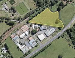
46.
|
47. 14 (c)
48. Supported based on the logical agglomeration of
industrial land uses, suitable site topography, potential to connect to
existing internal road network and to utilise existing access to/from Lismore
road.
49.
50.
|
|
51. 5. 204 Lismore Road
52.
- western
part of Lot 7 DP 626084
53.
54. (Area – 2.3ha)
55.
|
56. Proposed Industrial Area Extension
57.
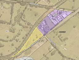
|
58. 14 (d)
59. Further expansion of the IN1 zone (industry) to the
subject land is not supported until such time as the landowner can
demonstrate legal access off Bugam Place and subdivision development has
commenced on undeveloped IN1 zoned land.
60.
61. 14 (e)
62. If a subdivision development application has not
been lodged by 1 July 2020, Council commence a process to rezone the
undeveloped IN1 zoned land to RU1 to enable agricultural use of land
consistent with the important farmland designation under the North Coast
Regional Plan 2036.
|
The following recommended changes to the ELS are in response
to landowner request for industrial land.
14. Adopt recommendations
14.(a) – 14.(e) in ‘Table 1 Summary of Site Specific Assessment
Outcomes - Employment Precincts (industrial areas)’ of this report.
Proposed new section in the Strategy –
‘Potential Anchor Location Activities’
A number of submissions raised the
strategy should contain actions to support wellbeing and health sector,
educational, cultural, historical, incubator and creative
“industries”. The DPE submission also identified a need for the
draft ELS to align with Northern Rivers Regional Economic Development Strategy
2018 -2022 dpc.nsw.gov.au/assets/REDS/6004f55e44/Northern-Rivers-REDS.pdf.
This document, adopted late last
year by the NSW government and prepared in consultation with the local councils
in the Northern Rivers area, is designed around one or more local government
areas working to function as an economic ‘region’. It notes that:
‘Byron’s economy today
reflects diverse specialisations like tourism, clothing manufacturing, creative
professionals (like advertising and motion picture activities), computer system
design, construction services and arts and recreational services.’
Having regard to this synopsis, as
well as:
· Council’s
Enterprising Byron - Strategic Direction 2 ‘nurture entrepreneurship
and innovation for work creation’;
· the findings in
ELS background report site suitability principle to support agglomerations -
similar business types providing the opportunity growth of clusters;
· North Coast
Regional Plan – Actions 6.1 and 6.2 to support the identification of
industry anchor locations; and
· recent resolutions
of Council than support the identification of potential locational hubs;
it is considered appropriate to
include a new section in the ELS to guide potential employment anchor location
activities in these sectors. Examples of emerging locations in the Shire
include Council land – Lot 12 on Bayshore Drive, the old Mullumbimby
Hospital site and land surrounding the operational Byron Hospital. The
following recommendation is in response to the above feedback.
15. Insert a new section in
the Employment Lands Strategy along supporting criteria/principles to guide
‘Potential Anchor Location Activities’ associated with:
i. health
services
ii. knowledge and
creative industries
iii. co-operative business
and innovation hubs.
Summary and next steps
A number of refinements to the
strategy have been identified in response to community and government agency
submissions. The most significant are in response to the DPE submission
(Attachment ‘2’) as these are considered necessary to enable the
DPE’s endorsement of a draft Employment Lands Strategy. These include:
· detailing
consistency with State policy positions such as ensuring a framework for
servicing and infrastructure delivery to industrial and business land; and
· set of
‘suitable-for-use principles’ for industrial land and business land
to guide future planning proposals or development applications.
Subject to Council supporting the
recommendations contained in this report, a final strategy incorporating the
necessary edits would be reported back to Council for adoption before the end
of the year.
STRATEGIC CONSIDERATIONS
Community Strategic Plan and
Operational Plan
|
Community
Objective 4: We manage growth and change responsibly
|
4.5
|
Work to improve
community resilience in our changing environment
|
4.5.1
|
Develop and
implement strategies for our community's needs
|
4.5.1.3
|
Complete and
implement a comprehensive Employment Lands Strategy
|
Legal/Statutory/Policy
Considerations
The
proposed actions to enable finalisation of the Employment Lands Strategy are
consistent with the relevant Commonwealth, State and Regional policy
frameworks.
Financial Considerations
The cost of preparing the draft
Employment Lands Strategy has been met within Council’s budget for this
project. Additional funds may be required should Council decide to
significantly expand the scope of this project.
Staff Reports - Sustainable Environment and Economy 6.6
Report No. 6.6 Report
of Planning Review Committee held on 9 May 2019
Directorate: Sustainable
Environment and Economy
Report
Author: Noreen
Scott, EA Sustainable Environment and Economy
Chris Larkin, Manager Sustainable
Development
File No: I2019/735
Summary:
This report provides the outcome of the Planning Review
Committee meeting held on 9 May, 2019.
NOTE TO COUNCILLORS:
In accordance with the
provisions of S375A of the Local Government Act 1993, a Division is to be
called whenever a motion for a planning decision is put to the meeting, for the
purpose of recording voting on planning matters. Pursuant to clause 2(a)
under the heading Matters to be Included in Minutes of Council Meetings of Council's
adopted Code of Meeting Practice (as amended) a Division will be deemed to have
been called by the mover and seconder of all motions relating to this report.
|
RECOMMENDATION:
That Council note the report of the Planning
Review Committee meeting held on 9 May 2019.
|
REPORT
The meeting commenced at 4:00pm and concluded at 4:40pm.
Present: Crs Hunter Martin, Lyon, Coorey, Ndiaye
Staff: Shannon Burt (Director Sustainable Environment &
Economy), Chris Larkin (Manager Sustainable Development)
Apologies: Crs Richardson, Cameron
The following development
applications were reviewed with the outcome shown in the final column.
|
DA No.
|
Applicant
|
Property Address
|
Proposal
|
Exhibition
Submission/s
|
Reason/s
Outcome
|
|
10.2019.103.1
|
Newton Denny Chapelle
|
784 Coolamon Scenic Drive COORABELL
|
Restaurant and Voluntary Planning Agreement for Upgrade of
Public Road and Carpark
|
Level 2
21/3/19 to 17/4/19
20 submissions
|
The perceived public significance of the application
Council
|
|
10.2019.82.1
|
Frank Stewart Architect
|
40 Mullumbimbi Street
BRUNSWICK HEADS
|
Alterations and Additions to Existing Tourist Facility to
create Three (3) Serviced Apartments and One (1) Managers Apartment
|
Level 2
14/3/19 to 27/3/19
3 submissions
|
The perceived public significance of the application
Council
|
|
10.2018.564.1
|
Ardill Payne & Partners
|
64 Corkwood Crescent
SUFFOLK PARK
|
Dual Occupancy (Attached), Swimming Pool, Detached Double
Garage and Pergola
|
Level 1
26/11/18 to 9/12/18
3 submission
|
Staff Delegation
|
|
10.2019.161.1
|
Lismore Venture Pty Ltd
|
23 Byron Bay Road BANGALOW
|
Multi Dwelling Housing Comprising Seventeen (17) Dwellings
|
Level 2
18/4/19 to 8/5/19
5 submissions (as at 03/05/2019)
|
The perceived public significance of the application
Council
|
|
10.2019.102.1
|
Ardill Payne & Partners
|
15 Byron Bay Road BANGALOW
|
Demolition of Existing Dwelling and Construction of Multi
Dwelling Housing comprising Three (3) Dwellings
|
Level 2
21/03/2019 to 03/04/2019
7 submissions
|
Staff Delegation
|
Council determined the following original development
application. The Section 4.55 application to modify the development consent was
referred to the Planning Review Committee to decide if the modification
application could be determined under delegated authority.
|
DA No.
|
Applicant
|
Property Address
|
Proposal
|
Exhibition
Submission/s
|
Reason/s
Outcome
|
|
10.2018.372.2
|
E-Synergies.Com Pty Ltd
|
361 Huonbrook Road HUONBROOK
|
S4.55 to Modify Condition 2 of Consent to Amend BAL Rating
|
Level 0
|
Staff Delegation
|
Staff Reports - Sustainable Environment and Economy 6.7
Report No. 6.7 PLANNING
- 26.2016.5.1 Environmental Zone Implementation Program: Stage 1 Planning
Proposal 'Submissions Report'
Directorate: Sustainable
Environment and Economy
Report
Author: Alex
Caras, Land Use Plannning Coordinator
File No: I2019/760
Summary:
Council at its 22 March 2018
Ordinary Meeting resolved (Res 18-186) to implement the Department’s ‘Northern Councils E Zone Review Final Recommendations Report’ in several stages to deliver more
timely and effective outcomes for affected landowners.
The E zone implementation program is being implemented in several stages to deliver more timely and effective outcomes for affected
landowners across the Shire. The engagement process to date has been robust, constructive
and well received by the majority of those affected. The conciliatory and consistent approach taken by staff to
achieve agreed outcomes has also generated a considerable
amount of goodwill for Council.
Stage 1 Planning Proposal (PP1) applies
environmental and non-environmental zones to approximately 60 properties in the
Shire based on agreed outcomes. Approximately 400ha of environmental
(E2/E3) zones will be applied in PP1. It also amends other LEP 2014 maps such
as Minimum Lot Size, Height of Building, Drinking Water Catchment and Acid
Sulfate Soils Maps.
This report presents:
· a summary of submissions received during exhibition of
Stage 1 Planning Proposal; and
· an amended version of the Planning Proposal for adoption.
NOTE TO COUNCILLORS:
In accordance with the
provisions of S375A of the Local Government Act 1993, a Division is to be
called whenever a motion for a planning decision is put to the meeting, for the
purpose of recording voting on planning matters. Pursuant to clause 2(a)
under the heading Matters to be Included in Minutes of Council Meetings of
Council's adopted Code of Meeting Practice (as amended) a Division will be
deemed to have been called by the mover and seconder of all motions relating to
this report.
|
RECOMMENDATION:
That Council:
1. Adopt the property-specific LEP mapping
amendments identified in Table 1.
2. Forward
Stage 1 E zone planning proposal (as amended and contained in Attachment 3,
E2019/38058) to the NSW Parliamentary Counsel’s Office requesting that
a draft LEP instrument be prepared.
3. Liaise
with Parliamentary Counsel’s Office (PCO) as necessary to finalise the
content of the draft LEP and to enable PCO to issue an Opinion that the plan can
be made.
4. Request
that the NSW Department of Planning and Environment, as the plan-making
authority in this instance, make the final LEP for notification on the NSW
Government legislation website.
|
Attachments:
1 Public
Submissions received for Stage 1 E Zone planning proposal, E2019/38045
2 Govt
Agency Submissions received for Stage 1 E Zone planning proposal, E2019/38047
3 E zone
Planning Proposal Stage 1 BLEP 2014 – v4 for Council Adoption, E2019/38058
REPORT
Council at its 22 March 2018
Ordinary Meeting resolved (Res 18-186) to implement the Department’s ‘Northern Councils E Zone Review Final Recommendations Report’ in several stages to deliver more
timely and effective outcomes for affected landowners. An overview of the
current staged implementation program is shown below.
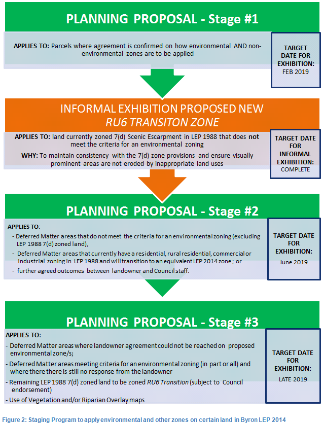
A report on the status of the staged E zone implementation program was considered at the
22 November 2018 meeting where Council resolved to re-allocate funds from other
planning projects in order to continue
progress the staged E zone implementation program and build on the high level
of community goodwill generated through the preparation of Planning Proposals 1
and 2.
The purpose of this report is to
present:
· a summary of submissions received during exhibition of
Stage 1 Planning Proposal; and
· an amended version of the Planning Proposal for adoption.
Planning Proposal #1
Planning
Proposal 1 (PP1) applies environmental and
non-environmental zones to approximately 60 properties in the Shire based on
agreed outcomes. Approximately 340ha of E2 Environmental Conservation
zones and 60ha of E3 Environmental Management zones will be applied in
PP1. It also amends other LEP 2014 maps such as Minimum Lot Size, Height of
Building, Drinking Water Catchment and Acid Sulfate Soils Maps.
PP1 was submitted to Department of
Planning & Environment for gateway determination at the end of June 2018. A
positive gateway determination was received in November 2018, which was conditional
on Council:
m Consulting
with following government agencies (prior to exhibition):
- NSW Rural Fire Service;
- Office of Environment and Heritage;
- NSW Department of Primary Industries; and
- NSW Division of Resources and Geoscience
m Notifying
all affected landowners in writing of the planning proposal and the public
exhibition arrangements
m Amending
the planning proposal as follows:
- ensuring all polygons which depict proposed zones and
development controls are labelled correctly in the maps in Appendix 5
- removing the "Equivalent Zones Reference Table for
Byron LEP 1988 and LEP 2014" in Appendix 5
Public Exhibition and
submissions received
PP1 was
exhibited from 27 February to 29 March 2019. Seven (7) public
submissions were received and these are summarised in Table 1 below. Confidential
copies of the submissions are contained in Attachment ‘1’.
Table 1 – Summary of public submissions received
|
Subject
land (Parcel No)
|
Issue
/ Comment
|
Response
|
|
1.
218 Skinners Shoot Rd, Skinners Shoot
(PN 175910)
|
Requests refinement of
proposed E2 zone to reflect water easement track and existing uses.
|
Agreed. Map
LZN_003CC_020 amended accordingly.
|
|
|
LZN_003CC
– ‘As Exhibited’
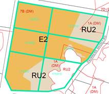
|
LZN_003CC
– ‘As Amended’
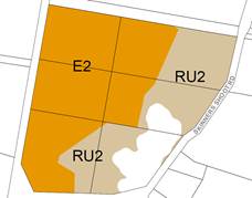
|
|
2. 36 Lomandra Lane, Mullumbim-by
(PN 16880)
|
Following
further consideration, has concerns about application of E2 Environmental
Conservation Zone across all of the riparian area on this land.
|
Although
the area adjacent to the Brunswick river satisfies the following E2 criteria:
Threatened flora
species.
Threatened fauna
species
Riparian
corridor
further discussions with the landowner resulted in
agreement to confine E2 zoning to the most heavily vegetated parts of
the riparian corridor, with E3 zoning to apply over the remainder.
Map
LZN_002BA_020 amended accordingly.
|
|
|
LZN_002BA
– ‘As Exhibited’
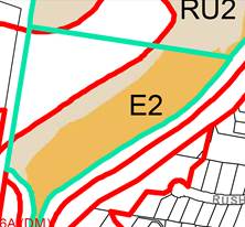
|
LZN_002BA
– ‘As Amended’
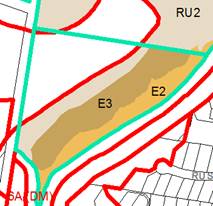
|
|
3. 951
Broken Head Rd, Broken Head
(PN 238081)
|
Request very minor
changes to proposed E2/SP3 zonings to better align with existing
buildings and roads.
|
Agreed. Map
LZN_003D_030 amended accordingly.
|
|
|
LZN_003D
– ‘As Exhibited’
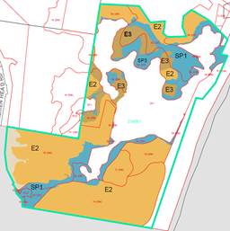
|
LZN_003D
– ‘As Amended’
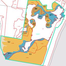
|
|
4. 95 Blackbutt Lane, Broken Head
(PN 239456)
|
Supports proposed
zones.
|
Noted. No mapping
changes required.
|
|
5. 526
Huonbrook Road, Huonbrook (PN 33010)
|
Requests refinement of
proposed E2 zone in western part of site by consolidating proposed E3 zone
below the 350m contour, to more accurately reflect existing uses on this part
of the land (ie. environmental management).
|
Agreed. Map LZN_001B_010
amended accordingly.
|
|
|
LZN_001B
– ‘As Exhibited’
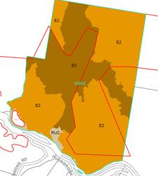
|
LZN_001B
– ‘As Amended’
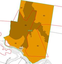
|
|
6. 230
Seven Mile Beach Rd, Broken Head
(PN 81710)
|
Supports proposed
zones.
|
Noted. No mapping
changes required.
|
|
7. 219
The Saddle Road, Brunswick Heads
(PN 137160)
|
Requests amendment to
LEP acid sulfate soils map to reflect previous assessment undertaken on this
property.
|
A LEP 2014 housekeeping
amendment is considered the appropriate mechanism to change the ASS Map, with
the next one scheduled in early 2020. No mapping changes required to
PP1.
|
RECOMMENDATION: That Council adopt the
property-specific LEP mapping amendments identified in Table 1.
Four (4) government agency
submissions also were received. These are
summarised in Table 2 below. Copies of the actual submissions are contained in Attachment
‘2’.
Table 2 – Summary of government agency submissions
received
|
Agency
Name
|
Comments
|
Response
|
|
1.
NSW Rural Fire Services
|
Has no objection to the
planning proposal and provides the following comment:
“Future development applications for all development on bush fire prone lands will be required to comply with either 84. 14
of the Environmental Planning and Assessment Act 1979 or
S100B of the Rural Fires Act 1997, depending upon the nature
of the proposed development, and the relevant provisions of Planning for Bush Fire Protection.”
|
Noted.
|
|
2. Office
of Environment and Heritage (OEH)
|
· Supports
Council's approach to determine the appropriate zoning for deferred matter
lands, given it is consistent with the Northern Councils E Zone Review Final
Recommendations Report;
· Supports
proposal to zone 7D (scenic escarpment) zoned lands to E2 or E3 where
relevant E zone criteria are verified as being present;
· Recommends
that Council engage with the relevant local Aboriginal knowledge holders and
land managers to determine whether 7D areas are of cultural significance, so
that an appropriate E zone can be applied to protect the inherent Aboriginal
cultural heritage values of these areas
|
Noted.
Noted
The
additional engagement recommended by OEH represents a large body of work that
falls outside the scope of the E zone review program. Such engagement is
best suited to a Shire wide study of Aboriginal cultural heritage
values, which in turn would inform preparation of an ‘Aboriginal
Cultural Heritage Management Plan’ (similar to Tweed Shire), subject to
future inclusion in Council’s Delivery/ Operation Plan. In
the meantime, applying the E2 Environmental Conservation Zone to
vegetated areas meeting E2 criteria (ie. in the current 7D zone) will provide
greater protection of Aboriginal
cultural heritage values from future development proposals.
|
|
3. NSW Division of Resources & Geoscience
(GSNSW)
|
GSNSW
advises that it has no resource sterilisation issues for consideration under
section 9.1 of the Environmental Planning and Assessment Act 1979, Direction 1.3
– Mining, Petroleum production and Extractive industry.
|
Noted.
|
|
4. NSW Department of Primary Industries
|
DPI
has no objection to the integration of land identified as “deferred matters”
into Byron Local Environmental Plan (LEP) 2014, and the application of environmental
zones to certain “non-Deferred Matter” areas already included in
LEP 2014 as identified in the Planning Proposal.
|
Noted.
|
Conclusion
The low
number of public submissions received is a reflection of the conciliatory and
consistent engagement approach taken by staff to achieve agreed outcomes. Such
agreements are either ‘explicit’ (ie. confirmed by landowner email,
letter or a signed zoning map) or ‘implicit’ (ie. where e zone has
been removed on affected land in accordance with submission). Inevitably
there will be a minority of landowners where there’s been (i) a change of
mind about what was originally agreed to on their land, (ii) a change in
ownership since an agreed outcome was reached or (iii) the accuracy of
transposing zone boundaries from a hard copy map to an electronic LEP map (by
staff) has been questioned. These circumstances form the basis for the
minor mapping amendments identified in Table 1 and incorporated into the
amended planning proposal (Attachment 3).
Financial Implications
The
remaining 2018/19 budget for the E zone Implementation program will be
exhausted by 30 June 2019. As a result $25,000 has been requested in the
2019/20 budget to assist with exhibition of Stage 2 and/or finalisation of
Stage 3 (for Gateway lodgement) of the E zone Implementation program. A further
update on the E zone budget will be included in the Stage 3 planning proposal
report to Council later this year.
Statutory and Policy Compliance Implications
The
process of applying E zones and mapped overlays in Byron LEP 2014 is being
undertaken in accordance with Section 117
Direction 2.5 – Application of E2 and E3 Zones and Environmental
Overlays in Far North Coast LEPs. This direction specifically
requires that a planning proposal that
introduces or alters an E2 Environmental Conservation or E3
Environmental Management Zone, or an overlay and associated clause must be
consistent with the Northern Councils E Zone Review Final Recommendations.
Staff Reports - Sustainable Environment and Economy 6.8
Report No. 6.8 Lot
130 Tallowood Estate Mullumbimby
Directorate: Sustainable
Environment and Economy
Report
Author: Christopher
Soulsby, Development Planning Officer S94 & S64
File No: I2019/771
Summary:
The purpose of this report is to
seek guidance from Council on the desired use of proposed lot 130 as approved
in development consent 10.2017.406.3.
Lot 130 is an approved residential lot in the Tallowood
Estate. There is a large tallowwood tree located in the eastern portion
of the lot. A section of the community has requested that Council
purchase this lot to protect a tree on the lot. There has been
negotiations between staff and the developer on the available mechanisms to
bring this lot into Council ownership. This report will set out those
mechanisms as options and discuss the consequences of those options.
It is the opinion of staff that the tree is adequately
protected by existing conditions of development consent and that the lot does
not need to be bought into public ownership in order to protect the tree.
Purchase of the lot for a public reserve (park) is not
consistent with the Community Strategic Plan, Delivery Plan, Operational Plan,
and the Contributions Plan. The purchase of the lot is not consistent
with Council’s strategic planning documents the purchase is not
supported.
|
RECOMMENDATION:
That Council note the report and take no further
action.
|
REPORT
The purpose of this report is to
seek guidance from Council on the desired use of proposed lot 130 and the large
tree on this lot as approved in development consent 10.2017.406.3.
DA 10.2017.406.3 was approved on
22 February 2018 for Subdivision
to create eighteen (18) residential Lots, a public reserve, a drainage
reserve, a residual lot and associated roads, earthworks, landscape and
infrastructure works (Stage 6 of Tallowood Ridge Estate). The consent
has been modified twice. The second modification application added
additional protections for the tree in the form of condition 31A as discussed
below. .
Lot 130 is a corner residential lot 1,200m2 in
area. It contains a 15m x 12m building envelope and will be accessed from
an extension of Lorikeet Lane. There is a large tallowwood tree located
in the eastern portion of the lot. An extract from the DA plans shows the
lot below with additional markups showing the general location of the tree and
the restriction area to protect the tree:
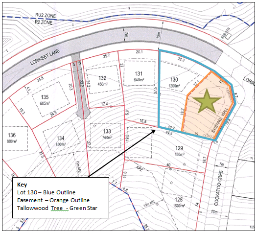
In this regard the consent contains condition 31A for a
Section 88B Instrument to be placed on the title of the land to protect the
tree. Condition 31A is set out as follows:
31A Restriction for preservation of
Tallowwood tree on Proposed Lot 130
The final plan of subdivision
and accompanying Section 88B Instrument are to provide for the following
restriction on the use of land:
The Owner of the Lot Burdened
must prohibit the following within the area denoted on the Plan as being
subject to the Restriction on Use “(a)”:
a) The
destruction or removal the tallowwood tree.
b) Any
act or omission which may adversely affect the tallowwood tree;
c) The
removal, introduction or disturbance of any soil, rock, or sand within the
marked area;
Any structures, including
dwellings, sheds, car ports and swimming pools.
A community group has made representations to Council and
the developer to seek to bring the tree into Council ownership. The
developer is willing to sell the lot to Council. The concern from
representatives of the community is that should the tree and the land it sits
upon be purchased privately and developed for housing the tree is at risk of
being removed.
The existing conditions imposed on the consent were
considered satisfactory to protect the tree. There has been no changes in
circumstances with respect to legislation, the consent, or the physical
characteristics of the land that would require the land to be bought into
public ownership to protect the tree.
Key issues
Options
1. Do nothing: Leave the development consent as
is with the tree protected by condition 31A; or
2. Buy the lot on the open market; or
3. Buy the lot with developer
contributions. This would involve a request to the developer to amend the
consent to dedicate the land to Council as open space and offset the cost
against future developer contributions.
There are no costs or
environmental implications associated with option 1. The tree remains
protected at no cost to Council.
The owner has stated that the land
is for sale at $380,000.
For option 2, Council would need
to allocate a budget of $380,000. In addition to the upfront capital cost
Council would have to maintain the land. This would be an ongoing
operational cost to Council to mow and maintain the lot. There is no
identified source of funds for this budget allocation.
In order to use Option 3 would
require the developer to apply to amend the consent under section 4.55 of the
Environmental Planning and Assessment Act 1979. The modification would
require the developer to volunteer to dedicate to the land to Council as a
public reserve. Such a dedication would be on the condition that the
value of the land is offset against the open space developer
contributions.
The developer has by email dated 7
May 2019 offer the following: -
a. Council to receive
Lot 130 Tallowood Ridge Stage 6 as a Public Reserve (Park); and
b. Council
to approve increase of our credit balance with Council as compensation for
dedication of land as Open Space (such as the sports field) as “works in
kind” as offset against Developer Charges on each future lot for Open
Space Acquisition and Open Space Embellishment by the amount of $300,000, which
is the net loss Tallowood Ridge group would suffer if we dedicate Lot 130 as a
Park instead of selling it for $380,000.
The lot is not identified in the contributions plan.
If Council resolves to accept the land it may offset the value of the land
against future developer contributions. In order for this to occur
Council would have to form the opinion that the dedication of the land as a
public reserve satisfies the developers obligations to pay the cash
contribution and that this benefit received by the dedication outweighs the
$300,000 in open space developer contributions that will not be
collected.
For completeness the whole of section 7.11 (formerly section
94) is set out below.
7.11 Contribution
towards provision or improvement of amenities or services
(cf previous s 94)
(1) If a consent authority is satisfied that
development for which development consent is sought will or is likely to
require the provision of or increase the demand for public amenities and public
services within the area, the consent authority may grant the development
consent subject to a condition requiring:
(a) the dedication
of land free of cost, or
(b) the payment of
a monetary contribution,
or both.
(2) A condition referred to in subsection (1) may
be imposed only to require a reasonable dedication or contribution for the
provision, extension or augmentation of the public amenities and public
services concerned.
(3) If:
(a) a consent
authority has, at any time, whether before or after the date of commencement of
this Part, provided public amenities or public services within the area in
preparation for or to facilitate the carrying out of development in the area,
and
(b) development for
which development consent is sought will, if carried out, benefit from the
provision of those public amenities or public services,
the consent authority may grant the development consent
subject to a condition requiring the payment of a monetary contribution towards
recoupment of the cost of providing the public amenities or public services
(being the cost as indexed in accordance with the regulations).
(4) A condition referred to in subsection (3) may
be imposed only to require a reasonable contribution towards recoupment of the
cost concerned.
(5) The consent authority may accept:
(a) the dedication
of land in part or full satisfaction of a condition imposed in accordance with
subsection (3), or
(b) the provision
of a material public benefit (other than the dedication of land or the payment
of a monetary contribution) in part or full satisfaction of a condition imposed
in accordance with subsection (1) or (3).
(6) If a
consent authority proposes to impose a condition in accordance with subsection
(1) or (3) in respect of development, the consent authority must take into
consideration any land, money or other material public benefit that the
applicant has elsewhere dedicated or provided free of cost within the area (or
any adjoining area) or previously paid to the consent authority, other than:
(a) a benefit
provided as a condition of the grant of development consent under this Act, or
(b) a benefit
excluded from consideration under section 7.4 (6).
Council would be accepting the dedication of land under
section 7.11 (5) (a) in lieu of the payment of a monetary contribution.
As the value of the land would exceed the value of the open space contributions
for that consent Council would be required take this land value into
consideration for future development applications that the applicant makes as
per section 7.11 (6). This means that the developer would be able to use
this credit against the open space contributions in future stages of the
subdivision.
The developer is seeking certainty that Council will offset
the developer contributions at an agreed value before lodging a modification
application.
Future uses of lot 130
Option 1 would see the lot in
private ownership and may be used for a permissible uses as set out in the R2 Low
Density Residential Zone of the Byron Local Environmental Plan 2014 and
Development control plan, subject to development consent. The identified
building envelope and the restrictions as to uses on the title of the land
further limit the development of the lot.
If Council purchases the land
under private treaty as per option 2 then the land would be operational land
and Council may use it as per the LEP permissible uses described above.
An option for such a use would be for the purposes of affordable housing.
If a Council proceeds with option
3 and the developer dedicates the land as a public reserve then the lot would
be classified as community land. The probable management objectives for a
public reserve of this type would be as set out in section 36G of the Local Government
Act 1993. Clause 36G is set out as follows:
36G
Core objectives for management of community land categorised as a park
The
core objectives for management of community land categorised as a park are:
(a) to encourage, promote and facilitate recreational,
cultural, social and educational pastimes and activities, and
(b) to provide for passive recreational activities or
pastimes and for the casual playing of games, and
(c) to improve the land in such a way as to promote
and facilitate its use to achieve the other core objectives for its management.
The classification of the land as
community land for a park would limit Council’s scope to use this land in
other ways.
Council may embellish the park
with seats, playground equipment, or other facilities. There is already a
high level of service provided to the residents of this estate with a
playground, basketball court, tennis court and sports field all provided within
easy walking distance of this lot. The provision of additional facilities
would mean that this area has a higher level of service than when compared to
the rest of the Shire.
Next steps
No further action is required if the recommendation is
adopted.
STRATEGIC CONSIDERATIONS
Community Strategic Plan and
Operational Plan
Option 1 is consistent with the
CSP and Operational plan.
Option 2 would be consistent with
the following objective of the CSP and the actions and activity from the
Delivery Plan and Operational Plan.
|
Community
Objective 4: We manage growth and change responsibly
|
4.2
|
Support
housing diversity in appropriate locations across the Shire
|
4.2.1
|
Establish
planning mechanisms to support housing that meets the needs of our community
|
4.2.1.2
|
Identify
opportunities and partners to facilitate the provision of housing
diversity/affordability in the Shire
|
The acquisition of this land for a
public reserve is not consistent with the following objective of the CSP nor is
it consistent with the Delivery Plan or Operational Plan.
|
Community
Objective 2: We cultivate and celebrate our diverse cultures, lifestyle and
sense of community
|
2.3
|
Provide
accessible, local community spaces and facilities
|
2.3.5
|
Maintain Public
Open space in a safe and efficient way that provides for both active and
passive recreation (SP)
|
2.3.5.1
|
Plan and
deliver Open Space works programs based on defined levels of service
|
Legal/Statutory/Policy Considerations
If option 1 is adopted then there are no statutory or policy
implications.
If option 2 is adopted there will be the contractual and
land purchase requirements to be undertaken.
If option 3 is adopted then the requirements of section 7.11
of the Environmental Planning and Assessment Act 1979 as outlined above must be
complied with.
Reviewed by Legal Counsel: ☐
Financial Considerations
There are no financial implications if option 1 is
adopted.
There are significant implications if option 2 is adopted in
terms of initial capital outlay and ongoing maintenance. There is no
source identified source of funds for this purchase.
If option 3 is adopted there are no immediate budget
implications. There will be a shortfall in contributions in the
Mullumbimby open space catchment. This may adversely impact on
Council’s ability to deliver other works from the Developer Contributions
Plan.
Reviewed by Manager Finance: ☐
Consultation and Engagement
No public consultation or engagement has been
undertaken.
Staff Reports - Sustainable Environment and Economy 6.9
Report No. 6.9 Rural
Tourism Accommodation Development
Directorate: Sustainable
Environment and Economy
Report
Author: Shannon
Burt, Director Sustainable Environment and Economy
File No: I2019/804
Summary:
A Notice of Motion (NOM) - No. 9.1 Consider removal of
'Rural Cabin' provisions and amendment to 'Farm Stay' provisions in Rural Zones
- was included in the ordinary meeting agenda 18 April 2019, but withdrawn on
the day.
The purpose of this report is to provide further information
to Council in response to this NOM about rural tourism accommodation
development. In particular:
· What planning
controls apply to this type of development;
· Recent development
application trends;
· What are the
planning controls surrounding councils have in place for this type of
development; and
· Options for Shire
wide planning controls.
|
RECOMMENDATION:
That Council endorse Option 2 contained in this
report to review and amend Byron Local Environmental Plan 2014 and Byron
Development Control Plan 2014 in relation to rural tourism/holiday cabins.
|
REPORT
A Notice of Motion (NOM) - No. 9.1 Consider removal of
'Rural Cabin' provisions and amendment to 'Farm Stay' provisions in Rural Zones
- was included in the ordinary meeting agenda 18 April 2019, but withdrawn on
the day.
“There has been a notable increase in
applications for rural cabins and farm stay accommodation in our rural areas.
This has resulted in the further fragmentation (by built form) of our valuable
farm land, a rise in land use conflict, visual impacts, and an increase demand
on local services and infrastructure from visitor numbers to our hinterland and
rural areas.
Notably, these development types do not generate
additional rates for or pay contributions to Council. A ‘rural
cabin’ is a form of Tourist and Visitor Accommodation and designed to
enable rural cabins as a form of tourist accommodation not attached to a
working farm. The genesis of rural cabin development is Local Environmental
Plan (LEP) 1988, where provisions still remain in place for those rural lands
known as ‘deferred matters’ under Local Environmental Plan (LEP)
2014. In LEP 1988 specific requirements for this type of development are in
place under the definition of a ‘rural tourist facility’; these
being supported also by Development Control Plan 2010 provisions.
The other definition for rural Tourist and Visitor
Accommodation in the Local Environmental Plan 2014 is ‘farm stay’.
The 2014 definition of ‘farm stay’ follows: Farm stay accommodation
means a building or place that provides temporary or short-term accommodation
to paying guests on a working farm as a secondary business to primary
production. Note. See clause 5.4 for controls relating to the number of
bedrooms. Farm stay accommodation is a
type of tourist and visitor accommodation—see the definition of that term
in this Dictionary.
The rural zone objectives in the LEPs indicate that rural
cabins and farm stay development should only be considered where
‘small-scale’ and associated with the primary production and
environmental conservation of the land consistent with the rural character of
the locality.
The current controls within the LEPs and DCPs however do
not reinforce this objective cogently enough. Perversely, a rural land owner
under the current LEP and DCP provisions could conceivably make a development
application for a dwelling house, secondary dwelling, dual occupancy dwelling,
farm stay and rural cabins on land that meets relevant lot size and
permissibility criteria. This has the potential to enable 14 plus buildings for
habitation / tourist use on a single lot / holding without a specified minimum
lot size in LEP 2014.
Different provisions apply to land in LEP 1988 including
a 20 hectare minimum lot size requirement. The DCPs provide further controls
which although different, fortunately up until now have been upheld by Council
(and the Land and Environment Court when challenged).
Notwithstanding the above, more recently due to the
advent of online platforms like Airbnb, many farm stays and rural cabins are
being listed as ‘short term holiday lets’ in there own right
without a host and without any bona-fide primary production being undertaken on
the land. Some are also 20 conducting weddings and events (currently prohibited
in rural zones), to supplement and or in a majority of cases provide the
primary income from the use of the land. This is generally in direct
contravention of approvals in place.
To address this anomalous situation, Council needs to
have consistent and effective controls for all its rural lands to restrict
approval of rural cabins and farm stay development to where they can
legitimately provide a (minor) secondary source of income for a working farm.
To do this we should consider removing the rural cabins provisions from and
reviewing the farm stay provisions in both LEP 1988 and 2014 and DCP 2010 and
2014.”
The purpose of this report is to provide further information
to Council in response to the NOM about rural tourism accommodation
development. In particular:
· What planning
controls apply to this type of development;
· Recent development
application trends;
· What are the
planning controls surrounding councils have in place for this type of
development; and
· Options for Shire
wide planning controls.
Key issues
· planning controls applying to this type of development
There are two LEPs and DCPs that
currently apply to rural land, depending on the zoning, each with different
controls for rural tourism accommodation development.
Under LEP 2014, up until 2016,
rural tourism accommodation development was generally restricted to farm stay
accommodation, bed and breakfast, camping grounds or ecotourist facilities.
Each of the above uses has a
specific requirement under the LEP:
· Bed and breakfast – to be provided by the permanent
residents of a dwelling.
· Farm stay accommodation – to be located on a working
farm.
· Ecotourist facility – to be associated with special
ecological or cultural values.
· Camping ground – to be for portable temporary
structures for short term use.
In 2016, amendments to LEP 2014
were made to the RU1 and RU2 land use tables to enable holiday/tourist cabin
development that did not have to meet the above LEP development requirements.
Local
Environmental Plan 2014 (Applies to RU1 and RU2 land)
Definition
tourist and
visitor accommodation means
a building or place that provides temporary or short-term accommodation on a
commercial basis, and includes any of the following:
(a) backpackers’
accommodation,
(b) bed and
breakfast accommodation,
(c) farm stay
accommodation,
(d) hotel or motel
accommodation,
(e) serviced
apartments,
but does not include:
(f) camping
grounds, or
(g) caravan parks, or
(h) eco-tourist
facilities.
bed and
breakfast accommodation means
an existing dwelling in which temporary or short-term accommodation is provided
on a commercial basis by the permanent residents of the dwelling and where:
(a) meals are
provided for guests only, and
(b) cooking
facilities for the preparation of meals are not provided within guests’
rooms, and
(c) dormitory-style
accommodation is not provided.
Note. See clause 5.4 for controls relating to the number of
bedrooms for bed and breakfast accommodation.
Bed and breakfast accommodation is a type of tourist and
visitor accommodation—see the definition of that term in this Dictionary.
camping ground means an area of land that has access to
communal amenities and on which campervans or tents, annexes or other similar
portable and lightweight temporary shelters are, or are to be, installed,
erected or placed for short term use, but does not include a caravan park.
eco-tourist facility means a building or place
that:
(a) provides
temporary or short-term accommodation to visitors on a commercial basis, and
(b) is located in
or adjacent to an area with special ecological or cultural features, and
(c) is sensitively
designed and located so as to minimise bulk, scale and overall physical
footprint and any ecological or visual impact.
It may include facilities that are used to provide information or
education to visitors and to exhibit or display items.
Note.
See clause 5.13 for requirements in relation to the granting of
development consent for eco-tourist facilities.
Eco-tourist facilities are not a type of tourist and visitor
accommodation—see the definition of that term in this Dictionary.
farm stay
accommodation means a
building or place that provides temporary or short-term accommodation to paying
guests on a working farm as a secondary business to primary production.
Note. See clause 5.4 for controls relating to the number of
bedrooms.
5.4(5) Farm stay accommodation - If
development for the purposes of farm stay accommodation is permitted under this
Plan, the accommodation that is provided to guests must consist of no more
than 12 bedrooms.
Resolution
11-909 in relation to the
draft Byron Local Environmental Plan 2011, provided the above parameters for
Farm Stay Accommodation in now LEP 2014:
b) increase
the number of bedrooms for Farm Stay Accommodation from 3 to 12 to facilitate
cabin style development under Clause 5.4 (5);
c) include
specific numerical controls for Farm Stay Accommodation in a chapter of the
Draft Byron Shire-wide Development Control Plan (in preparation) to reflect the
maximum number of cabins, the floor area and the size of the land;…
holiday /
tourist cabin is not
specifically defined, but falls out of the definition of Tourist and Visitor
Accommodation as a nominated permissible use.
Relevant
clauses of LEP
6.8
Rural and nature-based tourism development
(1) The objective
of this clause is to ensure that tourism development in rural and natural areas
is small scale and does not adversely impact on the agricultural production,
scenic or environmental values of the land.
(2) This clause
applies to land in the following zones:
(a) Zone RU1
Primary Production,
(b) Zone RU2 Rural
Landscape.
(3) Development consent
must not be granted to tourism development on land to which this clause applies
unless the consent authority is satisfied that:
(a) there is, or
will be, adequate vehicular access to and from a road, other than a classified
road, taking into account the scale of the development proposed, and
(b) the development
is small scale and low impact, and
(c) the development
is complementary to the rural or environmental attributes of the land and its
surrounds, and
(d) the development
will not have a significant adverse impact on agricultural production, amenity
or significant features of the natural environment.
(4) Development
consent must not be granted to development for the purpose of tourism
development on land to which this clause applies unless:
(a) a lawfully
erected dwelling house or dual occupancy (attached) is situated on the land, or
(b) a dwelling
house may be erected on the land under this Plan.
(5) Development
consent must not be granted to development under subclause (4) if the
development:
(a) includes an
ancillary caretaker’s or manager’s residence, or
(b) is for the
purpose of more than 1 bed and breakfast accommodation.
(6) In this clause:
small scale
means a scale that is small enough to be generally managed and operated by the
principal owner living on the property.
tourism development includes, but is not necessarily limited to, development for any of
the following purposes:
(a) bed and
breakfast accommodation,
(b) camping
grounds,
(c) farm stay
accommodation,
(d) eco-tourist
facilities,
(e) home industries
that provide services, or the sale of goods, on site to visitors,
(f) information
and education facilities,
(g) restaurants or
cafes,
(h) rural
industries that provide services, or the sale of goods, on site to visitors.
5.13
Eco-tourist facilities
(1) The objectives
of this clause are as follows:
(a) to maintain the
environmental and cultural values of land on which development for the purposes
of eco-tourist facilities is carried out,
(b) to provide for
sensitively designed and managed eco-tourist facilities that have minimal
impact on the environment both on and off-site.
(2) This clause
applies if development for the purposes of an eco-tourist facility is permitted
with development consent under this Plan.
(3) The consent
authority must not grant consent under this Plan to carry out development for
the purposes of an eco-tourist facility unless the consent authority is
satisfied that:
(a) there is a
demonstrated connection between the development and the ecological,
environmental and cultural values of the site or area, and
(b) the development
will be located, constructed, managed and maintained so as to minimise any
impact on, and to conserve, the natural environment, and
(c) the development
will enhance an appreciation of the environmental and cultural values of the
site or area, and
(d) the development
will promote positive environmental outcomes and any impact on watercourses,
soil quality, heritage and native flora and fauna will be minimal, and
(e) the site will
be maintained (or regenerated where necessary) to ensure the continued
protection of natural resources and enhancement of the natural environment, and
(f) waste
generation during construction and operation will be avoided and that any waste
will be appropriately removed, and
(g) the development
will be located to avoid visibility above ridgelines and against escarpments
and from watercourses and that any visual intrusion will be minimised through
the choice of design, colours, materials and landscaping with local native
flora, and
(h) any
infrastructure services to the site will be provided without significant
modification to the environment, and
(i) any power
and water to the site will, where possible, be provided through the use of
passive heating and cooling, renewable energy sources and water efficient
design, and
(j) the
development will not adversely affect the agricultural productivity of
adjoining land, and
(k) the following
matters are addressed or provided for in a management strategy for minimising
any impact on the natural environment:
i. measures to remove any
threat of serious or irreversible environmental damage,
ii. the maintenance (or
regeneration where necessary) of habitats,
iii. efficient and minimal energy and
water use and waste output,
iv. mechanisms for monitoring and
reviewing the effect of the development on the natural environment,
v. maintaining improvements on
an on-going basis in accordance with relevant ISO 14000 standards relating to
management and quality control.
Under LEP 1988, rural tourism
accommodation and associated development is permitted under the definition of
rural tourist facility.
Local
Environmental Plan 1988 (Applies to Deferred Matter Land).
Definitions
rural tourist facility means an establishment providing for
low-scale holiday accommodation, or used for recreational or educational
purposes and may consist of a bed and breakfast establishment, boat landing
facilities, environmental facilities, holiday cabins, horse riding facilities,
a picnic ground, a primitive camping ground or a restaurant or the like.
holiday cabin means a building containing a room or
suite of rooms used, or intended to be used, for the provision of holiday
accommodation only.
Clause
34 Tourist accommodation in rural zones
(1) This clause
applies to all land within rural zones where rural tourist facilities are
permissible.
(2) Development for
the purpose of a rural tourist facility incorporating holiday cabins on land to
which this clause applies:
(a) may only be
carried out on a single allotment, and
(b) must not:
i. exceed a total of 6
cabins, and
ii. be carried out on an
allotment with an area less than 20 hectares.
(3) The council may
grant consent for development for the purposes of rural tourist facilities on
land within rural zones only where the council is satisfied that:
(a) (Repealed)
(b) the proposal
incorporates adequate landscaping and screen plantings for visual amenity when
viewed from a public road or dwelling-house on other land in the locality,
(c) (Repealed)
(d) the proposed
development will have no adverse effect on the present and potential use,
including agricultural use, of the land and of lands in the vicinity,
(e) there will be
no adverse visual impact of the proposed development on the landscape,
(f) the
proposed development will be low scale in nature, compatible with the rural
environment and of minimal environmental impact,
(g) (Repealed)
(h) tourist
accommodation is to be located so that it may benefit from existing road and
physical service infrastructure, and
(i) all
proposed buildings and other uses are clustered so as to reduce impact on rural
amenity, and
(j) adequate
separation distances will be incorporated to minimise the potential for land
use conflict between the proposed rural tourist facility and existing or
potentially conflicting land uses, such as intensive agriculture, quarries or
animal establishments on adjoining or adjacent land.
Development
Control Plan 2010
DCP 2010 applies to land to which
the Byron Local Environmental Plan 1988 (LEP 1988) applies i.e. all land
deferred from Byron Local Environmental Plan
2014 (LEP 2014), with the exception of the West Byron urban release area (where
DCP 2014 applies).
There were limited provisions in
DCP 2010 for rural tourist accommodation and associated development. As a
consequence, the Byron Rural Settlement Strategy 1998 (as referenced in clause
2A of BLEP 1988) was heavily relied upon for development assessment by staff.
Development
Control Plan 2014
DCP 2014 applies to all land
specified in the LEP 2014, with the addition of the West Byron urban release
area.
DCP 2014 has provisions for rural
tourist accommodation development by way of Chapter D3 Tourist Accommodation
which references Byron Rural Settlement Strategy 1998 (BRSS) and includes its
requirements as both performance standards and prescriptive measures; and has
other related chapters in the Plan for development assessment by staff.
Byron Rural Land Use Strategy
2018 and Byron Rural Settlement Strategy 1998
The Byron Rural Settlement
Strategy 1988 was replaced by endorsement of the Byron Rural Land Use Strategy
by the Department of Planning in 2018.
In a recent Land and Environment
Court judgement ([2018] NSWLEC 1695 Ardill Payne & Partners v Byron Shire
Council, Commissioner Walsh found that …the
DCP provisions calling up the Byron Rural Land Use Settlement Strategy remain
live and pertinent, albeit subject to the provisions of s4.15(3) of the EPA
Act. This is because a policy document has no power to alter a statutorily
made DCP.
Extract below:
4.15
Evaluation (cf previous s 79C)
(3) If an environmental
planning instrument or a regulation contains non-discretionary development standards
and development the subject of a development application does not comply with
those standards:
(a) subsection (2)
does not apply and the discretion of the consent authority under this section
and section 4.16 is not limited as referred to in that subsection, and
(b) a provision of
an environmental planning instrument that allows flexibility in the application
of a development standard may be applied to the non-discretionary development
standard.
Note. The application of non-discretionary development standards
to complying development is dealt with in section 4.28 (3) and (4).
(3A) Development control plans If a
development control plan contains provisions that relate to the development
that is the subject of a development application, the consent authority:
(a) if those
provisions set standards with respect to an aspect of the development and the
development application complies with those standards—is not to require
more onerous standards with respect to that aspect of the development, and
(b) if those
provisions set standards with respect to an aspect of the development and the
development application does not comply with those standards—is to be
flexible in applying those provisions and allow reasonable alternative
solutions that achieve the objects of those standards for dealing with that
aspect of the development, and
(c) may consider
those provisions only in connection with the assessment of that development
application.
In this subsection, standards include performance criteria.
· Statutory hierarchy
Having regard to the above, a
statutory hierarchy sees LEP provisions take precedent over DCP controls.
In DCPs, the hierarchy of controls
sees the prescriptive measures as mandatory matters for consideration, and the
performance criteria as general matters for consideration.
State legislation such as Rural
Fires Act (including Planning for Bushfire Protection), BASIX, Biodiversity
Conservation Act (BDAR, SEPP Vegetation), SEPP Rural Lands, SEPP Exempt and
Complying Code takes precedence over any of the above Council requirements
albeit lesser or higher standards being imposed as a consequence.
In the matter of [2018] NSWLEC
1695 Ardill Payne & Partners v Byron Shire Council, Commissioner Walsh
refused inter alia to grant consent to 2 holiday cabins due to their large size
and their lack of responsiveness to planning provisions like the relevant zone
objectives for small scale and that ‘tourist accommodation in rural zones
is just that..”.
Of relevance here is the statutory
hierarchy.
An example of how the statutory
hierarchy works for rural holiday/tourist cabin accommodation follows:
|
Matter for consideration
|
BRSS Guidelines
|
LEP
|
DCP
2014
|
Other
|
|
cabin definition
|
yes
|
1988 yes
2014 yes (2 definitions)
|
n/a
|
n/a
|
|
map for potential land for
cabins
|
yes
|
1988 Clause 34
2014 Clause 6.8
|
no
|
n/a
|
|
minimum land area 20 hectares
|
yes
|
1988 yes (20ha)
2014 no
|
no
|
n/a
|
|
restriction on number of
cabins per property (6)
|
yes
|
1988 yes (6)
2014 no
|
2014 D3.3.4 sliding scale (Performance
Criteria & Prescriptive Measures)
|
n/a
|
|
cabins to be no more than
60m2 GFA
|
yes
|
no
|
2014 D3.3.4 (Prescriptive
Measures)
|
n/a
|
|
no night-time lighting for
recreational facilities
|
yes
|
|
2014 D3.3.4 (Prescriptive
Measures)
|
n/a
|
|
all weather centralised
parking for guests
|
yes
|
no
|
2014 D3.3.4 (Prescriptive
Measures) & B4
|
n/a
|
|
disabled access
|
Yes (1)
|
no
|
2014 D3.3.4 (Prescriptive
Measures)
|
Building Code Australia
|
|
location, siting, character
of cabins
|
yes
|
|
2014 D3.2.1, D3.2.3 (Performance
Criteria)
|
BASIX, Planning for Bushfire
Protection
|
|
planting of the 900 trees per
cabin
a 90% survival rate of trees
after 24 months
payment of an environmental
repair bond of $4500 per cabin
|
yes
|
no
|
2014 D3.2.3 (Performance
Criteria)
|
SEPP 44, Biodiversity
Conservation Act, 10/50 rule
|
|
an energy efficiency site
analysis report
|
yes
|
|
2014 D3.2.3 (Performance
Criteria)
|
BASIX
|
|
no erection of cabins or
buildings near ridgelines
|
yes
|
|
2014 D3.3.4 (Performance
Criteria) & C3
|
Planning for Bushfire Protection
|
|
water supply
|
yes
|
|
2014 D3.2.3 (Performance
Criteria)
|
BASIX, Planning for Bushfire
Protection
|
|
land use conflict risk
assessment
|
yes
|
|
2014 D3.3.4 (Prescriptive
Measures) & B6
|
DPI Guidelines
|
|
wastewater and effluent
treatment on site
|
yes
|
|
2014 D3.3.4 (Prescriptive
Measures) & B3
|
S68 Local Government Act
|
There are differences in the LEP
and DCP controls that apply across the Shire for holiday/tourist cabon
development. In this regard each development application is considered
having regard to the statutory hierarchy, its individual merits and
circumstances of the case.
· Development Application Trends
A breakdown of rural applications
– individual dwelling/building count as approved for 2014 - 2018 is
below.
|
2014
|
2015
|
2016
|
2017
|
2018
|
|
Aged care units
|
0
|
4
|
0
|
0
|
0
|
|
Dual occupancy
|
11
|
14
|
22
|
26
|
12
|
|
Dwelling
|
57
|
52
|
56
|
47
|
28
|
|
Cabin - Rural Tourist
|
0
|
2
|
3
|
0
|
34
|
|
Secondary dwelling
|
22
|
27
|
46
|
37
|
21
|
|
Studio
|
13
|
13
|
10
|
4
|
8
|
|
Tourist facility
|
3
|
7
|
19
|
14
|
1
|
|
TOTAL
|
106
|
119
|
150
|
128
|
104
|
The above table shows the increase
in holiday/tourist cabin numbers on rural land since 2016.
It is also clear that the ability
to utilise multiple definitions in the LEP is resulting in different
development on rural land not entirely consistent with the RU1 and RU2 zone objectives
of the LEP.
There are also a considerable
number of unauthorised ‘cabins’, secondary dwellings and rural
sheds being used as dwellings and or holiday lets on rural land not currently
accounted for.
Impacts from the above development
types identified include: fragmentation of rural land, land use conflicts
from non-farm use on a farm, infrastructure impost in areas where roads etc.
are not of a standard to cater to traffic etc.
These issues are also common
themes in objections to development applications, consultation on planning
strategy/policy, complaints about unauthorised development on rural land.
Most of these development types are paying minimal or no development
contributions/rates.
· Other North Coast Councils – rural
tourism accommodation controls
The table below provides a
comparison with other North Coast councils with regards to LEP local rural
tourism accommodation clauses: the use of specific tourism or rural tourism DCP
chapters; and the inclusion DCP/LEP numerical limitations for scale, including
bedrooms or buildings or floor area.
The density and scale of rural
tourist accommodation for the Byron Shire is generous when compared to other
councils.
|
Council
|
LEP provision
|
Permits “other rural
tourist accommodation’
|
Rural Tourism DCP
|
LEP/DCP density/scale
limitations
|
|
Byron
|
yes
|
yes
|
yes
|
Farmstay – 12 bedrooms
Ecotourist 40m2 in a building;
60m2 stand alone cabin
Other
3-12 bedrooms
60m2/cabin
|
|
Ballina
|
yes
|
yes
|
yes
|
Farmstay – 3 bedrooms
Other – 8 cabins/16 bedrooms
75m2/cabin
|
|
Lismore
|
proposed
|
proposed
|
proposed
|
Farm stay – 5 bedrooms
Ecotourist – 3 bedrooms
Other
3 bedrooms
30m2 internal/cabin
|
|
Clarence Valley
|
no
|
no
|
yes
|
Farm Stay – 10 bedrooms
Ecotourist - none
|
|
Richmond Valley
|
no
|
no
|
yes
|
Farmstay – 10 bedrooms
Ecotourist – 1 cabin/ha
|
|
Tweed
|
no
|
no
|
no
|
Farm stay 12 bedrooms
|
Note: “Other”
doesn’t have to be located on a working farm (farm stay accommodation)
nor does it have to be associated with special ecological or cultural values
(eco-tourist facility).
Options
Council’s Rural Land Use Strategy Actions 10 and 13
provide for the local planning framework to be updated to reinforce the need to
support only low scale rural tourism opportunities, particularly those directly
associated with primary production and/or improved conservation outcomes on
rural land.
Next steps
A review and amendment to the Local Environmental Plan/s and
Development Control Plan/s is required if Council is of a mind to want to
change the current planning controls for rural tourism accommodation
development.
Separate reports to progress amendments can be provided to a
future Council meeting depending on the preferred option of Council.
Options available to Council include:
|
Option 1 NO CHANGE TO CONTROLS
|
Option 2 AMEND LEP & DCP CONTROLS
|
Option 3 REMOVE CONTROLS
|
|
No change to the current LEP and DCP provisions.
|
Include a minimum lot size for rural tourism accommodation
development;
Include a definition of rural holiday/tourist cabin (not
farm stay);
Strengthen the definition of small scale;
Reduce the number of bedrooms for farm stay accommodation
accordingly;
Amend DCP as required.
|
Remove provision for rural holiday / tourist cabin
development (rely on farm stay accommodation & ecotourist development).
Amend DCP as required.
|
|
Outcome = Status quo
|
Outcome = Limit the scale and density of development by
alignment of LEP and DCP controls to that of LEP 1988.
|
Outcome = Reduce the type of development permitted to pre
2016 controls.
|
STRATEGIC CONSIDERATIONS
Community Strategic Plan and
Operational Plan
|
CSP Objective
|
L2
|
CSP Strategy
|
L3
|
DP Action
|
L4
|
OP Activity
|
|
Community Objective 3: We protect
and enhance our natural environment
|
3.4
|
Support and secure our farming future
|
3.4.1
|
Develop and implement strategies to
support agriculture, agri-business and farmers
|
3.4.1.1
|
Implement priority actions of the Rural
Land Use Strategy
|
Legal/Statutory/Policy
Considerations
There are five steps in the Planning Proposal process which
must be complied with:
The Planning Proposal – the planning proposal
authority prepares the planning proposal. The planning proposal authority is
usually the local council; however the Minister can appoint the Secretary of
the Department of Planning and Environment, a regional planning panel or a
Sydney planning panel to be the planning proposal authority.
Gateway – the Minister (or delegate) decides whether
the planning proposal can proceed (with or without variation) and subject to
other matters including further studies being undertaken, public consultation,
public hearings, agency consultation and time frames. A planning proposal does
usually not proceed without conditions of this nature. The conditions are then
complied with and if necessary, the proposal is changed. A decision on whether
the relevant council is able to finalise particular types of LEPs is also
determined at this stage.
Community Consultation – the proposal is publicly
exhibited as required by the Minister. A person making a submission may also
request a public hearing be held.
Assessment – the planning proposal authority reviews
public submissions. Parliamentary Counsel then prepares a draft local
environmental plan.
The Making of the LEP – with the Minister’s (or
delegate’s) approval the local environmental plan is published on the NSW
legislation website and becomes law.
Amendments to the Development Control Plans will be done in
concert with the Planning Proposal including exhibition as required by the
Environmental Planning and Assessment Act 1979.
Financial Considerations
Task to be managed within existing financial / legal and
resource allocations.
Consultation and Engagement
As required by the gateway determination and Council’s
Engagement Policy.
Staff Reports - Sustainable Environment and Economy 6.10
Report No. 6.10 PLANNING
- 10.2018.384.1 Use of existing structure as a Dwelling House and Alterations
and Additions to create Dual Occupancy (detached), Alterations and Additions to
existing Dwelling House including Expanded Dwelling Module, Tree Removal and
Upgrade existing Wastewater System at 183 Coopers West Lane Main Arm
Directorate: Sustainable
Environment and Economy
Report
Author: Ivan
Holland, Planner
Noreen Scott, EA Sustainable
Environment and Economy
File No: I2019/833
|
DA No:
|
10.2018.384.1
|
|
Proposal description:
|
Use of existing structure as a Dwelling House and
Alterations and Additions to create Dual Occupancy (detached), Alterations
and Additions to existing Dwelling House including Expanded Dwelling Module,
Tree Removal and Upgrade existing Wastewater System
|
|
Property description:
|
LOT: 2 DP: 445771
|
|
183 Coopers West Lane MAIN ARM
|
|
Parcel No/s:
|
181870
|
|
Applicant:
|
Chris Lonergan - Town Planner
|
|
Owner:
|
Mr W S & Mrs J L Weisse
|
|
Zoning:
|
RU1 Primary Production / PART Deferred Matter (1(b2)
Agricultural Protection)
|
|
Date received:
|
31 July 2018
|
|
Integrated Development:
|
No
|
|
Public notification or exhibition:
|
- Level
1 advertising under DCP 2014 Part A14 – Public Notification and
Exhibition of Development Applications
- Exhibition
period: 14/8/18 to 27/8/18
- Submissions received: 4
|
|
Other approvals (S68/138):
|
Not applicable
|
|
Delegation to determination:
|
Council
|
|
Issues:
|
· Suitable vehicular
access – access road not within legal easement
· Tree removal
required to establish Asset Protection Zone required by Rural Fire Service
· Shed capable of
occupation
· Submissions in
opposition
|
Summary:
The amended application seeks approval for Alterations and
Additions to existing Dwelling House (central east of the site), use of an existing
structure (house) as a Dual Occupancy (detached) including alteration and
additions to this structure, and upgrading of the existing Wastewater System.
The subject property is located at Coopers West Lane, Main Arm in a rural
hinterland area characterised by rural acreage living.
The application raises two main issues which have not been
resolved, being access to the property and vegetation removal required to
establish Asset Protection Zone for bushfire protection purposes. In this
regard the existing vehicle access is not located within the designated right
of carriageway and it is required to be widened and upgraded to satisfy the
requirements of the Rural Fire Services. The Right of Carriageway also
needs to be re-aligned, but owners consent from the neighbour to the east has
not been provided agreeing to this.
Further, the proposal requires the removal of six ironbark
trees for the provision of an asset protection zone to facilitate the
retrospective approval of the dual occupancy. It is considered better siting of
the dwelling may have eliminated the need for these trees to be removed,
however this is difficult to achieve in this instance as the house has already
been constructed.
The Application is therefore recommended for refusal based
on ecological impacts and failing to demonstrate legal access to the site.
NOTE TO COUNCILLORS:
In accordance with the
provisions of S375A of the Local Government Act 1993, a Division is to be
called whenever a motion for a planning decision is put to the meeting, for the
purpose of recording voting on planning matters. Pursuant to clause 2(a)
under the heading Matters to be Included in Minutes of Council Meetings of
Council's adopted Code of Meeting Practice (as amended) a Division will be
deemed to have been called by the mover and seconder of all motions relating to
this report.
|
RECOMMENDATION:
That pursuant to
Section 4.16 of the Environmental Planning & Assessment Act 1979,
Development Application No.10.2018.384.1 for Use of existing structure as a Dwelling House and Alterations and
Additions to create Dual Occupancy (detached), Alterations and Additions to
existing Dwelling House, Tree Removal and Upgrade existing Wastewater System,
be refused for the following reasons:
1. Pursuant
to Section 4.15(1)(a)(i) of the EPA Act 1979 the proposed development does
not have adequate access arrangements in place to service the development in
accordance with clause 6.6 of the Byron Local Environment Plan 2014.
2. Pursuant
to Section 4.15 (1)(c) of the EPA Act 1979 the site is not suitable
for the proposed development as suitable vehicular access has
not been established for the property, and it requires the removal of native
vegetation for the provision of an Asset Protection Zone for the dual
occupancy.
3. Pursuant
to Section 4.15(b) of the EPA Act 1979 the proposed vegetation removal
will have an adverse impact upon the natural environment.
4. Pursuant
to Section 4.15(e) of the EPA Act 1979 the proposed development is not
in the public interest as suitable access arrangements are not provided to
the property and the issuing of retrospective approval for the dual occupancy
sets a undesirable planning precedent in the circumstances of the case.
|
Attachments:
1 Proposed
Plans, E2019/38326 
2 Submissions
received, E2019/38225
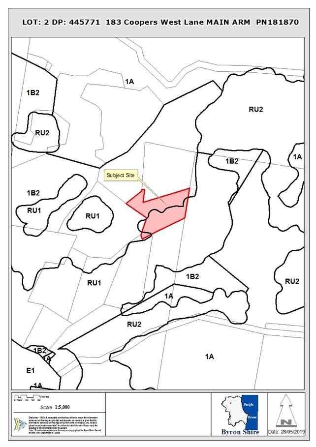
Assessment:
1. INTRODUCTION
1.1. History/Background
The site has an approval for a dwelling under BA 78/2020
determined 23/02/1978.
A request for further information was sent to the applicant
on 21/9/2018 regarding absence of a accurate survey plan and inconsistencies
identified with the provide plans following a site inspection (carried out on
14/9/2018). A response to this request was received on 4/10/2018 which
provided an interim amended site plan (P1, 2/10/18) and stated that a survey
had been commissioned. The detailed site survey was provided on
18/10/2018 (Amended Site Plan, 18/10/18).
Further correspondence was received from the applicant
(17/1/2019) stating that:
· The eastern
wastewater disposal fields will be relocated so that they are no longer
proximate to the Brushbox Tree, thus alleviating the need to remove this tree;
and
· Removal of the
expanded dwelling module from the plan.
A further request for further information was sent to the
applicant on 21/1/2019 regarding:
· Owners consent for
the proposed asset protection zones (APZ) beyond the property boundary or an
amended Bushfire Report that proposes mitigation that is restricted to within
the property; and
· An amended
Bushfire Report that reduces the ecological impacts from the recommended APZs.
An amended Bushfire Report (22/3/2019) was provided by the
applicant and referred to the Rural Fire Service (RFS) (3/4/2019) with a
response being received from RFS on 9/5/2019.
1.2. Description
of the proposed development
The initial application sought approval for:
· Alterations and
Additions to existing Dwelling House (central east of the site) including
construction of an expended dwelling module;
· Use of existing
structure as a Dual Occupancy (detached) including alteration and additions to this
structure;
· Tree Removal (8
trees); and
· Upgrade of the
existing Wastewater System.
The application was amended to remove the proposed expanded
dwelling module and tree removal (email 27/5/19).
1.3. Description
of the site
|
Land is legally described as
|
LOT: 2 DP: 445771
|
|
Property address is
|
183 Coopers West Lane MAIN ARM
|
|
Land is zoned:
|
RU1 Primary Production / PART Deferred Matter (1(b2)
Agricultural Protection)
|
|
Land area is:
|
2.18 ha
|
|
Property is constrained by:
|
Bushfire prone land (vegetation category 1 and buffer
zone)
High Environmental Value vegetation (three patches: middle
and east of site – north coast wet sclerophyll and subtropical
rainforest)
Koala habitat (two patches: middles and west of site)
Threatened fauna habitat
Underground and above ground powerlines run through
property
Right of Way
|
A site inspection was conducted on 3/6/2019.
|
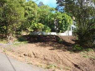
Photo 1 – Primary dwelling – view west from
Coopers Lane West.
|
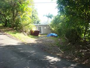
Photo 2 – Primary dwelling – view north from
Coopers Lane West.
|
|
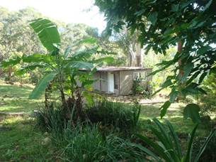
Photo 3 – Other building to be converted to a shed.
|
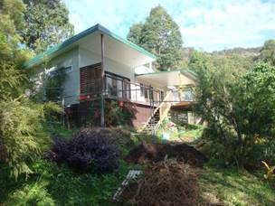
Photo 4 – Proposed dual occupancy
|
|
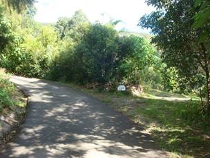
Photo 5 – Coopers Lane West at No.183.
|
|
2. SUMMARY OF
REFERRALS
|
Referral
|
Issue
|
|
Environmental Health Officer
|
No objections subject to conditions.
|
|
Development Engineer
|
Not supported due to unresolved issues with access.
|
|
Building Surveyor
|
Recommendation: “Deferred commencement”
condition that Building Information Certificate is required to demonstrate
that buildings are structurally adequate for their intended use.
|
|
S94 / Contributions Officer
|
No objections subject to conditions.
|
|
Ecologist
|
Siting of the second dwelling is not supported due to the
removal of a copse of grey ironbark trees.
|
|
Rural Fire Service (100B/4.14/4.14)
|
No objections subject to conditions.
|
3. SECTION 4.14
– BUSH FIRE PRONE LAND
Under section 4.14 of the Act, Council must be satisfied
prior to making a determination for development on bush fire prone land, that
the development complies with the document Planning for Bush Fire Protection
2006. The site is bush fire prone land. The development application was
referred to the NSW Rural Fire Service, which provided conditions which are
reflected in the Recommendation of this Report below.
The subject parcel of land is located in a designated 10/50 vegetation
entitlement clearing area (RFS online tool accessed 29/5/19).
4. SECTION 4.15C
– MATTERS FOR CONSIDERATION – DISCUSSION OF ISSUES
Having regard to the matters for consideration detailed in
Section 4.15(1) of the Environmental Planning & Assessment Act 1979
(EP&A Act), the following is a summary of the evaluation of the issues.
4.1 State Environmental
Planning Instruments
4.2A Byron Local Environmental Plan 2014 (LEP 2014)
LEP 2014 is an applicable matter for consideration in the
assessment of the subject development application in accordance with subsection
4.15(1) of the EP&A Act because it applies to the subject land and the
proposed development. The LEP 2014 clauses that are checked below are of
relevance to the proposed development:
|
Part 1
|
☒1.1|
☒1.1AA| ☒1.2| ☒1.3| ☒1.4| ☒Dictionary| ☒1.5| ☒1.6| ☒1.7| ☒1.8| ☐1.8A| ☒1.9| ☐1.9A
|
|
Part 2
|
☒2.1|☒2.2 |☒2.3 |☒Land Use Table
|
|
Part 3
|
☐3.1|
☐3.2| ☐3.3
|
|
Part 4
|
☒4.2A|
☒4.2D| ☒4.3
|
|
Part 6
|
☐6.1|
☐6.2| ☐6.3| ☐6.4| ☐6.5| ☒6.6| ☐ 6.7| ☐6.8| ☐6.9
|
In accordance with LEP 2014 clauses 1.4 and 2.1 – 2.3:
(a) The
proposed development is defined in the LEP 2014 Dictionary as Dwelling House
and Dual Occupancy (Detached);
(b) The
land is within the RU1 Primary Production / PART DM Deferred Matter (1(b2)
Agricultural Protection) according to the Land Zoning Map (The proposed
development is located only within Zone RU1 land);
(c) The
proposed development is permissible with consent; and
(d) Regard
is had for the Zone Objectives as follows:
|
Zone Objective
|
Consideration
|
|
• To encourage sustainable primary industry
production by maintaining and enhancing the natural resource base.
• To encourage diversity in primary
industry enterprises and systems appropriate for the area.
• To minimise the fragmentation and
alienation of resource lands.
• To minimise conflict between land uses
within this zone and land uses within adjoining zones.
• To encourage consolidation of lots for
the purposes of primary industry production.
• To enable the provision of tourist
accommodation, facilities and other small-scale rural tourism uses associated
with primary production and environmental conservation consistent with the
rural character of the locality.
• To protect significant scenic landscapes
and to minimise impacts on the scenic quality of the locality.
|
The proposed development does not further the zone
objectives but neither does it expressly conflict with them.
The application does not indicate that the property is
used for primary production or rural tourism.
|
Clause 4.2A Erection of dwelling houses and dual
occupancies on land in certain rural zones
Although the subject lot is less than the minimum lot size
of 40ha, development consent may be granted under subclause 3 as the lot was created
before this plan commenced and a dwelling house was permissible before
commencement of this plan (clause 15 and schedule 7 of BLEP 1988).
Development consent may be granted under subclause 4 as an approved dual
occupancy is not currently erected on the land.
Clause 4.2 D Erection of dual occupancies (detached)
and secondary dwellings in Zones RU1 and RU2
Under subclause (2), development consent must not be granted
to development for the purpose of a dual occupancy (detached) on land in Zone
RU1 Primary Production unless the consent authority is satisfied of a range of
matters discussed below:
(a) the development will
not impair the use of the land for agriculture or rural industries, and
(b) each dwelling will
use the same vehicular access to and from a public road, and
(c) any dwellings will
be situated within 100 metres of each other, and
(d) the land is
physically suitable for the development, and
(e) the land is capable
of accommodating the on-site disposal and management of sewage for the
development, and
(f) the development will
not have an adverse impact on the scenic amenity or character of the rural
environment.
The proposed dual occupancy satisfies part of the clause;
however the siting of the dwelling as currently located is questionable having
regards to environmental impacts associated with tree removal. In this regard
other sites closer to the dwelling may have ameliorated this issue and enabled
the retention of the subject ironbark trees that currently need to be removed
for the provision of an Asset Protection Zone. The application is recommended
for refusal.
Clause 6.6 Essential Services
The proposal relies on access to the site via right of
carriageway (ROW) over the property to the east. The constructed access road
however does not sit within the ROW; whilst the Rural Fire Service will require
the access to be upgraded to meet there access requirements. No detail has been
submitted from the applicant demonstrating that the ROW can be re-aligned or
upgraded in the form of owners consent from the land owner to the east. The
application is recommended for refusal.
4.3 Any proposed Instrument
that has been the subject of public consultation and has been notified to the
consent authority
No proposed planning instruments were identified that are
relevant to this application.
4.4A Byron Shire Development Control Plan 2014
(DCP 2014)
DCP 2014 is an applicable matter for consideration in the
assessment of the subject development application in accordance with subsection
4.15(1) of the EP& A Act because it applies to the land to which LEP 2014
applies. The DCP 2014 Parts/Chapters that are checked below are of relevance to
the proposed development:
|
Part A
|
☒
|
|
Part B Chapters:
|
☒B2|
☒B3| ☒B4| ☐B5| ☐B6| ☐B7| ☒B8| ☐B9| ☐B10| ☐B11| ☐B12| ☐B13|
☐B14
|
|
Part C Chapters:
|
☐C1|
☐C2| ☐C3| ☐C4
|
|
Part D Chapters
|
☐D1|
☒D2| ☐D3| ☐D4| ☐D5| ☐D6| ☐D7| ☐D8
|
|
Part E Chapters
|
☐
E1| ☐E2| ☐E3| ☐E4| ☐E5| ☐E6| ☐ E7
|
B2 – Preservation of Trees and Other Vegetation
The revised application (i.e., no expanded dwelling module)
does not require any tree removal for the alterations and additions to the
dwelling house. The asset protection zone (APZ) required by the Rural
Fire Service (RFS) for the proposed dual occupancy will require the removal of six
Ironbarks. The initial application proposed compensatory planting (see
amended Site Plan, 17/1/19) being:
· In a line
north-south between the dwelling and proposed dual occupancy; and
· To the west of the
proposed dual occupancy.
The applicant was provided the opportunity to seek
confirmation from a bushfire professional that the APZ required by the RFS
could be established and maintained without the need for the removal of the
Ironbarks however this information was not received at the time of finalising
this report.
B3 – Services
Water supply – The application states that water
supply for the dwellings will be from tank water. (NB - Rural
dwellings without reticulated water are to have a minimum domestic tank
capacity of 40,000 litres.)
Electricity – powerlines run through the property near
to the two subject buildings.
Telecommunications – No detail on telecommunications
for the proposed development was identified in the application.
Stormwater – The application states that roof water
will be diverted through the BASIX water tank, then the Bushfire Tank with
overflow directed to the stormwater infiltration areas (see Amended Site Plan,
17/1/19).
Access – via a right of way (ROW) from Coopers West
Lane. As discussed above the ROW need to be re-aligned and widened, but
owners consent for this to occur his has not been provided. The application is
recommended for refusal.
Wastewater – Council’s Environmental Health
Officer has assessed the proposed wastewater management and found it to be
acceptable subject to conditions.
B4 – Traffic Planning, Vehicle Parking,
Circulation and Access
Proposed parking and circulation are adequate however Council’s
Development Engineer identified issues relating to access.
B6 Buffers & minimising land use conflicts
Surrounding land use consists predominantly of
rural-residential development. Council’s Environmental Health
Officer is satisfied with the proposed buffers for wastewater disposal.
D2 Residential Accommodation and Ancillary Development
in Rural Zones
D2.2 General Provisions
The dwelling and proposed dual occupancy is set back over
20m from all property boundaries (D2.2.2). The total number of
residential buildings proposed for the property is two (D2.2.3).
D2.3 Dwelling Houses
The principal dwelling has adequate parking however
Council’s Engineer has raised concerns regarding access (D2.3.1).
D2.5 Dual Occupancies and Secondary Dwellings
Parking for (D2.5.1), and siting of (D2.5.2), the dual
occupancy is consistent with relevant prescriptive measures. Although not
clearly delineated in the application, there appears to be ample opportunity to
provide the required (30m2) private open space for the dual
occupancy (D2.5.4).
The proposed development raises no other issues under the
DCP.
4.5 Any Planning Agreement or
Draft Planning Agreement?
|
|
Yes
|
No
|
|
Is there any applicable planning agreement or draft
planning agreement?
|
☐
|
☒
|
4.6 Environmental Planning
& Assessment Regulation 2000 Considerations
|
Clause
|
This
control is applicable to the proposal:
|
I
have considered this control as it relates to the proposal:
|
If
this control is applicable, does the proposal comply?
|
|
92
|
No
|
N/A
|
N/A
|
|
93
|
Yes
|
Yes. See Building Surveyor referral
|
Condition to apply in relation to a Building Information
Certificate should the application be approved.
|
|
94
|
Yes
|
Yes. See Building Surveyor referral
|
See above.
|
|
94A
|
No
|
N/A
|
N/A
|
4.7 Any coastal zone management
plan?
|
|
Satisfactory
|
Unsatisfactory
|
Not applicable
|
|
Is there any applicable coastal zone management plan?
|
☐
|
☐
|
☒
|
4.8 The likely impacts of that
development, including environmental impacts on both the natural and built
environments, and social and economic impacts in the locality
|
Impact on:
|
Likely significant impact/s?
|
|
Natural environment
|
The proposed alterations and additions to the dwelling alone
will not have a significantly adverse impact on the natural environment.
However the retrospective approval for the second dwelling will require the
removal of six Ironbarks to meet Rural Fire Service requirements. It is
considered that better siting of the dwelling closer to the existing house
may have limited the need for these trees to be removed. As such it is
considered the proposal will have an adverse impact on the natural
environment.
|
|
Built environment
|
No. The proposal will not have a significantly adverse
impact on the built environment.
|
|
Social Environment
|
No. The proposal will not have a significant social impact
on the locality.
|
|
Economic impact
|
No. The proposal will not have a significant economic
impact on the locality.
|
4.9 The suitability of the site
for the development
The site is considered suitable for the proposed development
but for the following issue:
|
Issue
|
Comment
|
|
Services
- Access
|
The current ROW is of insufficient width and location to
meet the requirements of section 4.13 (2) of ‘Planning for Bushfire
Protection 2006’. Further, the constructed ROW does not follow the
legal alignment.
The ROW needs to be re-aligned to support the development
however this has not been addressed by the applicant, although details have
been sought in that regard.
|
4.10 Submissions made in accordance with
this Act or the regulations
The development application was publicly exhibited. There
were 4 submissions made on the development application, all in opposition.
|
Key issues raised in submissions
|
Consideration
|
|
Traffic, access (road condition/maintenance)
|
Council’s Engineer has considered traffic and access
for the proposed development. The additional traffic likely to be
generated by the proposed development was assessed as being minimal.
Concerns with legal access are discussed above.
|
|
Dust from road use
|
Additional traffic generated by the development is
expected to be minimal and the increase in dust from this development is not
likely to be significant.
|
|
Impact on habitat/native species
|
Should established native trees (i.e., the six Ironbarks)
require removal to establish the APZ for the dual occupancy there is likely
to be an impact on habitat/native species (see discussion above).
|
|
‘Illegal’ use of shed as a residence
|
The application proposes to remove the internal walls of
the “shed” and this could be required in addition to this
building not being used for habitation by condition/s should the application
be approved.
|
|
Impact on scenic quality/amenity
|
See discussion below.
|
|
On-site Sewage Management
|
Proposed on-site wastewater management has been reviewed
by Council’s Environmental Health Officer and found to be acceptable.
|
Impact on scenic quality/amenity
Council staff attended the property to the west of the
subject site on 14/9/2018 to assess the impact of the proposed development on
scenic quality/amenity. The below images were taken from the verandah of
the dwelling on the neighbouring property to the west (The dual occupancy is
the light-coloured roof in the centre of these photos).
|

|

|
|
Figure 1: portrait
|
Figure 2 Landscape
|
The applicant has proposed the following measures to
minimise the visual impact of the proposed dual occupancy:
· Plant native trees
to the west of the proposed dual occupancy (see Amended Site Plan, 17/1/19)
– 4/10/2018; and
· Remove gable roof
from building and replace with skillion roof (see Plan P2, 30/4/19).
It is considered the visual impact is minimal with the dual
occupancy screened in part by surrounding vegetation and not elevated in any
way to affect view lines to the surrounding hinterland. This is not considered
as a reason for refusal.
4.11 Public interest
The proposed development is not in the public interest as
access issues have not been resolved; and the issuing of the retrospective
approval for the dual occupancy sets an undesirable precedent in the circumstances
of the case.
5. DEVELOPER
CONTRIBUTIONS
5.1 Water & Sewer Levies
No Section 64 levies will be required.
5.2 Section 7.11 Contributions
Section 7.11 Contributions will
be payable.
6. DISCLOSURE OF
POLITICAL DONATIONS AND GIFTS
|
Has a Disclosure Statement been received in relation
to this application
|
No
|
|
Have staff received a ‘gift’ from anyone
involved in this application that needs to be disclosed. Where the answer is
yes, the application is to be determined by the Director or Manager of the
Planning, Development and Environment Division.
|
No
|
7. CONCLUSION
The proposed development relies upon the removal of native
vegetation and the realignment and upgrading of the existing right of
carriageway to the property on the neighbours land to the east. It is
considered the vegetation removal will have an adverse impact upon the
environment, whilst no detail has been submitted from the neighbour in the form
of owners consent in support of the works required for the right of carriageway
or for its legal re-alignment. The application as presented can not be approved
and is recommended for refusal.
Staff Reports - Sustainable Environment and Economy 6.11
Report No. 6.11 PLANNING
- 10.2018.466.1 Demolish Existing Dwelling House and Construct New Dwelling
House and Swimming Pool at 61 Kingsley Street Byron Bay
Directorate: Sustainable
Environment and Economy
Report
Author: Nancy
Tarlao, Planner
File No: I2019/834
|
DA No:
|
10.2018.466.1
|
|
Proposal description:
|
Demolish Existing Dwelling House and Construct New
Dwelling House and Swimming Pool
|
|
Property description:
|
LOT: 11 SEC: 45 DP: 758207
|
|
61 Kingsley Street BYRON BAY
|
|
Parcel No/s:
|
38660
|
|
Applicant:
|
Byron Bay Planning & Property Consultants
|
|
Owner:
|
Mrs N E & Mr C J Cowan
|
|
Zoning:
|
R2 Low Density Residential
|
|
Date received:
|
12 September 2018
|
|
Integrated / Designated Development:
|
☐
Integrated
|
☐
Designated
|
☒
Not applicable
|
|
Concurrence required
|
No
|
|
Public notification or exhibition:
|
- Level
1 advertising under DCP 2014 Part A14 – Public Notification and
Exhibition of Development Applications
- Exhibition
period: 25/09/2018 to 8/10/2018
- Revised
plans 05/03/2019 – 18/03/2019
- Submissions received:
Two objections received in total, various submissions received from the same
objector
|
|
Concurrent approvals (S68/138):
|
Not applicable
|
|
Variation request
|
☐
Clause 4.6
|
☐
SEPP 1
|
☒
Not applicable
|
|
Issues:
|
· Heritage
Conservation Area
· Non-compliance
with the Building Height Plane- DCP 2014
|
Summary:
The subject site is located within Kingsley Street
Conservation Area in Byron Bay. The DA proposes demolition of the existing
dwelling house and construction of a new 2 storey dwelling with basement
storage and a back yard pool. The existing dwelling to be demolished has been
updated throughout the years with non-characteristic heritage additions and no
longer displays heritage characteristics worthy of conservation.
The application was lodged on 12.09.2019 with architectural
plans that were non-compliant with the LEP height limit and the DCP controls
for the Building Height Plane. The building has been through various architectural
changes which have lowered the building height to less than 9m at the roof
pitch, however a breach of the building height plane remains. In this regard
the dwellings either side of the proposed building also breach the Building
Height Plane, however the development through the use of 3 metre ceilings on
the ground floor, has exacerbated the breach. To bring the development more
into compliance and to reduce overshadowing on neighbouring properties, it is
recommended the ground floor be lowered 200 mm and the floor to ceiling height
on this level be reduced a further 300 mm lowering the dwelling a total 500mm.
With the changes proposed by way of conditions, as discussed
above the proposed dwelling house is considered acceptable and not out of character
with the area. The application is recommended for approval subject to
Conditions of Consent.
NOTE TO COUNCILLORS:
In accordance with the
provisions of S375A of the Local Government Act 1993, a Division is to be
called whenever a motion for a planning decision is put to the meeting, for the
purpose of recording voting on planning matters. Pursuant to clause 2(a)
under the heading Matters to be Included in Minutes of Council Meetings of
Council's adopted Code of Meeting Practice (as amended) a Division will be
deemed to have been called by the mover and seconder of all motions relating to
this report.
|
RECOMMENDATION:
That pursuant to
Section 4.16 of the Environmental Planning & Assessment Act 1979,
development application no. 10.2018.466.1 for Demolish Existing Dwelling House and Construct New Dwelling House
and Swimming Pool, be granted consent subject to the conditions of approval
at the end of this report.
|
Attachments:
1 Development
Plans, E2019/38252
2 Submissions
received, E2019/38254
3 Conditions
of Consent, E2019/39725
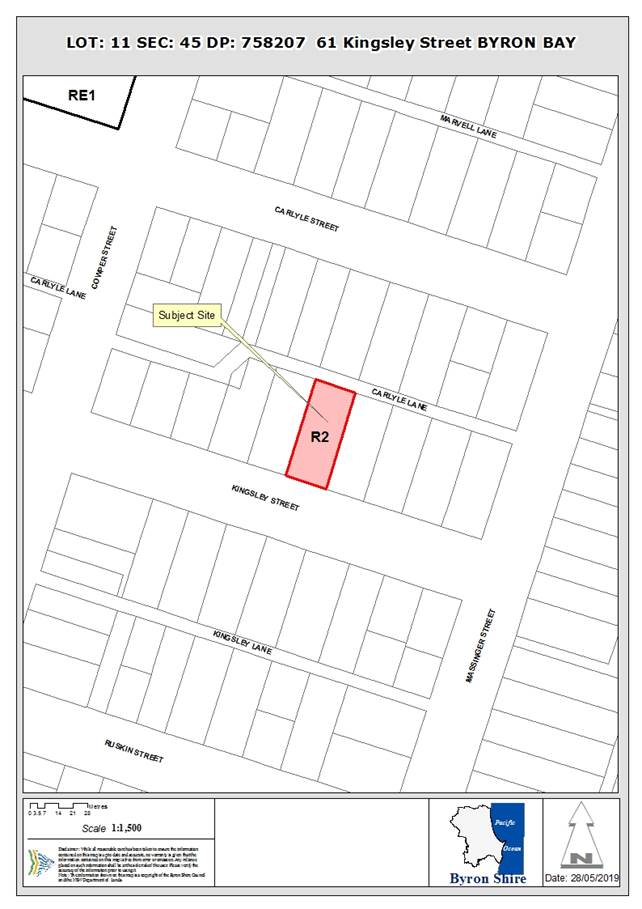
Assessment:
1. INTRODUCTION
1.1. History/Background
6.1994.2039.001 Building Applications Addition/Alteration
Dwelling Approved 16/03/1994
10.2010.190.1 Development
Application Tree removal Approved
19/04/2010
10.1998.744.1 Development
Application Dwelling Approved
06/01/1998
1.2. Description
of the proposed development
The proposed development is for demolition of an existing
single storey dwelling within the Kingsley Street Heritage Conservation Area,
and construction of a new two storey dwelling and pool and basement storage
level.
The proposed building form incorporates a hipped and gabled
roof with a skillion verandah to the front and side. The second storey has a
smaller footprint above the main floor.
Proposed materials are Scyon Linea Board cladding, Colorbond
roof and a stone wall base.
1.3. Description
of the site
|
Land is legally described as
|
LOT: 11 SEC: 45 DP: 758207
|
|
Property address is
|
61 Kingsley Street BYRON BAY
|
|
Land is zoned:
|
R2 Low Density Residential
|
|
Land area is:
|
1012 m2
|
The site is known as LOT: 11 SEC: 45 DP: 758207, 61 Kingsley
Street Byron Bay. It contains a single storey timber clad dwelling in an urban
subdivision. The property is modest in scale and size and is setback from the
street and falls away to the rear of the block where it slopes away from the
street. The subject site also contains rear lane access.
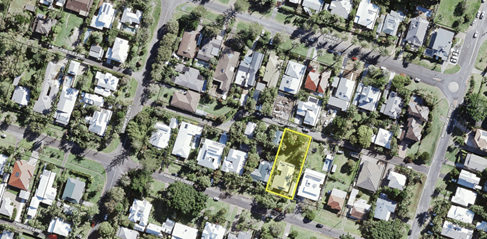
Figure 1: Shows the GIS mapping and the location of the
subject site
The subject property is within the statutory Kingsley Street
Heritage Conservation Area under Byron Shire LEP 2014 and lies in the general
streetscape setting of two heritage items on the opposite side of the street.
The existing property on site has been substantially altered over time and does
not contain any original features which would be deemed suitable to be retained
and repaired in the Heritage Conservation Area.
2. SUMMARY OF
REFERRALS
|
Referral
|
Issue
|
|
Development Engineer
|
No objections subject to conditions. Refer to Doc #A2018/30306
|
|
Heritage Consultant
|
No objections subject to conditions. Refer to Doc #E2018/88801
|
|
Essential Energy
|
No objections subject to conditions. Refer to Doc #E2018/80300
|
No objection was raised during the referral process.
3. SECTION 4.14
– BUSH FIRE PRONE LAND
Under section 4.14 of the Act, Council must be satisfied
prior to making a determination for development on bush fire prone land, that
the development complies with the document Planning for Bush Fire Protection
2006. The site is not bush fire prone land.
EFFECT OF 10/50 RULE ON SIGNIFICANT VEGETATION
Not relevant to this subject site
4. SECTION 4.15C
– MATTERS FOR CONSIDERATION – DISCUSSION OF ISSUES
Having regard to the matters for consideration detailed in
Section 4.15(1) of the Environmental Planning & Assessment Act 1979
(EP&A Act), the following is a summary of the evaluation of the issues.
4.1 State Environmental
Planning Instruments
4.2A Byron Local Environmental Plan 2014 (LEP 2014)
LEP 2014 is an applicable matter for consideration in the
assessment of the subject development application in accordance with subsection
4.15(1) of the EP&A Act because it applies to the subject land and the
proposed development. The LEP 2014 clauses that are checked below are of
relevance to the proposed development:
|
Part 1
|
☒1.1|
☒1.1AA| ☒1.2| ☒1.3| ☒1.4| ☒Dictionary| ☒1.5| ☒1.6| ☒1.7| ☒1.8| ☐1.8A| ☒1.9|
☐1.9A
|
|
Part 2
|
☒2.1|
☒2.2 | ☒2.3 |☒Land Use Table | ☐2.4 | ☐2.5 | ☐2.6 | ☐2.7 | ☐2.8
|
|
Part 3
|
☐3.1|
☐3.2| ☐3.3
|
|
Part 4
|
☐4.1|
☐4.1A| ☐4.1AA| ☐4.1B |☐4.1C| ☐4.1D| ☐4.1E| ☐4.2| ☐4.2A| ☐4.2B| ☐4.2C| ☐4.2|☒4.3|☐4.4 |☒4.5 | ☒4.6
|
|
Part 5
|
☐5.1|
☐5.2| ☐5.3| ☐5.4| ☐5.5| ☐5.6| ☐5.7| ☐5.8|☐5.9| ☐ 5.9AA| ☒5.10| ☐5.11| ☐5.12|
☐5.13
|
|
Part 6
|
☒6.1|
☒6.2| ☐6.3| ☐6.4| ☐6.5| ☐6.6| ☐ 6.7| ☐6.8| ☐6.9
|
In accordance with LEP 2014 clauses 1.4 and 2.1 – 2.3:
(a) The
proposed development is defined in the LEP 2014 Dictionary as Dwelling
,Swimming Pool ;
(b) The
land is within the R2 Low Density Residential according to the Land Zoning Map;
(c) The
proposed development is permissible with consent; and
(d) Regard
is had for the Zone Objectives as follows:
|
Zone Objective
|
Consideration
|
|
• To
provide for the housing needs of the community within a low density
residential environment.
|
The single dwelling house is an appropriate form of low
density housing
|
|
• To
enable other land uses that provide facilities or services to meet the day to
day needs of residents.
|
The replacement single dwelling is an appropriate
residential use on the site
|
Clause 4.4 Floor Space ratio
The proposed new dwelling has a FSR of 03:1 across the
entire site which has a total area of 1012m2 with a proposed floor space of
308.5 m2. The proposal complies with the allowable FSR of 0.5:1
Clause 4.3 Height of Buildings
The development has been designed to comply with the 9 metre
height limit. Conditions are also proposed to lower the building a further 500
mm in relation to the building height plane, which further reduce the overall
height of the dwelling.
Clause 5.10 Heritage Conservation
The proposed development is located within the Kingsley
Street Conservation Area. The application was considered by Councils Heritage
officer who raised no issue with the demolition to the existing dwelling or the
new house to replace. The following comments are provided:
The subject dwelling forms part of a streetscape of
predominantly single storey cottages on this side of Kingsley Street, which
collectively contribute to the aesthetic character of the Conservation Area
through bulk, scale, setbacks, materials, traditional roof forms and landscaped
setting. The subject dwelling however, demonstrates little aesthetic
significance. The roof lines have been extensively altered and modified and the
exterior fabric appears to include much new material, and non-original fenestration.
Replacement with the proposed dwelling which has a predominantly single storey
façade to the street and a small second storey area is not considered
likely to have an adverse impact upon the aesthetic significance of the
Conservation Area which is noted for the following elements.
-Wide streets, ample verges, buildings setback behind
fences
-Development respects the subdivision pattern but rises up
the slope
-Predominantly traditional forms and materials
-Buildings set on ample lots with subtropical vegetation
-No obvious kerbs and gutters
With regard to the setting of
the Conservation area and that of heritage items in the vicinity of the site,
the proposed dwelling is considered to be an acceptable design which will not
detract from these values.
Recommendations have been made in relation to the colour
scheme and condition of consent has been proposed in that regard.
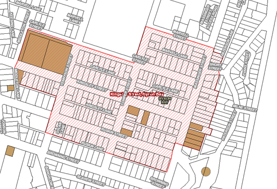
Figure 2: Kingsley Street Heritage Conservation Area and the
individual Heritage Items.
The proposed new design is considered appropriate in scale
and size and has an architectural design that reflects the objectives for new
infill house in the heritage conservation area. There is a range of dwelling
houses located in this locality of varying in style and colour. The proposal
however is considered to be sympathetic the heritage provisions within the DCP
and raises no specific issues in that regards. It is considered the proposal
complies with the provisions of Clause 5.10.
The proposal raises no other issues under the LEP.
4.3 Any proposed Instrument
that has been the subject of public consultation and has been notified to the
consent authority
No draft EPIs affect the proposal
4.4A Byron Shire Development Control Plan 2014
(DCP 2014)
DCP 2014 is an applicable matter for consideration in the
assessment of the subject development application in accordance with subsection
4.15(1) of the EP& A Act because it applies to the land to which LEP 2014
applies. The DCP 2014 Parts/Chapters that are checked below are of relevance to
the proposed development:
|
Part A
|
☒
|
|
Part B Chapters:
|
☒
B2| ☒ B3| ☒ B4| ☐B5| ☐B6| ☐B7| ☐B8| ☒ B9| ☐B10| ☐B11| ☐B12| ☐B13|
☐B14
|
|
Part C Chapters:
|
☒
C1| ☐C2| ☐C3| ☐C4
|
|
Part D Chapters
|
☒
D1| ☐D2| ☐D3| ☐D4| ☐D5| ☐D6| ☐D7| ☐D8
|
|
Part E Chapters
|
☐
E1| ☐E2| ☐E3| ☐E4| ☐E5| ☐E6| ☐ E7
|
Chapter C1
Non-Indigenous Heritage
C1.3.1 General Streetscape Context
Performance Criteria
1. The side and front setbacks
must be typical of the spacing of existing buildings both from each other and
from the street, such that the streetscape is retained.
2. The established landscape
character of the locality including height of canopy and density of boundary
landscape plantings must be retained in any new development.
3. New developments must
respect and complement the existing heritage character of the streetscape by
maintaining the general scale, height, bulk and proportions of traditional and
new buildings in the streetscape.
4. Extensions must not
overwhelm the original building. It may be preferable to create two separate
buildings with a linkage in order to maintain the integrity of the original.
5. Floor levels must be
compatible with floor levels of adjoining buildings.
Overall the new infill building is considered to be
sympathetic to the aims and objectives of the Kinsley Street Heritage
Conservation Area.
The new building does the following in order to comply with
the heritage considerations:
· Contains the same
setback as the adjoining properties
· Proposes a larger
side setback than the BCA minimum;
· Proposes the same
roof slope and pitch as the adjoining properties
· Façade
treatment is considered similar but modernised
· Floor levels align
with the adjoining properties
· Window size is
considered to align with heritage conservation principles
· Street trees are
proposed to be retained
· No works are
proposed along the rear Carlyle Lane.
Overall staff support the new building design, subject to
the changes in red - as marked on the architectural plans.
Chapter D1 Residential Accommodation in Urban, Village
& Special Purpose Zones
D1.2.1 Building Height Plane:
The proposed development breaches the prescribed building
height plane which is defined under DCP 2014 as:
Building Height Plane means the plane projected at an
angle of 450 over the land to be built upon, measured from a vertical distance
of 1.8 metres above ground level (existing) at the site boundary.
At the front elevation the 45 degree Building Height Plane
is generally compliant, however when viewed from the rear or northern elevation
there is a breach predominantly on the western elevation. The rear
non-compliance is exaggerated due to the slope and the topography of the land,
combined with the height of the development. The dwelling however is well
setback from the neighbouring property to the west being 1.6 metres at the
closest point and then extends to over 2 metres from the same boundary. The
upper levels of the dwelling are then setback in excess of 3 metres from the
boundary. The proposal has a garage and storage area on the eastern side
setback 1 metre from this boundary then the dwelling is setback over 5 metres
from that boundary
The adjoining property to the west (No. 59 Kingsley St) is
constructed approximately 850 mm from the side boundary and breaches the
Building Height Plane, whilst the property to the east comprising a
contemporary 1 and 2 storey development is only setback 2 metres from the boundary
and also clearly breaches the Building height plane. As to the existing
dwelling on the subject site it is also in breach of the building height plane
along the western boundary.
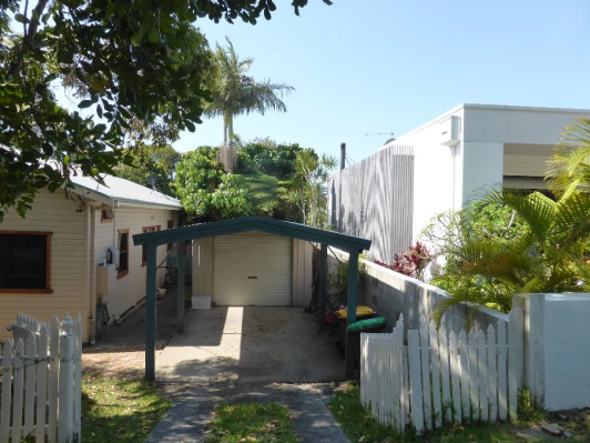
Figure 3: Adjacent dwelling at No. 63 Kingsley Street
to the right – (NB Dwelling approved prior the creation of the
Conservation Area under Byron LEP 2014).
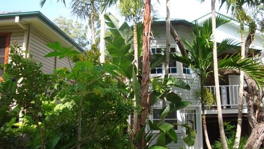
Figure 4: No. 59 Kingsley Street (to the right) from
rear yard
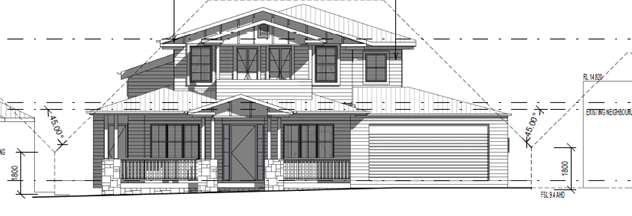
Figure 5: Proposed South elevation showing the Building
Height plane for the development and as existing for neighbouring
properties.
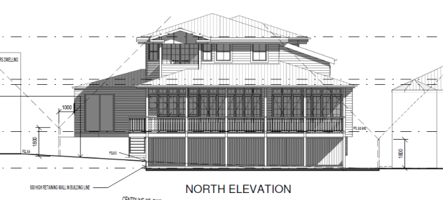
Figure 6: Proposed Northern elevation showing the
building height plane and as existing for neighbouring properties.
To bring the building into better compliance with the
prescriptive measures, conditions of consent are recommended to lower the
dwelling by 500 mm. In this regard the ground floor of the dwelling to be set
200 mm lower at 9.6 m AHD, whilst the 3 metre ceilings on this level are also
to be lowered to 300 mm to 2.7 m AHD. With further lowering of the development,
the proposal has been considered against the objectives and performance
criteria underpinning this design element in the DCP the following comments are
provided:
Objectives
1. To ensure that residential
development is designed to minimise impacts on solar access and privacy on adjoining
properties, and on the views from adjacent existing buildings.
2. To ensure that the occupants
of the building or buildings will enjoy the optimum use of winter sunlight and
summer shade.
Performance Criteria
1. Developments must be set
back progressively from the site boundaries as height increases so that they do
not adversely affect existing or future development on adjoining properties by
way of overshadowing, impinging on privacy or obstructing views.
2. Developments must be
designed so that they will promote energy efficiency and so that residents may
enjoy optimum use of winter sunlight and summer shade.
3. Development applications
must demonstrate that the windows of living areas (decks, living rooms,
bedrooms, kitchens, etc.) of development on adjoining properties will, as a
minimum, retain full solar access between the hours of 9.00am to 3.00pm on any
day.
Comment:
It is considered the design of the development which
gradually steps back from the side boundaries as it rises in height will
minimise impact in relation to solar access, whilst no direct impacts are
observed in terms of privacy. Also the orientation of the lots on a
general north south axis will ensure good solar access through the middle
of the day. It is considered the development will not obstruct views being
within an existing residential street dominated by dwellings aligned on a north
south axis, whilst general energy efficiency of the dwelling in terms of winter
sunlight and summer shade is maintained. As to shadow impact the applicant
provided a series of shadow diagrams. (See Attachment 1 for Plans)
Although the proposal will cast a shadow onto the neighbouring dwelling to the
west in midwinter at 9 am such impact has gone by 11 am. Further, such shadow
impact falls upon three bedrooms of the neighbours house, not there main living
areas which are located on the northern and western elevations. In contrast the
midwinter 3pm shadow diagram shows the dwelling at 59 Kingsley Street casting a
shadow onto the proposed dwelling.
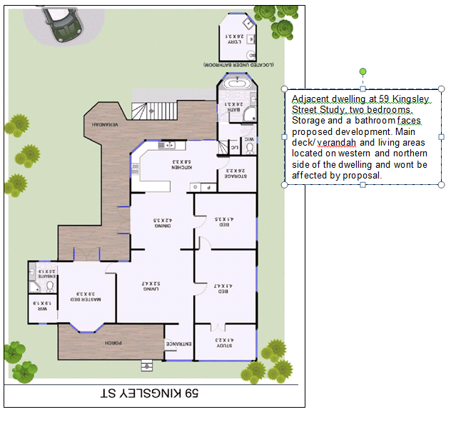
Conclusion
Having regard to the building height plane breaches that are
evident at both the adjoining properties at 59 and 63 Kingsley Street, the
level of encroachment resulting from the proposal is considered acceptable once
the further lowering of the development is achieved.
In some regards it could be considered that the BHP
provisions for both these properties has been abandoned to a degree and the
rationale or fairness to make the subject development comply strictly with this
guideline is not wholly apparent. However, it is clear from the proposed plans
the development has attempted to satisfy the controls. In relation to any
overshadowing that results from the development. It has to be recognised that
such shadow impacts already occur from each of these dwellings at 59 – 63
Kingsley Street in the morning and evening hours onto the subject property.
Having regards to the circumstance of the case the application can be
supported.
It is considered the proposal raises no other issues against
the DCP chapters within DCP 2014.
4.5 Any Planning Agreement or
Draft Planning Agreement?
|
|
Yes
|
No
|
|
Is there any applicable planning agreement or draft
planning agreement?
|
☐
|
☒
|
|
|
4.6 Environmental Planning
& Assessment Regulation 2000 Considerations
|
Clause
|
This control is applicable to the proposal:
|
I have considered this control as it relates to the
proposal:
|
If this control is applicable, does the proposal
comply?
|
|
92
|
Yes
|
Yes
|
Yes Conditions of consent proposed in relation to the demolition
of the dwelling house
|
|
93
|
Yes
|
No
|
No
|
|
94
|
Yes
|
Yes
|
No
|
|
94A
|
Yes
|
No
|
No
|
* Non-compliances and any other significant issues
discussed below
4.7 Any COASTAL ZONE MANAGEMENT
PLAN?
|
|
Satisfactory
|
Unsatisfactory
|
Not applicable
|
|
Is there any applicable coastal zone management plan?
|
|
☐
|
x
|
|
|
4.8 The likely impacts of that
development, including environmental impacts on both the natural and built
environments, and social and economic impacts in the locality
|
Impact on:
|
Likely significant impact/s?
|
|
Natural environment
|
No. The proposal will not have a significantly adverse
impact on the natural environment of the locality.
|
|
Built environment
|
No. The proposal will not have a significantly adverse
impact on the built environment of the locality.
|
|
Social Environment
|
No. The proposal will not have a significant social impact
on the locality.
|
|
Economic impact
|
No. The proposal will not have a significant economic
impact on the locality.
|
Conditions of consent to apply to control construction
activities including hours of work, builders noise, construction waste and
installation of sedimentation and erosion control devices.
4.9 The suitability of the site
for the development
The site is a serviced, unconstrained property and is
suitable for the proposed development. The property is not affected by natural
hazards such as landslip, flooding, bushfire, coastal eroison or acid sulfate
soils
4.10 Submissions made in accordance with
this Act or the regulations
The development application was publicly exhibited twice.
- First
exhibition: 25/09/2018 to 8/10/2018
- Re-Exhibition
for revised plans 05/03/2019 – 18/03/2019
Two Initial Objections were received with follow up submission
fro the immediate neighbours and consultant planner
|
Issues
|
Comment
|
|
Building height Plane Breach and Overshadowing Impacts
on 59 Kingsley street
|
The Building height Plane Breaches and level of
Overshadowing on the adjacent property to the West is discussed in detail
above. Such impacts having regards to the circumstances of the case and
existing built form in the street are considered acceptable.
|
|
Overshadow Impacts on 57 Kingsley Street
|
Shadow Diagrams have been submitted. It is considered
the proposal will not adversely impact 57 Kingsley Street two properties to
the west
|
|
The size and bulk of the dwelling is too large having
regards to the conservation precinct
|
The proposal was considered by Council’s
Heritage Adviser as acceptable having regards to the heritage controls under
Byron LEP and DCP 2014. The proposal complies with the statutory height and
FSR controls under the LEP; the size of the dwelling is not out of character
with other dwellings in the locality.
|
|
Privacy Impacts from rear decks and swimming pool
|
The decks are to be screened as per proposed plans,
whilst conditions are proposed in relation to landscaping the fence line
adjacent to the pool.
|
4.11 Public interest
The proposed development is unlikely to prejudice or
compromise the public interest or create a dangerous precedent
5. DEVELOPER
CONTRIBUTIONS
There is no nexus to levy contribution or headworks charges
in this instance
6. CONCLUSION
The proposed development is consistent with the relevant
environmental planning instruments and planning controls applicable to the
site. The proposal raises no significant issues in terms of environmental
impacts which cannot be managed and the site is considered suitable for the
development. The application is recommended for approval subject to conditions
of consent.
7. REASONS
FOR DECISION, HOW COMMUNITY VIEWS WERE ADDRESSED
Note:
From July 1 2018, Council’s are required to give and publicly notify reasons
for a range of planning decisions where they are deciding if development should
proceed to help community members to see how their views have been taken into
account and improve accountability to stakeholders. A statement of reasons for
the determination of this application is provided below.
|
Statement of Reasons
|
|
The proposed development complies with the provisions of
Byron Local Environmental Plan 2014.
|
|
The proposed development complies with relevant State
Environmental Planning Policies
|
|
The proposed development complies with relevant provisions
of Development Control Plan 2014
|
|
The proposed development complies with Environmental
Planning & Assessment Regulation 2000 considerations.
|
|
The proposed development complies with the Coastal Zone Management
Plan.
|
|
The proposed development will not have significant adverse
impact on the natural, built or social environment or economic impacts on the
locality.
|
|
The proposed development is considered suitable for the
proposed site.
|
|
The development application was notified/advertised in
accordance with Development Control Plan 2014. Issues raised in the
submissions have been addressed during assessment of the application.
|
|
The proposed development is unlikely to prejudice or
compromise the public interest.
|
|
The proposed development will not have a detrimental
impact on the heritage character of the precinct or the buildings contained
on the site. It is considered consistent with the heritage provisions
contained within Clause 5.10 of Local Environmental Plan 2014.
|
|
The proposed development will not have a detrimental
impact on the heritage character of the precinct or the buildings contained
on the site. It is considered consistent with the heritage provisions
contained within Development Control Plan 2014.
|
|
How community views were addressed
|
|
The DA was advertised in accordance with Development
Control Plan 2014. The submissions received were considered on merit and
addressed during assessment of the application.
To view the considerations, please contact Council to view
a copy of the assessment report relating to this DA.
|
Staff Reports - Sustainable Environment and Economy 6.12
Report No. 6.12 PLANNING
- 10.2017.399.2 - S4.55 to permit use of Cavanbah Centre carpark for the Byron
Farmers Market at 249 Ewingsdale Road Byron Bay
Directorate: Sustainable
Environment and Economy
Report
Author: Chris
Larkin, Manager Sustainable Development
Noreen Scott, EA Sustainable
Environment and Economy
File No: I2019/839
|
Section 96 Application No:
|
10.2017.399.2
|
|
Proposed modification:
|
S4.55 to Permit Use of Cavanbah Centre Carpark for the
Byron Farmers Market
|
|
Original Development:
|
10.2017.399.1
|
|
Type of modification sought:
|
|
|
|
|
|
Property description:
|
LOT: 3 DP: 706286
|
|
249 Ewingsdale Road BYRON BAY
|
|
Parcel No/s:
|
132490
|
|
Applicant:
|
Byron Shire Council
|
|
Owner:
|
Byron Shire Council
|
|
Zoning:
|
RE1 Public Recreation / PART RU2 Rural Landscape / PART DM
Deferred Matter
|
|
S96 Date received:
|
7 May 2019
|
|
Original DA determination date:
|
1 February 2018
|
|
Public notification or exhibition:
|
- Level
2 advertising under DCP 2014 Part A14 – Public Notification and Exhibition
of Development Applications
- Exhibition
period: 23/5/19 to 05/06/19
- No Submissions were received
|
|
Delegation to determination:
|
Council
|
|
Issues:
|
· Car parking
|
Summary:
An application has been submitted to amend development
Consent DA10.2017.399.1 to facilitate the use of the Cavanbah Centre Carpark
for the Byron Farmers markets for 80 stalls during construction of the Byron
Bay Town Centre Bypass. Amendments sought include to:
· Condition 4 as it
has been drafted in such a way to prevent the scenario of two markets operating
in Byron Bay on the same day.
· Condition 2 to
reflect the number of stalls proposed for the Byron Farmers Market within
Market Area B.
An assessment of the proposal against the car parking
requirements for markets has been carried out, and a minor numerical shortfall
of 9 spaces has been identified based on stall holders also requiring a
designated car parking space. As many of the stall holders will operate from
their vehicles within the market area, a minor variation to the numerical
requirements is considered justified in this instance.
The additional use of the site for the Byron Farmers Market
is considered to be substantially the same development as approved and
satisfies the provisions under Section 4.55 of the EPA Act 1979. It is
considered the amendments do not generate any additional impacts that have not
been previously considered; the site being directly accessible from Ewingsdale
Road is also deemed as suitable for the proposed use. The Section 4.55
Application is recommended for approval. .
NOTE TO COUNCILLORS:
In accordance with the
provisions of S375A of the Local Government Act 1993, a Division is to be
called whenever a motion for a planning decision is put to the meeting, for the
purpose of recording voting on planning matters. Pursuant to clause 2(a)
under the heading Matters to be Included in Minutes of Council Meetings of
Council's adopted Code of Meeting Practice (as amended) a Division will be
deemed to have been called by the mover and seconder of all motions relating to
this report.
|
RECOMMENDATION:
That pursuant to Section 4.55 of the
Environmental Planning & Assessment Act 1979, that Application No.
10.2017.399.2 to Permit Use of Cavanbah Centre Carpark for the Byron Farmers
Market, be approved subject to the amended Conditions in Attachment 1
(E2019/40630).
|
Attachments:
1 Amended
Conditions of Consent, E2019/40630
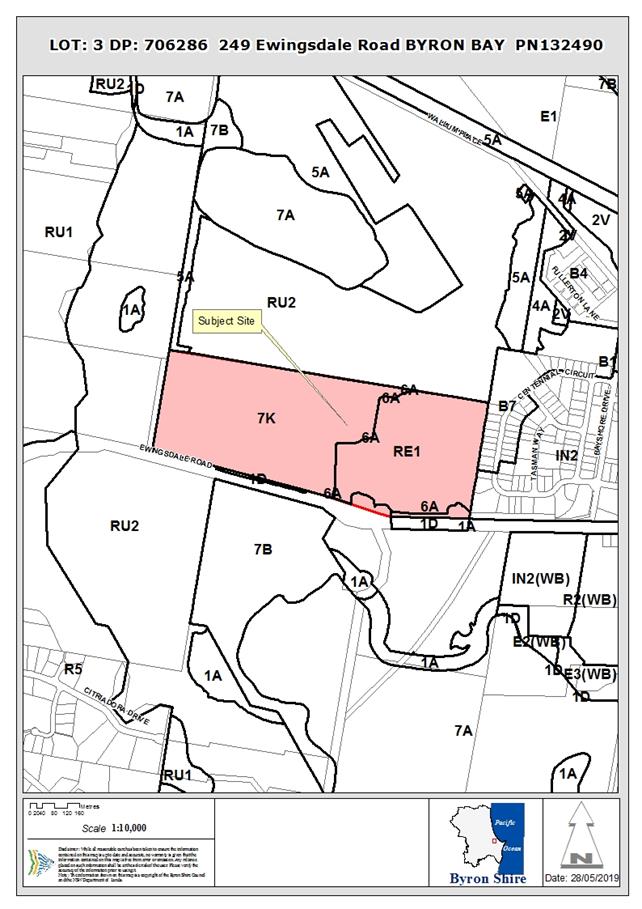
Assessment:
1. INTRODUCTION
1.1. History/Background
DA10.2017.399.1 – Use of Cavanbah Centre for Markets
and primitive camping ground. Approved 1/2/18
1.2. Description of the
proposed development
This application seeks approval for a S4.55 modification of
development consent to Permit Use of the Cavanbah Centre Carpark for the Byron
Farmers Market.
A modification is necessary as conditions were imposed on
the original development consent limiting the number of stalls to two areas,
and for ‘markets’ held on site not to conflict with either the
Byron Farmers Market or Byron Sunday Markets.
The applicant is seeking approval for the Byron Farmers
Market to be moved temporarily to the site during construction of the Byron Bay
Town Centre Pass.
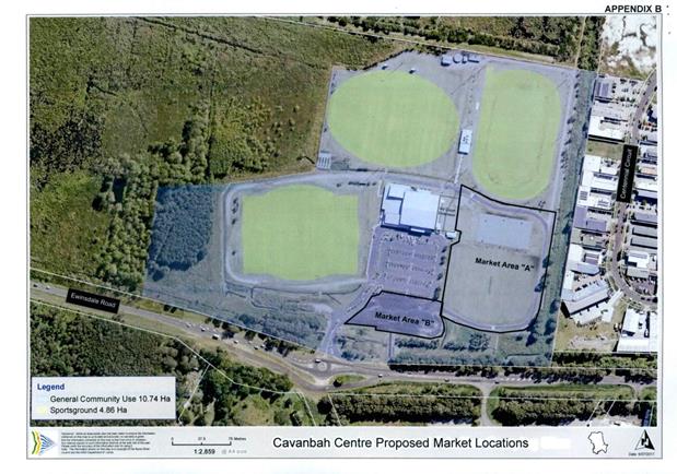
Figure
1 – Approved Market Area A and Area B
Conditions 2 and 4 of development consent 2017/399 currently
require the following:
2. Number of Stalls Permitted
When any stall is located within the
existing bitumen sealed car park, a maximum of 55 stalls are permitted.
When no stall is located within the
existing bitumen sealed car park a maximum of 90 stalls are permitted.
4. Restricted
hours of operation
Markets are not permitted to operate:
· While the Cavanbah Centre, associated sport facilities, sports ovals
or primitive camping are in use. Nor are the markets permitted to operate
within an hour of the Cavanbah Centre, associated sport facilities, sports
ovals or primitive camping beginning or finishing operation.
· At any time that coincides with the Byron Bay Community Markets and
Byron Farmers Market.
The Byron Farmers Market is proposed for the southern end of
the bitumen car park identified as Market Area B.
1.3 Description of
the site
|
Land is legally described as
|
LOT: 3 DP: 706286
|
|
Property address is
|
249 Ewingsdale Road BYRON BAY
|
|
Land is zoned:
|
RE1 Public Recreation / PART RU2 Rural Landscape / PART DM
Deferred Matter
|
|
Land area is:
|
40 hectares
|
|
Property is constrained in part by:
|
Flood Liable Land,
Bushfire prone land
Acid Sulfate Soils Class 2 and 3
High Conservation Value High Environmental Value in areas
to the west, outside existing sports fields. Markets and camping areas are
outside of high conservation value areas.
|
The site has a total area of 40
hectares. The eastern part of the site is developed for sporting fields, car
parking, roads, ancillary infrastructure and a community building. The
community building contains indoor sports facilities, meeting rooms, change rooms,
toilet and shower facilities and storage.
The western part of the site is
a mixed wetland and sedgeland with various levels of historical disturbance.
This area is managed as part of the West Byron Sewage Treatment Plant.
The site is located on the
western outskirts of Byron Bay, approximately four kilometres from the town
centre. It is bound by the Byron Bay Arts and Industrial Estate to the east,
the west Byron STP and effluent reused wetland to the north, rural and
environmental wetland to the west and Ewingsdale Road to the south. Vehicular
access to the site is via a roundabout on Ewingsdale Road. Pedestrian and
bicycle access is available to the site from the town centre.
2. SECTION 4.15 – MATTERS FOR CONSIDERATION
– DISCUSSION OF ISSUES
Having regard for the matters for consideration detailed in
Section 4.15(1) of the Environmental Planning & Assessment Act 1979, the
following is a summary of the evaluation of the issues.
2.1. State/Regional Planning
Policies, Instruments, EPA Regulations 2000
SEPP Infrastructure 2007
The site adjoins and takes its access from a classified road
(Ewingsdale road). The proposal was considered against Clause 101(2) of the
SEPP which states:
(2) The consent
authority must not grant consent to development on land that has a frontage to
a classified road unless it is satisfied that:
(a) where practicable, vehicular access to the
land is provided by a road other than the classified road, and
(b) the safety, efficiency and ongoing operation
of the classified road will not be adversely affected by the development as a
result of:
(i) the design of the vehicular access to the
land, or
(ii) the emission of smoke or dust from the
development, or
(iii) the nature, volume or frequency of
vehicles using the classified road to gain access to the land, and
(c) the development is of a type that is not
sensitive to traffic noise or vehicle emissions, or is appropriately located
and designed, or includes measures, to ameliorate potential traffic noise or
vehicle emissions within the site of the development arising from the adjacent
classified road.
The
matter was considered in some detail with the assessment of the original
application. In this regards there is no other means of access into the site
and a specifically designed roundabout on Ewingsdale Road provides access for
vehicles coming from both directions on Ewingsdale Road.
In
terms of traffic generation, it is considered the intersection has the capacity
to manage peak hour traffic. In terms of the market itself, it is a temporary
use which is unlikely to be adversely affected or impacted upon by traffic
noise or vehicle emissions.
Proposed amendments raise no other issues under the relevant
SEPPS, Policies or clauses of the EPA Regulations 2000.
2.2. Byron Local Environmental
Plan 2014
The proposed amendments raise no issues under Byron LEP 2014
2.3. Draft EPI that is or has
been placed on public exhibition and details of which have been notified to the
consent authority - Issues
No draft EPIs affect the proposal.
2.4. Development Control Plans
Chapter B4 Traffic Planning, Vehicle Parking, Circulation
and Access
Parking
Markets require 2.5 spaces per stall in terms of car parking
for customers but the DCP is silent on the staff or stall holder car parking
requirements. In the previous assessment for the DA an additional space per
stall holder was also included the calculation.
The subject location of the Byron Farmers Market in the
southern Car Park shown as Market Area B will remove some 131 car parking
spaces from the Cavanbah Centre, leaving 251 formal spaces and a further 20
informal spaces for parking. Based on a strict calculation this equates to
approximately 77.5 stalls, with a shortfall of around 9 spaces for the markets.
However no consideration has been given to the number of stall holders that
operate from the back of trucks, utes, vans and cars on market day. The
applicant has submitted information from the Byron Farmers Market that this is
the case (e.g. stall holders predominantly use their vehicles in part as
stalls) and as such will be parked in the designated Market Area. In terms of
other uses at the Cavanbah Centre, the applicant has advised no other
activities will be occurring at the Cavanbah centre on the Thursday Mornings.
It is considered that a variation be granted to the minor shortfall and the car
parking proposed is adequate.
Traffic
Traffic
generation was previously considered with the approval of DA10.2017.399.1. In
that regards the Cavanbah Centre Intersection on Ewingsdale Road was designed
with a peak hour traffic count of 470 peak hour trips. In accordance
with RMS Guide to Traffic Generating Developments 1 market stall generates 4
PHT’s. Therefore 80 stalls is equivalent to 320 peak hour trips. It is
considered the intersection has adequate capacity to cater for the Byron
Farmers Market.
Conditions were imposed for a
Traffic Management Plan to be submitted pursuant to S138 of the Roads Act for
approval. It is recommended condition 18 be partially re-worded to reflect the
need for the S138 Application only for works and signage in the road reserve.
Preliminary discussions with the applicant indicate that for the Byron Farmers
Market, the Management Plan will relate to traffic control and signage within
the car park area of the Cavanbah Centre only.
2.5. The likely impacts of that
development, including environmental impacts on both the natural and built
environments, and social and economic impacts in the locality
The proposed amendments do not generate any impacts that
have not been previously considered.
2.6. The suitability of the
site for the development
The restriction on markets at the Cavanbah Centre was placed
on the consent to avoid any potential conflict that the Cavanbah Centre could
operate a market on the same day as the Byron Farmers Market. It was never
envisaged that the Byron Farmers Market may need to operate from this site at
the time of approval.
The site is considered suitable for the Byron Farmers
Markets having regards to the car parking onsite, access from Ewingsdale Road
and the duration of the markets generally from 6am through to Midday every
Thursday Morning.
3.6 Submissions
made in accordance with this Act or the regulations
No submissions were received.
3.7 Public
interest
The proposed amendments are unlikely to prejudice or
compromise the public interest.
4. DEVELOPER
CONTRIBUTIONS/ WATER AND SEWER CHARGES
The applicant has sought a minor amendment to the
requirements for Certificate of Compliance under the Water Management Act 2000.
In this regard the certificates are required for the camping ground component
of the development should this ever go ahead where by headworks charges would
apply. Conditions 21 & 22 have been amended accordingly.
There is no nexus to levy additional contributions.
5. DISCLOSURE OF
POLITICAL DONATIONS AND GIFTS
|
Has a Disclosure Statement been received in relation
to this application
|
No
|
|
Have staff received a ‘gift’ from anyone
involved in this application that needs to be disclosed. Where the answer is
yes, the application is to be determined by the Director or Manager of the
Planning, Development and Environment Division.
|
No
|
|
Provide Disclosure Statement register details here:
|
Not applicable
|
6. CONCLUSION
The proposed use of the site for the Byron Farmers Market is
considered to be substantially the same development and satisfies the
provisions under Section 4.55 of the EPA Act 1979. The amendment seeks to make
minor modifications to a number of conditions of consent (2, 4 18, 21 & 22)
as it is concluded the site is suitable for the Byron Farmers Market as
proposed.
The proposal is recommended for approval subject to amended
conditions of consent.
Staff Reports - Sustainable Environment and Economy 6.13
Report No. 6.13 PLANNING
-10.2018.486.1 Redevelopment of Brunswick Heads Surf Life Saving Club including
Demolition works and Construction of New Surf Club Building containing Training
Rooms, Storage Areas, Canteen, Amenities and Foyer at Ground Level and an
Additional Training Room, Bar Areas, Kitchen, Amenities, Storage Areas, Cool
Rooms, Function Area and Deck Areas within the Upper Floor at South Beach Road
Brunswick Heads
Directorate: Sustainable
Environment and Economy
Report
Author: Patricia
Docherty, Planner
Noreen Scott, EA Sustainable
Environment and Economy
File No: I2019/847
|
DA No:
|
10.2018.486.1
|
|
Proposal description:
|
Redevelopment of Brunswick Heads Surf Life Saving Club
including demolition works and construction of new surf club building
containing training rooms, storage areas, canteen, amenities and foyer at
ground level and an additional training room, bar areas, kitchen, amenities,
storage areas, cool rooms, function area and deck areas within the upper
floor.
|
|
Property description:
|
LOT: 427 DP: 729272
|
|
South Beach Road BRUNSWICK HEADS
|
|
Parcel No/s:
|
181600
|
|
Applicant:
|
Joe Davidson Town Planning
|
|
Owner:
|
Byron Shire Council
|
|
Zoning:
|
7 f1 Coastal Land Zone
|
|
Date received:
|
24 September 2018
|
|
Integrated / Designated Development:
|
☐
Integrated
|
☐
Designated
|
☒
Not applicable
|
|
Concurrence required
|
No
|
|
Public notification or exhibition:
|
- Level
2 advertising under DCP 2014 Part A14 – Public Notification and
Exhibition of Development Applications
- Exhibition
period: 18/10/18 to 31/10/18
- Submissions received: one
(1) Support
|
|
Planning Review Committee:
|
Date of PRC: 25.10.18
|
|
Concurrent approvals (S68/138):
|
Not applicable
|
|
Variation request
|
☐
Clause 4.6
|
☐
SEPP 1
|
☒
Not applicable
|
|
Delegation to determine
|
Council
|
|
Issues:
|
Flood Liable Land – along western boundary.
Acid Sulfate Soils Class 3 and 5
Coastal Erosion Precinct 1
|
Summary:
The proposed development includes the demolition of the old
surf club and replacement with a new and larger facility on the site. The new
surf club building contains training rooms, storage areas, canteen, amenities
and foyer at ground level and an additional training room, bar areas, kitchen,
amenities, storage areas, cool rooms, function area and deck areas within the
upper floor. The old building was erected in the late 1960’s with the
most recent additions completed in 1973.
The subject site is located South Beach road and is zoned
7(f1) Coastal Lands Zone. Although the building is not relocatable, it is
considered that it is sited sufficient distance from the Erosion escarpment
some 70 metres to the east. In the event that the building was at risk of being
damaged by Coastal Erosion Processes, it can be demolished.
The proposed surf club is consistent with the relevant
environmental planning instruments and planning controls applicable to the
site. The proposal raises no significant issues in terms of environmental
impacts which cannot be managed and the site is considered suitable for the
development. The application is recommended for approval subject to conditions
of consent.
NOTE TO COUNCILLORS:
In accordance with the
provisions of S375A of the Local Government Act 1993, a Division is to be
called whenever a motion for a planning decision is put to the meeting, for the
purpose of recording voting on planning matters. Pursuant to clause 2(a)
under the heading Matters to be Included in Minutes of Council Meetings of
Council's adopted Code of Meeting Practice (as amended) a Division will be
deemed to have been called by the mover and seconder of all motions relating to
this report.
|
RECOMMENDATION:
That pursuant
to Section 4.16 of the Environmental Planning & Assessment Act 1979,
Development Application 10.2018.486.1 for redevelopment of Brunswick Heads Surf Life Saving Club including
demolition works and construction of new surf club building containing training
rooms, storage areas, canteen, amenities and foyer at ground level and an
additional training room, bar areas, kitchen, amenities, storage areas, cool
rooms, function area and deck areas within the upper floor, be granted
consent subject to conditions in Attachment 3 (E2019/40478).
|
Attachments:
1 Submission
received, E2018/89825
2 Final Plan
Set Brunswick Heads Surf Club.pdf, E2019/39486
3 Consent
Conditions, E2019/40478
Assessment:
1. INTRODUCTION
1.1. History/Background
The site has had continuous usage for surf life saving
activities for over 80 years. The applicants Statement of Environmental Effects
states that the proposed building is to replace an existing two storey
structure that was originally constructed within the site in 1968. Additions to
the club were completed in 1973.
Summary of Council ‘authority’ records for more
recent Development Applications on the land parcel:
DA10.2002.99.1 Amenities Block – withdrawn 19/4/02
DA10.2003.30.1 Amenities block – Approved 18/5/04
DA10.2006.66.1 New Surf lIfesaving tower – Approved
24/5/06
DA10.2006.583.1 Bikes and Kites event – Approved
3/11/06
1.2. Description
of the proposed development
This application seeks approval for redevelopment of
Brunswick Heads Surf Life Saving Club including demolition works and
construction of new surf club building containing training rooms, storage
areas, canteen, amenities and foyer at ground level and an additional training
room, bar areas, kitchen, amenities, storage areas, cool rooms, function area
and deck areas within the upper floor.
Two planted Lilli Pilli trees will be required to be removed
as part of construction works whilst a Cottonwood Hibiscus will require lopping
to facilitate construction of the new building.
Site Plan and location
tree removal and pruning
Western Elevation of proposed Brunswick Heads Surf Life
Saving Club
1.3. Description
of the site
A site inspection was carried out on 5 February 2019
|
Land is legally described as
|
LOT: 427 DP: 729272
|
|
Property address is
|
South Beach Road BRUNSWICK HEADS
|
|
Land is zoned:
|
7 f1 Coastal Land Zone
|
|
Land area is:
|
Lot area is 8.42 hectares
|
Property is constrained by:
· Flood Liable Land
– along western boundary however the site of the proposed development is
outside mapped 1 in 100 year flood area.
· Acid Sulfate Soils
Class 3 and 5
· High Environmental
Value – No significant vegetation to be cleared
· Coastal Erosion
Precinct 1 - DA referred to Coastal & Biodiversity Coordinator
Lot boundary Lot 427 in DP
729272 (L) Zoning Overlay (R)
The proposal relates to Lot 427 DP 729272. No works are
proposed within Lot 436 DP 839424 or Lot 437 DP 839424 adjoining the site. Any
works to be completed within the adjacent road reserve will be done so under
Section 138 of the Roads Act 1993. It is not proposed to reconstruct parking
areas within Lot 436 or Lot 437.
SLSC looking west from reserve
SLSC looking east from car park

Cottonwood in foreground to be pruned (L), Lilli Pilli to
be removed (R)
2. SUMMARY
OF REFERRALS
|
Referral
|
Issue
|
|
Environmental Health Officer
|
No objections subject to conditions. Refer to Doc #
A2018/31927
|
|
Development Engineer
|
No objections subject to conditions. Refer to Doc # A2018/31929
|
|
S64 / ET Systems Planning
|
No objections subject to conditions. Refer to Doc
#A2018/31933
|
|
S7.11 Contributions Officer
|
No contributions recommended. Refer to Doc # A2018/31935
Comments:
Developer contributions
(S7.12) could be levied for this development. However as this is for a
public facility that was previously identified in the 2005 Contributions Plan
it is not appropriate to levy a contribution.
Clause 2.16 of the plan
states:
It is not always possible
to identify in advance all developments which may be able to make a
meritorious case for an exemption from the obligation to pay some or all of
the applicable contributions. On the principle of ensuring public
accountability, transparency and equity between all developers, this section
specifies the limited opportunity for making a merit-based case for
exemption.
Council may formally
consider, on the individual merits, a case for exempting the following types
of development from the levying of contributions:
· Developments
which provide a distinct community benefit on a not-for-profit basis
including but not necessarily limited to: accommodation associated with fire
stations, police stations or police shop fronts, ambulance stations, rescue
services, State Emergency Service (SES) and Rural Fire Services (RFS)
operational bases and the like. This provision is not intended to
include corporate headquarters of any type; and
· Development
by or for non-profit or cooperative organisations which provide a distinct
community benefit including but not limited to: the provision of childcare
services (especially for under-2s and/or special needs children) including
kindergartens and pre-schools; outreach services, community services or the
like, on a cooperative or not-for-profit basis.
The surf club meets the requirements of the second dot
point. No contributions are payable.
|
|
Crown Lands
|
Owners consent was lodged with the application. Note from
Council Executive Officer extracted below - Refer Doc #E2019/39595:
The advice received from Crown Lands at the meeting 30
May was that the Owners Consent to the lodgement of the DA that they issued
to the Surf Club last year is continuing and remains valid for the purposes
of the DA. So no further owners consent is required. (30 May 2019)
|
|
Traffic Engineer
|
No objections subject to conditions. Refer to Doc #A2018/31953
|
|
Police
|
No comments or objections. Refer to Doc ##A2018/31981
|
|
Tweed Byron Land Council
|
No objections received. Refer to Doc #E2019/15513
|
|
NTSCorp
|
No objections received. Refer to Doc #E2019/18493
|
* Conditions provided in the above referral are included
in the Recommendation of this Report below
3. SECTION 4.14
– BUSH FIRE PRONE LAND
Under section 4.14 of the Act, Council must be satisfied
prior to making a determination for development on bush fire prone land that
the development complies with the document Planning for Bush Fire Protection
2006. The site is not mapped as bush fire prone land or mapped buffer.
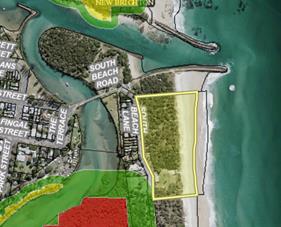
The site located on Lot 427 DP 729272 is outside the
bushfire vegetation buffer.
The proposal is not a Special Fire Protection Purpose and
therefore does not require approval of the RFS. Not-withstanding the RFS advice
was sought having regards to coastal vegetation surrounding the site. The RFS
provided recommended conditions, most of which have been incorporated into the
consent. However the provision of 30 metre APZ would require substantial
removal of coastal vegetation to the south and north of the building. As the
development is not a special fire protection purpose nor is it designed for
residential accommodation the Asset protection zone has not been included in
the consent so that surrounding areas of high environmental value coastal
vegetation are not removed.
Other conditions regarding water and utilities, evacuation
and emergency management and design and construction have been included in the
recommended conditions at the end of this report.
EFFECT OF 10/50 RULE ON SIGNIFICANT VEGETATION
Clearing cannot be undertaken on this parcel of land under
the 10/50 Code.
4. SECTION 4.15C
– MATTERS FOR CONSIDERATION – DISCUSSION OF ISSUES
Having regard to the matters for consideration detailed in
Section 4.15(1) of the Environmental Planning & Assessment Act 1979
(EP&A Act), the following is a summary of the evaluation of the issues.
4.1 State Environmental
Planning Instruments
|
|
Satisfactory
|
Unsatisfactory
|
|
State Environmental Planning Policy No
55—Remediation of Land
|
☒
|
☐
|
|
Consideration: The site has had continuous usage
for surf life saving activities for over 80 years.
A Preliminary Contaminated Land Assessment Report prepared
by Greg Alderson and Associates, dated August 2018 provided as part of the
Development Application addresses the detailed requirements of State
Environmental Planning Policy No. 55. The report concludes that:
A preliminary contaminated
site investigation was undertaken in the proposed development area of Lot 427
DP 729272 for the proposed redevelopment of the Brunswick Heads Surf Club.
The site was previously
used for a surf club building and sand mining was undertaken during 1966-67
in the vicinity. As the sand was taken off-site for processing, it is
unlikely that any of these land uses would have contaminated the site.
It is concluded that there
is sufficient evidence gathered from the site history to infer that the
investigation area is not contaminated in accordance with the definition
within NEPM 1999, and therefore, no further investigation is required to be
undertaken at the subject site for soil contamination however it is possible
that the building contains asbestos in the form of fibro and possibly other
materials. All work relating to asbestos is required to be in accordance with
the Occupational Health and Safety Regulation 2001.
The assessment is limited
to visual inspection of the building and immediate surrounds and history of
the site, if any foreign material is uncovered during the excavation work
this will need to be disposed of to an appropriately licensed landfill with
the possibility that further investigation may be required.
The DA was also referred to
Council’s Environmental Health Officer and conditions of consent are
included in the recommendation of this report. It is considered that no
further investigation is warranted.
|
|
State Environmental Planning
Policy (Coastal Management) 2018
|
☒
|
☐
|
|
Consideration: The site of proposed works is
located in the Coastal Environment Area and the Coastal Use Area. The
land subject to proposed works is not located within or in proximity
to Littoral Rainforest or Coastal Wetlands. The proposed development is
considered against Division 3 and 4 to satisfy that the development is
designed, sited and will be managed to avoid an adverse impact on:
· the integrity
and resilience of the biophysical, hydrological (surface and groundwater) and
ecological environment,
· coastal
environmental values and natural coastal processes,
· the water
quality of the marine estate (within the meaning of the Marine Estate
Management Act 2014), in particular, the cumulative impacts of the
proposed development on any of the sensitive coastal lakes identified in
Schedule 1,
· marine
vegetation, native vegetation and fauna and their habitats, undeveloped
headlands and rock platforms,
· existing public
open space and safe access to and along the foreshore, beach, headland or
rock platform for members of the public, including persons with a disability,
· Aboriginal
cultural heritage, practices and places,
· existing, safe
access to and along the foreshore, beach, headland or rock platform for
members of the public, including persons with a disability,
· overshadowing,
wind funnelling and the loss of views from public places to foreshores,
· the visual
amenity and scenic qualities of the coast, including coastal headlands,
· cultural and
built environment heritage, and
· has taken into
account the surrounding coastal and built environment, and the bulk, scale
and size of the proposed development.
|
4.2 Byron Local Environmental Plan
1988 (LEP 1988)
LEP 1988 is an applicable matter for consideration in the
assessment of the subject development application in accordance with subsection
4.15(1) of the EP&A Act because it applies to the subject land and the
proposed development:
In accordance with LEP 1988 clauses 5, 8 and 9:
(a) The
proposed development is defined in the LEP 1988 Dictionary as surf lifesaving
facility;
(b) The
land is within the LEP1988 Coastal Land Zone according to the map under LEP
1988;
(c) The
proposed development is permissible with consent; and
(d) The
proposed development is consistent with the relevant objectives of the Zone for
the following reasons:
|
Zone Objective
|
Consideration
|
|
(a) to identify and protect environmentally
sensitive coastal land,
|
The proposal is consistent with the objectives of the
zone. It is not considered to have a detrimental effect on habitat, landscape
or scenic quality of the locality nor is it likely to interfere with coastal
processes.
|
|
(b) to enable development for certain purposes
where such development does not have a detrimental effect on the habitat,
landscape or scenic quality of the locality,
|
|
(c) to prevent development which would
adversely affect, or be adversely affected by, coastal processes, and
|
|
(d) to enable the careful control of noxious
plants and weeds by means not likely to be significantly detrimental to the
native ecosystem.
|
Clause 33 Development within Zone No 7 (f1) (Coastal
Lands Zone)
The development has been considered against the relevant
provisions of this Clause and advises that the Council, in deciding whether to
grant consent to development referred to in subclause (2), can be satisfied
that the following has been taken into consideration:
· the likelihood of
the proposed development adversely affecting, or being adversely affected by,
coastal processes,
· the likelihood of
the proposed development adversely affecting any dune or beach of the shoreline
or foreshore,
· the likelihood of
the proposed development adversely affecting the landscape, scenic or
environmental quality of the locality of the land, and
· whether adequate
safeguards and rehabilitation measures have been, or will be, made to protect
the environment.
Conditions of consent to apply for the consent to cease in
the event of a coastal erosion event threatening the surf club and for the
building to be removed.
Clause 63 Acid Sulfate Soils
An Acid Sulfate Soils Assessment prepared by Greg Alderson
and Associates submitted with the DA has concluded:
Investigations by this office in the locality of the
subject site has found that the surrounding soils
are acidic, however are not potential acid sulfate soils.
It is concluded that the site is not on acid sulfate soils and further
assessment is not warranted.
An unexpected findings condition has been recommended at the
end of this report to address any unexpected disturbance of Acid Sulfate Soils
during construction.
All relevant clauses have been taken into consideration in
the assessment of the subject development application in accordance with
subsection 4.15(1) of the EP&A Act. The proposed development complies with
all clauses of LEP 1988 (in some cases subject to conditions and/or to the
satisfaction of other assessing officers).
4.3 Any proposed Instrument
that has been the subject of public consultation and has been notified to the
consent authority
No draft Environmental planning instruments affect the
proposal.
4.4 Byron Shire Development
Control Plan 2010 (DCP 2010)
DCP 2010 is an applicable matter for consideration in the
assessment of the subject development application in accordance with subsection
4.15(1) of the EP& A Act because its purpose is to provide planning strategies
and controls for various types of development permissible in accordance with
LEP 1988.
Part G Vehicle Circulation and Parking
The development requires the formalisation of 25 spaces to
generally service the club and its activities. These will be located partly
within the road reserve and partly onsite at the front of the property facing
South Beach Road. Conditions of consent to apply.
Part J – Coastal Erosion
The proposed development is located within the Coastal
Erosion Precinct No. 1. The applicant has provided a statement in support
of the proposal, which the assessing officer considers to be reasonable in the
particular circumstances of the case and subject to conditions of consent
regarding the provisions of Part J - Coastal Erosion:
Part J2.1 of Development Control Plan 2010 requires new
buildings or works to be temporary and able to be readily removed in the event
of coastal erosion. It also states:
Development that is of a
community nature, which relates to the use of the beachfront, may be
considered, provided that any building is easily removable and does not require
a major extension to a service main.
The proposed building is to replace an existing two
storey structure that was originally constructed within the site in 1968. Additions
to the club were completed in 1973. The current building comprises brickwork
walls over concrete footings. A pitched roof clad with metal sheeting covers
the building. A timber deck extends to the east.
Whilst the proposed surf club building does not require a
major extension to a service main (as per Part J2.1 of DCP 2010), it has not
strictly been designed to be “easily removable”. The building can
be dismantled and removed from the site, but not in a short timeframe.
The proposed development is unique to other development proposals
that are considered by Byron Shire Council as it is one of only two surf club
buildings within the Byron Shire. A meeting with Byron Shire Council’s
Development Advice Panel on 21 November 2017 suggested that a variation to the
requirements of Part J2.1 of DCP 2010 should be sought as part of the
Development Application. Reasons in support of this variation are discussed
below.
The site of the current (and proposed) surf life saving
building was specifically chosen following the demolition of a former surf club
building in August 1968. The demolished building was located
approximately 100 metres to the east of the current
building. In late 1950, the former surf club building was threatened by coastal
erosion. However, it is noted that this was at a time before the construction
of the Brunswick River training walls which have significantly increased
stability to the coastline adjacent to the site.
The current and proposed location of the surf club
building has a substantial buffer of coastal dunes between the nearest recorded
erosion escarpment. Dated in May 2010, this line is located over 70
metres to the east of the proposed development…Byron Shire
Council’s most recent mapping of coastal erosion probability adjacent to
the proposed development….provides that the maximum predicted 2100 year
erosion line is approximately 40 metres from the proposed development.
As noted above, the development site is over 70 metres
from the nearest recorded erosion escarpment. The above estimates maintain a
buffer of approximately 40 metres to the development site in 2100.
The proposed development will replace an existing brick
building with blockwork construction at ground level and lightweight materials
above. Whilst an increase in the footprint of the development is proposed, the
proposal comprises the replacement of the existing building with a very similar
structure in the same location. As such, the development will result in no
significant change in threats to the site.
The project Draftsperson has advised that preliminary
engineering designs include the use of a screw pier system to support the
development. This system is particularly beneficial within the sandy soils
beneath the site. Such will also provide support for the development in the
unlikely event of coastal erosion processes affecting the building. Detailed
engineering designs are to be submitted as part of the construction phase of
the development.
The assessing officer further notes Council’s Coastal
and Biodiversity Coordinator comments that conclude:
The applicant has considered the effect of coastal
processes and the provisions of development within Erosion Precinct 1. The
location of the new development will be within the same footprint (although
larger) of the original Surf Club which is an adequate distance from the most
recent survey of the erosion escarpment. Council’s most recent coastal
hazard mapping has also been referred to which outlines that the development
will be located up to 40 m landward of the 2100 hazard line (which accommodates
erosion, and sea level rise recession). Estimated recession of the shoreline
due to sea level rise in the most recent study is 26 m at the site and as such,
the development is unlikely to be impacted over the proposed lifetime of the
development.
All other relevant Chapters/Parts have been taken
into consideration in the assessment of the subject development application in
accordance with subsection 4.15(1) of the EP&A Act. The proposed
development is demonstrated to meet the relevant Objectives of DCP 2010 (in
some cases subject to conditions and/or to the satisfaction of other assessing
officers).
4.5 Any Planning Agreement or
Draft Planning Agreement?
Not applicable
4.6 Environmental Planning
& Assessment Regulation 2000 Considerations
|
Clause
|
This control is applicable to the proposal:
|
I have considered this control as it relates to the
proposal:
|
If this control is applicable, does the proposal comply?
|
|
92
|
Yes
|
Yes
|
Yes – demolition conditions to apply
|
|
93
|
No
|
No
|
No
|
|
94
|
No
|
No
|
No
|
|
94A
|
No
|
No
|
No
|
4.7 Any Coastal Zone Management
Plan?
Not applicable
4.8 The likely impacts of that
development, including environmental impacts on both the natural and built
environments, and social and economic impacts in the locality
|
Impact on:
|
Likely significant impact/s?
|
|
Natural environment
|
No. The proposal will not have a significantly adverse
impact on the natural environment of the locality.
|
|
Built environment
|
No. The proposal will not have a significantly adverse impact
on the built environment of the locality.
|
|
Social Environment
|
No. The proposal will not have a significant social impact
on the locality.
|
|
Economic impact
|
No. The proposal will not have a significant economic
impact on the locality.
|
Conditions of consent to apply in relation to construction
activities, hours of work construction noise, builders waste and the like.
4.9 The suitability of the site
for the development
The site is a serviced, unconstrained property and is suitable
for the proposed development subject to conditions of consent.
4.10 Submissions made in accordance with
this Act or the regulations
The development application was publicly exhibited.
There was one submission made on the development application in support of the
development. However, this submission raised an issue about the loss of an
access path from South Beach Road, and the car park to the beach and the
off-leash beach exercise area as a result of the increased footprint of the
surf club. The submission requested a new level access to be provided.
Conditions of consent to apply for the access to be re-instated.
4.11 Public interest
The proposed development is unlikely to prejudice or
compromise the public interest or create an undesirable precedent.
5. DEVELOPER
CONTRIBUTIONS
5.1 Water & Sewer Levies
Section 64 levies will be payable.
5.2 Section 7.11 Contributions
No Section 7.11 Contributions
will be required.
6. CONCLUSION
The proposed development is consistent with the relevant
environmental planning instruments and planning controls applicable to the
site. The proposal raises no significant issues in terms of environmental
impacts which cannot be managed and the site is considered suitable for the
development. The application is recommended for approval subject to conditions
of consent.
7. REASONS
FOR DECISION, HOW COMMUNITY VIEWS WERE ADDRESSED
Note:
From July 1 2018, Council’s are required to give and publicly notify
reasons for a range of planning decisions where they are deciding if
development should proceed to help community members to see how their views
have been taken into account and improve accountability to stakeholders. A
statement of reasons for the determination of this application is provided
below.
|
Statement of Reasons
|
|
The proposed modifications were minor and substantially
the same as the original development approval with no detrimental
environmental impacts.
|
|
The proposed development complies with the provisions of
Byron Local Environmental Plan 1988.
|
|
The proposed development complies with relevant State
Environmental Planning Policies
|
|
The proposed development complies with relevant provisions
of Development Control Plan 2010
|
|
The proposed development complies with Environmental
Planning & Assessment Regulation 2000 considerations.
|
|
The proposed development complies with the Coastal Zone
Management Plan.
|
|
The proposed development will not have significant adverse
impact on the natural, built or social environment or economic impacts on the
locality.
|
|
The proposed development is considered suitable for the
proposed site.
|
|
The development application was notified/advertised in
accordance with Development Control Plan 2010. Issues raised in the
submissions have been addressed during assessment of the application.
|
|
The proposed development is unlikely to prejudice or
compromise the public interest.
|
|
How community views were addressed
|
|
The DA was advertised in accordance with Development
Control Plan 2014. The submissions received were considered on merit and
addressed during assessment of the application.
To view the considerations, please contact Council to view
a copy of the assessment report relating to this DA.
|
Staff Reports - Sustainable Environment and Economy 6.14
Report No. 6.14 PLANNING
- Proposed Amendments to Byron LEP 2014 and Byron DCP 2014 to incorporate
controls for manors houses and multiple dwelling houses (terrace houses) in response
to the Low Rise Medium Density Development Code
Directorate: Sustainable
Environment and Economy
Report
Author: Steve
Daniels, Project Officer - Planning Reforms
Shannon Burt, Director Sustainable
Environment and Economy
File No: I2019/872
Summary:
On 6 April 2018 amendments were made to the NSW planning
framework to facilitate the development of low rise medium density housing
through the introduction of a new Low Rise Medium Density Housing Code (SEPP
Exempt and Complying Development Codes) 2008. The amendments came into effect
on 6 July 2018.
However, the commencement of the Code was deferred to land
in the Byron Shire LGA until 1 July 2019. A subsequent request was made
to the Minister to extend the deferment beyond 1 July 2019; however Council has
not received a response to date.
The Low Rise Medium Density Housing Code introduces two new
development typology definitions to the standard instrument –
‘manor houses’ and ‘multi dwelling housing
(terraces)’. Preparation of a planning proposal to introduce
minimum lot size controls for these new development types is considered prudent
in the absence of a favourable response to Council’s request to extend
the deferment of the Code.
Based on the results of the draft
Residential Strategy public consultation process – Shaping our
Neighbourhoods, and to maintain consistency with existing planning controls and
zone objectives, it is recommended that Council proceed with a Planning
Proposal to amend the Byron Shire Local Environmental Plan (LEP) 2014 by
inserting minimum lot size controls for ‘manor houses’ and
‘multi dwelling housing (terraces)’ as detailed in Attachment 1 and
in Table 2 of this report.
Amendments to the Byron Shire
Development Control Plan (DCP) 2014 to include controls for ‘manor
houses’ and ‘multi dwelling housing (terraces)’ are also
recommended as these are new development types not yet captured under existing
DCP controls. A review of the DCP against the State Government’s DA
Design Guide should also be undertaken to determine where improvements can be
made generally to controls that relate to low rise medium density housing.
This report seeks Council
support for:
· A
planning proposal to amend clause 4.1E of Byron Shire Local Environmental Plan
2014 by inserting the minimum lot size standards shown in Table 2, and detailed
in Attachment 1, of this report.
· Forwarding
the planning proposal to the Minister for Planning for Gateway determination to
allow public exhibition.
· Initiating
a review of Byron DCP 2014 as it relates to low rise medium density housing,
and introducing any required changes and references to manor houses and multi
dwelling housing (terraces). The draft DCP would be reported to Council
for consideration before being placed on public exhibition.
Due to the uncertainty of a Code
deferral extension, these amendments need to be commenced as a matter of
urgency.
NOTE TO COUNCILLORS:
In accordance with the provisions
of S375A of the Local Government Act 1993, a Division is to be called whenever
a motion for a planning decision is put to the meeting, for the purpose of
recording voting on planning matters. Pursuant to clause 2(a) under the
heading Matters to be Included in Minutes of Council Meetings of Council's
adopted Code of Meeting Practice (as amended) a Division will be deemed to have
been called by the mover and seconder of all motions relating to this report.
|
RECOMMENDATION:
That Council:
1. Agree
to initiate a planning proposal to amend clause 4.1E of Byron LEP 2014, by inserting
minimum lot size standards for ‘manor houses’ and ‘multi
dwelling housing (terraces)’ as contained in E2019/41816 (Attachment
1).
2. Forward
the planning proposal to the NSW Department of Planning and Environment for a
Gateway determination.
3. Agree
to initiate a review of Byron DCP 2014 as it relates to low rise medium
density housing, and prepare a draft amendment to strengthen Byron DCP 2014
where necessary and include references to ‘manor house’ and ‘multi
dwelling housing (terraces)’ development.
4. Receive
a further report to consider the proposed DCP amendments before proceeding to
public exhibition.
|
Attachments:
1 PP for
amendment of Byron Local Environmenta Plan 2014 to introduce minimum lot size
controls for manor house and multi dwelling housing (terraces), E2019/41816
REPORT
Background
On 6 April 2018 amendments were made to the NSW planning
framework to facilitate the development of low rise medium density housing
through the introduction of a new ‘Low Rise Medium Density Housing
Code’ into the SEPP (Exempt and Complying Development Codes) 2008.The
amendments came into effect on 6 July 2018.
However, the Byron Shire LGA (and 50 other LGAs in NSW) was
deferred from commencement of the Code until 1 July 2019. The deferral was
provided to allow Councils sufficient time to fully consider the potential
impacts of the amendments. For Byron Shire, the pause was an opportunity
to enable Council to determine the nature and extent of any impacts on its
Residential Strategy (in preparation) and supporting planning controls.
A subsequent request was made to the Minister to extend the
deferment beyond 1 July 2019; however Council has not received a response to
date. Preparation of a planning proposal to amend relevant minimum lot
size controls is considered prudent in the absence of a favourable response to
this request.
Low rise medium density housing
Low rise medium density housing consists of three
development types, limited to 1 or 2 storeys in height:
· Dual
occupancy – being two dwellings either attached or detached on
one lot of land.
· Manor house
– being a maximum two-storey residential flat building which contains 3
or 4 dwellings. At least one dwelling must be located above another, and
dwellings are attached by a common wall or floor.
· Multi
dwelling housing (terraces) – being three or more attached
dwellings on one lot of land, facing and generally aligned along one or more
public roads.
Low rise medium density
housing permitted with a development application
From 1 July 2019, manor houses
will be permissible with development consent (as a DA) in the Shire wherever
multi dwelling housing is permitted - namely the R2 Low Density Residential and
R3 Medium Density Residential Zones. Dual occupancy and Multi dwelling
housing (terraces) development are already permitted.
The new Low Rise Medium Density
code will allow one and two storey dual occupancies, manor houses and
multi-dwelling housing (terraces) to be carried out under a fast-track
complying development approval process. Fast-track complying development
(including that under private certification) can only be approved if the
development application meets the requirements of the code and if the proposed
use is permitted under a council’s local environmental plan.
The Low Rise Medium Density Design Guide for Development
Applications (DA Design Guide) commenced on 6 July 2018 to provide design
guidance and best practice design controls and standards for low rise medium
density development requiring development consent. The Environmental Planning
and Assessment Regulation 2000 (the Regulation) requires councils to consider
the DA Design Guide when assessing DAs for this type of development, until they
adopt development controls and standards for these new housing types. A council
may choose not to adopt local development controls and standards and instead rely
on the DA Design Guide.
Council is preparing a
residential strategy which will include local area residential character
narratives articulating the desirable elements of an area’s existing or
future character. The ‘narratives' will assist in updating
residential design guidelines for our urban towns and villages, where required.
However, concerns remain that the Code coming into effect on 1 July 2019 will
pre-empt the residential strategy process. This includes introducing relevant
LEP and DCP provisions that seek to manage the potential impact of the code.
In addition to impacts on residential
character, concerns have been raised over the adequacy of existing
infrastructure to meet the demands of higher density development in certain
parts of the Shire. It is anticipated that the fast track complying
development approvals process via the new code may incentivise low rise medium
density development and result in an upsurge in these types of
applications. Investigations are currently underway to inform the
residential strategy with regard to infrastructure.
Community Consultation and
Feedback
As part of the draft Residential
Strategy public consultation process, Council staff undertook a ‘Shaping
Our Neighbourhoods’ discussion with the community to inform the
'residential character narratives' for each urban town and village.
The implications of the Low Rise Medium Density Housing Code were a key topic
for discussion and feedback. Feedback was provided via:
· Written
submissions
· Discussion
board posts on Council’s ‘Have Your Say’ website
· Online
Surveys
· Interactive
drop-in sessions held across the LGA between 30/4/19 and
13/5/19
Over 80% of survey respondents
considered that low rise (2 storey) Manor Houses should only occur on
lots 800m2 or larger. Lot sizes under the minimum are deemed
inadequate to provide for a suitable, sustainable and local form of
development. Of note specific concerns were raised regarding the effects of
overshadowing resulting from low rise medium density development on small
blocks (i.e. 600m2).
Concerns over the adequacy of
car parking provisions were also raised. The volume of cars parking on residential
streets is already diminishing amenity and character of neighbourhoods across
the Shire. This impact would be further exacerbated by densities under the new Code.
Infrastructure capacity was
among the key issues identified in Council’s letter to the Planning
Minister (April 2019) requesting extension of time on the Code implementation.
Planning proposal to amend
Byron Shire LEP 2014
Clause 4.1E Minimum lot sizes
for dual occupancies, multi dwelling housing and residential flat building
of the Byron Shire LEP 2014 currently sets out minimum lot size standards for
dual occupancies, multi dwelling housing and residential flat buildings within
certain zones. These are shown in in Table 1 below.
Table 1: Existing Minimum Lot
Size Controls
|
Multi dwelling housing
|
Zone R2 Low Density Residential
|
1,000 square metres
|
|
Multi dwelling housing
|
Zone R3 Medium Density Residential
|
800 square metres
|
|
Residential flat building
|
Zone R3 Medium Density Residential
|
800 square metres
|
By contrast, the DA Design Guide control for minimum lot size
of manor houses and multi dwelling housing (terraces) is 600
square metres.
To respect the desired future
character of our urban towns and villages, and to maintain consistency with
existing planning controls and zone objectives, it is recommended that minimum
lot size standards for manor houses and multi dwelling housing (terraces) be
introduced in Byron LEP 2014 as follows:
Table 2: Proposed Minimum Lot
Size Controls
|
Manor house
|
Zone R2 Low Density Residential,
|
1,000 square metres
|
|
Manor house
|
Zone R3 Medium Density Residential
|
800 square metres
|
|
Multi dwelling housing (terraces)
|
Zone R2 Low Density Residential
|
1000 square metres
|
|
Multi dwelling housing (terraces)
|
Zone R3 Medium Density Residential
|
800 square metres
|
The above is considered to
provide the best mix of application and location for this type of development
in the Shire.
A planning proposal (Attachment
1) has been prepared to facilitate the recommended changes to Byron Shire LEP
2014, Clause 4.1E Minimum lot sizes for dual occupancies, multi dwelling
housing and residential flat building. The draft clause is detailed
in the planning proposal.
DCP controls for low rise
medium density housing
The Byron DCP 2014 currently
provides development controls for the development of dual occupancies, multi
dwelling housing and residential flat buildings within the Byron LGA. To
provide appropriate controls for all types of low rise medium density housing,
additional controls are required for manor houses and multi dwelling
housing (terraces).
In addition to extending the
controls of Byron DCP 2014 to manor houses and multi dwelling housing
(terraces), a review of the DCP against the State Government’s DA Design
Guide should also be undertaken to determine where improvements can be made
generally to controls that relate to low rise medium density housing.
It is therefore recommended that
Council staff initiate a review of Byron DCP 2014 as it relates to low rise
medium density housing and prepare a draft DCP for Council’s
consideration.
Summary
This report seeks Council
support for:
· A
planning proposal to amend clause 4.1E of Byron Shire Local Environmental Plan
2014 by inserting the minimum lot size standards shown in Table 2, and detailed
in Attachment 1, of this report.
· Forwarding
the planning proposal to the Minister for Planning for Gateway
determination to allow public exhibition.
· Initiating
a review of Byron DCP 2014 as it relates to low rise medium density housing,
and introducing any required changes and references to manor houses and multi
dwelling housing (terraces). The draft DCP would be reported to Council
for consideration before being placed on public exhibition.
Due to the uncertainty of a Code
deferral extension, these amendments need to be commenced as a matter of
urgency.
STRATEGIC CONSIDERATIONS
Community Strategic Plan and
Operational Plan
|
CSP Objective
|
L2
|
CSP Strategy
|
L3
|
DP Action
|
L4
|
OP Activity
|
|
Community
Objective 4: We manage growth and change responsibly
|
4.2
|
Support
housing diversity in appropriate locations across the Shire
|
4.2.1
|
Establish
planning mechanisms to support housing that meets the needs of our community
|
|
|
Legal/Statutory/Policy Considerations
The relevant legal/statutory/policy
considerations have been noted above.
Financial Considerations
As this is a Council initiated planning proposal, the costs
will be borne by Council if it chooses to proceed.
The costs associated with the recommended review of the DCP
and preparation of a draft DCP will also be borne by Council if it chooses to
proceed.
Consultation and Engagement
If Council chooses to proceed with
the planning proposal, it will be forwarded to the NSW Department of Planning
& Environment for a Gateway determination. A positive determination
will identify any government agency or other consultation requirements.