Agenda
Ordinary (Planning) Meeting

Thursday, 8 June 2023
Agenda
Ordinary (Planning) Meeting
Thursday, 8 June 2023
Agenda Ordinary (Planning) Meeting
held at Council Chambers, Station Street, Mullumbimby
commencing at 11.00am
Public access relating to items on this agenda can be made between 11:00am and 11:30am on the day of the meeting. Requests for public access should be made to the General Manager or Mayor no later than 12:00 midday on the day prior to the meeting.

Mark Arnold
General Manager
CONFLICT OF INTERESTS
What is a “Conflict of Interests” - A conflict of interests can be of two types:
Pecuniary - an interest that a person has in a matter because of a reasonable likelihood or expectation of appreciable financial gain or loss to the person or another person with whom the person is associated.
Non-pecuniary – a private or personal interest that a Council official has that does not amount to a pecuniary interest as defined in the Code of Conduct for Councillors (eg. A friendship, membership of an association, society or trade union or involvement or interest in an activity and may include an interest of a financial nature).
Remoteness – a person does not have a pecuniary interest in a matter if the interest is so remote or insignificant that it could not reasonably be regarded as likely to influence any decision the person might make in relation to a matter or if the interest is of a kind specified in the Code of Conduct for Councillors.
Who has a Pecuniary Interest? - a person has a pecuniary interest in a matter if the pecuniary interest is the interest of the person, or another person with whom the person is associated (see below).
Relatives, Partners - a person is taken to have a pecuniary interest in a matter if:
· The person’s spouse or de facto partner or a relative of the person has a pecuniary interest in the matter, or
· The person, or a nominee, partners or employer of the person, is a member of a company or other body that has a pecuniary interest in the matter.
N.B. “Relative”, in relation to a person means any of the following:
(a) the parent, grandparent, brother, sister, uncle, aunt, nephew, niece, lineal descends or adopted child of the person or of the person’s spouse;
(b) the spouse or de facto partners of the person or of a person referred to in paragraph (a)
No Interest in the Matter - however, a person is not taken to have a pecuniary interest in a matter:
· If the person is unaware of the relevant pecuniary interest of the spouse, de facto partner, relative or company or other body, or
· Just because the person is a member of, or is employed by, the Council.
· Just because the person is a member of, or a delegate of the Council to, a company or other body that has a pecuniary interest in the matter provided that the person has no beneficial interest in any shares of the company or body.
Disclosure and participation in meetings
· A Councillor or a member of a Council Committee who has a pecuniary interest in any matter with which the Council is concerned and who is present at a meeting of the Council or Committee at which the matter is being considered must disclose the nature of the interest to the meeting as soon as practicable.
· The Councillor or member must not be present at, or in sight of, the meeting of the Council or Committee:
(a) at any time during which the matter is being considered or discussed by the Council or Committee, or
(b) at any time during which the Council or Committee is voting on any question in relation to the matter.
No Knowledge - a person does not breach this Clause if the person did not know and could not reasonably be expected to have known that the matter under consideration at the meeting was a matter in which he or she had a pecuniary interest.
Non-pecuniary Interests - Must be disclosed in meetings.
There are a broad range of options available for managing conflicts & the option chosen will depend on an assessment of the circumstances of the matter, the nature of the interest and the significance of the issue being dealt with. Non-pecuniary conflicts of interests must be dealt with in at least one of the following ways:
· It may be appropriate that no action be taken where the potential for conflict is minimal. However, Councillors should consider providing an explanation of why they consider a conflict does not exist.
· Limit involvement if practical (eg. Participate in discussion but not in decision making or vice-versa). Care needs to be taken when exercising this option.
· Remove the source of the conflict (eg. Relinquishing or divesting the personal interest that creates the conflict)
· Have no involvement by absenting yourself from and not taking part in any debate or voting on the issue as of the provisions in the Code of Conduct (particularly if you have a significant non-pecuniary interest)
RECORDING OF VOTING ON PLANNING MATTERS
Clause 375A of the Local Government Act 1993 – Recording of voting on planning matters
(1) In this section, planning decision means a decision made in the exercise of a function of a council under the Environmental Planning and Assessment Act 1979:
(a) including a decision relating to a development application, an environmental planning instrument, a development control plan or a development contribution plan under that Act, but
(b) not including the making of an order under that Act.
(2) The general manager is required to keep a register containing, for each planning decision made at a meeting of the council or a council committee, the names of the councillors who supported the decision and the names of any councillors who opposed (or are taken to have opposed) the decision.
(3) For the purpose of maintaining the register, a division is required to be called whenever a motion for a planning decision is put at a meeting of the council or a council committee.
(4) Each decision recorded in the register is to be described in the register or identified in a manner that enables the description to be obtained from another publicly available document, and is to include the information required by the regulations.
(5) This section extends to a meeting that is closed to the public.
OATH AND AFFIRMATION FOR COUNCILLORS
Councillors are reminded of the oath of office or affirmation of office made at or before their first meeting of the council in accordance with Clause 233A of the Local Government Act 1993. This includes undertaking the duties of the office of councillor in the best interests of the people of Byron Shire and the Byron Shire Council and faithfully and impartially carrying out the functions, powers, authorities and discretions vested under the Act or any other Act to the best of one’s ability and judgment.
BUSINESS OF Ordinary (Planning) Meeting
1. Public Access
3. Attendance by Audio-Visual Link
4. Requests for Leave of Absence
5. Declarations of Interest – Pecuniary and Non-Pecuniary
6. Tabling of Pecuniary Interest Returns (Cl 4.14 Code of Conduct for Councillors)
7. Adoption of Minutes from Previous Meetings
7.1 Ordinary (Planning) Meeting held on 11 May 2023
8. Reservation of Items for Debate and Order of Business
9. Notices of Motion
Nil
10. Mayoral Minute
11. Petitions
12. Delegates' Reports
13. Staff Reports
Sustainable Environment and Economy
13.1 PLANNING - 10.2022.36.1 - Tourist and Visitor Accommodation Comprising Six (6) Holiday Cabins and Associated Works at 72 Lawlers Lane Bangalow................. 8
13.2 PLANNING - Variations to development standards - Quarter 1 2023................. 42
13.3 PLANNING - 26.2022.5.1 - Planning controls for rural tourist and visitor accommodation - LEP and DCP amendments submissions report..................... 44
13.4 PLANNING - 10.2014.417.3 S4.55 to Reconfigure Five (5) Apartments inclusive of Dual Key Functionality for Two (2) of the Apartments, increasing Building Height to Accommodate Two (2) Roof Top Swimming Pools, associated Access and Structures, provision of Internal Access between Levels and Modification to Private Open Space at 43 Lawson Street BYRON BAY............................................................................ 54
13.5 PLANNING - 10.2014.417.4 S4.55 for Changes to Building Height to accommodate One (1) Roof Top Swimming Pool and associated Access and Structures, provision of Internal Access between Levels and Modification to Private Open Space 43 Lawson Street BYRON BAY..................................................................................................... 74
13.6 PLANNING - 26.2022.8.1 - Planning proposal to permit events at the Cavanbah Centre without the need to obtain development consent - Submissions Report 94
13.7 PLANNING - Report of the Planning Review Committee held 4 May 2023..... 100
13.8 PLANNING - DA10.2014.753.1- Bluesfest - 35 Yarun Road, Tyagarah - Condition 53 - Small Events Noise limitations................................................................................ 102
13.9 PLANNING - S4.55 Application No. 10.2011.524.4 to modify Conditions 1 and 20(d) to expand the Building Envelope - at 388 Coopers Shoot Road Coopers Shoot. 108
No table of contents entries found.
14. Questions With Notice
14.1 Disruptive roadworks Murwillumbah Road Mullumbimby.................................... 124
Questions with Notice: A response to Questions with Notice will be provided at the meeting if possible, that response will be included in the meeting minutes. If a response is unable to be provided the question will be taken on notice, with an answer to be provided to the person/organisation prior to the next Ordinary Meeting and placed on Councils website www.byron.nsw.gov.au/Council/Council-meetings/Questions-on-Notice
Councillors are encouraged to ask questions regarding any item on the business paper to the appropriate Director prior to the meeting. Any suggested amendments to the recommendations should be provided to Councillor Support prior to the meeting to allow the changes to be typed and presented on the overhead projector at the meeting.
BYRON SHIRE COUNCIL
Staff Reports - Sustainable Environment and Economy 13.1
Staff Reports - Sustainable Environment and Economy
Report No. 13.1 PLANNING - 10.2022.36.1 - Tourist and Visitor Accommodation Comprising Six (6) Holiday Cabins and Associated Works at 72 Lawlers Lane Bangalow
Directorate: Sustainable Environment and Economy
Report Author: Ben Grant, Planner
File No: I2023/115
Proposal:
|
DA No: |
10.2022.36.1 |
||
|
NSW PP |
PAN-191829 |
||
|
Proposal description: |
Tourist and Visitor Accommodation comprising Six (6) Holiday Cabins and Associated Works |
||
|
Property description: |
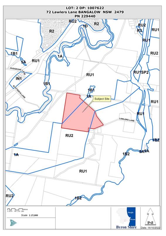
LOT: 2 DP: 1007622 |
||
|
72 Lawlers Lane BANGALOW |
|||
|
Parcel No/s: |
229440 |
||
|
Applicant: |
Town Planning Studio Pty Ltd |
||
|
Owner: |
Mr R Mamone |
||
|
Zoning: |
RU1 Primary Production / PART RU2 Rural Landscape |
||
|
Date received: |
14 February 2022 |
||
|
Integrated / Designated Development: |
☒ Integrated |
☐ Designated |
☐ Not applicable |
|
Public notification or exhibition: |
- Level 2 advertising under DCP 2014 Part A14 – Public Notification and Exhibition of Development Applications - Exhibition period: 1 March 2022 to 14 March 2022. - Submissions received: Twenty (20) submissions. - Submissions acknowledged: ☒ Yes ☐ No ☐ N/A |
||
|
Estimated cost of works |
$738,000 (revised) |
||
|
Delegation to determine |
Council |
||
Summary:
At the Planning Meeting of 14 November 2022, Council considered Development Application 10.2022.36.1 for tourist and visitor accommodation comprising 12 holiday cabins plus ancillary recreation building and associated works at 72 Lawlers Lane, Bangalow.
The staff assessment report recommended that the application be refused due to excessive scale and non-compliance with the relevant planning controls for rural tourist accommodation in Byron LEP 2014 and Byron DCP 2014.
Council resolved to defer determining the application to enable amended plans to be submitted to address the issues raised in the assessment report as follows:
Resolved (22-622):
1. That pursuant to Section 4.16 of the Environmental Planning & Assessment Act 1979, Development Application No. 10.2022.36.1 for tourist and visitor accommodation comprising twelve (12) cabins and ancillary recreation building, be deferred to enable amended plans and details to be submitted back to Council that reduce the number of cabins to 6 and removes the Ancillary Shed Recreation Building to ensure the development remains consistent with Councils planning controls for small scale low impact rural tourism.
2. The Application be reported back to Council following receipt and assessment of the amended plans.
Amended plans have been submitted in accordance with the Council Resolution, reducing the number of holiday cabins to six and removing the large central facility building. The amended proposal has been re-assessed in accordance with Section 4.15 of the Environmental Planning and Assessment Act 1979 and is being reported back to Council for determination.
This assessment finds that the amended Plans satisfy the relevant planning controls for rural tourist accommodation and will not have an adverse impact on the surrounding natural and built environment subject to appropriate conditions of consent. The amended proposal satisfactorily addresses the issues raised in public submissions and is recommended for approval subject to the conditions listed in Attachment 1.
NOTE TO COUNCILLORS:
In accordance with the provisions of S375A of the Local Government Act 1993, a Division is to be called whenever a motion for a planning decision is put to the meeting, for the purpose of recording voting on planning matters. Pursuant to clause 2(a) under the heading Matters to be Included in Minutes of Council Meetings of Council's adopted Code of Meeting Practice (as amended) a Division will be deemed to have been called by the mover and seconder of all motions relating to this report.
RECOMMENDATION:
That pursuant to Section 4.16 of the Environmental Planning & Assessment Act 1979, Development Application No. 10.2022.36.1 for tourist and visitor accommodation comprising six (6) holiday cabins and associated works at 72 Lawlers Lane, Bangalow, be approved subject to the conditions of consent attached to this Report (Council Document #E2023/47447).
1 10.2022.36.1
Recommended Conditions of Consent, E2023/47447
![]()
2 10.2022.36.1
Amended Architectural Plans, E2023/47895
![]()
3 10.2022.36.1
VMP, E2023/47463 ![]()
4 10.2022.36.1
LUCRA Report, E2022/9320 ![]()
5 Confidential - 10.2022.36.1 Public Submissions (Confidential), E2022/102072
Locality Map
Report
BACKGROUND
At the Planning Meeting of 14 November 2022, Council considered Development Application 10.2022.36.1 for tourist and visitor accommodation comprising 12 holiday cabins plus ancillary recreation building and associated works at 72 Lawlers Lane, Bangalow.
Council resolved to defer determining the application to enable amended plans to be submitted to address the issues raised in the Council assessment report as follows:
Resolved (22-622):
1. That pursuant to Section 4.16 of the Environmental Planning & Assessment Act 1979, Development Application No. 10.2022.36.1 for tourist and visitor accommodation comprising twelve (12) cabins and ancillary recreation building, be deferred to enable amended plans and details to be submitted back to Council that reduce the number of cabins to 6 and removes the Ancillary Shed Recreation Building to ensure the development remains consistent with Councils planning controls for small scale low impact rural tourism.
2. The Application be reported back to Council following receipt and assessment of the amended plans.
Amended development proposal
Amended plans have been submitted in response to the Council Resolution, reducing the number of holiday cabins to six and removing the large central facility building.
The amended proposal comprises:
· Six holiday cabins, each containing one-bedroom, open plan living plus a bathroom and laundry. Each cabin is 42m2 and features a covered deck. Four of the cabins have a plunge pool.
· Internal loop road including a vehicle turn around area, largely unchanged from the original proposal.
· Deletion of the central facility building.
· Ancillary works including a new on-site management system and environmental enhancement program remain unchanged from the original application.
The amended proposal has been re-assessed in accordance with Section 4.15 of the Environmental Planning and Assessment Act 1979.
Assessment:
1.1 History relevant to the development application
A search of Council records identified the following determinations for the property:
· 10.2000.61.1 – Development Consent for a dwelling and shed Issued 20 April 2000.
· 10.2003.81.1 – CDC for a swimming pool issued 10 June 2003.
1.2 Compliance actions
Several moveable dwellings were transported to the property in April 2021. The landowner advised Council that the buildings would be used as part of a forthcoming development proposal. No further action was taken at the time.
1.3 Further information and amendments
Council requested further information in relation to landscaping, public art, visual impact, water supply and other matters relating to the scale of the development on 24 June 2022. Additional information was received addressing some of these matters on 11 August 2022.
An amended proposal was submitted to Council on 7 December 2022 in accordance with Council Resolution 22-622, reducing the number of cabins to six and removing the central facility building. A Bushfire Report was later provided on 3 April 2023 to address the requirements of the Rural Fire Service in relation to bushfire protection measures.
1.4 Description of the proposed development
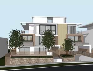
The amended development application seeks approval for six (6) tourist and visitor accommodation cabins (four with swimming pools), earthworks, roads, associated infrastructure, and environmental enhancement works.
The following is proposed in detail:
(1) Six rural tourist cabins
Six (6) tourist cabins located in a cluster on the eastern side of the property. Each cabin will be single storey with a floor area of ~42m2 and will contain one-bedroom, open plan kitchen/dining and a combined bathroom/laundry. Four of the cabins will have swimming pools.
(2) Earthworks, roads, and ancillary infrastructure
A new internal access road will be constructed to provide vehicular access, along with earthworks, ancillary infrastructure, and a new on-site sewage management facility.
(3) Environmental enhancement works
A Vegetation Management Plan has been submitted which aims to restore approximately 5 hectares of Camphor laurel dominated forest to subtropical rainforest around a riparian corridor in in the south-western corner of the property. The restoration approach uses a combination of assisted natural regeneration by systematically replacing weeds with native species and planting new native trees in larger canopy gaps where regeneration is unlikely to occur. The VMP estimates that up to 800 new native trees will need to be planted to achieve the project objectives.
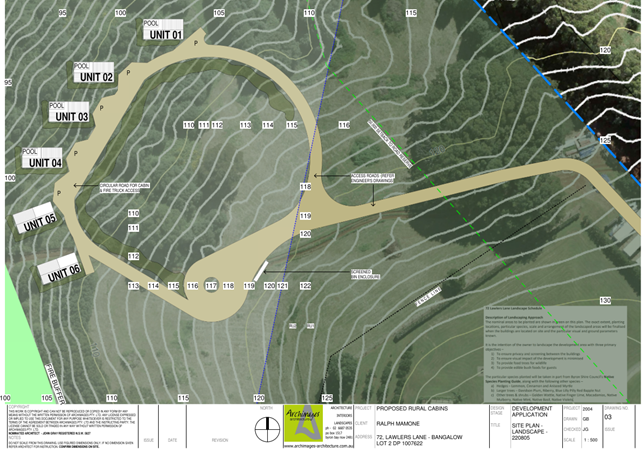
Figure 1: Amended site plan extract illustrating the development layout.
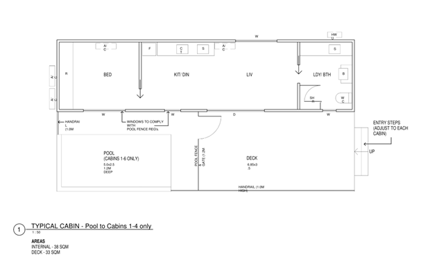
Figure 2: Cabin floor plan.
Figure 3: Elevation and sections of cabin.
1.4 Description of the site
A site inspection was carried out on 28 April 2022
|
Land is legally described |
LOT: 2 DP: 1007622 |
|
|
Property address |
72 Lawlers Lane BANGALOW |
|
|
Land is zoned: |
RU1 Primary Production / PART RU2 Rural Landscape |
|
|
Land area is: |
36.07 hectares |
|
|
Property is constrained by: |
Bushfire Prone Land, High Environmental Value Vegetation |
|
|
|
Is a BDAR required due to the location of the proposed development? |
☐ Yes ☒ No |
|
|
Are there any easements in favour of Council affecting the site? |
☐ Yes ☒ No |
|
|
Is there a Vegetation Management Plan which might affect the proposal? |
☐ Yes ☒ No |
|
|
Is there a Voluntary Planning Agreement which might affect the proposal? |
☐ Yes ☒ No |
The site is a 36-hectare property located 2km south of Bangalow township, situated in a rural area characterised by grazing land, orchards, and rural dwellings on lots with varying size and area.
The western half of the property is covered by a mixture of Camphor Laurel dominated regrowth rainforest, while the westerns side contains cleared pasture.
Existing development comprises a single storey dwelling house, sheds, and a swimming pool. The site is surrounded by several fruit orchards and a handful of residential dwellings on small lots between 1 to 2 acres in size.

Figure 4: Aerial image of the site.
Photo 1: View of the site, looking north-west.

Photo 2: View of the site, looking north-east towards Bangalow.

Photo 3: View of Lawlers Lane.

Photo 4: Existing mobile buildings to be used as cabins.
2. SUMMARY OF REFERRALS
|
Referral |
Issue |
|
Environmental Health Officer |
Council’s Environmental Health Officer commented that the amended development application was satisfactory on environmental health grounds. Conditions are recommended for a vegetated spray drift buffer to be established along the north-eastern boundary of the site in accordance with the approved Land Use Conflict Risk Assessment Report. |
|
Development Engineer |
Council’s Development Engineer raised no objections to the amended proposal. Conditions are recommended to seal Lawlers Lane for 20 metres past the property boundary to reduce the effect of dust and noise on nearby residences. |
|
Rural Fire Service (s4.14) |
A Bush Fire Safety Authority and General Terms of Approval were issued by the RFS on 3 May 2023. The proposed development is capable of complying with the conditions of the BFSA without removal of vegetation. |
3. SECTION 4.46 INTEGRATED DEVELOPMENT
The proposal is integrated development requiring a Bush Fire Safety Authority under s. 100B of the Rural Fires Act 1997. General Terms of Approval were issued by the RFS on 3 May 2023 and are included in the conditions of consent.
4. SECTION 4.15C – MATTERS FOR CONSIDERATION – DISCUSSION OF ISSUES
Having regard to the matters for consideration detailed in Section 4.15(1) of the Environmental Planning & Assessment Act 1979 (EP&A Act), the following is a summary of the evaluation of the issues.
State Environmental Planning Policies (SEPP)
|
Considerations |
Satisfactory |
Unsatisfactory |
|
State Environmental Planning Policy (Resilience and Hazards) 2021 Chapter 4 Remediation of land Council’s Environmental Health Officer commented that the site was previously assessed for contamination during the assessment of DA 10.2000.61.1 and was found to be uncontaminated. Based on the previous assessment it is concluded that the site is suitable for the proposed tourist accommodation use in its current state and does not require remediation. |
☒ |
☐ |
|
State Environmental Planning Policy (Biodiversity and Conservation) 2021 Chapter 3 Koala habitat protection 2020 Section 4 of the Vegetation Management Plan included a flora survey to determine the vegetation communities present on the site. A field survey identified only one vegetation community on the property, being Camphor Laurel dominated regrowth rainforest. The upper, middle, and lower strata of the vegetation community comprises less than 15% koala feed tree species listed in schedule 1 of the SEPP. In accordance with ss. 3.6 and 3.7 of this policy, the site is not considered to be a potential or core koala habitat and a plan of management is not required. |
☒ |
☒ |
4.2A Byron Local Environmental Plan 2014 (LEP 2014)
LEP 2014 is an applicable matter for consideration in the assessment of the subject development application in accordance with subsection 4.15(1) of the EP&A Act because it applies to the subject land and the proposed development. The LEP 2014 clauses that are checked below are of relevance to the proposed development:
|
Part 1 |
☒1.1 | ☒1.1AA | ☒1.2 | ☒1.3 | ☒1.4 | ☒ Dictionary | ☒1.5 | ☒1.6 | ☒1.7 | ☒1.8 | ☒1.8A | ☒1.9 | ☒1.9A |
|
Part 2 |
☒ 2.1 | ☒2.2 | ☒2.3 | ☒ Land Use Table | ☒2.4 | ☒2.5 | ☒2.6 | ☒2.7 | ☒2.8 |
|
Part 4 |
☒ 4.2A | ☒4.3 |
|
Part 5 |
☒ 5.4 |
|
Part 6 |
☒6.2 | ☒6.5 | ☒6.6 | ☒6.8 |
In accordance with LEP 2014 clauses 1.4 and 2.1 – 2.3:
(a) The proposed development is defined in the LEP 2014 Dictionary as tourist and visitor accommodation.
(b) The land is zoned part RU1 Primary Production and part RU2 Rural Landscape. The proposed cabins are located entirely in the RU2 zone. Part of the proposed access road and associated earthworks are located within the RU1 zone.
(c) The proposed development is permitted with consent; and
(d) Regard is had for the Zone Objectives as follows:
|
Zone Objective RU2 Rural Landscape |
Consideration |
|
· To encourage sustainable primary industry production by maintaining and enhancing the natural resource base. · To maintain the rural landscape character of the land. · To provide for a range of compatible land uses, including extensive agriculture. · To provide for a range of compatible land uses, including extensive agriculture. · To protect significant scenic landscapes and to minimise impacts on the scenic quality of the locality. |
The proposed development is compatible with the zone objectives. |
The remaining clauses have been taken into consideration in the assessment of the subject development application in accordance with Section 4.15 of the EP&A Act. The proposed development complies with all clauses of LEP 2014 (in some cases subject to conditions and/or to the satisfaction of other assessing officers).
Part 4 – Principal Development Standards
|
Provision |
Compliance |
Comment |
|
4.3 Height of Buildings |
Yes |
A maximum height of 9m is permitted. A height of 4m is proposed for the cabins. |
Part 6 – Local Provisions
|
Provision |
Compliance |
Comment |
|
6.2 Earthworks
|
Yes, subject to conditions of consent |
The site is separated from downstream watercourses by approximately 500m. The proposed earthworks are unlikely to have a detrimental impact on soil stability or drainage patterns in the area subject to condition for appropriate sediment and erosion controls to be implemented during construction. |
|
Clause 6.5 Drinking water catchments
|
Yes |
The development and associated wastewater system will be located approximately 600m from Byron Creek and will not have an adverse impact on the quality or quantity of water entering the drinking water storage. |
|
Clause 6.6 Essential services
|
Yes, subject to conditions |
Adequate services can be made available to the development subject to conditions of consent. The proposed vehicular access is adequate for the development. |
|
Clause 6.8 Rural and nature-based tourism development
|
Yes |
The proposed development complies with the requirements of Clause 6.8, as follows: · The proposed development is small scale and low impact and is capable of being managed by the principal owner or manager living on the property.
· The development will not have a significantly adverse impact on agricultural production, amenity of significant features of the natural environment. · The development will be generally compatible with the rural attributes of the surrounding landscape, subject to conditions requiring landscaping and the use of complementary colours and materials. · There is a lawfully erected dwelling house on the property. · The proposal does not include an ancillary caretaker’s dwelling. |
4.3 Any proposed Instrument that has been the subject of public consultation and has been notified to the consent authority
There are no draft environmental planning instruments that are relevant.
4.4A Byron Shire Development Control Plan 2014 (DCP 2014)
|
What Section and prescriptive measure does the development not-comply with? |
Does the proposed development comply with the Objectives of this Section? Address. |
Does the proposed development comply with the Performance Criteria of this Section? Address. |
|
B14.2 Excavation and Fill in all Zones Requirement Prescriptive measure B14.2(1) limits excavation and fill to a maximum depth of 1m. Proposal The civil engineering plans indicate that excavation up to 2.6m in depth is proposed for the access road and turn around bay. |
The proposed development complies with the Objectives of the Section because: The extent, character, bulk, and scale of earthworks will not detract from the existing and desired future character of the area, subject to appropriate conditions for landscaping and transitions for the earth batters. |
The proposed development complies with the Performance Criteria of this Section because: The resulting landforms will remain consistent with the scale and character of the surrounding rural environment, subject to conditions requiring the use of smooth transitions to natural ground level and landscaping to soften the appearance of the earthworks in views from surrounding properties and publicly accessible locations. The proposal does not require the use of large retaining structures or engineering support works and will not significantly affect the drainage characteristics of the site. |
Chapter B1 Biodiversity
|
Provision |
Compliance |
Comment |
|
B1.1.5 Biodiversity Planning Principles B1.2.1 Development Envelope Controls |
Yes |
The proposed development is located on cleared land, with nearby vegetation comprising mostly Camphor laurel dominated regrowth rainforest. The development footprint is clear of any ecological ‘red flagged areas’ such as threatened ecological communities, wetlands, or old-growth forest. A vegetation management plan has been provided in accordance with the requirements of Part B1.2.5. |
Chapter B3 Services
|
Provision |
Compliance |
Comment |
|
B3.2.1 Provision of Services Water supply |
Yes, subject to conditions |
A condition is recommended for plans to be provided with the construction certificate application demonstrating at least 10,000L potable water supply is to be provided for each cabin. A Potable Water Supply Management Plan is also required in accordance with NSW private Drinking Water Supply Guidelines. |
|
B3.2.2 On-site Sewage Management |
Yes |
The application proposes tertiary wastewater treatment via three separate AWTS systems and a Taylex ABS 5000 system. The proposed irrigation field will be located ~60m from the nearest gully and ~ 600m from Byron Creek. The site is capable of accommodating wastewater from the proposed tourist facility. |
Chapter B4 Traffic Planning, Vehicle Parking, Circulation and Access
|
Provision |
Compliance |
Comment |
|
B4.2.1 Traffic Impact |
Yes, subject to conditions |
Council’s Engineer assessed traffic generation at a rate of 0.4 Peak Hour Trips (PHT’s) and 3 Daily Vehicle Trips (DVT’s) per holiday cabin. Total traffic for the development is estimated to be 18 DVT’s and 2.4 PHT’s. Traffic generated by the proposal is likely to have a low impact on the surrounding road network (in terms of its capacity to accommodate increased traffic) but could generate direct environmental impacts from increased dust and noise, particularly on the unsealed section of road at the western end of Lawlers Lane. Council’s Development Engineer noted that the unsealed section of Lawlers Lane should be upgraded to 20m past the property driveway to meet the requirements of the Northern Rivers Local Government Design and Construction Guidelines which specifies a 6.0m wide seal and 1.0m wide shoulder. |
Chapter B6 Buffers and Minimising Land Use Conflict
|
Provision |
Compliance |
Comment |
|
B6.2.2 Conflict Risk Assessment (CRA) |
Yes |
A Land Use Conflict Risk Assessment (LUCRA) has been submitted in accordance with the provisions of Part B6.2.2 Findings of the report are discussed below and a copy is attached to the report. |
|
B6.2.4 Buffers |
Yes, subject to conditions |
The proposed cabins will have a 90m buffer from a neighbouring fruit orchard to the east. Spray drift from the neighbouring stone fruit orchard was identified as the main potential land use conflict and was given a risk rating of 9 out of 25 on the risk ranking matrix (i.e., medium risk). Other issues such as noise, dust and odour were given low risk ratings of between 1 and 4 out of 25. To manage the risk of spray drift, the report recommends the following precautionary measures be employed, including: · Retain vegetation on the eastern boundary. · Undertake additional planting on the eastern boundary. · Use first flush divertors on all tanks if roof water is collected. · Use a filtration system for all drinking water. · Use a drinking water quality assurance program to be prepared and approved by Council of NSW health for the site. · Establish neighbourly communication. Council’s Environmental Health Officer generally agreed with the finding of the report noting that the main risk for guests is contamination of drinking water and this would need to be addressed using first flush devices and water filtration systems. Based on the findings of the LUCRA and the advice from Council’s Environmental Health Officer the proposal is unlikely to generate significant land use conflicts subject to the implementation of appropriate mitigation and management measures. Conditions are recommended for the establishment of a vegetated buffer between the proposed development and the neighbouring fruit orchard, along with the use of first flush systems on all rainwater tanks used to supply drinking water. |
Chapter B8 Waste Minimisation and Management
|
Provision |
Compliance |
Comment |
|
B8.4.3 Tourist Accommodation and Commercial and Retail Development |
Yes, subject to conditions |
There is sufficient room in the Lawlers Lane road reserve to facilitate Council garbage collection for the proposed development. A condition is recommended for a site waste minimisation and management plan to be prepared in accordance with Chapter B8 and submitted for approval as part of the construction certificate application. |
Chapter B9 Landscaping
|
Provision |
Compliance |
Comment |
|
B9.2.2 Landscape Plans for Development Applications |
Yes, subject to conditions |
A condition is recommended requiring a revised landscaping plan to be submitted for approval with the construction certificate application. The landscaping plan shall include details for: · screen plantings between cabins for privacy, · plantings on the north-western side of the development to soften the appearance of the built form in views from the Bangalow area. · Landscaping of the earth batters and areas of cut associated with the new access road using native grasses, shrubs and trees. |
Chapter C3 Visually Prominent Sites, Visually Prominent Development and View Sharing
|
Provision |
Compliance |
Comment |
|
C3.2.1 Visual Impact Assessment |
Yes, subject to conditions |
A Visual Impact Assessment was provided in the applicant’s further information. The VIA generally addressed the requirements of Part C3.2.12 and demonstrated that the site is only visible at a distance from roads and publicly accessible locations near Bangalow. A range of locations were considered in terms of visual impact as indicted on the map below. The applicant in their assessment that the proposal will not have a significant adverse impact on the rural landscape and invites Council to impose conditions relating to landscaping and colours materials. It is considered, the amended development proposal has a greatly reduced visual footprint and is unlikely to have a significant visual impact on the surrounding landscape subject to conditions for appropriate use of landscaping to soften the appearance of the development in external views. |
Chapter D3 Tourist Accommodation
|
Provision |
Compliance |
Comment |
|
D3.2.1 Location and Siting
|
Yes |
The proposed development is not located near any ecologically sensitive areas or areas with high environmental values. |
|
D3.2.3 Character and Design in Rural Zones
|
Yes |
The amended proposal is consistent with the Performance Criteria and Objectives of Part D3.2.3 for the following reasons: 1. The scale and density of the modified proposal is generally compatible with the character and amenity of the surrounding rural and natural landscape.
2. The amended design is low scale and is consistent with the relevant Aims, Guiding Principles, Best Practice Guidelines and Performance Standards contained in Chapters 7 and 8 of the Byron Rural Settlement Strategy 1998. In particular: · The proposal is generally consistent with the overall objective for Chapter 7 which seeks to encourage a ‘low scale’ form of rural tourist accommodation. · The proposal comprises a maximum of six (6) holiday cabins. · Each cabin has a floor area of less than 60m2. · Conditions are recommended for one of the cabins to have disabled access. |
|
D3.3.4 Rural Tourist Accommodation and Farm Stay Accommodation
|
Yes |
The proposed development satisfies the Performance Criteria and Objectives of Part D3.3.4 as follows: · The development is unlikely to result in land use conflict or affect the productivity of adjoining agricultural uses. · The new cabins are clustered on the eastern side of the property and will not adversely affect the character of the surrounding landscape. · The amended proposal is low scale and is compatible with the surrounding rural environment. · Adequate carparking and vehicular access is provided to guests. · The cabins have a northerly or north-westerly aspect and are clustered within 80m of each other. · A vegetation management plan has been submitted (Attachment 3) detailing an ecological restoration concept involving 5 hectares of restoration work and weeding. The VMP meets the requirements of D3.3.4. |
Chapter D8 Public Art
|
Provision |
Compliance |
Comment |
|
D8.2.1 Provision of Public Art |
Not Applicable |
The amended proposal is substantially smaller in scale than the original design. The estimated cost of works has been recalculated at $738,000, which is below the $1 million public art threshold. Part D8.2.1 no longer applies. |
4.5 Environmental Planning & Assessment Regulation 2000 Considerations
|
Clause |
Compliance |
Comment |
|
Clause 61 Additional matters that consent authority must consider |
N/A |
No demolition is proposed. |
|
Clause 62 Consideration of fire safety |
N/A |
A change of use is not proposed. |
|
Clause 64 Consent authority may require upgrade of buildings |
Yes |
The existing dwelling does not require upgrading. |
4.6 The likely impacts of that development, including environmental impacts on both the natural and built environments, and social and economic impacts in the locality
|
Impact on: |
Likely significant impact/s? |
|
Natural environment |
No. The proposal will likely have a positive impact on the natural environment subject to the implementation of the Vegetation Management Plan. |
|
Built environment |
The proposal will not have a significantly adverse impact on the built environment subject to conditions of consent. |
|
Social Environment |
No. The proposal will not have a significant social impact on the locality. |
|
Economic impact |
No. The proposal will not have a significant economic impact on the locality. |
4.7 The suitability of the site for the development
The site characteristics are suitable for the amended proposal subject to conditions of consent.
4.8 Submissions made in accordance with this Act or the regulations
The development application was publicly exhibited and notified for a period of 21 days in accordance with Byron DCP 2014. There were 20 submissions made on the development application. Issues raised in the submissions have been summarised and assessed in the table below.
|
Issue |
Comment |
|
Traffic generation and road condition Lawlers Lane does not cope with the existing level of traffic and is in constant need of repair. The increased traffic along Lawlers Lane, particular from buses would adversely affect the condition of the lane and would affect safety for road users. There is also a problem of dust contamination of water tanks of surrounding homes. Visitors may park on the verge outside the property and in front of neighbouring properties. The turn off from Hinterland Way into Lawlers Lane occurs between two blind bends and is already dangerous. Often cars will tailgate as you are required to brake heavily from 80kph to 30 kph to make the 90-degree turn. |
The proposal has been reduced to six cabins and the central facility building has been removed. Council’s Development Engineer commented that the amended proposal would have a low traffic impact. Conditions are recommended requiring the unsealed portion of Lawlers Lane, up to 20m past the driveway entrance, to be upgraded and sealed to reduce environmental impacts on surrounding residences from noise and dust.
|
|
Noise Any noise from the development will be exacerbated by the topography of the land, its situation within the Bangalow valley and the sensitive peaceful nature of the surrounding area. The use of the central facility building as a recreation or function centre will produce a substantial increase in noise. Noise from said development, especially stage 2 with weddings and other events will badly impact neighbours and (especially) at night as noise travels throughout the lane and surrounds. Inevitably, people will spill over from the recreation facility back to the cabins with pool side parties running long into the night. This will be difficult to enforce as Council and police are not available late at night or on weekends in rural areas of the Shire. Having a manger on site will not stop that scenario eventuating. |
The proposal has been significantly reduced in scale and no longer features a large central facility building. These changes will minimise the risk of excessive or unreasonable noise disturbances in the surrounding area. |
|
Visual impact 12 cabins and a function centre seem excessive relative to the size of the land and its elevated location above a scenic valley. The buildings will be highly visible across the valley. |
The amended proposal has a significantly lower scale and will be less visible in views from Bangalow and surrounding properties. Conditions are recommended for the use of landscaping and recessive colours and materials ensure the development blends with the surrounding landscape. |
|
Security and safety Issues around security and trespass have not been addressed. |
Trespassing is considered a low risk given the location of the cabins and lack of clear access to neighbouring land. |
|
Excessive scale – overdevelopment of site Twelve cabins and a function centre is an overdevelopment of the site. The existing dwelling is also used for short-term rental accommodation. The proposal of 12 cabins, together with those staying in the existing house, could potentially result in as many 30 persons arriving in Lawlers Lane on the weekend. This is greater than the number of people that actually live in the lane. If a wedding is held this number could swell to as many has 150 persons. An enterprise of this scale is neither considered small, low impact or complementary to the rural environment and locality and as a result is non-complying. It is inconsistent with the provisions of LEP Clause 6.8. |
The scale of the proposal has been substantially reduced following the submission of amended plans. The amended 6 cabin proposal complies with the requirements of LEP Clause 6.8 and is consistent with the design considerations for rural tourist accommodation detailed in Byron LEP 2014 and DCP 2014.
|
|
Previous unauthorised activity The site has allegedly been used for unauthorised weddings and there were noise complaints. |
No evidence of previous compliance action was identified in Council’s records in relation to weddings. Conditions to apply in relation to weddings and functions not permitted under this DA. |
|
Drinking water catchment The headwaters of Byron Creek are near this property. A development of this scale poses a risk of contamination to the water catchment. |
The proposal involves ecological restoration of the riparian corridor feeding into Byron Creek. The proposed OSMS has adequate separation distance from the creek to avoid adverse impacts on the drinking water storage. |
|
Impacts on wildlife Koalas have been observed on this property using it as a movement corridor. Koalas recently listed as endangered species. The impact on animals and birdlife will be severe due to the amount of noise, people, cars and lights. At present we see wallaby, koalas, many species of birds, echidna, lizards, snakes, brush turkeys and bandicoot. |
Koalas are known to existing within the Bangalow area however this property is not identified as potential or core koala habitat. The proposed environmental restoration program will likely have a positive environmental impact if fully implemented. |
|
Undesirable precedent An excessive development of this scale would set an undesirable precedent. The maximum amount of past approved cabins is 7 and this proposal is nearly double this figure.
|
The proposal has been reduced to 6 cabins, which is consistent with previous Council decisions and will not set and undesirable precedent if approved. |
|
Public interest A development of this scale that does not comply with the planning rules is not in the public interest and should be rejected. |
See above. The proposal has been amended and is now consistent with the planning rules for rural tourist accommodation. |
|
Rural amenity Lawlers Lane is a quiet, rural environment. The proposal is considered likely to have a significant adverse impact on the rural amenity of the locality due to increased traffic and noise. |
To address the potential impacts of noise and dust, a condition is recommended that requires Lawlers Lane to be upgraded and sealed up to 20m past the property entrance. |
|
Buffers and land use conflict There is only 90 meters between the eastern most cabin and the custard apple plantation which requires spray. Lawlers Lane has many and varied agricultural pursuits which have been operating in the lane for many years. These pursuits employ numerous people in the area and provide income to the area. It would be wrong for an approval to be given which curtails these activities. We air spray up to 6-7 times per year using highly poisonous insecticides and fungicides. This is an unavoidable and essential part of maintaining a pest and disease-free orchard even though we are now utilising regenerative farm practices. Spraying is conducted preferably in the evenings between sundown and about midnight (to protect pollinators) and we are careful to manage drift of the sprays and sound.
We note the planning guidance states that dwellings should not be approved within 200m from an orchard which is sprayed. With respect this guideline does not take into account the high-powered air spraying machinery and spray patterns utilised to spray trees which are up to 15m tall. |
Council’s Environmental Health Officer commented that land use conflict was manageable subject to the establishment of a Vegetated Spray Drift Buffer between the development and the adjoining fruit orchard. Conditions are recommended for the buffer to be established prior to the issue of an occupation certificate. Conditions are also recommended for the installation and use of first flush systems for all drinking water supply tanks.
|
|
Inconsistent with strategic vision for rural tourist accommodation The proposed development does not reflect the vision of
the Byron Shire Council as a. Policy 4 “Make our neighbourhoods local” - by proposing a large resort style development in a rural/residential area b. Priorities guiding the strategy’s development by “managing tourism in a way that has a positive impact for locals”. Proposed planning controls will limit bedrooms to eight and cabins to four. This proposal is inconsistent with the intended strategic planning for the area. |
The amended proposal is generally consistent with Council’s planning controls for rural tourist accommodation. Refer to Part 4.6 of this report for further discussion.
|
|
Characterisation The recreation facility for which approval is sought seems to be a precursor to a further application to run this facility as a wedding venue. That possibility is disclosed in the proposal and gives clear insight into the Applicant’s future intentions.
|
The recreation building has been removed from the plans in accordance with Council Resolution 22-622. |
|
Isolated location The resort is located on a ridge above Bangalow town,
which is ~4 km away and therefore too far to walk, especially up the steep
incline that is the Hinterland hwy. |
Acknowledged. The facility will only be accessible by bus or private vehicle. |
4.9 Public interest
The amended proposal is generally consistent with Council’s planning controls for rural tourist accommodation and will not compromise the public interest or set an undesirable precedent.
Consideration of Council resolution 20-691
At the Planning Meeting of 10 December 2019, Council resolved (20-691) to prepare new planning controls for rural tourist accommodation as follows:
20-691 Resolved that Council:
1. Requests staff to prepare a planning proposal to amend Byron Local Environmental Plan 2014 and a draft amendment to Byron Development Control Plan 2014, to accord with the recommendations of the Review of Planning Controls for Rural Tourist Accommodation in Attachment 1 (E2020/94209).
2. Authorises staff to submit the planning proposal to the Department of Industry and Environment for Gateway determination.
3. Pending gateway determination, undertakes public exhibition of the planning proposal and development control plan amendment and consult with government agencies as required by the gateway determination; and
4. Receives a report outlining the public exhibition outcomes.
5. Supports the use of the amendments in point 1 as drafted by staff as guiding principles for assessment of Rural Tourist Accommodation until such time as the amendments are finalised.
6. Requests staff to complete a review of the current developer contributions regime as it applies to Rural Tourist Accommodation and receive a report on the outcomes.
Point 5 of the Resolution requires Council planning staff to use to the recommendations of the Council report as a guideline in the assessment of development applications for rural tourist accommodation. A summary of the proposal against the report recommendations is given below.
|
Recommendation |
Proposal |
|
Maximum 4 accommodation buildings and 8 bedrooms. |
Minor inconsistency. The proposal is for 6 cabins with 6 bedrooms in total. The scale and density of accommodation is consistent with the existing planning controls and other Council approved tourist and visitor accommodation facilities in the Byron Shire. |
|
Minimum lot size 20 hectares |
Consistent. Lot size is ~36 hectares. |
|
Clearer controls for clustering of cabins |
Consistent. The proposed cabins are arranged in a cluster pattern with an average diameter of approximately 80m. |
|
Traffic Impact Statement for >3 cabins. |
Minor inconsistency. A Traffic Impact Statement was not provided however Council’s Development Engineer commented that the proposal was acceptable subject to road upgrades including the sealing of Lawlers Lane. |
|
Improved requirements for water supply and rainwater storage. |
Consistent, subject to conditions. A condition is recommended for a rainwater tanks to be provided for each cabin and a Potable Water Supply Management Plan to be provided for approval with the construction certificate application. 10kL potable water supply is to be provided for each cabin. |
|
Single driveway per development |
Complies. The site is accessed by a single driveway. |
The proposal is generally consistent with the key amendments outlined in the Council report and is compatible with the future vision for rural tourist and visitor accommodation in the Byron Shire.
5. DEVELOPER CONTRIBUTIONS
5.1 Water & Sewer Levies
The site is not connected to reticulated water or sewer services. Section 64 levies are not required.
5.2 Developer Contributions
The development is commercial in nature and has a cost of more than $100,000. Section 7.12 Contributions will be payable should the application be approved.
6. DISCLOSURE OF POLITICAL DONATIONS AND GIFTS
|
Disclosure details |
Response |
|
Has a Disclosure Statement been received in relation to this application? If Yes, Provide Disclosure Statement register reference: 91. |
Yes ☐ No ☒ |
|
Have staff received a ‘gift’ from anyone involved in this application that needs to be disclosed. |
Yes ☐ No ☒ |
7. CONCLUSION
Amended plans have been submitted in accordance with the Council Resolution 22-622, reducing the number of holiday cabins to six and removing the large central facility building.
This assessment finds that the proposed development is satisfactory having regard to the relevant environmental planning instruments and planning controls applicable to the site. The proposal raises no significant issues in terms of environmental impacts which cannot be managed, and the site is considered suitable for the proposed development. The application is recommended for approval subject to the conditions listed in the Recommendation of this Report.
BYRON SHIRE COUNCIL
Staff Reports - Sustainable Environment and Economy 13.2
Report No. 13.2 PLANNING - Variations to development standards - Quarter 1 2023
Directorate: Sustainable Environment and Economy
Report Author: Kylie Grainey, Business Improvement Officer
File No: I2023/604
Summary:
This report is provided as a requirement of the NSW Department of Planning Circular PS17-006, for reporting on exceptions to development standards for applications made under Clause 4.6 of Byron LEP 2014 and Clause 64A of Byron LEP 1988.
RECOMMENDATION:
That Council notes the Report on variations to development standards for the period January 2023 to March 2023.
Report
This Report is provided as a requirement of the NSW Department of Planning Circular PS17-006, for reporting on exceptions to development standards for applications made under Clause 4.6 of Byron LEP 2014 and Clause 64A of Byron LEP 1988.
The period of reporting is for the January 2023 to March 2023 Quarter for the following DAs:
|
DA No. |
10.021.571.1 |
|
Property: |
212 Fowlers Lane, Bangalow |
|
Development Category |
3: Residential - New second occupancy |
|
Environmental planning Instrument |
Byron LEP 2014 |
|
Zoning: |
RU2 Rural Landscape |
|
Development Standard being varied: |
4.2D(2)(b) - Erection of dual occupancies (detached) and secondary dwellings in Zones RU1 and RU2 |
|
Justification Summary |
• Meets objectives of the zone. • Compatible with existing development in locality. • Variation reduces extent of earthworks. • Second driveway currently exists as a farm entry. |
|
Extent of variation |
100% (Independent access for dual occupancy) |
|
Concurring Authority |
Council |
|
Determined Date |
9 February 2023 |
The Variations to Development Standards register on Council’s website has been updated.
Strategic Considerations
Community Strategic Plan and Operational Plan
|
CSP Objective |
CSP Strategy |
DP Action |
Code |
OP Activity |
|
4:
Ethical Growth |
4.1: Manage responsible development through effective place and space planning |
4.1.1: Development assessment - Manage development through a transparent and efficient assessment process |
4.1.1.1 |
Assess and Determine DA's accordance with the relevant legislation |
Legal/Statutory/Policy Considerations
The report is provided as a requirement of NSW Department of Planning circular PS 17-006.
BYRON SHIRE COUNCIL
Staff Reports - Sustainable Environment and Economy 13.3
Report No. 13.3 PLANNING - 26.2022.5.1 - Planning controls for rural tourist and visitor accommodation - LEP and DCP amendments submissions report
Directorate: Sustainable Environment and Economy
Report Author: Roseanna Meech, Planner
Alex Caras, Land Use Plannning Coordinator
File No: I2023/332
Summary:
This Report presents the exhibition outcomes of the planning proposal (26.2022.5.1) to introduce a minimum lot size for rural tourist accommodation and reduce the number of farm stay accommodation bedrooms permitted.
At the Planning Meeting of 20 June 2019, Council resolved to review and amend Byron Local Environmental Plan (LEP) 2014 and Development Control Plan (DCP) 2014 in relation to rural tourist accommodation. The resolution was made in response to a staff report which noted that the current planning framework for rural tourist accommodation was resulting in development on rural land that is not entirely consistent with the RU1 and RU2 zone objectives.
As per the Resolution, an investigation has been carried out into the adequacy of the planning controls in LEP 2014 and DCP 2014 for rural tourist and farm stay accommodation. A planning proposal was submitted to the Department of Planning and Environment (DPE) to amend Byron LEP 2014 to better align the controls for rural tourist accommodation with (i) the objectives of the rural zones and (ii) the corresponding provisions in Byron LEP 1988.
The amendments to LEP 2014 require amendments to Byron DCP 2014 Chapter D3 Tourist Accommodation.
The planning proposal (Attachment 1) received a Gateway determination to proceed to public exhibition and was placed on public exhibition from 8 March to 5 April 2023, along with the accompanying DCP amendments. The public exhibition period was extended to allow for further notification until 21 April 2023.
The Gateway determination required Council to consult with a number of agencies whose submission have been addressed in this report.
As a result of the submissions received the planning proposal has been amended to remove the minimum lot size for farm stay accommodation of 15 hectare, as this can be appropriately controlled through an amendment to Clause 5.4 of the Byron LEP 2014 and further amendments to the DCP.
It is recommended that the planning proposal (as amended) be sent to DPE for finalisation and that Council undertake further community consultation on the proposed DCP changes.
In accordance with the provisions of S375A of the Local Government Act 1993, a Division is to be called whenever a motion for a planning decision is put to the meeting, for the purpose of recording voting on planning matters. Pursuant to clause 2(a) under the heading Matters to be Included in Minutes of Council Meetings of Council's adopted Code of Meeting Practice (as amended) a Division will be deemed to have been called by the mover and seconder of all motions relating to this report.
RECOMMENDATION:
That Council
1. Adopts the amended planning proposal as attached to this report (Attachment 1 – #E2023/46789) to introduce a minimum lot size for rural tourist accommodation, and forwards this to the Department of Planning and Environment for finalisation.
2. Supports the following amendments to Byron DCP 2014 Part A and Chapter D3: Tourist Accommodation, to be further exhibited and then reported to Council:
a) Part A (Attachment 2 – #E2023/50568) - Amend Rural Tourist Accommodation definition to reflect proposed changes
b) Chapter D3 (Attachment 3 – #E2022/34439) – Reinstate updated Table D3.1 ‘Density of Rural Tourist Accommodation’ within the Prescriptive Measures of D3.3.4
c) Chapter D3 – Add an additional Table to regulate for farm stay accommodation densities within the Prescriptive Measures of D3.3.4
1 26.2022.5.1
Rural tourist and visitor accommodation planning proposal V3 May 2023 - Post
April Public Exhibition, E2023/46789
![]()
2 26.20225.1
Draft Byron Shire DCP 2014 Part A Preliminary - Post April Public Exhibition
Version, E2023/50568 ![]()
3 26.2022.5.1
Draft Byron Shire DCP 2014 Chapter D3 Tourist Accommodation - Post April Public
Exhibition Version, E2022/34439 ![]()
4 26.2022.5.1
Combined Agency Submissions, E2023/43413
![]()
5 26.2022.5.1
Combined Public Submissions, E2023/43412
![]()
6 Form
of Special Disclosure of Pecuniary Interest, E2012/2815
![]()
Report
At the 10 December 2020 Planning Meeting, Council received a report that reviewed the current controls for rural tourist accommodation and resolved 20-691 to prepare a planning proposal and DCP amendment.
A planning proposal and draft amendments to DCP 2014 Chapter D3 Tourist Accommodation where subsequently prepared.
During the preparation of these amendments NSW Department of Planning and Environment (DPE) were reviewing the State planning controls for tourism on rural land and in December 2022 finalised the agritourism reforms.
Based on consultation with DPE and the Gateway determination (issued 25 October 2022), the planning proposal was amended to address the agritourism planning reforms. This included reducing the minimum lot size proposed for rural tourist and visitor accommodation from 20 hectares to 15 hectares. This minimum lot size is consistent with the lot size applied to farm stay accommodation as complying development within the agritourism reform.
An alteration to the Gateway was issued based on the revised planning proposal on 13 February 2023, with an expiry date of 31 July 2023.
The planning proposal was exhibited from 8 March to 5 April 2023. The proposal and supporting information were available for viewing and comment on Council’s YourSay page. An advertisement of the proposed changes was placed in the Echo newspaper to give wider reach of the proposed changes to the LEP and DCP. Exhibition was also extended to 21 April 2023.
Agency submissions
The Gateway required Council to engage with 3 public authorities and government agencies and submissions were received from 2.
Department of Primary Industries – Agriculture
Department of Primary Industries (DPI) raised the following:
· Supports reduction in farm stay accommodation bedrooms from 12 to 8
· Notes benefits of a 15-hectare minimum lot size (MLS), including less tourist accommodation in the rural landscape, which is not related to agricultural production, greater opportunity to provide buffers, minimise land use conflicts as well as reduced impacts on rural infrastructure
· Requests that the drafting does not have unintended consequences on other agritourism land uses such as farm gate premises and farm experience premises
· Requests exclusion of farm stay accommodation from 15-hectare minimum lot size requirements
Comment: Consideration has been given to DPI’s request to exclude farm stay accommodation from the minimum lot size controls. The proposed drafting of the Byron LEP 2014 amendment has been modified to exclude farm stay accommodation from the 15-hectare minimum lot size, as farm stay accommodation development will be appropriately controlled through an amendment to Clause 5.4 of the Byron LEP 2014 (as discussed below in this Report) and further amendments to the DCP.
To support and guide the establishment of low scale farm tourism, where farm stay accommodation is proposed, it is recommended that Chapter D3: Tourist Accommodation be further revised. The omitted rural tourist accommodation density tables for maximum number of bedrooms to land size should be reinstated to align with the same densities that apply under the Codes State Environmental Planning Policy for Agritourism.
It is recommended that these DCP changes undergo further community consultation with a submissions report to Council to follow.
NSW Rural Fire Service
The NSW RFS raised no concerns or issues in relation to bush fire.
No response was received from Destination NSW.
Submission summary
During the exhibition period twenty-two (22) submissions were received from the public. Seventeen (17) submissions where supportive of the changes and five (5) opposed.
A summary of the key points raised in the submissions is provided below.
|
Submission |
Staff comment |
|
In support |
|
|
The proposal provides a realistic solution and supports everyone’s needs |
Noted. |
|
As well as capping the number of tourist cabins, there must be a condition attached to stop other buildings on the property being let on STRA platforms |
Only lawfully approved rural tourist accommodation that complies with the conditions of consent should be let on the STRA platforms |
|
I support this initiative by Council as being a farmer and having 7 different sharefarms the impact on agricultural operation and land use conflicts was quite significant. We need to stop over commercialising our RU1 zones and stop permitting tourist development on boundary areas that impact the right to farm |
Managing land use conflicts and impacts on agricultural operations are also addressed in Chapter B6 Buffers and Minimising Land Use Conflict of DCP 2014 |
|
I agree with the proposed changes. Too many tourist facilities erode the authentic character of rural areas. Also the roads are not designed for the extra traffic generated by these facilities |
The planning proposal will assist with reducing the impact on Councils rural infrastructure.
|
|
Cabins approved under these proposed changes must be removed/demolished if there is any changes in the minimum lot size, change of land use, and subdivision of the allotment |
Under Division 4.11 of the Environmental Planning and Assessment Act 1979, protection is provided to the use of a building, work or land for a lawful purpose in place before a proposed amendment takes effect. |
|
In opposition |
|
|
Submission |
Staff comment |
|
Lot size is a blunt instrument for controlling unsuitable development |
The proposed minimum lot size is consistent with the agritourism reforms as it seeks to ensure sites have sufficient space for agricultural purposes and that tourist and visitor accommodation are not the primary use of rural land within the shire. |
|
The changes will result in inconsistent system where those who have approval prior to the changes can continue to operate, however new lots will not be able to |
The planning proposal will reduce the number of future sites where tourist accommodation is permissible in the rural zones. This change is a result of reviewing Councils current planning controls, trends in development applications and their planning outcomes. |
|
Planning rules will restrict supply and reduce the number of beds available |
This planning proposal does not apply to residential zones. The planning proposal will ensure tourist and visitor opportunities are more compatible with the needs of farmers, rural communities, natural environments and impact on Councils rural infrastructure. |
|
The prescriptive measure D3.3.4 is inconsistent with LEP |
It is recommended that Byron DCP 2014 be updated to reflect the changes to the LEP minimum lot size as required under the gateway determination. |
|
The proposed restriction is excessive and inconsistent with the Byron Rural Strategy 1998 |
Reference within Chapter D3 to the Byron Rural Strategy 1998, which has since been repealed, has now been removed from the chapter as publicly exhibited. |
|
The DCP is inappropriate as of course there will be differing topographical situations |
All Development Applications will continue to be assessed on their merits. |
|
A Savings Provisions should be endorsed to ensure existing DA proposals are protected |
Consistent with Council’s approach to LEP amendments, the proposed amendments would come into force on the day the LEP is published on the NSW Legislation. The planning proposal will be given appropriate weighting for any DAs lodged prior to this date. |
|
Not all properties of similar size have the agricultural productivity or conservation values |
By ensuring rural tourism accommodation remains low scale, the planning proposal strikes an appropriate balance between the needs of farmers, rural communities, natural environments and impact on Councils rural infrastructure. |
|
60m2 floor space requirement does not cater for larger families |
The amendments to Chapter D3 follow a review of planning controls and DA’s received since 2014, which identified development trends and areas where the current planning rules had not achieved intended outcomes. The prescriptive measure of 60m2 for maximum floor area remains as existing and was not recommended for amendment. Where applicable, rural landowners can apply for a dual occupancy of greater floor space to cater for larger families. |
Changes recommended to the exhibited planning proposal
Based on agency submissions received, the proposed amendments to Byron LEP 2014 will exclude ‘farm stay accommodation’ from the minimum lot sizes applied to other tourist and visitor accommodation in the RU1 and RU2 zones. It is noted that the amendments detailed below will be subject to Parliamentary Counsel review.
Clause 4.1E Minimum lot size for certain tourist and residential accommodation.
It is proposed to have this clause apply to tourist and visitor accommodation as well as residential accommodation and include the following in the table:
|
Development type (Column 1) |
Zone (Column 2) |
Minimum lot area (Column 3) |
|
Tourist and visitor accommodation (Excluding bed and breakfast accommodation and farm stay accommodation)
|
RU1 Primary Production, RU2 Rural Landscape |
15 ha |
Clause 5.4 Controls relating to miscellaneous permissible uses
(5) Farm stay accommodation: If development for the purposes of farm stay accommodation is permitted under this Plan, the accommodation that is provided to guests must consist of no more than 8 bedrooms.
One of the public submissions noted an inconsistency in which the LEP proposed a 15-hectare minimum lot size whilst the DCP proposed a 20-hectare minimum lot size. By oversight, this wording was not updated to reflect (pre-exhibition) discussions with DPE on a minimum 15-hectare lot size. The DCP will be amended to reflect the 15-hectare minimum lot size requirement in LEP 2014.
Byron Development Control Plan 2014
To support the changes to the proposed Byron LEP wording and to ensure the intent of the planning proposal is maintained, Council staff have decided to reinstate an updated version of the Rural Tourist Accommodation density table which was removed as part of the original DCP amendments exhibited with this planning proposal. These changes are shown below and in Attachment 2 with the exhibited amendments shown in red text and the further amendments highlighted in yellow.
Table D3.1 – Density of Rural Tourist Accommodation (excluding Farm Stay Accommodation)
|
Land Size |
Max Number of Bedrooms |
Max Number of Buildings 1. |
|
15 – 20 ha |
5 |
3 |
|
20 – 25 ha |
6 |
4 |
|
25 – 30 ha |
7 |
5 |
|
30 ha or greater |
8 |
6 |
Table D3.2 – Density of Farm Stay Accommodation
|
Land Size |
Max Number of Bedrooms |
Max Number of Buildings 1. |
|
0 - 5 ha |
2 |
1 |
|
5 - 10 ha |
3 |
2 |
|
10 - 15 ha |
4 |
3 |
|
15 - 20 ha |
5 |
4 |
|
20 - 25 ha |
6 |
5 |
|
25 - 30 ha |
7 |
6 |
|
30 ha or greater |
8 |
6 |
1. Accords with Codes SEPP building densities for farm stay accommodation
Chapter A: Preliminary - Dictionary
Byron DCP 2014 Chapter A is to be amended to reflect changes to the Rural Tourist Accommodation definition (Attachment 2).
Rural tourist accommodation
means (in relation to Section
D3.3.4 and D3.3.5 of this DCP) a structure containing a room or suite of rooms
used, or intended to be used, for the provision of holiday accommodation only. Any such accommodation
structure is to have a maximum of two bedrooms and must be freestanding.
These changes will undergo further community consultation and any submissions received will be reported to Council.
Next steps
It is recommended that Council adopt the planning proposal in Attachment 1 and forward to the Department of Planning and Environment for finalisation.
It is also recommended that the proposed changes to Byron DCP 2014, to support the above LEP changes, are placed on public exhibition.
The Gateway for this planning proposal expires on 31 July 2023 and hence it is important that its adoption occurs at this meeting.
Strategic Considerations
Community Strategic Plan and Operational Plan
|
CSP Objective |
CSP Strategy |
DP Action |
Code |
OP Activity |
|
4: Ethical
Growth |
4.1: Manage responsible development through effective place and space planning |
4.1.4: LEP & DCP - Review and update the Local Environmental Plan and Development Control Plans |
4.1.4.4 |
Implement review of Planning Controls for Rural Tourist Accommodation (Res 20-691) |
Recent Resolutions
· Resolution 19-284 - 20 June 2019 Council (Planning) Meeting
· Resolution 20-691 - 10 December 2020 Council (Planning) Meeting
Legal/Statutory/Policy Considerations
This planning proposal will amend Byron Local Environmental Plan 2014 in accordance with the relevant legislative requirements.
Financial Considerations
If Council chooses to proceed with the planning proposal, it will be at its own expense as a Council-initiated planning proposal. If Council chooses not to proceed, then the matter does not incur any additional costs.
Consultation and Engagement
The outcome of the latest community engagement process has been outlined within this report.
BYRON SHIRE COUNCIL
Staff Reports - Sustainable Environment and Economy 13.4
Report No. 13.4 PLANNING - 10.2014.417.3 S4.55 to Reconfigure Five (5) Apartments inclusive of Dual Key Functionality for Two (2) of the Apartments, increasing Building Height to Accommodate Two (2) Roof Top Swimming Pools, associated Access and Structures, provision of Internal Access between Levels and Modification to Private Open Space at 43 Lawson Street BYRON BAY
Directorate: Sustainable Environment and Economy
Report Author: Patricia Docherty, Planner
File No: I2023/485
Proposal:
|
Modification No |
10.2014.417.3 |
|
Planning Portal Ref |
PAN-293119 |
|
Proposed modification |
S4.55 to Reconfigure Five (5) Apartments inclusive of Dual Key Functionality for Two (2) of the Apartments, increasing Building Height to Accommodate Two (2) Roof Top Swimming Pools, associated Access and Structures, provision of Internal Access between Levels and Modification to Private Open Space |
|
Original Development |
Demolition of existing residential flat building & construction of a new residential flat building and associated works |
|
Type of modification sought |
4.55(2) Other modifications |
|
Property description |
LOT: 0 SP: 16094 |
|
43 Lawson Street BYRON BAY |
|
|
Parcel No/s |
41930 |
|
Applicant |
Mr A Smith |
|
Owner |
The Owners of Strata Plan 16094 |
|
Zoning |
R3 Medium Density Residential |
|
Date received |
27 February 2023 |
|
Original DA determination date |
10 December 2015 |
|
Integrated Development |
No |
|
Public notification or exhibition |
- Level 2 advertising under the Byron Shire Council Community Participation Plan. - Exhibition period: 17 March 2023 to 30 March 2023 - Submissions received: Total 16. 2 Objections with 14 in Support |
|
Delegation to determination |
Council |
|
Issues |
Height of Building History or original consent: · DA 10.2014.417.1 was originally recommended for refusal on 19 March 2015 for a range of reasons including non-compliance with the 9-metre height limit under Byron LEP 1988. · Determination was deferred and then reported back to Council 10 December 2015 for approval once the height was brought down to comply with the 9-metre height limit. Approved on the basis of near full compliance with 9 metre height controls for the site (max height of 9.05m). The proposed modification to the approved residential flat building including increase in height to 11.77 metres is not in accordance with relevant environmental planning instruments including Byron LEP 2014, State Environmental Planning Policy Resilience and Hazards 2021 and various sections of Byron DCP 2014. |
Summary:
An application has been received for S4.55 to Reconfigure Five (5) Apartments inclusive of Dual Key Functionality for Two (2) of the Apartments, increasing Building Height to Accommodate Two (2) Roof Top Swimming Pools, associated Access and Structures, provision of Internal Access between Levels and Modification to Private Open Space.
The proposal raises significant detrimental environmental impacts as a result of an increase in height to 11.77 metres and the 30.7 % breach of the maximum permissible height of the 9 metre height limit is not justified in this instance. It is considered the height of building would impact on the visual amenity and scenic qualities of the coast taking into account the surrounding coastal and built environment, and the bulk, scale and size of the proposed development.
The proposal does not demonstrate it is in keeping with the predominant character of the area and would result in an intrusion when viewed from public land in the coastal foreshore locality.
Having regards to the history of approval of the original application the proposal is not in the public interest, and the section 4.55 application is recommended for refusal on the grounds listed in the Recommendation of this Report.
NOTE TO COUNCILLORS:
In accordance with the provisions of S375A of the Local Government Act 1993, a Division is to be called whenever a motion for a planning decision is put to the meeting, for the purpose of recording voting on planning matters. Pursuant to clause 2(a) under the heading Matters to be Included in Minutes of Council Meetings of Council's adopted Code of Meeting Practice (as amended) a Division will be deemed to have been called by the mover and seconder of all motions relating to this report.
RECOMMENDATION:
It is recommended pursuant to Section 4.55 of the Environmental Planning & Assessment Act 1979, that Application No. 10.2014.417.3 for S4.55 to Reconfigure Five (5) Apartments inclusive of Dual Key Functionality for Two (2) of the Apartments, increasing Building Height to Accommodate Two (2) Roof Top Swimming Pools, associated Access and Structures, provision of Internal Access between Levels and Modification to Private Open Space, be refused as follows:
2. Pursuant to section 4.15(1)(a)(i) of the Environmental Planning and Assessment Act 1979 the proposed development does not comply with Clause 4.3 Height of building under Byron Local Environmental Plan 2014.
3. Pursuant to Section 4.15(1)(a)(iii) of the Environmental Planning and Assessment Act 1979 the proposed development does not comply with Chapter C3 Byron Development Control Plan 2014.
4. Pursuant to Section 4.15(1)(a)(iii) of the Environmental Planning and Assessment Act 1979 the proposed development does not comply with Chapter D1 of Byron Development Control Plan 2014.
5. Pursuant to Section 4.15(1)(a)(iii) of the Environmental Planning and Assessment Act 1979 the proposed development does not comply with Chapter E5 of Byron Development Control Plan 2014.
6. Pursuant to Section 4.15 (1) (a) (iv) the application for the proposed modification of an approved residential flat building does not comply with section 102 of the Environmental Planning and Assessment Regulation 2021.
7. Pursuant to Section 4.15 (1) (b) of the Environmental Planning and Assessment Act 1979 the proposed development is likely to result in adverse environmental impacts on both the natural and built environments, and social impacts in the locality and the occupants of that environment.
8. Pursuant to Section 4.15(1)(d) of the Environmental Planning & Assessment Act 1979 the proposed development is not in the public interest with regards for relevant matters for consideration raised in properly made submissions received by Council.
9. Pursuant to Section 4.15(1)(e) of the EP&A Act 1979 the proposed development is not in the public interest for the reasons outlined above.
Attachments:
1 10.2014.417.3
Architectural Plans, E2022/125710
![]()
2 Confidential - 10.2014.417.3 Public Submissions, E2023/49918
Figure 1: Locality Plan
1. INTRODUCTION
1.1. History/Background
Building Application No. 10/80 - Three storey building containing 6 x 2-bedroom units, with 6 residential parking spaces plus 1 visitors parking.
10.2014.417.1 - Development Application: Demolition of existing residential flat building & construction of a new residential flat building and associated works was approved by Council on 10/12/2015. Note.10.2014.417.1 was originally recommended for refusal on 19 March 2015 for a range of reasons including non-compliance with the 9-metre height limit under Byron LEP 1988. The application was deferred and then reported back to Council 10 December 2015 for approval once the height was brought down to comply with the 9 metre heigh limit.
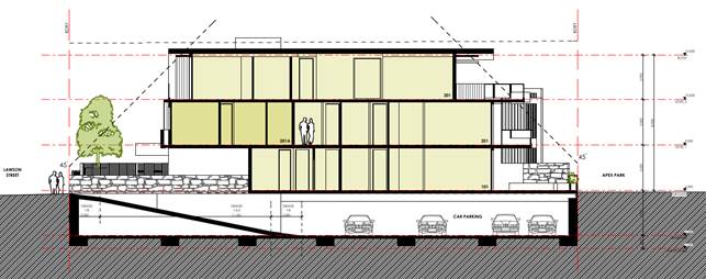
Figure 2: Original Proposal exceeding 9 m height limit - not supported/deferred.

Figure 3: Approved Section – Development Consent 10.2014.417.1 near compliant with 9.0m height limit.
10.2014.417.2: S4.55 to Modify Staging. Stage 1: Conversion of Existing Garage to Temporary Sales and Display Office for on-site Marketing of Approved Residential Flat Building, Temporary Car Parking Space, Pedestrian Access, and Landscaping. Stage 2: Completion of all Works and Demolition of Existing Building, approved by Council 10/06/2021.
10.2014.417.4: Section 4.55 of the Environmental Planning & Assessment Act 1979, that Application No. 10.2014.417.4, for S4.55 for Changes to Building Height to accommodate One (1) Roof Top Swimming Pool and associated Access and Structures, provision of Internal Access between Levels and Modification to Private Open Space was formally lodged (fees paid) on 8 March 2023 and is also recommended for refusal.
1.2. Description of the proposed development
This application seeks approval for a S4.55 to reconfigure five (5) apartments inclusive of dual key functionality for two (2) of the apartments, increasing building height to accommodate two (2) roof top swimming pools, associated access and structures, provision of internal access between levels and modification to private open space.
The proposed modification to the development adds an additional storey and proposes a total building height of 11.77 metres. The proposal represents a 30.7% variation to the 9 metre height of building development standard applicable to the land under Byron Local Environmental Plan (LEP) 2014. See Figures 4 and 5.
Byron LEP 2014 legally defines height of building as follows:
building height (or height of building) means—
(a) in relation to the height of a building in metres—the vertical distance from ground level (existing) to the highest point of the building, or
(b) in relation to the RL of a building—the vertical distance from the Australian Height Datum to the highest point of the building,
including plant and lift overruns, but excluding communication devices, antennae, satellite dishes, masts, flagpoles, chimneys, flues and the like.
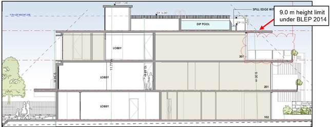
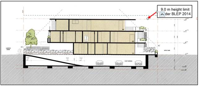
Figure 4: Proposed modification to building section (top) comparison with approved building (bottom)
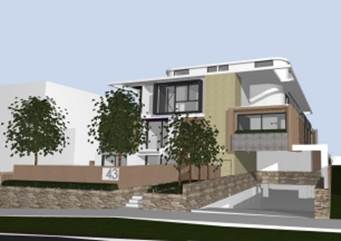
Figure 5: Proposed building model
Council Correspondence with the Applicant
It is noted Council staff raised concerns about the height of the building with the applicant advising it would not be supported and requesting the application be withdrawn. The request to withdraw the application was formalised on the NSW Planning Portal on 19 April 2023. This formal request included draft written reasons for refusal.
Further correspondence by email from the Manager Sustainable Development was sent on the 12 May 2023 to the applicant and representatives to the owner of the property.
At the time of completing this assessment for the June 8 Planning Meeting, this application and the other S.4.55 application had not been withdrawn.
1.3. Description of the site
The site was inspected on 15 March 2023 and 5 May 2023.
The site at 43 Lawson Street, Byron Bay is zoned R3 Medium Density Residential under Byron LEP 2014, and contains an existing brick residential flat building.
The property backs onto the foreshore reserve and park adjacent to the beach at Byron Bay.
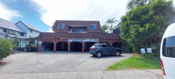
Figure 6: Site from Lawson Street
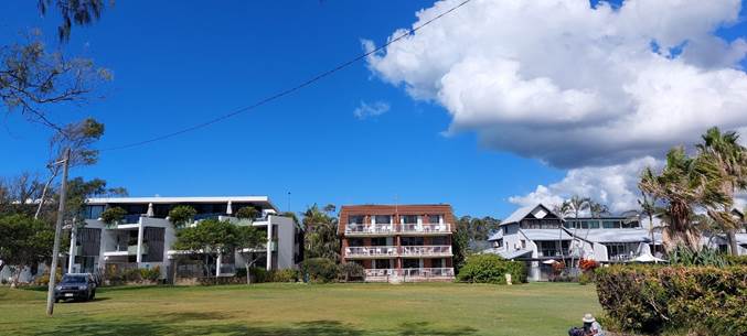
Figure 7: Site from Public Foreshore Reserve
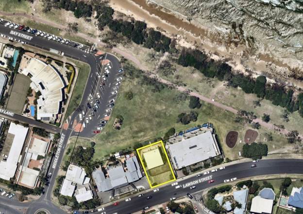
Figure 8: Aerial view of 43 Lawson Street, Byron Bay

Figure 9: Zoning Map Extract (Geocortex)
2. SECTION 4.55(2)
|
Section 4.55 (2) |
The Applicant is a person entitled to act on the consent. The applicable provisions of the Regulation are considered below. The development to which the consent as modified relates is substantially the same as the originally approved development. Consultation was not required with the Minister, public authority or an integrated development approval body in relation to the original development application. Public notification of the application, including consideration of any submissions received if applicable, is discussed elsewhere in this report. |
|
Section 4.55(3) |
Section 4.15(1) matters are considered below. |
|
Section 4.55(4) |
The modification to the development consent is not the granting of a consent. The modified consent becomes the consent. |
|
Section 4.55(6) |
The deemed refusal provisions are noted. |
|
Section 4.55(8) |
The Court was not involved in the original development consent and is not involved in the current section 96 application. |
3. ENVIRONMENTAL PLANNING AND ASSESSMENT REGULATION 2021
|
Section 98 (1) |
The application has been made with the consent of the owner. |
|
Section 98 (4) |
The notice requirements are noted. |
|
Section 98 (6) |
The land is not owned by a Local Aboriginal Land Council. |
|
Section 99 (1) |
The modification application was in the approved form, and contained information and documents required by the approved form, and the Act or this Regulation* see exception Section 102, and was submitted on the NSW planning portal. |
|
Section 99 (2) |
The application is not for State Significant Development. |
|
Section 100 (1) a-g |
The application was made using the NSW Planning Portal including all necessary information* see exception under Section 102. The modification application contained the name and address of the applicant, a description of the development that will be carried out under the development consent, the address and folio identifier of the land on which the development will be carried out, a description of the modification to the development consent, including the name, number and date of plans that have changed, to enable the consent authority to compare the development with the development originally approved, a description of the expected impacts of the modification, and an undertaking that the modified development will remain substantially the same as the development originally approved, a statement that the owner consents to the making of the modification application. |
|
Section 100 (1) h |
The modification application that is not required to be accompanied by a biodiversity development assessment report. |
|
Section 100 (1) i |
The Land and Environment Court is not involved. The Court did not grant the original consent. |
|
Section 100 (3) |
The application is accompanied by a BASIX Certificate, reflecting the modified proposal. |
|
Section 102 |
The proposal relates to a residential apartment building. The application does not comply with section 102 of the Environmental Planning and Assessment Regulation 2021 because a design verification statement has not been submitted to verify that the modification does not diminish or detract from the design quality of the original development, or compromise the design intent of the original development. |
|
Section 106 |
The original development application was not for designated development, State significant development or for any other advertised development made to a consent authority other than Council. |
|
Section 107 |
Any required advertising of this application is discussed below. |
|
Section 109 |
The original development application did not involve any concurrence authority or integrated development approval body. |
4. SUMMARY OF REFERRALS
|
Referral |
Issue |
|
Environmental Health Officer |
Not supported - insufficient information regarding the potential impact of noise and light from the pool areas. |
5. SECTION 4.15 – MATTERS FOR CONSIDERATION – DISCUSSION OF ISSUES
Having regard to the matters for consideration detailed in Section 4.15(1) of the Environmental Planning & Assessment Act 1979 (EP&A Act), the following is a summary of the evaluation of the issues.
5.1. State Environmental Planning Instruments
|
State Environmental Planning Policy Resilience and Hazards 2021 Division 4 Coastal use area 2.11 Development on land within the coastal use area (1) Development consent must not be granted to development on land that is within the coastal use area unless the consent authority— (a) has considered whether the proposed development is likely to cause an adverse impact on the following— (i) existing, safe access to and along the foreshore, beach, headland or rock platform for members of the public, including persons with a disability, (ii) overshadowing, wind funnelling and the loss of views from public places to foreshores, (iii) the visual amenity and scenic qualities of the coast, including coastal headlands, (iv) Aboriginal cultural heritage, practices and places, (v) cultural and built environment heritage, and (b) is satisfied that— (i) the development is designed, sited and will be managed to avoid an adverse impact referred to in paragraph (a), or (ii) if that impact cannot be reasonably avoided—the development is designed, sited and will be managed to minimise that impact, or (iii) if that impact cannot be minimised—the development will be managed to mitigate that impact, and (c) has taken into account the surrounding coastal and built environment, and the bulk, scale and size of the proposed development. Comment: It is considered the proposed amendment with its increased height is inconsistent with the SEPP and is not supported. |
5.2. Byron Local Environmental Plan 2014 (LEP 2014)
LEP 2014 is an applicable matter for consideration in the assessment of the subject application in accordance with subsection 4.15(1) of the EP&A Act because it applies to the subject land and the proposal.
The Byron LEP 2014 clauses have been taken into consideration in the assessment of the subject development application in accordance with subsection 4.15(1) of the EP&A Act. The proposed development does not comply with Clause 4.3 of LEP 2014.
4.3 Height of buildings
(1) The objectives of this clause are as follows—
(a) to achieve building design that does not exceed a specified maximum height from its existing ground level to finished roof or parapet,
(b) to ensure the height of buildings complements the streetscape and character of the area in which the buildings are located,
(c) to minimise visual impact, disruption of views, loss of privacy and loss of solar access to existing development.
(2) The height of a building on any land is not to exceed the maximum height shown for the land on the Height of Buildings Map.
The height limit for the property as shown on the Height of Buildings Map is a maximum of 9 metres.
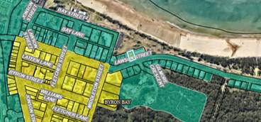
Figure 10: Height of building map (Geocortex) extract
The proposal as amended now has a maximum height of 11.77 metres which is some 30.7 % breach of the maximum permissible. The existing development as approved is nearly in full compliance with the 9.0 metre height limit. It is considered there are no environmental planning grounds to support the proposed extension to the height limit.
The height of building would impact on the visual amenity and scenic qualities of the coast taking into account the surrounding coastal and built environment, and the bulk, scale and size of the proposed development.
The proposal does not demonstrate it is in keeping with the predominant character of the area and would result in an intrusion when viewed from public land in the coastal foreshore locality.
The proposal is recommended for refusal.
5.3. Any proposed Instrument that has been the subject of public consultation and has been notified to the consent authority
Not applicable.
5.4. Byron Shire Development Control Plan 2014 (DCP 2014)
Byron DCP 2014 is an applicable matter for consideration in the assessment of the subject application in accordance with subsection 4.15(1) of the EP& A Act because it applies to the land to which LEP 2014 applies. The proposed development is not in accordance with the following Sections in Chapters C3, D1 and E5 of Byron DCP 2014, with consideration for building height plane, setbacks from boundaries, privacy, overlooking, visual impact, siting and design.
Sections C3.1.1, D1.2.1, D1.2.2, D1.2.3, D1.2.4, D1.2.6, D1.6.10 and E5.8.4 consideration in bold for emphasis:
Chapter C3 Visually Prominent Sites, Visually Prominent Development and View Sharing
Section C3.1.1
The Aims of this Chapter are:
1. to promote Byron Shire’s natural features, vegetation and topography as key components of its visual character and appeal;
2. to control development including land use, earthworks, vegetation clearing, built form and civil works in order to preserve and enhance the visual, cultural, ecological and landscape values of visually prominent sites and locations;
3. to ensure that development blends into the natural surroundings and does not intrude on the skyline when viewed from public land;
4. to minimise the visual impact of development when viewed from adjacent land, public reserves, public areas and waterways;
5. to ensure that development is designed to respect and, where reasonable, to preserve and/ or share existing views and vistas;
6. to ensure that development does not occur on or near any ridgeline unless no other alternative location for the development is available on the land, and then only when design will ensure protection of visual amenity and scenic values.
Chapter D1 Residential Accommodation in Urban, Village and Special Purpose Zones
The proposed modification is not supported with consideration for the following:
D1.2.1 Building Height Plane
The proposed modification does not:
1. ensure that residential development is designed to minimise impacts on solar access and privacy on adjoining properties, and on the views from adjacent existing buildings.
2. ensure that the occupants of the building or buildings will enjoy the optimum use of winter sunlight and summer shade.
3. mitigate excessive bulk in built-form.
4. offer a high level of amenity and sense of openness with buildings that are cognisant of, and blend with, the scale and streetscape character of the locality.
D1.2.2 Setbacks from Boundaries
The proposed modification does not:
1. complement and harmonise with existing and planned streetscapes and development in the locality.
2. achieve high quality living environments relative to sunlight, shade, wind, residential amenity and proximity of neighbouring development.
3. achieve effective use of allotments to create useable and liveable private open space and courtyards including existing adjoining private open space.
4. ensure that development that seeks to minimise any negative impacts on neighbours.
D1.2.3 Privacy
The proposed modification does not:
1. ensure buildings do not unduly affect existing or future development on adjoining properties by impinging on privacy or obstructing views.
2. ensure buildings are designed to optimise privacy for internal and external spaces.
D1.2.4 Solar Access
The proposed modification does not demonstrate that it is designed to optimise solar access and thereby not significantly overshadow living areas (decks, living rooms, bedrooms, kitchens etc.), private open spaces of adjoining properties.
D1.2.6 Character & Visual Impact
The proposed modification does not:
1. retain and enhance the unique character of Byron Shire and its distinctive landscapes, ecology, towns, villages, rural and natural areas.
2. ensure that new development respects and complements those aspects of an area’s natural and built environment that are important to its existing character.
D1.6.10 (Character)
The proposed modification does not ensure that the residential flat building is compatible in character with development in the locality.
Chapter E5 Certain Locations in Byron Bay and Ewingsdale
The proposed modification is not consistent with the defined character narrative of the area under Section E5.8.4:
Pocket A contains the original Byron Bay town (including Belongil) has the greatest diversity in built form and an eclectic village character. Set on a grid street layout, residential areas are within easy walking distance of the town centre. The oldest dwellings were the homes of entrepreneurs, farmers and people of a working-class background – a mix of street fronting low set fibro workers cottages, bungalows and high-set weatherboard Queenslander style homes with characteristically strong ‘Federation’ influences of hipped or gabled roofs. The homes are located at a relatively consistent setback and of a locally consistent height with front verandahs and set in landscaped gardens. Vehicle access to the sites has minimal interruption to the street frontages with the parking incorporated at the side or to the rear. The newer detached housing has largely continued to reflect these features blending to contribute to an overall integrated streetscape. Byron Bay town has a strong presence of medium density villa, townhouse and three storey mixed use developments. These medium density developments exhibit a somewhat incoherent and inconsistent design contribution to the overall streetscape. As a mix of apartment types and sizes is proposed for this area, new buildings outside of the Heritage Conservation Areas should be able to have their own unique interpretation of ‘local’ to continue the pattern of an eclectic village character. The outcome should nevertheless be one that responds sensitively to the predominant coastal townscape of the particular locality.
These Parts/Chapters have been taken into consideration in the assessment of the subject development application in accordance with subsection 4.15(1) of the EP&A Act. The proposed development is not demonstrated to meet the relevant Objectives of all relevant Parts.
5.5. Any Planning Agreement or Draft Planning Agreement?
|
|
Yes |
No |
|
Is there any applicable planning agreement or draft planning agreement? |
☐ |
☒ |
5.6. Environmental Planning & Assessment Regulation 2021 Considerations
The proposed modifications raise no specific issues in terms of the applicable regulations.
5.7. The likely impacts of that development, including environmental impacts on both the natural and built environments, and social and economic impacts in the locality
|
Impact on: |
Likely significant impact/s? |
|
Natural environment |
Yes. The proposal will have a significantly adverse impact on the natural environment of the locality in the foreshore. |
|
Built environment |
Yes. The proposal will have a significantly adverse impact on the built environment of the locality. |
|
Social Environment |
Yes. The proposal will have a significant social impact on the locality with regards to amenity of adjoining residential premises. |
|
Economic impact |
No. The proposal will not have a significant economic impact on the locality. The purpose of the original approval is for residential accommodation to provide for the housing needs of the community in the form of a residential flat building on residential zoned land. |
5.8. The suitability of the site for the development
The site is a serviced property with access to water, sewer, drainage, electricity and communication services. The site is suitable for residential use. Notwithstanding, the site is not suitable for the proposed modification to the original development without adversely impacting adjoining properties and cannot be accommodated within the site without significant breaches of Council's development standards and development control requirements.
5.9. Submissions made in accordance with this Act or the regulations
The application was publicly exhibited. There were 16 submissions made on the application:
- 2 Against in objection
- 14 For in support received after the exhibition period.
|
Issue
|
Consideration |
|
Privacy, overlooking, overshadowing and amenity.
|
Council assessment concludes that the impacts as a result of proposed increase in height substantially exceeding the maximum permissible 9 metre height limit, is not in the public interest. |
|
History of the original assessment and consent that specifically limited the height of the building having regards to the 9 metre height controls that applied at the time. |
Council assessment concludes that further variation to the 9 metre controls are not supported. |
|
In its current approved form, no activity is to occur at the roof level. The proposal now seeks to create a useable space, pools and new roof top structures. |
Council assessment concludes that new structures in an additional storey that requires further variation to the 9 metre controls are not supported. |
|
Accuracy and depiction of Byron Local Environmental Plan 2014 height requirement of 9.0 metres, misrepresented on plans as “9.9M LEP HEIGHT LINE” scales to a height of over 10.75 metres above ground |
Council concurs that the maximum permissible height on the land is 9 metres. |
It is noted that the content of fourteen late submissions of support received after the exhibition period relate to market preferences and property values and do not raise any valid environmental planning reasons to support the proposed 30.7% variation to the maximum permissible height limit.
5.10. Public interest
It is noted the consent when approved in 2015 was negotiated in good faith with the applicant to bring the development into compliance with the height limit. The proposed amendment now seeks approval for a fourth level which was never envisaged or proposed originally. It is considered the proposal is likely to prejudice or compromise the public interest and create an undesirable precedent.
6. DEVELOPER CONTRIBUTIONS
No changes to the approved Developer Contributions or headworks levies will be required if the application is refused.
7. CONCLUSION
An application has been received for S4.55 to Reconfigure Five (5) Apartments inclusive of Dual Key Functionality for Two (2) of the Apartments, increasing Building Height to Accommodate Two (2) Roof Top Swimming Pools, associated Access and Structures, provision of Internal Access between Levels and Modification to Private Open Space.
The proposal raises significant detrimental environmental impacts as a result of increase in height to 11.77 metres and the 30.7 % breach of the maximum permissible height is not justified on the basis of environmental planning grounds.
The height of building would impact on the visual amenity and scenic qualities of the coast taking into account the surrounding coastal and built environment, and the bulk, scale and size of the proposed development. Having regards to the history of the approved development it is considered inappropriate to now add a fourth level to the development and is not in the public interest.
The section 4.55 application is recommended for refusal on the grounds listed in the Recommendation of this Report.
BYRON SHIRE COUNCIL
Staff Reports - Sustainable Environment and Economy 13.5
Report No. 13.5 PLANNING - 10.2014.417.4 S4.55 for Changes to Building Height to accommodate One (1) Roof Top Swimming Pool and associated Access and Structures, provision of Internal Access between Levels and Modification to Private Open Space 43 Lawson Street BYRON BAY
Directorate: Sustainable Environment and Economy
Report Author: Patricia Docherty, Planner
File No: I2023/486
Proposal:
|
Proposed modification |
S4.55 for Changes to Building Height to accommodate One (1) Roof Top Swimming Pool and associated Access and Structures, provision of Internal Access between Levels and Modification to Private Open Space |
|
Original Development |
Demolition of existing residential flat building & construction of a new residential flat building and associated works |
|
Type of modification sought |
4.55(2) Other modifications |
|
Property description |
LOT: 0 SP: 16094 |
|
43 Lawson Street BYRON BAY |
|
|
Parcel No/s |
41930 |
|
Applicant |
Mr A Smith |
|
Owner |
The Owners of Strata Plan 16094 |
|
Zoning |
R3 Medium Density Residential |
|
Date received (DA fees paid) |
8 March 2023 |
|
Original DA determination date |
10 December 2015 |
|
Integrated Development |
No |
|
Public notification or exhibition |
- Level 2 advertising under the Byron Shire Council Community Participation Plan. - Exhibition period: 17 March 2023 to 30 March 2023 - Submissions received: Total 16. 2 Object. 14 Support (Late Submissions) |
|
Planning Review Committee |
Not applicable |
|
Delegation to determination |
Council
|
|
Issues |
Height of Building History or original consent: · DA 10.2014.417.1 was originally recommended for refusal on 19 March 2015 for a range of reasons including non-compliance with the 9-metre height limit under Byron LEP 1988. · Determination was deferred and then reported back to Council 10 December 2015 for approval once the height was brought down to comply with the 9-metre height limit. Approved on the basis of near full compliance with 9 metre height controls for the site (max height of 9.05m). The proposed modification to the approved residential flat building including increase in height to 11.77 metres is not in accordance with relevant environmental planning instruments including Byron LEP 2014, State Environmental Planning Policy Resilience and Hazards 2021 and various sections of Byron DCP 2014.
|
Summary:
An application has been received for S4.55 for Changes to Building Height to accommodate One (1) Roof Top Swimming Pool and associated Access and Structures, provision of Internal Access between Levels and Modification to Private Open Space.
The proposal raises significant detrimental environmental impacts as a result of an increase in height to 11.77 metres and the 30.7 % breach of the maximum permissible height of the 9metre height limit is not justified in this instance. It is considered the height of building would impact on the visual amenity and scenic qualities of the coast taking into account the surrounding coastal and built environment, and the bulk, scale and size of the proposed development.
The proposal does not demonstrate it is in keeping with the predominant character of the area and would result in an intrusion when viewed from public land in the coastal foreshore locality.
It is noted the applicant submitted two S4.55 applications almost simultaneously with similar height breaches with roof top pools. It would appear the purpose of doing this is to provide Council with two concepts to consider. The other application DA10.2014.417.3 is being reported to Council for consideration at the same time as this application. It is also recommended for refusal.
Having regards to the history of approval of the original application, the proposal is not in the public interest, and the section 4.55 application is recommended for refusal on the grounds listed in the Recommendation of this Report.
NOTE TO COUNCILLORS:
In accordance with the provisions of S375A of the Local Government Act 1993, a Division is to be called whenever a motion for a planning decision is put to the meeting, for the purpose of recording voting on planning matters. Pursuant to clause 2(a) under the heading Matters to be Included in Minutes of Council Meetings of Council's adopted Code of Meeting Practice (as amended) a Division will be deemed to have been called by the mover and seconder of all motions relating to this report.
RECOMMENDATION:
It is recommended pursuant to Section 4.55 of the Environmental Planning & Assessment Act 1979, that Application No. 10.2014.417.4, for S4.55 for Changes to Building Height to accommodate One (1) Roof Top Swimming Pool and associated Access and Structures, provision of Internal Access between Levels and Modification to Private Open Space, be refused as follows:
1. Pursuant to section 4.15(1)(a)(i) of the Environmental Planning and Assessment Act 1979 the proposed development does not comply with Section 2.11 of State Environmental Planning Policy - Resilience and Hazards.
2. Pursuant to section 4.15(1)(a)(i) of the Environmental Planning and Assessment Act 1979 the proposed development does not comply with Clause 4.3 Height of building under Byron Local Environmental Plan 2014.
3. Pursuant to Section 4.15(1)(a)(iii) of the Environmental Planning and Assessment Act 1979 the proposed development does not comply with Chapter C3 Byron Development Control Plan 2014.
4. Pursuant to Section 4.15(1)(a)(iii) of the Environmental Planning and Assessment Act 1979 the proposed development does not comply with Chapter D1 of Byron Development Control Plan 2014.
5. Pursuant to Section 4.15(1)(a)(iii) of the Environmental Planning and Assessment Act 1979 the proposed development does not comply with Chapter E5 of Byron Development Control Plan 2014.
6. Pursuant to Section 4.15 (1) (a) (iv) the application for the proposed modification of an approved residential flat building does not comply with section 102 of the Environmental Planning and Assessment Regulation 2021.
7. Pursuant to Section 4.15 (1) (b) of the Environmental Planning and Assessment Act 1979 the proposed development is likely to result in adverse environmental impacts on both the natural and built environments, and social impacts in the locality and the occupants of that environment.
8. Pursuant to Section 4.15(1)(d) of the Environmental Planning & Assessment Act 1979 the proposed development is not in the public interest with regards for relevant matters for consideration raised in properly made submissions received by Council.
9. Pursuant to Section 4.15(1)(e) of the EP&A Act 1979 the proposed development is not in the public interest for the reasons outlined above
1 10.2014.417.4
Architectural Plans, E2022/125720
![]()
2 Confidential - 10.2014.417.4 Public Submissions, E2023/49917
 Figure 1: Site Location
1. INTRODUCTION
1.1. History/Background
Building Application No. 10/80 - Three storey building containing 6 x 2-bedroom units, with 6 residential parking spaces plus 1 visitors parking.
10.2014.417.1 - Development Application: Demolition of existing residential flat building & construction of a new residential flat building and associated works was approved by Council on 10/12/2015. Note.10.2014.417.1 was originally recommended for refusal on 19 March 2015 for a range of reasons including non-compliance with the 9-metre height limit under Byron LEP 1988. The application was deferred and then reported back to Council 10 December 2015 for approval once the height was brought down to comply with the 9 metre heigh limit.

Figure 2: Original Proposal exceeding 9 m height limit - not supported/deferred.
Figure 3: Approved Section – Development Consent 10.2014.417.1
10.2014.417.2: S4.55 to Modify Staging. Stage 1: Conversion of Existing Garage to Temporary Sales and Display Office for on-site Marketing of Approved Residential Flat Building, Temporary Car Parking Space, Pedestrian Access and Landscaping. Stage 2: Completion of all Works and Demolition of Existing Building, approved by Council 10/06/2021.
Current separate assessment
10.2014.417.3: S4.55 to Reconfigure Five (5) Apartments inclusive of Dual Key Functionality for Two (2) of the Apartments, increasing Building Height to Accommodate Two (2) Roof Top Swimming Pools, associated Access and Structures, provision of Internal Access between Levels and Modification to Private Open Space was formally lodged (fees paid) 27 February 2023 and is also recommended for refusal.
1.2. Description of the proposed development
This application seeks approval for a S4.55 for Changes to Building Height to accommodate One (1) Roof Top Swimming Pool and associated Access and Structures, provision of Internal Access between Levels and Modification to Private Open Space.
The proposed modification to the development adds an additional storey and proposes a total building height of 11.77 metres. The proposal represents a 30.7% variation to the 9 metre height of building development standard applicable to the land under Byron Local Environmental Plan (LEP) 2014. See Figures 4 and 5.
Byron LEP 2014 legally defines height of building as follows:
building height (or height of building) means—
(a) in relation to the height of a building in metres—the vertical distance from ground level (existing) to the highest point of the building, or
(b) in relation to the RL of a building—the vertical distance from the Australian Height Datum to the highest point of the building,
including plant and lift overruns, but excluding communication devices, antennae, satellite dishes, masts, flagpoles, chimneys, flues and the like.
 Figure 4: Proposed
modification to building section (top) comparison with approved building
(bottom)
Figure 4: Proposed
modification to building section (top) comparison with approved building
(bottom)
Figure 5: Proposed building model
Council Correspondence with the Applicant
It is noted Council staff raised concerns about the height of the building with the applicant advising it would not be supported and requesting the application be withdrawn. The request to withdraw the application was formalised on the NSW Planning Portal on 19 April 2023. This formal request included draft written reasons for refusal. Further correspondence by email from the Manager Sustainable Development on the 12 May 2023 to the applicant and representatives to the owner of the property.
Council staff requested that separate application 4.55 10.2014.417.3, also be withdrawn for the same reasons because it sought approval for the same changes to building height extent to accommodate two (2) roof top swimming pools one and associated access and structures as opposed to (1) roof top swimming pool proposed under this application.
At the time of reporting deadline for the June 8 Planning Meeting, both current 4.55 applications have not been withdrawn.
1.3. Description of the site
The site was inspected on 15 March 2023 and 5 May 2023.
The site at 43 Lawson Street, Byron Bay is zoned R3 Medium Density Residential under Byron LEP 2014 and contains an existing brick residential flat building.
The property backs onto the foreshore reserve and park adjacent to the beach at Byron Bay.

Figure 6: Site from Lawson Street
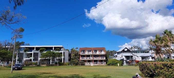
Figure 7: Site from Public Foreshore Reserve
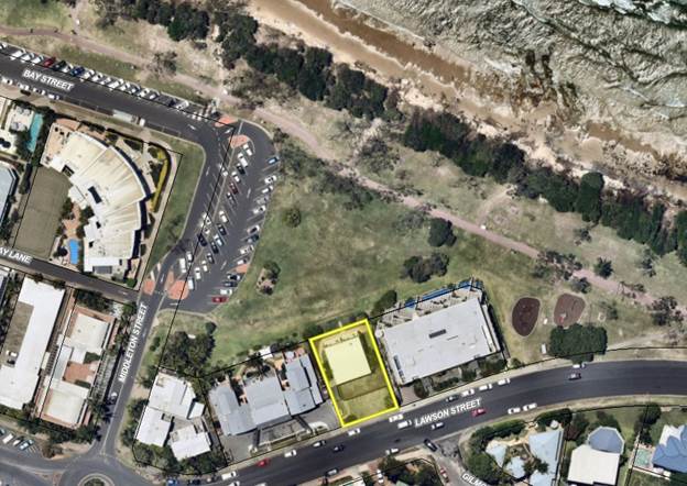
Figure 8: Aerial view of 43 Lawson Street, Byron Bay
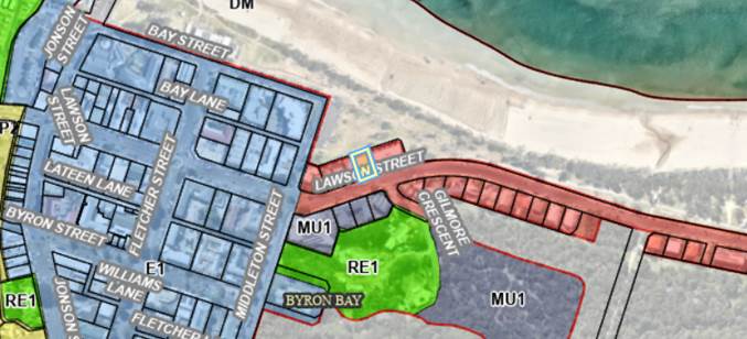
Figure 9: Zoning Map Extract (Geocortex)
SECTION 4.55(2)
|
Section 4.55 (2) |
The Applicant is a person entitled to act on the consent. The applicable provisions of the Regulation are considered below. The development to which the consent as modified relates is substantially the same as the originally approved development. Consultation was not required with the Minister, public authority, or an integrated development approval body in relation to the original development application. Public notification of the application, including consideration of any submissions received if applicable, is discussed elsewhere in this report. |
|
Section 4.55(3) |
Section 4.15(1) matters are considered below. |
|
Section 4.55(4) |
The modification to the development consent is not the granting of a consent. The modified consent becomes the consent. |
|
Section 4.55(6) |
The deemed refusal provisions are noted. |
|
Section 4.55(8) |
The Court was not involved in the original development consent and is not involved in the current section 96 application. |
2. ENVIRONMENTAL PLANNING AND ASSESSMENT REGULATION 2021
|
Section 98 (1) |
The application has been made with the consent of the owner. |
|
Section 98 (4) |
The notice requirements are noted. |
|
Section 98 (6) |
The land is not owned by a Local Aboriginal Land Council. |
|
Section 99 (1) |
The modification application was in the approved form, and contained information and documents required by the approved form, and the Act or this Regulation* see exception Section 102 and was submitted on the NSW planning portal. |
|
Section 99 (2) |
The application is not for State Significant Development. |
|
Section 100 (1) a-g |
The application was made using the NSW Planning Portal including all necessary information* see exception under Section 102. The modification application contained the name and address of the applicant, a description of the development that will be carried out under the development consent, the address and folio identifier of the land on which the development will be carried out, a description of the modification to the development consent, including the name, number and date of plans that have changed, to enable the consent authority to compare the development with the development originally approved, a description of the expected impacts of the modification, and an undertaking that the modified development will remain substantially the same as the development originally approved, a statement that the owner consents to the making of the modification application. |
|
Section 100 (1) h |
The modification application that is not required to be accompanied by a biodiversity development assessment report. |
|
Section 100 (1) i |
The Land and Environment Court is not involved. The Court did not grant the original consent. |
|
Section 100 (3) |
The application is accompanied by a BASIX Certificate, reflecting the modified proposal. |
|
Section 102 |
The proposal relates to a residential apartment building. The application does not comply with section 102 of the Environmental Planning and Assessment Regulation 2021 because a design verification statement has not been submitted to verify that the modification does not diminish or detract from the design quality of the original development or compromise the design intent of the original development. |
|
Section 106 |
The original development application was not for designated development, State significant development or for any other advertised development made to a consent authority other than Council. |
|
Section 107 |
Any required advertising of this application is discussed below. |
|
Section 109 |
The original development application did not involve any concurrence authority or integrated development approval body. |
3. SUMMARY OF REFERRALS
|
Referral |
Issue |
|
Environmental Health Officer |
Not supported - insufficient information regarding the potential impact of noise and light from the pool areas. |
4. SECTION 4.15 – MATTERS FOR CONSIDERATION – DISCUSSION OF ISSUES
Having regard to the matters for consideration detailed in Section 4.15(1) of the Environmental Planning & Assessment Act 1979 (EP&A Act), the following is a summary of the evaluation of the issues.
4.1. State Environmental Planning Instruments
|
State Environmental Planning Policy Resilience and Hazards 2021 Division 4 Coastal use area 2.11 Development on land within the coastal use area (1) Development consent must not be granted to development on land that is within the coastal use area unless the consent authority— (a) has considered whether the proposed development is likely to cause an adverse impact on the following— (i) existing, safe access to and along the foreshore, beach, headland or rock platform for members of the public, including persons with a disability, (ii) overshadowing, wind funnelling and the loss of views from public places to foreshores, (iii) the visual amenity and scenic qualities of the coast, including coastal headlands, (iv) Aboriginal cultural heritage, practices and places, (v) cultural and built environment heritage, and (b) is satisfied that— (i) the development is designed, sited and will be managed to avoid an adverse impact referred to in paragraph (a), or (ii) if that impact cannot be reasonably avoided—the development is designed, sited and will be managed to minimise that impact, or (iii) if that impact cannot be minimised—the development will be managed to mitigate that impact, and (c) has taken into account the surrounding coastal and built environment, and the bulk, scale and size of the proposed development. Comment: It is considered the proposed amendment with its increased height is inconsistent with the SEPP and is not supported. |
4.2. Byron Local Environmental Plan 2014 (LEP 2014)
LEP 2014 is an applicable matter for consideration in the assessment of the subject application in accordance with subsection 4.15(1) of the EP&A Act because it applies to the subject land and the proposal.
The Byron LEP 2014 clauses have been taken into consideration in the assessment of the subject development application in accordance with subsection 4.15(1) of the EP&A Act. The proposed development does not comply with Clause 4.3 of LEP 2014.
4.3 Height of buildings
(1) The objectives of this clause are as follows—
(a) to achieve building design that does not exceed a specified maximum height from its existing ground level to finished roof or parapet,
(b) to ensure the height of buildings complements the streetscape and character of the area in which the buildings are located,
(c) to minimise visual impact, disruption of views, loss of privacy and loss of solar access to existing development.
(2) The height of a building on any land is not to exceed the maximum height shown for the land on the Height of Buildings Map.
The height limit for the property as shown on the Height of Buildings Map is a maximum of 9 metres.

Figure 10: Height of building map (Geocortex) extract
The proposal as amended now has a maximum height of 11.77 metres which is some 30.7% breach of the maximum permissible. The existing de elopement as approved is nearly in full compliance with the 9.0 metre height limit. It is considered there are no environmental planning grounds to support the proposed extension to the height limit.
The height of building would impact on the visual amenity and scenic qualities of the coast taking into account the surrounding coastal and built environment, and the bulk, scale and size of the proposed development.
The proposal does not demonstrate it is in keeping with the predominant character of the area and would result in an intrusion when viewed from public land in the coastal foreshore locality.
The proposal is recommended for refusal.
4.3. Any proposed Instrument that has been the subject of public consultation and has been notified to the consent authority
Not applicable.
4.4. Byron Shire Development Control Plan 2014 (DCP 2014)
Byron DCP 2014 is an applicable matter for consideration in the assessment of the subject application in accordance with subsection 4.15(1) of the EP& A Act because it applies to the land to which LEP 2014 applies. The proposed development is not in accordance with the following Sections in Chapters C3, D1 and E5 of Byron DCP 2014, with consideration for building height plane, setbacks from boundaries, privacy, overlooking, visual impact, siting and design.
Sections C3.1.1, D1.2.1, D1.2.2, D1.2.3, D1.2.4, D1.2.6, D1.6.10 and E5.8.4 consideration in bold for emphasis:
Chapter C3 Visually Prominent Sites, Visually Prominent Development and View Sharing
Section C3.1.1
The Aims of this Chapter are:
1. to promote Byron Shire’s natural features, vegetation and topography as key components of its visual character and appeal;
2. to control development including land use, earthworks, vegetation clearing, built form and civil works in order to preserve and enhance the visual, cultural, ecological and landscape values of visually prominent sites and locations;
3. to ensure that development blends into the natural surroundings and does not intrude on the skyline when viewed from public land;
4. to minimise the visual impact of development when viewed from adjacent land, public reserves, public areas and waterways;
5. to ensure that development is designed to respect and, where reasonable, to preserve and/ or share existing views and vistas;
6. to ensure that development does not occur on or near any ridgeline unless no other alternative location for the development is available on the land, and then only when design will ensure protection of visual amenity and scenic values.
Chapter D1 Residential Accommodation in Urban, Village and Special Purpose Zones
The proposed modification is not supported with consideration for the following:
D1.2.1 Building Height Plane
The proposed modification does not:
1. ensure that residential development is designed to minimise impacts on solar access and privacy on adjoining properties, and on the views from adjacent existing buildings.
2. ensure that the occupants of the building or buildings will enjoy the optimum use of winter sunlight and summer shade.
3. mitigate excessive bulk in built-form.
4. offer a high level of amenity and sense of openness with buildings that are cognisant of, and blend with, the scale and streetscape character of the locality.
D1.2.2 Setbacks from Boundaries
The proposed modification does not:
1. complement and harmonise with existing and planned streetscapes and development in the locality.
2. achieve high quality living environments relative to sunlight, shade, wind, residential amenity and proximity of neighbouring development.
3. achieve effective use of allotments to create useable and liveable private open space and courtyards including existing adjoining private open space.
4. ensure that development that seeks to minimise any negative impacts on neighbours.
D1.2.3 Privacy
The proposed modification does not:
1. ensure buildings do not unduly affect existing or future development on adjoining properties by impinging on privacy or obstructing views.
2. ensure buildings are designed to optimise privacy for internal and external spaces.
D1.2.4 Solar Access
The proposed modification does not demonstrate that it is designed to optimise solar access and thereby not significantly overshadow living areas (decks, living rooms, bedrooms, kitchens etc.), private open spaces of adjoining properties.
D1.2.6 Character & Visual Impact
The proposed modification does not:
1. retain and enhance the unique character of Byron Shire and its distinctive landscapes, ecology, towns, villages, rural and natural areas.
2. ensure that new development respects and complements those aspects of an area’s natural and built environment that are important to its existing character.
D1.6.10 (Character)
The proposed modification does not ensure that the residential flat building is compatible in character with development in the locality.
Chapter E5 Certain Locations in Byron Bay and Ewingsdale
The proposed modification is not consistent with the defined character narrative of the area under Section E5.8.4:
Pocket A contains the original Byron Bay town (including Belongil) has the greatest diversity in built form and an eclectic village character. Set on a grid street layout, residential areas are within easy walking distance of the town centre. The oldest dwellings were the homes of entrepreneurs, farmers and people of a working class background – a mix of street fronting low set fibro workers cottages, bungalows and high-set weatherboard Queenslander style homes with characteristically strong ‘Federation’ influences of hipped or gabled roofs. The homes are located at a relatively consistent setback and of a locally consistent height with front verandahs and set in landscaped gardens. Vehicle access to the sites has minimal interruption to the street frontages with the parking incorporated at the side or to the rear. The newer detached housing has largely continued to reflect these features blending to contribute to an overall integrated streetscape. Byron Bay town has a strong presence of medium density villa, townhouse and three storey mixed use developments. These medium density developments exhibit a somewhat incoherent and inconsistent design contribution to the overall streetscape. As a mix of apartment types and sizes is proposed for this area, new buildings outside of the Heritage Conservation Areas should be able to have their own unique interpretation of ‘local’ to continue the pattern of an eclectic village character. The outcome should nevertheless be one that responds sensitively to the predominant coastal townscape of the particular locality.
These Parts/Chapters have been taken into consideration in the assessment of the subject development application in accordance with subsection 4.15(1) of the EP&A Act. The proposed development is not demonstrated to meet the relevant Objectives of all relevant Parts.
4.5. Any Planning Agreement or Draft Planning Agreement?
|
|
Yes |
No |
|
Is there any applicable planning agreement or draft planning agreement? |
☐ |
☒ |
4.6. Environmental Planning & Assessment Regulation 2021 Considerations
The proposed modifications raise no specific issues in terms of the applicable regulations.
4.7. The likely impacts of that development, including environmental impacts on both the natural and built environments, and social and economic impacts in the locality
|
Impact on: |
Likely significant impact/s? |
|
Natural environment |
Yes. The proposal will have a significantly adverse impact on the natural environment of the locality in the foreshore. |
|
Built environment |
Yes. The proposal will have a significantly adverse impact on the built environment of the locality. |
|
Social Environment |
Yes. The proposal will have a significant social impact on the locality with regards to amenity of adjoining residential premises. |
|
Economic impact |
No. The proposal will not have a significant economic impact on the locality. The purpose of the original approval is for residential accommodation to provide for the housing needs of the community in the form of a residential flat building on residential zoned land. |
4.8. The suitability of the site for the development
The site is a serviced property with access to water, sewer, drainage, electricity and communication services. The site is suitable for residential use. Notwithstanding, the site is not suitable for the proposed modification to the original development without adversely impacting adjoining properties and cannot be accommodated within the site without significant breaches of Council's development standards and development control requirements.
4.9. Submissions made in accordance with this Act or the regulations
The application was publicly exhibited. There were 16 submissions made on the application:
- 2 Against in objection
- 14 For in support received after the exhibition period.
|
Issue |
Consideration |
|
Privacy, overlooking, overshadowing and amenity.
|
Council assessment concludes that the impacts as a result of proposed increase in height substantially exceeding the maximum permissible 9 metre height limit, is not in the public interest. |
|
History of the original assessment and consent that specifically limited the height of the building having regards to the 9 metre height controls that applied at the time. |
Council assessment concludes that further variation to the 9 metre controls are not supported. |
|
In its current approved form, no activity is to occur at the roof level. The proposal now seeks to create a useable space, pools and new roof top structures. |
Council assessment concludes that new structures in an additional storey that requires further variation to the 9 metre controls are not supported. |
|
Accuracy and depiction of Byron Local Environmental Plan 2014 height requirement of 9.0 metres, misrepresented on plans as “9.9M LEP HEIGHT LINE” scales to a height of over 10.75 metres above ground |
Council concurs that the maximum permissible height on the land is 9 metres. |
It is noted that the content of fourteen late submissions of support received after the exhibition period relate to market preferences and property values and do not raise any valid environmental planning reasons to support the proposed 30.7% variation to the maximum permissible height limit.
4.10. Public interest
It is noted the consent when approved in 2015 was negotiated in good faith with the applicant to bring the development into compliance with the height limit. The proposed amendment now seeks approval for a fourth level which was never envisaged or proposed originally. It is considered the proposal is likely to prejudice or compromise the public interest and create an undesirable precedent.
5. DEVELOPER CONTRIBUTIONS
No changes to the approved Developer Contributions or headworks levies will be required if the application is refused.
An application has been received for S4.55 for Changes to Building Height to accommodate One (1) Roof Top Swimming Pool and associated Access and Structures, provision of Internal Access between Levels and Modification to Private Open Space.
The proposal raises significant detrimental environmental impacts as a result of increase in height to 11.77 metres and the 30.7 % breach of the maximum permissible height is not justified on the basis of environmental planning grounds.
The height of building would impact on the visual amenity and scenic qualities of the coast taking into account the surrounding coastal and built environment, and the bulk, scale and size of the proposed development.
The proposal does not demonstrate it is in keeping with the predominant character of the area and would result in an intrusion when viewed from public land in the coastal foreshore locality.
The impacts as a result of increase in height are not in the public interest with consideration for issues raised in properly made submissions of objection.
The proposal is not satisfactory having regard to relevant matters for consideration and the section 4.55 application is recommended for refusal on the grounds listed in the Recommendation of this Report.
BYRON SHIRE COUNCIL
Staff Reports - Sustainable Environment and Economy 13.6
Report No. 13.6 PLANNING - 26.2022.8.1 - Planning proposal to permit events at the Cavanbah Centre without the need to obtain development consent - Submissions Report
Directorate: Sustainable Environment and Economy
Report Author: Roseanna Meech, Planner
File No: I2023/600
Summary:
This Report presents the exhibition outcomes of the planning proposal 26.2022.8.1.
The intention of this planning proposal is to permit function centres (being low impact performance of live music and / or arts events) as exempt development under the Byron LEP 2014 on part of the Cavanbah Sporting and Cultural Centre site, 249 Ewingsdale Road, Byron Bay.
The changes within the LEP aim to remove the requirement of a Development Application to hold events at the Cavanbah Centre, reducing the cost and time for event holders. Applicants will still be required to apply to Council to undertake events however they will no longer be required to undertake the development assessment process. Post the planning proposal process, a low impact performance of live music / or arts events approval process and procedure will be developed for the site.
The planning proposal (Attachment 1) received a Gateway determination to proceed to public exhibition from the Department of Planning and Environment (DPE) and was placed on public exhibition from 27 March to 1 May 2023. One (1) public submission was received in support of the changes. The Gateway determination required Council to consult with a number of agencies whose submissions have been summarised and addressed below. Copies of the submissions are attached to this report.
The gateway period expires on 23 August 2023.
It is recommended that the planning proposal (as amended in accordance with this report) be sent to DPE for finalisation.
NOTE TO COUNCILLORS:
In accordance with the provisions of S375A of the Local Government Act 1993, a Division is to be called whenever a motion for a planning decision is put to the meeting, for the purpose of recording voting on planning matters. Pursuant to clause 2(a) under the heading Matters to be Included in Minutes of Council Meetings of Council's adopted Code of Meeting Practice (as amended) a Division will be deemed to have been called by the mover and seconder of all motions relating to this report.
RECOMMENDATION:
That Council adopts the amended planning proposal as attached to this report (Attachment 1 - #E2023/1080) for an amendment to Byron Local Environmental Plan 2014 to permit events on certain Council owned land at 249 Ewingsdale Road, Ewingsdale (Cavanbah Centre), and forwards this to the Department of Planning, Industry and Environment for finalisation.
Attachments:
1 26.2022.8.1
Planning Proposal Post Exhibition Version, E2023/1080
![]()
2 26.2022.8.1
Combined Agency Submissions, E2023/43847
![]()
3 26.2022.8.1
Public Submission, E2023/43851 ![]()
4 Form
of Special Disclosure of Pecuniary Interest, E2012/2815
![]()
Report
At the 13 October 2022 Planning Meeting Council resolved 22-552 as follows
1. That Council proceeds with a planning proposal as attached to this report (Attachment 1) that seeks to amend Byron LEP 2014 to permit events on certain Council owned land at 249 Ewingsdale Road without the need to obtain development consent;
2. Forward the planning proposal to the NSW Department of Planning and Environment for a Gateway determination;
3. That Council, pending a positive gateway determination, undertakes public exhibition of the planning proposal in accordance with the determination requirements;
4. That Council considers a submissions report post exhibition that includes any recommended changes to the planning proposal for final adoption.
In accordance with the Resolution, staff uploaded a planning proposal to the NSW Planning Portal on 20 October 2022 to amend Byron LEP 2014 to permit events on certain Council owned land at 249 Ewingsdale Road without the need to obtain development consent (exempt development).
The planning proposal was initially returned following the original proposed wording within Schedule 2 being ‘Entertainment and events’ which did not align with the standard instrument definitions. Following the advice of DPE, Council amended the planning proposal such that the proposed events clause would now seek to permit a defined LEP land use (like ‘function centre’) as development without consent, which would require a Part 5 activity approval from Council to proceed.
Resolution 22-552 was subsequently updated at the 15 December 2022 Council Meeting, whereby Council supported (resolution 22-705) an amendment to the planning proposal following the advice of DPE.
Gateway determination was issued based on the revised planning proposal on 24 February 2023. In accordance with Gateway conditions, consultation with public authorities and government agencies was initiated.
The planning proposal was placed on exhibition from 27 March to 1 May 2023. The proposal and supporting information were available for viewing and comment on Council’s Your Say page.
Agency submissions
DPE – Biodiversity and Conservation Division (BCD)
In accord with gateway requirement, the DPE – Biodiversity and Conservation Division were invited to comment on the planning proposal. The comments received were based on the data from the Belongil Creek Floodplain Risk Management Study (BMT 2015), with a portion of the site being constrained by the 100-year ARI and the Probable Maximum Flood (PMF) affecting the entire site.
BCD recommended a ‘Flood Plan’ for the Cavanbah Centre be developed that has clear protocols, procedure and triggers in place to mitigate possible risk from a flood event.
Comment – Council’s Manager of Open Space and Facilities was engaged to provide further information on existing protocols, procedures or triggers in place with regard to flood events at the Cavanbah Centre.
Similar to the existing procedures in place for sporting activities on the site, the temporary use of outdoor spaces would be subject to prevailing weather conditions and use of the site would be guided by the Wet Weather Sporting Ground Closures Policy 2021.
Council as landowner will have control over events that will take place on the site. These uses are temporary, often outdoors and are not likely to be held if flood events are forecast. Mitigation efforts are considered adequately addressed within existing Council policies and guidelines.
The NSW RFS raised no objection to the LEP amendment however recommends the draft LEP amendment wording include:
· Must not include overnight accommodation or camping
Comment – The proposed wording of the Schedule 2 amendment has been updated to reflect this.
NSW Environment Protection Authority
NSW EPA recommends Council to consider the potential land use conflict between the Byron Sewerage Treatment Works and Bioenergy Facility located adjacent to the proposal which have the potential to cause odour that may impact upon events held on the Cavanbah Centre site.
Comment – The subject land at the Cavanbah Centre zoned RE1 Public Recreation will not be altered as part of the planning proposal. The Byron STP and Bioenergy Facility are located sufficient distance away to minimise potential for odour impacts on events.
Transport for NSW (TfNSW)
TfNSW is primarily concerned with the proximity of the site to the Pacific Highway and the unspecified numbers of attendees permitted at any given event that may impact the on/off ramp with queuing onto the motorway.
The progression of the planning proposal was supported given the above-mentioned concerns would be appropriately addressed through relevant road approvals/licenses (such as Road Occupancy Licences, Traffic Management Plan, Traffic and Pedestrian Plan etc) as specified by the Local Traffic Committee. The proposed wording of the draft Schedule 2 amendment has been updated to reflect this.
No response was received from Tweed Byron Local Aboriginal Land Council.
Submission summary
During the exhibition period one (1) submission was received. The submission was in support of the proposed changes.
Recommended changes
Based on agency submissions, the proposed wording of the Schedule 2 amendment is as follows:
Schedule 2 Exempt development
Function Centres on land owned or managed by Council
Applies to that part of Lot 3 DP 706286 zoned RE1 Public Recreation
Must not include the erection of a permanent structure on the land
Must not include clearing of native vegetation
Must have obtained all required approvals including (but not limited to) the endorsement of the Local Traffic Committee.
Must not include overnight accommodation or camping
Next steps
It is recommended that Council adopt the planning proposal in Attachment 1 and forward it to the Department of Planning and Environment for finalisation.
The Gateway for this proposal expires on 23 August 2023.
Post the planning proposal process, a low impact performance of live music / or arts events approval process and procedure will be developed for the site.
Strategic Considerations
Community Strategic Plan and Operational Plan
|
CSP Objective |
CSP Strategy |
DP Action |
Code |
OP Activity |
|
4:
Ethical Growth |
4.1: Manage responsible development through effective place and space planning |
4.1.4: LEP & DCP - Review and update the Local Environmental Plan and Development Control Plans |
4.1.4.1 |
Assess requests to amend Local Environmental Plans and/or Development Control Plans including maps in accordance with legislative requirements. |
|
2:
Inclusive Community |
2.1: Foster opportunities to express, celebrate and participate in arts and cultural activity |
2.1.3: Events and festivals - Support and enable arts & cultural activity, festivals, projects, and events |
2.1.3.9 |
Collaborate with government, agency and industry on policy and legislative reforms |
Recent Resolutions
· Resolution 22-552 – 13 October 2022 Council (Planning) Meeting
· Resolution 22-705 - 15 December 2022 Council (Ordinary) Meeting
Legal/Statutory/Policy Considerations
This planning proposal will amend Byron Local Environmental Plan 2014 in accordance with the relevant legislative requirements.
Financial Considerations
Consultation and Engagement
The outcome of the latest community engagement process has been outlined within this report.
BYRON SHIRE COUNCIL
Staff Reports - Sustainable Environment and Economy 13.7
Report No. 13.7 PLANNING - Report of the Planning Review Committee held 4 May 2023
Directorate: Sustainable Environment and Economy
Report Author: Chris Larkin, Manager Sustainable Development
File No: I2023/726
Summary:
This report provides the outcome of the Planning Review Committee (PRC) held on 4 May 2023.
NOTE TO COUNCILLORS:
In accordance with the provisions of S375A of the Local Government Act 1993, a Division is to be called whenever a motion for a planning decision is put to the meeting, for the purpose of recording voting on planning matters. Pursuant to clause 2(a) under the heading Matters to be Included in Minutes of Council Meetings of Council's adopted Code of Meeting Practice (as amended) a Division will be deemed to have been called by the mover and seconder of all motions relating to this report.
RECOMMENDATION:
That Council endorses the outcomes of the Planning Review Committee meeting held 4 May 2023.
Report
The Planning Review Committee meeting was held on 4 May 2023. The meeting commenced at 4:25pm and concluded at 4:45pm.
Councillors: Mayor Cr Lyon, Cr A Hunter, Cr D Dey, Cr C Coorey, Cr M Swivel.
Apologies: Cr S Ndiaye, Cr P Westheimer, Chris Larkin (Manager Sustainable Development)
Staff: Shannon Burt (Director of Sustainable Environment & Economy)
Conflict of Interest: None declared
The following development applications were reviewed with the outcome shown in the final column.
Council determined the following original development applications. The S.4.55 applications to modify those consents were referred to the Planning Review Committee to decide if the modification applications can be determined under delegated authority with the outcome shown in the final column.
|
DA No. / Applicant |
Property Address / Proposal |
Consultation / Submissions |
Reason/s / Outcome |
|
10.2023.62.1 Ms TE Appleton |
4 Jubilee Avenue MULLUMBIMBY Alterations and additions to community facilities on Council land. Restoration of the interior of a 1916 building - the Drill Hall Theatre - in a heritage precinct; renovation of the kiln room at the community pottery and upgrading backstage amenities |
Level 1
12/4/23 to 24/4/23
0 submissions |
Staff delegation |
|
10.2022.518.1 Ardill Payne & Associates |
50 Shirley Street Byron Bay Multi Dwelling Housing comprising of Four (4) Dwellings being Two (2) Dwellings previously Approved under Development Application No. 10.2021.275.1, Demolition of Existing Dwelling and Construction of Two (2) Dwellings with Basement Car Parking, Swimming Pool and Tree Removal |
Level 2
14/3/23 to 27/3/23
3 submissions |
Staff delegation |
BYRON SHIRE COUNCIL
Staff Reports - Sustainable Environment and Economy 13.8
Report No. 13.8 PLANNING - DA10.2014.753.1- Bluesfest - 35 Yarun Road, Tyagarah - Condition 53 - Small Events Noise limitations
Directorate: Sustainable Environment and Economy
Report Author: Chris Larkin, Manager Sustainable Development
File No: I2023/746
Summary:
The Bluesfest Site has approval under Development Consent DA10.2014.753.1 for events totalling 120 days per annum. Of those, 100 days are approved as small events of up to 2000 people. The number of amplified events for small events is limited to just 10 per year, but Condition 53 of the consent enables this to be reviewed after 6 small events to expand the number of events with amplified music.
The applicant has submitted detail addressing the condition and it is considered small events at the site with amplified music do not have a detrimental impact on the surrounding area. In particular, such events are generally held within the permanent tent structure (known as “The Green Room”) near the central office on the site and not near adjoining property boundaries. It is also noted amplified music from the site for small events is likely to be competing with and being drowned out by background noise including that coming from the Pacific Motorway to the west of the site, and on other occasions the Pacific Ocean to the east of the site.
As such it is recommended that Council extend the approval of amplified music to 100 days per annum on a permanent basis as applied for by the applicant.
RECOMMENDATION:
That Council grant approval to an increase in amplified music to 100 days per annum as per Condition 53 of Development Consent 10.2014.753.1(as amended) and confirm such approval in writing to the applicant.
1 10.2014.753.7
Performance Report Small Events Increase of Amplified Event Days, E2023/48053 ![]()
Report
The Bluesfest Site has approval under Development Consent DA10.2014.753.1 for events totalling 120 days per annum. Of those, 100 days are approved as small event days of up to 2000 people. The applicant’s vision for small events includes a range of activities from music events, conferences, weddings, trade shows, workshops and other community events. Hours of operations for such activities would be varied with not all small events running for the full extent of the hours that are permissible throughout the day being 8am to midnight with no amplified music prior to 10am as per conditions within the consent.
The consent limits the number of amplified events for small events to just 10 per year, with condition 53 of the consent enabling this to be reviewed after 6 small events to be extended. The condition states:
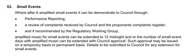
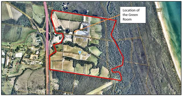
Bluesfest Property – Green Room
Small events are generally held within the permanent tent structure called the Green Room near the central office on the site and not near adjoining property boundaries. It is also noted such amplified music is likely to compete with and be drowned out by background noise including that coming from the Pacific Motorway to the west of the site and on other occasions the Pacific Ocean to the east of the site.
The applicant has submitted details addressing the condition and the following is noted.
a) Performance Reporting – Noise monitoring was carried out by the applicant’s noise consultant David Moore and Associates Pty Ltd at various locations surrounding the site including Prestons Lane to the south east and Foxs Lane to the west, Hyrama crescent to the north west and Tandys Lane to the north for 6 events on the 27, 29, 30 September 2022, 4 and 5 October 2022 and the 26 November 2022.
![]()
Noise Monitoring Locations
The last event was a Xavier Rudd event and the noise monitoring report makes the following comments:
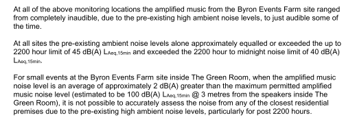
b) Complaints – there is no record of noise complaints from the smaller events held to date.
c) Regulatory working group – the matter was reported to the RWG who resolved to support the increase in the number of amplified days. Specific comments from the minutes of that meeting on the 1 March 2023 are as follows:
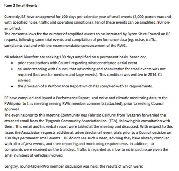
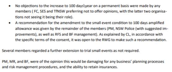
Applicant’s submission
In addition to addressing the condition of consent to go to 100 amplified event days, the applicant also provided the following information in support:
We are appealing to you that the increase is given on a permanent basis as endorsed by the RWG. Reasons for the permanent request are:
1. Peter Noble’s ongoing investment into the site to develop it as an Entertainment Centre for the Northern Rivers. A development encouraged by BSC since many years.
2. The development of The Green Room at the Byron Events Farm has costed more than $1M.
3. A permanent approval allows Bluesfest to plan to secure business for the Green Room.
4. The properties consent has overarching conditions to manage all events.
5. No negative feedback or complaints from launch events were received.
6. Performance Reports including information on small events will be submitted annually to council. Reference #56
7. Complaint systems for future events are in place to allow for resident’s feedback.
8. Endorsement RWG to approve the increase to 100 amplified small events on a permanent basis.
9. Agreed to increase communication with Tyagarah Community in form of Email to Tyagarah Community Group to inform about commercial events such as Xavier Rudd. Regardless that this is not requested as per the DA conditions.
10. Also including the commercial events on the Byron Events Farm website and sharing the overall events calendar including private events with RWG group.
Conclusion
Options would exist under the condition to give only a further temporary extension e.g., an increase to 50 small events per annum for 2023 and a further 50 events in 2024 to ascertain whether there are likely noise complaints or amenity issues that might arise from a greater frequency of events.
As such it is recommended that Council extend the approval of amplified music to 100 days per annum on a permanent basis as requested by the applicant.
BYRON SHIRE COUNCIL
Staff Reports - Sustainable Environment and Economy 13.9
Report No. 13.9 PLANNING - S4.55 Application No. 10.2011.524.4 to modify Conditions 1 and 20(d) to expand the Building Envelope - at 388 Coopers Shoot Road Coopers Shoot.
Directorate: Sustainable Environment and Economy
Report Author: Greg Yopp, Planner
File No: I2023/781
Proposal:
|
Modification No |
10.2011.524.4 |
|
Planning Portal Ref |
PAN-319467 |
|
S4.55 modify Conditions 1 & 20(d) to expand Building Envelope |
|
|
Original Development |
Subdivision to create 4 allotments including SEPP 1 objection |
|
Type of modification sought |
4.55(1A) Modifications involving minimal environmental impact |
|
Property description |
LOT: 1 DP: 1283631 |
|
388 Coopers Shoot Road COOPERS SHOOT |
|
|
Parcel No/s |
271233 |
|
Applicant |
Town Planning Studio Pty Ltd |
|
Owner |
L G Armstrong & E A Hayes & Messrs B J & S Armstrong |
|
Zoning |
R5 Large Lot Residential |
|
Date received |
13 April 2023 |
|
Original DA determination date |
12 April 2012 |
|
Public notification or exhibition |
- Level 2 advertising under the Byron Shire Council Community Participation Plan. - Exhibition period: 25 April 2023 to 8 May 2023 - Two Submissions received |
|
Issues |
· Views and Rural amenity · Approved Building Envelope imposed by the elected Council 12/4/ 2011 |
Summary:
The elected Council approved the original 4 lot subdivision under Development Application DA10.2011.524.1 with a requirement for a building envelope to be registered on the new subdivision plan to protect views from the adjoining dwelling to the southwest (Lot 1 DP 572897 or 398 Coopers Shoot Road, Coopers Shoot).
The reason the envelope was imposed by the elected Council was in response to a public submission. The allotments created under 10.2011.524.1 and subsequently amended under 10.2011.524.2 have been registered including the building envelope as required by the conditions of approval.
The applicant now seeks consent to expand the existing approximately 1,800m2 envelope to approximately 4,500m2 within the subject 7,500m2 allotment. Two submissions in objection were received, one by an adjoining landholder and the other by a planning consultant on behalf of the same landholder.
Staff have assessed the proposal and recommend an envelope with a smaller area of approximately 3,300m2 which is setback 20 metres from the neighbours boundary as opposed to the proposed 10 metre setback. The recommended building envelope will preserve the neighbours distant Cape Byron Lighthouse views as well as preserving foreground and midground views, whilst providing a degree of spatial separation to any future dwellings and or buildings that maybe erected on the subject lot consistent with what is expected in terms of a rural residential area.
The amended proposal is satisfactory having regard to relevant matters for consideration and the Section 4.55 application is recommended for approval subject to amended conditions of consent.
NOTE TO COUNCILLORS:
In accordance with the provisions of S375A of the Local Government Act 1993, a Division is to be called whenever a motion for a planning decision is put to the meeting, for the purpose of recording voting on planning matters. Pursuant to clause 2(a) under the heading Matters to be Included in Minutes of Council Meetings of Council's adopted Code of Meeting Practice (as amended) a Division will be deemed to have been called by the mover and seconder of all motions relating to this report.
RECOMMENDATION:
That pursuant to Section 4.55 of the Environmental Planning and Assessment Act 1979, that Application No. 10.2011.524.4 to modify Conditions 1 & 20(d) to expand the Building Envelope, be approved by modifying development consent number 10.2011.524.1 as amended by 10.2011.524.2 as follows:
Amend Condition 1 and 20(d) to read:
1) Development is to be in accordance with approved plans.
The development is to be in accordance with plans listed below:
|
Description |
Prepared by |
Dated |
|
|
DWG11078A Sheet 1 of 1 Rev 1 |
Appendix 2 – Survey Map Showing Subdivision. Title: Plan showing contours and detail |
Kennedy Surveying Pty Ltd |
11/10/2011
|
Except as modified by the following plan only in relation to the amended building.
|
Plan No. |
Description |
Prepared by |
Dated |
|
Contour, View Line & Building envelope Plan Sheet 03 Revision A |
Plan marked in red indicating approved Amended Building Envelope |
Town Planning Studio Pty Ltd |
01/04/2023 |
The development is also to be in accordance with any changes shown in red ink on the approved plans or conditions of consent.
The approved plans and related documents endorsed with the Council stamp and authorised signature must be kept on site at all times while work is being undertaken.
20) Building Envelope
d) The building envelope for Lot 1 DP 1283631 shall be located in accordance with Condition 1 of this consent to ensure that views from the dwelling on Lot 1 DP 572897 to the south-west are retained.
1 10.2011.524.4
Building Envelope Plan for Approval, e2023/51818
![]()
2 10.2011.524.4
View Related Photos, e2023/33537 ![]()
3 10.2011.524.4
Submission, e2023/51960 ![]()
4 10.2011.524.4
Submission, e2023/51972 ![]()
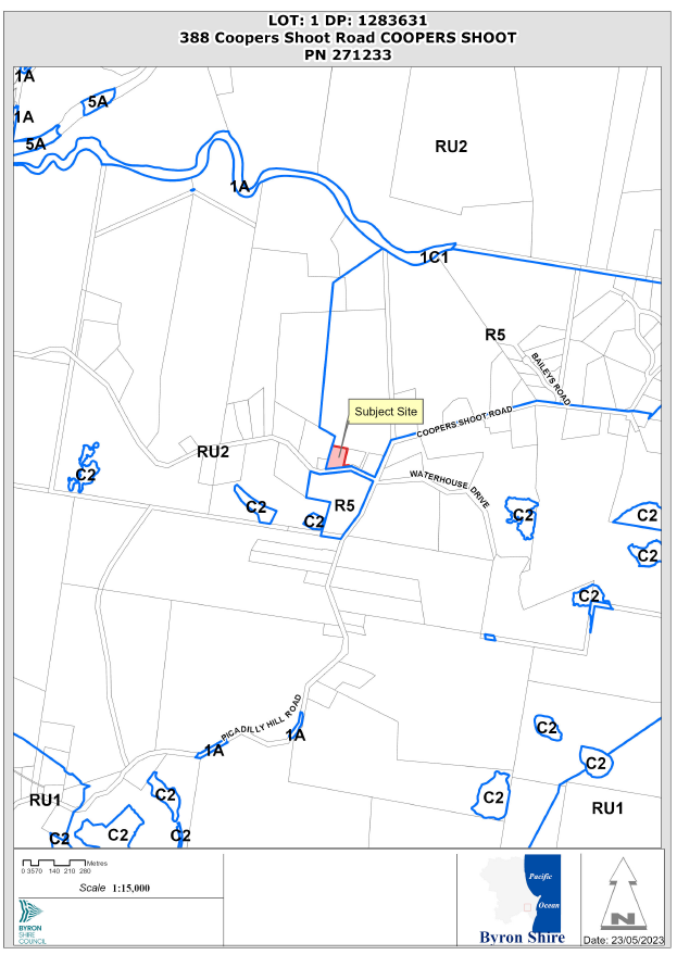
Figure 1 Locality Plan
Assessment:
1. INTRODUCTION
1.1. History/Background
History of Development Applications and s4.55 modifications plus additional matters:
|
DA/s4.55 number |
Description of proposal |
Outcome |
|
10.2011.524.1 |
Subdivision to create 4 allotments including SEPP 1 objection |
Approved 12/4/2012 |
|
10.2011.524.2 |
S96 to amend conditions 20(d) and 30 (rectify incorrect description of Lot and DP) |
Approved 2/2/2016 |
|
10.2011.524.3 |
S4.55 to delete condition 20(d) relating to building envelope |
Refused 10/11/2022 |
The elected Council approved the original development application with a requirement for a building envelope to be registered on the new subdivision plan to protect views from the adjoining dwelling to the southwest (Lot 1 DP 572897 or 398 Coopers Shoot Road, Coopers Shoot) refer to Figures 2 and 3 below.
The reason the envelope was imposed by the elected Council was in response to a public submission. The allotments created under 10.2011.524.1 and subsequently amended under 10.2011.524.2 have been registered. Figure 2 below is an extract of the deposited plan with a building envelope on the subject allotment (Lot 1 DP 1283631).
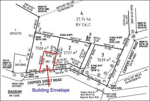
Figure 2 – Deposited Plan extract – Building Envelope Lot 1 DP 1283631 (as approved and registered on title)
The applicant has proposed to enlarge the building envelope as shown below in Figure 3.
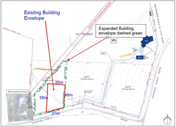
Figure 3 – Site Plan with proposed amended building envelope (dashed green line) and existing registered building envelope in red.
1.2. Description of the proposed development
This application seeks approval under S4.55 for Changes to Condition 20(d) relating to Building Envelope and condition 1 relating to the approved plans of subdivision. A previous S4.55 10.2011.524.3 modification application to remove the building envelope in its entirety was refused on 10/11/2022. Had this been approved, further applications could have been submitted to construct a dwelling house or rural dual occupancy anywhere on the property.
The current proposal before Council is somewhat more nuanced and provides a limited 10 metre setback to the neighbours boundary to the west and seeks to maintain view lines through to Cape Byron from the neighbours house. Figure 4 below is an extract from the proposed Building Envelope Plan as submitted by the applicant.
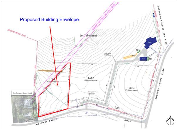
Figure 4 – Site Plan with proposed amended building envelope as submitted by applicant
Subsequent to public exhibition and assessment of the proposal Council staff have recommend that the building envelope as proposed by the applicant be slightly reduced in area as noted in Figure 5 below.
The recommended envelope is setback 20 metre from the adjoining western allotment as opposed to the proposed 10 metre. Additionally, the recommended envelope is setback a further 5 metre from the view corridor to the distant lighthouse. Justification for the recommended building envelope is located in Section 2 of this Report. The existing building envelope as registered has an approximate area of 1,800m2. The recommended building envelope as illustrated in Figure 5 above has an approximate area of 3,300m2. It is considered this is more than sufficient area to construct a rural residential dwelling and ancillary facilities on the subject property.
In summary this is considered to be a reasonable compromise and as discussed in the assessment below provides a degree of spatial separation, privacy and amenity between the neighbouring property and any future development on the subject land.
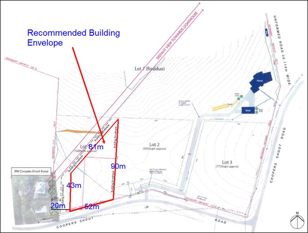
Figure 5 – Recommended Building Envelope
1.3. Description of the site
A site inspection was undertaken on 18 May 2023.
The subject allotment is located at 388 Copers Shoot Road Coopers Shoot and is legally known as Lot 1 DP 1283631. The 7,500m2 lot is located within Zone R5 Large Lot Residential. The land is adjoined by Zone RU2 Rural Landscape to the west. Zone R5 adjoins the land to the east, north and south.
The land is vegetated with exotic grasses and ubiquitous herbaceous weeds. No woody vegetation is located on the site. The gently sloping allotment has an elevation of 134 metres AHD in the southwestern portion. The lot slopes down to the east northeast with an elevation of 126m. The elevation of this clear allotment affords a distant panorama of the Cape Byron Lighthouse with some ocean glimpses. The primary foreground and mid ground views from this allotment and adjoining land is of the rolling green hills of Coopers Shoot. Refer to Figure 6 below for foreground, midground and distant views. Refer to Attachment 2 for additional photographs and aerial imagery.

Figure 6 – Views from the south west of the allotment
1.4. State/Regional Planning Policies, Instruments, EPA Regulations 2021
The Proposed amendments raise no issues under the relevant SEPPS, Policies or clauses of the EPA Regulations 2021.
1.5. Byron Local Environmental Plan 2014
S4.55 10.2011.524.3 modification application to remove the building envelope in its entirety was refused on 10/11/2022 as stated above. The subject s4.55 modification application, 10.2011.524.4, is to expand the existing building envelope, thus providing an opportunity to assess the merits of variations to an expanded building envelope, whilst maintaining views and rural amenity for the adjoining western landholder.
It is contended that the recommended building envelope is consistent with the Zone R5 Large Lot Residential Objectives.
Zone R5 Large Lot Residential
1 Objectives of zone
• To provide residential housing in a rural setting while preserving, and minimising impacts on, environmentally sensitive locations and scenic quality.
• To ensure that large residential lots do not hinder the proper and orderly development of urban areas in the future.
• To ensure that development in the area does not unreasonably increase the demand for public services or public facilities.
• To minimise conflict between land uses within this zone and land uses within adjoining zones.
The recommended building envelope is setback 20 metres from the western boundary, thus minimising the potential for any negative impact on rural amenity for the adjoining western landholder. Additionally, the northern extent of the recommended building envelope is setback approximately 10 metres to the south of the view corridor from the adjoining western dwelling. Refer to Attachment 2 and Figure 5 for detail.
The Proposed amendments raise no other issues under the LEP.
2. SECTION 4.15 – MATTERS FOR CONSIDERATION – DISCUSSION OF ISSUES
Having regard for the matters for consideration detailed in Section 4.15(1) of the Environmental Planning & Assessment Act 1979, the following is a summary of the evaluation of the issues.
2.1. State/Regional Planning Policies, Instruments, EPA Regulations 2000
|
|
Agree or No (add comments as required) |
|
Proposed amendments raise no issues under the relevant SEPPS, Policies or clauses of the EPA Regulations 2000 |
Agree |
2.2. Byron Local Environmental Plan 2014
|
|
Agree or No (add comments as required) |
|
Proposed amendments raise no issues under the LEP |
Agree |
|
S4.55 10.2011.524.3 modification application to remove the building envelope in its entirety was refused on 10/11/2022 as stated in Section 1.1 of this report. The subject s4.55 modification application, 10.2011.524.4, is to expand the existing building envelope, thus providing an opportunity to assess the merits of variations to an expanded building envelope, whilst maintaining views and rural amenity for the adjoining western landholder.
It is contended that the recommended building envelope is consistent with the Zone R5 Large Lot Residential Objectives.
Zone R5 Large Lot Residential 1 Objectives of zone • To provide residential housing in a rural setting while preserving, and minimising impacts on, environmentally sensitive locations and scenic quality. • To ensure that large residential lots do not hinder the proper and orderly development of urban areas in the future. • To ensure that development in the area does not unreasonably increase the demand for public services or public facilities. • To minimise conflict between land uses within this zone and land uses within adjoining zones.
The recommended building envelope is setback 20m from the western boundary, thus minimising the potential for any negative impact on rural amenity for the adjoining western landholder. Additionally, the northern extent of the recommended building envelope is setback approximately 10m to the south of the view corridor from the adjoining western dwelling. Refer to Attachment 2 and Figure 5 for detail.
|
2.3. Draft EPI that is or has been placed on public exhibition and details of which have been notified to the consent authority - Issues
No draft EPIs affect the proposal
2.4. Development Control Plans
Chapter D6 Subdivision
Section D6.2.1 Subdivision Design Guidelines
Prescriptive measures – Development applications for subdivision must address the following design guidelines:
Site Design
a) The following natural environment factors must be addressed in the overall site design of any proposed subdivision:
i) Climate control (wind and sun)
ii) Landform
iii) Aspect and views*
iv) Geology and soils
v) Drainage and groundwater
vi) Vegetation.
Note. Bold for emphasis
The recommended building envelope addresses aspect and views as follows:
· The subject allotment has high levels of solar access
· The proposed amended building envelope should maintain a good level of distant, foreground and midground views for the subject allotment.
· The adjoining western allotment will still be provided with a view corridor to the Cape Byron Lighthouse, as well as good foreground and midground views.
· An expanded building envelope will enable occupants of any future dwelling on the subject lot to maintain panoramic views. In this regard, when a DA is lodged with Council for a dwelling on the adjoining eastern allotment view sharing is likely to be an issue.
· It is worth noting that all dwellings in rural zones and Zone R5, in a Drinking Water Catchment, are excluded from the Rural Housing Code, therefore a DA is the approval pathway. The subject allotment and surrounding land are in a Drinking Water Catchment. This means DCP 2014 Section C3.2.2 “Assessment of Impacts on Views and View Sharing” apply.
Chapter C3
Section C3.2.2 Assessment of Impacts on Views and View Sharing
Regard should be given to the NSW Land and Environment Court Views – general principles Tenacity Consulting v Warringah Council [2004] NSWLEC 140. Refer to a summary of the principles below.
1. Assess the views to be affected. Water view, iconic views and whole views given a higher value.
2. Where are the views obtained. Location in a dwelling? sitting standing?
3. Assess the extent of the impact. Loungeroom views more important than bedroom views. Qualitative terms to assess view loss.
4. Assess the reasonableness. Support for a compliant development more reasonable than a noncompliant development. Skilful design to reduce impact.
The Recommended Building Envelope (refer to Figure 5) has been assessed against the LEC View Sharing Principles and the following comments are provided:
1. Distant water glimpses and the view corridor to the Cape Byron Lighthouse will be maintained for the adjoining western allotment and the subject allotment. Future residents of any new dwelling on the subject allotment can more equitably participate in view sharing when a future dwelling is constructed on the adjoining eastern allotment.
2. The adjoining western dwelling is located on a site that it approximately 2m higher the subject allotment. Notwithstanding the elevation of the western allotment, a clear view corridor to the Cape Byron Lighthouse will be maintained from the loungeroom/living room of the dwelling.
3. Lounge room/living room views are valued highly, and these are maintained in the adjoining western dwelling. Moreover, the view loss associated with the existing building envelope is generally limited to foreground and midground views to the east. The “Recommended Building Envelope” is not likely to increase this view loss due to the slope of the land and the shape of the envelope.
4. It is contended that the “Recommended Building Envelope” is reasonable. There are no issues of noncompliance associated with the proposal. Skilful design of the building envelope mitigates against potential view loss.
It should be noted that DCP Chapter C3 will also apply for any future dwelling house on the subject allotment.
The proposal raises no other issues under the DCP
2.5. The likely impacts of that development, including environmental impacts on both the natural and built environments, and social and economic impacts in the locality
The recommended building envelope is setback 20 metres from the western boundary, thus minimising the potential for any negative impact on rural amenity for the adjoining western landholder. Additionally, the northern extent of the recommended building envelope is setback approximately 10 metres to the south of the view corridor to the Cape Byron Lighthouse from the adjoining western dwelling. Refer to Attachment 2 and Figure 5 for detail.
The recommended building envelope has been designed to minimise negative impacts on views and rural amenity for the adjoining western landholder. Moreover, the recommended envelope also protects the landholders of the subject allotment from view loss associated with any future adjoining eastern dwelling, whilst the additional spatial separation of 20 metres to the building envelope will ensure a degree of privacy and amenity expected in a rural residential location.
2.6. The suitability of the site for the development
The changes to the building envelope as recommended are considered suitable.
2.6 Submissions made in accordance with this Act or the regulations
Council received two submissions and are discussed as follows
|
Issue |
Comments |
|
1. Inconsistent with LEP 2014 Zone R5 Objectives. |
S4.55 10.2011.524.3 modification application to remove the building envelope in its entirety was refused on 10/11/2022 as stated in Section 1.1 of this report. The subject s4.55 modification application, 10.2011.524.4, is to expand the existing building envelope, thus providing an opportunity to assess the merits of variations to an expanded building envelope, whilst maintaining views and rural amenity for the adjoining western landholder.
It is contended that the recommended building envelope is consistent with the Zone R5 Large Lot Residential Objectives.
Zone R5 Large Lot Residential 1 Objectives of zone • To provide residential housing in a rural setting while preserving, and minimising impacts on, environmentally sensitive locations and scenic quality. • To ensure that large residential lots do not hinder the proper and orderly development of urban areas in the future. • To ensure that development in the area does not unreasonably increase the demand for public services or public facilities. • To minimise conflict between land uses within this zone and land uses within adjoining zones.
The recommended building envelope is setback 20m from the western boundary, thus minimising the potential for any negative impact on rural amenity for the adjoining western landholder. Additionally, the northern extent of the recommended building envelope is setback approximately 10m to the south of the view corridor from the adjoining western dwelling. Refer to Attachment 2 and Figure 5 for detail. |
|
2. Inconsistent with the Environmental Planning and Assessment Act 1979 Section 1.3 Objects of Act. |
1.3 Objects of Act The objects of this Act are as follows— (a) to promote the social and economic welfare of the community and a better environment by the proper management, development and conservation of the State’s natural and other resources, (b) to facilitate ecologically sustainable development by integrating relevant economic, environmental and social considerations in decision-making about environmental planning and assessment, (c) to promote the orderly and economic use and development of land, (d) to promote the delivery and maintenance of affordable housing, (e) to protect the environment, including the conservation of threatened and other species of native animals and plants, ecological communities and their habitats, (f) to promote the sustainable management of built and cultural heritage (including Aboriginal cultural heritage), (g) to promote good design and amenity of the built environment, (h) to promote the proper construction and maintenance of buildings, including the protection of the health and safety of their occupants, (i) to promote the sharing of the responsibility for environmental planning and assessment between the different levels of government in the State, (j) to provide increased opportunity for community participation in environmental planning and assessment.
The recommended building envelope still affords protection for the adjoining western landholder by minimising negative impacts on rural amenity and views. The proposal also achieves a reasonable balance to enable residents of a future dwelling on the subject allotment to also participate high standard of rural amenity and view sharing. The proposed development is consistent with the objects of the Act, in particular: · The proposal is an orderly and economic use and development of the land; · The proposal does not negatively impact on threatened species or other native species, ecological communities or their habitats; · The proposal will facilitate good design and amenity of the built and rural environment. |
|
3. The proposal ignores the bush fire threat. |
The DA for subdivision, 10.2011.524.1, was issued Bush Fire Safety Authority in accordance with Section 100B of the Rural Fires Act 1997. Consequently, the consent is subject to bush fire safety conditions under the ‘General Terms of Integrated Development Approval’.
Any future DA for a dwelling on the subject allotment will be assessed against the requirements for Planning for Bush Fire Protection 2019 in accordance with section 4.14 of the EP&A Act 1979.
A twenty mere setback to the neighbouring boundary will generally afford a suitable setback for asset protection zones. |
|
4. No geotechnical assessment. |
The gently sloping allotment does not involve geotechnical constraints. Moreover, the land is not slip prone. |
|
5. View loss |
The recommended building envelope strikes a reasonable balance in that it maintains views and rural amenity for the adjoining western landholder while providing a similar level of amenity for future residents of the subject allotment. Details follow:
· The proposed amended building envelope maintains a good level of distant, foreground and midground views for the subject allotment. · The adjoining western allotment will still be provided with a view corridor to the Cape Byron Lighthouse, as well as good foreground and midground views. · An expanded building envelope will enable occupants of any future dwelling on the subject lot to maintain panoramic views. In this regard, when a DA is lodged with Council for a dwelling on the adjoining eastern allotment view sharing is likely to be an issue. · It is worth noting that all dwellings in rural zones and Zone R5, in a Drinking Water Catchment, are excluded from the Rural Housing Code (SEPP (Exempt and Complying Development Codes) 2008), therefore a DA is the approval pathway. The subject allotment and surrounding land are in a Drinking Water Catchment. Therefore DCP 2014 Section C3.2.2 “Assessment of Impacts on Views and View Sharing” applies.
A thorough assessment of the proposal has been undertaken in accordance with DCP 2014 Section C3.2.2 “Assessment of Impacts on Views and View Sharing”. The proposal has been assessed against the NSW Land and Environment Court Views – general principles - Tenacity Consulting v Warringah Council [2004] NSWLEC 140. It is contended that the recommended building envelope is a reasonable outcome. The proposal will result in equitable view sharing. |
|
6. Decreased rural amenity for adjoining western landholder |
The adjoining 2145m2 western allotment is setback approximately 7m to its eastern boundary (the common boundary with the subject allotment). The recommended building envelope is setback 20m from the western boundary, thus minimising the potential for any negative impact on rural amenity for the adjoining western landholder. Additionally, the northern extent of the recommended building envelope is setback approximately 10m to the south of the view corridor from the adjoining western dwelling. Refer to Attachment 2 and Figure 5 for detail. |
2.7 Public interest
Proposed amendments are unlikely to prejudice or compromise the public interest.
3. DEVELOPER CONTRIBUTIONS/ WATER AND SEWER CHARGES
There is no nexus to levy additional contributions.
4. CONCLUSION
The proposed expanded dwelling envelope, as modified by staff, is considered to be reasonable way to resolve this matter. This approach mitigates view loss and rural amenity issues raised during the exhibition period while still providing future residents of the subject allotment a high level of rural amenity and rural vistas and providing a suitable degree of amenity and spatial separation to the neighbouring property. The Section 4.55 application is recommended for approval.
BYRON SHIRE COUNCIL
Questions With Notice 14.1
Question with Notice No. 14.1 Disruptive roadworks Murwillumbah Road Mullumbimby
File No: I2023/804
Cr Dey asks the following question:
On 23 February 2023, Council resolved via Resolution 23-034 to remember an earlier Resolution 22-741 adopting “policy” not to conduct disruptive roadworks during heavy traffic times on various important non-motorway routes in the Shire. Council also recommitted to the two routes named in December (listed as 1 and 2 below) and then added a third route (listed as 3 below):
1) Ewingsdale Road, during daylight hours;
2) Bangalow / Broken Head Roads, during morning and afternoon peak hours; and
3) Mullumbimby from Jubilee Avenue to the Showground, on Mullumbimby Farmers Market mornings.
Council also recommitted to:
a) writing to all relevant authorities, such as Essential Energy, requesting that they adhere to the same policies for work within the road corridor; and
b) noting that emergency road works are exempt from the above policies.
Work began in about March 2023 on the pedestrian crossing on Murwillumbah Road. The location sits on route 3 named in Resolution 23-034.
The work later expanded to a full re-sheeting the roadway, from Federation Bridge north to beyond Main Arm Road. Traffic closures included on Friday 19 May causing long queues (on a Farmers Market morning).
1. why did Resolution 23-034 have no impact on these disruptive roadworks?
2. can the disruption be avoided on subsequent Fridays?
Response Director Infrastructure Services:
Council’s Construction Team were aware of the above resolutions and had made plans not to work on Friday mornings as part of the planned works.
The team were very conscious of the Council resolution, but unfortunately had to work on Friday 19 May 2023 due to emergency works following a watermain being struck by machinery the day before. The team were making the site safe for the weekend.
The team worked hard to maintain two lanes of traffic for the majority of the day whilst making the area safe for the weekend.
The watermain was struck because in that location the watermain only had 200mm of cover below road level. It was deeper in other areas investigated as part of the project planning. 600mm cover is generally considered minimum cover for most utilities.
It is understood by staff that emergency works are exempt under both resolutions (Res 22-741 and Res 23-034).