 Agenda
Ordinary (Planning) Meeting

Thursday, 8 February 2024
Agenda
Ordinary (Planning) Meeting
Thursday, 8 February 2024
Agenda Ordinary (Planning) Meeting
held at Council Chambers, Station Street, Mullumbimby
commencing at 11.00am
Public access relating to items on this agenda can be made between 11:00am and 11:30am on the day of the meeting. Requests for public access should be made to the General Manager or Mayor no later than 12:00 midday on the day prior to the meeting.

Mark Arnold
General Manager
CONFLICT OF INTERESTS
What is a “Conflict of Interests” - A conflict of interests can be of two types:
Pecuniary - an interest that a person has in a matter because of a reasonable likelihood or expectation of appreciable financial gain or loss to the person or another person with whom the person is associated.
Non-pecuniary – a private or personal interest that a Council official has that does not amount to a pecuniary interest as defined in the Code of Conduct for Councillors (eg. A friendship, membership of an association, society or trade union or involvement or interest in an activity and may include an interest of a financial nature).
Remoteness – a person does not have a pecuniary interest in a matter if the interest is so remote or insignificant that it could not reasonably be regarded as likely to influence any decision the person might make in relation to a matter or if the interest is of a kind specified in the Code of Conduct for Councillors.
Who has a Pecuniary Interest? - a person has a pecuniary interest in a matter if the pecuniary interest is the interest of the person, or another person with whom the person is associated (see below).
Relatives, Partners - a person is taken to have a pecuniary interest in a matter if:
· The person’s spouse or de facto partner or a relative of the person has a pecuniary interest in the matter, or
· The person, or a nominee, partners or employer of the person, is a member of a company or other body that has a pecuniary interest in the matter.
N.B. “Relative”, in relation to a person means any of the following:
(a) the parent, grandparent, brother, sister, uncle, aunt, nephew, niece, lineal descends or adopted child of the person or of the person’s spouse;
(b) the spouse or de facto partners of the person or of a person referred to in paragraph (a)
No Interest in the Matter - however, a person is not taken to have a pecuniary interest in a matter:
· If the person is unaware of the relevant pecuniary interest of the spouse, de facto partner, relative or company or other body, or
· Just because the person is a member of, or is employed by, the Council.
· Just because the person is a member of, or a delegate of the Council to, a company or other body that has a pecuniary interest in the matter provided that the person has no beneficial interest in any shares of the company or body.
Disclosure and participation in meetings
· A Councillor or a member of a Council Committee who has a pecuniary interest in any matter with which the Council is concerned and who is present at a meeting of the Council or Committee at which the matter is being considered must disclose the nature of the interest to the meeting as soon as practicable.
· The Councillor or member must not be present at, or in sight of, the meeting of the Council or Committee:
(a) at any time during which the matter is being considered or discussed by the Council or Committee, or
(b) at any time during which the Council or Committee is voting on any question in relation to the matter.
No Knowledge - a person does not breach this Clause if the person did not know and could not reasonably be expected to have known that the matter under consideration at the meeting was a matter in which he or she had a pecuniary interest.
Non-pecuniary Interests - Must be disclosed in meetings.
There are a broad range of options available for managing conflicts & the option chosen will depend on an assessment of the circumstances of the matter, the nature of the interest and the significance of the issue being dealt with. Non-pecuniary conflicts of interests must be dealt with in at least one of the following ways:
· It may be appropriate that no action be taken where the potential for conflict is minimal. However, Councillors should consider providing an explanation of why they consider a conflict does not exist.
· Limit involvement if practical (eg. Participate in discussion but not in decision making or vice-versa). Care needs to be taken when exercising this option.
· Remove the source of the conflict (eg. Relinquishing or divesting the personal interest that creates the conflict)
· Have no involvement by absenting yourself from and not taking part in any debate or voting on the issue as of the provisions in the Code of Conduct (particularly if you have a significant non-pecuniary interest)
RECORDING OF VOTING ON PLANNING MATTERS
Clause 375A of the Local Government Act 1993 – Recording of voting on planning matters
(1) In this section, planning decision means a decision made in the exercise of a function of a council under the Environmental Planning and Assessment Act 1979:
(a) including a decision relating to a development application, an environmental planning instrument, a development control plan or a development contribution plan under that Act, but
(b) not including the making of an order under that Act.
(2) The general manager is required to keep a register containing, for each planning decision made at a meeting of the council or a council committee, the names of the councillors who supported the decision and the names of any councillors who opposed (or are taken to have opposed) the decision.
(3) For the purpose of maintaining the register, a division is required to be called whenever a motion for a planning decision is put at a meeting of the council or a council committee.
(4) Each decision recorded in the register is to be described in the register or identified in a manner that enables the description to be obtained from another publicly available document, and is to include the information required by the regulations.
(5) This section extends to a meeting that is closed to the public.
OATH AND AFFIRMATION FOR COUNCILLORS
Councillors are reminded of the oath of office or affirmation of office made at or before their first meeting of the council in accordance with Clause 233A of the Local Government Act 1993. This includes undertaking the duties of the office of councillor in the best interests of the people of Byron Shire and the Byron Shire Council and faithfully and impartially carrying out the functions, powers, authorities and discretions vested under the Act or any other Act to the best of one’s ability and judgment.
BUSINESS OF Ordinary (Planning) Meeting
1. Public Access
3. Attendance by Audio-Visual Link
4. Requests for Leave of Absence
5. Declarations of Interest – Pecuniary and Non-Pecuniary
6. Tabling of Pecuniary Interest Returns (Cl 4.14 Code of Conduct for Councillors)
7. Adoption of Minutes from Previous Meetings
7.1 Ordinary (Planning) Meeting held on 7 December 2023
8. Reservation of Items for Debate and Order of Business
9. Notices of Motion and Rescission
9.1 Possible change of road name Hottentot Crescent, Mullumbimby........................ 8
9.2 Save the community park in Bayside Brunswick...................................................... 9
9.3 Interim Heritage Order on works proposed and imminent at 15 Torakina Road (Wallum Estate) in Bayside Brunswick..................................................................................... 14
10. Mayoral Minute
11. Petitions
12. Delegates' Reports
13. Staff Reports
Sustainable Environment and Economy
13.1 Status report on Development Applications (DAs) with bodies like the Northern Regional Planning Panel (NRPP).............................................................................. 22
13.2 PLANNING - Report of the Planning Review Committee held 30 November 2023........................................................................................................................................ 27
13.3 PLANNING - 10.2020.109.4 - Section 4.55 to Stage 9 for Removal of Existing Exotic and Native Trees to Allow for Construction of Approved Roads and Earthworks, Relocation of Inter-allotment Drainage and Sewer Services and Easement Modifications and Deletion of Local Open Space and Recreation S7.11 Contributions - 86 Tuckeroo Avenue Mullumbimby........................................................................... 30
13.4 Update on the Creation of a Byron Shire Council Led Land Trust...................... 39
13.5 PLANNING - 10.2023.390.1 Alterations and Additions to Existing Dwelling at 2 Strand Avenue, New Brighton................................................................................................ 49
13.6 Wallum Subdivision DA 10.2021.575.1 - Response to Council Resolution 23-454........................................................................................................................................ 71
13.7 PLANNING - DA10.2023.332.1 - Dual Occupancy Dwelling – 135 Blindmouth Road, Main Arm....................................................................................................................... 94
14. Questions With Notice
14.1 Development and/or fill on floodplains................................................................... 111
14.2 Mullumbimby’s future water supply......................................................................... 115
14.3 Ecological matters at "Wallum", Bayside Brunswick............................................ 118
14.4 Classification of "Bayside Park" in Bayside Brunswick........................................ 120
Questions with Notice: A response to Questions with Notice will be provided at the meeting if possible, that response will be included in the meeting minutes. If a response is unable to be provided the question will be taken on notice, with an answer to be provided to the person/organisation prior to the next Ordinary Meeting and placed on Councils website www.byron.nsw.gov.au/Council/Council-meetings/Questions-on-Notice
Councillors are encouraged to ask questions regarding any item on the business paper to the appropriate Director prior to the meeting. Any suggested amendments to the recommendations should be provided to Councillor Support prior to the meeting to allow the changes to be typed and presented on the overhead projector at the meeting.
BYRON SHIRE COUNCIL
Notices of Motion and Rescission 9.1
Notice of Rescission Motion No. 9.1 Possible change of road name Hottentot Crescent, Mullumbimby
File No: I2023/1981
We move that Council rescind Resolution No. 23-548 from its Ordinary meeting held on 23 November 2023 which reads as follows:
23-548 Resolved that Council commences the name change process for Hottentot Crescent, Mullumbimby.
If successful we intend to move:
That Council:
1. Notes the survey of residents attached regarding the possible change of road name for Hottentot Crescent.
2. Takes no further action with respect to this matter.
3. Advises residents of this decision and thanks them for their submissions on this matter.
Signed: Cr Michael Lyon
Cr Westheimer
Cr Dey
Comments from Director Infrastructure Services:
If successful, the motion will rescind Resolution 23-548, meaning it will not proceed.
Resolution 23-548 has not been acted on in any part.
If the motion passes as written the following is noted.
All residents of Hottentot Crescent will be notified of this decision.
BYRON SHIRE COUNCIL
Notices of Motion 9.2
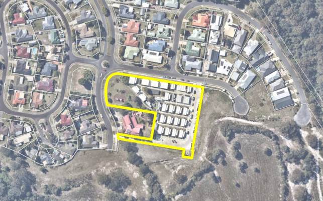
Notice of Motion No. 9.2 Save the community park in Bayside Brunswick
File No: I2024/104
I move that Council removes from consideration, as a Housing Option for the Shire’s Residential Strategy, Lot 69 DP 851902 (Bayside Park) so that the Park returns as soon as possible to its original intended use as open space for the local community.
Signed: Cr Duncan Dey
Councillor’s supporting information:
The residential enclave of Bayside Brunswick is poorly served with community space. After floods ruined so much housing in so many flood-prone parts of the Shire in February and March 2022, most of Bayside Park was given over for emergency accommodation in a temporary pod village.
The community of Bayside supported this emergency measure, on the understanding that the precinct’s only Open Space would be returned to its long-term use after two or three years. This arrangement was often reiterated by government agencies and is written into the village’s lease with Byron Shire Council.
Brunswick Residents Association wrote a submission to Council’s Housing Options Paper process asking that the Park not be considered an option for permanent housing. This submission is not mentioned and appears not to have been considered. Bayside Park continues to be an option.
BRA points out that both the State Government and Council gave assurances throughout the development process for the pod village that Bayside Park would be returned to public use and “the site made good”, as required by the lease for the pod village.
BRA posits that the small number of permanent dwellings that could be placed on this land would never offset the loss of amenity to the broader community. Were the Park turn over to housing, those incoming residents would also live in a precinct without any public open space.
BRA understands that no other neighbourhood parks in the Shire were identified as housing options.
I support BRA and strongly object to the principle of using public land for permanent housing following its use for temporary housing after climate disasters. With predictions of further such disasters, it is essential that Council and other levels of government develop principles of how to relocate climate victims on a permanent basis. Taking away areas of public land in and close by to residential communities is not an option. Public lands enrich the lives of our residents and are an essential component of residential life. In view of the current residential strategy this is a principle Council must uphold.
Staff comments
by Sharyn French, Acting Director, Sustainable Environment and Economy:
The Housing Options Paper Engagement Strategy Report (Attachment 4 of Report No. 13.6 to the Ordinary Council Meeting 14 December 2023) included feedback from submissions received on Lot 69 DP 851902 (Lot 69), as follows:
Lot 69 DP 851902 (The Park)
“The site is identified as a potential investigation area in the Housing Options Paper.
Around five submissions were received opposing the inclusion of this site as an investigation area as this land (together with Lot 71) are the only spaces that facilitates community and social cohesion in the Bayside area. The site is the only centrally located green space for community gatherings and recreation. The community has also been promised that the park (which is currently used for temporary housing pods) would be returned in an equal or better state after the emergency period”
Council Report No. 13.6 acknowledged these submissions and that concerns raised in them would be addressed in a future report to Council (emphasis added):
“Further, housing for the flood displaced remains a priority for Council. It forms part of ongoing discussions with the Reconstruction Authority and their Housing Taskforce. This includes looking at short medium- and long-term housing solutions – like the future of the temporary housing villages in Mullumbimby, Bayside and Brunswick Heads. Further updates will be reported separately to Council on this and will address concerns raised in submissions on same”.
Lot 69, together with the adjoining parcel (Lot 71) were identified as an Investigation Area in the Housing Options Paper. Lot 71 is privately owned and has approval for a mixed-use development.
Investigation Area (Lot 69 DP851902 & Lot 71 DP851902)
Boundary of Lot 69 DP 851902
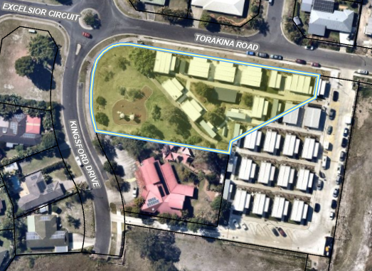
Lot 69 is classified as Community Land with an R2 Low Density Residential zoning.
As an Investigation Area it requires further detailed studies to determine what land is suitable for development. Additionally, whilst the land is zoned for residential purposes, the sites classification would need to be changed from Community to Operational before development could proceed, and this process requires a public hearing.
At the Council (Planning) Meeting of 12 May 2022, Council resolved 22-183 to provide in principle support to the proposed leases with Resilience NSW (now NSW Reconstruction Authority) for the temporary pod villages. Council also resolved to enter into a lease on set terms, including a 3-year lease with 2 x 1-year options to renew. The lease commences on the date it was executed; it was signed on 19 August 2022. The lease also requires that the site be made good at the end of the lease.
The pod development has retained the playground and an area of open parkland. There is additional parkland across from the site on the corner of Excelsior Ct and Kingsford Dr.
Infrastructure has been invested on the site in the placement of the temporary housing pods. This may assist if the site is developed for housing, noting that the lease with RA requires the site to be made good.
The dwelling yield for the Investigation Area (Lot 69 & 71) is estimated at 31 dwellings. This is based on the number of temporary housing pods. This number contributes to Council’s housing target of 4,522 homes by 2041.
Financial/Resource/Legal Implications:
Nil
Is the proposal consistent with any Delivery Program tasks?
The refresh of Council’s Residential Strategy is included in the OP.
|
CSP Objective |
CSP Strategy |
DP Action |
Code |
OP Activity |
|
4: Ethical Growth |
4.1: Manage responsible development through effective place and space planning |
4.1.2: Growth Management Strategies - Implement Local Growth Management Strategies |
4.1.2.5 |
Revise and update Residential Strategy
|
BYRON SHIRE COUNCIL
Notices of Motion 9.3
Notice of Motion No. 9.3 Interim Heritage Order on works proposed and imminent at 15 Torakina Road (Wallum Estate) in Bayside Brunswick
File No: I2024/106
I move:
That Council:
1. Makes representations to the Minister to either authorise Council to make an IHO or for the Minister to make an IHO under the Heritage Act 1977 to safeguard a place or object of heritage significance for a period of 12 months, that place being the area known as Wallum as identified in attached requests.
2. Then collaborates with first nations people and relevant Government agencies to assesses Wallum’s significance and to determine whether permanent heritage listing is warranted.
Signed: Cr Duncan Dey
Councillor’s supporting information:
Councillors received written requests (see copies below) on Monday 15 January, repeating verbal requests to at least two meetings of Council in 2023 for an Interim Heritage Order (IHO) at Wallum. The matter is now urgent as construction / destruction works are likely to commence soon. This area of Wallum heathland is special not only because of its collections of flora and fauna, but also because it is a significant place of cultural and spiritual heritage to first nations people.
According to the following NSW Government website:
an interim heritage order made under the Heritage Act 1977 safeguards a place or object of potential heritage significance for a temporary period of up to 12 months.
(https://www.environment.nsw.gov.au/topics/heritage/request-a-heritage-listing/interim-heritage-orders)
The site goes on to say:
Interim heritage orders (IHOs) allow time to fully assess a place or object’s significance and determine if a heritage listing is warranted.
Interim heritage orders can be made by the Minister for Environment and Heritage on the advice of the Heritage Council, or by local councils under authorisation. They are generally only made if there is a threat of harm.
There are limited instances where it will be appropriate for the Minister to make an interim heritage order. If you are concerned about the protection of a place or object of potential heritage significance we recommend you discuss it with the local council in the first instance. If the council is unable to make an interim heritage order contact us for further advice.
The email of 15 January requests:
To Byron Shire Major, Michael Lyons and Councilor's
On three occassion's local Aboriginal constituents have raised their concerns at council meetings regarding the development of the Wallum site in Brunswick Heads.
They have advised council that the site is of cultural value and that the Cultural Heritage report provided by Everitts in regards to the development is inadequate and that Wallum Site has significant cultural and spiritual importance to the local tribes of the Northern Rivers.
At the last council meeting in December, Local Aboriginal community members made a request that the BSC make an urgent application for an Interim Heritage Order (IHO).
On the 22nd of December 2023, Major Lyons was copied into an email that was sent to Heritage NSW and Minister Piblersik requesting an urgent IHO be placed on the Wallum Site. We have received no correspondence in relation to this request from your
This action was taken because, to be honest, we are all so confused by your council's processes. There have been Aboriginal representatives at all meetings since October yet we do not feel the voices of the Aboriginal Community are being heard by council members. We have no idea if council is taking note of our concerns, or even if the cultural significance is being acknowledged by council.
We ask you to take a minute and read the below information we are appealing to council that you urgently consider the cultural and spiritual heritage of the Wallum site.
We request that you immediately apply for an IHO to be placed on the Wallum site so that further and more comprehensive cultural assessment can be undertaken, prior approving the start work certificate to Clarence property group.
We would like to also draw your attention to the attached letter from Jahvis Loveday who highlights the cultural and spiritual significance of the Wallum area and the on-going use of this sacred site for cultural purposes.
REQUEST FOR IHO
The Minjungbal people, Original Custodians of the Brunswick River and Tweed Heads region, and our non-indigenous community members, are deeply concerned about the “Wallum development” (15 Torrakina Rd Brunswick Heads, DA 10.2021.575.1), taking place on our traditional lands.
We as a collective have worked tirelessly to draw attention to our local Shire Council that the “Wallum” development is detrimental to our native flora and fauna and that the Cultural Heritage Assessment (CHA) conducted by Everick Heritage Consultants, in 2010, is inadequate and does not give a true and honest representation of the cultural, spiritual and ecological value of this site.
At the December 2023 Byron Shire council meeting, independent Elders, cultural leaders and cultural educators who undertook a preliminary site-walk advised council that the CHA is missing important and vital content.
Subsequently, a request was made by apical descendants that our local council consider applying for an IHO on this sacred site so further assessment and consultation can be undertaken.
We have received no correspondence from Council and do not know your stance on this or what action you will be willing to take to protect the cultural and spiritual heritage of Wallum. We are very concerned as the community has already campaigned for the council to put a one month pause on issuing a commence work order over the Christmas period. Once issued the destruction to this site will be ecologically irreparable and our cultural heritage will be lost for our future generations.
We are deeply troubled as the CHA only discusses the trees on the development site - namely the scribbly gums and banksias, as part of the environment and ecology and makes no reference to the cultural scarring on many of them. Independent ecologists have dated these trees as 100-300+ years old, local Indigenous elders and leaders also confirm this.
We are strongly advocating and request your support for these sacred trees to be further assessed for their cultural, spiritual, and ecological value. Some of the eldest trees with significant cultural markings are zoned to be destroyed for a carpark and for an environmental interpretation centre. They are at immediate risk of harm and complete destruction as soon as stage one of construction commences. Their importance as habitat also puts multiple endangered species at further risk.
The spiritual importance of the site was not mentioned in the report. This area is related to many of the dreamtime and creation stories including stories of the Creator Nuthungully, the Three Brothers and the story of the Goanna and Snake all of which exist and belong to this area.
The site is also abundant with medicinal plants, traditional food sources and is home to many of our endangered animal totems. We have grave concern for the Wallum Sedge Froglet, the Glossy Black Cockatoo, the Long-nosed Potoroo, the Rainbow Bee Eater ,and the Mitchell’s Rainforest Snail. The development will have a direct impact on threatened species, including 9 federally-listed Matters of National Environmental Significance and 15 species listed under the Biodiversity Conservation Act (2016).
Yvonne Stewart, the Arakwal representative who participated in the CHA, notes in her report that an important pathway runs through the area that “requires further assessment”. There is no evidence documented that further assessment was completed as recommended. This site is a connected part of a songline that is integral to well-documented ceremonial grounds of the region, known to be the largest of their kind across all nations. Attention was also drawn in the original report to a known sacred site only 400 meters from the development footprint, with still no mention of the significance of the development site.
The assessment makes several references to the lack of ground visibility. Areas were not adequately assessed, were overlooked, and no proper investigation was made on the majority of the site for the reason of ground visibility.
Cultural fire lore and practice was strong across the Northern Rivers region. This area has not burned in 75 years. We believe that if cultural burns were to occur that cultural artifacts and heritage of the area would be exposed.
We also consider the interruption to cultural flow of water from existing developments has already had a detrimental impact on the natural state of the area. Pre-colonisation, this area held great importance due to it lagoons and access to freshwater springs and creeks that have been noted as integral to the traditional usage of the area to sustain the many clans and tribes who frequented the region for ceremonial purposes.
Ashley Moran our local Aboriginal Heritage Cultural Officer reported in the ECHO in 2017, “.. there are potentially thousands of undiscovered Aboriginal sites across the northern rivers region. A lot of these sites are not recorded”. We consider this site as one of these area’s that has not been thoroughly assessed for its cultural and spiritual significance.
Ashley Moran also states that the Office of and Environment and Heritage (OEH) “.. they are the only ones who should be engaged to interpret the heritage.” There is no evidence within the cultural assessment OEH actively participated in the CHA.
We know within our being that this place is of great importance to Minjungbal, our neighbouring tribal groups, the 13 tribes of the Northern Rivers Region, as-well as holding national significance. We know that the stories and sites exist as our elders speak of them.
There is widespread support to “Save Wallum” by the broader community. It is with a great sense of foreboding of irreplaceable loss that we urge you to please assist us. We request Byron Shire Council apply for an urgent Interim Heritage Order (IHO) so a more detailed cultural assessment can be completed.
The email of 15 January is accompanied by an attachment also addressed to Council and saying:
I am Jahvis Loveday, a young aboriginal filmmaker, storyteller, and dancer from Bundjalung country in the far north of NSW, we sit within the Byron Shire. Our brother's late father's people are that of the people of Brunswick Heads River NSW and the people of the Tweed Heads River, and the honour of protecting our country, our waters, and our community, has now fallen upon us, the next generation.
When I was only young, that man took us to dance upon the hill in Ocean Shores, one of the many men's initiation sites that lies within this country - Round house place Ocean Shores overlooking the Brunswick River. He fought and fought to preserve that place, yet, we lost it to housing development, now $8 million houses sit upon that site. The Cape Byron lighthouse sits upon one of the most sacred initiation sites in our country, the final one, where boys will become men. Our Bora grounds were destroyed, rumoured to be some of the oldest in Australia, and now lies beneath a cricket ground and bowls club in Brunswick Heads. Our Grandmother's Hill - which Mullumbimby is named after, fades away under a farmhouse, taken. Our bora grounds that connect the songline from the east coast of Australia to the west coast, starting at Nuthungulli/Julian Rocks, and moving west through Billinugel Nature Reserve, were damaged. When we were little, we used to camp on either side of the south arm of Brunswick Heads River, now under threat from the Wallum housing development. All up and down that creek there were/are middens, thousands of years old, where them old people would sit, and where we would sit as kids, and learn to fish, learn to become who we are meant to be. We learned that the land the Wallum housing development is supposed to go is very sacred, almost never talked about. Either side of that river, running down towards Tyagarah, holds many stories, and many sacred connections that run back up towards the high country of the border ranges.
I am 23 years old now, and as I grow up, our people before us will pass, and it will be up to me, my brothers, and my sisters, to pass down what we know, what we learned, to our kids, and to our community. When I have kids, I dread taking them to all these sacred sites, only to show them a $6 million house, a bowls club, or a lighthouse, an empty field, or a fence that we cannot pass, we cannot connect to.
We have little left here, in the Byron Shire of our cultural sites, it's heartbreaking for me as a young man, trying to do my part in continuing Australia's culture, trying to step up and become a man, whilst witnessing the destruction of all that we hold sacred to us. All I want is to be able to show my kids those trees, that are over 300 years old, I want to show them as we walk from the river, only across a 100m radius, we have over five different types of country, that hold so much life, so many threatened species, that we will lose if all these houses go in.
Here, you sit at a crossroads, you can make a decision that will benefit stories and culture that have come to us thousands of years before we both existed, and maybe, just maybe, if this place is protected, these stories can exist thousands of years into our future, long after we go.
I urge you to please take direct and immediate action to save Wallum and support our application and grant an Interim Heritage Order.
We will forever strive to look after this place and continue our connection! For our people before us, for our people of tomorrow
Kind Regards
Jahvis Assan Loveday
Staff advised by email on 20 January amongst other things that:
..... council is unable to make an IHO due to limitations under the Ministerial Order. It may if it considers it appropriate having regard to the Act, make representations to the Minister to either authorise council to make an IHO or for the Minister to make an IHO. Either way a resolution of council to do so is required.
As such, the most expeditious pathway available to community for an IHO, is to seek an IHO through their own application and representations to the Minister directly under the Act. Separate and independent legal advice however should be sought by the community first on this to understand the required information they need to submit to the Minister to consider.
I am following that advice in asking Councillors’ support to progress this matter.
Staff comments
By, Director Sustainable Environment and Economy:
Council (if authorised by the Minister) may make an IHO for a place, building, work, relic, moveable object, or precinct in the council’s area that the Council considers may, on further inquiry or investigation, be found to be of local heritage significance, and that the Council considers is being or is likely to be harmed.
Council can only issue IHOs in accordance with the conditions of the authorisation conferred by the Minister. The current authorisation for Councils is an order which was gazetted in 2013 (Ministerial Authorisation).
When making an IHO, Council must exercise its power strictly in accordance with the conditions prescribed in Schedule 2 of the Ministerial Order (the Schedule). A failure to do so can lead to invalidity of an IHO and may result in an adverse costs order against the Council if the IHO is challenged and found to be invalid.
While all the conditions in the Schedule must be complied with in the making of an IHO, a key requirement is that Council must consider a preliminary heritage assessment prepared by a person with appropriate heritage knowledge, skills and experience employed or retained by the Council prior to making the IHO. The preliminary assessment must address whether:
(i) the item is or is likely to be found, on further inquiry and investigation, to be of local heritage significance; and
(ii) the item is being or is likely to be harmed; and
(iii) the proposed IHO is confined to the item determined as being under threat.
Council must find that each of those requirements are met, based on the preliminary assessment, before it makes the IHO. If the preliminary assessment is subsequently found to be inadequate in material respect, then the Council’s decision to make the IHO may be susceptible to legal challenge.
In addition to the above, there are other important limitations in the Ministerial Order which must be observed. In summary, Council cannot make an IHO over an item where (emphasis added):
· it doesn’t have a heritage schedule in its LEP derived from a heritage study;
· the item is already listed as a heritage item, or is within a heritage conservation area;
· the item is covered by an order made under s. 136 of the Heritage Act;
· an IHO has been placed on the item previously;
· a development consent (other than a complying development certificate) has been granted authorising that the item can be harmed;
· if the item is a dwelling, a complying development certificate has been issued for its demolition and the erection of a new 1 or 2 storey house;
· the item is located on Crown Land, Land being developed by the Crown, or which is subject to development for which the Minister for Planning is the Consent Authority; and
· another approval has been given by the Crown that requires or authorises the item to be harmed.
If Council issues an IHO contrary to these limitations, it may lead to the IHO being found to be invalid.
Having regard to the above, a development consent has been issued for the subject site with inter alia aboriginal cultural heritage assessments undertaken, consultation with the Arakwal and Tweed Byron Land Councils completed, and relevant conditions included in the development consent.
In the circumstances Council is unable to make an IHO due to limitations under the Ministerial Order. It may, as the Motion seeks, if it considers it appropriate having regard to the Act, make representations to the Minister to either authorise Council to make an IHO or for the Minister to make an IHO.
Respectfully, the most expeditious pathway available to community for an IHO, is to seek an IHO through their own application and representations to the Minister directly under the Act. Separate and independent legal advice however should be sought by the community first on this to understand the required information they need to submit to the Minister to consider.
Financial/Resource/Legal Implications:
Ministerial Order -Authorisation for Local Councils to make Interim Heritage Orders, 2013
Heritage Act 1977.
Is the proposal consistent with any Delivery Program tasks?
Collaborating with first nations people is in the CSP.
|
CSP Objective |
CSP Strategy |
DP Action |
Code |
OP Activity |
|
2: Inclusive Community |
2.3: Respect Aboriginal culture, value cultural knowledge, and acknowledge history |
2.3.1: Aboriginal community and First Nations People - Develop strong and productive relationships that empower the Aboriginal community |
2.3.1.1 |
Continue working with Traditional owners on land management matters |
BYRON SHIRE COUNCIL
Staff Reports - Sustainable Environment and Economy 13.1
Staff Reports - Sustainable Environment and Economy
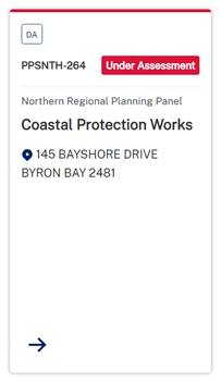
Report No. 13.1 Status report on Development Applications (DAs) with bodies like the Northern Regional Planning Panel (NRPP)
Directorate: Sustainable Environment and Economy
Report Author: Shannon Burt, Director Sustainable Environment and Economy
File No: I2023/1975
Summary:
At the Council (Planning) Meeting of 12 October 2023 it was resolved as part of 23-461
that Council: Receives status reports monthly to each Ordinary (Planning) Meeting on all
DA’s that are being processed by Council for determination by other bodies such as the
Northern Regional Planning Panel or the Independent Planning Commission.
Resolution 22-559 further requires: That Councillors receive, as a standard procedure, a copy of the Assessment Report prepared by Council staff for any DA that is to be determined by the Northern Regional Planning Panel on the next working day after it is lodged on the Planning Portal.
RECOMMENDATION:
That Council notes the status report on Development Applications (DAs) with bodies like the Northern Regional Planning Panel (NRPP).
Report
The following application is a matter for determination by the Northern Regional Planning Panel in accordance with the Sydney District & Regional Planning Panels Operational Procedures. There are no matters currently with the Independent Planning Commission.
|
Planning Authority |
Application Description and link |
Status |
|
Northern Regional Planning Panel |
Coastal Protection Works | Planning Portal - Department of Planning and Environment (nsw.gov.au)
Link to DA tracker for DA 2023.287.1 information and documents here: |
Under assessment |
Strategic Considerations
Community Strategic Plan and Operational Plan
|
CSP Objective |
CSP Strategy |
DP Action |
|
1: Effective Leadership |
1.1: Enhance trust and accountability through open and transparent leadership |
1.1.2: Governance - Ensure legislative compliance and support Councillors to carry out their civic duties |
Recent Resolutions
· 23-461
Legal/Statutory/Policy Considerations
The Planning Panels determine regionally significant development applications (DAs), certain other DAs and s4.55(2) and s4.56 modification applications including:
· Regionally significant development, as outlined in Schedule 6 of the State Environmental Planning Policy Planning Systems 2021
· Regionally significant development relating to Aboriginal land, as outlined in Chapter 3 of the State Environmental Planning Policy Planning Systems 2021
· Development with a capital investment value (CIV)* over $30 million.
· Development with a CIV* over $5 million which is:
o Council related
o lodged by or on behalf of the Crown (State of NSW)
o private infrastructure and community facilities
o eco-tourist facilities
o extractive industries, waste facilities and marinas that are designated development
o certain coastal subdivisions and
o certain coastal protection works.
*Capital investment value (CIV) is calculated at the time of lodgement of the DA for the purpose of determining whether an application should go to a Planning Panel - refer to Planning Circular PS 10-008.
Section 10 of the Sydney District & Regional Planning Panels Operational Procedures talks to Roles of councils and other panels.
10.1 states the elected Council and Council staff have different roles in the assessment of DAs. Under the Local Government Act 1993, the independence of Council staff is protected in the preparation of advice and recommendations. Staff members are not subject to direction by the Council or by a Councillor as to the content of any advice or recommendation made by the staff member. Equally, a Council or Councillor is not bound by the advice or recommendation made by a member of staff.
10.3 states historically, one of the roles of an elected Council has been to determine or make decisions on DAs in their capacity as a consent authority. There are occasions, however, where the determination role is performed by other people or bodies, either because the Council has delegated that function, or because it has been conferred upon another person or body. For example, where local planning panels have been introduced, elected Councils no longer determine DAs (see section 2.17 of the EP&A Act). The Panel for the area in which the development is to be carried out is the consent authority for regionally significant development (see section 4.5 of the EP&A Act).
10.4 states Council staff are responsible for post-determination functions including:
· notifying Panel determinations on DAs (see sections 4.7(2)(e), 4.18 and 4.59 of the EP&A Act),
· registering Panel development consents on the NSW Planning Portal (see sections 4.7(2)(e) and 4.20 of the EP&A Act), and
· monitoring and enforcing compliance with conditions of the development consent.
The notice of determination should be issued once Council receives a copy of the endorsed and final determination from the Panel. The notice of determination must include all conditions imposed by the Panel, including any additional or amended conditions.
The Council has no power to amend conditions or include additional conditions following the Panel’s determination.
Council will advise any person who made a submission on the DA of the determination.
The Council continues to be responsible for the monitoring of, and enforcing compliance with, any conditions of the development consent.
Where an application has been approved subject to a ‘deferred commencement’ condition Council is responsible for determining whether the requirements of the condition have been met (see section 4.16(3) of the EP&A Act). Council advises the chair of the Panel in writing when the matter specified in the condition has been satisfied (see section 277(2) of the EP&A Regulation)
Microsoft Word - Att C - Amended RPP Operational Procedures.docx (amazonaws.com)
11.13 talks to Council representation to the Planning Panel.
An elected Council may make a submission on a DA within their LGA that is to be determined by a Panel up to seven days before the Panel meeting. After the assessment report is sent to the Secretariat, it may be given to the elected Council to assist in its decision as to whether it will be making a submission to the Panel. The elected Council’s submission should not be prepared by persons involved in the assessment of the application but could be prepared by another Council officer, or a consultant.
A Council submission should not be specifically referenced in the assessment report or recommendations prepared by the Council staff. If Council makes a submission, a staff representative or individual Councillors may register to address the Panel at the meeting to express the views of Council. Councillors who are also Panel members have an independent role because they have been nominated by their Council as its nominee to the Panel.
A Code of Conduct also applies to members of the Planning Panels.
Appeals from Planning Panel determinations
Section 8.15(4) of the EPA Act was introduced on 1 March 2018. It provides relevantly:
If the determination or decision appealed against under this Division was made by a Sydney district or regional planning panel or a local planning panel, the Council for the area concerned is to be the respondent to the appeal but is subject to the control and direction of the panel in connection with the conduct of the appeal. The Council is to give notice of the appeal to the panel.
In respect of the conduct and potential resolution of appeals, Councils are subject to the direction and control of planning panels in respect of decisions they make after 1 March 2018.
The Land and Environment Court has said that in circumstances where the panel and Council have conflicting views on a development, the appropriate approach would be for the panel to apply to be joined as a party to the appeal proceedings.
Financial Considerations
None relevant to this report.
Consultation and Engagement
Applications are exhibited as per the Council’s Community Participation Plan.
Otherwise, consultation, engagement and reporting must be in accordance with the Planning Panels Operations Procedure and Code of Conduct.
BYRON SHIRE COUNCIL
Staff Reports - Sustainable Environment and Economy 13.2
Report No. 13.2 PLANNING - Report of the Planning Review Committee held 30 November 2023
Directorate: Sustainable Environment and Economy
Report Author: Shannon Burt, Director Sustainable Environment and Economy
File No: I2023/1951
Summary:
This report provides the outcome of the Planning Review Committee (PRC) held on 30 November 2023.
NOTE TO COUNCILLORS:
In accordance with the provisions of S375A of the Local Government Act 1993, a Division is to be called whenever a motion for a planning decision is put to the meeting, for the purpose of recording voting on planning matters. Pursuant to clause 2(a) under the heading Matters to be Included in Minutes of Council Meetings of Council's adopted Code of Meeting Practice (as amended) a Division will be deemed to have been called by the mover and seconder of all motions relating to this report.
RECOMMENDATION:
That Council endorses the outcomes of the Planning Review Committee meeting held 30 November 2023.
Report
The PRC meeting was held on 30 November 2023. The meeting commenced at 4:35pm and concluded at around 5:00pm.
Councillors: Mayor M Lyon, Cr D Dey, Cr A Hunter, Cr P Westheimer.
Apologies: Cr S Ndiaye, Cr S Balson
Staff: Chris Larkin (Manager Sustainable Development), Shannon Burt (Director of Sustainable Environment & Economy)
Conflict of Interest: None declared.
Council determined the following original development applications.
The S.4.55 applications to modify the consents were referred to the PRC to decide if the modification applications can be determined under delegated authority with the outcome shown in the final column.
|
DA No. / Applicant |
Property Address / Proposal |
Consultation / Submissions |
Reason/s / Outcome |
|
10.2014.753.8 Newton Denny Chapelle |
2
Tanner Lane S4.55 Modification to allow the permanent use of a temporary stage on the northern part of the East Coast Blues & Roots Music Festival Site and amendments to conditions 13C, 73 & 100 relating to community notification and traffic management. |
Level 2 6/11/23 to 19/11/23 1 Submission |
Staff Delegation |
|
10.2001.121.3 Mr MR Curtis |
114
Lighthouse Road S4.55 Modification to Modify Conditions 1 of consent for Residential Units comprising of 10 x 4 Bedroom Two Storey Units contained in 3 Separate Buildings and associated Basement Carpark Below. |
Level 2 1/6/23 to 15/6/23 1 Submission |
Staff Delegation |
|
10.2014.398.5 Planners North |
3
Shirley Street S4.55 to Modify Plans including Increase of Basement Car Parking, Update to Room Numbers and Manager's Quarters, Modification of Dining and Bar, Deletion of Spa Treatment Rooms and Manager's Dwelling. |
Level 2 24/8/23 to 6/9/23
No Submissions |
Staff Delegation |
|
10.2016.625.5 M Scott |
35-37
Burringbar St S4.55 Modification to Condition 65 to Extend Operating Hours. |
Level 2 2/8/23 to 15/8/23 1 Submission |
Council
|
BYRON SHIRE COUNCIL
Staff Reports - Sustainable Environment and Economy 13.3
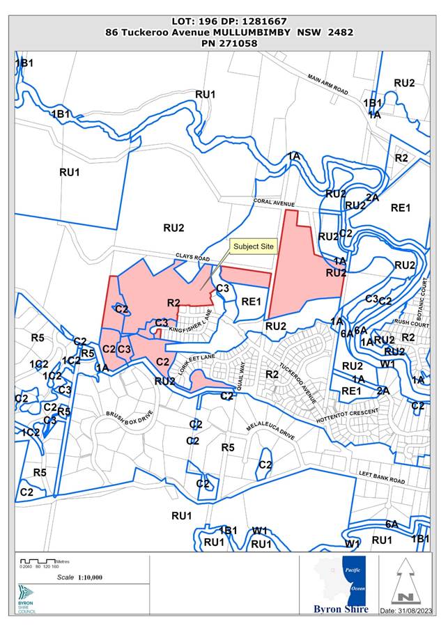
Report No. 13.3 PLANNING - 10.2020.109.4 - Section 4.55 to Stage 9 for Removal of Existing Exotic and Native Trees to Allow for Construction of Approved Roads and Earthworks, Relocation of Inter-allotment Drainage and Sewer Services and Easement Modifications and Deletion of Local Open Space and Recreation S7.11 Contributions - 86 Tuckeroo Avenue Mullumbimby
Directorate: Sustainable Environment and Economy
Report Author: Greg Smith, Team Leader Planning Services
File No: I2023/1858
Proposal:
|
Modification No |
10.2020.109.4 |
|
Planning Portal Ref |
PAN-317313 |
|
Proposed modification |
S4.55 to Stage 9 for Removal of Existing Exotic and Native Trees to Allow for Construction of Approved Roads and Earthworks, Relocation of Inter-allotment Drainage and Sewer Services and Easement Modifications and Deletion of Local Open Space and Recreation S7.11 Contributions |
|
Original Development |
Stage 9 Tallowood Ridge Estate Subdivision to Create Forty-Eight (48) Residential Lots, of which Seven (7) of these Lots are a Community Title subdivision, and a Community Title common Property Lot |
|
Type of modification sought |
4.55(2) Other modifications |
|
Property description |
LOT: 196 DP: 1281667 |
|
86 Tuckeroo Avenue MULLUMBIMBY |
|
|
Parcel No/s |
271058 |
|
Applicant |
CivilTech Consulting Engineers |
|
Owner |
Gainsplay Pty Ltd |
|
Zoning |
C2 Environmental Conservation / C3 Environmental Management / R2 Low Density Residential / RU1 Primary Production / RU2 Rural Landscape |
|
Date received |
12 April 2023 |
|
Original DA determination date |
14 October 2021 |
|
Integrated Development |
Yes |
|
Public notification or exhibition |
- Level 2 advertising under the Byron Shire Council Community Participation Plan. - Exhibition period: 25/4/2023 to 8/5/2023 - Submissions received: 22 |
|
Planning Review Committee |
Meeting date 1/6/2023 Report to Council |
|
Delegation to determination |
Council |
|
Issues |
· Contributions |
Summary:
The section 4.55 application seeks approval for the modification of the approved Stage 9 subdivision, being for the removal of existing exotic and native trees to allow for the construction of approved roads and earthworks, relocation of the inter-allotment drainage and sewer services and easement modifications, and the deletion of local open space and recreation section 7.11 contributions.
The Report on the application was considered at the Council (Planning) meeting of 9 November 2023. At that meeting, Council resolved to defer the matter to a future meeting to be able to obtain a preliminary land valuation or appraisal of Lot 281 as proposed, and that it be provided to Council in confidence. The resolution states:
Resolved that Council:
1. Pursuant to Section 4.55 of the Environmental Planning & Assessment Act 1979, that Application No. 10.2020.109.4, for S4.55 to Stage 9 for Removal of Existing Exotic and Native Trees to Allow for Construction of Approved Roads and Earthworks, Relocation of Inter-allotment Drainage and Sewer Services and Easement Modifications and Deletion of Local Open Space and Recreation S7.11 Contributions, defers this matter to a future meeting of Council.
2. Obtains a preliminary land valuation or appraisal of Lot 281 as proposed, and that it be provided to Council in confidence.
The Applicant has submitted a Valuation Report, which is included as confidential Attachment 4 to this Report. The Applicant has indicated that the value of the land is more than the amount of Local Open Space Contributions in Stage 9.
The proposal is considered satisfactory having regard to relevant matters for consideration and the section 4.55 application is recommended for approval subject to the Recommended Modifications in Attachment 1 to this Report. The valuation does not change the Recommendation of staff; hence the attached recommended modifications are the same as those which were attached to the Report considered at the Council meeting dated 9 November 2023. (see item 13.7 in Agenda of Ordinary (Planning) Meeting - Thursday, 9 November 2023 (infocouncil.biz))
The modified plans attached to the previous Council report actually showed the originally approved Lot 282 as a mix of Lot 281 and 282. These have now been corrected in red to show the entire lot as Lot 282 as per the original plans and the contributions condition number 48 of the consent. The corrected Modified Plans are included as Attachment 2 to this report and the Biodiversity Assessment is Attachment 3.
NOTE TO COUNCILLORS:
In accordance with the provisions of S375A of the Local Government Act 1993, a Division is to be called whenever a motion for a planning decision is put to the meeting, for the purpose of recording voting on planning matters. Pursuant to clause 2(a) under the heading Matters to be Included in Minutes of Council Meetings of Council's adopted Code of Meeting Practice (as amended) a Division will be deemed to have been called by the mover and seconder of all motions relating to this report.
RECOMMENDATION:
That pursuant to Section 4.55 of the Environmental Planning & Assessment Act 1979, that Application No. 10.2020.109.4, for S4.55 to Stage 9 for Removal of Existing Exotic and Native Trees to Allow for Construction of Approved Roads and Earthworks, Relocation of Inter-allotment Drainage and Sewer Services and Easement Modifications and Deletion of Local Open Space and Recreation S7.11 Contributions, be approved by modifying Development consent number 10.2020.109.1 in accordance with Attachment 1 Recommended Amended Conditions of Consent.
1 10.2020.109.4
- Recommended Amended Conditions of Consent, E2023/105246
![]()
2 10.2020.109.4
- Modified Plans, E2023/105245 ![]()
3 10.2020.109.4
- Biodiversity Assessment, E2023/105244
![]()
4 Confidential - 10.2020.109.4 - CONFIDENTIAL - Applicant's Land Valuation, E2023/130384
Assessment:
1. INTRODUCTION
1.1. History/Background
At the Council (Planning) Meeting on 9 November 2023, Council considered a report on the section 4.55 application. It was resolved that Council:
1. Pursuant to Section 4.55 of the Environmental Planning & Assessment Act 1979, that Application No. 10.2020.109.4, for S4.55 to Stage 9 for Removal of Existing Exotic and Native Trees to Allow for Construction of Approved Roads and Earthworks, Relocation of Inter-allotment Drainage and Sewer Services and Easement Modifications and Deletion of Local Open Space and Recreation S7.11 Contributions, defers this matter to a future meeting of Council.
2. Obtains a preliminary land valuation or appraisal of Lot 281 as proposed, and that it be provided to Council in confidence.
The Applicant has submitted a Valuation Report and indicated that the value of the land is more than the amount of Local Open Space Contributions in Stage 9. The proposal is considered satisfactory having regard to relevant matters for consideration and the section 4.55 application is recommended for approval subject to the Recommended Modifications in Attachment 1 to this Report. The valuation does not change the Recommendation of staff; hence the attached recommended modifications are the same as those which were attached to the Report considered at the Council meeting dated 9 November 2023.
Section 7.11 Developer Contribution Implications
The applicant under the current consent has been levied some $561,000 in local open space contributions. Considering the valuation of the land this would be deleted from the amount to be levied, consistent with condition 48 of the consent which states:
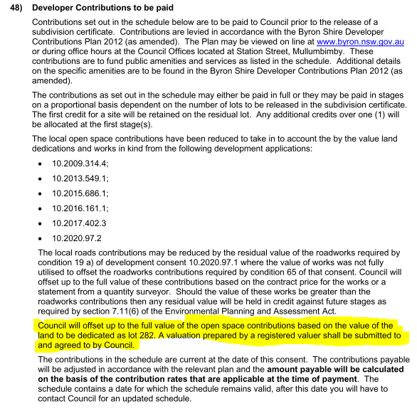
It is noted that the land that was to be dedicated to Council is not listed in any developer contribution plans and is surplus to any specific open space needs of the Shire. The requirement for its dedication came about as a result of Resolution 20-720 in response to the NOM 9.2 - Tallowood Ridge Reserve on 17 Dec 2020. (for details see notice of Motion 9.2 Agenda of Ordinary Meeting - Thursday, 17 December 2020 (infocouncil.biz))
The Council resolution states:
20-720 Resolved that Council:
1. Enter negotiations with the relevant landowners and/or developer to seek the gifting of the land outlined in the map in the report for the management of Council in conjunction with the community in perpetuity.
2. Ensure that these negotiations stipulate that this is not instead of any other previous environmental agreement.
3. Acknowledge that if negotiations are successful, staff will take the appropriate steps to prepare a Plan of Management (Ndiaye/Richardson)
It is noted that staff advised Council in response to this NOM re: the land dedication (which was previously proposed as common property for an 8-lot community title subdivision within Stage 9) the following:
The site is proposed to be managed by the community association in the long term. Such an arrangement ensures the protection and management of the vegetation without the financial burden of bringing the land into public ownership. To date Council has resisted effort by developers to dedicate land that has no development potential. This has occurred at the West Byron development and here at Tallowood.
Financial/Resource/Legal Implications:
If the land is gifted to Council, Council will need to establish a Plan of Management and manage the land in accordance with this plan. In the long-term Council ad hoc acquisitions of land may adversely impact upon Council’s ability to manage all of the open space land to levels that meet community expectations / desirable levels of service in its portfolio.
Should Council no longer want the subject land having regards to the financial implications to the S7.11 Contribution Plans, an alternate recommendation would need to be drafted and debated during the Council meeting. That alternate recommendation in brief would amend the consent so that Lot 282 is not to be dedicated to Council and that it is to be consolidated with the common property Lot C8 as part of the 8-lot community title subdivision, with condition 48 also being amended to remove the references to Lot 282 being offset to the full value of the open space contributions. As such Staff will be guided by the elected Council on the matter. It is noted that regardless of ownership the land will need to be embellished and rehabilitated in accordance with the approved Biodiversity Conservation Management Plan with a range of works required prior to the issue of any subdivision certificate (Condition 49) and ongoing management of the land for a period of up to 10 years (Condition 66).
The dedication of this land is to be offset against the value of developer contributions plus any remaining credit that the developer retained through previous land dedications, works in kind, and material public benefit works that the developer has undertaken in all previous consents.
The developer has credit of $220,697.48 remaining from the roadwork undertaken in Clays Road.
The nominal value of Lot 282 is $600,000. This gives a remaining credit for the developer of $820,697.48.
Condition 48 of the consent allows the developer to offset these amounts from the remaining developer contributions.
When the schedule of contributions to condition 48 is indexed into today’s dollars the contributions owing would be $940,000. Subtracting the credit leaves a total amount of contributions payable of $119,302.45. This is shown in an amended schedule of contributions to condition 48 in Attachment 1. Consequential amendments to condition 48 have also been made to recognize the known value of the credits as also recommended in Attachment 1.
2. CONCLUSION
The section 4.55 application is recommended for approval subject to the Recommended Modifications in Attachment 1.
BYRON SHIRE COUNCIL
Staff Reports - Sustainable Environment and Economy 13.4
Report No. 13.4 Update on the Creation of a Byron Shire Council Led Land Trust
Directorate: Sustainable Environment and Economy
Report Author: Shannon Burt, Director Sustainable Environment and Economy
File No: I2024/3
Summary:
Council considered Report No. 13.3 Update Resolution 21-062 Creation of a Byron Shire Council Community Land Trust on the Agenda of Ordinary (Planning) Meeting - Thursday, 8 April 2021 (infocouncil.biz) and:
Resolved 21-123 that Council:
1. Notes the staff report Update Resolution 21-062 Creation of a Byron Shire Council Community Land Trust.
2. Agrees in principle to the establishment of a Land Trust as a Council legal entity to hold land for the development of local housing that meets the needs of the community. The agreed name of the entity to be ‘Byron Shire Land Limited’.
3. Agrees that the most appropriate Council legal entity is a company limited by guarantee and licensed with Council being the majority shareholder. A board of directors to be appointed, via an EOI process, comprising representatives from Council, community housing providers, not-for-profit organisations; and suitably qualified individuals with specialist expertise (e.g., legal, financial, and management) beneficial to the operation of the Land Trust. The Board to be responsible for all aspects of running the Land Trust including the development of a comprehensive Business Plan with an annual report to council on achievement of the Trust’s objectives and affordable housing outcomes.
4. Agrees that Byron Shire Land Limited will:
a) aim to provide 10% of the Shire’s housing stock within the first 10 years of operation.
b) use 30% of the median weekly household income for the Byron Shire as the benchmark of affordability.
In June 2021, an application under Section 358 of the Local Government Act 1993 was prepared by staff and made to the Office of Local Government (OLG) and then Minister for Local Government The Hon. Shelley Hancock for consent to create a legal entity in the form of a company by limited guarantee to be known as Byron Shire Land Limited. The purpose of the legal entity inter alia to hold land for the development of local housing that meets the needs of the community (aka Land Trust).
The application as made, Attachment 1 complied with Resolution 21-123 and addressed the then Circular 07-49 – Criteria For Applications Under Section 358 Of The Local Government Act 1993 – Formation Of Corporations Or Other Entities - Office of Local Government NSW. Staff made every attempt to address the criteria as best they could given the nature of application being prepared.
Despite the request for consultation and the ability to amend the application based on OLG feedback the application was rejected in August 2021, Attachment 2 as non-conforming on two points. The first being an appropriate Resolution of Council and the second in relation to response to Criteria.
The OLG subsequently issued updated Guidelines Formation of Corporations and Entities (Section 358) Guideline (nsw.gov.au) in January 2022. These guidelines made it clear that a significant amount of work was needed to support any further application to the Minister for Council to form an entity under Section 358 including justification documents, governance arrangements and public interest test.
With this in mind, work on a revised application was put on hold by staff due to other competing housing initiatives and project priorities progressing at the same time (Affordable Housing Contributions Scheme, Residential Strategy, Mullumbimby Hospital Redevelopment, 57 Station Street, and other housing planning proposals), and the need to collate updated information and evidence to support a revised application to the Minister as per the 2022 Guidelines.
With a body of work now completed, Council is in a better position to respond to the 2022 Guidelines and make a revised application to the Minister for Local Government. This report seeks Council support to do so.
RECOMMENDATION:
That Council:
1. Confirms its support for, and commitment to, the establishment of a Byron Shire Council Led Land Trust.
2. Confirms the preferred model of Council Led Land Trust to be a company limited by guarantee and licensed with Council being the majority shareholder, consistent with the key components discussed in the report.
3. Requests staff to prepare a new application on the basis of Part 2 of this Resolution, to form an entity under Section 358 of the Local Government Act 1993 as per the 2022 Guidelines for ‘Formation of Corporations and Entities.
4. Receives and considers the new application as per Part 3 at a future Council meeting.
5. Writes to The Hon. Rose Jackson in her capacity as Minister for Housing and Minister of the North Coast seeking her support for this application as it is directly aligned with Actions in the NSW Housing Strategy 2041 in relation to working with Local Government to deliver housing solutions to meet community needs.
Attachments:
1 Confidential - Application to Minister for Local Government creation on Byron Shire Land Limited June 2021, E2021/81716
2 Confidential - Letter from Office of Local Government - Byron Shire Land Limited - Land Trust, E2021/106111
Report
Background
· The concept of a Land Trust has been talked about by Council since as far back as the 2008 Byron Shire Affordable Housing Strategy, and as recently as at the Housing Affordability Advisory Committee meeting Agenda of Housing and Affordability Advisory Committee Meeting - Thursday, 17 November 2022 (infocouncil.biz), where Dr Louise Crabtree presented on this topic.
· To this aim, Council previously resolved to become a foundation member of a Community Land Trust known as Byron Community Land Limited in 2018. The principal purpose for which the BCLL was established was “to acquire land to provide Charitable housing in perpetuity for people in need of charitable housing who live or work in the Shire”. Notwithstanding the commitment of the Board to the principal purpose, the decision was taken by the Board to voluntarily deregister the company on 23 March 2020. This mainly occurred around the lack of financial viability and organisational capacity of getting a pilot project off the ground given the need to acquire land for this purpose in the first instance.
· Since then, Council has, by Resolution, committed to an alternate Council Led Land Trust (2021).
· Of noting, the Office of Local Government issued Guidelines for ‘Formation of Corporations and Entities (section 358) in January 2022. These guidelines provide a comprehensive checklist of what a Council needs to do to satisfy the Minister for Local Government of the need to create an entity under Section 358 of the Local Government Act 1993.
· Further to the above, a new Community Land Trust has now been formed in Byron Shire known as Byron Shire Community Land Trust - A community-led solution to Byron's housing crisis (bsclt.org) Their purpose being to provide long term affordable rental accommodation. This Community Land Trust has a pilot project on land on Saddle Road.
· With a Bellingen Shire Community Land Trust Establishment Project also now funded by the Siddle Foundation progressing to proof of concept. Bellingen Shire Community Land Trust - Housing Matters Action Group
· Staff are aware of the above Community Land Trusts and have had separate conversations with the respective groups on same.
· Work has been on hold on a revised Council Led Land Trust proposal due to the significant amount of work needed to support it as per the 2022 Guidelines.
· To this aim, a body of work has now been completed, and Council is in a better position to respond to the 2022 Guidelines and make a revised application to the Minister for Local Government.
· Council has an Affordable Housing Contribution Scheme in place. This Scheme provides details about how, where, and at what rate development contributions can be collected from landowners for affordable housing. Contributions can be land or buildings.
· The NSW Housing Strategy 2041 encourages State Government to work with Local Government to address their housing needs in innovative ways.
· Action 5.4.1 in particular talks about Land Trusts. This action can be used to support Council’s case.
Key issues
· Understanding the difference between a community land trust and a council led land trust
A Community Land Trust can form from within a community according to local capacity as a grass roots organisation. They can vary in both how they are formed and governed.
There are however 5 key features of a Community Land Trust:
· Community controlled and community owned
· Open democratic structure
· Homes and other assets are kept permanently affordable
· Not for profit
· Long term stewardship
Formation of a formal Community Land Trust entity is generally done as a company limited by guarantee (CLG).
The process of setting up a CLG is set out in the Corporations Act 2001 (Cth) (Corporations Act).
All CLGs are governed by the Corporations Act, the Corporations Regulations 2001 (Cth) (Corporations Regulations) and the CLG’s constitution.
The government body responsible for regulating the incorporation and operation of CLGs is the Australian Securities and Investments Commission (ASIC). A CLG that meets the requirements of the Charities Act 2013 (Cth) (Charities Act) may seek registration with the Australian Charities and Not-for-Profit Commission (ACNC).
The ACNC is the Commonwealth charity regulator responsible for the registration and oversight of registered charities in Australia. The ACNC decides whether an organisation is eligible to be registered as a charity. A registered charity is able to access certain tax concessions.
Formation of a Council Led Land Trust however has an additional regulatory step to that above.
First, an application must be made to the Minister for Local Government under Section 358 to form a company/legal entity. The application must meet these Guidelines. The application must be approved to proceed.
Once established the principles to which the company/legal entity - Land Trust operates will be dictated by the company constitution, preferred key elements of model of Land Trust and the associated business/action plan. This is what has been spelt out and agreed to by the Minister for Local Government via the Section 358 application. See below.
· Understanding the key elements of a Byron Shire Council Land Trust
The key components of a Byron Shire Council Led Land Trust were discussed in the previous report to Council and remain unchanged.
Land Trust Entity
The entity needs to be set up correctly so that it's eligible for tax concessions, can receive contributions and is as easy as possible to administer.
As a simplified explanation, the land trust would be set up as an incorporated company acting as trustee for the land.
Under the Local Government Act 1993, Council has the power to form such a company with Ministerial consent. In naming the land entity the words trust and trustee cannot be used in company or business names because of restrictions under the Corporations Act 2021 (Cth.) and the Business Names Registration.
A suggested name is ‘Byron Shire Land Limited’ thus sending a clear message as to its purpose. The final naming would be subject to Australian Security and Investments Commission approval.
A constitution is fundamental to the company’s governance. To be effective it should set out important objectives, certain rights, roles and responsibilities including who the Land Trust will support, how it will be funded and who will administer it and how.
That said the Land Trust needs to operate within the federal and state regulatory framework. For example, if land or funds held have been dedicated via an affordable housing contribution scheme its use by Land Trust must be compliant with the regulations governing such a scheme i.e. use for the purpose of providing affordable housing.
Below are some suggested criteria for a Byron Shire Land Trust, listed under typical constitutional headings.
Principal purpose
To acquire land to provide charitable housing in perpetuity for people in need of charitable housing who live or work in the Shire.
The entity to have:
· majority shareholder – Byron Shire Council
· Chief Executive Officer or General Manager
· Board members.
The Board to:
· initially comprise representatives from Council, community housing providers, not-for-profit organisations; and suitably qualified individuals with specialist expertise beneficial to the operation of the Land Trust.
The initial membership:
· to be determined by an expression of interest process.
In the longer term with the delivery of homes, residents may be added to the Board mix.
All Board members would undergo the same training to understand their role in guiding the Land Trust according to its stated objectives.
Stewardship of Land
Principles as stated below:
· the land component to remain in the ownership of the Land Trust
· the Land Trust will be able to the lease the land and charge an ongoing ground lease (i.e. a form of rent) for the land
· ground leases on which the homes are built are inheritable, and properties on leased land can be bought and sold at prices determined by a resale formula spelt out in each Land Trust’s ground lease
· due to an encumbrance registered on the title, the land would revert back to the Council should the Land Trust wind up.
Ground leases
A primary intent could be to provide long term leases, say for 50 years to:
· Registered community housing providers
· Not-for- profit organisation including co-operatives as legally incorporated member-based entities that provide housing for their members and are bound by relevant national or state legislation.
Additional scope for leases directly to individuals satisfying affordable housing criteria to build homes could be considered.
Funding, Land Sources and Operating Cost
The Land Trust would be able to receive funding through government grants and also through ongoing contributions of land, buildings and/or funds from private local developers who have committed support for community housing as part of an upzoning process of their land under an AHCS or voluntary planning agreement.
The ground lease rent would also be a source of revenue.
It is recommended that an Action Plan be prepared once the entity is created and board members chosen to provide further guidance on the Land Trust’s operations in regard to priorities, strategies and success indicators.
Memorandum of Understanding (MOU)
An MOU arrangement is recommended to maintain the independence of the Land Trust from Council, so that it can act independently from the Council. It also enables capacity for Council to work with community housing providers or other not-for-profit housing organisations in other aspects of Council’s operations. An example of this is the Queenstown Lakes Community Housing Trust.
Some suggested basic criteria for an MOU between Council and a Trust could include:
· is intended to be part of the long term solution for housing in our Shire
· the parties agree to work together with openness and clarity on each parties’ function
· the parties agree to serve as a model of land stewardship and community development that could be simply replicated
· the parties agree to help insulate the community housing interests by being able to exclude engagement with organisations/businesses that are monopolistic and/or speculative
· Council will confirm that the Land Trust is its preferred mechanism for receiving any contribution received by Council under a Affordable Housing Contribution Scheme or Voluntary Planning Agreement unless circumstances dictate otherwise
· land or cash contributed from the Council to the Land Trust is to be used exclusively for the mutually agreed purpose, and will be subject to an encumbrance in favour of the Council
· Council will provide initial administrative support, possibly provision of a start up grant, with the mutual aim of reducing the support services from the Council to the Land Trust over time with an intent that the Land Trust largely operates at no cost to the rate payers.
The above details will be updated as required to comply with the 2022 Guidelines and form part of the Application to the Minister for Local Government.
Next steps
· Council requests staff to prepare a new application to form an entity under Section 358 of the Local Government Act 1993 as per the 2022 Guidelines for further consideration by Council at a future meeting.
· Council writes to the Minister for Housing and Minister for the North Coast The Hon Rose Jackson seeking support for this application as it is directly aligned with Actions in the NSW Housing Strategy 2041.
Strategic Considerations
Community Strategic Plan and Operational Plan
|
CSP Objective |
CSP Strategy |
DP Action |
Code |
OP Activity |
|
4: Ethical Growth |
4.2: Enable housing diversity and support people experiencing housing insecurity |
4.2.3: Legislation changes - Establish planning mechanisms and advocate for changes to legislation to support housing that meets the needs of our community |
4.2.3.1 |
Prepare submission/s on draft changes to State government planning policy or legislative reforms |
Recent Resolutions
· 20-365
· 21-062
· 21-112
· 21-114
· 21-123
Legal/Statutory/Policy Considerations
Legal advice will be sought as required to inform the process.
Financial Considerations
Staff time and other resources required to complete a revised application under Section 358 of the Local Government Act 1993, including legal advice are unknown at this time and may require additional budget.
Consultation and Engagement
BYRON SHIRE COUNCIL
Staff Reports - Sustainable Environment and Economy 13.5
Report No. 13.5 PLANNING - 10.2023.390.1 Alterations and Additions to Existing Dwelling at 2 Strand Avenue, New Brighton
Directorate: Sustainable Environment and Economy
Report Author: Ben Grant, Planner
File No: I2024/4
Proposal:
|
DA No: |
10.2023.390.1 |
|||||
|
Planning Portal ref |
PAN-380024 |
|||||
|
Proposal description: |
Alterations and Additions to Existing Dwelling House |
|||||
|
Property description: |
LOT: 1 DP: 1004049 |
|||||
|
2 Strand Avenue NEW BRIGHTON |
||||||
|
Parcel No/s: |
228740 |
|||||
|
Applicant: |
Mr M Walker |
|||||
|
Owner: |
Mr P A Laing & Ms T A Lee |
|||||
|
Zoning: |
7(f2) (Coastal Urban Lands Zone) Byron LEP 1988 |
|||||
|
Date received: |
9 November 2023 |
|||||
|
Integrated / Designated Development: |
☐ Integrated |
☐ Designated |
☒ Not applicable |
|||
|
Concurrence required |
No |
|||||
|
Public notification or exhibition: |
- Level 2 advertising under Council’s Community Participation Plan. - Exhibition period: 17 November 2023 to 30 November 2023. - Submissions received: Nil. - Submissions acknowledged: ☐ Yes ☐ No ☒ N/A |
|||||
|
Concurrent approvals included with DA |
☐ N/A |
☒ W & S (68) |
☐OSMS (68) |
☐ ST (68) |
☐ RA (138) |
|
|
Other: |
|
|||||
|
Planning Review Committee |
Not applicable |
|||||
|
Variation request to Development Standards under an EPI (eg clause 4.6) |
Name of clause - Height Clause number - Clause 40(2)(b)(i) Percentage value of variation sought – 13.5% Percentage value of the variation approved – Recommend approval for entire variation request. Brief justification for the variation – strict compliance is unreasonable and unnecessary in the circumstances because the existing building already exceeds the 4.5m height limit for the topmost floor level. The proposal does not increase the height of any existing floor levels apart from an internal set of stairs to access the third floor. |
|||||
|
Estimated cost |
$827,500.00 |
|||||
|
Delegation to determine |
Council |
|||||
|
Issues |
Exceedance of 4.5m upper floor level development standard under Clause 40(2)(b)(i) of LEP 1988. Building Height Plane encroachment. |
|||||
Summary:
This development application seeks approval for alterations and additions to an existing dwelling house at 2 Strand Avenue, New Brighton. The project mostly involves internal design changes, but also includes the construction of a new wraparound verandah and rear deck.
The application is referred to the Council for determination as the proposal involves a breach of Clause 40(2)(b)(i) of LEP 1988 which specifies that the topmost floor of a building must not exceed 4.5 metres above the existing ground level.
The proposal includes a new internal staircase to access the third floor which will have a maximum height of 5.2m above existing ground level, resulting in a contravention of the development standard by up to up to 700mm or 13.5%. Each rung of the staircase is considered to be a ‘floor level’ for the purposes of this assessment.
A written justification for the proposed variation to the height development standard was submitted in accordance with clause 64A of LEP 1988. The reasons contained in the clause 64A request are acceptable and the variation is supported.
Strict compliance with the development standard is impractical in the circumstances and would not achieve any planning purpose given the existing three-storey dwelling was constructed prior to the current planning regime and already exceeds the 4.5m height limit. No change to the height of any existing floor levels is proposed apart from the new stairs access to the third floor. The proposed renovation will increase the internal amenity of the dwelling and improve its appearance whilst also having no significant external impacts on the surrounding built environment.
The application was advertised and notified between 17 November 2023 to 30 November 2023 and no submissions were received during this time.
The application appropriately addresses the relevant constraints applying to the site and is recommended for approval subject to the Conditions in Attachment 1.
NOTE TO COUNCILLORS:
In accordance with the provisions of S375A of the Local Government Act 1993, a Division is to be called whenever a motion for a planning decision is put to the meeting, for the purpose of recording voting on planning matters. Pursuant to clause 2(a) under the heading Matters to be Included in Minutes of Council Meetings of Council's adopted Code of Meeting Practice (as amended) a Division will be deemed to have been called by the mover and seconder of all motions relating to this report.
RECOMMENDATION:
That pursuant to Section 4.16 of the Environmental Planning & Assessment Act 1979, Development Application No. 10.2023.390.1 for alterations and additions to existing dwelling house, be granted consent subject to the conditions in Attachment 1 (#E2024/1786).
1 10.2023.390.1
Recommended Conditions of Consent, E2024/1786
![]()
2 10.2023.390.1
Plans for Approval, E2024/4079 ![]()
Report
1. INTRODUCTION
History/Background
The site contains a three-storey elevated timber dwelling that was approved on 7 March 1994 via Building Application 6.1994.2094.1.
Description of the proposed development
This development application seeks approval for alterations and additions to an existing dwelling house at 2 Strand Avenue, New Brighton. The project mostly involves internal design changes, but also includes the construction of a new wraparound verandah and rear deck.
The following is proposed:
Ground Floor
· Remove internal and external staircases.
· Decommission existing laundry and convert to a garden storeroom.
· Replace garage doors and construct a new internal staircase providing access to the first floor.
· Construct a new rear deck, terrace, and fireplace with access stairs to the first floor.
First Floor
· Demolish existing floor plan layout.
· Relocate kitchen, dining, and living areas to the northern elevation to improve solar access and provide an open plan area that opens onto outdoor decks.
· Construct a wrap-around deck along the northern side of the dwelling to connect with the exiting deck to maximise views.
· Reduce number of bedrooms on first floor from three to two.
· Relocate laundry from ground floor to first floor.
· Construct new internal stairs to access the second floor.
Second Floor
· Demolish approximately half the second-floor area and deck to form an internal void.
· Reconfigure upper-level floor plan to provide for a master bedroom, walk-in robe and ensuite.

Figure 1: Architect’s visualisation of the front north-east elevation.
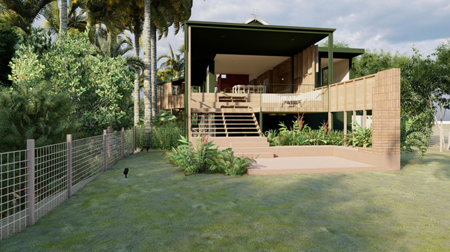
Figure 2: Architect’s visualisation of the new deck and entertaining area as viewed from the backyard.
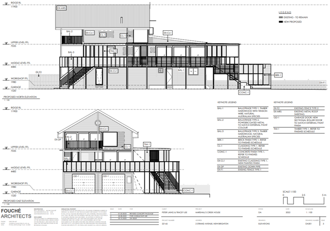
Figure 3: Extract of proposed north and east elevations.
Description of the site
A site inspection was carried out on 19 December 2023
|
Land is legally described |
LOT: 1 DP: 1004049 |
|
|
Property address |
2 Strand Avenue NEW BRIGHTON |
|
|
Land is zoned: |
DM Deferred Matter Byron LEP 1988 |
|
|
Land area is: |
1196 m2 |
|
|
Property is constrained by: |
Flood Liable Land, Bushfire prone land, Acid Sulfate Soils Class 1 High Conservation Value Vegetation |
|
|
|
Is a BDAR required due to the location of the proposed development? |
☐ Yes ☒ No |
|
|
Are there any easements in favour of Council affecting the site? |
☐ Yes ☒ No |
|
|
Is there a Vegetation Management Plan which might affect the proposal? |
☐ Yes ☒ No |
|
|
Is there a Voluntary Planning Agreement which might affect the proposal? |
☐ Yes ☒ No |
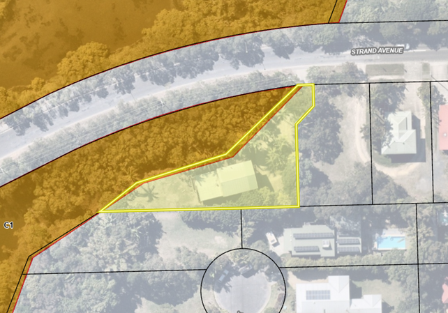
Figure 4: Aerial image with zoning overlay. The site is zoned 7(f2) (Urban Coastal Lands Zone).
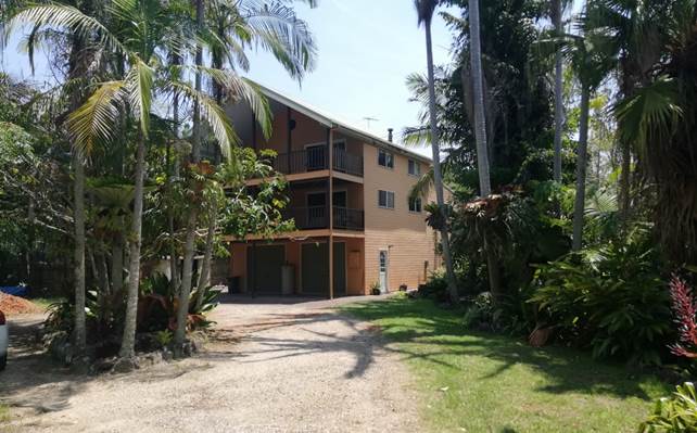
Figure 5: Existing three storey dwelling house.
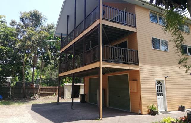
Figure 6: View of dwelling (SW).
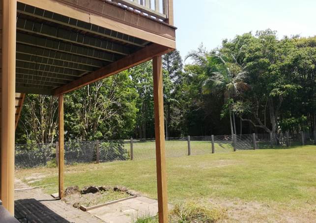
Figure 7: View of backyard and rear deck.
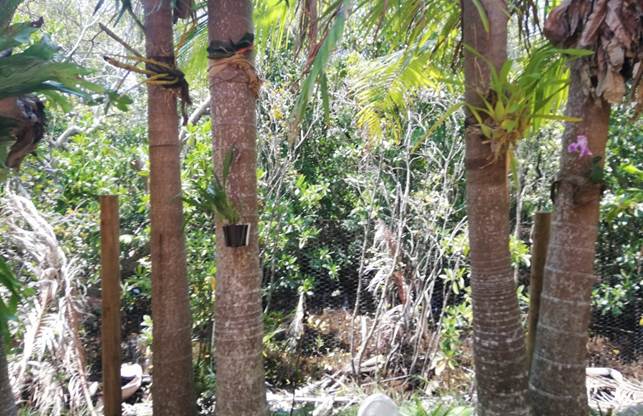
Figure 8: Coastal wetlands vegetation to the north of the site. No development is occurring in this area.
SUMMARY OF REFERRALS
|
Referral |
Issue |
|
Development Engineer |
No objections subject to conditions of consent. A condition is recommended for the use of flood compatible materials below the 2050 Flood Planning Level of 3.5m AHD. |
|
Local Approvals Officer |
Approval for water and sewer work under s68 of the Local Government Act 1993 issued concurrently with this development consent. Refer to Schedule 3 of the recommended conditions of consent. |
SECTION 4.14 – BUSH FIRE PRONE LAND
Under section 4.14 of the Act, Council must be satisfied prior to making a determination for development on bush fire prone land, that the development complies with the document ‘Planning for Bush Fire Protection 2019’’.
A small part of the driveway is within the bushfire buffer of a Category 2 hazard to the north-east. No part of the land containing the proposed development is identified as bush fire prone land. Section 4.14 of the Act does not apply to the proposal.
SECTION 4.15C – MATTERS FOR CONSIDERATION – DISCUSSION OF ISSUES
Having regard to the matters for consideration detailed in Section 4.15(1) of the Environmental Planning & Assessment Act 1979 (EP&A Act), the following is a summary of the evaluation of the issues.
State Environmental Planning Policies (SEPP)
|
Considerations |
Satisfactory |
Unsatisfactory |
|
Resilience and Hazards SEPP 2021 Chapter 2 Coastal management The proposed development comprises alterations and additions to an existing dwelling house and will not have a significant impact on the coastal environment. The proposal is satisfactory having regard to the matters for consideration under Clauses 2.7 to 2.15 of the Resilience and Hazards SEPP. Part of the existing driveway is located within the Coastal Wetlands Map however no development is proposed within this area. The proposal is not designated development and does not require submission of an EIS. Chapter 4 Remediation of land The site is not included in the Council or EPA contaminated land registers and has a long-standing history of residential use. There are no records of potentially contaminating activities occurring on the site or on surrounding sites. Based on the available information the site is considered to be suitable for ongoing residential use in its current state and does not require remediation. |
☒ |
☐ |
|
Sustainable Buildings SEPP 2022 A valid BASIX certificate for alterations and additions has been submitted with the application. Commitments for water, energy and thermal comfort are shown on the DA plans. |
☒ |
☐ |
4.2B Byron Local Environmental Plan 1988 (LEP 1988)
In accordance with LEP 1988 clauses 5, 8 and 9:
(a) The proposed development is defined in the LEP 1988 Dictionary as a Dwelling House;
(b) The land is within the LEP1988 7(f2)(Urban Coastal Land Zone) according to the map under LEP 1988;
(c) The proposed development is permitted with consent; and
(d) The proposed development is consistent with the relevant objectives of the Zone for the following reasons:
|
Zone Objective 7(f2) (Urban Coastal Land Zone) |
Consideration |
|
(a) to identify urban land likely to be influenced by coastal processes, |
The proposed alterations and additions are generally compatible with the zone objectives. |
|
(b) to permit urban development within the zone subject to the council having due consideration to the intensity of that development and the likelihood of such development being adversely affected by, or adversely affecting, coastal processes, |
|
|
(c) to permit urban development within the zone subject to the council having due consideration to— (i) the need to relocate buildings in the long term, (ii) the need for development consent to be limited to a particular period, (iii) the form, bulk, intensity and nature of the development, and (iv) continued safe public access to the site, and |
|
|
(d) to allow detailed provisions to be made, by means of a development control plan, to set aside specific areas within the zone for different land uses and intensities of development. |
|
Provision |
Compliance |
Comment |
|
Clause 24 Development of flood liable land |
Yes |
All habitable rooms are located on the first and second floors, which are both well above the Flood Planning Level of 3.5m AHD. Conditions are recommended for the use of flood compatible materials and services below the flood planning level. |
|
Clause 32 Development within Zone No 7 (f2) (Urban Coastal Land Zone) |
Yes |
The site is located outside Erosion Precinct 3. The site has a low likelihood of being affected by coastal processes in the short to medium term. There is no need to relocate the new development or limit the development consent to a particular period. |
|
Clause 36 Development adjoining wetland |
Yes |
The proposed alterations and additions will not have any adverse impact on the adjoining wetland. No excavation is proposed which would affect drainage or the level of the water table. |
|
Clause 40 Height |
No, Clause 64A request submitted. |
A 9m height limit applies to the site. In addition, Clause 40(2)(b)(i) provides that the topmost floor level of the building must not exceed 4.5m above existing ground level. The proposal includes a new staircase to provide access to the third floor which has a maximum height of 5.2m above existing ground level. The new stairs are considered to be a “floor level” for the purposes of Clause 40. The proposed development contravenes Clause 40(2)(b)(i) by up to 0.7m or 13.5% of the development standard. The Applicant has submitted a written request to vary the development standard in accordance with Clause 64A of the LEP which is addressed in Section 4.3 of this report. |
|
Clause 45 Provision of services |
Yes |
The site is a fully serviced allotment and is suitable for ongoing residential use. |
|
Clause 63 Development on land identified on the Acid Sulfate Soils Planning Map |
Yes |
The site contains Class 2 Potential Acid Sulfate Soils. The proposed development does not involve excavation or soil disturbance. |
|
Clause 64A Exceptions to development standards |
Yes |
A written request has been submitted to vary Clause 64A in relation to the maximum height of the topmost floor level of the building. See below for details. |
Clause 64A Exceptions to Development Standards
The applicant has sought a variation to Clause 40(2)(b)(i) of LEP 1988 which provides that the topmost floor level of a building shall not exceed 4.5m above existing ground level.
The proposed development includes a new internal staircase which will have a maximum height of 5.2m above existing ground. Each rung of the staircase is considered to be a ‘floor level’ for the purposes of this assessment. The proposed staircase contravenes the development standard by up to 700mm or 13.5%.
Objective of the standard
40 Height
(1) The objectives of this clause are as follows—
(a) to achieve building design that does not exceed a specified maximum height from its existing ground level to finished roof or parapet,
(b) to ensure that the height and scale of development is appropriate to its location, surrounding development and the environmental characteristics of the land.
Objectives of the zone
Zone No 7 (f2) (Urban Coastal Land Zone)
1 Objectives of zone
The objectives of the zone are—
(a) to identify urban land likely to be influenced by coastal processes,
(b) to permit urban development within the zone subject to the council having due consideration to the intensity of that development and the likelihood of such development being adversely affected by, or adversely affecting, coastal processes,
(c) to permit urban development within the zone subject to the council having due consideration to—
(i) the need to relocate buildings in the long term,
(ii) the need for development consent to be limited to a particular period,
(iii) the form, bulk, intensity and nature of the development, and
(iv) continued safe public access to the site, and
(d) to allow detailed provisions to be made, by means of a development control plan, to set aside specific areas within the zone for different land uses and intensities of development.
Applicant's Written Request - Clause 4.6(3)(a) and (b)
In summary, the applicant seeks to justify the contravention of the minimum floor level standard on the following basis:
(a) That compliance with the standard is unreasonable and unnecessary in the circumstances of the case, and that the proposed development will meet the objectives of the standard given the upper floor level of the dwelling has already been approved at a height greater than 4.5m.
(b) That there are sufficient environmental planning grounds to justify contravening the standard as the proposed works are not externally visible nor will they impact on adjoining properties or the streetscape.
Consideration of Applicant’s Written Request - Clause 4.6(4) (a) (i) and (ii)
Development consent must not be granted unless the consent authority is satisfied that:
(a) The applicant’s written request has adequately addressed the matters required to be demonstrated by subclause 4.6(3) being that compliance with the development standard is unreasonable or unnecessary in the circumstances of the case, and that there are sufficient environmental planning grounds to justify contravening the standard, and
(b) The proposed development will be in the public interest because it is generally consistent with the objectives of the particular standard and the objectives for development within the zone in which the development is proposed to be carried out.
Does the written request adequately address those issues at Clause 4.6(3)(a)?
The applicant's written request has adequately addressed Clause 64A of LEP 1988 as it demonstrates that the objectives of the development standard are achieved notwithstanding non-compliance with the 4.5m internal height limit.
The existing dwelling is three storeys in height and was approved in 1994 with a maximum upper floor height of approximately 5.4m above existing ground level. The proposed alterations and additions do not alter the external height of the building, nor do they make the building more perceptible from the street by altering the buildings bulk, scale, or visual appearance.
Strict compliance with the development standard is impractical in the circumstances and would result in an inferior planning outcome if rigidly enforced. The proposal will improve the internal amenity of the building and results in an improved architectural outcome with negligible impact on adjoining residences or the public domain.
Does the written request adequately address those issues at clause 4.6(3)(b)?
The applicant's written request has adequately demonstrated that there are sufficient environmental planning grounds to justify varying the development standard.
Strict compliance with the standard would not achieve any planning purpose given the dwelling already exceeds the height limit and was constructed prior to the introduction of the current planning regime. The proposed renovation will increase the internal amenity of the building and improve its street appeal whilst also having no significant external impacts. The Applicant’s written request has demonstrated that there are sufficient environmental planning grounds to justify a variation to the development standard in the circumstances.
Is the development in the public interest?
The proposed development will be in the public interest because it is consistent with both the objectives of the standard and the objectives for development within the zones in which the development is proposed to be carried out, as outlined in detail above. The breach is technical contravention of a numeric standard and will not have any negative impacts from a planning perspective.
Has the concurrence of the Planning Secretary been obtained?
The concurrence of the Planning Secretary can be assumed in accordance with the Concurrence Notice detailed in Planning Circular PS 18-003. However, the development application must be determined by the full Council given the extent of the numeric variation is greater than 10% of the development standard.
Conclusion
For the reasons provided above the requested variation to the maximum floor level is supported as the applicant's written request has adequately addressed the matters required to be addressed by Clause 64A of the Byron LEP 1988 and the proposed development would be in the public interest because it is generally consistent with the objectives of standard and the zoning of the site.
4.3 Any proposed Instrument that has been the subject of public consultation and has been notified to the consent authority
Not applicable.
4.4B Byron Shire Development Control Plan 2010 (DCP 2010)
The following provisions are of relevance.
|
What Section and prescriptive measure does the development not meet? |
Does the proposed development meet the Element Objectives of this Section? Address. |
Does the proposed development meet the Performance Criteria of this Section? Address. |
|
C2.5 Element – Building Height Plane The Building Height Plane passes through the proposed deck railing and roof eaves on the northern elevation. |
The proposed development complies with the Objectives of the Section because: · The dwelling will retain a high level of amenity and sense of openness in the built environment without adversely affecting the solar access, views, and amenity of adjoining residences. |
The proposed development complies with the Performance Criteria of this Section because: · The minor BHP encroachment on the northern elevation relates to an eave and railing and will not adversely affect the solar access, views, or privacy of adjoining properties.
· The proposed alterations are largely contained within the existing building footprint and do not change the existing siting, separation distances or sense of openness in the surrounding environment.
· The proposed wrap around balcony on the northern elevation will ensure occupants of the dwelling have access to winter sunlight and summer shade. |
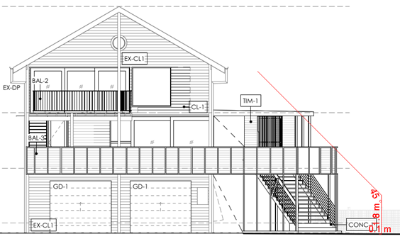
Figure 9: BHP encroachment on northern elevation.
Chapter 1: Part K Flood Liable Lands
|
Provision |
Compliance |
Comment |
|
K2.1 Element - Flood Standard K2.2 Element – Development Criteria |
Yes |
All habitable rooms are located on the first and second floors of the building which are well above the 2050 FPL of 3.5m AHD.
Conditions are recommended for the use of flood compatible materials below the FPL.
|
The proposed development is demonstrated to meet the relevant Element Objectives of DCP 2010.
4.5 Environmental Planning and Assessment Regulation 2021 considerations
|
Provision |
Applicable to the proposal: |
Considered the control as it relates to the proposal: |
If this control is applicable, does the proposal comply? |
|
Section 61 - Additional matters that consent authority must consider |
☒ Yes |
☒ Yes
|
☒ Yes - Condition AS 2601. |
|
Section 62 - Consideration of fire safety |
☒ No |
☒ NA |
☒ NA |
|
Section 64 - Consent authority may require upgrade of buildings |
☒ Yes |
☒ Yes
|
☒ Yes
|
|
Section 63 - Considerations for erection of temporary structures |
☒ No |
☒ NA |
☒ NA |
4.6 The likely impacts of that development, including environmental impacts on both the natural and built environments, and social and economic impacts in the locality
|
Impact on: |
Likely significant impact/s? |
|
Natural environment |
No. The proposal will not have a significantly adverse impact on the natural environment of the locality. |
|
Built environment |
No. The proposal will not have a significantly adverse impact on the built environment of the locality. |
|
Social Environment |
No. The proposal will not have a significant social impact on the locality. |
|
Economic impact |
No. The proposal will not have a significant economic impact on the locality. |
|
Construction Impacts |
No. The development will generate minor impacts during its construction. Conditions of consent recommended to control hours of work, builders waste, construction noise, installation of sedimentation and erosion control measures and the like to ameliorate such impacts. |
4.6.2 Marine Estate Management Act 2014
The development is unlikely to have an effect on the plants or animals within the Cape Byron Marine Park or their habitat.
4.7 The suitability of the site for the development
The site is a serviced, unconstrained property and is suitable for the proposed development.
4.8 Submissions made in accordance with this Act or the regulations
The development application was publicly exhibited for a period of 14 days in accordance with the Byron Shire Community Participation Plan. There were no submissions made on the development application.
4.9 Public interest
The proposed development is unlikely to prejudice or compromise the public interest or create an undesirable precedent.
DEVELOPER CONTRIBUTIONS
No Developer Contributions will be required.
DISCLOSURE OF POLITICAL DONATIONS AND GIFTS
|
Disclosure details |
Response |
|
Has a Disclosure Statement been received in relation to this application? If Yes, Provide Disclosure Statement register reference: 91. |
Yes ☐ No ☒ |
|
Have staff received a ‘gift’ from anyone involved in this application that needs to be disclosed. |
Yes ☐ No ☒ |
CONCLUSION
The proposed development is satisfactory having regard to the relevant environmental planning instruments and planning controls applicable to the site. The proposal raises no significant issues in terms of environmental impacts which cannot be managed. The site is a serviced, unconstrained property and is considered suitable for the proposed development.
The application appropriately addresses the relevant constraints applying to the site and is recommended for approval subject to the conditions listed in Attachment 1.
BYRON SHIRE COUNCIL
Staff Reports - Sustainable Environment and Economy 13.6
Report No. 13.6 Wallum Subdivision DA 10.2021.575.1 - Response to Council Resolution 23-454
Directorate: Sustainable Environment and Economy
Report Author: Chris Larkin, Manager Sustainable Development
File No: I2024/52
Summary:
Council considered Report No. 13.12 Wallum Subdivision DA 10.2021.575.1 - Response to Council Resolution 23-454 Late Items Agenda of Ordinary Meeting - Thursday, 14 December 2023 (infocouncil.biz) and Resolved 23-651 that Council defers Report ‘Wallum Subdivision DA 10.2021.575.1 - Response to Council Resolution 23-454’ (I2023/1946) until the first meeting in February 2024 to enable Councillors time to fully engage and understand the late report that has been provided.
RECOMMENDATION:
That Council:
1. Notes the report Wallum Subdivision DA 10.2021.575.1 - Response to Council Resolution 23-454.
2. Notes that the relevant plans under Conditions 6, 7, 8 and 9 DA 10.2021.575.1 as submitted have been assessed as compliant as they relate to the Early Stage 1 Ecological Rehabilitation Works for the subdivision.
3. Notes that staff will now issue the Subdivision Works Certificate for the Early Stage 1 Ecological Rehabilitation Works for the subdivision to commence.
1 14.2021.575.1
Revised Wallum Vegetation Management Plan - AWC - Revision M 6/12/23, E2023/129124 ![]()
2 14.2021.575.1
Revised Wallum Froglet Management Plan - AWC Revision I - 6/12/23, E2023/129023 ![]()
3 14.2021.275.1
Construction Environmental Management Plan (CEMP) Ref: 1-211400_03d prepared by
AWC - Revised 30/11/2023., E2023/128135
![]()
4 14.2021.575.1
Surface Water and Groundwater Management Plan (SWGMP) Ref: 1-211400_03e
prepared by AWC - Revised 1/12/23, E2023/128125
![]()
5 14.2021.575.1
Peer Review from Martens and Associates of WFMP, E2023/129002 ![]()
6 Extract
from the Commissioner’s Public Report into Wingecarribee Shire Council, E2023/127714 ![]()
Background
Council considered a Notice of Motion 9.2 Wallum DA10.2021.575.1 referral and assessment Agenda of Ordinary (Planning) Meeting - Thursday, 12 October 2023 and resolved under Parts 5 and 7 of Resolution 23-454 to receive certain assessments of certain plans, and for those assessments to be reported back to Council.
This report responds to Parts 5 and 7 Resolution 23-454 in particular it:
· Notes the applicant has submitted the relevant plans for approval as per the conditions: Vegetation Management Plan, the Wallum Froglet Management Plan, the Construction Environmental Management Plan and the Updated Surface and Groundwater Management Plan.
· The revised Vegetation and Wallum Froglet Management Plans as per Conditions 6 and 7 have been assessed by an external consultant.
· The Construction Environmental Management Plan and the Updated Surface and Groundwater Management Plan as per Conditions 8 and 9 have been assessed by Council Environmental Health Officers.
· Has determined their compliance with Conditions 6, 7, 8 and 9 of the Development Consent DA10.2021.575.1. as they relate to the Early Stage 1 Ecological Rehabilitation Works for the subdivision.
The development has been approved in a number of stages. This report deals only with those plans relevant to Early Stage 1 Ecological Rehabilitation Works.
Based on the assessment received by the external consultant, staff recommend that Council notes the report.
This will enable the Subdivision Works Certificate to be issued for the Early Stage 1 Ecological Rehabilitation Works. This is consistent with the relevant Legislation.
Report
Council resolved on 12 October 2023 under Part 5 of Resolution 23-454 the following:
5. Receives assessments of the Amended Management Plans submitted to Council for the development at Bayside Brunswick (DA10.2021.575.1) to ensure that those Plans comply with Consent Conditions set by the NRPP and with Federal, State and Local regulations, including separate assessments of Plans for:
a) Vegetation Management (Condition 6);
b) Wallum Froglet Management (Condition 7);
c) Construction Environmental Management (Condition 8);
d) Updated Surface and Groundwater Management (Condition 9);
e) Stormwater Maintenance Management (Condition 12);
f) Cultural Heritage Site Inspection (Condition 18).
Conditions 6, 7, 8 and 9 of the Development Consent DA10.2021.575.1. apply to the Early Stage 1 Ecological Rehabilitation Works for the subdivision. The applicant has submitted the relevant documents for approval under Subdivision Works Certificate 14.2021.575.1 Copies of the relevant documents are attached to this report.
(NB. Conditions 12 and 18 relate to subsequent stages of the development in terms of earthworks and civil construction of the subdivision and will be reported later to Council).
Conditions 6 and 7 have been assessed by an external consultant Ascentecology on behalf of Council with comments provided below against the specifics of the condition attributed to this consulting firm.
Conditions 8 and 9 have been considered by Council Staff with comments provided below attributed to Council Environmental Health Officers.
It is noted that the Vegetation Management Plan and Wallum Froglet Management Plan have already been approved under Condition 1 of the consent and the condition only required the plans to be updated/amended to include additional detail. Comments on the four conditions are as follows:
Condition 6 Vegetation Management Plan
6) Amended Vegetation Management Plan – Early Stage 1
An amended vegetation management plan must be updated and submitted to Council for approval and include the following:
a. Provide an accurate plan at 1:200 scale that clearly indicates the location of compensatory plantings for the glossy black cockatoo and the koala as indicated in the VMP as approved under Condition 1
External Consultants Assessment: The Revised Vegetation Management Plan (Revision M – 6/2/2023) satisfies condition 6a of the DA10.2021.575.1. Accurate figures to the required scale are provided in Appendix B.
b. Provide details for the ongoing vegetation management of the mitchells rainforest snail habitat in Management Zones 1 and 4 and its long term protection
External Consultants Assessment: The Revised Vegetation Management Plan (Revision M - 6/12/2023) satisfies condition 6b of the DA10.2021.575.1. Management guidelines, canopy cover thresholds and mapping has been provided to detail how the Mitchell’s Rainforest snail will be managed.
c. Provision of 50 nest boxes designed for glossy black cockatoos and a range of arboreal mammals found in the area. The plan to show the location of the boxes to be installed together with details of the monitoring and reporting to Council of their use. The boxes to be installed as part of Early Stage 1. The plan to also include details of the monitoring with a 6 monthly inspection regime, and reporting of the boxes across the seven stages of the development with mitigation measures to replace boxes if damaged or utilized by pest including bees, mynas and other feral animals, termites and the like.
External Consultants Assessment: The Revised Vegetation Management Plan (Revision M - 6/12/2023) satisfies condition 6d of the DA10.2021.575.1. A nest box management plan is provided in Appendix D. The installation of nest boxes has been included as a management action with timing, KPI’s and adaptive management identified.
d. include details of strategies to be used to restrict breeding opportunities for the introduced Cane Toad Rhinella marina, such as the planting of dense sedges to widths of up to 5 m along watercourses.
External Consultants Assessment: The Revised Vegetation Management Plan (Revision M - 6/12/2023) satisfies condition 6d of the DA10.2021.575.1. Details of required landscape planting have been included in section 5.5 and drawings in appendix B.
§ The plan to be prepared by a suitably qualified Ecologist.
External Consultants Assessment: The plan has been prepared by suitably qualified ecologists from Australian Wetland Consulting.
Condition 7 Wallum Froglet Management Plan
7) Amended Wallum Froglet Management Plan
An amended Wallum Froglet Management Plan to be submitted to Council for approval prior to the issue of the Subdivision works certificate. The amended WFMP must contain a review of engineering plans including Basin Layout Plans prepared by Civil Tech Ref: 1133-GW5_A (Sheet 5 of 7), and Hydrological Assessment Ref: P2008063JR02V03 prepared by Martens P/L dated 25 August 2021. In particular the amended plan is to address:
a. Modelling results in terms of potential zero drawdown of groundwater levels in the retained habitat area (MZ-3A) adjacent to the proposed new stormwater drain, and a description of how such changes to hydrology and water quality/ chemistry will be managed in the context of recreating Wallum froglet habitat and the existing habitat within the existing drain.
External Consultants Assessment: Revised Wallum Froglet Management Plan (Revision I- 6/12/2023) satisfies condition 7a of the DA10.2021.575.1. Modelling has been provided in P2008063JR02V03 prepared by Martens P/L dated 25 August 2021.
b. Illustrate on maps of a suitable scale (1:200 or better) detailed engineering plans and word form identifying the donor Wallum Froglet habitat areas which includes the vegetation suite and dimensions (H/L/D) of the individual habitat areas and overall area of the habitat earmarked for translocation.
External Consultants Assessment: Revised Wallum Froglet Management Plan (Revision I - 21/11/2023) satisfies condition 7b of the DA10.2021.575.1. Drawings provided in Appendix B (1-211400_EW_09 -11).
c. Detailed engineering plans indicating the location of the translocated habitat plots as indicated in Northwest Landscape Plan, Southwest Landscape Plan Central Drain Habitat & Rehabilitation Zone Plan and Eastern Habitat & Rehabilitation Zone Plan of the Revised Vegetation Management Plan (Revision J - 09/11/22)
External Consultants Assessment: The Revised Wallum Froglet Management Plan (Revision I – 6/12/2023) satisfies condition 7c of the DA10.2021.575.1 Drawings provided in Appendix B.
d. Prior to the translocation of any Wallum Froglet habitat from the proposed house lot area, Wallum Froglet population surveys are to be carried out before and after rainfall events at these sites to establish both population size and density of existing Wallum Froglets in the Wallum Froglet habitat areas to be moved (Fig 1.3 – Wallum Froglet Habitat Mapping – Revised Wallum Froglet Management Plan). This will be used as a benchmark to rate success of planned translocation.
External Consultants Assessment: The Revised Wallum Froglet Management Plan (Revision I – 6/12/2023) satisfies condition 7d of the DA10.2021.575.1. Section 6.3.1 outlines number and type of sampling events required prior to habitat translocation.
e. A Habitat Translocation Plan to include WF survey methodology, Wallum Froglet translocation methodology, translocation timing and timeframes with Key Performance Indicators for the seven stages of the development, benchmarking completion and success at the end of each stage and mitigation measures if KPI at the end of that stage is not met. The KPIs must reflect current WF population and density benchmarks, with reporting and monitoring to be provided to Council as required including with each Subdivision Works Certificate (from early Stage 2, Civil Stage 1 to 5) and Subdivision Certificate (from Civil Stage 1 to 5).
External Consultants Assessment: The Revised Wallum Froglet Management Plan (Revision I – 6/12//2023) satisfies condition 7e of the DA10.2021.575.1. Table 3.2 outlines the habitat translocation plan, sufficient detail has been provided regarding KPI’s, adaptive management and mitigation measures.
f. Mitigation measures should the translocated habitat not survive and function as intended and how it is to be replaced over the seven stages of the development.
External Consultants Assessment: The Revised Wallum Froglet Management Plan (Revision I- 6/12/2023) satisfies condition 7b of the DA10.2021.575.1. Mitigation measures have been provided in table 3.2.
§ The Management Plan to be prepared by a suitably qualified ecologist and peer reviewed by a suitably qualified hydrogeologist prior to submission to council for approval.
External Consultants Assessment: The Management Plan was prepared by a suitably qualified ecologist with further commentary provided by a suitably qualified hydrogeologist (Martens and Associates) in terms of the froglet breeding ponds construction and supervision and groundwater monitoring post construction. See attached correspondence to this report.
Federal, State and Local Guidelines
Ascent Ecology conducted a detailed review of the current federal, state and local regulations/ guidelines relating to the preparation of Vegetation Management Plans (VMP) and applicable threatened frog management plans (Table 1).
The Revised Vegetation Management Plan (Revision M - 6/12/2023) and Revised Wallum Froglet Management Plan (Revision I- 6/12/2023) were assessed against available guidelines (Table 2 and 3).
Table 1 State, Federal and Local Guidelines applicable to the VMP and WFMP
|
Legislation |
Federal |
State |
Local |
|
VMP |
· No guidelines published |
· Some criteria in the ‘Controlled activities – Guidelines for vegetation management plans on waterfront land’ (DPE 2022) are applicable. · No other guidelines published |
· ‘BSC Guidelines for preparing: Vegetation Management Plans (VMP) Biodiversity Conservation Management Plans (BCMP)’ |
|
WFMP |
· ‘National recovery plan for the wallum sedgefrog and other wallum-dependent frog species outlines some management practices’ (DCCEEW 2006). · The Wallum Froglet is not listed under EPBC Act, and no guidelines are published |
· ‘Translocation operational policy’ (DPIE 2019) not applicable as the translocation proposal is in accordance with a development consent (BC Act s.2.8). |
· No guidelines published · ‘BSC Guidelines for preparing: Vegetation Management Plans (VMP) Biodiversity Conservation Management Plans (BCMP)’ can be reviewed to ensure management practices are in line with other Council practices. |
Table 2 Vegetation Management Plan
|
Legislation |
Compliance |
||||||||||||||
|
State: Guidelines for vegetation management plans on waterfront land
|
The Revised Vegetation Management Plan (Revision M – 6/12/2023) has been assessed against Applicable Criteria identified in the Guidelines for vegetation management plans on waterfront land (Note: Criteria specifically related to waterfront land have been excluded).
Photographs of the site should be supplied, and photo points should be identified. To assist with future monitoring and reporting requirements, the photo points should be identified by GPS coordinates or by survey. This is particularly important for large-scale earthworks or extractive industries. Complies: Establishment of permanent plots and photo points has been included in the VMP as part of reporting requirements.
Measures for controlling long-term access and encroachments (bollards, fences, etc.) into the riparian corridor should be identified. Complies: The VMP identifies that exclusion fencing will be installed during construction phase.
Vegetation species composition, planting layout and densities should be identified. Complies: Species selection and planting locations identified on landscape plans (Appendix B).
Seed or plant sources should be identified. Where possible, native plants and seed sources of local provenance should be used. Complies: VMP specifies that local provenance should be used where available and plant stock should be hardened off in a nursery with similar climatic conditions to the site.
Maintenance requirements should extend for a minimum of 2 years after the completion of works or until such time as a minimum 80% survival rate of each species planted and a maximum 5% weed cover for the treated riparian corridor-controlled activity is achieved. Complies: KPI’s (Table C1 of VMP) include 95% of woody weeds and exotic groundcover removed by end of year 2 and 90% survival of planted trees which align with this criterion.
Project tasks should be defined and described, including a schedule detailing the sequence and duration of works necessary for the implementation of the VMP. Complies: Project tasks and timing are included in Table 7.1
Processes for monitoring and review, including a method of performance evaluation should be identified. This should include replacing plant losses, addressing deficiencies, problems, climatic conditions and successful completion of works. Complies: KPI’s and adaptive management are included Table 7.1
Regular reporting on the implementation and status of works covering progress, success or failures and completion should be provided. The number and duration of reporting periods will be identified in the CAA. Works as executed plans and reports detailing how the components of the VMP have been implemented will be required prior to the release of any security held by the department. Complies: VMP states that a brief report that outlines the progress of revegetation and restoration works over each monitoring event should be produced annually. |
||||||||||||||
|
Local: BSC Guidelines for preparing: Vegetation Management Plans (VMP) Biodiversity Conservation Management Plans (BCMP) |
The Revised Vegetation Management Plan-Revision M 6/12/2023 (VMP) has been assessed against the BSC Guidelines for preparing Vegetation Management Plans.
General requirements: provide sufficient background information and site assessment to justify the proposed works; Complies: The VMP includes details of the proposed development, current site attributes (soils, vegetation communities, weeds etc.) and clearly outlines areas impacted and how these impacts will be mitigated (through implementation of the VMP).
clearly describe specific ecological restoration and management requirements for fauna and flora including the timeframe required to meet each particular outcome; Complies: The VMP includes specific management requirements such as nest box installation and koala and glossy black cockatoo feed tree planting, timeframes for implementation have been clearly identified in table format.
provide details of ongoing monitoring requirements including measurable outcomes; Complies: The VMP includes measurable outcomes (number of nest boxes, percentage of canopy cover) in the implementation schedule and management actions plan.
contingency planning options in the case of system failure or natural events which hinder progression. Complies: Hold points have been identified to ensure contingency planning options can be implemented in the case of system failure.
|
Table 3 Wallum Froglet Management Plan
|
Legislation |
Compliance |
|
Federal: National recovery plan for the wallum sedge frog and other wallum-dependent frog species outlines some management practices.
|
The National recovery plan for the wallum sedgefrog and other wallum-dependent frog species identifies nine guidelines for habitat management to ensure proper management of wallum frog habitat. The Revised Wallum Froglet Management Plan (Revision I – 6/12/2023) has been reviewed to ensure management practices are aligned with the recovery plan. Compliance with these guidelines in not a legislative requirement.
1-Minimising soil disturbance- Where earthworks are carried out in the vicinity of breeding habitat, runoff from earthworks must be appropriately contained. Complies: An erosion and sediment control plan (E&SCP) for the project has been outlined for the bulk earthworks, WFMP also includes recommendations ensure retained Wallum Froglet (WF) habitat is not contaminated by site works.
2-Retention of vegetation- At a minimum, vegetation within 50m of breeding sites must be left intact. Proposal does not comply: Not relevant to the WFMP.
3-Preventing nutrient enrichment- direct stormwater runoff away from breeding sites. Complies: The (revised) Stormwater Management Plan (CivilTech Consulting Engineers) includes measures can be integrated with WF habitat creation and management. Stormwater runoff from perimeters roads will be directed into swales for treatment and detention and is contained for all rainfall events up to 15-minute 5yr ARI event.
4-Adaptive fire management- monitoring the response of wallum frogs to fire and modifying burning practices as necessary Not applicable- A Bush Fire Safety Authority (BFSA) has been issued for the development.
5-Limiting use of biocides in wallum frog habitat- biocides should not be used in the immediate vicinity of wallum frog breeding sites. Complies: WHMP specified that nonchemical weed control techniques (hand pull) must be implemented within WF habitat areas.
6-Managing recreational use of coastal lakes (National parks and conservation reserves)-visitor numbers and access to lakes and swamps must be reduced or boardwalks constructed to allow visitors access to water without reed beds being trampled. Not applicable- Site is not a national park or conservation reserve
7-Managing the impact of feral animals Complies: Monitoring and controlling pest species (in particular Cane Toads and Mosquito Fish) has been identified as part of the habitat translocation plan.
8-Road construction- Roads should be built around or over, not through, wallum frog breeding habitat Proposal does not comply: Not relevant to the WFMP.
9-Monitoring- Where the impact of development is to be assessed, monitoring must be carried out a year or preferably more, before development starts. Proposal does not comply: Proponent to update WFMP to specify that the ‘Prior to translocation sampling’ detailed on section 6.3.1 will be carried out at least one year prior to the development commencing.
|
|
Local: BSC Guidelines for preparing: Vegetation Management Plans (VMP) Biodiversity Conservation Management Plans (BCMP). |
The Revised Wallum Froglet Management Plan-Revision I - 6/12/2023 (WFMP) has been assessed against the BSC Guidelines for preparing Biodiversity Conservation Management Plans (BCMP):
Provide management strategies to minimise threats to threatened species and ecological values of the site during development and ongoing use of the site; Complies: The WFMP outlines several strategies to minimise threats to Wallum Froglets and Wallum Froglets habitat including: Orientating development footprint to avoid existing WF habitat, habitat translocation and habitat restoration.
Improved environmental outcomes of development by restoring and enhancing threatened species habitat; Complies: The WFMP proposes a 7000m² (0.7ha) net gain in Wallum Froglets habitat.
Be consistent with relevant recovery plans, legislation and policy. Complies: The WFMP meets applicable management requirements outlined in the ‘National recovery plan for the wallum sedge frog and other wallum-dependent frog species’. Currently no specific recovery plan exists for the Wallum Froglets under State Legislation. |
|
Ecological Values- Survey methods The WFMP has provided references to reports which contain details of previous Wallum Froglet surveys and records as well as details of survey methodology used. |
|
|
Ecological Values- Fauna Management The WFMP includes a description of the Wallum Froglet and Wallum Sedgefrog, including legislative status, habitat requirements and biology, and threatening processes. The locations of observed wallum Froglets and Wallum Sedgefrog have been provided. |
|
|
Ecological Values -Feral animals The WFMP includes a description of potential feral animals on site and identifies management provisions to mitigate their impacts. |
|
|
Ecological Values -Biodiversity at a landscape level Not applicable to the WFMP |
|
|
Ecological Values -Biodiversity at a Genetic level Not applicable to the WFMP |
|
|
Ecological Values -Watercourses and riparian areas The WFMP provides sufficient detail of watercourses and drainage lines located on and near the site. |
|
|
Management Strategies-Fauna management The WFMP provides specific management strategies necessary to satisfactorily manage significant fauna species (Wallum Froglets). This includes management of habitat (through habitat translocation and restoration) to ensure the continued success of Wallum Froglet populations. The WFMP is based on the principals of avoid, minimise and mitigate). |
|
|
Management Strategies-Aquatic habitats protection & management The WFMP includes an assessment of the hydrology on the site to ensure that constructed habitats are protected from overland flow. Mitigation measures to ensure appropriate hydrological conditions are maintained are included as part of the management strategies. |
|
|
Management Strategies - Human land-use & activity management Not applicable to the WFMP |
|
|
Management Strategies-Pest & domestic animal management The WFMP provides strategies and provisions to manage the impacts of pest species the Site. |
|
|
Management Strategies-Fire Management Not applicable to the WFMP |
|
|
Management Strategies-Monitoring The WFMP includes a monitoring strategy which sets out the monitoring methodology and performance to specifically address the aims and objectives of the plan. Performance indicators provided are measurable (population estimate, percentage cover of habitat) and are directly related to the aims and objectives (ensure conservation of Wallum Froglets). Provisions for Baseline monitoring are also included, allow an assessment of the impact of the development on Wallum Froglet populations. The WFMP also includes some provisions to adjust monitoring and management strategies in response to unanticipated circumstances such as habitat translocation failure. |
Conditions 6 and 7 – Conclusion
It is considered the Vegetation Management Plan prepared by AWC Revision M dated 6/12/2023 and the Wallum Froglet Management Plan prepared by AWC Revision I dated 6/12/2023 satisfy Conditions 6 and 7 of Development Consent DA10.2021.575.1.
As detailed above it is also considered the conditions of consent have been satisfied with additional commentary provided in terms of Federal, State and Local Government regulations.
In terms of State legislation, the EPA Act 1979 and Associated Environmental Planning and Assessment (Development Certification and Fire Safety) Regulation 2021 also apply.
With the conditions satisfied this will enable the Subdivision Works Certificate to be issued under Section 6.15(c) of the EPA Act 1979, and pursuant to Section 34 of the Environmental Planning and Assessment (Development Certification and Fire Safety) Regulation 2021.
Condition 8
8) Construction Environmental Management Plan
A detailed Construction Environmental Management Plan (CEMP) is to be prepared and submitted to Council. The CEMP shall document all environmental related commitments for each Stage of development including but not limited to mitigation, management, restoration, monitoring, and reporting detailed in the approved ASSMP, SMP, DMP, SWGMP, UFP, VMP, and WFMP.
The CEMP is to be developed so that it can receive new information gathered from ongoing monitoring and modelling and be adapted as necessary to accommodate any necessary design changes and /or contingency measures.
The monitoring requirements in the ASSMP, SMP, SWGMP, UFP, VMP, and
WFMP shall be included the CEMP to include:
External Consultants Assessment: Report titled ‘Early Stage 1, Construction Environmental Management Plan (CEMP) Ref: 1-211400_03d prepared by AWC dated 30/11/2023. The detailed document provides the monitoring requirements for the ASSMP, SMP, SWGMP, UFP, VMP, and WFMP. The document has been reviewed by council officers and it can be confirmed that it was developed to receive new information gathered from ongoing monitoring and modelling and be adapted as necessary to accommodate any necessary design changes and /or contingency measures.
a. Analysis of all monitoring and sampling data against baseline data and approved thresholds (in the approved CEMP), limits and triggers; and
External Consultants Assessment: CEMP (AWC, Ref: 1-211400_03d, dated 30/11/2023) sets out all monitoring and sampling data against baseline data and approved thresholds, limits and triggers for the ASSMP, SMP, SWGMP, UFP, VMP, and WFMP References are outlined throughout the document and all approved reports are appended to the CEMP and therefore complies with part (a) of condition 8.
b. At least six (6) monthly reporting during subdivision construction works for at least five (5) years or until two years following the issue of a subdivision certificate for Stage 5, whichever is the later; and
External Consultants Assessment: CEMP (AWC, Ref: 1-211400_03d, dated 30/11/2023) sets out the reporting regime required in part (b) of condition 8. References to the required reporting framework of at least six (6) monthly reporting during subdivision construction works for at least five (5) years or until two years following the issue of a subdivision certificate for Stage 5 is outlined throughout the document therefore complies with part (b) of condition 8.
c. Reporting on the performance of the road pavement, bioretention basin, bio pods and the North South drain by the project engineer or other professional with sufficient experience and capabilities in road pavement, construction, and establishment of bioretention basins and stormwater detention systems for Council’s acceptance demonstrating compliance with the Approved Design; and
External Consultants Assessment: CEMP (AWC, Ref: 1-211400_03d, dated 30/11/2023) sets out requirements for reporting on performance on road pavement (s.4.22 on page 83) bioretention and bio pods (Table 4.21 on page 54) and North South drain (Table 4.16 on page 48). Reporting was undertaken by Adrian Leader (Environmental Consultant, AWC) and Wade Fletcher (Engineer, Civil Tech). Therefore, the CEMP complies with part (c) of condition 8.
d. In the event the report required by item c identifies failures, the report shall provide an alternative design that will prevent future and ongoing failures for the civil works of the subdivision; and
External Consultants Assessment: CEMP (AWC, Ref: 1-211400_03d, dated 30/11/2023) s. 4.7.4 on page 55 provides that in the event the monitoring report identifies failures, it shall also provide alternative design that will prevent future ongoing failure for the particular device, and therefore the CEMP complies with part (d) of condition 8.
e. Annual reporting hereafter until the final maintenance bond is returned.
External Consultants Assessment: CEMP (AWC, Ref: 1-211400_03d, dated 30/11/2023) states that ‘from the issue of the final certificate from Council, monthly sample collection for a further 12 months. An Annual report will be prepared detailing results and comparisons to the action criteria stipulated, or as amended in the interim until the final maintenance bond is returned’ (s.4.10.2.2 on page 65). Thus part (e) of condition 8 has been satisfied.
§ The CEMP, including the independent environmental audit of compliance with the CEMP, is to be submitted to Council for approval prior to the commencement of each stage. Any non-compliance/s are to be satisfactorily addressed before commencement of the following stage.
External Consultants Assessment: An independent audit report ref: ENV217959 for Early Stage 1, Construction Environmental Management Plan was prepared by ENV dated 8/11/2023. The audit resulted in amendments to the CEMP and a further review by ENV deemed it to be compliant with development consent conditions set out in DA10.2021.575.1.
§ The CEMP must specify that the successful contractor’ is to understand the interrelationships and potential conflict during construction between surface, groundwater, vegetation, acid sulphate soils, acid frog habitat and benthic invertebrates. The successful contractor is to nominate and retain a competent Environmental Manager and Environmental Consultants in hierarchy to ensure that that the CEMP is understood fully and implemented as required.
§ The names and contact details of the Environmental Manager are to be provided to Council and a prestart meeting must be arranged with Council Officers prior to commencement of any groundworks and must be noted in the CEMP. The CMP must be approved by Council.
External Consultants Assessment: The nominated Environmental Managers (Damian McCann and Jesse Munroe of AWC) have been endorsed following receipt of their CVs which are now attached to the CEMP. Relevant contact details for Damian McCann and Jesse Munroe included in the CEMP.
Condition 8 Conclusion
The condition is a “bespoke condition” imposed to require all environmental related commitments under the consent in one document. It is considered there is no specific Federal, State or Local Government Regulations that relate to its assessment, other than the condition must be satisfied to enable the Subdivision works certificate to be issued under Section 6.15(c) of the EPA Act 1979 and pursuant to Section 34 of the Environmental Planning and Assessment (Development Certification and Fire Safety) Regulation 2021.
Based on the assessment provided above the Construction Environmental Management Plan (CEMP) Ref: 1-211400_03d prepared by AWC dated 30/11/2023 satisfies condition 8 of DA 10.2021.575.1 for Early Stage 1.
Condition 9
9) Updated Surface and Groundwater Management Plan – Monitoring, Analysis, Modelling and Contingency management
Prior to issue of a subdivision works certificate for each stage, an updated Surface and Groundwater Monitoring Plan (GMP) shall be prepared and provided to Council for approval.
External Consultants Assessment: Surface Water and Groundwater Management Plan (SWGMP) Ref: 1-211400_03e prepared by AWC dated 1/12/2023 has been submitted to council for review and is deemed to generally satisfy condition 9 of DA 10.2021.575.1 for Early Stage 1.
The SWGMP (AWC, 1-211400_03b, 14/09/2022) shall be updated to include monitoring of groundwater levels and quality prior to, during and following construction of the subdivision works as they progress, including, but not limited to:
a. Monitoring results of groundwater levels and quality from the commencement of Early Stage 1 works until the issue of a subdivision certificate for Stage 5 with submission of an updated report to Council prior to the issue of the subdivision works certificate for each stage of works.
External Consultants Assessment: SWGMP (AWC, Ref: 1-211400_03e, 1/12/2023) demonstrates that AWC collected a baseline data set of groundwater quality across the site from 2021 to 2022 from six bores (Fig 3.1) on page 12. shows their locations. Sampling was undertaken in accordance with Groundwater Sampling and Analysis – A Field Guide, (Sundarum at el, 2009) with all laboratory analysis being undertaken by EAL NATA accredited laboratory. The suite of analytes are provided by AWC in (Table 3.5) on page 14 and consistent with groundwater reporting requirements.
b. Monitoring of groundwater levels and quality at the end of each Stage.
External Consultants Assessment: SWGMP (AWC, Ref: 1-211400_03e, 1/12/2023) provides the scope and commitment for ongoing monitoring for groundwater level and quality for each stage is provided in s. 3.3 and 3.4 with surface water monitoring detailed in s. 4.1 pages 9 – 23.
c. Monitoring of groundwater levels and quality monthly for 12 months following the issue of a subdivision certificate for stage 5; and
External Consultants Assessment: s.3.5.2 SWGMP (AWC, Ref: 1-211400_03e, 1/12/2023) demonstrates the commitment from the issue of the final subdivision certificate from Council, monthly sample collection and level data logging will continue for a further 12 month. Six monthly reports will be prepared detailing results and comparison to the action criteria stipulates, or as amended in the interim. Table 3.9 provides detail on the monitoring program, schedule and reporting for the occupation phase.
d. Targets for groundwater quality and levels and the commitment to use these targets in required routine reporting.
External Consultants Assessment: SWGMP (AWC, Ref: 1-211400_03e, 1/12/2023) demonstrates that groundwater level and quality data have been collected to form a baseline data set with targets determined to detect adverse impacts. Surface water quality data been collected to form a baseline data set with targets determined to detect adverse impacts. Refer to s. 3.3.2, s. 3.4.2 and s. 4.1.1.
Action criteria are based on 80 percentile value of baseline data set with pH action criteria based on the existing recorded range. Action criteria are generally above ANZECC Guidelines due to function of the existing condition of groundwater reserves being impacted by existing urban land uses in the catchment. If there is an exceedance of one of the action criteria the Groundwater Action Response will be enacted (refer pages 16, 17). The action criteria are considered satisfactory given the existing recorded water quality for analytes. pH action criteria are considered representative of natural acidic groundwater conditions.
e. Groundwater data to be compiled and analysed and uploaded into a groundwater modelling report with updated results analysed; and
External Consultants Assessment: Groundwater data will be provided to Martens quarterly throughout the project refer page 3. Martens will compile and upload data into a groundwater modelling in preparation for AWC to routinely report back to Council.
f. Contingency Management to resolve any unforeseen groundwater matters.
External Consultants Assessment: SWGMP (AWC, Ref: 1-211400_03e, 1/12/2023) provides contingency management to resolve any unforeseen groundwater matters. AWC state that, ‘ongoing monitoring and comparison with the baseline data set and adopted action criteria will alert the Environmental Manager to a development related impact. Rectification of the impact will need to be investigated with consideration of spatial and temporal effects, stakeholder values and practicality.’ s 5 SWGMP (Ref: 1-211400_03e, 1/12/2023) on page 25 provides discussion of contingency actions. Strategies have been developed into the following 4 categories:
Ø Maintenance of Groundwater Levels (s. 5.1) page 25
Ø Groundwater Quality (s. 5.2) page 25
Ø Surface Water Quality (s. 5.3) page 25
Ø Risk Assessment and Emergency Response Plan (s. 5.4) page 25,26
Table 5.2 on page 27 provides a ‘risk assessment matrix’ that considers possible events, consequences, likelihood, risk ranking and emergency response. The highest risk raking is attributed to ‘high intensity rainfall’ (significant, likely, high) and the lowest ranking of (minor, rare, very low) being bushfire. Possible events have been provided with recommended emergency responses. An Action Response Plan is detailed in s. 6 of the SWGMP.
§ The groundwater monitoring shall consider the specific details of the site, proposed subdivision construction works methodology and subdivision layout. The construction stage monitoring must be designed and conducted as appropriate for each stage with details to be given in the CEMP.
External Consultants Assessment: Groundwater monitoring program for Early Stage 1 is detailed in s 4.2.1 and Table 4.4. Locations for collection locations, collection timing and reporting time are detailed in Table 4. 4. The regime is considered appropriate and will incorporate six existing groundwater bores shown in Figure 3.1.
§ The Surface and Groundwater Management Plan (AWC, 1-211400_03b, 14/09/2022) provides details on baseline groundwater levels and quality and this information is to be incorporated into the Updated Surface and Groundwater Management Plan.
External Consultants Assessment: Surface and Groundwater Management Plan (AWC, Ref: 1-211400_03d, 1/12/2023) has been cited in ‘Early Stage 1, Construction Environmental Management Plan (CEMP) Ref: 1-211400_03d prepared by AWC dated 30/11/2023. The document shall be amended to reflect the amended report (AWC, Ref: 1-211400_03e, 1/12/2023) and the report shall be appended to the CEMP when formally approved by council. This will take place prior to issue of the construction certificate for Early Stage 1.
§ The Plan must be prepared by a suitably qualified hydrogeologist or equivalent professional.
External Consultants Assessment: Surface Water and Groundwater Management Plan (SWGMP) Ref: 1-211400_03e prepared by AWC dated 1/12/2023 has been prepared by Jesse Munro (Senior Environmental Scient) and Adrian Leader (Environmental Consultant) employed with AWC P/L. Mr Munroe’s CV is contained in the CEMP and Mr Leader has provided council with a copy of his CV and it can be provided on request.
Condition 9 - Conclusion
The condition is a “bespoke condition” imposed to require all surface water and groundwater management commitments in one document. It is considered there is no specific Federal, State or Local Regulations that relate to it assessment, other than the condition must be satisfied to enable the Subdivision Works Certificate to be issued under Section 6.15(c) of the EPA Act 1979, and pursuant to Section 34 of the Environmental Planning and Assessment (Development Certification and Fire Safety) Regulation 2021.
Based on the assessment provided above, it is considered the Surface Water and Groundwater Management Plan (SWGMP) Ref: 1-211400_03e prepared by AWC dated 1/12/2023 satisfies condition 9 of development consent DA 10.2021.575.1.
Strategic Considerations
Community Strategic Plan and Operational Plan
|
CSP Objective |
CSP Strategy |
DP Action |
Code |
OP Activity |
|
4: Ethical Growth |
4.1: Manage responsible development through effective place and space planning |
4.1.1: Development assessment - Manage development through a transparent and efficient assessment process |
4.1.1.1 |
Assess and determine development assessments in accordance with the relevant legislation |
|
4: Ethical Growth |
4.1: Manage responsible development through effective place and space planning |
4.1.1: Development assessment - Manage development through a transparent and efficient assessment process |
4.1.1.2 |
Certify development in accordance with relevant legislation |
Recent Resolutions
· 23-454
Legal/Statutory/Policy Considerations
The Legal Services team staff hold concerns as to whether the elected Council can take the place of appropriately qualified Council staff in assessing the adequacy of documents submitted to satisfy consent conditions.
In other words, can the elected body of Council take the place of the certifier?
The relevant EP&A (Development and Certification and Fire Safety) Regulations dealing with the role of the certifier state as follows:
33 Determination of application for subdivision works certificate
(1) A certifier must ensure the certifier’s determination of an application for a subdivision works certificate contains the following information—
(a) the date on which the application was determined,
(b) whether the application is approved or refused,
(c) if the application is refused—
(i) the reasons for the refusal, and
(ii) if the certifier is a consent authority—the applicant’s right of appeal under the Act.
(2) Within 2 days after determining the application, the certifier must use the NSW planning portal to—
(a) give the determination to the applicant, and
(b) give a copy of the following to the consent authority and council—
(i) the determination and the application to which it relates,
(ii) a subdivision works certificate issued as a result of the determination,
(iii) the plans and specifications in relation to which the subdivision works certificate is issued,
(iv) other documents that were lodged with the application for the certificate or given to the certifier under section 32.
(3) In this Part, a reference to issuing a subdivision works certificate includes a reference to endorsing the subdivision work on the relevant plans and specifications.
Maximum penalty (subsections (1) and (2))—
(a) for a corporation—300 penalty units, or
(b) for an individual—150 penalty units.
34 Compliance with development consent and planning agreement
(1) A certifier must not issue a subdivision works certificate unless the design and construction of the subdivision work is consistent with the development consent.
(2) A certifier must not issue a subdivision works certificate under a development consent unless the following have been complied with—
(a) a condition of the development consent or an agreement referred to in the Act, section 4.17(6) requiring the provision of security before work is carried out,
(b) a condition of the development consent, referred to in the Act, section 7.11 or 7.12, requiring the payment of a monetary contribution or levy before work is carried out,
(c) a condition of the development consent that must be complied with before the subdivision works certificate may be issued,
(d) a condition of a planning agreement that must be complied with before the subdivision works certificate may be issued.
(3) In this section—
design and construction of subdivision work means the design and construction of the work described in the plans and specifications and other information given to the certifier under section 32.
Maximum penalty (subsections (1) and (2))—
(a) for a corporation—300 penalty units, or
(b) for an individual—150 penalty units.
73 Certifiers may be satisfied of certain matters
(1) If a condition of a development consent requires a consent authority or council to be satisfied about a relevant matter, the condition is taken to have been complied with if a certifier is satisfied about the matter.
(2) In this section—
relevant matter means—
(a) a matter that relates to the form or content of the plans and specifications for the following kind of work that will be carried out in connection with the erection of a building or the subdivision of land—
(i) earthworks,
(ii) roadworks, including road pavement and road finishing,
(iii) stormwater drainage work,
(iv) landscaping work,
(v) erosion and sedimentation control works,
(vi) excavation work,
(vii) mechanical work,
(viii) structural work,
(ix) hydraulic work,
(x) work associated with driveways and parking bays, including road pavement and road finishing, and
(b) a matter that relates to the external finish of a building.
Attachment 1 is an extract from the Commissioner’s Public Report into Wingecarribee Shire Council which touched on Councillor transgression into operational matters on planning considerations.
Councillors are referred to the decision of the Chief Judge of the Land and Environment Court in Australian Wildlife Ark Limited v Secretary, Department of Planning and Environment [2023] NSWLEC 139.
It is a costs decision, following a Class 1 merit appeal for a licence under the Biodiversity Conservation Act 2016.
The Applicant sought costs on a number of bases, including under r 3.7(3)(c) of the LEC Rules 2007. Failure to perform a statutory duty (in this case determine an application) was held to be unreasonable conduct warranting the engagement of costs.
His Honour at paragraph 103 said:
I find that the Department did act unreasonably in the circumstances leading up to the commencement of the proceedings by refusing to consider and determine Aussie Ark’s applications for licences. As I have explained earlier, the conduct in refusing to consider and determine Aussie Ark’s applications for licences until the Department’s compliance investigation was completed lacked statutory authority. The Department failed to perform its statutory duty to consider and determine the applications. That failure to perform its statutory duty was the operative cause of Aussie Ark having to re-submit its applications for licences and having to appeal against the deemed refusal of the re-submitted applications.
At paragraph 133 his Honour found as follows:
I consider that the making of an order as to the whole of the costs of both proceedings is fair and reasonable in the circumstances. An order for costs will serve to compensate Aussie Ark for the costs it has had to incur because of the conduct of the Department in the circumstances leading up to the commencement of the proceedings and in the conduct of the proceedings, which I have found to be unreasonable. As Aussie Ark has been successful in its application for costs, it is also fair and reasonable to make an order for costs of the application for costs.
Financial Considerations
Should there be unnecessary delays in the finalisation of the Subdivision Works Certificate, the applicant has rights of appeal through the Land Environment Court. Council would need to finance any defence and costs associated with it in terms of an appeal if it eventuated. See information on adverse costs above.
External consultants and legal advice fees vary and are an ongoing cost consideration for this matter.
Consultation and Engagement
Not applicable.
BYRON SHIRE COUNCIL
Staff Reports - Sustainable Environment and Economy 13.7
Report No. 13.7 PLANNING - DA10.2023.332.1 - Dual Occupancy Dwelling – 135 Blindmouth Road, Main Arm
Directorate: Sustainable Environment and Economy
Report Author: Jordan Vickers, Planner
File No: I2024/85
Proposal:
|
DA No: |
10.2023.332.1 |
||||||
|
Planning Portal ref |
PAN-366704 |
||||||
|
Proposal description: |
Dual Occupancy |
||||||
|
Property description: |
LOT: 7 DP: 260707 |
||||||
|
135 Blindmouth Road MAIN ARM |
|||||||
|
Parcel No/s: |
182270 |
||||||
|
Applicant: |
Mr R L Larkin |
||||||
|
Owner: |
Mr R L Larkin |
||||||
|
Zoning: |
RU2 Rural Landscape |
||||||
|
Date received: |
11 September 2023 |
||||||
|
Integrated / Designated Development: |
☐ Integrated |
☐ Designated |
☒ Not applicable |
||||
|
Concurrence required |
No |
||||||
|
Public notification or exhibition: |
- Level 1 advertising under Council’s Community Participation Plan. - Exhibition period: 19 September 2023 to 3 October 2023 - Submissions received: 0
|
||||||
|
Concurrent approvals included with DA |
☒ N/A |
|
☒OSMS (68) |
|
|
||
|
Other: |
|
||||||
|
Planning Review Committee |
Not applicable |
||||||
|
Variation request to Development Standards under an EPI (eg clause 4.6) |
Clause 4.6 – >100m Separation of Dual occupancy Dwelling on Rural land |
||||||
|
Estimated cost |
$388,300.00 |
||||||
|
Delegation to determine |
Council |
||||||
|
Issues |
· 4.6 variation: dwellings >100m apart |
||||||
Summary:
This application seeks approval for a Dual Occupancy dwelling comprised of two bedrooms, two bathrooms and open-plan dining, kitchen and living. A new On-site Sewage Management System is proposed to service the dwelling and access is provided via the existing driveway at Blindmouth Road.
The application is referred to Council for determination as the proposal involves a variation to Clause 4.2(2)(d) of LEP 2014 which specifies that Dual occupancy dwellings on Rural allotments are to have a maximum separation distance of 100m.
The proposed second dwelling is located 119.5m from the existing dwelling. A written justification for the proposed variation to the development standard was submitted in accordance with clause 4.6 of LEP 2014. The reasons contained in the clause 4.6 request are acceptable and the variation is supported.
The application was advertised and notified between 19 September 2023 to 3 October 2023 with no submissions received.
The application appropriately addresses the relevant constraints applying to the site and is recommended for approval subject to the Conditions in Attachment 1.
NOTE TO COUNCILLORS:
In accordance with the provisions of S375A of the Local Government Act 1993, a Division is to be called whenever a motion for a planning decision is put to the meeting, for the purpose of recording voting on planning matters. Pursuant to clause 2(a) under the heading Matters to be Included in Minutes of Council Meetings of Council's adopted Code of Meeting Practice (as amended) a Division will be deemed to have been called by the mover and seconder of all motions relating to this report.
RECOMMENDATION:
That Pursuant to Section 4.16 of the Environmental Planning & Assessment Act 1979, Development Application No. 10.2023.332.1 for Dual Occupancy Dwelling, be granted consent subject to the conditions of approval in Attachment 1 (E2024/6057).
1 DA10.2023.332.1
Conditions of Consent, E2024/6057
![]()
2 DA10.2023.332.1
Plans, E2024/6010 ![]()
3 70.2023.332.1
OSMS - Approval to Install, A2024/3002
![]()
4 70.2023.332.1
OSMS Stamped Plans, E2024/6101 ![]()
Report
Description of the proposed development
![]()
This application seeks approval for a Dual Occupancy Dwelling comprised of two
bedrooms, two bathrooms and open-plan dining, kitchen and living. The second
dwelling is located 119.5m from the existing dwelling on the property and a
Clause 4.6 variation to development standards has been submitted to address
clause 4.2(2)(d) LEP 2014.
A new On-site Sewage Management System is proposed to service the dwelling and access is provided via the existing driveway.
Description of the site
The subject site is known as 135 Blindmouth Road, Main Arm (Lot 7 on DP 260707) has an area of 11.94ha and is zoned Rural Landscape (RU2) under Byron LEP 2014. The site is identified as Bushfire prone land and contains High Environmental Value vegetation. An existing dwelling house and farm building currently improve the property and approval DA10.2016.166.1 (as modified) depicts an existing shed in the southeastern corner of the property which is not referred to in the plans. No easements or infrastructure encumber the site.
A site inspection was carried out on 20 November 2023
|
Land is legally described |
LOT: 7 DP: 260707 |
|
|
Property address |
135 Blindmouth Road MAIN ARM |
|
|
Land is zoned: |
RU2 Rural Landscape |
|
|
Land area is: |
11.94 hectares |
|
|
Property is constrained by: |
Bushfire prone land, High Environmental Value |
|
|
|
Is a BDAR required due to the location of the proposed development? |
☐ Yes ☒ No |
|
|
Are there any easements in favour of Council affecting the site? |
☐ Yes ☒ No |
|
|
Is there a Vegetation Management Plan which might affect the proposal? |
☐ Yes ☒ No |
|
|
Is there a Voluntary Planning Agreement which might affect the proposal? |
☐ Yes ☒ No |
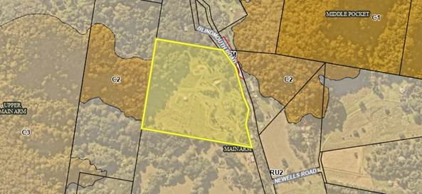
![]()
![]()
![]()
![]()
1. SUMMARY OF REFERRALS
|
Referral |
Issue |
|
Environmental Health Officer* |
No objections subject to conditions. |
|
Development Engineer |
No objections subject to conditions. |
|
S7.11 / Contributions Planner |
No objections subject to conditions. |
* Conditions provided in the above referral are included in the Recommendation of this Report.
2. SECTION 4.14 – BUSH FIRE PRONE LAND
|
Direction |
North, South, East, West |
|
Vegetation formation |
Rainforest (North, East, West), Grassland (South) |
|
Distance between vegetation formation and building |
30m (N), Nil(S), 36m(East), 65m (West) |
|
Effective slope |
11º downhill (N), 11º downhill (S), 6º downhill (E), 9º Uphill (W) |
|
Asset Protection Zone |
20m (N), 20m(S), 20m(E), 9m(W) |
|
Bushfire Attack Level (BAL) |
BAL– 19 to the N façade BAL– 12.5 to the S facade. BAL– 19 to the E façade BAL– 12.5 to the W façade |
A condition is included in the Recommendation of this Report accordingly.
Effect of 10/50 rule on significant vegetation
“The parcel of land you have selected is located in a designated 10/50 vegetation entitlement clearing area. You must read the 10/50 Code of Practice carefully to ensure that you are only clearing in accordance with the 10/50 Code. For more information see our frequently asked questions.”
Accordingly, the landowner may clear vegetation in accordance with the 10/50 Vegetation Clearing Code Of Practice For New South Wales.
3. SECTION 4.15C – MATTERS FOR CONSIDERATION – DISCUSSION OF ISSUES
Having regard to the matters for consideration detailed in Section 4.15(1) of the Environmental Planning & Assessment Act 1979 (EP&A Act), the following is a summary of the evaluation of the issues.
State Environmental Planning Policies (SEPP)
|
Considerations |
Satisfactory |
Unsatisfactory |
|
SEPP No 55—Remediation of Land Consideration: The property is on Council’s Contaminated Land Register for previous agricultural activity (dairy, beef cattle, avocado, and banana) and has been assessed by Council (10.2016.166.1), with officer Emma Holt confirming that the risk is low and no remediation is required. Based on the available information, the site is considered to be suitable for the proposed use in its current state and no further investigation is warranted. |
☒ |
☐ |
|
SEPP (Building Sustainability Index: BASIX) 2004 Consideration: The proposal is accompanied by a valid BASIX and NatHers certificate. The SEPP has been addressed and the proposal is considered to comply. |
☒ |
☐ |
4.2A Byron Local Environmental Plan 2014 (LEP 2014)
LEP 2014 is an applicable matter for consideration in the assessment of the subject development application in accordance with subsection 4.15(1) of the EP&A Act because it applies to the subject land and the proposed development. The LEP 2014 clauses that are checked below are of relevance to the proposed development:
|
Part 1 |
☒1.1 | ☒1.1AA | ☒1.2 | ☒1.3 | ☒1.4 | ☒Dictionary | ☒1.5 | ☒1.6 | ☒1.7 | ☒1.8 | ☐1.8A | ☒1.9 | ☐1.9A |
|
Part 2 |
☒2.1 | ☒2.2 | ☒2.3 | ☒Land Use Table | ☐2.4 | ☐2.5 | ☐2.6 | ☐2.7 | ☐2.8 |
|
Part 3 |
☐3.1 | ☐3.2 | ☐3.3 |
|
Part 4 |
☐4.1 | ☐4.1A | ☐4.1AA | ☐4.1B | ☐4.1C | ☐4.1D | ☐4.1E | ☐4.1F | ☐4.2 | ☐4.2A | ☐4.2B | ☐4.2C | ☒4.2D | ☒4.3 | ☒4.4 | ☒4.5 | ☒4.6 |
|
Part 5 |
☐5.1 | ☐5.2 | ☐5.3 | ☐5.4 | ☐5.6 | ☐5.7 | ☐5.8 | ☐5.10 | ☒5.11 | ☐5.12 | ☐5.13 | ☐5.14 | ☐5.15 | ☐5.16 | ☐5.17 | ☐5.18 | ☐5.19 | ☐5.20 | ☐5.21 | ☐5.22 |
|
Part 6 |
☐6.1 | ☒6.2 | ☐6.4 | ☐6.5 | ☒6.6 | ☐ 6.7 | ☐6.8 | ☐6.9 | ☐6.11 | ☐ 6.12 | ☐6.13 | ☐6.14 | ☐6.15 | ☐6.16 |
In accordance with LEP 2014 clauses 1.4 and 2.1 – 2.3:
(a) The proposed development is defined in the LEP 2014 Dictionary as Dual occupancy;
(b) The land is within the RU2 Rural Landscape according to the Land Zoning Map;
(c) The proposed development is permitted with consent; and
(d) Regard is had for the Zone Objectives as follows:
|
Zone Objective |
Consideration |
|
• To encourage sustainable primary industry production by maintaining and enhancing the natural resource base. • To maintain the rural landscape character of the land. • To provide for a range of compatible land uses, including extensive agriculture. • To enable the provision of tourist accommodation, facilities and other small-scale rural tourism uses associated with primary production and environmental conservation consistent with the rural character of the locality. • To protect significant scenic landscapes and to minimise impacts on the scenic quality of the locality. |
The proposal addresses and satisfies the objectives. |
The checked clauses have been taken into consideration in the assessment of the subject development application in accordance with Section 4.15 of the EP&A Act. The proposed development complies with all clauses of LEP 2014 (in some cases subject to conditions and/or to the satisfaction of other assessing officers).
Clause 4.6 Exceptions to Development Standards
A variation to the 100m separation distance under Clause 4.2D(2)(d) is sought for the second dwelling house. The variation of 19m is a 19% variation to the development standard, and concurrence therefore may not be assumed for Council delegates and the application is to be determined by Councillors.
The applicant has submitted a written request that strict compliance with the development standard is unreasonable or unnecessary and that there are sufficient environmental grounds to vary the controls as follows:
· “Due to the topography of the site. The area surrounding the existing dwelling is generally undulating and not suitable for the type of construction proposed, being a slab on ground. The proposed location is generally level and elevated to take advantage of the rural outlook. The proposed dwelling location is the most suitable location on the site and results in a better planning outcome.”
· “Additionally, some housekeeping amendments [to the] LEP are currently being submitted to the NSW Department of Planning and Environment for Gateway determination. These proposed amendments include the removal of subclause 2(c) of clause 4.2D, which requires that dual occupancies be situated within 100m of each other. The reason for removal of this clause is the acknowledgement that siting dwellings further than 100m apart may be appropriate and produce better outcome[s] in certain circumstances, which is true in this case.
It is considered that strict compliance with the development standard is unreasonable and unnecessary in the circumstances of the case and that there are sufficient environmental grounds to vary the development standard for the following reasons:
· The topography of the site is undulating in an east-west direction, perpendicular to the overarching slope of the site (south-to-north). In most other locations on this site, this circumstance will either demand cut/fill to establish a dwelling on posts, or substantial cut/fill to establish a slab-on-ground construction.
· The location of the proposed dwelling is a flat cleared pad, one of few remaining on the property in proximity to the existing dwelling house. Despite a variation to the standard, the proposed location of the dwelling makes use of the natural topography with minimal disturbance to natural ground levels and engineering required. There are sufficient environmental grounds to vary the development standard.
· A planning proposal to remove Clause 4.2D(2)(c) received gateway determination on 20/09/2023. The LEP changes proposed are currently on public exhibition, closing 29 January 2024; to date no submissions have been received regarding the removal of this clause. It is likely that this clause of the Byron LEP 2014 will be supported for removal from the LEP in the near future.
Further, the proposal is in the public interest having regards to the objectives of the development standard as follows:
· Objective 1(a) of Clause 4.2D seeks “to provide alternative accommodation for rural families and workers”. The proposal complies with this objective by providing residential accommodation on the rural allotment.
· Objective 1(b) of Clause 4.2D seeks to “ensure that the development is of a scale and nature that is compatible with the primary production potential, rural character and environmental capabilities of the land”. Locating the building to mitigate excessive cut/fill and making use of the flat pad existing on the property is compatible with the rural and environmental character of the property and meets this objective.
· Objective 1(c) of Clause 4.2D seeks “to set out consent considerations for development of dual occupancies (detached) and secondary dwellings to address matters such as access, siting, land suitability and potential impacts.” Discussion and assessment of this application has demonstrated that the location of the proposed dwelling house is suitable.
The concurrence of the Planning Secretary is not required.
It is recommended that the development standard can be varied in this instance.
a) The development is satisfactory having regard to the requirements outlined in clause 4.6;
b) The development is satisfactory having regard to applicable Department of Planning, Infrastructure and Environment Circulars;
c) The development is satisfactory having regard to relevant caselaw;
d) The DA demonstrates that compliance is with the development standard is unreasonable and unnecessary;
e) The DA demonstrates that there are sufficient environmental planning grounds to justify contravening the standard;
f) The DA demonstrates that that the development in the public interest;
g) The DA demonstrates that the development is consistent with the objectives of the standard and the zone;
h) The DA demonstrates how the development produces a better planning outcome than one that strictly complied with the development standard; and
i) The DA demonstrates what it is about the grounds of the request that are particular to the proposed development on this site, and that there has to be something particular to the development on this site to justify the variation.
4.3 Any proposed Instrument that has been the subject of public consultation and has been notified to the consent authority
Council are currently undertaking a Planning Proposal to amend the Byron LEP 2014, Clause 4.2D(2)(d) requiring that a rural dual occupancy provide a maximum 100m separation distance between buildings.
The subject development proposes a Dual occupancy 119m from the existing dwelling, exceeding the development standard by 19m (19%).
The LEP amendment is status is currently that the proposal has received Gateway Determination and the amendment is on public exhibition, due to close 29th January 2024.
The proposal appeals to the intent of the LEP amendment in discussion.
4.4A Byron Shire Development Control Plan 2014 (DCP 2014)
DCP 2014 is an applicable matter for consideration in the assessment of the subject development application in accordance with subsection 4.15(1) of the EP& A Act because it applies to the land to which LEP 2014 applies. The DCP 2014 Parts/Chapters that are checked below are of relevance to the proposed development:
|
Part A |
☒ |
|
Part B Chapters: |
☐ B1 | ☐ B2 | ☒ B3 | ☒ B4 | ☐ B5 | ☐ B6 | ☐ B7 | ☐ B8 | ☐ B9 | ☐ B10 | ☐ B11 | ☐ B12 | ☐ B13 | ☒ B14 | ☐ B15 |
|
Part C Chapters: |
☐ C1 | ☐ C2 | ☐ C3 | ☐ C4 |
|
Part D Chapters |
☐ D1 | ☒ D2 | ☐ D3 | ☐ D4 | ☐ D5 | ☐ D6 | ☐ D7| ☐ D8|☐ D9 |
|
Part E Chapters |
☐ E1 | ☐ E2 | ☐ E3 | ☐ E4 | ☐ E5 | ☐ E6 | ☐ E7 | ☐ E8 | ☐ E9 | ☐ E10 |
These checked Parts/Chapters have been taken into consideration in the assessment of the subject development application in accordance with Section 4.15 of the EP&A Act. The proposed development is demonstrated to meet the relevant Objectives of all relevant Parts/Chapters (in some cases subject to conditions and/or to the satisfaction of other assessing officers).
4.5 Environmental Planning and Assessment Regulation 2021 considerations
|
|
Applicable to the proposal: |
Considered the control as it relates to the proposal: |
If this control is applicable, does the proposal comply? |
|
Clause 92 - Additional matters that consent authority must consider |
☐ Yes ☒ No |
☐ Yes ☐ No ☒ NA |
☐ Yes ☐ No ☒ NA |
|
Clause 93 Fire safety and other considerations |
☐ Yes ☒ No |
☐ Yes ☐ No ☒ NA |
☐ Yes ☐ No ☒ NA |
|
Clause 94 - Consent authority may require buildings to be upgraded |
☐ Yes ☒ No |
☐ Yes ☐ No ☒ NA |
☐ Yes ☐ No ☒ NA |
|
Clause 94A - Fire safety and other considerations applying to erection of temporary structures |
☐ Yes ☒ No |
☐ Yes ☐ No ☒ NA |
☐ Yes ☐ No ☒ NA |
* Non-compliances and any other significant issues discussed below
4.6 The likely impacts of that development, including environmental impacts on both the natural and built environments, and social and economic impacts in the locality
4.6.1
|
Impact on: |
Likely significant impact/s? |
|
Natural environment |
No. The proposal will not have a significantly adverse impact on the natural environment of the locality. |
|
Built environment |
No. The proposal will not have a significantly adverse impact on the built environment of the locality. |
|
Social Environment |
No. The proposal will not have a significant social impact on the locality. |
|
Economic impact |
No. The proposal will not have a significant economic impact on the locality. |
|
Construction Impacts |
No. The development will generate minor impacts during its construction. Conditions of consent recommended to control hours of work, builders waste, construction noise, installation of sedimentation and erosion control measures and the like to ameliorate such impacts. |
4.6.2 Marine Estate Management Act 2014
The development is unlikely to have an effect on the plants or animals within the Cape Byron Marine Park or their habitat.
4.6.3 Council Policies applicable to the proposed development?
Council Policies applicable to the proposed development have been considered through the assessment of this application with relevant conditions imposed where necessary.
4.7 The suitability of the site for the development
Issue |
Comment |
|
Services - Water/ Sewer/ Stormwater - Ph/ power - Access |
- The site has existing lawful access to Blindmouth Road at the property frontage. - The allotment is serviced by electricity and telecommunications infrastructure. - The land is of a suitable size to accommodate Stormwater on the property. - The proposed dwelling is to be serviced by a minimum 40,000L rainwater tanks for domestic water supply. - The proposed dwelling will be serviced by an On-site Sewage Management System which has been assessed concurrent to this DA. |
|
Onsite Effluent Disposal |
The proposed dwelling will be serviced by an On-site Sewage Management System which has been assessed concurrently with this DA. Council’s EHO has issued an approval to install for the system proposed. See Attachments 3 & 4. |
|
Hazards - Bushfire |
The land is identified as prone to bushfire hazard. The land has been assessed and Bushfire Protection Measures recommended via conditions of consent. |
|
Land Use conflicts |
The proposal considers the residential use of the land which is consistent with the existing and surrounding land uses. The premises is not adjoined by uses anticipated to cause land use conflicts. |
4.8 Submissions made in accordance with this Act or the regulations
The development application was publicly exhibited.
There were 0 submissions made on the development application.
4.9 Public interest
The proposed development is unlikely to prejudice or compromise the public interest or create an undesirable precedent.
4. DEVELOPER CONTRIBUTIONS
5.1 Water & Sewer Levies
No Section 64 levies will be required.
5.2 Developer Contributions
Section 7.11 Contributions will be payable.
5. DISCLOSURE OF POLITICAL DONATIONS AND GIFTS
|
Disclosure details |
Response |
|
Has a Disclosure Statement been received in relation to this application? If Yes, Provide Disclosure Statement register reference: 91. |
Yes ☐ No ☒ |
|
Have staff received a ‘gift’ from anyone involved in this application that needs to be disclosed. |
Yes ☐ No ☒ |
6. CONCLUSION
The DA proposes a Dual Occupancy Dwelling.
The proposed development is satisfactory having regard to the relevant environmental planning instruments and planning controls applicable to the site. The proposal raises no significant issues in terms of environmental impacts which cannot be managed. The site is a serviced, unconstrained property and is considered suitable for the proposed development.
The application appropriately addresses the relevant constraints applying to the site and is recommended for approval subject to the conditions listed in Attachment 1.
BYRON SHIRE COUNCIL
Questions With Notice 14.1
Question with Notice No. 14.1 Development and/or fill on floodplains
File No: I2024/93
Cr Dey asks the following question:
1. Submissions last year to the Housing Options Paper were presented in various Attachments to Report 13.6 on the Agenda for our meeting of 14 December. Of the hundreds of “General Submissions” that I read in Attachments 5 to 8, one in three actively opposed new housing on flood-prone land. I did not find submissions proposing housing on flood-prone land.
Attachment 12 was Submissions from Resident and Business Groups. It had 306 occurrences of the word "flood", or a derivative including those letters, on its 85 pages.
Attachment 15 was Submissions from two government agencies, with 30 occurrences on its 4 pages. The submission from the state’s floodplain agency recommends housing people in “hazard-free” places.
QUESTION: Did any of the General, Group or Agency submissions (not landholder submissions) actively ask for development on floodplains?
2. QUESTION: Was Council’s flood management team (which sits within the Directorate of Infrastructure Services) consulted and its opinion sought, about development on floodplains in general or about the recommendations in Report 13.6 for development on the Shire’s floodplains?
3. The answer to my Question with Notice 15.2 in the Agenda for Council’s meeting of 26 October 2023 lists ground levels and Flood Planning Levels (100-year in year 2100) for four corners of proposed Area 8, which is now slated along with Area 9 for urban development immediately east of Mullumbimby.
The height from ground level and to the FPL is 1.9m in the north-east corner, 1.2m south-east, 1.8m south-west, and 0.8m north-west. The first two heights also represent the western side of Area 9.
QUESTION: Will Areas 8 and 9 be filled, or will development be limited to being built on piers to lift floor levels above the 100-year Flood Planning Level?
Response Director Sustainable Environment and Economy:
QUESTION 1: Did any of the General, Group or Agency submissions (not landholder submissions) actively ask for development on floodplains?
Overall, 286 submissions were received on the Housing Options Paper. Of those, 251 were categorised as ‘Community General’ (Attachments 5-8*), ‘Resident and Business Groups’ (Attachment 12*) and ‘Agencies’ (Attachment 14 & 15*).
*Attachments referenced above can be found in Report No. 13.6 to the 14 December 2023 Council meeting.
Given the number of submissions received and the timeframes Council are working towards to have an adopted Residential Strategy submitted to DPE before 31 March 2024 as per Resolutions 23-165 and 23-315, the high-level analysis of submissions focused on collating key themes and feedback on housing options, specific localities and sites identified in the Paper.
Specific feedback was received on the areas to be removed, retained and proposed as investigation areas (both in support and in opposition of including sites for future housing). Some of these sites are on floodplains.
Agency submissions didn’t specifically ask for development in any location including floodplains.
QUESTION 2: Was Council’s flood management team (which sits within the Directorate of Infrastructure Services) consulted and its opinion sought, about development on floodplains in general or about the recommendations in Report 13.6 for development on the Shire’s floodplains?
Cross Directorate engagement on strategic planning matters for development on floodplains is ongoing. Report 13.6 included Investigation Areas some of which are on floodplains. The potential for any development on these lands will be subject to more detailed assessments at the rezoning and DA stages to determine what land is suitable and safe for development. Further engagement with Infrastructure Service staff will occur in line with this.
Importantly, any development must consider Council’s LEP 2014, cl 5.21 Flood Planning:
(1) The objectives of this clause are as follows—
(a) to minimise the flood risk to life and property associated with the use of land,
(b) to allow development on land that is compatible with the flood function and behaviour on the land, taking into account projected changes as a result of climate change,
(c) to avoid adverse or cumulative impacts on flood behaviour and the environment,
(d) to enable the safe occupation and efficient evacuation of people in the event of a flood.
(2) Development consent must not be granted to development on land the consent authority considers to be within the flood planning area unless the consent authority is satisfied the development—
(a) is compatible with the flood function and behaviour on the land, and
(b) will not adversely affect flood behaviour in a way that results in detrimental increases in the potential flood affectation of other development or properties, and
(c) will not adversely affect the safe occupation and efficient evacuation of people or exceed the capacity of existing evacuation routes for the surrounding area in the event of a flood, and
(d) incorporates appropriate measures to manage risk to life in the event of a flood, and
(e) will not adversely affect the environment or cause avoidable erosion, siltation, destruction of riparian vegetation or a reduction in the stability of river banks or watercourses.
(3) In deciding whether to grant development consent on land to which this clause applies, the consent authority must consider the following matters—
(a) the impact of the development on projected changes to flood behaviour as a result of climate change,
(b) the intended design and scale of buildings resulting from the development,
(c) whether the development incorporates measures to minimise the risk to life and ensure the safe evacuation of people in the event of a flood,
(d) the potential to modify, relocate or remove buildings resulting from development if the surrounding area is impacted by flooding or coastal erosion.
(4) A word or expression used in this clause has the same meaning as it has in the Considering Flooding in Land Use Planning Guideline unless it is otherwise defined in this clause.
(5) In this clause—
Considering Flooding in Land Use Planning Guideline means the Considering Flooding in Land Use Planning Guideline published on the Department’s website on 14 July 2021.
flood planning area has the same meaning as it has in the Flood Risk Management Manual.
Flood Risk Management Manual means the Flood Risk Management Manual, ISBN 978-1-923076-17-4, published by the NSW Government in June 2023.
Additionally, there is nothing in the state governments Floodplain Risk Management Manual and Ministerial Direction 4.1 that precludes development on floodplains, rather the objective is to minimise and manage potential risks.
QUESTION 3: Will Areas 8 and 9 be filled, or will development be limited to being built on piers to lift floor levels above the 100-year Flood Planning Level?
Both Areas 8 and 9 are Investigation Areas and as such further investigations are required to determine what land is suitable and safe for development. How the land will be developed and how housing will the sited are subject to further reports.
A flood/drainage study for Area 9 found that:
• flooding of the land is mostly a result of the stormwater water discharged from the upstream urban catchment rather than river catchment flooding into the property
• an integrated Stormwater Management Plan can adequately address existing and post- development flood management issues for both sites and the wider sub-catchment
• combining this site with the adjoining Area 8 can deliver an overall net improved outcome to flood/stormwater management for both
Importantly, both Areas 8 and 9 need to be considered collectively as part of the same planning proposal, to deliver a net improved flood/stormwater management outcome for these sites and adjoining urban sub-catchment.
BYRON SHIRE COUNCIL
Questions With Notice 14.2
Question with Notice No. 14.2 Mullumbimby’s future water supply
File No: I2024/99
Cr Duncan Dey asks the following question:
I thank Council for responses to my Questions at Item 15.2 in the Agenda for our meeting of 23 November.
I learnt that Council has engaged Consultants and that stakeholders will be managed under a Stakeholder Management Plan that is being developed now, with an aim to execute it in February 2024.
Council committed in August (Res 23-365) to consult and inform the community “in a meaningful way”, before making a decision [on Mullumbimby’s future water supply].
I now ask:
2. Will the consultation in February 2024 include the option described in Part 7 of Res 23-120?
3. Will background information for the meaningful consultation include any of the information sought under Resolution 23-120 Part 8?
4. Alternatively, what actions will take place to complete Resolution 23-120?
For information, Parts 7 and 8 of resolution 23-120 are:
7. Following the meeting with representatives of Rous, consider investigation of matters that will enable a strategy for Mullumbimby’s long term water supply based on the following concept:
a) Lavertys Gap as the source during flows in excess of environmental requirements;
b) water stored off-stream between the source and Mullumbimby;
c) water treated at a new location between the storage and Mullumbimby;
d) water delivered to Mullumbimby and possibly beyond; and
e) maximising demand management, including the harvesting of roof water.
8. The investigation above to include:
a) the topography of the terrain between Lavertys Gap and Mullumbimby, to identify potential dam sites;
b) the hydrology of Wilsons Creek and its capacity to supply, including seasonality;
c) the impact of climate change on supply and on demand (using CC data and methodologies in the pilot phase for local water supply through DPE, and applied in Regional Water Strategies);
d) infrastructure needs including offtake, storage, treatment and linkages to the town’s reservoirs;
e) environmental assessments for the creation and operation of that infrastructure, including greenhouse gas emissions;
f) assessment of the weir at Lavertys Gap including (i) structural integrity; (ii) means of creating fish passage; and (iii) how this proposal enhances its heritage and preservation; and
g) economic assessment.
Response Director Infrastructure Services:
The following are in response to Cr. Dey’s questions on notice.
1. Will the Stakeholder Management Plan (SMP) refer to the Water & Sewer Advisory Committee’s option, as articulated in Part 7 of Council’s Resolution 23-120 of 27 April 2023?
The stakeholder management plan will include the option as articulated in part 7 of Council’s Resolution 23-120 of 27 April 2023.
2. Will the consultation in February 2024 include the option described in Part 7 of Res 23-120?
Council staff confirm that all options will be included in consultation as detailed in the Hydrosphere report around options analysis. The options report covers parts 7 and 8 of the Resolution 23-120.
3. Will background information for the meaningful consultation include any of the information sought under Resolution 23-120 Part 8?
As detailed in the Hydrosphere report around options analysis. The options report covers parts 7 and 8 of the Resolution 12-120.
Background information around other options will be included in the meaningful consultation.
4. Alternatively, what actions will take place to complete Resolution 23-120?
The Rous Future Water Strategy Project 2060 was presented to the Committee by Rous County Council staff in May 2023 and again at the Councillor Workshop 02 November 2023.
Cr. Dey did not attend the workshop where the below considerations were discussed around Rous’s Future Water Strategy and Mullumbimby’s Future Water Strategy. Parts 7 and 8 were presented and workshopped with Rous and Byron Shire Council Staff.
Essentially the Hydrosphere (Mullumbimby Future Water Supply Strategy) report covers part 7 & 8 of the Resolution 23-120.
Therefore, as per below, parts 7 and 8 of resolution 23-120 are now complete.
For information, Parts 7 and 8 of resolution 23-120 are:
7. Following the meeting with representatives of Rous, consider investigation of matters that will enable a strategy for Mullumbimby’s long term water supply based on the following concept:
a) Lavertys Gap as the source during flows in excess of environmental requirements;
b) water stored off-stream between the source and Mullumbimby;
c) water treated at a new location between the storage and Mullumbimby;
d) water delivered to Mullumbimby and possibly beyond; and
e) maximising demand management, including the harvesting of roof water.
8. The investigation above to include:
a) the topography of the terrain between Lavertys Gap and Mullumbimby, to identify potential dam sites;
b) the hydrology of Wilsons Creek and its capacity to supply, including seasonality;
c) the impact of climate change on supply and on demand (using CC data and methodologies in the pilot phase for local water supply through DPE, and applied in Regional Water Strategies);
d) infrastructure needs including offtake, storage, treatment and linkages to the town’s reservoirs;
e) environmental assessments for the creation and operation of that infrastructure, including greenhouse gas emissions;
f) assessment of the weir at Lavertys Gap including (i) structural integrity; (ii) means of creating fish passage; and (iii) how this proposal enhances its heritage and preservation; and
BYRON SHIRE COUNCIL
Questions With Notice 14.3
Question with Notice No. 14.3 Ecological matters at "Wallum", Bayside Brunswick
File No: I2024/100
Cr Duncan Dey asks the following question:
1. In a letter of October 2023 to Councillors, Peter Fahey Managing Director of Clarence Property stated "The removal of 21 secondary koala food trees will be offset in a conservation corridor on site at a 2:1 ratio, resulting in a gain in food trees in the long term.” This appears inconsistent with the old Vegetation Management Plan (VMP) that gained approval in May 2023 and with the tree removal plan.
QUESTION 1: How many koala feed trees such as Swamp Mahogany (primary koala feed tree), Scribbly Gum, broad leaf paperbark and other secondary tree species (as listed in the State Government Koala guidelines) are proposed for removal under the Amended VMP presented to Council in our Agenda for 14 December 2023?
2. The old VMP recognises the Federally listed Endangered Ecological Community “Coastal Swamp Sclerophyll” of NSW and SE Queensland. Its occurrence on the site is confirmed by Save Wallum ecologists. Under that old VMP, about half a hectare of this EEC was to be cleared for Lots 98-101. This area has been highlighted with the Federal Environment Minister as a Matter of National Environmental Significance.
The area of EEC mapped in the VMP was not consistent with Council’s most recent vegetation mapping, which was only done at a broad scale and was not ground-truthed. For example, the recent mapping shows this area erroneously as scribbly gum forest.
QUESTION 2: Do the actions to preserve Mitchells Rainforest Snail (as proposed in the Amended VMP) cover all potential MRS habitat including all Coastal Swamp Sclerophyll areas as identified in the VMP?
3. QUESTION 3: Are the areas of Swamp Mahogany Forest EEC to be restored as potential habitat for MRS?
4. Research to date indicates that the Black Glossy Cockatoo does not nest in artificial hollows. Fifty such boxes are required under Consent Condition 6)c. While these may serve a range of arboreal mammals found in the area, they are not likely to serve Black Glossy Cockatoos.
QUESTION 4: Was this anomaly considered in the Amended VMP and are any new measures proposed?
5. Mapping in the old VMP indicated a first order stream in Lots 98-101 and proposed it be filled in. The December 2012 Revised Statement of Commitments (author Jim Glazebrook) refers on page 9 to first order streams under the Strahler system and notes that the Water Management Act of 2000 requires a 10m Vegetated Riparian Zone (VRZ) for such areas. Under the Coastal Swamp Sclerophyll Forest guidelines, changes in drainage are considered one of the significant impacts on potential MRS habitat.
QUESTION 5: Are the hydrological and other impacts of the proposed to drainage considered in the Amended VMP and what actions are proposed to ensure no impact on areas of Swamp Sclerophyll Forest EEC?
6. Actions that degrade potential future MRS habitat “will interfere with the recovery of the species” – this is a trigger named in the Environmental Protection Biodiversity Conservation Act.
QUESTION 6: Do actions proposed in the Amended VMP ensure that potential MRS habitat in Zones 1 and 4 is protected and restored, to ensure the recovery of the critically endangered MRS? Does that include retaining adequate buffers around the areas?
7. QUESTION 7: How many trees and which types listed by species and size (eg by diameter at breast height DBH) are to be removed under the Amended VMP or under any other Plan?
Response Director Sustainable Environment and Economy:
These questions have been referred to Council’s consultant ecologist.
At the time of responding to this report, the ecologist is intrastate undertaking remote work and will be available to respond to these questions after their return at the end of January.
If a response to the questions is available prior to the 8 February Council Meeting staff will issue Councillors with an update to this Question with Notice.
If the response is not available until after the 8 February meeting, then a response will be provided in the 22 February Council meeting agenda.
BYRON SHIRE COUNCIL
Questions With Notice 14.4
Question with Notice No. 14.4 Classification of "Bayside Park" in Bayside Brunswick
File No: I2024/102
Cr Duncan Dey asks the following question:
Bayside Park occupies Lot 69 DP 851902, with an area of about 4,000m2 in Bayside Brunswick. Across the road is another allotment Lot 51 DP 851902 with an area of about 1,000m2 .
QUESTION 1: Are these Lots classified Community or Operational?
QUESTION 2: Are both Lots called Bayside Park, or just Lot 69?
Response Director Infrastructure Services:
Both Lots are classified Community Land.
Neither reserve has been officially named through the Geographical Names Board.
Lot 69 DP 851902 is anecdotally recognised as both “Bayside Park” and/or “Torakina Road Park”.