 Agenda
Ordinary (Planning) Meeting

Thursday, 8 December 2022
Agenda
Ordinary (Planning) Meeting
Thursday, 8 December 2022
Agenda Ordinary (Planning) Meeting
held at Conference Room, Station Street, Mullumbimby
commencing at 9.00am
Public access relating to items on this agenda can be made between 9:00am and 9:30am on the day of the meeting. Requests for public access should be made to the General Manager or Mayor no later than 12:00 midday on the day prior to the meeting.

Mark Arnold
General Manager
CONFLICT OF INTERESTS
What is a “Conflict of Interests” - A conflict of interests can be of two types:
Pecuniary - an interest that a person has in a matter because of a reasonable likelihood or expectation of appreciable financial gain or loss to the person or another person with whom the person is associated.
Non-pecuniary – a private or personal interest that a Council official has that does not amount to a pecuniary interest as defined in the Code of Conduct for Councillors (eg. A friendship, membership of an association, society or trade union or involvement or interest in an activity and may include an interest of a financial nature).
Remoteness – a person does not have a pecuniary interest in a matter if the interest is so remote or insignificant that it could not reasonably be regarded as likely to influence any decision the person might make in relation to a matter or if the interest is of a kind specified in the Code of Conduct for Councillors.
Who has a Pecuniary Interest? - a person has a pecuniary interest in a matter if the pecuniary interest is the interest of the person, or another person with whom the person is associated (see below).
Relatives, Partners - a person is taken to have a pecuniary interest in a matter if:
· The person’s spouse or de facto partner or a relative of the person has a pecuniary interest in the matter, or
· The person, or a nominee, partners or employer of the person, is a member of a company or other body that has a pecuniary interest in the matter.
N.B. “Relative”, in relation to a person means any of the following:
(a) the parent, grandparent, brother, sister, uncle, aunt, nephew, niece, lineal descends or adopted child of the person or of the person’s spouse;
(b) the spouse or de facto partners of the person or of a person referred to in paragraph (a)
No Interest in the Matter - however, a person is not taken to have a pecuniary interest in a matter:
· If the person is unaware of the relevant pecuniary interest of the spouse, de facto partner, relative or company or other body, or
· Just because the person is a member of, or is employed by, the Council.
· Just because the person is a member of, or a delegate of the Council to, a company or other body that has a pecuniary interest in the matter provided that the person has no beneficial interest in any shares of the company or body.
Disclosure and participation in meetings
· A Councillor or a member of a Council Committee who has a pecuniary interest in any matter with which the Council is concerned and who is present at a meeting of the Council or Committee at which the matter is being considered must disclose the nature of the interest to the meeting as soon as practicable.
· The Councillor or member must not be present at, or in sight of, the meeting of the Council or Committee:
(a) at any time during which the matter is being considered or discussed by the Council or Committee, or
(b) at any time during which the Council or Committee is voting on any question in relation to the matter.
No Knowledge - a person does not breach this Clause if the person did not know and could not reasonably be expected to have known that the matter under consideration at the meeting was a matter in which he or she had a pecuniary interest.
Non-pecuniary Interests - Must be disclosed in meetings.
There are a broad range of options available for managing conflicts & the option chosen will depend on an assessment of the circumstances of the matter, the nature of the interest and the significance of the issue being dealt with. Non-pecuniary conflicts of interests must be dealt with in at least one of the following ways:
· It may be appropriate that no action be taken where the potential for conflict is minimal. However, Councillors should consider providing an explanation of why they consider a conflict does not exist.
· Limit involvement if practical (eg. Participate in discussion but not in decision making or vice-versa). Care needs to be taken when exercising this option.
· Remove the source of the conflict (eg. Relinquishing or divesting the personal interest that creates the conflict)
· Have no involvement by absenting yourself from and not taking part in any debate or voting on the issue as of the provisions in the Code of Conduct (particularly if you have a significant non-pecuniary interest)
RECORDING OF VOTING ON PLANNING MATTERS
Clause 375A of the Local Government Act 1993 – Recording of voting on planning matters
(1) In this section, planning decision means a decision made in the exercise of a function of a council under the Environmental Planning and Assessment Act 1979:
(a) including a decision relating to a development application, an environmental planning instrument, a development control plan or a development contribution plan under that Act, but
(b) not including the making of an order under that Act.
(2) The general manager is required to keep a register containing, for each planning decision made at a meeting of the council or a council committee, the names of the councillors who supported the decision and the names of any councillors who opposed (or are taken to have opposed) the decision.
(3) For the purpose of maintaining the register, a division is required to be called whenever a motion for a planning decision is put at a meeting of the council or a council committee.
(4) Each decision recorded in the register is to be described in the register or identified in a manner that enables the description to be obtained from another publicly available document, and is to include the information required by the regulations.
(5) This section extends to a meeting that is closed to the
public.
OATH AND AFFIRMATION FOR COUNCILLORS
Councillors are reminded of the oath of office or affirmation of office made at or before their first meeting of the council in accordance with Clause 233A of the Local Government Act 1993. This includes undertaking the duties of the office of councillor in the best interests of the people of Byron Shire and the Byron Shire Council and faithfully and impartially carrying out the functions, powers, authorities and discretions vested under the Act or any other Act to the best of one’s ability and judgment.
BUSINESS OF Ordinary (Planning) Meeting
1. Public Access
3. Attendance by Audio-Visual Link / Requests for Leave of Absence
4. Declarations of Interest – Pecuniary and Non-Pecuniary
5. Tabling of Pecuniary Interest Returns (Cl 4.9 Code of Conduct for Councillors)
6. Adoption of Minutes from Previous Meetings
6.1 Ordinary (Planning) Meeting held on 10 November 2022
7. Reservation of Items for Debate and Order of Business
8. Mayoral Minute
9. Notices of Motion
9.1 Changing policy to remove fossil fuel sponsorship................................................... 8
9.2 Roadworks on Ewingsdale Road.............................................................................. 12
9.3 Compliance at another landscape supplier............................................................. 14
9.4 Rural & Regional Summit on 20 February 2023..................................................... 16
9.5 Update on Resolution 22-361.................................................................................... 18
10. Petitions
11. Submissions and Grants
12. Delegates' Reports
13. Staff Reports
Sustainable Environment and Economy
13.1 Response to an Expression of Interest for community housing providers for the Affordable Housing Contribution Scheme................................................................ 21
13.2 Expressions of Interest for Next Place Plan............................................................ 26
13.3 PLANNING - Rural Land Use Strategy Review Scoping Report......................... 35
13.4 Federal Village Masterplan......................................................................................... 44
13.5 Federal Village Main Street Concept Design.......................................................... 52
13.6 26.2022.9.1 Heritage Amendments to Byron Local Environmental Plan 2014. 60
13.7 PLANNING - S4.55 Application No. 10.2014.743.5 - for Modified Stage 3 Design, to Increase the Number of Dwellings from 8 to 10 and Revised Internal Driveway Configuration - at 41 Matong Drive, 43 Matong Drive, 2 Kulgun Court and Pacific Highway, Ocean Shores............................................................................................. 65
13.8 PLANNING - DA 10.2022.107.1 - 3 Lot Subdivision - 23 Bayshore Drive, Byron Bay........................................................................................................................................ 80
13.9 PLANNING - Report of the Planning Review Committee held 3 November 2022 103
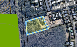
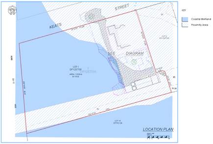
13.10 PLANNING - DA 10.2021.685.1 - New Dwelling to Create Dual Occupancy (Detached), Swimming Pool and Strata Subdivision to create Two (2) Lots and Common Property – 2 Keats Street, Byron Bay................................................... 106
13.11 PLANNING - DA 10.2022.370.1 - Use of alterations and additions to farm building, use of farm building as a cool room – 252 Middle Pocket Road Middle Pocket..... 130
14. Questions With Notice
Nil
Questions with Notice: A response to Questions with Notice will be provided at the meeting if possible, that response will be included in the meeting minutes. If a response is unable to be provided the question will be taken on notice, with an answer to be provided to the person/organisation prior to the next Ordinary Meeting and placed on Councils website www.byron.nsw.gov.au/Council/Council-meetings/Questions-on-Notice
Councillors are encouraged to ask questions regarding any item on the business paper to the appropriate Director prior to the meeting. Any suggested amendments to the recommendations should be provided to Councillor Support prior to the meeting to allow the changes to be typed and presented on the overhead projector at the meeting.
BYRON SHIRE COUNCIL
Notices of Motion 9.1
Notice of Motion No. 9.1 Changing policy to remove fossil fuel sponsorship
File No: I2022/1664
I move:
1. That Council recognises that fossil fuels are the main driver of climate change and that we are in a climate emergency.
2. That Council recognises that the marketing of high emissions products, such as petroleum and gas through sponsorships or advertising increases demand and delays behaviour changes in the community that are required to reduce emissions.
3. That the Federal Government has a responsibility to implement restrictions on fossil fuel advertising through national laws, like what was done for tobacco advertising which saw a proven reduction in tobacco consumption per capita, therefore reducing the health burden of tobacco use.
4. That Council:
a) write to the Federal Minister for Communications, The Hon Michelle Rowland MP, to ask the Federal Government to pass national laws that restrict fossil fuel advertising; and
b) write to the organisers of prominent local organisations and events outlining Council’s position against fossil fuel advertising and sponsorships and requesting they adopt similar policies.
5. That the General Manager be requested to:
a) Update the Byron Sponsorships received by Council Policy, to prohibit accepting sponsorships from companies whose main business is the extraction, production or sale of coal, petroleum and gas.
b) Review other polices as appropriate to remove support for companies whose main business is the extraction, production or sale of coal, petroleum and gas.
1 DRAFT
Policy: Sponsorship Received by Council 2022, E2022/113064
![]()
Signed: Cr Asren Pugh
Councillor’s supporting information:
Air pollution from burning fossil fuels takes 8.7 million lives prematurely each year – more than tobacco. An estimated 150,000 people are dying due to climate change impacts every year.
At least eight Australian Councils, as well as France and jurisdictions in the UK and Netherlands are restricting fossil fuel advertising.
Council has a duty to ensure that its activities do not adversely impact the health and wellbeing of residents. Because of this, Council restricts the advertising of tobacco and other harmful products in Byron Sponsorships received by Council Policy.
Item 4.4 of the Policy states:
The following companies, partnerships, sole traders or individuals are not suitable sponsors in Byron Shire, those:
● involved in the manufacture, distribution and wholesaling of tobacco related products, pornography and/or addictive drugs;
● found guilty of illegal or improper conduct by ICAC or any similar authority;
● involved in political fields eg political parties;
● involved in a competitive tender or purchasing process at or around the time of negotiating a sponsorship agreement;
● who have an unacceptable sponsorship record with Council or with any other government authority.
The first dot point could be updated to state:
"involved in the manufacture, distribution and wholesaling of tobacco related products, involved in the extraction and sale of coal, petroleum and gas, pornography and/or addictive drugs'
Coal, oil and gas are affecting our health, environment and climate. Air pollution from burning fossil fuels takes 8.7 million lives prematurely each year – more than tobacco.[1][2] An estimated 150,000 people are dying due to climate change impacts every year[3].
Fossil fuels are the primary cause of global warming[4], which is impacting our LGA in the form of more intense and frequent heatwaves, storms, bushfires, floods, droughts and coastal erosion.
Council has adopted that we are facing a climate emergency and we are aiming to reach net zero by 2025. Advertising of companies involved with fossil fuel production or supply, as well as products such as gas, oil and coal is inconsistent with this adopted Council position.
At least eight Australian Councils, including the City of Sydney, have voted for a Staff Report on how to restrict fossil fuel promotions on Council-managed land. Restrictions on fossil fuel advertising are in place in France, and several local government areas in the UK and the Netherlands.
Staff comments
by Shannon Burt, Director, Sustainable Environment and Economy and Esmeralda Davis, Director Corporate and Community Services
Comments on Point 1
Council has been taking action to reduce its reliance on fossil fuels for more than a decade through the Greenhouse Action Strategy 2004 and the Byron Shire Low Carbon Strategy 2014. The current Net Zero Emissions Strategy for Council Operations 2025 maps out a pathway to continue Council’s move away from fossil fuels and associated technologies.
Comments on Point 5
Point 5 of the recommendation requests amendments to Council Policies. When reviewing our policies, Council’s Corporate Documents Standard (internal policy) provides the following guidance to staff:
A Policy sets out Byron Shire Council’s position on a specific matter – a formal statement of intent and non-discretionary governing principles that apply to Byron Shire Council’s practice. The principles are derived from and shaped by the law and regulations that apply, community expectations, and the values and mission contained in the adopted Community Strategic Plan. A Policy is a concise document that may facilitate, enable or constrain practice, standard, guidelines or delegated functions but does not prescribe in detail how to perform certain functions - instead it provides a framework for action with its primary role being to guide the achievement of the adopted strategic goals and ensure legislative compliance.
Each point is addressed below:
a) Update the Byron Sponsorships received by Council Policy, to prohibit accepting sponsorships from companies whose main business is the extraction, production or sale of coal, petroleum and gas.
The Councillor Supporting Information provides suggested wording for inclusion in Part 4.4 of the Sponsorship received by Council Policy:
"involved in the manufacture, distribution and wholesaling of tobacco related products, involved in the extraction and sale of coal, petroleum and gas, pornography and/or addictive drugs'
This suggested wording has been incorporated into a draft Sponsorships received by Council Policy (Attachment 1). The draft Policy, if supported by Council, should be placed on public exhibition for a period of 28 days.
b) Review other policies as appropriate to remove support for companies whose main business is the extraction, production or sale of coal, petroleum and gas.
This can be considered as other policies are reviewed.
Financial/Resource/Legal Implications:
The Policy amendments may limit sponsorship opportunities.
Is the proposal consistent with any Delivery Program tasks?
|
CSP Objective |
CSP Strategy |
DP Action |
Code |
OP Activity |
|
1:
Effective Leadership |
1.1: Enhance trust and accountability through open and transparent leadership |
1.1.1: Leadership - Enhance leadership effectiveness, capacity, and ethical behaviour |
1.1.1.1 |
Coordinate Council's annual policy review program, update and publish adopted policies |
BYRON SHIRE COUNCIL
Notices of Motion 9.2
Notice of Motion No. 9.2 Roadworks on Ewingsdale Road
File No: I2022/1665
I move:
1. That Council implements a policy of only conducting roadworks on Ewingsdale Road at night.
2. That Council implements a policy of not conducting roadworks on Bangalow Road and Broken Head Road during morning and afternoon peak hours.
3. That Council writes to all relevant authorities, such as Essential Energy, requesting that they adhere to the same policies.
4. That the emergency road works be exempt from the above policies.
5. That Council receives a report to update council on Transport for NSW plans to fix the Ewingsdale highway interchange.
Signed: Cr Asren Pugh
Councillor’s supporting information:
The Ewingsdale Highway interchange is dangerous. Traffic consistently backing up along the highway in the morning peak is a threat to those cars and other traffic utilising the highway, including large trucks.
Contractors working for council fixing a siderail on Tuesday 8th of November ran the job late. This resulted in a massive exacerbation of the existing issues. The highway backup was even more dangerous, with cars stopping in the right-hand lane of the highway trying to merge left as they had missed the end of the line. Residents and workers were delayed by up to 1.5 hours. Schools and businesses were significantly affected.
In addition, there has been a number of instances recently on Bangalow Road and Broken Head Road where Essential Energy has conducted tree lopping during peak hour that has significantly impacted residents, workers and school children. This has been done without proper notice to residents or consultation with council.
The Ewingsdale Highway interchange needs to be fixed properly. I understand there have been discussions between council and Transport for NSW and it is time to move this project forward.
Staff comments
A Policy for Roadworks on Ewingsdale Road will be developed in accordance with the above Notice of Motion and presented to Council for further consideration.
The Works Department (IS) have already committed to no day works on Ewingsdale Road unless works are deemed an emergency. This will remain in place until Council adopts a revised policy.
The Open Spaces Department (IS) have a maintenance program along Ewingsdale Road and Broken Head Road, including the Butlers Street Bypass. This program is currently carried out monthly, outside of peak traffic periods.
These works have been successfully carried out for the last few years without negatively impacting peak traffic flows. As these works have demonstrated ability to be completed with minimal impact on traffic flows, it is recommended that Council mowing and garden maintenance works are not included within the definition of “roadworks”.
Conducting mowing and garden maintenance works roadside at night would create additional risk for workers and would require increased levels of traffic control. Any decision requiring mowing and gardening to be completed as nightworks needs to be informed by the additional cost requirement for lighting and traffic safety measures so that he impacts upon maintenance budgets can be quantified. Investigation into the availability and cost of contractors able and willing to conduct mowing and gardening activities as nightworks needs also to be explored so that the budget and services implications of this variation can be quantified.
The M1 Interchange and Ewingsdale Road upgrades draft options study are currently being prepared by Transport for NSW (TfNSW).
Once TfNSW has completed a draft options study and it has been reviewed by staff it is intended that prior to commencement of stakeholder engagement the options are presented to Council at a workshop. This matter can be addressed in a separate report to Council after the workshop.
Financial/Resource/Legal Implications:
Night works will have a significant increase cost and reduce the amount of work achievable within current budgets. Additional costs are not known at this time.
Is the proposal consistent with any Delivery Program tasks?
No.
BYRON SHIRE COUNCIL
Notices of Motion 9.3
Notice of Motion No. 9.3 Compliance at another landscape supplier
File No: I2022/1691
I move that Council receives a report on compliance at the nursery and landscaping supply business beside the Pacific Motorway at 8 Grays Lane, Tyagarah.
1 Advertisement
in Echo - Compliance at another landscape supplier, E2022/115546 ![]()
Signed: Cr Duncan Dey
Councillor’s supporting information:
Consent was granted on 4 March 2016 under DA 10.2015.260.1 for a “plant nursery and relocated dwelling”. Approval includes an outdoor nursery area of 1,600 square metres, converting an existing dwelling to a plant nursery storage / office, and bringing a relocated dwelling onto the site. This consent was lawfully commenced but the Occupation Certificate for the nursery has not yet been issued.
Complaints about the property have been responded to in recent years and extensive investigations undertaken, including visits to the property. Three EP&A Orders have been issued.
DA 10.2020.510.1 was lodged on 18 September 2020 and refused on 4 December 2020. A Section 8.2 review of that determination was applied for on 29 March 2021 and withdrawn on 19 August 2021.
DA 10.2021.659.1 was lodged (via the NSW Government’s online Planning Portal) on 12 October 2021. Enforcement of a Stop Use Order was paused pending the outcome of the DA. It was rejected on 15 November 2021 due to insufficient information, in accordance with Schedule 1 of the EP&A Regulation. No further applications have been submitted by the property owner.
The business continues to expand and to advertise, see example advertisement overleaf. Activities appears to be at a scale beyond approvals. Council recently considered a DA for a landscape supply business at Myocum. It appeared to operate beyond approvals.
Equity is an important component of government. Hence, I’d like to know the status of this activity.
Staff comments
by Shannon Burt, Director, Sustainable Environment and Economy:
A report can be prepared by staff for a future meeting of Council on this matter.
Financial/Resource/Legal Implications:
The report will need to observe confidentiality on any enforcement matters and or legal proceedings relevant at the time.
Enforcement Policy - Byron Shire Council (nsw.gov.au)
Is the proposal consistent with any Delivery Program tasks.
|
CSP Strategy |
DP Action |
Code |
OP Activity |
|||
|
2:
Inclusive Community |
2.2: Enhance safety and contribute to the physical, mental, and spiritual health and well being of our people |
2.2.3: Regulatory controls and compliance - Enhance public safety, health and liveability through the use of Council's regulatory controls and services |
2.2.3.2 |
Respond to and investigate complaints against building standards |
||
BYRON SHIRE COUNCIL
Notices of Motion 9.4
Notice of Motion No. 9.4 Rural & Regional Summit on 20 February 2023
File No: I2022/1729
I move that Council nominates Councillors Dey, ______ and ____ as delegates to attend the Rural and Regional Summit 2023 to be held on Monday 20 February in Sydney.
Signed: Cr Duncan Dey
Councillor’s supporting information:
Councillors were emailed on 17 November about training and conferences available for 2023.
The Rural and Regional Summit will be a one-day event for Mayors, Councillors, General Managers and senior Council staff to come together to discuss the key issues affecting rural and regional communities in the lead up to the NSW State Election.
I would like to attend and to represent Byron Shire Council at the Summit, should Council charge me with ideas to present and pursue at the Summit.
Staff comments
by Esmeralda Davis, Director, Corporate and Community Services:
Conferences are an excellent opportunity for Councillors to improve their knowledge and understanding of issues relevant to Byron Shire. The Local Government NSW (LGNSW) Rural and Regional Summit provides a forum to discuss topics specific to rural and regional communities.
Councillor attendance at this Conference is subject to the Councillor Expenses and Facilities Policy which stipulates that Council will meet the reasonable cost of registration fees, transportation and accommodation associated with attendance. As per Clause 6.40, in assessing a Councillor request to attend a conference, the following factors must be considered:
1. relevance of the topics and presenters to current Council priorities and business and the exercise of the Councillor’s civic duties
2. cost of the event in relation to the total remaining budget.
Regarding point 1, the Housing Crisis has been named by LGNSW as the key topic to be covered at the Summit, as well as:
· Building back better after natural disasters
· Telecommunications and technology in rural areas
· Mental health following disasters
· Renewable energy - cost of energy and where it is distributed
Regarding point 2, the costing and registration details for the Summit will be released on 1 December 2022. Details of the available budget are given in the financial considerations section below.
Following the Conference, Councillor/s are requested to submit a delegate’s report in writing to an Ordinary Meeting of Council on the aspects of the conference, seminar, workshop, or function relevant to Council business and or the local community.
Financial Implications:
Of the $31,500 allocated for Councillors attendance at Conferences and Professional Development in the 2022/23 Financial Year, 42% has been spent, with approximately $18,200 remaining.
Is the proposal consistent with any Delivery Program tasks?
|
CSP Objective |
CSP Strategy |
DP Action |
Code |
OP Activity |
|
1:
Effective Leadership |
1.1: Enhance trust and accountability through open and transparent leadership |
1.1.2: Governance - Ensure legislative compliance and support Councillors to carry out their civic duties |
1.1.2.3 |
Provide administrative support to Councillors to carry out their civic duties |
BYRON SHIRE COUNCIL
Notices of Motion 9.5
Notice of Motion No. 9.5 Update on Resolution 22-361
File No: I2022/1739
I move that Council:
1. Notes the recent vote of members of the Bangalow Bowling and Sports Club to support amalgamation with North Sydney Leagues Club
2. Notes that North Sydney Leagues Club had pre covid (2019) revenue of over $58 million and does not need financial support from council
3. Rescinds the budget allocation of $2,000 established via Resolution 22-361
4. Continues to ensure that the Bangalow Bowling Club be engaged in the Plan of Management process for the Bangalow Sports Fields as per the rest of Resolution 22-361
Signed: Cr Asren Pugh
Councillor’s supporting information:
The purpose behind Resolution 22-361 was to support the community run Bangalow Bowling Club to engage with the Bangalow Sports Fields Plan of Management. The Bangalow Bowling Club membership have voted to amalgamate with North Sydney Leagues Club and no longer be run locally by community members.
Given the financial and paid staffing resources of the North Sydney Leagues Club, and the current financial situation of council, it would not be appropriate to provide financial support to this organisation.
If a workshop or meeting is appropriate for the Sports Field PoM process, North Sydney Leagues Club should be able resource this themselves.
Staff comments
by James Brickley, Manager Finance, Corporate & Community Services:
As detailed in the Council report for the 11 August 2022 meeting, Council is required to renew the 2005 Plan of Management for the Bangalow Sports Fields. A new Plan of Management is proposed that includes the skate park and that will provide clarification to the Bangalow community on the future uses proposed for the site. Any additions that, require any new categories of use of the community land, will be determined by the adoption of the new Plan of Management. The new Plan of Management will be an essential component in the planning for the whole area.
Council must undertake mandatory public hearings with the local members and interested stakeholders on the proposed new Plan of Management in accordance with section 40A of the Local Government Act.
Resolution 22-361 required $2,000 to be set aside to support a workshop with the Bowling Club and Sports Club Limited stakeholders. Council is required to consult with and invite the Bangalow Bowling Club to all public hearings for the proposed new Plan of Management for the Bangalow Sports Fields.
Financial/Resource/Legal Implications:
Resolution 22-361 when adopted by Council did not identify a funding source, so the $2,000 was included in the 2022/2023 budget, by increasing the budget deficit from $205,000 to $207,000. Should Council support part 3 of this Notice of Motion, the impact of removing the $2,000 budget will reduce the projected budget deficit back to $205,000.
Is the proposal consistent with any Delivery Program tasks?
The proposal is consistent with Delivery Plan Tasks in that Part 4 of the Notice of Motion is continuing to engage with the Bangalow Bowling Club in regards to the Plan of Management.
|
CSP Objective |
CSP Strategy |
DP Action |
Code |
OP Activity |
|
5:
Connected Infrastructure |
5.4: Provide accessible community facilities and open spaces |
5.4.4: Sporting facilities and swimming pools - Ensure ongoing maintenance and upgrade of inclusive sporting facilities and swimming pools |
5.4.4.3 |
Complete review of Plan of Management and associated Landscape Masterplan for Bangalow Sportsfields and seek funding opportunities for implementation |
BYRON SHIRE COUNCIL
Staff Reports - Sustainable Environment and Economy 13.1
Staff Reports - Sustainable Environment and Economy
Report No. 13.1 Response to an Expression of Interest for community housing providers for the Affordable Housing Contribution Scheme
Directorate: Sustainable Environment and Economy
Report Author: Kristie Hughes, Planning Projects Officer
Natalie Hancock, Senior Planner
File No: I2022/1258
Summary:
The Byron Shire Affordable Housing Contribution Scheme (AHCS) was adopted by Council 11 August 2022. At the time of writing this report staff were awaiting the LEP 2014 clause to be published on the NSW legislation website.
Under the AHCS, Section 3.4 Registered Community Housing Providers (CHP) and Delivery Program, Council is required to hold a register of nominated community housing providers that can deliver and/or manage the affordable rental housing in line with the Byron AHCS.
An expression of interest was issued calling for accredited community housing providers to register. This report identifies the six respondents to this EOI and recommends they all be included in the list of providers to be placed in the Community Housing Providers Register.
RECOMMENDATION:
1. That Council endorses the Community Housing Providers identified in Table 1 of this report being placed on the Community Housing Providers Register and for this register to be published on Council’s website.
2. The Community Housing Providers endorsed by Council are notified.
Attachments:
1 Confidential - AHCS CHP Expressions of Interest combined, e2022/111583
2 Special
Disclosure of Pecuniary Interest Annexure for matters relationing to
environmental planning instruments, E2012/2815
![]()
Report
The Byron Shire Affordable Housing Contribution Scheme was adopted by Council 11 August 2022. At the time of writing this report staff were awaiting the LEP 2014 clause to be published on the NSW Legislation website.
Under the AHCS, Section 3.4 Registered Community Housing Providers and Delivery Program, Council is required to hold a register of nominated community housing providers that can deliver and manage the affordable rental housing in line with the Byron AHCS.
The creation of a register streamlines future tender processes by reducing associated costs and enabling faster response times as planning proposals seeking upzoning are submitted.
An expression of interest was issued in September calling for accredited community housing providers to join our register. This report identifies the respondents and recommends a list of providers to be placed in the register.
Process of notification to Community Housing Providers
Notices calling for EOI from Community Housing providers were published on Council’s AHCS website page.
Research was conducted to identify registered community housing providers with an interest in working within the North Coast region. These community housing providers were contacted directly and invited to submit an application to join our register. In addition, the invitation was forwarded to local community groups and not for profit organisations working in the local housing space to share with their networks. This measure was taken to raise awareness of the AHCS and capture any organisations with existing local connections. Landcom were also notified and asked to extend the invitation to their networks.
The Expression of Interest period was initially for one month (14 October 2022 – 14 September 2022), however only one application was received during that period. The closing date was therefore extended to 7 November 2022.
Applications Received
In total six applications were received from the registered providers in Table 1.
The reference to ‘tiers’ in the table is explained by the Community Housing Provider Registration - NSW - Australian Business Licence and Information Service.
Table 1: Community Housing Providers
|
Tier |
About the organisation as provided by the CHP |
|
|
1 |
Amelie provides appropriate, secure and affordable rental housing and works to create socially inclusive neighbourhoods. Established in 2012, Amélie Housing has grown from initially being an NSW focused organisation, to a national organisation incorporating the expertise and experience of housing organisations in other states and territories. |
|
|
1 |
CHL is a not for profit housing organisation with a vision for a world without housing poverty. CHL deliver a diverse range of affordable housing to low to moderate income people who are unable to secure long-term affordable housing or are disadvantaged by the private rental market. We provide rental housing at subsidised market rent to the most vulnerable in the community. |
|
|
2 |
A nationally recognised housing provider. Common Equity is the peak body for housing co-operatives in NSW. Working in both Sydney and regionally (including Bellingen, Forster & Nelson Bay). |
|
|
1 |
A leading national CHP, Mission Australia supports individuals and families in many diverse communities throughout Australia. Four strategic focus areas: · Helping end homelessness in Australia · Partnering to strengthen communities · Supporting people in need to thrive · Driving excellence. |
|
|
1 |
The largest established CHP on the far North Coast. A people-centred organisation who support the community with housing needs, striving for equality and fairness in housing outcomes. |
|
|
2 |
Wesley Mission through our current strategic plan is focusing on increasing the supply of social and affordable housing across the state of NSW. |
Notification of Affordable Housing Contribution Scheme
At the time of preparing this report the Affordable Housing Contribution Scheme had not been published on the NSW Legislation website.
Next steps
Subject to Council endorsing the establishment of a register of suitable community housing providers, this register will be published on Council’s website under Housing Affordability Initiatives.
To streamline and reduce the cost of tendering for community housing providers under the Affordable Housing Implementation and Delivery Program, a three-phase process is anticipated with this register being the first phase.
The three phases are:
· expression of interest to form a register of preferred community housing providers
· selection of a CHP for a particular site being upzoned and
· formalising CHP housing delivery agreement.
With the initial expression of interest period closed, Council staff will continue to liaise with community housing providers and hold future expression of interest processes to further build our register.
Strategic Considerations
Community Strategic Plan and Operational Plan
|
CSP Strategy |
DP Action |
Code |
OP Activity |
||
|
4: Ethical
Growth |
4.2: Enable housing diversity and support people experiencing housing insecurity |
4.2.2: Partnerships and pilots to address housing needs - Investigate partnerships and pilots that deliver an innovative and affordable housing model for the Shire |
4.2.2.3 |
Affordable Housing Contribution Scheme -Implementation and Delivery program |
|
Recent Resolutions
Council at the 11 August 2022 Planning meeting resolved (22-380) to adopt the planning proposal to amend Byron LEP 2014, together with the Affordable housing contribution scheme.
Legal/Statutory/Policy Considerations
The establishment of this register is consistent with section 6.3 of the adopted Affordable Housing Contribution Scheme.
Financial Considerations
As a Council initiative, the staff costs of finalising the register and setting up the Affordable Housing Implementation and Delivery Program will be borne by Council.
BYRON SHIRE COUNCIL
Staff Reports - Sustainable Environment and Economy 13.2
Report No. 13.2 Expressions of Interest for Next Place Plan
Directorate: Sustainable Environment and Economy
Report Author: Isabelle Hawton, Place Liaison Officer
File No: I2022/1437
Summary:
At the Council meeting held on 29 October 2021, Council resolved to undertake an Expression of Interest (EOI) process to determine the location for Council’s next Place Plan. The EOI was released in August 2022 and ran for six weeks.
During this time Council received 16 responses (Attachment 1). Additionally, one response is included in this report that relates to an earlier request in 2021 (Attachment 2). Respondents were asked to address:
· Perceived need for a Place Plan
· Appropriateness of a Place Plan to address identified issues
· Community support for a Place Plan
Multiple responses were received for some locations, these have been grouped together along with grouping of some locations. Submissions were received for:
· Brunswick Heads/Bayside
· Ocean Shores/ North Ocean Shores
· North Byron District (Ocean Shores, South Golden Beach, New Brighton and Billinudgel)
· Suffolk Park/Broken Head
· Skinners Shoot
· South Golden Beach
· New Brighton
A summary of responses received and assessment thereof is provided in the report with additional information to this in Attachment 3.
Based on the responses submitted, staff recommend that Council choose to proceed in a staged approach with Place Plans for Brunswick Heads, Ocean Shores and South Golden Beach. Staff recommend Council confirm an order of priority for these three areas to allow certainty into the future.
Staff also note the strong interconnectedness between South Golden Beach and Ocean Shores – consideration should be paid in the scoping stage to the interconnectedness of these two places and how this will impact on potential budget and methodology.
Once these three locations are prioritised, staff will report back to Council with a detailed project scope, methodology and budget.
RECOMMENDATION:
That Council:
1. Recognises that the next priority Place Plan locations are Brunswick Heads, Ocean Shores and South Golden Beach.
2. Selects the following location to proceed in the first instance: ____________, Followed by ______________ (priority two) and then ________________ (priority three).
3. Requests a further report to Council providing a detailed Place Plan project scope, methodology and budget for the first preferred location noted in Point 2.
4. Notes that given current budget constraints, a Place Plan for the first preferred location noted in Point 2 should be considered in the 2024/25 financial year.
1 Combined
submissions - Future Place Plan EOI, E2022/96853
![]()
2 New
Brighton Village masterplan - request to council, E2022/100201 ![]()
3 Summary
of Responses for Expression of Interest for Future Place Plans, E2022/101248 ![]()
4 Form
of Special Disclosure of Pecuniary Interest, E2012/2815
![]()
Report
What is a Place Plan
Place Plans are strategic documents that describe a vision for a neighbourhood, town or village for the next 20 years (sometimes longer/shorter).
They are important strategic documents that can contain (but aren’t limited to) a set of principles, a vision, themes, and actions related to:
· streetscape upgrades
· transport and access
· planning controls
· resilience
· safety
· events
· character
· open space
· community building
· arts and culture
They are usually developed collaboratively between community members and Council staff, sometimes with the involvement of a consultant.
Examples of current Place Plans and their various formats can be found here Place planning - Byron Shire Council (nsw.gov.au)
Responses to Expression of Interest Process
Council received 16 responses to the Expression of Interest (EOI) process and one earlier request from New Brighton. The 17 responses were for the following:
· Brunswick Heads/Bayside
· Ocean Shores/ North Ocean Shores (note that applicant did not define in their submission what they consider to be ‘North Ocean Shores’)
· North Byron District (Ocean Shores, South Golden Beach, New Brighton and Billinudgel)
· Suffolk Park/Broken Head
· Skinners Shoot
· South Golden Beach
· New Brighton
There were no direct applications from Sunrise, Billinudgel, Main Arm or Eureka.
The EOI applications are included in Attachment 1 and the earlier request from New Brighton is in Attachment 2.
A summary of the submissions is provided in Table 1 with additional information to this in Attachment 3.
Table 1. Summary of submissions
|
Location |
Interest |
Staff Comment |
|
Brunswick Heads/Bayside |
2x individuals, 3x community groups: · Brunswick Heads Chamber of commerce, · Bayside Residents Association, · Brunswick Heads Progress Association |
Staff recognise the significance of Brunswick Heads in terms of its impact as a key commercial and residential centre in the Shire, its large visitor population, and the continued pressures of the town’s popularity. If a Place Plan were to be developed for Brunswick Heads, it is recommended that the scope would include nearby suburb Bayside. The applications submitted as a part of this process made note of the extensive amount of work already completed in working towards a vision for the town (though the bulk of this was completed some time ago now). There appears to be a strong network of existing community groups who would be mobile and eager to work together and with Council to create a place plan for Brunswick Heads. The issues identified in the submissions are generally appropriate for the remit of a place plan. Recommend for consideration |
|
Ocean Shores/North Ocean Shores (the area comprising ‘North Ocean Shores’ was not defined in the EOI) |
6x individuals, 1x North Byron Chamber |
Staff recognise the significance of Ocean Shores in terms of it being the largest residential population in the Shire, and its critical connectivity with the villages of New Brighton, South Golden Beach and Billinudgel. There is obvious evidence of strong community support for the plan, many of the issues identified can be addressed through a plan, and there is an obvious benefit to a large population of the Shire’s residents. Ocean Shores residents and businesses would benefit from a plan that can tackle some of the existing access, connectivity, public space and growth and change related issues. Recommend for consideration |
|
North Byron District (Ocean Shores, South Golden Beach, New Brighton and Billinudgel) |
1x North Byron District |
The issues identified in this particular application would likely fall outside of the scope of a Place Plan and are better dealt with through Council’s refresh of the Residential Strategy, Business and Industrial lands Strategy and Operational and Delivery plans. Additionally, undertaking a Place Plan at this scale would be resource intensive for both community and staff. This application and the Ocean Shores applications referenced the interconnectedness of these individual places, noting that people living in the north of the shire move fluidly through these communities in their daily lives. Council staff note these key connections that exist between communities, and that there are other local challenges that push beyond the borders of a place. However, a local Place Plan is able to address sub-regional issues for specific actions as needed. As such, a Place Plan for example for Ocean Shores could also have regard to sub-regional goals such as footpath/bike path connections, events, and branding. This would need to be considered during the scoping of any Masterplan for the northern areas of the Shire. |
|
Suffolk Park/Broken Head |
2x individuals, 1x Suffolk Park Progress Association |
Staff note the previous resolution to investigate Council budget to undertake a Place Plan in Suffolk Park (Res 21-263). Applications for this location were minimal in information and support provided at this time. A place plan may be appropriate for Suffolk Park into the future, but the absence of demonstrated extensive community support in this application and the lack of a well-articulated case for a place plan in this instance suggests it may be less pressing than other areas. |
|
Skinners Shoot |
1x Skinners Shoot Residents Group |
Skinners Shoot is a semi-rural, largely residential area with no central commercial or public space. Given the make-up and small population of Skinners Shoot, staff don’t recommend a place plan here at this time. Some issues mentioned as a part of this application such as Short-Term Rental Accommodation are being dealt with via other Council processes. |
|
South Golden Beach |
1x South Golden Beach/New Brighton/Ocean Shores Community Resilience Team. |
The South Golden Beach community has pulled together a well-thought-out application to be considered for a place plan. There is evidence of strong community support to create a plan. Some of the identified issues fall slightly outside of the remit of a place plan. It is also believed that other issues identified, like actions related to community resilience, are already underway and don’t need to wait for a place plan. Any place plan for South Golden Beach would need to consider its relationships to adjoining New Brighton and Ocean Shores. Recommend for consideration |
|
New Brighton |
1x New Brighton Village Association |
New Brighton shows evidence of a strong community association who has already commenced on some of the work that would be required to deliver a place plan for the village (see Attachment 2). It should be noted that some of the above identified issues are currently being dealt with via other Council processes (Dogs in public spaces strategy, infrastructure planning etc). This lessens the urgency for a place plan at this time, and as such, New Brighton is recommended to be considered in the future. |
Key issues
Current Projects
Council’s Place Planning team, as
well as managing the development of new place plans, also has a role in
managing the implementation of projects from existing plans for Bangalow,
Mullumbimby, Byron Arts and Industry and (soon to be completed) Federal.
Some of Council’s adopted place plans will be approaching five years old in 2023 and are due for review. Additionally, they will need to reflect the directions of other Council strategy reviews such as the Residential Strategy and the State Governments Far North Coast Regional Plan review, also underway.
The team also assists with major projects related to Council owned land, in particular the priority for the team will be the planning work required for redevelopment including masterplan for the Mullumbimby Hospital site in the 2023/24 year.
As such, the development of any new place plan needs to proceed in a staged approach to ensure that the work of the team on the Mullumbimby Hospital site is not compromised or delayed.
Budgetary Constraints
Council more broadly needs to carefully manage its financial position due to the financial impacts of the February/March 2022 Flood Events. Given current budget constraints, there is limited opportunity for new budget items in the foreseeable future without additional revenue or reducing current expenditures to compensate. Any initiation of a new place plan should therefore be considered as a part of the budgetary process in the 2024/25 financial year. At that time, Council may be in a better position to understand its financial capacity as the flood recovery should be well progressed.
Other Council strategies and projects
Whilst place plans are a useful tool for a holistic vision of a place, many of the issues identified by various towns and villages throughout this process are dealt with through other Council policies or strategies, such as the residential, employment lands and rural land use strategies. Several of these strategies are currently being re-examined and refreshed.
Other issues raised in some submissions are more appropriately dealt with through Council’s Delivery Plan and Operational Plan processes.
Next steps
Staff will report back to Council with a detailed project scope, methodology and budget for the priority location.
Strategic Considerations
Community Strategic Plan and Operational Plan
|
CSP Objective |
CSP Strategy |
DP Action |
Code |
OP Activity |
|
|
4:
Ethical Growth |
4.1: Manage responsible development through effective place and space planning |
4.1.3: Town / Village Masterplans - Develop, implement and update Place Plans that promote place-based forward planning strategies and actions |
4.1.3.10 |
Investigate priority needs for future village/town masterplans |
|
Recent Resolutions
· 22-216 – North Byron Shire Masterplan, Notice of Motion
· 21-468 – Expression of Interest Process for next village/town masterplan
Legal/Statutory/Policy Considerations
Place Planning is a process that aims to create a long-term plan or vision for a neighbourhood and/or a community. A Place Plan is a comprehensive plan for a town, village, or suburb. It is not a statutory document and as such doesn’t have any legal status. A Place Plan can be the basis for changes in planning controls like Local Environmental Plans and Development Control Plans.
Financial Considerations
The next step in the process is to scope the selected priority place plan. This will involve a scoped area, project plan, resourcing plan and other budget required to undertake the work. This may result in a staged or multiyear approach to the next place plan.
Due to the financial and resourcing constraints and commitments discussed above the development of a new place plan should be considered as a part of the budgetary process in the 2024/25 financial year.
Consultation and Engagement
Relevant engagement was undertaken to ensure that the EOI was advertised – including:
· Media release
· Direct emails to key community groups in the Shire
· A presentation to Council’s community roundtable
· A Facebook post on Council’s Facebook page
Further consultation with the successful EOI applicant is recommended as staff move to scope up the future place plan.
The next report to Council detailing the scoping of the project, will also detail further engagement methods for the proposed place plan.
BYRON SHIRE COUNCIL
Staff Reports - Sustainable Environment and Economy 13.3
Report No. 13.3 PLANNING - Rural Land Use Strategy Review Scoping Report
Directorate: Sustainable Environment and Economy
Report Author: Sam Tarrant, Planner
Natalie Hancock, Senior Planner
File No: I2022/1417
Summary:
The Byron Shire Rural Land Use Strategy (RLUS) was adopted by Council in 2017 and endorsed by the State government in June 2018. At the June 2022 planning meeting an audit of actions achieved during the first four years of implementation of the RLUS was tabled in a report. At this meeting Council resolved 22-246 several actions including:
· 22-246 Item 2 to receive a report by end of November 2022 that details the scope of works and budget estimate needed to undertake a comprehensive five-year Rural Land Use Strategy review, with this report to inform a forward budget bid for this work to progress.
· 22-246 Item 3 prioritise delivery of Rural Land Use Strategy Action 21 in the 2022/23 financial year, being: Investigate capacity for re-subdivision within existing Large Lot Residential estates.
· Resolution 22-246 Item 4 requesting an options paper on the potential for additional land to be nominated for rural lifestyle living opportunities and/or other emerging housing types in peri-urban areas e.g. villages
This report:
· sets out a broad program for delivery for these two items
· provides a budget estimate for such work
· explains how this work will interconnect with the Residential Strategy refresh and Resolution 22-246 Item 4.
The investigation of the capacity for re-subdivision within existing Large Lot Residential estates will lead the work as it may provide an efficient means to deliver additional housing within established communities. This to be followed by a broad picture RLUS policy framework review for the preferred management of existing and emerging rural land uses in the Rural Zones, Conservation Zones, Village Zones and Large Lot Residential Zones.
NOTE TO COUNCILLORS:
In accordance with the provisions of S375A of the Local Government Act 1993, a Division is to be called whenever a motion for a planning decision is put to the meeting, for the purpose of recording voting on planning matters. Pursuant to clause 2(a) under the heading Matters to be Included in Minutes of Council Meetings of Council's adopted Code of Meeting Practice (as amended) a Division will be deemed to have been called by the mover and seconder of all motions relating to this report.
RECOMMENDATION:
That Council:
1. Supports staff progressing the scope of work and process as outlined in this report to review the Rural Land Use Strategy (RLUS) and to deliver RLUS Action 21: Investigate capacity for re-subdivision within existing Large Lot Residential estates.
2. Supports staff progressing as a precursor to the Action 21 delivery, Residential Strategy refresh and the RLUS review, preparation of a Housing Response Options Paper that would encompass Resolution 22-246 Item 4.
3. Notes that funding to progress both the Housing Response Options Paper and Action 21 of the RLUS will be funded from Flood Response Planning Grant from the NSW Planning Delivery Unit.
4. Notes that any new or additional funding for the comprehensive review of the RLUS, will be considered in the 2023/24 budget process/compilation amongst other priorities.
Attachments:
1 Attachment
1: Byron Shire Rural Strategy map 3 Large Lot Residential land, E2022/109941 ![]()
2 Special
Disclosure of Pecuniary Interest Annexure for matters relating to environmental
planning instruments, E2012/2815 ![]()
Report
The Byron Shire Rural Land Use Strategy (RLUS) was adopted by Council in 2017 and endorsed by the State government in June 2018. At the June 2022 planning meeting an audit of actions achieved during the first four years of implementation of the RLUS was tabled in a report. At this meeting Council resolved 22-246 several actions including:
· 22-246 Item 2 to receive a report by end of November 2022 that details the scope of works and budget estimate needed to undertake a comprehensive five-year Rural Land Use Strategy review, with this report to inform a forward budget bid for this work to progress.
· 22-246 Items 3/5(a) prioritise delivery of Rural Land Use Strategy Action 21 in the 2022/23 financial year, being: Investigate capacity for re-subdivision within existing Large Lot Residential estates including options for more community title and intentional community lands.
· Resolution 22-246 Item 4 requesting an options paper on the potential for additional land to be nominated for rural lifestyle living opportunities and/or other emerging housing types in peri-urban areas e.g., villages.
This report sets out a broad program for delivery for Items 2 and 3, provides a budget estimate for such work and explains how this work will interconnect with the Residential Strategy refresh and Item 4.
A program has been set that is cognitive of the wider pressure to deliver well placed and affordable housing in the Shire and the Northern Rivers region, ongoing State Government reforms, and the Northern Rivers Reconstruction Corporation charter that may affect RLUS policy and actions going forward.
The investigation of the capacity for re-subdivision within existing Large Lot Residential estates will lead the RLUS review work as it may provide an efficient means to deliver additional housing within established communities.
Action 21: Investigate Large Lot Residential estate capacity for re-subdivision
This project applies to land that is currently zoned R5 Large Lot Residential as shown on Attachment 1. R5 Large Lot Residential zone whilst managed under in the Rural Land Use Strategy is considered by the DPI and DPE 1. as a residential zone.
Key considerations unpinning this investigation would include:
· potential to deliver Affordable Housing
· land capacity and risk/hazard management
· stakeholder input with best endeavours to minimise stresses to the established communities by providing check-in points in the process
· enhancing sustainability and climate change resilience outcomes
· infrastructure capacity for expected additional population encompassing:
- efficient servicing
- cost-recovery options
- viable management framework to enable infrastructure upgrade cost allocation and sequencing where multiple landowners are involved
· Resolution 22-246 Item 5(a) that requested options for more community title and intentional community lands.
1. Sources: DPI Planning for Agriculture in Rural Land Use Strategies and the DPE draft North Coast Regional Plan 2041
Diagram 1 sets out the key stages to the investigation.
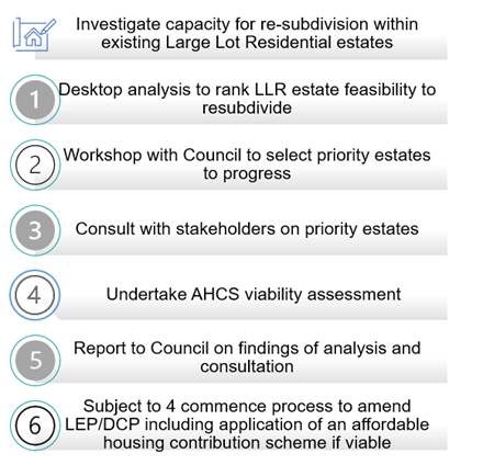
Diagram 1: Stages to Action 21 project
Rural Land Use Strategy Review
The RLUS is a broad picture of the preferred management for existing and emerging rural land use in the Rural Zones, Conservation Zones, Village Zones and Large Lot Residential Zones. The Strategy sets out a 20-year vision and policy intent under four themes: Environment, Economy, Community and Infrastructure. Endorsed by the State Government in 2018, it is scheduled for a five-year review.
Key Issues
The adopted RLUS policy whilst still applicable, was determined at a point of time since which drivers of change have emerged necessitating a review such as:
· Farming techniques and types: For example, local farmers are more engaged with regenerative farming to work with nature not against it to produce food. Whilst the nursery and cut flower industry has increased its % share of the total value of Byron Shire agricultural production from 29% (2015-16) to 33.5% (latest ABS figures 2021-22 released in August) to be on a quick analysis, the highest value agricultural production industry in the Shire. DPI provide an agricultural industry snapshot for planning.
· Competing needs/wants for rural land: Byron Shire’s locational qualities have combined with high level of in-migration and short-term rental industry growth to contribute to ‘farms’ transitioning to lifestyle or holiday use properties, landowners seeking additional dwellings on a property and as noted in the 2021 Valuer General Report on NSW Land Values ‘rural land values across the region increased by 30.5% with Byron (LGA) increased 70.5% as the residential market moved into hobby farms and lifestyle properties’.
· Renewable energy infrastructure: now increasingly relied upon to reduce farm operational costs or for income diversification by hosting a large-scale wind or solar farms.
· Scenic amenity: The RLUS ‘Environment’ policy framework seeks to have future rural tourist development and rural lifestyle living opportunities protect and where possible enhance key environmental features and preserve land of high scenic quality, however has no specific actions relating to delivery. In light of the ongoing NSW Government reforms outlined, moving forward an approach to managing the remaining 7(d) Scenic Escarpment zoned land may be necessary.
· NSW Government planning framework reforms: Diagram 2 illustrates the position of the RLUS as a local growth management strategy within the NSW planning framework facilitated under the provisions of the Environmental Planning and Assessment Act 1979. Highlighted in green text in the diagram are some of the policy reforms/updates since its adoption by Council in 2017, also listed as:
- introduction of Local Strategic Planning Statements as an overarching summary of the strategic planning priorities for the Shire
- North Coast Settlement Planning Guidelines 2019
- Draft North Coast Regional Plan 2041
- SEPP Biodiversity and Conservation 2021 and draft NCRP 2041 offering increased support for the use of biodiversity corridors as a means better sustain an area’s overall biodiversity
- land use regulation change such as agritourism and farm stay with an intent to enable commercial farms to be more economically robust
- Department of Primary Industry (DPI) release of Planning for Agriculture in Rural Land Use Strategies (nsw.gov.au) providing guidance on how to plan for the needs and growth of agriculture in land use planning strategies for rural land .
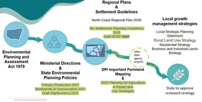
Diagram 2: Strategies and NSW planning framework
Scope of work
Diagram 3 sets a 5-stage review process. The review will focus on identification of key drivers of change and set out options for how the strategy could be updated to provide a more current growth management response. Completed actions will be removed from the action plan, others may change, or new actions introduced depending on the policy direction updates.
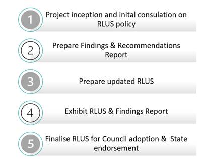
Diagram 3: RLUS Project
Stages
Stage 1: Project inception and initial consultation
This stage will combine research and analysis with targeted stakeholder consultation to understand how Byron Shire drivers of change impact on RLUS policy and actions. It will help identify emerging critical information gaps including those connected to changing climatic conditions or state government regulatory reforms and their likely effects on agricultural industries, environment asset catchments, infrastructure and communities.
Stakeholder consultations will encompass internal staff, traditional owner groups, State agencies, NRJO planning staff representatives, primary producers, industry bodies for key agricultural industries or agricultural processors, other coastal and rural hinterland catchment landowners and users and Byron community groups such as Byron Farmers Network and Landcare.
Stage 2: Findings and Recommendations report
From this, a report will be prepared setting out policy/actions to be retained, updated, deleted or added to the Rural Land Use Strategy.
Stages 3 – 5 RLUS revision, exhibitions and finalisation are reasonably self-explanatory and will be expanded upon as stages 1 and 2 progress, giving Councillors the opportunity to consider the Findings and Recommendations report prior.
Next Steps and relationship with the Residential Strategy
State Government policy (DPE and DPI) is clear that the provision of housing is not the focus for a rural land use strategy, the appropriate context for this consideration being the Residential Strategy. As such, the adopted RLUS is largely contained to policy on the provision of rural village housing and rural residential or lifestyle development as a housing choice within the context of the entirety of the community housing needs.
However, the competing wants for rural land and state government policy reforms suggest a need to also consider rural workers, population cohorts in housing need and visitor accommodation.
In this context, Diagram 4 sets out a phased program to ensure a Shire wide integrated growth management housing response. It is proposed to provide a Housing Response Options Paper, as precursor to the Action 21 delivery, Residential Strategy refresh and the RLUS review. This Housing Response Options Paper would encompass Resolution 22-246 Item 4 request for options paper on the potential for additional land to be nominated for rural lifestyle living opportunities and/or other emerging housing types in peri-urban areas e.g. villages.
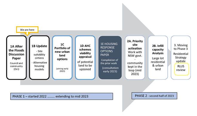
Diagram 4: Integrating the Residential Strategy refresh with the RLUS review
Strategic Considerations
Community Strategic Plan and Operational Plan
|
CSP Strategy |
DP Action |
Code |
OP Activity |
||
|
4:
Ethical Growth |
4.1: Manage responsible development through effective place and space planning |
4.1.2: Growth Management Strategies - Implement Local Growth Management Strategies |
4.1.2.1 |
Review Rural Land Use Strategy |
|
Recent Resolutions
· 22-246 Comprehensive five-year Rural Land Use Strategy review
· 22-247 Residential strategy update.
Legal/Statutory/Policy Considerations
Diagram 3 illustrates how the Rural Land Use Strategy as a local growth management strategy, fits within the NSW planning framework facilitated under the provisions of the Environmental Planning and Assessment Act 1979.
Action 21 - Estimate of cost to deliver
The work required up to and including stage 5 shown on Diagram 1 will rely on a commitment from existing staff resources and can largely be met within the staffing budgets. However, several investigations have been identified that will require resources or skills outside staff capacity:
· infrastructure viability and delivery management framework analysis
· affordable housing contribution scheme viability analysis
Funding to progress this work can be found within the $166,666 grant Council has received for Flood Response Planning from the NSW Government through the Planning Delivery Unit.
Rural Land Use Strategy
The work required up to and including stage 4 shown on Diagram 3 will rely on a commitment from existing staff resources and can largely be met within the staffing budgets. However, it is anticipated that as the review progresses consultation or investigations may arise that require resources or skills outside staff capacity:
· rural industry consultation and commercial farmland audit
· expert advisory support services such as on practical pathways to provide resilient rural infrastructure services or ensure adequate farmland supply is maintained to meet industry demands.
It is anticipated that this work will cost $45,000 and this will be considered when compiling the 2023/24 Budget as to the availability of funding against other priorities Council may have.
Consultation and Engagement
If Council chooses to proceed with the projects a meeting will be held with the NSW Department of Planning & Environment to confirm their level of engagement in the projects.
BYRON SHIRE COUNCIL
Staff Reports - Sustainable Environment and Economy 13.4
Report No. 13.4 Federal Village Masterplan
Directorate: Sustainable Environment and Economy
Report Author: Andrew FitzGibbon, Place Planning Coordinator
Isabelle Hawton, Place Liaison Officer
File No: I2022/1482
Summary:
In August 2020, Council resolved (Res 20-418) to commence work on a community-led place plan for Federal Village. This was a new and different type of place plan process to that previously completed for other towns and villages in Byron Shire.
The project aims were:
· to establish a shared vision for Federal, prioritising actions that align with that vision;
· to develop a formal and collective document that will provide the strategic basis to promote and fund priority actions;
· to produce a Masterplan that will be adopted by Council as one of Byron Shire’s Place Planning Strategies and feed into future statutory planning documents; and,
· to test community led planning – a new way of doing things – that could be a framework for the whole Shire going forward.
A Steering Group approached Council with a request to guide the community-led process.
The resultant masterplan includes a vision for the future of Federal, four (4) principles and fifteen (15) actions.
The revised draft has undergone significant community consultation, with fifty-five (55) responses received in the first round of consultation and six (6) in the second community consultation period.
The Federal Village Masterplan is presented to Council for adoption.
An evaluation report will be presented to Council in 2023 to reflect more broadly on the advantages and challenges of a community led place planning process and to consider the implementation of the masterplan.
At the 10 December 2020 Council considered a further report outlining the project scope for developing the masterplan and resolved (Res. 20-869) to produce a short video to capture the community-led masterplan process for future use and reference. This video is currently being completed and will be uploaded to Council’s web once finalised.
RECOMMENDATION:
That Council:
1. Adopts the Federal Village Masterplan (Attachment 1, E2022/112461) as a place planning strategy document for Byron Shire.
2. Thanks the Federal Village Masterplan Steering Group and the wider Federal and surrounding community for their hard work and commitment to preparing the Federal Village Masterplan.
3. Notes an evaluation report will be forthcoming in 2023 to reflect more broadly on the advantages and challenges of a community led place planning process and consider the implementation of the Federal Village Masterplan.
4. Notes that a final video of the community-led masterplan process for the Federal Village Masterplan is currently being completed in accordance with Resolution 20-689.
Attachments:
1 Federal
Village Masterplan_v11 - Final version for Adoption by Council, E2022/112461 ![]()
2 Federal
Village Masterplan Exhibition period 1 - Submissions summary, E2022/111230 ![]()
3 Submissions
Draft Federal Masterplan - Exhibition period 1 - redacted, E2022/96855 ![]()
4 Draft
Federal Masterplan Final Comments - Redacted, E2022/112096
![]()
5 Updates
to Draft Masterplan - Following Final comments, E2022/112282 ![]()
6 BSC
legal advice - master plan as a development application consideration -
draft Federal village masterplan, E2022/111482
![]()
7 Form
of Special Disclosure of Pecuniary Interest, E2012/2815
![]()
Report
In August 2020, Council resolved to commence work on a community led place plan for Federal Village. An initial project scoping meeting followed. This meeting involved Council staff and representatives from the Federal Community Centre and Federal School of Arts Association.
From this initial meeting, a project scope and framework were developed.
At the outset, the project aims were:
· to establish a shared vision for Federal, prioritising actions that align with that vision;
· to develop a formal and collective document that will provide the strategic basis to promote and fund priority actions;
· to produce a Masterplan that will be adopted by Council as one of Byron Shire’s Place Planning Strategies and feed into future statutory planning documents; and,
· to test community led planning – a new way of doing things – that could be a framework for the whole Shire going forward.
A Steering Group was established to guide the process, consisting of eight (8) community members initially. An expression of interest process led to the addition of a further two (2) members. The ten (10) community members were empowered to undertake a place planning process and produce a Masterplan document, provided that they could demonstrate that:
· community consultation has been carried out, generally in accordance with the communications and engagement plan reported in December 2020, ensuring that primary stakeholders were given adequate opportunity to have meaningful involvement, and demonstrating that there is general community acceptance of the final masterplan within the Federal community;
· agreed milestones were generally met (or as amended);
· any proposed actions are realistic in terms of Council budget limitations;
· any proposed action timeframes are cognisant of Council’s forward works planning to ensure shire wide project delivery is economical and efficient; and,
· any proposed actions adequately consider safety, lawfulness and other community risks.
The Steering Group also nominated two (2) representatives to join the Place Planning Collective – where they were able to connect with other community representatives and learn from the processes they had been through.
Council’s Place Planning team supported the Steering Group throughout the process, with inputs from other staff as needed.
The Steering Group worked over 18 months to engage with the broader Federal community and to create the vision, principles and actions that make up the Federal Village Masterplan.
The resultant document includes a vision for the future of Federal, four (4) principles and fifteen (15) actions.
This revised draft has undergone significant community consultation, with fifty-five (55) responses received in the first round of consultation and 6 in the second community consultation period.
It is presented to Council for adoption.
Key issues in the exhibition period
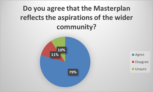
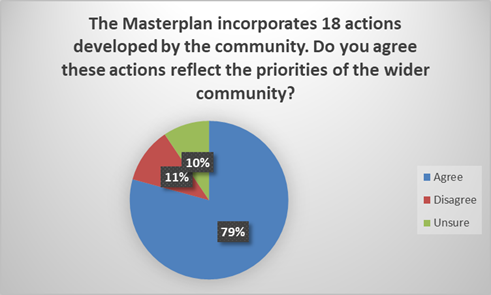
There was extensive support for the plan in the public exhibition period. Data collected in the consultation survey shows that 79 percent of respondents felt the plan was reflective of the aspirations of the wider community and the same percentage also agreed that the proposed actions reflected the priorities of the community.
The most common themes to come up during the exhibition period were:
· Support for the vision and aspirations in the plan
· Positive feedback on the process to create the plan
· Gratitude for the work the Steering Group have undertaken on the plan
· Development and related actions
· Concerns that the plan did not support small business in Federal enough
An overview of Feedback received during the first exhibition period is in Attachment 2.
The full feedback is in Attachment 3.
Final comments following revised draft document
Following the initial feedback period, Steering Group members and Council staff reviewed the submissions and workshopped potential changes to the document. These changes are explained in Attachment 2.
The revised draft was then placed on the web, and previous submitters and the steering group’s email list were notified. The community was given an opportunity to make any final comments on the plan. Six (6) comments were received in total. These can be seen in Attachment 4.
Based on this feedback, the Steering Group made minor updates to wording in the draft which can be seen in Attachment 5.
Review against resolution
Resolution 20-689 from Council meeting held on 10 December 2020 empowered to undertake a place planning process and produce a Masterplan document, provided that they could demonstrate:
|
Objective |
Outcome |
|
Community consultation has been carried out, generally in accordance with the communications and engagement plan reported in December 2020, ensuring that primary stakeholders were given adequate opportunity to have meaningful involvement, and demonstrating that there is general community acceptance of the final masterplan within the Federal community;
|
See community consultation discussion in report below. |
|
Agreed milestones were generally met (or as amended);
|
Milestones were heavily impacted by both the Covid 19 pandemic and the Northern Rivers flood event of 2022. However, the project has continued despite these significant events and is now nearing completion, twenty-four (24) months after commencement. |
|
Any proposed actions are realistic in terms of Council budget limitations;
|
Council staff have reviewed the actions contained in the draft and determined that they are feasible and realistic. |
|
Any proposed action timeframes are cognisant of Council’s forward works planning to ensure shire wide project delivery is economical and efficient; and,
|
Timeframes in the document are high level and dependent on resourcing and budgetary constraints. |
|
Any proposed actions adequately consider safety, lawfulness and other community risks.
|
Actions in the document are high level, these considerations will continue to apply in the detailed enactment of actions. |
Strategic Considerations
Community Strategic Plan and Operational Plan
|
CSP Strategy |
DP Action |
Code |
OP Activity |
|
|
4: Ethical
Growth |
4.1: Manage responsible development through effective place and space planning |
4.1.3: Town / Village Masterplans - Develop, implement and update Place Plans that promote place-based forward planning strategies and actions |
4.1.3.5 |
Support the Federal Community Village Masterplan Steering Group to finalise the community-led master planning for Federal |
Recent Resolutions
· Resolution 20-418: Request to Prepare Project Scope (27 August 2020)
· Resolution 20-689: Federal Community Led Masterplan – Project Scope (10 December 2020)
· Resolution 21-243: Movement and access budget allocation (24 June 2021)
· Resolution 21-261: Update on the Masterplan and Main Street Process (5 August 2021)
Legal/Statutory/Policy Considerations
The development of the Masterplan in Federal has raised issues relating to the legal weight of place plans in consideration of development applications. Legal Counsel provided advice to Councillors in relation to Masterplans (in accordance with Res 22-429). This advice is provided at Attachment 6.
Additionally, there have been suggestions during the exhibition process of perceived conflicts of interest for two (2) Steering Group members and that the non-declaration of these conflicts are breaches of Council’s Code of Conduct, refer to Attachment 4.
The Federal Village Masterplan Steering Group comprises local volunteers who have set themselves up to address community concerns and encourage the community to be involved in the ongoing development of the Village. They operate as a community group independent of Council. As part of a decision to enlarge the number of the membership group, it was the Group who sought expressions of interest.
The Group has been working with Council input to help better identify and achieve their aims.
Specifically, Council's Operational Plan sets out a very clear objective: "Support the Federal Community Village Masterplan Steering Group to finalise the community-led master planning for Federal"
The Group is not a body to whom a function of council has been delegated and its members are not required to meet Council’s Code of Conduct.
Nevertheless, it is noted that during the deliberations by the Steering Group on the final version of the masterplan two (2) Steering Group members with commercial properties in the village core noted the perceived conflict of interest raised in the submissions and left part of the workshop as a precaution. These members did not participate in final discussions relating to defining a commercial area for Federal Village or in relation to actions associated with Lot 1 DP1003205 a significant development site next to the park.
Financial Considerations
The actions outlined in this Masterplan will require future budget in order to be undertaken. This will need to be considered as a part of future Council budgetary processes and grant applications.
Consultation and Engagement
The following consultation was completed as a part of the primary exhibition period:
· Mail outs to landowners in the village
· Emails to community email list
· Local social media
· Posters at key locations
· Two drop-in sessions in the village
The draft was sent to relevant agencies and stakeholders (e.g Department of Planning and Environment, Transport for NSW, JALI etc.)
The following was completed as a part of the secondary exhibition period:
· Email out to previous submitters
· Email to community email list
Previous community engagement included as part of the masterplan process included:
· An online survey that received 154 respondents
· A door-to-door survey that interviewed 84 households
· A listening post in Federal Pak
· Two different workshops focussed on visioning and actions (233 participants total)
· Many one-on-one interviews with key stakeholders in the village, including major land owners, commercial operators, bus companies and rivers, RU5 property owners etc.
· Online feedback forms for the draft vision and principles
· Online feedback forms for the draft actions
BYRON SHIRE COUNCIL
Staff Reports - Sustainable Environment and Economy 13.5
Report No. 13.5 Federal Village Main Street Concept Design
Directorate: Sustainable Environment and Economy
Report Author: Andrew FitzGibbon, Place Planning Coordinator
Isabelle Hawton, Place Liaison Officer
File No: I2022/1483
Summary:
The purpose of this report is to seek Council endorsement of the Federal Drive Main Street Concept Plan.
The Plan has been revised because of feedback from the public exhibition and consideration of other engineering, transport, open space and place making advice.
Key changes to the final concept design include:
· Larger roundabout at Federal Drive and Binna Burra Road to enable bus U-turns
· Turning area inside Coachwood Court to enable safer bus turn arounds off Federal Drive.
· Split bus zones (close to existing locations) but pushed away from the centre where possible to limit car parking conflicts.
· Improved crossing/connectivity at the Binna Burra/Federal Drive intersection.
· Removal of powerline infrastructure (assumed undergrounding of power).
· Extension of the proposed 30km/h zone.
The Federal Drive design is an
important project which aims to make significant improvements to safety,
accessibility and placemaking for Federal Drive, Federal.
RECOMMENDATION:
That Council endorses the Federal Drive Main Street Concept Plan (as shown in Attachment 1 E2022/111275) to proceed to engineering design and costing.
Attachments:
1 Federal
Drive, Federal Main Street Concept Design - November 2022, E2022/111275 ![]()
2 Project
Scope and Objectives - Federal Main Street, E2021/123824
![]()
3 Combined
redacted submissions - Federal Main Street Design, E2022/111295 ![]()
4 Summary
of Submissions - Federal Main Street - Exhibition Period Nov-Dec 2021, E2022/111247 ![]()
5 Road
Safety Audit and Safe Systems Audit - Federal Main Street, E2022/111286 ![]()
6 Stakeholder
Feedback - Federal Main Street - Exhibition Period Nov-Dec 2021, E2022/111288 ![]()
7 Feedback
from movement and access sub group and steering group on revised plans -
Federal Main Street concept design, E2022/102307
![]()
Report
The Federal Drive main street design is an important project which aims to provide significant improvements to safety, accessibility and placemaking for Federal Drive. An overview of project goals and rationale is provided at Attachment 2.
The project is running parallel to the broader Federal Village Masterplan project.
The concept design has been led by Landscape Architect consultants Better Cities Group alongside Council Place Planning and Infrastructure Planning staff.
Community consultation has occurred throughout the process (as described below). This included a formal consultation period (15 November 2021 to 19 December 2021) for the draft concept design (refer resolution 21-480 from 4 November 2021).
· Submissions received during the exhibition of the draft concept design are included at Attachment 3 in full.
· A summary of submissions and design response is included at Attachment 4.
· Safe Systems Assessment and a Road Safety Audit are included at Attachment 5.
· Advice from key stakeholders: Transport for NSW, Northern Rivers Buslines and Access Consultative Working Group is included at Attachment 6.
· Final comments from Movement and Access Subgroup & Masterplan Steering Group – meeting notes from 18 October 2022 provided at Attachment 7.
These above inputs alongside further technical advice from Councils Infrastructure Services, Transport, Open Space and Place Planning staff were key considerations in developing the final concept design.
A number of changes were made to the draft concept design in consideration of the submissions received and the other inputs noted above. Key changes included the following.
· Larger roundabout at Federal Drive and Binna Burra Road to enable bus u-turns
· Turning area inside Coachwood Court to enable safer bus turn arounds off Federal Drive.
· Split bus zones (close to existing locations) but pushed away from the centre where possible to limit car parking conflicts.
· Improved crossing/connectivity at the Binna Burra/Federal Drive intersection.
· Removal of powerline infrastructure (assumed undergrounding of power).
· Extension of the proposed 30km/h zone.
The Concept Design
The final proposed Concept Design is included at Attachment 1. The design is described below in relation to the project goals set at the beginning of the process.
|
|
Project Goal |
Design Response |
|
1 |
To improve general pedestrian safety by reducing the overall traffic speed in the main street and on approach roads. |
A speed zone of 30km/hr is proposed along with other physical speed calming measures such as carriage way narrowing in select locations. |
|
2 |
To provide priority safe and accessible pedestrian connections between the shop-side and park-side of the main street. |
A zebra crossing as well as other informal crossing points are included.
|
|
3 |
Create a safe space for pedestrians on both sides of the main street and reduce the number of people walking on the road. |
Over 500m of new 1.5m wide footpaths on both sides of Federal Drive – linking the northern and southern ends of the main street. Undergrounding the overhead powerlines to support provision of footpaths. |
|
4 |
To provide a more formalised bus zone and shelter in an optimal location to improve safety and accessibility. |
Two clearly defined bus stops supported by safer turning opportunities. Design supports potential for bus shelter – to be investigated further during engineering design. |
|
5 |
To improve accessibility so that people with a disability or people with mobility restrictions can easily move about the main street and feel safe and included. |
1.5m footpaths on both sides of the street which will also link to accessible carparking spaces. |
|
6 |
To provide safer and more legible car parking options with limited net loss of spaces in the village centre. |
Formalised on-street carparking including additional marked spaces in Roses Road. |
|
7 |
To provide options for safer U-turns at edge of village centre for cars and buses (out of the core area). |
A mini-roundabout at Roses Road provides for car u-turns. A large roundabout on Binna Burra Road provides for bus and car u-turns. A 3-point turn area for buses in Coachwood Court provides for bus turnarounds off Federal Drive. |
|
8 |
To retain and enhance the features that set the look and feel of the main street. |
Material character boards developed. |
|
9 |
To provide a consistent landscape character for the main street that offers shade and amenity. |
Additional street trees proposed along the main street. |
|
10 |
To create informal places for people to socialise in the street. |
Small public space areas included along the main street. |
Next steps
· Council Infrastructure Planning team to draw engineering designs, estimate costs for construction works, and consider staging options.
· Apply for grants as they become available for construction (of whole or part).
· Council Infrastructure Planning team to draw engineering preliminary designs to be construction ready.
Strategic Considerations
Community Strategic Plan and Operational Plan
|
CSP Strategy |
DP Action |
Code |
OP Activity |
|
|
4:
Ethical Growth |
4.1: Manage responsible development through effective place and space planning |
4.1.3: Town / Village Masterplans - Develop, implement and update Place Plans that promote place-based forward planning strategies and actions |
4.1.3.6 |
Complete Federal Village Main Street Movement and Place detailed design. |
Recent Resolutions
Resolution 20-689 (point 7) from 10 December 2020 noted that Council acknowledges that a detailed design of the Federal Village main street is a priority ‘construction grant ready’ project, and that a forward budget bid be considered for the 2021/22 operational plan process.
Resolution 21-243 (point 2) from 24 June 2021 allocated a budget of $73,500 to undertake the design work for the Federal Village main street. This followed a formal request by the Federal Village Masterplan Steering Group (dated 7 June 2021) which was supported by the Place Planning Collective and a budget estimate by Council staff.
Resolution 21-480 from 4 November 2021 endorsing formal consultation period (15 November 2021 to 19 December 2021) of the draft concept design.
Legal/Statutory/Policy Considerations
Regulatory approvals required for the works will be required and will be considered during next steps of engineering design.
Financial Considerations
Sufficient budget exists (in ledger account 2605.171) for the remaining engineering design work.
Construction budget to be estimated as per next steps section. Staff expect works to be in the order of $3-5m. Grant funding will be needed to fund construction.
Maintenance budget would also be needed following construction. Council’s Open Space team have estimated an annual gardens and streetscape maintenance budget of $11,400.
Community consultation carried out to date:
· 18 August 2021: Kick off meeting with the design consultant included Masterplan Steering Group representatives
· 07 September 2021: Session #1 with Masterplan Steering Group
· 17 September 2021: Session #2 with Masterplan Steering Group
· 13 November 2021: Workshop with Movement and Access Subgroup & Masterplan Steering Group
· 15 November 2021 – 19 December 2021: Public Exhibition Period of Draft Concept Plan (refer details below)
· 18 October 2022: Update provided to the Movement and Access Subgroup & Masterplan Steering Group
The following activities were undertaken during the 15 November 2021 – 19 December 2021 Public Exhibition Period of Draft Concept Plan.
· Your Say webpage
· Letters to landowners
· Email to stakeholders (eg. Transport for NSW)
· Email to community mailing list
· Movement and Access Subgroup & Masterplan Steering Group (13 November 2021)
· Drop-in session (5 December 2021) at Federal Hall (well attended as situated next to polling station on local election day)
· Notice in school newsletters
· Presentation to Access Consultative Working Group (14 December 2021)
· Hard copies for Federal shop, park notice board, hall notice board
Additional community consultation will be part of the engineering design refinement stage.
BYRON SHIRE COUNCIL
Staff Reports - Sustainable Environment and Economy 13.6
Report No. 13.6 26.2022.9.1 Heritage Amendments to Byron Local Environmental Plan 2014
Directorate: Sustainable Environment and Economy
Report Author: Sam Tarrant, Planner
File No: I2022/1516
Summary:
The Byron Shire Heritage Strategy (2020–2024) includes the following action in relation to the local area’s heritage:
Identify Heritage Items in the Byron Shire and list them in the Local Environmental Plan - Maintain, review and update the Byron LEP 2014 Heritage Schedule and accompanying State Heritage Inventory database.
To support this action Council staff have been developing a list of additional sites within the Byron Shire of heritage significance through site visits with Council’s Heritage Advisor, and information from members of the public. For each site, Council staff and Heritage Advisor have undertaken research to assess their heritage significance.
It is recommended that Council now endorse a planning proposal to amend Schedule 5 - Environmental Heritage of Byron Local Environmental Plan (LEP) 2014 to include additional items that warrant individual heritage listing and a Brunswick Heads Heritage Conservation Area.
NOTE TO COUNCILLORS:
In accordance with the provisions of S375A of the Local Government Act 1993, a Division is to be called whenever a motion for a planning decision is put to the meeting, for the purpose of recording voting on planning matters. Pursuant to clause 2(a) under the heading Matters to be Included in Minutes of Council Meetings of Council's adopted Code of Meeting Practice (as amended) a Division will be deemed to have been called by the mover and seconder of all motions relating to this report.
RECOMMENDATION:
1. Proceeds with a planning proposal as attached to this report (Attachment 1 – E2022/106357) that seeks to amend Byron LEP 2014 to introduce new heritage items and a Brunswick Heads Heritage Conservation Area;
3. Forwards the planning proposal to the NSW Department of Planning and Environment for a gateway determination;
4. Pending a positive gateway determination, undertakes public exhibition of the planning proposal in accordance with the determination requirements;
5. Considers a submissions report post exhibition that includes any recommended changes to the planning proposal for final adoption.
1 26.2022.9.1
Heritage Planning Proposal - Council report version, E2022/106357 ![]()
2 Form
of Special Disclosure of Pecuniary Interest, E2012/2815
![]()
3 7
Leslie Street Bangalow Heritage Assessment, E2022/106893
![]()
4 Carabene
Ewingsdale Road Ewingsdale Heritage Assessment, E2022/106894 ![]()
5 Robinson
Subdivision and Lismore Rd Bangalow Heritage Assessment, E2022/106911 ![]()
6 221
Coolamon Scenic Drive Coorabell Heritage Assessment, E2022/106922 ![]()
7 40
Cowper Street Byron Bay Heritage Assessment, E2022/106974
![]()
8 22
Coolamon Scenic Drive and 5 Main Arm Road. Mullumbimby.Heritage Assessment, E2022/107222 ![]()
9 Longfield
175 Wilsons Creek Road Wilsons Creek Heritage Assessment, E2022/114397 ![]()
10 Brunswick
Heads Conservation Area and Items Heritage Assessment, E2022/106917 ![]()
11 Confidential - Attachment Confidential submissions received - HAC Report - Heritage Committee, E2022/85191
Report
This report presents the recommendations of the informal consultation undertaken on the proposed Brunswick Heads Heritage Conservation Area and several new heritage items for inclusion in Byron Local Environmental Plan 2014.
Council’s Heritage Advisory Committee supports the proposed listings.
Brunswick Heads Heritage Conservation Area
Brunswick Heads proposed Heritage Conservation Area with several additional proposed heritage items was on public exhibition until 26 August 2022.
Heritage Conservation in Brunswick Heads - Byron Shire Council
This was in response to Resolution 20-265 and 21-005 to progress a heritage conversation area for Brunswick Heads.
This was informal consultation, as requested by the Chamber of Commerce and Progress Association, prior to the matter being considered at Council for the formal listing process and Planning Proposal.
18 submissions were received to the proposal predominately in support (Attachment 11).
The Brunswick Heads Heritage Conservation Area assessment report is contained in Attachment 10.
Proposed Local Environmental Plan amendments to list new heritage items
Several properties have been supported for individual heritage listing in the LEP by Resolution 22-598 of the Heritage Advisory Committee including:
· 7 Leslie Street, Bangalow
· Carabene, Ewingsdale Road, Ewingsdale
· 40 Cowper Street, Byron Bay
· Robinson Subdivision and group of cottages, Lismore Road, Bangalow
· Longfield, 175 Wilsons Creek Road, Wilsons Creek
· 221 Coolamon Scenic Drive, Coorabell
These properties have had a heritage assessment completed (Attachments 3-9) and have landowner support, except for 175 Wilson Creek Road, Wilsons Creek which is pending.
Next steps
The planning proposal (Attachment 1) will be sent to Department of Planning for a gateway determination, followed by public exhibition.
Strategic Considerations
Community Strategic Plan and Operational Plan
|
CSP Objective |
CSP Strategy |
DP Action |
Code |
OP Activity |
|
4:
Ethical Growth |
4.1: Manage responsible development through effective place and space planning |
4.1.4: LEP & DCP - Review and update the Local Environmental Plan and Development Control Plans |
4.1.4.3 |
Stand-alone LEP 2014 amendment to introduce new heritage-listed properties |
Recent Resolutions
· 20-265
· 21-005
· 22-598
Legal/Statutory/Policy Considerations
The Byron Shire Heritage Strategy (2020–2024) includes the following action in relation to the local area’s heritage:
Identify Heritage Items in the Byron Shire and list them in the Local Environmental Plan - Maintain, review, and update the Byron LEP 2014 Heritage Schedule and accompanying State Heritage Inventory database.
Financial Considerations
This is a Council initiated planning proposal and will be funded from within existing budgets.
The listing of a site as a heritage item on the Local Environmental Plan will assist property owners in applying for Council’s Heritage Assistance Funds as well as State Government grants.
Consultation and Engagement
Brunswick Heads proposed Heritage Conservation Area with several additional proposed heritage items was on public exhibition until 26 August 2022. Submissions received are attached to this report (Attachment 11).
Heritage Conservation in Brunswick Heads - Byron Shire Council
Landowners of affected properties have been consulted through that process.
The inclusion of 175 Wilsons Creek Road, Wilsons Creek in this planning proposal is subject to written owners’ consent, otherwise it will be excluded from the planning proposal submission.
The planning proposal will be exhibited in accordance with the gateway determination and Council’s Community Participation Plan. Notification of the planning proposal exhibition will be sent to directly landowners of affected properties.
BYRON SHIRE COUNCIL
Staff Reports - Sustainable Environment and Economy 13.7
Report No. 13.7 PLANNING - S4.55 Application No. 10.2014.743.5 - for Modified Stage 3 Design, to Increase the Number of Dwellings from 8 to 10 and Revised Internal Driveway Configuration - at 41 Matong Drive, 43 Matong Drive, 2 Kulgun Court and Pacific Highway, Ocean Shores
Directorate: Sustainable Environment and Economy
Report Author: Greg Smith, Team Leader Planning Services
File No: I2022/1549
Proposal:
|
Modification No: |
10.2014.743.5 |
|||
|
Proposed modification: |
S4.55 Application No. 10.2014.743.5 for Modified Stage 3 Design, to Increase the Number of Dwellings from 8 to 10 and Revised Internal Driveway Configuration at 41 Matong Drive OCEAN SHORES, 43 Matong Drive OCEAN SHORES, 2 Kulgun Court OCEAN SHORES, Pacific Highway OCEAN SHORES |
|||
|
Original Development: |
Proposed five (5) lots into three (3) lot consolidation, two boundary adjustments, construction and strata subdivision of thirty (30) of multi dwelling houses, and detached dual occupancy over four (4) stages |
|||
|
Type of modification sought: |
|
|
|
|
|
Property description: |
LOT: 3 DP: 1243658, PT: 3 DP: 1243658, PT: 2 DP: 1243658, LOT: 2 DP: 1243658, LOT: 1 DP: 1243658, LOT: 954 DP: 241073, LOT: 12 DP: 1128095, LOT: 9 DP: 1046566, LOT: 892 DP: 241810, LOT: 893 DP: 241810, LOT: 944 DP: 241810 |
|||
|
41 Matong Drive OCEAN SHORES, 43 Matong Drive OCEAN SHORES, 2 Kulgun Court OCEAN SHORES, Pacific Highway OCEAN SHORES |
||||
|
Parcel No/s: |
269483, 269528, 269529, 269526, 269527, 269482, 269481, 40340, 240483, 238921, 51340, 51360, 119840 |
|||
|
Applicant: |
Northpoint Advisory |
|||
|
Owner: |
Mr C A Squires |
|||
|
Zoning: |
R2 Low Density Residential |
|||
|
Date received: |
9 August 2021 |
|||
|
Original DA determination date: |
29 October 2015 |
|||
|
Integrated Development: |
Yes |
|||
|
Public notification or exhibition: |
Level 2 advertising under the Byron Shire Community Participation Plan. Exhibition period: 30 March 2021 to 12 April 2021 Submissions received: 2 |
|||
|
Planning Review Committee: |
7 October 2021 – application to be determined by Council |
|||
|
Issues: |
· Public submissions (2) · Density |
|||
Summary:
The approved development can be broadly summarised as a total of 31 dwellings, associated driveway / access / car parking and other works, and associated subdivisions in a total of 7 stages.
Stage 3 as approved includes 8 dwellings as does Stage 4 with Stage 5 comprising 6 dwellings. The section 4.55 application seeks to modify the development consent by modifying the Stage 3 design, to increase the number of dwellings from 8 to 10 and revise the internal driveway configuration.
Two submissions have been received raising concerns in relation to the development being inconsistent with the R2 low density residential zoning and the resultant increase in traffic and parking. It is noted the subject parcel for Stage 3 is 6462 m2 in areas and the proposal will have a yield of 1 dwelling per 646.2 m2. It is considered the density does not offend the objectives of the zone and additional traffic on the road network is considered negligible, whilst parking complies with the DCP provisions.
The proposal is satisfactory having regard to relevant matters for consideration and the Section 4.55 application is recommended for approval subject to conditions in the modified consent in Attachment 1.
NOTE TO COUNCILLORS:
In accordance with the provisions of S375A of the Local Government Act 1993, a Division is to be called whenever a motion for a planning decision is put to the meeting, for the purpose of recording voting on planning matters. Pursuant to clause 2(a) under the heading Matters to be Included in Minutes of Council Meetings of Council's adopted Code of Meeting Practice (as amended) a Division will be deemed to have been called by the mover and seconder of all motions relating to this report.
RECOMMENDATION:
That pursuant to Section 4.55 of the Environmental Planning & Assessment Act 1979, that Application No. 10.2014.743.5, for S4.55 for Modified Stage 3 Design, to Increase the Number of Dwellings from 8 to 10 and Revised Internal Driveway Configuration, be approved by modifying Development consent number 10.2014.743.1 in accordance with the recommended Modifications to Consent in Attachment 1.
Attachments:
1 DA
10.2014.743.5 Modifications to Consent, E2022/105556
![]()
2 DA
10.2014.743.5 Plans, E2022/105555
![]()
3 DA
10.2014.743.5 Submissions redacted, E2022/105552
![]()
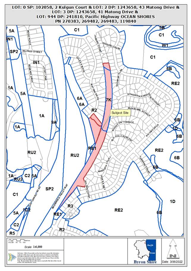
Assessment:
1. INTRODUCTION
1.1. History/Background
The applications lodged which essentially relate to the development site as a whole, as outlined in the report relating to the below mentioned Application No. 10.2014.743.3, are as follows:
|
10.2008.757.1 |
Seniors living 94 units in 3 stages (Lapsed) |
Approved 10/06/2010 |
|
10.2014.608.1 |
30 Residential Units, Dual Occ, strata sub |
Rejected 23/10/2014 |
|
10.2014.743.1 |
Consolidation of five (5) lots into three (3) lots, two boundary adjustments, construction and strata subdivision of thirty (30) of multi dwelling houses, and a detached dual occupancy over four (4) stages |
Approved 29/10/2015 |
|
10.2014.743.2 |
S96 to reconfigure approved Torrens Title allotments and construct the development in 7 Stages. |
Approved 15/02/2017 |
|
10.2014.743.3 |
S4.55 - Revise the design of the eight (8) dwellings approved as Stage 2 |
Approved 23/8/2017. |
|
10.2014.743.4 |
S4.55 Modification to require Stage 4 to be carried out before Stage 3, |
Approved 9/9/2022 |
1.2. Description of the proposed development
This application seeks approval for a S4.55 for Modified Stage 3 Design, to Increase the Number of Dwellings from 8 to 10 and Revised Internal Driveway Configuration. The submitted plans are included in Attachment 2 to this Report. Attachments 3 and 4 contain the BASIX Certificate and NatHERS Certificate, respectively.
The application provides a more detailed description of the proposal as follows:
“In summary, the proposed amendment seeks increase the number of dwellings in the above stated area from eight (8) to ten (10) by way of adopting a revised design approach to the dwellings proposed, which not only increases the yield in this particular area, but also incorporates a revised internal driveway configuration. This design change has been bought about by way of adapting to commercial needs and wants of the housing market and through the design evolution process highlighting the ability to amend the access arrangement in a more efficient manner.”
Other Referrals
Council’s Development Engineer raised no objection to the proposal, subject to amended conditions.
Council’s Environmental Health Officer raised no objection to the proposal subject to amended conditions.
Council’s ET Engineer raised no objection to the proposal, subject to a modified headworks charge.
Council’s Natural Resource Planner raised no objection to the proposed amendment.
The NSW Rural Fire Service raised no objection to the proposal, subject to modified General Terms of Approval and Bush Fire Safety Authority,
1.3. Description of the site
|
Land is legally described as: |
LOT: 954 DP: 241073, LOT: 12 DP: 1128095, LOT: 9 DP: 1046566, LOT: 892 DP: 241810, LOT: 893 DP: 241810, LOT: 944 DP: 241810 |
||
|
Property address is: |
2 Kulgun Court OCEAN SHORES, 41 Matong Drive OCEAN SHORES, 43 Matong Drive OCEAN SHORES, Pacific Highway OCEAN SHORES |
||
|
Land is zoned: |
R2 Low Density Residential Zone 7(k) (Habitat Zone) |
||
|
Property is constrained by: |
Bush fire prone land Flood liable land Acid sulfate soils (small portions of land in Class 5) High environmental value vegetation – however the location of the development as modified is not within mapped HEV vegetation and this constraint is not considered further by this Report. |
||
|
|
|
|
|
|
Figure 1: View of site from Matong Drive |
Figure 2: View towards site from current end of driveway off Kulgun Court |
|
|
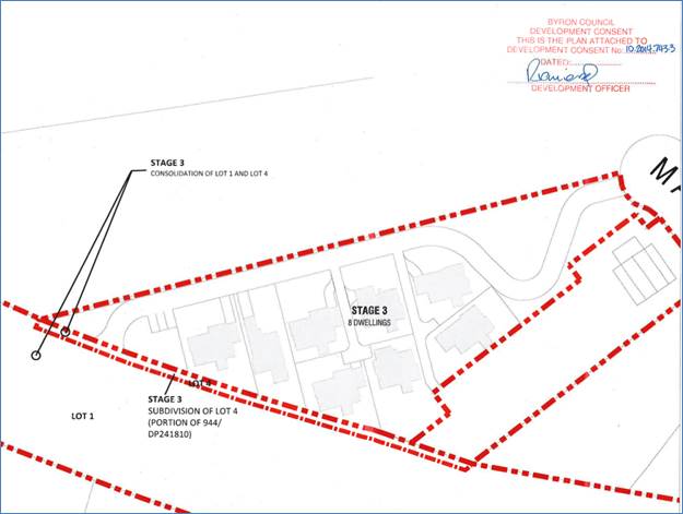
Approved Stage 3 Layout
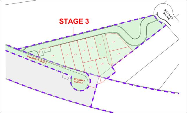
Proposed Stage 3 Lot Layout
2. SECTION 4.15 – MATTERS FOR CONSIDERATION – DISCUSSION OF ISSUES
Section 4.55 of the EPA Act 1979
Having regards to the scale of the total development, the proposal as amended is considered to be substantially the same development and satisfies the provisions under S4.55 of the EPA Act 1979.
2.1. State/Regional Planning Policies, Instruments, EPA Regulations 2021
Proposed amendments raise no issues under the relevant SEPPS, Policies or clauses of the EPA Regulations 2021
2.2. Byron Local Environmental Plan 2014
The relevant provisions of LEP 2014 are considered with reference to the proposed modified design for Stage 3 as follows:
Clause 2.3 Zone Objectives and Land Use Table
Stage 3 is located within the R2 Low Density Residential Zone. The modified multi dwelling housing development is permitted with consent in the R2 Zone and is satisfactory having regard to the zone objectives.
Clause 4.1E Minimum lot sizes for certain residential accommodation
Stage 3 exceeds the minimum lot area development standard for multi dwelling housing in the R2 Zone of 1000m2.
Clause 4.3 Height of buildings
The modified dwellings are less than the 9m maximum height of buildings development standard.
Clause 4.4 Floor space ratio
The site is large, and the modified development is less than the 0.5:1 maximum floor space ratio development standard.
Clause 5.21 Flood planning
Part of Stage 3 is located within flood liable land. No change was recommended by Council’s Development Engineer in relation to the existing flood related conditions on the consent.
Clause 6.1 Acid sulfate soils
Part of Stage 3 is located within acid sulfate soils Class 5 – Works within 500 metres of adjacent Class 1, 2, 3 and 4 land that is below 5 metres AHD and by which the watertable is likely to be lowered below 1 metre AHD on adjacent Class 1, 2, 3 and 4 land. The modified development is unlikely to disturb acid sulfate soils in this regard. The location of the modified Stage 3 development approximates the location of the approved development. Council’s Environmental Health Officer raised no objection to the proposal, and an additional condition is included in the recommendation as provided by the Environmental Health Officer.
Clause 6.2 Earthworks
Council’s Development Engineer and Environmental Health Officer raised no objection to the proposal based on the proposed earthworks.
Clause 6.6 Essential services
Modified Stage 3 maintains access to essential services in the same way that the approved Stage 3 has access.
Clause 6.7 Affordable housing in residential and business zones
This clause requires that prior to granting consent to development on land zoned R2 Low Density Residential, the consent authority has considered (a) the need for providing, maintaining, or retaining affordable housing, and (b) the need for imposing conditions relating to providing, maintaining, or retaining affordable housing including, but not limited to, imposing covenants and the registration of restrictions about users.
While the modified proposal does not provide for affordable housing as defined by the clause, it instead seeks to respond to this clause through provision of new supply and diversity of housing stock in the Ocean Shores area. It is understood that the dwellings will be offered for purchase and or long-term rental over short term holiday letting. There is an existing condition in the consent requiring that the dwellings are not to be used for short term rental accommodation or for holiday let purposes.
2.3. Draft EPI that is or has been placed on public exhibition and details of which have been notified to the consent authority - Issues
No draft environmental planning instruments significantly affect the proposal.
2.4. Development Control Plans
Byron Shire Development Control Plan 2014 (DCP 2014)
The following comments are provided on the relevant DCP provisions
|
What Section and prescriptive measure does the development does not comply with? |
Does the proposed development comply with the Objectives of this Section? Address. |
Does the proposed development comply with the Performance Criteria of this Section? Address. |
|
B14.2 Excavation and Fill in All Zones The proposed depth of excavation is up to approximately 1.66m deep for House 27 and 2.0 m deep for House 28, which exceeds the 1m requirement. However the excavation is incorporated into the dwelling structure to satisfy minimum car parking requirements and is allowed up to be a maximum height of 2 metres. The development complies in this regard. However the Objectives and Performance Criteria are considered for completeness.
|
The proposed development complies with the Objectives of the Section because: 1. The residential proposal maintains overall compatibility with the Shire’s natural features and historical built character. The excavation >1m is remote from the site boundaries and is generally contained behind the proposed building. 2. The extent, character, bulk and scale of the proposed earthworks will not detract from the existing and desired future character of the immediate locality and surrounding area. 3. The proposed earthworks will not detract from the existing and desired future character of the immediate locality and surrounding area. |
The proposed development complies with the Performance Criteria of this Section because: 1. The proposed earthworks will be compatible with the low rise, low to medium density form, scale and desired future character of the locality and immediate surrounds. Excavation is limited to ensure that: a) Adverse visual impacts, bulk and scale of both the proposed earthworks and the resultant overall development are minimised; b) Significant overshadowing of adjoining land is avoided; c) The scale and character of the resultant landform and buildings remains compatible with the surrounds and desired future character of the locality; d) Drainage characteristics and systems will not be significantly affected; e) The need for engineering and support works is minimised; f) Risk of geotechnical instability and/ or landslip is minimised; 2. The proposed earthworks do not relate to improving thermal sustainability or insulation. 3. The proposal is not in a commercial area. 4. Filling is not proposed to mitigate flooding and stormwater issues. 5. The site is not mapped as having stability problems. |
Chapter D1 Residential Accommodation in Urban Village Special Purpose Zones
The two additional dwellings within this stage and the general reconfiguration of the other 8 dwellings is satisfactory considering the shape and size of the parcel, the design and height of the dwellings. The proposal is satisfactory in terms of setbacks, building height plane, open space, car parking and facilities. The dwellings are modest in design comprising three bedrooms, bathrooms and open living and kitchen with car parking.
Chapter E9 Ocean Shores, South Golden Beach and New Brighton
The subject property is in an area classified as Subtle: small clusters of low rise medium density complementing the existing form and terrain – likely to be incremental with many existing elements remaining under this chapter of the DCP. It is considered the proposal as designed represents a cluster of low rise medium density housing and is of a bulk, scale and form for infill housing which does not offend the character of Ocean Shores or the controls under Chapter E9.
The proposed development raises no other issues under the DCP.
2.5. The likely impacts of that development, including environmental impacts on both the natural and built environments, and social and economic impacts in the locality
The proposed amendments do not generate any impacts that have not been previously considered.
2.6. The suitability of the site for the development
The proposed amendments do not affect the Sites Suitability.
2.7 Submissions made in accordance with this Act or the regulations
The application was publicly exhibited. Two (2) public submissions were received. The redacted public submissions are provided in Attachment 5 to this Report. The issues raised in the submission are commented on as follows:
|
Issues |
Comment |
|
The proposal is inconsistent with the R2 Zone and objectives zoning of: “low density housing where the planning objective is to protect the locality's single dwelling character and landscape setting”. 2 additional dwellings is not in keeping with the R2 Zoning of this street.
|
The site is within the R2 Low Density Residential Zone. The kinds of residential accommodation which are permitted with consent in the R2 Zone include attached dwellings, dual occupancies, dwelling houses, multi dwelling housing, secondary dwellings and seniors housing. The proposal is for multi dwelling housing which is permitted with consent in this R2 Zone. The proposal is satisfactory having regard to the primarily applicable objective of the Zone, because it provides for the housing needs of the community within a low density residential environment. Further the development is for detached housing as opposed to multi storey residential flat buildings and the yield proposed for Stage 3 with an area of 6462 m2 equates to a yield of 1 dwelling per 646.2 m2. It is considered the proposed density is compatible with the objectives of the R2 Zone. The development also complies with the primarily applicable density development standards, such as the minimum 1000m2 lot size for multi dwelling housing in the R2 Zone (clause 4.1E), height of building (clause 4.3) and floor space ratio (clause 4.4). The proposal is considered satisfactory. |
|
Taken together with the other current proposed related DA modification of 3 dwellings on 41 Matong Drive (DA.10.2020.284.1), this would mean an additional 13 dwellings across 41 & 43 Matong Drive – should the proposed modifications be approved. |
Noted – the immediate property to the North in Matong Drive is also approved for multi dwelling housing. |
|
The R2 zoning specifies minimum-sized lots of 600m2. Yet only one of the proposed dwellings (H36) has a lot size more than 600m2.
|
The 600m2 minimum lot size development standard under clause 4.1 of LEP 2014 does not apply to the registration of a strata plan of subdivision. |
|
Matong Drive does not have the infrastructure to adequately support the increased traffic flow that will arise from this development. Traffic Noise Safety
|
In relation to traffic impact, Council’s Development Engineer advised that a net increase of 14 daily trips and 1.3 peak hour trips. This accounts to 0.3% increase in total peak hour trips. This increase is minimal and will not have an adverse impact on the road network. Such a small increase in traffic generation is not expected to significantly increase traffic noise beyond that expected for a low density residential environment area. |
|
Proposal is driven by commercial and market needs and interest, rather than any regard for the amenity of the neighbourhood or the wishes of the street’s residents. Never at any stage have the developers sought to consult with or ascertain the needs and interests of the residents of Matong Drive. |
Noted. |
|
Inadequate parking. |
The proposal complies with the car parking requirements for residential development for the dwelling plus provides for the required visitor spaces. |
|
Maintenance of restricted access to Matong Drive by residents of the associated development bordering Kulgun Court
|
No modification is recommended in relation to description of Stage 3 as per the recommendation of this Report, which includes “access to Matong Drive with a locked gate for Emergency Services (gate to be locked to prevent access through the site to Kulgun Court/Brunswick Valley Way)”. |
|
How much greenery and space is there between houses? How many native trees are there intended to remove. How many have already been removed?
|
Landscaping and open space for the 10 dwellings is considered satisfactory. Council’s Natural Resource Planner has considered the proposal and raised no objection to the proposed amendment, noting in particular that the development footprint has largely already been approved by the previous consent issued by Council over the land. |
2.8 Public interest
Proposed amendments are unlikely to prejudice or compromise the public interest.
3. DEVELOPER CONTRIBUTIONS/ WATER AND SEWER CHARGES
Developer contributions to be adjusted to reflect the additional two dwellings proposed.
DISCLOSURE OF POLITICAL DONATIONS AND GIFTS
|
Has a Disclosure Statement been received in relation to this application |
No |
|
Have staff received a ‘gift’ from anyone involved in this application that needs to be disclosed. Where the answer is yes, the application is to be determined by the Director or Manager of the Planning, Development and Environment Division. |
No |
|
Provide Disclosure Statement register details here: |
Not applicable |
4. CONCLUSION
The proposed modifications to the staging are considered acceptable. Amended conditions of consent are recommended to address matters raised during the exhibition period to lessen amenity impacts on neighbours to the south-east of the site. The proposed S4.55 application is recommended for approval.
BYRON SHIRE COUNCIL
Staff Reports - Sustainable Environment and Economy 13.8
Report No. 13.8 PLANNING - DA 10.2022.107.1 - 3 Lot Subdivision - 23 Bayshore Drive, Byron Bay
Directorate: Sustainable Environment and Economy
Report Author: Chris Larkin, Manager Sustainable Development
File No: I2022/1558
Proposal:
|
Proposal description: |
Subdivision One (1) Lot into Three (3) Lots |
||
|
Property description: |
LOT: 12 DP: 1189646 |
||
|
23 Bayshore Drive BYRON BAY |
|||
|
Parcel No/s: |
267109 |
||
|
Applicant: |
Geolink Consulting Pty Ltd |
||
|
Owner: |
Byron Shire Council |
||
|
Zoning: |
Part B7 Business Park / part DM Deferred Matter Byron LEP 1988. The deferred matter is zoned part 2V (Village Zone) and part 4A (Industrial Zone) under Byron LEP 1988. |
||
|
Date received: |
1 April 2022 |
||
|
Integrated / Designated Development: |
☐ Integrated |
☐ Designated |
☒ Not applicable |
|
Concurrence required |
No |
||
|
Public notification or exhibition: |
- Level 2 advertising under Council’s Community Participation Plan. - Exhibition period: 19/4/22 to 14/5/22 - Submissions received: 1 - Submissions acknowledged: ☒ Yes ☐ No ☐ N/A |
||
|
Estimated cost |
$500,000.00 |
||
|
Assessing Officer |
Kellie Shapland – Consulting Planner |
||
|
Delegation to determine |
Council |
||
|
Relevant Policy |
Management of Conflicts of Interest in Development Matters (Development application submitted by/behalf Byron Shire Council) |
||
|
Issues |
Vegetation Management for the residual ecological lot. |
||
Summary:
The DA proposes Subdivision one (1) lot into three (3) lots with two lots created for development purposes and the third residual lot will be primarily for ecological purposes. Access to the site is to be provided from Bayshore drive via a new road which will terminate in a cul-de-sac head. The southern lot will house the new TAFE building which is currently under construction
The application appropriately addresses the relevant constraints applying to the site and is recommended for a Deferred Commencement consent subject to the conditions listed in Attachment 1.
NOTE TO COUNCILLORS:
In accordance with the provisions of S375A of the Local Government Act 1993, a Division is to be called whenever a motion for a planning decision is put to the meeting, for the purpose of recording voting on planning matters. Pursuant to clause 2(a) under the heading Matters to be Included in Minutes of Council Meetings of Council's adopted Code of Meeting Practice (as amended) a Division will be deemed to have been called by the mover and seconder of all motions relating to this report.
RECOMMENDATION:
It is recommended that pursuant to Section 4.16 of the Environmental Planning & Assessment Act 1979, Development Application No. 10.2022.107.1 for Subdivision one (1) lot into three (3) lots, be granted consent subject to the conditions in Attachment 1 (E2022/106022).
Attachments:
1 DA10.2022.107.1
Recommended Conditions of Consent, E2022/106022
![]()
2 DA10.2022.107.1
Proposed Plan of Subdivision and Road Works, E2022/113068
![]()
3 Confidential - DA10.2022.107.1 Submissions received, E2022/105728
Assessment Report:
INTRODUCTION
History/Background
The subject site is owned by Byron Shire Council (BSC). BSC is proposing to subdivide the site into three (3) lots to create two (2) commercial lots and one residue lot that is proposed to be retained for environmental protection purposes.
A TAFE Connected Learning Centre is currently being constructed on part of the site which is subject to a lease agreement between BSC and TAFE NSW. The connected learning centre will be located on part of one of the commercial lots.
The following is a history of development applications from Council records.
|
Application Number |
Description |
Determination Date |
Decision |
|
10.2021.234.1 |
Educational Establishment TAFE NSW Connected Learning Centre |
29/11/2021 |
Approved by NRPP |
|
10.2015.177.1 |
Tree removal |
17/06/2015 |
Approved |
|
10.2007.177.1 |
Environmental enhancement work |
19/12/2007 |
Approved |
|
5.1997.171.1 |
Subdivision - Subdivision (4 lots) |
04/07/1997 |
Approved Delegation |
The site was historically used by BSC for the storage of a range of construction materials including a variety of surplus fill materials derived from construction works. The site was cleaned up following an assessment of materials on the site and development of a clean-up strategy. The NSW Environment Protection Authority (EPA) issued a license for the works. The license was lifted in 2017 following final approval of the completed clean up.
Description of the proposed development
Overview
This application seeks approval for the subdivision of the subject site into three lots to create:
· Proposed Lot 1 having an approximate area of 1.19 ha. This will be a vacant lot that will be available for future development for Business Park purposes.
· Proposed Lot 2 having an approximate area of 0.85 ha. The western part of this proposed lot will contain a drainage reserve and the TAFE Connected Learning Centre. The eastern part of this lot would be available for future development for Business Park purposes.
A road reserve separating Lots 1 and 2 is also proposed to be dedicated to BSC.
The proposed subdivision layout is illustrated on Figure 1.
The application indicates that the proposed boundaries for Lots 1 and 2 have been designed to ensure these two lots exclude existing native vegetation in the western portion of Lot 12 as well as excluding any mapped Biodiversity Values Land (BVL).
The proposed boundary for Lot 3 has been designed to contain the native vegetation within the western portion of existing Lot 12. Lot 3 will also contain all the BVL mapped under the BC Act within existing Lot 12 and land covered under the existing VMP approved for the site.
Services
Proposed Lot 1 will be provided with water, sewer, electricity, and communications.
Proposed Lot 2 is already serviced by recently constructed water and sewerage infrastructure parallel to the site boundary within Lot 12, therefore it will only require electricity and communications.
The subdivision will accommodate a new public road within the boundary of existing Lot 12 to service Lots 1 and 2 and to provide sufficient public road corridor for future construction of a roundabout to service the commercial lots and the shopping centre opposite.
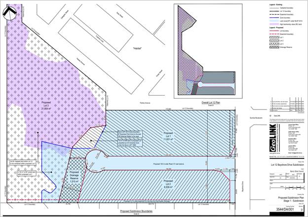
Figure 1 – Proposed Subdivision Layout
Staging
It is proposed to undertake the development in stages as follows:
· Stage 1 – includes the subdivision of land, dedication of the new road reserve to BSC and registration of the three (3) lots. It proposes to include the provision of utility services (water, sewer, power and communications) to proposed Lots 1 and 2.
· Stage 2 – includes the construction of the roundabout intersection on Bayshore Drive providing upgraded formal access into the subject site (Lot 12) and the shopping centre opposite.
Description of the site
|
Land is legally described |
LOT: 12 DP: 1189646 |
|
|
Property address |
23 Bayshore Drive BYRON BAY. An aerial photograph of the property is shown below (Figure 2). |
|
|
Land is zoned: |
Part B7 Business Park / part DM Deferred Matter Byron LEP 1988. The deferred matter is zoned part 2V (Village Zone) and part 4A (Industrial Zone) under Byron LEP 1988 (refer to Figure 3). |
|
|
Land area is: |
5.815 m2 |
|
|
Property is constrained by:
|
Bushfire prone land – northern portion of the site Acid Sulfate Soils Class 3 High Environmental Value land Proximity land to coastal wetlands Biodiversity Values Map |
|
|
|
Is a BDAR required due to the location of the proposed development? |
☐ Yes ☒ No |
|
|
Are there any easements in favour of Council affecting the site? |
☒ Yes ☐ No There are easements for services adjacent to Bayshore Drive. (refer to Figure 4). |
|
|
Is there a Vegetation Management Plan which might affect the proposal? |
☒ Yes ☐ No A VMP was required as a condition of consent for DA 10.2015.177.1 |
|
|
Is there a Voluntary Planning Agreement which might affect the proposal? |
☐ Yes ☒ No |
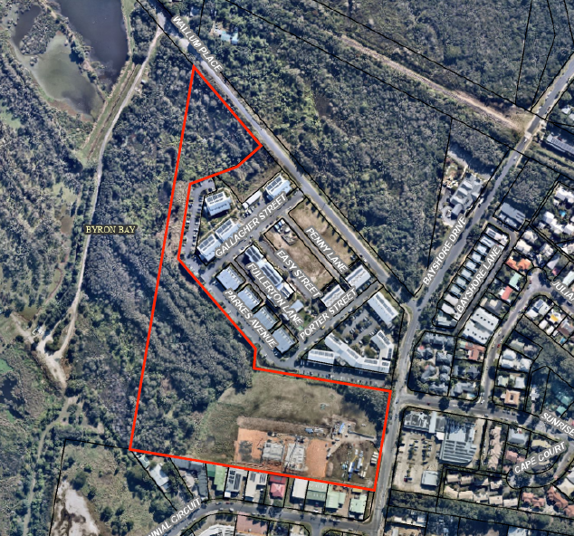
Figure 2 – Aerial Photograph
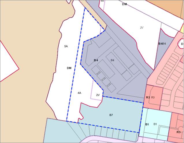
Figure 3 – Zoning (Byron LEP 2014 and BLEP 1988 combined) – the eastern portion of the site is zoned B7 Business Park (BLEP 2014). The Deferred Matter (DM) is shown white and is zoned part 2V (Village Zone) and part 4A (Industrial Zone) under Byron LEP 1988.
The roadworks in Bayshore drive are on land zoned B1 Neighbourhood Centre.
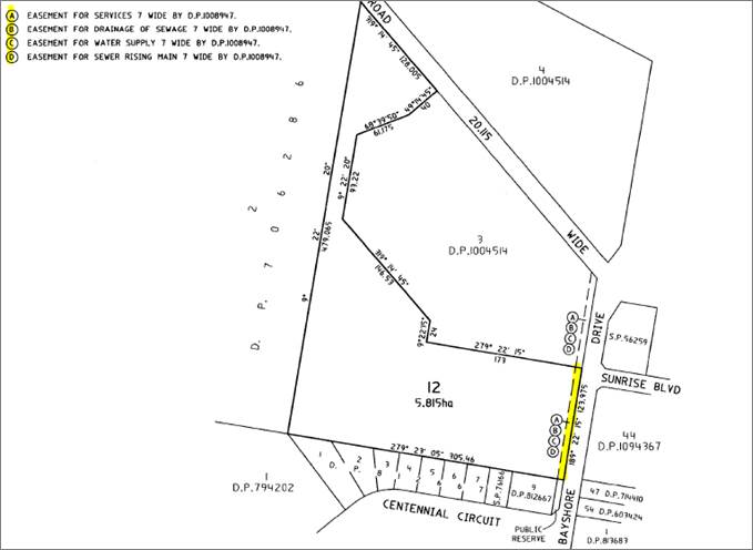
Figure 4 – DP 1189646 Easements
SUMMARY OF REFERRALS
|
Referral |
Issue |
|
Environmental Health Officer* |
No objections subject to conditions. |
|
Development Engineer |
No objections subject to conditions. See additional comments |
|
S64 / Systems Planning Officer |
No objections subject to conditions. |
|
S7.11 / Contributions Planner |
No objections subject to conditions. |
|
Natural Resource Planner |
No objections subject to conditions. See additional comments |
|
Essential Energy |
No Objections |
|
Bundjalung (Arakwal) |
Council has received the following advice: Please be aware that any ground disturbing or excavation works taking place at Lot 12, DP 1189646, 23 Bayshore Drive, Byron Bay will be in an area that Aboriginal Cultural Heritage is at high risk of uncovering or disturbing Cultural Heritage.
We also note that wherever ground disturbing works are being undertaken, it is BOBBAC's expectation that two Arakwal Traditional Owners are engaged as Cultural Site Monitors for the duration of works to oversee and assess the potential for harm to our Aboriginal Cultural Heritage. A condition of any consent will require the engagement of Cultural Site Monitors. |
Issues:
Development Engineering
Access and traffic
Proposed Lot 2 is currently being developed for a TAFE Connected Learning Centre and the remainder of this proposed lot is vacant. Proposed lot 1 is likely to be further developed for mixed uses. Without knowing the final development types and sizes for the site assumptions have been made with respect to traffic generation. These assumptions have been assessed as being conservative.
The existing and development traffic up to the design horizon falls below the lower limit capacity specified in Austroads Guide to Traffic Generating Developments Part 3. This indicates a single lane roundabout has ample storage capacity to cater for the background and development traffic past the design horizon.
The design of the internal road has been amended from that which was originally proposed to provide a wider road reserve and pavement, and additional on street parking. The road layout generally meets the Industrial Road carriageway requirements however the narrowing of the throats at the entrance of the road and the cul-de-sac head will require further investigation using a Single Unit Bus with 12.5m radius. This can be addressed at the detailed design phase.
Access and traffic have been assessed as being satisfactory subject to recommended conditions of any consent. This includes the provision of the following work in each of the proposed stages:
· Stage 1 of Construction – TAFE access + Internal Road 12 excluding the roundabout, prior to the issue of subdivision certificate (note: this requirement varies from the development proposal which indicated that the internal road would be constructed as part of Stage 2)
· Stage 2 of Construction – Roundabout, prior to any further development inside proposed Lot 1 & Lot 2 or 12 months after the issue of the subdivision certificate whichever comes first.
Stormwater management
A stormwater detention pond in the southwestern portion of the site is being constructed as part of the TAFE Connected Learning Centre development. This will cater for the development of the TAFE and the remainder of proposed Lot 2 as well as the proposed new road.
Stormwater management for proposed Lot 1 will be required to be addressed in detail as part of any future development of this lot.
Natural Resource Planner
Mapping Constraints
· Biodiversity Values Map
The site includes land identified on the BV Map. The boundary of the mapped area broadly aligns with the edge of the forested area in the west of the site and the HEV maps.
· High Environmental Value Vegetation (extract Figure 5)
High Environmental Value vegetation is identified within the site (refer Figure 5). This includes:
o A patch of Swamp oak-broad-leaved paperbark-willow bottlebrush floodplain forested wetland roughly in the centre of the site that has been cleared since the mapping was undertaken.
o A patch of Broad-leaved paperbark-swamp mahogany-swamp box swamp sclerophyll forest on coastal sandsheets transitioning to Giant sedge sedgeland of frequently inundated areas of sandy alluvium in the west of the site.
o A patch of sedgeland-grassland (only broadly described) transitioning to Slender twine-rush-pale cord-rush sedgeland in the north west of the site. This area is contiguous with a small area of constructed habitat within the Habitat development site.
o An isolated patch of paperbark-teatree coastal swamp forest in the north east of the site.
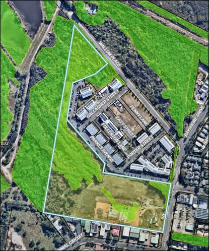
Figure 5 – Mapped High Environmental Value Land
Fauna
Land to the west and north comprises habitat for threatened frog species (Crinia tinnula and Litoria olongburensis).
The future development resulting from the subdivision will involve ancillary works such as construction of stormwater infrastructure that may indirectly impact the hydrology of the adjacent wetland systems. Future development applications over the proposed lots will need to address this issue.
Vegetation and proposed boundaries
Councils Natural Resource Planner notes that the application states that the proposed boundary of Lot 3 has been designed to contain all native vegetation within the western portion of the existing Lot 12, including all land identified on the Biodiversity Values Map. The boundaries were not designed to incorporate the ecological setback areas required under Chapter B1 of the DCP.
Byron Shire DCP Chapter B1 Biodiversity
Section B1.2 of the Byron DCP 2014 includes a number of ecological setback requirements that development must incorporate. Having regards to the HEV mapping to the west of Proposed Lot 1 a buffer from the edge of the boundary of Lot 3 is recommended in terms of a building envelope.
Vegetation Management Plan
An existing consent was issued in 2015 for vegetation clearing including 2280 m2 of swamp sclerophyll forest (DA 10.2015.177.1). Condition 3 of this consent required a Vegetation Management Plan (VMP) detailing restoration and compensation comprising compensatory plantings. A VMP was subsequently approved in satisfaction of this condition which specified management actions over a period of five years (plan extract shown in Figure 6).
No monitoring reports or evidence of the work commencing could be located in Council’s records. Conditions of consent re proposed to ensure existing VMP works are undertaken and a new VMP prepared for the ongoing management of Lot 3.
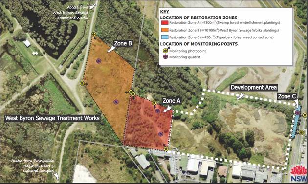
Figure 6- Vegetation Management Zones as defined in the approved VMP for DA 10.2015.177.1
SECTION 4.14 – BUSH FIRE PRONE LAND
Proposed lots 1 and 2 are not affected by the bushfire prone land mapping.
The proposal is considered satisfactory with respect to bushfire considerations, having regards to the zoning of the land. Referral to NSW Rural Fire Service is not necessary in this instance.
SECTION 4.15C – MATTERS FOR CONSIDERATION – DISCUSSION OF ISSUES
Having regard to the matters for consideration detailed in Section 4.15(1) of the Environmental Planning & Assessment Act 1979 (EP&A Act), the following is a summary of the evaluation of the issues.
State Environmental Planning Policies (SEPP)
|
Considerations |
Satisfactory |
Unsatisfactory |
|
Biodiversity and Conservation SEPP 2021 Consideration: Chapter 4 – Koala habitat protection 2021 The site is greater than 1 hectare in area and therefore the Byron CKPoM/Koala SEPP 2021 applies.
The site is within a Koala Management Precinct as defined in the Byron CKPoM. No potential koala habitat as defined in the Byron CKPoM occurs within the site.
|
☒ |
☐ |
|
Resilience and Hazards SEPP 2021 Consideration: Chapter 2 Coastal management This chapter applies to land within the coastal zone. Coastal management areas comprise: · the coastal wetlands and littoral rainforests area – the subject site is not mapped as coastal wetlands or littoral rainforest. However, a small area in the northern portion of the property is mapped as a proximity area for coastal wetlands (refer Figure 7) · the coastal vulnerability area – no mapped areas currently · the coastal environment area – the site is not mapped within the coastal environment area · Figure 7 – Proximity Area for Coastal Wetlands Section 2.8 Development on land in proximity to coastal wetlands or littoral rainforests provides: (1) Development consent must not be granted to development on land identified as “proximity area for coastal wetlands” or “proximity area for littoral rainforest” on the Coastal Wetlands and Littoral Rainforests Area Map unless the consent authority is satisfied that the proposed development will not significantly impact on— (a) the biophysical, hydrological or ecological integrity of the adjacent coastal wetland or littoral rainforest, or (b) the quantity and quality of surface and ground water flows to and from the adjacent coastal wetland or littoral rainforest. The northern portion of the subject land mapped as being a proximity area for a coastal wetland, is located approximately 125m metres from the northern boundary of proposed Lot 1 (the closest area that could potentially be developed). The wetlands on the western portion of the site where the development drains to, is not mapped as coastal wetlands, littoral rainforest or a proximate area. The closest mapped area to the west is located on the adjacent land, approximately 250 metres from the western boundary of proposed Lot 2. The application has been assessed by Council ecologist, engineer and environmental health officer and it is considered that, subject to the implementation of appropriate conditions, activities will not significantly impact on the biophysical, hydrological or ecological integrity of the adjacent coastal wetland, or the quantity and quality of surface and ground water flows to and from the adjacent coastal wetland. Chapter 4 – Remediation of land A Preliminary Site Contaminated Report has been prepared. Included are 25 soil sampling results for contaminates of concern. The site was below the relevant Health Investigation Levels.
No further investigation or remedial action is considered warranted.
The report has been reviewed by Councils Environmental Health Officer and no objections are raised. Standard conditions have been imposed for the preparation of an Unexpected Findings Protocol.
|
☒ |
☐ |
|
Consideration: The proposal is not state significant or regional development. |
☒ |
☐ |
|
Transport and Infrastructure SEPP 2021 Consideration: The proposal was referred to essential energy with respect to proposed roadworks in proximity to overhead powerlines. As discussed, no objections were raised.
|
☒ |
☐ |
4.2A Byron Local Environmental Plan 2014 (LEP 2014)
LEP 2014 is an applicable matter for consideration in the assessment of the subject development application in accordance with subsection 4.15(1) of the EP&A Act because it applies to the subject land and the proposed development. In accordance with LEP 2014 clauses 1.4 and 2.1 – 2.3:
(a) The proposed development is defined in the LEP 2014 Dictionary as Subdivision;
(b) Lot 12 is within the B7 Business Park and B1 Neighbourhood Business Zone and PART DM Deferred Matter according to the Land Zoning Map. The Deferred Matter is land affected by Byron LEP 1988 and is zoned part 2(v) Village Zone and part 4(a) Industrial Zone. Roadworks adjacent to Lot 12 includes land zoned B1 Neighbourhood Centre.
(c) The proposed development is permitted with consent; and
(d) Regard is had
for the Zone Objectives as follows:
|
Zone Objective |
Consideration |
|
B7 Business Park |
|
|
• To provide a range of office and light industrial uses. |
The size and shape of proposed lots 1 and 2 will enable future development for a range of uses permitted in the zone. |
|
• To encourage employment opportunities. |
The proposed subdivision will facilitate future development that will provide employment opportunities. |
|
• To enable other land uses that provide facilities or services to meet the day to day needs of workers in the area. |
This objective will not compromised by the proposed subdivision. |
|
• To enable a range of other development compatible with or ancillary to industrial uses if such uses do not undermine the retail function of Byron Bay town centre. |
This objective will not compromised by the proposed subdivision. |
|
B1 Neighbourhood Centre |
|
|
• To provide a range of small-scale retail, business and community uses that serve the needs of people who live or work in the surrounding neighbourhood. |
The proposed roadworks in this zone is will not impact on this objective. The works are designed to ensure access to business uses is retained. |
Clause 4.1 Minimum lot size
This clause prescribes that the minimum lot size of a property is not to be less than the minimum size shown on the Lot Size Map. The minimum lot size for the B7 zoned land on the site is 1000m2. The proposal complies in this regard.
The proposal also involves the subdivision of land located in the area affected by Byron LEP 1988. This is discussed later in this report.
Clause 6.1 Acid sulfate soils
The proposed development is located on land identified as Class 3 on the Acid Sulfate Soils Map. Where there is work more than 1 metre below natural ground level, subclause (3) provides that development consent must not be granted under this clause unless an acid sulfate soils management plan has been prepared for the proposed works in accordance with the Acid Sulfate Soils Manual and has been provided to the consent authority.
The applicant has advised that no work included in the application will be undertaken below 1 metre below natural ground level. Accordingly, further acid sulfate soils investigations are not required.
Clause 6.2 Earthworks
The objective of this clause is to ensure that earthworks for which development consent is required will not have a detrimental impact on environmental functions and processes, neighbouring uses, cultural or heritage items or features of the surrounding land. Subclause 3 requires that:
In deciding whether to grant development consent for earthworks (or for development involving ancillary earthworks), the consent authority must consider the following matters—
(a) the likely disruption of, or any detrimental effect on, drainage patterns and soil stability in the locality of the development,
(b) the effect of the development on the likely future use or redevelopment of the land,
(c) the quality of the fill or the soil to be excavated, or both,
(d) the effect of the development on the existing and likely amenity of adjoining properties,
(e) the source of any fill material and the destination of any excavated material,
(f) the likelihood of disturbing relics,
(g) the proximity to, and potential for adverse impacts on, any waterway, drinking water catchment or environmentally sensitive area,
(h) any appropriate measures proposed to avoid, minimise or mitigate the impacts of the development.
No significant earthworks are required for the proposed subdivision. The stormwater detention pond to treat runoff from proposed Lot 2 and the internal road is being constructed under the consent for the TAFE Connected Learning Centre. Detailed stormwater management design for proposed Lot 1 will be determined in conjunction with any future development application for that lot.
With respect to the specific clause 6.2 considerations, Councils engineers have raised no objections to the earthworks proposed and it is concluded that suitable conditions can be placed on any consent to ensure that there will be no unacceptable impacts on drainage patterns and surrounding properties, or wetlands to the west. If relics are uncovered, work must immediately stop, and the relevant authorities notified.
Clause 6.6 Essential services
The clause requires that, prior to granting consent to development, the consent authority must be satisfied that the nominated services are available or that adequate arrangements have been made to make them available.
The site is within an existing developed urban area where all required services are available or can be made available.
Conditions of consent to apply.
4.2B Byron Local Environmental Plan 1988 (LEP 1988)
The land affected by Byron LEP 1988 is zoned part 2(v) Village and part (4a) Industrial.
The western portion of proposed Lot 1 is zoned 4(a) Industrial. The 2(v) Village zone is located on proposed Lot 3 which is the land to be retained for environmental purposes and where no work is proposed.
In accordance with LEP 1988 clauses 5, 8 and 9:
(a) The proposed development is defined as subdivision;
(b) The land is within the LEP1988 4(a) Industrial and 2(v) Village zone according to the map under LEP 1988;
(c) The proposed development is permissible with consent; and
(d) The proposed development is consistent with the relevant objectives of the Zone for the following reasons:
|
Zone Objective - 4(a) Industrial Zone |
Consideration |
|
(a) to set aside certain land for the purposes of industry within convenient distances of the urban centres of the Shire of Byron and with good access to arterial roads, (b) to enable certain forms of development compatible with or ancillary to the industrial uses of the land, (c) to allow detailed provision to be made, by means of a development control plan, to set aside specific areas within the zone for different industry types and intensities of development, (d) to ensure industrial development creates areas which are pleasant to work in, safe and efficient in terms of transportation, land utilisation and service distribution, and (e) to permit tourist facilities where it can be demonstrated that the development is ancillary to the industrial use of the land. |
Approximately 710m2 of proposed Lot 1 is located in this zone. The 4(a) zoned land would likely be developed in conjunction with the adjoining B7 zoned land and overall, the objectives of this zone would not be compromised by the proposal.
|
|
Zone Objective – 2(v) Village Zone |
Consideration |
|
(a) to make provision for certain suitable lands to be used for small rural village purposes or integrated newly developing residential neighbourhoods, (b) to encourage a range of housing types in appropriate locations, (c) to enable development for retail commercial and service purposes for the local and nearby rural community in appropriate locations within the zone where the scale and type of development is compatible with living areas, (d) to ensure that development does not take place unless adequate provision is made for water supply and sewerage disposal, and the likely impact of the development on the locality has been considered, (e) to ensure by means of a development control plan the location, form, character and density of permissible development, and (f) to ensure that new development retains and enhances the existing village character or proposed residential neighbourhood character.
|
An area of 2(v) zoned land would be retained in proposed Lot 3 which is to be set aside for environmental protection purposes. This land would not be developed for residential purposes due to its environmental characteristics, however the wider 2(v) zoned land (which has now zoned under Byron LEP 2014) has been developed for a range of uses which are consistent with the 2(v) zone. |
The proposal raises no other issues under the LEP.
4.3 Any proposed Instrument that has been the subject of public consultation and has been notified to the consent authority
The LEP Employment zones reforms instrument has been exhibited. It proposes to replace the existing Business and Industrial zones across the state to Employment zones within individual LEP’s. The proposal remains permissible with consent and has no major implications for the proposed subdivision.
4.4A Byron Shire Development Control Plan 2014 (DCP 2014)
Chapter B1- Biodiversity
The proposal is satisfactory subject to conditions of consent for a vegetation management plan and a buffer to Lot 3 for the vacant Lot 1.
Chapter D5: Industrial Development
The existing TAFE Building will only be set back 5-8 metres from the proposed road. A variation to the prescriptive measures is proposed
|
What Section and prescriptive measure does the development not comply with? |
Does the proposed development comply with the Objectives of this Section? Address. |
Does the proposed development comply with the Performance Criteria of this Section? Address. |
|
Section D5.2.1 – Building lines 1. For the purposes of this Section: a) "Primary Building Line" is defined as 10 metres from the front boundary of the allotment. b) "Secondary Building Line" is defined as 6 metres from the front boundary of the allotment. 2. All buildings must be set back to the primary building line. However, buildings may encroach forward of the primary building line to the secondary building line to achieve a "stepped" front elevation. This encroachment must not exceed more than half of the width of the building at the primary building line. The TAFE building will be setback 5-8 metres from the new front road property boundary of Lot 1. |
Objectives 1. To establish minimum building setbacks in industrial areas to enhance streetscape and provide suitable commercial exposure. 2. To encourage a stepped front elevation to provide variation in the front facade and building form. The approved TAFE is at the end of the new internal road, with landscaping, seating and pedestrian facilities along the frontage. The building is stepped and overall, it is considered that the setbacks will be satisfactory. |
The performance criteria are: 1. Building setbacks must be designed to ensure that the aesthetics and character of industrial development will be compatible with development in the locality and with the existing and desired future character of the precinct. 2. Development may be permitted to encroach into the setback area where a development application demonstrates that: a) The proposed setback enhances the design of the building and complements the streetscape; and b) The proposed development does not adversely affect adjoining development, nor conflict with other requirements of this Chapter. Applicants Response: The TAFE NSW building line will be setback from the road boundary between 5-8m. This will be consistent with the future character of the innovation business park precinct. Site specific setback requirements will be developed in a specific DCP chapter relating to Lot 12 at a later date. In relation to points a) and b): · The proposed setbacks support a more active streetscape which is a goal for this innovation business precinct. It also supports a safer street by providing greater levels of overlooking on the street. · There are no adjoining developments next to the TAFE NSW site at this point. As the subdivision is not a traditional industrial subdivision and the TAFE, and the area in general is likely to be developed as an innovation precinct the setbacks proposed are considered satisfactory and the variation to the DCP requirement is justified. |
Chapter D6 Subdivision
The proposed subdivision and road layout is considered satisfactory for the proposed development in terms of D6.5. The applicant has sought a variation to the manner in which a normal development of this nature proceeds in terms of the roundabout construction being deferred to stage 2 as opposed to just constructing it up front with the rest of the works. In this regards the subdivision will be in effect completed and the lots registered with the roundabouts works then proceeding as a second stage. Noting that Council is the developer, a condition of consent is recommended requiring the roundabout to be built within two years of the date of the subdivision certificate being issued and no further development to occur on Lots 1 and 2 until such time ass the roundabout is built. The timing arrangements are considered satisfactory; however it is noted that should the vacant lot be on-sold or Council wish to developer other parts of the land in the interim, such works will be held up until such time as the roundabout is built. This will be a matter for Council to manage as landowner/ developer and be mindful not to overcommit to future developers either as a joint venture or individually until such time as the roundabout is built.
4.4B Byron Shire Development Control Plan 2010 (DCP 2010)
Although DCP 2010 applies to part of the site, the proposal raises no issues against these controls.
4.5 Environmental Planning and Assessment Regulation 2021 considerations
|
|
Applicable to the proposal: |
Considered the control as it relates to the proposal: |
If this control is applicable, does the proposal comply? |
|
Section 61 - Additional matters that consent authority must consider |
☐ Yes ☒ No |
☐ Yes ☐ No ☒ NA |
☐ Yes ☐ No ☒ NA |
|
Section 62 - Consideration of fire safety |
☐ Yes ☒ No |
☐ Yes ☐ No ☒ NA |
☐ Yes ☐ No ☒ NA |
|
Section 64 - Consent authority may require upgrade of buildings |
☐ Yes ☒ No |
☐ Yes ☐ No ☒ NA |
☐ Yes ☐ No ☒ NA |
|
Section 63 - Considerations for erection of temporary structures |
☐ Yes ☒ No |
☐ Yes ☐ No ☒ NA |
☐ Yes ☐ No ☒ NA |
4.6 The likely impacts of that development, including environmental impacts on both the natural and built environments, and social and economic impacts in the locality
|
Impact on: |
Likely significant impact/s? |
|
Natural environment |
No. Subject to the imposition of relevant conditions, the proposal will not have a significantly adverse impact on the natural environment of the locality. |
|
Built environment |
No. The proposal will not have a significantly adverse impact on the built environment of the locality. |
|
Social Environment |
No. The proposal will not have a significant social impact on the locality. |
|
Economic impact |
No. The proposal will not have a significant economic impact on the locality. |
|
Construction Impacts |
The development will generate minor impacts during its construction. Conditions of consent recommended to control hours of work, builders waste, construction noise, installation of sedimentation and erosion control measures and the like to ameliorate such impacts. |
Are there any Council Policies that are applicable to the proposed development?
None that require further consideration.
4.7 The suitability of the site for the development
The site is a serviced property and subject to the imposition of relevant conditions of consent which consider the sites environmental constraints, is suitable for the proposed development.
4.8 Submissions made in accordance with this Act or the regulations
The development application was publicly exhibited
There was one objection made on the basis that the subdivision is an enabling mechanism for a subsequent development by Creative Capital that will negatively affect the neighbourhood amenity. Residential uses are located opposite the site. Creative Capitals masterplan has a childcare centre opposite homes which will create noise impacts.
Request a condition of consent requiring a noise wall on the eastern and northern sides of Lot 12.
Comment: These issues would be addressed with any subsequent development applications over the site when full development details are known. It is premature to place such conditions on a consent when full details of any future development are not known, and they can be adequately addressed with future applications. Further the future owner of the subject lot is not known and won’t be known until such time as titles are created and the land has been sold by Council.
4.9 Public interest
The proposed development is unlikely to prejudice or compromise the public interest or create an undesirable precedent.
DEVELOPER CONTRIBUTIONS
5.1 Water & Sewer Levies
Section 64 levies will be payable.
5.2 Developer Contributions
Section 7.11 Contributions will be payable.
DISCLOSURE OF POLITICAL DONATIONS AND GIFTS
|
Disclosure details |
Response |
|
Has a Disclosure Statement been received in relation to this application? If Yes, Provide Disclosure Statement register reference: 91. |
Yes ☐ No ☒ |
|
Have staff received a ‘gift’ from anyone involved in this application that needs to be disclosed.
|
Yes ☐ No ☒ |
CONCLUSION
The proposed development is satisfactory having regard to the relevant environmental planning instruments and planning controls applicable to the site. The proposal raises no significant issues in terms of environmental impacts which cannot be managed, and the site is considered suitable for the development. The application is recommended for approval subject to the conditions of consent.
BYRON SHIRE COUNCIL
Staff Reports - Sustainable Environment and Economy 13.9
Report No. 13.9 PLANNING - Report of the Planning Review Committee held 3 November 2022
Directorate: Sustainable Environment and Economy
Report Author: Chris Larkin, Manager Sustainable Development
File No: I2022/1631
Summary:
This report provides the outcome of the Planning Review Committee (PRC) held on 3 November 2022.
NOTE TO COUNCILLORS:
In accordance with the provisions of S375A of the Local Government Act 1993, a Division is to be called whenever a motion for a planning decision is put to the meeting, for the purpose of recording voting on planning matters. Pursuant to clause 2(a) under the heading Matters to be Included in Minutes of Council Meetings of Council's adopted Code of Meeting Practice (as amended) a Division will be deemed to have been called by the mover and seconder of all motions relating to this report.
RECOMMENDATION:
That Council endorses the outcomes of the Planning Review Committee meeting held on 3 November 2022.
The Planning Review Committee meeting was held on 3 November 2022. The meeting commenced at 4:30pm and concluded at 5:03pm.
Councillors: Cr P Westheimer, Cr A Hunter, Cr S Balson, Cr S Ndiaye, Cr D Dey.
Apologies: M Lyon (Mayor), Cr C Coorey, Cr M Swivel
Staff: Chris Larkin (Manager Sustainable Development, Shannon Burt (Director Sustainable Environment and Economy)
Conflict of Interest: None declared
The following development applications were reviewed with the outcome shown in the final column.
|
DA No. / Applicant |
Property Address / Proposal |
Consultation / Submissions |
Reason/s / Outcome |
|
10.2022.279.1 Ardill Payne |
194 St Helena Road MCLEODS SHOOT
Primitive Camping including Business Identification Signage |
Level 1 1/9/22 to 14/8/22
2 submissions against
|
Staff Delegation |
Council determined the following original development applications. The S.4.55 applications to modify those consents were referred to the Planning Review Committee to decide if the modification applications can be determined under delegated authority with the outcome shown in the final column.
|
DA No. / Applicant |
Property Address / Proposal |
Consultation / Submissions |
Reason/s / Outcome |
|
10.1998.699.4 Stephen P McElroy & Associates |
113A Orana Road S4.55 to Delete and/or Modify Conditions 1(a), 4, 7 and 8 relating to Provision of Public Access over Ocean Shores Country Club
|
Level 2 30/9/22 to 14/10/22 12 submissions |
Staff Delegation |
|
10.2013.587.10 K Meade |
110 Jonson Street S4.55 to Modify the Consent in relation to the Tenancy 19 Gallery / Small Bar to Increase the Number of People attending to 120 for Art or Film Festival Openings and Events Occurring up to Twice Per Month from 5pm to 12 Midnight on Weekdays early in the Week, and to Extend the Time allowed to Serve Alcohol to 12 Midnight |
Level 2 29/9/22 to 5/10/22
2 submissions
|
Staff Delegation |
|
10.2020.272.2 Mrs L Love |
530 Lismore Road S4.55 to Modify Deferred Commencement Condition Timeframe from Two (2) Years to Three (3) Years |
Level 0 |
Staff Delegation |
|
10.2011.524.3 Town Planning Studio Pty Ltd |
384 Coopers Shoot Road COOPERS SHOOT S4.55 to Delete Condition 20(d) relating to Building Envelope |
Level 2 27/9/22 to 11/10/22 2 submissions against |
Staff Delegation |
BYRON SHIRE COUNCIL
Staff Reports - Sustainable Environment and Economy 13.10
Report No. 13.10 PLANNING - DA 10.2021.685.1 - New Dwelling to Create Dual Occupancy (Detached), Swimming Pool and Strata Subdivision to create Two (2) Lots and Common Property – 2 Keats Street, Byron Bay
Directorate: Sustainable Environment and Economy
Report Author: Ivan Holland, Planner
File No: I2022/1657
Proposal:
|
Proposal description: |
New Dwelling to Create Dual Occupancy (Detached), Swimming Pool and Strata Subdivision to create Two (2) Lots and Common Property |
||||||
|
Property description: |
LOT: 1 DP: 1257709 |
||||||
|
2 Keats Street BYRON BAY |
|||||||
|
Parcel No/s: |
269977 |
||||||
|
Applicant: |
Town Planning Studio Pty Ltd |
||||||
|
Owner: |
Mrs M J Kerrigan |
||||||
|
Zoning: |
R2 Low Density Residential / 2(a) Residential / 7(a) Wetlands |
||||||
|
Date received: |
16 November 2021 |
||||||
|
Integrated / Designated Development: |
☒ Integrated |
☒ Designated |
☐ Not applicable |
||||
|
Concurrence required |
Yes – Enter CNR No.31702 |
||||||
|
Public notification or exhibition: |
- Level 2 advertising under Council’s Community Participation Plan and designated development advertising under Schedule 1 (sub 8) of the EP&A Act and ss.56, 58 of the EP&A Regs. - Exhibition period: 26 November 2021 to 17 January 2022 - Submissions received: Nil (0) |
||||||
|
Other approvals |
☐ N/R |
☒ W & S (68) |
☐OSMS (68) |
☐ ST (68) |
☒ RA (138) |
||
|
Other: |
|
||||||
|
Estimated cost |
$519,000.00 |
||||||
|
Delegation to determine |
Council |
||||||
|
Issues |
· Coastal Wetlands under the Coastal Management SEPP – Designated Development – Environmental Impact Statement · Unauthorised conversion of shed to a dwelling |
||||||
Summary:
The DA proposes construction of a new dwelling, with a swimming pool, to create a dual occupancy (detached) and strata subdivision that will result in one dwelling being located on each strata lot and the residual land being incorporated into a common property lot.
The west of the property is mapped coastal wetland and the remainder of the property is coastal wetland proximity area. Aspects of the development (i.e., subdivision boundaries, part of the driveway and bush fire asset protection zones) encroach the mapped coastal wetland. Consequently, the proposal is designated development and must be determined by Council. However, the mapped boundaries of the coastal wetland are not particularly accurate, no native vegetation needs to be removed to facilitate the development and a Vegetation Management Plan has been offered for the ongoing care of the wetland.
Part of the shed has been converted to a dwelling/habitable space without approval and will be required to be restored to a shed by way of condition of consent.
Subject to recommended conditions to address the above, and other site-specific matters such as stormwater management, acid sulfate soils and vehicular access, the application is able to be recommended for approval subject to a deferred commencement consent.
NOTE TO COUNCILLORS:
In accordance with the provisions of S375A of the Local Government Act 1993, a Division is to be called whenever a motion for a planning decision is put to the meeting, for the purpose of recording voting on planning matters. Pursuant to clause 2(a) under the heading Matters to be Included in Minutes of Council Meetings of Council's adopted Code of Meeting Practice (as amended) a Division will be deemed to have been called by the mover and seconder of all motions relating to this report.
RECOMMENDATION:
That, pursuant to Section 4.16 of the Environmental Planning and Assessment Act 1979, Development Application No. 10.2021.685.1 for New Dwelling to Create Dual Occupancy (Detached), Swimming Pool and Strata Subdivision to create Two (2) Lots and Common Property, be granted consent subject to a deferred commencement requirement and the recommended conditions attached to this report.
1 DA
10.2021.685.1 Development and subdivision plans, E2021/130777 ![]()
2 DA
10.2021.685.1 Annotated Engineering plans, E2022/62977
![]()
3 DA
10.2021.685.1 Recommended conditions, E2022/111868
![]()
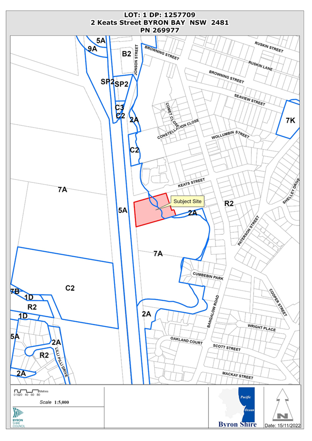
Assessment:
1. INTRODUCTION
History/Background
Council’s records indicate the following development approval history for the property:
· The subject property was created by a 2 lot subdivision (DA 10.2016.794.1) which was approved on 13/6/2017.
The development assessment report for the 2 lot subdivision identifies the following development approvals for the pre-subdivision property:
· BA 6.1996.2739.1 – Dwelling and swimming pool – approved 16/1/1997;
· DA 10.1998.382.1 – Dwelling additions FPL (shed) – approved 14/12/1998;
· DA 10.2016.301.1 – Tree Removal (1) – approved 19/10/2016;
The development assessment report also states “Proposed Lot 1, with an area of approximately 1.02 hectares, would retain the existing dwelling, pool, sheds and State Environmental Planning Policy (SEPP) No. 14 Wetland. Proposed Lot 2, with an area of approximately 6050m2 consists of predominately vacant land that could provide for future residential development”, with proposed Lot1 being the subject property for this development application.
Council requested further information in relation to engineering matters, particularly vehicular access and manoeuvring, on 31 January 2022 and received a response on 8 March 2022.
Council requested further information regarding sewerage plans and specifications on 19 May 2022 and received a response on 3 June 2022.
Description of the proposed development
This application seeks approval for a dwelling house to create a dual occupancy (detached), a swimming pool and strata subdivision.
The new dwelling will:
· Be single storey with the built-form being a skillion roof over masonry walls on a concrete slab.
· Contain two bedrooms, three bathrooms, a lounge room, kitchen, laundry and dining areas.
· Be located near the south-eastern corner of the property.
· Have an inground swimming pool located on the western side of the new dwelling.
The strata subdivision will (see Figure 1):
· Result in the current dwelling being located on proposed Lot 1 (identified as Lot A).
· Have the proposed dwelling located within Lot 2 (identified as Lot B).
· Have the remainder of the property allocated to a common property lot (identified as Lot 1).
The proposed lot areas are detailed in the table below:
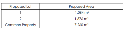
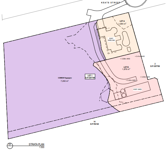
Figure 1. Proposed strata subdivision plan.
Description of the site
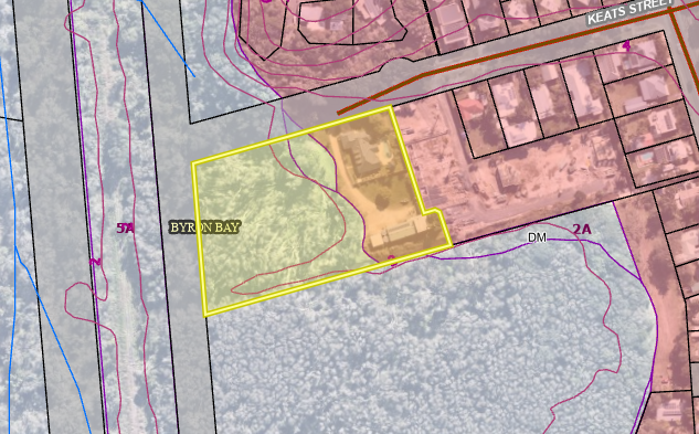
Figure 2. Aerial photo with land zoning overlay. Subject property identified by yellow polygon.
|
Land is legally described |
LOT: 1 DP: 1257709 |
|
|
Property address |
2 Keats Street BYRON BAY |
|
|
Land is zoned: |
R2 Low Density Residential / 2(a) Residential / 7(a) Wetlands (see Figure 2) |
|
|
Land area is: |
1.022 ha |
|
|
Property is constrained by:
|
· Flood liable land · Bushfire prone land · Acid sulfate soils - Class 2/5 · High environmental value vegetation (coastal swamp forest) · Mapped coastal wetland · Stormwater pipeline through north of property · Key fish habitat |
|
|
|
Is a BDAR required due to the location of the proposed development? (see consideration in Section 1.5 of the Biodiversity Assessment (Geolink, June 2021) |
☐ Yes ☒ No |
|
|
Are there any easements in favour of Council affecting the site? |
☒ Yes ☐ No |
|
|
Is there a Vegetation Management Plan which might affect the proposal? |
☒ Yes ☐ No |
|
|
Is there a Voluntary Planning Agreement which might affect the proposal? |
☐ Yes ☒ No |
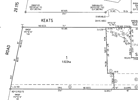
Figure 3. Extract of property title showing “easement for drainage of water 2.01 & 6 wide” (labelled (A)).
A site inspection was carried out on 7 November 2022
|
Photo 1 – driveway access to property from Keats Street. View east |
Photo 2 – driveway access to proposed new dwelling. View north |
|
Photo 3 – driveway access to proposed new dwelling. View south |
Photo 4 – View north over site for proposed dwelling |
|
Photo 5 – View south over site for proposed dwelling with shed in the background. East section of building to be restored to use as a shed |
Photo 6 – View west over site for proposed dwelling |
|
Photo 7 – View west over driveway to coastal wetland |
Photo 8 – Coastal wetland west of development site. Applicant has advised that fence has been installed along western edge of bush fire asset protection zone |
2. SUMMARY OF REFERRALS
|
Referral |
Issue |
|
Environmental Health Officer |
No objections subject to conditions. |
|
Development Engineer |
No objections subject to conditions. |
|
S64 / Systems Planning Officer |
No objections subject to conditions. |
|
S7.11 / Contributions Planner |
No objections subject to conditions. |
|
Rural Fire Service (RFS) |
RFS issued general terms of approval (GTAs) and a bush fire safety authority for the proposal on 2 September 2022 (ref: DA20220706009128-Original-1). |
|
Department of Primary Industries – NSW Fisheries (DPI Fisheries) |
DPI Fisheries issued general terms of approval for the proposal on 5 August 2022 (ref: IDA22/80). |
3. SECTION 4.15C – MATTERS FOR CONSIDERATION – DISCUSSION OF ISSUES
Having regard to the matters for consideration detailed in Section 4.15(1) of the Environmental Planning & Assessment Act 1979 (EP&A Act), the following is a summary of the evaluation of the issues.
State Environmental Planning Policies (SEPP)
|
Considerations |
Satisfactory |
Unsatisfactory |
|
SEPP (Biodiversity and Conservation) 2021 Chapter 4 Koala habitat protection 2021 The subject property is located within the koala planning area covered by the Byron Coast Comprehensive Koala Plan of Management (BCCKPoM) and consequently, determination of the development application must be consistent with the BCCKPoM (cl.4.4, 4.8 and Schedule 2). The subject property is not within a koala management precinct and does not contain any mapped koala habitat (see map below).
Koala management precincts (yellow hatched area) and koala habitat (green shaded areas) – subject property identified by yellow polygon. |
☒ |
☐ |
|
SEPP (Resilience and Hazards) 2021 Chapter 2 Coastal management In relation to the mapped areas under the SEPP (Coastal Management), the development is located as follows (see map below): · Proposed Lot B and Lot 1 subdivision boundaries, part of the driveway and bush fire asset protection zones encroach the large area of the property to the west that is mapped coastal wetland; and · The new dwelling and swimming pool are to be located entirely within the coastal wetland proximity area.
The proposal is designated development as part of the proposal is on land identified as “coastal wetlands” and is “any other development” (cl.2.7(1) and (2), s.4.10 EP&A Act). The Applicant obtained the Secretary’s Environmental Assessment Requirements, and the DA is accompanied by an Environmental Impact Statement (EIS). The DA has been publicly exhibited for 28 days. Development consent must not be granted “… unless the consent authority is satisfied that sufficient measures have been, or will be, taken to protect, and where possible enhance, the biophysical, hydrological and ecological integrity of the coastal wetland or littoral rainforest” (cl.2.7(4)). The application proposes the following measures to manage impacts on the wetlands: · No native tree removal; and · weed control in the coastal wetland for 5 years following initial works (details are provided in the Vegetation management Plan provide with the application). A fence has been installed to the west of the gravel driveway accessing proposed Lot B (see Photos 6-8). The applicant advised that this fence has been installed along the western limit of the required bush fire asset protection zone for the proposed dwelling. Some pruning of the canopy of a stand of Melaleucas at the west of proposed Lot B (see Photo 7) is likely to be required to meet asset protection zone standards but otherwise adverse impacts on native vegetation from the development appear to be unlikely. The application proposes to discharge stormwater from the development to the drainage channel that runs along the southern boundary of the property. Stormwater quality modelling is not required by Council’s Development Control Plan, as developed area is less than 2,500m2. However, consideration of the potential impacts of the stormwater discharge on the adjoining wetlands was a requirement of the EIS. An erosion and sediment control plan has been prepared for the construction phase of the development. The application proposes treating stormwater from the completed development using a bio retention basin prior to discharge. Council’s Development Engineer has advised that the bio retention basin needs to be extended and has recommended a condition accordingly. Mitchell’s Rainforest Snails (MRS) were identified on the site as part of the biodiversity assessment in the vegetated wetland areas. No specific mitigation measures for potential impacts on MRS have been proposed however the MRS were only identified in vegetated areas of the site separate from the development footprint. The new dwelling, swimming pool and associated works are within the “proximity area for coastal wetlands” and must not significantly impact on- (a) the biophysical, hydrological or ecological integrity of the adjacent coastal wetland or littoral rainforest, or (b) the quantity and quality of surface and ground water flows to and from the adjacent coastal wetland or littoral rainforest. (cl.2.8(1)). The proposed location for the dwelling (and associated APZ) and swimming pool is currently a combination of grassed area, gravel driveway and domestic landscaping. Indirect impacts (i.e., noise, light and vehicle strike) of the development are also expected to be minimal due to the location and scale of the development. Consequently, the development is unlikely to have a significant impact on the adjoining coastal wetland. Chapter 4 Remediation of land A preliminary site contamination report (Tim Fitzroy & Associates, February 2021) was provided with the application. The report states that the site was previously filled, not contaminating activities were identified from historical aerial photos and soil sampling results did not indicate any contamination. Council’s Environmental Health Officer found no evidence of contaminating activities having been carried out on site. Based on the above, the site is considered suitable for the proposed development. |
☒ |
☐ |
|
SEPP (Building Sustainability Index: BASIX) 2004 Consideration: The dwelling is BASIX development, and a BASIX Certificate was provided with the application. |
☒ |
☐ |
|
SEPP (Transport and Infrastructure) 2021 Consideration: The now disused Murwillumbah to Casino rail line is to the west of the property separated by a road reserve. The proposed development is for residential accommodation which could be adversely affected by rail noise or vibration in the unlikely event the rail line was to be reused for trains (cl.2.100). In their Secretary’s Environmental Assessment Requirements (SEARS) response, Transport for NSW (TfNSW) requested the following matters be addressed: · Impact of the development (construction and operation) on the rail line; · Stormwater management and implications to the rail corridor; and · An acoustic assessment confirming residents will not be subject to adverse noise and vibration if the rail corridor becomes operational. There will be no direct impacts of the development on the rail corridor due to separation of over 100m of vegetated land. Stormwater from the new development on Lot B will be discharged to the open drain that runs along the southern boundary of the property. Provided on-site stormwater detention and bioretention is provided in accordance with the condition recommended by Council’s Development Engineer, adverse impacts on the rail corridor from stormwater from the development are unlikely. The noise & vibration assessment (Noise Measurement Services, 1/2/2021) provided with the application concluded that, in the event passenger trains were reintroduced, the internal noise limit would not be exceeded in the dwellings, even with the windows open. |
☒ |
☐ |
4.2A Byron Local Environmental Plan 2014 (LEP 2014)
In accordance with LEP 2014 clauses 1.4 and 2.1 – 2.3:
(a) The proposed development is defined in the LEP 2014 Dictionary as dwelling house and dual occupancy (see Note) and in cl.6.2 of the EP&A Act as subdivision of land;
(b) The land is within the R2 Low Density Residential according to the LEP 2014 Land Zoning Map;
(c) The proposed development is permitted with consent; and
(d) Regard is had for the Zone Objectives as follows:
|
Zone Objectives – R2 |
Consideration |
|
• To provide for the housing needs of the community within a low density residential environment. • To enable other land uses that provide facilities or services to meet the day to day needs of residents. |
The dual occupancy will provide for the housing needs of the community. |
Note: The building on proposed lot B, identified as “Exist. Shed”, has been converted to a dwelling/habitable space. This application does not seek to approve the use of this building as a dwelling and as such a deferred commencement requirement is recommended for this building to be restored to a shed (i.e., through the removal of kitchen, bathroom and all non-structural internal partitions).
4.1 Minimum subdivision lot size
The minimum lot size requirement does not apply to strata subdivisions however, the proposed lots (A and B) exceed the minimum lot size for the R2 zoned land being 600m2.
4.1E Minimum lot sizes for certain residential accommodation
The property, at 1.20ha, is greater than the minimum lot size for a dual occupancy (detached) in the R2 zone being 800m2.
4.3 Height of buildings
The maximum height of the proposed dwelling is 5.5m above ground level and well below the 9m maximum .
4.4 Floor space ratio
The floor space ratio for Lots A and B is 0.22:1 and 0.1:1 respectively (based on dwelling floor areas of 240m2 and 187m2 respectively) being below the 0.5:1 maximum .
5.21 Flood planning
Council’s GIS indicates that the property is in a flood planning area. Council’s Development Engineer is satisfied with the development is compatible with the flood hazard (i.e., no works below 100 year flood level, floor heights above flood planning level, suitable access) and will not adversely affect flood function and behaviour.
6.1 Acid sulfate soils
The property is mapped as having acid sulfate soils (Class 2 to the west and class 5 to the east). An acid sulfate soils assessment (Tim Fitzroy & Associates, February 2021) was provided with the application. The assessment report concluded that, “The results of field and laboratory testing have shown the site contains actual acid sulfate soil from the ground surface to approximately 1.5m below the ground surface. The acid sulfate soil will present an environmental hazard and it will require treatment if it is to be disturbed or excavated for the proposed development”.
The acid sulfate soils assessment included a management plan which was found to be acceptable by Council’s Environmental Health Officer.
6.2 Earthworks
The development will require earthworks for the dwelling footings, the swimming pool (~1.5m in depth), connection of services and driveway works. The earthworks are relatively minor in scale and an erosion and sediment control plan was included with the application to managed construction-phase stormwater quality. The application states that no fill will be imported to the site. Excavated soils will be removed in accordance with site contamination/acid sulfate soils management requirements.
6.6 Essential services
Subject to conditions recommended by Council’s Development Engineer, the property is expected to have access to necessary essential services as it is in an established residential area and has an established dwelling. Council’s Engineers are satisfied the development can be adequately serviced subject to recommended conditions.
6.7 Affordable housing in residential and business zones
This clause requires that prior to granting consent to development for residential accommodation or the subdivision of land, the consent authority has considered— the need for providing, maintaining, or retaining affordable housing, and the need for imposing conditions relating to providing, maintaining, or retaining affordable housing including, but not limited to, imposing covenants and the registration of restrictions about users.
While the proposal does not provide for affordable housing as defined by the clause, it responds to this clause through provision of new housing stock. To ensure the dwelling is used for residential purposes and adds to the housing stock of the Shire, a condition has been recommended to preclude use of the dwellings for short-term rental accommodation and/or holiday letting.
Without an appropriate legislative mechanism in place, Council is unable to require anything further of a proponent currently. To this aim, staff are reviewing this clause to encompass wording in line with the on exhibition Affordable Housing Contribution Scheme - Byron Shire Council (nsw.gov.au) to provide greater guidance to applicant’s on expectations.
4.2B Byron Local Environmental Plan 1988 (LEP 1988)
In accordance with LEP 1988 clauses 5, 8 and 9:
(a) The proposed development is defined in the LEP 1988 Dictionary as dual occupancy (see Note) and subdivision of land (cl.6.2 of the EP&A Act);
(b) The land is within the 2(a) Residential and 7(a) Wetlands zones according to the map under LEP 1988;
(c) The proposed development is permitted with consent; and
(d) The proposed development is consistent with the relevant objectives of the Zone for the following reasons:
|
Zone Objectives – 2(a) |
Consideration |
|
(a) to make provision for certain suitable lands, both in existing urban areas and new release areas, to be used for the purposes of housing and associated neighbourhood facilities of high amenity and accessibility, (b) to encourage a range of housing types in appropriate locations, (c) to enable development for purposes other than residential purposes only if it is compatible with the character of the living area and has a domestic scale and character, and (d) to control by means of a development control plan the location, form, character and density of permissible development. |
The proposed dwelling house and strata subdivision are not inconsistent with zone 2(a) objectives. |
|
Zone Objectives – 7(a) |
Consideration |
|
(a) to identify all lands covered by State Environmental Planning Policy No 14—Coastal Wetlands, (b) to identify and preserve estuaries and wetlands and allow them to continue to function as feeding and breeding areas for wildlife, shellfish and fish, (c) to prohibit development within the zone that is likely to have a detrimental effect on the habitat or landscape qualities or the flood mitigation function of the wetlands, (d) to enable development of public works and environmental facilities where such development would not have a significant detrimental effect on the habitat or landscape qualities of the wetland and other significant coastal habitat areas, and (e) to enable the careful control of noxious plants and weeds by means not likely to be significantly detrimental to the native ecosystem. |
The development is unlikely to have a detrimental impact on the adjoining coastal wetland due to all building works being outside the wetland area, no native tree removal being required and the scale of the development being relatively minor. |
Note: Only the bush fire APZ associated with the current dwelling encroaches zone 2(a) land and the bush fire APZ associated with the proposed dwelling encroaches zone 7(a) land. Otherwise, the dwellings are entirely located within zone R2 land.
11 Subdivision in rural areas for agriculture etc
The minimum subdivision lot size for zone 7(a) land is 40ha if the subdivision is “… for agriculture, forestry or a dwelling-house… ”. Proposed Lot 1 will contain all the zone 7(a) land and will be common property under the proposed strata arrangement but will be only 7260m2 in area. The applicant has argued that the minimum lot size does not apply as the dwelling will not be located on proposed Lot 1. But for a small section of asset protection zone required for the new dwelling, no component of the dwelling (e.g., including the driveway) will encroach the 7(a) zoned land. On the basis that the common property lot is not being created for a dwelling, a variation to the minimum lot size requirement for the zone 7(a) land is not required.
17 Dual occupancy
A dual occupancy is permissible on the zone 2(a) land, “ but only if, not more than 2 dwellings will be created or result on the allotment”. As noted above, the shed that has been converted to a dwelling/habitable space will need to be restored back to a shed. A deferred commencement requirement has been recommended to this effect. The lots for the dwelling are greater than 800m2 and the resulting floor space ratio will be less than 0.5:1 and as such the proposed dual occupancy can comply with this clause.
24 Development of flood liable land
As noted above, Council’s Development Engineer is satisfied with the development in relation to flood compatibility and flooding impacts.
36 Development adjoining wetland
The bush fire APZ for the current dwelling and possibly a small part of the driveway is located within zone 2(a) land which adjoins the wetland (zone 7(a) land). Development proposed in this area is minimal and is not contrary to the requirements of this clause.
The remaining checked clauses have been taken into consideration in the assessment of the subject development application in accordance with Section 4.15 of the EP&A Act. The proposed development complies with all clauses of LEP 1988 (in some cases subject to conditions and/or to the satisfaction of other assessing officers).
4.3 Any proposed Instrument that has been the subject of public consultation and has been notified to the consent authority
No proposed instruments were identified that are relevant to this application.
4.4A Byron Shire Development Control Plan 2014 (DCP 2014)
B1 – Biodiversity
As acknowledged in the Biodiversity Assessment (Geolink, June 2021) provided with the application, the proposal does not comply with several of the required ecological setbacks. A variation to these setbacks has been sought on the basis that:
· the dwelling is setback as far as practicable from the coastal wetland;
· no vegetation of habitat removal is required for the development;
· bush fire APZs are located on cleared land and do not overlap the coastal wetland (Joe to confirm);
· no fencing is proposed; and
· A Vegetation Management Plan has been provided for the coastal wetland.
Based on the above measures, the proposal is consistent with the objectives of the development envelope controls (D1.2.1).
The subject property is in a 10/50 vegetation entitlement clearing area however the 10/50 exemption cannot be used to clear vegetation on this parcel of land as it is wholly or partially within a coastal wetland (online tools access 10/11/22).
The subject property was created by a 2 lot subdivision (DA 10.2016.794.1) which was approved subject to a Vegetation Management Plan (VMP) for “…restoration of the SEPP 14/Coastal Wetlands …”. The figure below is extracted from the approved VMP which illustrates the actins proposed by the VMP being weed control within the swamp sclerophyll forest and supplementary planting along the drain spoil batter. The VMP provided with this development application will further the weed control initiated under the original subdivision DA.
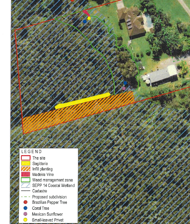
B3 – Services
The property has an existing dwelling and is in an established residential area. Essential services (i.e., water and wastewater) are available (or can be made available with required) for the additional dwelling. Stormwater is to be discharged in the Council drainage reserve along the southern boundary of the property and vehicular access will be via Keats Street which some upgrade works to the driveway and crossover being required.
B4 – Traffic Planning, Vehicle Parking, Circulation and Access
Proposed parking and traffic impacts are acceptable however Council’s Development Engineer identified issues relating to access and has recommended conditions to address removal of the boom gate, modification of the proposed turning bay in the road reserve to minimise pavement and avoid tree removal, deletion of the driveway kerb and provision of a turning head for the new dwelling.
B6 – Buffers and Minimising Land Use Conflict
The subject property adjoins the disused rail corridor to the west. The new dwelling will be ~140m to the east of the railway line and separated by established coastal swamp forest. A Noise Assessment was provided with the application that concluded that, in the event the railway recommenced operation, the relevant noise limit would be met in the dwelling even with the windows open.
B9 – Landscaping
A landscaping plan is required but was not provided with the application. A conditions has been recommended requiring a landscaping plan consistent with relevant provisions (B9.3.1 and B9.5.1).
D1 Residential Accommodation in Urban, Village and Special Purpose Zones
D1.2 General Provisions
The dwelling will be set back 2m from the eastern boundary and is consistent with building height plane and setback requirements (D1.2.1, D1.2.2).
D1.3 Dwelling Houses
The new dwelling and proposed Lot B, on which it will be situated, have adequate space to provide the required car parking and landscaping (D1.3.1, D.3.2).
D1.5 Dual Occupancy and Semi-Detached Dwellings
There is adequate space for car parking and private open space for both dwellings (D1.5.1, D1.5.4). Character impacts and impacts of neighbours will be negligible due to the new dwelling being located at the terminus of Keats Street and behind the current dwelling (D1.5.2, D1.5.3).
D6 – Subdivision
The proposed strata subdivision is generally consistent with the relevant subdivision design guidelines (D6.2.1). The two strata lots in the zone R2 land are greater than the minimum lot size, meet lot size and shape requirements (D6.4.1) and the two development lots have, or can be provided, suitable vehicular access (D6.4.2).
4.4B Byron Shire Development Control Plan 2010 (DCP 2010)
All the land governed by DCP 2010 will be contained within the common property lot (Proposed Lot 1). Other than driveway upgrade works, no other development is proposed in the common property lot.
Part B – Subdivision
The proposed strata subdivision is generally consistent with the relevant subdivision design guidelines (B2) and development guidelines (B3). Vehicle access, stormwater management and landscaping are considered above under DCP 2014 in relation to the development lots.
4.5 Environmental Planning and Assessment Regulation 2000 considerations
|
|
Applicable to the proposal: |
Considered the control as it relates to the proposal: |
If this control is applicable, does the proposal comply? |
|
Clause 92 - Additional matters that consent authority must consider |
☐ Yes ☒ No |
☐ Yes ☐ No ☒ NA |
☐ Yes ☐ No ☒ NA |
|
Clause 93 Fire safety and other considerations |
☐ Yes ☒ No |
☐ Yes ☐ No ☒ NA |
☐ Yes ☐ No ☒ NA |
|
Clause 94 - Consent authority may require buildings to be upgraded |
☐ Yes ☒ No |
☐ Yes ☐ No ☒ NA |
☐ Yes ☐ No ☒ NA |
|
Clause 94A - Fire safety and other considerations applying to erection of temporary structures |
☐ Yes ☒ No |
☐ Yes ☐ No ☒ NA |
☐ Yes ☐ No ☒ NA |
4.6 The likely impacts of that development, including environmental impacts on both the natural and built environments, and social and economic impacts in the locality
|
Impact on: |
Likely significant impact/s? |
|
Natural environment |
The proposal will not have a significantly adverse impact on the natural environment of the locality. |
|
Built environment |
The proposal will not have a significantly adverse impact on the built environment of the locality. |
|
Social Environment |
The proposal will not have a significant social impact on the locality. |
|
Economic impact |
The proposal will not have a significant economic impact on the locality. |
|
Construction Impacts |
The development will generate minor impacts during its construction. Conditions of consent recommended to control hours of work, builders waste, construction noise, installation of sedimentation and erosion control measures and the like to ameliorate such impacts. |
4.7 The suitability of the site for the development
The site is capable of being serviced, has manageable constraints and is suitable for the proposed development.
4.8 Submissions made in accordance with this Act or the regulations
The development application was publicly exhibited
There were Nil (0) submissions made on the development application:
4.9 Public interest
The proposed development is unlikely to prejudice or compromise the public interest or create an undesirable precedent.
4. SECTION 4.46/7 – INTEGRATED DEVELOPMENT
The proposal is integrated development (s.4.46 EP&A Act) in that it requires authorisation under:
· s.100B of the Rural Fires Act 1997 in respect of subdivision of land that could lawfully be used for residential or rural residential purposes; and
· s.201 of the Fisheries Management Act 1994 to carry out dredging or reclamation works.
The consent authority must, in accordance with the regulations, obtain general terms of approval in relation to the development before granting consent. RFS issued general terms of approval and a bush fire safety authority for the proposal on 2 September 2022 (ref: DA20220706009128-Original-1). DPI Fisheries issued general terms of approval for the proposal on 5 August 2022 (ref: IDA22/80).
5. DEVELOPER CONTRIBUTIONS
5.1 Water & Sewer Levies
Section 64 levies will be payable.
5.2 Developer Contributions
Section 7.11 Contributions will be payable.
6. DISCLOSURE OF POLITICAL DONATIONS AND GIFTS
|
Disclosure details |
Response |
|
Has a Disclosure Statement been received in relation to this application? If Yes, Provide Disclosure Statement register reference: 91. |
Yes ☐ No ☒ |
|
Have staff received a ‘gift’ from anyone involved in this application that needs to be disclosed. |
Yes ☐ No ☒ |
7. CONCLUSION
The proposed development is satisfactory having regard to the relevant environmental planning instruments and planning controls applicable to the site. The proposal raises no significant issues in terms of environmental impacts which cannot be managed, and the application is recommended for approval subject to conditions of consent.
BYRON SHIRE COUNCIL
Staff Reports - Sustainable Environment and Economy 13.11
Report No. 13.11 PLANNING - DA 10.2022.370.1 - Use of alterations and additions to farm building, use of farm building as a cool room – 252 Middle Pocket Road Middle Pocket
Directorate: Sustainable Environment and Economy
Report Author: Lachlan Wall, Gateway Planner
Ivan Holland, Planner
File No: I2022/1692
Proposal:
|
DA No: |
10.2022.370.1 |
||||||
|
NSW PP |
PAN-257416 |
||||||
|
Proposal description: |
Use of Alterations and Additions to Farm Building |
||||||
|
Property description: |
LOT: 102 DP: 1133367 |
||||||
|
252 Middle Pocket Road MIDDLE POCKET |
|||||||
|
Parcel No/s: |
240578 |
||||||
|
Applicant: |
Ms E M Tomlinson |
||||||
|
Owner: |
Ms E M Tomlinson |
||||||
|
Zoning: |
RU2 Rural Landscape |
||||||
|
Date received: |
28 September 2022 |
||||||
|
Integrated / Designated Development: |
☐ Integrated |
☐ Designated |
☒ Not applicable |
||||
|
Concurrence required |
No |
||||||
|
Public notification or exhibition: |
- Level 2 advertising under Council’s Community Participation Plan. - Exhibition period: 6 October 2022 to 19 October 2022. - Submissions received: 7 - Submissions acknowledged: ☒ Yes ☐ No ☐ N/A |
||||||
|
Other approvals |
☐ N/R |
☒ W & S (68) |
☐OSMS (68) |
☐ ST (68) |
☐ RA (138) |
||
|
Other: |
|
||||||
|
Estimated cost |
$18,700.00 |
||||||
|
Delegation to determine |
Council |
||||||
|
Issues |
Characterisation of use |
||||||
Summary:
This application seeks consent for the use of alterations and additions to a ‘farm building’, and the use of ‘farm building’ as a cold room. The original structure the subject of this development application was constructed utilising exempt development provisions for a ‘farm building’.
After the construction of the ‘farm building’, and during an inspection for the on-site wastewater system it was noted that additional fixtures and further works had been undertaken to the ‘farm building’ that have changed the characterisation of the structure.
The proposed development cannot be characterised as a ‘farm building’ given the range of facilities provided within the structure and is best characterised now as a ‘dwelling’.
The building as constructed includes two bathrooms, has a range of partition walls and an upper-level kitchen. Further, the site inspection revealed there to be little evidence that the ‘farm building’ is being utilised for that defined purpose. It is noted that the subject land already has an approval for a ‘dual occupancy’ on the land.
The application was advertised and notified between 6 October 2022 to 19 October 2022 in accordance with the Byron Community Participation Plan, and seven (7) submissions were received from the public during this time.
The application is recommended for refusal.
NOTE TO COUNCILLORS:
In accordance with the provisions of S375A of the Local Government Act 1993, a Division is to be called whenever a motion for a planning decision is put to the meeting, for the purpose of recording voting on planning matters. Pursuant to clause 2(a) under the heading Matters to be Included in Minutes of Council Meetings of Council's adopted Code of Meeting Practice (as amended) a Division will be deemed to have been called by the mover and seconder of all motions relating to this report.
RECOMMENDATION:
It is recommended that pursuant to Section 4.16 of the Environmental Planning & Assessment Act 1979, Development Application No. 10.2022.370.1 for Use of Alterations and Additions to Farm Building, Use of Farm Building as a Cold Room, be refused for the following reasons:
1. The development application is not satisfactory having regard to Section 4.15(1)(a)(i) of the Environmental Planning & Assessment Act 1979 because the development is not a farm building by definition in the dictionary under clause 1.4 of the Byron Local Environmental Plan 2014, and is not permitted with development consent in the RU2 Zone.
2. The development application is not satisfactory having regard to Section 4.15(1)(a)(iii) of the Environmental Planning & Assessment Act 1979 because the development does not comply with the objectives and performance criteria of Chapter D2.7.2 Farm Buildings, Sheds and other Structures of the Byron Development Control Plan 2014.
3. The development application is not satisfactory having regard to Section 4.15(1)(b) of the Environmental Planning & Assessment Act 1979 and will have an adverse economic impact on rural land.
4. The development application is not satisfactory having regard to Section 4.15(1)(e) of the Environmental Planning & Assessment Act 1979 because the development is not in the public interest.
1 DA
10.2022.370.1 Architectural Plans, E2022/113805
![]()
2 Confidential - DA 10.2022.370.1 Submissions, E2022/113817
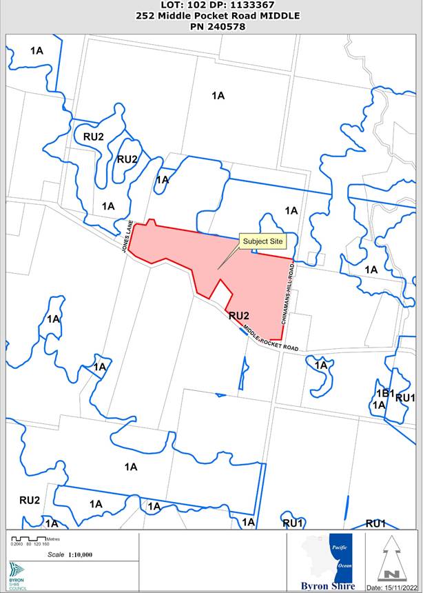
Assessment:
1. INTRODUCTION
History/Background
The site contains the following development history.
|
Application number |
Description |
Status |
Date |
|
16.2012.49.1 Complying Development Certificate |
New dwelling |
Approved |
20/09/2012 |
|
10.2017.715.1 |
Farm stay accommodation |
Approved |
22/03/2018 |
|
10.2018.626.1 |
Change of use of studio and farm works’ facility to Dual occupancy |
Approved |
29/05/2019 |
|
16.2019.9.1 Complying Development Certificate |
Studio, storage building & Workers amenities |
Approved |
23/01/2019 |
|
16.2021.115.1 Complying Development Certificate |
Conversion of Four (4) bedrooms to create a bed and breakfast |
Approved |
08/12/2021 |
|
10.2022.83.1 |
Use of existing deck, spa pool and outdoor bathrooms |
Approved |
14/07/2022 |
Description of the proposed development
This application seeks approval for Use of Alterations and Additions to ‘Farm Building’.
The Statement of Environmental Effects (SEE) provided with the
application describes the works as:
Development consent is sought for the Continued use of Existing Farm
Buildings as cold-room storage, farm and domestic storage, farm workers
facilities (bathroom, Iunchroom, meeting area), farm office and construction of
external stairway.
The ‘farm building’ was originally constructed as Exempt Development, with the existing footprint being below 200m2 and setback at least 50m from the nearest boundary.
The application also seeks consent for further additions to the larger ‘farm building’ structure to provide a stairway and landing to provide access to the first floor. These works have yet to be built.
The ‘farm building’ as constructed is 14.02m x 14.01m on the ground floor, with an additional floor area of 10.33m x 9.855m on the first floor. The “existing cold-room is an additional 13.77m2. resulting in a total floor area of 302.457m2 of the development. The overall footprint of the structure is 196.42m2. The height of the farm building is 7.224m with the cold room being a maximum height of 2.99m
Description of the site
|
Land is legally described |
LOT: 102 DP: 1133367 |
|
|
Property address |
252 Middle Pocket Road MIDDLE POCKET |
|
|
Land is zoned: |
RU2 Rural Landscape 1A General Rural |
|
|
Land area is: |
20.46 ha |
|
|
Property is constrained by:
|
Flood Liable Land |
|
|
|
Is a BDAR required due to the location of the proposed development? |
☐ Yes ☒ No |
|
|
Are there any easements in favour of Council affecting the site? |
☐ Yes ☒ No |
|
|
Is there a Vegetation Management Plan which might affect the proposal? |
☐ Yes ☒ No |
|
|
Is there a Voluntary Planning Agreement which might affect the proposal? |
☐ Yes ☒ No |
A site inspection was carried out on 7 November 2022
|
|
Photo 2 – Cold store – interior |
|
Photo 3 – Building exterior – east facade |
Photo 4 – Building exterior – north facade |
|
Photo 5 – Building interior – ground floor – room labelled “plant potting/storage” |
Photo 6 – Building interior – ground floor - room labelled “garage/storage” |
|
Photo 7 – Building interior – ground floor – laundry and stairs |
Photo 8 – Building interior – ground floor - room labelled “storage” |
|
Photo 9 – Building interior – ground floor - bathroom |
Photo 10 – Building interior – ground floor – bathroom/shower |
|
Photo 11 – Building interior – first floor - bathroom |
Photo 12 – Building interior – first floor - room labelled “office” |
|
Photo 13 – Building interior – first floor - room labelled “lunchroom” |
|
2. SUMMARY OF REFERRALS
|
Referral |
Issue |
|
Building Surveyor |
Should consent be granted a Building Information Certificate would be required. |
3. SECTION 4.14 – BUSH FIRE PRONE LAND
Under section 4.14 of the Act, Council must be satisfied prior to making a determination for development on bush fire prone land, that the development complies with the document ‘Planning for Bush Fire Protection 2019’’. The site is mapped as bush fire prone land, however the use of the structure for a non-habitable purpose, and Section 8.3.2 of Planning for Bush Fire Protection 2019 applies.
The structures are located more than 6m from a dwelling and there are no bush fire protection requirements that apply in terms of a shed.
However, the development if properly characterised as a dwelling house would generate the need for asset protection zones, construction standards, water supply for bushfire fighting purposes and the like.
4. SECTION 4.15C – MATTERS FOR CONSIDERATION – DISCUSSION OF ISSUES
Having regard to the matters for consideration detailed in Section 4.15(1) of the Environmental Planning & Assessment Act 1979 (EP&A Act), the following is a summary of the evaluation of the issues.
State Environmental Planning Policies (SEPP)
|
Considerations |
Satisfactory |
Unsatisfactory |
|
Resilience and Hazards SEPP 2021 The development does not offend the requirements of this SEPP. |
☒ |
☐ |
4.2A Byron Local Environmental Plan 2014 (LEP 2014)
Clause 1.4 Definitions
Characterisation of the development
A Farm Building is defined within the Byron LEP 2014 as “a structure the use of which is ancillary to an agricultural use of the landholding on which it is situated and includes a hay shed, stock holding yard, machinery shed, shearing shed, silo, storage tank, outbuilding or the like, but does not include a dwelling.”
However as already mentioned, the subject building as constructed is more appropriately characterised as a ‘dwelling’ as it contains all necessary facilities to be used as a ‘dwelling’ i.e., cooking and washing facilities. During the site inspection, no beds were observed in the structure however, the structure contains internal partitions that allow for the provision of a bedroom within the first floor.
A ‘dwelling’ is defined within the Byron LEP 2014 as…“a room or suite of rooms occupied or used or so constructed or adapted as to be capable of being occupied or used as a separate domicile”.
In this regard, the evidence presented in the application clearly establishes that the building is used as a dwelling as opposed to a ‘farm building’. As it is fully capable of being occupied or used as a separate domicile.
The bona fides of the structure as built in the context of the actual works undertaken, including the additional fixtures and fit-out of the structure satisfies the definition of a dwelling. i.e., sleeping, washing and cooking facilities. A ‘farm building’ does not require these facilities, Given the range of facilities available, it is likely that the use of the building includes overnight accommodation. The subject building clearly meets/satisfies the definition of a ‘dwelling’, in that it is "a room ... occupied or used or so constructed or adapted as to be capable of being occupied or used as a separate domicile.
Based on the above it is considered that the purpose of the building is a ‘dwelling’.
If characterised as a ‘dwelling’, then the use of the site would constitute ‘multi-dwelling housing’ (defined as means 3 or more dwellings (whether attached or detached) on one lot of land, each with access at ground level, but does not include a residential flat building) as the site already contains two dwellings on it (approved dual occupancy). Multi dwelling housing is prohibited in the RU2 Rural Landscape Zone. As such council cannot issue consent for prohibited development and must refuse the application.
The application has failed to correctly characterise the development, The application should be refused given the improper characterisation of the development as approval of the development would result in prohibited development.
RU2 Zoning
The land is within the RU2 Rural Landscape according to the Land Zoning Map.
The proposal as a third dwelling on the property, as part of a ‘multi dwelling housing’ development is prohibited development in the RU2 zone and can’t be consented to.
|
Zone Objective |
Consideration |
|
• To encourage sustainable primary industry production by maintaining and enhancing the natural resource base. |
The ground floor of the structure has the character of a farm building, i.e. roller doors etc, however the first floor is not consistent with this character. It is unclear based on the site inspection and as evidenced by the photos exactly what farming activity occurs in the shed. It is considered granting consent to the development is inconsistent with this zone objective as it does not encourage primary industry production on the land. |
|
• To maintain the rural landscape character of the land. |
The footprint of the structure is not inconsistent with rural character. |
|
• To provide for a range of compatible land uses, including extensive agriculture. |
The structure is presented as an ancillary structure to an agricultural land use, identified in the SEE as cattle grazing. |
|
• To enable the provision of tourist accommodation, facilities and other small-scale rural tourism uses associated with primary production and environmental conservation consistent with the rural character of the locality. |
The proposal is not for tourist accommodation. |
|
• To protect significant scenic landscapes and to minimise impacts on the scenic quality of the locality. |
The existing structure was constructed as exempt development. and is considered that it does not have significant impacts on the scenic quality. |
Clause 4.3 Height of buildings
The existing structure is 7.224m in height above ground level – complies
Clause 6.6 Essential Services
(b) The supply of electricity
The ‘farm building’ contains a solar array but is not connected to the electrical network. A backup generator is also shown on plans, it is unclear why this is required when electrical supply is available from Middle Pocket Road.
(c) The disposal and management of sewage.
An approval for an on-site wastewater system was approved in relation to the structure with Council Reference 70.2019.1021.1. The works as shown on the plans accompanying this application indicate that the system is undersized given the additional plumbing fixtures that were not approved as a part of the above application. Provided that all unapproved fixtures installed within the ‘farm building’ are removed and the structure is restored to those plumbing fixtures approved under the above application, adequate arrangements can be made to provide for the disposal of wastewater generated by the development.
However, should approval of the application be supported in accordance with the plans presented in this application, an upgrade to the existing wastewater system would be necessary.
Clause 4.6 Exceptions to Development Standards
N/a
4.3 Any proposed Instrument that has been the subject of public consultation and has been notified to the consent authority
No proposed instruments apply to the development.
4.4A Byron Shire Development Control Plan 2014 (DCP 2014)
D2.7.2 Farm Buildings, Sheds and other structures
The farm building is inconsistent with the character and criteria for establishing farm buildings as the structure is not open with minimal dividing walls and plumbing.
4.5 Environmental Planning and Assessment Regulation 2021 considerations
|
|
Applicable to the proposal: |
Considered the control as it relates to the proposal: |
If this control is applicable, does the proposal comply? |
|
Section 61 - Additional matters that consent authority must consider |
☐ Yes ☒ No |
☐ Yes ☐ No ☒ NA |
☐ Yes ☐ No ☒ NA |
|
Section 62 - Consideration of fire safety |
☐ Yes ☒ No |
☐ Yes ☐ No ☒ NA |
☐ Yes ☐ No ☒ NA |
|
Section 64 - Consent authority may require upgrade of buildings |
☐ Yes ☒ No |
☐ Yes ☐ No ☒ NA |
☐ Yes ☐ No ☒ NA |
|
Section 63 - Considerations for erection of temporary structures |
☐ Yes ☒ No |
☐ Yes ☐ No ☒ NA |
☐ Yes ☐ No ☒ NA |
* Non-compliances and any other significant issues discussed below
4.6 The likely impacts of that development, including environmental impacts on both the natural and built environments, and social and economic impacts in the locality
4.6.1
|
Impact on: |
Likely significant impact/s? |
|
Natural environment |
The proposal will not have a significantly adverse impact on the natural environment of the locality. |
|
Built environment |
The proposal will have a significantly adverse impact on the built environment of the locality. As the bona fides of the use of the structure as a farm building has not been established. |
|
Social Environment |
The proposal will not have a significant social impact on the locality. |
|
Economic impact |
The proposal as an additional dwelling further erodes the viability of rural land in the Shire and encourages others on rural land to utilise such property for purposes other than farming distorting the market and having a negative economic impact |
|
Construction Impacts |
Not relevant. |
4.6.2 Marine Estate Management Act 2014
Unlikely to have an effect on the plants or animals within the Cape Byron Marine Park or their habitat.
4.6.3 Council Policies applicable to the proposed development?
|
Council Policy |
Consideration |
|
If the application is approved, a building information certificate will be required. |
4.7 The suitability of the site for the development
Issue |
Comment |
|
Hazards - Bushfire |
The site is bush fire prone land, however given the structure is purported to be non-habitable there are no specific requirements for this structure.
|
4.8 Submissions made in accordance with this Act or the regulations
The development application was publicly exhibited between 6 October 2022 and 19 October 2022.
There were 7 submissions made on the development application; issues raised have been summarised below.
|
Submission key concerns |
Comment |
|
Impacts to road infrastructure |
A farm building in and of itself does not generate additional traffic movements and does not require developer contributions to be paid. |
|
Amenity impacts - Noise from generator - Overdevelopment |
Should noise from the generator create “offensive noise” and Council receives a noise complaint, Council’s enforcement team, and/or environmental health team may take action in relation to noise complaints. If necessary, and in emergencies the NSW Police may investigate noise complaints. |
|
Creation of an additional dwelling |
Noted. |
|
Wasting of Council resources |
Noted. |
|
The shed is being used as a dwelling |
Noted |
|
Works undertaken without development consent being obtained prior to commencement of works |
Noted.
|
|
Number of structures on the property are being used as dwellings |
Noted.
|
|
Short term holiday rental business operates out of the primary residence. |
Noted.
|
4.9 Public interest
The bona fides of the proposal as a ‘farm building’ are questionable considering the internal layout and fit-out of the building. Having regard to this, it is considered the proposed development is likely to prejudice or compromise the public interest and is recommended for refusal.
5. DEVELOPER CONTRIBUTIONS
No Developer Contributions will be required as a shed.
6. DISCLOSURE OF POLITICAL DONATIONS AND GIFTS
|
Disclosure details |
Response |
|
Has a Disclosure Statement been received in relation to this application? If Yes, Provide Disclosure Statement register reference: 91. |
Yes ☐ No ☒ |
|
Have staff received a ‘gift’ from anyone involved in this application that needs to be disclosed. |
Yes ☐ No ☒ |
7. CONCLUSION
The DA proposes Use of Alterations and Additions to Farm Building, Use of Farm Building as a Cold Room. The bonafides of the application are questionable and it is considered the proposal is characterised as a ‘dwelling’ based on the internal fit-out of the structure and presents as a separately habitable dwelling. The application is recommended for refusal accordingly.