Agenda
Ordinary
Meeting
Thursday,
19 April 2018
held
at Council Chambers, Station Street, Mullumbimby
commencing
at 9.00am
Public Access relating to items
on this Agenda can be made between 9.00am and 10.30am on the day of the
Meeting. Requests for public access should be made to the General Manager
or Mayor no later than 12.00 midday on the day prior to the Meeting.

Mark
Arnold
Acting
General Manager
What is a “Conflict of Interests” - A conflict of
interests can be of two types:
Pecuniary - an interest that a person has in a matter because of a reasonable
likelihood or expectation of appreciable financial gain or loss to the person
or another person with whom the person is associated.
Non-pecuniary – a private or personal interest that a Council
official has that does not amount to a pecuniary interest as defined in the
Local Government Act (eg. A friendship, membership of an association, society
or trade union or involvement or interest in an activity and may include an
interest of a financial nature).
Remoteness – a person does not have a pecuniary interest in a matter
if the interest is so remote or insignificant that it could not reasonably be
regarded as likely to influence any decision the person might make in relation
to a matter or if the interest is of a kind specified in Section 448 of the
Local Government Act.
Who has a Pecuniary Interest? - a person has a pecuniary interest in a
matter if the pecuniary interest is the interest of the person, or another
person with whom the person is associated (see below).
Relatives, Partners - a person is taken to have a pecuniary interest in a
matter if:
§ The person’s
spouse or de facto partner or a relative of the person has a pecuniary interest
in the matter, or
§ The person, or a
nominee, partners or employer of the person, is a member of a company or other
body that has a pecuniary interest in the matter.
N.B. “Relative”, in relation to a person means any of the
following:
(a) the
parent, grandparent, brother, sister, uncle, aunt, nephew, niece, lineal
descends or adopted child of the person or of the person’s spouse;
(b) the
spouse or de facto partners of the person or of a person referred to in
paragraph (a)
No Interest in the Matter - however, a person is not taken to have a
pecuniary interest in a matter:
§ If the person is
unaware of the relevant pecuniary interest of the spouse, de facto partner,
relative or company or other body, or
§ Just because the
person is a member of, or is employed by, the Council.
§ Just because the
person is a member of, or a delegate of the Council to, a company or other body
that has a pecuniary interest in the matter provided that the person has no
beneficial interest in any shares of the company or body.
Disclosure and participation in meetings
§ A Councillor or a
member of a Council Committee who has a pecuniary interest in any matter with
which the Council is concerned and who is present at a meeting of the Council
or Committee at which the matter is being considered must disclose the nature
of the interest to the meeting as soon as practicable.
§ The Councillor or
member must not be present at, or in sight of, the meeting of the Council or
Committee:
(a) at any
time during which the matter is being considered or discussed by the Council or
Committee, or
(b) at any
time during which the Council or Committee is voting on any question in
relation to the matter.
No Knowledge - a person does not breach this Clause if the person did
not know and could not reasonably be expected to have known that the matter
under consideration at the meeting was a matter in which he or she had a
pecuniary interest.
Participation in Meetings Despite Pecuniary Interest (S 452 Act)
A Councillor is not prevented from taking part in the consideration or
discussion of, or from voting on, any of the matters/questions detailed in
Section 452 of the Local Government Act.
Non-pecuniary Interests - Must be disclosed in meetings.
There are a broad range of options available for managing conflicts &
the option chosen will depend on an assessment of the circumstances of the
matter, the nature of the interest and the significance of the issue being
dealt with. Non-pecuniary conflicts of interests must be dealt with in at
least one of the following ways:
§ It may be appropriate
that no action be taken where the potential for conflict is minimal.
However, Councillors should consider providing an explanation of why they
consider a conflict does not exist.
§ Limit involvement if
practical (eg. Participate in discussion but not in decision making or
vice-versa). Care needs to be taken when exercising this option.
§ Remove the source of
the conflict (eg. Relinquishing or divesting the personal interest that creates
the conflict)
§ Have no involvement by
absenting yourself from and not taking part in any debate or voting on the
issue as if the provisions in S451 of the Local Government Act apply
(particularly if you have a significant non-pecuniary interest)
RECORDING OF VOTING ON PLANNING MATTERS
Clause 375A of the Local Government Act 1993
– Recording of voting on planning matters
(1) In this section, planning
decision means a decision made in the exercise of a function of a council
under the Environmental Planning and Assessment Act 1979:
(a) including a decision
relating to a development application, an environmental planning instrument, a
development control plan or a development contribution plan under that Act, but
(b) not including the making of
an order under Division 2A of Part 6 of that Act.
(2) The general manager is
required to keep a register containing, for each planning decision made at a
meeting of the council or a council committee, the names of the councillors who
supported the decision and the names of any councillors who opposed (or are
taken to have opposed) the decision.
(3) For the purpose of
maintaining the register, a division is required to be called whenever a motion
for a planning decision is put at a meeting of the council or a council
committee.
(4) Each decision recorded in
the register is to be described in the register or identified in a manner that
enables the description to be obtained from another publicly available
document, and is to include the information required by the regulations.
(5) This section extends to a
meeting that is closed to the public.
Ordinary Meeting
BUSINESS OF Ordinary Meeting
1. Public Access
2. Apologies
3. Requests for Leave of
Absence
4. Declarations of Interest
– Pecuniary and Non-Pecuniary
5. Tabling of Pecuniary
Interest Returns (s450A Local Government Act 1993)
6. Adoption of Minutes from
Previous Meetings
6.1 Byron
Shire Reserve Trust Committee held on 22 March 2018
6.2 Ordinary
Meeting held on 22 March 2018
7. Reservation of Items for
Debate and Order of Business
8. Mayoral Minute
9. Notices of Motion
9.1 Byron
Community Land Limited Foundation Membership............................................... 6
9.2 Lone
Goat Gallery .......................................................................................................... 10
9.3 Massinger
Street Treehouse........................................................................................... 14
9.4 Support
for College of Marine Studies ........................................................................... 20
9.5 Public
Endorsement of Byron Bay Skate Park Location................................................ 22
10. Petitions
10.1 Middle
Pocket Road........................................................................................................ 26
11. Submissions and Grants
11.1 Byron
Shire Council Submissions and Grants as at 28 March 2018.............................. 28
12. Delegates' Reports
13. Staff Reports
Corporate and Community Services
13.1 Australia
Day PRG Finalisation of the 2018 Group and Commencement of the 2019 Group 30
13.2 Public
Art Panel - minutes of meeting 15 February 2018............................................... 34
13.3 Section
355 Management Committees - resignations and appointments...................... 36
13.4 A
draft wellbeing indicator framework for Byron Shire................................................... 39
13.5 Investments
March 2018................................................................................................. 43
13.6 Stronger
Country Communities Fund Round 2.............................................................. 50
Sustainable Environment and Economy
13.7 PLANNING
- Development Application 10.2017.712.1 for Strata Subdivision to create two lots,
relocation of and alterations to an existing dwelling at 25 Strand Avenue New
Brighton 52
13.8 Compliance
– Belongil and Brunswick Dunes ............................................................... 73
13.9 PLANNING
- Site Specific Planning Proposal considered as part the Rural Land
Use Strategy Process - 74 Charltons Road, Federal...................................................... 78
13.10 Draft
CZMP for the Eastern Precincts of the BBE for Council endorsement for
public exhibition............................................................................................................... 83
13.11 PLANNING
- Development Application 10.2017.681.1 alterations and additions to existing
amenities building to create a clubhouse for Byron Bay Football Club at 35
Carlyle Street Byron Bay 86
13.12 PLANNING
- Development Application 10.2017.429.1 Dual Occupancy (Detached) 31 Charlotte
Street , Bangalow ......................................................................................................... 106
13.13 PLANNING
- Report update of Council resolution 17-327 Tyagarah Airstrip - 26.2015.1.1 119
13.14 PLANNING
- Development Application 10.2017.460.1 - Utility Installation:
Telecommunication Tower at 54 Jones Road Wooyung ........................................................................................ 127
13.15 PLANNING
- DA. 10.2017.588.1 - Demolition of cottage; construction of four (4) storey
mixed-use building comprising: ground floor commercial, two (2) levels of hotel
and motel accommodation with basement parking,roof top swimming pool
with raised roof deck, covered amenties and open bar at 4 Marvell Street Byron
Bay 140
13.16 PLANNING
- Development Application No. 10.2017.686.1 - Stage 1: Alterations
& Additions to existing dwelling to create two (2) lots strata; Stage 2:
two (2) dwellings to create multi-dwelling housing comprising three (3)
dwellings and
strata subdivision at 57 Carlyle Street Byron Bay......................................................... 163
13.17 Report
of the Planning Review Committee Meeting held on 15 March, 2018............. 187
13.18 Directions
Document and Draft Integrated Pest Management Policy......................... 189
13.19 PLANNING
- Update on Council Resolution 18-041 - Planning a new era for the Byron Arts
and Industry Estate............................................................................................................... 194
13.20 PLANNING
- 26.2017.4.1 - Planning Proposal for Rezoning and Reclassifying
Part Lot 22 DP 1073165 Mullumbimby......................................................................... 200
13.21 PLANNING
- DA 10.2017.526,1 Carport and Shed at 1 Lawson Street, Byron Bay... 205
13.22 PLANNING
- Development Application 10.2018.10.1 - Use of existing garage
as a bedroom with ensuite and wet bar, construction of new parking space and
driveway - 5 Milton Street, Byron Bay ......................................................................................................... 215
13.23 PLANNING
- Update on Resolution 18-191 with reference to three DAs for Dual Occupancy
and Strata Subdivision deferred at the Ordinary Meeting of 22 March 2018 ..................... 227
13.24 Update
- Resolution 17-184 Brunswick Heads Holiday Parks and Resolution
17-523 Heritage and Environmental Assessment Reports - Coastal cypress Pines
at Terrace Reserve Brunswick Heads.......................................................................... 229
Infrastructure Services
13.25 Belongil
Beach Parking Management Strategy............................................................ 239
13.26 All
Abilities Access Report............................................................................................. 241
13.27 Minutes
of Coastal Estuary Catchment Panel Meeting 15 March 2018...................... 253
13.28 Grant
Opportunity - Byron Bay Football Club............................................................... 255
14. Reports of Committees
Sustainable Environment and Economy
14.1 Report
of the Biodiversity Advisory Committee Meeting held on 12 March 2018....... 259
14.2 Report
of the Sustainability and Emissions Reduction Advisory Committee
Meeting held on 29 March 2018.................................................................................... 263
Infrastructure Services
14.3 Report
of the Local Traffic Committee Meeting held on 20 March 2018..................... 266
14.4 Report
of the Water, Waste and Sewer Advisory Committee Meeting held on
1 March 2018................................................................................................................ 274
14.5 Report
of the Transport and Infrastructure Advisory Committee Meeting held on
15 March 2018.............................................................................................................. 277
14.6 Report
of the Byron Shire Floodplain Risk Management Committee Meeting held
on 14 March 2018......................................................................................................... 281
No table of contents entries found.
15. Questions
With Notice
15.1 West
Byron Sewerage Treatment Plant....................................................................... 283
15.2 Brunswick
Valley Sewerage Treatment Plant.............................................................. 284
15.3 Brunswick
Heads STP.................................................................................................. 285
15.4 Coronial
Inquest Barrister.............................................................................................. 286
15.5 Agglomerated
Data on Dwelling Supply in Byron Shire............................................... 287
16. Confidential Reports
Corporate and Community Services
16.1 Confidential - Byron Shire Aboriginal
Cultural Heritage Study - Stage One........ 291
Infrastructure Services
16.2 Confidential - 2017-0042 - Bus Shelter
Tender - Award....................................... 292
Councillors are
encouraged to ask questions regarding any item on the business paper to the
appropriate Director prior to the meeting. Any suggested amendments to the
recommendations should be provided to Councillor Support prior to the meeting
to allow the changes to be typed and presented on the overhead projector at the
meeting.
Notices of Motion 9.1
Notices of Motion
Notice of Motion No. 9.1 Byron
Community Land Limited Foundation Membership
File No: I2018/626
|
I move that Byron Shire Council accept the offer to
become a Foundation Member of the newly established Byron Community Land
Limited.
|
Attachments:
1 FOUNDATION
MEMBERSHIP DEED - BYRON SHIRE COUNCIL, E2018/28492
⇨

2 2017.12.18
Constitution - company limited by guarantee - FINAL VERSION with ACN number, E2018/28491 ⇨

3 2017.12.18
ASIC company search, E2018/28490 ⇨

Signed: Cr
Paul Spooner
Councillor’s supporting information:
Byron Community Land (BCL) is a public company limited by
guarantee that was registered with ASIC on 18 December 2017 following a number
of meetings initiated out the Byron Shire Housing Summit held in early 2017.
The Principal Purpose for which the Company was
established is to acquire land to provide charitable housing in perpetuity for
people in need of charitable housing who live or work in the Byron Shire.
The activities the Company will
undertake include:
· acquiring
and holding land in trusteeship to provide for permanent affordable housing by
removing the land from the speculative market forever;
· building
homes and using lands in an environmentally sensitive and socially responsible
manner by leasing to individuals for housing, production of food, development
of enterprises, co-operatives or activities that support community life;
· developing
and exercising responsible and ecological practices that preserve, protect and
promote the land’s natural characteristics;
· preserving
the opportunity for individual ownership but protecting the public interest by
preventing monopolization, absentee control and speculative gain;
· serving
as a model in land stewardship and community development by providing
information, resources and expertise;
· undertaking
such other incidental activities it considers will support the Principal
Purpose.
Membership of BCL is open to any
person who supports the purpose of the company.
Foundation membership status is being
offered to Byron Shire Council as a special class of membership. This requires
no joining fee or annual fees to be paid, as requried by other membership
classes.
Foundation membership provides a
special status to holding a veto power over any constitutional changes proposed
for the company. This provides the company with stability of purpose and use of
any assets acquired and managed through time to remain soley for the betterment
of the principal purpose of providing affordable housing and stewardship of
land for Byron Shire residents and workers.
In accepting this offer to become a
Foundation Member there is no requirement for Byron Shire Council to be
actively involved in the affairs and operation of the company. It provides no
financial risk and only ensures that Council is able to provide an oversight
and influence that will guarantee that affordable housing is delivered by the
activities of the company.
Foundation membership status has also
been offered to and accepted by the Byron Bay Community Association.
Staff comments by Ralph James Legal Counsel:
(Management Comments must not
include formatted recommendations – resolution 11-979)
The Legal Services Team will
require additional time to examine and obtain advice on the ‘Foundation
Member Agreement’ which Council would need to execute it became a
foundation member.
The following preliminary comments are provided:
· Each
member’s guarantee is only $10, so Council would not be exposed to
onerous liabilities.
· This company is
set up to acquire land and rent it long term to people. It remains unknown as
to how that will work in practice. However, for the moment, Council should
proceed to consider the proposal on the basis that Council’s membership
of the company won’t trigger any of the land classification requirements
under the LGA, because the company would own any land, not the members.
· Beyond that, the
other issue is what the expectation is/may be about Council supplying land. It
remains unknown as to where the company is going to get the land from if
it’s not Council. If so, that will come with a discussion about Council
selling public land to a private company.
· Section 358 Local
Government Act provides that
358 Restrictions
on formation of corporations and other entities
(1) A
council must not form or participate in the formation of a corporation or other
entity, or acquire a controlling interest in a corporation or other entity,
except:
(a) with
the consent of the Minister and subject to such conditions, if any, as the
Minister may specify, or
(b) as
provided by this Act.
(2) This
section does not prevent a council from being a member of a co-operative
society or a company limited by guarantee and licensed not to use the word
“Limited” in its name.
(3) In
applying for the Minister’s consent under subsection (1) (a), the council
is required to demonstrate, to the Minister’s satisfaction, that the
formation of, or the acquisition of the controlling interest in, the
corporation or entity is in the public interest.
(3A) The
regulations may make provision for or with respect to the matters to be taken
into account by the Minister in deciding whether to grant consent under this
section and the conditions that may or must be specified by the Minister under
this section.
(4) In
this section, entity means any partnership, trust, joint
venture, syndicate or other body (whether or not incorporated), but does not
include any such entity that is of a class prescribed by the regulations as not
being within this definition.
Council
needs to carefully consider the scope of the words “A Council must not
form or participate in the formation of a corporation or other entity” in
section 358. If Council becomes a member after a company is formed, does
that mean it does not need Ministerial approval? The Legal Services team
presently read the words more broadly and suggest that the prohibition is about
any involvement in a private company without approval.
External
or OLG advice will be required on what Council needs to do to comply with the
section.
Financial/Resource/Legal Implications:
As above
Is the proposal consistent
with any Delivery Program tasks?
SC1 Support communities to
achieve equitable access to an appropriate range and level of whole of life
services such as healthcare, education and housing
EN2 Sustainable towns,
villages and rural settlements that: respect our natural environment; create an
inclusive social environment; integrate harmoniously with the character of
local areas; and provide more inclusive social environments.
Notices of Motion 9.2
Notice of Motion No. 9.2 Lone
Goat Gallery
File No: I2018/627
|
I move:
1. That
Council fund the shortfall in the revenue raised by the Lone Goat Gallery
Board of Management to cover the 3 day/week Gallery coordinator’s
salary from October 2018 to October 2019. Current figures suggest this would
amount to $30,000.
2. That
Council, in line with the upcoming NSW Arts and Cultural Policy (as part of
its initiative - NSW 2021: A Plan to make NSW Number One), set aside
funding to renew its lapsed 2008 Cultural policy and draft a new Arts and
Cultural Policy for the Byron Shire. Expected cost: $25,000.
|
Attachments:
1 LGNSW
Submission on the NSW Arts and Cultural Policy Discussion Paper January 2014, E2018/28515 ⇨
2 Lone Goat
Gallery Coordinator report 2018, E2018/28514
⇨

3 LGNSW
Communities and Culture Research into Arts Culture and Heritage July 2017, E2018/32642 ⇨
Signed: Cr
Jan Hackett
Councillor’s supporting information:
1. The
idea of Byron Bay having an exhibition space for local artists was initiated by
the Practicing Arts Network (PAN) in 2012. The resulting Lone Goat Gallery,
currently housed in two meeting rooms of the new Byron Shire Library, has, with
Council’s administrative support, been in operation since 2013.
The
Gallery is managed on a volunteer basis through a Council Section 355
Committee. In 2016 the management committee requested some professional support
to ease and improve the gallery’s operational matters. Council
committed to funding a coordinator for 3 days a week on a 12 months trial
basis, with the possibility of extending this for a further 12 months. A
coordinator began work in October 2016 and funding of his salary has since been
extended for the second year until October 2018.
It
was hoped that revenue raised from the Gallery’s rental and commissions
from sales, together with sponsorship, philanthropy and grants, would be enough
to cover both the gallery’s ongoing operational costs and a paid
coordinator by October 2018, when the Council’s commitment to pay for the
coordinator would end.
Since
the appointment of a coordinator, the Gallery has greatly extended its
professional profile and popularity and more than covered its operational costs
with a current balance of $12,000 in March 2018. This balance is healthy and
projections see the annual revenue raised from rent and commission on sales
coming in at around $26000 per annum.
However,
while the Committee is also seeking sponsorship support, philanthropic
donations and preparing to write for grants, none of this kind of funding can
be applied to wages for gallery personnel. (See
page 4, Coordinator’s 2018 progress report. A financial spread sheet for
the 5 years of operation is also attached.).
It
is apparent then, that despite a healthy bank balance, a Section 355 Management
Committee will be unable to fully fund the coordinator’s
salary between October 2018 and October 2019, and therefore requests salary top
up support for that period.
A
final review and report on the current Strategic Plan 2016-2019 for the Lone
Goat Gallery will be presented to Council late in 2019. At the same time a new
proposal for the Lone Goat to become the Shire’s official public community
gallery, in line with the NSW Arts and Cultural Policy, will be
presented to Council for their consideration.
2. The
arts, culture and heritage are vital to any community’s sense of
identity, inclusion, liveability, reconciliation and survival. But whereas all
councils in NSW provide public libraries, which are seen as core services
despite their costs, there is often a reluctance to resource the arts to the
same level, especially when budgets are stretched.
Yet,
as noted in the NSW Arts and Cultural policy currently being progressed at both
State and Local Government level, there are economic benefits as well as social
benefits, especially in the tourism sector. Arts and culture play a critical
role in enriching ratepayers lives. They are the glue that strengthens and
keeps a community connected. Not only a social enabler, they are a tourism
generator.
The
Byron Shire lauds itself as a creative hub and is a world destination for
tourism. Yet without its own public art gallery or arts centre, we are letting
our community down. The tourist invasion is fragmenting our community rather
than strengthening it. We should be supporting growth, diversity and world
class cultural activities so that resilience, vibrancy and industriousness
return to the Shire.
Note, from the LGNSW submission
of the NSW Arts and Cultural Policy in 2014:
The Local Government and Shires Associations of NSW
‘Social Policy and Community Services Survey’[1] results
demonstrate that between 1999 and 2009:
• NSW councils with Performing Arts Centres
increased from 16% to 57%.
•
NSW
councils with Museums increased from 35% to 62%.
•
NSW
councils with Art Galleries increased from 27% to 64%. (80% in 2014)
•
NSW
councils with Community Arts Centres increased from 11% to 36%.
With a healthy population of over
30,000, Byron Shire is within the 20% of councils (expected in 2014) that
remain without a public art gallery.
Griffith (pop: 25000) and
Goulburn (pop: 23000) have long had very successful Regional Galleries. The
Lone Goat Gallery aspires to fill this gap, but without official status and run
by volunteers, it will continue to struggle.
Commercial galleries do not play
the same role as a public gallery. They come and go because of high rents, and
are seen as part of the commercial invasion, not a community enrichment and
support centre.
Meanwhile, Byron Shire Council is
without a current Arts and Cultural Policy.
I believe it is timely,
especially with intergovernmental partnerships and Arts and Cultural policy
papers nearing completion, for Council to draft a fresh Arts and Cultural
Policy, seeking a new vision for arts and culture in our Shire. Such a policy
would:
· develop
our Shire’s visual identity,
· celebrate
connectedness,
· celebrate
our Indigenous culture
· champion
local heritage and history
· actively
encourage creative learning and experiences,
· continuously
improve Council’s cultural facilities,
· foster
open communication, partnerships and leadership,
· value
and support our creative industries and cultural economy, and;
· communicate
our culture locally and globally.
Staff comments by Sarah Ford Manager Community Development
(Management Comments must not include formatted
recommendations – resolution 11-979)
In response to recommendation 1, Manager Community
Development provides the following comments:
Community Development team provides support to the Lone Goat
Gallery Board to implement the Lone Goat Gallery Strategic Plan (2016-19). It
was acknowledged by Council that the LGG Board of volunteers did not have the
capacity or resources to fully implement the LGG Strategic Plan and assistance
from Council in the appointment of a Gallery Coordinator in October 2016 was to
ensure the key strategic priorities of the LGG Strategic Plan were realised.
Improvements in key areas have been made as a result of the
Gallery Coordinator and include:
· Development of an
Exhibition strategy
· Develop relationships
with the Arts Sector and appropriate community/business groups
· Undertake audience
development
· Develop a sound
financial basis for the future of the Gallery
Work in these areas is ongoing, with an emphasis on the
financial sustainability of the Gallery into the future. The Gallery
Coordinator is key to the ongoing implementation of the Plan.
In response to recommendation 2, Manager Community
Development provides the following comments:
Council has a Cultural Policy last reviewed in 2008. Council
has previously had a Cultural Plan (2008-13). Preliminary investigations in
relation to Cultural Plans and Policies at other regional Councils has
identified a significant staff resourcing and cultural expertise is required.
Tweed Shire Council
The Cultural Officer Tweed Shire Council spent 3 days per
week for 4 months (excluding community consultation), developing their Cultural
Plan. The consultation consisted of 5 focus groups plus an ‘ethnic and
cultural activities snapshot’. A booklet was produced for
information and people were encouraged to complete a survey. Three hundred and
eighty responses were received and this information. The project took approximately
one year from start to finish.
Great Lakes Shire Council
The Manager Cultural Services wrote the Cultural Plan full
time for approximately 120 days. The project started with cultural mapping and
development of a consultative report and communications strategy. Significant
community consultation was undertaken to inform the Plan. Great Lakes cultural
staff were utilised throughout the planning process.
If Council seeks to undertake a full cultural planning
exercise, a further report should be provided by the Community Development team
in order to understand the implications for development and implementation.
Information will be sought by similar regional Councils in relation to how they
address the arts and cultural needs of their communities. Further, any decision
to move toward a community gallery model requires consideration and
investigation of the model, the location and ongoing financial resourcing.
The Community Development team does not have the capacity
currently to undertake the development and implementation of a cultural plan
without additional resourcing.
Financial/Resource/Legal Implications:
The Draft 2018/19 Budget has an allowance of $27,100 to
December 2018 for the Gallery Coordinator. The current contract is due to
terminate 16 October 2018, however an allowance has been made in the draft
2018/19 budget for a transition period for the Gallery Coordinator to 31
December 2018.
The cost to fund the Gallery Coordinator to 17 October 2019
will be an additional:
· $27,100 for 2018/19
· $13,500 for the 2019/20
The total additional budget to extend the Gallery
Coordinator contract to 16 October 2019 and based on current contract rates is
$40,600. This figure may be offset by the Lone Goat Gallery Board.
Is the proposal consistent with any Delivery Program
tasks?
The proposal is consistent with Delivery Program action SC
2.4.1 Enhance opportunity for interaction with art in public spaces.
Notices of Motion 9.3
Notice of Motion No. 9.3 Massinger
Street Treehouse
File No: I2018/629
|
I move that Council:
1. Remove
any notice issued regarding the removal of the Massinger Street Treehouse;
2. Provide
approval for the Massinger Street Treehouse to remain in place;
3.
Request the following of the owner at 77 Massinger Street Byron Bay:
a) to
hold Public Liability Insurance coverage to the value of $20 million in
regards to the Massinger Street Treehouse;
b) to
provide an engineering certificate attesting to the structural integrity of
the treehouse;
c) to
provide an arborists report attesting to the health of the trees where the
treehouse is located;
d) to
provide any other report reasonably required by council to allow the
treehouse to remain.
|
Attachments:
1 Letter of
4 August 2017, E2018/29871 ⇨
2 Roads Act
Direction 2 February 2018, E2018/29872
⇨
3 Confidential
- Legal advice , E2018/28728
Signed: Cr
Paul Spooner
Councillor’s
supporting information:
At the 22 March 2018 council meeting local resident Mell
Coppin made a submission to council to consider holding off enforcement action
in regards to a treehouse constructed on the verge at the front of her
residence in Massinger Street Byron Bay.
This motion seeks council endorsement for the treehouse to
remain.
Mell Coppin’s Submission To Council:
My necessity to publicly respond to councils request to
remove the treehouse, is on the basis of strong neighbourhood support &
that it seems to meet with councils own criteria of public art.
The beautiful cubby floating in the gums at the T
intersection of Kingsley and Massinger streets has become more than a
treehouse.
Neighbours can attest to the many people who take photos of
it, who literally daily pull up their cars to marvel at it.
The cubby has encouraged
conversations and reminiscences about simple childhood times when many houses
had cubbies in long gone backyards. It has been a precious topic of
conversation between children and their parents and grandparents.
For me it is a romantic gesture – to an era of grass
roots, DIY, alternative living; all that made Byron Shire an exciting place to
be.
Unlike a commissioned piece of artwork that would attempt to
symbolise these ideas – the treehouse is ours and it’s REAL.
It’s a well-considered thing of beauty that we built, in our street, and
it’s THAT authenticity - that people seem to delight in.
I find encouragement from British
artist Tracey Emin who looks for art that makes us feel better - that makes us
stop and slow down in our day.
I think, the Massinger Street Treehouse is a glimpse into a
bit of real life lived magic and people enjoy participating in that.
As the natural custodian of the treehouse at 77
Massinger, I want to let councillors know that my builder has ensured its
structural integrity and that my arborist has ensured that good health of the
gums.
Furthermore pending a favourable outcome from you, I am
willing to foot the expense for council inspections.
FYI the treehouse is physically too low to cause serious
injury, yet high enough that most people cannot access it.
I really wish I had photos of all the people’s faces
who have shared its pleasure and connection. I hope you’ll take my word
for it.
The
Neighbourhood loves the Treehouse. It has become a piece of art that has encouraged conversations and reminiscences about simple
childhood times when many houses had cubbies in long gone backyards. It has
been a precious topic of conversation between children and their parents and
grandparents.
It
seems to meet with councils own Public Art Criteria:
· Site specificity
– all public art has to be relevant to its site in response to values of
identity and place, and of an appropriate scale to its context.
· Meaning –
public art must reflect the cultural narratives of the Shire.
· Sustainability
– the longevity and robustness of artwork is vital not only to its
artistic integrity but also as a means of minimising maintenance.
· Value –
ensure public art provides value for money as well as adding value to the
community quality of life.
· The treehouse has
structural integrity, as supported by my builder: Steve Walsh Bld license
no.77283C.
· The gums are healthy
& uncompromised as supported by local Arborist; Paulo Shrimpton.
· Mell Coppin is willing
to foot the bill for upkeep & council inspections, as well as seek to
include the artwork into her insurance.
· The Massinger Street
Treehouse is a glimpse into a bit of real life lived magic and people enjoy
participating in that.
Staff comments by Ralph
James, Legal Counsel, Corporate and Community Services:
It is assumed that the NoM intends that all directions to
remove the structure be withdrawn and that approval be granted for the
structure to remain BUT THAT those actions take place after all of the matters
set out in part 3 of the NoM have occurred.
To read the NoM otherwise i.e. sequentially, would mean that
directions would be withdrawn and approval granted before, and without, all of
the matters in 3 of the NoM being attended to.
There is currently no timeframe for the actions in 3 of the
NoM to be taken.
If directions are to be withdrawn and approval granted
Council MUST first be satisfied that:
a. evidence is provided that Ms
Coppin has effected Public Liability Insurance coverage to the value of $20
million. A Certificate of Currency should be produced.
b. evidence is provided by way of
an engineering certificate attesting to the structural integrity of the
structure;
c. evidence is provided by way of
an arborist report attesting to the health of the trees where the structure is
located;
To achieve this, a resolution of Council could be in the
following form:
1. That
by close of business on Thursday, 31 May 2018 Ms Coppin provide Council with
the following:
a. evidence
by way of a Certificate of Currency that Public Liability Insurance coverage to
the value of $20 million has been effected in respect of the structure.
b. evidence
by way of an engineering certificate attesting to the structural integrity of
the structure;
c. evidence
by way of an arborist report attesting to the health of the trees where the
structure is located.
2. That
on compliance with ALL components of 1 above Council, for a period of 28 days,
advertise its intention to grant Ms Coppin a 12 month lease over the unused
public road being that part of the public road adjoining the property at 77
Massinger Street Byron Bay at a rental to be determined by an independent
market valuation of the unused public road in question.
3. That
a. in
the event that there are no submissions Council delegate to the General Manager
authority to enter into the lease referred to in 2 above, or
b. in
the event that submissions are made all submissions received be reported to
Council for consideration.
4.
That when approval is granted Council withdraw all directions to remove the
structure.
5.
That enforcement action in respect directions presently issued be stayed until
the happening of either 3a or 3b above, whichever shall first occur.
Directions given
On 4 August 2017 Council wrote to Ms Coppin requesting that
she remove the treehouse. A copy of that letter is attachment 1.
On 2 February 2018 Council issued Ms Coppin with a direction
pursuant to section 107 Roads Act 1993 directing the removal of the tree house.
A copy of that direction is attachment 2.
Insurance advice
Council’s insurer has provided the following
information:
Essentially, this would be a
matter for Council to resolve with the resident, which may require legal
advice, especially if the matter is to proceed to the land and environmental
court (sic).
In terms of liability, should a
person become injured, and Council is joined in an action, Statewide would
defend Council only, for any liability that Council may have subject to the
terms of the Mutual. If a person is injured, or if property is damaged
due to the residents tree house, and Council sought cover from Statewide in
defending a claim against Council, we would defend Council, subject to
Statewide Liability scheme terms and conditions, and we would seek to subrogate
against the homeowner for any losses or damage arising out of the treehouse
structure, to the full extent permissible at law.
The treehouse owner in all
likelihood would not have insurance projection beyond the confines of their
allotted property / address. If they do have Public Liability cover as a
homeowner, they may find themselves to be self-insured should a loss arise
unless their insurers have specifically agreed to cover the homeowner on
Council’s land.
From a risk perspective, if
Council allows a treehouse to be built on its reserve under a licence/ with an
indemnity, this may create a significant increase in applications for such
structures on Council land.
This is offered in our capacity
as insurance advisors to Council and shouldn’t be construed as legal
advice. We suggest consulting with your legal advisors for an opinion if
required, including the drafting of any indemnity clauses that you may seek
from the homeowner.
Can there be an approval and, if so, what form would it
take?
|
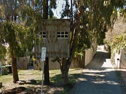
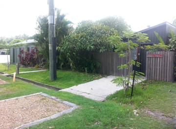
Picture 1.
|
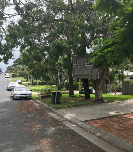
Picture 2
|
Council as a road authority may grant a short-term lease of
land comprising a public road to the owner of land adjoining the public road
under s153 of the Roads Act 1993 (NSW) only if in Council’s
reasonable opinion the road is not being used by the public. Section 145 Roads
Act provides that all public roads (including footpaths) within a local
government area are vested in fee simple in the appropriate road authority.
Council is a road authority for all public roads within the shire, s7 Roads
Act.
Massinger Street including the footpath is a public road
under authority of Byron Shire Council.
The tree house is constructed on a public road (picture 1)
adjacent to a strata unit owned by Ms Coppin.
To grant a lease Council must form an opinion that the public
road is unused by the public. As there are no formed footpaths on either side
of this part of Massinger Street the forming of a reasonable opinion that the
public road is unused by the public may be difficult to achieve (picture 2).
If in Council’s opinion the public road is unused then
public notice of the proposed lease must be advertised in a local newspaper
calling for submissions (Roads Act s154). Council must duly consider all
submissions before considering granting a lease.
An independent market rent valuation is required to set rent
payable under the lease. Based on rent payable on similar leases granted over
small encroachments on public roads in the Byron Shire, market rent could be as
high as $1500 per annum exclusive of GST.
Legal Implications:
The Land and Environment Court
have been strong in stating that “there is a need for the upholding of
the integrity of the system of planning and development control. This system
depends on persons taking steps to obey the law by ascertaining when
development consent is required and then obtaining development consent before
carrying out development”.
In this matter the treehouse was
constructed to completion without contact with Council concerning approvals
required, let alone, obtaining those approvals.
Council obtained advice from its
external solicitors. A copy of that advice is at confidential attachment 3.
Is the proposal consistent with any Delivery Program
tasks?
N/A
Notices of Motion 9.4
Notice of Motion No. 9.4 Support
for College of Marine Studies
File No: I2018/630
|
I move:
1. That
Council:
a) acknowledges
the support it has provided in the past to College of Marine Studies (COMS),
including $5,000 for a scoping study;
b) acknowledges
the role of COMS in initiating the Masterplan process, and
c) acknowledges
the potential value of a maritime education facility for the Shire.
2. That
as part of Council’s submission to the Masterplan process, Council gives
in principle support to COMS for a not for profit training facility at the
Brunswick Heads Boat Harbour;
3. That
Council work with stakeholders and Crown Lands to explore a potential
location for COMS at the Brunswick Heads Boat Harbour or other location.
|
Attachments:
1 Brunswick-Heads-Boat-Harbour-introduction-scope-vision-and-objectives,
E2018/28539 ⇨
2 COMS
scoping study may 2013 V2 with COMS drawings, E2018/28540
⇨
3 The
Krawarree Project Feb 2018, E2018/28541
⇨
Signed: Cr
Cate Coorey
Councillor’s supporting information:
The College of Marine Studies (COMS) has been working with
community groups, Government Agencies, particularly Crown Land, local and
neighbouring Councils and Registered Training Organisations interstate.
COMS had been working closely
with Crown Land for over fourteen (14) years. A scoping study was created
in 2007 for the Brunswick Heads Boat Harbour and the creation of the College of
Marine Studies website (www.collegeofmarinestudies.org).
The College of Marine Studies
was established primarily as a vehicle to restore and maintain the marine
precinct on a self-supporting model. Representatives of COMS believe this
can be achieved.
The Masterplan that is currently
in draft removes the slipway that formed part of the viability of the scoping
study. Crown Lands has taken a different position with regard to the uses for
the site and COMS has been effectively been sidelined in this process.
Byron Shire Council gave $5,000
to contribute towards the scoping study and Council’s Economic
Development Officer worked with the committee to help develop the scoping
study.
Given the possible economic and
social benefits that could be derived from an educational facility of this
kind, Byron Shire Council should, through the Draft Master Plan process, give
in principle support to COMS, subject to its viability.
Staff comments by Shannon Burt, Director Sustainable
Environment and Economy:
(Management Comments must not include formatted
recommendations – resolution 11-979)
The Draft Master Plan (Plan) for Brunswick Boat Harbour is
now on public exhibition. The draft plan outlines proposed future improvement
of boating safety and access, infrastructure within the harbour, and for
revitalising Crown land along the foreshore.
https://www.crownland.nsw.gov.au/crown_lands/coastal-harbours-and-river-entrances/brunswick-heads/harbour-master-plan
The Department of Industry (Lands & Water) is
responsible for the Plan.
Council’s role is limited to that of a submitter,
albeit an important one.
Staff from the DPI presented to Council staff and to
councillors present on the Plan on the 12 April 2018.
Council could resolve to have staff make a submission to the
Plan promoting the College of Marine Studies (COM), and to have staff continue
discussions about a future site location for the COM as well.
Financial/Resource/Legal Implications:
None known.
Is the proposal consistent with any Delivery Program
tasks?
Not applicable.
Notices of Motion 9.5
Notice of Motion No. 9.5 Public
Endorsement of Byron Bay Skate Park Location
File No: I2018/635
|
I move that Council:
1. Endorse the Sandhills
area as the preferred location for a Byron Bay Skate park.
2. Seek public and user
group feedback and ascertain support for this location.
3. Seek support from the
Department of Industry-Crown Land for use of this site for a youth focused
activity.
4. Provide a report
on the feedback provided by stakeholders, the wider community and the
Department of Industry-Crown Land.
|
Signed: Cr
Simon Richardson
Councillor’s supporting information:
When
one begins a discussion with locals on the establishment of a skate park in the
bay, the first reaction is one of disbelief; a disbelief due to the many false
starts and non starts over years and decades. We would struggle to find a
local in the Bay who does not believe we need a skate park or our kids deserve
a skatepark.
Now is
the time and opportunity to bring this project to life. Though its’
gestation period resembles that of an elephant, its’ time has finally
come.
The
three key ingredients for establishment of a skatepark: community support, a
agreed upon location and funding confidence are all ready for mixing.
At the
end of 2017, Councillor Spooner and myself and convened a public meeting to
ascertain the level of community support to drive this project. The
support, though a touch guarded, was still evident and clear, and strong.
From this meeting, a facebook group’ Byron Skatepark Planners Group’ was formed to begin the
project management process.
During
the initial ‘Take Off Meeting’, a location became quite clearly
identified. Initially, we moved through the options and considered the
individual strengths and weaknesses of each. These can be seen here:
Byron Foreshore Precinct
Council
Managed Crown Land
Unapproved CZMP -coastal protection
infrastructure issues
Many
different possible uses and conflicting views-highly contested
Sandhills
Owned by the Crown -soon available to Council
CPTED issues
Few possible uses and
marginally contested
Byron
Rec Grounds
A defined recreation
precinct
Size
and other stakeholder issues
Many
different possible uses and conflicting views-highly contested
Butler
Street
CPTED
issues
Other
Uses
Cavanbah Centre
The
master plan identifies a future skate park SE corner
Out of
town
From
these option, it became very clear that the Sandhills area would be an ideal
location. Those present at the meeting were unanimous in pursuing this option.
Funding
avenues also crystallised and this made the project tangible. Council has
already allocated and committed $300,000. If the community could
establish a fund-raising regime and work towards $200,000, this would allow for
a $500,000 budget, with the ability to seek matching funding to push the
ultimate budget to $1,000,000.
Recommended
priority relative to other Delivery Plan tasks:
This
area, dubbed The Sandhills Community Hub within the Byron Bay Town
Centre Masterplan, “should be a community destination for all ages,
integrated within an eco-friendly setting, linking to the regenerated Sandhills
scrub as an ideal place.” Though not explicitly listed as an
activity within the area, a skatepark with accompanying passive recreational
and gathering amenities for all ages certainly meets the priorities listed:
5.6
SANDHILLS COMMUNITY HUB :
Short Term Priorities [2016 - 2021]
The
Sandhills Community Hub should be established as a community destination that
supports the diverse needs of the town centre’s
local community, providing opportunities for the young, elderly and everyone in
between. Located on the edges of the village centre and Sandhills Scrub,
the precinct provides a perfect transition between the town centre’s urban and natural character.
Through
offering an improved youth and environmental centre, reoriented library, local
community gardens, a children’s adventure space and adult
learning facilities the Sandhills Community Hub should become a place for all
ages to learn about and enjoy Byron Bay’s unique natural
environment.
Using
this area to create a skatepark also fits within higher order planning as
outlined in the masterplan, through its cultural benefits. With adjacent
activities and enters focused on all ages, with a particular focus on early
childhood and youth activities, it makes good planning sense to establish a
further activity to complement these current uses, as “Establishing
community precincts which concentrate complimentary types of facilities ensures
regular usage, space activation, a varied demographic and improved integration
with the surrounding areas.” BBTCMP-page 60
Lastly,
the explicit linking of a skatepark to the town’s youth centre makes
sense. This too can be seen through the priority mentioned within the Sandhills
Community Hub section within the BBTCMP- “Youth Centre Refurbishment.
Refurbish the youth centre to provide improved youth facilities. To
ensure regular use an environmental centre should be integrated within the
facility providing strong links to the library and Sandhills Scrub.”
A
skatepark, part funded by Council, part funded by the community and part funded
by external grants can be a community loved and supported and utilised addition
to town- bringing the ultimate vision articulated within the BBTCMP to life,
“Connect the
Centre of Byron Bay with the Spirit of its community”
Definition
of the project/task:
Seeking
community support for the establishment of a skatepark in the Sandhills area
within Byron Bay and reporting to council on the resultant feedback.
Source
of Funds (if applicable):
Negligible
Staff comments by Michael Matthews, Manager Open Space and
Resource Recovery, Infrastructure Services:
(Management Comments must not include formatted
recommendations – resolution 11-979)
Existing skate parks within the Shire are
located at Bangalow, Brunswick Heads, Mullumbimby, South Golden Beach, Suffolk
Park and Federal with Byron Bay as an obvious void for this often highly
utilised recreational infrastructure.
Skate Parks predominately cater for our youth,
however where located with other recreational infrastructure, can provide
significant additional intergenerational activation of a space.
Skate parks have a relatively high capital cost
outlay with minimum maintenance due to durability.
These facilities placed in the appropriate
environment with ancillary facilities can create an important positive social
setting for our youth.
From a Crime Prevention perspective it is
important that a chosen area is activated and not isolated and it is preferable
that the area provides for strong passive surveillance to ensure the safety of
our Youth and other users.
Local Police have the ability to undertake
Crime Prevention Risk Assessment services on appropriate requests from Council
that could assist in appropriate Crime Prevention Through Environmental
Design (CPTED) principles being identified and adopted within the design
(including placement and orientation).
Financial/Resource/Legal Implications:
A skate park is identified in the developer contributions
plan. (Section 94 Plan)
The skate park is the next highest priority in the plan for
expenditure upon completion of the Byron Bay Town Centre Master plan
(BBTCMP).
This is based upon adopted priorities.
The implementation of the BBTCMP is likely to absorb all
current contributions held with Council in the 2018/19 financial year. Based
upon the cash flows into the plan, the BBTCMP will use all future contributions
for the next 5-7 years.
Council does vary the priorities within the plan to meet
grant funding requirements.
If Council received a grant then it is open to Council to
resolve to redirect money from the BBTCMP to the skate park. The skate park in
the works schedule is identified separately to the BBTCMP.
If Council identifies the skate park as a BBTCMP work then
it may access this funding but it should then remove the skate park as a
separate item from the plan and cease collecting money from developers for this
purpose.
Is the proposal consistent with any Delivery Program
tasks?
No
Petitions 10.1
Petitions
Petition No. 10.1 Middle Pocket Road
Directorate: Infrastructure Services
Report
Author: Evan
Elford, Team Leader Infrastructure Planning
File No: I2018/496
Theme: Community Infrastructure
Local Roads and Drainage
At Council’s Ordinary meeting held on 22 March 2018 Cr
Richardson tabled a petition containing 148 signatures which states:
“We, the residents of Middle Pocket Road, wish
to bring to your attention again:
The appalling negligence and duty of care of Middle Pocket
Road. This has been tolerated for over 45 years or so. We are calling on
something to be done about the Road damage, inadequate drainage and potholes
upon potholes on Middle Pocket road. The neglect has brought about a vast
increase in car maintenance due to abnormal wear and tear on our vehicles. The
council have admitted Middle Pocket Road is in need of a new road but
constantly waist money adding to the bumps with an inefficient pot hole top up
occasionally. This washes away immediately the rain comes because the drains
are higher than the road on most occasions and is not being addressed seriously
and adequately. The council tick the “Done Box” and we are
still left with the damage a week later. The reasons stated from the council is
because there are not enough funds so the false economy continues. This
is not a good enough excuse, especially when there have been numerous accidents
and some near fatal, due to having to avoid large pot holes for miles.
The abhorrent condition of this road is regularly
compromised because of flood damage that has not been addressed
adequately. We as residents of Middle Pocket Road are now all seriously
compromised.
Our plea is to encourage you to fix this road and refund all
mechanical bills that we have occurred such as: shock absorbers,
suspension rebuild, breaks, tires, realignments and so on…not to mention
damage due to falling branches and over hanging trees. The turnaround point at
the end of Middle Pocket Road for the garbage truck, the school bus, semi
trailers and other large vehicles is a nightmare.
We the rate payers are tired of miss spent, miss managed
public money. Byron does not need more Palm Trees and we need to be safe and
not be bombarded with an abnormal amount of mechanical fees.
We shall await your feedback, if the council cannot manage
its finances to keep its residents safe, then you must appeal to for funding
from state and Federal Government as this is a life and death situation”.
Comments from Director Infrastructure Services:
Council understands the frustrations of the community in
this regard and has been working on a number of strategies to address
maintenance backlog across all community infrastructure across the shire.
The condition of the roads in Byron Shire is a major source
of complaint from residents and accordingly, Council has increased spending in
this area significantly in recent years. Council is now approaching its
second year of a Special Rate Variation and the allocation of funding of
roadworks is undertaken in accordance with Council’s established risk
based management procedures.
Because the road network was historically underfunded for
many years fixing them, whilst a priority, is a long and slow process.
Information about roadworks is available on the
Council’s website.
|
RECOMMENDATION:
That the
petition regarding Middle Pocket Road be noted.
|
Submissions and Grants 11.1
Submissions and Grants
Report No. 11.1 Byron
Shire Council Submissions and Grants as at 28 March 2018
Directorate: Corporate
and Community Services
Report
Author: Jodi
Frawley, Grants Co-ordinator
File No: I2018/527
Theme: Corporate Management
Governance Services
Summary:
Council have submitted applications for a number of grant
programs which, if successful, would provide significant funding to enable the
delivery of identified projects. This report provides an update on these
grant submissions.
|
RECOMMENDATION:
That Council note the report and Attachment (E2018/25251).
|
Attachments:
1 Byron
Shire Council Submissions and Grants as at 28 March 2018, E2018/25251 ⇨
This report provides an
update on grant submissions including funding applications submitted and new
potential funding opportunities.
Funding Applications
– Successful
· Enviro-poles for cigarette litter reform (NSW
Environmental Protection Authority – Council Litter Prevention Grants) -
$100,000
· Active Recreation Waterlily Park, Ocean Shores (NSW
Stronger Country Communities Fund Round One) - $418,608
· Extension of Heritage House, Bangalow (NSW Stronger
Country Communities Fund Round One) - $320,154
· Refurbish and Renew Sandhills Early Child Care
Centre (NSW Stronger Country Communities Fund Round One) - $255,763
Funding Applications
– Unsuccessful
· Byron Virtual Reality Walking Tour (NSW Office of
Environment – Heritage Near Me – Strategic Projects)
Applications Submitted
· Weed Control on Endangered Graminoid Clay Heath at
Byron Bay ( NSW Public Reserves Management Fund)
· Flying Improvements (NSW Office of Environment,
Environmental Trust Restoration and Rehabilitation Grants)
· Multi Cultural Meeting Place (Multicultural NSW
Unity Grants)
· Creative Cultural Connections (Multicultural NSW
Celebration Grants)
Additional information on
the grant submissions made and/or pending is provided in Attachment 1 –
Submissions and Grants report as at 28 March 2018.
Financial Implications
If Council is successful
in obtaining the identified grants more than $18 million would be achieved
which would provide significant funding for Council projects. Some of the
grants require a contribution from Council (either cash or in-kind) and others
do not. Council’s contribution is funded. The potential funding and
allocation is noted below:
|
Requested funds from
funding bodies
|
18,933,875
|
|
Council cash
contribution
|
10,393,699
|
|
Council in-kind
Contribution
|
365,158
|
|
Other contributions
|
17,324,960
|
|
Funding applications submitted and awaiting notification
(total project value)
|
47,017,692
|
Statutory and Policy Compliance Implications
Council is required under
Section 409 3(c) of the Local Government Act 1993 to ensure that
‘money that has been received from the Government or from a public
authority by way of a specific purpose advance or grant, may not, except with
the consent of the Government or public authority, be used otherwise than for
that specific purpose’. This legislative requirement governs
Council’s administration of grants.
Staff Reports - Corporate and Community Services 13.1
Staff Reports - Corporate and Community
Services
Report No. 13.1 Australia
Day PRG Finalisation of the 2018 Group and Commencement of the 2019 Group
Directorate: Corporate
and Community Services
Report
Author: Deborah
Stafford, Community Projects Officer (Generalist)
File No: I2018/513
Theme: Society and Culture
Community Development
Summary:
This report provides information on the work completed by
the Australia Day 2018 Project Reference Group (PRG). It is recommended that
the 2018 PRG be disbanded following the completion of its objectives.
This report also recommends that a 2019 PRG be established
to coordinate the Australia Day activities for 26 January 2019.
|
RECOMMENDATION:
That Council:
1. Note
this report on the Australia Day 2018 activities and disbands the Australia
Day Project Reference Group effective 19 April 2018.
2. Write
to members of the Australia Day 2018 Project Reference Group advising of this
resolution and to thank the participants for their assistance.
3. Participate
in the Australia Day Council Ambassador Program for 2019 Australia Day
activities.
4. Adopt
the Constitution for the Australia Day 2019 Project Reference Group shown in
Attachment 1 (E2018/23898).
5. Invite
the following organisations to nominate representatives to be a member on the
Australia Day 2019 Project Reference Group:
· Byron Bay Rural
Fire Brigade, Suffolk Park
· Rotary Club
of Byron Bay
· Rotary Club
of Mullumbimby, representing the Combined Services Clubs of Brunswick Valley
· Brunswick
Mullumbimby Lions Club
· Ocean Shores
Community Association
· Brunswick
Valley Historical Society
· Sisters for
Reconciliation
· Byron Bay
Surf Club representing Australia Day Paddle
· Bangalow Red
Cross
|
Attachments:
1 DRAFT
Constitution Australia Day PRG 2019, E2018/23898
⇨
Report
Finalisation of Australia Day 2018 PRG
In accordance with Resolution 17-065, Council invited
organisations to nominate representatives to be a member on the Australia Day
2018 PRG.
The PRG met on three occasions prior to Australia Day and
held a debrief meeting in February 2018. Additional discussions and
correspondence were undertaken as required in order to confirm arrangements for
the official ceremony and separate community events.
In accordance with resolution 09-680 which states, in part,
that the official ceremony is to ‘alternate each year to different
locations within the Shire’, the official ceremony for 2018 was held at
the Ocean Shores Country Club and coordinated by the Ocean Shores Community
Association in conjunction with Council.
The Official ceremony was conducted with the assistance of
an Auslan interpreter. There were approximately 70 invited guests plus
spectators in attendance. The following people and events were included:
· Cr Simon Richardson as
MC
· Welcome to Country by
Sonia Woods
· Musical performance by
Ocean Shores Public School students
· Speech by the Australia
Day Address Giver, Frank Mills OAM
· Speech by Byron
Shire’s Australia Day Ambassador, Corey Payne
· Local Australia Day
Awards
· Citizenship Ceremony
· Sit down lunch for
invited guests
Nominations were received for the award categories listed
below (with the recipient noted in brackets):
· Citizen of the Year (Barbara
Upson-Shaw)
· Special Mention (Gill
and Barry Lomath)
· Senior Citizen of the
Year (Margaret Fisher)
· Volunteer of the Year
(Heather McQuilty)
· Community Event of the
Year (Mullumbimby Music Festival)
Other Australia Day events were planned and delivered by the
various community groups with the details of these events noted below.
· Brunswick
Heads Breakfast in the Park (Rotary Club of Mullumbimby representing the
Combined Services Clubs): This event was held at Banner Park. There
were approximately 700 people in attendance for this 30th year of
the event.
· Byron
Bay Breakfast in the Park (Rotary Club of Byron Bay): This event was held
in Apex Park with small numbers people attending over the duration of the event
and all aspects of the day proceeding well.
· Celebration
of the Survival of Aboriginal and Torres Strait Islander Peoples and Culture
(Sisters for Reconciliation): This event was held at Apex Park and included
speakers, dancers and music. The event was delivered despite difficulties
with the location and it was identified that additional volunteers and shade
will be required for the 2019 event.
· Suffolk
Park Fun Afternoon (Byron Bay Rural Fire Brigade, Suffolk Park and Suffolk Park
Progress Association): This event was held at Gaggin Park with
approximately 200 attendees. All activities proceeded well however there was a
noted decrease in numbers from previous years, the cause of which is unknown.
· Ocean
Shores Family Afternoon (Ocean Shores Community Association): This event
was held at the Ocean Shores Public School and included the mullet throwing
competition and rainforest walk. All activities proceeded well however there
was a noted decrease in numbers from previous years (80 last year).
Bangalow and Mullumbimby events
were not held in 2018.
Identified Opportunities for Improvement
It was identified that Council would continue to work with the
relevant Project Reference Group to streamline administrative and event
management processes. Opportunities for supporting community leadership of
community-based events and incorporating operational efficiencies will be
discussed at the first meeting of the Australia Day 2019 Project Reference
Group.
Australia Day Project
Reference Group Constitution
The objectives outlined in the
PRG's Constitution have been met – these are generally described as:
1. Organise
Australia Day Events
2. Australia
Day Address – Local Resident
3. Local
Australia Day Awards
4. Australia
Day Ambassador – Participation in Program
The PRG thanked Council for all
support provided and noted that:
· The
Australia Day Ambassador was well received at all events
· Council
staff preparation of grounds was excellent
· Provision of
bin stations (with three types of bins) and volunteers to assist with
appropriate use (where provided) was well received and effective
· Additional
funding would be useful for local events
· Bangalow Red
Cross be invited to lead a Bangalow event
Commencement
of Australia Day 2019 PRG
In previous years, Council's
Australia Day PRG has coordinated Australia Day activities throughout the Shire
on an annual basis. As noted in this report, the Australia Day 2018 PRG is
recommended to be disbanded. To enable the coordination of Australia Day
activities for 26 January 2019, it is recommended that a PRG be
established.
No Councillors are required to be appointed to the PRG.
Council may appoint a Councillor as a non voting delegate to attend the
meetings of the PRG.
The invited community organisations, excluding Red Cross
Bangalow, were represented on the PRG for events on Australia Day 2018.
Due to the success of previous Australia Day events, it is recommended that the
nominated groups be invited to join the Australia Day 2019 PRG.
It is anticipated the first meeting of this PRG will be held
in September 2018.
Location of the 2019 Australia
Day Official Ceremony
The location of the 2019
Australia Day Official Ceremony was discussed by the 2018 PRG at its final
meeting. The cycle has returned to Suffolk Park if coordinators are
available to host it. This will be discussed and determined by the
Australia Day 2018 PRG at its first meeting.
Financial Implications
Finalisation of Australia Day 2017 PRG
An amount of $13,300 was provided for Australia Day
arrangements in the 2017-2018 budget with expenses totalling approximately $13,277
being incurred.
Commencement of Australia Day 2019 PRG
The draft 2018-2019 Budget has an allocation of $13,400 for
the purpose of Australia Day 2019. This funding is proposed to be used to
provide activities throughout the shire as informed by the coordination of
previous years with any opportunities for improvement identified and
implemented.
Statutory and Policy Compliance Implications
Finalisation of the Australia Day 2018 PRG
In Council’s Delivery Program 2017-2021, SC2.4 states
that Council is required to ‘support a range of events that encourage
broad community participation and promote social inclusion’.
The Constitution for the Australia Day PRG provides nine
months to complete its objectives.
Commencement of Australia Day 2019 PRG
The Australia Day PRG will meet in accordance with its
adopted Constitution.
PRG structure
As per Council’s
procedure on PRG’s, each PRG is to have a specified timeframe to carry
out its objectives. A timeframe of 3 months to 12 months can be elected,
with the option of renewal, or as determined by Council in the PRG
Constitution.
At the end of a PRG’s timeframe to carry out its objectives, it will, in
most cases, be disbanded whether it has completed the objectives of not.
In some circumstances the timeframe may be extended by Council or an Advisory
Committee.
Staff Reports - Corporate and Community Services 13.2
Report No. 13.2 Public
Art Panel - minutes of meeting 15 February 2018
Directorate: Corporate
and Community Services
Report
Author: Joanne
McMurtry, Community Project Officer
File No: I2018/514
Theme: Society and Culture
Community Development
Summary:
A Public Art Panel meeting was held on 15 February 2018.
This report provides the minutes of the meeting.
The meeting received information about key art projects in
the Shire and endorsed the draft Public Art Strategy.
|
RECOMMENDATION:
1. That Council
request further investigation of the use and compliance of development contributions
in relation to the YHA youth hostel development in Byron Bay, and the apparent
failure to comply with the presentation that was made to the Public Art Panel
on 28 September 2017.
2. That
development contributions accepted for Public Art under the DCP are quarantined
for exclusively for Public Art. Any use that contravenes this request needs
to be presented to the Public Art Panel.
3. That Council:
a. Support
the Brunswick Nature Sculpture Walk 2018 event by contributing $10,000 from
the public art budget where Panel members will be consulted regarding the
acquisition of a permanent sculpture for Brunswick Heads following the event.
b. note
that the event will:
· Enable established
interstate artists to provide workshops for local sculptors and community
· Curate sculptures,
focusing on local and interstate sculptors whom work with environmental
themes
· Provides a good
springboard for emerging artists
· Was a well run
event in 2015
4. That Council
develop an MOU with Creative Mullumbimby to develop a mutually beneficial
partnership for public art in Mullumbimby.
5. That
considering the adoption of the draft Public Art Strategy and its stated
focus of resources on
more permanent and sculptural works for the Shire that are well managed
and require less ongoing maintenance, Council:
a. will
support in principle the proposal received for the Byron Gateway Wall,
however,
b. do not support the
allocation of funds to this project.
|
Report
A Public Art Panel meeting was held on 15 February 2018.
This report provides the minutes of the meeting. The meeting received
information about key art projects in the Shire and endorsed the draft Public
Art Strategy.
The Panel made several recommendations to Council as
provided on the first page of this report, and these recommendations are
supported by staff.
A copy of the Agenda for the Public Art Panel meeting of 15
February 2018 can be found at the following link: http://byron.infocouncil.biz/Open/2018/02/PAP_15022018_MIN_821_WEB.htm
Draft Public Art Strategy
Council received a report outlining the new strategic
approach to Public Art in the Shire at the 22 March ordinary meeting and
adopted the Public Art Panel recommendation below at that meeting:
6. That
the Public Art Panel recommend to Council to endorse the draft Public Art
Strategy and draft Public Art Policy and place them on public exhibition for 28
days, with any submissions to be reported back to the Public Art Panel.
Financial Implications
The Public Art budget year-to-date balance for 2017/18
financial year is approximately $33,600.
Statutory and Policy
Compliance Implications
Public Art Policy
Public Art Guidelines and Criteria
Staff Reports - Corporate and Community Services 13.3
Report No. 13.3 Section
355 Management Committees - resignations and appointments
Directorate: Corporate
and Community Services
Report
Author: Joanne
McMurtry, Community Project Officer
File No: I2018/515
Theme: Society and Culture
Community Development
Summary:
This report updates Council on recent resignations and
proposed appointments to various committees.
|
RECOMMENDATION:
1. That
the resignation from Alice Jarvis from the Marvell Hall Management Committee
be accepted and a letter of thanks be provided.
2. That
Maureen Lightfoot be appointed to the Marvell Hall Management Committee.
3. That
Jennifer Parenteau and John Dorczak be appointed to the Mullumbimby Civic
Hall Board of Management.
|
Attachments:
1 Confidential
- Additional community representatives for Section 355 committees, E2018/23976
Resignations and Committee appointments
This report details resignations and proposed new
appointments for Section 355 committees where nominations have been received.
Marvell
Hall Byron Bay Management Committee
Following a period of advertising for more committee
members, a nomination has been received for the Marvell Hall Byron Bay
Management Committee. Details of nominees can be found in Confidential
Attachment 1.
A resignation has also been received from Alice Jervis who
was treasurer on the committee.
Current members of this Management Committee are:
Councillors
Cr Cate Coorey
Cr Jan Hackett (alternate)
Community Representatives
Jim Beatson (Chair)
Nancy English (Secretary)
Carline Lloyd (Co–bookings)
Jay Pearse
Margaret Robertson (Co- bookings)
Christine Willmot
Management Recommendation
That the resignation from Alice Jarvis be accepted and a
letter of thanks be provided.
That Maureen Lightfoot be appointed to the Marvell Hall
Byron Bay Management Committee.
Mullumbimby
Civic Hall Board of Management
Following a period of advertising for more committee
members, nominations have been received for the Mullumbimby Civic Hall Board of
Management. Details of nominees can be found in Confidential Attachment 1.
Current members on this Management Committee are:
Councillors
Cr Basil Cameron
Cr Jeannette Martin (alternate)
Community Representatives:
Sam Fell (Secretary)
Maureen Lightfoot (Treasurer)
Judy MacDonald
Glenn Wright (Chair)
Management Recommendation:
That Jennifer Parenteau and John Dorczak be appointed to the
Mullumbimby Civic Hall Board of Management.
Financial Implications
Community Members of Section 355 Management Committees are
volunteer positions unless otherwise resolved by Council.
Statutory and Policy
Compliance Implications
Management Committees and Boards of Management operate under
Guidelines which states:
3.2 Committee Membership
Committee
membership will number not less than four and not more than nine and each
committee will state the actual number in their Terms of Reference unless
otherwise decided by Council. The exception will be the Bangalow Parks
(Showground) committee which numbers twelve. Council reserves the right to
appoint up to two Councillors to each Committee. The total number of members
includes office bearer committee members and Councillor members which are
appointed by Council.
Whilst
no particular qualifications are necessary (not withstanding 3.1.a), a
commitment to the activities of the Committee and a willingness to be actively
involved in Committee issues is essential. Committees work best when the
workload is shared amongst committee members and there is evident goodwill and
cooperation amongst members.
Further information on the operations and meeting minutes
for these Committees and Boards can be found on Council’s web site at https://www.byron.nsw.gov.au/Council/Committees-and-groups/Section-355-Committees-and-Boards-of-Management.
Staff Reports - Corporate and Community Services 13.4
Report No. 13.4 A
draft wellbeing indicator framework for Byron Shire
Directorate: Corporate
and Community Services
Report
Author: Deborah
Stafford, Community Projects Officer (Generalist)
File No: I2018/519
Theme: Society and Culture
Community Development
Summary:
A draft wellbeing indicator
framework has been developed in order to inform organisational
decision-making and embed wellbeing across organisational practice.
The wellbeing indicator framework
was developed by drawing on the extensive body of highly researched,
evidence based national and international best practice in wellbeing indicator
frameworks and tailoring a locally appropriate model for the Byron Shire.
This report seeks endorsement from
Council of the draft wellbeing indicator framework for the Byron Shire.
|
RECOMMENDATION:
1. That Council
endorses the draft wellbeing indicator framework.
2. That
Council endorses the inclusion of the draft wellbeing indicator framework in
the Community Strategic Plan 2018-2028.
|
Report
Information/Background
The adopted 2017-2021 Delivery Program and Operational Plan
requires Council to develop a wellbeing framework and wellbeing indicators in
order to incorporate them within the organisation and inform organisational
decision-making.
Wellbeing is a concept that is closely related to ‘quality
of life’ at both an individual and community level. Rather than referring
to a brief feeling of happiness, wellbeing is aligned with a deeper
acknowledgement of individual, communal and place based conditions.
The purpose of a wellbeing indicator framework is to measure
and monitor current levels of wellbeing, track change over time and,
importantly, inform planning and decision-making to ensure that the conditions
for improved wellbeing in the Byron Shire are maximised.
The draft wellbeing indicator framework draws on the
extensive body of highly researched, evidence-based national and international
best practice in wellbeing indicator frameworks. Within the Australian context,
local government has worked towards and within community indicator frameworks
to enhance strategic planning and community wellbeing outcomes. While uptake
and mechanisms vary, the last decade has seen a growing consensus regarding the
value of such indicators and their basic overarching architecture.
The draft framework for the Byron Shire draws on best
practice for local councils, such as Community Indicators Victoria (CIV), the
Australian Centre for Excellence in Local Government (ACELG) in partnership
with the Local Government Association of Queensland (LGAQ), and the University
of Technology Sydney Centre for Local Government (CLG) and Institute for
Sustainable Futures (ISF) in partnership with, respectively, Lane Cove and City
of Sydney Councils. While exemplars have informed the draft framework, they
have been reviewed and adapted to ensure that local relevance remains at the
forefront.
At the international level, the framework draws on
innovative and holistic approaches, such as the Bhutanese Gross National
Happiness (GNH) index. GNH is a holistic wellbeing and sustainability framework
that has been conceptualised as ‘development with values’. While
the GNH model was developed in Bhutan, it grew from a strong foundation of
international research in community indicators. It is important to emphasise
that the term ‘happiness’, when used in the GNH model, is akin to
the Western understanding of personal and collective wellbeing or quality of
life. Aspects of the GNH model have been adapted, as appropriate, to ensure
relevance in the local context.
The overarching structure of the wellbeing indicator
framework consists of four pillars: Society and Culture; Environment; Economy
and Civic Leadership. These four pillars or themes are aligned with the areas
that make up a Quadruple Bottom Line (QBL) approach. A QBL approach is required
within Council’s Integrated Planning and Reporting (IP&R) framework
and draft Community Strategic Plan (CSP) objectives. Translation between
framework themes can be seen below:
|
Wellbeing
framework pillars
|
IP&R QBL themes
|
Draft Byron CSP objectives
|
|
Society & culture
|
Society and culture
|
We celebrate our lifestyle, culture and sense of community
|
|
Environment
|
Environment
|
We protect and enhance our natural environment
|
|
We have infrastructure, transport and services which meet
our expectations
|
|
Economy
|
Economy
|
We manage growth and change responsibly
|
|
Civic leadership
|
Governance/civic leadership
|
We have community led decision making which is open and
inclusive
|
It is useful to acknowledge that many aspects of
Council’s work cannot be placed under only one heading in the wellbeing
framework, as they are interrelated, and action in one area creates impact
across each of the others. Recognising interrelationship is intended to enhance
collaboration and highlight otherwise unanticipated consequences of policies,
programs and actions.
Figure 1. Draft Byron Shire wellbeing framework indicators
|
SOCIAL AND CULTURAL
|
ENVIRONMENTAL
|
|
Housing affordability
Relative socioeconomic equality
Community services and facilities
Self reported health
Life satisfaction
Safety
Community connectedness
Social support
Cultural diversity
Cultural participation
Recreation
Public art
|
Responsibility for environmental sustainability
Greenhouse gas emissions
Energy use
Waste minimisation
Healthy waterways
Biodiversity
Open space
Road safety
Active and public transport
|
|
ECONOMIC
|
CIVIC LEADERSHIP
|
|
Economic diversity and resilience
Early childhood education and care access
Innovation
Work-life balance
Growth and development
|
Trust
Political participation
Council performance
|
Rather than attempting to identify and measure every aspect
of wellbeing, the framework is intended to underpin a practical approach to
understanding and enhancing wellbeing.
Further work on the framework will consolidate data sources,
targets and benchmarks for each indicator. The framework is in its first
iteration and will continue to evolve and be refined during the course of the
first year of implementation. A concise and straightforward toolkit is being
developed alongside the wellbeing indicators to support with translating the
framework into practice.
Integration with the CSP
It is proposed that the wellbeing indicators be incorporated
in the CSP and that measures for each indicator be incorporated in the Delivery
Program and Operational Plan. The wellbeing indicators have been checked
against draft CSP strategies and are effective and holistic ‘big
picture’ measures of progress towards the community outcomes identified
in the CSP.
Consultation
The recent, extensive community engagement undertaken to
develop the draft Community Strategic Plan allowed for deep listening to a
broad cross section of the Byron community. The resulting engagement report has
been foundational in shaping and ensuring local alignment between the wellbeing
framework and local conditions and priorities. The wellbeing indicators
themselves are strongly evidence based and, as such, the capacity for external
consultation to contribute to the development of new or additional indicators
is somewhat limited by requirements for rigour within the data.
Several iterations of internal consultation have been
conducted with key staff across the organisation during the development of the
draft indicators from October 2017 to March 2018. Additional internal
consultation will be undertaken to develop and refine data sources and targets
for each specific indicator.
Next steps
Subsequent to framework endorsement, it is
intended that baseline data be collected prior to 30 June 2018.
It is proposed that a toolkit and training
package be developed and implemented in the 2018-2019 year, including:
• policy/project screening tool(s)
• communication tool
• co-learning workshops
• online learning and collaboration platform
• alignment with community grants
• identification of additional implementation opportunities
Financial Implications
The available 2017-2018 wellbeing indicator framework budget
allocation (#2323.2) is $29,100. This will be used to develop an appropriate
survey instrument as well as collect, collate and interpret a baseline data
set. Costs will be incurred in relation to indicators where existing or
publically available data is not adequate. Detailed costing can be developed
upon endorsement of the draft framework.
The 2018-2019 draft budget has an allocation of $8,200 for
the purpose of continuing with data collection, collation, interpretation and
reporting. Additionally, this budget amount will contribute to implementation
strategies, including Council and community co-learning workshops and
communications strategies.
Statutory and Policy Compliance Implications
The adopted 2017-2021 Delivery Program and Operational Plan
requires Council to develop a wellbeing framework and wellbeing indicators in
order to incorporate them within the organisation and inform organisational
decision-making.
IP&R legislation requires Council to address Quadruple
Bottom Line (QBL) considerations in the CSP as well as report back to the
community on CSP progress. The wellbeing indicator framework, if incorporated
into the CSP, addresses both of these requirements: it addresses QBL
considerations directly and clearly; and monitors progress towards achieving
the objectives and strategies outlined in the CSP. Reporting will occur at
least once every four years.
Staff Reports - Corporate and Community Services 13.5
Report No. 13.5 Investments
March 2018
Directorate: Corporate
and Community Services
Report
Author: James
Brickley, Manager Finance
File No: I2018/614
Theme: Corporate Management
Financial Services
Summary:
This report includes a list of investments and identifies
Council’s overall cash position for the month of March 2018 for
Council’s information.
This report is prepared to comply with Regulation 212 of the
Local Government (General) Regulation 2005.
|
RECOMMENDATION:
That the report listing Council’s
investments and overall cash position as at 31 March 2018 be noted.
|
Report
In relation to the investment portfolio for the month of
March 2018, Council has continued to maintain a diversified portfolio of
investments. At 31 March 2018, the average 90 day bank bill rate (BBSW)
for the month of March was 1.93%. Council’s performance to 31 March
2018 is 2.53%. Council’s performance is again higher than the
benchmark. This is largely due to the active ongoing management of the
investment portfolio, maximising investment returns through secure term
deposits and purchasing floating rate notes with attractive interest rates.
The table below identifies the investments held by Council
as at 31 March 2018:
Schedule of
Investments held as at 31 March 2018
|
Purch Date
|
Principal ($)
|
Description
|
CP*
|
Rating
|
Maturity Date
|
No Fossil
Fuel ADI
|
Type
|
Interest Rate Per
Annum
|
Current Value
|
|
28/10/16
|
650,000
|
Teachers Mutual Bank
|
P
|
BBB+
|
28/10/19
|
Y
|
FRN
|
3.17%
|
653,642.89
|
|
24/03/17
|
1,000,000
|
NAB Social Bond (Gender Equality)
|
P
|
AA-
|
24/03/22
|
N
|
B
|
3.25%
|
1,011,100.17
|
|
31/03/17
|
1,000,000
|
CBA Climate Bond
|
P
|
AA-
|
31/03/22
|
N
|
FRN
|
3.25%
|
1,000,000.00
|
|
16/11/17
|
750,000
|
Bank of Queensland
|
P
|
BBB+
|
16/11/21
|
N
|
FRN
|
2.63%
|
750,000.00
|
|
04/10/17
|
2,000,000
|
Police Credit Union
|
P
|
NR
|
04/04/18
|
Y
|
TD
|
2.70%
|
2,000,000.00
|
|
05/10/17
|
1,000,000
|
Police Credit Union
|
N
|
NR
|
05/04/18
|
Y
|
TD
|
2.56%
|
1,000,000.00
|
|
17/10/17
|
1,000,000
|
Police Credit Union
|
N
|
NR
|
17/04/18
|
Y
|
TD
|
2.55%
|
1,000,000.00
|
|
23/10/17
|
1,000,000
|
Bank of Queensland
|
N
|
BBB+
|
23/04/18
|
N
|
TD
|
2.55%
|
1,000,000.00
|
|
02/11/17
|
2,000,000
|
Police Credit Union
|
N
|
NR
|
02/05/18
|
Y
|
TD
|
2.73%
|
2,000,000.00
|
|
03/11/17
|
1,000,000
|
Maitland Mutual Building Society
|
P
|
NR
|
02/05/18
|
Y
|
TD
|
2.55%
|
1,000,000.00
|
|
15/11/17
|
1,000,000
|
The Capricornian Credit Union
|
P
|
NR
|
16/04/18
|
U
|
TD
|
2.55%
|
1,000,000.00
|
|
17/11/17
|
1,000,000
|
Police Credit Union
|
N
|
NR
|
17/05/18
|
Y
|
TD
|
2.75%
|
1,000,000.00
|
|
23/11/17
|
1,000,000
|
The Capricornian Credit Union
|
N
|
NR
|
23/05/18
|
U
|
TD
|
2.55%
|
1,000,000.00
|
|
24/11/17
|
1,000,000
|
ME Bank
|
P
|
BBB
|
24/05/18
|
Y
|
TD
|
2.55%
|
1,000,000.00
|
|
28/11/17
|
1,000,000
|
Bananacoast Credit Union
|
P
|
NR
|
28/05/18
|
Y
|
TD
|
2.65%
|
1,000,000.00
|
|
30/11/17
|
2,000,000
|
NAB
|
N
|
AA-
|
30/04/18
|
N
|
TD
|
2.49%
|
2,000,000.00
|
|
30/11/17
|
2,000,000
|
ME Bank
|
N
|
BBB
|
30/04/18
|
Y
|
TD
|
2.49%
|
2,000,000.00
|
|
06/12/17
|
1,000,000
|
Hunter United Employees Credit Union
|
P
|
NR
|
06/04/18
|
U
|
TD
|
2.55%
|
1,000,000.00
|
|
08/12/17
|
2,000,000
|
ME Bank
|
N
|
BBB
|
08/06/18
|
Y
|
TD
|
2.55%
|
2,000,000.00
|
|
08/12/17
|
2,000,000
|
My State Bank
|
P
|
BBB
|
08/06/18
|
Y
|
TD
|
2.65%
|
2,000,000.00
|
|
19/12/17
|
2,000,000
|
Credit Union Australia
|
P
|
BBB
|
19/06/18
|
Y
|
TD
|
2.60%
|
2,000,000.00
|
|
19/12/17
|
2,000,000
|
Gateway Credit Union
|
P
|
NR
|
19/04/18
|
Y
|
TD
|
2.50%
|
2,000,000.00
|
|
02/01/18
|
1,000,000
|
ME Bank
|
N
|
BBB
|
04/04/18
|
Y
|
TD
|
2.40%
|
1,000,000.00
|
|
02/01/18
|
2,000,000
|
ME Bank
|
N
|
BBB
|
04/07/18
|
Y
|
TD
|
2.55%
|
2,000,000.00
|
|
09/01/18
|
1,000,000
|
Gateway Credit Union
|
N
|
NR
|
11/05/18
|
Y
|
TD
|
2.50%
|
1,000,000.00
|
|
10/01/18
|
1,000,000
|
Bankwest
|
P
|
AA-
|
10/04/18
|
N
|
TD
|
2.50%
|
1,000,000.00
|
|
12/01/18
|
1,000,000
|
Bank of Queensland
|
N
|
BBB+
|
12/06/18
|
N
|
TD
|
2.55%
|
1,000,000.00
|
|
12/01/18
|
1,000,000
|
Bankwest
|
N
|
AA-
|
12/06/18
|
N
|
TD
|
2.55%
|
1,000,000.00
|
|
12/01/18
|
1,000,000
|
Bankwest
|
N
|
AA-
|
12/04/18
|
N
|
TD
|
2.50%
|
1,000,000.00
|
|
23/01/18
|
1,000,000
|
AMP Bank
|
P
|
A
|
23/07/18
|
N
|
TD
|
2.60%
|
1,000,000.00
|
|
24/01/18
|
1,000,000
|
ME Bank
|
N
|
BBB
|
24/07/18
|
Y
|
TD
|
2.60%
|
1,000,000.00
|
|
29/01/18
|
2,000,000
|
Rural Bank
|
P
|
BBB+
|
30/07/18
|
Y
|
TD
|
2.60%
|
2,000,000.00
|
|
31/01/18
|
2,000,000
|
AMP Bank
|
N
|
A
|
03/08/18
|
N
|
TD
|
2.60%
|
2,000,000.00
|
|
02/02/18
|
1,000,000
|
Rural Bank
|
N
|
BBB+
|
02/08/18
|
Y
|
TD
|
2.62%
|
1,000,000.00
|
|
05/02/18
|
2,000,000
|
NAB
|
N
|
AA-
|
07/05/18
|
N
|
TD
|
2.47%
|
1,000,000.00
|
|
06/02/18
|
2,000,000
|
Bankwest
|
N
|
AA-
|
15/05/18
|
N
|
TD
|
2.45%
|
2,000,000.00
|
|
06/02/18
|
1,000,000
|
Gateway Credit Union
|
N
|
NR
|
07/05/18
|
Y
|
TD
|
2.55%
|
1,000,000.00
|
|
07/02/18
|
2,000,000
|
ME Bank
|
N
|
BBB
|
08/05/18
|
Y
|
TD
|
2.45%
|
2,000,000.00
|
|
07/02/18
|
2,000,000
|
Beyond Bank
|
P
|
BBB
|
18/06/18
|
Y
|
TD
|
2.50%
|
2,000,000.00
|
|
08/02/18
|
1,000,000
|
AMP
|
N
|
A
|
08/08/18
|
N
|
TD
|
2.60%
|
2,000,000.00
|
|
15/02/18
|
1,000,000
|
Bankwest
|
N
|
AA-
|
15/06/18
|
N
|
TD
|
2.50%
|
1,000,000.00
|
|
15/02/18
|
1,000,000
|
Police Credit Union Limited (SA)
|
N
|
NR
|
15/08/18
|
Y
|
TD
|
2.61%
|
1,000,000.00
|
|
16/02/18
|
1,000,000
|
Hunter United Employees Credit Union
|
N
|
NR
|
17/05/18
|
U
|
TD
|
2.45%
|
1,000,000.00
|
|
16/02/18
|
1,000,000
|
Gateway Credit Union
|
N
|
NR
|
18/06/18
|
Y
|
TD
|
2.45%
|
1,000,000.00
|
|
26/02/18
|
1,000,000
|
B & E Ltd (Bank of Us)
|
P
|
NR
|
28/05/18
|
U
|
TD
|
2.48%
|
1,000,000.00
|
|
26/02/18
|
1,000,000
|
ME Bank
|
N
|
BBB
|
28/05/18
|
Y
|
TD
|
2.38%
|
1,000,000.00
|
|
28/02/18
|
1,500,000
|
Defence Bank
|
P
|
BBB
|
29/05/18
|
U
|
TD
|
2.40%
|
1,500,000.00
|
|
28/02/18
|
1,000,000
|
ME Bank
|
N
|
BBB
|
29/05/18
|
Y
|
TD
|
2.35%
|
1,000,000.00
|
|
01/03/18
|
1,000,000
|
Defence Bank
|
N
|
BBB
|
01/08/18
|
U
|
TD
|
2.50%
|
1,000,000.00
|
|
05/03/18
|
1,000,000
|
NAB
|
N
|
AA-
|
05/06/18
|
N
|
TD
|
2.54%
|
1,000,000.00
|
|
06/03/18
|
2,000,000
|
My State Bank
|
N
|
BBB
|
06/09/18
|
Y
|
TD
|
2.65%
|
2,000,000.00
|
|
06/03/18
|
1,000,000
|
Bananacoast Credit Union
|
N
|
NR
|
06/09/18
|
Y
|
TD
|
2.60%
|
1,000,000.00
|
|
07/03/18
|
1,000,000
|
Beyond Bank
|
N
|
BBB
|
09/07/18
|
Y
|
TD
|
2.50%
|
1,000,000.00
|
|
07/03/18
|
1,000,000
|
Bananacoast Credit Union
|
N
|
NR
|
07/08/18
|
Y
|
TD
|
2.55%
|
1,000,000.00
|
|
14/03/18
|
1,000,000
|
NAB
|
N
|
AA-
|
16/07/18
|
N
|
TD
|
2.58%
|
1,000,000.00
|
|
15/03/18
|
1,000,000
|
Auswide Bank Ltd
|
P
|
BBB-
|
15/06/18
|
Y
|
TD
|
2.51%
|
1,000,000.00
|
|
15/03/18
|
1,000,000
|
The Capricornian Credit Union
|
N
|
NR
|
15/06/18
|
U
|
TD
|
2.55%
|
1,000,000.00
|
|
16/03/18
|
1,000,000
|
The Capricornian Credit Union
|
N
|
NR
|
17/09/18
|
U
|
TD
|
2.80%
|
1,000,000.00
|
|
28/03/18
|
1,000,000
|
Bankwest
|
N
|
AA-
|
26/06/18
|
N
|
TD
|
2.50%
|
1,000,000.00
|
|
N/A
|
574,357
|
CBA Business Online Saver
|
N
|
A
|
N/A
|
N
|
CALL
|
1.40%
|
574,357.30
|
|
12/01/18
|
1,003,599
|
NSW Treasury Corp
|
N
|
AAA
|
N/A
|
Y
|
CALL
|
1.27%
|
1,003,599.31
|
|
Total
|
76,477,956
|
|
|
|
|
|
AVG
|
2.53%
|
76,492,699.67
|
|
Note 1.
|
CP = Capital protection on maturity
|
|
|
N = No Capital Protection
|
|
|
Y = Fully covered by Government Guarantee
|
|
|
P = Partial Government Guarantee of $250,000 (Financial
Claims Scheme)
|
|
|
|
|
Note 2.
|
No Fossil Fuel ADI
|
|
|
Y = No investment in Fossil Fuels
|
|
|
N = Investment in Fossil Fuels
|
|
|
U = Unknown Status
|
|
Note 3.
|
Type
|
Description
|
|
|
|
B
|
Bonds
|
Principal can vary based on
valuation, interest payable via a fixed interest, payable usually each
quarter.
|
|
|
FRN
|
Floating Rate Note
|
Principal can vary based on
valuation, interest payable via a floating interest rate that varies each
quarter.
|
|
|
TD
|
Term Deposit
|
Principal does not vary during investment term. Interest
payable is fixed at the rate invested for the investment term.
|
|
|
CALL
|
Call Account
|
Principal varies due to cash flow demands from deposits/withdrawals,
interest is payable on the daily balance.
|
Environmental and Socially
Responsible Investing
An additional column has been
added to the schedule of Investments above, to identify if the financial
institution holding the Council investment, has been assessed as a ‘No
Fossil Fuel’ investing institution. This information has been
sourced through www.marketforces.org.au and identifies financial
institutions that either invest in fossil fuel related industries or do
not. The graph below highlights the percentage of each classification
across Council’s total investment portfolio in respect of fossil fuels
only.
The notion of Environmental and
Socially Responsible Investing is much broader than whether a financial
institution as rated by ‘marketforces.org.au’ invests in fossil
fuels or not. Council’s current Investment Policy defines
Environmental and Socially Responsible Investing at Section 4.1 of the
Policy. Council’s Investment Policy can be found at the following
link:
https://www.byron.nsw.gov.au/files/assets/public/hptrim/corporate-management-policies-current/council-investments-policy-2017-current_policies.pdf

In this regard Council has an
additional two investments that are with financial institutions that invest in
fossil fuels but the purposes of the investments are in accord with the broader
definition of Environmental and Socially Responsible investments as indicated
below:
1. $1,000,000 investment with the National Australia Bank maturing
on 24 March 2022 known as a Social Bond that promotes Gender Equity.
2. $1,000,000 investment with Commonwealth Bank maturing on 31
March 2022 known as a Climate Bond.
For the month of March 2018, as indicated in the table
below, there is a dissection of the investment portfolio by investment type:
Dissection
of Council Investment Portfolio as at 31 March 2018
|
Principal Value ($)
|
Investment Linked to:-
|
Current Market Value ($)
|
Cumulative Unrealised Gain/(Loss) ($)
|
|
71,500,000.00
|
Term
Deposits
|
71,500,000.00
|
0.00
|
|
2,400,000.00
|
Floating
Rate Note
|
2,403,642.89
|
3,642.89
|
|
574,357.30
|
Business
On-Line Saver (At Call)
|
574,357.30
|
0.00
|
|
1,003,599.31
|
NSW Treasury Corp
(T Corp)
|
1,003,599.31
|
0.00
|
|
1,000,000.00
|
Bonds
|
1,011,100.17
|
11,100.17
|
|
76,477,956.61
|
|
76,492,699.67
|
14,743.06
|
The current value of an investment compared to the principal
value (face value or original purchase price) provides an indication of the
performance of the investment without reference to the coupon (interest) rate. The
current value represents the value received if an investment was sold or traded
in the current market, in addition to the interest received.
The table below provides a reconciliation of investment
purchases and maturities for month of March 2018 on a current market value
basis.
Movement
in Investment Portfolio – March 2018
|
Item
|
Current Market Value (at end of month) $
|
|
Opening
Balance at 1 March 2018
|
77,990,508.24
|
|
Add:
New Investments Purchased
|
12,000,000.00
|
|
Add:
Call Account Additions
|
0.00
|
|
Add:
Interest from Call Account
|
1,256.78
|
|
Less:
Investments Matured
|
13,500,000.00
|
|
Add:
T Corp Additions
|
0.00
|
|
Add:
Interest from T Corp
|
934.65
|
|
Less:
Call Account Redemption
|
0.00
|
|
Less:
Fair Value Movement for period
|
0.00
|
|
Closing
Balance at 31 March 2018
|
76,492,699.67
|
Investments
Maturities and Returns – March 2018
|
Principal Value ($)
|
Description
|
Type
|
Maturity Date
|
Number of Days Invested
|
Interest Rate Per Annum
|
Interest Paid on Maturity $
|
|
1,000,000
|
Defence Bank
|
TD
|
01/03/18
|
90
|
2.50%
|
6,164.38
|
|
1,000,000
|
NAB
|
TD
|
05/03/18
|
152
|
2.55%
|
10,619.18
|
|
1,500,000
|
ME Bank
|
TD
|
06/03/18
|
92
|
2.40%
|
9,073.97
|
|
1,000,000
|
Bananacoast Credit
Union
|
TD
|
06/03/18
|
182
|
2.60%
|
12,964.38
|
|
1,000,000
|
Bananacoast Credit
Union
|
TD
|
07/03/18
|
182
|
2.60%
|
12,964.38
|
|
2,000,000
|
ME Bank
|
TD
|
13/03/18
|
123
|
2.42%
|
16,310.14
|
|
1,000,000
|
Auswide Bank Ltd
|
TD
|
15/03/18
|
90
|
2.45%
|
6,041.10
|
|
1,000,000
|
Peoples Choice
Credit Union
|
TD
|
15/03/18
|
181
|
2.55%
|
12,645.20
|
|
1,000,000
|
The Capricornian
|
TD
|
15/03/18
|
120
|
2.50%
|
8,219.18
|
|
1,000,000
|
Bank of Queensland
|
TD
|
19/03/18
|
122
|
2.45%
|
8,189.04
|
|
1,000,000
|
Bank of Queensland
|
TD
|
27/03/18
|
181
|
2.50%
|
12,397.26
|
|
1,000,000
|
Defence Bank
|
TD
|
20/03/18
|
109
|
2.50%
|
7,465.75
|
|
13,500,000
|
|
|
|
|
|
123,053.96
|
The overall ‘cash position’ of Council is not
only measured by what funds Council has invested but also by what funds Council
has retained in its consolidated fund or bank account as well for operational
purposes. In this regard, for the month of March 2018 the table below
identifies the overall cash position of Council as follows:
Dissection
of Council Cash Position as at 31 March 2018
|
Item
|
Principal Value ($)
|
Current Market Value ($)
|
Cumulative Unrealised Gain/(Loss) ($)
|
|
Investments
Portfolio
|
|
|
|
|
Term Deposits
|
71,500,000.00
|
71,500,000.00
|
0.00
|
|
Floating Rate Note
|
2,400,000.00
|
2,403,642.89
|
3,642.89
|
|
Business On-Line
Saver (At Call)
|
574,357.30
|
574,357.30
|
0.00
|
|
NSW Treasury Corp
(T Corp)
|
1,003,599.31
|
1,003,599.31
|
0.00
|
|
Bonds
|
1,000,000.00
|
1,011,100.17
|
11,100.17
|
|
Total Investment
Portfolio
|
76,477,956.61
|
76,492,699.67
|
14,743.06
|
|
|
|
|
|
|
Cash at Bank
|
|
|
|
|
Consolidated Fund
|
1,546,689.17
|
1,546,689.17
|
0.00
|
|
Total Cash at Bank
|
1,546,689.17
|
1,546,689.17
|
0.00
|
|
|
|
|
|
|
Total Cash
Position
|
78,024,645.78
|
78,039,388.84
|
14,743.06
|
Financial Implications
Council uses a diversified mix of investments to achieve
short, medium and long-term results.
Statutory and Policy
Compliance Implications
In accordance with Regulation 212 of the Local Government
(General) Regulation 2005, the Responsible Accounting Officer of Council must
provide Council with a monthly report detailing all monies Council has invested
under section 625 of the Local Government Act 1993.
The Report must be presented at the next Ordinary Meeting of
Council after the end of the month being reported. In this regard, the
current Council Meeting cycle does not always allow this to occur, especially
when investment valuations required for the preparation of the report, are
often received after the deadline for the submission of reports for the meeting.
Endeavours will be made to ensure the required report will be provided to
Council and this will for some months require reporting for one or more months.
Council’s investments are carried out in accordance
with section 625(2) of the Local Government Act 1993 and Council’s
Investment Policy. The Local Government Act 1993 allows Council to invest money
as per the Ministers Order – Forms of Investment, last published in the
Government Gazette on 11 February 2011.
Council’s Investment Policy includes the objective of
maximising earnings from authorised investments and ensuring the security of
Council Funds.
Council at its Ordinary Meeting held 8 October 2015 resolved
through resolution 15-515 to insert a new objective into its adopted
Investment Policy, which gives a third tier consideration by Council to
Environmental and Socially Responsible Investments, when making investment
decisions.
Staff Reports - Corporate and Community Services 13.6
Report No. 13.6 Stronger
Country Communities Fund Round 2
Directorate: Corporate
and Community Services
Report
Author: Jodi
Frawley, Grants Co-ordinator
Bronwyn Challis, Strategic
Procurement Co-ordinator
File No: I2018/637
Theme: Corporate Management
Governance Services
Summary:
The NSW Government opened the
second round of the Stronger Country Communities Fund on 12 March 2018, with
applications due on 4 May 2018.
At its meeting on 22 March
2018, Council resolved (Res 18-184) to support community groups to apply for
funding for suitable projects through Council.
Following submission of
project nominations from the community, a panel will consider the nominations
and decide the priority ranking of the projects supported by Council. The panel
will consist of nominated Councillors, with the Parliamentary Secretary for the
North Coast and the Member for Ballina being invited. Final grant applications
are required to be submitted to the funding body by 4 May 2018.
Nominations are sought from Councillors who would be
interested in being on the panel to consider the applications.
|
RECOMMENDATION:
That the following Councillors sit on the panel
to review community infrastructure grant applications: Councillor
____________, Councillor ____________, Councillor ____________, and
Councillor ____________.
|
Report
The NSW Government opened the
second round of the Stronger Country Communities Fund on 12 March 2018, with
applications due on 4 May 2018.
The funding body requires
from Council:
· More than
one application
· Equal
number of community amenity and sports infrastructure applications
· Substantial
communications and engagement program to support application, including
identified community priorities for each project.
From previous experience with
the SCCF application process for Round One and the extensive documentation
required, Council does not have the resources available to complete multiple
applications in the required timeframe.
At its meeting on 22 March
2018, Council resolved (Res 18-184) to nominate the Broken Head Road Cycleway
project as the Council-nominated projects and encourage community groups to
apply for funding for suitable projects through Council.
Council has announced this
opportunity to the Byron Shire Community and held workshops with interested
community groups and members on 6 April and 9 April 2018 to assist them with
the grant writing and application process.
Project nominations are
required to be submitted to Council by 30 April 2018.
Following submission of
project nominations from the community, a panel will consider the nominations
and decide the priority ranking of the projects supported by Council. The panel
will consist of nominated Councillors, with the Parliamentary Secretary for the
North Coast and the Member for Ballina being invited. Final grant applications
are required to be submitted to the funding body by 4 May 2018.
Nominations are sought from
Councillors who would be interested in being on the panel to consider the
nominations.
Financial Implications
Successful submission of grant applications for community
infrastructure may result in projects being funded that may not otherwise have
been.
Statutory and Policy Compliance Implications
Council is required under Section 409 3(c) of the Local
Government Act 1993 to ensure that “money that has been received from
the Government or from a public authority by way of a specific purpose advance
or grant, may not, except with the consent of the Government or public
authority, be used otherwise than for that specific purpose.” This
legislative requirement governs Council’s administration of grants.
Staff Reports - Sustainable Environment and Economy 13.7
Staff Reports - Sustainable Environment and
Economy
Report No. 13.7 PLANNING
- Development Application 10.2017.712.1 for Strata Subdivision to create two
lots, relocation of and alterations to an existing dwelling at 25 Strand Avenue
New Brighton
Directorate: Sustainable
Environment and Economy
Report Author: Rob
Van Iersel, Major Projects Planner
File No: I2018/463
Theme: Ecology
Development and Approvals
Proposal:
|
Proposal description:
|
Relocation of and Alterations and Additions to Existing
Dwelling House, Tree Removal and Strata Subdivision to create Two (2) Strata
Lots
|
|
Property description:
|
LOT: 2 DP: 536175
|
|
25 Strand Avenue NEW BRIGHTON
|
|
Parcel No/s:
|
91210
|
|
Applicant:
|
Joe Davidson Town Planning
|
|
Owner:
|
Kratzke Investments Pty Ltd & P & R Lee Holdings
Pty Ltd
|
|
Zoning:
|
DM Deferred Matter (7(f2) Urban Coastal Lands under Byron
LEP 1988)
|
|
Date received:
|
12 December 2017
|
|
Integrated Development:
|
No
|
|
Public notification or exhibition:
|
- Level
1 advertising under DCP 2014 Part A14 – Public Notification and
Exhibition of Development Applications
- Exhibition
period: 28/12/17 to 10/1/18 (re-exhibited due to holiday period: 25/01/18 to
07/02/18)
- No submissions received
|
|
Delegation to determination:
|
Council
|
|
Issues:
|
· Coastal hazards
· Suitability of
the site
· Public Interest
|
Summary:
The application proposes a strata subdivision of the land,
to create two lots of 1,030m2 and 975m2. Proposed
Lot 1 (1,030m2) includes an access-handle 5.3m wide onto Strand
Avenue. It will be vacant.
Alterations are proposed to the existing six-bedroom,
two-storey dwelling, which will also be repositioned to be wholly within
proposed Lot 2 (975m2).
The proposal includes removal of 13 trees, including 2 trees
located in the road reserve of Strand Avenue (Council consent as land owner
provided).
The repositioning of the dwelling involves its rotation from
its existing north/south orientation to an east/west orientation, so that it
will be contained wholly within proposed Lot 2. The alterations proposed
include demolition of part of the existing structure, internal reconfiguration
of rooms, and extension of external decks on the southern elevation of both
levels.
The site is located within an identified coastal hazard
area. Previous hazard mapping (for Part J DCP 2010) shows the eastern
part of the land within Erosion Precinct 1 and the western part, containing the
existing dwelling, within Precinct 2. The reconfigured dwelling would be
repositioned to remain in Precinct 2.
Updated coastal hazard mapping, adopted for the purpose of
an updated Coastline Management Plan (not yet prepared), shows that the
property is significantly impacted, with both the ‘best estimate’
2050 erosion line and the ‘best estimate’ 2100 line located well
within the property.
The Coastline Hazards Assessment report (September 2013)
indicates that continued coastal erosion is inevitable in the New Brighton
locality. A Coastline Management Plan would address how these ongoing
hazards are to be managed in the future. However, work has not yet
commenced on the preparation of such a Plan for this part of the coast.
In the absence of a Coastline Management Plan, and given the
nature and extent of hazard in this locality it is considered that the site is
not suitable for further development.
The property is subject to the provisions of Byron Local
Environmental Plan 1988. Clause 32 of that LEP restricts the intensity of
development in locations subject to these coastal hazards. In particular,
the provisions of that clause prohibit subdivision of land, although an anomaly
in the wording allows subdivision to be approved if it is undertaken under the
Strata titling provisions.
It is suggested that the intent of that provision was to
allow for the subdivision of existing lawfully approved buildings, rather than
to allow the creation of vacant lots, as it makes no sense why subdivision to
create vacant land would be prohibited for one form of titling but acceptable
for another.
It is accepted, however, that the current words within the
clause do not clearly state that intent. It is recommended, therefore,
that a Planning Proposal be prepared to amend the wording of clause 32 of
BLEP 1988 to clarify that Strata title subdivision only be permitted in
relation to existing lawfully approved buildings (i.e. no vacant lots).
An associated amendment to Part J of Byron Development Control Plan 2010 is
also recommended.
These amendments would continue to restrict the
intensification of land use within high risk areas prior to the development of
a Coastal Zone Management Plan.
The proposed development is not considered to be suitable in
that it would result in intensification of development in an area subject to
significant natural hazards (coastal erosion and flooding). The applicant
has also failed to demonstrate that stormwater can be adequately managed in
accordance with Council’s standards. Refusal of the development
application is recommended.
NOTE TO COUNCILLORS:
In accordance with the
provisions of S375A of the Local Government Act 1993, a Division is to be
called whenever a motion for a planning decision is put to the meeting, for the
purpose of recording voting on planning matters. Pursuant to clause 2(a)
under the heading Matters to be Included in Minutes of Council Meetings of
Council's adopted Code of Meeting Practice (as amended) a Division will be
deemed to have been called by the mover and seconder of all motions relating to
this report.
|
RECOMMENDATION:
1. That
pursuant to Section 80 of the Environmental Planning &
Assessment Act 1979, development application 10.2017.712.1 for Relocation
of and Alterations and Additions to Existing Dwelling House, Tree Removal and
Strata Subdivision to create Two (2) Strata Lots be refused for the following
reasons:
a) Pursuant
to S79C(1)(c) of the Environmental Planning & Assessment Act 1979, the
subject land is not considered suitable for the development as proposed given
the nature and extent of coastal hazard;
b) Pursuant
to S79C(1)(e) of the Environmental Planning & Assessment Act 1979,
approval of the development is not in the public interest in regard to
intensifying development in a location subject to significant coastal hazard
and flood hazard.
c) Pursuant
to S79C(1)(a)(i) of the Environmental Planning & Assessment Act
1979, approval of the development is not consistent with the provisions of
State Environmental Planning Policy No. 71, in that the type, bulk, scale and
size of the development is not appropriate to its location.
d) Pursuant
to S79C(1)(a)(i) of the Environmental Planning & Assessment Act
1979, approval of the development is not consistent with the aims, objectives
and guiding principles of Byron Local Environmental Plan 1988.
e) Pursuant
to S79C(1)(a)(i) of the Environmental Planning & Assessment Act
1979, approval of the development is not consistent with the objectives of
clause 32 of Byron Local Environmental Plan 1988.
f) Pursuant
to S79C(1)(a)(i) of the Environmental Planning & Assessment Act 1979,
Council is not satisfied that the proposed subdivision would not restrict the flow
characteristics of flood waters, increase the level of flooding on other land
in the vicinity or provide satisfactory access during a flood,
which compromises clause 24(3) of Byron LEP 1988.
g) Pursuant
to S79C(1)(a)(iii) of the Environmental Planning & Assessment Act 1979,
insufficient information has been provided to demonstrate that the proposed
stormwater management system for the subdivision could be feasible within the
site, as required by Part N2 of DCP 2010. A lawful point of discharge
has not been provided to the development, which compromises Part N3.1 of DCP
2010.
2. That
Council:
a) agree
to initiate a Planning Proposal to amend clause 32 of Byron Local Environmental
Plan 1988, to clarify that subdivision of land under the Strata Schemes
Development Act 2015 is only permitted in relation to existing lawfully
approved buildings, and not to create vacant lots.
b) prepare
an amendment to Part J of Byron Development Control Plan 2010 to clarify that
subdivision of land under the Strata Schemes Development Act 2015 is only
permitted in relation to existing lawfully approved buildings, and not to
create vacant lots.
c) forward
the planning proposal to the NSW Department of Planning and Environment for a
Gateway determination.
d) agree
that staff can proceed to public exhibition of the planning proposal and the
draft DCP amendment and government agency consultation based on the Gateway
determination issued by the NSW Department of Planning and Environment, and
report back to Council as part of post-exhibition reporting.
|
Attachments:
1 Attachment
A Plans - DA 10.2017.712.1, E2018/24924
⇨
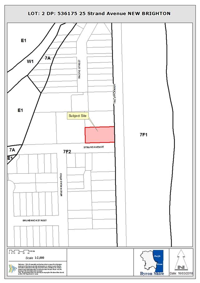
Assessment:
1. INTRODUCTION
1.1. History/Background
|
DA 5.1987.308.1
|
Two-storey dwelling
|
Approved 02/07/87
|
|
BA 6.1988.2337.1
|
Two-storey dwelling
|
Approved 01/09/88
|
|
DA 10.2008.715.1
|
1.8m front fence
|
Approved 03/02/09
|
1.2. Description
of the proposed development
This application seeks approval for Relocation of and Alterations
and Additions to Existing Dwelling House, Tree Removal and Strata Subdivision
to create Two (2) Strata Lots.
The strata subdivision of the land will create:
· Lot 1 –
1,030m2; a vacant lot on the northern side of the existing lot, with
a 5.3m wide access handle, positioned at the western end of the lot, to Strand
Avenue. The lot will be vacant.
· Lot 2 – 975m2;
on the southern side of the existing lot, to contain the repositioned dwelling.
Existing Property:
Proposed Strata Subdivision:
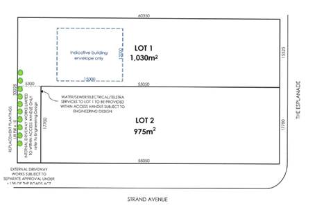
Alterations are proposed to the existing six-bedroom,
two-storey dwelling, which will also be repositioned to be wholly within
proposed Lot 2 (i.e. reorientated 900). The alterations
involve:
· Lower level
– demolition of part of a bedroom and rumpus room and removal of a deck;
reconfiguration of internal space to provide two bedrooms, a bathroom, laundry
and new living area, and extension of external deck, including stairs to upper
floor (existing double-garage retained);
· Upper level
– demolition of two bedrooms, a bathroom and deck, and reconfiguration to
provide four bedrooms, two with ensuite bathrooms, two additional bedrooms,
kitchen, dining, lounge and new external covered deck.
The total floor space of the renovated and reoriented
dwelling will be approx. 185m2.
The proposal includes removal of 13 trees, including 2 trees
located in the road reserve of Strand Avenue (Council consent as land owner
provided).
The property is located within a coastal erosion
precinct. The existing dwelling pre-dates the DCP requirement to be
removable. The reorientation of the dwelling will not result in a modular
structure that is able to be removed, and the application suggests that, in the
circumstances, demolition of the structure would be required if the erosion
escarpment condition is triggered in the future.
Development on the vacant strata lot would be subject to a
separate DA process.
1.3. Description
of the site
|
Land is legally described as
|
LOT: 2 DP: 536175
|
|
Property address is
|
25 Strand Avenue NEW BRIGHTON
|
|
Land is zoned:
|
DM Deferred Matter (7(f2) Urban Coastal Lands under BLEP
1988)
|
|
Land area is:
|
2,023m2
|
|
Property is constrained by:
|
Acid Sulfate Soils Class 3 & 5
|
|
|
Coastal Erosion Precinct 1 & 2
|
|
|
Updated Coastal Hazard Mapping
(see detailed mapping below)
|
|
|
Flood Prone Land (whole site)
|
|
|
Threatened flora/fauna
|
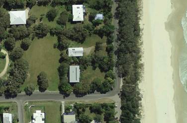
The Site – showing
proximity to beach and scale of existing development in immediate locality
2. SUMMARY OF
REFERRALS
|
Referral
|
Issue
|
|
Development Engineer
|
Application not supported due to concerns relating to
flooding and stormwater – see below.
|
|
S64 / Systems Planning Officer
|
No objections subject to conditions.
S64 levies are payable
|
|
S94 / Contributions Officer
|
No objections subject to conditions.
S94 Contributions are payable
|
|
Ecologist
|
Application is not supported. See Issues (below)
|
Issues:
Stormwater:
The application includes a concept Stormwater Management
Plan, prepared on the basis of a dual occupancy, rather than a land
subdivision. It does not meet with requirements of Council’s DCP in
regard to dual occupancies.
Insufficient information has been provided to demonstrate
that the proposed stormwater management system for the subdivision could be
feasible within the site, as required by Part N2 of DCP 2010, particularly
regarding existing site elevations relative to existing kerb and gutter.
A lawful point of discharge has not been provided to the development, which
compromises Part N3.1 of DCP 2010.
Flooding:
The Marshalls Creek Floodplain Management Plan (Paterson
Consultants Pty Ltd, November 1997) permits limited filling for driveway works
subject to the provision of local drainage patterns not being adversely
affected. The proposed subdivision will likely adversely affect local
drainage provisions, and as such Council can not be satisfied that the
requirements of clause 24 of BLEP 1988 can be satisfied (see further
information below).
Vehicle access will be restricted during storm events
greater than a Q20 year which provide a reasonable level of service.
Evacuation will be managed by SES in accordance with flood excavation plan
developed with SES and available on Council’s web-site if evacuation is
required. The additional allotment requiring evacuation is not a
significant economic impact on the community, however the cumulative impact of
similar developments should be considered and given the Marshalls Creek
Floodplain Management Plan (Paterson Consultants Pty Ltd, November 1997)
requires the building footprint to be limited to a single dwelling on any one
allotment, Council can not be satisfied that this clause is satisfied.
Ecology:
The site contains areas of native
vegetation as well as planted non-local natives and exotic species. The
application proposes the removal of 13 trees. Plans submitted with the
application, however, indicate that two additional trees would potentially be
impacted by the development works.
Council’s Ecologist is not satisfied that the proposed
planting is sufficient in terms of species type or number to offset the
ecological impacts associated with the tree removal proposed, although this
issue could be addressed by way of conditions of consent should approval of the
application be recommended.
3. SECTION 79BA
– BUSH FIRE PRONE LAND
Under section 79BA of the Act, Council must be satisfied
prior to making a determination for development on bush fire prone land, that
the development complies with the document ‘Planning for Bush Fire
Protection 2006’. The site is not bush fire prone land.
EFFECT OF 10/50 RULE ON SIGNIFICANT VEGETATION
The property is not located in a designated 10/50 vegetation
clearing entitlement area.
4. SECTION 79C
– MATTERS FOR CONSIDERATION – DISCUSSION OF ISSUES
Having regard to the matters for consideration detailed in
Section 79C(1) of the Environmental Planning & Assessment Act 1979
(EP&A Act), the following is a summary of the evaluation of the issues.
4.1 State Environmental
Planning Instruments
SEPP 71 – Coastal
Protection
|
Cl. 8 Matters for Consideration:
|
|
|
(a) the aims of this Policy set out in
clause 2:
|
|
|
(a) to protect and
manage the natural, cultural, recreational and economic attributes of the New
South Wales coast, and
|
Not directly applicable.
|
|
(b) to protect and
improve existing public access to and along coastal foreshores to the extent
that this is compatible with the natural attributes of the coastal foreshore,
and
|
The proposed development does not impeded coastal
foreshore access in the short term.
|
|
(c) to ensure that
new opportunities for public access to and along coastal foreshores are
identified and realised to the extent that this is compatible with the
natural attributes of the coastal foreshore, and
|
Not directly applicable.
|
|
(d) to protect and
preserve Aboriginal cultural heritage, and Aboriginal places, values,
customs, beliefs and traditional knowledge, and
|
No perceived impacts.
|
|
(e) to ensure that
the visual amenity of the coast is protected, and
|
Minimal impact on visual amenity.
|
|
(f) to protect
and preserve beach environments and beach amenity, and
|
Minimal impact on beach amenity.
|
|
(g) to protect and
preserve native coastal vegetation, and
|
Tree clearing is proposed – see comments in this
report.
|
|
(h) to protect and
preserve the marine environment of New South Wales, and
|
Not directly applicable.
|
|
(i) to protect
and preserve rock platforms, and
|
Not directly applicable.
|
|
(j) to manage
the coastal zone in accordance with the principles of ecologically
sustainable development (within the meaning of section 6 (2) of the Protection of the Environment
Administration Act 1991), and
|
A precautionary approach would suggest that, in the
absence of a Management Plan to address known coastal risks/ hazards,
approval of further development in the coastal hazard area is not
appropriate.
|
|
(k) to ensure that
the type, bulk, scale and size of development is appropriate for the location
and protects and improves the natural scenic quality of the surrounding area,
and
|
As above – given the nature and extent of the known
coastal hazard, further intensification of development should not be undertaken
in the absence of an adopted Management Plan that addresses the risks.
|
|
(l) to
encourage a strategic approach to coastal management.
|
As above.
|
|
(b) existing public access to and along the coastal foreshore
for pedestrians or persons with a disability should be retained and, where
possible, public access to and along the coastal foreshore for pedestrians or
persons with a disability should be improved
|
The proposed development does not impeded coastal
foreshore access.
|
|
(c) opportunities
to provide new public access to and along the coastal foreshore for
pedestrians or persons with a disability
|
Not directly applicable.
|
|
(d) the
suitability of development given its type, location and design and its
relationship with the surrounding area
|
As detailed further in this report, it is considered that
the creation of an additional vacant lot is not appropriate in this location
given the nature and scale of coastal erosion risks and the fact that Council
does not yet have an adopted Management Plan to address the hazard.
|
|
(e) any
detrimental impact that development may have on the amenity of the coastal
foreshore, including any significant overshadowing of the coastal foreshore
and any significant loss of views from a public place to the coastal
foreshore
|
The development will not result in any significant amenity
impacts.
|
|
(f) the scenic
qualities of the New South Wales coast, and means to protect and improve
these qualities
|
As above.
|
|
(g) measures
to conserve animals (within the meaning of the Threatened Species Conservation Act
1995) and plants
(within the meaning of that Act), and their habitats
|
See ecology comments above.
|
|
(h) measures
to conserve fish (within the meaning of Part 7A of the Fisheries Management Act 1994) and marine vegetation (within the
meaning of that Part), and their habitats
|
No significant impacts envisaged.
|
|
(i) existing
wildlife corridors and the impact of development on these corridors
|
Not directly applicable.
|
|
(j) the
likely impact of coastal processes and coastal hazards on development and any
likely impacts of development on coastal processes and coastal hazards
|
See detailed assessment in this report – the site is
located within an identified coastal hazard area. In the absence of any
adopted coastal hazard management options, the development will be impacted
by coastal recession/ erosion at some time in the future.
|
|
(k) measures
to reduce the potential for conflict between land-based and water-based
coastal activities
|
Not directly applicable.
|
|
(l) measures
to protect the cultural places, values, customs, beliefs and traditional
knowledge of Aboriginals
|
The development will not impact on any known areas of
Aboriginal Heritage.
|
|
(m) likely impacts of
development on the water quality of coastal waterbodies
|
The development is unlikely to impacts coastal water
quality.
|
|
(n) the
conservation and preservation of items of heritage, archaeological or
historic significance
|
The development will not impact on any known areas of
historic significance.
|
|
(o) only in
cases in which a council prepares a draft local environmental plan that
applies to land to which this Policy applies, the means to encourage compact
towns and cities
|
Not directly applicable.
|
|
(p) only in
cases in which a development application in relation to proposed development
is determined:
(i) the
cumulative impacts of the proposed development on the environment, and
(ii) measures
to ensure that water and energy usage by the proposed development is
efficient.
|
The property immediately to the west of the land was
subdivided in 2010 to provide 2 vacant strata lots.
Cumulatively, this proposal adds to the intensification of
development in this coastal hazard area.
|
|
Cl. 13 Flexible
zone provisions
|
Not directly applicable.
|
|
Cl. 14 Public
access
|
See above – the proposal does not impede coastal
access.
|
|
Cl. 15 Effluent
disposal
|
Reticulated sewer is available.
|
|
Cl. 16
Stormwater
|
Stormwater can be adequately managed on site.
|
Coastal Hazards:
The Byron Shire Coastline Hazards
Assessment Update (Sept 2013) provides a detailed analysis of the nature and
extent of coastal hazards affecting the whole of the Shire. In relation
to New Brighton, the assessment indicates a net shoreline recession equating to
0.1-0.3m/year. It further notes that factors, such as the beach scraping
that has been undertaken in the area, mean that there is some uncertainty in
these rates, which could be more than calculated. It concludes that
“there is significant risk of erosion and wave overtopping over-wash to
the hind dune areas”, and “the immediate erosion hazard could
involve breakthrough to the low land areas behind the dune”.
It is noted that no beach scrapping is being undertaken this
year.
Allowing for the uncertainty, and considering sea level rise
predictions, the Assessment has plotted updated Coastal Hazard lines that have
a serious impact on the subject property.
The “immediate hazard” line is plotted only
approx. 12m to the east of the current property boundary. The “best
estimate” of the 2050 erosion line is approx. 20m inside the site, with
the 2100 “best estimate” approx. 44m into the property.
This hazard assessment clearly shows that the property is
significantly affected, raising serious concerns around the suitability of the
site for more intensive development. The hazard assessment is also
reflected in the State Government’s draft Coastal Management SEPP, which
maps the whole of the land within the Coastal Vulnerability Area (see below).
The updated hazard assessment will inform the preparation of
a Coastal Zone Management Plan, which will determine how the hazards will be
managed into the future. At this time, however, preparation of the
Management Plan is proceeding for Byron Bay, and no work has started on
management options for New Brighton.
In the absence of management plan work, it is considered
that the proposed development is inconsistent with the provisions of SEPP 71,
in that it is not suitable for further development. On this basis,
refusal of the development application is recommended.
4.2 Byron Local Environmental Plan
1988 (LEP 1988)
LEP 1988 is an applicable matter for consideration in the
assessment of the subject development application in accordance with subsection
79C(1) of the EP&A Act because it applies to the subject land and the
proposed development.
In accordance with the LEP clauses 5, 8 and 9:
(a) The
proposed development is defined in the LEP 1988 Dictionary as Dwelling House,
and in accordance with the EP&A Act as subdivision of land;
(b) The
land is within the 7(f2) Urban Coastal Lands Zone according to the map under
LEP 1988;
(c) The
proposed development is permissible (subject to discussion below); and
(d) The
proposed development is inconsistent with the relevant objectives of the Zone
for the following reasons:
|
Zone Objective
|
Consideration
|
|
(1) to identify urban land likely to be influenced by coastal
processes,
|
The land is influenced by coastal process – see
further information below.
|
|
(2) to permit urban development within the zone subject to
the council having due consideration to the intensity of that development and
the likelihood of such development being adversely affected by, or adversely
affecting, coastal processes,
|
While the development is (technically) permissible,
the provisions of cl.32 seek to minimise intensification of land uses in the
zone.
It is therefore inconsistent with these zone
objectives.
See further discussion below.
|
|
(3) to permit urban
development within the zone subject to the council having due consideration
to:
(i) the need to
relocate buildings in the long term,
(ii) the need for
development consent to be limited to a particular period,
(iii) the form, bulk,
intensity and nature of the development, and
(iv) continued safe public
access to the site, and
|
|
|
(4) to allow detailed provisions to be made,
by means of a development control plan, to set aside specific areas within
the zone for different land uses and intensities of development.
|
|
Special Provisions:
Cl. 2 Aims, objectives and
guiding principles
Guiding Principles:
· The
precautionary principle: In some circumstances this will mean actions
will need to be taken to prevent damage even when it is not certain that damage
will occur.
This is directly relevant to the
subject application – in the absence of adopted measures to manage the
protection of existing development in the face of known coastal hazards/ risks,
the precautionary principle is supported by Council’s objectives,
expressed in cl. 32 of the LEP, to restrict intensification of development.
The application cannot be supported
under the precautionary principle.
Cl. 24 Development of flood
liable land
Council cannot consent to development on flood prone land
unless it is satisfied that:
· the
development would not restrict the flow characteristics of flood waters
The Marshalls Creek Floodplain
Management Plan (Paterson Consultants Pty Ltd, November 1997) permits limited
filling for driveway works subject to the provision of local drainage patterns
not being adversely affected. The proposed subdivision will likely adversely
affect local drainage provisions, and as such Council can not be satisfied that
this clause is satisfied.
· the
development would not increase the level of flooding on other land in the
vicinity
The Marshalls Creek Floodplain
Management Plan (Paterson Consultants Pty Ltd, November 1997) permits limited
filling for driveway works but requires the building footprint to be limited to
a single dwelling on any one allotment and as such Council can not be satisfied
that this clause is satisfied.
· the
structural characteristics of any building or work the subject of the
application are capable of withstanding flooding
The driveway can be constructed to
withstand flooding and future highset dwelling construction on the vacant
strata lot can be made to comply with this clause.
· the
building is adequately flood proofed
Future highset dwelling construction
on the vacant strata lot can be made to comply with this clause by having
habitable floors above the flood planning level and flood compatible materials
below the flood planning level.
Cl. 32 Development within
Zone No 7(f2) (Urban Coastal Land Zone)
(3) Council, in deciding
whether to grant consent shall take into consideration:
(a) the
likelihood of the proposed development adversely affecting, or being adversely
affected by, coastal processes
See the assessment above.
Based on the recent assessment of coastal hazards (Byron Shire Coastline
Hazards Assessment Update, Sept 2013), the whole of the property is located
within an area subject to coastal erosion/ recession.
Both the reoriented existing
dwelling and a future dwelling on the proposed vacant lot would be affected by
coastal recession within the anticipated lifetime of those buildings.
Council has yet to undertake the work required to address
these hazards. In the absence of an adopted Coastal Zone Management Plan
for this section of coast, it is considered that it is inappropriate to approve
substantial additional development which will be affected by coastal processes.
(b) the
need to relocate buildings in the long term
Council has a policy of
“planned retreat” to manage development in coastal hazard areas,
implemented through the provisions of Part J of DCP 2010 (see further detail
below).
A key component of this policy is to
provide for the relocation/ removal of dwellings/ structures in coastal areas
when the erosion escarpment comes within 50m of the building.
Standard development conditions are
implemented on development approvals to implement this policy. There are,
however, known difficulties in implementing the policy and enforcing the
conditions of approval and Council does not have unilateral power to remove
buildings.
In the event that removal/
demolition is triggered (i.e. when the erosion escarpment comes within 50m of
the building), Council would advise the land owner that, in accordance with the
terms of the condition, development consent has ceased and the dwelling is to
be removed/ demolished.
If no action were taken by the land
owner, Council would need to take legal actions for a breach of consent/
condition.
Conditions of consent can be
enforced in two main ways:
· Council can
issue orders under s121B of the Environmental Planning and Assessment Act, but
only where the requirements and circumstances set out in s121B are met. A
statutory process must be followed by Council before such an order can be
issued. The recipient of the order has a merit right of appeal to the
Land and Environment Court (“Orders pathway”); or
· civil
enforcement proceedings can be brought in the Land and Environment Court
seeking orders from the Court to remedy or restrain the alleged breach of the
condition of consent (“litigation pathway”).
Restrictions on title, where they
exist, could potentially be enforced by proceedings in the Supreme Court.
If Council sought to do this, the affected landowner could raise counter
arguments seeking that the restrictions be extinguished, utilising provisions
of the Conveyancing Act 1919.
Whether there is an enforcement
option open to Council needs to be assessed individually for each landowner,
according to the facts and circumstances of each property.
Even if Council could prove that there has been a breach
of a consent condition, the Court has discretion as to whether any orders
should be made to “remedy” the breach.
(c) the
need for the development consent to be limited to a particular period
Rather than specify a time limit on approvals,
Council’s policy of planned retreat specifies a condition requiring
buildings be removed when the erosion escarpment comes within 50m. See
further comments above.
(d) the
form, bulk, intensity and nature of the development
These matters need to be considered
in relation to the provisions of parts (4) & (5) below.
Clause 32 is specifically written to
limit the intensity of development, prohibiting a range of development,
including dual occupancies, and prohibiting the subdivision of land (other than
certain cases – discussed further below).
The proposed development would result in an
intensification of the use of the site, resulting in two dwellings where there
currently is one. Were it not for the anomaly in the wording of the
clause (discussed below), the development as proposed would not be permissible.
(e) continued
safe access to the site
While safe access will be available in the foreseeable
future, in the absence of adopted management measures to address coastal
recession, continued access cannot be guaranteed in the longer term.
(4) The council shall not consent to the
carrying out of development on land shown edged heavy black and stippled on the
map marked “Byron Local Environmental Plan 1988 (Amendment No 66)”
for the purpose of clubs, commercial premises, hostels, hotels, motels,
residential flat buildings, shops or tourist facilities or for a purpose that
would otherwise be permissible with consent under clause 17 (Dual occupancy).
The clear intent of this clause is
to restrict the scale and intensity of development in this zone. In
relation to residential development, by specifically prohibiting dual occupancy
and residential flat buildings, the intent of the clause is to restrict such
development to one dwelling per property.
While the current development does not propose dual
occupancy, the end result will be the same – two dwellings on what is
currently one parcel of land.
(5) The Council
must not consent to the subdivision of land within Zone No 7 (f2) other than:
(a) a subdivision under the Strata Schemes
(Freehold Development) Act 1973, or
(b) a subdivision to excise an allotment that
is, or that the Council is satisfied is intended to be, used for a public
purpose, or
(c) a subdivision that, in the opinion of the
Council, is only a boundary adjustment where no additional lots are created.
There is an anomaly in this clause,
particularly when read in conjunction with part (4). While it is clear
why a subdivision for public purposes or a boundary adjustment that does not
create additional lots should be acceptable, it is unclear why the creation of
one or more vacant lots might be acceptable only under one particular titling
system – i.e. strata title, when the clause specifically seeks to
restrict the subdivision of land.
It is more likely that the intention
of the clause was to allow the strata title subdivision of existing lawfully
erected buildings (which is not subdivision of land).
It is acknowledged, however, that
the clause is not currently clearly worded to reflect that
interpretation.
The applicant has provided a number
of precedent approvals where Council has previously approved vacant strata
title lots in the 7(f2) zone.
It is recommended, however, that the
wording of this clause of LEP 1988 be amended to clarify the intent, by
amending part (a) to read:
a subdivision of an existing
lawfully erected building (or buildings) under the Strata Schemes Development
Act 2015 (updated legislation) – see Part 6 of this report.
Conclusion:
Notwithstanding that the proposed strata subdivision is
permissible given the words of the clause, it is considered that the
development should not be supported given the resulting form and intensity of
development, on a site that is affected by known coastal processes.
Cl. 40 Height
The maximum building height within this clause is 9.0m to
the topmost part of the building, measured from existing ground level.
The plans provided with the application do not provide
dimensions or levels to accurately gauge the maximum height of the
building. ‘Scaling’ from the plans indicates that the peak of
the roof may be slightly in excess of the 9.0m limit.
This could be addressed by a condition if approval is
recommended, requiring compliance with the 9.0m limit, to be demonstrated on
plans submitted with an application for Construction Certificate.
4.3 Any proposed Instrument
that has been the subject of public consultation and has been notified to the
consent authority
Draft SEPP (Coastal
Management) 2016
The Draft Coastal Management State Environmental Planning
Policy (SEPP) proposes to establish a new, strategic land use planning
framework for coastal management. It is intended to support the
implementation of the management objectives set out in the Coastal Management
Act 2016.
Once adopted, the Coastal Management SEPP will be the single
land use planning policy for coastal development and will bring together and
modernise provisions from SEPP 14 (Coastal Wetlands), SEPP 26 (Littoral
Rainforests) and SEPP 71 (Coastal Protection).
The aim of the Draft SEPP is to promote an integrated and
co-ordinated approach to planning in the ‘Coastal Zone’,
identifying four coastal management areas:
· coastal wetlands
and littoral rainforests area
· coastal
environment area;
· coastal use area;
and
· coastal
vulnerability area.
The whole of the subject site will be mapped within the coastal
use area and the coastal vulnerability area.
Coastal use area: Similar provisions to SEPP 71,
relating to foreshore access and amenity/ overshadowing impacts on the
beach. The application does not raise any issues in this regard.
Coastal vulnerability area:
Development consent must not be
granted to development on land to which this clause applies unless the consent
authority is satisfied that the proposed development:
(a) if
there is an existing beach adjacent to the proposed development – allows
for the ambulatory and dynamic nature of the beach and foreshore or provides
for beach nourishment, and
As indicated above, in the absence of an adopted Coastal
Zone Management Plan for this area, the site will be subject to coastal
recession.
(b) is
not likely to cause increased risk of coastal hazards on that land or other
land, and
The development would cause increased risk to the extent
that it would provide for an additional dwelling, which will be subject to the
identified coastal hazards.
(c) is
not likely to alter coastal processes to the detriment of the natural
environment or other land, and
The development is unlikely to alter coastal processes.
(d) is
not likely to reduce the public amenity, access to and use of any beach,
foreshore, rock platform or headland adjacent to the proposed development, and
The development will not impact beach access or amenity.
(e) incorporates
appropriate measures to manage risk to life and public safety from coastal
hazards.
There are no such measures
incorporated into this development, and Council does not have an adopted
Management Plan that outlines such measures for this location.
Development consent must not be granted to development on
land to which this clause applies unless the consent authority has considered,
given anticipated impacts of coastal processes and coastal hazards, whether:
(a) any
proposed buildings or works should be temporary buildings or works, and
See commentary above regarding the removal of the
reorientated dwelling.
(b) whether
any use of land should be a temporary use of land.
See comments above.
Conclusion:
The development as
proposed is inconsistent with the provisions of the draft SEPP as they would
apply to the Coastal Vulnerability Area.
4.4 Byron Shire Development
Control Plan 2010 (DCP 2010)
DCP 2010 is an applicable matter for consideration in the
assessment of the subject development application in accordance with subsection
79C(1) of the EP& A Act because its purpose is to provide planning
strategies and controls for various types of development permissible in
accordance with LEP 1988.
Part G Vehicular Circulation
and Car Parking
Table G2.1 indicates a car parking requirement for a
dwelling house with a floor area greater than 100m2 is 2 spaces,
plus 1 additional space per 2 bedrooms over 4 bedrooms.
In this case, the dwelling has in excess of 100m2
floor area, with 6 bedrooms, requiring the provision of 3 spaces.
Only 2 spaces have been provided. However, there would
be sufficient room on the site to accommodate an additional parking space if
approval were to be recommended.
Part J Coastal Erosion Lands
The eastern part of the property is within Coastal Erosion
Precinct 1 – Beach Escarpment to the Immediate Impact Line.
The western part, containing the existing dwelling, is within Precinct 2
– Between the Immediate Impact Line and the 50 year Erosion Line.
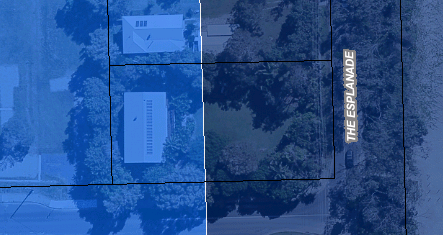
The application states that the reoriented dwelling will
remain wholly within Precinct 2.
As outlined above, the most recent erosion study shows
different hazard lines, with the immediate impact and best estimate 50 year
lines located slightly seaward of the Part J Precinct lines.
The more recent lines have not yet been adopted for the
purpose of the Development Control Plan, and therefore the Precinct controls in
Part J remain applicable.
Precinct 2 – Prescriptive
Measures:
Development within this precinct will be granted on the
understanding that any consent granted will be subject to the proviso that must
the erosion escarpment come within 50 metres of any building then the
development consent will cease.
A condition to this effect would be
imposed on any approval of this application. See comments above regarding
concerns about enforcement of such a condition.
If the development consent does cease then the owner of
the land will be responsible for the removal of any or all buildings from the
site, or, where possible, to a location on the site further than 50 metres from
the erosion escarpment. Prior to lodging an application with Council, the
developer of the land must determine whether buildings are to be relocatable or
demolished, should the consent cease.
The application proposes that the
building would be demolished.
Notwithstanding the above, all Class 1 residential
buildings (dwelling-houses) must be relocatable. Extensions to existing
dwellings may also be required to be demountable, taking into consideration the
additional floor space proposed and the likely effect of the extension on the
ability of the building to be relocated in an emergency.
The reoriented dwelling, which is a
Class 1 building, will not be relocatable. The application argues that
this is not required as it is an existing dwelling.
4.5 Any Planning Agreement or
Draft Planning Agreement?
There is not any applicable planning agreement or draft
planning agreement relevant to this application.
4.6 Environmental Planning
& Assessment Regulation 2000 Considerations
|
Clause
|
This control is applicable to the proposal:
|
I have considered this control as it relates to the
proposal:
|
If this control is applicable, does the proposal
comply?
|
|
92 Coastal Policy
|
Yes (see below)
|
Yes
|
Yes
|
|
93 Change of Building Use
|
No
|
N/A
|
N/A
|
|
94 Rebuilding, enlargement of existing building
|
Yes
|
Yes
|
Yes
|
|
94A Temporary structures
|
No
|
N/A
|
N/A
|
The NSW Coastal Policy is the overarching framework for
management of the coastal zone. It is implemented through Coastline
Management Planning process and the provisions of SEPP 71.
The Coastline Hazards Assessment Update referred to above is
the first step in the Coastal Zone Management Process for this locality, having
identified the scale and nature of coastal processes and hazards. The
preparation of a Management Plan would be the next step, identifying measures
to manage the identified hazards.
That work has not yet begun in relation to the New Brighton
area.
The provisions of SEPP 71 are addressed above.
4.7 Any coastal zone management
plan?
As highlighted above, work has not yet commenced on a
Coastal Zone Management Plan for this section of the coast.
4.8 The likely impacts of that
development, including environmental impacts on both the natural and built
environments, and social and economic impacts in the locality
|
Impact on:
|
Likely significant impact/s?
|
|
Natural environment
|
Minimal. The proposal involves tree clearing and therefore
will have a some adverse impact on the natural environment of the locality.
|
|
Built environment
|
No. The proposal will not have a significantly
adverse impact on the built environment of the locality.
|
|
Social Environment
|
Yes. The proposal will have a significant social
impact on the locality by providing for a vacant lot that would be developed
for additional residential development within a location subject to
significant coastal hazard.
|
|
Economic impact
|
Potential. An increase in the intensity of
development in this locality has the potential to increase the future cost of
management/ protection works which, ultimately, will be an economic cost to
the community.
|
4.9 The suitability of the site
for the development
As highlighted above, the property is identified as being
subject to coastal hazards. In the absence of management / protection
measures, coastal recession will physically impact the land within the lifetime
of the proposed dwelling.
Council’s policy, as outlined in clause 32 of Byron
LEP 1988, is to restrict the intensity of development in locations subject to
these coastal hazards. In particular, the provisions of that clause
prohibit subdivision of land, although an anomaly in the wording allows
subdivision to be approved if it is undertaken under the Strata titling
provisions.
It is suggested that the intent of that provision was to
allow for the subdivision of existing lawfully approved buildings, rather than
to allow the creation of vacant lots, as it makes no sense why the subdivision
of land to create vacant lots might be acceptable for one form of titling but
not for another.
It is accepted, however, that the current words within the
clause do not clearly state that intent.
Council has not yet started work on a Coastal Zone
Management Plan for this section of coast. Such a Plan would include
measures to address the level of risk and clarify the extent to which future
development could be supported.
In the absence of such a Plan, approval of the current
application would provide for additional development that would be subject to
coastal recession within its planned lifetime, with no measures in place for
Council or the land owner to manage that risk, other than to remove dwellings
when the erosion escarpment comes within 50m of the buildings.
Legal advice has raised questions regarding the ability for
Council to rely on this condition of approval to achieve removal of dwellings.
In the circumstances, it is considered that the land is not
suitable for the development as proposed.
4.10 Submissions made in accordance with
this Act or the regulations
The development application was publicly exhibited 28/12/17 to
10/1/18; and then re-exhibited due to holiday period from 25/01/18 to 07/02/18.
There were no submissions made on the development
application.
4.11 Public interest
The application would result in an intensification of use in
this vulnerable area, increasing the burden on Council and the community to
protect that development when it is impacted by coastal erosion / recession in
the future.
In the absence of an adopted Management Plan for this part
of the coast, it is considered that intensification of land use is not in the
public interest.
4.12 Section 5A of the EP&A Act –
Significant effect on threatened species
Having regard to sections 5A, 5C and 5D of the EP&A Act, there is not likely to be a significant effect on threatened species,
populations or ecological communities, or their habitats as a result of the
proposed development.
4.13 Section 5B of the EP&A Act –
Have regard to register of critical habitat
The NSW Critical
Habitat Register does not identify any critical habitat on or adjacent to the
site.
5. DEVELOPER
CONTRIBUTIONS
5.1 Water & Sewer Levies
Section 64 levies would be payable if the application were
approved.
5.2 Section 94 Contributions
Section 94 Contributions would
be payable if the application were approved.
6. AMENDMENT TO
BYRON LEP 1988
Byron LEP 1988 will continue to apply to coastal lands
identified as being subject to coastal hazard until Council has finalised a
review of those lands and determined an appropriate zoning to incorporate into
Byron LEP 2014.
At this time, the State Government’s Standard LEP
Template does not provide a zoning option that is directly equivalent to the
7(f1) or 7(f2) zones.
Council is continuing discussions with the State Government
in this regard, but it is likely that the situation will take some time to
resolve. In the meantime, it is considered that it worth addressing the
anomaly in the clause 32 of the existing clause, to prevent continued pressure
to create additional vacant development lots that are subject to coastal
hazards.
As outlined above, it is suggested that there is an anomaly
in the current wording of clause 32 of the LEP, where the subdivision of
land is prohibited, apart from subdivision undertaken under the strata
titling legislation.
Historically, strata title was more or less exclusively used
to subdivision existing buildings. In this context, allowing strata
subdivision makes sense, as it is not then the subdivision of land.
In more recent time, strata provisions have been used to
create vacant allotments, mostly in the case of staged development proposals,
where specific building designs have also been approved for the
‘development lot’.
It has rarely been used as proposed in this application, to
create a vacant allotment not linked to a specified building proposal, as the
torrens title (i.e. conventional land subdivision) system is much less
cumbersome.
Strata subdivision is proposed in this case simply because
the words in clause 32(5) are written to allow “a subdivision under
the Strata Schemes (Freehold Development) Act 1973” (superseded
legislation).
It is likely that the intention of the clause was to allow
the strata title subdivision of existing lawfully erected buildings.
It is acknowledged, however, that the clause does not
currently specify that intent, and the applicant has provided a number of
precedent approvals where Council has previously approved vacant strata title
lots in the 7(f2) zone. As such, it is not considered appropriate to
refuse the current application based on an interpretation of this clause.
It is recommended, however, that a Planning Proposal be
prepared with the intention of amending the wording of this clause of LEP 1988
to clarify the intent. It is suggested that clause 32(5)(a) be amended to
read:
a subdivision of an existing
lawfully erected building (or buildings) under the Strata Schemes Development
Act 2015, where no vacant lots result from the subdivision
7. AMENDMENT TO
BYRON DCP 2010
Part J of the DCP deals with development within identified
coastal erosion precincts. It will continue to apply to deferred areas as
long as Byron LEP 1988 is applicable.
It is recommended that this part be amended by including the
following:
|
J2.6
|
Element – Subdivision
of Land
|
|
|
Element Objective
|
|
|
Restrict the intensity of
development within locations adversely affected by coastal processes.
|
|
|
Performance Criteria
|
|
|
Development will not be
considered where it would result in the creation of vacant land capable of
being development for residential purposes.
|
|
|
Prescriptive Measures
|
|
|
Council will not consent to the subdivision of land within
Precincts 1 and 2 other than:
(a) a
subdivision of an existing lawfully erected building (or buildings) under the
Strata Schemes Development Act 2015, where no vacant lots result from
the subdivision; or
(b) a
subdivision to excise an allotment that is, or that the Council is satisfied
is intended to be, used for a public purpose, or
(c) a
subdivision that, in the opinion of the Council, is only a boundary
adjustment where no additional lots are created.
|
Staff Reports - Sustainable Environment and Economy 13.8
Report No. 13.8 Compliance
– Belongil and Brunswick Dunes
Directorate: Sustainable
Environment and Economy
Report Author: Shannon
Burt, Director Sustainable Environment and Economy
Andrew Hill, Team Leader Community
Enforcement
Sarah Ford, Manager Community
Development
File No: I2018/71
Theme: Ecology
Planning Policy and Natural Environment
Summary:
Council considered a Report 4.1 Compliance – Belongil
and Brunswick Dunes at the Ordinary Meeting 1 December 2017 and resolved as
follows:
17-614 Resolved in order
to minimise illegal visitor use of our dune systems and the corresponding
damage it does, that Council:
1. Receives a memorandum by the 14 December meeting detailing
current compliance priorities.
2. Receives a
memorandum by the 14 December meeting that provides updates on:
a) Actions
that have been taken or are planned to be taken to prevent illegal
camping, dumping and other damaging activities at the Belongil sand dunes
following the latest clean-up that occurred on October 24.
b) Actions that have been taken or are planned
to be taken to prevent damage to sand dunes at Brunswick
Heads.
3. Receives a report
on current strategies in place for providing assistance to people who are
homeless that have been or
may be impacted by the actions above.
The purpose of this report is to update Council on items 1-3
of the resolution.
|
RECOMMENDATION:
That Council:
1. Note
the report.
2. Support
in principle the concept to activate the Belongil area by strategically
introducing greater public use through a formal pedestrian/bicycle pathway
from Main Beach Car Park to Kendall Street Belongil.
3. Request
staff in the Community Enforcement Team to commence preparation of a detailed
project plan in consultation with relevant staff in Infrastructure Services
and Community Development on item 2. The project plan will outline the
key stages, milestones, stakeholders and a budget outline for the project.
|
Report
1. Receives
a memorandum by the 14 December meeting detailing current compliance
priorities.
A report was prepared for the 14 December 2017 Council
meeting but due to the size of the agenda for that meeting was deferred for 1
February 2018 Council meeting. Links below:
Report
No. 13.12 Compliance Priorities Program - 2018 File No: I2017/1793
http://byron.infocouncil.biz/Open/2018/02/OC_01022018_AGN_758.PDF
18-032
Resolved:
1.
That Council note the report.
2.
That Council adopt the proposed Compliance Priorities Program for 2018 as
provided in Attachment 1 (E2017/108374) with the addition of 2 2.2(d) below: 2
2.2(d)Development without consent, or not in accordance with consent, of the
nature of Short Term Holiday Letting.
2. Receives a memorandum by the 14 December meeting that
provides updates on:
a) Actions that have been taken
or are planned to be taken to prevent illegal
camping, dumping and other
damaging activities at the Belongil sand dunes
following the latest clean-up
that occurred on October 24.
b) Actions
that have been taken or are planned to be taken to prevent damage to sand dunes
at Brunswick Heads.
CAVANBAH DUNES (Belongil Sand Dunes)
Background
In 2004 Council obtained a vegetation management plan for
the site titled Vegetation Management Plan Cavanbah Dunes (East Belongil)
Byron Bay.
Since 2004 Council and the community have experienced mixed
success in rehabilitating and maintaining the site. However, over time the site
has continued to be degraded as a result of unauthorised camping, weed
infestation, unmitigated tracks and damage caused by the hail storm in November
2013.
The site is experiencing a substantial die-back event,
mostly comprising advanced native trees. The die-back event is a result of the
2013 hail storm, which has caused further weed infestations.
Unauthorised camping has caused significant impacts on the
site including vegetation destruction, rubbish dumping, littering and
unmitigated formation of tracks. The vegetation destruction and rubbish dumping
by campers has contributed to the rapid growth of invasive weeds including
Lantana (Lantana camara), Bitou Bush (Chrysanthemoides monilifera ssp
rotundata), Umbrella Tree (Schefflera actinophylla), Ground Asparagus
(Asparagus aethiopicus), Glory Lily (Gloriasa superba), Mickey Mouse Bush
(Ochna serrulata), Winter Senna (Senna pendula var. glabrata) and Camphor
laurel (Cinnamomum camphora).
Council’s Community Enforcement Team has been carrying
out patrols of the area with assistance of the Police and Council clean up
crews.
The subject site is somewhat isolated and the thickets of
weeds with discrete access tracks have made the site popular for users of
illicit drugs. Used syringes are a common occurrence and care needs to be taken
by Council and the Police to avoid needle stick injuries. This situation also
poses a significant public health and safety risk.
Between December 2016 and August 2017 Council has incurred
$11,157 in costs associated with cleaning up the site after illegal camping in
the area.
Site Description
The site commences at the western end of Main Beach car park
and extends to the intersection of Kendall Street and Border Street. The site
is approximately 800 metres in length and is variable in width up to about 90
metres.
Land Status
The site that is subject to this report comprises land owned
by Council (Red Edge), Crown land managed by Council (Yellow Edge) and road
reserve partly maintained by Council (White Shade). Refer to the diagram below.
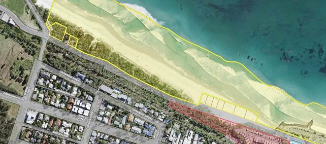
Diagram A. Land Status - Land owned by Council (Red
Edge), Crown land managed by Council (Yellow Edge) and road reserve partly
maintained by Council (White Shade). Refer to the diagram below.
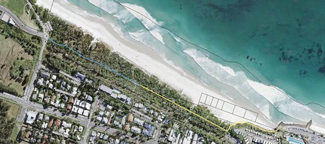
Diagram B. Blue line existing track. Yellow line proposed
path.
Proposal
It is proposed to activate the area by strategically
introducing greater public use. It is suggested that a formal
pedestrian/bicycle pathway be constructed from Main Beach Car Park to Kendall
Street Belongil. The blue line depicted in diagram B above comprises an
existing track that previously served an overhead power line. The power line is
now redundant. This existing track would only require minor improvement works
to be to be suitable for the purpose. The remainder of the proposed pathway may
require more substantial work.
The introduction of the proposed path would promote passive
surveillance and facilitate greater access by Council and the community to
maintain the area.
BRUNSWICK HEADS (Brunswick Sand Dunes)
The Brunswick Heads dunal area does not have the significant
numbers of unauthorised campers as the Belongil area. The majority of
unauthorised campers identified in the Brunswick Heads area are in campervans
or vehicles, parked in the streets. These campers are regularly fined by
community enforcement officers during morning patrols. Local police and
Council officers are also aware that a number of unauthorised campers are
located on a large area of private land that is set for development, located at
the end of Torakina Road. Police and Council have communicated with the
owner of the land in an effort to reduce authorised camping and its associated
affects in this area.
Community enforcement officers have also identified the
presence of unauthorised camping taking place in the bushland/dunes located on
Crown Land, South of the Brunswick Heads Surf Life Saving Club. The
numbers of campers appear to be smaller at this time but may have the potential
to cause impacts on the Crown Land including vegetation destruction, rubbish
dumping, littering and unmitigated formation of tracks.
3. Receives a report on current strategies in place for
providing assistance to people who are homeless that have been or may be
impacted by the actions above.
Council’s Community Enforcement Team implement the
terms of Council’s Homelessness Policy, particularly in regards to
Annexure A, which provides a “Protocol for Dealing with homeless
People”. This protocol requires cooperation between Council officers and
the NSW Police Service.
file://fapmho2/users$/sburt/Downloads/Policy-Homelessness-2015-current_policies.pdf
When carrying out patrols of the site Council officers are usually
accompanied by Police. Both Police and Council officers are in regular
communication with each other. We are familiar with the identity of homeless
persons in Byron Bay and we have a good understanding as to who are genuinely
homeless.
When a homeless person is found in this area Council
officers and the Police generally leave them alone, unless there is an issue
with that person behaving in a disorderly manner or is a danger to themselves,
others or property. Council officers do not have the powers to move people on
and therefore we rely on the Police to do so, but only when necessary.
Council and the Police always make an effort to ensure
homeless people are informed of relevant support services available in Byron
Bay. Unfortunately genuine homeless people do not form the majority of campers
that use the site. Most campers that use this site are predominantly, tourists
backpackers and itinerate workers avoiding the need to pay for accommodation in
backpacker hostels or caravan parks/camping grounds.
Council’s Community Development Team continues to work
with State agencies and local service providers to develop strategies to
respond to rough sleeping in the Shire. It is recognised that a multiagency
response is required in relation to the complex nature of rough sleeping and
the lack of funding and services available for people experiencing chronic
homelessness. Community Development plays a key role in collecting data to
support improved collaboration and investment in the Shire.
Financial Implications
As discussed in the report. There are costs to Council to
patrol, monitor activity and clean up the dune areas.
Statutory and Policy
Compliance Implications
Council’ Enforcement Policy and Homelessness Policy
Local Government Act and other related Acts and Regulations
Staff Reports - Sustainable Environment and Economy 13.9
Report No. 13.9 PLANNING
- Site Specific Planning Proposal considered as part the Rural Land Use
Strategy Process - 74 Charltons Road, Federal
Directorate: Sustainable
Environment and Economy
Report
Author: Alex
Caras, Land Use Plannning Coordinator
File No: I2018/76
Theme: Ecology
Planning Policy and Natural Environment
Summary:
Council at its 26 October 2017
Ordinary Meeting considered a report on the draft Rural Land Use Strategy and resolved
(in part) to:
“4. Receive a report at the meeting on 23 November 2017
regarding site specific planning proposals being considered as part of the RLUS
including at 74 Charltons Road, Federal”.
Council at its 28 November 2017 extra ordinary Meeting
resolved (in part) to:
“2 Defer consideration
of Planning Proposals concerning 74 Charlton’s Road, Federal until site
visits have been arranged.”
Councillors undertook a site inspection on 17 April 2018.
This report presents a summary of the relevant information
in response to item ‘2’ of the above resolution, and recommends
that the planning proposal not proceed any further.
NOTE TO COUNCILLORS:
In accordance with the
provisions of S375A of the Local Government Act 1993, a Division is to be
called whenever a motion for a planning decision is put to the meeting, for the
purpose of recording voting on planning matters. Pursuant to clause 2(a)
under the heading Matters to be Included in Minutes of Council Meetings of
Council's adopted Code of Meeting Practice (as amended) a Division will be
deemed to have been called by the mover and seconder of all motions relating to
this report.
|
RECOMMENDATION:
That Council:
1. Resolve not to proceed any further with the Planning
Proposal contained in Attachment 1 to this report, as it does not satisfy the
Rural Land Use Strategy criteria for future rural lifestyle living
opportunities or accord with the State/regional policy framework (namely the
North Coast Regional Plan and s117 Ministerial Direction 5.3).
2. Notify the
applicant of Council’s decision not to proceed and their opportunity to
request the relevant Planning Panel to review council’s decision within
42 days of being notified.
|
Attachments:
1 Copy of
Planning Proposal 74 Charltons Road Federal, E2017/103100
⇨

2 Letter to
applicant re Planning Proposal 74 Charltons Road Federal, E2018/22866 ⇨
3 Form of
Special Discloure of Precinary Interest, E2012/2815
⇨
Report
Council at its 26 October 2017 Ordinary Meeting considered
a report on the draft Rural Land Use Strategy and resolved the following:
Resolution 17-504
1. Note
the update on priority actions progressed to date as contained in Table 1 of
this report;
2. Adopt
the proposed amendments to the draft Rural Land Use Strategy (RLUS) and
supporting documents, as contained in Table 2 and Table 3 of this report, to
enable submission to Department of Planning & Environment;
3. Delegate
authority to the Director Sustainable Environment & Economy to amend the
draft Rural Land Use Strategy in relation to any consequential (non-policy)
and/or other minor editorial amendments required for clarity or accuracy, prior
to submitting to Department of Planning & Environment for final
endorsement; and
4. Receive a
report at the meeting on 23 November 2017 regarding site specific planning
proposals being considered as part of the RLUS including at 74 Charltons Road,
Federal.
Resolution 17-609
Council at its 28 November 2017 extra ordinary Meeting
resolved (in part) to:
“2 Defer consideration
of Planning Proposals concerning 74 Charlton’s Road, Federal until site
visits have been arranged.”
Councillors undertook a site inspection of the subject land
on 17 April 2018.
This report presents a summary of the relevant information
in response to item ‘2’ of the above resolution.
Background
Council
at the 8 August 2013 meeting resolved (Res. 13-388) to include
six properties on the Byron LEP 2014 Multiple Occupancy and Community Title
Map. Only one property was supported for inclusion on the Map by the Minister for Planning & Environment’s
delegate when the LEP was gazetted.
The
then Director Environment and Planning wrote to the remaining five property
owners to advise them of their options as to
how the following properties could progress
towards a rural multiple occupancy development. At the time two options
were provided:
Ø be considered during preparation of Council’s Rural
Land Use Strategy; or
Ø prepare a planning proposal to amend the Byron LEP 2014
ahead of Council completing the Rural Land Use Strategy.
Council subsequently received a planning proposal for Lot
11 DP 1039847, 74 Charlton’s Road, Federal.
The site is
shown in Figure 1 below.
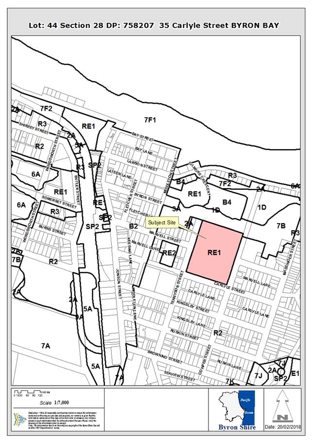
Figure 1: Lot 11 DP 1039847, 74 Charlton’s Road,
Federal
A copy of
the planning proposal and supporting information is contained in Attachment 1
(‘Charltons Road’).
As the timing of the planning proposal received coincided
with preparation of a new Rural Land Use Strategy (RLUS), the applicant was
sent a letter advising that the planning proposal would now be considered as
part of the strategy process. Specifically, the area would be “assessed against the site
selection criteria being developed as part of this wider land use strategy
review. This will determine if the site has merit to be zoned for rural
settlement purposes.” A copy of the letter sent to the applicant is contained in
Attachment 2.
This
is consistent with Resolution 16-286 relating to other sites considered
in Report No 13.11 - Request for an Early Implementation Program to
supplement Council’s Rural Lands Strategy Initiative, in which
Council resolved:
Resolution 16-286
“Resolved that Council not support the “Early
Implementation Program to supplement Council’s Rural Land Use Strategy
Initiative and instead consider these properties in the Byron Rural Land Use
Strategy now under preparation.”
Because
the applicant was advised that the planning proposal would now be assessed
under the RLUS framework, it was not intended at the time to have it separately
determined by Council. Instead the more detailed site information contained in
the planning proposal would be considered against the RLUS policy directions
and site selection criteria, with any final Council decision to coincide with
adoption of the RLUS.
The applicant
took the opportunity to make further submissions during the RLUS exhibition
process.
Assessment against site
selection criteria in Rural Land Use Strategy (as adopted)
Table 1
below shows the relevant criteria applied in assessing the site for
‘future rural lifestyle living opportunities’ in the adopted Rural
Land Use Strategy.
Table 1 – RLUS criteria for identifying ‘future rural
lifestyle living opportunities’
|
Criteria
|
74
Charltons Road, Federal
|
|
i) situated west of the Pacific Highway (undeveloped sites only) AND
within a 5 km radius
of a town with
a high school; and
|
Ï
Outside
5km service catchments of Mullumbimby & Byron Bay
|
|
ii) not identified in a draft or adopted strategy for future urban
purposes, or for future village / urban development in this strategy; and
|
P
|
|
iii) contains at least 10ha of unconstrained land AND does not
require access through constrained land, as identified in Table 1 of the Site
Suitability Criteria and Mapping Methodology; and
|
Ï
No
unconstrained land due to the following:
- regionally
significant farmland (entire site)
- slope
> 25% (part of site)
|
|
iv) can be adequately serviced by existing or committed road
infrastructure at a standard suitable for the predicted level and type
of traffic resulting from development, at no cost to the wider community
|
Ï
Located
outside 5km major service catchment and in an area that cannot be serviced
adequately by existing or committed road infrastructure.
|
P=
satisfies
criteria
Ï= does
not satisfy criteria
In summary,
the site neither satisfies the RLUS criteria for future rural lifestyle
living opportunities nor accords with the State/regional policy framework
(namely the North Coast Regional Plan and s117 Ministerial Direction 5.3 -
Farmland of State and Regional Significance on the NSW Far North Coast).
It is therefore recommend that the planning proposal not proceed any further.
Site visit
In
accordance with Res 17-609 a councillor site visit was conducted on 17 April 2018.
Financial Implications
The cost of assessing this planning proposal as part of the
Rural Land Use Strategy process has been met by Council.
Statutory and Policy Compliance Implications
The Rural Land Use Strategy is consistent with the relevant
Commonwealth, State and Regional policy frameworks.
Opportunity
for Applicant to request a pre-Gateway review
The Environmental Planning and Assessment Regulation
2000 (EP&A
Regulation) requires councils
to notify a proponent when the council decides not to prepare a planning proposal. The proponent then has 42 days from notification to request the relevant Planning
Panel to review council’s decision.
Accordingly the applicant
should be notified of Council’s decision not to proceed with their
respective planning proposal, as recommended in this report.
Staff Reports - Sustainable Environment and Economy 13.10
Report No. 13.10 Draft
CZMP for the Eastern Precincts of the BBE for Council endorsement for public
exhibition
Directorate: Sustainable
Environment and Economy
Report
Author: Chloe
Dowsett, Coastal and Biodiversity Coordinatior
File No: I2018/239
Theme: Ecology
Planning Policy and Natural Environment
Summary:
This report presents the draft Coastal Zone Management Plan
(CZMP) for the Eastern Precincts of the Byron Bay Embayment (Cape Byron to Main
Beach) for Council endorsement to go to public exhibition. Accompanying the
draft CZMP, is an Emergency Action Sub Plan (EASP) which details
Council’s response to an emergency within the locality of the Eastern
Precincts. The EASP forms part of the draft CZMP and is a requirement for
Ministerial certification.
The draft CZMP has been developed in close consultation with
public agencies and the Office of Environment and Heritage (OEH) and is in the
final stages of development. Preliminary comments on the draft plan have been
provided by some agencies already, however, letters of support are yet to be
received.
It is critical to have the new CZMP completed and with the
Minister for certification prior to the lapsing of the existing
legislation’s transitional arrangements. The legislation has now come
into effect (3 April 2018); therefore the new CZMP should ideally be with the
Minister by end of July 2018, to leave ample time for Ministerial approval of
the plan.
This report recommends that the draft CZMP is publicly
exhibited for a period of 4 weeks. Community and public agency submissions and
comments on the draft CZMP will be reviewed during the exhibition period and
reported to Council post-exhibition period.
Based on the enactment of the legislation timeframes have
been further revised as previously reported at the 22 February meeting on the
delivery of the CZMP to the Minister and are provided in Table 1 of the
report.
|
RECOMMENDATION:
That Council:
1.
Publicly exhibit the draft CZMP for the Eastern Precincts of the Byron
Bay Embayment (Cape Byron to Main Beach) and the Emergency Action Sub Plan
for a period of 4 weeks (Attachment 1 E2018/19317 and Attachment 2
E2018/29660 ).
2. Note
the revised timeframes for submission of the draft CZMP to the Minister.
|
Attachments:
1 Attachment
1 - Draft CZMP for the Eastern Precincts of the BBE and appendices, E2018/19317 ⇨
2 Attachment
2 - Draft Emergency Action Sub Plan - CZMP for the Eastern Precincts of the
BBE, E2018/29660 ⇨
Report
Background
Council considered a report at the 26 October 2017 meeting
on the Minister’s and NSW Coastal Panel’s advice on the draft
Coastal Zone Management Plan for the Byron Bay Embayment, which included
amongst other advice excising the Belongil Spit area from the plan and
resubmitting for Ministerial certification. At this meeting Council
resolved (Resolution 17-521) to prepare a Coastal Zone Management Plan
(CZMP) for the Eastern Precincts of the Byron Bay Embayment (BBE) for Cape
Byron to Main Beach, comprising Wategos/Little Wategos, The Pass, Clarkes Beach
and Main Beach precincts.
It is critical to have the new CZMP completed and with the
Minister for certification prior to the lapsing of the existing
legislation’s transitional arrangements. The legislation has now come
into effect (3 April 2018); therefore the new CZMP should ideally be with the
Minister by end of July 2018, to leave ample time for Ministerial approval of
the plan.
Plan Development
The development of the draft CZMP for the Eastern Precincts
of the BBE is in the final stages. Early engagement and involvement with public
agencies has taken place and staff have worked closely with the Office of
Environment and Heritage (OEH) throughout development of the plan. Accompanying
the draft CZMP, is an Emergency Action Sub Plan (EASP) which details
Council’s response to an emergency (beach erosion due to storm activity) within
the locality of the Eastern Precincts. The EASP forms part of the CZMP and is a
requirement for Ministerial certification.
A workshop was held on 24 January 2018 with some agencies in
attendance and others providing written comments for discussion at the
workshop. Secondary meetings were also held with public agencies on 5 April
2018 to gain further comment and feedback.
Staff have liaised with the following organisations:
· Office of Environment
and Heritage
· NSW State Emergency
Services
· National Parks and
Wildlife Service
· Department of Industry
Crown Lands & Water
· Department of Primary
Industries – Fisheries (Cape Byron Marine Park)
· NSW Crown Holiday Parks
Trust
· Arakwal Corporation
Due to the enactment of the new coastal legislation and the
pending timeframes for Ministerial certification of the plan, staff propose
that Council endorse public exhibition of the draft CZMP for a period of 4
weeks.
At this stage, it is proposed that the public exhibition
phase commence late April, with the intent of providing a public submissions
report to the 21 June 2018 Council meeting. This is an anticipated timeframe
and will be dependant on the number and nature of submissions received during
the public exhibition period. This is preferable as it will allow maximum time
for the plan to be reviewed by the Minister.
Project Delivery
At the 14 December 2017 meeting Council considered a report
on the delivery timeframes for the CZMP. The timeframe for delivery of the plan
has now been revised in accordance with the commencement of the legislation and
preferable timeframes for public exhibition and council consideration of
submissions. Refer to Table 1.
Table 1 – Revised Project Delivery Timeframe
|
When
|
What
|
Status
|
|
December 2017
|
· Commence
development of the CZMP and accompanying EASP for the Eastern Precincts BBE
(Cape Byron to Main Beach).
|
Commenced
|
|
· Report
to 14 December Council meeting on status of draft plan and other coastal
projects.
· Plan
for the Eastern Precincts acknowledged as highest priority project.
|
Complete
|
|
January 2018
|
· Workshop with
Public Agencies (24 Jan) on the draft plan
|
Complete
|
|
February / March 2018
|
· Close
consultation with OEH to finalise the draft plan
· Preliminary
review of draft CZMP by OEH and public agencies
· Workshop
for Councillors (8 Feb) - presentation of draft plan and agency comments/feedback
· Report
to Council (22 Feb) – update on development of plan
|
Complete
|
|
April 2018
|
· Further
comment and feedback on the draft CZMP by agencies.
· Report
to Council (19 Apr) on draft CZMP. Council approve draft CZMP to go to public
exhibition.
· Commence
public exhibition and community engagement activities.
|
Commenced
This report
Pending
|
|
May 2018
|
· Public
Exhibition (4 weeks)
· Community
engagement activities
|
Pending
|
|
May/June 2018
|
· Review
submissions and feedback.
· Report
to Council at 21 June 2018 meeting, finalise plan
|
Pending
|
|
July 2018
|
· Submit
to Minister for certification
|
Pending
|
|
July 2018
|
· Review
and approval of the CZMP
|
Pending
|
Financial Implications
Exhibition of the draft CZMP for the Eastern Precinct Byron
Bay Embayment will be funded from existing budget.
Statutory and Policy
Compliance Implications
In accordance with Section 55E of the Coastal Protection
Act 1979 a CZMP must be publicly exhibited for a period of not less than 21
days.
The Coastal Protection Act 1979 has been repealed by
the Coastal Management Act 2016 (3 April 2018).
Staff Reports - Sustainable Environment and Economy 13.11
Report No. 13.11 PLANNING
- Development Application 10.2017.681.1 alterations and additions to existing
amenities building to create a clubhouse for Byron Bay Football Club at 35
Carlyle Street Byron Bay
Directorate: Sustainable
Environment and Economy
Report
Author: Chris
Larkin, Manager Sustainable Development
Noreen Scott, EA Sustainable
Environment and Economy
File No: I2018/246
Theme: Ecology
Development and Approvals
|
DA No:
|
10.2017.681.1
|
|
Proposal:
|
Alterations and additions to existing amenities building
to create an upper floor clubhouse
|
|
Property description:
|
Lot: 44 Section 28 DP: 758207
35 Carlyle Street BYRON BAY
Byron Recreation Grounds
|
|
Parcel No/s:
|
177670
|
|
Applicant:
|
Byron Bay Football Club
|
|
Owner:
|
Byron Shire Council
|
|
Zoning:
|
Zone No. RE1 Public Recreation
|
|
Date received:
|
30 November 2017
|
|
Integrated Development:
|
No
|
|
Public notification or exhibition:
|
- Level
2, advertising under DCP 2014 Part A14 – Public Notification and
Exhibition of Development Applications
- Exhibition
period: 21 December 2017 to 10 January 2018
- Submissions: For
= 0 Against = 2 Neutral/Other = 1 (Crown
Lands)
|
|
Delegation to determination:
|
Council
|
|
Issues:
|
· Hours of operation
· Use of site for
functions, events, etc
· Traffic and
parking
· Noise from
patrons
· General impacts
on surrounding residential development
· Disabled access
|
Summary:
The application proposes alterations to an existing
amenities block to create a second storey for part of the building to be used
as a clubhouse and administration building. The upper floor will include a
large balcony on the eastern and northern side and access will be via an
external staircase at the north west corner and an internal staircase in a
central location. The ground floor layout will be modified to allow for the
internal staircase. A solar array and club signage will be included on
the upper floor.
The land is approximately 5.13 hectares in area, bounded by
Cowper Street to the east, Tennyson Street to the west, Carlyle Street to the
south and the Sandhills Crown land to the north. It is Community Land pursuant
to the Local Government Act 1993.
The proposed clubhouse is within the RE1 Public Recreation
Zone, and Recreation Area is permitted with Council consent. The
clubhouse is ancillary to the use of the site for community sporting events and
activities
The Statement of Environmental Effects accompanying the DA
adequately addresses the LEP and DCP requirements and demonstrates that the
proposed clubhouse on this site is appropriate, subject to conditions.
NOTE TO COUNCILLORS:
In accordance with the
provisions of S375A of the Local Government Act 1993, a Division is to be
called whenever a motion for a planning decision is put to the meeting, for the
purpose of recording voting on planning matters. Pursuant to clause 2(a)
under the heading Matters to be Included in Minutes of Council Meetings of
Council's adopted Code of Meeting Practice (as amended) a Division will be
deemed to have been called by the mover and seconder of all motions relating to
this report.
|
RECOMMENDATION:
That Pursuant to Section 80 of the Environmental
Planning & Assessment Act 1979, development application 10.2017.681.1 for
alterations and additions to an existing amenities building to create an
upper floor clubhouse be granted consent subject to the conditions listed in Attachment
2 #E2018/16544.
|
Attachments:
1 Proposed
Plans prepared by John McKay Architects , E2018/13305
⇨
2 Conditions
of consent , E2018/16544 ⇨
3 submissions
received, E2018/17259 ⇨

Assessment:
1. INTRODUCTION
1.1 History/Background
The Byron Recreation Grounds were established in 1921
commencing with a War Memorial and then Memorial Gates at the Tennyson Street
entrance.
The site was progressively developed for sports and
community uses including:
· Fields and courts
for active recreation – football (soccer), cricket, rugby union, tennis,
croquet, netball, basketball, athletics, school uses and personal training.
· Playground and
shelter;
· Passive community
uses;
· Buildings such as
a scout hall, community cabin (formerly guide hall), croquet club, tennis club,
rugby club and football club amenities.
The amenities building the subject of this application is
the central southern building used by the football club (Figure 1). The
northern half of this building was approved in September 2004 (DA
10.2004.245.1) and constructed shortly after that.
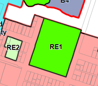
Figure 1: Existing amenities block that is proposed to be
altered to create a clubhouse on an upper floor
The land on which the club house is proposed is zoned RE1
Public Recreation under Byron LEP 2014 (Figure 2). The clubhouse fits
with the definition of Recreation Area and is permitted with Council
consent.
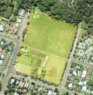
Figure 2: The land on which the club house is located is
zoned RE1 under Byron LEP 2014
1.2 Description
of the site
The subject land is approximately 5.13 hectare lot (Lot 444
Section 28 DP 758207) located in Byron Bay (Figure 3). It is bounded by Cowper
Street to the east, Tennyson Street to the west, Carlyle Street to the south
and the Sandhills Crown land to the north. It is Community Land pursuant to the
Local Government Act 1993 and is owned by Council. Surrounding land is
generally residential in nature with a mix of one and two storey development.
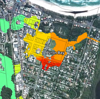
Figure 3: The land is a single lot that is a developed
sports facility.
The site is mostly sports fields and courts, amenities and
clubhouses and small areas of passive open space with scattered native shade
trees. It includes a popular east/ west shared path. The War Memorial and
Memorial Gates are located at its western edge along Tennyson Street.
Electricity and telephone are connected to the subject land
and it is connected to reticulated water and sewerage. It is supplied with a
Council solid waste and recycling service. The subject land does not
contain any native vegetation mapped as ecologically significant. It is
affected by flooding in all events from the 10 year ARI through to the probable
maximum flood (PMF). Figure 4 shows the area affected in the 100 year ARI event
that is the design flood event.
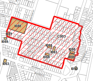
Figure 4: The 100 year ARI event affects that subject land.
The land is not listed as a heritage item but is immediately
adjacent to a Heritage Conservation Area (HCA) Figure 5.

Figure 5: The land is adjacent to a Heritage Conservation
Area
The entire Byron Recreation Ground is identified as
“unhealthy building land” on Council’s mapping system (Figure
6). It is not listed on Council’s contaminated land register and is
not identified as a site that has received mineral sands tailings. The
“unhealthy building land” designation appears to be as a result of
historic drainage issues as there is no clear evidence of a past use that would
have caused contamination. Parts of the site have been filled over the
years through its use as a sports ground. The proposed clubhouse will be
on land that has been filled. Minimal ground disturbance is anticipated
for the upper floor alterations.
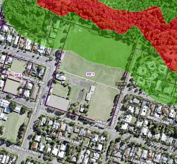
Figure 6: The entire site is mapped as “unhealthy
building land”.
Land immediately to the north of the subject land includes
vegetation mapped as having a bushfire hazard. The buffer to this vegetation
affects the northern part of the site but not the location of the proposed
clubhouse.
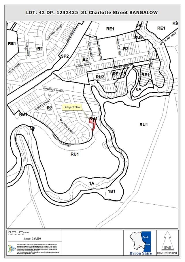
Figure 7: The proposed clubhouse if not affected by bushfire
hazard (red) or buffer (green)
1.3 Description
of the proposed development
The applicant wants to keep the existing single storey
amenities building mostly as is and add a second storey to part of it. The
upper floor will yield about 151m2 of enclosed floor space to be
used for offices, toilets, storage, a small kitchen and a general purpose club
room. It will also include balconies on the north and east side with a combined
area of 100 m2. The existing ground floor will remain as is,
other than modifying the existing physio/coaches room into a foyer and
stairwell to the upper floor. The upper floor will also have an access from an
external stair case at the north west corner of the building. The roof of the
clubhouse will include a solar array. Signage for the football club is proposed
on the south facing gable end of the upper floor.
Although not shown on plans, the applicants have indicated
that they intend to install a lift chair in the internal foyer to enable
disabled persons to access the upper floor. The upper floor materials will be
light weight cladding and a metal roof in earth tones to match the existing
structure. The lower floor (existing) is largely brick on concrete slab.
Use of the new clubhouse is proposed to be dominated by
football club activities such as a supporter viewing area, post-match
presentation area, club offices and meetings. All training is generally
completed by 9pm. Matches are completed by 9:30 pm with field lighting switched
off at 10pm. Club activity will be completed at 11pm each day at the latest.
The Football club has stated that it intends to rent out the
venue up to 6 times per year to other community groups. No external groups will
be allowed to use the facility after 10 pm. Noise will need to comply with
industrial noise policy. (Note: this consent does not permit the use of this
site for events, etc).
The Football club would like to lease the clubhouse and take
on maintenance of it as part of that lease process. (Note: this consent does
not address maintenance or lease issues).
2. SUMMARY
OF GOVERNMENT/EXTERNAL/ INTERNAL REFERRALS
|
|
Summary of Issues
|
|
Environmental Health Officer
|
Supported conditionally. Comments included in relevant
report sections.
|
|
Principal Engineer - Systems Planning, Utilities
|
No Objections. The BB FC is able to demonstrate that it
can meet the exemption criteria for water and sewer fees in section 2.7 of
Council’s DSP as a non profit charitable organisation that makes a
significant contribution to the community. There are Council pipelines in
proximity to the proposed balcony supports and stairs. Compliance with
Council Policy 4.20. Building Over Pipelines and Other Underground
Structures is required.
|
|
Engineer
|
No Objections. On the basis that the club house is to be
used by the existing football club members then it will not result in
additional traffic or car parking. If this development is to be used for
external functions, parties, wedding or events this development consent must
be amended to account for car parking and traffic requirements that would be
generated by such uses.
|
|
Building Services Supervisor
|
No Objections. The proposed works are able to satisfy the
BCA. A platform lift for disabled persons is required to access the upper
floor. This type of lift is able to satisfy the BCA.
The existing building will need to be structurally
adequate for future loads. Engineers to certify as part of Construction
Certificate.
|
|
Dept of Industry (Lands and Forestry)
|
No Objections. However, development should not encroach on
any Crown land or affect Crown land in any way. Note that the nearest Crown
Land is Lot 457 DP 1087879 and comprising
Reserve 755695 for Future Public Requirements notified 29
June 2007 (Sandhills); and Public Crown Road (part Cowper Street).
|
3. SECTION
79C – MATTERS FOR CONSIDERATION – DISCUSSION OF ISSUES
Having regard for the matters for consideration detailed in
Section 79C(1) of the Environmental Planning & Assessment Act 1979, the
following is a summary of the evaluation of the issues.
State/Regional Planning
Policies and instruments - Issues
3.1. STATE/REGIONAL
PLANNING POLICIES AND INSTRUMENTS
|
Requirement
|
Requirement
|
Proposed
|
Complies
|
|
State Environmental
Planning Policy 55 – Remediation of Lands
|
A consent authority must not
consent to the carrying out of any development on land unless:
(a) it has considered
whether the land is contaminated, and
(b) if the land is
contaminated, it is satisfied that the land is suitable in its contaminated
state (or will be suitable, after remediation) for the purpose for which the
development is proposed to be carried out, and
(c) if the land
requires remediation to be made suitable for the purpose for which the
development is proposed to be carried out, it is satisfied that the land will
be remediated before the land is used for that purpose.
|
The Byron Recreation Ground
has been used since the1930s as a recreation area. It is mapped as
“unhealthy building land” most likely as a result of it being
poorly drained. There is no clear evidence of a past use that would result in
contamination.
The proposed development is an
upper storey addition and minimal ground disturbance is required.
As the proposed development is
a non-residential use of the land it is suitable for this location.
No further investigation is
warranted.
|
Yes
|
|
SEPP 71 Coastal Protection
(NSW Coastal Policy 1997)
|
Clause 7 requires Council to
consider certain matters in determining a DA in the coastal zone. These are
set out in Clause 8 of the SEPP. These matters cover the key issues of
the NSW Coastal Policy.
|
The subject land is set back
approximately 0.5 km from the high water mark at the nearest beach and it is
in the coastal zone.
(a) the application
is consistent with the aims of this Policy,
(b) the development
will not impact existing public access to and along the coastal foreshore for
pedestrians or persons with a disability ,
(d) the development
is suitable given its type, location and design and its relationship with the
surrounding area given there is a mix of one and two storey dwelling sin the
surrounds,
(e) the development
will not have any detrimental impact on the amenity of the coastal foreshore,
including no overshadowing of the coastal foreshore and no significant
loss of views from a public place to the coastal foreshore,
(f) the scenic
qualities of the New South Wales coast will remain unchanged by this
development,
(g) no threatened fauna
(within the meaning of the Threatened
Species Conservation Act 1995) and plants (within the meaning of that
Act), and their habitats will be affected by this development,
(h) no fish or
marine vegetation or their habitat will be affected,
(i) existing
wildlife corridors will not be impacted as no vegetation is to be removed,
(j) the site is not
impacted by coastal processes or coastal hazards,
(k) measures to
reduce the potential for conflict between land-based and water-based coastal
activities,
(l) the development
is unlikely to impact the cultural places, values, customs, beliefs and
traditional knowledge of Aboriginals,
(m) the development
will not impact the water quality of coastal waterbodies,
(n) the development
is set back approximately 90 metres from the nearby HCA conservation and
mature trees are located in this buffer. The heritage or historic
significance of this locality is unlikely to be impacted by this development,
(o) the development will
not impact on compact towns and cities,
(p) the cumulative
impacts of the proposed development on the environment are minimal given the
sporting related use of the subject land. A solar array for the roof
will offset energy usage making the building more energy balanced than it
currently is. Water efficient toilets and showers will be installed to reduce
water usage.
|
|
|
Building Code of Australia
|
Class 9b building
|
The proposed works are able to
satisfy the BCA
|
Yes
|
|
Demolition
|
A Site Waste Minimisation and
Management Plan is required
to assist applicants in
planning for sustainable waste management.
|
Demolition on the site will be
limited to removing the roof of part of the amenities block and modifications
to the ground floor to allow an internal stair well.
A Site Waste Minimisation and
Management Plan has not been prepared but will be required as a condition of
approval.
|
Conditions to apply.
|
|
Disability Access (DDA)
|
Access for persons with
disabilities and integration into surrounding streetscapes without creating
barriers. (Council Res.10-1118)
|
No disability access to the
upper floor has been shown on the plans submitted. In response to an RFI the
applicant has indicated they intend to install a lift chair or platform lift
on the internal stairwell to enable disabled access to the upper floor.
|
Conditions to apply.
|
*
Non-complying issues discussed below
3.2. BYRON
LOCAL ENVIRONMENTAL PLAN 2014
Zone: Zone No. RE1 Public Recreation
Definition: Dual occupancy (detached) dwelling
|
LEP Requirement
|
Summary of Requirement
|
Proposed
|
Complies
|
|
Meets zone objectives
|
• To enable land to be used for public
open space or recreational purposes.
• To provide a range of recreational
settings and activities and compatible land uses.
• To protect and enhance the natural
environment for recreational purposes.
|
The development is consistent with the objectives of the
RE1 zone because the proposed club house is a building ancillary to the use
of the site for recreation purposes (sport). It will not unduly impact on the
setting and is compatible with adjacent sporting uses.
It will not impact on the natural environment.
|
Yes
|
|
Permissible use
|
The clubhouse fits with the definition of Recreation
Area and is permitted with Council consent.
Recreation Area means a place used for outdoor
recreation that is normally open to the public, and includes:
(a) a children’s playground, or
(b) an area used for community sporting
activities, or
(c) a public park, reserve or garden or the
like,
and any ancillary buildings, but does not include a recreation
facility (indoor), recreation facility (major) or recreation facility
(outdoor).
|
Recreation Area
|
Yes
|
|
4.3 Height of buildings
|
This clause requires that buildings not exceed the height
shown on the Height of Buildings map. In this case the prescribed maximum
height is 9 metres.
|
The building will be a maximum height of 7.5 metres above
ground level.
|
Yes
|
|
5.5 Development within the coastal
zone
|
This clause duplicates the provisions of the NSW Coastal
Policy 1997.
|
Compliance with this clause is covered previously in the
section above addressing SEPP 71.
|
Yes
|
|
6.1 Acid Sulfate Soils
|
This clause requires ASS assessment if ASS are likely to
be disturbed on the site.
|
The subject land that is classified as ASS Class 3.
However the land on which the clubhouse is to be located has been filled.
Minimal soil disturbance is proposed. It will be limited to post holes for
veranda posts and the base of the external stairs.
|
Yes
|
|
6.2 Earthworks
|
Earthworks that require consent should have minimal impact
on environmental functions, neighbouring uses, cultural heritage and
surrounding land.
|
Minimal soil disturbance is proposed. It will be limited
to post holes for veranda posts and the base of the external stairs. The
small amount of disturbance will not affect the environment or impact on
neighbours or surrounding land. All works need to avoid Council pipelines in
the vicinity of the amenities.
|
Yes
|
|
6.3 Flood Planning
|
This clause requires that Council consider a range of
issues for any development at or below the flood planning level. The subject
land is partly below the flood planning level (1:100 ARI flood event plus 0.5
m freeboard).
|
The clubhouse is an upper level structure that will be
well above flood heights for this location.
The existing lower level amenities building was not built
to be entirely above the flood planning level so the upper floor will provide
a flood refuge for sporting equipment that may be stored on the site.
|
Yes
|
|
6.6 Essential services
|
The development should have adequate
· water
· sewer
· electricity
· stormwater
· vehicle access
|
The existing building is connected to reticulated water
supply, sewerage and electricity and this will also service the upper floor
club house. The site also has controlled vehicle access. Stormwater is a
problem on this flat site but has been addressed in past approvals. The
proposed alteration to create a club house will not significantly exacerbate
stormwater issues.
|
Yes
|
* Non-complying issues
discussed below
Byron Local Environmental Plan
2014 - Issues
There are no issues of non-compliance with LEP 2014 that
raise any concerns.
Draft EPI that is or has been
placed on public exhibition and details of which have been notified to the
consent authority - Issues
There are no issues that relate to draft LEPs that have been
placed on public exhibition.
3.3 DEVELOPMENT
CONTROL PLANS
Development Control Plan 2014
Chapter B3 – Services
The purpose of this Chapter is to identify the minimum
requirements necessary to adequately service development for water, sewer,
stormwater management, on-site effluent disposal and other necessary
infrastructure. The site has reticulated town water supply, sewerage,
reticulated power and communications.
The site is flat and has a history of poor drainage.
However, past filling and stormwater drainage that links to the existing
amenities building can be use by the clubhouse on the same footprint. The
application complies with the requirements in this chapter.
Council records show that a sewer pipeline and recycled
water pipeline are both located in proximity to the proposed club house. It is
important that buildings are not constructed over these pipelines and that
posts for the proposed verandah are not too close to pipelines or cause damage
to them.
Chapter B4 – Traffic
Planning, Vehicle Parking Circulation and Access
The purpose of this Chapter
is to provide guidelines, controls and standards for traffic planning, vehicle
access, circulation and parking for developments. This application
provides no dedicated parking for the clubhouse and relies on the surrounding
street parking. The Byron Recreation Ground does not have any dedicated
parking area and has always relied on street parking. A Recreation
Area is not listed as a specific land use in the parking schedule in this
chapter.
Most clubhouse users will
park on the street and walk a short distance into the ground to use the club
house for games or training, etc. Delivery vehicles and construction vehicles
can access the site via locked gates. Pedestrians and cyclists can easily
access the centrally located site. The clubhouse is a relatively minor
expansion of usable floor space and is intended to be used by the club members
that already use the site anyway. It is therefore not expected to result in an
increase in traffic and parking demand. If its use is confined to the
definition of a Recreation Area then it does not need to supply
additional parking. It should be noted that Recreation Area does not
include a recreation facility (indoor), recreation facility (major) or
recreation facility (outdoor). This consent does not cover a function
centre which means a building or place used for the holding of events,
functions, conferences and the like, and includes convention centres,
exhibition centres and reception centres, but does not include an entertainment
facility. It also does not include a food and drink premises.
This application complies with the parking requirements of
the DCP.
Chapter B5 – Providing for Cycling
This Chapter aims to retain, increase and improve cycling
facilities; consistently review cyclist needs; and provide a consistent
standard of facilities for cyclists within the area.
The clubhouse is a relatively minor expansion of usable
floor space and is intended to be used by the club members that already use the
site anyway. The site already has a cycle rack close to the proposed
clubhouse site. A Recreation Area is not listed as a specific land
use in the bicycle parking schedule in Chapter B4.
This application complies with the cycling requirements of
the DCP.
Chapter B6 – Buffers and Minimising Land Use
Conflicts
The purpose of this Chapter is to provide advice and
guidance on planning for land use compatibility, avoiding land use conflict and
the use of buffers. The application is located on RE1 zoned land that is
surrounded on three sides by R2 Low Density Residential land. The site
has been use for recreation purposes since the 1930s and the clubhouse is
consistent with that long term use.
The nearest dwellings in Cowper and Carlyle Streets are
approximately 120 metres from the proposed club house. However,
sound from the club house upper floor would travel this distance easily,
particularly at night when background noise subsides. Management of noise (and
lights) at the site needs to be a focus of the Football Club if the impacts on
residential neighbours are to be kept reasonable.
Operating hours for the club house should be restricted to
preserve neighbourhood amenity as follows: Monday to Saturday - 9.30pm and Sunday
– 6.30pm.
The subject land does not contain vegetation classified as a
bushfire hazard and the buffer to vegetation on the adjacent Sandhills site
does not affect the proposed clubhouse site. A detailed bushfire hazard
assessment is not required.
Chapter B8 – Waste
Minimisation and Management
Council requires a Site Waste
Minimisation and Management Plan for this development. No plan has been
provided with the statement of environmental effects. It should be
provided as a condition of approval prior to the issue of a construction
certificate.
Chapter B9 – Landscaping
This Chapter provides advice, guidelines and controls
relating to design, construction and maintenance of landscape and vegetation
associated with all developments on land to which Byron LEP 2014 applies.
In this case a landscape plan was approved for the original ground floor
amenities building. This upper floor extension does not warrant any changes to
that plan.
Chapter B10 – Signage
The purpose of this Chapter is to provide guidelines and controls
for signage consistent with the objectives and provisions of Byron Local
Environmental Plan 2014 and State Environmental Planning Policy 64 –
Advertising and Signage (SEPP).
The development plans show a wall sign on the south facing
gable end of the upper floor structure depicting the football club logo. This
is effectively a building identification sign. No dimensions or details
are provided. This sign faces the HCA and it is reasonable that it be kept to a
modest size (2.5 m2 is suggested by the DCP) and not be illuminated.
Chapter B11 - Planning For Crime Prevention
This Chapter aims to ensure that all development plays a
role in enhancing the safety of our communities; to reduce the vulnerability of
our community to crime through good urban design; and to
require developers to work with the community and the NSW
Police Force to create a safer environment and be active in practical crime
prevention.
The DCP does not identify this development as one that must
be accompanied by a formal Crime Risk Assessment prepared in accordance with
NSW Police Force Safer by Design guidelines. The SEE does not address the CPTED
principles as required by the DCP. The four principles that should have
been addressed are:
Surveillance – The upper floor club house can be
easily viewed from all directions including three public streets and the
various playing fields around it. It is easily viewed form the busy main shared
path that runs east /west across the recreation grounds. When the club is
being used it will be possible to view most of the Recreation Grounds form the
balcony and this will increase passive surveillance of the whole sports
facility.
Access control - This aspect can be improved. The access to
the upper floor stairs needs to be gated (as the canteen etc is now) to ensure
that it does not become a hiding place after dark. Other than that it is an
upper floor addition and access is only by internal stairs or the external
stairs.
Territorial reinforcement- The clubhouse will be perceived
as “belonging” to the Byron Bay FC and this creates a sense of
territory that promotes a sense of ownership and pride in the football players
that use the space. This is not to say that Council is giving exclusive
use rights to the football club. That matter is not part of this development
application.
Space management - Strategies relevant to this site include
activity coordination (football club events), site cleanliness, rapid repair of
vandalism and graffiti ( use of murals) , the replacement of burned out security
lighting and the removal or refurbishment of decayed physical elements.
The Byron Recreation Ground has been the subject of
complaints relating to poor behaviour, homeless camping, backpackers camping in
cars on the streets, littering and crowd behaviour at sporting events. These
are ongoing site management matters that will not be exacerbated by this
development.
Chapter B13 – Access and Mobility
The Commonwealth Disability Discrimination Act 1992 (DDA)
is the primary Australian statute that aims to eliminate discrimination on the
grounds of disability. Section 23 of the DDA makes it unlawful to discriminate
against people with a disability or their associates in relation to access to
and use of premises that the public enter or use.
The site is accessed by a concrete path from three
directions. This includes access to ground floor toilets and changes rooms. The
upper floor will be accessible via an internal chair lift incorporated into the
internal stair well. This chair lift is not shown on plans and needs to be
included as a condition of approval. This access must be provided
to and within the facilities in accordance with the provisions of the BCA and
AS1428.1 – Design for Access and Mobility –General Requirements for
Access – New Buildings.
Parking is not being provided however it would be
appropriate that a space along Carlyle Street be dedicated as a disabled
parking space when this area of parking is formalised.
Chapter C1 – Non Indigenous Heritage
The purpose of this Chapter is to set out controls and
guidelines that complement Byron LEP 2014 in relation to development to or in
the vicinity of heritage items and Heritage Conservation Areas. Any development
to or in the vicinity of heritage items or Heritage Conservation Areas will
need to be in harmony with the surroundings, both natural and constructed, and
enhance the physical context valued by the community and by the Shire's
increasing number of visitors.
In this case the club house is a simple design that has a
neutral impact on the heritage character of the adjacent HCA. It does not
compromise the significance and character of the components of the HCA. The
club house is set well back from the HCA (about 90 metres) and there are
substantive shade trees in the recreation grounds that filter views to the club
house from many angles. Signage on the club house building will not impose on
the HCA.
Chapter C2 – Areas Affected by Flood
The purpose of this chapter is to identify development
requirements for flood liable lands that are appropriate for the degree of
flood hazard on that land.
The land on which the club house is proposed is flood
affected. The floor level proposed for the upper level is well above the
3.9 metre AHD that represent the design flood in this location. The upper floor
clubhouse is not flood affected. It will provide an opportunity to store
gear upstairs temporarily if a flood is going to inundate the ground floor of
the building. This flood free storage area may also be useful for other users
of the Byron Recreation Ground in times of flood.
Flood isolation of the club house is likely to be short
duration given that the area is at the edge of the flood affected land and is
caused by heavy local rainfall rather than overbank flower from a river with a
large catchment. Flood velocity is not an issue in this situation.
Chapter C3 - Visually
Prominent Sites, Visually Prominent Development and View Sharing
Council is committed to
ensuring that the Shire’s landscape character and visual quality are
maintained and where possible enhanced in the development process. The
visual quality of an area can be strongly influenced and affected by the
treatment of visually prominent sites and locations. These include land in the
coastal zone, ridgetops and nearby lands, escarpments, environmentally
sensitive sites on sloping land and any site where development has the
potential to degrade visual amenity.
The subject land is in the coastal zone and therefore it
meets the definition of a visually prominent site and this chapter applies.
A visual impact statement was not supplied by the applicant
and is not warranted in this case.
The site is not significant when viewed form public places
such as the beach or Cape Byron. The proposed clubhouse will not disrupt or
impact on neighbours’ views or prominent viewscapes.
Other Development Control
Plan/s - Issues
The current plan of management for the subject land is the
Byron Recreation Ground Plan of Management , 2002. The site of the clubhouse is
classified as Sports Ground under this plan. Land in this category is used or
proposed to be used primarily for active recreation involving organised sports
or the playing of outdoor games. The amenities and proposed clubhouse are
ancillary to the playing of football on this site. This is consistent with the
Plan of Management (PoM).
Many of the actions of this plan of management have been
implemented since 2002. Construction of the ground floor amenities block above
which the clubhouse is to be built was an action of this PoM. It could be
argued that this clubhouse is an extension of the amenities block that
embellished the amenities by providing more toilets and showers as well as a
covered spectator area (the balconies ) and a general meeting room and
offices. The PoM does clearly indicate that all new structures should be
shared use facilities. This aspect needs to be negotiated between Council and
the Byron Bay FC.
Three versions of a draft PoM to replace the 2002 version
have been prepared for Byron Recreation Grounds over the last few years and
none have been finally adopted.
On 1st February 2018 Council resolved in relation
to the Byron Recreation Grounds to:
Confirm that the draft Plan of Management will facilitate
only those alternative community or commercial uses that:
a) are compatible both with the
categorisation of the facility and the current sporting uses at the Grounds;
and
b) that do not interfere with
the scheduled use of the sporting fields nor degrade fields or facilities
utilised by sporting users.
The proposed club house is compatible with the current
categorisation of the site and the various sporting uses at the site. Other
than during construction it will not interfere with the scheduled use of the
fields and facilities. It will not degrade the fields or facilities.
A further revised draft PoM will be prepared and exhibited
in due course. It is difficult to give any weight to previous drafts until they
are finalised and adopted.
3.4 The likely
impacts of that development, including environmental impacts on both the
natural and built environments, and social and economic impacts in the locality
Subject to consent conditions
the proposed upper floor clubhouse is not likely to result in any negative
impacts on the natural and built environment nor is it likely to negatively
impact socially or economically on the locale.
3.5 The
suitability of the site for the development
The site has an adequate size and shape to accommodate the
development. The existing amenities block is a suitable location being
central to the recreation grounds and adjacent to the football fields. No
native vegetation needs to be removed to enable the development. The upper
floor is not affected by hazards and will not impact significantly on the
nearby HCA. It is suitable for a club house development as
proposed.
3.6 Submissions
made in accordance with this Act or the regulations
The application was lodged with letters of support from the
Byron Bay Rugby Club, Byron Bay Cricket Club, Byron Bay Netball, 1st
Byron Bay Scout Group, RSL Byron Bay Sub Branch, Byron Bay Public School, Byron
Community Primary School, Byron Bay High School, and St Finbarr’s Primary
School. Although they are not technically submissions they do show that other
site users support the development.
There were two submissions made on the development
application from residents of Carlyle and Cowper streets. The submissions both
object to the development and make the following points:
1. The
DA intends to have six functions a year and has a stated capacity of 166
persons seated and 332 standing. Object to this being a new function centre
Planning Response: This application is for a
recreation area with the clubhouse being ancillary to the sporting use of the
site by the football club (and potentially other sporting users). It is not
being granted consent for a function centre. (A function centre means a
building or place used for the holding of events, functions, conferences and
the like, and includes convention centres, exhibition centres and reception
centres). It is not being granted consent for a food and drink
premises either.
2. Traffic
and parking are major issues with this site already and with no parking
proposed for this DA it will only get worse.
Planning Response: The application is for
embellishment of facilities primarily for the Byron Bay FC that already use the
site on a regular basis. If this is the case then there will not be
additional parking demand generated. Although street parking is annoying
for neighbours there is minimal opportunity for off street parking in this
location (without reducing sports facilities) and sports related use has taken
place on this site for many decades based on street parking. The site is
not being given consent to be used as a function centre or a food and drink
premises.
3. A
two storey building is not in keeping with surrounding buildings.
Planning Response: The other buildings on the
recreation grounds are all single storey but surrounding residential streets
have two storey developments. The proposed building is below the 9 metre height
limit and will not impact on views or cause problematic overshadowing to other
land. It is consistent with the height of nearby trees.
4. Behaviour
of site users and impact of noise, litter etc on surrounding residential land
Planning Response: All sporting venues in residential
areas experience some problems with user behaviour from time to time. This
application is unlikely to exacerbate problems with this site. It is up to the
football club and other sports users to control their own members. If laws are
broken then it is a matter for the police. Council will need to enforce the
conditions of this or any other approvals to ensure that the site is not used
other than in accord with its consents. Noise control is a matter that Council
in conjunction with the Police can take action about. Compliance with NSW noise
laws will be expected at this site and enforced by Council. Imposition of
hours of operation on the clubhouse may assist in reducing noise impacts.
Littering is a matter of concern but requires individuals to be “caught
in the act”.
5. Building
safety and crime prevention
Planning Response: It is agreed that the upper
floor balcony needs to be gated to ensure that it is not a late night crime
venue or a place to party after hours. This can be imposed as a condition of
consent.
6. Hours
of operation
Planning Response: It is appropriate for a
clubhouse in a residential neighbourhood to have restricted operating hours to
preserve neighbourhood amenity as follows: Monday to Saturday - 9.30pm and Sunday
– 6.30pm. This can be a condition of approval.
7. Alcohol
and security
Planning Response: Alcohol licensing is a
matter for the NSW Liquor and Gaming. This consent is not for a Registered
Club, Hotel, Pub, Restaurant or other use that typically has a liquor licence.
It is not a food and drink premises. Any application for a temporary
liquor licence would be assessed by authorities on merit and breaches of
licensing laws are a serious offence. Security is a good idea at larger
sporting events if alcohol is served but this is a decision for the club to
make based on its own risk assessment.
3.7 Public
interest
This development does raise significant issues of public
interest but on balance the proposed clubhouse is an appropriate use of the
site and if managed properly will not compromise the wider public interest in
the site.
4. DEVELOPER
CONTRIBUTIONS
4.1 Water
& Sewer Levies
The proposed upper floor club house will be connected to
reticulated water or sewerage. The ground floor is already
connected. No levies apply because the Byron Bay FC is a not for profit
sporting organisation that contributes to the Byron Shire community. This
development has met criteria listed in Section 2.7 of Council’s Developer
Servicing Plan for water supply and sewerage and is therefore exempt from water
and sewerage developer contributions.
4.2 Section
94 Contributions
The works are an embellishment of an existing recreation
area, do not involve dwellings or accommodation of any type and no
contributions will be required.
6. DISCLOSURE
OF POLITICAL DONATIONS AND GIFTS
|
Has a Disclosure Statement
been received in relation to this application
|
No
|
|
Have staff received a
‘gift’ from anyone involved in this application that needs to be
disclosed. Where the answer is yes, the application is to be determined by
the Director or Manager of the Planning, Development and Environment
Division.
|
No
|
Provide Disclosure Statement
register details here: Nil
7. CONCLUSION
Council recognises the role of local sporting clubs in
arranging organised sport for the Byron Shire community. Council supports uses
that are compatible both with the categorisation of the facility and the
current sporting uses at the Byron Recreation Grounds; and that do not
interfere with the scheduled use of the sporting fields nor degrade fields or
facilities utilised by sporting users.
It is also important that use of the clubhouse is restricted
to sports related matters and does not interfere with the amenity of the
neighbourhood. This consent does not include approval for a function
centre which means a building or place used for the holding of events,
functions, conferences and the like, and includes convention centres,
exhibition centres and reception centres. This consent does not include
approval for a food and drink premises of any type, such as a restaurant
or café. Appropriate conditions have been recommended in relation to
hours of operation.
This development meets the Council’s requirements.
Conditional approval is appropriate.
Staff Reports - Sustainable Environment and Economy 13.12
Report No. 13.12 PLANNING
- Development Application 10.2017.429.1 Dual Occupancy (Detached) 31 Charlotte
Street , Bangalow
Directorate: Sustainable
Environment and Economy
Report
Author: Simone
Kenyon, Planner
File No: I2018/258
Theme: Ecology
Development and Approvals
Proposal:
|
Proposal description:
|
Dual Occupancy
(Detached),
|
|
Property description:
|
LOT: 42 DP: 1232435
|
|
31 Charlotte Street BANGALOW
|
|
Parcel No/s:
|
268781
|
|
Applicant:
|
Mrs N E Dodge & Mr V Tassiello
|
|
Owner:
|
Bodhi Superannuation Pty Ltd & Mrs N E Dodge & Mr
V Tassiello
|
|
Zoning:
|
PART R2 Low Density Residential/PART RU1 Primary
Production/PART DM Deferred Matter – 1A General Rural Zone
|
|
Date received:
|
11 August 2017
|
|
Integrated Development:
|
No
|
|
Public notification or exhibition:
|
- Level 1 advertising
under DCP 2014 Part A14 – Public Notification and Exhibition of
Development Applications
- Exhibition
period: 24/8/17 to 6/9/17
- Submissions received:
Nil
|
|
Planning Review Committee:
|
N/A
|
|
Delegation to determination:
|
Council
|
|
Issues:
|
- 30% variation to the
minimum site area permissible for dual occupancies within the RU1 Primary
Production zone
|
Summary:
Development approval is sought for a dual occupancy
(detached) at 31 Charlotte Street, Bangalow. The property is zoned Part R2 Low Density
Residential/Part RU1 Primary Production/Part DM Deferred Matter – 1A
General Rural Zone in accordance with the Byron Local Environment Plans 2014
and 1988 respectively. The battle axe shaped allotment has a total land area of
1227m² and is currently vacant. It is proposed that each dwelling will
provide for three bedrooms and double garage.
The proposed development is generally consistent with the
relevant environmental planning instruments and planning controls applicable to
the site including the LEP and DCP provisions for this type of development.
However part of the site although a residential allotment is partly zoned RU1
Primary Production and a smaller area is zoned 1(a) General Rural in the north
east corner of the property. Councils planning controls establish a minimum lot
size for dual occupancy of 4000 m2 in the RU1 Zone. However due to
the inherent residential nature of this property, its access to necessary
services and its location within a clearly residential area of Bangalow a
variation is supported in this instance.
It is considered the proposal raises no significant issues
in terms of environmental impacts which cannot be managed through reasonable
and relevant conditions of approval, and the site is considered suitable for
the development. As such the application is recommended for approval subject to
conditions of consent.
NOTE TO COUNCILLORS:
In accordance with the
provisions of S375A of the Local Government Act 1993, a Division is to be
called whenever a motion for a planning decision is put to the meeting, for the
purpose of recording voting on planning matters. Pursuant to clause 2(a)
under the heading Matters to be Included in Minutes of Council Meetings of
Council's adopted Code of Meeting Practice (as amended) a Division will be
deemed to have been called by the mover and seconder of all motions relating to
this report.
|
RECOMMENDATION:
That pursuant to
Section 80 of the Environmental Planning and Assessment Act 1979, development
application no. 10.2017.429.1 for a Dual Occupancy (Detached), be granted
consent subject to conditions listed in Attachment E2018/19348.
|
Attachments:
1 Plans
10.2017.429.1 31 Charlotte Street, Bangalow , E2018/25319
⇨
2 conditions
of consent 10.2017.429.1 31 Charlotte Street Bangalow, E2018/19348 ⇨

Assessment:
1. INTRODUCTION
1.1. History/Background
The subject lot was registered 27
January 2017 as a result of Development Application 10.2011.413.1 which granted
consent for a 42 lot subdivision. The land is currently vacant.
1.2. Description
of the proposed development
This application seeks approval for a Dual Occupancy (Detached) comprising three
bedrooms, modest living and dining areas with suitable area for car parking
landscaping and private opne space. Plan extracts are provided below.
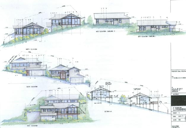
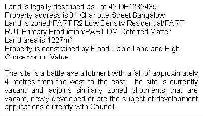
1.3. Description
of the site

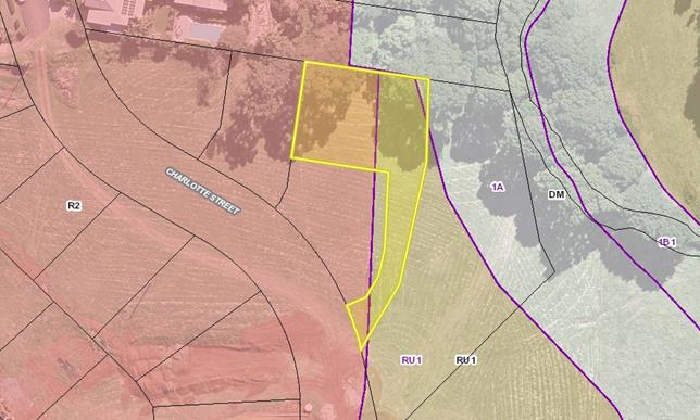
2. SUMMARY OF
REFERRALS
|
Referral
|
Issue
|
|
Development Engineer
|
No objections subject to conditions. See Doc # A2017/29006.
|
|
Building Surveyor
|
No objections subject to conditions. See Doc # A2017/21419.
|
|
S64 Systems Planning Officer
|
No objections subject to conditions. See Doc # A2017/21422.
|
|
S94 Contributions Officer
|
No objections subject to conditions. See Doc # A2017/21429.
|
3. SECTION 79BA
– BUSH FIRE PRONE LAND
Under section 79BA of the Act,
Council must be satisfied prior to making a determination for development on
bush fire prone land, that the development complies with the document ‘Planning
for Bush Fire Protection 2006’. The site is not bush fire prone land.
4. SECTION 79C
– MATTERS FOR CONSIDERATION – DISCUSSION OF ISSUES
Having regard to the matters for
consideration detailed in Section 79C(1) of the Environmental Planning and
Assessment Act 1979 (EP&A Act 1979), the following is a summary
of the evaluation of the issues.
4.1 State Environmental
Planning Instruments
4.2A Byron Local Environmental Plan 2014 (LEP 2014)
LEP 2014 is an applicable matter
for consideration in the assessment of the subject development application in
accordance with subsection 79C(1) of the EP&A Act 1979 because it
applies to the subject land and the proposed development. The LEP 2014 clauses
that are checked below are of relevance to the proposed development:
|
Part 1
|
☒1.1|
☒1.1AA| ☒1.2| ☒1.3| ☒1.4| ☒Dictionary| ☒1.5| ☒1.6| ☒1.7| ☒1.8| ☐1.8A| ☒1.9|
☐1.9A
|
|
Part 2
|
☒2.1|
☒2.2 | ☒2.3 |☒Land Use Table | ☐2.4 | ☐2.5 | ☐2.6 | ☐2.7 | ☐2.8
|
|
Part 3
|
☐3.1|
☐3.2| ☐3.3
|
|
Part 4
|
☐4.1|
☐4.1A| ☐4.1AA| ☐4.1B |☐4.1C| ☐4.1D| ☒4.1E| ☐4.2| ☒4.2A| ☐4.2B| ☐4.2C| ☒4.2D|☒4.3|☒4.4 |☐4.5 | ☒4.6
|
|
Part 5
|
☐5.1|
☐5.2| ☐5.3| ☐5.4| ☐5.5| ☐5.6| ☐5.7| ☐5.8|☐5.9| ☐ 5.9AA| ☒5.10| ☐5.11| ☐5.12|
☐5.13
|
|
Part 6
|
☐6.1|
☒6.2| ☒6.3| ☐6.4| ☐6.5| ☒6.6| ☐ 6.7| ☐6.8| ☐6.9
|
Note: The floor space ratio applies only to the portion of land
that is zoned R2 Low Density Residential and the gross floor area of structures
within this zone is compliant. It is worth noting that the intent for the site
is that of R2 Low Density Residential and the boundary lines are an anomaly in
the mapping. As part of general housekeeping amendments to BLEP 2014, the
subject site will in the not too distant future will be located in its
entirety, within the R2 Low Density Residential zone. As such, a calculation of
the proposed gross floor area applied to the total land area indicates that the
proposal would still comply with the FSR standard.
In accordance with LEP 2014
clauses 1.4 and 2.1 – 2.3:
a) The proposed development is defined in
the LEP 2014 Dictionary as Dual Occupancy
(Detached),
b) The land is partly within R2 Low
Density Residential/PART RU1 Primary Production/PART DM Deferred Matter –
1A General Rural Zone according to the Land Zoning Map. Given that the proposal
is wholly located within the areas mapped R2 Low Density Residential and RU1
Primary Production an assessment against BLEP 2014 is required and BLEP 1988 is
not applicable.
c) The proposed development is
permissible with consent; and
d) Regard is had for the Zone Objectives
as follows:
|
R2 Low Density Residential
Zone Objectives
|
Consideration
|
|
To provide for the housing
needs of the community within a low density residential environment; and to
enable other land uses that provide facilities or services to meet the day to
day needs of residents.
|
The proposed dual occupancy
will meet the day to day needs of the immediate residents.
|
|
RU1 Primary Production Zone Objective
|
Consideration
|
|
· To
encourage sustainable primary industry production by maintaining and
enhancing the natural resource base;
· To
encourage diversity in primary industry enterprises and systems appropriate
for the area;
· To
minimise the fragmentation and alienation of resource lands;
· To
minimise conflict between land uses within this zone and land uses within adjoining
zones;
· To
encourage consolidation of lots for the purposes of primary industry
production;
· To
enable the provision of tourist accommodation, facilities and other
small-scale rural tourism uses associated with primary production and
environmental conservation consistent with the rural character of the
locality; and
· To
protect significant scenic landscapes and to minimise impacts on the scenic
quality of the locality.
|
The proposal is unlikely to
conflict with existing adjacent rural land uses. The proposal in its current
location will not adversely impact on the scenic and environmental qualities
of the site.
|
The remaining checked
clauses have been taken into consideration in the assessment of the subject
development application in accordance with subsection 79C(1) of the EP&A
Act 1979. The proposed development complies with all of these clauses (in
some cases subject to conditions and/or to the satisfaction of other assessing
officers), except in relation to Development Standard 4.1E which
stipulates the following:
4.1E Minimum lot sizes for
dual occupancies, multi dwelling housing and residential flat buildings
(1) The objective of this clause
is to achieve planned residential density in certain zones.
(2) Development consent may be
granted to development on a lot in a zone shown in Column 2 of the table to
this clause for a purpose shown in Column 1 of the table opposite that zone, if
the area of the lot is equal to or greater than the area specified for that
purpose and shown in Column 3 of the table.
|
Column 1
|
Column 2
|
Column 3
|
|
Dual occupancy (attached)
|
Zone R2 Low Density
Residential, Zone R3 Medium Density Residential
|
800m²
|
|
Dual occupancy (attached)
|
Zone RU1 Primary Production,
Zone RU2 Rural Landscape, Zone RU5 Village, Zone R5 Large Lot Residential
|
4,000 m²
|
|
Dual occupancy (detached)
|
Zone RU1 Primary Production,
Zone RU2 Rural Landscape
|
4,000 m²
|
|
Dual occupancy (detached)
|
Zone R2 Low Density
Residential, Zone R3 Medium Density Residential
|
800 m²
|
|
Multi dwelling housing
|
Zone R2 Low Density
Residential
|
1,000 m²
|
|
Multi dwelling housing
|
Zone R3 Medium Density
Residential
|
800 m²
|
|
Residential flat building
|
Zone R3 Medium Density
Residential
|
800 m²
|
The Applicant has submitted a
clause 4.6 variation request (refer to Doc # E2017/90084). The clause 4.6
variation request is considered with reference to relevant matters as follows:
1. Introduction – Summary
of proposed development
The development
application proposes a dual occupancy (detached) on an allotment within the
newly created residential estate on Charlotte Street, Bangalow. The site is
dual zoned R2 low Density Residential and RU1 Primary Production.
2. Clause 4.6 Exceptions to
Development Standards
LEP 2014 clause
4.6 allows the granting of a development consent, even though the development
would contravene a development standard. However Council must first consider a written
request from the Applicant that seeks to justify the contravention of the
development standard by demonstrating:
a) That compliance with the development
standard is unreasonable or unnecessary in the circumstances of the case, and
b) That there are sufficient
environmental planning grounds to justify contravening the development
standard.
Council must be
satisfied that the Applicant’s written request has adequately addressed
the matters required to be demonstrated and that the proposed development will
be in the public interest because it is consistent with the objectives of the
particular standard and the objectives for development within the zone in which
the development is proposed to be carried out (noting that the concurrence of
the Secretary is not required to be obtained in this instance).
3. The Development Standard to
be varied
The development
standard to be varied is the minimum lot size planning control of 4000m²
applicable to this site under LEP 2014 clause 4.1E as described above.
The minimum lot
size planning control is a development standard in accordance with the
applicable definition in section 4 of the Environmental Planning and
Assessment Act 1979 because it is a provision of an environmental planning
instrument in relation to the carrying out of development, being a provision by
or under which requirements are specified or standards are fixed in respect of
any aspect of that development, being the area of land.
4. Extent of Variation to the
Development Standard
The extent of the
variation is 30% as indicated above.
5. Objective of the Development
Standard
The objectives
of development standard subclause 4.1(E) are is to achieve planned residential
density in certain zones. The intent for this particular site was solely for the
purpose of Low Density Residential purposes.
6. Objectives of the Zone
The objectives
of the R2 Low Density Residential and RU1 Primary Productions Zones are stated
and have been addressed in this section of this report above.
7. Assessment – the specific
questions to be addressed:
a) Clause 4.6(3)(a) – Is
compliance with the development standard unreasonable or unnecessary in the
circumstances of the case?
The clause 4.6
written request submitted in support of the DA advises as follows in this
regard:
‘It is
submitted that compliance with the development standard is both unreasonable
and unnecessary in the circumstances of this particular case. The proposed
development includes land identified as RU1 Primary Production in accordance
with the provisions of BLEP14. The approved subdivision of the lot created a
land parcel with multiple zones over the land. The subject site is largely
zoned R2 Low Density Residential. The strict compliance with the development
standard is unreasonable given the approved lot configuration and land use
zoning. It is also submitted that strict compliance with development standard
is unnecessary in the subject circumstances whereby a residential development
is proposed on an approved allotment within an existing urban subdivision and
setting’.
b) Clause 4.6(3)(b) – Are there
sufficient environmental planning grounds to justify contravening the
development standard?
The clause 4.6
written request submitted in support of the DA advises as follows in this
regard:
‘The
environmental planning grounds to justify the development standard relate to
the approved allotment and associated land use zoning. The creation of an
allotment with part of the land zoned RU1 Primary Production, part zoned R2 Low
Density Residential and part zoned 1(a) General Rural has resulted in a
proposal which does not strictly comply with the development standard but is
consistent with the form and scale of development envisaged by the planning
controls’.
c) Clause 4.6(4)(a)(ii) – Is the
proposed development in the public interest? Is it consistent with the
objectives of the standard and the zone as set out above?
The clause 4.6
written request submitted in support of the DA advises as follows in this
regard:
‘The
proposed development is consistent with the objectives of the particular
development standard. The development standard seeks to ensure that development
for the purposes of detached dual occupancy in rural zones is undertaken on
allotments with an adequate area to accommodate the proposed development and
able to cater for servicing of the land, particularly wastewater management. In
the subject case the allotment is connected to Council’s sewerage system
and strict compliance with the minimum lot size is not necessary particularly
having regard for the partial R2 Low Density Residential zoning of the
land’.
The proposal produces a better
planning outcome than one that strictly complies with the development standard
because requiring strict compliance would result in built form that is not in
keeping with the approved and establishing built form of this locality. The
circumstances of the case warrant a more flexible approach to the application
of the minimum lot size development standard, which in this case, is merely due
to zoning mapping that is not reflective of the intended use for this site. The
Applicant’s variation request is supported and the development
application is recommended for approval despite the non-compliance. No public
submissions have been received to the exhibition of the development application
and the proposed development is considered to be in the public interest.
It is further noted that the mapped zoning of the subject
site will be amended as part of Council’s housekeeping amendments to the
BLEP 2014.
4.3 Any proposed Instrument
that has been the subject of public consultation and has been notified to the
consent authority
1. Draft State Environmental
Planning Policy (Coastal Management) 2016 (CM SEPP). The proposal is unlikely
to conflict with this Policy.
2. The Department of Planning and
Environment (‘DPE‘) has announced a Draft Remediation of Land SEPP
(‘Draft SEPP‘) which will repeal and replace the current State
Environmental Planning Policy No 55—Remediation of Land (‘SEPP 55‘).
The Explanation of Intended Effect of the Draft SEPP is on exhibition to 31
March 2018. The Draft SEPP will maintain the two categories of remediation work
currently in SEPP 55:
· Category
1 – works that require development consent; and
· Category
2 – works that may be carried out without development consent.
The proposal is
unlikely to conflict with this Policy.
4.4A Byron Shire Development Control Plan 2014
(DCP 2014)
DCP 2014 is an applicable matter
for consideration in the assessment of the subject development application in
accordance with subsection 79C(1) of the EP& A Act 1979 because it
applies to the land to which LEP 2014 applies. The DCP 2014 Chapters that are
detailed below are of relevance to the proposed development:
Part A: Preliminary
The appropriate plans were
submitted by the applicant. Public Notification was undertaken as per the
requirements of this Chapter.
Chapter B2: Preservation of Trees and Other Vegetation
The proposal does not result in
vegetation removal.
Chapter B3: Services
The
proposal is located on an allotment that is already equipped with services in
the form of water, stormwater, electricity and telecommunications.
Chapter B4: Traffic Planning, Vehicle Parking,
Circulation and Access
Sufficient carparking numbers
have been provided and manoeuvrability within the site has or can be achieved
through conditions of approval imposed by Council’s Development Engineer.
B6 Buffers and Land Use Conflict
It is considered that the
proposal will not result in land use conflicts as the intent for the subject
site was for that of residential purposes. Adjacent rural allotments that are
capable of establishing rural activities will not be impacted upon given the
creek location, existing vegetation and the Council owned eastern adjoining lot
whose intent was for that of recreational activities.
Chapter B8: Waste Minimisation and Management
A Site Waste Minimisation and
Management Plan was submitted by the applicant and considered to be
satisfactory. Conditions of approval will be imposed with regards to the
implementation of this plan.
Chapter B14: Excavation and Fill
The proposal has been designed to
ensure no more than 1 metre of cut is required to facilitate the construction
of garages associated with the dwellings.
Chapter C1: Non-Indigenous Heritage
C.1.6.7 of Chapter C1 requires
development to be consistent with the specific policy provisions for the
Bangalow Heritage Conservation Area included in Chapter E2 Bangalow.
The site is located within a new
estate that is establishing a development pattern of Queenslander style
dwellings. The proposal is considered to be consistent with the forming and
desired built pattern and character of Bangalow. The proposal raises no issues
in terms of heritage.
Chapter C2: Areas Affected by Flood
A small portion of the lot along
the access handle and to the rear eastern corner is mapped as being flood
affected. However, an assessment by Council’s Development Engineer has
determined the site is not flood affected and the access handle provides floor
free access to the proposed dwelling sites.
Chapter D1: Residential Accommodation in Urban,
Village & Special Purpose Zones
The proposal complies with all
required setbacks, the building height plane as well as providing sufficient
carparking and private open space to the dwellings. The proposal has been
designed to minimise any potential for overlooking of adjoining residences
which is somewhat difficult given the battle axe arrangement and the slope of
the land.
Chapter E2: Bangalow
The proposed design complements the bulk, scale and
character of development in the existing town and is compatible between new and
old development in terms of streetscape, landscaping, building materials,
colour, roof pitch and materials.
4.5 Any Planning Agreement or
Draft Planning Agreement?
|
|
Yes
|
No
|
|
Is there any applicable planning agreement or draft
planning agreement?
|
☐
|
☒
|
4.6 Environmental Planning
and Assessment Regulation 2000 Considerations
|
Clause
|
This control is applicable to
the proposal:
|
I have considered this control
as it relates to the proposal:
|
If this control is applicable,
does the proposal comply?
|
|
92
|
Yes
|
Yes
|
Yes
|
|
93
|
Yes
|
Yes
|
Yes
|
|
94
|
Yes
|
Yes
|
Yes
|
|
94A
|
No
|
N/A
|
N/A
|
4.7 Any coastal zone management
plan?
|
|
Satisfactory
|
Unsatisfactory
|
N/A
|
|
Is there any applicable coastal zone management plan?
|
☐
|
☐
|
☒
|
4.8 The
likely impacts of that development, including environmental impacts on both the
natural and built environments, and social and economic impacts in the locality
|
Impact on:
|
Likely significant impact/s?
|
|
Natural environment
|
No. The proposal will not have
a significantly adverse impact on the natural environment of the locality.
|
|
Built environment
|
No. The proposal will not have
a significantly adverse impact on the built environment of the locality.
|
|
Social Environment
|
No. The proposal will not have
a significant social impact on the locality.
|
|
Economic impact
|
No. The proposal will not have
a significant economic impact on the locality.
|
Are there any Council Policies
that are applicable to the proposed development?
4.9 The suitability of the site
for the development
The subject site is an existing
allotment within the R2 Low Density Residential zone. Having regard to the
above assessment of the proposed development, the site is suitable for the
proposal.
4.10 Submissions made in accordance with
this Act or the regulations
No submissions being received by
Council.
4.11 Public interest
The proposed development is
unlikely to prejudice or compromise the public interest or create an
undesirable precedent.
4.12 Section 5A of the EP&A Act 1979
– Significant effect on threatened species
Having regard to sections 5A, 5C
and 5D of the EP&A Act 1979,
there is unlikely to be a significant effect
on threatened species, populations or ecological communities, or their habitats
as a result of the proposed development as the proposal does not propose
vegetation removal.
4.13 Section 5B of the EP&A Act 1979
– Have regard to register of critical habitat
The NSW Critical
Habitat Register does not identify any critical habitat on or adjacent to the
site.
5. DEVELOPER
CONTRIBUTIONS
5.1 Water & Sewer Levies
Section 64 levies will be payable.
5.2 Section 94 Contributions
Section 94 Contributions will be
payable.
6. CONCLUSION
The proposed development is
consistent with the relevant environmental planning instruments and planning
controls applicable to the site. The proposal raises no significant issues in
terms of environmental impacts which cannot be managed and the site is
considered suitable for the development. The application is recommended for
approval subject to conditions of consent.
7. RECOMMENDATION
It is recommended that
pursuant to Section 80 of the Environmental Planning and Assessment Act 1979,
development application no. 10.2017.429.1 for a Dual Occupancy (Detached), be granted consent subject to
conditions of approval.
DISCLOSURE OF POLITICAL
DONATIONS AND GIFTS
|
Has a Disclosure Statement been
received in relation to this application
|
No
|
|
Have staff received a
‘gift’ from anyone involved in this application that needs to be
disclosed. Where the answer is yes, the application is to be determined by
the Director or Manager of the Planning, Development and Environment
Division.
|
No
|
Provide Disclosure Statement register details here: Nil.
Staff Reports - Sustainable Environment and Economy 13.13
Report No. 13.13 PLANNING
- Report update of Council resolution 17-327 Tyagarah Airstrip - 26.2015.1.1
Directorate: Sustainable
Environment and Economy
Report
Author: Rob Van
Iersel, Major Projects Planner
File No: I2018/380
Theme: Ecology
Planning Policy and Natural Environment
Summary:
Council considered a report on this matter at the Ordinary
Meeting 24 August 2017 and resolved as follows:
17-327 Resolved:
1. That
Council considers progressing the Tyagarah Airstrip Planning Proposal after the
following have been completed:
a) a
Social Impact Assessment (SIA) associated with any expansion and
intensification of commercial uses at the Tyagarah Airfield;
b) an
assessment of noise impacts associated with any expansion and intensification
of commercial uses at the Tyagarah Airfield
c) an
updated flood impact assessment associated with any expansion and
intensification of commercial uses at the Tyagarah Airfield
d) a
Councillor workshop to consider other uses for the site that do not involve
increased aircraft activity.
e) community
consultation to include all affected stakeholders.
f) a
report on the cumulative ecological impacts of tree clearing required for the
airfield and in the interim cease any tree clearing not associated with current
airstrip safety.
2. The
Council does not support, and thus, removes any reference to commercial
helicopter operations or activities operating at Tyagarah Airfield, including
construction of a heliport.
In accordance with part 1(d) of the resolution, a Strategic
Planning Workshop was held on 8 February 2018, during which Councillors
indicated a strong preference for alternative employment generating uses of the
land, which would minimise intensification in flight numbers.
Based on that workshop, consideration of the Tyagarah site
has been included in the current Employment Lands Strategy. A recent State
Agency workshop, held in relation to that strategy project, identified the
Tyagarah site (in conjunction with other adjoining land to the north) as to
having short and long term potential to be rezoned for industrial uses (land
currently zoned RU2 Rural Landscape).
The current RU2 zoning also provides potential for the
consideration of food / agricultural produce industries, which could be
considered through the development application process without the need to
rezone the land.
The draft Employment Lands Strategy is expected to be
reported to Council in June. In the meantime, this report presents a
number of options for consideration, arising from the discussions at the
February Councillors Workshop.
Given the previous resolutions and workshop discussions, it
is recommended that Council move forward with a Planning Proposal to rezone
part of the Council-owned land immediately north of the airstrip from RU2 Rural
Landscape to IN1 General Industry concurrently with the finalisation of the
Employment Lands Strategy.
NOTE TO COUNCILLORS:
In accordance with the
provisions of S375A of the Local Government Act 1993, a Division is to be
called whenever a motion for a planning decision is put to the meeting, for the
purpose of recording voting on planning matters. Pursuant to clause 2(a)
under the heading Matters to be Included in Minutes of Council Meetings of
Council's adopted Code of Meeting Practice (as amended) a Division will be
deemed to have been called by the mover and seconder of all motions relating to
this report.
|
RECOMMENDATION:
That Council:
1. Agree
to initiate a Planning Proposal over the area within the Council-owned land
located immediately north of the airstrip, currently zoned RU2 Rural
Landscape, to amend the Byron Local Environmental Plan 2014 to apply a zoning
of IN1 General Industry to that area.
2. Forward
the Planning Proposal to the NSW Department of Planning and Environment for a
Gateway Determination.
3. Agree
that staff can proceed to public exhibition of the planning proposal and
government agency consultation based on the Gateway Determination issued by
the NSW Department of Planning and Environment, and report back to Council as
part of post-exhibition reporting.
|
Report
Council has been considering options to optimise the
financial return from the operation of the Tyagarah Airfield, specifically
examining the potential to provide for further development of the Council-owned
property for airfield related uses.
As part of this, a Planning Proposal has been prepared, to
amend Byron Local Environmental Plan 2014 (BLEP) by reducing the minimum lot
size applicable to the land. This could facilitate the further
subdivision of the land to provide additional lots that could then be sold or
leased.
Under the provisions of State Environmental Planning
Policy (Infrastructure) 2007, development for retail, business, recreational, residential or industrial
uses is permissible with consent on that land, if the development is ancillary
to the use of the airfield.
Most of the site is zoned RU2 Rural Landscape under the
Byron LEP and therefore, employment generating uses that are not directly
related to the use of the airfield are restricted, with agricultural produce
industries being the only non-airfield related industry type currently
permissible.
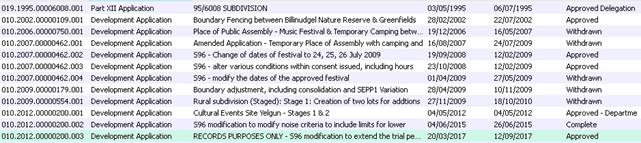
The Department of Planning and Environment initially issued
a Gateway Determination for the Planning Proposal in March 2016. That
Proposal was publically exhibited in May 2016. Eight public submissions
were received, including a submission that suggested that the site would be
better utilised for high technology industry or the like.
In considering the submissions, Council resolved (17-327):
1. That
Council considers progressing the Tyagarah Airstrip Planning Proposal after the
following have been completed:
a) a
Social Impact Assessment (SIA) associated with any expansion and
intensification of commercial uses at the Tyagarah Airfield;
b) an
assessment of noise impacts associated with any expansion and intensification
of commercial uses at the Tyagarah Airfield;
c) an
updated flood impact assessment associated with any expansion and
intensification of commercial uses at the Tyagarah Airfield;
d) a
Councillor workshop to consider other uses for the site that do not involve
increased aircraft activity;
e) community
consultation to include all affected stakeholders;
f) a
report on the cumulative ecological impacts of tree clearing required for the airfield
and in the interim cease any tree clearing not associated with current airstrip
safety.
2. That
Council does not support, and thus, removes any reference to commercial
helicopter operations or activities operating at Tyagarah Airfield, including construction
of a heliport.
To assist in implementing the resolution, a number of
structure plan options were prepared, investigating the development potential
of the Council-owned land for industrial-sized lots (around 1,000m2),
which could house hangars or other industrial-scale buildings, to be used for
airfield-related purposes.
There is approximately 4ha of relatively unconstrained land
located on the north side of the existing airstrip. This takes into
consideration the presence of an “Obstacle Limitation Surface” off
the side of the strip, which prevents building too close to the airstrip.
The presence of high environmental value vegetation was also considered, with
those areas excluded from potentially developable land.
Preliminary flood assessment indicates that, while the whole
of the land is flood prone, it would be possible to design filling of the land
in a manner that does not result in external flood increases.
The structure planning work also assumed that wastewater
could be managed by way of individual treatment systems discharging to a common
irrigation / disposal space. Further investigations would be required to
establish the feasibility of connecting the site to reticulated sewerage
infrastructure (connection to Brunswick Heads infrastructure appears to be
viable).
The structure planning work indicates that it could be
possible to create 10-20 airfield-related lots on the land, depending on
whether the existing buildings are retained.
If the airstrip were removed / redeveloped, the potentially
unconstrained land is increased by approx. 5-6ha, providing a total of around
9-10ha of land potentially suitable for development (Note: flooding,
servicing and acid sulfate soils remain issues to be addressed in any
development of this land).
The Council-owned part of the Tyagarah site has been
included in the consideration of the current Employment Lands Strategy. A
recent State Agency workshop held in relation to that project identified that
the Tyagarah site (in conjunction with other adjoining land to the north)
appears to have short and long term potential as a site for industrial uses.
That workshop was undertaken to examine sites that have
potential to provide for additional industrial development. Preliminary
work undertaken for the Employment Lands Strategy indicates that approx. 8-10ha
of additional land is required to meet forecast demand for service industries,
and that there are no existing zoned sites that could provide that area.
The workshop included an inspection of a number of sites,
all of which are constrained to some extent. The Tyagarah site, which
includes the Council-owned airfield site and RMS land immediately to the north,
was noted to have the least encumbrances of the sites viewed.
It was also noted during the workshop that the current rural
zoning provides potential for the immediate consideration of food/ agricultural
produce industries, which could be considered through the development
application process without the need to rezone the land.
The draft Employment Lands Strategy is expected to be
reported to Council in June.
Background – Flights & Aircraft Noise
Tyagarah airfield is not certified or controlled by the
Civil Aviation Safety Authority (CASA), nor is the airspace above it, up to a
height of 4,500 feet above ground, controlled by Airservices Australia (above
4,500 feet, airspaces is managed by Air Traffic Control out of Gold Coast
Airport).
CASA is a Commonwealth Government authority regulating air safety,
whereas Airservices Australia manages operations within airspace.
The majority of recreational flights in and out of Tyagarah
are uncontrolled, as they generally remain lower than 4,500 feet. The
exceptions are the Byron Skydive flights, which are ‘controlled’,
from the Gold Coast Airport Air Traffic Control Centre, once they climb above
4,500 feet.
Those skydive flights are logged and must respond to the
orders of air traffic control. Skydive Australia advise that their
preferred flight path is direct east-west, climbing mostly over the
ocean. Airservices Australia is aware of that preferred path. From
time to time, for weather or traffic reasons, air traffic control might require
the skydive flight to take a different route, but this appears to occur
infrequently.
Above 4,500 feet, the coastal airspace from Gold Coast
Airport down to Cape Byron Lighthouse is designated in “Danger
Areas” 656A-D, with 656D above Tyagarah itself.
These Danger Areas have been designated by Airservices
Australia for flight training use, with the majority of training flights
originating out of Gold Coast Airport.
An operator of Airgoldcoast, a pilot training organisation
located at Gold Coast Airport advises that, depending on weather conditions,
there are likely to be an average of 35-40 flights per day out of Gold Coast
Airport, flying south within the designated Danger Areas.
It is reasonable to assume that a large portion of
complaints that Council receives about aircraft noise are generated by these
training flights.
The training operator advises that training flights will
generally avoid flying directly over Tyagarah because of the skydiving
activities, diverting instead either out to sea or to the west. Good
communication is maintained between skydive and training flights to ensure
ongoing safety.
The training operator suggested that closure of the Tyagarah
airstrip would have no effect on the numbers of training flights operating out
of Gold Coast Airport.
Options
Based on work undertaken to date, and on previous Council
resolutions there are a number of options for proceeding with consideration of
the Tyagarah Airfield land
1. Do Nothing
– continue to manage the airfield for its current purpose
While there were
previous years where the operation of the airfield was conducted at a financial
loss, work over the last two financial years has returned the operation to
profitability, as shown below:
|
Year
|
Net Operating Profit / Loss
|
|
2015
|
-$506.00
|
|
2016
|
-$14,016.00
|
|
2017
|
$42,603.00
|
Council would continue
to implement improvements and new ways to increase revenue from the existing
facilities at the site.
In terms of flight
numbers, it is understood that Skydive Byron Bay account for an estimated 95%
of all flights in and out of Tyagarah.
There are currently 5
“lots” at the site, leased for airfield related purposes, plus the
glider club, located on Crown land to the east. The airfield is not
certified by CASA (Civil Aviation Safety Authority) and the airspace
immediately above the airfield (up to 4,500ft) is not controlled by Airservices
Australia. As such, there is no reliable data on flight numbers, other
than those associated with the skydive operations.
The current Planning
Proposal, to reduce the minimum lot size, would be withdrawn, as it would no
longer be required.
Council would negotiate
appropriate lease arrangements with existing tenants, who are currently on
‘hold-over’ terms. Council would also deal with Skydive
Australia to secure the appropriate planning approval for their business.
2. Continue
to optimise the site for airfield-related uses:
As outlined above, the
development potential for subdivision of the land for these purposes is in the
order of 10-20 lots (in total).
For this option, Council would
continue work to implement the previous Council resolution. Based on the
preliminary Structure Plan options, staff would commission a Social Impact
Assessment to examine the potential impacts of expansion of the airfield
related uses. The work currently being undertaken in relation to a Fly
Neighbourly Agreement could address potential noise impacts.
The current Planning Proposal
would remain active, with Council to respond to the Department of Planning and
Environment to request the Minister to make the change to the LEP.
Council could then undertake the
investigation and assessment required for the preparation of a Development
Application to subdivision the land.
Council would negotiate
appropriate lease arrangements with existing and potential tenants.
Council would also deal with Skydive Australia to secure the appropriate
planning approval for their business.
3. Close the
airfield and redevelop the land for alternative employment generating uses:
The Tyagarah site is being
considered in terms of its suitability for a wider range of employment
generating uses, particularly for service industries that require good
connection to the highway.
Preliminary work undertaken for
the Employment Lands Strategy suggests that it might be one of the best placed
sites available for such a use.
The Employment Lands Strategy is
expected to be completed in September 2018.
Further consideration of this
option should wait for the completion of that work, to understand whether the
Tyagarah site is the only reasonable choice for future industrial land, or
whether it is one of a number of sites that have this potential.
That knowledge would then allow
consideration of the relative merits of industrial use versus maintaining the
airstrip.
The current Planning
Proposal, to reduce the minimum lot size, would be withdrawn. A new
Proposal could be developed to rezone the land for industrial uses, subject to
the outcome of the Employment Lands Strategy.
It should be noted that closure
of the airstrip is unlikely to reduce aircraft noise in some areas within the
Shire, as it is apparent that local airspace is used extensively by flight
training operations out of Gold Coast Airport.
It has been suggested that
closing Tyagarah could actually result in an increase in these training flights
out of the Gold Coast, as some operators are said to avoid the local area
because there are regular skydiving activities.
4. Interim
– staged approach:
While the Employment Lands
Strategy is continuing, work is sufficiently advanced to justify preparation of
a Planning Proposal to amend the current RU2 zoning of the site to IN1 General
Industry. This would, in the first stage, only relate to the area north
of the airstrip (outside of the Obstacle Limitation Surface constraint).
It would then allow works to
prepare a subdivision proposal that could provide for a wider diversity of land
uses, airfield related, more general, or food industries for example.
Depending on the outcome of the
Employment Lands Strategy, Council could consider whether the airstrip should
remain in place in the longer term, or be replaced by an expansion of the IN1
General Industry zoning.
The current Planning Proposal
would be withdrawn, to be replaced by the proposal to rezone the land, which
would also include amendment to the minimum lot size map.
Option 4 is recommended as it will provide the greatest
flexibility by allowing short term actions to proceed whilst further strategic
decisions are made. The outcome and recommendations of the Employment
Lands Strategy will provide a context within which Council can decide on the
future of the airstrip.
Financial Implications
The options described above would lead to different
financial outcomes. In the short term, the maximum financial return would
be gained through rezoning, subdivision and sale of lots. As part of that
process, financial modelling can be undertaken to measure options, including
sale versus lease and comparison of returns against fees generated by aircraft
movement.
Statutory and Policy
Compliance Implications
Other than doing nothing, all options require amendment to
Byron LEP 2014.
Staff Reports - Sustainable Environment and Economy 13.14
Report No. 13.14 PLANNING
- Development Application 10.2017.460.1 - Utility Installation:
Telecommunication Tower at 54 Jones Road Wooyung
Directorate: Sustainable
Environment and Economy
Report
Author: Simone
Kenyon, Planner
File No: I2018/391
Theme: Ecology
Development and Approvals
Proposal:
|
Proposal description:
|
Utility Installation: Telecommunication Tower
|
|
Property description:
|
LOT: 100 DP: 1178907
|
|
54 Jones Road WOOYUNG
|
|
Parcel No/s:
|
241928
|
|
Applicant:
|
Optus Mobile Pty Ltd
|
|
Owner:
|
Billinudgel Property Pty Ltd
|
|
Zoning:
|
Part RU1 Primary
Production/Part DM Deferred Matter – 7(k) Habitat Zone
|
|
Date received:
|
24 August 2017
|
|
Integrated Development:
|
No
|
|
Public notification or exhibition:
|
- Level 2 advertising
under DCP 2014 Part A14 – Public Notification and Exhibition of
Development Applications
- Exhibition period:
14/9/17 to 27/9/17
- Submissions
received: Two (2) submissions received
|
|
Planning Review Committee:
|
N/A
|
|
Delegation to determination:
|
Council
|
|
Issues:
|
- Natural Constraints
– Flood, Bushfire, Acid Sulfate Soils – Class 3, High
Conservation Value Vegetation and a Cattle Dip Buffer; and
- Clause 40 –
Exceeds 9m height limitation – SEPP 1 Objection
|
Summary:
Development approval is sought for a Utility Installation
– Telecommunications Tower at 54 Jones Road, Wooyung. The property is
zoned Part RU1 Primary Production/Part DM Deferred Matter – 7(k) Habitat
Zone in accordance with the Byron Local Environment Plans 2014 and 1988 respectively.
However, it is noted that the proposal is wholly located within the portion of
the site that is mapped 7(k) Habitat Zone and as such, an assessment against
BLEP 1988 and BSDCP 2010 only, has occurred.
The fragmented allotment has a total land area of 21.235 hectares
and is utilised for a variety of purposes, more specifically the
‘Splendour on the Grass’ festival. The proposal includes one (1)
35m tower with ancillary infrastructure such as dishes, antennae and cabling.
The phone tower is to provide improved telecommunication in the Wooyung area
and festival goers. It is noted that mobile phone towers are used at present
for the festivals.
The proposed development is generally consistent with the
relevant environmental planning instruments and planning controls applicable to
the site including the LEP and DCP provisions for this type of development,
excluding Clause 40 of BLEP 1988. The height of the tower is supported as
strict compliance with the development standards is not warranted in this
instance. In particular a phone tower would be in-effective at 9 metres in
height, whilst the proposal is unlikely to have an adverse impact on the visual
amenity of the locality.
It is considered the proposal raises no significant issues
in terms of environmental impacts which cannot be managed through reasonable
and relevant conditions of approval, and the site is considered suitable for
the development. As such the application is recommended for approval subject to
conditions of consent.
NOTE TO COUNCILLORS:
In accordance with the
provisions of S375A of the Local Government Act 1993, a Division is to
be called whenever a motion for a planning decision is put to the meeting, for
the purpose of recording voting on planning matters. Pursuant to clause
2(a) under the heading Matters to be Included in Minutes of Council Meetings of
Council's adopted Code of Meeting Practice (as amended) a Division will be
deemed to have been called by the mover and seconder of all motions relating to
this report.
|
RECOMMENDATION:
That pursuant to
Section 80 of the Environmental Planning and Assessment Act 1979, development
application no. 10.2017.460.1 for a Utility Installation: Telecommunication
Tower, be granted consent subject to conditions listed in Attachment 2
E2018/30097.
|
Attachments:
1 Proposed
Plans 10.2017.460.1, E2018/28608 ⇨
2 Conditions
of consent 10.2017.460.1, E2018/30097
⇨
3 submissions
received 10.2017.460.1, E2018/25091
⇨
Assessment:
1. INTRODUCTION
1.1. History/Background
The subject allotment was
registered 19 September 2012. A search of Council records identifies the
following development application history:
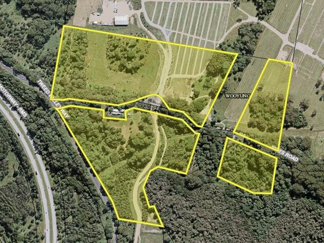
1.2. Description
of the proposed development
This application seeks approval
for Utility Installation Telecommunication Tower as demonstrated Attachment 1.
The proposal includes:
a) One (1) 35m monopole;
b) Six (6) panel antennas, each less than
2.8m in length, mounted on the pole in the following configurations:
i. Three (3) panel antennas mounted on
a turret headframe at a centreline height of 36.5m; and
ii. Three (3) panel antennas mounted on the
pole at a centreline height of 31.7m.
c) One (1) radio-communication dish with
a diameter of 1.2m, mounted at 28.7m in height;
d) One (1) outdoor equipment shelter, with
a floor area of 7.5m², mounted at ground level adjacent to the new pole;
and
e) Ancillary equipment associated with
operation and safety of the facility, including remote radio units, cabling,
safe access methods, earthing, electrical works and air conditioning equipment.
The facility will be within an 80m² compound area,
enclosed by a 2.4m chain-link security fence. The total height of the facility,
including antennas and ancillary equipment, will be no taller than 38.3m above
the natural ground level.
1.3. Description
of the site
Land is legally described as Lot
100 DP1178907.
Property address is 54 Jones
Road, Wooyung.
Land is zoned Part RU1 Primary
Production/Part DM Deferred Matter – 7(k) Habitat Zone.
Land area is 21.235ha.
The property has a whole is
constrained by Flood, Bushfire, Acid Sulfate Soils Class 3, High Conservation
Value Vegetation and a Cattle Dip Buffer.
The subject lot is a fragmented
allotment that supports numerous festivals including ‘Splendour on the
Grass’. The portion of the allotment proposed to support the facility
is within a cleared portion of the allotment.
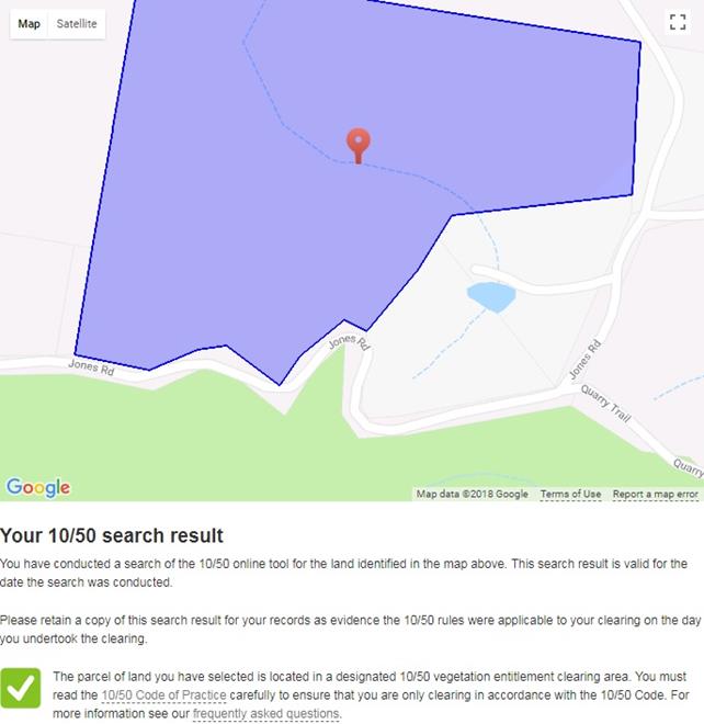
2. SUMMARY OF
REFERRALS
|
Referral
|
Issue
|
|
Environmental Health Officer
|
No objections subject to
conditions.
|
|
S94 Contributions Officer
|
No objections subject to
conditions.
|
|
Consultant Heritage Advisor
|
No objection. Conditions to
apply in relation to cultural heritage
|
|
Ecologist
|
No objections subject to
conditions.
|
|
Office of Environment &
Heritage – National Parks
|
Original information submitted
was deemed insufficient. Information supplied by the applicant in response to
this request is considered to satisfy any concerns raised.
|
|
Bundjalung (Arakwal)
|
Original information submitted
was deemed insufficient. Re-referral was undertaken. No objection was
received by Council.
|
|
Tweed Byron Land Council
|
Original information submitted
was deemed insufficient. Re-referral was undertaken. No objection was
received by Council.
|
3. SECTION 79BA
– BUSH FIRE PRONE LAND
Under section 79BA of the Act,
Council must be satisfied prior to making a determination for development on
bush fire prone land, that the development complies with the document
‘Planning for Bush Fire Protection 2006’. The site is bush fire prone
land. The development application is accompanied by a Draft Bushfire Management
Plan, Reference No. 003.07.17, prepared by Bushfire Risk Reducers dated July
2017.
Conditions have been included in
the Recommendation of this Report requiring that the development must comply at
all times with the requirements of the Draft Bushfire Management Plan,
Reference No. 003.07.17, prepared by Bushfire Risk Reducers dated July 2017.
EFFECT OF 10/50 RULE ON SIGNIFICANT VEGETATION
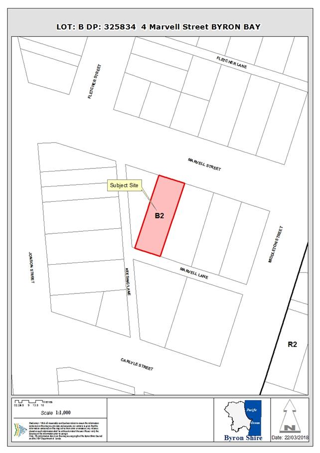
4. SECTION 79C
– MATTERS FOR CONSIDERATION – DISCUSSION OF ISSUES
Having regard to the matters for consideration detailed in
Section 79C(1) of the Environmental Planning and Assessment Act 1979 (EP&A
Act 1979), the following is a summary of the evaluation of the issues.
4.1 State Environmental
Planning Instruments
|
|
Satisfactory
|
Unsatisfactory
|
|
State
Environmental Planning Policy No 1—Development Standards
|
☒
|
☐
|
|
Consideration: Where the
consent authority is satisfied that the objection is well founded and is also
of the opinion that granting of consent to that development application is
consistent with the aims of this Policy as set out in clause 3, it may, with
the concurrence of the Director, grant consent to that development
application notwithstanding the development standard the subject of the
objection referred to in clause 6.
|
|
State
Environmental Planning Policy No 44—Koala Habitat Protection
|
☒
|
☐
|
|
Consideration: No vegetation
removal will occur to facilitate the proposal. The proposal has been assessed
by Council’s Ecologist who has determined that the proposal will
unlikely adversely impact on any koalas in this locality.
|
|
State
Environmental Planning Policy No 55—Remediation of Land
|
☒
|
☐
|
|
Consideration:
The subject site is located on undeveloped, cleared land used as a service
area for the parklands, approximately 470m northeast of the Pacific Highway.
The subject site is bounded by established mature vegetation, and located
close to but not within Billinudgel Nature Reserve. A review of the EIS (DEC
2017) for Parklands discovered that a site contamination assessment was
conducted on the subject site by EAL Consulting Services on behalf of
Parklands as part of the original concept plan for the Festival Site. The
assessment included:
· A
site history review;
· Geological
and hydrogeological review; site inspection;
· Soil
and water sampling, including 65 individual soil samples and 1 water samples
from the farm dam; and
· Analysis
of potential contaminants of concern.
The assessment
found that the Parklands site had been used for low intensity agricultural
purposes since at least 1947. Past agricultural use included dairy
farming, some cropping for banana (approximately 10 to 12 acres for 3 to 4
year, typically north facing slopes), and some cropping for sugar cane (in
low lying areas and, predominantly, cattle grazing. Soil and water samples
were analysed for a range of potential contaminants of concern including
hydrocarbons, pesticides and heavy metals. The analysis found that
contaminate levels were all below the applicable criteria, with the exception
of:
· Chromium
and manganese in some samples; and’
· Total
petroleum hydrocarbons (TPH) in one sample near an abandoned car in a
forested area.
Chromium
and manganese are naturally elevated in local soils. The TPH is not located
near the proposed Telecommunication Tower. No further investigation is
warranted.
|
|
State Environmental
Planning Policy (Rural Lands) 2008
|
☒
|
☐
|
|
Consideration:
The compound has been sited as close as possible to the lot boundary,
allowing for large trucks to pass the compound unimpeded. Because this area
hosts large festivals and other events, Optus are willing to coordinate
scheduled maintenance activities with Council and North Byron Parklands to
minimise conflict. This may be formalised as a condition of development
consent. No significant Land use conflicts are envisaged should the
development be approved by Council. The proposal will not adversely impact on
rural land uses within the immediate locality.
|
|
State Environmental Planning
Policy (Infrastructure) 2007
|
☒
|
☐
|
|
Consideration: Development
permitted with consent (1) Development for the purposes of
telecommunications facilities, other than development in clause 114,[applies
to works by public authorities] may be carried out by any person with
consent on any land.
The SEPP makes the proposed
development permissible in any Zone and would over ride any LEP prohibition.
The application invokes the SEPP thereby ensuring that there is no
uncertainty in regard to the permissibility of the proposed development
|
4.2A Byron Local Environmental Plan 1988 (LEP 1988)
LEP 1988 is an applicable matter
for consideration in the assessment of the subject development application in
accordance with subsection 79C(1) of the EP&A Act 1979 because it
applies to the subject land and the proposed development. The LEP 1988 clauses that
are checked below are of relevance to the proposed development:
|
Part 1
|
☒1|
☒2| ☒2A| ☒3| ☒4| ☒5| ☒LEP 1988 Dictionary| ☒7
|
|
Part 2
|
☒8|
☒9
|
|
Part 3
|
☐10| ☐11| ☐11A| ☐11B| ☐12| ☐13| ☐14| ☐15| ☐16| ☐17| ☐17A| ☐17B| ☐18| ☐19| ☐22| ☐22| ☐23| ☒24| ☐25| ☐27| ☐ 29| ☐29AA| ☐29A| ☐30| ☐31| ☐32| ☐33| ☐34| ☐35| ☐36| ☐37| ☐38| ☒38A| ☐38B| ☐39| ☐39A| ☐39B| ☐39C| ☒40| ☐41| ☐42| ☐43| ☐44| ☒45| ☐46| ☐47| ☐47AA| ☐47A| ☐48| ☐49| ☐51| ☒52| ☐53| ☐54| ☐55| ☐56| ☐ 57| ☐58| ☐59| ☐60| ☐61| ☐62| ☒63| ☐64
|
|
Part 5
|
| ☐65| ☐66| ☐67| ☐68| ☐69| ☐70| ☐71| ☐72| ☐73| ☐74| ☐75| ☐76| ☐77| ☐78| ☐79| ☐80| ☐81| ☐82| ☒83| ☐84| ☐85| ☐86| ☐87| ☐88| ☐89| ☐90| ☐91| ☐92| ☐93| ☐94| ☐95|
☐96|
☐97| ☐98| ☐99| ☐100| ☐101
|
In accordance with LEP 1988
clauses 5, 8 and 9:
a) The proposed development is defined in
the LEP 1988 Dictionary as a ‘utility installation’;
b) Whilst the land has multiple land use
zones, the proposed structure will be wholly located within the 7(k) Habitat
Zone under LEP 1988;
c) The proposed development is made
permissible by the Infrastructure SEPP; and
d) The proposed development is consistent
with the relevant objectives of the Zone for the following reasons:
|
Zone Objective
|
Consideration
|
|
The objectives are:
a) To identify and
protect significant vegetation and wildlife habitats for conservation
purposes;
b) To prohibit
development within the zone that is likely to have a detrimental effect on
the wildlife habitats which exist;
c) To enable the carrying
out of development which would not have a significant detrimental effect on
the wildlife habitats; and
d) To enable the careful
control of noxious plants and weeds by means not likely to be significantly
detrimental to the native ecosystem.
|
The 7K zone identifies and
protects significant vegetation; the general area around the Optus site is
acknowledged to retain environmental significance based on Council policy and
Optus’ own environmental assessments, and is therefore appropriately
zoned.
The Optus proposal does not
prevent this area from being identified ‘significant’ – the
area will still retain its significance after the facility has been
constructed. Further, the proposal does not conflict with the objective of
protecting the area, since the subject site is on land that has been
previously disturbed, with minimal environmental impact.
|
The remaining checked
clauses have been taken into consideration in the assessment of the subject
development application in accordance with subsection 79C(1) of the EP&A
Act 1979. The proposed development complies with all of these clauses (in
some cases subject to conditions and/or to the satisfaction of other assessing
officers), except in relation to Clause 40 which is considered further as
follows:
|
What clause does the
development not comply with and what is the nature of the non-compliance?
|
Further consideration,
including whether the development application is recommended for approval or
refusal accordingly
|
|
Clause 40 (2)(b)(ii)- (1)
The Council must not consent to the erection of any building if the vertical
distance between the topmost part of the building and the existing ground
level below exceeds 9 metres.
|
The proposed maximum height
inclusive of ancillary antennae and dishes of 38.5m. As such, further
discussion is detailed below:
|
Clause 40 – Height of buildings
Subclause 40(2)(b)(ii) of LEP
1988 states that ‘Council
must not consent to the erection of any building if the vertical distance
between the topmost part of the building and the existing ground level below
exceeds 9 metres’.
The
LEP map indicates that the site is zoned 7(k) Habitat zone with the proposed
utility installation having a maximum height of 38.5m, a variation of approximately 425% to the 9m height restriction.
Accordingly, the development
application does not meet the 9m building height requirement and the DA is
supported by an objection pursuant to SEPP 1. The Land Environment Court
judgment in Wehbe v Pittwater Council [2007] identified requirements needed in
order to uphold a SEPP 1 objection, and these are addressed in the
circumstances of this particular case as follows:
Is the requirement a development standard?
The 9m building height requirement is a development
standard as defined by section 4 of the Environmental Planning and
Assessment Act 1979, because it is a provision of an environmental planning
instrument in relation to the carrying out of development, being a provision by
or under which requirements are specified and standards are fixed in respect to
the maximum height of a building.
Is the objection in writing, is it an objection
“that compliance with the development standard is unreasonable or
unnecessary in the circumstances of the case” and does it specify
“the grounds of the objection”?
The development application is accompanied by an objection
in writing. It is an objection that compliance with the development standard is
unreasonable or unnecessary in the circumstances of the case and specifies the
grounds of the objection as follows:
‘This proposal is in response to an established
community need for improved mobile coverage in the Wooyung area. Optus have a
discrete and specific area (the area around and including North Byron
Parklands) within which coverage is to be improved by establishing a new
telecommunications facility.
There is a technical requirement for
telecommunications facilities to protrude above the surrounding environment to
function correctly. In order to achieve Optus’ coverage objectives, this
facility needs to be at its current proposed height. A shorter tower would be
blocked by surrounding vegetation and terrain, meaning it would not work.
· Optus cannot achieve a feasible level of coverage
in this location, or any alternate site in the vicinity, without exceeding Council
height limits. Council’s policies are designed to prevent inappropriately
tall buildings being constructed; the policy is not responsive to the technical
needs of telecommunications infrastructure, or the actual amenity impacts of
the development;
· All of the potential sites in North Byron Parklands
would require a protrusion above the 9m height limit. Because this protrusion
cannot be avoided, Optus have selected a site where amenity impacts resulting
from the protrusion can be minimised, while still ensuring a feasible technical
outcome.
· From a visual amenity perspective, this site is
considered highly favourable.
- There is very little development in the area. There
is one residence approximately 240m west of the site, which is oriented away from
the Optus facility; the next closest residences are over 1.5km east;
- The facility is located in a heavily vegetated,
hilly area well screened from passing traffic on Jones Road; and
- The facility will have a visual presence from
within North Byron Parklands. This is unavoidable given the nature of the use;
however the North Byron Parklands owners, who are likely to be most affected,
are supportive of the project. For visitors to the Parklands, and
festivalgoers, the visibility of the facility is unlikely to adversely impact
their experiences at the venue – especially as their presence onsite is
transient, and only a handful of events are held each year.
We acknowledge Council’s policy is designed
to protect the visual amenity of the local community. In this case there are
very few community members whose amenity could feasibly be impacted, and the
facility is well hidden from these perspectives.
It is an established principle that
telecommunications carriers seek out rural and industrial areas for deployment
of new infrastructure, if possible, over residential areas or community spaces.
This site is in a rural area. While the facility will contravene
Council’s height limit for the area, Optus consider there is both
technical need, and sufficient planning merit, for the variation to be
allowed’.
Is “the objection well founded” and
will “granting of consent to the development application be consistent
with the aims of SEPP 1 as set out in clause 3”?
An objection under SEPP 1 may be well founded and be consistent
with the aims set out in clause 3 of the Policy in one of a variety of ways
(according to the above mentioned judgment). These are:
1. ‘Compliance
with the development standard is unreasonable or unnecessary because the
objectives of the development standard are achieved notwithstanding
non-compliance with the standard.
2. The
underlying objective or purpose is not relevant to the development with the
consequence that compliance is unnecessary.
3. The
underlying objective or purpose would be defeated or thwarted if compliance was
required with the consequence that compliance is unreasonable.
4. The
development standard has been virtually abandoned or destroyed by the
Council’s own actions in granting consents departing from the standard
and hence compliance with the standard is unreasonable and unnecessary.
5. The
zoning of particular land was unreasonable or inappropriate so that a
development standard appropriate for that zoning was also unreasonable or
unnecessary as it applied to that land and compliance with the standard in that
case would also be unreasonable or unnecessary’.
In the subject case, compliance with the development
standard is unreasonable and unnecessary because the objectives of the
development standard were created at a date in time that facilities such as
these were not in existence or the purpose of mobile phone coverage. The
technical needs of a functional mobile telecommunications network are such that
they need height to work. In this regard, compliance with this objective would
ensure the proposal was ineffective and thus is considered unreasonable.
Further:
a) This
proposal is in response to an established community need for improved mobile
coverage in the Wooyung area. Optus have a discrete and specific area (the area
around and including North Byron Parklands) within which coverage is to be
improved by establishing a new telecommunications facility;
b) The
surrounding trees exceed 9m in height, meaning the actual protrusion of the
tower above the surrounding landscape is much lower than the numbers would
suggest. The standard fails to account for existing landscape features;
c) Strict
compliance with Council’s height limits would prevent new
telecommunications facilities from being deployed in much of Byron Shire. Optus
and other mobile carriers would be unable to deliver an effective service to
the community, with significant social, economic and public safety
implications; and
d) There
is a precedent for telecommunications facilities to be installed in areas subject
to a height restriction in Byron Shire, provided they can be justified
appropriately on town planning grounds. Some examples include the 35m Optus
monopoles at 8 Grevillea Street, Byron Bay (DA10.2008.425.1) and Byron Golf
Club, 62 Broken Head Road, Byron Bay (DA 10.2011.325.1). While these sites are
obviously in very different environments to this proposal, both were progressed
under the 1988 LEP and deemed to be appropriate on planning grounds, despite
exceeding a 9m height restriction.
Given the above, it is considered that the SEPP 1 objection is
well founded notwithstanding non-compliance with the development standard and
it is recommended that the SEPP 1 objection be upheld.
4.3 Any proposed Instrument
that has been the subject of public consultation and has been notified to the
consent authority
1. Draft State Environmental
Planning Policy (Coastal Management) 2016 (CM SEPP). The proposal is unlikely
to conflict with this Policy.
2. The Department of Planning and
Environment (‘DPE‘) has announced a Draft Remediation of Land SEPP
(‘Draft SEPP‘) which will repeal and replace the current State
Environmental Planning Policy No 55—Remediation of Land (‘SEPP
55‘). The Explanation of Intended Effect of the Draft SEPP is on
exhibition to 31 March 2018. The Draft SEPP will maintain the two categories of
remediation work currently in SEPP 55:
· Category
1 – works that require development consent; and
· Category
2 – works that may be carried out without development consent.
The proposal is
unlikely to conflict with this Policy.
4.4A Byron Shire Development Control Plan 2010 (DCP 2010)
DCP 2010 is an applicable matter
for consideration in the assessment of the subject development application in
accordance with subsection 79C(1) of the EP& A Act 1979 because its
purpose is to provide planning strategies and controls for various types of
development permissible in accordance with LEP 1988. The DCP 2010
Chapters/Parts that are checked below are of relevance to the proposed
development:
|
Chapter 1 Parts:
|
☒A| ☐B| ☐C| ☐D| ☐E| ☒F| ☒G| ☐H| ☐J| ☒K| ☐L| ☐ N
|
|
Chapters:
|
☐4| ☐6| ☐7| ☐8| ☐9| ☐10| ☐11| ☐12| ☐14| ☐15| ☐16| ☒17| ☐18| ☐19| ☐20| ☐21| ☐22
|
These checked
Chapters/Parts have been taken into consideration in the assessment of the
subject development application in accordance with subsection 79C(1) of the EP&A
Act 1979. The proposed development is demonstrated to meet the relevant
Objectives of DCP 2010 (in some cases subject to conditions and/or to the
satisfaction of other assessing officers).
4.5 Any Planning Agreement or
Draft Planning Agreement?
|
|
Yes
|
No
|
|
Is there any applicable planning agreement or draft
planning agreement?
|
☐
|
☒
|
4.6 Environmental Planning
and Assessment Regulation 2000 Considerations
|
Clause
|
This control is applicable to
the proposal:
|
I have considered this control
as it relates to the proposal:
|
If this control is applicable,
does the proposal comply?
|
|
92
|
Yes
|
Yes
|
Yes
|
|
93
|
Yes
|
Yes
|
Yes
|
|
94
|
No
|
N/A
|
N/A
|
|
94A
|
No
|
N/A
|
N/A
|
4.7 Any coastal zone management
plan?
|
|
Satisfactory
|
Unsatisfactory
|
N/A
|
|
Is there any applicable coastal zone management plan?
|
☐
|
☐
|
☒
|
4.8 The
likely impacts of that development, including environmental impacts on both the
natural and built environments, and social and economic impacts in the locality
|
Impact on:
|
Likely significant impact/s?
|
|
Natural environment
|
No. The proposal will not have
a significantly adverse impact on the natural environment of the locality.
|
|
Built environment
|
No. The proposal will not have
a significantly adverse impact on the built environment of the locality.
|
|
Social Environment
|
No. The proposal will not have
a significant social impact on the locality.
|
|
Economic impact
|
No. The proposal will not have
a significant economic impact on the locality.
|
Are there any Council Policies
that are applicable to the proposed development?
4.9 The suitability of the site
for the development
The proposed telecommunications tower
is appropriately sited on a cleared portion of land that is utilised for
numerous festivals and will provide telephone reception in a commonly known
‘blackspot’ area.
4.10 Submissions made in accordance with
this Act or the regulations
The development application was publicly exhibited with two
(2) submissions being received by Council. An outline of these submissions is
detailed below:
1) No Community Consultation – ‘According to the DA the proposal for the OMT has
been in the pipeline for almost 12 months. Despite this, there has been no
community consultation with residents of Jones Road from the proponent (Optus)
or the landowner (North Byron Parklands)’.
Planner’s Comment
The proponent
is not required to consult with residents prior to lodgement of the
application. The application was placed on Level 2 notification and residents
are permitted to lodge submissions up to the point an application is
determined. Two (2) submissions only were received by Council.
It is
considered that the community has been reasonably consulted with.
2) Concerns of impacts by electromagnetic fields on fauna
species and the 7(k) habitat zone
Planner’s Comment
The proposal
does not involve vegetation clearing. Information supplied by the applicant
considered potential impacts on bats and was found to be considered
satisfactory by Council’s Ecologist. Conditions have been supplied by
Council’s Environmental Health Officer in relation to electromagnetic
impacts and was further considered by Council’s Ecologist.
3) Fire Hazard Area – ’It is our understanding that telecommunication
towers have been known to ignite and cause fires.
Planner’s Comment
The applicant
has proposed a site layout and facilities to avoid clearing for an APZ, as well
as upgrade the housing unit to Flame Zone standard. The bushfire
consultant’s report also satisfactorily demonstrates that the tower
itself and associated facilities would not increase bushfire risk to surrounding
natural areas.
4) Festival Site – ‘Over the past 5 years during festival events, NBP have provided
‘Cell On Wheels’ (Optus, Telstra & Vodaphone) to cater for the
patrons, staff and emergency services on site. Our family utilizes Optus as a
provider, which is reliable and not an issue. We understand, however, that the
Yelgun Valley & Crabbes Creek areas have poor mobile phone reception.
Planner’s Comment
The proposal
will provide service to an area with a telecommunications blackspot.
5) Alternate Locations – ’Optus needs to investigate alternate sites located
outside areas identified as ‘Extreme Fire Risk’. For example, there
may be areas in the north of the Parklands site or alternatively on the western
side of Tweed Valley Way which could potentially supply the festival site as
well as the Yelgun Valley and Crabbes Creek communities.
Planner’s Comment
It is clear
from the previous submission comment that there is a significant need for this
service within this area. There is not a better location that one that does not
require vegetation removal.
6) Power Supply – ‘We have lived on Jones Road for 39 years. Our property is
at the very end of the power supply. During this time, our power supply has
often been affected, i.e. black outs, power shortages and interferences which
has resulted in the loss of electrical equipment. We are concerned that
our electricity supply could become even more problematic, if the MOT is
approved for this location.
Planner’s Comment
Whilst power
supply is matter for some consideration, it would be apparent that the matters
involving the submission author’s power supply is a matter for their
power supply company.
7) Aesthetics – ‘The
installation of a 35 metre MOT is not in keeping with the surrounding rural environment
and is contrary to the values of the Marshalls Ridge wildlife corridor and the
adjacent Billinudgel Nature Reserve’.
Planner’s Comment
Additional
studies were undertaken by the applicant which has since been reviewed by
Council’s Ecologist. The proposal is considered to be more than
acceptable and unlikely to adversely impact on the values of the wildlife
corridor or the Billinudgel Nature Reserve.
Given the above, it is determined
that the concerns raised by submission authors have been considered within the
assessment of this application.
4.11 Public interest
The proposed development is
unlikely to prejudice or compromise the public interest or create an
undesirable precedent.
4.12 Section 5A of the EP&A Act 1979
– Significant effect on threatened species
Having regard to sections 5A, 5C
and 5D of the EP&A Act 1979,
there is unlikely to be a significant effect
on threatened species, populations or ecological communities, or their habitats
as a result of the proposed development as the proposal does not involve the
removal of vegetation. In addition, the applicant provided a flora and fauna
report which offered particular attention to microchiropteran bats. Given the
location of the tower within a cleared area, and the extent of any potential
harm being reduced by no roosts or hollows/caves being affected which are used
for breeding, the proposal does not impact on bats.
4.13 Section 5B of the EP&A Act 1979
– Have regard to register of critical habitat
The NSW Critical
Habitat Register does not identify any critical habitat on or adjacent to the
site.
5. DEVELOPER
CONTRIBUTIONS
5.1 Water & Sewer Levies
No Section 64 levies will be required.
5.2 Section 94 Contributions
Section 94 Contributions will be
payable.
Disclosure of Political
Donations and Gifts
|
Has a Disclosure Statement been
received in relation to this application
|
No
|
|
Have staff received a
‘gift’ from anyone involved in this application that needs to be
disclosed. Where the answer is yes, the application is to be determined by
the Director or Manager of the Planning, Development and Environment
Division.
|
No
|
Provide Disclosure Statement register details here: Nil.
6. CONCLUSION
The proposed development is
consistent with the relevant environmental planning instruments and planning
controls applicable to the site. The proposal raises no significant issues in
terms of environmental impacts which cannot be managed and the site is
considered suitable for the development. The application is recommended for
approval subject to conditions of consent.
Staff Reports - Sustainable Environment and Economy 13.15
Report No. 13.15 PLANNING
- DA. 10.2017.588.1 - Demolition of cottage; construction of four (4) storey
mixed-use building comprising: ground floor commercial, two (2) levels of hotel
and motel accommodation with basement parking,roof top swimming pool with
raised roof deck, covered amenties and open bar at 4 Marvell Street Byron Bay
Directorate: Sustainable
Environment and Economy
Report
Author: Patricia
Docherty, Planner
File No: I2018/418
Theme: Ecology
Development and Approvals
|
Proposal description:
|
Demolition of
existing building and construction of a four (4) storey mixed use development
comprising of restaurant, bar, shops, motel accommodation, roof top pool, bar
and amenities block with basement car parking
|
|
Property description:
|
LOT: B DP: 325834
|
|
4 Marvell Street BYRON BAY
|
|
Parcel No/s:
|
50260
|
|
Applicant:
|
Ardill Payne & Partners
|
|
Owner:
|
Marvell Street Investments Pty Ltd
|
|
Zoning:
|
B2 Local Centre
|
|
Date received:
|
19 October 2017
|
|
Integrated Development:
|
Yes - Office of Water
|
|
Public notification or exhibition:
|
- Level
2 advertising under DCP 2014 Part A14 – Public Notification and
Exhibition of Development Applications
- Exhibition
period: 09/11/2017 - 22/11/2017
- Submissions received:
No submissions
|
|
Planning Review Committee:
|
22/02/2018
|
|
Delegation to determination:
|
Council – Clause 4.6 variation
|
|
Issues:
|
Site constraints
Acid Sulfate Soils – Class 3
Flood Prone Land
Groundwater
Byron LEP 2014
· Clause 4.3 Height
of buildings
· Clause 4.4 Floor
space ratio
· Clause 4.6 Exceptions
to development standards
· Clause 6.6
– Essential Services
Byron DCP 2014
· B2
Preservation of Trees and Other Vegetation
· Chapter B4 Traffic
Planning, Vehicle Parking, Circulation and Access
· B4.2.2 Parking
Layout Standards
· B4.2.3 Vehicle
Access and Manoeuvring Areas
· B4.2.5 Car
Parking Requirements
· B4.2.9 Loading
Bays
· B4.2.12 Parking
Schedules
· Chapter B8 Waste
Minimisation and Management
· B8.3.3 Bin
Sizes and Collection Measures
· Chapter B12
– Social Impact Assessment
· B12.1.3 Application
of this Chapter
· B12.2 Qualifications
for Conducting a Social Impact Assessment
· Chapter D3 Tourist
Accommodation
· D3.2.4 Character
and Design in Business and Mixed Use Zones
· Chapter D4 Commercial
and Retail Development
· D4.2.1 Design
Character of Retail and Business Areas.
· Section D4.2.2
– Design Detail and Appearance.
· D4.2.10 Restaurants,
Cafes, Small bars, Pubs Registered Clubs, Function Centres and other Licensed
Premises in the Urban Areas of Byron Shire
Noise impacts – noise report and operational
plan not provided
Dewatering - insufficient information to
clarify need for permanent dewatering associated with basement parking
|
Summary:
Development consent is sought for demolition of existing building and construction of a four (4)
storey mixed use development comprising of restaurant, bar, shops, motel
accommodation, roof top pool, bar and amenities block with basement car
parking.
The proposed development is inconsistent with provisions of
the Byron LEP 2014 and DCP 2014. The proposed development contravenes
Council’s adopted development standards and controls without sufficient
justification under both Byron LEP 2014 and Byron DCP 2014. In particular the
proposal includes a fourth storey roof top bar, whilst inadequate car parking
and access arrangements are provided within the development. The proposed
development if approved would set an undesirable precedent within the Byron Bay
Town Centre and is not in the public interest.
It is recommended that Development Application
No.10.2017.588.1 be refused for the reasons outlined in this report.
NOTE TO COUNCILLORS:
In accordance with the
provisions of S375A of the Local Government Act 1993, a Division is to be
called whenever a motion for a planning decision is put to the meeting, for the
purpose of recording voting on planning matters. Pursuant to clause 2(a)
under the heading Matters to be Included in Minutes of Council Meetings of
Council's adopted Code of Meeting Practice (as amended) a Division will be
deemed to have been called by the mover and seconder of all motions relating to
this report.
|
RECOMMENDATION:
That Pursuant to
Section 80 of the Environmental Planning & Assessment Act 1979,
development application no. 10.2017.588.1 for demolition of existing building and construction of a four
(4) storey mixed use development comprising of restaurant, bar, shops, motel
accommodation, roof top pool, bar and amenities block with basement car
parking, be refused for the following
reasons:
a) Pursuant
to Section 79C (1)(a)(i) of the Environmental Planning and Assessment Act
1979, the proposed development does not comply with Clause 4.3 Height
of buildings which sets a maximum height of 11.5 metres.
b) Pursuant
to Section 79C (1)(a)(i) of the Environmental Planning and Assessment Act
1979, the written request accompanying the proposed development fails to
comply with clause 4.6 of Byron Local Environmental Plan 2014.
Insufficient justification has been provided to demonstrate that compliance
with height of building development standards is unreasonable or unnecessary
or that there are sufficient
environmental planning grounds to justify contravening the standard or that
the proposed development is in the public interest.
c) Pursuant
to Section 79C (1)(a)(i) of the Environmental Planning and Assessment Act
1979, the proposed development does not comply with clause 6.6 of Byron
Local Environmental Plan 2014 which requires development consent
must not be granted to a development unless suitable vehicular access has
been provided in relation to waste collection vehicles.
d) Pursuant
to Section 79C (1) (a) (iii) of the Environmental Planning and Assessment Act
1979, the proposed development does not comply with Byron Development Control
Plan 2014, for the following reasons:
• B2 Preservation of Trees and Other
Vegetation
• Chapter B4 Traffic Planning, Vehicle
Parking, Circulation and Access
• B4.2.2 Parking
Layout Standards
• B4.2.3 Vehicle
Access and Manoeuvring Areas
• B4.2.5 Car
Parking Requirements
• B4.2.9 Loading
Bays
• B4.2.12 Parking
Schedules
• Chapter B8 Waste Minimisation and
Management
• B8.3.3 Bin
Sizes and Collection Measures
• Chapter B12 Social Impact Assessment
• B12.1.3 Application
of this Chapter
• B12.2 Qualifications
for Conducting a Social Impact Assessment
• Chapter D3 Tourist Accommodation
• D3.2.4 Character
and Design in Business and Mixed Use Zones
• Chapter D4 Commercial and Retail
Development
• D4.2.1 Design
Character of Retail and Business Areas
• D4.2.2 Design
Detail and Appearance
• D4.2.10
Restaurants, Cafes, Small bars, Pubs Registered Clubs, Function Centres
and other Licensed Premises in the Urban Areas of Byron Shire
e) Pursuant to the
provisions of Section 79C (1)(b) of the Environmental Planning and Assessment
Act 1979 insufficient information has been provided to demonstrate that
the development will have no
significant environmental impacts on both the natural and built environments,
and social and economic impacts in the locality, in relation to:
· excessive height;
· noise impacts;
· operational management; and
· site dewatering requirements over the
life of the development.
f) Pursuant
to the provisions of Section 79C (1)(c) of the Environmental Planning and
Assessment Act 1979, the site is not considered suitable for the development
as proposed, as there is insufficient information to demonstrate
that sufficient space is available to accommodate essential vehicle access
for garbage collection on site.
g) Pursuant
to the provisions of Section 79C (1)(e) of the Environmental Planning and
Assessment Act 1979, approval of a development which contravenes
Council’s adopted development standards and development controls without
sufficient justification may set an undesirable precedent and is not in the
public interest.
.
|
Attachments:
1 DA Plans
180305_4Marvell_Rev-G, E2018/27584
⇨
Assessment:
1. INTRODUCTION
1.1. History/Background
5.1993.135.1 – Change of use - Approved 28/04/1993
5.1998.99.1 – Commercial development – addition
to treatment room - Approved 15/05/1998
6.1993.2185.1 – Alteration of dwelling to consulting
room - Approved 06/05/1993
6.1997.2678.1 – Addition/alteration to dwelling -
Approved 09/07/1998
22.2017.15.1 – Development advice panel 15/08/2017n -
proposal the subject to this assessment report. (Refer to minutes at Trim Doc #A2017/20894)
1.2. Description
of the proposed development
This application seeks approval for demolition of an existing building and construction of a four (4)
storey mixed use development comprising of basement parking, restaurant, bar,
shops, 24 hotel rooms, roof top pool, bar and amenities block. All five (5)
levels accessible by lift.
Extract of Site Plan Drawing
1.0 Revision G, Prepared by Harley Graham Architects Dated 1 March 2018
Development plans propose the following:
|
Level 0
|
Basement car parking, storage, 36 m² dewatering
station. The entrance to basement car park off Marvel Lane is designed
to the flood planning level and a flood gate barrier proposed to be activated
in the event of flooding; to prevent water entering the basement levels of
the proposed building. Gross floor area on this floor is nil.
|
|
Level 1
|
Ground floor retail, hotel lobby, bar and restaurant,
manager residence, toilets and outdoor dining in an onsite ‘public
space area’, connecting Marvel Street and Marvel Lane. Access to
a loading/waste area and basement car park off Marvel Lane. Bicycle store (28
bikes) in the onsite ‘public space’ area. Gross floor area on
this level is 360 m²
|
|
Level 2
|
12 Hotel Rooms with balconies. Gross floor area on this
level is 465 m²
|
|
Level 3
|
12 Hotel Rooms with balconies. Gross floor area on this
level is 465 m²
|
|
Level 4
|
Roof top pool, bar and amenities block. Gross floor area
on this level is 57 m²
|
Extract of elevations
Drawing 2.1 Revision G, Prepared by Harley Graham Architects Dated 1 March 2018
1.3. Description
of the site
|
Land is legally described as
|
LOT: B DP: 325834
|
|
Property address is
|
4 Marvell Street BYRON BAY
|
|
Land is zoned:
|
B2 Local Centre
|
|
Land area is:
|
1,012m2
|
|
Property is constrained by:
|
Acid Sulfate Soils (Class 3) – The proposed
development involves works more
than 1 metre below the natural ground surface.
|
|
|
Flood Prone Land - The 2050, 100yr storm event, Flood
Planning Level for this site is 3.44m AHD.
|
 Site
boundary of subject lot
Site
boundary of subject lot
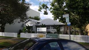
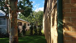
1. Existing cottage at 4
Marvel Street to be demolished;
2. Existing cottage with
adjoining side wall of commercial building on boundary of 6 Marvel Street
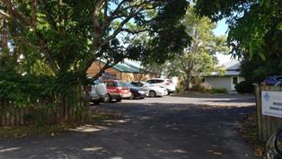
3. Property boundary
adjoining side wall of ‘‘Vinnies’ building at 2 Marvel Street
4. Existing car park
located off Marvel Lane – roof of ‘Vinnies’ building behind
parked cars
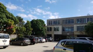

5. Front of adjoining 3
storey building - 6 Marvel Street with architectural roof feature 11.1 m high
6. Rear of adjoining 3
storey building - 6 Marvel Street – 10.1 m high on the south elevation
both (10.2004.732.1)
7. Existing 2 Storey
buildings on northern side of Marvel Street opposite site
8. Marvel Street - 3
storey commercial and tourist accommodation approved 2000 (DA.10.2000.368.1)
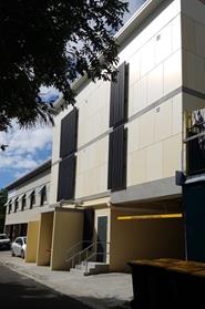
9. Streetscape
Marvel Lane / Keesing Lane
10. Existing laneway
frontage - English Language School located behind site on Keesing Lane
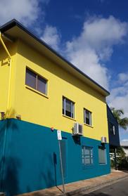
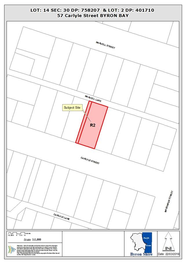
11. Existing 3 storey
backpackers accommodation – Max height approved is 10.88 metres
(DA.10.2015.505.1)
12. Existing 2 storey
English language school to north of Marvel Lane
2. SUMMARY OF
REFERRALS
|
Referral
|
Issue
|
|
Environmental Health Officer
|
Not supported.
REASONS FOR REFUSAL
1. The
application fails to demonstrate compliance with Byron Development
Control Plan 2014 Section D4.2.10 as it
did not include a Noise Report required for developments operating after 6pm.
2. The
application fails to demonstrate that environmental impact of the proposed
development are consistent with the public interest having regard to noise
and disturbance for neighbouring residents.
3. The
application fails to demonstrate the likely environmental impact of the proposed
development by failing to provide sufficient information regarding
4. The
application fails to demonstrate that environmental impact of the proposed
development are consistent with the public interest by failing to provide
sufficient information regarding site dewatering requirements over the life
of the development.
|
|
Development Engineer
|
Not supported.
The application has not provided sufficient car parking
spaces in accordance with DCP 2014 Chapter B4 requirements. Insufficient
justification has been submitted to vary the DCP requirements.
Comments have also been provided to discuss inadequate access for garbage
collection.
Reasons for Refusal
1. Essential
Services
Car Parking
The applicant has not provided acceptable justification
or adequate data to vary Council DCP 2014 Chapter B4 car parking
requirements. Therefore, the development does not comply with Council
requirements.
In addition, proposed disabled parking in not in
accordance with AS2890.1 requirements. Modifying car park layout to
incorporate disabled parking would result in an increased non-compliance.
Service Area
Inadequate access has been provided for skip bin
collection by front end loading garbage trucks. In accordance with DCP 2014
Chapter B8.3.3 prescriptive measures the SWMMP and DA submission must
illustrate on a site plan the proposed bin locations and pick up vehicle
access and manoeuvring. While Council requested a Waste Minimisation Plan
this was not submitted.
When skip bins are presented for collection there is
not sufficient room within the laneway for a FEL to manoeuvre into position
for bin collection. In the unlikely event the FEL can manoeuvre into position
the vehicle will extend approximately 4m into the laneway, effectively
blocking off the lane during collection.
In addition, in accordance with DCP 2014 Chapter
B8...3.3 where collection vehicles are required to enter a site to collect
bins the layout must be designed to ensure collection vehicles enter and
leave in a forward direction. This has not been provided.
|
|
S64 / Systems Planning Officer
|
No objections subject to conditions.
|
|
S94 / Contributions Officer
|
Council’s Section 94 Contributions Officer has
provided the following comments.
The applicant has not proposed a VPA to address the
shortfall in parking on the site.
The proposed development has both a commercial /
tourist accommodation and a permanent residential component. The
managers residence would us part of the existing credit for a dwelling on the
lot. The remainder of the development would be subject to the S94A
levy.
|
|
Resource Recovery Officer
|
Applicant has failed to provide sufficient information
demonstrating that manoeuvring areas are available for garbage collection
from the rear lane.
|
|
Department of Primary Industries – Office of Water
|
No objections subject to the following advice was provided
on 21 March 2018:
… we agree that de-watering for construction
purposes at the site of the proposed development would likely involve minor
volumes.
WaterNSW are the approval body with responsibility to
license groundwater extraction. However minor dewatering as described in the
letter attached, does not require a license unless the volume of water
extracted is likely to exceed 3ML/year.
Both DoIW and WaterNSW offer their sincere apologies
for this very late response.
I would appreciate it if you could ensure the proponent
receives a copy of the advice in the attached letter.
The letter provided advice as follows:
The application proposes basement parking which may
possibly trigger the need for dewatering. Any take of water as a result
of minor temporary dewatering activities that is estimated to be less than 3
megalitres per year (3ML/yr) will generally not require a licence or approval
from WaterNSW [Grafton Office (02) 6641 6500].
It is the applicant’s responsibility to assess
and monitor water take and impacts, and to advise WaterNSW if they exceed
these conditions, at which time a licence must be obtained. The applicant
must also meet all requirements of other agencies and consent authorities as
per usual.
If it is the applicant’s estimation that water
take will exceed 3ML/yr then they must apply for a licence under Part 5 of
the Water Act 1912 prior to commencing the activity.
NOTE: Neither DoIW nor WaterNSW support permanent dewatering
of basement car parking. It is the applicant’s responsibility to
determine whether this outcome would be likely and the basement be made
waterproof to avoid the need for permanent dewatering.
|
3. SECTION 79BA
– BUSH FIRE PRONE LAND
Under section 79BA of the Act, Council must be satisfied
prior to making a determination for development on bush fire prone land, that
the development complies with the document ‘Planning for Bush Fire
Protection 2006’. The site is not bush fire prone land.
4. SECTION 79C
– MATTERS FOR CONSIDERATION – DISCUSSION OF ISSUES
Having regard to the matters for consideration detailed in
Section 79C(1) of the Environmental Planning & Assessment Act 1979
(EP&A Act), the following is a summary of the evaluation of the issues.
4.1 State Environmental
Planning Instruments
|
|
Satisfactory
|
Unsatisfactory
|
|
State
Environmental Planning Policy No 55—Remediation of Land
|
☒
|
☐
|
|
Consideration: A Preliminary Contaminated Site
Investigation Report prepared by Ardill Payne and Partners dated October 2017
has been submitted in support of the application. Based on an
assessment of historic land use and analysis of soil samples taken from the
site, the report concludes that the potential for soil contamination is low
and the site is suitable for its intended use.
|
|
State
Environmental Planning Policy No 64—Advertising and Signage
|
☒
|
☐
|
|
Consideration: The application does not include any
signage proposals. Signage would therefore be subject to separate
applications in the future.
|
|
State
Environmental Planning Policy No 71—Coastal Protection
|
☒
|
☐
|
|
Consideration: The proposal has
no impact on public access to the coastal foreshore and will not result on
overshadowing of any foreshore area. No effluent is proposed to be
disposed other than to Council’s sewerage system.
The property is not likely to be
detrimentally impacted by coastal process or hazards.
The proposed development will not
impact the scenic qualities of the coast nor any coastal environmental
features.
Stormwater – A separate
approval of the stormwater management plan, including details of the method
of treating stormwater runoff would be required.
|
|
State
Environmental Planning Policy (Infrastructure) 2007
|
☒
|
☐
|
|
Consideration: The development does not constitute traffic
generating development as defined in this SEPP. No other provisions
of the SEPP are applicable.
|
|
State
Environmental Planning Policy (State and Regional Development) 2011
|
☒
|
☐
|
|
Consideration: The development does not constitute either
state or regional development as defined in this SEPP. Council remains
the consent authority for this application.
|
4.2 Byron Local Environmental Plan
2014 (LEP 2014)
LEP 2014 is an applicable matter for consideration in the
assessment of the subject development application in accordance with subsection
79C(1) of the EP&A Act because it applies to the subject land and the
proposed development. The LEP 2014 clauses that are checked below are of relevance
to the proposed development:
|
Part 1
|
☒1.1|
☒1.1AA| ☒1.2| ☒1.3| ☒1.4| ☒Dictionary| ☒1.5| ☒1.6| ☒1.7| ☒1.8| ☐1.8A| ☒1.9|
☐1.9A
|
|
Part 2
|
☒2.1|
☒2.2 | ☒2.3 |☒Land Use Table | ☐2.4 | ☐2.5 | ☐2.6 | ☒2.7 | ☐2.8
|
|
Part 3
|
☐3.1|
☐3.2| ☐3.3
|
|
Part 4
|
☐4.1|
☐4.1A| ☐4.1AA| ☐4.1B |☐4.1C| ☐4.1D| ☐4.1E| ☐4.2| ☐4.2A| ☐4.2B| ☐4.2C| ☐4.2|☒4.3|☒4.4 |☒4.5 | ☒4.6
|
|
Part 5
|
☐5.1|
☐5.2| ☐5.3| ☐5.4| ☒5.5| ☐5.6| ☐5.7| ☐5.8|☐5.9| ☐ 5.9AA| ☒5.10| ☐5.11| ☐5.12|
☐5.13
|
|
Part 6
|
☒6.1|
☒6.2| ☒6.3| ☒6.4| ☐6.5| ☒6.6| ☐ 6.7| ☐6.8| ☐6.9
|
In accordance with LEP 2014 clauses 1.4 and 2.1 – 2.3:
(a) The
proposed development is defined in the LEP 2014 Dictionary as mixed use
development, including: retail premises (which is a type of commercial
premises); restaurant or café (which is a type of retail
premises; which is a type of commercial premises); dwelling (in
this case, ancillary to hotel or motel accommodation); and hotel or
motel accommodation (which is a type of tourist and visitor
accommodation).
(b) The
land is within the B2 Local Centre Zone according to the Land Zoning Map;
(c) Mixed
use development, commercial premises, and tourist and visitor
accommodation are all permitted with consent in the B2 zone; and
(d) Regard
is had for the Zone Objectives as follows:
|
Zone Objectives
|
Consideration
|
|
· To
provide a range of retail, business, entertainment and community uses that
serve the needs of people who live in, work in and visit the local area.
· To
encourage employment opportunities in accessible locations.
· To maximise
public transport patronage and encourage walking and cycling.
· To
encourage vibrant centres by allowing residential and tourist and visitor
accommodation above commercial premises.
|
The proposed use of the land is compatible with the
objectives of the zone.
|
The remaining checked clauses have been taken into
consideration in the assessment of the subject development application in
accordance with subsection 79C(1) of the EP&A Act. The proposed development
complies with all of these clauses (in some cases subject to conditions and/or
to the satisfaction of other assessing officers), except in relation to those
considered further as follows:
|
What clause does the development not comply with and what
is the nature of the non-compliance?
|
Further consideration, including whether the development
application is recommended for approval or refusal accordingly
|
|
Clause 4.3 - Height of buildings
Maximum height limit as shown on the Height of Buildings
Map is 11.5 metres.
*building height (or height
of building) means:
(a) in relation to the height of a building in
metres—the vertical distance from ground level (existing) to the
highest point of the building, or
(b) in relation to the RL of a
building—the vertical distance from the Australian Height Datum to the
highest point of the building,
including plant and lift overruns, but excluding
communication devices, antennae, satellite dishes, masts, flagpoles,
chimneys, flues and the like.
ground level (existing) means the
existing level of a site at any point.
4.3 Height of buildings
(1) The objectives of this clause are as follows:
(a) to achieve building design that does not
exceed a specified maximum height from its existing ground level to finished
roof or parapet,
(b) to ensure the height of buildings
complements the streetscape and character of the area in which the buildings
are located,
(c) to minimise visual impact, disruption of
views, loss of privacy and loss of solar access to existing development.
(2) The height of a building on any land is not to
exceed the maximum height shown for the land on the Height of
Buildings Map.
|
It is noted that the Statement of Environmental Effects
submitted with the application, inaccurately states that the maximum height
of the proposed building is 13.87 metres.
A detailed assessment identifies that the building height
is 14.76 metres above the existing ground level, based on:
1. architectural
plans prepared by Harley Graham Architects (Revision G, dated 1 March
2018;
2. a
survey plan prepared by Canty’s Surveyors, dated 4 July 2016;
and
3. the
legal definition of building height and ground level (existing), in the NSW
Standard Instrument LEP dictionary*
Calculation of building height exceeding the 11.5 metre
maximum, is detailed as follows:
Lift overrun:
The uppermost part of the lift overrun shown on plans is
+17.780 RL and the existing ground level shown on the survey plan where the
lift overrun will be located is 3.02 RL. This means that the maximum
proposed building height is 14.76 metres (17.780-3.02). This
would require a variation of 3.26 metres or 28.35% above the 11.5
metre development standard.
Roof over pool deck/bar/toilet/change facilities:
The roof over the proposed deck, bar, toilets and change
facilities shown on plans is +17.13 RL and the lowest point at existing
ground level below, shown on the survey plan is 2.82 RL. This means
that this part of the building height is 14.31 metres (17.13-2.82).
This would require a variation of 2.81 metres or 24.43% above the 11.5
metre development standard.
Pool deck level:
The pool deck level shown on plans is +14.940 RL and the
lowest point at existing ground level below shown on the survey plan is 2.85
RL. This means that this part of the building height is 12.09 metres
(14.940-2.85). This would require a variation of 0.59 metres
5.13% above the 11.5 metre development standard.
Remainder of the roof over hotel/motel is below the
11.5 metre height limit:
The lower roof section shown on plans is +13.44 RL
and the lowest point of the existing ground level below, shown on the survey
plans is 2.78 RL. This means that this part of the building height is 10.66
metres (13.44-2.78).
The development should be refused, because the proposed
variation to the height of building development standard fails to meet the
objectives of Clause 4.3. Specifically in relation to:
An assessment of existing approved buildings in this part
of Byron Bay Town Centre (see images and comments in section 1.2 above)
clearly demonstrates that the proposed 4 storey building that exceeds the
height of building development standard by 28.35% at the highest point
and 24.43% along the eastern boundary, fails to ensure that
height of buildings complements the character of the area in which the
buildings are located.
The extent of the height variation fails to minimise
visual impact, privacy and loss of solar access to existing development.
Potential amenity issues are likely to arise with the use of the rooftop as a
bar area.
|
|
Clause 4.4 - Floor space ratio
Maximum floor space ratio for a building on the subject
site is not to exceed 1.3:1 as shown on the Floor Space Ratio Map.
4.4 Floor space ratio
(1) The objectives of this clause are as follows:
(a) to ensure that new buildings are appropriate
in relation to the character, amenity and environment of the locality,
(b) to enable a diversity of housing types by
encouraging low scale medium density housing in suitable locations,
(c) to provide floor space in the business and
industrial zones adequate for the foreseeable future,
(d) to regulate density of development and
generation of vehicular and pedestrian traffic,
(e) to set out maximum floor space ratios for
dual occupancy in certain areas.
(2) The maximum floor space ratio for a building on
any land is not to exceed the floor space ratio shown for the land on
the Floor
Space Ratio Map.
(2A) Despite subclause (2), the maximum floor space
ratio for dual occupancies on land in Zone R2 Low Density Residential is
0.5:1.
|
The total area of the subject allotment is 1,012m2.
The maximum permissible gross floor area on this site is 1,315.6m²
(1.3x1,012).
It is noted that the Statement of Environmental Effects
submitted with the application, inaccurately states that the Gross Floor Area
(GFA) for this development is 1,434m2, which is 118.4m²
more than the permissible GFA and an FSR variation of 9%.
Based on the LEP definition of Gross Floor Area*, Council has
assessed that the building is calculated at 1,347 m², which is 31.4
m² more than the permissible FSR and a lesser variation of 2.4 %.
*gross floor area means the sum of the
floor area of each floor of a building measured from the internal face of external
walls, or from the internal face of walls separating the building from any
other building, measured at a height of 1.4 metres above the floor, and
includes:
(a) the area of a mezzanine, and
(b) habitable rooms in a basement or an attic,
and
(c) any shop, auditorium, cinema, and the like,
in a basement or attic,
but excludes:
(d) any area for common vertical circulation,
such as lifts and stairs, and
(e) any basement:
(i) storage, and
(ii) vehicular access, loading areas, garbage
and services, and
(f) plant rooms, lift towers and other areas
used exclusively for mechanical services or ducting, and
(g) car parking to meet any requirements of the
consent authority (including access to that car parking), and
(h) any space used for the loading or unloading
of goods (including access to it), and
(i) terraces and balconies with outer walls
less than 1.4 metres high, and
(j) voids above a floor at the level of a
storey or storey above.
The FSR variation is considered to be relatively minor in
the context of land zoned
|
|
Clause 4.6 - Exceptions to development standards
Development
consent may, subject to this clause, be granted for development even though
the development would contravene a development standard imposed by this or
any other environmental planning instrument.
|
The application seeks to vary the 11.5m building height
development standard and the 1.3:1 floor space ratio development standard.
This would require a variation of 3.26 metres or 28.35%
above the 11.5 metre development standard and a variation of 31.4
m² or 2.4 % more than the permissible FSR development standard.
The proposed development should be refused because it
provides insufficient justification for variation to the height of building
development standard.
The information submitted by the applicant to seek a
variation to the development standards is inaccurate and contains
miscalculations that understate the height of building. The assessing
officer considers that Council would not be satisfied that:
a) the
Applicant’s written request under Clause 4.6 of BLEP 2014 has
adequately addressed the following matters required to be demonstrated:
i. that
compliance with the height of building development standard is unreasonable
or unnecessary in the circumstances of the case, and
ii. that
there are sufficient environmental planning grounds to justify contravening
the height of building development standard.
iii. the
proposed development will be in the public interest.
b) The
extent of the exceedence of the proposed development does not ensure:
· that height of
buildings complements the character of the area in which the buildings are
located.
· that height of
buildings minimise visual impact, privacy and loss of solar access to
existing development.
|
|
Clause 6.6 Essential Services
|
The proposed development should be refused because Council
is not satisfied that adequate arrangements have been made for suitable
vehicle access that is essential for the development including waste
collection arrangements and the appropriate number of car parking spaces
including disabled accessible car parking that is fully compliant with not in
accordance with AS2890.1.
|
4.3 Any proposed Instrument
that has been the subject of public consultation and has been notified to the
consent authority
Draft SEPP (Coastal Management) 2016
The draft SEPP proposes to replace SEPP 14 (Coastal
Wetlands), SEPP 26 (Littoral Rainforest) and SEPP 71(Coastal Protection).
It will redefine the current ‘Coastal Zone’, to be within four
coastal management areas:
· coastal wetlands
and littoral rainforests area
· coastal
environment area;
· coastal use area;
and
· coastal
vulnerability area.
The subject site will be mapped within the coastal use
area. The proposed development is not in a wetland, littoral rainforest,
coastal environment area or coastal vulnerability area. The proposed
amendments to the consent do not raise any specific issues that apply to the
coastal use area provisions under the draft SEPP.
4.4 Byron Shire Development
Control Plan 2014 (DCP 2014)
DCP 2014 is an applicable matter for consideration in the
assessment of the subject development application in accordance with subsection
79C(1) of the EP& A Act because it applies to the land to which LEP 2014
applies. The DCP 2014 Parts/Chapters that are checked below are of relevance to
the proposed development:
|
Part A
|
☒
|
|
Part B Chapters:
|
☒
B2| ☒ B3| ☒ B4| ☒ B5| ☒ B6| ☒ B7| ☒ B8| ☒ B9| ☐B10| ☒ B11| ☒ B12| ☒ B13| ☒ B14
|
|
Part C Chapters:
|
☐C1|
☒ C2| ☐C3| ☐C4
|
|
Part D Chapters
|
☐D1|
☐D2| ☒ D3| ☒ D4| ☐D5| ☐D6| ☐D7| ☒ D8
|
|
Part E Chapters
|
☐
E1| ☐E2| ☐E3| ☐E4| ☐E5| ☐E6| ☐ E7
|
These checked Parts/Chapters have been taken into
consideration in the assessment of the subject development application in
accordance with subsection 79C(1) of the EP&A Act. The proposed development
complies with all sections of these Parts/Chapters (in some cases subject to
conditions and/or to the satisfaction of other assessing officers), except in
relation to certain prescriptive measures which are considered further (having
regard to the DCP 2014 Section A1 Dual Path Assessment) as follows:
|
What Section and prescriptive measure does the development
not comply with?
|
Does the proposed development comply with the Objectives
of this Section? Address.
|
Does the proposed development comply with the Performance
Criteria of this Section? Address.
|
|
B2 Preservation of Trees and Other Vegetation
|
There are no specific objectives in this section.
The application identifies the location and species of 9
trees to be removed. It is noted that 3 trees on the street frontage
are to be retained.
The application did not provide sufficient information to
assess the impact of the proposed removal of 9 trees.
Council cannot be satisfied that the proposed removal of
trees is in accordance with the DCP.
|
N/A There is no performance criteria within this
chapter.
|
|
Chapter B4 Traffic Planning, Vehicle Parking,
Circulation and Access
B4.2.2 Parking Layout Standards
B4.2.3 Vehicle Access and Manoeuvring Areas
B4.2.5 Car Parking Requirements
B4.2.9 Loading Bays
B4.2.12 Parking Schedules
|
The applicant has not provided acceptable justification or
adequate data to vary Council DCP 2014 Chapter B4 car parking requirements.
Therefore, the development does not comply with Council requirements.
Council’s Development Engineer reviewed the
application against the DCP requirements and further undertook a merit based
assessment.
The total number of spaces proposed fails to satisfy the
minimum required.
In addition, proposed disabled parking in not in
accordance with AS2890.1 requirements. Modifying car park layout to
incorporate disabled parking would result in an increased non-compliance.
|
N/A There is no performance criteria within this
chapter.
|
|
Chapter B8 Waste Minimisation and Management
B8.3.3 Bin Sizes and Collection Measures
|
No. The proposal fails to:
· ensure adequate
provision is made for collection and transport of waste, commensurate with
the development’s scale, nature and potential for waste generation.
· demonstrate that
the design and provision of waste collection, storage and transport
facilities does not create significant adverse impacts on the amenity of the
surrounding locality.
Service Area
Inadequate access has been provided for skip bin
collection by front end loading garbage trucks. In accordance with DCP 2014
Chapter B8.3.3 prescriptive measures the SWMMP and DA submission must
illustrate on a site plan the proposed bin locations and pick up vehicle
access and manoeuvring. While Council requested a Waste Minimisation Plan
this was not submitted.
When skip bins are presented for collection there is
not sufficient room within the laneway for a FEL to manoeuvre into position
for bin collection. In the unlikely event the FEL can manoeuvre into position
the vehicle will extend approximately 4m into the laneway, effectively
blocking off the lane during collection.
In addition, in accordance with DCP 2014 Chapter
B8..3.3 where collection vehicles are required to enter a site to collect
bins the layout must be designed to ensure collection vehicles enter and
leave in a forward direction. This has not been provided.
|
Yes.
The applicant could enter a contractual arrangement with a
service provider, however this will not address the prescriptive
measures required.
|
|
Chapter B12 – Social Impact Assessment
B12.1.3 Application of this Chapter
B12.2 Qualifications for Conducting a Social Impact
Assessment
|
No. The application fails to ensure that social impact
assessments are prepared and certified by persons with appropriate qualifications
and experience.
A Social Impact Assessment (SIA) will be required for
the following:
tourist and visitor accommodation for 50 or more
persons.
The applicant stated in the Statement of Environmental
Effects that they did not accept that there was a need for a Social Impact
Assessment.
The proposal will provide accommodation including 26 x
double beds, capable of accommodating 52 visitors at any one time. This
also fails to consider the potential for additional guests that may be
accommodated in rollaway/sofa-bed arrangements that are expected to be
available upon request in the four larger hotel rooms proposed.
The proposal therefore fails to ensure that social impact
assessments are prepared systematically and contain the information required
to enable objective evaluation of social issues, impacts and management
measures and elements for consideration including safety and amenity such as noise.
|
N/A. There is no performance criteria in this Chapter.
|
|
D3.2.4 Character and Design in Business and Mixed Use
Zones
|
No. The open bar on the roof top for use by guests
does not 1. To ensure that tourist accommodation in Business … Zones is
compatible with the character and amenity of development in the locality
where residential development including shop top housing is located and
permissible with consent.
|
No.
Tourist accommodation in Zones B1, B2 and B4 must be
compatible in character and amenity with development in the locality. The
provisions of the following Sections in Chapter D4 … in the same way
they apply to commercial and retail development in Business and Mixed Use
zones:
a) Section D4.2.1 – Design Character of Retail and
Business Areas.
b) Section D4.2.2 – Design Detail and Appearance.
|
|
D4.2.1 – Design Character of Retail and Business
Areas.
|
No
Council cannot be satisfied the establishment and
operation of the rooftop deck and bar would contribute to and not detract
from the social and economic robustness, diversity and vitality of retail,
business and community areas and precincts.
|
No.
Development must be compatible with and reinforce the role
of the centre in the commercial centres hierarchy. Development within coastal
centres must reflect a lowscale, tourist-beach image. Development in rural
centres or localities must be compatible with the atmosphere and character of
the centre or locality.
Development applications must demonstrate that the
establishment and operation of the proposed development will not adversely
affect: a) The social and economic robustness, diversity and vitality of
retail, business and community areas and precincts. b) The social amenity of
the precinct in which it is located. 7. Development applications must
demonstrate that the proposed development will be consistent with the
requirements of this DCP, including (but not limited to) Chapter B4 Traffic
Planning, Vehicle Parking, Circulation and Access, B8 Waste Minimisation and
Management, B10 Signage and B11 Planning for Crime Prevention.
|
|
Section D4.2.2 – Design Detail and Appearance.
|
No. the excessive height of the building
particularly on the eastern boundary does not ensure that development is
compatible with the design and amenity of development in the locality.
|
No.
The design of new buildings must reflect and enhance the
existing character of the precinct. The design, scale, bulk, design and
operation of business, commercial and Byron Shire Development Control Plan
2014 – Chapter D4 – Commercial and Retail Development Adopted 26
June 2014 Effective 21 July 2014 8 retail development must be compatible with
the streetscape and with the aesthetics, function and amenity of development
in the locality.
|
|
D4.2.10 Restaurants, Cafes, Small
bars, Pubs Registered Clubs, Function Centres and other Licensed Premises in
the Urban Areas of Byron Shire
|
No.
The application fails to demonstrate that the restaurants
or cafes, and other licensed premises, operating in the urban areas of Byron
Shire do not adversely impact upon the amenity of the are and Council cannot
be satisfied that they would operate in a manner that does not generate
offensive noise or create anti social behaviour.
|
No.
The application did not include a management plan or a
noise report required for developments operating after 6pm.
The application fails to demonstrate that environmental
impact of the proposed development are consistent with the public interest
having regard to noise and disturbance for neighbouring residents.
Restaurants or cafes, other licensed premises or venues
are to be suitably located in relation to residential properties, shop top
housing and other development that may be sensitive to offensive noise.
Development applications are to be submitted with sufficient
information detailing how the development will be managed in relation to
noise, patron behaviour, staffing, crime prevention measures and other
operational requirements
|
The proposed development is recommended for refusal for non
compliance with relevant sections of Byron DCP 2014.
4.5 Any Planning Agreement or
Draft Planning Agreement?
|
|
Yes
|
No
|
|
Is there any applicable planning agreement or draft
planning agreement?
|
☐
|
☒
|
|
Consideration: The applicant has not prepared a Draft
Planning Agreement.
|
4.6 Environmental Planning
& Assessment Regulation 2000 Considerations
|
Clause
|
This control is applicable to the proposal:
|
I have considered this control as it relates to the
proposal:
|
If this control is applicable, does the proposal
comply?
|
|
92
|
Yes
|
Yes
|
Yes
|
|
93
|
No
|
N/A
|
N/A
|
|
94
|
No
|
N/A
|
N/A
|
|
94A
|
No
|
N/A
|
N/A
|
4.7 Any coastal zone management
plan?
|
|
Satisfactory
|
Unsatisfactory
|
Not applicable
|
|
Is there any applicable coastal zone management plan?
|
☐
|
☐
|
☒
|
4.8 The likely impacts of that
development, including environmental impacts on both the natural and built
environments, and social and economic impacts in the locality
|
Impact on:
|
Likely significant impact/s?
|
|
Natural environment
|
No. The proposal will not have a significantly adverse
impact on the natural environment of the locality.
|
|
Built environment
|
Yes. The proposal will have a significantly adverse impact
on the built environment of the locality having regards to the height of the
development and lack of car parking.
|
|
Social Environment
|
No. The proposal will not have a significant social impact
on the locality.
|
|
Economic impact
|
No. The proposal will not have a significant economic
impact on the locality.
|
4.9 The suitability of the site
for the development
|
Issue
|
Comment
|
|
Services
- Access
|
The proposed development should be refused because Council
is not satisfied that adequate arrangements have been made for suitable
vehicle access that is essential for the development- particularly inadequate
access has been provided for garbage trucks.
|
4.10 Submissions made in accordance with
this Act or the regulations
The development application was publicly exhibited. There
were no submissions made on the development application.
4.11 Public interest
The proposed development contravenes Council’s adopted
development standards and controls without sufficient justification and
approval will set a precedent for similarly inappropriate development within
land zoned B2 Local Centre in Byron Bay Town Centre. The proposed development
is not in the public interest.
4.12 Section 5A of the EP&A Act –
Significant effect on threatened species
Having regard to sections 5A, 5C and 5D of the EP&A Act, there is unlikely to be a significant effect on threatened species,
populations or ecological communities, or their habitats as a result of the
proposed development because no high environmental value land is known to be
located on the site.
4.13 Section 5B of the EP&A Act –
Have regard to register of critical habitat
The NSW Critical
Habitat Register does not identify any critical habitat on or adjacent to the
site.
5. DEVELOPER
CONTRIBUTIONS
Section 64 Levies and S94A Contributions would be payable,
should the application be approved.
6. CONCLUSION
The proposed development is not
consistent with a range of planning controls under Byron Local Environmental
Plan 2014 and Byron Development Control Plan 2014. The proposal is considered
to be an overdevelopment of the site and is recommended for refusal.
Staff Reports - Sustainable Environment and Economy 13.16
Report No. 13.16 PLANNING
- Development Application No. 10.2017.686.1 - Stage 1: Alterations &
Additions to existing dwelling to create two (2) lots strata; Stage 2: two (2)
dwellings to create multi-dwelling housing comprising three (3) dwellings
and strata subdivision at 57 Carlyle Street Byron Bay
Directorate: Sustainable
Environment and Economy
Report
Author: Patricia
Docherty, Planner
File No: I2018/419
Theme: Ecology
Development and Approvals
Proposal:
|
Proposal description:
|
Multi-dwelling housing comprising 3 dwellings, in two (2)
stages as follows:
Stage 1: Alterations and additions to existing dwelling
and strata subdivision to create two (2) strata lots including vacant
development lot; and
Stage 2: Two (2) dwellings to create multi dwelling
housing comprising three (3) dwellings and strata subdivision.
|
|
Property description:
|
LOT: 14 SEC: 30 DP: 758207 and Lot 2: DP 401710
|
|
57 Carlyle Street BYRON BAY
|
|
Parcel No/s:
|
112490
|
|
Applicant:
|
Dromore Properties Pty Ltd
|
|
Owner:
|
Dromore Properties Pty Ltd
|
|
Zoning:
|
R2 Low Density Residential
|
|
Date received:
|
30 November 2017
|
|
Integrated Development:
|
No
|
|
Public notification or exhibition:
|
- Level
2 advertising under DCP 2014 Part A14 – Public Notification and
Exhibition of Development Applications
- Exhibition
period: 21/12/2017 - 10/01/2018
- Submissions received:
four (4)
|
|
Planning Review Committee:
|
22/02/2018
|
|
Delegation to determination:
|
Council
|
|
Issues:
|
Byron LEP 2014
The proposal fails to meet the requirements of Byron Local
Environmental Plan 2014, in relation to:
· Clause 4.1
Minimum subdivision lot size (600m²) – new strata subdivision
breaches minimum lot size as follows:
· Stage 1: 7.8 %
for vacant lot; 3.3% for lot containing Dwelling A.
· Stage 2: 52.5%
for Dwelling B; 55.3% for Dwelling C.
· Clause 4.6 Exceptions
to development standards - insufficient justification for variation to
development standards.
· Clause 5.10 Heritage
conservation – unacceptable impacts.
· Clause 6.1 Acid
Sulfate Soils - Class 3 - Part of Lot 2.
· Clause 6.6 Essential
services – vehicle access unsuitable for stacked parking and
vehicle manoeuvring
Byron DCP 2014
The proposal fails to meet the requirements of Byron
Development Control Plan 2014,particularly in relation to: road access;
parking layout standards; set-backs and onsite parking; non indigenous
heritage; preservation of trees and landscaping.
· Public
submissions
|
Summary:
Development consent is sought for multi-dwelling housing
comprising 3 dwellings, in two (2) stages as follows:
· Stage 1:
Alterations and additions to existing dwelling and strata subdivision to create
two (2) strata lots including vacant development lot; and
· Stage 2: Two (2)
dwellings to create multi dwelling housing comprising three (3) dwellings and
strata subdivision.
The proposed development is inconsistent with provisions of
the Byron LEP 2014 and DCP 2014 and is likely to result in significant impacts
on the existing residential environment in the Kingsley Heritage Conservation
Area.
The proposed development contravenes Council’s adopted
development standards and controls having regards to access and parking,
heritage character and landscaping without sufficient justification. It is
considered approval will set a precedent for similarly inappropriate
development within land zoned low density residential in a heritage
conservation area. The proposed development is not in the public interest.
It is recommended that Development Application
No.10.2017.686.1 be refused for the reasons outlined in this report.
NOTE TO COUNCILLORS:
In accordance with the
provisions of S375A of the Local Government Act 1993, a Division is to be
called whenever a motion for a planning decision is put to the meeting, for the
purpose of recording voting on planning matters. Pursuant to clause 2(a)
under the heading Matters to be Included in Minutes of Council Meetings of
Council's adopted Code of Meeting Practice (as amended) a Division will be
deemed to have been called by the mover and seconder of all motions relating to
this report.
|
RECOMMENDATION:
That pursuant to
Section 80 of the Environmental Planning & Assessment Act 1979,
development application no. 10.2017.686.1 for multi-dwelling housing in stages -
Stage 1:
Alterations and additions to existing dwelling and strata subdivision to
create two (2) strata lots including vacant development lot; and
Stage 2: Two (2)
dwellings to create multi dwelling housing comprising three (3) dwellings and
strata subdivision,
be refused for the
following reasons.
REASONS
FOR REFUSAL:
a) Pursuant to Section
79C (1)(a)(i) of the Environmental Planning and Assessment Act 1979,
the proposed development does not comply with clause 4.1 Minimum
subdivision lot size of Byron Local Environmental Plan 2014, which
sets a 600m2 minimum lot size for new lots.
b) Pursuant to Section
79C (1)(a)(i) of the Environmental Planning and Assessment Act 1979,
the proposed development does not comply with clause 5.10 Heritage
conservation. The proposed development would have a significant effect
upon the significance and setting of the Kingsley Street Heritage
Conservation Area. The proposed roof forms, design of the proposed additions
and the rear dwellings are likely to negatively impact upon the setting of
the existing dwelling, and the group of single storey dwellings, streetscape
and landscape setting which collectively demonstrate historical,
and aesthetic significance as part of
the Kingsley Street Heritage Conservation Area.
c) Pursuant to Section
79C (1)(a)(i) of the Environmental Planning and Assessment Act 1979,
the proposed development does not comply with clause 6.6 of Byron Local
Environmental Plan 2014, which requires development consent must not be
granted to a development unless suitable vehicular access has been
provided. The proposed vehicular access does not meet requirements in
accordance with Australian Standards AS2890.1.
d) Pursuant to Section
79C (1) (a) (iii) of the Environmental Planning and Assessment Act 1979, the
proposed development does not comply with Byron Development Control Plan
2014, for the following reasons:
· Chapter B2 Preservation
of Trees and Other Vegetation
· Chapter B3 Services
· B3.2.1: Road
Access - laneway aisle width not adequate for cars reversing out of
stacked car park. Vehicular stacked parking located in building setback on
laneway.
· Chapter B4 Traffic
Planning Vehicle Parking, Circulation and Access
· B4.2.2:
Parking Layout Standards -Inadequate width on Marvel Lane for cars
reversing out of the stacked parking - does not comply with AS2890.1
requirements
· Chapter B9 Landscaping
o B9.3.1 General Landscape
Principles
o B9.4 Multi Dwelling
Housing, Attached Dwellings and Residential Flat Buildings
· Chapter C1 Non
Indigenous Heritage
· C1.3.1
General Streetscape Context
· C1.4.1 Roof
Form and Chimneys
· C1.4.2
Verandahs
· C1.4.6
Parking, Garages and Carports
· C1.4.9
Subdivision
· C1.6.3
Kinsley Street Byron Bay Conservation Area
· D1 Residential
Accommodation in Urban, Village and Special Purpose Zones
· D1.2.2 Setbacks
- Minimum Street Frontage Setbacks
· D1.6.3 Landscaping
· D1.6.4.1 On
site car parking
e) Pursuant to the
provisions of Section 79C (1)(c) of the Environmental Planning and Assessment
Act 1979, the site is not considered suitable for the development as
proposed, as there is insufficient area to accommodate the proposed dwellings
and associated vehicle access and deep soil area resulting in further removal
of vegetation and an overdevelopment of the site.
f) Pursuant to
the provisions of Section 79C (1)(e) of the Environmental Planning and
Assessment Act 1979, approval of a development which contravenes
Council’s adopted development standards and development controls
without sufficient justification may set an undesirable precedent and is not
in the public interest..
|
Attachments:
1 DA
Plans from S2017 21065 Dromore Properties Pty Ltd - 10.2017.686.1 -
PN112470 - Application and Supporting Documentation, E2018/23968 ⇨
2 submissions
received 10.2017.686.1, E2018/24979
⇨
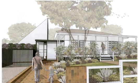
Assessment:
1. INTRODUCTION
1.1. History/Background
6.1976.22075.1 - Garage - Approved 14/04/1976
6.1986.2145.1 - Dwelling
Alterations - Approved 07/04/1986
10.2000.316.1 - Tree Removal -
Approved 27/06/2000
10.2017.515.1 - Tree Removal
Three (3) trees - Approved 09/10/2017
1.2. Description
of the proposed development
This application seeks approval for multi-dwelling housing
comprising 3 dwellings, as follows:
Stage 1: Alterations and additions to existing dwelling and
strata subdivision to create two (2) strata lots including vacant
development lot (each 580 m² and 553 m² respectively); and
Stage 2: Two (2) dwellings to create multi dwelling housing
comprising three (3) dwellings and strata subdivision lots (each 580 m²,
285 m², and 268 m²).
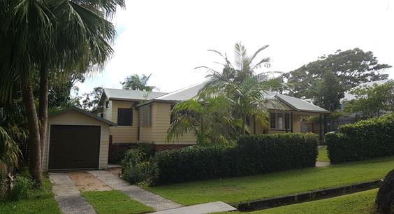
Proposal –
Photomontage from Carlyle Street
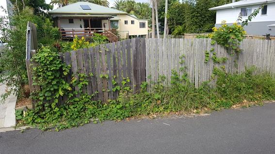
Current – cottage
and detached garage looking north from Carlyle Street
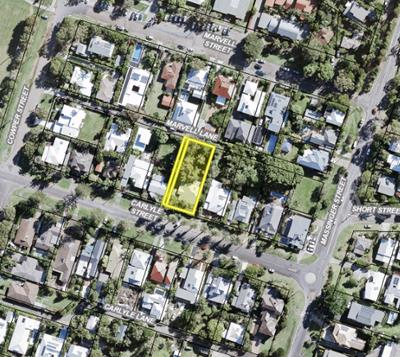
Current – cottage
looking south from Marvel Lane
1.3. Description
of the site
|
Land is legally described as
|
LOT: 14 SEC: 30 DP: 758207; Lot 2: DP 401710
|
|
Property address is
|
57 Carlyle Street BYRON BAY
|
|
Land is zoned:
|
R2 Low Density Residential
|
|
Land area is:
|
1165 m² (area of both lots combined)
|
|
Property is constrained by:
|
Kingsley Street Heritage Conservation Area
Acid Sulfate Soils - Class 3 - Part of Lot 2
Minimum Lot Size - 600 m²
Marvel Lane carriageway width limitations on vehicle
access
|
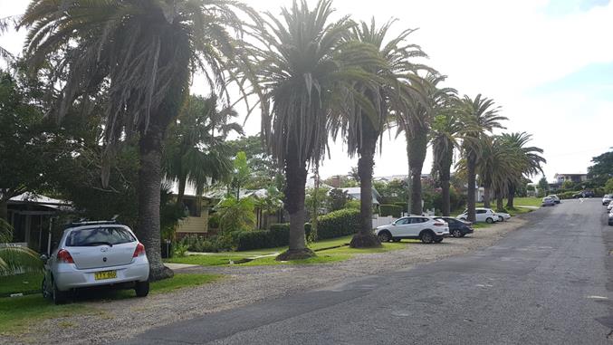
Site boundary of subject
lots
The Kingsley Street Conservation Area Statement of
Significance describes the area, as follows:
“A group of dwellings and other buildings, back
lanes, street trees and landscaping, which taken together, illustrate an aspect
of town development that has a special coastal town character which is highly
attractive and of high value in the district.”
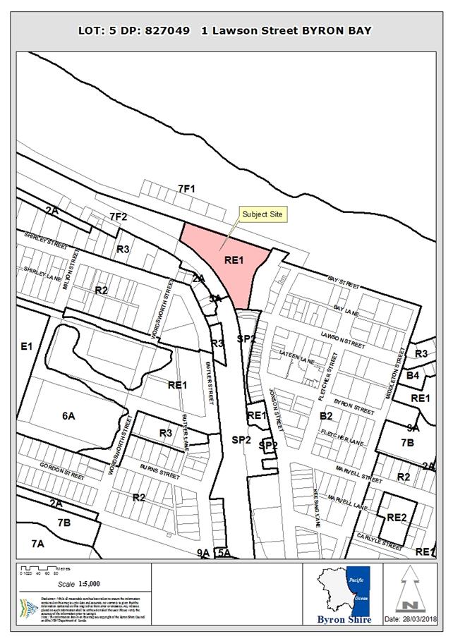
Streetscape character
2. SUMMARY OF
REFERRALS
|
Referral
|
Issue
|
|
Development Engineer
|
Not supported from an engineering viewpoint.
Reasons for Refusal
1. Marvel
Lane
In accordance with Byron Local Environmental Policy
2014 suitable vehicular access has not been provided. Marvel lane carriageway
width is 5m in front of the proposed Dwelling B and C driveways. This width
is not adequate for cars reversing out of the stacked parking and does not
comply with AS2890.1 requirements.
2. Car
Parking
In accordance with Development Control Plan 2014
Chapter B4.2.2 item 4 insufficient justification has been submitted to permit
stacked parking. All three dwellings propose stacked parking which is not
consistent with other developments in the immediate vicinity. In addition,
while DCP 2014 Chapter B4.2.2 does permit stacked parking in specific
situations, this development does not reflect the stated situations.
|
|
Heritage Consultant
|
Not supported.
“It is considered that the proposed development
would have an adverse impact upon the significance and setting of the
Kingsley Street Heritage Conservation Area. The proposed roof forms, design
of the proposed additions and the rear dwellings are likely to negatively
impact upon the setting of the existing dwelling, and the group of single
storey dwellings, streetscape and landscape setting which collectively
demonstrate historical, and aesthetic
significance as part of the Kingsley
Street Heritage Conservation Area.”
|
|
S64 / Systems Planning Officer
|
No objections subject to conditions.
|
|
S94 / Contributions Officer
|
No objections subject to conditions.
|
3. SECTION 79BA
– BUSH FIRE PRONE LAND
Under section 79BA of the Act, Council must be satisfied
prior to making a determination for development on bush fire prone land, that
the development complies with the document ‘Planning for Bush Fire
Protection 2006’. The site is not bush fire prone land.
4. SECTION 79C
– MATTERS FOR CONSIDERATION – DISCUSSION OF ISSUES
Having regard to the matters for consideration detailed in
Section 79C(1) of the Environmental Planning & Assessment Act 1979
(EP&A Act), the following is a summary of the evaluation of the issues.
4.1 State Environmental
Planning Instruments
|
|
Satisfactory
|
Unsatisfactory
|
|
State
Environmental Planning Policy No 55—Remediation of Land
|
☒
|
☐
|
|
Consideration: The site is located in an established urban
area with a long standing history of residential use. There are no
potentially contaminating land uses or dip sites known to have occurred on
the site or in the immediate vicinity and a search of Council’s records
find no history on contaminated land register. The closest radioactive sands
sites are at 53 Carlyle Street and 36 Marvell Street, both separated by a lot
or road reserve. A preliminary site investigation report is not required.
|
|
State
Environmental Planning Policy No 71—Coastal Protection
|
☒
|
☐
|
|
Consideration:
- No public
access to the coastal foreshore will be impeded or diminished as part of the
proposal
- No effluent
is proposed to be disposed other than to Council’s sewerage system.
- Stormwater
is to be discharged to street discharge point and will not be directly into
the coastal environment.
|
|
State
Environmental Planning Policy (Building Sustainability Index: BASIX) 2004
|
☒
|
☐
|
|
Consideration: Two BASIX certificates for alterations and
additions; and multi dwelling were submitted with the development
application.
|
4.2 Byron Local Environmental Plan
2014 (LEP 2014)
LEP 2014 is an applicable matter for consideration in the
assessment of the subject development application in accordance with subsection
79C(1) of the EP&A Act because it applies to the subject land and the
proposed development. The LEP 2014 clauses that are checked below are of
relevance to the proposed development:
|
Part 1
|
☒1.1|
☒1.1AA| ☒1.2| ☒1.3| ☒1.4| ☒Dictionary| ☒1.5| ☒1.6| ☒1.7| ☒1.8| ☐1.8A| ☒1.9|
☐1.9A
|
|
Part 2
|
☒2.1|
☒2.2 | ☒2.3 |☒Land Use Table | ☐2.4 | ☐2.5 | ☒2.6 | ☒2.7 | ☐2.8
|
|
Part 3
|
☐3.1|
☐3.2| ☐3.3
|
|
Part 4
|
☒4.1|
☐4.1A| ☐4.1AA| ☐4.1B |☐4.1C| ☐4.1D| ☒4.1E| ☐4.2| ☐4.2A| ☐4.2B| ☐4.2C| ☐4.2|☒4.3|☒4.4 |☒4.5 | ☒4.6
|
|
Part 5
|
☐5.1|
☐5.2| ☐5.3| ☐5.4| ☒5.5| ☐5.6| ☐5.7| ☐5.8|☐5.9| ☐ 5.9AA| ☒5.10| ☐5.11| ☐5.12|
☐5.13
|
|
Part 6
|
☒6.1|
☒6.2| ☐6.3| ☐6.4| ☐6.5| ☒6.6| ☐ 6.7| ☐6.8| ☐6.9
|
In accordance with LEP 2014 clauses 1.4 and 2.1 – 2.3:
(a) The
proposed development is defined in the LEP 2014 dictionary as Multi dwelling
housing;
(b) The
land is within the R2 Low Density Residential according to the Land Zoning Map;
(c) The
proposed development is permissible with consent; and
(d) Regard
is had for the Zone Objectives as follows:
|
Zone Objective
|
Consideration
|
|
To provide for the housing needs of the community within a
low density residential environment.
|
The proposed development would provide multi dwelling
housing at a density that is not suited to the particular location within a
low density environment and heritage conservation area.
|
|
To enable other land uses that provide facilities or
services to meet the day to day needs of residents.
|
The remaining checked clauses have been taken into
consideration in the assessment of the subject development application in
accordance with subsection 79C(1) of the EP&A Act. The proposed development
complies with all of these clauses (in some cases subject to conditions and/or
to the satisfaction of other assessing officers), except in relation to
which considered further as follows:
|
What clause does the development not comply with and what
is the nature of the non-compliance?
|
Further consideration, including whether the development
application is recommended for approval or refusal accordingly
|
|
Clause 4.1 Minimum subdivision lot size (600m²)
– new strata subdivision breaches minimum lot size
|
The proposed development should be refused because it will
result in a significant breach of the minimum subdivision lot size:
Stage 1: 7.8 % for vacant lot; 3.3% for lot containing
Dwelling A.
Stage 2: 52.5% for Dwelling B; 55.3% for Dwelling C.
|
|
Clause 4.1E Minimum lot sizes for dual occupancies, multi
dwelling housing and residential flat buildings (800 m²)
|
Complies because the current lots size is 1,165m²
(area of both lots combined). It is noted that the proposed development
will create a vacant lot of 553 m² for the proposed development of Two
(2) dwellings on one lot.
|
|
Clause 4.4 – Floor Space Ratio (Maximum 0.5:1)
|
The total FSR
complies for all three dwellings proposed when calculated against the current
total site area of 1,165 m² (area of both lots combined).
It is noted that the combined gross floor area of Dwellings
B & C proposed in stage 2 equals 339.64 m² on a 553 m²
site, which is an FSR that exceeds 0.6:1.
|
|
Clause 4.6 Exceptions to development standards
|
The proposed development should be refused because it
provides insufficient justification for variation to development standards.
The assessing officer considers that Council would not be satisfied that:
a) the
Applicant’s written request under Clause 4.6 of BLEP 2014 has
inadequately addressed the following matters required to be demonstrated:
i. that
compliance with the development standard is unreasonable or unnecessary in
the circumstances of the case, and
ii. that
there are sufficient environmental planning grounds to justify contravening
the development standard.
iii. the
proposed development will be in the public interest.
b) The
proposed development does not ensure that lot sizes and floor space ratio are
compatible with local environmental values and constraints and does not
facilitate the efficient use of land resources for residential purposes.
|
|
Clause 5.10 Heritage conservation – unacceptable
impacts
|
The proposed development should be refused because the
proposed built form is unacceptable in the Kingsley Street Heritage
Conservation Area, comprising a group of single storey dwellings, streetscape
and landscape setting, which collectively demonstrate historical, and
aesthetic significance in Byron Bay.
The dominant roof pitch in this locality is approximately
20-25 degrees. The proposed roof feature is 40 degrees and the total
height extends above the ridgeline of the existing roof structure. Impacts
arise, particularly with reference to the 40 degree high pitched roof
feature, flat roof features and dominance of the built form on the
streetscape of Carlyle Street and in Marvel Lane.
It is noted that the area is characterised by dwellings,
dual occupancies and granny flats, not multi dwelling housing.
The history of tree removal on the site has resulted in a
reduction in mature landscape setting with no evidence of replacement planting
having been undertaken in accordance with previous approvals for tree
removal. The proposed density and limited building separation will
reduce space on the site for deep soil planting. Council is not
satisfied that the overall layout and design constrained by multiple built
structures, including swimming pools, would support mature trees to be
successfully re-established on the site.
|
|
Clause 6.6 Essential services
|
The proposed development should be refused because Council
is not satisfied that adequate arrangements have been made for suitable
vehicle access that is essential for the development.
The proposed location of stacked parking in the building
set back and located side by side in Marvel Lane is unsuitable for safe and
suitable vehicle access and egress and would
result in multiple cars performing complex reversing manoeuvres to enter and
leave the site.
The width of Marvel Lane is not adequate for cars
reversing out of the stacked parking and does not comply with AS2890.1
Australian Standards requirements.
|
|
|
|
4.3 Any proposed Instrument
that has been the subject of public consultation and has been notified to the
consent authority
Draft SEPP (Coastal Management) 2016
The draft SEPP proposes to replace SEPP 14 (Coastal
Wetlands), SEPP 26 (Littoral Rainforest) and SEPP 71(Coastal Protection).
It will redefine the current ‘Coastal Zone’, to be within four
coastal management areas:
· coastal wetlands
and littoral rainforests area
· coastal
environment area;
· coastal use area;
and
· coastal
vulnerability area.
The subject site will be mapped within the coastal use
area. The proposed development is not in a wetland, littoral rainforest,
coastal environment area or coastal vulnerability area. The proposed
amendments to the consent do not raise any specific issues that apply to the
coastal use area provisions under the draft SEPP.
4.4A Byron Shire Development Control Plan 2014
(DCP 2014)
DCP 2014 is an applicable matter for consideration in the
assessment of the subject development application in accordance with subsection
79C(1) of the EP& A Act because it applies to the land to which LEP 2014
applies. The DCP 2014 Parts/Chapters that are checked below are of relevance to
the proposed development:
|
Part A
|
☒
|
|
Part B Chapters:
|
☒
B2| ☒ B3| ☒ B4| ☒ B5| ☒ B6| ☒ B7| ☒ B8| ☒ B9| ☐B10| ☐B11| ☐B12| ☐B13| ☒ B14
|
|
Part C Chapters:
|
☒
C1| ☐C2| ☐C3| ☐C4
|
|
Part D Chapters
|
☒
D1| ☐D2| ☐D3| ☐D4| ☐D5| ☐D6| ☐D7| ☐D8
|
|
Part E Chapters
|
☐
E1| ☐E2| ☐E3| ☐E4| ☐E5| ☐E6| ☐ E7
|
These checked Parts/Chapters have been taken into
consideration in the assessment of the subject development application in
accordance with subsection 79C(1) of the EP&A Act. The proposed development
complies with all sections of these Parts/Chapters (in some cases subject to
conditions and/or to the satisfaction of other assessing officers), except in
relation to certain prescriptive measures which are considered further (having
regard to the DCP 2014 Section A1 Dual Path Assessment) as follows:
|
What Section and prescriptive measure does the development
not comply with?
|
Does the proposed development comply with the Objectives
of this Section? Address.
|
Does the proposed development comply with the Performance
Criteria of this Section? Address.
|
|
B2 Preservation of Trees and Other Vegetation
|
There are no specific objectives in this section.
The application did not provide sufficient information to
assess the impact of the proposed removal of 9 trees.
A site survey plan submitted with the development
application labels most trees as palms or other species excluded from this
section of the DCP. Notwithstanding the plan also identifies Two (2)
Eucalypts and one tree species as ‘unknown’.
Council cannot be satisfied that the proposed removal of
trees is in accordance with the DCP.
|
N/A There is no performance criteria within this
chapter.
|
|
Chapter B3. Section B3.2.1: Provision of Services
· B3.2.1 Road
Access - laneway aisle width not adequate for cars reversing out of
stacked car park.
|
No The proposal fails to ensure provision of adequate
engineering and safety standards for public road access.
The proposed location of stacked parking in the building
set back and located side by side in Marvel Lane is unsuitable for safe and
suitable vehicle access and egress and would
result in multiple cars performing complex reversing manoeuvres to enter and
leave the site.
The width of Marvel Lane is not adequate for cars
reversing out of stacked parking and does not comply with AS2890.1 Australian
Standards requirements.
|
N/A There is no Performance Criteria within this Section.
|
|
Chapter B4 Traffic Planning, Vehicle Parking,
Circulation and Access
· B4.2.2 Parking
Layout Standards
|
No
The proposed layout fails to:
1. ensure
that parking supply and management in new developments supports Council
policies and objectives for the development of Byron Shire;
2. ensure
the safe and efficient circulation of vehicles entering, leaving and within
car parking and service/delivery areas;
3. ensure
that entry/exit points to car parking areas are situated in a way that sight
distances are maximised, and disruption to the circulation of vehicles on the
public road system is minimised.
Car parking requirements, parking layout, driveway widths
and vehicle manoeuvring areas are not in accordance with the relevant
sections of the current editions of Australian Standard 2890.
Each dwelling has 2 car spaces proposed. However, all
three dwellings propose stacked parking. This is not considered to be in
accordance with the intent of DCP 2014 Chapter B4.2.2 where stacked parking
is generally only favoured in specific situations.
This development does not reflect the stated situations.
Therefore, the car park design is to be amended to eliminate the proposed
stacked parking for all dwellings.
In addition, it is noted that all three dwellings propose
cars to be parked within the front set back of the building.
|
N/A There is no Performance Criteria within this Section.
|
|
Chapter B9: Landscaping
B9.3.1 General Landscape Principles
B9.4 Multi Dwelling Housing, Attached Dwellings and
Residential Flat Buildings
|
No.
The proposed development fails to meet the specified
general principles that apply to landscape design associated with development
in Byron Shire:
· Landscaping not
to interfere with utilities and services
· Planting in the
north west corner is located above the planned sewer connection.
· Landscaping not
to interfere with the structural integrity of buildings and structures -
Trees must not be planted within 3 metres of any building.
· Proposed trees
for Dwelling Band C are planted between 30 cm and 2.5 metres from the
proposed dwellings and pools.
· Landscaping does
not conserve - remaining trees.
· Nine (9) trees
proposed to be removed within a heritage conservation area.
· Landscaping
fails to incorporate sufficient compensatory locally indigenous plantings for
a previously tree removal (DA.10.2017.515.1) the planned
removal of further trees will significantly impact the character of the
heritage area
Landscaping will be constrained by the proximity of
building structures and services. This is expected to limit the growth
of mature trees to soften the harsh visual effect of extensive areas of
hard-surfacing, and the cumulative effect of building walls, car parking
areas and pavements when the development is viewed from adjoining public
streets or neighbouring properties.
The proposed development will fail to ensure a high
quality landscape and aesthetic environment for multi dwelling housing,
attached dwellings.
Specifically the proposal will not ensure:
a) retention of suitable existing vegetation;
b) screen planting to street frontages and driveway areas,
to provide privacy between dwelling houses and around the boundaries of the
site;
d) planting selection that relates to building scale and
mass.
The proposed Dwelling B and C fail to provide at least
90m² of landscaped area, required as a minimum.
|
There is no Performance Criteria for B9.3.1.
No. Landscaping does not reflect the scale of
development, does not complement existing the streetscape in Kingsley
Heritage Conservation Area has not been designed to maximise the number of
trees retained on the site.
|
|
Chapter C1 Non Indigenous Heritage
C1.3.1 General Streetscape Context
C1.4.1 Roof Form and Chimneys
C1.4.2 Verandahs
C1.4.6 Parking, Garages and Carports
C1.4.9 Subdivision
C1.6.3 Kingsley Street Byron Bay Conservation Area
|
No.
The proposal does not meet the following objectives:
1. To promote development that complements the existing
heritage character and amenity of the area and the heritage significance of
the heritage item or Heritage Conservation Area.
2. To maintain and enhance the heritage character of the
streetscape in the vicinity of the heritage item or within the Heritage
Conservation Area.
3. To ensure that new development respects the established
patterns and visual setting in the streetscape including setbacks, siting,
landscape settings, car parking and fencing.
4. To retain and reflect the character of building
frontage design in the streetscape.
The Heritage assessment prepared by Council’s
Heritage Consultant, does not support the development:
“It is considered that the proposed development
would have an adverse impact upon the significance and setting of the
Kingsley Street Heritage Conservation Area. The proposed roof forms, design
of the proposed additions and the rear dwellings are likely to negatively
impact upon the setting of the existing dwelling, and the group of single
storey dwellings, streetscape and landscape setting which collectively
demonstrate historical, and aesthetic significance
as part of the Kingsley Street Heritage
Conservation Area.” ( Refer to Doc # E2018/21832)
The proposal will significantly impact the established
landscape character of the locality including height of canopy and density of
boundary landscape plantings which will not be retained
The proposed development does not respect and
complement the existing heritage character of the streetscape.
Extensions with 40 degree pitched roof taller than the existing roof
ridgeline will overwhelm the original building.
No. The proposal fails to retain the characteristic
scale and massing of roof forms. Particularly the triangular roof feature,
altered roof pitches and flat roof structures on the verandah and garage.
No. The proposal does not ensure that original
verandahs or verandah elements are retained and that any new verandah
elements relate to the proportions and scale of the existing heritage
fabric.
No. The proposal does not ensure that garages and
driveways are designed to be compatible with the heritage environment, have
an adverse visual impact on heritage streetscapes and are visually discreet.
No. The proposed development fails to retain the
development and subdivision pattern of the Kingsley Street Heritage
Conservation Area including the characteristic rhythm and spacings of the
built form.
Comment:
The proposed development fails to:
· retain all
attributes of the Heritage Conservation Area that demonstrate its heritage
character and significance including its pattern of subdivision development,
boundary setbacks and all original external fabric; and
· does not respect
the existing character and integrity of the Heritage Conservation Area and is
not designed to be compatible with the existing group in terms of its
exterior appearances, facades, building heights, building styles, materials,
landscaping and lot sizes.
It does not provide adequate and visually compatible
accommodation for vehicles. This will have an adverse impact on the visual
quality of the low density setting of the Kingsley Street Heritage
Conservation Area.
The proposed development fails to meet the policy of
Kingsley Street Conservation Area. It does not:
· Retain all
attributes of the Heritage Conservation Area that demonstrate its heritage
character and significance including its pattern of subdivision development,
boundary setbacks and all original external fabric.
· Respect the
existing character and integrity of the Heritage Conservation Area and must
be designed to be compatible with the existing group in terms of its exterior
appearances, facades, building heights, building styles, materials,
landscaping and lot sizes.
|
No.
Fails to demonstrate that the proposed development
complements the character and heritage significance of the established
streetscapes on Carlyle Street and Marvel Lane in relation:
· roof form and
pitch
· scale, height
and proportion of buildings
· landscaping and
garden treatment
· spaces between
buildings
· facade
treatment, verandahs and window placement.
· placement and
design of
· garages and
driveways.
No. The proposed development fails to meet the
performance criteria for Clause C1.4.1, as follows:
· Maintain
traditional roof forms and materials.
· Roofs of
extensions should be carefully related to the existing roof in materials,
shape and pitch.
· New buildings
must have roofs that reflect the orientation, size, shape, pitch, eaves,
ridge heights and bulk of existing roofs in the locality, and must be in
proportion with the proposed building.
No. The proposed development fails to meet the
performance criteria for Clause C1.4.2, as follows:
· In altering
existing buildings, original verandahs must be kept where possible, repaired
and respected.
· Additional
verandahs must not compete with the importance of the original and should be
simple in design.
No. The proposed development fails to meet the
performance criteria for Clause C1.4.6, as follows:
Garages should generally be kept separate from the house,
be of a simple design, must use traditional pitched roof forms and must match
the roof pitch, form and materials of the main building as closely as
possible.
Further, the location of car parking for dwelling B and C
does no respect the existing vegetation and original garden layouts on the
site.
No. The proposed development fails to meet the
performance criteria for Clause C1.4.9, as follows:
· Allotment and
building spacing, including frontage widths, side and front boundary setbacks
must not impact adversely on vistas and views to and of heritage items and
Heritage Conservation Areas.
· The setting
of a heritage item and a satisfactory curtilage, including important
landscape and garden elements, must be retained.
· The
subdivision must not require Landscape quality of the streetscape in Heritage
Conservation Areas must be retained.
T
here is no performance criteria for Clause C1.6.3
|
|
D1 Residential Accommodation in Urban, Village and
Special Purpose Zones
· D1.2.1
Building Height Plane
|
Yes.
The breach of the Building height planes is relatively
minor.
|
Not applicable.
|
|
· D1.2.2
Setbacks - Minimum Street Frontage Setbacks
|
No.
The proposed dwellings will not :
· complement and
harmonise with existing and planned streetscapes and development in the
locality.
· achieve spacing
of residential developments that achieve high quality living environments
relative to residential amenity and proximity of neighbouring development.
|
No.
No development or car parking is permitted within the
building setbacks other than garbage, storage facilities, mail boxes,
landscaping and driveways.
The proposed single garages would necessitate car spaces
required by the development to be located within the minimum street frontage
setback for the building. This is not permitted under the DCP.
The proposed integrated garages are not detached as
required in the heritage conservation area and will dominate the laneway
street frontage.
|
|
D1.6.3 Landscaping
|
No.
The proposed development fails to provide attractive
landscapes that reinforce the function of the street, enhance the amenity of
dwellings and the built environment, and allow preservation of significant
vegetation.
It is particularly noted that the proposed subdivision of
the dwellings would provide minimal deep soil area and in the absence of a
common landscaped area, the subdivisions would result in dwellings both
attached and detached on their own lot.
It is noted that at least 25% of the entire site will be
deep soil area (319.78 m² being 27.5 %).
Although not strictly a numeric requirement applicable to
multi dwelling housing, subdivision would result in dwellings on their own
lot. It is considered that the individual lot sizes proposed would
result in minimal deep soil areas with limited space between buildings to
support the growth of mature trees:
Dwelling A: 29.5 %:
Site area: 580 m²
Deep soil area: 171.32 m²
Dwelling B: 30 %
Site area: 285 m²
Deep soil area: 86.85 m²
Dwelling C: 23 %
Site area: 268 m²
Deep soil area: 61.61m²
The proposal is an overdevelopment of the site and removes
further trees and mature vegetation.
|
No.
|
|
D1.6.4 On site car parking
|
No. The proposal does not ensure that vehicle access
to and from development is safe, effective and enhances visual amenity.
|
No. See B4 above.
|
The proposed development should be refused because it does
not meet multiple relevant Objectives and prescriptive measures of Byron DCP
2014.
4.5 Any Planning Agreement or
Draft Planning Agreement?
|
|
Yes
|
No
|
|
Is there any applicable planning agreement or draft
planning agreement?
|
☐
|
☒
|
|
Consideration: Not applicable.
|
4.6 Environmental Planning
& Assessment Regulation 2000 Considerations
|
Clause
|
This control is applicable to the proposal:
|
I have considered this control as it relates to the
proposal:
|
If this control is applicable, does the proposal
comply?
|
|
92
|
Yes
|
Yes
|
Yes
|
|
93
|
No
|
N/A
|
N/A
|
|
94
|
No
|
N/A
|
N/A
|
|
94A
|
No
|
N/A
|
N/A
|
* Non-compliances and any other significant issues
discussed below
4.7 Any coastal zone management
plan?
|
|
Satisfactory
|
Unsatisfactory
|
Not applicable
|
|
Is there any applicable coastal zone management plan?
|
☐
|
☐
|
☒
|
|
|
4.8 The likely impacts of that
development, including environmental impacts on both the natural and built
environments, and social and economic impacts in the locality
|
Impact on:
|
Likely significant impact/s?
|
|
Natural environment
|
Yes. The proposal will have a significantly adverse impact
on the natural environment of the locality.
|
|
Built environment
|
Yes. The proposal will have a significantly adverse impact
on the built environment of the locality.
|
|
Social Environment
|
No. The proposal will not have a significant social impact
on the locality.
|
|
Economic impact
|
No. The proposal will not have a significant economic
impact on the locality.
|
The development has been assessed against Council Policies
that are applicable to the proposed development.
4.9 The suitability of the site
for the development
|
Issue
|
Comment
|
|
Services
- Access
|
The proposed development should be refused because Council
is not satisfied that adequate arrangements have been made for suitable
vehicle access that is essential for the development.
The proposed location of stacked parking in the building
set back and located side by side in Marvel Lane is unsuitable for safe and
suitable vehicle access and egress and would
result in multiple cars performing complex reversing manoeuvres to enter and
leave the site.
The width of Marvel Lane is not adequate for cars reversing
out of the stacked parking and does not comply with AS2890.1 Australian
Standards requirements.
The proposal represents an overdevelopment of the site.
|
4.10 Submissions made in accordance with
this Act or the regulations
The development application was publicly exhibited. There
were four (4 ) submissions made on the development application:
- Two
(2) with no objections
- Two
(2) Against
Submissions made in relation to the following matters:
No objection
1. No
objection to the application for alterations and additions. However, we
would like to bring to Councils attention that the current state of the road in
the area of 57 Carlyle Street is already in a very poor state of repair.
2. We
are the owners of 58 Carlyle St, Byron Bay and would like to provide additional
support to the below request made by our neighbour, Robyn and Denis Unwin for
Byron Bay Council to address the damaged road that we share.
We agree that the state of the
road is a risk to property and the safety of drivers and pedestrians using the
road.
Can you please confirm
Council’s intention to address this risk, and the timeframe that it will
be completed?
Against
1. Multiple
concerns:
a. Whilst Marvell Lane
has “recently been upgraded” it should not be used for vehicle
parking.
b. We do not need any
more short-term holiday letting in the vicinity.
c. Do the proposed 2 X 3
bedroom units, i.e. 6 bedrooms on Marvell Lane, have enough off-street vehicle
parking?
d. Why is there only one pedestrian
access of 1.2m?
e. Site access during
construction
f. Site access
after construction
g. Please take into consideration our concerns for this development. If
Council decides to approve this development, then the continued amenity of our
neighbourhood without additional visual, noise and air pollution, and without
holiday let disruptions.
h. that the laneway neighbourhood is not significantly disrupted during
the build process with congestion by delivery and trades parking for
unnecessarily long times in the lane.
2. Multiple
concerns:
a. Marvell
lane cannot handle 2 x 3 bedroom residences with no parking for all. It will be
very disruptive for all existing residents. It is not complying with
council regulations or even considering surrounding residents.
b. I
have observed on the plans that they are requesting stacked parking for the two
rear residences with no set back. It is my understanding that a 3 meter set
back is required in the laneway (5.5 m for a driveway non compliant.) This DA
is requesting this for 2 residences on 1 site. You are also assuming that
they will be using the garage for the second parking space for each residence,
currently other residences do not park in garages and driveways, instead using
the lane and do not have consideration for other residents. Bottom line is,
what they are requesting is illegal and does not work. The Lane is already very
congested and I believe this will cause more congestion and ongoing problems.
c. Height
planes for the front and back structures on the western boundaries are also non
compliant. Both of these structures need to be within required height
plains and will affect our property with shading. They are trying to put too
much on each lot and I strongly object.
d. The
drawings show new fences along the western boundary. What type?, how
high? This needs to be clarified. Also our landscaping and trees we
have planted as well as dogs cannot be impacted with construction of the new
proposed fence.
e. Parking
in the laneway is a huge problem, with our driveways being blocked consistently
by residents that do not use their garages or driveways and also builders. It
is very important that we can access our driveways with ease. The turning
radius is very tight in the lane therefore parking on the fences up to
driveways is not acceptable.
f. I
request that during the building period that there is no parking for builders
and trades in the Lane, only onsite parking and deliveries only. All trucks and
cars need to park in Cowper Street or on development site. We had this clause
on our recent build and our builders and trades adhered to this which
worked for all residents living in the lane. It is very important due to the
congestion in Marvell Lane. We had a sign displayed so it was very clear
what the rules are. A traffic management plan needs to be put in place –
again we had this on our DA and it worked.
g. Privacy
is very important to us and I request privacy screens on the second story
Bedroom windows or mature trees on the western boundary as mature trees have
already been removed which has already impacted our privacy. We did not
receive a DA showing removal of said native trees.
h. I
object the current DA and feel they are trying to put too much on each
lot. The rear lot cannot withstand two 3 three bedroom dwellings. I feel
my above requests are very important and justified.
4.11 Public interest
The proposed development contravenes Council’s adopted
development standards and controls without sufficient justification and
approval will set a precedent for similarly inappropriate development within
land zoned low density residential in a heritage conservation area. The
proposed development is not in the public interest.
4.12 Section 5A of the EP&A Act –
Significant effect on threatened species
Having regard to sections 5A, 5C and 5D of the EP&A Act, there is unlikely to be a significant effect on threatened species,
populations or ecological communities, or their habitats as a result of the
proposed development because there is no known threatened species on the site.
4.13 Section 5B of the EP&A Act –
Have regard to register of critical habitat
The NSW Critical
Habitat Register does not identify any critical habitat on or adjacent to the
site.
5. DEVELOPER
CONTRIBUTIONS
5.1 Water & Sewer Levies
Section 64 levies would be payable should the development be
approved.
5.2 Section 94 Contributions
Section 94 Contributions would be payable should the
development be approved.
6. DISCLOSURE OF
POLITICAL DONATIONS AND GIFTS
|
Has a Disclosure Statement been received in relation
to this application
|
No
|
|
Have staff received a ‘gift’ from anyone involved
in this application that needs to be disclosed. Where the answer is yes, the
application is to be determined by the Director or Manager of the Planning,
Development and Environment Division.
|
No
|
Provide Disclosure Statement register details here: Not
applicable
7. CONCLUSION
The proposed development is not consistent with relevant
clauses of Byron LEP 2014 and various sections of Byron DCP 2014. In particular
heritage character, landscaping, car parking and access to the site remain of a
significant concern and the proposal represents an over development of the
site. The site is not suitable for the proposed development and the development
is not in the public interest. Accordingly, the proposed development is
recommended for refusal.
Staff Reports - Sustainable Environment and Economy 13.17
Report No. 13.17 Report
of the Planning Review Committee Meeting held on 15 March, 2018
Directorate: Sustainable
Environment and Economy
Report
Author: Chris
Larkin, Manager Sustainable Development
File No: I2018/458
Theme: Ecology
Development and Approvals
Summary:
This report provides the outcome of the Planning Review
Committee Meeting held on 15 March, 2018.
|
RECOMMENDATION:
That Council note the report.
|
Report:
The meeting commenced at 4.30
and concluded at 4.45pm.
Present: Crs Martin,
Coorey, Lyon, Hackett, Cameron, Ndiaye
Staff: Chris Larkin
(Manager Sustainable Development).
Apologies: Crs Spooner,
Hunter
The following development
application was reviewed with the outcome shown in the final column.
|
DA No.
|
Applicant
|
Property Address
|
Proposal
|
Exhibition
Submission/s
|
Reason/s
Outcome
|
|
10.2017.755.1
|
Mr DE Robinson
|
5 Luan Court
Byron Bay
|
Secondary dwelling and tree
removal
|
Level 1
25/1/18 to 7/2/18
6 submissions
|
Delegations
to Staff
|
Staff Reports - Sustainable Environment and Economy 13.18
Report No. 13.18 Directions
Document and Draft Integrated Pest Management Policy
Directorate: Sustainable
Environment and Economy
Report
Author: Clare
Manning, Biodiversity Officer
File No: I2018/461
Theme: Ecology
Planning Policy and Natural Environment
Summary:
To inform the preparation
of an Integrated Pest Management Strategy (IPM Strategy), Council has prepared
a Directions Document and draft Integrated Pest Management Policy (Policy), as
per Resolution 13-621.
The Directions Document reports
on the current success and impediments to implementing Resolution 13-621, which
addresses pesticide use in Byron Shire. In the nearly five years since the
passing of the Resolution, pesticide use by Council staff has ceased in all
children’s playgrounds, formal bus stops, in town and village centres and
15 of 23 sports fields. However, achieving reduced pesticide use has not come
without cost, and whilst in many situations that cost is acceptable, in others
it is not. For example, cessation or reduced use of pesticides has resulted in
some areas having potentially compromised public or operator safety, biosecurity
management or infrastructure protection; and in some cases there are issues
around responsible financial management. These impediments have been considered
in the Directions Document which identifies opportunities to place the intent
of the original Resolution in a more practical and secure long-term pesticides
use policy framework.
The Directions Document and
draft Policy will underpin and provide guidance on the development of the IPM
Strategy. It is intended that the IPM Strategy will establish local priorities
for pest species and areas to be managed and identify required pest management
strategies and actions, with implementation timeframes and responsibilities
assigned. The action plan component will include mechanisms and timeframes for
monitoring and reporting on its implementation and success in managing the
impacts of pest species within Byron Shire while also aspiring to cease or
minimise pesticide use.
The timeframe to develop
the IPM Strategy was reported to the 12 March 2018 Biodiversity Advisory
Committee. The Committee supported Option 1 which provides for delivery of the
IPM Strategy by early 2019 to enable robust and well considered community
engagement on the draft Policy, which ultimately underpins the Strategy. Refer
to the ‘Report on the Biodiversity Advisory Committee Meeting held on 12
March 2018’ also on todays agenda.
It is therefore recommend
that the draft Policy, accompanied by the Directions Document, be placed on
public exhibition for a period of six weeks from April to May 2018. The
exhibition will be supported by government agency and community workshops
tentatively planned for early May 2018.
|
RECOMMENDATION:
That
Council:
1. Place
the draft Integrated Pest Management Policy (Attachment 2 E2018/28298) on
public exhibition for a period of six weeks and that the exhibition of the
Policy be accompanied by the Directions Document (Attachment 1 E2018/28400).
2. Consider
an allocation of $50,000 in 2018-19 budgets to complete the development of
the Integrated Pest Management Strategy.
|
Attachments:
1 Integrated
Pest Management Directions Document for Public Exhibition (version 1.0), E2018/28400 ⇨
2 Draft
Integrated Pest Management Policy for Public Exhibition (version 0.7), E2018/28298 ⇨
Report
Council resolved (Resolution 13-621) to
develop a shire-wide Integrated Pest Management Policy and Strategy for Council
owned and managed lands.
In response to the Resolution, a consultant was engaged to
prepare a preliminary draft Integrated Pest Management Strategy. The
preliminary draft Strategy was considered at the 4 August 2016 Council Meeting
and Council resolved (Resolution 16-362 in part) to peer review
the draft Integrated Weed Management Strategy against Council resolution 13-621
to ensure its compliance. Council at the 20 April 2017 meeting (Resolution
17-141 in part) noted that staff are undertaking an internal peer
review of the preliminary draft Strategy.
The Pest Management Working Group, consisting of staff and a
Landcare representative, found that the preliminary draft Strategy only partially
aligned with the intent of Resolution 13-621 in that:
· a
shire wide integrated weed management strategy was prepared for Council owned
and managed land, in consultation with Council staff, community and experts in
the field
· the
IWMS makes a strong case to minimize (though not cease) the use of pesticides
on Council owned or managed land but where required, to use them responsibly in
the control of pests i.e. that weeds cannot be adequately and economically
controlled in the Shire unless synthetic pesticide (i.e. a man-made produced
substance register with the APVMA that prevents, repels, alters or kills a
pest) are used in some situations.
· the
draft IWMS provides an audit of pesticides used by Council
· the
draft IWMS makes clear that alternative weed control methods are most needed in
highly frequented public use areas only and supports the use of planting as
means of weed control
· the
draft IWMS offers slight guidance on monitoring and reporting requirements
· the draft IWMS offers
actions to trial organic pesticides
The Working Group concluded the draft IWMS does not:
· offer
a clear vision statement to underpin the development of a shire wide integrated
pest management policy
· provide
a shire wide integrated pest management policy or framework
· address
integrated pest animals management
· direct
Council on how and where to prioritise and cease (or even minimise) the use of
synthetic pesticides within the desired timeframe of 5-years
· offer
what priority research projects should be undertaken in partnership with
universities to guide Council on monitoring and assessing the use of synthetic
pesticides
· offer
suggested initiatives to encourage landholders to adopt non-use of synthetic
pesticides to be considered by Council
Also at the 20 April 2017 meeting Council resolved to note (Resolution
17-141 in part) that staff are developing a Directions Document to
provide a continued direction for reducing the use of pesticide on Council land
in the long term.
In the nearly five years since the passing of Resolution
13-621, pesticide use by Council staff has ceased at:
· All
34 children’s playgrounds;
· All
41 formal bus shelters;
· All
207 public garden beds and kerbs in town and village centres (excluding
roundabouts);
· 70%
(or 15 of 23 sports fields that are permanently open to the public;
· Roadsides
where there is no safety or known biosecurity issue; and,
· Majority
of public buildings (with respect to managing rodents).
Cessation of pesticide use has been achieved through
adoption of Integrated Pest Management principles, which has allowed
improvements and innovation in various locations. Approaches to
pesticide-free weed control in the Shire now include manual weed removal,
timely treatments, steam cleaning (of kerbs), steam weeding, garden bed edging
and mowing.
The Directions Document (Attachment 1) reports these current
success further as well as impediments to implementing Resolution 13-621,
through a series of case studies, along with other pesticide reduction
initiatives from around the world. It identifies circumstances in which
pesticides, while the least preferred option, might at times be essential to
ensure that Council meets its statutory obligations around road safety and pest
management as prescribed in legislation. For example, on 1 July 2017, the
Biosecurity Act 2015 and Biosecurity Regulations 2017 commenced providing
specific legal requirements for state-level priority weeds and high-risk
activities. The Directions Document also identifies opportunities to
place the intent of the original Resolution in a more practical and secure
long-term integrated pest management framework. This framework underpins the
draft Integrated Pest Management Policy (Attachment 2).
It is recommended that the
draft Integrated Pest Management Policy is publicly exhibited for a period of 6
weeks from April to May 2018 and that
its exhibition be accompanied by the Directions
Document.
Bryon Shire hosts a broad
diversity of views on the issue of pesticide use, and community engagement is
vital to shape a policy and strategy that reflects these views. Due to
the complexity and highly debated range of issues it would be prudent to ensure
adequate community engagement is undertaken to disseminate information to the
local and wider community and gain feedback in a meaningful and constructive
way.
The draft Policy will
establish Council’s position on the use of pesticides. Exhibiting the
draft Policy ahead of the Strategy will ensure that the Strategy is founded on
a Policy that has received robust community engagement.
Biodiversity Advisory Committee consultation
The Biodiversity Advisory
Committee considered the delivery timeframe for the Directions Document, draft Policy
and Strategy at the 12 March 2018 meeting. The Committee recommends that
Council support Option 1 for delivery of the Directions Document and draft
Policy in April 2018 and the Strategy in early 2019. Refer to the ‘Report on the Biodiversity
Advisory Committee Meeting held on 12 March 2018’ also on todays agenda
and the following link to the Committees 12 March meeting agenda which includes
information on the two timeframe options to deliver the Strategy:
http://byron.infocouncil.biz/RedirectToDoc.aspx?URL=Open/2018/03/BAC_12032018_AGN_870_AT.PDF
Should Council not support the Biodiversity Advisory
Committees recommendation and instead resolves on Option 2 timetable for
delivery of a Strategy by December 2018, then Council would not exhibit the
draft Policy and accompanying Directions Document but instead support them in
principle so they can inform development of the Strategy. The draft
Policy and draft Strategy would then be exhibited together later in the year.
The risk with Option 2 is that Council’s draft policy position on the use
of pesticides will not have received community input and the Strategy will be
drafted on a policy position that has not been adopted by Council.
Additionally, if Council adopts the Option 2 timeframe for
delivery of the Strategy then further funds are required to support other
biodiversity projects as existing staff resources will be reassigned to
delivery of the Integrated Pest Management Strategy, including:
· Delivery
of the Pest Animal Plan, a grant funded project. Additional funds of $8,600
will be required to keep the deliverables on track, as per the Grant Agreement.
· Delivery
of the Biodiversity Conservation Strategy would need to be placed on hold to
fast tack the Integrated Pest Management Strategy. Alternatively, if Council
chose to proceed with this project concurrently an additional project officer
would be required to manage the project at an additional budget allocation of
$40,000.
The Biodiversity Advisory Committee considered the draft
Policy and Directions Document at the 9 April 2018 meeting. The Committee
undertook an inspection of several pest management sites in Byron Bay and
Brunswick Heads to better understand the intent of the draft Policy.
Public exhibition
Over the six week public exhibition period, the public will
be informed, consulted and involved by:
· Factsheets
· Our website
· Media releases
· Community workshop tentatively
planned for early May 2018. in Mullumbimby
· Making a written
submission by email to submissions@byron.nsw.gov.au
or post to The General Manager, PO Box 219 Mullumbimby 2482.
Financial Implications
Council’s 2017-18 budget has provided funds of $33,300
for the Directions Document, draft Policy and community engagement program.
Additional funds estimated of $50,000 in 2018-19 budget will
be required for the completion of the IPM Strategy and further community
engagement.
Statutory and Policy Compliance Implications
Council’s 2017-18 Operational Plan lists the preparation
of an Integrated Pest Management Policy and Strategy as key activities (EN
1.1.3).
All planning documents:
Ø Byron
Shire’s Community Engagement Policy
Ø Byron
Shire’s Community Strategic Plan 2022
Ø NSW Biosecurity Act
Ø Local Land Services Act
The Acts (above) guide how pest (weeds & pest animals)
are managed across NSW. The Acts establish a responsibility for all landholders
to manage pests on their land.
Staff Reports - Sustainable Environment and Economy 13.19
Report No. 13.19 PLANNING
- Update on Council Resolution 18-041 - Planning a new era for the Byron Arts and
Industry Estate
Directorate: Sustainable
Environment and Economy
Report
Author: Rob Van
Iersel, Major Projects Planner
File No: I2018/478
Theme: Ecology
Planning Policy and Natural Environment
Summary:
At the Ordinary Meeting of 1 February 2018, Council resolved
(18-041):
1. Note
the report and acknowledge the current work and projects under way that relate
to the Byron Arts and Industrial Estate.
2. Acknowledge
the need to prepare a comprehensive precinct plan for the staged redevelopment
and revitalisation of the Byron Arts and Industrial Estate. The key
objectives of the precinct plan to include inter alia:
· provision
of new opportunities for economic growth and employment generation in the Byron
Arts and Industry Estate that capitalise on the creative industries there
· to
enable the precinct to receive a much needed “face lift” as well as
improving access and amenity and facilities for all users
3. Request
staff in the Place Planning Team to commence the preparation of a detailed
project plan for the preparation of a comprehensive precinct plan for the Byron
Arts and Industrial Estate and wider environs as per 2 above; and that the
precinct plan is to include consideration of the following: traffic and parking
management, alternate transport options including car share, park and ride, use
of the rail corridor, land use mix and density, place activation and
beautification, technology needs like NBN, identification of land which links
key sites including Cavanbah, Bayshore Drive railway station, future park and
ride sites and walking and pedestrian links. The project plan will outline the
key stages, milestones, stakeholders and a budget outline for the project.
4. Note
that to inform the Byron Arts and Industrial Estate project viability and a
feasibility assessment of Lot 12 Bayshore Drive and the Council depot site for
a range of uses to ensure any on or off site impacts from the future
redevelopment of these sites is taken into account during this precinct
planning process. The feasibility study is to be included in the project
plan.
5. Consider
the project plan and costing at the April council meeting, and that a budget
allocation for the project be considered as part of the in the 2018-19 budget
process reported then.
This report provides information on the Project Plan
developed in response to this resolution.
It is recommended that the preparation of the Precinct Plan
for the estate be undertaken through an Enquiry by Design process.
Enquiry by Design has been described as "an intensive,
interactive forum, over 2 – 4 days that aims to produce non-binding urban
design and planning visions for complex projects". It can be a very
useful participatory process that brings together technical expertise and
community vision to provide urban design outcomes. It can also compress
timeframes for what could be, under a more traditional process, a project that
could span many months.
There are a number of urban design consulting firms with
significant experience in this process. Bringing them together with the
knowledge, skills and vision of key community stakeholders, and the technical
expertise of relevant Council staff, will provide an opportunity to achieve the
key objectives outlined in the Council resolution.
While no quotes have yet been sought, it is anticipated that
the costs required to undertake an Enquiry by Design process for the Arts and
Industry Estate Precinct Plan Project will be in the order of $40,000-$60,000,
depending on the make up of the final team and the number of days required for
the forum itself. This would be additional to staff time for the Place
Planning Team and representatives of Infrastructure Services.
NOTE TO COUNCILLORS:
In accordance with the
provisions of S375A of the Local Government Act 1993, a Division is to be
called whenever a motion for a planning decision is put to the meeting, for the
purpose of recording voting on planning matters. Pursuant to clause 2(a)
under the heading Matters to be Included in Minutes of Council Meetings of
Council's adopted Code of Meeting Practice (as amended) a Division will be
deemed to have been called by the mover and seconder of all motions relating to
this report.
|
RECOMMENDATION:
1. That
Council endorse Enquiry by Design as the process for preparation of
the Arts and Industry Estate Precinct Plan, subject to budget allocation of
$60,000 in the 2018/19 Budget.
2. That,
subject to allocation of project budget, Council prepares a Request for
Quotation, targeting urban design consultants with expertise and experience
in Enquiry by Design.
3. That
assessment of quotations received be reported to Council with a
recommendation in regard to proceeding with the project.
|
Report
As outlined in the report to Council’s meeting of 1
February 2018, the Byron Arts and Industry Estate has changed substantially
over recent years. Having started as a conventional industrial estate, it
has evolved into a much more diverse precinct, with creative industries,
business start-ups, retail, shop top housing, food and more adding to mix of enterprises
undertaken at the Estate.
As this evolution continues, it generates a range of issues
that need consideration, including, but not limited to, infrastructure
(including telecommunications), movement of people and vehicles, land use
compatibility and urban design/ cohesiveness.
Council’s planning controls should be reviewed to
ensure that they stay ‘ahead of the game’ in facilitating the
future for the estate that is envisaged by the landowners, users and wider
community.
Consideration of Council-owned land at Lot 12 is important
in this mix, as is the potential future for Council’s current depot site
and the continued use and operation of the Cavanbah Centre and the Elements
tourist facility.
Master planning for this locality will require:
· close collaboration
with land owners and users;
· a thorough
understanding of the existing place, its users, challenges and needs;
· specific technical
expertise in respect of planning, urban design, infrastructure planning (and
more);
· appreciation of
wider community visions and aspirations; and
· an ability to pull
all of this together into a realistic plan that can provide a framework for the
future.
It is recommended that the following scope be adopted for
the project:
1. Information
gathering / strategy development
There is a lot we already know about
the Arts & Industry Estate. Consultants engaged by Council for the
Employment Lands Strategy have undertaken a comprehensive audit of existing
land uses, which we can build on to get a clear picture of what is there at the
moment.
We can also collate and build on what
we know in regard to servicing, traffic and parking and flooding and drainage.
2. Preliminary
consultation
To assist in building a clear
understanding of the area, we would engage with Councillors, key land owners/
occupiers/ community groups and the wider community to appreciate current
issues and future visions.
3. Enquiry
by Design
Enquiry by Design is an intensive,
interactive process particularly suited to urban redevelopment projects. In
essence, it brings together governance, technical skills and key community
stakeholders to produce urban design outcomes, tested “live” as
they are developed.
The following summary, taken from
website participedia.net provides a useful overview of the process.
Summary
An Enquiry-by-Design is defined by
deliberative democracy scholar and practitioner Janette Hartz-Karp as "an
intensive, interactive forum, over 2-4 days that aims to produce non-binding
urban design and planning visions for complex projects" (Hartz-Karp 2004).
Similar in procedure to a Charette, the Enquiry-by-Design method is used in
more specific instances of urban design such as single-site
redevelopment.
Problems and Purpose
Enquiry-by-Design is used in cases
where an urban redevelopment project is thought to have positive, regenerative
effects on the community. This creates a win-win situation between the
government or other implementing body and the citizenry: where the former
requires an urban area be altered, the latter will most likely be keen to have
a say in the process. The Enquiry workshops bring together a technical
team and a consultation group to develop a both a mutually satisfying design
and a feasible implementation strategy (Hartz-Karp 2004). It is therefore
suggested that the Enquiry-by-Design method be employed in cases where
interrelated urban challenges are being discussed; while the technical team
could adequately address the immediate design concerns on their own, the
consultant group is necessary to ensure the design fits in with the broader
goals of the community. For example, the Enquiry-by-Design method was
used in Bassendean, Australia to redesign a train station which, it was hoped,
would provide an "attractive and safe focal point, as well as [a] catalyst
for further renewal of the Bassendean town centre area" (Parry,
2016).
History
The Enquiry-by-Design process has
been used in both Australia, New Zealand, and England (ESD: Enquiry by
Design).
Two case studies are available
on Participedia.net ;
· the
Bassendean Train Station Enquiry-by-Design in 2001 at http://participedia.net/en/cases/bassendean-train-station-enquiry-design;
and
· the
comprehensive, long-term community planning of Port Hedland in 2004 at http://participedia.net/en/cases/port-hedland-enquiry-design.
Participant Recruitment and
Selection
The method used to select
participants can vary from case to case and is primarily determined by the
scope of the project and the level of actual or anticipated contention among
stakeholders. The Bassenden case used a random selection method, public
advertisements and targeted invitation of key stakeholder groups. In
contrast, the Enquiry-by-Design in Port Hedland used a telephone survey prior
to the event followed by a random sample, public advertisements and the
establishment of a steering group made up of stakeholders, local
council’s representatives and members of the regional development
commission (Parry 2016). The technical team is usually comprised of
"multidisciplinary experts including local and state government
representatives and consultants such as urban designers, economists and
architects, notionally around 20 people" (NCDD 2008).
Deliberation, Decisions,
and Public Interaction
The Enquiry can last anywhere from
2-4 days and is attended by members of the technical team and the consultation
group. The first half day is dedicated to briefing members of both groups
on the event process, the design principles and project scope. As well, a
discussion of the community values is held which, it is expected, both teams
will take into consideration in their decision-making. This time period
may also include brief presentations on specific issues by technical
experts.
The rest of the first day and the
morning of the next are dedicated to the development of urban design concepts
by the technical team. Depending on the complexity of the project, it may
be useful for smaller sub-teams to conceptualize and brainstorm ideas which are
then fed back to the main team for consideration.
At the end of the second day, the
technical team meets with the consultation team and relays their work thus
far. The consultation team then takes the rest of the day to
independently review the progress and suggest any changes.
The technical team takes the final
1-2 days to incorporate the consultation team's advice into its final design
plans, which are again reviewed by the consultation team before the final
report is written. The final report is to contain "the process, the
community's input, the technical team's response, and implementation
strategies" (Hart-Karp 2004).
Influence, Outcomes, and
Effects
The novelty of the
Enquiry-by-Design process lays in what Hartz-Karp terms a "live
environment" which "provides immediate feedback to the Technical Team
developing the plans" (Hartz-Karp 2004). The final report is thus
far more complete than those of other processes such as citizens' juries or
consensus forums, since it is not only a measure of public opinion but an
amalgamation of public opinion, technical know-how and stakeholder approval. In
short, the final report, presents the convening body with a 'ready-to-go'
implementation plan - both technically feasible and community approved.
Analysis and Lessons
Learned
The enquiry-by-design method is
unique in providing multiple instances for the collection of feedback from the
participants. At the end of each of the technical team's two working
days, the consultation team is provided with a report not only of the design
plans but of the procedure followed to create them. The consultation team
is to assess all aspects of the technical team's work and may therefore provide
'live' feedback on the procedure itself. The enquiry-by-design's success
hinges on the ability and willingness of the technical team to take in and act
on the consultation team's advice.
As well, the enquiry-by-design
method is meant to include all stakeholders - including lay community members -
from conceptualization to design to implementation. While the final
report is a the product of technical design and community consultation, and
could, in theory be placed solely into the hands of officials for
implementation, the enquiry process demands that the report be distributed to
all participants for further consideration and consensual development of
further action plans (Prince's Foundation 2008). Practitioners looking to
use the enquiry-by-design method should take seriously the continued engagement
of the original technical and consultation teams during and after the
implementation process if the totality of positive, regenerative effects of the
design is to be actualized.
For the Arts & Industry
Estate project, it is recommended that an urban design consultancy team, with
experience in leading the process, be engaged. This team would be
supplemented by Council staff from Sustainable Environment and Economy and Infrastructure
Services. In particular, Council’s Business Analyst would be a key
team member, to provide feasibility assessments before and during the process
for key sites such as Lot 12 and the depot land.
While quotations have not been
sought, previous experience would suggest that consultants costs could be in
the order of $40,000 - $60,000, depending on the number of consultants making
up the team and the number of days proposed for the Enquiry by Design.
4. Wider
engagement and adoption of the Precinct Plan
While the Enquiry by Design process
can provide a well-developed precinct plan, it would be wise to undertake a
broader consultation process with the wider community. At the same time,
further work would be undertaken internally to consider and document a detailed
project plan to implement the plan.
The results of both these steps
could then be considered by Council before adoption of a final plan.
Financial Implications
As outlined above, preparation of a Precinct Plan for the
Arts & Industry Estate, addressing the requirement of Council resolution
18-014 is likely to require a budget allocation in the order of $60,000.
Note a consideration of this amount has been included in the 2018/19 budget
process current.
Statutory and Policy
Compliance Implications
Implementation of the Precinct Plan for the Arts and
Industry Estate is likely to require amendments to Byron Local Environmental
Plan 2014 and Byron Development Control, Plan 2014. The nature and extent
of these amendments would become clear during the Enquiry by design process.
Staff Reports - Sustainable Environment and Economy 13.20
Report No. 13.20 PLANNING
- 26.2017.4.1 - Planning Proposal for Rezoning and Reclassifying Part Lot 22 DP
1073165 Mullumbimby
Directorate: Sustainable
Environment and Economy
Report
Author: Steve
Daniels, Project Officer - Planning Reforms
File No: I2018/498
Theme: Ecology
Planning Policy and Natural Environment
Summary:
On 23
November 2017 Council resolved to support a planning proposal that relates to
Council owned land located at the southern edge of Mullumbimby, described as
part Lot 22 DP 1073165.
The planning
proposal aims to:
· Alter the land use zone
(and related controls) to permit residential development with an emphasis on
affordable housing.
· Reclassify the land from
Community land to Operational land.
· Include local provisions
to encourage diverse and affordable housing on key sites to be identified on a
map in Byron LEP 2014.
The planning proposal was sent to DPE requesting a Gateway
determination in December 2017. In March 2018 DPE advised “there
is an issue with the proposed affordable housing provisions in the planning
proposal for Stuart Street Mullumbimby. Council’s intention to require
50% of the dwellings in a development to be used for affordable housing is in
effect a contribution for affordable housing. Since Byron LGA is not listed in
SEPP 70 (Affordable Housing), the inclusion of the affordable housing
provisions in the Byron LEP 2014 as proposed by the planning proposal is
contrary to the EPA Act, 1979.”
DPE suggested there are three options for this planning proposal to
proceed:
“1. Amend the planning proposal to remove the proposed
affordable housing provisions; or
2. Withdraw the planning
proposal until such time as Byron Council has pursued its
inclusion into
SEPP 70; or
3. Request
the Department to proceed to issue a Gateway determination for the planning
proposal as submitted, though it is likely that any Gateway determination will
contain a condition requiring the removal of the affordable housing provisions
from the proposal.”
Council has allocated resources to this planning proposal in order
to achieve affordable and diverse housing outcomes on part of Lot 22 DP 1073165
through its rezoning and reclassification. The matters raised by DPE are valid
but they are not fatal to Council achieving affordable and diverse housing
outcomes on this land.
Option 3 allows Council to maintain the momentum of the planning
proposal and continue with the site specific studies and further consultation
that are required prior to exhibition of the planning proposal (e.g. a summer
survey for the threatened species Hairy-joint Grass and Missionary
Nutgrass). Rezoning and reclassifying this land is the key to achieving
affordable housing on it. That process should continue.
Council can also resolve to commence a separate process to consider
amending SEPP 70, LEP 2014 and the Development Contributions Plan in relation
to affordable housing provisions.
Council should request DPE issue a Gateway
determination for the planning proposal as submitted with a condition requiring
the removal of the affordable housing provisions from the proposal.
NOTE TO COUNCILLORS:
In accordance with the
provisions of S375A of the Local Government Act 1993, a Division is to be
called whenever a motion for a planning decision is put to the meeting, for the
purpose of recording voting on planning matters. Pursuant to clause 2(a)
under the heading Matters to be Included in Minutes of Council Meetings of
Council's adopted Code of Meeting Practice (as amended) a Division will be
deemed to have been called by the mover and seconder of all motions relating to
this report.
|
RECOMMENDATION:
That Council:
1. Request
NSW Department of Planning and Environment proceed to issue a Gateway
determination for the planning proposal as submitted by Council and accept
that this will include a condition requiring the removal of the affordable
housing provisions from the proposal.
2. Agree
that staff can proceed to further studies and then public exhibition of the
planning proposal and government agency consultation based on the Gateway
determination issued by the NSW Department of Planning and Environment, and
report back to Council as part of post-exhibition reporting.
3.
Request staff to prepare a report for Council outlining the information and
process to consider amending SEPP 70, LEP 2014 and the Byron Development
Contributions Plan in relation to affordable housing provisions.
|
Attachments:
1 Form of
Special Disclosure of Pecuniary Interest, E2012/2815
⇨
Report
The Planning Proposal
On 23 November 2017 Council
resolved to support a planning proposal that relates to Council owned land
located at the southern edge of Mullumbimby, described as part Lot 22
DP 1073165. Lot 22 is an irregular shaped lot that is split by
a railway line and has part of its boundary to Saltwater Creek. It
includes Mullumbimby community gardens. It has a total area of approximately
29.2 hectares. Approximately 22 hectares was affected by zone
changes in the planning proposal. The balance of the zones within the
subject land was to remain unchanged.
The planning proposal Council
supported was to:
§ Insert
R1 General Residential as a new zone in Byron LEP 2014
§ Rezone
approximately 22 hectares of the existing RE1 Public Recreation zone to R1
General Residential
§ Apply
a minimum lot size of 200 m2 to the R1 General Residential zone
area on Lot 22 DP 1073165
§ Reclassify
part Lot 22 DP 1073165 from Community to Operational to reflect the
changes to the zoning of the land and prospective change of land use
§ Insert
a Key Sites Map in Byron LEP 2014 and identify part Lot 22 DP 1073165
on that map
§ Insert
new local provisions into Byron LEP 2014 to encourage diverse
and affordable housing on key sites identified on the Key Sites Map.
Past
Council Resolutions on this Planning Proposal
Council
resolved on 23 November 2017 as follows:
17-597 Resolved that Council:
1. Agree
to initiate the planning proposal to amend Byron LEP 2014 (Attachment 1) for
the reasons outlined in this report.
2. Forward
the planning proposal to the NSW Department of Planning and Environment for a
Gateway determination.
3. Agree
that staff can proceed to public exhibition of the planning proposal and
government agency consultation based on the Gateway determination issued by the
NSW Department of Planning and Environment, and report back to Council as part
of post-exhibition reporting.
Key
Issues
Department of Planning and Environment (DPE) Response to
Gateway
The planning proposal and supporting information was sent to
DPE in December 2017.
On 1 March 2018 DPE advised:
“there is an issue with the proposed affordable
housing provisions in the planning proposal for Stuart Street Mullumbimby.
Council’s intention to require 50% of the dwellings in a development to
be used for affordable housing is in effect a contribution for affordable
housing.
Section 7.32 (formerly 94F) of the Act provides that a
contribution for affordable housing cannot be required unless the local
government area (LGA) is listed in clause 9 of SEPP No. 70 Affordable Housing (Revised
Schemes). Even if an LGA is listed in SEPP 70 it must also have in place a
scheme for dedications or contributions for affordable housing adopted by the
SEPP.
Since Byron LGA is not listed in SEPP 70, the inclusion
of the affordable housing provisions in the Byron LEP 2014 as proposed by
the planning proposal is contrary to the Act.
The Department is happy to talk with Council about being
included in SEPP 70. Council would need to justify inclusion in the SEPP by
providing a detailed analysis of the need for affordable housing in their LGA
as has recently been done for Randwick City, Inner West, Northern Beaches, City
of Ryde and City of Canada Bay councils.
Byron Council could then write to the Minister asking the
SEPP be amended. Such a process would follow the same process that has occurred
for the current exhibition for the above mentioned metro councils only the
amendment would go further and remove the requirement to be within the Greater
Sydney area.
Council has the following options in relation to the
planning proposal:
1. Amend
the planning proposal to remove the proposed affordable housing provisions; or
2. Withdraw
the planning proposal until such time as Byron Council has pursued its
inclusion into SEPP 70; or
3. Request
the Department to proceed to issue a Gateway determination for the planning
proposal as submitted, though it is likely that any Gateway determination will
contain a condition requiring the removal of the affordable housing provisions
from the proposal.
Should the planning proposal proceed with the
reclassification and rezoning of the Stuart Street land without the proposed
affordable housing provisions, it is envisaged that Council could still pursue
its intention to provide affordable housing on the site as it is the land
owner. This could be achieved through mechanisms outside of the planning system
such as conditions on contracts of sale for the land, Council developing the
land itself in conjunction with a community housing provider etc.”
Staff has reviewed the DPE advice and agree with it.
DPE now require Council to decide on how it wants to proceed with this planning
proposal.
Options
to Move Forward
Option 1 – This entails DPE sending the
planning proposal back and then Council amending it before going back to DPE
requesting a Gateway determination on the revised version. The amended version
cannot refer to the local provisions for affordable housing. It is an option
that will achieve the same as option 3 in the end but take a couple of months
longer to get there. Option 3 is preferred.
Option 2- This requires Council to resolve to write
to DPE asking them to send the planning proposal back to Council. Council would
then need to prepare a case to amend SEPP 70 including sufficient information
to justify the specific affordable housing provisions. Byron LEP 2014 would
then still need to be amended as would Byron Development Contributions
Plan. This work would take at least another 12 months (or more) to
complete (starting from the date of the decision to proceed) and require
considerable staff or consultant resources. There is no guarantee that DPE will
agree with amending the SEPP or applying the local affordable housing
provisions. When the SEPP has been amended the planning proposal could go back
to DPE for a Gateway determination. This option is not preferred.
Option 3 - This requires Council to resolve to write
to DPE agreeing that it can proceed to issue a Gateway determination (knowing
that it will be conditional on the removal of the affordable housing local
provisions). This Gateway can be issued quickly and then Council can continue
to finalise the supporting information and early consultation before commencing
the public exhibition of the planning proposal. The planning proposal would
still rezone the subject land for residential purposes, reclassify the land and
identify it on a key sites map as suitable for diverse housing. Because
Council owns the land it can still be developed for affordable housing, with
the involvement of organisations such as North Coast Community Housing once the
land is rezoned. While this planning proposal continues Council staff can bring
a report back that considers a separate process to commence the amendment of
SEPP 70, LEP 2014 and the Byron Development Contributions Plan to achieve
affordable housing provisions. This option is preferred.
In
summary the three options open to Council on this matter are:
1. Ask DPE to send
the planning proposal back so Council can remove the proposed affordable
housing provisions.
2. Ask DPE to send
the planning proposal back and commence a process to amend SEPP 70, LEP 2014
and the Development Contributions Plan
3. Request DPE to
proceed to issue a Gateway determination for the planning proposal as
submitted, accepting that it will be conditional on requiring the removal of
the affordable housing provisions from the proposal.
Conclusion
Council has allocated resources
to this planning proposal in order to achieve affordable and diverse housing
outcomes on part of Lot 22 DP 1073165 through its rezoning and
reclassification. The matters raised by DPE are valid but they are not fatal to
Council achieving affordable and diverse housing outcomes on this land.
Option 3 allows Council to maintain the momentum of the
planning proposal and continue with the site specific studies and further
consultation that are required prior to exhibition of the planning
proposal ( eg a summer survey for the threatened species Hairy-joint
Grass and Missionary Nutgrass). While this is occuring Council can commence
a separate process to consider amending SEPP 70, LEP 2014 and the Development
Contributions Plan in relation to affordable housing provisions.
Council should request DPE to proceed to issue a Gateway
determination for the planning proposal as submitted with a condition requiring
the removal of the affordable housing provisions from the proposal.
Financial Implications
If Council chooses to proceed with the planning proposal, it
will be at its own expense given that Council owns the land and has initiated
the planning proposal. If Council chooses not to proceed then the matter
does not incur any additional costs.
Statutory and Policy
Compliance Implications
The relevant policy considerations are addressed above and
in the previous reports on this planning proposal.
Staff Reports - Sustainable Environment and Economy 13.21
Report No. 13.21 PLANNING
-DA 10.2017.526,1 Carport and Shed at 1 Lawson Street, Byron Bay
Directorate: Sustainable
Environment and Economy
Report
Author: Rochelle
Barclay, Planner
File No: I2018/605
Theme: Ecology
Development and Approvals
Proposal:
|
DA No:
|
10.2017.526.1
|
|
Proposal description:
|
Carport and Shed
|
|
Property description:
|
LOT: 5 DP: 827049
|
|
1 Lawson Street BYRON BAY
|
|
Parcel No/s:
|
187230
|
|
Applicant:
|
Matt Walker Town Planning
|
|
Owner:
|
Byron Shire Council
|
|
Zoning:
|
RE1 Public Recreation
|
|
Date received:
|
25 September 2017
|
|
Public notification or exhibition:
|
- Level
0 advertising under DCP 2014 Part A14 – Public Notification and
Exhibition of Development Applications
- Exhibition
period: NA
- Submissions received:
N/A
|
|
Planning Review Committee:
|
Not applicable
|
|
Delegation to determination:
|
Council
|
|
Issues:
|
· Erosion Precinct
· Acid Sulfate
Soils
· Bushfire Prone
Land (Part site Buffer)
|
Summary:
This application seeks development consent for the
construction of a Carport and a Shed (ancillary to existing development
(Caravan park & Camping Ground)(LEP 2014). The proposed development is not
likely to result in significant impacts on the existing environment and raises
no issues in terms of Councils Planning controls. It is recommended that the
development be approved subject to conditions of consent. .
NOTE TO COUNCILLORS:
In accordance with the
provisions of S375A of the Local Government Act 1993, a Division is to be
called whenever a motion for a planning decision is put to the meeting, for the
purpose of recording voting on planning matters. Pursuant to clause 2(a)
under the heading Matters to be Included in Minutes of Council Meetings of
Council's adopted Code of Meeting Practice (as amended) a Division will be
deemed to have been called by the mover and seconder of all motions relating to
this report.
|
RECOMMENDATION:
Pursuant to Section
80 of the Environmental Planning & Assessment Act 1979, Development
Application No. 10.2017.526.1 for the construction of a Carport and a Shed (ancillary to
existing Caravan Park & Camping Ground) be granted consent as per the
conditions in Attachment 2.#E2018/26467.
|
Attachments:
1 Proposed
Plans 10.2017.526.1, E2018/25389 ⇨
2 consent
conditions, E2018/28627 ⇨

Assessment:
1. INTRODUCTION
1.1. History/Background
· BA 71/2120 for
Cabins Approved 9/1/1985;
· BA 96/2538 for
Dwelling Approved 12/9/96
· 5.1992.175.1
Dwelling Approved 28/5/92
· 5.1995.174.1
Cycleway and Path and Revegetation works approved 25/9/96
· 5.1996.326.1
Dwelling additions approved 7/4/97
· 6.1992.2199.1
Relocated Dwelling approved 7/4/97
· 6.1993.2135.1
Outbuilding- Garage/storage/laundry approved 8/4/93
· 6.1994.2349.1
Outbuilding-Shed approved 22/6/94
· 6.1994.2538.1
Outbuilding- Amenities Block/Camp Kitchen approved 8/8/94
· 6.1996.2548.1
Dwelling Caretaker/Manager- additions to managers residence approved 16/6/98
· 10.2000.632.1
Storage Room approved 15/12/00
· 10.2001.305.1
Add/alt to Kiosk, new first aid building and replacement fencing approved
16/10/01
· 10.2002.738.1 Tree
Trimming and pruning Withdrawn
· 10.2004.539.1
Managers Residence and Campers Kitchen Approved 15/06/05
· 10.2006. 12.1 Tree
Removal approved 15/2/06
· 10.2008.25.1
Alterations & additions to existing caravan park approved 28/2/08
1.2. Description
of the proposed development
This application seeks approval for the construction of a
single Carport and a Shed (ancillary to existing development being The First
Sun Caravan Park & Camping Ground) near the entrance to the site of Lawson
Street
The proposed carport will also provide cover to the proposed
shed which will be adjoining an existing shed on the site. The carport roof
reaches a maximum height of 3.0m with a colorbond roof and cladding along the
two sides.
The image below shows the positioning of the proposed
carport and shed relevant to other existing development on the site:
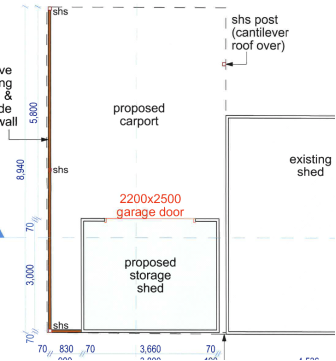
Figure 1 Perspective

Figure 2: Floor Plan
1.3. Description
of the site
|
Land is legally described as
|
LOT: 5 DP: 827049
|
|
Property address is
|
1 Lawson Street BYRON BAY
|
|
Land is zoned:
|
RE1 Public Recreation
|
|
Land area is:
|
18630 m2
|
|
Property is constrained by:
|
Bushfire prone land – Part site (Buffer)
Acid Sulfate Soils Class 3
High Conservation Value High Environmental
Value
No vegetation removal is proposed as a part of this
application and accordingly this item is not addressed in any further detail.
|
2. SUMMARY OF
REFERRALS
|
Referral
|
Issue
|
|
Building Surveyor
|
No objections subject to conditions. Refer to Doc # A2017/25810.
The Building Certifier highlighted the required setback of
1.8 metres to the adjoining cabin. A condition of consent will be included to
ensure that prior to issue of the Construction certificate, a site plan
showing regulatory setbacks is provided.
|
|
S64 / Systems Planning Officer
|
No objections subject to conditions. Refer to Doc # A2017/16689.
|
3. SECTION 79BA
– BUSH FIRE PRONE LAND
Part of the site is mapped as Bushfire Buffer Zone (north
western corner). Referencing the “Best Practice Guide to Bushfire
Protection- Upgrading of Existing Buildings.” (NSW Rural Fire Service,
2011) and in consideration of the small scale of the development and the
proximity to any bushfire risk, it is considered that the development is
unlikely to be affected by bushfire. Notwithstanding a separate approval is
required under Section 100B of the Rural Fires Act 1997. Conditions of consent
to apply.
4. SECTION 79C
– MATTERS FOR CONSIDERATION – DISCUSSION OF ISSUES
Having regard to the matters for consideration detailed in
Section 79C(1) of the Environmental Planning & Assessment Act 1979
(EP&A Act), the following is a summary of the evaluation of the issues.
4.1 State Environmental
Planning Instruments
|
|
Satisfactory
|
Unsatisfactory
|
|
State
Environmental Planning Policy No 21—Caravan Parks
|
☒
|
☐
|
|
Consideration: This SEPP should already have been
considered for the initial application. The proposal is for ancillary
structures only.
|
|
State Environmental
Planning Policy No 55—Remediation of Land
|
☒
|
☐
|
|
Consideration: This application was not referred to the
Environmental Health officer at the allocations meeting. The lot has been
improved by cabins since 1986. Records indicate there has been a continued
tourist and visitor accommodation use on the site. No records indicate the
lot was used for anything other than these purposes... The application is for
a shed and carport ancillary to the existing caravan park and is not intended
for habitation. It is considered that this application does not intensify the
use of the site, nor does it propose to change the existing use. Based on the
existing and continuous use of the land it is considered that the site is
unlikely to be contaminated.
|
|
State
Environmental Planning Policy No 71—Coastal Protection
|
☒
|
☐
|
|
Consideration: Council must consider the matters listed at
Section 8 of SEPP 71.
Matters for consideration for development within the
coastal zone:
· retention
of existing public access to the coastal foreshore
· impact
of effluent disposal on water quality
· development
must not discharge untreated stormwater into a coastal water body.
The proposed application has no
detrimental effects in relation to Coastal Protection.
|
4.2A Byron Local Environmental Plan 2014 (LEP 2014)
LEP 2014 is an applicable matter for consideration in the
assessment of the subject development application in accordance with subsection
79C(1) of the EP&A Act because it applies to the subject land and the
proposed development. The LEP 2014 clauses that are checked below are of
relevance to the proposed development:
|
Part 1
|
☒1.1|
☒1.1AA| ☒1.2| ☒1.3| ☒1.4| ☒Dictionary| ☒1.5| ☒1.6| ☒1.7| ☒1.8| ☐1.8A| ☒1.9|
☐1.9A
|
|
Part 2
|
☒2.1|
☒2.2 | ☒2.3 |☒Land Use Table | ☐2.4 | ☐2.5 | ☐2.6 | ☐2.7 | ☐2.8
|
|
Part 3
|
☐3.1|
☐3.2| ☐3.3
|
|
Part 4
|
☐4.1|
☐4.1A| ☐4.1AA| ☐4.1B |☐4.1C| ☐4.1D| ☐4.1E| ☐4.2| ☐4.2A| ☐4.2B| ☐4.2C| ☐4.2|☒4.3|☐4.4 |☐4.5 | ☐4.6
|
|
Part 5
|
☐5.1|
☐5.2| ☐5.3| ☐5.4| ☐5.5| ☐5.6| ☐5.7| ☐5.8|☐5.9| ☐ 5.9AA| ☐5.10| ☐5.11| ☐5.12|
☐5.13
|
|
Part 6
|
☒6.1|
☐6.2| ☐6.3| ☐6.4| ☐6.5| ☒6.6| ☐ 6.7| ☐6.8| ☐6.9
|
In accordance with LEP 2014 clauses 1.4 and 2.1 – 2.3:
(a) The
proposed development is defined in the LEP 2014 Dictionary as Carport &
Shed;
(b) The
land is within the RE1 Public Recreation according to the Land Zoning Map;
(c) The
proposed development is permitted with consent ; and
(d) Regard
is had for the Zone Objectives as follows:
|
Zone Objective
|
Consideration
|
|
• To
enable land to be used for public open space or recreational purposes.
|
The proposal
is for a shed and carport ancillary to the existing approved caravan park
& camping ground and does not compromise the intent of the objectives.
|
|
• To
provide a range of recreational settings and activities and compatible land
uses.
|
|
• To
protect and enhance the natural environment for recreational purposes.
|
The remaining checked clauses have been taken into
consideration in the assessment of the subject development application in
accordance with subsection 79C(1) of the EP&A Act. The proposed development
complies with all clauses of LEP 2014 (in some cases subject to conditions
and/or to the satisfaction of other assessing officers).
6.1 Acid Sulfate Soils
The site is situated on land in PASS 5 category. It is
unlikely that the proposed works will lower the water table below 1 metre AHD
on any adjacent Class 1, 2, 3 or 4 land. In this way no further
consideration of this item is considered necessary.
Clause 6.6 Essential Services
Clause 6.6 of Byron LEP 2014 states that:
Development consent must not be granted to development
unless the consent authority is satisfied that any of the following services
that are essential for the development are available or that adequate
arrangements have been made to make them available when required:
(a) the supply of water,
(b) the supply of electricity,
(c) the disposal and management of sewage,
(d) stormwater drainage or on-site
conservation,
(e) suitable vehicular access.
The proposal was referred to Councils Development Engineer
and ET team. The proposed development will have essential services available to
service the development. It is noted that the development is ancillary to
existing approved development.
4.3 Any proposed Instrument
that has been the subject of public consultation and has been notified to the
consent authority
Draft SEPP (Coastal Management)
2016
The Draft Coastal Management State
Environmental Planning Policy (SEPP) proposes to establish a new, strategic
land use planning framework for coastal management. It is intended to support
the implementation of the management objectives set out in the Coastal
Management Act 2016.
Once adopted, the Coastal Management SEPP
will be the single land use planning policy for coastal development and will
bring together and modernise provisions from SEPP 14 (Coastal Wetlands), SEPP
26 (Littoral Rainforests) and SEPP 71 (Coastal Protection).
The aim of the Draft SEPP is to promote an
integrated and co-ordinated approach to planning in the ‘Coastal
Zone’, identifying four coastal management areas:
· coastal wetlands
and littoral rainforests area
· coastal
environment area;
· coastal use area;
and
· coastal
vulnerability area.
The subject site is mapped within
the ‘coastal use area’ and ‘coastal hazard area’. The
draft provisions for consideration of development within this area generally
reflect the existing matters for consideration currently outlined in SEPP
71.
The proposal is considered to be acceptable having regard to
the provisions of the Draft SEPP particularly Division No’s. 4 & 5.
The proposed development is not in a wetland, littoral rainforest, or coastal
vulnerability area.
4.4A Byron Shire Development Control Plan 2014
(DCP 2014)
DCP 2014 is an applicable matter for consideration in the
assessment of the subject development application in accordance with subsection
79C(1) of the EP& A Act because it applies to the land to which LEP 2014
applies. The DCP 2014 Parts/Chapters that are checked below are of relevance to
the proposed development:
|
Part A
|
☐
|
|
Part B Chapters:
|
☐B2|
☐B3| ☐B4| ☐B5| ☐B6| ☐B7| XB8| ☐B9| ☐B10| ☐B11| ☐B12| ☐B13|
☐B14
|
|
Part C Chapters:
|
☐C1|
☐C2| ☐C3| ☐C4
|
|
Part D Chapters
|
☐D1|
☐D2| XD3| ☐D4| ☐D5| ☐D6| ☐D7| ☐D8
|
|
Part E Chapters
|
☐
E1| ☐E2| ☐E3| ☐E4| XE5| ☐E6| ☐ E7
|
These checked Parts/Chapters have been taken into
consideration in the assessment of the subject development application in
accordance with subsection 79C(1) of the EP&A Act. The proposed development
is demonstrated to meet the relevant Objectives of all relevant Parts/Chapters
(in some cases subject to conditions and/or to the satisfaction of other
assessing officers).
B8- Site Waste Minimisation & Management
No SWMMP was provided- a condition of consent requiring
compliance with the intent of this chapter will be included in the consent.
E5 - Certain Locations in Byron Bay and Ewingsdale
A condition of consent will be included in relation to the
erosion escarpment; including a S88E instrument.
4.5 Any Planning Agreement or
Draft Planning Agreement?
|
|
Yes
|
No
|
|
Is there any applicable planning agreement or draft
planning agreement?
|
☐
|
☒
|
|
|
4.6 Environmental Planning
& Assessment Regulation 2000 Considerations
|
Clause
|
This control is applicable to the proposal:
|
I have considered this control as it relates to the
proposal:
|
If this control is applicable, does the proposal
comply?
|
|
92
|
Yes
|
Yes
|
Yes
|
|
93
|
No
|
No
|
No
|
|
94
|
No
|
No
|
No
|
|
94A
|
No
|
No
|
No
|
* Non-compliances and any other significant issues
discussed below
4.7 Any coastal zone management
plan?
|
|
Satisfactory
|
Unsatisfactory
|
Not applicable
|
|
Is there any applicable coastal zone management plan?
|
☐
|
☐
|
☒
|
|
|
4.8 The likely impacts of that
development, including environmental impacts on both the natural and built
environments, and social and economic impacts in the locality
|
Impact on:
|
Likely significant impact/s?
|
|
Natural environment
|
No. The proposal will not have a significantly adverse
impact on the natural environment of the locality.
|
|
Built environment
|
No. The proposal will not have a significantly adverse
impact on the built environment of the locality.
|
|
Social Environment
|
No. The proposal will not have a significant social impact
on the locality.
|
|
Economic impact
|
No. The proposal will not have a significant economic
impact on the locality.
|
4.9 The suitability of the site
for the development
The site is a serviced, unconstrained property and is
suitable for the proposed development.
4.10 Submissions made in accordance with
this Act or the regulations
The development application was not publicly notified .
4.11 Public interest
The proposed development is unlikely to prejudice or
compromise the public interest or create a undesirable precedent
4.12 Section 5A of the EP&A Act –
Significant effect on threatened species
Having regard to sections 5A, 5C and 5D of the EP&A Act, there is unlikely to be a significant effect on threatened species,
populations or ecological communities, or their habitats as a result of the
proposed development because explanation no native vegetation is proposed for
removal.
4.13 Section 5B of the EP&A Act –
Have regard to register of critical habitat
The NSW Critical
Habitat Register does not identify any critical habitat on or adjacent to the
site.
5. DEVELOPER
CONTRIBUTIONS
5.1 Water & Sewer Levies
No Section 64 levies will be required.
5.2 Section 94 Contributions
No Section 94 Contributions will
be required.
6. DISCLOSURE OF
POLITICAL DONATIONS AND GIFTS
|
Has a Disclosure Statement been received in relation
to this application
|
No
|
|
Have staff received a ‘gift’ from anyone
involved in this application that needs to be disclosed. Where the answer is
yes, the application is to be determined by the Director or Manager of the
Planning, Development and Environment Division.
|
No
|
Provide Disclosure Statement register details here: Not
applicable
7. CONCLUSION
This application seeks development consent for the
construction of a Carport and a Shed (ancillary to an existing
development Caravan park & Camping Ground). The proposed development is not
likely to result in significant impacts on the existing environment and
is considered suitable for the proposed development. It is recommended that the
development be approved subject to conditions of consent listed at the end of this
report.
Staff Reports - Sustainable Environment and Economy 13.22
Report No. 13.22 PLANNING
- Development Application 10.2018.10.1 - Use of existing garage as a bedroom
with ensuite and wet bar, construction of new parking space and driveway - 5
Milton Street, Byron Bay
Directorate: Sustainable
Environment and Economy
Report
Author: Paul
Mills, Senior Planner
File No: I2018/610
Theme: Ecology
Development and Approvals
Proposal:
|
DA No:
|
10.2018.10.1
|
|
Proposal description:
|
Use of existing garage as a bedroom with ensuite and wet
bar, construction of new parking space and driveway.
|
|
Property description:
|
LOT: 1 DP: 317023
|
|
5 Milton Street BYRON BAY
|
|
Parcel No/s:
|
118160
|
|
Applicant:
|
Planners North
|
|
Owner:
|
Ms E Van Haandal
|
|
Zoning:
|
R2 Low Density Residential
|
|
Date received:
|
15 January 2018
|
|
Integrated Development:
|
No
|
|
Public notification or exhibition:
|
- Level
0 advertising under DCP 2014 Part A14 – Public Notification and
Exhibition of Development Applications
- Exhibition
period: N/A
- Submissions received:
Nil.
|
|
Planning Review Committee:
|
Not applicable.
|
|
Delegation to determination:
|
Meeting of full Council
|
|
Issues:
|
· Clause 4.6
request for variation submitted, seeking to exceed the maximum FSR of 0.5:1.
Proposed FSR is 0.588:1 (The proposal represents a 17.5% to the development
standard)
· The proposal does
not comply with Council’s DCP 2014 controls for parking spaces,
landscaping and expanded houses.
· Bush fire prone
land.
|
Summary:
This application seeks approval for Use of existing garage
as a bedroom with ensuite and wet bar, construction of new parking space and
driveway.
The proposed development exceeds the maximum Floor Space
Ratio (FSR) for the subject site as refer to in Clause 4.4 of LEP 2014. The
applicant has submitted a Clause 4.6 request for variation to allow the
proposed development to exceed the maximum FSR by 17.5%, this request is not
considered to have sufficient planning merit to warrant approval. The proposal
also involves non-compliances with Council’s DCP 2014 controls relating
to car parking, landscaping and expanded houses.
The application has not demonstrated the proposed
development is able to satisfy Section 79BA of the Act which requires the
development to accord with the provisions of the document Planning for Bush
Fire Protection 2006.
The proposed development is considered to lack planning
merit is and is recommended for refusal.
NOTE TO COUNCILLORS:
In accordance with the
provisions of S375A of the Local Government Act 1993, a Division is to be
called whenever a motion for a planning decision is put to the meeting, for the
purpose of recording voting on planning matters. Pursuant to clause 2(a)
under the heading Matters to be Included in Minutes of Council Meetings of
Council's adopted Code of Meeting Practice (as amended) a Division will be
deemed to have been called by the mover and seconder of all motions relating to
this report.
|
RECOMMENDATION:
That
pursuant to Section 80 of the Environmental Planning & Assessment Act
1979, Development Application no. 10.2018.10.1 for Use of existing garage as a bedroom
with ensuite and wet bar, construction of new parking space and driveway, be refused for the following reasons:
1. Section 76A of the Environmental
Planning and Assessment Act 1979 provides that specified development may
not be carried out except with development consent, and that a person must
not carry out development on land (to which that provision applies) unless
such a consent has been obtained and is in force. The submitted Development
Application seeks retrospective development consent for a conversion which
has already been carried out and development consent is unable to be
granted.
2. Pursuant to Section 79C(1)(a)(i)
of the Environmental Planning and Assessment Act 1979, the proposed development
significantly exceeds the maximum Floor Space Ratio shown for the land on the
Floor Space Ratio Map, contrary to Clause 4.4(2) of Byron Local Environment
Plan 2014.
3. Pursuant to Section 79C(1)(a)(i)
of the Environmental Planning and Assessment Act 1979, the proposed
development fails to provide two (2) on-site parking spaces to satisfy the
requirements of Byron Development Control Plan 2014 Section B4.2.5 Car
Parking Requirements.
4. Pursuant to section 79C(1)(b) of
the Environmental Planning and Assessment Act 1979, insufficient
information has been submitted to demonstrate that the proposed development
is compatible with the built environment of the area.
5. Pursuant to section 79C(1)(c) of
the Environmental Planning and Assessment Act 1979, the proposal is
considered to be an overdevelopment of the subject site and the application
fails to demonstrate that the subject site is suitable for the proposed
development having regard to residential amenity.
6. Pursuant to section 79C(1)(e) of
the Environmental Planning and Assessment Act 1979, the application
fails to demonstrate that the proposed development is consistent with the
public interest.
|
Attachments:
1 Proposed
Plans 10.2018.10.1, E2018/28681 ⇨

Assessment:
1.
INTRODUCTION
1.1. History/Background
-
10.2003.389.1 Development
Application seeking consent to Demolish/remove 2 existing sheds; New
carport/shed; Deck with roofing, consent granted 27 November 2003.
10.2015.175.1 Development
Application seeking consent for Additions to a dwelling, consent granted 11 May
2015.
1.2. Description
of the proposed development
This application seeks approval for Use of existing garage
as a bedroom with ensuite and wet bar, construction of new parking space and
driveway.
Note: At time of inspection the garage had already
been converted to what appeared to be a studio dwelling with kitchenette,
bedroom, separate bathroom and separate external access from Milton Street.
1.3. Description
of the site
|
Land is legally described as
|
LOT: 1 DP: 317023
|
|
Property address is
|
5 Milton Street BYRON BAY
|
|
Land is zoned:
|
R2 Low Density Residential
|
|
Land area is:
|
253 m2
|
|
Property is constrained by:
|
Flood Liable Land, Bushfire prone land & Acid Sulfate
Soils Class 3
|
Figure 1 - Photographs of existing development
2. SUMMARY OF
REFERRALS
|
Referral
|
Issue
|
|
Development Engineer
|
Car parking, access and flood planning. See comments in
Doc No. A2018/2048.
|
3. SECTION 79BA
– BUSH FIRE PRONE LAND
Using the procedure provided on the NSW Rural Fire Service
webpage titled ‘Site Assessment Methodology’, the asset protection
zone and bush fire attack levels for this proposed development (which is in
fire weather area FDI 80) are as follows:
|
Direction
|
South-South -West
|
|
Vegetation formation
|
Swamp Forest
|
|
Distance between vegetation formation and building
|
86m
|
|
Effective slope
|
0 degrees,
|
|
Asset Protection Zone
|
Minimum 20 metres.
|
|
Bushfire Attack Level (BAL) BAL – 12.5
|
The applicant has not demonstrated the proposed development
is able to comply with the document Planning for Bush Fire Protection 2006.
4. SECTION 79C
– MATTERS FOR CONSIDERATION – DISCUSSION OF ISSUES
Having regard to the matters for consideration detailed in
Section 79C(1) of the Environmental Planning & Assessment Act 1979
(EP&A Act), the following is a summary of the evaluation of the issues.
4.1 State Environmental
Planning Instruments
4.2A Byron Local Environmental Plan 2014 (LEP 2014)
LEP 2014 is an applicable matter for consideration in the
assessment of the subject development application in accordance with subsection
79C(1) of the EP&A Act because it applies to the subject land and the
proposed development. The LEP 2014 clauses that are checked below are of
relevance to the proposed development:
|
Part 1
|
☒1.1|
☒1.1AA| ☒1.2| ☒1.3| ☒1.4| ☒Dictionary| ☒1.5| ☒1.6| ☒1.7| ☒1.8| ☐1.8A| ☒1.9|
☐1.9A
|
|
Part 2
|
☒2.1|
☒2.2 | ☒2.3 |☒Land Use Table | ☐2.4 | ☐2.5 | ☐2.6 | ☐2.7 | ☐2.8
|
|
Part 3
|
☐3.1|
☐3.2| ☐3.3
|
|
Part 4
|
☐4.1|
☐4.1A| ☐4.1AA| ☐4.1B |☐4.1C| ☐4.1D| ☐4.1E| ☐4.2| ☐4.2A| ☐4.2B| ☐4.2C| ☐4.2|☒4.3|☒4.4 |☒4.5 | ☒4.6
|
|
Part 5
|
☐5.1|
☐5.2| ☐5.3| ☐5.4| ☒5.5| ☐5.6| ☐5.7| ☐5.8|☐5.9| ☐ 5.9AA| ☒5.10| ☐5.11| ☐5.12|
☐5.13
|
|
Part 6
|
☒6.1|
☐6.2| ☒6.3| ☐6.4| ☐6.5| ☒6.6| ☐ 6.7| ☐6.8| ☐6.9
|
In accordance with LEP 2014 clauses 1.4 and 2.1 – 2.3:
(a) The
proposed development is defined in the LEP 2014 Dictionary as Dwelling house:
(b) The
land is within the R2 Low Density Residential according to the Land Zoning Map;
(c) The
proposed development is permissible with consent ; and
(d) Regard
is had for the R2 Zone Objectives as follows:
|
Zone Objective
|
Consideration
|
|
• To provide for the
housing needs of the community within a low density residential environment.
• To enable other land uses
that provide facilities or services to meet the day to day needs of
residents.
|
Concerns the density of the proposed development is
excessive for the subject lot.
|
The above checked clauses have been taken into
consideration in the assessment of the subject development application in
accordance with subsection 79C(1) of the EP&A Act. The proposed development
complies with all clauses of LEP 2014 (in some cases subject to conditions and/or
to the satisfaction of other assessing officers), except as follows:
Clause 4.6 request for variation to Clause 4.4 of Byron
LEP 2014
The maximum floor space ratio for the subject site is 0.5:1 in
accordance with Clause 4.4 (2A) and the Floor Space Ratio Map. The dwelling
house approved in accordance with DA 10.2015.175.1 has a total floor plan area
of 126m2. The proposed additional 25m2 associated with
the use of the garage for a bedroom will result in a total floor area of 151m2,
based on the site area of 258m2 this will result in a floor space
ratio of 0.58:1. This exceeds the permitted 0.5:1 and a variation is sought
having regard to Clause 4.6 Exceptions to Development Standards.
The Applicant has submitted a written clause 4.6 variation
request which is assessed as follows:
1. Introduction
– Summary of proposed development
The development application
proposes Use of existing garage as a bedroom with ensuite and wet bar,
construction of new parking space and driveway.
2. Clause
4.6 Exceptions to Development Standards
LEP 2014 clause 4.6 allows
the granting of a development consent, even though the development would
contravene a development standard. However Council must first consider a
written request from the Applicant that seeks to justify the contravention of
the development standard by demonstrating:
(a) that
compliance with the development standard is unreasonable or unnecessary in the
circumstances of the case, and
(b) that
there are sufficient environmental planning grounds to justify contravening the
development standard.
Council must be
satisfied that the Applicant’s written request has adequately addressed
the matters required to be demonstrated and that the proposed development will
be in the public interest because it is consistent with the objectives of the
particular standard and the objectives for development within the zone (noting
that the concurrence of the Secretary is not required to be obtained in this
instance).
3. The
Development Standard to be varied
The development standard to be
varied is the maximum Floor Space Ratio of 0.50:1 applicable to this site under
LEP 2014 clause 4.1 as described above.
The maximum floor space ratio
planning control is a development standard in accordance with the applicable
definition in Section 4 of the Environmental Planning and Assessment Act
1979 because it is a provision of an environmental planning instrument in
relation to the carrying out of development, being a provision by or under
which requirements are specified or standards are fixed in respect of any
aspect of that development, being the floor space ratio.
4. Extent
of Variation to the Development Standard
The extent of the proposed
variation is 17.5% of the maximum permissible Floor Space Ratio for the subject
site.
5. Objective
of the Development Standard
The objectives of the development
standard, as outlined in subclause 4.4(1) are:
(a) to
ensure that new buildings are appropriate in relation to the character, amenity
and environment of the locality,
(b) to
enable a diversity of housing types by encouraging low scale medium density
housing in suitable locations,
(c) to
provide floor space in the business and industrial zones adequate for the
foreseeable future,
(d) to
regulate density of development and generation of vehicular and pedestrian
traffic,
(e) to
set out maximum floor space ratios for dual occupancy in certain areas.
6. Objectives
of the Zone
The objectives of the R2 Low
Density Residential Zone are stated and have been addressed in this section above.
7. Assessment
– the specific questions to be addressed:
(a) Clause
4.6(3)(a) – Is compliance with the development standard unreasonable or
unnecessary in the circumstances of the case?
The clause 4.6 written request
submitted in support of the DA advises as follows in this regard:
· In
the circumstances of this particular case it is submitted that the
strict
application of the Development Standard is unreasonable. The subject site has
an area of 259m2.
Existing
buildings on the site have a total area of 151m2. Whilst the garage
is presently not included in the calculation of Floor Space Ratio, the proposed
use of this building for the purpose of a bedroom does not change the overall
area of built form on the site, nor will it change the character, bulk, scale
or appearance of site development.
The use of
the existing garage in conjunction with the existing dwelling house will retain
a modest building with a floor area of 151m2 which is considered to
be low density. The external appearance of the built form as viewed from Milton
Street and Shirley Lane will not alter at all. Council has accepted similar
variations on small sized allotments.
The
objectives of Clause 4.4 include ensuring that new buildings are appropriate in
relation to the character and amenity and environment of the locality, The
proposal does not provide for the construction of any new buildings and the
existing buildings remain appropriate in relation to the character and amenity
and environment of the locality. The single storey structures are compatible
with existing surrounding development. It is submitted that the objectives of
the development standard and the R2 Low Density Residential Zone are
maintained, notwithstanding the proposed variation.
Requiring compliance with the development
standard would result in the proposed development being consistent with the
maximum floor space ratio for the site. The proposed development does involve
physical change to the subject site with the creation of a single parking space
within the existing outdoor private open space, this will visually add to the overdevelopment
of the site and reduce the residential amenity of the site.
Requiring compliance with the
development standard would not be unreasonable and unnecessary in the
circumstances of the case. The applicant has not provided any evidence of
matters specific to this site which may warrant a variation to the maximum
floor space ratio.
(b) Clause
4.6(3)(b) – Are there sufficient environmental planning grounds to
justify contravening the development standard?
The clause 4.6 written request
submitted in support of the DA advises only provides the comments detailed in
point ‘a’ above.
There are
considered to be insufficient environmental planning grounds which are
individually particular to the site to justify contravening the development
standard.
(c) Clause
4.6(4)(a)(ii) – Is the proposed development in the public interest? Is it
consistent with the objectives of the standard and the zone as set out above?
The clause 4.6 written request
submitted in support of the DA notes the existing development and approvals
over the subject land.
The proposal
is inconsistent with the objectives of the development standard and the zone,
which state as follows:
1. Objectives of the Standard
(a) to ensure that new buildings are appropriate in relation
to the character, amenity and environment of the locality,
(b) to enable a diversity of housing types by encouraging
low scale medium density housing in suitable locations,
(c) to provide floor space in the business and industrial
zones adequate for the foreseeable future,
(d) to regulate density of development and generation of
vehicular and pedestrian traffic,
(e) to set out maximum floor space ratios for dual occupancy
in certain areas.
2. Objectives of the R2 Zone
· The proposed Strata Title subdivision supports the development to
provide for the housing needs of the community within a low density residential
environment.
· The proposal is not a land use other than housing, and would not hinder
but would instead support any other land use that provides facilities or
services to meet the day to day needs of residents.
The proposal is not considered to
produce a better planning outcome than one that strictly complies with the
development standard, with the loss of a garage and further loss of private
open space on the site reducing the overall amenity of the site. The new
vehicle cross over is also not considered a beneficial aspect of the proposal
particularly with the location of an existing electricity pole. The
Applicant’s variation request is not supported in this instance.
4.3 Any proposed Instrument
that has been the subject of public consultation and has been notified to the
consent authority
Draft SEPP (Coastal Management) 2016
The draft SEPP proposes to replace SEPP 14 (Coastal
Wetlands), SEPP 26 (Littoral Rainforest) and SEPP 71(Coastal Protection).
It will redefine the current ‘Coastal Zone’, to be within four
coastal management areas:
· coastal wetlands
and littoral rainforests area
· coastal
environment area;
· coastal use area;
and
· coastal
vulnerability area.
The subject site will be mapped within the coastal use
area. The proposed development is not in a wetland, littoral rainforest,
coastal environment area or coastal vulnerability area. The proposed
amendments to the consent do not raise any specific issues that apply to the
coastal use area provisions under the draft SEPP.
4.4A Byron Shire Development Control Plan 2014
(DCP 2014)
DCP 2014 is an applicable matter for consideration in the
assessment of the subject development application in accordance with subsection
79C(1) of the EP& A Act because it applies to the land to which LEP 2014
applies. The DCP 2014 Parts/Chapters that are checked below are of relevance to
the proposed development:
|
Part A
|
☒
|
|
Part B Chapters:
|
☒ B2| ☒ B3| ☒ B4| ☒ B5| ☒ B6| ☒ B7| ☒ B8| ☒ B9| ☐B10| ☐B11| ☐B12| ☐B13|
☐B14
|
|
Part C Chapters:
|
☒ C1| ☒ C2| ☐C3| ☐C4
|
|
Part D Chapters
|
☒
D1| ☐D2| ☐D3| ☐D4| ☐D5| ☐D6| ☐D7| ☐D8
|
|
Part E Chapters
|
☐
E1| ☐E2| ☐E3| ☐E4| ☐E5| ☐E6| ☐ E7
|
These checked Parts/Chapters have been taken into
consideration in the assessment of the subject development application in
accordance with subsection 79C(1) of the EP&A Act. The proposed development
is demonstrated to meet the relevant Objectives of all relevant Parts/Chapters
(in some cases subject to conditions and/or to the satisfaction of other
assessing officers).
Section D1.2.1 Building Height Plane
The existing structure encroaches within the Building Height
Plane adjacent to the northern and western boundaries of the site.
Section B4.2.5 Car Parking Requirements
Table B4.1 within DCP 2014 specifies dwelling houses are to
have two (2) parking spaces. An existing development consent, 10.2003.389.1, approved
a variation to car parking allowing the provision of only one (1) car space. The
car space lost by the conversion of the garage to a bedroom is proposed to be
replaced by a new open car space. However, the additional demand for car
parking created by the additional bedroom on-site warrants the provision of a
second parking space in accordance with Section B4.2.5. The proposal fails to
provide two (2) on-site parking spaces in accordance with the DCP.
Section D1.3.2 Landscaping
Objectives
1. To enhance the
visual quality of residential areas and to improve the residential amenity of
the Shire.
2. To limit stormwater runoff
from residential areas.
Performance Criteria
To enhance the visual quality
and improve the residential amenity of the Shire, Council encourages the
landscaping of dwelling house allotments in accordance with the principles
contained in Chapter B9 Landscaping.
Prescriptive Measures
2. At least 25% of the site
must consist of deep soil areas. The deep soil area must not include any
areas used for the management of on-site sewage effluent.
Less than 25% of the subject site consists of deep soil
area. ‘Deep soil area’ means a specified area of the
development site, not covered by an impervious surface, that allows water on
the site to infiltrate naturally to the groundwater and allows for the future
provision of mature vegetation.
Section D1.3.3 Expanded House
Contrary to Section D1.3.3 the proposed outbuilding contains
facilities (e.g. kitchen, sink or the like) that would enable the preparation
of food.
4.5 Any Planning Agreement or
Draft Planning Agreement?
|
|
Yes
|
No
|
|
Is there any applicable planning agreement or draft
planning agreement?
|
☐
|
☒
|
|
|
4.6 Environmental Planning
& Assessment Regulation 2000 Considerations
The proposed development is considered to satisfy the
relevant provisions of the Regulations.
4.7 Any coastal zone management
plan?
|
|
Satisfactory
|
Unsatisfactory
|
Not applicable
|
|
Is there any applicable coastal zone management plan?
|
☐
|
☐
|
☒
|
|
Consideration: CZMP not adopted at the time of this
report.
|
4.8 The likely impacts of that
development, including environmental impacts on both the natural and built
environments, and social and economic impacts in the locality
|
Impact on:
|
Likely significant impact/s?
|
|
Natural environment
|
No. The proposal will not have a significantly adverse
impact on the natural environment of the locality.
|
|
Built environment
|
It is considered the proposal will have an adverse impact
on the built environment of the locality. The proposal will reduce the
residential amenity of the subject site with the loss of limited private open
space on an already under sized lot.
|
|
Social Environment
|
No. The proposal will not have a significant social impact
on the locality.
|
|
Economic impact
|
No. The proposal will not have a significant economic
impact on the locality.
|
4.9 The suitability of the site
for the development
The site is a serviced property constrained by Flooding,
Bush Fire and Class 3 Acid Sulfate Soils. The proposal is considered to
represent an overdevelopment of an under sized allotment.
4.10 Submissions made in accordance with
this Act or the regulations
The development application was not publicly notified.
4.11 Public interest
The proposed development is considered to be contrary to the
public interest as it involves significant departures from development
standards which have been adopted following extensive public consultation.
4.12 Section 5A of the EP&A Act –
Significant effect on threatened species
Having regard to sections 5A, 5C and 5D of the EP&A Act, there is unlikely to be a significant effect on threatened species,
populations or ecological communities, or their habitats as a result of the
proposed development because the proposed development does not involve
the removal of any significant vegetation.
4.13 Section 5B of the EP&A Act –
Have regard to register of critical habitat
The NSW Critical
Habitat Register does not identify any critical habitat on or adjacent to the
site.
5. DEVELOPER
CONTRIBUTIONS
5.1 Water & Sewer Levies
Should the application have been supported it would have
been referred to Council’s ET Engineers for assessment.
5.2 Section 94 Contributions
No Section 94 Contributions will
be required.
6. CONCLUSION
The proposed development exceeds the maximum Floor Space
Ratio (FSR) for the subject site as refer to in Clause 4.4 of LEP 2014. The
applicant has submitted a Clause 4.6 request for variation to allow the
proposed development to exceed the maximum FSR by 17.5%, this request is not
considered to have sufficient planning merit to warrant approval.
The proposal also involves non-compliances with
Council’s DCP 2014 controls relating to car parking, landscaping and
expanded houses.
The application has not demonstrated the proposed
development is able to satisfy Section 79BA of the Act which requires the
development to accord with the provisions of the document Planning for Bush
Fire Protection 2006.
The proposed development is considered to lack planning
merit is and is recommended for refusal.
Staff Reports - Sustainable Environment and Economy 13.23
Report No. 13.23 PLANNING
- Update on Resolution 18-191 with reference to three DAs for Dual Occupancy
and Strata Subdivision deferred at the Ordinary Meeting of 22 March 2018
Directorate: Sustainable
Environment and Economy
Report
Author: Chris
Larkin, Manager Sustainable Development
File No: I2018/643
Theme: Ecology
Development and Approvals
Summary:
Three development
applications were reported to Council at the ordinary meeting held on the 22
March 2018, in relation to Dual Occupancy development and Strata Subdivision.
Following receipt of legal
advice, Council was concerned as to the permissibility of using Clause 4.6 of
the Byron LEP 2014 to vary Clause 4.1 in relation to the minimum lot size map
to support the strata subdivision associated with the dual occupancy
development.
Council resolved:
18-191
1. That this report be deferred to enable staff to
consider the implications of the decision in DM & Longbow Pty Ltd v
Willoughby City Council [2017] NSWLEC 173.
2. That it be reported to the 19 April 2018 Ordinary
Meeting
Further legal advice has now been received from
Council’s solicitors about the Longbow decision in the Land and
Environment Court, and is a confidential attachment to this report. On review
of this advice, the subject applications are not able to be reported to Council
at this point in time.
Further information or amendment is required from the
applicants in relation to the three proposals. The applications will be
reported as required in the future.
It is recommended that Council note the
report.
NOTE TO COUNCILLORS:
In accordance with the
provisions of S375A of the Local Government Act 1993, a Division is to be
called whenever a motion for a planning decision is put to the meeting, for the
purpose of recording voting on planning matters. Pursuant to clause 2(a)
under the heading Matters to be Included in Minutes of Council Meetings of
Council's adopted Code of Meeting Practice (as amended) a Division will be
deemed to have been called by the mover and seconder of all motions relating to
this report.
|
RECOMMENDATION:
That Council note the report
|
Attachments:
1 Confidential
- External Advice - Swaab Attorneys - DAs 10.2017.450.1, 10.2017.600.1 and
10.2017.619.1 - Clause 4.6, E2018/29883
Report
The purpose of this report is
to provide Council with an update on three development applications which were reported
to Council at the ordinary meeting of 22 March 2018 in relation to Dual
Occupancy Development and Strata Subdivision. Following receipt of legal
advice, Council was concerned as to the permissibility of using Clause 4.6 of
the Byron LEP 2014 to vary Clause 4.1 in relation to the minimum lot size map
to support the strata subdivision associated with the dual occupancy
development. Council resolved:
18-191
1. That this report be deferred to enable staff to
consider the implications of the decision in DM & Longbow Pty Ltd v
Willoughby City Council [2017] NSWLEC 173.
2. That it be reported to the 19 April 2018 Ordinary
Meeting
The applications in question were:
DA10.2017.450.1 - 40 Charlotte Street Bangalow
DA10.2017.600.1 - 10 Rangal Road, South Golden Beach
DA10.2017.619.1 - 19 Aloota Crecent, Ocean Shores
Further legal advice has been received from Council’s
solicitor having regards to the Longbow decision in the Land and Environment
Court, and is a confidential attachment to this report. Further clarification
was also sought in relation to the creation of vacant strata lots prior to the
erection of the second dwelling. The legal advice can be summarised as follows:
(i) Where
strata subdivision can be carried out as exempt development, then no development
consent is required and it is inappropriate for Council to issue a development
approval in such circumstances. Byron LEP 2014 includes exempt provisions to
that effect under Schedule 2 for dual occupancy development and that is the
appropriate approval path.
(ii) Dual
Occupancy development which also includes strata subdivision in a staged
arrangement to create a vacant allotment prior to the erection of the second
dwelling house, can not be characterised as a dual occupancy. In this regard
dual occupancy means the construction of two dwellings on one allotment. If the
two lot strata subdivision is completed prior to the building works being
finalised for the second dwelling, then the proposal becomes two dwellings on
two allotments.
Having regard to the above, the subject applications are not
able to be reported to Council at this point in time. Further information or
amendment is required from the applicants in relation to the three proposals.
The applications will be reported as required in the future. Such applications
also need to be characterised and described correctly to enable a valid
development application to be made and then to be appropriately assessed by
Council prior to any development consent being issued based on that proposal.
It is noted that should the strata subdivision component is
removed from DA10.2017.450.1 and DA10.2017.619.1, then these applications can
then be determined under delegated authority.
This advice also has implications to other similar
applications currently before Council and these will also need to be reviewed
accordingly to ensure that they are considered appropriately.
It is recommended that Council note the
report.
Staff Reports - Sustainable Environment and Economy 13.24
Report No. 13.24 Update
- Resolution 17-184 Brunswick Heads Holiday Parks and Resolution 17-523
Heritage and Environmental Assessment Reports - Coastal cypress Pines at
Terrace Reserve Brunswick Heads
Directorate: Sustainable
Environment and Economy
Report
Author: Shannon
Burt, Director Sustainable Environment and Economy
File No: I2018/652
Theme: Ecology
Development and Approvals
Summary:
The purpose of this report is
to provide Council with an update on the status of:
· Resolution
17- 418 Update on Resolution 17-184 – Brunswick Heads Holiday Parks; and
· Resolution
17-523 Heritage and Environmental Assessment Reports – Coastal Cypress
Pines at Terrace Reserve Brunswick Heads
It is also to seek Council
support for a way forward for the Approval to Operate (ATO) with Council for
the Terrace Reserve Holiday Park.
|
RECOMMENDATION:
1. That Council support the
progression by staff under delegation the Approval to Operate application for
the Terrace Reserve Holiday Park with specific conditions inter alia taken
from the Arboricultural Impact Assessment prepared by Arborsafe 2018 (Attachment
1 E2018/30243) to meet resolution 17-418 and in particular (a) and (b) below:
a) Southern Cypress Pine Precinct is to be
restricted to short-term camping sites with no permanent residents or cabins
to be relocated to the area.
b) Camping practices in Southern Cypress Pine
Precinct will observe and protect structural root zones of the Cypress Pines
as part of an ongoing monitoring program.
2. That Council:
a) impose a condition on any Approval to Operate
issued in respect of the application for Terrace Reserve Holiday Park that
the operation of the caravan park/camping ground and any building or work
associated with its operation must comply with all applicable standards
imposed by the Local Government (Manufacture Home Estates, Caravan Parks,
Camping Grounds and Movable Dwellings) Regulation 2005, and;
b) where there is any non-compliance with the
Local Government (Manufacture Home Estates, Caravan Parks, Camping Grounds
and Movable Dwellings) Regulation 2005, NSWCHPT commit to doing all acts and
things necessary to resolve the non-compliance issues as part of the
development and works programme for the Terrace Reserve Holiday Park in
accordance with the timing schedule and staging plan known as Schedule of
Compliance Works and Activities which will form part of the Approval to
Operate dated 6 November 2017.
3. That
in order to enable the development and works program to be completed to
comply with the requirements in 2 (a) and 2 (b) above, any Approval to
Operate issued be for a period of three years.
|
Attachments:
1 Arboricultural
Impact Assessment prepared by Arborsafe, E2018/30243
⇨
2 Ecological
considerations of vegetation management Terrace Holiday Park: Southern
Precinct, E2018/32644 ⇨
Report
Resolution 17-418
Council at its Ordinary
Meeting on 21 September 2017, considered a report which provided an update on
an earlier resolution (17-184) on the Brunswick Heads Holiday Parks. Link
below:
http://byron.infocouncil.biz/Open/2017/09/OC_21092017_AGN_610.PDF
Council at the meeting
resolved as follows with regard to the Terrace Reserve.
17-418 Resolved:
4. That Council notes the
following Concept Parameters as shown in Attachment 1 (#E2017/86763) and
detailed below for the purposes of amending the Plans of Management for Terrace
Reserve for the purposes of public exhibition of the Crown Reserves Plan of
Management:
a) Southern
Cypress Pine Precinct is to be restricted to short-term camping sites with no
permanent residents or cabins to be relocated to the area.
b) Camping
practices in Southern Cypress Pine Precinct will observe and protect structural
root zones of the Cypress Pines as part of an ongoing monitoring program.
c) The
Trust will negotiate to form a consolidated central permanent residents’
precinct which will be made to comply with the 3m set back from top of bank to
any structure as a minimum. The Trust will make endeavours to achieve 10m set
back from top of bank to any structure wherever feasible.
d) Remaining
permanent residents will be relocated to north western precinct.
e) With
the exception of the central permanent residents’ precinct addressed in
item 1c, Terrace Reserve operational boundary will be established to achieve 7m
set back from top of bank to any short-term camp sites and 10m set back from
top of bank to any dwelling sites in providing a continuous foreshore walkway.
f) the
Southern Cypress Pine Precinct is acknowledged as a place of reflection and
remembrance.
g) Any areas of
Indigenous cultural significance be recognised and protected.
2. That
Council supports NSWCHPT in seeking Ministerial approval to exhibit the
proposed changes to the PoM for Terrace Reserve as per the parameters above.
5. That:
a) Council
impose a condition on any Approval to Operate issued by Council in respect of
the applications for Terrace Reserve that the operation of the caravan
park/camping ground and any building or work associated with its operation must
comply with all applicable standards imposed by the Local Government
(Manufacture Home Estates, Caravan Parks, Camping Grounds and Movable
Dwellings) Regulation 2005, and;
b) where
there is any non-compliance with the Local Government (Manufacture Home
Estates, Caravan Parks, Camping Grounds and Movable Dwellings) Regulation 2005,
NSWCHPT commit to doing all acts and things necessary to resolve the
non-compliance issues as part of the development and works programme of the
relevant Holiday Park in accordance with the timing schedule and staging plan
known as Schedule of Compliance Works and Activities which will form part of
the Approval to Operate.
4. That
in order to enable the development and works program set out in the Schedule of
Compliance Works and Activities as per 3b and included as a condition in any
Approval to Operate, the Approval to Operate be issued for a period of three
years.
Approval to Operate (ATO)
applications were lodged on 6 November 2017, for each of the three Brunswick
Holiday Parks (Ferry Reserve, Massey Green and Terrace Reserve). Each
application had regard to the applicable resolutions of Council at that time.
At the Ordinary Meeting 14
December 2017, Council considered reports on Ferry Reserve and Massey Green
Holiday Parks and resolved to grant an ATO to each subject to conditions.
Link to Council agenda and minutes below:
Ferry Reserve and Massey
Green reports
http://byron.infocouncil.biz/Open/2017/12/OC_14122017_AGN_613.PDF
Minutes
http://byron.infocouncil.biz/Open/2017/12/OC_14122017_MIN_613.PDF
Notwithstanding the above,
and Resolution 17-418 being clear in its terms of issuing an ATO for the
Terrace Reserve Holiday Park, the ATO for this Holiday Park remains
undetermined. Consideration of Resolution 17-523 from 26 October 2017 Ordinary
Meeting is critical in this regard, and is discussed below in items 4 & 5.
Resolution 17-523
Council considered a report
at the Ordinary Meeting 26 October 2017, on the heritage and ecological
significance of the Coastal Cypress Pines on the Terrace Reserve Holiday
Park. This report was in response to an earlier Resolution 14-658 of
Council, and ongoing community concern about the operation of the Terrace
Reserve Holiday Park southern camping precinct not respecting the significance
of the Coastal Cypress Pines on site.
Council at the meeting
resolved as follows with regard to the Terrace Reserve.
17-523 Resolved:
1. The
area of Coastal Cypress Pines within the 2014 approved POM for the Terrace
Holiday Park be listed on Byron Shire Council's LEP Schedule 5 under
Environmental Heritage.
2. Council
pursue the listing of the significant area in the southern part of the Terrace
Holiday Park under section 25 (2) of the NSW Heritage Act 1977.
3. Council
pursue a nomination to the Heritage Division of the Office of Environment and
Heritage (OEH) for listing of the significant area on the State Heritage
Register.
4. Council
acknowledge the findings in the ecologist's report advising that preservation
and conversation of the Coastal Cypress Pines in the southern area of the
Terrace Holiday Park is best managed by removing all existing infrastructure
and use of the area and restricting all activities to the northern area.
Council formally advises NSW Crown Holiday Parks of these findings.
5. Council
formally advises NSW Crown Holiday Parks Trust of the ecologist's recommended
tree management strategies and works with them to achieve this.
6. That
Council note the pressing issue of the Aboriginal cultural heritage issues
raised in the recommendation of the Arakwal Memorandum of Understanding
Advisory Committee meeting of Friday, 22 September 2017:
"That Council write to Crown Lands as a matter of
urgency with regards to requesting that a barrier be erected to protect the
aboriginal cultural heritage site in the precinct (maps to be provided) with
letters of support sought from Brunswick Valley Landcare, Tweed-Byron Land
Council and the Arakwal Corporation.”
1. Items 1-3
Staff have prepared a draft
planning proposal to amend the LEP as per the resolution. Discussions with the
Heritage Division of the Office of Environment and Heritage (OEH) and Department
of Planning and Environment are still to occur. New South Wales Crown Holiday
Parks Trust (NSWCHPT) are aware of the resolution and the work of staff in this
regard. Further consultation with NSWCHPT will occur about the draft planning
proposal subsequent to this report to Council.
2. Items
4 & 5
Resolution 17-523 provided a
potential conflict with Resolution 17-418 in relation to the future use of the
southern area of the Terrace Reserve.
In response to items 4 & 5, discussions have ensured with
NSWCHPT since last year.
NSWCHPT have now submitted an Arboricultural Impact
Assessment prepared by Arborsafe for the southern precinct of the Terrace
Reserve to address the concerns raised in the resolution. An ecologist report
has also been prepared.
At the time of writing this report only the Arborsafe report
had been submitted to Council, and is attached to the report. Should the
ecology report become available in time it will also be presented to Council by
way of a late submission.
In summary, the Arborsafe report recommends an inspection,
designated site use, regeneration and management regime for this section of the
Park to provide for short term camping to continue as per Resolution 17-418.
This report takes into account the previous ecological
report prepared by Dr Robert Kooyman (August 2017) as presented to Council
including its recommendations. It proposes a compromise put forward by the
Kooyman report to enable a coexistence and enhancement of the Coastal Cypress
Pines (a known Endangered Ecological Community) and retention of the southern
precinct as a camping area. Relevant extracts from the Arborsafe report are
provided below:
Extract page 12
Extract page 13
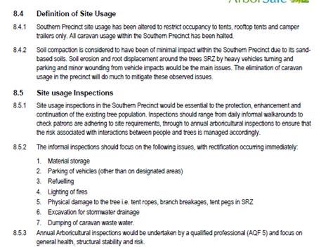
Extract Page 14
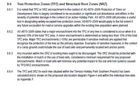
Extract page 17

In the circumstances, and based on the assessment provided
by Arborsafe, it is reasonable now for Council to support the progression by
staff of the ATO application for the Terrace Reserve Holiday Park with
conditions included to meet resolution 17-418 (a) and (b) below.
a) Southern Cypress Pine
Precinct is to be restricted to short-term camping sites with no permanent
residents or cabins to be relocated to the area.
b) Camping
practices in Southern Cypress Pine Precinct will observe and protect structural
root zones of the Cypress Pines as part of an ongoing monitoring program.
It is envisaged that the recommendation put forward now for
the Terrace Reserve Holiday Park will provide for an appropriate and ongoing
level of protection of the Coastal Cypress Pines. It will also provide an
approval regime consistent to all three holiday parks in Brunswick Heads with
regard to legislative requirements for planning and caravan park regulation.
3. Item
6
Correspondence sent.
Financial Implications
N/A
Statutory and Policy
Compliance Implications
Local Government Act 1993
Section 68 Approval to Operate
The operation of caravan parks and camping grounds require
Approval to Operate (ATO) under
Section 68 (Part F2) of the Local Government Act 1993. Applications
are lodged by the land owner
to continue the operation of caravan park and camping ground
activities and application fees are paid in accordance with Councils’
adopted fees and charges.
The process of assessing and determining ATO applications is
regulated under Chapter 7 Part 1 of
the Local Government Act 1993. Part of the consideration of
such applications involves the
auditing of compliance with the Local Government
(Manufactured Home Estates, Caravan Parks,
Camping Grounds and Moveable Dwellings) Regulation 2005
(“the Regulation”).
Once it has been determined that the application represents
the actual site activities, and satisfies
the requirements of the Regulation, then an ATO approval is
granted. Once an approval has been
issued Council may determine to extend or renew an approval
(but without changing the terms of
the approval) if satisfied there is good cause for doing so.
Section 105 Circumstances in which approval
is taken to have been refused
(1) If the council has not determined an application:
(a) within the period of 40
days after the application is lodged with it, except as provided by paragraph
(b), or
(b) within the period of 80
days after the application is lodged with it in the case of an application for
which the concurrence of a person or authority is required by or under this
Act,
the council is, for the purposes
only of section 176, taken to have determined the application by refusing
approval on the date on which that period expires.
(2) Nothing in subsection (1) prevents the council
from determining an application after the expiration of the 40-day or 80-day
period, whether on a review under section 100 or otherwise.
(3) A determination under subsection (2) does not
prejudice or affect the continuance or determination of an appeal made under
section 176 in respect of a determination that is taken under subsection (1) to
have been made, subject to subsection (4).
(4) Where a determination under subsection (2) is made
by granting approval, the council is entitled, with the consent of the
applicant and without prejudice to costs, to have an appeal made under section
176 in respect of a determination that is taken by subsection (1) to have been
made, withdrawn at any time before the appeal is determined.
Section 72 Determination of applications by
the Crown
(1) A council, in respect of an application for
approval made by the Crown or a person prescribed by the regulations, must not:
(a) refuse to grant
approval, except with the written consent of the Minister, or
(b) impose a condition of an
approval, except with the written consent of the Minister or the applicant.
(2) If the council proposes to refuse to grant
approval or to impose a condition of approval, it must immediately notify the
applicant.
(3) After the applicant is so notified, the council
must submit to the Minister:
(a) a copy of the
application for approval, and
(b) details of its proposed
determination of the application, and
(c) the reasons for the
proposed determination, and
(d) any relevant reports of
another public authority.
(4) The applicant may refer the application to the
Minister whether or not the council complies with subsection (3).
(5) After receiving the application from the council
or the applicant, the Minister must notify the council and the applicant of:
(a) the Minister’s
consent to the refusal of approval, or
(b) the Minister’s
consent to the imposition of the council’s proposed conditions, or
(c) the Minister’s
intention not to agree with the council’s proposed refusal and the period
within which the council may submit any conditions it wishes to impose as
conditions of approval, or
(d) the Minister’s
refusal to agree with the council’s proposed conditions and any
conditions to which the Minister’s consent may be assumed.
(6) At the end of the period specified in subsection
(5) (c), the Minister must notify the council and the applicant:
(a) whether the Minister
consents to the imposition of any of the conditions submitted by the council
during that period and, if so, which conditions, or
(b) of the conditions to
which the Minister’s consent may be assumed.
(7) The Minister must notify the council and the
applicant of the reasons for a decision under subsection (5) or (6).
(8) If the council does not determine the application
within the period notified by the Minister for the purpose, the council is
taken, on the expiration of that period, to have determined the application in
accordance with the Minister’s consent.
Section 73 Effect of council’s failure
to determine Crown application
(1) If the council does not determine an application
to which section 72 applies within the relevant period specified in section
105, the council is taken, on the expiration of that period, to have refused
the application.
(2) If the application is taken to have been refused,
the applicant may refer the application to the Minister for determination.
(3) The Minister may determine an application so
referred to the Minister.
(4) The Minister’s determination has effect as
if it were a determination of the council.
Staff Reports - Infrastructure Services 13.25
Staff Reports - Infrastructure Services
Report No. 13.25 Belongil
Beach Parking Management Strategy
Directorate: Infrastructure
Services
Report
Author: Joshua
Winter, Civil Engineer
File No: I2018/209
Theme: Community Infrastructure
Local Roads and Drainage
Summary:
Staff are seeking Council
resolution to amend the delivery plan of the Belongil Beach Parking Management
Strategy to clearly separate the management strategy itself from the financial
implications of implementing the strategy. Staff propose that the delivery plan
be as follows;
Belongil Beach Parking Management Strategy
Staff to engage with the
community regarding the various parking areas that have been identified in the
attached plans and to develop a finalised parking management plan to be
presented to Council after a Strategic Planning Workshop to discuss the plan.
Belongil Beach Parking Management Financial Implications
Staff to present preliminary
estimates to Council that will detail the capital investment required to
implement the plan and the potential funding sources, including the
consideration of pay parking if relevant.
Adopting a formalised parking
management strategy prior to considering the financial implications may result
in clearer and more concise discussion regarding each issue and will allow each
to be considered as a standalone subject of discussion throughout the project.
|
RECOMMENDATION:
That Council:
1. adopt
the revised delivery plan for the Belongil Beach Parking Management Strategy
project.
2. endorse
the Parking Management Plan for Belongil (E2018/8203) to be used to engage
with the community regarding a Belongil Beach Parking Management Strategy.
3. receive
a finalised Belongil Beach Parking Management Strategy for endorsement after
community engagement has adequately informed the strategy.
4. receive
a financial implications report associated with the strategy following
adoption of the finalised Belongil Beach Parking Management Strategy.
5. retain
the budget allocated to this project in resolution 17-056 to implement the
revised plan for the Belongil Beach Parking Management Strategy.
|
Attachments:
1 TPS
Parking Management Plan for Belongil, E2018/8203
⇨
Report
Council resolved 17-056 regarding the Belongil Beach parking area as
follows;
1. That Council adopt the Belongil Beach Parking Management
Strategy (#E2016/91345) prepared by Traffic and Parking Systems Group (TPS).
2. That Council endorse the procurement of a street management master
plan for the Belongil Beach area in consultation with the community to consider
all access, amenity and urban design issues.
3. That Council endorse investigation and community
consultation with the Belongil Beach community regarding the implementation of
a formalised parking arrangement and pay parking in the area.
4. That a budget of $60,000 be allocated from the Pay Parking
Reserve to perform the initial investigation, concept designs and preparation
of the street management master plan and community consultation with the
Belongil Beach community regarding the implementation of a formalised parking
layout and pay parking scheme in the area.
After this resolution, three
parking management strategies were adopted by Council, being the Brunswick Heads,
Bangalow and Mullumbimby parking management strategies. Council resolved for
all three of these strategies to implement the time limit changes and monitor
the parking demand and infringements for a minimum period of twelve months to
ascertain the need to implement a pay parking scheme in the towns.
It is with this information
in mind that staff are seeking Council resolution to amend the delivery plan
moving forward, clearly splitting the discussion between a parking management
strategy and the financial implications of implementing the strategy, which
should result in clearer and more concise discussion regarding each issue.
Financial Implications
The initial budget of $60,000 allocated to this project has
approximately $40,000 remaining and it is proposed that this be retained for
future work on this project.
Statutory and Policy Compliance Implications
No implications at this stage.
Any relevant implications will be presented with each report
as the project progresses.
Staff Reports - Infrastructure Services 13.26
Report No. 13.26 All
Abilities Access Report
Directorate: Infrastructure
Services
Report
Author: Pattie
Ruck, Open Space Facilities Coordinator
File No: I2018/459
Theme: Community Infrastructure
Open Space and Recreation
Summary: To
provide a report on the below resolution.
Council
resolved on 24 April 2017 to:-
1. Provide
a report on:
a) The
different options for providing beach access to all Byron Shire beaches,
including temporary options such as Mobility Matting
b) Costs
of providing all ability beach access on all Byron Shire’s beaches
c) A
preferred priority list of locations to ensure at least all ability access
point at each beach
d) Possible
funding sources
2. Liaise
with relevant stakeholders, including Marine Parks Authority, the Arakwal
Corporation, Access Consultative Working Group (ACWG), NPWS and Disabled
Surfers Association, Far North Coast to provide information on matters arising
from point 1.
3. Ensure
this report informs Councils current Disability Inclusion Action Planning
(DIAP) which is required by the NSW Disability Inclusion Act 2014 (The Act).
4. Write to local State and
Federal Members and relevant Ministers seeking support in providing this
essential infrastructure
|
RECOMMENDATION:
1. That
Council note the report.
2. That
the three (3) main priority areas for All Abilities Access be included
for consideration within the 2018/19 draft budget.
3. That
further consultation with relevant stakeholders continues throughout the
detailed design phase.
|
Attachments:
1 Clarkes
Beach Access Options Report
Principal Coastal Engineer, Water Research Laboratory School of Civil and
Environmental Engineering UNSW Sydney, E2017/102314
⇨
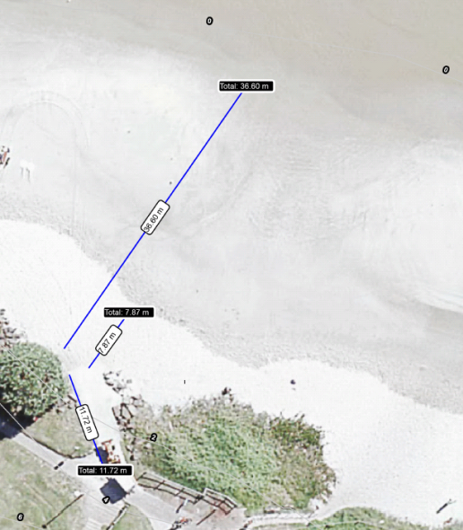
2 ACWG
Feedback All, E2018/29889 ⇨
3 Cape Byron
at DPI Feedback, E2018/29891 ⇨
4 NPWS
Feedback, E2018/29892 ⇨
5 Quotation
on matts and mobi chairs, E2018/29893
⇨
Report
Preferred priority list of
four locations to ensure at least all ability access point at each
beach.
Please note this priority list
is based on relative usage, geographical equity, Council’s resources
distributed to maximise access for the greatest number of people in the
community, Council staff researching possible locations for all abilities
access and liaising with relevant stakeholders.
Currently, two Sandcruiser Beach Wheelchairs are available
to use in Byron Shire.
One of the wheelchairs is located at the Byron Surf Club at
Main Beach and the other at the Brunswick Valley Community Centre opposite the
Brunswick Heads Surf Life Saving Club.
The Sandcruiser Beach Wheelchairs are available for free
public use, ensuring access to the beach for everyone.
These wheelchairs have been gratefully received by
wheelchair user groups.
Applicable Australian Standards for All Abilities Access
– AS 1428
For wheelchair access, Australian Standard 1428 Design
for access and mobility requires that ramps have a maximum slope of 1V:14H,
with flat landings (1200 mm long) provided every 9 m, giving an overall slope
of approximately 1V:16H for long ramps.
While GeoCortex (Council’s GIS System) could be used
to calculate initial contours at the preferred locations a detailed survey and
concept design would be required to ensure standards are feasible for the
locations outlined.
Priority One – Clarkes Beach All Abilities Access
This access location already exists.
This all abilities access at Clarkes Beach is currently
under repair due to recent erosion at Clarkes Beach.
The alternatives for this location are currently being
investigated by The Team Leader for Open Space and outlined in Attachment 1
(E2017/102314).
This ongoing process will determine any costs of providing
and maintaining this particular location. It does not appear that the
Clarkes ramp was constructed to standard, the installed path differing from the
actual design. The new concept designs will take this into consideration
and be amended to provide an all abilities access. The feedback from
Stakeholders has suggested this location as a strong option as the water is
fairly protected from swell.
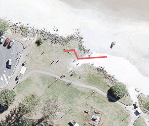
Priority Two – Main Beach
There are two possible locations at Main Beach.
Option 1 - The existing ramp for the Surf Life Saving
vehicles could be utilised as an access path and mobile matting on the sand for
access to the water.
From initial Geocortex investigations ramp modification may
be necessary as the ramp measurements are outside of the Australian Standard of
flat landings (1200 mm long) provided every 9 m.
The ramp is currently longer than the 9 m requirement;
however the slope of the ramp is also calculated outside of the slope
tolerances for 1V:16V.
This location would require both ramp modification of length
and slope to remain inside of the AS 1428. The mobile matting could be
stored at the Surf Life Saving Club.
Currently one of the Sandcruiser wheelchairs is housed at
the Surf Club.
There are lifesaving services seasonally available at this
location. The feedback from Stakeholders have suggested this location as
a strong option as the water is fairly protected from swell. Proximity to
Surf Club is ideal for additional personal safety when swimming.
Costing for providing beach access at Byron Main
Beach Surf Ramp
Initial - $
29,900.00
Breakdown -
$ 13,200 +GST for max on low tide 36 metres mobile matting
-
$ 6,200 + GST for one 50 meter Mobi-Roll N Stow devices
-
$ 4,000 + GST for Survey, Concept Design and Detailed Design of
ramp/slope
-$
4,500 + GST Review of Environmental Factors (REF)
-
$ 2,000 + GST Signage Upgraded
Ongoing – $ 8,600.00 + GST p.a.
Breakdown -
$ 1,000 + GST training of life savers p.a
-
$ 2,600 + GST storage at SLS rent
-
$ 5,000 + GST maintenance and administration p.a
Option 2 - The red line below outlines another possible area
that could be re-designed for a ramp or boardwalk for all abilities
access. This feasibility would be depending on a survey result and
possible concept designs available for this pathway.
From initial Geocortex investigations the slope of this
particular area would require a new ramp to provide a slope within the AS 1428
standard. The mobile matting could be stored at the Surf Life Saving
Club. Currently one of the Sandcruiser wheelchairs is housed at the Surf
Club.
There are lifesaving services available during busy season
at this location. This location would require a REF and Design
Concepts. The additional ramp at this location would prevent any traffic
conflicts on the existing ramp used by the SLS.
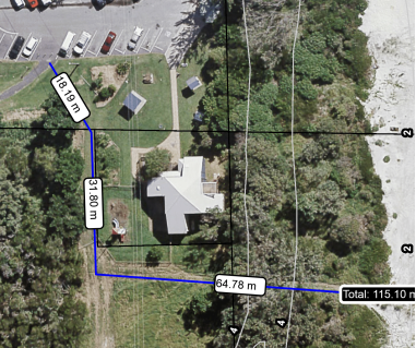
Costing for providing beach access at Byron Main
Beach Other Ramp
Initial - $
27,626.00
Breakdown -
$ 10,926 +GST for max on low tide 30 metres mobile matting
-
$ 6,200 + GST for one 50 meter Mobi-Roll N Stow devices
-
$ 4,000 + GST for Survey, Concept Design and Detailed Design of
ramp/slope
-
$ 4,500 + GST Review of Environmental Factors (REF)
-
$ 2,000 + GST Signage Upgraded
Ongoing –
$ 8,600.00
Breakdown -
$ 1,000 + GST training of life savers p.a
-
$ 2,600 + GST storage at SLS rent
-
$ 5,000 + GST maintenance and administration p.a
Priority Three – Brunswick Heads
Currently the Sandcruiser Beach Wheelchair is located at the
Brunswick Valley Community Centre. After stakeholders consultation access
at Torakina Beach would be the preferred location in Brunswick Heads.
This location provides parking close by and the water access is calm and safe.
From initial GeoCortex investigations the slope of this
particular area would require a new slope adjustment to fall within the AS 1428
standard. This location would require a REF and Design Concepts.
Torakina does not provide any life saving facilities and
storage would need to be supplied for the mobi matts and mobi chair at this
location. This location would require remote accessibility as the Life
Saving Services are 500 m away.

Costing for providing beach access at Brunswick
Heads Torakina
Initial - $
32,805
Breakdown -
$ 9,105 +GST for max on low tide 25 metres mobile matti
-
$ 6,200 + GST for one 50 meter Mobi-Roll N Stow devices
-
$ 7,000 + GST storage options
-
$ 4,000 + GST for Survey, Concept Design and Detailed Design of
ramp/slope
-
$ 4,500 + GST Review of Environmental Factors (REF)
-
$ 2,000 + GST Signage Upgraded
Ongoing –
$ 10,000.00
Breakdown -
$ 5,000 + GST storage at Storage at remote site.
-
$ 5,000 + GST maintenance and administration p.a
Priority Four – South Golden Beach
Southern beach access is preferred as the car park is
established and life savers are present at certain time of the year. The
initial gradient calculated via GeoCortex calculates the steepest slope at this
location as approximately 1V:13H. Mobile matting could be rolled up and
stored at the life saving building. After stakeholders consultation this
location is agreed to be on the bottom of the priority list due to remoteness
and possible usage.
Costing for providing beach access at SGB
Initial - $
77,766.00
Breakdown -
$ 51,716.00 +GST for 142 metres mobile matting
-
$ 18,600 + GST for three 50 metre Mobi-Roll N Stow devices
-
$ 5,450 + GST for Mobi-Chair Floating Wheelchair
-
$ 2,000 + GST Signage Upgraded
Ongoing –
$ 8,600.00
Breakdown -
$ 1,000 + GST training of life savers p.a
-
$ 2,600 + GST storage at SLS rent
-
$ 5,000 + GST maintenance and administration p.a
All Abilities Beach Access Products
Mobi-Chair Floating Beach Wheelchair

Mobi-Mat Beach Access Matting
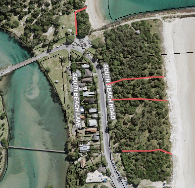
Mobi-Roll N Stow
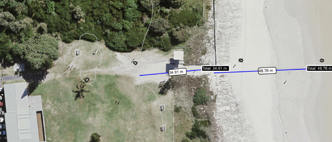
Other Access Points Considered
Suffolk Park Access – Alcorn Clifford Street car
park access.
Negative aspects - the slope of this particular area would
require a new slope adjustment and major engineering works to fall within the
AS 1428 standard. There are no onsite storage alternatives. This
location would require a REF and Design Concepts. There are lifesaving
services available during busy season at this location only. The water
entry is rough and unsafe. Stakeholder consultation considered this
locations water access as rough and unsafe.
Broken Head – Carpark near Caravan Park.
Negative aspects - the slope of this particular area would
require a new slope adjustment and major engineering works to fall within the
AS 1428 standard. The distance between the carpark and water is in excess
of 70m. There are no onsite storage alternatives. This
location would require a REF and Design Concepts. The water entry can be
rough, unsafe and rips are often present. Stakeholder consultation
considered this locations water access as rough and unsafe.
Brunswick Heads – Community Centre – Location
Map below.
Initially this was the preferred location in Brunswick
Heads, however after consultation with stakeholders Torakina was highlighted as
the preferred access point.
Currently the Sandcruiser Beach Wheelchair is located at the
Brunswick Valley Community Centre. From initial GeoCortex investigations
the slope of this particular area would require a new slope adjustment to fall
within the AS 1428 standard.
This location would require a REF and Design Concepts.
There are lifesaving services available during busy season at this
location. There is car parking available close by. Mobile matting
could be stored at the community centre or the Surf Lifesaving Club.


Relevant Stakeholder Consultation
Marine Park Authority contacted directly and asked for
feedback on possible locations and their involvement. Supportive response
received and noted the all abilities access points to be consistent with the
objectives of the Marine Estate Management Act 2014.
Access Consultative Working Group (ACWG) contacted and
consulted by Community Development Team in Council. Feedback on locations
from ACWG received. The timing of the consultation was well received;
location considerations need to factor in access to calm water, proximity to
Surf Clubs and lifesavers. Torakina, Main Beach and Clarkes Beach were
highlighted as the preferred option by the stakeholders.
Arakwal Corporation will be contacted and consulted as due
process through the Request for Environmental Factors (REF) report on the
individual locations.
NPWS contacted for comment or feedback on possible
locations. The North Coast branch of NPWS responded to the preferred
locations and stated their support for the provision of all abilities access on
Council’s beaches and have noted the locations do not include NPWS
estate.
Disabled Surfers Association contacted for input and
feedback on locations outlined. Unfortunately we have not received any
feedback from this association on several contact attempts.
Ensure this report informs Councils current Disability
Inclusion Action Planning (DIAP) which is required by the NSW Disability
Inclusion Act 2014 (The Act).
The DIAP is incorporated in the Integrated Planning and
Reporting Framework, including the Community Strategic Plan (CSP), Delivery
Program (DP) and yearly Operational Plan (OP). The requested report fits
under the DP and OP. DP: “CI3.4.1 Ensure Council’s
public spaces will be accessible and inclusive for all” and OP:
“Review all current public spaces and map key access and inclusion
barriers to develop priority schedule of works”.
Possible and appropriate Funding Sources
Upcoming grant availabilities to be informed by
Council’s Grant Officer. Local, State and Federal requests for
support and funding opportunities. Presently there are a number of grant
schemes that could fund these projects – either individually, or as a
whole. Most grants will require Council to match any funds 1:1.
· The
Liquor and Gaming - Infrastructure Grants - Sports and Recreation
(NSW) up to $200K
· Building
Better Regions Fund round 3 Community Investments stream (Commonwealth)
up to $1M
· Stronger
Country Communities round 2 (NSW) up to $250K
· Community
Development Grants (Commonwealth) up to $50K
There may also be an opportunity to develop these works as
part of a larger project about dune regeneration and protection through one of
the commonwealth or state environment agencies.
Council contribution to either a) Fully fund or b)
contribute to a grant opportunity is from Crown Reserve that is available for
the particular reserve.
Write to local State and
Federal Members and relevant Ministers seeking support in providing this
essential infrastructure
A letter has been sent to the
Member for Ballina, MP Tamara Smith, State Member for Canterbury, MP Sophie
Cotsis, Minister for Social Services The Hon Dan Tehan MP and Assistant
Minister for Social Services and Disability Services The Hon Jane Prentice MP
seeking support in providing this essential infrastructure. Currently
waiting for responses.
Financial Implications
Grant funding sources opportunities identified as outlined
in report. Grant process to be actioned upon detailed costings after REF
and design concepts completed. Additional staff time allocation required
for this specific project. Initially a budget of $ 30,000.00 required for
REF and Survey, Concept Design and Detailed Design of ramp/slope for both Main
Beach and Torakina Access points as the highest priority locations. This
budget includes staff time of 7 hours a week for 12 weeks at $40 per
hour. Financial implications for stage two of this project will need to
be assessed upon receiving concept designs and associated quotes.
Statutory and Policy
Compliance Implications
REF completion for the access points will ensure
consideration of environmental factors and consultation with the Arakwal
Corporation. DPI consultation will ensure the Marine Estate Management
Act 2014 is adhered to. Consultation with Council staff and relevant
stakeholders to ensure the concept designs take into consideration AS 1428
– Australia Standard for All Abilities Access.
Staff Reports - Infrastructure Services 13.27
Report No. 13.27 Minutes
of Coastal Estuary Catchment Panel Meeting 15 March 2018
Directorate: Infrastructure
Services
Report
Author: Dominika
Tomanek, Executive Assistant Infrastructure Services
File No: I2018/524
Theme: Community Infrastructure
Emergency Services and Floods
Summary:
That attachment to this report provides the minutes of the
Coastal Estuary Catchment Panel Meeting of 15 March 2018 for determination by
Council.
|
RECOMMENDATION:
1. That
Council note the minutes of the Coastal Estuary Catchment Panel meeting held
on 15 March 2018.
2. That Council
adopt the following Panel recommendations:
Panel Recommendation 4.1. Management and Reporting for the 24 Hectare Melaleuca
Plantation at the Byron Bay STP
That next Panel meeting to be
held onsite at the Interpretive Centre including a tour of the site and
invitation extended to Councillors, Drainage Union Directors, Wetland
designers Bolton & Pont and members of Water, Waste and Sewer Committee.
3. That
Council adopt the following Panel recommendations:
Panel Recommendation 4.2. Environmental Management Plan for the opening of the
Tallow Creek
a) That
the Council note Environmental Management Plan and
the opening strategy for Tallow Creek.
b) That plan and strategy
be available to the public on Council website.
c) That Council note the
need for a Coastal Management Program for the ICOLL and that this look at
water quality issues on the whole of catchment basis.
4. That
Council adopt the following Panel recommendations:
Panel
Recommendation 4.3 Alternative /
Additional Flowpath BBSTP
That the Council investigate
environmental impacts of the alternative flowpath and its environs on the
receiving environment (from Ewingsdale Road to the mouth of Belongil Creek)
as part of an allocation of $250,000 for detailed design and formal
application for the Byron Bay Sewage Treatment Plant Alternative Flowpath
project.
|
Attachments:
1 Minutes
15/03/2018 Coastal Estuary Catchment Panel, I2018/438
⇨
Report
The attachment to this report provides the minutes of the
Coastal Estuary Catchment Panel Meeting of 15 March 2018 for determination by
Council, as the recommendations made by the Committee require determination by
Council.
The agenda for this meeting can be located on
Council’s website at:
http://byron.infocouncil.biz/Open/2018/03/CECP_15032018_AGN_811_AT.PDF
The Panel recommendations are provided in the attachment to
this report.
Financial Implications
As per the Reports listed within the Coastal Estuary
Catchment Panel Meeting of 15 March 2018.
Statutory and Policy
Compliance Implications
As per the Reports listed within the Coastal Estuary
Catchment Panel Meeting of 15 March 2018.
Staff Reports - Infrastructure Services 13.28
Report No. 13.28 Grant
Opportunity - Byron Bay Football Club
Directorate: Infrastructure
Services
Report
Author: Darren
McAllister, Acting Open Space and Facilities Coordinator
File No: I2018/618
Theme: Community Infrastructure
Open Space and Recreation
Summary:
This report addresses item 2 of Council resolution 17-634 of
28th November 2017:
That in relation to the
proposed funding application for the Byron Bay Football Club at the Byron
Recreational Ground, Byron Bay, Council:
1. Provide
in principle land owners consent for the purpose of lodging a DA
2. Receive
a report from staff on the proposed Sport house facility including
consideration of:
a. Ongoing
operational options and impacts
b. Ownership
and tenure of the structure including draft sports user agreement
c. Type
of use - Exclusive use versus multi use access
d. Consideration
of alignment with the draft Plan of Management and Shire Wide Recreational
Needs Study
e. Details
of the proposed grant/s and funding sources (Ndiaye/Lyon)
Item 1 of 17-634 is complete and the DA was lodged on 30th
November 2017.
|
RECOMMENDATION:
That should Council approve Development
Application 10.2017.681.1 for alterations and additions to existing amenities
building to create a clubhouse for Byron Bay Football Club at 35 Carlyle
Street Byron Bay that it includes conditions listed at the end of this report
in addition to conditions listed in Staff Report (I2018/246) attached.
|
Attachments:
1 PDF of
I2018/246 ~ Report 19/04/2018 Council PLANNING - Development Application
10.2017.681.1 alterations and additions to existing amenities building to
create a clubhouse for Byron Bay Football Club at 35 Carlyle Street Byron Bay, E2018/30545 ⇨
Report
Staff met with representatives from the Byron Bay Football
Club (BBFC) on the 19th March 2018 to discuss the following items of
Res 17-634. Staff see this as a unique opportunity to embrace
volunteerism and form a stronger working relationship with a passionate club
benefiting the club itself, the wider community and Council as being
responsible for provision of passive and active recreational land and
infrastructure for our Community.
a. Ongoing
operational options and impacts
To ensure the structure remains in good condition into the
future, BBFC have offered to enter into a formal agreement with Council that
primarily would make the club responsible for renewals and maintenance of the
club house facility. BBFC have offered to develop and provide an asset
management plan for the building, detailing a renewals and maintenance
program. Both plans are to provide detailed costing’s and ongoing
budget estimates. The offer includes a regime of audits and maintenance
plans that are periodically renewed. Staff suggest a 50 year renewals
program and audits and maintenance plans every 6 years.
It should be noted that matters in relation to maintenance
and drainage of the fields as described in the Development Applications
Statement of Environmental Effects are not a part of the consent for
Development Application 10.2017.681.1.
b. Ownership and tenure of
the structure including draft sports user agreement
As Council is the owner of the land, ownership of the Club
house facility should be vested with Byron Shire Council.
To establish a better understanding of user and community
requirements, (further clarified in item c below) tenure would be best managed
through a user agreement for a minimum period of 12 months from the completion
of the upgraded facility.
Councils existing user agreement template can be adapted for
this purpose. User agreements are reviewed annually.
c. Type of use -
Exclusive use versus multi use access
Exclusive Use
BBFC’s proposal requests that the building is leased
by BBFC from Council and that BBFC then hire the premises to groups of the
wider community. In general, the term “lease” implies
exclusive use, and in this case the offering of a lease is not appropriate,
regardless of the outcome of the Plan of Management review, because there is no
perceived commercial benefit to Council or the Community.
A lease may also attract competitive tendering for the
project.
Exclusive Use via a lease may also set a precedent and
create unrealistic expectations among sporting clubs and associations. For the
wider community to benefit financially and gain access to community facilities,
a more inclusive and collaborative model is required. Whilst the intentions of
sporting clubs are genuine and admirable for their members, they may not
inherently include the interests of the wider community.
Sporting clubs regularly change their committee members
which can result in a change of culture that may not be inclusive of previous
agreements or values. Following clubs being granted exclusive use,
Council has seen examples of facilities being run down and badly managed,
resulting in additional renewal costs and difficult relationships to manage,
and leaving legacy issues for future Councils.
Exclusive use via a lease is not Council staff’s
preferred model to manage facilities.
Multi Use Access
Multi use access enables the wider community to gain access
to Councils facilities. Technology has vastly improved the capability for
facility managers, particularly in the bookings area.
The recent implementation of a facilities booking system
within Council, has streamlined the process and enabled the wider community to
make online bookings. This technology could be applied to any Council
owned facility and can be viewed as an opportunity for utilisation of Council
Owned and Managed facilities.
Council has established processes and statutory structure to
ensure financial accountability and provide appropriate governance required to
administer community Facilities. Sporting Clubs access to bookings can also be
managed through the online booking system, based on usage entitled through user
agreements that is aimed at maximising utilisation whilst preventing
conflicting uses.
Multi Use Access via User Agreement is Council staff’s
preferred model to manage facilities.
Facility Management and Bookings
Facility Management via User Agreement, bookings made by
Club, and controlled by Council using Council booking system. Training
and system access required. Club bookings based on usage entitled through user
agreement.
Payments to be made online via booking system as per
Councils fees and charges.
d. Consideration of
alignment with the draft Plan of Management and Shire
Wide Recreational Needs Study
The proposal is consistent with the current Plan of
Management.
It is recommended that should a draft Plan of Management
that changes areas of the Byron Recreation Ground to be categorised as General
Community Use, then the proposed Club house be categorised the same to enable
additional activities as required.
The Draft Shire Wide Recreational Needs Study when and if
adopted can be used to inform the User Agreement in relation to cost
distribution and responsibilities between sporting clubs and Council.
e. Details of the
proposed grant/s and funding sources
Financial Implications
BBFC to provide details of grant/s and funding sources as
they arise.
Examples of recent grants that would attract application
are:
· Regional Sports
Infrastructure Grants - NSW Gov, Restart NSW, More than $1,000,000
· Stronger Country
Communities Fund - NSW Department of Industry, From $100,000 up to $1,000,000
Conditions of Consent
(additional to Development Application Evaluation Report)
1. The
BBFC’s to provide an Asset Management Plan including Building Audits and
Maintenance Plans as described in section “a” within this report.
2. Ownership
of the facility is vested in Byron Shire Council.
3. Tenure
to be managed by User Agreement for a trial period of a minimum of 12 months as
per section “b” within this report.
4. Bookings
to be managed as per Facility Management and Bookings, section
“c” within this report
Reports of Committees - Sustainable Environment and Economy 14.1
Reports of Committees - Sustainable Environment
and Economy
Report No. 14.1 Report of the Biodiversity Advisory Committee Meeting held on 12 March 2018
Directorate: Sustainable Environment and Economy
Report
Author: Sharyn
French, Manager Environmental and Economic Planning
File No: I2018/489
Theme: Ecology
Planning Policy and Natural Environment
Summary:
The attachment to this report provides the minutes of the
Biodiversity Advisory Committee Meeting of 12 March 2018 for determination by
Council.
|
RECOMMENDATION:
1. That
Council note the minutes of the Biodiversity Advisory Committee Meeting held
on 12 March 2018.
|
|
2. That Council
adopt the following Committee Recommendations:
Report No. 4.1 Committee Induction
File No: I2018/385
Committee Recommendation 4.1.1
1. That
the Biodiversity Advisory Committee confirm the Constitution for this
Committee, in accordance with Council Resolution 18-114 with the following
change:
· Amend
name of committee under section 3 to Biodiversity Advisory Committee
2. That
the Biodiversity Advisory Committee recommend to Council that an Expression
of Interest (EOI) process be held to invite three new community members.
3. That
the Biodiversity Advisory Committee receive a presentation on Byron
Shire Council’s Code of Conduct once the three new Committee members
have been selected.
|
|
3. That Council
adopt the following Committee Recommendations:
Report No. 4.2 Integrated Pest Management
Strategy and other Environmental Projects
File No:
I2018/375
Committee Recommendation 4.2.1
That the Biodiversity
Advisory Committee recommend that Council support the revised project
timetable for the Biodiversity Conservation Strategy and Option 1 for the
Integrated Pest Management: Directions Document, Policy and Strategy.
|
|
4. That Council
adopt the following Committee Recommendations:
Report No. 4.3 Brunswick Valley Landcare
File No:
I2018/377
Committee Recommendation 4.3.1
That the Biodiversity
Advisory Committee recommend that Council:
1. Consider
the allocation of $15,500 as part of the forward budget process 2018/19
(alongside other Council program and budget priorities) to support the Brunswick
Valley Landcare, Landare Support Officer position for 1 day per week
to continue to deliver the Land for Wildlife Program and respond to customer
enquiries.
2. Work
with Brunswick Valley Landcare to review the location and needs of the
locality groups to determine what level of support can be provided.
3. Invite
Brunswick Valley Landcare to nominate a representative to be a committee
member on the Biodiversity Advisory Committee.
4. Write
to Local Land Services and relevant Ministers advocating the work of our
local Landcare networks and to seek their support to maintain funding for
community support.
|
|
5. That Council does not adopt Committee Recommendation
4.4.1 as shown in Attachment 1 to this report, but instead adopts the
Management Recommendation as follows:
Report No. 4.4 Future Meeting Agendas
File No:
I2018/390
Management Recommendation
4.4.1
That the Biodiversity Advisory Committee meeting dates be
changed to a Monday, starting at 3.15pm except for the June meeting which
will remain on Thursday to enable councillor attendance at the planned
Agri-environment field trip:
· Thursday 14 June
· Monday 8 October
· Monday 10 December
|
Attachments:
1 Minutes
12/03/2018 Biodiversity Advisory Committee, I2018/372
⇨
Report
Attachment 1 to this report provides the minutes of the
Biodiversity Advisory Committee Meeting of 12 March 2018 for determination by
Council. The agenda for this meeting can be located on Council’s
website at:
http://byron.infocouncil.biz/RedirectToDoc.aspx?URL=Open/2018/03/BAC_12032018_AGN_870_AT.PDF
Committee Recommendation
4.2.1
That the Biodiversity Advisory Committee recommend that
Council support the revised project timetable for the Biodiversity Conservation
Strategy and Option 1 for the Integrated Pest Management: Directions Document,
Policy and Strategy.
Management Comments 4.2.1
A report titled ‘Directions Document and draft
Integrated Pest Management Policy’ is also being considered at
today’s meeting. This report recommends that Council place the draft
Integrated Pest Management Policy on public exhibition for a period of 6 weeks
and that the exhibition of the Policy be accompanied by the Directions
Document.
Should Council not support Committee Recommendation 4.2.1
and instead resolves on Option 2 timetable for delivery of an Integrated Pest
Management Strategy by December 2018, then Council would not exhibit the draft
Policy and accompanying Directions Document but instead support them in
principle so they can inform development of the Strategy. The draft Policy and
draft Strategy would then be exhibited together later in the year. The risk
with Option 2 is that Council’s draft policy position on the use of
pesticides will not have received community input and the Strategy will be
drafted on a policy position that has not been adopted by Council.
Additionally, if Council adopts the Option 2 timeframe for
delivery of the Strategy then further funds are required to support other
biodiversity projects as existing staff resources will be reassigned to
delivery of the Integrated Pest Management Strategy, including:
· Delivery
of the Pest Animal Plan, a grant funded project. Additional funds of $8,600
will be required to keep the deliverables on track, as per the Grant Agreement.
· Delivery of the
Biodiversity Conservation Strategy would need to be placed on hold to fast tack
the Integrated Pest Management Strategy. Alternatively, if Council chose to
proceed with this project concurrently an additional project officer would be
required to manage the project at an additional budget allocation of $40,000.
Management Recommendation 4.2.1
Management support the Biodiversity Advisory Committee
Recommendation 4.2.1.
Committee Recommendation 4.4.1
That the Biodiversity Advisory Committee consider the future
meeting schedule in Table 1 of this report and recommend to Council that all meeting dates be amended to a Monday, starting at
3.15pm as follows:
· 9 April
· 4 June
· 8 October
· 10 December
Management Comments 4.4.1
In accordance with the Committee Recommendation, Management
provide the following additional information.
The 9 April meeting was held on that date. The 4 June
date is not appropriate as an Agri-environment field trip has been planned for
14 June 2018 and is open to all councillors to attend.
For these reasons the alternative recommendation to Council
is:
Management Recommendation 4.4.1
That the Biodiversity Advisory
Committee meeting dates be changed to a Monday, starting at 3.15pm except for the
June meeting which will remain on Thursday to enable councillor attendance at
the planned Agri-environment field trip:
· Thursday 14 June
· Monday 8 October
· Monday 10 December
Financial Implications
As per the Reports listed within the Biodiversity Advisory
Committee Meeting of 12 March 2018.
Statutory and Policy
Compliance Implications
As per the Reports listed within the Biodiversity Advisory
Committee Meeting of 12 March 2018.
Reports of Committees - Sustainable Environment and Economy 14.2
Report No. 14.2 Report of the Sustainability and Emissions Reduction Advisory
Committee Meeting held on 29 March 2018
Directorate: Sustainable Environment and Economy
Report
Author: Sharyn
French, Manager Environmental and Economic Planning
File No: I2018/617
Theme: Ecology
Planning Policy and Natural Environment
Summary:
This report presents the minutes of the Sustainability and
Emissions Reduction Advisory Committee held on 29 March 2018 for determination
by Council.
|
RECOMMENDATION:
1. That
Council note the minutes of the Sustainability and Emissions Reduction
Advisory Committee Meeting held on 29 March 2018 (Attachment 1).
|
|
2. That Council
adopt the following Committee recommendation as
follows:
Report No. 4.1 Committee Induction
File No:
I2018/422
Committee Recommendation
4.1.1
1. That
the Sustainability and Emissions Reduction Advisory Committee confirm the
Constitution for this Committee, in accordance with Council Resolution 18-114
and recommend a change to the Purpose as follows:
· Replace in item 1.
‘food security initiatives’ to ‘associated sustainability
initiatives’
2. That
the Sustainability and Emissions Reduction Advisory Committee recommend to
Council that the membership be increased to include a representative from
COREM and a further two additional community members through an Expression of
Interest process.
|
|
3. That Council
adopt the following Committee recommendation as
follows:
Report No. 4.2 Future Meeting Agendas
File No:
I2018/412
Committee Recommendation 4.2.1
1. That
the Sustainability and Emissions Reduction Advisory Committee meet six times
a year with additional field trips and workshops scheduled as required.
2. That
the Sustainability and Emissions Reduction Advisory Committee schedule an
additional meeting on Thursday 26 April 2018 at 2pm.
|
|
4. That Council
adopt the following Committee recommendation as
follows:
Report No. 4.3 Funding models for
sustainability projects
File No:
I2018/450
Committee Recommendation 4.3.1
That the
Sustainability and Emissions Reduction Committee recommend to Council that
Council establishes a mechanism to offer commercial property owners access to
Environmental Upgrade Agreements (EUAs) to enable environmental upgrades to
commercial premises and that an event be organised to launch the service.
|
|
5. That Council
adopt the following Committee recommendation as
follows:
Report No. 4.4 Emissions Reduction Strategy
and Key Project Updates
File No:
I2018/451
Committee Recommendation 4.4.1
That the
Sustainability and Emissions Reduction Advisory Committee recommend that
staff compile a list of suitable sustainability and emission reduction
projects with supporting information for tabling with the Parliamentary
Secretary for Renewable Energy and Northern NSW The Hon. Ben Franklin MLC and
invite members of the Committee to put forward proposals.
|
Attachments:
1 Minutes
29/03/2018 Sustainability and Emissions Reduction Advisory Committee, I2018/506 ⇨
Report
The attachment to this report provides the minutes of the
Sustainability and Emissions Reduction Advisory Committee Meeting of 29 March
2018 for determination by Council. The agenda for this meeting can be
located on Council’s website at:
http://byron.infocouncil.biz/RedirectToDoc.aspx?URL=Open/2018/03/SERAC_29032018_AGN_875_AT.PDF
All Committee recommendations are supported by management
and are provided in the attachment to this report.
Financial Implications
As per the Reports listed within the Sustainability and
Emissions Reduction Advisory Committee Meeting of 29 March 2018.
Statutory and Policy
Compliance Implications
As per the Reports listed within the Sustainability and
Emissions Reduction Advisory Committee Meeting of 29 March 2018.
Reports of Committees - Infrastructure Services 14.3
Reports of Committees - Infrastructure Services
Report No. 14.3 Report of the Local Traffic Committee Meeting held on 20 March 2018
Directorate: Infrastructure Services
Report
Author: Stephanie
Tucker, Traffic and Transport Assistant
File No: I2018/425
Theme: Community Infrastructure
Roads and Maritime Services
Summary:
This report contains the recommendations of the Local
Traffic Committee from the meeting held on the 20 March 2018.
|
RECOMMENDATION:
1. That
Council note the minutes of the Local Traffic Committee Meeting held on 20 March
2018.
|
|
2. That Council
adopt the following Committee Recommendation(s):
Report No. 6.1 Regulatory Signage - No
Stopping Signage - Gulgan Road opposite entrance road to Mevlana Community
File No:
I2018/43
Committee Recommendation 6.1.1
That Council:-
1. Note
the content of the correspondence from Melaleuca Properties.
2. Install
a no stopping zone at the intersection, defined by a yellow line initially
and if non compliance is an issue, install signs.
|
|
3. That Council
adopt the following Committee Recommendation(s):
Report No. 6.2 RMS Recommendation to extend
60km/h speed zone at Ewingsdale McGettigans Lane Intersection
File No:
I2018/67
Committee Recommendation 6.2.1
That Council note the
speed review and the extension of the 60kph speed zone being implemented.
|
|
4. That Council
adopt the following Committee Recommendation(s):
Report No. 6.3 Pocket Road - Petition - Speed
Zone Review and Regulatory Signage
File No:
I2018/204
Committee Recommendation 6.3.1
That Council:
1. Approve
the use of intersection signage and line marking at the Pocket Road, Moffatts
Road and Middle Pocket Road intersections as warranted.
2. Approve
“Caution: Driveways” signs to be implemented along the Pocket
Road as warranted.
3. Consider
the allocation of $4,000 to carry out the works in the 2018/19 Capital Works
Budget.
4. Refer
the application for a speed zone review to the RMS.
|
|
5. That Council
adopt the following Committee Recommendation(s):
Report No. 6.4 Events - Anzac Day 2018 - Road
Closures in Byron, Mullumbimby, Brunswick Heads, Bangalow
File No:
I2018/374
Committee Recommendation 6.4.1
1. That
Council endorse the ANZAC Day Parades for 25 April 2018 for the Return
Services League sub branches of Byron Bay, Mullumbimby, Bangalow and
Brunswick Heads / Billinudgel.
2. That
the endorsement provided in Part 1 is subject to:
a) implementation of the approved Traffic
Management Plan and Traffic Control Plan, including the use of signed
detours, as designed and implemented by those with appropriate accreditation;
b) that the impact of the event be advertised
via a notice in the local weekly paper a minimum of one week prior to the
operational impacts taking effect, noting it must include the event name,
specifics of any traffic impacts or road closures and times, alternative
route arrangements, event organiser, a personal contact name and a telephone
number for all event related enquiries or complaints.
c) the event be notified on Council’s
webpage.
d) the event organiser:
i. undertake consultation with community
and affected businesses including adequate response/action to any raised
concerns.
ii. undertake consultation with emergency
services and any identified issues addressed.
iii. holding $20m public liability insurance cover
which is valid for the event.
3. That
Council:
a) assists where requested with
implementing the necessary temporary road closures and detours; and
b) placing of public notice
advertisements in a local weekly newspaper which is circulated prior to the
event and a copy of which is placed on Council’s website.
|
|
6. That Council
adopt the following Committee Recommendation(s):
Report No. 6.5 Events - Ballina to Byron Bay
Coastal Charity Walk for Westpac Rescue Helicopter - 27 May 2018
File No:
I2018/394
Committee Recommendation 6.5.1
1. That
Council adopt the Traffic Control Plan for the Westpac Life Saver Rescue
Helicopter fundraiser, Ballina to Byron Coastal Charity Walk, to be held
Sunday 27 May 2018.
2. That
the approval provided in Part 1 is subject to:
a. Receipt
of a satisfactory Traffic Control Plan and Traffic Management Plan.
b. implementation
of the approved Traffic Management Plan and Traffic Control Plan, including
the use of signed detours, as designed and implemented by those with
appropriate accreditation.
c. that
the impact of the event be advertised via a notice in the local weekly paper
a minimum of one week prior to the operational impacts taking effect, noting
it must include the event name, specifics of any traffic impacts or road
closures and times, alternative route arrangements, event organiser, a
personal contact name and a telephone number for all event related enquiries
or complaints.
d. the
event be notified on Council’s webpage.
e. the
event organiser:
i. undertake
consultation with community and affected businesses including adequate
response/action to any raised concerns.
ii. undertake
consultation with emergency services and any identified issues addressed.
iii. holding
$20m public liability insurance cover which is valid for the event.
iv. paying
Council’s Road Event Application Fee prior to the event.
f. the
use of marshals along Marine Parade who, for the purpose of aiding and
forming participants into walking groups, are to undertake their duties in
accordance with a pre-event risk assessment and management plan, a copy of
which is to be provided to Council prior to the event
g. attainment
(by the event proponent) of NPWS written acceptance of the event
3. That
the approval in Part 1 is also subject to the following in regard to the use
of Seven Mile Beach Road, that is:
a. signage,
which specifies the date, hours and nature of the event, be positioned at the
entrance and exit of Seven Mile Beach Road one week prior to the event;
b. on
the day of the event, at 500m intervals, and facing both directions of
travel, signs advising of “ Special Event - Charity Walk Ahead”
(or similar) are installed prior, and removed after, the event occurs; and
c. a
safety induction for participants advising of hazards be provided.
|
|
7. That Council
adopt the following Committee Recommendation(s):
Report No. 6.6 CRM 2343/2018 Broken Head Reserve
Road - Regulatory Signage
File No:
I2018/421
Committee Recommendation 6.6.1
That Council prepare a plan
and install “No Stopping” signs and line marking to control
inappropriate car parking and to improve pedestrian safety along Broken Head Reserve
Road, Broken Head where considered necessary.
|
|
8. That Council
adopt the following Committee and Management Recommendation(s):
Report No. 7.1 Events - Byron Bay Triathlon
2018 - Traffic Management
File No:
I2017/637
Committee Recommendation 7.1.1
That Council:-
1. Adopt
the Traffic Control Plan for the 2018 Byron Bay Triathlon, subject to:
a. implementation
of the approved Traffic Management Plan and Traffic Control Plan, including
the use of signed detours, as designed and implemented by those with
appropriate accreditation.
b. that
the impact of the event be advertised via a notice in the local weekly paper
a minimum of one week prior to the operational impacts taking effect, noting
it must include the event name, specifics of any traffic impacts or road
closures and times, alternative route arrangements, event organiser, a
personal contact name and a telephone number for all event related enquiries
or complaints.
c. the
event be notified on Council’s webpage.
d. the
event organiser:
i. undertake
consultation with community and affected businesses including adequate
response/action to any raised concerns.
ii. undertake
consultation with emergency services and any identified issues addressed.
iii. holding
$20m public liability insurance cover which is valid for the event.
iv. paying
Council’s Road Event Application Fee prior to the event.
|
|
9. That Council
adopt the following Committee Recommendation(s):
Report No. 7.2 Events - Bangalow Billy Cart
Derby 2018- Byron St Road Closure
File No:
I2018/234
Committee Recommendation 7.2.1
1. That
Council endorse the Bangalow Billy Cart Derby to be held on Sunday 20 May
2018, that includes the temporary road closure below:
a. Byron
Street, Bangalow between Ashton Street and Granuaille Road, between 6am and
4pm on Sunday 20 May 2018.
2. That
the approval provided in Part 1 is subject to:
a. implementation
of the approved Traffic Management Plan and Traffic Control Plan, including
the use of signed detours, as designed and implemented by those with
appropriate accreditation;
b. that
the impact of the event be advertised via a notice in the local weekly paper
a minimum of one week prior to the operational impacts taking effect, noting
it must include the event name, specifics of any traffic impacts or road
closures and times, alternative route arrangements, event organiser, a
personal contact name and a telephone number for all event related enquiries
or complaints.
d. the
event be notified on Council’s webpage.
e. the
event organiser:
i. undertake
consultation with community and affected businesses including adequate
response/action to any raised concerns.
ii. undertake
consultation with emergency services and any identified issues addressed.
iii. holding
$20m public liability insurance cover which is valid for the event.
iv. paying
Council’s Road Event Application Fee prior to the event.
|
|
10. That Council adopt the
following Committee Recommendation(s):
Report No. 7.3 Kendall St Rail Crossing -
Train and Vehicle Incidents
File No:
I2018/405
Committee Recommendation 7.3.1
That Council:-
1. Note
the content of the correspondence from Byron Bay Railroad Company Ltd.
2. Investigate,
in conjunction with the Byron Bay Railroad Company, the issues raised.
3. Research
level crossing safety and undertake risk assessment and refer back to the LTC
if required.
|
|
11. That Council adopt the
following Committee Recommendation(s):
Report No. 8.1 DA 10.2017.510.1 - Commercial Residential
Development
Cnr Jonson and Browning Streets Byron Bay
Additional comments for JRPP Submission
File No:
I2018/247
Committee Recommendation 8.1.1
That the committee
comments be provided to Council’s Planners.
|
|
12. That Council adopt the
following Committee Recommendation(s):
Report No. 8.2 Development Application
10.2013.128.3 - s96 Application to permit paid parking during Bluesfest 2018
File No:
I2018/399
Committee Recommendation 8.2.1
That the committee’s
comments be provided to Council’s Planners.
|
|
13. That Council adopt the
following Committee Recommendation(s):
Report No. 8.3 Events - 2018 Splendour in the
Grass Music Festival 20-22/7/
File No:
I2018/401
Committee Recommendation 8.3.1
1. That
Council approve the Splendour in the Grass 2018 TMP to be held on Friday 20
July 2018 to Sunday 22 July 2018, that includes the including the
installation and enforcement of No Camping and No Stopping signs between 6am
and 6pm, subject to conditions at Tweed Valley Way, Brunswick Valley Way and
Yelgun Road.
2. That
the approval provided in Part 1 is subject to:
a. separate
approvals by NSW Police and RMS being obtained, noting that the event is on a
state road or may impact the state road network;
b. implementation
of the approved Traffic Management Plan and Traffic Control Plan, including
the use of signed detours, as designed and implemented by those with
appropriate accreditation;
c. that
the impact of the event be advertised via a notice in the local weekly paper
a minimum of one week prior to the operational impacts taking effect, noting
it must include the event name, specifics of any traffic impacts or road
closures and times, alternative route arrangements, event organiser, a
personal contact name and a telephone number for all event related enquiries
or complaints;
d. the
event be notified on Council’s webpage.
e. the
event organiser:
i. undertake
consultation with community and affected businesses including adequate
response/action to any raised concerns.
ii. undertake
consultation with emergency services and any identified issues addressed.
iii. holding
$20m public liability insurance cover which is valid for the event.
iv. paying
Council’s Road Event Application Fee prior to the event.
v. the
holding of an event debrief within a month following the festival which
includes but not limited to Council, RMS and Police.
3. That
Council’s Parking Enforcement be invited to assist the event in
compliance of no stopping areas within the Road Reserve..
|
Attachments:
1 Minutes
20/03/2018 Local Traffic Committee, I2018/441
⇨
Report
The attachment to this report provides the minutes of the
Local Traffic Committee Meeting of 20 March 2018 for determination by
Council. The agenda for this meeting can be located on Council’s
website at:
http://byron.infocouncil.biz/Open/2018/03/LTC_20032018_AGN_886_AT.PDF
The committee recommendations are supported by management
and are provided in the attachment to this report.
Financial Implications
As per the Reports listed within the Local Traffic Committee
Meeting of 20 March 2018.
Statutory and Policy
Compliance Implications
As per the Reports listed within the Local Traffic Committee
Meeting of 20 March 2018.
Reports of Committees - Infrastructure Services 14.4
Report No. 14.4 Report of the Water, Waste and Sewer Advisory Committee Meeting held
on 1 March 2018
Directorate: Infrastructure Services
Report
Author: Dominika
Tomanek, Executive Assistant Infrastructure Services
File No: I2018/521
Theme: Community Infrastructure
Waste and Recycling Services
Summary:
The attachment to this report provides the minutes of the
Water, Waste and Sewer Advisory Committee Meeting held on 1 March 2018 for determination
by Council.
|
RECOMMENDATION:
1. That
Council note the minutes of the Water, Waste and Sewer Advisory Committee
Meeting held on 1 March 2018.
|
|
2. That Council
adopt the following Committee Recommendation(s):
Report No. 4.1 Ocean Shores Sewage Transfer
Risk Assessment
File No:
I2017/1821
Committee Recommendation 4.1.1
The Committee have a workshop to
further consider Ocean Shore Sewage Transfer Risk Assessment including:
a) An
up-to-date assessment of the capacity of the OS STP
b) Sensitivity
of whole-of-life cost assessment of options for BVSTP and OSSTP to reduced
augmentation requirements at OS STP
c) Projection
of comparative nutrient loads to the Brunswick River and under the Option 4
and Option 1 scenarios
|
|
3. That Council
adopt the following Committee Recommendation(s):
Report No. 4.2 Belongil Swamp Drainage Union
Report to Council
File No:
I2018/228
Committee Recommendation 4.2.1
1. That
Council supports the Belongil Swamp Drainage Union’s submission to DA
10.2017.661.1
2. That
Council recognises that Under the Water Management Act ( Part 3 S214&215)
a new subdivision is not entitled to be connected to a Private Drainage
Board:
‘If a holding is
subdivided, a new holding resulting from the subdivision is not entitled to
be connected to a PDBs drainage works until a date determined by the
board’.
And further states that:
“All works to be
constructed must be constructed in accordance with the approval in writing of
the board in respect of location, design, form, dimensions and
construction”.
3. That
Council ask that any decision on the DA (and any other DA’s in this
catchment) be deferred until critical information regarding the impact of
development on the catchment’s hydrology is fully investigated.
4. That
Council refer issues in relation to Belongil Creek flowing into the Marine
Park and to flooding in the ICOLL, erosion and environmental issues to
relevant Council committees and/or panels.
|
|
4. That Council
adopt the following Committee Recommendation(s):
Report No. 4.3 Review of Rural Waste Service
Options
File No:
I2018/229
Committee Recommendation
4.3.1
1. That
Council approve the introduction of a Rural 140L fortnightly landfill bin
service option, with the provision of a Council subsidised compost bin,
kitchen caddy and education pack for residents that take up the Rural
service.
2. That
Council apply rural domestic waste charges on each parcel of rateable land
for which a service is available at commencement of the 2018/19 financial
year.
3. That
existing data on bins that have fallen over in rural areas be presented to
the next quarterly meeting of the committee.
4. That
Federal village zone be included in the urban 3 bin service.
|
Attachments:
1 Minutes
01/03/2018 Water, Waste and Sewer Advisory Committee, I2018/351 ⇨
Report
The attachment to this report provides the minutes of the
Water, Waste and Sewer Advisory Committee Meeting of 1 March 2018 for
determination by Council. The agenda for this meeting can be located on
Council’s website at:
http://byron.infocouncil.biz/Open/2018/03/WWSAC_01032018_AGN_772_AT.PDF
Committee Recommendation
The committee recommendations are supported by management
and are provided in the attachment to this report.
Financial Implications
As per the Reports listed within the Water, Waste and Sewer
Advisory Committee Meeting of 1 March 2018.
Statutory and Policy
Compliance Implications
As per the Reports listed within the Water, Waste and Sewer
Advisory Committee Meeting of 1 March 2018.
Reports of Committees - Infrastructure Services 14.5
Report No. 14.5 Report of the Transport and Infrastructure Advisory Committee
Meeting held on 15 March 2018
Directorate: Infrastructure Services
Report
Author: Dominika
Tomanek, Executive Assistant Infrastructure Services
File No: I2018/522
Theme: Community Infrastructure
Roads and Maritime Services
Summary:
The attachment to this report provides the minutes of the
Transport and Infrastructure Advisory Committee Meeting of 15 March 2018 for determination
by Council.
|
RECOMMENDATION:
1. That
Council note the minutes of the Transport and Infrastructure Advisory
Committee Meeting held on 15 March 2018.
|
|
2. That Council
does not adopt the following Committee Recommendation(s)
4.1 as shown below , but instead adopts the Management Recommendation(s) as
follows:
Report No. 4.1 Draft Transport Asset
Management Plan (TAMP)
File No:
I2018/341
Committee Recommendation 4.1.1
1. That
the draft Transport Asset Management Plan (TAMP) be referred to the Council
for consideration and adoption.
2. That
the members of TIAC be invited to contribute further comments and, if
received, they be included in the report.
Management Recommendation 4.1.1
1. That
Council places the draft Transport Asset Management Plan (TAMP) on public
exhibition for 28 days.
2. Should
no comments and submissions be received it be adopted by Council, otherwise
comments to be noted and a report to Council for consideration.
3. That
the members of TIAC be invited to contribute further comments and, if
received, they be included in the report.
|
|
3. That Council
adopt the following Committee Recommendation(s):
Report No. 4.2 Byron Bay (Browning St) to
Suffolk Park (Clifford St) Cycleway Investigation
File No:
I2018/347
Committee Recommendation 4.2.1
That Council:
a) Endorse
the Byron Bay (Browning St) to Suffolk Park (Clifford St) Cycleway
Investigation Report and Preferred Option Concept Design completed by PSA
Consulting (Attachments 1-8).
b) Consider
during the 2018/19 budget process allocation of funding to support
application for the 2018/19 round of Active Transport and Stronger
Communities Fund grants for works in 2019/20.
c) Place
the Byron Bay (Browning St) to Suffolk Park (Clifford St) Cycleway
Investigation Report and Preferred Option Concept Design (Attachments 1-8) on
the public exhibition, including the staged implementation and proposed
2018/19 funding, comprised of Council funds and grant funds.
|
|
4. That Council
adopt the following Committee Recommendation(s):
Report No. 4.3 High Risk Infrastructure
Service Priorities
File No:
I2018/348
Committee Recommendation 4.3.1
That the balance of the loan funds
previously anticipated for Bridge Renewal now be committed over the coming
financial years to the renewal of high risk Rural Causeways and Major
Culverts.
|
|
5. That Council
adopt the following Committee Recommendation(s):
Report No. 4.4 Bike Plan and PAMP Status
Report
File No:
I2018/358
Committee Recommendation 4.4.1
1. That
the Communications Plan be developed and reported to the Communications
Committee.
2. That
Council:
a) note
the update on the progress of Council’s Pedestrian Access and Mobility
Plan (PAMP) and Bike Strategy and Action Plan (Bike Plan).
b) note
the submissions by preferred consultant, PSA Consulting, in response to
Request for Quotations for the PAMP and Bike Plan works.
c) engage
PSA Consulting to develop the Pedestrian Access and Mobility Plan (PAMP) and
review and update the Bike Strategy and Action Plan (Bike Plan).
|
|
6. That Council
adopt the following Committee Recommendation(s):
Report No. 4.5 Development of a Shire-wide
Transport Strategy
File No:
I2018/411
Committee Recommendation 4.5.1
1. That
the Committee have an extraordinary meeting in April 2018 to workshop the
development of Shire-wide Transport Strategy.
2. That
the report be prepared for TIAC that identify any useful existing strategies
developed by other councils, regional bodies and other sources of
information.
3. That
the Committee members be encourage to research and share ideas.
|
Attachments:
1 Minutes
15/03/2018 Transport and Infrastructure Advisory Committee, I2018/437 ⇨
Report
The attachment to this report provides the minutes of the
Transport and Infrastructure Advisory Committee Meeting of 15 March 2018 for
determination by Council. The agenda for this meeting can be located on
Council’s website at:
http://byron.infocouncil.biz/Open/2018/03/TIAC_15032018_AGN_797_AT.PDF
Committee Recommendation
The committee recommendations 4.2; 4.3; 4.4; 4.5 are
supported by management and are provided in the attachment to this report.
Management Comments
Management do not agree with the Committee recommendations
4.1 for the reasons given below and alternatively recommended:
1. That
Council places the draft Transport Asset Management Plan on public exhibition
for 28 days. Should no comments be received it be adopted by Council, otherwise
comments and submissions to be noted and a report to Council for consideration
2. That
the members of TIAC be invited to contribute further comments and, if received,
they be included in the report.
The Reason is that the DRAFT Transport Asset Management Plan
is a key Integrated Planning and Reporting document that has not gone to
formal community consultation for the 28 day public exhibition period.
Financial Implications
As per the Reports listed within the Transport and
Infrastructure Advisory Committee Meeting of 15 March 2018.
Statutory and Policy
Compliance Implications
As per the Reports listed within the Transport and
Infrastructure Advisory Committee Meeting of 15 March 2018.
Reports of Committees - Infrastructure Services 14.6
Report No. 14.6 Report of the Byron Shire Floodplain Risk Management Committee
Meeting held on 14 March 2018
Directorate: Infrastructure Services
Report
Author: Dominika
Tomanek, Executive Assistant Infrastructure Services
File No: I2018/607
Theme: Community Infrastructure
Emergency Services and Floods
Summary:
The attachment to this report provides the minutes of the
Byron Shire Floodplain Risk Management Committee Advisory Committee Meeting
held on 14 March 2018 for Determination by Council.
|
RECOMMENDATION:
1. That
Council note the minutes of the Byron Shire Floodplain Risk Management
Committee Meeting held on 14 March 2018.
|
|
2. That Council
adopt the following Committee Recommendation(s):
Report No. 4.1 North Byron Floodplain Risk
Management Study and Plan
File No:
I2018/241
Committee Recommendation 4.1.1
That the Council note the
report.
|
Attachments:
1 Minutes
14/03/2018 Byron Shire Floodplain Risk Management Committee, I2018/436 ⇨
Report
The attachment to this report provides the minutes of the
Byron Shire Floodplain Risk Management Committee Meeting of 14 March 2018 for
determination by Council.
The agenda for this meeting can be located on
Council’s website at:
http://byron.infocouncil.biz/Open/2018/03/BSFRM_14032018_AGN_867_AT.PDF
Committee Recommendation
The committee recommendations are supported by management
and are provided in the attachment to this report.
Financial Implications
As per the Reports listed within the Byron Shire Floodplain
Risk Management Committee Meeting of 14 March 2018.
Statutory and Policy
Compliance Implications
As per the Reports listed within the Byron Shire Floodplain
Risk Management Committee Meeting of 14 March 2018.
Questions With Notice 15.1
Questions With Notice
Question with Notice No. 15.1 West
Byron Sewerage Treatment Plant
File No: I2018/492
|
At Council’s Ordinary Meeting held on 22 March 2018,
Patricia Warren submitted the following question which was taken on notice:
What are the volumes and telemetry generated pump hours
for reuse been supplied to Byron Bay Golf Club from West Byron Sewerage
Treatment Plant per annum over the last 3 years?
Response Director Infrastructure Services:
This was previously presented to the Water, Waste and
Sewer Advisory Committee on 21 December 2017, see following table from the
report of that meeting:
|
Dates
|
BOM
Rainfall
|
Golf Course
Application
|
|
mm/year
|
ML/year
|
ML/ha/year
|
|
2013-2014
(Aug - Aug)
|
876
|
100
|
5.0
|
|
2014-2015
(Aug - Aug)
|
1686
|
40
|
2.0
|
|
2015-2016
(Aug - Aug)
|
1418
|
51
|
2.6
|
|
2016-2017
(Aug - May)
|
993
|
89
|
4.5
|
Pump hours from telemetry system for the corresponding
periods:
|
Dates
|
Pump Hours
Byron Reuse
|
|
2013-2014
(Aug - Aug)
|
Not available (no
data)
|
|
2014-2015
(Aug - Aug)
|
Not available (no
data)
|
|
2015-2016
(Aug - Aug)
|
3655
|
|
2016-2017
(Aug - May)
|
3631
|
|
Questions With Notice 15.2
Question with Notice No.
15.2 Brunswick Valley Sewerage Treatment Plant
File No: I2018/493
|
At Council’s Ordinary Meeting held on 22 March 2018,
Sonia Laverty submitted the following question which was taken on notice:
What are the daily inflows and rainfall at Brunswick
Valley Sewerage Treatment Plant 30th January to date at EPA Monitoring Point
5?
Response Director Infrastructure Services:
EPA Monitoring Point 5 is a volumetric monitoring site
only
|
Parameter
|
Frequency
|
Method
|
Monitor Point
|
|
Total Volume
|
Measured continuously
|
Magnetic flow meter
|
EPA Point 5 – two
Magflow meters on Inlet Works @ 551002E and 6843175N.
|
Rainfall is not read at the site on a daily basis. There
is no automatic rainfall monitoring device at the site. Any rainfall reading recorded
at the site is a manual reading and is the accumulation of the days preceding
the reading. A blank space indicates that a reading was not taken, a number
including a zero (0) indicates that a rainfall reading was recorded.
A copy of the recorded inflow and rainfall data is
attached. (E2018/30349)
|
Attachments:
1 Brunswick
Valley STP Inflow and Rainfall data from 30 Jan 2018 to 31 March 2018, E2018/30349 ⇨
Questions With Notice 15.3
Question with Notice No.
15.3 Brunswick Heads STP
File No: I2018/494
|
At Council’s Ordinary Meeting held on 22 March 2018,
Matthew O’Reilly submitted the following question which was taken on
notice:
The Brunswick Heads STP ponds have been filled in and
capped with some sort of gravel/sand material but no vegetation planting has
occurred but what is alarming is the southern end which slopes to the Byron
Marine Park and Simpsons Creek has eroded and the geotextile material used to
cover the contaminated fill is already exposed. No community
consultation took place regarding the use of contaminated fill and the creek
banks have all been fenced off (where the community once walked). The
contaminated material appears to already be exposed despite having hardly any
rain and this does not appear to be best practice considering the potential
to contaminate Cape Byron Marine Park. Can Council please provide
details on what its final plans for the Brunswick STP site are and why no
consultation has taken place with the Brunswick Heads community regarding the
recent remediation program and the use of contaminated fill and what
contingencies are in place for the exposure of contaminated material caused
by erosion of the capping material?
Response Director Infrastructure Services:
The remediation of the former Brunswick Heads STP included
the filling of the effluent pond, in which the southern end is filled with
sand from Tweed River which has been tested as uncontaminated and fit for
purpose. Council’s Project Engineer has confirmed that this area has
been seeded with grass species. The final grade does not slope to Simpsons
Creek and there is no visible erosion.
Fill imported from off-site is not contaminated. This
was tested and verified by the environmental consultant and auditor. All
contaminated material remaining buried on site contains non-leachable
contaminant and they are capped/contained. Going forward the site will have a
management plan noting these areas. There is no erosion of any of these
contained/capped areas to date. All remediation methods have been
approved by an EPA accredited contaminated site auditor. No geotextile
is exposed at the southern end.
The creek banks adjacent to the site are accessible in
some areas and access will not be restricted at the completion of the
works.
The remediation of the site is the final stage of the
Brunswick STP decommissioning and no consultation was required for these
works.
The final use of the site has not as yet been determined
and will be subject to further assessment and community consultation.
|
Questions With Notice 15.4
Question with Notice No.
15.4 Coronial Inquest Barrister
File No: I2018/495
|
At Council’s Ordinary Meeting held on 22 March 2018,
John Anderson submitted the following question which was taken on notice:
Whose decision was it to engage a barrister Mr Guihot
from Sir Owen Dixon chambers in Sydney for the coronial inquest into the
death of a swimmer at Island Quarry, held last December, when during the
procedures Mr Guihot had nothing to say except that Council wasn’t
involved, which any junior local lawyer could have said, and what was the
total cost to Council for said lawyer and his assistance, including airfares
and 4 days accommodation?
Response Legal Counsel:
On 17 June 2016 Council was advised that it may become an
interested party in the inquest into the death of Brendan James Vickery.
Council notified its insurer which thereafter undertook
carriage of the matter on behalf Council.
On 5 July 2016 Council’s insurer instructed Moray
and Agnew solicitors of Newcastle to represent Council in the proceedings.
Council was required to pay a $12,500 excess pursuant to
its insurance policy.
Costs associated with instructing Moray and Agnew, the
briefing of Counsel and any disbursements were a matter for Council’s
insurer.
Council cannot comment upon the conduct of the proceedings
or any tactical decisions taken.
|
Questions With Notice 15.5
Question with Notice No. 15.5 Agglomerated
Data on Dwelling Supply in Byron Shire
File No: I2018/620
|
Cr Coorey asks the following question:
In view of
the upcoming Residential Strategy and to assist in considering future
planning decisions, can councillors and the community be advised of changes
in residential approvals over the last two terms of Council (and since the
operation of the Byron LEP 2014).
Can staff
please provide figures for the number of new dwellings, rural tourist
accommodation rooms and new lots approved as complying development, council
approved development and JRPP approved development in the 2012, 2013,
2014, 2015, 2016 and 2017 calendar years. Can these figures be divided
into:
In rural
areas all approvals, including:
· primary dwellings
· dual occupancies
· secondary dwellings
· workers dwellings
· studios
· Rural tourist cabins, farm stay accommodation or eco tourism
accommodation (total bedrooms)
In urban
areas all approvals including:
· detached dwellings
· secondary dwellings
· dual occupancies approved as strata title or freehold developments
· multi dwelling housing approved as strata title or freehold
developments
· studios
· Shop top housing dwellings
and
· Ancillary caretaker dwellings/Ancillary
managers and staff dwellings.
· Ancillary dwellings in industrial and business zones
· New lots under 800m2 with dwelling entitlements
· New lots under 1000m2 with dwelling entitlements
· New lots over 10002 with dwelling entitlements
NB please
count total dwellings, total rooms and total lots, not total approvals as
often multiple dwellings are included in a single approval such as multi
dwelling housing, dual occupancies or a new house and secondary dwelling.
Rural
includes RU1, RU2, RU5, R5 and environmental zones.
Urban includes all Residential, Business
and Industrial Zones.
|
Response Director Sustainable Environment and
Economy:
The tables below break down the Development (DA) and
Complying Development (CDC) applications approved during the calendar years
from 2012 to 2017.
It is not possible to provide the level of detail requested
in the question above as information collected and collated by Council does not
necessary correlate. As such the breakdown in the response provided below
is based on that information that is readily able to be accessed and presented
by staff from Council records or other sources.
Dwellings
The figures show number of dwelling (or studios) approved
during these periods, not the number of applications. It should be noted that
bedroom numbers are not recorded on Council’s electronic register and
therefore have not been included in the data. To capture this information each
application would need to be individually reviewed by a staff member, a task
that is not resourced to be done.
The Census includes a question on the number of bedrooms per
household which may be of use in this regard. A link to the Byron
Community profile web follows: https://profile.id.com.au/byron
|
2017
|
No. of
Dwellings
|
|
|
Rural
|
128
|
|
|
Dual Occupancy
|
26
|
|
|
Dwelling
|
47
|
|
|
Secondary Dwelling
|
37
|
|
|
Studio
|
4
|
|
|
Tourist Facility
|
14
|
|
|
Urban
|
276
|
|
|
Dual Occupancy
|
23
|
|
|
Dwelling
|
65
|
|
|
Medium density development
|
70
|
|
|
Residential Units
|
3
|
|
|
Secondary Dwelling
|
113
|
|
|
Studio
|
2
|
|
|
Grand Total
|
404
|
|
|
2016
|
No. of
Dwellings
|
|
Rural
|
150
|
|
Cabin - Rural Tourist
|
3
|
|
Dual Occupancy
|
22
|
|
Dwelling
|
56
|
|
Secondary Dwelling
|
46
|
|
Studio
|
10
|
|
Tourist Facility
|
19
|
|
Urban
|
282
|
|
Dual Occupancy
|
22
|
|
Dwelling
|
103
|
|
Medium density development
|
15
|
|
Residential Units
|
17
|
|
Secondary Dwelling
|
115
|
|
Studio
|
4
|
|
Tourist Facility
|
6
|
|
Grand Total
|
432
|
|
|
|
|
|
2015
|
No. of
Dwellings
|
|
|
Rural
|
119
|
|
|
Aged Care Units
|
4
|
|
|
Cabin - Rural Tourist
|
2
|
|
|
Dual Occupancy
|
14
|
|
|
Dwelling
|
52
|
|
|
Secondary Dwelling
|
27
|
|
|
Studio
|
13
|
|
|
Tourist Facility
|
7
|
|
|
Urban
|
287
|
|
|
Dual Occupancy
|
39
|
|
|
Dwelling
|
99
|
|
|
Medium density development
|
18
|
|
|
Residential Units
|
19
|
|
|
Secondary Dwelling
|
102
|
|
|
Studio
|
3
|
|
|
Tourist Facility
|
7
|
|
|
Grand Total
|
406
|
|
|
2014
|
No. of
Dwellings
|
|
Rural
|
106
|
|
Dual Occupancy
|
11
|
|
Dwelling
|
57
|
|
Secondary Dwelling
|
22
|
|
Studio
|
13
|
|
Tourist Facility
|
3
|
|
Urban
|
235
|
|
Dual Occupancy
|
34
|
|
Dwelling
|
99
|
|
Residential Units
|
17
|
|
Secondary Dwelling
|
79
|
|
Studio
|
6
|
|
Grand Total
|
341
|
|
2013
|
No. of
Dwellings
|
|
Rural
|
74
|
|
Dwelling
|
44
|
|
Dual Occupancy
|
6
|
|
Studio
|
6
|
|
Tourist Facility
|
7
|
|
Secondary Dwelling
|
11
|
|
Urban
|
155
|
|
Dwelling
|
58
|
|
Dual Occupancy
|
32
|
|
Studio
|
1
|
|
Medium Density Development
|
5
|
|
Secondary Dwelling
|
59
|
|
Grand Total
|
229
|
|
|
|
|
|
2012
|
No. of Dwellings
|
|
Rural
|
76
|
|
Dwelling
|
46
|
|
Dual Occupancy
|
3
|
|
Studio
|
8
|
|
Secondary Dwelling
|
7
|
|
Tourist Facility
|
12
|
|
Urban
|
240
|
|
Dwelling
|
67
|
|
Dual Occupancy
|
26
|
|
Residential Unit
|
15
|
|
Studio
|
4
|
|
Medium Density Development
|
72
|
|
Secondary Dwelling
|
56
|
|
Grand Total
|
316
|
Subdivisions
It should be noted that lot sizes are not recorded on
Council’s electronic register and therefore have not been included in the
data in Table 1. To capture this information each application would need to be
individually reviewed by a staff member, a task that is not resourced to be
done.
Table 1 below shows the number of lots approved between
2012-2017.
|
Table 1
|
Rural
|
Urban
|
Total
|
|
2017
|
32
|
38
|
70
|
|
2016
|
53
|
50
|
103
|
|
2015
|
36
|
17
|
53
|
|
2014
|
55
|
42
|
97
|
|
2013
|
20
|
394 *
|
414
|
|
2012
|
122
|
140
|
262
|
Source: Authority
Notes:
Does not include strata
subdivision
Does not distinguish
between properties created with or without dwelling entitlements
* State Government
approvals and concept approval for Bayside Brunswick Heads
Table 2 shows the breakdown of lots registered (i.e.
constructed) between 2012 and 2017 including lot sizes (derived from Council’s
GIS software). These lots do not indicate if there is a dwelling entitlement as
that data is not available on Council’s GIS software.
|
Table 2
|
<800
|
>800 and
<1000
|
>1000
|
Total
|
|
2017
|
39
|
14
|
110
|
163
|
|
2016
|
34
|
20
|
110
|
164
|
|
2015
|
87
|
25
|
105
|
217
|
|
2014
|
32
|
12
|
90
|
134
|
|
2013
|
49
|
22
|
59
|
130
|
|
2012
|
31
|
9
|
66
|
106
|
Source: Geocortex
Notes:
Does not include strata
subdivision
Does not distinguish
between properties created with or without dwelling entitlements
Does not does not break
down if the subdivision was a boundary adjustment or torrens (i.e. additional
lot/s)
Confidential Reports - Corporate and Community Services 16.1
Confidential Reports - Corporate and Community
Services
Report No. 16.1 Confidential - Byron Shire Aboriginal
Cultural Heritage Study - Stage One
Directorate: Corporate
and Community Services
Report
Author: Belle
Arnold, Community Project Officer
File No: I2018/364
Theme: Society and Culture
Community Development
Summary:
This report presents the
results of the Byron Shire Aboriginal Cultural Heritage Study (Stage One) and
discusses the ongoing management and protection of Aboriginal Cultural Heritage
in the Byron Shire.
RECOMMENDATION:
1. That
pursuant to Section 10A(2)(h) of the Local Government Act, 1993, Council
resolve into Confidential Session to discuss the report Byron Shire Aboriginal
Cultural Heritage Study - Stage One.
2. That
the reasons for closing the meeting to the public to consider this item be that
the report contains:
a) information
concerning the nature and location of a place or an item of Aboriginal
significance on community land
3. That
on balance it is considered that receipt and discussion of the matter in open
Council would be contrary to the public interest, as:
h) information concerning the
nature and location of a place or an item of Aboriginal significance on
community land
Attachments:
1 Byron
Shire Heritage Study (Stage One), E2017/72586
2 DRAFT -
Preserving Aboriginal CulturaL Heritage in the Byron Shire, E2018/19104
3 TBLALC -
Feedback to Byron Shire Cultural Heritage Study, E2018/19213
4 Jali LALC
- Feedback to Byron Shire Cultural Heritage Study, E2018/19212
5 Byron
Shire Aboriginal Heritage Study (Stage 1) Everick Report - NPWS comments, E2018/30494
6 Byron Shire
Aboriginal Heritage Study - NPWS comments, E2018/30493
7 PDF of
E2017 7583 Draft Aboriginal Cultural Heritage Advisory Committee
Constitution, E2018/30581
Confidential Reports - Infrastructure Services 16.2
Confidential Reports - Infrastructure Services
Report No. 16.2 Confidential - 2017-0042 - Bus Shelter
Tender - Award
Directorate: Infrastructure
Services
Report
Author: Dominic
Cavanough , Contract Engineer
Bronwyn Challis, Strategic
Procurement Co-ordinator
Craig Purdy, Asset Engineer
File No: I2018/467
Theme: Community Infrastructure
Local Roads and Drainage
Summary:
On 31 August 2018, the General Manager, under delegated
authority, approved the use of the open tender method to call for tenders for
Contract 2017-0042 Supply and installation of Bus Shelters.
The Request for Tender was advertised from 23/01/2018 to
13/02/2018.
Tenders were received from the following organisations:
· Claude Outdoor Ptd
Ltd
· Felton Industries
Pty Ltd
· Sidewinder
Advertising Pty Ltd
Tenders have been assessed in accordance with the provisions
of the Local Government (General) Regulations 2005. This report summarises the
background and assessment of the tenders and provides a recommendation to award
the tender for Contract 2017-0042.
RECOMMENDATION:
1. That
pursuant to Section 10A(2)(c) and (d)i of the Local Government Act, 1993,
Council resolve into Confidential Session to discuss the report 2017-0042 - Bus
Shelter Tender - Award.
2. That
the reasons for closing the meeting to the public to consider this item be that
the report contains:
a) information
that would, if disclosed, confer a commercial advantage on a person with whom
the Council is conducting (or proposes to conduct) business
b) commercial
information of a confidential nature that would, if disclosed prejudice the
commercial position of the person who supplied it
3. That
on balance it is considered that receipt and discussion of the matter in open
Council would be contrary to the public interest, as:
disclosure of information
that may need to be discussed could prejudice the commercial position of the
person who supplied the information.
OR, ALTERNATIVELY WHERE
THE MEETING IS NOT PROPOSED TO BE CLOSED:
RECOMMENDATION:
1. That
pursuant to Section 11(3) of the Local Government Act, 1993, resolve that the
Annexures to the report, 2017-0042 - Bus Shelter Tender - Award are to be
treated as confidential as they relate to matters specified in s10A(2)(c) and
s10A(2)(d)i of the Local Government Act 1993.
2. That
Council adopt the recommendation set out on the final page of the Report.