Agenda
Planning
Meeting
Thursday,
11 April 2019
held
at Council Chambers, Station Street, Mullumbimby
commencing
at 11.00am
 Public Access relating to items
on this Agenda can be made between 11.00am and 11.30am on the day of the
Meeting. Requests for public access should be made to the General Manager
or Mayor no later than 12.00 midday on the day prior to the Meeting.
Public Access relating to items
on this Agenda can be made between 11.00am and 11.30am on the day of the
Meeting. Requests for public access should be made to the General Manager
or Mayor no later than 12.00 midday on the day prior to the Meeting.
Mark
Arnold
General
Manager
What is a “Conflict of Interests” - A conflict of
interests can be of two types:
Pecuniary - an interest that a person has in a matter because of a reasonable
likelihood or expectation of appreciable financial gain or loss to the person
or another person with whom the person is associated.
Non-pecuniary – a private or personal interest that a Council
official has that does not amount to a pecuniary interest as defined in the
Local Government Act (eg. A friendship, membership of an association, society
or trade union or involvement or interest in an activity and may include an
interest of a financial nature).
Remoteness – a person does not have a pecuniary interest in a matter
if the interest is so remote or insignificant that it could not reasonably be
regarded as likely to influence any decision the person might make in relation
to a matter or if the interest is of a kind specified in Section 448 of the
Local Government Act.
Who has a Pecuniary Interest? - a person has a pecuniary interest in a
matter if the pecuniary interest is the interest of the person, or another
person with whom the person is associated (see below).
Relatives, Partners - a person is taken to have a pecuniary interest in a
matter if:
§ The person’s
spouse or de facto partner or a relative of the person has a pecuniary interest
in the matter, or
§ The person, or a
nominee, partners or employer of the person, is a member of a company or other
body that has a pecuniary interest in the matter.
N.B. “Relative”, in relation to a person means any of the
following:
(a) the
parent, grandparent, brother, sister, uncle, aunt, nephew, niece, lineal
descends or adopted child of the person or of the person’s spouse;
(b) the
spouse or de facto partners of the person or of a person referred to in
paragraph (a)
No Interest in the Matter - however, a person is not taken to have a
pecuniary interest in a matter:
§ If the person is
unaware of the relevant pecuniary interest of the spouse, de facto partner,
relative or company or other body, or
§ Just because the
person is a member of, or is employed by, the Council.
§ Just because the
person is a member of, or a delegate of the Council to, a company or other body
that has a pecuniary interest in the matter provided that the person has no
beneficial interest in any shares of the company or body.
Disclosure and participation in meetings
§ A Councillor or a
member of a Council Committee who has a pecuniary interest in any matter with
which the Council is concerned and who is present at a meeting of the Council
or Committee at which the matter is being considered must disclose the nature
of the interest to the meeting as soon as practicable.
§ The Councillor or
member must not be present at, or in sight of, the meeting of the Council or
Committee:
(a) at any
time during which the matter is being considered or discussed by the Council or
Committee, or
(b) at any
time during which the Council or Committee is voting on any question in
relation to the matter.
No Knowledge - a person does not breach this Clause if the person did
not know and could not reasonably be expected to have known that the matter
under consideration at the meeting was a matter in which he or she had a
pecuniary interest.
Participation in Meetings Despite Pecuniary Interest (S 452 Act)
A Councillor is not prevented from taking part in the consideration or
discussion of, or from voting on, any of the matters/questions detailed in
Section 452 of the Local Government Act.
Non-pecuniary Interests - Must be disclosed in meetings.
There are a broad range of options available for managing conflicts &
the option chosen will depend on an assessment of the circumstances of the
matter, the nature of the interest and the significance of the issue being
dealt with. Non-pecuniary conflicts of interests must be dealt with in at
least one of the following ways:
§ It may be appropriate
that no action be taken where the potential for conflict is minimal.
However, Councillors should consider providing an explanation of why they
consider a conflict does not exist.
§ Limit involvement if
practical (eg. Participate in discussion but not in decision making or
vice-versa). Care needs to be taken when exercising this option.
§ Remove the source of
the conflict (eg. Relinquishing or divesting the personal interest that creates
the conflict)
§ Have no involvement by
absenting yourself from and not taking part in any debate or voting on the
issue as if the provisions in S451 of the Local Government Act apply
(particularly if you have a significant non-pecuniary interest)
RECORDING OF VOTING ON PLANNING MATTERS
Clause 375A of the Local Government Act 1993
– Recording of voting on planning matters
(1) In this section, planning
decision means a decision made in the exercise of a function of a council
under the Environmental Planning and Assessment Act 1979:
(a) including a decision
relating to a development application, an environmental planning instrument, a
development control plan or a development contribution plan under that Act, but
(b) not including the making of
an order under Division 2A of Part 6 of that Act.
(2) The general manager is
required to keep a register containing, for each planning decision made at a
meeting of the council or a council committee, the names of the councillors who
supported the decision and the names of any councillors who opposed (or are
taken to have opposed) the decision.
(3) For the purpose of maintaining
the register, a division is required to be called whenever a motion for a
planning decision is put at a meeting of the council or a council committee.
(4) Each decision recorded in
the register is to be described in the register or identified in a manner that
enables the description to be obtained from another publicly available
document, and is to include the information required by the regulations.
(5) This section extends to a
meeting that is closed to the public.
Planning Meeting
BUSINESS OF Planning Meeting
1. Public Access (only on items on the agenda)
2. Apologies
3. Declarations of Interest
– Pecuniary and Non-Pecuniary
4. Adoption of Minutes from
Previous Meetings
4.1 Planning
Meeting held on 21 March 2019
5. Reservation of Items for
Debate and Order of Business
6. Staff Reports
Sustainable Environment and Economy
6.1 PLANNING
- 26.2018.3.1 - Submissions Report following Public Exhibition of Planning
Proposal 7(f2)................................................................................................................................... 4
6.2 PLANNING
- 10.2018.305.1 Subdivision to Create Thirty-Two (32) Lots (Tallowood Ridge -
Stage 7) at 77 Tuckeroo Avenue Mullumbimby............................................................................ 39
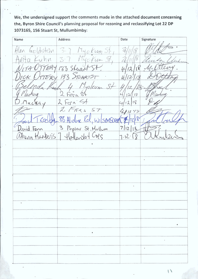
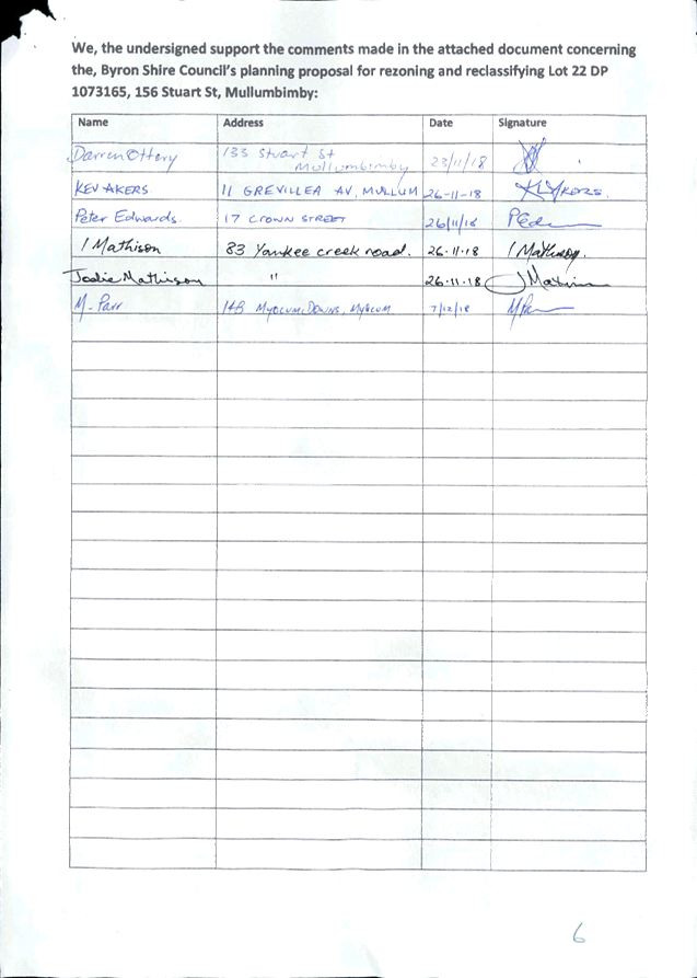
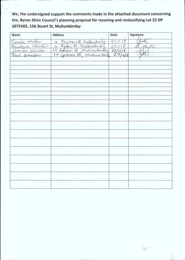
6.3 PLANNING
- 26.2017.4.1 Submissions Report Planning Proposal - Lot 22 DP 1073165, 156
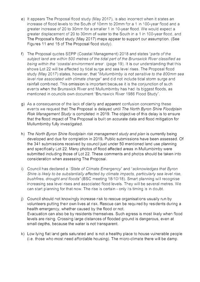
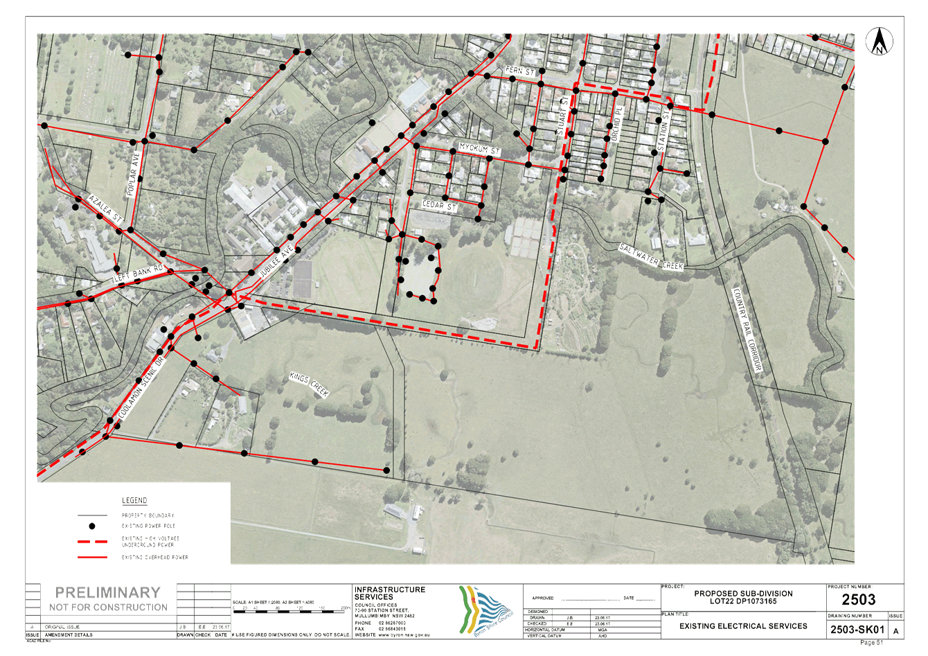
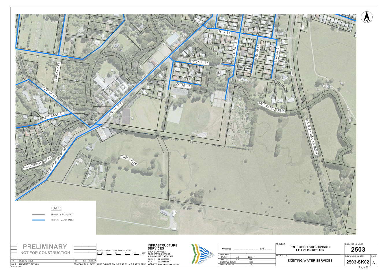
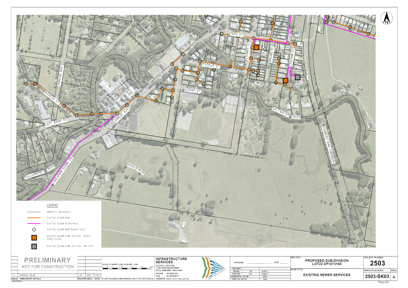
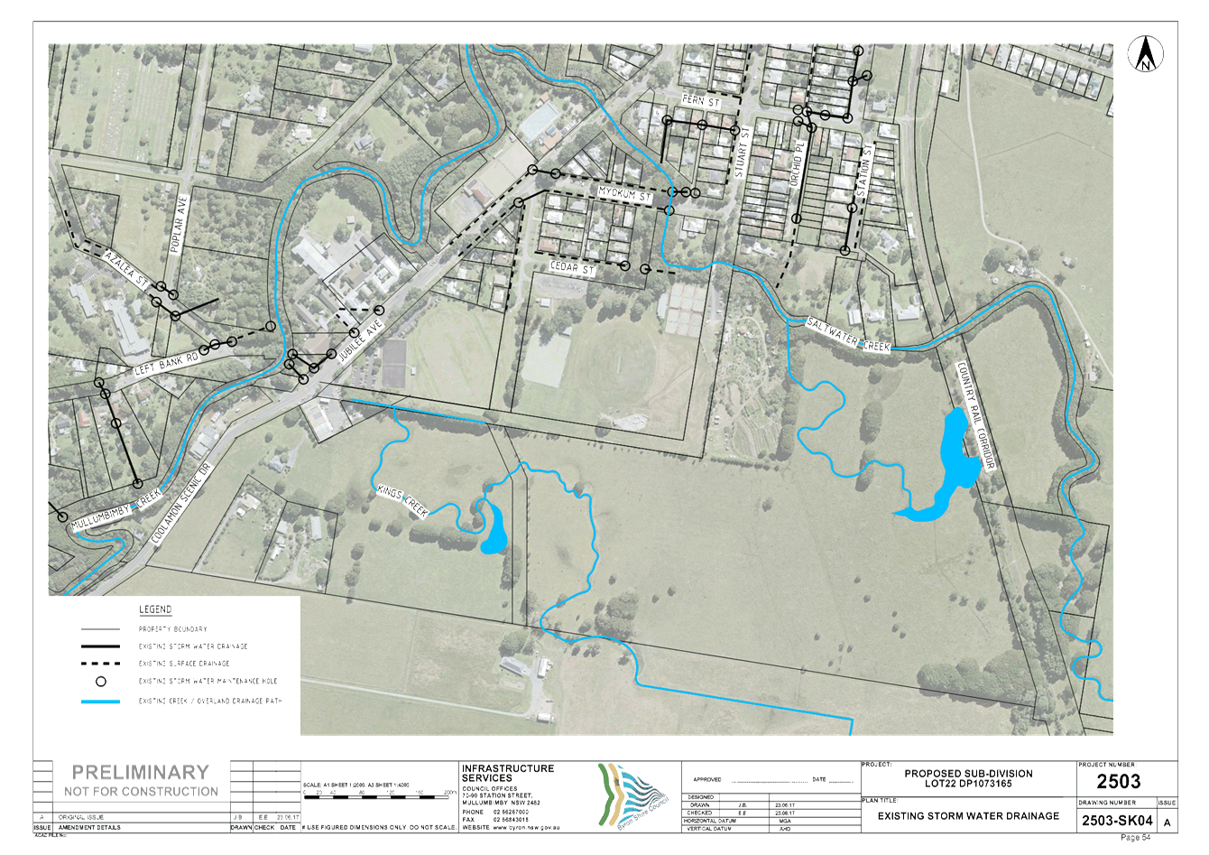
Stuart Street, Mullumbimby....................................................................................................... 98
6.4 Report
of Planning Review Committee held on 14 March 2019.................................. 351
6.5 PLANNING
- Rural Function Centres Update.............................................................. 353
6.6 Community
Participation Plan and Local Strategic Planning Statement...................... 356
6.7 PLANNING
- 10.2018.480.1 Stage 1: Strata Subdivision to Create Two (2) Lots including
One (1) Vacant Lot, Stage 2: Construction of New Dwelling House on Vacant
Strata Lot to Create Dual Occupancy (Detached) with Expanded Dwelling
Module at 8 Cemetery Road Byron Bay 391
6.8 State
Environmental Planning Policy No 70 Affordable Housing (Revised Schemes) (SEPP
70)....................................................................................................................................... 437
Councillors are
encouraged to ask questions regarding any item on the business paper to the
appropriate Director prior to the meeting. Any suggested amendments to the
recommendations should be provided to Councillor Support prior to the meeting
to allow the changes to be typed and presented on the overhead projector at the
meeting.
Staff Reports - Sustainable Environment and Economy 6.1
Staff Reports - Sustainable Environment and
Economy
Report No. 6.1 PLANNING
- 26.2018.3.1 - Submissions Report following Public Exhibition of Planning
Proposal 7(f2)
Directorate: Sustainable
Environment and Economy
Report
Author: Sam
Tarrant, Planning Support Officer
File No: I2019/91
Summary:
Council, at the Ordinary Meeting of 19 April 2018, resolved
to initiate a planning proposal to amend Clause 32 of Byron Local Environmental
Plan 1988, to clarify that strata subdivision of land in the 7(f2) Urban
Coastal Land zone is only permitted in relation to existing lawfully approved
buildings where new vacant lots are not created.
The Gateway was issued with Minister authorisation for Council to exercise delegation to make the LEP
amendment after the completion of the exhibition period. The planning
proposal was publicly exhibited for a period of 28 days. Two public submissions
and one agency submission were received. This report presents the public
exhibition outcomes and recommends that the planning proposal continues without
amendment to become formally gazetted.
NOTE TO COUNCILLORS:
In accordance with the
provisions of S375A of the Local Government Act 1993, a Division is to be
called whenever a motion for a planning decision is put to the meeting, for the
purpose of recording voting on planning matters. Pursuant to clause 2(a)
under the heading Matters to be Included in Minutes of Council Meetings of
Council's adopted Code of Meeting Practice (as amended) a Division will be
deemed to have been called by the mover and seconder of all motions relating to
this report.
|
RECOMMENDATION:
1. That
Council forward the planning proposal to amend Byron LEP 1988, as exhibited (Attachment
1 - E2019/9711) to NSW Parliamentary Counsel’s Office requesting that a
draft LEP instrument be prepared.
2. That
Council liaise with Parliamentary Counsel’s Office (PCO) as necessary
to finalise the content of the draft LEP and to enable PCO to issue an Opinion
that the Plan can be made.
3. That
Council make the draft LEP under delegated authority and forward the Plan to
the NSW Department of Planning and Environment for notification on the NSW
Government legislation website.
|
Attachments:
1 Planning
Proposal for amendment to LEP 1988 - Clause 32 Development within Urban Coastal
Land 7f2, E2019/9711 , page 9⇩ 
2 Submissions,
E2019/18808 , page 36⇩ 
3 Template -
Form of Special Disclosure of Pecuniary Interest, E2012/2815 , page 38⇩ 
REPORT
At the ordinary meeting of 19
April 2018, Council resolved (18-207) to initiate a planning proposal to
amend clause 32 of Byron Local Environmental Plan (BLEP) 1988, to clarify that,
in relation to land zoned 7(f2) Urban Coastal Land, subdivision of land under
the Strata Schemes Development Act 2015 is only permitted in relation to
existing lawfully approved buildings and where no new vacant lots are created.
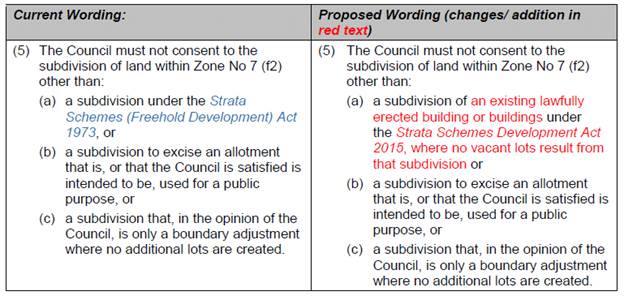
The planning proposal (Attachment
1) will amend part 5(a) of clause 32 of BLEP 1988 to reflect the current Strata
Schemes Development Act and to ensure any subdivision in the 7(f2) Urban
Coastal Land zone did not create any vacant lots that would result in increased
development in an area subject to coastal processes. The proposed changes are
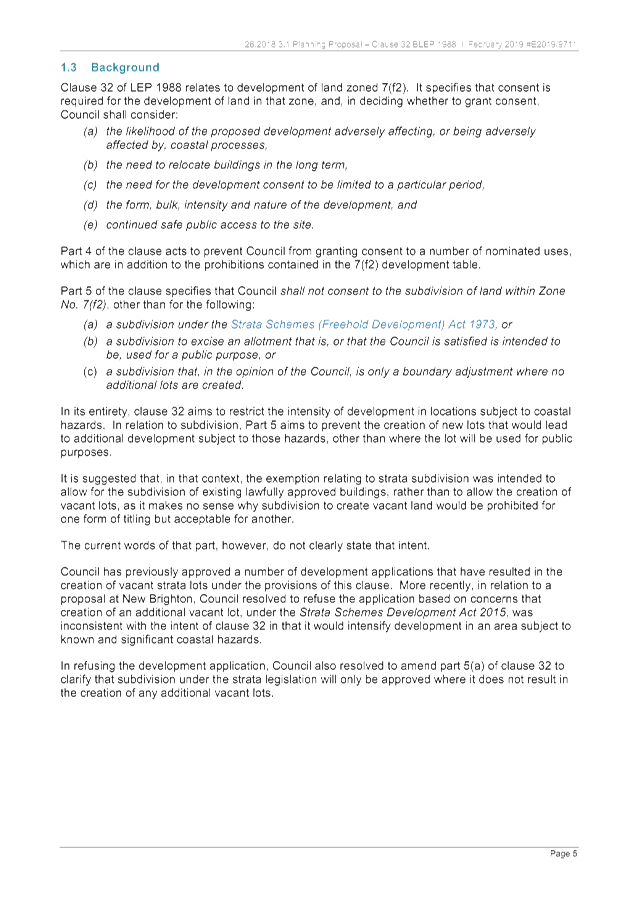
shown in the table below:
In accordance with the resolution (18-207),
the planning proposal was forwarded to the NSW Department of Planning and
Environment for Gateway determination. The Gateway was received on 10 January
2019, with the planning proposal to be placed on public exhibition for 28
days.
The Minister for Planning and
Environment issued an authorisation for Council to exercise delegation to make
this LEP amendment after the completion of the exhibition period.
In accordance with the Gateway
Determination, the planning proposal was on exhibition for a minimum of 28 days
from 13 February to 13 March 2019. Letters were sent to all property
owners with all or part of 7(f2) zoning on their property to notify them of the
planning proposal and its intention. The Office of Environment and
Heritage, NSW Rural Fire Service and Transport for NSW were also notified and
provided with a copy of the planning proposal.
During the exhibition period two
public submissions and one agency submission were received.
Public Submissions
One submission expressed concern that strata subdivision to
create additional vacant lots is already having an impact on the coastal
area. There was clearly a misunderstanding regarding the intention of the
planning proposal, as the amendment seeks to limit strata subdivision to
already existing lawfully erected buildings in the urban coastal zone.
Another submission objected to the proposed changes, stating
that the proposal reduces flexibility for new housing opportunities.
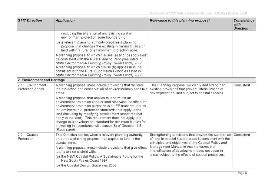
It should be noted that the current provisions of Clause 32
of BLEP 1988 effectively restrict housing opportunities in the 7(f2) zone to
single dwellings. The proposed amendment makes no change to those
provisions. The amendment clarifies that the ability to use the strata
subdivision provisions to subdivide existing lawful buildings cannot result in
the creation of new vacant lots that would be subsequently available for
additional housing. The proposed change is required to support the
objectives of the 7(f2) zone, principally to prevent the intensification of
development in vulnerable coastal areas.
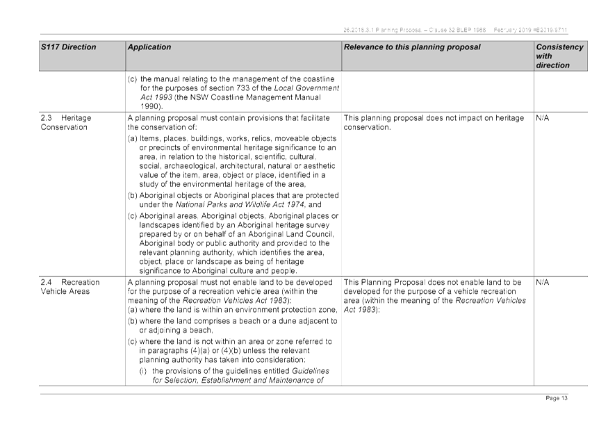
The objectives of the 7(f2) urban coastal land zone are:
(a) to
identify urban land likely to be influenced by coastal processes,
(b) to
permit urban development within the zone subject to the council having due
consideration to the intensity of that development and the likelihood of such
development being adversely affected by, or adversely affecting, coastal
processes,
(c) to
permit urban development within the zone subject to the council having due
consideration to:
(i) the
need to relocate buildings in the long term,
(ii) the
need for development consent to be limited to a particular period,
(iii) the
form, bulk, intensity and nature of the development, and
(iv) continued
safe public access to the site, and
(d) to
allow detailed provisions to be made, by means of a development control plan,
to set aside specific areas within the zone for different land uses and
intensities of development.
The two submissions are contained at Attachment 2.
A number of phone calls were received as a result of the
letters sent to property owners seeking clarification on what the changes
meant. There were no objections to the proposed amendments raised during
the phone calls.
Agencies response
Transport for NSW responded to the notification of this
planning proposal and had no comments regarding the proposed amendments.
NSW Rural Fire Service and the Office of Environment and Heritage provided no
response to the planning proposal.
Next steps
The amendment will be sent to the
Parliamentary Counsel’s Office for legal drafting before being officially
made by the director of SEE.
STRATEGIC CONSIDERATIONS
Council has commenced work on a
Coastal Management Program for the whole of the Shire. A result of this
work will be the preparation of a Coastal Management Program that will outline
how Council will manage coastal hazards/ risks into the future.
Completion of that work will also
allow consideration of appropriate future zoning of coastal land, most of which
remains a ‘deferred matter’ under Byron Local Environmental Plan
2014.
The proposed amendment to the
controls within Byron Local Environmental Plan 1988 will ensure that, during
the coastline planning process, existing at risk development will not be
intensified.
Community Strategic Plan and Operational Plan
|
CSP Objective
|
L2
|
CSP Strategy
|
L3
|
DP Action
|
L4
|
OP Activity
|
|
Community
Objective 4: We manage growth and change responsibly
|
4.2
|
Support
housing diversity in appropriate locations across the Shire
|
4.2.1
|
Establish
planning mechanisms to support housing that meets the needs of our community
|
|
Legal/Statutory/Policy Considerations
This planning proposal will amend clause 32 of the Byron
Local Environmental Plan 1988.
Financial
Considerations
No financial costs are likely to occur as a result of this
planning proposal. Staff time will be used to continue with the final steps of
adopting the amendments to the Byron LEP 1988 as shown in the planning
proposal.
Consultation
and Engagement
See assessment of submissions above.
Staff Reports - Sustainable Environment and Economy 6.1 - Attachment 1

Staff Reports - Sustainable Environment and Economy 6.1 - Attachment 2
Staff Reports - Sustainable Environment and Economy 6.1 - Attachment 3
Local
Government (General) Regulation 2005
Schedule 3A Form of special disclosure
of pecuniary interest
(Clause 195A)
Section 451 of the Local Government
Act 1993
Form of Special Disclosure of Pecuniary Interest
1 The particulars of
this form are to be written in block letters or typed.
2 If any space is
insufficient in this form for all the particulars required to complete it, an
appendix is to be attached for that purpose which is properly identified and
signed by you.
Important information
This information is being collected for the purpose of
making a special disclosure of pecuniary interests under sections 451 (4) and
(5) of the Local Government Act 1993. The special disclosure must relate to a pecuniary
interest that arises only because of an interest of the councillor in the
councillor’s principal place of residence or an interest of another
person (whose interests are relevant under section 443 of the Act) in that
person’s principal place of residence. You must not make a special
disclosure that you know or ought reasonably to know is false or misleading in
a material particular. Complaints made about contraventions of these
requirements may be referred by the Director-General to the Local Government
Civil and Administrative Tribunal.
This form must be completed by you before the
commencement of the council or council committee meeting in respect of which
the special disclosure is being made. The completed form must be tabled at the
meeting. Everyone is entitled to inspect it. The special disclosure must be
recorded in the minutes of the meeting.
Special
disclosure of pecuniary interests
by
____________________________________________________________________________________
[full
name of councillor]
in the matter of
__________________________________________________________________________
[insert
name of environmental planning instrument]
which is to be considered at a meeting of the
______________________________________________________________________________________
[name of council or council committee (as the case
requires)]
Report No. __________ to be held on the _________________ day of
________________________ 201
|
Pecuniary
interest
|
|
Address of land
in which councillor or an associated person, company or body has a
proprietary interest (the identified land)1
|
|
|
Relationship of identified land to councillor
[Tick or cross one box.]
|
Councillor
has interest in the land (e.g. is owner or has other interest arising out of
a mortgage, lease, trust, option or contract, or otherwise).
Associated
person of councillor has interest in the land.
Associated company
or body of councillor has interest in the land.
|
|
Matter giving rise to pecuniary interest
|
|
Nature of land that is subject to a
change
in zone/planning control by proposed
LEP (the subject land)2
[Tick or cross one box]
|
The identified
land.
Land
that adjoins or is adjacent to or is in proximity to the identified land.
|
|
Current
zone/planning control
[Insert name
of current planning instrument and identify relevant zone/planning control
applying to the subject land]
|
|
|
Proposed
change of zone/planning control
[Insert name of proposed
LEP and identify proposed change of zone/planning control applying to the
subject land]
|
|
|
Effect
of proposed change of zone/planning control on councillor
[Insert
one of the following:
“Appreciable financial gain” or
“Appreciable
financial loss”]
|
|
[If
more than one pecuniary interest is to be declared, reprint the above box and
fill in for each additional interest.]
_____________________________
Councillor’s
signature
_____________________________
Date
(This
form is to be retained by the Council’s general manager and included in
full in the minutes of the meeting.)
1 Section 443 (1) of the Local Government Act 1993 provides
that you may have a pecuniary interest in a matter because of the pecuniary
interest of your spouse or your de facto partner or your relative 4 or because
your business partner or employer has a pecuniary interest. You may also have a
pecuniary interest in a matter because you, your nominee, your business partner
or your employer is a member of a company or other body that has a pecuniary
interest in the matter.
Section 442
of the Local Government Act 1993 provides
that a "pecuniary interest" is an interest that a
person has in a matter because of a reasonable likelihood or expectation of
appreciable financial gain or loss to the person. A person does not have a
pecuniary interest in a matter if the interest is so remote or insignificant
that it could not reasonably be regarded as likely to influence any decision
the person might make in relation to the matter or if the interest is of a kind
specified in section 448 of that Act (for example, an interest as an elector or
as a ratepayer or person liable to pay a charge).
2 A pecuniary interest may
arise by way of a change of permissible use of land adjoining, adjacent to or
in proximity to land in which a councillor or a person, company or body
referred to in section 443 (1) (b) or (c) of the Local Government Act 1993 has a proprietary interest-see section 448 (g) (ii) of
the Local Government Act 1993 .
3 "Relative" is
defined by the Local Government Act 1993 as meaning your, your spouse’s or your de facto
partner’s parent, grandparent, brother, sister, uncle, aunt, nephew,
niece, lineal descendant or adopted child and the spouse or de facto partner of
any of those persons.
Staff Reports - Sustainable Environment and Economy 6.2
Report No. 6.2 PLANNING
- 10.2018.305.1 Subdivision to Create Thirty-Two (32) Lots (Tallowood Ridge -
Stage 7) at 77 Tuckeroo Avenue Mullumbimby
Directorate: Sustainable
Environment and Economy
Report
Author: Ben
Grant, Planner
Noreen Scott, EA Sustainable
Environment and Economy
File No: I2019/240
Proposal:
|
DA No:
|
10.2018.305.1
|
|
Proposal description:
|
Subdivision to create thirty-two (32) residential lots, a
public reserve, drainage basin, earthworks, environmental enhancement
works and associated civil infrastructure
|
|
Property description:
|
LOT: 109 DP: 1239902
|
|
77 Tuckeroo Avenue MULLUMBIMBY
|
|
Parcel No/s:
|
269119
|
|
Applicant:
|
Bayview Land Development Pty Ltd
|
|
Owner:
|
Gainsplay Pty Ltd
|
|
Zoning:
|
R2 Low Density Residential, RU1 Primary Production, RU2
Rural Landscape, 1(a) (General Rural Zone)
|
|
Date received:
|
25 June 2018
|
|
Integrated Development:
|
Yes – Bush Fire Safety Authority required under
s100B Rural Fires Act 1997. A controlled activity approval is also
required under section 90 of the Water Management Act 2000. This
applicant has not elected to obtain this approval through the integrated
development process
|
|
Public notification or exhibition:
|
- Level
2 advertising under DCP 2014 Part A14 – Public Notification and
Exhibition of Development Applications
- Exhibition
period: 12/7/18 to 25/7/18
- 2 Submissions received
during the exhibition period
- Additional meetings and
discussions with local residents during the assessment process with staff.
|
|
Delegation to determination:
|
Council
|
|
Issues:
|
· Bush
Fire Prone Land. BFSA received from RFS with conditions.
· Flood
liable land.
· Retention
of large existing Teak tree.
· Earthworks
· Consistency
with concept approval
· The
application includes a SEPP No.1 objection to Clause 11(1) regarding the 40
hectare minimum lot size for land within Zone 1(a) General Rural. Concurrence
has been granted by the Department of Planning and Environment.
· Long
term management of residual areas of vegetation
|
Summary:
This development application seeks approval for a
residential subdivision at the Tallowood Ridge Estate, approximately 1km west
of Mullumbimby. The development involves the creation of 32 residential lots,
dedication of a public reserve, a detention basin, civil infrastructure and
environmental restoration works.
The Tallowood Ridge estate is subject to a staged
development consent (known as the Concept Approval) that was approved by the
NSW Land and Environment Court in 2010. The Concept Approval envisages the
development of a residential estate comprising approximately 240 lots, roads,
open space, rehabilitation areas and associated infrastructure over seven
stages. Stages 1 to 6 have been approved to date, with subdivision works for
Stage 6 currently under construction. Each new phase of development beyond
Stage 1 is required to align with the plans and conditions of consent in the
Concept Approval.
In September 2017, an amendment to LEP 2014 was made that
rezoned an additional 12 hectares of rural land to west of the Tallowood Estate
to R2 Low Density Residential. The significance of the rezoning is that allows
further residential development beyond Stage 7. This development application
proposes a subdivision of land within the Stage 7 area outlined in the Concept
Approval and also includes further subdivision into the newly zoned residential
land to the west. As such a modification is proposed to Management Zone 9
consistent with the residential zoning with a reduction in area by
approximately 4000 m2, whilst further riparian plantings are proposed within
Management Zones 1 and 2 to offset this area of approximately 5200 m2.
The long term management and ownership of residual areas of
vegetation along the southern boundary of the Tallowood Estate has been raised
by residents within the Estate. At present this remains in private ownership.
The applicant has not proposed to dedicate this area to Council or to any other
government Agency at this point in time. For Council (and any other Public
Authority) to consider acceptance of these areas along the southern boundary as
a nature reserve in a future stage, the financial impost on Council will need
to be considered.
The proposed development is considered to be generally
consistent with the Concept Approval and aligns with Council’s future
planning intent for the area. The subdivision has been assessed as complying
with the relevant planning controls and is unlikely to result in significant
adverse impacts on the natural or built environment. The development
application is recommended for approval subject to conditions of consent.
NOTE TO COUNCILLORS:
In accordance with the
provisions of S375A of the Local Government Act 1993, a Division is to be
called whenever a motion for a planning decision is put to the meeting, for the
purpose of recording voting on planning matters. Pursuant to clause 2(a)
under the heading Matters to be Included in Minutes of Council Meetings of
Council's adopted Code of Meeting Practice (as amended) a Division will be deemed
to have been called by the mover and seconder of all motions relating to this
report.
|
RECOMMENDATION:
That pursuant to
Section 4.16 of the Environmental Planning & Assessment Act 1979,
development application 10.2018.305.1 for subdivision to create
thirty-two (32) residential lots, a public reserve, drainage basin,
earthworks, environmental enhancement works and associated civil
infrastructure, be granted consent
subject to the conditions of approval listed in Attachment 3 #E2019/22528.
|
Attachments:
1 Proposed
Plans 10.2018.305.1 - Stage 7, E2019/22557
, page 73⇩ 
2 Extracts
from Concept Approval 10.2009.314.11, E2019/22560
, page 79⇩
3 conditions
of consent, E2019/22528 , page 81⇩ 
4 submission
received, E2018/68592 , page 99⇩
REPORT
Assessment:
1. BACKGROUND
1.1. Tallowood
Ridge Staged Development Application
Development Application No. 10.2009.314.1 (Tallowood Ridge)
was refused by Council on 12 November 2009. Prior to the determination, an
appeal was lodged with the NSW Land & Environment Court against the deemed
refusal of the application. Consent orders were eventually made granting
consent to the development application including the first stage comprising 29
residential allotments. The approval is a staged development consent (known as
the Concept Approval) that envisages a subdivision comprising approximately 240
residential lots, roads, open space, rehabilitation areas and associated
infrastructure over seven stages.
Development beyond Stage 1 is outlined in a document known
as the ‘Future Stages Concept Proposal’ that contains plans and
written statements which aim to direct future development of the subdivision
including phasing, land use, roads, open space and
restoration of natural areas. Each future stage of the estate must not be
inconsistent with the overall layout for the site envisaged in the Concept
Approval and the conditions of consent. Stages 1 to 6 have been approved to
date, with bulk earthworks and civil works for Stage 6 currently under
construction.
Since its approval, the Concept Approval has been modified
ten times to account for changes in the phasing of the subdivision and to
address various matters that have arisen during the development of the estate.
The Stages Plan showing the each intended phase of the estate is shown in figure
1 below.
Figure
1: Staging plan for the Concept
Approval (10.2009.314.11).
1.2. Previous
Development Applications Relating to the Site
Separate development applications for each stage have been
approved and modified as follows:
|
Stage 1
Development Application 10.2009.314.1
|
Stage 1 Tallowood Ridge Estate including Future
Stages Concept Approval. Modified 10 times with the most recent modification
being 10.2009.314.11 for modifications to Land Use Plan 2.1B. Earlier
modifications altered staging, roads and pathways, open space and recreation
areas, contributions, infrastructure and land uses.
|
|
Stage 2
Development Application 10.2011.117.1
|
Stage 2 Tallowood Ridge Estate for urban
subdivision comprising 28 residential allotments and associated civil
infrastructure and access roads. Granted consent on 4 April 2012. The consent
was modified twice, with the most recent approval being s96 application
10.2011.117.3 to remove a number of conditions applied in error.
|
|
Stage 3
Development Application 10.2013.549.1
|
Stage 3 Tallowood Ridge Estate for subdivision to
create thirty-one (31) residential allotments, one (1) residual allotment,
roads, a stormwater detention basin, landscaping and related infrastructure
works. Granted consent on 6 February 2014. Subsequently modified three times
with the latest alteration being 10.2013.549.3 to defer the construction of
the sports field and access road plus the inclusion of a new tennis court and
half basketball court.
|
|
Stage 4A
Development Application 10.2015.79.1
|
Stage 4A Tallowood Ridge Estate for subdivision to create
thirteen (13) residential allotments, public reserves and associated
infrastructure works. S96 application no. 10.2015.79.2 to modify engineering
conditions, and the timing of environmental restoration works and other
matters was granted approval on 26 February 2016.
|
|
Stage 5
Development Application 10.2015.686.1
|
Stage 5 Tallowood Ridge Estate for Subdivision to
create twenty-four (24) residential allotments, a public reserve, a residual
allotment, associated roads and infrastructure. Granted consent on 25 August
2016. Stage 5 was modified 3 times, with the most recent modification being
10.2015.686.6 to include plans omitted in error. Previous modifications
corrected minor errors in relation to rehabilitation works and the timing of
contributions, amongst others.
|
|
Stage 4B
Development Application 10.2016.161.1
|
Stage 4B Tallowood Ridge Estate for Subdivision to create fifteen (15) residential
lots, dedication of a public reserve and extend existing Corella Crescent
road reserve. Granted consent on 31 August 2017. Section 96
application no. 10.2016.161.2 for modification of bush fire asset protection
zones was approved on 2 July 2018.
|
|
Stage 6
Development Application 10.2017.402.1
|
Stage 6 Tallowood Ridge Estate for subdivision to create eighteen (18) residential
Lots, a public reserve, a residual lot and associated infrastructure works.
Granted consent on 26 July 2017. S4.55 application no. 10.2017.402.2 for the
inclusion of a temporary crossing and a stockpile for stage 6 earthworks was
approved on 21 December 2018. A further modification (10.2017.402.3) to
remove the creek crossing and reinstate the former conditions is currently
under assessment.
A further application may be lodged to amend this
consent to make Lot 130 which contains a large tallowwood tree as a public
reserve.
|
1.3. Tallowood
Ridge Rezoning and Future Stages
On 22 September, 2017, an amendment to Byron Local
Environmental Plan 2014 was gazetted that rezoned an additional 12 hectares
of rural land to west of Tallowood Ridge to R2 Low Density Residential. It also
back-zoned existing R2 land into the RU2 Rural Landscape zone to protect
forested areas near the southern ridgeline and a riparian corridor that
traverses the site. Other changes include rezoning the sports fields to RE 1
Public Recreation zone and the introduction of a 400m2 minimum
subdivision lot size for the western part of the estate.
The current application will see the completion of the
Concept Approval (Stage 7), and the commencement of a new phase of development
to subdivide the residential land to the west. Future stages will not be bound
by the Concept Approval although the existing consent conditions for
environmental restoration works associated with earlier stages and the
Biodiversity Conservation Management Plan will remain in
force.
The subdivision layout has been
designed to allow future expansion of the estate. An indicative road layout for
the new areas beyond stage 7 is shown in figure 2 below.
Figure
2: concept road network layout for
Tallowood Ridge future stages
1.4. Site and
surrounds
The Tallowood Ridge Estate is located approximately 1km west
of Mullumbimby and comprises seven residential precincts, six of which have
been approved to date, with bulk earthworks and civil works for stage six
currently under construction. The site has an area of approximately 33 hectares
and is located between Tuckeroo Avenue and Clays Road.
The land is within the R2 Low Density Residential zone, RU1
Primary Production zone and RU2 Rural Landscape zone under LEP 2014. Three
small corners of the site are a deferred matter and fall within the 1(a)
(General Rural Zone) under LEP 1988. The southern ridgeline is forested but the
majority of the site is cleared except for grass cover. The site contains
bushfire prone land, flood prone land and potential acid sulfate soils.
Surrounding land uses consist of rural-residential lots to
the south and rural land to the north and west. Urban land developed in the
earlier stages of the estate lies to the east of Stage 7.
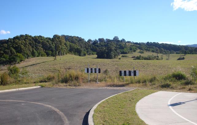
Figure 3: View across the proposed subdivision area, looking
south-west. Tuckeroo Avenue will be extended across the creek line.
1.5. Description
of the proposed development
This development application seeks approval for a thirty-two
(32) lot residential subdivision including, earth works, dedication of a public
reserve, stormwater detention basin and associated civil infrastructure.
The proposed subdivision has the following key elements:
(1) Subdivision
· Thirty-two
(32) residential lots, ranging in size from 504m2 to 1331m2.
· Two (2) lots
for drainage and civil infrastructure containing a stormwater detention basin
and a sewage pump station intended to service the proposed subdivision and
future development of the recently zoned residential areas to the north-west.
· One (1) lot
of 10,600m2 containing part of the riparian corridor adjacent of the
sports fields near to Clays Road. The lot will be dedicated to Council as a
public reserve and is intended to be rehabilitated and revegetated with
riparian species as part of Stage 7. Linking with the other riparian areas
identified as Management Zones 1,2,3 and 4 which have been planted out and
previously dedicated to Council.
· A residue
lot of 28.5 hectares comprising the balance of remaining rural and residential
zoned lands in the existing parcel. The long term ownership of the residual
land which comprises habitat along the southern boundary of the Tallowwood
Estate is yet to be determined.
Table
1: Lot size and shape for Stage 7
|
Proposed
subdivision – Stage 7
|
|
Lot
|
Area (m2)
|
Shape
|
Lot
|
Area (m2)
|
Shape
|
|
161
|
1077
|
Regular
|
179
|
1059
|
Regular
|
|
162
|
637
|
Regular
|
180
|
961
|
Regular
|
|
163
|
647
|
Regular
|
181
|
819
|
Regular
|
|
164
|
657
|
Regular
|
182
|
815
|
Regular
|
|
165
|
1014
|
Corner
|
183
|
834
|
Regular
|
|
166
|
1267
|
Corner
|
184
|
865
|
Regular
|
|
167
|
504
|
Regular
|
185
|
870
|
Regular
|
|
168
|
603
|
Regular
|
186
|
989
|
Regular
|
|
169
|
598
|
Regular
|
187
|
529
|
Regular
|
|
170
|
609
|
Regular
|
188
|
545
|
Regular
|
|
171
|
638
|
Regular
|
189
|
615
|
Regular
|
|
172
|
1229
|
Corner
|
190
|
624
|
Regular
|
|
173
|
1249
|
Corner
|
191
|
627
|
Regular
|
|
174
|
1682
|
Regular
|
192
|
825
|
Corner
|
|
175
|
1161
|
Fan
|
193*
|
4320
|
Irregular
|
|
176
|
966
|
Fan
|
194**
|
767
|
Irregular
|
|
177
|
1341
|
Fan
|
195***
|
15,477
|
Irregular
|
|
178
|
716
|
Regular
|
Residue
|
28.5ha
|
Irregular
|
* Lot for
drainage basin
** Lot for sewerage pump
station
*** Lot for stage 7 riparian
area
(2) Roads
and pathways
· An extension
to Tuckeroo Avenue will act as the main collector road connecting Stage 7 to
the rest of the estate. Two additional roads (proposed roads 2 and 3) will
branch off to the north and south, providing access to the remaining Stage 7
lots. Temporary turning circles will be required at the dead-end sections until
such time as they are extended to service future subdivisions in the adjoining
residential zoned land.
· A 2.5m wide
concrete pedestrian pathway will extend along the northern side of the
extension to Tuckeroo Avenue.
(3) Civil
infrastructure and stormwater detention basin
· A sewage
pumping station located approximately 30 metres from the bank of a creek line
which runs past the existing sports fields to the north.
· A stormwater
detention basin located to the north of the Tuckeroo Avenue extension and
adjacent to the riparian corridor.
(4) Landscaping
and street lighting
· Street trees
and lighting is proposed within the in the Tuckeroo Avenue road reserve. The
applicant has indicated that detailed landscaping plans will be submitted for
approval with the construction certificate application.
(5) Earthworks
· Bulk
earthworks comprising 23,000m3 of cut and 9,230m3 of fill
which will be sourced on-site. The majority of the earthworks will be between
1m to 1.5m in depth. Excavation to a depth of 3m on the higher part of the site
is proposed to create lots 177 – 181.
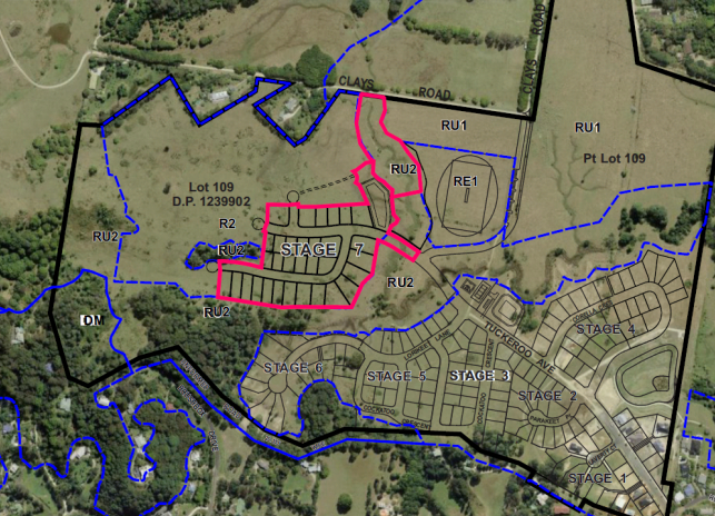
Figure 5: Location plan identifying the extent of the proposed
subdivision (outlined in pink).
Figure 6: Site plan extract detailing the proposed road network
and subdivision layout.
2. CONCEPT APPROVAL ASSESSMENT
In accordance with Section 4.24 of the Environmental
Planning and assessment Act 1979 the proposed development must not be
inconsistent with staged development consent 10.2009.314.11 which is in force
at the time of writing this report. Section 4.24 (2) specifies:
4.24 Status
of staged development applications and consents
(2) While any consent granted on the determination of a concept
development application for a site remains in force, the determination of any
further development application in respect of the site cannot be inconsistent
with the consent for the concept proposals for the development of the site.
An assessment has been undertaken
against the various sections of the Future Stages Concept Plan and Statement
Environmental Effects that form part of the Concept Approval. The proposed
development is considered to be generally consistent with these provisions as
detailed below.
|
Concept Approval Documents
|
Complies
|
Comment
|
|
Section 2 – Design principles
Section 2 includes an indicative land use plan for the
Tallowood Ridge Site. The plan broadly reflects the development guidelines
for the location of residential land, open space and roads under the former
DCP No. 11 Mullumbimby which was in force prior to the granting of consent by
the Court.
Refer to Land Use Plan 2.1C in Attachment 1.
|
Yes
|
The proposed subdivision seeks the following
variations to Land Use Plan 2.1C:
· Residential
lots 175 and 176 located within the a rural zone (nominated RU2 Rural
Landscape Area).
· Residential
Lots 161-172 and 187-192 located within the nominated ‘Buffer
zone–Agriculture’.
The above mentioned variations are the result of a
recent rezoning by Council which created additional R2 zoned land within
these areas.
The agricultural buffer zone is no longer applicable
as this land has been rezoned for residential use. Further the land is not
being used for any agricultural activities such as grazing or
horticulture.
The variations are considered to be generally consistent
with the Concept Approval and are the result of recent zone changes to LEP
2014.
|
|
Section 4 – The location of development
considering the natural features of the site
This section identifies the natural features of the
site and identifies areas for conservation and rehabilitation.
Refer to Rehabilitation Plan 4.3B in Attachment 1.
|
Yes
|
Rehabilitation Plan 4.3B delineates areas for
‘development’ and ‘rehabilitation’. A major riparian
corridor with an area of 10,600m2 which traverses the site will be replanted
and reconstructed as part of the Stage 7 development.
|
|
Section 6 – Phasing of development
This section sets out the phasing and area of each
stage and associated environmental restoration works.
Refer to Stages Plan 6.1B in Attachment 1.
|
Yes
Stage 7 + future stages
|
The footprint of Stage 7 extends outside the area
nominated within staging plan 6.1B. Lots 166, 167-168 and 187-188 are within
management zone 9 of the BCMP.
The Future Stage Concept Proposal document provides
flexibility for future stages, noting that the actual development footprint
for each stage could vary by up to 10%. The extent of the variation in this
case exceeds this figure.
The applicant has put forward a view that the proposed
subdivision constitutes the completion of stage 7, and also incorporates
subdivision of the newly zoned land to the north-west as an additional
element contained within the same development application.
As discussed in section1.4 of this report, development
beyond stage 7 is not subject to the limitations of the Concept Approval. The
proposed development footprint is considered to be permissible on the basis
that it is consistent with Council future planning for the area.
Encroachment into management zone 9 nominated in the
BCMP is addressed in more detail in the section addressing condition 59
below.
|
|
Section 9 – Subdivision pattern
The section sets out a vision for lot sizes in the
estate. Lot sizes are intended to be predominately 600m2.
|
Yes
|
The proposed subdivision pattern for Stage 7 consists
of large allotments ranging in size from 504m2 to 1331m2
and is consistent with the subdivision pattern envisaged in the concept
approval.
It is worth noting that Council recently amended the
LEP 2014 lot size map for this part of the estate to allow a minimum
subdivision lot size of 400m2.
|
|
Section 14 – Provision of public facilities
and services
When the Concept Approval was originally approved Land
Use Map 2.1 did not include a commercial area for a neighbourhood shop as
this was considered to be economically unviable.
Later amendments to Concept Approval on 13 April 2016
included a notation for a ‘potential neighbourhood shop site’
within the Stage 7 area, on the corner of Tuckeroo Avenue and Proposed Road
2.
|
Yes
|
Stage 7 includes residential lots in the area
nominated for a potential neighbourhood shop. A neighbourhood shop would be a
permissible use in the R2 zone and there is scope for the development of a
shop within the estate if the demand arises in the future.
|
Following a review of the approved concept plan details it
is considered that the proposed subdivision is generally consistent with the
phasing and conditions of consent. Conditions of the Concept Approval that are
relevant to this assessment are specified below:
|
Conditions of consent
|
Complies
|
Comment
|
|
Condition 5 Phasing of
development
The development must be
carried out in 7 separate stages in accordance with the approved plans and
conditions of consent
Stage 7 subdivision and Stage 7 Plantings and
restoration areas are to be carried out at the same time.
Refer to Plan 6.1 in Attachment
1.
|
Yes
|
The proposal will see the commencement of the Stage 7
subdivision and Stage 7 plantings in accordance with condition 5. Additional
subdivision of the newly zoned residential land is also proposed.
|
|
Condition
6 Modification to Future Concept Proposals
(c) The access to Brushbox Drive per
‘DCP 11 Mullumbimby’, shown on Plan 8.1 of the ‘Future
Concept Proposals’ document, is limited to bikeway construction only.
Construction of vehicular access from the subdivision to Brush Box Drive may
be considered within an alternative location (such as the end of Brushbox
Drive) as part of Stage 7.
|
Yes
|
Plan 8.1 was modified to remove any road to Brushbox
Drive. This occurred primarily for environmental reasons to minimise
disturbance of the shelter belt. A shared bike way or pedestrian path linking
the estate to Brush Box Drive is considered to be a desirable outcome. This
connection will be outside the stage 7 area and is better dealt with as part of
future stages. Such a pathway linking through to Brushbox Drive can be
provided on cleared land to the west of Stage 7. This provision is currently
embedded in DCP 2014 Chapter E3 Mullumbimby, Parts E3.6, prescriptive measure
2.
Council will be required to give consideration to this
DCP provision when considering future stages.
|
|
Condition
8 - Buffer to agricultural land
A 50 metre
buffer must be maintained between the 2(a) Residential Zone and the
agricultural land located to the north. A fence is to be erected and
maintained 50 metres inside the 1(a) General Rural Zoned part of the land at
locations as shown on Plan 2.1 Land Use Plan of the ‘Future Stages
Concept Proposal’ document as part of the development of stage 7.
|
N/A
|
The agricultural buffer zone shown on Plan 2.1C has
now been rezoned to R2 Low Density residential. This condition is no longer
applicable given the zones have been substantially changed since the Concept
Approval was granted consent in 2010.
|
|
Condition
59
Biodiversity
Conservation Management Plan
The BCMP
must incorporate a landscaped open space network that links the
‘shelter belt’ ‘existing native vegetation stands’
and ‘riparian zone planting’ areas.
The
provisions of the BCMP are to be adhered to at all times.
|
Yes*
Modified BCMP
|
A modified BCMP has been submitted which provides for
enhanced rehabilitation of existing riparian corridors in exchange for a
reduction in the extent of management zone 9. In this regard the applicant
has commenced planting an additional area within the riparian corridor
nominated as Stage 2 and 3 amounting to a further 5000 m2 of plantings. Refer
to Section 4.12 of this report for further discussion of the environmental
impacts.
|
3. REFERRALS AND
CONSULTATION
|
|
Summary of Issues
|
|
NSW Rural Fire Service
|
A Bush Fire Safety Authority
has been issued under Section 100B of the Rural Fires Act 1997.
|
|
NSW Department of Planning & Environment
|
Concurrence issued in relation to the SEPP 1 objection
to vary the 40 hectare minimum subdivision lot size in clause 11 of LEP 1988.
|
|
Department of Primary Industries – Office of
Water
|
The Department was contacted for comment but did not
provide a response. A Controlled Activity Approval is required to construct
the culvert and extension of Tuckeroo Avenue. A condition is recommended
requiring the approval to be obtained prior to the issue of a construction
certificate.
|
|
Bundjalung (Arakwal)
|
No objections subject to conditions of consent.
Additional monitoring conditions are recommended for any subdivision works in
proximity to the areas of significance previously identified in the Everick
(2009) report.
|
|
Tweed Byron Land Council
|
No objections subject to conditions of consent.
Support given to the improved monitoring conditions recommended by TBLALC.
|
4. ENVIRONMENTAL PLANNING AND ASSESSMENT
ACT 1979
4.1 Section 4.46 –
Integrated Development
Rural Fires Act 1997
The site is identified as Bushfire Prone Land. The proposed
residential subdivision requires a Bush Fire Safety Authority under s100B of
the Rural Fires Act 1997 and constitutes integrated development pursuant
to s4.46 of the Environmental Planning and assessment Act 1979 (the
Act).
The application was referred to the NSW Rural Fire Service
seeking General Terms of Approval (GTAs) for the integrated development
application. GTAs and a Bush Fire Safety Authority have been issued and are
included as part of the recommended conditions at the end of this report.
Asset protection Zones have been identified on the
subdivision plan which are located within each lot.
Water Management Act 2000
The access to the new residential area will require the
construction of a culvert across a creek line to facilitate an extension of
Tuckeroo Avenue. The work requires a Controlled Activity Approval (CAA) to be
obtained under section 91 of the Water Management Act 2000.
The applicant has provided a written submission clarifying
that the CAA will be applied for separately should consent be granted to the
development application. A condition is recommended requiring the CAA to be
obtained prior to the issue of a construction certificate for the subdivision
works.
4.2 Section 4.15 Evaluation
Having regard to the matters for consideration detailed in
Section 4.15(1) of the Environmental Planning & Assessment Act 1979
(EP&A Act), the following is a summary of the evaluation of the issues.
4.3 Section 4.15.1(1)(a)(i) the
provisions of any environmental planning instrument
State Environmental Planning
Policy No 1—Development Standards
A SEPP 1 objection to Clause 11 of Byron Local
Environmental Plan 1988 has been lodged with the application in relation to
the minimum lot size for part of the residue lot. This is addressed in Section
4.5 of the report, under Byron LEP 1988.
State Environmental Planning
Policy No 44—Koala Habitat Protection
Parts of the site are considered to represent potential
koala habitat. Previous survey results indicate the site is unlikely to be
regarded as core habitat, but is known to be used for movement and dispersal.
No adverse impacts on local koala populations are expected as a result of Stage
7 given there is no clearing of vegetation and no works proposed within the
within the shelter belt and the southern ridgeline.
State Environmental Planning
Policy No 55—Remediation of Land
The land was historically used for agricultural purposes
including cattle grazing. No potentially contaminating land uses known to have
operated on or near the site in recent times. The land is not within the
proximity of any cattle dip sites and is not listed on Council’s
Contaminated Lands Register.
A preliminary site investigation of the Stage 7 area was
undertaken for the original staged development application no.10.2009.314.1;
analysis of soil samples found the site to be suitable for residential use. Based
on all the available information the land is considered to be suitable for the
proposed development in its current state and does not require remediation.
Any unexpected contamination identified during subdivision
works (buried tanks, building waste, asbestos etc.) is to be dealt with in
accordance with an Unexpected Findings Protocol (UFP). The UFP is to be
submitted to Council for approval prior to the issue of a construction
certificate.
State
Environmental Planning Policy (Coastal Management) 2018
All of the proposed residential allotments, roads, civil
infrastructure and ancillary works are located outside the coastal zone. The
Coastal SEPP does not apply to these elements of the proposed development.
The lower part of the residue lot near to Coral Avenue is
within the coastal use mapped area and the coastal environment mapped area and
the SEPP applies to this land. Given
there is no physical works occurring in this location, nor any change to the
land use or boundary alignments, it is concluded that the development will not
have an adverse impact on the coastal environment and is satisfactory having
regard to the relevant matters for consideration under the SEPP.
State Environmental Planning
Policy (Rural Lands) 2008
The residue lot
will retain a dwelling entitlement and the Rural SEPP is applicable to this
element of the proposed subdivision. The preferred and predominant land uses in
the surrounding area are residential and rural-residential uses and this is
consistent with the future planning intent for the area. The remaining rural
land in the residue lot has limited agricultural capability and the potential
for land use conflict between urban and rural land uses is considered to be
low.
4.4 Byron Local Environmental Plan
2014 (LEP 2014)
LEP 2014 is an applicable matter for consideration in the
assessment of the subject development application in accordance with subsection
4.15(1) of the EP&A Act because it applies to the subject land and the
proposed development. The LEP 2014 clauses that are checked below are of
relevance to the proposed development:
|
Part 1
|
☒1.1|
☒1.1AA| ☒1.2| ☒1.3| ☒1.4| ☒Dictionary| ☒1.6| ☒1.7| ☒1.8| ☒1.8A| ☒1.9| ☒1.9A
|
|
Part 2
|
☒2.1|
☒2.2 | ☒2.3 |☒Land Use Table | ☒2.4 | ☒2.5 | ☒2.6 | ☒2.7 | ☒2.8
|
|
Part 4
|
☒4.1|
☒4.1D| ☒4.3| ☒4.4 | ☒4.5
|
|
Part 5
|
☒5.10|
☒5.16
|
|
Part 6
|
☒6.1|
☒6.2| ☒6.3| ☒6.6| ☒ 6.7
|
In accordance with LEP 2014 clauses 1.4 and 2.1 – 2.3:
(a) The
proposed development is defined in the LEP 2014 Dictionary as Subdivision
(including ancillary works and civil infrastructure);
(b) The
land is within the R2 Low Density Residential zone, RU1 Primary Production zone
and RU2 Rural Landscape zone according to the Land Zoning Map. Three small
portions of the site are identified as a deferred matter and these areas revert
to the 1(a) (General Rural Zone) under LEP 1988.
(c) The
proposed development is permitted with consent; and
(d) Regard
is had for the Zone Objectives as follows:
R2 Low Density Residential Zone
· To provide for the housing needs of the community within a low density
residential environment.
· To enable other land uses that provide facilities or services to meet
the day to day needs of residents.
The proposed subdivision will provide additional land for
housing in the Mullumbimby area. Large lot sizes will provide opportunities for
the development of a low density residential environment consistent with the
zone objectives.
RU2 Rural Landscape Zone
· To encourage sustainable primary industry production by maintaining and
enhancing the natural resource base.
· To maintain the rural landscape character of the land.
· To provide for a range of compatible land uses, including extensive
agriculture.
· To enable the provision of tourist accommodation, facilities and other
small-scale rural tourism uses associated with primary production and
environmental conservation consistent with the rural character of the locality.
· To protect significant scenic landscapes and to minimise impacts on the
scenic quality of the locality.
The only physical works occurring
in the RU2 land will be the extension of Tuckeroo Avenue and the riparian
restoration works identified in the Concept Approval and the BCMP. Residential
development on other parts of the site is contained within the R2 zone. The
proposed subdivision will not have a significant effect on the rural character
of the or the scenic qualities of the locality.
RU 1 Primary
Production Zone
· To encourage sustainable primary industry
production by maintaining and enhancing the natural resource base.
· To encourage diversity in primary industry
enterprises and systems appropriate for the area.
· To minimise the fragmentation and alienation of
resource lands.
· To minimise conflict between land uses within this
zone and land uses within adjoining zones.
· To encourage consolidation of lots for the purposes
of primary industry production.
· To enable the provision of tourist accommodation,
facilities and other small-scale rural tourism uses associated with primary
production and environmental conservation consistent with the rural character
of the locality.
· To protect significant scenic landscapes and to
minimise impacts on the scenic quality of the locality.
A portion of RU1 zoned land is
contained within the residue lot near the intersection of Clays Road and Plover
Parkway. No physical works or reconfiguration of the zone boundaries is
proposed for this area. The proposed subdivision is adequately separated from
this land by sports fields and a riparian corridor in the RU2 zone.
Clause 4.1 Minimum subdivision lot
size
The minimum lot
size in the R2 Low Density Residential zone on the subject land is 400m2.
The remainder of the site is zoned RU1 Primary Production, RU2 Rural Landscape
and 1(a) (General Rural) zone. A 40 hectare minimum lot size applies to these
areas.
As illustrated in
the table below, the proposed lots in the R2 zone vary in size from 504m2
to 3600m2 and comply with the minimum lot size standard. The residue
lot and riparian lot do not comply with the minimum lot size, an issue which is
discussed further below. Special provisions are afforded to split zoned sites
under clause 4.1D to facilitate the subdivision of the residue lot which is
less than 40 hectares.
Table 2: Compliance with the Lot Size Map
|
Lot type
|
Zone
|
Min Lot Size
|
Proposed Lot Size
|
Compliance
|
|
32
Residential Lots
|
R2
|
400m2
|
504m2–1267m2
|
Yes
|
|
1 Drainage
Lot
|
R2
|
400m2
|
3600m2
|
Yes
|
|
1
Infrastructure Lot
|
R2
|
400m2
|
930m2
|
Yes
|
|
1 Riparian
Lot
|
RU2
|
40 hectares
|
1.16
hectares
|
No
|
|
1 Residue
Lot
|
RU1, RU2,
1(a)
|
40 hectares
|
28.5
hectares
|
No
|
Clause 4.1D Exceptions to minimum
subdivision lot sizes for certain split zones
Clause 4.1D
allows the subdivision of split zoned sites which do not meet the minimum lot
size standards specified under clause 4.1. The purpose of this provision is to
ensure that subdivision occurs in a manner that promotes suitable land use and
development.
Clause
4.1D Exceptions to minimum subdivision lot sizes for certain
split zones
(1) This
clause applies to each lot (an original lot) that contains:
(a) land
in a residential, business or industrial zone, and
(b) land
in Zone RU1 Primary Production, Zone RU2 Rural Landscape or Zone SP3 Tourist.
(2) Despite
clause 4.1, development consent may be granted to subdivide an original lot to
create other lots (the resulting lots) if:
(a) one
of the resulting lots will contain:
(i) land
in a residential, business or industrial zone that has an area that is not less
than the minimum size shown on the Lot Size
Map in relation to that land, and
(ii) all
of the land in Zone RU1 Primary Production, Zone RU2 Rural Landscape or Zone
SP3 Tourist that was in the original lot, and
The proposal is
considered to comply with the provisions of this clause because all of the
rural zoned land will be contained within the residue lot, with the exception
of 1.547 hectares that is to be dedicated to Council as a public reserve. The
excision of land to create public reserve is exempt development under State
Environmental Planning Policy (Exempt and Complying Development Codes) 2008.
Clause 5.10 Heritage Conservation
The site is known
to contain an area of significance previously identified in a cultural heritage assessment undertaken by
Everick consultants in 2009. The report identified the Mooibul Spur, part of
which forms the southern boundary of the site, as being part of the cultural
landscape. The Spur presents a likely access way used by Aboriginal
people, between the Koonyum Ranges in the west and the Brunswick River to the
east.
The report recommended that this natural feature be preserved
by retaining as many trees as possible along the southern ridgeline. Any
disturbance resulting from roads or sub-surface infrastructure is to be subject
to a post clearance inspection to look for Aboriginal Objects that may
have not been identified during past surveys.
Tweed Byron Local
Aboriginal Land Council and Arakwal Aboriginal Corporation were notified as
part of the advertising procedure for the current application. Specific
comments were provided noting that any disturbance near the ridgeline should be
supervised during the subdivision works, rather than being inspected in a
post-clearance survey as recommended in the report.
A moderate amount
of excavation will be undertaken to create lots 177–181, but this work
will occur below the ridgeline and will not involve the removal of vegetation.
The development is considered to be consistent with the
recommendations of the Everick report and is unlikely to result in adverse
impacts on the cultural landscape. Conditions for the monitoring of excavation
works in accordance with the recommendations of the TBLALC and Arakwal are
included in the recommendations of this report.
Clause 6.1 Acid sulfate soils
The site is not
included on the Acid Sulfate Soils Map; however, acid sulfate soils have been
identified during the construction of previous stages in the lower lying areas.
The main concern for stage 7 relates to the construction of a culvert to
facilitate the extension of Tuckeroo Avenue.
Council’s
Environmental Health Officer has recommended a condition requiring an acid
sulfate soils investigation and management plan (ASMP) to be prepared and
submitted for approval with the construction certificate. Should any acid soils
be discovered, the ASMP will include provisions for neutralising and managing
the soils on site during the construction phase.
Clause 6.2 Earthworks
Bulk
earthworks comprising 23,000 cubic metres of cut and 9,230 cubic metres of fill
is proposed in stage 7. Fill
will be sourced internally from the site, ensuring infiltration characteristics
will match the existing soil properties. The majority of the cut and fill will vary
between 1m to 1.5m in depth, although a deeper section of excavation to
approximately 3m is proposed to create lots 177-181. Deeper excavation will be graded with relatively smooth
transitions to prevent the need for retaining walls.
A vegetated,
eroded gully is located to the west of Stage 7 within the RU2 zone. As a result
of filling to create residential lots, water flows from the gully will be
diverted into a piped drainage system that will discharge into a bio retention
basin near the Stage 7 riparian corridor. Council’s Development Engineer
reviewed the proposal and noted that it was an acceptable solution and would
not result in excessive peak flows or flooding of downstream properties.
Erosion
and sediment runoff is a concern given the amount of material to be disturbed
and the proximity of the development to creeks which drain into the Brunswick
River. A condition is recommended for a detailed sediment and erosion control
plan to be prepared and submitted for approval as part of the construction
certificate application.
Clause 6.3 Flood planning
Parts of the
subject site are identified in the North Byron Flood Study as flood prone land.
Lower lying land near the Brunswick River and along the creek lines is
identified as being subject to inundation during a 1 in 100 year ARI flood
event. The flood planning level for the site is 7.67m AHD.
Residential lots
in Stage 7 are located well above the flood planning level. Areas of concern
relate to the bulk earthworks for the drainage basin and culvert needed to
facilitate the extension of Tuckeroo Avenue.
The applicant
submitted a flood study which identified only a minimal impact on the movement
of floodwaters to downstream properties. The
flood modelling for the proposed development does not identify any significant
increase in the extent and level of flooding compared to the modelling for
Stage 6 which has been accepted by Council as part of development application
no. 10.2017.402.1. On the basis of the information supplied, the subdivision is
considered to be compatible with the flood hazard of the land and satisfies the
matters for consideration under this clause.
Clause 6.6 Essential services
The subdivision
is capable of being serviced by reticulated sewage, water, electricity and
telecommunications including NBN subject to conditions of consent. In relation
to vehicular access, each lot is capable of being serviced with a driveway that
connects to the public road network; no internal access driveways need to be
constructed to service individual allotments as part of the subdivision works.
4.5 Byron Local Environmental Plan
1988 (LEP 1988)
LEP 1988 is an applicable matter for consideration in the
assessment of the subject development application in accordance with subsection
4.15(1) of the EP&A Act because it applies to the subject land and the
proposed development. The LEP 1988 clauses that are checked below are of
relevance to the proposed development:
|
Part 1
|
☒1|
☒2| ☒2A| ☒3| ☒4| ☒5| ☒LEP 1988 Dictionary| ☒7
|
|
Part 2
|
☒8|
☒9
|
|
Part 3
|
☒10|
☒11| ☒24| ☒38| ☒38A| ☒40| ☒45| ☒63
|
In accordance with LEP 1988 clauses 5, 8 and 9:
(a) The
proposed development is defined in the LEP 1988 Dictionary as Subdivision
(including ancillary works and civil infrastructure);
(b) The
land is within the 1 (a) (General Rural) Zone
according to the map under LEP 1988;
(c) The
proposed development is permitted with consent; and
(d) The
proposed development is consistent with the relevant objectives of the Zone for
the following reasons:
Zone No 1 (a) (General Rural)
(a) to encourage and permit a range of uses creating a
pattern of settlement, at a scale and character that maintains or enhances the
natural, economic, cultural, social and scenic amenity of the rural environment
of the Shire of Byron,
(b) to encourage and permit a pattern of settlement which
does not adversely affect the quality of life of residents and visitors and
maintains the rural character,
(c) to ensure development only occurs on land
which is suitable for and economically capable of that development and so as
not to create conflicting uses,
(d) to allow the use of land within the zone
for agricultural purposes and for a range of other appropriate purposes whilst
avoiding conflict between other uses and intensive agriculture,
(e) to identify lands (shown hatched on the
map) which in the opinion of the council possess a limited capability for more
intensive uses or development,
(f) to restrict the establishment of
inappropriate traffic generating uses along main road frontages other than in
road side service areas,
(g) to ensure sound management of land which
has an extractive or mining industry potential and to ensure that development
does not adversely affect the potential of any existing or future extractive
industry,
(h) to enable the provision of rural tourist
accommodation and facilities only where such facilities are compatible with the
form and density of the nature of the locality, and
(i) to permit the development of limited light
industries which do not pose any adverse environmental impact, (eg software
manufacture and film processing), and
(j) to ensure that the development and use of land shown
cross-hatched on the map adjacent to areas of significant vegetation and
wildlife habitat do not result in any degradation of that significant
vegetation and wildlife habitat, and that any development conserves and
protects and enhances the value of the fauna and flora.
Only a few small corners of the residue lot are within the
1(a) zone under LEP 1988. These areas are not near Stage 7 and will not be
materially affected by the subdivision works. The proposed development will not
have any adverse environmental impacts on land in the 1(a) zone and is
consistent with the zone objectives.
4.6 Any proposed Instrument
that has been the subject of public consultation and has been notified to the consent
authority
There are no
proposed instruments that are of relevance to the subject application.
4.7 Byron
Shire Development Control Plan 2014 (DCP 2014)
DCP 2014 is an applicable matter for consideration in the
assessment of the subject development application in accordance with subsection
4.15(1) of the EP& A Act because it applies to the land to which LEP 2014
applies. The DCP 2014 Parts/Chapters that are checked below are of relevance to
the proposed development:
|
Part A
|
☒
Preliminary
|
|
Part B Chapters:
|
☒B2|
☒B3| ☒B4| ☒B5| ☒B6| ☒B7| ☒B8| ☒B9| ☒B11| ☒B12| ☒B13| ☒B14
|
|
Part C Chapters:
|
☒C2|
☒C3
|
|
Part D Chapters
|
☒ D6
|
|
Part E Chapters
|
☒ E3
|
These checked Parts/Chapters have been taken into
consideration in the assessment of the subject development application in
accordance with subsection 4.15(1) of the EP&A Act. The proposed
development complies with all sections of these Parts/Chapters (in some cases
subject to conditions and/or to the satisfaction of other assessing officers),
except in relation to certain prescriptive measures which are considered
further (having regard to the DCP 2014 Section A1 Dual Path Assessment) as
follows
Part B14.2 Excavation and Fill in all zones
Prescriptive measure B14.2(1) provides that excavation and
filling must be limited to a depth of 1 metre. The proposed excavation and fill
generally varies from 1m to 1.5m except for proposed lots 177-181 which involve
excavation to a depth of 3m and for the construction of the stormwater basin.
Notwithstanding this non-compliance, the proposed earthworks are considered to
satisfy the objectives and performance criteria of Part B14.2.
Objectives
1. To
ensure that towns, villages, commercial, industrial, residential and rural
areas maintain overall compatibility with the Shire’s natural features
and its historical built character.
2. To
control the extent, character, bulk and scale of earthworks so that both
individual and cumulative earthworks over time do not detract from the existing
and desired future character of their immediate locality, and the surrounding
area.
3. To
promote the use of earthworks to create landscapes and streetscapes that make a
positive contribution to the existing and desired future character of their
immediate locality and the surrounding area.
Performance
Criteria
1. Development
proposals must demonstrate that proposed earthworks will be compatible with the
low rise, low to medium density form, scale and desired future character of
their locality and immediate surrounds. Proposals must demonstrate that
excavation and fill will be limited to ensure that:
a) Adverse
visual impacts, bulk and scale of both the proposed earthworks and the
resultant overall development are minimised;
b) Overshadowing
of adjoining private and public land is avoided;
c) The
scale and character of the resultant landform and buildings will remain
compatible with their surrounds and with the desired future character of the locality;
d) Resultant
drainage characteristics and systems both on the site and in the locality will
be consistent with Chapter B3 Services and with Water Sensitive Urban Design
Principles.
e) The
need for engineering and support works is minimised;
f) Risk
of geotechnical instability and/ or landslip is minimised.
2. Where
earthworks are designed to facilitate and/ or improve thermal sustainability
and insulation in buildings and developments rather than as structural or
landscape elements, development proposals must demonstrate the particular
benefits to be gained from those earthworks.
3. Earthworks
must be designed to ensure that the community /pedestrian scale and character
of commercial areas will be retained and reinforced.
4. Where
filling is proposed to mitigate flooding and stormwater issues, details are to
be submitted with the application demonstrating the fill will not have a
significant adverse impact on the flow characteristics of flood waters or
detrimentally increase the level of flooding or stormwater on other properties
or development.
Given the undulating terrain and steep topography near lots
177-181, it is difficult to avoid earthworks exceeding 1m in depth. Overall,
the visual impact from the proposed earthworks is not expected to be
objectionable given the deeper areas of cut will be transitioned gradually to
natural ground level to negate the need for retaining walls. Dwelling sites will sit below the tree line and will not
detract from the scenic or environmental values of the southern ridgeline. The
resulting land form and pattern of development will not be dissimilar to the
earlier stages of the estate.
A flood study has been submitted demonstrating that no
adverse impacts on downstream properties will occur as a result of the
earthworks, including the filling of the lower parts of the site to construct
the culvert and stormwater detention basin. In
relation to geotechnical stability and stormwater, the use of existing material
from the site will ensure infiltration characteristics match the existing soil
profile. The stormwater basin is also proposed to detain stormwater to ensure
it is treated and controlled before entering the local water course to the east
which eventually drains to the Brunswick River. A variation to the numerical
requirements under the DCP is supported in this instance
The proposed development is
considered to comply with the relevant objectives and performance criteria for
each relevant chapter of Byron DCP 2014. Consideration of the requirements in
Chapter D6 Subdivision and Chapter E3 Mullumbimby is detailed below.
|
D6.2 Subdivision Design Guidelines
|
Compliance
|
Comment
|
|
1. Site
Design
|
Yes
|
Most of the proposed lots have a northerly aspect and
will offer reasonable access to views and breezes for future dwellings.
|
|
2. Climate
Control and Aspect
|
Yes
|
Stage seven is situated on a north-facing slope; most
of the allotments have a north-south orientation. The subdivision will
facilitate good solar access and provide flexibility for the siting and
design of future dwellings.
Lots 173-177 have an east- west orientation, however,
these parcels have been provided large lot sizes to allow the siting of a
house that may not be parallel to the boundaries.
|
|
3. Hazards
|
Yes
|
The application has suitably addressed environmental
hazards including flooding and bushfire. Lots 161 – 186 along the
southern and eastern side of the subdivision will be burdened with asset
protection zones on the title of each lot to ensure adequate separation
distances to vegetation on the ridgeline and creek.
|
|
4. Vegetation
removal
|
Yes
|
No vegetation removal is proposed.
|
|
5. Riparian
Buffers and land fronting watercourses
|
Yes
|
Significant bush regeneration works are being
undertaken throughout the riparian corridor which lies east of the stage
seven area.
|
|
6. Landscaping
|
*Yes Condition
|
A condition is recommended for
street trees to be provided
|
|
7. Roads
|
Yes
|
The subdivision will maintain the existing road
hierarchy by extending Tuckeroo Avenue as the main thoroughfare throughout
the estate. It is anticipated that the Stage 7 road network will interlink
with future residential subdivisions on the recently rezoned land to the north-west.
|
|
8. Street
Lighting
|
*Yes Condition
|
Conditions are recommended for
street lighting to be provided in accordance with the provisions of DCP 2014.
New lighting is to match the existing infrastructure design throughout the
estate.
|
|
9. Public
open space and public reserves
|
Yes
|
A pedestrian pathway in Tuckeroo
Avenue will connect Stage 7 back to playgrounds and sports fields approved in
earlier stages.
|
|
10. Stormwater
Management
|
Yes*
Condition
|
Stormwater is able to be
adequately managed. Conditions are recommended.
|
|
11. Utility
Services
|
Yes
|
Electricity and telephone
services, including NBN, can be supplied to each lot.
|
|
12. Provision
of Potable Water Supply
|
Yes
|
Reticulated water and sewer
services are able to be provided to each lot.
|
|
13. Sewer
|
Yes
|
|
14. Geotechnical
Report
|
Yes*
Condition
|
Geotechnical report to be provided
for the construction certificate application.
|
|
D6.3.3 Road Design and Construction
|
Compliance
|
Comment
|
|
15. The
design of such works must comply with the Northern Rivers Development and
Design Manual. Construction must be carried out in accordance with those
requirements.
|
Yes
|
The road design complies with the Northern Rivers
Development Design Manual.
|
|
16. Additional
standards may apply in bushfire prone areas as per the requirements of the
NSW Rural Fire Service.
|
Yes
|
The Bush Fire Safety Authority
requires a temporary turning circle with a 12m outer radius to be provided at
the termination of road 1 and 2. Road design must comply with section
4.1.3(1) of ‘Planning for Bush Fire Protection 2006’, except that
a perimeter road is not required.
|
|
D6.3.4 Sewage Management
|
Compliance
|
Comment
|
|
1. Where
Council deems that reticulated sewer service is available and feasible, each
allotment created must be connected to Council's sewerage reticulation
system.
|
Yes
|
Reticulates sewer service is available to the proposed
subdivision. A new pump station is proposed to facilitate the proposed and
future development.
|
|
D6.4.1 Lot Size and shape
|
Compliance
|
Comment
|
|
1. Lot
sizes must not be less than the minimum area specified in Byron LEP 2014 on
the lot size map.
|
Yes
|
All proposed allotments exceed the 400m2
minimum lot size.
|
|
2. For
lots that are not typical rectangular shaped lots, Table D6.1 indicates
Council's preferred minimum lot sizes in urban subdivisions:
Table D6.1 –
Preferred Minimum Lots Sizes – Urban Subdivision
|
Type of lot
|
Min. lot area
|
|
General lot
|
See lot size map
|
|
Corner lot
|
650m2
|
|
Hatchet-shaped lot
|
800m2
|
|
Hatchet shaped lot
adjacent to public reserve
|
650m2
|
|
Fan-shaped lot
(minimum frontage 7m)
|
650m2
|
|
Yes
|
The proposed lots are generally
regular in shape, with the exception of three fan shaped parcels near the
creek line which all have large areas ranging from 966m2 to 1682m2.
Larger lot sizes are provided to allow a dwelling to be sited that is not
parallel to the boundaries.
Lot 175 contains a native tree
with hollows and potentially providing habitat. Conditions of consent
recommended requiring the tree to be protected in terms of a no build
easement around the tree with the lot increased in size and area to 1251m2
to provide a suitable footprint around the tree for a future residential
dwelling.
|
|
4. Lots
must provide an appropriate shape and area to accommodate an unconstrained
building envelope with minimum dimensions of 12 metres by 15 metres.
|
Yes
|
All proposed allotments have
unconstrained building envelopes with minimum dimensions of 12m by 15m.
|
|
D6.4.2 Access Design
|
Compliance
|
Comment
|
|
1. Applications
must demonstrate that vehicle access can be provided to each lot created by
the subdivision in accordance with Chapter B3 Services. In certain
circumstances, due to topography and other constraints, the driveway will
need to be designed and constructed at the subdivision stage.
|
Yes
|
Vehicular access is able to be appropriately provided
for each individual lot. No access driveways will need to be constructed as
part of the subdivision works.
|
|
2. Additional
standards may apply in bushfire prone areas as per the requirements of the
NSW Rural Fire Service.
|
Yes
|
NSW RFS did not specify any
requirements for driveways or internal access.
|
|
E3.6 Urban Design in Precinct 5
|
Compliance
|
Comment
|
|
1. The
shelterbelt will have a minimum width of 20 metres and shall be planted with
species locally indigenous to Byron Shire (refer to the Native Species
Planting Guide to Byron Shire) along the southern boundary of Precinct 5
(Mullumbimby Urban Area Map) within the adjacent road reserve (See Figure
E3.1 for design details). Existing native vegetation within the road reserve
and within Precinct 5 is to be integrated with planted species.
|
Yes
|
Stage 7 does not encroach into the shelter belt.
Replanting and bush regeneration works for this application are concentrated
primarily around the riparian corridor which bounds the Stage 7 precinct to
the east.
|
|
2. No
vehicle access or roads to be provided from or constructed within the
shelterbelt other than a potential link connecting Brushbox Drive within
Precinct 7 to the proposed distribution road, as indicated in the Mullumbimby
Urban Area Map. A shared bike/ pedestrian pathway in the shelterbelt will be
considered on merit.
|
Yes
|
No vehicular access or roads
through the shelter belt are proposed as part of stage seven.
Discussions between Council and
the applicant have reached a consensus that a shared bikeway or footpath
between Tallowood Estate and Brushbox drive would improve connectivity and is
a desirable outcome for the community.
The most suitable location for a
bike path or footway is further west of stage seven.
It is considered appropriate to
pursue potential linkages as part of future development applications for the
subdivision of the remaining residual residential land.
|
4.8 Byron Shire Development
Control Plan 2010 (DCP 2010)
DCP 2010 is an applicable matter for consideration in the
assessment of the subject development application in accordance with subsection
4.15(1) of the EP& A Act because its purpose is to provide planning
strategies and controls for various types of development permissible in
accordance with LEP 1988. The DCP 2010 Chapters/Parts that are checked below
are of relevance to the proposed development:
|
Chapter 1 Parts:
|
☒A|
☒B| ☒C| ☒F| ☒G| ☒H| ☒K| ☒ N
|
|
Chapters:
|
☒11|
☒17
|
These checked Chapters/Parts have been taken into
consideration in the assessment of the subject development application in
accordance with subsection 4.15(1) of the EP&A Act. The proposed
development is demonstrated to meet the relevant Objectives of DCP 2010.
Note. DCP 2010 only applies to three small corners of
the residue lot that fall within the 1(a) (General Rural Zone). No residential
lots or subdivision works are proposed in these areas.
4.9 Any Planning Agreement or
Draft Planning Agreement?
There are no planning agreements associated with the stage
seven subdivision application or with the original concept approval for the
site.
4.10 Environmental Planning &
Assessment Regulation 2000 Considerations
No clauses were identified for considerations that are
relevant to this proposal.
4.11 Any coastal zone management plan?
There is no applicable coastal zone management plan.
4.12 The likely impacts of that
development, including environmental impacts on both the natural and built
environments, and social and economic impacts in the locality
Natural environment
Residential Lots 166, 167, 168, 187, 188 extend in part into
the riparian area of Management Zone 9 which was intended to be restored.
Further Road 2 does not comply with the NSW Water Guidelines for riparian
corridors on waterfront land, which requires a 10 metre buffer to the banks
of a Class 1 Water Course. In this regard Council has rezoned this
part of Management Zone 9 R2 Low Density Residential with a site specific LEP
amendment to Byron LEP 2014. The area in question will be developed for 5
residential lots with water from this ephemeral watercourse redirected by way
of a piped network into the stormwater drainage basin. This comprises approximately
0.4 Hectares.
An additional offset is proposed to the north of Management
Zones 1 and 2 comprising an area of approximately 0.52.hectares to embellish
the riparian plantings in this location. The applicant has already commenced
plantings in this area as this offset. It is considered this is a reasonable
outcome with the offsets proposed. The BCMP is to be amended to reflect this
and conditions of consent are recommended.
In terms of the NSW Guidelines for Riparian Corridors on
Waterfront Land this will be a matter for consideration by DPI Water with the
issue of the Controlled Activity approval under the Water Management Act 2000.
In the event they require a buffer to the bank of this ephemeral water course,
there is sufficient room for Road 2 to be relocated south into Lots 183 –
186 to facilitate this.
As to the ongoing management of Management Zone 9, this will
remain as part of the residual lot owned by the developer. There are no plans
at present for this to be dedicated to Council. The area is to be embellished
by way of weed removal and the like, whilst the applicant has proposed to
install a pool fence around this area to limit access considering safety issues
in terms of the slopes of this small gully. It is noted the gully will not hold
water permanently, but will drain to the local network of streams to the east
of Stage 7 via the stormwater drainage basin.
There is some concern that Council will need to manage part
of Management Zone 10 for bushfire asset protection zone (APZ’s). However
all APZ’s are located within residential properties and not within
Management Zone 10. The RFS have recommended that Easements be created for
these APZ’s. In terms of Management Zone 10 this is part of the residual
lot presently in the ownership of the developer and is not proposed to become a
public reserve as part of the development application. The future
ownership of Management Zone 10 and other residual vegetated area along the
southern boundary will need to be resolved in the future.
Impacts on native vegetation have been considered with the
development designed to limit impacts on native flora and fauna with the
subject development located on cleared land and paddock. As discussed above
additional planting in Management Zone 1 and 2 amounting to approximately
5200m2 of pasture area are to be planted out. This will embellish the existing
riparian areas already planted with a further 2593 plants. The applicant has
already commenced these plantings.
Two trees (a teak and foambark) within Lot 175 to be
protected by way of covenant whilst the lot was increased in area from 1161 to
1251 m2 to provide a suitable footprint for a dwelling on the
property. The teak tree contains hollows which has some value as habitat for
native fauna for nesting purposes. It is recommended that a section 88B
instrument be placed on the title of the lot, setting out an exclusion zone
around the TPZ to ensure future land owners are aware that the tree is to be
retained. Conditions are also proposed during the construction phase to also
protect the tree.
It is noted Management Zone 9 does not link or connect with
vegetation further to the south severing any connection with the Mooball Spur.
The main area of Management Zone 9, consisting of a small gully with remnant
vegetation, will be embellished and is to be protected from further
development. Not withstanding large areas of riparian land have and are
being embellished to provide the connectivity between Mooball Spur (upland) and
the Brunswick River (Lowland). This includes Management Zones 1, 2, 3 and 5
through to Management Zone 7.
Stormwater drainage and downstream water quality
Stormwater treatment and detention will be provided by a bio
retention basin located adjacent to the Stage 7 riparian area. Gross pollutant
traps will be installed at the head wall inlet at the southern end of the
basin. The basin will also detain stormwater prior to it entering the local
network of creeks which have been rehabilitated with riparian plantings prior
to it entering the Main Arm of the Brunswick River. Significant work has
already been undertaken in previous stages to embellish and repair existing
riparian drainage lines throughout the estate with the plantings in Management
Zones 1 through to 5 with additional works proposed in Management Zone 6.
Council’s Development Engineer concluded that the
stormwater drainage and treatment system complies with Council’s
stormwater quality standards subject to conditions of consent.
Concern was raised about the level and depth of earthworks
proposed for the drainage basin in terms of Councils cut and fill requirements
under DCP 2014 generally restricting works to 1 metre cut or fill. In this
regard for the basin to be effective, works are proposed to construct earth
walls around 2.7 metres high with a 1:3 batter. It is considered this is an
appropriate engineering solution to manage stormwater and in accordance with
Councils design specifications, whilst the cut and fill planning controls are
predominantly orientated at earthworks for residential dwellings and the like.
The drainage basin is suitably sited to collect urban stormwater runoff prior
to entering the local network of streams. A suitable buffer is provided to the
adjacent creek which has already been partly planted out with riparian species
as part of Management Zone 4 and further plantings are required in Management
Zone 6. These Management Zones/ Riparian areas are to be dedicated to Council
as part of the subdivision process. In terms of earthworks the construction of
the stormwater basin to be effective will necessitate a variation to the DCP
controls which is supported in this instance as discussed previously in this
report.
It is considered that stormwater will exit the
development via an appropriate stormwater treatment train and that proposal
will have minimal impact on the Brunswick River and its habitats. Appropriate
conditions of consent are included in the recommendation to apply during the
construction phase including the installations and maintenance of sedimentation
and erosion control devices and a stormwater drainage basin.
Built environment
Urban Design and Landscaping
The landscaping and urban design for Stage 7 is intended to
be similar to stages 1-6 of Tallowood Ridge. Submission of detailed landscaping
plans will be required as part of the construction certificate application.
Conditions are recommended for the landscaping, street lighting and urban
design treatments to be consistent with earlier stages of the estate.
Access, Transport and Traffic
Tuckeroo Avenue will operate as the main collector road for
Stage 7 and future stages. A 2.5m concrete path is proposed within the Tuckeroo
Avenue Road reserve to provide pedestrian and bicycle access to the rest of the
estate including the sports fields and recreation areas.
The existing and proposed road network has sufficient
capacity to handle the anticipated level of traffic generated by Stage 7. Roads
1, 2 and 3 will require a local street type construction with 7-9m wide
carriageway within 15-17m wide road reserves.
Council’s Development Engineer noted that the
intersection of Azalea Street/Jubilee Street and Left Bank Road/Tuckeroo Avenue
will require upgrading to an “AU” type auxiliary right turn and
“CH” type channelized right turn..
Amenity
The majority of the proposed residential lots have a
favourable north-south aspect, providing opportunities for views and breezes.
It is anticipated that the subdivision is capable of providing a high level of
amenity for future residents. In relation to the amenity of existing residents
during the construction phase, suitable conditions are recommended to control
hours of work, noise levels and construction traffic.
Hazards
There is a potential risk of bush fire from the vegetation
along the southern ridgeline and the creek line to the east which is being
regenerated. The application was supported by a bushfire risk assessment report
which recommended asset protection zones over the rear of lots 161 and 173 to
186 by way of a section 88B instrument. This measure was endorsed by the RFS
and is reflected in the conditions of the Bush Fire Safety Authority; except
that the APZ for lots 183 to 186 must be increased to 21m.
In relation to flooding, all of the proposed residential
lots are above the flood planning level of 7.67m AHD. Council’s
Development Engineer did not raise any concerns in this regard and noted that
the applicants flood study had demonstrated that the flood risk to downstream
properties as a result of the proposed earthworks was minimal.
Construction impacts
A condition is recommended for a
Traffic Control Plan to be prepared and implemented during construction of the
Stage 7. The Traffic Control Plan must be prepared by a suitably qualified and
RTA accredited Work Site Traffic Controller and adhered to at all times.
Conditions are recommended to control the level of noise
during construction and the hours of work. Comprehensive sediment and erosion
controls are to be implemented during the bulk earthworks and maintained until
such time as the site is stabilised with grass cover or other suitable
vegetation
Social and economic impacts in the locality
Approval of the development application may result in short
term benefits to the local economy through additional employment in the
construction industry. No significant long term economic or social impacts are
expected.
4.13 The
suitability of the site for the development
The site has been zoned for
residential use and is part of a staged development consent for the development
of the Tallowood Ridge Estate. The sites attributes are conducive to the
proposed subdivision having regard to aspect, slope, drainage, bushfire,
flooding and the availability of services.
Certain environmental issues such as bushfire, drainage and environmental
restoration are able to be managed through the imposition of conditions of
consent.
The site is considered to be suitable for the proposed
development.
4.14 Submissions
made in accordance with this Act or the regulations
In accordance with Part A14 of Byron DCP 2014, the
development application was advertised and notified for a period of fourteen
days from 12 July 2018 until 25 July 2018. A total of four (4) written
submissions were received from the public. Council officers also met with residents
to discuss various concerns in person. The relevant issues raised have been
summarised and addressed below.
|
Submission – Issue
|
Comment
|
|
Impact on Aboriginal pathway
|
|
· Concerned
about the ancient Aboriginal walking track along the ridgeline from Koonyum
Range to the ocean which lies through the Tallowood Estate and which was
outlined in the original DA as of special significance and which should be
protected.
|
Previous cultural heritage
investigations for the site identified the southern ridgeline as being a
likely pathway with cultural significance to the Arakwal and Tweed Byron
LALC. A moderate amount of excavation will be required to create lots
177-181, which sit below the southern ridgeline, although the higher
vegetated parts of the southern ridge itself will be unaffected.
Tweed Byron LALC and Arakwal
Aboriginal Corporation did not raise any objections to the proposed
subdivision. Additional conditions for supervision and monitoring of any
excavation near the ridgeline were recommended.
|
|
Public consultation
|
|
· Request
that there be community consultation relating to this Stage 7, and the time
for making submissions extended beyond the allocated 14 days.
|
Council has considered all
public submissions made during the assessment. It is further noted that the
matters discussed between staff and residents has also been given due
consideration.
|
|
Impact on ridgeline and shelterbelt
|
|
· The
community has been concerned over the impact of the Tallowood Ridge
development on the High Conservation Value vegetation along the ridge line.
This concern was supported by the Land and Environment Court
proceedings to protect, enhance and ensure access to the "shelter
belt".
· The
ridgeline has been identified as an area that would have been used as an
important pathway for Aboriginal people. This area also contains important
koala feed trees and is known to be used by koalas and is identified as a
priority area in the Shire's Koala Plan of Management.
|
The stage seven residential
area is situated below the ridgeline and will not have an adverse impact on
the visual, environmental or culturally significant values of this important
feature of the landscape.
No works or clearing is
proposed on the ridgeline as part of this DA.
Works in the shelter belt
for enhancement were carried out in earlier stages of the Tallowood Estate
|
|
Impacts on flora and fauna
|
|
· Brunswick
Valley Landcare has identified the area as an important wildlife corridor
along the Mooball spur and has lobbied for it to be included as a locally
significant corridor for over a decade as per the Byron
Biodiversity Conservation Strategy objectives.
|
Noted. The proposed subdivision does not intrude into
the wildlife corridor or require the removal of any vegetation.
It is also noted, the development of the Tallowood
Estate has enhanced the wildlife corridor providing a vegetated link between
the riparian areas of the Main Arm of the Brunswick River and the Mooball
Spur.
|
|
Public access to the shelterbelt
|
|
· There
is no public access to bushland on the southern ridgeline. This was meant to
occur in earlier stages. It does not need a formal track just an access point
to the proposed reserve to avoid it being landlocked by houses.
|
Acknowledged. Access to the bushland on the southern
ridgeline, either formally or informally, is a good outcome for the
community.
However, creating a public access point in or near the
Stage 7 lots near the southern ridgeline is not considered to be desirable
given the land here is steep and heavily forested. A more suitable location
would be further west of Stage 7 requiring limited clearing of vegetation to
accommodate this pedestrian / bikeway link through to Left Bank road via
Brushbox Drive.
|
|
Consistency with BCMP and Concept Approval
|
|
· Stage
7 will encroach into management zone 9 and is not consistent with the BCMP.
· Residential
development was meant to have a 50m buffer from RU2 land to the west
|
Acknowledged. An amended BCMP has been supplied which
includes additional riparian zone plantings and restoration areas to offset
the reduction of management zone 9.
The agricultural buffer is no longer applicable
because this land has been rezoned to R2 Low Density Residential.
|
|
Tree removal and isolation in earlier stages
|
|
· Land
identified as a public reserve in earlier stages, including old growth
vegetation, has been transferred into private residential lots.
|
Council has been in discussion with the applicant
regarding the Large Tallowwood tree on Lot 130 in Stage 6 to be dedicated to
Council. An application to amend that consent is required which the applicant
is considering subject to further discussions with Council.
This lot would then become a “pocket park”
for the residents in stage 5 and 6.
Notwithstanding, Council can not be expected to manage
all old growth vegetation across the landscape having regards to the
financial burden this places upon Councils budget and the rate payer. Where
such vegetation does end up in private lots, better controls and conditions
are required to protect trees such as the easements proposed for Lot
175.
|
|
· Creation
of a public reserve for remaining vegetated areas along the southern boundary
of the Tallowood Estate
|
The long term ownership of the
residual land which comprises habitat along the southern boundary of the
Tallowwood Estate is yet to be determined but it currently remains in private
ownership. As discussed above, should the land be proposed to be dedicated to
Council, this will place a financial burden on council in terms of management
in the long term. Should this be proposed in future stages of the Tallowood
Estate the financial impost on Council will need to be carefully
considered.
|
|
|
|
4.15 Public interest
The proposed subdivision is considered to be generally
consistent with the approved concept plan and the future planning intent for
the site. The proposal is unlikely to prejudice or compromise the public
interest or create an undesirable precedent.
5. DEVELOPER
CONTRIBUTIONS
5.1 Water & Sewer Levies
Section 64 levies will be payable.
5.2 Section 7.11 Contributions
Section 7.11 Contributions will
be payable.
6. DISCLOSURE OF
POLITICAL DONATIONS AND GIFTS
|
Has a Disclosure Statement been received in relation
to this application
|
No
|
|
Have staff received a ‘gift’ from anyone
involved in this application that needs to be disclosed. Where the answer is
yes, the application is to be determined by the Director or Manager of the
Planning, Development and Environment Division.
|
No
|
Provide Disclosure Statement register details here: Not
applicable
REASONS FOR DECISION,
HOW COMMUNITY VIEWS WERE ADDRESSED
Note:
From July 1 2018, Council’s are required to give and publicly notify
reasons for a range of planning decisions where they are deciding if
development should proceed to help community members to see how their views
have been taken into account and improve accountability to stakeholders. A
statement of reasons for the determination of this application is provided
below.
|
Statement of Reasons
|
|
The proposed development complies with the provisions of
Byron Local Environmental Plan 1988 and 2014.
|
|
The proposed development complies with relevant State
Environmental Planning Policies
|
|
The proposed development complies with relevant provisions
of Development Control Plan 2010 and 2014
|
|
The proposed development complies with Environmental
Planning & Assessment Regulation 2000 considerations.
|
|
The proposed development will not have significant adverse
impact on the natural, built or social environment or economic impacts on the
locality.
|
|
The proposed development is considered suitable for the
proposed site.
|
|
The proposed development is unlikely to prejudice or
compromise the public interest.
|
|
|
|
How community views were addressed
|
|
The DA was notified/advertised in accordance with
Development Control Plan 2014. Submissions were received and issues raised as
discussed in the body of this report.
|
7. CONCLUSION
The proposed subdivision is considered to be generally
consistent with the Concept Approval and aligns with Council’s future
planning intent for the area. The subdivision has been assessed as complying
with the relevant planning controls under Byron LEP 2014 and DCP 2014 and is
unlikely to result in significant adverse impacts on the natural or built
environment. The development will add a further 32 residential lots to current
supply, adding to the existing Tallowwood Estate. The development application
is recommended for approval subject to conditions of consent.
Staff Reports - Sustainable Environment and Economy 6.2 - Attachment 1
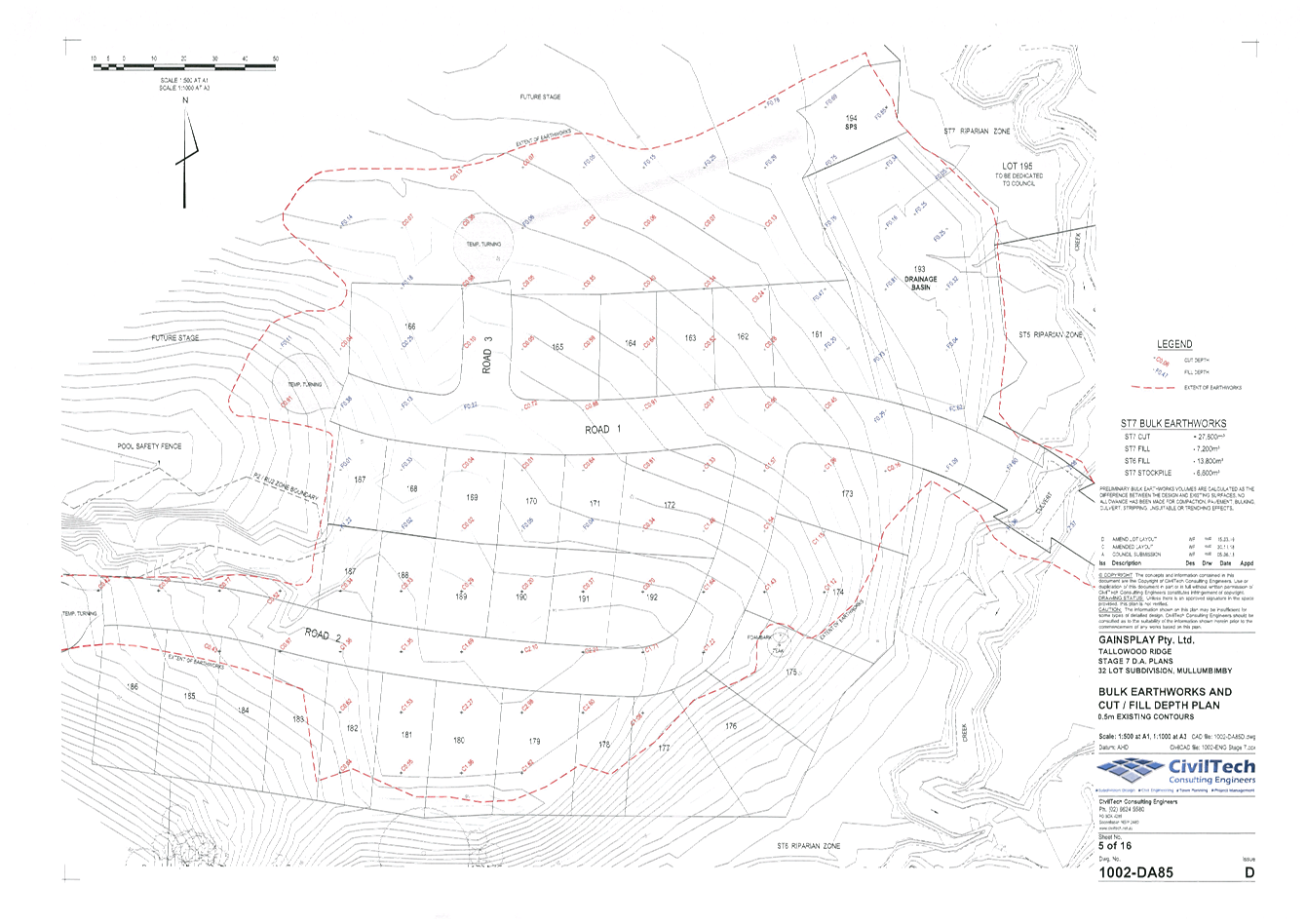
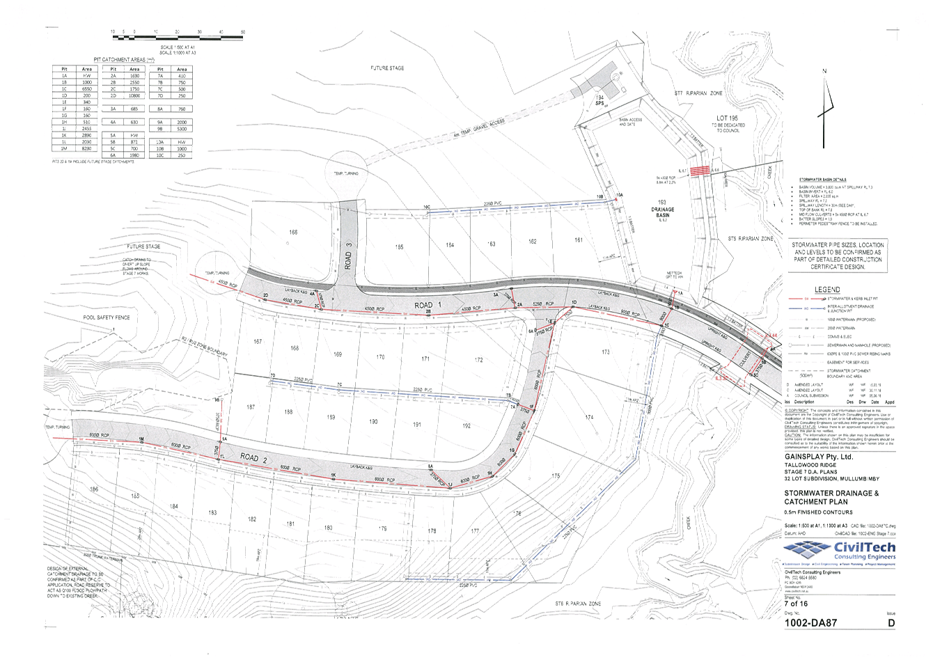
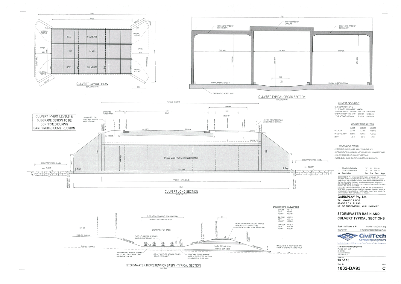
Staff Reports - Sustainable Environment and Economy 6.2 - Attachment 2
Staff Reports - Sustainable Environment and Economy 6.2 - Attachment 3
|
Parameters of
consent
|
|
1.
|
Development is to be in accordance with approved
plans
The development is to be in accordance with plans
listed below:
|
Plan No.
|
Description
|
Prepared by
|
Dated:
|
|
Plan 2.1
|
Site Plan – Stage 7DA
|
-
|
June 2018
|
|
1002-DA82 Issue D
|
Subdivision Layout Plan
|
CivilTech
|
15/03/2019
|
|
1002-DA83 Issue D
|
Subdivision Layout with Arial Photo
|
CivilTech
|
15/03/2019
|
|
1002-DA85 Issue D
|
Bulk Earthworks Plan
|
CivilTech
|
15/03/2019
|
|
1002-DA86 Issue D
|
Roadworks Plan
|
CivilTech
|
15/03/2019
|
|
1002-DA87 Issue D
|
Stormwater Drainage and Catchment Plan
|
CivilTech
|
15/03/2019
|
|
1002-DA88 Issue C
|
Road 1 Long Section and Typical Section
|
CivilTech
|
30/11/2018
|
|
1002-DA89 Issue C
|
Road 1 Cross Sections
|
CivilTech
|
30/11/2018
|
|
1002-DA90 Issue C
|
Road 2 Long Section and Typical Section
|
CivilTech
|
30/11/2018
|
|
1002-DA91 Issue C
|
Road 2 Cross Sections
|
CivilTech
|
30/11/2018
|
|
1002-DA92 Issue C
|
Road 3 Long Section and Cross Sections
|
CivilTech
|
30/11/2018
|
|
1002-DA93 Issue C
|
Stormwater Basin and Culvert Typical Sections
|
CivilTech
|
30/11/2018
|
|
1002-DA94 Issue D
|
Sewer Reticulation Plan
|
CivilTech
|
15/03/2019
|
|
1002-DA95 Issue C
|
Water Reticulation Plan
|
CivilTech
|
30/11/2018
|
|
1002-DA96 Issue C
|
Schematic Services Plan
|
CivilTech
|
30/11/2018
|
|
1002-SK33
|
External Catchment Stage 7, 8 & 9 Sheet 1 Rev A
|
CivilTech
|
February 2019
|
|
Ref No 1002
|
Stormwater Management Assessment Tallowood Ridge
Stage 7, 8 & 9
|
CivilTech
|
November 2018
|
|
|
|
|
|
The
development is also to be in accordance with any changes shown in red ink on
the approved plans or conditions of consent.
The
approved plans and related documents endorsed with the Council stamp and
authorised signature must be kept on site at all times while work is being
undertaken.
|
|
2.
|
Discovery of
Aboriginal Relics
Upon discovery
of any Aboriginal relics within the meaning of the National Parks and
Wildlife Act 1974, the
developer shall immediately notify the NSW Office of Environment and Heritage
(OEH), Tweed Byron Local Aboriginal Land Council and the Byron Bay Aboriginal
Corporation (Arakwal) and must immediately cease works within the vicinity
until such time as the necessary permits have been obtained from OEH to
continue the work. The developer must comply with any further request made by
OEH to cease work for the purposes of archaeological assessment and
recording.
|
|
3.
|
No tree removal
This
development consent does not authorise any native tree to be ringbarked, cut
down, lopped, removed or damaged, or caused to be ringbarked, cut down,
lopped, removed or damaged.
|
|
4.
|
Integrated Development
Approval
Integrated Development Approval is issued under Section 100B of
the Rural Fires Act 1997, being a Bush Fire Safety Authority, subject
to conditions listed in schedule 3 at the end of this consent. It is a
requirement that the Applicant meet the terms of this integrated approval as
part of the operation of this development consent.
|
|
The following
conditions are to be complied with prior to issue of a Construction
Certificate for subdivision works
|
|
5.
|
Water Management Act 2000
A Controlled
Activity Approval under the Water Management Act 2000 for the proposed
works within an adjacent to existing watercourses must be obtained from the
NSW Natural Resource Access Regulator. A copy of the approval must be
provided to the Principal Certifying Authority prior to the issue of the a
Construction Certificate for the development. The Construction
Certificate Application to comply with any requirements of this approval.
|
|
6.
|
Landscaping plan
A
detailed landscaping plan for the Bioretention basin and the road reserves
must be prepared by a suitably qualified landscape architect / architect
/ecologist who has appropriate experience and competence in landscaping and
submitted to the Principal Certifying Authority as part of the Construction Certificate
application.
The landscaping plan must
indicate the following as a minimum:
a) The planting
style, diversity and species selection shall be in accordance with Section
5.8 and Tables 28 and 29 of bioretetention Technical Design Guidelines,
Version 1.1 (Water by Design, 2014).
https://waterbydesign.com.au/download/bioretention-technical-design-guidelines
b) To prevent
weeds from flourishing above the filter media, the planting density shall be
double the rate specified Table 29 of the Bioretetention Technical Design
Guidelines.
c) Plants in the
Bioretention basin shall be selected to withstand significant periods of inundation
and must be dense enough to mitigate the growth of weeds on top of the
Bioretention basin filter area.
a) Landscaping
treatments throughout the public road reserves including provision of street trees of the same or similar
species as those used in earlier stages of the Tallowood Ridge Estate (e.g.
Tuckeroo).
b) Street trees
must be a minimum of 45 litres in size to provide an early established
character to the development.
c) A minimum of
one street tree per 15 metres of residential lot street frontage.
d) proposed location for planted shrubs and trees
– trees should be located clear
of infrastructure and service pits.
e) botanical name of shrubs and trees to be planted
f) mature height of trees to be planted
g) location of grassed and paved areas, and
h) location of trees identified for retention in the
development application plans.
Such plans and
specifications must be approved as part of the Construction Certificate.
|
|
7.
|
Biodiversity
Conservation Management Plan (BCMP)
Prior to the issue of the
Construction certificate, a modified BCMP shall be submitted to Council for
approval including the following amendments:
1. Additional
Plantings to Management Zones 1 and 2 between the northern boundary of Lot 93
DP 1216681 and the edge of the existing riparian plantings.
2. Management
Zone 9 to be reduced in area consistent with the subdivision plans comprising
fencing to limit access to the area.
|
|
8.
|
Tree Protection Zones to be shown and earthworks
amended where necessary
The plans submitted for approval with the
Construction Certificate must accurately show the Foam Bark and Teak trees to
be preserved within Lot 175. The plans must also illustrate an overlay of the
Tree Protection Zones for each of the trees formulated in accordance with AS
4970-2009 – Protection of Trees on Development Sites.
The Principal Certifying
Authority shall be satisfied that no excavation or fill is proposed within
any of the nominated Tree Protection Zones (TPZ). The earthworks plans
submitted for approval with the Construction Certificate must be amended
where necessary so that all of the proposed earthworks are occurring outside
the nominated TPZ’s. Where changes to the extent of the earthworks are
necessary to comply with this requirement, levels should transition gradually
to natural ground level to avoid steep areas of cut and/or the use of
retaining walls.
|
|
9.
|
Engineering Construction
Plans
Three (3) copies of
engineering construction plans and specifications must accompany the
Construction Certificate application demonstrating compliance with Council's
standards for the required engineering works.
Each set of drawings must
be accompanied by a Certification Report which must be signed by a suitably
qualified Civil Engineer or Registered Surveyor. The Certification Report
will comprise the certificate and check lists set out in Annexure DQS-A of
the Northern Rivers Local Government Development &
Design Manuals.
The information shown on
the drawings must be logically collected on discrete sheets generally in
accordance with Annexure DQS-B and the Sample Drawings of the Northern Rivers
Local Government Development & Designs. The drawings are to provide for
the following works:
a) Azalea
St & Jubilee St Intersection upgrade
The
intersection shall be upgraded to provide a Channelised Right Turn Treatment
in accordance with Figure A3 of Austroads Guide to Road Design.
b) Left
Bank Road & Tuckeroo Avenue Intersection upgrade
The
intersection shall be upgraded to provide a Channelised Right Turn Treatment
in accordance with Figure A3 of Austroads Guide to Road Design.
c) Full
Width Road Construction
Full
width road, kerb & gutter, drainage and footpath/bike path construction
for all proposed roads on the approved plan.
d) Turn
Around Areas
Turn
around areas shall be provided in accordance with Condition 6 of RFS General
Terms of Approval with reference no DA18/6185 DA 18070213785 PC dated 28
August 2018.
e) Service
Conduits
Service
conduits to each of the proposed new allotments laid in strict accordance
with the service authorities’ requirements.
f) Street
Name Signs
Street
name signs and posts to all proposed new roads.
g) Stripping
and Stockpiling
Stripping
and stockpiling of existing topsoil on site, prior to commencement of
earthworks, and the subsequent re-spreading of this material together with a
sufficient quantity of imported topsoil so as to provide a minimum thickness
of 80mm over the allotments and footpaths and public reserves, upon
completion of the development works.
h) Inter-allotment
Drainage
Inter-allotment
drainage to an approved public drainage system for each of the proposed new
allotments where it is not possible to provide a gravity connection of future
roofwater to the kerb and gutter.
i) Cross
Culverts under Road 1
A
fully detailed design and construction plan shall be submitted with the CC.
The cross culvert must be designed to accept the full catchment including the
external catchment in accordance with Northern Rivers Local Government
Development & Design Manuals.
The
cross culvert shall be designed to cater for a 1 in 100 year ARI event
without afflux and a minimum freeboard of 300mm from the design ARI event to
the underside of the culvert.
j) Stormwater
Drainage
Stormwater
is to be collected and discharged in accordance with Council’s
standards, currently Northern Rivers Local Government Development Design
& Construction Manuals. A full
and detailed stormwater management plan for the site must be provided for
Council's records at the time of lodging detailed engineering plans for
construction certificate approval. The drawings and management plan must be
accompanied by a Design Submission Checklist as set out in APPENDIX C of the
Northern Rivers Local Government Handbook of Stormwater Drainage Design,
which must be signed by a suitably qualified Civil Engineer or Registered
Surveyor. The drawings and management plan are to include, but not be limited
to, the following items:
a) Catchment
plan including all contributing external catchments (included in the drawing
set);
b) The
external catchment must be designed to cater for a 100year ARI including a
positive relief outlet. This system must be contained within a reserve or an
easement.
c) Detailed
hydrological and hydraulic design calculations based on the methods outlined
in the Queensland Urban Design Manual (QUDM) and Australian Rainfall &
Runoff (AR&R) 1987. A summary of the calculations must be included on the
drawings consistent with the Sample Drawings of the Northern Rivers Local
Government Development & Design Manuals.
d) Fully
detailed design & construction plan of the major and minor drainage
systems including the detention system generally in accordance with the
approved plan;
e) Stormwater
management structures/facilities that have minimum impact on Council’s
maintenance program. All maintenance activities must be specified in a
maintenance plan (and associated maintenance inspection forms) to be
developed as part of the design procedure and included in the stormwater
management plan.
k) Stormwater
Outlets
An
energy dissipating pit with a suitably installed locked grated outlet to all
pipes or any other drainage structures. Grates must be of galvanised weldlock
construction.
l) Stormwater
Quality
Stormwater
quality must be suitable for discharge in accordance with Council's
standards, currently Chapter B3 Services of Development Control Plan 2014 and Northern Rivers Local Government Development Design
& Construction Manuals. The
proposed water quality management devices and treatment train must have
minimum impact on Council’s maintenance program. All maintenance
activities must be specified in a maintenance plan (and associated
maintenance inspection forms) to be developed as part of the design procedure
and submitted with the construction certificate documentation.
A
fully detailed design of all Stormwater Quality Improvement Devices (SQIDs)
in accordance with Stormwater Management Assessment Tallowood Ridge Stage 7,
8 & 9 prepared by CivilTech Consulting Engineers dated 17 November 2018
shall be submitted for assessment and approval as part of the CC. The
following shall be included and verified for the proposed Bioretention Basin
but not limited to:-
d) Extended
Detention Depth of 1.0m, this depth is the difference in level from the top
of the filter layer up to the invert level of the outlet pipes (5 x 450mm
RCP);
e) Filter
Depth of 1.2m, this depth is the thickness of the filter media excluding the
thicknesses of the drainage layer and transition layer;
f) Design
& Sizing of the subsoil drainage pipes including the slots;
g) Provision
of coarse sediment forebay.
h) Landscaping
– the plants in the Bioretention basin should be selected to withstand
significant periods of inundation and must be dense enough to mitigate the
growth of weeds on top of the Bioretention basin filter area.
i) Maintenance
Access
j) Maintenance
Plan (identify all maintenance plant and equipment but not limited to)
m) Access
to Stormwater Structures
Satisfactory
access to all drainage discharge points and filter controls for maintenance
purposes.
n) Street
Lighting
The
provision of street lighting to the satisfaction of Byron Shire Council and
Essential Energy. Such lighting must be strategically positioned to minimise
spill impacts on future dwellings within the subdivision and existing
dwellings within adjacent properties.
The Plans to comply with
the requirement of the Controlled Activity Approval under the Water
Management Act 2000.
|
|
10.
|
Sewerage and Water Mains
An approval is to be
obtained under Section 68 of the Local Government Act 1993 to carry out water
supply and sewerage works.
Sewerage and water mains
are to be extended to service all residential allotments in the
subdivision. All Council gravity sewerage mains are to be a minimum 150
mm diameter and water mains are a minimum 100mm diameter.
Water supply and sewerage
works are to comply with Council's latest Standards and Policies including
but not limited to:
· Development Design and Construction Manuals,
Northern Rivers Local Government, 2009;
· Development Servicing Plan for Water Supply
Services, Byron Shire Council, 2011;
· Development Servicing Plan for Sewerage Services,
Byron Shire Council, 2011;
· Fire Flow Design Guidelines, Water Directorate,
2011;
· Water and Sewer Equivalent Tenement Policy (13/005),
Byron Shire Council, 2013;
· Pressure Sewerage Policy (12/014), Byron Shire
Council, 2012.
· Private Sewer Pump Station Policy (12/015), Byron
Shire Council, 2012.
Upgrade
SPS2010 storage capacity to at least 50 kL and upgrade each individual
submersible sewerage pump in SPS2010 such that the flow rate is equal to at
least 12.1 L/s at maximum head.
|
|
11.
|
Erosion and Sedimentation Control Plan
The plans and
specifications to accompany the construction certificate application are to
include a sediment and erosion control plan to indicate the measures to be
employed to control erosion and loss of sediment from the site. The sediment
and erosion control plan is to be designed in accordance with the
requirements of the NSW Department of Housing Manual (1989), Managing
Urban Stormwater, Soils and Construction.
A suitably experienced
person must prepare the sediment and erosion control plan. Suitably experienced
people include those certified by:
· The Institution of Engineers, Australia, for
engineering and hydrology matters.
· The International Erosion Control Association for
soil conservation matters.
· The Australian Society of Soil Science for collection
or analysis of soil data.
The plan must incorporate
(without being limited to) information on general site management, material
handling practices, soil stabilisation, water control, sediment control, wind
erosion control and access measures.
|
|
12.
|
Long Service Levy to be
paid
Long Service Levy in
accordance with the requirements of the Long Service Corporation is required
to be paid prior to issue of the Construction Certificate. This is a
State Government Levy and is subject to change.
These payments may be made
online at www.longservice.nsw.gov.au or at Council’s Administration Office,
Station Street, Mullumbimby. Where paying to Council, cheques are to be made
payable to ‘Byron Shire Council’.
For further information
regarding the Long Service payment please refer to the website above.
|
|
13.
|
Street Name Application
to be lodged
Street / road names for the
subdivision must be submitted for Council approval prior to issue of the
Construction Certificate.
An application for approval
of a street name must be in writing (letter or email) and is to include:
a) at least 2
names for each proposed road in preferential order;
b) the location
and extent of the road;
c) background/history
of the selected name/s;
d) details on
why the selected name is considered to be appropriate;
e) details on
how the selected name conforms with Council’s Street Name Policy and
the NSW Address Policy;
f) a locality
plan;
g) a layout plan
showing proposed road/s and selected name/s suitable for publishing in the
local newspaper; and
h) payment of
fees in accordance with Council’s adopted schedule of fees and charges.
|
|
14.
|
Fibre-ready Facilities
and Telecommunications Infrastructure
Prior to the issue of the
Construction Certificate in connection with a development, the developer
(whether or not a constitutional corporation) is to provide evidence satisfactory
to the Certifying Authority that arrangements have been made for:
(i) the
installation of fibre-ready facilities to all individual lots and/or premises
in a real estate development project so as to enable fibre to be readily
connected to any premises that is being or may be constructed on those lots.
Demonstrate that the carrier has confirmed in writing that they are satisfied
that the fibre ready facilities are fit for purpose; and
(ii) the provision of fixed-line telecommunications infrastructure
in the fibre-ready facilities to all individual lots and/or premises in a
real estate development project demonstrated through an agreement with a
carrier.
(Note real estate
development project has the meanings given in section 372Q of the Telecommunications
Act).
|
|
15.
|
Unexpected Findings
Protocol - Contamination & Remediation
An Unexpected Findings
Protocol (UFP) shall be prepared and submitted to Council for approval prior
to the issue of Construction Certificate. The UFP shall be prepared by
a suitable qualified person experienced in matters relating to Contamination
of Land and Remediation.
|
|
16.
|
Acid Sulfate Soils
Management Plan must be submitted to Council for approval
Acid Sulfate Soils
Management Plan must be submitted to Council for approval by prior to the
issue of a Construction Certificate for subdivision works. The ASMP
must detail measures to be undertaken for the management the disturbance of
acid sulfate soils during construction works including:
a. Construction of the Culvert as shown on Cut /
Fill Depth Plan Drawing No. 1002-DA85 (Sheet 5of 16) prepared by
CivilTech Consulting Engineers dated 5/6/18.
Investigations and
management of ASS must be undertaken by a suitably qualified environmental
consultant in accordance with the Acid Sulfate Soil Manual (ASSMAC, 1998).
Note: The ASSMP must
be dated subsequent to the date of the consent and approved by Councils EHO
involved with the subdivision development. .
|
|
17.
|
Site Waste Minimisation
and Management Plan
Chapter B8 of
Byron Shire Development Control Plan 2014 (DCP 2014) aims to facilitate
sustainable waste management in a manner consistent with the principles of
Ecologically Sustainable Development. Prior to the issue of a Construction
Certificate, a Site Waste Minimisation and Management Plan (SWMMP) must be
submitted outlining measures to minimise and manage waste generated during
demolition, construction and the ongoing operation and use of the
development. The SWMMP must specify the proposed method of recycling or
disposal and the waste management service provider.
A template is provided on Council’s website to
assist in providing this information www.byron.nsw.gov.au/files/publication/swmmp -
pro-forma-.doc
|
|
18.
|
Certification of fill to
be provided to Council
Copy of documentation
certifying that fill contained on the subject site is from a source that is
clean and uncontaminated must be provided to Council prior to the issue of a
Construction Certificate for the development.
|
|
The following
conditions are to be complied with prior to commencement of subdivision works
|
|
19.
|
Trees to be
retained and fenced
Trees to be
retained are to be protected by a Tree Protection Zone (TPZ) exclusion
fence. The fence is to be constructed in accordance with Sections 3.2
and 4.3 of AS4970-2009 Protection of trees on development sites. The fence must:
a) be
located outside the dripline of the tree so as to minimise disturbance to
tree roots;
b) have
a minimum height of 1.8 metres;
c) be
constructed of wire mesh panels, plywood, steel star pickets or similar, with
a maximum distance of 2metres between star pickets;
d) have
a minimum of 3 strands of steel wire or similar;
e) have
high visibility barrier mesh (eg orange), shade cloth or similar, attached to
the outside of the fence and continuing around its perimeter;
f) include
at least one Tree Protection Zone (TPZ) sign in accordance with Section 4.4
of AS4970-2009.
Activities that are excluded within the TPZ (as per
section 4.2 of AS4970-2009) include excavation, construction activity, grade
changes, surface treatment and storage of material. The Tree Protection Zone
(TPZ) exclusion fence is to be maintained for the duration of the site
clearing, preparation, construction and landscaping works.
|
|
20.
|
Erosion and sediment
measures
Erosion and sedimentation
controls are to be in place in accordance with the approved Erosion and
Sediment Control Plan.
No soil or fill
material is to be placed within the dripline of a tree so as to cause changes
in surface level by more than 50mm from the existing level and such soil is
not to be compacted. Such soil fill must not be finer than that being covered
in situ, e.g. clay must not be placed over loam soil.
Note: Council may impose
on-the-spot fines for non-compliance with this condition.
|
|
21.
|
Acid sulfate soils management
All treatment and storage
facilities associated with the approved Acid Sulfate Soils Management Plan
must be in place prior the commencement of subdivision works.
|
|
22.
|
Subdivision Work
Subdivision work
in accordance with the development consent must not be commenced until a
construction certificate has been issued, a principal certifying authority
has been appointed and at least 2 days’ written notice for the
intention to commence works has been made, in accordance with the
requirements of the Environmental Planning and Assessment Act and
Regulations. The written notice for the intention to commence works must also
include names and contact details of the certifying engineer and principal
contractor.
Note. Subdivision work means any physical
activity authorised to be carried out under the conditions of this
development consent for the subdivision of land, including earthwork, road
work, stormwater drainage work, landscaping work, tree/vegetation removal,
erosion and sediment control, traffic control, etc.
|
|
23.
|
Metered Stand Pipe
required
Prior to the
commencement of any civil works requiring water from Council water main, a
metered Stand Pipe for temporary water supply must be supplied and installed
by Council. Contact Council’s Water and Recycling Department to
arrange for this requirement on 02 6626 7081.
Note: Council may impose
on-the-spot fines for non-compliance with this condition.
|
|
The following
conditions must be complied with during subdivision works
|
|
24.
|
Construction noise
Construction noise is to be
limited as follows:.
a) For
construction periods of four (4) weeks and under, the L10 noise level
measured over a period of not less than fifteen (15) minutes when the
construction site is in operation must not exceed the background level by
more than 20 dB(A).
b) For construction
periods greater than four (4) weeks and not exceeding twenty‑six (26)
weeks, the L10 noise level measured over a period of not less than fifteen
(15) minutes when the construction site is in operation must not exceed the
background level by more than 10 dB(A).
|
|
25.
|
Construction times
Construction works must not
unreasonably interfere with the amenity of the neighbourhood. In particular
construction noise, when audible from adjoining residential premises, can
only occur:
a) Monday to
Friday, from 7 am to 6 pm.
b) Saturday,
from 8 am to 1 pm.
No construction work to
take place on Saturdays and Sundays adjacent to Public Holidays and Public
Holidays and the Construction Industry Awarded Rostered Days Off (RDO)
adjacent to Public Holidays.
Note: Council may impose
on-the-spot fines for non-compliance with this condition.
|
|
26.
|
Public safety
requirements
All care is to be taken to
ensure the safety of the public in general, road users, pedestrians and
adjoining property. Council is not held responsible for any negligence caused
by the undertaking of the works.
|
|
27.
|
Council Specification
All works to be constructed
to at least the minimum requirements of the “Northern Rivers Local Government Design and
Construction Manual”
|
|
28.
|
Approved Plans to remain
on site
A copy of the approved
Construction Certificate including plans, details and specifications must remain
at the site at all times during the construction of the subdivision.
|
|
29.
|
Placement of services
near trees
All care is to be taken to
manually excavate around or under any lateral structural support roots of any
tree so as minimum root disturbance where services are to be laid within the
dripline of a tree.
|
|
30.
|
No filling around trees
No soil or fill material is to be placed within the
dripline of a tree so as to cause changes in surface level by more than 50mm
from the existing level and such soil is not to be compacted. Such soil/fill
must be finer than that being covered in situ, e.g. clay must not be
placed over loam soil.
|
|
31.
|
Public safety
requirements
All care is to be taken to
ensure the safety of the public in general, road users, pedestrians and
adjoining property. Council is not held responsible for any negligence caused
by the undertaking of the works.
|
|
32.
|
Acid sulfate soils management
All soil disturbance and
excavation works must be carried out in accordance with the approved Acid
Sulfate Soils and Water Management Plan.
|
|
33.
|
Builders rubbish to be
contained on site
All builders
rubbish is to be contained on the site in a ‘Builders Skips’ or
an enclosure. Footpaths, road reserves and public reserves are to be
maintained clear of rubbish, building materials and all other items.
|
|
34.
|
Prevention of water
pollution
Only clean and unpolluted
water is to be discharged to Council’s stormwater drainage system or
any watercourse to ensure compliance with the Protection of Environment
Operations Act.
|
|
35.
|
Maintenance of sediment
and erosion control measures
Sediment and erosion
control measures must be maintained at all times until the site has been
stabilised by permanent vegetation cover or hard surface.
|
|
36.
|
Protection
of Native Trees
All
trees nominated to be retained by notation or condition as a requirement of
the development consent shall be maintained and protected during demolition,
excavation and construction on the site in accordance with AS 4970-2009
– Protection of Trees on Development Sites.
|
|
37.
|
Monitoring of excavation
works
No ground disturbing works
near the southern ridgeline in the areas identified in the Cultural
Heritage Assessment Report prepared by Everick dated June 2009 as the
‘post clearing inspection areas’, is to occur unless a
representative from Tweed Byron Local Aboriginal Land Council and Byron Bay
Aboriginal Corporation (Arakwal) is present to monitor the ground disturbing
works while they are being undertaken.
|
|
The following
conditions must be complied with prior to issue of a Subdivision Certificate
|
|
38.
|
Subdivision Certificate
application required
An application for a
Subdivision Certificate must be made on the approved form. The Subdivision
Certificate fees, in accordance with Council's adopted schedule of fees and
charges, must accompany such application.
NOTE: The application MUST be one complete concise
package addressing ALL conditions of consent relevant to the subdivision with
a clear explanation how each condition has been complied with, together with
supplying ALL the relevant information /documents/ certificate and/or plans
that is required by that condition. Failure to provide the abovementioned
information in one package will likely result in the application being
refused or rejected and returned to you.
|
|
39.
|
Plan of Subdivision
The final plan of subdivision
must be in accordance with the approved plan/s. A Deposited Plan
Administration Sheet (original plus one (1) copy), two (2) copies of the plan
of subdivision and any necessary section 88B instrument (original plus one
(1) copy) are to be submitted with the application for a subdivision
certificate.
An additional copy of the
final plan of subdivision is to be submitted showing the location of all
buildings and/or other permanent improvements including any fences, internal
access driveways/roads, and where relevant effluent disposal areas and the 1
in 100 year flood and flood planning level extents on land within or adjacent
to a flood planning area. Where the building/s or improvements are close to
boundaries, offset distances are to be included on the additional copy of the
plan. This plan must be endorsed by a Registered Surveyor. Any
encroachments affecting new boundaries or the road reserve must be removed or
relocated wholly within the allotment. The new boundaries must not
cause any existing building/s to contravene the Building Code of Australia.
Final plan of subdivision
to indicate lots 193, 194 and 195 to be transferred to Council.
|
|
40.
|
Certificate of
Compliance – Water Management Act 2000
Water and sewer services
are to be provided to the land in accordance with an approval granted under
Section 68 of the Local Government Act 1993.
Payment of
developer charges to Byron Shire Council for water supply and sewerage.
A copy of the Certificate
of Compliance under Section 307 of the Water Management Act 2000 is to be
obtained from Byron Shire Council prior to the issue of a Subdivision
Certificate.
Application
forms are available from Council’s administration building or online at
http://www.byron.nsw.gov.au/files/Forms/Section_305_Certificate.pdf to be submitted for a Certificate of Compliance.
|
|
41.
|
Developer Contributions
to be paid
Contributions set out in
the schedule below are to be paid to Council prior to the release of a
subdivision certificate. Contributions are levied in accordance with
the Byron Shire Developer Contributions Plan 2012 (as amended). The
Plan may be viewed on line at http://www.byron.nsw.gov.au/ or during office hours at the Council Offices
located at Station Street, Mullumbimby. These contributions are to fund
public amenities and services as listed in the schedule. Additional
details on the specific amenities are to be found in the Byron Shire
Developer Contributions Plan 2012 (as amended).
The
contributions as set out in the schedule may either be paid in full or they
may be paid in stages on a proportional basis dependent on the number of lots
to be released in the subdivision certificate.
The
contributions in the schedule are current at the date of this consent.
The contributions payable will be adjusted in accordance with the relevant
plan and the amount payable will be calculated on the basis of the
contribution rates that are applicable at the time of payment. The
schedule contains a date for which the schedule remains valid, after this
date you will have to contact Council for an updated schedule.
Note: The local and LGA wide open space and recreation
contributions has been reduced to zero due to land previously dedicated in DA
10.2009.314.10 and the works and land dedication specified in DA
10.2009.151.4 Stages 1 and 2.
|
|
42.
|
Certificates for engineering
works
The submission of all test
certificates, owners manuals, warranties and operating instructions for civil
works, mechanical and/or electrical plant, together with a certificate from a
suitably qualified engineer certifying that all works have been constructed
in accordance with the approved plans and Council’s current
“Northern Rivers Local Government Design and Construction Manuals and
Specifications”.
|
|
43.
|
Works-As-Executed Plans
Following completion of
works and prior to issue of the subdivision certificate, Work-as-Executed
Drawings, together with a Work-As-Executed Certification Report, in
accordance with Council’s requirements are to be submitted to Council.
Two categories of Work-as-Executed Drawings are to be submitted to Council, being
Amended Design Work-as-Executed Drawings and Summary Work-as-Executed
Drawings.
Amended
Design Work-as-Executed Drawings, being certified copies of all approved
design plans with as constructed departures, deletions and additions clearly
noted and detailed on the plans, are to be submitted to Council in the
following formats:-
(a) One
(1) paper copy at the same scale and format as the approved design plans,
but, marked appropriately for as constructed information and with original
signatures; and
(b) An
electronic copy of above in PDF format and provided to Council on CD, DVD or
via email.
Summary
Work-as-Executed Drawings are to be prepared on a background plan of lot
layout and kerb lines with a set of separate plans for stormwater drainage,
sewerage, water supply and site works. The site works drawing/s shall include
the 1 in 100 year flood and flood planning level extents and levels, where
relevant. Such drawings are to be submitted to Council in the following
formats:-
a) One
(1) paper copy of each drawing with original signatures and in accordance
with Council’s requirements.
b) Electronic
copy of the above in AutoCAD DWG or DXF format and provided to Council on CD,
DVD or via email. The AutoCAD (DWG or DXF) files are to be spatially referenced
to MGA Zone 56.
c) Electronic
copy of above in PDF format and provided to Council on CD, DVD or via email.
Note: Council’s requirements are detailed in
Council’s adopted engineering specifications, currently the Northern
Rivers Local Government Development Design and Construction Manuals, and on
Council’s website.
|
|
44.
|
Water service and meter
to be connected to each lot, dual occupancy and strata subdivisions
An approval under Section
68 of the local Government Act 1993 to carry out water supply work and
sewerage work must be obtained. Water metering to be in accordance with Byron
Shire Councils Water metering Requirements
Any new water service and
meter will be at applicants cost”.
Each Dwelling/ Unit/ Shop
capable of being subdivided under Torrens, Community or Strata title shall
have a separate meter
|
|
45.
|
Certificate for services
within easements
The submission of a
certificate from a registered surveyor certifying that all pipelines,
structures, access driveways and/or services are located wholly within the
relevant easements.
|
|
46.
|
Section 88B Instrument
A Section 88B Instrument
and one (1) copy are to be submitted with the application for a subdivision
certificate. The final plan of subdivision and accompanying Section 88B
Instrument are to provide for:
a) Dedicated
Public Road Access
Dedication
of suitable public road accesses to all proposed allotments.
b) Inter-allotment
Drainage Easements
The
creation of easements for drainage of water, with a minimum width of 1.5
metres, over all inter-allotment drainage pipelines and structures located
within the proposed allotments.
c) Drainage
Easements
The
creation of easements for drainage of water over all drainage pipelines and
structures located within the proposed allotments in accordance with
Council’s policy.
d) Drainage
Reserve
The
dedication of drainage reserve over the drainage treatment devices and
constructed access.
e) Restricting Development – On-site Stormwater
Detention
Restricting
residential development of each vacant allotment until the proprietor has
constructed or made provision for the construction of an on-site stormwater detention
system to the requirements of Byron Shire Council.
f) Sewer
Easements
The
creation of easements for drainage of sewage over all sewage pipelines and
structures located within the proposed allotments in accordance with
Council’s Building Over Pipelines Policy 4.20.
g) Easement
for Services
The
creation of suitable easements for services over the access handle(s) of
proposed Lot(s)
|
|
47.
|
Restriction for
preservation of native trees(Teak and Foambark) on Proposed Lot 175
The
final plan of subdivision and accompanying Section 88B Instrument are to
provide for the following restriction on the use of land:
The
Owner of the Lot Burdened must prohibit the following within the area denoted
on the Plan as being subject to the Restriction on Use:
a) The destruction or
removal the native trees indicated.
b) Any act or omission
which may adversely affect the native trees;
c) The removal,
introduction or disturbance of any soil, rock, or sand within the marked
area;
d) Any structures,
including dwellings, sheds, car ports and swimming pools.
|
|
48.
|
Plantings, restoration
and Landscaping works.
Prior to the issue of a
subdivision certificate, the developer must demonstrate to Council’s
satisfaction the following matters:
(a) Additional
Plantings within management Zones 1 and 2 to be completed in accordance with
the BCMP.
(b) The Stage 7
Plantings and Restoration Works within Management Zone 6 have been carried
out in accordance with the BCMP.
(c) Management Zone 9
to be enhanced in accordance with the BCMP. An Appropriate pool fence to be
erected around the Management Zone to limit pedestrian access
(d) Management Zone 8
to be weeded in accordance with the BCMP
(e) Additonal
Plantings to be completed in Management Zone 4 adjacent to the culvert on
road 1 (Tuckeroo Avenue)
(f) The Boundaries of
Management zones 5, 6 and 7b to be fenced as required in the BCMP.
(g) Maintenance and
Monitoring Reports as required under the BCMP to be submitted to
Council.
(h) All landscaping
works as required under this consent have been completed
|
|
49.
|
Erection of Street Signs
The subdivider is to supply
and erect street signs for the approved street names in accordance with this
development consent and the Construction Certificate approval.
|
|
50.
|
CCTV Inspection and
Report
CCTV inspection must be undertaken on all
completed underground pipe systems, including the sewerage reticulation,in
accordance with Council’s specification. Both a hardcopy and electronic
copy of the report (submitted in CD or DVD medium in a format suitable to
Council) of the CCTV inspection must be provided to Council for consideration
prior to the release of the Subdivision Certificate, Occupation Certificate,
Final Inspection for Section 68 Approvals, "Off-maintenance" or
Release of Security Bond.
|
|
51.
|
Electricity Supply
Certificate
Written evidence from an
electricity supply authority is to be submitted with the application for a
subdivision certificate stating that satisfactory arrangements have been made
for the provision of underground electricity supply throughout the
subdivision.
|
|
52.
|
Fibre-ready Facilities
and Telecommunications Infrastructure
Prior to the issue of the
Subdivision in connection with a development, the developer (whether or not a
constitutional corporation) is to provide evidence satisfactory to the
Certifying Authority that arrangements have been made for:
1. the
installation of fibre-ready facilities to all individual lots and/or premises
in a real estate development project so as to enable fibre to be readily
connected to any premises that is being or may be constructed on those lots.
Demonstrate that the carrier has confirmed in writing that they are satisfied
that the fibre ready facilities are fit for purpose; and
2. the provision of fixed-line telecommunications
infrastructure in the fibre-ready facilities to all individual lots and/or
premises in a real estate development project demonstrated through an
agreement with a carrier.
(Note
real estate development project has the meanings given in section 372Q of the
Telecommunications Act).
|
|
53.
|
Geotechnical Report (Lot
Classification)
A certificate from a
practicing Geotechnical Engineer must be provided in conjunction with a Lot
Classification Report prepared in accordance with Australian Standard
AS2870.1. Such certificate must certify that all vacant allotments have a
building site of adequate size and shape on each lot that is not subject to
slip or subsidence.
|
|
54.
|
Maintenance Bond
A
maintenance bond of 5% (minimum bond amount of $1,000.00) of the value of the
works constructed is to be lodged with Council. A copy of the contract
construction cost of the subdivision works is to be submitted with the bond.
The maintenance period is 6 months in accordance with Council’s current
Design & Construction Manuals for roads, water, sewer, stormwater and
general landscaping. A five year maintenance period to apply to the riparian
plantings in Management Zone 6.
The
applicant is responsible for the maintenance of Bio-retention and Detention
Basins until the completion all stormwater works in the contributing upstream
catchment and the 12 month maintenance period of the Bio-retention and
Detention Basin commences upon Council’s acceptance of all contributing
upstream stormwater works On-Maintenance.
The period will commence
from the date of issue of the Subdivision Certificate. The security may be
provided, at the applicant's choice, by way of cash bond or a satisfactory
bank guarantee. An application in writing for the release of the bond must be
made at the satisfactory completion of the maintenance period.
|
|
55.
|
Record of Infrastructure
A record of infrastructure
coming into Council ownership, upon registration of the final plan of subdivision,
is to be submitted to Council. The information is to be submitted in
the form of Council’s Standard Form titled “Asset Creation
Record”. This form is available from Council’s Local
Approvals Section.
|
|
56.
|
Acid sulfate soils
The works engineer must
certify to the Principal Certifying Authority that all works have been
carried out in accordance with the approved Acid Sulfate Soils Management
Plan. Documentary evidence must be provided confirming the destination
of all Acid Sulfate soils removed from the site.
|
|
SCHEDULE 2
PRESCRIBED CONDITIONS
|
|
The prescribed conditions in accordance with Division 8A of the
Environmental Planning and Assessment Regulation apply as are of relevance to
this application:
|
|
Clause
98 Compliance
with Building Code of Australia and insurance requirements under the Home
Building Act 1989http://www.legislation.nsw.gov.au/
- /view/regulation/2000/557/part6/div9
|
|
Clause
98A Erection
of signs
|
|
Clause
98B Notification
of Home Building Act 1989 requirements
|
|
Clause
98E Condition
relating to shoring and adequacy of adjoining property
|
|
Refer
to the NSW State legislation for full text of the clauses under Division 8A
of the Environmental Planning and
Assessment Regulation 2000.
This can be accessed at http://www.legislation.nsw.gov.au.
|
|
|
|
SCHEDULE 3 INTEGRATED
DEVELOPMENT APPROVAL – NSW RURAL FIRE SERVICE
|
|
The
New South Wales Rural Fire Service (NSW RFS) has considered the information
submitted. General Terms of Approval, under Division 4.8 of the
‘Environmental Planning and Assessment Act 1979’, and a Bush Fire
Safety Authority, under Section 100B of the 'Rural Fires Act 1997', are now
issued subject to the following conditions:
Asset Protection Zones
The
intent of measures is to provide sufficient space and maintain reduced fuel
loads so as to ensure radiant heat levels of buildings are below critical
limits and to prevent direct flame contact with a building. To achieve this,
the following conditions shall apply:
1. At
the issue of subdivision certificate and in perpetuity, the entire area of
each residential lot shall be managed as an inner protection area (IPA) as
outlined within section 4.1.3 and Appendix 5 of 'Planning for Bush Fire
Protection 2006' and the NSW Rural Fire Service's document 'Standards for
asset protection zones'.
2. A
restriction to the land use pursuant to section 88B of the Conveyancing Act
1919 shall be included over Lots 161 and 173 to 186 (inclusive) to prohibit
the construction of a dwelling or Class 10 building within 10 metres of a
dwelling, in the area identified as APZ (asset protection zone) on the plan
titled ‘Subdivision Layout Plan’ prepared by CivilTech (ref:
1002-DA82, Issue A), dated 5 June 2018, except that the APZ on Lots 183 to
186 shall be 21 metres.
3. A
restriction to the land use pursuant to section 88B of the Conveyancing Act
1919 Shall be included over the residue lot requiring the provision of a
temporary asset protection zone (APZ) in the following locations:
· north of Lots 161 to 166 (inclusive) for 9 metres;
· west of Lots 166 and 186 for 8 metres; and
· west of Lots 167 and 187 for 9 metres.
The APZ shall be managed as an inner protection area
(IPA) as outlined within section 4.1.3 and Appendix 5 of 'Planning for Bush
Fire Protection 2006' and the NSW Rural Fire Service's document 'Standards
for asset protection zones'. The restriction to land use for a temporary
asset protection zone may be extinguished upon the commencement of
development over the affected areas.
Water and Utilities
The
intent of measures is to provide adequate services of water for the
protection of buildings during and after the passage of a bush fire, and to
locate gas and electricity so as not to contribute to the risk of fire to a
building. To achieve this, the following conditions shall apply:
4. Water,
electricity and gas are to comply with section 4.1.3 of 'Planning for Bush
Fire Protection 2006'.
Access
The
intent of measures for public roads is to provide safe operational access to
structures and water supply for emergency services, while residents are
seeking to evacuate from an area. To achieve this, the following conditions
shall apply:
5. Public
road access shall comply with section 4.1.3(1) of ‘Planning for Bush
Fire Protection 2006’, except that a perimeter road is not required and
Roads 1 and 2 are greater than 200 metres in length.
6. A
temporary turning circle with a minimum 12 metre outer radius shall be
provided at the termination of Road 1 and 2. Both roads are to be clearly
sign posted as a dead end.
Landscaping
7. Landscaping to the site is to comply with the
principles of Appendix 5 of 'Planning for Bush Fire Protection 2006'.
|
|
|
|
SCHEDULE 4 NOTES
|
|
Schedule
of Development Contributions
The following
contributions are current at the date of this consent. The contributions
payable will be adjusted in accordance with the relevant plan and the amount
payable will be calculated on the basis of the contribution rates that are
applicable at the time of payment. The current contribution rates are
available from Council offices during office hours. Payments will only be accepted by cash or bank cheque.
|
|
Water
payments under the Water Management Act 2000
Charges will be calculated based on the additional
water and sewerage load that the proposed development generates, shown in
Equivalent Tenements (ET) by the following table:
ADDITIONAL WATER & SEWER
LOAD OF DEVELOPMENT
(ET
Policy No:13/005)
NB:
Information regarding Development
Servicing charges
can be found on the Byron Shire Council website (http://www.byron.nsw.gov.au/development-contributions-plans-section-94-and-64). These charges will
enable you to calculate the total contribution charges payable when you are
ready to pay them. Developer charges will be calculated in accordance with the Development
Servicing Plan applicable at the date of payment.
|
|
Construction Certificate
required:
This development consent is
issued under the Environmental Planning and Assessment Act 1979 and does not
relate to structural aspects or specifications of the building under the
Building Code of Australia. All buildings and alterations require the issue
of a Construction Certificate prior to works commencing. Application forms
are available from the customer services counter or Council’s website www.byron.nsw.gov.au
|
|
Principal Certifying
Authority:
Work must not commence
until the applicant has:-
a. appointed a
Principal Certifying Authority (if the Council is not the PCA); and
b. given Council
at least two days notice of the intention to commence the erection of the
building. Notice must be given by using the prescribed ‘Form 7’.
c. notified the
Principal Certifying Authority of the Compliance with Part 6 of the Home
Building Act 1989.
|
|
Occupation Certificate
required:
The building must not be
occupied until the Principal Certifying Authority has issued an Occupation
Certificate.
|
|
Protection of the
Environment Operations Act 1997:
It is an offence under the
provisions of the Protection of the Environment Operations Act 1997 to act in
a manner causing, or likely to cause, harm to the environment. Anyone
allowing material to enter a waterway or leaving material where it can be
washed off-site may be subject to a penalty infringement notice
(“on-the-spot fine”) or prosecution.
|
|
Penalties apply for
failure to comply with development consents
Failure to comply with
conditions of development consent may lead to an on the spot fine (generally
$600) being issued pursuant to section 127A of the Environmental Planning
& Assessment Act 1979 or prosecution pursuant to section 125 of the
Environmental Planning & Assessment Act 1979.
|
|
Plumbing Standards and
requirements.
All Plumbing, Water Supply,
Sewerage and Stormwater Works shall be installed in accordance with the Local
Government Act 1993, Plumbers Code of Australia and AS/NZS 3500 Parts 0-5,
the approved plans (any notations on those plans) and the approved
specifications. Any plumbing inspections required under a Section 68 Approval
are to occur in accordance with that approval.
|
Staff Reports - Sustainable Environment and Economy 6.2 - Attachment 4
Staff Reports - Sustainable Environment and Economy 6.3
Report No. 6.3 PLANNING
- 26.2017.4.1 Submissions Report Planning Proposal - Lot 22 DP 1073165, 156
Stuart Street, Mullumbimby
Directorate: Sustainable
Environment and Economy
Report
Author: Isabelle
Hawton, Planner
Steve Daniels, Project Officer -
Planning Reforms
File No: I2019/241
Summary:
On 23 November 2017 Council resolved to support a planning
proposal for Council owned land located at the southern edge of Mullumbimby,
described as (part) Lot 22 DP 1073165, 156 Stuart Street, Mullumbimby. The Department of Planning issued a Gateway
Determination on 30 May 2018 to proceed to public exhibition following the
completion of site studies.
The planning proposal aims to:
· Rezone
part of Lot 22 (approximately 22 hectares of 29.2 hectares) from RE1
Public Recreation zone to R1 General Residential zone to permit residential
development with an emphasis on affordable and diverse housing, and make
further consequential amendments to planning controls for the site.
· Reclassify
the land from Community to Operational land.
· Include
local provisions to encourage diverse and affordable housing on this and other
key sites to be identified on a map in Byron LEP 2014.
In accordance with the Gateway Determination, the planning
proposal was placed on public exhibition from 31 October 2018 to 12 December
2018 and an independently chaired Public Hearing was held on the 6 February
2019. Attached to this report is a copy of submissions received
(Attachment 1) along with the independent report from the Public Hearing
(Attachment 2). Public consultation in addition to the above statutory
requirement was also undertaken.
Submissions received from State agencies included
submissions from the New South Wales State Emergency Service (SES) (Attachment
3) and the NSW office of Environment and Heritage (OEH) (Attachment 4).
Key issues raised in public submissions, state agency
submissions, public hearing submissions and informal community consultation predominately
centred on onsite and offsite flood impacts that may occur as a result of
development. Inconsistencies between the flood modelling for the site and
actual levels experienced during the 2017 flood event were highlighted.
Concerns were also raised around traffic impacts and access options to and from
the site generally, as well as during flood events. The loss of
future recreational land was raised as an additional concern. A detailed
summary and response to the issues raised is provided in the body of this
report.
Following the consideration of submissions, it is
recommended that Council:
· Prepare
a further flood study and a structure plan for Lot 22 DP 1073165 and the three
surrounding properties that make up the Mullumbimby Accessible Housing Area;
and
· Receive
a further report to consider the future of the Planning Proposal once the
additional studies have been completed.
NOTE TO COUNCILLORS:
In accordance with the
provisions of S375A of the Local Government Act 1993, a Division is to be
called whenever a motion for a planning decision is put to the meeting, for the
purpose of recording voting on planning matters. Pursuant to clause 2(a)
under the heading Matters to be Included in Minutes of Council Meetings of
Council's adopted Code of Meeting Practice (as amended) a Division will be
deemed to have been called by the mover and seconder of all motions relating to
this report.
|
RECOMMENDATION:
That Council:
1. Prepare
a further flood study and a structure plan for Lot 22 DP 1073165 and the
three surrounding properties that make up the Mullumbimby Accessible Housing
Area.
2. Receive
a further report to consider the future of the Planning Proposal for Lot 22
DP 1073165 once the additional studies have been completed.
|
Attachments:
1 Submissions
to Planning Proposal - including Petition / Submission From Mullumbimby
Residents Association, E2019/3430
, page 120⇩ 
2 Report
from Independent Chair for Public Hearing, E2019/11728
, page 239⇩ 
3 Submission
from SES State Emergency Services, E2018/107186
, page 277⇩
4 Submission
from NSW Office of Environment and Heritage, S2018/13913
, page 284⇩
5 Planning
Proposal Lot 22 Mullumbimby (Exhibition version) - pdf of E2018/76218, E2018/76692 ,
page 291⇩
6 Form of
Special Disclosure of Pecuniary Interest, E2012/2815
, page 351⇩
REPORT
Background
On 23 November 2017 Council considered a planning proposal
to rezone and reclassify Council owned land located at the southern edge of
Mullumbimby, described as (part) Lot 22 DP 1073165, 156 Stuart
Street, Mullumbimby, for the purpose of permitting residential development with
an emphasis on affordable and diverse housing.
Lot 22 is an irregular shaped lot that is split by a
railway line and has part of its boundary to Saltwater Creek. Lot 22 includes
Mullumbimby community gardens (however this area is not proposed to be rezoned)
and has a total area of approximately 29.2 hectares. Approximately
22 hectares is affected by zone changes in the planning proposal.
The balance of the zones within the subject land is to remain unchanged (see
Figure 1 for details).
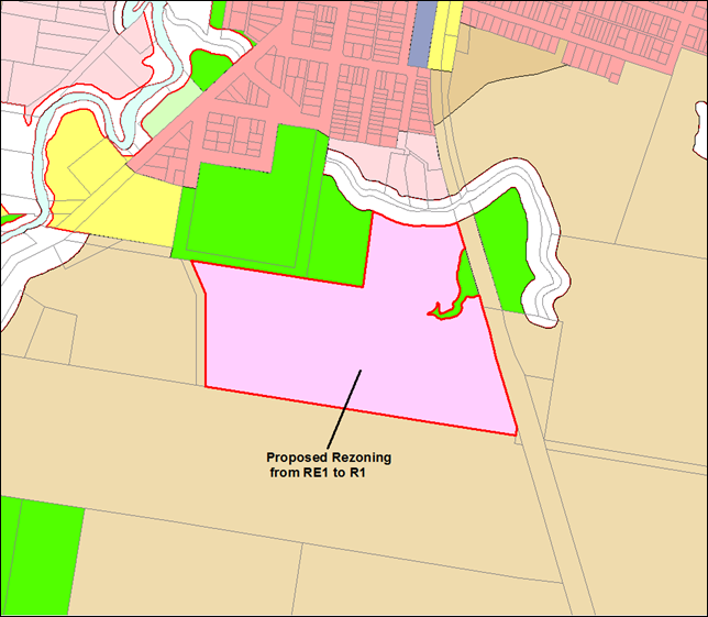
Figure 1: Lot 22 DP 1073165, 156 Stuart Street,
Mullumbimby
Mullumbimby Accessible Housing Area
Lot 22 is one of three other properties identified in the
Draft Byron Shire Residential Strategy as the Mullumbimby Accessible Housing
Area. The surrounding property owners expressed an interest in providing 30% of
their developable land for accessible housing. The area is outlined in blue in
Figure 2 below.
The draft Residential Strategy, which was endorsed at the 13
December 2018 Council meeting for further refinements
prior to public exhibition, includes an action to prepare a structure
plan:
Prepare a
structure plan for the Mullumbimby Accessible Housing Area setting out a visual
framework for:
a) protecting the environment
b) managing flooding and stormwater
c) securing movement corridors (vehicular, cycling and walking)
d) the scale, pattern and broad location of new housing, including
providing accessible housing
e) supporting liveable neighbourhood principles.
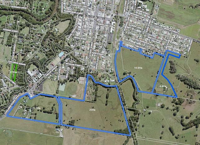
Figure 2: Mullumbimby Accessible Housing Area
Following consideration of the 23 November 2017 Council
report, Council resolved (17-597) to:
1. Agree
to initiate the planning proposal to amend Byron LEP 2014 (Attachment 1) for
the reasons outlined in this report.
2. Forward
the planning proposal to the NSW Department of Planning and Environment for a
Gateway determination.
3. Agree
that staff can proceed to public exhibition of the planning proposal and
government agency consultation based on the Gateway determination issued by the
NSW Department of Planning and Environment, and report back to Council as part
of post-exhibition reporting
The Department of Planning
requested that changes be made to the initial planning proposal at the first
request for Gateway. As a result a subsequent report to Council on 19
April 2018 presented a list of options for the planning proposal to
proceed. The options were as follows:
1. Amend
the planning proposal to remove the proposed affordable housing provisions; or
2. Withdraw
the planning proposal until such time as Byron Council has pursued its
inclusion into SEPP 70; or
3. Request
the Department to proceed to issue a Gateway determination for the planning
proposal as submitted, though it is likely that any Gateway determination will
contain a condition requiring the removal of the affordable housing provisions
from the proposal.”
18-217 Resolved that Council:
1. Request
NSW Department of Planning and Environment proceed to issue a Gateway
determination for the planning proposal as submitted by Council and accept that
this will include a condition requiring the removal of the affordable housing
provisions from the proposal.
2. Agree
that staff can proceed to further studies and then public exhibition of the
planning proposal and government agency consultation based on the Gateway
determination issued by the NSW Department of Planning and Environment, and
report back to Council as part of post-exhibition reporting.
3. Request
staff to prepare a report for Council outlining the information and process to
consider amending SEPP 70, LEP 2014 and the Byron Development Contributions
Plan in relation to affordable housing provisions.
The planning proposal was subsequently amended and aims to:
§ Insert R1 General Residential
as a new zone in Byron LEP 2014
§ Rezone approximately
22 hectares of the existing RE1 Public Recreation zone to R1 General
Residential
§ Apply a minimum lot size of
200 m2 to the R1 General Residential zone area
§ Reclassify part of
Lot 22 DP 1073165 from Community to Operational to reflect the
changes to the zoning of the land and prospective change of land use
§ Insert a Key Sites Map in
Byron LEP 2014 and identify part Lot 22 DP 1073165 on that map
§ Insert new local provisions
into Byron LEP 2014 to encourage diverse and affordable
housing on key sites identified on the Key Sites Map.
The amended planning proposal was forwarded to the
Department of Planning & Environment in accordance with Res 18-217 and a
Gateway Determination was issued on 30 May 2018 to proceed to public
exhibition, following the completion of site studies.
Gateway Determination
The Gateway Determination required that Council:
· Amend
the planning proposal to remove sections where it was proposed to introduce
prescriptions for a portion of affordable housing on the site.
· Amend
certain maps in the Planning Proposal, including the Key sites Map.
· Conduct
additional site studies including further investigation of potential
contamination of the land, further ecological assessments, an aboriginal
cultural heritage assessment and an acid sulfate soils study.
Council staff commissioned these studies prior to the public
exhibition period. All supporting studies were made available on
Council’s website for the duration of the exhibition period.
In addition, the Draft Byron Shire Open Space and Recreation
Needs Analysis were exhibited alongside the Planning Proposal for Lot 22 as
required by the Gateway Determination.
Consultation Undertaken
Before and during the exhibition period, which ran from 31
October 2018 to 12 December 2018, Council staff provided a range of
opportunities for community feedback including:
· Meetings
with key stakeholder groups in the lead up to the formal exhibition period
– meetings were held with Mullumbimby High School, Mullumbimby residents
association, Community Alliance Byron Shire and Mullumbimby Chamber of
Commerce. Many others were invited to set up meetings with Council staff, but
elected not to.
· Online
videos that were published through YouTube and Facebook.
· Facebook
posts, newspaper advertisements, posters advertising the drop in sessions on
key notice boards.
· Letters
to adjoining residents inviting them to have their say.
· Three
drop in sessions held over three days in the Council chambers where residents
had the opportunity to chat to a Council staff member or record their feedback.
· A
stall at the Mullumbimby Farmer’s Market held on the 30 November 2018
where Council chatted with nearly 30 members of the public
In addition, a public hearing chaired by an independent
facilitator was held on 6 February 2019 in accordance with clause 40A of the Local
Government Act 1993.
Sixty submissions were received
from the public during the public exhibition period along with a petition from the Mullumbimby Residents
Association (Attachment 1). Submissions were also received from the SES
(Attachment 3) and the Office of Environment and Heritage (Attachment 4). The
key issues raised in these submissions and at the public hearing are addressed in the following tables.
Key Issues Raised
Submissions Received During the Public Exhibition Period
|
|
Submission
Theme: FLOODING
39 of the 60
individual submissions received related to flooding
|
|
Item #
|
Issues Raised
|
Council Staff Response
|
|
1.
|
Many residents expressed distrust in the flood modelling
as it did not match their ‘lived’ experience – particularly
of the March 2017 floods.
|
Noted. To date the flood study provided by BMT
WBM has been used to inform the planning proposal, however it is agreed that
the scope of the modelling can be further refined to more accurately inform
future development of the site.
Residents have indicated that the floods they have
experienced are more severe than those described in the Planning
Proposal. Residents have also raised concerns about; the flow state of
Saltwater Creek, the effectiveness of culverts under the railway line which
effectively act as a dam, and the impact of the new Kings Creek bridge on the
flow characteristics of Kings Creek during flood events. These factors
are said to impact on flood levels and the ability of flood waters to recede
from the urban area of Mullumbimby.
It is recommended that a flood study be prepared that
holistically considers the entirety of the Mullumbimby Accessible Housing
Area (made up of Lot 22 and the other accessible housing sites).
The flood study should also consider the most appropriate
approach to lot layout, building design and stormwater management given the
flooding characteristics of the locality and the catchment. Such large
scale flood planning may present an opportunity to improve the current flood
risk in Mullumbimby by resolving choke points, creating additional flood
storage, and engineering stormwater flows away from the town. The study
may also help to inform the North Byron Flood Mitigation / Risk Management
Plan.
Council’s Flood Engineer supports the recommendation
that a more comprehensive flood study be undertaken and that the rezoning of
Lot 22 be placed on hold until such time as this occurs.
|
|
2.
|
A substantial number of submissions suggested that the
flood modelling was flawed, and that any decision about the site should be
postponed until the North Byron Flood Mitigation/Risk Management Plan has been finalised.
|
Noted. Please see response to Item
1.
|
|
3.
|
Residents also expressed concern over the ability for
future residents of the site to access insurance. Some suggested this
might also have implications for potential residents taking out mortgages.
|
Noted. More detailed planning and flood modelling
will be required as a part of the process and this matter may be considered
at that time. In addition, the future tenure model is yet to be considered
and as such it is too early to comment on mortgage implications.
|
|
4.
|
Many neighbouring property owners were concerned that
flooding might negatively affect their property, and the urban area of
Mullumbimby as a whole.
|
To date, the proposal has relied on the flood studies
provided by BMT WBM which show a decrease in projected flood levels
experienced in the urban area to the north of Lot 22. This report
recommends that Council undertake a further flood study (please see response
to Item 1).
|
|
5.
|
A number of submissions were also concerned that the PP
did not adequately address the future impacts of climate change –
especially relating to sea level rise and extreme weather events.
|
Council’s Flood Engineer has reviewed the Flood
Study undertaken as a part of the Planning Proposal. The Flood
Engineer suggests that the site is on the limit of flood increases due to sea
level rise. This will need to be considered in the flood study recommended
for the Mullumbimby Accessible Housing Area.
|
|
6.
|
Some submissions suggested that the movement of water
across the site was high velocity and would result in a dangerous scenario
for future residents. SES also noted the possibility that flows across
the site might be high velocity however this could not be determined based on
the available information.
|
Council’s Flood Engineer recommends that
verification of flow rates should be considered as part of any future flood
study.
It is recommended that the information and experiences
shared by local residents during the exhibition period be considered in
preparation of a flood study for the Mullumbimby Accessible Housing Area.
|
|
7.
|
A high number of residents did not support affordable
housing being built on flood prone land.
|
Rezoning of flood prone land for urban purposes can occur
in instances where the inconsistency with Section 9.1 Ministerial
Direction 4.3 - Flood Prone Land can be justified.
The feasibility of developing the site for future housing
will be informed by the recommended flood study for the Mullumbimby
Accessible Housing Area (Please see response to Item 1 for further detail).
|
|
|
Submission
Theme: ACCESS AND MOVEMENT
24 of the 60
individual submissions received related to access and movement
|
|
Item #
|
Issues Raised
|
Council Staff Response
|
|
8.
|
Some submissions were concerned about the Traffic
Implications for Mullumbimby Town Centre as a result of the increased
population density.
|
The site is located in walkable distance to the town
centre, high school, services and parklands – reducing the reliance on
private vehicle transport.
The draft Residential Strategy identifies a possible new
connection road along the southern perimeter of the Mullumbimby Accessible
Housing Area, which could redirect a considerable amount of
“through-traffic” away from the Town Centre.
The Our Mullumbimby Masterplan process is also
underway and will consider how to address traffic and congestion issues in
the main town.
This report recommends that a structure plan be prepared
for the Mullumbimby Accessible Housing Area prior to further consideration of
the planning proposal. The structure plan would provide a multi model
solution for access and movement in the area, and would be integrated with
work underway on the Our Mullumbimby Masterplan.
|
|
9.
|
Some submissions were concerned that any access via Stuart
Street would impact on the amenity of the community gardens, sports fields
and skate park.
|
Any access via Stuart Street would involve an upgrade of
both the access over Saltwater Creek and the informal parking area alongside
the community gardens. It would result in a more attractive, safer road to
access the sports fields and the community gardens. However it is noted that
the best access options to and from the site are yet to be determined. Refer
also to comments in item 8 above.
|
|
10.
|
Some submissions were concerned that any access via Stuart
Street would require a bridge upgrade that would be paid for by tax payers.
|
Noted, however further information is required before
access and movement to and through the site is confirmed. Stuart Street
is one of a number of access options at this stage. A bridge upgrade would
likely be required if this route were chosen however the financial
implications would be subject to future consideration by Council.
Refer also to comments in item 8 above.
|
|
11.
|
Some submissions were concerned that access through Byron
Street might negatively affect the Netball Courts, and eliminate the high
school oval which sits partially over the road reserve.
|
Byron Street has been identified as one of a number of
access options for the site, however planning staff consider that Byron St
offers the least desirable access option due to the nature of the
intersection with Jubilee Ave.
The high school oval currently encroaches on the road
reserve extending south from Byron St; however the netball courts are located
outside of the road reserve. It is noted that the high school oval is
an important asset for the community.
This report recommends that a structure plan be prepared
for the Mullumbimby Accessible Housing Area. The best access options
for Lot 22 can be determined as part of this process.
|
|
12.
|
Some submissions in support of the proposal suggested that
any development on the site should move away from private vehicle transport
and look to other solutions.
|
Noted. Should the site be rezoned, such considerations
will be dealt with at the development application stage.
|
|
13.
|
A small number of submissions suggested that Council
should not be building new infrastructure (roads etc.) if it cannot maintain
its current infrastructure.
|
Noted. It is unclear what models of governance and
operational delivery will be employed on the site and this will determine the
financial implications for Council moving forward.
Notwithstanding this, a key direction in Council’s
Draft Residential Strategy is for the majority of our shire’s future
housing to be located in urban towns and villages, mainly to ensure more
efficient use of land and infrastructure.
|
|
Submission
Theme: LOSS OF RECREATIONAL LAND
24 of the 60
individual submissions related to the loss of recreational land
|
|
Item #
|
Issues Raised
|
Council Staff Response
|
|
14.
|
Many submissions expressed concern over the loss of
recreational zoned land and the loss of potential future sports fields for a
growing community.
NB: There appeared to be a great deal of confusion over
the adjacent location of the sportsfields containing the skate park, cricket
pitch and tennis courts. Many residents thought that this land, Lot 389 DP728162, was included in the proposal to
rezone and reclassify Lot 22.
|
Noted. Consideration of the provision of open space
is based on the results of the Open Space and Recreation Strategy that was
adopted by Council in 2018. This study identified Lot 22 as surplus to
the needs of Mullumbimby, and thus potentially suitable for development in
the form of affordable housing.
It is important to note that no land currently used for
passive or active recreation is proposed to be rezoned or
reclassified. In addition, the R1 zoning of the site does not
preclude the inclusion of sports fields in any future development, and open
space may be a large part of any development on site.
It should also be noted that not all of the site is
proposed to be rezoned and reclassified. The remaining 7ha of RE1
Public Recreation zoned community land may provide an option for delivering
additional open space or sporting facilities, if required in the future.
|
|
15.
|
Many submissions expressed concern over the accuracy of
the Open Space and Recreational Needs Strategy and the methodology of the document.
Primarily, there was concern that rural residents were not included in the
calculations to project future requirements.
|
Noted. The methodology used to produce the Open
Space and Recreational Needs Study is standard practice for this kind of study.
Council employed expert consultants who are well experienced at undertaking
these types of studies. Inclusion of rural land is not standard practice for
these calculations.
|
|
|
OTHER ISSUES
RAISED
|
|
Item #
|
Issues Raised
|
Council Staff Response
|
|
16.
|
Some submissions were excited about the potential for the
site to become an exemplar site including elements of sustainable design and
architecture into any future development.
|
Noted. Council is in conversations with the DPE to this
effect.
|
|
17.
|
Some submissions suggested that the site be restored to
biodiversity habitat, not housing.
|
Noted. Considering the housing crisis in the Shire
and the real need for accessible and diverse housing, it is considered that
addressing this issue is a priority for the community.
The freshwater wetland at the North of the site has been
excluded from the Planning Proposal due to the environmental sensitivity of
the area. There may be an opportunity to allow for habitat restoration in
this area and throughout the site as a result of any future development
opportunities.
|
|
18.
|
One submission expressed concern over the development
becoming an ‘enclave’ of drug addiction and crime
|
Noted. The objectives of the R1 zone as
proposed are:
· To provide for
the housing needs of the community
· To provide for a
variety of housing types and densities
· To enable other
land uses that provide facilities or services to meet the day to day needs of
residents
· To provide a
secure supply of affordable housing stock that meets the needs of low to
middle income residents.
· To enable
provision of non-residential land uses that are compatible with and do not
place demands on services beyond the level reasonably require for,
residential development.
The proposal is aiming to provide a diverse range of
housing, including key workers in the low to middle income bracket, and is
not intended to be social housing.
|
|
19.
|
One submission voiced concern about the potential road for
the Mullumbimby Accessible Housing Area passing through the section of the
site not proposed for rezoning as was initially shown in the Draft
Residential Strategy.
|
Noted. There are a number of potential locations for
access to the site and these will be considered when preparing the structure
plan recommended in this report.
|
|
20.
|
Some submissions suggested that Council is not a developer
and should not be undertaking such projects at the taxpayers cost.
|
Noted. Affordable housing is one of the most
pressing needs of our community and is identified in both the Community
Strategic Plan and the customer satisfaction survey as one of the issues that
most concerns our residents. Council is yet to decide on the governance
and operational delivery of this project but feasibility would be a
key consideration.
|
|
21.
|
Some submissions expressed distrust in the Council’s
ability to deliver housing that was truly affordable.
|
Noted. Council is exploring a number of governance
and operational delivery mechanisms to ensure future housing on sites such as
Lot 22 remains affordable ‘in perpetuity’ for low to middle
income earners.
|
|
22.
|
A number of submissions expressed their support in
Council’s endeavour to deliver affordable housing.
|
Noted.
|
Agency Submissions
In accordance with the Gateway Determination, Council referred the matter to the Office of
Environment and Heritage, the SES and the Local Aboriginal Land Council.
The submissions received from the SES and OEH are summarised below.
Council staff did not receive comment from the Local Aboriginal Land Council
after Gateway.
|
|
SES Submission
|
|
Item #
|
Issues Raised
|
Council Staff Response
|
|
23.
|
Concerns that in a flood larger than a 1% AEP flood event
smaller than a PMF, the site will be inundated and the dwellings may be
impacted, even with fill. It will therefore be unsafe for people to remain
|
Noted. Please see response to
Item 1.
|
|
24.
|
Safe flood evacuation access to an area outside the
floodplain may not be available somewhere in the 1% and 2% flood.
Further information would need to be provided to determine at what point
egress is no longer possible.
|
Noted. Further work is required to determine flood
evacuation options. It is also noted that this is a relevant issue for
much of the Mullumbimby urban area and is not confined solely to the Lot 22
site.
This report recommends that a comprehensive Flood Study
and Structure Plan be prepared for the Mullumbimby Accessible Housing
Area. Flood evacuation options can be considered as part of this
process.
.
|
|
25.
|
Inconsistency with S9.1 Directions
|
Noted. Please see response to Item 7.
|
|
|
Office of
Environment and Heritage
|
|
Item #
|
Issues Raised
|
Council Staff Response
|
|
26.
|
It was suggested that Council further consider and justify
the potential presence of EECs in the planning area
|
Noted. At this point the Planning Proposal has been
informed by the two ecological studies that have not found evidence of
EECs.
Further review may be considered at the development
application stage if deemed necessary.
|
|
27.
|
Ensure any areas that contain EECs are zoned E2
|
Noted
|
|
28.
|
Provide further information around proposed rehabilitation
works- perhaps by updating the plan of management to include these works
|
Noted. The plan of management will be reviewed if a
rezoning and reclassification process occurs in line with any Council
decisions.
Areas proposed for rehabilitation can be considered during
the development of a structure plan for the Mullumbimby Accessible Housing
Area, which may include supporting DCP provisions.
|
|
29.
|
Consider a Constraints map
|
Noted. This may be considered for inclusion in the
Planning Proposal after the integrated flood study and structure plan have
been prepared.
|
|
30.
|
Provide further detail and commitment to review the zoning
of the land when E zones can be applied.
|
Noted. An E zone review is underway throughout the
shire. This process is ongoing concurrently with this Planning Proposal
and will deal with the deferred matter zones on the site in due course.
|
|
31.
|
Undertake further flood modelling for additional design
flood events
|
Noted. It is recommended that this advice be heeded
in the form of a holistic flood study for the entirety of the Mullumbimby
Accessible Housing Area with further detail and taking into account local
knowledge and known patterns of flow based on historic incidences.
|
|
32.
|
Address all aspects of the floodplain development manual
including flood safety and access.
|
Noted. More work needs to be undertaken to ascertain
the flood hazard. Council’s Flood Engineer suggests that the area
may have high velocity flow. If this is confirmed by further flood studies,
options for evacuation in a flood event can be considered as part of the
recommended structure plan for the Mullumbimby Accessible Housing Area
sites.
|
|
33.
|
Consider the broader catchment and relationship to the
North Byron Floodplain Risk Management Study and Plan
|
Noted. It is recommended that further flood studies
consider the broader catchment beyond the Mullumbimby Accessible Housing Area
sites and their relationship to the North Byron Floodplain Risk Management
Study and Plan.
As stated in item 1, the combined study will help to
inform the North Byron Flood Mitigation / Risk Management Plan.
|
|
34.
|
Consider amending the
planning proposal to align the boundary no less than 40m from Saltwater creek
|
Noted. A 40m buffer
will be considered as a part of the structure planning process for Lot 22.
|
|
35.
|
Require further investigation of Aboriginal cultural
heritage at DA Stage
|
Noted. It is anticipated that further consultation
with relevant indigenous groups and authorities will be undertaken if the
proposal progresses.
|
Petition
Along with many individual
submissions, Council also received a petition from Mullumbimby Residents
association (Attachment 1) that was signed by 351 residents and noted at the
Council meeting 28 February 2019. The petition raised issues that are
discussed below.
|
Item #
|
Key Issues raised
|
Council Staff Response
|
|
36.
|
Concern that the studies
(flooding and ecology) were inconsistent with one another, and with anecdotal
experience from the 2017 floods.
|
Noted. Please see response for
Item 1.
|
|
37.
|
Disputing the accuracy of the Flood
study
|
Noted. Please see response
for Items 1 and 2.
|
|
38.
|
Concerns that the proposal
should be put on hold until the North Byron Floodplain Risk Management Study
and Plan has been finalised.
|
Noted. Please see Item 2.
|
|
39.
|
A technical omission in the
flood study that did not account for filling in Orchid place, Mullumbimby
|
Noted. Please see Item 1.
Specifically this omission can be passed on when further studies are
conducted.
|
|
40.
|
Concern that the flood study
does not account for sea level rise associated with climate change, despite
the fact that the proposal suggests that it is in the tidal part of the
Brunswick river and will therefore be affected.
|
Noted. Please see Item 5.
|
|
41.
|
Suggestions that the experiences
and records of local residents, and the submissions for the North Byron Shire
Floodplain Risk Management Study and Plan should be taken into account for
any future flood study.
|
Noted. Please see Items 1
and 2.
|
|
42.
|
Concerns over evacuation risk to
any future residents and emergency evacuation personnel
|
Noted. Please see response to
Item 24.
|
|
43.
|
Concerns over the damp nature of
the microclimate for any future housing on the site
|
Noted. It should be
clarified that the freshwater wetland to the north of the site is not included
in the proposal for reclassification and rezoning. Further studies may
require an expansion of the area retained for habitat for drainage and
ecology. In addition, it is assumed that any future development on the
site will be accompanied by extensive engineering which will ensure a healthy
drainage capacity for the developed areas of the site, resulting in an
engineered solution to damp conditions.
|
|
44.
|
External
fill should not be allowed on site as it will rule out the possibility of
affordable housing on the site and be contrary to the direction of the
“Byron Shire Council Residential Strategy” 2003.
|
Noted.
Ideally any regrading of the site will not require fill to be imported, however these
matters can be considered in detail at the development application stage.
|
|
45.
|
Consultation is required with
NSW Government in regards to Kings Creek which passes through the site as it
is considered a part of Cape Byron Marine Park.
|
Noted. State agency consultation
has been consistent with the Gateway Approval
|
|
46.
|
Concern that any future access
via Stuart street will be costly to tax payers and will increase traffic
congestion in the CBD. Also notes that an exclusion zone will need to
be considered for the fuel storage at the Co-op.
|
Noted. Please see response to
Items 8 and 10.
|
|
47.
|
There is no undeveloped land for
open space in close proximity to Mullumbimby
|
Noted. Please see response to Item 14.
There is opportunity to provide
for open space and recreational land uses on Lot 22 within the
proposed R1 General Residential zone. Other
parts of site that are not proposed for rezoning such as the residual
portion east of the railway tracks, the community gardens site and the freshwater wetland will remain as passive
recreation spaces.
|
|
48.
|
Northern hinterland rural
residents should be included in the calculations
|
Noted. Please see response to Item
15.
|
|
49.
|
The proposal will adversely
affect the amenity of existing recreation grounds
|
Noted. See item 9.
|
|
50.
|
It is recommended that a
masterplan be developed before any rezoning of Lot 22 is considered to ensure
needs of sporting groups are accommodated now and into the future.
|
Noted. The Open Space and
Recreational Needs study has identified Lot 22 as surplus recreational lands.
This report recommends that the planning proposal be
supported by a structure plan. Suitable opportunities for open space
provision will be considered as part of this process.
|
Public Hearing
The Planning Proposal seeks to reclassify the land from
Community to Operational land, therefore, a formal Public Hearing was required
pursuant to clause 40A of the Local Government Act 1993.
The hearing was held on Wednesday 6 February 2019. The
hearing was presided over by an independent chair, Ms Emma Bromfield of Locale
Consulting. A number of people provided verbal and visual submissions to
the hearing, as summarised in the Report of the Hearing (Attachment 2).
The Report recommends that Council consider not proceeding
further with the proposal to reclassify the land until:
· The flood
modelling and associated impacts have been reviewed in light of the information
that was provided at the hearing, and through submissions to the exhibition of
the planning proposal, including being independently peer reviewed; and
· Council has
established a process for considering the broader strategic planning issues
that are apparent through the proposed creation of the Mullumbimby Accessible
Housing Area in the draft Residential Strategy and related planning activities.
A brief summary of submissions made at the public hearing,
and staff response to the issues raised is summarised below:
|
Public Hearing
|
|
Item #
|
Key Issues raised
|
Council Staff Response
|
|
51.
|
Some speakers expressed concern over the lack of apparent
strategic focus for broader Mullumbimby
|
Noted.
The potential development of Lot 22 has been assessed
against the site suitability criteria used to inform the draft Byron Shire
Residential Strategy. Preparation for public exhibition of the draft
strategy is underway.
The report recommends that a comprehensive Flood Study and
Structure Plan be prepared for the Mullumbimby Accessible Housing Area.
It is considered that the completion of this body of work prior to any
potential rezoning of Lot 22 will provide a broad strategic context for the
rezoning of this site.
|
|
52.
|
Some speakers suggested that an engineering solution could
be possible to reduce flooding at Lot 22 and other sites in the Mullumbimby
Accessible Housing Area
|
Council staff agree that an engineering solution could be
possible to address flooding issues and that further work is required to
determine if this is the case.
Please also see response to Item 1 for further detail.
|
|
53.
|
Some speakers queried the
validity of the flood study
|
Noted. Please see item 1.
|
|
54.
|
Some speakers expressed their support for affordable
housing and reiterated their personal need for more land for housing key
workers.
|
Noted. Council is looking at several mechanisms for
alleviating housing stress in the area.
|
|
55.
|
Some speakers noted the incongruity between the
Council’s climate emergency and the lack of consideration of climate
change in the Planning Proposal.
|
Noted. Please see item 5.
|
|
56.
|
Some speakers expressed concern over any future
residents’ ability to access insurance
|
Noted. Please see item 3.
|
|
57.
|
Some speakers questioned Council’s ability to
deliver affordable housing.
|
Noted. Please see item 21.
|
|
58.
|
Some speakers were concerned over the loss of recreational
lands
|
Noted. Please see item 14.
|
|
59.
|
Some speakers expressed their desire for the site to be an
innovative exemplar site.
|
Noted. Please see item 16.
|
|
60.
|
Some speakers suggested that private land that is higher
to the North of Mullumbimby be used instead for affordable and diverse
housing.
|
Noted. Council has undertaken an assessment of land
it currently owns in order to identify sites for possible future
housing. Of the land identified, Lot 22 was the preferred option due to
its proximity to Mullumbimby town, and the relative advantages of the
site.
|
|
61.
|
Some speakers where concerned about the access to the site
in a flood event.
|
Noted. See item 24.
|
|
62.
|
Some speakers were concerned about the poor environmental
state of Saltwater Creek.
|
Noted. Council officers are aware of this issue and
are investigating.
|
|
63.
|
Some speakers were concerned that the Flood Study did not
reflect their lived experience.
|
Noted. See item 1.
|
|
64.
|
Some speakers noted concerns relating to traffic and
access.
|
Noted. See items 8 – 13.
|
As required by the Act, a report on the hearing, prepared by
the independent chair, was provided to Council on 15 February 2019, and
published on Council’s website within 4 days of receipt. A hard
copy was also made available at Council offices. Those who made verbal submissions
were notified on receipt of the report by email when it was published.
Options Moving
Forward
Option 1 (Recommended)
· Prepare a further
flood study and a structure plan for Lot 22 DP 1073165 and the three
surrounding properties that make up the Mullumbimby Accessible Housing Area
· Receive a further
report to consider the future of the Planning Proposal once the additional
studies have been completed.
Option 2
· Forward the
Planning Proposal in its current state to the Department of Planning &
Environment for finalisation.
· Prepare detailed
site studies in association with a Masterplan for Lot 22
Option 3
· Abandon the
Planning Proposal and look for other suitable Council sites for affordable and
diverse housing.
STRATEGIC CONSIDERATIONS
Community Strategic Plan and
Operational Plan
|
CSP Objective
|
L2
|
CSP Strategy
|
L3
|
DP Action
|
L4
|
OP Activity
|
|
Community
Objective 4: We manage growth and change responsibly
|
4.2
|
Support
housing diversity in appropriate locations across the Shire
|
4.2.1
|
Establish
planning mechanisms to support housing that meets the needs of our community
|
|
|
|
|
|
|
|
|
|
|
Legal/Statutory/Policy
Considerations
This planning proposal intends to amend the Byron LEP
2014. Relevant legal and statutory considerations have been addressed
above.
Financial Considerations
Council will bear a portion of the costs of the combined
flood study that will consider the development of Lot 22 in association with
the other accessible housing sites that make up the Mullumbimby Accessible
Housing Area.
It is proposed that Council bear the full cost of a
structure plan for the Mullumbimby Accessible Housing Area.
This additional work is considered a necessary financial
commitment given the issues raised during the public exhibition period in
relation to Lot 22, and given that Lot 22 is a Council owned site that makes up
a portion of the Mullumbimby Accessible Housing Area.
The estimated cost for this work is $80,000. This amount has
been included in the draft 2019/20 Budget from the Property Development Reserve
pending Council’s consideration of this report.
Consultation and Engagement
Details pertaining to community consultation and engagement
are provided above.
Staff Reports - Sustainable Environment and Economy 6.3 - Attachment 1

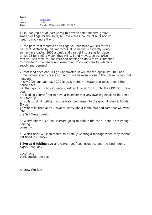
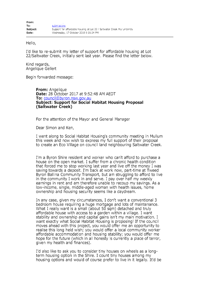


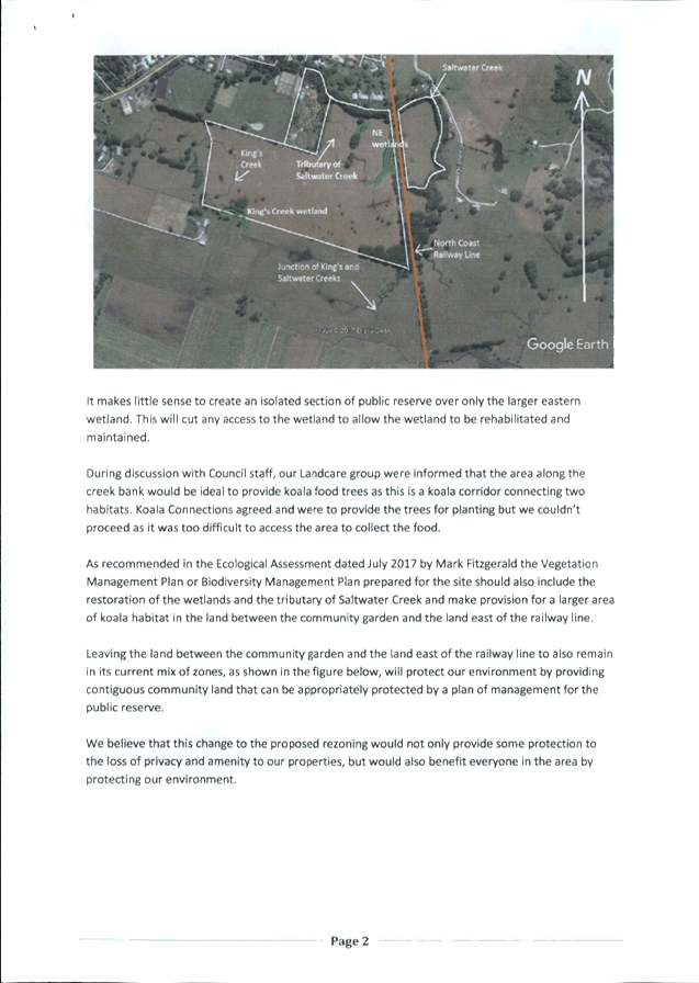
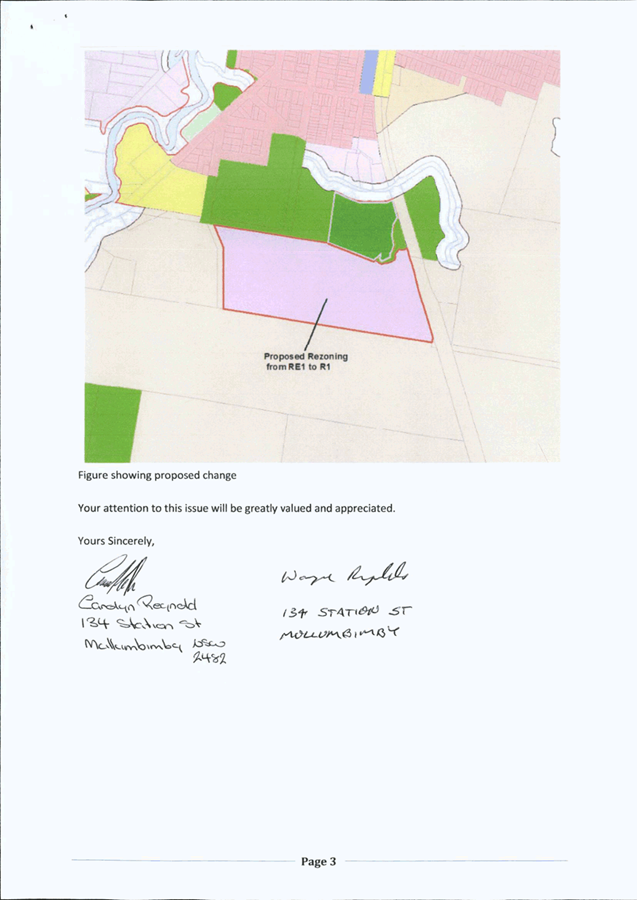
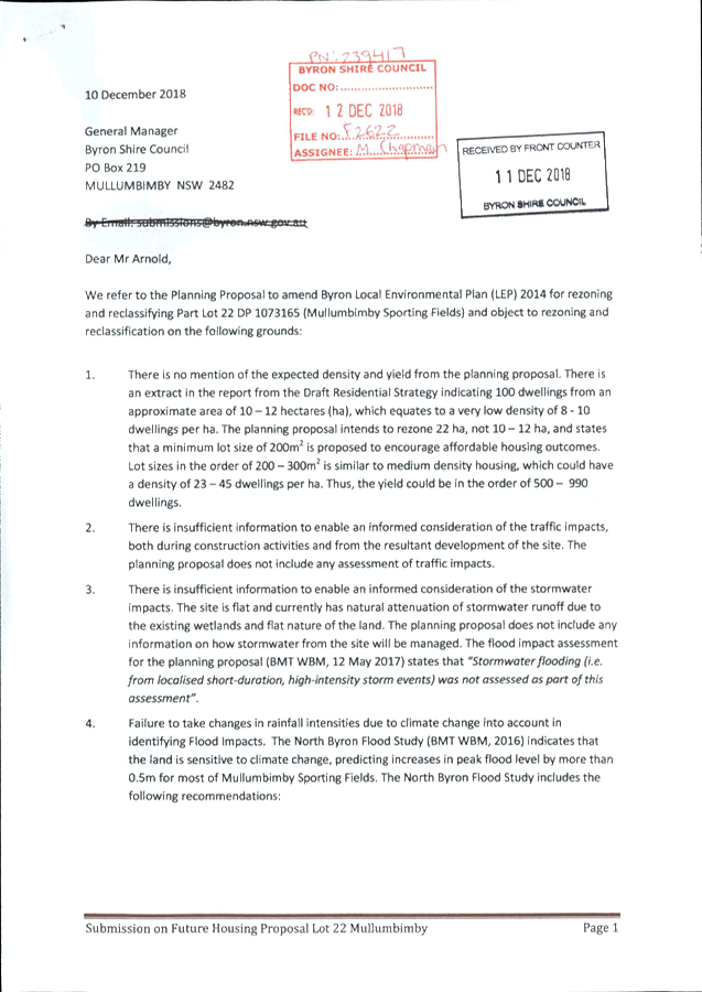
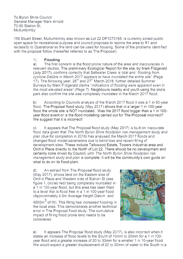


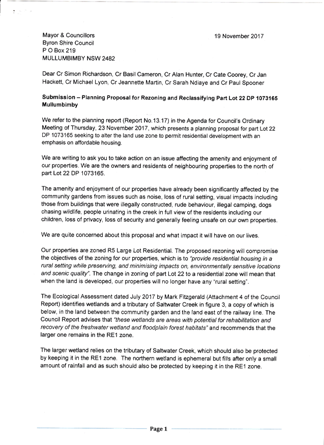
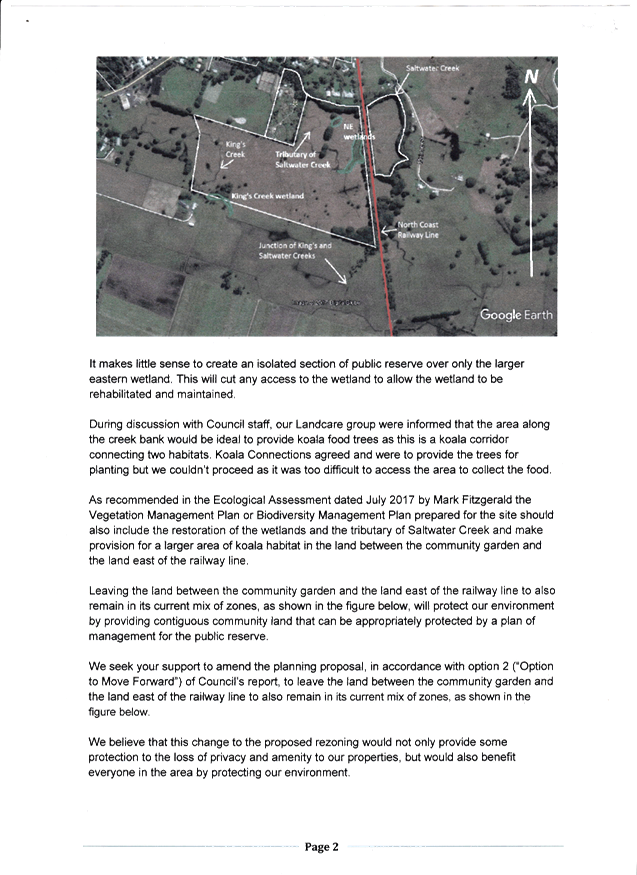
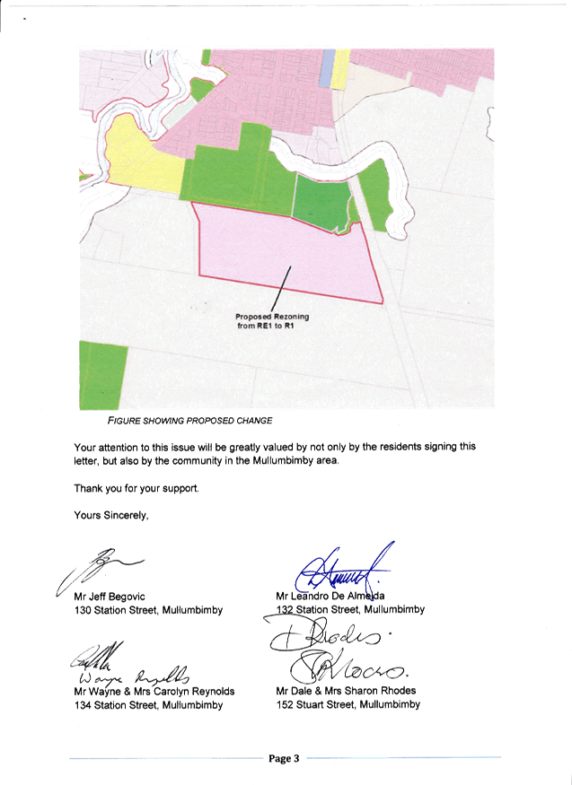
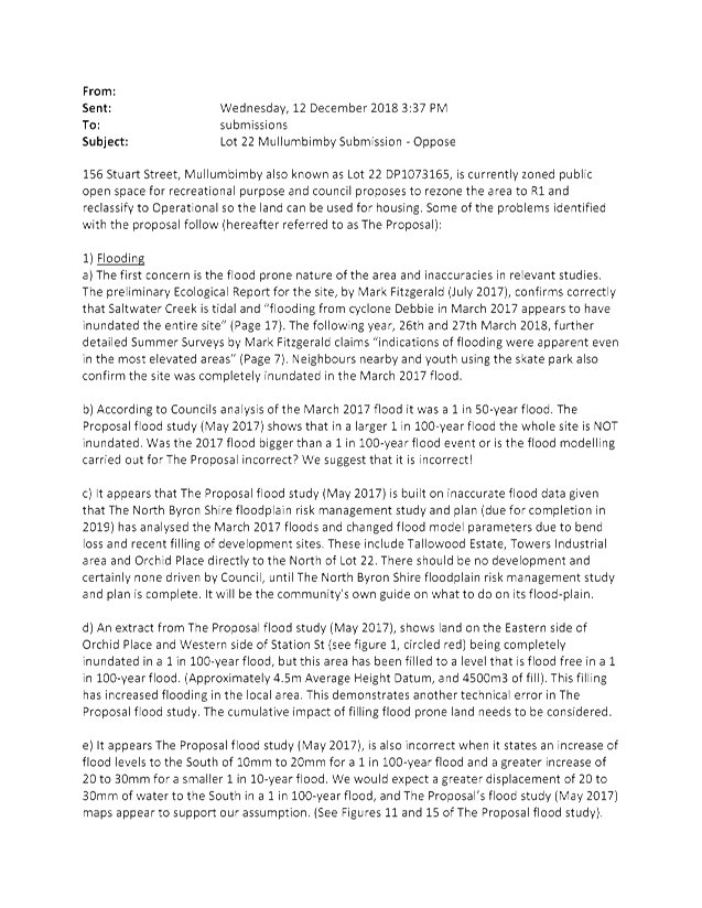

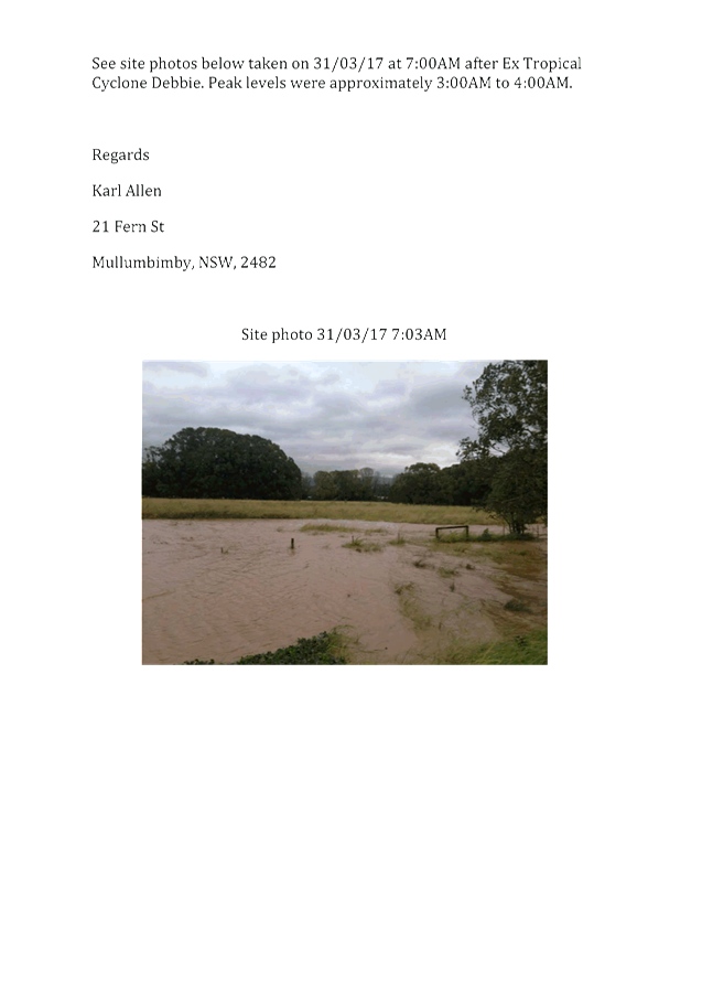
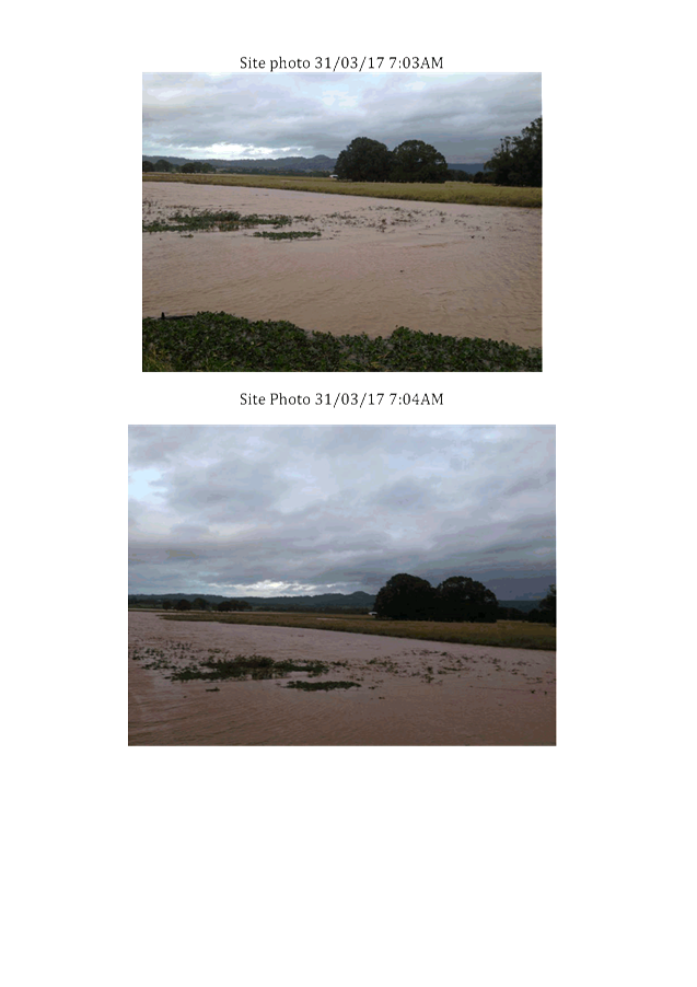
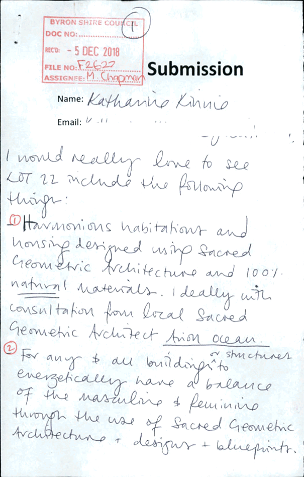
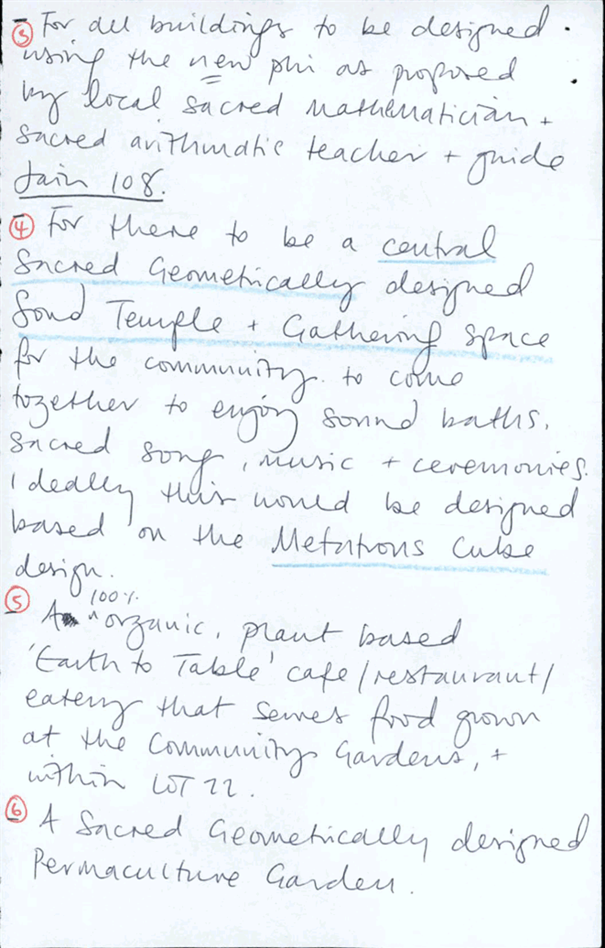
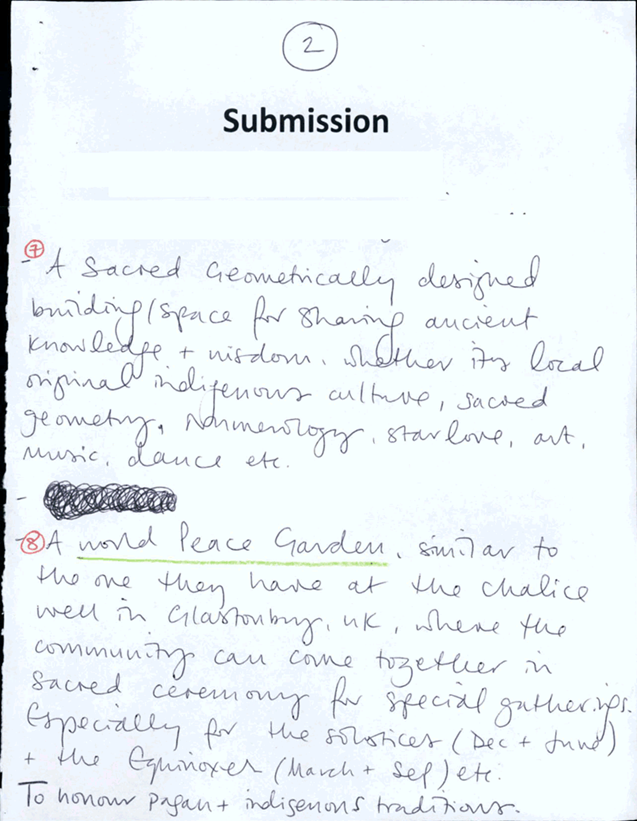
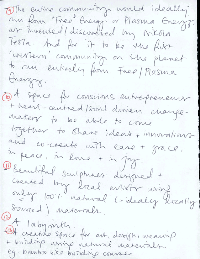
Staff Reports - Sustainable Environment and Economy 6.3 - Attachment 2

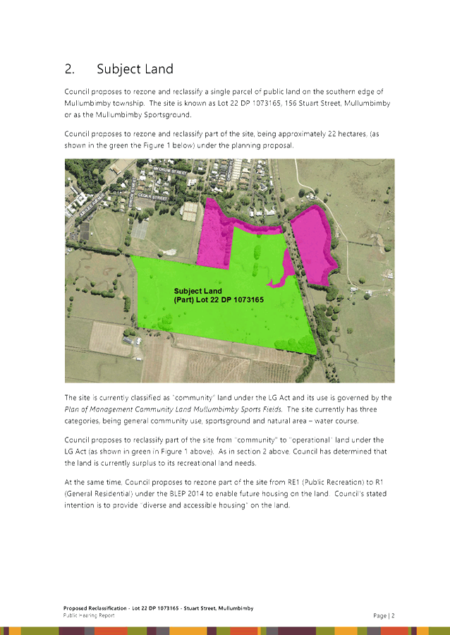


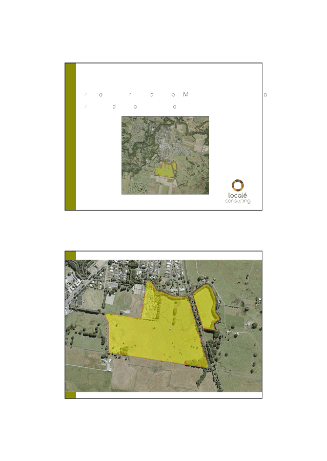
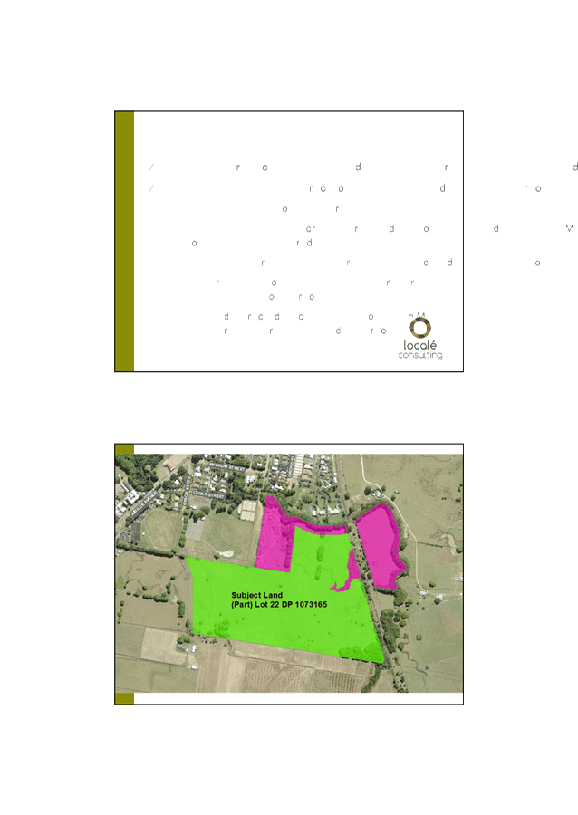
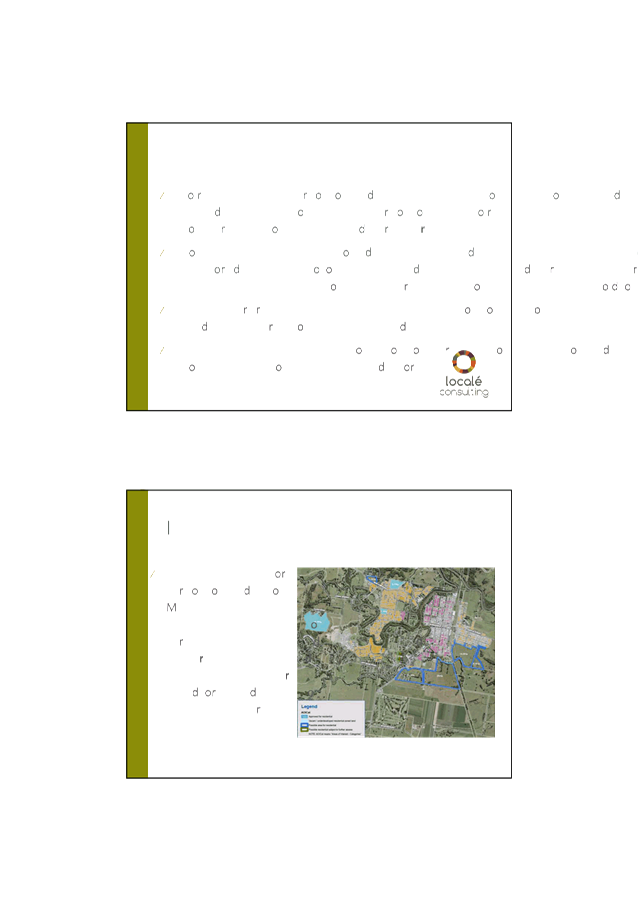
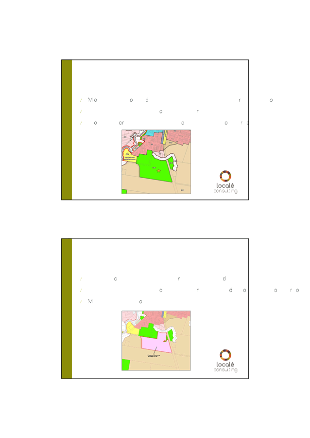
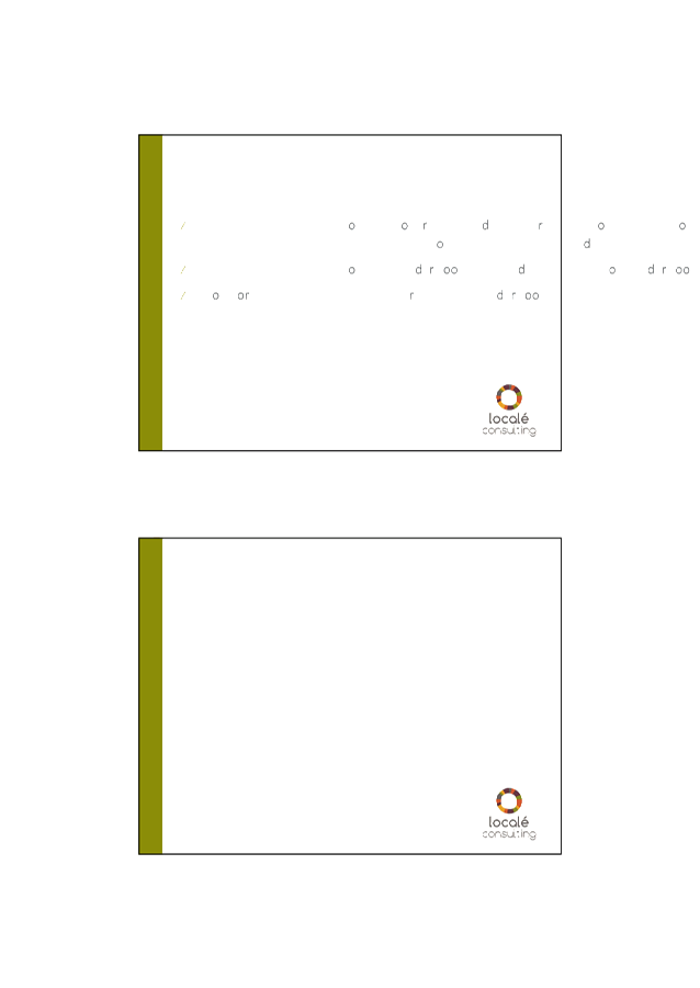

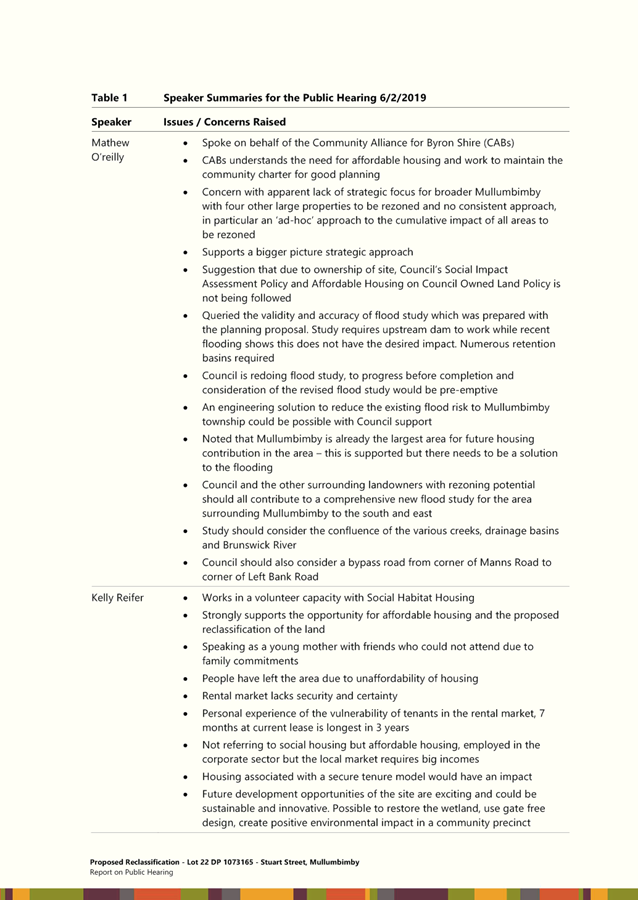
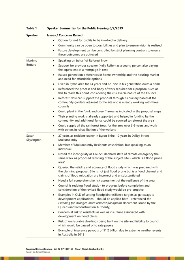
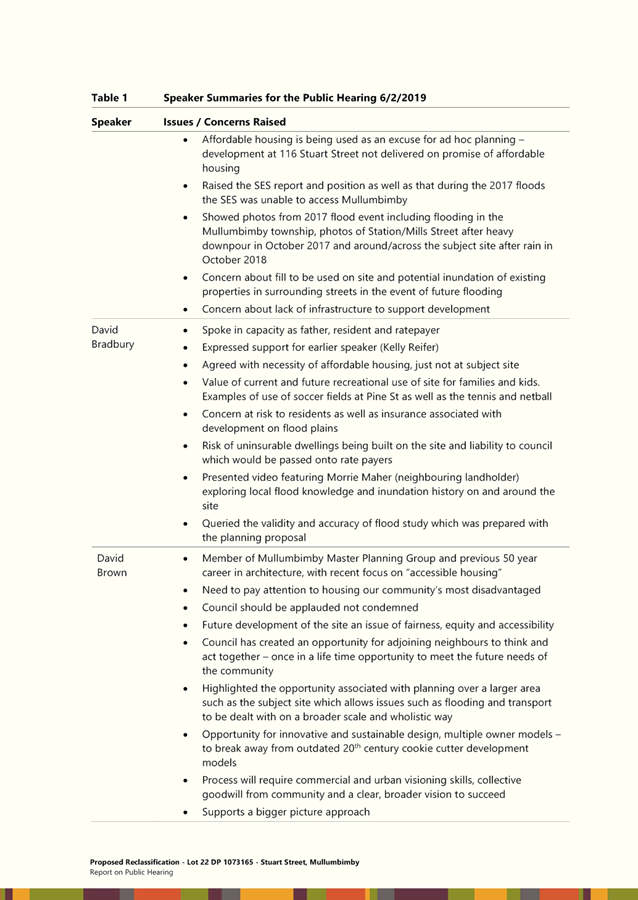
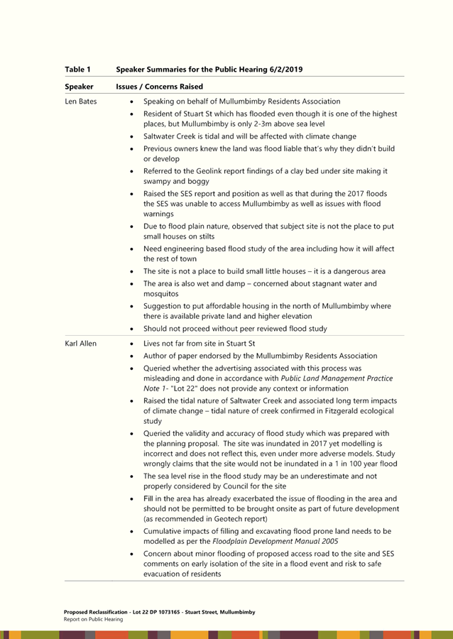
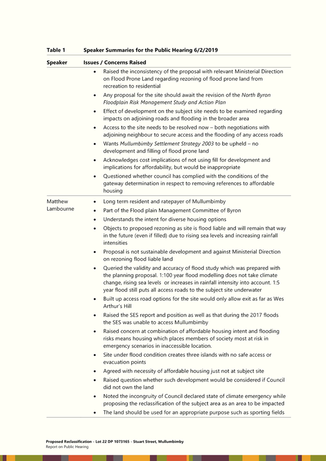
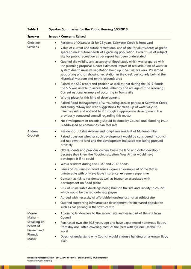
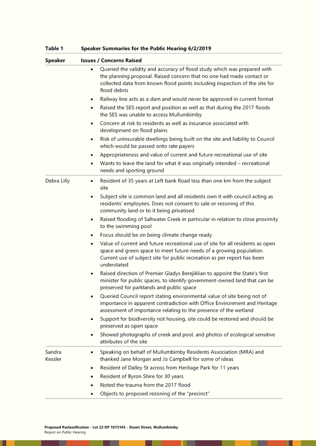
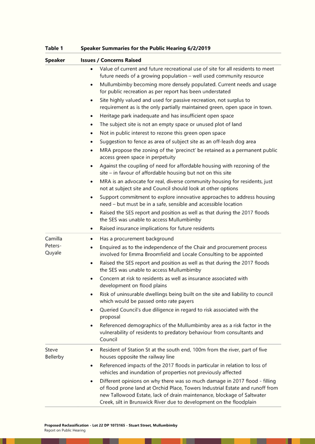
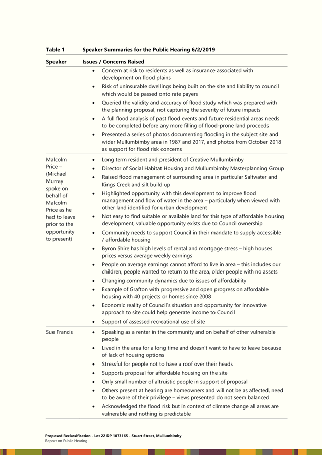
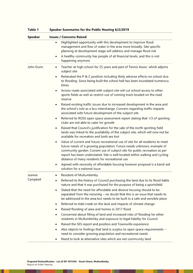
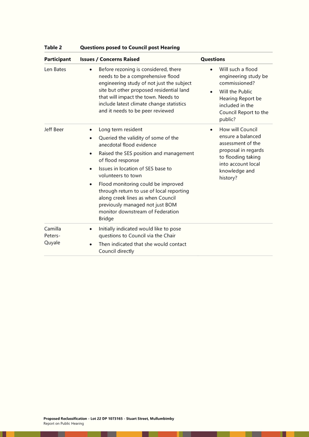

Staff Reports - Sustainable Environment and Economy 6.3 - Attachment 3


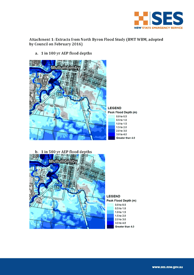

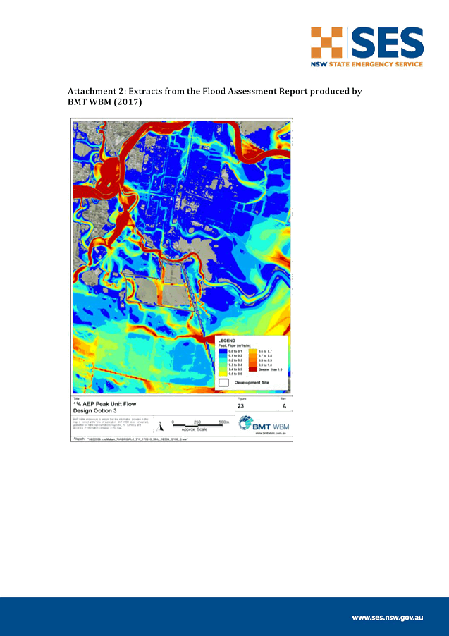
Staff Reports - Sustainable Environment and Economy 6.3 - Attachment 4
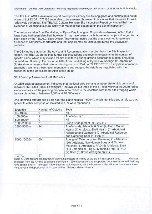
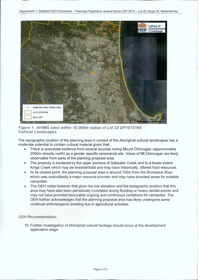
Staff Reports - Sustainable Environment and Economy 6.3 - Attachment 5

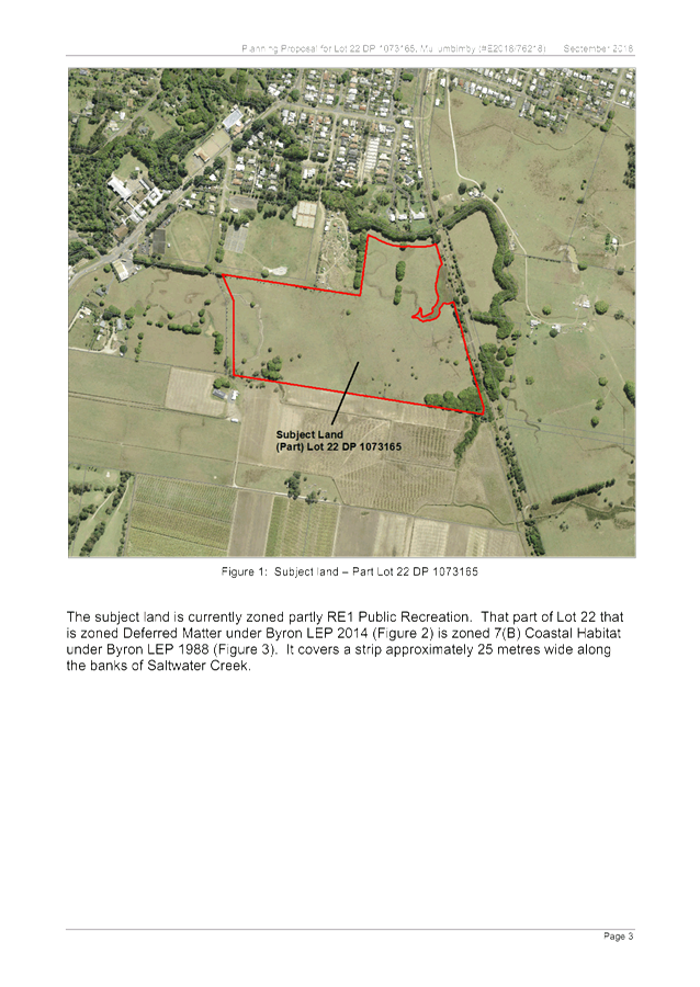
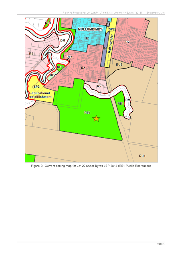
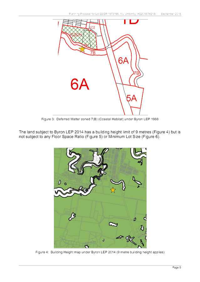
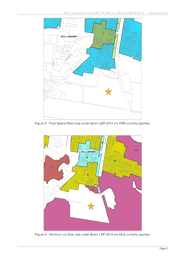

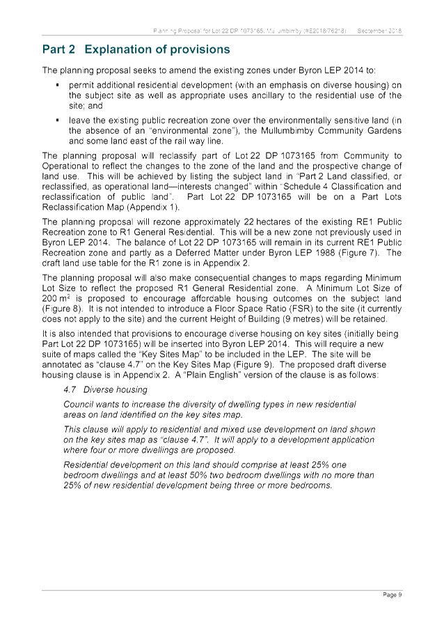
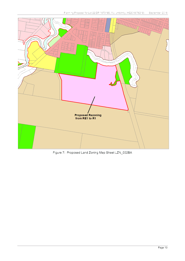
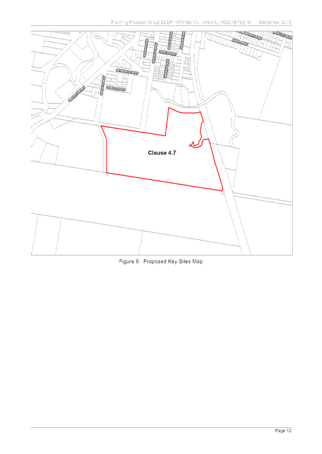
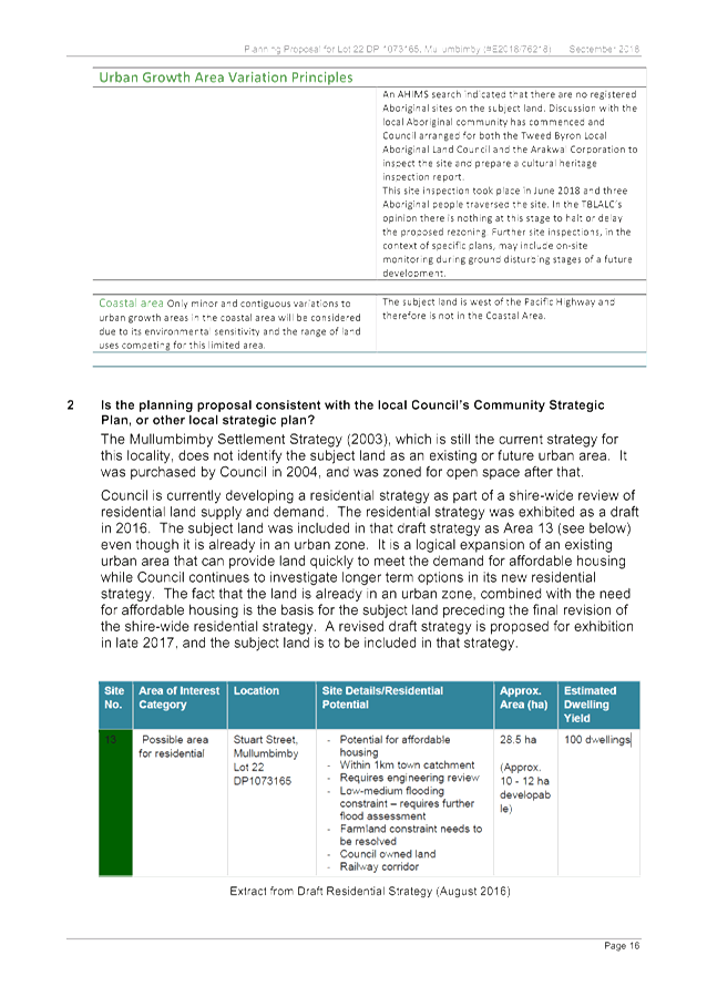
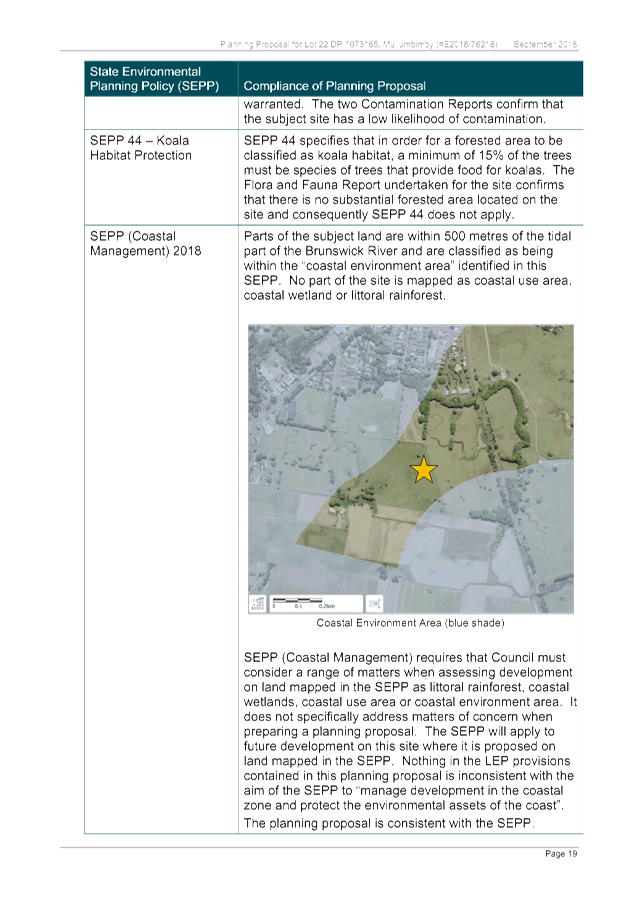
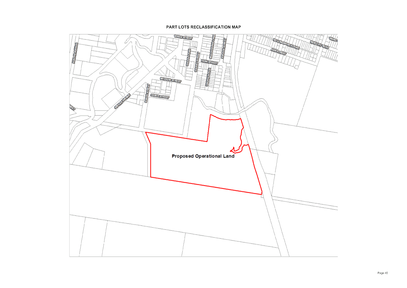
Staff Reports - Sustainable Environment and Economy 6.3 - Attachment 6
Local
Government (General) Regulation 2005
Schedule 3A Form of special disclosure
of pecuniary interest
(Clause 195A)
Section 451 of the Local Government
Act 1993
Form of Special Disclosure of Pecuniary Interest
1 The particulars of
this form are to be written in block letters or typed.
2 If any space is
insufficient in this form for all the particulars required to complete it, an
appendix is to be attached for that purpose which is properly identified and
signed by you.
Important information
This information is being collected for the purpose of
making a special disclosure of pecuniary interests under sections 451 (4) and
(5) of the Local Government Act 1993. The special disclosure must relate to a pecuniary
interest that arises only because of an interest of the councillor in the
councillor’s principal place of residence or an interest of another
person (whose interests are relevant under section 443 of the Act) in that
person’s principal place of residence. You must not make a special
disclosure that you know or ought reasonably to know is false or misleading in
a material particular. Complaints made about contraventions of these
requirements may be referred by the Director-General to the Local Government
Civil and Administrative Tribunal.
This form must be completed by you before the commencement
of the council or council committee meeting in respect of which the special
disclosure is being made. The completed form must be tabled at the meeting.
Everyone is entitled to inspect it. The special disclosure must be recorded in
the minutes of the meeting.
Special
disclosure of pecuniary interests
by
____________________________________________________________________________________
[full
name of councillor]
in the matter of
__________________________________________________________________________
[insert
name of environmental planning instrument]
which is to be considered at a meeting of the
______________________________________________________________________________________
[name of council or council committee (as the case
requires)]
Report No. __________ to be held on the _________________ day of
________________________ 201
|
Pecuniary
interest
|
|
Address of land
in which councillor or an associated person, company or body has a
proprietary interest (the identified land)1
|
|
|
Relationship of identified land to councillor
[Tick or cross one box.]
|
Councillor
has interest in the land (e.g. is owner or has other interest arising out of
a mortgage, lease, trust, option or contract, or otherwise).
Associated
person of councillor has interest in the land.
Associated company
or body of councillor has interest in the land.
|
|
Matter giving rise to pecuniary interest
|
|
Nature of land that is subject to a
change
in zone/planning control by proposed
LEP (the subject land)2
[Tick or cross one box]
|
The identified
land.
Land
that adjoins or is adjacent to or is in proximity to the identified land.
|
|
Current
zone/planning control
[Insert name
of current planning instrument and identify relevant zone/planning control
applying to the subject land]
|
|
|
Proposed
change of zone/planning control
[Insert name of proposed
LEP and identify proposed change of zone/planning control applying to the
subject land]
|
|
|
Effect
of proposed change of zone/planning control on councillor
[Insert
one of the following:
“Appreciable financial gain” or
“Appreciable
financial loss”]
|
|
[If
more than one pecuniary interest is to be declared, reprint the above box and
fill in for each additional interest.]
_____________________________
Councillor’s
signature
_____________________________
Date
(This
form is to be retained by the Council’s general manager and included in
full in the minutes of the meeting.)
1 Section 443 (1) of the Local Government Act 1993 provides
that you may have a pecuniary interest in a matter because of the pecuniary
interest of your spouse or your de facto partner or your relative 4 or because
your business partner or employer has a pecuniary interest. You may also have a
pecuniary interest in a matter because you, your nominee, your business partner
or your employer is a member of a company or other body that has a pecuniary
interest in the matter.
Section 442
of the Local Government Act 1993 provides
that a "pecuniary interest" is an interest that a
person has in a matter because of a reasonable likelihood or expectation of
appreciable financial gain or loss to the person. A person does not have a
pecuniary interest in a matter if the interest is so remote or insignificant
that it could not reasonably be regarded as likely to influence any decision
the person might make in relation to the matter or if the interest is of a kind
specified in section 448 of that Act (for example, an interest as an elector or
as a ratepayer or person liable to pay a charge).
2 A pecuniary interest may
arise by way of a change of permissible use of land adjoining, adjacent to or
in proximity to land in which a councillor or a person, company or body
referred to in section 443 (1) (b) or (c) of the Local Government Act 1993 has a proprietary interest-see section 448 (g) (ii) of
the Local Government Act 1993 .
3 "Relative" is
defined by the Local Government Act 1993 as meaning your, your spouse’s or your de facto
partner’s parent, grandparent, brother, sister, uncle, aunt, nephew,
niece, lineal descendant or adopted child and the spouse or de facto partner of
any of those persons.
Staff Reports - Sustainable Environment and Economy 6.4
Report No. 6.4 Report
of Planning Review Committee held on 14 March 2019
Directorate: Sustainable
Environment and Economy
Report
Author: Chris
Larkin, Manager Sustainable Development
Noreen Scott, EA Sustainable
Environment and Economy
File No: I2019/406
Summary:
This report provides the outcome of the Planning Review
Committee meeting held on 14 March 2019.
NOTE TO COUNCILLORS:
In accordance with the
provisions of S375A of the Local Government Act 1993, a Division is to be
called whenever a motion for a planning decision is put to the meeting, for the
purpose of recording voting on planning matters. Pursuant to clause 2(a)
under the heading Matters to be Included in Minutes of Council Meetings of
Council's adopted Code of Meeting Practice (as amended) a Division will be deemed
to have been called by the mover and seconder of all motions relating to this
report.
|
RECOMMENDATION:
That Council note the report of the Planning
Review Committee meeting held on 14 March 2019.
|
REPORT
The meeting commenced at 4:40pm and concluded at 5:10pm.
Present: Crs Martin, Hunter, Ndiaye
Staff: Shannon Burt (Director Sustainable Environment &
Economy), Chris Larkin (Manager Sustainable Development)
Apologies: Crs Hackett, Lyon , Richardson
The following development
applications were reviewed with the outcome shown in the final column.
Council determined the following original development
applications. The Section 4.55 application to modify these development consents
are referred to the Planning Review Committee to decide if the modification
applications can be determined under delegated authority.
|
DA No.
|
Applicant
|
Property Address
|
Proposal
|
Exhibition
Submission/s
|
Reason/s
Outcome
|
|
10.2009.261.2
|
Mr B J Mackney
|
17 Byron Creek Road
COOPERS SHOOT
|
S4.55 (1A) Modification to a Boundary Adjustment
Subdivision
|
Level 0
|
Staff Delegation
|
|
10.2014.753.3
|
Newton Denny Chapelle
|
30 Tanner Lane TYAGARAH
|
S4.55 to Amend Condition 101 regarding Traffic Management
Plan
|
Level 2
28/2/19 to 13/319
2 submissions
|
Staff Delegation
|
|
10.2017.402.3
|
Bayview Land Development Pty Ltd
|
77 Tuckeroo Avenue MULLUMBIMBY
|
S4.55 to Delete Conditions regarding temporary creek
crossing – no longer proposed
|
Level 0
|
Staff Delegation
|
Staff Reports - Sustainable Environment and Economy 6.5
Report No. 6.5 PLANNING
- Rural Function Centres Update
Directorate: Sustainable
Environment and Economy
Report
Author: Isabelle
Hawton, Planner
Rob Van Iersel, Major Projects
Planner
File No: I2019/426
Summary:
At the Ordinary meeting of 21 June 2018, Council considered
a report addressing the results of preliminary community engagement regarding a
potential approval mechanism for weddings and events in the rural parts of the
Shire. The report noted division within the community as to the best ways
to deal with the issues associated with rural events.
At the meeting, Council resolved to proceed with a Planning
Proposal to provide an approval mechanism for events on land zoned RU2 Rural
Landscape and to forward the planning proposal to the Department of Planning
and Environment for a Gateway Determination.
The aim of the proposal is to find a balance with events and
weddings occurring in the rural areas of the Shire, whereby they can be
approved on suitable sites with a range of controls to limit the scale and
intensity of individual events.
The Gateway was subsequently received and a six week
engagement/ exhibition exercise was undertaken in November/ December
2018.
There was significant community interest in the engagement
activities, resulting in good attendance numbers at workshops held across the
Shire. In particular, community members directly involved in the wedding/
events industry were well represented.
Staff have been reviewing and compiling the submissions.
Strong division remains in the community, with a range of views expressed
during the exhibition period. Finding a balance continues to be a priority.
Staff are working to refine and build upon the previously
recommended clause in order to achieve the best possible outcomes. This
includes examining the benefits of introducing a stand-alone definition for
rural events as opposed to adopting the standard definition of function centre,
addressing Councillor discussions at the June 2018 meeting and some of the
submissions received.
A further report will be provided in the coming months.
NOTE TO COUNCILLORS:
In accordance with the
provisions of S375A of the Local Government Act 1993, a Division is to be
called whenever a motion for a planning decision is put to the meeting, for the
purpose of recording voting on planning matters. Pursuant to clause 2(a)
under the heading Matters to be Included in Minutes of Council Meetings of
Council's adopted Code of Meeting Practice (as amended) a Division will be
deemed to have been called by the mover and seconder of all motions relating to
this report.
REPORT
At the Ordinary meeting of 21 June 2018, Council considered
a report addressing the results of preliminary community engagement regarding
weddings and events in the rural parts of the Shire. The report noted
division within the community as to the best way to deal with issues associated
with rural events.
It recommended that Byron Local Environmental Plan 2014 (LEP
2014) be amended by listing function centres as a permissible use in the RU2
Rural Landscape zone and inserting a new local clause establishing an approval
mechanism for commercial event sites on land in that zone.
The recommended local clause contained draft controls aimed
at defining characteristics that would determine the suitability of sites for
rural events and others relating to the management of events.
At the meeting, Council resolved (18-404) to proceed
with the Planning Proposal and forward it to the Department of Planning and
Environment for a Gateway Determination.
The Gateway was subsequently received and a six week
engagement/ exhibition exercise was undertaken in November/ December 2018.
Engagement
The Planning Proposal was exhibited for 6 weeks from
November 7 until December 21. Advertisement went out in the Echo, via the
E-news, media release, in school newsletters of the rural primary schools, on
social media and via email to all those who expressed interest in the project
earlier in the year (approximately 200 people).
During the exhibition period, four community workshops were
held across the Shire to give opportunity for people to have their say
regarding the suggested LEP amendment and allow staff to obtain community
feedback in testing the draft controls. Approximately 20-40 people attended
each of the workshops, with each one having a majority of industry related
personnel in attendance – i.e. caterers, sound technicians, wedding planners,
celebrants etc.
Fifty-six written submissions were
received. The views offered over the exhibition period were divergent and
passionate. Staff are reviewing the draft clause, as it was exhibited, in
order to provide a comprehensive and well thought out solution to what is a
highly complex issue.
A further report to Council, detailing the summary of the
submissions and next steps, will be provided in the coming months.
STRATEGIC CONSIDERATIONS
Community Strategic Plan and Operational Plan
|
CSP Objective
|
L2
|
CSP Strategy
|
L3
|
DP Action
|
L4
|
OP Activity
|
|
Community
Objective 3: We protect and enhance our natural environment
|
3.4
|
Support and
secure our farming future
|
3.4.1
|
Develop and
implement strategies to support agriculture, agri-business and farmers
|
3.4.1.1
|
Implement
priority actions of the Rural Land Use Strategy
|
|
Community
Objective 4: We manage growth and change responsibly
|
4.5
|
Work to improve
community resilience in our changing environment
|
4.5.1
|
Develop and
implement strategies for our community's needs
|
4.5.1.2
|
Prepare
planning controls to facilitate Rural Events
|
Legal/Statutory/Policy Considerations
The
Planning Proposal seeks to amend the Byron LEP 2014. All other relevant
statutory and policy considerations have been discussed above.
Financial
Considerations
There
are no relevant financial considerations at this time.
Consultation
and Engagement
Community
consultation and engagement has been addressed above.
Staff Reports - Sustainable Environment and Economy 6.6
Report No. 6.6 Community
Participation Plan and Local Strategic Planning Statement
Directorate: Sustainable
Environment and Economy
Report
Author: Sharyn
French, Manager Environmental and Economic Planning
File No: I2019/434
Summary:
In line with the changes to the Environmental Planning and
Assessment Act 1979, all Councils are required to prepare a Community
Participation Plan by 1 December 2019 and a Local Strategic Planning Statement
by 1 July 2020.
The Community Participation Plan sets out how Council will
engage with our community on our statutory planning functions such as local
environmental plans, development control plans and development consent.
A Local Strategic Planning Statement sets out the 20-year
vision for land use in Byron Shire, the special character and values that are
to be preserved and how change will be managed into the future.
|
RECOMMENDATION:
That Council:
1. Note
the requirement to prepare a Community Participation Plan by 1 December 2019
and a Local Strategic Planning Statement by 30 June 2020.
2. Write
to the Department of Planning requesting financial support to prepare the
Community Participation Plan and Local Strategic Planning Statement and an
extension of 6 months to prepare the respective documents.
3. Consider
a budget allocation of $100,000 in the 2019/20 budget to enable preparation
of both documents.
|
Attachments:
1 Community
Participation Plan-draft Department of Planning, E2019/20513 , page 363⇩
2 Local
Strategic Planning Statement - Guideline for Councils, E2019/20509 , page 379⇩
REPORT
Community
Participation Plans (Plan)
The
intent of the new Plan is to make it easier for the community to understand how
they can participate in planning matters.
It is a
high-level document which describes how and when the community can have their
say on Council’s planning functions including local strategic planning
statements, local environmental plans, development control plans, development
consent, environmental impact assessment and contribution plan. It does
not need to outline specific engagement strategies.
It must
also set out the minimum public exhibition timeframes as stipulated in Schedule 1 of the Environmental Planning and Assessment Act
(EP&A Act). While the Plan must meet the minimum requirements for
community participation as set out in the EP&A Act Council can go
beyond the minimum requirements if they decide it is appropriate.
The EP&A
Act also requires planning decision-makers to give and publicly notify reasons
for their decisions, including how community views were considered, on key
planning matters. This requirement came into
effect on 1 July 2018.
In
preparing the Plan, Council will need to consider the new community participation principles, which set the standard for how the community should be
engaged. These principles are consistent with the model for engagement set by
the International Association for Public Participation. The Department of
Planning’s (DPE) draft Community Participation Plan (Attachment 1) is an
example of how to demonstrate regard to these principles.
At the
21 June 2018 meeting Council first considered the need to prepare a Community
Participation Plan and noted in the report that the above
principles align with the Charter of Good Planning adopted by Council in 2014
and reaffirmed in 2017 (Resolutions 14-624 & 17-530).
The report proposed that the Charter be reflected in the new Community
Participation Plan rather than remain as a stand alone document of Council.
Plans
are required to be completed and uploaded to the NSW Planning Portal by 1
December 2019.
Local Strategic Planning Statements (Statements)
Statements
are a succinct and easy to understand document that will allow community
members to contribute to and understand the future 20 year direction for land
use in Byron Shire.
Council’s
Statement will set out:
· the 20-year vision for land use in the local area
· the shared community values to be maintained and enhanced
· how future growth and change will be managed
· the special characteristics which contribute to local
identity
The Statements will implement actions from the North Coast
Regional Plan, and our own priorities from the Community Strategic Plan.
The Statement
will inform changes to Council’s local environmental plan (LEP) and
development control plans (DCP) to achieve the priorities. The Statements will
also inform other planning tools, such as contribution plans, to ensure that
local facilities are provided as the community’s needs change.
The
Statements must identify the planning priorities for an area and explain how
these are to be delivered. They must also show how Council will monitor and
report on how the priorities will be implemented.
The DPE
have provided a Guideline (Attachment 2) to assist Council’s in preparing
their Statement. Statements are required to be completed by 1 July 2020.
Next steps
Council needs to commence
preparing both documents in order to meet the timeframes imposed by DPE.
Staff are currently working on a number of key strategic planning documents and
projects for Council including Residential Strategy, Employment Lands Strategy,
Byron Arts and Industry Estate Enquiry by Design, various applicant funded and
Council Planning Proposals, Accessible Housing project, Mullumbimby Hospital
precinct and Environmental Zones. In order to advance the preparation of
the CPP and LSPS, to meet the timeframes imposed by the State, additional
funding is required to resource the projects.
Additionally, it is recommended
that Council write to DPE to request an extension of time and resource support
to assist in the preparation of both documents.
STRATEGIC CONSIDERATIONS
Community Strategic Plan and Operational Plan
|
CSP Objective
|
L2
|
CSP Strategy
|
L3
|
DP Action
|
L4
|
OP Activity
|
|
Community
Objective 5: We have community led decision making which is open and
inclusive
|
5.1
|
Engage and
involve community in decision making
|
5.1.1
|
Facilitate
inclusive community consultation and stakeholder engagement to inform Council
decision making (SP)
|
5.1.1.6
|
Prepare a
Community Participation Plan
|
|
Community
Objective 4: We manage growth and change responsibly
|
4.1
|
Support the
visions and aspirations of local communities through place-based planning and
management
|
4.1.1
|
Develop,
implement and update Place Plans that promote place-based forward planning
strategies and actions
|
4.1.1.10
|
Prepare Local
Strategic Planning Statements
|
|
|
|
|
|
|
|
|
|
|
|
|
|
Legal/Statutory/Policy Considerations
Community
Participation Plans and Local Strategic Planning Statements are regulated under
the EP&A Act 1979.
Financial
Considerations
Funding is required to assist in the preparation of both
documents. An amount of $100,000 has been submitted and is being considered as
a budget bid in the development of 2019/20 draft budget.
Staff Reports - Sustainable Environment and Economy 6.6 - Attachment 1

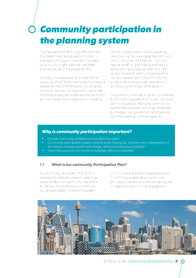

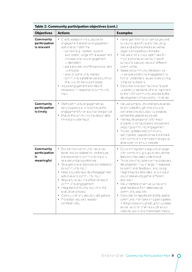
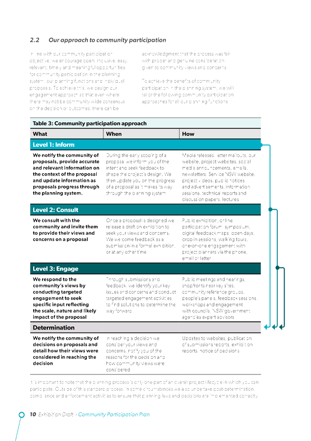

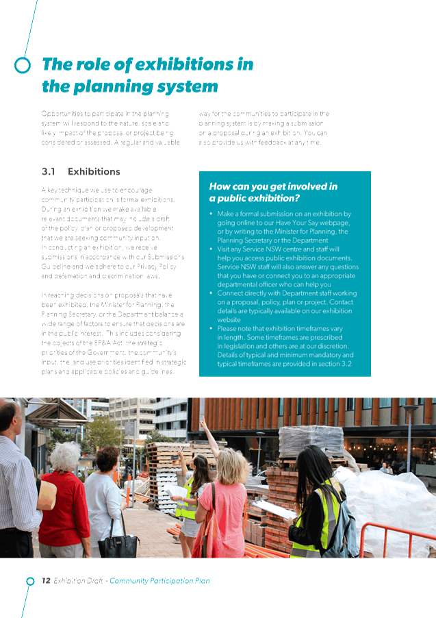
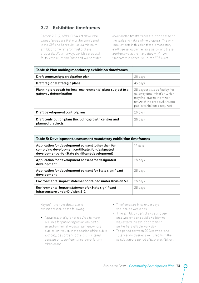
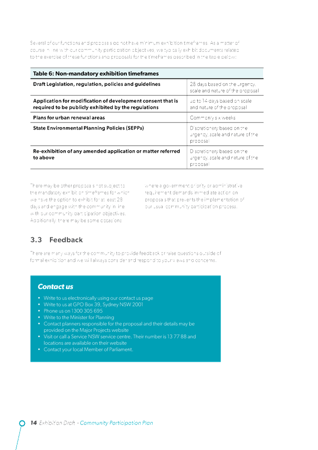
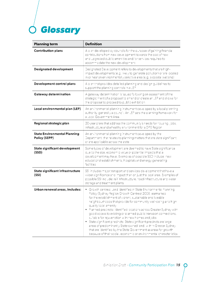

Staff Reports - Sustainable Environment and Economy 6.6 - Attachment 2
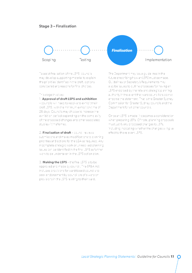
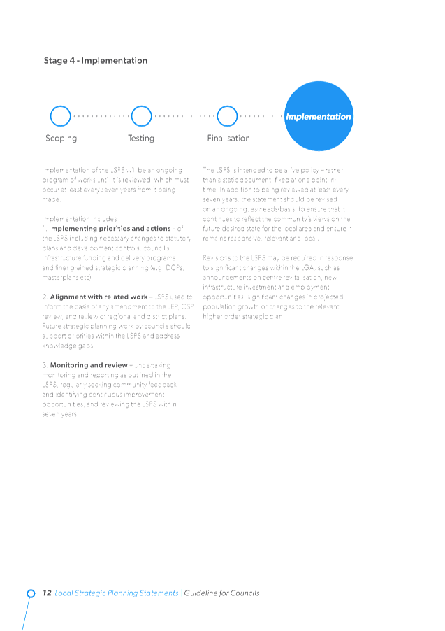
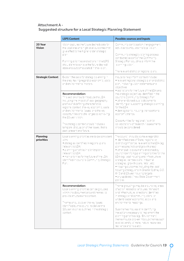
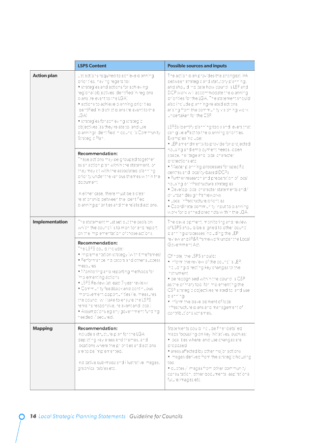

Staff Reports - Sustainable Environment and Economy 6.7
Report No. 6.7 PLANNING
- 10.2018.480.1 Stage 1: Strata Subdivision to Create Two (2) Lots including
One (1) Vacant Lot, Stage 2: Construction of New Dwelling House on Vacant
Strata Lot to Create Dual Occupancy (Detached) with Expanded Dwelling
Module at 8 Cemetery Road Byron Bay
Directorate: Sustainable
Environment and Economy
Report
Author: Karina
Vikstrom, Planner
File No: I2019/439
|
Proposal description:
|
Stage 1: strata subdivision to create two (2) lots
including one (1) vacant strata lot (including removal of seven (7) trees and
compensatory plantings), Stage 2: construction of new dwelling house on
vacant strata lot to create dual occupancy (detached) with expanded dwelling
module.
|
|
Property description:
|
LOT: 21 DP: 838192
|
|
8 Cemetery Road BYRON BAY
|
|
Parcel No/s:
|
195230
|
|
Applicant:
|
Matt Walker Town Planning
|
|
Owner:
|
Mr P R Shine & Ms C M Coorey
|
|
Zoning:
|
2(a) Residential Zone (BLEP1988)
|
|
Date received:
|
25 September 2018
|
|
Integrated / Designated Development:
|
☒
Integrated
|
☐
Designated
|
☐
Not applicable
|
|
Concurrence required
|
No
|
|
Public notification or exhibition:
|
- Level
1 advertising under DCP 2014 Part A14 – Public Notification and
Exhibition of Development Applications
- Exhibition
period: 12/10/18 to 25/10/18
- Submissions received:
Nil
|
|
Delegation to determination:
|
Council
|
|
Issues:
|
· Building Height
Plane Encroachment
· Vegetation
removal
· Car parking
associated with existing dwelling
|
Summary:
The current application has been referred for determination
by the elected Council as it relates to land jointly owned by a
Councillor. The town planning assessment has been completed by an
independent Town Planning consultant contracted to Council. The applicant is
seeking consent to construct a dual occupancy in a staged arrangement with a
vacant lot created as stage 1 and the house constructed in stage 2 on the
vacant lot.
The application is generally compliant with the applicable
LEP and DCP controls and, other than for the ownership status of the property,
would normally be approved subject to conditions under delegated authority. It
is noted the proposed dual occupancy dwelling encroaches into the Building
Height Plane along the eastern elevation. However, given the development
footprint on the adjoining landholding, no adverse privacy, overshadowing or
amenity impacts are envisaged (subject to an additional privacy screen being
provided).
The back yard of the property contains a number of mature
landscape trees. The application involves retaining at least five (5)
existing trees (including two (2) large specimens). The application also
proposes the removal of seven trees to achieve suitable building envelopes in
the rear half of the property. In this instance, the trees in question appear
to have been planted for landscape and amenity purposes. All of the trees
are at the rear of the property and are not prominent features in the
landscape. In addition, the vegetation is not identified within Council
mapping as being of high conservation value or within a wild life
corridor.
Given the above it is considered that a reasonable balance
has been achieved within the application with respect to retention and removal
of vegetation at the rear of the site. Suitable conditions have been
applied requiring the planting of at least six (6) compensatory trees prior to
the completion of the Strata subdivision. Suitable conditions have also been
applied requiring the involvement of a qualified Arborist to undertake the tree
removal works and also to form part of the team responsible for the design and
installation of works in the vicinity of the trees to be retained.
Extensive discussions have occurred between the
proponent’s engineering consultant and Council’s engineers relating
to driveway access and stormwater management. These matters have been
resolved to the satisfaction of Council’s engineers, subject to suitable
conditions being applied. The application is recommended for approval subject
to conditions of consent.
NOTE TO COUNCILLORS:
In accordance with the
provisions of S375A of the Local Government Act 1993, a Division is to be
called whenever a motion for a planning decision is put to the meeting, for the
purpose of recording voting on planning matters. Pursuant to clause 2(a)
under the heading Matters to be Included in Minutes of Council Meetings of
Council's adopted Code of Meeting Practice (as amended) a Division will be
deemed to have been called by the mover and seconder of all motions relating to
this report.
|
RECOMMENDATION:
That pursuant to
Section 4.16 of the Environmental Planning & Assessment Act 1979,
development application no. 10.2018.480.1 for Stage 1: strata subdivision to create two (2) lots including one
(1) vacant lot (including removal of seven (7) trees and compensatory
plantings), Stage 2: construction of new
dwelling house on vacant strata lot to create dual occupancy (detached) with
expanded dwelling module, be granted consent subject to the conditions of
approval listed in attachment 2 #E2019/21459.
|
Attachments:
1 Plans, E2019/20720 , page 412⇩
2 Conditions
of consent, E2019/21459 , page 425⇩
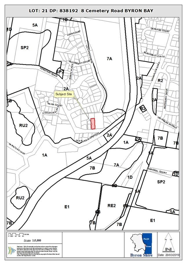
Assessment:
1. INTRODUCTION
1.1. History/Background
|
Application
|
Description
|
Determination Date
|
Determination
|
|
10.2012.560.1
|
Installation of an insulated
patio roof and construction of a deck
|
30/01/2013
|
Approved
|
|
10.2014.405.1
|
Use of works (insulated
patio roof and deck)
|
05/08/2014
|
Approved
|
|
10.2014.428.1
|
Roof over Patio
|
18/08/2014
|
Withdrawn
|
|
10.2017.223.1
|
Secondary Dwelling
|
25/10/2017
|
Withdrawn
|
|
10.2018.480.1
|
Stage 1: Strata Subdivision
to Create Two (2) Lots including One (1) Vacant Lot, Stage 2: Construction of
New Dwelling House on Vacant Strata Lot to Create Dual Occupancy (Detached)
with Expanded Dwelling Module
|
|
|
1.2. Description
of the proposed development
This application seeks approval for a staged development
involving a number of inter-related matters:
Stage 1: Strata Subdivision of Lot 21 DP 838192 to
create two (2) Lots as follows:
· Proposed Strata
Lot 1 will be approximately 626m2 and contain the existing dwelling
at the front of the property; and
· Proposed Strata
Lot 2 will be approximately 586m2 in size and comprise a vacant
Strata Lot. Proposed Lot 2 will be accessed via a right of carriage over
the adjoining Lot 2 DP880389.
Stage 1 will include vegetation management works involving
the removal of 7 trees, and the provision of required infrastructure service
connections to the reticulated network in Cemetery Road, also via the right of
carriage over the adjoining allotment.
Stage 2: Involves the construction of a new dwelling
house on the Vacant Strata Lot (Lot 2) to create a Dual Occupancy (Detached)
with expanded dwelling module. The proposed dwelling will be a two storey
structure comprising the following:
· Ground level:
The main dwelling will contain an open plan dining / living / kitchen, laundry,
bathroom, media room and utilities. A generous deck area will be provided
along the western frontage. A double carport will also be provided.
In addition, an expanded dwelling module will be provided in the north east
corner of the property containing one bedroom, living space, ensuite bathroom
and deck.
· Upper level:
The upper level of the ‘main dwelling’ will comprise 3 bedrooms,
bathroom and office / spare room. An upper level balcony will be provided
for the length of the northern frontage (above the lower level deck).
Construction materials will comprise fibre cement sheeting,
colorbond roofing, steel sliding doors and window frames and select hardwood
posts to the decks.
Extracts from the Plan Set are provided below.
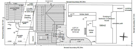
Development Layout
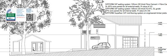
Western Elevation,
Proposed Dual Occupancy & Expanded Dwelling Module
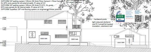
Eastern Elevation,
Proposed Dual Occupancy & Expanded Dwelling Module
1.3. Description
of the site
|
Land is legally described as
|
LOT: 21 DP: 838192
|
|
Property address is
|
8 Cemetery Road BYRON BAY
|
|
Land is zoned:
|
DM Deferred Matter (BLEP2014)
2(a) Residential Zone (BLEP1988)
|
|
Land area is:
|
1212 m2
|
|
Property is constrained by the following:
|
|
Easement
|
The rear portion of the site is constrained by a 5m wide
easement for water supply. The easement traverses the rear of the
property on a diagonal and represents a significant limitation on the
available building envelope. The easement will separate the proposed
‘main dwelling’ on proposed Lot 2 from the expanded dwelling
module.
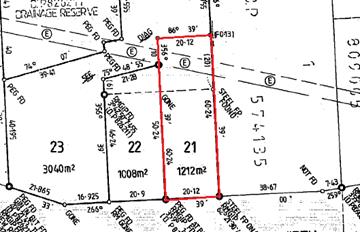
|
|
Bushfire prone land
|
The land is mapped as containing a small area of Category
1 bushfire vegetation, with the remainder of the property being located
within the buffer to that vegetation. Accordingly, the application was
classified as ‘Integrated Development’ and referred to the NSW
RFS as part of the assessment process.
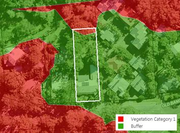
|
|
Acid Sulfate Soils
|
The land is mapped as comprising a combination of Class 2
and Class 5 ASS.
|
|
|
|
The rear of the property comprises landscaped grounds with
assorted trees and plantings. A small cabin / cubby house is located at
the rear of the land which will be demolished to accommodate the
development. The following plates illustrate the existing improvements on
the site. The existing driveway access for the adjoining property which
is to be utilised by proposed Lot 2 is also illustrated in the plates below.
This driveway is relatively narrow and is currently finished with a gravel all
weather surface.
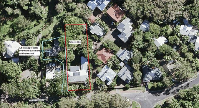
Air View of Site
|
Location of
Proposed Dwelling on Lot 2
|
|
Cabin / Cubbyhouse
to be demolished
|
|
Driveway for Access
to Lot 2.
|
|
Driveway to Unit
Development Adjoining Site
|
2. SUMMARY OF
REFERRALS
|
Referral
|
Issue
|
|
Development Engineer
|
· Road network is
suitable for proposed development. No upgrades required.
· Shortfall of one
carparking space for existing dwelling. Condition to be applied
requiring provision of additional space adjacent to existing.
· Driveway width adequate.
Condition to be applied requiring sealing of driveway.
· Condition to be
applied requiring easement to facilitate driveway access and service
connections to proposed Lot 2.
· Site note subject to
flooding, geotechnical or coastal hazard risks.
|
|
S64 / Systems Planning Officer
|
· Headworks charges to
apply
· Condition proposed to
ensure the Water Supply Authority (Rous Water)sign off on the Encroachment
into the easement for the new dwelling
|
|
Contributions Officer
|
S7.11 contributions to apply
|
3. SECTION 4.14
– BUSH FIRE PRONE LAND
Under section 4.14 of the Act, Council must be satisfied
prior to making a determination for development on bush fire prone land, that
the development complies with the document Planning for Bush Fire Protection
2006. The site is bush fire prone land. The development application was
referred to the NSW Rural Fire Service, which provided conditions which are
reflected in the Recommendation of this Report below.
EFFECT OF 10/50 RULE ON SIGNIFICANT VEGETATION
Council mapping does not identify the land as containing
significant vegetation. A review of the NSW RFS Website on 23 January
2019 confirmed that the parcel of land is located in a designated 10/50
vegetation entitlement clearing area.
4. SECTION 4.15C
– MATTERS FOR CONSIDERATION – DISCUSSION OF ISSUES
Having regard to the matters for consideration detailed in
Section 4.15(1) of the Environmental Planning & Assessment Act 1979
(EP&A Act), the following is a summary of the evaluation of the issues.
4.1 State Environmental
Planning Instruments
4.2A Byron Local Environmental Plan 2014 (LEP 2014)
The subject land is identified as ‘DM Deferred
Matter’ within BLEP 2014 mapping. As such, it does not apply to the
current development application.
4.2B Byron Local Environmental Plan 1988 (LEP 1988)
LEP 1988 is an applicable matter for consideration in the
assessment of the subject development application in accordance with subsection
4.15(1) of the EP&A Act because it applies to the subject land and the proposed
development. The LEP 1988 clauses that are checked below are of relevance to
the proposed development:
|
Part 1
|
☒1|
☒2| ☒2A| ☒3| ☒4| ☒5| ☒LEP 1988 Dictionary| ☒7
|
|
Part 2
|
☒8|
☒9
|
|
Part 3
|
☒10|
☐11| ☐11A| ☐11B| ☐12| ☐13| ☐14| ☐15| ☐16| ☒17| ☐17A| ☐17B| ☐18| ☐19| ☐22| ☐22| ☐23| ☐24| ☐25| ☐27| ☐ 29| ☐29AA| ☐29A| ☐30| ☐31| ☐32| ☐33| ☐34| ☐35| ☐36| ☐37| ☐38| ☐38A| ☐38B| ☐39| ☐39A| ☐39B| ☐39C| ☒40| ☐41| ☐42| ☐43| ☐44| ☒45| ☐46| ☐47| ☐47AA| ☐47A| ☐48| ☐49| ☐51| ☒52| ☐53| ☐54| ☐55| ☐56| ☐ 57| ☐58| ☐59| ☐60| ☐61| ☐62| ☒63| ☐64
|
|
Part 4
|
| ☐65|
☐66| ☐67| ☐68| ☐69| ☐70| ☐71| ☐72| ☐73| ☐74| ☐75| ☐76| ☐77| ☐78| ☐79| ☐80| ☐81| ☐82| ☐83| ☐84| ☐85| ☐86| ☐87| ☐88| ☐89| ☐90| ☐91| ☐92| ☐93| ☐94| ☐95|
☐96|
☐97| ☐98| ☐99| ☐100| ☐101
|
In accordance with LEP 1988 clauses 5, 8 and 9:
(a) The
proposed development is defined as a ‘dual occupancy’ pursuant to
Clause 17;
(b) The
land is within the LEP1988 Property Zone 2(a) Residential according to the map
under LEP 1988;
(c) The
proposed development is permissible with development consent; and
(d) The
proposed development is consistent with the relevant objectives of the Zone for
the following reasons:
|
Zone Objective
|
Consideration
|
|
(a) to make provision for certain
suitable lands, both in existing urban areas and new release areas, to be
used for the purposes of housing and associated neighbourhood facilities of
high amenity and accessibility,
|
N/a. Zoning framework already established for the
land.
|
|
(b) to encourage a range of
housing types in appropriate locations,
|
The current proposal will increase the available supply of
housing within Byron Bay.
|
|
(c) to enable development for
purposes other than residential purposes only if it is compatible with the
character of the living area and has a domestic scale and character, and
|
N/a
|
|
(d) to control by means of a
development control plan the location, form, character and density of
permissible development.
|
The development is consistent with the development control
plan provisions for the project.
|
Clause 17 Dual Occupancy
Clause 17 enables dual occupancies to be permitted on land
zoned 2(a) Residential subject to complying with the following provisions:
|
Provision
|
Consideration
|
|
Arrangements satisfactory to it have been made for the
provision of a water supply to each dwelling and for the disposal of sewage
and stormwater from each dwelling
|
Complies: Council’s engineers are satisfied
that suitable arrangements are in place relating to these matters.
|
|
The area of the allotment on which the dwellings are or
will be erected is not less than 800 square metres
|
Complies: Allotment has an area of 1212m2
|
|
Unless the floor space ratio of any building on the land
will not exceed 0.5:1.
|
Complies: Proposed FSR is in the order of 0.35:1
|
The remaining checked clauses have been taken into
consideration in the assessment of the subject development application in
accordance with subsection 4.15(1) of the EP&A Act. The proposed
development complies with all clauses of LEP 1988 (in some cases subject to
conditions and/or to the satisfaction of other assessing officers).
Clause 63 Development on land identified on the Acid
Sulfate Soils Planning Map
The land is mapped as comprising a combination of Class 2
and Class 5 ASS. This triggers a requirement for development consent to
be obtained for the following:
· Class 2 –
Works below the natural ground surface
· Class 5
–Works within 500 metres of adjacent Class 1, 2, 3 or 4 land below 5
metres AHD likely to lower the watertable below 1 metre AHD on the adjacent
Class 1, 2, 3 or 4 land
Only a small portion of the expanded dwelling module is to
be located within the Class 2 land. Works within this portion of the site
will involve footings associated with the structure. Suitable conditions
have been applied requiring an Acid Sulfate Soils Management Plan to be
prepared prior to issue of a Construction Certificate for Stage 2.
Clause 45 – Infrastructure services
There has been significant negotiation between Council
Engineers and the applicant relating to the provision of service infrastructure
(particularly stormwater disposal). These matters have been resolved to the
satisfaction of Council’s Engineer and suitable conditions have been
applied.
With respect to ‘soft’ infrastructure, it is
noted that the development plans to not provide for a mail box to Cemetery Road
to service proposed Strata Lot 2 (at the rear of the property). A
suitable condition has been applied requiring this to be provided along the
Cemetery Road frontage, with this to be provided as part of Lot 2.
4.3 Any proposed Instrument
that has been the subject of public consultation and has been notified to the
consent authority
No draft Planning Instrument is applicable to the site.
4.4B Byron Shire Development Control Plan 2010 (DCP 2010)
DCP 2010 is an applicable matter for consideration in the
assessment of the subject development application in accordance with subsection
4.15(1) of the EP& A Act because its purpose is to provide planning
strategies and controls for various types of development permissible in accordance
with LEP 1988. The DCP 2010 Chapters/Parts that are checked below are of
relevance to the proposed development:
|
Chapter 1 Parts:
|
☒A|
☒B| ☒C| ☐D| ☐E| ☐F| ☒G| ☐H| ☐J| ☐K| ☐L| ☒ N
|
|
Chapters:
|
☐4|
☐6| ☐7| ☐8| ☐9| ☐10| ☐11| ☐12| ☐14| ☐15| ☐16| ☒17| ☐18| ☐19| ☐20| ☐21| ☐22
|
These checked Chapters/Parts have been taken into
consideration in the assessment of the subject development application in
accordance with subsection 4.15(1) of the EP&A Act. The proposed
development is demonstrated to meet the relevant Objectives of DCP 2010 (in
some cases subject to conditions and/or to the satisfaction of other assessing
officers).
In addition, the following particular comments are made with
respect to elements of the DCP of particular relevance to the proposal.
Chapter 1 Part A General
A5 Tree Preservation and Vegetation Management
The back yard of the property contains a number of mature
landscape trees. The application involves retaining at least five
(5) existing trees (including two (2) large specimens). The application
also proposes the removal of seven trees to achieve suitable building
envelopes as identified in the table below:
|
Tree
|
Consideration
|
|
1 x Mango
|
This is a fruit tree and accordingly no approval is
required to remove this tree under Item 2(a) of the TPO
|
|
3 x Rhus Taitenis
|
Consent is required for the removal of these tree.
Whilst a rainforest species, this tree is not native to
the local area, with the natural range being within the Northern Territory,
Cape York and North East Queensland.
(Note: This is not the same species as the Rhus tree
identified on the List of Undesirable Trees within the TPO)
|
|
1 x Candlenut
|
Consent is required for the removal of this tree.
|
|
1 x Poinciana
|
Consent is required for the removal of this tree.
This is not a native tree.
|
|
1x Quandong
|
Consent is required for the removal of this tree
|
In this instance, the trees in question appear to have been
planted for landscape and amenity purposes. All of the trees are at the rear of
the property and are not prominent features in the landscape. In
addition, the vegetation is not identified within Council mapping as being of
high conservation value or within a wild life corridor. Given the above
it is considered that a reasonable balance has been achieved within the
application with respect to retention and removal of vegetation at the rear of
the site. Suitable conditions have been applied requiring the planting of
at least six (6) compensatory trees as part of Stage 1 of the
project.
Suitable conditions have also been applied requiring the
involvement of a qualified Arborist to undertake the tree removal works and
also to form part of the team responsible for the design and installation of
works in the vicinity of the trees to be retained.
Chapter 1 Part C Residential Development
C2 – General Provisions
|
Provision
|
Consideration
|
|
C2.2 – Height of Buildings
Buildings are to comply with BLEP1988
|
Complies.
|
|
C2.3 – Buffer Areas
|
Not applicable.
|
|
C2.4 – Coastal Erosion Zones
|
Not applicable
|
|
C2.5 – Building Height Plane
|
Comment: Refer comment below.
|
|
C2.6 – Setback from Street, Side and Rear Boundaries
|
Complies
|
|
C2.7 – Extent of Earthworks
|
Complies – Only minimal earthworks are proposed to
facilitate the development.
|
|
C2.8 - Screening the underfloor space of buildings
|
Not applicable
|
C2.5 – Building Height Plane
As illustrated in the Plates below, the eastern elevation of
the proposed ‘main dwelling’ on Lot 2 will encroach into the
building height plane along the eastern elevation. In most circumstances,
an encroachment of this scale is unlikely to be supported. However, in
this instance the characteristics of the site and the development pattern on
the adjoining land are such that the encroachment is considered reasonable in
the circumstances. The reasons are as follows:
1. The
adjoining property to the east of the development site contains an established
town house development. The portion of the adjoin site in proximity to
the proposed dwelling comprises car parking and driveway access.
Accordingly, any overshadowing (in the late afternoon) is not expected to
adversely impact on private open space or living areas on the adjoining
property.
2. The
upper level windows of the proposed dwelling are both highset and have privacy
screening. As such, overlooking from the windows is unlikely to
occur. It is recommended that screening also be required to the eastern
end of the upper level deck. Suitable conditions have been included to
facilitate this outcome.
3. No
objections were received from adjoining property owners.
Plan extract –
Building Height Plane Encroachment
Plan extract –
Eastern Elevation
Air view illustrating
relationship with adjoining property
C3 – Design Principles
|
Provision
|
Consideration
|
|
C3.1 – Visual Impact
|
Complies. The proposed development is considered to
be a suitable addition to the locality.
|
|
C3.2 – Building Design in Rural Areas
|
Not applicable
|
|
C3.3 – Development On or Near Ridgetops
|
Not applicable
|
|
C3.4 – Development in Scenic Zones
|
Not applicable
|
|
C3.5 Element – Minimum Lot Sizes and Street
Frontages
|
Complies. The subject land complies with the
required 800m2 minimum lot size and 15m frontage.
|
|
C3.6 Element –Fences
|
No changes are proposed to the existing front fence to
Cemetery Road.
|
C5 – Dual Occupancy
|
Provision
|
Consideration
|
|
C5.1 - Carparking
2 spaces required per dwelling
|
The application originally provided for only one car
parking space to service the existing dwelling (retaining the existing
arrangement for the dwelling). The owner advises that this situation
has been satisfactory to their requirements to date.
Given that the proposal seeks to establish a new
development outcome for the site, it is reasonable that the project provide a
second space in accordance with the DCP requirements (particularly having
regard to the potential for ownership changes in the future). The
applicant has agreed to this requirement and a suitable condition has been
applied.
|
|
C5.2 - Character and Private Open Space
|
Complies: Each dwelling has been provided with suitable
and compliant areas of private open space.
|
|
C5.3 - Density Control
Maximum density of 0.5:1 and 25% absorbent surfaces.
|
Complies.
|
|
C5.4 - Sound Proofing
|
Not applicable
|
|
C5.5 – Private Open Space
90m2 POS required for each dwelling
|
Complies.
|
|
C5.6 – Adjoining and Adjacent Development
|
Comment: The proposed dual occupancy building provides a
reasonable interface with nearby properties.
The upper level eastern elevation is located in a position
where it could potentially overlook common driveway and circulation space in
the adjoining unit development. The design responds to this potential
privacy intrusion by providing high-level, screened windows along this
elevation. A condition of consent has been applied requiring the eastern end
of the upper level deck to also have privacy screening.
|
|
C5.7 – Attached Dual Occupancies
|
Not applicable
|
4.5 Any Planning Agreement or
Draft Planning Agreement?
|
|
Yes
|
No
|
|
Is there any applicable planning agreement or draft
planning agreement?
|
☐
|
☒
|
|
|
4.6 Environmental Planning
& Assessment Regulation 2000 Considerations
|
Clause
|
This control is applicable to the proposal:
|
I have considered this control as it relates to the
proposal:
|
If this control is applicable, does the proposal
comply?
|
|
92
|
No
|
|
|
|
93
|
No
|
|
|
|
94
|
No
|
|
|
|
94A
|
No
|
|
|
4.7 Any COASTAL ZONE MANAGEMENT
PLAN?
|
|
Satisfactory
|
Unsatisfactory
|
Not applicable
|
|
Is there any applicable coastal zone management plan?
|
☐
|
☐
|
☒
|
|
|
4.8 The likely impacts of that
development, including environmental impacts on both the natural and built
environments, and social and economic impacts in the locality
|
Impact on:
|
Likely significant impact/s?
|
|
Natural environment
|
No. The proposal will not have a significantly adverse
impact on the natural environment of the locality.
|
|
Built environment
|
No. The proposal will not have a significantly adverse
impact on the built environment of the locality.
|
|
Social Environment
|
No. The proposal will not have a significant social impact
on the locality.
|
|
Economic impact
|
No. The proposal will not have a significant economic
impact on the locality.
|
Are there any Council Policies that are applicable to the
proposed development?
4.9 The suitability of the site
for the development
|
Issue
|
Comment
|
|
Services
- Water/
Sewer/ Stormwater
- Ph/
power
- Access
|
As outlined above, Council’s engineer satisfied that
suitable arrangements are in place, or can be conditioned, relating to
service infrastructure.
|
|
Hazards
- ASS
- Bushfire
|
The bushfire and Acid Sulfate Soil characteristics of the
land have been considered within this assessment and are able to be managed
in a satisfactory manner, subject to the application of suitable consent
conditions.
|
4.10 Submissions made in accordance with
this Act or the regulations
The development application was publicly exhibited. No
submissions were received.
4.11 Public interest
The proposed development is unlikely to prejudice or
compromise the public interest or create a dangerous precedent
5. DEVELOPER CONTRIBUTIONS
5.1 Water & Sewer Levies
Section 64 levies will be payable.
5.2 Section 7.11 Contributions
Section 7.11 Contributions will
be payable.
6. REASONS
FOR DECISION, HOW COMMUNITY VIEWS WERE ADDRESSED
Note:
From July 1 2018, Council’s are required to give and publicly notify
reasons for a range of planning decisions where they are deciding if
development should proceed to help community members to see how their views
have been taken into account and improve accountability to stakeholders. A
statement of reasons for the determination of this application is provided
below.
|
Statement of Reasons
|
|
The proposed development complies with the provisions of
Byron Local Environmental Plan 1988.
|
|
The proposed development complies with relevant State
Environmental Planning Policies
|
|
The proposed development complies with relevant provisions
of Development Control Plan 2010
|
|
The proposed development complies with Environmental
Planning & Assessment Regulation 2000 considerations.
|
|
The proposed development will not have significant adverse
impact on the natural, built or social environment or economic impacts on the
locality.
|
|
The proposed development is considered suitable for the
proposed site.
|
|
The development application was notified/advertised in
accordance with Development Control Plan 2010. No submissions were
received.
|
|
The proposed development is unlikely to prejudice or
compromise the public interest.
|
|
How community views were addressed
|
|
The DA was notified/advertised in accordance with
Development Control Plan 2010. No submissions were received.
|
7. DISCLOSURE OF
POLITICAL DONATIONS AND GIFTS
|
Has a Disclosure Statement been received in relation
to this application
|
Yes
|
|
Have staff received a ‘gift’ from anyone
involved in this application that needs to be disclosed. Where the answer is
yes, the application is to be determined by the Director or Manager of the
Planning, Development and Environment Division.
|
No
|
Provide Disclosure Statement register details here: One of
the landowners is a Councillor on Byron Shire Council.
Given the above, the town planning assessment has been
completed by an independent town planning consultant on contract to Byron Shire
Council.
8. CONCLUSION
The proposed development is generally consistent with the
relevant environmental planning instruments and planning controls applicable to
the site. The proposal raises no significant issues in terms of environmental
impacts which cannot be managed and the site is considered suitable for the
development. The application is recommended for approval subject to conditions
of consent.
Staff Reports - Sustainable Environment and Economy 6.7 - Attachment 1
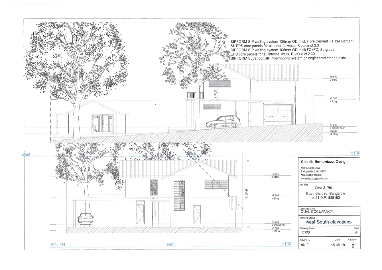
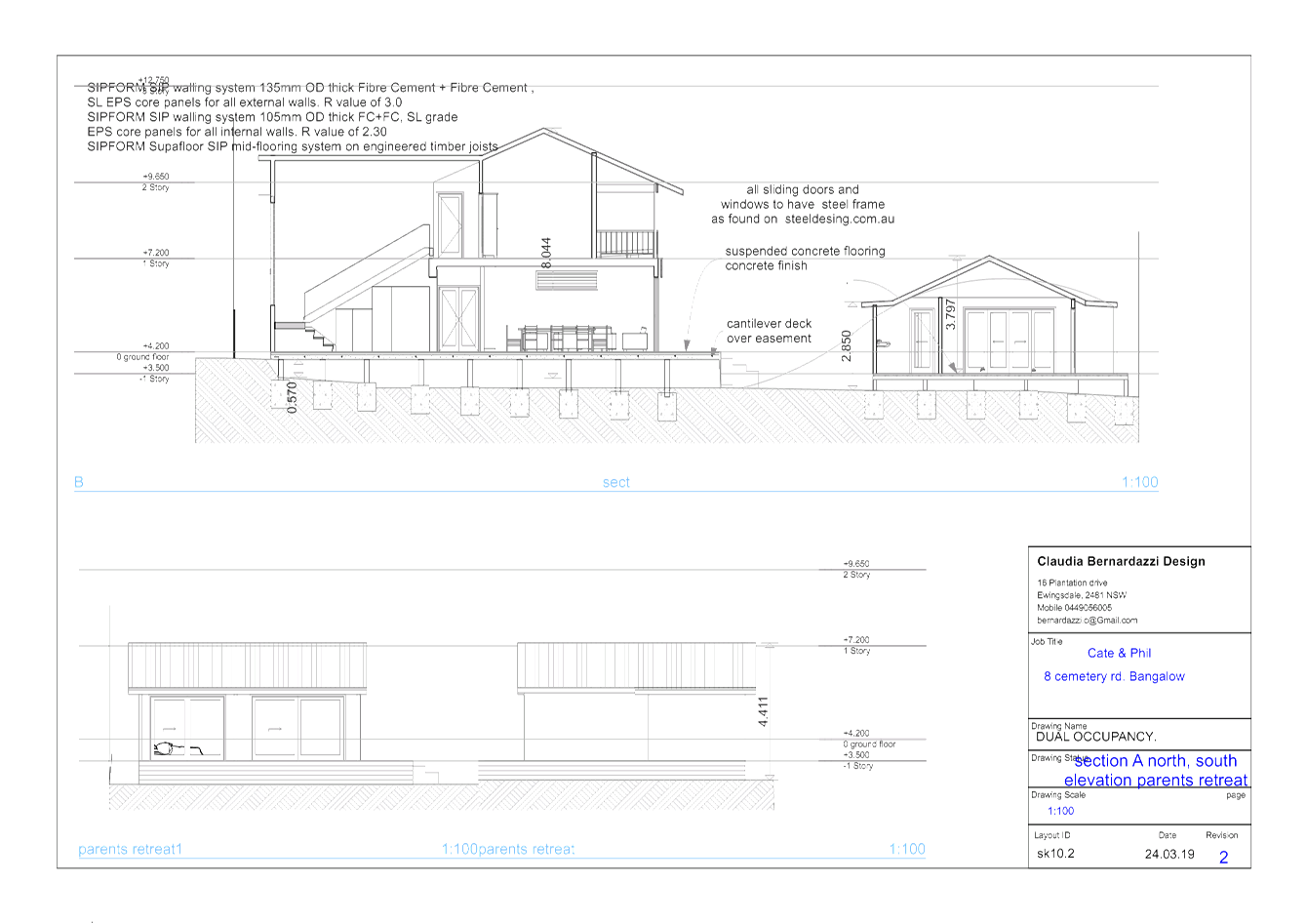
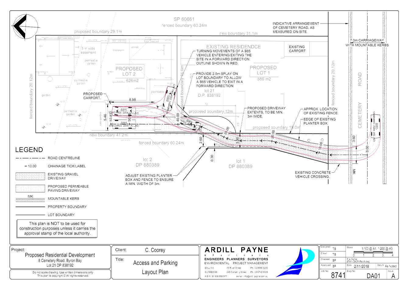
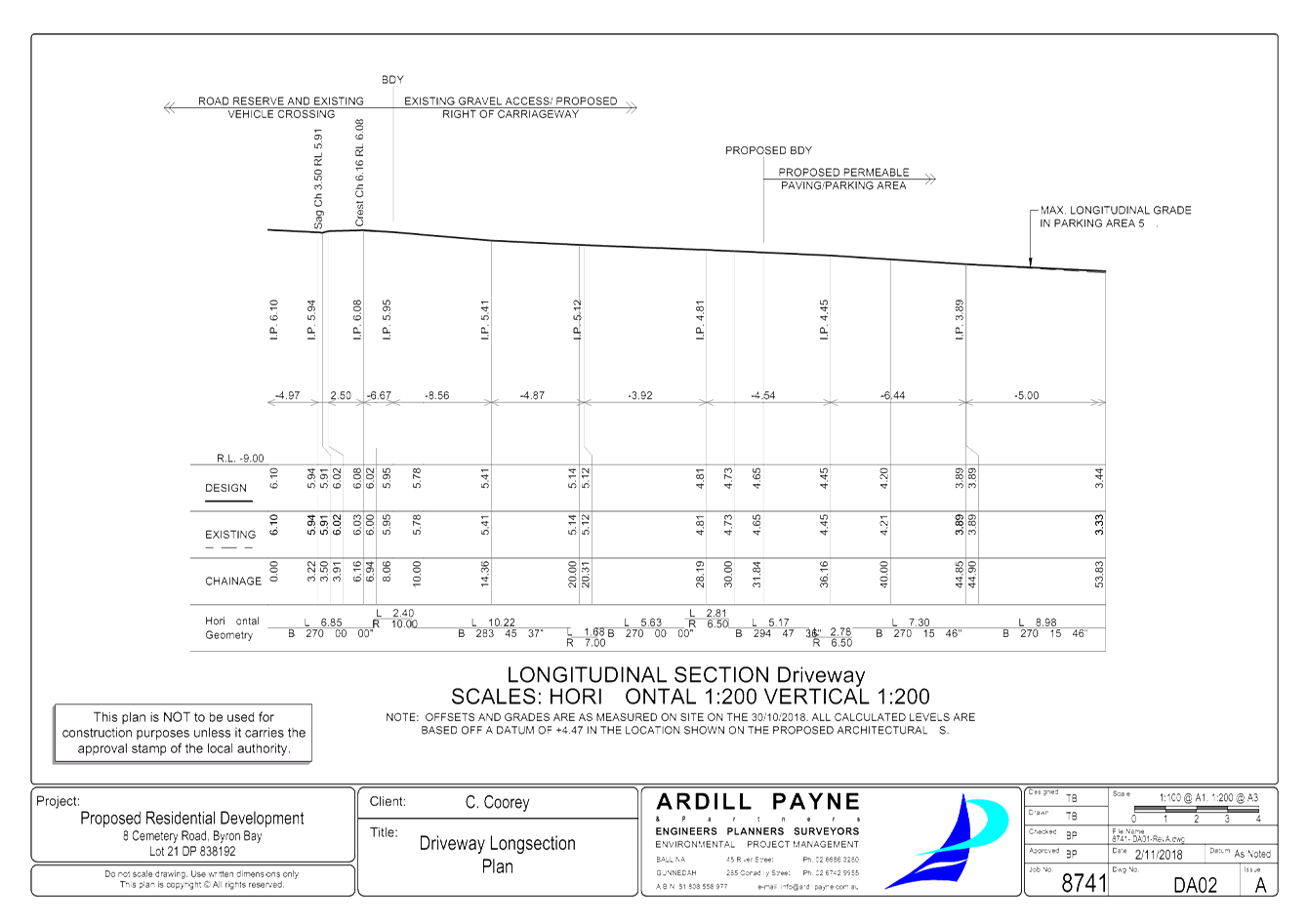
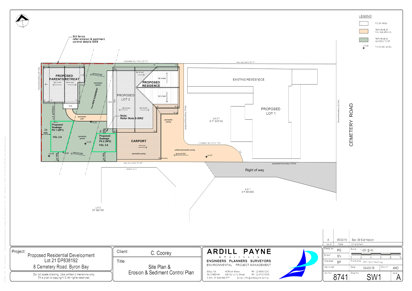
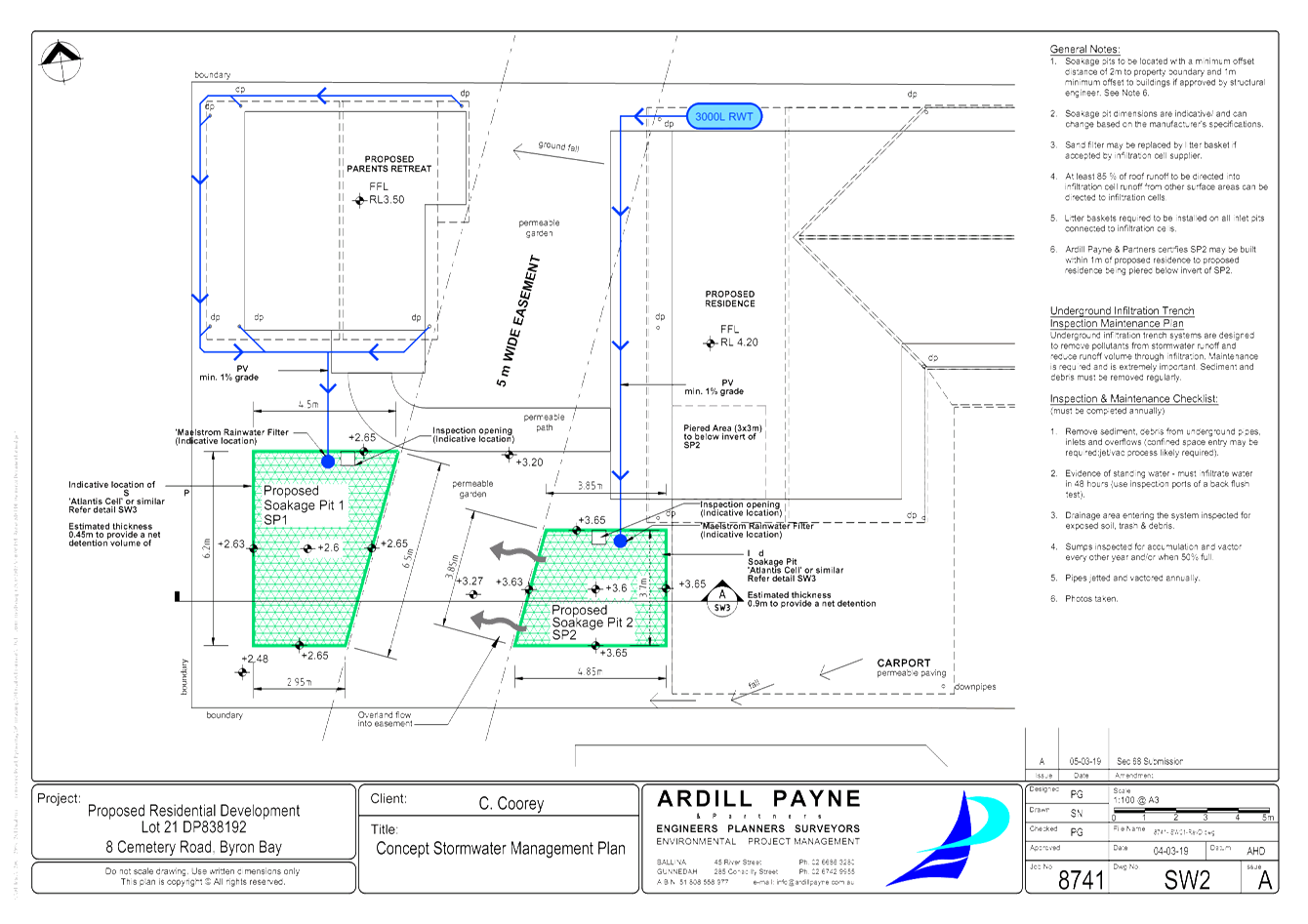
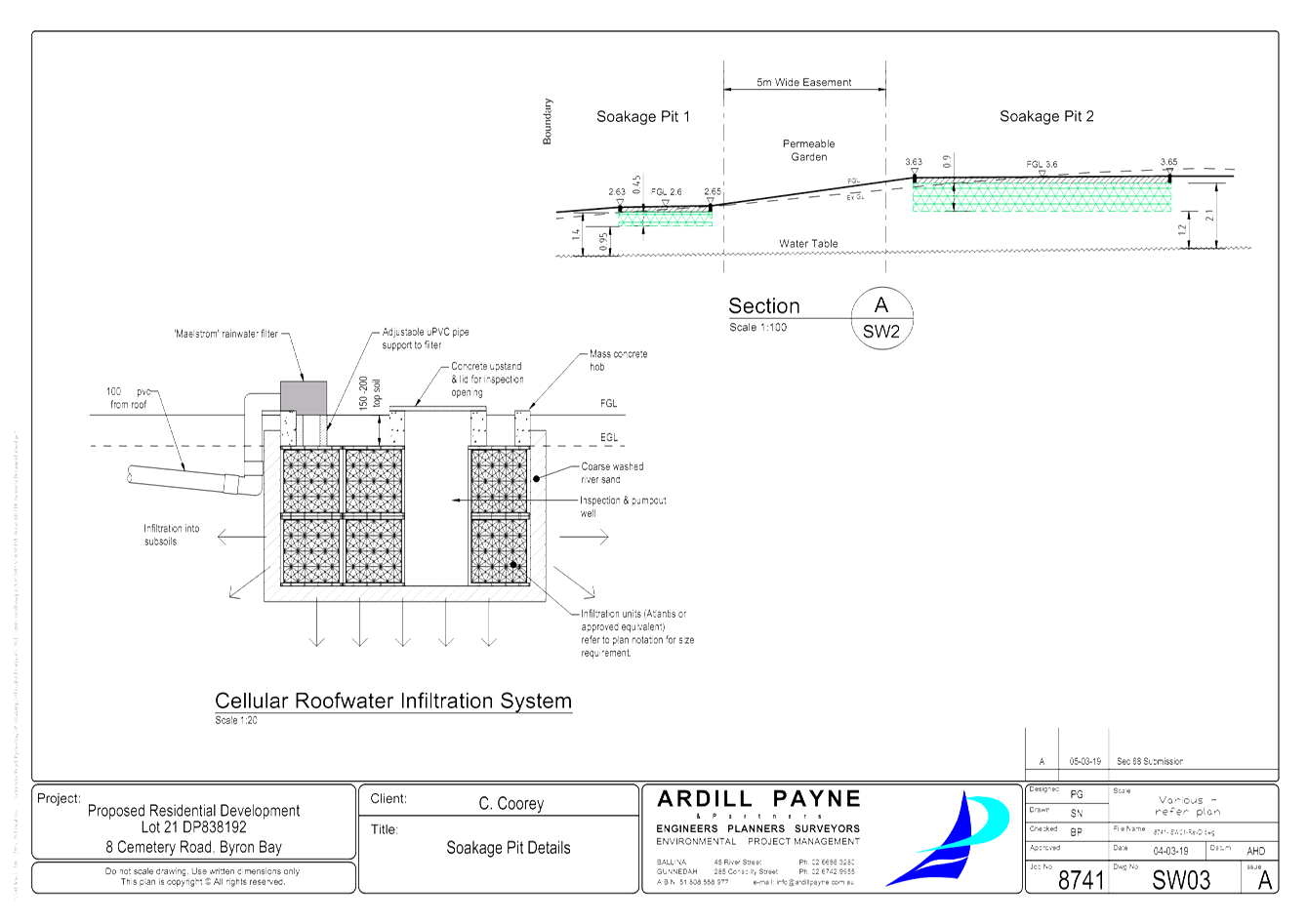
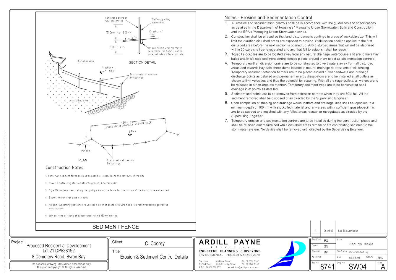
Staff Reports - Sustainable Environment and Economy 6.7 - Attachment 2
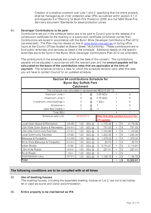
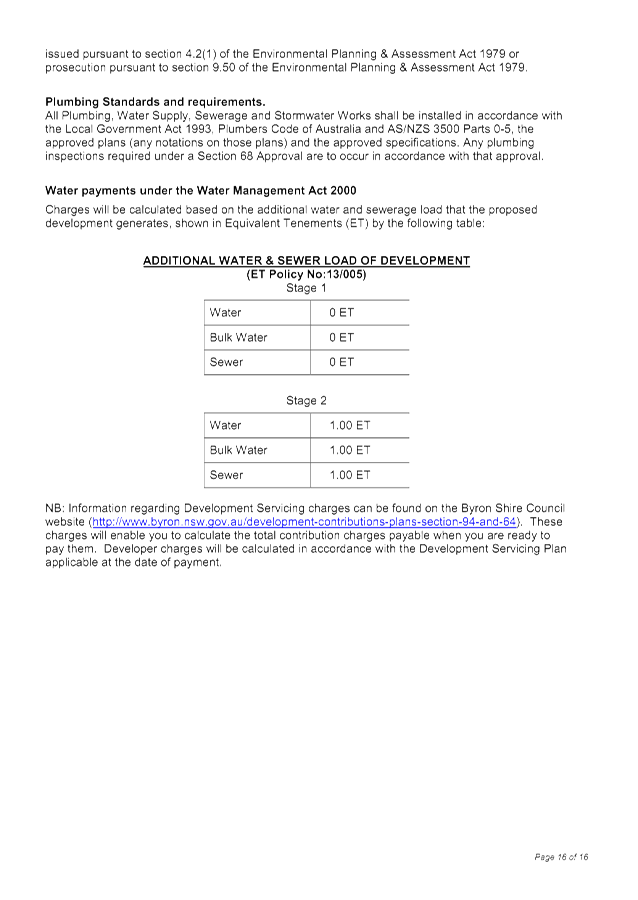
Staff Reports - Sustainable Environment and Economy 6.8
Report No. 6.8 State
Environmental Planning Policy No 70 Affordable Housing (Revised Schemes) (SEPP
70)
Directorate: Sustainable
Environment and Economy
Report
Author: Shannon
Burt, Director Sustainable Environment and Economy
File No: I2019/446
Summary:
In
February 2019, SEPP 70 was further expanded to include all councils across NSW.
The purpose of this report is to update Council on next steps now that Byron
Shire has been entered into SEPP 70 to investigate and develop an affordable
housing contributions scheme under the SEPP.
https://www.planning.nsw.gov.au/Policy-and-Legislation/Housing/Diverse-and-affordable-housing/SEPP-70-Affordable-Housing-Revised-Schemes
|
RECOMMENDATION:
1. That
Council advise the Department of Planning that it is preparing an affordable
housing contribution scheme under State Environmental Planning Policy No 70
Affordable Housing (Revised Schemes).
2. That
Council fund the expedited preparation of an affordable housing contribution
scheme and its associated local environmental plan amendment and planning
agreement policy for Byron Shire through an allocation of $20,000 at the March
Budget Quarterly review.
3. That
subject to 2, Council prepare an affordable housing contribution scheme and
its associated local environmental plan amendment which is consistent with
the Department of Planning guideline.
4. That
subject to 2, Council prepare a planning agreement policy for affordable
housing which is consistent with the Environmental Planning and
Assessment (Planning Agreements) Direction 2019.
|
REPORT
One of the objectives of the
Environmental Planning and Assessment Act 1979 (the Act) is to promote the
delivery and maintenance of affordable housing.
The Act enables councils to levy
contributions for affordable housing. To do this, the Act requires a council’s
local government area (LGA) to be named in a state environmental planning
policy. State Environmental Planning Policy
No. 70 – Affordable Housing (Revised Schemes) (SEPP 70) identifies these LGAs.
Once an LGA is named in SEPP 70, a
council can seek to amend its local environmental plan (LEP) to have reference
to an affordable rental housing contribution scheme and to levy affordable
housing contributions.
In February 2019, SEPP 70 was
further expanded to include all councils across NSW. The amendment removes the
administrative step of entering a LGA into SEPP 70, thereby expediting
councils’ ability to investigate and develop an affordable housing
contributions scheme. It does so by entering all LGAs into SEPP 70 (thus
meeting the Act’s requirements of a council being named in a SEPP).
The next step in the process is for
Council to prepare affordable housing contribution scheme and amend the local
environmental plan to reference the scheme.
What
can an ‘affordable housing’ scheme do?
An ‘affordable housing’
scheme allows development consent conditions to be imposed requiring, either:
· the
dedication of part of the development site (or other land of the applicant)
free of cost to be used for the purpose of providing ‘affordable
housing’; or
· the
payment of a monetary contribution to be used for the purpose of providing
‘affordable housing’;
· or
both.
What
is ‘affordable housing’ under SEPP 70?
SEPP 70 is founded on the principle
that the housing is only ‘affordable housing’ if it meets the
following definitions:
affordable housing means housing for very low income households,
low income
households or moderate income households, being such households as
are prescribed by
the regulations or as are provided for in an environmental
planning instrument
(as per section 1.4(1) of the Act).
Definition of ‘affordable housing’ households:
For the purposes of the definition of affordable housing in
section 1.4 (1) of the Act, very low income households, low income households
and moderate income households are those whose gross incomes fall within the
following ranges of percentages of the median household income, for the time
being for the Greater Sydney (Greater Capital City Statistical Area) or the
Rest of NSW (Greater Capital City Statistical Area) according to the Australian
Bureau of Statistics:
Very low income household less than 50%
Low income household 50 or more but less than 80%
Moderate income household 80–120%
It should be noted that schemes
under SEPP 70 generally only look to provide rental housing (rather than
owner-occupied housing). Additionally, there is generally a requirement
that that housing be institutional (in the sense that it must be managed by
registered housing organisations, rather than traditional ‘mum and
dad’ and property investors). Further, buildings provided for affordable
housing are to be managed so as to maintain their continued use for affordable
housing (in perpetuity).
How
to prepare an affordable housing contribution scheme
Councils must:
1. Investigate
the affordable housing need in their LGAs;
2. Identify
the areas to which an affordable housing contribution scheme will apply;
3. Determine
a viable affordable housing contribution rate;
4. Prepare
affordable housing contribution schemes; and
5. Amend
their LEPs through the planning proposal process to reference their affordable
housing contribution schemes.
After which, councils can then
apply consent conditions that require contributions for affordable housing.
An example of how a new scheme
might work is set out in the Inner West Council’s Affordable Housing
Policy dated November 2016. The policy provides for a 15 per cent
‘Affordable Housing Contribution’ within new greenfield, brownfield
and greyfield sites, and major private and public redevelopments. The
policy is directed at developments that meet a threshold of 20 units or 1,700
square metres in gross floor area.
It is important to understand that
the proposed ‘15 per cent’ is not a proportion of development
profits. It is 15 per cent of gross floor area of the development.
So essentially, what is taxed under such a scheme is the gross revenue of the
development, rather than the net revenue (as might occur in more conventional
taxation schemes).
An important consideration for the contribution scheme is
how and when it can be applied. Under Section 7.32(3)(b) of the Act, any
condition imposed on a development consent for affordable housing must be
authorised by an LEP and must be in accordance with an affordable housing
contribution scheme for dedications or contributions set out in, or adopted by,
the LEP.
With this in mind it is critical that Council expedite the
preparation of a contributions scheme and LEP amendment prior to the completion
of any current and anticipated major greenfield / brownfield land rezoning to
ensure that a contribution for ‘affordable housing’ can be
collected from the development of land identified in the scheme that is being
upzoned.
Of note, the rate of contribution can be determined either
by a percentage of floor space that can equate to a completed affordable rental
unit, or a monetary contribution, or any combination of the above. This
provides flexibility to Council to determine when it is appropriate and
efficient to receive completed dwellings and when it would be appropriate to
receive monetary contributions.

Voluntary Planning Agreements for Affordable Housing
Further to SEPP 70.
The Act enables a council to enter into a Voluntary Planning
Agreement with a developer for provision of or monetary contribution for
affordable housing.
The Minister has issued an Environmental Planning and
Assessment (Planning Agreements) Direction 2019 to clarify this. The Direction
requires councils to consider a series of matters when negotiating a planning
agreement with a developer for the purposes of affordable housing in connection
with a development application.
Councils that want to negotiate a planning agreement for the
provision of affordable housing, after considered the requirements of the
Ministerial Direction, will need to prepare and publish a policy that sets out
the circumstances in which it may seek out a planning agreement. This policy
will need to be made publicly available.
It is recommended that Council prepare a policy in concert
with the contributions scheme.
STRATEGIC CONSIDERATIONS
Community Strategic Plan and Operational Plan
|
CSP Objective
|
L2
|
CSP Strategy
|
L3
|
DP Action
|
L4
|
OP Activity
|
|
Community
Objective 4: We manage growth and change responsibly
|
4.2
|
Support
housing diversity in appropriate locations across the Shire
|
4.2.1
|
Establish
planning mechanisms to support housing that meets the needs of our community
|
4.2.1.1
|
Investigate and
implement planning controls to encourage an increase in the supply of
affordable and inclusive housing stock
|
|
|
|
|
|
|
|
|
Legal/Statutory/Policy Considerations
In
February 2019, SEPP 70 was further expanded to include all councils across NSW.
The amendment removes the administrative step of entering a LGA into SEPP 70,
thereby expediting councils’ ability to investigate and develop an
affordable housing contributions scheme. It does so by entering all LGAs into
SEPP 70 (thus meeting the Act’s requirements of a council being named in
a SEPP).
Financial
Considerations
An
allocation of $20,000 for the expedited preparation of an affordable housing
contribution scheme and its associated local environmental plan amendment and
planning agreement policy will be considered as part of the March Budget
Quarterly review deliberations.